Embed Size (px)
Citation preview

CLAYTON, ROPER & MARSHALL CRM File No. 10-076
9
SUMMARY OF SALIENT FACTS LOCATION The subject is located at the southwest corner of State
Road 434 and Palm Drive in Oviedo, Seminole County, Florida.
PROPERTY TYPE Vacant land DATE OF VALUATION March 22, 2010 INSPECTION DATES February 24, March 15 and 22, 2010 SITE SIZE 1.65± acres, or 71,874± square feet of land area IMPROVEMENT DESCRIPTION Vacant land ZONING C-1, Commercial District, Oviedo FUTURE LAND USE CM, Commercial District, Oviedo HIGHEST AND BEST USE Office/Commercial Development VALUATION “AS IS” COST APPROACH Not Applicable SALES COMPARISON APPROACH (LAND ONLY) $790,000 INCOME APPROACH Not Applicable
RECONCILED VALUE ESTIMATE $790,000 MARKETING PERIOD One Year

CLAYTON, ROPER & MARSHALL CRM File No. 10-076
10
AERIAL PHOTO

CLAYTON, ROPER & MARSHALL CRM File No. 10-076
18
IDENTIFICATION OF THE SUBJECT PROPERTY The subject site consists of approximately 1.65 acre± acres or 71,874 ± square feet of land area
located at the southwest corner of State Road 434 and Palm Drive in Oviedo, Seminole County,
Florida. This location is in the southeast quadrant of State Road 434 and State Road 417.
LEGAL DESCRIPTION
The legal description was taken from the most recent deed found in O.R. Book 3343, Page 0253, of
the Public Records of Seminole County, Florida, as follows:
FLOOD HAZARD STATEMENT
According to the Federal Emergency Management Agency (FEMA), National Flood Insurance Map
No. 12117C 0180F, dated September 28, 2007, the subject site is located in Flood Zone X, an area
outside the 100-year flood plain. A copy of the Flood Map panel is included at the end of this section
of the report.
REAL ESTATE TAX INFORMATION
The Seminole County Tax Collector issues the tax bills providing for a 4% discount for payment in
November, a 3% discount for payment in December, a 2% discount for payment in January and a 1%
discount for payment in February. All tax bills are delinquent after March 31 of each year. The
subject is currently assessed by Seminole County as Tax Parcel 04-21-31-501-0A00-0000. The 2009
CRM File No. 10-076
63
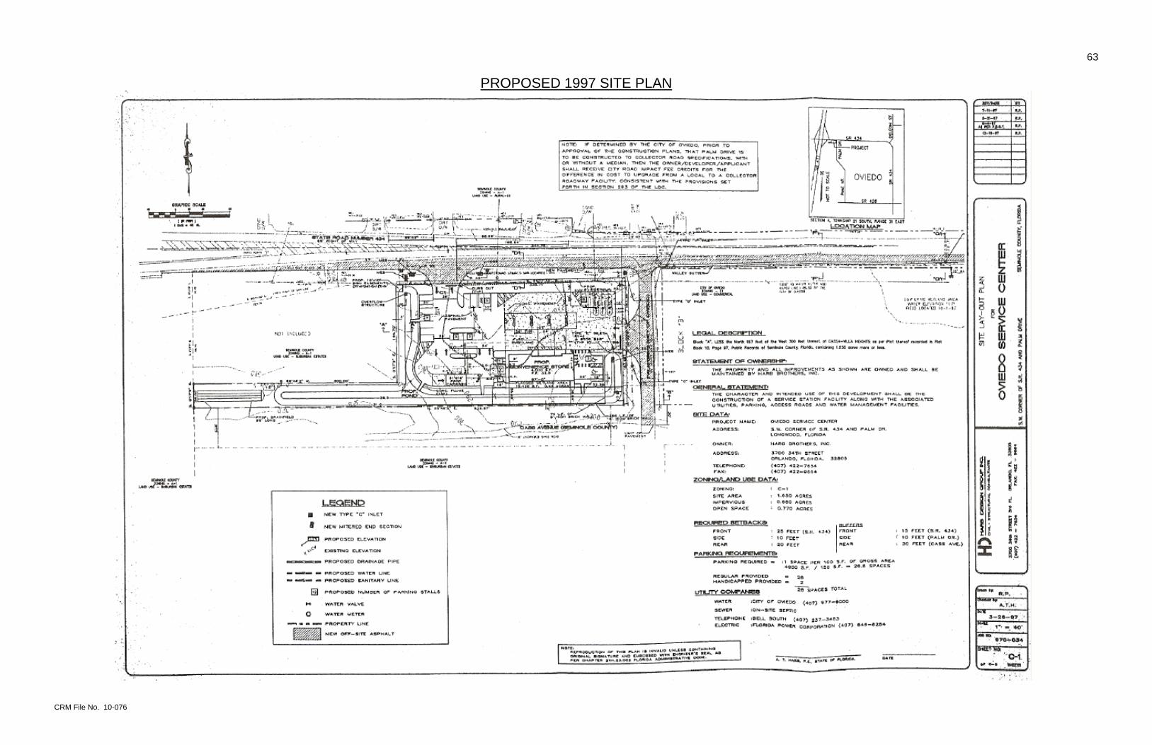
PROPOSED 1997 SITE PLAN

CRM File No. 10-076
64
DETAIL OF PROPOSED SITE PLAN
CLAYTON, ROPER & MARSHALL CRM File No. 10-076
65
DESCRIPTION OF THE SUBJECT SITE LOCATION
The subject is located at the southwest corner of State Road 434 and Palm Drive in Oviedo, Seminole
County, Florida. According to an Oviedo Planning Department document we obtained, the subject’s
street address is 1021 State Road 434. The subject’s location is within the southeast quadrant of the
interchange of State Road 434 and State Road 417, which is also known as the Greeneway and is a
portion of the Orlando beltway. The Greeneway is a limited-access toll expressway extending around
the east, south and west portions of the Orlando Metropolitan Area. The northwestern portion of the
highway, which would complete the beltway, is still in the planning stages.
SHAPE, DIMENSIONS AND AREA
The 1.65± gross acre or 71,874± square foot subject land tract was flag-shaped. The dimensions on
the owner’s proposed site plan were semi-legible, but the subject land tract appears to have a
southern border of 837± feet and an eastern border of 183± feet. The western and southwestern
borders are irregular due to a cutout of the separately-owned parcel directly west and northwest of the
subject. The western dimension of the main rectangle was 144.7 feet in length, while the western
dimension of the narrow extension to the southwest was 36 feet. The northern dimension of that
extended parcel was 300 feet. The northern dimension of the main rectangle with frontage on State
Road 434 appears to be 338.71 feet in length. The notes on the proposed site plan conclude that the
site area is 1.65 acres.
ACCESS
The subject had frontage and visibility on the south side of State Road 434. There was no specific
driveway from State Road 434. The subject also had frontage and visibility on the west side of Palm
Drive, a public road maintained by the City of Oviedo. We observed no physical barrier to access on
Palm Drive. The subject also had frontage on the north side of Cass Avenue, a minimally-improved
neighborhood road also maintained by the City of Oviedo. The Oviedo Public Works Department has
an ongoing program to upgrade such older, minimally-improved roads. The intersection of State
Road 434 and Palm Drive allows full-directional turns. To the west of that there is a painted, striped

CLAYTON, ROPER & MARSHALL CRM File No. 10-076
66
median, which widens to the west toward the State Road 434/State Road 417 interchange and, as the
street approaches the expressway on and off ramps, a grass median begins within the painted,
striped median. The owner’s proposed site plan shows a right-in / right-out driveway on the subject’s
north border on State Road 434 and a full-directional driveway on its east border on Palm Drive.
UTILITIES
Electricity: Progress Energy Corporation Water: Oviedo Sewer: Oviedo Reclaimed Water: Oviedo and Alafaya Utilities (both to limited areas) Police: Oviedo Fire: Oviedo Telephone: AT&T
EASEMENTS
The proposed site plan shows a 10 foot by 10 foot easement at its northwest corner fronting on State
Road 434, which is not labeled as to its proposed use.
HAZARDOUS SUBSTANCES
The appraisers have not been supplied with a report of the subsoil conditions for the subject sites.
Detection of possible soil defects would be beyond our realm of expertise. There are no apparent
conditions of the subject site or subsoil structure, which would render them more or less valuable. No
responsibility is assumed for such conditions or for engineering, which may be required to discover
them.
TOPOGRAPHY AND DRAINAGE
On inspection we observed that the vacant site is at approximate road grade on the west side of Palm
Drive, which slopes from north to south. According to the Seminole County Topographic Contour
Map, the subject’s elevation ranged from between 20 and 25 feet above mean sea level (MSL) on its
south border, to more than 15 feet above MSL on its north border. In general, the subject slopes
downward from south to north, and stormwater drainage would follow that topographic profile to the
lower elevations.

CLAYTON, ROPER & MARSHALL CRM File No. 10-076
67
TOPOGRAPHIC MAP
The area’s topographic contours are a result of the property’s location south of the flood plane of Lake
Jesup to the north. Lake Jesup is a portion of the St. Johns River, which flows from east to west north
of the subject neighborhood. The Seminole County Flood Map below is simply a color version of the
FEMA map earlier in this report.