Embed Size (px)
DESCRIPTION
Urban development
Citation preview
Opportunities, incentives and challenges to risk sensitive land use planning.
Lessons from Nepal, Spain and Vietnam.
Sudmeier-Rieux, K.
Fra Paleo, U.
Garschagen, M.
Estrella, M.
Renaud, F.G.
Jaboyedoff, M.
Background Paper prepared for the Global Assessment Report on
Disaster Risk Reduction 2013
Geneva, Switzerland, 2013

2013 Global Assessment Report on Disaster Risk Reduction
Sudmeier-Rieux, K. 1, Fra Paleo, U
2., Garschagen, M.,
3 Estrella, M
4, Renaud, F.G.
3, Jaboyedoff, M
1.
1. University of Lausanne, Center for Research of the Terrestrial Environment, Switzerland
2. University of Santiago de Compostela, Department of Agricultural Engineering, Land Laboratory, Spain
3. United Nations University, Institute for Environment and Human Security, Germany
4. United Nations Environment Programme, Post Conflict and Disaster Management Branch, Switzerland
Opportunities, incentives and challenges to risk sensitive land use planning. Lessons from Nepal, Spain and
Vietnam.
1. Introduction
As risk continues to increase globally, largely driven by increasing numbers of people and infrastructure built in
highly exposed places, ‘the global community’ is exploring ways to reduce the occurrence of disasters (IPCC,
2012; UNISDR, 2011). Both the 2011 Global Assessment Report and the 2012 IPCC Special Report on Extreme
Events highlight that high exposure to hazard events results mainly from economic and demographic pressures
on land use, especially in densely populated coasts, rivers and mountains. While these places often are the
most productive or attractive locations to live, they are also potentially the most dangerous. It is also clear that
there are complex interactions between the interests of the private sector and those of the public sector where
governments are ultimately responsible for the safety of their citizens, for paying for disaster losses as well as
for making decisions about land use and how to allocate public funds for disaster risk reduction (DRR).
One of GAR 2013’s key questions is “how do investment decisions in the private sector (in a context of
incentives and regulation by the public sector) increase levels of disaster risk and, in some cases, transfer risk
from private investors to governments and to other sectors of society”. This paper responds to this question by
analyzing both private and public investment decisions and the interplay between regulations, acting as various
incentives or disincentives, with lessons learned from three case studies from Nepal, Spain and Vietnam. Based
on the UNISDR (2009) definition of risk as resulting from hazards, vulnerability and exposure, this paper focuses
primarily on drivers of exposure, as investment and regulatory decisions ultimately affect where people live
and under what conditions. Yet it is difficult to discuss reducing exposure without also including vulnerability
reduction. Nevertheless, true measures to reduce vulnerability1 and influence access to resources, is more the
domain of structural measures to reduce social inequalities, market access, literacy and poverty (Sen, 1982;
Wisner et al., 2004). However, it can be argued that land use planning can also be instrumental in adjusting
social inequalities by providing safer places to live, regulating land tenure issues and including marginalized
populations in participatory planning processes.
The paper highlights three interlinked drivers of exposure: economic liberalization which has given incentives
to private investors to intensify real estate development in exposed and risk-prone areas; urban expansion,
which has led to over-development, environmental degradation and risky development investments; and weak
public policies which have led to social inequality, lack of risk information, weak planning tools and weak
environmental regulations. The case studies in this paper bring various examples of poor land use practices,
which have led to increasing risk through exposure: economic liberalization in Vietnam and Spain leading to
1 There are many definitions of vulnerability but in this paper we define it as „the characteristics and
circumstances of a community, system or asset that make it susceptible to the damaging effects of a hazard” (UNISDR, 2009)

opportunistic development in risky areas and in Nepal, informal settlements established in a high risk area to
gain access to economic opportunities. In all cases, weak policies and institutions allowed the private sector to
seek gains through risk prone development, whether driven by real estate companies or private individuals.
We then focus on the role of policy instruments in reducing exposure: financial incentives, land use regulation
and public participation, are an important, yet often overlooked component of risk reduction. This paper
postulates that risk sensitive land use planning is one useful approach to mitigating exposure and to some
extent vulnerability, yet is only effective if accompanied by a strong institutional setting.
As the case studies demonstrate, creative solutions are required to balance short term economic interests with
long term risk reduction measures, especially in the absence of strong institutions. Examples include innovative
development projects where both environmental and disaster impacts are taken into consideration, incentives
to local governments for risk sensitive planning, tax incentives to reduce development in dangerous areas,
insurance schemes that allow for greater private sector participation in reducing risk and financial incentives to
invest in more sustainable risk reduction. Finally, public participation in risk reduction - possibly involving
NGOs in partnerships with local government for improved planning, risk awareness and public accountability -
is a solution that has a much higher potential for reducing risk, especially in countries where few regulatory and
financial incentives are available.
According to Burby et al. (1999), risk sensitive land use planning is planning that integrates risk reduction, to
allow communities to find the right mix of both development and risk reduction, in other words, accepting
some risk for economic gain and vice versa. Although substantive literature was published on risk sensitive land
use planning over two decades ago, notably by Burby (1998) and Godshalk, D.R., Kaiser, E.J. and P. Berke
(1998), eliciting debate on the subject, collaboration between planning administrations and disaster reduction
authorities is still not common. Encouraging such an approach is urgent, considering the fragmented approach
to DRR, which is still dominated by a post-disaster, civil protection approach rather than emphasizing
preventive approaches through spatial planning and long term investments in DRR (Greiving et al., 2012;
Johnson, 2011). There are thus opportunities and limits to spatial planning as a policy instrument for efficient
and balanced territorial development, including the long term planning required for effective disaster risk
reduction and especially the little studied role that ecosystem management can play in reducing risk, also
referred to as ‘natural- or ecological infrastructure’ or ‘green solutions’ for DRR (Dudley et al., 2010; Gupta and
Nair, 2012; Kousky, 2010; Kazmierczak and Carter, 2010; Renaud et al. forthcoming).
Risk sensitive land use planning is thus at the center for reducing exposure, the factor causing most increase in
disaster risk and for which the least progress has been made in achieving HFA objectives (UNISDR, 2011;
UNISDR, 2009). To address this complex topic this paper asks a number of sub-questions to the above GAR
2013 question: “How effective is risk sensitive land use planning for reducing disaster risks?”; secondly, “How
are risks transferred between public and private actors?”; and finally “What are the solutions in terms of the
main financial and non-financial incentives for reducing disaster risks?”. To answer these questions, we
examine a variety of issues related to land use planning issues in three countries, Nepal, Spain and Vietnam,
based on three independent studies with case specific yet complementary research questions, combining
various methods from sustainability science, hazard studies, ecology and spatial planning. It is based both on a
literature review and first hand lessons from three case studies on various types of issues in addressing land
use planning and risk in Nepal, Spain and Vietnam, followed by a discussion of possible solutions and limits that
can be brought to reducing risk through risk-sensitive land use planning. The case studies provide additional
examples to highlight the above discussion about the interplay between public regulations and incentives for
reducing DRR through both public and private actors. They represent different types of risk situations in
countries with different levels of economic development and capacities for managing risks through land use
planning, regulations and various types of incentives, both financial and non-financial.

2. Case studies
2.1 Vietnam case study
Contributors: Matthias Garschagen and Fabrice Renaud, UNU-EHS
Along with Vietnam’s rapid economic growth and socio-economic transformation, the country has been
experiencing substantial urbanization which is expected to continue in the future (UN-DESA 2011). This urban
growth is not only linked to political liberalization in terms of migration and private industries but also in terms
of property rights and land markets. Hence, private sector real estate developers have been gaining in
influence and are today equipped with substantial power to shape urban planning and development. However,
these trends bear a considerable challenge for long-term disaster risk prevention and mitigation in Vietnam’s
cities. This is because cities sprawl into areas that are highly exposed to known and potentially new natural
hazards, thereby creating new potential for disasters. Many of these areas had previously been blocked from
development due to known exposure of already existing hazards, notably flood hazard. Yet, under the
increasing pressure from population growth, industrialization and real estate development – the latter often
targeting short-term profits through land speculation – existing land use zoning is often put aside and gives way
to urban expansion into the exposed areas. While Storch and Downes (2011) demonstrate how the new
developments in the south of Ho Chi Minh City are sprawling into highly flood-exposed areas, similar trends can
also be observed in Vietnam’s other urban areas, particularly in the highly dynamic mid-sized cities such as Can
Tho City (Error! Reference source not found.).
Figure 1. Can Tho, Cai Rang district, Vietnam. SPOT Image Mosaic 2005 and 2009
With a population of around 350,000 people, the urban core of Can Tho can be considered the demographic
and economic centre of the Vietnamese Mekong Delta. The city provides not only central services for the
Mekong Delta region in terms of, for example, trade, higher education, specialized health or commerce but
also hosts extended – and growing – industrial zones in its peri-urban fringe and is the Delta’s largest receiver
of net in-migration (Garschagen et al., 2012; GSO, 2009). Within Can Tho City, major parts of the envisaged new
urban developments are concentrated in a district called Cai Rang which can be considered to be amongst the
most dynamically developing districts in urban Vietnam (Garschagen et al., 2011). Currently hosting around
90,000 inhabitants, the development master plan until 2025 envisages new residential constructions for an
additional 120,000 to 150,000 people, covering an area of 700-800 hectares (SRV, 2006). Most of these
developments will be concentrated in three wards (Hung Phu, Hung Thanh and Phu Thu) at the confluence of
two major rivers (Hau River and Can Tho River). In addition, two new industrial parks are planned for the
district, covering another 600-700 hectares (SRV 2006).
Linking Cai Rang’s trends in urban growth and development to the emerging knowledge and awareness of
climate change-related hazard exposure, two main questions arise: First, how is future-oriented risk
management framed and implemented in Cai Rang? Second, how are the respective responsibilities, tasks and
costs distributed and counter-measures regulated or incentivised? These questions relate to the policy domain
of urban planning and management (under the Department of Construction, the Department for Urban
Planning, and external consultants) and to the interface it shares with the policy fields of disaster risk
management (under the Department for Agriculture and Rural Development) and climate change adaptation
(under the Department for Environment and Natural Resources). Urban planning in Vietnam comprises socio-
economic development planning, land use planning and construction planning. The formal planning legislation
envisages that these elements are merged in a triad of plans, i.e. the general plans, zoning plans and detailed
plans. Hence, there would – in theory – be two main options for integrating prevention or at least mitigation
mechanisms in terms of hazard exposure and disaster risk. First, zoning plans could identify areas of high
exposure which are either blocked entirely from development or are assigned strict regulations or counter-
incentives through obligatory insurance schemes or other (financial) risk burdening mechanisms. Second,
detailed plans could prescribe standards for architecture and infrastructure (e.g. minimum level of landfill or
capacity of drainage systems) in order to limit the exposure and susceptibility of buildings and infrastructure
and to increase their functionality coping range.
However, expert interviews2 with urban planners and administration officers in Can Tho and in sub-national
planning institutes have revealed that such risk mitigation measures have been applied only to a very limited
extent. A number of institutional reasons could be identified. One of the underlying reasons is the fragmented
administrative systems with separated responsibilities for the three policy fields and the lack of integrated
planning and knowledge exchange. Hazard exposure was largely not considered when drafting the zoning plan
and particularly no detailed scenarios of future flood conditions were taken into consideration – partly because
they had not been available during that time and partly because there had been insufficient data exchange and
a lack of awareness for the need to do so. Further, the zoning plans largely follow the interests of the real
estate developers who aim for short-term speculation gains and do not consider long-term flooding risk.
Decision makers who draft or approve the zoning and development plans should in theory counter-balance and
regulate these real estate and speculation interests. Yet, the research has shown that in reality, many of them
are, at the same time, stakeholders of the real estate industry and hence do not have an interest in blocking
these developments or in burdening them with financial or other counter-incentives. Many key informants
therefore critically noted that even if, for example, detailed Digital Elevation Models or flood scenarios had
been available for Cai Rang, they would probably not have resulted in restrictive zoning that could have tamed
the establishment of these new, highly exposed, real estate projects.
In addition, the regulations regarding the land infill and elevation of infrastructure was largely based on the
maximum flood levels observed in the past – partly due to the lack of awareness towards future climate change
trends and partly in order to limit the costs for the land developers. Moreover, the issuing of investment and
building permits was often not in line with the master plan and was not based on stringent reviews of the
building details. An independent research initiative by one of the interviewed key informants found that the
2 Semi-structured interviews with 68 key informants at national, province, district and ward level have been
conducted in 2009, 2010 and 2011. The group of these key informants comprised urban planners, urban administration officers, staff of international organizations working in Vietnam, researchers and NGO practitioners. All interviews were conducted within the framework of the WISDOM project (www.wisdom.eoc.dlr.de).

investment project permissions that had been issued in Cai Rang would in fact sum up to residential buildings
for roughly 250,000 new residences – in contrast to the 120,000 to 150,000 envisaged in the master plan. Many
key informants consider such numbers far beyond the demand, meaning that a large share of these
constructions might in fact never be developed. However, most of the land has already been cleared which not
only means that previously productive agricultural land has been converted and flood retention areas reduced
but also that the district might turn into a mosaic of developed patches mixed with already impermeable open
spaces and fallows, which in turn can contribute to aggravating the flood hazard. At a later stage, such a low
density patchwork development might reduce the financial efficiency, and hence the acceptance, of
undertaking disaster mitigation infrastructure investments, such as a dyke system or pumping infrastructure.
Similar observations can be made in the case of industrial parks where often, large expenses of impermeable
open spaces are present or where undeveloped spaces are cut off from their original drainage canals. In this
case, increased exposure to flooding can result not only in damages to industries, but also generate secondary
disasters such as the release of toxic chemicals into waterways which are used by a majority of the Delta
population for their everyday livelihoods (from transport to drinking water). Moreover, this type of patchwork
development disrupts or disconnects the natural drainage flows in the city, making it difficult for authorities to
effectively manage flooding in an integrated, cost-efficient way that combines the use of water bodies such as
wetlands, rivers and streams, for their flood regulatory functions, and thus forcing greater reliance on
engineered infrastructure which requires additional financial investment by the state.
In conclusion, the case study sheds light on different types of inter-linkages between land use planning, urban
planning and disaster risk management. It underscores how a coherent and stringently implemented urban
land-use planning process could contribute to long-term disaster risk management. Yet, it also shows which
challenges can emerge if the planning framework is not capable to convert these potentials in a coherent
manner.
2.2 Spain Case study
Contributor: Urbano Fra Paleo
The take-off of the Spanish mass tourism industry in the 1960s turned the country into an international holiday
destination, particularly for other Europeans, and progressed into a vital economic sector. Although also based
on its cultural and historical heritage, the ‘sun, sand and sea’ model is dominant, particularly in the
Mediterranean area and the Canary Islands. Progressive human encroachment of beach resorts, residential
housing and suburban development on farmland illustrates the transition from a primary to a service sector-
based economy and so called ‘impulse construction’. But tourism development and population densification in
coastal zones brought a considerable increase of human pressure on coastal zone environments and a leap
forward in the exposure to coastal hazards and anticipated impacts of climate change. Generalized loss of
fragile key habitats, widespread environmental impacts to natural coastal processes and local recurring
disasters (i.e. coastal erosion and flooding) triggered by natural and man-made hazards have created
undesirable, unexpected and ignored side effects.
Rapid growth of construction did not simply follow the rapid development of tourism but continued to escalate
particularly during the 1990s and the 2000s, resulting in a real estate bubble (Thomas and Minder, 2012). The
burst of the bubble and the collapse of the housing market in 2007, in parallel with the financial crisis, showed
that vulnerability was systemic, not just environmental but also financial.
‘A Frouxeira’ is a seashore lagoon and wetland in northwestern Spain closed by a sandbar of secondary and
tertiary dunes whose environmental values have been recognized by its designation as a nature reserve, as a
Special Protection Area in 1979, Ramsar Wetland of International Importance in 1992, and European Site of
Community Importance in 2004 (Error! Reference source not found.2). A Frouxeira is located in the

metropolitan area of the city of Ferrol, with a population of 160,000, a decaying historical district and former
industrial centers, but with an extended, booming suburban area. In the last decades of the 20th century, the
coastland attracted the interest of neighboring urban residents, and the beach soon became a popular summer
bathing area. The initial dominant form of settlement was progressively followed by a rapid process of
suburbanization, with former farms and agricultural lots turning into vacation properties through infill and
expansion. Farming expanded in the surrounding area during the 20th century up to a maximum land
occupation that reached the limits of the wetland and sand dunes. Subsequently, the vegetated sand dunes
which were not favorable for farming, were forested with pine trees (Pinus pinaster and Pinus radiata) and the
previously common land was privatized. A number of lots close to the lagoon shore were developed and other
constructions invaded the fixed sand dunes.
Figure 2. ‘A Frouxiera’ lagoon and nature reserve (central and western area) and suburban area (east).
Source: Xunta de Galicia, Spain. POL.
The sand dunes thus became degraded due to human intervention and eventually breached under natural
wave action. Following a national programme, the Spanish Coastal Authority started to build an oceanway
corridor between the urbanized area and the lagoon and identified the nominal inland coastal boundary
marking the property line that delineates private from public land. In November 2002, the Galician Regional
Administration, responsible for the management of the natural protected area, decided to place a barrier to
protect the lagoon and wetland from the environmental impact caused by the pollutants of the Prestige oil spill
in 2002, off the coast of Galicia. This led to a seasonal artificial impoundment of the freshwater flowing from
streamlets, the rise of the lagoon water level, and the recurrent flooding of private properties, homes and
public oceanway along the eastern shore. Damages consisted in blocked access to approximately 20 homes,
flooded sewage system and deterioration of fencing and other public infrastructure. In view of these problems,
the barrier was removed in 2004.
Flooding and its controversial management activated a latent conflict between social and environmental
interests. Water levels naturally oscillate according to multiple factors: the flow of freshwater from
contributors, the infiltration through the sand barrier, and the opening or closure of the discharge channel by
the cyclic processes of beach sand erosion and deposition. Local residents had traditionally responded to the
natural flooding of farmland with opening the outlet when it was closed (Dalda, 1968). Later the aperture of
the discharge channel continued to be operated by the local government without any kind of environmental
control. After the Prestige oil spill, the operations were carried out by the Regional Government, which
pursued varied goals and actions: to prevent flooding using heavy machinery to open the outlet, to regulate
water discharge by placing a rip-rap groyne in 2008, or to remain reluctant to intervene. By 2011, the latent
conflict among stakeholders with apparently opposing goals, i.e. environmental conservation, risk mitigation
and residential area development, emerged visibly. Property owners, supported by the local government,
demanded an urgent solution to mitigate flood risk and increase safety, and to recognize the legal nature of
their property and housing development to gain security of tenure. At the same time, two major environmental
NGOs neither shared a common interpretation of the natural processes taking place, nor had a consensual
solution for resolving the problem. The key questions that arise from this case are: What processes in
governance have driven an increase in risk exposure and the lack of consideration of environmental values?;
Secondly, Do development incentives originate a wicked risk problem in which consensus among actors is not
feasible?
Political responsibility for the management of the area is split among three levels of administration. The local
level is responsible for land use and spatial planning, the Regional Administration manages nature protection
and risk, and, finally, the National Administration is accountable for the use and protection of coastal areas.
However, the complexity of the situation is not derived solely from failure in the interaction between these
three levels but mostly from weak regulatory compliance and policy enforcement. The Regional Government
had to take part in undertaking risk mitigation and environmental conservation in the face of growing pressure
from different groups, but a solution has not yet been envisaged because the conflicting interests are difficult
to resolve. Pressure was put on the Regional Administration to design an environmental protection
management plan for the site, but also on the National Administration to re-delineate the coastal boundary in
light of the oscillating water level of the lagoon that led to partisan conflict.
While some experts estimate that the natural properties of the lagoon should prevail, (i.e., natural
sedimentation processes, colmatation or clogging of the lagoon, dune and water oscillations) others believed
that a more picturesque lagoon (i.e. managed for aesthetics) should prevail, opposing any actions allowing
freshwater discharges. Uncertainties and lack of knowledge about the natural processes led to a number of
erroneous development decisions: the misplacement of the private-public boundary, the faulty construction of
a surrounding road, the emergence of private interests in neighboring plots and the award of permits by the
local government to build both houses and concrete wall fences in environmentally sensitive areas. On the one
hand, the local government is interested in urban development in order to collect additional taxes, with poor
consideration of the associated costs, and has developed a spatial planning policy that strongly favours urban
land uses. On the other hand, the Regional Government has the responsibility for evaluating the context in
which development takes place and the capacity to enforce environmental, landscape or risk regulations to
promote sustainability; it holds the key responsibility over supervision of local spatial plans. The Regional
Administration has proposed an engineered solution that would function similar to a dam and that would allow
regulating the water level of the lagoon; however, this intervention might support the perception of safe
development and help increase environmental pressures on the wetland and increased susceptibility to hazard
events.
This case illustrates how coastal suburbanization drives encroachment of housing units in hazard-prone areas,
sometimes vulnerable habitats themselves, built by private individual investors or landowners, but supported
by weak public policies or public acts of negligence. Disputes over land uses between stakeholders and
administrations finally have evolved to the point where there is no simple solution, as multiple interests
matured under pressure from private real estate interests, protection of environmental services and conflicting
political stances. Thus, the local government acts as a mediator and advocate for the interests of local land
owners and private developers at the regional level rather than representing all public interests, including
environmental concerns.

2.3 Nepal Case study
Contributors: Karen Sudmeier-Rieux and Michel Jaboyedoff
Dharan Municipality is situated on a large alluvial fan in the upper part of the Terai region of Nepal, below the
Siwalik foothills, with an average elevation of 400-500 meters above sea level. The region is characterized by a
tropical climate and intensive monsoon rainfall period between June and September with average rainfall in
Sunsari district of 2,600 mm per year (Dharan Muncipality, 2011). Two major rivers running north to south,
define Dharan’s limits: Sardu Khola River to the west and Seuti Khola River to the east. Two other rivers also
cross the city, which are temporary in character but with high flows when it rains, causing frequent flash
flooding. Similarly, there are number of active landslides within the catchment. Low lands adjacent to these
rivers/streams in the area are often affected by floods.
The city was severely damaged by the 1988 earthquake (6.8 in Richter scale), which killed 138 people, injured
2,117 people and damaged 2,500 buildings (NSET, 2011). Yet, flooding is the most common hazard to
settlements along the major rivers Sardu Khola and Seuti Khola Rivers, many of which are directly in the flood
plain, on terraces in the river bed. This encroachment has especially occurred over the past 5 years by landless
people emigrating here for access to employment and education (Figure 3). The most exposed households
have to rebuild their houses almost once a year because of flooding. Smaller tributaries, which cross the city,
Khahare Khola and Turke Khola Rivers are also subject to inundations and flash flooding. In September 2009, a
school collapsed because of flooding along Khahare Khola River. In addition to floods, slope failures causing
landslides are common on the western bank above Sardu Khola River and in the upper catchment of Seuti
Khola River. In the event of a mid- to high-intensity earthquake, there is the possibility of a large landslide
blocking Sardu Khola River and creating an artificial dam, putting the river’s communities in great danger. River
bank erosion also poses a threat to houses along the left bank of Sardu Khola River.
Figure 3. Left: Sardu Khola River, Dharan Municipality, 2005. Google Earth Image; Right: Same river in 2009.
IKONOS image. Informal settlements with over 200 shanty houses in 2009, mainly migrants from Middle Hills
to the flood plain. Community forests on hillsides enabled improved forest cover and less landslide risk, yet
flood risk remains very high.

The questions guiding research on Dharan were: “What are the major risks to the city and its possible coping
strategies?”; Secondly, “What is the range of incentives to the informal settlements and public sector for
reducing risks?” Data were gathered in 2009 based on household surveys of the most marginalized river
communities and one marginalized neighborhood in central Dharan (n=80). Housing conditions for these
communities were very poor, with most living in one story makeshift huts constructed out of bamboo, iron
sheets, or other light materials. There was a large difference between the poor landless communities, many
living along the rivers and wealthy retired British army recruits living in immaculate three-story houses
sometimes only 1 km away from poor river communities. Most people living in the river communities were
stone collectors, gathering stones from Sardu River and breaking them into gravel manually, most having
migrated here from other places in the Middle Hills of Nepal. As flooding is frequent, their houses located in
the river bed, are flooded annually.
The main coping strategy of the communities is to rebuild, clean and maintain any valuable household items
dry during frequent flood events. Some gabion walls were built by the community itself for flood protection but
these are not entirely effective, as all respondents claimed that they were still flooded several times every year.
Wealthier residents upstream had erected stronger more effective protection measures, shifting the flooding
problem to the poor communities. All respondents were very worried about flash floods and considered the
probability of repeated flooding very high. Yet according to survey results, their main priorities were
development related: mainly education, employment, road development, and secondarily, flood mitigation.
The main challenge for the Dharan Municipality is clearly the provision of clean and regularly available drinking
water, which is in acute shortage for half of the year, proper sanitation and basic services such as garbage
collection and education. On-site visits with municipal technical staff to areas frequently affected by flash
flooding demonstrated that although they were highly aware of the flooding problem, their capacities to
address this problem were limited. Besides drinking water and sanitation, they stated that they were actually
more preoccupied with enforcing retrofitting codes to reduce earthquake risk, rather than the more frequent
flood risk. Yet much of the municipalities’ water shortages could be addressed through better planning,
addressing the upper watershed degradation and undertaking structural measures for protecting dense urban
infrastructure.
A project to establish a watershed management program in the upper watershed of Dharan was initiated with
the International Union of Conservation and Nature, in partnership with the Dharan Municipality and several
local civil society organisations (IUCN, 2011). A feasibility study was conducted to evaluate the possibility for
establishing a payment for ecosystem services (PES) project in order to protect the water supply including
protection of the upper watershed, which would also have led to benefits for reducing landslide risk. A number
of households residing in the upper watershed had already been offered incentives through land in the lower
part of Dharan and restrictions were installed to prohibit settlements in this critical area for Dharan’s water
supply. Some residents were forcibly removed from the upper watershed to the designated new development.
Within a few years, the residents had returned to the upper watershed, due to lack of capacity of the
municipality to enforce the restriction. Likewise, the PES scheme did not come to fruition most likely due to
the lack of a direct “producer” and a willing payer, as consumers in Dharan pay little for municipal drinking
water, and the “producers” were not well organized. One positive outcome of the project was the
strengthening of environmental governance in the watershed through the establishment of a platform for
dialogue between civil society organizations and local government.
Several policies exist to regulate land use and development in Nepal. The Guided Land Development and Land
Pooling Acts are two public initiatives to guide urbanization for municipalities, with the goal of providing space
for urban infrastructure for transportation, water supply, drainage, etc. Infrastructure development is still
driven by a sectoral approach, with few master plans to guide piece-meal constructions (ADB, 2006). The Local
Self-Governance Act of 1999 empowered municipalities to manage their urban areas and new legislation on

land use and land reform are currently being discussed. Additionally, in 1997 the Town Development Fund was
established to provide financial resources, loans and technical expertise to assist municipalities with local
development planning and infrastructure projects. According to the Asian Development Bank, “(…) the lack of
coordination and mutual support among the institutions remain the main stumbling block in the planning,
construction, and maintenance of urban infrastructure and facilities. Institutional confusion regarding the
assignment of responsibility, authority, and handling of resources remains contentious” (ADB, 2006, p. 210).
Summary of main problems facing the Dharan Municipality :
1) addressing basic needs for drinking water, sanitation and education;
2) lack of capacity to ensure compliance with building codes for new construction and retrofitting of
buildings for earthquakes;
3) flash flood risk;
4) increasing number of people in informal settlements in exposed river areas;
5) a major lack of technical, economic and human resources to undertake the above actions.
This situation highlights a very common problem in Nepal: municipalities and local government are
overwhelmed with basic every day livelihood issues of water supply, sanitation, and basic maintenance,
without being able to properly address other issues, such as flooding, landslides, earthquakes or other physical
safety issues. Low budgets, low salaries, and a ‘brain drain’ of educated professionals migrating out of the
municipality are hampering local development and urban planning. Thus for reducing climate and disaster risks,
the problem is not access to information about flooding or how to interpret climate models, but rather lack of
capacities and budgets to address the most urgent local needs of today (Sudmeier-Rieux et al., 2012).
Therefore, long-term planning to anticipate climate change induced flood risk, even if adequate local data were
available, is not the first priority of the Dharan Municipality.
3. Case study discussion
There are commonalities in all three cases in spite of differing levels of institutional capacities, regulations and
economic development they describe. In Vietnam, dynamic urbanization is linked to political liberalization in
terms of migration, private industries, land markets and urban planning. The rapid urban growth thereby
contributes to increase risk due to urban sprawl into hazard prone areas that had previously been blocked from
development. The case study highlights rapid expansion into the peri-urban fringe of Can Tho City, where long-
term planning is to date insufficiently equipped to reconcile urban development pressures and precautionary
risk governance.
In northwestern Spain, the ‘A Frouxeira’ seashore lagoon and wetland are characterized by a sandbar of dunes
that naturally protect the coastline and are designated as special protection areas. Agriculture expansion, dune
mining, tree plantations, tourism, the Prestige oil spill in 2002, and ultimately urban sprawl in the coastal zone
have placed significant pressure on this fragile ecosystem, leading to social and environmental conflicts and
increases in vulnerability to floods. Under growing pressure from multiple stakeholders, the Regional
Government has begun a process of risk mitigation and environmental conservation; however, a final solution
is yet to be envisaged.
Finally in Nepal, poor food security, landslides and more intense rainfall patterns are pushing people out of
mountainous areas to the plains and abroad. In Dharan, Eastern Nepal the population has grown exponentially
over the past five years with informal settlements springing up in flood-prone riverbanks. Governance
capacities are inadequate to regulate informal settlements but the city has now become liable for the safety of
persons residing in these dangerous areas. Environmental degradation of the watershed is directly a cause of
poor water quality and supply for the municipality’s drinking water.
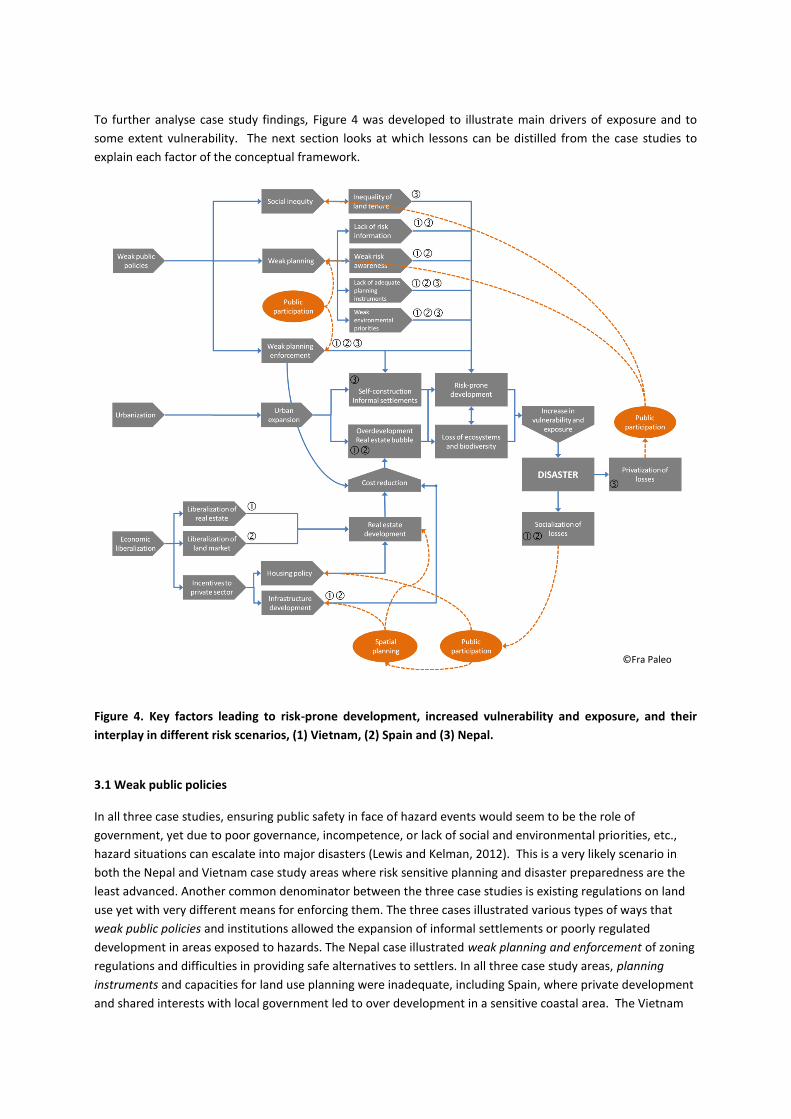
To further analyse case study findings, Figure 4 was developed to illustrate main drivers of exposure and to
some extent vulnerability. The next section looks at which lessons can be distilled from the case studies to
explain each factor of the conceptual framework.
Figure 4. Key factors leading to risk-prone development, increased vulnerability and exposure, and their
interplay in different risk scenarios, (1) Vietnam, (2) Spain and (3) Nepal.
3.1 Weak public policies
In all three case studies, ensuring public safety in face of hazard events would seem to be the role of
government, yet due to poor governance, incompetence, or lack of social and environmental priorities, etc.,
hazard situations can escalate into major disasters (Lewis and Kelman, 2012). This is a very likely scenario in
both the Nepal and Vietnam case study areas where risk sensitive planning and disaster preparedness are the
least advanced. Another common denominator between the three case studies is existing regulations on land
use yet with very different means for enforcing them. The three cases illustrated various types of ways that
weak public policies and institutions allowed the expansion of informal settlements or poorly regulated
development in areas exposed to hazards. The Nepal case illustrated weak planning and enforcement of zoning
regulations and difficulties in providing safe alternatives to settlers. In all three case study areas, planning
instruments and capacities for land use planning were inadequate, including Spain, where private development
and shared interests with local government led to over development in a sensitive coastal area. The Vietnam
©Fra Paleo

case illustrated a ‘middle ground’ example, with higher planning capacities than in Nepal yet not sufficient for
withstanding economic pressures that led to ‘risk-prone development’. All three situations resulted from serial
and incremental investments, a source of major conflict and manifestations of weak or inexistent public risk
reduction policies. In Nepal, the case study also highlighted difficulties facing informal settlements due to poor
access to secure tenure, and a lack of rights to safe places to live, or social inequality. Neighborhoods in
Dharan, Nepal, which could afford it erected their own gabion walls to protect themselves from flooding,
shifting flood risk down the river to those with no means for erecting protection walls. Likewise, public and
private compensation for damages is often insufficient to cover disaster losses, especially in lower income
countries, depending on whether local homeowners and business are able to secure insurance protection.
Insufficient damage compensation then affects the marginalized to a greater extent. These examples are about
transferring risk from the rich to poor, an ethical question that ought to be addressed by governments but is a
common experience found in high- and low-income nations alike.
Finally, weak environmental priorities were observed in all three case studies, but especially in Nepal and
Vietnam where budgets, regulations and enforcement capacities are lacking. Unfortunately the result is a
negative feedback spiral where further environmental degradation then fuels risk. Exceptions include the
development of community forests in Nepal, where government incentives and regulations have provided
capacities to improve forest management. The result has been positive with reduced landslide occurrence and
increased livelihood resources (Jaquet et al., forthcoming).
Weak policies, institutions, and enforcement of land use are only part of the problem. Lack of risk information,
and lack of risk awareness both among authorities and decision makers but also among the public (mainly due
to poor public participation and public information about risk) may contribute substantially to increasing
disaster risks. This is clearly the case in Nepal, where new migrants most often lack adequate knowledge about
flood risks in their newly settled areas as compared to indigenous populations. However, even for indigenous
populations with high risk awareness, there may be little option but to continue living with risk of hazard
events when faced with low food security and economic options (Nathan, 2009; Sudmeier-Rieux, 2011). For
such populations, livelihoods options must be combined with risk reduction activities, making public
participation in DRR projects, or municipal land use plans, a very high priority. It is conceivable that higher
public participation, alongside better enforcement of the water protection area of upper Sardu Watershed of
Dharan would have led to more positive outcomes for both water quality and risk reduction. In Spain, public
participation is part of the land use planning process, as stipulated by law yet due to a poor institutional and
regulatory environment, public input was not channelled in a productive manner and only emerges in case of
conflict.
Yet there is much greater potential for public participation (in Fig. 4 referred to as access to information and
awareness) as a cost-effective and “soft” solution to creating more ownership of the risk reduction process,
especially when combined with a means to adequately follow up on public inputs.
3.2 Urbanization
Population growth partially explains how difficult it is to reduce exposure to disaster risks. The world’s human
population has increased four-fold in the past 100 years and is projected to increase from 7 billion in 2012 to
8.9 billion by 2050 (UNESA, 2004), while the amount of land available for human settlement is assumed to
remain constant or shrink due to sea level rise and coastal erosion. Most of the world’s growth is taking place
in coastal urban areas in southern countries. In 2000, 49% of the world’s population lived in urban areas and
this number is projected to rise to 59% by 2025 (UN Habitat, 2011). The share of urban populations living in
low-elevation coastal zones is expected to rise from 56% to 68% in Asia and from 82% to 90% in South America
(UN Habitat, 2011). Rivers also attract large numbers of people, with an estimated 78% of Europeans living in
an urban area near inland water in 2000, compared to 84% in North America and 71% in South America. All
these figures are expected to rise by 2025 increasing the worldwide trend of urbanization along coasts and

rivers (Biesbroek et al., 2008; Satterthwaite, 2010; UN-Habitat, 2011). Urban growth and sprawl in Vietnam
and Nepal are part of this evolution. Population growth in Spain has tapered off –if we do not consider the
contribution of immigration- yet growth in the tourism industry spawned new constructions until 2007.
Resulting from fast paced economic growth (as in the cases of Vietnam and Spain) or limited rural income
opportunities (as in the case of Nepal) are informal settlements and urban sprawl that often overwhelm the
capacity of local governments to regulate, provide adequate services and safe places in case of hazard events.
Households in informal settlements usually lack legal land tenure, erect houses that are often not able to
withstand hazards and are thus extremely vulnerable to both intensive risk (high impact, infrequent hazard
events) and extensive risk (low impact, frequent hazard events) (O’Donnell, 2011; UNISDR, 2011).
Informal settlements may benefit from access to economic opportunities, transportation, services,
infrastructure and provide low cost labor to the urban economy but receive little to no hazard protection, are
usually not able to insure their homes, nor can they expect much public disaster relief should their homes and
assets be destroyed. Oftentimes newly settled residents in unsafe areas are either not aware of disaster risks,
or more likely, their short-term economic risks are higher than the perceived probability of future hazard
events occurring, as discussed above (Nathan, 2008; Sudmeier-Rieux et al. 2011). Informal settlements are
emblematic of the poverty – disaster nexus and illustrate why investments in poverty reduction should also be
investments toward disaster risk reduction. Following informal settlements is a more organized form of
development through the real estate bubble, which will be discussed in session 3.3 “Economic liberalization”.
Informal and formal settlement patterns, which have tended to follow an expansion of land use with little
planning or regard for local ecological features, have led to various levels of land use pressures, ranging from
real estate developments in the Spain and Vietnam case studies to the informal settlements in the Nepal case
study. For the case studies, these pressures affected a volatile river bed in Nepal, a sensitive coastal area in
Spain and dynamic river delta in Vietnam.
As illustrated in the case studies, urbanization has resulted in environmental degradation, another central
factor leading to extensive risk, highlighted by several influential policy and scientific synthesis documents
(UNISDR, 2011; IPCC, 2012). Environmental degradation actually amplifies risk by a factor of three: first by
increasing the magnitude of hazards (e.g. degraded slopes are more likely to lead to landslides); second,
reduced availability of natural resources amplifies household vulnerabilities; and finally, dangerous areas are
best maintained as ‘green spaces’ where possible, thus reducing exposure. In Nepal, the degraded upper
watershed area, which is not covered by community forests is clearly affecting water quality and supply to the
city, in addition to leading to higher landslide risks. In Spain, disturbed coastal processes, (i.e. sand dune
removal) due to private land development are increasing coastal risks to the ‘A Frouxiera’ community.
The final outcome is risk-prone development, which not only increases exposure but often vulnerability and the
core of disaster creation and the transfer of risk, most often to public spheres and the poor (see section 3.4).
3.3. Economic liberalization
The third major driver of exposure highlighted by the case studies is economic liberalization, especially through
the liberalization of the land markets and recent growth of the real estate industry. This is not just a powerful
economic sector for any country but also involves a complex and interlocked network of players -among them
mortgage finance lenders, large landholders, insurance companies, lobbying organizations, home builders,
apartment owners or residential brokerages (Wong, 2010), with its own specific interests, processes and
expectations. But beyond these major actors, we should neither overlook nor diminish the role of citizens as
land owners, promoters or consumers and, ultimately, decision-makers at a local and large scale. It should be

noted that 87% of households’ wealth in Spain was held in property in the early 2000s, and this proportion
might have increased over the decade (Esteban and Altuzarra, 2008).
The latest real estate bubble in Spain is very illustrative of the interplay of salient forces and factors that have
driven not merely a financial crisis but an important coastal ecological and landscape impact, and presumably
have established the conditions for future localized coastal disasters. The drivers of this escalating demand
were economic growth, employment opportunities and per capita income, and population growth to which in-
migrants contributed notably (Esteban and Altuzarra, 2008). Favorable financial conditions were created with
descending mortgage rates and the influx of foreign capital investment – mostly in coastal real estate - that
peaked in 2004 when it represented 0.91% of GDP, and which responded to “…expectations of substantial
capital gains in an environment of cheap and easy borrowing” (Esteban and Altuzarra, 2008 p 368). But not all
the advantageous conditions for real estate industry were external or neutral, namely house price formation,
building costs and land prices due to the process of liberalization (Esteban and Altuzarra, 2008).
In the case of Spain, liberalization of real estate through the mortgage market played a critical role and acted as
indirect incentives to decreased costs and increased benefits in the housing industry. It was spurred by several
Government acts with the manifested aim of increasing offer and decreasing prices, and decoupling the role of
the developer and the land owner, placing economic interest first without any additional provisions regarding
the environmental and social conditions of land development. The pronounced goals of liberalization were to
return control to the market and dismantle rigidities, leading to a housing boom, land ownership
concentration, rising land prices of over 20% in 2004, and unconstrained availability of land for development
and satisfaction of the ever-increasing demand of housing (Esteban and Altuzarra, 2008).
Finally, incentives to the private sector may actually create more risk than reduce it. In countries with little
insurance coverage, both public and private domains bear the cost of disaster and both are responsible for
creating and reducing it, while where public insurance programmes have been implemented, these may exert
perverse disincentive effects. Since many insurance companies may not be willing to insure homeowners living
in hazard zones, governments may provide them with reinsurance backing, rather than encourage
homeowners to relocate elsewhere or retrofit their houses. For example in Spain, the public insurance
organization (Consorcio de Compensacion de Seguros) provides public backing in case of disaster and, in the
absence of private insurance coverage, will pay for damage losses. This point will be discussed in more detail in
the next section on incentives. Secondly, public policies and relief compensation for disaster losses from
national governments may encourage people to rebuild their homes in the same dangerous places, rather than
move to higher ground or away from coasts (Burby, 1998).
In addition to the pressures coming from the private – liberalized – real estate and development market, local
governments themselves often create new risks and development incentives. This happens particularly through
the development of new infrastructure such as roads, bridges, or dykes all of which can function as incubators
for additional investment and development from within the private market. The case studies hinted (e.g.
Vietnam) to the important fact that such decisions are often driven by individual or collective motivations of
political decision makers with conflicting interests, which might differ quite substantially from sustainable
planning perspectives. As a result, the development of projects, which are not only risk insensitive but often
beyond the needed capacity to manage risks, can in particular be observed in rapidly growing countries like
Vietnam. In that sense, incentives for risk insensitive developments in the private sector are often fueled or
supported by the public sector – which in theory should instead regulate ‘counter-productive’ developments in
the private sector, even in liberalized markets.
As in the case of Spain, the private sector might furthermore receive financial incentives for developing new
projects, which originally had been in state responsibility (such as housing provisions) but are liberalized due to
the above mentioned reforms. Thus, low land prices and perverse market incentives may actually attract more
social housing in hazard prone areas (UNISDR, 2009). However, when risk information is available and the

market is transparent, information on risks can have an impact on housing prices and act to dissuade
development projects in risk prone areas (Bin, Kruse and Landry, 2008; World Bank, 2010).
3.4 Increase in exposure and vulnerability leads to transfers of losses to public and private entities
To conclude this section on drivers of exposure and to some extent, vulnerability, the case studies highlighted
various ways in which disaster risk is created. In all three cases, risk is rooted in individual and collective
decisions about investments in risky development based on differing and often conflicting interests, needs, and
perceptions about risk as compared to public concerns about safety. As reducing risk bears a cost, this cost was
either transferred from private to public actors, or from wealthy to poor households following a path of least
resistance. We can thus consider how disaster losses are transferred in two ways, either as a socialization of
losses or a privatization of losses. Borrowing financial terms, the socialization of losses refers to public
absorption of losses, either leading to losses being passed to tax payers, a redirection of public expenditures
from other areas, or from the international community. This is most often the case in developing countries
where private insurance of private and public property is low. Privatization of losses refers to the absorption of
losses by citizens, private owners, either wealthy or marginalized populations, which are the least likely to have
any type of insurance, nor the savings to recover losses. Figure 5 illustrates the various actors affected by
disaster losses. The three case studies illustrated all various types of actors and losses, from the wealthy
population with property along Spain’s coasts to the marginalized population in Nepal. Figure 5 also illustrates
various processes that exacerbate these transfers of losses, namely (i) business in unsafe locations transferring
losses to both private insurance and governments, (ii) compensation of losses actually creating more risk, (iii)
losses covered by the government, and (iv) transfers of losses from wealthy to poor populations when
mitigation structures are most often erected in rich neighborhoods, transferring the hazard situation
downstream to poor neighbourhoods. The following sections discuss in more detail the various transfers of
risks based on lessons from the case studies.
Figure 1. Diagram of actors and interactions between actors in relation to mitigation options,
compensations and spatial planning
From Local to National Government
In most countries, even when risks are created locally due to poor preparedness, early warning or lack of
planning, the national government becomes ultimately responsible when a major disaster occurs. For example
after the 2011 Mississippi floods, the U.S. Government declared a state of major disaster in numerous counties
©Fra Paleo

in three states, providing federal funding to state and local governments for repairs and relief (CBS/AP, 2011).
In other words, where local government fails to regulate land use, ultimately national authorities, or the
international community become responsible for disaster outcomes and public safety. The same conclusion can
be drawn from all three case studies although there will be obvious differences in the capacities of Nepal,
Vietnam and Spain to ensure public safety and compensate for losses.
The level of de facto and official responsibility for public safety varies for each country and will depend on
several factors including the level of tolerable or acceptable risk a society is willing to assume, expectations on
government roles and economic and technical capacities to address risk. Local government is usually at the
front line of risk reduction as they are responsible for approving development projects and building plans. Yet
they may not have the adequate technical capacity and financial resources and they may be influenced by
competing interests and corruption (Lewis and Kelman, 2012). Expectations on governments for public safety
and risk reduction also vary considerably. We might hypothesize that as countries improve their economic and
governance capacities, they may become more able to take responsibility for public safety. Consider the
tangible differences between our case study countries, Nepal, Spain and Vietnam. In Nepal, remote
communities are almost entirely self-sufficient, with little response and reconstruction assistance expected nor
received from government in case of a hazard event. While in mountainous areas of developed countries,
communities will still be quite self-sufficient but they also expect and will receive government assistance in
case of an emergency.
From Private to Public
Increasing disaster risk emanates not only from small to middle sized low income urban centers, but plagues
high income countries likewise, as reflected in the exponential increase in economic losses due to disasters
over the past two decades (Swiss Re, 2011). This trend is partly explained by relatively weak land use legislation
and enforcement on the one hand, versusstrong economic pressures to develop land even in hazard prone
areas on the other hand. Secondly, whether recognized as a natural resource or as a fundamental component
of landscapes or ecosystems, land undeniably has an associated economic value, particularly in agricultural
systems and urban development. Current –and future- use of land is thus one among the multiple causes and
effects of acquiring a market value. Expectations on future development, zoning and land use regulation are
factors that steer land use change, and the occupation of both non-exposed and hazard-prone areas.
The large amount of private investments, which normally represent a majority of a country’s GDP, implies that
private investments, whether informal settlements or real estate companies are highly impacted by disasters
but also that they are highly responsible for generating risk (UNISDR, 2012). This is true as so often short term
private economic interests supersede long term risk considerations. The private sector therefore shares
responsibility with the public sector for the increase in both intensive and extensive disaster risk. Our case
study examples illustrate a spectrum of private investments which create public risk: from the real estate
development along the environmental coastline in Spain, the development of a master plan for housing and an
industrial park in flood prone Can Tho City, to informal private investments along Sardu Khola River in Dharan,
Nepal.
From Rich to Poor
Most high income countries have invested in risk reduction measures that reduce extensive risks, such as
reoccurring flooding for densely populated areas. However, these measures may protect well-off cities to the
expense of poorer rural areas. Flood management policy in the Mississippi river basin is a good example of
high structural investments to protect cities from annual flooding, with periodic flooding of lowland agricultural
areas during above normal floodwaters. Additionally, Hurricane Katrina demonstrated the short comings of
decades of physical engineering of its river basin, mainly affecting poor populations. Likewise, the exceptional
Thai floods in autumn 2011 following Tropical Storm Nock-ten and heavy monsoon rains were managed to

avoid flooding Bangkok’s wealthy financial center to the expense of its outskirts, affecting Thailand’s
manufacturing industry and angering poor local residents (Bangkok Post, Nov. 28, 2011). Similar lessons were
learned from our case studies: in Nepal, poorer downstream populations are more often flooded due to private
protection measures upstream. In Spain, real estate development for wealthy secondary home owners led to
coastal degradation and increased flooding costs for the entire community.
To summarize the issue of transfer of losses and risks:
• from private home owners and private sector to government (e.g. compensation paid for losses as
described above)
• from wealthy to poor or marginalized populations (as protection is often given to rich first)
• from private owners to insurance companies, and eventually from private to government (when public
backing of insurance as described above)
• from government to private sector individuals and businesses (e.g. when government decisions to
protect certain areas over others lead to uncovered losses)
• from the private sector to individuals when businesses and services provided are located in hazard-
prone areas
This diagram of actors and interactions between actors can certainly be applied to all three case study
countries, although the main difference will be the respective weights of public versus private sectors in
covering disaster losses and taking responsibility for risk reduction: i.e., the role of the insurance industry,
levels of public insurance in providing compensation for losses. In Nepal, the brunt of disaster losses was
carried by private owners, namely businesses and especially marginalized populations, in contrast to Spain
where the government and public insurance assumed a greater financial burden for losses, and thus should
logically have a greater stake in pursuing greater risk reduction measures. Vietnam with a very modest to
burgeoning insurance market illustrated a middle grounds distribution of loss-sharing between public and
private actors.
This next section explores in more detail the different types of incentives for reducing risk, while considering
the many actors and actions involved in bearing responsibility for reducing risk.
4. Solutions for reducing risk
One of the main problems with reducing risk is that it either ends up being paid for by tax payers or
marginalized populations. Thus one important way to reduce risks is to better analyze and reduce such
transfers of risk, and oblige those who create risks to also pay for it. In light of the above discussion, we
examine the legal, financial or market based, and other types of incentives, such as the important role of public
participation for both the public and private domains to reduce risk. However, at times, the three can be
difficult to distinguish as they are often interwoven. Figure 6 illustrates the three main types of policy
instruments for reducing exposure: financial incentives, land use regulation and public participation, an
important, yet often overlooked component of risk reduction. Many of these elements can be generated and
managed through risk sensitive land use planning when accompanied by a strong institutional setting. The
following sections discuss these three policy instruments in more detail.

Figure 2. Interplay of incentives and disincentives in the three studied risk scenarios (1) Vietnam (2)
Spain, (3) Nepal
4.1 Legal incentives and regulations
Regulations regarding land use for DRR would seem to be the most effective way to prevent development in
unsafe locations (Timothy and Earl, 2008). Regulatory measures usually cover two types of measures: location
and design. The goal of the ‘location approach’ to risk reduction is to limit development in hazardous areas,
while the ‘design approach’ is to build safe constructions in safe or in hazardous areas (Burby, 1998; Greiving et
al. 2012). Yet the reality is more complex, as regulations are not always enforced or enforceable, due to lack of
capacities and budgets, as we observed in the Nepal case. In Spain and Vietnam, short term economic interests
superseded existing regulations, not necessarily due to the lack of enforcement capacities but rather due to
weak institutions and possible conflicting interests of local politics. Moreover, even when regulations are
enforceable, new zoning regulations are less likely to be effective for already established settlements, as the
economic and political costs of relocation can be very high, unless residents are forced to relocate due to
frequently occurring hazard events or high probability of an extreme event (Burby, 1998). However, regulations
and land use planning are likely to be more successful for new developments or reconstructions after disasters,
as being planned for reconstruction after the 2011 Japan earthquake, where zoning is to be strictly enforced,
placing green belts by the coast and hospitals and schools further inland (Onishi and Ishiwatari, forthcoming).
Regulations for design of new constructions may also be highly effective, depending on how enforceable
building codes may be. Retrofitting of buildings is often conducted with a combination of regulatory and
©Fra Paleo
financial incentives, such as government or international grants to retrofit schools. These are unfortunately
often not undertaken until the aftermath of a disaster forces retrofitting, under public pressure.
Regulations that have led to positive risk sensitive land use planning for DRR include more recent flooding and
water legislation in Europe: The Water Framework Directive (EC 2000) which recognizes that a structural
approach to flooding cannot completely eliminate flood risk, together with concerns about the environmental
impacts of river engineering. Secondly, after a number of major floods struck Europe between 1998 and 2004,
the EC Flood Directive (EC 2007) was enacted to coordinate flood risk management, especially with regards to
transboundary water issues. It was also an attempt to address major deficiencies reported in the transposition
of the Water Framework Directive into national law. The Flood Directive requires States to undertake flood
hazard and flood risk maps and devise flood risk management plans by 2015 (Llosa and Zodrow, 2011). The
binding nature of this legislation has led many States to revise their national flood legislation and increase their
efforts in this field (Llosa and Zodrow, 2011).
The result of these two EC directives led to a number of country programs, including the Dutch ‘Room for the
River Programme’, which promulgates the use of former agricultural areas, wetlands, peat bogs, and other
natural spaces as reservoirs for excess water (Corvers, 2009). A combination of environmental and economic
arguments, together with legislation on ecosystem based flood management have led to a powerful force for
change in river management practices in recent years and has informed the development of an array of
alternative, ecosystem-based approaches (Wharton and Gilvear, 2006). At the core of these approaches
(ecological design, river restoration and more strategic integrated approaches) is the acceptance that rivers are
meant to flood and must have room to move (Gilvear et al., 1995) a recognition that rivers are dynamic, and
linked to their surrounding floodplain (Wharton and Gilvear, 2006).
4.2 Financial or market based incentives
In the absence of strong institutions for enforcing regulations on land use, financial or market based incentives
could offer persuasive incentives, including government based disaster relief, tax-write offs and insurance
incentives (Jackson, 2011). However, our three case studies did little to illustrate how this could be done in
practice. In Nepal, financial incentives and land were offered to residents to relocate away from a hazard
prone water conservation area, to little avail as residents returned to their original homesteads one year later
due to lack of enforcement capabilities. In Vietnam, forced relocation can take place from flood prone areas to
village clusters built by the local and national authorities although the success of this is sometimes debatable.
In Spain, insurance companies paid for damages to homes, and in case of absence of coverage, a public
reinsurance company pays for the compensations, when a hazard event has been declared a disaster.
As discussed in previous sections, many financial incentives actually translate into perverse incentives for
homeowners to settle in hazard prone areas or dissuade them from relocating elsewhere (Godschalk et al.,
1998). Relief, although often inadequate may lead to complacency as individuals and communities may not be
willing to take necessary steps to reduce their vulnerability to disasters. Relief also does little to dissuade
people from moving back to the same disaster prone location and same construction designs (Burby, 1998).
Tax-write offs for home improvement and disaster losses are common in many Western countries and do not
necessarily carry any clauses requiring improved home design or relocation to disaster safe areas. However,
the potential is great for making them into strong incentives for moving homes and business away from
dangerous places.
Business and home insurance, if regulated, may provide one of the most persuasive financial incentives for
safer construction and locating homes and businesses in safer places (Burby, 1998). If insurance rates increase
in hazard prone areas to the extent that it is no longer financially viable to live in such unsafe places, then

people will move elsewhere. Insurance policies may push for more hazard-proofing, such as blocking low
windows, elevating houses or retrofitting buildings for earthquakes. Yet as mentioned above, as reinsurance is
often difficult for insurance companies to find, governments may back insurance companies or provide
alternative federal protection. U.S. Flood Insurance Program was established in 1968 (Kerjan, 2010) to provide
protection for home owners in hazardous area, who were not able to take out standard flood insurance. This
government program has thus created perverse incentives for staying or settling in flood plains (Kriesel and
Landry, 2004).
Two examples highlight some of the various fundamental problems with disaster insurance.
Insurance coverage may prevent both relocation and investment in mitigation measures (Kerjan, 2010).
”One flood-prone house in Baton Rouge, Louisiana, for example, has received over $200,000 in flood insurance
payments since the owner purchased the dwelling in 1991 for $30,000. Needless to say, the owner has no
interest in relocating the structure to a flood-free site” (Burby, 1999: 253).
“When insurance companies began cancelling policies in Florida following Hurricane Andrew, for example, the
State of Florida instituted a surcharge on property insurance policies to create the Hurricane Catastrophe Fund,
a reinsurance fund for private insurers” (Burby, 1998: 7).
The use of risk transfer mechanisms, such as insurance, that allow for greater private sector participation is still
very limited in developing countries, with a low coverage of only 3% of disaster losses. Insurance coverage in
agriculture is especially low despite the sector’s economic importance in these countries, with premiums
accounting for only 0.01% of GDP (Burby, 1998). Insurance in general has low penetration among lower income
groups due to its lack of affordability. As a result, there is still insufficient experience, though promising, to
clearly demonstrate that insurance for developing countries can be used to better manage risks. Insurance is
generally intended to soften disaster impacts, but may dilute the incentive to prevent, unless the insurance
premium reflects the risk and the prevention measures that the insured must undertake.
Nonetheless, the insurance industry is growing rapidly especially in emerging market economies. And there are
more and more examples, mainly from industrialized countries, that show how insurance tools can be used to
work together with other risk reduction measures and to incentivize such measures. That is, risk reduction
measures can be used as a prerequisite to insurance coverage.
To what extent such preconditions for risk insurance can be tied to improved risk sensitive land use planning
remains an open question. There is a move toward ‘sustainable insurance principles’ to entice insurers to
integrate environmental, social and governance issues into a company’s management and operations,
alongside developing new kinds of risk management products and services (UNEP, 2012). In some cases,
insurers themselves have paid directly for risk reduction through direct investment or lending. For example,
Tokio Marine & Nichido Fire Insurance Co., Ltd., an insurance company, has invested in the protection of
mangrove plantations in Indonesia, Myanmar, the Philippines, and Thailand, which reduce the risk of storm
surges affecting areas further inland; protecting mangroves reduces the risk of losses both to plantations as
well as insured assets inland. Box 1 illustrates further examples of how some insurance companies have been
able to link land use with risk management.

Box 1. Examples of insurers promoting ecosystem-based risk reduction strategies
Promoting reforestation in Spain
The insurance company MAPFRE created an insurance scheme for forest plantations in Spain designed to help owners meet the costs involved in reforestation after a fire. Within the European Union, Spain is the country most exposed to forest fires, experiencing on average the highest surface area affected per year, with 20,000 fires year affecting around 147,000 hectares. The MAPFRE forest insurance policy is to guarantee reforestation after a fire, and in order to receive compensation, MAPFRE’s technical staff must check that reforestation has been undertaken in accordance with the conditions stipulated in the contract. When establishing the insurance premium, MAPFRE takes into account the type of management carried out by the insured plantation, and bonuses are offered to those plantations that adopt an environmentally sustainable management policy.
Restoring rivers to tackle flooding in the UK
The RSA Insurance Group is working together with the Thames River Restoration Trust and World Wide Fund for Nature (WWF) in developing urban river restoration in the London area. River restoration is viewed as one measure for developing low cost, environmentally sustainable flood defences. In the past, rivers in urban settings are often channelized in order to move water as quickly as possible between two points. During periods of intense rainfall, the fast-moving water can create major flooding problems downstream. The project will recreate the natural meander of the Thames River, remove the concrete channels and recreate the floodplain providing more space for water flow. The project aims to investigate whether urban river restoration schemes reduce flood risk in a cost-effective manner.
Source: United Nations Environment Programme’s Finance Initiative (UNEP FI), “Principles for Sustainable
Insurance Initiative” forthcoming
5. Public participation as a key incentive for reducing disaster risks
There are other non-regulatory or market based incentives for reducing risk that can also have a significant
impact on reducing exposure. Where the public has been included to actively partake in the planning process
and in partnership with a broad array of stakeholders there is more opportunity for success in implementation,
since the public’s interests have been incorporated and awareness has been increased (Burby, 2003).
Participation can actually be considered a non-monetary type of incentive perhaps as powerful as regulatory or
financial incentives (Burby, 2003). Public participation in land use planning has become standard in many
countries and even mandatory for new projects through Environmental Impact Assessment (EIA), and Strategic
Environmental Assessment (SEA) processes, which are becoming common instruments for decisions at policy,
plan and program levels (Gupta and Nair, forthcoming). Hence, gaining access to information about future
development and risk reduction plans, the ability to participate in decision making, demand greater public
accountability and offer local knowledge can be very empowering and provide strong incentives to gain
ownership over planning and risk reduction (Burby, 2003; Fordham, 1999; Pearce, 2003). Box 2 provides an
example of an SEA that sought a broad stakeholder involvement for addressing reconstruction plans in
northern Sri Lanka, taking into account disaster risks, development and environmental considerations.
Box 2. Integrated Strategic Environment Assessment for the post-conflict recovery and development in the Northern Province, Sri Lanka The end of over 30 years of internal conflict in Sri Lanka in 2009 provided a complex scenario in planning for the reconstruction and development of the Northern Province. This period was characterized by national government agencies having old data or missing information; competing development and conservation interests; weak coordination amongst conservation, development and regulatory agencies; and a large number of scattered, sector-specific development plans being proposed for the Northern Province. A modified Strategic Environment Assessment or Integrated Strategic Environment Assessment (ISEA) in line with Local Risk Assessment was adopted for guiding development planning in the Northern Province (five districts), starting in November 2009. This process brought over 30 different actors: government agencies, universities, private sector and the general public. It compiled multi-agency data; initiated field generation of missing or required information; and using GIS software, compiled proposed development plans (e.g. for roads, electricity, agriculture, urban settlements, etc) which was then overlaid with environmental baseline data (e.g. forests, coastal lagoons, water resources, cultural heritage sites, etc) as well as hazard information (which did not include updated vulnerability data due to restricted access to many parts of the Northern Province at the time). The purpose was to ensure that future development of the Northern Province is sustainable and resilient to disasters. During the process, which involved intense inter-agency government collaboration and dialogue, land uses for the forest, wildlife, geological and mining were prioritized allowing wild elephant corridors to be kept intact and protecting environmentally sensitive and culturally important areas from development and mining. While releasing low priority forest and wildlife areas for development, some other areas were selected to preserve as conservation areas and to support eco-tourism. Similarly, the proposed resettlement plans and road traces were revisited and optimized based on agency inputs including city plans. Compilation of environmental baseline data with proposed development plans resulted in the creation of an “Opportunity Map”, a key output that highlighted the spatial distribution of areas available for development with minimum environment and disaster constraints. The outputs were shared with local authorities and general public through a series of consultations. While more localized environmental impact assessments may still be required for specific development project, overall the ISEA approach provided a framework for investments, local risk financing (LRF) and sustainable development efforts. Among the critical elements for success were timing, political endorsement at the highest levels, and its multi-stakeholder, inter-agency approach. As a result of the ISEA, a number of infrastructure plans and proposed developments have been improved due to the analysis, and training of planners at national and district levels on the further use of ISEA information is underway. The ISEA approach has been endorsed at the highest level as an approach to be replicated in other provinces. Authors: Ananda Mallawatantri (UNDP Sri Lanka), Damith Chandrasekera (UNDP Sri Lanka) and Buddhi Marambe (University of Peradeniya, Sri Lanka)
The case study from Spain illustrated how local environmental NGOs were able to participate in the planning
process and offer expertise about environmental processes, most likely contributing to improving the balance
between development and coastal environmental and hazard protection, even if the outcome remains
uncertain. It involved so called “third sector” actors, NGOs which can be considered private actors or semi-
public depending on the NGOs (Burby, 1998). There are many examples of such NGO – governmental
partnerships successfully collaborating to guide sustainable regional and community planning from many cities
in North America and Europe (i.e. Chesapeake Bay programme, Charles River Watershed project, Portland City
planning project). In Europe, the Green and Blue Space Adaptation for Urban Areas and Eco Towns (GRABS)
project brings together local authorities, academia and NGOs to facilitate the exchange of knowledge and
experience and the actual transfer of good practice on climate change adaptation strategies to local and
regional authorities (GRABS, 2012).
In the absence of strong institutions or financial incentives, especially in developing countries, it is possible that
such participatory processes combining local, national or international NGOs with local government may be
one of the most promising solutions to more sustainable measures for reducing exposure. In the Dharan
Municipality, although local NGOs were not successful in creating a sustainable solution to water management
problems a strong partnership was created with the municipality that could carry forward future DRR and
water conservation measures. In Spain, environmental NGOs and community based organisations, if working
in a more coherent manner, could act as strong catalysts for promoting more public participation – and
accountability - in risk reduction decisions in spite of weak institutions. In Vietnam public participation in urban
planning is now increasingly promoted by legislative reforms and could act as a strong catalyst to buy-in risk
mitigation measures. However, how far the new policies will in fact be implemented from paper into practice
and how much critical discourse will be allowed in participation processes remains to be seen. A true opening
can currently be only observed at the margins.
6. Opportunities and limitations to risk sensitive planning for reducing exposure
Figure 7, shows various types of investments made in disaster risk reduction as reported by countries to the
HFA Monitor for 2009-2011. We observe a large discrepancy between high and low income countries especially
for investing in urban and land use planning, in spite of its cost-effectiveness (UNISDR, 2011). Reasons for this
divide are discussed throughout this paper: the difficulty in reducing public risks due to weak institutions or
lack of capacities through regulating risk-prone development. Investing in land-use planning requires a long- to
mid-term commitments that are more likely in high versus low income countries. Land use planning, when
backed by strong institutions, could be considered an instrument for negotiating and “equalizing” risks before
they are transferred to marginalized populations or taxpayers.
Figure 7. Countries reporting on investments made in disaster risk
reduction measures, as broken down by income. (UNISDR, 2011)

As argued in this paper, a properly conducted participatory planning process and risk sensitive land use
planning can allow communities to strike a balance between the two, in other words, accepting some risk for
economic gain and vice versa, while utilizing ecosystems for protection and vulnerability reduction (Burby,
1999). Also, zoning, or designating areas for various land use purposes, may be a flexible enough instrument
to accommodate both location to the design approaches, different and changing political preferences and
interests. The three case studies touched upon ways in which this was possible: in Nepal, protection of the
watershed would protect the water supply as well as reduce run-off, in Spain, sand dunes are well known
natural barriers of coastal erosion and storms, in Vietnam, preservation of a flood retention area in a mosaic of
open spaces and lower density development is a possibility. Yet, these options were not utilized fully mainly
due to economic pressures and lack of institutional capacities. Of the three, Spain illustrated the strongest
regulatory framework and capacities to incorporate ecosystem management in risk sensitive planning, mainly
also due to strong local public participation.
However, risk sensitive land use planning will only be as strong as the institutions which lead it, as
demonstrated in all the case studies. In Vietnam, private real estate interests prevailed over regulations due to
weak planning and enforcement mechanisms. In the case of Spain we learned how environmental
considerations at the local scale might have prevented risk-prone development but, in the absence of this
vision in local institutions, higher levels of administration have the political and technical capability to change
the land use provisions. In Nepal, the very weak state of institutions provided a planning vacuum, filled in by
private informal settlements in a dangerous area. Thus, even in the case of Spain, where a planning process
was undertaken, land use planning failed to negotiate or “equalize” risks back to the private sector.
There is hope for risk-sensitive land use planning, which incorporates ecosystem considerations especially
when it includes a broader territorial or regional approach, taking into account the entire physical context
affected by risk (Etkin, 2009; March and Henry, 2007). Land use planning has an overwhelmingly more positive
cost-benefit ratio as compared to approaches such as relocation and retrofitting and mitigation measures for
disaster risk reduction and, naturally, as compared to bear the costs of disaster (Figure 5) (UNISDR, 2012;
Burby, 1998). These three approaches do not exclude each other, yet they need to be combined in order to
respond to specific contexts. Other success factors include fitting land use management programs to the local
context, considering the large difference in regulatory and incentive frameworks in each country (Henstra,
2010).
Admittedly, land use planning is likely to be most successful in areas yet to be developed or facing
reconstruction (Burby, 1998; March and Henry, 2007). Relocation can be extremely difficult to effect due to
costs incurred, not only economic but social costs. Residents are generally unwilling to move unless there are
strong push and pull factors (i.e., high risks vs. compensation, safer location). Finally, there are successful
examples of the provision of safe land to informal settlements for reducing poverty and risk, for example in
Argentina (World Bank, 2010). Finally, perhaps the best way to summarize successful risk sensitive land use
planning is finding the right mix of regulatory, financial and other incentives for guiding urban expansion and
redevelopment to locations that are free of hazards with planning programs that eliminate the possibility of
significant damage (Burby, 1998).
7. Conclusions : potential of risk sensitive land use planning for reducing risks
This paper has responded to the GAR 2013 question: “how do investment decisions in the private sector (in a
context of incentives and regulation by the public sector) increase levels of disaster risk and, in some cases,
transfer risk from private investors to governments and to other sectors of society?”

This paper examined this question through a spectrum of possible solutions, mainly through risk sensitive land
use planning but also financial incentives and public participation in reducing disaster risks. The key barriers to
risk sensitive land use planning can be summed up by the institutional capacities to carry forward plans and
enforce them, the amount of public participation in planning and the amount of political leverage to support
the planning process. Additionally, innovative financial incentives, such as tax incentives and insurance
initiatives to encourage risk sensitive planning are needed, rather than creating perverse incentives for risk-
prone development. This will also require improved collaboration between agencies such as urban and land
use planners, civil protection, environmental management, the private sector and NGOS who work on various
aspects of DRR but rarely in a coordinated manner. Promoting cooperative governance among administrations
can be extremely powerful rather than the command-and-control approaches, that have failed to successfully
implement risk reduction policies (Burby and May, 2009).
Obviously, considering the fast growing pace of many small- to medium cities, as illustrated by our three case
studies, it is clear that exposure and risk cannot be eliminated or drastically reduced through land use planning
alone. Actors in the three case studies have very different levels of capacities and access to land use planning
tools for DRR, which could be used more effectively had they the capacity to reconcile multiple interests and
promote more long term investments in DRR. Hence, this paper concludes that in spite of the multiple land
tenure, political and economic forces, more effective risk reduction is possible through improved planning.
Perhaps one of the strongest arguments in favour of risk sensitive land use planning is its cost-effectiveness,
considering the high costs of structural measures to reducing risk, drawing upon many tools and approaches
from sophisticated to simple. It encompasses comprehensive, coordinated planning at all scales, from national
to local, aiming at an efficient and balanced territorial development. This can include ecosystem management,
an often overlooked element of DRR for reducing hazard magnitude, reducing vulnerability by providing
livelihood resources and even exposure when dangerous areas are used as open spaces.
Finally, we conclude that in order for risk reduction to be successful, a combination of both regulatory and
financial or market based incentives are required to both offer “hard regulations and financial disincentives”.
This includes non-coercive incentives and information about land use planning if it is to become a more viable
part of DRR (Berke, 1998). This will also require better incentives and enforcement of regulations of private
informal settlements and market actions, which are largely causing risk, while encouraging more private actor
responsibility for risk. The case study examples highlighted this point, especially in Vietnam and Nepal, where
incentives other than regulatory ones may be necessary to achieve risk reduction through land use planning.
Ultimately, meeting human needs and improving quality of life are key drivers and the strongest incentives for
change (Fra Paleo, 2009). Yet to achieve these goals, support from NGOs, public and private sectors is needed
to increase the capacities of local and national governments to provide incentives and regulations for the
private sector and to ensure safe places for people to live.
8. References
Asian Development Bank/ICIMOD (2006) Environment Assessment of Nepal: Emerging Issues and Challenges.
Kathmandu.
Bangkok Post (2011) “Residents poised to revolt”, Bangkok Post. 28 November 2011
Bangkok Post (2011) “PM orders new relief as crisis deepens” Bangkok Post. 21 August 2011
Berke, P.R (1998): Reducing Natural Hazard Risks Through State Growth Management, Journal of
the American Planning Association, 64:1, 76-87
Biesbroek, G.R., Swart, R.J, Knaap, W.G.M. van der (2008) The mitigation-adaptation dichotomy and
the role of spatial planning, Habitat International, 33(3), 230–237.
Bin, O., J.B. Kruse, and C.E. Landry (2008) Flood hazards, insurance rates, and amenities: Evidence
from the coastal housing market. Journal of Risk and Insurance 75(1): 63–82.
Brink, M.A. van den; Termeer, C.; Meijerink, S.V. (2010) Climate-proof spatial planning for flood prone
areas. Amsterdam : IVM Institute for Environmental Studies.
Burby, R.J. (1998) Natural Hazards and Land Use. In: Burby, R. (ed.) Cooperating with Nature.
Confronting Natural Hazards with Land-Use Planning for Sustainable Communities.
Washington, D.C., John Henry Press.
Burby, R.J., Beatley, T. Berke, T.R., Deyle, R.E., French, S.P., Godschalk, D.R., Kaiser, E.J., Kartez,J.D.,
May, P.J., Olshansky, R., Paterson, R.G. & R.H. Platt (1999): Unleashing the Power of Planning to
Create Disaster-Resistant Communities, Journal of the American Planning Association,65:3, 247-258
Burby, R.J., R.E. Deyle, D.R. Godschalk, R.B. Olshansky (2000) Creating Hazard Resilient Communities
through Land-Use Planning. Natural Hazards Review 2 (1):99–106.
Burby, R.J. (2003) Making Plans that Matter: Citizen Involvement and Government Action , Journal
of the American Planning Association, 69:1, 33-49
Burby, R. and P.J. May, (2009) Command or Cooperate? Rethinking Traditional Central Governments'
Hazard Mitigation Policies. In Fra Paleo, U. (ed.), Building Safer Communities. Risk
Governance Spatial Planning and Responses to Natural Hazards. Amsterdam: IOS Press. pp. 21-33.
Carew-Reid, J. (2008) Rapid assessment of the extent and impact of sea level rise in Vietnam (Brisbane).
CBS News/ Associated Press (2011) “Rural Louisiana flooded to save New Orleans" (CBS News/Associated
Press) May 14, 2011
Corvers, R. (2009) Vulnerable to Flooding? Nature Development and ‘Room for the River’: A Governance
Perspective. In Fra Paleo, U. (ed.), Building Safer Communities. Risk Governance Spatial Planning and
Responses to Natural Hazards. Amsterdam: IOS Press. pp. 125-136.
Dalda, J. (1968) Estudiofitopatológico de la Laguna de Valdoviño. Botanica Complutensis, 1: 15-50.
Dasgupta, S., Laplante, B., Meisner, C. et al. (2007), ‘The impact of sea level rise on developing countries: A
comparative Analysis’, World Bank Policy Research Working Paper, 4136.
Dharan Municipality (2011). http://www.dharan.gov.np/english/default.asp. Accessed July 1, 2011.
Dudley, N., S. Stolton, A. Belokurov, L. Krueger, N. Lopoukhine, K. MacKinnon, T. Sandwith & N.
Sekhran. (2010) Natural Solutions, Protected areas helping people cope with climate change. Gland,
Switzerland, Washington DC and New York, USA: IUCN-WCPA, TNC, UNDP, WCS,The World Bank,
WWF.
European Commission (EC).(2000) Directive 2000/60/EC of the European Parliament and of the
Council of 23 October 2000 establishing a framework for Community action in the field of water policy.
(Directive 2000/60/EC). European Commission. Brussels. Belgium.
European Commission (EC)(2007) Directive 2007/60/EC of the European Parliament and of the Council of 23
October 2007 on the assessment and management of flood risks. (Directive 2007/60/EC). European
Commission, Brussels. Belgium.
Esteban, M. and A. Altuzarra (2008) A model of the Spanish housing market. Journal of Post Keynesian
Economics 30(3), 353–373.
Etkin, D. (2009) Patterns of Risk: Spatial Planning as a Strategy for the Mitigation of Risk from Natural
Hazards. In Fra Paleo, U. (ed.). Spatial Planning as a Strategy for the Mitigation of Risk from. Natural
Hazards. Amsterdam: IOS Press. pp. 44-60.
Fordham, M. (1999) Participatory planning for flood mitigation: models and approaches. Australian
Journal of Emergency Management. 13(4) 27–34.
Fra Paleo, U. (2009) “On exposure to natural hazards: Revisiting a neglected primal action”. In U.
Fra Paleo (ed.), Building Safer Communities. Risk Governance Spatial Planning and Responses to
Natural Hazards. Amsterdam: IOS Press. pp. 61-78.
Garschagen , M. (2010) Potential Humanitarian Crises and Climate Change Adaptation in the Coupled Social-
Ecological Systems of the Mekong Delta – The Need for Rethinking Concepts and Policies, Vietnam. In:
Shen, X.; Downing, T.E.; Hamza, M. (Eds.): Tipping Points in Humanitarian Crises: From Hot Spots to Hot
Systems. SOURCE No.13/2010. pp. 45-55.
Garschagen, M., Renaud, F. G., and Birkmann, J. (2011) ‘Dynamic resilience of peri-urban agriculturalists in the
Mekong Delta under pressures of socio-economic transformation and climate change’, in M. A.
Stewart and P. A. Coclanis (eds.), Environmental Change and Agricultural Sustainability in the Mekong
Delta (New York: Springer), 141–63.
Garschagen, M., Revilla Diez, J., Nhan, D. K. et al. (2012) ‘Socio-Economic Development in the Mekong Delta:
Between the Prospects for Progress and the Realms of Reality’, in F. G. Renaud and C. Kuenzer (eds.),
The Mekong Delta system. Interdisciplinary analyses of a river delta (Dordrecht ;, New York: Springer),
83–132.
Gilvear, D., Maitland, P., Peterkin, G. and Hanley, N. (1995) “Wild Rivers”. Report to WWF (Scotland), 63 pp.
Godshalk, D.R., Kaiser, E.J. and P. Berke (1998) “Integrating Hazard Mitigation and Local Land Use Planning. In:
Burby, R.J. 1998. Natural Hazards and Land Use”pp. 85-118. In: Burby, R. (ed.) Cooperating with
Nature. Confronting Natural Hazards with Land-Use Planning for Sustainable Communities.
Washington, D.C., John Henry Press.
GRABS (2012). Green and Blue Space Adaptation for Urban Areas and Eco towns
http://www.grabs-eu.org/about.php (retrieved September 3, 2012)
Greiving, S., Fleishhauer, M and S. Wanczura (2006) Management of Natural Hazards in Europe: The Role of
Spatial Planning in Selected EU Member States, Journal of Environmental Planning and Management,
Vol. 49, No. 5, 739 – 757
Greiving, S., Pratzler-Wanczura,S. Sapountzaki, K., Ferri, F., Grifoni,P., Firus, K., and G. Xanthopoulos (2012)
Linking the actors and policies throughout the disaster management cycle by “Agreement on
Objectives” – a new output-oriented management approach Nat. Hazards Earth Syst. Sci., 12, 1085–
1107,
GSO [General Statistics Office Vietnam] (2010) The 2009 Vietnam Population and Housing Census (Hanoi).
Gupta, A.K. and S.S Nair (forthcoming) Applying EIA and SEA in Disaster Management, In: Renaud, F.G.,
Sudmeier-Rieux, K. and M. Estrella. The Role of Ecosystems in Disaster Risk Reduction, Tokyo: United
Nations University Press
Henstra, D. (2010) Evaluating Local Government Emergency Management Programs: What
Framework Should Public Managers Adopt? Public Administration Review, 70: 236–246.
IPCC [Intergovernmental Panel on Climate Change](2012) Managing the Risks of Extreme Events and Disasters
to Advance Climate Change Adaptation. A Special Report of Working Groups I and II of the
Intergovernmental Panel on Climate Change eds. C. B. Field, V. Barros, T. F. Stocker, D. Qin, D. J.
Dokken, K. L. Ebi, M. D. Mastrandrea, K. J. Mach, G.-K. Plattner, S. K. Allen, M. Tignor & M. P.M., 582
pp. Cambridge, UK, and New York, NY, USA.
IUCN [International Union for Conservation of Nature](2011) Integrated Watershed Conservation and
Management Plan: Sardu Watershed, Dharan, Sunsari, Nepal. Kathmandu: International Union for
Conservation of Nature. 158.pp, January 2011
Jackson, D. (2011) Effective Financial Mechanisms at the national and local level for Disaster Risk Reduction
United Nations Capital Development Fund, 29pp.

Jaquet, S., K. Sudmeier-Rieux, M. Jaboyedoff & M.-H. Derron (forthcoming) Forest trends, landslides community and forests in Dolakha district, Central Nepal. In The role of ecosystems in disaster risk reduction, eds. F. Renaud, K. Sudmeier-Rieux & M. Estrella. Bonn: United Nations University Press.
Johnson, C. (2011) Creating an enabling environment for reducing disaster risk: Recent experience of
regulatory frameworks for land, planning and building in low and middle-income countries. GAR 2011
Background paper, Geneva: UNISDR. 44pp.
Kazmierczak, A. and Carter J. (2010) Adaptation to climate change using green and blue
infrastructure, a database of case studies. Manchester: University of Manchester.
Kerjan, M.E. (2010) Catastrophe Economics. The National Flood Insurance Program. Journal of
Economic Perspectives, 24(4): 165-186.
Kriesel, W. and C. Landry (2004) Participation in the National Flood Insurance Program: An Empirical
Analysis of Coastal Properties. The Journal of Risk and Insurance 71: 405-420
Kousky, C. (2010) Using Natural Capital to Reduce Disaster Risk, Journal of Natural Resources Policy Research,
2:4, 343-356
Lewis, J. and I. Kelman, I. (2012) The Good, The Bad and The Ugly: Disaster Risk Reduction (DRR) Versus
Disaster Risk Creation (DRC). PLoS currents Disasters. June 21, 2012
Llosa, S. and Zodrow, I. (2011) Disaster Risk Reduction legislation as a basis for effective adaptation.
Background paper to the UNISDR Global Assessment Report, 2011. UNISDR, Geneva, Switzerland.
18pp.
March, A. and S. Henry. (2007) A better future from imagining the worst: land use planning & training
responses to natural disaster, Australian Journal of Emergency Management 22(3): 17-22.
MONRE [Ministry of Natural Resources and the Environment] (2009), Climate Change Sea Level Rise Scenarios
for Vietnam (Hanoi).
Nathan, F. (2008) Risk perception risk management and vulnerability to landslides in the hill slopes in the city of
La Paz, Bolivia. A preliminary statement. Disasters, 32, 337−357.
NSET [National Society for Earthquake Techology, Nepal] (2011).
http://www.nset.org.np/nset/php/EAP_Dharan_.php. Website accessed July 1, 2011
New York City (2011) Green Infrastructure Plan.
http://www.nyc.gov/html/dep/pdf/green_infrastructure/NYCGreenInfrastructurePlan_ExecutiveSummary.pdf
Website accessed January 3, 2011.
Olson, R.S., Sarmiento, J.P. and G. Hoberman, (2011) Establishing public accountability, speaking truth to
power and inducing political will for disaster risk reduction: `Ocho Rios + 25’; 10 (2011) 59–68
Onishi, T. and M. Ishiwatari (forthcoming) “Lessons from Tsunami Stricken Area on Reconstructing Safer
Communities”. In World Bank (forthcoming) Learning from Mega-Disasters, Washington, D.C.: World
Bank
Pearce L. (2003) Disaster management and community planning, and public participation: How to
achieve sustainable hazard mitigation. Natural Hazards, 28, 211-228.
PC CTC [People's Committee of Can Tho City] (2010), Can Tho City Climate Change Resilience Plan: English
Synthesis Report (Can Tho City).
Renaud, F.G., Sudmeier-Rieux, K. and M. Estrella (forthcoming) The Role of Ecosystems in Disaster Risk
Reduction, Tokyo: United Nations University Press
Satterthwaite, D. (2010) “Avoiding the urbanization of disasters”, in IFRC, World Disasters Report
2010: Focus on urban risk, Geneva: International Federation of Red Cross and Red Crescent Societies,
pp. 10-29.
Sen, A. (1982) Poverty and Famines : An Essay on Entitlements and Deprivation. Oxford: Clarendon Press. SRV [Socialist Republic of Vietnam], Decision on approving the master plan on construction of Can Tho City up
to 2025, Decision of the Prime Minister: 207/2006/QD-TTg.
Storch, H., and Downes, N. K. (2011), ‘A scenario-based approach to assess Ho Chi Minh City’s urban
development strategies against the impact of climate change’, Cities, 28/6: 517–526.
Sudmeier-Rieux, K., S. Jaquet, M.-H. Derron, M. Jaboyedoff & S. Devkota (2011) A Case Study of Landslides and
Coping Strategies in Two Villages of Central-Eastern Nepal. Journal of Applied Geography 32, 680-690.
Sudmeier-Rieux, K., J.-C. Gaillard, S. Sharma , M. Jaboyedoff & J. Dubois (2012) Floods, landslides and adapting
to climate change in Nepal: What role for climate change models?. In Climate Change Modeling for
Local Adaptation in the Hindu Kush-Himalayan Region, eds. A. Lamadrid & I. Kelman. Bingley: Emerald
Books.
Suisse Re. 2011. Natural catastrophes and man-made disasters in 2010: a year of devastating and costly events.
Sigma no. 1, 2011. Zurich: Swiss Re, 40pp.
Thomas, L. and Minder, R. (2012) Cost of Spain’s Housing Bust Could Force a Bailout. The New York
Times, April 24, 2012. http://www.nytimes.com/2012/04/25/business/global/cost-of-spains-housing-
bust-could-force-a-bailout.html?pagewanted=all
Timothy S., and B.J. Earl (2008) The Proof of the Planning is in the Platting: An Evaluation of.
Florida's Hurricane Exposure Mitigation Planning Mandate. Journal of American Planning Association
74(3):349 – 370
UN-HABITAT [United Nations Human Settlements Programme](2011) Cities and Climate
Change: Global Report on Human Settlements 2011. Washington, D.C.: Earthscan.
http://www.unhabitat.org/grhs/2011
UNESA [United Nations Economic and Social Affairs] (2004) World Population to 2300
ST/ESA/SER.A/236. New York: United Nations. 240 pp.
UNEP [United Nations Environment Programme] Principles for Sustainable Insurance, A global sustainability
framework and initiative of the United Nations Environment Programme Finance Initiative: UNEP,
Geneva, 9pp.
UNISDR [United Nations International Strategy for Disaster Reduction] (2011) Global Assessment
Report, Revealing Risk, Redefining Development. Geneva: United Nations. 178 pp.
UNISDR [United Nations International Strategy for Disaster Reduction] (2012)
Background Note: GAR13 call for papers, 7p.
Wharton, G. and D. Gilvear (2006) River restoration in the UK: Meeting the dual needs of the European Union
Water Framework Directive and flood defence? Intl. J. River Basin Management Vol. 4, No. 4 (2006),
pp. 1–12
Wisner, B., P. Blaikie, T. Cannon & I. Davis (2004) At Risk, Natural Hazards, People’s Vulnerability and Disasters. London and New York: Routledge.
Wong, V. (2010) The 50 Most Powerful People in U.S. Real Estate. Bloomberg Business Week. 23/03/2010.
Available at http://www.businessweek.com/lifestyle/content/mar2010/bw20100323_425446.htm
World Bank (2010) Convenient solutions to an inconvenient truth: ecosystem-based approaches to climate
change. Washington, D.C.: The World Bank.
World Bank (2010) Natural Hazards, UnNatural Disasters. The Economics of Effective Prevention; Washington
D.C.: The World Bank and The United Nations.