Embed Size (px)
Citation preview
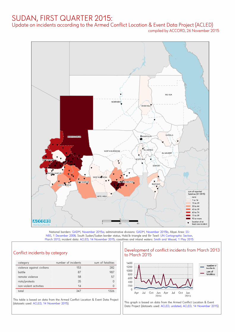
SUDAN, FIRST QUARTER 2015:Update on incidents according to the Armed Conflict Location & Event Data Project (ACLED)
compiled by ACCORD, 26 November 2015
National borders: GADM, November 2015a; administrative divisions: GADM, November 2015b; Abyei Area: SS-NBS, 1 December 2008; South Sudan/Sudan border status, Hala’ib triangle and Bir Tawil: UN Cartographic Section,March 2012; incident data: ACLED, 14 November 2015; coastlines and inland waters: Smith and Wessel, 1 May 2015
Conflict incidents by category
category number of incidents sum of fatalities
violence against civilians 153 282
battle 87 987
remote violence 58 57
riots/protests 35 0
non-violent activities 14 0
total 347 1326
This table is based on data from the Armed Conflict Location & Event Data Project(datasets used: ACLED, 14 November 2015).
Development of conflict incidents from March 2013to March 2015
This graph is based on data from the Armed Conflict Location & EventData Project (datasets used: ACLED, undated, ACLED, 14 November 2015).
SUDAN, FIRST QUARTER 2015: UPDATE ON INCIDENTS ACCORDING TO THE ARMED CONFLICT LOCATION & EVENTDATA PROJECT (ACLED) COMPILED BY ACCORD, 26 NOVEMBER 2015
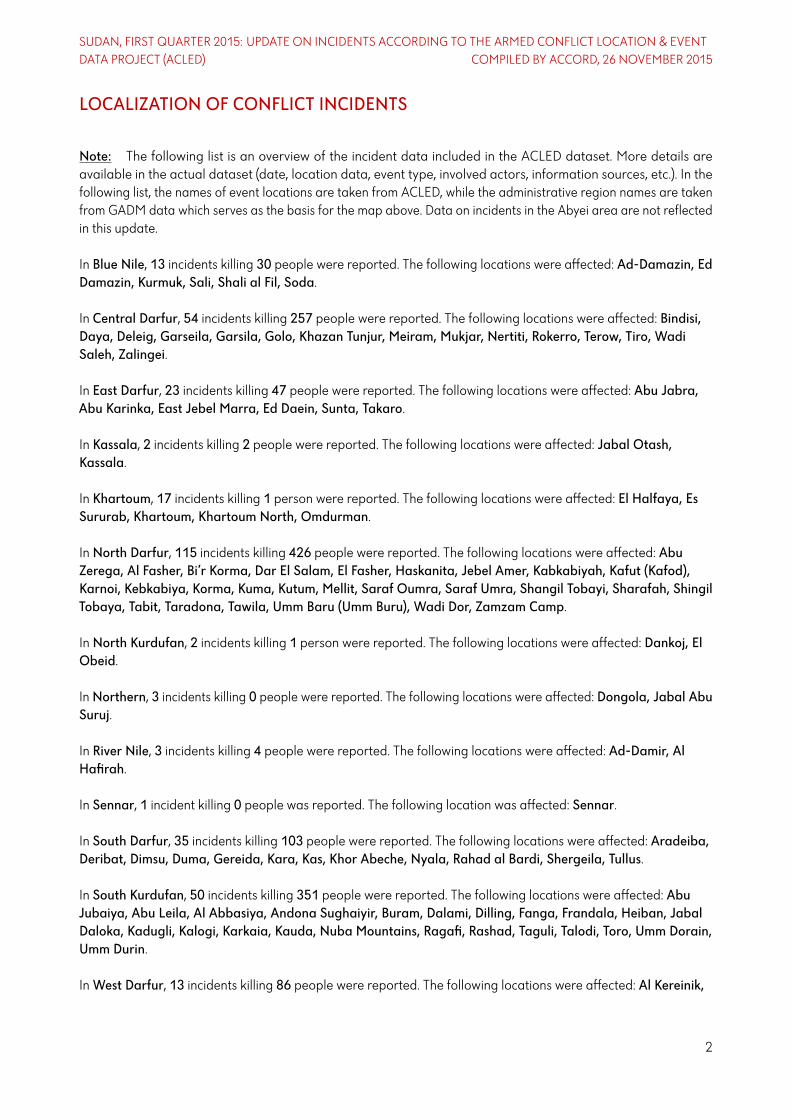
LOCALIZATION OF CONFLICT INCIDENTS
Note: The following list is an overview of the incident data included in the ACLED dataset. More details areavailable in the actual dataset (date, location data, event type, involved actors, information sources, etc.). In thefollowing list, the names of event locations are taken from ACLED, while the administrative region names are takenfrom GADM data which serves as the basis for the map above. Data on incidents in the Abyei area are not reflectedin this update.
In Blue Nile, 13 incidents killing 30 people were reported. The following locations were affected: Ad-Damazin, EdDamazin, Kurmuk, Sali, Shali al Fil, Soda.
In Central Darfur, 54 incidents killing 257 people were reported. The following locations were affected: Bindisi,Daya, Deleig, Garseila, Garsila, Golo, Khazan Tunjur, Meiram, Mukjar, Nertiti, Rokerro, Terow, Tiro, WadiSaleh, Zalingei.
In East Darfur, 23 incidents killing 47 people were reported. The following locations were affected: Abu Jabra,Abu Karinka, East Jebel Marra, Ed Daein, Sunta, Takaro.
In Kassala, 2 incidents killing 2 people were reported. The following locations were affected: Jabal Otash,Kassala.
In Khartoum, 17 incidents killing 1 person were reported. The following locations were affected: El Halfaya, EsSururab, Khartoum, Khartoum North, Omdurman.
InNorth Darfur, 115 incidents killing 426 people were reported. The following locations were affected: AbuZerega, Al Fasher, Bi’r Korma, Dar El Salam, El Fasher, Haskanita, Jebel Amer, Kabkabiyah, Kafut (Kafod),Karnoi, Kebkabiya, Korma, Kuma, Kutum, Mellit, Saraf Oumra, Saraf Umra, Shangil Tobayi, Sharafah, ShingilTobaya, Tabit, Taradona, Tawila, Umm Baru (Umm Buru), Wadi Dor, Zamzam Camp.
InNorth Kurdufan, 2 incidents killing 1 person were reported. The following locations were affected: Dankoj, ElObeid.
InNorthern, 3 incidents killing 0 people were reported. The following locations were affected: Dongola, Jabal AbuSuruj.
In River Nile, 3 incidents killing 4 people were reported. The following locations were affected: Ad-Damir, AlHafirah.
In Sennar, 1 incident killing 0 people was reported. The following location was affected: Sennar.
In South Darfur, 35 incidents killing 103 people were reported. The following locations were affected: Aradeiba,Deribat, Dimsu, Duma, Gereida, Kara, Kas, Khor Abeche, Nyala, Rahad al Bardi, Shergeila, Tullus.
In South Kurdufan, 50 incidents killing 351 people were reported. The following locations were affected: AbuJubaiya, Abu Leila, Al Abbasiya, Andona Sughaiyir, Buram, Dalami, Dilling, Fanga, Frandala, Heiban, JabalDaloka, Kadugli, Kalogi, Karkaia, Kauda, Nuba Mountains, Ragafi, Rashad, Taguli, Talodi, Toro, Umm Dorain,Umm Durin.
InWest Darfur, 13 incidents killing 86 people were reported. The following locations were affected: Al Kereinik,
2

SUDAN, FIRST QUARTER 2015: UPDATE ON INCIDENTS ACCORDING TO THE ARMED CONFLICT LOCATION & EVENTDATA PROJECT (ACLED) COMPILED BY ACCORD, 26 NOVEMBER 2015
Bardani, El Geneina, Forobaranga (Foro Burunga), Habila, Jabal Sirba, Murnei.
InWest Kurdufan, 12 incidents killing 17 people were reported. The following locations were affected: Adila,Al-Fulah, Dabbat, Dibab, Heglig, Lagawa.
InWhite Nile, 4 incidents killing 1 person were reported. The following locations were affected: Ed Dueim, Hashaba,Kosti.
3
SUDAN, FIRST QUARTER 2015: UPDATE ON INCIDENTS ACCORDING TO THE ARMED CONFLICT LOCATION & EVENTDATA PROJECT (ACLED) COMPILED BY ACCORD, 26 NOVEMBER 2015
METHODOLOGY
The data used in this report was collected by the Armed Conflict Location & Event Data Project (ACLED). ACLEDcollects data on reported conflict events in selected African and Asian countries, Sudan being among them. ACLEDresearchers collect event data from a variety of sources and code them by date, location, agent, and event type. Forfurther details on ACLED and for the full data, see www.acleddata.com und Raleigh; Linke; Hegre, and Karlsen,2010.
Based on these data, the Austrian Centre for Country of Origin & Asylum Research and Documentation (ACCORD)compiles updates on conflict incidents.
Incidents comprise the following categories: battle, headquarters or base established, non-violent activity by aconflict actor, riots/protests, violence against civilians, non-violent transfer of territory, remote violence. For detailson these categories, please see
• ACLED – Armed Conflict Location & Event Data Project: Codebook, 2015http://www.acleddata.com/wp-content/uploads/2015/01/ACLED_Codebook_2015.pdf
• ACLED – Armed Conflict Location & Event Data Project: User Guide, January 2015http://www.acleddata.com/wp-content/uploads/2015/01/ACLED_User-Guide_2015.pdf
SOURCES
• ACLED – Armed Conflict Location & Event Data Project: ACLED Version 5 (1997 – 2014) standard file,undatedhttp : //www.acleddata .com/wp- content/uploads/2015/06/ACLED-Version- 5- All - Africa- 1997-2014_dyadic_Update.xlsx
• ACLED – Armed Conflict Location & Event Data Project: Realtime 2015 All Africa File, 14 November 2015http://www.acleddata.com/wp-content/uploads/2015/11/ACLED-All-Africa-File_20150101- to-20151114.xlsx
• GADM – Global Administrative Areas: gadm28_levels.shp, Version 2.8, November 2015ahttp://biogeo.ucdavis.edu/data/gadm2.8/gadm28_levels.shp.zip
• GADM – Global Administrative Areas: SDN_adm.zip, Version 2.8, November 2015bhttp://biogeo.ucdavis.edu/data/gadm2.8/shp/SDN_adm.zip
• Raleigh, Clionadh; Linke, Andrew; Hegre, Håvard, and Karlsen, Joakim: Introducing ACLED-Armed ConflictLocation and Event Data, In: Journal of Peace Research, 47(5), p. 651–660, 2010http://jpr.sagepub.com/content/47/5/651.full.pdf+html
• Smith,Walter H. F. andWessel, Paul: Global Self-consistent Hierarchical High-resolution Geography (GSHHG),Version 2.3.4, 1 May 2015https://www.ngdc.noaa.gov/mgg/shorelines/data/gshhg/latest/
4
SUDAN, FIRST QUARTER 2015: UPDATE ON INCIDENTS ACCORDING TO THE ARMED CONFLICT LOCATION & EVENTDATA PROJECT (ACLED) COMPILED BY ACCORD, 26 NOVEMBER 2015
• SSNBS – South Sudan National Bureau of Statistics: Counties including disputed Abyei region, 1 December2008https ://www.humanitarianresponse . info/sites/www.humanitarianresponse . info/files/datasets/SS_admbnda_adm2_200k_ssnbs_2013_0.zip
• UN Cartographic Section: Sudan, March 2012http://www.ecoi.net/file_upload/4232_1407158723_sudan.pdf
DISCLAIMER
Most of the data collected by ACLED is gathered based on publicly available, secondary reports. It may thereforeunderestimate the volume of events. Fatality data particularly is vulnerable to bias and inaccurate reporting, andACLED uses the most conservative estimate available. Furthermore, event data may be revised or complemented infuture updates. The lack of information on an event in this report does not permit the inference that it did not takeplace. The boundaries and names displayed do not imply endorsement or acceptance by the Austrian Red Cross.
Cite as
• ACCORD – Austrian Centre for Country of Origin & Asylum Research and Documentation: Sudan, firstquarter 2015: Update on incidents according to the Armed Conflict Location & Event Data Project (ACLED),26 November 2015
5