Embed Size (px)
Citation preview
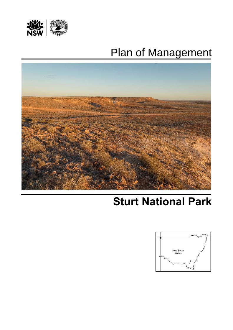
Plan of Management
Sturt National Park
ii
© 2018 State of NSW and the Office of Environment and Heritage
With the exception of photographs, the State of NSW and the Office of Environment and Heritage (OEH) are pleased to allow this material to be reproduced in whole or in part for educational and non-commercial use, provided the meaning is unchanged and its source, publisher and authorship are acknowledged. Specific permission is required for the reproduction of photographs.
OEH has compiled this publication in good faith, exercising all due care and attention. No representation is made about the accuracy, completeness or suitability of the information in this publication for any particular purpose. OEH shall not be liable for any damage that may occur to any person or organisation taking action or not on the basis of this publication.
All content in this publication is owned by OEH and is protected by Crown Copyright. It is licensed under
the Creative Commons Attribution 4.0 International (CC BY 4.0) , subject to the exemptions contained in
the licence. The legal code for the licence is available at Creative Commons . OEH asserts the right to be attributed as author of the original material in the following manner: © State of New South Wales and Office of Environment and Heritage 2018.
This plan of management was adopted by the Minister for the Environment on 23 January 2018.
Acknowledgments
OEH acknowledges that Sturt is in the traditional Country of the Wangkumara and Malyangapa people.
This plan of management was prepared by staff of the NSW National Parks and Wildlife Service (NPWS), part of OEH. For additional information or any enquiries about this plan of management or Sturt, contact the NPWS Tibooburra Office in Briscoe Street, Tibooburra, NSW 2880 or by telephone on (08) 8091 3308.
Front cover: View from Jump-up Lookout, Sturt National Park. Photo credit: D Haskard, NPWS.
Published by:
Office of Environment and Heritage 59–61 Goulburn Street, Sydney NSW 2000 PO Box A290, Sydney South NSW 1232
Phone: (02) 9995 5000 (switchboard) Phone: 131 555 (environment information and publications requests) Phone: 1300 361 967 (national parks, climate change and energy efficiency information and publications requests) Fax: (02) 9995 5999 TTY: (02) 9211 4723 Email: [email protected] Website: www.environment.nsw.gov.au
Report pollution and environmental incidents: Environment Line: 131 555 (NSW only) or [email protected]
See also www.environment.nsw.gov.au/pollution
ISBN 978-1-76039-991-7 OEH 2018/0081
Sturt National Park Plan of Management, January 2018
This plan has been printed on recycled paper

iii

iv
Blank page

v
Contents
1. INTRODUCTION .......................................................................................................... 1
1.1 Location, reservation and regional setting ........................................................... 1
1.2 Statement of significance..................................................................................... 2
2. MANAGEMENT CONTEXT .......................................................................................... 4
2.1 Legislative and policy framework ......................................................................... 4
2.2 Management purposes and principles ................................................................. 4
2.3 Specific management directions .......................................................................... 5
3. VALUES ....................................................................................................................... 6
3.1 Geology, landscape and hydrology ...................................................................... 6
3.2 Native plants and animals.................................................................................. 10
3.3 Aboriginal connections to Country ..................................................................... 20
3.4 Historic heritage ................................................................................................ 23
3.5 Visitor use ......................................................................................................... 28
3.6 Information, education and research ................................................................. 40
4. THREATS................................................................................................................... 43
4.1 Pests ................................................................................................................. 43
4.2 Fire .................................................................................................................... 48
4.3 Climate change ................................................................................................. 49
4.4 Traversing the park with stock and domestic animals ........................................ 51
5. MANAGEMENT OPERATIONS AND OTHER USES ................................................. 53
5.1 NPWS management facilities and operations .................................................... 53
5.2 Non-NPWS access and operations ................................................................... 58
6. IMPLEMENTATION .................................................................................................... 61
REFERENCES .................................................................................................................... 67

vi
TABLES
Table 1: Threatened and significant native plant species recorded or predicted to occur in Sturt .......................................................................................................... 13
Table 2: Threatened and significant native animal species recorded in Sturt ....................... 14
Table 3: Visitor experiences and facilities ............................................................................ 30
Table 4: Walking opportunities in Sturt ................................................................................ 33
Table 5: Weeds and pest animals recorded in Sturt ............................................................. 43
Table 6: Far West Region climate change snapshot ............................................................ 49
Table 7: List of management responses .............................................................................. 61
FIGURES
Figure 1: Fort Grey visitor precinct and Lake Pinaroo ............................................................ 8
Figure 2: Dead Horse Gully visitor precinct .......................................................................... 37
Figure 3: Mount Wood visitor precinct .................................................................................. 38
Figure 4: Olive Downs visitor precinct .................................................................................. 39
Figure 5: Sturt location map .......................................................................... inside back cover

1
1. Introduction
1.1 Location, reservation and regional setting
Features Description
Sturt National Park
Location Sturt National Park (also referred to as ‘Sturt’ or ‘the park’ in this plan) is located in the far north-west corner of New South Wales, approximately 330 kilometres north of Broken Hill and 400 kilometres west of Bourke (see Figure 5 inside back cover). The park extends to the north, east and west of the town of Tibooburra (population fluctuating between 85 and about 150 people) and is bordered by Queensland to the north and South Australia to the west.
The park was named after Charles Sturt, the first recorded non-Aboriginal person to explore this region.
Area The reserved area of Sturt National Park totals 325,329 hectares.
The park also includes unreserved land known as the Warratta Paddock, which is vested in the Minister under Part 11 of the National Parks and Wildlife Act 1974. This land comprises 12,391 hectares and is leased for the purpose of grazing.
Reservation date The first section of the park was reserved in 1972. It has been progressively added to since.
Previous tenure Sturt was formed from six former Western Lands leases (or parts thereof) issued under the Western Lands Act 1901 in the Western Division of New South Wales. These were Fort Grey, Binerah Downs, Olive Downs, Mount King, Whitta Brinnah and Mount Wood, and were acquired progressively since 1968. Although Whitta Brinnah has been managed as park since the initial reservation, it was not reserved until the expiry of mineral and mining interests in 2003.
Regional context
Biogeographic region
Sturt lies across two bioregions (Thackway & Cresswell 1995):
• the Simpson–Strzelecki Dunefields Bioregion in the west and north-west of the park (approximately 40% by area)
• the Channel Country Bioregion in the central and eastern sections of the park (approximately 60% by area).

2
Features Description
Surrounding land use
At its main entrance from the south, the park abuts the town common of Tibooburra which is managed by the Tibooburra Common Trust under the Commons Management Act 1989.
On its NSW borders, Sturt is surrounded by sheep and cattle grazing on Western Lands leases. Pastoral land in South Australia and Queensland is separated from the park by the Dog Fence (or Dingo Fence) constructed during the 1880s. Two Crown reserves associated with Charles Sturt’s exploration, which are also managed by the National Parks and Wildlife Service (NPWS), adjoin the Part 11 land. Sturts Cairn reserve is 129.5 hectares and Pooles Grave reserve is 0.4 hectares.
The nearest NSW parks are Nocoleche Nature Reserve to the east, Mutawintji National Park to the south, and Paroo-Darling National Park to the south-east, all approximately 270 kilometres away. Currawinya National Park lies to the north in Queensland.
Sturt is located within the Unincorporated Far West Region of New South Wales, which means it is not part of any local government area.
Other authorities Authorities relevant to the park are Western Local Land Services and Tibooburra Local Aboriginal Land Council.
1.2 Statement of significance
Lake Pinaroo, in the west of the park, has international significance as a wetland listed under the Ramsar Convention on Wetlands of International Significance (UNESCO 1971). Sturt is also of national significance for its landscape and geological, biological, cultural and research values. It is listed on the non-statutory archive of the Australian Heritage Database (formerly known as the Register of the National Estate) for its natural heritage values. The park is also of state and regional significance for its Aboriginal heritage, historic heritage, recreation and tourism values. These significant values include:
Landscape, geological and catchment values:
• location at Cameron Corner in Central Australia at the junction of the boundaries of New South Wales, Queensland, and South Australia
• a diversity of striking landscapes that typify outback Australia, such as the asymmetric ridges and hills of the Jump-up country, the gibber plains of the eastern park and the extensive red linear sand dunes in the west; the combination of these landscapes is not represented in other NSW parks
• the only conservation area in New South Wales that includes sections of the Lake Eyre drainage basin
• Lake Pinaroo (Fort Grey Basin), is part of the Lake Eyre drainage system, one of the largest systems in the world. The lake is listed as a wetland of international significance under the Convention on Wetlands, and is the largest terminal basin in the NSW dunefields. When full, the lake and other ephemeral wetlands provide valuable breeding habitat for migratory birds
• low hills of 400-million year-old granodiorite outcrops and tors known as The Granites, which surround the township of Tibooburra.

3
Biological values:
• the largest park in the arid lands of western New South Wales, providing habitat for a suite of native plants and animals that are adapted to the arid environment, including over 197 bird species, 67 reptile species and 31 mammal species
• 51 threatened animal species and 16 threatened plant species including the flame spider flower (Grevillea kennedyana), the desert mouse (Pseudomys desertor) and the recently re-discovered dusky hopping-mouse (Notomys fuscus)
• a diverse guild of Australian raptors, including breeding populations of the threatened grey falcon (Falco hypoleucos).
Aboriginal and historic heritage values:
• opportunities for Aboriginal people to access and connect with Country
• an exceptionally high density and variety of Aboriginal cultural heritage including hearths, middens, ceremonial sites, quarries and abundant stone objects suggesting that a substantial Aboriginal population once occupied this area
• shared pastoral history including historic Aboriginal campsites and significant oral history about the varied work carried out by Aboriginal people and relations between Aboriginal and non-Aboriginal communities
• evidence of early non-Aboriginal exploration, including the depot and stockade established by Charles Sturt at Fort Grey in 1844
• significant pastoral historic heritage, including the state-listed Mount Wood Homestead complex
• the iconic Dog Fence (or Dingo Fence), which is the longest fence in the world, stretching from eastern Queensland to the South Australian coastline. It was constructed in the 1880s with the original purpose of stopping the spread of a major rabbit plague across state borders but was later heightened and expanded to restrict the movement of wild dogs.
Recreation and tourism values:
• location on the well-recognised remote tourist and travel route between the west Darling River country of New South Wales and Cooper Creek, Innamincka and the Flinders Ranges in South Australia
• opportunities to observe arid land ecosystems of the Australian Outback and the striking contrasts caused by occasional rain in the desert environment
• walking tracks and self-guided drives that showcase the unique landscapes of the park
• remote landscapes and lack of light pollution that provide unique viewing opportunities for artists, photographers, stargazers and astronomers
• low-impact accommodation options including nature-based camping and historic pastoral building accommodation.
Education and research values:
• teaching and educational opportunities for tourists and visiting groups, such as school classes
• opportunities for research of natural and cultural values including ecological, geomorphological, geological, historic and archaeological research
• internationally recognised site for filming nature documentaries.
4
2. Management context
2.1 Legislative and policy framework
The management of Sturt National Park is in the context of the legislative and policy framework of NPWS, primarily the National Parks and Wildlife Act 1974 and Regulation, the Biodiversity Conservation Act 2016 and NPWS policies.
Other legislation, strategies and international agreements may also apply to management of the area. In particular, the Environmental Planning and Assessment Act 1979 may require assessment of the environmental impact of works proposed in this plan. The NSW Heritage Act 1977 may apply to the excavation of known archaeological sites or sites with potential to contain historic archaeological relics. The Commonwealth Environment Protection and Biodiversity Conservation Act 1999 may apply in relation to actions that impact matters of national environmental significance, such as migratory and threatened species listed under that Act.
A plan of management is a statutory document under the National Parks and Wildlife Act. Once the Minister has adopted a plan, the plan must be carried out and no operations may be undertaken in relation to the lands to which the plan relates unless the operations are in accordance with the plan. This plan replaces the plan of management adopted in 1996.
This plan will also apply to any future additions to the park. Should management strategies or works be proposed in future that are not consistent with this plan, an amendment to the plan will be required.
2.2 Management purposes and principles
National parks
National parks are reserved under the National Parks and Wildlife Act to protect and conserve areas containing outstanding or representative ecosystems, natural or cultural features or landscapes or phenomena that provide opportunities for public appreciation, inspiration and sustainable visitor use and enjoyment.
Under the National Parks and Wildlife Act 1974 (section 30E), national parks are managed to:
• conserve biodiversity, maintain ecosystem functions, protect geological and geomorphological features and natural phenomena and maintain natural landscapes
• conserve places, objects, features and landscapes of cultural and historic value
• protect the ecological integrity of one or more ecosystems for present and future generations
• promote public appreciation and understanding of the park's natural and cultural values
• provide for sustainable visitor or tourist use and enjoyment that is compatible with conservation of natural and cultural values
• provide for sustainable use (including adaptive re-use) of any buildings or structures or modified natural areas having regard to conservation of natural and cultural values
• provide for appropriate research and monitoring.
The primary purpose of national parks is to conserve nature and cultural heritage. Opportunities are provided for appropriate visitor use in a manner that does not damage these values.

5
Part 11 lands
Part 11 lands (i.e. unreserved lands) are lands vested in the Minister and include land that is intended to be reserved (e.g. newly acquired additions to the park estate that have not yet been formally reserved); and land that is unlikely to ever be reserved (e.g. severely modified areas, quarries, telecommunication towers, some access roads). Where appropriate, for example if they are surrounded by park or there is a strong likelihood that they will be added to a park in the future, Part 11 lands are managed in accordance with the objectives of the National Parks and Wildlife Act, including to:
• conserve nature, including habitats, ecosystems, biodiversity, landforms, landscapes, wilderness and wild rivers
• conserve objects, places or features of cultural value
• foster public appreciation, understanding and enjoyment of natural and cultural heritage and conservation
• apply the principles of ecologically sustainable development.
State Heritage Register
NPWS policy requires all cultural heritage items listed on the State Heritage Register to have a conservation management plan and be maintained in accordance with best practice management principles. Under the NSW Heritage Act all buildings listed on the State Heritage Register, other than ruins, must meet minimum standards of maintenance and repair (see Section 3.4).
2.3 Specific management directions
In addition to the general principles for the management of national parks (see Section 2.2), the following specific management directions apply to the management of Sturt:
• control priority pest plant and animal species in the park to protect and enhance native species habitat and support the recovery of rare and threatened plant and animal species
• reduce artificially high grazing pressure and restore more natural patterns of surface water availability through progressive removal of artificial watering points
• assist ecosystem restoration through reintroduction of locally extinct threatened species, many of which are integral in maintaining ecosystem function
• manage fire in the park to achieve ecological goals and to minimise the threat to neighbouring life and property
• conserve Aboriginal and non-Aboriginal cultural heritage values including examples of goldmining, pastoralism and early exploration
• promote the park as a tourist destination in the most remote area of New South Wales, providing a range of sustainable recreational opportunities including bush camping in designated locations, low-impact day use, walking tracks, tourist drives and the provision of accommodation options in pastoral buildings
• encourage and facilitate scientific, historic and archaeological research into the natural and cultural values of the park
• provide and promote sustainable and appropriate environmental education opportunities within the park.

6
3. Values
This plan aims to conserve both natural and human cultural values of the park. The location, landforms and plant and animal communities of an area have determined how it has been used and valued by both Aboriginal and non-Aboriginal people. These values may be attached to the landscape as a whole or to individual components, for example to plant and animal species used by Aboriginal people. To make this plan clear and easy to use, various aspects of natural heritage, cultural heritage, threats and ongoing use are dealt with individually although these features are interrelated.
3.1 Geology, landscape and hydrology
Sturt is located in the arid zone of New South Wales. This desert environment is characterised by hot temperatures, low and irregular rainfall of only 150–200 millimetres per year, and sparse vegetation. Four distinct landforms occur in the park:
• red sand plains and dunefields in the western section of the park
• gibber plains, also known as stony downs, in the eastern section
• rugged ridges and hill tops of the Jump-up country in the central part of the park
• low hills of granodiorite outcrops and boulders (The Granites) surrounding the township of Tibooburra.
Sturt is split between two expansive bioregions that extend into Queensland and South Australia. These are:
• the Simpson–Strzelecki Dunefields Bioregion in the west and north-west of the park (representing 11.1% of this bioregion in New South Wales)
• the Channel Country Bioregion in the central and east sections of the park (8.9% of this bioregion in New South Wales).
Sturt is the only conservation reserve within these bioregions in New South Wales and contains 23 land systems (similar areas with recurring patterns of geology, geography and ecology) (Walker 1991).
The Simpson–Strzelecki Dunefields Bioregion
In this bioregion the main land system represented in the park is the Corner Land System. The main features of this land system are stable linear red sand dunes averaging 10–15 metres in height. These dunes were formed from wind-blown sediments derived from ancient lakes and streams during an arid period in the late Pleistocene: 25,000 to 13,000 years ago. The dunes are interspersed with swales, playas, clay pans and lake basins (Walker 1991).
The Fort Grey and Cobham land systems comprise a group of wetlands, which are good examples of canegrass clay pans found in dunefields. These wetlands drain into Lake Pinaroo near Fort Grey. The northern section of the park drains into the Lake Eyre system in South Australia. Sturt is the only park in New South Wales connected to the Lake Eyre drainage system.
Other land systems associated with this bioregion include the dunefields of the Gumpola and Binerah land systems, the stony downs of the Binerah Land System and the alluvial flats and low dunes of the Allandy Land System (Walker 1991).
7
The Channel Country Bioregion
The Channel Country Bioregion is an extensive stream system draining into Lake Eyre. River channels and wide floodplains cross a landscape of gibber plains and low stony rises. The main land systems associated with this bioregion in the park are the Olive Downs, Pulgamurtie, Quarry View, Onepah, Gum Vale and Flat Top land systems. Olive Downs is the greatest in extent, all of which are stony and undulating. Other land systems in the park include the sandy Rodges and Black Stump land systems and the stony Katalpa, Fowlers and Oakvale land systems.
The dominant features of the Channel Country Bioregion include:
• the silcrete-capped mesas, tablelands and hills of the Grey Range, known locally as the Jump-up country. The steep slopes have been eroded by wind and water action over thousands of years and exhibit a colourful array of mottled white, red and yellow clay layers
• extensive gibber plains, made up of closely packed, rounded or angular weather-worn pebbles of silcrete and quartz. The word ‘gibber’ is understood to derive from an Aboriginal word for stone. Constant buffeting by strong winds gives this form of desert pavement a polished or varnished appearance
• The Granites, surrounding the Tibooburra township. Tibooburra is believed to mean ‘heaps of rocks’ in one of the local Aboriginal languages and the rocks themselves are culturally significant to the Wangkumara People, see Section 3.3. These outcrops are the exposed centre of the Tibooburra Dome, a granite batholith. The Granites are the oldest rock formation in the park, dating back to the Silurian Period (450–400 million years ago).
The major watercourse in the east of the park is Twelve Mile Creek. This creek drains the eastern half of the park through Mount Wood Gorge and towards the Bulloo Overflow.
Great Artesian Basin
The park is situated above the Mesozoic-era Eromanga Basin, a subsection of the Great Artesian Basin, the largest and deepest artesian basin in the world. The Eromanga Basin is a sedimentary basin formed during the Jurassic and Cretaceous periods, 200–65 million years ago.
The Great Artesian Basin was first tapped for water by non-Aboriginal people in 1878, when the first bore was installed. The former pastoral leases that are now part of the park relied on a network of bores for at least part of their water supply. Some bores were associated with ground tanks, which also captured surface water runoff. Most of these bores ceased to flow or have been decommissioned.
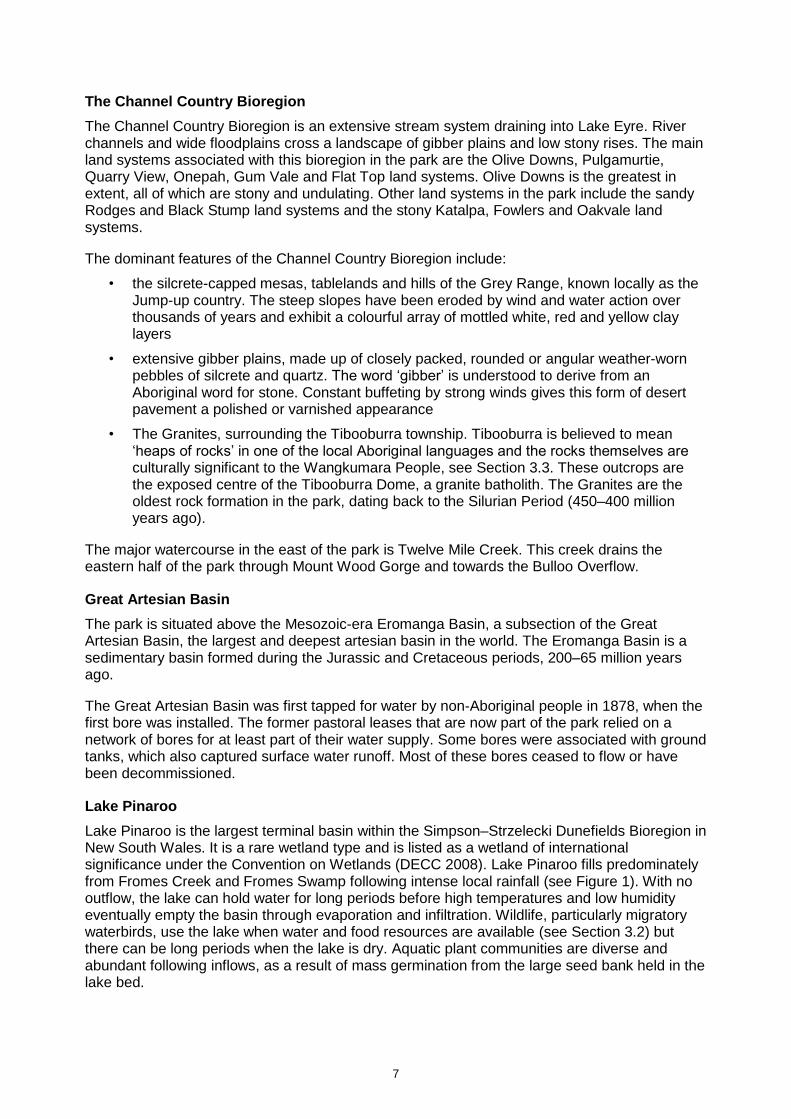
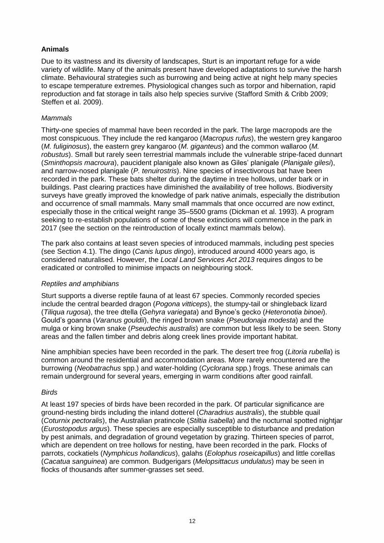
Lake Pinaroo
Lake Pinaroo is the largest terminal basin within the Simpson–Strzelecki Dunefields Bioregion in New South Wales. It is a rare wetland type and is listed as a wetland of international significance under the Convention on Wetlands (DECC 2008). Lake Pinaroo fills predominately from Fromes Creek and Fromes Swamp following intense local rainfall (see Figure 1). With no outflow, the lake can hold water for long periods before high temperatures and low humidity eventually empty the basin through evaporation and infiltration. Wildlife, particularly migratory waterbirds, use the lake when water and food resources are available (see Section 3.2) but there can be long periods when the lake is dry. Aquatic plant communities are diverse and abundant following inflows, as a result of mass germination from the large seed bank held in the lake bed.

8
Figure 1: Fort Grey visitor precinct and Lake Pinaroo

9
Current understanding of the hydrology and ecology of Lake Pinaroo is limited. Further research into water quality, flood regimes and the hydrological relationship between surface water and groundwater is needed to improve knowledge of how the wetland functions. Known threats to the wetland include changes to its hydrology and ecology as a result of climate change (see Section 4.3) and the impacts of introduced plants and animals (see Section 4.1).
Lake Pinaroo is also known as Fort Grey Basin. The explorer Charles Sturt built a stockade on the eastern shore of Lake Pinaroo and the ruins of the original Fort Grey Homestead are on the north-western shore (see Section 3.4). A marker known as Sturt’s Tree is located towards the eastern shore of the lake, where it is periodically inundated (see Section 3.4). A travelling stock route traverses Lake Pinaroo, however, it has not been used since 1972 (see Section 5.2).
There is also extensive evidence of Aboriginal use and occupation around Lake Pinaroo, including hearths, scarred trees and artefact scatters (see Section 3.3).
Soils
The soils of the dune systems in the western section of the park are mainly red siliceous sands that have only limited soil profile development. Cracking brown and grey clays which retain moisture for longer occur in the drainage swales, along creeklines and in lake beds. To the east, soils include shallow gritty loams, brown loams with stony surfaces, and sticky clays with a high gypsum content or stony texture contrast soils (NPWS 2003).
All soils in the park are fragile, prone to erosion and generally poor in nutrients and other elements. Higher quality soils are rare and patchily distributed, but are very important in supporting plant and animal communities. Intense rainfall causes considerable erosion and transport of soil.
Past agricultural practices such as grazing by introduced herbivores has contributed to large-scale scalding and gully erosion. Driving vehicles off formed tracks damages vegetation and destroys surface crusts that naturally reduce the impacts of wind and rainfall on soils. Studies carried out within the park indicate that since the 1890s the area has lost approximately 20 centimetres of topsoil and up to two metres in some areas (Fanning 1999). Several years of above-average rainfall are needed to support natural revegetation at erosion sites, making recovery slow and sporadic.
Issues
• Arid ecosystems and landscapes are characterised by prolonged hot dry periods interrupted by above-average rainfall. Climate change is predicted to exaggerate these extremes (see Section 4.3).
• The landscape is diverse, prone to erosion and very sensitive to disturbance, such as off-road driving. The removal of vegetation and overgrazing has led to scalding and erosion gullies. High-use areas may suffer more from erosion. Recovery is very slow.
• Hydrological monitoring is needed to better understand the health of Lake Pinaroo and its inflows, and to enable park managers to detect functional changes over time.
Desired outcomes
• Soils and landscape features are protected and conserved and erosion is minimised.
• Landscape and catchment values of the park are protected, including scenic viewscapes of significant geological and geomorphological features.
• Only developments or activities that are ecologically sustainable are allowed.
• Nutrient and vegetation ‘rich’ patches (such as small creeks and river run-out plains, gilgais and small depressions in the inter-dune country) are protected.

10
• An improved and effective monitoring protocol for Lake Pinaroo is implemented.
Management response
3.1.1 Regularly monitor erosion in existing campgrounds, day use areas, walking tracks, tourist roads and management trails and take remedial action as required.
3.1.2 Ensure that all works within the park are designed and undertaken to minimise adverse environmental impacts including erosion.
3.1.3 Monitor and where possible control threatening processes such as Noogoora burr that have the potential to degrade ephemeral wetlands in the park, in particular those which may alter the ecological character of internationally significant wetland values.
3.1.4 Develop and implement hydrological monitoring protocols for Lake Pinaroo in accordance with Convention on Wetlands requirements.
3.2 Native plants and animals
Plants
The vegetation of Sturt is typical of arid outback Australia, dominated by arid shrublands and grasslands as annual rainfall and soil moisture are too low to support tree-dominated communities (Keith 2004).
Prior to reservation of the park, native plants and animals suffered serious decline due to grazing practices, the introduction of non-native pests and the removal of native predators. Because past clearing and grazing of the park decreased the perennial grass, native shrub and tree cover, reservation and de-stocking of the area has significantly improved these habitat values.
Plants of the arid zone employ a number of strategies to survive the extreme climate with its erratic pulses of rainfall and long, dry times in between. For example, mulga (Acacia aneura) forms a wide and deep root system so as to maximise soil moisture uptake, and produces many seedlings. Accordingly, for this park, mulga should not be considered an invasive native species as it is in other areas of New South Wales. The seeds of poached egg daisies (Polycalymma stuartii) may lie dormant in the soil for many years before rainfall triggers germination. Seeds from some species may not germinate for decades. Many plants grow only after summer rains, producing a shallow root network close to the soil surface (Fox & Parish 2007; Stafford Smith & Cribb 2009).
A comprehensive vegetation survey of the park has not been undertaken. However, the vegetation of the park is consistent with the following broad, statewide vegetation classes (Keith 2004; Fox & Parish 2007):
• Sand Plain Mulga Shrublands
• Gibber Chenopod Shrublands
• Stony Desert Mulga Shrublands
• Inland Floodplain Shrublands
• Inland Floodplain Woodlands.
The BioNet Vegetation Classification System models 26 finer scale vegetation communities in the park (OEH 2017b). These communities are closely associated with specific habitats and geological features, and include:
11
• The sand dunes of the western half of the park, supporting a perennial woodland community dominated by sandhill wattle (Acacia ligulata), mulga, belah (Casuarina cristata), needlewood (Hakea leucoptera), whitewood (Atalaya hemiglauca) and beefwood (Grevillea striata). These woodlands include a shrub layer principally of cassia (Senna spp.), turpentine bush (Eremophila sturtii) and narrow-leaved hop-bush (Dodonaea viscosa subsp. angustissima). A generally sparse ground layer includes poached egg daisies, copperburr (Sclerolaena spp.) and wiregrasses (Aristida spp.). Areas between widely spaced sand dunes may comprise canegrass (Eragrostis australasica) / lignum (Duma florulenta) swamp communities, with a variety of forbs and grasses, especially during wet years.
• The gibber plains support open chenopod shrublands. The dominant perennial species include saltbushes (Atriplex spp.), bluebushes (Maireana spp.) and copperburrs. In higher rainfall years, Mitchell grasses (Astrebla spp.), bluegrasses (Dichanthium spp.) and lovegrasses (Eragrostis spp.) grow between the shrubs. The plains are generally treeless although isolated stands of gidgee (Acacia cambagei) and dead finish (A. tetragonophylla) occur along small creeks and gullies, and some mulga occurs in scattered patches. Gilgais provide an important microhabitat and support distinct vegetation, including succulent herbs and small shrubs such as Warrigal greens (Tetragonia tetragonioides), twinleaf (Zygophyllum spp.) and crowfoot (Erodium spp.).
• The Jump-up area supports Acacia shrublands of scattered mulga, dead finish, prickly wattle (A. victoriae) and cabbage-tree wattle (A. cana), together with emubushes (Eremophila spp.), bluebushes, lobed-leafed hopbush (Dodonaea lobulata), cassia and sida (Sida spp.). A sparse ground cover of perennial plants and ephemeral herbs also occurs within this community. Gidgee occurs where plateau surfaces are large enough to increase water flow onto adjacent slopes.
• Vegetation at The Granites is typically bluebush, saltbush and prickly wattle, grading to copperburr on the shale hills to the north and west. Desert bloodwoods (Corymbia opaca) and occasional whitewood (Atalaya hemiglauca) and quandong (Santalum acuminatum) line the creeks and gullies in this area. Grasses and low shrubs are sparse although woollybutt (Eragrostis eriopoda), mulga grass (Thyridolepis mitchelliana) and wiregrasses are usually present. The prostrate Sturt’s desert pea (Swainsona formosa) spreads when conditions are favourable, as do silver tails (Ptilotus spp.), lantern-flower (Abutilon leucopetalum) and small purslane (Calandrinia eremaea).
• Fromes Creek, Twelve Mile Creek and their tributaries are lined by river red gum (Eucalyptus camaldulensis). Coolibah (E. coolabah) is also present in the narrow tree-line along the banks on heavier textured soils. The understorey is comprised mostly of grasses including curly Mitchell grass (Astrebla lappacea) and canegrass. Herbs often grow on the channel banks.
There have been few botanical studies in these areas. The flora and ecology of the gibber chenopod and mulga scrublands in particular is poorly known. Further research supporting the management of these communities is required, as they cover large areas of the park.
There is a lack of woody native plant (e.g. mulga, gidgee) regeneration throughout western New South Wales, mainly as a consequence of the erratic rainfall and grazing by native and non-native herbivores. Even when the timing of seed drop and rainfall produces seedlings, these are usually eaten and rarely reach maturity. Effective management of this vegetation in the park to encourage successful recruitment requires additional monitoring and research. Of additional concern has been an apparent decline of Mitchell grasslands in the region, as observed over 100 years following the introduction of pastoralism. Observations by NPWS staff suggest areas of Mitchell grass within the park are showing signs of recovery following 40 years without grazing by sheep.
12
Animals
Due to its vastness and its diversity of landscapes, Sturt is an important refuge for a wide variety of wildlife. Many of the animals present have developed adaptations to survive the harsh climate. Behavioural strategies such as burrowing and being active at night help many species to escape temperature extremes. Physiological changes such as torpor and hibernation, rapid reproduction and fat storage in tails also help species survive (Stafford Smith & Cribb 2009; Steffen et al. 2009).
Mammals
Thirty-one species of mammal have been recorded in the park. The large macropods are the most conspicuous. They include the red kangaroo (Macropus rufus), the western grey kangaroo (M. fuliginosus), the eastern grey kangaroo (M. giganteus) and the common wallaroo (M. robustus). Small but rarely seen terrestrial mammals include the vulnerable stripe-faced dunnart (Sminthopsis macroura), paucident planigale also known as Giles’ planigale (Planigale gilesi), and narrow-nosed planigale (P. tenuirostris). Nine species of insectivorous bat have been recorded in the park. These bats shelter during the daytime in tree hollows, under bark or in buildings. Past clearing practices have diminished the availability of tree hollows. Biodiversity surveys have greatly improved the knowledge of park native animals, especially the distribution and occurrence of small mammals. Many small mammals that once occurred are now extinct, especially those in the critical weight range 35–5500 grams (Dickman et al. 1993). A program seeking to re-establish populations of some of these extinctions will commence in the park in 2017 (see the section on the reintroduction of locally extinct mammals below).
The park also contains at least seven species of introduced mammals, including pest species (see Section 4.1). The dingo (Canis lupus dingo), introduced around 4000 years ago, is considered naturalised. However, the Local Land Services Act 2013 requires dingos to be eradicated or controlled to minimise impacts on neighbouring stock.
Reptiles and amphibians
Sturt supports a diverse reptile fauna of at least 67 species. Commonly recorded species include the central bearded dragon (Pogona vitticeps), the stumpy-tail or shingleback lizard (Tiliqua rugosa), the tree dtella (Gehyra variegata) and Bynoe’s gecko (Heteronotia binoei). Gould’s goanna (Varanus gouldii), the ringed brown snake (Pseudonaja modesta) and the mulga or king brown snake (Pseudechis australis) are common but less likely to be seen. Stony areas and the fallen timber and debris along creek lines provide important habitat.
Nine amphibian species have been recorded in the park. The desert tree frog (Litoria rubella) is common around the residential and accommodation areas. More rarely encountered are the burrowing (Neobatrachus spp.) and water-holding (Cyclorana spp.) frogs. These animals can remain underground for several years, emerging in warm conditions after good rainfall.
Birds
At least 197 species of birds have been recorded in the park. Of particular significance are ground-nesting birds including the inland dotterel (Charadrius australis), the stubble quail (Coturnix pectoralis), the Australian pratincole (Stiltia isabella) and the nocturnal spotted nightjar (Eurostopodus argus). These species are especially susceptible to disturbance and predation by pest animals, and degradation of ground vegetation by grazing. Thirteen species of parrot, which are dependent on tree hollows for nesting, have been recorded in the park. Flocks of parrots, cockatiels (Nymphicus hollandicus), galahs (Eolophus roseicapillus) and little corellas (Cacatua sanguinea) are common. Budgerigars (Melopsittacus undulatus) may be seen in flocks of thousands after summer-grasses set seed.

13
Lake Pinaroo, Frome Swamp and other smaller ephemeral swamps, when filled, can support large numbers of waterbirds including several threatened species. Lake Pinaroo is an important stopover for migratory waders travelling to breeding sites, and acts as a drought refuge for at least 40 species of waterbirds (DECC 2008).
The park supports a wide variety of birds of prey ranging in size from the largest wedge-tailed eagle (Aquila audax) and black-breasted buzzard (Hamirostra melanosternon) to the smallest Australian hobby (Falco longipennis) and nankeen kestrel (Falco cenchroides). The diversity and abundance of nesting raptors, including all Australian mainland falcons, highlights the state and national conservation value of Sturt for this ecologically important group of birds.
Invertebrates
Insects and other invertebrates are known to play important roles in arid ecosystems but the knowledge of invertebrates in the park is poor. Ants, termites and native bees all show high species diversity in arid areas. Spiders are very abundant and conspicuous. The park contains a number of conspicuous crustaceans including the inland yabby (Cherax destructor) and freshwater crab (Austrothelphusa transversa). Populations of shield shrimp (Triops australiensis) explode in temporary water pools and water-filled clay pans after rain.
Threatened plants and animals
Sixteen threatened plant species have been recorded, or are predicted to occur in Sturt (see Table 1).
Strategies for the recovery of threatened species, populations and ecological communities have been set out in a statewide Biodiversity Conservation Program (OEH 2017a) (formerly known as the Threatened Species Priorities Action Statement). These actions are currently prioritised and implemented through the Saving our Species program, which aims to maximise the number of threatened species that can be secured in the wild in New South Wales for 100 years (OEH 2013c). Individual recovery plans may also be prepared for threatened species to consider management needs in more detail. For example, recovery plans have been prepared for the kultarr (Antechinomys laniger), the sandy inland mouse (Pseudomys hermannsburgensis) and Forrest’s mouse (Leggadina forresti).
Table 1: Threatened and significant native plant species recorded or predicted to occur in Sturt
Common name Scientific name BC Act status EPBC Act status
A forb Stackhousia clementii Endangered
A herb Polycarpaea spirostylis subsp. glabra
Endangered
A subshrub Dipteracanthus australasicus subsp. corynothecus
Endangered
Brilliant hopbush Dodonaea microzyga var. microzyga
Endangered
Crumbweed sp. Dysphania platycarpa Endangered
Flame spider flower Grevillea kennedyana Vulnerable Vulnerable
Fleshy minuria Kippistia suaedifolia Endangered
Goodenia sp. ‘Nocoleche’ Goodenia nocoleche Endangered
Green bird flower Crotalaria cunninghamii Endangered
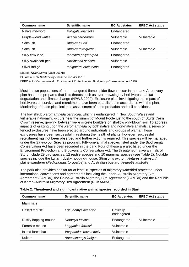
14
Common name Scientific name BC Act status EPBC Act status
Native milkwort Polygala linariifolia Endangered
Purple-wood wattle Acacia carneorum Vulnerable Vulnerable
Saltbush Atriplex sturtii Endangered
Saltbush Atriplex infrequens Vulnerable Vulnerable
Silky cow-vine Ipomoea polymorpha Endangered
Silky swainson-pea Swainsona sericea Vulnerable
Silver indigo Indigofera leucotricha Endangered
Source: NSW BioNet (OEH 2017b)
BC Act = NSW Biodiversity Conservation Act 2016
EPBC Act = Commonwealth Environment Protection and Biodiversity Conservation Act 1999
Most known populations of the endangered flame spider flower occur in the park. A recovery plan has been prepared that lists threats such as over-browsing by herbivores, habitat degradation and climate change (NPWS 2000). Exclosure plots investigating the impact of herbivores on survival and recruitment have been established in accordance with the plan. Monitoring of these plots includes assessment of seed predation and soil conditions.
The low shrub Xerothamnella parvifolia, which is endangered in New South Wales and vulnerable nationally, occurs near the summit of Mount Poole just to the south of Sturts Cairn Crown reserve, growing between large silcrete boulders on shallow windblown soil. To address impacts of grazing upon the Xerothamnella by both native and non-native animals, a series of fenced exclosures have been erected around individuals and groups of plants. These exclosures have been successful in restoring the health of plants, however, successful recruitment has not been observed and further action is required. This species will be managed under the Saving our Species program. Fifty-one animal species listed under the Biodiversity Conservation Act have been recorded in the park. Four of these are also listed under the Environment Protection and Biodiversity Conservation Act. The threatened native animals of Sturt include 29 bird species, 12 reptile species and 10 mammal species (see Table 2). Notable species include the kultarr, dusky hopping-mouse, Stimson’s python (Antaresia stimsoni), plains-wanderer (Pedionomus torquatus) and Australian bustard (Ardeotis australis).
The park also provides habitat for at least 10 species of migratory waterbird protected under international conventions and agreements including the Japan–Australia Migratory Bird Agreement (JAMBA), the China–Australia Migratory Bird Agreement (CAMBA) and the Republic of Korea–Australia Migratory Bird Agreement (ROKAMBA).
Table 2: Threatened and significant native animal species recorded in Sturt
Common name Scientific name BC Act status EPBC Act status
Mammals
Desert mouse Pseudomys desertor Critically endangered
Dusky hopping-mouse Notomys fuscus Endangered Vulnerable
Forrest’s mouse Leggadina forresti Vulnerable
Inland forest bat Vespadelus baverstocki Vulnerable
Kultarr Antechinomys laniger Endangered

15
Common name Scientific name BC Act status EPBC Act status
Little pied bat Chalinolobus picatus Vulnerable
Long-haired rat Rattus villosissimus Vulnerable
Sandy inland mouse Pseudomys hermannsburgensis
Vulnerable
Stripe-faced dunnart Sminthopsis macroura Vulnerable
Yellow-bellied sheathtail-bat
Saccolaimus flaviventris Vulnerable
Reptiles
A skink Cyclodomorphus venustus Endangered
Centralian blue-tongued lizard
Tiliqua multifasciata Vulnerable
Collared whip snake Demansia rimicola Vulnerable
Crowned gecko Lucasium stenodactylum Vulnerable
Eastern fat-tailed gecko Diplodactylus platyurus Endangered
Interior blind snake Anilios endoterus Endangered
Narrow-banded snake Simoselaps fasciolatus Vulnerable
Ringed brown snake Pseudonaja modesta Endangered
Stimson’s python Antaresia stimsoni Vulnerable
Wedgesnout ctenotus Ctenotus brooksi Vulnerable
Woma Aspidites ramsayi Vulnerable
Yellow-tailed plain slider Lerista xanthura Vulnerable
Birds
Australian bustard Ardeotis australis Endangered
Australian painted snipe Rostratula australis Endangered Endangered Migratory
Barking owl Ninox connivens Vulnerable
Black-breasted buzzard Hamirostra melanosternon Vulnerable
Black falcon Falco subniger Vulnerable
Black-tailed godwit Limosa limosa Vulnerable Migratory
Blue-billed duck Oxyura australis Vulnerable
Brolga Grus rubicunda Vulnerable
Brown treecreeper (eastern subspecies)
Climacteris picumnus victoriae
Vulnerable
Caspian tern Hydroprogne caspia Migratory
Chestnut quail-thrush Cinclosoma castanotum Vulnerable
Common greenshank Tringa nebularia Migratory

16
Common name Scientific name BC Act status EPBC Act status
Dusky woodswallow Artamus cyanopterus cyanopterus
Vulnerable
Flock bronzewing Phaps histrionica Endangered
Fork-tailed swift Apus pacificus Migratory
Freckled duck Stictonetta naevosa Vulnerable
Glossy ibis Plegadis falcinellus Migratory
Grey-crowned babbler (eastern subspecies)
Pomotostomus temporalis temporalis
Vulnerable
Grey falcon Falco hypoleucos Endangered
Grey grasswren (Bulloo) Amytornis barbatus barbatus Endangered Endangered
Gull-billed tern Gelochelidon nilotica Migratory
Hall’s babbler Pomatostomus halli Vulnerable
Hooded robin (south-eastern form)
Melanodryas cucullata cucullata
Vulnerable
Little eagle Hieraaetus morphnoides Vulnerable
Major Mitchell’s cockatoo Lophochroa leadbeateri Vulnerable
Marsh sandpiper Tringa stagnatilis Migratory
Masked owl Tyto novaehollandiae Vulnerable
Painted honeyeater Grantiella picta Vulnerable Vulnerable
Pied honeyeater Certhionyx variegatus Vulnerable
Plains-wanderer Pedionomus torquatus Endangered Critically endangered
Rainbow bee-eater Merops ornatus Migratory
Red-necked stint Calidris ruficollis Migratory
Red-tailed black-cockatoo (inland subspecies)
Calyptorhynchus banksii samueli
Vulnerable
Redthroat Pyrrholaemus brunneus Vulnerable
Sharp-tailed sandpiper Calidris acuminata Migratory
Spotted harrier Circus assimilis Vulnerable
Square-tailed kite Lophoictinia isura Vulnerable
White-fronted chat Epthianura albifrons Vulnerable
Wood sandpiper Tringa glareola Migratory
Source: NSW BioNet (OEH 2017b), Species Profile and Threats Database (DoEE n.d.)
BC Act = NSW Biodiversity Conservation Act 2016
EPBC Act = Commonwealth Environment Protection and Biodiversity Conservation Act 1999
Some monitoring of small mammal, reptile and amphibian diversity is undertaken annually using a network of permanent pitfall trap sites established at various locations throughout the park. Visiting birdwatchers including members of university study groups also contribute knowledge regarding threatened species. Park staff carry out quarterly bird of prey surveys.

17
Reintroduction of locally extinct mammals
Clearing of vegetation, the introduction of hard-hoofed animals, changed fire regimes and the impact of non-native predators have all been implicated in the decline and extinction of many native species in Australia. For the Western Division of New South Wales, however, it was the incursion of massive numbers of sheep and the way they were managed that finally drove so many of the native mammal species to extinction (Lunney 2001). The effects of the rabbit plague, foxes and drought cycles added to the impact of ever-increasing numbers of sheep across the landscape by the mid 1880s, including those marginal parts which formerly provided sufficient refuge for native animals to persist in the harsh conditions of arid Australia.
The introduction of bores and ground tanks across the arid and semi-arid zones also fundamentally altered the dynamics of native animal species and non-native pest species. Many are now able to persist in areas that were previously not habitable for most of the time. This has resulted in the persistence of larger and more widespread populations of these species than would otherwise be possible. In a number of cases, the increase in abundance of a species may have significant negative effects on other species (James et al. 1999).
Current estimates indicate that of Australia’s native animal assemblage, mammals have been most adversely affected by extinctions, and 50% of all mammal species historically recorded in the region are now extinct (Dickman et al. 1993; Dickman 1994). In an effort to address this decline, a project to re-establish locally extinct mammals will be undertaken in Sturt under the Saving our Species program. National parks represent a feasible opportunity for this initiative as they are managed to address or exclude the threatening processes that operate on a landscape scale and have caused the extinction of these species.
Sturt is considered suitable for a reintroduction project on the basis that it has been managed for conservation purposes for over 40 years and has large areas of suitable habitat available. Similar projects to the one in Sturt are being developed in Mallee Cliffs National Park and Pilliga Outwash parks. The key objectives of the projects are to:
• address the decline in mammal diversity
• improve the overall ecosystem resilience of the parks
• assist in securing a number of threatened species from extinction.
Predation by introduced pest species, particularly cats and foxes (see Section 4.1), is recognised as playing a major role in the decline of Australia’s native animals. Native animals evolved without the responses needed to combat these pests. The removal of introduced predators from within securely fenced exclosures is therefore fundamental to the success of the project, as this has been proven to be an effective method for ensuring that reintroduced native species establish secure populations. In time, it is intended these species will also be reintroduced outside the exclosures.
An area of approximately 35,000 hectares has been identified in the north-west corner of the park as the project area. Within this area, two securely fenced exclosures, each of about 2000 hectares, will be constructed to form the core habitat for the progressive reintroduction of a range of mammal species (see Figure 5 for an indicative location). Once all predators and other species with potential to disrupt the project such as emus and kangaroos have been removed, the following species are intended to be progressively introduced:
• burrowing bettong (Bettongia lesueur graii)
• western quoll (Dasyurus geoffroii)
• greater bilby (Macrotis lagotis)
• crest-tailed mulgara (Dasycercus cristicauda)

18
• greater stick-nest rat (Leporillus conditor)
• golden bandicoot (Isoodon auratus)
• western barred bandicoot (Perameles bougainville fasciata).
These are species which are no longer found in the park but are known historically to have played an important role in maintaining healthy ecosystems in this environment. Each of these species is also threatened with extinction across its range. Ground-dwelling mammals such as bettongs, bilbies and bandicoots are known to have far-reaching, positive effects on entire ecosystems in the arid zone. Turning over soil in their search for food allows better penetration of water into soils and reduces surface runoff, as well as creating the disturbance needed for many plants to germinate. In this sense, such species function as ecological engineers (James et al. 2009; Read et al. 2008) and with the loss of these species, the important ecosystem services to which they contribute are in turn threatened (Fleming et al. 2014).
The final selection of species may vary slightly depending on the availability of animals and other factors. The final location of the exclosures will be based on the suitability of habitat and the need to minimise disturbance to the park’s natural and cultural values.
An initial 10-year contract has been awarded to the University of New South Wales for the project in Sturt. In addition to establishing and managing viable populations of locally extinct species in the project area, the contract includes the delivery of park management activities such as pest and weed control, visitor management, asset maintenance and supporting NPWS in fire management activities. At the end of the 10-year period the outcomes of the project will be assessed. This review will help to determine the next steps for the project. Additional detail on the project is included in Section 5.1.
The management of genetic health and resilience in the populations of each of the species to be introduced is an important and essential component of the project. Animals for reintroduction will be sourced from a number of subpopulations, including wild populations, so as to maximise genetic diversity. Preference will be given to animals from populations in environments that are most similar to the conditions in Sturt and that are closest to the park. In the event that suitable animals are not available from wild subpopulations, they may be selected from captive populations.
Reintroduced species will be translocated into the purpose-built exclosures free of introduced predators. In the surrounding area outside the fence, intensive pest control including targeted cat control, will benefit extant threatened species. This concentrated effort is expected to have benefits for all biodiversity in the park, particularly ground-dwelling and ground-nesting animal species. It will also improve knowledge of predator–prey interactions and improve expertise in effective pest control, particularly for cats and foxes. The long-term objective of the program is that once the reintroduced populations become established and the threats to these species are effectively reduced more broadly throughout the park, animals will be released from the exclosures into the surrounding area.
Fencing for the exclosures has been designed to maximise cat, fox and dog exclusion as well as to exclude pest species such as rabbits, pigs and goats (see photo below of a similar exclosure). Special measures include two electrified wires at different heights, rabbit netting along the ground to prevent burrowing in, and floppy overhangs to prevent cats and foxes climbing over the fence. The exclosures will also be equipped with one-way gates to allow small mammals to disperse from the exclosures into the park in the long term. The integrity of the fence will be constantly monitored and maintained in conjunction with ongoing pest management.

19
Exclosure fence at Arid Recovery Centre, South Australia. Photo credit: K Moseby, Ecological Horizons Pty Ltd
Extensive environmental monitoring will be conducted regularly, both inside and outside the exclosures, to assess reintroduced animals, responses of other native species including threatened species, and responses of other aspects of the ecosystem to the reintroduction of mammal species and threat management. Short-term, medium-term and long-term indicators of success towards establishing viable populations of each of the reintroduced species will be developed. The results of the monitoring will be used to guide ongoing management decisions, evaluate progress towards establishing viable populations and improve the ecological health of the park. Information about the progress of the project will also be made known to the public.
Issues
• Past clearing of vegetation and grazing by hard-hoofed animals have severely reduced habitat and shelter for small vertebrates and led to significant erosion of sensitive soils.
• The introduction of pest species has been detrimental to many native plant and animal species, particularly mammals, and contributed directly to their decline or extinction within the park and the broader landscape.
• Grazing and browsing by both native and non-native animal species continues to adversely impact the regeneration of native vegetation in the park. Grazing by rabbits, goats and artificially high numbers of kangaroos are of particular concern. Artificial watering points in the park sustain high levels of these species (see Section 5.1).
• Vegetation in the park has not been comprehensively mapped.
• There is little known about the ecology of gibber plains and mulga shrublands and the factors influencing regeneration of woody vegetation in the park.
• While the park is known to support significant populations of threatened plants and vertebrate animals, the invertebrate animals of the park are not well known.
Desired outcomes
• The condition of vegetation communities, animal habitat and populations of native animal and plant species are protected, maintained and enhanced where appropriate. Negative impacts on threatened species are minimised.
• Biodiversity is enhanced and ecosystem resilience increased through the reintroduction of locally extinct species and control of the threats affecting these species.
• Knowledge of the park’s ecology, including that of threatened animal and plant species and their habitat requirements, is improved and informs park management.

20
• Meaningful data is collected from targeted surveys and regular monitoring of biodiversity and ecological assets in the park; in particular: waterbirds at Lake Pinaroo, birds of prey, and small mammals.
Management response
3.2.1 Encourage and support research into little-known ecological values of the park including gibber and mulga shrublands, and the regeneration of woody vegetation.
3.2.2 Facilitate the implementation of the Reintroduction of Locally Extinct Mammals project under the Saving our Species program.
3.2.3 Implement relevant recovery actions in the Biodiversity Conservation Program and recovery plans for threatened plant species, populations and communities occurring in the park.
3.2.4 Conduct and support biodiversity surveys to inform park management.
3.2.5 Seek to improve ecological data for the Lake Pinaroo wetlands of international significance including monitoring the extent and frequency of waterbird abundance.
3.3 Aboriginal connections to Country
The land, water, plants and animals within a landscape are central to Aboriginal people and their cultural spirituality, identity and wellbeing. Aboriginal communities associate natural resources with the use and enjoyment of foods and medicines, caring for and utilising the land, continuation and the passing on of cultural knowledge, kinship systems and strengthening social and cultural connections.
Sturt lies in the traditional Country of a number of Aboriginal groups. These include the Wadigali (alternative spelling Wadikali) centrally and to the west; Karengappa to the east; Wangkumara (alternative spelling Wongkumara) centrally, east to the Bulloo Overflow, north into Queensland and northwest to Innamincka, South Australia; and the Malyangapa to the south, including what was to become the township of Milparinka (Peter Freeman Pty Ltd 2004). Today Aboriginal people are represented in the region by the Tibooburra Local Aboriginal Land Council and by local elders who continue to identify the land within the park as part of their traditional lands.
The Wangkumara People belong to the Karnic language group of the Lake Eyre Basin while Yarli languages were spoken by both the Malyangapa and Wadigali peoples. All three groups were thought to be multilingual and readily shared landscapes, resources and ceremonies. These groups also interacted with communities further afield including the Paakantji language speakers to the south (Hercus & Beckett 2009).
Aboriginal people of the region traditionally relied on a wide range of food resources, which are still important to Aboriginal people today. Large game animals such as kangaroo and emu are eaten routinely and emu eggs are prized. Various plants and seeds including nardoo and pigweed, which require specialised preparation, are also important nutritional resources (Gillon & Knight 1986). Many plants and animals have traditional uses, such as medicine, sources of fibre and use in ceremonies.
Being desert communities, Aboriginal people of the area traditionally lived in small nomadic groups, often separated by large distances. Permanent and semi-permanent water holes were very important to Aboriginal people and were used as meeting places and ceremonial sites (Hope 2006). People moved widely across the landscape during periods of abundance, with social networking and trading over vast distances being an important part of practicing and maintaining culture. Grey Range and Mount Wood Range provided an abundant source of silcrete, which was extensively exploited for tool-making, and enabled trade of highly valued tools with other groups lacking a source of stone. There is abundant evidence of silcrete blade-
21
making in the park and some of these blades were traded as far north as Arnhem Land. Similarly, artefacts from distant locations, such as ‘Cloncurry axes’ made of basalt, have been found locally (Mosely 2010). Trading also allowed the oral transmission of knowledge which is central to Aboriginal culture, and stories from the Dreaming tell of interactions between neighbouring groups.
Aboriginal people in the area first encountered non-indigenous people in 1845 when Charles Sturt and his exploration party arrived in the region. Early interactions between the two groups were amicable, although later encounters with the Burke and Wills exploration team in 1860 were less so. European visitors to the arid outback were often assisted in finding water by Aboriginal people. Tracks and stock routes tended to follow mura stories (meaning ‘pathway’ in the Ngunnawal Aboriginal language) as non-Aboriginal people were shown or otherwise took advantage of the existing mura tracks (Peter Freeman Pty Ltd 2004).
Traditional life for Aboriginal people continued until the late 1870s when pastoral stations were established over most of the north-west of New South Wales, disrupting tribal boundaries and the traditional culture (Hardy 1976, cited in AMBS 2012). The expansion of pastoralism and a gold rush at Mount Poole in the late 1880s brought more and more non-Aboriginal people into the Corner Country (see Section 3.4). Aboriginal people were forced to become increasingly dependent on pastoral stations and station life. Many Aboriginal people in the region lived on the stations, including Mount Wood and Olive Downs, and became valued workers. The men worked as stockmen, station hands, outstation managers, horse breakers and contractors undertaking shearing, tank sinking, windmill installation and repair, and women worked as domestic servants, cooks, nannies and stockwomen. The park contains evidence from these times including historic campsites and places where Aboriginal people lived and worked that have shared Aboriginal and historic heritage significance (Peter Freeman Pty Ltd 2004).
With the passing of the Aborigines Protection Act 1909, Aboriginal people were increasingly controlled by the Aboriginal Protection Board and placed in government reserves in places such as Milparinka, Tibooburra, Wilcannia, Walgett, Brewarrina and Bourke (Memmott & Moran 2001, cited in AMBS 2012). Through this period many Aboriginal people came and went from the local area, occupying town fringes and the Tibooburra Common.
The 1920s and 1930s were difficult decades for all people in the area owing to severe water shortages, drought and the Great Depression. In 1938 Aboriginal women, children and the elderly were forcibly taken from Tibooburra and rehoused 500 kilometres away at the Brewarrina Mission as a result of government policy of the time (Peter Freeman Pty Ltd 2004). This was the last Aboriginal community in New South Wales to be moved en masse (AMBS 2012). Despite this upheaval and disconnection from Country, spiritual connection for the Aboriginal community to ancestors, culture, language and the landscape remained strong and persists today (Peter Freeman Pty Ltd 2004; AMBS 2012).
While the NSW Government has legal responsibility for the protection of Aboriginal objects, sites and places under the National Parks and Wildlife Act, it acknowledges the right of Aboriginal people to make decisions about their own heritage as custodians. It is therefore NPWS policy that Aboriginal communities are consulted and involved in the management of Aboriginal sites, places, and the promotion and presentation of Aboriginal culture and its history. NPWS also recognises that Aboriginal culture and its connection to nature are inseparable and need to be managed in an integrated manner across the landscape, in partnership with Aboriginal people.
The park contains a wealth of Aboriginal cultural heritage, which is important to Aboriginal people, their culture, history, heritage and connection with Country. This includes artefacts, hearths, quarries and tool-making sites, stone arrangements, campsites and scarred trees. There are abundant grinding stones and numerous artefact scatters distributed over very large areas. Sites include both pre-contact and post-contact elements and therefore provide a record of Aboriginal culture and heritage undergoing a process of transformation and adaptation to new circumstances (Peter Freeman Pty Ltd 2004). The presence of silcrete in Grey Range and

22
Mount Wood Range has resulted in an abundance of quarries and silcrete artefacts including the specialised, highly worked stone tools such as pirri points (leaf-shaped flakes for use as a spearhead) and long leilira blades up to 10 centimetres long (Witter 1992, 2004). As an example of the abundance of the Aboriginal cultural heritage record, an archaeological survey conducted in one quarry in the Mount Wood Range yielded almost 4000 cores and over 14,000 flake fragments in an area of 3640 square metres (Doelman 2005).
Archaeological investigation in the park has contributed to understanding of Aboriginal manufacturing technology, organisation, trade networks and patterns of Aboriginal mobility. A major survey of Aboriginal cultural heritage was undertaken in north-west New South Wales from 1995 to 1998 by NPWS in collaboration with La Trobe and Macquarie universities, Tibooburra Local Aboriginal Land Council and the Wangkumara Tribal Council (Holdaway et al. 2000, cited in Peter Freeman Pty Ltd 2004). Other surveys include the survey of the Moomba (Natural Gas) Pipeline which cuts through the park (Buchan 1975), a sample survey across Sturt in 1980–81 (Witter 1992), a survey of proposed powerline routes in 1994, and archaeological analysis of stone artefacts and hearths mainly in the Mount Wood area (Holdaway et al. 1998, 2000).
Many Dreaming stories have been recorded for the Aboriginal people of north-west New South Wales. The Warratta Paddock contains White Lady Rock Aboriginal Place, which is a highly sacred women’s site, particularly significant to Malyangapa and Wangkumara people (see also Section 5.2). Oral histories have also been recorded for several Aboriginal people in 2004 and the conservation management plan prepared for Olive Downs Homestead includes the Aboriginal history over that part of the park (see also Section 3.4). The homestead complex is located on an important mura pathway of the ancestral people (Peter Freeman Pty Ltd 2004).
There is currently an undetermined native title claim (QC2008/003) over the land within the park, lodged by the Wongkumara People (NNTT 2016).
At various times over the park’s history Aboriginal people have been actively involved in surveying, recording and interpreting Aboriginal cultural heritage in the park. NPWS is aware of the difficulties faced by the local Aboriginal community in maintaining connection with Country as people are widely dispersed throughout Australia. NPWS encourages involvement by the community in interpretation and presentation of Aboriginal cultural heritage and its management.
Issues
• Sturt is part of the extensive cultural landscape of Central Australia spanning many thousands of years for Aboriginal people. Connection to Country remains strong and opportunities need to be created so the Aboriginal community can be involved in the management and interpretation of the park.
• Aboriginal cultural heritage is subject to movement and damage through erosion, sedimentation, off-road vehicles and the activity of pest animals, and unauthorised collecting.
• Local Aboriginal people may require access to natural resources in the park such as silcrete and medicinal plants for cultural purposes.
• Some cultural values associated with Aboriginal sites and places are not for public knowledge and need to be protected in consultation with the Aboriginal community.
• Access to White Lady Rock must be obtained from Tibooburra Local Aboriginal Land Council and the sub-lessee of the Warratta Paddock.
Desired outcomes
• Aboriginal places, sites and values in Sturt are identified, registered and protected. Impacts on Aboriginal heritage values are minimised.

23
• Aboriginal communities are consulted and involved in management of the park including management of Aboriginal cultural heritage, research and the promotion and presentation of Aboriginal culture and history.
• Understanding of the park’s Aboriginal cultural values is improved, especially as related by oral history.
• Links between Aboriginal people and Country are supported, maintained and strengthened.
• The rights of Aboriginal people to make decisions about their own culture and heritage are acknowledged. Aboriginal engagement in landscape management is not restricted to management of artefacts.
Management response
3.3.1 Work cooperatively with Tibooburra Local Aboriginal Land Council, Aboriginal Elders groups, native title claimants and other Aboriginal community organisations and custodial families in the management of Aboriginal cultural heritage, including appropriate interpretation of cultural places and values.
3.3.2 Manage White Lady Rock Aboriginal Place in consultation with the Aboriginal community.
3.3.3 Allow only those Aboriginal sites and places that are approved by the local Aboriginal community to be open for visitation and interpretation.
3.3.4 Assist Aboriginal people to record Aboriginal cultural heritage in the park in the Aboriginal Heritage Information Management System (AHIMS).
3.3.5 Undertake Aboriginal cultural heritage surveys, assessment and consultation prior to all works that have the potential to impact Aboriginal cultural heritage in the park.
3.3.6 Undertake all conservation works needed to protect Aboriginal cultural heritage in consultation with the Aboriginal community.
3.3.7 Work with the Tibooburra Local Aboriginal Land Council, Elders, native title claimants and other relevant Aboriginal community organisations to encourage further research into the Aboriginal cultural heritage values of the park.
3.4 Shared heritage
Heritage places and landscapes are made up of living stories as well as connections to the past, which can include natural resources, objects, customs and traditions that individuals and communities have inherited and wish to conserve for current and future generations. Cultural heritage comprises places and items that may have historic, scientific, cultural, social, archaeological, architectural, natural or aesthetic significance. NPWS conserves the significant heritage features of the parks that it manages.
Exploration and settlement
Sturt derives its name from the explorer Charles Sturt, who in 1844 was instructed by the Governor of South Australia to lead an expedition from Adelaide to the interior of Australia in search of an inland sea. Though he never found such a thing, Sturt’s expedition made it as far as the Simpson Desert and won him a gold medal from the Royal Geographical Society of London. His detailed accounts and journals written by others in the party made a significant contribution to non-Aboriginal knowledge of the geography, geology and natural history of the
24
interior of the continent, and led to opening north-west New South Wales to pastoral settlement and gold mining (AMBS 2012).
Sites associated with Sturt’s expedition are located at Lake Pinaroo in the park. At one stage of the expedition Sturt established a base camp at Fort Grey on the south-east edge of the lake and near Frome Creek on a slight rise, out of reach of floodwater, where there were a number of Aboriginal huts (Davis 2002, cited in AMBS 2012). The camp included a timber stockade built to protect the men and their provisions from possible attacks by Aboriginal people. Archaeological investigations of the site have revealed an assortment of European artefacts, which may include items from Sturt’s expedition, as well as items associated with more recent drovers and pastoralists. A blazed box tree with ‘Sturt 1845’ carved into the trunk, still stands near the stockade site and is thought to have been marked to record the location of a message bottle buried by a member of the expedition party.
There are two other sites associated with Sturt’s expedition south of the Warratta Paddock adjacent to Depot Glen, a natural waterhole with permanent water (see Figure 5). These sites are Crown reserves also managed by NPWS. The first, Pooles Grave, commemorates James Poole who was a member of the 17-man expedition who died from scurvy in July 1845. He was buried under a beefwood tree blazed with his initials, and the year and the tree is still standing. The second site is Sturts Cairn, erected as a marker and for use as a triangulation point, though its construction was also intended to keep the men of the party occupied during a lengthy delay caused by drought (AMBS 2012). This cairn was a substantial structure constructed from silcrete rocks, measuring 18 feet (5.5 metres) in height and highly visible on the gibber plain. It was one of at least four cairns erected during the trip. Silcrete from this area was also extensively used by Aboriginal people for the manufacture of stone tools.
An archaeological management plan has been completed for all Sturt’s expedition sites on lands managed by NPWS (AMBS 2012). The plan describes and records the Sturt Exploration Cultural Landscape and provides a framework for preservation of these archaeological resources for future generations. The Sturt exploration sites are listed in the non-statutory archive of the Australian Heritage Database (formerly known as the Register of the National Estate) in recognition of their historic heritage significance (DoEE n.d.). The cultural landscape fulfils the criteria for listing on the State Heritage Register, and may also warrant listing on the National Heritage Register because of its significance for Australian people.
Other notable early European visitors to the area included the explorers Robert O’Hara Bourke and William John Wills who, in 1860, passed to the east of the park (through what is now the Pindera Downs Aboriginal Area) on their ill-fated expedition to cross Australia from Melbourne to the Gulf of Carpentaria. In 1880 the surveyor John Cameron and a combined NSW and
Queensland survey team travelled along the 29th parallel to mark the point where the New
South Wales, Queensland and South Australia state boundaries meet at 141⁰ longitude. This
locality became known as Cameron Corner and is identified with a cement post and plaque. The original wooden survey post is on display in the NPWS visitor centre at Tibooburra (AMBS 2012).
The push for sheep pasture had reached the Darling River in the late 1840s and 1850s, and by the early to mid 1860s pastoralists were moving up the Warrego and Paroo rivers (Peter Freeman Pty Ltd 2004). By the late 1870s most of north-west New South Wales had been ‘claimed’ as pastoral properties though access to permanent water in the more arid country continued to be the key factor for establishing sheep stations. The discovery of gold in 1880, in the Grey Range near Mount Poole, about 30 kilometres south-west of present day Tibooburra, provided the impetus for an improvement in water supplies. The gold rush that ensued led to a rapid increase in the region’s population to about 3000 people, and to towns like Tibooburra and Milparinka springing up (Gerritsen 1981, cited in Peter Freeman Pty Ltd 2004). The gold finds also triggered a rapid taking-up of pastoral runs in the district. The coincidental discovery of the

25
Great Artesian Basin led to sinking of artesian bores and the beginnings of a major travelling stock route in 1884 (Pearson 2003, cited in Peter Freeman Pty Ltd 2004).
The Albert Goldfield was declared in early 1881 over an area of 1300 square kilometres. Sturt National Park contains only the northern tip of the historic goldfield. Several old mine shafts are present in the park and a reconstructed mining whim and other structures are on display at Golden Gully mining site adjacent to the Dead Horse Gully campground. The Albert Goldfield and Warratta Town are listed on the State Heritage Register in recognition of this being the first large-scale exploitation of Australia’s arid mineral fields, and the first development of arid country goldmining technologies (OEH n.d.). Little remains of Warratta Town which is located within the Warratta Paddock (see Section 5.2).
Pastoral heritage
Sturt was formed from six former pastoral Western Lands leases: Fort Grey, Binerah Downs, Olive Downs, Mount King, Whitta Brinnah and Mount Wood. Although some of the original station homesteads have been demolished, the park retains a diverse collection of historic heritage representative of the evolution and development of Australia’s pastoral industry in the remote Corner Country from the 1890s to the 1970s. Some heritage buildings such as Fort Grey Homestead and Whitta Brinnah Homestead are being adaptively re-used for park management purposes.
Mount Wood Station is the oldest of the pastoral leases and was taken up in late 1881 or early 1882 over an area of 368,385 acres (149,080 hectares). The number of stock peaked in 1890 when 64,000 sheep were listed for the property, equating to a stocking rate of 1 sheep per 6.25 acres. By 1900 this figure had fallen dramatically to 37,316 (1 sheep per 10.72 acres) and at the time of the last shearing in 1972, to 16,000 (1 sheep per 25 acres). Drought, invasion by rabbits and depletion of native vegetation led to this rapid decline in carrying capacity for sheep and the belated realisation that the ancient, nutrient-poor ecosystem was unsuited for this type of activity (Condon 2002).
The Mount Wood Station complex contains all the elements associated with a vast, isolated sheep station that needed to be completely self-supporting to be able to survive the harsh conditions of north-west New South Wales. The homestead, woolshed, shearers’ quarters, wool scour, blacksmith shop, stables, windmills, dump and outstations together provide a tangible record of station life and changing technology over an unbroken period of almost 100 years. The careful setting out of the dump over an area of about two hectares gives the impression that nothing was wasted, merely set aside for recycling (Peter Freeman Pty Ltd 1997). Mount Wood Station precinct is of state significance and listed on the State Heritage Register. It is described as an unusually complete, representative sample of the elements typical of pastoral stations in the region (OEH 2012). The homestead was sited to take advantage of a semi-permanent water supply and formed a centralised hub of operations to produce scoured wool ready for a lengthy journey by camel trains and drays to Wilcannia for shipping. The original stone hut built in 1890 remains standing as does the stone homestead (1897) and the art deco-styled homestead dating from between the wars (1935). The wool scour site contains the complete suite of equipment used for washing wool in the 1890s and is particularly rare as the only 19th-century station-based scour demonstrated to have survived largely intact (Peter Freeman Pty Ltd 1997). The 1913 woolshed is a good example of local building skills, ingenuity, and the economical use of local, new and recycled materials. Its construction coincided with the introduction of machine shearing.
Characteristic of western New South Wales, each of the former stations now in Sturt had a network of outstations to manage different parts of the property which were over a day’s travel by horseback from the main homestead. Like the main homesteads, the location of outstations reflected the availability of water on or below the surface and the need to water stock in a region with an average seasonal rainfall of only six inches (152 millimetres) (Peter Freeman Pty Ltd

26
1997). Throughout Sturt, all but one of the outstations are now collections of ruins such as stone floors, long-lasting gidgee timber frames, occasional water tanks and the remains of holding yards. At Narcowla Outstation, however, approximately 32 kilometres north of Mount Wood Homestead, Narcowla Cottage has been restored for short-term accommodation by visitors to the park. The outstation was established around a bore sunk in 1941 which is now outside the park boundary but the cottage dates from 1955. Nearby gibber plains provided fieldstone for the cottage walls and local quartzite outcrops provided tool-making material for Aboriginal people.
Olive Downs Station was established after Mount Wood Station between 1884 and 1886 but the actual date is uncertain (Peter Freeman Pty Ltd 2004). It was 92,000 acres and the first recorded owners were Charles Murray and William Sanderson in 1889. The property changed hands a number of times and grew in area to become 512,000 acres in 1912 and even larger with the addition of an adjoining property in Queensland sometime before 1924. In 1924 or 1927 it became part of Sidney Kidman’s pastoral empire. It has been said that Kidman controlled a third of the West Darling region by 1920 (Stanley 1991, cited in Peter Freeman Pty Ltd 2004). Like Mount Wood Station, Olive Downs Station ran huge flocks of sheep in its early days but by 1927–1932 these were dramatically reduced to an average of 12,172 head of sheep.
In 1969 part of Olive Downs (116,255 acres) was resumed and leased to the Broken Hill and District Bush Children’s Hostel Association for 20 years. Stock and voluntary supervision donated by local graziers generated funds for the Tibooburra War Memorial Bush Children’s Hostel, which provided accommodation for school children from surrounding stations until 1995. In 1972 both the Mount Wood and Olive Downs leases expired and the properties were resumed by NPWS. By 1976, Binerah Downs, Fort Grey and Whitta Brinnah were also acquired by NPWS and Sturt was formed.
Like Mount Wood, Olive Downs is significant in demonstrating the continuity of pastoral occupation of the north-west for over 100 years. Although some of the original elements were demolished soon after acquisition by NPWS, it is representative of a manager-occupied homestead complex rather than an owner-occupied property like Mount Wood. The stone store was probably built in the 1880s in conjunction with the original homestead/overseer’s quarters and is the oldest surviving building in the complex (Peter Freeman Pty Ltd 2004). The present homestead was constructed during Kidman’s ownership in 1939 and has been used for accommodation by NPWS staff, researchers and for other short-term accommodation.
Management and ongoing maintenance of Mount Wood and Olive Downs are informed by conservation management plans (Peter Freeman Pty Ltd 1997, 2004 respectively). The conservation management plan for Mount Wood recommends that a residential presence is maintained in the homestead whether for NPWS staff or for commercial lease, and that consideration should be given to re-establishing a museum at the homestead. In addition, the shearers’ quarters could be considered for adaptive use as accommodation for tourists by an external provider under lease.
For Olive Downs, the conservation management plan recommends that residential use by NPWS staff, researchers and visitors is appropriate for some buildings including the homestead and the single men’s quarters. In a few other buildings, storage or small-scale works would be suitable but the remainder should only be used for interpretation.
NPWS is managing the historic heritage of the park in accordance with its assessed level of heritage significance. Extensive work has been undertaken to stabilise historic structures and buildings to maintain the overall integrity of this important record of pastoral history. The park includes an extensive record of historic structures and buildings. While most of those that demonstrate high heritage significance are in good condition, some are not. The impact of aging and other natural processes means that some historic heritage structures in Sturt have deteriorated to a point where repair and reconstruction is not recommended in the conservation management plans. These structures will therefore be allowed to gradually deteriorate and will
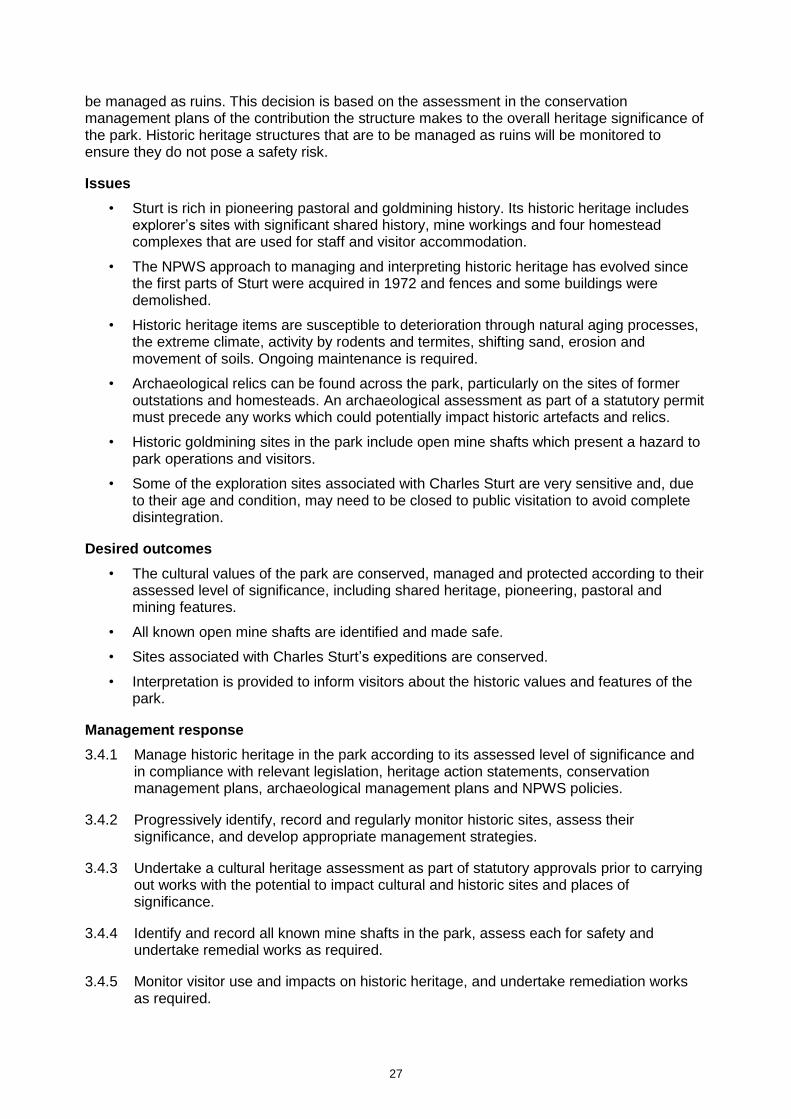
27
be managed as ruins. This decision is based on the assessment in the conservation management plans of the contribution the structure makes to the overall heritage significance of the park. Historic heritage structures that are to be managed as ruins will be monitored to ensure they do not pose a safety risk.
Issues
• Sturt is rich in pioneering pastoral and goldmining history. Its historic heritage includes explorer’s sites with significant shared history, mine workings and four homestead complexes that are used for staff and visitor accommodation.
• The NPWS approach to managing and interpreting historic heritage has evolved since the first parts of Sturt were acquired in 1972 and fences and some buildings were demolished.
• Historic heritage items are susceptible to deterioration through natural aging processes, the extreme climate, activity by rodents and termites, shifting sand, erosion and movement of soils. Ongoing maintenance is required.
• Archaeological relics can be found across the park, particularly on the sites of former outstations and homesteads. An archaeological assessment as part of a statutory permit must precede any works which could potentially impact historic artefacts and relics.
• Historic goldmining sites in the park include open mine shafts which present a hazard to park operations and visitors.
• Some of the exploration sites associated with Charles Sturt are very sensitive and, due to their age and condition, may need to be closed to public visitation to avoid complete disintegration.
Desired outcomes
• The cultural values of the park are conserved, managed and protected according to their assessed level of significance, including shared heritage, pioneering, pastoral and mining features.
• All known open mine shafts are identified and made safe.
• Sites associated with Charles Sturt’s expeditions are conserved.
• Interpretation is provided to inform visitors about the historic values and features of the park.
Management response
3.4.1 Manage historic heritage in the park according to its assessed level of significance and in compliance with relevant legislation, heritage action statements, conservation management plans, archaeological management plans and NPWS policies.
3.4.2 Progressively identify, record and regularly monitor historic sites, assess their significance, and develop appropriate management strategies.
3.4.3 Undertake a cultural heritage assessment as part of statutory approvals prior to carrying out works with the potential to impact cultural and historic sites and places of significance.
3.4.4 Identify and record all known mine shafts in the park, assess each for safety and undertake remedial works as required.
3.4.5 Monitor visitor use and impacts on historic heritage, and undertake remediation works as required.
28
3.4.6 Review the archaeological management plan and prepare a maintenance strategy for the Charles Sturt exploration sites based on the recommendations in that plan.
3.4.7 Manage Mount Wood and Olive Downs homestead precincts consistent with conservation management plans.
3.4.8 Manage items, buildings and places listed on the State Heritage Register with expert advice, and monitor their condition.
3.4.9 Support the listing of the Sturt Exploration Cultural Landscape (as defined in the archaeological management plan) on the State Heritage Register, in consultation with relevant stakeholders.
3.5 Visitor use
NPWS parks and reserves provide a range of opportunities for education and tourism including opportunities for relaxation and renewal as well as recreation. Visitor opportunities in the natural and undeveloped settings within the park are intended to have minimal or no impact on park values. NPWS aims to ensure that visitors appreciate and enjoy their experience while conserving and protecting the park.
Visitor use of Sturt is focused on day use activities and camping, but also includes short-term accommodation in adapted historic heritage buildings. Activities in the park include bird and wildlife watching, photography, stargazing and the appreciation of heritage and cultural values.
Sturt is an important regional and local tourist destination. There are four main access points:
• from South Australia to the west through Cameron Corner via the Strzelecki Track
• from Queensland to the north via Warri Gate
• from the east via the Bourke–Wanaaring road
• from the south via the Silver City Highway.
Visitor numbers are estimated at 30,000 people per year. The period between April and October is the most popular, and patronage is highest during school holidays in July and in August/September. Surveys by NPWS indicate two-thirds of visitors are from New South Wales and their length of stay is between one and three days. The park is very popular with the retired ‘wanderer’ market segment, which contributes over half the park’s visitors. Travel and tourism in summer is limited by the extreme temperatures, and is also confined to periods of dry weather as road closures are necessary after even minor rainfall events.
Visitation to NPWS parks provides opportunities for people to connect to the landscape and increases advocacy for the ongoing protection and conservation of parks. Visitation to Sturt needs to be carefully managed because visitors can have a negative impact on natural and cultural values. The nature and severity of visitor-use impacts on park values depends on the type and frequency of the activity, visitor numbers and behaviours, as well as the sensitivity of the site. The arid landscape of Sturt is a sensitive environment that is highly prone to erosion. In this environment, recovery from adverse impacts takes a very long time and is dependent on there being no further disturbance. Cultural and heritage artefacts and sites are particularly sensitive to human disturbance and erosive processes. The large size of the park, its remoteness, isolation and multiple access points are all factors that increase the incidence of undesirable visitor behaviour such as camping outside designated camping grounds, using wood fires, off-road driving and avoiding camping and park-use fees. NPWS is working to minimise such activities through monitoring, visitor education and signage.
29
Any proposals regarding the upgrading or replacement of existing visitor facilities, including within day use areas and campgrounds, will be assessed for appropriateness and will be based on demand.
The national parks of far west New South Wales including Sturt, Mungo, Mutawintji, Kinchega, and Paroo-Darling are major tourist attractions that generate significant contributions to the regional economy. Travellers to Sturt often visit other desert parks and attractions as well. Sturt provides visitor opportunities that complement the regional experience.
Issues
• The park is remote and in a harsh, arid environment. Visitors are not always adequately prepared for the harsh conditions.
• Prohibited activities that occur in the park on a semi-regular basis include firewood collection, vandalism, bush camping outside designated areas and off-road driving.
• Landscapes are sensitive to erosion, and cultural heritage is sensitive to disturbance.
Desired outcomes
• Visitor use of the park is appropriate, ecologically sustainable and consistent with the conservation and appreciation of the natural and cultural values of the park. Prohibited activities are minimised.
• Visitor safety is promoted, and signage, interpretation and education promotes a safe and enjoyable visitor experience.
• Proposals to develop visitor facilities or experiences are assessed for appropriateness and based on demand.
• Visitor experiences in Sturt complement the regional tourism experience.
Management response
3.5.1 Monitor visitor use of the park and its facilities. Take remedial action where negative impacts or unwanted activities occur. Upgrade existing facilities as required.
3.5.2 Work with the broader community, regional and state tourism bodies to promote Sturt as the focus of a remote, arid landscape tourism experience, which includes historic and Aboriginal cultural heritage and wildlife conservation programs.
Visitor facilities and experiences
The park offers a range of day use, camping and hard-roofed accommodation in four main visitor precincts (see Figures 1 to 4). These are distributed throughout the park, providing visitors with access to key points of interest and a variety of experiences including scenic lookouts, iconic desert landscapes, Aboriginal cultural heritage, an outdoor pastoral museum, historic homesteads and a replica of a historic goldmining site. Available facilities and experiences are listed in Table 3. No additional visitor facilities are proposed to be constructed in the park.
In order to limit damage to the park’s fragile environment and to maintain visitor safety in remote conditions, camping in Sturt is allowed only in the established campgrounds. Consistent with a remote, desert experience, campgrounds will continue to be maintained with basic camping facilities.

30
Table 3: Visitor experiences and facilities
Precinct Experiences Facilities
Dead Horse Gully
Golden Gully – replica of historic gold mining site
Camping
The Granites Nature Walking Trail
Picnic tables, gas barbecues, solar lighting, non-potable water, rubbish bins, information, toilets
Sites for tents, camper trailers, caravans
Mount Wood Mount Wood Homestead
Mount Wood Shearers’ Quarters
Campground
Gibber plains
Birdwatching
Walking track around Mount Wood Homestead complex – historic heritage
Outdoor pastoral museum and wool scour
Hard-roofed accommodation
Sites for tents, camper trailers, caravans
Picnic tables, gas barbecues, solar lighting, non-potable water, rubbish bins, information, toilets
Olive Downs Camping
Olive Downs Shearers Quarters ruins
Mulga woodlands
Jump-up Walking Track
Sites for tents, camper trailers, caravans
Picnic tables, gas barbecues, solar lighting, non-potable water, rubbish bins, information, toilets
Fort Grey Camping
Fort Grey Wells Walk
Sturt’s Tree Walk
Observing threatened species
Lake Pinaroo (Convention on Wetlands site)
Birdwatching
Desert sand dunes
Old Fort Grey Homestead
Dog Fence
Cameron Corner
Sites for tents, camper trailers, caravans
Picnic tables, gas barbecues, solar lighting, non-potable water, rubbish bins, information, toilets
South Myers Tank
Birdwatching Birdhide
Due to the harsh climate and remoteness of the park, only untreated water can be made available in all campgrounds and no showers are provided. Visitors are advised to bring their own drinking water and to take appropriate precautions before consuming the water at the campgrounds.
In Sturt’s arid environment there is relatively little vegetation. Fallen timber is a scarce ecological resource in arid environments, needed to provide habitat for a range of organisms, to condition the soil, prevent erosion and act as a barrier to trap seeds and promote revegetation. The removal of fallen timber and coarse woody debris is listed as a key threatening process under the Biodiversity Conservation Act (NSW SC 2003). Therefore, wood fires are not permitted in the park.
Sturt also provides a hard-roofed accommodation option for visitors in adapted historic heritage buildings. Facilities range from modernised homesteads to rustic shearers’ quarters. This form
31
of accommodation is available to individuals and groups with prior bookings and includes Mount Wood Homestead and Shearers’ Quarters, Olive Downs Single Men’s Quarters and Narcowla Hut.
A new and uncommon visitor experience will be provided by the Reintroduction of Locally Extinct Mammals project as described in Section 3.2. Visitors will be able to observe threatened species in the reintroduction areas through guided tours including night tours. The Fort Grey campground will serve as a focus for visitors once the project is well-established and will be managed under licence as part of the project.
Issues
• Bush camping outside designated campgrounds causes significant impacts on park values and increases risks to visitors.
• Maintaining and servicing hard-roofed accommodation in a remote location is costly and may not operate on a full cost-recovery basis.
Desired outcomes
• A range of facilities and experiences are available in the park that provide satisfying visitor experiences.
• Visitation to the park is sustainable, and negative impacts on park values resulting from visitor use are minimised.
• Awareness of threatened species conservation issues and ecosystem restoration are increased through visitors’ engaging in wildlife experiences in the park.
Management response
3.5.3 Maintain the current range of low-impact, unobtrusive facilities for visitors in the park including camping and hard-roofed accommodation, which are consistent with park values and the remote visitor experience, and appropriate to demand.
3.5.4 Allow the construction of visitor infrastructure to support the Reintroduction of Locally Extinct Mammals project within Fort Grey Campground and the wider project area.
3.5.5 Do not allow timber collection or wood fires in the park. Encourage visitors to use their own non-wood fuel stoves. Provide gas barbecues in designated visitor areas.
3.5.6 Support educational, guided wildlife viewing experiences as part of the Reintroduction of Locally Extinct Mammals project.
Visitor access
Visitor access in the park is via a network of gravel or dirt roads as shown on Figure 5. The majority of these roads are constructed to two-wheel drive, dry-weather standard. Caravans and motorhomes can traverse most parts of the park except where higher clearance is needed. Due to increasing visitor traffic, NPWS is aiming to construct and maintain all roads to two-wheel drive, dry-weather standard including Middle Road East and Middle Road West. The unsealed dirt roads of the outback are part of the remote visitor experience. Park roads do, however, become increasingly corrugated with constant use and impassable following rain. They may be closed at the discretion of NPWS to ensure visitor safety and to prevent damage to the road surface.
The various features of the park are far apart and it is essential that visitors are adequately prepared by travelling in a suitable vehicle and carrying supplies of fuel and water.

32
There are four self-guided scenic drives in the park that connect the visitor precincts and together provide a route for visitors to explore the entire park (see Figure 5). From east to west these are:
• Gorge Loop Drive in the eastern section of the park leaves the Wanaaring–Tibooburra road at the Mount Wood turnoff (approximately 27 kilometres east of Tibooburra) and traverses the rolling downs country with its gibber plains and the large ephemeral Twelve Mile Creek to meet with the Silver City Highway north of Tibooburra.
• Jump-up Loop Drive starts where the Gorge Loop Drive meets the Silver City Highway 18 kilometres north of Tibooburra. It explores the catchment area of Twelve Mile Creek, then climbs the Jump-up before winding its way back to the highway to return to Tibooburra.
• Middle Road begins at the Olive Downs complex and crosses the park from east to west for 80 kilometres. The road leads through Mitchell grass plains, across red dunes and over the white, bleached sands of the lunette surrounding Lake Pinaroo. It finishes north of Lake Pinaroo where it intersects with Cameron Corner Road. Middle Road is designated for four-wheel drive vehicles only. Off-road caravans and camper trailers are permitted.
• Dunes Scenic Drive is a 22-kilometre road that links Cameron Corner Road to the iconic tri-state corner of New South Wales, South Australia and Queensland. This drive takes visitors through the sand dune country of the outskirts of the Strzelecki Desert. Additional issues apply to the management of Dunes Scenic Drive (see below).
The scenic drives are speed-limited to help reduce dust and collisions with wildlife. Driving off formed roads is not permitted in the park as the arid landscape is home to fragile ecosystems and includes sensitive soil crusts. These soil crusts are important for soil stability and nutrient retention and once broken by vehicles, hard-hoofed animals or other disturbances, can take decades to recover (ANBC 2012; Eldridge & Tozer 1997).
Issues
• Drivers frequently exceed the speed limits which increases the risk of accidents, including collisions with wildlife.
• The park is accessible only by unsealed roads which are often closed after rain.
• Dunes Scenic Drive can currently only be maintained to the same standard as other scenic drives in the park and road accidents occur from time to time. Scenic drives in the park may be closed due to dangerous driving conditions, wet weather or during management operations.
Desired outcomes
• Visitors have a safe driving experience while visiting the park and visitor traffic does not cause adverse impacts on park values.
Management response
3.5.7 Maintain scenic drives to two- or four-wheel drive, dry-weather road standards as shown on the maps in this plan until such time as they can be upgraded to two-wheel drive, dry-weather road standard.
3.5.8 Monitor driver behaviour and enforce speed restrictions.
3.5.9 Provide appropriate signage, including interpretive and safety information on the scenic drives.

33
3.5.10 Continue to liaise with NSW Roads and Maritime Services, NSW Police and other relevant stakeholders regarding road safety and the appropriate management of traffic in the area.
Bushwalking and cycling
Bushwalking and cycling allow visitors to be in close contact with the environment and increases the understanding and enjoyment of parks. Sturt provides a variety of bushwalking and off-road cycling opportunities of different lengths across a diverse range of landscapes as described in Table 4.
Table 4: Walking opportunities in Sturt
Track name Location Setting Distance
Wells Walk (short) Fort Grey Campground
Early pastoral evidence; ephemeral lake; internationally significant wetland
4 km
Sturt’s Tree Walk (long)
Fort Grey Campground
Early exploration and pastoral evidence; ephemeral lake; internationally significant wetland
7 km
Mount Wood Homestead Walk
Mount Wood Homestead
Pastoral history; State Heritage-listed building
600 m
The Granites Nature Walking Trail (short)
Dead Horse Gully Campground
Granodiorite tors 500 m
The Granites Nature Walking Trail (long)
Dead Horse Gully Campground
Granodiorite tors 2 km
Olive Downs Walking Trail (short)
Olive Downs Campground
Jump-ups 1.5 km
Olive Downs Walking Trail (long)
Olive Downs Campground
Jump-ups 3.5 km
Mount Wood Summit Walk
Gorge Loop Drive Gibber plains; gorges; Twelve Mile River system
8 km
All walks indicated in Table 4 are classified within Australian Standard Walking Tracks Part 1: Classification and signage (AS 2156.1–2001) as ‘Hiking Track 4’ (DSE n.d.). High or heavy rainfall can cause erosive damage to walking tracks. This has occurred previously on the Mount Wood Summit Walk.
Cycling is allowed on management trails in the park consistent with the NPWS Sustainable Mountain Biking Strategy (OEH 2011b). Cycling on the unsealed park roads shared with motorised vehicles in this region is too dangerous due to excessive dust and the condition of the road surface. Cycling is therefore not permitted on park roads, and will only be permitted on management trails with prior consent.
Due to the arid environment and remote location of the park, walkers and cyclists are encouraged to register their trip with the NPWS Tibooburra office, and provide details of planned routes prior to setting out.

34
Issues
• Sturt regularly experiences extreme temperatures. Bushwalking and cycling in these conditions involves risks to safety. Visitors must be prepared.
• Maintaining walking tracks to safe standards in environmentally challenging locations is difficult.
Desired outcomes
• Appropriate information and signage guides bushwalkers and cyclists safely through the park.
• The negative impacts of bushwalking and cycling on park values are minimised.
• Potential negative interactions between park users, including walkers, cyclists and motorists, are eliminated.
Management response
3.5.11 Provide bushwalking opportunities in accordance with Table 4.
3.5.12 Upgrade Mount Wood Summit Walk to improve visitor safety and protect fragile environments, and extend the track to create a loop back to the carpark.
3.5.13 Permit cycling on management trails in Sturt with prior NPWS consent. Cycling is not permitted on walking tracks, off-track (i.e. cross-country) or on park roads.
3.5.14 Ensure directional, interpretive and safety signage on walking and cycling tracks is reviewed and upgraded as appropriate.
3.5.15 Close roads and trails to walkers and cyclists where there is an unacceptable environmental impact or risk to users.
Horse riding
Although horses were once used in the management of stock in this region there is no history of recreational horse riding. Sturt is remote, water is scarce and there is a lack of suitable stabling facilities. There are also significant risks for conflict between horse riders and vehicular traffic in the park. For these reasons, horse riding is not permitted.
Issues
• Safety of park users is a primary issue.
• There are no facilities within the park to cater for horses.
Desired outcome
• People understand the problems, including safety, conservation and animal welfare issues associated with horse riding in Sturt.
Management response
3.5.16 Horse riding is not permitted in Sturt. In the event that land within any of the travelling stock routes is added to the park in future, consideration could be given to horse riding along these routes.
Fossicking
Fossicking is the small-scale search for, and collection of, minerals, gemstones or mineral-bearing material from the surface (or by digging from the surface) with hand-held implements.

35
Fossicking is generally not allowed in parks because it can pose unacceptable risks to natural and cultural heritage values. However, the NPWS Fossicking Policy allows for limited fossicking opportunities where it is consistent with the relevant management principles for the park and subject to an appropriate level of environment and risk assessment.
Due to the presence of highly significant Aboriginal cultural heritage and sensitive environmental values, fossicking is not considered to be a suitable activity in Sturt.
Management response
3.5.17 Fossicking is not permitted in Sturt.
Group activities (commercial and non-commercial)
Group activities such as guided tours provide opportunities for the less independent traveller, and can promote environmental and cultural understanding and support for conservation. Group activities can also provide opportunities for commercial tour operators to partner with NPWS in providing enjoyable visitor experiences. Large groups can, however, have an impact on park values and can change the experience for independent visitors and campers.
All large group activities in the park require written consent, and must be consistent with the management principles of Sturt and be compatible with the maintenance of the natural and cultural heritage values of the park.
Commercial tourism increases the opportunity for public participation in nature-based activities and provides opportunities for professional instruction in various recreational pursuits. All commercial tourism activities in the park must be licensed under the National Parks and Wildlife Act. Approximately 20 commercial tour operators are licensed to operate in Sturt. Newly licensed commercial operators are required to undertake a specific Sturt induction prior to operating in the park and to comply with any licence conditions that may apply.
Monitoring of and communication with commercial operators in the park has been insufficient. Some operators are known to have breached licence conditions by not notifying park management of the timing or nature of tours. Such breaches compromise the ability of park management to notify tour groups of impending management activities, such as road closures, as well as any opportunities for visitors that may arise.
Issues
• Large organised groups can have a negative impact on park experiences for individuals and smaller groups.
• Some tour operators fail to notify park management of tour activities proposed in the park.
Desired outcomes
• Group activities have minimal impacts on natural and cultural values and on other users.
• Group activities facilitate a quality experience for participants, enhancing their understanding and appreciation of the natural and cultural heritage value of the park.
• Tour operators comply with licence conditions.
Management response
3.5.18 Allow group activities that are consistent with the management objectives, principles and values of NPWS and Sturt. Group activities are subject to conditions on group size, type of activity and location within the park.

36
3.5.19 Limit the size of visitor groups without written consent to five vehicles or 10 people. Groups exceeding this number require written consent from NPWS.
3.5.20 Monitor commercial and non-commercial group activities with respect to cumulative impacts, safety requirements, quality of information being given and compliance with licence or consent conditions. Licences or consents may be cancelled if a breach of conditions occurs.

37
Figure 2: Dead Horse Gully visitor precinct
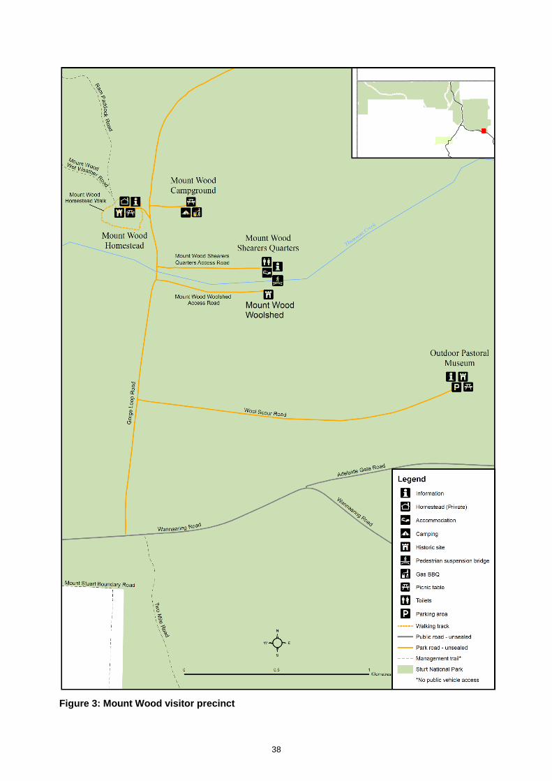
38
Figure 3: Mount Wood visitor precinct
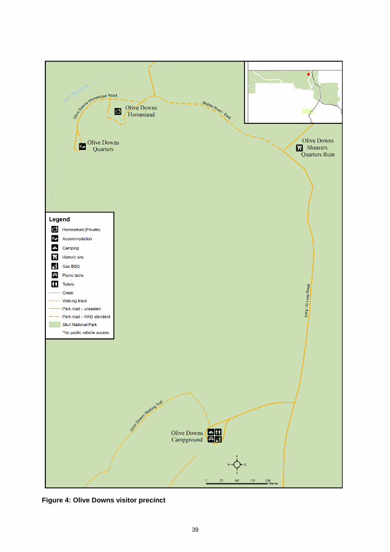
39
Figure 4: Olive Downs visitor precinct
40
3.6 Information, education and research
Visitor information and education
Providing interpretive and educational information to park visitors helps preserve and protect natural and cultural heritage, promotes support for conservation and environmental awareness, increases the enjoyment and satisfaction of visitors, and encourages positive visitor behaviour. Research underpins information flow, education and management.
Sturt presents many opportunities for visitors to experience and learn about a wide range of cultural and natural park values. NPWS actively promotes visitor education and works to raise public awareness of the importance of management programs designed to conserve and protect those values.
Because Sturt is remote, information to orientate visitors and to provide up-to-date advice about weather and road conditions is particularly important. The main sources of information for visitors are:
• Tibooburra NPWS Visitor Centre and Courthouse Museum, which serve as the visitor gateway to the park and the Corner Country
• information shelters placed at the main entrances to the park at Warri Gate, Toona Gate, on the Tibooburra–Wanaaring road, and at Cameron Corner
• information shelters located at the four campgrounds
• interpretative signs placed at various points of interest across the park, relating to historic heritage, Aboriginal cultural heritage and natural values
• numbered signs along the self-drive routes at points of interest
• guides to the native animals and plants of the park produced in conjunction with researchers
• NPWS website.
A Discovery program has been run in the park during most school holidays. NPWS rangers may also conduct guided walks, tag-along tours and other activities for park visitors at peak visitor times. NPWS has also delivered a Green Ranger program at Tibooburra Primary School, which has been run four times each year. The program introduces local children and their families to a wide variety of park management activities.
Educational opportunities will also be provided for visitors in the park as part of the Reintroduction of Locally Extinct Mammals project (see Section 3.2). One of the project’s objectives is to increase public engagement in nature conservation through awareness of threatened species and ecosystem restoration. Visitors will have the opportunity to learn about threatened species found in Sturt and how landscapes can be restored through the reintroduction of locally extinct mammals.
Issues
• Providing adequate orientation and safety information is essential for safe visitor management and satisfactory visitor experiences in the park.
• Mobile reception in the park is available only in the south-east section of the park and only through the Telstra network. Visitors need to be self-supporting and adequately equipped for travel in the outback.
• Interpretation of Aboriginal history and the involvement of traditional owners in public education about Aboriginal cultural values of the park is currently very limited.

41
• Not all visitors pay park fees as required and some behave inappropriately while in the park. There is an ongoing need to educate visitors.
Desired outcomes
• There is widespread community understanding and appreciation of the park’s natural and cultural values, and of appropriate behaviour while in the park.
• Visitors are aware of the park’s recreation and tourism opportunities and are well-prepared for the outback conditions.
• The park and its facilities are a primary environmental educational resource for local schools and the community.
• Aboriginal people are involved in the interpretation of history and culture in the park.
Management response
3.6.1 Support visitor use and enjoyment of the park by providing and regularly reviewing educational and interpretation materials in consultation with the Aboriginal community and other stakeholders.
3.6.2 Provide additional directional, regulatory, and safety signage in the park where required.
3.6.3 Support a program of visitor experiences based on the Reintroduction of Locally Extinct Mammals project.
3.6.4 Engage the local Aboriginal community and descendants of original Aboriginal occupants in developing material and programs for the interpretation of Aboriginal culture.
3.6.5 Continue to encourage and support the educational and research activities in the park.
Research
Sturt has been the focus of scientific research studies. These have included archaeological and geomorphological/geological surveys, the ecology of native animals and plants in the arid zone and pest control. Several studies have provided information that has benefited park management. Additional and ongoing research is required to improve management practices in Sturt, to address knowledge gaps, and to enhance the level of education and information provided to park visitors.
NPWS encourages environmental research and student field work training projects in the park. Preference is given to applied research, which will benefit ongoing adaptive management for the park’s significant natural and cultural values. Potential research topics include threatened species biology, hydrology, geomorphology, palaeontology and archaeology, fire fuel management and visitor impact. Effective management strategies for the park will be enhanced by research outcomes. Information gathered on the park also has the potential to increase understanding of arid zone issues and solutions, which can be applied to the management and conservation of ecosystems in the broader landscape.
Monitoring and research into ecosystem restoration and species reintroductions will be conducted in the park by the University of New South Wales (operating as ‘Wild Deserts’) as part of the Reintroduction of Locally Extinct Mammals project (see Section 3.2). A research strategy will be developed to examine key aspects of species reintroductions including: population dynamics, preferred habitat attributes, relationships between reintroduced and resident species, and predator–prey relationships for both native and non-native predators. Pest control methods will also be studied.

42
Issues
• Sturt is a large and varied park offering many opportunities for research across a range of scientific fields.
• A greater understanding of the park’s ecology is required to deal with park management issues, including the impacts of climate change.
Desired outcomes
• Research informs adaptive park management, enhances knowledge of the natural and cultural assets of the park and promotes awareness and understanding of park values.
• Cooperative research partnerships are formed where possible.
• All research activities are conducted with approval from NPWS and with appropriate scientific licences and animal research ethics approvals.
Management response
3.6.6 Identify research opportunities that will support decision-making about the park. High priorities include the management of Lake Pinaroo Convention on Wetlands site, predator–prey relationships, and ecosystem restoration through reintroduction of locally extinct species.
3.6.7 Encourage organisations and individuals to take up priority research opportunities and, where appropriate and possible, provide support for this research.
3.6.8 Support cooperative research partnerships and agreements with educational and research organisations.
3.6.9 Ensure that research reports and data are provided to NPWS for park records and management purposes.
3.6.10 Where appropriate, interpret and publicise research findings to park visitors, research organisations and the public.
3.6.11 Ensure that information pertaining to the values of Sturt is gathered, analysed, appropriately shared and archived.
3.6.12 Involve Aboriginal stakeholders in any research relating to Aboriginal cultural values, sites or oral histories.

43
4. Threats
4.1 Pests
Pest species are plants, animals and pathogens that have negative environmental, economic and social impacts; commonly they are introduced species. Pests can have impacts across a range of park values, including impacts on biodiversity, cultural heritage, ecosystem function, landscape and scenic values.
NPWS prepares pest management strategies which identify pest species across that region’s parks. These strategies also identify priorities for control and incorporate actions listed in the Priorities Action Statement (see Section 3.2), threat abatement plans and other strategies, such as Biodiversity Priorities for Widespread Weeds (NSW DPI & OEH 2011) and the NSW Biosecurity Strategy 2013–2021 (DPI 2013).
The regional pest management strategy for the Far West Region (OEH 2013b) identifies pest species and priority programs for the park (see Table 5). The overriding objective of the pest management strategy is to minimise adverse impacts of introduced species on biodiversity and other park and community values while complying with legislative responsibilities. The strategy also identifies where other site- or pest-specific plans or strategies need to be developed to provide a more detailed approach.
Table 5: Weeds and pest animals recorded in Sturt
Common name Scientific name Comment
Weeds
Noogoora burr Xanthium occidentale Scattered infestation. Highly invasive weed. Competes against all native grass species. Has potential to create monocultures
Paterson’s curse Echium plantagineum Scattered infestation. Competes with all native grass species
Bathurst burr Xanthium spinosum Scattered infestation. Invasive agricultural weed of disturbed areas
Saffron thistle Carthamus lanatus Scattered infestations along roadsides
Athel pine * # Tamarix aphylla Isolated infestation. Potential to invade sandy areas adjacent to creek lines. Outcompetes native vegetation
Mexican poppy Argemone ochroleuca Scattered infestation. Competes with native species. Can create monocultures
African boxthorn *# Lycium ferocissimum Isolated infestation. Provides cover for feral pigs and rabbits. Competes with native species. Has potential to create monocultures and impede wildlife
Tree tobacco Nicotiana glauca Isolated infestation. Competes with native species
44
Common name Scientific name Comment
Buffel grass Cenchrus ciliaris Two main infestations at Mount Wood and near park boundary with Tibooburra Common. Has potential to create monocultures and has been linked to increased fire frequency and intensity throughout arid regions in central Australia
Pest animals
Wild dog Canis lupus subsp. Low densities
European fox Vulpes vulpes Established widespread infestation.
Feral cat Felis catus Widespread in park. Kills native wildlife. Carrier of disease and parasites that can be transferred
European rabbit Oryctolagus cuniculus Established widespread infestation. Responsible for native vegetation and soil damage. Competes with native animals for suitable habitat
Feral goat Capra hircus Scattered and widespread infestation. Destroys native vegetation and severely impacts seedling growth
Feral pig Sus scrofa Isolated infestation. Greatest damage in wet years
* Declared Weed of National Significance
# State-level priority weed under the NSW Biosecurity Act 2015.
Weeds
The NSW Biosecurity Act 2015 and Regulations provide specific legal requirements for the prevention, eradication or containment of state-level priority weeds. These requirements apply equally to both public and privately owned land. A regional strategic weed management plan prepared under the Biosecurity Act identifies those pest plants that are being prioritised for management action, investment and compliance effort within the Western Local Land Services region (Western LLS 2017). These priorities will be implemented via the relevant NPWS pest management strategy.
Weed control programs are run annually within Sturt. The majority of weed spraying, particularly of Noogoora burr, occurs in late summer. Noogoora burr seeds stay viable for over 20 years, making it important to control this plant prior to it setting seed. Paterson’s curse and saffron thistle are sprayed in spring following outbreaks occurring along public access roads where disturbed areas are colonised by seed brought in by vehicles. The long viability of Noogoora burr seeds and vehicle-introduced infestations of Paterson’s curse make these two weeds particularly difficult to control. An eradication program for athel pine has also been implemented.
Buffel grass occurs infrequently throughout the ephemeral creek systems of Sturt, favouring drainage lines as they are usually higher in nutrients and moisture. This imported species originally proved useful for pasture and soil retention in a wide range of environments including arid and semi-arid Australia due to its drought tolerance, high biomass, deep roots, rapid response to summer rains, relative palatability and resistance to overgrazing. However, these same characteristics also make it an environmental weed (CRC for Weed Management 2008) and it is included in the listing of novel biota and their impact on biodiversity as a threatening process (DoEE 2013). As with other pasture species, buffel grass responds readily to rain, but in Sturt tends to be controlled by prevalent harsh seasonal conditions.

45
Wild dogs
Wild dogs are known to occur occasionally within the park though only at very low densities. Wild dogs, including dingos, are a declared pest under the Local Land Services Act due to their impacts on livestock. NPWS therefore has a statutory obligation to control wild dogs on its estate. Wild dogs may also have significant impacts upon the distribution and abundance of some native wildlife. Feral dogs are listed as a key threatening process under the Biodiversity Conservation Act (NSW SC 2009).
The movement of dogs into the park from the north and west is prevented by the Dog Fence, which was constructed along the Queensland and South Australian borders in the 1880s and now extends for a total distance of 5614 kilometres. The fence has helped reduce the loss of sheep to wild dogs and is supplemented by baiting, trapping and shooting. The occurrence of wild dogs in the park is sporadic (Croft 2002). NPWS participates in control operations with the Wild Dog Destruction Board and Local Land Services to ensure a coordinated approach across the local area. Monitoring for dog activity occurs regularly and NPWS seeks to assist neighbours within 36 hours of receiving a report of a wild dog attack on livestock.
Native dingos (Canis lupus dingo) are also known to occur within the park. Dingo populations occur at a low density and are responsive to widespread environmental constraints such as droughts. Recent research has suggested that as a top-order native predator, they may have beneficial effects for the conservation of small native vertebrates, because their presence reduces the numbers of both foxes and cats (Purcell 2010; Dickman et al. 2009; Letnic et al. 2012; Visser et al. 2009; Johnson & Van Der Wal 2009; Johnson et al. 2007). On this basis, the loss of dingos from an area may be detrimental to populations of native animals.
Dingos are not protected in New South Wales by the National Parks and Wildlife Act as they are regarded as a wild dog under the Local Lands Services Act. NPWS recognises that, together with wild dogs, dingos cause losses to livestock and so it includes them in pest control activities.
Foxes
Foxes suppress native animal populations, particularly medium- and small-sized ground-dwelling and semi-arboreal mammals, ground-nesting birds and freshwater turtles. Foxes are also known to prey on domestic stock, including lambs and poultry. Predation by the European red fox is a declared key threatening process under both the Biodiversity Conservation Act and the Environment Protection and Biodiversity Conservation Act (NSW SC 1998; DoE 2009). The fox is also a declared pest species in New South Wales under the Local Land Services Act.
Foxes are widespread in Sturt and in the surrounding area. Their numbers increase following good conditions that result in an abundance of small prey. Native animals most likely to be impacted in Sturt include small mammals, reptiles and birds (e.g. dusky hopping-mouse, long-haired rat and flock bronzewing).
The NSW Threat Abatement Plan for Predation by the Red Fox (Vulpes vulpes) (OEH 2011a) was first initiated in 2001 with the primary objective of protecting threatened native animals by establishing long-term control programs at priority sites. The plan now applies to 59 priority sites across public and private lands in New South Wales. Fox control and monitoring is undertaken in Sturt in accordance with the plan. Proactive control programs include two planned baits across the whole park each year plus reactive baits as needed in response to wild dog activity. Larger scale baiting increases the time taken for re-infestation (Moseby & Hill 2011).
Monitoring the effectiveness of fox control programs for threatened species benefit is crucial. This can be difficult as threatened species tend to occur in low densities. Remotely operated cameras have been used to assist in biodiversity monitoring with varying results (Towerton et al. 2011).
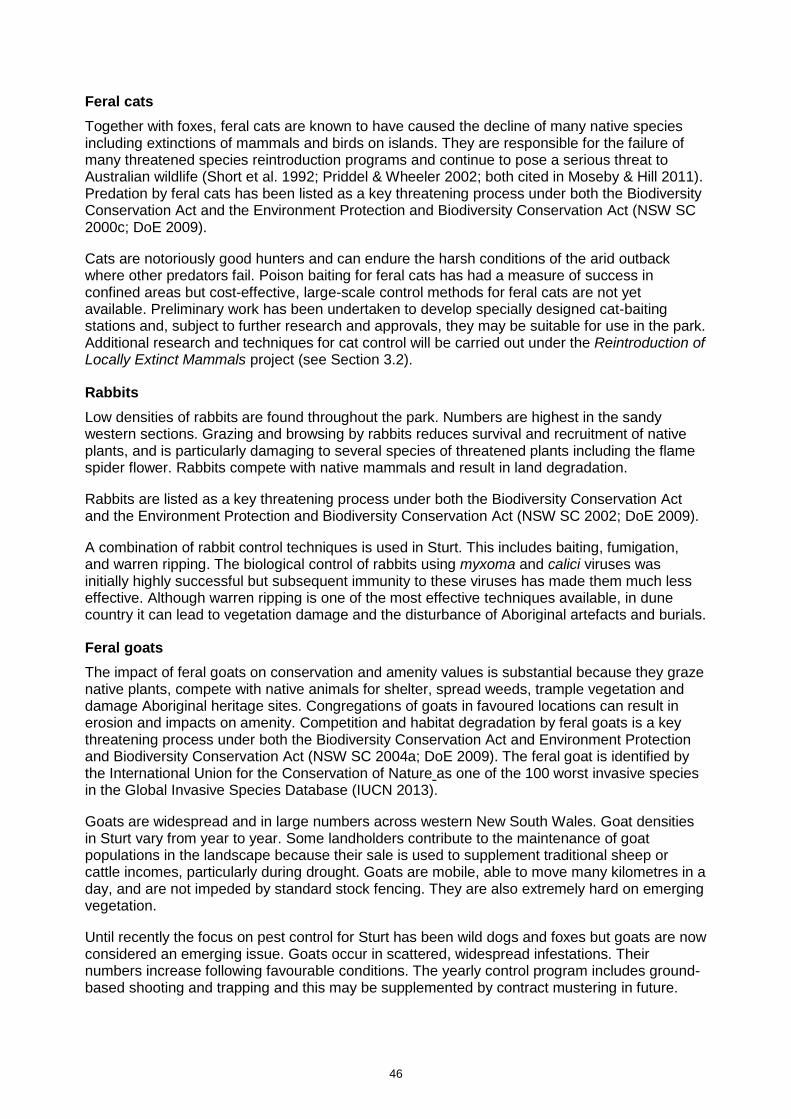
46
Feral cats
Together with foxes, feral cats are known to have caused the decline of many native species including extinctions of mammals and birds on islands. They are responsible for the failure of many threatened species reintroduction programs and continue to pose a serious threat to Australian wildlife (Short et al. 1992; Priddel & Wheeler 2002; both cited in Moseby & Hill 2011). Predation by feral cats has been listed as a key threatening process under both the Biodiversity Conservation Act and the Environment Protection and Biodiversity Conservation Act (NSW SC 2000c; DoE 2009).
Cats are notoriously good hunters and can endure the harsh conditions of the arid outback where other predators fail. Poison baiting for feral cats has had a measure of success in confined areas but cost-effective, large-scale control methods for feral cats are not yet available. Preliminary work has been undertaken to develop specially designed cat-baiting stations and, subject to further research and approvals, they may be suitable for use in the park. Additional research and techniques for cat control will be carried out under the Reintroduction of Locally Extinct Mammals project (see Section 3.2).
Rabbits
Low densities of rabbits are found throughout the park. Numbers are highest in the sandy western sections. Grazing and browsing by rabbits reduces survival and recruitment of native plants, and is particularly damaging to several species of threatened plants including the flame spider flower. Rabbits compete with native mammals and result in land degradation.
Rabbits are listed as a key threatening process under both the Biodiversity Conservation Act and the Environment Protection and Biodiversity Conservation Act (NSW SC 2002; DoE 2009).
A combination of rabbit control techniques is used in Sturt. This includes baiting, fumigation, and warren ripping. The biological control of rabbits using myxoma and calici viruses was initially highly successful but subsequent immunity to these viruses has made them much less effective. Although warren ripping is one of the most effective techniques available, in dune country it can lead to vegetation damage and the disturbance of Aboriginal artefacts and burials.
Feral goats
The impact of feral goats on conservation and amenity values is substantial because they graze native plants, compete with native animals for shelter, spread weeds, trample vegetation and damage Aboriginal heritage sites. Congregations of goats in favoured locations can result in erosion and impacts on amenity. Competition and habitat degradation by feral goats is a key threatening process under both the Biodiversity Conservation Act and Environment Protection and Biodiversity Conservation Act (NSW SC 2004a; DoE 2009). The feral goat is identified by the International Union for the Conservation of Nature as one of the 100 worst invasive species in the Global Invasive Species Database (IUCN 2013).
Goats are widespread and in large numbers across western New South Wales. Goat densities in Sturt vary from year to year. Some landholders contribute to the maintenance of goat populations in the landscape because their sale is used to supplement traditional sheep or cattle incomes, particularly during drought. Goats are mobile, able to move many kilometres in a day, and are not impeded by standard stock fencing. They are also extremely hard on emerging vegetation.
Until recently the focus on pest control for Sturt has been wild dogs and foxes but goats are now considered an emerging issue. Goats occur in scattered, widespread infestations. Their numbers increase following favourable conditions. The yearly control program includes ground-based shooting and trapping and this may be supplemented by contract mustering in future.

47
Feral pigs
The impact of feral pigs on conservation values is substantial as they forage, wallow and root in wetland areas and adjacent to creek lines causing major disturbance and damage to soils, roots, sensitive ground plants and wetland environments. Pigs also prey on native and non-native species. Areas disturbed by feral pigs are at risk from subsequent weed invasion and soil erosion. They are also a potential host for a number of exotic diseases.
Predation, habitat degradation, competition and disease transmission by feral pigs is listed as a key threatening process under both the Biodiversity Conservation Act and the Environment Protection and Biodiversity Conservation Act (NSW SC 2004b; TSSC 2001b). A feral pig threat abatement plan has been prepared under the Environment Protection and Biodiversity Conservation Act, which sets out a national framework to guide coordinated control actions (DEH 2005).
During years of average rainfall the impact of pigs on park values is negligible, however, in wet years pig numbers in the park increase. Pig activity is monitored and populations are controlled by trapping, shooting and baiting.
Plague locusts
The Australian plague locust (Chortoicetes terminifera) is a native insect, capable of reaching population levels that significantly impact the productive capacity of grazing and cropping land. Under the Local Land Services Act, all land managers including NPWS are responsible for the control of locusts on their land.
Locust habitats are primarily open tussock grasslands on clay loam soils. Habitats become suitable for locust breeding after rainfall when soil moisture allows egg development and vegetation response provides food for subsequent survival of nymphs (‘crawlers’).
To manage the competing responsibilities of managing native habitat and native animals and assisting in the control of Australian plague locusts, NPWS has in place an environment risk assessment protocol. This is used in response to all locust reports on its land and includes strict buffer zones excluding locust spraying operations within known or suspected threatened species habitat and otherwise sensitive environmental areas.
Desired outcomes
• Pest plants and animals are controlled and where possible eradicated.
• Negative impacts of introduced species on park values are minimised.
• The effectiveness of pest control programs is monitored and evaluated.
Management response
4.1.1 Manage and monitor pest species in accordance with pest management strategies relevant to the park and best practice adaptive management. Priority will be given to Noogoora burr, feral goat, pig, wild dog, cat and fox control.
4.1.2 Implement fox control in accordance with the threat abatement plan.
4.1.3 Regularly monitor the park for new and emerging weeds and pest threats, and treat outbreaks as a priority.
4.1.4 Coordinate pest and weed actions in consultation with park neighbours, Western Local Lands Services, the Wild Dog Destruction Board and other stakeholders.
4.1.5 Support research and incorporate new research findings into pest management programs.

48
4.2 Fire
The primary objectives of NPWS fire management are to protect life, property and community assets from the adverse impacts of fire, while also managing fire regimes in parks to maintain and enhance biodiversity. NPWS also assists in developing fire management practices that contribute to conserving cultural heritage across the landscape, and implements cooperative and coordinated fire management arrangements with other fire authorities, neighbours and the community (OEH 2013a).
Fire is a natural feature of many environments and is essential for the survival of some plant communities. However, inappropriate fire regimes can lead to the loss of particular plant and animal species and communities. Too-frequent fire has been listed as a key threatening process under the Biodiversity Conservation Act (NSW SC 2000b).
Fire occurrence and intensity is characteristically very low in the arid areas of New South Wales due to very sparse vegetation cover and extremely low fuel loads for the majority of years. Generally the sparse perennial plants do not provide sufficient fuel to carry a fire. The fire history prior to reservation is only partially known. Only a few fires have occurred in the park since reservation: in 1976, 1977, two in 2011 and two in 2012. All were ignited by lightning strikes.
Historically, large grass fires occur in the arid landscape of the park following two consecutive years of above-average annual rainfall, during a La Niña cycle. These conditions promote extensive growth of annual grasses, which creates a continuous fuel load on non-clay soils and creates a very high fire risk at a landscape scale. An event of this kind occurred in 2012 following two wet years and resulted in over 11,000 hectares burnt. In order to avoid such events, NPWS closely monitors the build-up of fuel and undertakes prescribed burning to create a mosaic of burnt and unburnt country, targeting areas of high ephemeral grass growth.
A fire management strategy that defines the fire management approach for Sturt has been prepared and is periodically updated (OEH 2016b). The fire management strategy identifies key assets within and adjoining the park (including sites of natural and cultural heritage value), fire management zones and fire control advantages such as management trails and water supply points. It also contains fire regime guidelines for conservation of the park’s vegetation communities.
NPWS maintains cooperative arrangements with surrounding landowners and the Rural Fire Service and is actively involved with the West Darling Bush Fire Management Committee. Cooperative arrangements include fire planning, fuel management and information sharing. Hazard reduction programs, ecological burning proposals and fire trail works are submitted annually to the bush fire management committee.
Issues
• Life, property and community assets must be protected from adverse impacts of fire.
• Fire is not necessarily required to maintain the natural vegetation of this arid zone park.
• Firefighting control activities can potentially damage natural and cultural features and values.
Desired outcomes
• Negative impacts of fire on life, property and the environment are minimised.
• The potential for spread of bushfires on, from, or into the park is minimised.
• Fire regimes are appropriate for long-term conservation of native plant and animal communities.

49
• Aboriginal and historic heritage sites are protected from damage by bushfires and suppression operations.
Management response
4.2.1 Implement the fire management strategy for the park.
4.2.2 Manage Sturt to protect biodiversity values in accordance with the identified fire regimes.
4.2.3 Monitor the ability of vegetation communities and plants to recover between fires and review regimes where relevant.
4.2.4 Participate in local emergency management meetings and maintain liaison with local Rural Fire Service personnel.
4.2.5 Assist adjacent landholders with fire suppression in close proximity to park boundaries, when required.
4.2.6 Where required, rehabilitate areas disturbed by fire suppression operations as soon as practical.
4.3 Climate change
Human-induced climate change is listed as a key threatening process under the Biodiversity Conservation Act (NSW SC 2000a) and the associated loss of habitat is listed on the Environment Protection and Biodiversity Conservation Act (TSSC 2001a).
The latest information on projected changes to climate are from the NSW and ACT Regional Climate Modelling (NARClim) project (OEH 2014). The climate projections for 2020–39 are described as ‘near future’ and projections for 2060–79 are described as ‘far future’ The snapshot shown in Table 6 is for the Far West Region which includes Sturt (OEH 2014).
Table 6: Far West Region climate change snapshot
Projected temperature changes
Maximum temperatures are projected to increase in the near future by 0.3–1.0°C
Maximum temperatures are projected to increase in the far future by 1.8–2.7°C
Minimum temperatures are projected to increase in the near future by 0.4–0.8°C
Minimum temperatures are projected to increase in the far future by 1.4–2.7°C
The number of hot days (i.e. >35°C) will increase
The number of cold nights (i.e. <2°C) will decrease
Projected rainfall changes
Rainfall is projected to decrease in spring Rainfall is projected to increase in summer and autumn
Projected Forest Fire Danger Index changes
Average fire weather is projected to increase in summer and spring in far future
Severe fire weather days are projected to increase in summer and spring in far future
Source: OEH 2014.

50
What is already a harsh hot climate in the north-west of New South Wales is expected to become even hotter and drier under climate change. The meteorological station at Tibooburra currently records over 70 hot days over 35°C per year. Under the projections for climate change, this is expected to increase by up to 40 additional days.
The projected increases in temperature and increased number of hot days is likely to increase evaporation by up to 50% in spring and lead to drier soil conditions throughout the year. This in turn may result in changes to the distribution of Mitchell grasslands and other arid vegetation communities. Increasing dryness is not likely to change the already very low occurrence of fire in the arid region due to very sparse vegetation cover and extremely low fuel loads. With regard to rainfall, a slight increase is projected to occur but the modelling of runoff shows significant variation and there are no clear patterns as to whether or not droughts are going to be more or less severe (DECCW 2010).
Under hotter and drier conditions, arid areas with little or no vegetation are likely to increase in extent and the impact of water scarcity will become more acute. Larger areas may be vulnerable to increased erosion by wind and by heavy downpours during more frequent intense storms. This increases the risk of disturbance and damage to Aboriginal cultural heritage in the landscape. Increased drying will also continue the aging and deterioration of standing historic heritage buildings in the park. Increased temperatures and the increase in hot days are also likely to exceed the physiological limits of many soil-crust lichens and cryptogams that are present in arid environments (DECCW 2010). Soil crusts form a major component of ground cover in these environments and play an important role in soil stability, nitrogen fixing and soil fertility. Ephemeral wetlands such as Lake Pinaroo are likely to be under increased pressure to support waterbirds and other native animals through the dry times.
Throughout the region, animal species that are unable to cope with the intensification of extreme temperatures may decline. Species most at risk are those already under pressure because they are unable to migrate or adapt, for example because they have specialised habitat or thermal requirements, small population sizes or slow growth rates. This could include species such as dusky hopping-mice and grey grass-wrens.
Sturt has been managed as a conservation reserve for over 40 years to remove or lessen the effect of threatening processes and restore habitat needed by native plants and animals. The presence of the Dog Fence along the northern and western boundaries has supplemented efforts made within the park. The size of the park and the maintenance of a range of habitats have also helped to build resilience in a region of New South Wales which is modified by mining and grazing (DECCW 2010). Actions that reduce the pressures arising from other threats, such as controlling invasive species and maintaining species-sensitive fire regimes, will help reduce the severity of the effects of climate change.
Long-term conservation of biodiversity depends upon the protection, enhancement and connection of remaining habitat across the landscape, incorporating vegetation remnants on both public and private lands. Cooperative arrangements with neighbours are therefore important in controlling pest species and maximising the connectivity of habitats across the landscape. However, for Sturt the possibility of connecting with other parks is limited, with the nearest parks being Nocoleche Nature Reserve (200 kilometres); Paroo-Darling National Park (200 kilometres); Mutawintji National Park, Nature Reserve and Historic Site; Currawinya National Park in Queensland and Innamincka Nature Reserve (370 kilometres) in South Australia.
Issues
• Climate change is likely to exacerbate existing threats to the natural and cultural values of the park.

51
• Some introduced species, especially weeds, may benefit from the effects of climate change.
• The impact of climate change on individual populations is difficult to predict due to large knowledge gaps about the biology and ecology of species.
• Distance to other reserves makes Sturt isolated and difficult to connect to, or to form corridors.
• The Dog Fence is a barrier to migration of terrestrial native animals larger than a small rodent.
• Hotter and drier conditions may impact visitor safety.
Desired outcomes
• The resilience of the park to the effects of climate change is enhanced.
• Natural waterbodies and waterways, ephemeral wetlands and other refuge areas in the park are protected to the maximum extent possible.
• Understanding the effects of climate change is enhanced and informs management of the park.
Management response
4.3.1 Continue existing fire, pest and weed management programs to increase the park’s capacity to cope with climate change and adapt where required to minimise climate change–induced threats.
4.3.2 Encourage research into appropriate indicators to monitor the specific effects of climate change on the natural and cultural values of the park.
4.3.3 Support or undertake research relevant to arid landscape processes and ecosystems to facilitate improved management of the park at a landscape scale. Apply the outcomes of research in developing adaptive risk management practices.
4.3.4 Liaise with neighbours, Western Local Land Services, NSW Department of Primary Industries, NSW Roads and Maritime Services and other agencies to encourage the retention and appropriate management of key habitat areas and wildlife corridors.
4.4 Traversing the park with stock and domestic animals
Dunes Scenic Drive is part of a route linking the townships of Tibooburra, Innamincka, Birdsville and Arkaroola, passing through Cameron Corner. Although an identified scenic drive, it is also the major route between New South Wales and South Australia used by local and through-traffic (see also Section 5.1). Stock and domestic animals are permitted to be transported through the park via Dunes Scenic Drive, as there is currently no practical alternative route.
Domestic stock and other introduced animals can be a threat to native biodiversity and visitors to parks. Under the NPWS Regulation it is an offence to take an animal onto any road, including public roads, traversing a park without approval. However, a plan of management can identify roads for the transit of pets and livestock provided there is no alternative route.
Desired outcomes
• Stock, domestic pets and other non-native animals are not released in the park.

52
Management response
4.4.1 Permit animals to be transported within vehicles on Dunes Scenic Drive, provided there is no other practical alternative route, in accordance with the National Parks and Wildlife Regulation and NPWS Pets Policy. The vehicles must not stop and the animals must remain fully within the vehicle while within the park.

53
5. Management operations and other uses
5.1 NPWS management facilities and operations
Roads and management trails
Several public roads that traverse the park are maintained by NSW Roads and Maritime Services. These are:
• Cameron Corner from Tibooburra to Fortville Gate
• Toona Gate Road from Tibooburra to the Queensland border, traversing the centre of the park
• Silver City Highway from Broken Hill to the Warri Gate on the Queensland border, north of Tibooburra
• Tibooburra–Wanaaring road, heading to Bourke
• Wompah Gate Road to the north and Adelaide Gate Road to the east to the Queensland border.
Other roads in the park maintained by NPWS are part of the tourist drive network accessible to the public. These include Dunes Scenic Drive, Jump-up Loop Drive, Gorge Loop Drive, and Middle Road (see also Section 3.5).
A network of management trails within the park provides access for park operations including fire, pest and visitor management. Public vehicle access is not permitted on management trails, but walking and cycling on these trails are permitted with approval (see Section 3.5).
In total Sturt contains a network of approximately 1000 kilometres of roads and trails. This network requires ongoing maintenance to cope with park management operations, visitors and other public traffic on Dunes Scenic Drive.
Dunes Scenic Drive was originally intended as a slow scenic drive with a speed limit of 60 kilometres per hour and a weight limit of 5 tonnes. Following de-gazettal of a road that once served as the major route between the states, Dunes Scenic Drive became the main thoroughfare into South Australia and the south-west corner of Queensland. This route now receives much higher traffic volumes, including through-traffic and heavy vehicles. Road trains servicing mines, gas fields, and cattle stations now travel up the Silver City Highway and through the park via Dunes Scenic Drive into South Australia’s north-east.
With this change there have been a number of serious accidents in this area of the park, including the rollover of a fuel tanker. NPWS subsequently realigned sections of the route to reduce curves and increase safety but these improvements have led to drivers increasing their speed, negating safety improvements. The road surface is not designed to carry industrial loads and the need for regular maintenance has increased. Inappropriate use of this road poses a significant risk to staff and visitor safety. Given this relatively short section of road is needed for use as a public road it may be more appropriate for it be revoked from the park and gazetted as a public road.
New management trails may be needed to provide access for the Reintroduction of Locally Extinct Mammals project in the western end of the park (see Section 3.2). Perimeter trails will also be required around the exclosures for fire management. The exact location of all additional management trails will be determined in conjunction with the location of the fenced exclosures and will be subject to NPWS environmental impact assessment requirements (see Section 5.2). All road and trail construction will be undertaken in accordance with NPWS standards and will include measures to minimise the area of earthworks, impact on Aboriginal cultural heritage,
54
vegetation and animal habitat. A new management trail (or trails) may also be required for opening new quarries in the park (see ‘Quarries’ below).
Roads and trails are susceptible to erosion and degradation, particularly after high rainfall events, during extended dry periods, and under high traffic volumes. Roads may be closed at any time at NPWS discretion.
Issues
• NPWS maintains approximately 1000 kilometres of management trails and visitor roads.
• Roads and trails are susceptible to erosion and degradation, particularly after high rainfall events, or during extended dry periods or with excessive high traffic volumes.
• In some instances some park roads are used as thoroughfares.
Desired outcomes
• All management trails are maintained to an appropriate standard, providing access for park management purposes of fire, weed, pest and biodiversity management.
• Roads and trails in Sturt are maintained and managed to minimise adverse environmental impacts.
• An appropriate route between south-west Queensland and South Australia is developed outside the park.
• Management responsibility for Dunes Scenic Drive is transferred to NSW Roads and Maritime Services.
Management response
5.1.1 Maintain the road and trail network in the park at either two-wheel drive or four-wheel drive standard as specified by park information and signage. Existing roads and management trails may be closed or realigned due to poor driving conditions.
5.1.2 Periodically assess use of the road and trail network to identify any sections that are no longer required for management purposes. Close and rehabilitate any excess roads and trails.
5.1.3 Investigate the transfer of management of Dunes Scenic Drive to NSW Roads and Maritime Services including potential revocation of this section.
5.1.4 New management trails may be constructed for the purpose of accessing the Reintroduction of Locally Extinct Mammals project exclosures, maintaining fencelines and facilitating pest control. Trail location, design and construction will require environmental impact assessment and relevant approvals.
5.1.5 New management trails may be constructed for access to new quarry sites, if approved. Trail location, design and construction will require environmental impact assessment and relevant approvals.
Airstrips
At the time the park was created, Mount Wood, Olive Downs and Fort Grey stations each had their own airstrips. The airstrips at Mount Wood and Olive Downs were considered to be excess to NPWS requirements. They were decommissioned and allowed to revegetate naturally after the construction of an all-weather airstrip in Tibooburra.

55
The airstrip at Fort Grey remains operational for park management purposes including deployment of staff for wildfire response and for the Reintroduction of Locally Extinct Mammals project. The airstrip is also available for use in emergencies such as medical evacuations.
Issues
• Fort Grey airstrip is required for park management and emergency use, however, it requires upgrading to meet minimum requirements for retrievals by the Royal Flying Doctor Service.
Desired outcomes
• Olive Downs and Mount Wood airstrips revegetate.
• Fort Grey airstrip remains available for park management and emergency use, including use by the Royal Flying Doctor Service.
Management response
5.1.6 Continue to maintain Fort Grey airstrip and upgrade it as required.
Quarries
Gravel is required for ongoing maintenance of roads, trails and other facilities in the park. Sourcing gravel from within the park avoids the high cost of freighting gravel from other locations and removes the risk of introducing external pathogens and weeds.
Gravel is currently extracted from three licensed quarries located along Dunes Scenic Drive in accordance with the Mine Health and Safety Act 2004. NPWS is also able to extract gravel from two quarries licensed to NSW Roads and Maritime Services under a memorandum of understanding.
Due to increasing visitor traffic and road maintenance demands, an additional source of gravel will be needed in the eastern half of the park to be cost-effective for maintaining the Olive Downs, Dead Horse Gully and Mount Wood visitor precincts. An additional quarry or quarries may therefore be required and in this regard suitable sources of gravel have been identified along Middle Road East and Middle Road West.
Once the usable resource in existing quarries is exhausted the quarries will be rehabilitated.
Issues
• Quarries are required for the ongoing maintenance of park roads and trails.
• Quarries in the park are used by third parties, namely NSW Roads and Maritime Services.
• New quarries may need to be established when existing quarries are exhausted.
Desired outcomes
• Any new quarries in the park are sited to minimise impacts on natural and cultural values and in accordance with relevant approvals.
• Disused quarries are revegetated and made safe once decommissioned.
Management response
5.1.7 Investigate suitable gravel sources and establish one or more new quarries to provide materials to support road maintenance activities within the park.
5.1.8 Where required, revegetate decommissioned quarries.

56
Water supply and artificial watering points
Water supply for the park is provided through a combination of licensed bores accessing sub-artesian water and ground tanks. Groundwater licences are issued under the Water Act 1912 and administered by Water NSW. Water is a scarce resource in the Sturt environment and management effort is applied to ensure water is appropriately conserved.
When the pastoral leases were first acquired to form the park, there were approximately 60 ground tanks (dams) on Sturt. Not only were these considered excess to management of a conservation reserve but the provision of extra water in the arid landscape proved to have undesirable consequences in supporting populations of non-native pest animals, and distorting the population dynamics of native animal populations. The majority of these artificial watering points have subsequently been decommissioned. Fourteen ground tanks remain open for operational requirements including road works, targeted pest management using goat traps, wildfire response and visitor safety. Over time NPWS will fence remaining waterpoints where possible to retain water for management use.
Further closures of artificial watering points will be considered where ecological benefits are identified including the likely compounding impacts of climate change. No new ground tanks will be constructed in the park.
Desired outcomes
• Artificial watering points are maintained within the park where they are necessary for park management and visitor use.
• Management of artificial watering points assists in effective control of pest species.
Management response
5.1.9 Undertake cultural and environmental impact assessment prior to decommissioning artificial watering points that are not required for management purposes.
5.1.10 Periodically assess artificial watering points to determine whether fencing is required to exclude pest animals, particularly goats.
Staff housing
Former homesteads in the park are available for NPWS staff accommodation and other visiting personnel in accordance with the NPWS Staff Housing Policy.
Long-term staff accommodation is maintained at the Mount Wood, Whitta Brinnah and Fort Grey homesteads, with short-term accommodation for visiting staff or researchers available at Olive Downs Homestead and Fort Grey Hut.
From 2017 onwards, Fort Grey Homestead and Fort Grey Hut will accommodate personnel from the University of New South Wales and other visiting researchers as part of the Reintroduction of Locally Extinct Mammals project, which is being developed in the far west section of the park (see Figure 5 and Section 3.2). This will provide the necessary security and supervision for the project.
Each of the homesteads is equipped with a reliable water supply, power and communications. Mount Wood, Olive Downs and Whitta Brinnah are connected to grid power. A solar system has been installed at Mount Wood which feeds power back into the grid. Fort Grey Homestead is powered by a solar – diesel generator hybrid system.
Domestic water for the homesteads is supplied as follows:
• Mount Wood and Whitta Brinnah – bore and ground tanks
57
• Olive Downs – ground tank only
• Fort Grey – bore only, which also supplies Fort Grey Campground.
All bores require ongoing maintenance. The bore at Whitta Brinnah remains functional but the water contains arsenic levels that are above the limit permitted for human use.
Waste generated from all campgrounds and staff housing in the east of the park is taken for disposal at Tibooburra, outside the park. Waste from the Fort Grey residence and campground is disposed of in the park. Measures are in place to ensure the waste dump does not impact park values, including a wire cage to deter foraging by animals.
Desired outcomes
• Essential services for residences in the park are maintained to a safe standard and with minimal environmental impact.
• All residences are managed in accordance with the NPWS Housing Policy.
Management response
5.1.11 Manage staff tenancies of housing in the park in accordance with the NPWS Staff Housing Policy.
5.1.12 Manage housing and visitor accommodation in the park to conserve water and minimise the impacts of groundwater extraction.
Boundary fencing
Sturt is bounded to the north and west by the Dog Fence, which is maintained and managed by the Wild Dog Destruction Board (see Section 5.2).
On the other park boundaries, fencing is managed with adjoining landholders in accordance with the NPWS Boundary Fencing Policy.
Where boundary fencing has been damaged or is in poor condition, domestic stock can enter the park from neighbouring stations. During prolonged dry periods, livestock may trample fences to gain access to vegetation on the park. Standard fencing does not prevent the movement of goats into the park.
Issues
• Boundaries to the north and west of the park are maintained by the Wild Dog Destruction Board.
• Standard fencing does not prevent the movement of goats into the park.
Desired outcome
• Boundary fencing is in place to prevent domestic stock straying into the park.
Management response
5.1.13 Work cooperatively with neighbours to develop boundary fencing agreements to maintain a stock-proof boundary in accordance with the NPWS Boundary Fencing Policy.
Fencing and other infrastructure for the Reintroduction of Locally Extinct Mammals project
As outlined in Section 3.2, the Reintroduction of Locally Extinct Mammals project is being implemented in Sturt under the Saving our Species program.
58
The construction and maintenance of two fenced exclosures of approximately 2000 hectares is critical to the project and will be undertaken by the University of New South Wales. ‘Wing fences’ will also be constructed to join the two exclosures and connect them to the Queensland and South Australian sections of the Dog Fence respectively, thereby creating a predator-proof area for acclimatising reintroduced animals. Construction of fencing over sand dunes will also require capping of dune crests using clay sourced from a number of local borrow pits. Once clay has been dug out, the pits will be permanently rehabilitated.
A detailed environmental impact assessment will be undertaken prior to any work being carried out in the park for this project. The outcomes of the assessment will determine the final location of the project’s components and infrastructure, and the alignment of additional management trails needed to service the project area.
Existing park roads within the project area will be reclassified as management trails and closed to public access. Factors to be considered in siting all infrastructure include:
• the need to minimise the footprint of environmental disturbance
• the need to minimise impacts on habitat needed by extant threatened species while including a diversity of habitat within the exclosure for the reintroduced species
• effective asset protection
• cost-effective service provision
• location of existing management trails
• potential impacts on existing park management activities
• operation and workability of the overall project
• aesthetics, design and visual impact on park landscape values.
Management response
5.1.14 Facilitate and support the construction of exclosure fences and other infrastructure needed to support the Reintroduction of Locally Extinct Mammals project.
5.2 Non-NPWS access and operations
Travelling stock routes
Four travelling stock routes cross the park (TSR1991, TSR1993, TSR500 and TSR11335). They were originally established in the late 1880s for moving livestock on the hoof to markets in all seasons including drought. No stock have been moved along these routes for many years.
There are two public watering points within the park at Mount King Bore and Camp Oven Tank, which were used for watering stock along the routes in the past. Western Local Land Services is responsible for maintaining these.
OEH is licenced to occupy both the land and the assets contained in the travelling stock routes within Sturt, which are managed as part of the park. In the event that land within any of the travelling stock routes is added to the park in future, consideration could be given to horse riding along these routes.
Part 11 lands
The Part 11 lands are in a separate parcel from the majority of Sturt, accessed via the Silver City Highway roughly halfway between Tibooburra and Milparinka. This parcel is known as the Warratta Paddock and has an area of 10,724 hectares. It comprises a perpetual Western Lands Lease (No. 2765) which is subleased to a private landholder by the Minister administering the
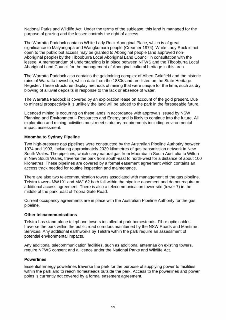
59
National Parks and Wildlife Act. Under the terms of the sublease, this land is managed for the purpose of grazing and the lessee controls the right of access.
The Warratta Paddock contains White Lady Rock Aboriginal Place, which is of great significance to Malyangapa and Wangkumara people (Creamer 1974). White Lady Rock is not open to the public but access may be granted to Aboriginal people (and approved non-Aboriginal people) by the Tibooburra Local Aboriginal Land Council in consultation with the lessee. A memorandum of understanding is in place between NPWS and the Tibooburra Local Aboriginal Land Council for the management of Aboriginal cultural heritage in this area.
The Warratta Paddock also contains the goldmining complex of Albert Goldfield and the historic ruins of Warratta township, which date from the 1880s and are listed on the State Heritage Register. These structures display methods of mining that were unique for the time, such as dry blowing of alluvial deposits in response to the lack or absence of water.
The Warratta Paddock is covered by an exploration lease on account of the gold present. Due to mineral prospectivity it is unlikely the land will be added to the park in the foreseeable future.
Licenced mining is occurring on these lands in accordance with approvals issued by NSW Planning and Environment – Resources and Energy and is likely to continue into the future. All exploration and mining activities must meet statutory requirements including environmental impact assessment.
Moomba to Sydney Pipeline
Two high-pressure gas pipelines were constructed by the Australian Pipeline Authority between 1974 and 1993, including approximately 2029 kilometres of gas transmission network in New South Wales. The pipelines, which carry natural gas from Moomba in South Australia to Wilton in New South Wales, traverse the park from south-east to north-west for a distance of about 100 kilometres. These pipelines are covered by a formal easement agreement which contains an access track needed for routine inspection and maintenance.
There are also two telecommunication towers associated with management of the gas pipeline. Telstra towers MW191 and MW162 both fall within the pipeline easement and do not require an additional access agreement. There is also a telecommunication tower site (tower 7) in the middle of the park, east of Toona Gate Road.
Current occupancy agreements are in place with the Australian Pipeline Authority for the gas pipeline.
Other telecommunications
Telstra has stand-alone telephone towers installed at park homesteads. Fibre optic cables traverse the park within the public road corridors maintained by the NSW Roads and Maritime Services. Any additional earthworks by Telstra within the park require an assessment of potential environmental impacts.
Any additional telecommunication facilities, such as additional antennae on existing towers, require NPWS consent and a licence under the National Parks and Wildlife Act.
Powerlines
Essential Energy powerlines traverse the park for the purpose of supplying power to facilities within the park and to reach homesteads outside the park. Access to the powerlines and power poles is currently not covered by a formal easement agreement.

60
Dog Fence
The Dog Fence is aligned along the Queensland and South Australian boundaries of the park for over 130 kilometres. There is an access road located immediately adjacent to the fence to facilitate maintenance. An agreement is in place between NPWS and the Wild Dog Destruction Board to facilitate maintenance of the fence and access through the park when required.
The South Australian section of fence is situated on the state border but the east–west section of fence adjoining Queensland is located approximately 20 metres outside the park boundary. Therefore the access road does not fall within the park’s reserved area and NPWS has no jurisdiction over this road. The public are not permitted to travel on any sections of the Dog Fence track.
Existing uses by neighbour
Onepah Station is located immediately east of the park and has an existing interest to obtain water from the park. While the Narcowla bore is no longer functioning, the Narcowla ground tank collects and stores rainwater runoff from the park. The original wing banks located on Sturt are maintained by the neighbour to receive adequate flow-in.
Issues
• There is no formal easement agreement in place with Essential Energy nor with the adjoining property owner for the maintenance of the Narcowla ground tank.
Desired outcomes
• NPWS maintains cooperative working relationships with other stakeholders who have an interest or facility in the park.
• Non-NPWS uses are covered by a licence or formal easement agreement and have minimal impact on natural and cultural values of the park.
• Travelling stock routes are reserved as part of the park, particularly where they traverse the Lake Pinaroo Convention on Wetlands site.
Management response
5.2.1 Seek to have the travelling stock routes and former public watering points added to the park.
5.2.2 Formalise an agreement with Essential Energy for the maintenance of existing powerlines that traverse the park.
5.2.3 Formalise the arrangement with Onepah Station for the maintenance of, and access to, Narcowla ground tank.

61
6. Implementation
This plan of management establishes a scheme of operations for Sturt. Implementation of this plan will be undertaken within the annual program of the NPWS West Branch.
Identified activities for implementation are listed in Table 7. Relative priorities are allocated against each activity as follows:
• High priority activities are imperative to achieve the plan’s objectives and desired outcomes. They must be undertaken in the near future to avoid significant deterioration in natural, cultural or management resources.
• Medium priority activities are necessary to achieve the objectives and desired outcomes but are not urgent.
• Low priority activities are desirable to achieve the objectives and desired outcomes but can wait until resources become available.
• Ongoing activities are undertaken on an annual basis or in response to an issue that arises.
This plan of management does not have a specific term and will stay in force until amended or replaced in accordance with the National Parks and Wildlife Act.
Table 7: List of management responses
Action no. Management response Priority
3.1 Geology, landscape and hydrology
3.1.1. Regularly monitor erosion in existing campgrounds, day use areas, walking tracks, tourist roads and management trails and take remedial action as required.
Ongoing
3.1.2 Ensure that all works within the park are designed and undertaken to minimise adverse environmental impacts including erosion.
Ongoing
3.1.3 Monitor and where possible control threatening processes such as Noogoora burr that have the potential to degrade ephemeral wetlands in the park, in particular those which may alter the ecological character of internationally significant wetland values.
High
3.1.4 Develop and implement hydrological monitoring protocols for Lake Pinaroo in accordance with Convention on Wetlands requirements.
Medium
3.2 Native plants and animals
3.2.1 Encourage and support research into little-known ecological values of the park including gibber and mulga shrublands, and the regeneration of woody vegetation.
Ongoing
3.2.2 Facilitate the implementation of the Reintroduction of Locally Extinct Mammals project under the Saving our Species program.
High
3.2.3 Implement relevant recovery actions in the Biodiversity Conservation Program and recovery plans for threatened plant species, populations and communities occurring in the park.
Medium
3.2.4 Conduct and support biodiversity surveys to inform park management. Ongoing
3.2.5 Seek to improve ecological data for the Lake Pinaroo wetlands of international significance site including monitoring the extent and frequency of waterbird abundance.
Medium

62
Action no. Management response Priority
3.3 Aboriginal connections to Country
3.3.1 Work cooperatively with Tibooburra Local Aboriginal Land Council, Aboriginal Elders groups, native title claimants and other Aboriginal community organisations and custodial families in the management of Aboriginal cultural heritage, including appropriate interpretation of cultural places and values.
High
3.3.2 Manage White Lady Rock Aboriginal Place in consultation with the Aboriginal community.
High
3.3.3 Allow only those Aboriginal sites and places that are approved by the local Aboriginal community to be open for visitation and interpretation.
High
3.3.4 Assist Aboriginal people to record Aboriginal cultural heritage in the park in the Aboriginal Heritage Information Management System (AHIMS).
Medium
3.3.5 Undertake Aboriginal cultural heritage surveys, assessment and consultation prior to all works that have the potential to impact Aboriginal cultural heritage in the park.
High
3.3.6 Undertake all conservation works needed to protect Aboriginal cultural heritage in consultation with the Aboriginal community.
Ongoing
3.3.7 Work with the Tibooburra Local Aboriginal Land Council, Elders, native title claimants and other relevant Aboriginal community organisations to encourage further research into the Aboriginal cultural heritage values of the park.
Medium
3.4 Shared heritage
3.4.1 Manage historic heritage in the park according to its assessed level of significance and in compliance with relevant legislation, heritage action statements, conservation management plans, archaeological management plans and NPWS policies.
Ongoing
3.4.2 Progressively identify, record and regularly monitor historic sites, assess their significance, and develop appropriate management strategies.
Medium
3.4.3 Undertake a cultural heritage assessment as part of statutory approvals prior to carrying out works with the potential to impact cultural and historic sites and places of significance.
High /
Ongoing
3.4.4 Identify and record all known mine shafts in the park, assess each for safety and undertake remedial works as required.
Medium
3.4.5 Monitor visitor use and impacts on historic heritage, and undertake remediation works as required.
Ongoing
3.4.6 Review the archaeological management plan and prepare a maintenance strategy for the Charles Sturt exploration sites, based on the recommendations in that plan.
Ongoing
3.4.7 Manage Mount Wood and Olive Downs homestead precincts consistent with the conservation management plans.
Medium
3.4.8 Manage items, buildings and places listed on the State Heritage Register with expert advice, and monitor their condition.
High

63
Action no. Management response Priority
3.4.9 Support the listing of the Sturt Exploration Cultural Landscape (as defined in the archaeological management plan) on the State Heritage Register, in consultation with relevant stakeholders.
Medium
3.5 Visitor use
3.5.1 Monitor visitor use of the park and its facilities. Take remedial action where negative impacts or unwanted activities occur. Upgrade existing facilities as required.
Ongoing
3.5.2 Work with the broader community, regional and state tourism bodies to promote Sturt as the focus of a remote, arid landscape tourism experience, which includes historic and Aboriginal cultural heritage and wildlife conservation programs.
Medium
3.5.3 Maintain the current range of low-impact, unobtrusive facilities for visitors in the park including camping and hard-roofed accommodation, which are consistent with park values and the remote visitor experience, and appropriate to demand.
Ongoing
3.5.4 Allow the construction of visitor infrastructure to support the Reintroduction of Locally Extinct Mammals project within Fort Grey Campground and the wider project area.
High
3.5.5 Do not allow timber collection or wood fires in the park. Encourage visitors to use their own non-wood fuel stoves. Provide gas barbecues in designated visitor areas.
Ongoing
3.5.6 Support educational, guided wildlife viewing experiences as part of the Reintroduction of Locally Extinct Mammals project.
Ongoing
3.5.7 Maintain scenic drives to two- or four-wheel drive, dry-weather road standards as shown on the maps in this plan until such time as they can be upgraded to two-wheel drive, dry-weather road standard.
Ongoing
3.5.8 Monitor driver behaviour and enforce speed restrictions. Ongoing
3.5.9 Provide appropriate signage, including interpretive and safety information on the scenic drives.
Medium
3.5.10 Continue to liaise with NSW Roads and Maritime Services, NSW Police and other relevant stakeholders regarding road safety and the appropriate management of traffic in the area.
Ongoing
3.5.11 Provide bushwalking opportunities in accordance with Table 4. Ongoing
3.5.12 Upgrade Mount Wood Summit Walk to improve visitor safety and protect fragile environments, and extend the track to create a loop back to the carpark.
High
3.5.13 Permit cycling on management trails in Sturt with prior NPWS consent. Cycling is not permitted on walking tracks, off-track (i.e. cross-country) or on park roads.
Ongoing
3.5.14 Ensure directional, interpretive and safety signage on walking and cycling tracks is reviewed and upgraded as appropriate.
Ongoing
3.5.15 Close roads and trails to walkers and cyclists where there is an unacceptable environmental impact or risk to users.
Ongoing
3.5.16 Horse riding is not permitted in Sturt. In the event that land within any of the travelling stock routes is added to the park in future, consideration could be given to horse riding along these routes.
Ongoing

64
Action no. Management response Priority
3.5.17 Fossicking is not permitted in Sturt. Ongoing
3.5.18 Allow group activities that are consistent with the management objectives, principles and values of NPWS and Sturt. Group activities are subject to conditions on group size, type of activity and location within the park.
Ongoing
3.5.19 Limit the size of visitor groups without written consent to five vehicles or 10 people. Groups exceeding this number require written consent from NPWS.
Ongoing
3.5.20 Monitor commercial and non-commercial group activities with respect to cumulative impacts, safety requirements, quality of information being given and compliance with licence or consent conditions. Licences or consents may be cancelled if a breach of conditions occurs.
Ongoing
3.6 Information, education and research
3.6.1 Support visitor use and enjoyment of the park by providing and regularly reviewing educational and interpretation materials in consultation with the Aboriginal community and other stakeholders.
Medium
3.6.2 Provide additional directional, regulatory, and safety signage in the park where required.
High
3.6.3 Support a program of visitor experiences based on the Reintroduction of Locally Extinct Mammals project.
Medium
3.6.4 Engage the local Aboriginal community and descendants of original Aboriginal occupants in developing material and programs for the interpretation of Aboriginal culture.
Medium
3.6.5 Continue to encourage and support the educational and research activities in the park.
Ongoing
3.6.6 Identify research opportunities that will support decision-making about the park. High priorities include the management of Lake Pinaroo Convention on Wetlands site; predator–prey relationships; and ecosystem restoration through reintroduction of locally extinct species.
Medium
3.6.7 Encourage organisations and individuals to take up priority research opportunities and, where appropriate and possible, provide support for this research.
Medium
3.6.8 Support cooperative research partnerships and agreements with educational and research organisations.
High
3.6.9 Ensure that research reports and data are provided to NPWS for park records and management purposes.
Ongoing
3.6.10 Where appropriate, interpret and publicise research findings to park visitors, research organisations and the public.
High
3.6.11 Ensure that information pertaining to the values of Sturt is gathered, analysed, appropriately shared and archived.
Ongoing
3.6.12 Involve Aboriginal stakeholders in any research relating to Aboriginal cultural values, sites or oral histories.
High
4.1 Pests

65
Action no. Management response Priority
4.1.1 Manage and monitor pest species in accordance with pest management strategies relevant to the park and best practice adaptive management. Priority will be given to Noogoora burr, feral goat, pig, wild dog, cat and fox control.
High
4.1.2 Implement fox control in accordance with the threat abatement plan. High
4.1.3 Regularly monitor the park for new and emerging weeds and pest threats, and treat outbreaks as a priority.
Medium
4.1.4 Coordinate pest and weed actions in consultation with park neighbours, Western Local Land Services, the Wild Dog Destruction Board and other stakeholders.
Medium
4.1.5 Support research and incorporate new research findings into pest management programs.
Ongoing
4.2 Fire
4.2.1 Implement the fire management strategy for the park. High
4.2.2 Manage Sturt to protect biodiversity values in accordance with the identified fire regimes.
High
4.2.3 Monitor the ability of vegetation communities and plants to recover between fires and review regimes where relevant.
Ongoing
4.2.4 Participate in local emergency management meetings and maintain liaison with local Rural Fire Service personnel.
Ongoing
4.2.5 Assist adjacent landholders with fire suppression in close proximity to park boundaries, when required.
Ongoing
4.2.6 Where required, rehabilitate areas disturbed by fire suppression operations as soon as practical.
High
4.3 Climate change
4.3.1 Continue existing fire, pest and weed management programs to increase the park’s capacity to cope with climate change and adapt where required to minimise climate change–induced threats.
Ongoing
4.3.2 Encourage research into appropriate indicators to monitor the specific effects of climate change on the natural and cultural values of the park.
Medium
4.3.3 Support or undertake research relevant to arid landscape processes and ecosystems to facilitate improved management of the park at a landscape scale. Apply the outcomes of research in developing adaptive risk management practices.
Medium
4.3.4 Liaise with neighbours, Western Local Land Services, NSW Department of Primary Industries, NSW Roads and Maritime Services and other agencies to encourage the retention and appropriate management of key habitat areas and wildlife corridors.
Low
4.4 Traversing the park with pets or stock
4.4.1 Permit animals to be transported within vehicles on Dunes Scenic Drive, provided there is no other practical alternative route, in accordance with the National Parks and Wildlife Regulation and NPWS Pets Policy. The vehicles must not stop and the animals must remain fully within the vehicle while within the park.
Ongoing
5.1 NPWS Management facilities and operations

66
Action no. Management response Priority
5.1.1 Maintain the road and trail network in the park at either two-wheel drive or four-wheel drive standard as specified by park information and signage. Existing roads and management trails may be closed or realigned due to poor driving conditions.
High
5.1.2 Periodically assess use of the road and trail network to identify any sections that are no longer required for management purposes. Close and rehabilitate any excess roads and trails.
Medium
5.1.3 Investigate the transfer of management of Dunes Scenic Drive to NSW Roads and Maritime Services including potential revocation of this section.
5.1.4 New management trails may be constructed for the purpose of accessing the Reintroduction of Locally Extinct Mammals project exclosures, maintaining fencelines and facilitating pest control. Trail location, design and construction will require environmental impact assessment and relevant approvals.
High
5.1.5 New management trails may be constructed for access to new quarry sites, if approved. Trail location, design and construction will require environmental impact assessment and relevant approvals.
Medium
5.1.6 Continue to maintain Fort Grey airstrip and upgrade it as required. Ongoing
5.1.7 Investigate suitable gravel sources and establish one or more new quarries to provide materials to support road maintenance activities within the park.
Medium
5.1.8 Where required, revegetate decommissioned quarries. Medium
5.1.9 Undertake cultural and environmental impact assessment prior to decommissioning all artificial watering points that are not required for management purposes.
Medium
5.1.10 Periodically assess artificial watering points to determine whether fencing is required to exclude pest animals, particularly goats.
Medium
5.1.11 Manage staff tenancies of housing in the park in accordance with the NPWS Housing Policy.
Ongoing
5.1.12 Manage housing and visitor accommodation in the park to conserve water and minimise the impacts of groundwater extraction.
Ongoing
5.1.13 Work cooperatively with neighbours to develop boundary fencing agreements to maintain a stock-proof boundary in accordance with the NPWS Boundary Fencing Policy.
Ongoing
5.1.14 Facilitate and support the construction of exclosure fences and other infrastructure needed to support the Reintroduction of Locally Extinct Mammals project.
High
5.2 Non-NPWS access and operations
5.2.1 Seek to have the travelling stock routes and former public watering points added to the park.
Low
5.2.2 Formalise an agreement with Essential Energy for the maintenance of existing powerlines that traverse the park.
Medium
5.2.3 Formalise the arrangement with Onepah Station for the maintenance of, and access to, Narcowla ground tank.
Medium

67
References
AMBS 2012, Charles Sturt’s Expedition Sites on Office of Environment and Heritage managed Estates & Sturt: Archaeological Management Plan, report prepared by Australian Museum Business Services, Sydney.
ANBC 2012, Ecology: Biological soil crusts, Australian National Botanic Gardens, www.anbg.gov.au/lichen/ecology-soil-crusts.html.
Buchan R 1975, Archaeological survey of the natural gas pipeline route (Purnanga Station, Purnanga to Yalda Downs, Yalda Downs to the Silver City Highway, Silver City Highway to the Queensland Border). Unpublished report to NPWS, Sydney.
Condon D 2002, Out of the West: A historical perspective of the Western Division of New South Wales, Rangeland Management Action Plan.
CRC for Weed Management 2008, Weed Management Guide: Buffel grass (Cenchrus ciliaris), Department of Primary Industry http://archive.dpi.nsw.gov.au/__data/assets/pdf_file/0005/347153/buffel-grass-weed-management-guide.pdf.
Creamer HPF 1974, Investigation of Aboriginal sites in the Tibooburra area of New South Wales. Unpublished report to National Parks and Wildlife Service.
Croft D 2002, Estimation of the abundance of wild-living dogs in Sturt. Unpublished study prepared as part of degree requirements for University of New South Wales.
DECC 2008, Ecological character description: Lake Pinaroo Ramsar site, Department of Environment and Climate Change NSW, Sydney, accessed 13 October 2016, www.environment.nsw.gov.au/resources/water/08275lpecd.pdf.
DECCW 2010, NSW Climate Impact Profile: The impacts of climate change on the biophysical environment of New South Wales, Department of Environment, Climate Change and Water NSW, Sydney, climatechange.environment.nsw.gov.au/Impacts-of-climate-change/2010-NSW-climate-impact-reporting.
DEH 2005, Threat Abatement Plan for Predation, Habitat Degradation, Competition and Disease Transmission by Feral Pigs, Commonwealth Department of Environment and Heritage, Canberra, www.environment.gov.au/cgi-bin/sprat/public/publicshowkeythreat.pl?id=11.
Dickman C 1994, Mammals of New South Wales: past, present and future, Australian Zoologist 29(3-4) pp. 158–165, publications.rzsnsw.org.au/doi/pdf/10.7882/AZ.1994.004.
Dickman C, Glen A & Letnic M 2009, Reintroducing the Dingo: Can Australia’s Conservation Wastelands be Restored? in Reintroduction of Top-Order Predators, first edition, edited by MW Hayward & MJ Somers, Blackwell Publishing.
Dickman C, Pressey R, Lim L & Parnaby H 1993, Mammals of particular conservation concern in the Western Division of New South Wales, Biological Conservation 65 pp. 219–248.
DoE 2009, Listed Key Threatening Processes, Department of the Environment, www.environment.gov.au/cgi-bin/sprat/public/publicgetkeythreats.pl.
DoEE 2013, Novel biota and their impact on biodiversity, www.environment.gov.au/biodiversity/threatened/key-threatening-processes/novel-biota-impact-on-biodiversity.
DoEE n.d. Australian Heritage Database, Department of the Environment and Energy, www.environment.gov.au/cgi-bin/ahdb/search.pl.

68
DoEE n.d. Species Profile and Threats Database, Department of the Environment and Energy, www.environment.gov.au/cgi-bin/sprat/public/sprat.pl
Doelman T 2005, Quarrying masses of information: an approach to the recording and interpretation of a quarry assemblage, Archaeology in Oceania, 40 pp.50-61.
DPI 2013, NSW Biosecurity Strategy 2013–2021, NSW Department of Primary Industries, Orange, www.dpi.nsw.gov.au/content/biosecurity/biosecurity-strategy.
DSE n.d. Users Guide to the Australian Walking Track Grading System, Victoria Department of Sustainability and the Environment, Melbourne, www.depi.vic.gov.au/__data/assets/pdf_file/0003/225597/dse_trail_grade_brochure_tagged.pdf.
Eldridge D & Tozer ME 1997, A practical guide to soil lichens and bryophytes of Australia’s dry country, Department of Land and Water Conservation (NSW).
Fanning P 1999, Recent landscape history in arid western New South Wales, Australia: A model for regional change, Geomorphology 29 pp. 191–209.
Fleming PA, Anderson H, Prendergast AS, Bretz MR, Valentine LE & Hardy GEStJ 2014, Is the loss of Australian digging mammals contributing to a deterioration in ecosystem function? Mammal Review 44, pp. 94–108.
Fox A & Parish S 2007, Wild habitats: A natural history of Australian ecosystems, ABC Books, Archerfield.
Gillon A & Knight E 1986, Bourke bush foods: traditional foods of Bourke Aboriginal people, Development and Advisory Publications of N.S.W., Dubbo NSW.
Hercus L & Beckett J 2009, The Two Rainbow Serpents Travelling: Mura track narratives from the ‘Corner Country’, http://epress.anu.edu.au/two_rainbow_citation.html.
Holdaway S, Fanning P, Witter D 2000, Report of the Western New South Wales Archaeological Project. Unpublished Report for NSW NPWS.
Holdaway S, Witter D, Fanning P, Musgrave R, Cochrane G, Doelman T, Greenwood S, Pigdon D & Reeves J 1998, New approaches to open site archaeology in Sturt, New South Wales, Australia. Archaeology in Oceania 33 pp. 1-19.
Hope J 2006, The Unincorporated Area of New South Wales: a heritage study, a report to Department of Natural Resources and the Heritage Office of NSW.
IUCN 2013, Global Invasive Species Database, Invasive Species Specialist Group, University of Auckland, New Zealand, accessed 4 April 2016, www.issg.org/database/species/search.asp?st=100ss&fr=1&str=&lang=EN.
James AI, Eldridge DJ & Hill BM 2009, Foraging animals create fertile patches in an Australian desert shrubland, Ecography 32 pp. 723-732.
James CD, Landsberg J & Morton SR 1999, Provision of watering points in the Australian arid zone: a review of effects on biota, Journal of Arid Environments 41 pp. 87–121.
Johnson C & Van Der Wal J 2009, Evidence that dingoes limit abundance of a mesopredator in eastern Australian forests, Journal of Applied Ecology 46 pp. 641–646.
Johnson C, Isaac J & Fisher D 2007, Rarity of a top predator triggers continent-wide collapse of mammal prey: dingoes and marsupials in Australia, Proceedings of the Royal Society B: Biological Sciences 274 pp. 341–346, www.southwestnrm.org.au/sites/default/files/uploads/ihub/johnson-cn-isaac-jl-fisher-do-2007-rarity-top-order-predator-triggers.pdf.
Keith D 2004, Ocean Shores to Desert Dunes: The Native Vegetation of New South Wales and the ACT, The Department of Environment and Conservation (NSW), Hurstville.

69
Letnic M, Ritchie E & Dickman C 2012, Top predators as biodiversity regulators: the dingo Canis lupus dingo as a case study, Biological Reviews 87, pp. 390–413, onlinelibrary.wiley.com/doi/10.1111/j.1469-185X.2011.00203.x/abstract;jsessionid=0AC4FB87665EFB9B20BBF326EE529398.f01t02.
Lunney D 2001, Causes of the extinction of native mammals of the Western Division of New South Wales: an ecological interpretation of the nineteenth century historical record, The Rangeland Journal 21 pp. 44–70, www.publish.csiro.au/?paper=RJ01014.
Moseby KL & Hill BM 2011, The use of poison baits to control feral cats and red foxes in arid South Australia I. Aerial baiting trials, Wildlife Research 38 pp. 338-349.
Mosely B 2010, Survey of the historic artefact scatter at Lake Pinaroo, Sturt, report to the NSW National Parks and Wildlife Service.
NNTT 2016, Claimant application summary – Wongkumara People, accessed 21 March 2016, www.nntt.gov.au/searchRegApps/NativeTitleRegisters/Pages/RNTC_details.aspx?NNTT_Fileno=QC2008/003.
NPWS 2000, Flame spider flower (Grevillea kennedyana) Recovery Plan, NSW National Parks and Wildlife Service, Sydney, www.environment.nsw.gov.au/resources/nature/grevkenn.pdf.
NPWS 2003, The Bioregions of New South Wales: their biodiversity, conservation and history, NSW National Parks and Wildlife Service, Hurstville.
NSW DPI and OEH 2011, Biodiversity Priorities for Widespread Weeds, report prepared for the 13 Catchment Management Authorities (CMAs) by NSW Department of Primary Industries and Office of Environment & Heritage, Orange.
NSW SC 1998, Final Determination to List Predation by the European Red Fox Vulpes vulpes (Linnaeus 1758) as a Key Threatening Process on Schedule 3 of the TSC Act, NSW Scientific Committee, www.environment.nsw.gov.au/threatenedSpeciesApp/profile.aspx?id=20015.
NSW SC 2000a, Final Determination to List Anthropogenic Climate Change as a Key Threatening Process on Schedule 3 of the TSC Act, New South Wales Scientific Committee, www.environment.nsw.gov.au/threatenedspecies/HumanClimateChangeKTPListing.htm.
NSW SC 2000b, Final Determination to List High Frequency Fire Resulting in the Disruption of Life Cycle Processes in Plants and Animals and Loss of Vegetation Structure and Composition as a Key Threatening Process on Schedule 3 of the TSC Act, NSW Scientific Committee, www.environment.nsw.gov.au/threatenedSpeciesApp/profile.aspx?id=20014.
NSW SC 2000c, Final Determination to List Predation by the Feral Cat Felis catus (Linnaeus, 1758) as a Key Threatening Process on Schedule 3 of the TSC Act, NSW Scientific Committee, www.environment.nsw.gov.au/threatenedSpeciesApp/profile.aspx?id=20008.
NSW SC 2002, Final Determination to List Competition and Grazing by the Feral European Rabbit Oryctolagus cuniculus (L.) as a Key Threatening Process on Schedule 3 of the TSC Act, NSW Scientific Committee, www.environment.nsw.gov.au/determinations/FeralEuropeanRabbitKTPListing.htm.
NSW SC 2003, Final Determination to List Removal of Dead Wood and Dead Trees as a Key Threatening Process on Schedule 3 of the TSC Act, NSW Scientific Committee, www.environment.nsw.gov.au/threatenedspeciesapp/profile.aspx?id=20011.

70
NSW SC 2004a, Final Determination to List Competition and Habitat Degradation by Feral Goats, Capra hircus Linnaeus 1758 as a Key Threatening Process on Schedule 3 of the TSC Act, NSW Scientific Committee, www.environment.nsw.gov.au/threatenedSpeciesApp/profile.aspx?id=20017.
NSW SC 2004b, Final Determination to List Predation, Habitat Degradation, Competition and Disease Transmission by Feral Pigs, Sus scrofa Linnaeus 1758 as a Key Threatening Process on Schedule 3 of the TSC Act, NSW Scientific Committee, www.environment.nsw.gov.au/threatenedSpeciesApp/profile.aspx?id=20020.
NSW SC 2009, Final Determination to List Predation and Hybridisation by Feral Dogs, Canis lupus familiaris as a Key Threatening Process on Schedule 3 of the TSC Act, NSW Scientific Committee, www.environment.nsw.gov.au/threatenedSpeciesApp/profile.aspx?id=20116.
OEH 2011a, NSW Threat Abatement Plan for Predation by the Red Fox (Vulpes vulpes), Office of Environment and Heritage, Sydney, www.environment.nsw.gov.au/threatenedspecies/ThreatAbatementPlans.htm.
OEH 2011b, Sustainable Mountain Biking Strategy, Office of Environment and Heritage, Sydney, www.environment.nsw.gov.au/parkmanagement/SustainableMtBStrategy.htm%20.
OEH 2012, Mount Wood Station, Office of Environment and Heritage, Heritage Branch, accessed 9 May 2016 www.environment.nsw.gov.au/heritageapp/ViewHeritageItemDetails.aspx?id=5014101.
OEH 2013a, Living with Fire in NSW National Parks: A strategy for managing bushfires in national parks and reserves 2012–2021, revised edition, Office of Environment and Heritage, Sydney, www.environment.nsw.gov.au/resources/firemanagement/120690LiveFire.pdf.
OEH 2013b, Regional Pest Management Strategy 2012–2017, Far West Region: A new approach for reducing impacts on native species and park neighbours, Office of Environment and Heritage, Sydney, www.environment.nsw.gov.au/pestsweeds/RegionPestManagement.htm.
OEH 2013c, Saving our Species, Office of Environment and Heritage, Sydney, www.environment.nsw.gov.au/saving our species/about.htm.
OEH 2014, Far West: Climate change snapshot, Office of Environment and Heritage, Sydney, www.climatechange.environment.nsw.gov.au/Climate-projections-for-NSW/Climate-projections-for-your-region/Far-West-Climate-Change-Downloads.
OEH 2016b, Sturt Fire Management Strategy, Office of Environment and Heritage, Broken Hill NSW, www.environment.nsw.gov.au/firemanagement/FireManagementPlans.htm.
OEH 2017a, Biodiversity Conservation Program, Office of Environment and Heritage, www.environment.nsw.gov.au/threatenedspecies/pas.htm.
OEH 2017b, NSW BioNet, Atlas of NSW Wildlife, Office of Environment and Heritage, Sydney, www.bionet.nsw.gov.au/.
OEH n.d., NSW heritage database, Office of Environment and Heritage www.environment.nsw.gov.au/Heritage/listings/database.htm.
Peter Freeman Pty Ltd 1997, Conservation Management Plan – Mount Wood Complex. Unpublished report to NPWS.
Peter Freeman Pty Ltd 2004, Conservation Management Plan – Olive Downs Homestead Complex. Unpublished report to NPWS.
Purcell B 2010, Dingo, CSIRO Publishing, Melbourne.
71
Read JL, Carter J, Moseby KM & Greenville A 2008, Ecological roles of rabbit, bettong and bilby warrens in arid Australia, Journal of Arid Environments 72 pp. 2124-2130.
Stafford Smith, M & Cribb, J 2009, Dry times: Blueprint for a red land, CSIRO Publishing, Collingwood.
Steffen W, Burbidge A, Hughes L, Kitching R, Lindenmayer D, Musgrave W, Stafford Smith M, & Werner P 2009, Australia’s Biodiversity and Climate Change: A strategic assessment of the vulnerability of Australia’s biodiversity to climate change. A report to the Natural Resources Management Ministerial Council commissioned by the
Australian Government, CSIRO Publishing, https://books.google.com.au/books?id=fMuodFp4IMsC.
Thackway R & Cresswell I 1995, An interim Biogeographic Regionalisation for Australia: A Framework for Establishing the National System of Reserves. Version 4.0. Australian Nature Conservation Agency, Canberra.
Towerton AL, Penman TD, Kavanagh RP & Dickman CR, 2011 Detecting pest and prey response to fox control across the landscape using remote cameras, Wildlife Research 38 pp. 208-220.
TSSC 2001a, Commonwealth Listing Advice on Loss of Terrestrial Climatic Habitat Caused by Anthropogenic Emissions of Greenhouse Gases, Threatened Species Scientific Committee, www.environment.gov.au/cgi-bin/sprat/public/publicshowkeythreat.pl?id=7.
TSSC 2001b, Commonwealth Listing Advice on Predation, Habitat Degradation, Competition and Disease Transmission by Feral Pigs, Threatened Species Scientific Committee, www.environment.gov.au/cgi-bin/sprat/public/publicshowkeythreat.pl?id=11.
UNESCO 1971, Convention on Wetlands of International Significance Especially as Waterfowl Habitat, United National Educational, Scientific and Cultural Organization, available at http://www.ramsar.org/sites/default/files/documents/library/current_convention_text_e.pdf.
Visser R, Watson J, Dickman C, Southgate R, Jenkins D & Johnson C 2009, A national framework for research on trophic regulation by the Dingo in Australia, Pacific Conservation Biology 15 pp. 209-216, http://espace.library.uq.edu.au/view/UQ:316074.
Walker P 1991, Land Systems of Western New South Wales, Technical Report No. 25, Soil Conservation Service of New South Wales.
Western LLS 2017, Western Regional Strategic Weed Management plan 2017-2022, prepared in partnership with the Western Regional Weed Committee and published by Western Local Land Services, http://western.lls.nsw.gov.au/__data/assets/pdf_file/0006/722391/Western-RSWMP-web.pdf.
Witter D 1992, regions and resources, unpublished PhD thesis, Australian National University.
Witter D 2004, Regional variation of the archaeology in western New South Wales, Rangelands Journal 26(2) pp.129-149.

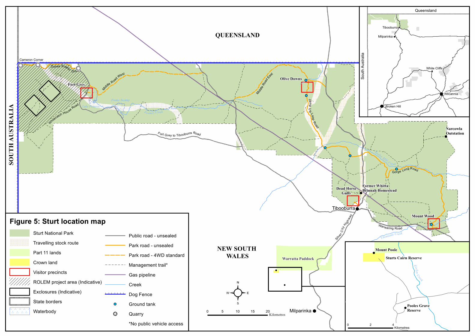
!
!
!
Mount Wood
Dead HorseGully
Olive DownsFort Grey
F ort G rey to Tibooburra Road
Silve r C
ity
Hig hway
Tibooburra
Milparinka
Whitecatch House Road
Thomsons Creek
Middle Road West
Middle Ro
adEas
t
JumpU
p LoopRoad
Gorge Loop Road
Twelve Mile C reek
!
F romes Creek
Wanaaring Road
!
Dunes Scenic D rive
Warratta Paddock
!
Former WhittaBrinnah Homestead
NarcowlaOutstation
QUEENSLAND
0 5 10 15 20Kilometres
²
NEW SOUTH WALES
Queensland
South
Austr
alia
Lake PinarooFrome Swamp
Broken Hill
Tibooburra
Milparinka
White Cliffs
Wilcannia
!Mount Poole
Pooles Grave Reserve
Sturts Cairn Reserve
0 2 4Kilometres
Cameron Corner<! <!
<!
!
!
Evelyn C reek
Figure 5: Sturt location mapSturt National ParkTravelling stock routePart 11 landsCrown landVisitor precinctsROLEM project area (Indicative)Exclosures (Indicative)State bordersWaterbody
Public road - unsealedPark road - unsealedPark road - 4WD standardManagement trail*Gas pipelineCreekDog FenceGround tank
!>>! Quarry*No public vehicle access
SOUT
H AU
STRA
LIA