Embed Size (px)
Citation preview

Transport for NSW
Hill Road upgrade at Sydney Olympic Park and Lidcombe
November 2021transport.nsw.gov.au
Appendix D –Biodiversity assessment report

Transport for NSW
Hill Road Upgrade Biodiversity Assessment
SEPTEMBER 2021
CONFIDENTIAL

This document may contain confidential and legally privileged information, neither of which are intended to be waived, and must be used only for its intended purpose. Any unauthorised copying, dissemination or use in any form or by any means other than by the addressee, is strictly prohibited. If you have received this document in error or by any means other than as authorised addressee, please notify us immediately and we will arrange for its return to us.
PS122138-ECO-REP-001 RevD_Biodiversity Assessment Confidential September 2021
Hill Road Upgrade Biodiversity Assessment Transport for NSW WSP Level 27, 680 George Street Sydney NSW 2000 GPO Box 5394 Sydney NSW 2001 Tel: +61 2 9272 5100 Fax: +61 2 9272 5101 wsp.com
REV DATE DETAILS
A 29/04/2021 Revision A
B 06/05/2021 Revision B
C 11/06/2021 Final
D 24/09/2021 Revised Final
NAME DATE SIGNATURE
Prepared by: Troy Jennings 24/09/2021
Reviewed by: Lukas Clews 24/09/2021
Approved by: Lukas Clews 24/09/2021
Glossary ............................................................................. iv
Abbreviations ................................................................... vii
1 Introduction ............................................................. 1
1.1 The Proposal ........................................................................... 1
2 Legislative context .................................................. 3
2.1 Environmental Planning and Assessment Act 1979 ............. 3
2.2 Biodiversity Conservation Act 2016 ....................................... 3
2.3 Environment Protection and Biodiversity Conservation Act 1999............................................................ 4
3 Desktop assessment and field surveys ................. 5
3.1 Database searches ................................................................. 5
3.2 Field Surveys .......................................................................... 7
4 Existing environment .............................................. 8
4.1 Landscape context.................................................................. 8
4.2 Plant communities ................................................................ 10
4.3 Fauna habitat ........................................................................ 10
4.4 Groundwater dependent ecosystems .................................. 11
5 Threatened biodiversity ........................................ 13
5.1 BC Act listed threatened ecological communities .............. 13
5.2 BC Act listed threatened flora species ................................ 13
5.3 BC Act listed threatened fauna species ............................... 13
6 Matters of national environmental significance ............................................................ 16
6.1 Wetlands of international importance .................................. 16
6.2 Listed threatened ecological communities .......................... 16
6.3 Listed threatened species .................................................... 16
6.4 Listed migratory species ...................................................... 17
Table of contents

CONTENTS (Continued)
7 Impacts ................................................................... 18
7.1 Direct impacts ....................................................................... 18
7.2 Indirect impacts .................................................................... 19
8 Mitigation measures .............................................. 22
9 Assessments of significance ............................... 25
10 Biodiversity offsets ............................................... 26
10.1 Commonwealth offsetting requirement ............................... 27
11 Conclusion ............................................................. 28
12 Limitations ............................................................. 29
12.1 Permitted purpose ................................................................ 29
12.2 Qualifications and assumptions .......................................... 29
12.3 Use and reliance ................................................................... 29
12.4 Disclaimer ............................................................................. 30
12.5 Field survey limitations ........................................................ 30
References ........................................................................ 31
List of tables Table 3.1 Database searches .....................................................................5 Table 3.2 Likelihood of occurrence criteria for threatened species
and populations of animals ..........................................................6 Table 3.3 Likelihood of occurrence criteria for threatened species
and populations of plants .............................................................6 Table 3.4 Weather conditions during field surveys .......................................7 Table 4.1 Landscape features .....................................................................8 Table 4.2 Plant community types and threatened ecological
communities recorded ............................................................... 10 Table 5.1 Threatened fauna species listed under the BC Act with a
moderate or higher potential to occur ......................................... 14 Table 6.1 Threatened fauna species listed under the EPBC Act
with a moderate likelihood of occurrence .................................... 17 Table 7.1 Direct impacts to vegetation....................................................... 18 Table 7.2 Impact on threatened fauna and their habitats ............................ 18 Table 8.1 Mitigation measures .................................................................. 22 Table 9.1 Summary of outcome of assessment of significance for
threatened entities..................................................................... 25 Table 10.1 RMS Guidelines for Biodiversity Offsets – Offsetting
thresholds for REFs................................................................... 26
List of figures Figure 1.1 Study area ..................................................................................2 Figure 4.1 Landscape features .....................................................................9 Figure 4.2 Plant communities and habitat features ...................................... 12 Figure 7.1 Direct impacts ........................................................................... 21
List of appendices Appendix A Threatened flora likelihood assessment
Appendix B Threatened fauna likelihood of occurrence Appendix C Assessments of significance

Project No PS122138 Hill Road Upgrade Biodiversity Assessment Transport for NSW
WSP September 2021
Page iv
Glossary Biodiversity Assessment Method (BAM)
Biodiversity Assessment Method 2020 that supports the Biodiversity Conservation Act 2016. The BAM is a scientific document that provides:
— a consistent method for the assessment of biodiversity on a proposed development or major project, or clearing site
— guidance on how a proponent can avoid and minimise potential biodiversity impacts, and
— the number and class of biodiversity credits that need to be offset to achieve a standard of ‘no net loss’ of biodiversity.
Biodiversity The biological diversity of life is commonly regarded as being made up of the following three components:
— Genetic diversity – the variety of genes (or units of heredity) in any population — Species diversity – the variety of species — Ecosystem diversity – the variety of communities or ecosystems.
BioNet Atlas the EES database of flora and fauna records (formerly known as the NSW Wildlife Atlas). The Atlas contains records of plants, mammals, birds, reptiles, amphibians, some fungi, some invertebrates (such as insects and snails listed under the Biodiversity Conservation Act 2016) and some fish.
BioNet Vegetation Classification
the master vegetation community-level classification for use in vegetation mapping programs and regulatory biodiversity impact assessment frameworks in NSW. The BioNet Vegetation Classification is published by EES and available at www.environment.nsw.gov.au/research/Visclassification.htm.
Critical habitat The whole or any part or parts of an area or areas of land comprising the habitat of an endangered species, an endangered population or an endangered ecological community that is critical to the survival of the species, population or ecological community (Department of Environment and Conservation, 2004). Critical habitat is listed under both the Biodiversity Conservation Act 2016 and the Environment Protection and Biodiversity Conservation Act 1999 and both the State and Federal environment agencies maintain a register of this habitat. Capitalisation of the term ‘Critical Habitat’ in this report refers to the habitat listed specifically under the relevant State and Commonwealth legislation.
Derived vegetation PCTs that have changed to an alternative stable state because of land management practices since European settlement. Derived communities can have one or more structural components of the vegetation entirely removed or severely reduced, or have developed new structural components where they were previously absent.
Ecological community An assemblage of species occupying a particular area.
Environment, Energy and Science (EES) Group
Group within DPIE which brings together a range of functions including national park management, biodiversity and conservation, climate change, sustainability, resilience and adaptation, renewable energy and energy security, waste management and resource recovery, and environment protection and mine safety regulation.
Exotic Introduced from outside the area (Stralberg et al., 2009). Used in the context of this report to refer to species introduced from overseas.

Project No PS122138 Hill Road Upgrade Biodiversity Assessment Transport for NSW
WSP September 2021
Page v
Habitat An area or areas occupied, or periodically or occasionally occupied, by a species, population or ecological community, including any biotic or abiotic components.
High Threat Weed Vascular plants not native to Australia that if not controlled will invade and outcompete native species. A list of high threat weeds is available as part of the BAM Calculator (https://www.lmbc.nsw.gov.au/bamcalc)
Hollow bearing tree A living or dead tree that has at least one hollow. A tree is considered to contain a hollow if:
(a) the entrance can be seen (b) the entrance width is at least 5cm (c) the hollow appears to have depth (i.e. you cannot see solid wood beyond the entrance) (d) the hollow is at least 1m above the ground. Trees must be examined from all angles.
IBRA region A bioregion identified under the Interim Biogeographic Regionalisation for Australia (IBRA) system, which divides Australia into bioregions on the basis of their dominant landscape-scale attributes.
IBRA subregion a subregion of a bioregion identified under the IBRA system.
Introduced Not native to the area: not indigenous (Stralberg et al., 2009). Refers to both exotic and non-indigenous Australian native species of plants and animals.
Landscape attributes In relation to a site or a biodiversity stewardship site, native vegetation cover, vegetation connectivity, patch size and the strategic location of a biodiversity stewardship site.
Likely Taken to be a real chance or possibility (Department of Environment and Conservation, 2004).
Local population The population that occurs within the study area, unless the existence of contiguous or proximal occupied habitat and the movement of individuals or exchange of genetic material across the boundary can be demonstrated.
Locality The area within a 10 kilometre radius of the study area.
Migratory species Species protected as Migratory under the Environment Protection and Biodiversity Conservation Act 1999. Listed migratory species are those listed in the Convention on the Conservation of Migratory Species of Wild Animals (Bonn Convention), China-Australia Migratory Bird Agreement (CAMBA), Japan-Australia Migratory Bird Agreement (JAMBA) and Republic of Korea – Australia Migratory Bird Agreement (RoKAMBA). Listed migratory species also include any native species identified in an international agreement approved by the Minister (Matthei, 1995). Capitalisation of the term ‘Migratory’ in this report refers to those species listed as Migratory under the Environment Protection and Biodiversity Conservation Act 1999.
Mitchell landscape landscapes with relatively homogeneous geomorphology, soils and broad vegetation types, mapped at a scale of 1:250,000.
Plant community type (PCT)
A NSW plant community type identified using the PCT classification system.
Priority Weeds An introduced species listed under the Biosecurity Act 2015. Under the Act, priority weeds have specific control measures for each region.

Project No PS122138 Hill Road Upgrade Biodiversity Assessment Transport for NSW
WSP September 2021
Page vi
Region A bioregion defined in a national system of bioregionalisation. The Proposal is located within the Sydney Basin Bioregion as defined in the Interim Biogeographic Regionalisation for Australia (IBRA) (Thackway & Cresswell, 1995).
Significant Important, weighty or more than ordinary
Threatened biodiversity Threatened species, populations or ecological communities as listed under the Biodiversity Conservation Act 2016, Fisheries Management Act 1994 or the Environment Protection and Biodiversity Conservation Act 1999.
Threatened ecological community (TEC)
Critically endangered ecological community, an endangered ecological community or a vulnerable ecological community listed under:
— Schedule 2 of the Biodiversity Conservation Act 2016 — Schedule 4, 4A and/or 5 of the Fisheries Management Act 1994 — Part 13 of the EPBC Act Environment Protection and Biodiversity Conservation Act
1999.
Threatened species and populations
Critically endangered, endangered or vulnerable threatened species and populations as defined by:
— Schedule 1 of the Biodiversity Conservation Act 2016 — Schedule 4, 4A and/or 5 of the Fisheries Management Act 1994 — Part 13 of the Environment Protection and Biodiversity Conservation Act 1999.
Capitalisation of the terms ‘threatened’, ‘vulnerable’, ‘endangered’ or ‘critically endangered’ in this report refers to listing under the relevant State and/or Commonwealth legislation.
Viable local population A population that has the capacity to live, develop and reproduce under normal conditions, unless the contrary can be conclusively demonstrated through analysis of records and references (Department of Environment and Climate Change, 2007).
Weeds of National Significance
In 1998, Australian governments endorsed a framework to identify which weed species could be considered (WONS) within an agricultural, forestry and environmental context.
Project No PS122138 Hill Road Upgrade Biodiversity Assessment Transport for NSW
WSP September 2021
Page vii
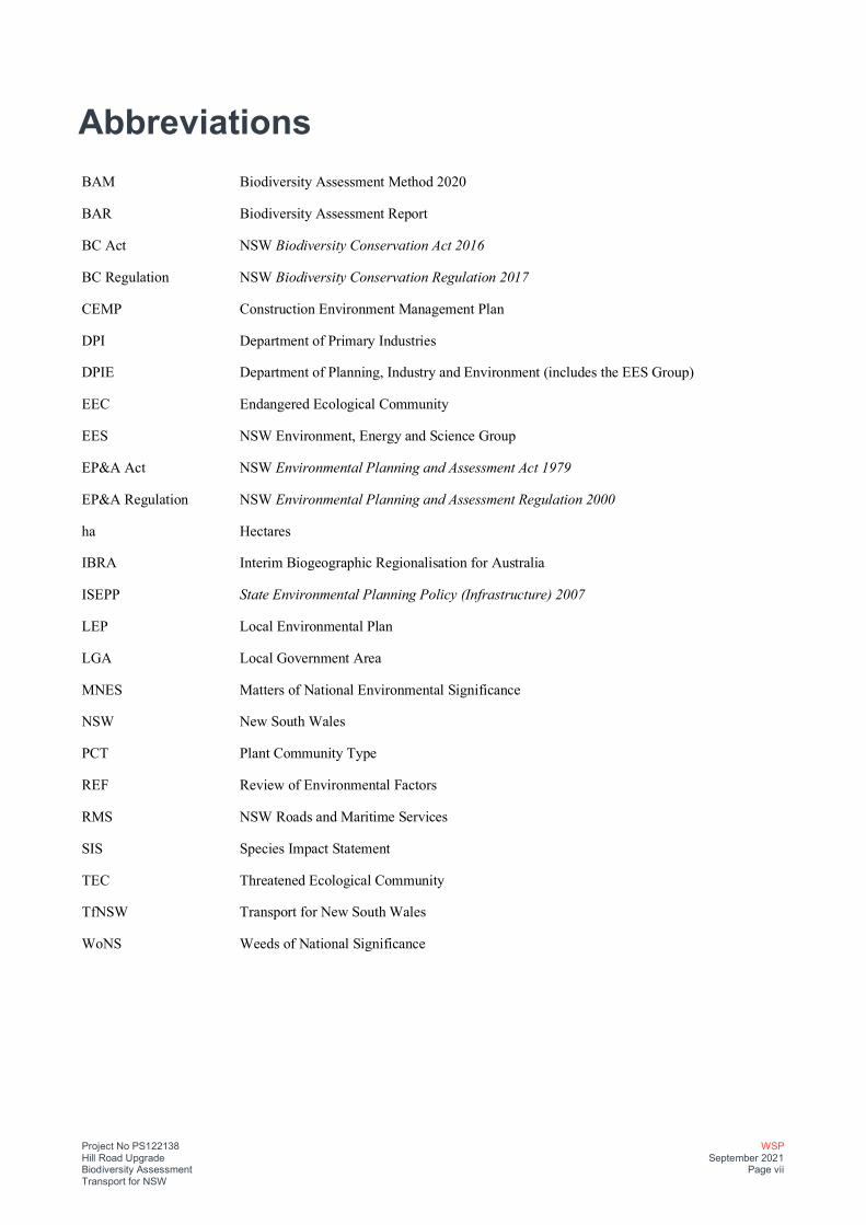
Abbreviations BAM Biodiversity Assessment Method 2020
BAR Biodiversity Assessment Report
BC Act NSW Biodiversity Conservation Act 2016
BC Regulation NSW Biodiversity Conservation Regulation 2017
CEMP Construction Environment Management Plan
DPI Department of Primary Industries
DPIE Department of Planning, Industry and Environment (includes the EES Group)
EEC Endangered Ecological Community
EES NSW Environment, Energy and Science Group
EP&A Act NSW Environmental Planning and Assessment Act 1979
EP&A Regulation NSW Environmental Planning and Assessment Regulation 2000
ha Hectares
IBRA Interim Biogeographic Regionalisation for Australia
ISEPP State Environmental Planning Policy (Infrastructure) 2007
LEP Local Environmental Plan
LGA Local Government Area
MNES Matters of National Environmental Significance
NSW New South Wales
PCT Plant Community Type
REF Review of Environmental Factors
RMS NSW Roads and Maritime Services
SIS Species Impact Statement
TEC Threatened Ecological Community
TfNSW Transport for New South Wales
WoNS Weeds of National Significance

Project No PS122138 Hill Road Upgrade Biodiversity Assessment Transport for NSW
WSP September 2021
Page 1
1 Introduction This biodiversity technical memo has been prepared to support the Hill Road Upgrade Review of Environmental Factors (REF) and covers:
— an introduction to the project and project description — a brief legislative section to reference new planning approval pathway of an REF — desktop assessment — mapping — assessment to biodiversity impacts from construction and/or operation based on the proposed scope of works — preparation of 5-part tests to determine significance of impacts to threatened biodiversity.
1.1 The Proposal Transport for NSW proposes to upgrade Hill Road between Parramatta Road and John Ian Wing Parade (the Proposal). The Proposal is located near Sydney Olympic Park in Lidcombe within Cumberland local government area (LGA) and Parramatta LGA. The Proposal is within the Greater Parramatta Priority Growth Area and under the Carter Street Master Plan the industrial area adjacent to Hill Road was identified for redevelopment as a residential area known as the Carter Street Precinct. The Master Plan was finalised on 18 December 2020 and was enacted through an amendment of the Auburn Local Environmental Plan 2010.
The Proposal would include the following key elements:
— upgrading Hill Road to include road widening to accommodate additional turn lanes — modifying Parramatta Road and Hill Road intersection to provide a new left turn lane and a widened footpath onto
Hill Road (northbound) — construction of a new shared user paths (SUP) along the western side of Hill Road between Parramatta Road and
Carter Street and on the eastern side of Hill Road between Carter Street and Green Spine Road — widening Bombay Street to include additional through and turn lanes — converting the Hill Road and Carter Street intersection to a left-in, left-out intersection — upgrading the Hill Road and John Ian Wing Parade intersection with additional through and turn lanes as well as a
widening the footpath — widening and signalising the M4 Motorway eastbound off-ramp — adjusting the kerb return on the northwest corner of the Birnie Avenue and Parramatta Road intersection.
For the purposes of this assessment the study area is the defined boundary of the Proposal and construction footprint and shown in Figure 1.1.

Project No PS122138 Hill Road Upgrade Biodiversity Assessment Transport for NSW
WSP September 2021
Page 2
Figure 1.1 Study area

Project No PS122138 Hill Road Upgrade Biodiversity Assessment Transport for NSW
WSP September 2021
Page 3
2 Legislative context There are two overarching statutory frameworks that govern the environmental planning approvals and assessment process for the construction and operation of the Proposal that include biodiversity controls, being the:
— Environmental Planning and Assessment Act 1979 (NSW) — Environment Protection and Biodiversity Conservation Act 1999 (Commonwealth)
The relevant legislation, policies and guidelines for biodiversity matters that have been considered during the preparation of this report are outlined further below.
2.1 Environmental Planning and Assessment Act 1979 The Environmental Planning and Assessment 1979 (EP&A Act) provides the statutory controls that establish a framework governing what development is permitted or prohibited, and the processes for how assessment and gaining approval for development is undertaken in NSW. It is supported by the Environmental Planning and Assessment Regulation 2000 (EP&A Regulation) which provides additional detail and gives effect to the legislation. Division 5.1 of the EP&A act applies to activities that do not require development consent.
An REF has been prepared to satisfy Transport for NSW’s duties under section 5.5 of the EP&A Act to “examine and take into account to the fullest extent possible all matters affecting or likely to affect the environment by reason of that activity” and in making decisions on the likely significance of any environmental impacts. This biodiversity technical memo forms part of the REF being prepared for the Proposal and assesses the biodiversity impacts of the Proposal to meet the requirements of the EP&A Act.
If an activity is ‘likely to significantly affect the environment (including critical habitat) or threatened species, populations or ecological communities, or their habitats’, as defined in section 5.7 of the EP&A Act, further assessment such as a Species Impact Statement (SIS) would need to be prepared corresponding to the impacts assessed in this REF, or Environmental Impact Statement (EIS) may be required.
2.2 Biodiversity Conservation Act 2016 The NSW Biodiversity Conservation Act 2016 (BC Act) came into effect on the 25 August 2017. This Act repealed the Threatened Species Conservation Act 1995 (TSC Act), Native Vegetation Act 2003 and parts of the National Parks and Wildlife Act 1974. All threatened entities previously listed under the TSC Act have now been listed under the BC Act.
Section 7.3 of the BC Act requires that the significance of the impact on threatened species, and endangered ecological communities is assessed using a five-part test. Where a significant impact is likely to occur, a species impact statement (SIS) must be prepared in accordance with the Secretary’s requirements or a Biodiversity Development Assessment Report (BDAR) must be prepared by an accredited assessor in accordance with the Biodiversity Assessment Method (BAM).

Project No PS122138 Hill Road Upgrade Biodiversity Assessment Transport for NSW
WSP September 2021
Page 4
2.3 Environment Protection and Biodiversity Conservation Act 1999
The objective of the Environment Protection and Biodiversity Conservation Act 1999 (EPBC Act) is to ensure that actions likely to cause a significant impact on matters of national environmental significance (MNES) undergo an assessment and approval process. Under the EPBC Act, an action includes a project, a development, an undertaking, an activity or a series of activities, or an alteration of any of these things. An action that ‘has, will have or is likely to have a significant impact on a matter of national environmental significance’ is deemed to be a ‘controlled action’ and may not be undertaken without prior approval from the Australian Minister for the Department of Agriculture, Water and the Environment (DAWE). MNES relevant to this report include threatened species, ecological communities and migratory species.
The EPBC Act has been considered in this assessment through:
— desktop review to determine the listed biodiversity matters that are predicted to occur within the locality of the project and hence could occur, subject to the habitats present
— field surveys for listed threatened biota and migratory species — assessment of potential impacts on threatened and migratory biota, including assessments of significance in
accordance with the EPBC Act significant impact guidelines (Department of the Environment 2013) where relevant — identification of suitable impact mitigation and environmental management measures for threatened and migratory
biota, where required.
Project No PS122138 Hill Road Upgrade Biodiversity Assessment Transport for NSW
WSP September 2021
Page 5
3 Desktop assessment and field surveys
The desktop assessment was undertaken to using the following information sources:
— aerial photographic imagery — NSW Mitchell Landscapes (Office for Environment & Heritage, 2016) — Interim Biogeographic Regionalisation of Australia (IBRA version 7.0) (Department of the Environment and
Energy, 2016) — Atlas of Groundwater Dependent Ecosystems (GDE) (Bureau of Meteorology, 2020) — Directory of Important Wetlands of Australia (Department of Environment and Energy, 2020a) — priority weed listings for the Greater Sydney region (Department of Primary Industries, 2020a) — The Native Vegetation of the Sydney Metropolitan Area (Office of Environment and Heritage 2016c) — Native vegetation of Southeast NSW: A Revised Classification and Map for the Coast and Eastern Tablelands (Tozer
et al. 2010)
3.1 Database searches Threatened species database searches are outlined in Table 3.1.
Table 3.1 Database searches
DATABASE SEARCH DATE AREA SEARCHES REFERENCE
PlantNET Spatial Search 16/03/2021 10km radius centred on the study area
Royal Botanic Gardens (2020)
BioNet Atlas species sighting search
16/03/2021 10km x 10km centred on the study area
Environment Energy and Science Group (2020a)
EPBC Protected Matters Search Tool
16/03/2021 10km buffer on the study area Department of Environment and Energy (2020b)
NSW Department of Primary Industries (Fishing and Aquaculture) spatial data
16/03/2021 Cumberland and Parramatta Local Government Areas (LGA)
Department of Primary Industries (2020b)
3.1.1 Likelihood of occurrence assessment
A habitat assessment was completed to assess the likelihood of occurrence of each threatened species, population and community (threatened biodiversity) identified with the potential to occur in the study area. All threatened biodiversity identified during background research were considered. The assessment was based on the habitat profile for the species and other habitat information in the Threatened Species Profile Database (Environment Energy and Science Group, 2020b). The assessment also included consideration of the dates and locations of nearby records and information about species populations in the locality. The assessment results are summarised in Section 6 & Section 7 and are provided in full in the likelihood of occurrence assessments (Appendix A & Appendix B).
For this study, the likelihood of occurrence of threatened and migratory species and populations was determined based on the criteria shown in Table 3.2 and Table 3.3.

Project No PS122138 Hill Road Upgrade Biodiversity Assessment Transport for NSW
WSP September 2021
Page 6
Table 3.2 Likelihood of occurrence criteria for threatened species and populations of animals
LIKELIHOOD CRITERIA
Known The species was observed in the study area either during the current survey or during another survey less than one year prior.
High A species has a high likelihood of occurrence if:
— the study area contains or forms part of a large area of high-quality suitable habitat — important habitat elements (i.e. for breeding or important life cycle periods such as winter
foraging periods) are abundant within the study area — the species has been recorded recently in similar habitat in the locality — the study area is likely to support resident populations or to contain habitat that is visited by the
species during regular seasonal movements or migration.
Moderate A species has a moderate likelihood of occurrence if:
— the study area contains or forms part of a small area of high-quality suitable habitat — the study area contains or forms part of a large area of marginal habitat — important habitat elements (i.e. for breeding or important life cycle periods such as winter
foraging periods) are sparse or absent within the study area — the study area is unlikely to support resident populations or to contain habitat that is visited by the
species during regular seasonal movements or migration but is likely to be used occasionally during seasonal movements and/or dispersal.
Low A species has a low likelihood of occurrence if:
— potentially suitable habitat exists but the species has not been recorded recently (previous 10 years) in the locality despite intensive survey (i.e. the species is considered to be locally extinct)
— the species is considered to be a rare vagrant, likely only to visit the study area very rarely; e.g. during juvenile dispersal or exceptional climatic conditions (e.g. extreme drought conditions in typical habitat of inland birds).
None Suitable habitat is absent from the study area.
Table 3.3 Likelihood of occurrence criteria for threatened species and populations of plants
LIKELIHOOD CRITERIA
Known The species was observed in the study area either during the current survey or during another survey less than one year prior.
High A species has a high likelihood of occurrence if:
— the study area contains or forms part of a large area of high-quality suitable habitat that has not been subject to recent disturbance (e.g. fire), the species is known to form a persistent soil seedbank and the species has been recorded recently (within 10 years) in the locality
— the species is a cryptic flowering species that has been recorded recently (within 10 years) in the locality and has a large area of high-quality potential habitat within the Proposal footprint that was not seasonally targeted by surveys.
Project No PS122138 Hill Road Upgrade Biodiversity Assessment Transport for NSW
WSP September 2021
Page 7
LIKELIHOOD CRITERIA
Moderate A species has a moderate likelihood of occurrence if:
— the species:
— has a large area of high-quality suitable habitat in the study area that has not been subject to recent disturbance (e.g. fire)
— the species is known to form a persistent soil seedbank, but — the species has not been recorded recently (within 10 years) in the locality
— the species:
— has a small area of high-quality suitable habitat or a large area of marginal habitat in the study area That has not been subject to recent disturbance (e.g. fire)
— the species is known to form a persistent soil seedbank — the species has been recorded recently (within 10 years) in the locality — the species is a cryptic flowering species, with a small area of high-quality potential habitat
or a large area of marginal habitat within the Proposal footprint, that was not seasonally targeted by surveys.
Low A species has a low likelihood of occurrence if:
— it is not a cryptic species, nor a species known to have a persistent soil seedbank species and was not detected despite targeted searches
— the species is a cryptic flowering species, with a small area of high-quality potential habitat or a large area of marginal habitat within the Proposal footprint, that was not seasonally targeted by surveys as the species has not been recorded within 50 years in the locality.
None Suitable habitat is absent from the Proposal footprint.
3.2 Field Surveys Previous field surveys were undertaken as part of the Environmental Impact Statement of the M4 Motorway Widening Modification in 2017 and 2019. Information from that survey were referenced and included in this assessment to validate any desktop assessment as previously described. Site surveying also included parallel line transverses and random meander surveys to target threatened flora species. Field surveys were undertaken on the 22nd February 2017 and 17th January 2019 (Table 3.4).
Table 3.4 Weather conditions during field surveys
DATE RAINFALL MIN TEMP. MAX TEMP. WIND DIRECTION AND SPEED
22 February 2017 0.0mm 17.5°C 29°C ENE 37 km/hr
17 January 2019 0.0mm 22.9°C 34.1°C ENE 35 km/hr
Note: Climate data was obtained from AWS 066212 (Sydney Olympic Park)

Project No PS122138 Hill Road Upgrade Biodiversity Assessment Transport for NSW
WSP September 2021
Page 8
4 Existing environment
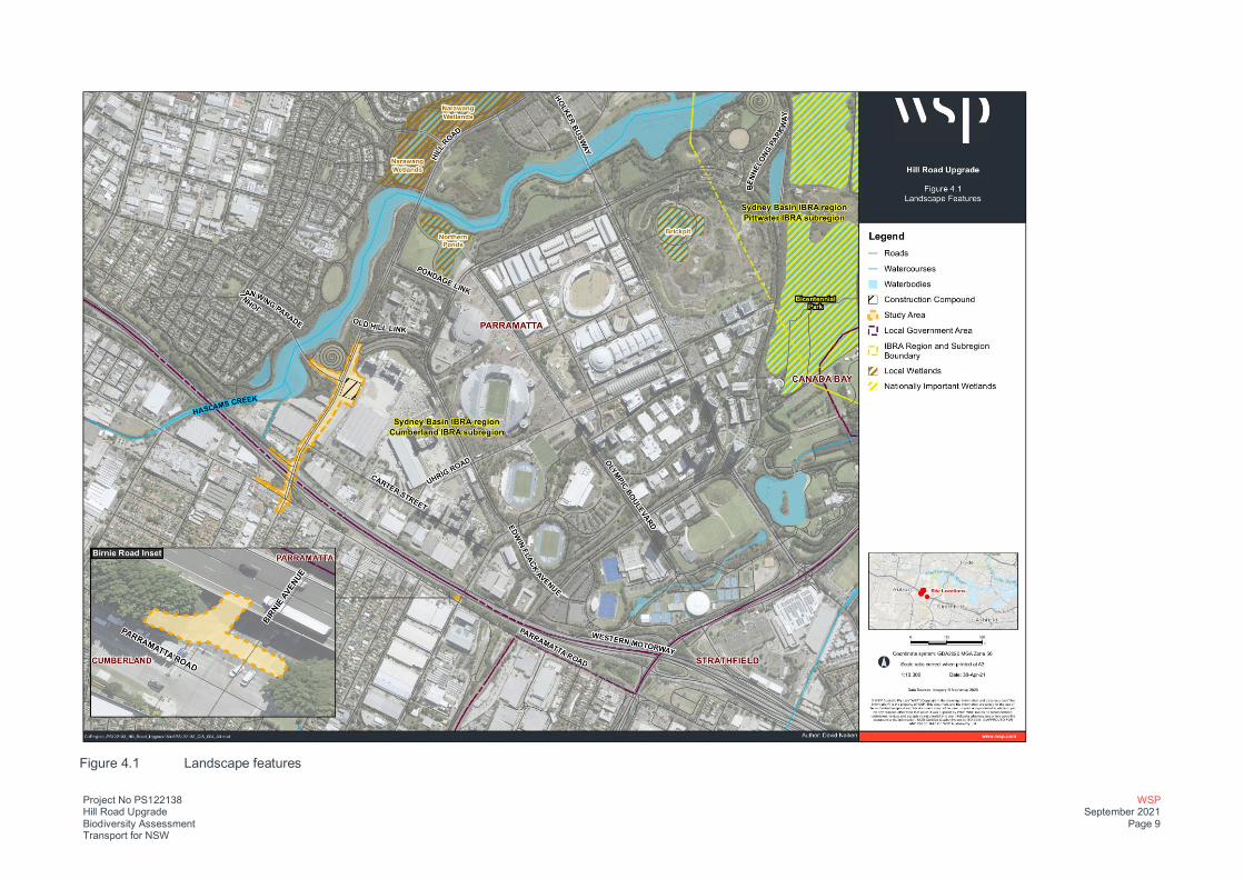
4.1 Landscape context An overview of landscape features associated with the study area are presented in Table 4.1.
Table 4.1 Landscape features
LANDSCAPE FEATURE OCCURRENCE IN MODIFICATION STUDY AREA
IBRA bioregion Sydney basin
IBRA subregion Cumberland
NSW landscape regions (Mitchell landscapes)
Ashfield plains and Port Jackson basin
Local Government Area (LGA) Cumberland and Parramatta
Local Land Service (LLS) region Greater Sydney
Botanical subregion Central coast
Rivers, streams and estuaries Figure 4.1 show the location of rivers and streams.
Important and local wetlands Figure 4.1 shows the location of the Nationally important Newington Wetlands & Bicentennial Park and locally important Narawang Wetlands, Northern Ponds, Brickpit & Nuwi Wetlands
Connectivity features No state or regionally significant biodiversity links were identified within the assessment circle.
Areas of geological significance and soil hazard features
Potential high-risk acid sulphate soils, associated with low lying alluvial flats along Haslams Creek have been identified within locality of the study area.
Areas of outstanding biodiversity value
None listed
Project No PS122138 Hill Road Upgrade Biodiversity Assessment Transport for NSW
WSP September 2021
Page 9
Figure 4.1 Landscape features

Project No PS122138 Hill Road Upgrade Biodiversity Assessment Transport for NSW
WSP September 2021
Page 10
4.2 Plant communities The following NSW Plant Community Types (PCTs) and non-native vegetation type were recorded within the study area or immediately adjacent to the study area:
— PCT 724 Broad-leaved ironbark – Grey Box – Melaleuca decora grassy open forest on clay/gravel soils of the Cumberland Plain, Sydney Basin Bioregion
— Miscellaneous ecosystem – Urban exotic / native landscape plantings.
PCT 724 was assessed as being in a Poor condition class based on broad vegetation condition class criteria. Non-native vegetation was not assigned a condition class.
A summary of the vegetation recorded, is presented in Table 4.2 and the extent and distribution within the study area is shown in Figure 4.2. Detailed description each PCT and vegetation patches is provided below.
Table 4.2 Plant community types and threatened ecological communities recorded
VEGETATION TYPE
CONDITION VEGETATION FORMATION
VEGETATION CLASS
NSW TEC LISTING EPBC TEC
LISTING
AREA WITH STUDY
AREA (HA)
Native Plant Community Types
PCT 724 Broad-leaved ironbark – Grey Box – Melaleuca decora grassy open forest on clay/gravel soils of the Cumberland Plain, Sydney Basin Bioregion
Poor Dry sclerophyll forests (shrub/grass sub-formation)
Cumberland dry sclerophyll forests
Forms part of Shale Gravel Transition Forest in the Sydney Basin Bioregion, listed as Endangered (BC Act) and Critically Endangered (EPBC Act).
N/A 0.03
Miscellaneous ecosystems1
Highly disturbed areas with no or limited native vegetation
N/A N/A N/A Not listed Not listed 0.64
(1) Miscellaneous ecosystems are commensurate with previously disturbed land as classified under the ISCA.
4.3 Fauna habitat The Proposal locality contains predominantly disturbed land providing foraging and roosting habitat for highly mobile species such as birds and bats due to its fragmented nature. Overall the study area contains poor quality habitat. Habitat within the study area is highly isolated with limited connectivity to surrounding native vegetation communities. For this reason, of the habitat available, it is more suited to those species that are more mobile and capable of moving across a highly fragmented landscape (i.e. birds and bats). Much of the available native vegetation and habitat in the study area is disturbed with the majority of ground covers being exotic species.
Majority of the vegetation that occurs in the study area is in the form of landscape plantings that are locally indigenous to the Sydney Basin bioregion; namely Eucalyptus crebra (Narrow-leaved Ironbark), Melaleuca quinquenervia (Broad-leaved Paperbark), Casuarina glauca (Swamp Oak). Landscape plantings of species that are not indigenous to NSW but

Project No PS122138 Hill Road Upgrade Biodiversity Assessment Transport for NSW
WSP September 2021
Page 11
are indigenous in other parts of Australia; namely Corymbia citriodora, Acacia saligna (Golden Wreath Wattle), Lophostemon confertus (Brush Box), Cupaniopsis anacardioides (Tuckeroo). Majority of these species provide blossom resources for nectarivorous birds and bats. Landscape plantings of species that are exotic (not indigenous to Australia); namely Juncus acutus*, Gazania linearis*, Phoenix canariensis* (Canary Island Date Palm), Photinia serratifolia* (Christmas Berry) also provide some foraging resources for both birds, mammals and bats.
Field surveys that were undertaken did not record important roosting habitat sufficient to accommodate colonies of hollow-dependant bats. Artificial habitat for Large Bentwing Bat (Miniopterus orianae oceanensis), Southern Myotis (Myotis macropus) or Little Bentwing Bat (Miniopterus australis), may exist in the local area in the form of bridges and culverts. Blossoming eucalypts and fruiting trees also provide seasonal foraging resources for Little Lorikeet (Glossopsitta pusilla) and Grey-headed flying-fox (Pteropus poliocephalus).
After the Proposal is constructed, key ecotonal edges (the area where two communities meet and integrate), which create key foraging environments for fauna would continue to exist as there is an abundance of similar and higher quality foraging habitat available locally to species such as the Powerful Owl (Ninox strenua).
4.4 Groundwater dependent ecosystems
4.4.1 GDEs within proximity of the proposed modification
GDEs within two kilometres of the study area include the Parramatta River and its tributaries (including Haslams Creek and the Haslams Creek tributary), locally important wetlands and nationally important wetlands. Riparian vegetation fringing these wetlands and water bodies include saltmarsh, swamp oak forest and mangrove communities.
4.4.2 GDEs within the proposal footprint
There are no GDEs within the proposed impact area. The nearest is Haslams Creek tributary, which is located about 40 m from the edge of the proposal footprint and approximately 200 m from the construction compound.
Previous surface water impact assessment undertaken in 2017 as part of the old M4 Westbound Off Ramp to Hill Road project concluded that the proposal will not impact on existing surface flow conditions, existing flows in Haslams Creek or flooding conditions. Further assessment undertaken by WSP (2021) Surface Water Quality Assessment – determined that sediment and erosion controls consistent with the relevant Transport for NSW erosion and sedimentation management procedure and best practice industry guidelines will be effective at managing any water quality impacts in the receiving systems during construction.
Based on previous investigations and the nature and impacts of the proposal any impact to groundwater are likely to be temporary (during construction phase) and would be managed through a water quality plan and monitoring program consistent with standard mitigations such as Landcom (2004) Managing Urban Stormwater: Soils and construction Volume 1 and Volume 2. The operational phase of the proposal is unlikely to impact on groundwater.
It is therefore unlikely the proposal will have an impact on GDEs.

Project No PS122138 Hill Road Upgrade Biodiversity Assessment Transport for NSW
WSP September 2021
Page 12
Figure 4.2 Plant communities and habitat features

Project No PS122138 Hill Road Upgrade Biodiversity Assessment Transport for NSW
WSP September 2021
Page 13
5 Threatened biodiversity This section provides an overview of the threatened species, populations and communities recorded or considered likely to use habitat in the study area.
5.1 BC Act listed threatened ecological communities One plant community type recorded within the study area, PCT 724, is consistent with a BC Act listed threatened ecological community Shale Gravel Transition Forest in the Sydney Basin Bioregion (Shale Gravel Transition Forest).
Vegetation which aligns to Shale Gravel Transition Forest was recorded on the edges of the study area in the form of the plant community type PCT 724 Broad-leaved ironbark – Grey Box – Melaleuca decora grassy open forest on clay/gravel soils of the Cumberland Plain, Sydney Basin Bioregion and displayed the following attributes:
— occurred as a tall open eucalypt forest dominated by Eucalyptus longifolia (Woollybutt) and Melaleuca decora (White feather honey myrtle). The shrub layer consists of Melaleuca nodosa (Prickly leaf paperbark), Acacia parramattensis (Parramatta wattle) and emergent Eucalyptus longifolia (Woollybutt)
— was recorded on soils derived from Ashfield Shale within the City of Parramatta and Cumberland Council LGAs. — canopy species (Eucalyptus longifolia (Woollybutt) and Melaleuca decora (White feather honey myrtle) of a mature
age class were recorded.
This vegetation occurs as three fragmented patches that have been disturbed and exhibit exotic species; particularly in the ground stratum. Each occurrence of this community is within a mature age class and is considered highly likely to respond to assisted natural regeneration, as the natural soil and associated seedbank is still at least partially intact.
5.2 BC Act listed threatened flora species Based on the desktop database searches and assessments, 44 threatened flora species listed under the NSW BC Act (see Appendix A) have been recorded or are predicated to occur within the Proposal locality. Parallel line transverses and random meander surveys were previously carried out to target threatened flora species and no threatened flora species were recorded during surveys. No threatened flora species are anticipated to be impacted by the Proposal.
5.3 BC Act listed threatened fauna species Based on the desktop database searches and assessments, 62 threatened fauna species listed under the NSW BC Act and/ or FM Act (Appendix B) have been recorded or are predicated to occur within the Proposal locality.
No threatened species were recorded in the study area during the previous survey. Based on the presence of potentially suitable habitat and known occurrences in associated habitats in the wider locality, eight threatened fauna species are considered to have a moderate or greater likelihood of occurrence based on the habitat in the study area (Table 5.1).
Majority of the vegetation that provides foraging habitat for threatened species in the study area is in the form of landscape plantings. Landscape plantings were identified as locally trees species indigenous to the Sydney Basin bioregion; namely Eucalyptus crebra (Narrow-leaved ironbark), Melaleuca quinquenervia (Broad-leaved paperbark), Casuarina glauca (Swamp oak). Other foraging resources were species that are not indigenous to NSW but are indigenous in other parts of Australia; namely Corymbia citriodora, Acacia saligna (Golden wreath wattle), Lophostemon confertus (Brush box), Cupaniopsis anacardioides (Tuckeroo). Majority of these tree species provide blossom resources for nectarivorous birds and bats. Landscape plantings of species that are exotic (not indigenous to Australia); namely Juncus acutus*, Gazania linearis*, Phoenix canariensis* (Canary Island date palm), Photinia serratifolia* (Christmas berry) also provide some foraging resources for both birds, mammals and bats.

Project No PS122138 Hill Road Upgrade Biodiversity Assessment Transport for NSW
WSP September 2021
Page 14
Table 5.1 Threatened fauna species listed under the BC Act with a moderate or higher potential to occur
SCIENTIFIC NAME
COMMON NAME
BC ACT1
LIKELIHOOD OF OCCURRENCE
Birds
Glossopsitta pusilla Little Lorikeet V Moderate. Recorded within locality to the study area. Marginal foraging resource of planted eucalypts, unlikely it would utilise the study area on regular basis for blossom. Small hollows and canopy species capable of providing suitable blossom foraging and breeding habitat were recorded within the study area.
Mammals – bats
Falsistrellus tasmaniensis
Eastern False Pipistrelle
V Moderate. Potential foraging habitat in remnant and planted native vegetation. Records within the riparian areas of Sydney Olympic Park.
Micronomus norfolkensis
Eastern Freetail Bat
V Moderate. Potential foraging habitat in remnant and planted native vegetation within 500 metres of watercourses was recorded. Eastern freetail bat would only use hollows irregularly as this species is known to change breeding sites regularly (every few days).
Pteropus poliocephalus
Grey-headed Flying-fox
V Moderate. No camps were recorded. Species is likely to utilise the study area for foraging purposes on occasion.
Miniopterus orianae oceanensis
Large Bent-winged Bat
V Moderate. Potential foraging habitat in remnant and planted native vegetation. Records within the riparian areas of Sydney Olympic Park. Cave, tunnel, mine, culvert or other structure known or suspected to be used for breeding were not recorded within the study area.
Miniopterus australis Little Bent-wing Bat
V Moderate. Though this species was not identified in database searches however was recently recorded in Sydney Olympic Park. Marginal habitat within study area for foraging purposes. Cave, tunnel, mine, culvert or other structure known or suspected to be used for breeding were not recorded within the study area.
Myotis macropus Southern Myotis V Moderate. Vegetation surrounding waterways is may be utilised as breeding and/or roosting habitat. Remnant vegetation which is likely to provide suitable habitat within the study area (PCT 724) is more than 200 metres from Haslams Creekline. This species may utilise non-native vegetation.
Saccolaimus flaviventris
Yellow-bellied Sheathtail-bat
V Moderate. Potential foraging habitat in remnant and planted native vegetation. Recent records within Newington Nature Reserve.
(1) V = Vulnerable; E = Endangered; CE = Critically Endangered under the BC Act.
Project No PS122138 Hill Road Upgrade Biodiversity Assessment Transport for NSW
WSP September 2021
Page 15
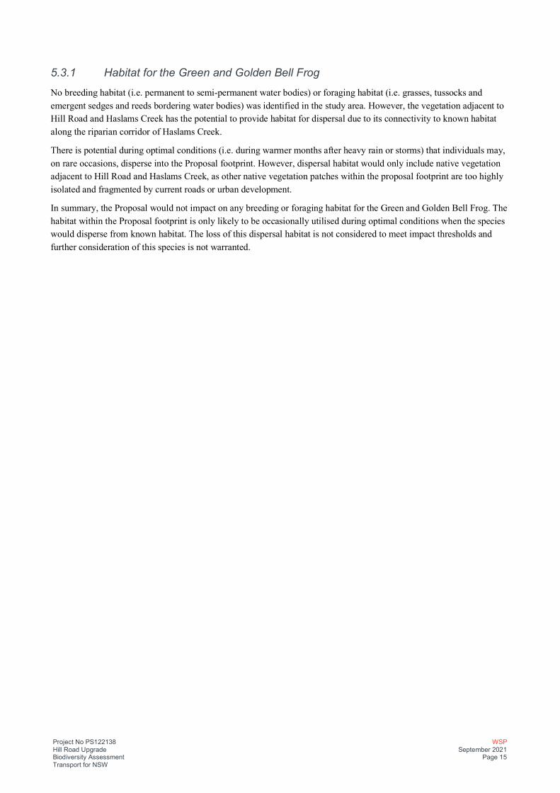
5.3.1 Habitat for the Green and Golden Bell Frog
No breeding habitat (i.e. permanent to semi-permanent water bodies) or foraging habitat (i.e. grasses, tussocks and emergent sedges and reeds bordering water bodies) was identified in the study area. However, the vegetation adjacent to Hill Road and Haslams Creek has the potential to provide habitat for dispersal due to its connectivity to known habitat along the riparian corridor of Haslams Creek.
There is potential during optimal conditions (i.e. during warmer months after heavy rain or storms) that individuals may, on rare occasions, disperse into the Proposal footprint. However, dispersal habitat would only include native vegetation adjacent to Hill Road and Haslams Creek, as other native vegetation patches within the proposal footprint are too highly isolated and fragmented by current roads or urban development.
In summary, the Proposal would not impact on any breeding or foraging habitat for the Green and Golden Bell Frog. The habitat within the Proposal footprint is only likely to be occasionally utilised during optimal conditions when the species would disperse from known habitat. The loss of this dispersal habitat is not considered to meet impact thresholds and further consideration of this species is not warranted.

Project No PS122138 Hill Road Upgrade Biodiversity Assessment Transport for NSW
WSP September 2021
Page 16
6 Matters of national environmental significance
Matters of National Environmental Significance (MNES), listed under the EPBC Act, are addressed in this section. The following biodiversity MNES protected under the EPBC Act were considered for their relevance to the Proposal:
— wetlands of international importance (Ramsar) (EPBC Act sections 16 and 17B) — listed threatened species and communities (EPBC Act sections 18 and 18A) — listed migratory species (EPBC Act sections 20 and 20A).
6.1 Wetlands of international importance Two nationally important wetlands are located downstream to the study area (with 2 km); Newington Wetland and Bicentennial Park. These wetlands are listed as nationally important wetlands and provide habitat for migratory birds. The location of these wetlands is outlined in Figure 4.1. It is unlikely that the Proposal will interfere with existing flow and flooding conditions. Given this, and the fact that Haslams creek is not located within the study area, it is unlikely the Proposal would impact on wetlands downstream.
No wetlands of international importance occur locally.
6.2 Listed threatened ecological communities PCT 724 - Broad-leaved Ironbark - Grey Box - Melaleuca decora grassy open forest on clay/gravel soils of the Cumberland Plain, Sydney Basin Bioregion can potentially form part of the TEC Cumberland Plain Shale Woodlands and Shale-Gravel Transition Forest, which is listed as Critically Endangered under the EPBC Act.
Unlike the equivalent BC Act TEC listings, the EPBC Act listing is defined by specific patch size and condition thresholds, in addition to floristic composition and location characteristics. Based on the small patch size of PCT 724 within the study area, it is considered that this vegetation does not meet the thresholds for the critically endangered Cumberland Plain Shale Woodlands and Shale-Gravel Transition Forest listed under the EPBC Act.
6.3 Listed threatened species
6.3.1 Threatened flora species
The results of the updated PMST identified 35 threatened flora species listed as threatened under the EPBC Act as occurring or considered likely to occur in the study area (Appendix A).
Based on the previous survey, no EPBC listed threatened flora species were recorded. As such no EPBC listed threatened flora are predicted to be impacted by the Proposal.
6.3.2 Threatened fauna species
The results of the PMST identified 49 threatened fauna species listed as threatened under the EPBC Act as occurring or considered likely to occur in the study area (Table 6.1). Of these, one threatened fauna species was assessed as having a moderate likelihood of occurring in the study area based on available habitat, mobility and known occurrences in the wider locality.

Project No PS122138 Hill Road Upgrade Biodiversity Assessment Transport for NSW
WSP September 2021
Page 17
Table 6.1 Threatened fauna species listed under the EPBC Act with a moderate likelihood of occurrence
SCIENTIFIC NAME COMMON NAME EPBC ACT1
LIKELIHOOD OF OCCURRENCE
Pteropus poliocephalus Grey-headed Flying-fox
V Moderate. No camps were recorded. Species is likely to utilise the study area for foraging purposes on occasion.
(1) V = Vulnerable under the EPBC Act.
6.4 Listed migratory species The Proposal is unlikely to/ significantly affect migratory species and therefore this group has not been considered further.
Project No PS122138 Hill Road Upgrade Biodiversity Assessment Transport for NSW
WSP September 2021
Page 18
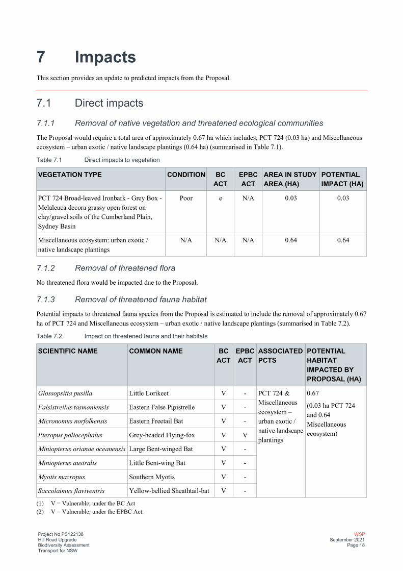
7 Impacts This section provides an update to predicted impacts from the Proposal.
7.1 Direct impacts
7.1.1 Removal of native vegetation and threatened ecological communities
The Proposal would require a total area of approximately 0.67 ha which includes; PCT 724 (0.03 ha) and Miscellaneous ecosystem – urban exotic / native landscape plantings (0.64 ha) (summarised in Table 7.1).
Table 7.1 Direct impacts to vegetation
VEGETATION TYPE CONDITION BC ACT
EPBC ACT
AREA IN STUDY AREA (HA)
POTENTIAL IMPACT (HA)
PCT 724 Broad-leaved Ironbark - Grey Box - Melaleuca decora grassy open forest on clay/gravel soils of the Cumberland Plain, Sydney Basin
Poor e N/A 0.03 0.03
Miscellaneous ecosystem: urban exotic / native landscape plantings
N/A N/A N/A 0.64 0.64
7.1.2 Removal of threatened flora
No threatened flora would be impacted due to the Proposal.
7.1.3 Removal of threatened fauna habitat
Potential impacts to threatened fauna species from the Proposal is estimated to include the removal of approximately 0.67 ha of PCT 724 and Miscellaneous ecosystem – urban exotic / native landscape plantings (summarised in Table 7.2).
Table 7.2 Impact on threatened fauna and their habitats
SCIENTIFIC NAME COMMON NAME BC ACT
EPBC ACT
ASSOCIATED PCTS
POTENTIAL HABITAT IMPACTED BY PROPOSAL (HA)
Glossopsitta pusilla Little Lorikeet V - PCT 724 & Miscellaneous ecosystem – urban exotic / native landscape plantings
0.67
(0.03 ha PCT 724 and 0.64 Miscellaneous ecosystem)
Falsistrellus tasmaniensis Eastern False Pipistrelle V -
Micronomus norfolkensis Eastern Freetail Bat V -
Pteropus poliocephalus Grey-headed Flying-fox V V
Miniopterus orianae oceanensis Large Bent-winged Bat V -
Miniopterus australis Little Bent-wing Bat V -
Myotis macropus Southern Myotis V -
Saccolaimus flaviventris Yellow-bellied Sheathtail-bat V -
(1) V = Vulnerable; under the BC Act (2) V = Vulnerable; under the EPBC Act.

Project No PS122138 Hill Road Upgrade Biodiversity Assessment Transport for NSW
WSP September 2021
Page 19
7.2 Indirect impacts
7.2.1 Wildlife connectivity and habitat fragmentation
Habitat fragmentation per se relates to the physical dividing up of once continuous habitats into separate smaller fragments. The habitats within the study area are fragments that have formed since the initial habitat clearing that has occurred. The current rail line and roads divide the habitats in the study area. However, functional habitat connectivity for more mobile species (e.g. birds, flying-foxes, insectivorous bats, insects, plants) is still present. The current rail line and roads do not totally prevent fauna movement between habitat fragments (fauna can and likely do cross the rail line) but the rail line does present a hazard to movement.
The proposal is unlikely to break apart continuous habitats into separate smaller fragments. The further reduction in habitat patches causing isolation that may be caused by the proposal is not likely to have an appreciable impact on nomadic or migratory species such as birds.
The predicted level of isolation from the proposal is not likely to be enough to prevent the breeding and dispersal of plant pollinators or the dispersal of plant propagules (i.e. seed or other vegetative reproductive material) between habitat patches. Functional connectivity for many species would remain in the study area as was before the proposal. This impact would be of low magnitude and mitigation measures are not deemed necessary.
7.2.2 Edge effects on adjacent native vegetation and habitat
The development of linear infrastructure is known to cause disturbance in terms of reducing habitat quality in adjacent areas. This is due to the greater potential for edge effects and habitat fragmentation and barrier effects due to the high perimeter to area ratio of linear developments. The proposal would be built in an area that is currently subject to a high level of edge effects from the existing urban development and adjacent roads. The vegetation patches are suffering from weed invasion and the habitats that would be impacted by the proposal are edge habitats without any undisturbed core. There is unlikely to be any further impacts from edge effects resulting from the proposal. This impact would be of low magnitude and mitigation measures are not deemed necessary.
7.2.3 Weed dispersal
The proposal has the potential to further disperse weeds into nearby areas of native vegetation. The greatest potential for weed dispersal and establishment associated with the proposal would include earthworks, movement of soil and attachment of seed (and other propagules) to vehicles and machinery where these are utilised within or adjacent to retained vegetation. The clearing of native vegetation for the proposal, including earthworks would increase the potential for weed invasion into adjacent patches of native vegetation. Management measures would be required to minimise the risk of introduction and spread of weeds. With appropriate weed management, the overall impact of weed invasion on retained vegetation is likely to decrease in the medium to long term. Weeds must be managed during construction.
7.2.4 Invasion and spread of pathogens and disease
Plant and animal pathogens can affect threatened biodiversity through direct mortality and modification to vegetation structure and composition. The following pathogens are considered to have potential to affect the biodiversity within the proposal footprint and are the subject of Key Threatening Process listings:
— Amphibian Chytrid Fungus (Batrachochytrium dendrobatidis) — Exotic Rust Fungi (order Pucciniales, e.g. Myrtle rust fungus Uredo rangelii) — Phytophthora Root Rot Fungus (Phytophthora cinnamomi).
These three pathogens have all been recorded in the bioregion and have potential to occur within the proposal area at present or in the future. The main way in which Exotic Rust Fungi and Phytophthora Root Rot Fungus may be spread is through the movement of infected plant material and/or soil. The construction and operation of the proposal may increase the risk of disturbing and spreading these pathogens. With the implementation of hygiene procedures for the use of

Project No PS122138 Hill Road Upgrade Biodiversity Assessment Transport for NSW
WSP September 2021
Page 20
vehicles and the importation of materials to the proposal area, the risk of introducing these pathogens would, however, be low. Amphibian Chytrid Fungus can be spread through the movement of infected animals or water (including mud or moist soil) from infected areas. With the implementation of hygiene procedures for the use of vehicles and the importation of materials to the proposal footprint, the risk of introducing this pathogen to uninfected areas is low.
7.2.5 Noise and vibration
Considering the existing levels of noise and vibration from the roads and urban environment, it is unlikely there would be a significant increase in noise and vibration that would result in any increased impacts to biodiversity within the study area. There is however potential for impacts to locally common fauna from noise and vibration during construction, which may result in fauna temporarily avoiding habitats adjacent to the construction. The magnitude of this impact would be low and mitigation measures are not deemed necessary.

Project No PS122138 Hill Road Upgrade Biodiversity Assessment Transport for NSW
WSP September 2021
Page 21
Figure 7.1 Direct impacts
Project No PS122138 Hill Road Upgrade Biodiversity Assessment Transport for NSW
WSP September 2021
Page 22
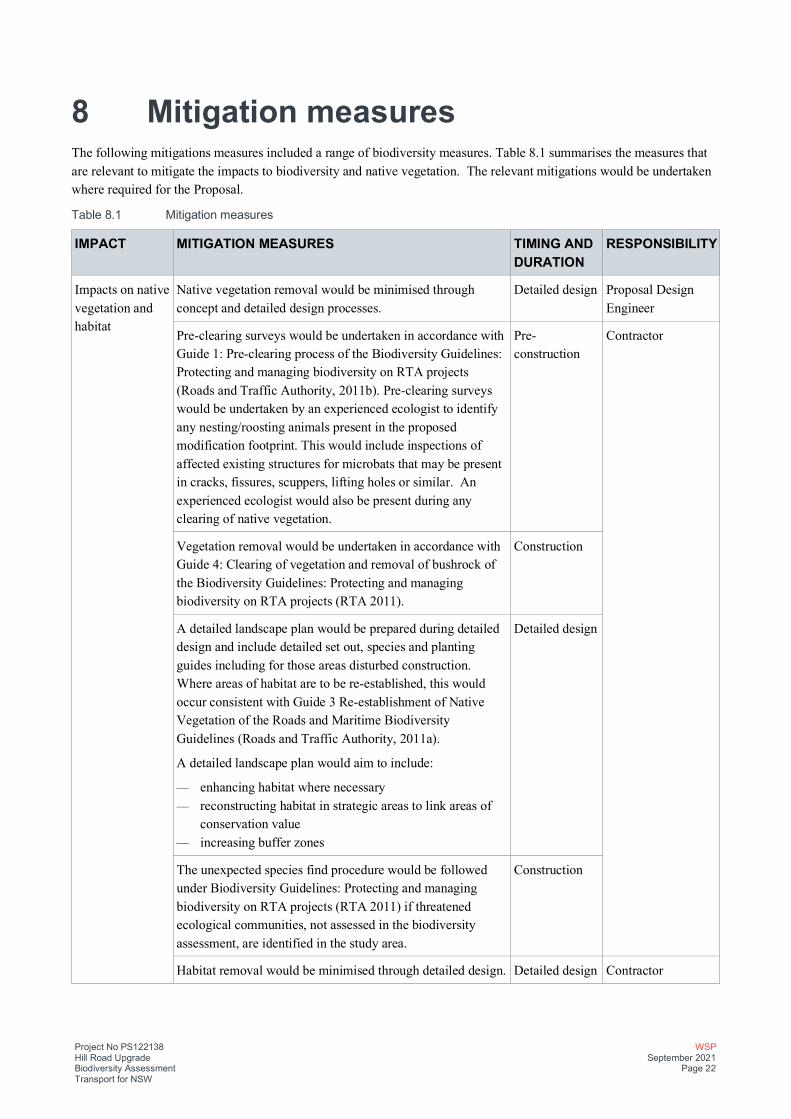
8 Mitigation measures The following mitigations measures included a range of biodiversity measures. Table 8.1 summarises the measures that are relevant to mitigate the impacts to biodiversity and native vegetation. The relevant mitigations would be undertaken where required for the Proposal.
Table 8.1 Mitigation measures
IMPACT MITIGATION MEASURES TIMING AND DURATION
RESPONSIBILITY
Impacts on native vegetation and habitat
Native vegetation removal would be minimised through concept and detailed design processes.
Detailed design Proposal Design Engineer
Pre-clearing surveys would be undertaken in accordance with Guide 1: Pre-clearing process of the Biodiversity Guidelines: Protecting and managing biodiversity on RTA projects (Roads and Traffic Authority, 2011b). Pre-clearing surveys would be undertaken by an experienced ecologist to identify any nesting/roosting animals present in the proposed modification footprint. This would include inspections of affected existing structures for microbats that may be present in cracks, fissures, scuppers, lifting holes or similar. An experienced ecologist would also be present during any clearing of native vegetation.
Pre-construction
Contractor
Vegetation removal would be undertaken in accordance with Guide 4: Clearing of vegetation and removal of bushrock of the Biodiversity Guidelines: Protecting and managing biodiversity on RTA projects (RTA 2011).
Construction
A detailed landscape plan would be prepared during detailed design and include detailed set out, species and planting guides including for those areas disturbed construction. Where areas of habitat are to be re-established, this would occur consistent with Guide 3 Re-establishment of Native Vegetation of the Roads and Maritime Biodiversity Guidelines (Roads and Traffic Authority, 2011a).
A detailed landscape plan would aim to include:
— enhancing habitat where necessary — reconstructing habitat in strategic areas to link areas of
conservation value — increasing buffer zones
Detailed design
The unexpected species find procedure would be followed under Biodiversity Guidelines: Protecting and managing biodiversity on RTA projects (RTA 2011) if threatened ecological communities, not assessed in the biodiversity assessment, are identified in the study area.
Construction
Habitat removal would be minimised through detailed design. Detailed design Contractor

Project No PS122138 Hill Road Upgrade Biodiversity Assessment Transport for NSW
WSP September 2021
Page 23
IMPACT MITIGATION MEASURES TIMING AND DURATION
RESPONSIBILITY
Fauna would be managed in accordance with Guide 9: Fauna handling of the Biodiversity Guidelines: Protecting and managing biodiversity on RTA projects (RTA 2011).
Construction
Habitat removal would be undertaken in accordance with Guide 4: Clearing of vegetation and removal of bushrock of the Biodiversity Guidelines: Protecting and managing biodiversity on RTA projects (RTA 2011).
Construction
Habitat would be replaced or re-instated in accordance with Guide 5: Re-use of woody debris and bushrock and Guide 8: Nest boxes of the Biodiversity Guidelines: Protecting and managing biodiversity on RTA projects (RTA 2011).
Construction
Impacts on native vegetation and habitat
Exclusion zones would be set up at the limit of clearing in accordance with Guide 2: Exclusion zones of the Biodiversity Guidelines: Protecting and managing biodiversity on RTA projects (RTA 2011).Exclusion zones would be established to avoid damage to native vegetation and fauna habitats identified for retention and prevent the distribution of weeds. The location of exclusion fencing to be installed would be identified by project environmental management plans and the function and importance of the exclusion zones would be communicated to construction personnel.
Construction Contractor
Weed species would be managed in accordance with Guide 6: Weed management of the Biodiversity Guidelines: Protecting and managing biodiversity on RTA projects (RTA 2011).
Construction
A weed management plan consistent with the Roads and Maritime Biodiversity Guidelines (Roads and Traffic Authority, 2011a) would be developed as part of the construction environmental management plan. The weed management plan would include descriptions and mapping of major weed infestations and appropriate management actions to be undertaken in relation to each infestation.
Construction
Pest species would be managed within the study area. Construction
Pathogens would be managed in accordance with Guide 2: Exclusion zones of the Biodiversity Guidelines: Protecting and managing biodiversity on RTA projects (RTA 2011).
Construction Contractor
Measures to prevent the spread of pathogens would be detailed in the construction environmental management plan. Measures would be consistent with Roads and Maritime Biodiversity Guidelines – Guide 7 Pathogen Management (Roads and Traffic Authority, 2011a). This would include measures to minimise the spread of Chytrid fungus and would be implemented during construction.
Construction

Project No PS122138 Hill Road Upgrade Biodiversity Assessment Transport for NSW
WSP September 2021
Page 24
IMPACT MITIGATION MEASURES TIMING AND DURATION
RESPONSIBILITY
Removal of threatened species habitat
Pre-clearing surveys, if required, would be undertaken in accordance with Guide 1: Pre-clearing process of the Biodiversity Guidelines: Protecting and managing biodiversity on RTA projects (Roads and Traffic Authority, 2011a).
Construction Contractor
The unexpected species find procedure would be followed under Biodiversity Guidelines: Protecting and managing biodiversity on RTA projects ((Roads and Traffic Authority, 2011a)) if threatened flora species, not assessed in the biodiversity assessment, are identified in the study area.
Construction
Project No PS122138 Hill Road Upgrade Biodiversity Assessment Transport for NSW
WSP September 2021
Page 25
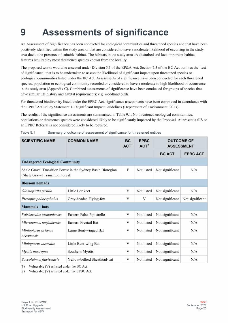
9 Assessments of significance An Assessment of Significance has been conducted for ecological communities and threatened species and that have been positively identified within the study area or that are considered to have a moderate likelihood of occurring in the study area due to the presence of suitable habitat. The habitats in the study area are disturbed and lack important habitat features required by most threatened species known from the locality.
The proposed works would be assessed under Division 5.1 of the EP&A Act. Section 7.3 of the BC Act outlines the ‘test of significance’ that is to be undertaken to assess the likelihood of significant impact upon threatened species or ecological communities listed under the BC Act. Assessments of significance have been conducted for each threatened species, population or ecological community recorded or considered to have a moderate to high likelihood of occurrence in the study area (Appendix C). Combined assessments of significance have been conducted for groups of species that have similar life history and habitat requirements; e.g. woodland birds.
For threatened biodiversity listed under the EPBC Act, significance assessments have been completed in accordance with the EPBC Act Policy Statement 1.1 Significant Impact Guidelines (Department of Environment, 2013).
The results of the significance assessments are summarised in Table 9.1. No threatened ecological communities, populations or threatened species were considered likely to be significantly impacted by the Proposal. At present a SIS or an EPBC Referral is not considered likely to be required.
Table 9.1 Summary of outcome of assessment of significance for threatened entities
SCIENTIFIC NAME COMMON NAME BC ACT1
EPBC ACT2
OUTCOME OF ASSESSMENT
BC ACT EPBC ACT
Endangered Ecological Community
Shale Gravel Transition Forest in the Sydney Basin Bioregion (Shale Gravel Transition Forest)
E Not listed Not significant N/A
Blossom nomads
Glossopsitta pusilla Little Lorikeet V Not listed Not significant N/A
Pteropus poliocephalus Grey-headed Flying-fox V V Not significant Not significant
Mammals – bats
Falsistrellus tasmaniensis Eastern False Pipistrelle V Not listed Not significant N/A
Micronomus norfolkensis Eastern Freetail Bat V Not listed Not significant N/A
Miniopterus orianae oceanensis
Large Bent-winged Bat V Not listed Not significant N/A
Miniopterus australis Little Bent-wing Bat V Not listed Not significant N/A
Myotis macropus Southern Myotis V Not listed Not significant N/A
Saccolaimus flaviventris Yellow-bellied Sheathtail-bat V Not listed Not significant N/A
(1) Vulnerable (V) as listed under the BC Act (2) Vulnerable (V) as listed under the EPBC Act.

Project No PS122138 Hill Road Upgrade Biodiversity Assessment Transport for NSW
WSP September 2021
Page 26
10 Biodiversity offsets The Proposal is being assessed under a Review of Environment Factors (REF) and in reference with Section 4.2: Table 1 – RMS Guidelines for Biodiversity Offsets (Roads & Maritime Services, 2016) the Proposal would not meet the threshold criteria that require to offset the impact of native vegetation or threatened species habitat recorded within the study area (Table 10.1).
Table 10.1 RMS Guidelines for Biodiversity Offsets – Offsetting thresholds for REFs
DESCRIPTION OF ACTIVITY OR IMPACT CONSIDER OFFSETS OF SUPPLEMENTARY
MEASURES
APPLICABLE?
Activities in accordance with Roads and Maritime Services Environmental assessment procedure: Routine and Minor Works (RTA 2011)
No N/A
Works on cleared land, plantations, exotic vegetation where there are no threatened species or habitat present
No N/A
Works involving clearing of vegetation planted as part of a road corridor landscaping program (this includes where threatened species or species comprising listed ecological communities have been used for landscaping purposes)
No N/A
Works involving clearing of national or NSW listed critically endangered ecological communities (CEEC)
Where there is any clearing of an CEEC in moderate to good
condition
Doesn’t meet criterion – vegetation community is
not listed as critically endangered and occurs
in poor condition
Works involving clearing of nationally listed threatened ecological community (TEC) or nationally listed threatened species habitat
Where clearing >1 ha of a TEC or habitat in moderate to
good condition
Doesn’t meet criterion - <1 ha of TEC being
impacted, and habitat occurs in poor condition
Works involving clearing of NSW endangered or vulnerable ecological community
Where clearing > 5 ha or where the ecological
community is subject to an SIS
Doesn’t meet criterion - <1 ha of TEC being impacted and not
subject to SIS
Works involving clearing of NSW listed threatened species habitat where the species is a species credit species as defined in the OEH Threatened Species Profile Database (TSPD)
Where clearing > 1ha or where the species is the
subject of an SIS
Doesn’t meet criterion - <1 ha of habitat being
impacted and not subject to SIS
Works involving clearing of NSW listed threatened species habitat and the species is an ecosystem credit species as defined in OEH’s Threatened Species Profile Database (TSPD)
Where clearing > 5ha or where the species is the
subject of an SIS
Doesn’t meet criterion - <1 ha of habitat being
impacted and not subject to SIS
Type 1 or Type 2 key fish habitats (as defined by NSW Fisheries)
Where there is any net loss of habitat
N/A

Project No PS122138 Hill Road Upgrade Biodiversity Assessment Transport for NSW
WSP September 2021
Page 27
10.1 Commonwealth offsetting requirement The Proposal will not result in a significant impact on any Matters of National Environmental Significance and as such the Proposed modification will not require an environmental offset under the EPBC Act.

Project No PS122138 Hill Road Upgrade Biodiversity Assessment Transport for NSW
WSP September 2021
Page 28
11 Conclusion The Proposal would have a minimal impact on 0.67 ha of vegetation within the study area comprising of one native plant community type and one non-native vegetation type:
— PCT 724 Broad-leaved Ironbark - Grey Box - Melaleuca decora grassy open forest on clay/gravel soils of the Cumberland Plain, Sydney Basin (0.03ha)
— Miscellaneous ecosystem – Urban exotic / native landscape plantings (0.64 ha)
One native vegetation community, PCT 724 Broad-leaved Ironbark - Grey Box - Melaleuca decora grassy open forest on clay/gravel soils of the Cumberland Plain, Sydney Basin, is consistent with a BC Act listed threatened ecological community Shale Gravel Transition Forest in the Sydney Basin Bioregion (Shale Gravel Transition Forest) - listed as Endangered.
No threatened ecological communities listed under the EPBC Act were recorded within the study area.
No threatened flora species have been recorded or are considered affected by the Proposal.
During the previous surveys, no threatened fauna species were recorded, however, based on habitat within the study area eight threatened fauna species are considered to have foraging habitat including:
— Little Lorikeet (Glossopsitta pusilla) listed as Vulnerable under the BC Act — Eastern False Pipistrelle (Falsistrellus tasmaniensis) listed as Vulnerable under the BC Act — Eastern Freetail Bat (Micronomus norfolkensis) listed as Vulnerable under the BC Act — Grey-headed Flying-fox (Pteropus poliocephalus) listed as Vulnerable under the BC Act and EPBC Act — Large Bent-winged Bat (Miniopterus orianae oceanensis) listed as Vulnerable under the BC Act — Little Bent-wing Bat (Miniopterus australis) listed as Vulnerable under the BC Act — Southern Myotis (Myotis macropus) listed as Vulnerable under the BC Act — Yellow-bellied Sheathtail-bat (Saccolaimus flaviventris) listed as Vulnerable under the BC Act — The biodiversity mitigation measures as outlined in Table 8.1 should be implemented to minimise impacts.
Assessments of impact significance were conducted for all threatened species, populations and ecological communities considered likely to be affected by the Proposal. Through these assessments, it was concluded that the Proposal is unlikely to have a significant impact on any threatened species, population or ecological community. As such, a SIS or referral of this Proposal under the EPBC Act is not required.
No biodiversity offsets are required to offset the impact to native vegetation or threatened species habitat identified in the study area.
Project No PS122138 Hill Road Upgrade Biodiversity Assessment Transport for NSW
WSP September 2021
Page 29
12 Limitations This Report is provided by WSP Australia Pty Limited (WSP) for TfNSW (Client) in response to specific instructions from the Client and in accordance with WSP’s proposal and agreement with the Client (Agreement).
12.1 Permitted purpose This Report is provided by WSP for the purpose described in the Agreement and no responsibility is accepted by WSP for the use of the Report in whole or in part, for any other purpose (Permitted Purpose).
12.2 Qualifications and assumptions The services undertaken by WSP in preparing this Report were limited to those specifically detailed in the Report and are subject to the scope, qualifications, assumptions and limitations set out in the Report or otherwise communicated to the Client.
Except as otherwise stated in the Report and to the extent that statements, opinions, facts, conclusion and / or recommendations in the Report (Conclusions) are based in whole or in part on information provided by the Client and other parties identified in the report (Information), those Conclusions are based on assumptions by WSP of the reliability, adequacy, accuracy and completeness of the Information and have not been verified. WSP accepts no responsibility for the Information.
WSP has prepared the Report without regard to any special interest of any person other than the Client when undertaking the services described in the Agreement or in preparing the Report.
12.3 Use and reliance This Report should be read in its entirety and must not be copied, distributed or referred to in part only. The Report must not be reproduced without the written approval of WSP. WSP will not be responsible for interpretations or conclusions drawn by the reader. This Report (or sections of the Report) should not be used as part of a specification for a project or for incorporation into any other document without the prior agreement of WSP.
WSP is not (and will not be) obliged to provide an update of this Report to include any event, circumstance, revised Information or any matter coming to WSP’s attention after the date of this Report. Data reported and Conclusions drawn are based solely on information made available to WSP at the time of preparing the Report. The passage of time; unexpected variations in ground conditions; manifestations of latent conditions; or the impact of future events (including (without limitation) changes in policy, legislation, guidelines, scientific knowledge; and changes in interpretation of policy by statutory authorities); may require further investigation or subsequent re-evaluation of the Conclusions.
This Report can only be relied upon for the Permitted Purpose and may not be relied upon for any other purpose. The Report does not purport to recommend or induce a decision to make (or not make) any purchase, disposal, investment, divestment, financial commitment or otherwise. It is the responsibility of the Client to accept (if the Client so chooses) any Conclusions contained within the Report and implement them in an appropriate, suitable and timely manner.
In the absence of express written consent of WSP, no responsibility is accepted by WSP for the use of the Report in whole or in part by any party other than the Client for any purpose whatsoever. Without the express written consent of WSP, any use which a third party makes of this Report or any reliance on (or decisions to be made) based on this Report is at the sole risk of those third parties without recourse to WSP. Third parties should make their own enquiries and obtain independent advice in relation to any matter dealt with or Conclusions expressed in the Report.

Project No PS122138 Hill Road Upgrade Biodiversity Assessment Transport for NSW
WSP September 2021
Page 30
12.4 Disclaimer No warranty, undertaking or guarantee whether expressed or implied, is made with respect to the data reported or the Conclusions drawn. To the fullest extent permitted at law, WSP, its related bodies corporate and its officers, employees and agents assumes no responsibility and will not be liable to any third party for, or in relation to any losses, damages or expenses (including any indirect, consequential or punitive losses or damages or any amounts for loss of profit, loss of revenue, loss of opportunity to earn profit, loss of production, loss of contract, increased operational costs, loss of business opportunity, site depredation costs, business interruption or economic loss) of any kind whatsoever, suffered on incurred by a third party.
12.5 Field survey limitations No sampling technique can eliminate the possibility that a species is present on a site. For example, some species of plant may be present in the soil seed bank and some fauna species use habitats on a sporadic or seasonal basis and may not be present on site during surveys. The conclusions in this report are based upon previous studies, data acquired for the site and the environmental field surveys and are, therefore, merely indicative of the environmental condition of the site at the time of preparing the report, including the presence or otherwise of species. Also, it should be recognised that site conditions, including the presence of threatened species, can change with time.
Given the nature and access restrictions of some sections of the study area (i.e. private property) some areas were unable to be inspected due to safety concerns and time limitations. Where access was not available biodiversity values were extrapolated from a distance with the aid of binoculars. Additionally, given time restrictions targeted threatened species surveys were not completed as part of this assessment.
Project No PS122138 Hill Road Upgrade Biodiversity Assessment Transport for NSW
WSP September 2021
Page 31
References Bureau of Meteorology. (2020). Bureau of Meteorology - Groundwater Dependent Ecosystems Atlas. Retrieved from
http://www.bom.gov.au/water/groundwater/gde/
Department of Environment and Energy. (2020a). Directory of Important Wetlands in Australia. Retrieved from http://www.environment.gov.au/water/wetlands/australian-wetlands-database/directory-important-wetlands
Department of Environment and Energy. (2020b). Protected Matters Search Tool. Retrieved from https://www.environment.gov.au/epbc/protected-matters-search-tool
Department of Primary Industries. (2020a). NSW WeedWise. Retrieved from https://weeds.dpi.nsw.gov.au/
Department of Primary Industries. (2020b). Threatened Aquatic Fauna Database Search. Retrieved from http://pas.dpi.nsw.gov.au/Species/Species_byRegion.aspx
Department of the Environment and Energy. (2016). An Interim Biogeographic Regionalisation of Australia (IBRA) - Version 7. Retrieved from Canberra:
Environment Energy and Science Group. (2020a, 21 January 2020). BioNet Atlas of NSW Wildlife. Retrieved from http://www.bionet.nsw.gov.au/
Environment Energy and Science Group. (2020b). Threatened Species Profile Database. Retrieved from http://www.bionet.nsw.gov.au/
Office for Environment & Heritage. (2016). NSW Mitchell Landscapes Version 3.1. Retrieved from: http://data.environment.nsw.gov.au/dataset/nsw-mitchell-landscapes-version-3-1
Roads & Maritime Services. (2016). Guideline for Biodiversity Offsets. Retrieved from
Roads and Traffic Authority. (2011a). Biodiveristy Guidelines: Protecting and managing biodiversity on RTA projects. Retrieved from
Roads and Traffic Authority. (2011b). Biodiversity Guidelines - Protecting and managing biodiversity on RTA projects. Retrieved from Sydney:
Royal Botanic Gardens. (2020). Plantnet - The Plant Information Network System of Botanic Gardens Trust Version 2.0. Retrieved from http://plantnet.rbgsyd.nsw.gov.au/

Threatened flora likelihood assessment
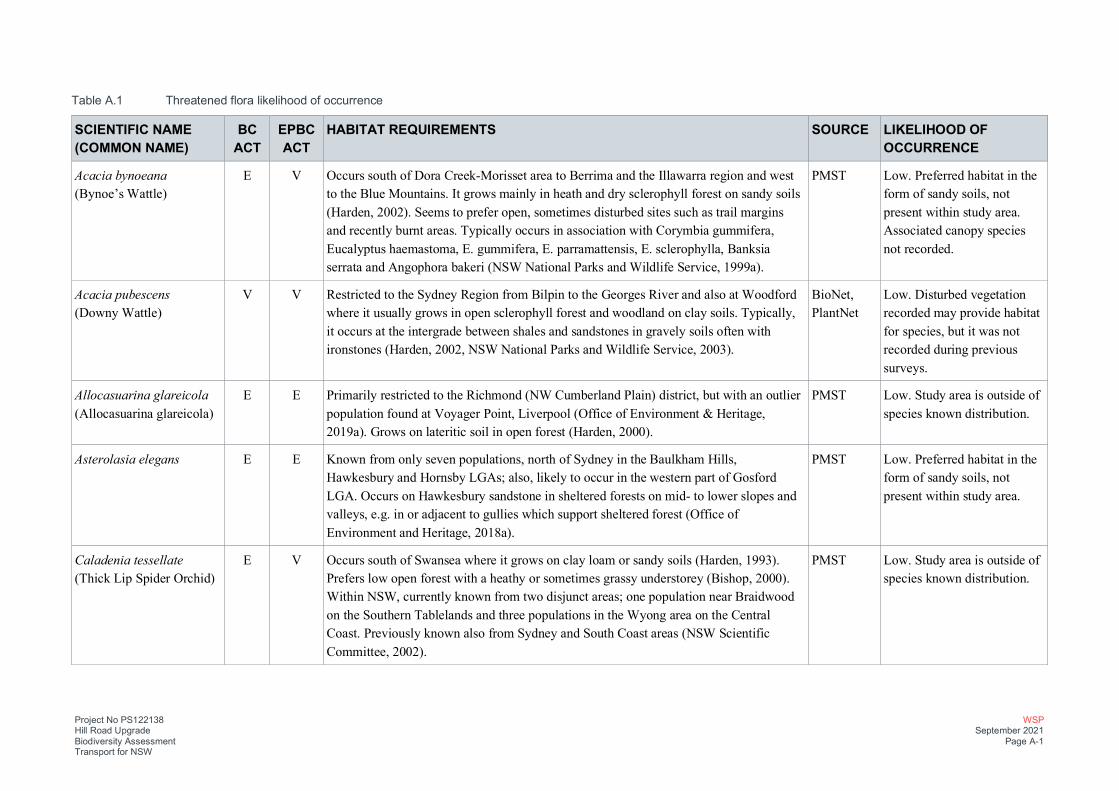
Project No PS122138 Hill Road Upgrade Biodiversity Assessment Transport for NSW
WSP September 2021
Page A-1
Table A.1 Threatened flora likelihood of occurrence
SCIENTIFIC NAME (COMMON NAME)
BC ACT
EPBC ACT
HABITAT REQUIREMENTS SOURCE LIKELIHOOD OF OCCURRENCE
Acacia bynoeana (Bynoe’s Wattle)
E V Occurs south of Dora Creek-Morisset area to Berrima and the Illawarra region and west to the Blue Mountains. It grows mainly in heath and dry sclerophyll forest on sandy soils (Harden, 2002). Seems to prefer open, sometimes disturbed sites such as trail margins and recently burnt areas. Typically occurs in association with Corymbia gummifera, Eucalyptus haemastoma, E. gummifera, E. parramattensis, E. sclerophylla, Banksia serrata and Angophora bakeri (NSW National Parks and Wildlife Service, 1999a).
PMST Low. Preferred habitat in the form of sandy soils, not present within study area. Associated canopy species not recorded.
Acacia pubescens (Downy Wattle)
V V Restricted to the Sydney Region from Bilpin to the Georges River and also at Woodford where it usually grows in open sclerophyll forest and woodland on clay soils. Typically, it occurs at the intergrade between shales and sandstones in gravely soils often with ironstones (Harden, 2002, NSW National Parks and Wildlife Service, 2003).
BioNet, PlantNet
Low. Disturbed vegetation recorded may provide habitat for species, but it was not recorded during previous surveys.
Allocasuarina glareicola (Allocasuarina glareicola)
E E Primarily restricted to the Richmond (NW Cumberland Plain) district, but with an outlier population found at Voyager Point, Liverpool (Office of Environment & Heritage, 2019a). Grows on lateritic soil in open forest (Harden, 2000).
PMST Low. Study area is outside of species known distribution.
Asterolasia elegans E E Known from only seven populations, north of Sydney in the Baulkham Hills, Hawkesbury and Hornsby LGAs; also, likely to occur in the western part of Gosford LGA. Occurs on Hawkesbury sandstone in sheltered forests on mid- to lower slopes and valleys, e.g. in or adjacent to gullies which support sheltered forest (Office of Environment and Heritage, 2018a).
PMST Low. Preferred habitat in the form of sandy soils, not present within study area.
Caladenia tessellate (Thick Lip Spider Orchid)
E V Occurs south of Swansea where it grows on clay loam or sandy soils (Harden, 1993). Prefers low open forest with a heathy or sometimes grassy understorey (Bishop, 2000). Within NSW, currently known from two disjunct areas; one population near Braidwood on the Southern Tablelands and three populations in the Wyong area on the Central Coast. Previously known also from Sydney and South Coast areas (NSW Scientific Committee, 2002).
PMST Low. Study area is outside of species known distribution.

Project No PS122138 Hill Road Upgrade Biodiversity Assessment Transport for NSW
WSP September 2021
Page A-2
SCIENTIFIC NAME (COMMON NAME)
BC ACT
EPBC ACT
HABITAT REQUIREMENTS SOURCE LIKELIHOOD OF OCCURRENCE
Callistemon linearifolius (Netted Bottle Brush)
V - Occurs chiefly from Georges to the Hawkesbury River where it grows in dry sclerophyll forest, open forest, scrubland or woodland on sandstone. Found in damp places, usually in gullies (Robinson, 1994, Fairley and Moore, 2002, Harden, 2002).
BioNet, PlantNet
Low. Preferred habitat i.e. sandstone soils, not present within study area.
Cryptostylis hunteriana (Leafless Tongue Orchid)
V V Occurs south from the Gibraltar Range, chiefly in coastal districts but also extends on to tablelands. Grows in swamp-heath and drier forest on sandy soils on granite & sandstone. Occurs in small, localised colonies most often on the flat plains close to the coast but also known from some mountainous areas growing in moist depressions and swampy habitats (Harden, 1993).
PMST Low. Preferred habitat in the form of heathy vegetation and sandy soils, not present within study area.
Darwinia biflora V V Occurs from Cheltenham to Hawkesbury River where it grows in heath on sandstone or in the understorey of woodland on shale-capped ridges (Harden, 2002). Occurs on the edges of weathered shale-capped ridges, where these intergrade with Hawkesbury Sandstone. Associated overstorey species include Eucalyptus haemastoma, Corymbia gummifera and/or E. squamosa (Office of Environment and Heritage, 2019b).
PMST Low. Preferred habitat in the form of heathy vegetation and sandy soils, not present within study area.
Darwinia biflora V V Recorded in Ku-ring-gai, Hornsby, Baulkham Hills and Ryde local government areas. The northern, southern, eastern and western limits of the range are at Maroota, North Ryde, Cowan and Kellyville, respectively. Occurs on the edges of weathered shale-capped ridges, where these intergrade with Hawkesbury Sandstone. Associated overstorey species include Eucalyptus haemastoma, Corymbia gummifera and/or E. squamosa. The vegetation structure is usually woodland, open forest or scrub-heath. Flowering occurs throughout the year but is concentrated in autumn, with mature fruits being produced from May to August.
PMST Low. Preferred habitat in the form of heathy vegetation and sandy soils, not present within study area.
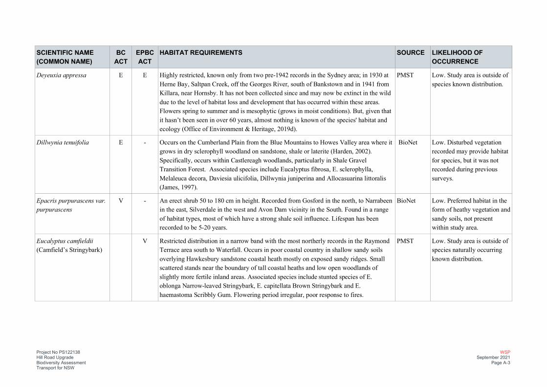
Project No PS122138 Hill Road Upgrade Biodiversity Assessment Transport for NSW
WSP September 2021
Page A-3
SCIENTIFIC NAME (COMMON NAME)
BC ACT
EPBC ACT
HABITAT REQUIREMENTS SOURCE LIKELIHOOD OF OCCURRENCE
Deyeuxia appressa E E Highly restricted, known only from two pre-1942 records in the Sydney area; in 1930 at Herne Bay, Saltpan Creek, off the Georges River, south of Bankstown and in 1941 from Killara, near Hornsby. It has not been collected since and may now be extinct in the wild due to the level of habitat loss and development that has occurred within these areas. Flowers spring to summer and is mesophytic (grows in moist conditions). But, given that it hasn’t been seen in over 60 years, almost nothing is known of the species' habitat and ecology (Office of Environment & Heritage, 2019d).
PMST Low. Study area is outside of species known distribution.
Dillwynia tenuifolia E - Occurs on the Cumberland Plain from the Blue Mountains to Howes Valley area where it grows in dry sclerophyll woodland on sandstone, shale or laterite (Harden, 2002). Specifically, occurs within Castlereagh woodlands, particularly in Shale Gravel Transition Forest. Associated species include Eucalyptus fibrosa, E. sclerophylla, Melaleuca decora, Daviesia ulicifolia, Dillwynia juniperina and Allocasuarina littoralis (James, 1997).
BioNet Low. Disturbed vegetation recorded may provide habitat for species, but it was not recorded during previous surveys.
Epacris purpurascens var. purpurascens
V - An erect shrub 50 to 180 cm in height. Recorded from Gosford in the north, to Narrabeen in the east, Silverdale in the west and Avon Dam vicinity in the South. Found in a range of habitat types, most of which have a strong shale soil influence. Lifespan has been recorded to be 5-20 years.
BioNet Low. Preferred habitat in the form of heathy vegetation and sandy soils, not present within study area.
Eucalyptus camfieldii (Camfield’s Stringybark)
V Restricted distribution in a narrow band with the most northerly records in the Raymond Terrace area south to Waterfall. Occurs in poor coastal country in shallow sandy soils overlying Hawkesbury sandstone coastal heath mostly on exposed sandy ridges. Small scattered stands near the boundary of tall coastal heaths and low open woodlands of slightly more fertile inland areas. Associated species include stunted species of E. oblonga Narrow-leaved Stringybark, E. capitellata Brown Stringybark and E. haemastoma Scribbly Gum. Flowering period irregular, poor response to fires.
PMST Low. Study area is outside of species naturally occurring known distribution.
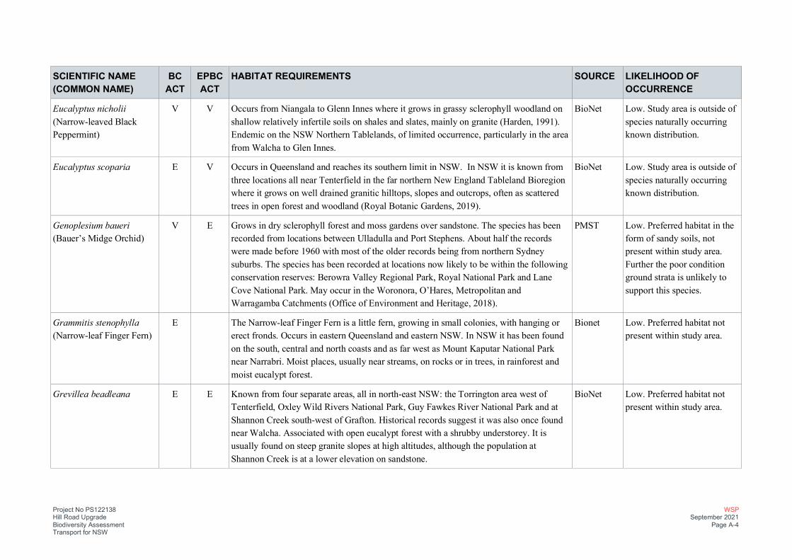
Project No PS122138 Hill Road Upgrade Biodiversity Assessment Transport for NSW
WSP September 2021
Page A-4
SCIENTIFIC NAME (COMMON NAME)
BC ACT
EPBC ACT
HABITAT REQUIREMENTS SOURCE LIKELIHOOD OF OCCURRENCE
Eucalyptus nicholii (Narrow-leaved Black Peppermint)
V V Occurs from Niangala to Glenn Innes where it grows in grassy sclerophyll woodland on shallow relatively infertile soils on shales and slates, mainly on granite (Harden, 1991). Endemic on the NSW Northern Tablelands, of limited occurrence, particularly in the area from Walcha to Glen Innes.
BioNet Low. Study area is outside of species naturally occurring known distribution.
Eucalyptus scoparia E V Occurs in Queensland and reaches its southern limit in NSW. In NSW it is known from three locations all near Tenterfield in the far northern New England Tableland Bioregion where it grows on well drained granitic hilltops, slopes and outcrops, often as scattered trees in open forest and woodland (Royal Botanic Gardens, 2019).
BioNet Low. Study area is outside of species naturally occurring known distribution.
Genoplesium baueri (Bauer’s Midge Orchid)
V E Grows in dry sclerophyll forest and moss gardens over sandstone. The species has been recorded from locations between Ulladulla and Port Stephens. About half the records were made before 1960 with most of the older records being from northern Sydney suburbs. The species has been recorded at locations now likely to be within the following conservation reserves: Berowra Valley Regional Park, Royal National Park and Lane Cove National Park. May occur in the Woronora, O’Hares, Metropolitan and Warragamba Catchments (Office of Environment and Heritage, 2018).
PMST Low. Preferred habitat in the form of sandy soils, not present within study area. Further the poor condition ground strata is unlikely to support this species.
Grammitis stenophylla (Narrow-leaf Finger Fern)
E The Narrow-leaf Finger Fern is a little fern, growing in small colonies, with hanging or erect fronds. Occurs in eastern Queensland and eastern NSW. In NSW it has been found on the south, central and north coasts and as far west as Mount Kaputar National Park near Narrabri. Moist places, usually near streams, on rocks or in trees, in rainforest and moist eucalypt forest.
Bionet Low. Preferred habitat not present within study area.
Grevillea beadleana E E Known from four separate areas, all in north-east NSW: the Torrington area west of Tenterfield, Oxley Wild Rivers National Park, Guy Fawkes River National Park and at Shannon Creek south-west of Grafton. Historical records suggest it was also once found near Walcha. Associated with open eucalypt forest with a shrubby understorey. It is usually found on steep granite slopes at high altitudes, although the population at Shannon Creek is at a lower elevation on sandstone.
BioNet Low. Preferred habitat not present within study area.

Project No PS122138 Hill Road Upgrade Biodiversity Assessment Transport for NSW
WSP September 2021
Page A-5
SCIENTIFIC NAME (COMMON NAME)
BC ACT
EPBC ACT
HABITAT REQUIREMENTS SOURCE LIKELIHOOD OF OCCURRENCE
Grevillea juniperina subsp. Juniperina (Juniper-leaved Grevillea)
V - Endemic to Western Sydney, centred on an area bounded by Blacktown, Erskine Park, Londonderry and Windsor with outlier populations at Kemps Creek and Pitt Town. Grows on reddish clay to sandy soils derived from Wianamatta Shale and Tertiary alluvium (often with shale influence), typically containing lateritic gravels. Recorded from Cumberland Plain Woodland, Castlereagh Ironbark Woodland, Castlereagh Scribbly Gum Woodland and Shale/Gravel Transition Forest. (Office of Environment and Heritage, 2019g)
Professional opinion
Low. Disturbed vegetation recorded may provide habitat for species, but it was not recorded during previous surveys.
Grevillea parviflora subsp. parviflora (Small-flower Grevillea)
V V Mainly known from the Prospect area (but now extinct there) and lower Georges River to Camden, Appin and Cordeaux Dam areas, with a disjunct populations near Putty, Cessnock and Cooranbong. Grows in heath or shrubby woodland in sandy or light clay soils usually over thin shales (NSW Scientific Committee, 1998a, Harden, 2002).
PMST Low. Disturbed vegetation recorded may provide habitat for species, but it was not recorded during previous surveys.
Haloragodendron lucasii E E The known locations of this species are confined to a very narrow distribution on the north shore of Sydney. Associated with dry sclerophyll forest. Reported to grow in moist sandy loam soils in sheltered aspects, and on gentle slopes below cliff-lines near creeks in low open woodland. Associated with high soil moisture and relatively high soil-phosphorus levels. Flowering occurs from August to November with fruits appearing from October to December.
PMST Low. Preferred habitat not present within study area.
Hibbertia puberula E - Recent work on this species (Toelken and Miller, 2012) and its relatives have shown it to be widespread, but never common. It extends from Wollemi National Park south to Morton National Park and the south coast near Nowra. Early records of this species are from the Hawkesbury River area and Frenchs Forest in northern Sydney, South Coogee in eastern Sydney, the Hacking River area in southern Sydney, and the Blue Mountains. It favours low heath on sandy soils or rarely in clay, with or without rocks (Toelken and Miller, 2012) (Office of Environment and Heritage, 2019f).
PMST Low. Preferred habitat in the form of sandy soils and low heathy vegetation, not present within study area.

Project No PS122138 Hill Road Upgrade Biodiversity Assessment Transport for NSW
WSP September 2021
Page A-6
SCIENTIFIC NAME (COMMON NAME)
BC ACT
EPBC ACT
HABITAT REQUIREMENTS SOURCE LIKELIHOOD OF OCCURRENCE
Hibbertia puberula subsp. glabrescens
CE CE Known to occur from one population at Bankstown Airport in Sydney's southern suburbs. The population comprises fewer than 100 individuals. Flowers October, November and sometimes December.
PMST Low. Preferred habitat in the form of sandy soils and low heathy vegetation, not present within study area.
Lasiopetalum joyceae V V Has a restricted range occurring on lateritic to shaley ridgetops on the Hornsby Plateau south of the Hawkesbury River. It is currently known from 34 sites between Berrilee and Duffys Forest. Seventeen of these are reserved. Grows in heath on sandstone.
PMST Low. Preferred habitat in the form of sandy soils and low heathy vegetation, not present within study area.
Leptospermum deanei V V Occurs in Hornsby, Warringah, Ku-ring-gai and Ryde LGAs in woodland on lower hills and slopes or near creeks, sandy alluvial soil or sand over sandstone (Office of Environment and Heritage, 2019h). Only occurs near the watershed of Lane Cove River where it grows on forested slopes (Harden, 2002).
PMST Low. Preferred habitat in the form of alluvial sandy soils, not present within study area.
Melaleuca biconvexa (Biconvex Paperbark)
V V Occurs as disjunct populations in coastal New South Wales from Jervis Bay to Port Macquarie, with the main concentration of records is in the Gosford/Wyong area (NSW Scientific Committee, 1998b). Grows in damp places, often near streams, or low-lying areas on alluvial soils of low slopes or sheltered aspects (Harden, 2002).
PMST Low. Preferred habitat not present within study area.
Melaleuca deanei (Deane’s Paperbark)
V V Occurs in two distinct areas, in the Ku-ring-gai/Berowra and Holsworthy/Wedderburn areas respectively. There are also more isolated occurrences at Springwood (in the Blue Mountains), Wollemi National Park, Yalwal (west of Nowra) and Central Coast (Hawkesbury River) areas. The species occurs mostly in ridgetop woodland, with only 5% of sites in heath on sandstone (Office of Environment and Heritage, 2019b).
Bionet, PMST
Low. Preferred habitat in the form of ridgetop woodland, not present within study area.
Pelargonium sp. Striatellum (Omeo Storksbill)
E E Known from only 4 locations in NSW, with three on lake-beds on the basalt plains of the Monaro and one at Lake Bathurst. The only other known population is at Lake Omeo, Victoria (Department of Environment and Climate Change, 2019).
PMST Low. Study area is outside of species known distribution.
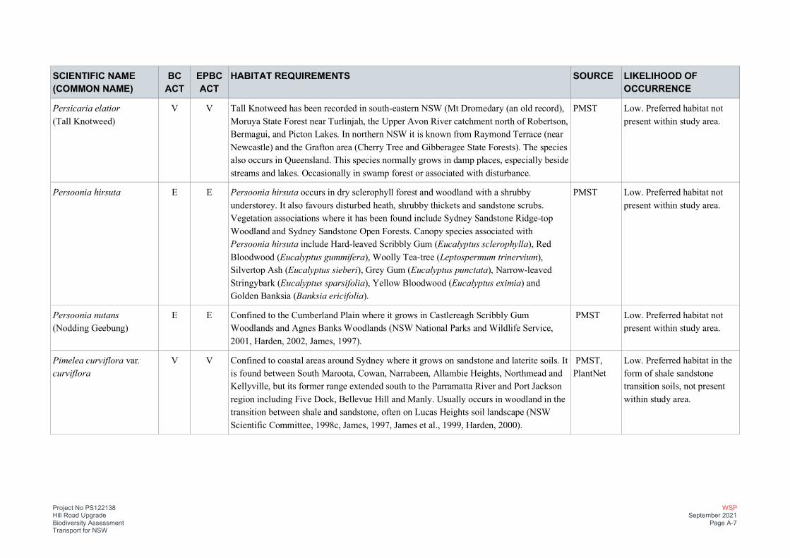
Project No PS122138 Hill Road Upgrade Biodiversity Assessment Transport for NSW
WSP September 2021
Page A-7
SCIENTIFIC NAME (COMMON NAME)
BC ACT
EPBC ACT
HABITAT REQUIREMENTS SOURCE LIKELIHOOD OF OCCURRENCE
Persicaria elatior (Tall Knotweed)
V V Tall Knotweed has been recorded in south-eastern NSW (Mt Dromedary (an old record), Moruya State Forest near Turlinjah, the Upper Avon River catchment north of Robertson, Bermagui, and Picton Lakes. In northern NSW it is known from Raymond Terrace (near Newcastle) and the Grafton area (Cherry Tree and Gibberagee State Forests). The species also occurs in Queensland. This species normally grows in damp places, especially beside streams and lakes. Occasionally in swamp forest or associated with disturbance.
PMST Low. Preferred habitat not present within study area.
Persoonia hirsuta E E Persoonia hirsuta occurs in dry sclerophyll forest and woodland with a shrubby understorey. It also favours disturbed heath, shrubby thickets and sandstone scrubs. Vegetation associations where it has been found include Sydney Sandstone Ridge-top Woodland and Sydney Sandstone Open Forests. Canopy species associated with Persoonia hirsuta include Hard-leaved Scribbly Gum (Eucalyptus sclerophylla), Red Bloodwood (Eucalyptus gummifera), Woolly Tea-tree (Leptospermum trinervium), Silvertop Ash (Eucalyptus sieberi), Grey Gum (Eucalyptus punctata), Narrow-leaved Stringybark (Eucalyptus sparsifolia), Yellow Bloodwood (Eucalyptus eximia) and Golden Banksia (Banksia ericifolia).
PMST Low. Preferred habitat not present within study area.
Persoonia nutans (Nodding Geebung)
E E Confined to the Cumberland Plain where it grows in Castlereagh Scribbly Gum Woodlands and Agnes Banks Woodlands (NSW National Parks and Wildlife Service, 2001, Harden, 2002, James, 1997).
PMST Low. Preferred habitat not present within study area.
Pimelea curviflora var. curviflora
V V Confined to coastal areas around Sydney where it grows on sandstone and laterite soils. It is found between South Maroota, Cowan, Narrabeen, Allambie Heights, Northmead and Kellyville, but its former range extended south to the Parramatta River and Port Jackson region including Five Dock, Bellevue Hill and Manly. Usually occurs in woodland in the transition between shale and sandstone, often on Lucas Heights soil landscape (NSW Scientific Committee, 1998c, James, 1997, James et al., 1999, Harden, 2000).
PMST, PlantNet
Low. Preferred habitat in the form of shale sandstone transition soils, not present within study area.
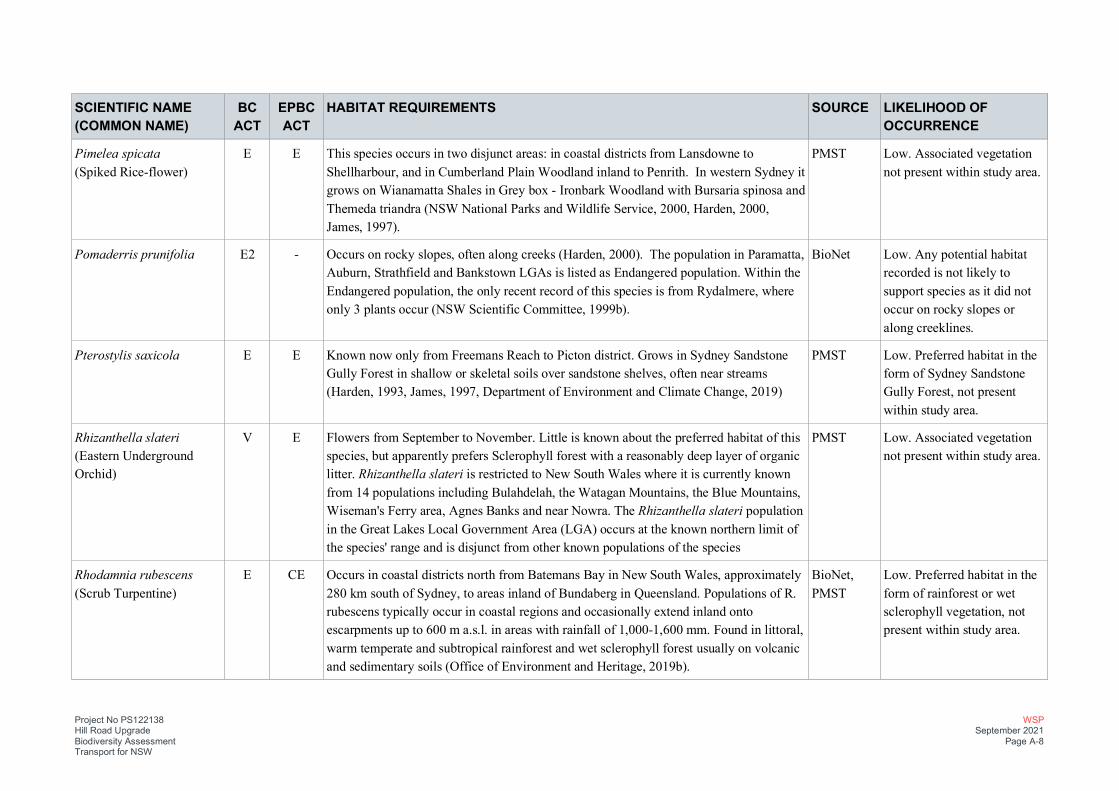
Project No PS122138 Hill Road Upgrade Biodiversity Assessment Transport for NSW
WSP September 2021
Page A-8
SCIENTIFIC NAME (COMMON NAME)
BC ACT
EPBC ACT
HABITAT REQUIREMENTS SOURCE LIKELIHOOD OF OCCURRENCE
Pimelea spicata (Spiked Rice-flower)
E E This species occurs in two disjunct areas: in coastal districts from Lansdowne to Shellharbour, and in Cumberland Plain Woodland inland to Penrith. In western Sydney it grows on Wianamatta Shales in Grey box - Ironbark Woodland with Bursaria spinosa and Themeda triandra (NSW National Parks and Wildlife Service, 2000, Harden, 2000, James, 1997).
PMST Low. Associated vegetation not present within study area.
Pomaderris prunifolia E2 - Occurs on rocky slopes, often along creeks (Harden, 2000). The population in Paramatta, Auburn, Strathfield and Bankstown LGAs is listed as Endangered population. Within the Endangered population, the only recent record of this species is from Rydalmere, where only 3 plants occur (NSW Scientific Committee, 1999b).
BioNet Low. Any potential habitat recorded is not likely to support species as it did not occur on rocky slopes or along creeklines.
Pterostylis saxicola E E Known now only from Freemans Reach to Picton district. Grows in Sydney Sandstone Gully Forest in shallow or skeletal soils over sandstone shelves, often near streams (Harden, 1993, James, 1997, Department of Environment and Climate Change, 2019)
PMST Low. Preferred habitat in the form of Sydney Sandstone Gully Forest, not present within study area.
Rhizanthella slateri (Eastern Underground Orchid)
V E Flowers from September to November. Little is known about the preferred habitat of this species, but apparently prefers Sclerophyll forest with a reasonably deep layer of organic litter. Rhizanthella slateri is restricted to New South Wales where it is currently known from 14 populations including Bulahdelah, the Watagan Mountains, the Blue Mountains, Wiseman's Ferry area, Agnes Banks and near Nowra. The Rhizanthella slateri population in the Great Lakes Local Government Area (LGA) occurs at the known northern limit of the species' range and is disjunct from other known populations of the species
PMST Low. Associated vegetation not present within study area.
Rhodamnia rubescens (Scrub Turpentine)
E CE Occurs in coastal districts north from Batemans Bay in New South Wales, approximately 280 km south of Sydney, to areas inland of Bundaberg in Queensland. Populations of R. rubescens typically occur in coastal regions and occasionally extend inland onto escarpments up to 600 m a.s.l. in areas with rainfall of 1,000-1,600 mm. Found in littoral, warm temperate and subtropical rainforest and wet sclerophyll forest usually on volcanic and sedimentary soils (Office of Environment and Heritage, 2019b).
BioNet, PMST
Low. Preferred habitat in the form of rainforest or wet sclerophyll vegetation, not present within study area.

Project No PS122138 Hill Road Upgrade Biodiversity Assessment Transport for NSW
WSP September 2021
Page A-9
SCIENTIFIC NAME (COMMON NAME)
BC ACT
EPBC ACT
HABITAT REQUIREMENTS SOURCE LIKELIHOOD OF OCCURRENCE
Rhodomyrtus psidioides (Native Guava)
CE CE Occurs from Broken Bay, approximately 90 km north of Sydney, New South Wales, to Maryborough in Queensland. Populations are typically restricted to coastal and sub-coastal areas of low elevation however the species does occur up to c. 120 km inland in the Hunter and Clarence River catchments and along the Border Ranges in NSW. Pioneer species found in littoral, warm temperate and subtropical rainforest and wet sclerophyll forest often near creeks and drainage lines.
PMST Low. Preferred habitat in the form of rainforest or wet sclerophyll vegetation, not present within study area.
Syzygium paniculatum (Magenta Lilly Pilly)
V V Occurs between Bulahdelah and St Georges Basin where it grows in subtropical and littoral rainforest on sandy soils or stabilized dunes near the sea (Harden, 2002). On the south coast the Magenta Lilly Pilly occurs on grey soils over sandstone, restricted mainly to remnant stands of littoral (coastal) rainforest. On the central coast Magenta Lilly Pilly occurs on gravels, sands, silts and clays in riverside gallery rainforests and remnant littoral rainforest communities (Department of Environment and Climate Change, 2008).
BioNet, PMST
Low. Preferred habitat in the form of rainforest vegetation, not present within study area.
Tetratheca glandulosa (Glandular Pink-Bell)
V V Occurs from Mangrove Mountain to the Blue Mountains where it grows in sandy or rocky heath or scrub (Harden, 1992). Associated with shale-sandstone transition habitat where shale-cappings occur over sandstone, with associated soil landscapes such as Lucas Heights, Gymea, Lambert and Faulconbridge. Topographically, the plant occupies ridgetops, upper-slopes and to a lesser extent mid-slope sandstone benches. Soils are generally shallow, consisting of a yellow, clayey/sandy loam. Stony lateritic fragments are also common in the soil profile on many of these ridgetops. Vegetation structure varies from heaths and scrub to woodlands/open woodlands, and open forest. Vegetation communities correspond broadly to Benson & Howell’s Sydney Sandstone Ridgetop Woodland (Map Unit 10ar). Common woodland tree species include: Corymbia gummifera, C. eximia, Eucalyptus haemastoma, E. punctata, E. racemosa, and/or E. sparsifolia, with an understorey dominated by species from the families Proteaceae, Fabaceae, and Epacridaceae (Department of Environment and Climate Change, 2019).
Bionet, PMST
Low. Preferred habitat in the form of shale sandstone transition soils, not present within study area. Associated species not recorded.
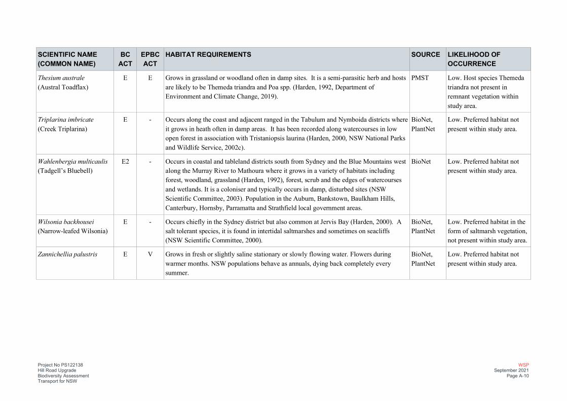
Project No PS122138 Hill Road Upgrade Biodiversity Assessment Transport for NSW
WSP September 2021
Page A-10
SCIENTIFIC NAME (COMMON NAME)
BC ACT
EPBC ACT
HABITAT REQUIREMENTS SOURCE LIKELIHOOD OF OCCURRENCE
Thesium australe (Austral Toadflax)
E E Grows in grassland or woodland often in damp sites. It is a semi-parasitic herb and hosts are likely to be Themeda triandra and Poa spp. (Harden, 1992, Department of Environment and Climate Change, 2019).
PMST Low. Host species Themeda triandra not present in remnant vegetation within study area.
Triplarina imbricate (Creek Triplarina)
E - Occurs along the coast and adjacent ranged in the Tabulum and Nymboida districts where it grows in heath often in damp areas. It has been recorded along watercourses in low open forest in association with Tristaniopsis laurina (Harden, 2000, NSW National Parks and Wildlife Service, 2002c).
BioNet, PlantNet
Low. Preferred habitat not present within study area.
Wahlenbergia multicaulis (Tadgell’s Bluebell)
E2 - Occurs in coastal and tableland districts south from Sydney and the Blue Mountains west along the Murray River to Mathoura where it grows in a variety of habitats including forest, woodland, grassland (Harden, 1992), forest, scrub and the edges of watercourses and wetlands. It is a coloniser and typically occurs in damp, disturbed sites (NSW Scientific Committee, 2003). Population in the Auburn, Bankstown, Baulkham Hills, Canterbury, Hornsby, Parramatta and Strathfield local government areas.
BioNet Low. Preferred habitat not present within study area.
Wilsonia backhousei (Narrow-leafed Wilsonia)
E - Occurs chiefly in the Sydney district but also common at Jervis Bay (Harden, 2000). A salt tolerant species, it is found in intertidal saltmarshes and sometimes on seacliffs (NSW Scientific Committee, 2000).
BioNet, PlantNet
Low. Preferred habitat in the form of saltmarsh vegetation, not present within study area.
Zannichellia palustris E V Grows in fresh or slightly saline stationary or slowly flowing water. Flowers during warmer months. NSW populations behave as annuals, dying back completely every summer.
BioNet, PlantNet
Low. Preferred habitat not present within study area.

Threatened fauna likelihood of occurrence
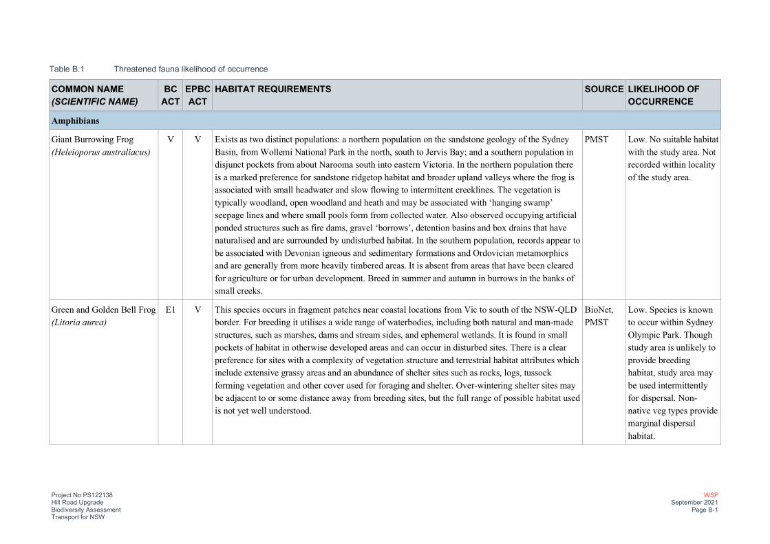
Project No PS122138 Hill Road Upgrade Biodiversity Assessment Transport for NSW
WSP September 2021
Page B-1
Table B.1 Threatened fauna likelihood of occurrence
COMMON NAME (SCIENTIFIC NAME)
BC ACT
EPBC ACT
HABITAT REQUIREMENTS SOURCE LIKELIHOOD OF OCCURRENCE
Amphibians
Giant Burrowing Frog (Heleioporus australiacus)
V V Exists as two distinct populations: a northern population on the sandstone geology of the Sydney Basin, from Wollemi National Park in the north, south to Jervis Bay; and a southern population in disjunct pockets from about Narooma south into eastern Victoria. In the northern population there is a marked preference for sandstone ridgetop habitat and broader upland valleys where the frog is associated with small headwater and slow flowing to intermittent creeklines. The vegetation is typically woodland, open woodland and heath and may be associated with ‘hanging swamp’ seepage lines and where small pools form from collected water. Also observed occupying artificial ponded structures such as fire dams, gravel ‘borrows’, detention basins and box drains that have naturalised and are surrounded by undisturbed habitat. In the southern population, records appear to be associated with Devonian igneous and sedimentary formations and Ordovician metamorphics and are generally from more heavily timbered areas. It is absent from areas that have been cleared for agriculture or for urban development. Breed in summer and autumn in burrows in the banks of small creeks.
PMST Low. No suitable habitat with the study area. Not recorded within locality of the study area.
Green and Golden Bell Frog (Litoria aurea)
E1 V This species occurs in fragment patches near coastal locations from Vic to south of the NSW-QLD border. For breeding it utilises a wide range of waterbodies, including both natural and man-made structures, such as marshes, dams and stream sides, and ephemeral wetlands. It is found in small pockets of habitat in otherwise developed areas and can occur in disturbed sites. There is a clear preference for sites with a complexity of vegetation structure and terrestrial habitat attributes which include extensive grassy areas and an abundance of shelter sites such as rocks, logs, tussock forming vegetation and other cover used for foraging and shelter. Over-wintering shelter sites may be adjacent to or some distance away from breeding sites, but the full range of possible habitat used is not yet well understood.
BioNet, PMST
Low. Species is known to occur within Sydney Olympic Park. Though study area is unlikely to provide breeding habitat, study area may be used intermittently for dispersal. Non-native veg types provide marginal dispersal habitat.

Project No PS122138 Hill Road Upgrade Biodiversity Assessment Transport for NSW
WSP September 2021
Page B-2
COMMON NAME (SCIENTIFIC NAME)
BC ACT
EPBC ACT
HABITAT REQUIREMENTS SOURCE LIKELIHOOD OF OCCURRENCE
Southern Bell Frog (Litoria raniformis)
E1 V In the past, the Growling Grass Frog was distributed across a large area of south-east Australia, including Tasmania, at altitudes of up to 1300 m. Its range has declined over time with the most pronounced decline evident in NSW. The species has disappeared from a number of sites along the Murrumbidgee River and there are no recent records from the Monaro district near the Victorian border. The Southern Bell Frog is usually found amongst emergent vegetation such as Typha, Phragmites and Eleocharis within or at the edges of still or slow-flowing water bodies such as lagoons, swamps, lakes, ponds, and farm dams (Robinson, 1998). It also in occurs in irrigation channels and crops, lignum shrublands, black box and river red gum woodlands and at the periphery of rivers. Apart from breeding and foraging habitat, refuge areas for this species may include soil cracks, fallen timber, debris and dense vegetation on low, frequently inundated floodplains (Cogger, 2000). Vegetation types in which this species occurs include open grassland (including crops and pastures), open forest, and ephemeral and permanent non-saline marshes and swamps (Department of the Environment, 2016b).
PMST Low. Foraging and foraging habitat not present within study area and species has not been previously recorded within locality.
Stuttering Frog (Mixophyes balbus)
E1 V Terrestrial species, found in rainforest, Antarctic beech forest or wet sclerophyll forest. The species depends on freshwater streams and riparian vegetation for breeding and habitation. No records are known from riparian habitat that has been disturbed (NSW Scientific Committee, 2003, Cogger, 2000).
PMST Low. No suitable habitat within study area.
Birds
Antipodean Albatross (Diomedea exulans antipodensis)
V V; M Breeds on Antipodes and Campbell Islands, New Zealand, foraging across the southwest Pacific and the Tasman Sea, including waters off the coasts of NSW (Garnett and Crowley, 2000). Essentially an oceanic species, usually uncommon in inshore habitats and not entering enclosed waters.
PMST Low. No suitable habitat within study area.
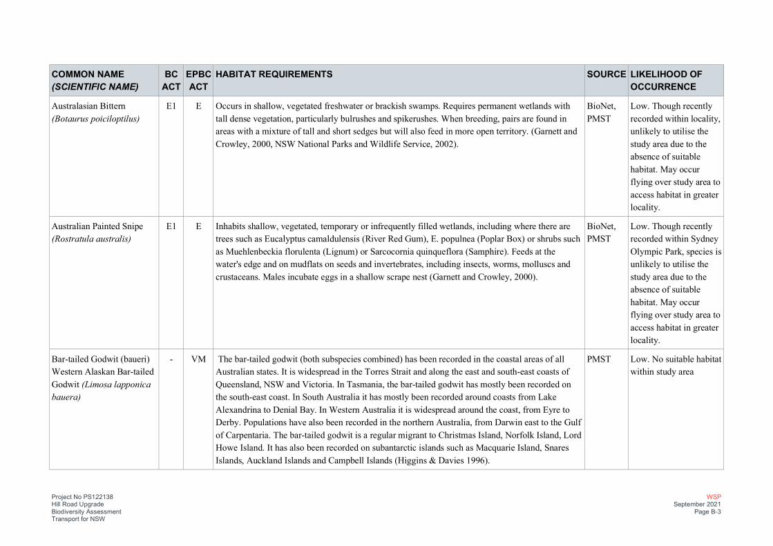
Project No PS122138 Hill Road Upgrade Biodiversity Assessment Transport for NSW
WSP September 2021
Page B-3
COMMON NAME (SCIENTIFIC NAME)
BC ACT
EPBC ACT
HABITAT REQUIREMENTS SOURCE LIKELIHOOD OF OCCURRENCE
Australasian Bittern (Botaurus poiciloptilus)
E1 E Occurs in shallow, vegetated freshwater or brackish swamps. Requires permanent wetlands with tall dense vegetation, particularly bulrushes and spikerushes. When breeding, pairs are found in areas with a mixture of tall and short sedges but will also feed in more open territory. (Garnett and Crowley, 2000, NSW National Parks and Wildlife Service, 2002).
BioNet, PMST
Low. Though recently recorded within locality, unlikely to utilise the study area due to the absence of suitable habitat. May occur flying over study area to access habitat in greater locality.
Australian Painted Snipe (Rostratula australis)
E1 E Inhabits shallow, vegetated, temporary or infrequently filled wetlands, including where there are trees such as Eucalyptus camaldulensis (River Red Gum), E. populnea (Poplar Box) or shrubs such as Muehlenbeckia florulenta (Lignum) or Sarcocornia quinqueflora (Samphire). Feeds at the water's edge and on mudflats on seeds and invertebrates, including insects, worms, molluscs and crustaceans. Males incubate eggs in a shallow scrape nest (Garnett and Crowley, 2000).
BioNet, PMST
Low. Though recently recorded within Sydney Olympic Park, species is unlikely to utilise the study area due to the absence of suitable habitat. May occur flying over study area to access habitat in greater locality.
Bar-tailed Godwit (baueri) Western Alaskan Bar-tailed Godwit (Limosa lapponica bauera)
- VM The bar-tailed godwit (both subspecies combined) has been recorded in the coastal areas of all Australian states. It is widespread in the Torres Strait and along the east and south-east coasts of Queensland, NSW and Victoria. In Tasmania, the bar-tailed godwit has mostly been recorded on the south-east coast. In South Australia it has mostly been recorded around coasts from Lake Alexandrina to Denial Bay. In Western Australia it is widespread around the coast, from Eyre to Derby. Populations have also been recorded in the northern Australia, from Darwin east to the Gulf of Carpentaria. The bar-tailed godwit is a regular migrant to Christmas Island, Norfolk Island, Lord Howe Island. It has also been recorded on subantarctic islands such as Macquarie Island, Snares Islands, Auckland Islands and Campbell Islands (Higgins & Davies 1996).
PMST Low. No suitable habitat within study area

Project No PS122138 Hill Road Upgrade Biodiversity Assessment Transport for NSW
WSP September 2021
Page B-4
COMMON NAME (SCIENTIFIC NAME)
BC ACT
EPBC ACT
HABITAT REQUIREMENTS SOURCE LIKELIHOOD OF OCCURRENCE
Bar-tailed Godwit (Limosa lapponica)
- M Occurs in coastal mudflats, sandbars, shores of estuaries, salt marsh and sewage ponds (Morcombe, 2003).
PMST Low. Though species was recently recorded within Sydney Olympic Park, it is unlikely to utilise the study area due to the absence of suitable habitat. May occur flying over study area to access habitat in greater locality.
Black Bittern (Ixobrychus flavicollis)
V - Usually found in dense vegetation in and fringing streams, swamps, tidal creeks and mudflats, particularly amongst swamp she-oaks and mangroves. Feeds on aquatic fauna along streams, in estuaries and beside billabongs and pools. Breeding occurs in summer in secluded places in densely vegetated wetlands. It nests in trees that overhang the water (NSW National Parks and Wildlife Service, 2002, Garnett and Crowley, 2000).
BioNet Low. Not suitable habitat within the study area.
Black Falcon (Falco subniger)
V - Widely, but sparsely, distributed in New South Wales, mostly occurring woodland, shrubland and grassland in the arid and semi-arid zones, especially wooded watercourses and agricultural land with scattered remnant trees. It is usually associated with streams or wetlands, visiting them in search of prey and often using standing dead trees as lookout posts. Habitat selection is generally influenced more by prey densities than by specific aspects of habitat floristics or condition, although in agricultural landscapes it tends to nest in healthy, riparian woodland remnants with a diverse avi-fauna (NSW Scientific Committee, 2013).
BioNet Low. Limited suitable habitat within the study area. One record from 1990 within locality.
Black-browed Albatross (Thalassarche melanophris)
V VM Nomadic marine species that breeds on subantarctic island outside Australian waters but moves northwards in non-breeding seasons. The waters off southern Australia between Brisbane and Perth are the principal feeding area of birds (Garnett and Crowley, 2000). Black-browed-type albatross are more regularly observed from shore than more pelagic albatross species.
PMST Low. No suitable habitat within study area.
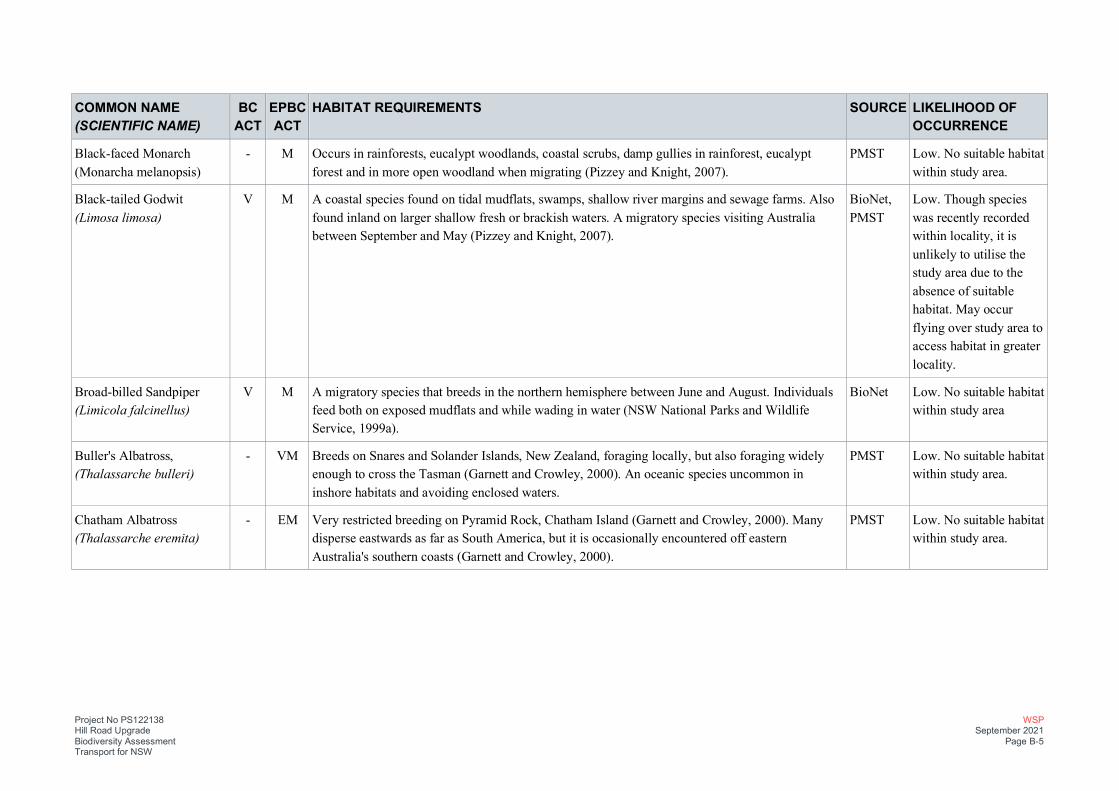
Project No PS122138 Hill Road Upgrade Biodiversity Assessment Transport for NSW
WSP September 2021
Page B-5
COMMON NAME (SCIENTIFIC NAME)
BC ACT
EPBC ACT
HABITAT REQUIREMENTS SOURCE LIKELIHOOD OF OCCURRENCE
Black-faced Monarch (Monarcha melanopsis)
- M Occurs in rainforests, eucalypt woodlands, coastal scrubs, damp gullies in rainforest, eucalypt forest and in more open woodland when migrating (Pizzey and Knight, 2007).
PMST Low. No suitable habitat within study area.
Black-tailed Godwit (Limosa limosa)
V M A coastal species found on tidal mudflats, swamps, shallow river margins and sewage farms. Also found inland on larger shallow fresh or brackish waters. A migratory species visiting Australia between September and May (Pizzey and Knight, 2007).
BioNet, PMST
Low. Though species was recently recorded within locality, it is unlikely to utilise the study area due to the absence of suitable habitat. May occur flying over study area to access habitat in greater locality.
Broad-billed Sandpiper (Limicola falcinellus)
V M A migratory species that breeds in the northern hemisphere between June and August. Individuals feed both on exposed mudflats and while wading in water (NSW National Parks and Wildlife Service, 1999a).
BioNet Low. No suitable habitat within study area
Buller's Albatross, (Thalassarche bulleri)
- VM Breeds on Snares and Solander Islands, New Zealand, foraging locally, but also foraging widely enough to cross the Tasman (Garnett and Crowley, 2000). An oceanic species uncommon in inshore habitats and avoiding enclosed waters.
PMST Low. No suitable habitat within study area.
Chatham Albatross (Thalassarche eremita)
- EM Very restricted breeding on Pyramid Rock, Chatham Island (Garnett and Crowley, 2000). Many disperse eastwards as far as South America, but it is occasionally encountered off eastern Australia's southern coasts (Garnett and Crowley, 2000).
PMST Low. No suitable habitat within study area.

Project No PS122138 Hill Road Upgrade Biodiversity Assessment Transport for NSW
WSP September 2021
Page B-6
COMMON NAME (SCIENTIFIC NAME)
BC ACT
EPBC ACT
HABITAT REQUIREMENTS SOURCE LIKELIHOOD OF OCCURRENCE
Common Greenshank (Tringa nebularia)
- M Occurs in a range of inland and coastal environments. Inland, it occurs in both permanent and temporary wetlands, billabongs, swamps, lakes floodplains, sewage farms, saltworks ponds, flooded irrigated crops. On the coast, it occurs in sheltered estuaries and bays with extensive mudflats, mangrove swamps, muddy shallows of harbours and lagoons, occasionally rocky tidal ledges. It generally prefers wet and flooded mud and clay rather than sand (Morcombe, 2003).
PMST Low. Though recently recorded within Sydney Olympic Park, species is unlikely to utilise the study area due to the absence of suitable habitat. May occur flying over study area to access habitat in greater locality.
Common Noddy (Anous stolidus)
- M An inshore and oceanic species breeding on islets, cays and rock stacks (Higgins and Davies, 1996). Exhibits movements away from seasonal breeding habitats to more oceanic habitats out of the breeding season (Higgins and Davies, 1996). In Australia most commonly recorded in tropical and sub-tropical seas with more southward movements associated with southerly warm water movements in late summer. Much less frequently encountered on the most southerly Australian coasts.
PMST Low. No suitable habitat within study area.
Curlew Sandpiper (Calidris ferruginea)
E1 CE; M Occurs in inter-tidal mudflats of estuaries, lagoons, mangrove channels and also around lakes, dams, floodwaters and flooded saltbush surrounding inland lakes (Morcombe, 2003).
BioNet, PMST
Low. Though recently recorded within Sydney Olympic Park, marginal foraging habitat within study area, May occur flying over study area to access habitat in greater locality.
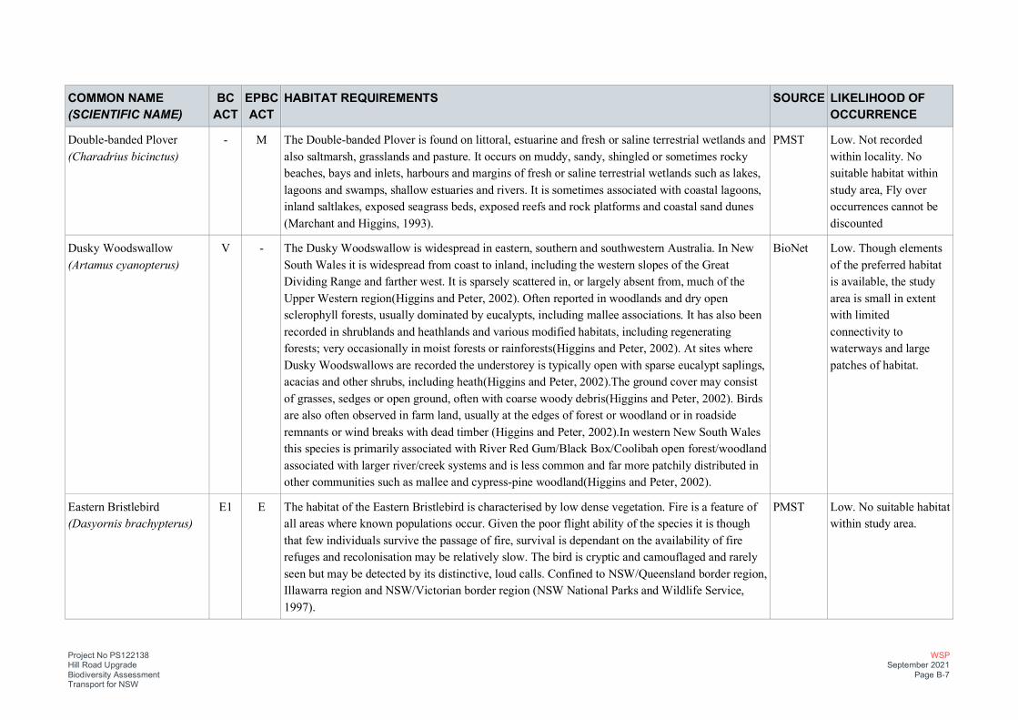
Project No PS122138 Hill Road Upgrade Biodiversity Assessment Transport for NSW
WSP September 2021
Page B-7
COMMON NAME (SCIENTIFIC NAME)
BC ACT
EPBC ACT
HABITAT REQUIREMENTS SOURCE LIKELIHOOD OF OCCURRENCE
Double-banded Plover (Charadrius bicinctus)
- M The Double-banded Plover is found on littoral, estuarine and fresh or saline terrestrial wetlands and also saltmarsh, grasslands and pasture. It occurs on muddy, sandy, shingled or sometimes rocky beaches, bays and inlets, harbours and margins of fresh or saline terrestrial wetlands such as lakes, lagoons and swamps, shallow estuaries and rivers. It is sometimes associated with coastal lagoons, inland saltlakes, exposed seagrass beds, exposed reefs and rock platforms and coastal sand dunes (Marchant and Higgins, 1993).
PMST Low. Not recorded within locality. No suitable habitat within study area, Fly over occurrences cannot be discounted
Dusky Woodswallow (Artamus cyanopterus)
V - The Dusky Woodswallow is widespread in eastern, southern and southwestern Australia. In New South Wales it is widespread from coast to inland, including the western slopes of the Great Dividing Range and farther west. It is sparsely scattered in, or largely absent from, much of the Upper Western region(Higgins and Peter, 2002). Often reported in woodlands and dry open sclerophyll forests, usually dominated by eucalypts, including mallee associations. It has also been recorded in shrublands and heathlands and various modified habitats, including regenerating forests; very occasionally in moist forests or rainforests(Higgins and Peter, 2002). At sites where Dusky Woodswallows are recorded the understorey is typically open with sparse eucalypt saplings, acacias and other shrubs, including heath(Higgins and Peter, 2002).The ground cover may consist of grasses, sedges or open ground, often with coarse woody debris(Higgins and Peter, 2002). Birds are also often observed in farm land, usually at the edges of forest or woodland or in roadside remnants or wind breaks with dead timber (Higgins and Peter, 2002).In western New South Wales this species is primarily associated with River Red Gum/Black Box/Coolibah open forest/woodland associated with larger river/creek systems and is less common and far more patchily distributed in other communities such as mallee and cypress-pine woodland(Higgins and Peter, 2002).
BioNet Low. Though elements of the preferred habitat is available, the study area is small in extent with limited connectivity to waterways and large patches of habitat.
Eastern Bristlebird (Dasyornis brachypterus)
E1 E The habitat of the Eastern Bristlebird is characterised by low dense vegetation. Fire is a feature of all areas where known populations occur. Given the poor flight ability of the species it is though that few individuals survive the passage of fire, survival is dependant on the availability of fire refuges and recolonisation may be relatively slow. The bird is cryptic and camouflaged and rarely seen but may be detected by its distinctive, loud calls. Confined to NSW/Queensland border region, Illawarra region and NSW/Victorian border region (NSW National Parks and Wildlife Service, 1997).
PMST Low. No suitable habitat within study area.

Project No PS122138 Hill Road Upgrade Biodiversity Assessment Transport for NSW
WSP September 2021
Page B-8
COMMON NAME (SCIENTIFIC NAME)
BC ACT
EPBC ACT
HABITAT REQUIREMENTS SOURCE LIKELIHOOD OF OCCURRENCE
Eastern Curlew (Numenius madagascariensis)
- CE; M Inhabits coastal estuaries, mangroves, mud flats and sand pits. It is a migratory shorebird which generally inhabits sea and lake shore mud flats, deltas and similar areas, where it forages for crabs and other crustaceans, clam worms and other annelids, molluscs, insects and other invertebrates. Its migration route ranges from its wintering grounds in Australia to its breeding grounds in northern China, Korea and Russia (Pizzey and Knight, 2007).
BioNet, PMST
Low. Though species was recently recorded within Sydney Olympic Park, it is unlikely to utilise the study area due to the absence of suitable habitat. May occur flying over study area to access habitat in greater locality.
Eastern Grass Owl (Tyto longimembris)
V - Typically found in tussock-grasslands but also occur in heathland, swamps, coastal dunes, tree-lined creeks, treeless plains, grassy gaps between trees and crops. Nest on the ground generally under tussocks. They generally feed on rodents but will also eat insects (Pizzey and Knight, 2012).
BioNet Low. No suitable habitat within study area.
Eastern Osprey (Pandion cristatus (syn. P. haliaetus))
V M Generally, a coastal species, occurring in estuaries, bays, inlets, islands and surrounding waters, coral atolls, reefs, lagoons, rock cliffs and stacks. Sometimes ascends larger rivers to far inland. Builds nests high in tree, on pylon or on ground on islands. Feeds on fish (Pizzey and Knight, 2007).
BioNet, PMST
Low. No suitable habitat within study area. May occur flying over study area whilst foraging in the greater locality.
Fairy Prion (Pachyptila turtur)
- V The Fairy Prion is a marine bird which breeds on subantarctic and cool temperate islands within the South Pacific, including the Bass Strait Islands, Tasmania, and Macquarie Island. Fairy Prions are commonly seen offshore from mainland Australia, feeding across the continental shelf and in pelagic waters. The species is particularly common in Tasmania but does also visit the South east coast of Australia and is often found beach cast.
PMST Low. No suitable habitat within study area

Project No PS122138 Hill Road Upgrade Biodiversity Assessment Transport for NSW
WSP September 2021
Page B-9
COMMON NAME (SCIENTIFIC NAME)
BC ACT
EPBC ACT
HABITAT REQUIREMENTS SOURCE LIKELIHOOD OF OCCURRENCE
Flame Robin (Petroica phoenicea)
V - The Flame Robin is endemic to south eastern Australia, and ranges from near the Queensland border to south east South Australia and also in Tasmania. In NSW, it breeds in upland areas and in winter, many birds move to the inland slopes and plains. It is likely that there are two separate populations in NSW, one in the Northern Tablelands, and another ranging from the Central to Southern Tablelands. Breeds in upland tall moist eucalypt forests and woodlands, often on ridges and slopes. Prefers clearings or areas with open understoreys (Office of Environment and Heritage, 2019b).
BioNet Low. Though elements of the preferred habitat is available the Flame Robin is unlikely to utilise it due to the extent, isolation and limited connectivity
Fork-tailed Swift (Apus pacificus)
- M Breeds in the northern hemisphere, wintering south to Australia. It is almost exclusively aerial, flying from less than 1 m to at least 300 m above ground. It mostly occurs over inland plains but sometimes above foothills or in coastal areas over cliffs, beaches, islands and well out to sea. It also occurs over towns and cities. It mostly occurs over dry and/or open habitats, including riparian woodland and tea-tree swamps, low scrub, heathland or saltmarsh, grassland, spinifex sandplains, farmland and sand-dunes. It sometimes occurs above forests. It probably roosts aerially, but has occasionally been observed to land (Higgins, 1999).
PMST Low. Though elements of the preferred habitat is available the Fork-tailed Swift is unlikely to utilise it due to the extent, isolation and limited connectivity
Freckled Duck (Stictonetta naevosa)
V - In most years this species appear to be nomadic between ephemeral inland wetlands. In dry years they congregate on permanent wetlands while in wet years they breed prolifically and disperse widely, generally towards the coast. In inland eastern Australia, they generally occur in brackish to hyposaline wetlands that are densely vegetated with Lignum (Muehlenbeckia cunninghamii) within which they build their nests (Garnett and Crowley, 2000).
BioNet Low. No suitable habitat within study area.
Gibson's Albatross (Diomedea exulans gibsoni)
V V; M Breeds on Auckland Island, New Zealand, and forages throughout the Tasman Sea (Garnett and Crowley, 2000) where it is commonly encountered off the NSW coast during seabird surveys in the Austral winter. An oceanic species uncommon in inshore habitats and avoiding enclosed waters.
PMST Low. No suitable habitat within study area.

Project No PS122138 Hill Road Upgrade Biodiversity Assessment Transport for NSW
WSP September 2021
Page B-10
COMMON NAME (SCIENTIFIC NAME)
BC ACT
EPBC ACT
HABITAT REQUIREMENTS SOURCE LIKELIHOOD OF OCCURRENCE
Glossy Black-Cockatoo (Calyptorhynchus lathami)
V - The species is uncommon although widespread throughout suitable forest and woodland habitats, from the central Queensland coast to East Gippsland in Victoria, and inland to the southern tablelands and central western plains of NSW, with a small population in the Riverina. An isolated population exists on Kangaroo Island, South Australia. Inhabits open forest and woodlands of the coast and the Great Dividing Range where stands of sheoak occur. Black Sheoak (Allocasuarina littoralis) and Forest Sheoak (A. torulosa) are important foods. Feeds almost exclusively on the seeds of several species of she-oak (Casuarina and Allocasuarina species), shredding the cones with the massive bill. Dependent on large hollow-bearing eucalypts for nest sites(Office of Environment & Heritage, 2018e).
Bionet Low. No suitable habitat within study area.
Great Frigatebird (Fregata minor)
- M Major breeding populations of the Greater Frigatebird are found in tropical waters of the Pacific and Indian Ocean, as well as one population in the South Atlantic (Trinidade and Martim Vaz, Brazil). It is predominately sedentary, with immature and non-breeding individuals dispersing throughout the tropical seas with the exception of the east and central Atlantic.
PMST Low. No suitable habitat within study area.
Great Knot (Calidris tenuirostris)
V CE; M Generally, a coastal species found on tidal mudflats and sandy ocean shores. A migratory species visiting Australian waters between September and March (Pizzey and Knight, 2007).
BioNet, PMST
Low. Recorded within locality in Bicentennial Park and Newington Wetlands. Marginal foraging habitat within study area. May occur flying over study area to access habitat in greater locality.
Greater Sand Plover (Charadrius leschenaultia)
V V; M Entirely coastal in NSW foraging on intertidal sand and mudflats in estuaries and roosting during high tide on sand beaches or rocky shores. A migratory species it is found in New South Wales generally during the summer months (Pizzey and Knight, 2007).
BioNet, PMST
Low. No recent recorded within locality. No suitable habitat within study area. Fly over occurrences cannot be discounted
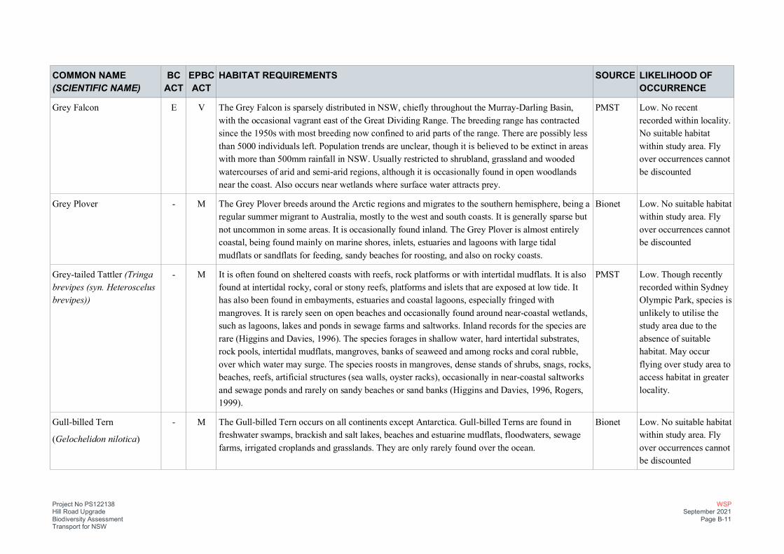
Project No PS122138 Hill Road Upgrade Biodiversity Assessment Transport for NSW
WSP September 2021
Page B-11
COMMON NAME (SCIENTIFIC NAME)
BC ACT
EPBC ACT
HABITAT REQUIREMENTS SOURCE LIKELIHOOD OF OCCURRENCE
Grey Falcon E V The Grey Falcon is sparsely distributed in NSW, chiefly throughout the Murray-Darling Basin, with the occasional vagrant east of the Great Dividing Range. The breeding range has contracted since the 1950s with most breeding now confined to arid parts of the range. There are possibly less than 5000 individuals left. Population trends are unclear, though it is believed to be extinct in areas with more than 500mm rainfall in NSW. Usually restricted to shrubland, grassland and wooded watercourses of arid and semi-arid regions, although it is occasionally found in open woodlands near the coast. Also occurs near wetlands where surface water attracts prey.
PMST Low. No recent recorded within locality. No suitable habitat within study area. Fly over occurrences cannot be discounted
Grey Plover - M The Grey Plover breeds around the Arctic regions and migrates to the southern hemisphere, being a regular summer migrant to Australia, mostly to the west and south coasts. It is generally sparse but not uncommon in some areas. It is occasionally found inland. The Grey Plover is almost entirely coastal, being found mainly on marine shores, inlets, estuaries and lagoons with large tidal mudflats or sandflats for feeding, sandy beaches for roosting, and also on rocky coasts.
Bionet Low. No suitable habitat within study area. Fly over occurrences cannot be discounted
Grey-tailed Tattler (Tringa brevipes (syn. Heteroscelus brevipes))
- M It is often found on sheltered coasts with reefs, rock platforms or with intertidal mudflats. It is also found at intertidal rocky, coral or stony reefs, platforms and islets that are exposed at low tide. It has also been found in embayments, estuaries and coastal lagoons, especially fringed with mangroves. It is rarely seen on open beaches and occasionally found around near-coastal wetlands, such as lagoons, lakes and ponds in sewage farms and saltworks. Inland records for the species are rare (Higgins and Davies, 1996). The species forages in shallow water, hard intertidal substrates, rock pools, intertidal mudflats, mangroves, banks of seaweed and among rocks and coral rubble, over which water may surge. The species roosts in mangroves, dense stands of shrubs, snags, rocks, beaches, reefs, artificial structures (sea walls, oyster racks), occasionally in near-coastal saltworks and sewage ponds and rarely on sandy beaches or sand banks (Higgins and Davies, 1996, Rogers, 1999).
PMST Low. Though recently recorded within Sydney Olympic Park, species is unlikely to utilise the study area due to the absence of suitable habitat. May occur flying over study area to access habitat in greater locality.
Gull-billed Tern
(Gelochelidon nilotica)
- M The Gull-billed Tern occurs on all continents except Antarctica. Gull-billed Terns are found in freshwater swamps, brackish and salt lakes, beaches and estuarine mudflats, floodwaters, sewage farms, irrigated croplands and grasslands. They are only rarely found over the ocean.
Bionet Low. No suitable habitat within study area. Fly over occurrences cannot be discounted
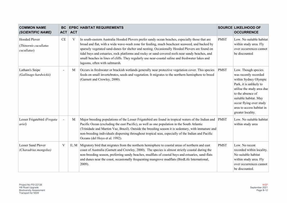
Project No PS122138 Hill Road Upgrade Biodiversity Assessment Transport for NSW
WSP September 2021
Page B-12
COMMON NAME (SCIENTIFIC NAME)
BC ACT
EPBC ACT
HABITAT REQUIREMENTS SOURCE LIKELIHOOD OF OCCURRENCE
Hooded Plover
(Thinornis cucullatus cucullatus)
CE V In south-eastern Australia Hooded Plovers prefer sandy ocean beaches, especially those that are broad and flat, with a wide wave-wash zone for feeding, much beachcast seaweed, and backed by sparsely vegetated sand-dunes for shelter and nesting. Occasionally Hooded Plovers are found on tidal bays and estuaries, rock platforms and rocky or sand-covered reefs near sandy beaches, and small beaches in lines of cliffs. They regularly use near-coastal saline and freshwater lakes and lagoons, often with saltmarsh.
PMST Low. No suitable habitat within study area. Fly over occurrences cannot be discounted
Latham's Snipe (Gallinago hardwickii)
- M Occurs in freshwater or brackish wetlands generally near protective vegetation cover. This species feeds on small invertebrates, seeds and vegetation. It migrates to the northern hemisphere to breed (Garnett and Crowley, 2000).
PMST Low. Though species was recently recorded within Sydney Olympic Park, it is unlikely to utilise the study area due to the absence of suitable habitat. May occur flying over study area to access habitat in greater locality.
Lesser Frigatebird (Fregata ariel)
- M Major breeding populations of the Lesser Frigatebird are found in tropical waters of the Indian and Pacific Ocean (excluding the east Pacific), as well as one population in the South Atlantic (Trinidade and Martim Vaz, Brazil). Outside the breeding season it is sedentary, with immature and non-breeding individuals dispersing throughout tropical seas, especially of the Indian and Pacific Oceans (del Hoyo et al. 1992).
PMST Low. No suitable habitat within study area
Lesser Sand Plover (Charadrius mongolus)
V E; M Migratory bird that migrates from the northern hemisphere to coastal areas of northern and east coast of Australia (Garnett and Crowley, 2000). The species is almost strictly coastal during the non-breeding season, preferring sandy beaches, mudflats of coastal bays and estuaries, sand-flats and dunes near the coast, occasionally frequenting mangrove mudflats (BirdLife International, 2009).
PMST Low. No recent recorded within locality. No suitable habitat within study area. Fly over occurrences cannot be discounted.
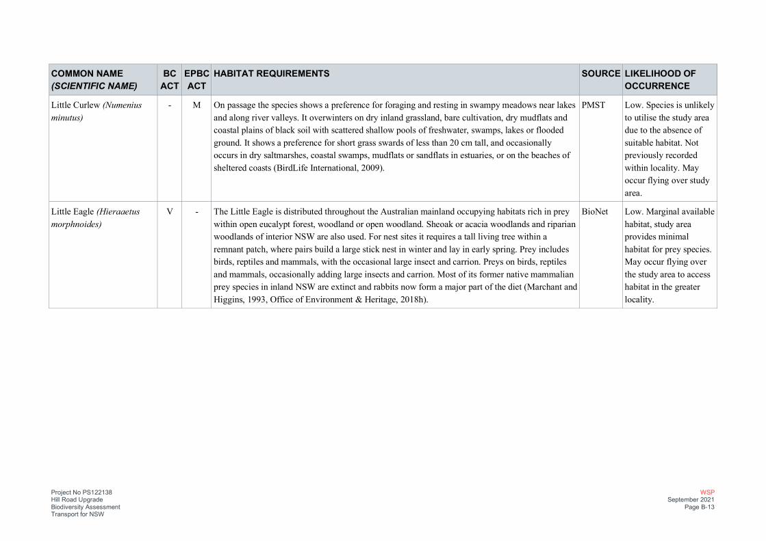
Project No PS122138 Hill Road Upgrade Biodiversity Assessment Transport for NSW
WSP September 2021
Page B-13
COMMON NAME (SCIENTIFIC NAME)
BC ACT
EPBC ACT
HABITAT REQUIREMENTS SOURCE LIKELIHOOD OF OCCURRENCE
Little Curlew (Numenius minutus)
- M On passage the species shows a preference for foraging and resting in swampy meadows near lakes and along river valleys. It overwinters on dry inland grassland, bare cultivation, dry mudflats and coastal plains of black soil with scattered shallow pools of freshwater, swamps, lakes or flooded ground. It shows a preference for short grass swards of less than 20 cm tall, and occasionally occurs in dry saltmarshes, coastal swamps, mudflats or sandflats in estuaries, or on the beaches of sheltered coasts (BirdLife International, 2009).
PMST Low. Species is unlikely to utilise the study area due to the absence of suitable habitat. Not previously recorded within locality. May occur flying over study area.
Little Eagle (Hieraaetus morphnoides)
V - The Little Eagle is distributed throughout the Australian mainland occupying habitats rich in prey within open eucalypt forest, woodland or open woodland. Sheoak or acacia woodlands and riparian woodlands of interior NSW are also used. For nest sites it requires a tall living tree within a remnant patch, where pairs build a large stick nest in winter and lay in early spring. Prey includes birds, reptiles and mammals, with the occasional large insect and carrion. Preys on birds, reptiles and mammals, occasionally adding large insects and carrion. Most of its former native mammalian prey species in inland NSW are extinct and rabbits now form a major part of the diet (Marchant and Higgins, 1993, Office of Environment & Heritage, 2018h).
BioNet Low. Marginal available habitat, study area provides minimal habitat for prey species. May occur flying over the study area to access habitat in the greater locality.
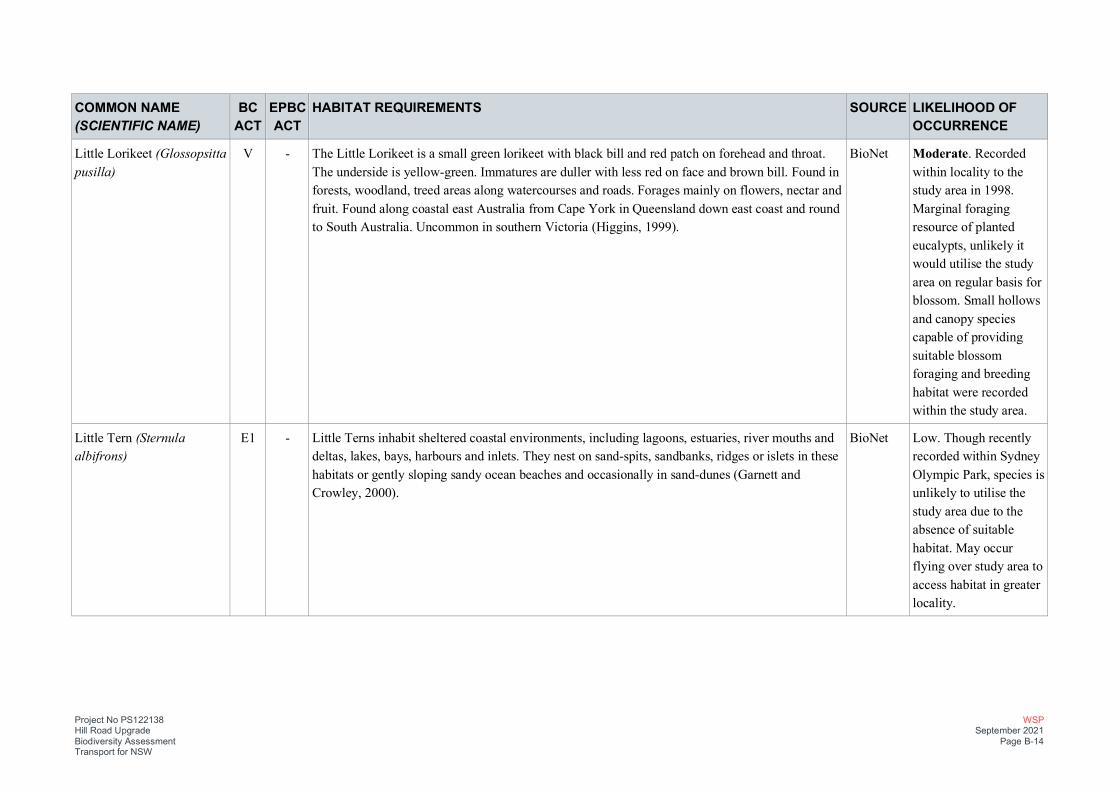
Project No PS122138 Hill Road Upgrade Biodiversity Assessment Transport for NSW
WSP September 2021
Page B-14
COMMON NAME (SCIENTIFIC NAME)
BC ACT
EPBC ACT
HABITAT REQUIREMENTS SOURCE LIKELIHOOD OF OCCURRENCE
Little Lorikeet (Glossopsitta pusilla)
V - The Little Lorikeet is a small green lorikeet with black bill and red patch on forehead and throat. The underside is yellow-green. Immatures are duller with less red on face and brown bill. Found in forests, woodland, treed areas along watercourses and roads. Forages mainly on flowers, nectar and fruit. Found along coastal east Australia from Cape York in Queensland down east coast and round to South Australia. Uncommon in southern Victoria (Higgins, 1999).
BioNet Moderate. Recorded within locality to the study area in 1998. Marginal foraging resource of planted eucalypts, unlikely it would utilise the study area on regular basis for blossom. Small hollows and canopy species capable of providing suitable blossom foraging and breeding habitat were recorded within the study area.
Little Tern (Sternula albifrons)
E1 - Little Terns inhabit sheltered coastal environments, including lagoons, estuaries, river mouths and deltas, lakes, bays, harbours and inlets. They nest on sand-spits, sandbanks, ridges or islets in these habitats or gently sloping sandy ocean beaches and occasionally in sand-dunes (Garnett and Crowley, 2000).
BioNet Low. Though recently recorded within Sydney Olympic Park, species is unlikely to utilise the study area due to the absence of suitable habitat. May occur flying over study area to access habitat in greater locality.

Project No PS122138 Hill Road Upgrade Biodiversity Assessment Transport for NSW
WSP September 2021
Page B-15
COMMON NAME (SCIENTIFIC NAME)
BC ACT
EPBC ACT
HABITAT REQUIREMENTS SOURCE LIKELIHOOD OF OCCURRENCE
Marsh Sandpiper (Tringa stagnatilis)
- M Occurs in coastal and inland wetlands (salt or fresh water), estuarine and mangrove mudflats, beaches, shallow or swamps, lakes, billabongs, temporary floodwaters, sewage farms and saltworks ponds (Morcombe, 2003).
PMST Low. Though recently recorded within Sydney Olympic Park, species is unlikely to utilise the study area due to the absence of suitable habitat. May occur flying over study area to access habitat in greater locality.
Masked Owl (Tyto novaehollandiae)
V - Extends from the coast where it is most abundant to the western plains. Overall records for this species fall within approximately 90% of NSW, excluding the most arid north-western corner. There is no seasonal variation in its distribution. Lives in dry eucalypt forests and woodlands from sea level to 1100 m. A forest owl, but often hunts along the edges of forests, including roadsides.
Low. Marginal habitat in study area. Unlikely to rely on study area for foraging purposes on occasion.
Northern Buller’s Albatross (Thalassarche bulleri platei)
- V The Pacific Albatross is a non-breeding visitor to Australian waters. Foraging birds are mostly limited to the Pacific Ocean and the Tasman Sea, although birds do reach the east coast of the Australian mainland (EA 2001f). The Pacific Albatross is a marine, pelagic species. It occurs in subtropical and subantarctic waters of the South Pacific Ocean (Marchant & Higgins 1990).
PMST Low. No suitable habitat within study area
Northern Giant-Petrel (Macronectes halli)
- V; M Nomadic marine species, that nest as dispersed pairs, often amidst tussocks in dense vegetation. Forages in inshore waters of southern Australia and occasionally visits the coast of NSW (Garnett and Crowley, 2000).
PMST Low. No suitable habitat within study area
Northern Royal Albatross (Diomedea epomophora sanfordi)
- E; M Breeds on Chatham Island and Taiaroa Head on South Island of New Zealand (Garnett and Crowley, 2000). Observed regularly in Tasmanian and South Australian waters and extends into the southwest Atlantic, but more rarely off the NSW coast (Garnett and Crowley, 2000).
PMST Low. No suitable habitat within study area

Project No PS122138 Hill Road Upgrade Biodiversity Assessment Transport for NSW
WSP September 2021
Page B-16
COMMON NAME (SCIENTIFIC NAME)
BC ACT
EPBC ACT
HABITAT REQUIREMENTS SOURCE LIKELIHOOD OF OCCURRENCE
Northern Siberian Bar-tailed Godwit, Bar-tailed Godwit (menzbieri) (Limosa lapponica menzbieri)
- CEM The bar-tailed godwit (both subspecies combined) has been recorded in the coastal areas of all Australian states. It is widespread in the Torres Strait and along the east and south-east coasts of Queensland, NSW and Victoria. The bar-tailed godwit (northern Siberian) occurs mainly in coastal habitats such as large intertidal sandflats, banks, mudflats, estuaries, inlets, harbours, coastal lagoons and bays. It has also been recorded in coastal sewage farms and saltworks, saltlakes and brackish wetlands near coasts, sandy ocean beaches, rock platforms, and coral reef-flats (BirdLife International, 2009)..
PMST Low. No suitable habitat within study area
Oriental Cuckoo, Himalayan Cuckoo (Cuculus opatus (syn. Cuculus saturatus))
- M A non-breeding migrant to Australia, it often inhabits rainforest, vine thickets, wet sclerophyll forest and open woodland and sometimes occurs in mangroves, wooded swamps and as vagrants in gardens (Higgins, 1999). The population trend appears to be stable (BirdLife International, 2009).
PMST Low. Limited suitable habitat within the study area
Pacific Golden Plover (Pluvialis fulva)
- M Prefers sandy, muddy or rocky shores, estuaries and lagoons, reefs, saltmarsh, and or short grass in paddocks and crops. The species is usually coastal, including offshore islands; rarely far inland. Often observed on beaches and mudflats, sandflats and occasionally rock shelves, or where these substrates intermingle; harbours, estuaries and lagoons (Marchant and Higgins, 1993).
PMST Low. Species is unlikely to utilise the study area due to the absence of suitable habitat. Not previously recorded within locality. May occur flying over study area.
Painted Honeyeater (Grantiella picta)
V V Lives in dry forests and woodlands. Primary food is the mistletoes in the genus Amyema, though it will take some nectar and insects. Its breeding distribution is dictated by presence of mistletoes which are largely restricted to older trees. Less likely to be found in in strips of remnant box-ironbark woodlands, such as occur along roadsides and in windbreaks, than in wider blocks (Garnett and Crowley, 2000).
PMST Low. Not suitable habitat within the study area.

Project No PS122138 Hill Road Upgrade Biodiversity Assessment Transport for NSW
WSP September 2021
Page B-17
COMMON NAME (SCIENTIFIC NAME)
BC ACT
EPBC ACT
HABITAT REQUIREMENTS SOURCE LIKELIHOOD OF OCCURRENCE
Pectoral Sandpiper (Calidris melanotos)
- M In Australasia, the Pectoral Sandpiper prefers shallow fresh to saline wetlands. The species frequents coastal lagoons, estuaries, bays, swamps, lakes, inundated grasslands, saltmarshes, river pools, creeks, floodplains and artificial wetlands. It is usually found in coastal or near coastal habitat but occasionally further inland. It prefers wetlands that have open fringing mudflats and low, emergent or fringing vegetation, such as grass or samphire. It has also been recorded in swamp overgrown with lignum. They forage in shallow water or soft mud at the edge of wetlands (Higgins and Davies, 1996).
PMST Low. Though recently recorded within Sydney Olympic Park, no wetlands present within study area. As several wetlands occur within locality. May occur flying over study area to access habitat in greater locality.
Pintail Snipe (Gallinago stenura)
- M During non-breeding period the Pin-tailed Snipe occurs most often in or at the edges of shallow freshwater swamps, ponds and lakes with emergent, sparse to dense cover of grass/sedge or other vegetation. The species is also found in drier, more open wetlands such as claypans in more arid parts of species' range. It is also commonly seen at sewage ponds; not normally in saline or inter-tidal wetlands (Simpson, 2004).
PMST Low. No suitable habitat within study area
Powerful Owl (Ninox strenua)
V - A sedentary species with a home range of approximately 1000 hectares it occurs within open eucalypt, Casuarina or Callitris pine forest and woodland. It often roosts in denser vegetation including rainforest of exotic pine plantations. Generally, feeds on medium-sized mammals such as possums and gliders but will also eat birds, flying-foxes, rats and insects. Prey are generally hollow dwelling and require a shrub layer and owls are more often found in areas with more old trees and hollows than average stands (Garnett and Crowley, 2000).
BioNet Low. Marginal foraging habitat. May occur within the study area whilst accessing foraging habitat in the greater locality.

Project No PS122138 Hill Road Upgrade Biodiversity Assessment Transport for NSW
WSP September 2021
Page B-18
COMMON NAME (SCIENTIFIC NAME)
BC ACT
EPBC ACT
HABITAT REQUIREMENTS SOURCE LIKELIHOOD OF OCCURRENCE
Red Knot (Calidris canutus) - E; M In Australasia, the Red Knot mainly inhabit intertidal mudflats, sandflats and sandy beaches of sheltered coasts, in estuaries, bays, inlets, lagoons and harbours; sometimes on sandy ocean beaches or shallow pools on exposed wave-cut rock platforms or coral reefs. They are occasionally seen on terrestrial saline wetlands near the coast, such as lakes, lagoons, pools and pans, and recorded on sewage ponds and saltworks, but rarely use freshwater swamps. They rarely use inland lakes or swamps (Higgins and Davies, 1996).
BioNet, PMST
Low. Though recently recorded within Sydney Olympic Park, marginal foraging habitat within study area. May occur flying over study area to access habitat in greater locality.
Red-necked Stint (Calidris ruficollis)
- M Mostly found in coastal areas, including sheltered inlets, bays lagoons and estuaries. They also occur in shallow wetlands near the coast or inland, including lakes, waterholes and dams (Higgins and Davies, 1996). They forage in mudflats, shallow water, sandy open beaches, flooded paddocks and in samphire feeding along the edges. The species roosts on sheltered beaches, spits, banks or islets, of sand, mud, coral or shingle. Occasionally they roost on exposed reefs or shoals (Higgins and Davies, 1996) and amongst seaweed, mud and cow-pats (Hobbs, 1961). During high tides they may also use sand dunes and claypans.
Bionet, PMST
Low. Though recently recorded within Sydney Olympic Park, marginal foraging habitat within study area. May occur flying over study area to access habitat in greater locality.
Regent Honeyeater (Anthochaera phrygia (syn. Xanthomyza phrygia))
CE CE Occurs mostly in box-ironbark forests and woodland and prefers wet, fertile sites such as along creek flats, broad river valleys and foothills. Riparian forests with Casuarina cunninghamiana and Amyema cambagei are important for feeding and breeding. Spotted Gum and Swamp Mahogany forests are also important feeding areas in coastal areas. Important food trees include Eucalyptus sideroxylon (Mugga Ironbark), E. albens (White Box), E. melliodora (Yellow Box) and E. leucoxylon (Yellow Gum) (Garnett and Crowley, 2000).
BioNet, PMST
Low. Marginal foraging habitat in the form of planted eucalypts, unlikely to utilise study area or rely on blossom resource on regular basis. May occur within study area during migration and movements whilst foraging.

Project No PS122138 Hill Road Upgrade Biodiversity Assessment Transport for NSW
WSP September 2021
Page B-19
COMMON NAME (SCIENTIFIC NAME)
BC ACT
EPBC ACT
HABITAT REQUIREMENTS SOURCE LIKELIHOOD OF OCCURRENCE
Ruddy Turnstone (Arenaria interpres)
- M Occurs at beaches and coasts with exposed rock, stony or shell beaches, mudflats, exposed reefs and wave platforms (Morcombe, 2003).
PMST Low. No suitable habitat within study area
Ruff (Philomachus pugnax) - M The Ruff is found on generally fresh, brackish or saline wetlands with exposed mudflats at the edges. It is found in terrestrial wetlands including lakes, swamps, pools, lagoons, tidal rivers, swampy fields and flood lands and occasionally on sheltered coasts, in harbours, estuaries, seashores, sewage farms and saltworks. It is also sometimes found on wetlands surrounded by dense vegetation including grass, sedges, saltmarsh and reeds and has been observed on sand spits and other sandy habitats including shingles. It forages on mudflats, in shallow water and occasionally on dry mud, dry waterside plants and in swampy areas in sewage farms. It prefers to roost amongst shorter vegetation (Higgins and Davies, 1996).
PMST Low. No suitable habitat within study area
Rufous Fantail (Rhipidura rufifrons)
- M Occurs in a range of habitats including the undergrowth of rainforests/wetter eucalypt forests/gullies, monsoon forests paperbarks, sub-inland and coastal scrubs, mangroves, watercourses, parks and gardens. When migrating they may also be recorded on farms, streets and buildings. Migrates to SE Australia in October-April to breed, mostly in or on the coastal side of the Great Dividing Range (Pizzey and Knight, 2007).
PMST Low. No suitable habitat within study area
Salvin's Albatross (Thalassarche salvini)
- VM An oceanic species that breeds on Bounty, Snares and Chatham Islands, south of New Zealand, and Crozet Island in the southern Indian Ocean (Garnett and Crowley, 2000). Most individuals disperse east to the eastern Pacific Ocean from the breeding grounds, but a few individuals visit Australian waters, although few reach north of southern NSW.
PMST Low. No suitable habitat within study area
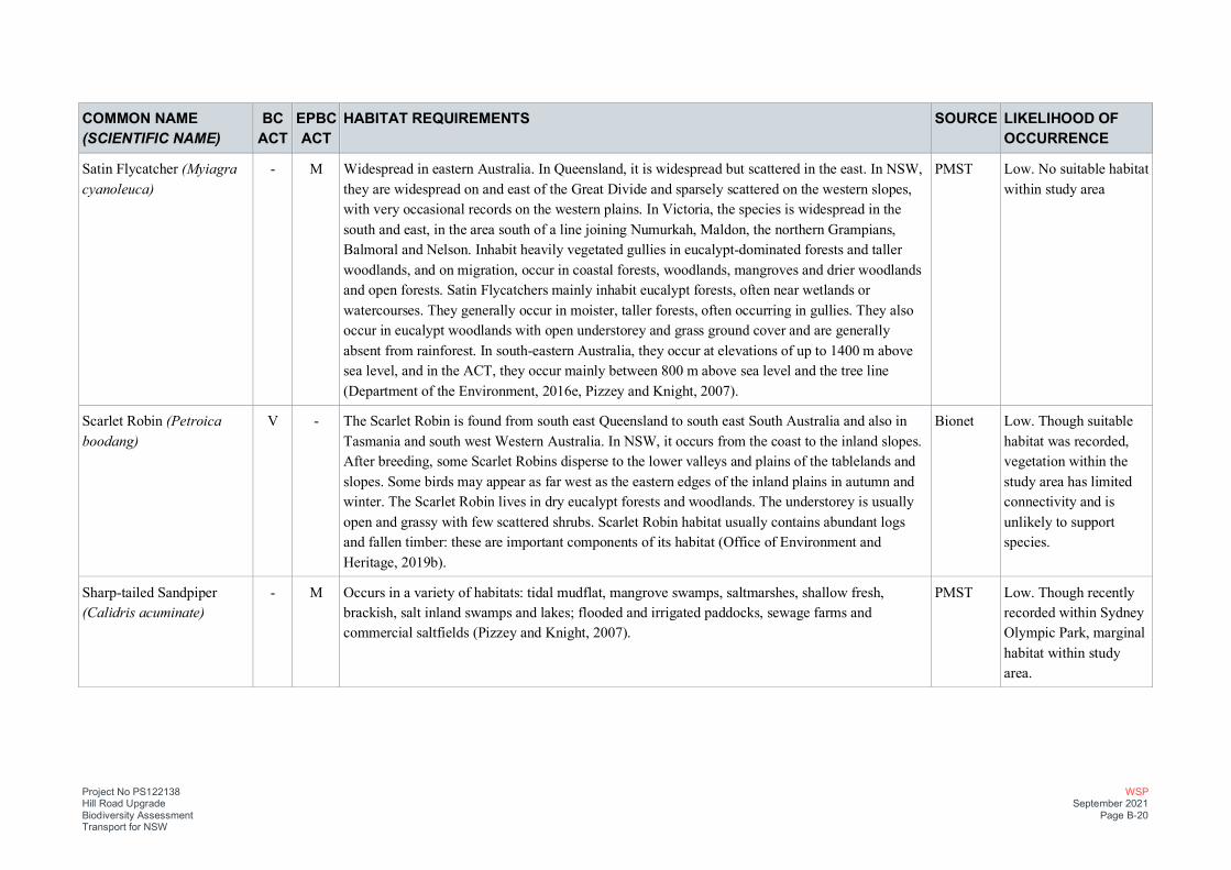
Project No PS122138 Hill Road Upgrade Biodiversity Assessment Transport for NSW
WSP September 2021
Page B-20
COMMON NAME (SCIENTIFIC NAME)
BC ACT
EPBC ACT
HABITAT REQUIREMENTS SOURCE LIKELIHOOD OF OCCURRENCE
Satin Flycatcher (Myiagra cyanoleuca)
- M Widespread in eastern Australia. In Queensland, it is widespread but scattered in the east. In NSW, they are widespread on and east of the Great Divide and sparsely scattered on the western slopes, with very occasional records on the western plains. In Victoria, the species is widespread in the south and east, in the area south of a line joining Numurkah, Maldon, the northern Grampians, Balmoral and Nelson. Inhabit heavily vegetated gullies in eucalypt-dominated forests and taller woodlands, and on migration, occur in coastal forests, woodlands, mangroves and drier woodlands and open forests. Satin Flycatchers mainly inhabit eucalypt forests, often near wetlands or watercourses. They generally occur in moister, taller forests, often occurring in gullies. They also occur in eucalypt woodlands with open understorey and grass ground cover and are generally absent from rainforest. In south-eastern Australia, they occur at elevations of up to 1400 m above sea level, and in the ACT, they occur mainly between 800 m above sea level and the tree line (Department of the Environment, 2016e, Pizzey and Knight, 2007).
PMST Low. No suitable habitat within study area
Scarlet Robin (Petroica boodang)
V - The Scarlet Robin is found from south east Queensland to south east South Australia and also in Tasmania and south west Western Australia. In NSW, it occurs from the coast to the inland slopes. After breeding, some Scarlet Robins disperse to the lower valleys and plains of the tablelands and slopes. Some birds may appear as far west as the eastern edges of the inland plains in autumn and winter. The Scarlet Robin lives in dry eucalypt forests and woodlands. The understorey is usually open and grassy with few scattered shrubs. Scarlet Robin habitat usually contains abundant logs and fallen timber: these are important components of its habitat (Office of Environment and Heritage, 2019b).
Bionet Low. Though suitable habitat was recorded, vegetation within the study area has limited connectivity and is unlikely to support species.
Sharp-tailed Sandpiper (Calidris acuminate)
- M Occurs in a variety of habitats: tidal mudflat, mangrove swamps, saltmarshes, shallow fresh, brackish, salt inland swamps and lakes; flooded and irrigated paddocks, sewage farms and commercial saltfields (Pizzey and Knight, 2007).
PMST Low. Though recently recorded within Sydney Olympic Park, marginal habitat within study area.

Project No PS122138 Hill Road Upgrade Biodiversity Assessment Transport for NSW
WSP September 2021
Page B-21
COMMON NAME (SCIENTIFIC NAME)
BC ACT
EPBC ACT
HABITAT REQUIREMENTS SOURCE LIKELIHOOD OF OCCURRENCE
Shy Albatross (Thalassarche cauta cauta)
V V; M An Australian territory endemic, which breeds on three islands off southern Tasmania; Albatross, Bass and Pedra Branca Islands (Marchant and Higgins, 1990). Genetic data studies on shy-type albatross collected off New Zealand, Australia and South Africa, strongly suggest that most Shy Albatross remain close to the breeding grounds throughout the year, with few birds moving north beyond the southern NSW coast (Abbott, 2006).
PMST Low. No suitable habitat within study area
Southern Giant-Petrel (Macronectes giganteus)
E1 E; M A partly nomadic marine species that forages off the coast of New South Wales (Garnett and Crowley, 2000).
PMST Low. No suitable habitat within study area
Southern Royal Albatross (Diomedea epomophora epomophora)
- VM Breeds on Campbell, Adams, Enderby and Auckland Islands, south of New Zealand (Garnett and Crowley, 2000). A Southern Ocean pelagic species occasionally observe off southern Australian coasts, but rare in the north (Garnett and Crowley, 2000).
PMST Low. No suitable habitat within study area
Spectacled Monarch (Monarcha trivirgatus)
- M The Spectacled Monarch is found in coastal north-eastern and eastern Australia, including coastal islands, from Cape York, Queensland to Port Stephens, New South Wales. It is much less common in the south. It is also found in Papua New Guinea, the Moluccas and Timor. The Spectacled Monarch prefers thick understorey in rainforests, wet gullies and waterside vegetation, as well as mangroves.
PMST Low. Species is unlikely to utilise the study area due to the absence of suitable habitat. May occur flying over study area.
Spotted Harrier (Circus assimilis)
V - Occurs throughout the Australian mainland, except in densely forested or wooded habitats of the coast, escarpment and ranges, and rarely in Tasmania. Occurs in grassy open woodland including Acacia and mallee remnants, inland riparian woodland, grassland and shrub steppe. It is found most commonly in native grassland, but also occurs in agricultural land, foraging over open habitats including edges of inland wetlands. Preys on terrestrial mammals (e.g. bandicoots, bettongs, and rodents), birds and reptile, occasionally insects and rarely carrion. (Office of Environment & Heritage, 2019k)
BioNet Low. Limited suitable habitat within the study area

Project No PS122138 Hill Road Upgrade Biodiversity Assessment Transport for NSW
WSP September 2021
Page B-22
COMMON NAME (SCIENTIFIC NAME)
BC ACT
EPBC ACT
HABITAT REQUIREMENTS SOURCE LIKELIHOOD OF OCCURRENCE
Superb Fruit-Dove (Ptilinopus superbus)
V - The Superb Fruit-dove occurs principally from north-eastern in Queensland to north-eastern NSW. It is much less common further south, where it is largely confined to pockets of suitable habitat as far south as Moruya. There are records of vagrants as far south as eastern Victoria and Tasmania. Inhabits rainforest and similar closed forests where it forages high in the canopy, eating the fruits of many tree species such as figs and palms. It may also forage in eucalypt or acacia woodland where there are fruit-bearing trees (Office of Environment and Heritage, 2019b).
BioNet Low. No suitable habitat within study area
Swift Parrot (Lathamus discolor)
E1 CE Breeding occurs in Tasmania, majority migrates to mainland Australia in autumn, over-wintering, particularly in Victoria and central and eastern NSW, but also south-eastern Queensland as far north as Duaringa. Until recently it was believed that in New South Wales, swift parrots forage mostly in the western slopes region along the inland slopes of the Great Dividing Range but are patchily distributed along the north and south coasts including the Sydney region, but new evidence indicates that the forests on the coastal plains from southern to northern NSW are also extremely important. In mainland Australia it is semi-nomadic, foraging in flowering eucalypts in eucalypt associations, particularly box-ironbark forests and woodlands. Preference for sites with highly fertile soils where large trees have high nectar production, including along drainage lines and isolated rural or urban remnants, and for sites with flowering Acacia pycnantha, is indicated. Sites used vary from year to year. (Garnett and Crowley, 2000),(Swift Parrot Recovery Team, 2001).
BioNet, PMST
Low. Marginal foraging habitat in the form of blossoming planted eucalypts. Unlikely to rely on feeding resources within the study area. Recorded in 1991 near Bicentennial Park.
Swinhoe's Snipe (Gallinago megala)
- M During the non-breeding season Swinhoe's Snipe occurs at the edges of wetlands, such as wet paddy fields, swamps and freshwater streams. The species is also known to occur in
PMST Low. No suitable habitat within study area

Project No PS122138 Hill Road Upgrade Biodiversity Assessment Transport for NSW
WSP September 2021
Page B-23
COMMON NAME (SCIENTIFIC NAME)
BC ACT
EPBC ACT
HABITAT REQUIREMENTS SOURCE LIKELIHOOD OF OCCURRENCE
Terek Sandpiper (Xenus cinereus)
V M A rare migrant to the eastern and southern Australian coasts, being most common in northern Australia, and extending its distribution south to the NSW coast in the east. The two main sites for the species in NSW are the Richmond River estuary and the Hunter River estuary. The latter has been identified as nationally and internationally important for the species. In Australia, has been recorded on coastal mudflats, lagoons, creeks and estuaries (Office of Environment and Heritage, 2019b).
BioNet Low. Though recently recorded within Sydney Olympic Park, species is unlikely to utilise the study area due to the absence of suitable habitat. May occur flying over study area to access habitat in greater locality.
Turquoise Parrot (Neophema pulchella)
V - The Turquoise Parrot’s range extends from southern Queensland through to northern Victoria, from the coastal plains to the western slopes of the Great Dividing Range. Lives on the edges of eucalypt woodland adjoining clearings, timbered ridges and creeks in farmland. Prefers to feed in the shade of a tree and spends most of the day on the ground searching for the seeds or grasses and herbaceous plants or browsing on vegetable matter (Office of Environment and Heritage, 2019b).
Bionet Low. Limited suitable habitat within study area
Wandering Albatross (Diomedea exulans)
E1 V; M Southern circumpolar distribution, breeding in Australian territory on Macquarie and Heard Islands (Garnett and Crowley, 2000). Also breeds in subantarctic islands in the southern Atlantic and Indian oceans (Garnett and Crowley, 2000). A pelagic species visiting mainland Australian waters seasonally occasionally occurring within sight of the coast.
PMST Low. No suitable habitat within study area.
Whimbrel (Numenius phaeopus)
- M Migrates to Taiwan, Philippines, PNG, and a race breeding in NE Siberia is found on the north and south-eastern coastlines of Australia. Juveniles arrive to Australia from spring to early summer. Usually only juveniles remain in Australia but very occasionally adults in breeding plumage may be seen in Australian winters (Pizzey and Knight, 2007).
Bionet, PMST
Low. Species is unlikely to utilise the study area due to the absence of suitable habitat. Not previously recorded within locality. May occur flying over study area.
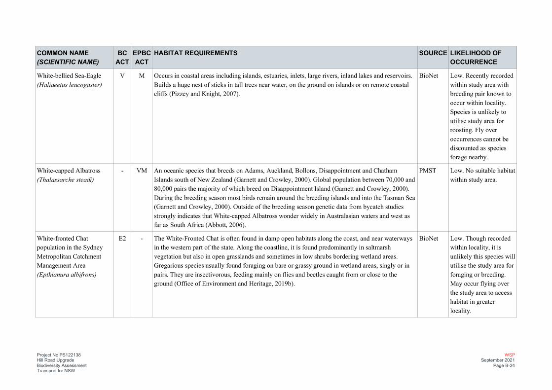
Project No PS122138 Hill Road Upgrade Biodiversity Assessment Transport for NSW
WSP September 2021
Page B-24
COMMON NAME (SCIENTIFIC NAME)
BC ACT
EPBC ACT
HABITAT REQUIREMENTS SOURCE LIKELIHOOD OF OCCURRENCE
White-bellied Sea-Eagle (Haliaeetus leucogaster)
V M Occurs in coastal areas including islands, estuaries, inlets, large rivers, inland lakes and reservoirs. Builds a huge nest of sticks in tall trees near water, on the ground on islands or on remote coastal cliffs (Pizzey and Knight, 2007).
BioNet Low. Recently recorded within study area with breeding pair known to occur within locality. Species is unlikely to utilise study area for roosting. Fly over occurrences cannot be discounted as species forage nearby.
White-capped Albatross (Thalassarche steadi)
- VM An oceanic species that breeds on Adams, Auckland, Bollons, Disappointment and Chatham Islands south of New Zealand (Garnett and Crowley, 2000). Global population between 70,000 and 80,000 pairs the majority of which breed on Disappointment Island (Garnett and Crowley, 2000). During the breeding season most birds remain around the breeding islands and into the Tasman Sea (Garnett and Crowley, 2000). Outside of the breeding season genetic data from bycatch studies strongly indicates that White-capped Albatross wonder widely in Australasian waters and west as far as South Africa (Abbott, 2006).
PMST Low. No suitable habitat within study area.
White-fronted Chat population in the Sydney Metropolitan Catchment Management Area (Epthianura albifrons)
E2 - The White-Fronted Chat is often found in damp open habitats along the coast, and near waterways in the western part of the state. Along the coastline, it is found predominantly in saltmarsh vegetation but also in open grasslands and sometimes in low shrubs bordering wetland areas. Gregarious species usually found foraging on bare or grassy ground in wetland areas, singly or in pairs. They are insectivorous, feeding mainly on flies and beetles caught from or close to the ground (Office of Environment and Heritage, 2019b).
BioNet Low. Though recorded within locality, it is unlikely this species will utilise the study area for foraging or breeding. May occur flying over the study area to access habitat in greater locality.
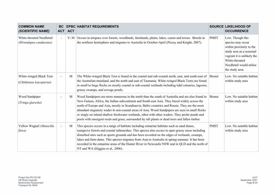
Project No PS122138 Hill Road Upgrade Biodiversity Assessment Transport for NSW
WSP September 2021
Page B-25
COMMON NAME (SCIENTIFIC NAME)
BC ACT
EPBC ACT
HABITAT REQUIREMENTS SOURCE LIKELIHOOD OF OCCURRENCE
White-throated Needletail (Hirundapus caudacutus)
- V; M Occurs in airspace over forests, woodlands, farmlands, plains, lakes, coasts and towns. Breeds in the northern hemisphere and migrates to Australia in October-April (Pizzey and Knight, 2007).
PMST Low. Though this species may occur within proximity to the study area as a seasonal vagrant it is unlikely the White-throated Needletail would utilise the study area.
White-winged Black Tern
(Chlidonias leucopterus)
- M The White-winged Black Tern is found in the coastal and sub-coastal north, east, and south-east of the Australian mainland, and the north and east of Tasmania. White-winged Black Terns are found in small to large flocks on mostly coastal or sub-coastal wetlands including tidal estuaries, lagoons, grassy swamps, and sewage ponds.
Bionet Low. No suitable habitat within study area
Wood Sandpiper
(Tringa glareola)
- M Wood Sandpipers are more numerous in the north than the south of Australia and are also found in New Guinea, Africa, the Indian subcontinent and South-east Asia. They breed widely across the north of Europe and Asia, mostly in Scandinavia, Baltic countries and Russia. They are the most abundant migratory wader in non-coastal areas of Asia. Wood Sandpipers are seen in small flocks or singly on inland shallow freshwater wetlands, often with other waders. They prefer ponds and pools with emergent reeds and grass, surrounded by tall plants or dead trees and fallen timber.
Bionet Low. No suitable habitat within study area
Yellow Wagtail (Motacilla flava)
- M This species occurs in a range of habitats including estuarine habitats such as sand dunes, mangrove forests and coastal saltmarshes. This species also occurs in open grassy areas including disturbed sites such as sports grounds and has been recorded on the edges of wetlands, swamps, lakes and farm dams. This species migrates from Asia to Australia in spring-summer. It has been recorded in the estuarine areas of the Hunter River in Newcastle NSW and in QLD and the north of NT and WA (Higgins et al., 2006).
PMST Low. No suitable habitat within study area

Project No PS122138 Hill Road Upgrade Biodiversity Assessment Transport for NSW
WSP September 2021
Page B-26
COMMON NAME (SCIENTIFIC NAME)
BC ACT
EPBC ACT
HABITAT REQUIREMENTS SOURCE LIKELIHOOD OF OCCURRENCE
Fish
Black Cod (Epinephelus daemelii)
V V Adult black cod are usually found in caves, gutters and beneath bomboras on rocky reefs. They are territorial and often occupy a particular cave for life. Small juveniles are often found in coastal rock pools, and larger juveniles around rocky shores in estuaries. Black cod are opportunistic carnivores, eating mainly other fish and crustaceans. They can change from one colour pattern to another in just a few seconds. They are usually black in estuaries and banded around clear water reefs. Black cod are apparently slow growing. Smaller fish are mostly females, but they generally change sex to become males at around 100-110 cm in length. (Department of Primary Industries, 2005)
PMST Low. No suitable habitat within study area.
Macquarie Perch (Macquaria australasica)
- E Macquarie Perch are found in the Murray-Darling Basin (particularly upstream reaches) of the Lachlan, Murrumbidgee and Murray rivers, and parts of south-eastern coastal NSW, including the Hawkesbury/Nepean and Shoalhaven catchments. Macquarie Perch are found in both river and lake habitats; especially the upper reaches of rivers and their tributaries. It prefers clear water and deep, rocky holes with lots of cover. As well as aquatic vegetation, additional cover may comprise of large boulders, debris and overhanging banks. Spawning occurs just above riffles (shallow running water). (Department of the Environment, 2016c) (Department of Primary Industries, 2016).
PMST Low. No suitable habitat within study area.
Invertebrates
Cumberland Plain Land Snail (Meridolum corneovirens)
E1 - Restricted to the Cumberland Plain and Castlereagh Woodlands of Western Sydney and also along the fringes of River Flat Forest, especially where it meets Cumberland Plain Woodland. It is typically found under logs and other debris, amongst leaf litter and bark around bases of trees. It is also sometimes found under grass clumps and where possible it will burrow into loose soil (NSW National Parks and Wildlife Service, 1999b).
BioNet Low. Marginal habitat available, suitable ground cover minimal. This species was the subject of targeted surveys – important microhabitat not available.
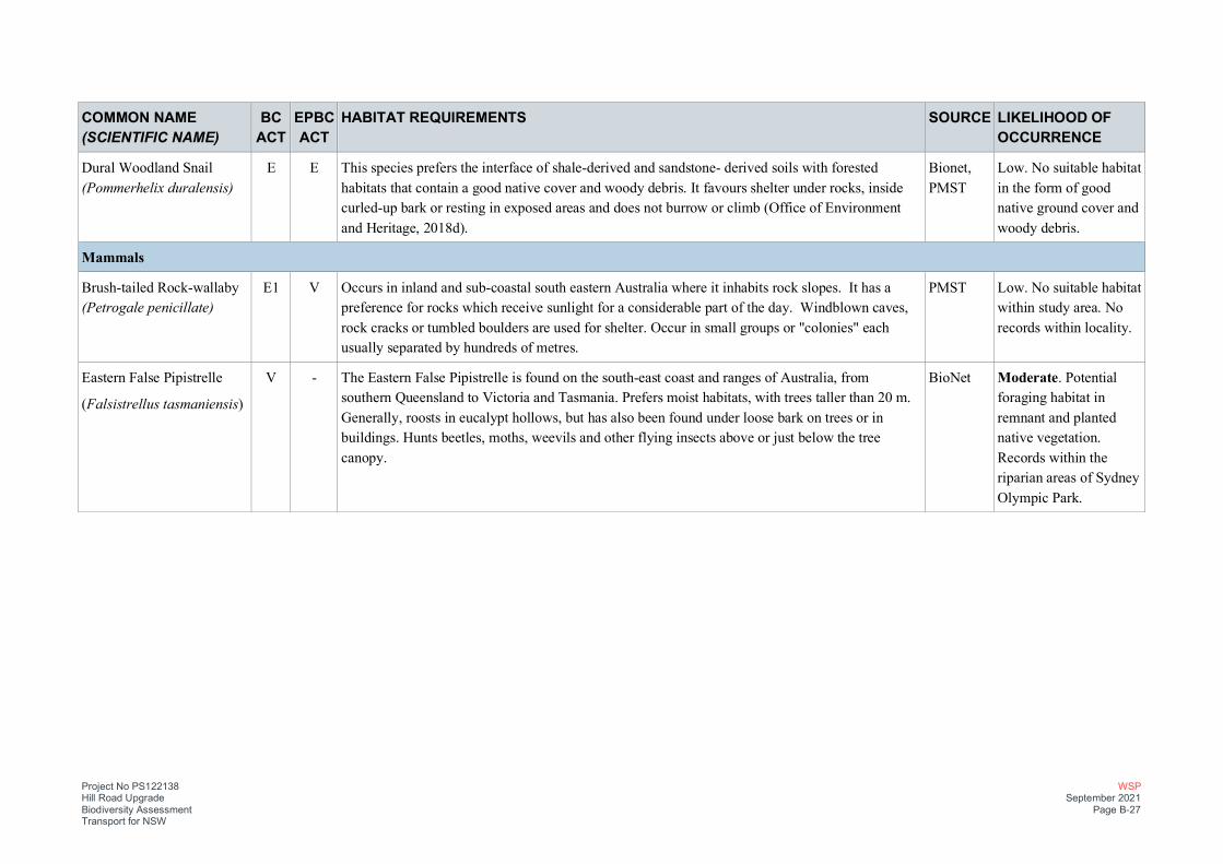
Project No PS122138 Hill Road Upgrade Biodiversity Assessment Transport for NSW
WSP September 2021
Page B-27
COMMON NAME (SCIENTIFIC NAME)
BC ACT
EPBC ACT
HABITAT REQUIREMENTS SOURCE LIKELIHOOD OF OCCURRENCE
Dural Woodland Snail (Pommerhelix duralensis)
E E This species prefers the interface of shale-derived and sandstone- derived soils with forested habitats that contain a good native cover and woody debris. It favours shelter under rocks, inside curled-up bark or resting in exposed areas and does not burrow or climb (Office of Environment and Heritage, 2018d).
Bionet, PMST
Low. No suitable habitat in the form of good native ground cover and woody debris.
Mammals
Brush-tailed Rock-wallaby (Petrogale penicillate)
E1 V Occurs in inland and sub-coastal south eastern Australia where it inhabits rock slopes. It has a preference for rocks which receive sunlight for a considerable part of the day. Windblown caves, rock cracks or tumbled boulders are used for shelter. Occur in small groups or "colonies" each usually separated by hundreds of metres.
PMST Low. No suitable habitat within study area. No records within locality.
Eastern False Pipistrelle
(Falsistrellus tasmaniensis)
V - The Eastern False Pipistrelle is found on the south-east coast and ranges of Australia, from southern Queensland to Victoria and Tasmania. Prefers moist habitats, with trees taller than 20 m. Generally, roosts in eucalypt hollows, but has also been found under loose bark on trees or in buildings. Hunts beetles, moths, weevils and other flying insects above or just below the tree canopy.
BioNet Moderate. Potential foraging habitat in remnant and planted native vegetation. Records within the riparian areas of Sydney Olympic Park.
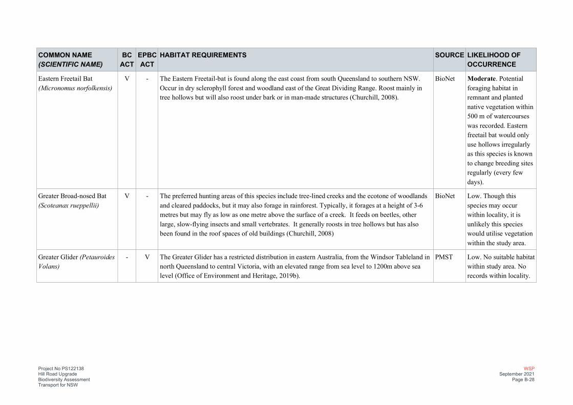
Project No PS122138 Hill Road Upgrade Biodiversity Assessment Transport for NSW
WSP September 2021
Page B-28
COMMON NAME (SCIENTIFIC NAME)
BC ACT
EPBC ACT
HABITAT REQUIREMENTS SOURCE LIKELIHOOD OF OCCURRENCE
Eastern Freetail Bat (Micronomus norfolkensis)
V - The Eastern Freetail-bat is found along the east coast from south Queensland to southern NSW. Occur in dry sclerophyll forest and woodland east of the Great Dividing Range. Roost mainly in tree hollows but will also roost under bark or in man-made structures (Churchill, 2008).
BioNet Moderate. Potential foraging habitat in remnant and planted native vegetation within 500 m of watercourses was recorded. Eastern freetail bat would only use hollows irregularly as this species is known to change breeding sites regularly (every few days).
Greater Broad-nosed Bat (Scoteanax rueppellii)
V - The preferred hunting areas of this species include tree-lined creeks and the ecotone of woodlands and cleared paddocks, but it may also forage in rainforest. Typically, it forages at a height of 3-6 metres but may fly as low as one metre above the surface of a creek. It feeds on beetles, other large, slow-flying insects and small vertebrates. It generally roosts in tree hollows but has also been found in the roof spaces of old buildings (Churchill, 2008)
BioNet Low. Though this species may occur within locality, it is unlikely this species would utilise vegetation within the study area.
Greater Glider (Petauroides Volans)
- V The Greater Glider has a restricted distribution in eastern Australia, from the Windsor Tableland in north Queensland to central Victoria, with an elevated range from sea level to 1200m above sea level (Office of Environment and Heritage, 2019b).
PMST Low. No suitable habitat within study area. No records within locality.
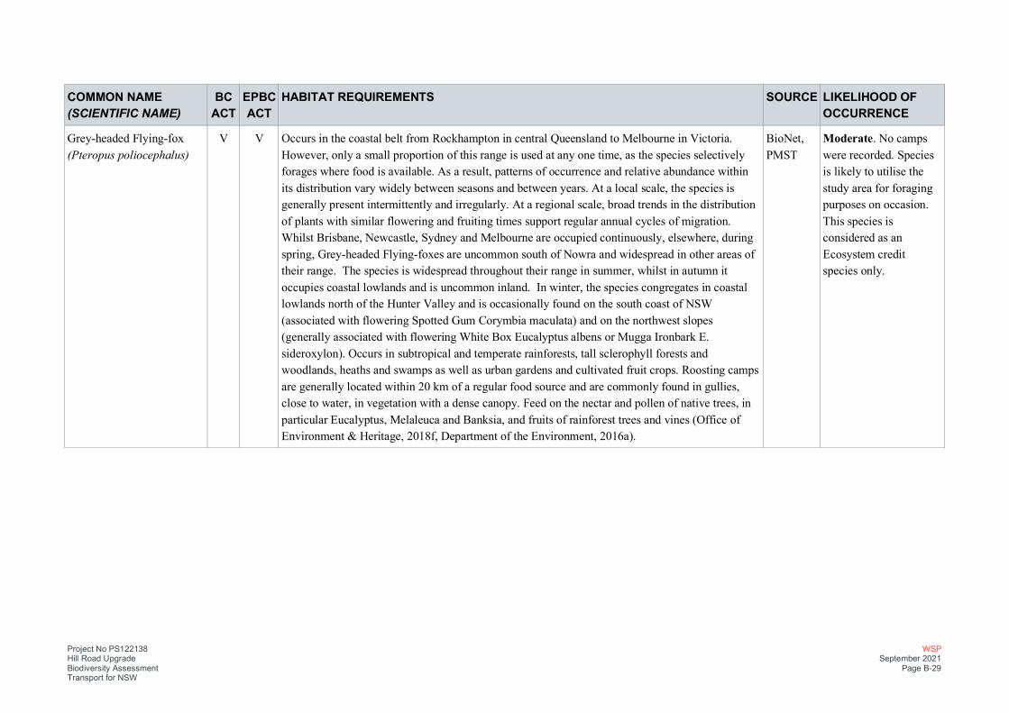
Project No PS122138 Hill Road Upgrade Biodiversity Assessment Transport for NSW
WSP September 2021
Page B-29
COMMON NAME (SCIENTIFIC NAME)
BC ACT
EPBC ACT
HABITAT REQUIREMENTS SOURCE LIKELIHOOD OF OCCURRENCE
Grey-headed Flying-fox (Pteropus poliocephalus)
V V Occurs in the coastal belt from Rockhampton in central Queensland to Melbourne in Victoria. However, only a small proportion of this range is used at any one time, as the species selectively forages where food is available. As a result, patterns of occurrence and relative abundance within its distribution vary widely between seasons and between years. At a local scale, the species is generally present intermittently and irregularly. At a regional scale, broad trends in the distribution of plants with similar flowering and fruiting times support regular annual cycles of migration. Whilst Brisbane, Newcastle, Sydney and Melbourne are occupied continuously, elsewhere, during spring, Grey-headed Flying-foxes are uncommon south of Nowra and widespread in other areas of their range. The species is widespread throughout their range in summer, whilst in autumn it occupies coastal lowlands and is uncommon inland. In winter, the species congregates in coastal lowlands north of the Hunter Valley and is occasionally found on the south coast of NSW (associated with flowering Spotted Gum Corymbia maculata) and on the northwest slopes (generally associated with flowering White Box Eucalyptus albens or Mugga Ironbark E. sideroxylon). Occurs in subtropical and temperate rainforests, tall sclerophyll forests and woodlands, heaths and swamps as well as urban gardens and cultivated fruit crops. Roosting camps are generally located within 20 km of a regular food source and are commonly found in gullies, close to water, in vegetation with a dense canopy. Feed on the nectar and pollen of native trees, in particular Eucalyptus, Melaleuca and Banksia, and fruits of rainforest trees and vines (Office of Environment & Heritage, 2018f, Department of the Environment, 2016a).
BioNet, PMST
Moderate. No camps were recorded. Species is likely to utilise the study area for foraging purposes on occasion. This species is considered as an Ecosystem credit species only.
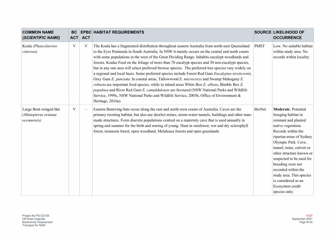
Project No PS122138 Hill Road Upgrade Biodiversity Assessment Transport for NSW
WSP September 2021
Page B-30
COMMON NAME (SCIENTIFIC NAME)
BC ACT
EPBC ACT
HABITAT REQUIREMENTS SOURCE LIKELIHOOD OF OCCURRENCE
Koala (Phascolarctos cinereus)
V V The Koala has a fragmented distribution throughout eastern Australia from north-east Queensland to the Eyre Peninsula in South Australia. In NSW it mainly occurs on the central and north coasts with some populations in the west of the Great Dividing Range. Inhabits eucalypt woodlands and forests. Koalas Feed on the foliage of more than 70 eucalypt species and 30 non-eucalypt species, but in any one area will select preferred browse species. The preferred tree species vary widely on a regional and local basis. Some preferred species include Forest Red Gum Eucalyptus tereticornis, Grey Gum E. punctata. In coastal areas, Tallowwood E. microcorys and Swamp Mahogany E. robusta are important food species, while in inland areas White Box E. albens, Bimble Box E. populnea and River Red Gum E. camaldulensis are favoured (NSW National Parks and Wildlife Service, 1999c, NSW National Parks and Wildlife Service, 2003b, Office of Environment & Heritage, 2016a).
PMST Low. No suitable habitat within study area. No records within locality.
Large Bent-winged Bat (Miniopterus orianae oceanensis)
V - Eastern Bentwing-bats occur along the east and north-west coasts of Australia. Caves are the primary roosting habitat, but also use derelict mines, storm-water tunnels, buildings and other man-made structures. Form discrete populations centred on a maternity cave that is used annually in spring and summer for the birth and rearing of young. Hunt in rainforest, wet and dry sclerophyll forest, monsoon forest, open woodland, Melaleuca forests and open grasslands.
BioNet Moderate. Potential foraging habitat in remnant and planted native vegetation. Records within the riparian areas of Sydney Olympic Park. Cave, tunnel, mine, culvert or other structure known or suspected to be used for breeding were not recorded within the study area. This species is considered as an Ecosystem credit species only.
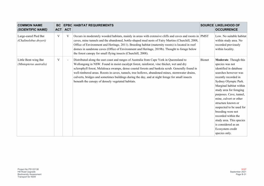
Project No PS122138 Hill Road Upgrade Biodiversity Assessment Transport for NSW
WSP September 2021
Page B-31
COMMON NAME (SCIENTIFIC NAME)
BC ACT
EPBC ACT
HABITAT REQUIREMENTS SOURCE LIKELIHOOD OF OCCURRENCE
Large-eared Pied Bat (Chalinolobus dwyeri)
V V Occurs in moderately wooded habitats, mainly in areas with extensive cliffs and caves and roosts in caves, mine tunnels and the abandoned, bottle-shaped mud nests of Fairy Martins (Churchill, 2008, Office of Environment and Heritage, 2011). Breeding habitat (maternity roosts) is located in roof domes in sandstone caves (Office of Environment and Heritage, 2019b). Thought to forage below the forest canopy for small flying insects (Churchill, 2008).
PMST Low. No suitable habitat within study area. No recorded previously within locality.
Little Bent-wing Bat (Miniopterus australis)
V - Distributed along the east coast and ranges of Australia from Cape York in Queensland to Wollongong in NSW. Found in moist eucalypt forest, rainforest, vine thicket, wet and dry sclerophyll forest, Melaleuca swamps, dense coastal forests and banksia scrub. Generally found in well-timbered areas. Roosts in caves, tunnels, tree hollows, abandoned mines, stormwater drains, culverts, bridges and sometimes buildings during the day, and at night forage for small insects beneath the canopy of densely vegetated habitats.
Bionet Moderate. Though this species was not identified in database searches however was recently recorded in Sydney Olympic Park. Marginal habitat within study area for foraging purposes. Cave, tunnel, mine, culvert or other structure known or suspected to be used for breeding were not recorded within the study area. This species is considered as an Ecosystem credit species only.
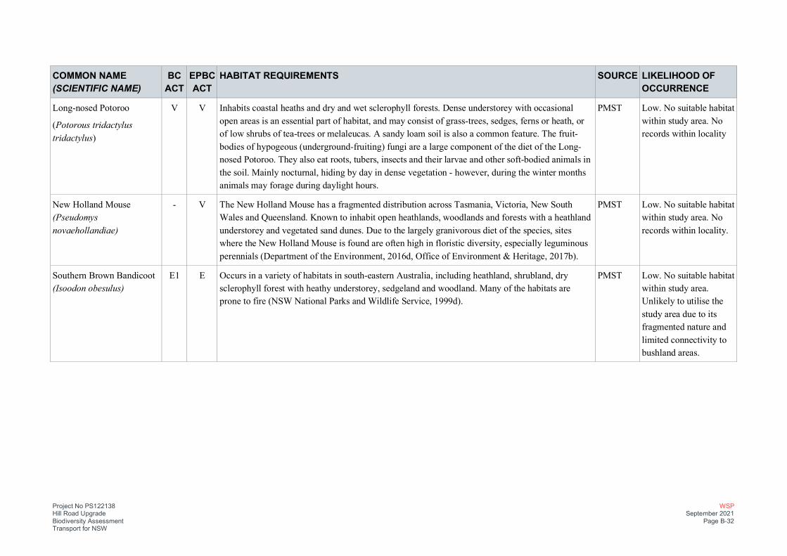
Project No PS122138 Hill Road Upgrade Biodiversity Assessment Transport for NSW
WSP September 2021
Page B-32
COMMON NAME (SCIENTIFIC NAME)
BC ACT
EPBC ACT
HABITAT REQUIREMENTS SOURCE LIKELIHOOD OF OCCURRENCE
Long-nosed Potoroo
(Potorous tridactylus tridactylus)
V V Inhabits coastal heaths and dry and wet sclerophyll forests. Dense understorey with occasional open areas is an essential part of habitat, and may consist of grass-trees, sedges, ferns or heath, or of low shrubs of tea-trees or melaleucas. A sandy loam soil is also a common feature. The fruit-bodies of hypogeous (underground-fruiting) fungi are a large component of the diet of the Long-nosed Potoroo. They also eat roots, tubers, insects and their larvae and other soft-bodied animals in the soil. Mainly nocturnal, hiding by day in dense vegetation - however, during the winter months animals may forage during daylight hours.
PMST Low. No suitable habitat within study area. No records within locality
New Holland Mouse (Pseudomys novaehollandiae)
- V The New Holland Mouse has a fragmented distribution across Tasmania, Victoria, New South Wales and Queensland. Known to inhabit open heathlands, woodlands and forests with a heathland understorey and vegetated sand dunes. Due to the largely granivorous diet of the species, sites where the New Holland Mouse is found are often high in floristic diversity, especially leguminous perennials (Department of the Environment, 2016d, Office of Environment & Heritage, 2017b).
PMST Low. No suitable habitat within study area. No records within locality.
Southern Brown Bandicoot (Isoodon obesulus)
E1 E Occurs in a variety of habitats in south-eastern Australia, including heathland, shrubland, dry sclerophyll forest with heathy understorey, sedgeland and woodland. Many of the habitats are prone to fire (NSW National Parks and Wildlife Service, 1999d).
PMST Low. No suitable habitat within study area. Unlikely to utilise the study area due to its fragmented nature and limited connectivity to bushland areas.

Project No PS122138 Hill Road Upgrade Biodiversity Assessment Transport for NSW
WSP September 2021
Page B-33
COMMON NAME (SCIENTIFIC NAME)
BC ACT
EPBC ACT
HABITAT REQUIREMENTS SOURCE LIKELIHOOD OF OCCURRENCE
Southern Myotis (Myotis macropus)
V - Found in most habitat types in association with streams and permanent waterways usually at low elevations in flat or undulating landscapes from northern areas of Western Australia, and the Northern Territory, down the entire east coast and the southern coast of Australia to just west of the Victoria/South Australia border and inland along the Murray River. Roosts in caves, tree hollows, in clumps of dense vegetation (e.g. Pandanus), mines, tunnels, under bridges, road culverts and stormwater drains often in abandoned, intact Fairy Martin nests. Roost sites are strongly associated with bodies of water where this species commonly feeds on aquatic insects, shrimp and small fish at the water surface, however, aerial foraging for other insects is also known (Churchill, 2008). Breeding habitat likely to coincide with roosting habitat (Office of Environment & Heritage, 2016c).
BioNet Moderate. Vegetation surrounding waterways is may be utilised as breeding and/or roosting habitat. Remnant vegetation which is likely to provide suitable habitat within the study area (PCT 724) is more than 200m from Haslams Creekline. This species may utilise non-native vegetation. This species is considered as an Ecosystem credit species only.
Spotted-Tailed Quoll (Southern Subspecies) (Dasyurus maculatus maculatus)
V E Occurs from the Bundaberg area in south-east Queensland, south through NSW to western Victoria and Tasmania. In NSW, it occurs on both sides of the Great Dividing Range and north-east NSW represents a national stronghold (NSW National Parks and Wildlife Service, 1999g). Occurs in wide range of forest types, although appears to prefer moist sclerophyll and rainforest forest types, and riparian habitat. Most common in large unfragmented patches of forest. It has also been recorded from dry sclerophyll forest, open woodland and coastal heathland, and despite its occurrence in riparian areas, it also ranges over dry ridges. Nests in rock caves and hollow logs or trees. Feeds on a variety of prey including birds, terrestrial and arboreal mammals, small macropods, reptiles and arthropods.
BioNet, PMST
Low. No suitable habitat within study area. Unlikely to utilise the study area due to its fragmented nature and limited connectivity to bushland areas.

Project No PS122138 Hill Road Upgrade Biodiversity Assessment Transport for NSW
WSP September 2021
Page B-34
COMMON NAME (SCIENTIFIC NAME)
BC ACT
EPBC ACT
HABITAT REQUIREMENTS SOURCE LIKELIHOOD OF OCCURRENCE
Yellow-bellied Sheathtail-bat (Saccolaimus flaviventris)
V - This species is widespread through tropical Australia and migrates to southern Australia in summer. Occurs in eucalypt forest where it feeds above the canopy and in mallee or open country where it feeds closer to the ground. Generally, a solitary species but sometimes found in colonies of up to 10. It roosts and breeds in tree hollows but has also been recorded roosting under exfoliating bark, in burrows of terrestrial mammals, in soil cracks and under slabs of rock and in the nests of bird and sugar gliders.
BioNet Moderate. Potential foraging habitat in remnant and planted native vegetation. Recent records within Newington Nature Reserve. Breeding and roosting habitat in the form of hollow-bearing trees recorded.
Reptiles
Broad-headed Snake
(Hoplocephalus bungaroides)
E V The Broad-headed Snake is largely confined to Triassic and Permian sandstones, including the Hawkesbury, Narrabeen and Shoalhaven groups, within the coast and ranges in an area within approximately 250 km of Sydney. Shelters in rock crevices and under flat sandstone rocks on exposed cliff edges during autumn, winter and spring. Moves from the sandstone rocks to shelters in cervices or hollows in large trees within 500m of escarpments in summer.
PMST Low. No suitable habitat within study area. Unlikely to utilise the study area due to its fragmented nature and limited connectivity to bushland areas.

Assessments of significance
Project No PS122138 Hill Road Upgrade Biodiversity Assessment Transport for NSW
WSP September 2021
Page C-1
C1 Assessments of significance The proposed works would be assessed under Division 5.1 of the EP&A Act. As such, Section 7.3 of the BC Act outlines the ‘test of significance’ that is to be undertaken to assess the likelihood of significant impact upon threatened species or ecological communities listed under the BC Act. Assessments of significance have been completed for the following TEC as listed under the BC Act:
— Shale Gravel Transition Forest in the Sydney Basin Bioregion (Shale Gravel Transition Forest) (corresponds to PCT 724).
Assessments of significance have been completed for the following threatened species listed under the BC Act:
— Eastern False Pipistrelle (Falsistrellus tasmaniensis) — Eastern Freetail Bat (Micronomus norfolkensis) — Yellow-bellied Sheathtail-bat (Saccolaimus flaviventris) — Little Bent-wing Bat (Miniopterus australis) — Large Bent-wing Bat (Miniopterus orianae oceanensis) — Southern Myotis (Myotis macropus) — Little Lorikeet (Glossopsitta pusilla) — Grey-headed Flying-fox (Pteropus poliocephalus).
Assessments of significance have been completed for the following threatened species listed under the EPBC Act:
— Grey-headed Flying-fox (Pteropus poliocephalus).
C1.1 Shale Gravel Transition Forest in the Sydney Basin Bioregion
The following is to be taken into account for the purposes of determining whether a proposed development or activity is likely to significantly affect threatened species or ecological communities, or their habitats —
(a) in the case of a threatened species, whether the proposed development or activity is likely to have an adverse effect on the life cycle of the species such that a viable local population of the species is likely to be placed at risk of extinction
Not applicable.
(b) in the case of an endangered ecological community or critically endangered ecological community, whether the proposed development or activity—
(i) is likely to have an adverse effect on the extent of the ecological community such that its local occurrence is likely to be placed at risk of extinction, or
(ii) is likely to substantially and adversely modify the composition of the ecological community such that its local occurrence is likely to be placed at risk of extinction
The local occurrence of Shale Gravel Transition Forest in the Sydney Basin Bioregion is estimated at about 18 ha based on available mapping. The Proposal would remove around 0.03 ha of Shale Gravel Transition Forest in the Sydney Basin Bioregion in the form of PCT 724. Given the extent of similar remnant and planted vegetation in the locality, the impacts are negligible at approximately 0.16% of mapped extent. In terms of proportional impact to available habitat the Proposal is not significant. The Proposal would not have an adverse effect on the extent of Shale Gravel Transition Forest in the Sydney Basin Bioregion such that the local occurrence is likely to be placed at risk of extinction.
Project No PS122138 Hill Road Upgrade Biodiversity Assessment Transport for NSW
WSP September 2021
Page C-2
The Proposal is considered unlikely to substantially and adversely modify the composition of Shale Gravel Transition Forest in the Sydney Basin Bioregion such that its local occurrence is placed at risk of extinction. The local occurrence of this TEC has already been substantially and adversely modified by past land use practices. Shale Gravel Transition Forest in the Sydney Basin Bioregion is currently suffering from altered composition caused by a very large reduction in ecological function, as indicated by:
— altered community structure (i.e. missing structural layers) — altered species composition (i.e. missing species) — disruption of ecological processes (i.e. altered drainage, mowing preventing natural regeneration) — invasion and establishment of exotic species resulting in weed dominance — degradation of habitat — fragmentation.
The Proposal is not considered likely to further modify the composition of Shale Gravel Transition Forest in the Sydney Basin Bioregion such that the local occurrence of the TEC is placed at risk of extinction. The composition of Shale Gravel Transition Forest in the Sydney Basin Bioregion within the locality is predicted to remain as is after the implementation of the Proposal.
(c) in relation to the habitat of a threatened species or ecological community—
(i) the extent to which habitat is likely to be removed or modified as a result of the proposed development or activity, and
(ii) whether an area of habitat is likely to become fragmented or isolated from other areas of habitat as a result of the proposed development or activity, and
(iii) the importance of the habitat to be removed, modified, fragmented or isolated to the long-term survival of the species or ecological community in the locality,
The extent of predicted impacts to Shale Gravel Transition Forest in the Sydney Basin Bioregion is estimated at 0.03 ha.
Fragmentation is unlikely to occur from the Proposal. Importantly, the Proposal would not result in the breaking apart of large blocks of high quality examples of threatened ecological communities into many smaller blocks. No further habitat fragmentation on a landscape scale would occur because of the Proposal. Isolation of habitats is unlikely to increase as the Proposal will not entirely remove patches from the landscape.
Due to the conservation significance of Shale Gravel Transition Forest in the Sydney Basin Bioregion, the remaining patches within NSW are likely to be important for its survival. The patch impacted by the development footprint is very small and in poor condition and long-term viability is questionable. As such, the impacted patch of Shale Gravel Transition Forest in the Sydney Basin Bioregion is unlikely to be important to the long-term survival of the ecological community in the locality.
(d) whether the proposed development or activity is likely to have an adverse effect on any declared area of outstanding biodiversity value (either directly or indirectly),
The Proposal will not impact on any declared area of outstanding biodiversity value.
(e) whether the proposed development or activity is or is part of a key threatening process or is likely to increase the impact of a key threatening process.
A Key Threatening Process (KTP) is a process that threatens, or may have the capability to threaten, the survival or evolutionary development of species, population or ecological community. Key threatening processes are listed under the BC Act and at the present there are currently 38 listed KTPs. Of the 38 listed KTPs under the BC Act, nine are applicable to Shale Gravel Transition Forest in the Sydney Basin Bioregion (see Table C.1). However, hygiene and weed control measures would reduce or avoid the impact of most KTPs with the exception of clearing of native vegetation.
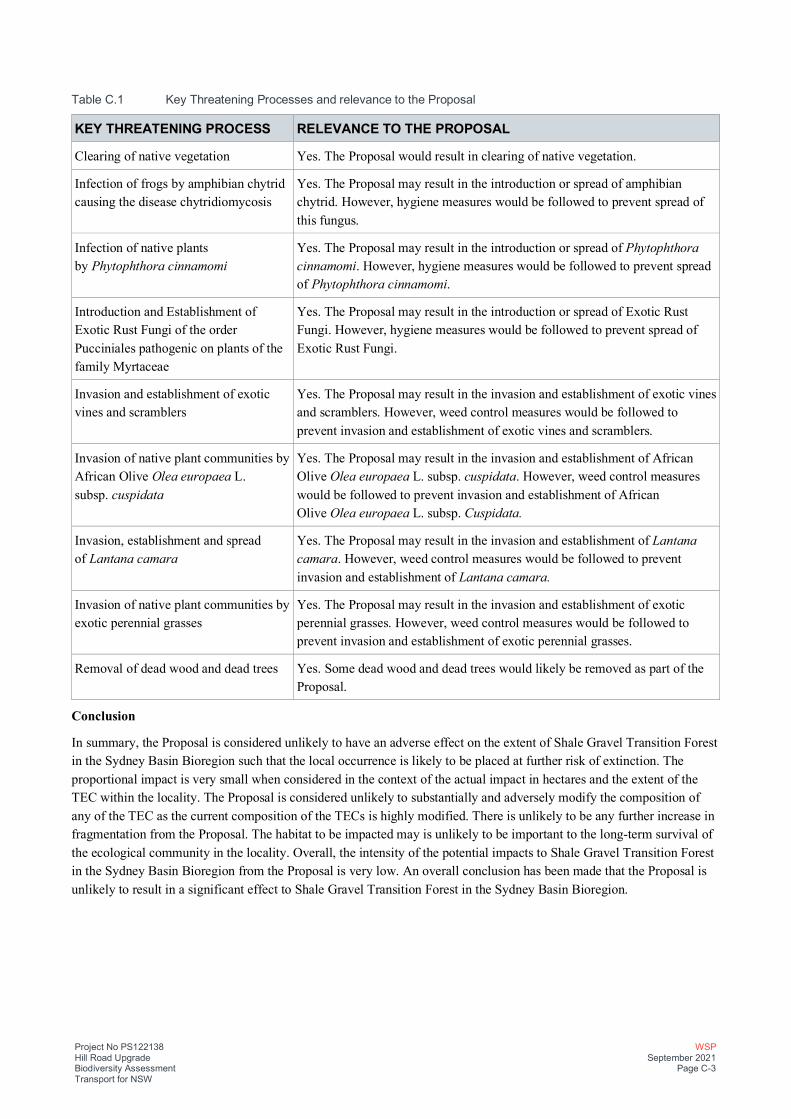
Project No PS122138 Hill Road Upgrade Biodiversity Assessment Transport for NSW
WSP September 2021
Page C-3
Table C.1 Key Threatening Processes and relevance to the Proposal
KEY THREATENING PROCESS RELEVANCE TO THE PROPOSAL
Clearing of native vegetation Yes. The Proposal would result in clearing of native vegetation.
Infection of frogs by amphibian chytrid causing the disease chytridiomycosis
Yes. The Proposal may result in the introduction or spread of amphibian chytrid. However, hygiene measures would be followed to prevent spread of this fungus.
Infection of native plants by Phytophthora cinnamomi
Yes. The Proposal may result in the introduction or spread of Phytophthora cinnamomi. However, hygiene measures would be followed to prevent spread of Phytophthora cinnamomi.
Introduction and Establishment of Exotic Rust Fungi of the order Pucciniales pathogenic on plants of the family Myrtaceae
Yes. The Proposal may result in the introduction or spread of Exotic Rust Fungi. However, hygiene measures would be followed to prevent spread of Exotic Rust Fungi.
Invasion and establishment of exotic vines and scramblers
Yes. The Proposal may result in the invasion and establishment of exotic vines and scramblers. However, weed control measures would be followed to prevent invasion and establishment of exotic vines and scramblers.
Invasion of native plant communities by African Olive Olea europaea L. subsp. cuspidata
Yes. The Proposal may result in the invasion and establishment of African Olive Olea europaea L. subsp. cuspidata. However, weed control measures would be followed to prevent invasion and establishment of African Olive Olea europaea L. subsp. Cuspidata.
Invasion, establishment and spread of Lantana camara
Yes. The Proposal may result in the invasion and establishment of Lantana camara. However, weed control measures would be followed to prevent invasion and establishment of Lantana camara.
Invasion of native plant communities by exotic perennial grasses
Yes. The Proposal may result in the invasion and establishment of exotic perennial grasses. However, weed control measures would be followed to prevent invasion and establishment of exotic perennial grasses.
Removal of dead wood and dead trees Yes. Some dead wood and dead trees would likely be removed as part of the Proposal.
Conclusion
In summary, the Proposal is considered unlikely to have an adverse effect on the extent of Shale Gravel Transition Forest in the Sydney Basin Bioregion such that the local occurrence is likely to be placed at further risk of extinction. The proportional impact is very small when considered in the context of the actual impact in hectares and the extent of the TEC within the locality. The Proposal is considered unlikely to substantially and adversely modify the composition of any of the TEC as the current composition of the TECs is highly modified. There is unlikely to be any further increase in fragmentation from the Proposal. The habitat to be impacted may is unlikely to be important to the long-term survival of the ecological community in the locality. Overall, the intensity of the potential impacts to Shale Gravel Transition Forest in the Sydney Basin Bioregion from the Proposal is very low. An overall conclusion has been made that the Proposal is unlikely to result in a significant effect to Shale Gravel Transition Forest in the Sydney Basin Bioregion.
Project No PS122138 Hill Road Upgrade Biodiversity Assessment Transport for NSW
WSP September 2021
Page C-4
C1.2 Hollow-dependant bats Threatened hollow-dependent species of microchiropteran bat have been assessed together as they generally share similar habitat requirements, threats that affect their recovery, and potential impacts as result of the Proposal. Hollow-dependent microchiropteran bats considered for the impact assessment are:
— Eastern False Pipistrelle (Falsistrellus tasmaniensis) — Eastern Freetail Bat (Micronomus norfolkensis) — Yellow-bellied Sheathtail-bat (Saccolaimus flaviventris).
All the above-mentioned species are listed as Vulnerable under the BC Act.
The following is to be taken into account for the purposes of determining whether a proposed development or activity is likely to significantly affect threatened species or ecological communities, or their habitats.
(a) in the case of a threatened species, whether the proposed development or activity is likely to have an adverse effect on the life cycle of the species such that a viable local population of the species is likely to be placed at risk of extinction
The study area contains vegetation (total area of 0.67 ha) that occur as a narrow linear corridor along the existing roads. This consists of approximately 0.64 ha of planted native vegetation and 0.03 ha of PCT 724 to be impacted provides foraging for microchiropteran bats.
Whilst 0.67 ha of foraging habitat may be removed as part of the Proposal, an abundance of similar or high quality roosting opportunities occur in the wider locality. The removal of 0.67 ha would represent <1% of available habitat for these species.
While vegetation to be removed represents foraging opportunities for hollow-dwelling microchiropteran bats, it is considered unlikely that the removal of this vegetation will significantly affect locally occurring microchiropteran bat populations, due to the small scale of the study area and the retention of similar and presence of higher quality habitat adjacent to the study area and in the greater locality.
The action proposed is unlikely to have an adverse effect on the life cycle of hollow-dwelling microchiropteran bats to the point that these species are likely to be placed at risk of extinction.
(b) in the case of an endangered ecological community or critically endangered ecological community, whether the proposed development or activity—
(i) is likely to have an adverse effect on the extent of the ecological community such that its local occurrence is likely to be placed at risk of extinction, or
(ii) is likely to substantially and adversely modify the composition of the ecological community such that its local occurrence is likely to be placed at risk of extinction
Not applicable.
(c) in relation to the habitat of a threatened species or ecological community—
(i) the extent to which habitat is likely to be removed or modified as a result of the proposed development or activity, and
Approximately 0.67 ha of native vegetation representing potential habitat for these species is likely to be affected by the proposed action.
(ii) whether an area of habitat is likely to become fragmented or isolated from other areas of habitat as a result of the proposed development or activity, and
Habitat connectivity is not likely to be affected by the Proposal. The majority of the study area occurs on previously disturbed land associated with existing road corridor. Approximately 0.67 ha of vegetation is likely to be affected in the study area and vegetation removal will be largely limited to previously disturbed areas adjacent to the existing roadside.
Project No PS122138 Hill Road Upgrade Biodiversity Assessment Transport for NSW
WSP September 2021
Page C-5
Consequently, it is considered unlikely that the proposed action would significantly isolate or fragment potential habitat beyond which currently exists within the study area. As the Proposal will result in disturbance to linear corridors through disturbed habitat, and given the species high mobility, the proposed action is unlikely to represent significant increases to habitat isolation and or fragmentation.
(iii) the importance of the habitat to be removed, modified, fragmented or isolated to the long-term survival of the species or ecological community in the locality,
A relatively small area of potential foraging habitat (0.67 ha) will be affected by the proposed action. The Proposal would not impact habitat considered critical to the long-term survival of populations in the locality and is unlikely to further create a barrier to movement for these species.
(d) whether the proposed development or activity is likely to have an adverse effect on any declared area of outstanding biodiversity value (either directly or indirectly),
The Proposal will not impact on any declared area of outstanding biodiversity value.
(e) whether the proposed development or activity is or is part of a key threatening process or is likely to increase the impact of a key threatening process.
With respect to hollow-dwelling microchiropteran bats, the Proposal is consistent with three key threatening processes under the BC Act:
— clearing of native vegetation — removal of dead wood and trees.
The extent of native vegetation clearing, and habitat removal associated with the Proposal is considered relatively small, 0.67 ha of marginal and fragmented habitat. Although the Proposal will represent the loss of potential foraging habitat, such habitat would only be a small component of locally occurring resources accessible to these species.
Conclusion
Approximately 0.67 ha potential habitat in the form of planted native vegetation and PCT724, which may be used by these species for foraging purposes. Habitat to be impacted occurs as a narrow patches of vegetation along existing roads and urban development and is predominantly in land disturbed by urban development. As the Proposal will result in disturbance to linear corridors through predominately disturbed habitat, and given the high mobility of assessed species, the Proposal is unlikely to represent significant increases to habitat isolation and or fragmentation. The habitat is not considered critical habitat to long term survival of these species within the locality. Given this, the Proposal is considered unlikely to lead to a significant impact on these species or their habitat.
Project No PS122138 Hill Road Upgrade Biodiversity Assessment Transport for NSW
WSP September 2021
Page C-6
C1.3 Cave-dwelling bats The following cave-dwelling microchiropteran bats were considered to be limited to foraging potential within the study area, due to the lack of suitable cave/artificial roosting opportunities:
— Little Bent-wing Bat (Miniopterus australis) — Large Bent-wing Bat (Miniopterus orianae oceanensis) — Southern Myotis (Myotis macropus).
It should be noted however, given limiting cave roosting opportunities some species are known to utilise hollow-bearing trees (i.e. Southern Myotis) but generally the above-mentioned species do prefer to roost in caves or artificial structures. These species have been assessed as a guild because of their similarity in habitat usage and habits.
All the above-mentioned species are listed as Vulnerable under the BC Act.
The following is to be taken into account for the purposes of determining whether a proposed development or activity is likely to significantly affect threatened species or ecological communities, or their habitats.
(a) in the case of a threatened species, whether the proposed development or activity is likely to have an adverse effect on the life cycle of the species such that a viable local population of the species is likely to be placed at risk of extinction
No roosting opportunities within the study area for cave-dwelling microchiropteran bat species were identified during field investigations. Significant roost sites used by cave-dwelling microchiropteran bats are often large with deep connecting tunnels or crevices; have restricted airflow to maintain humidity and have the presence of standing water. No significant roost sites were identified in the study area.
There are foraging opportunities for these species associated with planted native vegetation, throughout the study area and in the wider locality. Only a relatively small area of foraging habitat (0.67 ha) would be affected by the Proposal. These species often prefer to forage along the ecotonal edges between open and wooded habitats and these types of foraging opportunities will continue to exist throughout the study area.
Therefore, the Proposal is unlikely to cause significantly adverse effects upon cave-dwelling microchiropteran bat species, due to the relatively small area of vegetation removed (0.67 ha), did not cannot any significant cave-dwelling roosts. Further, well-timbered areas will remain within the locality post Proposal construction.
(b) in the case of an endangered ecological community or critically endangered ecological community, whether the proposed development or activity—
(i) is likely to have an adverse effect on the extent of the ecological community such that its local occurrence is likely to be placed at risk of extinction, or
(ii) is likely to substantially and adversely modify the composition of the ecological community such that its local occurrence is likely to be placed at risk of extinction
Not applicable.
(c) in relation to the habitat of a threatened species or ecological community—
(i) the extent to which habitat is likely to be removed or modified as a result of the proposed development or activity, and
Potential foraging habitat for cave-dwelling microchiropteran bat species was recorded within the study area during field surveys. Approximately 0.67 ha of foraging habitat is likely to be affected by the Proposal. No significant roosting habitat will be impacted due to the Proposal.

Project No PS122138 Hill Road Upgrade Biodiversity Assessment Transport for NSW
WSP September 2021
Page C-7
(ii) whether an area of habitat is likely to become fragmented or isolated from other areas of habitat as a result of the proposed development or activity, and
While the study area occurs in predominantly disturbed land, proposed vegetation removal is in the form of planted native vegetation within an urban environment and provides marginal foraging habitat. As the Proposal will result in disturbance to linear corridors through predominately disturbed habitat, and given the species high mobility, the proposed action is unlikely to significant increase habitat isolation and or fragmentation.
(iii) the importance of the habitat to be removed, modified, fragmented or isolated to the long-term survival of the species or ecological community in the locality,
The study area provided a relatively small amount of potential foraging habitat for these species. The removal of 0.67 ha potential foraging habitat will present <1% of available habitat for these species. Foraging opportunities occurring within the study area, such as ecotonal zones, will continue to exist and an abundance of similar and potential higher quality foraging opportunities will remain available the wider locality. The proposed action would not impact habitat considered critical to the long-term survival of populations in the locality.
(d) whether the proposed development or activity is likely to have an adverse effect on any declared area of outstanding biodiversity value (either directly or indirectly),
The Proposal will not impact on any declared area of outstanding biodiversity value.
(e) whether the proposed development or activity is or is part of a key threatening process or is likely to increase the impact of a key threatening process.
A Key Threatening process means a process that threatens, or may have the capability to threaten, the survival or evolutionary development of species, populations or ecological communities. Key threatening processes are listed under the BC Act.
With respect to cave-dwelling microchiropteran bats, the proposed development is consistent with one KTP, being clearing of native vegetation. This KTP is not likely to significantly affect these species in the locality given the relatively small area to be cleared and the abundance of similar, higher quality habitat in the wider locality. A threat abatement plan has not been prepared for this process.
Conclusion
While the study area provides potential foraging resources for cave-dwelling microbat species the majority of the study area has been previously disturbed by the existing road verge from urban development. Vegetation clearance will be small in size, with 0.67 ha of potential habitat likely to be affected. No significant roosting habitat will be impacted due to the Proposal.
The action proposed is unlikely to lead to a significant impact on cave-dwelling microchiropteran bats or their habitats.

Project No PS122138 Hill Road Upgrade Biodiversity Assessment Transport for NSW
WSP September 2021
Page C-8
C1.4 Blossom Nomads Little Lorikeet (Glossopsitta pusilla) and Grey-headed Flying-fox (Pteropus poliocephalus) have been grouped for assessment owing to generally sharing similarities in ecology and habitat preference. Under the BC Act, Little Lorikeet and Grey-headed Flying-fox are listed as Vulnerable. Under the EPBC Act the Grey-headed Flying-fox is listed as Vulnerable.
The following is to be taken into account for the purposes of determining whether a proposed development or activity is likely to significantly affect threatened species or ecological communities, or their habitats.
(a) in the case of a threatened species, whether the proposed development or activity is likely to have an adverse effect on the life cycle of the species such that a viable local population of the species is likely to be placed at risk of extinction
Approximately 0.67 ha of potential habitat is likely to be affected by the Proposal. Although the Proposal will represent the loss of potential foraging habitat, the study area would only be a small component of locally occurring resources that would be accessible to these species. Thus, the Proposal is not considered likely to impact blossom nomads such that a viable local or intermittent seasonal population would be placed at a significant risk of extinction.
The Little Lorikeet could possibly utilise the study area for breeding, however, no hollow-bearing trees were identified to occur or be impacted as a result of the Proposal. The Grey-headed Flying-fox usually setup roosting camps in association with blossom availability, which are usually situated in dense vegetation and associated with water. No roost camps were located in the Proposal area.
The Proposal will remove vegetation along a linear corridor which occurred in the form of planted native trees. Considering the mobile nature of these species, this action is unlikely to isolate the species habitat significantly. Given the scale at which the Proposal is to impact (0.67 ha), it is unlikely that the Proposal will have an adverse effect on the life cycle of this species, such that a viable local populations is to be placed at risk of extinction.
(b) in the case of an endangered ecological community or critically endangered ecological community, whether the proposed development or activity—
(i) is likely to have an adverse effect on the extent of the ecological community such that its local occurrence is likely to be placed at risk of extinction, or
(ii) is likely to substantially and adversely modify the composition of the ecological community such that its local occurrence is likely to be placed at risk of extinction
Not applicable.
(c) in relation to the habitat of a threatened species or ecological community—
(i) the extent to which habitat is likely to be removed or modified as a result of the proposed development or activity, and
Approximately 0.67 ha of suitable habitat, in the form of planted native vegetation (0.64 ha) & PCT 724 (0.03 ha), would be affected by the Proposal.
(ii) whether an area of habitat is likely to become fragmented or isolated from other areas of habitat as a result of the proposed development or activity, and
Habitat connectivity is not likely to be affected by the Proposal. The majority of the Proposal area occurs in a previously disturbed and highly modified landscape (urban area). Approximately 0.67 ha of foraging habitat is likely to be affected by the Proposal with vegetation removal largely limited to a linear disturbance corridor. The Proposal is would not significantly exacerbate fragmentation than what already exists. Furthermore, given that blossom nomad species are highly mobile, the Proposal would not present a significant barrier to these species. It is considered unlikely that habitat would become further isolated or fragmented significantly beyond that currently existing in the study area.

Project No PS122138 Hill Road Upgrade Biodiversity Assessment Transport for NSW
WSP September 2021
Page C-9
(iii) the importance of the habitat to be removed, modified, fragmented or isolated to the long-term survival of the species or ecological community in the locality,
These species would not only be limited to this area but have access to a much greater region. Therefore, the extent of potential habitat (0.67 ha predominately planted native vegetation) to be removed represents a small proportion (<1%) of habitat available within the locality and surrounding landscape. Owing to the small extent of potential habitat likely to be affected, the Proposal is unlikely to affect the long-term survival of these species.
(d) whether the proposed development or activity is likely to have an adverse effect on any declared area of outstanding biodiversity value (either directly or indirectly),
The Proposal will not impact on any declared area of outstanding biodiversity value.
(e) whether the proposed development or activity is or is part of a key threatening process or is likely to increase the impact of a key threatening process.
With respect to threatened blossom nomads, the Proposal is consistent with two key threatening processes under the BC Act:
— clearing of native vegetation — removal of dead wood and trees.
The extent of native vegetation clearing, and habitat removal associated with the Proposal is considered relatively small (0.67 ha native vegetation) in terms of the available habitat for these species within the surrounding landscape, although it is considered to be an incremental loss of suitable habitat locally.
Conclusion
The Proposal will affect approximately 0.67 ha of suitable foraging habitat for these opportunistic blossom nomads. Potential foraging habitat was observed in the form of landscape plantings.
The extent of native vegetation clearing, and habitat removal associated with the Proposal is small in terms of the available habitat for these species within the surrounding landscape. Although the loss of foraging habitat for blossom nomads is considered to be an incremental loss of suitable habitat locally, the Proposal is not likely to have a significant impact upon these species that might lead to their extinction locally.
Project No PS122138 Hill Road Upgrade Biodiversity Assessment Transport for NSW
WSP September 2021
Page C-10
C1.5 EPBC Act significance Assessment – Grey-headed Flying-fox
The Grey-headed Flying-fox is considered moderately likely to utilise the PCTs within the study area as foraging habitat. The Grey-headed Flying-fox exists as one interconnected population along the eastern Australian coastal belt from Rockhampton in central Queensland to Melbourne in Victoria. As a result, for this assessment, the impact has been considered in terms of ‘important habitat’ as opposed the presence of an ‘important population’.
An action is likely to have a significant impact on a vulnerable species if there is a real chance or possibility that it will:
1 lead to a long-term decrease in the size of an important population of a species
There are no roost camps in the study area and the action would not affect any known permanent roosting, breeding / maternity site. Therefore, it is likely that the impacts of construction and operation of the action would be confined to minor loss of foraging habitat caused by direct clearing or damage to native vegetation during the construction phase.
The Proposal would remove around 0.67 ha of potential habitat. Given the extent of similar remnant and planted vegetation in the locality and abundance of higher quality foraging habitat within the feeding range of local individuals, the impacts are negligible at <1% of existing mapped habitat. In terms of proportional impact to available habitat the Proposal is not significant. The Proposal is not expected to significantly affect important habitat or lead to a long-term decrease in the size of an important population.
2 reduce the area of occupancy of an important population
The area of occupancy of the Grey-headed Flying-fox is not known but the species exists as one interconnected population along the eastern Australian coastal belt from Rockhampton in central Queensland to Melbourne in Victoria. The area occupied by this species would remain the same after the action. No decrease in the area of occupancy for this species expected as a result of the Proposal.
3 fragment an existing important population into two or more populations
Highly mobile species such as bats are expected to be less impacted by fragmentation. The Grey-headed Flying-fox is particularly well adapted to accessing widely spaced habitat resources given its mobility and preference for seasonal fruits and blossom in differing parts of the landscape. The Proposal would not fragment an important population of the Grey-headed Flying-fox. Individuals would still be able to disperse between roosts along the east Australian coast. Genetic exchange within the population and dispersal would not be disrupted by the Proposal.
4 adversely affect habitat critical to the survival of a species
This species typically exhibits a large home range and Grey-headed Flying-fox is known to travel distances of at least 50 kilometres from roost sites to access seasonal foraging resources. There are no known roost camps within the study area and the site does not provide critical roosting habitat.
Native vegetation within the study area is unlikely to constitute critical foraging habitat and the affected area of foraging habitat would represent a small percentage of the total extent of important foraging vegetation types present within a 50 kilometre radius of any nearby camp. Given the extensive nature of high quality foraging habitats within the locality, the Proposal is not expected to adversely affect foraging habitat critical to the survival of this species in this region.
5 disrupt the breeding cycle of an important population
As stated above there would be a minor impact on foraging habitat during the breeding cycle of the species. The Proposal would not directly impact on a known roost camp / breeding or maternity site. Extensive foraging resources are available in the locality that would provide suitable resources during the maternity season. The habitats in the study area are not limiting for this species.

Project No PS122138 Hill Road Upgrade Biodiversity Assessment Transport for NSW
WSP September 2021
Page C-11
6 modify, destroy, remove or isolate or decrease the availability or quality of habitat to the extent that the species is likely to decline
The impacts to foraging habitat are minimal and no evidence of a roost camp has been identified from the study area. This impact is not expected to lead to a decline in the species in this region considering the magnitude of this impact and the expanse of high quality foraging habitat available to local animals in the coastal area.
7 result in invasive species that are harmful to a vulnerable species becoming established in the Vulnerable species’ habitat
The action is unlikely to result in an invasive species harmful to the Grey-headed Flying-fox becoming established in the habitat. The potential for weed invasion was considered possible with a Proposal of this nature and appropriate controls are required during construction and operation to reduce this threat. The management of invasive species would be managed under the construction environmental management plan using best practice methods.
8 introduce disease that may cause the species to decline, or
There are no known disease issues affecting this species in relation to the Proposal. The action would be unlikely to increase the potential for significant disease vectors to affect local populations. It is the intention to use current best practice hygiene protocols as part of the CEMP to prevent the introduction or spread of pathogens.
The project mitigation strategy and environmental management procedures would include guidance for preventing the introduction and/or spread of disease causing agents such as bacteria and fungi.
9 interfere substantially with the recovery of the species.
There is no adopted or made Recovery Plan for this species.
Conclusion
The Grey-headed Flying-fox would experience a small reduction in extent of suitable foraging habitat from the Proposal. No breeding camps or other important habitat would be impacted. The Proposal is unlikely to reduce the population size of the Grey-headed Flying-fox or decrease the reproductive success of this species. The Proposal would not interfere with the recovery of the Grey-headed Flying-fox and would not contribute to the key threats to this species. After consideration of the factors above, an overall conclusion has been made that the Proposal is unlikely to result in a significant impact to the Grey-headed Flying-fox.

Project No PS122138 Hill Road Upgrade Biodiversity Assessment Transport for NSW
WSP September 2021
Page C-1
ABOUT US WSP is one of the world's leading professional services consulting firms. We are dedicated to our local communities and propelled by international brainpower. We are technical experts and strategic advisors including engineers, technicians, scientists, planners, surveyors and environmental specialists, as well as other design, program and construction management professionals. We design lasting solutions in the Transport & Water, Property & Buildings, Earth & Environment, and Mining & Power sector as well as offering strategic Advisory, Engagement & Digital services. With approximately 6,100 talented people in more than 50 offices in Australia and New Zealand, we engineer future ready projects that will help societies grow for lifetimes to come. www.wsp.com/en-au/.