Embed Size (px)
Citation preview
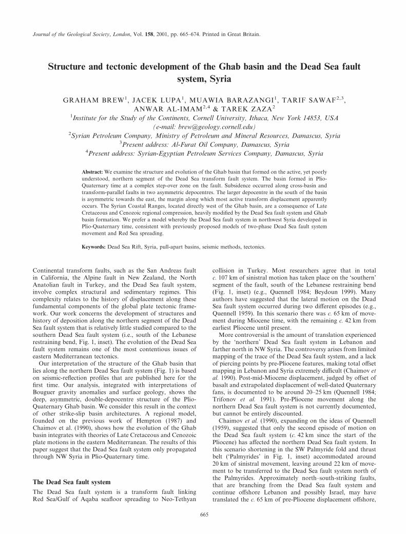
Journal of the Geological Society, London, Vol. 158, 2001, pp. 665–674. Printed in Great Britain.
Structure and tectonic development of the Ghab basin and the Dead Sea faultsystem, Syria
GRAHAM BREW1, JACEK LUPA1, MUAWIA BARAZANGI1, TARIF SAWAF2,3,ANWAR AL-IMAM2,4 & TAREK ZAZA2
1Institute for the Study of the Continents, Cornell University, Ithaca, New York 14853, USA(e-mail: [email protected])
2Syrian Petroleum Company, Ministry of Petroleum and Mineral Resources, Damascus, Syria3Present address: Al-Furat Oil Company, Damascus, Syria
4Present address: Syrian-Egyptian Petroleum Services Company, Damascus, Syria
Abstract: We examine the structure and evolution of the Ghab basin that formed on the active, yet poorlyunderstood, northern segment of the Dead Sea transform fault system. The basin formed in Plio-Quaternary time at a complex step-over zone on the fault. Subsidence occurred along cross-basin andtransform-parallel faults in two asymmetric depocentres. The larger depocentre in the south of the basinis asymmetric towards the east, the margin along which most active transform displacement apparentlyoccurs. The Syrian Coastal Ranges, located directly west of the Ghab basin, are a consequence of LateCretaceous and Cenozoic regional compression, heavily modified by the Dead Sea fault system and Ghabbasin formation. We prefer a model whereby the Dead Sea fault system in northwest Syria developed inPlio-Quaternary time, consistent with previously proposed models of two-phase Dead Sea fault systemmovement and Red Sea spreading.
Keywords: Dead Sea Rift, Syria, pull-apart basins, seismic methods, tectonics.
Continental transform faults, such as the San Andreas faultin California, the Alpine fault in New Zealand, the NorthAnatolian fault in Turkey, and the Dead Sea fault system,involve complex structural and sedimentary regimes. Thiscomplexity relates to the history of displacement along thesefundamental components of the global plate tectonic frame-work. Our work concerns the development of structures andhistory of deposition along the northern segment of the DeadSea fault system that is relatively little studied compared to thesouthern Dead Sea fault system (i.e., south of the Lebaneserestraining bend, Fig. 1, inset). The evolution of the Dead Seafault system remains one of the most contentious issues ofeastern Mediterranean tectonics.
Our interpretation of the structure of the Ghab basin thatlies along the northern Dead Sea fault system (Fig. 1) is basedon seismic-reflection profiles that are published here for thefirst time. Our analysis, integrated with interpretations ofBouguer gravity anomalies and surface geology, shows thedeep, asymmetric, double-depocentre structure of the Plio-Quaternary Ghab basin. We consider this result in the contextof other strike-slip basin architectures. A regional model,founded on the previous work of Hempton (1987) andChaimov et al. (1990), shows how the evolution of the Ghabbasin integrates with theories of Late Cretaceous and Cenozoicplate motions in the eastern Mediterranean. The results of thispaper suggest that the Dead Sea fault system only propagatedthrough NW Syria in Plio-Quaternary time.
The Dead Sea fault systemThe Dead Sea fault system is a transform fault linkingRed Sea/Gulf of Aqaba seafloor spreading to Neo-Tethyan
collision in Turkey. Most researchers agree that in totalc. 107 km of sinistral motion has taken place on the ‘southern’segment of the fault, south of the Lebanese restraining bend(Fig. 1, inset) (e.g., Quennell 1984; Beydoun 1999). Manyauthors have suggested that the lateral motion on the DeadSea fault system occurred during two different episodes (e.g.,Quennell 1959). In this scenario there was c. 65 km of move-ment during Miocene time, with the remaining c. 42 km fromearliest Pliocene until present.
More controversial is the amount of translation experiencedby the ‘northern’ Dead Sea fault system in Lebanon andfarther north in NW Syria. The controversy arises from limitedmapping of the trace of the Dead Sea fault system, and a lackof piercing points by pre-Pliocene features, making total offsetmapping in Lebanon and Syria extremely difficult (Chaimov etal. 1990). Post-mid-Miocene displacement, judged by offset ofbasalt and extrapolated displacement of well-dated Quaternaryfans, is documented to be around 20–25 km (Quennell 1984;Trifonov et al. 1991). Pre-Pliocene movement along thenorthern Dead Sea fault system is not currently documented,but cannot be entirely discounted.
Chaimov et al. (1990), expanding on the ideas of Quennell(1959), suggested that only the second episode of motion onthe Dead Sea fault system (c. 42 km since the start of thePliocene) has affected the northern Dead Sea fault system. Inthis scenario shortening in the SW Palmyride fold and thrustbelt (‘Palmyrides’ in Fig. 1, inset) accommodated around20 km of sinistral movement, leaving around 22 km of move-ment to be transferred to the Dead Sea fault system north ofthe Palmyrides. Approximately north–south-striking faults,that are branching from the Dead Sea fault system andcontinue offshore Lebanon and possibly Israel, may havetranslated the c. 65 km of pre-Pliocene displacement offshore,
665

hence eliminating the requirement of pre-Pliocene slip on thenorthern Dead Sea fault system (Chaimov et al. 1990).
Another scenario suggests that the northern Dead Sea faultsystem has been inactive since the Miocene (Butler et al. 1997).However, given the geomorphological evidence for Pliocene–Recent tectonic activity on the fault, together with seismicity(Ambraseys & Jackson 1998) and GPS measurements(McClusky et al. 2000), this inactive northern fault hypothesisseems highly improbable.
The recent tectonics of the Ghab basin further attests to thecurrent activity along the northern Dead Sea fault system.Ponikarov (1966) considered the Ghab basin to be a Pliocene–Recent feature, and recognized that the basin developed on aleft-step in the Dead Sea fault system. These findings wereechoed in geomorphological studies by Hricko (1988), andDevyatkin et al. (1997). Palaeostress analysis on faults aroundthe Ghab basin by Matar & Mascle (1993) further suggest an
active step-over geometry. Herein we do not present directevidence regarding the history of movement on the northernDead Sea fault system. However, we interpret that the Ghabbasin formed as a pull-apart basin on the Dead Sea faultsystem since earliest Pliocene time. This supports a scenario ofnorthern Dead Sea fault system development in which c. 20–25 km of sinistral displacement has occurred on the northernDead Sea fault system since latest Miocene–earliest Pliocenetime.
Data and interpretation methodologyAmong the data used for our subsurface analysis of the Ghabbasin are around 260 km of 2D migrated seismic-reflectionprofiles (Fig. 1). The seismic sections shown here are in time,rather than depth. Within the basin seismic P-wave velocities
Fig. 1. Shaded relief image of the areaimmediately surrounding the Ghab basinilluminated from the NW. The very lowrelief Ghab basin is at an elevation ofc. 170 m, and the peak of the CoastalRanges is 1562 m. Locations of otherfigures are shown. Seismic-reflectionprofile locations are shown as thin blacklines and well locations are illustratedwith solid circles. (AP is Asharneh Plain,JW is Jebel Wastani, JZ is JebelAz-Zawieh, BT is Balou Trough, MG isMissyf Graben). Location of the mainfigure is shown by heavy box in insetfigure. Inset shows a shaded relief imageof the eastern Mediterranean illustratingthe topography associated with the DeadSea Fault System (DSFS). Surface traceof DSFS is highlighted betweenarrowheads.
666 G. BREW ET AL.

are 2.0�0.2 km s�1 as derived from sonic logs and seismicstacking velocities (Dzhabur 1985). Hence the two-way timescales in Figs 2, 3, and 4 are a close approximation for depthin kilometres for the basin fill. The one deep well within thebasin (Ghab, Fig. 1) was used, together with seismic signaturesand shallow boring in the south of the basin (Devyatkinet al. 1997), to provide stratigraphic control on the seismicinterpretations.
Geological maps and gravity interpretations provideadditional information especially where seismic data werelacking. We modelled the Bouguer gravity data from agrid of eight profiles, two of which are presented here (Figs 2 &4). This modelling accounted for along-strike changes, asnecessary in a narrow basin. Faults were not directly incorpor-ated into the density models because of their insignificant effectrelative to continuous surfaces. The final models give a reason-able fit (<3 mGal difference) between calculated and observedanomalies. During the gravity modelling, density informationcame from field samples (Hricko 1988), borehole density logs,and seismic refraction data (Seber et al. 1993) and sonic logs,with velocities inverted for densities. Depth limits came from
seismic refraction (Seber et al. 1993) and reflection data, andwell data, as presented in this study. These densities werefound to be reasonable according to our knowledge of lith-ologies derived from drilling information. Given these exter-nal controls on densities and depths, this gravity modellingis better determined and less ambiguous than typical gravitystudies.
Ghab basin
GeomorphologyThe surface expression of the Ghab basin is an extensive(roughly 60 km by 15 km), flat plain with almost no topo-graphic relief, thus revealing its recent lacustrine history (Fig.1). In the south, between two strands of the Dead Sea faultsystem, is the Missyf graben (Fig. 1). The eastern fault strandcan be traced northward at the surface along the easternmargin of the Ghab basin before bifurcating to the NNE. Nodefinitive termination of this eastern fault is observed along thebasin margin.
Fig. 2. Cross-section along-strike of the Ghab basin (see Fig. 1 for location) showing a seismic-reflection profile (with and withoutinterpretation), density model and associated gravity anomalies. The dashed box on the density model illustrates the extent of seismic-reflectiondata coverage. Intersections with other seismic reflection profiles are shown as small arrows. Densities shown on model are g cm�3. Quaternarydeposits form the surface layers along the entire length of the transect. Most of the faults shown have components of both normal andstrike-slip fault movement. Deeper structure cannot be constrained with current data.
GHAB BASIN & DEAD SEA FAULT, SYRIA 667

The Syrian Coastal Ranges; which Ponikarov (1966)referred to as Jebel An-Nusseriyeh, rise dramatically byc. 1300 m in just 4 km of distance (Fig. 1), exposing Jurassicand uppermost Triassic strata directly west of the basin. Thissteep flank suggests geologically recent uplift along the westernmargin of the Ghab basin (the origin of the Coastal Ranges isdiscussed below). In contrast to the eastern margin, this edgeof the basin is poorly defined, obscured by significant mass-wasting and large blocks detached from the Coastal Ranges.Faults would be expected along the western margin given atypical fault step-over arrangement for the Ghab basin. How-ever, no surface expression has been detected along thesemargins, except in the far north, probably owing to burial bymass-wasting. Surface observations indicate the Ghab basin fillis Neogene–Quaternary lacustrine and alluvial deposits, finergrained in the basin centre (Devyatkin et al. 1997).
Subsurface analysisIn our seismic interpretations (Figs 2, 3, and 4), tied to theGhab well, the deepest mapped reflector is a relatively thin bedof Mid-Cambrian limestone. The unconformity at the top of
Palaeozoic (generally Upper Ordovician strata) presents aclear reflector where the mainly carbonate–Mesozoic sectionoverlies a largely clastic Palaeozoic section. Middle Triassicanhydrite and dolomite form a sequence of strong reflectors, asdoes Lower Cretaceous sandstone. The uppermost mappedreflector, (other than arbitrarily traced horizons within thebasin fill shown by dashed lines in Figs 2, 3, and 4), is atthe base of basin fill that is Middle Eocene or, in the south ofthe basin, Upper Cretaceous (Devyatkin et al. 1997).
The Ghab well penetrates Middle Eocene limestone imme-diately beneath Pliocene strata. A clear unconformity at thispoint is expressed by abrupt facies change (clay to limestone),palaeontological evidence, and an absence of volcanic detritusthat is found throughout the younger strata. We interpret thisunconformity (at a depth of 350 m in the Ghab well, butdropping sharply to the south and north, Fig. 2) as the base ofbasin fill (Figs 2, 3, 4 and 5). Furthermore, we interpret a verythin layer of volcanic rocks encountered at a depth of 200 mwithin the basin fill in the Ghab well is part of a nearby 1–2 Maold sequence.
The seismic and well data show no evidence of basin strataolder than earliest Pliocene. Shallow borings (<500 m) in themain depocentre have also failed to penetrate rocks older thanPliocene, and find Mesozoic strata immediately below Pliocene(Devyatkin et al. 1997). Furthermore, outcrop studies haveshown marine Pliocene strata at the northern end of thecurrent Ghab basin, but continental strata of the same agenear the south end of the basin (Ponikarov 1966). Thisindicates that the full extent of the Ghab basin topographicdepression was not fully established until at least after theearliest Pliocene. Furthermore, Cenozoic volcanic activityaround the Ghab basin is confined to the Plio-Quaternary(Devyatkin et al. 1997). Taking this evidence in totality, weinterpret that Ghab basin formation commenced aroundearliest Pliocene time.
The basic structure of the Ghab basin is a fault-controlleddouble depocentre. The main depocentre is positioned beneaththe southern portion of the surface plain, and slight northwardmigration of that depocentre with time is clear from the seismicdata (Fig. 2). Also apparent are a mid-basin ridge (on whichthe Ghab well is drilled, marked R in Fig. 6a) and a secondsmaller depocentre to the north.
The relatively undeformed nature of much of the basin fillsuggests that most subsidence has been accommodated along themajor basin-bounding faults. An apparent western boundingfault (speculatively marked A on Fig. 3) when projected to thesurface would be close to the foot of the Coastal Ranges. Abruptsediment thickness changes are very apparent across the easternbounding fault (marked A in Fig. 4). Most of the subsidence isclearly asymmetric in the southern depocentre controlled by themore prominent eastern basin-bounding fault (marked F in Fig.3). This asymmetry is not merely a consequence of the obliquityof the seismic profile in Fig. 3. The asymmetry is also docu-mented in the gravity modelling, and Mesozoic strata encoun-tered by shallow drilling on the western flank (Devyatkin et al.1997) further support this interpretation. Gravity and seismicinterpretations reveal the southern depocentre to be up toc. 3400 m deep in the eastern part of the basin.
In the earlier stages of basin formation, accommodationspace was created by movement on cross-basin faults that arenow internal to the basin, rather than on the flanking faults.This displacement shifted between the faults, with older dis-placement on the more interior (western) faults (marked B–Ein Fig. 3, marked C in Fig. 6a), and most recent motion
Fig. 3. Interpreted migrated seismic profile across the Ghab basin.See Fig. 1 for location. Intersections with other seismic reflectionprofiles are shown as small arrows. Quaternary age deposits are thesurfical strata along the whole line. Most of the faults shown havecomponents of both normal and strike-slip fault movement. Thefault marked F is the main strand of the Dead Sea fault system andthe major eastern bounding fault of the Ghab basin.
668 G. BREW ET AL.
accommodated on the eastern basin-bounding fault (marked Fin Fig. 3).
The geometry of the faults can be appreciated from Figs 5and 6a. Two depocentres are illustrated, the larger in thesouth, and the smaller in the north, both formed against thebasin-bounding faults. Cross-basin faults (C in Fig. 6a) arefound particularly in the south of the basin, predominatelysteeply dipping to the NE (faults B–E on Fig. 3). Thesetransverse features are generally NE–SE striking and suggestsome extension across the basin. The central region is domi-nated by acutely striking cross-basin faults that bound a horstextending across the basin (faults A–C on Fig. 2, featuremarked R in Fig. 6a). A second depocentre in the NW of thebasin (Figs 2 & 5) is somewhat asymmetric toward the westernbounding fault and is up to c. 1700 m deep.
NNE of the Ghab basin, faults splay out significantly andseveral depocentres are present. Our gravity interpretations
and previous work (Hricko 1988) report 500–1000 m of basinfill in what is apparently another strike-slip basin bounded byrecently active left-lateral faults beneath the Balou Trough(Figs 1 & 5).
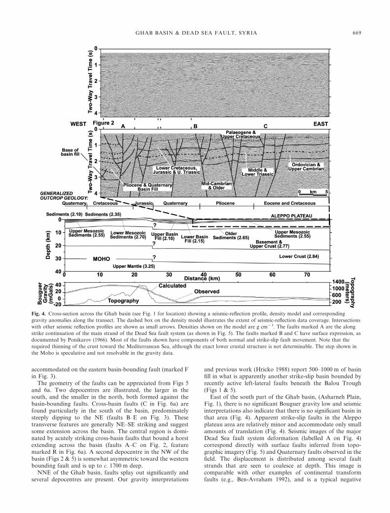
East of the south part of the Ghab basin, (Asharneh Plain,Fig. 1), there is no significant Bouguer gravity low and seismicinterpretations also indicate that there is no significant basin inthat area (Fig. 4). Apparent strike-slip faults in the Aleppoplateau area are relatively minor and accommodate only smallamounts of translation (Fig. 4). Seismic images of the majorDead Sea fault system deformation (labelled A on Fig. 4)correspond directly with surface faults inferred from topo-graphic imagery (Fig. 5) and Quaternary faults observed in thefield. The displacement is distributed among several faultstrands that are seen to coalesce at depth. This image iscomparable with other examples of continental transformfaults (e.g., Ben-Avraham 1992), and is a typical negative
Fig. 4. Cross-section across the Ghab basin (see Fig. 1 for location) showing a seismic-reflection profile, density model and correspondinggravity anomalies along the transect. The dashed box on the density model illustrates the extent of seismic-reflection data coverage. Intersectionswith other seismic reflection profiles are shown as small arrows. Densities shown on the model are g cm�3. The faults marked A are the alongstrike continuation of the main strand of the Dead Sea fault system (as shown in Fig. 5). The faults marked B and C have surface expression, asdocumented by Ponikarov (1966). Most of the faults shown have components of both normal and strike-slip fault movement. Note that therequired thinning of the crust toward the Mediterranean Sea, although the exact lower crustal structure is not determinable. The step shown inthe Moho is speculative and not resolvable in the gravity data.
GHAB BASIN & DEAD SEA FAULT, SYRIA 669

flower structure (tulip) typically shown to be associated withstrike-slip faulting in an extensional setting.
Comparison with other basins and basin modelsAs suggested by Matar & Mascle (1993), the Ghab basin isgenerally representative of a transtensional pull-part basin. Inthis section, we examine some of the second-order features ofthe basin. Asymmetric basins have been documented along theDead Sea fault system (especially in the Gulf of Aqaba), theSan Andreas Fault, the North Anatolian fault, and many othermajor strike-slip faults (Ben-Avraham 1992; Ben-Avraham &Zoback 1992). These asymmetric basins are bound on only oneside by a major linear strike-slip fault, against which mostdeposition generally occurs. The opposite side of the basin isbound by predominantly normal faults; thus, the overall faultgeometry is distinctly different from the classic step-over. Thesense of basin asymmetry commonly changes along strike inthese fault systems as strike-slip displacement transfers fromone en-echelon strike-slip fault to the next. This geometrycould be caused by a reorientation of stresses near a weakfault in an otherwise strong crust, so as to minimize shearstress on the fault, resulting in transform-normal extension(Ben-Avraham & Zoback 1992).
The asymmetry within the Ghab basin closely follows thispattern of deformation, with the southern depocentre asym-metric to the east. This suggests that at the latitude of the
Fig. 5. Perspective view from the NW of the Ghab basin, looking tothe SE. See Fig. 1 for location. The top layer represents thetopography surrounding the Ghab basin. The middle layer is arepresentation of the base of Ghab basin sedimentary fill; theslightly angular appearance is a consequence of the gridding process.The lowermost layer shows Bouguer gravity contours. Contourinterval is 2 mGal, bolder lines every 10 mGal.
Fig. 6. Comparison of the Ghab basin structure with physical andmathematical models, and real examples of strike-slip basins.Throughout the figure, cross-hatched areas indicate majordepocentres and bolder lines indicate faults that are moresignificant. (a) Fault map in the Ghab basin and immediatesurroundings. See Fig. 1 for location. These faults have beenmapped either from surface observations and geomorphology (greylines) (Ponikarov 1966), or from seismic reflection and otherinterpretations (black lines, this study). Letters G, C, T and Rcorrespond to features also observed in (b). (b) Fault map from asandbox model of step-over basin, after Dooley & McClay (1997).(c) Numerical model of a step-over basin from Rodgers (1980).(d) Simplified structure map of the Cariaco basin, Venezuela,from Schubert (1982). (e) Fault map from Dead Sea basin,summarized from several sources (Garfunkel & Ben-Avraham1996).
670 G. BREW ET AL.

Ghab basin most of the lateral movement on the Dead Seafault system is accommodated on the eastern bounding fault ofthe basin. Some displacement steps over to the western bound-ing fault farther to the north, and the smaller northerndepocentre is slightly asymmetric to the west.
Transverse structures, such as those found in the Ghabbasin, are also commonly observed in other strike-slip basins.The Dead Sea basin (Fig. 6e) is bounded by strike-slip faultson which most of the deformation occurs and transversestructures separate smaller sub-basins there (Garfunkel &Ben-Avraham 1996). Another analogue for the Ghab basinis the Cariaco basin, Venezuela (Fig. 6d), where twin depo-centres, asymmetric toward the more active strike-slip andseparated by a central sill have developed at a dextral faultstep-over (Schubert 1982).
Physical (e.g., sandbox/clay) models of pull-apart basins canprovide insight into strike-slip basin evolution by consideringsimplistic end-member cases that are rare in nature. Of themodels Dooley & McClay (1997), the one with resultingdeformation most closely resembling the Ghab basin was acase of an initial 90� releasing sidestep between the twosegments of the strike-slip fault (Fig. 6b). Strong similaritieswith the Ghab basin include: cross-basin faults (C in Fig. 6)that are active particularly in the early stages of basin evol-ution, mid-basin ridge (R in Fig. 6); strongly terraced sidewallsof basin (T in Fig. 6); graben along the principal displacementzone at the basin ends (G in Fig. 6).
Rahe et al. (1998) used unequal motion on the ‘crustal’blocks on opposite sides of the strike-slip fault in their physicalmodels. The results show asymmetric basins, with increasedsubsidence toward the moving boundary. Commonly observedin these models are intrabasin highs, early opening accommo-dated on oblique-slip transverse faults, and switching basinasymmetry along strike (associated with ‘master fault’ step-over). Again, all these features are observed in the Ghab basin.
Theoretical models for the deformation of a basin understrike-slip conditions were made by Rodgers (1980) and Golkeet al. (1994), among others. Rodgers (1980) showed that oncethe total translation along the bounding strike-slip faults isapproximately equal to the separation between the faults, twodistinct depocentres begin to form through normal faulting(Fig. 6c). If considered analogous to the Ghab basin (Fig. 6a),this shows that the northern depocentre in the Ghab developedsometime after the initiation of the southern depocentre owingto increasing displacement on the Dead Sea fault system. Thisexplains the smaller size of the northern depocentre. Golkeet al. (1994) found that two depocentres developed when initialmaster fault overlap is close to zero—the 90� case of Dooley &McClay (1997). They also saw the formation of asymmetricbasins when translation is focused on one of the boundingmaster faults. Golke et al. (1994) also observed basin mi-gration, in the same sense as that in the Ghab, because ofincreasing master fault overlap with time.
In summary, we find that many of the second-order struc-tures within the Ghab basin are common to other strike-slipbasins. The basin asymmetry seen in the Ghab is probablyrelated to the relative amount of offset on the bounding faults.
Syrian Coastal RangesThe topographically prominent Syrian Coastal Ranges,directly west of the Ghab basin (Fig. 1), are clearly related insome way to the evolution of the basin and the Dead Sea faultsystem. Unfortunately, limited by only surface geological
evidence, there is significant uncertainty in our knowledge ofthe uplift history of the Coastal Ranges. Based on stratigraphicrelationships we can document that the uplift occurred in atleast two phases. The first uplift was sub-parallel, and ofsimilar extent, to the current topography (albeit without theimposition of the Ghab basin), and formed in the LatestCretaceous and Palaeocene (Ruske 1981). Middle Eocenelimestone throughout the studied area (including beneaththe Ghab basin) indicates that this initial uplift had largelysubsided by Mid-Eocene time.
There is an absence of any Late Eocene–Miocene strata onor around the Coastal Ranges or beneath the Ghab basin,although these strata are found elsewhere in Syria. Thisstrongly suggests that a second stage of uplift started aroundLate Eocene time, as suggested by Ruske (1981), and mostlikely is still in progress. The cause of these phases of uplift isinterpreted to be regional compression.
Clearly the Coastal Range uplift has been very stronglymodified by the propagation of the Dead Sea fault systemthrough NW Syria, and the related formation of the Ghabbasin. The Plio-Quaternary Ghab basin formed near what waspresumably the crest of the pre-Pliocene Coastal Range uplift.This created the extremely steep scarp on the eastern face ofthe Coastal Ranges alongside the Ghab basin. Furthermore,the presence of the Dead Sea fault system has caused asym-metry in the uplift (Fig. 1). The Coastal Ranges are topo-graphically and structurally significantly higher directly to thewest of the present Dead Sea fault system (Fig. 7). Thus theCoastal Ranges take on the appearance of an uplifted horst,bounded, particularly to the east, by normal faults. Plio-Quaternary uplift may, in part, be due to rotation of theCoastal Ranges as the hanging wall of a major fault block. Inthis scenario, normal faults would be controlling the westernmargin of the present Ghab basin (Fig. 7), as suggested in theprevious section to explain the asymmetry of the Ghab depo-centre. Brew (2001) presents further hypotheses and associatedmathematical modelling regarding possible causes of theSyrian Coastal Range uplift.
Fig. 7. Highly schematic, vertically exaggerated, three-dimensionalrepresentation of the Ghab basin. Large arrows show approximaterelative movements; the Coastal Ranges block is depicted uplifting,possibly through rotation, while translating southwards.
GHAB BASIN & DEAD SEA FAULT, SYRIA 671

Evolution of NW Syria
Late CretaceousThe well-documented Maastrichtian initial uplift of the SyrianCoastal Ranges is coincident with contemporaneous eventsdocumented throughout NW Arabia (Fig. 8a). Most notablythis time was the first episode in the formation of the ‘SyrianArc’. The Syrian Arc is the swath of folds and structurallyinverted faults observed along the Sinai and Levant coasts,sub-parallel to the present shoreline (Fig. 8a). In the originaldefinition (Krenkel 1924) the Arc extended northward towardsTurkey, although more recent authors have also included thePalmyride folds in the definition. The formation of the SyrianArc is dated as a Maastrichtian phenomenon (Guiraud &Bosworth 1997), although some subtle precursory compressionbegan earlier in the Late Cretaceous (Bartov et al. 1980;Walley 1998). Chaimov et al. (1992) considered the initialfolding, uplift, and structural inversion in the southwestPalmyride fold and thrust belt to be part of the Syrian Arc anddocumented this compression as latest Cretaceous. On a moreregional scale, the cessation of extensional tectonics in theSinjar and Euphrates areas of eastern Syria is well establishedas a Maastrichtian phenomenon (Brew 2001).
The Maastrichtian was the time of ophiolite emplacementalong the northern Arabian margin, particularly in the Baer-
Bassit and Kurd Dagh areas proximal to the present Ghabbasin (Robertson et al. 1991). This emplacement occurred asthe northern Arabian margin collided with an intra-oceansubduction zone. These collisions can explain the observationsof Maastrichtian age compression throughout the northernArabian platform. Thus, the initial Maastrichtian time upliftof the Coastal Ranges fits well with the previously documentedregional plate tectonics. Hence, we interpret the Syrian CoastalRanges to be part of the Syrian Arc folding, as originallysuggested by Walley (1998).
PalaeogeneThe uplift that affected the Coastal Ranges in the latestCretaceous continued into the Palaeogene but was subduedduring the Eocene. Middle Eocene marine deposits weredeposited throughout the studied area, with the possibleexception of the crest of the Coastal Range uplift that mayhave remained emerged. As discussed above, the secondepisode of Coastal Range uplift was post-Mid-Eocene. Thiscorresponds with the second episode of Syrian Arc develop-ment (Guiraud & Bosworth 1997). The Mid-Eocene was also atime of uplift of the Palmyrides (Chaimov et al. 1992) (Fig. 8b),and some minor structural inversion in NE Syria (Brew 2001),resulting in reverse movement on previous normal faults.
Fig. 8. Maps showing schematic structural evolution of the Dead Sea fault system and Ghab basin in a regional setting. Modern-day geographyshown for reference. Bold lines indicate approximate palaeo-plate boundaries, and large arrows indicate approximate motion of Arabia relativeto Africa. No attempt is made to illustrate all tectonic events on this map. (EAF is East Anatolian Fault).
672 G. BREW ET AL.
Furthermore, through stratigraphic relationships Dubertret(1975) documented how most of the uplift of the Lebanesemountains occurred during the Late Eocene and Oligocene, aview supported by the more recent work of Walley (1998).
These periods of renewed compression within the northernArabian platform are clearly related to the Mid–Late Eocenefinal collision of Eurasia and Arabia along the northernArabian margin (Hempton 1985). This final obliteration ofNeo-Tethys oceanic crust led to the Bitlis suture that stillmarks the boundary of these plates (Fig. 8b). From Mid–LateEocene time until the Mid-Miocene, convergence between theEurasian and Arabian plates was accommodated by continen-tal margin shortening and thickening along this northernmargin (Hempton 1987). Hence, the Syrian Coastal Rangesare again shown to be part of the larger Syrian Arc foldingcoincident with the regional tectonic development.
MioceneThe first phase of rifting in the Red Sea area saw continentalstretching there that probably started in the Oligocene(Hempton 1987). From Early Miocene time onwards thedifferential motion between northward moving Africa andArabia began to be accommodated along the newly formedDead Sea fault system (Fig. 8b, c). Thus c. 64 km of sinistralmotion occurred on the southern Dead Sea fault system duringthis first phase of movement in Early and Mid-Miocene time(Fig. 8c). Whether this motion was also transmitted to thenorthern Dead Sea fault system is unclear. Lacking evidencefor this pre-Pliocene northern Dead Sea fault system motionwe favour a model in which the Miocene motion was trans-lated offshore in southern Lebanon and south of Lebanon.This was first suggested by Chaimov et al. (1990) and requiresthat the northern Dead Sea fault system only formed in thePliocene.
In his regional model, Hempton (1987) argues that byMid-Miocene time the northern margin of Arabia had reachedfull crustal thickness after shortening and thickening in theEurasia–Arabia collision. Hempton (1987) suggests that thiswas therefore the terminal suturing of Eurasia–Arabia, afterwhich Arabia was unable to converge significantly any furtheron Eurasia, and so spreading in the Red Sea halted. In turn,this led to a cessation of movement along the Dead Sea faultsystem (Fig. 8d). Thus, in the model of Hempton (1987), thefirst phase of motion on the Dead Sea fault system came to aclose during the Mid-Miocene and the Dead Sea fault systemwas inactive from around 14.5 Ma until about 4.5 Ma. Otherauthors suggest a more continuous opening of the Red Sea.For example, Steckler & ten Brink (1986) show continuousmotion of the Dead Sea fault system from around Early–Mid-Miocene time onwards, with a slight reorientation andacceleration in Plio-Quaternary time. We favour Hempton’smodel because it synthesizes many observations of episodictectonics and quiescence from deformed zones around theArabian plate. Interestingly, the time of no fault movement inHempton’s model also approximately corresponds to a periodof no volcanic activity in Syria (Mouty et al. 1992).
Pliocene–RecentHempton (1987) goes on to argue that activity on the DeadSea fault system commenced again in the Early Pliocene(c. 4.5 Ma) after the re-commencement of Red Sea seafloor
spreading. This occurred as the northward Arabia motion wasaccommodated by the escape of Anatolia along the newlyformed North and East Anatolian faults (Fig. 8e). In accord-ance with this model, we suggest that with the renewed activityand reoriented stress regime, the Dead Sea fault system formedits current path though Syria beginning in Early Pliocene time(Fig. 8e). Besides the Pliocene formation of the Ghab basin,further evidence for Pliocene propagation of the northernDead Sea fault system comes from offsets in Pliocene basaltand Quaternary fans (Trifonov et al. 1991) together with GPScurrent motion vectors. Preliminary GPS measurements sug-gest c. 6 mm a�1 of relative Africa/Arabia motion in thenorthern Arabian platform (McClusky et al. 2000), in agree-ment with field studies (Trifonov et al. 1991). If this motion hasbeen roughly constant, it indicates c. 27 km of movement inthe last 4.5 Ma, roughly equivalent to previously suggestedtotals (Quennell 1984; Trifonov et al. 1991). Furthermore, thefocus of volcanic activity in western Syria shifted from theAleppo plateau to a point along the northern Dead Sea faultsystem (Fig. 8e) around 5 Ma (Mouty et al., 1992). In thismodel, the well-established c. 42 km of post-Miocene Dead Seafault system motion is accommodated by about 22 km move-ment along the northern Dead Sea fault system, and about20 km shortening in the Palmyrides (Chaimov et al. 1990)(Fig. 8e).
We suggest that after the northern propagation of the DeadSea fault system, the Ghab basin formed as a pull-apart basinowing to the complex splaying left step-over in the sinistralfault system. Despite significant relief to the west, surface andsubsurface data show that the eastern basin-bounding fault ismore active, and this fault is continuous north of the basin asreadily seen in topography and seismicity data. This suggestsan incomplete transfer of lateral motion from the eastern tothe western strands of the Dead Sea fault system across theGhab basin. Thus, north of the Ghab basin the Dead Sea faultsystem splays out into a broad zone of deformation withlateral motion distributed amongst several branching faults.
We suggest that during the Pliocene–Recent time the Ghabbasin and the northern Dead Sea fault system were superposedon the pre-Pliocene Syrian Coastal Ranges topography. Thisfaulting along the crest of the Coastal Ranges has created thevery steep eastern flank of the uplift through normal faulting,and perhaps some rotation of the Coastal Ranges west of theDead Sea fault system.
ConclusionsGeomorphology, stratigraphic relationships, and seismicityclearly demonstrate the active deformation of the northern,Syrian segment of the Dead Sea fault system. Sinistral move-ment at a left-step and splaying of the fault has resulted in theGhab basin that we interpret to have formed since EarlyPliocene time. Cross-basin oblique-slip faults accommodatedsome initial basin opening, but most subsidence has occurredalong the better-defined and apparently more active easternbasin-bounding fault. This has accommodated basin fillthicker (asymmetric) to the east. A northward-shifting depo-centre, and the subsequent development of a second depo-centre in the Ghab basin, are due to increasing fault overlapwith time. These features are commonly observed in otherstrike-slip basins and models. The basin exhibits two asymmet-ric depocentres with geometry suggestive of some transform-normal extension. The timing of Ghab basin formation
GHAB BASIN & DEAD SEA FAULT, SYRIA 673

supports a model in which the current northern strand of theDead Sea fault system (in Lebanon and Syria) has only beenactive since the latest Miocene/earliest Pliocene to Recent.
Uplift of the Syrian Coastal Ranges is probably related tothe Syrian Arc and has been episodic since latest Cretaceoustime. The first episode of uplift, in the Maastrichtian, wasclearly related to plate-wide compression and folding causedby collision along the northern margin of the Arabian plate.Mid–Late Eocene uplift was again contemporaneous withregionally observed folding due to final continent–continentcollision along the northern Arabian margin. This uplift isongoing, and has been strongly influenced by the formation ofthe Dead Sea fault system, along which basin formation andsubsidence to the east was counterbalanced by uplift and tiltingof the Coastal Ranges to the west.
Our thanks go to the Syrian Petroleum Company (SPC) for thegenerous provision of most of the data used in this study. CornellUniversity, Department of Geological Sciences, acknowledges supportof this project by Landmark Graphics Corporation via the LandmarkUniversity Grant program. Arco and Conoco provided partialfinancial assistance to Cornell University. The authors acknowledgethe constructive comments of K. Al-Maleh of Damascus University,M. Meghraoui of IPG Strasbourg, and our Cornell colleagues S.Gallow, F. Gomez, T. Jordan, E. Sandvol and especially D. Seber. Wealso thank M. Miller, Y. Dilek and U. ten Brink for constructivereviews.
ReferencesA, N.N. & J, J. A. 1998. Faulting associated with historical and
recent earthquakes in the Eastern Mediterranean region. GeophysicalJournal International, 133, 390–406.
B, Y., L, Z., S, G. & Z, I. 1980. Mesozoic and TertiaryStratigraphy, Paleogeography and Structural History of the Gebel Areif enNaqa Area, Eastern Sinai. Israel Journal of Earth Sciences, 29, 114–139.
B-A, Z. 1992. Development of asymmetric basins along continentaltransform faults. Tectonophysics, 215, 209–220.
B-A, Z. & Z, M.D. 1992. Transform-normal extension andasymmetric basins: An alternative to pull-apart models. Geology, 20,423–426.
B, Z. 1999. Evolution and development of the Levant (Dead SeaRift) Transform System: a historical-chronological review of a structuralcontroversy. In: MN, C. & R, P.D. (eds) ContinentalTectonics. Geological Society, London. Special Publications, 164, 239–255.
B, G. 2001. Tectonic evolution of Syria interpreted from integrated geo-physical and geological analysis. PhD Thesis. Cornell University, Ithaca,NY.
B, R.W.H., S, S. & G, H.M. 1997. Transcurrent faultactivity on the Dead Sea Transform in Lebanon and its implications forplate tectonics and seismic hazard. Journal of the Geological Society,London, 154, 757–760.
C, T., B, M., A-S, D., S, T. & G, A. 1990.Crustal shortening in the Palmyride fold belt, Syria, and implications formovement along the Dead Sea fault system. Tectonics, 9, 1369–1386.
C, T., B, M., A-S, D., S, T. & G, A. 1992.Mesozoic and Cenozoic deformation inferred from seismic stratigraphyin the southwestern intracontinental Palmyride fold-thrust belt, Syria.Geological Society of America Bulletin, 104, 704–715.
D, E.V., D, A.E., S, E.V., Z, V.S., S,A.N., K, K. & N, H. 1997. The El-Ghab Rift Depression in Syria:Its Structure, Stratigraphy, and History of Development. Stratigraphy andGeological Correlation, 5, 362–374.
D, T. & MC, K. 1997. Analog modelling of pull-apart basins.American Association of Petroleum Geologists Bulletin, 81, 1804–1826.
D, L. 1975. Introduction a la Carte Geologique a 1:50 000 du Liban.Notes Memoire Moyen-Orient, 13, 345–403.
D, I. 1985. Seismological description of Latakia region of Syriaaccording to borehole and surface observations. Vestnik MoskovskogoUniversiteta Geologiya, 40, 90–93.
G, Z. & B-A, Z. 1996. The Structure of the Dead Sea basin.Tectonophysics, 266, 155–176.
G, M., C, S. & F, K. 1994. Finite-element modelling ofpull-apart basin formation. Tectonophysics, 240, 45–57.
G, R. & B, W. 1997. Senonian basin inversion and rejuvenationof rifting in Africa and Arabia: synthesis and implications to plate-scaletectonics. Tectonophysics, 282, 39–82.
H, M. 1985. Structure and deformation of the Bitlis suture near LakeHazar, southeastern Turkey. Geological Society of America Bulletin, 96,233–243.
H, M. 1987. Constraints on Arabian plate motion and extensionalhistory of the Red Sea. Tectonics, 6, 687–705.
H, J. 1988. Geophysical Exploration in Selected Areas of Syrian ArabRepublic, Stage Report on Survey in Jisr al Shoghour Area, Unpublishedinternal report. Strojexport Praha – Geofyzika Brno, Czechoslovakia,Damascus/Brno.
K, E. 1924. Der Syrische Bogen. Zentralblatt fuer Mineralogie, Geologieund Palaeontologie, 9, 274–281.
M, A. & M, G. 1993. Cinematique de la Faille du Levant au Nord dela Syrie: Analyse Microtectonique du Fosse d’Alghab. Geodinamica Acta, 6,153–160.
MC, S. & B, S. . 2000. GPS constraints on platekinematics and dynamics in the eastern Mediterranean and Caucasus.Journal of Geophysical Research, 105, 5695–5719.
M, M., D, M., F, D., P, O. & W, J. 1992. Thevolcanic activity in Syria and Lebanon between Jurassic and Actual.Schweizerische Mineralogische und Petrographische Mitteilungen, 72,91–105.
P, V.P. 1966. The Geology of Syria. Explanatory Notes on the Geologi-cal Map of Syria, Scale 1:200 000. Ministry of Industry, Damascus, SyrianArab Republic.
Q, A.M. 1959. Tectonics of the Dead Sea Rift Proceedings of the 20thInternational Geological Congress, Mexico, 385–403.
Q, A.M. 1984. The Western Arabia rift system. In: D, J.E.& R, A.H.F. (eds) The Geological Evolution of the EasternMediterranean. Geological Society, London. Special Publications, 17,775–788.
R, B., F, D.A. & M, A.P. 1998. Physical analog modeling ofpull-apart basin evolution. Tectonophysics, 285, 21–40.
R, A.H.F., C, P.D., D, P.J. & J, G. 1991. Palaeo-geographic and palaeotectonic evolution of the Eastern MediterraneanNeotethys. Palaeogeography, Palaeoclimatology, Palaeoecology, 87, 289–343.
R, D.A. 1980. Analysis of pull-apart basin development produced by enechelon strike-slip faults. In: B, P.F. & R, H.G. (eds)Sedimentation in Oblique-slip Mobile Zones. International Society ofSedimentologists Special Publications, 4, 27–41.
R, R. 1981. Geologie des syrischen Kustengebirges. VEG Deutscher Verlagfur Grundstoffindustrie, Leipzig.
S, C. 1982. Origin of Cariaco basin, South Caribbean Sea. MarineGeology, 47, 345–360.
S, D., B, M., C, T., A-S, D., S, T. &K, M. 1993. Upper crustal velocity structure and basementmorphology beneath the intracontinental Palmyride fold-thrust belt andnorth Arabian platform in Syria. Geophysical Journal International, 113,752–766.
S, M. & B, U. 1986. Lithospheric strength variations as acontrol on new plate boundaries: examples from the northern Red Sea.Earth and Planetary Science Letters, 79, 120–132.
T, V.G., T, V.M., A, Z., D, S., E-K,Y. & A, K. 1991. Levant fault zone in northwest Syria. Geotectonics, 25,145–154.
W, C. 1998. Some outstanding issues in the geology of Lebanon andtheir importance in the tectonic evolution of the Levantine region.Tectonophysics, 298, 37–62.
Received 27 November 2000; revised typescript accepted 20 February 2001.Scientific editing by Alex Maltman.
674 G. BREW ET AL.