Embed Size (px)
Citation preview

Stratigraphy of Pennsylvanian
and Lower Permian Rocks
in Brown and Coleman
Counties, Texas
GEOLOGICAL SURVEY PROFESSIONAL PAPER 315-D
Prepared in cooperation with the
Bureau of Economic Geolovy
The University of Texas

Stratigraphy of Pennsylvanian
and Lower Permian Rocks
in Brown and Coleman
Counties, TexasBy D. HOYE EARGLE
PENNSYLVANIAN AND LOWER PERMIAN ROCKS OF PARTS OF WEST AND CENTRAL TEXAS
GEOLOGICAL SURVEY PROFESSIONAL PAPER 315-D
Prepared in cooperation with the
Bureau of Economic Geology
The University of Texas
UNITED STATES GOVERNMENT PRINTING OFFICE, WASHINGTON : 1960

UNITED STATES DEPARTMENT OF THE INTERIOR
FRED A. SEATON, Secretary
GEOLOGICAL SURVEY
Thomas B. Nolan, Director
For sale by the Superintendent of Documents, U.S. Government Printing OfficeWashington 25, D.C.

CONTENTS
Page Abstract_________________________________________ 55Introduction.______________________________________ 55General relations and nomenclature of stratigraphic units. 57 Pennsylvanian system_______________._______________ 58
Strawn group_______________________________ 58Tipper part of the Strawn group ______________ 60
Ricker Station limestone of Cheney (1949) _ 60 Ricker sandstone member of Nickell (1938) _ 61 Shale between the Ricker sandstone mem
ber of Nickell (1938) and the Capps limestone lentil of Plummer and Moore (1921)._____________________ 61
Capps limestone lentil of Plummer andMoore (1921)_________________ 62
Canyon group____________________ 62Graford formation....________________ 63
Brown wood shale member___ _______ _ 63Adams Branch limestone member_________ 64Cedarton shale member________________ 65
Winchell limestone_________________ 65Lower unnamed member_____________ 65Tipper unnamed member_____________ 65
Brad formation____________________ 66Placid shale member..-_______________ 66Ranger limestone member___________ 66
Caddo Creek formation___________________ 67Colony Creek shale member..-___________ 67Home Creek limestone member.__________ 67
Pennsylvanian system ContinuedCisco group_________ _ --__ __ _ 68
Graham formation.. _______________ 68Bluff Creek shale member 69 Gunsight limestone member. ___. 70 Wayland shale member__ ___ _ 70 Ivan limestone member _ _________ 71Shale overlying the Ivan limestone member- 71
Thrifty formation__ _ 71 Speck Mountain limestone member__... 72 Shale overlying the Speck Mountain lime
stone member_ _________ _ ____ 72Breckenridge limestone member ________ _ 72Clay overlying the Breckenridge limestonemember 73
Parks Mountain sandstone member. 74Chaffin limestone member__ ____ 74
Permian system__________ _ ___________ 74Wichita group__ 74
Pueblo formation. 75 Waldrip shale member_ ______ 75 Saddle Creek limestone member and over
lying rocks_ ________ 76 References. ________ ___ __________ 76
ILLUSTRATIONS
[Plates 25-27 are in pocket]
PLATE 25. Map showing locations of stratigraphic sections in Brown, Coleman, McCulloch Counties, Tex.26. Stratigraphic sections of Pennsylvanian and lower Permian rocks in Brown, Coleman, and McCulloch Counties, Tex.27. Classifications of Pennsylvanian and lower Permian rocks in Brown and Coleman Counties, Tex. PPTO28. Rocks of the Strawn group__________ ______ _____ 6629. Rocks of the Canyon group________-__._________________________ _ ____ _______ ______ 6630. Rocks of the Cisco group-------.--..-.__________________ 66
FIGUBB 11. Index map of Texas showing location of area described in this report_________ _ ___________ 5612. Map showing generalized geology of central Texas.________________ ___ ___ _. ___________ 57
TABLE
TABLE 1. Nomenclature of rocks of Late Pennsylvanian and early Permian ages in Brown and Coleman Counties, Tex__ 58xn


PENNSYLVANIAN AND LOWER PERMIAN ROCKS OF PARTS OF WEST AND CENTRAL TEXAS
STRATIGRAPHY OF PENNSYLVANIAN AND LOWER PERMIAN ROCKS IN BROWN ANDCOLEMAN COUNTIES, TEX.
By D. HOYE EAEGLB
ABSTRACT
Bocks of Pennsylvanian and early Permian age crop out in a roughly triangular area in the Colorado River valley in central Texas, immediately north of the Llano Uplift. The apex of this triangular area is about 70 miles northwest of Austin; its base trends north-northeastward from an overlap of Lower Cre taceous rocks near Brady to another overlap of Lower Cretace ous rocks that lies along the divide between the Colorado and Brazos River valleys. Brownwood and Coleman are the two largest cities in or near this area.
Only outcropping rocks of Middle Pennsylvanian to early Permian age are considered in this study. The Pennsylvanian rocks belong to three groups Strawn, Canyon, and Cisco. The Permian rocks belong to the lower part of the Wichita group. The beds dip gently west-northwestward about 50 to 80 feet to the mile. Of these rocks, only those of the lower part of the Strawn group are appreciably disturbed by folding or faulting in the Colorado River valley. The limestone beds generally occupy the tops of cuestas whose back slopes are dip slopes slightly truncated by erosion. The shale and thin sandstone beds are less resistant to erosion than the limestone and occupy the frontal slopes of the cuestas and the valley bottoms. Thick beds of standstone or conglomerate also locally form cuestas.
Rocks of the Strawn group in Brown and Coleman Counties are probably the equivalents of thicker deposits to the north east, east, and southeast in the Fort Worth basin and the Ouachita geosyncline. Although a few beds are limestone con taining marine fossils, most of the beds are nonmarine shale and sandstone. The Strawn group has not been divided into formations on the outcrop in the Colorado River valley as it has been in the Brazos River valley to the northeast; nor can equivalent beds be traced, with the exception of the Capps limestone lentil of Plummer and Moore (1921), from one valley to another. The Strawn is accordingly considered in this pa per as one mappable unit.
The Strawn becomes thinner from Central Brown County, where it is reported to be 1,100 feet thick in wells, to 500 feet in northcentral Coleman County; and from 1,235 feet in north ern Brown County to about 250 feet in southwestern Brown County and southeastern Coleman County.
Rocks of the Canyon group are about 600 feet thick in the Colorado River valley. They consist chiefly of thick beds of limestone that form the most prominent cuestas of the region, and of intervening beds of shale and sandstone that generally occupy the frontal slopes of the cuestas and the valley bottoms. The Canyon group has been divided into four formations: from
bottom to top, the Graford, the Winchell, the Brad, and the Caddo Creek.
The Cisco group, about 400 feet thick, consists chiefly of shale containing channel-fill deposits of chert conglomerate and sandstone, and thin beds of limestone. It has been divided into the Graham and Thrifty formations.
The Wichita group consists chiefly of formations composed of a shale unit underlying a prominent, but generally thin, lime stone unit. Deeply cut channels filled with sandstone and con glomerate are present in the lower formations of the group, the Pueblo and Moran formations. The stratigraphy of only the lower part of the Pueblo formation is discussed.
INTRODUCTION
This report presents correlations of the exposed rocks of Late Pennsylvanian and early Permian age across a triangular area in central Texas that extends from the Colorado Eiver northeast to the Callahan Divide in Callahan and Eastland Counties (figs. 11 and 12). The Callahan Divide, which separates the drainage basins of the Brazos and Colorado Eivers, is capped with Lower Cretaceous rocks. This belt of Cretaceous rocks interrupts the continuity of oiitcrop of the underlying Pennsylvanian and lower Permian rocks, thereby making definite correlation of beds be tween central and north-central Texas difficult. TS purpose of this report is to present detailed informa tion on stratigraphic units south of the Callahan I : - vide as an aid in resolving some of the differences in nomenclature and in establishing correlations with equivalent rocks north of the Callahan Divide and in the subsurface to the west.
Differences in the usage of names of rock units in these areas have arisen because the formations were first named and described in the Brazos River valley, whereas most of the members of these formations were named and described as beds by Drake (1893) in the Colorado River valley. Inaccuracy in correlating some of Drake's beds with stratigraphic units in the Brazos River valley has brought about confusion and changes
55 :

56 PENNSYLVANIAN AND LOWER PERMIAN ROCKS OF WEST AND CENTRAL TEXAS
103' 101
COUNTIES REFERRED TO IN TEXT
1. Young2. Stephens3. Palo Pinto4. Jack5. Callahan6. Eastland
7. Coleman8. Brown9. Mills
10. McCulloch11. San Saba12. Lampasas
-34'
990 97°
FIOUBE 11. Index map of Texas showing location of area described in this report
in groupings in both, areas. In addition, miscorrela- tion of some surface units with, the subsurface has re sulted in further confusion. In the present study the relations of the various units were determined by care fully measuring and tracing stratigraphic units in the field, and by examining the lithologic characteristics and f aunal content of all the beds.
Stratigraphic data presented in this report were ac cumulated by detailed geologic mapping in the Colo rado Kiver valley during the years 1950-54. The au thor gratefully acknowledges the important contribu tions by other geologists to this study. D. A. Myers and K. A. Yenne, of the U.S. Geological Survey, stud ied the fusulinids and other fossils, and assisted in
measuring stratigraphic sections; P. T. Stafford and K. T. Terriere, also of the U.S. Geological Survey, meas ured most of the sections north of Jim Ned Creek in northwestern Brown County, and Terriere measured several sections in southeastern Coleman County. W. A. Jenkins, Jr., then a graduate student at TliQ. Univer sity of Texas, generously contributed sectiors 11 and 18 (pis. 25 and 26), though his nomenclature of the beds has been slightly altered to conform to that pro posed herein. The author acknowledges the benefit of collaboration with the late Monroe G. Cheney in work ing out the stratigraphy of the area. The project was carried on with the cooperation of the Bureau of Eco nomic Geology, The University of Texas.

PENNSYLVANIAN AND LOWER PERMIAN ROCKS, BROWN AND COLEMAN COUNTIES
101° 99 C
57
"' '-V.V.V^ ^.V-V-y-tV^y' <Vj A NK"ni\/mp ^-' ', 'CALL AH ANf DIVIDE,- ' " AXT
^ -~-.-.-.-. (ALLAHAN I EASTLAND^/
S^Area covered by .location map
X-XvX-X-Xl 8BOWN
EXPLANATION
Rocks of Mesozoic age Pennsylvaman rocks
Permian rocks Pre-Pennsylvaman rocks
FIGURE 12. Map showing generalized geology of central Texas.
GENERAL RELATIONS AND NOMENCLATURE OF STRATIGRAPHIC UNITS
Stratigraphic units of Pennsylvania]! and early Per mian age which crop out in Brown and Coleman Coun ties between the Colorado River and the Callahan Di vide belong to the Strawn, Canyon, and Cisco groups of the Pennsylvaman system and to the Wichita group of the Permian system. The names, lithologic char acteristics, thicknesses, and correlations of the forma tions and members in each of these groups, together with the distribution of fusulinids and ammonoids in these sections, are shown on the chart of measured sec tions (pi. 26). Table 1 summarizes the nomenclature of the rocks as recognized in this paper.
The Strawn group in the area considered in this re port represents only the upper part of this group else where; it has a prominent ridge-forming limestone at the top but consists chiefly of shale and lenticular bed" of sandstone with some conglomerate. The Canyon group consists of ridge-forming beds of limestone sej - arated by less-resistant beds of shale and of sandstone that is locally conglomeratic. The Cisco group consists of thin beds of limestone, relatively thick beds of shale, and some lenticular beds of sandstone and other chan nel-fill sedimentary deposits. The Wichita group cor- sists of sandstone, shale, and limestone, and in th^ lower part contains sequences of gray and red shale/, sandstone, and coal.

58 PENNSYLVANIAN AND LOWER PERMIAN ROCKS OF WEST AND CENTRAL TEXAS
TABLE 1. Nomenclature of rocks of Pennsylvanian and Permian ages in Brown and Coleman Counties, Tex,
System
Permian
Pennsylvanian
Group
Wichita (in part)
Cisco
Canyon
Strawn
Stratigraphic unit
Pueblo formation (lower part)
Thrifty formation
Graham formation
Caddo Creek formation
Brad formation
Winchell limestone
Graford formation
Undifferentiated
Saddle Creek limestone member. Waldrip shale member.
Chaffin limestone member. Parks Mountain sandstone member. Breckenridge limestone member. Speck Mountain limestone membe".
Ivan limestone member. Wayland shale member. Gunsight limestone member. Bluff Creek shale member.
Home Creek limestone member. Colony Creek shale member.
Ranger limestone member. Placid shale member.
Upper unnamed limestone member. Lower unnamed limestone member.
Cedarton shale member. Adams Branch limestone member. Brown wood shale member.
Capps limestone lentil of Plummer and Moore (1921).
Ricker sandstone member of Nickell (1938).
Ricker Station limestone of Cheney (1949).
The nomenclature of the principal stratigraphic units in the area was set up in connection with early studies by geologists interested chiefly in the coal de posits. The large divisions were named and described by Tarr (1890), Bumble (1890), and Cummins (1891) (pi. 27); whereas most of the beds (later termed mem bers) were first named and described by N. F. Drake (1893). Formational names were added by Plummer and Moore (1921), chiefly from localities in the Brazos River valley. The nomenclature was summarized and partly revised by Sellards (1933). Cheney (1929, 1940, 1945, 1948, 1949, and 1950) and Cheney and Eargle (195la) cleared up past miscorrelations and revised the nomenclature to accord with time-rock units. Studies of individual areas have been made by Bullard and Cuyler (1935), Lee, Nickell, Williams, and Henbest (1938), Moore (1949), and Jenkins (1952, unpublished doctoral dissertation, University of Texas), Terriere (1960), and Stafford (1960).
PENNSYLVANIAN SYSTEM
STRAWN" GROUP
The standstone and shale beds that constitute the Strawn group in the Colorado River valley were first called the Richland sandstone division by Tarr (1890, p. 204). These and correlative beds in the Brazos River valley were called the Richland-Gordon sand stones by Bumble (1890, pi. 3). Later Drake (1893, p. 16), separated these rocks into 20 units of alternating sandstone and shale beds. He gave local names to these units, or "beds" as he termed them, and numbered those of the Strawn group, from bottom to top, 4 to 23. (See pi, 27.) Only Drake's name for the upper unit, the Ricker, is in common use today, but that name has been restricted to the prominent standalone at the base of Drake's Ricker bed. Drake referred these units to the Strawn division of Cummins (1891, p. 16), which he considered to include all rocks above th^ limestone

PENNSYLVANIAN AND LOWER PERMIAN ROCKS, BROWN AND COLEMAN COUNTIES 59
and black shale of the Bend division, and below his Coral limestone bed, the Capps limestone of later au thors.
Plummer and Moore (1921, table 2, and p. 61-68) considered the Strawn in the Colorado River valley to be equivalent to their Mineral Wells and Millsap for mations of the Brazos River valley section, but be lieved that accurate correlations of individual layers in one valley with those of the other were impossible. They limited the Strawn group to the rocks that over lie the Smithwick shale of the Bend group and under lie the Rochelle conglomerate. This placed Drake's Coral limestone bed, which Plummer and Moore re named the Capps limestone lentil, in the Canyon group. The Capps was thought to overlie the Rochelle con glomerate, and was regarded as a part of the Brown- wood shale member of the Graford formation. Sellards (1933, p. 109) did not follow this classification, but transferred the Capps back to the Strawn group, and considered it the upper member of the Mineral Wells formation. Mckell (1938, pi. 8) assigned not only the Capps but also about 100 feet of the overlying shale (the Brownwood bed of Drake and the Brownwood shale of Plummer and Moore) to the Strawn group. Cheney (1940, p. 66), Cheney and Eargle (1951a, p. 55), and Plummer (1950, p. 88), however, affirmed the placing of the Capps limestone in the Strawn group on the basis of the presence of Fusulina sp. and the bra- chiopod Mesolobus sp. in the beds, and considered its top as the top of the Strawn group.
Cheney's work in 1940 changed much of the nomen clature and the rank of the units of this region. He considered the Pennsylvanian to be of systemic rank and divided it into five series called, from oldest to youngest, the Morrow, Lampasas, Strawn, Canyon, and Cisco; the Permian he divided into the Wolf camp and Leonard series and the post-Leonard Whitehorse group. In his Lampasas series Cheney (1940, fig. 1) included the lower part of the Strawn and the upper part of the Bend of earlier authors. His Strawn series he divided (Cheney, 1940, p. 88) into the Millsap Lake group, below, and the Lone Camp group, above.
Cheney (1940) believed that an important discon- formity existed at the boundary between the Strawn and the Canyon and that separate formational names should be given the rocks of those ages. Accordingly, he advocated the abandonment of the name Mineral Wells because that formation in the Brazos River valley includes rocks of both Strawn and Canyon ages. He assigned the beds of Strawn age in the old Mineral Wells formation to his Lone Camp group and those of Canyon age to his Whitt group. In his Lone Camp group he included the Brazos River conglomerate of
531480 60 2
the Brazos River valley and the Rochelle conglomerate of the Colorado River valley, which he considered to H correlative. Later he also included in the Lone Camp group the Ricker conglomerate (the Ricker sandstorm of Nickell), which he and others then correlated with the Rochelle. At the top of his Lone Camp group he placed Plummer's Village Bend limestone of the Bra zos River valley and Plummer and Moore's Capps limestone lentil of the Colorado River valley.
The most recent work in the Strawn group of tl 3 Colorado River valley has been done by university stu dents and oil-company geologists. This work h?s brought to light some additional features of the Strawn and has clarified parts of the stratigraphy, especially the correlations with the rocks of the Brazos River valley. W. A. Jenkins, Jr. (1952, unpublished doctoral dissertation, University of Texas) mapped the Mercury quadrangle which lies chiefly south of the Colorado River, but extends into southern Brown County. He did not differentiate the Strawn group and placed tl 3 Rochelle conglomerate as probably at the base of tl 3 Canyon group. He found that, although Plummer and Moore's Capps limestone lentil does not extend as fr.r south as the northern limit of the Rochelle, the Ro chelle lies at the approximate position of the Capps and probably should be considered a channel-fill basal conglomerate of the Brownwood shale member of tH Graford formation in the Canyon group. Sheltcn (1958) studied the boundary between the Strawn and Canyon groups from the vicinity of Rochelle in tl ^ Colorado River valley northeast to the easternmost er- tremity of the Pennsylvanian rocks in Parker County in the Brazos River valley. He found that the top of the Strawn coincided generally with the top of tl ^ Capps limestone lentil of Plummer and Moore (1921) in the Colorado River valley and with the top of tl 3 East Mountain shale member of the Mineral Wells for- mation in the Brazos River valley. He traced tH Capps almost to the Eastland-Palo Pinto County line in the Brazos River valley but could not definitely recognize it farther north.
Rocks of the Strawn group in the Brazos River valley have been studied in considerable detail and have been classified into units. Those of the Colorado River valley, however, have been only locally observed or superficially studied since Drake's initial worV. Hence, their structure and depositional history, the en vironmental conditions of their deposition, and their relation to underlying rocks are imperfectly under stood. The Strawn is known to be thinner to the we"?t and southwest, but there is little agreement among ge ologists as to the position of the basal boundary or to the relation of the Strawn to underlying rocks. If

60 PENNSYLVANIA!* AND LOWER PEBMIAN ROCKS OF WEST AND CENTRAL TEXAS
Drake's measurements of individual beds of the out cropping Strawn are totaled, they make an impressive thickness of 4,100 feet (Plummer and Moore, 1921); yet in wells where there is a complete section of Strawn, no more than 1,200 feet of it has been drilled. It is believed that the lower thicker beds cropping out in the eastern part of the Colorado River valley have been overlapped to the west (Sellards, 1933, p. 109) or that equivalent units, if present to the west, are con siderably thinner there.
Only the upper part of the Strawn group will be discussed in detail here, because the lower and middle parts do not crop out in the area studied.
UPPER PART OF THE STRAWN GROUP
The term "Strawn group" is used here for all rocks in the Colorado River valley between the top of the Smithwick shale of the Bend group and the base of the Brownwood shale member of the Graford formation of the Canyon group. The term "Mineral Wells forma tion" is not used in this area because of the marked range in thickness and lithology that occurs in the Strawn between the Brazos and Colorado River valleys.
Drake's original description of the rocks of the Strawn group (1893, p. 16-27) and his classification of them constitute the most complete discussion of their lithologic character, areal extent, facies changes, and relation to other units that has been published. Drake (1893, p. IT) found that, in the vicinity of the Colorado River in San Saba and Lampasas Counties, the Smithwick shale of his Bend division grades up ward at "nearly all points" into reworked shale of the basal bed of the Strawn (his Lynch Creek bed). This bed of reworked shale, in turn, grades upward into sandstone beds differing from place to place in thick ness, in amount of included shale, and in resistance to erosion. Locally, however, Smithwick shale is absent, and a basal conglomerate of the Strawn containing re worked limestone pebbles lies directly on Marble Falls limestone of the Bend group.
During the deposition of approximately the upper third of the Strawn group, a sudden change in condi tions and type of sedimentation occurred. Conglom eratic beds containing conspicuous subangular pebbles of chert were laid down as broad channel-fill deposits. The base of the conglomerate is irregular; locally the bases of the conglomerate lenses cut sharply into the underlying shale. At most places along the outcrop, the upper third of the Strawn contains a higher per centage of sandstone in relation to shale than the lower part. To the west, in the subsurface, the section is thinner and contains a higher percentage of shale.
The upper part of the Strawn crops out in western Mills and northern San Saba Counties and up the Col orado River and its tributary from the north, Pecan Bayou, into southeastern Brown County. This part of the Strawn consists chiefly of gray to gree'iish-gray clayey shale, which weathers to bright-red clayey soil, and contains considerable plant material, mostly prints of stems and leaves. Several beds of sandstone form prominent eastward-facing cuestas. The sandstone beds are thick to thin bedded and generally gray, but weather light reddish to yellowish brown. Surfaces of the sandstone beds have ripple marks, burrows or trails, and impressions of plants. One bed of sandstone found by Robert Pavlovic, ot the Magnolia Petroleum Company (personal communication), on Farm Road 45 in cuts north of the bridge Qver Wilbarger Creek, is profusely fossiliferous, with abundant brachiopods and mollusks and a few ammonoi(jls. About 200 feet below the top of the Strawn in central Brown County is the thin and discontinuous fusulinid-bearing limestone bed that was called the Ricker Station limestone ty Cheney (1949). More detailed descriptions of this ard the up permost beds of the Strawn group follow.
BICKER STATION LIMESTONE OF CHENEY (19'<>)
The limestone unit that Cheney (1940, p. 66) called the Ricker Station limestone was listed as the Ricker limestone in his table of strata of Paleozoic age of north-central Texas but was not described. He listed it again in a similar table (1949, opposite p. 8), but called it the Ricker Station limestone apparently to avoid confusion with the Ricker bed descriHd previ ously by Drake. The limestone, although or.ly a thin discontinuous bed, is an important stratigraphic unit. It is the lowermost limestone bed of the Strawn group found to the date of this survey in the Colorado River valley and contains an abundance of fusulinids.
The outcrop of the Ricker Station limestone of Cheney (1949) is indicated by scattered blocks of the limestone as much as 3 feet across in a pasture about one-tenth of a mile south of the road crossing at the Ricker railroad siding, 5% miles S. 76° E. of the court house at Brownwood, on the Gulf, Colorado, and Santa Fe Railroad (pi. 28 A, B, and G). The outcrop of the limestone may be traced discontinuously for 5 miles southwest of this locality but has not been foiuid to the northeast. Fusulinids constitute about half of the lime stone near Ricker siding, but grains of sand, fossil fragments (chiefly mollusks, especially Betterophon- type gastropods, and some crinoid columrals), and scattered subrounded chert pebbles are also present in the rock. Thompson (1945, p. 452-453) described and

PENNSYLVANIA AND LOWER PEBMIAN BOCKS, BROWN AND COLEMAN COUNTIES 61
named the fusulinid from this locality as Fmulina(l) rickerensis. Ashworth (1954, unpublished master's thesis, The University of Texas) found the same fusu linid in a thin sandy limestone bed that he called the Gibson limestone in the Garner formation in the Bra zos River valley. If his identification is correct and if the fossil has correlative value, the rocks in which this fossil is found are equivalent to the Garner formation of the Brazos River valley.
The best exposure of the Ricker Station limestone of Cheney (1949) is 6 miles southeast of the courthouse at Brownwood along the Brownwood-Elkins road, 1.6 miles southeast of the crossing of this road with the military road to Camp Bowie. The exposure is on the southeast face of a cuesta locally called Six-Mile Moun tain. In the road cuts and in the bed of an abandoned section of the road 200 feet to the west, the unit, a 4- foot thick bed of grayish-brown limestone containing fine-grained sand, crops out. Fusulinids, crinoids, and other components are abundant as at the Ricker siding locality. The limestone is overlain by 12 feet of green ish-gray clay that in turn is overlain by gray fine grained slabby thin-bedded calcareous sandstone. The limestone bed is underlain by silty or sandy greenish- gray shale containing plant fossils. Also in the green ish-gray clay, obviously of later age than the lime stone, but lying at lower elevations, are blocks of limestone, lithologically similar to the solid bed of limestone above, which were apparently carried to lower levels by postdepositional slumping that accom panied the cutting of channels through the bed and into the underlying shale.
SICKER SANDSTONE MEMBER OF NICKELL (1988)
Drake's Ricker bed, which he placed at the top of his Strawn division, is separated from the underlying Ricker Station limestone of Cheney (1949) by 50 to 70 feet of interbedded gray shale and sandstone. Drake (1893) stated that the sandstone and conglomerate of his Ricker bed caps an isolated butte north of Ricker Station, 5% miles east of Brownwood. Other expos ures, he said, were found along the west side of Steppes Creek and along the crest of a high escarpment west of Pecan Bayou. Nlckell (1938, plate 9) correlated a bed of sandstone along the Colorado River, 5 to 9 miles east of Winchell, with this unit. In his stratigraphic sec tion of rocks in the Brownwood area, Nickell (1938) placed the Ricker sandstone member in the Mineral Wells formation of the Strawn group. Cheney (1949) and Cheney and Eargle (1951a) suggested the correla tion of this sandstone with the Brazos River conglom erate member of the Garner formation of the Brazos River valley. Cordell and Zimmerman (1954) have
pointed out, however, that, on the basis of a study cf ostracodes, it is quite likely that this sandstone unit lies stratigraphically below the Brazos River conglomerate member.
The best exposure of the basal sandstone of tt«> Eicker bed of Drake is in a cut on the recently relo cated Fort Worth division of the Gulf, Colorado, an^ Santa Fe Railroad 5 miles east of the courthouse r.t Brownwood and three-tenths of a mile south of U.P. Highway 84 in a spur of the west valley wall of Step pes Creek. At this locality the bed is a 25- to 35-foot brown sandstone containing chert pebbles. It irregu larly overlies 17 feet of greenish-gray shale. The lower part of the Ricker in this cut locally occupies channels cut 10 to 12 feet into the underlying shale. An excel lent exposure of the top of the conglomeratic Ricker sandstone member is in the face of a borrow pit north of the crossing of the Santa Fe Railroad and the mil'- tary road to Camp Bowie, 2 miles south of the junction of this road with U.S. Highway 84. At this locality, reddish-brown and gray shale is interbedded with thin lenticular beds of sandstone containing chert pebbles and reworked fragments of the coral Chaetetes.
SHALE BETWEEN THE RICKER SANDSTONE MEMBER OF NICKELL (1988) AND THE CAPPS LIMESTONE LENTIL OF PLUMMER AND MOORE (1921)
The shale between the Ricker sandstone member of Nickell (1938) and the Capps limestone lentil of Plum- mer and Moore (1921) is gray and generally silty. Locally it contains "stumps" or cylindrical colonies of ChaeteteS) thin beds of argillaceous limestone, and con glomerate composed of limestone pebbles. At some places near the Colorado River a 2-foot bed of grry limestone has been found in this part of the Strawn group, about 70 feet below the Capps limestone lentil of Plummer and Moore (1921). The same stratigr-r.- phic position in nearby exposures is occupied by chan nel-fill sandstone.
The shale and sandstone in this part of the Strain are notably lenticular and contain extensive channel- fill deposits with associated slumping. The sandstones are generally thin bedded. Lenticular sandstones in a similar stratigraphic position in the subsurface west of the outcrop area are among the most prolific oil-bear ing sands of the region.
Shale between the Ricker sandstone member of Mcv- ell (1938) and the Capps limestone lentil of Plummer and Moore (1921) in the upper part of the Strain group (pi. 28c) is best exposed in the steep escarpment west of the military road half a mile south of the bridge over Pecan Bayou, 4 miles southeast of the courthouse in Brownwood and 5 miles south-southeast of Early School (section 45, pi. 26). A cuesta as muuh

62 PENNSYLVANIA AND LOWER PERMIAN ROCKS OP WEST AND CENTRAL TEXAS
as 140 feet above the adjoining lowland of Pecan Bayou is formed by the Capps limestone lentil of Plummer and Moore (1921) and 50 to 60 feet of underlying shale and sandstone are well exposed in cuts on the military highway. The Capps limestone lentil of Plummer and Moore (1921) is here about 25 feet thick and consists of dense gray nodular limestone containing fusulinids, crinoids, and various types of brachiopods. Below it, is thin-bedded sandstone, 3 to 4: feet in thickness, un derlain by silty and sandy shale containing many bry- ozoans, gastropods, and pelecypods. This grades down ward into shale that is thinly interbedded with sand stone. The shale shows extensive channel erosion, slump structures, and crossbedding.
CAPPS LIMESTONE LENTIL OF PLTTMMEE AND MOOEE (1921)
The Capps limestone lentil as used by Plummer and Moore (1921), originally called the Coral limestone bed by Drake because it contains an abundance of Ohae- tetes, extends across Brown County north of the Colo rado River, except where removed locally by channel erosion. The community of Early encompasses the type locality of the Capps limestone lentil which was named by Plummer and Moore (1921) for exposures on the nearby Capps farm. The unit was classified by Sellards (1933) as the Capps limestone member of the Mineral Wells formation, but for reasons previously stated, it is not considered feasible to extend use of the term "Mineral Wells formation" into the Colorado Eiver valley.
The Capps limestone lentil of Plummer and Moore is represented by blocks of limestone in a pasture one- tenth of a mile south of the Early High School, and by a bedrock surface of limestone in a drainage ditch lead ing from U.S. Highways 67 and 84 two-tenths of a mile southwest of the school. Numerous other exposures of the limestone are found within a mile of this locality along the dip slope of a cuesta formed by the lime stone.
South of the Colorado Eiver a channel-fill conglom erate, termed by Drake (1893) the Eochelle conglom erate, has been found by Jenkins (1952, unpublished doctoral dissertation, University of Texas) to be equiv alent to, or slightly younger than, the Capps limestone lentil of Plummer and Moore (1921). Plummer (1950, p. 90) reported that a rich fauna of Des Moines (Strawn) age is found in shale underlying Drake's Eochelle; whereas shale above Drake's Eochelle con tains a fauna typical of Missouri (Canyon) age. Plum mer therefore placed the top of the Strawn at the base of the Eochelle conglomerate and its equivalent sand stone. Studies by K. A. Yenne in preparation for this
report showed that the Capps contains Fusrlina, sp., which is indicative of Des Moines age (Thompson, 1945, p. 443).
The Capps limestone lentil is gray, is wavy-bedded to nodular, and in some places is conglomeratic at its base. It is abundantly fossiliferous, containing espe cially Fusulina sp., Chaetetes^ and brachiopods, chiefly of the genus Oomposita. In places, beds of shale as much as 10 feet in thickness separate individual beds of limestone. Near Brownwood the unit ranges from about 10 to 30 feet in thickness. Locally it Ihs on the truncated edges of silty and sandy shale which have been eroded and have undergone contemporaneous slumping. In places where it has been removed by channel erosion, pebbles of the Capps have been found in the conglomerate of the channel-fill sedimentary rock.
CANYON GROUP
The sequence of rocks now assigned to the Canyon group includes most of the rocks assigned to the Mil- burn shales and the Brownwood division by Tarr (1890) and to the Brownwood-Eanger series by Dura ble (1890). Tarr's Brownwood division and Dumble's Brownwood-Eanger series were described as lying above their Milburn shales (later called the Brown- wood shale) and as including the rocks that are barren of coal and that consist chiefly of limestore (Tarr, 1890, p. 206; Dumble, 1890, p. Ixvii). The upper limit of this sequence of rocks was not accurately identified but appears to have been the top of the Gunsight lime stone member of the Graham formation, Cis?.o group, of the present classification.
In 1893 Drake, adopting Cummins' divisions of the rocks of the Brazos Eiver valley (1891, p. 361-374), applied the term "Canyon" to the prominent beds of limestone and intervening beds of shale of the Colo rado Eiver valley, to which he gave local names and which he classified as beds. He considered tH base of the Canyon to be the top of his Coral limestone bed (Capps limestone lentil of Plummer and Moore), and the top of the Canyon to be his Oampophyllum bed (Gunsight limestone member of present usage,). Plum mer and Moore (1921, table 1) called the Canyon a group, divided it into formations named for Brazos Eiver valley localities, and further divided these into members bearing the nomenclature of Drake's beds. This terminology is still widely used, though some re naming, reorganization, and redefining of the units have been accomplished. The following nomenclature is recommended for the formations and members, in descending order:

PENNSYLVANIA AND LOWER PERMIAN ROCKS, BROWN AND COLEMAN COUNTIES 63
Canyon group
Caddo Creek formation:Home Creek limestone memberColony Creek shale member
Brad formation:Ranger limestone memberPlacid shale member
Winchell limestone :Upper unnamed limestone memberLower unnamed limestone member
Graford formation:Cedarton shale memberAdams Branch limestone memberBrownwood shale member
GRAFORD FORMATION
The Graford formation, here redefined, consists of the following members in descending order:
Cedarton shale memberAdams Branch limestone memberBrownwood shale member
The formation was originally named by Plummer and Moore (1921, p. 95) for a locality in Palo Pinto County and was intended to include a thick limestone forming a prominent cuesta in that county, which they considered to be the Adams Branch, and the underly ing shale down to the Palo Pinto limestone. They showed the Palo Pinto to be absent in the Colorado Eiver valley, and they defined the basal member of the Graford as the Brownwood shale (Drake's Brownwood bed), in which they included their Capps limestone lentil (Drake's Coral limestone bed), and the Kochelle conglomerate. They considered the Kochelle to under lie their Capps limestone lentil, although later workers have found it to be in the position of the Capps, or to be a channel-fill conglomerate and sandstone of later age which has replaced their Capps limestone lentil.
Cheney (1929, p. 26, 27) showed that the limestone at the top of the Graford in Palo Pinto County was not correlative with the Adams Branch, but with part of the limestone now called the Winchell limestone in the Colorado Kiver valley. Sellards (1933, p. Ill) re defined the Graford to include his Merriman limestone (equivalent to part of the Winchell as later defined) and the underlying Cedarton shale of Moore and Plum mer (1922) as well as their Adams Branch limestone and Brownwood shale. He included, therefore, in one formation all units lie considered equivalent in both valleys. The treatment of the Graford by later au thors is shown in the classification chart (pi. 27). Cheney (1940, 1945, 1948, 1949, 1950) considered the Brownwood to be the one and only formation of a new group, which he named the Whitt. Cheney and Eargle (1951b) defined the WEitt of Cheney (1940) to include the Adams Branch and the Brownwood units whereas
531480 60 3
the Graford included only the Winchell limestone ard Cedarton shale.
The classification recommended here for the Colo rado Kiver valley would define the Winchell as a for mation overlying the Graford. The Graford forma tion would include the Brownwood shale member, t^>e Adams Branch limestone member, and the Cedarton shale member. It is here recommended that the name Palo Pinto be abandoned in the Colorado Kiver valle-y, and that the beds called Palo Pinto with question by Nickell (1938, p. 95) and the shale unit between it and the Capps limestone member be included in t\e Brownwood shale member, in accordance with general current usage in Texas.
The Graford formation is about 285 feet thick in the southern part of Brown County and about 340 feQ,t thick in the central part of Brown County. Most of the formation is concealed beneath Cretaceous rocks north of central Brown County.
BROWNWOOD SHALE MEMBER
The name "Brownwood shale member" is proposed for formal adoption because of the lateral continuity of the member, its conspicuous topographic expression, and its consistent relationship to other traceable units; also, because of the wide usage of the name at the pres ent time. It is recommended that the base of the mem ber be drawn at the top of the Capps limestone lentil of Plummer and Moore (1921). This boundary is more widely traceable than any other horizon in the interval between the highest rocks that bear lithogenetic and fossil affinities with the Strawn group below and affn- ities with the Canyon group above. It is proposed that the top of the Brownwood be drawn at the base of the Adams Branch limestone member.
Drake (1893, p. 28-30) described the Brownwood bed, placing it in the Canyon division of Cummins (1891, p. 373). In his Brownwood bed he included shale and some sandstone which overlie both the Ko chelle conglomerate and his Coral limestone ted (Capps limestone lentil of Plummer and Moore (1921)). His Brownwood bed is thus practically iden tical with the unit that has been considered by later geologists as the Brownwood shale member. Bill (1901, p. 98) and Gordon (1911, p. 117) used the name "Brownwood division" to include also all of the Mil- burn division of Tarr, approximately equivalent to the present Brownwood shale member. Plummer and Moore (1921, p. 97-101) used the term "Brownwood shale" in the sense that Drake had used it earlier, but considered the Kochelle conglomerate to underlie their Capps limestone lentil (1921, p. 96, 97).
Nickell (1938, p. 100-103) did not use the term

64 PENNSYLVANIA]* AND LOWER PERMIAN BOCKS OF WEST AND CENTRAL TEXAS
"Brownwood shale" and referred the base of the Canyon group to the base of a limestone provisionally correlated by Cheney with the Palo Pinto limestone of the Brazos Kiver valley. Nickell described this bed as 1 foot of yellow dense limestone lying 111 feet above the Capps limestone lentil in the Brownwood area. Nickell stated that this classification was unsatisfac tory and that further definition of the Palo Pinto in the Colorado River valley was necessary. He discussed the upper part of the sequence now included in the Brownwood shale member as the lower shale member (of the Graford formation), and described it as com posed of shale, sandstone, and a thin fusulinid coquina that lies 54 feet below the Adams Branch limestone member.
Cheney (1940, 1945, 1948, 1949, 1950), Cheney and Eargle (1951a, 1951b), and Jenkins (1952 unpublished doctoral dissertation, University of Texas) have con sidered the base of their Brownwood shale to be the top of the Capps limestone lentil. Most geologists have considered the base farther south, where the Capps is absent, to be the base of the Rochelle conglomerate.
The position of the Rochelle conglomerate south of the Colorado River and its correlatives north of the river has concerned most geologists who have worked in the region. The Rochelle has been mentioned var iously as being below the Capps limestone lentil, in the position of the Capps limestone lentil (at the base of the Brownwood), and in the Brownwood shale mem ber. Jenkins (1952, unpublished doctoral dissertation, University of Texas) found in mapping the Mercury quadrangle that the Rochelle appears to be a channel- fill deposit originating in the Brownwood shale mem ber just above the position of the Capps limestone len til. The Capps limestone lentil, however, cannot be traced continuously to the type locality of the Rochelle, which is about 14 miles south of the Colorado River in San Saba County. In southern Brown County exten sive channel erosion has locally removed the Capps limestone lentil and the channels have been filled with conglomerate, sandstone, and reddish-brown claystone. Some of the pebbles and boulders of the conglomerate are limestone lithologically similar to the Capps. These deposits are considered as perhaps equivalent to the Rochelle conglomerate, although the channel-fill sand stones are not continuous.
The basal beds of the Brownwood shale member, im mediately overlying the Capps limestone lentil in Brown County, are gray shale containing marine fos sils. They grade upward into red shale containing several beds of impure limestone and beds of sandstone. About 50 feet above the base are additional beds of gray shale containing an abundant marine fauna, in
cluding the brachiopod genus OJionetina. Fosrdliferous shale in this part of the member is well exposed in the pit of the Texas Brick Co. in the western part of the city of Brownwood. This shale is overlain alternately by lenticular beds of sandstone and a calcareous bed that appears in different places to be a desiccation brec cia of limestone fragments, a cemented mass of algal(?) limestone pebbles, an impure clastic Tmestone, a sandy limestone, or (as in the Winchell area of south ern Brown County) a bed of gray limestone 2 feet in thickness containing fusulinids. This is the limestone considered to be the Palo Pinto equivalent by Nickell (1938, p. 95) and by Cheney and Eargle (1951 a, p. 54).
Lying above this carbonate bed, and in many places cutting into it, is conglomeratic sandstone. In the sub surface of northern Brown County extensive lenses of oil-bearing sandstone at about this stratigraphic posi tion are known locally as the Cross Cut sandf. Mostly gray silty shale and some lenticular beds of sandstone occupy the interval from the conglomeratic sandstone, near the middle of the Brownwood shale member, to the base of the Adams Branch limestone member. This part of the Brownwood was called the lower shale member of the Graford formation by Nickel (1938, p. 100-103). About 50 feet below the top of the unit is a zone containing abundant fossils, chiefly bra- chiopods and bryozoans, and a thin coquins of fusu linids. Immediately below the Adams Branch lime stone member the shale is red and silty or sandy.
The Brownwood shale member is approximately 225 feet thick along the Colorado River and abort 300 feet thick in the central part of Brown County, where the entire unit is exposed.
ADAMS BRANCH LIMESTONE MEMBER
The Adams Branch limestone member is stratigra- phically the lowest of several limestone units of the Canyon group producing prominent asymmetric ridges or cuestas. It was named by Drake (1893) for expos ures along the head of Adams Branch, west of Brown- wood. It is a light-gray wavy-bedded slabby limestone that is brittle and easily crushed and consequently is extensively quarried for use as a source of crushed stone. A basal 2-foot bed, however, is mass've, tough, and sandy, and is usually left unquarried. A few miles northeast of Brownwood the Adams Branch limestone member grades laterally into shale, calcareous sand stone, and, in some places, a coquina of brachiopod, mollusk, and crinoid fragments. A similar lithologic change takes place in the subsurface of northern Brown County. In most places this limestone contains abundant fusulinids of a larger species than is common in the rocks stratigraphically below.

PENNSYLVANIAN AND LOWER PERMIAN ROCKS, BROWN AND COLEMAN COUNTIES 65
About 1 mile west of Brownwood the Adams Branch limestone member is about 15 feet in thickness, but it thickens to about 40 feet in wells downdip toward the west. In northeastern McCulloch County immediately south of the Colorado River it appears to be at least 50 or 60 feet in thickness. Jenkins (1952, unpublished doctoral dissertation, University of Texas) has found that it becomes thinner south of that point and changes to shale near the town of Kochelle.
CEDARTON SHALE MEMBER
The Cedarton shale member generally consists of gray shale near the base, grading upward into red shale that contains, near the top, thin lenticular bodies of sandstone only 15 to 25 feet below the lowermost bed of the "Winchell limestone. Locally near the mid dle of the member are thin beds of argillaceous lime stone containing abundant productid brachiopods and crinoids. According to Cheney (1949, p. 11), a sand stone at this stratigraphic position in the subsurface produces oil in southeastern Callahan County, only a few miles north of the Brown-Coleman County line. The producing sand there is known to petroleum ge ologists as the Cross Plains sand. The member ranges from 60 to 80 feet in thickness.
WINCHELL LIMESTONE
The lowermost rocks in the sequence here included in the "Winchell limestone were described originally as the Clear Creek bed by Drake (1893, p. 31, 32), and later called the Clear Creek limestone by Plummer and Moore (1921, p. 109, 110). The upper strata in this sequence were part of Drake's bed 7, later named the Placid shale by Plummer and Moore (1921, p. 110). Inasmuch as the name "Clear Creek" had been pre empted, Sellars (1933) suggested that the term Mer- riman limestone, a term applied by Beeves (1922, p. 120) to a bed in a similar stratigraphic position in the Brazos Kiver valley, be substituted. The Merriman as used locally in the Brazos Kiver valley is lith- ologically similar to, and presumed to be correlative with, a distinctive brown limestone which had been designated the topmost bed of the Clear Creek of Plummer and Moore (1921) in the Colorado Kiver valley. Nickell (1938, p. 105) applied the name "Win chell member of the Graford formation to agroup of thin limestones separated by thick shale beds and thin sandstones in the Winchell area, in Brown County, which to the west develop into a conspicuous limestone bed, as re corded in logs of wells drilled in central Coleman County.
This member included not only the Clear Creek lime stone of Plummer and Moore but also prominent beds
of limestone in the lower part of the Placid shale of Plummer and Moore (Drake's bed 7).
This formation is about 100 feet thick, of whbh about one-third is limestone. It consists of two re- quences of resistant limestone beds, which form escarp ments, separated by less resistant beds of shale, which form an intervening gentle slope. Because these tr-o limestone sequences coalesce into a single limestone downdip, making a lithologic unit that is easily recog nizable as a strong deflection on electric logs, and be cause this unit is of the same order of thickness, con sistency, and continuity as the other formations of the Canyon group, it is here recommended that it be ghnn formation rank, and the two limestone sequences at its top and bottom be unnamed members, here referred to informally as the upper unnamed limestone member and the lower unnamed limestone member.
LOWER UNNAMED LIMESTONE MEMBER
The lower unnamed limestone member, separated from the upper by 30 to 40 feet of shale and thin sand stone beds, forms a ridge that is generally less prom inent than the one formed by the upper unnamed lime stone member. The lower limestone member consists of several limestone beds from 1 to 10 feet thick. The lower part of this member is commonly calcareous gr^.y shale in which several thin lenticular limestone beds occur locally. One of these, a bed of nodular limestone plastered with bryozoans, mainly fenestellids, and abundant brachiopods of the Neospirifer type, crops out in the spillway at Lake Brownwood (pi. 29), in readouts 2% miles northwest of Brownwood on Stf.te Highway 279, and in readouts 2 miles northwest of Brownwood on U.S. Highways 67 and 84. Overlying this shale is a massive dense dark-gray limestone b^d whose smooth upper surface contrasts with the lower surface which is a network of fucoidlike markings. A few feet of shale separates this limestone bed from the uppermost and generally thickest bed of the member. This limestone, which was called the Clear Creek lime stone by Plummer and Moore (1921), is light grr.y, nodular, and irregular in thickness, and contains abun dant structures that are apparently of algal origin.
A channel-fill sandstone, locally conglomeratic, is present discontinuously above the massive dark-gr^y fucoidal limestone bed. In several places it crts through all underlying limestone beds of the memler and locally extends downward almost to the Adams Branch limestone member.
UPPER UNNAMED LIMESXONE MEMBER
The upper unnamed limestone member of the "Win chell limestone was included in the Placid shale by

66 PENNSYLVANIAN AND LOWER PERMIAN ROCKS OF WEST AND CENTRAL TEXAS
Plummer and Moore (1921, p. 109, 110) and by Bul- lard and Cuyler (1935, p. 207-210) before the two se quences of ridge-forming limestone were renamed the Winchell member by Mckell (1938). This member consists of two beds of limestone totaling more than 20 feet in thickness, separated by a 4- to 10-foot bed of shale. The bed of shale forms a grass-covered slope conspicuous on aerial photographs as an almost-white band between darker bands produced by the growth of live-oak trees on the surfaces of limestone. These bands can be clearly traced across the whole outcrop area in Brown County.
The limestone beds of the upper member generally contain few fossils, but shells of several distinctive species of brachiopods can be broken out of the lime stone.
BRAD FORMATION
The Brad formation consists of the following mem bers in descending order: Ranger limestone member, Placid shale member.
The formation was named by Plummer and Moore (1921, p. 107-109) for a locality in southwestern Palo Pinto County and was defined to include not only the two members listed above but also their Clear Creek limestone and the Cedarton shale member. These two members were assigned to the Graford formation by Sellards when it was shown that their equivalents had been included in the sequence of rocks assigned to the Graford at its type area.
The Brad formation is about 130 feet thick in the southwestern part of Brown County, where it is some what thicker than farther north because the limestone thickens in the Brad formation along the Colorado River. It is about 105 feet in thickness in central Brown County, but northeast of Pecan Bayou this formation is not completely exposed at any locality and thicknesses can be determined only from well logs.
PLACID SHALE MEMBER
The Placid shale was named by Plummer and Moore (1921, p. 110) for a town in northeastern McCulloch County and was defined to include Drake's bed 7 and his Cherty limestone bed. Mckell described Drake's bed 7 as a shale member (of the Brad formation).
Jenkins (1952, unpublished doctoral dissertation, University of Texas) described the Placid as a forma tion and, in the Mercury quadrangle, named prominent and persistent limestone beds in the unit the Corn Creek limestone member. These beds can be traced north into Brown County to a point about 2 miles west of the village of Brookesmith, beyond which they seem to have been removed by channel erosion and replaced
by sandstone and conglomerate. Northward through out Brown County, red shale and sandstone and in some places conglomerate occupy the position of the Corn Creek limestone of Jenkins.
Mckell showed that the Cherty limestone of Drake lithologically changes to shale from southwestern Brown County toward the northeast and presumed that the northeastward fingering out of tH cherty limestone "represents the pulsating advance, and re treat of conditions favorable to deposition of shale and unfavorable to that of limestone" (1938, p. 111-114). Thick cherty limestone masses (constituting Drake's Cherty limestone) at the type locality of the Home Creek limestone member of the Caddo Creek formation about 4 miles west of Winchell, are apparertly parts of a conspicuous and thick limestone complex that is present in most of the beds of the Canyon grcup in the general area where Brown, Coleman, and McCulloch Counties meet. Cheney (oral communication, 1951), however, considered the cherty limestone of the Home Creek locality to be the Ranger limestone member, and he followed Drake's original designation of the Home Creek limestone as the noncherty limestone overlying the cherty limestone in the walls of the creek. Cheney and Eargle (1951b) considered the cherty limestone at the Home Creek locality to be the lower par1: of their Ranger limestone, interfingering with shah, to the northeast in southern Brown County. Jenkins (1952, unpublished doctoral dissertation, University of Texas) showed that the cherty limestone is above his Corn Creek member of the Placid shale.
The thickness of the Placid shale member ranges from 120 to 145 feet along the Colorado River to about 95 feet in the central and north-central parts of Brown County.
RANGER LIMESTONE MEMBER
The Ranger limestone, named by Plummer and Moore (1921, p. Ill) for the town of Ranger in East- land County to replace Drake's term Cherty limestone, was mapped from there to southwestern Brown County where it became a limestone complex at leapt 35 feet thick and possibly thicker. Normally, it is about 12 to 20 feet thick, fine grained, and gray to pale yellow ish brown; locally it contains fusulinids and bra chiopods. At the type locality of the overlying Home Creek limestone member in southeastern Coleman County, the rocks included in the upper part of the Ranger are noncherty, as pointed out by Mckell (1938, p. 114); whereas the lower part of the Ranger is a thick massive cherty limestone, the Cherty limestone of Drake. In the subsurface to the north and west, the Ranger limestone member produces a sharp, distinctive

GE
OL
OG
ICA
L
SUR
VE
YP
RO
FE
SS
ION
AL
P
AP
ER
3
15
P
LA
TE
28
A.
EX
POSU
RE
O
F T
HE
RIC
KE
R S
TA
TIO
N L
IME
STO
NE
O
F C
HE
NE
Y
(194
9)
AT
TH
E T
YPE
LO
CA
LIT
Y
One
-ten
th
of
a m
ile
sout
h of
th
e ra
ilro
ad
cros
sing
at
R
icke
r si
ding
on
th
e G
ulf,
C
olor
ado,
an
d S
anta
F
eR
ailr
oad,
5%
mile
s S.
76°
E.
of t
he c
ourt
hous
e at
Bro
wnw
ood,
Tex
.
B.
BL
OC
K
OF
TH
E
RIC
KE
R
STA
TIO
N
LIM
EST
ON
E
OF
CH
EN
EY
(1
949)
A
T
TH
E
LO
CA
LIT
YSH
OW
N I
N A
Sur
face
of
the
rock
, et
ched
by
wea
ther
ing,
sho
ws
abun
dant
fus
ilin
ids,
sca
tter
ed
crin
oid
stem
s an
d ga
stro
pods
,an
d on
e su
bang
ular
che
rt p
ebbl
e
C.
UP
PE
RM
OS
T B
ED
S O
F T
HE
ST
RA
WN
GR
OU
P
App
aren
t cr
ossb
eddi
ng i
n th
e sh
ale
unde
rlyi
ng
Cap
ps
lim
esto
ne
lent
il
of P
lum
mer
and
M
oore
(1
921)
ha
lf a
m
ile
sout
h of
Pec
an
Bay
ou
in
cut
on
the
mil
itar
y ro
ad
from
U
.S.
Hig
hway
84
to
Cam
p E
owie
, 4.
1 m
iles
so
uthe
ast
of t
he c
ourt
hous
e at
Bro
wnw
ood,
Tex
.
ROCKS OF THE STRAWN GROUP

GEOLOGICAL SURVEY
PROFESSIONAL PAPER 315
PLATE 29
ROCKS OF THE CANYON GROUP.
The
lo
wer
mos
t fo
ur l
imes
tone
be
ds a
nd
the
inte
rven
ing
shal
e th
at
mak
e up
th
e lo
wer
un
nam
ed
mem
ber
of t
he
Win
chel
l li
mes
tone
. T
he
uppe
r un
nam
ed
mem
ber
of
the
Win
chel
l ca
ps
the
hill
s on
th
e sk
ylin
e.
Spill
way
of
L
ake
Bro
wnw
ood,
8l/2
m
iles
nort
h of
the
cou
rtho
use
in B
row
nwoo
d, T
ex.
GE
OL
OG
ICA
L
SUR
VE
YP
RO
FE
SS
ION
AL
P
AP
ER
3
15
P
LA
TE
30
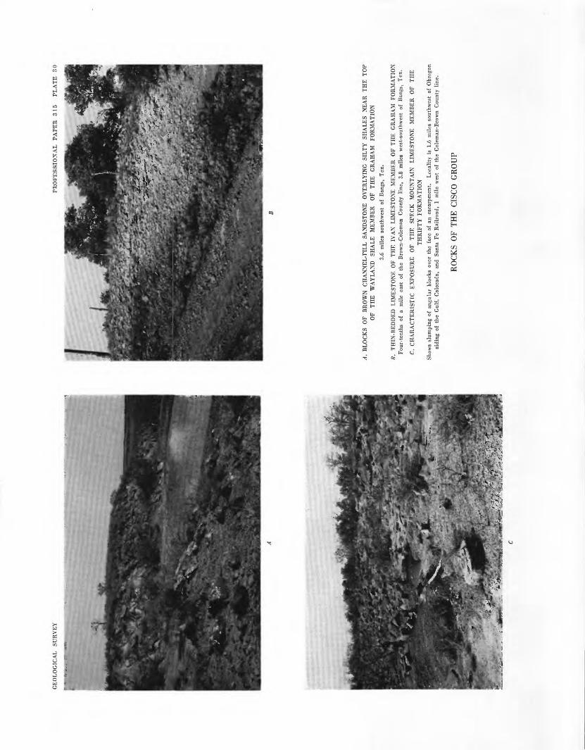
A.
BL
OC
KS
OF
BR
OW
N
CH
AN
NE
L-F
ILL
SA
ND
STO
NE
O
VE
RL
YIN
G
SIL
TY
SH
AL
ES
NE
AR
T
HE
T
OP
OF
TH
E
WA
YL
AN
D
SHA
LE
M
EM
BE
R
OF
TH
E
GR
AH
AM
FO
RM
AT
ION
3.6
mile
s so
uthw
est
of B
angs
, T
ex.
B.
TH
IN-B
ED
DE
D
LIM
EST
ON
E
OF
TH
E
IVA
N L
IME
STO
NE
M
EM
BE
R
OF
TH
E
GR
AH
AM
FO
RM
AT
ION
F
our-
tent
hs
of
a m
ile
east
of
the
B
row
n-C
olem
an
Cou
nty
line
, 3.
8 m
iles
wes
t-so
uthw
est
of B
angs
, T
ex.
C.
CH
AR
AC
TE
RIS
TIC
E
XP
OS
UR
E
OF
TH
E
SP
EC
K
MO
UN
TA
IN
LIM
EST
ON
E
ME
MB
ER
O
F T
HE
TH
RIF
TY
FO
RM
AT
ION
Show
s sl
umpi
ng o
f an
gula
r bl
ocks
ove
r th
e fa
ce o
f an
esc
arpm
ent.
Loc
alit
y is
1.6
mil
es s
outh
wes
t of
Obr
egon
si
ding
of
the
Gul
f,
Col
orad
o, a
nd
San
ta F
e R
ailr
oad,
1
mile
wes
t of
the
Col
eman
-Bro
wn
Cou
nty
line
.
RO
CK
S O
F T
HE
CIS
CO
GR
OU
P


PENNSYLVANIAN AND LOWER PERMIAN ROCKS, BROWN AND COLEMAN COUNTIES 67
deflection on the electric logs because it is thin and lies between beds of shale.
CADDO CREEK FORMATION
The Caddo Creek formation was named by Plummer and Moore (1921, p. 117-118) for strata exposed in a creek in the Brazos Kiver valley. As originally de fined, it included Drake's Hog Creek shale below and the Home Creek limestone member above, named for localities in north-central Brown County and southeast ern Coleman County, respectively. Because of miscor- relations in the past, as described below, the name Hog Creek shale member should be replaced. As redefined here, the formation includes, in descending order, the Home Creek limestone member and the Colony Creek shale member.
Unusual thickening of the limestone units in the up permost part of the Canyon group near the junction of Home Creek and the Colorado Kiver has resulted in much confusion in correlations with limestone units in the Caddo Creek and Brad formations as mapped else where. Drake originally applied the term "Home Creek bed" to the upper noncherty limestone in the walls of the creek, and the name "Cherty bed" to the lower massive limestone, which contains abundant rounded nodules of chert. The chert-bearing limestone is now included in the Brad formation, as described above. Plummer and Moore (1921, p. 118-121) ap plied the name "Home Creek" to the prominent lime stone at the top of the Canyon group in the Brazos and Colorado Kiver valleys. This nomenclature has been in general use by geologists since that time. By tracing this member across northern McCulloch County to the type locality, and by studying the stratigraphy of northern Brown County, however, Nickell (1938, p. 116-118) found that the limestone called the Home Creek limestone by most geologists correlated with one higher on the slope than the one to which Drake had originally applied the term "Home Creek" at the type locality. Drake's Home Creek limestone, he found, was the one that Plummer and Moore had subsequently named the Kanger. Nickell's conclusions have recently been corroborated by Jenkins (1952, unpublished doc toral dissertation, University of Texas) in his mapping of the Mercury quadrangle.
Other miscorrelations to the north have been made in the past. Beds mapped as Home Creek across south ern Brown County north to the outlier of Cretaceous rocks on which the town of Bangs is located were mapped as Kanger limestone member of the Brad for mation (Plummer and Moore, 1921) north of the out lier. Thus, the Hog Creek shale of Drake (1893), named for a creek north of the outlier in which the
Bluff Creek shale as used by Cheney (1948, p. 20) is exposed was believed to lie below Plummer and Moore's Home Creek limestone. Actually the Ho^ Creek shale of Drake lies above the Home Creek, and because of this confusion, Cheney (1948, p. 20) recoir- mended discarding the term "Hog Creek" for the unit underlying the Home Creek and substituting the tern "Colony Creek" shale. This name is taken from a stream in Eastland County between the towns cf Kanger and Eastland. The author suspects that some of the miscorrelations in northern Brown County re sult from the misconception that the Kanger (probably the Cherty limestone of Drake at the Home Creev locality) is cherty throughout Brown County; wheres,s actually the Home Creek has considerably higher chert content in northern Brown County than the Kanger.
The thickness of the Caddo Creek formation at the outcrop ranges from about 55 feet along the Colorado Kiver to about 75 feet in central Brown County. This northward increase in thickness apparently continues, and in northern Brown County, where the Caddo Creek is covered by Cretaceous rocks, its thickness ss determined from well logs averages about 115 feet.
COLONY CREEK SHALE MEMBER
Because of the confusion that has resulted from tire miscorrelations of the Home Creek limestone member and misapplication of the term "Hog Creek," adoption of Cheney's term "Colony Creek shale" (1948, p. 20) is recommended here for the shale member below the Home Creek limestone member. The unit is a gray shale that contains a generally conspicuous fine-grainei thinly to thickly and irregularly bedded sandstone nes r its top. In the Lake Brownwood area the shale cor- tains abundant fossils chiefly crinoids, bryozoan^, gastropods, and brachiopods near the base, and grades upward into silty shale and sandstone. Generally, greenish-gray shale immediately underlies the Hoire Creek limestone member.
In the southern part of the area the Colony Creek shale member attains a thickness of about 25 feet, but locally the member is absent and the Home Creek lime stone member is contiguous with limestone members of the Brad formation. In north-central Brown County the member averages about 60 feet in thickness; to tH northeast, it is covered by rocks of Cretaceous age where its thickness in the subsurface is 75 to 80 feet.
HOME CREEK LIMESTONE MEMBER
The Home Creek limestone member extends north east from its type locality in the southeastern corner of Coleman County across Brown County, and is co^- ered by sandstones of the Lower Cretaceous series just

68 PENNSYLVANIA AND LOWER PERMIAN ROCKS OF WEST AND CENTRAL TEXAS
west of the town of May in northeastern Brown County. It ranges from a light-gray cherty vugular solid limestone to nodular irregularly bedded limestone containing partings of shale. Fossils are generally scarce in the outcrop area, but they consist of fusu- linids, crinoid columnals, and some brachiopods of the Composita type.
Detailed thicknesses of the Home Creek in various places in the vicinity of the Colorado River have not been obtained because of irregular thickening of the limestone there. In most places in the southern part of Brown County the member consists of several beds of limestone as much, as 8 to 10 feet thick separated by several feet of shale, the whole averaging about 30 feet thick; along the Colorado River, however, the member is estimated to exceed 50 feet in thickness. In the northern part of Brown County the Home Creek, con sisting chiefly of massive to nodular limestone, aver ages from 10 to 15 feet in thickness.
CISCO GROUP
Drake (1893, p. 37-39) referred the lower part of what is now considered the Cisco group, including his Bluff Creek and CampopJiyllum beds, to Cummins' Canyon division. To Cummins' Cisco division he re ferred the rocks from the base of his Trickham bed up to the base of his Coleman Junction bed (Coleman Junction limestone of the Putnam formation, Wichita group, Moore, 1949). Plummer and Moore (1921, table 2) reclassified Drake's beds as members and con sidered his Bluff Creek bed to be a member of their Graham formation. The Gunsight limestone (Plum mer, 1919) and the newly named Way land shale were also included in the Graham formation which they placed in the Cisco group. Plummer and Moore (1921, table 2) placed the upper boundary of the Cisco at the top of their Coleman Junction limestone. Thus they considered the Cisco group to consist of all beds from their Home Creek Limestone to the top of their Coleman Junction limestone. They placed in the Thrifty formation all beds between their Wayland shale and the top of the Breckenridge limestone (Drake's Chaffin bed). Their Harpersville formation consisted of Drake's Waldrip and Saddle Creek beds. They also included the Pueblo, Moran, and Putnam formations in this Cisco group.
Hudnall and Pirtle (1929,1931) placed the Graham formation in the Cisco group, agreeing that the base of the Cisco is the top of the Home Creek limestone. Sellards (1933, p. 113) also considered the top of the Home Creek as the base of the Cisco group, but he lowered the top of the Cisco to the top of Plummer and Moore's (1921) Camp Colorado limestone of the
Pueblo formation. Bullard and Cuyler (1935, p. 221) retained these boundaries, but raised the Graham- Thrifty boundary to the top of the Speck Mountain limestone member. Cheney (1940, p. 91) suggested that the top of the Ciscoshould be placed at some widespread disconformity in the Harpersville formation above the Waldrip-Newcastle coal zone and below the Schwagerina-besLiiag 'Waldrip limestone No. 3' and the Saddle Creek limestone.
Moore (1949) lowered the top of the Cisco to the base of a sandstone in the Waldrip shale member of the Pueblo group, and discontinued the use of the name "Harpersville formation." The present repcrt places the top of the Thrifty formation of the Cis",o group at the top of the Chaffin limestone member, the most persistent mappable unit found in that part of the stratigraphic sequence, and the uppermost unit in which distinctive Pennsylvanian fusulinids have been found.
As the boundary between the Permian and the Penn sylvanian is obscure and probably gradationrl, no de finite upper boundary between the two systems has been drawn.
The formations and members of the Cisco group as recommended in this report are as follows, in descend ing order:
Thrifty formation:Chaffin limestone memberParks Mountain sandstone memberBreckenridge limestone memberSpeck Mountain limestone member
Graham formation:Ivan limestone memberWayland shale memberGunsight limestone memberBluff Creek shale member
GRAHAM FORMATION
The Graham formation was named by Plummer and Moore (1921, p. 125) for the county seat of Young County in the Brazos River valley. The base of the Graham in the Brazos River valley has been described as an unconformity by Lee and others (1938, p. 12-16) at the base of the deep sandstone-filled "Kisinger chan nel" in southeastern Young County. The channel erosion is described as cutting out the underlying Caddo Creek formation of the Canyon gronp and a part of the Ranger limestone member of the Brad for mation. Channel erosion has cut to the lower part of the Bluff Creek shale member also in Brown County, and these channel-fill sandstones are reported to be the so-called Overall oil sand as recognized by petroleum geologists in the Overall oil field in Coleman County (Cheney and Eargle, 195la, p. 1). In the western part

PENNSYLVANIAN AND LOWER PERMIAN ROCKS, BROWN AND COLEMAN COUNTIES
of that field, Cheney (1940, p. 90) reported that chan nel erosion has removed the Home Creek limestone member of the Caddo Creek formation. Eed shale, which Cheney interpreted as indicating a zone of weathering associated with an unconformity, is found locally at the base of the Bluff Creek shale member of the Graham.
The boundary between the Graham and the Thrifty formations has been defined as the base of the Avis sandstone member (Sellards, 1933, p. 114; Nickell, 1938, p. 122), a prominent sandstone in the Brazos River valley. In the Colorado River valley, however, this boundary is not mappable because only discon tinuous lenses of sandstone are present at the stratig- raphic position of the Avis. Furthermore, the lime stone next above the Avis, the Ivan limestone member, is also discontinuous. The terms "Avis" and "Ivan" were brought into the Colorado River valley from the Brazos River valley where the members are bettter de veloped. It is therefore recommended that the base of the Speck Mountain limestone member of the Thrifty formation, a persistent member throughout the whole Colorado River valley and most likely equivalent to the Blach Ranch limestone of Plummer and Moore (1921) in the Brazos River valley, be designated the boundary between the Thrifty and Graham forma tions. In places where the Speck Mountain limestone member has been replaced by a channel-fill conglom eratic sandstone, as by the Parks Mountain sandstone member in southeastern Coleman County, the boundary of the Graham and Thrifty is considered the base of the sandstone.
The thickness of the Graham formation, as defined here, is about 265 feet in southeastern Coleman County, and about 290 feet in northern Brown County.
BLUFF CREEK SHALE MEMBER
The Bluff Creek shale member was first described by Drake (1893, p. 37, 38) as the Bluff Creek bed from ex posures along a tributary of the Colorado River in northeastern McCulloch County. Plummer and Moore (1921, p. 137) called the member the Bluff Creek shale and said that a thin yellow limestone in the middle of the unit may be equivalent to the Bunger limestone member in Young and Stephens Counties. Bullard and Cuyler (1935, p. 223-225) retained the name "Bun ger" for a characteristic bed in northern McCulloch County that they said is unlikely to be continuous with the one at the type locality in Young County but oc cupies the same stratigraphic position. The shale above this Bunger they termed the Upper Bluff Creek shale and the shale below, the Lower Bluff Creek shale. In addition, they named a persistent ferrugin
ous limestone bed lying 15 to 20 feet below their Bun ger limestone and 35 to 45 feet above the base of the;r Lower Bluff Creek shale the White Ranch limestone, from exposures on the ranch of that name in northern McCulloch County, particularly along Bluff Creek.
Hudnall and Pirtle (1929) called a limestone unit in this interval in Brown County the North Leon lim^- stone, believing it to be correlative with a thin lime stone bed in central Eastland County named North Leon by Reeves (1922, p. 117). Cheney (1950, table following p. 11) and Cheney and Eargle (1951b) added the North Leon and Gonzales limestones to tH list of names of limestones in the lower part of tl e Graham formation in Brown County. The Gonzal^s was first described by C. S. Ross (1921, p. 307) as a local bed in southeastern Stephens County, but its identity outside of a very local area and its correlation with other beds are questionable.
As many as six thin limestone units in the lower part of the Bluff Creek shale member are traceable for con siderable distances across Brown and Coleman Coun ties, but most of these are discontinuous. Lenticular beds of sandstone are also found in several strati- grapliic positions. One of these is above the limestone mapped as Bunger in Brown County by Cheney ari Eargle (1951b), and another is near the base of tH member. The sandstone lenses near the base of tH member fill channels in many places and range from 1 or 2 feet to as much as 30 feet in thickness within short distances; they apparently are near the strati- graphic position of the "Kisinger channel" in Yourg County.
The exact correlation of the limestone beds in tH lower part of the Bluff Creek shale member could not be determined because of lateral changes in lithologic character and because of the abrupt changes in inter vals of shale between them. Inasmuch as they cannot definitely be mapped for long distances or traced to the type localities of the named beds, the formal usage of individual names for these beds whose type local ities are chiefly in the Brazos River valley is not recon- mended for the Colorado River valley until more de finite correlations can be established.
The Bluff Creek shale member is a gray marine shale; locally, the basal 10 to 30 feet is red shale, gen erally near channels. The more continuous beds of limestone are medium gray and dense; the less con tinuous are light gray, wavy bedded, and nodukr. Some of the limestones are ferruginous and are yello^- ish brown in color. Fusulinids are found in most of the limestones except in those that are nodular or thc^ that contain abundant algal structures. An ammono^d

70 PENNSYLVANIAN AND LOWER PERMIAN ROCKS OF WEST AND CENTRAL TEXAS
zone is found near the top of the member in southeast ern Coleman County and in southwestern Brown County. Colonies of horn corals are found at the top of the member in many places, generally immediately under the Gunsight limestone member. The Bluff Creek shale member ranges in thickness from about 90 feet along the Colorado River to about 140 feet in north-central Brown County.
GUNSIGHT LIMESTONE MEMBER
This member, called the Cainpophyllum bed by Drake (1893, p. 38, 39) and the Gunsight limestone by Plummer (1919), was divided into two beds, the Upper Gunsight and the Lower Gunsight limestones, by Hud- nail and Pirtle (1931). It was later called the Gun- sight limestone by Sellards (1933, p. 103), Bullard and Cuyler (1935, p. 225, 226), Nickell (1938, p. 119, 120), Cheney (1950, table following p. 11), and Jenkins (1952, unpublished doctoral dissertation, The Univer sity of Texas). It was again divided into Upper Gun- sight limestone and Lower Gunsight limestone by Cheney and Eargle (1951b). Stafford (1960) and Ter- riere (1960), however, have shown by recent mapping in northern Brown County that the Upper Gunsight limestone as mapped by Cheney and Eargle is discon tinuous to the north more than 1 or 2 miles east of Pecan Bayou. Locally, there are several limestone beds in the sequence; Terriere has shown that as many as three can be traced for considerable distance throughout Brown County. The limestones that are separated by only thin beds of shale, especially those above the banks of horn corals at the top of the Bluff Creek shale member and immediately below the Way- land shale member, are included in the Gunsight lime stone member.
The Gunsight limestone member is generally fine grained and pale brownish yellow to gray. The upper bed commonly contains clear crystalline wavy struc tures believed to be of algal origin. In the shale below the uppermost of the three beds of limestone in this member in Brown County is a zone containing rela tively abundant ammonoids. The zone generally con tains a rich fauna of uncoiled cephalopods, brachio- pods, corals, and crinoids. In southeastern Coleman and southwestern Brown Counties a shale rich in the same fauna, but notably containing, in addition, Conularia sp., lies near the top of the Bluff Creek shale member and underlies the lowermost of the two limestone beds of the Gunsight of that region. The sequence of beds included in the Gunsight limestone member ranges from about 17 feet along the Colorado Kiver to 25 feet in north-central Brown County. To ward northern Brown County the upper part of the
Gunsight changes to sandstone and the member is as thin as 13 feet.
WAYLAND SHALE MEMBER
The thick shale that forms broad lowlands above the Gunsight limestone member, part of which was termed the Trickham bed by Drake (1893, p. 39-42), was first correlated by Plummer and Moore (1921, p. 138) with their Wayland shale of Stephens County. They also listed and illustrated the highly distinctive fauna. Most authors have followed Plummer and Moore in bringing the term "Wayland" into the Colorado River valley. Although the term "Trickham" has priority, retention of the name Wayland shale member is recom mended on the basis of this usage, and on the similar ity in lithologic character, fossil content, and thickness to the Wayland of the Brazos River valley. The name "Wayland" is used generally in subsurface correlations to the west and north.
Above the Wayland shale member in th^ Brazos River valley is a sandstone that is very prominent and that fills channels cut into the Wayland. It was called the Avis sandstone by Plummer and Moore (1921), who considered the base of the sandstone the boundary between the Graham and Thrifty formations. The term Avis was first used in the Colorado River valley by Nickell (1938, p. 123, 124) who applied it to len ticular beds of sandstone at one or more positions be low the Ivan limestone member. Inasmuch as sand stone is present only locally and the sandstone lenses occupy several stratigraphic positions in the Wayland, the name Avis sandstone member probably si ould not be brought into the Colorado River valley.
Some of the sandstone lenses are conglomeratic and fill channels (pi. 304). Near Thrifty a channel sand stone cuts down within 50 feet or less of the Gunsight limestone member. It forms two high flf.t-topped mesas: one, called Keeler Knob, about half a mile east of Thrifty, and the other about a mile southeast of Thrifty (section 49, pi. 26).
The Wayland shale member is chiefly gr".y, com monly silty to sandy near the top, and contains abun dant sideritic platy concretions. Locally, shale in the vicinity of the sandstone channel deposits is r°,d. Sev eral layers in the Wayland shale member contain abun dant fusulinids. The richest of these layers is near the base of the member. Mollusks, mostly gastropods, are found in great numbers in scattered localities of lim ited areal extent near the base of the member. Along the Colorado River the member is about 100 feet in thickness, in the vicinity of Pecan Bayou it is about 75 feet in thickness, and in northern Brown County it is about 105 feet in thickness.

PENNSYLVANIAN AND LOWER PERMIAN ROCKS, BROWN AND COLEMAN COUNTIES 71
IVAN LIMESTONE MEMBER
The name "Ivan limestone member" is here recom mended for the member that was described as the Bellerophon bed by the earlier authors (Nickell, 1938, p. 123, 124), the Ivan [limestone] by Cheney and Eargle (1951a, table following p. 11), and the Ivan limestone by Cheney and Eargle (1951b). As the name of a characteristic fossil found in a member does not constitute a satisfactory name for a member, and because the Ivan limestone member at its type locality in Stephens County in the Brazos Eiver valley occu pies the same general stratigraphic position as the Bellerophon limestone of early workers in the Colo rado Eiver valley, the extension to this area of the name Ivan limestone member is recommended even though it cannot be continuously traced from the Bra zos River valley to the Colorado Elver valley.
Locally the Ivan limestone member changes in lith- ologic character from limestone to calcareous sandstone and (or) shale within short distances. In southeastern Coleman County the Ivan is a massive oolitic and algal (?) limestone, medium gray in color and about 8 feet thick. In this area it is overlain by a few feet of gray shale and a partly nodular limestone about 2 feet thick (pi. 30Z?). In eastern Coleman County, at a lo cality about 9% miles southeast of Santa Anna and a mile east of Mukewater School, the Ivan consists chiefly of a single bed of limestone 12 feet thick; a quarter of a mile to the north this member consists of two beds of limestone, each 4 feet thick, separated by 4 feet of shale containing horn corals. Another quar ter of a mile northwest it grades into shale and sand stone containing a zone of calcareous shale having abundant fusulinids.
In places the Ivan limestone member is as much as 18 feet thick, as at section 37 (pi. 26) on the Brown- Coleman County line 4 miles west-southwest of Bangs; but within short distances it becomes much thinner and has been locally removed by channel erosion. In north ern Brown County the member consists chiefly of a calcareous sandstone and shale, in places containing masses of syringoporoid corals.
SHALE OVERLYING THE IVAN LIMESTONE MEHBER
The shale overlying the Ivan limestone member and underlying the Speck Mountain limestone member of the Thrifty formation was called the Speck Mountain clay bed by Drake (1893, p. 43, 44), and was discussed as a separate shale member by Nickell (1938, p. 123, 124). It is chiefly silty or sandy, and red and contains locally abundant limonite concretions. The basal part of this shale unit contains lenticular sandstone and
conglomerate, filling channels that locally cut through the Ivan limestone member.
Immediately below the Speck Mountain limestone member is a thin bed of coal that extends over a wide area in northwestern Brown County. In the bed of Mud Creek, a short distance above its junction wi*h Jim Ned Creek 3^ miles northwest of Thrifty (section 38, pi. 26), the coal bed is 3% inches thick and is un derlain by a thin bed of clay that grades downward into gray shale. The shale overlying the Ivan lime stone member ranges in thickness from about 45 to 65 feet in southeastern Coleman County to about 25 to 40 feet in the northern part of Brown County.
THRIFTY FORMATION
The Thrifty formation was named by Plummer and Moore (1921, p. 152, 153) for the small village of Thrifty in northwestern Brown County which is lo cated on the outcrop of the Gunsight limestone mem ber. Good exposures of the formation are from 1 mile to several miles west of the village. Plummer and Moore (1921) originally described this formation as including sandstone, shale, and limestone overlying their Wayland shale and extending to the top of their Breckenridge limestone (the limestone at the top of Drake's Chaffin bed). The various usages of the nane by later authors are shown in the classification chart, plate 27.
As redefined here, the Thrifty formation consists of two persistent beds of limestone, another less persistent bed of limestone, and a lenticular channel-fill sand stone, which have been given the member names listed below. Relatively nonresistant sandstone and shrle occupy the intervals between the more resistant units here considered members. The Thrifty formation con sists of the following members in descending order:
Chaffin limestone member Parks Mountain sandstone member Breckenridge limestone member Speck Mountain limestone member
The Thrifty formation has been redefined to facil itate mapping in the Colorado Eiver valley. The for mation is here considered to lie between the base of the Speck Mountain limestone member and the top of the Chaffin limestone member, the uppermost persistent limestone of Pennsylvanian age as determined by fusulinids. The Speck Mountain and the Chaffin r.re traceable across the entire area except locally whore channel erosion has cut through one or the oth^-r. Where such channel erosion exists, the base of the channel-fill sandstone has been used for the limit of the formation.

72 PENNSYLVANIAN AND LOWER PERMIAN ROCKS OP WEST AND CENTRAL TEXAS
Along the Colorado Eiver in southern Coleman County the thickness of the Thrifty formation is about 55 feet and in northern Brown County the average thickness is about 100 feet.
SPECK MOUNTAIN LIMESTONE MEMBER
The Speck Mountain limestone member, named by Drake (1893, p. 39), is generally continuous across the whole area. It has been called the Breckenridge lime stone by Hudnall and Pirtle (1929, 1931), but the Speck Mountain limestone member by most other au thors. It has been correlated with Plummer and Moore's (1921) Blach Eanch limestone of the Brazos Kiver valley by Cheney (1948, 1949, 1950), and this correlation has been verified in reconnaissance with P. T. Stafford during this survey. Its type locality is Speck Mountain, a mesa capped with the limestone member in southern Coleman County about a mile north of the Home Creek crossing of Whon-Santa Anna road. It is a firm massive dark-gray limestone that breaks along vertical joints, forming blocks that creep down the scarp of the cuesta it forms (pi. 30#). It contains Foraminifera, of which fusulinids are com mon but not generally abundant, and abundant minute algal(?) structures. It ranges from 1 to 3 feet in thickness.
SHALE OVERLYING THE SPECK MOUNTAIN LIMESTONE MEMBER
Because Drake's descriptions apply chiefly to beds in the vicinity of the Colorado Eiver and southward, his terminology may not apply perfectly to the beds to the north where differences exist in the stratigraphy. He described as one unit the shale and sandstone se quences overlying the Speck Mountain limestone mem ber which extend up to the next highest persistent limestone, the Chaffin limestone member. He named the unit the Lohn bed for a locality south of the Colo rado Eiver in northern McCulloch County (1893, p. 44, 45). This terminology applies to the sequences as they crop out south of Home Creek in southern Cole man County. He concluded that the Chaffin limestone member spilts into two beds north of Home Creek; his Lohn bed from there northward extends up to his lower Chaffin limestone bed. In the present survey, however, Drake's lower Chaffin was found to be the Breckenridge limestone member, which does not ex tend south of the vicinity of Home Creek. His Lohn bed, therefore, includes a thicker stratigraphic interval south of Home Creek than that north of the creek. For that reason the name Lohn is being discarded as a stratigraphic name for use in eastern Coleman and northwestern Brown Counties. The Lohn bed of
Drake was called the Lohn shale by Sellards (1933, p. 103) and by Nickell (1938, p. 125-126).
The shale immediately above the Speck B fountain limestone member in eastern Coleman and northwest ern Brown Counties is generally gray and contains abundant and characteristic marine fossils. It contains especially a concentric cup-shaped bryozoan that ap parently began growth attached to another object, com monly a shell or a crinoid columnal. Other types of bryozoans, brachiopods of several genera, r.bundant crinoids, horn corals, and, more rarely, fusulinids and trilobites are also found. This gray shale grades up ward into red and variegated shale which extends up to the base of the Breckenridge limestone member. Southward from the vicinity of Home C^eek the Breckenridge limestone member has not been found, and most of the interval from the Speck Mountain limestone member to the Chaffin limestone member con sists of red to gray shale, in places silty and sandy, and in places containing sandstone and conglomerate of the Parks Mountain sandstone member.
BRECKENRIDGE LIMESTONE MEMBER
The Breckenridge limestone member was ramed by Plummer and Moore (1921, p. 155) for a gray massive resistant limestone, 3 or 4 feet thick and forming a prominent escarpment in and about Breckenrdge, the county seat of Stephens County. They considered it easily traceable to the northeast and south anc1 possibly identifiable with the upper Chaffin bed of Drake in the Colorado Eiver valley. It was traced as far northeast as the northeastern quarter of Jack County and as far southwest as northwestern Eastland Count7 by the American Association of Petroleum Geologists coop erative mapping committee, as shown on the geologic maps of Jack (Armstrong, 1929), Young (Plummer and Fuqua, 1937), Stephens (Bradish, 1929), and East- land (Wender, 1929) Counties. The bed here corre lated with the Breckenridge is shown on the geologic map of Coleman County (Hudnall and Pirtle, 1929) as the Lower Crystal Falls limestone. Bullard and Cuyler (1935) followed Plummer and Moore's correla tions, and the bed they mapped as Breckenridge through northern McCulloch County is therefore the Chaffin limestone of Drake. Cheney and Eargle (1951b) mapped the Breckenridge throughout north western Brown County and showed it in the interval between their Chaffin and Speck Mountain limestones.
During the preparation of this report, the Brecken ridge limestone member was mapped as far southwest as Home Creek, and was found to be correlative with the bed Drake considered the lower Chaffin limestone. From the vicinity of Home Creek southwest to the

PENNSTLVANIAN AND LOWER PERMIAN ROCKS, BROWN AND COLEMAN COUNTIES 73
Colorado River in southeastern Coleman County, this limestone and the shale immediately above and below it is removed by channel erosion and the channel filled by the Parks Mountain sandstone member. The Breckenridge limestone member has not been recog nized south of the Colorado River; however, the rocks were not studied in detail more than a mile south of the river.
The member termed Breckenridge by Cheney and Eargle (1951b) has recently been mapped through in- liers in overlapping Cretaceous rocks in southern East- land County by P. T. Stafford and through northern Eastland County by R. J. Burnside. By reconnais sance, Stafford and Eargle traced this and the under lying shale and Speck Mountain limestone member north to the town of Breckenridge where it was def initely correlated with the Breckenridge limestone de scribed by Plummer and Moore (1921). Thus, the out crop of the Breckenridge limestone member has been traced from the vicinity of Home Creek to the vicinity of Breckenridge, an airline distance of nearly 90 miles. If mapping and correlations to the northeast by the American Association of Petroleum Geologists cooperative mapping committee are correct, it may ex tend an additional TO miles in that direction.
The Breckenridge limestone member is 20 to 40 feet above the Speck Mountain limestone member. Drake, considering it a lower bed of the Chaffin limestone (1893, p. 47), described it as "white, and at places pink" and "being friable, appears less prominent than the upper [bed]." Characteristically it is pale green ish gray to almost white, blotched with pale reddish purple. At the most southerly place where it was found, in southeastern Coleman County in the vicinity of Home Creek, it consists of about 1 foot of nodular limestone overlying 1 foot of firmer limestone. This member is continuous to the north, except locally where removed by channel erosion, and is generally a nodular bed a foot or two in thickness. It gradually increases to a thickness of about 3 feet in northern Brown County where it forms a ledge of firm lime stone.
The Breckenridge limestone member in the area of this report is thickest in northern Brown County near the community of Blake. The exposure where the limestone and underlying beds can best be observed is at the western end of a breached dam on Red River, iy2 miles S. 35° W. of Rudco Gas and Oil Co.'s gaso line plant, 2y2 miles northwest of Blake church. There, 3 feet of light-gray algal (?) limestone, some of which is nodular, overlies about 20 feet of greenish-olive-gray to purplish-red mottled clay. Overlying the limestone is about 5 feet of shale and above that is a 1-foot lime
stone bed that is generally fusulinid bearing. Another more accessible place where the formation can be seen is at the eastern end of the bridge over the Red River on the road from Cross Cut to Williams School, about 2.4 miles west-northwest of Blake church. Good ex posures are also found under the bridge over Pecan Bayou on State Highway 279 between Brownwood and Abilene, and half a mile east of the bridge on the ranc> of Bransford Eubank.
CLAY OVERLYING THE BRECKENRIDGE LIMESTONE MEMBER
The beds that intervene between the Breckenridge and Chaffin limestone members in Brown County and north of Home Creek in eastern Coleman County are red clay containing abundant hematite nodules and plant fossils. Plummer and Bradley (1949) studied its potentialities as a brick clay, and named it the Quinn clay for exposures in Eastland County, where it has been extensively mined. In many places lentic ular beds of sandstone are found within this unit, particularly near the base, and some channel-fill con glomerate is also present. The conglomerate may per haps be correlated with the Parks Mountain sandstone member, described below, inasmuch as it occupies the same stratigraphic interval.
In the vicinity of Home Creek the clay overlying the Breckenridge is pale reddish and purplish brown and contains abundant ferruginous concretions. It con tains a 3-foot bed of calcareous sandstone about 5 feet above the Breckenridge limestone member. From Home Creek to the Colorado River the Breckenridge limestone member and some of the shale above and be low this limestone have been cut out by the channel erosion that preceded or accompanied the deposition of the Parks Mountain sandstone member, the top of which is only 20 feet below the Chaffin limestone mem ber.
In the area immediately south of the Colorado River no prominent beds intervene between the Chaffin and Speck Mountain limestone members. The interval consists chiefly of gray shale red near the base that contains a coal bed at its top. This coal was mined many years ago near the mouth of Little Elm Creek, a tributary entering the Colorado River from the south, about a quarter of a mile south of Chaffin crossing. The interval contains also a thin-bedded sandstone, which thickens to the northwest toward the river and is evidently an extension of the Parks Mountain sand stone member. This shale unit between the Chaffin and Speck Mountain limestone members, about 50 feet thick, has been termed the Lohn bed by Drake (1893, p. 44-45) in McCulloch County. Inasmuch as the term "Lohn" did not apply to exactly the same interval

74 PENNSYLVANIAN AND LOWER PERMIAN ROCKS OF WEST AND CENTRAL TEXAS
north of the river, as previously stated, it is not recom mended for use in Coleman and Brown Counties.
PARKS MOUNTAIN SANDSTONE MEMBER
A thick unit of conglomeratic sandstone capping Parks Mountain north of the Colorado Eiver in south eastern Coleman County was named and described by Drake as the Parks Mountain conglomerate and sand stone bed "because of its irregular position and relation to the coal beds" (1893, p. 45). It was termed the Avis sandstone by Bullard and Cuyler (1935, p. 232, 233) because that name had been applied to the first con glomeratic sandstone bed above the Wayland shale of Plummer and Moore (1921) in the Brazos River valley and because this conglomerate holds the same relation to the Wayland along the Colorado River. The Avis of Plummer and Moore (1921), however, has been shown by Lee to have originated before the Ivan lime stone member was deposited (Lee and others, 1938, p. 56), and, therefore, the name Avis of Bullard and Cuyler (1935) can not be correctly applied to the stra- tigraphically higher Parks Mountain sandstone mem ber.
In the area where the Parks Mountain is a channel- fill deposit, it has a thickness of at least 60 feet. This member is overlain by carbonaceous shale and coal near the Colorado River, and by ferruginous red shale farther north. The channel-fill conglomeratic facies of this member is of small areal extent along the out crop, confined chiefly to the area within a few miles north of the Colorado River. It grades laterally into a thin-bedded sandstone of wide extent, ranging in thickness from a few feet to 30 feet or more in the northern part of the area covered by this report. In several places in northern Brown County a channel- fill conglomerate occupies the position of the Brecken- ridge limestone member and forms high mesas a mile or more in length. This conglomerate and lenticular beds of sandstone elsewhere between the Chaffin and Breckenridge limestone members may be correlated with the Parks Mountain sandstone member.
CHAFFIN LIMESTONE MEMBER
Drake (1893) described and used the name "Chaffin beds" for a distinctive limestone and coal at the now abandoned Chaffin mines about a quarter of a mile southwest of Chaffin crossing on the Colorado River, 1% miles east of Waldrip, McCulloch County, near the mouth of Little Elm Creek. He found that the lime stone was cut out by a channel immediately north of the river, except in one locality, but traced the lime stone across the rest of Coleman and Brown Counties. From the vicinity of Home Creek northward he found
two limestones and called the lower one the lower Chaffin limestone. The lower Chaffin limestone is here correlated with the Breckenridge limestone member.
The generally persistent upper part of the Chaffin limestone member has been variously called the Breck enridge limestone by Plummer and Moore (1921, p. 155), the Upper Crystal Falls limestone \yj Hudnall and Pirtle (1929, 1931), the Chaffin limestone by Sel- lards (1933, p. 103, 115), the Breckenridge limestone by Bullard and Cuyler (1935, p. 233-235), the Chaffin limestone by Nickell (1938, p. 127, 128), the Crystal Falls limestone by Cheney (1950, table following p. 11), and the Chaffin limestone by Cheney and Eargle (1951b).
The Chaffin limestone member immediately south of the Colorado River ranges from about 15 feet in thick ness at the Chaffin mines to about 7 feet ir thickness at the locality of section 1, plate 25. At this locality it is a slabby irregularly bedded gray limestone, stained purplish red in large spots. It contains abundant fusulinids and thin wavy structures of el?.ar calcite which may have been precipitated by algae. These structures characterize the bed over most of Coleman County.
The limestone becomes thinner and generally darker gray to the north. In Brown County it averages only 1 to 2 feet thick, is massive, and breaks into vertical joints, although weathering usually causes it also to break horizontally into slabs. It is nearly everywhere abundantly fusulinid bearing. It is cut by a channel filled with sandstone, siltstone, and clay in a few places in northern Brown County.
PERMIAN SYSTEM
WICHITA GROUP
Rocks overlying the Cisco group of the Pennsyl- vanian system in Brown and Coleman Courties are of Wolfcamp age and belong to the Pueblo formation of the Wichita group. Nomenclature of rocks of the Pueblo formation is given on the diagram showing his tory of classification (pi. 27). These rocks were desig nated by Sellards (1933, p. 103) as the upper part of the Pennsylvanian Cisco group, but now are considered to be Permian. Moore (1949) assigned tl Q. Wichita group to the Permian, and it is his nomenclature that is used for this part of this report except for the addi tion of the Coon Mountain sandstone member.
The base of the Pueblo formation of tH Wichita group has been defined by Moore (1949, she^t 2) as an obscure disconformity that separates the Permian from the Pennsylvanian. The exact boundary between the two systems is in question and no additional evidence

PENNSYLVANIAN AND LOWER PERMIAN ROCKS, BROWN AND COLEMAN COUNTIES
was obtained during this study to clarify its position. As Moore indicated, the beds in which this boundary is presumed to fall show great lithologic variation. A number of lenticular beds of sandstone have been found in the interval between the highest persistent limestone beds of the Waldrip shale member above and the Chaffin limestone member below. Although some of these beds of sandstone can be traced for several miles, none of them has been found to be persistent laterally across the area considered here. Lloyd G. Henbest (written communication, April 13, 1957) reports as follows:The paleontological change from the Pennsylvanian to the Per mian in the Colorado River area is transitional like that of the lithogenetic change. Studies with D. A. Myers and R. O. Douglass indicate that such characteristic Permian fusulinids as Pseudofusulina sp., Schubertella kingi Dunbar and Skinner, and Dunbarinella(f) sp. aff. D.(?) compacta (White) appeared at different levels in the Thrifty and Waldrip sequence. All three of these fusulinids are first found in direct association in the Waldrip No. 1 bed of Drake. Although it appears that the Pennsylvanian-Permian boundary is within the interval be tween the top of the Thrifty formation and the base of Drake's Waldrip No. 1 bed, it is recommended that, for practical pur poses, the boundary be placed at the base of the Waldrip shale member.
Despite the heterogeneity of the deposits, the lack of traceable units, conclusive paleontologic evidence, and definite structural evidence of an unconformity in this area, the boundary between Permian and Pennsyl vanian for practical purposes is drawn at the base of the Waldrip shale member in this report. In this study the term Waldrip shale member is used for the entire unit between the base of the Saddle Creek lime stone member of the Pueblo formation and the top of the Chaffin limestone member of the Thrifty forma tion.
PUEBLO FORMATION
The Pueblo formation consists of the following members in Brown and Coleman Counties, in descend ing order:
Camp Colorado limestone member Salt Creek Bend shale member Stockwether limestone member Coon Mountain sandstone member Camp Creek shale member Saddle Creek limestone member Waldrip shale member
All members except the Salt Creek Bend shale mem ber were named and described as beds by Drake (1893, p. 39). Drake's Bed 13 was named Salt Creek Bend shale by Bullard and Cuyler (1935, p. 249, 250). The Coon Mountain sandstone of Drake (1893, p. 51) is retained for this report because the member chiefly a
sandstone and conglomerate deposit which, with finer- grained sediments, fills one or more deep channels forms a prominent ridge in northwestern Brown and northeastern Coleman Counties. The Pueblo forma tion thins toward the north along the outcrop from about 200 feet along the Colorado River in southern Coleman County to about 115 feet in northwestern Brown County. The Waldrip shale member, the Sad dle Creek limestone member, and locally the Coon Mountain sandstone member are the only members of the Pueblo formation shown in measured sections en the correlation chart (pi. 26) and described in this re port.
WALDEIP SHALE MEMBER
The Waldrip shale member was described by Drake (1893, p. 47-50), who called it the Waldrip bed as con sisting principally of blue clay, sandstone, coal, car bonaceous shale, and limestone. The beds of sandstone, he found, are mostly near the bottom of the unit and are quite irregular in thickness; three beds of limestor^ near the top of the Waldrip he designated by the num bers 1, 2, and 3, beginning with the lowest. Plummcr and Moore (1921, p. 160-163) included in their Har- persville formation the beds later called Waldrip shale by Moore (1949), together with the Saddle Creek lime stone member.
Bullard and Cuyler restricted the term Waldrip to about 115 feet of beds from the base of the No. 1 lime stone to the base of the Saddle Creek limestone meir- ber. The lower part of the unit to the top of tH Chaffin limestone member of the Thrifty formation (their Breckenridge limestone) they found to be about 90 feet in thicknes, and they called this part the Lower Harpersville beds. Nickell (1938, pi. 8) found tH Waldrip beds of Drake to be 238 feet thick. Cheney (1940, p. 91) considered that the upper boundary of his Cisco seriesshould be placed at some widespread unconformity in the Har persville formation above the Waldrip-Newcastle coal zone ar"l below the Schwagerina-be&riiLg Waldrip limestone No. 3. ...
The beds underlying this systemic boundary and over lying his Chaffin formation he termed the Obregon for mation. Moore (1949) placed the Permian and Penn sylvanian boundary 40 to 55 feet below the top of tH Waldrip shale member, between limestones 1 and 2 c* Drake.
No traceable horizon was found during this survey which could be considered the boundary between tH Permian and Pennsylvanian. The whole interval thr.t Drake called the Waldrip beds is, therefore, for pur poses of mapping and description, considered the Waldrip shale member of the Pueblo formation. TH

76 AND LOWER PERJMIAN ROCKS OF WEST AND CENTRAL TEXAS
Waldrip lies between the top of the Chaffin limestone member of the Thrifty formation, and the base of the Saddle Creek limestone member of the Pueblo forma tion. The lower beds of the Waldrip are not com pletely exposed along the Colorado Biver and the thickness of some beds in this part of the member could only be estimated. The thickness (85.2 feet) of the interval from the Chaffin limestone member up to the No. 1 limestone of Drake (pi. 26, section 1) is from measurements by Bullard and Cuyler (1935, p. 236). This compares closely with the interval of 93 feet in terpreted from the log of a well drilled 2% miles west of Waldrip (Cheney, 1948, well 6 on cross section).
Whereas most shale in the lower part of the Wald rip is gray, the shale in the upper part is red and variegated. Hematite nodules as large as an inch in diameter are abundant in some zones. Some of the nodules incorporate marine fossils. Several beds of coal have been found in the lower part of the Waldrip shale member.
The lower limestones (Nos. 1 and 2) of the sequence near the top of the Waldrip shale member are not per sistent to the north. In many places, however, a fos- siliferous zone is found about 25 feet below the No. 3 limestone of Drake. Moore (personal communication) believes this to be the northern extension of the No. 1 limestone. This zone is rich in large crinoid colran- nals, thick shells of Ghonetina and other brachiopods, and fusulinids, and contains scattered shark teeth. A light-greenish-gray siltstone that underlies this zone in some places contains abundant pelecypod casts.
The upper limestone, Drake's No. 3, is gray, massive, vertically jointed, and laterally persistent, and forms a conspicuous ledge below the Saddle Creek limestone member. It contains abundant fusulinids, among which Both (1931, p. 295) found the genus Schwager- ina.
SADDLE CREEK LIMESTONE MEMBER AND OVERLYING ROCKS
West of the extensive lowland formed in the Wal drip shale member stands a continuous, high cuesta capped by the Saddle Creek limestone member. This limestone is generally dense, very light to medium gray, and only locally fusulinid-bearing. It weathers into rounded blocks or slabs and is moderately resist ant to weathering. In many places weathering on the high escarpment has removed all except a few feet of the lower part of the Saddle Creek limestone member.
In northern Brown County extensive channel erosion has removed the Saddle Creek in a number of places, especially over a wide area on Coon Mountain locally called The Holloway in northwestern Brown County. In places this channel erosion has cut down to within
about 50 feet of the Chaffin limestone member. The sandstone and conglomerate deposited in these chan nels was called the Coon Mountain bed by Drake. Plummer and Moore (1921, p. 172) consicVed it of Cretaceous age, but it was again referred to the Penn- sylvanian and called the Coon Mountain sandstone by Sellards (1933, p. 103), and by Nickell (19^. p. 133). Inasmuch as it was not extensively exposed in the area mapped by Moore (1949), he did not use the name. The exact relations of the Coon Mountain sandstone member to the beds surrounding it are only partially known, and the thick body may be a complex of two or more channels, the later one or ones superposed on the earlier in the outcrop area. This member is, there fore, tentatively placed in the section where Drake placed it until future detailed work explains its rela tions more exactly. Other than for the Coor Mountain sandstone member, the nomenclature used by Moore (1949) for the members of the Pueblo formation is recognized by this study and the reader is referred to Moore (1949, sheet 2) for detailed descriptions of the other members of the formation.
REFERENCES
Armstrong, J. M., 1929, Geologic map of Jack Connty: Texas Univ., Bur. of Bcon. Geology (maps by Am. Assoc. Petro leum Geologists Cooperative Mapping Committee).
Bradish, Ford, 1929, Geologic map of Stephens County: Texas Univ., Bur. of Bcon. Geology (maps by Am. Assoc. Petro leum Geologists Cooperative Mapping Committee).
Bullard, F. M., and Cuyler, R. H., 1935, The up^er Pennsyl- vanian and lower Permian section of the Colorado River valley, Texas: Texas Univ. Bull. 3501, p. 191-258.
Cheney, M. G., 1929, Stratigraphic and structural studies in north-central Texas: Texas Univ. Bull. 2913, 27 p.
1940, Geology of north-central Texas: Am. Assoc. Petro leum Geologists Bull., v. 24, p. 65-118.
1945, Main divisions of the Pennsylvanian system, in Classification of Mississippian and Pennsylvarian rocks of North America: Am. Assoc. Petroleum Geologists Bull., v. 29, p. 142-269.
(leader), 1948, Study of Lower Permian and Upper Pennsylvanian rocks in Brazos and Colorado Piver valleys of west-central Texas, particularly from Coleman Junction to Home Creek limestones: Abilene Geol. Soc., spring field trip, June 11-12, 1948, 20 p.
(chairman), 1949, 1949 field trip, in Abilene Geol. Soc., Subsurface studies and 1949 field trip: Abilene, Tex., 47 p.
(chairman), 1950, 1950 field trip guidebook, Strawn andolder rocks of Pennsylvanian and Mississippirn system of Brown, San Saba, McCulloch, Mason, and KimMe Counties, Texas, November 2-4, 1950: Abilene, Tex., 44 p.
Cheney, M. G., and Bargle, D. H., (leaders), 19£la, Pennsyl vanian of Brazos River and Colorado River Valleys, north- central Texas: West Texas Geol. Soc., Guidebook spring field trip, June 1-2, 1951, Midland, Texas, 97 p.
1951b, Geologic map of Brown County, Teras (revision of 1931 edition): Texas Univ., Bur. of Bcon. Geology map.

PENNSYLVANIA*? AND LOWER PERMIAN ROCKS, BROWN AND COLEMAN COUNTIES 77
Cordell, R. J., and Zimmerman, D. A., 1954, Lower Canyon- upper Strawn relationships in Palo Pinto and Brown Coun ties, Texas: Abilene Geol. Soc., Guidebook, Nov. 1954, p. 47-49.
Cummins, W. F., 1891, Report on the geology of northwestern Texas, in Dumble, B. T., Second annual report of the Geological Survey of Texas, 1890: p. 357-552.
Drake, N. F., 1893, Report on the Colorado coal field of Texas: 4th Annual Report of the Geol. Survey of Texas, pt. 1, p. 355-446. Reprinted 1917 as Texas Univ. Bull. 1755, 75 p. (As only the reprinted edition in which the pages were numbered from 1 to 75 is generally available, page refer ences in this paper are those of the 1917 edition.)
Dumble, B. T., 1890, First annual report of the Geological Sur vey of Texas, 1889; 410 p.
Eargle, D. H., and Yenne, K. A., 1951, Outcropping Carboni ferous rocks of Brown County, Texas [abs.]: Am. Assoc. Petroleum Geologists Bull., v. 35, p. 2626.
Gordon, C. H., 1911, The Wichita formation of northern Texas, with discussions of the fauna and flora by George H. Girty and David White: Jour. Geology, v. 19, p. 110-134.
Hill, R. T., 1901, Geography and geology of the Black and Grand Prairies, Texas: U.S. Geol. Survey 21st Ann. Rept., pt. 7, 666 p.
Hudnall, J. S., and Pirtle, G. W., 1929, Geologic map of Cole- man County (revised 1937) : Texas Univ., Bur. of Bcon. Geology (maps by Am. Assoc. Petroleum Geologists Co operative Mapping Committee).
1931, Geologic map of Brown County (revised 1937, with additions by Bur. of Econ. Geology) : Texas Univ., Bur. of Bcon. Geology (maps by Am. Assoc. Petroleum Geologists Cooperative Mapping Committee).
Lee, Wallace, Nickell, C. O., Williams, J. S., and Henbest, L. G., 1938, Stratigraphic and paleontologic studies of the Penn sylvanian and Permian rocks in north-central Texas: Texas Univ., Bur. of Econ. Geology Pub. 3801, 252 p.
Moore, R. C., 1949, Rocks of Permian (?) age in the Colorado River valley, north-central Texas: U.S. Geol. Survey Oil and Gas, Inv. Prelim. Map 80.
Moore, R. C., and Plummer, F. B., 1922, Pennsylvanian stratig raphy of north-central Texas: Jour. Geology, v. 30, p. 18-42.
Nickell, C. O., 1938, Stratigraphy of the Canyon and Cisco groups on Colorado River in Brown and Coleman Counties, Texas, in Lee, Wallace, and others, Stratigraphic and paleontologic studies of the Pennsylvanian and Permian rocks in north-central Texas: Texas Univ., Bur. of Bcon. Geology Pub. 3801, p. 91-138.
Plummer, F. B., 1919, Preliminary paper on the stratigraphy of the Pennsylvanian formations of north-central Texas (with discussion) : Am. Assoc. Petroleum Geologists, Bull., v. 3, p. 132-150.
Plummer, F. B., 1929, Geologic map of Palo Pinto County: T?xas Univ., Bur. of Econ. Geology (maps by Am. Assoc. Petrol "urn Geologists Cooperative Mapping Committee).
1950, The Carboniferous rocks of the Llano regio^ of central Texas: Texas Univ., Bur. of Bcon. Geology Pub. 4329, 170 p.
Plummer, F. B., and Bradley, H. B., 1949, Geology of the clay deposits, in Plummer, F. B., Bradley, H. B., and Pence, F. K., Clay deposits of the Cisco group of north-cer^ral Texas: Texas Univ., Bur. of Bcon. Geology Pub. 4915, 44 p.
Plummer, F. B., and Fuqua, F. B., 1937, Geologic map of Young County (revised) : Texas Univ., Bur. of Icon. Geology (maps by Am. Assoc. Petroleum Geologists Co operative Mapping Committee).
Plummer, F. B., and Hornberger, Joseph, Jr., 1935, Geology of Palo Pinto County, Texas: Texas Univ. Bull. 3534, 240 p.
Plummer, F. B., and Moore, R. C., 1921, Stratigraphy of the Pennsylvanian formations of north-central Texas: Texas Univ. Bull. 2132, 237 p.
Reeves, Frank, 1922, Geology of the Ranger oil field, Te^as: U.S. Geol. Survey Bull. 736, p. 111-170.
Ross, C. S., 1921, The Lacasa area, Ranger district, north-^en- tral Texas: U.S. Geol. Survey Bull. 726, p. 303-314.
Roth, Robert, 1931, New information on the base of the Per mian in north-central Texas: Jour. Paleontology, v. f, p. 295.
Sellards, B. H., 1933, The pre-Paleozoic and Paleozoic systems in Texas, in Sellards, B. H., Adkins, W. S., and Plumper, F. B., The Geology of Texas: Tex. Univ. Bull. 3232, r. 1, p. 15-238.
Shelton, John W., 1958, Strawn-Canyon (Pennsylvanian) bound ary in north-central Texas: Geol. Soc. America B'U., v. 69, no. 12, p. 1515-1524.
Stafford, Philip T., 1960, Geology of the Cross Plains quad rangle, Brown, Callahan, Coleman, and Eastland Counties, Texas: U.S. Geol. Survey Bull. 1096-B. (In press.)
Tarr, R. S., 1890, A preliminary report on the coal fields of the Colorado River, Texas, in First annual report of the Geo logical Survey of Texas, 1889: p. 199-216.
Terriere, Robert T., 1960, Geology of the Grosvenor quadrangle, Brown and Coleman Counties, Texas: U.S. Geol. Survey Bull. 1096-A. (In press.)
Thompson, M. L., 1945, Upper Desmoinesian fusulinids: Am. Jour. Sci., v. 243, p. 443-455.
Wender, W. G., 1929, Geologic map of Eastland County (re vised 1937) : Texas Univ., Bur. of Bcon. Geology (maps by Am. Assoc. Petroleum Geologists Cooperative Mappng Commmittee).
Wilmarth, M. G., 1938, Lexicon of geological names of the United States: U.S. Geol. Survey Bull. 896, 2 v., 2396 p.