Embed Size (px)
Citation preview

Stratiform zinc-lead mineralization in Nasina assemblage rocksof the Yukon -Tanana Upland in east-centra l Alaskaby
Cynthia Dusel-Bacon (U.S. Geological Survey, Menlo Park, Calif.), Jason R. Bressler (WGM,Inc., Anchorage, Alaska), Hidetoshi Takaoka (Sumitomo Metal Mining Company, Vancouver,B.C.), James K. Mortensen (University of British Columbia, Vancouver, B.C.), Douglas H.Oliver (Southern Methodist University, Dallas, Tex.), Joel S. Leventhal (U.S. Geological Survey,Denver, Colo.), Rainer J. Newberry (University of Alaska, Fairbanks, Alaska), and Thomas K.Bundtzen (Pacific Rim Geological Consulting, Fairbanks, Alaska)
Open-File Report 98-340
This report is preliminary and has not been reviewed for conformity with U.S. Geological Survey editorial standardsor with the North American Stratigraphic Code. Any use of trade, product, or firm names is for descriptive purposesonly and does not imply endorsement by the U.S. Government.
1998

Dusel-Bacon and others, 1998, USGS Open-File Report 98-340
2
World Wide Web publication informationThis report is published on line on the World Wide Web at the following URL:
http://geopubs.wr.usgs.gov/open-file/of98-340.html and should be cited as follows:
Dusel-Bacon, Cynthia, Bressler, J.R., Takaoka, Hidetoshi, Mortensen, J.K., Oliver, D.H.,Leventhal, J.S., Newberry, R.J., and Bundtzen, T.K., 1998, Stratiform zinc-leadmineralization in Nasina assemblage rocks of the Yukon-Tanana Upland in east-centralAlaska: U.S. Geological Survey Open-File Report 98-340 (World Wide Web URL,http://geopubs.wr.usgs.gov/open-file/of98-340.html).
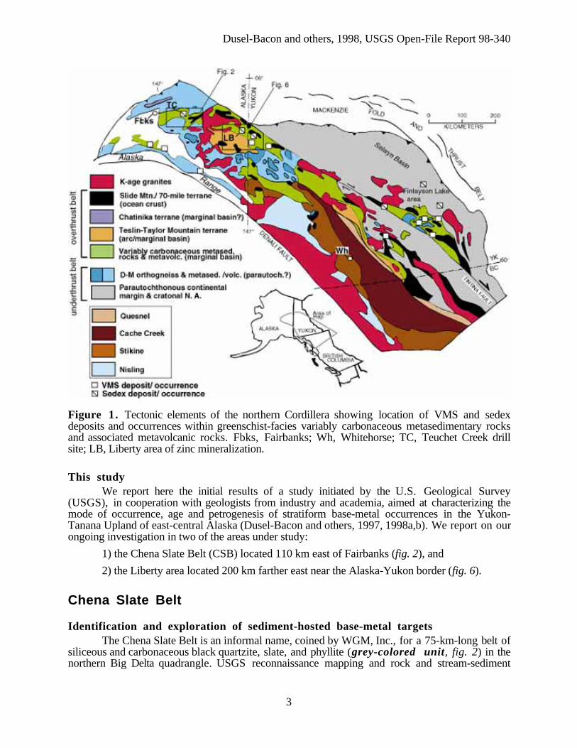
IntroductionThe Yukon-Tanana Upland of east-central Alaska and Yukon comprises thrust sheets of
ductilely deformed metasedimentary and metaigneous rocks of uncertain age and origin that areoverlain by klippen of weakly metamorphosed oceanic rocks of the Seventymile-Slide Mountainterrane, and intruded by post-kinematic Early Jurassic, Cretaceous and Tertiary granitoids.
Metamorphosed continental margin strata in the Yukon-Tanana Upland of east-centralAlaska are thought to be correlative, on the basis of stratigraphic similarities and sparseMississippian U-Pb zircon and fossil ages (Mortensen, 1992), with middle Paleozoicmetasedimentary and metavolcanic rocks in the eastern Alaska Range and in western andsoutheastern Yukon. Furthermore, rocks in the northern Yukon-Tanana Upland may correlateacross the Tintina fault with unmetamorphosed counterparts in the Selwyn Basin (Murphy andAbbott, 1995).
Volcanic-hosted (VMS) and sedimentary exhalative (sedex) massive sulfide occurrences arewidely reported for these other areas (green-colored unit of fig. 1) but, as yet, have not beendocumented in the Alaskan part of the Yukon-Tanana Upland. Recent discoveries of VMS depositsin Devono-Mississippian metavolcanic rocks in the Finlayson Lake area of southeastern Yukon(Hunt, 1997) have increased the potential for finding VMS deposits in rocks of similar lithologyand age in the Yukon-Tanana Upland of Alaska. Restoration of 450 km of early Tertiary dextralmovement along the Tintina fault juxtaposes these two areas.
Dusel-Bacon and others, 1998, USGS Open-File Report 98-340
3
Figure 1. Tectonic elements of the northern Cordillera showing location of VMS and sedexdeposits and occurrences within greenschist-facies variably carbonaceous metasedimentary rocksand associated metavolcanic rocks. Fbks, Fairbanks; Wh, Whitehorse; TC, Teuchet Creek drillsite; LB, Liberty area of zinc mineralization.
This studyWe report here the initial results of a study initiated by the U.S. Geological Survey
(USGS), in cooperation with geologists from industry and academia, aimed at characterizing themode of occurrence, age and petrogenesis of stratiform base-metal occurrences in the Yukon-Tanana Upland of east-central Alaska (Dusel-Bacon and others, 1997, 1998a,b). We report on ourongoing investigation in two of the areas under study:
1) the Chena Slate Belt (CSB) located 110 km east of Fairbanks (fig. 2), and
2) the Liberty area located 200 km farther east near the Alaska-Yukon border (fig. 6).
Chena Slate Belt
Identification and exploration of sediment-hosted base-metal targetsThe Chena Slate Belt is an informal name, coined by WGM, Inc., for a 75-km-long belt of
siliceous and carbonaceous black quartzite, slate, and phyllite (grey-colored unit, fig. 2) in thenorthern Big Delta quadrangle. USGS reconnaissance mapping and rock and stream-sediment

Dusel-Bacon and others, 1998, USGS Open-File Report 98-340
4
geochemical studies in the late 1970's indicated a potential for sediment-hosted base-metal depositsin the belt (Menzie and Foster, 1978). WGM, Inc., conducted exploration in this belt intermittentlybetween 1981 and 1994. Stream silt geochemical data collected in the belt identified a 30-km-longbelt of strongly anomalous Zn values. Poor exposure of the recessively weathering carbonaceouslithology necessitated a follow-up program, begun in 1991 on behalf of Sumitomo Metal MiningCompany, consisting of soil and rock geochemical surveys, gravity surveys, and airborne andhorizontal-loop EM surveys. Results from these surveys delineated three Zn-Pb targets in thevicinity of Teuchet Creek (TC, fig. 2). Eight core holes totaling 1,600 m drilled as preliminarytests of the targets revealed a section comprising 30 m of tan sericitic phyllite underlain by at least550 m of interlayered gray to black siliceous phyllite and quartzite. Twenty-five km to the west,another base-metal target was drilled in carbonaceous and calcareous slate at Drone Creek (DC,fig. 2).

Dusel-Bacon and others, 1998, USGS Open-File Report 98-340
5
Figure 2. Geologic map of the northern Big Delta quadrangle (modified from Weber and others,1978) showing location of Teuchet Creek (TC) and Drone Creek (DC) drill sites and U-Pb zirconcrystallization ages of felsic metavolcanic rocks.
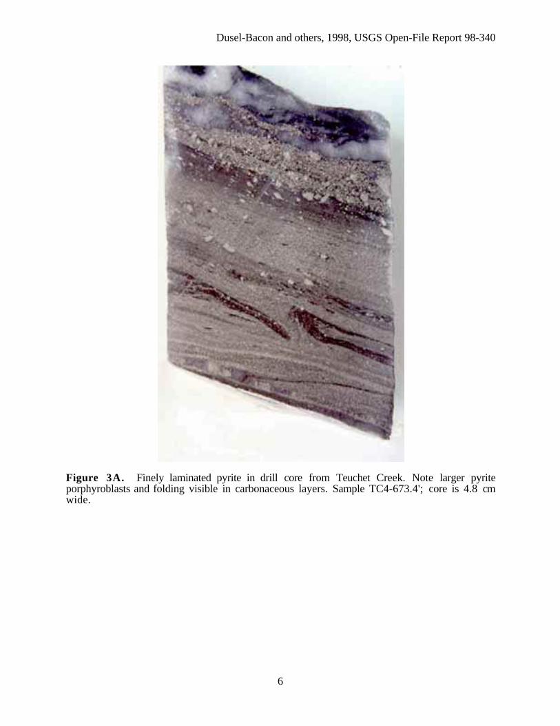
Results from drillingThe best mineralized target at the Teuchet Creek Property yielded intersections of up to 5
percent disseminated and foliation-parallel pyrite, sphalerite and galena in carbonaceous phylliteand quartzite over intervals of 18 m to 61 m. Mineralized sections included 4.6 m at 0.92 percentZn and 0.32 percent Pb, with 12 cm at 10.1 percent Zn, 3.6 percent Pb, and 38 g/t Ag. Pyriteoccurs locally in massive layers up to 52 cm thick with bands of red-brown sphalerite, galena andpyrite up to 12 cm thick (figs. 3A and 3B). Drilling at the Drone Creek Property revealedapproximately 45 m of sulfide-bearing zones, including a 17 m interval of black, verycarbonaceous slate with laminae of sphalerite, galena, pyrite and pyrrhotite with 5-7 percent totalsulfides. A 1.2-m thick sphalerite-rich interval from which the sample shown in figs. 3C and 3Dwas taken averaged 1.88 percent Zn, 820 parts per million (ppm) Pb, and 4.4 g/t Ag.
Dusel-Bacon and others, 1998, USGS Open-File Report 98-340
6
Figure 3A. Finely laminated pyrite in drill core from Teuchet Creek. Note larger pyriteporphyroblasts and folding visible in carbonaceous layers. Sample TC4-673.4'; core is 4.8 cmwide.

Dusel-Bacon and others, 1998, USGS Open-File Report 98-340
7
Figure 3B. Sphalerite-rich interval in drill core from Teuchet Creek. Note threadlike wisps ofsilvery galena, brassy pyrite porphyroblasts, and concordant quartz veins. Sample TC4-670'; coreis 4.8 cm wide.

Dusel-Bacon and others, 1998, USGS Open-File Report 98-340
8
Figure 3C. Five-cm thick layer of folded sphalerite and quartz in drill core from Drone Creek.Sample DC3-277'; core is 4.8 cm wide.

Dusel-Bacon and others, 1998, USGS Open-File Report 98-340
9
Figure 3D. Photograph of entire thin section made from core shown in 3C. Note concentrationof sphalerite (red-brown) in quartz-rich, graphite-poor layer. Height of photo is about 35 mm.
Sulfide textures and mineralogyPrimary sedimentary features in the carbonaceous rocks have been obliterated by complex
ductile shearing, folding, and low- to medium-grade metamorphism. Deformation fabrics in thesulfides indicate that mineralization pre-dated regional metamorphism. Early formed, near vertical,quartz veining is truncated along low-angle shear planes along which pyrite is commonlyconcentrated (fig. 4A). Pyrite precipitation both preceded (fig. 4B) and followed (fig. 4C) quartzveining and shearing episodes. Pyrite occurs as laminae of subhedral cubes and as largerporphyroblasts which have been partially comminuted into fine fragments (fig. 5A). Sphalerite(about 84 percent ZnS) occurs as anhedral lenses and galena forms interstitial fillings in areas highin pyrite and sphalerite (figs. 5A and 5B). Boulangerite (PbSbS) and selenium-rich galena (PbS-PbSe solid solution) (fig. 5C) occur along with galena in one interval of TC5 core. Chalcopyrite,pyrrhotite, and arsenopyrite are present in minor amounts.

Dusel-Bacon and others, 1998, USGS Open-File Report 98-340
10
Figure 4A. Siliceous black slate showing truncation of vertical quartz veins along low-angleshear planes. Note laminae of golden pyrite and reddish sphalerite (top of photo). Sample TC5-638'; core is 4.8 cm wide.

Dusel-Bacon and others, 1998, USGS Open-File Report 98-340
11
Figure 4B. Pyrite laminae in graphitic slate cut by early quartz veins and concordant to laterones. Sample TC4-690'; core is 4.8 cm wide.

Dusel-Bacon and others, 1998, USGS Open-File Report 98-340
12
Figure 4C. Pyrite concentrated within shear band that truncates quartz veins in graphitic slate.Sample TC4-691'; core is 4.8 cm wide.

Dusel-Bacon and others, 1998, USGS Open-File Report 98-340
13
Figure 5A. Reflected light (plane polarized) photomicrograph showing comminution of pyriteporphyroblast (top of photo) to form disseminated pyrite fragments. Note cleavage pits ininterstitial galena. Sample TC5-400'; width of photo 1.72 mm.

Dusel-Bacon and others, 1998, USGS Open-File Report 98-340
14
Figure 5B. Reflected light (plane polarized) photomicrograph showing typical texture of sulfide-rich intervals with subidiomorphic pyrite, interstitial galena, and amorphous sphalerite. Pyrrhotiteoccurs in trace amounts. Sample TC4-674.6'; width of photo 1.72 mm.

Dusel-Bacon and others, 1998, USGS Open-File Report 98-340
15
Figure 5C. Reflected light (plane polarized) photomicrograph showing wormy selenium-richgalena within a sphalerite layer. Amount of Se substituted for S in sample ranges from 4 to 37atom percent. Sample TC5-638'; width of photo 1.72 mm.
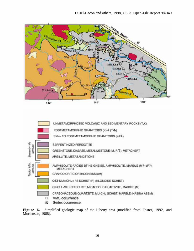
Liberty areaStratiform Zn-Pb-Ag mineral occurrences are hosted in carbonaceous schist, quartzite, and
possible felsic metavolcanic rocks in a poorly exposed 150 km2 area near Liberty in thesoutheastern Eagle quadrangle of Alaska and in adjacent parts of Yukon (fig. 6). In Alaska, thisarea is part of the holdings of the Doyon, Limited, Native Corporation. Most of the mineralizationoccurs in rocks proposed as correlatives of the Devono-Mississippian Nasina assemblage(Mortensen, 1988; Foster, 1992).
Dusel-Bacon and others, 1998, USGS Open-File Report 98-340
16
Figure 6. Simplified geologic map of the Liberty area (modified from Foster, 1992, andMortensen, 1988).

Dusel-Bacon and others, 1998, USGS Open-File Report 98-340
17
Newly identified zinc mineralization in Nasina QuartziteThree previously unreported localities of sphalerite-bearing quartzite were discovered
during this study along a three-km stretch of the Taylor Highway near the mouth of ColumbiaCreek. Carbonaceous quartzite is the dominant lithology at all three localities but mineralizationwas only observed in carbon-free or carbon-poor quartzite (metachert or exhalite?). At thesouthernmost and middle localities (borrow pits), dark foliaform laminae of reddish-ambersphalerite >>pyrite >galena >chalcopyrite occur within scattered blocks of buff-colored, celsian(barium silicate)-bearing quartzite (94-96 percent SiO2) (figs. 7A and 7B). Strained, elongatequartz grains and thin folia of tabular celsian define a penetrative fabric. Celsian-bearing quartzitesfrom both sites are high in Ba (1.6 and 3.6 percent), Zn (1.8 and 2.7 percent), and Pb (3,980 and1,040 ppm).
Figure 7A. Sample of celsian quartzite with thin lenses and laminae of sphalerite (dark gray inphoto). Sample 96ADb 32c.

Dusel-Bacon and others, 1998, USGS Open-File Report 98-340
18
Figure 7B. Transmitted light (plane polarized) photomicrograph of sample shown in fig. 7Ashowing sphalerite lenses and colorless, prismatic celsian (a barium silicate). Width of photo 0.86mm.
The northernmost locality consists of variably rusty-weathering, tan to pale gray, slightlymuscovitic and carbonaceous quartzite (88 percent SiO2) exposed in outcrop and landslide debrisjust east of the mouth of Columbia Creek. Interlayered with the quartzite are 10-20 cm-thick layersof more muscovite-rich quartzite including some layers of muscovite schist. These layers may haveoriginated as felsic tuffs. The sulfides (amber-brown sphalerite>>galena, chalcopyrite) occurwithin the quartzite in discontinuous lenses 1-2 cm thick (fig.8).

Dusel-Bacon and others, 1998, USGS Open-File Report 98-340
19
Figure 8. This grab sample of sphalerite-bearing quartzite yielded 8.1 percent Zn, 100 ppm Cd,38 parts per billion (ppb) Au, and 132 ppm Hg. Sample 96ADb 63.
Quartzite-hosted mineralization spans borderFour showings of stratiform Pb-Zn mineralization, similar to those in the Liberty area,
occur in Nasina assemblage quartzite in the Dawson 116C quadrangle of Yukon (Mortensen, 1988;Hunt, 1997). At one of these showings (MORT), 1-3 mm-thick laminae of galena or cerussite ±sphalerite are present in buff-colored muscovitic quartzite interlayered with muscovite schist (figs.9A and 9B).

Dusel-Bacon and others, 1998, USGS Open-File Report 98-340
20
Figure 9A. Jim Mortensen poses at the MORT occurrence (location shown on fig. 6). Sample offig. 9B was collected from light-colored, folded quartz-rich layer.

Dusel-Bacon and others, 1998, USGS Open-File Report 98-340
21
Figure 9B. This sample of cerussite-bearing quartzite yielded 4.3 percent Pb, 54 g/t Ag, and 60ppb Au. Sample 96ADb41b.
Lead Creek prospect hosts base- and precious-metal mineralization of unknownage
The Lead Creek prospect, so named because of the discovery by WGM, Inc., of high Pb,Zn, and Ag values in silt samples from a south-flowing tributary of Columbia Creek, is currentlybeing drilled as part of an exploration program conducted by WGM, Inc., on behalf of VenturesResource Alaska. The prospect is underlain by a regionally and contact-metamorphosed, relativelyundeformed section of carbonaceous schist, quartz-mica schist, pyritic metachert, felsic metatuff,and marble. Protolith ages for the host rocks may be Triassic, Permian, or Devonian andMississippian. EM conductors and Pb and Ag soil anomalies occur in an area underlain bycarbonaceous schist containing siliceous nodules and quartz-galena veins. Most siliceous nodulescontain <3.7 percent Pb and 196 g/t Ag (Schmidt, 1997). A 2.5 m-long trench sample ofcarbonaceous schist contained 1.9 percent Pb and 72 g/t Ag and a sample of a feldspar porphyrydike contained 1,309 ppm Pb and 2,450 ppm As (U.S. Bureau of Mines, 1995). Sampling at theprospect during the present study yielded a sample of pyrite-bearing carbonaceous quartzite thatcontained >10,000 ppm As and 170 ppb Au and a highly mineralized and oxidized sampledisplaying gray and yellow banding (fig. 10).

Dusel-Bacon and others, 1998, USGS Open-File Report 98-340
22
Figure 10. This supergene grab sample from the Lead Creek prospect yielded 2,330 ppb Au,2126 g/t Ag, >10,000 ppm As, >100 ppm Cd, 1,420 ppm Cu, 10.8 percent Pb, and >10,000 ppmSb. Sample 96ADb 49.
Newly dated Permian metarhyolite expands potential for VMS depositsWeakly metamorphosed and deformed pyritic rhyolite tuff (fig. 11) crops out 13 km
northeast of the mouth of Columbia Creek in an area formerly mapped as part of the Nasinaassemblage. A U-Pb zircon age determined in this study indicates a Permian (256.6±1 Ma)crystallization age for the rhyolite suggesting correlation with the Klondike Schist. Several VMSoccurrences are hosted in Klondike Schist near Boundary (fig. 6) (Mortensen, 1988), 45 km to thesouth, enhancing the potential for similar-aged deposits in the Liberty area.

Dusel-Bacon and others, 1998, USGS Open-File Report 98-340
23
Figure 11. Transmitted light photomicrograph (crossed polars) of Permian-aged metarhyolite. Apyroclastic origin for the metarhyolite is suggested by: 1) the presence of an approximately 1-mmgranophyre clast (right-hand half of photo); 2) evidence of broken phenocrysts; and 3) the absenceof glomerocrysts, common in lava flows or shallow intrusions. Sample 96ADb 47b; width ofphoto 0.86 mm.
Late Mississippian age for deposition and mineralization of Chena Slate Belt andLiberty area quartzites
New Pb isotopic data for syngenetic(?) galena collected in mineralized drill core from theCSB and from sphalerite-bearing quartzite in the Liberty area indicate a Devono-Mississippian ageof mineralization (fig. 12). In addition, an Early Mississippian (346.4±1 Ma) protolith age for theCSB is indicated by a newly determined concordant U-Pb zircon crystallization age for a felsicmetatuff layer within carbonaceous argillite in the eastern part of the CSB (fig. 2). These new agessupport correlation of the black quartzite unit with both the Devono-Mississippian Nasinaassemblage in Yukon as proposed by Mortensen (1992) and Foster (1992), and with the KeevyPeak Formation in the Alaska Range as proposed by Smith and others (1994).

Dusel-Bacon and others, 1998, USGS Open-File Report 98-340
24
Figure 12. Lead isotopic data for sulfides from east-central Alaska (published data from Churchand others, 1987, and Newberry and others, 1997; unpublished 1997 data for galena from ChenaSlate Belt (Teuchet Creek drill core) and sphalerite from quartzite in Liberty area from J.K.Mortensen; Abbreviations: v, VMS deposits of the Bonnifield District, Alaska Range; K, LloydProspect, Kantishna; E, mineralized boulder in dredge tailings, Chatanika eclogite terrane; D, DeerCreek, Eagle area.
Conclusions1. A syngenetic origin for the sulfides in Nasina assemblage metasedimentary rocks in the
CSB and the Liberty areas is indicated by:
• Devono-Mississippian Pb isotopic model ages of stratiform galena and U-Pb zirconcrystallization ages of interlayered felsic tuffs.
• finely laminated to locally massive sulfide textures parallel to metamorphic foliation andcompositional layering in the graphitic rocks of the CSB.
• the high SiO2 and locally high Ba contents of the buff-colored, sphalerite- and galena-bearing quartzite layers within the carbonaceous sequence in the Liberty area. Theselayers may represent diagenetically altered and subsequently metamorphosed chemicalprecipitates that originally formed on the seafloor.
2. Mineralization in Nasina-age rocks of the CSB and the Liberty area may be similar in ageand tectonic and (or) sedimentary setting to sediment-hosted Zn-Pb deposits in the Selwyn

Dusel-Bacon and others, 1998, USGS Open-File Report 98-340
25
Basin–Kechika Trough farther east that occur in fine to coarse black clastic rocks of the MiddleDevonian to Mississippian Earn Group.
3. The variety of metals and host rocks at the Lead Creek prospect may indicate multipleepisodes of mineralization. Pb- and Ag-enriched siliceous nodules in carbonaceous schist andmetachert are perhaps of diagenetic origin. However, the presence of a feldspar porphyry dikeanomalous in Pb and As, the high Pb, Sb and As in oxidized material, and the presence of quartz-galena veins, contact metamorphism and sulfide-bearing intrusions in the immediate area suggestthat some metals were remobilized or introduced during a later magmatic hydrothermal event.
4. The discovery of a Permian-age metarhyolite in the Liberty area expands the potential forstratiform mineralization to include Permian VMS deposits.
AcknowledgmentsCharlie Bacon and Julie Hunt participated in field work. Lew Calk provided expertise and
assistance with electron microprobe analyses. Kurt Friehauf advised the senior author on oremicroscopy. Denise Armstrong and Chris Keegan provided office and laboratory assistance. JudyWeathers ably turned the senior author's mock-up into a completed poster for Pathways toDiscovery Exploration Methods '98 at Cordilleran Roundup. Mike Diggles then turned the posterinto the web page you are now viewing.
ReferencesChurch, S.E., Delavaux, M.H., and Gray, J.E., 1987, Pb-isotope base for sulfides from Alaska:
U.S. Geological Survey Open-File Report 87-259, 44 p.Dusel-Bacon, C., Bressler, J.R., Takaoka, H., Mortensen, J.K., Oliver, D.H., Leventhal, J.S.,
Newberry, R.J., and Bundtzen, T.K., 1997, Stratiform massive sulfides in the Yukon-Tanana Upland of Alaska: Are they there? [abs.]: Abstracts for the Alaska MinersAssociation 1997 Meeting, Anchorage, Alaska, p. 24-26.
_____, 1998a, Stratiform zinc-lead mineralization in Nasina assemblage rocks of the Yukon-Tanana Upland in east-central Alaska [abs.]: Pathways '98, Extended Abstracts Volume:British Columbia & Yukon Chamber of Mines, p. 170-173.
Dusel-Bacon, C., Wooden, J.L., Mortensen, J.K., Bressler, J.R., Takaoka, H., Oliver, D.H.,Newberry, R., and Bundtzen, T.K., 1998b, Metamorphic-hosted mineralization in theYukon-Tanana Upland, Alaska [abs.]: Extended abstracts of the 16th Biennial Conferenceon Alaskan Mining, March 2-7, 1998, Fairbanks, Alaska Miners Association, p. 16-18.
Foster, H.L., 1992, Geologic Map of the eastern Yukon-Tanana Region, Alaska: U.S. GeologicalSurvey Open-File Report 92-313, 26 p.
Hunt, J.A., 1997, Massive sulphide deposits in the Yukon-Tanana and adjacent terranes. in:Yukon exploration and Geology, 1996, Exploration and Geological Services Division,Yukon, Indian and Northern Affairs Canada, p. 35-45.
Menzie, W.D., and Foster, H.L., 1978, Metalliferous and selected nonmetalliferous mineralresource potential in the Big Delta quadrangle, Alaska: U.S. Geological Survey Open-FileReport 78-529D.
Mortensen, J.K., 1988, Geology Southwestern Dawson Map area: Geological Survey of CanadaOpen-File 1927, scale 1:250,000.
Mortensen, J.K., 1992, Pre-mid-Mesozoic tectonic evolution of the Yukon-Tanana terrane, Yukonand Alaska: Tectonics, v. 11, p. 836-853.
Murphy, D.C., and Abbott, G., 1995, Northern Yukon-Tanana terrane: The equivalent ofYukon's western Selwyn Basin offset along the Tintina fault?: Geological Society ofAmerica Abstracts with Programs, v. 27, no. 5, p. 26.
Newberry, R.J., Crafford, T.C., Newkirk, S.R., Young, L.E., Nelson, S.W., and Duke, N.A.,1997, Volcanogenic massive sulfide deposits of Alaska: Economic Geology Monograph 9,p. 120-150.

Dusel-Bacon and others, 1998, USGS Open-File Report 98-340
26
Schmidt, J.M., 1997, Shale-hosted Zn-Pb-Ag and barite deposits of Alaska: Economic GeologyMonograph 9, p. 35-65.
Smith, T.E., Robinson, M.S., Weber, F.R., Waythomas, C.W., and Reifenstuhl, R.R., 1994,Geologic map of the upper Chena River area, eastern Interior Alaska: Alaska Division ofGeological and Geophysical Surveys Professional Report 115, scale 1:63,360, 19 p.
U.S. Bureau of Mines, 1995, Final Report of the Mineral Resource Evaluation of the Bureau ofLand Management Black River and Fortymile River Subunits: U.S. Bureau of MinesOpen-File Report 79-95, 69 p.
Weber, F.R., Foster, H.F., Keith, T.E.C., and Dusel-Bacon, Cynthia, 1978, Preliminarygeologic map of the Big Delta quadrangle, Alaska: U.S. Geological Survey Open-FileReport 78-529-A, scale 1:250,000.
To contact the senior author, email Cynthia Dusel-Bacon ([email protected]).