Embed Size (px)
Citation preview
Stratford Metropolitan MasterplanSupporting Document:Building Heights PaperFebruary 2011
Final version approved by London Borough of Newham Cabinet on 16th December 2010.Copyright London Borough of Newham 2011www.newham.gov.uk/stratfordmetropolitan
Supported by Shared Intelligence, DTZ, Halcrow, Urban Space Management and Arup.
2
Contents Introduction........................................................................................................................................ 3 Why is building height important?.................................................................................................... 3 Areas / views of particular sensitivity............................................................................................... 6 Principles ........................................................................................................................................... 8 Guidance on General Height............................................................................................................ 9 Guidance on Tall Buildings ............................................................................................................ 12 Stratford High Street in focus ......................................................................................................... 14
Appendix 1 ........................................................................................................................................... 16 Appendix 2 ........................................................................................................................................... 17
3
Introduction
1.1 Stratford is comprised of a wide range of building heights. However, only a decade ago, Stratford was largely characterised by two to three storey terraced developments, a few estates with 3-4 storey apartment buildings and a number of 20 storey tower blocks. In Stratford town centre these were complemented by 15-storey Morgan House and a few other 4-6 storey office blocks. The historic height scape is strongly contrasted by more recent development along the High Street, in Stratford City and the Olympic Village, which brought forward a substantially increased height, and also led to a number of high rise towers of unprecedented height. The result is a very heterogeneous and fragmented picture in terms of building height.
1.2 This framework presents an opportunity to establish a more coordinated approach to building height, which over time, with new development coming forward, will overcome the current stark contrast in favour of a more coherent and legible built environment, providing character areas with consistent built form. It is hoped that given the current policy vacuum with relation to building height (see local policy section below for more details) that this study can be worked up in phase 2 of the Stratford Metropolitan Masterplan to become part of the SPD guidance and therefore provide a firm policy basis for assessing building height. As has been highlighted by the evidence base urban design analysis and by stakeholders and council officers, Stratford High Street (and increasingly the town centre) is an area for particular concern because of the significant development pressures on these areas for tall buildings. Therefore, after giving general guidance on height across the area, this study carries out some more focused analysis on the High Street.
Why is building height important? 1.3 Building heights have an important influence on the character and image of a place. They
also have a direct impact on development density and the intensity of activity in an area. Therefore building height needs to be carefully managed, particularly where there are significant development pressures (as there are in Stratford). This guidance considers both general building heights (the typical height of the majority of development in an area) and also exceptional heights (the few taller elements that break the norm). In relation to tall buildings this guidance has due regard to the following guidance.
Cabe and English Heritage guidance
1.4 The Cabe and English Heritage guidance on tall buildings (2007) makes a clear case why it is important to manage tall buildings. In summary, the guidance states that:
• Tall buildings are likely to have a greater impact than other building types due to their massing and size.
• Tall buildings can mark points of significant activity such as central places, create fine landmarks, highlight civic buildings and emphasise important transport connections.
On the other hand: • tall buildings can overshadow • tall buildings can overlook and dominate their immediate surroundings • tall buildings can have harmful effects on living conditions, private gardens and public
spaces. • if inappropriately planned, designed and located tall buildings can be especially
harmful for historic buildings, Conservation Areas, significant views and skylines, and the greater their height, the broader their impact tends to be.
1.5 It follows that the location of tall buildings needs to be carefully managed.
4
London Plan guidance
1.6 This management of tall buildings is also addressed through the London Plan (2008) and the draft replacement London Plan. The London Plan (2008) frames the policy on tall buildings in a positive light, stating:
“The Mayor will promote the development of tall buildings where they create attractive landmarks enhancing London’s character, help to provide a coherent location for economic clusters of related activities and/or act as a catalyst for regeneration and where they are also acceptable in terms of design and impact on their surroundings”. 1.7 The emerging policy in the Draft Replacement London Plan (published for consultation in
October 2009) is more restrictive in tone, stating:
“Tall and large buildings should be part of a strategic approach to changing or developing an area, and should not have an unacceptably harmful impact on their surroundings.” 1.8 The Draft Replacement London Plan Policy 7.7 gives further advice regarding tall
buildings, stating that tall buildings should:
• Generally be limited to sites in the Central Activity Zone, Opportunity Areas, Areas of Intensification or Town Centres that have good access to public transport
• Only be considered in areas whose character would not be adversely affected by the scale, mass or bulk of a tall or large building
• Relate well to the form, proportion, composition, scale and character of surrounding buildings, urban grain and public realm (including landscape features), particularly at street level;
• Individually or as a group, form a distinctive landmark that emphasizes a point of civic or visual significance, and enhances the skyline and image of London
• Incorporate the highest standards of architecture and materials • Have ground floor activities that provide a positive relationship to the surrounding
streets • Incorporate publicly accessible areas on the upper floors, where appropriate • Make a significant contribution to local regeneration
1.9 The London Plan (2008) also states the role that Boroughs should play in defining where tall buildings would be appropriate and states that:
“Boroughs may wish to identify defined areas of specific character that could be sensitive to tall buildings…[and] should clearly explain what aspects of local character could be effected and why”.
1.10 This underlines the importance of boroughs having a strategy in place for the management of tall buildings.
Local guidance:
1.11 There are a number of existing and emerging policies relating to tall buildings at a local level.
1.12 The Unitary Development Plan (adopted 2001) has a number of policies relating to tall buildings (EQ27 and EQ28). Policy EQ28 states that
“provided they…do not harm composition and harmony of existing buildings of the surrounding environment, do not adversely affect the skyline or do not cause a hazard to aircraft, consideration will be given to high buildings (exceeding the equivalent of four / five domestic storeys in height) at:
5
• The periphery of Stratford Town Centre (excluding the Centre’s conservation area) • Major transport interchanges in the area • Areas already developed with existing high buildings
1.13 This policy therefore sets the framework for tall buildings being developed along the High Street and the Town Centre, however it does not give the further guidance that is now needed in development control terms given the context of the greater development pressure in the area due to the 2012 Games and the opening of Westfield (added to the excellent strategic transport links in the area).
1.14 The core strategy will also put in place some guidelines relating to tall buildings through Core Strategy Successful Places policies (SP1, SP3, SP4, SP5 and SP7). These are currently in draft only. The core strategy is likely to be adopted in 2012. Emerging policy SP4 states that:
• Parts of Stratford Metropolitan will be the key location for the tallest buildings in the borough (20 storeys plus on landmark sites) with Canning Town Centre as a secondary focus, as a component of transformation plans for these centres;
• Other locations with good public transport access within the arc of opportunity will be regarded as suitable locations for buildings of up to 20 storeys (but typically around 8-12 storeys) where they will contribute to legibility and place-making objectives;
1.15 This policy gives a greater level of clarity than the Local Plan policy EQ28, and the design standards set out in the other Successful Places policies will form useful guidance for the assessment of new buildings. However if the need for a greater rigor in the assessment of tall buildings along the High Street and in Stratford Town Centre is to be met, this emerging policy will need to be supported by a clear framework as to where landmarks may be appropriate and exactly how high the landmarks should be. This paper sets out the first steps towards doing that, however further analysis will have to be undertaken if it is to be adopted as part of an SPD.
1.16 In addition a number of studies undertaken by the Council have considered building heights across Stratford – The Stratford High Street Urban Design and Public Realm study (February 2008) and the Newham Character Study (interim version, 2010). The Stratford High Street Urban Design and Public Realm study sets out some detailed guidance for Stratford High Street with relation to scale and massing as follows:
• Stratford High Street is identified as a location for tall buildings in certain sites. On specific sites these should be between 20 – 30 storeys (approx 75 -110m in height).
• An exception applies to Warton Road and Carpenter’s Road where Tall Buildings are inappropriate due to the narrow nature of the access roads off the High Street.
• The elevations should be narrow in relation to the height, of no more than 20m facing onto the High Street. In order to prevent a monotonous wall of development, blocks should have a minimum of 40m spacing between them with 5m offsets.
• Additional environmental considerations in terms of applications for tall buildings include potential for wind-tunnel effects, outlook, overshadowing, maintaining views from the High Street and public space. These all apply to the suitability of proposals for tall buildings.
1.17 This study provides some useful and detailed information about scale and massing on the High Street, however it has not been adopted as planning policy and the rapidly changing context of Stratford means that further work needs to be carried out in order to allow for a truly coherent approach to the High Street.
1.18 The Newham Character Study underlines some of the concerns about tall buildings in Stratford that have already been discussed. It states that:
6
• Stratford High Street is where many of these tall buildings have been located and refers to them as “statement” towers. The result has been to increase dwelling density and building heights but has “created a High Street lacking coherence and legibility”
• Stratford High Street is “a particularly important gateway in danger of competing buildings creating a tunneling effect”
1.19 In response to these issues:
• The strategy calls for a “strategic approach to tall buildings, to be reflected in the Core Strategy and more detailed policies and guidance”
• It notes that many of the benefits of Tall Buildings can be achieved by buildings which are “taller by a few storeys than the prevailing height locally, but not necessarily “tall” in the increasingly common sense of the word 18-20 storeys+.
• It states that taller buildings should be located on major transport corridors • It notes that existing tall buildings do not necessarily support more tall buildings • It accepts that a balanced approach to “retrospective mitigation” of areas where
piecemeal tall development has already occurred in order to raise the average height of buildings on the street may be necessary
• The Stratford Metropolitan Masterplan is referred to as an opportunity to improve this situation by “managing their distribution and addressing their impacts”
1.20 This building heights paper takes account of this policy work already undertaken and seeks to put the first steps in place for a rigorous framework to assess building heights. It is hoped that further detail can be added to this study at Phase 2 of the Stratford Metropolitan Masterplan process in which the masterplan (including the guidance on heights) will be adopted as an SPD.
Areas / views of particular sensitivity 1.21 The Cabe and English Heritage guidance highlights the potential impacts of tall buildings
on historic buildings, Conservation Areas and significant views and skylines and the London Plan guidance demonstrates the Borough’s role in defining what aspects of local character could be affected and why.
1.22 Within the Stratford Metropolitan Masterplan study area, there are a number of conservation areas – St. John’s Conservation Area, The University Conservation Area, Sugar House Lane Conservation and Three Mills Conservation area. This study has also identified some important local views that need to be protected. The potential impact of tall buildings on all these features is explored below.
Conservation areas
1.23 In terms of the special characteristics of the conservation areas in the ward, the following are particularly relevant in terms of managing building heights:
• The St. John’s Conservation Area Appraisal states that St. John’s Church is very much the focal point of the St. John’s Conservation Area, terminating views into and within it. This emphasises the importance of preserving and enhancing these views.
• Part of the special character in the University Conservation area is in the mix of uses and building forms with both larger scale buildings built for community or commercial uses and domestic scale residences (the area contains the only surviving group of Georgian / Regency properties in the borough). The scale and height of new buildings should therefore respect these special characteristics of the Conservation Area.
• The Sugar House Lane Conservation Area Appraisal stresses the importance of the sequence of spaces and waterways in the area, the plain simple buildings with strong group value and the rich silhouette and skyline. It is clear that building height of any new proposals could impact upon these features and therefore should be carefully managed within the area.
7
• The Three Mills Conservation Area is distinguished by both its waterways and its range of exceptional listed buildings (including the grade 1 listed Tide Mill, known as House Mill).
Views
1.24 A detailed analysis of views is beyond the scope of this study, however a number of key local views have been identified that are in areas of particular development pressure around the town centre and close to conservation areas. The views are as follows:
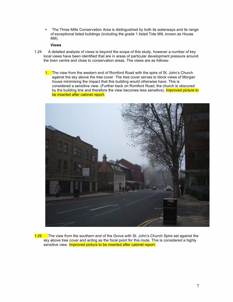
1. The view from the western end of Romford Road with the spire of St. John’s Church
against the sky above the tree cover. The tree cover serves to block views of Morgan house minimising the impact that this building would otherwise have. This is considered a sensitive view. (Further back on Romford Road, the church is obscured by the building line and therefore the view becomes less sensitive). Improved picture to be inserted after cabinet report.
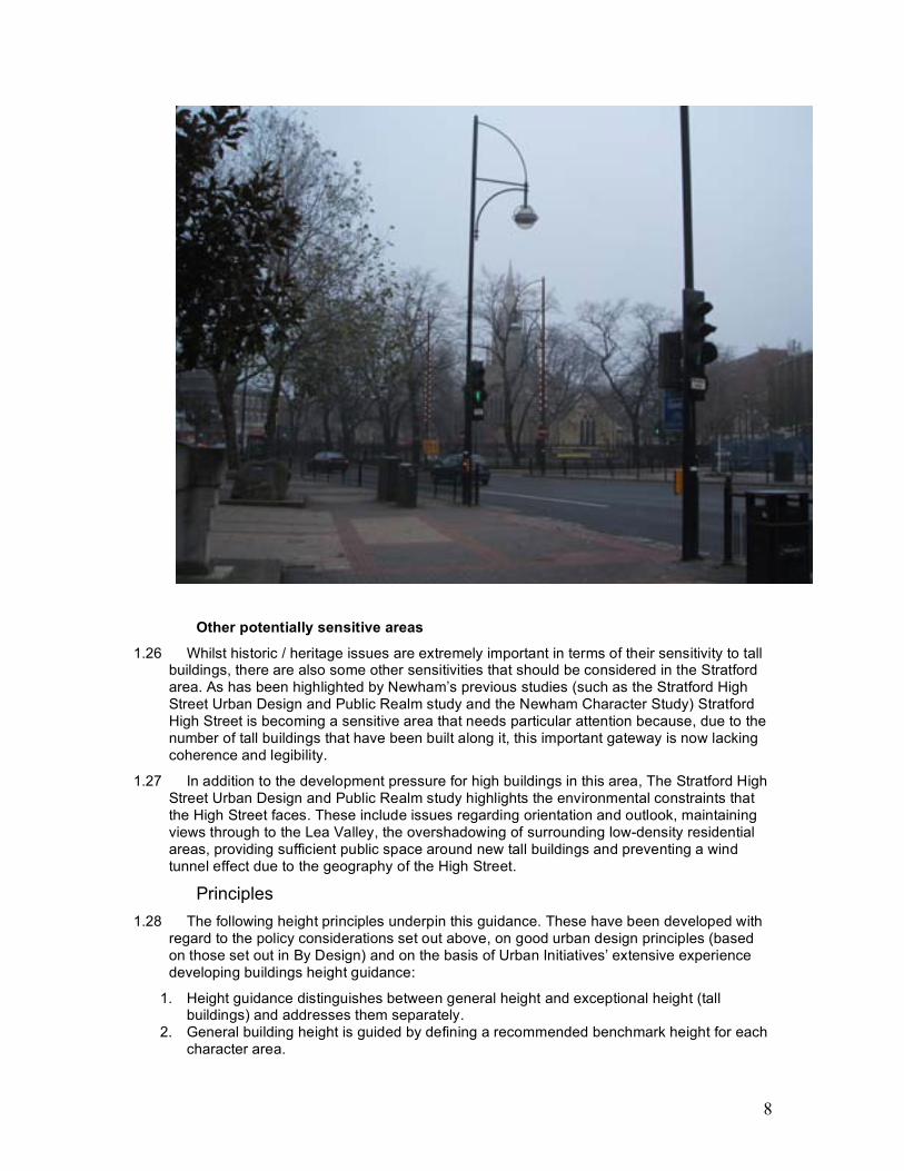
1.25 The view from the southern end of the Grove with St. John’s Church Spire set against the sky above tree cover and acting as the focal point for this route. This is considered a highly sensitive view. Improved picture to be inserted after cabinet report.
8
Other potentially sensitive areas
1.26 Whilst historic / heritage issues are extremely important in terms of their sensitivity to tall buildings, there are also some other sensitivities that should be considered in the Stratford area. As has been highlighted by Newham’s previous studies (such as the Stratford High Street Urban Design and Public Realm study and the Newham Character Study) Stratford High Street is becoming a sensitive area that needs particular attention because, due to the number of tall buildings that have been built along it, this important gateway is now lacking coherence and legibility.
1.27 In addition to the development pressure for high buildings in this area, The Stratford High Street Urban Design and Public Realm study highlights the environmental constraints that the High Street faces. These include issues regarding orientation and outlook, maintaining views through to the Lea Valley, the overshadowing of surrounding low-density residential areas, providing sufficient public space around new tall buildings and preventing a wind tunnel effect due to the geography of the High Street.
Principles 1.28 The following height principles underpin this guidance. These have been developed with
regard to the policy considerations set out above, on good urban design principles (based on those set out in By Design) and on the basis of Urban Initiatives’ extensive experience developing buildings height guidance:
1. Height guidance distinguishes between general height and exceptional height (tall buildings) and addresses them separately.
2. General building height is guided by defining a recommended benchmark height for each character area.
9
3. The benchmark height is established in relation to a. existing height & character; b. relative centrality and accessibility by public transport; and c. existing and proposed mix of uses.
4. The benchmark height given is the building shoulder height, which is the sheer height of the building above building line, one set back storey of (inhabited) roof space is generally acceptable above this height.
5. It is recognised that in some cases there may be a need to apply a modifier – a minor diversion from the benchmark height by normally one or two storeys - to respond to local circumstances. This is at the discretion of the planning authority in return for a public benefit, which could be an urban design or socio-economic benefit.
6. Urban Design Criteria include: for upward modifiers:
a. Provision of better enclosure of public spaces, and b. Enhancing legibility of end of blocks on street corners c. Emphasise / terminate important views d. Emphasise important routes
Downward modifiers: a. relate appropriately to setting of historic buildings b. to protect residential amenities c. to be consistent with scale of street / general character
7. Tall buildings is a relative concept – relative to the height of their context, and as such height guidance for tall buildings refers to the general height
8. Tall buildings should generally be the exception, rather than the norm and existing tall building do not necessarily mean that further tall buildings will be acceptable in a given location.
9. Tall buildings should only be allowed in areas that benefit from higher public transport accessibility and have sufficient provision of transport and social infrastructure (or make allowance for provision of these).
10. Additionally, tall buildings should • provide clear socio-economic benefits (ie. conglomeration benefits or contribution) • contribute to enhanced legibility on a local and city scale and • have no adverse impacts onto conservation areas or important views.
11. There is a greater case for exceptional height when buildings have a public or well known function
12. Tall buildings that aim to provide a landmark function should be of exceptional and iconic design.
13. The height of tall buildings should relate to the relative importance of their location in the wider context.
14. This study makes a distinction between local, district and metropolitan landmarks. Local landmarks are buildings that are up to twice the context height and help to locally emphasise an important point in the urban fabric. District landmarks are generally 2-3 times the general height and mark centres and locations of district-wide importance, and metropolitan landmarks are buildings of 3-4 times the general height that mark places of metropolitan significance.
15. The recommended height for a tall building would normally set the height of the tower shaft (full storey) while in principle allowing for a few additional set-back/ receding storeys, that are no more than 10-15% additional to the recommended height. This allows for the development of special articulation at the top of the tower.
Guidance on General Height 1.29 Based on policy guidance, the definition of character areas by this development
framework, and a review of existing heights, the following general height approach is recommended (the table should be read in conjunction with the building heights at appendix 1).
10
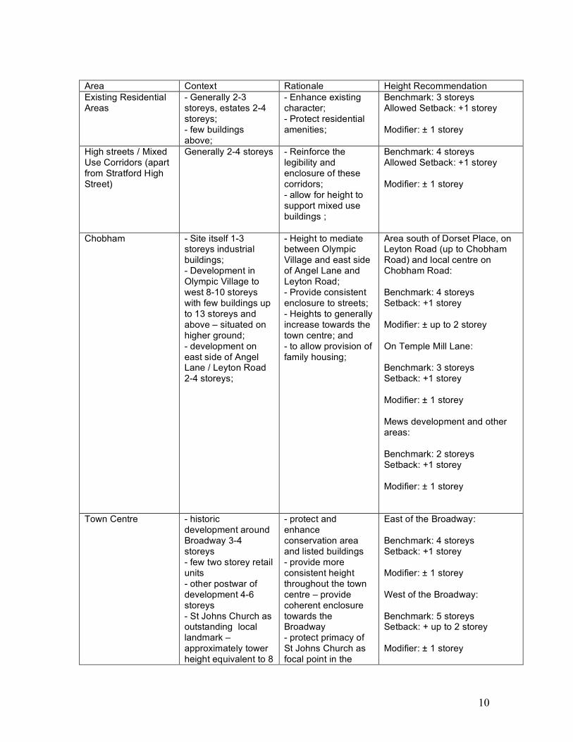
Area Context Rationale Height Recommendation Existing Residential Areas
- Generally 2-3 storeys, estates 2-4 storeys; - few buildings above;
- Enhance existing character; - Protect residential amenities;
Benchmark: 3 storeys Allowed Setback: +1 storey Modifier: ± 1 storey
High streets / Mixed Use Corridors (apart from Stratford High Street)
Generally 2-4 storeys - Reinforce the legibility and enclosure of these corridors; - allow for height to support mixed use buildings ;
Benchmark: 4 storeys Allowed Setback: +1 storey Modifier: ± 1 storey
Chobham - Site itself 1-3 storeys industrial buildings; - Development in Olympic Village to west 8-10 storeys with few buildings up to 13 storeys and above – situated on higher ground; - development on east side of Angel Lane / Leyton Road 2-4 storeys;
- Height to mediate between Olympic Village and east side of Angel Lane and Leyton Road; - Provide consistent enclosure to streets; - Heights to generally increase towards the town centre; and - to allow provision of family housing;
Area south of Dorset Place, on Leyton Road (up to Chobham Road) and local centre on Chobham Road: Benchmark: 4 storeys Setback: +1 storey Modifier: ± up to 2 storey On Temple Mill Lane: Benchmark: 3 storeys Setback: +1 storey Modifier: ± 1 storey Mews development and other areas: Benchmark: 2 storeys Setback: +1 storey Modifier: ± 1 storey
Town Centre - historic development around Broadway 3-4 storeys - few two storey retail units - other postwar of development 4-6 storeys - St Johns Church as outstanding local landmark – approximately tower height equivalent to 8
- protect and enhance conservation area and listed buildings - provide more consistent height throughout the town centre – provide coherent enclosure towards the Broadway - protect primacy of St Johns Church as focal point in the
East of the Broadway: Benchmark: 4 storeys Setback: +1 storey Modifier: ± 1 storey West of the Broadway: Benchmark: 5 storeys Setback: + up to 2 storey Modifier: ± 1 storey
11
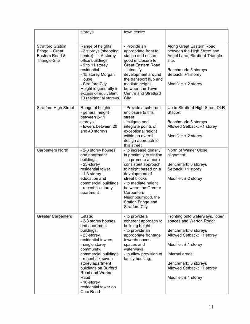
storeys
town centre
Stratford Station Fringe – Great Eastern Road & Triangle Site
Range of heights: - 2 storeys (shopping centre) – 4-6 storey office buildings - 9 to 11 storey residential - 15 storey Morgan House - Stratford City Height is generally in excess of equivalent 10 residential storeys
- Provide an appropriate front to station and ensure good enclosure to Great Eastern Road - Intensify development around the transport hub and mediate height between the Town Centre and Stratford City
Along Great Eastern Road between the High Street and Angel Lane, Stratford Triangle site: Benchmark: 8 storeys Setback: +1 storey Modifier: ± 2 storey
Stratford High Street Range of heights: - general height between 2-11 storeys, - towers between 20 and 40 storeys
- Provide a coherent enclosure to this street - mitigate and integrate points of exceptional height within an overall design approach to this street
Up to Stratford High Street DLR Station: Benchmark: 8 storeys Allowed Setback: +1 storey Modifier: ± 2 storey
Carpenters North - 2-3 storey houses and apartment buildings, - 23-storey residential tower, - 1-3 storey education and commercial buildings - recent six storey apartment
- to increase density in proximity to station - to promote a more consistent approach to height based on a development of street blocks - to mediate height between the Greater Carpenters Neighbourhood, the Station Fringe and Stratford City
North of Wilmer Close alignment: Benchmark: 6 storeys Setback: +1 storey Modifier: ± 2 storey
Greater Carpenters Estate: - 2-3 storey houses and apartment buildings, - 23-storey residential towers, - single storey community, commercial buildings - recent six-seven storey apartment buildings on Burford Road and Warton Raod - 16-storey residential tower on Cam Road
- to provide a coherent approach to building height - to provide an appropriate frontage towards opens spaces and waterways - to allow provision of family housing;
Fronting onto waterways, open spaces and Warton Road: Benchmark: 6 storeys Allowed Setback: +1 storey Modifier: ± 1 storey Internal areas: Benchmark: 3 storeys Allowed Setback: +1 storey Modifier: ± 1 storey
12
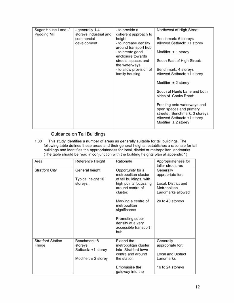
Sugar House Lane ./ Pudding Mill
- generally 1-4 storeys industrial and commercial development
- to provide a coherent approach to height - to increase density around transport hub - to create good enclosure towards streets, spaces and the waterways - to allow provision of family housing
Northwest of High Street: Benchmark: 6 storeys Allowed Setback: +1 storey Modifier: ± 1 storey South East of High Street: Benchmark: 4 storeys Allowed Setback: +1 storey Modifier: ± 2 storey South of Hunts Lane and both sides of Cooks Road: Fronting onto waterways and open spaces and primary streets : Benchmark: 3 storeys Allowed Setback: +1 storey Modifier: ± 2 storey
Guidance on Tall Buildings 1.30 This study identifies a number of areas as generally suitable for tall buildings. The
following table defines these areas and their general heights; establishes a rationale for tall buildings and identifies the appropriateness for local, district or metropolitan landmarks. (The table should be read in conjunction with the building heights plan at appendix 1).
Area Reference Height Rationale Appropriateness for taller structures
Stratford City General height: Typical height 10 storeys.
Opportunity for a metropolitan cluster of tall buildings, with high points focussing around centre of cluster; Marking a centre of metropolitan significance Promoting super-density at a very accessible transport hub
Generally appropriate for: Local, District and Metropolitan Landmarks allowed 20 to 40 storeys
Stratford Station Fringe
Benchmark: 8 storeys Setback: +1 storey Modifier: ± 2 storey
Extend the metropolitan cluster into Stratford town centre and around the station Emphasise the gateway into the
Generally appropriate for: Local and District Landmarks 16 to 24 storeys
13
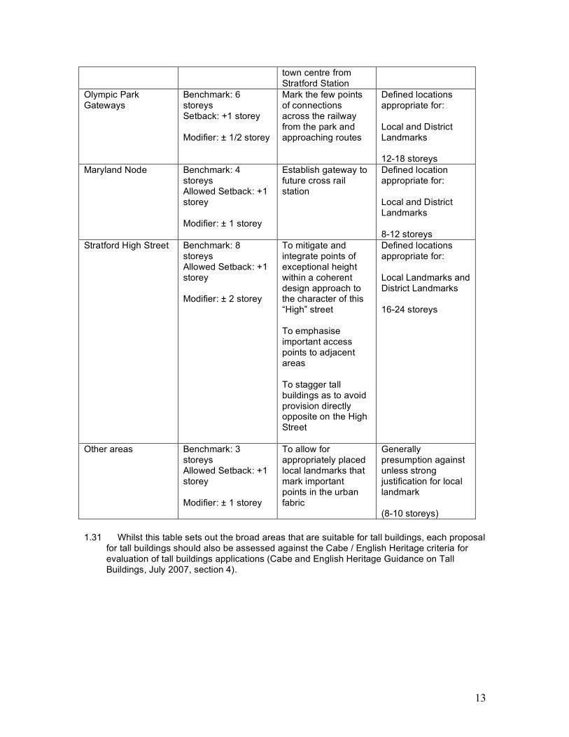
town centre from Stratford Station
Olympic Park Gateways
Benchmark: 6 storeys Setback: +1 storey Modifier: ± 1/2 storey
Mark the few points of connections across the railway from the park and approaching routes
Defined locations appropriate for: Local and District Landmarks 12-18 storeys
Maryland Node Benchmark: 4 storeys Allowed Setback: +1 storey Modifier: ± 1 storey
Establish gateway to future cross rail station
Defined location appropriate for: Local and District Landmarks 8-12 storeys
Stratford High Street Benchmark: 8 storeys Allowed Setback: +1 storey Modifier: ± 2 storey
To mitigate and integrate points of exceptional height within a coherent design approach to the character of this “High” street To emphasise important access points to adjacent areas To stagger tall buildings as to avoid provision directly opposite on the High Street
Defined locations appropriate for: Local Landmarks and District Landmarks 16-24 storeys
Other areas Benchmark: 3 storeys Allowed Setback: +1 storey Modifier: ± 1 storey
To allow for appropriately placed local landmarks that mark important points in the urban fabric
Generally presumption against unless strong justification for local landmark (8-10 storeys)
1.31 Whilst this table sets out the broad areas that are suitable for tall buildings, each proposal
for tall buildings should also be assessed against the Cabe / English Heritage criteria for evaluation of tall buildings applications (Cabe and English Heritage Guidance on Tall Buildings, July 2007, section 4).
14
Stratford High Street in focus 1.32 As has been highlighted by the evidence base, urban design analysis and by
stakeholders and Newham Council officers, Stratford High Street (and increasingly the town centre) is an area for particular concern because of the significant development pressures on these areas for tall buildings.
1.33 The current streetscape on the High Street is highly fragmented. Historic development along the High Street typically is two to three storeys. This is contrasted by recent development bringing forward general heights that range between 6 and 8 storey, and, in some cases, towers of exceptional height on or near the High Street. In the guidelines above Stratford High Street has been categorized as an area in which context heights should be 8 storeys with an allowed Setback of +1 storey and a modifier of ± 2 storeys. The rationale behind this is to promote a more consistent approach to height, that results in a balanced and coherent environment along this corridor, which is of sufficient scale to integrate existing and future taller buildings along this corridor.
1.34 A consistent line of eight-storey development on either side will provide good enclosure to the corridor. This will transform its character from what is currently a traffic dominated and relatively open environment into a great street that feels inherently urban. Together with an improved public realm and tree planting this has the potential to become an attractive access route and welcoming gateway into Stratford Metropolitan Centre.
1.35 In addition the High Street has been categorized as an area in which local and district landmarks may be suitable. The rationale for this is that the High Street is a strategic access route into and through Stratford Metropolitan Centre. Providing taller buildings along such a route can emphasise its importance in the network, increase its distinctiveness, and help legibility by marking and emphasizing important intersections, decision points and other places of interest.
1.36 In principle the height of tall buildings should relate to the relative importance of their location in the wider context. Although the corridor is part of the strategic and London-wide street network, it cannot be classified as a place of metropolitan significance, not least because it lacks any strategic public transport node that would be precursor for such a designation. As such, and in principle, only buildings of district or local landmark height would be acceptable on this route i.e. 16 to 24 full storeys respectively.
1.37 It is recognized that recent, permitted and ongoing developments have been or are bringing forward heights well in excess of this. These proposals, however, have emerged in a context of a relative lack on guidance on building height and tall buildings. They clearly rival or exceed anything proposed in the Metropolitan Centre and as such create an unwelcome ambiguity of the whereabouts of the centre and focus of activity in the wider area. This in particular has an impact on the wider legibility and way finding in the Olympic Park and Lea Valley. While they cannot be ignored in preparing a height strategy for the High Street (which must aim to integrate them), their height cannot be used as a benchmark when the aim is to create a more consistent and legible townscape.
1.38 Categorizing the High Street as an area in which local and district landmarks may be suitable does not mean that these tall buildings would be suitable anywhere on the High Street. Whilst further work is clearly needed to assess specific locations where tall buildings may be suitable, some initial analysis which suggests the locations where tall buildings might be suitable is as follows (please also see plan at appendix two):
1.39 The southern end of the High Street at the intersection with the A12 could potentially be marked by a district landmark (up to 24 full storey) to emphasize this strategic junction and mark the gateway into Stratford. There are two potential sites opposite to each other on the High Street. Should tall buildings proposals come forward for both sites, one of them should be markedly lower to avoid a tunnel effect. The site to the south east of the High Street sits in the viewing corridor along Bow Road towards St. Mary-at-the-Bow Church, and with its
15
height may impact on this view. Without pre-judging any future visual assessment, it is likely that a height above local landmark height will not be acceptable on this site.
1.40 The Future connection of Marshgate Lane and Sugar House Lane will establish an important local connection across the high street linking the Pudding Mill and the Sugar House Quarter. As such there is an opportunity to establish a local landmark at this junction. This is likely to sit south of the proposed new canal link to appropriately mark this new connection, but also to offset the loss of development on this site (Porsche garage) resulting from this link.
1.41 The intersection of the Greenway and the High Street (both district wide strategic infrastructure) again offer an opportunity for a district landmark (up to 24 storeys). As the sites to the northwest of the High Street are limited in size and constrained by the canal the only suitable site is east of the intersection on the High Street on Livingstone Road. A building in this location would also visually emphasize the point where the Greenway kinks. The allowed height of 24 storey would help to mitigate and step up to the significantly taller buildings on both sides of the junction with Warton Road.
1.42 A further opportunity for a new accentuated highpoint on the High Street would be at the intersection with the Wilmer Lea Close corridor, marking this important local route from Stratford High Street DLR station and the Broadway into the Olympic Park. This building should only be of a local landmark height (16 full storeys) reflecting the relative importance of this route. It also steps up and helps to mitigate the impact of the permitted tall building on the corner of the High Street and Carpenters Road. Greater height in this location would risk the merging of the tall buildings cluster on the High Street with the tall buildings cluster in the town centre (Olympian Tower etc.), which would weaken the distinctiveness of these areas.

16
APPENDIX 1
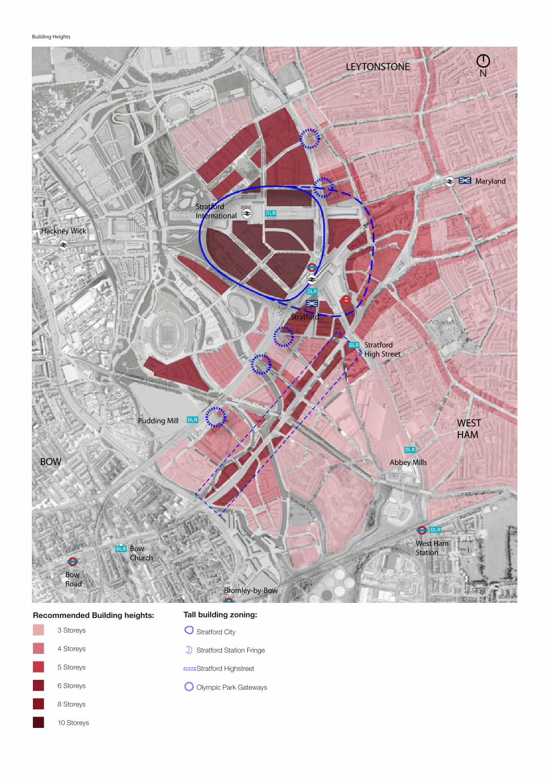
Building Heights
West Ham Station
Stratford
BOW
LEYTONSTONE
Bromley-by-Bow
Bow Church
Stratford International
Abbey Mills
Pudding Mill
Bow Road
Hackney Wick
WEST HAM
Stratford High Street
Maryland
N
Recommended Building heights:
3 Storeys
4 Storeys
5 Storeys
6 Storeys
8 Storeys
10 Storeys
Tall building zoning:
Stratford City
Stratford Station Fringe
Stratford Highstreet
Olympic Park Gateways

17
APPENDIX 2
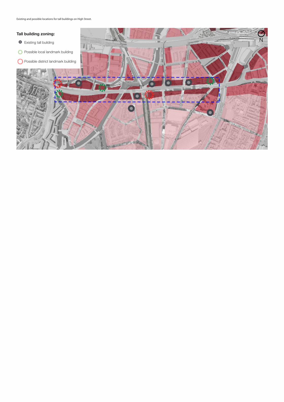
Existing and possible locations for tall buildings on High Street.
Tall building zoning:
Existing tall building
Possible local landmark building
Possible district landmark building
N


www.newham.gov.uk/stratfordmetropolitan