Embed Size (px)
Citation preview
STRATEGIC STONE STUDYA Building Stone Atlas ofHerefordshire
Published September 2012
Herefordshire Strategic Stone Study 1
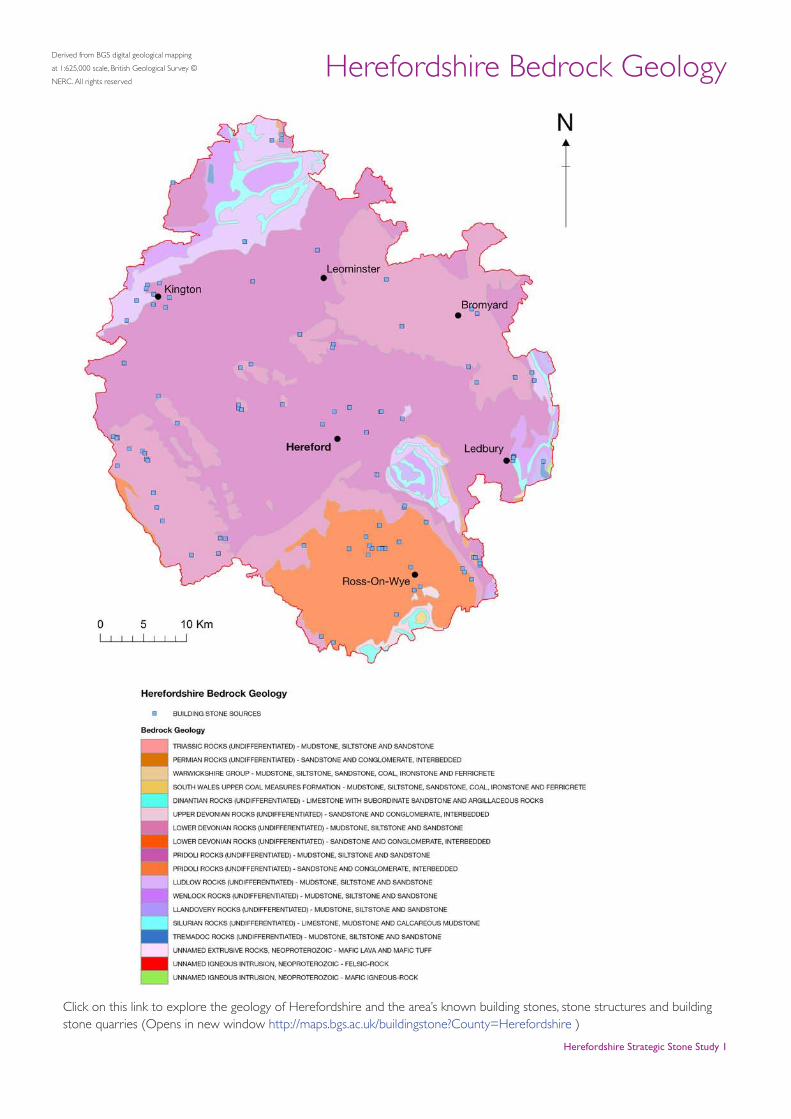
Herefordshire Bedrock GeologyDerived from BGS digital geological mapping
at 1:625,000 scale, British Geological Survey ©
NERC. All rights reserved
Click on this link to explore the geology of Herefordshire and the area’s known building stones, stone structures and building stone quarries (Opens in new window http://maps.bgs.ac.uk/buildingstone?County=Herefordshire )
Introduction
Herefordshire is one of the most sparsely populated counties of England. With only six towns of any significant size – Hereford, Leominster, Bromyard, Ledbury, Ross-on-Wye and Kington – and a wide scatter of mostly small villages and isolated hamlets, it is the natural rather than the man-made features that dominate the landscape. If one looks for a regional architectural style within this essentially rural landscape, it is the timber-framed or ‘black-and-white’ that is most striking. This is particularly so in the northwestern quarter of the county, where a tourist trail known as the ‘Black and White Village Trail’ has been developed.
A closer examination, however, reveals that the vernacular architecture strongly reflects the local geology. Large swathes of the county are underlain by the three main formations of the local ‘Lower Old Red Sandstone’ succession i.e. the Late Silurian Raglan Mudstone Formation (part of the Downton Group) and the Early Devonian St Maughans and Brownstones formations. Within the areas underlain by strata assigned to these units one almost always finds that the village church is built from local stone. The plinths upon which the sole-plates of timber-framed houses rest are, or were, of local stone, linking the house above ground almost ‘organically’ to the rock beneath. A few farm buildings are stone-built, at least on their gable ends, and a small number of C17 to C19 houses are constructed of stone. Such was the isolation of the county’s settlements, with only inadequate roads, no canals and a poorly developed railway network, the stone that was used up until the mid-C19 would have come from very local sources.
Only in four areas of Herefordshire – the north-west corner of the county, a narrow strip along the western flank of the Malvern Hills (East Herefordshire), a very small area adjacent to May Hill in the far south-east, and a roughly circular area taking in the concentric limestone
outcrops of the Woolhope Dome – are there any significantly different rock types present, and this is once again reflected in the stone-use in these areas.
A striking feature of the stone buildings in most parts of the county is the variability of the stone itself, especially within the churches. There is none of the uniformity of, for example, a Cotswolds village. The stone varies in colour and texture, often within a single wall, ranging from purple-red to greenish-grey and including coarse-grained sandstones through to well laminated, fine-grained sandstones and very soft siltstones. This is particularly the case with the lithologies of the Raglan Mudstone and St Maughans formations.
From the mid-C19 century onwards, with improved transport facilities, a certain amount of stone was ‘imported’ from beyond the county boundary, notably for church restoration work (which required better quality material for window frames and tracery, in particular). Much of this was either Jurassic limestone from the Cotswolds, or Triassic sandstone from neighbouring Shropshire or Worcestershire.
Herefordshire Strategic Stone Study 2
Herefordshire Strategic Stone Study 3
PRECAMBRIANMalverns CoMplex
‘Malvern Stone’
The Herefordshire–Worcestershire county boundary
follows the crest of the Malvern Hills at their southern
end. Some stone, especially from small quarries located
on the western flank of the range, has been used in
buildings found immediately to the west. The Malvern
stones comprise a mixture of meta-igneous lithologies
which yield a rubbly, but nonetheless attractive, building
stone. The typically strongly sheared and faulted nature of
the Malverns Complex rocks makes them very difficult to
cut, and true dimension stone is only rarely seen. Despite
this, the stone has been used in the construction of a few
houses around Colwall and more extensively as a rough
walling stone as far west as Ledbury. The stones are often
grey, pink or green, but due to their variable composition,
frequently show a wide range of colours, both when fresh
and weathered.
Wentnor GroupBrampton Formation
Broomie Hill Stone
On the opposite side of the county, in the far northwestern
corner, lies a small sliver of Precambrian (Ediacaran) strata,
comprising variably coloured sandstones and conglomerates.
Structurally, the outcrop is a portion of the ‘western
Longmyndian’ caught up within the splays of the Church
Stretton Fault system. The main quarry is found on the
Brampton Bryan Estate, and this produced a sedimentary
rock which rarely shows definite bedding or lamination; it
has almost always been used as blocks of irregularly shaped
rubblestone. The stone was used on the estate for boundary
walls, for farm buildings and for estate workers cottages, and
within the village of Brampton Bryan itself.
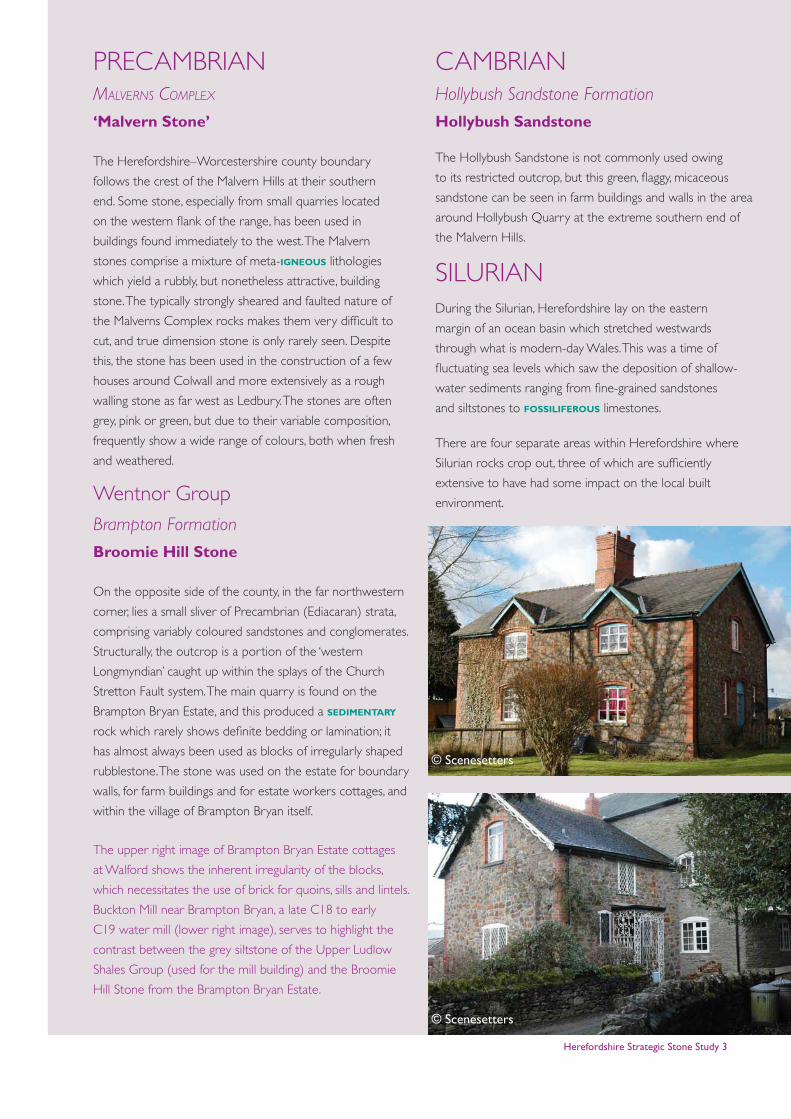
The upper right image of Brampton Bryan Estate cottages
at Walford shows the inherent irregularity of the blocks,
which necessitates the use of brick for quoins, sills and lintels.
Buckton Mill near Brampton Bryan, a late C18 to early
C19 water mill (lower right image), serves to highlight the
contrast between the grey siltstone of the Upper Ludlow
Shales Group (used for the mill building) and the Broomie
Hill Stone from the Brampton Bryan Estate.
CAMBRIANHollybush Sandstone Formation
Hollybush Sandstone
The Hollybush Sandstone is not commonly used owing
to its restricted outcrop, but this green, flaggy, micaceous
sandstone can be seen in farm buildings and walls in the area
around Hollybush Quarry at the extreme southern end of
the Malvern Hills.
SILURIANDuring the Silurian, Herefordshire lay on the eastern
margin of an ocean basin which stretched westwards
through what is modern-day Wales. This was a time of
fluctuating sea levels which saw the deposition of shallow-
water sediments ranging from fine-grained sandstones
and siltstones to fossiliferous limestones.
There are four separate areas within Herefordshire where
Silurian rocks crop out, three of which are sufficiently
extensive to have had some impact on the local built
environment.
© Scenesetters
© Scenesetters
Herefordshire Strategic Stone Study 4
SILURIAN of north-west Herefordshire
The most extensive development of Silurian rocks occurs
in the northwestern part of the county, where the
distinctive ridge-and-vale topography that characterises
Shropshire to the north continues across the county
boundary into Herefordshire, Folding affects these strata,
notably forming the Ludlow Anticline and giving rise to
the pronounced horseshoe-shaped outcrop pattern of
the Wigmore area. Moving southwestwards, the strata
resume their NE–SW strike, extending to Kington and
beyond into Wales.
WENLOCK ‘SERIES’Much Wenlock Limestone Formation
Wenlock Limestone
By the time it crosses into Herefordshire from Shropshire,
the classic escarpment of the Wenlock Limestone is a
much reduced topographical feature when compared
to the more prominent ridge created by the Aymestry
Limestone. Though quarried and burnt for lime in the
vicinity of its outcrop within the Vale of Wigmore, only a
handful of properties around Pipe Aston incorporate this
limestone in their structures.
LUDLOW ‘SERIES’Aymestry Limestone Formation (sic)
Aymestry Limestone (sic)
North-west Herefordshire and south-west Shropshire
are the classic research areas for the rocks of the Ludlow
‘Series’ and form the basis of the Ludlovian stratigraphical
framework. From a building-stone perspective, however,
a classification based on rock type is most appropriate,
not least because the best building stone yielded by this
‘series’ – the Aymestry Limestone – is diachronous and,
in this part of Herefordshire, tends to be variable in its
limestone content, grading into the Lower Ludlow Shales
Group (below) and Upper Ludlow Shales Group (above)
to such an extent that both the precise age and source
of the ‘limestone’ blocks observed in buildings are often
difficult to determine.
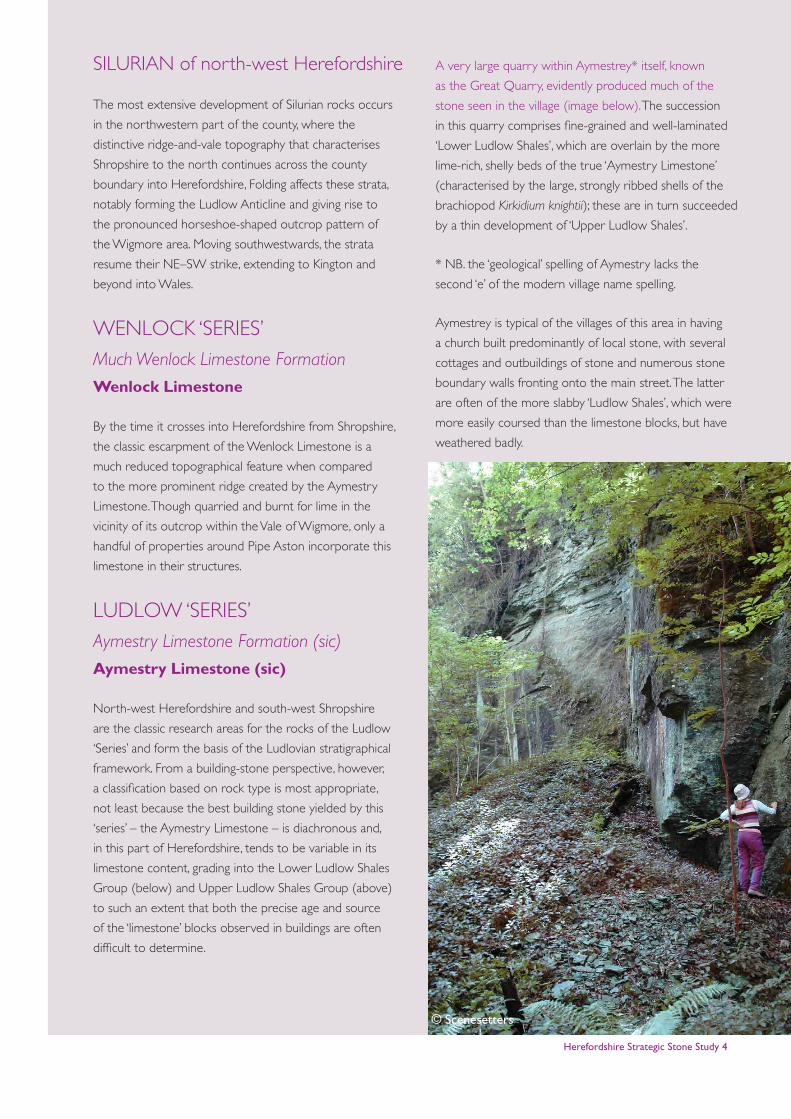
A very large quarry within Aymestrey* itself, known
as the Great Quarry, evidently produced much of the
stone seen in the village (image below). The succession
in this quarry comprises fine-grained and well-laminated
‘Lower Ludlow Shales’, which are overlain by the more
lime-rich, shelly beds of the true ‘Aymestry Limestone’
(characterised by the large, strongly ribbed shells of the
brachiopod Kirkidium knightii); these are in turn succeeded
by a thin development of ‘Upper Ludlow Shales’.
* NB. the ‘geological’ spelling of Aymestry lacks the
second ‘e’ of the modern village name spelling.
Aymestrey is typical of the villages of this area in having
a church built predominantly of local stone, with several
cottages and outbuildings of stone and numerous stone
boundary walls fronting onto the main street. The latter
are often of the more slabby ‘Ludlow Shales’, which were
more easily coursed than the limestone blocks, but have
weathered badly.
© Scenesetters
Herefordshire Strategic Stone Study 5
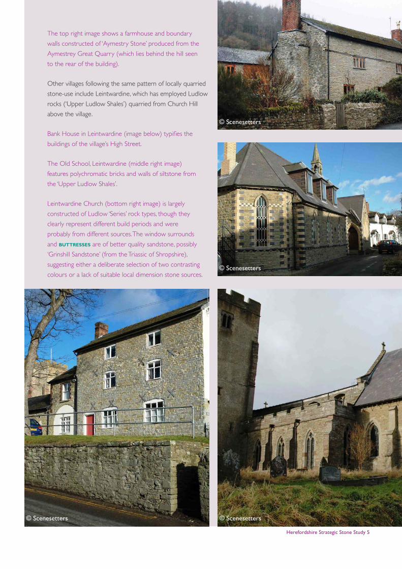
The top right image shows a farmhouse and boundary
walls constructed of ‘Aymestry Stone’ produced from the
Aymestrey Great Quarry (which lies behind the hill seen
to the rear of the building).
Other villages following the same pattern of locally quarried
stone-use include Leintwardine, which has employed Ludlow
rocks (‘Upper Ludlow Shales’) quarried from Church Hill
above the village.
Bank House in Leintwardine (image below) typifies the
buildings of the village’s High Street.
The Old School, Leintwardine (middle right image)
features polychromatic bricks and walls of siltstone from
the ‘Upper Ludlow Shales’.
Leintwardine Church (bottom right image) is largely
constructed of Ludlow ‘Series’ rock types, though they
clearly represent different build periods and were
probably from different sources. The window surrounds
and buttresses are of better quality sandstone, possibly
‘Grinshill Sandstone’ (from the Triassic of Shropshire),
suggesting either a deliberate selection of two contrasting
colours or a lack of suitable local dimension stone sources.
© Scenesetters © Scenesetters
© Scenesetters
© Scenesetters
Herefordshire Strategic Stone Study 6
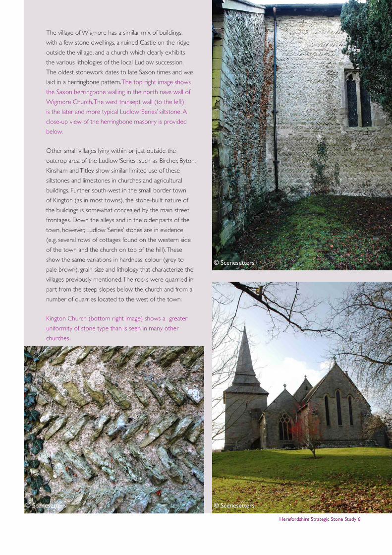
The village of Wigmore has a similar mix of buildings,
with a few stone dwellings, a ruined Castle on the ridge
outside the village, and a church which clearly exhibits
the various lithologies of the local Ludlow succession.
The oldest stonework dates to late Saxon times and was
laid in a herringbone pattern. The top right image shows
the Saxon herringbone walling in the north nave wall of
Wigmore Church. The west transept wall (to the left)
is the later and more typical Ludlow ‘Series’ siltstone. A
close-up view of the herringbone masonry is provided
below.
Other small villages lying within or just outside the
outcrop area of the Ludlow ‘Series’, such as Bircher, Byton,
Kinsham and Titley, show similar limited use of these
siltstones and limestones in churches and agricultural
buildings. Further south-west in the small border town
of Kington (as in most towns), the stone-built nature of
the buildings is somewhat concealed by the main street
frontages. Down the alleys and in the older parts of the
town, however, Ludlow ‘Series’ stones are in evidence
(e.g. several rows of cottages found on the western side
of the town and the church on top of the hill). These
show the same variations in hardness, colour (grey to
pale brown), grain size and lithology that characterize the
villages previously mentioned. The rocks were quarried in
part from the steep slopes below the church and from a
number of quarries located to the west of the town.
Kington Church (bottom right image) shows a greater
uniformity of stone type than is seen in many other
churches..
© Scenesetters © Scenesetters
© Scenesetters
Herefordshire Strategic Stone Study 7
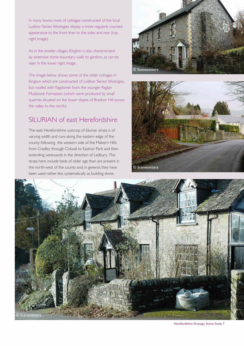
In many towns, rows of cottages constructed of the local
Ludlow ‘Series’ lithologies display a more regularly coursed
appearance to the front than to the sides and rear (top
right image).
As in the smaller villages, Kington is also characterized
by extensive stone boundary walls to gardens, as can be
seen in the lower right image.
The image below shows some of the older cottages in
Kington which are constructed of Ludlow ‘Series’ lithologies,
but roofed with flagstones from the younger Raglan
Mudstone Formation (which were produced by small
quarries situated on the lower slopes of Bradnor Hill across
the valley to the north).
SILURIAN of east HerefordshireThe east Herefordshire outcrop of Silurian strata is of
varying width and runs along the eastern edge of the
county following the western side of the Malvern Hills
from Cradley through Colwall to Eastnor Park and then
extending westwards in the direction of Ledbury. The
strata here include beds of older age than are present in
the north-west of the county and, in general, they have
been used rather less systematically as building stone.
© Scenesetters
© Scenesetters
© Scenesetters
Herefordshire Strategic Stone Study 8
LLANDOVERY ‘SERIES’May Hill Sandstone Group
Consisting of purple-brown to buff, coarse-grained
sandstones, ‘grits’ and conglomerates, the Llandovery ‘Series’
beds would have made a more important local building
stone were they not restricted to a small outcrop in the
Eastnor Park area, just west of Midsummer Hill. It is recorded
that they were used in the construction of Bronsil Castle, as
well as in other local farm buildings and walls.
WENLOCK ‘SERIES’Much Wenlock Limestone Formation
Wenlock Limestone
In this part of the county, the Wenlock Limestone crops
out along the border with Worcestershire around Cradley,
as well as forming part of the ridge east of Ledbury. It was
quarried predominantly for lime-burning, but close to the
outcrops around Cradley and in Ledbury, examples can
be found of its use in cottage and boundary walls e.g. St
Katherine’s Hospital.
The image below shows an old barn of Wenlock
Limestone on the east side of Ledbury.
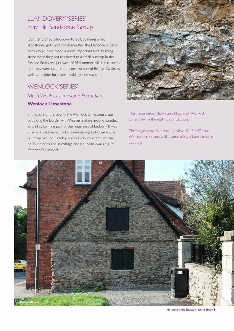
The image above is a close-up view of a fossiliferous
Wenlock Limestone wall located along a back-street in
Ledbury.
© Scenesetters
© Scenesetters
Herefordshire Strategic Stone Study 9
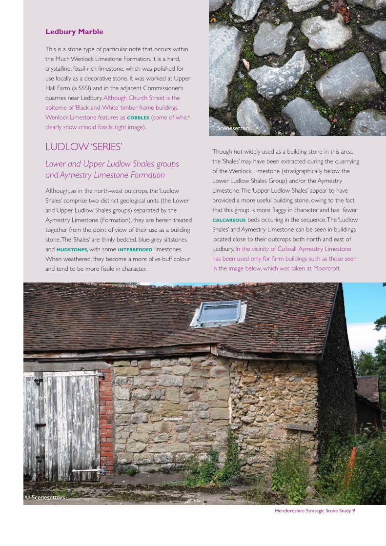
Ledbury Marble
This is a stone type of particular note that occurs within
the Much Wenlock Limestone Formation. It is a hard,
crystalline, fossil-rich limestone, which was polished for
use locally as a decorative stone. It was worked at Upper
Hall Farm (a SSSI) and in the adjacent Commissioner’s
quarries near Ledbury. Although Church Street is the
epitome of ‘Black-and-White’ timber frame buildings,
Wenlock Limestone features as cobbles (some of which
clearly show crinoid fossils; right image).
LUDLOW ‘SERIES’
Lower and Upper Ludlow Shales groups and Aymestry Limestone Formation
Although, as in the north-west outcrops, the ‘Ludlow
Shales’ comprise two distinct geological units (the Lower
and Upper Ludlow Shales groups) separated by the
Aymestry Limestone (Formation), they are herein treated
together from the point of view of their use as a building
stone. The ‘Shales’ are thinly bedded, blue-grey siltstones
and mudstones, with some interbedded limestones.
When weathered, they become a more olive-buff colour
and tend to be more fissile in character.
Though not widely used as a building stone in this area,
the ‘Shales’ may have been extracted during the quarrying
of the Wenlock Limestone (stratigraphically below the
Lower Ludlow Shales Group) and/or the Aymestry
Limestone. The ‘Upper Ludlow Shales’ appear to have
provided a more useful building stone, owing to the fact
that this group is more flaggy in character and has fewer
calcareous beds occuring in the sequence. The ‘Ludlow
Shales’ and Aymestry Limestone can be seen in buildings
located close to their outcrops both north and east of
Ledbury. In the vicinity of Colwall, Aymestry Limestone
has been used only for farm buildings such as those seen
in the image below, which was taken at Moorcroft.
© Scenesetters
© Scenesetters
Herefordshire Strategic Stone Study 10
SILURIAN of the Woolhope Dome
The third outcrop of Wenlock and Ludlow ‘Series’ strata
is centred on Woolhope, to the east of Hereford, and
exists as a domed inlier known as the ‘Woolhope Dome’.
The effect of this structure on the Silurian limestones
and shales is clearly evident in the topography. These
lithologies have had minimal influence on building stone
usage, however, due to the paucity of dwellings in the
area.
Woolhope Limestone Formation
Woolhope Limestone
There is an additional limestone unit lying within the
Wenlock ‘Series’ of the Woolhope Dome, known
appropriately as the Woolhope Limestone. Its main
value was, again, as a source of lime, but a few isolated
dwellings are constructed from it.
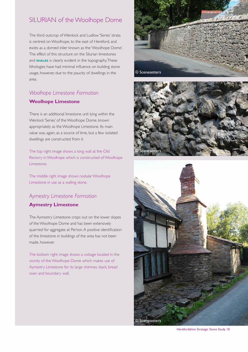
The top right image shows a long wall at the Old
Rectory in Woolhope which is constructed of Woolhope
Limestone.
The middle right image shows nodular Woolhope
Limestone in use as a walling stone.
Aymestry Limestone Formation
Aymestry Limestone
The Aymestry Limestone crops out on the lower slopes
of the Woolhope Dome and has been extensively
quarried for aggregate at Perton. A positive identification
of the limestone in buildings of the area has not been
made, however.
The bottom right image shows a cottage located in the
vicinity of the Woolhope Dome which makes use of
Aymestry Limestone for its large chimney stack, bread
oven and boundary wall.
© Scenesetters
© Scenesetters
© Scenesetters
Herefordshire Strategic Stone Study 11
SILURO-DEVONIANLower Old Red Sandstone
PRIDOLI ‘SERIES’
Downton Group
The Pridoli ‘Series’ succession of Herefordshire and adjacent
parts of Shropshire commences with the distinctive Ludlow
Bone Bed (Member). This marks a fundamental change
in sedimentation patterns in the area as marginal marine
and, ultimately, fully continental depositional environments
became established. It is still convenient to refer to the
lithologies of the Pridoli ‘Series’, along with the overlying red
mudstones and sandstones of the Lower Devonian, as the
‘Lower Old Red Sandstone’ despite the fact that much of the
succession is neither red nor composed of sandstone.
Downton Castle Sandstone Formation
Downton Castle Sandstone
Named after its type area in the north-west of the county,
the Downtown Castle Sandstone has been used historically
both as a freestone and as a tilestone. The formation
comprises thin, planar beds of yellow-brown or buff
sandstone, with interdigitations of brown-grey siltstones
and mudstones. It is this lithological variability which allows
the sandstone beds to be split into thin stone tiles, or where
the beds are thickest, to be trimmed into regular blocks of
freestone.
The sandstone is fairly hard when freshly exposed, but the
sand grains are poorly cemented and often separate when
exposed to the agents of weathering. The sandstone is up to
20m thick in the Downton area, but is only 5m thick, at most,
in the east of the county. The stone is currently being worked
from a new exposure at Brakes Farm, just to the north of
Downton Castle.
The sandstone has been used in the construction of
Downton Castle and Croft Castle, and, owing to its
ferruginous brown colouring, can be identified in the
fabrics of a number of buildings along its very narrow
outcrop in the north-west of the area..
In the east, it has been quarried from several small outcrops
near Colwall and Cradley, and used for buildings and walling.
A thin band of the sandstone located to the east of Ledbury
has been quarried for use in the town, most conspicuously in
parts of the church, where its colour contrasts with that of
the other locally available building stones.
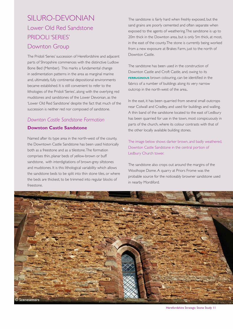
The image below shows darker brown, and badly weathered,
Downton Castle Sandstone in the central portion of
Ledbury Church tower.
The sandstone also crops out around the margins of the
Woolhope Dome. A quarry at Priors Frome was the
probable source for the noticeably browner sandstone used
in nearby Mordiford.
© Scenesetters
Herefordshire Strategic Stone Study 12
Raglan Mudstone Formation
The Raglan Mudstone Formation, which underlies more
than half of Herefordshire, marks the onset of fully terrestrial
’Old Red Sandstone’ sedimentation. Much of Herefordshire’s
built heritage has been constructed using stone types
worked from this unit. As its name suggests, the formation is
predominantly a red mudstone succession, although bands
of sandstone occur throughout. In addition, thin nodular,
pedogenic limestone bands (i.e. calcareous beds formed in
soils and known as ‘calcretes’) occur sporadically. These are
often referred to as ‘cornstones’ in the historical literature.
The mudstones themselves have been used as a source of
clay for the famous Herefordshire brick, tile and pipeworks
industries, and many of these sites are documented in a
recently published book on brickworks of the county. Some
250 brickworks are listed in the Herefordshire Sites and
Monuments Record. The mudstones can also have a high
mica content and, as a result, in places they become fissile
and flaggy. Many small building stone delves appear to
have exploited this lithological variant, though the resultant
micaceous (and usually red) slabby stone weathers very
badly.
Sandstone beds occur sporadically throughout the formation,
but they can be easily recognised in the landscape as their
greater resistance to erosion results in the development
of obvious topographic features, Many of these sandstones
have been exploited for building stone, and they were
often worked from small delves which are now mostly
overgrown or ploughed out. A good example is provided
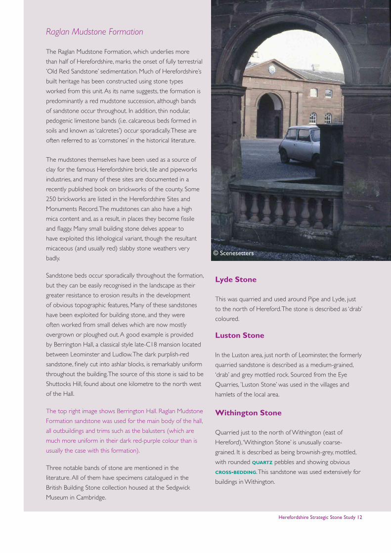
by Berrington Hall, a classical style late-C18 mansion located
between Leominster and Ludlow. The dark purplish-red
sandstone, finely cut into ashlar blocks, is remarkably uniform
throughout the building. The source of this stone is said to be
Shuttocks Hill, found about one kilometre to the north west
of the Hall.
The top right image shows Berrington Hall. Raglan Mudstone
Formation sandstone was used for the main body of the hall,
all outbuildings and trims such as the balusters (which are
much more uniform in their dark red-purple colour than is
usually the case with this formation).
Three notable bands of stone are mentioned in the
literature. All of them have specimens catalogued in the
British Building Stone collection housed at the Sedgwick
Museum in Cambridge.
Lyde Stone
This was quarried and used around Pipe and Lyde, just
to the north of Hereford. The stone is described as ‘drab’
coloured.
Luston Stone
In the Luston area, just north of Leominster, the formerly
quarried sandstone is described as a medium-grained,
‘drab’ and grey mottled rock. Sourced from the Eye
Quarries, ’Luston Stone’ was used in the villages and
hamlets of the local area.
Withington Stone
Quarried just to the north of Withington (east of
Hereford), ‘Withington Stone’ is unusually coarse-
grained. It is described as being brownish-grey, mottled,
with rounded quartz pebbles and showing obvious
cross-bedding. This sandstone was used extensively for
buildings in Withington.
© Scenesetters
Herefordshire Strategic Stone Study 13
The sandstone blocks of Withington Church (image
below) vary in colour, ranging from dull grey through
warmer colours to pale purples. Such variation is typical
of Raglan Mudstone buildings.
It is clear, however, that many other sandstone and
siltstone bands were also exploited locally for building
purposes wherever they occurred. Despite being known
as the ‘Black and White Villages’, those north-west of
Hereford, notably Eardisland, Pembridge, Almeley, Dilwyn,
Yarpole and Weobley, all boast some stone buildings. The
churches are invariably stone and most exhibit the wide
range of lithologies found within the Raglan Mudstone
Formation. The coarser, usually white or grey sandstones
are commonly used for the quoins and buttresses.
Variably coloured purple, red, cream and striped
sandstones are used, frequently at random, for the main
walling, while many churches areas are in part constructed
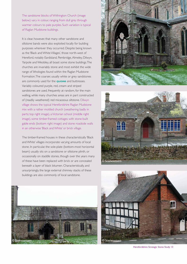
of (readily weathered) red micaceous siltstone. Dilwyn
village shows the typical Herefordshire Raglan Mudstone
mix with a rather mottled church (weathering badly in
parts; top right image), a Victorian school (middle right
image), some timber-framed cottages with stone-built
gable ends (bottom right image) and stone roadside walls
in an otherwise ‘Black and White’ or brick village.
The timber-framed houses in these characteristically ‘Black
and White’ villages incorporate varying amounts of local
stone. In particular, the sole-plate (bottom-most horizontal
beam) usually sits on a sandstone or siltstone plinth, or
occasionally on staddle stones, though over the years many
of these have been replaced with brick or are concealed
beneath a layer of black bitumen. Characteristically, and
unsurprisingly, the large external chimney stacks of these
buildings are also commonly of local sandstone.
© Scenesetters © Scenesetters
© Scenesetters
© Scenesetters
Herefordshire Strategic Stone Study 14
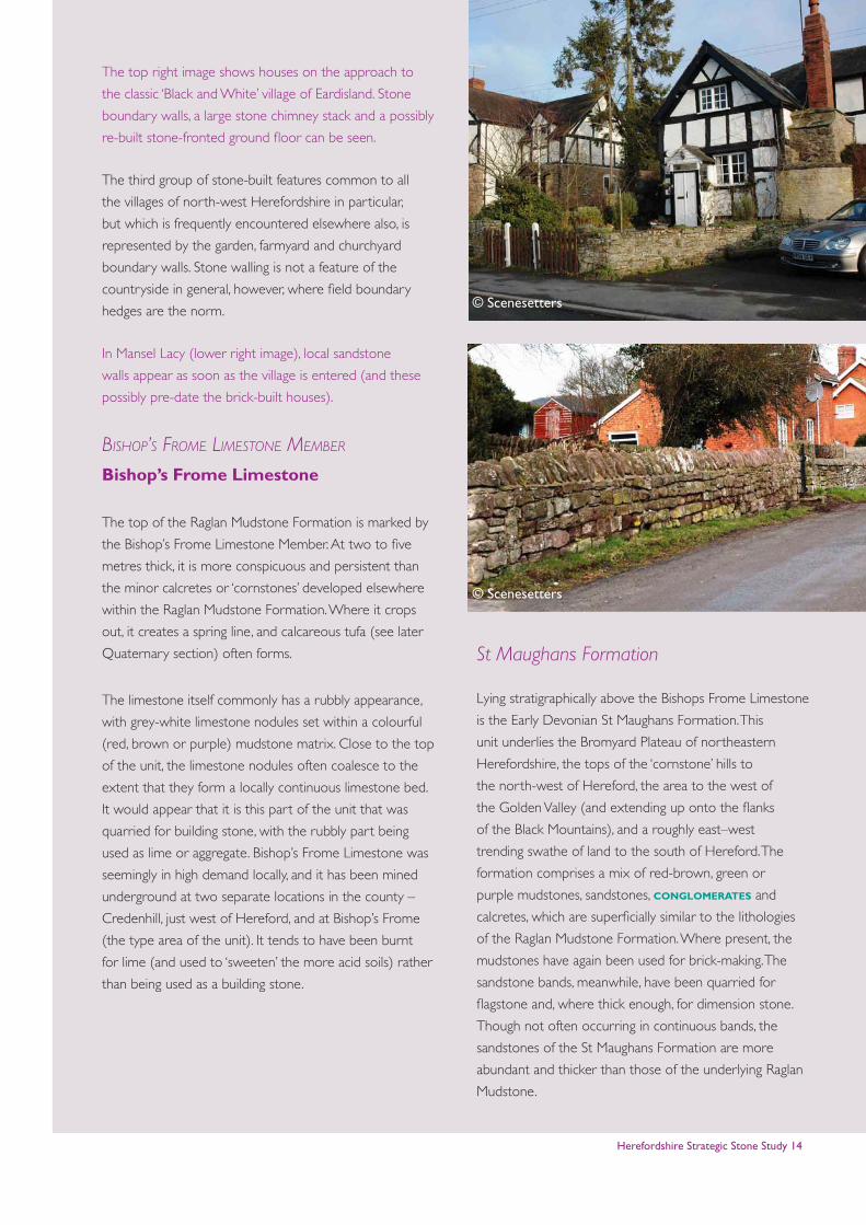
The top right image shows houses on the approach to
the classic ‘Black and White’ village of Eardisland. Stone
boundary walls, a large stone chimney stack and a possibly
re-built stone-fronted ground floor can be seen.
The third group of stone-built features common to all
the villages of north-west Herefordshire in particular,
but which is frequently encountered elsewhere also, is
represented by the garden, farmyard and churchyard
boundary walls. Stone walling is not a feature of the
countryside in general, however, where field boundary
hedges are the norm.
In Mansel Lacy (lower right image), local sandstone
walls appear as soon as the village is entered (and these
possibly pre-date the brick-built houses).
Bishop’s FroMe liMestone MeMBer
Bishop’s Frome Limestone
The top of the Raglan Mudstone Formation is marked by
the Bishop’s Frome Limestone Member. At two to five
metres thick, it is more conspicuous and persistent than
the minor calcretes or ‘cornstones’ developed elsewhere
within the Raglan Mudstone Formation. Where it crops
out, it creates a spring line, and calcareous tufa (see later
Quaternary section) often forms.
The limestone itself commonly has a rubbly appearance,
with grey-white limestone nodules set within a colourful
(red, brown or purple) mudstone matrix. Close to the top
of the unit, the limestone nodules often coalesce to the
extent that they form a locally continuous limestone bed.
It would appear that it is this part of the unit that was
quarried for building stone, with the rubbly part being
used as lime or aggregate. Bishop’s Frome Limestone was
seemingly in high demand locally, and it has been mined
underground at two separate locations in the county –
Credenhill, just west of Hereford, and at Bishop’s Frome
(the type area of the unit). It tends to have been burnt
for lime (and used to ‘sweeten’ the more acid soils) rather
than being used as a building stone.
St Maughans Formation
Lying stratigraphically above the Bishops Frome Limestone
is the Early Devonian St Maughans Formation. This
unit underlies the Bromyard Plateau of northeastern
Herefordshire, the tops of the ‘cornstone’ hills to
the north-west of Hereford, the area to the west of
the Golden Valley (and extending up onto the flanks
of the Black Mountains), and a roughly east–west
trending swathe of land to the south of Hereford. The
formation comprises a mix of red-brown, green or
purple mudstones, sandstones, conglomerates and
calcretes, which are superficially similar to the lithologies
of the Raglan Mudstone Formation. Where present, the
mudstones have again been used for brick-making. The
sandstone bands, meanwhile, have been quarried for
flagstone and, where thick enough, for dimension stone.
Though not often occurring in continuous bands, the
sandstones of the St Maughans Formation are more
abundant and thicker than those of the underlying Raglan
Mudstone.
© Scenesetters
© Scenesetters
Herefordshire Strategic Stone Study 15
These sandstones (and perhaps some of the sandstone
bands within the Raglan Mudstone) are the principal
sources of Herefordshire stone roofing ‘slate’. A small
number of quarries still actively work the St Maughans
Formation sandstones for building and roofing stone, and
there are numerous ‘active’ permissions in the extreme
west of the county in the Golden Valley area.
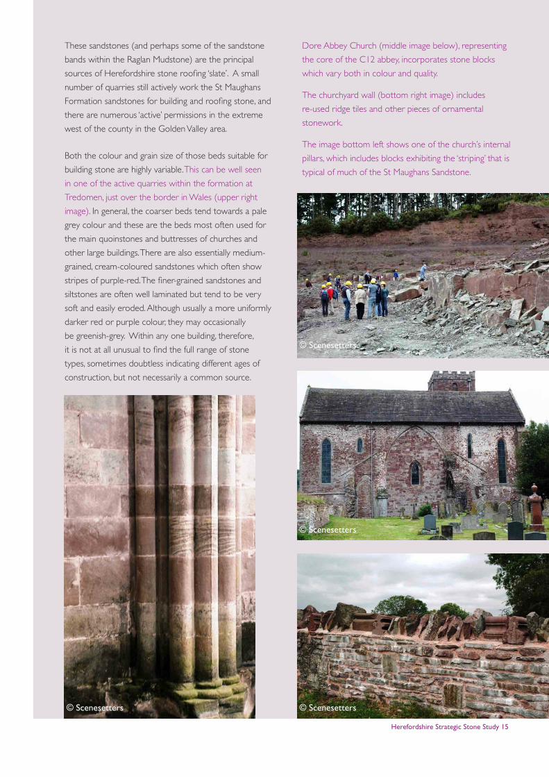
Both the colour and grain size of those beds suitable for
building stone are highly variable. This can be well seen
in one of the active quarries within the formation at
Tredomen, just over the border in Wales (upper right
image). In general, the coarser beds tend towards a pale
grey colour and these are the beds most often used for
the main quoinstones and buttresses of churches and
other large buildings. There are also essentially medium-
grained, cream-coloured sandstones which often show
stripes of purple-red. The finer-grained sandstones and
siltstones are often well laminated but tend to be very
soft and easily eroded. Although usually a more uniformly
darker red or purple colour, they may occasionally
be greenish-grey. Within any one building, therefore,
it is not at all unusual to find the full range of stone
types, sometimes doubtless indicating different ages of
construction, but not necessarily a common source.
Dore Abbey Church (middle image below), representing
the core of the C12 abbey, incorporates stone blocks
which vary both in colour and quality.
The churchyard wall (bottom right image) includes
re-used ridge tiles and other pieces of ornamental
stonework.
The image bottom left shows one of the church’s internal
pillars, which includes blocks exhibiting the ‘striping’ that is
typical of much of the St Maughans Sandstone.
© Scenesetters © Scenesetters
© Scenesetters
© Scenesetters
Herefordshire Strategic Stone Study 16
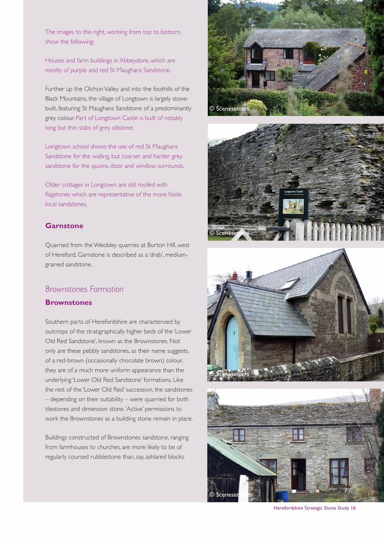
The images to the right, working from top to bottom,
show the following:
Houses and farm buildings in Abbeydore, which are
mostly of purple and red St Maughans Sandstone.
Further up the Olchon Valley and into the foothills of the
Black Mountains, the village of Longtown is largely stone-
built, featuring St Maughans Sandstone of a predominantly
grey colour. Part of Longtown Castle is built of notably
long but thin slabs of grey siltstone.
Longtown school shows the use of red St Maughans
Sandstone for the walling, but coarser and harder grey
sandstone for the quoins, door and window surrounds.
Older cottages in Longtown are still roofed with
flagstones which are representative of the more fissile
local sandstones.
Garnstone
Quarried from the Weobley quarries at Burton Hill, west
of Hereford, Garnstone is described as a ‘drab’, medium-
grained sandstone.
Brownstones Formation
Brownstones
Southern parts of Herefordshire are characterized by
outcrops of the stratigraphically higher beds of the ‘Lower
Old Red Sandstone’, known as the Brownstones. Not
only are these pebbly sandstones, as their name suggests,
of a red-brown (occasionally chocolate brown) colour,
they are of a much more uniform appearance than the
underlying ‘Lower Old Red Sandstone’ formations. Like
the rest of the ‘Lower Old Red’ succession, the sandstones
– depending on their suitability – were quarried for both
tilestones and dimension stone. ‘Active’ permissions to
work the Brownstones as a building stone remain in place.
Buildings constructed of Brownstones sandstone, ranging
from farmhouses to churches, are more likely to be of
regularly coursed rubblestone than, say, ashlared blocks.
© Scenesetters
© Scenesetters
© Scenesetters
© Scenesetters
Herefordshire Strategic Stone Study 17
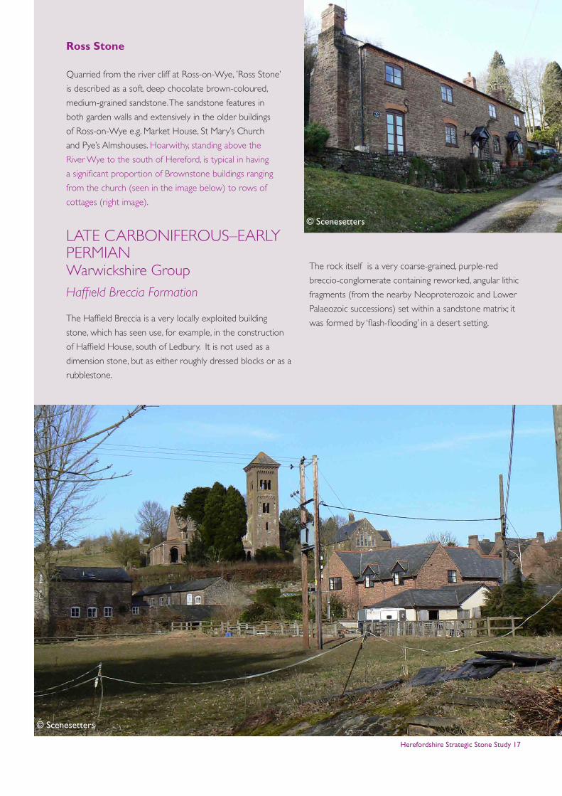
Ross Stone
Quarried from the river cliff at Ross-on-Wye, ’Ross Stone’
is described as a soft, deep chocolate brown-coloured,
medium-grained sandstone. The sandstone features in
both garden walls and extensively in the older buildings
of Ross-on-Wye e.g. Market House, St Mary’s Church
and Pye’s Almshouses. Hoarwithy, standing above the
River Wye to the south of Hereford, is typical in having
a significant proportion of Brownstone buildings ranging
from the church (seen in the image below) to rows of
cottages (right image).
LATE CARBONIFEROUS–EARLY PERMIANWarwickshire GroupHaffield Breccia Formation
The Haffield Breccia is a very locally exploited building
stone, which has seen use, for example, in the construction
of Haffield House, south of Ledbury. It is not used as a
dimension stone, but as either roughly dressed blocks or as a
rubblestone.
The rock itself is a very coarse-grained, purple-red
breccio-conglomerate containing reworked, angular lithic
fragments (from the nearby Neoproterozoic and Lower
Palaeozoic successions) set within a sandstone matrix; it
was formed by ‘flash-flooding’ in a desert setting.
© Scenesetters
© Scenesetters
Herefordshire Strategic Stone Study 18
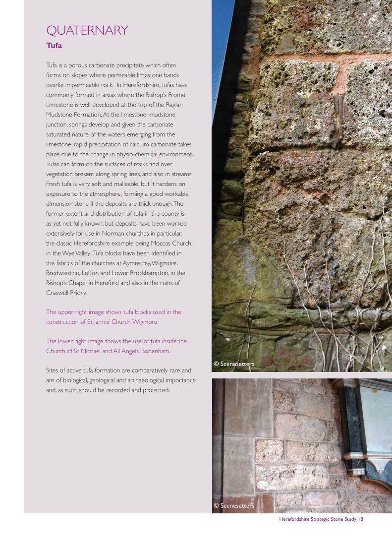
QUATERNARYTufa
Tufa is a porous carbonate precipitate which often
forms on slopes where permeable limestone bands
overlie impermeable rock. In Herefordshire, tufas have
commonly formed in areas where the Bishop’s Frome
Limestone is well developed at the top of the Raglan
Mudstone Formation. At the limestone–mudstone
junction, springs develop and given the carbonate
saturated nature of the waters emerging from the
limestone, rapid precipitation of calcium carbonate takes
place due to the change in physio-chemical environment.
Tufas can form on the surfaces of rocks and over
vegetation present along spring lines, and also in streams.
Fresh tufa is very soft and malleable, but it hardens on
exposure to the atmosphere, forming a good workable
dimension stone if the deposits are thick enough. The
former extent and distribution of tufa in the county is
as yet not fully known, but deposits have been worked
extensively for use in Norman churches in particular,
the classic Herefordshire example being Moccas Church
in the Wye Valley. Tufa blocks have been identified in
the fabrics of the churches at Aymestrey, Wigmore,
Bredwardine, Letton and Lower Brockhampton, in the
Bishop’s Chapel in Hereford and also in the ruins of
Craswell Priory.
The upper right image shows tufa blocks used in the
construction of St James’ Church, Wigmore.
The lower right image shows the use of tufa inside the
Church of St Michael and All Angels, Bodenham.
Sites of active tufa formation are comparatively rare and
are of biological, geological and archaeological importance
and, as such, should be recorded and protected.
© Scenesetters
© Scenesetters

Herefordshire Strategic Stone Study 19
Glossary
Buttress: A projection from a wall and bonded to the
wall to create additional strength and support.
Calcareous: A rock which contains significant (10-50%)
calcium carbonate principally in the form of a cement or
matrix.
Cemented: The materials which bind the grains and/or
fossil components together to form a rock.
Cobbles: Rounded rock clasts (of any lithology)
between 64 mm and 256 mm in size.
Conglomerate: A sedimentary rock made up of
rounded pebbles (>2mm), cobbles and boulders of rock
in a finer-grained matrix.
Cross-bedding: A feature principally of sandstones
formed by the movement of sand grains in currents to
produce layering oblique to the margins of the beds.
Ferruginous: Containing iron minerals usually in the
form of an iron oxide which gives the rock a ‘rusty’ stain.
Fossiliferous: Bearing or containing fossils.
Igneous: Rocks formed when molten magma cools
and solidifies. It includes extrusive rocks erupted
from volcanoes (e.g. basalt) and intrusive rocks that
cool beneath the Earth’s surface (e.g. granite, gabbro,
granodiorite, dolerite).
Interbedded: Occurs when beds (layers or rock) of a
particular lithology lie between or alternate with beds of
a different lithology. For example, sedimentary rocks may
be interbedded if there were sea level variations in their
sedimentary depositional environment.
Limestone: A sedimentary rock consisting mainly of
calcium carbonate (CaCO3) grains such as ooids, shell and
coral fragments and lime mud. Often highly fossiliferous.
Mudstone: A fine-grained sedimentary rock composed
of a mixture of clay and silt-sized particles.
Outcrop: Area where a rock unit is exposed at the
ground surface.
Quartz: A crystalline form of silica - silicon dioxide,
SiO2.
Quoins: The external angle of a building. The dressed
alternate header and stretcher stones at the corners of
buildings.
Sandstone: A sedimentary rock composed of sand-
sized grains (i.e. generally visible to the eye, but less than 2
mm in size).
Sedimentary rock: A rock that is commonly formed
by the binding together (lithification) of sediment particles
(e.g. sandstone, siltstone, mudstone, limestone).
Shales: An argillaceous rock with closely spaced, well-
defined laminae.
Siltstone: A sedimentary rock composed of silt-sized
grains (i.e. only just visible to the eye).
Herefordshire Strategic Stone Study 20
AcknowledgementsThis study, written by Andrew Jenkinson, is the Herefordshire and Worcestershire Earth Heritage Trust’s contribution to the
Strategic Stone Study, sponsored by English Heritage.
Edited by Graham Lott and Stephen Parry, British Geological Survey
Designed by Tarnia McAlester, English Heritage
We are grateful for advice from the following:
Don Cameron, British Geological Survey
Graham Lott, British Geological Survey
Stephen Parry, British Geological Survey
Further Reading
Hereford & Worcester Earth Heritage Trust Explore building stone trail guides (2003):
Goodrich Castle
Hereford Cathedral
Hereford City Centre (Now contains some errors due to some shop fronts being altered since published.)
Hereford & Worcester Earth Heritage Trust Explore geology trail guides (2003):
Ross-on Wye
Kington & Hergest
Brandon, A. (1989). Geology of the country between Hereford and Leominster. Memoir of the British Geological Survey,
Sheet 198 (England and Wales).
Howe, J.A. (1910, reprint 2001). The Geology of Building Stones. Donhead Publishing.
McCall, J. (2010). Hereford city centre trail: a city of sandstone, lath & plaster and red brick. Private, 24pp. Available at
http://www.englishstone.org.uk/Hereford%20Town.pdf.
Olver, P. A. (2007). Old Red Sandstone: the Herefordshire Stone. Transactions of the Woolhope Naturalists’ Field Club, 55,
pp. 43-57.
Brooks, A. and Pevsner, N. (2012). The Buildings of England: Herefordshire. Yale University Press, 800p..