Embed Size (px)
Citation preview

Storm Spotting 101 for Health Care Professionals
Or
Don’t Drive Into the Tornado!

Terms You May Hear
• Watch
• Warning
• Severe Thunderstorm
• Tornado
• Funnel Cloud
• Downburst
• Flash Flood
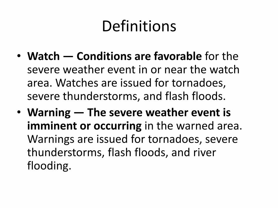
Definitions
• Watch — Conditions are favorable for the severe weather event in or near the watch area. Watches are issued for tornadoes, severe thunderstorms, and flash floods.
• Warning — The severe weather event is imminent or occurring in the warned area. Warnings are issued for tornadoes, severe thunderstorms, flash floods, and river flooding.

Definitions
• Severe Thunderstorm — A storm that produces hail 3/4 inch in diameter or larger and/or wind gusts of 58 mph or more.
• Tornado — A violently rotating column of air attached to a thunderstorm and in contact with the ground.
• Funnel Cloud — A rotating, funnel-shaped cloud extending downward from a thunderstorm base.
Definitions
• Downburst — A strong downdraft with an outrush of damaging wind on or near the ground.
• Flash Flood — A rapid rise in water, usually within 12 hours of a period of heavy rain or other causative agent (i.e., dam break).

Reporting Priority
• Urgent Priority – Tornado – Funnel cloud – Rotating wall cloud – Flash flooding
• High Priority – Hail 3/4-inch diameter or larger – Wind speed greater than 58 mph – Persistent non-rotating wall cloud – Rainfall 1 inch or more per hour
• Lower Priority – Hail 1/2-inch diameter or larger – Wind speed greater than 40 mph – Cloud features suggesting storm organization

Flash Floods
Flash flooding is a major killer. Many flash floods occur at night, which makes them more difficult to see. As a storm spotter, you may encounter flash floods at any time. Heeding the following flash flood safety rules may save your life. • DO NOT attempt to drive or walk across a flooded roadway or low water crossing. Nearly half of all flash flood deaths are vehicle-related. Moving water 2 feet deep will carry away most cars. • If your vehicle becomes caught in high water and stalls, leave it immediately and seek higher ground if you can do so safely. Rapidly rising water may sweep a vehicle and its occupants away. • Be especially careful at night when flash floods are harder to recognize.
Lightning
Lightning occurs in all thunderstorms and is also a significant threat to life. Storm spotters are especially vulnerable to being struck by lightning since they are often in prime strike locations, such as in open fields or on hilltops. The following lightning safety rules are important. • Lightning tends to strike the tallest object in an area...make sure it is not you. Remain in your vehicle or an indoor location whenever possible. • If you must go outside, crouch down to make yourself a poor lightning target. Do not lie flat on the ground since you will be more likely to be severely shocked if lightning strikes close to you.

Lightning Kills! Be Careful!
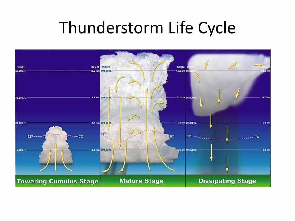
Thunderstorm Life Cycle

Supercells
Supercell in New Mexico 2004

Wall Cloud
This is a wall cloud. A wall cloud (or pedestal cloud) is a large, lowering, and rotating base of a cumulonimbus cloud that potentially forms tornadoes. It is typically beneath the rain-free base (RFB) portion of a deep cumulus cloud

Wall Cloud
Wall Cloud in Illinois 2010

Wall Cloud with Tail
Oklahoma 1980 Wall cloud with tail cloud/shelf cloud. Wall clouds are inflow features with (often warm) air moving towards them whereas shelf clouds are an outflow feature with cool air moving away from the storm, often as a gust front

Wall Cloud with Lightning
Wall cloud in Texas 1980. Wall clouds will usually be at the rear of the storm and tend to slope in, or toward the precipitation area, whereas shelf clouds as outflow clouds will jut outward from the storm.

Shelf Cloud A shelf cloud is a low, horizontal wedge-shaped cloud, associated with a thunderstorm gust front (or occasionally with a cold front, even in the absence of thunderstorms). People seeing a shelf cloud may believe they have seen a wall cloud. This is a likely mistake, since an approaching shelf cloud appears to form a wall. A shelf cloud usually appears on the leading edge of a storm, and a wall cloud will usually be at the rear of the storm.

Mammatus
Tulsa OK 1973 Mammatus-- Mammatus are most often associated with severe thunderstorms. They often extend from the base of a cumulonimbus.
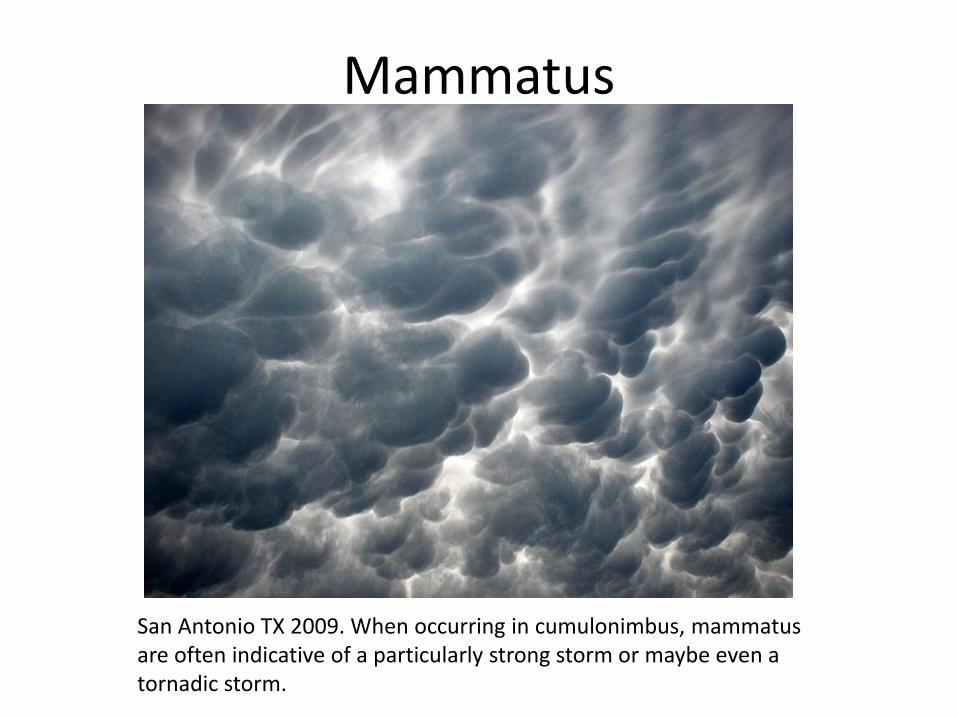
Mammatus
San Antonio TX 2009. When occurring in cumulonimbus, mammatus are often indicative of a particularly strong storm or maybe even a tornadic storm.

Roll Cloud
Roll cloud Racine Wisconsin 2007. A roll cloud is a low, horizontal, tube-shaped, and relatively rare type of arcus cloud. They differ from shelf clouds by being completely detached from other cloud features. Roll clouds usually appear to be "rolling" about a horizontal axis.
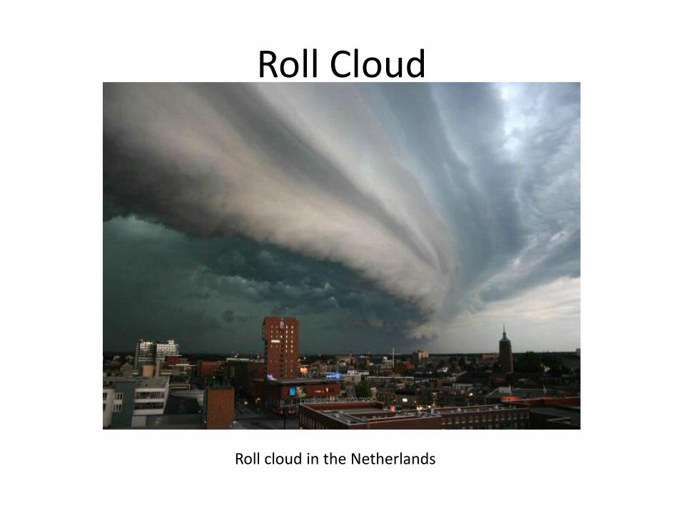
Roll Cloud
Roll cloud in the Netherlands

Microbursts Microbursts often have extremely heavy rain and large hail. They can be very dangerous to drive through or to try to fly through.
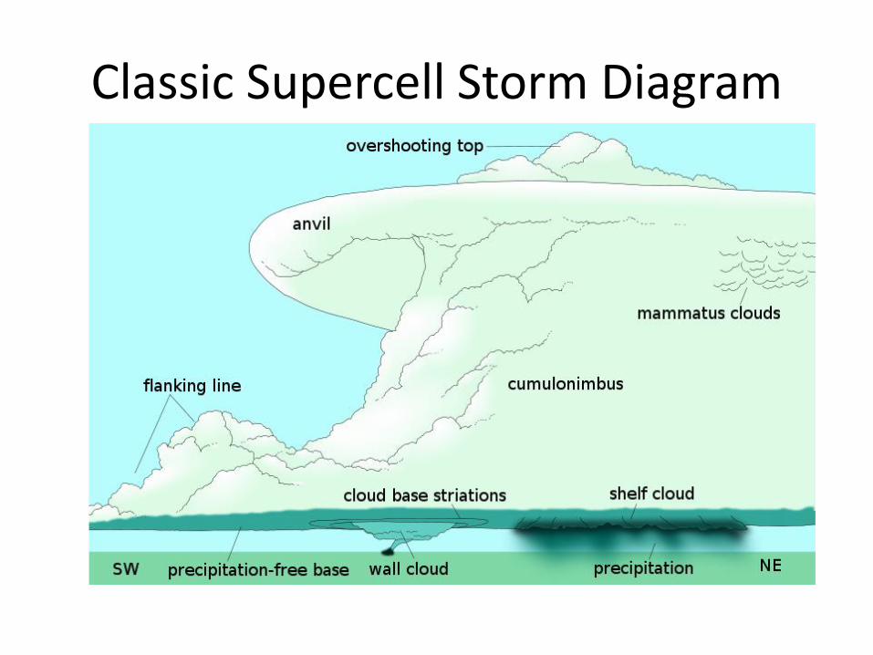
Classic Supercell Storm Diagram

Overhead View of Supercell
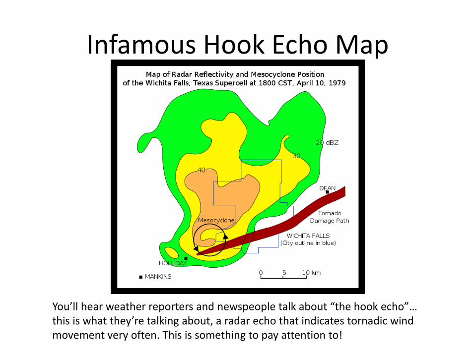
Infamous Hook Echo Map
You’ll hear weather reporters and newspeople talk about “the hook echo”… this is what they’re talking about, a radar echo that indicates tornadic wind movement very often. This is something to pay attention to!

Another Infamous Hook Echo Map
Moore, OK May 20, 2013 Tornado Hook Echo (Annotated). Here is the hook, eerily similar to the 1999 Moore, OK tornado (next slide).

Moore OK 1999
The graphics weren’t as good in 1999, but still…

Video Images of Tornadoes
http://en.wikipedia.org/wiki/1999_Oklahoma_tornado_outbreak
http://en.wikipedia.org/wiki/2013_Moore_tornado
http://youtu.be/77jiaIn4BoY Moore OK tornado on video
http://youtu.be/cy8LtrCn438 Birmingham AL tornado on video
http://youtu.be/TWKxVmpdtKg Nashville TN 1998 tornado on video

Moore OK Tornado Tracks

Clouds that look scary but aren’t
Scud clouds, roll clouds and shelf clouds can look scary but they’re usually just associated with cold fronts or rainstorms, not often with supercells or tornadic storms.

What to Report
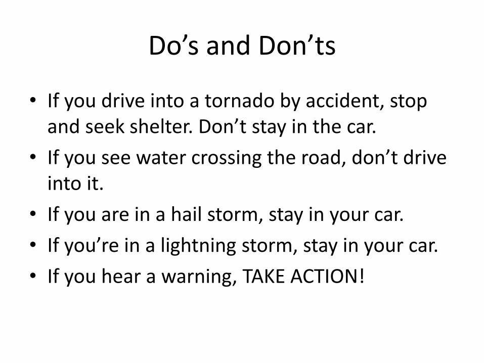
Do’s and Don’ts
• If you drive into a tornado by accident, stop and seek shelter. Don’t stay in the car.
• If you see water crossing the road, don’t drive into it.
• If you are in a hail storm, stay in your car.
• If you’re in a lightning storm, stay in your car.
• If you hear a warning, TAKE ACTION!