Embed Size (px)
Citation preview
Stilwell Community Plan 1
Exhibit A
Stilwell Community Plan An Amendment to the Johnson County Rural Comprehensive Plan
Appendix E, Section E.
Approved by the Board of County Commissioners of Johnson County, Kansas
December 12, 2013
Prepared by:
The Community of Stilwell, Kansas
Aubry-Oxford Consolidated Zoning Board
Johnson County Planning Commission
Johnson County Planning, Development and Codes Department
Stilwell Community Plan 2
PARTICIPANTS Aubry-Oxford Consolidated Zoning Board Vic Mosby, Chair H. Richard “Rick” Noon, Vice-Chair Patricia S. Fischer Kenneth Klingensmith Brad Miller Martin Seem Lori Tinkler
Former Zoning Board Members: Chris Illif Jason Meier Rod Richardson
Aubry Township Officials Brad Miller, Trustee Tim Gnau, Clerk Lori Hisle, Treasurer
Stilwell Community Organization Representative Kenneth Klingensmith, President Ronald Smith, Vice Chairman Stacie Moeller
Mike Ward Chris Bramhall
Focus Group Participants Ackerly, Mike Adair, Pat Adair, Tony Arquiera, Arturo Baldwin, Thomas Ballentine, Scott Baum, Bill Baum, Karen Bauman, Jonathan Bottaro, Pat Bradshaw, Joe Bramhall, Chris Brown, Ben Brown, Gary Burnett, Rhonda Burnett, Ron
Cross, Vicki Daschlke, Charlene Davidson, Lindsay Devinki, Sam Dougan, Darrel Dunn, Jeff Durham, Benham Eidemiller, Don Elliott, Roger Emel, Brandon Epps, Haley Fathollahi, Ali Fischer, Pat Fish, Dustin Fish, Vickie Fountain, Paul
Fountain, Vickie Francis, Jim Frank, Jerame Fry, John Gates, Tim Gaul, Brant Gliden, Terry Gnau, Tim Ham, Amy Ham, Shane Harris, Eleanor Harris, Vickie Hauser, Edward Hernstrom, Dave Hill, Dave Huggins, Mark
Stilwell Community Plan 3
Illif, Chris Inman, Steven Johnson, Jim Johnson, Lois Klika, Steve Klingensmith, Kenneth Koch, Tim Koppel, Arlan Kranker, Paul Kuhnkal, Mark Kure, Ken Kure, Linda Lambie, Jim Langhofer, Tom Lawson, Linda Ledgin, Norm Mallicoat, Barbara Mallicoat, Charles Mallicoat, Howard Mason, Michael Matile, Lynne McDaniel, David Meier, Jason Meyers, Lorna Miller, Brad Miller, Paul Miller, W. R. Moeller, Staci
Moore, Pam Moore, Tom Morse, Roxanne Mosby, Vic Mourning, Josh Noon, Rick Park, Sue Parker, Ken Passantino, Dante Pennington, Virginia Phelps, Harold Pintar, Gil Pishny, Norman Predmore, Corby Quinn, Dan Read, Dave Read, Joyce Read, Marvin Reed, Donna Richardson, Dave Richardson, Rod Robb, Debbie Robinson, Tom Rodlund, Daphne Roeseler, Joan Rozell, Laura Rudrick, Maggie Rupert, Brooke
Rupert, Tyler Rusinger, Brian Sapp, Fletcher Scheumann, Brent Schulz, Mark Seem, Martin Shyver, Tom Siegel, Herbert Smith, Matt Smith, Tracy Stansbarger, Charles Staten, Dale A. Stuart, Bill Thome, Jim Thompson, Phyllis Tulock, Matt Turner, Ted Twedt, Colin Vano, Ruth Veatch, Randy Waltin, S. Walton, James Ward, Mike Ward, Nacona Webb, Dave Williams, Matt Winston, Mary
Johnson County Planning Commission Chris Illif, Chair Floyd Danner, Vice-Chair Dennis Bollin E. Glenn Bonar Mike Fowks Bonnie Givens Katherine Hoffman
Mark S. Huggins George Lund Roger Mason Roxanne Morse Peter Opperman
Johnson County Board of County Commissioners Ed Eilert, Chair Jason Osterhaus, Vice-Chair, Commissioner 4th District E. Edward Peterson, Commissioner 1st District Jim Allen, Commissioner 2nd District
Stilwell Community Plan 4
Steve Klika, Commissioner 3rd District Michael Ashcraft, Commissioner 5th District John Toplikar, Commissioner 6th District
Table of Contents Participants Stilwell’s Community Vision Chapter 1 - Purpose and Background
I. Purpose and Need II. Background – History of Planning in the Blue Valley Area
III. Study Area IV. Overland Park Future Development Plan
Chapter 2 - Community Characteristics I. Brief History of Stilwell
II. Image Map III. Existing Land Uses IV. Demographics V. Natural Environmental
VI. Public Infrastructure, Utilities and Services Chapter 3 - Future Land Use
I. Blue Valley Plan II. No Changes to Blue Valley Plan Future Land Use Map
III. Streamway Park and Greenway Linkage Development IV. Future Transportation
Chapter 4 – Goals, Objectives, and Community Initiatives and Implementation I. Establishing Goals, Objectives, and Community Initiatives
II. Stilwell Community Goals and Objectives III. Community Initiatives IV. Implementation
Appendix Appendix A Focus Group and Aubry-Oxford Consolidated Zoning Board Comments
Stilwell Community Plan 5
Stilwell Community’s Vision Stilwell is a community of neighbors - proud of their rural heritage and proud of their commitment to civic involvement. Adjacent to expanding suburban development, the community is committed to retaining its historic small town identity - characterized by well-kept homes, small locally-owned businesses, safe and walkable neighborhoods, abundant agriculture and open spaces, clean air and beautiful night skies, and great community facilities.
CHAPTER 1 – Purpose and Background
I. Purpose and Need
Project Purpose The purpose of the Stilwell Community Plan is to update, as needed, a portion of the Blue Valley Plan for an area that contains some of the oldest and most diverse land uses and development patterns in the unincorporated area. The project “Study Area” for the plan is a portion of Aubry Township that is approximately six square miles - bounded by 183rd Street on the north, Nall Avenue on the east, 215th Street on the south, and U.S. Highway 69 on the west. In response to public comments received throughout the planning process, the goals and objectives adopted for the Study Area may also be applied to other locations throughout Aubry Township, e.g., extend to State Line Road. Though gradual, changes to this area over the past twenty years have been continuous. Pressures for new commercial development continue along Metcalf Avenue and 199th Street, particularly south of 199th Street. Continuous upgrades to residences throughout the area have been ongoing along with improvements in the old downtown Stilwell area, including removal of older structures, the addition of some new businesses, and the construction of new residences. Throughout the Study Area today there also remains numerous large tracts of land that offer opportunities for future development. Updating this portion of the County’s Blue Valley Plan will help to identify and protect important community, historic, and natural assets in the Study Area, assure coordination with nearby jurisdictions, and support orderly growth by establishing goals and objectives to help guide future public and private sector land use and development decisions within the Study Area. No other changes have been made or recommended to the Blue Valley Plan outside of the Study Area boundaries and the goals and objectives in the Stilwell Community Plan are considered to be supplemental the Blue Valley Plan. Project Need
Stilwell Community Plan 6
The need for a special plan for this area has long been contemplated. In 2001, the Report of the Aubry Oxford Planning Committee (AOTPC) to the Board of County Commissioners recommended the preparation of a “Village Plan” for the vicinity of 199th and Metcalf Avenue. In 2004, the update of the Johnson County Rural Comprehensive Plan included a similar recommendation to prepare a community-centered mixed use plan for the vicinity of 199th Street and Metcalf Avenue. In 2010, the Aubry Oxford Consolidated Zoning Board (AOCZB) formally discussed the need for a plan for the area and requested the County Planning, Development, and Codes Department to undertake such a project. With authorization from the County Planning Commission, the County’s planning staff undertook the project with the AOCZB serving as the project Steering Committee. The AOCZB established the Study Area boundaries and the scope and content for the project. Project Time Frame The time frame or “planning horizon” for the Stilwell Community Plan is 2030, approximately 20 years from now. Project Organization Planning staff met regularly with the AOCZB to get their input, and to update them on the project’s progress. Planning staff also met periodically with the County Planning Commission to keep them apprised of the project and its progress. At the end of this process, the Zoning Board took the lead in presenting the Stilwell Community Plan to the County Planning Commission. By state statute, the County Planning Commission is responsible for conducting the official public hearing on the Plan. The Planning Commission’s recommendation for approval was forwarded to the Board of County Commissioners for final approval and adoption of the Stilwell Community Plan as an amendment to the Johnson County Rural Comprehensive Plan. Initial public input was obtained through two series of targeted focus group meetings with over 200 participants. The first series of focus group meetings identified the Study Area’s strengths, weaknesses, opportunities, and threats (SWOT) and the second series of meetings was a discussion of the proposed goals and objectives drafted by planning staff and the AOCZB. A final public meeting with over 160 attendees was held to review the draft goals and objectives. The meeting was conducted by the AOCZB, the township trustee, and the chairman of the Stilwell Community Organization. A more detail description of the focus group and public meeting process is provided in Chapter 3.
II. Background – History of Planning in the Blue Valley Area
Earlier versions of the Johnson County Rural Comprehensive Plan recognized that the Blue Valley area contains a mixture of residential, commercial and industrial uses unlike the land use patterns in other unincorporated areas of Johnson County. Since 1980, various land use studies and reports have identified Aubry Township as experiencing exurban growth at a greater rate and
Stilwell Community Plan 7
concentration than other parts of the unincorporated area. Earlier versions of the county's Comprehensive Plan identified the need for a more specific plan for the orderly development of this area. In 1991, the Aubry-Stilwell Area Plan was adopted by the County as an amendment to the Comprehensive Plan. This area plan, however, did not address future land uses in the area north of the Blue River that was identified as “Urban Fringe Policy Area” in anticipation of future, joint-planning for that area with the City of Overland Park. In July 1996, a joint-planning committee of the Johnson County Planning Commission and the City of Overland Park Planning Commission prepared the Blue Valley Plan that was adopted by both jurisdictions. As part of the 2013, planning process, a review of the “Land Use Map” in the Blue Valley Plan concluded that the future land use recommendations in 1996 remain valid for the Study Area and no changes are proposed to this map. As noted in the following, since 1996 several annexations have occurred north of the Study Area. Therefore, the Land Use Map may need to be revised in the future for the areas outside the Study Area. Since 2008, Overland Park annexed over eight square miles of Aubry Township and the city amended its Comprehensive Plan to include a new plan (West Aubry Study Area Future Land Use Plan and Goals Report, 2009) for development west of U.S. Highway 69, adjacent to the Study Area. Overland Park’s plan anticipates the installation of sanitary sewers west of U.S. Highway 69 and subsequently has planned for more diverse and dense development than is currently planned for the area east of U.S. Highway 69. An overview of Overland Park’s plan for the areas east as well as west of U.S. Highway 69 is provided in a following section. New State annexation laws, however, may limit future involuntary annexations in Aubry Township as well as throughout the County.
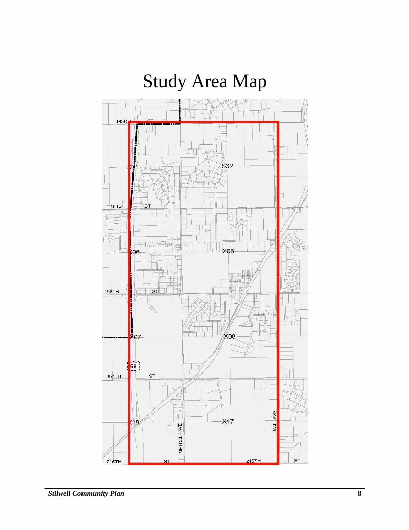
III. Study Area
The Study Area is bounded by 183rd Street on the north, U.S. Highway 69 on the east, 215th St. (county line) on the south, and Nall Avenue on the west. The area is approximately 6 square miles in size.
Stilwell Community Plan 8
Study Area Map
Stilwell Community Plan 9
IV. Overland Park Future Development Coordination
Because of the City of Overland Park’s close proximity to the Stilwell Community Plan Study Area it is important to be knowledgeable of the city’s future development plans as well as to work together with the County to assure coordinated development, e.g., future street improvement. The following is a summary of some the Overland Park’s major proposed future developments that may directly or indirectly impact the Stilwell Community Plan Study Area. Overland Park’s current Future Development Plan adopted in 2011, anticipates the installation of sanitary sewers to the annexed area west of U.S. Highway 69 and also to an approximately 2 square-mile annexed area east of Mission Road, south of 171st Street and abutting the State Line. The City’s Future Development Plan proposes a relatively dense mix of residential, commercial and business park development in these two separate areas located close to the Stilwell Community Plan Study Area. East of Study Area Sanitary sewers are now under construction to serve the soon to be developed Walnut Trail subdivision located on 571 acres, east of Mission Road between 183rd Street and 191st Streets. The majority of the subdivision has been zoned PRN, Planned Residential Neighborhood District, which allows for a mixture of residential uses and a future elementary school site. Approximately .7 acre of the property has been zoned CP-1, Planned Restricted Business District, which allows for limited neighborhood commercial uses. As sanitary sewers become available to this area, it may be anticipated that more similar residential and limited neighborhood commercial development will occur east of Mission Road as proposed in the Overland Park Future Development Plan. Much of the area around the intersection of 179th Street and Metcalf Avenue already has access to sanitary sewers. For this general area, the city’s Future Development Plan proposed a mix of low-density residential, commercial, office, and light industrial/business park uses west of Metcalf Avenue and east of U.S. Highway 69.
West of Study Area Overland Park’s Future Development Plan for west of U.S. Highway 69, between 179th and 199th Streets, proposes low-density residential development with a concentrated mix of commercial, office and medium-density residential development west of the 199th Street and U.S. Highway 69 interchange.
Stilwell Community Plan 10
Most of the City’s development proposed for the area west of U.S. Highway 69, however, is not anticipated to occur until sanitary sewers become available. The County Wastewater District’s current estimate is that sanitary sewers will likely not reach this area within the next 10-15 years.
Future Transportation and Greenway Linkage Improvements Two important future arterial road improvements are proposed in Overland Park’s Future Development Plan. Both roads are proposed to cross the State Line and connect with the existing Missouri roads system to the east. One proposed connection is an extension of 191st Street east of Mission Road through the future Walnut Trail subdivision. The other proposed arterial connection is an extension of 199th Street also east of Mission Road, extending northeast to approximately 195th Street.
The City of Overland Park’s future transportation planning also includes the identification of existing and proposed bicycle routes. The city’s Bike Route Plan proposes a series of on-street bicycle routes throughout Overland Park, primarily along minor arterial roads such as Lamar, Foster and Roe, 147th Street and 163rd Street. Several on-street bike routes are planned in the Walnut Trail subdivision and the other new areas near State Line Road. . The only existing route shown that directly serves the Stilwell Community Plan Study Area is on Metcalf Place, a local street just west of Metcalf Avenue, between approximately 171st and 179th Streets. Overland Park is now preparing to undertake a city-wide bicycle safety study that may propose additional bicycle routes that could connect with the Stilwell Community Plan Study Area. The bicycle safety study will take a comprehensive approach to studying and identifying safe bike routes, street signage/markings, and street designs for expanding on-street bicycling choices in the city
Overland Park’s Greenway Linkages Plan, proposes a Type 5 Parkway greenway along both sides of U.S. Highway 69. Such a greenway would be up to a 100 ft. wide and a trail on at least one side. In addition, a Type 2 Thoroughfare Greenway Linkage, where a bike/hike trail is built in replacement of a sidewalk, is proposed along both the north and south sides of 179th Street from Metcalf on west. A Type 1 Greenway Linkage, which is a separate bike/hike trail along a linear green space such as a streamway, is proposed to come down both branches of Camp Branch Creek. The greenway linkage is proposed to connect with the future Walnut Trail subdivision east of Mission Road and tie into future development that may occur within the general Stilwell area. West of U.S. Highway 69, Overland Park’s Greenway Linkages Plan proposes a Type 2 Thoroughfare Greenway Linkage on both sides of 199th Street and on one side of 191st Street.
Stilwell Community Plan 11
As the above developments occur and as Stilwell continues to grow, it is important for the Stilwell Community as well as for the County to continue to communicate and work together to assure that such development is orderly and coordinated.
CHAPTER 2 – Community Characteristics
I. Brief History of Stilwell
The following text is an excerpt from volume II of Kansas: a cyclopedia of state history, embracing events, institutions, industries, counties, cities, towns, prominent persons, etc…. 1912
Stilwell, one of the new towns that have grown up in the southeastern part of Johnson County, is located on the Missouri Pacific R. R. 10 miles from Olathe, the county seat. The railroad was the making of the town, which has a good public school; several churches and general stores, a blacksmith and wagon shop, implement and hardware house, lumber yard, express and telegraph facilities, and a money order post office with one rural route. In 1910 its population was 200. Being the only large town in the southeastern part of the county it is the shipping and supply point for a rich agricultural district and does considerable business. The town was formerly known as Mount Auburn, the name having been changed by act of the legislature, approved March 2, 1889. (1)
With the arrival of the train, the town of Stilwell was established. The plat for Mt. Auburn, the original name of the town, was filed on November 20, 1886, by Michael O’Keefe, John Larkin, William A. Kelly and A. J. Norman. The town was located on the Southeast Quarter of Section 5, Township 15 South, Range 25 East, on land owned by Noah Spears. The name of the town was changed later to Stilwell in honor of Arthur E. Stilwell, a conductor for the Missouri Pacific Railroad. The Stilwell train depot was located northeast of Main and Wall Streets. East of the Stilwell depot, across the tracks, was a fenced area with loading chutes used as a stockyard. The farmers would often use 199th Street, which was also known as Missouri or Ocheltree Road, as the path for driving their hogs and cattle to the stockyard. Southwest of the Stilwell depot was a hotel owned by the Adam Miller family and later managed by the Burgess family. Shortly after the train came to the area, telegraph service was established and located inside the train depot. Another means of communication arrived on June 22, 1888, when the US Post Office at Stilwell was established. The first telephone office was located on Delaware Street, west of the railroad tracks. In 1907 the company was called the Mijo Telephone Company, referring of course to the areas it served, Miami and Johnson Counties. Because the Stilwell-Aubry community did
Stilwell Community Plan 12
not have a fire department, the telephone was used to communicate the location of the fire; four long rings announced the location and the need for volunteer firemen. Other business established around the turn of the century included:
E. K. Gibson Merchandise Store, Northeast Corner of Main and Broadway
Balthrope Hardware
Sloan Drug Store
Whitsett Restaurant and Ice House
Conboy Grocery and Dry Goods
Medaris Grocery Store
Noon Hardware and Implement Store
Blaker Lumber Company
Witherspoon Barbershop
Wright Lunch Room and Confectionary
A gas well located east of the Whitsett Restaurant was used by many people for heating and cooking – at a charge of 50 cents a month. In 1925, a train engineer spotted flames in the Main Street business district in Stilwell; much of the area was destroyed and it seems Stilwell never fully recovered from the devastating fire. Source: (1) Page 766 from volume II of Kansas: a cyclopedia of state history, embracing events, institutions, industries, counties, cities, towns, prominent persons, etc. ... / with a supplementary volume devoted to selected personal history and reminiscence. Standard Pub. Co. Chicago: 1912. 3 v. in 4. : front., ill., ports.; 28 cm. Vols. I-II edited by Frank W. Blackmar. (2) Anita M. Tebbe; Spring 1980.
Stilwell Community Plan 13
II. Image Map
The Aubry Oxford Consolidated Zoning Board undertook an exercise to identify important physical elements that contribute to the image and character of the Study Area.
These physical features can be categorized into five components that may be further sub-catogorized as “major” or “minor”:
1) Paths – Routes used to traverse an area, including, streets, walkways, tansit, rail, etc.
2) Edges – Linear elements that are not considered paths that establish boundaries, seams, separations, or breaks in continuity, including abrupt changes in topography, treelines, railroad tracks, walls, etc.
3) Districts – Sections or areas that have a distinct common identifiable character or general boundaries that you enter “inside of”.
4) Nodes – Strategic locations of concentrated activity into which an observer may enter, including, street intersections, junctions of paths or concentrations of some activity or characteristic.
5) Landmarks - Sharply defined physical objects that are often points of reference for an area and may or may not be of historic interest or value, including buildings, signs, art, stores, mountains.
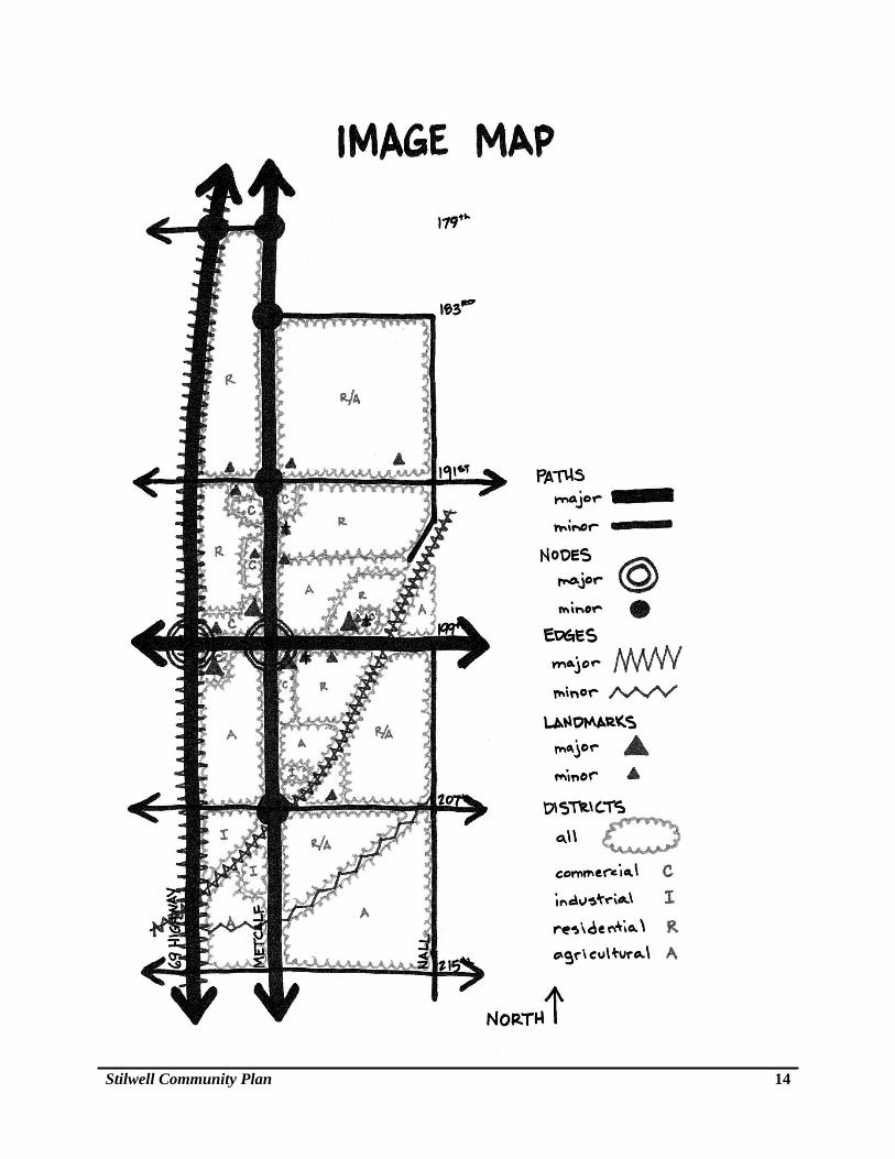
The following Image Map and text are the results of the zoning board efforts:
1. Paths:
Major paths are: U.S. Highway 69, Metcalf Avenue and 199th Street.
Within the Study Area, Metcalf Avenue and 199th Street primarily serve slower local circulation compared to U.S. Highway 69 that carries pass-by traffic.
All of the other arterial streets within the Study Area function as minor paths, primarily serving local traffic.
Nall Avenue, between 191st Street and 199th Street does not connect.
2. Edges:
U.S. Highway 69 functions as a major edge and western boundary of the Study Area.
The Union Pacific Railroad tracks also function as a major edge that severs the older residential and nonresidential development in the west half of the Study Area from the newer larger lot residential undeveloped area to the east.
The watershed ridge within the southeastern portion of the Study Area serves as a minor edge separating with open space and agricultural uses to the south.
Stilwell Community Plan 14
Stilwell Community Plan 15
3. Districts:
Metcalf Avenue from 191st Street to 215th Street still reflects much of the character of the corridor from when it was U. S. Highway 69, before the bypass was built in the 1970s. The corridor contains numerous large open agricultural fields as well as new and many older residential, commercial, industrial developments.
Downtown Stilwell is a minor district with only a few active commercial uses along with many smaller and older well-kept residences.
The north side of 199th Street from U.S. Highway 69 to Metcalf functions as a commercial use corridor with a mix of older and new commercial structures.
The two large undeveloped tracts of land northeast and southwest of 199th Street and Metcalf Avenue are two prominent agricultural districts located near the center of the Study Area. Future development of either of these two properties will likely have a significant impact on the image and character of the Stilwell Community.
4. Nodes:
The two major nodes within the Study Area are at the intersections of U.S. Highway 69 and 199th Street and at Metcalf Avenue and 199th Street.
The node at Metcalf and 199th Street also functions as the primary “gateway” to the Stilwell Community.
All of the other arterial street intersections with Metcalf Avenue (179th, 183rd, 191st, 207th, and 215th) function as minor nodes.
The intersection at 179th Street and Metcalf Avenue functions as the north “gateway” to the community as well as a minor node.
The intersection of 207th Street and Metcalf functions as south “gateway” to the community as well as a minor node.
5. Landmarks:
Major Landmarks:
Stilwell Elementary School
KCPL Service Center
Stilwell Station
Post Office
Minor Landmarks:
Shell Station
Old Stilwell Elementary School
Stilwell Community Plan 16
Future Stilwell Park site
Cemetery
Quarry
Stilwell Smokehouse (former)
Fire Station
Meyer Turf Farm
Dougan Insurance Building
Stilwell United Methodist Church
First Baptist Church of Stilwell
Holiness Church
KCPL substation
III. Existing Land Uses
Land Use The predominant land uses within the Study Area are agriculture, large and small lot residential uses, and some limited nonresidential development along 199th Street from U.S. Highway 69, east to Metcalf Avenue, scattered on the west side of Metcalf Avenue between 191st and 199th Streets. Light industrial uses have emerged along Metcalf Avenue, south of 206th Street. There is a public school along 199th St., east of Metcalf Avenue. The Union Pacific Railroad has an active main rail line that runs along the east side of the “old downtown” Stilwell area (at 199th Street, just west of Nall Avenue). The following Existing Land Use Map shows locations of the various land use within the Study Area.
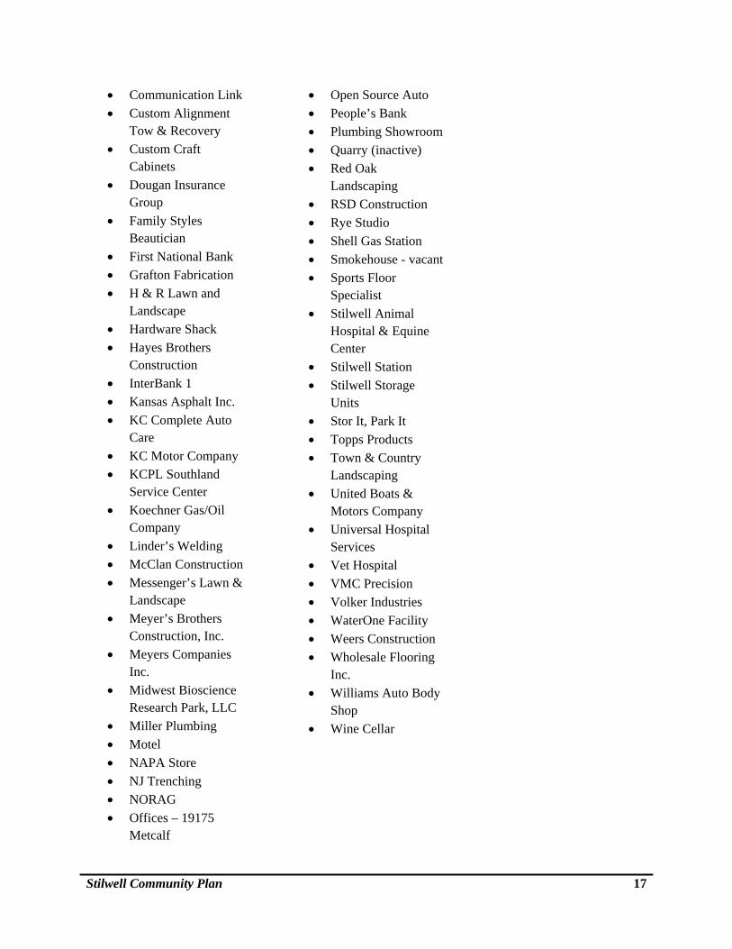
Nonresidential Land Uses There are numerous businesses in the Study Area. Most of these businesses are located along Metcalf Avenue between 191st Street and 207th Street. In addition, there are several businesses on 199th Street between Metcalf Avenue and US Highway 69. Three industrial parks are located in the Study Area, one small and older industrial area just north of 207th Street and Metcalf Avenue (Griffin Industrial Park) and two larger and newer industrial areas southwest of 207th and Metcalf Avenue. The following is a list of some of some of the businesses located within the Study Area:
Aubry Animal Clinic
Blue Valley Motor
Blue Valley School District Bus Parking & Dispatch
Bolivar Contracting Inc.
Stilwell Community Plan 17
Communication Link
Custom Alignment Tow & Recovery
Custom Craft Cabinets
Dougan Insurance Group
Family Styles Beautician
First National Bank
Grafton Fabrication
H & R Lawn and Landscape
Hardware Shack
Hayes Brothers Construction
InterBank 1
Kansas Asphalt Inc.
KC Complete Auto Care
KC Motor Company
KCPL Southland Service Center
Koechner Gas/Oil Company
Linder’s Welding
McClan Construction
Messenger’s Lawn & Landscape
Meyer’s Brothers Construction, Inc.
Meyers Companies Inc.
Midwest Bioscience Research Park, LLC
Miller Plumbing
Motel
NAPA Store
NJ Trenching
NORAG
Offices – 19175 Metcalf
Open Source Auto
People’s Bank
Plumbing Showroom
Quarry (inactive)
Red Oak Landscaping
RSD Construction
Rye Studio
Shell Gas Station
Smokehouse - vacant
Sports Floor Specialist
Stilwell Animal Hospital & Equine Center
Stilwell Station
Stilwell Storage Units
Stor It, Park It
Topps Products
Town & Country Landscaping
United Boats & Motors Company
Universal Hospital Services
Vet Hospital
VMC Precision
Volker Industries
WaterOne Facility
Weers Construction
Wholesale Flooring Inc.
Williams Auto Body Shop
Wine Cellar
Stilwell Community Plan 18
EXISTING LAND USE MAP
r y T w pr y T w p
215TH ST
207TH ST
99TH ST
183RD ST
191ST ST
ME
TC
ALF
AV
E NALL
AVE
215TH
206thSt
Walm
erFost
er
BlackOakCir
LowellA
ve
Hard
y
Lowell A
ve
Wal
mer
185thTer
Lam
ar A
ve
Trav
isLn
184th Ln
188th StW
alm
er
193rd St
Co n
ser
197thTer
198th St
194th St
Fost
er
197th St
192nd St
Newt
on A
ve
195th St
Fost
er
John
son
198th Ter
194th St
Newt
on
Floy
d
Trav
isLn
Delaware
Dear bor n
Dr
201st T
Vine
Broa
dway
201st Ter
Birc
hSt
201st St
202nd Ter
Lam
ar
Main
Travis
Ln 199th Ter
Rig gs
Goebels
Ave
Broa
dmoo
r Ln
203rdTer
Beve
rlyCi
r
Locust
Wal
l
Park
Beve
rly
187th St
Berry h
illDr
Flo
y d
210th St
192nd St
Heritage CtHerit
age
Cir
CherryR
188th
St
Black
Bob
Dr
StilwellCommunityFuture Park£¤69
Land Use
Vacant Residential
Single-Family Resid.
Duplex or Triplex
Other Residential
Mobile Home
Of f ice
General Commercial
Light Indeustrial
Heavy Industrial
Vac. Comm./Indus.
Agricutural
Gov t./Public
Recreational
Lake
Unassigned or ROW
US 69
Stilwell Community Plan 19
Community Facilities As noted in Section II, above, there are three churches in the general Study Area as well as a post office, an elementary school, and a fire station. The new future Stilwell Park, on the north side of 207th Street just east of the Union Pacific Railroad tracks, is still in the design and funding phase. Cultural The only State-designated historical feature within the Study Area is U.S. Highway 69, on the western border of the Study Area. This highway was designated in 1990 by the Kansas State Transportation Secretary as part of the “Frontier Military Historic Byway” that generally follows U.S. Highway 69 from Leavenworth through Ft. Scott, Kansas to the Oklahoma border. There are no other national or state designated historic structures within the Study Area. Government Jurisdictions The entire study area is within the unincorporated area of Johnson County, Kansas. The only shared border of the Study Area is with a portion of the City of Overland Park along the west side of U.S. Highway 69. Blue Valley School District serves most of Aubry Township and Stilwell Elementary School is the only school within the Study Area.
IV. Demographics
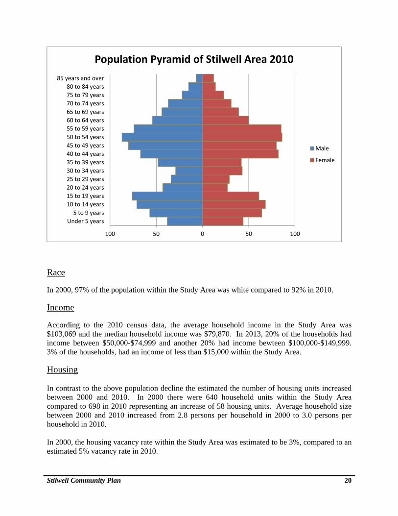
Because the 2000 and 2010 U.S. Census information data does not directly align with the Study Area, staff has estimated the following demographic information based on the use of aerial photography and available U.S. Census data. Population Based upon the 2000 U.S. Census, the estimated total population for the Study Area was 1,845 compared to a 2010 U.S. Census based estimate of 1,763 for a population decline of 82 persons. Age and Gender In 2000, 10% of the population was within the age range of 45-49. In 2010, that 10% group, advanced to the age range of 50-54. In 2000, 31% of the population within the Study Area was between 0-19 years of age. In 2010, that decreased to 27%. The split between male and female was almost even. The following graphic shows the population breakdown in the Study Area for age and gender in 2010.
Stilwell Community Plan 20
Race
In 2000, 97% of the population within the Study Area was white compared to 92% in 2010.
Income
According to the 2010 census data, the average household income in the Study Area was $103,069 and the median household income was $79,870. In 2013, 20% of the households had income between $50,000-$74,999 and another 20% had income bewteen $100,000-$149,999. 3% of the households, had an income of less than $15,000 within the Study Area.
Housing In contrast to the above population decline the estimated the number of housing units increased between 2000 and 2010. In 2000 there were 640 household units within the Study Area compared to 698 in 2010 representing an increase of 58 housing units. Average household size between 2000 and 2010 increased from 2.8 persons per household in 2000 to 3.0 persons per household in 2010. In 2000, the housing vacancy rate within the Study Area was estimated to be 3%, compared to an estimated 5% vacancy rate in 2010.
100 50 0 50 100
Under 5 years
5 to 9 years
10 to 14 years
15 to 19 years
20 to 24 years
25 to 29 years
30 to 34 years
35 to 39 years
40 to 44 years
45 to 49 years
50 to 54 years
55 to 59 years
60 to 64 years
65 to 69 years
70 to 74 years
75 to 79 years
80 to 84 years
85 years and over
Population Pyramid of Stilwell Area 2010
Male
Female
Stilwell Community Plan 21
In 2010, there were approximately 603 owner-occupied housing units, and 59 renter-occupied housing units. In 2000, there were approximately 582 owner-occupied housing units, and 44 renter-occupied housing units.
V. Natural Environment
The natural environment within the Study Area may be generally characterized as very low density development with large areas of agriculture and open spaces. There are two watersheds that encompass the Study Area - the Wolf Creek watershed on the west and the Camp Branch Creek watershed on the east. The two tributaries of Wolf Creek are located at the south end of the Study area near 207th Street and U.S. Highway 69 and on the north just west of the Aubry Cemetery on 191st Street. The Camp Branch Creek tributary is located generally east of the Union Pacific Railroad tracks between 191st and 207th Streets. The lands adjacent to these tributaries are designated as flood plain, where development should be discouraged. Generally, there are no significant ridges or slopes within the Study Area and according to the U.S. Soil Conservation Service, the Polo Soils (Pc) found in and around Aubry Township are the only soils within the County that present slight limitations for septic systems. The Polo soils are generally found on lands nearby the three tributaries noted above. Overall the flood plain, topographic and general soil conditions found within the Study Area do not pose any major obstacles to development. Natural resources including large areas of trees and vegetation have a significant impact on the quality of life within the Study Area and are important assets that need to be protected as the area develops.
VI. Public Infrastructure, Utilities, and Services To identify future Study Area public infrastructure, utility and service changes and needs as well as assess existing conditions, interviews were conducted with the following eleven public infrastructure, utility, and service providers. Below is a summary of the findings from the interviews.
Wastewater Treatment
Sanitary Sewers
Johnson County Wastewater Department provides sanitary sewer service to the areas immediately north and west of the Study Area. Within the Study Area today, however, there are no sanitary sewer lines or service. The closest sanitary sewer lines are located near the north boundary of the Study Area at 183rd Street and Metcalf Avenue.
Stilwell Community Plan 22
The Johnson County Wastewater has prepared estimates of when sanitary sewers might become available to the Study Area but notes that construction will depend on when individual property owners petition the County to approve such service.
Within the Study Area, north of 191st Street, sanitary sewers are projected to be installed between 2016 and 2020. A portion of the Estates of Prairie Glen subdivision currently has dry low pressure sewers.
The majority of the eastern portion of the Study Area is projected to have sanitary sewers between 2026 and 2030.
South of 191st Street and west of Metcalf Avenue, sanitary sewer projections are generally between 2021 and 2025.
South of the Massey Creek watershed boundary, the sanitary sewer projections are beyond 2030.
From the above it is apparent that although the sanitary sewers are feasible in the Study Area, installation costs are significant. Given today’s economic trends, the above listed estimates might be conservatively extended 5 years to reflect slower growth and the feasibility of private funding for large developments. On-Site Wastewater Treatment Systems Because there are no sanitary sewers within the Study Area, on-site wastewater treatment is by individual on-site septic or holding tank systems. Most residences utilize septic systems while commercial or nonresidential properties may be served by either septic systems or a holding tank. The Johnson County Department of Health and Environment (DHE) issue permits for all on-site wastewater treatment systems. DHE conducts inspections of all properties with septic systems that change ownership and conducts yearly inspections of all commercial on-site systems as well as investigates complaints regarding on-site system issues. Although the standard minimum residential lot area for a septic system in the unincorporated area is now 2 acres, there are numerous residences, particularly in the old town area, that are on smaller lots that predate the County’s current septic tank standards that were adopted in 1994. Of note, the Johnson County Zoning and Subdivision Regulations were recently amended to allow commercial uses (including restaurants) to be served by a septic system or a holding tank instead of the previous requirement to be served by a sanitary sewer system.
Water Supply
WaterOne District serves this area and has indicated there is sufficient capacity and capability to expand water service to serve existing and future development in the Study Area. The Kansas and Missouri rivers are the primary water sources for WaterOne. A 5 million gallon reservoir
Stilwell Community Plan 23
and pumping station is located at 211th Street and Metcalf Avenue. A 30-inch water supply line extends along Metcalf Avenue and there are generally 12-inch water lines along the section line roads with the exception of 199th Street that has an 8-inch line. Future WaterOne plans include a 20-inch line along 199th Street, estimated for construction between by 2014 and to increase the size of the 211th Street and Metcalf Avenue storage facility by 2024. Typical water distribution design in the Study Area is 12-inch mains on section line roads and 8-inch mains on half sections. Any distribution improvements needed (if any) would be paid for by development. WaterOne officials, however, did acknowledge that although sufficient water capacity exists, in some locations pressure may be an issue. WaterOne also is actively promoting policies and programs for water conservation by its customer/user base.
Electricity
Kansas City Power & Light (KCPL) provides electricity to the Study Area. KCPL indicated existing service to the area is adequate to support current development and can be expanded in the future, if needed. There are three substations that currently serve the study area: (1) the substation at 191st Street and Nall Avenue, (2) the substation at 194th Street and Lackman Road, and (3) the substation at 215th Street and Antioch Road, while located outside of the study area, it provides electricity within the study area. KCPL has indicated, based on current load growth, there are no new plans for future distribution substations in this area. In addition, KCPL is actively promoting resource conservation through education; customer rebate and net metering programs. KCPL is actively encouraging the use of energy efficient lighting systems and solar panels, among other methods.
Natural Gas
Kansas Gas Service provides natural gas to the Study Area. Kansas Gas Service indicated that current service to the Study Area is adequate and there is sufficient capacity to serve new development as it occurs. Residential uses are generally served by 2 to 4-inch plastic pipe lines that hold about 35-40 pounds of pressure. Kansas Gas Service future plans for this area include expanding a 12-inch line along Nall Avenue, expanding an 8-inch line south on Antioch Road, west of the Study Area. Transportation U.S. Highway 69 The most important roadway serving the Study Area is U.S. Highway 69 that is maintained by the Kansas Department of Transportation (KDOT). U.S. Highway 69 provides the most direct and convenient access to the urbanized area of Johnson County to the north as well as access to
Stilwell Community Plan 24
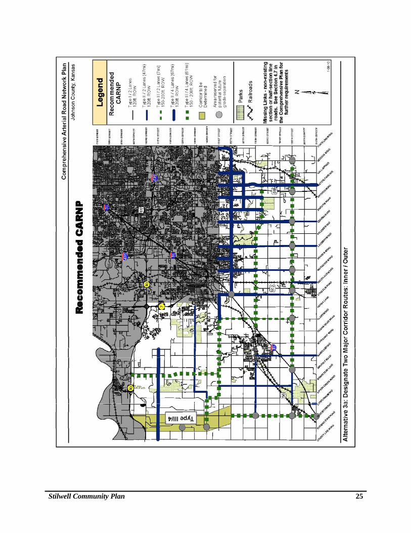
southeast Kansas and beyond. The 2011 annual average daily traffic (ADT) on the stretch of U.S. Highway 69 near Stilwell was 25, 320 vehicles. County-Maintained Roads The Johnson County Infrastructure and Transportation Department (Public Works) provides road improvements and maintenance for all the public roads, including local residential streets, in the Study Area. This ongoing maintenance includes snow removal, signage, drainage (culverts, bridges, ditches), and safety projects. The primary arterial roads that serve the Study Area are: 199th Street, Metcalf Avenue, and Nall Avenue. Other important arterial roads are 183rd Street, 191st Street, 207th Street and 215th Street. Comprehensive Arterial Road Network Plan (CARNP) The County will continue to utilize the Comprehensive Arterial Road Network Plan (CARNP) as its guide for future road improvements and the County’s Capital Improvement Plan (CIP). A copy of the CARNP Map is on the following page. CARNP designates 199th Street as a Type III road (4-lane), Metcalf Avenue as a Type II road (2-lane), and Nall Avenue as Type I (2-lane). All of the other arterial or section line roads within the Study Area are designated as Type I (2-lane) routes.
Average Daily Traffic (ADT) 2010 and 2013 counts at the intersection of 199th Street and Metcalf Avenue, an at-grade four way stop, are: 2010 2013
North Bound 4,114 3583 East Bound 4,277 3973 South Bound 3,206 2493 West Bound 5,299 5193 Total 16,896 15,242
Since 2012, there have been three accidents at the intersection of 199th Street and Metcalf Avenue and a total of eight accidents at this location since 2008.
The County’s 2014 CIP designates four projects in the Study Area for improvement within the next five years: (1) a shoulder addition project on 191 Street, from Lowell to Heritage Streets; and (2) a railroad crossing/elimination roadway re-alignment project on 207th Street, east of Metcalf Avenue, (3) Shoulder safety project at 199th Street and the Union Pacific Railroad tracks to Nall Avenue, and 4) converting 1.5 miles of millings roads to asphalt in the Aubry/Stilwell area. Public Works indicated that 199th Street will continue to be a major thoroughfare for this area and at this time there are no plans for improvements of 199th Street within the Study Area.
Stilwell Community Plan 25
Stilwell Community Plan 26
5-County Regional Transportation Study - 199th Street and Potential Outer Loop
In 2013, the Kansas Department of Transportation (KDOT), Mid-America Regional Council, and Lawrence-Douglas County Metropolitan Planning Organization completed a 5-County Regional Transportation Study that includes two separate future road improvements related to the Stilwell Plan Study Area. The 5-County Study identifies major road corridor improvements through the year 2040 for Leavenworth, Wyandotte, Douglas, Johnson, and Miami Counties.
The first recommendation related to the Stilwell Community Plan Study Area is to widen 199th Street to a 4-lane road as recommended in CARNP, as noted above. The second recommendation is for consideration of a potential outer loop highway that would connect U.S. Highway 73 in Leavenworth County to I-70, to K-10 Highway and I-35 in Johnson County, connect east to I-49/U.S. Highway 71 in Missouri. Although a portion of this conceptual corridor is shown within the Stilwell Community Plan Study Area, the potential outer loop received the lowest ranking in the 5-County Study and was not recommended for development within the 2040 time frame.
Railroad and Railroad Crossings
As noted in Chapter 2, the arrival of the Missouri Pacific Railroad in the mid 1880s “was the making of the town.” Today the Union Pacific Railroad operates the only active main line that runs diagonally through the Study Area from southwest to northeast and along the east side of the “old downtown” Stilwell.
The Union Pacific doesn’t make any stops in the Study Area and according to railroad officials, there are approximately 30 trains daily that pass through the Stilwell area. There is no passenger service and all of the rail traffic through the area is hauling freight. The average speed of the trains within the Study Area is from 40 mph to 60 mph.
207th Street and Metcalf Avenue Road Crossing:
The existing at-grade railroad intersection at 207th Street east of Metcalf Avenues is scheduled for realignment in 2014. Public Works plans to swing 207th street south to avoid the railroad line and reconnected it as a “T” intersection to Metcalf approximately 700’ further south. The project consists of two 12’-wide asphalt lanes with 4’ paved shoulders. The existing 207th Street right-of-way alignment will be retained to allow for a future overpass, if warranted.
183rd Street Future Overpass:
Currently, the County has plans but no funding at this time to construct an overpass on 183rd over Camp Branch Creek and the Union Pacific Railroad tracks between Mission Road and Nall Avenue. The estimated cost of construction is over $5 million. This also includes improving the 183rd Street to a 24’ wide asphalt surface with 6’ paved shoulders (Nall to Mission). It is anticipated that this overpass will improve mobility throughout the area for emergency services as well as for local traffic. 199th Street At-Grade Crossing:
Stilwell Community Plan 27
The County is aware of and supports the community’s interest in an overpass of the Union Pacific Railroad on 199th Street. This project, however, is not on the current 5-year County Road Plan and due to the large expense of construction such an overpass structure is not likely to be built in the near future.
Public Transit
Currently, there is no public transit service to the Stilwell area and Johnson County Transit has indicated that there is no planned transit service to the area in the near future. Study Area residents, however, now can access the Park and Ride lot at the Blue Valley Baptist Church at 151st and Antioch to catch the Route 673 – South Overland Park Xpress that provides service from south Johnson County to the downtown Kansas City, Missouri area.
Pedestrian and Bicycle Facilities
Throughout the Study Area there only a few locations with sidewalks (e.g., 199th Street) and there no designated bicycle routes or trial. The wide 2-lane design used on 199th from Antioch to the railroad tracks (approx. 1.5 miles), however, is intended not only to allow for turning movements but to provide additional width for bicycles. Also, the future improvement of 183rd Street between Nall Avenue and Mission Road will be designed to have 6’ paved shoulders to allow additional width for bicycles as well as vehicle traffic. Although the County is aware of a growing interest in adding pedestrian and bicycle facilities to the Study Area, there are no other plans or funding available at this time to do so. As future road improvements are made within the Study Area consideration will be given to addressing the needs of pedestrians and bicyclist as directed by the County’s 2011, adopted Complete Streets Policy that calls for safe travel for all transportation modes.
Stormwater Management
Public Works indicated stormwater management requirements for any new development in this Study Area generally will continue to be required to adhere to new 2008 American Public Works Association (APWA) standards adopted by the County for on-site stormwater management.
Parks and Recreation
The only parkland in the Study Area owned by Johnson County Park & Recreation District is located north of 207th Street, approximately one-quarter mile east of Metcalf Avenue. This approximately 55-acre parkland has not yet been developed but plans are in the works for picnic, trails, and recreational facilities. The Stilwell Community Organization is working in conjunction with the Parks and Recreation District on an implementation/development plan for this park.
Stilwell Community Plan 28
The Park District at this time has no other future parks planned for the Study Area. The Park District, however, has one future streamway pedestrian/bicycle trail connection point proposed from 183rd Street to the new Stilwell parkland at 207th Street and Metcalf.
The Park District supports a plan that would include greenway linkages and bike/walking paths and trails (new or connections to existing trails) in the Study Area. One concept that has been considered for the future is to eventually develop new pedestrian/bicycle trails that would connect Stilwell Elementary School and/or the future Stilwell Park to the Mid-America Regional Council (MARC) planned Metro Green trail system. This may be a connection to the recently acquired Park District properties along 175th Street and Mission Road, outside of the Study Area.
Overland Park’s future development plan shows a greenway linkage paralleling U.S. Highway 69 south to 207th Street.
Schools
Blue Valley School District serves the Study Area and as noted, Stilwell Elementary School located on 199th Street, east of Metcalf Avenue, is the only school facility within the Study Area. The elementary school has an on-site treatment plant that treats the wastewater. In addition, the School District has recently purchased an operations facility located west of Metcalf Avenue, just south of 194th Street, for bus storage/parking, dispatching, and maintenance.
The School District indicated there are no immediate plans for any new school facilities to be located with the Study Area. Outside of the Study Area, however, School District officials indicated there may be a future school site (K-8) as part of a new subdivision development that is proposed within an area recently annexed by Overland Park’s at 191st Street and State Line Road. Emergency Services Fire Protection Fire District No. 2 serves the Study Area and has one fire station located within the Study Area, on the east side of Metcalf Avenue at 194th Street. This station is staffed full-time. Just outside the Study Area, there are two more fire stations. One is located at 191st Street and Lackman Road and the other is located 184th Street and Mission that also serve the Study Area, if needed. The Fire District indicated there are currently sufficient facilities, manpower, and equipment to serve the Study Area. There are no immediate plans for new fire stations in the Study Area, with the possible exception of enlarging the fire station at 194th Street and Metcalf Avenue.
The Fire District indicated there are adequate facilities now to serve new development as well as existing development. Fire District officials, however, did indicate that some existing, older residential subdivisions can be challenging due to limited fire flow or lack of fire hydrants.
Stilwell Community Plan 29
Fire District officials noted two road/access response concerns in the Study Area: (1) on Nall Avenue, south of 191st Street to Wall Street, and (2) 183rd Street west of Nall Avenue. Fire District officials also noted that as development increases throughout the area, there will be an increasing need for a railroad overpass on 199th Street and possible improvements to portions of Mission Road.
Med-Act Ambulance Service
Johnson County Med-Act provides ambulance and emergency medical services throughout the county. Med-Act operates both ambulances and paramedic advance response (PAR) units to provide this service. Med-Act works in partnerships with other Johnson County cities to provide optimum response times and service.
Med-Act services are generally dispatched from fire stations depending on equipment availability at each fire station, including the fire station in the Study Area located at 194th Street and Metcalf Avenue. The two closest hospitals to the Study Area are St. Lukes South at 12000 South Metcalf Avenue and Menorah Hospital at 119th Street and Nall Avenue.
Med-Act officials indicated that they have few calls (e.g., 1/day) within the Study Area. The average age of the patient they respond to is 58. Med-Act officials indicated there were no outstanding or major impediments to providing emergency services to the Study Area.
Sheriff
The County Sheriff’s officials indicated they receive few calls for emergency services, including domestic or criminal activity (e.g., burglaries), within the Study Area. Sheriff officials noted commercial buildings in the area sometimes are a target for theft and limited security lighting throughout this portion of the County can contribute to criminal opportunities.
Within the Study Area, the Sheriff’s department has an office located in the fire station at 194th Street and Metcalf Avenue. The Study Area is patrolled on a regular basis and deputies monitor the elementary school site for safety and speed control. In addition, Sheriff’s officials indicated traffic safety might be improved in front of the elementary school if there is a turn lane for picking-up and dropping-off of students. The Sheriff’s department assists with community events such as organized bicycle races, the “Running of the Cows” event, the Fourth of July parade and fireworks display. Sheriff’s officials also noted there are few vehicle accidents within the Study Area with the exception of an increasing incidence of vehicle/deer collisions during the fall.
Sheriff’s officials indicated there are no immediate plans for law enforcement facilities within the Study Area.
Infrastructure/Utilities Conclusions
Based upon the above findings, it is apparent that, other than funding availability, there are few development pressures or limitations on the Study Area’s ability to continue to grow at its current modest pace. If, however, sanitary sewers do become available to the Study Area, it may be anticipated that the pace of development will increase along with pressure for more dense and diverse development.
Stilwell Community Plan 30
CHAPTER 3 – Future Land Use
I. Blue Valley Plan
As noted in Chapter 1, the purpose of the Stilwell Community Plan is to review and update, as needed, a six square-mile portion (Study Area) of the Blue Valley Plan. The Blue Valley Plan sets forth detailed goals, policies, and objectives for the area covered by the plan, including the Stilwell Community Plan Study Area. The “Future Land Use Map” within Blue Valley Plan along with goals, policies, and objectives in the plan serve as the County’s official guide on where and how development should occur. Along with other considerations, the recommendations contained and the Blue Valley Plan and the “Future Land Use Map,” are included as part of the County’s development (e.g., zoning) decision making process. Within the Stilwell Community Plan Study Area, the Blue Valley Plan recommends a general range of future land uses from rural and low-density residential to office/research and industrial warehousing. The portion of the Blue Valley Plan “Future Land Use Map” within the Study Area is shown in the following map.
The Blue Valley Plan “Future Land Use Map” includes the following proposed land uses within the Study Area:
Rural Policy Area – 1 dwelling/10 acres Growth Policy Area – 1 dwelling/10 acres is the standard with 1 dwelling/2 or 3 acres
appropriate as an option Very-Low-Density Residential – 1 dwelling/acre Commercial/Neighborhood Business – General neighborhood convenience retail Low-Intensity Office – Limited office compatible with residential development Light Industrial/Business Park – A mix of planned office, light industrial, limited retail,
and services on 15 acres or more Research and Development – Research-oriented development Industrial Warehouse – General warehouse and light manufacturing Public and Quasi-Public – Community facilities, churches, etc. Parks/Recreation/Open Space – public trails, greenways, outdoor activities, floodplain,
etc.
II. No Changes to Blue Valley Plan Future Land Use Map
For the purpose of this planning project, no changes are recommended for the goals, policies and objectives or the land uses recommended in the Blue Valley Plan “Future Land Use Map.”
This recommendation is based upon an evaluation of the information collected related to this plan update; particularly an assessment of the unlikely potential for sanitary sewers to reach the Study Area within the 20-year project timeframe. Also, although substantial, the impact of continuing development pressures from the north, east, or west are not anticipated to
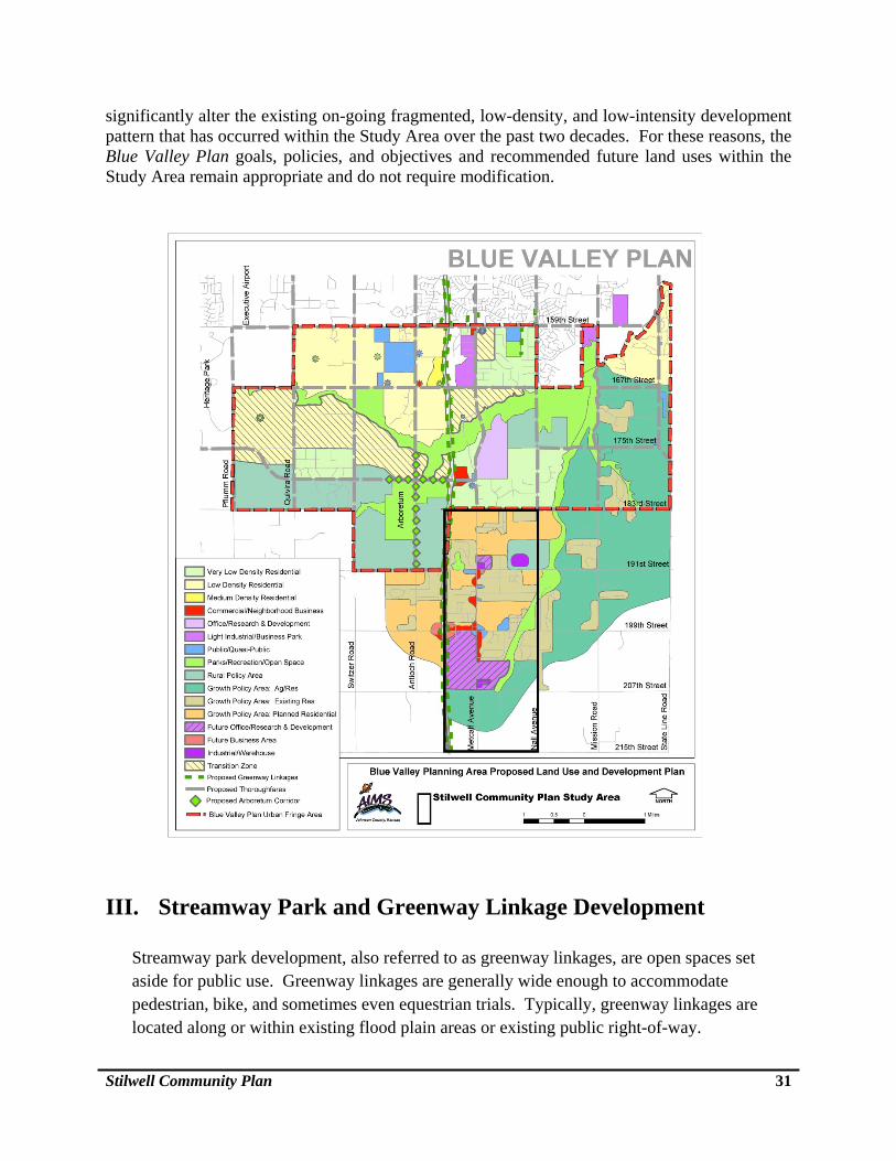
Stilwell Community Plan 31
significantly alter the existing on-going fragmented, low-density, and low-intensity development pattern that has occurred within the Study Area over the past two decades. For these reasons, the Blue Valley Plan goals, policies, and objectives and recommended future land uses within the Study Area remain appropriate and do not require modification.
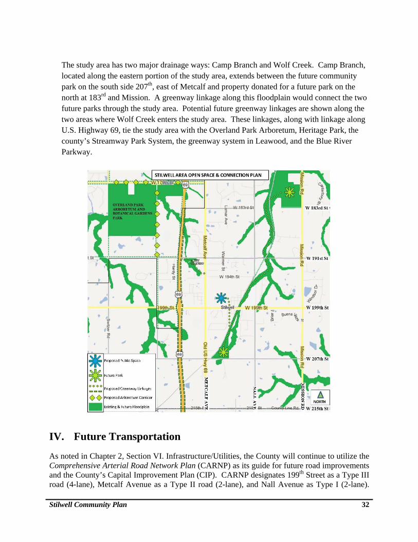
III. Streamway Park and Greenway Linkage Development Streamway park development, also referred to as greenway linkages, are open spaces set aside for public use. Greenway linkages are generally wide enough to accommodate pedestrian, bike, and sometimes even equestrian trials. Typically, greenway linkages are located along or within existing flood plain areas or existing public right-of-way.
Stilwell Community Plan 32
The study area has two major drainage ways: Camp Branch and Wolf Creek. Camp Branch, located along the eastern portion of the study area, extends between the future community park on the south side 207th, east of Metcalf and property donated for a future park on the north at 183rd and Mission. A greenway linkage along this floodplain would connect the two future parks through the study area. Potential future greenway linkages are shown along the two areas where Wolf Creek enters the study area. These linkages, along with linkage along U.S. Highway 69, tie the study area with the Overland Park Arboretum, Heritage Park, the county’s Streamway Park System, the greenway system in Leawood, and the Blue River Parkway.
IV. Future Transportation
As noted in Chapter 2, Section VI. Infrastructure/Utilities, the County will continue to utilize the Comprehensive Arterial Road Network Plan (CARNP) as its guide for future road improvements and the County’s Capital Improvement Plan (CIP). CARNP designates 199th Street as a Type III road (4-lane), Metcalf Avenue as a Type II road (2-lane), and Nall Avenue as Type I (2-lane).
Stilwell Community Plan 33
All of the other arterial or section line roads within the Study Area are designated as Type I (2-lane) routes.
CHAPTER 4 – Goals, Objectives, Community Initiatives and Implementation
I. Establishing Goals, Objectives, and Community Initiatives
Goals and Objectives
The following goals and objectives were derived from input by the Aubry-Oxford Consolidated Zoning Board, focus groups, and the community. Goals are desirable future conditions towards which development in Stilwell should be guided. Objectives are the general means for achieving the goals. Community Initiatives Following the description of goals and objectives is a list of Community Initiatives to be implemented by Stilwell’s residents, businesses, and property owners. These initiatives are beyond the normal realm of government services but could possibly be implemented jointly through public/private sector partnerships, similar to the development and operation of the future Stilwell Park on 207th Street.
Focus Group Process The focus group process consisted of a series of meetings with three separate representative groups from the community: 1) area businesses, 2) members of the real estate and development community, and 3) community institutions and residents. These participants were invited to two separate series of focus group meetings. The first series of meetings used a “brainstorming” process to identify the Study Area’s strengths, weaknesses, opportunities, and concerns. The results of the focus group’s discussions provided an initial overview of the general concerns and interests of those who participated and are summarized in Appendix A. The second series of meetings was to critique the goals and objectives drafted by staff and the AOCZB in response to the findings from the effort. Zoning Board and County Commission representatives also actively participated in the focus group meetings as well as received regular progress updates and provided feedback on staff’s working drafts. Focus Group Meetings Attendance
Stilwell Community Plan 34
A total of 207 individuals attended the two series of three focus group meetings. First Series:
1) Area business owners – 21 Attendees - November 22, 2011 2) Members of the development community – 28 Attendees - December 20, 2011 3) Community institution representatives and residents – 60 Attendees - February 15, 2012
Second Series: 1) Area businesses– 23 Attendees – June 20, 2013 2) Members of the development community – 20 Attendees – June 26, 2013 3) Community institution representatives and residents – 55 Attendees – July 10, 2013
A list of the attendees at the focus group meetings is included in the Project Participants section at the front of this report. The findings from the first series of focus groups are summarized in Appendix A. The comments and input from the second series of meetings are incorporated into the following goals and objectives. Community-Wide Public Meeting Following completion of the focus group review, the AOCZB revised the draft goals and objectives and hosted an open public meeting to present and receive input on the draft goals and objects. Over 160 people attended the public meeting held at the Stilwell Elementary School that was conducted by the AOCZB, the township trustee, and the chairman of the Stilwell Community Organization.
II. Stilwell Community Goals and Objectives These goals and objectives directly align with the goals, policies, and action steps contained in the County’s comprehensive plan. Responsibility for implementation of these goals and objects is shared by the County and the Stilwell community. Prioritization and funding of these goals and objectives, however, have not been identified at this time.
1. Goal: Historic Small Town Character and Sense of Community. Stilwell residents are
proud of their community and share a strong sense of commitment to enhancing as well as preserving its rural traditions and small town character.
Objectives:
Stilwell Community Plan 35
a. Encourage new development, particularly nonresidential structures and uses, to be appropriately scaled and designed to be compatible with and embrace the community’s character.
b. Establish guidelines to restrict excessive lighting, particularly on new nonresidential development. Undertake voluntary efforts to encourage businesses and residents to limit their outdoor lighting to be sufficient for safety and promote the use of new lighting technologies to reduce glare, e.g., LED when and if this lighting option becomes available.
c. Encourage multigenerational development that supports residents in all stages of their lives and particularly support efforts to enable the elderly to “age in place” with access to essential services (e.g., groceries, medical, and health services).
d. Increase efforts to improve property maintenance; particularly with absentee property owners and initiate a campaigns to promote a “litter-free” community.
e. Upgrade streetscapes of all major roadways into Stilwell to be inviting gateways, e.g.,
199th Street, and Metcalf Avenue north and south from 199th Street. f. Upgrade the intersection of 199th Street and Metcalf Avenue to be a community focal
point with welcoming signs, street fixtures, and landscaping in keeping with the village’s character.
g. Increase opportunities for residents to meet and interact, including the addition of
sidewalks or safe walking areas. h. Encourage redevelopment and adaptive reuse of older structures by reviewing
applicable zoning and building codes to identify possible regulation changes that might facilitate redevelopment; particularly within old downtown Stilwell.
2. Goal: Public Gathering Places - Parks, Greenways, Paths, and Recreation. Parks, greenways, paths, and recreational facilities are essential public amenities for Stilwell’s residents as well as providing opportunities to meet and interact.
Objectives: a. Support the establishment of a new centrally located and easily accessible public
gathering place like a village green to provide a common space, e.g., outdoor stage, picnic shelters, etc. for community events and enjoyment as well as a place of civic pride.
b. Develop a Camp Branch Creek bicycle and pedestrian greenway and possibly horse trail to connect with the recently acquired parkland at 175th and Mission Road as recommended in the Johnson County Rural Comprehensive Plan. Access to these improvements should be safe and convenient and could be developed through public/private partnerships.
Stilwell Community Plan 36
c. Identify utility corridors and unused land near stream corridors suitable for future
trails.
d. Develop a future bicycle and pedestrian trail connection to the Overland Park Arboretum.
3. Goal: Environmental Quality. Protection of the natural environment is essential to
maintaining a balance between the natural and built environments as well as maintaining the Village’s rural small town character.
Objectives: a. Integrate new development with the natural environment, minimizing adverse impacts
while conserving open spaces.
b. Encourage the inclusion of conservation or open space areas as part of new development, particularly, nonresidential development.
c. Minimize stormwater run-off by utilizing natural drainage systems and continue to restrict development in flood prone areas.
4. Goal: Future Development. Undeveloped land provides a wide range of opportunities for
new development including a balanced mix of housing types, shopping, entertainment, employment, and new community facilities.
Objectives: a. Assure harmonious transitions between new and existing development and differing
land uses.
b. Support a diversity of housing types with a wide range of prices.
c. Review applicable zoning and building codes to identify possible regulation changes that might facilitate new restaurants with local flavor along with expanded grocery and neighborhood convenience-type stores.
d. Explore establishing new zoning regulations that will allow for mixed-use development in the unincorporated area.
e. Encourage infill development of vacant and underutilized lots; particularly in old downtown Stilwell.
f. If sanitary sewers become available, assure that any new medium density development is appropriately located and compatible with adjacent existing development.
Stilwell Community Plan 37
g. Develop “general” voluntary design guidelines, including lighting and landscaping, for non-residential development to establish a common frame of reference for future and current development.
h. Restrict parking for future non-residential development to the rear or sides of the new building as well as provide sufficient screening from adjacent residential uses. Consider lowering parking requirements; particularly in the downtown area.
5. Goal: Transportation and Accessibility. Stilwell’s location, in combination with its
convenient transportation connections to the region, provides access to a wide range of business, employment, and shopping/entertainment opportunities.
Objectives: a. To the extent feasible, maintain the area’s low-traffic volume and existing
transportation system to assure continued mobility, access, and safety throughout the local network system of Stilwell.
b. Continue to adhere to the County’s Comprehensive Arterial Road Network Plan
(CARNP), which designates future road improvements and establishes design standards for the major and minor arterials that serve the area.
c. Adhere to the County’s policy of encouraging “Complete Streets” that serve the
needs of pedestrian, bicycle (e.g., striping bike lanes), and transit as well as motor vehicles.
d. Survey the community’s streets and identify potential ways to make them safer
for pedestrians and bicyclists. e. Continue to require paved streets for new development and continue to adequately
maintain streets, including snow removal, assuring safety, and long lasting low-maintenance improvements.
f. Explore opportunities for public transportation (e.g., Johnson County Transit
Local Link or Commuter Express) to serve Stilwell as well as promote use of the 151st Street and Antioch Road Park and Ride facility. Also, explore the potential for a future Park and Ride facility in Stilwell for carpooling and possibly for a future Stilwell JO route, if feasible.
g. Address traffic safety (e.g., pedestrian, bicycles, railroad crossing) on 199th Street,
while minimizing adverse impacts on surrounding existing development including Stilwell Elementary School.
6. Goal: Public Facilities/Services and Coordination. The effective use of limited public
resources and coordinated delivery of public facilities and services is essential to the continued high quality of life for Stilwell.
Stilwell Community Plan 38
Objectives:
a. Centrally locate future community facilities to create a “civic center” or area that would include other community facilities such as a post office, after-school facilities, a library, or a community center.
b. Plan and design the future installation of public utilities, including sanitary sewers, to limit adverse impacts on existing development.
c. Identify locations with utility services deficiencies (e.g., water pressure, power, etc.) and work with the utility providers to upgrade these services.
d. Increase communication and coordination with surrounding jurisdictions to ensure development is coordinated, orderly, efficient, and compatible.
III. Community Initiatives
As noted, the following list of community initiatives was developed during the preparation of the above goals and objectives. Because these initiatives are generally beyond the normal realm of government services, responsibility for implementation will be up to Stilwell’s residents, businesses, and property owners. Some of these initiatives, however, might be implemented jointly through public/private sector partnerships or support by the County and community organizations working together. 1. Historic Small Town Character and Sense of Community.
Community Heritage
Promote Stilwell’s heritage as essential to maintaining the community’s rural small town identity as well as to its sense of pride and connection to its past.
Survey important historic and cultural features to identify structures or locations
important to the community, preserve them, and commemorate them with historical signs or markers. Along with long-time and knowledgeable residents, the Johnson County Museum may provide assistance for conducting a survey.
Increase awareness of Stilwell’s old downtown through the addition of new directional signs and markers.
Establish a venue or location (e.g., future village green) to commemorate the community’s history, e.g., historical markers, public displays, etc.
Develop a sample historic-themed Village architectural style pamphlet for property owners to consider when remodeling or building new structures.
Stilwell Community Plan 39
Sense of Community
Encourage local civic organizations to bring neighbors together through community social, cultural, and historic events (e.g., Stilwell Parade).
Support redevelopment of the original Stilwell School into a community center or public gathering space.
Create a Stilwell logo or “brand” that can be used throughout the area on signs, banners, newsletters, websites, etc.
Small Town Character and Identity
Establish an ongoing farmer’s market to capitalize on locally grown produce as well
as to provide a location and opportunity for residents to meet and interact.
Encourage development of agri-businesses such as orchards, vineyards, pumpkin patches, etc., that reflect the community’s rural traditions and character and that attract visitors to the area.
2. Public Gathering Places - Parks, Greenways, Paths, and Recreation.
Continue collaboration between the County Park and Recreation District and the Stilwell Community Organization to develop parkland at 207th Street, east of Metcalf Avenue and create other “pocket parks” or trails in this area as well.
Capitalize on the number of bicyclists that ride through Stilwell by providing inviting amenities and commercial services, similar to communities along the KATY bicycle/pedestrian trial in Missouri.
3. Environmental Quality.
Promote the planting of hardy flowering trees and ornamental plants to reinforce a
common image for the community (e.g., host an annual community festival in celebration of a selected tree’s flowering) as well as to improve the overall environment.
Identify significant open spaces and stands of trees and encourage conservation of these areas through public-private cooperation or partnerships such as the Blue River Land Trust and the Kansas Land Trust.
4. Future Development.
Support existing local businesses as well as encourage new business and new
employment opportunities.
Stilwell Community Plan 40
5. Transportation and Accessibility.
Establish a “Quiet Zone” along the Union Pacific tracks in residential areas.
6. Public Facilities/Services and Coordination.
Support retaining Stilwell Elementary School at its current location while improving
its accessibility (e.g., sidewalks, bike lanes).
Increase communication between the County and Village property and business owners through newsletters, websites, email alerts, a community billboard, and various other forms of communication.
Establish an organization of business owners in the Stilwell area to collaborate with one another as well as promote their businesses, e.g., create a Stilwell business directory.
Explore opportunities to raise funds to support special community events and
projects.
IV. Implementation
As noted above, the preceding goals and objectives align with the goals, policies, and action steps contained in the Johnson County Rural Comprehensive Plan. Responsibility for implementation of the goals and objectives is shared by the County and the Stilwell community. At this time, however, neither prioritization nor funding for the goals and objectives has been identified.
Stilwell Community Plan 41
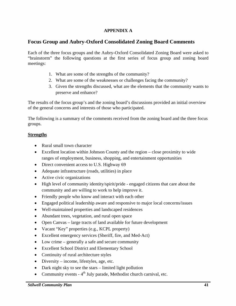
APPENDIX A
Focus Group and Aubry-Oxford Consolidated Zoning Board Comments Each of the three focus groups and the Aubry-Oxford Consolidated Zoning Board were asked to “brainstorm” the following questions at the first series of focus group and zoning board meetings:
1. What are some of the strengths of the community? 2. What are some of the weaknesses or challenges facing the community? 3. Given the strengths discussed, what are the elements that the community wants to
preserve and enhance?
The results of the focus group’s and the zoning board’s discussions provided an initial overview of the general concerns and interests of those who participated. The following is a summary of the comments received from the zoning board and the three focus groups. Strengths
Rural small town character
Excellent location within Johnson County and the region – close proximity to wide ranges of employment, business, shopping, and entertainment opportunities
Direct convenient access to U.S. Highway 69
Adequate infrastructure (roads, utilities) in place
Active civic organizations
High level of community identity/spirit/pride - engaged citizens that care about the community and are willing to work to help improve it.
Friendly people who know and interact with each other
Engaged political leadership aware and responsive to major local concerns/issues
Well-maintained properties and landscaped residences
Abundant trees, vegetation, and rural open space
Open Canvas – large tracts of land available for future development
Vacant “Key” properties (e.g., KCPL property)
Excellent emergency services (Sheriff, fire, and Med-Act)
Low crime – generally a safe and secure community
Excellent School District and Elementary School
Continuity of rural architecture styles
Diversity – income, lifestyles, age, etc.
Dark night sky to see the stars – limited light pollution
Community events - 4th July parade, Methodist church carnival, etc.
Stilwell Community Plan 42
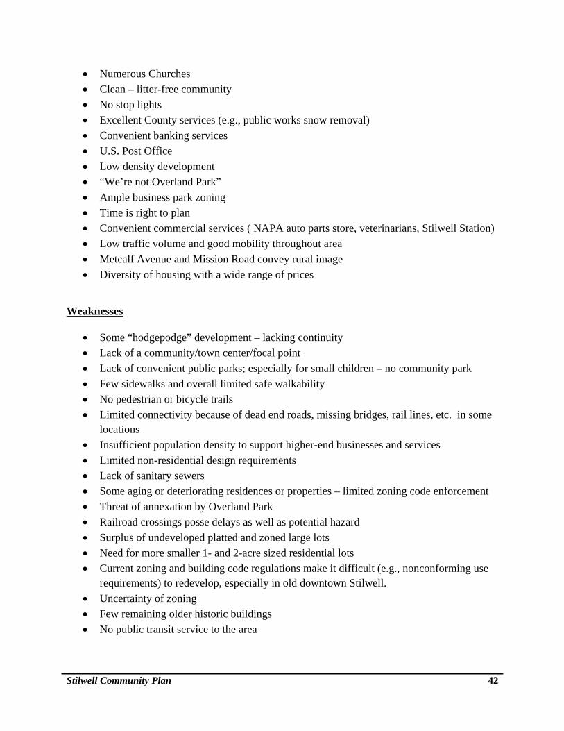
Numerous Churches
Clean – litter-free community
No stop lights
Excellent County services (e.g., public works snow removal)
Convenient banking services
U.S. Post Office
Low density development
“We’re not Overland Park”
Ample business park zoning
Time is right to plan
Convenient commercial services ( NAPA auto parts store, veterinarians, Stilwell Station)
Low traffic volume and good mobility throughout area
Metcalf Avenue and Mission Road convey rural image
Diversity of housing with a wide range of prices
Weaknesses
Some “hodgepodge” development – lacking continuity
Lack of a community/town center/focal point
Lack of convenient public parks; especially for small children – no community park
Few sidewalks and overall limited safe walkability
No pedestrian or bicycle trails
Limited connectivity because of dead end roads, missing bridges, rail lines, etc. in some locations
Insufficient population density to support higher-end businesses and services
Limited non-residential design requirements
Lack of sanitary sewers
Some aging or deteriorating residences or properties – limited zoning code enforcement
Threat of annexation by Overland Park
Railroad crossings posse delays as well as potential hazard
Surplus of undeveloped platted and zoned large lots
Need for more smaller 1- and 2-acre sized residential lots
Current zoning and building code regulations make it difficult (e.g., nonconforming use requirements) to redevelop, especially in old downtown Stilwell.
Uncertainty of zoning
Few remaining older historic buildings
No public transit service to the area
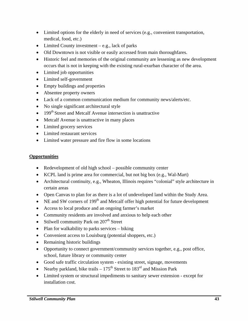
Stilwell Community Plan 43
Limited options for the elderly in need of services (e.g., convenient transportation, medical, food, etc.)
Limited County investment – e.g., lack of parks
Old Downtown is not visible or easily accessed from main thoroughfares.
Historic feel and memories of the original community are lessening as new development occurs that is not in keeping with the existing rural-exurban character of the area.
Limited job opportunities
Limited self-government
Empty buildings and properties
Absentee property owners
Lack of a common communication medium for community news/alerts/etc.
No single significant architectural style
199th Street and Metcalf Avenue intersection is unattractive
Metcalf Avenue is unattractive in many places
Limited grocery services
Limited restaurant services
Limited water pressure and fire flow in some locations
Opportunities
Redevelopment of old high school – possible community center
KCPL land is prime area for commercial, but not big box (e.g., Wal-Mart)
Architectural continuity, e.g., Wheaton, Illinois requires “colonial” style architecture in certain areas
Open Canvas to plan for as there is a lot of undeveloped land within the Study Area.
NE and SW corners of 199th and Metcalf offer high potential for future development
Access to local produce and an ongoing farmer’s market
Community residents are involved and anxious to help each other
Stilwell community Park on 207th Street
Plan for walkability to parks services – biking
Convenient access to Louisburg (potential shoppers, etc.)
Remaining historic buildings
Opportunity to connect government/community services together, e.g., post office, school, future library or community center
Good safe traffic circulation system - existing street, signage, movements
Nearby parkland, bike trails – 175th Street to 183rd and Mission Park
Limited system or structural impediments to sanitary sewer extension - except for installation cost.
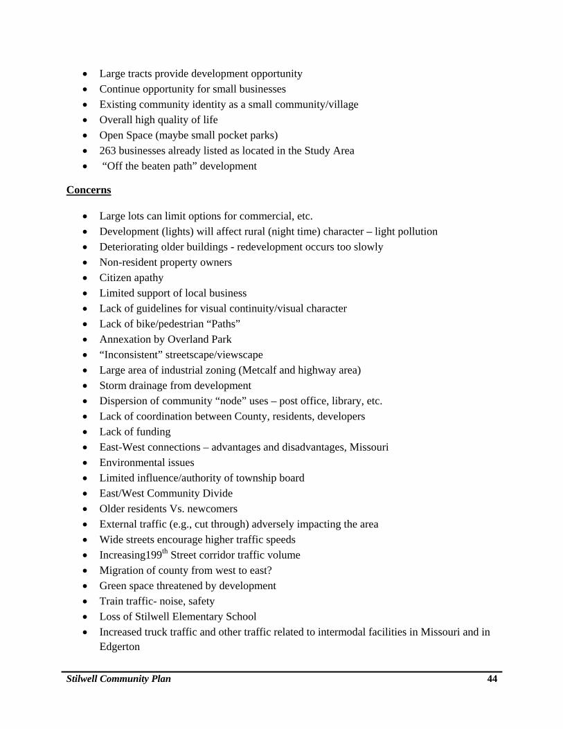
Stilwell Community Plan 44
Large tracts provide development opportunity
Continue opportunity for small businesses
Existing community identity as a small community/village
Overall high quality of life
Open Space (maybe small pocket parks)
263 businesses already listed as located in the Study Area
“Off the beaten path” development
Concerns
Large lots can limit options for commercial, etc.
Development (lights) will affect rural (night time) character – light pollution
Deteriorating older buildings - redevelopment occurs too slowly
Non-resident property owners
Citizen apathy
Limited support of local business
Lack of guidelines for visual continuity/visual character
Lack of bike/pedestrian “Paths”
Annexation by Overland Park
“Inconsistent” streetscape/viewscape
Large area of industrial zoning (Metcalf and highway area)
Storm drainage from development
Dispersion of community “node” uses – post office, library, etc.
Lack of coordination between County, residents, developers
Lack of funding
East-West connections – advantages and disadvantages, Missouri
Environmental issues
Limited influence/authority of township board
East/West Community Divide
Older residents Vs. newcomers
External traffic (e.g., cut through) adversely impacting the area
Wide streets encourage higher traffic speeds
Increasing199th Street corridor traffic volume
Migration of county from west to east?
Green space threatened by development
Train traffic- noise, safety
Loss of Stilwell Elementary School
Increased truck traffic and other traffic related to intermodal facilities in Missouri and in Edgerton