Embed Size (px)
Citation preview
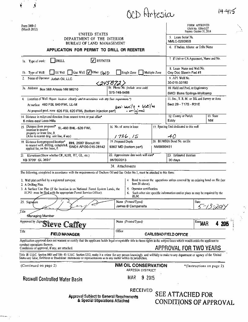
Form 3160-3 (March 2012)
UNITED STATES DEPARTMENT OF THE INTERIOR BUREAU OF LAND MANAGEMENT
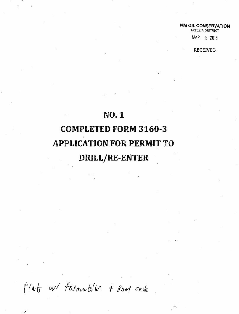
APPLICATION FOR PERMIT TO DRILL OR REENTER
FORM APPROVED OMBNo. 1004-0I37
Expires October 31,2014
Form 3160-3 (March 2012)
UNITED STATES DEPARTMENT OF THE INTERIOR BUREAU OF LAND MANAGEMENT
APPLICATION FOR PERMIT TO DRILL OR REENTER
5. Lease Serial No. NMLC-029395B
Form 3160-3 (March 2012)
UNITED STATES DEPARTMENT OF THE INTERIOR BUREAU OF LAND MANAGEMENT
APPLICATION FOR PERMIT TO DRILL OR REENTER 6. If Indian, Allotee or Tribe Name
la. Type of work: Q DRILL {7} REENTER
lb. Type of Well: • Oil Well Gas Well [/Joiner p Single Zone f _ ] Multiple Zone
7 If Unit or CA Agreement, Name and No. la. Type of work: Q DRILL {7} REENTER
lb. Type of Well: • Oil Well Gas Well [/Joiner p Single Zone f _ ] Multiple Zone 8. Lease Name and Well No.
Oxy Doc Slawin Fed #1
2. Name of Operator j u c j a r , oil, LLC
<MS87JL> 9. API Well No.
30-015-33180
3a. Address Box 568 Artesia NM 88210 3b. Phone No. (include area code) 575-748-5488
10. Field and Pool, or Exploratory
SWD: Bone Springs-Wolfcamp
4. Location of Well (Repori location clearly and in accordance with any State requirements. *)
A. surface 460 FSL 640 FWL UL-M ^ ^ + ^ / v O
At proposed prod, zone 626 FSL 620 FWL (bottom injection perf) -
11. Sec, T. R. M. or Blkand Survey or Area
Sect29-T17S-R31E
14. Distance in miles and direction from nearest town or post office* 6 miles east Loco Hills
12. County or Parish 13. State Eddy NM
15. Distance from proposed* B H L _ 6 2 Q p W L
location to nearest property or lease line, ft. (Also to nearest drig. unit line, if any)
16. No. of acres in lease
/ 7£6.IS
17. Spacing Unit dedicated to this well
18. Distance from proposed location* BHL 2680'Biscuit Hii to nearest well, drilling, completed, q w r ) 1 A p,o n n i J - 0 M . ~ applied for, on this lease, ft. S W D 1 API30-015-28142
19. Proposed Depth
9360' MD (bottom perf)
20. BLM/BIA Bond No. on file
NMB000451
21. Elevations (Show whether DF, KDB, RT, GL, etc.) KB 3709' GL3691'
22 Approximate date work will start* 06/30/2013
23. Estimated duration 30 days
24. Attachments The following, completed in accordance with the requirements of Onshore Oil and Gas Order No.l, must be attached to this form:
1. Well plat certified by a registered surveyor. 2 A Drilling Plan.
4. Bond to cover the operations unless covered by an existing bond on file (see Item 20 above).
3. A Surface Use Plan (if the location is on National. Forest System Lands, the SUPO must befiled_wjth the appropriate Forest Service Office).
5. Operator certification 6. Such other site specific information and/or plans as may be required by the
BLM.
25. Signature J y —~~~ Name (Printed/Typed) James B Campanella
Date
Title r " / -Managing Member
•"""""•Steve Caffey Name (Printed/Typed) DateMAR 4 2015 Tl"e FIELD MANAGER
Office CARLSBAD FIELD OFFICE
Application approval does not warrant or certify that the applicant holds legal or equitable title to those rights in the subject lease which would entitle the applicant to conduct operations thereon. « ~ » » ~ - » . . . . — . - . . , ^ , ,r- . ~ Conditions of approval, if any, are attached. A P P R O V A L F O R T W O Y E A R S
Title 18 U.S.C. Section 1001 and Tide 43 U.S.C. Section 1212, make it a crime for any person knowingly and willfully to make to any department or agency of the United States any false, fictitious or fraudulent statements or representations as to any matter within its jurisdiction.
(Continued on page 2) NM OIL CONSERVATION ""(Instructions on page 2) ARTESIA DISTRICT
Roswell Controlled Water Basin M A R 9 2 0 , 5
RECEIVED Approval Subject to General Requirements ^ E E ATTACHED FOR
& Special Stipulations Attached CONDITIONS OF APPROVAL
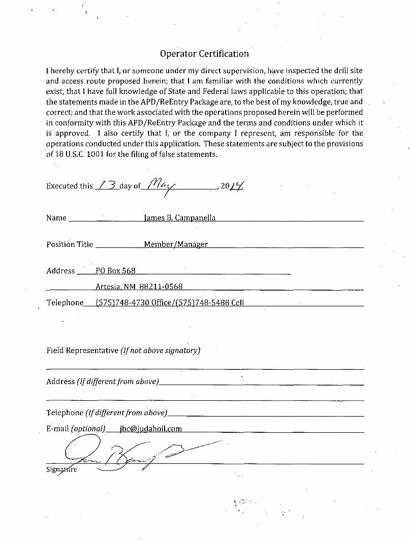
Operator Certification
I hereby certify that I, or someone under my direct supervision, have inspected the drill site and access route proposed herein; that I am familiar with the conditions which currently exist; that I have full knowledge of State and Federal laws applicable to this operation; that the statements made in the APD/ReEntry Package are, to the best of my knowledge, true and correct; and that the work associated with the operations proposed herein will be performed in conformity with this APD/ReEntry Package and the terms and conditions under which it is approved. I also certify that I, or the company I represent, am responsible for the operations conducted under this application. These statements are subject to the provisions of 18 U.S.C. 1001 for the filing of false statements.
Executed this_Z_jLday of / Y l & y . 20/Vf
Name ; james B. Campanella
Position Title Member/Manager
Address PO Box 568
Artesia. NM 88211-0568
Telephone (575)748-4730 Qffice/f5751748-5488 Cell
Field Representative (If not above signatory)
Address [If different from above).
Telephone (If different from above).
E-mail (optional) jbc(5)judahoil.com
I I !£1 'KII ;J_: 162) K fnncJi I» , Hobix. N'M RIW ("how (<7.«l.">">-<.l«l Hii |5:<)J01^7V.
tins t'liriSi ^nciMi.NMw:tt) f i x * * (J7S|?<S 1281 f l . {J7Ji 74|i.07J(: DI.STKKT. 1)1
Kin tfiiu> Ruid. A g > NMS74IO I lKX* |>l)<) J.H-6|7f l l , | 5W l»1 - ( i l 70
D I M K i r i IV I22(if i ' ( , , ' K I . I I I U l) i . SKKL tc NM K 7 » \
(5U57<'I>-M«i|- 'u i J0S)« f . 3M£
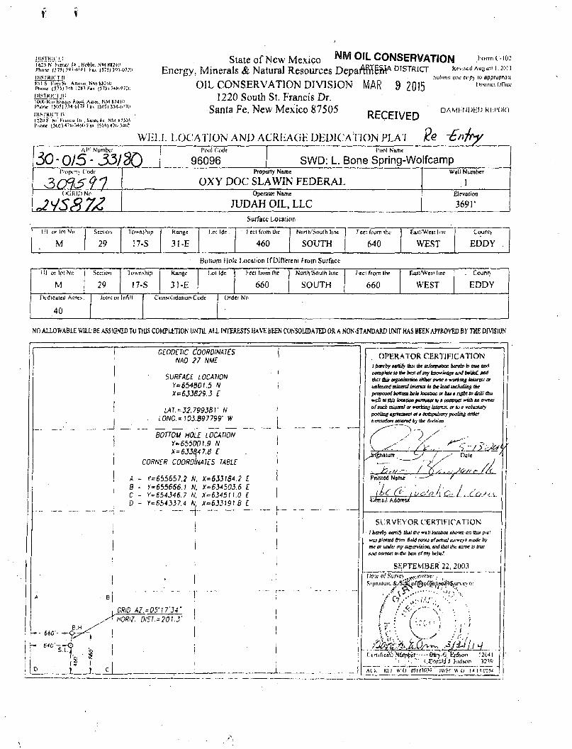
State of New Mexico ™IVI OIL CONSERVATION i «rmt 102 Energy, Minerals & Natural Resources DeparVnTit DISTRICT K.V,««, A ^ , I . im 1
OIL CONSERVATION DIVISION MAR 9 2015 1220 South St. Francis Dr.
Santa Fe. New Mexico 87505
.^uhiTiii unr cop) li> epprupnatt
RECEIVED
WH1.L LOCA TION AND ACRLAGE DEDICATION PL A 7 f?e
• AMKMI)!:(.> KI-.t'OK'l
Al'i Numbv.' _
30-0/5-33/30 fool Code
96096 1'ito) Name
SWD: L. Bone Spring-Wolfcamp I'KipiTly l.'odt Property Nwoe
OXY DOC SLA WIN FEDERAL Well Number
. 1 (XJRIDNo ' Opsraior Name
JUDAH OIL, LLC EJcvfliion
369r
Surface Lx>taii(in
1)1 l-r lOl No
M
Sccuon
29
Township
17-S Range I i.o! ldn.
31-E |
l-etl from Oic 1 North/South line
460 j SOUTH T cei from tht-
640
Fjui "Weii l.nc
WEST
Couno,
EDDY
Botiom Holt l-ocaiion IfDifTrreni from Surface Ul otlplNo
M 29
Township
17-S Ran(>t 1 Ixii ldn
31-E j
F-cci from the
660 Nonh'Soulh lint
SOUTH Feci from Ihe
660
luui'Wesi line
WEST
Counrj
EDDY rVdtcaleiJ Acrt>
40
Joint or Infill Cunv^hdahon Code Ordei Nr.
NO ALLOWABLE W1LLBE ASSIGNED TO THIS C0MPLIT10N UNTIL ALL INTERESTS HAVE BEEN CONSOLIDATED OR A NON-STANDARD UNIT HAS BEEN APPROVED BY THE DIVISION
' GEODETIC COORDINATES NAD 27 ME
SURFACE. LOCATION Y=65480l.5 N X*633B29.3 E
LA7.*32.7993BV rV . LONG. = 103.897799' W
BOTTOM HOLE LOCATION Y* 655001.9 N X= 6J3647.fi E
CORNER COORDINATES TABLE
A - r>655657.2 IV, X" 633184.2 L B - Y-655666.1 N. X*634503.6 E C - Y=S54346.7 N. X=63451L0 E D - Y=654337.4 K, X°6331918 E
i -
CRlD A7. = 05MI7'34' HORiZ. DIST.-'20'S
h- - 660'- —
OPERATOR CERTIFICATION i ttercby ctrbfy &u tbt udctViAOan bmrto fcs aw florf cenptele to tb* beg of my kBtnriedgt and belief, tad thzi thit otgflaipaofi efflw a workmg btiorvot or unkrsrd oiocnJ intenst is (he luxJ iochidin$ tbe prppotcrt bottom bob ioatttcc or bis* right to drill thii XvpU Bt thU bttOOOpWTV&Ot to t POffSTXt Wttb fifi OWTta of cud) mltxtnJ or vurkitts IBIOKX, or toe voluntary pooling igrtauat or a ooapulurry p 0 0 ^ o r A c r
bactofon eo\crt4 by Cbc diviiion
1 Printed N j m t /
lie Cc\ ,U<y>«h Q^.L-CjOy<X.
/ - Dsie
nail Ki,i\
SURVEYOR CERTIFICATION / hereby certify thi! the we// hcatxm tbowt on t&u pint HXJ plotted ffrm Belt! ecfmf twveyt ir&ic by mc cr under my A^XTVUJOC. end tbsi the urnc is trur Md c&ror. tn tbe bat of my belief.
SEPTEMBER 22, 2003 l>ait of Survr)^^,;.^^!:.-
e • < - , • ' . - - .
\i\ {-'•> \r
(.tiificaV- toii^l' Ctoj.'J Vj*>on 12641 '<• t.T.«ali 1 Kid^n 33.10
At >. Kfi »-i»"3Ti*Mew" iWW « o i m o : s i

DISTRICT' 1 PA b IMS, D.U..
DISTRICT I I P.O. t l j u m i i l i b .
DISTEICT CD
DISTRICT IV u u t BUM. m m rn. m i « i t a t -ma \
State of New Mexico
O I L C O N S E R V A T I O N D I V I S I O N P.O. Brat 2088
Santa Fc. New Mexico 87504-2068
WELL LOCATION AND ACREAGE DEDICATION PLAT
Form C - l O i SirefaeJ rabnuiT I * . IBM
SirtmlL U> Appropriate District Offiei BUle L m ~ 4 Cruris I
»r» Uoae - V
• AMENDED REPORT API Mnmkar
30-015- 74605 Undesignated Cedar LajdT Morrow, East
31063 X oxy DOC SLATOT'FEDERAL V&U Ki
1 ocsrc Ko. 192463 OXY U.S.A. W.T.P.. LP 369 T
Surface Location U l cr lot Jfo,
M Section
29 17-S 31-E "let Us
\
T u t tram Lbs
460' KBrtb/BsnUi D M
SOUTH y 640'
ZaU/ttvrt, Hue
WEST EDDY
Bottom Hole^ocfitiou If Different FroB^Surface DI or lot Mo.
M
Section
29 Township
17S 31E
Lot ldn \ Pent tram Oas
\ 6 6 0
Narth/fe&Ui line T«ei from lbs j XaoV^imt line.
660 J east <fcwmtj
Eddy Itadtcsled Acre*
320 Joist or Infi l l
1 CnwntMatintn Code Order Ifc. / f
\ /
OE A NON-SrCANDAHD UNIT HAS g^EN APPROVED BY THE DlVJglOK
60'
3709-T
Y « C34S01.S N
ur. 3r*rs7.77"H
t I 15' j
Biscuit Hill SWtJ 30-015-28142
ODSF n 3001532585
OPERATOR CERTIFICATION
/ hereby ctrtsfy ttm fAi tt/mnin in
EHftMbiro
David Stewart mt>Lt£ Name
Sr. Regulatory Analyst
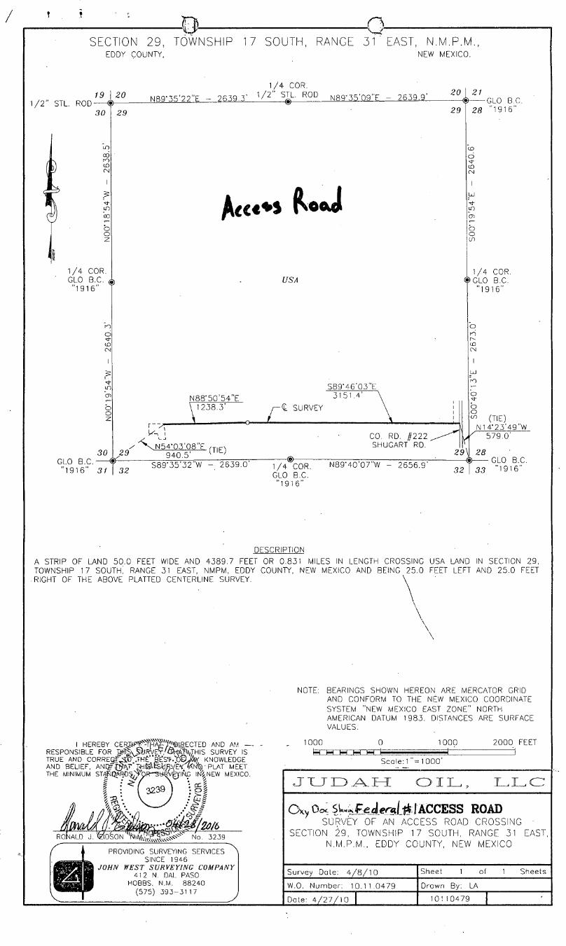
SECTION 29, TOWNSHIP EDDY COUNTY,
7 SOUTH, RANGE 31 ' EAST, N.M.P.M., NEW MEXICO.
1 / 2 " STL. ROD-19 20
30 29
1/4 COR. GLO B.C. "1916"
®
30 GLO B.C. "1916"
N89
USA
N88'50'54"E 1238.3'
S89-46'03"E 31 51.4 '
< SURVEY
29 ^ V N 5 4'03'08"E
940.5 ' (TIE)
CO. RD. #222 SHUGART RD.
31 32 S89'35'32"W - 2639.0 -€>-1/4 COR.
GLO B.C. "1916"
N89 - 40'07"W - 2656.9 '
20 \ 21 1 / 4 COR.
35'22"E - 2639.3 ' 1 / 2 " S J ^ - R 0 D N8QM5'09"F - 2639.9 ' & G L 0 B C
2 9 \ 2 8 "1916"
1/4 COR. $GLO B.C.
'1916"
29\
32
(TIE) N1 4'23'49"W
579.0 '
28 GLO B.C.
33 "1916"
DESCRIPTION
A STRIP OF LAND 50.0 FEET WIDE AND 4389.7 FEET OR 0.831 MILES IN LENGTH CROSSING USA LAND IN SECTION 29, TOWNSHIP 17 SOUTH, RANGE 31 EAST, NMPM, EDDY COUNTY, NEW MEXICO AND BEING 25.0 FEET LEFT AND 25.0 FEET
.RIGHT OF THE ABOVE PLATTED CENTERLINE SURVEY. \ ^
\
\ \ \ \
RESPONSIBLE . ~ . K V , ~ . . . _., .,. . . . „ . . . _ . TRUE AND CORREGjF W .THE'"B*E!S*f KNOWLEDGE AND BELIEF, AND/gfi^T* W i ^&dRYE* M f y • PLAT MEET THE MINIMUM STA^I^ARTJS^R--SH.'BVE^INJG IW NEW MEXICO.
hv-'^—' r -
RONALD J. tktDSON No. 3239
PROVIDING SURVEYING SERVICES SINCE 1946
JOHN WEST SURVEYING COMPANY 412 N. DAL PASO
HOBBS, N.M. 88240 (575) 393-31 17
NOTE: BEARINGS SHOWN HEREON ARE MERCATOR GRID AND CONFORM TO THE NEW MEXICO COORDINATE SYSTEM "NEW MEXICO EAST ZONE" NORTH AMERICAN DATUM 1983. DISTANCES ARE SURFACE VALUES.
1000 I—| j-H M I—I
0 1000 2000 FEET
Scale: 1 "= 1 000 '
J L T T O A . L T L O I L L L C
O K V OO< Si £edereii^ [ACCESS ROAD SURVEY OF AN ACCESS ROAD CROSSING -
SECTION 29, TOWNSHIP 17 SOUTH, RANGE 31 EAST, N.M.P.M., EDDY COUNTY, NEW MEXICO
Survey Dote: 4 / 8 / 1 0
W.O. Number: 10.1 1.0479
Date: 4 / 2 7 / 1 0 |
Sheet of Sheets
Drawn By: LA
10110479

SECTION 29, TOWNSHIP 17 SOUTH, RANGE ,31 EAST, N.M.P.M., EDDY COUNTY, ^ « a Ik ft A NEW MEXICO.
1 / 2 " STL. ROD-19
30
1/4 COR. GLO B.C. "1916"
20
29
30
GLO "1916
29
1/4 COR.
N89-35'22"E - 2639.3 ' 1 / 2 ' S I L R 0 D N8<r35'09"F 2639. a :
SEE DETAIL
USA
N89'33'45"E - 225.0 '
CEDAR LAKE FED. § 1 SWD
P & A
1.01 ACRES
S89 - 58'28"W .125.0" .
FENC
100.0 S89'55 35 W
DETAIL SCALE - 1' :100 '
N00'24'28"W 318.5'
(TIE)'
1949.4' B..C.77T* 689.6''"' S89'35'32"W 6" '
1/4 COR. GLO B.C. "1916"
N89'40'07"W - 2656.9'
20 4^ 29
GLO B.C. 28 1916
1 / 4 COR. <$>GLO B.C.
"1916"
29
UJ
b
b o
25 GLO B.C.
32 I 33 "1916" r DESCRIPTION
A TRACT OF LAND LOCATED IN THE SOUTHWEST QUARTER OF THE SOUTHWEST QUARTER OF SECTION 29, TOWNSHIP 17 SOUTH. RANGE 31 EAST, N.M.P.M.. EDDY COUNTY, NEW MEXICO BEING MORE PARTICULARLY DESCRIBED AS FOLLOWS:
BEGINNING AT THE SOUTHWEST CORNER OF THIS TRACT, WHICH LIES N89'35'32"E ALONG THE SOUTH LINE OF SAID SECTION A DISTANCE OF 689.6 FEET AND N00-24'28"W 318.5 FEET FROM THE SOUTHWEST CORNER OF SAID SECTION; THEN N14-51'14"W 90.0 FEET; THEN S89'58'28"W 125.0 FEET; THEN N0T32'47"W 150.0 FEET; THEN N89"33'45"E 225.0 FEET; THEN S06'29'11"E 240.0 FEET; THEN S89"55'35"W 100.0 FEET TO THE POINT OF BEGINNING AND CONTAINING 1.01 ACRES MORE OR LESS.
LEGEND © - DENOTES FOUND MONUMENT AS NOTED
® - DENOTES SET 1 / 2 " STL. ROD W/CAP MKD. "JWSC PS 1 2 6 4 1 "
NOTE: BEARINGS SHOWN HEREON ARE MERCATOR GRID AND CONFORM TO THE NEW MEXICO COORDINATE SYSTEM "NEW MEXICO EAST ZONE" NORTH AMERICAN DATUM 1983. DISTANCES ARE SURFACE VALUES.
THEREBY CEK'T.IFY(3fHAT//I)jJIRECTED AND AM RESPONSIBLE FOR^ffcyS* SURVEY,. T-HAT'f/THIS SURVEY IS TRUE AND CORRg:ef^TO' -THEj( B^Sf-b 'Fp&y KNOWLEDGE AND BELIEF, AN© THAT,NTHIS^SWRVEY AND PLAT MEET THE MINIMUM ST#NDARD5i'F0'R SURVEYING iflj NEW MEXICO.
12641
No. 12641
PROVIDING SURVEYING SERVICES SINCE 1946
JOHN WEST SURVEYING COMPANY 412 N. DAL PASO
HOBBS, N.M. 88240 (575) 3 9 3 - 3 1 1 7
1 0 0 0 I—I I—I I—I M M
1 000 2000-FEET
Scale: 1 " = 1 0 0 0 '
J U D A H O I L , L L C
SURVEY OF A SWD WELL TRACT OF LAND SITUATED IN
SECTION 2 9 , TOWNSHIP 17 SOUTH, RANGE 31 EAST,
N.M.P.M., EDDY COUNTY, NEW MEXICO
Survey Dole: 4 / 8 / 1 0
W.O. Number: 10.11.0479
Date: 4/16/10 \
Sheet of 1 Sheets
Drawn By: LA
10110479
HM OIL CONSERVATION ARTESIA DISTRICT
MAR 9 2015
RECEIVED
i 'r
Oil and Gas Producing [email protected]
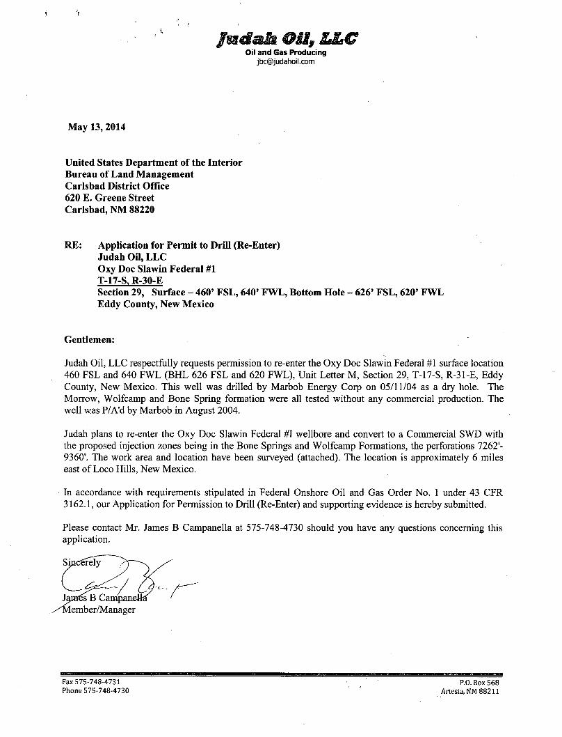
May 13, 2014
United States Department of the Interior Bureau of Land Management Carlsbad District Office 620 E. Greene Street Carlsbad, NM 88220
RE: Application for Permit to Drill (Re-Enter) Judah Oil, L L C Oxy Doc Slawin Federal #1 T-17-S, R-30-E Section 29, Surface - 460' FSL, 640' FWL, Bottom Hole - 626' FSL, 620' FWL Eddy County, New Mexico
Gentlemen:
Judah Oil, LLC respectfully requests permission to re-enter the Oxy Doc Slawin Federal #1 surface location 460 FSL and 640 FWL (BHL 626 FSL and 620 FWL), Unit Letter M, Section 29, T-17-S, R-31-E, Eddy County, New Mexico. This well was drilled by Marbob Energy Corp on 05/11/04 as a dry hole. The Morrow, Wolfcamp and Bone Spring formation were all tested without any commercial production. The well was P/A'd by Marbob in August 2004.
Judah plans to re-enter the Oxy Doc Slawin Federal #1 wellbore and convert to a Commercial SWD with the proposed injection zones being in the Bone Springs and Wolfcamp Formations, the perforations 7262'-9360'. The work area and location have been surveyed (attached). The location is approximately 6 miles east of Loco Hills, New Mexico.
In accordance with requirements stipulated in Federal Onshore Oil and Gas Order No. 1 under 43 CFR 3162.1, our Application for Permission to Drill (Re-Enter) and supporting evidence is hereby submitted.
Please contact Mr. James B Campanella at 575-748-4730 should you have any questions concerning this application.
Fax 575-748-4731 Phone 575-748-4730
P.O. Box 568 Artesia, NM 88211
1
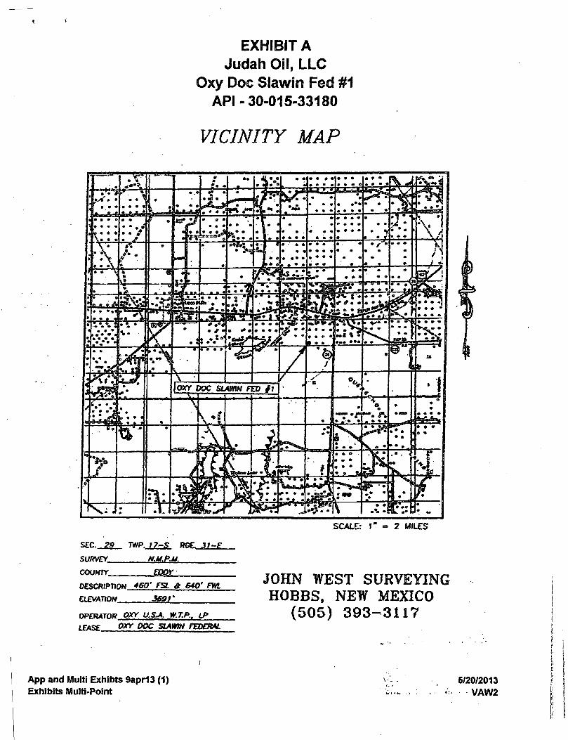
EXHIBIT A Judah Oil, LLC
Oxy Doc Slawin Fed #1 API -30-015-33180
VICINITY MAP
SCALE: 1' 2 MILES
SEC. 29 TWP. 17-S RGE. J)T£
SURVEY NMPM.
COUNTY EDDY
DESCRIPTION 460' FSL & 640' FWL
ELEVATION 369f
OPERATOR OXY U.&A W.T.P.. LP
LEASE OXY DOC SLAWIN FEDERAL
JOHN WEST SURVEYING HOBBS, NEW MEXICO
(505) 393-3117
App and Multi Exhibts 9apr13 (1) Exhibits Multi-Point
5/20/2013 VAW2
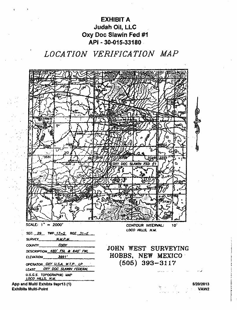
EXHIBIT A Judah Oil, LLC
Oxy Doc Slawin Fed #1 API - 30-015-33180
LOCATION VERIFICATION MAP
SCALE: I " « 2000 '
SEC , 29.. TWP. RGE. 31-E
SURVEY NM.PM.
COUNTY
CONTOUR INTERVAL: LOCO HILLS. NM.
EDDY
DESCRIPTION 460' FSL * 640' FWL
ELEVATION 5691'
OPERATOR OXY USA. W.T.P., LP
LEASE OXY DOC SLAWIN FEDERAL
US.GS. TOPOGRAPHIC MAP
LOCO mas, NM.
App and Multi Exhibts 9apr13 (1)
Exhibits Multi-Point
JOHN WEST SURVEYING HOBBS, NEW MEXICO
(505) 393-3117
5/20/2013
VAW2
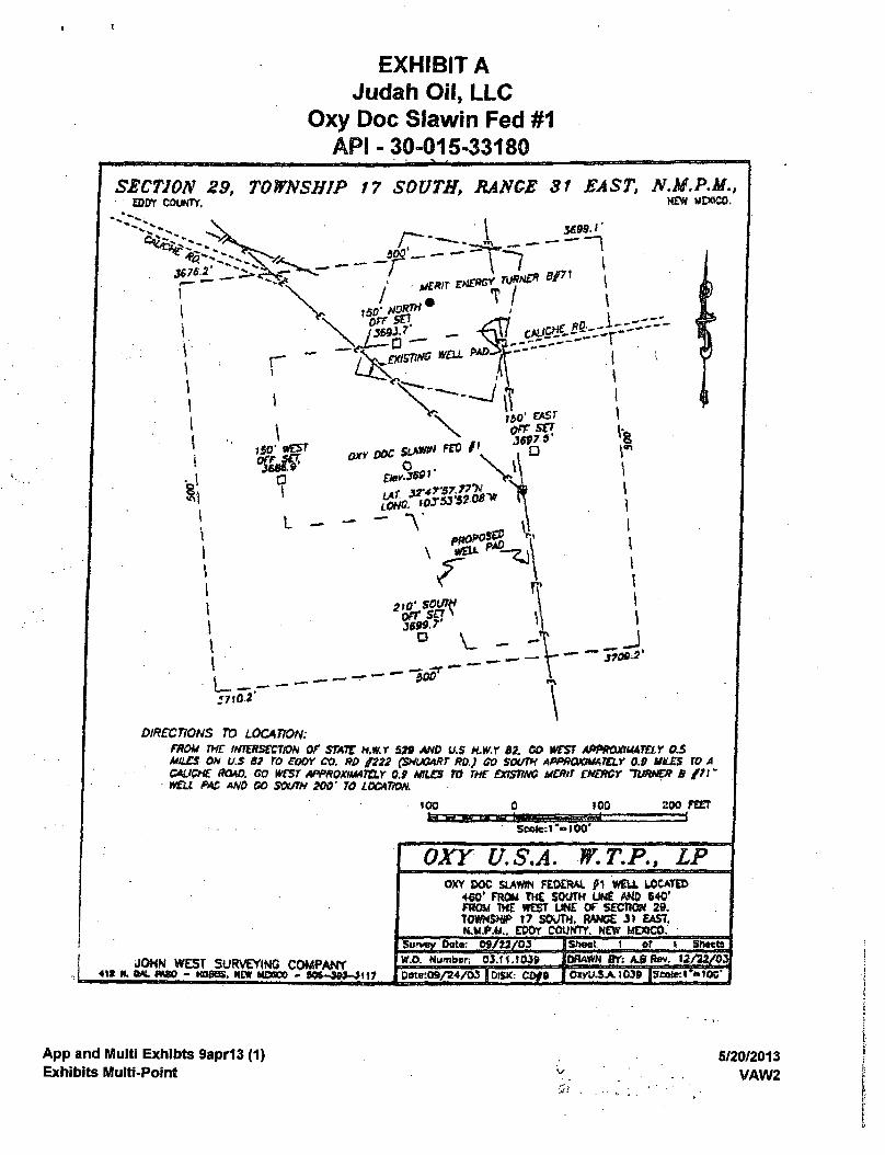
EXHIBIT A Judah Oil, LLC
Oxy Doc Slawin Fed #1 API-30-015-33180
SECTION 29, TOWNSHIP 17 SOUTH, RANGE 31 EAST, N.M,P.M., NEW MPOSO.
\ 3699.1
^ e x i s m s WELL I i
\ 1*0' » S r Off1 S£7
o
\
'8 r
- 1
DIRECTIONS TO LOCATION: FROM THE IHWtSCCTlON OF STATE H.W.T 539 AND US H.W.Y 82. CO WEST APPROXIMATELY OS MILES OH U.S 63 TO eOOY CO. RD J222 (SHUGART RD.) GO SOUTH APPROXIMATELY OS VICES TO A CAUCHE MAD. GO WEST APPROXIMATELY 0.9 MILES TO TUT EXISTING MERIT ENERGY TURNER 8/71* WELL PAS AND CO SOUTH 100' TO LOCATION.
IOO 0 100
Soote;l"»l00'
200 FEET
=r=J
OXY U.S.A. W.T.P., LP
JOHN WEST SURVEYING COMPANY • n n. (MI paso - HOBBS, nor MDOOC - S W - S M - J W
OXY DOC SLAWS FEDERAL f 1 W£U LOCATED 460' FROM THE SOUTH UNE AMD 640' FROM THE WEST UNE OF SECTtOH 29. TOWNSHIP t? SOUTH, RANGE 31 EAST, NM.PM.. COOT COUNTY, NEW MEXICO,
IShect 1 of t Sfttttt • I'l." • I1 • 'I >l ' — [W.O. Numbtn 0J.ft .1M9 ([PRAWN BT; A.SRev. 13/22/03 [pirte:09/24/03 l.fti;aw.?/-p i.rr.>±¥.+i-irp tf.-vnitii.-iM
App and Multi Exhibts 9apr13 (1) Exhibits Multi-Point
5/20/2013 VAW2
5i
( <
EXHIBIT A Judah Oil, LLC
Oxy Doc Slawin Fed #1 API-30-015-33180
OXV DOC SL&ffifflN FED
• •••©
>
©-• ^
,» - " V *?t
* * *
T ^ ' s V , -
b » # * 0 0O ^ 0 1
••ft d> * • * 6 *
» • • . *
, i p ' ^ • •—$ £ ^ % ®
App and Multi Exhibts 9apr13 (1) Exhibits Multi-Point
5/20/2013 VAW2
Ml, LLC Oxy Doc Slawin Fed #1
API 30-0X5-33180
n
am
)3 FEDERAL a ^ " " ' a - I V ~ * '
1*
j . #113 ©
1 TB ' i. TB ' vVU»ii4-
l'to»*J>*
* i s
^ * I - I T S ' 1 • ••3f» I Off,,: >,„l«il,i„i><..i,>.,.,«.! j . , , . . lU<w.Sii
BOl^fWS FEDERAL
to, Aft\ >& J - oft- * A - s
OXY qOC SLAWIS FQJERAL,
TO #82
ffi
d, i i .r * I Hiil.ii,•; rm M I .
r\.V. * 4
\ ^ u v y f j f
\ »tf> V \tir
I1^
POWER OEtP 81 fEEffifW:COM
M i l
• l i , .1)1.1^-
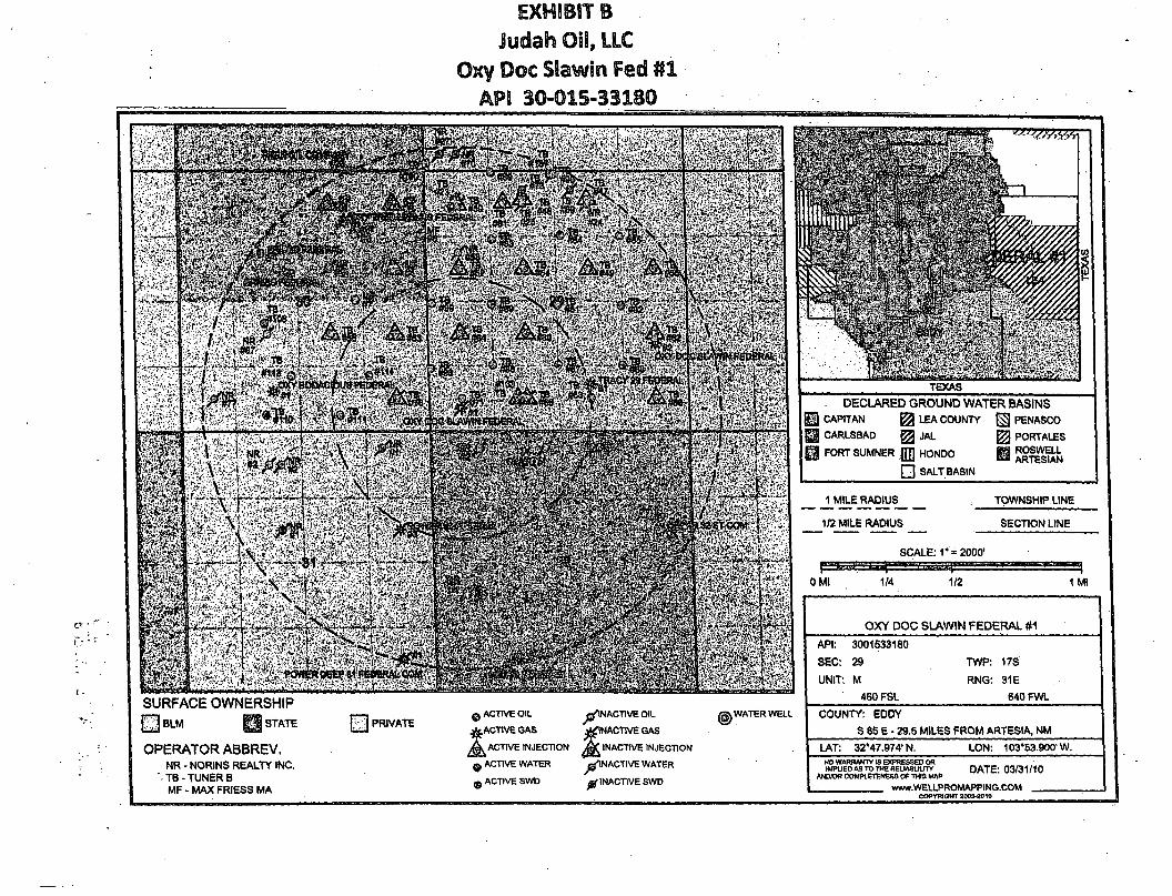
TEXAS DECLARED GROUND WATER BASINS
U CAPITAN ^ LEA COUNTY PENASCO |§ CARLSBAD ^ JAL PORTALES I FORT SUMNER |JJJ HONDO Q ARTESIAN
• SALTBASIN
J_^E_RADIL)S_
1/2 MILE RADIUS
TOWNSHIP. LINE
SECTION LINE
OMI 1/4
SCALE: 1" = 2000'
1/2 1 Ml
SURFACE OWNERSHIP £§BLM H STATE
OPERATOR ABBREV. NR - NORINS REALTY INC.
' TB- TUNER B MF - MAX FRIESS MA
PRIVATE 0 ACTIVE OIL
ACTIVE GAS
^ I N AC T I VE OIL
^ INACTIVE GAS
A ACTIVE INJECTION INACTIVE INJECTION
Q ACTIVE WATER ^ INACTIVE WATER
WATER WELL
, ACTIVE SWD I INACTIVE SWD
OXY DOC SLAWIN FEDERAL #1
API: 3001533180
SEC: 29
UNIT: M
460 FSL
TWP: 17S
RNG: 31E 640 FWL
COUNTY: EDDY S85E- 29.5 MILES FROM ARTESIA, NM
LAT: 32"47.974,N. LON: 103*53.600'W. NO WARRANTY IS EXPRESSED OR IMPLIED AS TO THE REIIAOUUTY
AND/OR COMPLETENESS OF THIS MAP DATE: 03/31/10
www.WELLPROMAPPING.COM COPYRIGHT 2003^010
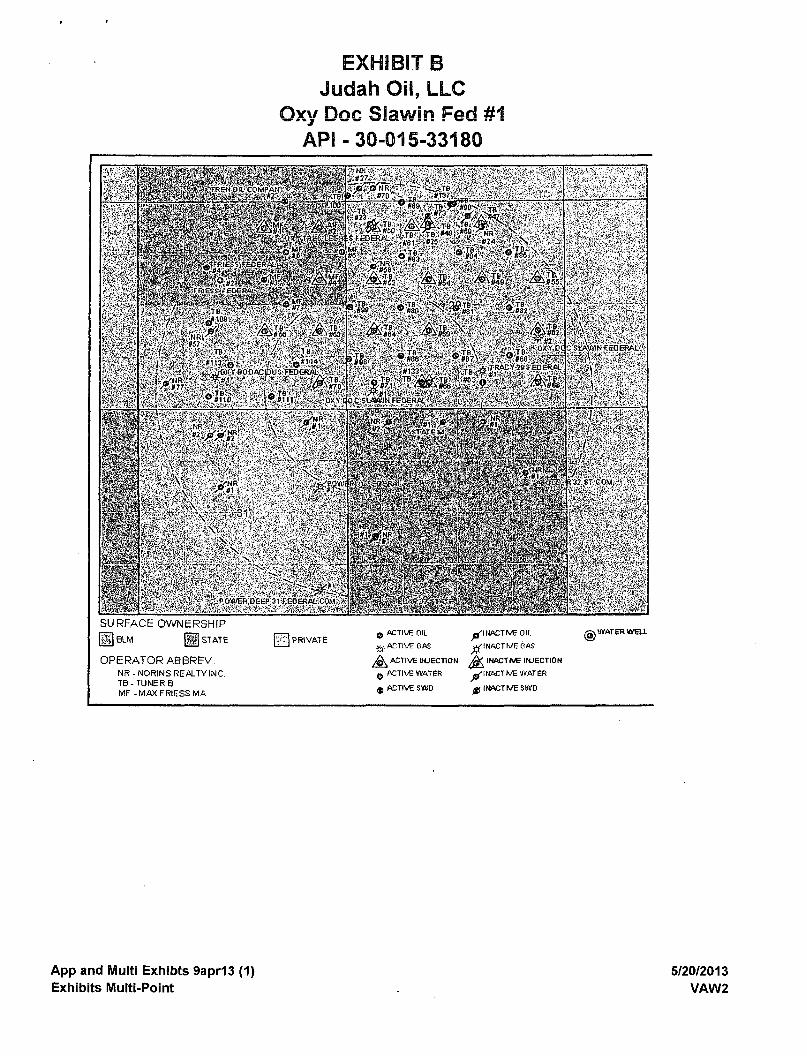
EXHIBIT B Judah Oil, LLC
Oxy Doc Slawin Fed #1 API - 30-015-33180
ilPP
" m
mm •BWW
•i
RH I L 1
FIE I.CEF
o a> Fr r K k
#3
Ibi
HP v f
/ Tf
1 TB
A™ n't / re
_ i l l 4
A TB
TB
SFEOERAl - T | « * | , «* 4 N
M F ^ * T e S T | 4 0 T B V
*1& 9M
4zi5 Aa ^ k
T8 , TB ' S82
P TB if 98
I TB '»88
lTB^ '#87^
OXY.BC
OKYDOC LA\»MF£=DERAL
TBS »88«l?gSli;f!
"> * A A < TB « * j
*6S
HR * \ MR *1
S1
f t N,
POWEPOEFP 1 FEOERAC CQh
. Iff! il> " i l 6
<STATFM
. UR | I ; ' L C I
NP
SURFACE OWNERSHIP
(HJBLM g STATE
OPERATOR ABBREV. NR-NORJNS REALTY INC. TB - TUNER B MF -MAXFRIESSMA
PRIVATE a ACTIVE OIL
fa ACTIVE GAS
^ ACTIVE INJECTION
0 ACTIVE WATER
$ ACTIVE SWD
^"INACTIVE OIL
^rlHACTh/EGAS
INACTrvE INJECTION
^"INACTIVE WATER
^(INACTr^ESWD
© WATER W6U.
App and Multi Exhibts 9apr13 (1) Exhibits Multi-Point
5/20/2013 VAW2
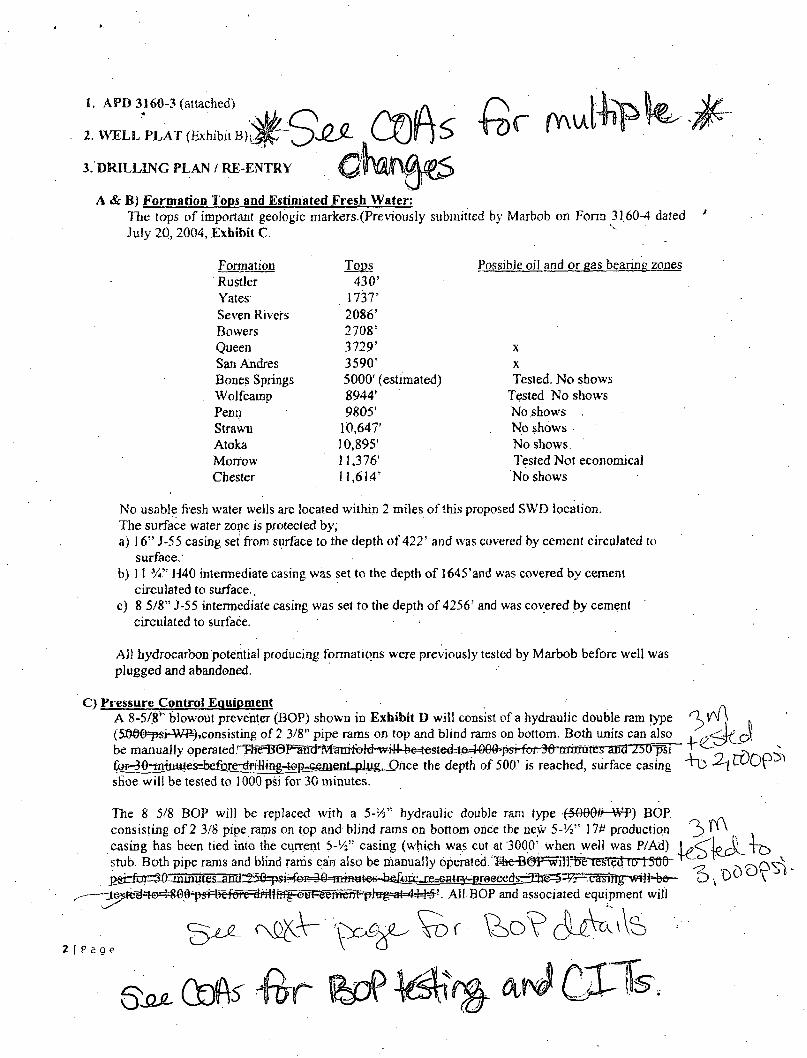
1. APD 3160-3 (attached)
2. WELL PLAT (Exhibit Bk,
3. DRILLING PLAN / RE-ENTRY
A & B) Formation l ops and Estimated Fresh Water: The tops of important geologic markers.(Previously submitted by Marbob on Form 3160^ dated ' July 20,2004, Exhibit C.
Formation Tops Possible oil and or eas bearinp zones Rustler 430' Yates 1737' Seven Rivers 2086' Bowers 2708' Queen 3729' X
San Andres 3-590'' X
Bones Springs 5000' (estimated) Tested. No shows Wolfcamp 8944' Tested No shows Penn 9805' No shows Strawn 10,647' No shows Atoka 10,895' No shows. Morrow 11,376' Tested Not economical Chester 11,614' No shows
No usable fresh water wells are located within 2 miles of this proposed SWD location. The surface water zone is protected by; a) 16" J-55 casing set from surface to the depth of 422' and was covered by cement circulated to
surface. b) 11 H40 intermediate casing was set to the depth of 1645'and was covered by cement
circulated to surface., c) 8 5/8" J-55 intermediate casing was set to the depth of 4256' and was covered by cement
circulated to surface. >
AJ) hydrocarbon potential producing formations were previously tested by Marbob before well was plugged and abandoned.
C) Pressure Control Equipment A 8-5/8" blowout preventer (BOP) shown in Exhibit D will consist of a hydraulic double ram type (5©©§=pst-Wii),consisting of 2 3/8" pipe rams on top and blind rams on bottom. Both units can also be manually operated r"Rfe^0P;1m^M'mTifcM 30,niijiutgs"and 25tTpSi ^•-90-Tmju^es=beiafe^ Once the depth of 500,' is reached, surface casing shoe will be tested to 1000 psi for 30 minutes.
The 8 5/8 BOP will be replaced with a 5-VT hydraulic double ram type (5O06r¥-WP) BOP consisting of 2 3/8 pipe rams on top and blind rams on bottom once the new 5-'/s!" 17# production 3 ^ , casing has been tied into the current 5-1/:" casing (which was cut at 3000'. when well was P/Ad) J^^IPTJL T~c> smb. Both pipe rams and blind rams can also be manually opera!eb/lhc D0Plv^::6eTiMed to 1"500~ ^ ^ P-Q^ psirfrjr^Q^mutesJn^ u \ \
~-^^»~d st^^§*p#r^^ All BOP and associated equipment will
P a g e
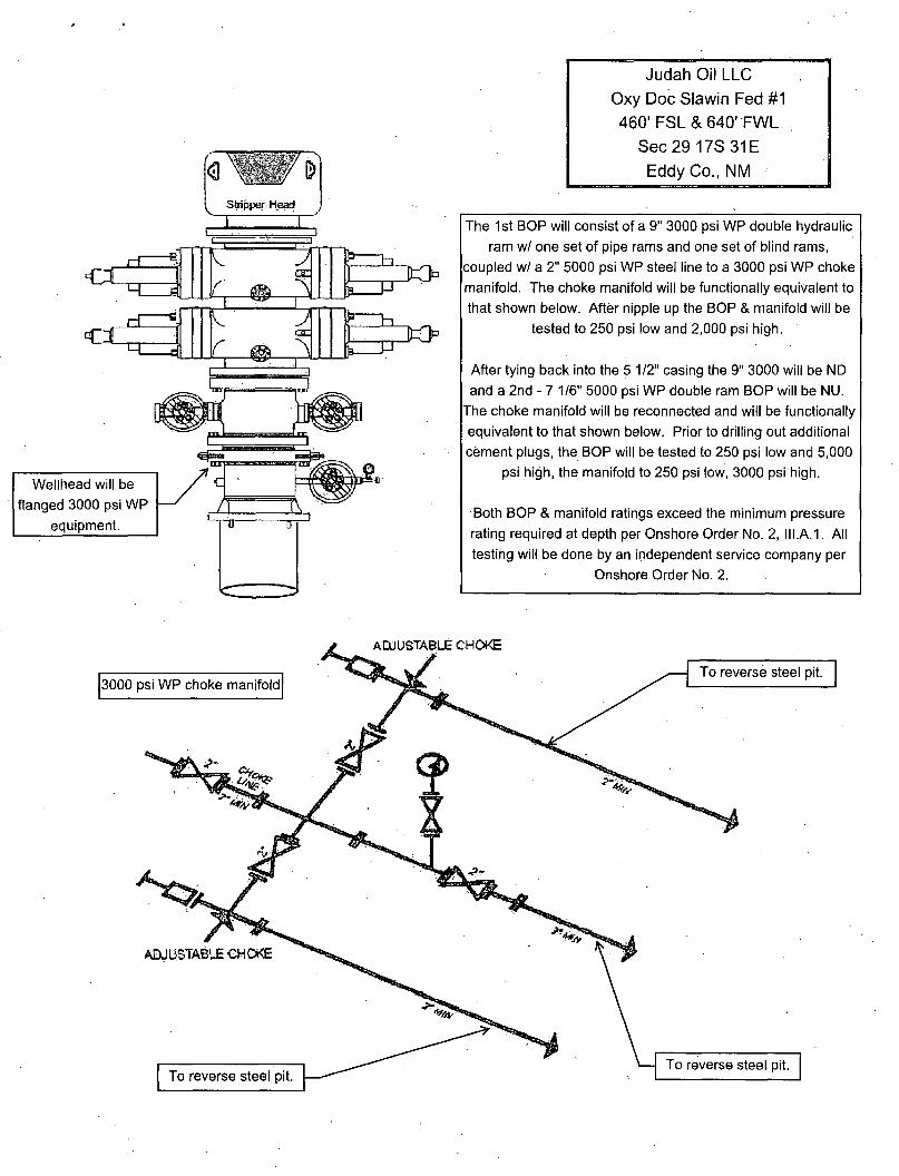
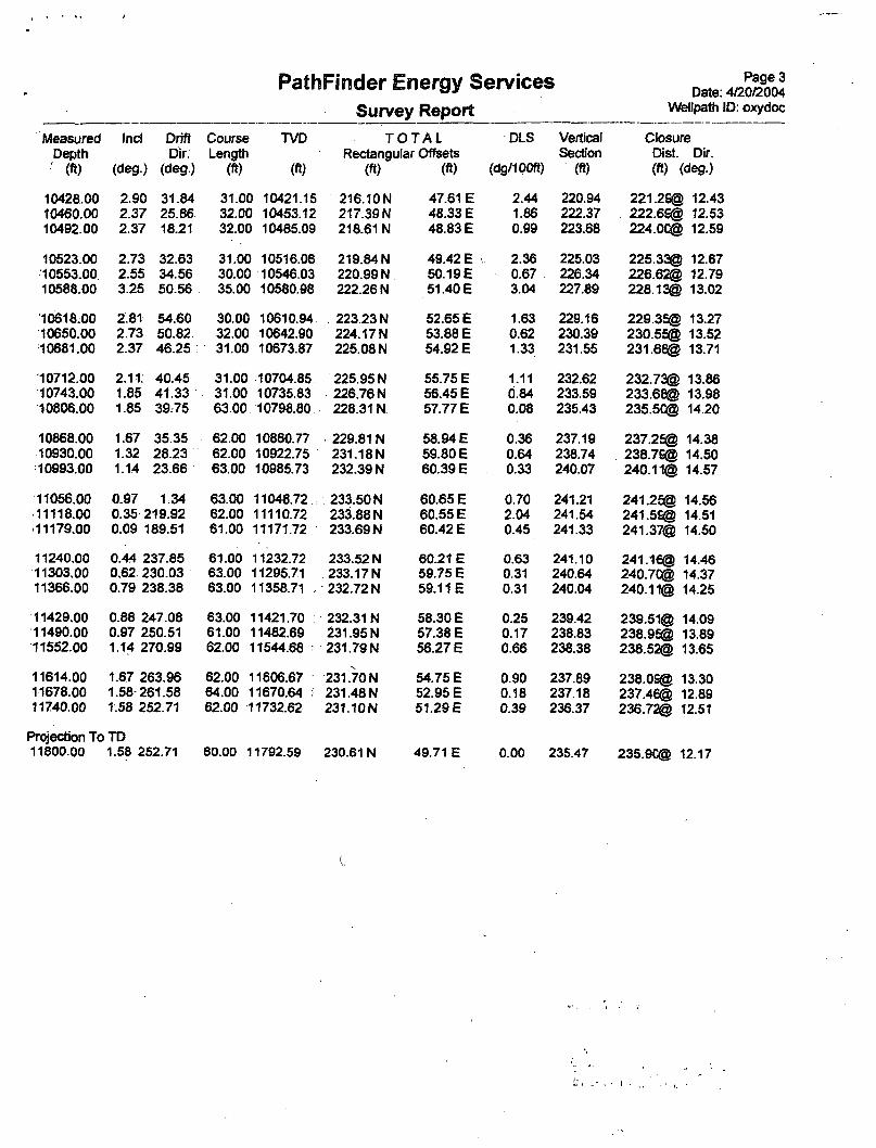
Wellhead will be flanged 3000 psi WP
equipment.
Judah Oil LLC
Oxy Doc Slawin Fed #1
460' FSL & 640" FWL
Sec29 17S31E
Eddy Co., NM
The 1st BOP will consist of a 9" 3000 psi WP double hydraulic ram w/ one set of pipe rams and one set of blind rams,
coupled w/ a 2" 5000 psi WP steel line to a 3000 psi WP choke manifold. The choke manifold will be functionally equivalent to that shown below. After nipple up the BOP & manifold will be
tested to 250 psi low and 2,000 psi high.
After tying back into the 5 1/2" casing the 9" 3000 will be ND and a 2nd - 7 1/6" 5000 psi WP double ram BOP will be NU.
The choke manifold will be reconnected and will be functionally equivalent to that shown below. Prior to drilling out additional cement plugs, the BOP will be tested to 250 psi low and 5,000
psi high, the manifold to 250 psi low, 3000 psi high.
Both BOP & manifold ratings exceed the minimum pressure rating required at depth per Onshore Order No. 2, III.A.1. All testing will be done by an independent service company per
Onshore Order No. 2.
be tested before all perforating procedures begin. Pipe rams will be operated and checked each 24 hours and each time the workover siring is pulled out of the hole.
These functions will be documented on daily work-over reports. A 2" kill line and a 2" choke line will be installed on the casing spool below the ram type BOP. Other accessory BOP equipment will include a choke manifold shown in Exhibit E and choke line having a WP rating of 3000 psi,.
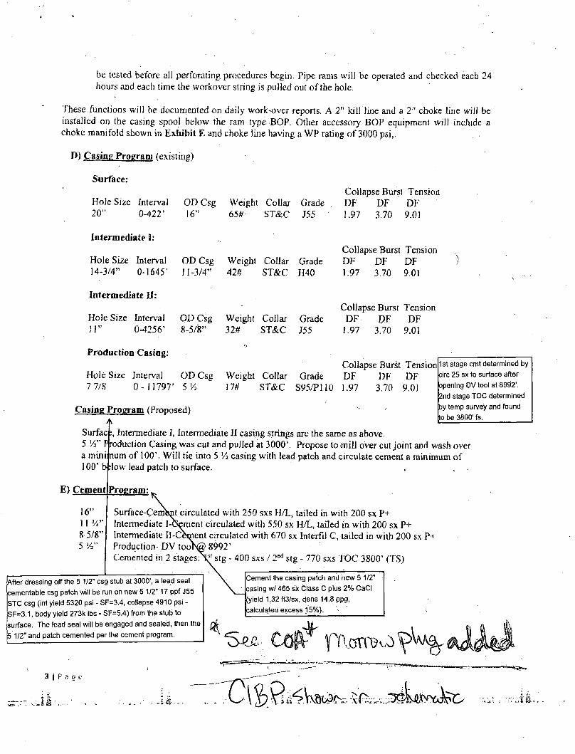
ft) Casing Program (existing)
Surface:
Hole Size 20"
Collapse Burst Tension Interval OD Csg Weight Collar Grade Dp DF DF 0-422' 16" 65#- ST&C J55 1.97 3.70 9.01
Intermediate I:
Hole Size Interval OD Csg Weight Collar Grade 14-3/4" 0-1645' 11-3/4" 42# ST&C H40
Intermediate JJ:
Hole Size Interval OD Csg Weight Collar Grade 11" 0-4256' 8-5/8" 32# ST&C J55
Collapse Burst Tension DF DF DF 1.97 3.70 9.01
Collapse Burst Tension DF DF DF
1.97 3.70 9.01
Production Casing:
Hole Size 7 7/8
Interval 0- 11797'
OD Csg 5 V2
Casing Program (Proposed)
Surfac Intermediate I, Intermediate JJ casing strings are the same as above. 5 Vi" Production Casing was cut and pulled at 3000'. Propose to mill over cut joint and wash over a mini num of 100'. Will tie into 5 VS casing with lead patch and circulate cement a minimum of 100' b slow lead patch to surface.
E) Cement
16" 11 y," 8 5/8" 5 X"
Weight Collar m ST&C
Collapse Burst Tension Grade
S95/P110 DF 1.97
DF 3.70
DF 9.01
1st stage cmt determined by circ 25 sx to surface after opening DV tool at 8992'. 2nd stage TOC determined by temp survey and found to be 3800' fs.
Program:.
Surfaee-CerjrjW circulated with 250 sxs H/L, tailed in with 200 sx P+ Intermediate 1-Gement circulated with 550 sx H/L, tailed in with 200 sx P+ Intermediate Il-Cement circulated with 670 sx Interfil C, tailed in with 200 sx P+ Production-DV too>@ 8992' Cemented in 2 stages-V stg - 400 sxs / 2 n d stg - 770 sxs TOC 3800' (TS)
After dressing off the 5 1/2" csg stub at 3000', a lead seal cementable csg patch will be run on new 5 1/2" 17 ppf J55 STC csg (int yield 5320 psi - SF=3.4, collapse 4910 psi -SF=3.1, body yield 273k lbs - SF=5.4) from the stub to surface. The lead seal will be engaged and sealed, then the 5 1/2" and patch cemented per the cement program.
Cement the casing patch and new 5 1/2" casing wl 465 sx Class C plus 2% CaCI (yield 1.32 ft3/sx, dens 14.8 ppg, calculated excess J 5%).
3 | P s g e
i s „ . • .
F) Drilling Fluid Program
Drilling fluid: 10 ppg brine, 28 sec viscosity, no water loss additives. The pit system will be closed loop and drilling returns will be hauled to a NMOCD approved solid drilling waste disposal site.
If a viscosifier or weighting agent is needed for any reason the viscosifier will be salt gel (viscosities range 28 sec to 60 sec) and the weighting agent will be barite as needed.
G) Testing
No other logs are expected to be ran during re-eQtry or completion procedures. After perforating, zones will be swabbed tested for hydrocarbons and results will be documented is daily report. If hydrocarbons are detected, BLM will be notified, of results before proceeding.
H) Bottom Hole Pressure
Maximum BHP is expected would be 4400 psi. No abnormal temperatures or H2S was encountered during the original drilling and completion of Lbs well therefore no abnormal temperatures or H2S gas are anticipated. As a precaution, H2S detection equipment will be utilized during the re-entry and completion procedures. Fluids will be constantly visually monitored for losses or gains.
P a g e
Districl I 1625 N. French Dr., Hobbs, NM 88240 Phone: (575) 393-6161 Fax: (575) 393-0720 District II 811 S. First St., Artesia, NM 88210 Phone: (575) 748-1283 Fax: (575) 748-9720 District III 1000 Rio Brazos Road, Aztec, NM 87410 Phone: (505) 334-6178 Fax: (505) 334-6170 District IV 1220 S. St. Francis Dr., Santa Fe, NM 87505 Phone: (505) 476-3460 Fax: (505) 476-3462
State of New Mexico FormC-101 Revised July 18, 2013
Energy Minerals and N a t u r a l ^ o ^ r L c e 4 O N S E R V A T | O N
Oil Conservation Division ARTESIA DISTRICT •AMENDED REPORT
1220 South St. Francis Dr. MAR 9 2015
Santa Fe, NM J87505 RECEIVED
APPLICATION FOR PERMIT TO D R I L L , R E - E N T E R , DEEPEN, PLUGBACK, OR ADD A ZONE Operator Name and Address
Judah Oil, LLC PO Box 568
Artesia, NM 88211-0568
"* Property Code 33349
J Property Name Oxy Doc Slawin Federal
OGRID Number 245872
*' API Number 30-015-33180
0 Well No. 1
Surface Location UL-Lot Section Township Range Lotldn Feet from . N/S Line Feet From EAV Line County
M 29 17S 31E " 460 FLS 640 FWL Eddy 8 Proposed Bottom Hole Location
UL-Lot Section Township Range Lot ldn Feet from N/S Line Feet From E/W Line County
M 29 17S 31E 626 FSL 620 FWL Eddy
Pool Information Pool Name Pool Code
SWD LBone Springs - Wolfcamp 96096
Additional Well Information "Work Type 12. Well Type 1 3 Cable/Rotary 1 4 Lease Type 1 5 Ground Level Elevation
E S R Federal 3691' 1 6 Multiple "• Proposed Depth 1 8 Formation " Contractor 2 0 Spud Date
No 9450' Bone-Springs/Wolfcamp n/a 3-16-04
Depth to Ground water Distance from neares t fresh water weD Distance to nearest surface water
430' 12 miles, Maljamar No one in area
• We will be using a closed-loop system in lieu of lined pits
21- P r n n n u u l
Type Hole Size Casing Size Casing Weight/ft Setting Depth Sacks of Cement Estimated TOC
Surface 20" 16" J55-65# 422' 450 Circulated
Intermediate 1 14 - y 4 " 11 - %" H40-42# 1645' 750 Circulated
Intermediate 2 11" 8-5.8" J55-32# 4256' 870 Circulated
Casing/Cement Program: Additional Comments 7 V hole to TD 11797' 5'/2" S95/P110 @ TD. TOC 3800' and 5 V2" cut at 3000'. Will tie back into 5 'A" and circulate cement to surface
Proposed Blowout Prevention Program Type Working Pressure Test Pressure Manufacturer
7 Vie" 5000# Hydraulic Double Ram 5000# 5000# Townsend
2 3 ' 1 hereby certify that the information given above is true and complete to the best of my knowledge and belief. I further certif^Hrart-have complied withJ9.15.14.9 (A) NMAC Q and/or 19.15.14.9/(W NMAC rt, iParjrrfkabJe^' / > - ^ " SignattireiV^^^^--^ f\^h__^^y
OLL CONSERVATION DIVISION 2 3 ' 1 hereby certify that the information given above is true and complete to the best of my knowledge and belief. I further certif^Hrart-have complied withJ9.15.14.9 (A) NMAC Q and/or 19.15.14.9/(W NMAC rt, iParjrrfkabJe^' / > - ^ " SignattireiV^^^^--^ f\^h__^^y
Approved By:
Printe<Lriame: James BrSa^lpanglla ^ Title:
Title: Member/Manager Approved Date: Expiration Date:
E-mail Address: [email protected]
Phone: 575-748-4730 Conditions of Approval Attached
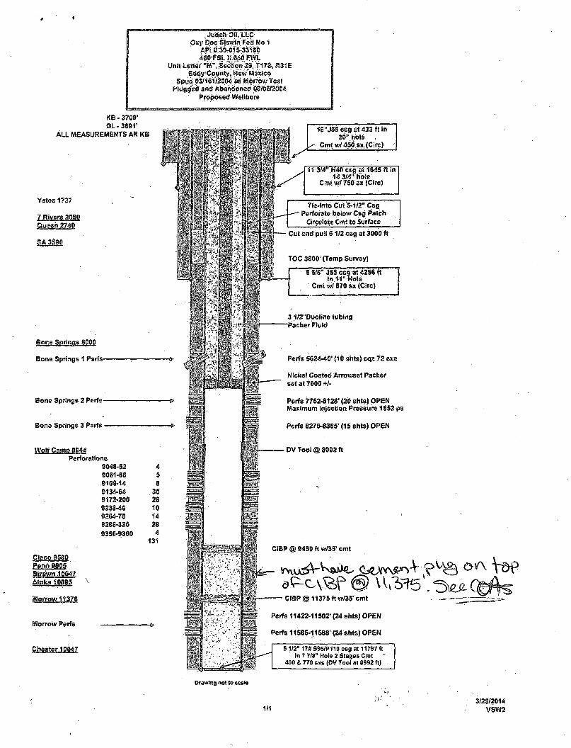
Oxy Doc Slawin Fe». Wo 1
"460'FSL X.640 FWL Unit Letter ™ V S « ^ n ~ 2 S , T17S, R31E
Eddy1 County, New^Mekieo Spud 03/16172004 W'Morrow test
Plugged arid Abandonees 08/06/2604 Proposed Wellbore
KB • 3709' GL - 3691*
ALL MEASUREMENTS AR KB
Yates 1737
7 Rivers 2080 Queen 2740
SA 3590
Bone Springs SOOO
Bone Springs 1 Perfs-
Bone Springs 2 Perfs -
Bone Springs 3 Perfs •
Wolf Camo 8644 Perforations
8048-32 4 9061-66 S 8100-14 8 8134-64 30 9172-200 28 8238-48 10 0264-78 14 8288-326 28 93S6-9360 4
131
PJpcpJSfJ,
Strawn 10647 Atoka10885
Morrow 11376
fiflorrow Perfs
Chester 10647
16"JSS csg at 422 ft in 20" hole
Cmt wl 450.SX (Cjrc)
11 3/4" H40 csg at 1645 tt In •i4'3/4' rH'ble'
Cmt w/ 750 sx (Circ)
Tie-Into Cut 5-1/2" Csg Perforate below Csg Patch
Circulate Cmt to Surface
Cut and pull 5 1/2 csg at 3000 f t
TOC 3800" (Temp Survey)
8 5/8" J55 csg at 4256 f t in .11 "Hole
Cmt vW 870 sx (Circ)
3 1/2"Ouoline tubing "Packer Fluid
Perfs 5624-40' (10 shts) sqz 72 sxs
Nickel Coated Arrowset Packer set at 7600 +/-
Perfs 7762-8128' (20 shts) OPEN Maximum Injection Pressure 1552 ps
Perfs 8275-8385' (15 shts) OPEN
DV Tool @ 8882 ft
9450 ft w/35' cmt
11375 ft w/35'cmt
Perfs 11422-11502' (24 shts) OPEN
Perfs 11585-11588' (24 shts) OPEN
51/2° 17* S95/P110 csg at 11797 ft in 7 7/8" Hole 2 Stages Cmt ~
400 & 770 sis (DV fool at 8992 ft)
Drawing not to scale
1/1 3/25/2014
VSW2
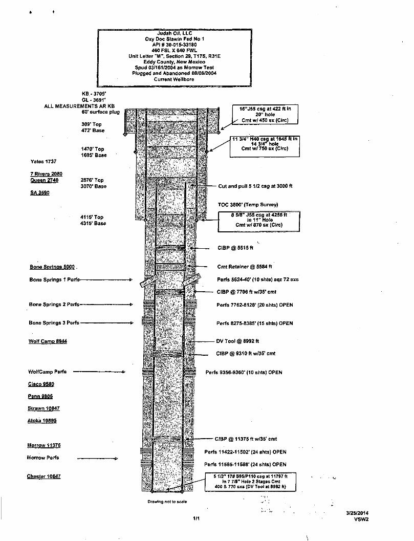
KB. - 3709' G L - 3 6 9 1 '
ALL MEASUREMENTS AR KB 60' surface plug
309' Top 472' Base
Yates 1737
7 Rivers 2080 Queen 2740
SA 3590
1470' Top 1695' Base
2876' Top 3070' Base
4115" Top 4315' Base
Bone Springs 5000.
Bone Springs 1 Perfs-
Bone Springs 2 Perfs-
Bone Springs 3 Perfs -
Wolf Camp 8944
Judah Oil, LLC Oxy Doc Slawin Fed No 1
API # 30-015-33180 460 FSL X 640 FWL
Unit Letter "M" , Section 29, T17S, R31E Eddy County, New Mexico
Spud 03/161/2004 as Morrow Test Plugged and Abandoned 08/06/2004
Current Wellbore
WolfCamp Perfs
Cisco 9580
Penn 9805
Strawn 10647
Atoka 10895
Morrow 11376
Morrow Perfs
Chester 10647
16"J55 csg at 422 ft in 20" hole
Cmtw/450sx (Circ)
11 3/4" H40 csg at 1645 ft in 14 3/4" hole
Cmt w/ 750 sx (Circ)
Cut and pull 5 1/2 csg at 3000 ft
TOC 3800' (Temp Survey)
8 5/8" J55 csg at 4256 f t in 1 1 " Hole
Cmt wl 870 sx (Circ)
CIBP @ 5515 ft
Cmt Retainer @ 5584 ft
Perfs 5624-40' (10 shts) sqz 72 sxs
CIBP @ 7706 ft w/35' cmt
Perfs 7762-8128' (20 shts) OPEN
Perfs 8275-8385' (15 shts) OPEN
DV Tool @ 8992 ft
CIBP @ 9310 ft w/35' cmt
Perfs 9356-9360' (10 shts) OPEN
CIBP @ 11375 ft w/35' cmt
Perfs 11422-11502" (24 shts) OPEN
Perfs 11585-11588" (24 shts) OPEN
5 1/2" 17# S95/P110 csg at 11797 ft in 7 7/8" Hole 2 Stages Cmt
400 & 770 sxs (DV Tool at 8992 ft)
Drawing not to scale
1/1 3/25/2014
VSW2
\
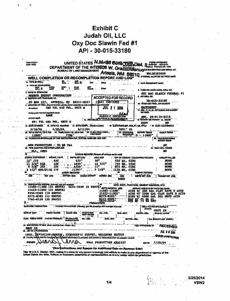
Exhibit C Judah Oil, LLC
Oxy Doc SSawin Fed #1 APS - 30-015-33180
Fomtieo-4 UNITED STATES N*MrW68HK_
WELL COMPLETION OR RECOMPLETION REPORT AND LOG*
_ FC8M APPROVED <g qaBttO IOM-0H7
KMLC029395B . fftxma^Aucrrraoa trass aaaa
wsu. _ n. rmvrvmxi ESW _ ftamt BSt> I cuts » £ U A OVCH EM - • BltEft-
MaBBOB ZHKB6Y COBPORATfOR j ! AB^eaAtfflTBiaPWJBS BO.
... PO BOX 227,. . AttfESlA, J» 88211-022?
Atwtaa 4*0 FSL 640 PHL, UKIT H
tsnr
©B»r
i M.
ACCEPTED FOR RECORD
JUL 2 1 2M
ALEXIS C SWOBOOA SAME
«91 FSL 690 FWL, BHIT M
3/16/04 . 4/20/04 6/11/04 » roTALsaPTH.caaivB .li. Pu%B^TiB,i»BstvB s»£»«niiiPueeo«*i_
11000* . 7706'
7: vmuommaamum
iemtmtawa euiea, n a m cay DOC SLAWIH FEDERAL ifi
.. 30-015-33180
BACSBEBKY _ " i». QK..?.a..a, ea SLOCK ABD BuSwrf
OBAOSA
SEC. 29-T17B-H31E iiooiwe«p«R » j». STATS'"'"
i i, aivATiraiw.R^in.OiVfTsr ' ri- ewiv.eASBwkiEAb
„ J - J ^ ^ ^ j O j ^ 11800' L
3691' Cl
. MOS-PROWJCTIire - TO gS P&A « \ TV«Q£CT^Af»CmW10SSBaW
_1HXS CSJJG . .
»• : .BO,
HO
CAStMSsatuGAMK' *semct,i&m. . i 6 " , J 5 s . . .««*. . . U. 3y.4r.BSfi. ... 42# ... 8 5/JL" 455. 32# .
.5 1/2" SS5/JU0 17* SB.
SIS TOP {03$
CA6&S6 ftSCOSD tflcpsrt ttfcijs «XH fe oaS) '. j eapnisetpaj"
422 •
_ t _ ARM'... 11797
UMSJ»R£CCSU>
HOLERS
20" 14 3/4" 11" ... 7 7/fi".
! TOP Of CaS£NT. CEMSMTIWC WCORO .' 450' SK, CISC : . 750 SX, CIRC ! 070 SX, CIRC i. U7D .SX, CIRC
3&
ACCW«RttJJ»
KOHE
sestet) pnot sac
BORE .BpHE'
34. pERFomnoa RBCOSP , 11585-11588 (24 11422*11502 (24 SHOTS) 9356-9360 (10 SHOTS) 8275-0385 (15 SHOTS)
_ 7762-8128 (20 SNOTS)
SHOTS) 5624-5640 (9 S M O T J , , ^ ^ ^ .11585-11588s
0622-11502'
raoauens»
ACID, SHOT. pfMcruae, cetsem Bosezi. ere.
: ACDZ 8/ 500 GAL CLAY SAFE X ACID i ACDZ B/- 25C0 GAL CLAY SAFE « ACID •- SCDZ B/ 4500 GAL 20X HEPE ACID
tun «OBT pnooucnm .. J
mussjtsias f CHQSO) OltS T PRtfjlt*POW Oft.—
cft«*9 S H | J T ^
fio». WBsas nisi. : CASIOEreeawsi 1 '«AUWATED t»ATEfU-QSL
RATIO i
M. tut»OCTOM<gffiA8 0s)O. ew4(srfial,t«xea etcj~
smrr IK J ». usferATTAOfttam ""
lioqs, A V I A T I O N
TUT tfffTI3S8SSD BV
,.CTODa»PIC SPKVEY, WELLBORE SKETCH
nae PRODUCTIOM AMALYST OATC 7/20/04
1 ami Spaces for Additlcael Data on jRoveroe Shte) rnte 18 U.S.C. Sedton 1001. ms os M a enm* {w B19 peraoo knowingly ond wKftjSy (o mete to any department or easrtcv of th« Unted Slates any tetee, fictflous or fretftfutenJ (asemsnts or rejKBaentBttons as to any matter within its jtrristketion.
1/4 3/25/2014
VSW2
EXHIBIT C Judah Oil, LLC
Oxy Doc Slawin Fed #1 API - 30-015-33180
37. SUMMARY OF POROUS ZONES: (Sfto* sii important zcnos ol porosity end oontefljj thereof, cored interval: and m dnii-osem, tests including depth interval taroted, cushion used time tool open, Bctvtng and shut-In pressures, ond fBcevorfeD):
FORMATION TOP I BOTTOM DESCRIPTION. CONTENTS. ETC
I SET CIBP § 11375'. DUMP 35 Jfcr CUT OS TOP. ; SET CIBP € 9310'. DUMP 35 TCMT ON TOP. ,' SET CIBP € 7700*. ' SET CEMENT RETAINER € 5584'
11 - J i
n j i 11
SB.
NAME
GEOLOGtCAl MARKERS " " TOP '
TRUE V6RT.QEPTH
38
i MEAS DEPTH NAME
RUSTLES 430' YATES 1737' SEVEN UTTERS 2066' BOWERS 2508' QUEEN • 2739' SAN ANDRES j 3590' WOLFCAMP 8944' PENN SHALE i 9805' STRAHN 10647' ATOKA 10895' MORBUS CLASTICS 11376' CHESTER 11614'
GEOLOGICAL, MARKERS
'T-Z'—Z'-.Z''.. "TOP i MEAS DEPTH TRUE
VERT OEPTH
. . . L i U S OOVERMMEHT PRINTfNO OPFICe l&a-TTHSTl
v. 3/25/2014 2/4 VSW2
RAD
1 2 3 4 5 6 7 8 9 10 11 12 13 14 15 16 17 18 19 20 21 22 23 24 25 26 27
, 28 29 30 31
, 32 33 34
201
1002 1102 1182 1321 1361 1521 1817 1867 1987 2004 2020 2178 2198 2209 2480 2657 2691 2764 2766 2831 2894 3042 3051 3121 3133 3162 3410 3497 3518 3619 3700 3751
API 3001533180
3001505454 3001505488 3001526620 3001526392 300152964S 3001505475 3001504902 3001505451 3001505481 3001505469 3001529187 3001505472 3001505447 3001526387 3001526621 3001526388 3001529530 3001505450 3001528142 3001531806 3001505484 3001505442 3001526389 3001505473 3001526883 3001505471 3001505443 3001505445 3001526571 3001526390 3001529573 3001526656 3001525053 3001505485
Judah Oil Wells with in AOR
Oxy Doc Slawin Fed # 1 OPER MARBOB
LINN JB&A um LINN LINN LINN AVON DEVON MCCLELL BJtE-TEX LINN LINN L I N N
LINN LINN LINN LINN LINN YESO DEVON ARCO LINN LINN LINN LINN LINN LINN ARCO LINN LINN LINN LINN HEYCO HANSON
LEASE WELL T s TWN RNG SEC UNT TVD OXY DOC SLAWIN FEDERAL #1 G p 17S" 31E 29 M 11800
TURNER B #71 O A 17S 31E 29 .1 m 3672 NORINS REALTY INC #2 p.. 17S 31E 32. p 3654 TURNERS #88 A 17S 31E 29 2 m 3750 TURNER B #86 0 A *17S 31E 29 3 L 3730 TURNERB #133 1 A 17S 31E 29 4 N 3953 TURNER B* #76 . 1 U 17S 31E 30 P 3597 TURNERS' #66 1 17S 3 1 & 29 5 fi 3706 TURNER S „ ^ - - ^ <im 1 i f i I31E, 29 6 L 3576
t NORINS REALTY INC « #1 o 17S 31E 31 " A 3599 STATE M #1 /o- p 17S 31E '32 C 3704 TURNER B #114 6 A 17S 31E 30 P 3738 TURNERS ^ ' • < -H#53j? i A : ifs 31E 30 1 3524 TURNERS . r • / #60 i A 17S 31E, 29 7 K 3626 TURNERS #87' 0 IA?" 17S 31E 29 8 K 3727 TURNERS #99 0 A "17S, '31E 29 9 L 3690 TURNERS - '#80* * % A. 17S 31E 29 10 L 3600 TURNERS #111 0 A 17S 31E 30 O 3795 TURNER B #63 O A 17S 31E 29 11 0 TRACY 29 FEDERAL #1 s A 17S 31E 29 12 0 11857 POWER 31 FEDERAL #3 G P 17S 31E 31 H 11875 NORINS REALTY INC #1 O P 17S 31E 32 B TURNER B #52 1 A 17S 31E 29 13 E TURNER B #81 o A 17S 31E 29 14 J TURNER B #56 1 A 17S 31E 30 J 3527 MAX FRIESS MA #7 o A 17S 31E 30 G 3740 MAX FRIESS MA #4 1 A 17S 31-E 30 H 3602 TURNER B #54 1 A 17S 31E 29 15 F NORINS REALTY INC #58 0 P 17S 31E 29 16 E TURNER B #88 0 A 17S 31E 29 17 J TURNER B #83 0 A 17S 31E 29 18 F TURNER B #113 0 A 17S 31E 30 N 3835 MAX FRIESS MA #5 0 A 17S 31E 30 A NORINS REALTY INC #1 0 P 17S 31E 32 L NORINS REALTY INC #1 0 P 17S 31E 32 L
Judah Oil Wells with in AOR
Oxy Doc Slawin Fed # 1
RAD API OPER LEASE . , 35 3844 3001533849 OXY OXY BODACIOUS FEDERAL 36 3873 3001505480 SCHUSTEI NORINS REALTY INC 37 3875 3001505436 LINN TURNERB 38 3889 3001505470 DEVON MAX FRIESS MA 39 3901 3001526385 LINN TURNERB 40 3978 3001505452 LINN TURNERB 41 3991 3001529572 LINN TURNER B 42 4085 3001526391 LINN TURNER B 43 4111 3001505479 ENGLISH NORINS REALTY INC 44 4126 3001526882 LINN MAX FRIESS MA 45 4151 3001505437 LINN TURNER B 46 4185 3001532585 OXY OXY DOC SLAWIN FEDERAL 47 4215 3001505482 A&H NORINS REALTY INC 48 4217 3001505474 ARCO NORINS REALTY INC 49 4246 3001505438 LINN TURNER B 50 4253 3001505449 LINN TURNER B 51 4280 3001505448 LINN TURNER B 52 4348 3001528984 LINN TURNER B 53 4355 3001505469 LINN MAX FRIESS MA 54 4364 3001505434 LINN TURNER B 55 4440 3001505478 HANSON NORINS REALTY INC 56 4457 3001505458 LINN TURNER B 57 4463 3001533850 OXY OXY TRES LECHES FEDERAL 58 4631 3001505455 MARBOB TURNERB 59 4663 3001505466 G PLEMOfN FRIESS FEDERAL 60 4667 3001527929 HEYCO CEDAR 32 ST COM 61 4685 3001538985 Apache Apache State SWD 62 4808 3001526386 LINN TURNER B 63 4835 3001526595 LINN TURNER B 64 4877 3001505444 LINN TURNER B 65 4919 3001505459 LINN MAX FRIESS MA 66 4921 3001505433 ARCO NORINS REALTY INC 67 4998 3001505453 MARBOB TURNER B 68 5000 3001526617 LINN TURNER B 69 5007 3001505435 LINN TURNER B 70 '5037 3001505476 ARCO NORINS REALTY INC
WELL T ' S : TWN. RNG SEC UNT TVD #1 G . A 17S 31E 30 N 11749 #2 O P 17S 31E 31 C
#49 I " A 17S . 31E . 29 19 G #3 O U 17S 31E 30 G #82 O A 17S 31E 29 20 J #68 I A " 17S' 31E 29 21 P #110 O A 17S ' 31E 30 N 3824 #84 O A 17S 31E 29 22 B #2 O P 17S 31E 31 C #6 O A 17S 31E 30 B 3937
#50 I P 17S 31E 29 23 D #2 G A 17S 31E . 29 24 I 11880 #1 O P 17S 31E 32 H #57 O P 17S 31E 30 K #23 O T 17S 31E 29 25 D 2102 #62 I A 17S 31E 29 26 I #61 I A 17S 31E 29 27 J 3550 #108 O A 17S 31E 30 K 3870
#2 I A 17S 31E 30 A #25 O T 17S 31E 29 28 C 2163 #1 O P 17S 31E 31 J #48 I A 17S 31E 29 29 C #1 G P 17S 31E 30 B #73 S P 17S 31E 29 30 C #2 O A 17S 3 iE 30 ' F #1 G A 17S 31E 32 H 11900 #1 S ND 17-S 31E 32 J #85 O A 17S 31E 29 31 B #89 O A 17S 31E 29 32 C #55 I A 17S 31E 29 33 H #1 I A 17S 31E 30 B 3439
#24 O P 17S 31E 29 34 B #69 O P 17S 31E 29 35 B #100 O A 17S 31E 20 M #47 I A 17S 31E 29 36 B #77 O P 17S 31E 30 M
Judah Oil Wells with in AOR
Oxy Doc Slawin Fed # 1 71 5103 3001529954 LINN TURNER B #137 O A 17S 31E 29 37 B 3650
RAD ' API OPER NAME # T S TWN RNG SEC UNT 72 5126 3001505465 G PLEMOls FRIESS FEDERAL #4 O A 17S 31E 30 F 73 5131 3001526606 DEVON TURNER B #90 O P 17S 31E 29 38 C 74 5141 3001505301 ARCO NORINS REALTY INC #70 o P 17S 31E 20 M 75 5151 3001505295 ARCO NORINS REALTY INC #27 0 P 17S 31E 20 M 76 5176 3001531808 HEYCO CEDAR 32 STATE #2 G A 17S 31E 32 N 11950 77 5232 3001531572 HEYCO POWER DEEP 31 FEDERAL COM #1 G P 17S 31E 31 P 11832 78 5272 3001528822 LINN FREN OIL COMPANY #23 O A 17S 31E 19 O 3735
#61 Permitted but not drill as of this date 1/3/2014

Scientific Drilling
Scientific Drilling Survey Report
Company: MARBOB ENERGY Field: Hackbeny, E Site: Eddy County, NM WcO: Oxy DOC Slawin Fed. #1 Wellpath: VH - Job #32K0404234
Date: 5/6/2004 OM>rdinate(N£; Reference: Vertical (TAT)) Reference: Section O'S) Reference: Survey Calculation Method:
Time: 1153:47 Page: 1 Site: Eddy County, NM, Grid North SITE 0.0 Well (0.0ON,0.0OE,15.64Azi) Minimum Curvature Ob: Sybase
Survey: 04/07/04 KSRGO'-7100'
Company: Scientific Drilling Tool: Keeper.Keeper Gyro
Start Date:
Tied-to:
4/7/2004
Gonzates/P&M From Surface
Snrvev
MD Ind Axfan TVD VS N/S EAV DLS CbD CUA ft deg deg ft ft ft ft deg/100ft ft deg
0.0 0.00 359.76 0.0 0.0 0.0 0.0 0.00 0.0 0.00 100.0 . 0.09 139.68 100.0 0.0 -0.1 0.1 0.09 0.1 139.68 200.0 :. 0.17 186.70 200.0 -02 -0.3 0.1 0.13 0.3 162.48 300.0 0.19 183.49 .300.0 •0.5 -0.6 0.1 0.02 0.6 174.39 400.0 . 0.76 136.54 400.0 -1.0 -12 0.5 0.65 1.3 157.71
500.0 0.78 140.93 500.0 -1.8 -22 1.4 0.06 26 148.17 . 600.0 :. 0.78 128.19 600.0 -24 •32 2.4 0.17 4.0 143.56
700.0 .. 0.65 126.90 700.0 -29 •3.9 3.3 0.13 52 139.76 " 800.0 - . 0.82 117.48 800.0 -3.3 -4.6 4.4 021 6.4 13620
900.0 .... 0.86 116.07 900.0 -3.5 -5.3 5.7 0.05 7.8 132.61
1000.0 r. 0.78 108.93 • 999.9 -3.7 -5.8 7.1 0.13 92 129.56 1100.0 0.77 102.16 1099.9 -3.7 -62 8.4 0.09 10.4 12653 1200.0 0.69 103.14 1199.9 -3.6 -65 9.6 0.08 11.6 123.98 1300.0 ' . 0.80 80.03 1299.9 -3.3 -6.5 10.9 0.32 127 120.81 1400.0 - - 0.99 66.55 1399.9 -2.5 -6.0 12.4 028 13.7 115.98
1500.0 . 126 60.01 14995 -1.1 -5.1 14.1 0.30 15.0 109.99 1600.0 . 1.31 58.28 1599.9 0.5 -4.0 16.0 0.06 16.5 103.94 1700.0 . 1.12 47.33 1699.8 22 -2.7 17.7 0.30 17.9 98.71 1800.0 0.86 35.77 1799.8 3.7 -1.4 18.9 0.33 18.9 94.37 1900.0 .. 0.92 26.04 1899.8 52 -0.1 19.7 0.16 19.7 90.33
2000.0 ' 'J 0.84 11.06 1999.8 6.7 1.3 202 024 20.2 86.23 2100.0 0.84 353.90 2099.8 8.1 2 8 202 025 20.4 8218 2200.0 1.01 344.32 2199.8 9.6 4.4 19.9 023 20.4 77.66 2300.0 1.03 350.17 2299.8 11.1 6.1 19.5 0.11 20.4 72.67 2400.0 0.99 335.25 2399.7 12.6 7.8 19.0 027 20.5 67.78
2500.0 1.20 330.67 2499.7 14.0 9.5 18.1 023 20.4 6244 2600.0 ... 1.19 333.77 2599.7 15.5 11.3 17.1 0.07 20.5 56.62 2700.0 1.18 325.19 2699.7 16.9 13.1 16.1 0.18 20.7 50.92 2800.0 1.21 313.53 2799.7 18.1 14.6 14.7 024 20.8 45.19 2900.0 1.18 . 317.24 28S9.6 19.1 16.1 13.3 0.08 20.9 39.47
3000.0 1.16 ' 313.14 2999.6 20.1 17.6 11.8 0.09 212 33.97 3100.0 . 1.19 315.40 3099.6 21.1 19.0 10.4 0.06 21.7 28.63 3200.0 . 1.19 306.65 3199.6 22.0 20.4 8.8 0.18 222 23.40 3300.0 1.11 315.31 3299.6 22.8 21.7 7.3 0.19 229 18.62 3400.0 .. 1.00 311.23 3399.5 23.7 22.9 6.0 0.13 23.7 14.57
3500.0 1.02 315.83 3499.5 24.5 24.2 4.7 0.08 24.6 10.98 3600.0 1.02 315.27 35995 25.4 25.4 3.4 0.01 25.7 7.71 3700.0 . 1.11 321.07 26.4 26.8 22 0.14 26.9 4.71 3800.0 1.25 319.58 3799.5 27.6 28.4 0.9 0.14 28.4 1.80 3900.0 1.04 323.06 3899.4 28.7 30.0 -0.4 022 30.0 359.31
4000.0 1.12 314.11 3999.4 29.8 31.4 -1.6 0.19 31.4 357.06 4100.0 1.23 302.40 4099.4 30.5 32.6 •32 0.26 328 354.37 4200.0 1.16 296.73 4199.4 31.0 33.6 -5.0 0.14 34.0 351.50 4300.0 1.43 29757 4299.4 31.5 34.7 -7.0 027 35.4 348.52 4400.0 1.36 298.28 4399.3 32.0 35.8 -92 0.07 37.0 345.60
4500.0 1.49 301.19 4499.3 32.6 37.0 -11.4 . 0.15 38.7 34296 4600.0 1.52 302.09 4599.3 333 38.4 -13.6 - 0.04 40.8 - 34052, 4700.0 1.33 300.06 46992 34.0 39.7 -15.7 020 42.7 338.41 4600.0 1.44 304.50 4799.2 34.7 41.0 -17.8 0.15 44.7 336.58
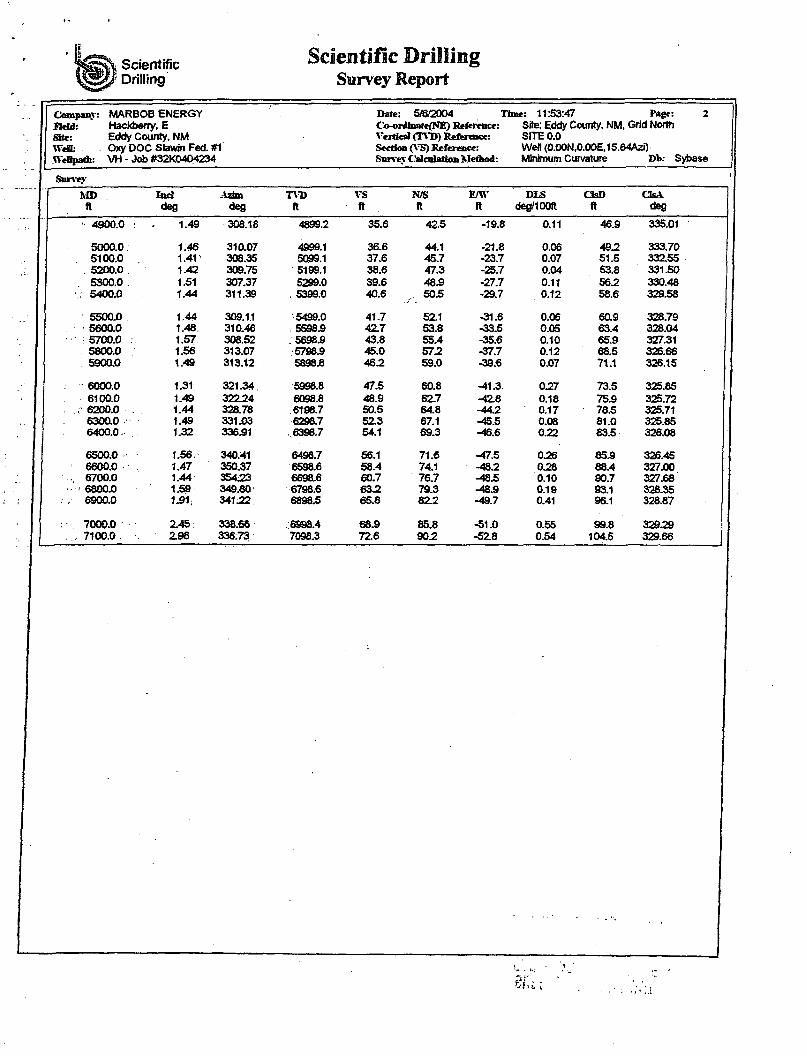
Scientific Drilling
Scientific Drilling Survey Report
Held: Site: WeH: WeHpaA:
MARBOB ENERGY Hackberry, E Eddy County, NM Oxy DOC Slawin Fed. #1 VH - Job #32X0404234
Date: 5/672004 Time: 11:53:47 Page: 2 Co-ortfnstfefNE) Reference: Site: Eddy County, NM, Grid North Vertical (TVD) Reference: SITE 0.0 Section (A S) Reference: Wefl (O.OON,O.OOE.15.64Azi) Survey Calculation Method: Minimum Curvature Db: Sybase
Survey
MD TVD VS N/S EAV DLS OsD CUA ft deg deg ft ft ft ft deg/IOOft ft deg
• 4900.0 : 1.49 308.18 48992 35.6 42.5 -19.8 0.11 465 335.01
5000.0; 1.46 310.07 4999.1 36.6 44.1 -21.8 0.06 492 333.70 . 5100.0 . 1.41" 308.35 5099.1 37.6 45.7 -23.7 0.07 51.5 33255
. 5200.0 1.42 309.75 5199.1 38.6 47.3 -25.7 0.04 53.8 331.50 5300.0 . 1.51 307.37 5299.0 39.6 485 -27.7 0.11 562 330.48
.. 5400.0 1.44 311.39 . 5399.0 40.6 50.5 -29.7 0.12 58.6 329.58
5500.0 1.44 309.11 5499.0 41.7 521 -31.6 0.06 605 328.79 5600.0 1.48. 310.46 . 55985 427 53.8 -33.5 0.05 63.4 328.04
; 5700.0 . 1.57 308.52 56985 43.8 55,4 -35.6 0.10 65.9 327.31 5800.0 1.56 313.07 57S85 45.0 572 -37.7 0.12 68.5 326.66
. 5900.0 1.49 313.12 5898.6 462 59.0 -39.6 0.07 71.1 326.15
6000.0 1.31 321.34 5998.8 47.5 60.8 -41.3. 027 73.5 325.85 6100.0 1.49 32224 6098.8 48.9 627 -*28 0.18 755 325.72
. 6200.0 . 1.44 328.78 6198.7 50.5 64.8 -442 0.17 78.5 325.71 63000 1.49 331.03 6298.7 523 67.1 -45.5 0.08 81.0 325.85 6400.0. 1.32 336.91 .6398.7 54.1 69.3 -46.6 0.22 83.5 328.08
6500.0 1.56. 340:41 6498.7 56.1 71.6 -47.5 026 855 326.45 6600.0 1.47 350.37 6598.6 58.4 74.1 -482 028 88.4 327.00 6700.0 1.44 35423 6698.6 60.7 76.7 -485 0.10 90.7 327.68 6800.0 1.59 349.80 6798.6 632 79.3 -485 0.19 93.1 328.35
. 6900.0 1J31; 34122 6898.5 65.8 822 -49.7 0.41 96.1 328.87
7000.0 245 : 338.66 6998.4 685 85.8 -51.0 0.55 99.8 329.29 , 7100.0 . 298 336.73 7098.3 72.6 902 -52.8 0.54 104.5 329.66
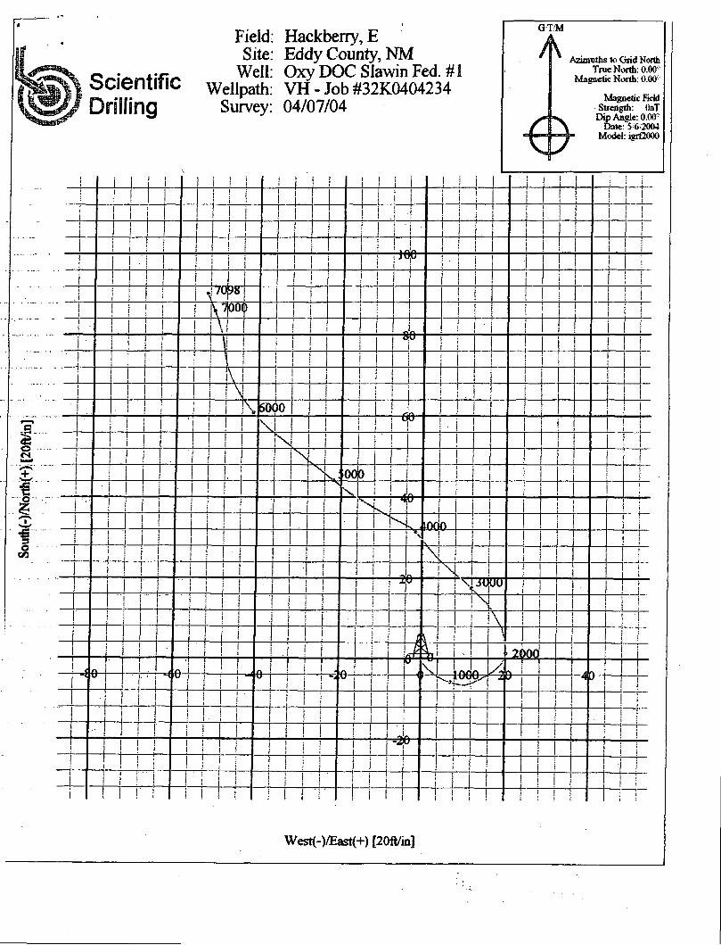
Scientific Drilling
Field: Hackberry, E Site: Eddy County, NM
Well: Oxy DOC Slawin Fed. #1 Wellpath: VH - Job #32K0404234
Survey: 04/07/04
GT/M
-m
Azimuths to Grid North True North: 0.00:
Magnetic North: 0.00-
Magnetic Field Strength: OnT
Dip Angle: 0.00 Date: 5 6 2004
Model: igrCOOO
~i—r
T-6i6-
I i rs 000
I I
4fr -H-lOpO-
I I TS 1 ! 3UDTJ
T — r M6- ' to
ff
! I
1GOQ .am
-2 9-
! i ! i
West(-)/East(+) [20ft/in]
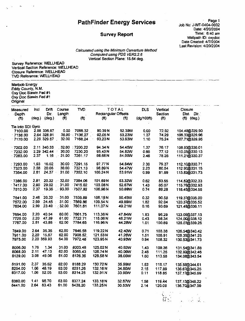
PathFinder Energy Services J o b N o j . ^ ^ Date: 4/20/2004
Survey ReDOrt T i m e : 6 : 4 0 a m
* Wellpath ID: oxydoc Date Created: 4/7/2004
Last Revision: 4/20/2004 Calculated using the Minimum Curvarture Method
Computed using PDS VER2.2.6 Vertical Section Plane: 15.64 deg.
Survey Reference: WELLHEAD Vertical Section Reference: WELLHEAD Closure Reference: WELLHEAD TVD Reference: WELLHEAD
Marbob Energy Eddy County, N.M. Oxy Doc Slawin Fed #1 Oxy Doc Slawin Fed #1 Original
Measured Incl Drift Course TVD T O T A L DLS Vertical Closure Depth Dir. Length Rectangular Offsets Section Dist. Dir.
(ft) (deg.) (deg.) (ft) (ft) (ft) (ft) (dg/100ft) (ft) (ft) (deg.)
Tie into SDI Gyro 7100.00 2.98 336.97 0.00 7098.32 90.39 N 52.39W 0.00 72.92 [email protected] 7138.00 2.64 328.91 38.00 ; 7136.27 92.05 N 53.23W 1.37 74.29 [email protected] 7170.00 2.29 329.87 . 32.00 7168.24 93.23 N 53.93W 1.10 75.24 [email protected]
7202.00 7232.00 7263.00
2.11 2.29 2.37
340.33 342.44
1.16
32.00 30.00 31.00
; 7200.22 7230.20 7261.17
94.34 N 95.43 N 96.66 N
. 7293.00 7323.00 7354.00
1.93 2.58 2.81
16.02 20.06 24.37
30.00 30.00 31.00
.7291.15 7321.13 7352.10
97.77 N 98.89 N
100.24 N
7386.00 7417.00 7510.00
2.81 2.90 2.37
20.32 29.02 19.36
. 32.00 : 31.00 . , 93.00
7384.06 7415.02 7507.92
101.69N 103.08 N 106.96 N
7541.00 7572.00 7604.00
2.46 2.99 2.99
20.32 24.45 23.49
31.00 : 31.00
. 32.00
7538.89 7569.86 7601.81
108.18N 109.54 N 111.07N
7664.00 7725.00 7787.00
2.20 2.20 2.81
40.54 47.39 43.88
60.00 61.00 62.00
7661.75 7722.71 7784.65
113.38 N 115.06 N 116.96 N
7849.00 7911.00 7975.00
2.64 35.35 2.20 15.67 2.20 359.93
62.00 62.00 64.00
7846.58 7908.52 7972.48
119.22 N 121.53 N 123.95 N
8006.00 8068.00 8129.00
1.76 2.11 3.08
1.34 47.13 49.06
31.00 62.00 61.00
8003.46 8065.43 8126.36
125.02 N 126.74 N 128.58 N
8191.00 8254.00 8317.00
2.37 1.06 1.06
35.62 48.19 52.05
62.00 63.00 63.00
8188.29 8251.26 8314.25
130.72 N 132.16 N 132.91 N
8380.00 8441.00
1.41 2.64
96.70 83.43
63.00 61.00
8377.24 8438.20
133.18N 133.25 N
54.45W 1.37 76.17 [email protected] 54.82W 0.66 77.12 110.0£@330.13 54.99W 2.46 78.26 [email protected]
54.84W 2.36 79.37 [email protected] 54.47W 2.23 80.54 [email protected] 53.91W 0.99 81:99 [email protected]
53.32W 0.62 83.55 [email protected] 52.67W 1.43 85.07 [email protected] 50.89W 0.74 89.28 [email protected]
50.45W 0.32 90.58 [email protected] 49.89W 1.82 92.04 [email protected] 49.21W 0.16 93.69 [email protected]
47.84W 1.83 96.29 [email protected] 46.21W 0.43 98.34 [email protected] 44.28W 1.01 100.69 [email protected]
42.40W 0.71 103.38 [email protected] 41.26W 1.51 105.91 128.3£@341.25 40.93W 0.94 108.32 [email protected]
40.92W 1.43 109.36 [email protected] 40.06W 2.48 111.25 132.92®342.46 38.00W 1.60 113.58 [email protected]
35.99W 1.53 116.17 135:[email protected] 34.80W 2.15 117.89 [email protected] 33.90W 0.11 118.85 [email protected]
32.67W 1.58 119^44 137.13@'346.22 30.53W 2.14 120.09 [email protected]
PathFinder Energy Services Survey Report
Page 2 Date: 4/20/2004
Wellpath ID: oxydoc
Measured Incl Drift Course TVD T O T A L DLS Vertical Closure Depth Dir. Length Rectangular Offsets Section Dist. Dir.
(ft) (deg.) (deg.) (ft) (ft) . (ft) (ft) (dg/100ft) (ft) (ft) (deg.)
8503.00 2.64 79.65 62.00 8500.14 133.67 N 27.71W 0.28 121.25 [email protected] 8564.00 2.73 79.03 61.00 8561.07 134.20 N 24.90W 0.16 122.52 [email protected] 8626.00 2.64 79.47 62.00 8623.00 134.74 N 22.05W 0.15 123.81 [email protected]
8688.00 8751.00
. 8814.00
2.81 3.78 3.96
87.30 90.55 82.99
62.00 8684.93 63.00 8747.83 63.00 8810.68
135.07 N 135.13N 135.37 N
19.13W 15.51W 11.27W
0.66 1.57 0.86
124.92 125.94 127.32
[email protected] [email protected] [email protected]
8874.00 8936.00 8998.00
4.66 5.98 5.10
68.49 60.75 49.50
60.00 i 8870.51 62.00 8932.25
: 62.00 . 8993.96
136.52 N . 139.02 N
142.39 N
6.95W 1.79W 3.13 E
2.15 2.42 2.25
129.59 133.39 137.96
[email protected] [email protected] 142.42@ 1.26
9059.00 9121.00 9182.00
4.40 4.40 4.92
30.52 27.53 25.07
61.00 9054.75 62.00 9116.57 61.00 9177.37
146.17N 150.32 N 154.77 N
6.38 E 8.68 E
10.87 E
2.80 0.37 0.91
142.47 147.10 151.97
146.31® 2.50 150.57® 3.31 155.15® 4.02
9244.00 9306.00 9369.00
3.96 3.87 3.96
26.04 42.82 43.79
62.00 : 9239.18 : 62.00: 9301.04
63.00 9363.89
159.10N 162.56 N 165.69 N
12.94 E 15.30 E 18.25 E
1.55 1.85 0.18
156.70 160.67 164.47
159.63@ 4.65 163.28® 5.38 166.69® 6.29
. 9431.00 9493.00
. 9524.00
3.52 3.61 3.96
39.75 35.18 • 29.29 .
62.00 . 9425.76 62.00 9487.64 31.00 9518.57.
168.70 N 171.76N 173.49 N
20.95 E 23.29 E 24.38 E
0.83 0.48 1.69
168.10 171.68 173.64
169.9S® 7.08 173.33@ 7.72 175.19® 8.00
• 9556.00 9617.00 967800
4.57 4.48 4.40
32.28 30.61 28.23
32.00 9550.48 61.00; 9611.29 61.00 9672.11
175.53 N 179.63 N 183.75 N
25.60 E 28.11 E 30.43 E
2.03 0.26 0.33
, 175.93 180.56 185.15
177.39® 8.30 181.82® 8.89 186.25® 9.40
9741.00 9804.00 9835.00
3.85 2.90 2.20
22.87 23.49 28.67
63.00 9734.95 63.00 9797.84 31.00 9828.80
187.82 N 191.23 N 192.48 N
32.40 E 33.85 E 34.45 E
1.07 ' 1.51 2.38
189.60 193.28 194.64
190.6C® 9.79 194.21® 10.04 195.53® 10.15
9865.00 9896.00 9927.00
2.46 3.34 2.90
27.44 23.66 30.08
30.00 9858.78 31.00 9889.74
.31.00' 9920.69
193.55 N 194.97 N 196.48 N
35.02 E 35.69 E 36.45 E
0.88 2.90 1.81
195.83 197.37 199.03
196.7C® 10.26 198.21® 10.37 199.83® 10.51
9959.00 9991.00
10022.00
2.02 1.85 2.20
24.02 21.47 31.57
32.00 . 9952.67 32.00 , 9984.65 31.00 10015.63
197.69 N 198.69 N 199.66 N
37.08 E 37.50 E 38.00 E
2.86 0.60 1.61
200.37 201.44 202.51
201.14® 10.62 202.2C® 10.69 203.24@ 10.78
10054.00 10086.00 10117.00
2.99 3.08 2.99
37.90 38.60 31.22 •
32.00.10047.59 32.00 10079.55 31.00 10110.51
200.84 N 202.17 N 203.51 N
38.83 E 39.88 E 40.82 E
2.62 0.30 1.29
203.87 205.44 206.98
204.56® 10.94 206.07@ 11.16 207.57@ 11.34
10147.00 10179.00 10210.00
2.64 2.81 3.25
35.27 33.33 52.14
30.00 10140.47 32.00 10172.43 31.00 10203.39
204.75 N 206.00 N 207.18 N
41.62E 42.48 E 43.59 E
1.34 0.60 3.49
208.39 209.83 211.26
208.94® 11.49 210.34® 11.65 211.71® 11.88
10240.00 10272.00 10303.00
2.81 2.73 2.55
48.36 30.69 6.26
30.00 10233.35 32.00 10265.31 31.00 10296.28
208.19 N 209.37 N 210.69 N
44.81 E 45.79 E 46.24 E
1.61 2.67 3.65
212.56 213.96 215.35
212.96® 12.15 214.31® 12.34 215.7C® 12.38
10334.00 10366.00 10397.00
2.64 2.55 2.47
3.36 15.58 18.48
31.00 10327.25 32.00 10359.21 31.00 10390.19
212.08 N 213.51 N 214.80 N
46.36 E 46.59 E 46.99 E
0.51 1.75 0.48
216.73 218.16 219152
217.09® 12.33 218.53® 12.31 219.88®' 12.34
PathFinder Energy Services Survey Report
Page 3 Date: 4/20/2004
Wellpath ID: oxydoc
Measured Ind Drift Course TVD T O T A L DLS Vertical Closure Depth Dir. Length Rectangular Offsets Section Dist. Dir.
(ft) (deg.) (deg.) (ft) (ft) (ft) (ft) (dg/100ft) (ft) (ft) (deg.)
10428.00 2.90 31.84 31.00 10421.15 216.10N 47.61 E 2.44 220.94 221.2S@ 12.43 10460.00 2.37 25.86 32.00 10453.12 217.39 N 48.33 E 1.86 222.37 222.6S@ 12.53 10492.00 2.37 18.21 32.00 10485.09 218.61 N 48.83 E 0.99 223.68 224.0C® 12.59
10523.00 10553.00 10588.00
2.73 32.63 2.55 34.56 3.25 50.56
31.00 30.00 35.00
10516.06 10546.03 10580.98
219.84 N 220.99 N 222.26 N
49.42 E 50.19 E 51.40E
2.36 0.67
•3.04
225.03 226.34 227.89
225.33® 226.62® 228.13®
12.67 12.79 13.02
10618.00 10650.00 10681.00
2181 54:60 2.73 50.82 2.37 46.25
30.00 32.00 31.00
10610.94 10642.90 10673.87
223.23 N 224.17 N 225.08 N
52.65 E 53.88 E 54.92 E
1.63 0.62 133
229.16 230.39 231.55
229.35® 230.55® 231.68®
13.27 13.52 13.71
10712.00 10743.00 10806.00
2.11 40.45 1.85 41.33 1.85 39.75.
31.00 31.00 63.00
10704.85 10735.83 10798.80
225.95 N 226.76 N 228.31 N.
55.75 E 56.45 E
. 57.77 E
1.11 0.84 0.08
232.62 233.59 235.43
232.73® 233.68® 235.5C®
13.86 13.98 14.20
10868.00 10930.00 10993.00
1.67 35:35 1.32 28.23 114 23:66
62.00 62.00 63.00
10860.77 10922.75 10985.73
229.81 N 231.18N 232.39 N
58.94 E 59.80 E 60.39 E
0.36 0.64 0.33
237.19 238.74 240.07
237.25® 238.7S® 240.11®
14.38 14.50 14.57
11056.00 11118.00
;11179.00
0.97- 1.34 0.35 219:92 0.09 189.51
63.00 62.00 61.00
11048.72 11110.72 11171.72
233.50 N 233.88 N 233.69 N
60.65 E 60.55 E 60.42 E
0.70 2.04 0.45
241.21 241.54 241.33
241.25® 241.5&@ 24137®
14.56 14.51 14.50
11240.00 11303.00 11366.00
0.44 237.85 0.62 230.03 0.79 238.38
61.00 63.00 63.00
11232.72 11295.71 11358.71
233.52 N 233.17 N
• 232.72 N
60.21 E 59.75 E 59.11 E
0.63 0.31 0.31
241.10 240.64 240.04
241.16® 240.7C® 240.11®
14.46 14.37 14.25
11429.00 11490.00 '11552.00
0.88 247.08 0.97 250.51 1.14 270.99
63.00 61.00 62.00
11421.70 11482.69 11544.68
232.31 N 231.95 N 231.79 N
58.30 E 57.38 E 56.27 E
0.25 0.17 0.66
239.42 238.83 238.38
239.51® 238.95® 238.52®
14.09 13.89 13.65
11614.00 11678.00 11740.00
1.67 263.96 158 261.58 158 252.71
62.00 64.00 62.00
11606.67 11670.64 11732.62
231.70 N 231.48 N 231.10N
54.75 E 52.95 E 5129 E
0.90 0.18 0.39
237.89 237.18 236.37
238.0S® 237.46® 236.72®
13.30 12.89 12.51
Projection To TD 11800.00 1.58 252,71 60.00 11792.59 230.61 N 49.71 E 0.00 235.47 235.9C® 12.17
)
PathFinder Energy Services Survey Report
Page 3 Date: 4/20/2004
Wellpath ID: oxydoc
Incl Drift Course Dir. Length
(deg.) (deg.) (ft)
2.90 31.84 31.00 2.37 25.86 32.00 2.37 18.21 32.00
2.73 32.63 31.00 2.55 34.56 30.00 3.25 50.56 35.00
2.81 54.60 30.00 2.73 50.82 32.00 2.37 46.25 31.00
Measured Depth ' (ft)
10428.00 10460.00 10492.00
10523.00 10553.00. 10588.00
10618.00 10650.00 10681.00
10712.00 10743.00 10806.00
10868.00 10930.00 10993.00
11056.00 11118.00 11179.00
11240.00 11303.00 11366.00
11429.00 11490.00 11552.00
11614.00 11678.00 11740.00
Projection To TD 11800.00 1.58 252.71
2.11. 1.85 1.85
1.67 1.32 1.14
40.45 41.33 39.75
35.35 28.23 23.66
31.00 31.00 63.00
62.00 62.00 63.00
0.97 1.34 63.00 0.35 219.92 62.00 0.09 189.51 61.00
0.44 237.85 61.00 0,62 230.03 63.00 0.79 238.38 63.00
0.88 247.08 63.00 0.97 250.51 61.00 1.14 270.99 62.00
1:67 263.96 62.00 1.58 261.58 64.00 1.58 252.71 62.00
TVD
(ft)
10421.15 10453.12 10485.09
10516.06 10546.03 10580.98
10610.94 10642.90 10673.87
10704.85 10735.83 10798.80 -
10860.77 10922.75 10985.73
11048.72 11110.72 11171.72
11232.72 11295.71 11358.71 .
11482.69 11544.68
11606.67 11670.64 11732.62
T O T A L Rectangular Offsets
(ft) (ft)
DLS Vertical Section
(dg/100ft) (ft)
216.10N 217.39 N 218.61 N
47.61 E 48.33 E 48.83 E
2.44 1.86 0.99
220.94 222.37 223.68
Closure Dist. Dir. (ft) (deg.)
221.2S@ 12.43 222.6S® 12.53 224.0C@ 12.59
60.00 11792.59
219.84 N 220.99 N 222.26 N
49.42 E 50.19 E 51.40E
2.36 0.67 3.04
225.03 226.34 227.89
225.33@ 12.67 226.62@ 12.79 228.13® 13.02
223.23 N 224.17 N 225.08 N
52.65 E 53.88 E 54.92 E
1.63 0.62 1.33
229.16 230.39 231.55
229.35® 13.27 230.55® 13.52 231.66® 13.71
225.95 N 226.76 N 228.31 N
55.75 E 56.45 E 57.77 E
1.11 0.84 0.08
232.62 233.59 235.43
232.73® 13.86 233.68® 13.98 235.5C® 14.20
229.81 N 231.18N 232.39 N
58.94 E 59.80 E 60.39 E
0.36 0.64 0.33
237.19 238.74 240.07
237.25® 14.38 238.7S® 14.50 240.11® 14.57
233.50 N 233.88 N 233.69 N
60.65 E 60.55 E 60.42 E
0.70 2.04 0.45
241.21 241.54 241.33
241.25® 14.56 241.5&@ 14.51 241.37® 14.50
233.52 N 233.17 N 232.72 N
60.21 E 59.75 E 59.11 E
0.63 0.31 0.31
241.10 240.64 240.04
241.16® 14.46 240.7C® 14.37 240.11® 14.25
232.31 N 231.95 N 231.79 N
58.30 E 57.38 E 56.27 E
0.25 0.17 0.66
239.42 238.83 238.38
239.51® 14.09 238.95® 13.89 238.52® 13.65
231.70 N 231.48 N 231.10N
54.75 E 52.95 E 51.29 E
0.90 0.18 0.39
237.89 237.18 236.37
238.0S® 13.30 237.46® 12.89 236.72® 12.51
230.61 N 49.71 E 0.00 235.47 235.9C® 12.17
Wellhead will be flanged 3000 psi WP
equipment.
Judah Oil LLC Oxy Doc Slawin Fed #1 460' FSL & 640' FWL
Sec 29 17S 31E Eddy Co., NM
The 1st BOP will consist of a 9" 3000 psi WP double hydraulic ram w/ one set of pipe rams and one set of blind rams,
coupled w/ a 2" 5000 psi WP steel line to a 3000 psi WP choke manifold. The choke manifold will be functionally equivalent to that shown below. After nipple up the BOP & manifold will be
tested to 250 psi low and 2,000 psi high.
After tying back into the 5 1/2" casing the 9" 3000 will be ND and a 2nd - 7 1/6" 5000 psi WP double ram BOP will be NU.
The choke manifold will be reconnected and will be functionally equivalent to that shown below. Prior to drilling out additional cement plugs, the BOP will be tested to 250 psi low and 5,000
psi high, the manifold to 250 psi low, 3000 psi high.
Both BOP & manifold ratings exceed the minimum pressure rating required at depth per Onshore Order No. 2, III.A.1. All testing will be done by an independent service company per
Onshore Order No. 2.
ADJUSTABLE CHOKE
3000 psi WP choke manifold To reverse steel pit.
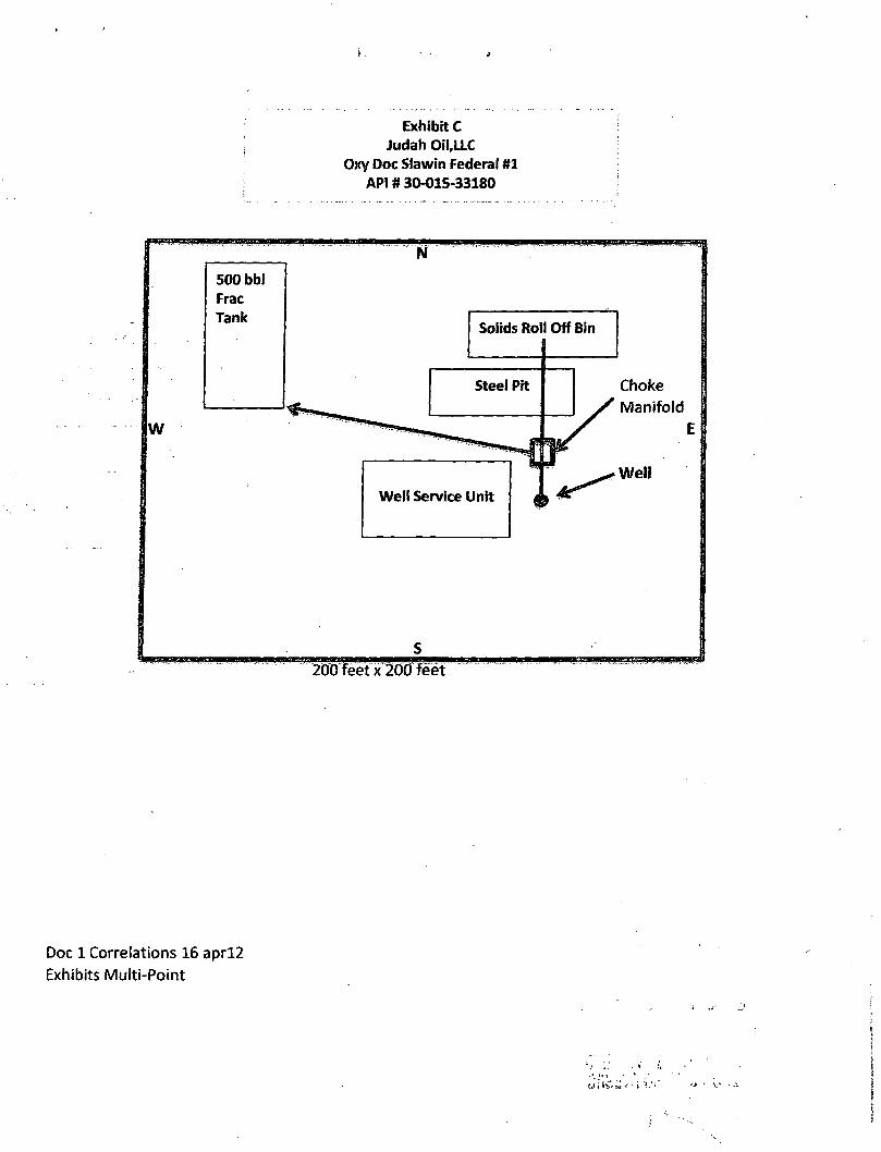
Exhibit C Judah OiLLLC
Oxy Doc Slawin Federal #1 API # 30-015-33180
Doc 1 Correlations 16 aprl2 Exhibits Multi-Point
v
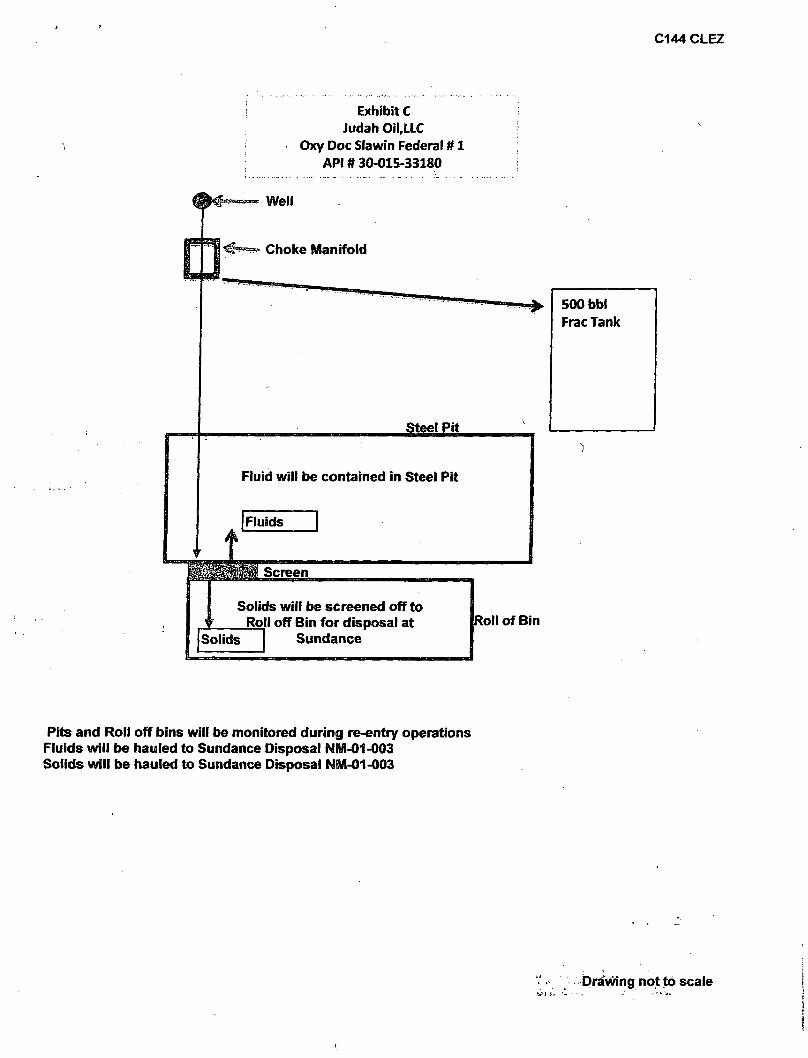
C144 CLE2
Exhibit C Judah OiLLLC
Oxy Doc Slawin Federal # 1 API # 30-015-33180
Well
Choke Manifold
Steel Pit
Fluid will be contained in Steel Pit
Solids will be screened off to j ' Roll off Bin for disposal at
Sundance
500 bbl Frac Tank
Roll of Bin
Pits and Roll off bins will be monitored during re-entry operations Fluids will be hauled to Sundance Disposal NM-01-003 Solids will be hauled to Sundance Disposal NM-01-003
Drawing not to scale
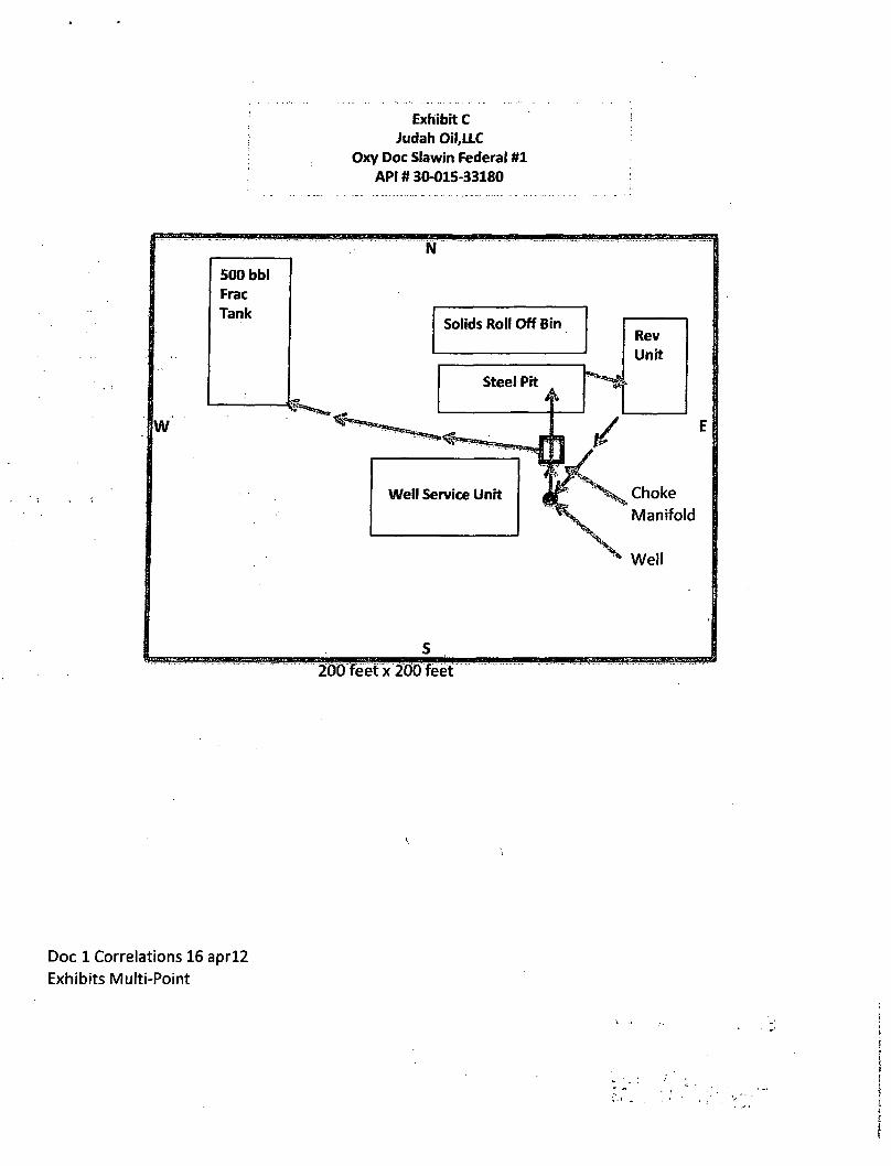
Exhibit C Judah OiLLLC
Oxy Doc Slawin Federal #1 API # 30-015-33180
Doc 1 Correlations 16 aprl2
Exhibits Multi-Point
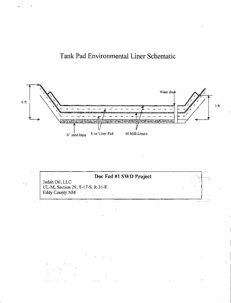
Tank Pad Environmental Liner Schematic
Doc Fed #1 SWI ) Project Judah Oil, LLC UL-M, Section 29, T-17-S, R-31-E Eddy County NM
Multi-Point Surface Use and Operation Plan Judah Oil, LLC
Oxy Doc Slawin Fed #1 API #30-015-33180
This plan is submitted with the Application for Permit, to Re-enter the above described well. The purpose of the plan is to identify the location of the proposed well, the proposed construction activities and operations plan, the magnitude of necessary surface disturbance involved and the procedures to be followed in rehabilitating the surface after completion of the operation so that a complete appraisal may be made of the environmental effects associated with the operation.
The well, and work area have been staked by a registered New Mexico land surveyor. Geo-Marine Inc. conducted an archaeological reconnaissance of the work area for Oxy for the original application to drill the above well. Their findings concerning cultural resources were reported to the Bureau of Land Management in the report dated December 10, 2003 and prepared by Mesa Field Services. (This report is not resubmitted in this operation plan.)
1. Existing Roads, A copy of a USGS "Red Lake, SE New Mexico" quadrangle maps is attached, as Exhibit A, showing the proposed location on a Vicinity Map, Location Verification Map, Land Piatt and General Well Location Map. The well location is spotted on all maps, which also shows the existing road system.
Directions to Location From the junction of US Hwy 82 and CR 222, go south on CR 222 approximately 7/8 mi and turn left (west) on lease road approximately 7/8 mi to the location.
2. Planned Access Road A. Will use existing access road. B. Surfacing material: Six inches of caliche and water, compacted and graded. C. Maximum Grade: Less than 3%. D. Turnouts: None needed E. Drainage Design: N/A F. Culverts: None needed G. Cuts and Fills: Leveling the location will require minimal cuts or fills. H. Gates or Cattle guards: None required
3. Existing wells within a 1 mile radius of the proposed SWD well are shown on Exhibit B, Well Location Map.
4. Location of Existing and/or Proposed Facilities A. If the injectivity test is successful, disposal facilities will be constructed on the well pad. The facility will consist of a 750 bbl gun barrel tank, one 300 bbl oil tank and three 300 bbl fiberglass water tanks. All permanent above ground facilities will be painted in accordance with the BLM's painting guidelines simulating the color of sandstone brown. (Sight Facility Attached) B. All site security guidelines identified in 43 CFR 3162.7 regulations will be adhered to and a site security plan will be submitted for the OXY Jamoca Federal #1 tank battery. All product lines entering and leaving hydrocarbon storage tanks will be effectively sealed.
5. Location and Type of Water Supply
P.O. Box 568 1805 W. Jacobs Artesia, NM 88211-0568
Office: (575)748-4730 Fax: (575)748-4731 E-Mail: [email protected]
Page 1 of 5
Multi-Point Surface Use and Operation Plan Judah Oil, LLC
Oxy Doc Slawin Fed #1 API #30-015-33180
Fresh water and brine water will be used to re-enter this well. It will be purchased from a supply in Loco Hills and transported to the well site.
6. Source of Construction Materials Caliche for surfacing the well pad will be obtained from State Pit No. 408A, located in Sec 16, T18S, R31E, Eddy County, New Mexico.
7 Method of Handling Waste Disposal A. Drill Cuttings will be screened in to roll off bins and hauled to Lea Land Services. B. Drilling fluids will be contained in steel pits and hauled to Sundance after the completion of re-entry and completion as salt water disposal well are concluded. NMOCD C144 CLEZ has been submitted and approved by the NMOCD with permit #211117 C. Current laws and regulations pertaining to the disposal of human waste will be complied with. D. Trash, waste paper, garbage and junk will be collected in steel trash bins and removed after drilling and completion operations are completed. All waste material will be contained to prevent scattering by
. the wind. 1
E. All trash and debris will be removed from the well site within 30 days after finishing drilling and/or completion operations.
8. Ancillary Facilities A. None needed.
9. Well site Layout A. The location and dimensions of the well pad and location of major rig components are shown on the well site layout sketches, Exhibit C. B. Leveling of the well site will be required with minimal cuts or fills anticipated.
10. Plans for Restoration of the Surface A. After completion of drilling and/or completion operations, all equipment and other materials not needed for operations will be removed. B. Location will be cleaned of all trash and junk to leave the well site in as aesthetically pleasing condition as possible. Location will be reduced in Interim Reclamation. (Interim Reclamation Layout Diagram Attached) C. After abandonment of the well, surface restoration will be in accordance with the land owner. This will be accomplished as expeditiously as possible. D. Plans for Surface Reclamation
d.a. Reclamation Objectives:
i . The objective of interim reclamation is to restore vegetative cover and a portion of the landform sufficient to maintain healthy, biologically active topsoil; control t erosion, and minimize habitat and forage loss, visual impact, and weed infestation, during the life of the well or facilities.
i i . The long-term objective of final reclamation is to return the land to a condition approximating that which existed prior to disturbance. This includes restoration
P.O. Box568 1805 W. Jacobs Artesia, NM 88211-0568
Office: (575)748-4730 Fax: (575)748-4731 E-Mail: [email protected]
Page 2 of 5
Multi-Point Surface Use and Operation Plan Judah Oil, LLC
Oxy Doc Slawin Fed #1 API #30-015-33180
of the landform and natural vegetative community, hydrologic systems, visual resources, and wildlife habitats. To ensure that the long-term objective will be reached through human and natural processes, actions will be taken to ensure standards are met for site stability, visual quality, hydrological functioning, and vegetative productivity.
i i i . The BLM will be notified at least 3 days prior to commencement of any reclamation procedures.
iv. If circumstances allow, interim reclamation and/or final reclamation actions will be completed no later than 6 months from when the final well on the location has been completed or plugged. We will gain written permission from the BLM if more time is needed.
d.b. Interim Reclamation
i . Interim reclamation will be performed on the well site after the well is drilled and completed. The production facility/interim reclamation layout depicts the location and dimensions of the planned interim reclamation for the well site.
i i . Within 30 days of well completion, the well location and surrounding areas will be cleared of, and maintained free of, all materials, trash, and equipment not required for production.
iii . In areas planned for interim reclamation, all the surfacing material will be removed and returned to the original mineral pit or recycled to repair or build roads and. well pads.
iv. The areas planned for interim reclamation will then be recontoured to the original contour i f feasible, or if not feasible, to an interim contour that blends with the surrounding topography as much as possible. Where applicable, the fill material of the well pad will be backfilled into the cut to bring the area back to the original contour. The interim cut and fi l l slopes prior to re-seeding will not be steeper than a 3.1 ratio, unless the adjacent native topography is steeper. Note: Constructed slopes may be much steeper during drilling, but will be recontoured to the above ratios during interim reclamation.
v. Topsoil will be evenly respread and aggressively revegetated over the entire disturbed area not needed for all-weather operations including cuts & fills. To seed the area, the proper BLM seed mixture, free of noxious weeds, will be used. Final seedbed preparation will consist of contour cultivating to a depth of 4 to 6 Inches within 24 hours prior to seeding, dozer tracking, or other imprinting in Order to break the soil crust and create seed germination micro-sites.
vi. Proper erosion control methods will be used on the area to control erosion, runoff and siltation of the surrounding area.
P.O. Box568 1805 W. Jacobs Artesia, NM 88211-0568
Office: (575)748^730 Fax: (575)748-4731 E-Mail: [email protected]
Page 3 of 5
Multi-Point Surface Use and Operation Plan Judah Oil, LLC
Oxy Doc Slawin Fed #1 API #30-015-33180
vii. The interim reclamation will be monitored periodically to ensure that vegetation has reestablished and that erosion is controlled.
d.c. Final Reclamation (well pad, buried pipelines, etc.)
i . Prior to final reclamation procedures, the well pad, road, and surrounding area will be cleared of material, trash, and equipment.
i i . All surfacing material will be removed and returned to the original mineral pit or recycled to repair or build roads and well pads.
iii . All disturbed areas, including roads, pipelines, pads, production facilities, and interim reclaimed areas will be recontoured to the contour existing prior to initial construction or a contour that blends indistinguishably with the surrounding landscape. Topsoil that was spread over the interim reclamation areas will be stockpiled prior to recontouring. The topsoil will be redistributed evenly over the entire disturbed site to ensure successful revegetation.
iv. After all the disturbed areas have been properly prepared, the areas will be seeded with the proper BLM seed mixture, free of noxious weeds. Final seedbed preparation will consist of contour cultivating to a depth of 4 to 6 inches within 24 hours prior to seeding, dozer tracking, or other imprinting in order to break the soil crust and create seed germination micro-sites.
v. Proper erosion control methods will be used on the entire area to control erosion, runoff and siltation of the surrounding area.
vi. All unused equipment and structures including pipelines, electric line poles, tanks, etc. that serviced the well will be removed.
vii. All reclaimed areas will be monitored periodically to ensure that revegetation occurs, that the area is not redisturbed, and that erosion is controlled.
11. Surface Ownership The well site is on federal owned surface. The surface is leased to: Williams & Son Cattle Co., P.O. Box 30, Maljamar, NM 88264. They will be notified of our intention to re-enter prior to any activity.
12. Other Information A. Topography: The location is a flat plain. GL elevation is 3692'. B. Soil: Sandy clay loams. . C. Flora and Fauna: The vegetative cover is generally sparse consisting of mesquite, yucca, shinnery oak, sand sage and perennial native range grasses. Wildlife in the area is also sparse consisting of coyotes, rabbits, rodents, reptiles, dove, and quail. D. Ponds and Streams: There are no rivers, streams, lakes or ponds in the area. E. Residences and Other Structures: No residence within 2 miles of the proposed location.
P.O. Box568 1805 W. Jacobs Artesia, NM 88211-0568
Office: (575)748-4730 Fax: (575)748-4731 • E-Mail: [email protected]
Page 4 of 5
Multi-Point Surface Use and Operation Plan Judah Oil, LLC
Oxy Doc Slawin Fed #1 API #30-015-33180
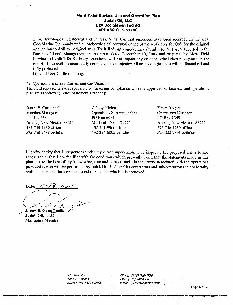
F. Archaeological, Historical and Cultural Sites: Cultural resources have been recorded in the area. Geo-Marine Inc. conducted an archaeological reconnaissance of the work area for Oxy for the original application to drill the original well. Their findings concerning cultural resources were reported to the Bureau of Land Management in the report dated December 10, 2003 and prepared by Mesa Field Services. (Exhibit D) Re-Entry operations will not impact any archaeological sites recognized in the report. I f the well, is successfully completed as an injector, all archaeological site will be fenced off and fully protected. G. Land Use: Cattle ranching.
13. Operator's Representatives and Certification The field representative responsible for assuring compliance with the approved surface use and operations plan are as follows (Letter Statement attached):
James B. Campanella Ashley Niblett Kevin Rogers Member/Manager Operations Superintendent Operations Manager PO Box 568 PO Box 6011 PO Box 1348 Artesia, New Mexico 88211 Midland, Texas 79711 Artesia, New Mexico 88211 575-748-4730 office 432-561-9960 office 575-756-1280 office 575-748-5488 cellular 432-214-6005 cellular 575-200-7896 cellular
I hereby certify that I , or persons under my direct supervision, have inspected the proposed drill site and access route; that I am familiar with the conditions which presently exist; that the statements made in this plan are, to the best of my knowledge, true and correct; and, that the work associated with the operations proposed herein will be performed by Judah Oil, LLC and its contractors and sub-contractors in conformity with this plan and the terms and conditions under which it is approved.
Date: S -/S'^O/V
/^ames B. Caropai Judah Oil, L L C Managing/Member
P.O. Box 568 1805 W. Jacobs Artesia, NM 88211-0568
Office: (575)748-4730 Fax: (575)748-4731 E-Mail: [email protected]
Page 5 of 5
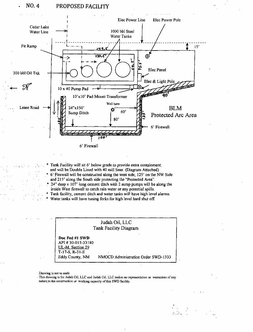
NO. 4 PROPOSED FACILITY
i ; Elec Power Line Elec Power Pole
ISO'
6' Firewall
* Tank Facility will sit 6' below grade to provide extra containment, and will be Double Lined with 40 mill liner. (Diagram Attached)
* 6' Firewall will be constructed along the west side, 125' on the NW Side and 215' along the South side protecting the "Protected Area".
* 24" deep x 107' long cement ditch with 2 sump pumps will be along the inside West firewall to catch rain water or any potential spills.
* Tank facility, cement ditch and water tanks will have high level alarms. * Water tanks will have tuning forks for high level hard shut off
Judah Oil, LLC Tank Facility Diagram
Doc Fed #1 SWD API # 30-015-33180 UL-M. Section 29 T-17-S, R-31-E Eddy County, NM NMOCD Administration Order SWD-1333
Drawing is not to scale This drawing is for Judah Oil, LLC and Judah Oil, LLC makes no representation or warranties of any natureto the construction or working capacity of this SWD facility.
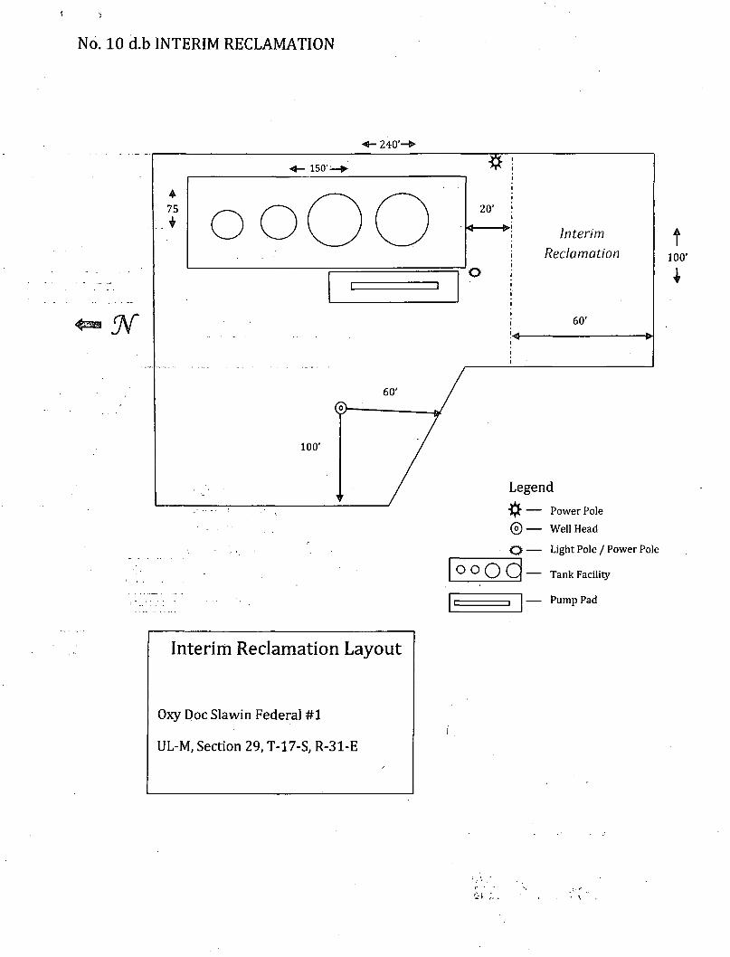
No. 10 d.b INTERIM RECLAMATION
240'-
150'-
4 75
100'
Interim Reclamation Layout
Oxy Doc Slawin Federal #1
UL-M, Section 29, T-17-S, R-31-E
o o O O 20'
o
Interim Reclamation
60*
t 100'
1
Legend
© O
o o Q C -
Power Pole
Well Head
Light Pole / Power Pole
Tank Facility
— Pump Pad
MARBOB ENERGY
Field: Haekberry, E Site: Eddy County, NM
Well: Oxy DOC Slawin Fed. # 1 Wellpath: VH - Job #32K0404234
Survey: 04/07/04
This survey is correct to the best of my knowledge and is supported by actual field data.
/ . ^ f e ^ L :.._$£^pfrr. Company Representative J tfl \ P Notorized this date p ^ of TFMlj 2004.
Notary Signature County of Midland u —oEBomsmm State of Texas Jtraenl NoMP"Wie. State of Texas
My Commission Expires 05-09-20l)i
AN ARCHAEOLOGICAL SURVEY FOR THE DOC SLAWIN FEDERAL COM. NO. 1 WELL
Prepared and Submitted by Sean Simpson
Mesa Field Services PO Box 3072
Carlsbad, NM 88221
Presented to
Terry Asel OXY U.S.A. WTP LP
Attn: A\P 13th Fl.-Oracle P.O. Box 1747
Addison, TX 75001-1747
New Mexico State Permit No. NM-03-104 Bureau of Land Management Permit No. 153-2920-03-M
NMCRISNo. 85389
Mesa Field Services Report No. 950 December 10,2003
Table of Contents
INTRODUCTION 1 Figure 1. Project Area Map 2
DESCRIPTION OF UNDERTAKING 3 ENVIRONMENTAL SETTING 3 CULTURAL OVERVIEW AND RESEARCH FOCUS 4
Paleomdiart Period (ca. 9,500 - 5,500 B.C.) .. 4 Archaic Period (ca, 5,500 B.C - A.D. 900) . 5 Ceramic Period (ca. A.D. 600/900 -1540) ~ 6 Historic Period (after A.D. 1540) i 8
METHODS : •. 9 Survey Methods .9 Site Recording and Artifact Analysis 10
RESULTS:: :. 11 Table 1. Site Summary Table 12
Pre-field Investigations.............................. . 12 Isolated Manifestations (IMs)........ i 12
Figure 2. Isolated Manifestations 13 Previously Recorded Sites 14
Figure 3. LA 43319 Site Map , 16 RECOMMENDATIONS .17
Figure 4. LA 137777 Site Map 18 REFERENCES CITED 19 APPENDIX A: PL AT SHEET 22
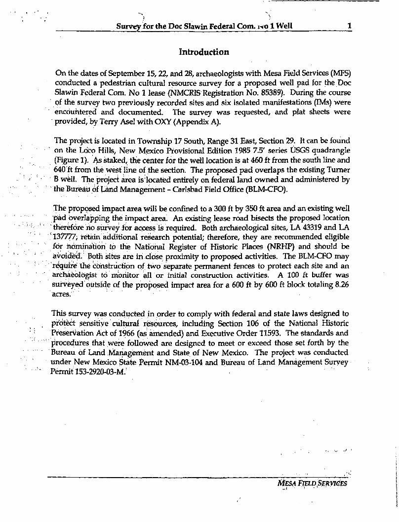
Survey for the Doc Slawin Federal Com. 1*01 Well 1
Introduction
On the dates of September 15,22, and 28, archaeologists with Mesa Field Services (MFS) conducted a pedestrian cultural resource survey for a proposed well pad for the Doc Slawin Federal Com. No 1 lease (NMCRIS Registration No. 85389). During the course of the survey two previously recorded sites and six isolated manifestations (IMs) were encountered and documented. The survey was requested, and plat sheets were provided, by Terry Asel with OXY (Appendix A).
The project is located in Township 17 South, Range 31 East, Section 29. It can be found on the Loco Hills, New Mexico Provisional Edition 1985 7.5' series USGS quadrangle (Figure 1). As staked, the center for the well location is at 460 ft from the south line and 640 ft from the west line of the section. The proposed pad overlaps the existing Turner B well. The project area islocated entirely on federal land owned and administered by the Bureau of Land Management - Carlsbad Field Office (BLM-CFO).
The proposed impact area will be confined to a 300 ft by 350 ft area and an existing well pad overlapping the impact area An existing lease road bisects the proposed location
' therefore rio survey for access is required. Both archaeological sites, LA 43319 and LA 137777; retain additional research potential; therefore, they are recommended eligible for nomination to the National Register of Historic Places (NRHP) and should be avoided. Both sites are in close proximity to proposed activities. The BLM-CFO may require the construction of two separate permanent fences to protect each site and an archaeologist to monitor all or initial construction activities. A 100 ft buffer was surveyed outside of the proposed impact area for a 600 ft by 600 ft block totaling 8.26 acres.
This survey was conducted in order to comply with federal and state laws designed to protect sensitive cultural resources, including Section 106 of the National Historic Preservation Act of 1966 (as amended) and Executive Order 11593. The standards and proceduJres that were followed are designed to meet or exceed those set forth by the Bureau Of Land Management and State of New Mexico. The project was conducted under New Mexico State Permit NM-03-104 and Bureau of Land Management Survey PermitT53-2920-03-M;
MESA FIELD SERVICES -1 •• 'i
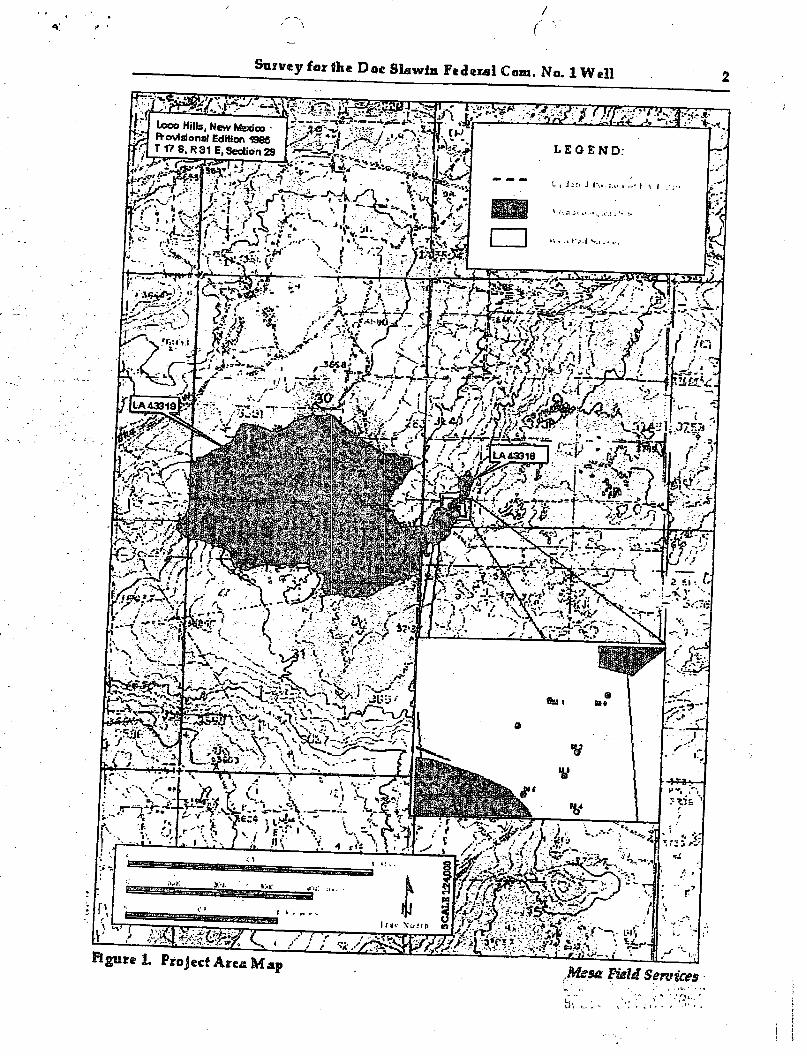
( '• Survey for fee Doc Slawin Federal Com. No. 1 Well
Sumy for the Doc Slawin Federal Com, ivo 1 Well 3
Description of Undertaking
OXY U.S. A. intends to construct a well pad to drill their Doc Slawin Federal Com. No. 1 lease. The project is located in Township 17 South, Range 31 East, Section 29. It can be found on the Loco Hills, New Mexico Provisional Edition 1985 7.5' series USGS quadrangle. As staked, the center for the well location is at 460 f t from the south line and 640 ft from the west line of the section. A100 ft buffer was surveyed outside of the proposed impact area for a 600 ft by 600 ft block totaling 8.26 acres. The proposed pad overlaps the existing Turner B well. The project area is located entirely on federal land owned and administered by the Bureau of Land Management - Carlsbad Field Office (BLMrCFO). The well pad will be built using standard heavy construction equipment. The survey was requested, and plat sheets were provided, by Terry Asel with OXY (Appendix A).
A previous survey encompassing a portion of this latest survey project was completed in 2002 by GeoMarine Inc. (NMCRIS # 81018). Due to the presence of a previously recorded site encountered during the GeoMarine survey the entire proposed location was surveyed to ensure the protection of cultural resources.
Environmental Setting
The project area is along the edge of an escarpment overlooking a large playa approximately three miles east of Loco Hills, New Mexico. The elevation averages 3,700 ft above mean sea level. Soils consist of deep sandy deposits of the Simano-Pajarito association as defined by the Soil Conservation Department of the U.S. Department of
, Agriculture. The soils have been wind-worked into dunes up to 3 m high. The project area slopes gently to the northwest at a grade of 3.5 percent.
Meteorological, data was obtained for the nearby town of Maljamar, NM from the Western Regional Climate Center (n.d.) online database for the period of 1942 to 2000.
..Maljamar had an average annual high temperature of 76.4 degrees (F) and an average annual low temperature of 44.7 degrees (F). In the same time span, Maljamar received an average annual precipitation of 14.37 inches. Additionally, the wettest three months in Maljamar were July through September, while the driest three months were January through March. The month of July was the warmest with an average high of 94.3 degrees (F), while January was the coolest with an average high of 56.1 degrees (F).
The local vegetation varies across the project area and includes juniper, shin oak, mesquite, prickly pear, yucca, and various grasses and low forbes. These species are typical of Chihuahuan Desert scrub. The vegetation includes several species that are suitable for use as food, medicine, or for the manufacture of items requiring the use of
MESA FIELD SERVICES
Survey for the Doc Slawin Federal Com, r o 1 Well 4
fibrous materials, such as basketry containers, clothing, and foot wear. Mesquite flowers and beans can be eaten, the leaves can be used to make a tea that helps relieve diarrhea, the sap makes a great adhesive, and the wood can be used to manufacture bows, mortars, and firewood (Cornett 1995:25). Yucca fibers can be woven into sandals, basketry, or used to make rope (Cornett 1995:15).
The contemporary environment provides adequate habitat for a variety of faunal species including mule deer, pronghorn antelope, coyote, badger, jackrabbit, desert cottontail, roadrunner, rattlesnake, and a variety of other small mammals and reptiles. Since the Historic Period, these species have shared their habitat with cattle, which currently graze in the project area.
Cultural Overview and Research Focus
Several overviews have been published of the archaeological and historical research performed in the southeastern part of New Mexico, providing a summary of the cultural characteristics of the region's inhabitants through time. Syntheses by Stuart and Gauthier (1988), Kate and Katz (1993), Sebastian and Larralde (1989), and others provide a valuable frame of reference within which cultural resource managers can assess the significance of archaeological resources and develop management strategies that address gaps in the current knowledge. Additionally, this background information can help field investigators identity areas of higher site location probability, and be aware of the expected resources in any given project area. To these ends, a brief summary of the known culture sequences and current avenues of research in southeastern New Mexico is provided below.
Paleoindian Period (ca. 9,500 - 5,500 B.C.)
The earliest conclusive evidence, of human habitation in North America was discovered in eastern New Mexico, at the Blackwater Draw and Folsom sites. At the end of the Pleistocene, early hunter-gatherers and scavengers inhabited what was then a lush grassland interspersed with stands of evergreens and broad, shallow lakes (Sebastian and Larralde 1989:19). Mammoths, bison antiquus, and other now-extinct species were commonly exploited for food by these Paleoindian groups, as evidenced by the characteristically large, lanceolate spear points and butchering tools that can be found associated with the remains of these animals (Sebastian and Larralde 1989:19).
The cultural adaptations of this period have been categorized into several complexes based on the diagnostic traits of affiliated projectile points (Judge 1974:5). However, because of the limited number of radiocarbon dates and pristine stratigraphic contexts associated with Paleoindian finds, there are still unresolved questions as to whether
MESA FIELD SERVICES
Survey for the Doc Slawin Federal Com, roo 1 Well 5
these point series are representative of temporal, cultural, or functional distinctions (Sebastian and Larralde 1989:23-26).
It is generally accepted that the Clovis complex represents the earliest known human occupation of this area, although a few New Mexico sites have been heavily debated as having a pre-Clovis component. Folsom and Midland points, similar in outline, are classified as diagnostic of the Folsom complex, which extends through the middle of the Paleoindian period. Later in the period, a diversification of projectile point forms has resulted in the identification of several (spatially and temporally overlapping) complexes in this region, including Plainview, Firstview, and Cody (Sebastian and Larralde 1989:32).
In addition to the confusion, surrounding the material culture sequences of this area during the Paleoindian period, numerous other questions have been raised that are difficult or impossible to answer given the limited data from the small number of sites mat have been excavated. For example, although the majority of Paleoindian remains consist of tools associated with the hunting and butchering of large mammals, the type of focal economy suggested by these remains is notoriously risky (Tainter and Gillio 1980:95). Therefore, it is highly probable that Paleoindian populations were exploiting a much broader range of resources, including plants and small game, but material evidence of this suspected pattern has not been conclusively identified. This is because any Paleoindian sites that were created by activities other than hunting or butchering would probably not contain the projectile points that are the only diagnostic indicators of this period, and would consequently be classified as having an unknown cultural/temporal association (Sebastian and Larralde 1989:33,34).
.A second research problem is in the location of known Paleoindian sites. Most Paleoindian sites OT components in southeastern New Mexico have been discovered in contexts along the edges of landforms subject to heavy erosion, such as along the face of the Mescalero Pediment (Stuart and Gauthier 1988:289). At this point, there is insufficient data to determine whether these patterns of site location are an accurate reflection of Paleoindian occupation zones, or if their exposure in these areas is more a function of erosional processes that have so far left other Paleoindian use areas unexposed.
Archaic Period (ca. 5,500 B.C- AD. 900)
The end of the Pleistocene was marked by a climatic shift toward a warmer, drier, and more seasonally variable environment closely resembling that of modern times. As a result of this change, vegetation types and distributions altered, sometimes dramatically. Furthermore, certain animal species died out, notably the megafauna that were a mainstay of the Paleoindian diet. Human adaptive strategies during this period changed as a necessity brought about by these environmental factors (Cordell 1997).
MESA FIELD SERVICES
Survey for the Poc Slawin Federal Com. r«o 1 Well 6
The Archaic period is characterized by a more visible reliance on small-bodied game and plant resources, while the remaining larger arumals, such as deer and pronghorn, were exploited to a lesser extent {Sebastian and Larralde 1989). Overall, evidence suggests a subsistence strategy with considerably more variation than that in use during the Paleoindian period Qndge 1982). Mobility also changed, becoming more cyclical and restricted, rather than the free-ranging pattern characteristic of earlier Paleoindian complexes. Qnce established, favorable site locations were reused on a seasonal basis for the exploitation of one or a few locally abundant resources.
In general, the Archaic period is defined by a diversity of tool forms. Projectile points were typically smaller than those of the Paleoindian period, but larger than the forms
, used during the subsequent Ceramic period (Sebastian and Larralde 1989:42). Stemmed and corner-notched points became the standard, although Archaic points show evidence of greater morphological variability and less precision in the quality of manufacture than Paleoindian points (Cordell 1997). Furthermore, grinding implements were frequent additions to the Archaic tool kit, a trait seen at only a miniscule fraction of Paleoindian sites.
Many of the same identification and research problems typical of Paleoindian sites are also common to Archaic sites. In particular, there is considerable variation among recorders as,to which sites are labeled as Archaic. Most recorders, when confronted with an artifact scatter that possess neither diagnostic projectile points nor ceramics, will assign that site to an unknown temporal period. However, there are those who will classify all aceramic scatters as Archaic, and others who will use varying criteria of lithic material type, reduction strategies, or spatial patterning of debitage to deduce an Archaic affiliation (Sebastian and Larralde 1989:41). While many of these site classifications are undoubtedly correct, they are (at best) ineffectually applied. The lack of a universal standard by which to determine Archaic affiliation has led to considerable inconsistencies in the site database for this region, and consequently, very little applicable knowledge of Archaic land use patterns (Sebastian and Larralde 1989:41-43,56).
Ceramic Period (ca. A.D. 600/900-1540)
The begiruiing of the Ceramic, or Formative, period is not based on climatic change, but rather on a cultural and technological event: the introduction and use of pottery (Sebastian and Larralde 1989:41). Use of ceramics in southeastern New Mexico was initially believed to have occurred between A.D. 600-900 (Stuart and Gauthier 1988). However, a limited number of sites yielding radiocarbon dates of A.D. 150 or 200 indicate that ceramics may have appeared earlier, either through trade or local manufacture.
MESA FIELD SERVICES
Survey for the Doc Slawin Federal Com, t o l Well 7
There has long been an underlying assumption that the appearance of pottery coincides with the adoption of agriculture and a more sedentary lifestyle (Sebastian and Larralde 1989). However, unlike many other parts of the American Southwest, Ceramic period sites in this region exhibit litde if any visible evidence of agricultural dependency (Stuart and Gauthier 1988). This had led some researchers to postulate that Archaic subsistence patterns continued, largely unchanged, until historic times (Sebastian and Larralde 1989:41,52,82). Still others have argued that agriculture did in fact play a role in Ceramic period subsistence strategies, but that the physical evidence of this practice is more subtle than in other parts of the Southwest, and therefore largely overlooked (MacNeish and Beckett 1987).
Site typologies for this region fall into two broad types based on subsistence strategies. When agriculture was a significant part of subsistence, pithouses and surface structures became more prevalent. In areas less conducive to agriculture, populations remained more mobile arid so used temporary or seasonal camps for hunting, gathering, and plant processing. A search of ARMS records completed in 1985 shows that 88.4 percent of the Jornada Mogollon Ceramic period sites were nonstructural (Sebastian and Larralde 1989). However, it is possible that evidence of structures has simply not been recognized.
A Ceramic period typology specifically for the Middle Pecos Valley was developed by Arthur Jelinek in 1967. This area was believed to be a local center of agricultural development during this time, and has been separated into four temporal phases (with each of the first three divided into early and late subphases). These phases are based primarily on differing architectural adaptations and ceramic assemblages (Jelinek 1967:144-164).
The Early and Late 18-Mile phases (A.D. 600-900 and A.D. 900-1000, respectively) are characterized by small pithouse villages, with some surface structures appearing in the late subphase. Ceramics from this time include Jornada Brown and Lino Gray, an Anasazi type, in the early subphase, with Middle Pecos Micaceous and Red Mesa Black-on-white appearing in the late subphase.
Early and Late Mesita Negra sites (A.D. 1000-1100 and A.D. 1100-1200) display a continuance of pithouse architecture, with surface roomblocks becoming gradually more common through time. Ceramic assemblages are distinguished by the introduction of Chupadero Black-on-white in the early subphase, with this type becoming more common in the late subphase. The micaceous wares typical of the Late 18-Mile phase gradually decline in frequency, while intrusive Santa Fe and Socorro Black-on-white ceramics from the middle and northern Rio Grande areas indicate increasing trade with these Puebloan groups.
MESA FIELD SERVICES
Survey for the Doc Slawin Federal Com. iio 1 Well 10
occurrence of fewer than 10 artifacts (that predates 1950) with no potential for additional buried materials (BLM-New Mexico State Office 2002). The locations of all IMs were plotted on the appropriate USGS quadrangles and recorded using a Garrrtin 12 Global Positioning System (GPS) unit, with a margin of error no more than 100 ft (30 m). Isolated manifestations were recorded using the same analytical methods and the same level of detail as were used during site recording.
Site Recording and Artifact Analysis
When sites are encountered, artifacts are marked with pin-flags to determine the distribution of the assemblage and to delineate boundaries. Sites are recorded using the Laboratory of Anthropology's Site Record Form and Mesa Field Services' artifact analysis forms. A site datum is established and marked with an aluminum tag wired to a 12-inch metal spike placed in the ground. Locations of the datum, features, unique or diagnostic artifacts, and site boundaries are recorded with a Garrriin 12 GPS unit. At minimum a general overview of the site will be photographed. Features and structures on site may also be photographed to help document the site.
Mesa Field Services' artifact analysis forms are designed to efficiently record those artifact attributes that are most useful in defining the type or use of the artifact. For
• debitage these attributes include flake condition/ degree of fragmentation, amount of dorsal cortex, reduction technology or stage, and platform type (when applicable). The recorded attributes of cores include core type, reduction method, and degree of reduction. Non-diagnostic tools are recorded with regard to parent object (core, cobble, or flake), tool type, and edge angle. These are attributes cited by leading flintknappers and researchers as being relevant to determining the function, and in some cases the age or cultural affiliation of the flaked-stone assemblage (Whittaker 1994, Crabtree 1972, Turner and Hester 1993).
Bifaces are recorded using reduction stages based upon work done by John Whittaker (1994). A Stage I biface has rough and or partial edges with cortex remairiing. It will generally be fairly thick. A Stage II biface will have a continuous bifacial edge with the flake scars extending up to or past the centerline. Very little to no cortex will remain. A Stage III biface has been thinned and shaped without any cortex remaining. Whittaker's Stage TV biface is not used by Mesa Field Services.
Although the projectile point typologies for this region are incomplete (complicated by issues of corner-notched point forms continuing in time from the Archaic through the Ceramic periods), some local researchers have developed techniques for determining approximate age categories (Katz and Katz 1985, Roney 1985). This technique is based on the measurement of neck width, a value that appears to be largely independent of other point measurements, as neck width decreased through time due to changes in hafting techniques (Roxlau et al 1997). The groups that have been defined on this basis
MESA FIELD SERVICES
Survey for the Doc Slawin Federal Com. ixQ 1 Well 11
are as follows: less than 9 mm= late prehistoric (arrow points), 9 to 14 mm= Transitional Archaic, 13 to 16 mm= Late Archaic, 16 mm or greater= Middle Archaic or earlier (Katz and Katz 1985).
All flaked-stone artifacts are recorded using a size scale that is based on the artifact's largest measurement in centimeters. The scale rounds this measurement up to the next whole centimeter and uses that number as the size category. FOT example, a flake that is 3.8 cm in length is considered a size 4. Material type and color are also recorded for all flaked-stone debitage, cores, and tools, and notes are taken regarding any unique characteristics of the artifact, such as heat treatment of material, specific fracture types, or flake terminations.
Groundstone tools are recorded with regard to basic form (mano, metate, or pestle) and specific type (slab, basin, trough, or bedrock metate; one-hand or two-hand mano, etc.). Formal preparation or shaping is noted, as is modification by burning. Size is measured using the scale described above, material type and grain size are recorded, and the condition of the tool is documented.
Ceramics are recorded using known types and wares. If the ware or type is unknown, sufficient descriptions of the paste, temper, and surface treatments are recorded so that ceramics can be matched to a known ware from a published description. Vessel and rim forms are noted, as these can be used to determine specific patterns of use and temporal affiliations.
Historic artifacts are described as to material type, original function (if known), and any identifying marks or characteristics. For ceramic or glass artifacts, maker's marks can be compared to a published typology, as can the size, shape, and sealing methods of cans (Simonis 1995).
When historic features are encountered, a Historic Cultural Properties Inventory (HCPI) Base Form (Form 1) is filled out. This form provides some basic information about a structure or historic feature with reference to dimensions and legal location, etc.
Results
Six IM's and two previously recorded sites (LA 43319, and LA 137777) were encountered and documented. Both sites retain additional research potential and are recommended eligible to the NRHP. Each of these resources is discussed below along with the results of the pre-field records search.
MESA FIELD SERVICES
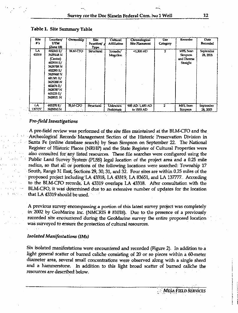
Survey for the Doc Slawin Federal Com, hru 1 Well 12
Table 1. Site Summary Table
Site Location/ Ownership Site Cultural Chronological Use Recorder Date rs UTM
Ownership Function/ j Affiliation Site Placement Category Recorded
(Zone 13) Type LA 602245 E / BLM-CFO Structural Jornada/ <L500AD 2 MF5,5ean September
43319 3629448N Mogollon Simpson 28,2003 (Center) and Theresa
602918 E / Straight 362970BN 602295 E / 3629968N 601381E/ 3629200N 602676 E / 3628787N 603223 E / 3629321N
LA 603270 E / BLM-CFO Structural Unknown 900 AD-1,400 AD 2 MPS, Sean September ,137777 . 36295I0N •: '. Prehistoric to 1550 AD Simpson 28,2003
Pre-field Investigations
A pre-field review was performed of the site files maintained at the BLM-CFO and the Archeological Records Management Section of the Historic Preservation Division in Santa Fe (online database search) by Sean Simpson on September 22. The National Rejgister of Historic Places (NRHP) and the State Register of Cultural Properties were also consulted for any listed resources. These file searches were configured using the Public Land Survey System (PLSS) legal location of the project area and a 0.25 mile radius, so that all or portions of the following locations were searched: Township 17 South, Range 31 East, Sections 29,30,31, and 32. Four sites are within 0.25 miles of the proposed project including LA 43318, LA 43319, LA 83651, and LA 137777. According to the BLM-CFO records, LA 43319 overlaps LA 43318. After consultation with the BLM-CFO, it was determined due to an extensive number of updates for the location that LA 43319 should be used.
A previous survey encompassing a portion of this latest survey project was completely in12002 by GeoMarine Inc. (NMCRIS # 81018). Due to the presence of a previously recorded site encountered during the GeoMarine survey the entire proposed location was surveyed to ensure the protection of cultural resources.
Isolated Manifestations (IMs)
Six isolated manifestations were encountered and recorded (Figure 2). In addition to a light general scatter of burned caliche consisting of 20 or so pieces within a 60-meter diameter area, several small concentrations were observed along with a single sherd and a hammerstone. In addition to this light broad scatter of burned caliche the resources are described below.
MESA FIELD SERVICES
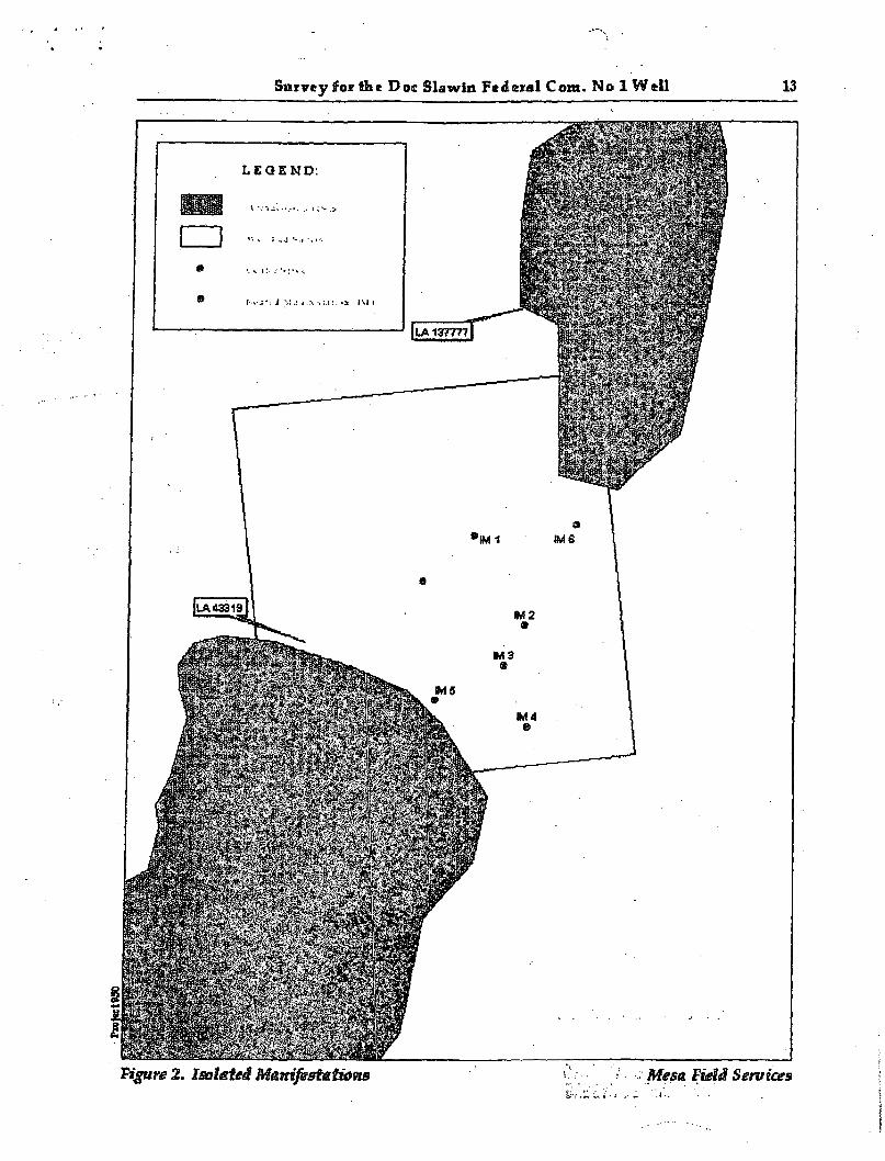
Survey for the Doc Slawin Federal Com. No 1 Well 13
Survey for the Doc Slawin Federal Com. Wo 1 Well 14
IM #1 consists of a single brownware sherd. (Zone 13:603215 E / 3629415 N).
IM # 2 consists of fifty pieces of burned caliche in a two-meter diameter area. A trowel test failed to reveal any intact deposits (Zone 13:603236 E / 3629377 N).
IM # 3 consists of six pieces of burned caliche in a two-meter diameter area (Zone 13: 603227 E / 3629361 N).
IM # 4 consists of four pieces of burned caliche in a one-meter diameter area (Zone 13: 603238 E/3629336 N).
IM # 5 consists of one quartzite hammerstone with pecking exhibited on either end (Zone 13: 603199 E / 3629346 N).
IM # 6 includes twenty pieces of burned caliche in a one-meter diameter area. The location was trowel tested which failed to reveal any subsurface material (Zone 13: 603258 E/3629419 N).
Previously Recorded Sites
LA No.: 43319 Quadrangle: Loco Hills, New Mexico Provisional Edition 1985 (32103-G8)
: Legal Location: T17 S, 31 E, Section 29: SWV* SW1/* UTM Coordinates: Zone 13:602245 E / 3629448 N (Center)
602918 E/3629708 N 602295 E / 3629968 N 601381 E/3629200 N 602676 E/3628787N 603223 E/3629321N
Size: 1,237 m (N/S) by 1,980 m (E/W) Ownership: BLM-CFO BLMCategory: 2 NRHP Eligibility: Eligible criterion d
LA 43319 was originally documented in 1973 by the Lea County Archaeological Inventory Group. It has been updated 15 times since then by Pecos Archaeological Consultants (PAQ, North Platte Archaeological Services, TRC Mariah Associates, Inc., Desert West Archaeological Services (DWAS), and Southern New Mexico Archaeological Services (SNMAS). Portions of the site were tested and excavated by DWAS in 1996 and 1997. Also in 1997, a well pad and access road were granted clearance for placement within the site boundaries because no artifacts were noted within the project boundaries.
MESA FIELD SERVICES
Survey for the Doc Slawin Federal Com, mo 1 Well 15
The site is situated along an escarpment and down the escarpment slope (Figure 3). The elevation varies from 3,580 ft to 3,720 ft with the general aspect of the site being north. Cedar Lake Draw is to the northwest of the site and drains into a playa to the north. Local vegetation includes mesquite, shin oak, creosote, prickly pear, and various grasses.
LA 43319 has been described as a large scatter of burned caliche with a variety of artifact types, including flakes from all stages of reduction, groundstone, sherds, tools, cores, and diagnostic projectile points. Also noted were mortar holes. The pottery types noted are Chupadero Black on White, Chupadero Smooth, Lincoln Brown on Red, Jornada Brown, El Paso Brown, South Pecos Brown, and El Paso Polychrome.
Due to the immense size of the site, over one mile in diameter, only its eastern portion closest to the project area was updated (Figure 3). Cultural material is limited to the escarpment edge and down slope. Due to a very light artifact scatter, site boundaries were defined based on an extant scatter of burned caliche. The midden deposits are positioned along the edge of the escarpment itself. Deposits are confined to the dunal blowouts. Dune ridges in this area are up to three meters high. The midden deposits consist of thick charcoal deposits thirty meters in diameter or more. The culturally derived midden deposits are extensive and almost continuous along the escarpment edge for the 0.25 miles inspected during this update and they continue to the west.
The site consists of a very large, varied artifact assemblage with depth. It dates to the jomada Mogollon based on the presence of the various types of sherds. The site retains additional research potential and is therefore recommended eligible for nomination to the NRHP under criterion d.
137777 Loco Hills, New Mexico Provisional Edition 1985 (32103-G8) T17 S, 31E, Section 29: SWA SWt Zone 13:603270 E/ 3629510 N (Datum) 185 m (N/S) by 180 m (E/W) BLM-CFO 2 Eligible, criterion d
This site was originally recorded by Ray Medlock with GeoMarine Inc. in October of 2002. The site consists of a variable density artifact and burned caliche scatter with thermal features. Ray Medlock initially outlined a series of 16 hearths, 18 possible structural remains, 41 burned caliche concentrations, and a sparse artifacts scatter in his description. A further description of feature types however, failed to correspond to the outline.
LA No.: Quadrangle: Legal Location: UTM Coordinates: Size: Ownership: BLM Category: NRHP Eligibility:
MESA FIELD SERVICES
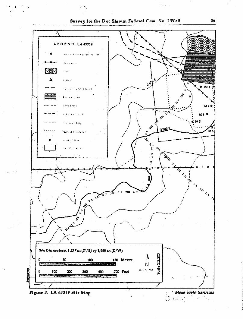
Survey for ihe Doc Slawin Federal Com. No. 1 Well 16
Figure 3. LA S3319 Site Map ; , Mesa Field Services
Survey for the Doc Slawin Federal Com, no 1 Well 17
During the latest visit, the site appeared as described (Figure 4). Ray Medlock described the presence of juniper branches on or adjacent to 13 of the features. It is not clear if the features described correspond to the 18 possible structural remains or 41 burned caliche concentrations outlined in the initial paragraph of the site description. However, only four cultural features consisting of subsurface staining were relocated.
The southern boundary of the site was originally described as crossing the south side of the lease road to the existing well. One piece of burned caliche and a hearth was all that was recorded in this area during the original visit. This latest visit failed to reveal any staining. All that was observed were four pieces of burned caliche. For management purposes, this area was redefined as an IM with the boundary for LA 137777 being drawn at the north side of the lease road.
Due to the lack of cultural diagnostics, a temporal marker for the prehistoric site can not be determined. The site retains additional information potential in the form of buried cultural deposits. A time frame for the site could be obtained from one of the thermal features on site with datable charcoal fil l . Therefore, LA 137777 is recommended eligible for nomination to the NRHP under criterion d.
Recommendations
During the course of the survey, two previously recorded sites, LA 43319 and LA 137777 were encountered and documented. Both sites are recommended eligible for nomination to the NRHP under criterion d and should be avoided. Although both sites are located within the survey corridor, they will not be impacted by proposed activities. The site LA 137777 is located north of the existing pad. Project activities will be restricted to the north within the pad limits. The north and eastern boundary for LA 43319 is within 30 ft of proposed activity to the south. Due to the close proximity of the sites tb proposed activities, the BLM-CFO may require the position of a permanent fence and have an archaeological monitor for at least initial surface disturbing activities.
MESA FIELD SERVICES
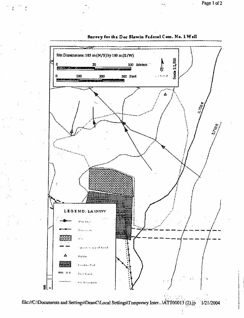
Page 1 of2
Survey for the Doc Slawin Federal Com. No. 1 Wel l
file://C:\Documents and Settings\DeanC\Local Settings\Temporary Inter.,AA TOOb 13; (2).jp 1/21/2004

Survey for the Doc Slawin Federal Com. i>o 1 Well 19
References Cited
BLM-New Mexico State Office 1999 Draft Stateivide Resource Management Plan Amendment/Environmental Impact
Statement. New Mexico Standards for Public Land Health and Guidelines for Livestock Grazing Management.
2002 Procedures for Performing Cultural Resource Fieldxoork on Public Lands in the Area of New Mexico BLM Responsibilities. BLM Manual Supplement H-8100-1 New Mexico, Oklahoma, and Texas.
Cordell, Linda
1997 Archaeology of the Southwest, second edition. Academic Press, San Diego.
Cornett, James W. 1995 Indian Uses of Desert Plants. Palm Springs Desert Museum. Palm Springs,
California. Crabtree, D.E. 1972 An Introduction to Flintworking. Occasional Papers of the Idaho State University
Museum No. 28. Pocatello.
Jelinek, Arthur J. 1967 A Prehistoric Sequence in the Middle Pecos Valley, Neu> Mexico. University of
Michigan, Museum of Anthropology, Anthropology Paper No. 31. Ann Arbor.
Judge, W. James 1974 Early Man: Plains and Southwest. An Interpretive Summary of the Paleoindian
Occupation of the Plains and Southwest. Smithsonian Handbook of North American Indians, vol. 3. Smithsonian Institution, Washington, D.C.
1982 The Paleo-Indian and Basketmaker Periods: An Overview and Some Research Problems. In The San ]uan Tomorrow: Planning for Conservation of Cultural Resources in the San Juan Basin, edited by Fred Plog and Walter Wait, pp. 5-57. National Park Service, Southwest Region, Santa Fe.
Katz, Susanna and Paul Katz 1985 The History of the Carlsbad Basin, Southeastern New Mexico. Technical Report
of Historic Archaeological Investigations in the Brantley Project Locality. Ms. On file, Bureau of Reclamation, Amarillo, Texas.
MESA FIELD SERVICES
Survey for the Doc Slawin Federal Com, no 1 Well 20
1993 Ardiaeological Overview of Soutlieastern New Mexico. New Mexico State Historic Preservation Division, Santa Fe.
MacNeish, Richard S. and Patrick H. Beckett
1987 T7ze Arclmic Chihuahua Tradition. Monograph No. 7, COAS, Las Cruces.
Olmstead, Virginia 1975 Cobnial Census of New Mexico, 1790, 1832, 1845. New Mexico Genealogical
Society, Albuquerque. Pratt, Boyd C. and Dan Scurlock 1989 Llano, River, and Mountains: Vie Southeast New Mexico Regional Overviexv. New
Mexico Historic Preservation Division, Santa Fe.
Roney, John R. 1985 Prehistory of me Guadalupe Mountains. Masters Thesis, Eastern New Mexico
University, Portales.
Roxlau, R. Blake, Gary M. Brown, and Rachael Loehman 1997 Lithic Typology for the Jemez Mountains. In Ole, Volume II: Artifacts. John
Acklen, editor. TRC Mariah Associates, Inc. and Public Service Company of New Mexico, Albuquerque.
Sebastian, Lynne, and Sigiia Larralde 1989 Living on tlie Land: 11,000 Years of Human Adaptation in Southeastern New Mexico,
An Overview of Cultural Resources in the Roswell District. Bureau of Land Management, Roswell District, Roswell.
Simonis, Don 1995 Can Chronology: Evaporated/Condensed Milk Can Measurements. Kingman Resource
Area Bureau of Land Management.
Stuart, David E., and Rory P. Gauthier
1988 Prehistoric Nexp Mexico. Historic Preservation Division, Santa Fe, New Mexico.
Tainter, Joseph and David Gillio ' 1980 Cultural Resources Overview, ML Taylor Area, New Mexico. USD A Forest Service
Southwest Region, Bureau of Land Management, New Mexico State Office, Albuquerque and Santa Fe.
Turner, S. and Thomas R. Hester 1993 A Field Guide to Stone Artifacts of Texas Indians, second edition.
Company, Houston.
MESA FIELD SERVICES
Gulf Publishing

Survey for the Doc Slawin Federal Com, no 1 Well 21
Western Regional Climate Center
n.d. Electronic document, http.7 / www.wrcc.dri.edu, accessed July 10,2003
Whittaker, John C. 1994 Flintknapping: Making & Understanding Stone Tools. University of Texas Press,
Austin.
i MESA.FIELD SERVICES
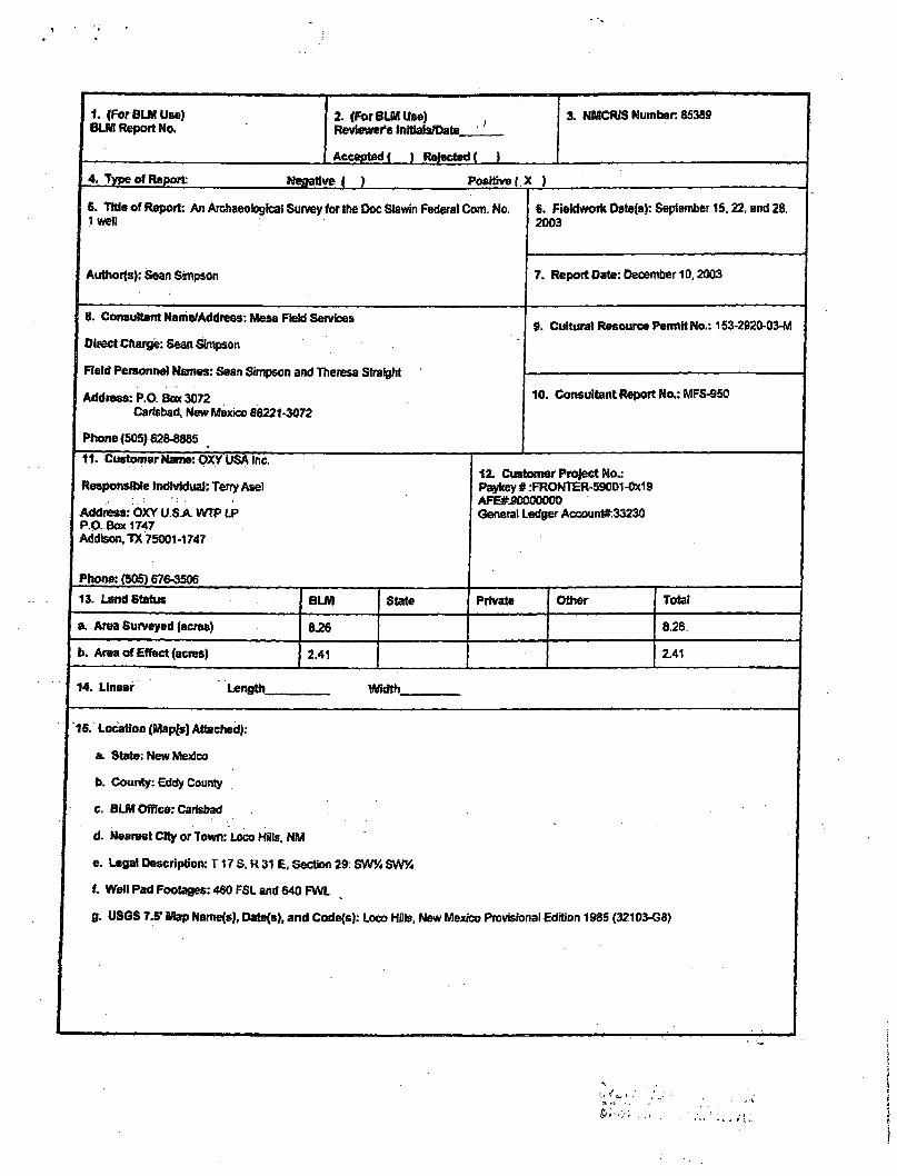
1. (For BLM Use) 2. (For BLM Use) 3. NMCRIS Number. 85389 BLM Report No. Reviewer's Initials/Date
Accepted ( ) Rejected ( )
4. Type of Report Negative ( ) Positive ( X )
6. Title of Report: An Archaeological Survey for the Doc Slawin Federal Com. No, Iwell
Authors): Sean Simpson
6. Fiektwork Date(s): September 15,22, and 28. 2003
7. Report Date: December 10,2003
8. Consultant Name/Address: Mesa Field Services
Direct Charge: Sean Simpson
Field Personnel Names: Sean Simpson and Theresa Straight
Address: P.O. Box 3072 Carlsbad, New Mexico 88221-3072
Phone (505) 628-8885
9. Cultural Resource Permit No.: 153-2920-03-W
10. Consultant Report No.: MFS-950
11. Customer Name: OXY USA Inc.
Responsible Individual: Terry Asel
Address: OXY U.S A WTP LP P.O. Box 1747 Addison. TX 75001-1747
Phone: (505) 676-3506 13. Land Status BLM State Private Other Total
a. Area Surveyed (acres) 8.26 8.26
b. Area of Effect (acres) 2.41 2.41
12. Customer Project No.: Paykey # :FRONTER-59001 -0x19 AFSfcSOOOOOOO General Ledger Account#:33230
14. Linear Length_ Width
15. Location (Mapfs) Attached):
a. State: New Mexico
b. County: Eddy County
c. BUM Office: Carlsbad
d. Nearest City or Town: Loco Hills. NM
e. Legal Description: T17 S. R 31 E, Section 29: SWV4 SVW
f. Well Pad Footages: 460 FSL and 640 FWL
0. USGS 7.5' Map NameM Date(s), and Code(s): Loco Hills. New Mexico Provisional Edition 1985 (32103-G8)
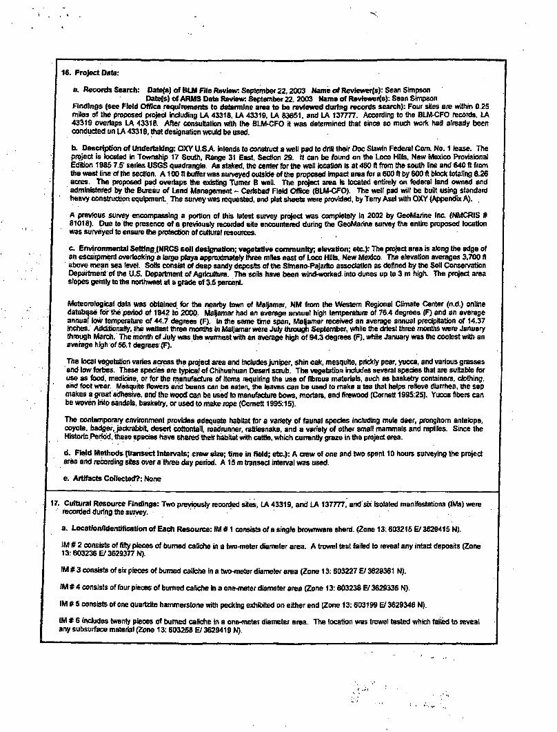
4
16. Project Date:
a Records Search: Date/s) of BLM File Review: September 22.2003 Name of Revlewerjs): Sean Simpson Datefs) of ARMS Data Review: September 22, 2003 Name of Reviewerfe): Sean Simpson
Findings (see Field Office requirements to determine area to be reviewed during records search): Four sites are within 0 25 miles of the proposed project including LA 43316, LA 43319, LA 83651. and LA 137777. According to the BLM-CFO records, LA 43319 overlaps LA 43318. After consultation with Ihe BLM-CFO it was determined that since so much work had already been conducted un LA 43318. that designation would be used.
b. Description of Undertaking: OXY U.S A intends to construct a well pad to drill their Doc Slawin Federal Com. No. 1 lease. The project is located in Township 17 South, Range 31 East, Section 29. It can be found on the Loco HDIs, New Mexico Provisional Edition 1985 7.5' series USGS quadrangle. As staked, the center for the well location rs at 460 ft from the south fine and 640 ft from the west fine of the section. A100 ft buffer was surveyed outside of the proposed impact area for a 600 ft by 600 ft block totaling 8.26 acres. The proposed pad overlaps the existing Turner B well. The project area Is located entirely on federal land owned and administered by the Bureau of Land Management - Carlsbad Field Office (BLM-CFO). The well pad will be built using standard heavy construction equipment The survey was requested, and plat sheets were provided, by Terry Asel with OXY (Appendix A). .
A previous survey encompassing a portion of this latest survey project was completely in 2002 by GeoMarine Inc (NMCRIS # 81018). Due to the presence of a previously recorded site encountered during the GeoMarine survey the entire proposed location was surveyed to ensure the protection of cultural resources.
c. Environmental Setting (NRCS soil designation; vegetative community; elevation; etc): The project area is along the edge of an escarpment overlooking a large playa approximately three mites east of Loco Hills. New Mexico. The elevation averages 3,700 fi above mean sea level. Sods consist of deep sandy deposits of the Slmano-Pajarfto association as defined by the Soil Conservation Department of the U.S. Department of Agriculture. The soils have been wind-worked into dunes up to 3 m high. The project area slopes gently to the northwest at a grade of 3.5 percent
Meteorological data was obtained, for the nearby town of Maljamar, NM from the Western Regional Climate Center (n.d.) online database for the period of 1942 to 2000. Maljamar had an average annual high temperature of 76.4 degrees (F) and an average annual low temperature of 44.7 degrees (F). In the same time span, Maljamar received an average annual precipitation of 14.37 Inches. Additionally, the wettest three months in Maljamar were Jury through September, while the driest three months were January through March. The month of Jury was the warmest with an average high of 94.3 degrees (F), while January was the coolest with an average high of 56.1 degrees (F).
The local vegetation varies across the project area and includes juniper, shin oak, mesquite. prickly pear, yucca, and various grasses end low forties. These species are typical of Chihuahuan Desert scrub. The vegetation includes several species that are suitable for use as food, medicine, or for the manufacture of Hems requiring the use of fibrous materials, such as basketry containers, clothing, and foot wear. Mesquite flowers and beans can be eaten, the leaves can be used to make a tea that helps relieve diarrhea, the sap makes a great adhesive, and the wood can be used to manufacture bows, mortars, and firewood (Cornett 1995:25). Yucca fibers can be woven into sandals, basketry, or used to make rope (Cornett 1995:15).
The contemporary environment provides adequate habitat for a variety of faunal species Including mule deer, pronghorn antelope, coyote, badger, jackrabbit desert cottontail, roadrunner, rattlesnake, and a variety of other small mammals and reptiles. Since the Historic Period, these species have shared their habitat with cattle, which currently graze in the project area.
d. Field Methods (transect Intervals; crew size; time in field; etc.): A crew of one and two spent 10 hours surveying the project area and recording sites over a three day period. A 15 m transect interval was used.
e. Artifacts Collected?: Norte
17. Cultural Resource Findings: Two previously recorded sites, LA 43319, and LA 137777, and six isolated manifestations (IMs) were recorded during the survey.
a. Location/Identification of Each Resource: IM # 1 consists of a single brownware sherd. (Zone 13:603215 E/ 3629415 N).
IM § 2 consists of fifty pieces of burned caliche in a two-meter diameter area. A trowel test failed to reveal any intact deposits (Zone 13:603236 V 3629377 N).
IM # 3 consists of six pieces of burned caliche in a two-meter diameter area (Zone 13:603227 El 3628361 N).
IM # 4 consists of four pieces of burned caliche in a one-meter diameter area (Zone 13:603238 E/ 3629336 N).
IM # 5 consists of one quartzfte hammerstone with peeking exhibited on either end (Zone 13:603199 El 3629346 N).
IM # 6 includes twenty pieces of burned caliche in a one-meter diameter area. The location was trowel tested which failed to reveal any subsurface material (Zone 13:603258 El 3629419 N).
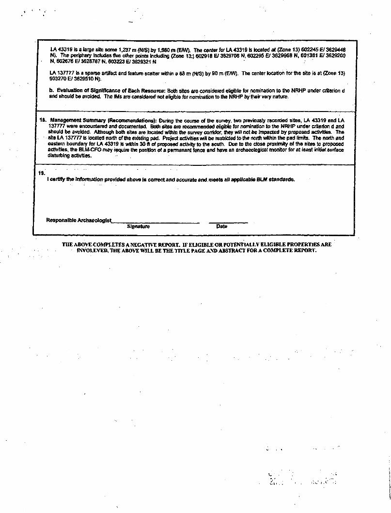
LA 43319 is a large site some 1.237 m (N/S) by 1,980 m (EAV). The center for LA 43319 is located at (Zone 13) 602245 El 3629448 N). The periphery Includes five other points including (Zone 13:) 602918 El 3629708 N, 602295 El 3629968 N, 601381 EI 3629200 N, 602676 El 3628787 N, 603223 El 3629321 N
LA 137777 is a sparse artifact and feature scatter within a 88 m (N/S) by 90 m (E/W). The center location for the site is at (Zone 13) 603270 El 3629510 N).
b. Evaluation of Significance of Each Resource: Both sites are considered eligible for nomination to the NRHP under criterion d and should be avoided. The IMs are considered not eligible for nomination to the NRHP by their very nature.
1ft. Management Summary (Recommendations): During ihe course of the survey, two previously recorded sites, LA 43319 and LA 137777 were encountered and documented. Both sites are recommended eligible for nomination to the NRHP under criterion d and should be avoided. Although both sites are located within the survey corridor, they will not be impacted by proposed activities. The eite LA 137777 Is located north of the existing pad. Project activities wilt be restricted to the north within the pad limits. The north and eastern boundary for LA 43319 is within 30 ft of proposed activity to the south. Due to the dose proximity of the Bites to proposed activities, the BLM-CFO may require the position of a permanent fence and have an archaeological monitor for at least initial surface disturbing activities.
19. I certify the Information provided above is correct and accurate and meets all applicable BLM standards.
Responsible Archaeologist Signature Date
THE ABOVE COMPLETES A NEGATIVE REPORT. IF ELIGIBLE OR POTENTIALLY ELIGIBLE PROPERTIES ARE fNVOLEVED, THE ABOVE WILL BE THE TITLE PAGE AND ABSTRACT FOR A COMPLETE REPORT.
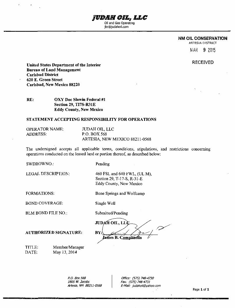
Oil and Gas Operating [email protected]
HM OIL CONSERVATION ARTESIA DISTRICT
MAR 9 2015
RECEIVED United States Department of the Interior Bureau of Land Management Carlsbad District 620 E. Green Street Carlsbad, New Mexico 88220
RE: OXY Doc Slawin Federal #1
STATEMENT ACCEPTING RESPONSIBILITY FOR OPERATIONS
The undersigned accepts all applicable terms, conditions, stipulations, and restrictions concerning operations conducted on the leased land or portion thereof, as described below:
Section 29, TI7S-R31E Eddy County, New Mexico
OPERATOR NAME: ADDRESS:
JUDAH OLL, LLC P.O. BOX 568 ARTESIA, NEW MEXICO 88211-0568
SWDROWNO.: Pending
LEGAL DESCRIPTION: 460 FSL and 640 FWL, (UL M), Section 29, T-17-S, R-31-E Eddy County, New Mexico
FORMATIONS: Bone Springs and Wolfcamp
BOND COVERAGE: Single Well
BLM BOND FILE NO.: Submitted/Pending
AUTHORIZED SIGNATURE:
TITLE: DATE:
Member/Manager May 13,2014
P.O. Box 568 1805 W. Jacobs Artesia, NM 88211-0568
Office: (575)748-4730 Fax: (575)748-4731 E-Mail: [email protected]
Page 1 of 1

PECOS DISTRICT CONDITIONS OF APPROVAL
OPERATOR'S NAME: Judah Oil, L L C LEASE NO.: NMLC-029395B
WELL NAME & NO.: Oxy Doc Slawin Fed 1 SURFACE HOLE FOOTAGE: 0460'FSL & 0640'FWL
BOTTOM HOLE FOOTAGE 0660' FSL & 0660' FWL LOCATION: Section 29, T. 17 S., R 31 E. , NMPM
COUNTY: Eddy County, New Mexico
T A B L E O F C O N T E N T S Standard Conditions of Approval (COA) apply to this APD. If any deviations to these
standards exist or special COAs are required, the section with the deviation or requirement will be checked below.
I I General Provisions I I Permit Expiration [~1 Archaeology, Paleontology, and Historical Sites I I Noxious Weeds 1X1 Special Requirements
Existing Fence Requirement Berm Well Pad Lesser Prairie-Chicken Timing Stipulations Ground-level Abandoned Well Marker
I I Construction Notification Topsoil Closed Loop System Federal Mineral Material Pits Well Pads Roads
I I Road Section Diagram Drilling
Cement Requirements H2S Requirements CIT Requirements Waste Material and Fluids
I I Production (Post Drilling) Well Structures & Facilities
I I Interim Reclamation 1X1 Final Abandonment & Reclamation
Page 1 of 15 /
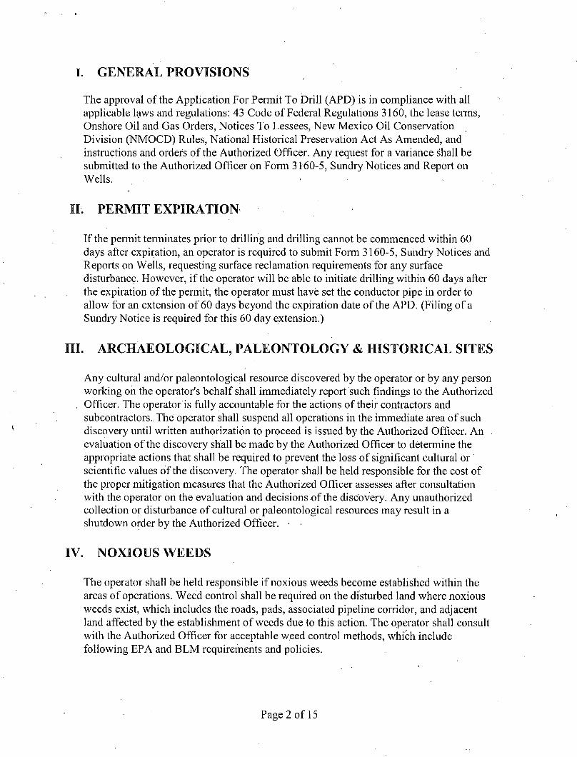
I. GENERAL PROVISIONS
The approval of the Application For Permit To Drill (APD) is in compliance with all applicable laws and regulations: 43 Code of Federal Regulations 3160, the lease terms, Onshore Oil and Gas Orders, Notices To Lessees, New Mexico Oil Conservation Division (NMOCD) Rules, National Historical Preservation Act As Amended, and instructions and orders of the Authorized Officer. Any request for a variance shall be submitted to the Authorized Officer on Form 3160-5, Sundry Notices and Report on Wells. •
I I . PERMIT EXPIRATION •
If the permit terminates prior to drilling and drilling cannot be commenced within 60 days after expiration, an operator is required to submit Form 3160-5, Sundry Notices and Reports on Wells, requesting surface reclamation requirements for any surface disturbance. However, i f the operator will be able to initiate drilling within 60 days after the expiration of the permit, the operator must have set the conductor pipe in order to allow for an extension of 60 days beyond the expiration date of the APD. (Filing of a Sundry Notice is required for this 60 day extension.)
III. ARCHAEOLOGICAL, PALEONTOLOGY & HISTORICAL SITES
Any cultural and/or paleontological resource discovered by the operator or by any person working on the operator's behalf shall immediately report such findings to the Authorized
. Officer. The operator is fully accountable for the actions of their contractors and subcontractors.. The operator shall suspend all operations in the immediate area of such discovery until written authorization to proceed is issued by the Authorized Officer. An . evaluation of the discovery shall be made by the Authorized Officer to determine the appropriate actions that shall be required to prevent the loss of significant cultural or scientific values of the discovery. The operator shall be held responsible for the cost of the proper mitigation measures that the Authorized Officer assesses after consultation with the operator on the evaluation and decisions of the discovery. Any unauthorized collection or disturbance of cultural or paleontological resources may result in a shutdown order by the Authorized Officer. •
IV. NOXIOUS WEEDS
The operator shall be held responsible i f noxious weeds become established within the areas of operations. Weed control shall be required on the disturbed land where noxious weeds exist, which includes the roads, pads, associated pipeline corridor, and adjacent land affected by the establishment of weeds due to this action. The operator shall consult with the Authorized Officer for acceptable weed control methods, which include following EPA and BLM requirements and policies.
Page 2 of 15
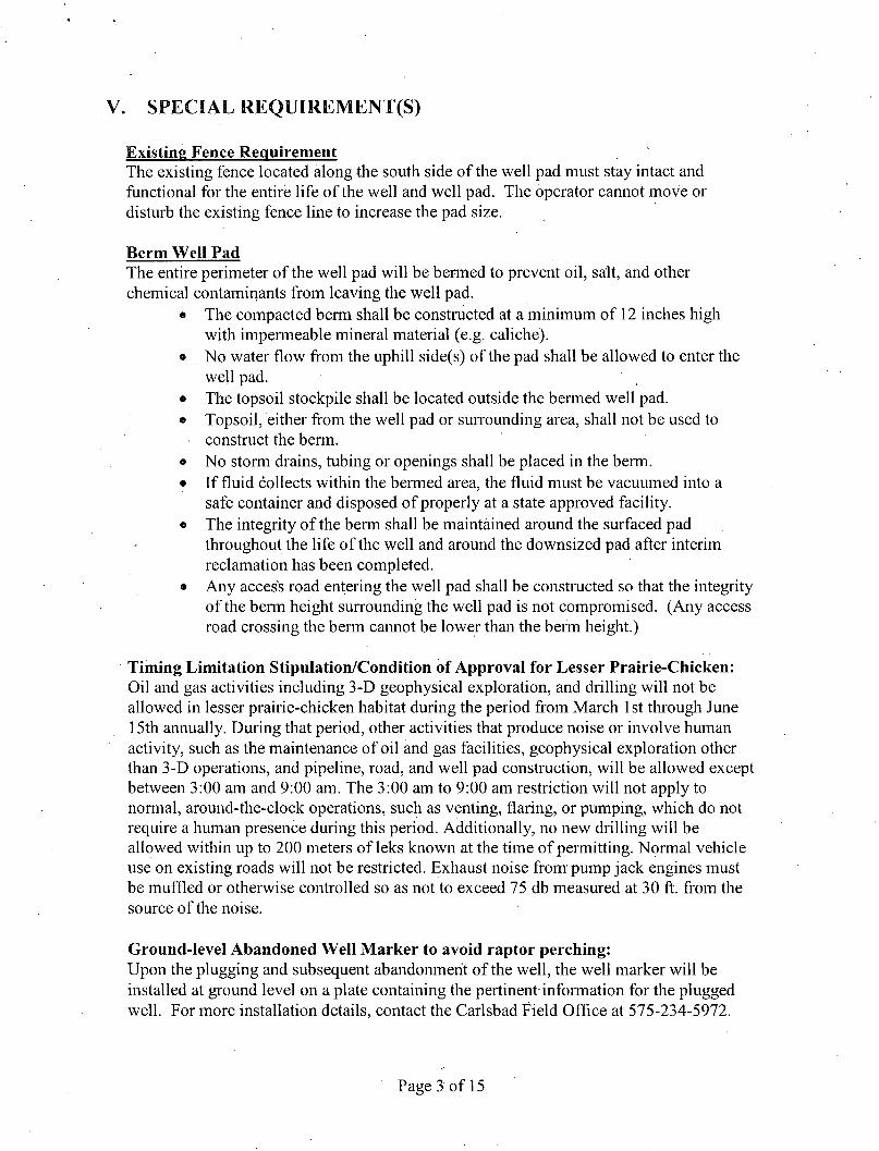
V. SPECIAL REQUIREMENT(S)
Existing Fence Requirement ' The existing fence located along the south side of the well pad must stay intact and functional for the entire life of the well and well pad. The operator cannot move or disturb the existing fence line to increase the pad size.
Berm Well Pad The entire perimeter of the well pad will be bermed to prevent oil, salt, and other chemical contaminants from leaving the well pad.
• The compacted berm shall be constructed at a minimum of 12 inches high with impermeable mineral material (e.g. caliche).
» No water flow from the uphill side(s) of the pad shall be allowed to enter the well pad.
• The topsoil stockpile shall be located outside the bermed well pad. o Topsoil, either from the well pad or surrounding area, shall not be used to
construct the berm. • No storm drains, tubing or openings shall be placed in the berm. • If fluid collects within the bermed area, the fluid must be vacuumed into a
safe container and disposed of properly at a state approved facility. • The integrity of the berm shall be maintained around the surfaced pad
throughout the life of the well and around the downsized pad after interim reclamation has been completed.
• Any access road entering the well pad shall be constructed so that the integrity of the berm height surrounding the well pad is not compromised. (Any access road crossing the berm cannot be lower than the berm height.)
Timing Limitation Stipulation/Condition of Approval for Lesser Prairie-Chicken: Oil and gas activities including 3-D geophysical exploration, and drilling will not be allowed in lesser prairie-chicken habitat during the period from March 1 st through June 15th annually. During that period, other activities that produce noise or involve human activity, such as the maintenance of oil and gas facilities, geophysical exploration other than 3-D operations, and pipeline, road, and well pad construction, will be allowed except between 3:00 am and 9:00 am. The 3:00 am to 9:00 am restriction will not apply to normal, around-the-clock operations, such as venting, flaring, or pumping, which do not require a human presence during this period. Additionally, no new drilling will be allowed within up to 200 meters of leks known at the time of permitting. Normal vehicle use on existing roads will not be restricted. Exhaust noise from pump jack engines must be muffled or otherwise controlled so as not to exceed 75 db measured at 30 ft. from the source of the noise.
Ground-level Abandoned Well Marker to avoid raptor perching: Upon the plugging and subsequent abandonment of the well, the well marker will be installed at ground level on a plate containing the pertinent-information for the plugged well. For more installation details, contact the Carlsbad Field Office at 575-234-5972.
Page 3 of 15
VI. CONSTRUCTION
A. NOTIFICATION
The BLM shall administer compliance and monitor construction of the access road and well pad. Notify the Carlsbad Field Office at (575) 234-5909 at least 3 working days prior to commencing construction of the access road and/or well pad.
When construction operations are being conducted on this well, the operator shall have the approved APD and Conditions of Approval (COA) on the well site and they shall be made available upon request by the Authorized Officer.
B. TOPSOIL
The operator shall strip the top portion of the soil (root zone) from the entire well pad area and stockpile the topsoil along the edge of the well pad as depicted in the APD. The root zone is typically six (6) inches in depth. All the stockpiled topsoil will be redistributed over the interim reclamation areas. Topsoil shall not be used for berming the pad or facilities. For final reclamation, the topsoil shall be spread over the entire pad area for seeding preparation.
Other subsoil (below six inches) stockpiles must be completely segregated from the topsoil stockpile. Large rocks or subsoil clods (not evident in the surrounding terrain) must be buried within the approved area for interim and final reclamation.
C. CLOSED LOOP SYSTEM
Tanks are required for drilling operations: No Pits.
The operator shall properly dispose of drilling contents at an authorized disposal site.
D. FEDERAL MINERAL MATERIALS PIT
Payment shall be made to the BLM prior to removal of any federal mineral materials. Call the Carlsbad Field Office at (575) 234-5972.
E. WELL PAD SURFACING
Surfacing of the well pad is not required.
If the operator elects to surface the well pad, the surfacing material may be required to be removed at the time of reclamation.The well pad shall be constructed in a manner which creates the smallest possible surface disturbance, consistent with safety and operational needs.
F. EXCLOSURE FENCING (CELLARS & PITS)
Page 4 of 15
Exclosure Fencing The operator will install and maintain exclosure fencing for all open well cellars to prevent access to public, livestock, and large forms of wildlife before and after drilling operations until the pit is free of fluids and the operator initiates backfilling. (For examples of exclosure fencing design, refer to BLM's Oil and Gas Gold Book, Exclosure Fence Illustrations, Figure 1, Page 18.)
G. ON LEASE ACCESS ROADS
Road Width The access road shall have a driving surface that creates the smallest possible surface disturbance and does not exceed fourteen (14) feet in width. The maximum width of
. surface disturbance, when constructing the access road, shall not exceed twenty-five (25) feet.
Surfacing Surfacing material is not required dn the new access road driving surface. If the operator elects to surface the new access road or pad, the surfacing material may be required to be removed at the time of reclamation. ,
Where possible, no improvements should be made on the unsurfaced access road other than to remove vegetation as necessary, road irregularities, safety issues, or to fi l l low areas that may sustain standing water.
The Authorized Officer reserves the right to require surfacing of any portion of the access road at any time deemed necessary. Surfacing may be required in the event the road deteriorates, erodes, road traffic increases, or it is determined to be beneficial for future field development. The surfacing depth and type of material will be determined at the time of notification.
Crowning Crowning shall be done on the access road driving surface. The road crown shall have a grade of approximately 2% (i.e., a 1" crown on a 14' wide road). The road shall conform to Figure I ; cross section and plans for typical road construction.
Ditching
Ditching shall be required on both sides of the road.
Turnouts • Vehicle turnouts shall be constructed on the road. Turnouts shall be intervisible with interval spacing distance less than 1000 feet. Turnouts shall conform to Figure 1; cross section and plans for typical road construction.
Drainage
Page 5 of 15
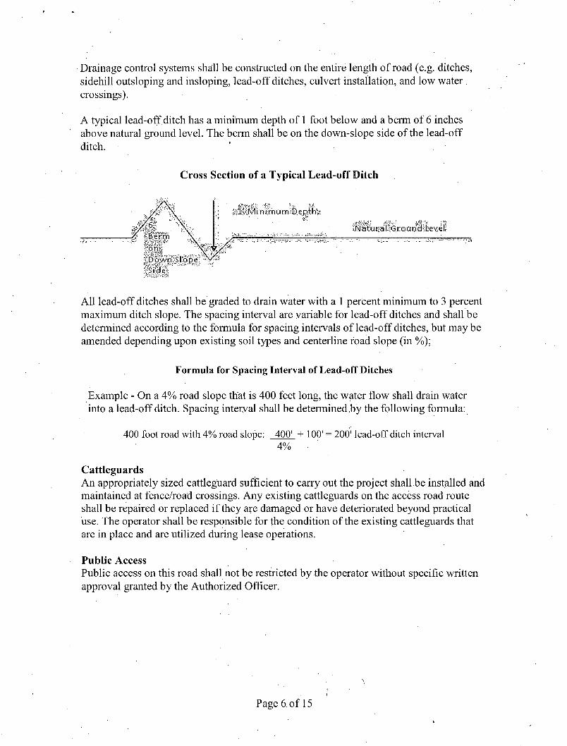
Drainage control systems shall be constructed on the entire length of road (e.g. ditches, sidehill outsloping and insloping, lead-off ditches, culvert installation, and low water . crossings).
A typical lead-off ditch has a minimum depth of 1 foot below and a berm of 6 inches above natural ground level. The berm shall be on the down-slope side of the lead-off ditch. ' ' •
Cross Section of a Typical Lead-off Ditch
Side
All lead-off ditches shall be graded to drain water with a 1 percent minimum to 3 percent maximum ditch slope. The spacing interval are variable for lead-off ditches and shall be determined according to the formula for spacing intervals of lead-off ditches, but may be amended depending upon existing soil types and centerline road slope (in %);
Formula for Spacing Interval of Lead-off Ditches
Example - On a 4% road slope that is 400 feet long, the water flow shall drain water into a lead-off ditch. Spacing interval shall be detennined .by the following formula:
400 foot road with 4% road slope: 400' + 100' = 200' lead-off ditch interval 4% •
Cattleguards An appropriately sized cattleguard sufficient to carry out the project shall be installed and maintained at fence/road crossings. Any existing cattleguards on the access road route shall be repaired or replaced i f they are damaged or have deteriorated beyond practical use. The operator shall be responsible for the condition of the existing cattleguards that are in place and are utilized during lease operations.
Public Access Public access on this road shall not be restricted by the operator without specific written approval granted by the Authorized Officer.
Page 6 of 15
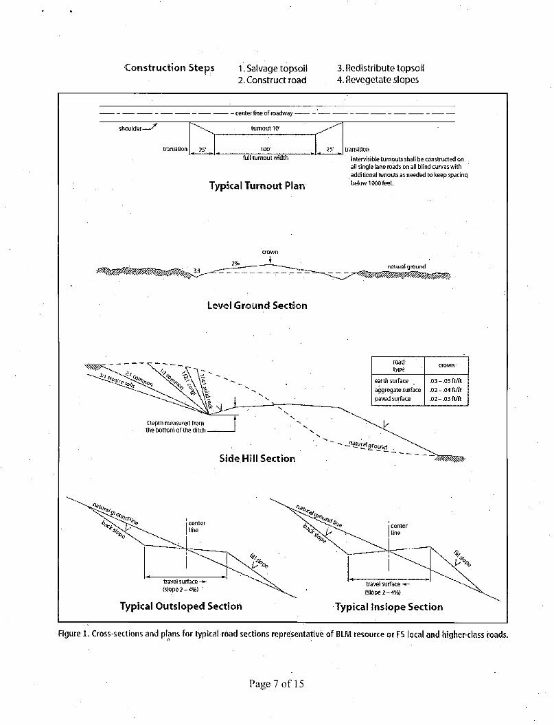
Construction Steps 1. Salvage topsoil 2. Construct road
3. Redistribute topsoil 4. Revegetate slopes
- center line of roadway -
shoulder-^ turnout 10' —
transition 25' 100' 25" transition
full turnout width
Typical Turnout Plan
Intervisible turnouts shall be constructed bn all single lane roads on all blind curves with additional runouts as needed to keep spacing below 1000 feet.
Level Ground Section
natural ground
road road crown
type
earth surface .03-.05 ft/ft aggregate surface .02 -.04 ft/ft paved surface .02 - m ft/ft
Depth measured from the bottom of the ditch -
Side Hill Section
travel surface -»-{slope 2-4%) '
Typical Outsloped Section
(slope 2 -4%).
Typical inslope Section
Figure 1. Cross-sections and plans for typical road sections representative of BLM resource or FS local and higher-class roads.
Page 7 of 1.5
VII. DRILLING
A. DRILLING OPERATIONS REQUIREMENTS
The BLM is to be notified in advance for a representative to witness:
. a. Setting and/or Cementing production casing (minimum of 4 hours) b. BOPE tests (minimum of 4 hours) c. CIT test
M Eddy County Call the Carlsbad Field Office, 620 East Greene St., Carlsbad, NM 88220, (575) 361-2822
1. A Hydrogen Sulfide (H2S) Drilling Plan shall be activated prior to drilling out the surface shoe. As a result, the Hydrogen Sulfide area must meet Onshore Order 6 requirements, which includes equipment and personnel/public protection items. If Hydrogen Sulfide is encountered, provide measured values and formations to the BLM.
2. If the drilling rig is removed prior to completing all approved drilling procedures - an Incident of Non-Compliance will be written and will be a "Major" violation.
3. Floor controls are required for 3M or Greater systems. These controls will be on the rig floor, unobstructed, readily accessible to the driller and will be operational at all times during drilling and/or completion activities. Rig floor is(defined as the area immediately around the rotary table; the area immediately above the substructure on which the draw works is located, this does not include the dog house or stairway area.
A. CASING - Re-entry
Changes to the approved APD casing program need prior approval if the items substituted are of lesser grade or different casing size or are Non-API. The Operator can exchange the components of the proposal with that of superior strength (i.e. changing from J-55 to N-80, or from 36# to 40#). Changes to the approved cement program need prior approval if the altered cement plan has less -\ volume or strength or if the changes are substantial (i.e. Multistage tool, ECP, etc.). The initial wellhead installed on the well will remain on the well with spools used as needed.
Wait on cement (WOC) for Water Basin: After cementing but before commencing any tests, the casing string shall stand cemented under pressure until both of the following conditions have been met: 1) cement reaches a minimum compressive strength of 500 psi at the shoe, 2) until cement has been in place at least 8 hours.
Page 8 of 15
No pea gravel permitted for remedial or fall back remedial without prior authorization from the BLM engineer.
Possibility of water flows in the Salado, Artesia Group, and Queen. Possibility of lost circulation in the Red Beds, Rustler, Artesia Group, San Andres, and Grayburg.
Abnormal pressures may be encountered within the Wolfcamp formation.
All casing is in place except for a portion of the 5-1/2" that was pulled.
1. The 16" surface casing is set at 422 feet with cement circulated to surface.
2. The 11-3/4" intermediate casing is set at 1645 feet with cement circulated to surface
3. The 8-5/8" production casing is set at 4256 feet with cement circulated to surface.
4. The 5-1/2" production casing is set from approximately 3000' to 11797 feet with cement circulated to 3800 feet (casing was pulled from surface to 3000').
Re-entrv/Plugback procedure:
1. ) Operator has stated they will test casing to 1,000 psi once a depth of 500' is reached.
2. ) Operator will replace pulled casing as stated in the drilling program, cement to surface, WOC, and preform a CIT per Onshore Oil and Gas Order 2.III.B.l.h prior to drilling out the next shoe plug.
Note: Operator shall provide method of verification for the cement behind 5-1/2" casing replacement.
3. ) A CIT is to be performed on the 5-1/2 inch casing per Onshore Oil and Gas Order 2.III.B.l.h prior to drilling out the last CIBP at 7706' before the open perforations are encountered.
4. ) Operator to tag CIBP at approximately 11375'. Operator to place 200' Class H cement on top to seal the Morrow formation. WOC.
5. ) Operator stated they will place a CIBP at 9450\with 35 feet Class H cement on top.
Page 9 of 15
B. PRESSURE CONTROL
1. All blowout preventer (BOP) and related equipment (BOPE) shall comply with well control requirements as described in Onshore Oil and Gas Order No. 2 and API RP 53 Sec. 17.
1. Prior to drilling out the surface plug, the BOP is to be tested. Minimum working pressure of the blowout preventer (BOP) and related equipment (BOPE) required for drilling below the surface casing shoe shall be 2,000 (2M) psi (Operating installing 3M).
2. After replacing 5-l/2"casing, the BOP is to be test. Minimum working pressure of the blowout preventer (BOP) and related equipment (BOPE) required for drilling below the surface casing shoe shall be 3,000 (3M) psi.
3. The appropriate BLM office shall be notified a minimum of 4 hours in advance for a representative to witness the tests.
a. In a water basin, for all casing strings utilizing slips, these are to be set as soon as the crew and rig are ready and any fallback cement remediation has been done. The casing cut-off and BOP installation can be initiated four hours after installing the slips, which will be approximately six hours after bumping the plug. For those casing strings not using slips, the minimum wait time before cut-off is eight hours after bumping the plug. BOP/BOPE testing can begin after cut-off or once cement reaches 500 psi compressive strength (including lead when specified), whichever is greater. However, i f the float does not hold, cut-off cannot be initiated until cement reaches 500 psi compressive strength (including lead when specified).
b. The tests shall be done by an independent service company utilizing a test plug not a cup or J-packer.
c. The test shall be run on a 5000 psi chart for a 2-3M BOP/BOP, on a 10000 psi chart for a 5M BOP/BOPE and on a 15000 psi chart for a 10M BOP/BOPE. If a linear chart is used, it shall be a one hour chart. A circular chart shall have a maximum 2 hour clock. If a twelve hour or twenty-four hour chart is used, tester shall make a notation that it is run with a two hour clock.
d. The results of the test shall be reported to the appropriate BLM office.
e. All tests are required to be recorded on a calibrated test chart. A copy of the BOP/BOPE test chart and a copy of independent service company test will be submitted to the appropriate BLM office.
Page 10 of 15
f. The BOP/BOPE test shall include a low pressure test from 250 to 300 psi. The test will be held for a minimum of 10 minutes if test is done with a test plug and 30 minutes without a test plug. This test shall be performed prior to the test at full stack pressure.
C. DRILL STEM TEST
If drill stem tests are performed, Onshore Order 2.III.D shall be followed.
D. WELL COMPLETION
A NOI sundry with the completion procedure for this well shall be submitted and approved prior to commencing completion work. The procedure will be reviewed to verify that the completion proposal will allow the operator to:
1. Properly evaluate the injection zone utilizing open hole logs, swab testing and/or any other method to confirm that hydrocarbons cannot be produced in paying quantities. This evaluation shall be reviewed by the BLM prior to injection commencing.
2. Restrict the injection fluid to the approved formation.
If off-lease water will be disposed in this well, the operator shall provide proof of right-of-way approval.
E. WASTE MATERIAL AND FLUIDS
All waste (i.e. drilling fluids, trash, salts, chemicals, sewage, gray water, etc.) created as a result of drilling operations and completion operations shall be safely contained and disposed of properly at a waste disposal facility. No waste material or fluid shall be disposed of on the well location or surrounding area:
Porto-johns and trash containers will be on-location during fracturing operations or any other crew-intensive operations.
JAM 030415
Page 11 of 15
VIII. PRODUCTION (POST DRILLING)
A. WELL STRUCTURES & FACILITIES
Placement of Production Facilities Production facilities should be placed on the well pad to allow for maximum interim recontouring and revegetation of the well location.
Exclosure Netting (Open-top Tanks) Immediately following active drilling or completion operations, the operator will take actions necessary to prevent wildlife and livestock access, including avian wildlife, to all open-topped tanks that contain or have the potential to contain salinity sufficient to cause harm to wildlife or livestock, hydrocarbons, or Resource Conservation and Recovery Act of 1976-exempt hazardous substances. At a minimum, the operator will net, screen, or cover open-topped tanks to exclude wildlife and livestock and prevent mortality. If the operator uses netting, the operator will cover and secure the open portion of the tank to prevent wildlife entry. The operator will net, screen, or cover the tanks until the operator removes the tanks from the location or the tanks no longer contain substances that could be harmful to wildlife or livestock. Use a maximum netting mesh size of 1 Vi inches. The netting must not be in contact with fluids and must not have holes or gaps.
Chemical and Fuel Secondary Containment and Exclosure Screening The operator will prevent all hazardous, poisonous, flammable, and toxic substances from coming into contact with soil and water. At a minimum, the operator will install and maintain an impervious secondary containment system for any tank or barrel containing hazardous, poisonous, flammable, or toxic substances sufficient to contain the contents of the tank or barrel and any drips, leaks, and anticipated precipitation. The operator will dispose of fluids within the containment system that do not meet applicable state or U. S. Environmental Protection Agency livestock water standards in accordance with state law; the operator must not drain the fluids to the soil or ground. The operator will design, construct, and maintain all secondary containment systems to prevent wildlife and livestock exposure to harmful substances. At a minimum, the operator will install effective wildlife and livestock exclosure systems such as fencing, netting, expanded metal mesh, lids, and grate covers. Use a maximum netting mesh size of 1 V2 inches.
Open-Vent Exhaust Stack Exclosures The operator will construct, modify, equip, and maintain all open-vent exhaust stacks on production equipment to prevent birds and bats from entering, and to discourage perching, roosting, and nesting. (Recommended exclosure structures on open-vent exhaust stacks are in the shape of a cone.) Production equipment includes, but may not be limited to, tanks, heater-treaters, separators, dehydrators, flare stacks, in-line units, and compressor mufflers.
Containment Structures Proposed production facilities such as storage tanks and other vessels will have a secondary containment structure that is constructed to hold the capacity of 1.5 times the
Page 12 of 15
largest tank, plus freeboard to account for precipitation, unless more stringent protective requirements are deemed necessary.
Painting Requirement All above-ground structures including meter housing that are not subject to safety requirements shall be painted a flat non-reflective paint color, Shale Green from the BLM Standard Environmental Color Chart (CC-001: June 2008).
IX. INTERIM RECLAMATION
During the life of the development, all disturbed areas not needed for active support of production operations should undergo interim reclamation in order to minimize the environmental impacts of development on other resources and uses.
Within six (6) months of well completion, operators should work with BLM surface management specialists (Jim Amos: 575-234-5909) to devise the best strategies to reduce the size of the location. Interim reclamation should allow for remedial well operations, as well as safe and efficient removal of oil and gas.
During reclamation, the. removal of caliche is important to increasing the success of revegetating the site. Removed caliche that is free of contaminants may be used for road repairs, fire walls or for building other roads and locations. In order to operate the well or complete workover operations, it may be necessary to drive, park and operate on restored interim vegetation within the previously disturbed area. Disturbing revegetated areas for production or workover operations will be allowed. If there is significant disturbance and loss of vegetation, the area will need to be revegetated. Communicate with the appropriate BLM office for any exceptions/exemptions if needed.
All disturbed areas after they have been satisfactorily prepared need to be reseeded with the seed mixture provided below.
Upon completion of interim reclamation, the operator shall submit a Sundry Notices and Reports on Wells, Subsequent Report of Reclamation (Form 3160-5).
X. FINAL ABANDONMENT & RECLAMATION
At final abandonment, well locations, production facilities, and access roads must undergo "final" reclamation so that the character and productivity of the land are restored.
Earthwork for final reclamation must be completed within six (6) months of well plugging. All pads, pits, facility locations and roads must be reclaimed to a satisfactory revegetated, safe, and stable condition, unless an agreement is made with the landowner or BLM to keep the road and/or pad intact.
Page 13 of 15
/
After all disturbed areas have been satisfactorily prepared, these areas need to be revegetated with the seed mixture provided below. Seeding should be accomplished by drilling on the contour whenever practical or by other approved methods. Seeding may need to be repeated until revegetation is successful, as. determined by the BLM.
Operators shall contact a BLM surface protection specialist prior to surface abandonment operations for site specific objectives (Jim Amos: 575-234-5909).
•' Ground-level Abandoned Well Marker to avoid raptor perching: Upon the plugging and subsequent abandonment of the well, the well marker will be installed at ground level on a plate containing the pertinent information for the plugged well.
Page 14 of 15

Seed Mixture for LPC Sand/Shinnery Sites
The holder shall seed all disturbed areas with the seed mixture listed below. The seed mixture shall be planted in the amounts specified in pounds of pure live seed (PLS)* per acre. There shall be no primary or secondary noxious weeds in the seed mixture. Seed will be tested and the viability testing of seed will be done in accordance with State law(s) and within nine (9) months prior to purchase. Commercial seed will be either certified or registered seed. The seed container will be tagged in accordance with State law(s) and available for inspection by the authorized officer.
Seed will be planted using a drill equipped with a depth regulator to ensure proper depth of planting where drilling is possible. The seed mixture will be evenly and uniformly planted over the disturbed ar ea (smaller/heavier seeds have a tendency to drop the bottom of the drill and are planted first). The holder shall take
. appropriate measures to ensure this does not occur. Where drilling is not possible, seed will be broadcast and the area shall be raked or chained to cover the seed. When broadcasting the seed, the pounds per acre are to be doubled. The seeding will be repeated until a satisfactory stand is established as determined by the authorized officer. Evaluation of growth will not be made before completion of at least one full growing season after seeding.
Species to be planted in pounds of pure live seed* per acre:
Species lb/acre
Plains Bristlegrass 51bs/A Sand Bluestem 51bs/A Little Bluestem 31bs/A Big Bluestem 61bs/A Plains Coreopsis 21bs/A Sand Dropseed 1 lbs/A
*Pounds of pure live seed:
Pounds of seed x percent purity x percent germination = pounds pure live seed
Page 15 of 15