Embed Size (px)
Citation preview

Agency, version?, Date 2014? [update filed in the slide master]
Coordination Group for Meteorological Satellites - CGMS Coordination Group for Meteorological Satellites - CGMS
Status report on the current and future Indian
EO satellite systems
Dr. R. Ramakrishnan ,SAC/ISRO Dr.A.Senthil Kumar, NRSC/ISRO
Dr. Virendra Singh, IMD
Presented to CGMS-[42] [Plenary] session, agenda item [D.1]

2003 RESOURCESAT-1 LISS 3; LISS 4; AWiFS
2001
TES Step & Stare PAN
2007/ 2008/ 2010 CARTOSAT-2/2A/2B PAN
2005
CARTOSAT-1 Stereo PAN, F/A
2002 KALPANA-1
VHRR
2003 INSAT- 3A VHRR, CCD
2009 OCEANSAT-2 OCM , SCAT ROSA
2008 IMS-1 MX-T; HySI
2011 RESOURCESAT-2 LISS 3; LISS 4; AWiFS
2011 Megha-Tropiques MADRAS, SAPHIR, SCaRaB
2012 RISAT-1 C-SAR
2009 RISAT-2 X-SAR
Indian Earth Observation Satellites • One of the largest
constellations • Provides remote
sensing data in a variety of spatial, spectral and temporal resolutions
• Both Optical and Microwave
2013 SARAL ALTIKA, ARGOS
2013 INSAT-3D IMAGER, SOUNDER

Oceansat-2 (2009) A global mission, providing continuity of ocean color data and wind vector in addition characterization of lower atmosphere and ionosphere from ROSA payload.
Global data acquisition of Ocean colour
• High Resolution Data - NRSC and INCOIS • 1km resolution global products through NRSC Website • Global Chlorophyll, Aerosol Optical Depth through NRSC
Website • Regional/Global NDVI, VF, Albedo products
Scatterometer Wind Products
• Reception Station at Svalbard • Real time transfer and processing • Uploading to Web within 3 hrs through EUMETCAST • 1.72 Lakhs data are downloaded from NRSC Website
Data Dissemination Mechanism • Established Ground station at INCOIS • Ground station at Bharti, Antarctica is commissioned. • EUMETCAST, NRSC Website for data and products

4
Global Vegetation Index Products from OCM sensor
Pixel Size: 8 km; Cycle: Monthly; Method: Max. Value Composite (to reduce cloud cover) CC>80% with MODIS NDVI

OCEANSAT-3 is a global mission and is configured to cover global oceans and provide continuity of ocean colour data with global wind vector and characterization of lower atmosphere and ionosphere.
OCEANSAT-3 Mission
Payloads:
• An 13-band Ocean Colour Monitor (OCM) in VNIR (400-1010 nm range) with 360 m spatial resolution and 1400 km swath for ocean Colour monitoring
• 2-band Long Wave Infra Red (LWIR) around 11 and 12 μm for Sea Surface Temperature (thermal channels) at 1080 m resolution.
• A Ku-Band Pencil beam SCATTEROMETER with a ground resolution of 50 km x 50 km for Continuity of wind vector data for cyclone forecasting and numerical weather modelling
Objectives:
• Continuity of ocean colour data with improvements to continue and enhance operational services like potential fishery zone and primary productivity.
• To enhance the applications by way of simultaneous Sea Surface Temperature (SST) measurements, in addition to chlorophyll, using additional thermal channels, is envisaged in this mission.
• Continuity of wind vector data through repeat of Scatterometer for cyclone forecasting and numerical weather modelling.
• The mission, in tandem with Oceansat-2 (on availability), will improve the repetivity of ocean colour measurements to every 24 hour and wind vector measurements to every 12 hour.
LAUNCH: 2016-17

Megha-Tropiques (Indo-French Mission: 2011)
• Water vapour profile • Six atmospheric layers upto
12 km height • 10 km Horizontal Resolution
• Outgoing fluxes at TOA • 40 km Horizontal Resolution
• Precipitation and Cloud properties • 89 &157 GHz: Ice particles in cloud top • 18 &37 GHz: Cloud Liquid Water and
precipitation; Sea Surface Wind speed • 24 GHz : Integrated water vapour
SAPHIR
SCARAB
MADRAS
For studying water cycle and energy exchanges to better understand the life cycles of the tropical convective system. The satellite is contributing to Global Precipitation Mission (GPM)
Applications:
Observations of tropics for • Water vapour • Clouds • Cloud condensed water • Precipitation • Evaporation

Agency, version?, Date 2014? [update filed in the slide master]
Coordination Group for Meteorological Satellites - CGMS
MADRAS Brightness Temperature

Agency, version?, Date 2014? [update filed in the slide master]
Coordination Group for Meteorological Satellites - CGMS
Dynamic Temperature Range : ( 4K - 310K)
Chan.No.
Central frequency
(GHz)
BW (MHz)
∆T(K) sensitivity
Requirement (goal) at 300K
Absolute Calibration
(K) over 180-300K
S1 183.31±0.2 200 2(1) ±1
S2 183.31±1.1 350 1.5(0.7) ±1
S3 183.31±2.7 500 1.5(0.7) ±1
S4 183.31±4.2 700 1.3(0.6) ±1
S5 183.31±6.6 1200 1.3(0.6) ±1
S6 183.31±11 2000 1.0(0.5) ±1
SAPHIR Brightness Temperature Specifications
SAPHIR Six Channels Cyclone - MAHASEN From Megha-Tropiques Eyes
Agency, version?, Date 2014? [update filed in the slide master]
Coordination Group for Meteorological Satellites - CGMS
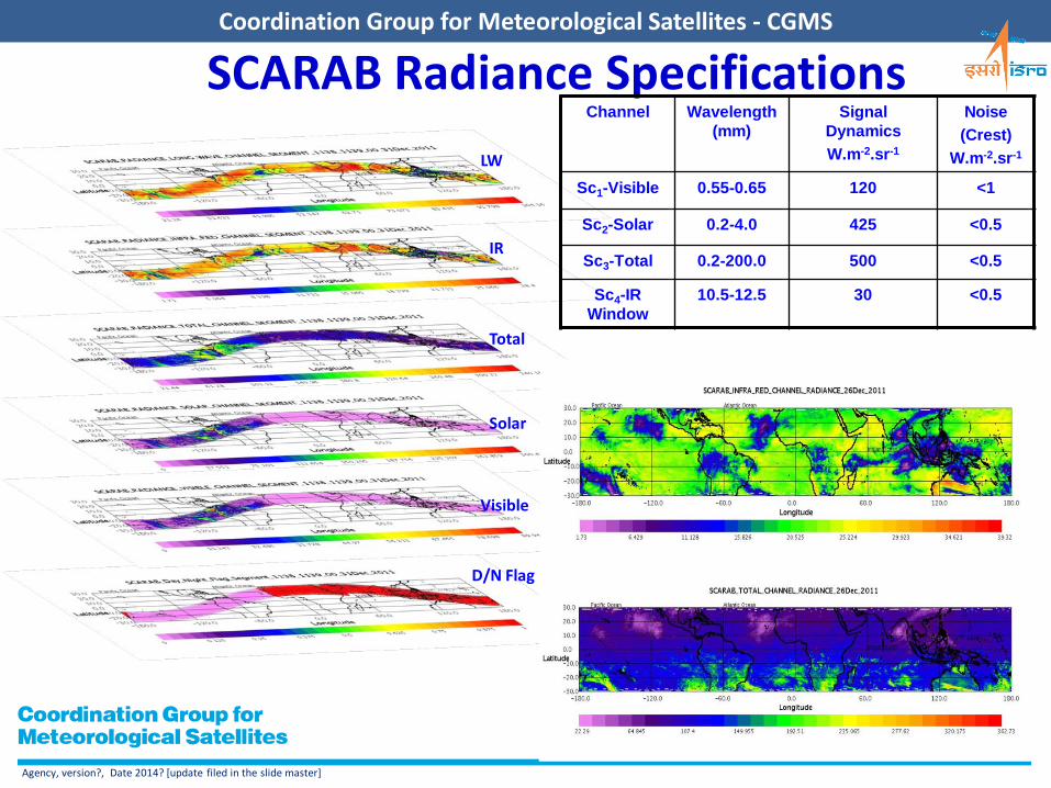
SCARAB Radiance Specifications Channel Wavelength
(mm) Signal
Dynamics W.m-2.sr-1
Noise (Crest)
W.m-2.sr-1
Sc1-Visible 0.55-0.65 120 <1
Sc2-Solar 0.2-4.0 425 <0.5
Sc3-Total 0.2-200.0 500 <0.5
Sc4-IR Window
10.5-12.5 30 <0.5
LW
IR
D/N Flag
Visible
Solar
Total

Altika/SARAL mission belongs to the global altimetry system for the precise and accurate observations of ocean topography, circulation and sea surface monitoring
SARAL: Satellite with Argos and Altimeter (2013)
Mission: • Sun-synchronous, polar orbiting
satellite
• Inclination: 98.38 Deg.
• Altitude: ~800 km
• Repeat cycle: 35 days
Altika Payload: • Ka-band (35.75 GHz, BW 500
MHz) radar altimeter
• Dual-frequency microwave radiometer (23.8 & 37 GHz)
• DORIS
• Laser Retro-reflector Array
French (CNES)- Indian (ISRO) Collaboration
SARAL/AltiKA SSHA observation overpass over Indian Ocean on Feb 28, 2013 and SLA from POM model at 0.5 degree resolution.
Agency, version?, Date 2014? [update filed in the slide master]
Coordination Group for Meteorological Satellites - CGMS
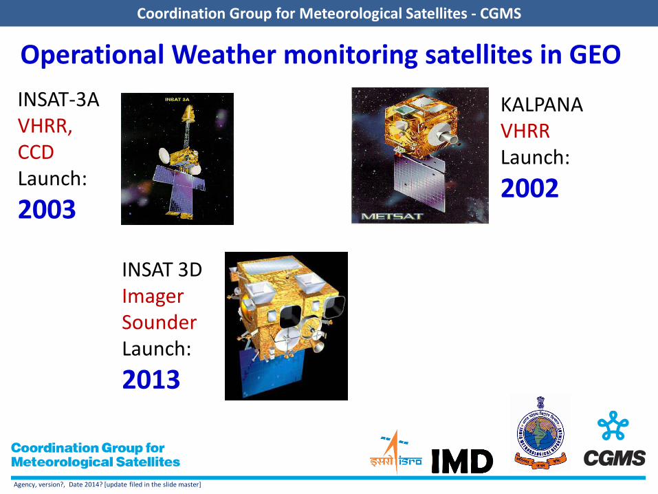
Operational Weather monitoring satellites in GEO INSAT-3A VHRR, CCD Launch: 2003
KALPANA VHRR Launch: 2002
INSAT 3D Imager Sounder Launch: 2013

INSAT-3D (2013) Follow Mission to Kalpana
Payloads:
IMAGER • Spectral Bands (6): VIS, SWIR, MWIR, WV, TIR- 1 &2
• Spatial Resolution: 1 km for VIS & SWIR 4 km for MIR & TIR 8 km for WV SOUNDER – Water Vapour & Temperature profiles • Spectral Bands (19): SWIR (6), MWIR (5), LWIR (7),
Vis (1) • Resolution (km): 10 X 10 for all bands • No of simultaneous sounding : 4 per band Data relay Transponder; Search & Rescue Payloads
Potential Applications Quantitative precipitation estimation, vertical temperature and moisture profile of
the atmosphere, surface and cloud top temperatures, ozone distribution, Sea Surface Temperature (SST), fire, smoke, fog detection, etc.

INSAT - 3DR
• Spectral Bands (µm) Visible : 0.55 - 0.75 Short Wave Infra Red : 1.55 - 1.70 Mid Wave Infra Red : 3.70 - 3.95 Water Vapour : 6.50 - 7.10 Thermal Infra Red – 1 : 10.30 - 11.30 Thermal Infra Red – 2 : 11.30 - 12.50
• Resolution : 1 km for Vis & SWIR 4 km for MIR & TIR 8 km for WV
6 Channel IMAGER
• Spectral Bands (µm) Short Wave Infra Red : Six bands Mid Wave Infra Red : Five Bands Long Wave Infra Red : Seven Bands Visible : One Band • Resolution (km) : 10 X 10 for all
bands • No of simultaneous : 4 sounding
per band
19 Channel SOUNDER
Advanced weather satellite of India configured with improved Imaging System and Atmospheric Sounder
LAUNCH: 2016

Geo Imaging Satellite (GISAT)
High resolution multi-spectral VNIR (HRMX-VNIR): 50m Resolution
Hyper spectral VNIR: 320m Resolution
Hyper spectral SWIR (HySI-SWIR): 192m Resolution
High resolution Multi-spectral (HRMX-TIR): 1.5km Resolution
• Multiple acquisition capability from a Geosynchronous Orbit
• Geostationary orbit of 36,000 km
• Every 30 minutes observation over India
LAUNCH: 2016-17
LAUNCH: 2016-17

Agency, version?, Date 2014? [update filed in the slide master]
Coordination Group for Meteorological Satellites - CGMS
GISAT-1 Payloads: 1. High resolution multi-spectral VNIR (HRMX-VNIR): Bands: B1 (0.45 mm – 0.52 mm) B2 (0.52 mm – 0.59 mm) B3 (0.62 mm – 0.68 mm) B4 (0.71 mm – 0.74 mm) B5 (0.77 mm – 0.86 mm) B6 (0.845 mm – 0.875 mm)
2. Hyper spectral VNIR: No. of Bands : 60 bands in range 0.4 mm to 0.87 mm
Resolution : 320 m 3. Hyper spectral SWIR (HyS-SWIR): No. of Bands : 150 bands in range 0.9 mm to 2.5 mm
Resolution : 192m 4. High resolution Multi-spectral (HRMX-TIR): Bands: TIR1 (7.1 mm – 7.6 mm) TIR2 (8.3 mm – 8.7 mm) TIR3 (9.4 mm – 9.8 mm) TIR4 (10.3 mm – 11.3 mm) TIR5 (11.5 mm – 12.5 mm) TIR6 (13 mm – 13.5 mm)
• Multi-spectral, multi-resolution imager
• Full or part of the earth disk from Geosynchronous orbit.
50m Res.
1.5 km Res.
Frequent Monitoring of
Coastal & Ocean Parameters

Agency, version?, Date 2014? [update filed in the slide master]
Coordination Group for Meteorological Satellites - CGMS
IMAGING MODES P/L Modes Swath in Km Resolution in m
Coarse Resolution ScanSAR (CRS)
220 50
Medium Resolution ScanSAR (MRS)
115 25
Fine Resolution Stripmap Mode (FRS-1)
25 3
Fine Resolution Stripmap Mode (FRS-2)
25 9
High Resolution ScanSAR Mode (HRS)
10 x 100 1
MISSION Particular Value Orbit Circular Polar Sun
Synchronous Orbit Altitude 536 km Orbit Inclination 97.552 degrees Orbit Period 95.49 min Number of Orbits per day 14 Repeativity 25 days Local Time of Equator Crossing
6:00 am/6:00 pm
RISAT1(2012)
• C band SAR 5.35 GHz frequency • Land, water, Ocean studies & Disaster Applications • Data is operationally available from NRSC.
Sunderban (West Bengal) as viewed by RISAT-1
Cloudy Area seen from optical sensor
Cloudy Area seen from RISAT-1
Terrain Visualization of RISAT-1

Agency, version?, Date 2014? [update filed in the slide master]
Coordination Group for Meteorological Satellites - CGMS
RESOURCESAT-2 (2011)
LISS-3 DUBAI
AWIFS LISS-4 MX
SHARJAH,UAE
Three Tier Imaging
MISSION
Spatial Resolution
5.8m (LISS-4MX) , 23.5m (LISS-3), 56 m (AWIFS)
Swath 70Km (LISS-4MX) , 141 Km (LISS-3), 740 Km (AWIFS)
Spectral Band 0.5-0.85 microns Quantization 10 / 12 bits ROLL tilt +/- 26 deg ( only for LISS -4MX) OBSSR Capacity 300 GB
Semi-major axis 7195.12 Km Altitude 817 Km Inclination 98.69 deg No of orbits per day 14 5/24 Orbit period 101.35 min Eccentricity 0.0001 Receptivity (LISS-III) 24 days Revisit (LISS-IV) 5 days Receptivity (AWIFS) 5 days Ground Track Velocity
6.65 Km/sec
Equatorial Crossing 10:30 AM ( descending )
Payload Specifications

RESOURCESAT-2A
SENSORS SPECTRAL BANDS
Ground Resolution
(meters)
Swath (km)
Radiometric Resolution
(bits)
Revisit Cycle (days)
LISS III VNIR/SWIR
B2 B3 B4 B5
23.5 141 10 24
LISS-IV MX VNIR
B2 B3 B4 5.8 70 10 24
AWiFS VNIR/SWIR
B2 B3 B4 B5
56 740 12 5
LAUNCH: 2015-16
Major Objectives
• To provide continuity of on-going services of Resourecesat-2 and ensure in-orbit redundancy of the satellite
• Increased frequency of observations in tandem with Resourecesat-2 during overlap period
• To explore newer application areas in Land and Water Resources monitoring & management

Cartosat-2 • Swath (km) : 10 • SNR : ≥ 180 • IGFOV (m) : 0 .8 • SWR (%) : ≥ 10
Cartosat-1 and 2 (2005, 2007) Cartosat-1 • 2.5 m resolution, 30 km Swath
• Stereo mission; +26° / -5° forward/ Aft view
• Revisit : 5 days • Along Track Stereo viewing - first of
its kind in the world
Cartosat-2 Data Products - Handling of unique imaging modes
o paint brush o multi-view in step and stare o spot scenes

Agency, version?, Date 2014? [update filed in the slide master]
Coordination Group for Meteorological Satellites - CGMS

Agency, version?, Date 2014? [update filed in the slide master]
Coordination Group for Meteorological Satellites - CGMS

Agency, version?, Date 2014? [update filed in the slide master]
Coordination Group for Meteorological Satellites - CGMS
SPECTRUM OF USERS
National Users
IMD
INDIAN NAVY
INDIAN AIR
FORCE
MP FOREST DEPT.
KSNDMC BARC
NCMRWF
INCOIS
EDU. INST.
CDAC
IITM

Bhuvan : ISRO’s Geo-portal
Name Description Data Availability Bhuvan 2D / 3D Allows visualization with pan, zoom, place
name search, overlays and online editing Resourcesat-1– AWiFS, LISS III & LISS IV, Cartosat 1 & 2 – PAN (merged with LISS IV), Oceansat – 1&2 - OCM
NRSC Open EO Data Archive (NEODA)
Allows download of free satellite data and products of specified period and resolution
Resourcesat-1: AWiFS Ortho and LISS III Ortho, IMS-1: HySI, CartoDEM, Oceansat-2:OCM2: NDVI(LAC, GAC), VF and Albedo, Tropical Cyclone Heat Potential, Ocean Heat Content, D 26, Wind Products.
Thematic Services To display or analyze using WMS / WMTS (OGC web Services)
Thematic Maps of 1:10,000, 1:50,000, 1:250,000 – Landuse/Landcover, Wasteland, Geomorphology, Lineament, Urban Landuse, Urban Sprawl, Erosion, Salt Affected and Water Logged Area, Water bodies.
Disaster Services To provide timely information on various disasters for better decision making
Drought, Earthquake, Flood, Forest Fire, Landslide and Cyclone.
Data Support for International Disasters.
Projects To provide platform to create, visualize, share, analyze Geospatial data products and services towards Spatial Mashups
Municipal GIS, Tourism GIS, Forestry, Irrigation, Agriculture, Urban etc
Bhuvan is a Geo-portal of ISRO (http://bhuvan.nrsc.gov.in), allowing host of services covering visualization, free data download, thematic map display and analysis, timely information on disaster and project specific GIS applications since August 2009.
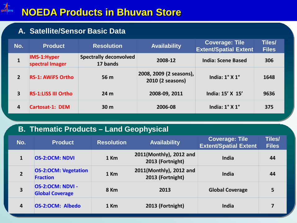
NOEDA Products in Bhuvan Store
No. Product Resolution Availability Coverage: Tile Extent/Spatial Extent
Tiles/ Files
1 IMS-1:Hyper spectral Imager
Spectrally deconvolved 17 bands 2008-12 India: Scene Based 306
2 RS-1: AWiFS Ortho 56 m 2008, 2009 (2 seasons), 2010 (2 seasons) India: 1° X 1° 1648
3 RS-1:LISS III Ortho 24 m 2008-09, 2011 India: 15’ X 15’ 9636
4 Cartosat-1: DEM 30 m 2006-08 India: 1° X 1° 375
A. Satellite/Sensor Basic Data
No. Product Resolution Availability Coverage: Tile Extent/Spatial Extent
Tiles/ Files
1 OS-2:OCM: NDVI 1 Km 2011(Monthly), 2012 and 2013 (Fortnight) India 44
2 OS-2:OCM: Vegetation Fraction 1 Km 2011(Monthly), 2012 and
2013 (Fortnight) India 44
3 OS-2:OCM: NDVI - Global Coverage 8 Km 2013 Global Coverage 5
4 OS-2:OCM: Albedo 1 Km 2013 (Fortnight) India 7
B. Thematic Products – Land Geophysical

NOEDA Climate Products in Bhuvan Store
No. Product Resolution Availability Coverage: Tile Extent/Spatial Extent
Tiles/ Files
1 Tropical Cyclone Heat Potential 0.25° Jan 1998 – till date North Indian Ocean
(30S – 30N; 30-120E ) ~6000
2 Ocean Heat Content 0.25° Jan 2002 – till date North Indian Ocean (30S – 30N; 30-120E ) ~4400
3 Depth of 26°C Isotherm 0.5° x 0.5° July 2013 – till date 30° S - 30° N; 30° E - 120° E ~200
C. Ocean – geophysical
No. Product Resolution Availability Coverage: Tile Extent/Spatial Extent
Tiles/ Files
1 Ocean Wind Stress 0.5° x 0.5° Jan. 2012 – Mar’14 30° S- 30° N; 30° E- 120° E ~800
2 Ocean Wind Stress Curl 0.5° x 0.5° Jan. 2012 – Mar’14 30° S- 30° N; 30° E- 120° E ~800
3 Ocean Wind Velocity 0.5° x 0.5° Jan. 2012 – Mar’14 30° S - 30° N; 30° E- 120° E ~800
D. Ocean – wind

Oceanic Heat Content Products
Ocean Heat Content at 700m Layer (OHC700) – important climatic parameter required for atmospheric and oceanic studies like cyclone and monsoon prediction and ocean heat transport estimations.
It is predicted (a) SSHA from altimeters, b) SST from TRMM-TMI, and (c) the climatological values of OHC700 derived from temperature profiles of World Ocean Atlas 2009.
The prediction model is similar one of ANN Daily 0.25 degree OHC700 available since January 2002
to present (one week delay) in png image format
Tropical cyclone heat potential (TCHP) – a measure of energy available for cyclones by summing the heat content in ocean water where SST is above 26 deg.
It is predicted with input parameters (a) sea surface height anomaly (SSHA) from Aviso altimeters, b) sea surface temperature (SST) from TRMM Microwave Imager (TMI) & (c) the climatological values of the depth of the 26°C isotherm (D26) derived from temperature profiles of World Ocean Atlas 2009.
Daily 0.25 degree TCHP and 0.5 deg. D26 available since January 1998 to present (one week delay) in png format

Oceanic Wind Products
Stress Curl:
• Daily and Two days wind composites generated from OSCAT over Indian Ocean using Data Interpolation Variational Analysis (DIVA) Methodology developed in collaboration with INCOIS and RC-E.
• Validated with in-situ buoys (r=0.81) and ASCAT Winds • Wind velocity, stress and curl products are provided in a
0.5 deg x 0.5 deg grid and made available in ‘png’ and netcdf formats. Reprocessing of these products @25km in progress
Wind Products
Wind stress • Horizontal force of the wind or wind stress is
calculated from OSCAT wind speed and non-linear drag coefficient .
• Zonal (E-W) /Meridional (N-S) stress products are estimated with angular components of wind vector and combined to release the total wind stress
• Curl - a measure of rotation of ocean surface circulation and computed from the zonal and meridional components with numerical differentiation method.

Terrestrial Vegetation Products
OCM LAC Vegetation products : Advantages of Wide swath of 1420 km, High revisit cycle of 2 days and high radiometric resolution (12 bits per pixel) prompted to attempt land geophysical products from OCM sensor.
Salient features: orthorectification, atmospheric and view angle correction, maximum value compositing (MVC) to minimize cloud masking the land cover
15-day or Fortnightly composite of NDVI and vegetation fraction products are generated and validated with MODIS vegetation products.
The products are released at 1 km resolution in tiff from 2011 onwards.
OCM GAC NDVI products are monthly (4-cycle MVC) at 8 km resolution
Vegetation Fraction - Nov’13 Global NDVI - Oct’13 CC=0.92 R2 = 0.86

Agency, version?, Date 2014? [update filed in the slide master]
Coordination Group for Meteorological Satellites - CGMS
ISRO Cal Val Activities - Overview • Establishing an Indian Cal-Val Program - by
setting up instrumented CAL sites for theme-oriented ISRO missions.
• Collaborating with WGCV teams for Inter-Sensor Calibration with contemporary sensors over CEOS specified global calibration sites.
29

Joint Calibration Exercise: RS2 AWIFS & MODIS Cross Calibration over Libya-4 CEOS Site
Bands TERRA - Bias CE-95 Limits Std. Dev. (%)
AWIFS B2 MODIS B4 1.014 0.967 – 1.06 8.552
AWIFS B3 MODIS B1 1.027 0.994 – 1.06 6.095
AWIFS B4 MODIS B2 1.045 1.020 – 1.069 4.513
AWIFS B5 MODIS B6 1.096 1.061 – 1.130 6.302
Bands AQUA - Bias CE-95 Limits Std. Dev. (%)
AWIFS B2 MODIS B4 1.012 0.962 – 1.061 9.076
AWIFS B3 MODIS B1 1.024 0.992 – 1.056 5.871
AWIFS B4 MODIS B2 1.045 1.016 – 1.074 5.347
AWIFS B5 MODIS B6 - - -
• Cross calibration was based on 14 AWIFS acquired during June 2011 – Dec. 2012 and corresponding day data of MODIS
• BRDF, Spectral Mismatch, Water Vapor effects are compensated to obtain Radiometric Bias* between two sensors
TOAAWIFS
TOAMODISBias
ρρ
=*
Results: 1) Biases for AWIFS B2, B3
within 2% while ~4.5% for B4
2) Bias is about 9.6% for AWIFS B5
3) Std. Dev. is higher; further acquisitions /long term analysis in progress.
Collaboration with MODIS (NASA) – FP: Jack Xiong

Joint Calibration Exercise: LISS4 Calibration Exercise over CEOS Geometric Sites (Sioux Falls, Pueblo)
• Statistics generated were from 560 and 670 control points. • Control points from a high resolution, high accuracy (<60cm) aerial imagery.
In Progress:
• Radiometric Calibration with L7/L8 over CEOS sites
• Geometric calibration to be repeated for consistency
Collaboration with USGS – FP: Greg Stensaas
Parameter Red (B3) – Green (B2) Line (AL) Pixel (AX)
Min -0.24 -0.32 Mean 0.00 0.00 Max 0.25 0.32
RMSE 0.12 0.16
Parameter Near IR (B4) – Red (B3) Line (AL) Pixel (AX)
Min -0.34 -0.28 Mean -0.02 -0.03 Max 0.30 0.22
RMSE 0.17 0.13
Parameter Location Error pixels (in m) Line (AL) Pixel (AX)
Min 0.75 4.3 Mean 28 19.7 Max 55.4 35.1
Std.Dev. 14 7.9 RMSE 31.3 21.2
Band Misregistration Error (Specs: ± 0.3 p RMSE)
Location Inaccuracy Specs: < 200m RMSE

RISAT-1 Calibration Exercise at Gunning (Canberra, Australia)
CR Type
CR No. CR Size (m)
Mesh 1,6,10 1.5
Powder 4,9,12 1.5
Metal
(7,11,15) (5,8,16)
(3,13,17) (2,14,18)
1.0 1.5 2.0 2.5
18 Triangular Trihedrals installed at Location ~ (149.20 Lat/-34.8 Long)
Joint Calibration Exercise - with Passive Corner Reflectors Image Acquisition planned between Dec13 and Mar14
Installation completed by 20DEC13 RISAT-1 Imaging and Processing in progress
CR Array Lay-out Map
Collaboration with Geoscience, Australia – FP: Medhavy

Agency, version?, Date 2014? [update filed in the slide master]
Coordination Group for Meteorological Satellites - CGMS
EARTH OBSERVATION MISSIONS
Y E A R
2002
2018
Mega Tropiques (2011)
SARAL(2012) RISAT-1 (2012)
IRS-P6 (2003)
Oceansat-2(2009)
INSAT-3D (2013)
Kalpana-1 (2002) INSAT-3A (2003)
Catro-1(2005)
Carto-2 (2007) IMS-1(2008)
Resourcesat-2(2011)
Res-2A Carto-2C SCATSAT-1
INSAT-3DR, S GISAT-1
RISAT-1A
INDIAN EO
MISSION TIMELINE