Embed Size (px)
Citation preview
55 MOUNTAIN STREET BROADWAY NSW ~ PO BOX 438 BROADWAY NSW 2007 ~ TELEPHONE [02] 9211 4099 FAX [02] 9211 2740 EMAIL: [email protected] ~ WEB SITE: www.bbcplanners.com.au
ABN 24 061 868 942
STATEMENT OF ENVIRONMENTAL EFFECTS TO ACCOMPANY A
DEVELOPMENT APPLICATION FOR THE DEMOLITION OF EXISTING STRUCTURES, EXCAVATION AND OTHER PREPARATORY SITE WORKS AND CONSTRUCTION OF A
MULTI-DWELLING HOUSING DEVELOPMENT COMPRISING 28 DWELLINGS ABOVE
BASEMENT CARPARKING, LANDSCAPING, DRAINAGE AND RELATED WORKS
No’s. 14-26 TELOPEA AVENUE, HOMEBUSH WEST
VOLUME 1
Prepared for Omaya Holdings
by
BBC Consulting Planners
Job No. 15-265
SEE - Final February 2017
Table of Contents
1. INTRODUCTION .............................................................................................. 1
1.1 Overview ........................................................................................................... 1
1.2 Project Objectives ........................................................................................... 1
1.3 Purpose of this Statement of Environmental Effects ................................... 2
1.4 Pre-DA Lodgement Consultation ................................................................... 2
2. THE SITE .......................................................................................................... 3
2.1 Location ............................................................................................................ 3
2.2 Real Property Description and Ownership .................................................... 3
2.3 Area and Frontages ......................................................................................... 3
2.4 Existing Improvements ................................................................................... 3
2.5 Existing Vegetation ......................................................................................... 3
2.6 Drainage Channel ............................................................................................ 4
2.7 Access .............................................................................................................. 4
2.8 Public Transport Services .............................................................................. 4
2.9 Contamination .................................................................................................. 4
2.10 Subsurface Conditions ................................................................................... 4
2.11 Topography ...................................................................................................... 4
2.12 Utilities .............................................................................................................. 5
2.13 Heritage ............................................................................................................ 5
3. SURROUNDING AREA .................................................................................... 6
3.1 General Observations ..................................................................................... 6
3.2 To the North ..................................................................................................... 6
3.3 To the East ....................................................................................................... 6
3.4 To the South ..................................................................................................... 6
3.5 To the West ...................................................................................................... 7
4. THE PROPOSAL .............................................................................................. 8
4.1 Overview ........................................................................................................... 8
4.2 Plans ................................................................................................................. 8
4.3 Demolition ........................................................................................................ 8
4.4 New dwellings .................................................................................................. 8
4.5 Height ................................................................................................................ 9
4.6 Gross Floor Area / Floor Space Ratio ............................................................ 9
4.7 Setbacks ......................................................................................................... 10 4.7.1 Front Setback – (primary) (north/south component of Telopea
Avenue) ........................................................................................................... 11 4.7.2 Front Setback – (secondary) (east/west component of Telopea
Avenue) ........................................................................................................... 11 4.7.3 Side Setback – (northern) ............................................................................... 11 4.7.4 Rear Setback – (eastern) ................................................................................ 11
4.8 Landscaping ................................................................................................... 11
4.9 Tree Removal ................................................................................................. 11
4.10 Stormwater Management .............................................................................. 11
4.11 Access and Parking ....................................................................................... 11 4.11.1 Vehicular Access ............................................................................................. 11 4.11.2 Parking ............................................................................................................ 12
4.12 BCA Compliance ............................................................................................ 12
4.13 Accessibility / Adaptable Dwellings ............................................................. 12
4.14 BASIX .............................................................................................................. 12
4.15 Waste Management ....................................................................................... 12
5. PLANNING CONTROLS ................................................................................ 14
5.1 State Environmental Planning Policy No. 55 – Remediation of Land ................................................................................................................ 14
5.2 State Environmental Planning Policy (Infrastructure) 2007 ...................... 15 5.2.1 Impact of road noise or vibration on non-road development (Clause
102) ................................................................................................................. 15 5.2.2 Traffic-Generating Development (Clause 104) ............................................... 16
5.3 State Environmental Planning Policy (Building Sustainability Index: BASIX) 2004 ........................................................................................ 17
5.4 Strathfield Local Environmental Plan 2012 ................................................. 17 5.4.1 Zoning and Permissibility ................................................................................ 17 5.4.2 Zone Objectives .............................................................................................. 17 5.4.3 Permissibility ................................................................................................... 18 5.4.4 Development controls ..................................................................................... 18
5.5 Strathfield Consolidated Development Control Plan (SDCP) 2005 ........... 24 5.5.1 Part C - Multiple-Unit Housing ........................................................................ 24 5.5.2 Part I – ‘Provision of Off-Street Parking’ ......................................................... 44 5.5.3 Part H – ‘Waste Management’ ........................................................................ 44 5.5.4 Part N – ‘Water Sensitive Urban Design’ ........................................................ 44
5.6 Development Control Plan No. 20 – Parramatta Road Corridor ................ 44 5.6.1 Introduction ..................................................................................................... 44 5.6.2 Objectives ....................................................................................................... 45
5.6.3 Relationship to Strathfield Consolidated Development Control Plan 2005 ................................................................................................................ 45
6. ASSESSMENT OF ENVIRONMENTAL EFFECTS ........................................ 46
6.1 Statutory Planning Considerations .............................................................. 46
6.2 Section 79C(1)(a) – Statutory Planning Considerations ............................ 46
6.3 Section 79C(b) – Environmental, Social and Economic Impacts .............. 47 6.3.1 Impacts on the natural environment ................................................................ 47 6.3.2 Impacts on the built environment .................................................................... 47 6.3.3 Social and economic impacts ......................................................................... 49
6.4 Section 79C(c) – The suitability of the site .................................................. 49
6.5 Section 79C(d) – Submissions ..................................................................... 50
6.6 Section 79C(e) – Public interest ................................................................... 50
6.7 Section 79C(3A) – Development Control Plans .......................................... 50
7. CONCLUSION ................................................................................................ 52
FIGURES Figure 1: Location
Figure 2: Site
Figure 3A: Aerial Photograph – Detail
Figure 3B: Aerial Photo – Wider Area
Figure 4A: Zoning Map – Strathfield LEP 2012
Figure 4B: Height of Buildings Map – Strathfield LEP 2012
Figure 4C: FSR Map – Strathfield LEP 2012
Figure 4D: Acid Sulfate Soils Map - Strathfield LEP 2012
Figure 4E: Lot Size Map – Strathfield LEP 2012
Figure 5: Homebush West – Courallie Avenue Precinct Map – Part C Consolidated DCP
Figure 5A: Parramatta Road Corridor Area Map – Strathfield DCP (No. 20) 2005
Figure 5B: Parramatta Road Corridor Masterplan Map - Strathfield DCP (No. 20) 2005
Figure 5C: Parramatta Road Corridor Masterplan Close Up Map - Strathfield DCP (No. 20) 2005
Figure 5D: Parramatta Road Corridor Built Form Masterplan Map - Strathfield DCP (No. 20) 2005
Figure 5E: Parramatta Road Corridor Consolidation Masterplan Map - Strathfield DCP (No. 20) 2005
Figure 6A: Recommended land use zones map (Homebush) - Parramatta Road Corridor - Planning and Design Guidelines - November 2016
Figure 6B: Recommended maximum building heights map (Homebush) - Parramatta Road Corridor - Planning and Design Guidelines - November 2016
Figure 6C: Preferred Floor Space Ratios (FSR) map (Homebush) - Parramatta Road Corridor - Planning and Design Guidelines - November 2016
APPENDICES
Volume 2 comprises all of the A3 plans
Appendix 1A: Certificate of Title and Deposited Plan
Appendix 1B: Survey Plan, prepared by Strata Surv (see Volume 2)
Appendix 2: Architectural Plans prepared by Squillace Architects (see Volume 2)
Appendix 3: Landscape Plans, prepared by Conzept Landscape Architects (see Volume 2)
Appendix 4: Arborist Report, prepared by Redgum
Appendix 5A: Flood Study prepared by Envirotech
Appendix 5B: Civil Plans prepared by ACOR Consultants Pty Ltd (see Volume 2)
Appendix 5C: Stormwater Management Plan prepared by ACOR Consultants
Appendix 6A: Preliminary Site Investigation prepared by Aargus
Appendix 6B: Geotechnical Investigation Report prepared by Morrow Geotechnics Pty Ltd
Appendix 7: Assessment of Traffic and Parking Implications, prepared by Transport and Traffic Planning Associates
Appendix 8A: BCA Report, prepared by Blackett Maguire + Goldsmith
Appendix 8B: Access Review, prepared by Morris Goding Access Consultants
Appendix 9: Acoustic Report, prepared by Acouras Consultancy
Appendix 10: BASIX Certificate
Appendix 11A:Waste Management Plan prepared by Wastech Services Pty Ltd
Appendix 11B: Construction/Demolition Waste Management Plan prepared by Squillace Architects
Appendix 12: Clause 4.6 Variation Requests in relation to Building Height and FSR
J:\2015\15-265\Reports\SEE - Final.doc Page 1
1. INTRODUCTION
1.1 Overview
This Statement of Environmental Effects (“SEE”) has been prepared by BBC Consulting Planners on behalf of Omaya Holdings (“the Applicant”) to accompany a Development Application (“DA”) lodged pursuant to Section 78A of the Environmental Planning and Assessment Act 1979 (“the Act”), for demolition of existing buildings and related structures, selective removal of trees, services diversions, excavation, other preparatory site works (including any remediation as required) and the erection of a multi dwelling housing development comprising 28 townhouse style dwellings above basement carparking, as well as landscaping, drainage and related works (“the proposal”) at Nos. 14-26 Telopea Avenue, Homebush West (“the site”).
The proposal has been formulated having full and proper regard to relevant development controls and to the environmental qualities of the site and its surroundings.
The proposal is highly consistent with the planning intent of Strathfield LEP 2012. In this regard, the site is zoned “R3 Medium Density Residential” in which “multi dwelling housing” is permissible with consent. The objectives of the R3 zone are as follows:-
“To provide for the housing needs of the community within a medium density residential environment.
To provide a variety of housing types within a medium density residential environment.
To enable other land uses that provide facilities or services to meet the day to day needs of residents.”
The proposal is entirely consistent with above objectives.
The proposal is also compatible with, and cognisant of, development on surrounding land which is also within the R3 Medium Density Residential zone. However, it is noted that the land to the north of the site has been recommended, as part of the Urban Growth NSW Parramatta Road Corridor Urban Transformation Strategy, to be rezoned to “B6 Enterprise Corridor” with a maximum building height of 17 metres and an FSR of 1.5:1.
The proposal will result in additional high quality, well-designed new medium density housing stock in a range of dwelling sizes and configurations to maximize housing choice. It has full and proper regard for the constraints and opportunities of the site and for the amenity of neighbouring development.
1.2 Project Objectives
The project objectives are as follows:-
J:\2015\15-265\Reports\SEE - Final.doc Page 2
to transform the existing commercially/industrially used site into a new, high-quality, well-designed, medium density residential development;
to provide high quality and high amenity residential accommodation; and
to exhibit excellence in design.
1.3 Purpose of this Statement of Environmental Effects
The purpose of this SEE is to:-
describe the site to which the DA relates;
describe the characteristics of the surrounding locality;
describe the proposal;
define the statutory planning framework within which the DA is to be assessed and determined; and
assess the proposal in light of all relevant heads of consideration listed in Section 79C of the Act.
1.4 Pre-DA Lodgement Consultation
Representatives of the Applicant have met with Council planning officers in the process of formulating the DA. Pre-DA advice was issued to the Applicant on 7 October 2016. Wherever possible and practicable, issues raised and advice provided by Council planning officers has been addressed and integrated into the DA package.
J:\2015\15-265\Reports\SEE - Final.doc Page 3
2. THE SITE
2.1 Location
The site is located on the eastern side of Telopea Avenue, which is an “L” shaped road which runs between Parramatta Road and Courallie Avenue at Homebush West. The site is located on the north-eastern bend of the road (see Figure 1).
2.2 Real Property Description and Ownership
The site comprises Lots 110 to 116 in Deposited Plan 11427 (see Figure 2).
All seven lots are owned by:-
Alen Michael Hanson;
John Robert Meagher; and
Angelic Pty Ltd.
Certificates of Title and Deposited Plans for all seven lots are provided in Appendix 1A.
2.3 Area and Frontages
The site is irregular in shape and has a total area of 4,017m². It has a western frontage of approximately 120.045m to Telopea Avenue and a southern frontage of 33.18 metres to Telopea Avenue (see Figure 2).
A detailed survey plan, prepared by Strata Surv, is provided in Appendix 1B.
2.4 Existing Improvements
The existing buildings on the site (see Appendix 1B and Figure 3A) comprise single and two storey brick buildings which are collectively known as “The Quality Centre” and which are occupied by a range of around 11 separate businesses/tenants.
The part of the site not occupied by buildings are generally used for parking, loading/ unloading and vehicle manoeuvring.
2.5 Existing Vegetation
Existing vegetation is predominately located on the western portion of the site.
An arborist’s report is provided in Appendix 4.
J:\2015\15-265\Reports\SEE - Final.doc Page 4
2.6 Drainage Channel
A drainage channel is located adjacent to the eastern boundary of the site. It is subject to flooding. Council’s pre-DA notes state:-
“Council’s records indicate that the subject site is affected by the 1 in 2 year flood event. The floor level at the upstream and downstream boundaries of the property are RL 10.05m AHD and RL 9.35m AHD.”
The pre-DA notes advise the Applicant to engage a qualified civil engineer with experience in flooding to prepare a flood impact report.
A flood report is provided in Appendix 5A.
2.7 Access
Three kerb crossings into the site exist along the western site frontage to Telopea Avenue and one kerb crossing exists along the southern site frontage to Telopea Avenue.
Footpaths are located on both sides of Telopea Avenue, however, there is no footpath directly adjoining the site.
2.8 Public Transport Services
The site is located approximately 700 metres north-west of Flemington Railway Station, which is on the T2 Inner West and South Line. Comprehensive bus services run along Parramatta Road.
2.9 Contamination
A preliminary site investigation has been prepared by Aargus (see Appendix 6A).
2.10 Subsurface Conditions
A geotechnical investigation report is provided in Appendix 6B. The report examines the excavation conditions including methodology and monitoring, subgrade preparation and earthworks, suitable foundation and founding levels, allowable bearing capacity and shaft adhesion for piles, retaining wall and shoring design parameters and preliminary comments on potential impacts of construction on the adjacent developments and the adjacent drainage canal.
2.11 Topography
The site is relatively flat with only a 1.0m fall from north to south.
J:\2015\15-265\Reports\SEE - Final.doc Page 5
2.12 Utilities
Electricity, telephone, water and sewage services are all available to the site. These services will be adapted/extended and/or expanded, where necessary, to meet the demands of the proposal.
2.13 Heritage
The site does not contain any heritage listed item and is not located in a heritage conservation area. The nearest heritage listed item is well-removed at 350–374 Parramatta Road, which is listed as the “Former Ford factory building (brick facade)”.
J:\2015\15-265\Reports\SEE - Final.doc Page 6
3. SURROUNDING AREA
3.1 General Observations
As shown on the aerial photo in Figure 3A, the locality which surrounds the subject site has a mixed character with a range of land uses including low and medium density residential, light industrial and commercial as well as local and major roads.
However, that part of the general locality to the north of the site will undergo a substantial transition, reflected in and promoted by the recent Parramatta Road Corridor - Urban Transformation Strategy 2016, which was released by Urban Growth on 9 November 2016 and which is discussed in detail in Section 1.5 of the SEE.
The wider locality is shown on the aerial photo in Figure 3B. It illustrates the “Parramatta Road Corridor”, the proximity of Olympic Park to north (which provides a wide range of sporting/recreational opportunities), as well as Flemington Markets to the east, the M4 to the north and east and the large industrial estate/business park to the west (Campus Homebush Business Park). The business park is separated from the dwellings on the western side of Telopea Avenue by an acoustic wall which is approximately 5 metres high.
3.2 To the North
To the north of the site are Nos. 6-12 Telopea Avenue and 344 Parramatta Road, which currently comprise single detached dwellings (Nos. 6 – 12 Telopea Avenue) and a used car yard (No. 344 Parramatta Road). As outlined above, the land immediately to the north of the site has recently been recommended by Urban Growth to be rezoned to B6 Enterprise Corridor with a recommended maximum building height of 17 metres and an FSR of 1.5:1.
3.3 To the East
A stormwater channel is located directly to the east of the site. Beyond the drainage channel to the east/north-east of the site are detached dwellings (Nos. 3-31 Courallie Avenue) and a mechanical workshop (No. 338-342 Parramatta Road).
3.4 To the South
To the south of the site, on the opposite side of Telopea Avenue, is a multi-dwelling housing development comprising 10 dwellings (Nos. 41-45 Telopea Avenue).
To the south-west of the site, on the opposite corner of the dog-leg in Telopea Avenue, is a recently completed part 2/part 3 storey multi-unit housing development, in the form of two separate buildings containing 40 dwellings with basement parking for 65 cars (Nos. 23-39 Telopea Avenue). It has a maximum height (as approved) of around 10.3m.
J:\2015\15-265\Reports\SEE - Final.doc Page 7
3.5 To the West
To the west/north-west of the site, to the north of Nos. 23-29 Telopea Avenue, are detached dwellings (Nos. 3-21 Telopea Avenue). Nos. 3-11 Telopea Avenue are recommended to be rezoned B6 Enterprise Corridor with a recommended maximum building height of 17 metres and an FSR of 1.5:1.
J:\2015\15-265\Reports\SEE - Final.doc Page 8
4. THE PROPOSAL
4.1 Overview
The DA seeks consent for the demolition of existing structures, selective removal of trees, services diversions, excavation, preparatory site works (including any remediation, as required) and the erection of a multi-dwelling housing development comprising 28 dwellings above basement carparking, as well as landscaping, drainage and all required related works.
4.2 Plans
Reduced (A3) copies of the architectural plans prepared by Squillace Architects, including a photomontage, demolition plan, shadow diagrams and 3D views are provided in Appendix 2.
Reduced (A3) copies of the landscape drawings prepared by Conzept Landscape Architects are contained in Appendix 3.
Reduced (A3) copies of the stormwater management plans prepared by ACOR Consultants Pty Ltd, are contained in Appendix 5B.
4.3 Demolition
All existing structures on site are to be demolished as part of the proposal.
All demolition work will be carried out in accordance with AS2601-2001-The Demolition of Structures.
A demolition plan is included in the reduced copies of the architectural plans prepared by Squillace Architects, provided in Appendix 2.
4.4 New dwellings
The proposal comprises 28 new townhouse type dwellings of which:-
5 will contain 2 bedrooms, plus study;
19 will contain 3 bedrooms; and
4 will contain 3 bedrooms plus study.
Every dwelling will have a garden ranging in area between 42-143sqm.
Dwelling areas vary from between 78sqm and 87sqm for the 2 bedroom dwellings, to between 104sqm and 140sqm for the 3 bedroom dwellings.
Every dwelling will address the street.
J:\2015\15-265\Reports\SEE - Final.doc Page 9
Each dwelling will be able to be accessed directly from the street frontage.
The ground floor level of each dwelling has been set above the relevant flood level (plus freeboard) as identified in the flood study in Appendix 5A. The resultant ground floor levels are as follows:
Dwellings 1-4 RL 9.45m
Dwellings 5-12 RL 9.7m
Dwellings 13-19 RL 9.45m
Dwellings 20-26 RL 9.00m
Dwellings 27-28 RL 8.70m
4.5 Height
Pursuant to Strathfield LEP 2012 “building height (or height of building) means:-
“building height (or height of building) means:
(a) in relation to the height of a building in metres – the vertical distance from ground level (existing) to the highest point of the building, or
(b) in relation to the RL of a building – the vertical distance from the Australian Height Datum to the highest point of the building,
including plant and lift overruns, but excluding communication devices, antennae, satellite dishes, masts, flagpoles, chimneys, flues and the like.”
All but 5 of the proposed dwellings each comprise a 2-storey streetfront presentation with a recessed 3-storey element. The former is well within the 9.5m height limit whilst in certain cases the latter exceeds that limit to varying degrees but only by up to 0.95m (This is the maximum exceedance measured at one point only. Other exceedances are less than 0.95m. The 0.95m exceedance occurs at the top of a dividing wall between 2 townhouses. The adjacent roof is 0.8m over the 9.5m height limit).
A written request for a variation of the maximum standard of 9.5m (prepared pursuant to clause 4.6 of SLEP 2012) is provided in Appendix 12).
Dwellings No’s 5, 13, 20, 27 and 28 contain only two storeys.
4.6 Gross Floor Area / Floor Space Ratio
Pursuant to Strathfield LEP 2012, “gross floor area” is defined as:-
“the sum of the floor area of each floor of a building measured from the internal face of external walls, or from the internal face of walls separating the
J:\2015\15-265\Reports\SEE - Final.doc Page 10
building from any other building, measured at a height of 1.4 metres above the floor, and includes:
(a) the area of a mezzanine, and
(b) habitable rooms in a basement or an attic, and
(c) any shop, auditorium, cinema, and the like, in a basement or attic,
but excludes:
(d) any area for common vertical circulation, such as lifts and stairs, and
(e) any basement:
(i) storage, and
(ii) vehicular access, loading areas, garbage and services, and
(f) plant rooms, lift towers and other areas used exclusively for mechanical services or ducting, and
(g) car parking to meet any requirements of the consent authority (including access to that car parking), and
(h) any space used for the loading or unloading of goods (including access to it), and
(i) terraces and balconies with outer walls less than 1.4 metres high, and
(j) voids above a floor at the level of a storey or storey above.”
The proposal, based on the above definition, has a GFA of 2,872m² which equates to a Floor Space Ratio of 0.715:1 on a site area of 4,017m2.
This requires a minor variation of the maximum FSR limit of 0.65:1 for the site as prescribed by Clause 4.4 of SLEP 2012.
A written request for a variation of the maximum FSR standard of 0.65:1 (prepared pursuant to Clause 4.6 of SLEP 2012) is provided in Appendix 12.
4.7 Setbacks
Setback dimensions are identified on the DA drawings prepared by Squillace Architects in Appendix 2 and can be summarised as follows:-
J:\2015\15-265\Reports\SEE - Final.doc Page 11
4.7.1 Front Setback – (primary) (north/south component of Telopea Avenue)
Dwellings 6-12. 14-19, 21-26: 6.0m (min).
Dwellings 13 and 20: 8.0m (min).
Dwellings 27 and 28: 7.0m (min).
4.7.2 Front Setback – (secondary) (east/west component of Telopea Avenue)
Dwellings 1-5: 4.0m.
4.7.3 Side Setback – (northern)
Dwelling 28: 4.0m – 4.5m.
4.7.4 Rear Setback – (eastern)
Variable: 8.0m (Dwelling 20) – 16.0m (Dwelling 6).
4.8 Landscaping
The DA is accompanied by detailed Landscape Plans (see Appendix 3A) prepared by Conzept Landscape Architects. A landscape report is provided in Appendix 3B.
4.9 Tree Removal
An Arborist Report is provided in Appendix 4.
The proposal involves the removal of 10 existing trees, 4 of which are recommended for removal independently of the proposed development.
4.10 Stormwater Management
Civil/Stormwater drawings are provided in Appendix 5B.
4.11 Access and Parking
4.11.1 Vehicular Access
Vehicular access to/from the carpark will be provided by a combined 5.8m wide ingress/egress driveway from the site’s southern frontage to Telopea Avenue.
J:\2015\15-265\Reports\SEE - Final.doc Page 12
4.11.2 Parking
The proposal provides 61 basement spaces. Of these, 54 will be for residents and 6 will be for visitors and one will function as a car wash bay.
4.12 BCA Compliance
A BCA Report has been prepared (see Appendix 8A).
The report concludes that (subject to consideration of the various matters set out in the report) the proposal can readily achieve compliance with the relevant provisions of the BCA with any further design changes being of a nature that will not result in the need to modify the development consent.
4.13 Accessibility / Adaptable Dwellings
An access review has been undertaken by Morris Goding Access Consultants (see Appendix 8B).
The report finds that:-
“In general, the development has accessible paths of travel that are continuous throughout. In line with the report recommendations, the proposed development has demonstrated an appropriate degree of accessibility. The Development Application drawings indicate that compliance with statutory requirements, pertaining to the site access, common area access, and accommodation can be readily achieved.”
As outlined in the access review, a total of 4 adaptable dwellings have been provided within the development. The access review makes recommendations which have either been incorporated into the architectural plans or will be included in the more detailed construction certificate drawings.
4.14 BASIX
A BASIX Certificate is provided in Appendix 10.
Stamped ABSA drawings are submitted under separate cover.
4.15 Waste Management
A Waste Management Plan is provided in Appendix 11A.
All waste generated during demolition and construction of the proposal will be appropriately managed and minimised by recycling and disposing of material at an appropriate waste

J:\2015\15-265\Reports\SEE - Final.doc Page 13
facility. A construction/demolition management waste management plan is provided in Appendix 11B.
J:\2015\15-265\Reports\SEE - Final.doc Page 14
5. PLANNING CONTROLS
5.1 State Environmental Planning Policy No. 55 – Remediation of Land
The objectives of State Environmental Planning Policy No. 55 - Remediation of Land (“SEPP 55”) include:-
“….to provide for a Statewide planning approach to the remediation of contaminated land”.
“….to promote the remediation of contaminated land for the purpose of reducing the risk of harm to human health or any other aspect of the environment:
(a) by specifying when consent is required, and when it is not required, for a remediation work, and
(b) by specifying certain considerations that are relevant in rezoning land and in determining development applications in general and development applications for consent to carry out a remediation work in particular, and
(c) by requiring that a remediation work meet certain standards and notification requirements.”
SEPP 55 provides that a consent authority must not consent to the carrying out of development on land unless it has considered whether the land is contaminated and if the land is contaminated it is satisfied that the land is (or will be suitable after remediation) for the purpose which it is proposed to be carried out. Furthermore, SEPP 55 requires that a consent authority must consider a report specifying the findings of a preliminary investigation of the land concerned, carried out in accordance with the contaminated land planning guidelines before determining an application for consent to carry out development that would involve a change of use of that land.
A Preliminary Site Investigation has been undertaken (see Appendix 6A). The Executive Summary of the report states:-
“The findings of this preliminary assessment indicated the following areas of potential environmental concern, those being: the potential importation of uncontrolled fill, previous and current site uses, an underground storage tank, car parking areas, chemical storage areas, asbestos fragment in garden bed area in western boundary, current and previous use of pesticides, metal degradation and asbestos based building materials.
J:\2015\15-265\Reports\SEE - Final.doc Page 15
The contaminants that may be present in some of these areas were considered to be of low to moderate significance in terms of risk to the human and environmental receptors identified.
Therefore, a Detailed Site Investigation (DSI) is required to confirm the presence and extent of contamination in order to determine the suitability of the site for the proposed development application and to address the data gaps identified.
Based on the information collected during this investigation and in reference to Clause 7 (DA development of SEPP 55), the site will be suitable subject to the completion of a Detailed Site Investigation (and after remediation and validation, if required) for the proposed residential development.”
5.2 State Environmental Planning Policy (Infrastructure) 2007
5.2.1 Impact of road noise or vibration on non-road development (Clause 102)
Clause 102 of the above SEPP states:-
“(1) This clause applies to development for any of the following purposes that is on land in or adjacent to the road corridor for a freeway, a tollway or a transitway or any other road with an annual average daily traffic volume of more than 40,000 vehicles (based on the traffic volume data published on the website of the RTA) and that the consent authority considers is likely to be adversely affected by road noise or vibration:
(a) a building for residential use,
(b) a place of public worship,
(c) a hospital,
(d) an educational establishment or child care centre.
(2) Before determining a development application for development to which this clause applies, the consent authority must take into consideration any guidelines that are issued by the Director-General for the purposes of this clause and published in the Gazette.
(3) If the development is for the purposes of a building for residential use, the consent authority must not grant consent to the development unless it is satisfied that appropriate measures will be taken to ensure that the following LAeq levels are not exceeded:
(a) in any bedroom in the building—35 dB(A) at any time between 10 pm and 7 am,
J:\2015\15-265\Reports\SEE - Final.doc Page 16
(b) anywhere else in the building (other than a garage, kitchen, bathroom or hallway)—40 dB(A) at any time.
(4) In this clause, freeway, tollway and transitway have the same meanings as they have in the Roads Act 1993.”
Nevertheless, an acoustic report (which includes measurements of traffic noise) is provided in Appendix 9.
5.2.2 Traffic-Generating Development (Clause 104)
Clause 104 of the Infrastructure SEPP states as follows in relation to traffic-generating development:-
“(1) This clause applies to development specified in Column 1 of the Table to Schedule 3 that involves:
(a) new premises of the relevant size or capacity, or
(b) an enlargement or extension of existing premises, being an alteration or addition of the relevant size or capacity.
(2) In this clause, relevant size or capacity means:
(a) in relation to development on a site that has direct vehicular or pedestrian access to any road—the size or capacity specified opposite that development in Column 2 of the Table to Schedule 3, or
(b) in relation to development on a site that has direct vehicular or pedestrian access to a classified road or to a road that connects to a classified road where the access (measured along the alignment of the connecting road) is within 90m of the connection—the size or capacity specified opposite that development in Column 3 of the Table to Schedule 3.”
Schedule 3 – Traffic-generating development to be referred to the RTA
Column 1 Purpose of development
Column 2 Size or capacity—site with access to any road
Column 3 Size or capacity—site with access to classified road or to road that connects to classified road (if access within 90m of connection, measured along alignment of connecting road)
Apartment or residential flat building
300 or more dwellings
75 or more dwellings

J:\2015\15-265\Reports\SEE - Final.doc Page 17
Area used exclusively for parking or any other development having ancillary parking accommodation
200 or more motor vehicles
50 or more motor vehicles
Although the proposal provides for more than 50 parking spaces, the proposed basement access to the site is more than 90 metres from Parramatta Road. Accordingly, a referral to the RMS pursuant to the Infrastructure SEPP will not be required.
5.3 State Environmental Planning Policy (Building Sustainability Index: BASIX) 2004
State Environmental Planning Policy (Building Sustainability Index) 2004 applies to development applications for new residential dwellings.
A BASIX certificate for the proposed development is provided in Appendix 10.
The ABSA stamped plans are provided under separate cover.
5.4 Strathfield Local Environmental Plan 2012
5.4.1 Zoning and Permissibility
The site is zoned “R3 Medium Density Residential” pursuant to Strathfield Local Environmental Plan 2012 (“SLEP”)(see Figure 4A).
5.4.2 Zone Objectives
The objectives of the “R3 Medium Density Residential” zone are as follows:-
“• To provide for the housing needs of the community within a medium density residential environment.
• To provide a variety of housing types within a medium density residential environment.
• To enable other land uses that provide facilities or services to meet the day to day needs of residents.”
The proposal is consistent with the above (relevant) objectives in that:-
it will provide for the housing needs of the community in a medium density environment which is compatible with the other medium density developments in the locality; and
it will add to the variety of housing types within a medium density environment.
J:\2015\15-265\Reports\SEE - Final.doc Page 18
5.4.3 Permissibility
“Multi dwelling housing” is permissible in the R3 Medium Density Residential zone and is defined in SLEP 2012 to mean:-
“3 or more dwellings (whether attached or detached) on one lot of land, each with access at ground level, but does not include a residential flat building.
Note. Multi dwelling housing is a type of residential accommodation—see the definition of that term in this Dictionary.”
The proposal, which results in the consolidation of the seven existing lots into one lot is for the erection of 28 dwellings on the consolidated site, each with access at ground level.
The proposal is permissible with consent.
5.4.4 Development controls
5.4.4.1 Minimum lot sizes for multi dwelling housing (Clause 4.1A)
Clause 4.1A of SLEP 2012 states (our emphasis):-
“(1) The objective of this clause is to achieve planned residential density in certain zones.
(2) Development consent may be granted to development on a lot in a zone shown in Column 2 of the Table to this clause for a purpose shown in Column 1 of the Table opposite that zone, only if the area of the lot is equal to or greater than the area specified for that purpose and shown opposite in Column 3 of the Table.
Column 1 Column 2 Column 3
Dual occupancy Zone R3 Medium Density Residential 560 square metres
Multi dwelling housing Zone R3 Medium Density Residential or Zone R4 High Density Residential
1,000 square metres
Residential flat building Zone R3 Medium Density Residential, Zone R4 High Density Residential, Zone B2 Local Centre, Zone B3 Commercial Core or Zone B4 Mixed Use
1,000 square metres
The site has an area of 4,017m² which complies with the relevant requirement of Clause 4.1A.
J:\2015\15-265\Reports\SEE - Final.doc Page 19
5.4.4.2 Height (Clause 4.3)
Pursuant to Clause 4.3 of SLEP 2012, the maximum building height for the site is 9.5 metres. “Building Height” is defined to mean:-
“(a) in relation to the height of a building in metres—the vertical distance from ground level (existing) to the highest point of the building, or
(b) in relation to the RL of a building—the vertical distance from the Australian Height Datum to the highest point of the building,
including plant and lift overruns, but excluding communication devices, antennae, satellite dishes, masts, flagpoles, chimneys, flues and the like.”
As shown on the set of DA drawings in Appendix 2, the proposal has a maximum building height of approximately 10.45m.
The LEP height control on the site was recently modified from 12 metres to 9.5 metres, with the amending SLEP 2012 (Amendment No 9) being published on 18 November 2016 (see Figure 4B).
The minor non-compliance with the 9.5m height control is the subject of the clause 4.6 variation request in Appendix 12.
5.4.4.3 Floor Space Ratio (FSR) (Clause 4.4)
Pursuant to Clause 4.4 of SLEP 2012, the maximum Floor Space Ratio (FSR) for the site is 0.65:1 (see Figure 4C).
The proposal, based on the relevant definition of GFA in SLEP 2012, has a GFA of 2,872m² which equates to a Floor Space Ratio of 0.715:1 on a site with an area of 4,017m2.
This non-compliance with the 0.65:1 FSR limit is also the subject of the clause 4.6 variation request in Appendix 12.
5.4.4.4 Exceptions to development standards (Clause 4.6)
Clause 4.6 of SLEP 2012 (as relevant) states:-
“(3) Development consent must not be granted for development that contravenes a development standard unless the consent authority has considered a written request from the applicant that seeks to justify the contravention of the development standard by demonstrating:
(a) that compliance with the development standard is unreasonable or unnecessary in the circumstances of the case, and
(b) that there are sufficient environmental planning grounds to justify contravening the development standard.
J:\2015\15-265\Reports\SEE - Final.doc Page 20
(4) Development consent must not be granted for development that contravenes a development standard unless:
(a) the consent authority is satisfied that:
(i) the applicant’s written request has adequately addressed the matters required to be demonstrated by subclause (3), and
(ii) the proposed development will be in the public interest because it is consistent with the objectives of the particular standard and the objectives for development within the zone in which the development is proposed to be carried out, and
(b) the concurrence of the Secretary has been obtained.
…
(8) This clause does not allow development consent to be granted for development that would contravene any of the following:
(a) a development standard for complying development,
(b) a development standard that arises, under the regulations under the Act, in connection with a commitment set out in a BASIX certificate for a building to which State Environmental Planning Policy (Building Sustainability Index: BASIX) 2004 applies or for the land on which such a building is situated,
(c) clause 5.4.”
A Clause 4.6 variation request in relation to the proposed non-compliance with the height and FSR standard in clauses 4.3 and 4.4 of SLEP 2012, is provided in Appendix 12.
5.4.4.5 Preservation of trees or vegetation (Clause 5.9)
Clause 5.9(3) of SLEP 2012 states:-
“A person must not ringbark, cut down, top, lop, remove, injure or wilfully destroy any tree or other vegetation to which any such development control plan applies without the authority conferred by:
(a) development consent, or
(b) a permit granted by the Council.”
Consent is sought for the removal of 10 trees.
An Arborist’s Report is provided in Appendix 4.
J:\2015\15-265\Reports\SEE - Final.doc Page 21
5.4.4.6 Acid Sulfate Soils (Clause 6.1)
The site is within an area classified as Class 5 acid sulfate soils under SLEP 2012 (see Figure 4D).
Clause 6.1 of SLEP 2012 states (as relevant):-
“(2) Development consent is required for the carrying out of works described in the Table to this subclause on land shown on the Acid Sulfate Soils Map as being of the class specified for those works.
...
5 Works within 500 metres of adjacent Class 1, 2, 3 or 4 land that is below 5 metres Australian Height Datum and by which the watertable is likely to be lowered below 1 metre Australian Height Datum on adjacent Class 1, 2, 3 or 4 land.
(3) Development consent must not be granted under this clause for the carrying out of works unless an acid sulfate soils management plan has been prepared for the proposed works in accordance with the Acid Sulfate Soils Manual and has been provided to the consent authority.
(4) Despite subclause (2), development consent is not required under this clause for the carrying out of works if:
(a) a preliminary assessment of the proposed works prepared in accordance with the Acid Sulfate Soils Manual indicates that an acid sulfate soils management plan is not required for the works, and
(b) the preliminary assessment has been provided to the consent authority and the consent authority has confirmed the assessment by notice in writing to the person proposing to carry out the works.
(5) Despite subclause (2), development consent is not required under this clause for the carrying out of any of the following works by a public authority (including ancillary work such as excavation, construction of access ways or the supply of power):
(a) emergency work, being the repair or replacement of the works of the public authority, required to be carried out urgently because the works have been damaged, have ceased to function or pose a risk to the environment or to public health and safety,
(b) routine maintenance work, being the periodic inspection, cleaning, repair or replacement of the works of the public authority (other than work that involves the disturbance of more than 1 tonne of soil),
(c) minor work, being work that costs less than $20,000 (other than drainage work).
J:\2015\15-265\Reports\SEE - Final.doc Page 22
(6) Despite subclause (2), development consent is not required under this clause to carry out any works if:
(a) the works involve the disturbance of less than 1 tonne of soil, and
(b) the works are not likely to lower the watertable.”
The proposal does not involve works within 500 metres of adjacent Class 1, 2, 3 or 4 land that is below 5 metres AHD and by which the watertable is likely to be lowered below 1 metre AHD on adjacent Class 1, 2, 3 or 4 land.
5.4.4.7 Earthworks (Clause 6.2)
Clause 6.2(3) of SLEP 2012 states:-
“(3) Before granting development consent for earthworks (or for development involving ancillary earthworks), the consent authority must consider the following matters:
(a) the likely disruption of, or any detrimental effect on, drainage patterns and soil stability in the locality of the development,
(b) the effect of the development on the likely future use or redevelopment of the land,
(c) the quality of the fill or the soil to be excavated, or both,
(d) the effect of the development on the existing and likely amenity of adjoining properties,
(e) the source of any fill material and the destination of any excavated material,
(f) the likelihood of disturbing relics,
(g) the proximity to, and potential for adverse impacts on, any waterway, drinking water catchment or environmentally sensitive area,
(h) any appropriate measures proposed to avoid, minimise or mitigate the impacts of the development.”
A geotechnical investigation report is provided in Appendix 6B which examines the excavation conditions including methodology and monitoring, subgrade preparation and earthworks, suitable foundation and founding levels, allowable bearing capacity and shaft adhesion for piles, retaining wall and shoring design parameters and provides preliminary comments on potential impacts of construction on adjacent development including the drainage channel.
5.4.4.8 Flood Planning (Clause 6.3)
Clause 6.3 of SLEP 2012 states:-

J:\2015\15-265\Reports\SEE - Final.doc Page 23
“(1) The objectives of this clause are as follows:
(a) to minimise the flood risk to life and property associated with the use of land,
(b) to allow development on land that is compatible with the land’s flood hazard, taking into account projected changes as a result of climate change,
(c) to avoid significant adverse impacts on flood behaviour and the environment.
(2) This clause applies to land at or below the flood planning level.
(3) Development consent must not be granted to development on land to which this clause applies unless the consent authority is satisfied that the development:
(a) is compatible with the flood hazard of the land, and
(b) is not likely to significantly adversely affect flood behaviour resulting in detrimental increases in the potential flood affectation of other development or properties, and
(c) incorporates appropriate measures to manage risk to life from flood, and
(d) is not likely to significantly adversely affect the environment or cause avoidable erosion, siltation, destruction of riparian vegetation or a reduction in the stability of river banks or watercourses, and
(e) is not likely to result in unsustainable social and economic costs to the community as a consequence of flooding.
(4) A word or expression used in this clause has the same meaning as it has in the Floodplain Development Manual (ISBN 0 7347 5476 0) published by the NSW Government in April 2005, unless it is otherwise defined in this clause.
(5) In this clause:
flood planning level means the level of a 1:100 ARI (average recurrent interval) flood event plus 0.5 metre freeboard.”
The site is subject to periodic flooding associated with the associated drainage channel. In this regard, a flood study has been prepared in support of the DA (see Appendix 5A). The findings of the flood study – notably the recommended finished ground floor levels – have been incorporated into the design.
J:\2015\15-265\Reports\SEE - Final.doc Page 24
5.4.4.9 Essential Services (Clause 6.4)
Electricity, telephone, water and sewage services are all available to the site. These services will be adapted/extended and/or expanded, where necessary, to meet the demands of the proposal.
5.5 Strathfield Consolidated Development Control Plan (SDCP) 2005
5.5.1 Part C - Multiple-Unit Housing
The table, overleaf, outlines the proposal’s compliance with the relevant provisions of Part C of SDCP 2005.
J:\2015\15-265\Reports\SEE - Final.doc Page 25
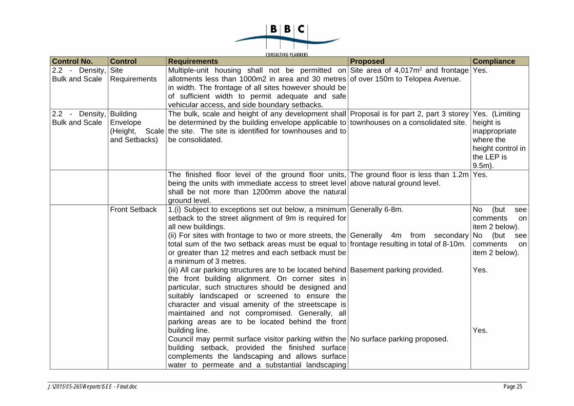
Control No. Control Requirements Proposed Compliance 2.2 - Density, Bulk and Scale
Site Requirements
Multiple-unit housing shall not be permitted on allotments less than 1000m2 in area and 30 metres in width. The frontage of all sites however should be of sufficient width to permit adequate and safe vehicular access, and side boundary setbacks.
Site area of 4,017m2 and frontage of over 150m to Telopea Avenue.
Yes.
2.2 - Density, Bulk and Scale
Building Envelope (Height, Scale and Setbacks)
The bulk, scale and height of any development shall be determined by the building envelope applicable to the site. The site is identified for townhouses and to be consolidated.
Proposal is for part 2, part 3 storey townhouses on a consolidated site.
Yes. (Limiting height is inappropriate where the height control in the LEP is 9.5m).
The finished floor level of the ground floor units, being the units with immediate access to street level shall be not more than 1200mm above the natural ground level.
The ground floor is less than 1.2m above natural ground level.
Yes.
Front Setback 1.(i) Subject to exceptions set out below, a minimum setback to the street alignment of 9m is required for all new buildings. (ii) For sites with frontage to two or more streets, the total sum of the two setback areas must be equal to or greater than 12 metres and each setback must be a minimum of 3 metres. (iii) All car parking structures are to be located behind the front building alignment. On corner sites in particular, such structures should be designed and suitably landscaped or screened to ensure the character and visual amenity of the streetscape is maintained and not compromised. Generally, all parking areas are to be located behind the front building line. Council may permit surface visitor parking within the building setback, provided the finished surface complements the landscaping and allows surface water to permeate and a substantial landscaping
Generally 6-8m. Generally 4m from secondary frontage resulting in total of 8-10m. Basement parking provided. No surface parking proposed.
No (but see comments on item 2 below). No (but see comments on item 2 below). Yes. Yes.
J:\2015\15-265\Reports\SEE - Final.doc Page 26
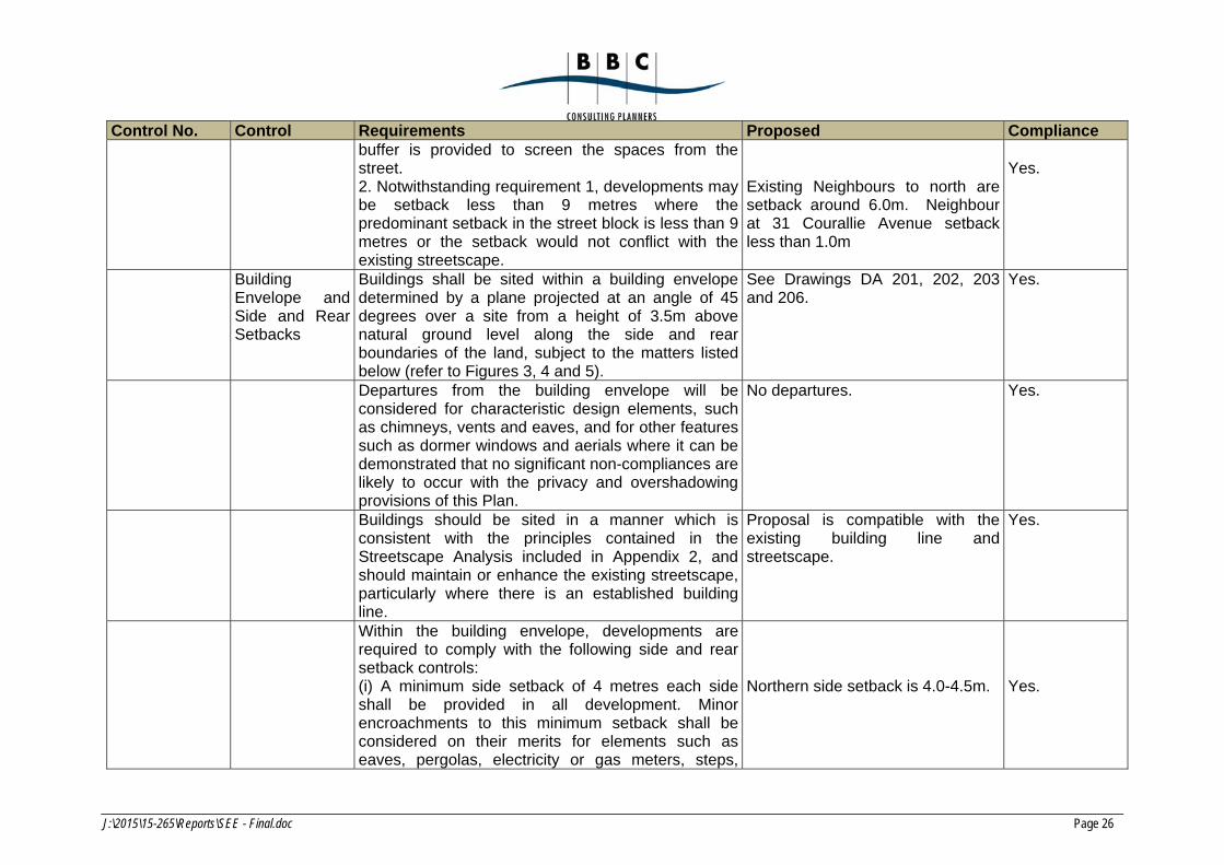
Control No. Control Requirements Proposed Compliance buffer is provided to screen the spaces from the street. 2. Notwithstanding requirement 1, developments may be setback less than 9 metres where the predominant setback in the street block is less than 9 metres or the setback would not conflict with the existing streetscape.
Existing Neighbours to north are setback around 6.0m. Neighbour at 31 Courallie Avenue setback less than 1.0m
Yes.
Building Envelope and Side and Rear Setbacks
Buildings shall be sited within a building envelope determined by a plane projected at an angle of 45 degrees over a site from a height of 3.5m above natural ground level along the side and rear boundaries of the land, subject to the matters listed below (refer to Figures 3, 4 and 5).
See Drawings DA 201, 202, 203 and 206.
Yes.
Departures from the building envelope will be considered for characteristic design elements, such as chimneys, vents and eaves, and for other features such as dormer windows and aerials where it can be demonstrated that no significant non-compliances are likely to occur with the privacy and overshadowing provisions of this Plan.
No departures. Yes.
Buildings should be sited in a manner which is consistent with the principles contained in the Streetscape Analysis included in Appendix 2, and should maintain or enhance the existing streetscape, particularly where there is an established building line.
Proposal is compatible with the existing building line and streetscape.
Yes.
Within the building envelope, developments are required to comply with the following side and rear setback controls: (i) A minimum side setback of 4 metres each side shall be provided in all development. Minor encroachments to this minimum setback shall be considered on their merits for elements such as eaves, pergolas, electricity or gas meters, steps,
Northern side setback is 4.0-4.5m.
Yes.
J:\2015\15-265\Reports\SEE - Final.doc Page 27
Control No. Control Requirements Proposed Compliance ramps or the like. (ii) Side and rear setbacks for buildings containing 2 or more storeys shall be determined by the building envelope, and the ability of the development to comply with Solar Access and Privacy requirements as set out in sections 2.3 and 2.6 of this Plan. Encroachments to the building envelope and setback controls will be considered on sites with frontage to a public place (including road or open space area), and will be determined on their merits. (iii) Exceptions to the side and rear setback controls will also be considered for sites with frontage to a major noise source, such as an arterial road or the railway line. The extent and nature of variations will be determined on the merits of the case.
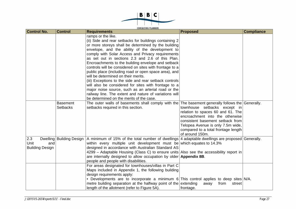
Basement Setbacks
The outer walls of basements shall comply with the setbacks required in this section.
The basement generally follows the townhouse setbacks except in relation to spaces 60 and 61. The encroachment into the otherwise consistent basement setback from Telopea Avenue is only 7.5m wide, compared to a total frontage length of around 150m.
Generally.
2.3 Dwelling Unit and Building Design
Building Design A minimum of 15% of the total number of dwellings within every multiple unit development must be designed in accordance with Australian Standard AS 4299 – Adaptable Housing (Class C) to ensure units are internally designed to allow occupation by older people and people with disabilities.
4 adaptable dwellings are proposed which equates to 14.3% Also see the accessibility report in Appendix 8B.
Generally.
For areas designated for townhouses/villas in Part C Maps included in Appendix 1, the following building design requirements apply: • Developments are to incorporate a minimum 6 metre building separation at the halfway point of the length of the allotment (refer to Figure 5A).
This control applies to deep sites extending away from street frontage.
N/A.
J:\2015\15-265\Reports\SEE - Final.doc Page 28
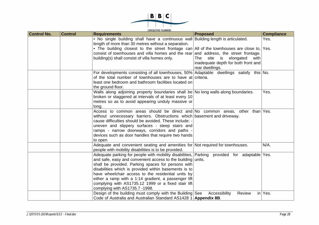
Control No. Control Requirements Proposed Compliance • No single building shall have a continuous wall length of more than 30 metres without a separation. • The building closest to the street frontage can consist of townhouses and villa homes and the rear building(s) shall consist of villa homes only.
Building length is articulated. All of the townhouses are close to, and address, the street frontage.The site is elongated with inadequate depth for both front and rear dwellings.
Yes. Yes.
For developments consisting of all townhouses, 50% of the total number of townhouses are to have at least one bedroom and bathroom facilities located on the ground floor.
Adaptable dwellings satisfy this criteria.
No.
Walls along adjoining property boundaries shall be broken or staggered at intervals of at least every 10 metres so as to avoid appearing unduly massive or long.
No long walls along boundaries. Yes.
Access to common areas should be direct and without unnecessary barriers. Obstructions which cause difficulties should be avoided. These include: -uneven and slippery surfaces - steep stairs and ramps - narrow doorways, corridors and paths -devices such as door handles that require two hands to open
No common areas, other than basement and driveway.
Yes.
Adequate and convenient seating and amenities for people with mobility disabilities is to be provided.
Not required for townhouses. N/A.
Adequate parking for people with mobility disabilities, and safe, easy and convenient access to the building shall be provided. Parking spaces for persons with disabilities which is provided within basements is to have wheelchair access to the residential units by either a ramp with a 1:14 gradient, a passenger lift complying with AS1735.12 1999 or a fixed stair lift complying with AS1735.7 -1998.
Parking provided for adaptable units.
Yes.
Design of the building must comply with the Building Code of Australia and Australian Standard AS1428 1
See Accessibility Review in Appendix 8B.
Yes.
J:\2015\15-265\Reports\SEE - Final.doc Page 29
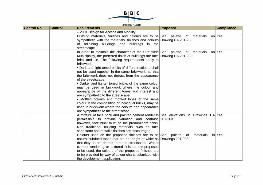
Control No. Control Requirements Proposed Compliance – 2001 Design for Access and Mobility.
Building materials, finishes and colours are to be sympathetic with the materials, finishes and colours of adjoining buildings and buildings in the streetscape.
See palette of materials on Drawing DA 201-203.
Yes.
In order to maintain the character of the Strathfield Municipality, the preferred finish of buildings are face brick and tile. The following requirements apply to brickwork: • Dark and light toned bricks of different colours shall not be used together in the same brickwork, so that the brickwork does not detract from the appearance of the streetscape. • Darker and lighter toned bricks of the same colour may be used in brickwork where the colour and appearance of the different tones add interest and are sympathetic to the streetscape. • Mottled colours and mottled tones of the same colour in the composition of individual bricks, may be used in brickwork where the colours and appearance are sympathetic to the streetscape.
See palette of materials on Drawing DA 201-203.
Yes.
A mixture of face brick and painted cement render is permissible to provide variation and contrast, however, face brick must be the predominant finish. Non traditional building materials such as fake sandstone and metallic finishes are discouraged.
See elevations in Drawings DA 201-203.
Yes.
Colours used on the proposed finishes are to be natural/subdued tones that are not bright or white so that they do not detract from the streetscape. Where cement rendering or textured finishes are proposed to be used, the colours of the proposed finishes are to be provided by way of colour charts submitted with the development application.
See palette of materials in Drawings 201-203.
Yes.
J:\2015\15-265\Reports\SEE - Final.doc Page 30
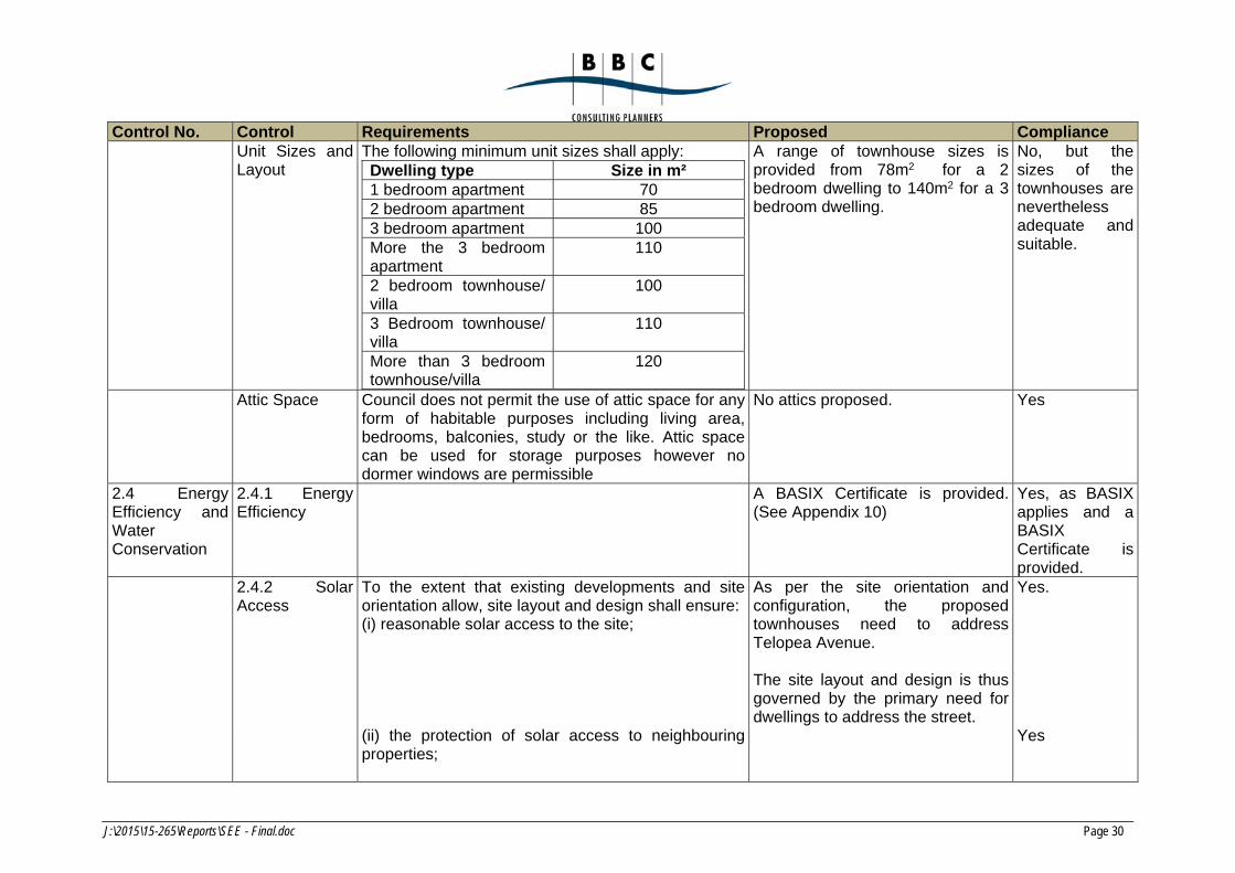
Control No. Control Requirements Proposed Compliance Unit Sizes and
Layout The following minimum unit sizes shall apply: Dwelling type Size in m² 1 bedroom apartment 70 2 bedroom apartment 85 3 bedroom apartment 100 More the 3 bedroom apartment
110
2 bedroom townhouse/ villa
100
3 Bedroom townhouse/ villa
110
More than 3 bedroom townhouse/villa
120
A range of townhouse sizes is provided from 78m2 for a 2 bedroom dwelling to 140m2 for a 3 bedroom dwelling.
No, but the sizes of the townhouses are nevertheless adequate and suitable.
Attic Space Council does not permit the use of attic space for any form of habitable purposes including living area, bedrooms, balconies, study or the like. Attic space can be used for storage purposes however no dormer windows are permissible
No attics proposed. Yes
2.4 Energy Efficiency and Water Conservation
2.4.1 Energy Efficiency
A BASIX Certificate is provided.(See Appendix 10)
Yes, as BASIX applies and a BASIX Certificate is provided.
2.4.2 Solar Access
To the extent that existing developments and site orientation allow, site layout and design shall ensure: (i) reasonable solar access to the site;
As per the site orientation and configuration, the proposed townhouses need to address Telopea Avenue. The site layout and design is thus governed by the primary need for dwellings to address the street.
Yes.
(ii) the protection of solar access to neighbouring properties;
Yes
J:\2015\15-265\Reports\SEE - Final.doc Page 31
Control No. Control Requirements Proposed Compliance (iii) buildings to maximise the benefits of solar access
in terms of reducing winter heat loss and the impact of summer afternoon sun (refer to Figures 6 and 7);
See Drawings DA 431 and 432 which shows solar access in mid-winter to the proposed dwellings.
Yes
(iv) adequate natural light to the living areas of dwellings for normal domestic duties; and
See Drawings DA 401 and 402 for evidence of minimal shadow impact on neighbours
Yes
(v) orientation to the north, with priority in dwelling layout being given to living areas and bedrooms (refer to Figure 8).
See above
Residential buildings are to be designed to maximise solar access to living areas and private open space. The following guidelines indicate the preferred levels of solar access for new developments, and any departures from these standards will require justification that resulting energy efficiency and solar access is acceptable:
(i) the main living areas and at least 50 percent of the principal private open space of each dwelling shall have at least three hours of sunlight between the hours of 9am and 3pm on June 22 (winter solstice); and
See Drawings DA 431, 432 and 450.
Yes
(ii) solar access to the windows of habitable rooms and to the majority of private open space of adjoining properties must be substantially maintained or achieved for a minimum period of 3 hours between 9.00am and 3.00pm at the winter solstice (June 22).
See Drawings DA 401 and 402 Yes
Solar access to existing neighbouring solar collectors including solar hot water systems and photovoltaic systems must be maintained or enhanced.
No impact Yes
Shadow diagrams are required to accompany all applications, and are to include:
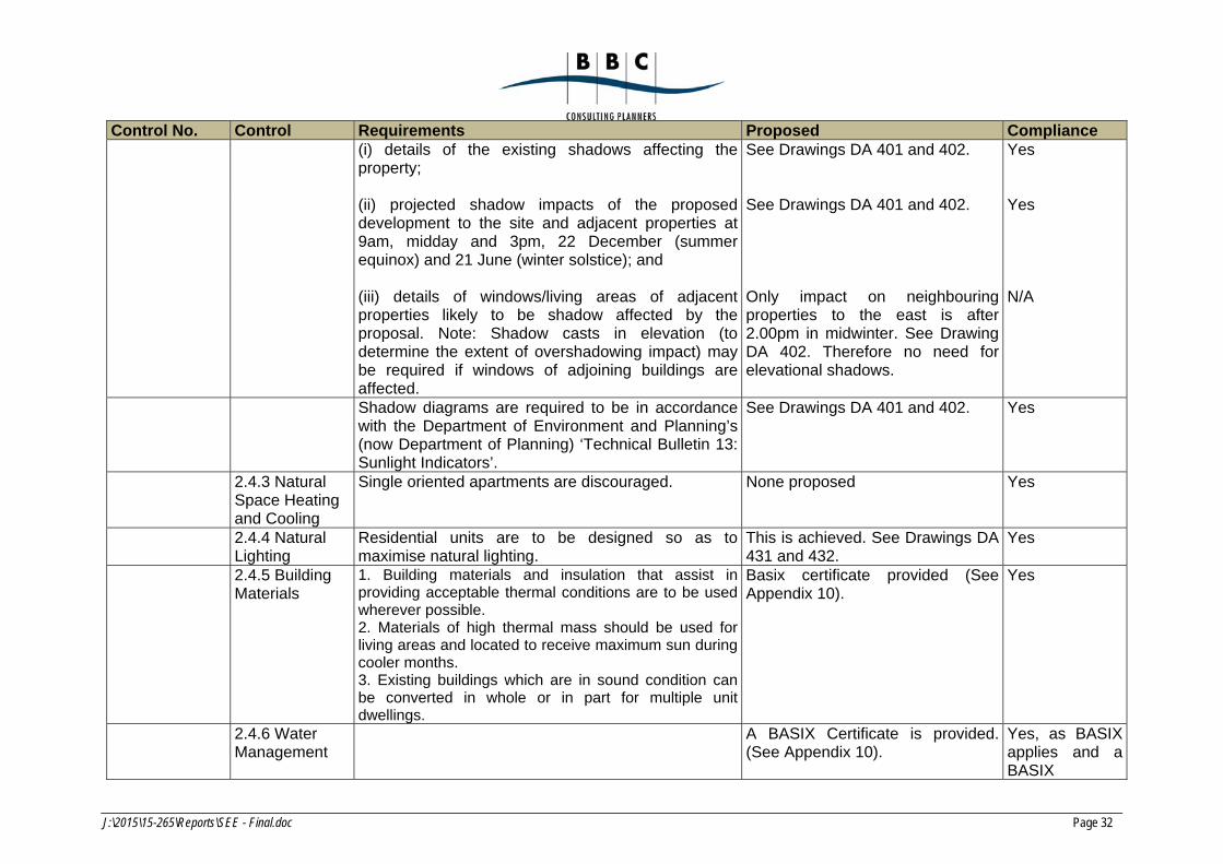
J:\2015\15-265\Reports\SEE - Final.doc Page 32
Control No. Control Requirements Proposed Compliance (i) details of the existing shadows affecting the
property;
See Drawings DA 401 and 402. Yes
(ii) projected shadow impacts of the proposed development to the site and adjacent properties at 9am, midday and 3pm, 22 December (summer equinox) and 21 June (winter solstice); and
See Drawings DA 401 and 402. Yes
(iii) details of windows/living areas of adjacent properties likely to be shadow affected by the proposal. Note: Shadow casts in elevation (to determine the extent of overshadowing impact) may be required if windows of adjoining buildings are affected.
Only impact on neighbouring properties to the east is after 2.00pm in midwinter. See Drawing DA 402. Therefore no need for elevational shadows.
N/A
Shadow diagrams are required to be in accordance with the Department of Environment and Planning’s (now Department of Planning) ‘Technical Bulletin 13: Sunlight Indicators’.
See Drawings DA 401 and 402. Yes
2.4.3 Natural Space Heating and Cooling
Single oriented apartments are discouraged. None proposed Yes
2.4.4 Natural Lighting
Residential units are to be designed so as to maximise natural lighting.
This is achieved. See Drawings DA 431 and 432.
Yes
2.4.5 Building Materials
1. Building materials and insulation that assist inproviding acceptable thermal conditions are to be used wherever possible. 2. Materials of high thermal mass should be used for living areas and located to receive maximum sun during cooler months. 3. Existing buildings which are in sound condition can be converted in whole or in part for multiple unit dwellings.
Basix certificate provided (See Appendix 10).
Yes
2.4.6 Water Management
A BASIX Certificate is provided.(See Appendix 10).
Yes, as BASIX applies and a BASIX
J:\2015\15-265\Reports\SEE - Final.doc Page 33
Control No. Control Requirements Proposed Compliance Certificate is provided.
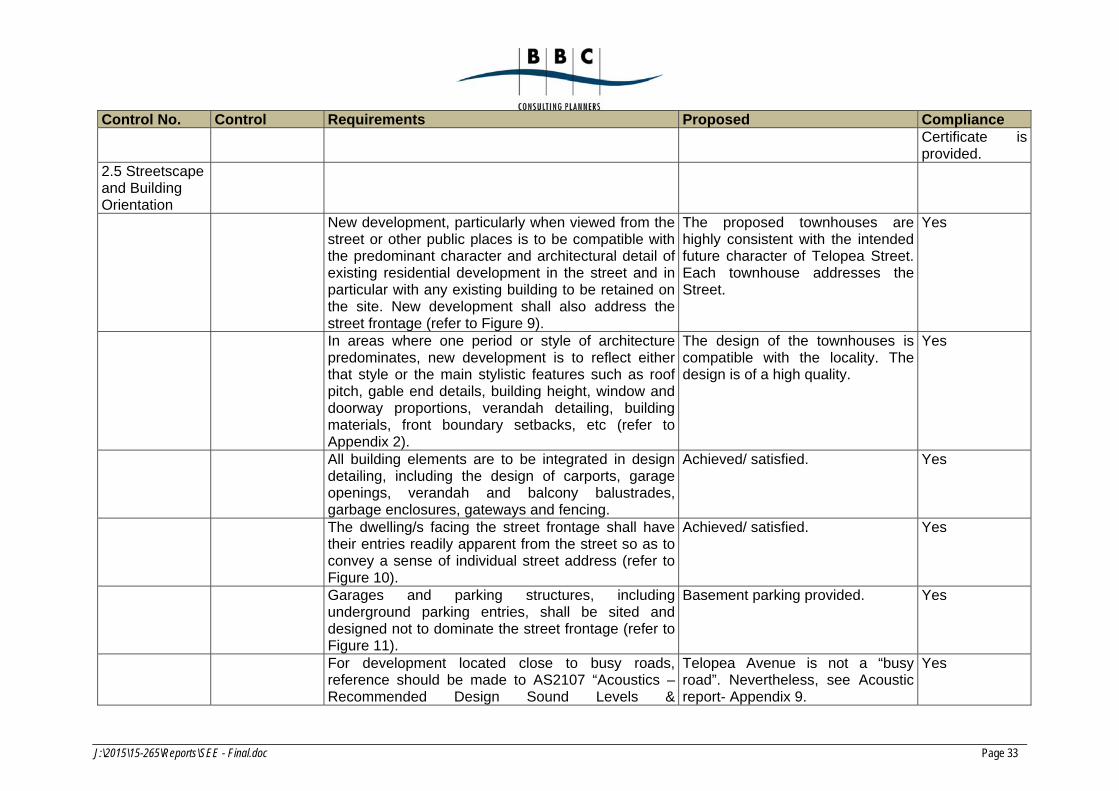
2.5 Streetscape and Building Orientation
New development, particularly when viewed from the street or other public places is to be compatible with the predominant character and architectural detail of existing residential development in the street and in particular with any existing building to be retained on the site. New development shall also address the street frontage (refer to Figure 9).
The proposed townhouses are highly consistent with the intended future character of Telopea Street. Each townhouse addresses the Street.
Yes
In areas where one period or style of architecture predominates, new development is to reflect either that style or the main stylistic features such as roof pitch, gable end details, building height, window and doorway proportions, verandah detailing, building materials, front boundary setbacks, etc (refer to Appendix 2).
The design of the townhouses is compatible with the locality. The design is of a high quality.
Yes
All building elements are to be integrated in design detailing, including the design of carports, garage openings, verandah and balcony balustrades, garbage enclosures, gateways and fencing.
Achieved/ satisfied. Yes
The dwelling/s facing the street frontage shall have their entries readily apparent from the street so as to convey a sense of individual street address (refer to Figure 10).
Achieved/ satisfied. Yes
Garages and parking structures, including underground parking entries, shall be sited and designed not to dominate the street frontage (refer to Figure 11).
Basement parking provided. Yes
For development located close to busy roads, reference should be made to AS2107 “Acoustics –Recommended Design Sound Levels &
Telopea Avenue is not a “busy road”. Nevertheless, see Acoustic report- Appendix 9.
Yes
J:\2015\15-265\Reports\SEE - Final.doc Page 34
Control No. Control Requirements Proposed Compliance Reverberation Times for Building Interiors” and AS3671 – 1989 “Acoustics – Road Traffic Noise Intrusion – Building Siting & Construction”.
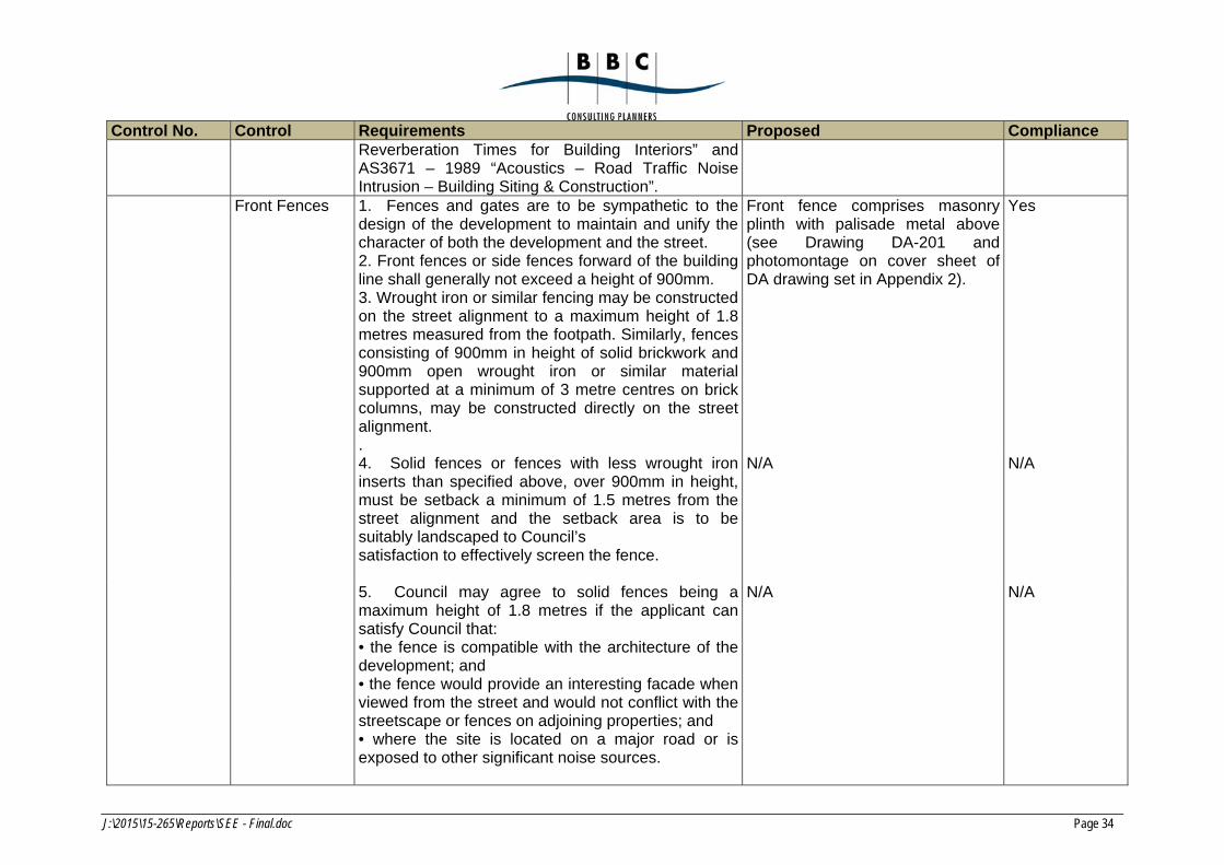
Front Fences 1. Fences and gates are to be sympathetic to the design of the development to maintain and unify the character of both the development and the street. 2. Front fences or side fences forward of the building line shall generally not exceed a height of 900mm. 3. Wrought iron or similar fencing may be constructed on the street alignment to a maximum height of 1.8 metres measured from the footpath. Similarly, fences consisting of 900mm in height of solid brickwork and 900mm open wrought iron or similar material supported at a minimum of 3 metre centres on brick columns, may be constructed directly on the street alignment. .
Front fence comprises masonry plinth with palisade metal above (see Drawing DA-201 and photomontage on cover sheet of DA drawing set in Appendix 2).
Yes
4. Solid fences or fences with less wrought iron inserts than specified above, over 900mm in height, must be setback a minimum of 1.5 metres from the street alignment and the setback area is to be suitably landscaped to Council’s satisfaction to effectively screen the fence.
N/A N/A
5. Council may agree to solid fences being a maximum height of 1.8 metres if the applicant can satisfy Council that: • the fence is compatible with the architecture of the development; and • the fence would provide an interesting facade when viewed from the street and would not conflict with the streetscape or fences on adjoining properties; and • where the site is located on a major road or is exposed to other significant noise sources.
N/A N/A

J:\2015\15-265\Reports\SEE - Final.doc Page 35
Control No. Control Requirements Proposed Compliance 6. Provision is to be made for access to public utility
installations by the relevant authorities, ie electricity, gas and water meters
Arrangements made as per drawings in Appendix 2.
Yes
Side and rear fences
1. Side and rear fences are to be no more than a maximum 1.8 metres in height (including any retaining walls). 2. Side and rear fences on a slope must be designed to allow water to flow through. 3. Side fences forward of the front building line are to taper down to the height of the front fence line. Solid sections of the side fence forward of the front building line shall not exceed a height of 900mm. A transparent section of the fence is therefore required to taper down from the height of the side fence to the height of the front fence. Piering above 900mm will be permitted to support the transparent section. 4. Where the front fences of adjoining properties are dissimilar in height, the owners of both properties are to come to an agreement on which front fence the side fence is to taper down to. 5. Side fences forward of the front building line are to be constructed in the same materials as the front fences of the adjoining dwellings. Where they are dissimilar, the owners of adjoining dwellings are to come to an agreement on the materials in the construction of the fence. The materials used must be in keeping with the architectural styles and materials of both development and must not dominate or detract from the streetscape. 6. The transparent section of the fence may be constructed with open inserts of wrought iron, timber or similar materials. To be considered transparent, the inserts must be spaced apart so that the building and the property forward of the
Standard side and rear fence proposed.
Yes
J:\2015\15-265\Reports\SEE - Final.doc Page 36
Control No. Control Requirements Proposed Compliance front building line are clearly visible through the fence from the street.
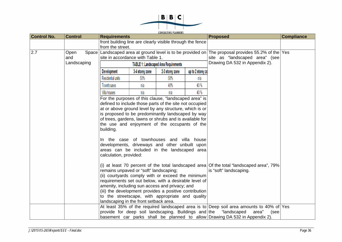
2.7 Open Space and Landscaping
Landscaped area at ground level is to be provided on site in accordance with Table 1.
For the purposes of this clause, “landscaped area” is defined to include those parts of the site not occupied at or above ground level by any structure, which is or is proposed to be predominantly landscaped by way of trees, gardens, lawns or shrubs and is available for the use and enjoyment of the occupants of the building. In the case of townhouses and villa house developments, driveways and other unbuilt upon areas can be included in the landscaped area calculation, provided:
The proposal provides 55.2% of the site as “landscaped area” (see Drawing DA 532 in Appendix 2).
Yes
(i) at least 70 percent of the total landscaped area remains unpaved or “soft” landscaping; (ii) courtyards comply with or exceed the minimum requirements set out below, with a desirable level of amenity, including sun access and privacy; and (iii) the development provides a positive contribution to the streetscape, with appropriate and quality landscaping in the front setback area.
Of the total “landscaped area”, 79% is “soft” landscaping.
At least 35% of the required landscaped area is to provide for deep soil landscaping. Buildings and basement car parks shall be planned to allow
Deep soil area amounts to 40% of the “landscaped area” (see Drawing DA 532 in Appendix 2).
Yes
J:\2015\15-265\Reports\SEE - Final.doc Page 37
Control No. Control Requirements Proposed Compliance contiguous deep soil areas, and planned to allow planting of large trees.
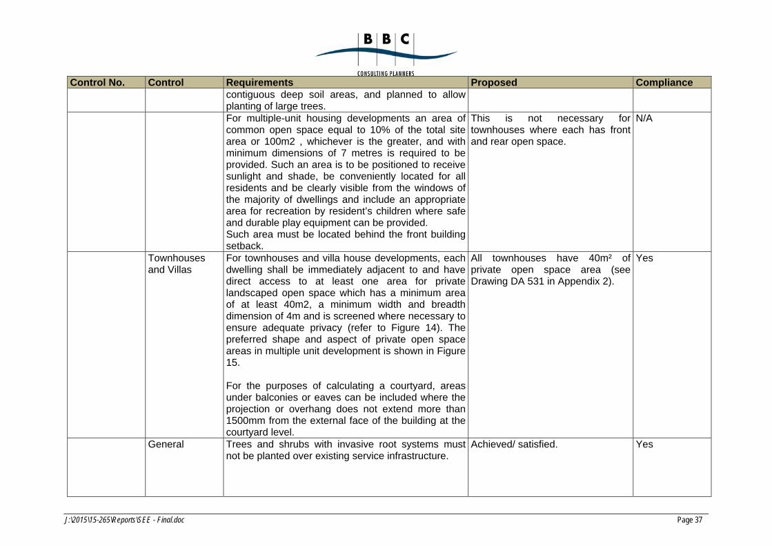
For multiple-unit housing developments an area of common open space equal to 10% of the total site area or 100m2 , whichever is the greater, and with minimum dimensions of 7 metres is required to be provided. Such an area is to be positioned to receive sunlight and shade, be conveniently located for all residents and be clearly visible from the windows of the majority of dwellings and include an appropriate area for recreation by resident’s children where safe and durable play equipment can be provided. Such area must be located behind the front building setback.
This is not necessary for townhouses where each has front and rear open space.
N/A
Townhouses and Villas
For townhouses and villa house developments, each dwelling shall be immediately adjacent to and have direct access to at least one area for private landscaped open space which has a minimum area of at least 40m2, a minimum width and breadth dimension of 4m and is screened where necessary to ensure adequate privacy (refer to Figure 14). The preferred shape and aspect of private open space areas in multiple unit development is shown in Figure 15. For the purposes of calculating a courtyard, areas under balconies or eaves can be included where the projection or overhang does not extend more than 1500mm from the external face of the building at the courtyard level.
All townhouses have 40m² of private open space area (see Drawing DA 531 in Appendix 2).
Yes
General Trees and shrubs with invasive root systems must not be planted over existing service infrastructure.
Achieved/ satisfied. Yes
J:\2015\15-265\Reports\SEE - Final.doc Page 38
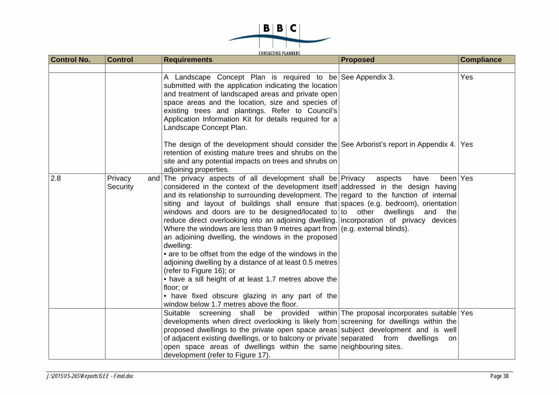
Control No. Control Requirements Proposed Compliance
A Landscape Concept Plan is required to be submitted with the application indicating the location and treatment of landscaped areas and private open space areas and the location, size and species of existing trees and plantings. Refer to Council’s Application Information Kit for details required for a Landscape Concept Plan.
See Appendix 3. Yes
The design of the development should consider the retention of existing mature trees and shrubs on the site and any potential impacts on trees and shrubs on adjoining properties.
See Arborist’s report in Appendix 4. Yes
2.8 Privacy and Security
The privacy aspects of all development shall be considered in the context of the development itself and its relationship to surrounding development. The siting and layout of buildings shall ensure that windows and doors are to be designed/located to reduce direct overlooking into an adjoining dwelling. Where the windows are less than 9 metres apart from an adjoining dwelling, the windows in the proposed dwelling: • are to be offset from the edge of the windows in the adjoining dwelling by a distance of at least 0.5 metres (refer to Figure 16); or • have a sill height of at least 1.7 metres above the floor; or • have fixed obscure glazing in any part of the window below 1.7 metres above the floor.
Privacy aspects have been addressed in the design having regard to the function of internal spaces (e.g. bedroom), orientation to other dwellings and the incorporation of privacy devices (e.g. external blinds).
Yes
Suitable screening shall be provided within developments when direct overlooking is likely from proposed dwellings to the private open space areas of adjacent existing dwellings, or to balcony or private open space areas of dwellings within the same development (refer to Figure 17).
The proposal incorporates suitable screening for dwellings within the subject development and is well separated from dwellings on neighbouring sites.
Yes
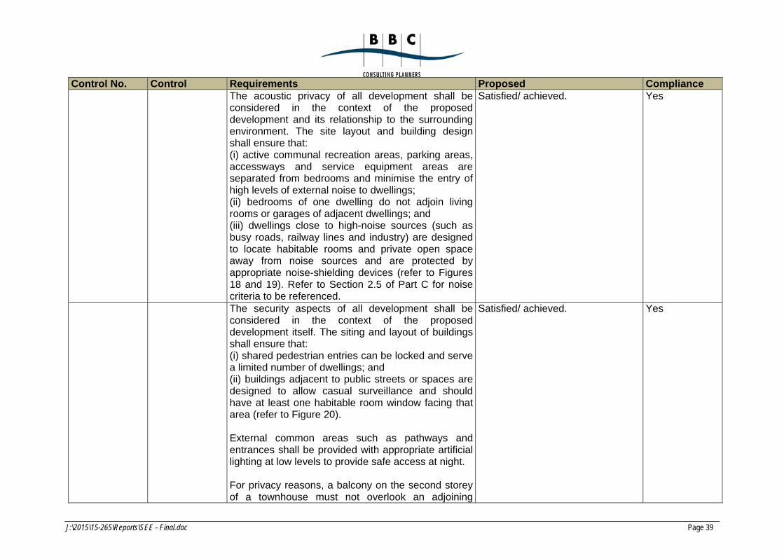
J:\2015\15-265\Reports\SEE - Final.doc Page 39
Control No. Control Requirements Proposed Compliance The acoustic privacy of all development shall be
considered in the context of the proposed development and its relationship to the surrounding environment. The site layout and building design shall ensure that: (i) active communal recreation areas, parking areas, accessways and service equipment areas are separated from bedrooms and minimise the entry of high levels of external noise to dwellings; (ii) bedrooms of one dwelling do not adjoin living rooms or garages of adjacent dwellings; and (iii) dwellings close to high-noise sources (such as busy roads, railway lines and industry) are designed to locate habitable rooms and private open space away from noise sources and are protected by appropriate noise-shielding devices (refer to Figures 18 and 19). Refer to Section 2.5 of Part C for noise criteria to be referenced.
Satisfied/ achieved. Yes
The security aspects of all development shall be considered in the context of the proposed development itself. The siting and layout of buildings shall ensure that: (i) shared pedestrian entries can be locked and serve a limited number of dwellings; and (ii) buildings adjacent to public streets or spaces are designed to allow casual surveillance and should have at least one habitable room window facing that area (refer to Figure 20). External common areas such as pathways and entrances shall be provided with appropriate artificial lighting at low levels to provide safe access at night. For privacy reasons, a balcony on the second storey of a townhouse must not overlook an adjoining
Satisfied/ achieved. Yes
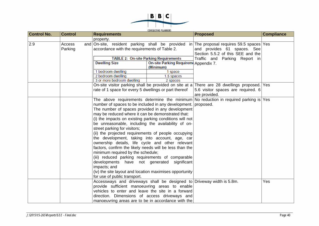
J:\2015\15-265\Reports\SEE - Final.doc Page 40
Control No. Control Requirements Proposed Compliance property.
2.9 Access and Parking
On-site, resident parking shall be provided in accordance with the requirements of Table 2.
The proposal requires 59.5 spaces and provides 61 spaces. See Section 5.5.2 of this SEE and the Traffic and Parking Report in Appendix 7.
Yes
On-site visitor parking shall be provided on site at a rate of 1 space for every 5 dwellings or part thereof
There are 28 dwellings proposed. 5.6 visitor spaces are required. 6 are provided.
Yes
The above requirements determine the minimum number of spaces to be included in any development. The number of spaces provided in any development may be reduced where it can be demonstrated that: (i) the impacts on existing parking conditions will not be unreasonable, including the availability of on-street parking for visitors; (ii) the projected requirements of people occupying the development, taking into account, age, car ownership details, life cycle and other relevant factors, confirm the likely needs will be less than the minimum required by the schedule; (iii) reduced parking requirements of comparable developments have not generated significant impacts; and (iv) the site layout and location maximises opportunity for use of public transport.
No reduction in required parking is proposed.
Yes
Accessways and driveways shall be designed to provide sufficient manoeuvring areas to enable vehicles to enter and leave the site in a forward direction. Dimensions of access driveways and manoeuvring areas are to be in accordance with the
Driveway width is 5.8m. Yes
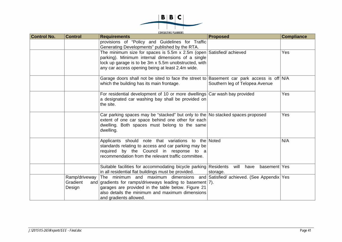
J:\2015\15-265\Reports\SEE - Final.doc Page 41
Control No. Control Requirements Proposed Compliance provisions of “Policy and Guidelines for Traffic Generating Developments” published by the RTA.
The minimum size for spaces is 5.5m x 2.5m (open parking). Minimum internal dimensions of a single lock up garage is to be 3m x 5.5m unobstructed, with any car access opening being at least 2.4m wide.
Satisfied/ achieved Yes
Garage doors shall not be sited to face the street to which the building has its main frontage.
Basement car park access is off Southern leg of Telopea Avenue
N/A
For residential development of 10 or more dwellings a designated car washing bay shall be provided on the site.
Car wash bay provided Yes
Car parking spaces may be “stacked” but only to the extent of one car space behind one other for each dwelling. Both spaces must belong to the same dwelling.
No stacked spaces proposed Yes
Applicants should note that variations to the standards relating to access and car parking may be required by the Council in response to a recommendation from the relevant traffic committee.
Noted N/A
Suitable facilities for accommodating bicycle parking in all residential flat buildings must be provided.
Residents will have basement storage.
Yes
Ramp/driveway Gradient and Design
The minimum and maximum dimensions and gradients for ramps/driveways leading to basement garages are provided in the table below. Figure 21 also details the minimum and maximum dimensions and gradients allowed.
Satisfied/ achieved. (See Appendix 7).
Yes
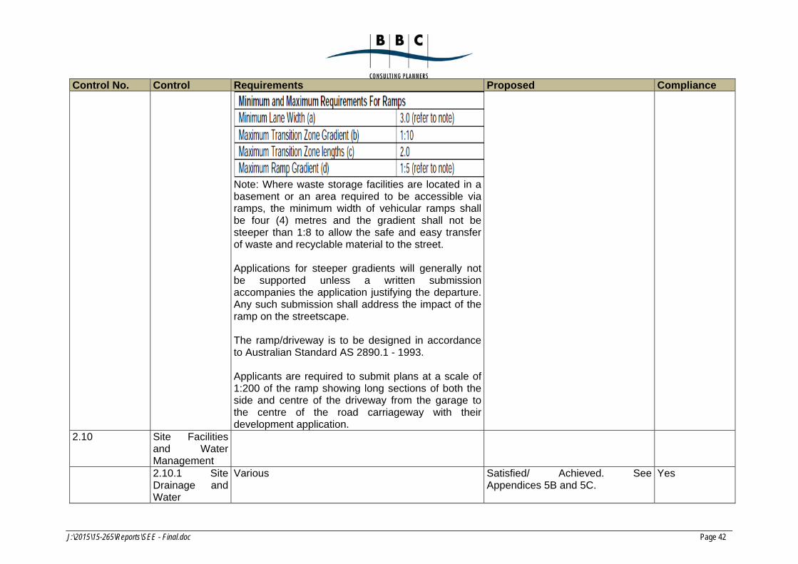
J:\2015\15-265\Reports\SEE - Final.doc Page 42
Control No. Control Requirements Proposed Compliance
Note: Where waste storage facilities are located in a basement or an area required to be accessible via ramps, the minimum width of vehicular ramps shall be four (4) metres and the gradient shall not be steeper than 1:8 to allow the safe and easy transfer of waste and recyclable material to the street. Applications for steeper gradients will generally not be supported unless a written submission accompanies the application justifying the departure. Any such submission shall address the impact of the ramp on the streetscape. The ramp/driveway is to be designed in accordance to Australian Standard AS 2890.1 - 1993. Applicants are required to submit plans at a scale of 1:200 of the ramp showing long sections of both the side and centre of the driveway from the garage to the centre of the road carriageway with their development application.
2.10 Site Facilities and Water Management
2.10.1 Site Drainage and Water
Various Satisfied/ Achieved. See Appendices 5B and 5C.
Yes

J:\2015\15-265\Reports\SEE - Final.doc Page 43
Control No. Control Requirements Proposed Compliance Management:
2.10.2 Garbage Facilities
Refer to Part H – Waste Management. Addressed in Appendices 11A and 11B of the SEE
Yes

J:\2015\15-265\Reports\SEE - Final.doc Page 44
5.5.2 Part I – ‘Provision of Off-Street Parking’
The following table sets out the proposal’s compliance with the relevant controls in the Strathfield Development Control Plan 2005.
Section Development Control Required Proposal Compliance
3.3.1 Controls only for “dwelling houses” and “residential flat buildings”
Part C specifies the following controls:-
1 space per 1 bedroom unit;
1.5 spaces per 2 bedroom unit;
2 spaces per 3 bedroom unit; and
1 visitor space per 5 dwellings.
The proposal provides 54 residential spaces and six visitor spaces plus a car-wash bay (i.e total of 61 spaces).
The parking calculation is:-
5 x 1.5 = 7.5 23 x 2 = 46 1 x 6 = 6 Total 59.5 spaces required
Yes
5.5.3 Part H – ‘Waste Management’
All waste on site during demolition and construction of the proposal will be appropriately managed and minimised by recycling and disposing of material at an appropriate waste facility in accordance with the Waste Management Plan provided in Appendix 11A.
An operational Waste Management Plan is provided in Appendix 11B.
5.5.4 Part N – ‘Water Sensitive Urban Design’
This section of the DCP applies to townhouse development sites with an area of 2000 sqm or more. The requirements include compliance with BASIX (see Appendix 10) and stormwater quality (see Appendix 5B).
5.6 Development Control Plan No. 20 – Parramatta Road Corridor
5.6.1 Introduction
The site is within the area to which Development Control Plan No.20 – Parramatta Road Corridor (“DCP 20”) applies (see Figure 5A). It was formulated on the findings of the
J:\2015\15-265\Reports\SEE - Final.doc Page 45
Parramatta Road Corridor Study 1997 and the Parramatta Road Corridor Analysis and Masterplan 1999. The controls in DCP 20 are currently under review as some of them are in conflict with and have been superseded by SLEP 2012. It is understood that Council is in the process of preparing a new DCP, although it is yet to be exhibited.
DCP 20 is structured into 2 main parts each with subsections which relate to specific advice or controls. The provisions of DCP 20 are addressed below.
5.6.2 Objectives
The aim of the DCP 20 is to achieve development within the Parramatta Road Corridor Area which is sympathetic and appropriate for the natural and built environment, optimises opportunities for utilising public transport, acceptable to the community, and economically feasible. The proposal has been prepared in accordance with the aims and objectives of DCP No. 20.
5.6.3 Relationship to Strathfield Consolidated Development Control Plan 2005
Section 1.6.1 of DCP 20 states that where the “Built Form Masterplan” provides for townhouses and villa houses the provisions “Part C – Multiple Unit House Developments of the Strathfield Consolidated DCP 2005 will be applied. On this basis, there is no utility in making further assessment of the proposal against the provisions of DCP20. Nevertheless, various illustrative plans from DCP No 20 are reproduced in Figures 5A – 5E.
“A. This DCP adopts the following provisions of the Strathfield Consolidated Development Control Plan 2005:
a) Part E – Child Care Centres
b) Part F – Bed and Breakfast Establishments
c) Part H – Waste Management
d) Part I – Provision of Off Street Parking Facilities
e) Part J – Erection and Display of Advertising Signs and Structures
f) Part K – Development on Contaminated Land
g) Part L – Public Notification Requirements for Development and Complying Development Applications.
B. For the purpose of clause 1.6.1 A above, any reference in those Parts to the Consolidated Plan is taken to be a reference to this DCP.”
The relevant parts of SDCP 2005 are addressed in Section 5.8.1 to 5.8.4 above.
J:\2015\15-265\Reports\SEE - Final.doc Page 46
6. ASSESSMENT OF ENVIRONMENTAL EFFECTS
6.1 Statutory Planning Considerations
In determining the subject DA, the Council is required to consider those relevant matters listed in Section 79C of the Environmental Planning and Assessment Act, 1979 (“the Act”). Each of the relevant matters is addressed below.
6.2 Section 79C(1)(a) – Statutory Planning Considerations
Section 79C(a) of the Act requires the consent authority to take into consideration:-
"(a) the provisions of:
(i) any environmental planning instrument; and
(ii) any proposed instrument that is or has been the subject of public consultation under this Act and that has been notified to the consent authority (unless the Director-General has notified the consent authority that the making of the proposed instrument has been deferred indefinitely or has not been approved); and
(iii) any development control plan; and
(iiia) any planning agreement that has been entered into under section 93F, or any draft planning agreement that a developer has offered to enter into under section 93F, and
(iv) the regulations (to the extent that they prescribe matters for the purposes of this paragraph), and
(v) any coastal zone management plan (within the meaning of the Coastal Protection Act 1979),
that apply to the land to which the development application relates,"
In relation to Section 79C(1)(a)(i) and (a)(iii) of the Act, these matters are addressed in Section 5 of this SEE.
In relation to Section 79C(1)(a)(ii), no proposed instruments have been publically exhibited which are relevant to the site or proposal.
In relation to Section 79C(1)(a)(iiia), no planning agreement is proposed.
In relation to Section 79C(1)(a)(iv), Clause 92 of the Environmental Planning and Assessment Regulation 2000 relevantly requires that in the case of development involving
J:\2015\15-265\Reports\SEE - Final.doc Page 47
demolition of a building the provisions of Australian Standard AS 2601 – 2001: the Demolition of Structures need to be taken into consideration.
The Applicant intends to comply with the relevant requirements of AS 2601 when demolishing the structures on the site.
In relation to Section 79C(1)(a)(v), this sub-section does not apply to this DA.
6.3 Section 79C(b) – Environmental, Social and Economic Impacts
Section 79C(1)(b) requires the consent authority to consider:-
“(b) the likely impacts of that development, including environmental impacts on both the natural and built environments, and social and economic impacts in the locality.”
The relevant matters are addressed below.
6.3.1 Impacts on the natural environment
The site is highly urbanised, having been used for many years for industrial/commercial purposes. The proposal will have no significant impact on the natural environment as the few trees to be removed will be replaced with new and more extensive (and appropriate) plantings as part of an overall comprehensive landscape scheme for the site which includes deep soil planting opportunities and new street frontage plantings.
This will more than compensate for the removal of several existing trees on the site. Details of the trees to be removed are provided in the Arborist’s report in Appendix 4. Details of the proposed landscaping are provided in Appendices 3A and 3B.
The impact of the proposal on the natural environment of the locality will be minimal.
6.3.2 Impacts on the built environment
6.3.2.1 Overview
The site presently comprises architecturally non-descript buildings and their associated hardstands and parking/manoeuvring areas. The demolition/removal of these buildings and their replacement with a well-designed, townhouse style, multi-dwelling housing development will have a positive impact on the built environment, particularly when considered in the context of the desired future character of the locality.
6.3.2.2 Bulk and scale/streetscape impacts
The proposal relates to a relatively large site (4,017m2) with a frontage of around 150m. It is bounded by Telopea Avenue on two sides and by the drainage channel on a third side.
J:\2015\15-265\Reports\SEE - Final.doc Page 48
The proposed landscaping, setbacks, façade design, modulation and articulation result in a high-quality presentation to surrounding streets.
The streetscape impact will be positive. With a scale of part two and part three-storeys, this proposal will have no unreasonable or unacceptable bulk and scale impacts. In this regard, there are part two and part three-storey residential flat buildings opposite the site and on the western side of Telopea Avenue. Therefore the scale which is proposed is already present in the immediate locality.
6.3.2.3 Overshadowing impacts
The shadow impacts of the proposal are generally consistent with those which might be reasonably anticipated by the planning controls which permit a maximum height limit of 9.5 metres. The additional height maximum of just less than 10.5m which is proposed gives rise to no significant additional shadow impacts.
6.3.2.4 Privacy impacts
No unanticipated privacy impacts arise from the proposal.
The proposed townhouses are separated from neighbouring dwellings to the west and south by Telopea Avenue. No privacy issues arise in relation to the northern side boundary as all dwellings are oriented east-west.
In relation to neighbouring dwellings to the east, these are separated from the proposed townhouses by the rear gardens of the townhouses, the drainage channel, and the rear yards of the neighbouring dwellings.
6.3.2.5 Noise Impacts and noise attenuation
Noise impacts and required noise attenuation are addressed in the Acoustic Report in Appendix 9.
Future residents on site will have good aural amenity through careful and effective consideration and attenuation of external noise sources, whilst existing and future residents on adjoining sites will not be impacted by noise generated from the proposed development on the subject site.
The report concludes as follows:-
“An acoustic assessment of the proposed development has been carried out in accordance with the requirements of Strathfield Council DCP and the EPA.
An environmental noise survey of the site has been conducted and the noise limited criteria for mechanical plant/equipment noise emission has been determined based on the EPA NGLG. The limits are presented in Table 4.
J:\2015\15-265\Reports\SEE - Final.doc Page 49
Construction for glazing, external walls and the roof/ceiling systems have been provided to achieve the internal noise criteria and are detailed in Section 3.1 and Section 3.2 based on the impact of road noise.
Providing the recommendations in this report are implemented, the noise from the proposed development is predicted to comply with acoustic requirements of the Strathfield Council DCP, BCA Part F5, EP noise guidelines and relevant Australian standards.”
6.3.2.6 Traffic and parking impacts
The traffic and parking impacts, which are all reasonable and acceptable, are addressed in the Traffic and Parking Report in Appendix 7.
The report concludes as follows:-
“The proposed residential development will replace the industrial use on the site in keeping with the zoning for the area. Assessment of the proposed townhouse development has confirmed that:
* there will not be any unsatisfactory traffic implications
* the proposed parking provision will be adequate
* the proposed vehicle access, internal circulation and servicing arrangements will be suitable and appropriate.”
6.3.3 Social and economic impacts
The social and economic impacts of the proposal will be positive, in that:-
an amalgamated site of substantial proportions in the R3 Medium Density Residential zone, will be used efficiently and effectively for residential purposes consistent with the locality’s desired future character;
the stock of quality dwellings and availability of housing choice in the locality will be increased;
the strong market demand for townhouse type dwellings in this locality will be better-satisfied;
future residents will have good amenity; and
many and varied employment opportunities will be created during marketing, construction and fit-out.
6.4 Section 79C(c) – The suitability of the site
Section 79C(c) requires the consent authority to consider:
J:\2015\15-265\Reports\SEE - Final.doc Page 50
“(c) the suitability of the site for the development.”
The site is zoned “R3 Medium Density Residential” in which “multi-dwelling housing” is are permissible with consent.
The proposed medium density development is an entirely suitable use of a site zoned “R3 Medium Density Residential”. It is also a more suitable planning use than the existing use.
6.5 Section 79C(d) – Submissions
Section 79C(d) requires the consent authority to consider:
“(d) any submissions made in accordance with this Act or the regulations”.
Any relevant submissions will need to be considered by the consent authority in the determination of the DA.
6.6 Section 79C(e) – Public interest
Section 79C(e) requires the consent authority to consider:
“(e) the public interest”.
The public interest is best served by the orderly and economic use of land for permissible purposes in a form which is cognisant of, and does not impact unreasonably on development on, surrounding land, and which satisfies a market demand, in this case for new townhouse/terrace type dwellings.
The proposal is in the public interest as it will:-
provide additional housing stock and expanded housing choice within Homebush West to meet future demand;
provide townhouse style living opportunities for 28 households;
transform the existing relatively under-utilised site consistent with the desired future character of the locality; and
exhibit a high quality design which will provide a high level of amenity for future residents without diminishing in any unreasonable way the amenity of existing residents.
6.7 Section 79C(3A) – Development Control Plans
Section 79C(3A) of the Act the Environmental Planning and Assessment Act, 1979 requires Councils to be flexible in applying any provisions that apply and allow reasonable alternative solutions that achieve the objects of those standards for dealing with that aspect of the development (our emphasis):-
J:\2015\15-265\Reports\SEE - Final.doc Page 51
“(3A) Development control plans
If a development control plan contains provisions that relate to the development that is the subject of a development application, the consent authority:
(a) if those provisions set standards with respect to an aspect of the development and the development application complies with those standards—is not to require more onerous standards with respect to that aspect of the development, and
(b) if those provisions set standards with respect to an aspect of the development and the development application does not comply with those standards—is to be flexible in applying those provisions and allow reasonable alternative solutions that achieve the objects of those standards for dealing with that aspect of the development, and
(c) may consider those provisions only in connection with the assessment of that development application.
In this subsection, standards include performance criteria.”
Therefore, pursuant to Section 79C(3A), the consent authority should apply some flexibility when analysing the proposal’s compliance against the relevant DCP requirements, particularly the front setback requirement of 9.0m.
J:\2015\15-265\Reports\SEE - Final.doc Page 52
7. CONCLUSION
Commensurate with its R3 Medium Density Residential zoning, the site is suitable for medium density residential development in the form which is proposed.
The proposal will result in the transformation of the architecturally undistinguished collection of buildings on the site (which accommodate existing non-residential activities), into a high quality, well designed townhouse type development which will provide new homes for 28 households making a significant addition to local housing stock and adding to the range of available dwelling types in the locality.
Having regard to the above, and in the light of the relevant heads of consideration listed under Section 79C(1) of the Environmental Planning and Assessment Act, 1979, the proposal is considered to be both reasonable and appropriate and worthy of support by the consent authority.

FIGURES

APPENDICES
APPENDIX 1A
Certificate of Title and Deposited Plan
Appendix 1B
Survey Plan, prepared by Strata Surv (see Volume 2)
Appendix 2
Architectural Plans prepared by Squillace Architects (see Volume 2)
Appendix 3
Landscape Plans, prepared by Conzept Landscape Architects (see Volume 2)
Appendix 4
Arborist Report, prepared by Redgum

Appendix 5A
Flood Study prepared by Envirotech

Appendix 5B
Civil Plans prepared by ACOR Consultants Pty Ltd (see Volume 2)
Appendix 5C
Stormwater Management Plan prepared by ACOR Consultants
Appendix 6A
Preliminary Site Investigation prepared by Aargus
Appendix 6B
Geotechnical Investigation Report prepared by Morrow Geotechnics Pty Ltd
Appendix 7
Assessment of Traffic and Parking Implications, prepared by Transport and Traffic Planning Associates

Appendix 8A
BCA Report, prepared by Blackett Maguire + Goldsmith
Appendix 8B
Access Review, prepared by Morris Goding Access Consultants
Appendix 9
Acoustic Report, prepared by Acouras Consultancy
Appendix 10
BASIX Certificate
Appendix 11A
Waste Management Plan prepared by Wastech Services Pty Ltd
Appendix 11B
Construction/Demolition Waste Management Plan prepared by Squillace Architects
Appendix 12
Clause 4.6 Variation Requests in relation to Building Height and FSR