Embed Size (px)
Citation preview

DRAFT
STATE OF CALIFORNIA STATE WATER RESOURCES CONTROL BOARD
In the Matter of Water Quality Certification for the
PACIFIC GAS AND ELECTRIC COMPANY POE HYDROELECTRIC PROJECT
FEDERAL ENERGY REGULATORY COMMISSION PROJECT NO. 2107
SOURCE: North Fork Feather River COUNTY: Butte WATER QUALITY CERTIFICATION FOR FEDERAL PERMIT OR LICENSE BY THE EXECUTIVE DIRECTOR: 1. Background and Project Description On December 16, 2003, Pacific Gas and Electric Company (PG&E or Licensee) filed an application for new license with the Federal Energy Regulatory Commission (Commission or FERC) for the Poe Hydroelectric Project (Project), FERC Project No. 2107. The original license for the Project was issued by FERC on October 26, 1953 and expired on September 30, 2003. The Project is currently operating under an annual license which extends the term of the original license. PG&E owns and operates the Project, which is located on the North Fork Feather River in Butte County. The Project boundary encompasses approximately 340 acres in the vicinity of the community of Pulga. Project land is owned by various parties including: 182 acres of PG&E-owned land; approximately 145 acres of National Forest System land; approximately 12 acres of privately-owned land; and one acre of California Department of Transportation land. The Project primarily consists of Poe Dam, Poe Reservoir, Poe Powerhouse, Big Bend Dam and Reservoir, and recreation facilities. Recreation facilities at Poe Powerhouse, Poe Beach, Bardees Bar and Sandy Beach are not included in the existing FERC license but have been proposed to be included in a new license by PG&E, FERC, and other relicensing participants. The primary Project facilities are briefly described below and illustrated in Figure 1 and Figure 2.
• Poe Dam is 400-foot-long by 60-foot-tall with four 50-foot-wide by 41-foot-high radial flood gates, a 20-foot-wide by 7-foot-high small radial gate, and a small skimmer gate.
• Poe Reservoir stretches from Poe Dam upstream to just below the Cresta Powerhouse1. Poe Reservoir is 53 surface-acres. Under existing Project operations, the average hydrologic residence time in Poe Reservoir is seven hours.
• Poe Powerhouse is located on PG&E owned property, 7.6 river miles downstream of Poe Dam. Poe Powerhouse is 175-feet-long by 114-feet-wide and has a total authorized
1 Cresta Powerhouse is associated with the Rock Creek-Cresta Hydroelectric Project (FERC Project No. 1962), which is also owned by PG&E.

DRAFT Water Quality Certification for Poe Hydroelectric Project
2
installed capacity of 142.83 megawatts (MW), with an average annual generation of 583 gigawatt-hours (GWh).
• Big Bend Dam and the associated reservoir are approximately 4,500 feet downstream of Poe Powerhouse. Big Bend Dam is a 370-foot-long by 61-foot tall, concrete gravity dam. Big Bend Dam impounds a 42 surface-acre reservoir.
• Recreational facilities associated with the Project are located at Sandy Beach, Bardees Bar, Poe Beach, Poe Powerhouse and Poe Reservoir. Each of these facilities includes parking facilities for contact and non-contact recreation opportunities, including swimming and whitewater boating.
As stated in PG&E’s license application, the Project is operated primarily as a peaking and baseload power facility2. North Fork Feather River flows are diverted at Poe Dam into the 19-foot diameter Poe Bypass Tunnel, which is approximately 6.25 miles long. The Poe Bypass Tunnel terminates at an underground steel penstock that is approximately 1,000-feet long and 14-feet in diameter. Water from the penstock discharges into the North Fork Feather River at the Poe Powerhouse. 2. Regulatory Authority 2.1 Water Quality Certification and Related Authorities The Federal Clean Water Act (33 U.S.C. §§ 1251-1387) was enacted “to restore and maintain the chemical, physical, and biological integrity of the Nation’s waters.” (33 U.S.C. § 1251(a).) Section 101 of the Clean Water Act (33 U.S.C. § 1251 (g)) requires federal agencies to “co-operate with the State and local agencies to develop comprehensive solutions to prevent, reduce and eliminate pollution in concert with programs for managing water resources.” Section 401 of the Clean Water Act (33 U.S.C. §1341) requires every applicant for a federal license or permit which may result in a discharge into navigable waters to provide the licensing or permitting federal agency with certification that the project will be in compliance with specified provisions of the Clean Water Act, including water quality standards and implementation plans promulgated pursuant to section 303 of the Clean Water Act (33 U.S.C. § 1313). Clean Water Act section 401 directs the agency responsible for certification to prescribe effluent limitations and other limitations necessary to ensure compliance with the Clean Water Act and with any other appropriate requirement of state law. Section 401 further provides that state certification conditions shall become conditions of any federal license or permit for the project. The State Water Resources Control Board (State Water Board) is designated as the state water pollution control agency for all purposes stated in the Clean Water Act and any other federal act (Wat. Code Section 13160.). The State Water Board’s Executive Director is authorized to issue a decision on a water quality certification application. (Cal. Code Regs., tit. 23, § 3838, subd. (a).) PG&E originally applied for water quality certification on February 18, 2005, and has annually withdrawn and re-applied for certification. On March 4, 2005, the State Water Board provided notice of receipt of a complete application for the Project to the applicable parties pursuant to California Code of Regulations, title 23, section 3835, subdivision (c). On July 14, 2009, the State Water Board provided public notice of the application pursuant to California Code of Regulations, title 23, section 3858 by posting information describing the Project on the State
2 Peaking power plants are operated during peak hours of the day when electricity is most valuable. This typically occurs from 8 AM to 8 PM and during the summer when electrical demands are high. Baseload plants consistently generate enough energy to satisfy minimum energy demand.

DRAFT Water Quality Certification for Poe Hydroelectric Project
3
Water Board’s website. Comments are posted on the State Water Board Project webpage at: http://www.waterboards.ca.gov/waterrights/water_issues/programs/water_quality_cert/poe_ferc2107.shtml Water Code section 13383 provides the State Water Board with authority to “establish monitoring, inspection, entry, reporting and recordkeeping requirements… and [require] other information as may reasonably be required” for activities subject to water quality certification under section 401 of the Clean Water Act that involve the diversion of water for beneficial use. The State Water Board delegated this authority to the Deputy Director for Water Rights (Deputy Director), as provided for in State Water Board Resolution No. 2012-0029. In the Redelegation of Authorities Pursuant to Resolution No. 2012-0029 memo issued by the Deputy Director on July 6, 2012, this authority is redelegated to the Assistant Deputy Directors of the Division of Water Rights. 2.2 Water Quality Standards and Water Quality Control Plans The California Regional Water Quality Control Boards adopt, and the State Water Board approves, water quality control plans (basin plans) for each watershed basin in the State. The basin plans designate the beneficial uses of waters within each watershed basin, and water quality objectives designed to protect those uses pursuant to Section 303 of the Clean Water Act. (33 U.S.C. § 1313.) The beneficial uses and water quality objectives that are contained in the basin plans, together with state and federal anti-degradation requirements, constitute California’s water quality standards. The Central Valley Regional Water Quality Control Board (Central Valley Regional Board) adopted, and the State Water Board and the United States Environmental Protection Agency approved, the Water Quality Control Plan for the Sacramento River and San Joaquin River Basins (SR/SJR Basin Plan). The SR/SJR Basin Plan designates the beneficial uses of water to be protected along with the water quality objectives necessary to protect those uses. The existing beneficial uses for the North Fork Feather River identified in the SR/SJR Basin Plan include: municipal and domestic supply; power; contact recreation; canoeing and rafting; noncontact recreation; cold freshwater habitat; cold freshwater spawning; and wildlife habitat. The State Water Board has listed the North Fork Feather River, upstream of Lake Oroville, on the Clean Water Act Section 303(d) list. The North Fork Feather River is impaired for temperature. The State Water Board cited hydromodification and flow regulation as potential sources of the impairment (State Water Board Resolution No. 2006-0079). The Project is a source of both hydromodification and flow regulation. 2.3 Project Water Rights PG&E operates the Project under a number of water rights administered by the State Water Board, Division of Water Rights. Water Rights license number 9871 gives PG&E the right for continuous diversion and use of up to 3,500 cubic feet per second (cfs) and Water Rights permit number 20864 gives PG&E the right to continuously divert up to 800 cfs. Additionally, PG&E has submitted an initial Statement of Diversion and Use (number S010395) for the Project.

DRAFT Water Quality Certification for Poe Hydroelectric Project
4
2.4 Construction General Permit The State Water Board has adopted a Construction General Permit3, which is required for activities that disturb one or more acres of soil or whose projects disturb less than one acre but are part of a larger common plan of development that in total disturbs one or more acres. Construction activities subject to the Construction General Permit include clearing, grading and disturbances to the ground such as stockpiling or excavation, but do not include regular maintenance activities performed to restore the original line, grade, or capacity of a facility. 3. Rationale When preparing the conditions in this certification, State Water Board staff reviewed and considered: (a) PG&E’s final FERC license application; (b) comments on the final license application submitted by agencies and interested parties; (c) United States Forest Service (Forest Service) 4(e) Conditions (16 U.S.C. § 797(e)); (d) FERC Environmental Assessment (EA) prepared pursuant to the National Environmental Policy Act (42 U.S.C §§ 4321 et seq.); (e) PG&E’s application for water quality certification; and (f) comments by interested parties. State Water Board staff also considered other Project-related comments, the SR/SJR Basin Plan, existing water quality conditions, Project-related controllable factors, and other information in the record. Any conditions that require development of a plan will require review, modification (if necessary), and approval by the Deputy Director. In addition, other regulatory agencies have specific authorities to approve plans and reports. The following describes the rationale used to develop most of the conditions in the water quality certification. The conditions for which additional rationale is not provided below (Conditions 13-41) are additional conditions commonly applicable to hydroelectric projects that, in this case, are necessary to ensure the protection of water quality standards over the term of the license and any extensions. 3.1 Minimum Instream Flows In 2001, PG&E conducted an Instream Flow Incremental Methodology (IFIM) study using a Physical Habitat Simulation (PHABSIM) model in conjunction with a habitat suitability criteria (HSC) study to examine the effects of increased instream flows on aquatic resources. Specifically, these studies were aimed at determining the change in available habitat for several fish species, in different life stages4, within the Poe bypass reach. PG&E designed and conducted these studies in consultation with relicensing participants, including but not limited to, the State Water Board, California Department of Fish and Wildlife (CDFW)5, Forest Service, Butte County, National Marine Fisheries Service (NMFS), United States Fish and Wildlife Service (USFWS), American Whitewater, California Sportfishing Protection Alliance (CSPA) and the National Park Service (NPS). On October 26, 2006, the State Water Board adopted the 2006 Federal Clean Water Act Section 303(d) List of Water Quality Limited Segments for California (Resolution No. 2006-0079). This list update included adding two impairments on the North Fork Feather River for 3 Water Quality Order 2009-0009-DWQ and National Pollutant Discharge Elimination System No. CAS000002, as amended by Order No. 2010-0014-DWQ and Order No. 2012-0006-DWQ. 4 Species and life stages analyzed include juvenile and adult rainbow trout, juvenile and adult Sacramento sucker, juvenile and adult Hardhead, juvenile and adult Sacramento pikeminnow and adult Smallmouth bass. 5 CDFW was formerly known as the California Department of Fish and Game.

DRAFT Water Quality Certification for Poe Hydroelectric Project
5
temperature and mercury concentration. The water temperature listing was identified as impairment to the cold freshwater habitat beneficial use. Specifically, the SR/SJR Basin Plan identified Hydromodification and Flow Regulation/Modification as potential sources. Both of these sources relate directly to PG&E operations on the Nork Fork Feather River and the Project. In 2006, as part of comments on the Draft EA, resource agencies participating in the relicensing process requested that FERC evaluate all new information and proposed flow regimes. This included higher instream flow proposals to support cold water fisheries, as a result of the 2006 303(d) listing of the North Fork Feather River for temperature. FERC’s 2007 Final EA included an increased instream flow schedule that would increase the weighted usable area (WUA) for many aquatic resources, but would not address the water temperature concerns in the Poe bypass reach. The variable instream flow requirements outlined in Condition 1 are expected to lower mean daily temperatures and create a thermal and geomorphic dynamic similar to the historical record of the North Fork Feather River. Mimicking a natural hydrological springtime recession is an important environmental cue for breeding and migration (Zweifel, 1955). Decreased temperatures throughout the year and the implementation of a spring recession may also help restore historical fish assemblages in the Poe bypass reach (Kiernan et al. 2012). Increased habitat for resident fish and other aquatic biota in the Poe bypass reach have the potential for decreasing intra and inter species competition. Current instream flow requirements reduce the amount of submerged spawning gravels with adequate flows, thus significantly reducing available spawning habitat for rainbow trout (FERC, 2007). Greater instream flows will lower mean daily temperatures for cold freshwater habitat during the summer, improving WUA for native fish species while providing for hydropower generation. 3.2 Water Year Types Designation of water year types is necessary to appropriately consider water supply and instream flow needs and protect the associated beneficial uses of water designated for the North Fork Feather River (see Section 2.2). Condition 1 of the certification relies on the Department of Water Resources (DWR) Bulletin 120 water year type determination in a given year. Unimpaired runoff projections provide the basis for water year type designations provided by DWR in Bulletin 120 in February, March, April, and May of each year. Unimpaired runoff projections in Bulletin 120 are commonly used throughout the state as a reliable metric for determining water year types. Climate change has the potential to increase ambient temperatures and affect precipitation patterns in California. This potential change in timing and availability of water resources may make it necessary to revise water year type criteria during the 30-50 year license term. Condition 1 allows PG&E to request a modification of water year types. A modification of water year types may result in modification of instream flows. 3.3 Planning for Extremely Dry Conditions California’s history of drought and dry years illustrates the importance of contingency planning for multiple dry years or drought. It is difficult to anticipate the specific impacts of consecutive Dry years, consecutive Critically Dry years, or a long-term drought, and identify where limited water supplies may be best used during times of shortage. Condition 3 provides PG&E the opportunity, following consultation with the State Water Board, Forest Service and CDFW, to

DRAFT Water Quality Certification for Poe Hydroelectric Project
6
request Deputy Director approval of a Revised Operations Plan during consecutive Dry, consecutive Critically Dry, or drought years. This condition provides flexibility for adaptive management during times of extreme water shortage. 3.4 Pulse Flows and Sediment Management Since the Project commenced operation in the 1950s, the Project has regulated flows of the North Fork Feather River from Poe Reservoir to the Oroville Facilities Hydroelectric Project (FERC Project No. 2100). As a result of consistently lower flows and diminished natural variability during this period, Project operations have potentially resulted in the deposition and accumulation of fine grain sediment and organic matter. California’s Mediterranean to dry climate results in a highly variable precipitation regime that can result in different storm magnitudes from year to year. This means that even in Normal water years there is the potential that flows are of an insufficient magnitude to flush fine grain sediments. Pulse flows will help flush fine grain sediment and organic matter down the Poe bypass reach and mimic natural geomorphic processes associated with the natural hydrograph. During the relicensing process PG&E and the resource agencies discussed proposals for pulse flows. PG&E commented on Forest Service preliminary 4(e) conditions that flows should be triggered before water temperatures exceed 10 degrees Celsius (10°C) to avoid impacts to rainbow trout spawning. The pulse flow and sediment management condition will protect the beneficial uses of the North Fork Feather River as described in PG&E’s comment and associated resource agencies’ input. Pulse flows and restoration of a more natural flow regime support the integrity of aquatic life by maintaining habitat of sufficient size, character, diversity, and connectivity and by providing natural sediment and organic material. Additionally, the implementation of seasonal pulse flows provides environmental cues for resident aquatic resources during different life stages. Condition 4 requires PG&E to implement a 20-hour flow release schedule for the mobilization of fine grain sediment. Pulse flows are triggered when monitoring finds a 25 percent increase in fine grain sediments in the Poe bypass reach. Monitoring will be conducted according to the Sediment Monitoring Plan, which PG&E must submit to the State Water Board for approval. 3.5 Ramping Rates The foothill yellow-legged frog (FYLF) (Rana boylii) is a California Species of Special Concern and a Forest Service Sensitive Species. It is believed that FYLF populations have declined in the majority of their historical range and FYLF are considered extinct in a number of watersheds they historically inhabited. Variable instream releases as a result of hydromodication from hydroelectric project operations are considered to be a contributing factor in declining FYLF reproductive success (Kupferberg et al. 2009). Significant stage changes can cause scouring and stranding of FYLF egg masses, as well as increased benthic macroinvertebrate (BMI) drift (Yarnell et al. 2012). Maintaining more consistent marginal habitat conditions also provides buffers against significant velocity increases that may otherwise be affected by Project operations and effect FYLF reproductive success (Kupferberg 1996; Yarnell et al. 2012). Considering FYLF tadpole’s sensitivity to changes in velocity and that egg masses are generally deposited at shallow depths, the implementation of ramping rates will offer increased reproductive protection. The State Water Board worked with the Forest Service and stakeholder groups to develop a ramping rate schedule protective of FYLFs.

DRAFT Water Quality Certification for Poe Hydroelectric Project
7
For spill flows between 3,000 cfs and 1,000 cfs, as measured at Gage 236 (United States Geological Survey [USGS] gage No. 11404500), PG&E will be required to operate the Project to mimic the non-Project recession flows of the East Branch of the North Fork Feather River. For a spill that is less than 1,000 cfs or once a spill becomes less than 1,000 cfs, PG&E will transition down to the required minimum flow using the 21-day ramp down table listed in Condition 5. The 21-day ramp down may be shorter in certain months and water year types with higher minimum instream flows (listed in Condition 1). The establishment of similar ramping rates for the protection of FYLF is also underway at Cresta Dam (FERC Project No. 1962). 3.6 Recreational Flows The Project and associated facilities offer a unique opportunity for whitewater recreation because of their close proximity to population centers in Oroville and Chico. Since the beginning of Project operations in 1958, the Project has not provided high enough flows for whitewater recreation during the recreation season (April–September). The Poe bypass reach offers multiple segments with various whitewater skill levels (class rapids) and drop-in access sites at Sandy Beach and Bardees Bar. Furthermore, the North Fork Feather River as a whole offers a regionally unique and stunning backdrop of deeply incised canyon walls for potential recreationalists. Per Condition 6, in Normal and Wet water years the Recreation Technical Review Group (RTRG) will schedule whitewater recreational flows in the Poe bypass reach when biological monitoring indicates flows will not impact FYLF. 3.7 Gage Maintenance Plan Accurate and real-time streamflow information is necessary for water management and to monitor compliance with instream flow requirements. Condition 7 requires the continued operation and maintenance of Gage 23 and Gage 517 (if applicable) and requires PG&E to provide real-time data via the internet within four hours of collection. 3.8 Recreation Improvement and Monitoring Plan The Project has three recreation sites along the North Fork Feather River, each with differing degrees of access and existing facilities. A 75 to 100 percent increase in recreational visitors and associated usage of Project facilities is projected over the course of a new FERC license (PG&E, 2003). The increased demand is anticipated to be associated with a number of recreation activities including: contact and non-contact water recreation, hiking, fishing, and primitive camping. This increased usage requires various new facilities, including toilets, trash receptacles and picnic tables at some sites to protect the beneficial uses of the North Fork Feather River. In addition, gravel resurfacing and trail construction is necessary to ensure the continued access and safety of the sites, as well as protection of water quality. Coordination and approval of the recreation improvements requires PG&E to develop a Recreation Improvement and Monitoring Plan. This plan will also include triggers for sanitation and recreation upgrades based on use. PG&E is required to consult with the Forest Service, California Department of Boating and Waterways, Butte County, State Historic Preservation Officer (SHPO), and State Water Board staff in developing the plan, and submit the final plan for Deputy Director approval.
6 Gage 23 is also identified as NF 23. PG&E owns and maintains Gage 23. 7 Gage 51 is also identified as NF 51. PG&E owns and maintains Gage 51.
DRAFT Water Quality Certification for Poe Hydroelectric Project
8
3.8.1 Sandy Beach
Sandy Beach receives the greatest recreation visitation of any of the Project facilities. Its location on Highway 70 makes it a popular attraction for vacationers passing through and nearby residents from Oroville and Chico. The current number of visitors Sandy Beach receives warrants additional facilities to protect the water quality and beneficial uses of the North Fork Feather River. Given the existing and projected increase in use at Sandy Beach, additional supportive facilities, such as parking and toilets, are needed. Condition 8 requires PG&E to submit a plan that includes resurfacing the parking lot and road, installing and maintaining portable toilets and trash receptacles, and trail construction.
3.8.2 Bardees Bar
Existing recreation facilities at Bardees Bar consist of a number of informal features leftover from the construction of the Project. When assessing recreation use at Bardees Bar, PG&E noted that while overall use was low, recreationalists at Bardees Bar tended to stay longer and had a higher percentage of overnight visits. In addition, one recreationalist suggested to State Water Board staff that the greatest use occurs during deer season and that Bardees Bar serves as a local overnight location for many hunters. The increased overnight use in the early fall and the lack of sanitation facilities at Bardees Bar makes the installation of supportive facilities necessary. PG&E is required to install and maintain bathroom, picnic, and trash facilities at Bardees Bar.
The Bardees Bar Spoil Pile is a remnant from the construction of the Project that is located on top of the southern bank of the North Fork Feather River near Adit 1 of the Poe Bypass Tunnel. The Bardees Bar Spoil Pile is estimated to be between 500,000 and 600,00 cubic yards and has been visually estimated to be between one and six feet tall. The Bardees Bar Spoil Pile has the potential to increase sedimentation during high flows and creates a visually displeasing viewshed from Highway 70. PG&E is required to identify how it will revegetate the sterile spoil pile soil and mitigate any potential water quality and visual impacts associated with the spoil pile in the Recreational Improvement and Monitoring Plan.
3.8.3 Poe Beach and Poe Powerhouse Beach
Poe Beach is a small informal recreation site located on the North Fork Feather River off Poe Powerhouse Road. Existing access to Poe Beach consists of approximately 100 feet of narrow, rutted, rope-guided trails that terminate at a small white sand beach. Support ropes on the trail are in poor condition and the slope stability of the trail is relatively poor. Increased user demand, high precipitation events, and changes in vegetation have the potential to render the trail impassable and contribute to erosion and associated sediment discharges. To support continued use of Poe Beach and to alleviate public safety concerns, trail improvements or construction of stairs is required. The specific scale, type, and timing of such improvements will be determined in consultation with agencies and will be reflected in the Recreation Improvement and Monitoring Plan.

DRAFT Water Quality Certification for Poe Hydroelectric Project
9
Poe Powerhouse Beach is located a short distance from Poe Beach at the confluence of the North Fork Feather River and the outflow from the Poe Powerhouse. Poe Powerhouse Road terminates at the Poe Powerhouse. The access road from Poe Powerhouse to the Poe Powerhouse Beach is in poor condition and limits the ability of the public to access the Poe Powerhouse Beach. In addition, neither Poe Beach nor Poe Powerhouse Beach have publically accessible restroom facilities nearby. This lack of sanitation facilities coupled with projected increases in visitation could impact water quality and beneficial uses. For these reasons, PG&E is required to resurface the access road to the Poe Powerhouse Beach and install a pit toilet.
3.8.4 Poe Reservoir
Due to the steep, narrow nature of Poe Reservoir no formal boat launch facilities exist. However, understanding the limited opportunities for flatwater boating in the area and to protect the water contact recreation beneficial use of the North Fork Feather River, PG&E is required to provide reasonable access to Poe Reservoir. If, after consultation with State Water Board staff and stakeholders, PG&E determines that access is infeasible based on water quality, security, or financial concerns, PG&E may submit a request for Deputy Director approval to suspend implementation of Condition 8.4. The implementation of Condition 8.4 may be re-evaluated in the future if the basis of the infeasibility determination changes.
3.9 Poe Bypass Reach Biological Monitoring Changes to the Poe bypass reach’s hydrological regime have the potential to change the distribution of biological resources. Following license issuance new baseline data for fish, BMI, and amphibians will need to be established. An early study required by FERC as part of the relicensing process suggested there was a link between higher instream flows and the decline of FYLF populations. However, relicensing participants later found scouring and stranding of egg masses were a heavy contributor to declining FYLF populations on the North Fork Feather River. While stage change measures are important in preventing FYLF egg mass scouring or stranding, higher flows will mimic the more natural hydrograph FYLF evolved under. See Condition 5 (Ramping Rates) for more on measures to protect FYLF during stage changes associated with spill events. Additionally, FYLF research has found that in larger channels, breeding sites tend to be found near point bars, tributary confluences, and features that offer spatial stability (Kupferberg, 1996). In some areas, the deeply incised canyon walls prevalent on the North Fork Feather River have the potential to offer less buffering capacity against velocity increases resulting from higher flows. Shifts in habitat distribution, connectivity, and quality as a result of increased instream flow requirements have the potential for varied short-term effects on FYLF populations in the Poe bypass reach. Considering that FYLF surveys often show repeated use of the same breading habitat and that there is a potential for some sites to be more heavily influenced by higher flows, FYLF monitoring is necessary (Kupferberg, 1996). Increased flows are expected to lower the summer mean daily temperature in the Poe bypass reach. Flow regime restoration has the potential to change the fish species composition and relative abundance (Kiernan et al. 2012). Fish monitoring will help track potential thermal benefits and illustrate the relative benefits of increased flows. Monitoring of fish populations

DRAFT Water Quality Certification for Poe Hydroelectric Project
10
over the life of the license will provide information on the health of resident fish populations, and provide information on impacts to the fish populations. Evaluating BMI communities is a useful tool in monitoring water quality trends and responses to new flow regimes. BMI provide an important food source for most salmonids. BMI monitoring will be consistent with State Water Board Surface Water Ambient Monitoring Program (SWAMP) protocols and be evaluated using the California Stream Condition Index (CSCI) and EPT index8. BMI monitoring data will provide information necessary to evaluate changes associated with implementation of instream flows (Condition1). 3.10 Temperature Monitoring Plan To protect beneficial uses, it is necessary to understand and monitor changes in temperature associated with the integrated management of PG&E’s North Fork Feather River hydroelectric system, including the Project. Temperature increases following spring recession flows are critical for signaling FYLF breeding. Average daily North Fork Feather River temperatures of 10-16°C trigger the onset of breeding and oviposition (GANDA, 2008). Pulse flows, recreation flows, and ramping rate conditions all depend on temperature monitoring to identify and mitigate potential effects on FYLF. Condition 10 of this certification outlines the timing for plan approval and facility modification, if necessary. 3.11 Riparian Vegetation Monitoring Plan Natural instream flow recessions historically dictated stream channel characteristics. High flow events from snow melt would increase the wetted width of the channel and recruit gravel, cobble and organic material. However, since the Project went online in 1958, variable high flows have been mostly limited to spring runoff peaks before returning to low summer baseflows. Returning the Poe bypass reach to a more natural instream flow regime is expected to reduce water temperatures, mimic past geomorphic processes, and reduce riparian encroachment (Mount, 1995). A riparian vegetation monitoring plan will help determine if increased flows are affecting habitat suitability within the Poe bypass reach. Riparian vegetation and large woody debris provide important habitat for cold water fisheries and BMI. Understanding yearly shifts in riparian vegetation area and distribution will help determine the efficacy of the new flow schedule. 3.12 National Marine Fisheries Service Reservation of Authority In letters dated December 12, 2005 and November 15, 2006 NMFS reserved its authority to condition fish passage for the Project. If a plan or action to reestablish anadromy for the North Fork Feather River fisheries is required by NMFS under section 18 of the Federal Power Act, PG&E will consult with relicensing participants in developing passage measures. Fish passage may require evaluation of salmonid habitat characteristics not quantified during relicensing studies or as part of any ongoing monitoring. Project flow regimes, facility limitations and the availability of spawning gravels and large woody debris are potential limitations to any effort to reintroduce Endangered Species Act listed anadromous fish species. In consultation with relicensing participants, the Project would need to be evaluated to ensure that continued operations are protective of the cold freshwater habitat and spawning beneficial uses.
8 The EPT Index summarizes BMI richness in groups that are generally considered pollution sensitive (Ephemeroptera / mayflies; Plecoptera / stoneflies; Trichoptera / caddisflies). This metric was used during relicensing studies on the North Fork Feather River.

DRAFT Water Quality Certification for Poe Hydroelectric Project
11
ACCORDINGLY, BASED ON ITS INDEPENDENT REVIEW OF THE RECORD, THE STATE WATER RESOURCES CONTROL BOARD CERTIFIES THAT THE POE HYDROELECTRIC PROJECT will comply with sections 301, 302, 303, 306, and 307 of the Clean Water Act, and with applicable provisions of State law, if the Pacific Gas and Electric Company complies with the following terms and conditions during the Project activities certified herein. CONDITION 1. Within 60 days of license issuance, the Licensee shall operate according to the minimum instream flow requirements specified in Table 1 as measured at USGS gage No. 11404500 (Gage 239). Flows shall be measured as both a 24-hour average (mean daily) and an instantaneous reading. Instantaneous flows are used to construct the average daily flow value and shall be measured in time increments of at least 15-minutes. Mean daily flows shall be 24-hour averages of the instantaneous readings from midnight of one day to midnight of the next day. Licensee shall record instantaneous streamflow as required by USGS standards. Instantaneous flow measurements shall be at least 90 percent of the minimum flow listed in Table 1. Mean daily flows shall be equal to or greater than the minimum flows listed in Table 1.
Table 1. Minimum Instream Releases (cfs) from Poe Dam as measured at Gage 231
Month Water Year Type2
Wet Normal Dry Critically Dry October 250 250 180 180
November 275 275 180 180 December 300 300 180 180 January 325 300 180 180 February 350 325 225 225
March 350 350 300 300 April 400 400 325 300 May 500 400 350 300 June 500 400 350 300 July 500 400 350 300
August 500 400 350 300 September 400 350 300 250
1 No diversion may occur until the minimum instream flows are satisfied. 2 Water year types are defined in Condition 2.
The minimum instream flow requirements (outlined in Condition 1) are subject to temporary modification if required by equipment malfunction, as directed by law enforcement authorities, or in emergencies. An emergency is defined as an unforeseen event that is reasonably out of the control of the Licensee and requires the Licensee to take immediate action, either unilaterally or under instruction by law enforcement or other regulatory agency staff, to prevent imminent loss of human life or substantial property damage. An emergency may include, but is not limited to, natural events such as landslides, storms or wildfires, malfunction or failure of Project works, and recreation accidents. When possible the Licensee shall notify the Deputy Director prior to any temporary stream flow modification. In all instances, the Licensee shall notify the Deputy 9 Gage 23 is also known as NF 23, and is owned and operated by PG&E.

DRAFT Water Quality Certification for Poe Hydroelectric Project
12
Director within 24 hours of any temporary stream flow modification. Within 96 hours of the temporary stream flow modification the Licensee shall provide the Deputy Director with an update of the conditions associated with the modification and an estimated timeline for returning to the required minimum instream flows. Within 30 days of any temporary stream flow modification, the Licensee shall provide the Deputy Director with: (1) photo documentation of the emergency or reason for the stream flow modifications; (2) a written description of the modification and its necessity; (3) an updated timeline for ending the emergency and returning to the required minimum instream flows; and (4) a plan to prevent a similar emergency in the future. CONDITION 2. Each year the Licensee shall determine the water year type based on forecasted unimpaired runoff of the Feather River at Lake Oroville. Water years shall be categorized into Wet, Normal, Dry, and Critically Dry based on historical unimpaired flows on the Feather River. Water year determinations will be dictated by spring runoff forecasts in DWR Bulletin 120 reports, published the beginning of February, March, April, and May. The Licensee shall use the May forecast to establish the water year type for the remaining months of the year until the following February, when forecasting shall begin again. Minimum instream flows requirements shall be implemented within two business days following DWR publication of Bulletin 120 unless ramping rate requirements preclude the Licensee from achieving those flows within two days. Licensee shall provide notice of the final water year determination to the State Water Board by May 31 of each year. The water year types are defined in Table 2.
With an increase in ambient temperatures, decrease in precipitation (snow fall), and cold freshwater dependent aquatic species, it may be necessary to revise water year types during the life of the license. After consultation with the State Water Board, Forest Service, and CDFW, the Licensee may submit to the Deputy Director for approval a request to modify how water year types are defined (Water Year Modification). The Licensee shall include with the Water Year Modification documentation of consultation with the State Water Board, Forest Service, and CDFW, copies of comments and recommendations made in connection with the Water Year Modification, and a description of how the Water Year Modification incorporates or addresses the comments and recommendations of the agencies. The Deputy Director may require modifications as part of any approval. Any changes in flows made in response to changing water year types shall follow the ramping rates in Condition 5. Upon Deputy Director approval of modifications to the water year types, the new water year types and associated implementation shall be filed with FERC and become a condition of this water quality certification.
Table 2. Water Year Types
Wet Greater than or equal to 5,679 thousand acre-feet (TAF)
Normal Less than 5,679 TAF, but greater than or equal to 3,228 TAF
Dry Less than 3,228 TAF, but greater than or equal to 2,505 TAF
Critically Dry Less than 2,505 TAF Based on forecasted unimpaired runoff of the Feather River at Lake Oroville provided in DWR’s Bulletin 120.

DRAFT Water Quality Certification for Poe Hydroelectric Project
13
CONDITION 3. In the event of extremely dry conditions, which may include a year in which the Governor of the State of California declares a drought, multiple consecutive Dry or Critically Dry years, the Licensee may request a modification of the flow requirements (Condition 1). The Licensee shall consult with representatives from the State Water Board, Forest Service, and CDFW to discuss operational plans to manage extremely dry conditions. The Licensee shall submit to the Deputy Director, for review and approval, a proposed revised operations plan and any comments provided by the Forest Service and CDFW during the consultation process. The Deputy Director may make modifications as part of any approval. The Licensee may implement the revised operations plan upon receiving Deputy Director and other necessary regulatory approvals. CONDITION 4. Within one year of license issuance, the Licensee shall submit a Sediment Management Plan for Deputy Director approval. The Sediment Management Plan shall be prepared in consultation with the State Water Board, Forest Service, and CDFW. The Sediment Management Plan shall outline goals and objectives for the management of fine-grained sediment and organic material within the Poe bypass reach, including implementation of pulse flows. The plan shall include methodologies for sampling and protocols for data sharing between agencies. The Deputy Director may make modifications as part of any approval.
Triggers for implementation of pulse flows shall be dependent on the results of sediment monitoring. Baseline monitoring shall occur the year following development of the Sediment Management Plan. The initial baseline sediment accumulation monitoring shall be performed three- to six-months following a flow event with a mean daily magnitude of at least 2,000 cfs. If monitoring shows that fine grain sediment and organic material accumulation has increased by more than 25 percent as compared to the initial sediment measurements, the Licensee shall either release or augment a spill flow prior to April 1 of the following year. The Licensee shall follow the regime shown in Table 3 while following the ramping rates in Condition 5. In no case will the pulse flow modifications require the release of more than 2,600 acre-feet of water in excess of the required minimum streamflow. Under extremely dry conditions the Licensee may request to modify or delay elements in the Sediment Management Plan. The Deputy Director may make modifications as part of any approval. In addition, the Licensee shall implement pulse flows in accordance with the following requirements:
• The pulse flow shall be implemented before the temperature of the North Fork Feather River exceeds 10°C mean daily water temperature at Gage 23 on two successive days.
• For the protection of FYLF populations, the pulse flow shall occur prior to the onset of frog breeding in the Poe bypass reach.
• Pulse flows shall also not take place if rainbow trout spawning in the Poe bypass reach is observed and reported to the Licensee by CDFW or Forest Service.

DRAFT Water Quality Certification for Poe Hydroelectric Project
14
Table 3. Pulse Flows Duration (hours)
Flow (cfs)
1 baseflow to 750 1 1,500 6 2,000 2 1,600 2 1,300 2 1,100 2 800 2 600 2 450
450 to baseflow
The Licensee shall monitor fine-grain sediment and organic material accumulation within three months and no more than six months following a pulse flow event. If monitoring indicates fine-grain sediment and organic material accumulation remains at or near a 25 percent increase as compared to the baseline sediment measurements, the Licensee shall consult with the State Water Board, CDFW, and Forest Service and request a modified flow schedule no later than nine months following post-pulse flow monitoring. The Licensee may also request a modified pulse flow schedule, following consultation with the State Water Board, CDFW and the Forest Service if the Licensee determines that the expected benefits can be better achieved by a pulse flow of a different magnitude or duration. The request shall be submitted to the Deputy Director for review and approval. The Deputy Director may make modifications as part of any approval. CONDITION 5. For the preservation and improvement of aquatic resources in the Project area, the Licensee shall control river flows by ramping streamflow releases from Poe Dam. These ramping rates shall be implemented within 60 days following FERC license issuance. Where facility modification is required to implement the requirements of this condition, the Licensee shall complete such modifications as soon as reasonably practicable and no later than two years after license issuance. Prior to completion of such required facility modifications, the Licensee shall make a good faith effort to meet the requirements of this condition within the capabilities of the existing facilities. In the event that studies or monitoring during the term of the License identify the need for modifications to ramping rates, the Licensee shall consult with the State Water Board, CDFW, USFWS and Forest Service to establish more appropriate rates. The revised ramping rates shall be approved by the Deputy Director and filed with FERC before implementation. The Deputy Director may make modifications as part of any approval.
5.1 Ramping Rates during the FYLF Breeding/Egg Mass Season: The following shall be implemented during FYLF breeding season, which is defined as April 1 through July 15 of each year. The Licensee shall not plan any powerhouse outages during FYLF breeding season. For any spill flows between 3,000 cfs and 1,000 cfs measured at Gage 23, the Licensee shall operate the Project with the goal that recession flows in the North Fork Feather

DRAFT Water Quality Certification for Poe Hydroelectric Project
15
River below Poe Reservoir follow the recession rates of the East Branch of the North Fork Feather River as measured at Gage 51. For a spill that is less than 1,000 cfs or once a spill becomes less than 1,000 cfs, the Licensee shall transition down to the required base flow using the 21-day ramp down schedule outlined in Table 4. In cases of multiple days of the same release level, the Licensee shall extend the draw down to mimic the natural hydrograph. Once at base flow, the Licensee shall attempt to hold releases as consistent as possible. However, should natural hydrological conditions dictate a need to ramp flows up, the Licensee shall attempt to follow the rate of change in the East Branch of the North Fork Feather River at Gage 51.
Table 4. 21-Day Ramp Down Schedule (cfs) Day Flow Day Flow Day Flow 1 1000 8 600 15 350 2 900 9 500 16 300 3 800 10 500 17 300 4 800 11 450 18 300 5 700 12 450 19 300 6 700 13 400 20 300 7 600 14 350 21 300
5.2 Ramping Rates During FYLF Tadpole and Young of Year Development:
a. For Controllable Spills10 Not Resulting from Powerhouse Outages: The down-ramping rate for controllable, non-discretionary spill events from July 16 through September 30, when FYLF tadpole and young of year life stages of FYLF are present in the bypass reach, shall be 0.5 foot/hour or less with a two hour separation between each step down.
b. For Recreation Streamflow Releases: Ramping rates associated with recreational flow events are outlined in Condition 6.
5.3. Spills or Other Flow Events Resulting From Outage or Equipment Failures from April 1 through September 30. In order to reduce potential impacts to aquatic biota from outage or equipment failures, the Licensee shall implement the following measures:
a. Pressure Relief Valves (PRVs). Use the existing PRVs at the Poe Powerhouse for short durations (no more than 48 hours). If use of the PRVs are needed for longer durations, the Licensee shall evaluate whether any repairs/ upgrades are needed to use the PRVs for longer durations. Any such evaluation shall be provided to the Deputy Director.
b. Outages. No Poe Powerhouse outages shall be scheduled from April 1 through July 15. The Licensee may request, in writing, approval from the Deputy Director for outages from April 1 through July 15. The Licensee shall notify the Deputy Director if an outage is proposed in between July 16 through September 30.
10 A controllable spill is defined as releases in the Poe bypass reach greater than the required flows prescribed in Condition 1 but less than 3,000 cfs.

DRAFT Water Quality Certification for Poe Hydroelectric Project
16
c. Unit Trips11. Manage unit trips from April 1 through September 30 as follows: i. In the event that a generator upstream of the Project is lost, the Licensee
shall coordinate operations upstream as practicable so the flows in the Poe bypass reach continue with minimal fluctuations.
ii. In the event that Poe Powerhouse is lost, the Licensee shall use the PRV at Poe Powerhouse as practicable to bypass water until the Licensee has adjusted diversion at Poe Dam to stabilize flow in the Poe bypass reach.
In implementing measures a-c above, the Licensee shall give priority to public and employee safety. The Licensee shall notify the Deputy Director in writing, within 96 hours of the event, if unable to comply with the measures due to safety or reliability. In the notification, the Licensee shall provide: a description of the event that lead to lack of compliance with the measures; and future actions the Licensee proposes to implement to avoid the event, if applicable. 5.4 Ramping Rates Outside of Critical FYLF Lifestage Development:
a. For Controllable Spills Not Resulting from Poe Powerhouse Outages from October 1 through March 3112: The ramping rate for controllable spill releases shall be: 1.0 foot/hour or less for ramp up; and 0.5 foot/hour or less for ramp down.
b. For Spills Influenced by Powerhouse Outages: When returning the Poe
Powerhouse to full load, the daily decrease of such spills shall not exceed the more protective ramping rate of: (i) 50 percent of the difference between the Poe Dam releases and the required minimum streamflow; or (ii) 0.5 foot/hour.
CONDITION 6. In Normal and Wet water years, the Licensee shall release 6,000 acre-feet in the Poe bypass reach for recreational boating purposes. Recreational river flows shall occur between the hours of 10 AM and 4 PM (unless otherwise agreed upon by the RTRG) and shall be measured at Gage 23 (USGS gage no. 11404500). The Licensee shall establish, within six months of license issuance, a RTRG that consists of representatives from the State Water Board, Forest Service, CDFW, American Whitewater, CSPA and Butte and Plumas Counties. The Licensee shall develop a Memorandum of Understanding (MOU) that establishes the goals of the RTRG and participant roles. One goal of the RTRG shall be to provide quality whitewater recreation flows while protecting the FYLF spawning window13. Within one year of license issuance, the final MOU signed by all parties except the State Water Board, shall be submitted to the Deputy Director for review and execution. The MOU parties will be notified if the Deputy Director determines modifications to the MOU are deemed necessary so that the MOU parties may concur with the modification prior to execution. Unless a permanent Project recreation release schedule is developed by the RTRG and approved by the Deputy Director, each year the Licensee shall work with the RTRG to develop a recreation release schedule. By May 1 of each year, the Licensee shall submit the proposed recreation release schedule along with any comments in opposition to the proposed recreation 11 Unit trips are instances when a generator unit automatically shuts down to prevent equipment failure. 12 October 1 through March 31 is outside of the time period when FYLF are known to be active in the Poe bypass reach. 13 Condition 9 will provide data that may be used to refine the FYLF spawning window.
DRAFT Water Quality Certification for Poe Hydroelectric Project
17
release schedule to the Deputy Director for consideration. Unless otherwise directed by the Deputy Director, the Licensee shall implement the proposed recreation release schedule. The Licensee shall maintain and make public via the internet records of RTRG meetings and the recreation release schedules.
Recreation flow releases may be postponed due to a temporary instream flow modification outlined in Condition 1. The Licensee shall notify the RTRG within 120 hours of when a recreation flow release is postponed due to a temporary flow modification (Condition 1). Unless otherwise directed by the Deputy Director the Licensee shall reschedule the postponed recreation release as recommended by the RTRG.
CONDITION 7. The Licensee shall operate and maintain Gage 23 (USGS gage no. 11404500) for the duration of the license and any extensions. The Licensee shall also operate and maintain Gage 51 or another comparable Deputy Director-approved gage on the unregulated East Branch of the North Fork Feather River. Within one year of license issuance, the Licensee shall submit a Gaging Plan for review and approval by the Deputy Director. The Deputy Director may make modifications as part of any approval. This plan shall outline how and where the Licensee will provide real-time release and stage change data (Condition 5) as well as a list of best management practices (BMPs) the Licensee will implement for gage installation and maintenance. Real-time flow information shall be available within four hours of collection and shall be accessible to the public via the internet including, but not limited to, the previous seven days of flow information. All provisional streamflow values shall be labeled, “These provisional data have not been reviewed or edited and may be subject to significant change.” All data recorded by the above-mentioned equipment shall comply with USGS standards and record flows at a frequency of no greater than 15-minute intervals. The Licensee shall document all instream flows in readily accessible formats. Stream flow data collected by the Licensee shall be reviewed by the Licensee’s hydrographers as part of its quality assurance/quality control (QA/QC) protocol. Upon completion of the QA/QC process and no later than December 31, the raw and reviewed data for the previous water year (October 1 – September 30) shall be catalogued and made available to USGS in an annual hydrology summary report(s). The Licensee shall provide notice to State Water Board staff when the data are submitted to USGS and provide the location on the internet where the annual hydrology summary report(s) can be found. CONDITION 8. Within one year of license issuance, the Licensee shall submit a Recreation Improvement and Monitoring Plan (Recreation Plan) to the Deputy Director for review and approval. The Deputy Director may make modifications as part of any approval. The Licensee shall develop the Recreation Plan in consultation with the Forest Service, California Department of Boating and Waterways, Butte County, State Water Board, and SHPO. The Plan shall outline construction details and schedules for implementation of recreation improvements that are anticipated within the first three years of license implementation, including the improvements outlined in Conditions 8.1 through 8.4. The Recreation Plan shall include proposed monitoring of recreational improvements and triggers for sanitation upgrades. Triggers include, but are not limited to: tipped or flipped toilets; overflowing toilets; exceeding anticipated frequency of pumping during recreation season; presence of human waste outside of toilet facility; overflowing trash receptacles; and other water quality concerns. After any three occurrences of these triggers included in the Recreation Plan approved by the Deputy Director, or at the direction of the Deputy Director, the Licensee shall consult with the Forest Service, California Department of Boating and Waterways, Butte County, State Water Board and SHPO to determine what steps are necessary to protect the beneficial uses of water from impacts

DRAFT Water Quality Certification for Poe Hydroelectric Project
18
associated with recreation. The Licensee shall consult with the parties within six months, and provide an updated Recreation Plan for Deputy Director approval within one year, of the appropriate trigger (third occurrence or other trigger in plan) or receipt of Deputy Director direction. Recreation improvements shall be located in a manner so as to avoid impacts to cultural and historical resources as determined by FERC’s programmatic agreement (PA) or SHPO. All recreation improvements shall be completed within three years of license issuance unless otherwise approved by the Deputy Director.
8.1 Sandy Beach Recreation Improvements:
a. The Licensee shall resurface with gravel or pave the transition from Highway 70 to the beginning of the Sandy Beach parking lot. The Licensee may submit a request to be relieved of this requirement to the Deputy Director for approval if Caltrans imposes conditions deemed to be cost prohibitive by the Licensee. The Sandy Beach parking lot shall be resurfaced with gravel or paved.
b. At a minimum, the Licensee shall install and maintain two portable toilets and sufficient trash receptacles with lids to contain trash at the Sandy Beach parking lot. The toilets and trash receptacles shall be in place during the recreation season (from Memorial Day through Labor Day). The Licensee shall develop a hardened trail or stairway from the Sandy Beach parking lot to Sandy Beach.
c. The Licensee shall maintain these improvements for proper functionality for the duration of the license and any extensions.
8.2 Bardees Bar Recreation Improvements:
a. If the Licensee removes the steel bridge at Bardees Bar, appropriate erosion control and water quality measures shall be implemented as outlined in the Deputy Director approved Recreation Plan. The Licensee shall make every effort to coordinate the steel bridge removal with Bardees Bar Spoil Pile revegetation activities.
b. The Bardees Bar Spoil Pile shall be revegetated with appropriate local endemic species. The Licensee shall implement erosion control measures at the toe of the spoil pile near the North Fork Feather River. The planting density, techniques, species and measures for success and completion shall be outlined in the Recreation Plan.
c. For the enhancement of recreation opportunities and protection of water quality, at a minimum, the Licensee shall install a vault toilet, permanent picnic table, and garbage facilities at the Bardees Bar parking area. The Licensee shall maintain these improvements for proper functionality for the duration of the license and any extensions.
8.3 Poe Beach and Poe Powerhouse Recreation Improvements:
a. At a minimum, the Licensee shall provide a vault toilet and trash receptacles at the Poe Powerhouse. The Licensee shall regrade the gravel road that leads to the beach area near the Poe Powerhouse. The scope of the proposed improvements shall be clearly outlined in the Recreation Plan.
b. The Licensee shall improve the access trail to Poe Beach through installation of stairs, a switchback trail, or other means approved in the Recreation Plan. The Licensee shall install signage at Poe Beach highlighting the location of the nearby restroom and trash receptacles at Poe Powerhouse.

DRAFT Water Quality Certification for Poe Hydroelectric Project
19
c. The Licensee shall maintain these improvements for proper functionality for the duration of the license and any extensions.
8.4 Poe Reservoir Access: The Licensee shall provide access to Poe Reservoir. If, after consultation with State Water Board staff and stakeholders, the Licensee determines that access to Poe Reservoir is not feasible due to water quality, security, or financial concerns, the Licensee may submit a request for Deputy Director approval to suspend implementation of Condition 8.4. The Deputy Director may make modifications as part of any approval. The Deputy Director may require reevaluation of Condition 8.4 if the basis of the infeasibility determination changes.
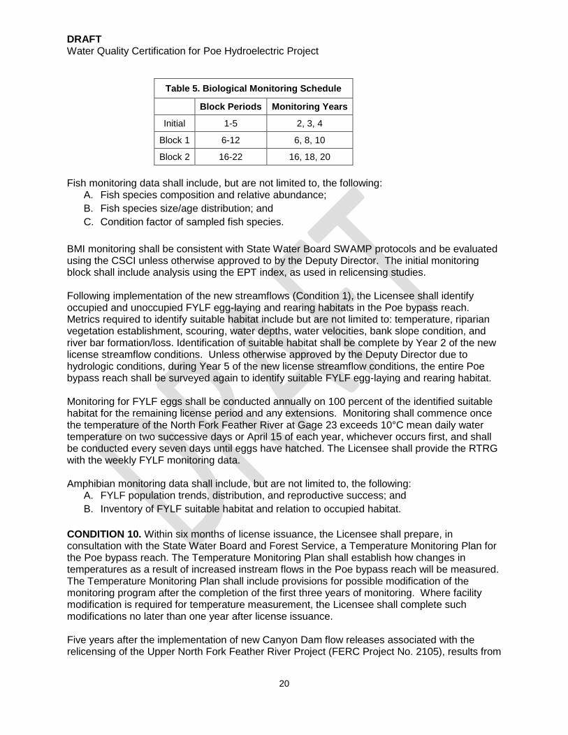
CONDITION 9. Within one year of license issuance the Licensee shall submit a Poe Bypass Reach Biological Monitoring Plan (Poe Bypass Plan) to the Deputy Director for review and approval. The Poe Bypass Plan shall be developed in consultation with State Water Board staff, Forest Service, USFWS and CDFW. The Poe Bypass Plan shall describe the fish, BMI, and amphibian monitoring the Licensee will conduct in the Poe bypass reach over the life of the license and any extensions. The Poe Bypass Plan shall include the following elements: (1) Objectives and Goals; (2) description of the methodology used for monitoring; and (3) description of possible circumstances that may affect monitoring and if those circumstances are caused by Project operations. The Licensee shall include documentation of consultation with the above agencies, copies of comments and recommendations made in connection with development of the Poe Bypass Plan, and a description of how the Poe Bypass Plan incorporates or addresses the comments and recommendations of the agencies. All monitoring shall be consistent with the methods conducted for upstream monitoring associated with the Rock Creek-Cresta Hydroelectric Project (FERC Project No. 1962) unless otherwise approved by the Deputy Director. The Licensee shall allow a minimum of 30 days for the above agencies to comment and to make recommendations before submitting the Poe Bypass Plan to the Deputy Director for review and approval. The Deputy Director may make modifications as part of any approval. Table 5 establishes the years following license issuance that the Licensee shall monitor BMI and fish in the Poe bypass reach. Sampling may be deferred to the following year(s) in the event of one drought, or more Critically Dry water years. A minimum of three sampling locations shall be sampled during each monitoring effort and sampling locations shall be consistent with past locations, unless otherwise approved by the Deputy Director. The Licensee shall submit biological monitoring reports to the State Water Board within six months following completion of each sampling effort. Within six months of the end of a biological monitoring block period (outlined in Table 5), the Licensee shall consult with the Forest Service, State Water Board staff, USFWS and CDFW to review the biological monitoring program. If changes to the biological monitoring program are determined appropriate by the agencies, the Licensee shall, within one year of the end of the block, propose updates to the Poe Bypass Plan for Deputy Director approval. The Deputy Director may make modifications as part of any approval. Possible updates include, but are not limited to, sampling timeframes and protocols.
DRAFT Water Quality Certification for Poe Hydroelectric Project
20
Table 5. Biological Monitoring Schedule
Block Periods Monitoring Years
Initial 1-5 2, 3, 4
Block 1 6-12 6, 8, 10
Block 2 16-22 16, 18, 20
Fish monitoring data shall include, but are not limited to, the following: A. Fish species composition and relative abundance; B. Fish species size/age distribution; and C. Condition factor of sampled fish species.
BMI monitoring shall be consistent with State Water Board SWAMP protocols and be evaluated using the CSCI unless otherwise approved to by the Deputy Director. The initial monitoring block shall include analysis using the EPT index, as used in relicensing studies. Following implementation of the new streamflows (Condition 1), the Licensee shall identify occupied and unoccupied FYLF egg-laying and rearing habitats in the Poe bypass reach. Metrics required to identify suitable habitat include but are not limited to: temperature, riparian vegetation establishment, scouring, water depths, water velocities, bank slope condition, and river bar formation/loss. Identification of suitable habitat shall be complete by Year 2 of the new license streamflow conditions. Unless otherwise approved by the Deputy Director due to hydrologic conditions, during Year 5 of the new license streamflow conditions, the entire Poe bypass reach shall be surveyed again to identify suitable FYLF egg-laying and rearing habitat. Monitoring for FYLF eggs shall be conducted annually on 100 percent of the identified suitable habitat for the remaining license period and any extensions. Monitoring shall commence once the temperature of the North Fork Feather River at Gage 23 exceeds 10°C mean daily water temperature on two successive days or April 15 of each year, whichever occurs first, and shall be conducted every seven days until eggs have hatched. The Licensee shall provide the RTRG with the weekly FYLF monitoring data. Amphibian monitoring data shall include, but are not limited to, the following:
A. FYLF population trends, distribution, and reproductive success; and B. Inventory of FYLF suitable habitat and relation to occupied habitat.
CONDITION 10. Within six months of license issuance, the Licensee shall prepare, in consultation with the State Water Board and Forest Service, a Temperature Monitoring Plan for the Poe bypass reach. The Temperature Monitoring Plan shall establish how changes in temperatures as a result of increased instream flows in the Poe bypass reach will be measured. The Temperature Monitoring Plan shall include provisions for possible modification of the monitoring program after the completion of the first three years of monitoring. Where facility modification is required for temperature measurement, the Licensee shall complete such modifications no later than one year after license issuance. Five years after the implementation of new Canyon Dam flow releases associated with the relicensing of the Upper North Fork Feather River Project (FERC Project No. 2105), results from

DRAFT Water Quality Certification for Poe Hydroelectric Project
21
the Project’s Temperature Monitoring Plan will be used to evaluate whether changes to the instream flows are appropriate. If changes to the instream flows are deemed appropriate by the Deputy Director to protect temperature related beneficial uses, the Licensee shall, after consultation with the Forest Service, CDFW, and State Water Board, submit a plan for Deputy Director approval to modify the instream flows (Condition 1) to improve temperature conditions. Consultation shall include an evaluation of potential effects related to potential instream flow changes. CONDITION 11. Within six months of license issuance, the Licensee shall prepare, in consultation with the State Water Board and the Forest Service, a riparian monitoring plan for the Poe bypass reach. Surveys shall be conducted in years 1-4 following the implementation of the updated flow schedule. Following Year 4, monitoring shall be conducted at five year intervals unless other intervals are deemed necessary by the Deputy Director to evaluate the effects of flow changes on riparian vegetation. CONDITION 12. If NMFS determines that anadromous fish passage is required under section 18 of the Federal Power Act, the Licensee shall consult with all interested relicensing participants in developing passage measures14. Introduction of anadromous fish may require reevaluation of Project facilities, flow regimes, availability of large woody debris, graveled spawning habitat and access to Project-affected tributaries.
The following conditions also apply to this Project in order to protect water quality and beneficial uses over the term of the Project’s license and any extensions.
CONDITION 13. The Licensee shall comply with the State Water Board’s Construction General Permit, and amendments thereto. For all construction or other activities that could impact water quality or beneficial uses, including those activities not subject to the Construction General Permit, a Deputy Director-approved water quality monitoring and protection plan shall be prepared and implemented.
CONDITION 14. Control measures for erosion, excessive sedimentation and turbidity shall be implemented and in place at the commencement of and throughout any ground clearing activities, excavation, or any other Project activities that could result in erosion or sediment discharges to surface waters. Erosion control blankets, liners with berms, and/or other erosion control measures shall be used for any stockpile of excavated material to control runoff resulting from precipitation, and prevent material from contacting or entering surface waters.
CONDITION 15. Waters shall be free of changes in turbidity (due to Project activities) that cause nuisance or adversely affect beneficial uses. Increases in turbidity attributable to Project-controllable water quality factors shall not exceed the turbidity limits as defined in the SR/SJR Basin Plan. Any appropriate averaging period shall be approved by the Deputy Director prior to the start of construction. The Deputy Director and the Central Valley Regional Board Executive Officer (Executive Officer) shall be notified promptly within 24 hours after monitoring results indicate a turbidity limit
14 Negotiations between PG&E, DWR and other stakeholders have been underway since 2005. Implementation of the Feather River Habitat Expansion Agreement (HEA) is dependent on issuance of a new FERC licenses for the Oroville Facilities Hydroelectric Project (FERC Project No. 2100), Poe Hydroelectric Project (FERC Project No. 2107), and the Upper North Fork Feather River Project (FERC Project No. 2105). By letters dated December 12, 2005 and November 15, 2006, NMFS has reserved its authority to condition fish passage for the Project.

DRAFT Water Quality Certification for Poe Hydroelectric Project
22
exceedance. Activities associated with these exceedances may not resume without approval from the Deputy Director.
CONDITION 16. All imported riprap, rocks, and gravels used for construction within or adjacent to any watercourses shall be pre-washed. Wash water generated on-site shall not contact or enter surface waters. Wash water shall be contained and disposed of in compliance with state, federal, and local laws, ordinances, and regulations.
CONDITION 17. Construction material, debris, spoils, soil, silt, sand, bark, slash, sawdust, rubbish, steel, or other inorganic, organic, or earthen material, and any other substances from any Project-related activity, shall be prevented from entering surface waters. All construction debris and trash shall be contained and regularly removed from the work area to the staging area during construction activities. Upon completion of construction, all Project-generated debris, building materials, excess material, waste, and trash shall be removed from all the Project sites for disposal at an authorized landfill or other disposal site in compliance with state, federal, and local laws, ordinances, and regulations.
CONDITION 18. No unset cement, concrete, grout, damaged concrete, concrete spoils, or wash water used to clean concrete surfaces shall contact or enter surface waters. Any area containing wet concrete shall be completely bermed and isolated. The berm shall be constructed of sandbags or soil and shall be lined with plastic to prevent seepage. No leachate from truck or grout mixer cleaning stations shall percolate into Project area soils. Cleaning of concrete trucks or grout mixers shall be performed in such a manner that wash water and associated debris is captured, contained and disposed of in compliance with state, federal, and local laws, ordinances and regulations. Washout areas shall be of sufficient size to completely contain all liquid and waste concrete or grout generated during washout procedures. Hardened concrete or grout shall be disposed at an authorized landfill, in compliance with state, federal, and local laws, ordinances and regulations.
CONDITION 19. All equipment must be washed prior to transport to the Project site and must be free of sediment, debris, and foreign matter. Any equipment used in direct contact with surface water shall be cleaned prior to use. All equipment using gas, oil, hydraulic fluid, or other petroleum products shall be inspected for leaks prior to use and shall be monitored for leakage. Stationary equipment (e.g., motors, pumps, generators, etc.) shall be positioned over drip pans or other types of containment. Spill and containment equipment (e.g., oil spill booms, sorbent pads, etc.) shall be maintained onsite at all locations where such equipment is used or staged.
CONDITION 20. Onsite containment for storage of chemicals classified as hazardous shall be away from watercourses and include secondary containment and appropriate management as specified in California Code of Regulations, title 27, section 20320.
CONDITION 21. Unless otherwise specified in this water quality certification or at the request of the Deputy Director, data and/or reports must be submitted electronically in a format accepted by the State Water Board to facilitate the incorporation of this information into public reports and the State Water Board's water quality database systems in compliance with Water Code section 13167.
CONDITION 22. The State Water Board’s approval authority includes the authority to withhold approval or to require modification of a proposal or plan prior to approval. The State Water Board may take enforcement action if the Licensee fails to provide or implement a required plan in a timely manner.

DRAFT Water Quality Certification for Poe Hydroelectric Project
23
CONDITION 23. The State Water Board reserves the authority to add to or modify the conditions of this water quality certification to implement a total maximum daily load developed by the State Water Board or the Central Valley Regional Board.
CONDITION 24. The State Water Board reserves the authority to add to or modify the conditions of this water quality certification: (1) if monitoring results indicate that continued operation of the Project could violate water quality objectives or impair the beneficial uses of the North Fork Feather River; (2) to coordinate the operations of this Project and other hydrologically connected water development projects, where coordination of operations is reasonably necessary to achieve water quality objectives or protect beneficial uses of water; or (3) to implement any new or revised water quality objectives and implementation plans adopted or approved pursuant to the Porter-Cologne Water Quality Act or section 303 of the Clean Water Act.
CONDITION 25. Future changes in climate projected to occur during the license term may significantly alter the baseline assumptions used to develop the conditions of this water quality certification. The State Water Board reserves authority to add to or modify the conditions in this water quality certification to require additional monitoring and/or other measures, as needed, to verify that Project operations meet water quality objectives and protect the beneficial uses assigned to the Project-affected stream reaches.
CONDITION 26. The Licensee shall comply with all applicable requirements of the SR/SJR Basin Plan. The Licensee must notify the Deputy Director and Executive Officer within 24 hours of any unauthorized discharge to surface waters.
CONDITION 27. Notwithstanding any more specific conditions in this water quality certification, the Project shall be operated in a manner consistent with all water quality standards and implementation plans adopted or approved pursuant to section 303 of the Clean Water Act. The Licensee must take all reasonable measures to protect the beneficial uses of waters of the North Fork Feather River. CONDITION 28. This water quality certification does not authorize any act which results in the taking of a threatened, endangered or candidate species or any act, which is now prohibited, or becomes prohibited in the future, under either the California Endangered Species Act (Fish & G. Code, §§ 2050-2097) or the federal Endangered Species Act (16 U.S.C. §§ 1531 - 1544). If a “take” will result from any act authorized under this water quality certification or water rights held by the Licensee, the Licensee must obtain authorization for the take prior to any construction or operation of the portion of the Project that may result in a take. The Licensee is responsible for meeting all requirements of the applicable Endangered Species Acts for the Project authorized under this water quality certification. CONDITION 29. In the event of any violation or threatened violation of the conditions of this water quality certification, the violation or threatened violation is subject to all remedies, penalties, process, or sanctions as provided for under applicable state or federal law. For the purposes of section 401(d) of the Clean Water Act, the applicability of any state law authorizing remedies, penalties, process, or sanctions for the violation or threatened violation constitutes a limitation necessary to ensure compliance with the water quality standards and other pertinent requirements incorporated into this water quality certification. CONDITION 30. In response to a suspected violation of any condition of this water quality certification, the Deputy Director or the Executive Officer may require the holder of any federal

DRAFT Water Quality Certification for Poe Hydroelectric Project
24
permit or license subject to this water quality certification to furnish, under penalty of perjury, any technical or monitoring reports the Deputy Director or the Executive Officer deems appropriate, provided that the burden, including costs, of the reports shall bear a reasonable relationship to the need for the reports and the benefits to be obtained from the reports. (Wat. Code, §§ 1051, 13165, 13267 & 13383). The State Water Board may add to or modify the monitoring and/or reporting conditions of this water quality certification as appropriate to ensure compliance. CONDITION 31. No construction shall commence until all necessary federal, state, and local approvals are obtained. CONDITION 32. Any requirement in this water quality certification that refers to an agency whose authorities and responsibilities are transferred to or subsumed by another state or federal agency will apply equally to the successor agency. CONDITION 33. The Licensee must submit any change to the Project, including changes in Project operation, technology, upgrades, or monitoring, that could have a significant or material effect on the findings, conclusions, or conditions of this water quality certification, to the Deputy Director for prior review and written approval. The Deputy Director shall determine significance and may require consultation with state or federal agencies. If the Deputy Director is not notified of a potentially significant change to the Project, it will be considered a violation of this water quality certification. If such a change would also require submission to FERC, the change must first be submitted and approved by the State Water Board, unless otherwise noted in this water quality certification. CONDITION 34. The Deputy Director and the Executive Officer shall be notified one week prior to the commencement of ground disturbing activities that may adversely affect water quality. Upon request, a construction schedule shall be provided to agency staff in order for staff to be present onsite to document compliance with this water quality certification. The Licensee must provide State Water Board and Central Valley Regional Board staff reasonable access to Project sites to document compliance with this water quality certification. CONDITION 35. This water quality certification is subject to modification or revocation upon administrative or judicial review, including review and amendment pursuant to Water Code section 13330 and California Code of Regulations, title 23, division 3, chapter 28, article 6 (commencing with section 3867). CONDITION 36. The State Water Board shall provide notice and an opportunity to be heard in exercising its authority to add to or modify the conditions of this water quality certification. CONDITION 37. Activities associated with operation and maintenance of the Project that threaten or potentially threaten water quality shall be subject to further review by the Deputy Director and Executive Officer. CONDITION 38. Nothing in this water quality certification shall be construed as State Water Board approval of the validity of any water rights, including pre-1914 claims. The State Water Board has separate authority under the Water Code to investigate and take enforcement action if necessary to prevent any unauthorized or threatened unauthorized diversions of water. CONDITION 39. This water quality certification is not intended and shall not be construed to apply to any activity involving a hydroelectric facility and requiring a FERC license or an

DRAFT Water Quality Certification for Poe Hydroelectric Project
25
amendment to a FERC license unless the pertinent certification application was filed pursuant to California Code of Regulations, title 23, section 3855, subdivision (b) and that application specifically identified that a FERC license or amendment to a FERC license for a hydroelectric facility was being sought. CONDITION 40. This water quality certification is conditioned upon total payment of any fee required under California Code of Regulations, title 23, division 3, chapter 28. CONDITION 41. A copy of this water quality certification shall be provided to any contractor and all subcontractors conducting Project-related work, and copies shall remain in their possession at the Project site. The Licensee shall be responsible for work conducted by its contractor, subcontractors, or other persons conducting Project-related work.
JUNE 14, 2017
DRAFT RELEASED FOR PUBLIC COMMENT ____________________________________ _____________________________ Executive Director Date Attachments: Figure 1: Upstream Project Features Figure 2: Downstream Project Features

DRAFT Water Quality Certification for Poe Hydroelectric Project
26
References CVRWQCB (Central Valley Regional Water Quality Control Board). 2016. The water quality
control plan (Basin Plan) for the California Regional Water Quality Control Board, Central Valley Region, The Sacramento River Basin and the San Joaquin River Basin, Fourth Edition - 2016. Central Valley Regional Water Quality Control Board web page. Available at http://www.waterboards.ca.gov/centralvalley/water_issues/basin_plans/sacsjr.pdf Accessed June 8, 2017.
FERC. 2007. Final Environmental Assessment (EA) for New Major Hydropower License: Poe
Hydroelectric Project (FERC Project No. 2107), California. Federal Energy Regulation Commission, Washington, DC. March 29, 2007.
Garcia and Associates (GANDA). 2008. Identifying Microclimatic and Water Flow Triggers
Associated with Breeding Activities of a Foothill Yellow‐Legged Frog (Rana boylii) Population on the North Fork Feather River, California. California Energy Commission, Public Interest Energy Research Program (PIER) Energy‐Related Environmental Research Program. CEC‐500‐2007‐041.
Kiernan, J. Moyle, P., Crain, P. 2012. Restoring native fish assemblages to a regulated
California stream using the natural flow regime concept. Ecological Applications 22(5): 1572-1482.
Kupferberg, S.J. 1996. Hydrologic and geomorphic factors affecting conservation of a river-
breeding frog (Rana boylii). Ecological Applications. 6: 1332–1344. Kupferberg, S., Lind, A., Mount, J., and Yarnell, S. 2009. Pulsed flow effects on the Foothill
Yellow-Legged Frog (Rana boylii): Integration of empirical, experimental, and hydrodynamic modeling approaches. California Energy Commission, PIER. CEC-500-2009-002.
Mount, Jeffery. 1995. California Rivers and Streams, The Conflict Between Fluvial Process and
Land Use. University of California Press. Berkeley, USA. PG&E. 2003. Final license application for the Poe Project (FERC No. 2107), application for new
license. December 16, 2003.
State Water Resources Control Board (SWRCB). 2012. Final 2012 Integrated Report (CWA section 303(d) List / 305(b) Report) http://www.waterboards.ca.gov/water_issues/programs/tmdl/2012state_ir_reports/category5_report.shtml. Accessed June 8, 2017.
Yarnell SM, Lind AJ, Mount JF. 2012. Dynamic flow modeling of riverine amphibian habitat with application to regulated flow management. River Research and Applications 28: 177–191.
Zweifel, R. G. 1955. Ecology, distribution, and systematics of frogs of the Rana boylii group. University of California Publications in Zoology 54: 207–292.

DRAFT Water Quality Certification for Poe Hydroelectric Project
27
Figure 1: Upstream Project Features (Source: PG&E, 2003, as modified by FERC staff).

DRAFT Water Quality Certification for Poe Hydroelectric Project
28
Figure 2: Downstream Project Features (Source: PG&E, 2003, as modified by FERC staff).