Embed Size (px)
Citation preview

Standard Detail Requirements for NJDEP Green Acres Surveys page 1 of 61 (effective July 1, 2017)
STATE OF NEW JERSEY DEPARTMENT OF ENVIRONMENTAL
PROTECTION GREEN ACRES PROGRAM
SCOPE OF SURVEY SERVICES
AND STANDARD DETAIL REQUIREMENTS
July 1, 2017

Standard Detail Requirements for NJDEP Green Acres Surveys page 2 of 61 (effective July 1, 2017)
Table of ContentsTable of ContentsTable of ContentsTable of Contents
1. PURPOSE ........................................................................................................................... 4
2. REQUEST FOR SURVEY ....................................................................................................... 6
2A. METHOD OF ENGAGEMENT ................................................................................................... 7
2A-1 Qualifying for NJDEP Green Acres Survey Contracts ................................................................... 7
2A-2 Site-Specific Engagement RFP ..................................................................................................... 7
2A-3 Site-Specific Engagements .......................................................................................................... 7 2A-4 Cost Estimating for site-specific engagements – All Inclusive Survey Cost ................................. 8
2A-5 Notification of Site Specific Engagement Award ......................................................................... 8
2A-6 Survey Contract Manager Discretion .......................................................................................... 8
2A-7 Time for Deliverables .................................................................................................................. 8
2A-8 Deficiency Conversion/ Correction Cost ..................................................................................... 8
3. SURVEYING STANDARDS AND STANDARDS OF CARE .......................................................... 9
3.1 Effective Date ....................................................................................................................... 9
3A. General Requirements for Property Surveys .......................................................................... 9
3B. Other Requirements and Standards of Practice ..................................................................... 10
3C. The Normal Standard of Care ............................................................................................... 10
3D. Boundary Resolution............................................................................................................ 11 3D-1 Deed Conflicts ........................................................................................................................... 11
3E. Measurement Standards ...................................................................................................... 12
4. RECORDS RESEARCH ........................................................................................................ 14
5. FIELD WORK .................................................................................................................... 15
5.1 Field Procedures and Crew Responsibilities .......................................................................... 15
5.2 Notification of Parties and Surveyors’ Right of Entry ............................................................. 15
5.2-a Agency Fax Notification ............................................................................................................. 15
5.2-b Property Owner, Adjoiners, and Police Notification ................................................................. 15
5.2-c Other Notifications .................................................................................................................... 16
5.3 Standards for the use of Global Positioning Systems (GPS) .................................................... 16
5.3-a Requirement for New GPS Work ............................................................................................... 16
5.3-b Control ....................................................................................................................................... 16
5.3-c Datum ........................................................................................................................................ 16 5A. MONUMENTS ...................................................................................................................... 16
5A-1 Corner Marking and Line Marking............................................................................................. 17
5B. RIGHTS OF WAY AND ACCESS ............................................................................................... 20
5C. LINES OF POSSESSION, AND IMPROVEMENTS ALONG THE BOUNDARIES ............................... 21
5D. BUILDINGS ........................................................................................................................... 21
5E. EASEMENTS AND SERVITUDES .............................................................................................. 21
5F. CEMETERIES ......................................................................................................................... 22
5G. WATER FEATURES ................................................................................................................ 22
6. REPORTS ...................................................................................................................... 23
6A. PLAN OF SURVEY ................................................................................................................. 23
6A-1 Overview ................................................................................................................................... 23
6A-2 Survey Plan Presentation - General........................................................................................... 25 6A-3 Survey Plan Presentation – Detailed Instructions ..................................................................... 30
6 B DEED DESCRIPTION .............................................................................................................. 34

Standard Detail Requirements for NJDEP Green Acres Surveys page 3 of 61 (effective July 1, 2017)
6B-1 Deed Description Format .......................................................................................................... 34
6B-2 Deed Description Type .............................................................................................................. 34
6B-3 Letterhead of Survey Firm ......................................................................................................... 34
6B-4 Description Heading .................................................................................................................. 34
6B-5 Description Introduction ........................................................................................................... 35 6B-6 Description Second Paragraph .................................................................................................. 35
6B-7 Body of Description ................................................................................................................... 35
6B-8 Using Augmenting and Qualifying Clauses ................................................................................ 36
6B-9 Recite Areas Described .............................................................................................................. 36
6B-10 Closing Paragraph and Call for Survey ....................................................................................... 36
6B-11 Original Signature, Embossed Seal and Date Signed ................................................................. 37
7. CERTIFICATIONS ........................................................................................................... 38
7.1 Plan Certification ................................................................................................................. 38
7.2 Surveyor’s Certification and Summary Form ......................................................................... 38
8. DELIVERABLES .............................................................................................................. 39
8.1 Copies of Notifications ......................................................................................................... 39
8.2 Copies of Written Consent ................................................................................................... 39
8.3 Parcel Closure ...................................................................................................................... 39 8.4 Full-size Paper Copies of Survey Plan .................................................................................... 40
8.5 Metes and Bounds Description and Reduced Survey Plan...................................................... 40
8.6 Digital Files .......................................................................................................................... 40
8.7 Surveyor’s Certification and Summary Form ......................................................................... 41
8.8 Checklist of Work Completed, Detail Sheet and Tax map ....................................................... 41
8.9 Corner Photographs and Corner Marker Description Sheets .................................................. 41
8.10 Preliminary Reviews and Modifications of Deliverables ........................................................ 41
9. DEFINITIONS ................................................................................................................ 43
10. SAMPLE FORMS AND TEXT ........................................................................................... 45
Sample Form 1 – AGENCY FAX NOTIFICATION ................................................................................... 46
Sample Form 2 – NOTIFICATION OF ENTRY LETTER ............................................................................ 47
Sample Form 3 – AERIAL PHOTO INFORMATION BLOCK .................................................................... 48
Sample Form 4 - WETLANDS DELINEATION INFORMATION ................................................................ 49 Sample Form 5A – LEGEND OF ACQUISITION - STATE ACQUISITION ................................................... 51
Sample Form 5B - LEGEND OF ACQUISITION - LOCAL UNIT OR NONPROFIT ........................................ 52
Sample Form 6A – CERTIFICATION FORM FOR STATE LAND ACQUISITION .......................................... 53
Sample Form 6B – CERTIFICATION FORM FOR LOCAL UNIT/NONPROFIT PROJECT .............................. 55
Sample Form 7A – STATE LAND ACQUISITION CHECKLIST .................................................................. 57
Sample Form 7B – LOCAL UNIT AND NONPROFIT LAND ACQUISITION CHECKLIST ............................... 59
11. GREEN ACRES REVIEW OF SURVEY DELIVERABLES ......................................................... 60
11.1 Purpose ............................................................................................................................... 60
11.2 Principles Guiding the Survey Review ................................................................................... 60
11.3 Survey Reviews for Local Unit and Nonprofit Projects ........................................................... 61
11.4 Survey Reviews for State Acquisition Projects ...................................................................... 61 11.5 Survey Review Process ........................................................................................................ 61

Standard Detail Requirements for NJDEP Green Acres Surveys page 4 of 61 (effective July 1, 2017)
State of New Jersey
Department of Environmental Protection Green Acres Program
STANDARD DETAIL REQUIREMENTS FOR
NJDEP GREEN ACRES SURVEYS (Effective July 1, 2017)
1. PURPOSE The New Jersey Department of Environmental Protection’s Green Acres Program is a state agency with the following mission statement: "To achieve, in partnership with others, a system of interconnected open spaces, whose protection will preserve and enhance New Jersey's natural environment and its historic, scenic, and recreational resources for public use and enjoyment." The Green Acres Program administers state funds, working with landowners, municipal and county governments, nonprofit agencies, and other conservation partners to protect land through direct purchase in fee or by obtaining conservation, public access, or historic preservation easements.
The specific content and format needs of the Green Acres Program are unique to its mission of acquiring interests in real property, and are not fully met by the minimum land survey standards and requirements by NJSA 45:8--27 et seq. and NJAC 13:40--1.1 et seq., even when supplemented by the Minimum Standard Detail Requirements of ALTA/NSPS Land Title Surveys. New Jersey statutory and regulatory survey requirements, applicable sections of ALTA/NSPS detail requirements (effective February 23, 2016, and used by permission), and agency-specific requirements are incorporated herein to more fully address NJDEP/ Green Acres Program survey needs.
These Standard Detail Requirements for New Jersey Department of Environmental Protection (NJDEP) Green Acres Surveys have been developed primarily to assure a more consistent format and presentation of information as to the many matters which might be discoverable from survey and inspection, and which may or not be evidenced by the public records.
A survey plan or plat serves as a record of field and record conditions at the time of the survey, and supplements a corresponding deed description of real property. The Green Acres Program utilizes these documents when encumbering land by restrictive covenant to assure that the property will be used for outdoor recreation or open space for public’s use and benefit. For these documents to be acceptable to the Green Acres Program, the plan of real property must show the land to be free and clear of survey matters (except those matters disclosed by the survey and indicated on the plat or map), certain specific and pertinent information must be presented to identify the distinct and clear understanding between the State of New Jersey, the seller(s) of the property, the purchaser(s) of the property (all acquisition partners), the title insurance company (insurer),and the surveyor professionally responsible for the survey.
The State of New Jersey, the seller of the property, the title insurer, and any acquisition partners are entitled to rely on surveyors to conduct surveys and prepare associated plans or plats together with their corresponding but separate metes and bounds deed descriptions that are of a professional quality and are appropriately uniform, complete and accurate. To that end, and in the interests of the general public; the surveying profession; title insurers; the State of New Jersey, Department of Environmental Protection, Green Acres Program (with reference to the joint efforts of ALTA and the National Society of Professional Surveyors, Inc. who jointly promulgated minimum standard of performance for ALTA/NSPS Land Title Surveys), does hereby set forth the details and criteria herein as the standard performance for NJDEP Green Acres Surveys.
A complete Green Acres Survey includes the research, fieldwork, and all deliverables as established by contract and as prepared in conformance with the specifications herein. This work includes but is not limited to records research as required under Section 4 herein, on-site fieldwork required under Section 5 herein, preparation of a plan or plat as required under Section 6A herein showing the results of the fieldwork and its

Standard Detail Requirements for NJDEP Green Acres Surveys page 5 of 61 (effective July 1, 2017)
relationship to record documents, a corresponding Deed Description as required under Section 6B herein, digital copies of the survey and description as required under Section 6 herein, and the plan certification and Surveyor’s Certification and Summary Form outlined in Section 7 herein.
Properties purchased with Green Acres Program funding subjects those parcels to restrictions and covenants to assure their status for conservation or outdoor recreation or open space. Thus, Green Acres is also an Ultimate User for surveys of properties for county governments, municipal governments, or not–for–profit organizations as well as for surveys made directly for this agency's State Land Acquisition Bureau. Green Acres' interests in the surveyed lands entitle it to require formats and additional information consistent with its needs and practices, which exceed minimum technical criteria established by the State Board of Professional Engineers and Surveyors' regulations established for surveys and descriptions produced in this state. Land surveys prepared for acquisitions for state parks, wildlife management areas, or cooperative efforts that will include state acquisition funds additionally must conform to the standards in this Green Acres Standard Scope of Survey Work for Land Surveys and Property Descriptions.

Standard Detail Requirements for NJDEP Green Acres Surveys page 6 of 61 (effective July 1, 2017)
2. REQUEST FOR SURVEY The survey may be ordered by the State of New Jersey, a municipal government, a county government, a nonprofit organization, or by the seller, depending upon the final intended disposition of the property by NJDEP and any real estate contracts made with the seller. In every case, the survey must be prepared in accordance with a written contract, followed by an authorization to proceed from the person or entity responsible for paying the contract for professional land surveying services. Due to the Open Public Records Act (OPRA) and other laws regarding government records, copyright laws cannot apply to surveys prepared under these contracts.
The survey contract shall specify that a NJDEP Green Acres Survey is required. In every case the contract shall specify that the State of New Jersey, Department of Environmental Protection Green Acres Program is also one of the “Ultimate Users” (NJAC 13:40 5.1 (d)). The contract shall provide for financial remuneration as an “all-inclusive, not to exceed” price that covers any and all any costs associated with the preparation of the survey to avoid any cost overruns. In rare instances, certain properties, including but not limited to marinas, campgrounds, trailer parks and leased areas, may present issues outside those normally encountered on an NJDEP Green Acres Survey. The scope of work related to such properties is to be discussed among the surveyor, the person or entity responsible for paying the contract for professional land surveying services, the title insurer (if necessary), and the NJDEP Green Acres Program, and agreed upon in writing as to the costs to provide all deliverables related to the survey to eliminate or drastically minimize the possibility of any cost overruns prior to authorizing the survey.
The NJ Licensed Land Surveyor, pursuant to NJSA 45:8-44.1 et seq. has the authority “to go on, over and upon lands of others during reasonable hours.” The NJ Licensed Land Surveyor who is working for the NJ Department of Environmental Protection in connection with State Land Acquisition surveys is authorized pursuant to NJSA 13:1D-9 to enter private lands. If eminent domain proceedings are considered, the NJ Licensed Land Surveyor acting on behalf of the prospective condemnor pursuant to NJSA 20:3-16 et seq. has the authority make surveys in connection with the possible litigation.
The NJ Licensed Land Surveyor shall provide written notice via US postal system to the adjoiners, pursuant to the regulatory authority above. In the case of all State Land Acquisition surveys, in addition to the adjoiners, the surveyor will send written notice to the municipal Police Department (see Sample Form 3) and via fax (see Sample Form 2) to the state division to whom the property will be assigned. If needed, in some instances where the property is fenced, blocked, or posted, the surveyor shall be responsible for securing permission to enter upon the property to be surveyed, to access the adjoining properties, or to access any offsite easements.
Freshwater Wetlands survey work is not usually required for NJDEP Green Acres Surveys. When required by contract with NJDEP, follow the specifications and guidelines provided by NJDEP.
Topographic survey work is not usually required for NJDEP Green Acres Surveys. If required by NJDEP, the recommended contour interval and elevation requirement for stable and unstable spot locations will be included in specifications and guidelines outside the scope of work of this document unless in combination with a Green Acres acquisition and development survey. Vertical relief will be shown with the source of information (e.g. ground survey or aerial map), contour interval, datum, and originating benchmark identified. When required, topographic surveys, as a minimum, will be performed using conventional or GPS leveling methods that shall provide similar positional accuracy that would meet or exceed the former Federal Standard for Third Order, Class I accuracy for published NGVD 1988. The contour interval shown on any plans shall be ten (10) feet unless the site-specific engagement specifies an alternate interval. Unstable spot elevations on ground positions must be stated in feet to one decimal place (0.1'), and stable positions such as on monuments or concrete must be stated in feet to two decimal places (0.01'), unless the specifications and guidelines being furnished with the detail sheet for a site-specific engagement request specifies an alternative increment.

Standard Detail Requirements for NJDEP Green Acres Surveys page 7 of 61 (effective July 1, 2017)
2A. METHOD OF ENGAGEMENT
2A-1 Qualifying for NJDEP Green Acres Survey Contracts
Survey contractors must first be generally pre–qualified with Treasury's Division of Property Management and Construction (DPMC) and then evaluated by Green Acres on a technical basis for the more specialized work associated with Green Acres' needs. Survey firms may find that DPMC pre–qualification allows them to secure awards from other agencies and organizations, and will be a prerequisite for future Green Acres State Land Acquisition survey service two–year contracts. A surveyor can become familiar with the requirements of Green Acres survey work by attending workshops, asking questions, and practicing locally on open space acquisition projects. Be sure to ask your clients when surveying open land if there is a possibility that the land will become subject to Green Acres restrictions. If so, follow the Green Acres requirements for your client even before they submit it to the program. Any firm wishing to perform work under this Scope of Survey Services must be pre-qualified by and in good standing with the New Jersey Department of the Treasury’s Division of Property Management and Construction (DPMC) at the time of responding to Requests for Proposals and for the duration of any contract awarded. Details of DPMC qualification are available on-line through DPMC’s website at http://www.nj.gov/treasury/dpmc/pub_how_to_do_business_with_division.shtml. At the time when responses to Requests for Proposals are submitted, the prospective Survey Contract Vendor must submit proof of authorization to conduct business in the State of New Jersey. Information about Business Registration Certificates is available on-line through the Department of the Treasury Division of Revenue’s website at http://www.state.nj.us/treasury/revenue/busregcert.shtml. The prospective Vendor must also submit proof of at least one individual in the direct employ of prospective Survey Contract Vendor holds a current and valid license as a Professional Land Surveyor. Subcontractors may not fulfill this requirement. All surveying work performed for any Using Agency shall be under the direct supervision and responsible charge of an individual holding a current and valid license as a Professional Land Surveyor. That individual shall be readily available for consultation by the Using Agency, and is responsible for assuring that deliverables submitted to the Using Agency are complete, in accordance with project specifications, and on time. For State projects, a two-year contract is awarded through the Bureau of Treasury. Five vendors for each of Green Acres' three regions are chosen through Quality Based Selection, and when projects in the regions become available, the pre-qualified vendors are notified by Green Acres so that they can submit their bids. Notices of upcoming RFPs are posted on the home page of New Jersey's Department of Treasury, Division of Purchase and Property at http://www.state.nj.us/treasury/purchase/ Local government and non–profit acquisition managers secure surveying services individually, and Green Acres has no notice of these surveying opportunities until the work is submitted for review.
2A-2 Site-Specific Engagement RFP
The Survey Contract Manager shall contact prequalified vendor firms that have been assigned to the region for which survey work is required, informing them of the nature, special circumstances, completion time, and due date for submittal of an all-inclusive survey cost in response to each site-specific engagement RFP. The Survey Contract Manager reserves to the right to solicit additional RFPs from prequalified vendors assigned to adjacent regions or prequalified vendors who may have previously worked in the vicinity of the project.
2A-3 Site-Specific Engagements
Prequalified vendors shall submit firm fixed costs by the Response to RFP due date for the site-specific engagement to perform professional land surveying services by the survey due date specified by the Survey Contract Manager. The Response to RFP for site-specific engagements shall be submitted as an all-inclusive survey cost. Such costs shall be provided for work to be completed within three timeframes from the date of authorization: 60 days, 90 days, or 120 days, or such other period specified in the site-specific engagement RFP.
Standard Detail Requirements for NJDEP Green Acres Surveys page 8 of 61 (effective July 1, 2017)
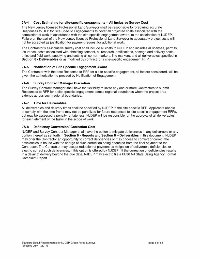
2A-4 Cost Estimating for site-specific engagements – All Inclusive Survey Cost
The New Jersey licensed Professional Land Surveyor shall be responsible for preparing accurate Responses to RFP for Site-Specific Engagements to cover all projected costs associated with the completion of work in accordance with the site-specific engagement award, to the satisfaction of NJDEP. Failure on the part of the New Jersey licensed Professional Land Surveyor to adequately project costs will not be accepted as justification for payment request for additional work.
The Contractor’s all-inclusive survey cost shall include all costs to NJDEP and includes all licenses, permits, insurance, costs associated with obtaining consent, all research, notifications, postage and delivery costs, office and field work, supplying and setting all corner markers, line markers, and all deliverables specified in Section 8 - Deliverables or as modified by contract for a site-specific engagement RFP.
2A-5 Notification of Site Specific Engagement Award
The Contractor with the best Response to RFP for a site-specific engagement, all factors considered, will be given the authorization to proceed by Notification of Engagement.
2A-6 Survey Contract Manager Discretion
The Survey Contract Manager shall have the flexibility to invite any one or more Contractors to submit Responses to RFP for a site-specific engagement across regional boundaries when the project area extends across such regional boundaries.
2A-7 Time for Deliverables
All deliverables and delivery times shall be specified by NJDEP in the site-specific RFP. Applicants unable to comply with the time frame may not be penalized for future responses to site-specific engagement RFPs, but may be assessed a penalty for lateness. NJDEP will be responsible for the approval of all deliverables for each element of the tasks in the scope of work.
2A-8 Deficiency Conversion/ Correction Cost
NJDEP and Survey Contract Manager shall have the option to mitigate deficiencies in any deliverable or any portion thereof as set forth in Section 6 - Reports and Section 8 – Deliverables in this document. NJDEP may offer the Contractor an opportunity to correct deficiencies or may choose to convert or correct the deficiencies in house with the charge of such correction being deducted from the final payment to the Contractor. The Contractor may accept reduction of payment as mitigation of deliverable deficiencies or elect to correct such deficiencies, if this option is offered by NJDEP. If the correction of deficiencies results in a delay of delivery beyond the due date, NJDEP may elect to file a PB36 NJ State Using Agency Formal Complaint Report.
Standard Detail Requirements for NJDEP Green Acres Surveys page 9 of 61 (effective July 1, 2017)
3. SURVEYING STANDARDS AND STANDARDS OF CARE
3.1 Effective Date
This document is effective July 1, 2017 and contains the Standard Detail Requirements for all NJDEP Green Acres Surveys, required for approval by the State of New Jersey, Department of Environmental Protection, Green Acres Program. Generally, survey activities that may be required by site-specific engagements with NJDEP/Green Acres and guided by these specifications are property surveys that do not require topographic services or wetlands location. When any other types of surveys are requested, specifications and guidelines will be furnished at the time that price quotes are solicited for a site-specific engagement.
3A. General Requirements for Property Surveys
The specifications herein primarily address property surveys, the most commonly requested work for NJDEP Green Acres. They also pertain to any boundary information required or depicted in the process of completing any other type of survey work requested.
i. The Detail Sheet supplied with the site-specific RFP will indicate the municipal tax block and lots to be surveyed. A copy from a tax map indicating the area and lots to be surveyed may also be supplied. From this information, the Contractor is required to obtain recorded deeds and other evidence to conduct the survey. The Contractor shall maintain the integrity of the municipal tax lots. Internal lot lines and individual areas per lot shall be stated on the plan, and each individual lot area shall be restated in the metes and bounds description. If the site-specific RFP dictates the acquisition of a portion of a tax lot, no attempt shall be made by the Contractor to assign new lot numbers to remaining lands, unless this provision is modified by NJDEP.
a. For surveys of multiple abutting lots, it may not be necessary to survey the interior lines to obtain the area for each of those lots. The surveyor can calculate the areas from metes and bounds descriptions of the individual parcels. For LOCAL or NONPROFIT SURVEYS ONLY, when better data is not available, it may be acceptable to use tax map areas in conjunction with surveyed area for reporting purposes if better data is not available.
ii. The basis of bearings or north reference for all NJDEP Green Acres Surveys and the beginning point coordinate values (stated in US Survey Feet to two decimal places) shall be New Jersey State Plane Coordinate System North American Datum 1983 Adjustment (NJSPCS NAD83). The grid factor shall be applied to the Northing and Easting values in US Survey Feet of the parcel’s description point of beginning, but not to horizontal survey distances in US Survey Feet. The north arrow shown on the plan must indicate the Bearing Base or reference north.
a. State Plane Coordinates can be determined by traditional ground survey methods or with survey grade GPS. Handheld GPS is not an acceptable method as it does not provide the accuracy required by Green Acres.
b. Conversion of coordinates from grid to ground coordinates is to be performed by determining a centroid point of the parcel being surveyed which will have the identical grid and ground coordinates. The combined scale factor is to be applied about the centroid. The point of beginning is to be labeled with the grid coordinates. The coordinates of the centroid point and the combined scale factor are to be stated on the plan.
c. The distances shown on Green Acres surveys are to be ground measurements in US Survey Feet. Distances must be ground for appraisal purposes, so that the surface area in acres to three decimal places is accurate. To eliminate confusion, plan notes should explain that the distances are ground and the coordinates are grid. Also provide a note regarding the conversion factor.
iii. All property lines of the surveyed parcel must form closed polygons: all sides must be defined by mathematical survey expressions with angular units being degrees, minutes, and whole seconds of arc. Horizontal distances, vertical elevations, radii of curves, lengths of arc, and New Jersey Plane Coordinate values of Northing and Easting shall be stated in horizontal ground US Survey feet stated to two decimal places. See Section 3E – Measurement Standards.
Standard Detail Requirements for NJDEP Green Acres Surveys page 10 of 61 (effective July 1, 2017)
iv. A separate plan of survey of property shall be prepared for each tax lot or group of contiguous tax lots in common ownership. Lots that are in common ownership in the general vicinity but are not contiguous may be grouped onto a single plan only if detail and clarity of information is not compromised when the scale of the plan is reduced.
v. A metes and bounds deed description of the property surveyed shall be prepared for each group of contiguous tax lots in common ownership or single lot if not contiguous. The deed description prepared must follow the Green Acres specific format, including the provision that requires individual area per each included tax lot within the conducted property survey. The description shall be a separate document apart from the plan of survey and shall be prepared on company letterhead that includes the survey contract vendor’s name and certificate of authorization number (if applicable), street and mailing addresses, telephone and fax numbers, company Email address, and company web page (if any), and shall be signed, sealed and dated by the surveyor responsible for the preparation of the survey. A reduced signed copy (8-1/2” by 11”) of the survey plan from which it was written shall be called for in the final paragraph and attached to each metes and bounds deed description. The specific sizing of the attached reduced survey is necessary for appropriate attachment to and filing with the recorded deed.
3B. Other Requirements and Standards of Practice
All survey work will be performed in accordance with New Jersey laws, court rulings and administrative codes pertaining to land surveying: NJAC 7:36 Appendix 2, NJSA 45:8 et seq., NJAC 13:40-1.1 et seq., the Recordation Law, NJSA 46:26A-1 et seq., and other laws pertaining to this professional activity. State Government is exempted from certain statutory laws and administrative rules, and this Scope of Work is written to minimize adverse impact of such exemption.
Where conflicts between the standards set forth herein and any jurisdictional requirements and standards of practice occur, generally this document (the New Jersey Department of Environmental Protection Green Acres Program Scope of Survey Services) incorporates all relevant State Statutes and Administrative Codes and shall apply.
The Contractor shall be required to obtain and maintain, during the term of prequalification for site-specific engagement award, all licenses, permits, certifications, authorizations, or any documents required by federal authorities, state authorities, county and municipal governments, and international authorities, whenever necessary, to complete its site-specific engagement award
3C. The Normal Standard of Care
Special care must be taken to insure accuracy, consistency, and clarity in all documents being prepared, since Green Acres participation and resultant restrictions insures that lands are retired from development pressure and the land survey plan and corresponding metes and bounds description will likely be the last ones prepared or recorded for that parcel. The Surveyor’s Statute of Limitations does not apply to survey work prepared for governmental agencies.
i. Responsibility for work - The New Jersey licensed Professional Land Surveyor who is a member of the survey firm under contract shall be the primary point of contact for any site-specific engagement contract. The New Jersey licensed Professional Land Surveyor shall be responsible for obtaining all deeds, records, maps, measurements, and evidence to conduct a correct and accurate land survey and for providing all deliverables according to the site-specific engagement contract. The New Jersey licensed Professional Land Surveyor shall insure that the plan of survey and corresponding description of property shall be prepared and presented in the format as specified, attested to by the New Jersey licensed Professional Land Surveyor’s embossed seal and original signature. The New Jersey licensed Professional Land Surveyor is responsible for checking all work and insuring that the deliverables are forwarded in the format specified in the Deliverables section of the site-specific engagement contract to NJDEP within the time period specified in the engagement award.
ii. Supervision - A New Jersey licensed Professional Land Surveyor is responsible for coordinating the research and supervising the field work and document preparation associated with the land survey.

Standard Detail Requirements for NJDEP Green Acres Surveys page 11 of 61 (effective July 1, 2017)
Evidence of personal supervision is signified by the original signature and raised seal of the Land Surveyor on each land survey plan or metes and bounds deed description document submitted. It is for this reason that rubber stamps or digital signatures of the Land Surveyor are not acceptable and unlawful.
3D. Boundary Resolution
The boundary lines and corners of any property being surveyed as part of the NJDEP Green Acres survey shall be established and/or retraced in accordance with appropriate boundary law principles governed by the set of facts and evidence found in the course of performing the research and survey. Actual deed overlaps and gores are to be shown on plan with geometry and area provided. Gores will always be described in a separate metes and bounds Deed Description to be used in a Quit Claim Deed to NJDEP. Title for state acquisition lands can be obtained subject to an overlap while municipal, county and nonprofit acquisitions may not encumber overlaps with open space funds.
The survey shall report the relationship of the boundaries of the surveyed property (i.e. contiguity, gaps, or overlaps) to its adjoiners, where ascertainable from Record Documents and/or from field evidence gathered during the process of conducting the survey of the property being surveyed. If the surveyed property is composed of multiple tax lots or parcels, the extent of any gaps or overlaps between those parcels shall be identified. Where gaps or overlaps are identified, the surveyor shall, prior to preparation of the final plat or map, disclose this to the insurer and NJDEP for determination of a course of action concerning junior/senior rights.
When, in the opinion of the surveyor, the results of the survey differ significantly from the record, or if a fundamental decision related to the boundary resolution is not clearly reflected on the plat or map, the surveyor shall explain this information with notes on the face of the plat or map.
3D-1 Deed Conflicts
The New Jersey licensed Professional Land Surveyor is responsible for obtaining all records, measurements and evidence to prepare a correct and accurate land survey, and shall present information on the plan of survey to show how the record condition now exists or fits on the ground. As a result of this research, the surveyor may uncover areas of title uncertainty such as a gore area between deeds, deed overlaps, or other areas of ambiguity. To demonstrate that adjoining records have been examined, the plan of survey must indicate information for all adjoiners, including the name of the record owner, the municipal tax block and lot, and the deed book and page number for adjoining parcels.
The New Jersey licensed Professional Land Surveyor may be able to render a professional opinion as to how a deed problem was created. However, the surveyor is only responsible for showing on the plan of survey the record condition as it now exists. Conflicts with adjoining deeds that are not resolved in the process of boundary analysis by the surveyor must be shown as deed overlaps or deed gores on the plan of survey. Areas of confusion are to be located by bearings and distances and the area is to be clearly stated. The plat of a parcel being acquired must show the total area surveyed, subject to an area of confusion with an adjoining area for which the tax lot and block numbers are given. Any “Apparent Deed Gore”, Deed Overlap, “Clouded Title Area” or “Encroachment Area” shall be labeled on the plats of all adjoiners as an area of confusion being surveyed, and defined by bearings, distances, and area
Descriptions prepared by the New Jersey licensed Professional Land Surveyor may enable NJDEP to correct the records and clear title to land. The description of property may be written to include such areas, in which case the description shall provide a qualifying clause “subject to” such area, or the using agency may require that a separate metes and bounds description be prepared. Apparent gore areas found to exist as a result of the survey shall always be described by a separate metes and bounds description to provide the using agency the opportunity to obtain a quit claim deed.
3D-1.1 Record Gore Areas
Green Acres generally does not fund areas of unknown title. Areas of apparent title gore between adjoining ownership may be resolved by obtaining a quit claim deed to the gore area from all adjoining parties.

Standard Detail Requirements for NJDEP Green Acres Surveys page 12 of 61 (effective July 1, 2017)
A gore between adjoining deeds may be the result of a true vacancy dating back to a conveyance out of the Board of Proprietors of Eastern or Western Divisions of New Jersey. Deed gores are to be defined by bearings, distances, and area, both on the survey plan and in a separate metes and bounds description, with references to tax lot and block numbers. A separate metes and bounds description of the gore area with appropriate copies shall be prepared in every case to provide NJDEP the opportunity to obtain a quit claim deed to the gore area from the Board of Proprietors or the sellers and the adjoiners as appropriate. The gore area shall be drawn on all survey plans of lots being surveyed. This description shall agree with the results of the survey plan to which it refers in every particular, and for that reason, the description must not include any information that does not appear either graphically or in a factual note on the survey plan. A reduced copy of the survey plan (8-1/2” by 11”) must also be attached to each copy of the description.
3D-1.2 Record Overlap Areas
Green Acres generally does not fund areas of clouded title. Areas of overlapping title can be handled in two ways:
1. Include the overlap area in the overall description of the property surveyed and understand that Green Acres will not fund it. The description will be “subject to” the described area of overlap in such instances.
2. Provide a description of the overall property, and also provide a separate metes and bounds description of area of encroachments and overlap as exceptions from the area being funded by Green Acres. For State land acquisitions, after closing the sale to NJDEP of the area unaffected by the overlap, the property owner can use this described overlap area to quit claim the property to an adjoiner who is adversely using the land.
Areas of deed description overlaps are to be defined by mathematical survey expressions and area, both on the survey plan and following a qualifying clause in the metes and bounds description of the property, with references to tax lot and block numbers stated. The overlap area shall be drawn on all adjoining survey plans of lots being surveyed. The overall metes and bounds description of a property shall agree with the results of the survey plan to which it refers in every particular, and the overlap area shall be described by metes and bounds following a qualifying clause (i.e. “subject to an overlap…”). The area of overlap shall also be stated for each Tax Block and lot, so that the net area of each surveyed lot is known and stated both on the plan and in the corresponding metes and bounds description. The description must not include any information that does not appear either graphically or in a factual note on the survey plan. A reduced copy of the signed survey plan (8-1/2” by 11”) must also be attached to each copy of the description.
3E. Measurement Standards
The following measurement standards address Relative Positional Precision for the monuments or witnesses marking the corners of the surveyed property.
i. “Relative Positional Precision” means the length of the semi-major axis, expressed in feet or meters, of the error ellipse representing the uncertainty due to random errors in measurements in the location of the monument, or witness, marking any corner of the surveyed property relative to the monument, or witness, marking any other corner of the surveyed property at the 95 percent confidence level (two standard deviations). Relative Positional Precision is estimated by the results of a correctly weighted least squares adjustment of the survey.
ii. Any boundary lines and corners established or retraced may have uncertainties in location resulting from (1) the availability, condition, history and integrity of reference or controlling monuments, (2) ambiguities in the record descriptions or plats of the surveyed property or its adjoiners, (3) occupation or possession lines as they may differ from the written title lines, and (4) Relative Positional Precision. Of these four sources of uncertainty, only Relative Positional Precision is

Standard Detail Requirements for NJDEP Green Acres Surveys page 13 of 61 (effective July 1, 2017)
controllable, although due to the inherent errors in any measurement, it cannot be eliminated. The magnitude of the first three uncertainties can be projected based on evidence; Relative Positional Precision is estimated using statistical means (see Section 3E-i. above and Section 3E-.v. below).
iii. The first three of these sources of uncertainty must be weighed as part of the evidence in the determination of where, in the surveyor’s opinion, the boundary lines and corners of the surveyed property should be located (see Section 3D. above). Relative Positional Precision is a measure of how precisely the surveyor is able to monument and report those positions; it is not a substitute for the application of proper boundary law principles. A boundary corner or line may have a small Relative Positional Precision because the survey measurements were precise, yet still be in the wrong position (i.e. inaccurate) if it was established or retraced using faulty or improper application of boundary law principles.
iv. For any measurement technology or procedure used on a NJDEP Green Acres Survey, the surveyor shall (1) use appropriately trained personnel, (2) compensate for systematic errors, including those associated with instrument calibration required by state law, and (3) use appropriate error propagation and measurement design theory (selecting the proper instruments, geometric layouts, and field and computational procedures) to control random errors such that the maximum allowable Relative Positional Precision outlined in Section 3E-v. below is not exceeded.
v. The maximum allowable Relative Positional Precision for a NJDEP Green Acres Survey is the same as an ALTA/NSPS Land Title Survey, being 2 cm (0.07 feet) plus 50 parts per million (based on the direct distance between the two corners being tested). It is recognized that in certain circumstances, the size or configuration of the surveyed property, or the relief, vegetation or improvements on the surveyed property will result in survey measurements for which the maximum allowable Relative Positional Precision may be exceeded. If the maximum allowable Relative Positional Precision is exceeded, the surveyor shall note the reason as explained in Section 6A-1.1-vi below.

Standard Detail Requirements for NJDEP Green Acres Surveys page 14 of 61 (effective July 1, 2017)
4. RECORDS RESEARCH A New Jersey licensed Professional Land Surveyor is responsible for coordinating the research necessary to obtaining sufficient documentation and evidence to render a survey plan which is correct as well as accurate to the stated specifications and standards. For site-specific engagement contract purposes, the surveyor shall be prepared to conduct all the research required to complete the work by the due date. Land survey plans for adjoining state owned property may be obtained from the administering division or from the original survey firm that prepared the work for NJDEP/Green Acres.
It is recognized that for the performance of a NJDEP Green Acres Survey, the New Jersey licensed Professional Land Surveyor is responsible for obtaining all records, measurements, and evidence to prepare a correct and accurate land survey, for providing paper and digital copies of the land survey plans that depict the results of the survey, and for preparing and providing the corresponding description of property, prepared on company letterhead for the deed of conveyance. To that end, the surveyor will obtain all appropriate data which can be relied upon in the preparation of the survey, including but not limited to tax records, deeds of the subject property as well as those of the adjoining parcels, public and private survey plans and filed maps. The request for a NJDEP Green Acres Survey shall set forth only the current record tax record block and lot of the property to be surveyed. In most cases, the surveyor will be provided with complete copies of the most recent title commitment, and copies of surveys of adjoining parcel surveys and deeds. However, it shall remain the responsibility of the surveyor to obtain the current record description of the property to be surveyed (or, in the case of an original survey, the parent parcel), the current record descriptions of adjoiners, any record easements benefiting the property, the record easements or servitudes and covenants burdening the property (all hereinafter referred to collectively as "Record Documents"), documents of record referred to in the Record Documents, documents necessary to ascertain, if possible, the junior/senior relationship pursuant to Section 3D above, and any other documents containing desired appropriate information affecting the property being surveyed, and to which the NJDEP Green Acres survey shall make reference, shall be provided to the surveyor for use in conducting the survey. Reference is made to Section 3B above.

Standard Detail Requirements for NJDEP Green Acres Surveys page 15 of 61 (effective July 1, 2017)
5. FIELD WORK The Survey shall be performed on the ground (except as otherwise negotiated).
5.1 Field Procedures and Crew Responsibilities
The New Jersey licensed Professional Land Surveyor shall be responsible for the work of all survey crews operating from the firm. The survey crew shall endeavor to cause as little inconvenience as possible to property owners when conducting the field survey.
Whenever possible, random traverse lines shall be run within the property being surveyed rather than upon the lands of an adjoiner. If traverse lines are run upon the lands of an adjoiner, no clearing of lines shall be conducted without the prior written consent of the party whose name appears as the property owner on the tax rolls of that municipality.
Painting and flagging evidence shall be kept to a minimum, and permanent paint shall not be used on lands of the adjoiner without prior written consent of that landowner. Littering or damaging any property may subject the offenders and licensee to possible civil action.
Large trees shall not be cut to clear line without the prior consent of NJDEP. Brushing-out of lines on adjoining land shall be kept to a minimum and is only permitted with the prior written consent of the owner. Brushing-out of lines on future state property shall be kept to a minimum. The surveyor is responsible for compliance with regulations, including procuring permits with regard to disturbance of wetland vegetation. Copies of the written consent documents, if any, must be forwarded to NJDEP with the final deliverables.
Locate improvements within any offsite easements or servitudes benefiting the surveyed property that are disclosed in the Record Documents provided to the surveyor and that are observed in the process of conducting the survey. Identify and locate any monumentation of said easements and servitudes.
Additionally, the field crew shall report any observations of evidence of prior or current earth moving work, dumping, clearing, or disturbances on the land, all of which is to be reported on the final plan.
5.2 Notification of Parties and Surveyors’ Right of Entry
The New Jersey licensed Professional Land Surveyor shall prepare and send fax and written notices as prescribed herein that their firm has been awarded a site-specific engagement contract to conduct a land survey of the property and the scheduled period of time that survey crews are scheduled to be present on the property.
5.2-a Agency Fax Notification
Prior to starting any field work, the New Jersey licensed Professional Land Surveyor must notify the Administering Agency by fax that the survey firm has been engaged to perform property survey work on the site identified by the notice and the dates that field crews will be present. The notification is to be made using the sample division notification and sent by facsimile transmission (fax) to the appropriate division representative. The paper copy of the fax letter is to be forwarded to NJDEP as a deliverable with all other notifications. See Sample Form 2 – Agency Fax Notification.
5.2-b Property Owner, Adjoiners, and Police Notification
The New Jersey licensed Professional Land Surveyor must send written notice to the property owner (or designated representative), and any adjacent property owners upon whose land it may be necessary to enter to complete the survey. The notice shall be reproduced as prescribed on company letterhead with a copy being sent to the police department of the municipality where the job is located and to NJDEP as a deliverable.
If it becomes necessary to enter the property without the permission of the owner, there are three statutory provisions allowing entry:
1) The Surveyor's Trespass Law, NJSA 45:8-44.1, to go on, over and upon lands of others during reasonable hours to make a land survey;

Standard Detail Requirements for NJDEP Green Acres Surveys page 16 of 61 (effective July 1, 2017)
2) As an agent of the Commissioner of the Department of Environmental Protection, pursuant to NJSA 13:8A-16 land surveyors may enter on any lands for the purpose of making surveys or other inspections;
3) Pursuant to the provisions of Preliminary Entry of the Eminent Domain Statute, NJSA 20:3-16, agent surveyors of a prospective condemnor may enter lands during reasonable business hours to make a land survey.
Each statute requires that written notice must be sent via the United States Postal Service as Certified Mail, Return Receipt Requested. Such notice, if required, shall be sent prior to entry and the notice shall be reproduced on the letterhead of the survey firm, substantially in accordance with Sample Form 3 – Notification of Entry Letter.
5.2-c Other Notifications
It shall be the responsibility of the New Jersey licensed Professional Land Surveyor to determine if other notifications shall be necessary. Copies of any notices shall be provided to NJDEP as confirmation with all other survey deliverables.
When digging will be necessary, the Underground Facility Protection Act, NJSA 2C:17-5, requires a phone call to 1-800-272-1000 three business days prior to digging to request that underground utilities be marked out on site.
5.3 Standards for the use of Global Positioning Systems (GPS)
When GPS technology is utilized, all work shall meet or exceed the Geospatial Positioning Accuracy Standards of the Federal Geographic Data Committee (FGDC). All work is to be tied into the National Spatial Reference System (NSRS). Network accuracy between any point in the survey and the NSRS must attain positional accuracy of 95%.
5.3-a Requirement for New GPS Work
Because the precision attainable with GPS continues to improve the accuracy of measurements, new GPS work is to be performed for all Green Acres surveys, rather than relying on coordinates reported on prior adjacent surveys, regardless of who performed them.
5.3-b Control
On the plan, indicate the National Geodetic Survey reference control utilized, the coordinates of the centroid point, and the combined scale factor.
5.3-c Datum
Survey work is to be reported in the most current datum and adjustment, which at the time of this Scope of Survey Services is NAD 83 (2011).
ALL FIELD WORK SHALL INCLUDE ITEMS IDENTIFIED IN SECTIONS 5A THROUGH 5G BELOW:
5A. MONUMENTS
Survey plans and metes and bounds descriptions shall include:
i. The location and description of any monuments or lines that control the boundaries of the surveyed property.
ii. The location, size and type of any monuments found or set on the boundary of the surveyed property, including line markers.
iii. The location, size and type of any other monuments placed (or a reference monument or witness to the corner) at all major corners of the boundary of the property, unless already marked or referenced by existing monuments or witnesses.

Standard Detail Requirements for NJDEP Green Acres Surveys page 17 of 61 (effective July 1, 2017)
5A-1 Corner Marking and Line Marking
Pursuant to rules of the New Jersey State Board of Professional Engineers and Land Surveyors, the New Jersey licensed Professional Land Surveyor is responsible for determining the Ultimate User of the survey, the survey plan, and the corresponding description. The Ultimate User shall be considered to be NJDEP and the State of New Jersey. In general, Green Acres' contracts establish that corner markers must be set at the limits of a project area (one or more tax lots) where the same adjoins lands of others. However, corner markers are not to be set on corners that are:
a. internal to the project area, common with other lands of the grantee taking title to the land (such as other lands owned by the purchasing agency) or
b. along a public road right–of–way, except where the external lines of the project area intersect the right–of–way line of the public road.
To more clearly define where corner markers must be set and where they may be omitted, the following sub-sections shall apply.
5A-1.1 Setting Corner Markers
Corner markers shall be set at the perimeter limits of a fee simple acquisition project area where the property being surveyed adjoins any lands owned by an individual or entity other than the purchaser or Using Agency, or not being acquired in fee as a part of the same project. Corner markers shall also be set at the perimeter limits of all public access easement corridors except where the public access easement corridor adjoins lands owned in fee by the purchaser or by NJDEP or is being acquired in fee as a part of the project. Corner markers shall also be set at the perimeter limits of all conservation easements. Concrete monuments must be set at the perimeter limits of Environmental Infrastructure Funding Program (EIFP) areas. Corner markers shall be set at the intersection of a public road right-of-way line with a perimeter limit line of the project. These provisions shall apply to both fee acquisition and easement area acquisitions. Internal lines within a lot marking a public access easement corridor limit shall be marked under the same guidelines as a fee acquisition. Corners of exception areas, both fee and easement, shall also be marked. Corner markers for such residential exception areas that fall in a tilled field shall, in addition to having a surface marker set, have a detectable subsurface marker set not less than 1.5 feet below the surface. The requirement to mark corners may be clarified or modified by NJDEP in a site-specific RFP.
When Green Acres is not participating in funding the acquisition of an entire site, the limits of its participation, and therefore of its encumbrance on the land, must be marked on the ground. As an Ultimate User of all surveys in which it participates, Green Acres requires that the limits of its participation be marked in the field with permanent markers in accordance with this section and New Jersey State Board of Registration regulations.
5A-1.2 Omitting Markers
Corner markers shall be omitted where the corners are within the right-of-way or along the right-of-way line of a public road (except at the intersection of the right-of-way line with a perimeter limit line of the project, common with a private adjoiner). Corner markers may also be omitted where such corners are common with other lands owned by NJDEP, the corners are within the project area limits (i.e. internal tax lot corners), the corners are common with other lands being acquired as part of the overall project area being surveyed, or where the corners fall within a waterway, water impoundment, or vertical escarpment, unless, in the professional judgment of the surveyor, the corners should be set. Corner markers that are omitted must be identified on the plan as omitted by contractual agreement using the language required by the State Board of Professional Engineers and Land Surveyors. (See NJAC 13:40-5.1/d).
As an Ultimate User of all surveys in which it participates, Green Acres requires all corner markers to be set except as specified above. Green Acres will not grant waivers to corner marking requirements beyond what corner markers may be intentionally omitted by a contract for site-specific engagement.

Standard Detail Requirements for NJDEP Green Acres Surveys page 18 of 61 (effective July 1, 2017)
5A-1.3 Found Markers
In instances where a corner marker would otherwise be set but during the course of conducting the survey, a corner marker is found in the field to be within a radius of 1.5 feet of the true corner as calculated by the surveyor, such corner shall be considered as marked. No new corner marker shall be set, except if this corner is the only alternative for use as the description point of beginning. The plan of survey shall clearly indicate the relationship of the found marker to the true calculated corner per the surveyor’s calculations. Such relationship shall be shown graphically on the plan by north or south and east or west offset distances from the true corner and in a corner detail, if necessary for clarification. Provide the size, type and description of the marker, including cap color and identity. If a marker is found on a corner for which a monument is specified to be set, the surveyor may set the monument as a line marker, set the monument on an alternate corner, or reduce the fee for the site-specific engagement if no new monument is set.
5A-1.4 Offset Markers
At the time of the survey, any marker that cannot be set because the location of the corner is inaccessible must be set on an offset. The marker must be set on the property line as near to the corner as is practical. The disk or cap shall be stamped “OFFSET” and the actual distance in US Survey Feet to the corner shall be clearly indicated on the plan, stated to two decimal places.
5A-1.5 Public Access Corner Markers
Corner markers shall be set to physically identify the location of all public access trail corridors whether such corridors are being acquired in fee or by easement interest, unless this requirement is specifically waived or modified by NJDEP in a site-specific engagement RFP. All such corridors shall be marked on both sidelines at each angle point and where the corridor sidelines intersect a public road right-of-way or the subject property boundary.
5A-1.6 Three Monument Minimum
To maintain the coordinate system for potential future surveys or re-surveys, the Contractor shall set a minimum of three monuments for corner markers, visible from one to another if at all possible, at each grouping of contiguous parcels that constitute a project area. The NJPCS Northing and Easting values must be stated for each of the three monuments set under this provision. It is highly preferred that one new set monument be selected as a description point of beginning for which the NJPCS Northing and Easting values must be stated. If the corner selected to be the Description Point of Beginning was found previously marked, then a monument must be set on an alternate corner to maintain the three-monument minimum requirement. If all original corner markers are found undisturbed, concrete monuments shall be set as line markers and added as accessories to those corners to fulfill the requirement for three new monuments. If original undisturbed corner markers are found within 1.5 feet of the record location, the corner is considered marked by a monument pursuant to the “Recordation Law”. A detail of the relation of the found mark to the calculated corner must be provided. If the marker is greater than 1.5 feet from the calculated corner, an additional marker is to be set at the surveyed corner. Do not replace corner markers that are found or markers considered Monuments under the “Recordation Law”.
5A-1.7 Cap Detail
To indicate the casting and stamping of each type of cap, disk, shiner, etc. actually set to mark corners, a detailed enlargement, not necessarily drawn to scale, shall be depicted on the survey plan. Each corner marker set in the field shall bear the name of the survey firm and shall be stamped with the year set and the corner number.
5A-1.8 Acceptable Corner Markers
All corner markers shall contain a standard 3-1/2 inch or 2-1/2 inch bronze or aluminum disk that bears the name of the survey firm and shall be stamped with the year set and the corner number. Currently available plastic markers do not take stamping well enough to be able to note the date set and the corner number, so presently only metal caps are permitted.

Standard Detail Requirements for NJDEP Green Acres Surveys page 19 of 61 (effective July 1, 2017)
Corner markers shall generally be set flush with the ground except in rural, unimproved areas where the top of the marker may extend not more than 0.2 foot above the ground surface. Green Acres reserves the right to specify the cap design and marker type or to supply corner markers or monuments in a site-specific engagement RFP.
5A-1.8-a Disks
Disks may be used for corner markers if the calculated survey corner falls on a large boulder or on poured concrete slabs, curbs, bridges, or walls. Each disk shall be a standard 3-1/2 inch or 2-1/2 inch bronze or aluminum disk set and cemented in a drill hole. The disk may be of such other materials or design approved by NJDEP for the site-specific engagement.
5A-1.8-b Monuments
All monuments set shall be one of two types: pre-cast or poured in place and set flush, but not more than 0.2 foot above the ground surface. Monuments shall be constructed of reinforced concrete, detectable with a ferrous or magnetic locator, not less than 4 inches square on top, not less than 4 inches square on the bottom, not less than 30 inches in length, and displaying a standard 3-1/2 inch or 2-1/2 inch bronze or aluminum disk. Monuments may be prefabricated of other materials or design if pre-approved by NJDEP for the site-specific engagement.
5A-1.8-c Subsurface Markers
Corner markers for a residential exception area to an easement acquisition that fall in a tilled field shall, in addition to having a surface marker set, have a ferrous or other metal detectable subsurface marker set not less than 1.5 feet below the surface. The requirement to set subsurface markers or mark these corners may be clarified or modified by NJDEP in a site-specific RFP or by mutual agreement of NJDEP and the New Jersey licensed Professional Land Surveyor at the time of the survey.
5A-1.8-d Rebar
All other corner markers other than disks or monuments shall consist of minimum 1/2 inch diameter rebar pins, driven to a point of refusal but shall not less than 24 inches in length. Larger diameters or longer lengths may be necessary to deter vandalism or removal. All rebar pins when set shall contain a standard 3-1/2 inch or 2-1/2 inch bronze or aluminum disk. Plastic caps are not acceptable for marking corners. Corner markers shall generally be set flush with the ground except in rural, unimproved areas where the top of the marker may extend not more than 0.2 foot above the ground surface. NJDEP reserves the right to specify the cap design and marker type or to supply corner markers or monuments in a site-specific engagement RFP.
5A-1.9 Flagging Corners
For each corner marker that is found or set in the field, a witness lath shall be placed within the surveyed property not more than 2 feet from the marker. To aid NJDEP with identification and recovery of corner markers, the lath shall extend above the ground by 2 feet, labeled with the corner number, and three bands of pink surveyor’s flagging shall be attached to the lath. This requirement for lath and flagging shall also apply to markers set on an offset to corner or pins set on line except that only one band of flagging is required. This does not apply to random traverse points set in the field, and it is recommended that an alternate flagging color be selected for each purpose. It is strongly recommended that the colors of each type of flagging used for each purpose be communicated to the administering division contact person.
5A-1.9-a Corner Photographs
Every corner marker found or set is to be photographed, showing the marker and its witness lath with the corner number on the lath clearly visible. Photographs are to be submitted in paper format as well as in a digital file on the deliverable disk. Upon request by the Using Agency, the Contractor will also provide Corner Marker Description Sheets. See Section 8.9 regarding Corner Marker Description Sheets for markers set under a site-specific contract.

Standard Detail Requirements for NJDEP Green Acres Surveys page 20 of 61 (effective July 1, 2017)
5A-1.10 Setting Line Markers
In addition to corner markers, line markers shall be set when the perimeter of a project area being surveyed and acquired in fee simple or as a public access corridor adjoins private lands not owned by NJDEP in fee or as part of a public access corridor easement. Line markers may be omitted when the adjoining land is being acquired by NJDEP as a part of the same project. Line markers must be set when the adjoining land is owned by an agency other than NJDEP. These provisions shall apply to both fee acquisitions and easement with public access area acquisitions. Additionally, public access easement corridors shall be marked under the same guidelines as a fee acquisition. Line markers shall be set at approximately 250 feet to 300 feet intervals to aid the administering divisions in identifying and locating long property lines in excess of 500 feet between corner markers. Only long lines for which corner markers must be set shall be further marked in this manner. The distances between line markers shall be noted on the plan of survey, stated as a horizontal distance in US Survey Feet to two decimal places. This requirement to set line markers may be modified or waived by NJDEP in a site-specific RFP.
5A-1.10-a Omitting Line Markers
Line markers shall be omitted where the line is within or along the right-of-way line of a public road, or where the line falls within a waterway, water impoundment, or vertical escarpment. Individual line markers may be omitted when the line runs along a physical wall, a fence, or other physical feature, provided that the physical feature is identifiable in the field and the distance to the line can be clearly identified on the plan of survey. Line markers may also be omitted along lines that are common with other lands owned by NJDEP in fee simple or as a public access easement, or lands being acquired by NJDEP as part of the overall project area being surveyed. The New Jersey licensed Professional Land Surveyor may omit line markers on lines that are internal to the perimeter of the survey lines or when this requirement is modified by NJDEP in a site-specific RFP.
5A-1.10-b Acceptable Line Markers
5A-1.10-b.1 Rebar
When used for marking the line, rebar shall consist of minimum 1/2 inch diameter rebar pins, driven to the point of refusal, but shall not less than 24 inches in length. Larger diameters or longer lengths may be necessary to deter vandalism or removal. All rebar pins when set shall contain a standard 3-1/2 inch or 2-1/2 inch bronze or aluminum disk or a plastic cap, any of which are acceptable for line markers when marked with the surveyor’s identification. However, plastic caps on rebar are not acceptable for marking corners and not acceptable for marking offsets to inaccessible corners.
5A-1.10-b.2 Durable Fiberglass Post
When a pin and cap are not practical to mark the line, such as through a field or marsh, the perimeter lines may be marked by setting durable orange or white fiberglass posts, Carsonite or similar material, six (6) feet in length. If fiberglass posts are set, the flattest side of the post shall face away from the property being surveyed, to allow for the attachment of signage.
5A-1.10-c Flagging Line Markers
For each line marker that is set (or found in the field within 1.5 feet of line), a witness lath shall be placed within the surveyed property not more than 2 feet from the marker. To aid NJDEP with identification and recovery of corner markers, the lath shall extend above the ground by 2 feet, be labeled as line marker, and one band of pink surveyor’s flagging shall be attached to the lath. This does not apply to random traverse points set in the field, and it is recommended that an alternate flagging color be selected for that purpose.
5B. RIGHTS OF WAY AND ACCESS
Survey plans shall indicate the following:
i. The distance from the appropriate corner or corners of the surveyed property to the nearest right of way line, if the surveyed property does not abut a right of way.

Standard Detail Requirements for NJDEP Green Acres Surveys page 21 of 61 (effective July 1, 2017)
ii. The name of any street, highway or other public or private way abutting the surveyed property, and the width and location of the traveled way relative to the nearest boundary line of the surveyed property.
iii. Visible evidence of physical access (such as, but not limited to, curb cuts and driveways) to any abutting streets, highways or other public ways.
iv. The location and character of vehicular, pedestrian or other forms of access by other than the apparent occupants of the surveyed property to or across the surveyed property, including, but not limited to driveways, alleys, private roads, sidewalks and footpaths observed in the process of conducting the survey.
v. Without expressing a legal opinion as to ownership or nature, the location and extent of any potentially encroaching driveways, alleys, and other ways of access from adjoining properties onto the surveyed property observed in the process of conducting the survey.
vi. Where documentation of the width or location of any abutting street, road or highway right of way was not disclosed in Record Documents provided to the surveyor or was not otherwise available from the controlling jurisdiction (see Section 6A-1.2-iv. below), the evidence and location of parcel corners recovered which might indicate the width or location of such right of way lines.
vii. Evidence of access to and from waters adjoining the surveyed property, such as paths, boat slips, launches, piers and docks observed in the process of conducting the survey.
5C. LINES OF POSSESSION, AND IMPROVEMENTS ALONG THE BOUNDARIES
Survey plans shall indicate the following: i. The character and location of evidence of possession or occupation along the perimeter of the
surveyed property, both by the occupants of the surveyed property and by adjoiners, observed in the process of conducting the survey.
ii. The character and location of all walls, buildings, fences, and other improvements within five feet of each side of the boundary lines, observed in the process of conducting the survey.
iii. Without expressing a legal opinion as to the ownership or nature of the potential encroachment, the evidence, location and extent of potentially encroaching structural appurtenances and projections observed in the process of conducting the survey, such as fire escapes, bay windows, windows and doors that open out, flue pipes, stoops, eaves, cornices, areaways, steps, trim, etc., by or onto adjoining property, or onto rights of way, easements or setback lines disclosed in Record Documents provided to the surveyor.
5D. BUILDINGS
Based on the normal standard of care, the location of all buildings on the surveyed property shown perpendicular to the nearest perimeter boundary line(s) and expressed to the appropriate degree of precision.
5E. EASEMENTS AND SERVITUDES
Survey plans shall indicate the following:
i. Evidence of any easements or servitudes burdening the surveyed property, disclosed in the Record Documents provided to the surveyor and observed in the process of conducting the survey.
ii. Evidence of easements or servitudes not disclosed in the Record Documents provided to the surveyor, but observed in the process of conducting the survey, such as those created by roads; rights of way; water courses; ditches; drains; telephone, fiber optic lines, or electric lines; water, sewer, oil or gas pipelines on or across the surveyed property and on adjoining properties if they appear to affect the surveyed property.
iii. Surface indications of underground easements or servitudes on or across the surveyed property observed in the process of conducting the survey. Locate all utilities existing on or serving the surveyed property as determined by observed evidence together with any evidence from plans obtained from utility companies or provided by NJDEP, and any markings by utility companies and other appropriate sources (with reference as to the source of information).

Standard Detail Requirements for NJDEP Green Acres Surveys page 22 of 61 (effective July 1, 2017)
iv. Evidence of use of the surveyed property by other than the apparent occupants observed in the process of conducting the survey.
v. Within conservation areas, show exterior dimensions of all buildings at ground level and square footage of exterior footprints of all buildings at ground level.
5F. CEMETERIES
As accurately as the evidence permits, the survey plan shall indicate the location of cemeteries, gravesites, and burial grounds
i. disclosed in the Record Documents provided to the surveyor, or
ii. observed in the process of conducting the survey.
Cemeteries found on the surveyed property are to be shown on the plan and their limits shown to the best of the surveyor’s ability. Generally, if a cemetery is intended to be and does physically reside entirely inside the acquisition site, then the area it encompasses will be part of the Green Acres encumbrance. The Cemetery Association will be responsible for maintenance of such sites. However, if gravesites appear to be encroachments onto a property then the area must be identified as an exception from Green Acres funding, participation, and encumbrance. In such instances, the boundaries of the encroachment area must be monumented on the ground and defined by metes and bounds in a written description and on the plan.
5G. WATER FEATURES
The survey plan shall indicate:
i. The location of springs, together with the location of ponds, lakes, streams, and rivers bordering on or running through the surveyed property, observed during the process of conducting the survey. Wetlands locations are not generally part of Green Acres requirements, except as specified by contract.
ii. The location of any water boundary on the surveyed property. The attribute(s) of the water feature located (e.g. top of bank, edge of water, high water mark, etc.) should be congruent with the boundary as described in the record description or, in the case of an original survey, in the new description. (See Section 6A-3.4. below).
Standard Detail Requirements for NJDEP Green Acres Surveys page 23 of 61 (effective July 1, 2017)
6. REPORTS The report for a Green Acres Survey consists of the plan of survey, the metes and bounds description(s), and the Surveyor’s Certification and Summary Form.
6A. PLAN OF SURVEY
The plan of survey is the survey report. A New Jersey licensed Professional Land Surveyor shall be responsible for preparing a plan of survey that serves to identify the results of the land survey and provide the basis for the preparation of a separate legal metes and bounds type description of property which shall not in any way be construed as modifying the apparent intention of the parties. Most special boundary or title situations found in the course of research or used as the basis of the survey may be explained in factual notes that are included on the plan of survey. Some special situations discovered in the course of conducting the survey may necessitate preparation of a separate factual letter for clarification.
The plan is to reflect evidence and locations gathered during the field work as outlined in Section 5 above.
6A-1 Overview
The survey shall show the following information. Where dimensioning is appropriate, dimensions shall be in accordance with the appropriate standard of care.
6A-1.1 Boundary, Descriptions, Dimensions and Closures
i. The lines of the survey are to run with the lines indicated in the deeds of the chain of title for the subject property. Survey lines for lots created by a filed map extend to centerlines of paper streets. When no metes and bounds deed description for the subject property exists, the survey may be conducted from adjoining deed information and the plan must be annotated, “SURVEYED AS IN POSSESSION FROM ADJOINING RECORD DEEDS”. The entire lot shall be surveyed and described by metes and bounds. Any lands to remain to the grantor become an exception to the description of the entire lot. The total area as surveyed is then also subject to other existing conditions, such as paramount public rights in road rights-of-way, public rights in rivers or claims of the State of New Jersey in tidelands as shown on public claims maps, or private access or utility easements found in the course of preparing the survey.
a. If multiple Tax Lots are included on a single survey, the interior lines and individual areas of each lot are to be indicated on the survey plan and in the description. Each lot on a tax map represents a chain of title that may have its own unique title issues, covenants, restrictions, or easements that affects title, utility and use of the land. Lot lines commonly define the division between municipal master plan zoning district areas that affects utility and value. All of these elements may affect the appraised value and utility of each lot.
ii. The location and description of any monuments, lines or other evidence that control the boundaries of the surveyed property or that were otherwise relied upon in establishing or retracing the boundaries of the surveyed property, and the relationship of that evidence to the surveyed boundary. In some cases, this will require notes on the plat or map.
iii. All distances and directions identified in the record description of the surveyed property (and in the new description, if one was prepared). Where a measured or calculated dimension differs from the record by an amount deemed significant by the surveyor, such dimension shall be shown in addition to, and differentiated from, the corresponding record dimension.
iv. The directional, distance and curve data necessary to compute a mathematical closure of the surveyed boundary. A note if the record description does not mathematically close. The basis of bearings shall be in accordance with Section 3A-ii.
v. The remainder of any recorded lot or existing parcel, when the surveyed property is composed of only a portion of such lot or parcel, shall be graphically depicted. Such remainder does not need to be included as part of the actual survey, except to the extent necessary to locate the lines and corners of the surveyed property, and it need not be fully dimensioned or drawn at the same scale as the surveyed property.

Standard Detail Requirements for NJDEP Green Acres Surveys page 24 of 61 (effective July 1, 2017)
vi. A note on the face of the plat or map explaining the site conditions that resulted in a Relative Positional Precision that exceeds the maximum allowed under Section 3E-v of these standards.
vii. A note on the face of the plat or map identifying the title commitment/policy number, effective date and name of the insurer for any title work provided to the surveyor.
6A-1.2 Easements, Servitudes, Rights of Way, Access and Record Documents
i. The width and recording information of all plottable rights of way, easements and servitudes (both public and private) burdening and benefiting the property surveyed, as evidenced by Record Documents that have been provided to or researched by the surveyor.
ii. A note regarding any right of way, easement or servitude evidenced by a Record Document either provided to or researched by the surveyor (a) the location of which cannot be determined from the record document, or (b) of which there was no observed evidence at the time of the survey, or (c) that is a blanket easement, or (d) that is not on, or does not touch, the surveyed property, or (e) that limits access to an otherwise abutting right of way, or (f) in cases where the surveyed property is composed of multiple parcels, which of such parcels the various rights of way, easements, and servitudes cross.
iii. A note if no physical access to a public way was observed in the process of conducting the survey.
iv. The width of abutting rights of way and the source of such information (a) where available from the controlling jurisdiction or (b) where disclosed in Record Documents provided to the surveyor. Identify location and geometry of proposed changes in street right of way lines and ultimate right of way width, if information is available from the controlling jurisdiction. While road returns are among the best data regarding a road's width, Green Acres recognizes that sometimes tax maps may be the only available information and will accept information from that (documented) source.
v. The identifying titles of all recorded plats, filed maps, right of way maps, or similar documents which the survey represents, wholly or in part, with their recording or filing data.
vi. For non-platted adjoining land, names and recording data identifying adjoining owners according to current public records. For platted adjoining land, this same information is required due to the possibility of changes since the plat’s recordation, although name and recording information of the subdivision plat may also be supplied.
6A-1.3 Determining Encumbered Area
i. Green Acres' policy is to avoid funding of areas already subject to the rights of the public or to uses inconsistent with conservation, outdoor recreation purposes, park land, or open space preservation. Therefore, funding is not available for areas within public rights–of–way, deed overlap areas, or other areas where the local unit will not be obtaining insurable or marketable title. Such areas must be identified separately as line items in the Area Summary in the Legend of Acquisition and subtracted from the total surveyed acreage to yield the net Green Acres encumbrance for a site. Additionally, areas that overlap adjoiners deeds and areas of unknown ownership such as gores are not eligible for Green Acres participation and encumbrance, although these areas can be included in the deed as quit claimed from seller to purchaser to minimize future claims to such areas.
ii. Where project parcels adjoin a road with substandard right–of–way width, a buffer area is to be
excluded from the participation area to prevent a future diversion from parkland issue. Such buffer areas need not be labeled “for future road widening”, as this may be construed as an offer of a road dedication. However, they shall be labeled as exceptions to the Green Acres encumbrance area. The same is true for areas of encroachment where the client wishes to have the flexibility to settle boundary issues by selling these areas in fee or easement to the encroaching adjoiner.
iii. Power line rights-of-way and easements may be encumbered for outdoor recreation and
conservation purposes, and are not deducted from the area encumbered by Green Acres. Such easements are considered in the overall appraisal of the premises and the seller is compensated for that area. Such easements and rights-of-way are therefore not part of the “area in right of way” in the Legend of Acquisition and Area Summary tables, as those lines refer to roads (for which such area is deducted from Green Acres

Standard Detail Requirements for NJDEP Green Acres Surveys page 25 of 61 (effective July 1, 2017)
6A-1.4 Environmental Infrastructure Funding Program (EIFP) Surveys
i. The Environmental Infrastructure Funding Program (EIFP) is a supplemental funding program that seeks to preserve land that provides a “water quality benefit”. Parcels eligible for Green Acres EIFP funding participation are subject to stringent use restrictions both present and future. The property must be free and clear of any easements or adverse use or encroachment by adjoiners at the time of acquisition and funding, and the site itself must be free of improvements. Future use of the property must leave the land in this fee simple absolute and undisturbed state. Therefore, no structures or paving or improved active recreation are permitted for future site development on parcels with EIFP restrictions.
ii. Local/Nonprofit lands purchased with support from the Environment Infrastructure Funding Program (EIFP) are subject to Green Acres review to assure that there are no uses contradictory to passive open space. These properties are to be free of any encroachments, structures, or encumbrances, including easements of any kind, whether on, above, or below the earth’s surface. The area of a project that is funded through the EIFP is subject to Environmental Infrastructure Trust (EIT) restrictions, requiring the land to be maintained in its natural state in perpetuity to provide a water quality benefit.
iii. EIT restrictions represent an additional condition placed on land, as an overlay to Green Acres interests, which may encumber a greater area than the EIT restricted area. Therefore, in preparing metes and bounds descriptions for projects that encompass EIT restricted areas, the surveyor must prepare a separate, stand-alone description for the land being acquired through the EIFP. Limits of EIT restricted areas must be marked in the ground by concrete monuments. Line markers are not required along the perimeter of EIT restricted areas, except if these happen to coincide with outer boundaries of the overall acquisition site that are subject to such requirements.
6A-2 Survey Plan Presentation - General
The items in this section shall appear on every plan presented to Green Acres, whether for State land acquisition or Local Unit/Nonprofit land acquisition.
i. The plat or map shall be drawn on a sheet of not less than 8 ½ by 11 inches in size (see Section 6A-2.1) at a legible, standard engineering scale, with that scale clearly indicated in words or numbers and with a graphic scale. When recordation or filing of a plat or map is required by law, such plat or map shall be produced in recordable form. The boundary of the surveyed property drawn in a manner that distinguishes it from other lines on the plat or map. A north arrow (with north to the top of the drawing when practicable – see Section 6A-2.3), a legend of symbols and abbreviations, and a vicinity or location map showing the property in reference to nearby highway(s) or major street intersection(s) (see Section 6A-2.4)
ii. Supplementary or detail diagrams when necessary.
iii. Show any permanent buildings, paved or concrete improvements, structures or foundation. In particular residences are to be identified and labeled in coordination with NJDEP. If there are no visible buildings on the surveyed property, a note stating “No buildings existing on the surveyed property” shall appear on the face on the survey.
iv. The surveyor’s project number (if any), and the name, registration or license number, signature, seal, street address, telephone number, and email address of the surveyor who performed the survey. The date(s) of any revisions made by said surveyor.
v. Sheet numbers where the plat or map is composed of more than one sheet.
vi. The title of the survey plan shall include the tax block(s) and lot(s), municipality, and county in which the property is located (see Section 6A-2.2)
vii. The plan shall include a list of and (to the extent possible) graphically depict all easements, conditions, restrictions, covenants, leases, etc. identified by the surveyor’s research and/or all such exceptions in Schedule B-2 of a referenced Title Insurance Commitment/Policy relating to

Standard Detail Requirements for NJDEP Green Acres Surveys page 26 of 61 (effective July 1, 2017)
the surveyed lands. The list on the plan shall, to the extent possible, identify the recordation information (book, page, date), name of the party and/or property benefiting by any easement, the purpose of the easement, and whether the easement can be plotted or is not plottable. Leased areas shall be graphically shown on the plan and appear in the list on the plan together with identification of the recordation information and the parties involved. Conditions, restrictions, and covenants shall appear in the list with recordation information and the parties involved. This list identifying easements, conditions, restrictions, covenants, leases, etc. with recordation data and parties or properties affected and/or involved, shall also appear in the Description prepared by the surveyor.
6A-2.1 Plan Size
The full-size final paper copies of the survey plan shall be either 30 inches by 42 inches or 24 inches by 36 inches, as provided by the New Jersey Recordation Law (NJSA 46:26A-5d). Smaller sizes are not acceptable due to loss of legibility when reduced to 8-1/2” by 11” for attachment to and recordation of the Deed Descriptions. Prior to submittal to NJDEP, all paper copies of the survey plan shall be folded to a size of approximately 8-1/2 inches by 11 inches, with the Standard Title Block facing up. Unfolded paper copies of the survey plan are not acceptable. The reduced signed survey plan attached to each copy of the metes and bounds description shall be no smaller than 8 ½ inches by 11 inches from cut edge to cut edge and shall include the entire image of the original survey plan, including border lines. If it becomes necessary to produce a booklet type plan of the area surveyed, the first sheet or cover sheet of any such booklet must be an index to show alignment with the remaining sheets of the survey. Each sheet must contain the required elements of the survey such as title block, north arrow, signature and seal, Legend of Acquisition, etc.
6A-2.2 Title Block
The New Jersey licensed Professional Land Surveyor is responsible for providing a standard title block as required by rules of the State Board of Professional Engineers and Land Surveyors. In addition to the elements required by the State Board of Professional Engineers and Land Surveyors, all title blocks shall include the telephone number of the firm and an email address. Surveyed parcels shall be identified in the title block by tax lot, tax block, municipality, and county. It is possible that information included in the title block regarding the identity of parcels surveyed will be duplicated in the Legend of Acquisition, but this does not preclude the necessity for presenting it in both locations.
6A-2.3 Orientation
Survey information and the graphic depiction of the parcel on the plan shall be drawn so that north points generally upward or to the left when viewing the plan in a landscape view, or generally upward or to the right when viewing the plan in a portrait view.
6A-2.4 Location Map
A location map shall be provided in the upper right hand corner of the plan. The perimeter of survey shall be drawn on the location map and an arrow shall indicate the site. A portion of a USGS Quadrangle Map (1 inch equals 2000 feet, 1:24,000 scale) is preferred, with at least one road or other identifying feature included for orientation. State the name of the quad and provide the scale and graphic north arrow. The orientation of this location or key map is to be the same as the orientation of the body of the survey map.
6A-2.5 Scale
Clarity of information will determine the actual scale of the plan. Standard engineering scales in feet in increments of 10 feet between 10 feet and 100 feet or increments of 100 feet between 100 feet and 500 feet are required, unless an alternate scale is requested in the site-specific RFP or by NJDEP. A graphic or bar scale of the overall plan shall be drawn on the plan. (This is imperative due to inclusion of reduced survey copies with the recorded deeds.) An enlargement detail may be drawn to an alternate scale from the overall plan but a detail drawn to show encroachment or marker dimensions relative to the survey line is not required to be drawn to scale. Enlargement details are recommended in many instances to show relationships of calculated corners to evidence found.

Standard Detail Requirements for NJDEP Green Acres Surveys page 27 of 61 (effective July 1, 2017)
6A-2.6 Line Weight and Type
The New Jersey licensed Professional Land Surveyor is responsible for presenting all of the findings on the final survey plan in a clear, concise manner. The perimeter survey lines shall be the predominant line weight of the main drawing. Solid lines are required for exterior boundaries and for limits of Green Acres’ interests.
6A-2.7 Point of Beginning
The point of beginning used in the metes and bounds description must be clearly labeled on the plan as “Description Point of Beginning” or “P.O.B.” or similar notation, and must be tied into a corner of record or road intersection. The NJPCS NAD 1983 Northing and Easting grid coordinate values stated in US Survey Feet to two decimal places must be labeled on the plan and stated in the description. The surveyor shall set a monument at the point of beginning for each parcel, unless that point is already marked on the ground or if physical impossibility, such as falling in a water body, requires setting of an offset monument. In the latter situation, it is preferable to select a different corner as the point of beginning.
6A-2.8 Clockwise Bearings
Bearings shall be drawn on the map so that the corresponding metes and bounds description of the parcel will read in a clockwise fashion. Bearings may have to be indicated in both forward and reverse directions on the plan of survey, with a small arrow to show the direction that the bearing runs, to provide both quadrants when needed for the description.
6A-2.9 Line and Curve Tables
Line and Curve Tables are confusing and difficult for lay persons to use and understand, and are therefore discouraged. Line and Curve Tables are not acceptable alternatives to labeling line and curve data directly on the drawn lines, unless specifically authorized by NJDEP.
6A-2.10 Coordinate Tables
To facilitate the recovery of State Land Corners using GPS technology, provide a “Table of Ground Coordinates for Corners and Markers” on the plan. Coordinate values shall be provided in this table for all actual property corners as well as for physical markers if those markers are offset from the true corners. In identifying property boundaries, the coordinate values presented for markers found or set are not to be construed as replacing the superior value of the actual property corner locations.
All markers found on the property corners shall be included. Although close enough by these specifications to satisfy the need for marking a corner, markers found within 1.5 feet of the property corner but not on the actual corner need not be included in this table. Offset markers set on line (as in situations involving water boundaries) shall be included in the table. Other line markers need not be included.
This table shall contain the following information:
• The number of each corner or corner offset marker (being the owner ID#; with the Point of Beginning being Corner No. 1 and subsequent corners numbered clockwise therefrom)
• The type of corner or marker (e.g. corner, offset marker [specify marker type], concrete monument, cross cut in stone, capped pin)
• The NJSPCS Northing and Easting values of the ground coordinate
• The NJSPCS Northing and Easting values of the grid coordinate (only in those regions of NJ where, due to higher elevations, there are significant variations from Ground Coordinate values)
• The geographic coordinate (in dd mm ss.s format).
Labels of coordinate values for line markers that do not constitute mandatory offsets for property corners may be added to the body of the plan but are not required.
Standard Detail Requirements for NJDEP Green Acres Surveys page 28 of 61 (effective July 1, 2017)
6A-2.11 Significant figures
Bearings shall be rounded to whole seconds of arc. Distances in US Survey Feet for survey courses shall be rounded to two decimal places. NJSPCS Coordinate Values in US Survey Feet shall be rounded to two decimal places. Areas of closed survey polygons shall be stated in acres and rounded to three decimal places. Square footage shall be rounded to the whole square foot but is only to be provided if the calculated area is less than 50 square feet or the survey is in an area of extremely high property values. If the latter, provide square feet and acres for area.
6A-2.12 Mathematical Closure
All property surveys must form closed polygons with all sides defined by mathematical survey expressions being bearings and distances on all straight line segments and tie lines: radius, arc length, delta, chord bearing and chord distance on all curved lines. General calls along roads or waterways are unacceptable without a tie line and are only permitted for existing deed calls or if specifically required in a site-specific engagement specified by NJDEP. Tie lines are to be provided along waterways, and riparian claim lines.
6A-2.13 Mathematical Survey Expressions
The New Jersey licensed Professional Land Surveyor is responsible for defining all courses of the parcel being surveyed by mathematical survey expressions. All straight-line courses will be defined by bearings and distances with angular units stated in degrees, minutes and whole seconds of arc. Curves will be defined by radius, arc length, central angle, chord bearing and chord length, and the horizontal distances, radii of curves or lengths of arc must be stated in US Survey Feet to two decimal places.
6A-2.14 Area
The areas calculated in association with the parcel land survey shall be stated in acres and rounded to three decimal places unless the parcel is bounded, all or in part, by a waterway or a Tidelands Claim of the State of New Jersey. In such cases, the area shall be given to one decimal place (0.1 acre). If the entire parcel is less than one (1) acre, the area shall be stated in square feet as well as acres. If the surveyed area is less than 50 square feet, then the area is to be stated in square feet only and rounded to the nearest square foot. If the survey is in an area of extremely high property values, provide both square feet and acreage. Consult NJDEP for guidance in any site-specific engagement.
Gross area shall be reported separately for each tax parcel or portion of tax parcel included in the survey. The Green Acres Program records open space parcels by the municipal tax block and lot number and records the area of each lot for these and other reasons. Although title may merge through the assemblage of lots, the final program records and payments are based on the Tax Lots that appear on the survey plan so the area of each lot is a required element for both the survey and the metes and bounds description.
6A-2.15 Legend of Acquisition
In addition to the surveyor's standard title block, all plans shall contain a Legend of Acquisition that provides the project number, funding source, Project Name, acquisition partner, seller name and ID#, municipality, county, list of each individual tax block and lot surveyed, type and percentage of interest being obtained in each individual lot, an Area Summary combining information about all surveyed and acquired lots, etc. See Sample Forms 5A and 5B – Legend of Acquisition Blocks for State and Local Unit/Nonprofit land acquisitions.
Areas affected by road rights of way are reflected differently in the Legend of Acquisition for State acquisitions and for Local or Nonprofit acquisitions.
a) For a Local or Nonprofit acquisition of a tract that runs to the center of the road, the area within existing road rights of way is acquired but identified on the plan of survey as “not subject to Green Acres restrictions” and the area is deducted from the amount financed with Green Acres funds. The area identified under “Parcel Information” reflects the entire area of the parcel (100%). However, the area within the road right of way is reported in the “Area Summary” section and subtracted from the total parcel area (along with other exceptions such as Tidelands) to yield the net area of Green Acres encumbrance.
b) For a State acquisition, this situation likely will not exist. The State acquires everything as deeded to the center of the road right-of-way, subject to pre-existing paramount rights of the public to use the current road right–of–way.

Standard Detail Requirements for NJDEP Green Acres Surveys page 29 of 61 (effective July 1, 2017)
When there is a future Master Plan or Ultimate right of way, avoid the terms “future right–of–way” and “ultimate right–of–way” because in doing so, the survey map and description may be construed as offering a dedication to the new width. The area between that line and the existing right of way is to be reported as follows:
a) For a Local or Nonprofit acquisition, the 100% of the parcel is acquired and reported in the “Parcel Information” section. However, the area between the Master Plan or Ultimate right of way and the deed line (whether the existing right of way or centerline of the existing right of way) is identified on the plan of survey as “not subject to Green Acres restrictions.” The area that is affected by future rights of way is deducted from the amount financed with Green Acres funds. The area identified under “Parcel Information” reflects the entire area of the parcel, but the area within the road right of way is reported in the “Certification” section and subtracted from the parcel area to yield the area of Green Acres encumbrance.
b) For State acquisitions, it is not necessary to show planned future expansion of road rights of way when the acquisition is in fee, because the State takes title to the entirety of whatever the owner has offered. For acquisitions of easements, label the area of such future expansions as “limit of Green Acres encumbrance” and subtract it from the encumbered area reported in the “Area Summary” to avoid future diversion of encumbered lands to non-open space uses.
For State acquisitions of easement interests, or for Local and Nonprofit acquisitions that Green Acres will encumber by providing funding, all areas within roads, tidelands, navigable waters, and encumbered by encroachments must be reported within the “Area Summary,” as these may affect the appraised values. First list the gross area of each separate parcel under “Parcel Information”, then add a line in the “Area Summary” for each item to be subtracted from that gross area to yield the net area of Green Acres encumbrance.
6A-2.16 Plan Certification
See Section 7 – Certifications.
6A-2.17 Corner Marking and Line Marking
All corner marking shall be made in accordance with “Corner Marking and Line Marking” as set forth in Section 5A-1 and shown on the survey plan. Detailed enlargements made to show a corner marker set or the relationships between any markers found and the actual calculated survey corner shall include all information shown on the full-scale plan. It is not necessary to indicate witness lath in the detail. Cap labels (surveyor, firm, license number) shall be identified on the plan for all such found corner markers, as well as referenced in the accompanying description prepared by the New Jersey licensed Professional Land Surveyor. Funding will not be approved for sites for which markers included in the contract are not yet set. Markers shall not be referenced as “to be set”.
6A-2.18 Encroachments
Land acquired with Green Acres funding must be available for public recreation and conservation purposes and cannot have encroachments that would interfere with the use of the land for such purposes or encumber title to the land. For the purposes of this specification, an encroachment is any structure or improvement that extends, without permission, over a property line onto the land to be acquired with Green Acres funding. Encroachments must be brought to the attention of NJDEP prior to finalizing the plan of survey and metes and bounds description of the property. Depending on the nature of the encroachment, and whether the survey is being prepared for a State acquisition or a local/nonprofit acquisition, the interest in the area to be acquired with Green Acres funds may be reduced to leave the area of encroachment with the seller.
6A-2.18a - Encroachments on Land to be Acquired through the State Acquisition Program:
Green Acres does not participate in the acquisition of an area of encroachment by an adjoining landowner. Such area is not insurable by title companies and may be unmarketable. The encroacher may have developed unwritten rights over time that are contrary to the objective of acquiring lands for outdoor recreation and conservation (open space) purposes. If the statutory requirements for adverse possession or a prescriptive easement have been met, it is possible that the seller no longer owns the area of encroachment but, rather, there may be a claim of title by the encroacher. Areas that are surrounded by fences to the exclusion of the public or occupied by structures owned by others are not useable for the intended purposes of public outdoor recreation or open space. The encroachments must be removed, or the areas cut out and excluded from the area to be acquired, prior to the closing on the property.
Standard Detail Requirements for NJDEP Green Acres Surveys page 30 of 61 (effective July 1, 2017)
6A-2.18b - Encroachments on Land to be Acquired by Local Governments or Nonprofits:
For surveys prepared for the proposed acquisition of land by a local government or nonprofit, all encroachments must be clearly drawn on the draft plan of survey, labeled and dimensioned to the property line. A detailed enlargement of the encroachment may be necessary to clearly show sheds, buildings, decks, or other structures or areas of adverse use such as stone parking areas or areas of mowed lawn.
However, whether the area of encroachment will remain within the area of Green Acres funding participation or if it will be excluded from this area will be determined by which of the following options is authorized by the Green Acres Project Manager after initial review of the survey disclosing encroachments and prior to the final survey being approved by Green Acres:
Option 1: The local government unit or nonprofit will work with the landowner to eliminate the encroachment prior to closing. Option 2: The local government unit or nonprofit may request removal of the area of encroachment from the Green Acres project site through the adjustment on the final survey of the property boundary of the land to be acquired. Option 3: In exceptional circumstances, Green Acres may obtain a written commitment from the local government unit or nonprofit to eliminate an area of encroachment after closing and within a reasonable timeline (not to exceed 6 months from the date of closing.)
Note: After the release of Green Acres funding, any encroachment that is not resolved within the agreed-upon time will, in most cases, be considered a diversion of public parkland, which the local government unit or nonprofit must resolve through the diversion application process. (See Green Acres rules at N.J.A.C. 7:36-26.)
6A-2.19 Property identification
6A-2.19-a Street address of the subject parcel being surveyed only if the municipality has assigned a common street number;
6A-2.19-b Tax Block and Lot number of the parcel being surveyed, and those of adjoiners; Note: If the survey findings indicate that the tax map is erroneous, so state. If a lot is not shown on the map, the lot shall be designated on the survey plan with the correct block number from the tax map and shall be identified as “NO LOT NUMBER ASSIGNED”. Note discrepancies from tax map, such as errors in municipal tax map linework or mislocation of the parcel.
6A-2.19-c The deed book and page number of the reference deeds actually used must be indicated in the graphic portion of the plan to which they apply, rather than in a separate table. This information shall not be excluded or limited in appearance through the use of notes, except that the surveyor may limit his or her search of records to the obvious and reasonable (after consultation with NJDEP), and may produce a plan noting that the work is subject to the findings of an accurate and up-to-date title search by a competent title company. This note shall not appear if the title report has been supplied to the New Jersey licensed Professional Land Surveyor by NJDEP prior to delivery of the final plans.
6A-2.19-d Provide the name of record owners and the latest deed book and page reference for adjoining lands to indicate that those records had been examined in the survey process and that there are no areas of confusion in the record, except for those that may be shown on the plan, if any. Adjoining owner names and deed references are to be shown directly on the graphic portion of the plan to which they apply, rather than in a separate table.
6A-3 Survey Plan Presentation – Detailed Instructions
This section contains information that may not be applicable to all surveys.
6A-3.1 Roads
The New Jersey licensed Professional Land Surveyor is responsible for preparing a survey and corresponding metes and bounds description, which cannot in any way be construed as modifying the apparent intention of the parties. Road rights-of-way and the principles of dedication of land for road purposes shall not be taken lightly by the surveyor. The lines of surveys prepared for the acquisition of land are to run with the lines of the deed description as written in the record, unless the site-specific

Standard Detail Requirements for NJDEP Green Acres Surveys page 31 of 61 (effective July 1, 2017)
engagement request directs some other course of action. If the fee title extends to the center of a public road, the survey lines should run to the center of the public road. If the public road involved is held in fee by the State and/or any of its political subdivisions, deed lines shall not run to the center of the road.
The survey must provide the bearings and distances of the road right-of-way sidelines, as well as the area within the public right-of-way. The area within the right-of-way is subject to the paramount rights of the public and possible private rights, and therefore shall be stated as a separate item on both the plan and in the description. The area within public roads shall be stated both on the plan and in the description, and deducted from any net area of Green Acres encumbrance stated for each lot. If there has been no dedication to define the sidelines of the right-of-way, or the tax map (which is a document of last resort) does not define the width for the sidelines of the right-of-way, the area of the right-of-way is defined as the area of the paved or traveled portion of the road bed. The survey must indicate recording information for maps, deed book number and page number, or other pertinent information regarding the dedication of public ways.
Proposed changes in street right-of-way lines shall also be noted on the plan, based on information from the controlling jurisdiction. The future and ultimate right-of-way width shall be the limit of Green Acres funding, participation, and encumbrance on Local Unit/Nonprofit land acquisitions, and shall be monumented as such. For State land acquisitions, the future and ultimate right-of-way width merely defines the limit of assessed value, although the State will take title to the entire tract. Private roads crossing the parcel being surveyed must also be shown on the survey and mentioned in the description. The survey must indicate recording information for maps, deed book number and page number, or other pertinent information regarding the dedication of public ways or private easements.
Roads that are not open are to be so indicated. Paper streets that have not been formally vacated are subject to possible public and/or private rights, and the area contained by them must be indicated on the plan.
While a road width might vary, there is generally some defined width that can be determined directly in front of the acquisition parcel. The width between road right–of–way sideline and centerline shall be shown on the survey and referenced in the description provided by the land surveyor.
6A-3.1 a Deeds Running to Centerline of Public Road Rights–of–Way
Because they are already subject to public use, the amount of area within public rights–of–way affects the appraised value of State acquisitions as well as funding for local and non-profit land acquisitions. If the fee title for a proposed acquisition extends to the center of a public road, the survey lines shall run to the center of the public road to properly extinguish all rights that the seller may have in the public right–of–way. Descriptions and surveys of properties that run to the centerline of public roads shall provide the bearings and distances of the right–of–way sidelines, as well as the area of the public right–of–way. They shall also note that the properties are subject to the paramount rights of the public and possible private rights; the area within road rights–of–way shall be stated as a separate item on both the plat and in the description. If there has been no dedication to define the sidelines of the right–of–way, the area of the right–of–way is defined as the area of the paved or traveled portion of the roadbed. This section does not apply to private roads crossing the parcel being surveyed, which also must also be shown.
The survey must indicate recording information for maps, deed book number and page number, or other pertinent information regarding the dedication of public ways or private easements. The surveyor is cautioned that a reference to a Green Acres Participation or Encumbrance buffer strip adjoining a public right–of–way labeled for “future road purposes” may be construed as an offer of dedication that is irrevocable on the part of the owner. It is suggested that the terms “participation limit line” or “buffer area” be used in order allow the using agency a greater flexibility for the future use of these areas without creating a road dedication.
6A-3.1 b Private Rights-of-Way and Easements
Private rights-of-way and easements for roads crossing the parcel being surveyed must also be shown with record or physical width provided. If record information exists regarding the creation and

Standard Detail Requirements for NJDEP Green Acres Surveys page 32 of 61 (effective July 1, 2017)
dimensions of private rights in the project area, that information is to be provided. Only if no record data as to location and width exists shall the physical location and width of the use by any individual or entity other than the record owner suffice. The survey must indicate recording information for maps, deed book and page number, or other pertinent information regarding the creation of the private easements. Calculation of the area of private easements is not required on the plan or in the description. The new metes and bound description may generally refer to the easement rights in a qualifying clause, i.e. SUBJECT TO, without actually describing the easement by metes and bounds.
6A-3.1 c Unimproved and Paper Streets
When a property to be acquired or funded by Green Acres fronts on an unimproved or paper street, the survey and description shall run to the center of such streets. A note shall be added to the plan and description that the area between the centerline of the paper street and the right–of–way line defining the perimeter of the site in question is subject to public and/or private rights. State the area in acres to three decimal places.
6A-3.2 Utilities and other facilities
6A-3.2-a Any utility easements, visible or known of record, overhead wires or pole lines within the parcel being surveyed must be identified and shown on the plan of survey. If such easements are within the lines of a dedicated public road right-of-way, they may be omitted from any graphic depiction.
6A-3.2-b Bridge and culvert easements are considered to be part of the public right-of-way in which Green Acres does not participate. They are to be dimensioned, their areas calculated, their corners marked where appropriate as limits to and exceptions from Green Acres participation (for local and nonprofit projects), and referenced in the description as exceptions from Green Acres encumbrance (in all instances).
6A-3.2-c Show all drains and sewers that are visible on the surface of and within the limits of the parcel. Drains and sewers within a dedicated public road right-of-way need not be shown.
6A-3.3 Areas of Claim of Tidelands Ownership by State of New Jersey
The New Jersey licensed Professional Land Surveyor is responsible for obtaining the official state maps showing riparian claims of the State of New Jersey and reproducing these claim lines on the survey plan. The area of the New Jersey claim is to be stated in acres to one-tenth acre (0.1 acre). The sources to be used will be maps entitled “Lands Subject To Investigation for Areas Now Or Formerly Below Mean High Water”, which have been issued by the State and filed in the office of the county recorder or clerk. Contact the NJDEP Division of Land Use Regulation for further information.
The area affected by these riparian tidelands claims by the State are generally not funded for acquisition unless a Tidelands Grant has been issued, and shall be noted to the nearest tenth of an acre in the Legend of Acquisition on the survey, the Surveyor’s Certification Form, and the description of lands to be acquired.
6A-3.4 Waterways and Watercourses
Waterways and water courses must be drawn and labeled on the plan, including the name and showing the direction of flow (for non-tidal bodies of water) and area contained within the bed of the water body. Note if water is tidal and/or navigable. The determination of navigability of a watercourse is on a case by case basis, but generally, Green Acres recognizes rivers (and some very large streams) as navigable.
When the boundary of a lot is a waterway, a note shall be placed on the face of the plat or map noting the date the boundary was measured, which attribute(s) of the water feature was/were located, and the caveat that the boundary is subject to change due to natural causes and that it may or may not represent the actual location of the limit of title. When the surveyor is aware of natural or artificial realignments or changes in such boundaries, the extent of those changes and facts shall be shown or explained.
Provide mathematical tie lines where the boundary follows a general call along a meandering water line. The tie line provided shall between the beginning of the first course running along a watercourse to the terminus of the final such course. Tie lines may be eliminated from the plan when the waterline is surveyed and/or defined by mathematical survey expressions with angular units being stated in degrees,

Standard Detail Requirements for NJDEP Green Acres Surveys page 33 of 61 (effective July 1, 2017)
minutes and whole seconds of arc, and the horizontal distances, radii of curves or lengths of arc are stated in feet to two decimal places. If the survey follows a Mean High or Low Water Line, the surveyor must state on the plan the date and time of that the survey data had been collected. The terms “trash-line” and “debris line” are neither appropriate nor acceptable survey terms. The tie lines may be eliminated from the plan when the water line is physically surveyed and defined by bearings and straight line distances that are indicated on the plan. Do not provide a line table. It is also not advisable to calculate curves along waterways.
When a property is surveyed for the purpose of obtaining an easement, the area of the easement shall extend into the river or watercourse. The area in a navigable river is subject to the paramount rights of the public and also possible private rights. Area under water must be provided for appraisal purposes, and is to be noted to the nearest tenth of an acre in the Legend of Acquisition on the Survey as well as on the Surveyor’s Certification Form and in the description. Areas of navigable waters, generally rivers, are deducted from the net area of Green Acres' participation and encumbrance, whereas areas under a stream or pond are not deducted.
The official state maps showing riparian claims of the State of New Jersey shall be used to reproduce those claim lines on the plan of survey. These maps, entitled “Subject To Investigation for Areas Now or Formerly Below Mean High Water”, have been filed in the office of the county recorder or clerk. . The area affected by these riparian tidelands claims by the State are generally not funded for acquisition unless a Tidelands Grant has been issued, and shall be noted to the nearest tenth of an acre in the Legend of Acquisition on the survey, the Surveyor’s Certification Form, and the description of lands to be acquired.
6A-3.5 Aerial Photographs and Planimetric Mapping
Rectified orthophotography, photogrammetric mapping, airborne/mobile laser scanning and other similar products, tools or technologies may be used as the basis for the showing the location of certain features (excluding boundaries) where ground measurements are not otherwise necessary to locate those features to an appropriate and acceptable accuracy relative to a nearby boundary. The surveyor shall place a note on the face of the survey explaining the source, date, precision and other relevant qualifications of any such data. An Aerial Information block shall be placed on the plan whenever aerial data has been used. See Sample Form 4 – Aerial Photo Information Block.
Aerial photographs or planimetric maps or manuscripts, when used to locate physical features upon the survey plan, will be georeferenced to NJPCS NAD 83, planimetrically depicted in conformance with National Map Accuracy Standards, and be current to within two (2) years of the date of the survey plan, unless the imagery is obtained from NJDEP (in which case NJDEP’s most current imagery can be used). In all cases, features must be field verified to the date of the current field work.
6A-3.6 Subdivision of Lands
The State of New Jersey and, as an extension thereof, any state Using Agencies are exempted from municipal subdivision ordinances. Other entities, such as municipal, county, or non-profit groups operating under the Green Acres Program or county agricultural programs that may be using this Scope of Work for Professional Surveying Services, may not be exempted, and municipal subdivision laws would apply and supersede these provisions. The interest to be acquired in an entire lot is known as an Entire Acquisition in Fee or E/A Fee and the interest to be acquired in a portion of a tax lot is known as a Partial Acquisition in Fee or P/A Fee. This subsection applies to Partial Acquisitions in Fee.
A subdivision, known as partial acquisition, shall be effectuated by surveying and describing the entire property and tax lots of the seller, then excepting out, by a metes and bounds description of the exception, all lands that are to remain to the seller. Monuments shall be set on corners of new lines, and line markers shall be set on new lines that are 500 feet or longer. Monuments set for corners shall be called for in the exception description. Severance lines shall project to the limits of the deed and may extend into public road rights-of-way. For this reason, any site-specific engagement RFP that specifies an exact acreage to remain with the seller shall be presumed to be exclusive of any fee interest in an adjoining public right-of-way that is included in the exception area.

Standard Detail Requirements for NJDEP Green Acres Surveys page 34 of 61 (effective July 1, 2017)
The bearings and distances of the dividing line between the Green Acres acquisition and lands remaining to the seller must be shown on the plan. The plan shall not be labeled to suggest that any lots will be consolidated or lot lines will be removed or to suggest proposed lot numbering, which shall remain a function of the municipal government in which the parcel is located. The integrity of the original lot shall be maintained by using terms such as “Part of Lot __”, “Area to be Acquired”, and “Area of Exception to Remain”. This terminology shall be clearly labeled on the plan. The plan shall include the area tabulation on the graphic portion of the plan and in the Area Summary of the Legend of Acquisition, including the percentage of each portion of lot being acquired rounded to two decimal places. This requirement may be modified by NJDEP in a site-specific engagement RFP.
6 B DEED DESCRIPTION
6B-1 Deed Description Format
The metes and bounds description with reduced plan (8-1/2 inches by 11 inches) attached shall be inserted into the deed document by the seller’s attorney without being retyped so that each description shall be written from the perspective of NJDEP as purchaser, in accordance with the following:
6B-2 Deed Description Type
The New Jersey licensed Professional Land Surveyor is responsible for preparing a separate metes and bounds type description of property pursuant to the survey of the property and with reference to the information contained on the plan of survey. This description is to agree with the results of the survey from which it written in every particular, and for this reason, the description shall not include any information that does not appear graphically or in a factual note on the survey plan, but shall include all details of the boundary and its markings that are shown on the plan. The metes and bounds description shall not be produced on the plan of survey but shall consist of a separate document. A copy of the survey plan reduced in size to 8-1/2 inches by 11 inches shall be stapled to the back of each copy of the description for recording. A separate metes and bounds description document shall be prepared by the New Jersey licensed Professional Land Surveyor for each fee acquisition area as defined by the survey. One description may include several contiguous lots in common ownership grouped together into one or more survey tracts, but the area of each tax lot shall be stated in addition to the total area contained at the end of the description.
A separate metes and bounds description document shall be prepared by the New Jersey licensed Professional Land Surveyor for recording in a deed of easement if, in addition to a fee area of acquisition, there is also an easement acquisition area as defined by the survey.
6B-3 Letterhead of Survey Firm
The New Jersey licensed Professional Land Surveyor shall prepare an original metes and bounds type description of property, separate and apart from the prepared final plan of survey. The first page shall be submitted on an original company letterhead 8 inches by 11 or 14 inches. The letterhead must contain the name of the survey firm, mailing address and street address (if different), and telephone, fax, and email address of the company. Subsequent sheets shall not be letterhead, but may be plain paper or preprinted at the bottom with the name of the survey firm, mailing address and street address (if different), and telephone, fax, and email address of the company. Left edge lined legal paper shall not be used.
6B-4 Description Heading
Each new metes and bounds description shall contain an appropriate heading and reference information. Use the term ”Deed Description” for all metes and bounds descriptions prepared under the scope of work. The Contractor shall use the qualifying supplemental terms “Conservation Easement Area”, “Public Access Easement Area”, “Encroachment Area”, “Gore Area”, “Overlap Area”, or “Exception Area” as appropriate. .
All headings shall appear centered at the top of the page, but below any company logo, address, or name. The use of the term “Deed Description” without a qualifier shall be understood to represent the metes and bounds description of an entire property being acquired in fee simple. The heading and reference information shall be substantially in accordance with the following:
Standard Detail Requirements for NJDEP Green Acres Surveys page 35 of 61 (effective July 1, 2017)
DEED DESCRIPTION (add qualifying statement such as CONSERVATION EASEMENT or PUBLIC ACCESS EASEMENT or other term as appropriate)
(project number – project name – Green Acres Survey Ref. #, if any)
Lands N/F (Purported owner) Owner ID#___ (Date)
(Block___, Lot____) (Municipality)
(Street address) (County)
6B-5 Description Introduction
The first paragraph of the metes and bounds description shall be written as follows:
All that certain tract or parcel of land located (at, on or along street address) in the (City, Borough, Town, or Township) of ________________, County of _________, New Jersey, bounded and described as follows:
6B-6 Description Second Paragraph
The second paragraph shall be used to describe the Point of Commencement, if any is used, that leads to the description beginning point. The description Point of Beginning shall be tied in to a record corner or intersection and is generally a found undisturbed or set monument, including its New Jersey Plane Coordinates (NAD 1983) Grid Coordinate value in US Survey Feet to two decimal places. The description shall state that the bearings that follow are NJSPCS NAD 83.
When commencing courses are used, they shall be lettered consecutively (to distinguish them from the numbered courses of the main description) and a line space shall be inserted between each commencing course.
6B-7 Body of Description
The description shall be written with courses running clockwise from the point of beginning. Each course shall be a new paragraph and shall be numbered, with a line space between each such course/paragraph. No information shall be provided in the description that does not appear graphically or appear in a factual note form on the plan.
The description shall not provide the New Jersey State Plane Coordinate System values of corners other than the Point of Beginning, as coordinates are not intended to control the boundary corners.
1. References to nearby markers and passing calls (including line markers) assist in the recovery of property lines and corners and in monitoring for stewardship of sites. Descriptions shall not run “to a point” when a physical marker exists. Whenever a called-for point is a marked corner, the description shall make reference to the type of marker and indicate whether found or set, without changing the intention of prior records. As an example, the call “to a point” should include language such as “now evidenced by a concrete monument set”, “to a point now evidenced by a one inch diameter pipe found”, “to a point near a capped iron pin found”, “passing over a capped iron pin set 50.00 feet from the origin of this line”, etc. Of course, original called-for markers shall still be called for in the description. An example is a call “to a concrete monument set” is now “to a concrete monument found.” The description shall include reference to the Corner Number for corner markers

Standard Detail Requirements for NJDEP Green Acres Surveys page 36 of 61 (effective July 1, 2017)
that have been set. Cap labels (surveyor, firm, license number) shall be referenced for all such found corner markers.
2. Markers passed over by a property line shall also be referenced as being so many feet from the beginning or terminus of the relevant description course.
3. Funding will not be approved for sites for which markers included in the contract are not yet set. Markers shall not be referenced as “to be set”.
6B-8 Using Augmenting and Qualifying Clauses
The surveyor is reminded that each description is to be prepared for use in a deed document from the perspective of NJDEP. An easement that benefits the parcel being surveyed but is located on an adjoining property shall be included in the description using the phrase “together with” such easement and describing its location and utility.
Another example of an augmenting clause to be included in the description if appropriate is if the State of New Jersey had issued a Tidelands Grant and rights associated with the grant are to pass with the parcel being surveyed. This situation would necessitate using the augmenting clause “together with” and continuing with the qualifying clause, such as “and subject to the terms of Tidelands grant”, etc.
An easement located upon the parcel being surveyed that benefits an adjoiner shall be mentioned in a qualifying clause in the description using the phrase “subject to” such easement, describing its location and utility, and in certain instances, the area shall also be stated.
Qualifying clauses shall also include the area in acres when the parcel being acquired is subject to public rights in a road right-of-way, subject to public rights in a navigable waterway such as a river, subject to a Tidelands Claim of the State of New Jersey, or subject to an overlap of deed description with an adjoining parcel. Such areas shall further be described with metes and bounds following the qualifying clause.
Note that when plans and descriptions are for local units and nonprofit organizations utilizing this Scope of Survey Services in applying for Green Acres funding, any areas subject to public rights, overlaps, encroachments, cemeteries, etc. that will not be encumbered by Green Acres but are part of that local or nonprofit acquisition must be identified with a statement to that effect. Appropriate preamble language to the description of such lands is, “Excepting from Green Acres funding, participation, and encumbrance the following area” (followed by metes and bounds).
A minor deed gore area may be included in a conveyance by inserting in the deed an augmenting clause of quit claim attached to the surveyor’s description at the request of NJDEP. A deed gore area that is of significance shall be described in a separate metes and bounds description prepared by the New Jersey licensed Professional Land Surveyor.
6B-9 Recite Areas Described
The metes and bounds description shall contain a paragraph that recites the total area contained within the metes and bounds description, then specifies the area of each included tax lot. This paragraph shall precede any exception description or any augmenting or qualifying clauses. Exception descriptions shall also contain a paragraph as to the total area of described exception, further specifying the area of each included portion of tax lot.
The total net area and individual net area of each included tax lot shall be restated following an exception description or qualifying clause of paramount public rights, deed overlaps, or Tidelands Claims of the State of New Jersey.
6B-10 Closing Paragraph and Call for Survey
To provide a uniform closing of all metes and bounds descriptions, the final paragraph shall contain the following language:
The above description was written pursuant to a survey of property designated as Block ________, Lot ______, on the municipal tax map of (______municipality name________), County of (_________county name________), State of New Jersey. Said survey was prepared by (____your firm's name and address_______),(____ date_____), revised through (__last revision date, if

Standard Detail Requirements for NJDEP Green Acres Surveys page 37 of 61 (effective July 1, 2017)
any__) and is marked as file No. ________. A reduced copy of said plan is attached hereto and made a part hereof.
6B-11 Original Signature, Embossed Seal and Date Signed
Each separate metes and bounds description shall bear the date, original ink signature and embossed seal of the surveyor who prepared the survey plan. A rubber stamp facsimile, mechanically reproduced, or computer generated signature is not acceptable.
Standard Detail Requirements for NJDEP Green Acres Surveys page 38 of 61 (effective July 1, 2017)
7. CERTIFICATIONS
7.1 Plan Certification
Surveys shall be certified only to those parties having a tangible interest in the property. Attorneys for the parties involved in the transaction do not have a tangible interest and are not to be listed in certifications. Buyers, sellers, title insurers, and lending institutions do have tangible interests and may be included in the certification. Green Acres, as an entity providing funding for the acquisition and encumbering the property as a condition of that funding, is a party having interest and therefore must be included in the certification.
The plat or map of a NJDEP / Green Acres Survey for a state land acquisition shall bear only the following certification, unaltered, except as may be required pursuant to Section 3B above. The first portion of the certification is to the seller, purchaser, and purchaser’s title insurance company.
I hereby certify to [name of seller] and to purchaser, State of New Jersey [as appropriate, state all acquisition partner names as specified by NJDEP], and on behalf of purchaser, to purchaser’s title insurer [provide specific name when available] that this plan, survey, and a corresponding metes and bounds description have been prepared under my immediate supervision in accordance with a written contract with NJDEP; that this plan is a correct and accurate representation of conditions existing as of [month and year of field work], subject to such notes as may appear hereon.
I do further certify that the monuments as designated and shown hereon have been set.
_______________________________________________ ___________
Signature and seal of NJ licensed Professional Land Surveyor Date
Plan certification for Local Unit/Nonprofit land acquisition projects shall bear a different certification from the one above, due to the different nature of Green Acres’ participation and encumbrance:
I hereby certify to State of New Jersey, to the seller [name of seller], and to purchaser [as appropriate, state all acquisition partner names as specified by NJDEP] and on behalf of purchaser, to purchaser’s title insurer [provide specific name when available] that this plan, survey, and a corresponding metes and bounds description have been prepared under my immediate supervision in accordance with a written contract with [state issuer of contract] ; that this plan is a correct and accurate representation of conditions existing as of [month and year of field work], subject to such notes as may appear hereon.
I do further certify that the monuments as designated and shown hereon have been set.
_______________________________________________ ___________
Signature and seal of NJ licensed Professional Land Surveyor Date
Certifications for State, Local Unit, and Nonprofit land acquisition surveys shall not be made to any persons or entities not having a tangible interest in the property. Legal counsel may be identified as representatives of the buyers or sellers. As an example: I hereby certify to the State of New Jersey, the seller A. B. Jones who is represented by C.D. Smith, Esq. … (etc.) Specific title agencies can be included in the certification if requested and clearly identified as having a tangible interest in the property.
7.2 Surveyor’s Certification and Summary Form
See Section 8.8, Sample Form 6A (State Project) and Sample Form 6B (Local Unit/Nonprofit Project).

Standard Detail Requirements for NJDEP Green Acres Surveys page 39 of 61 (effective July 1, 2017)
8. DELIVERABLES
All deliverables must be received by NJDEP within the time specified in the Engagement Award and before the passing of the Due Date. The surveyor shall furnish copies of the plat or map of survey to NJDEP, and as otherwise negotiated with NJDEP. Hard copies shall be on durable and dimensionally stable material of a quality standard acceptable to NJDEP. Digital copies of the plat or map may be provided in addition to, or in lieu of, hard copies in accordance with the terms of the contract. When required by law or requested by NJDEP, the plat or map shall be produced in recordable form and recorded or filed in the appropriate office or with the appropriate agency.
All paper copies of full size survey plans (not reduced plans) and all metes and bounds descriptions shall be signed and sealed by the New Jersey licensed Professional Land Surveyor who is responsible for the preparation of the field survey, the survey plan, and the metes and bounds descriptions. To assure that the products are those of the licensee, the signature must be handwritten in ink on each original and paper copy of the plan of survey and on each metes and bounds description. Rubber stamp signatures or computer-generated signatures are unacceptable.
The New Jersey licensed Professional Land Surveyor is responsible for submitting all deliverable work products on or before the date specified in a site-specific engagement to NJDEP or to such other location or entity as may be specified in the site-specific RFP. As appropriate for the type of survey ordered, the deliverables shall include all of the following or such other items as may be directed in the site-specific RFP. For checklists of required deliverables, see Sample Form 7A for State land acquisitions and Sample Form 7B for Local Unit/Nonprofit land acquisitions, in Section 10 of this document.
8.1 Copies of Notifications
Copies of all written notices that were originally prepared on company letterhead and sent to the administering division, property owners or designated representatives and occupants, if any, the municipal police department, adjacent property owners upon whose land it may have been necessary to enter to complete the survey: Relevant Sample Forms, required for State land acquisitions unless otherwise specified in the contract and not generally required for Local Unit/Nonprofit land acquisitions unless specified in the contract, are in Section 10 of this document.
8.1.1 DIVISION FAX NOTIFICATION - see Sample Form 2 – Agency Fax Notification 8.1.2 PROPERTY OWNER NOTIFICATION – see Sample Form 3 – Notification of Entry Letter 8.1.3 POLICE DEPARTMENT NOTIFICATION – see Sample Form 3 – Notification of Entry Letter 8.1.4 ADJOINER NOTIFICATION – see Sample Form 3 – Notification of Entry Letter 8.1.5 MISC. NOTIFICATION (UTILITY, ETC.) – see Sample Form 3 – Notification of Entry Letter
8.2 Copies of Written Consent
Copies of any written consent obtained from adjacent property owners or NJDEP to cut brush lines or large trees, if necessary.
8.2.1 Adjoiner Consent to Cut Brush or Trees 8.2.2 Using Agency Consent to Cut Trees
8.3 Parcel Closure
Provide a computer printout of the coordinate geometry COGO survey data files to demonstrate that the mathematical survey expressions used to define the parcel as used on the plan and in the description of the property form a closed polygon and to verify that the areas as stated are correct. The precision of the survey must be stated and the bearing and distance of the radial error of closure of the adjusted survey distance from the terminus of the final course to the point of beginning must be given. Parcel closure routine print-outs are required for the perimeter of each surveyed area defined by lines of the survey as a check that the bearings and distances as shown on the survey form a closed figure and the stated area is correct.

Standard Detail Requirements for NJDEP Green Acres Surveys page 40 of 61 (effective July 1, 2017)
8.4 Full-size Paper Copies of Survey Plan
For each acquisition partner identified in the State land acquisition site-specific RFP, submit fifteen (15) signed, sealed, and dated paper copies of the survey plan depicting the results of the field and record investigation to NJDEP, prior to the due date for the site-specific engagement. (Generally only two copies are required for Local Unit/Nonprofit land acquisitions, one for Green Acres and one for the Local Unit/Nonprofit. One additional copy is required for each additional acquisition or funding partner.) Prior to submittal, these plans shall be folded to approximately 8- 1 / 2 inches by 14 inches legal size with the title block or Legend of Acquisition facing up. Plans not bearing original signature or not folded prior to submission are unacceptable.
8.5 Metes and Bounds Description and Reduced Survey Plan
For each acquisition partner that is identified in the State land acquisition site-specific RFP, submit fifteen (15) original quality metes and bounds descriptions corresponding to and derived from the plan of survey. (Generally only two copies are required for Local Unit/Nonprofit land acquisitions, one for Green Acres and one for the Local Unit/Nonprofit. One additional copy is required for each additional acquisition or funding partner.) Each description shall be signed and sealed as prescribed.
Prior to submittal, there shall be stapled to the back of each description a photographically reduced copy (8-1/2 inches by 11 inches) of the signed survey plan, reproduced onto paper stock. This reduced plan must be a true reduction of the original plan as submitted and shall not be altered from the full-sized plan to provide clarity of data. This reduced plan shall be signed by the New Jersey licensed Professional Land Surveyor prior to reduction but shall not be sealed, to minimize further distortion when recording. The reduced survey plan shall be attached by a single staple in the upper left-hand corner of the description packet, with the title block of the reduced plan being located near the bottom when viewed in a portrait orientation.
8.6 Digital Files
This section applies to both State and Local Unit/Nonprofit land acquisitions. Submit media storage devices, either standard 5.25-inch CD-R or Mini CD-R compact disks produced to be read by any CD-ROM. This media shall contain four (4) files that are not zipped or compressed in any way. Digital files (one full set) are required for both State and Local Unit/Nonprofit land acquisitions. Metadata should be incorporated into every digital file to document date, source, methodology, etc. Files altered are more easily detected when metadata exists. Label the CDs with the name and File ID of the Property Owner, the Project Name and Number, Municipal Tax Block and Lot numbers, the Municipality and County, the Name of the Survey Firm, the Date of Survey, and Survey Reference Number.
8.6- 1 - One file shall be the exact text of each metes and bounds description prepared for the site-specific engagement. The format shall be MS Word 2003 file in .doc format or other text file extension format that may be acceptable to NJDEP. 8.6- 2 - One file shall be a digital file in AutoCAD .dwg format containing the full survey drawing. This drawing must be created at its real New Jersey State Plane Coordinates NAD 1983 position and the view shall be unrotated from the coordinate system so that the NJPCS NORTH points orthographically vertical in the screen. The file shall contain only a representation of the final drawing and shall not contain preliminary or working files. 8.6-3 - One file shall be a full-sized digital PDF copy of the plan once the plan has been signed and sealed by the surveyor. This drawing need not be created at its real New Jersey State Plane Coordinates NAD 1983. 8.6- 4 - One file shall be a .dxf (“Digital Exchange Format”, one of the more common formats of drawings understood by drawing software) single layer digital drawing containing the closed line polygon of the perimeter survey lines and certain other lines that are internal to the survey. Specifically, internal lines shall include: public road or other public right-of-way lines; bridge or culvert easements (which are de facto road right-of-way not funded by Green Acres);survey exception area lines; new survey tract lines created by this survey; funding participation limit lines (such as by Green

Standard Detail Requirements for NJDEP Green Acres Surveys page 41 of 61 (effective July 1, 2017)
Acres or Environmental Infrastructure Funding Program); internal navigable or tidal water edge or mean high water lines; survey tie lines; New Jersey Tidelands Claims lines (actual State ownership); clouded title lines; overlapping deed lines from adjoiner deeds; internal lot lines; and limit lines of new conservation or public access easements being created by this project of NJDEP. This file shall not be a complete drawing file of the survey and shall contain no text or symbols. This file shall be created at its real New Jersey Plane Coordinates NAD 1983 position and the view shall be unrotated from the coordinate system so that the NJPCS NORTH points orthographically vertical in the screen. The polygon shall be created from the coordinate geometry of its survey point of beginning through the final course of survey and terminus point. The file shall contain only a representation of the final drawing and shall not contain preliminary or working files. To provide a uniform method of closure without degrading the quality of bearings used, enter the radial error of closure as a final closing arc between the survey point of beginning and the survey point of ending. Add this additional course by inversing from the point of ending to the point beginning as a final course.
8.7 Surveyor’s Certification and Summary Form
Submit one copy of the Surveyor’s Certification and Summary Form, which shall be completed, signed and sealed by the New Jersey licensed Professional Land Surveyor who prepared or was in responsible charge for completion of the survey, survey plan, and property descriptions.
See Sample Form 6A – Surveyor’s Certification and Summary Form (State Project) See Sample Form 6B – Surveyor’s Certification and Summary Form (Local Unit/Nonprofit Project)
8.8 Checklist of Work Completed, Detail Sheet and Tax map
Submit one (1) checklist, signed by the New Jersey licensed Professional Land Surveyor who prepared or was in responsible charge for completion of the survey, survey plan, and property description(s) to assure that the specified items have been completed and that all deliverables are submitted. Attach a copy of the Detail Sheet and copy of the tax map originally provided by NJDEP when the site-specific engagement RFP was solicited.
See Sample Form 7A – Checklist of Work Completed (State Project) See Sample Form 7B – Checklist of Work Completed (Local Unit/Nonprofit Project)
8.9 Corner Photographs and Corner Marker Description Sheets
Photographs are to be provided for corner markers as per Section 5A-1.9a of this Scope of Survey Services. Additionally, upon request by the Using Agency under a site-specific engagement, provide a Corner Marker Description Sheet for each corner marker that has been set under that site-specific engagement award. The sheet shall include the corner number, character of mark, project information, seller information, location of mark, and information fully identifying the firm that set the marker under the contract. The description sheet shall include a cap detail, a sketch showing proximity to field witness marks, and a photograph of the mark, identifying direction of view. These sheets are only required for those markers set as per Section 5A-1.9-a and further identified in the Coordinate Table (see Section 6A-2.10).
8.10 Preliminary Reviews and Modifications of Deliverables
For complex projects or survey vendors who have not previously prepared any work subject to the Green Acres Scope of Work, it is sometimes helpful to submit preliminary documents for review. Preliminary plans submitted through the Green Acres Project Manager for a project can help to identify encroachments, partial acquisition areas, and special issues that may need clarifications. The program unfortunately does not have the resources to make a preliminary examination of each plan every time. Thus, if only a preliminary plan is

Standard Detail Requirements for NJDEP Green Acres Surveys page 42 of 61 (effective July 1, 2017)
submitted for review after a first review, closings may be delayed when documents (plans, descriptions, forms) are needed by a due date. Occasionally, the title search ordered by Green Acres is not complete by the time that the survey is contracted and begun. The survey can be modified after the title search is received. Project deliverables that have not yet been approved by Green Acres can be revised easily. Project deliverables that have already been approved with closings based upon those deliverables will have to have corrective deeds filed if the title search reveals that substantive changes are necessary.

Standard Detail Requirements for NJDEP Green Acres Surveys page 43 of 61 (effective July 1, 2017)
9. DEFINITIONS The following definitions shall be part of any site-specific engagement awarded or order placed with prequalified vendors or in connection with prequalification.
Corner Marker Description Sheet – A form used to identify corner markers set for a site-specific engagement. Use of this form is only required if specified at the time of request for a site-specific engagement.
Corner Number - The number used to identify corner markers set in the field. The Corner Number consists of the four-digit file number or owner identification number, followed by a dash, followed by a sequential number of the corner. The description point of beginning is point number one, and each corner shall be numbered in sequence thereafter in a clockwise manner.
Deed Overlap – The situation that exists when the deed descriptions of adjoining parcels, when laid out on the ground, both describe and include the same lands; lands claimed by adjoining parties.
Due Date – Relative to a site-specific engagement, this is the date that all materials specified in the site-specific engagement contract are to be delivered in accordance with the requirements spelled out on the Detail Sheet.
Detail Sheet – The document transmitted with a site-specific engagement RFP announcement that provides specific project information and requirements for the land survey. The Detail Sheet may serve to clarify or modify standard requirements for a site-specific engagement.
Entire Acquisition - The acquisition of an entire parcel as indicated by a single municipally designated tax lot.
Environmental Infrastructure Funding Program (EIFP) - a funding source that is administered by NJDEP for acquiring interests in lands that provide a water quality benefit. The area funded by this program is encumbered with a specific restrictive covenant that requires it be marked in the ground by concrete monuments and described in a separate metes and abounds description of easement. The area so encumbered by Environmental Infrastructure Trust (EIT) restrictions must have clear, quiet title, no structures or improvements, no easements, and no adverse use. Essentially, the area must be in its natural state.
File # - a sequence number that identifies the seller of the property. Same as Offer # or Owner ID #.
Geographic Information System/Land Information System (GIS/LIS) – For the purpose of site-specific engagement awards, the system within NJDEP or other New Jersey state agencies consisting of computer hardware, software and resources that integrates a wide variety of data and explores interrelationships between different types of complex information compiled in geographic and associated tabular databases.
Green Acres Program – The division within the NJDEP that provides funding to non-profit groups, or municipal and county governments to acquire land for recreation or open space and serves as the real estate agent for the DEP, acquiring land for state parks, forests, natural areas, and wildlife management areas.
Green Acres Participation Limit Lines - Survey lines defined by metes and bounds within the surveyed deed lines that identify the limits of covenants and restrictions pursuant to Green Acres rules. Defined buffer lines for areas that are not encumbered by Green Acres restrictions.
Green Acres Survey - A property survey of land conducted for the purpose of open space acquisition in cooperation with the State of New Jersey, Department of Environmental Protection, Green Acres Program. A Green Acres Survey prepared for the Local Unit and Nonprofit Acquisition Program follows specific guidelines and specifications promulgated by the Green Acres Program pursuant to NJAC 7:36 Appendix 2. The full scope of work for Green Acres Surveys provides the desired format, research requirements, field methodology, presentation of findings on the plan of survey and the format of the corresponding metes and bounds description of property, and specifies the other deliverables. A Green Acres Survey is one that is performed in accordance with Green Acres Guidelines and approved for use by the Green Acres Program (as per this document). The ultimate determination of whether or not work is a “Green Acres survey” is dependent upon approval by Green Acres.

Standard Detail Requirements for NJDEP Green Acres Surveys page 44 of 61 (effective July 1, 2017)
Green Acres Encumbrance Area - The net area for which funding has been expended for the acquisition or development of land, pursuant to Green Acres rules and regulations. The area subject to subject to restrictive covenants with the NJDEP Green Acres Program.
Green Acres Partners– The parties entering a tenancy in common for the common preservation of a parcel of land. The percentage of undivided interest for each Green Acres Partner, generally stated to two decimal places, may be used to derive the acreage of partner participation for each funding source that contributed toward the acquisition.
Interest – Relative to the Green Acres Land Survey Guidelines, the extent and nature of the acquisition of interests in a tax lot. The extent is either E/A –(entire acquisition) or P/A –(partial acquisition), and the nature of the acquisition is Fee –(fee simple absolute), CE –(conservation easement or restriction without public access), PE (permanent easement of conservation with public access), or AG –(conservation restriction specific to agricultural) e.g. E/A Fee; P/A Fee; E/A CE; P/A CE; etc.
Local Unit – a municipality, county, or agency of either such entity having governmental powers.
Mathematical Survey Expressions – Units of measurement to define lines of survey. Angular units shall be stated as bearings in degrees, minutes, and whole seconds of arc. Horizontal distances, radii of curves, or lengths of arc shall be stated in US survey feet to two decimal places. All curves shall be defined by radius, arc length, delta, chord bearing, and chord distance.
NJDEP – New Jersey Department of Environmental Protection
New Jersey State Plane Coordinate System (NJSPCS) – North American Datum 1983 83. For surveys prepared pursuant to site-specific engagement awards, coordinate values (Northing or Y values and Easting or X values) for the description point of beginning shall be provided in US Survey feet, rounded to two decimal places after application of the grid factor. All bearings are provided in degrees, minutes, and rounded to whole seconds of arc. Distances are to be stated for horizontal ground distance with no grid factor applied in US Survey feet, stated to two decimal places.
Notification of Engagement - Written authorization for the designated applicants to commence the survey project.
Offer # - A sequence number that identifies the seller of the property. Same as Owner # or File #.
Owner ID # - A sequence number that identifies the seller of the property. Same as Offer # or File #.
Partial Acquisition - The acquisition of a part of a municipally designated lot where the remaining portion of the lot is of the same ownership as the portion to be acquired.
Project Area - One or more tax lots being surveyed simultaneously or as part of the same site-specific engagement.
Site-Specific Engagement – (a) The body of work performed after authorization to proceed has been granted by the State to a Contractor on a specific site, pursuant to the terms and conditions of the site-specific engagement award, including performance in accordance with Green Acres Guidelines); (b) a land survey contract for a particular project area.
State Surveyor – A New Jersey licensed Professional Land Surveyor employed by the New Jersey Department of Environmental Protection or other Using Agencies who is responsible for the technical aspects of the site-specific land survey contract and land survey document review for the Green Acres Program or other Using Agencies.
State's Project Manager - The individual assigned by the State to be responsible for coordinating the activities of the Contractors.
Survey Contract Manager – Responsible party within NJDEP who is responsible for the administration of site-specific engagement land survey contracts. The Green Acres Survey Contract Manager solicits the request for Response to RFP for site-specific engagements, receives all contract deliverables, and processes vouchers for final payment.
Using Agency – relative to Green Acres state land acquisition and Green Acres local assistance acquisition surveys, the “Using Agency” includes the Green Acres program, meaning that Green Acres becomes an Ultimate User of the deliverables.

Standard Detail Requirements for NJDEP Green Acres Surveys page 45 of 61 (effective July 1, 2017)
10. SAMPLE FORMS AND TEXT
The following samples provide the basis of content and presentation for all state and local/nonprofit land acquisitions. Not all material is pertinent to every land acquisition project. Content is to be modified to conform to the specific conditions and contract parameters of each project. Sample Form 1 – AGENCY FAX NOTIFICATION
Sample Form 2 – NOTIFICATION OF ENTRY LETTER
Sample Form 3 – AERIAL PHOTO INFORMATION BLOCK
Sample Form 4 - WETLANDS DELINEATION INFORMATION
Sample Form 5A – LEGEND OF ACQUISITION – State Land Acquisition
Sample Form 5B - LEGEND OF ACQUISITION – Local Unit or Nonprofit Land Acquisition
Sample Form 6A – SURVEYOR’S CERTIFICATION AND SUMMARY FORM – State Land Acquisition
Sample Form 6B – SURVEYOR’S CERTIFICATION AND SUMMARY FORM – Local Unit or Nonprofit Land Acquisition
Sample Form 7A – STATE LAND ACQUISITION CHECKLIST
Sample Form 7B – LOCAL UNIT AND NONPROFIT LAND ACQUISITION CHECKLIST

Standard Detail Requirements for NJDEP Green Acres Surveys page 46 of 61 (effective July 1, 2017)
Sample Form 1 – AGENCY FAX NOTIFICATION
GREEN ACRES STATE LAND ACQUISITION DIVISION NOTIFICATION FAX TRANSMITTAL
DATE: __________________ FROM:
Surveyor _____________________________________________________
Name of Survey Firm _________________________________________________
Phone FAX_____________________________VOICE_______________________
Email_______________________________________________________________
FAX NOTIFICATION TO: _____ Division of Parks and Forestry Fax 609-984-0503 Terry Schmidt State Park Service Voice 609-561-0024 OR _____ Division of Fish, Game and Wildlife Fax 609-984-1414
Lisa Carben Bureau of Lands Management Voice 609-984-0547
OR _____ Office of Natural Lands Management Fax 609-984-1427 Cari Wild Voice 609-984-1206 RE: Green Acres Survey Reference No.__________
Project Name & Number_________________________________________________________________
Seller’s Name___________________________________________________________________________
Municipality _______________________________________ County______________________________
Tax Block Number(s)_____________________________ Tax Lot Number(s)________________________
Street Address of Property_________________________________________________________________
Our firm is under contract to provide Professional Land Surveying Services to GREEN ACRES STATE LAND ACQUISITION in connection with the above referenced land acquisition project. Be advised that members of our field crew expect to initiate the survey work on the subject property starting on___________________and our due date to complete work is__________________________. We would greatly appreciate you loaning to us copies of any prior surveys or deed documents that may be in the possession of your staff that would assist in the completion of this project. Please call me here at the office to advise if you have any such documents.
RETAIN THIS FORM TO SUBMIT AS CONTRACT DELIVERABLE FOLLOWING FAX TRANSMITTAL

Standard Detail Requirements for NJDEP Green Acres Surveys page 47 of 61 (effective July 1, 2017)
Sample Form 2 – NOTIFICATION OF ENTRY LETTER
(Company Letterhead)
(date) (To Property Owner, Lessee/Occupant) (Postal Address) (Postal Address) RE: Project No.___________________ Project Name_______________________
Lands N/F of ___________________________________________________
Municipality ________________________, County_____________________
Block _____________ Lot ____________________________________
Street Address _____________________________________________
Survey Reference No.__________
Dear___________:
Our firm is under contract to provide Professional Land Surveying Services to ________________ as NJDEP in connection with the above referenced land acquisition project.
In order to perform the land survey, our staff must gather field evidence, make measurements, and obtain data relative to existing physical characteristics and conditions of the lands being surveyed and sometimes on those lands that adjoin the project. It may be necessary for our land survey crew to enter upon your property for this purpose.
Be advised that there are several laws that provide specific authority for land surveyors to enter property for the purpose of making surveys. This letter is being provided to you as written notice that members of this office may be on your property during the period between ( ____time period______) and (____ time period__________).
Your cooperation in this success of this engagement is important to us. We would greatly appreciate you loaning to us copies of any prior surveys or deed documents that you may have in your possession that would assist in the completion of this project. Please call me here at the office to advise if you have any such documents.
If you have any questions concerning this project, please call (_______project coordinator identified in the site-specific engagement______) who can be reached by calling (______area code and phone number_____). While the work is being performed, we will make every effort to cause as little inconvenience as possible.
Very truly yours,
______________________________ CC Police Department Using Agency Using Agency Project Manager
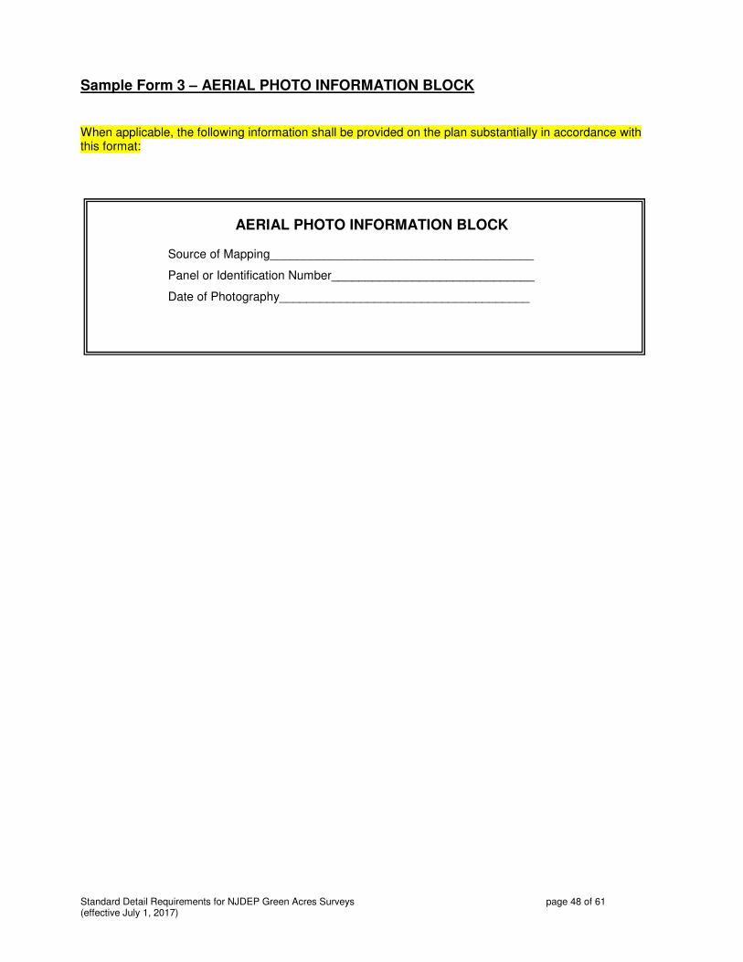
Standard Detail Requirements for NJDEP Green Acres Surveys page 48 of 61 (effective July 1, 2017)
Sample Form 3 – AERIAL PHOTO INFORMATION BLOCK
When applicable, the following information shall be provided on the plan substantially in accordance with this format:
AERIAL PHOTO INFORMATION BLOCK
Source of Mapping_______________________________________
Panel or Identification Number______________________________
Date of Photography_____________________________________

Standard Detail Requirements for NJDEP Green Acres Surveys page 49 of 61 (effective July 1, 2017)
Sample Form 4 - WETLANDS DELINEATION INFORMATION
Freshwater Wetlands survey work is not usually required for NJDEP Green Acres Surveys. If required by NJDEP, follow the specifications and guidelines provided by NJDEP. The guidelines included herein are meant to provide general guidance and shall be subject to more specific criteria in the contract for a site-specific engagement.
When work involving wetlands is specifically requested, it shall be one of two types identified at the time that price quotes are solicited for a site-specific engagement: SHOW WETLANDS or DELINEATE WETLANDS.
SHOW FRESHWATER WETLANDS Site-specific engagements requesting that that the wetlands be shown on the final plan of survey requires that the New Jersey licensed Professional Land Surveyor obtain copies of the appropriate New Jersey Freshwater Wetlands map for the area from the office of the county recorder or clerk. The upland limit line for those areas coded “01” on the Wetlands map must be reproduced, and an approximate estimate of wetlands area in acres on the plan must be derived to one decimal place (0.1 acre). The upland limit lines may be digitized or mechanically reproduced. The areas may be derived from the digitizing process or by planimeter, provided that the duplicated line is within 0.5 percent accuracy of the depiction of that upland limit line on the original source material. The mapped or digital source of upland limit line information must be provided (title of data or map, date, preparer, etc.).
FRESHWATER WETLANDS DELINEATION SURVEY
Site-specific engagements requesting that that the wetlands be surveyed, delineated, or field investigated requires that the New Jersey licensed Professional Land Surveyor engage an environmentalist, acceptable to NJDEP, who is proficient in New Jersey freshwater wetlands investigations. The environmentalist shall delineate the wetland areas in the field in accordance with adopted wetlands criteria in New Jersey. The New Jersey licensed Professional Land Surveyor shall field-locate each marked position, add the wetlands areas to the survey plan, provide areas in acres to two decimal places (0.01 acre), and label the wetlands area on the survey. Additionally, the wetlands buffer areas of 50 feet, 100 feet, or 150 feet as indicated by the environmentalist must be shown on the survey, with buffer areas calculated to two decimal places (0.01 acre).
The survey plan shall contain a Wetlands Delineation Information block that includes the environmental firm’s name, street and mailing addresses, telephone and fax numbers, and company Email address. The Wetlands Delineation Information block shall be signed and signed by the individual environmentalist responsible for the delineation. The date of the delineation and for whom it was prepared must appear in the Wetlands Delineation block on the survey. The environmentalist shall provide an original signature in the Wetlands Delineation Information block on the original survey plan and on each paper copy or print made. Other specifications and guidelines, if any are needed, shall be furnished at the time a wetlands delineation is requested as part of a site-specific engagement.
The following Sample Wetlands Delineation Information block is for use in the event of an actual Wetlands delineation on the surveyed property made as part of a site-specific engagement for NJDEP. When applicable, the following information shall be provided substantially in accordance with this format:
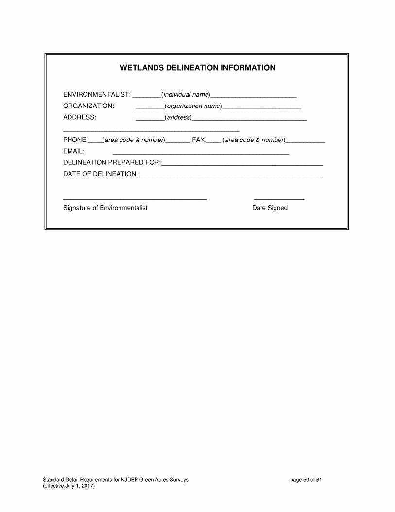
Standard Detail Requirements for NJDEP Green Acres Surveys page 50 of 61 (effective July 1, 2017)
WETLANDS DELINEATION INFORMATION
ENVIRONMENTALIST: ________(individual name)________________________
ORGANIZATION: ________(organization name)______________________
ADDRESS: ________(address)________________________________
_________________________________________________
PHONE:____(area code & number)_______ FAX:____ (area code & number)___________
EMAIL: _________________________________________________
DELINEATION PREPARED FOR:_____________________________________________
DATE OF DELINEATION:___________________________________________________
________________________________________ ______________
Signature of Environmentalist Date Signed

Standard Detail Requirements for NJDEP Green Acres Surveys page 51 of 61 (effective July 1, 2017)
Sample Form 5A – LEGEND OF ACQUISITION - STATE ACQUISITION
The following information shall be shown on the plan substantially in accordance with this format: Do not include NJDEP’s parenthetical instructions from this Sample Form regarding Project Information and Parcel Information on the plan. Text that is highlighted in this Sample Form is for guidance only, and is not meant to appear on the plan.
LEGEND OF ACQUISITION
PROJECT INFORMATION
NEW JERSEY DEPARTMENT OF ENVIRONMENTAL PROTECTION
(if Tenancy-in-Common, include % interest as below)
PROJECT NAME:_________________________________________________________________
GREEN ACRES SOURCE OF FUNDING/ PROJECT NUMBER: SA - -
GREEN ACRES PARTICIPATION ACRES THIS FUNDING SOURCE:_______________________
OWNER ID #________________________ SELLER’S NAME:____________________________
MANAGING AGENCY/ENTITY:_____________________________________________________
(Add the following only if a Tenancy-in-Common with Acquisition Partners is identified on Detail Sheet - add lines for other partners)
ACQUISITION PARTNER:_______________________as to _____% interest, Tenants-in-Common
PROJECT NAME:_________________________________________________________________
GREEN ACRES SOURCE OF FUNDING/ PROJECT NUMBER:____________________________
GREEN ACRES PARTICIPATION ACRES THIS FUNDING SOURCE:_______________________
PARCEL INFORMATION (Repeat format to provide data separately for each individual tax parcel)
MUNICIPALITY:_____________________COUNTY:_____________
TAX BLOCK:_____ LOT:____
INTEREST ACQUIRING: FEE___ EASEMENT___ TYPE OF EASEMENT______________
ENTIRE__or PART__ (OF LOT) PERCENT of LOT ACQUIRING:___ ACRES:_______
AREA SUMMARY
TOTAL GROSS AREA SURVEYED _________________________________ACRES
SUBJECT TO:
AREA IN PUBLIC ROADS______________________________________ACRES
AREA SUBJECT TO RIPARIAN CLAIM OF NEW JERSEY ____________ACRES
TOTAL AREA UNDER NAVIGABLE FRESH WATERS________________ACRES
AREA SUBJECT TO TITLE OVERLAPS____________________________ACRES
AREA SUBJECT TO TITLE GORES_______________________________ACRES
AREA SUBJECT TO PHYSICAL ENCROACHMENTS_________________ACRES

Standard Detail Requirements for NJDEP Green Acres Surveys page 52 of 61 (effective July 1, 2017)
Sample Form 5B - LEGEND OF ACQUISITION - LOCAL UNIT OR NONPROFIT
The following information shall be shown on the plan substantially in accordance with this format: Do not include NJDEP’s parenthetical instructions from this Sample Form on the plan. Provide a separate entry under “Parcel Information” for each individual tax lot surveyed. Provide composite information for all tax lots in the ”Area Summary.” Subtract the total of areas under “Subject To” from “Gross Area Surveyed” (the sum of all tax lot areas listed in “Parcel Information” above) to report “Net Area of Green Acres Encumbrance.” . Text that is highlighted in this Sample Form is for guidance only, and is not meant to appear on the plan.
LEGEND OF ACQUISITION
PROJECT INFORMATION
PROJECT NAME:_________________________________________________
PROJECT NUMBER: - -
SELLER’S NAME:_________________________________________________
MANAGING AGENCY/ENTITY:_______________________________________
(Add the following only if a Tenancy-in-Common with Acquisition Partners is identified on Detail Sheet –
add lines for other partners)
ACQUISITION PARTNER:______________________s to _____% interest, Tenants-in-Common
PROJECT NAME:__________________________________________________
PARCEL INFORMATION (Repeat format to provide data separately for each individual tax parcel)
MUNICIPALITY:_____________________COUNTY:_____________
TAX BLOCK:_____ LOT:____
INTEREST ACQUIRING: FEE___ EASEMENT___ TYPE OF EASEMENT______________
ENTIRE__or PART__ (OF LOT) PERCENT of LOT ACQUIRING:___ ACRES:_______
AREA SUMMARY
TOTAL GROSS AREA SURVEYED _________________________________ACRES
SUBJECT TO:
AREA IN PUBLIC ROADS_______________________________________ACRES
AREA SUBJECT TO RIPARIAN CLAIM OF NEW JERSEY _____________ACRES
TOTAL AREA UNDER NAVIGABLE FRESH WATERS_________________ACRES
AREA SUBJECT TO TITLE OVERLAPS____________________________ACRES
AREA SUBJECT TO TITLE GORES_______________________________ACRES
AREA SUBJECT TO PHYSICAL ENCROACHMENTS_________________ACRES
NET AREA OF GREEN ACRES ENCUMBRANCE____________________ACRES

Standard Detail Requirements for NJDEP Green Acres Surveys page 53 of 61 (effective July 1, 2017)
Sample Form 6A – CERTIFICATION FORM FOR STATE LAND ACQUISITION
The sample form on the following page contains the template for the certification form used when the survey is prepared for the purpose of acquisition by the State of New Jersey. This form can be substituted by a document that contains the same information in substantially the same form. Please print on a single sheet of paper if possible; legal size (8-1/2” by 14”) may be used if necessary. For Certification Forms that do not fit onto a single legal sized page, multiple letter size pages may be used.
If the acquisition project is a joint undertaking by multiple agencies or entities, then the following information is to be added at the end of the “Project Information” section:
ACQUISITION PARTNER:___________________________________________________
PROJECT NAME:__________________________________________________________
GREEN ACRES SOURCE OF FUNDING/ PROJECT NUMBER:_________________________
GREEN ACRES PARTICIPATION ACRES THIS FUNDING SOURCE:___________________
If the acquisition project entails more than one tax lot, create a separate entry under “Acquisition Parcel Information” for each individual tax lot, using the following format. The necessary information for each separate tax lot is as follows:
BLOCK:_____ LOT:_____ MUNICIPALITY:______________ COUNTY:_____________
ENTIRE__ or PART__ (OF LOT) FEE___ PERCENT of LOT:___ ACRES:_______
EASEMENT___ TYPE OF EASEMENT______________
Identify the deed used as reference for the property or properties in question in the “Acquisition Title Information” whether or not title commitment information is available.

Standard Detail Requirements for NJDEP Green Acres Surveys page 54 of 61 (effective July 1, 2017)
NEW JERSEY DEPARTMENT OF ENVIRONMENTAL PROTECTION GREEN ACRES PROGRAM
STATE LAND ACQUISITION PROGRAM
SURVEYOR’S CERTIFICATION AND SUMMARY FORM
PROJECT INFORMATION
PROJECT NAME:__________________________________________________________
GREEN ACRES SOURCE OF FUNDING/ PROJECT NUMBER: SA-_______-__________
SELLER’S NAME:_________________________________________________________
MANAGING AGENCY/ENTITY:________________________________________________
ACQUISITION PARCEL INFORMATION
BLOCK:_____ LOT:_____ MUNICIPALITY:______________ COUNTY:_____________
ENTIRE__ or PART__ (OF LOT) FEE___ PERCENT of LOT:___ ACRES:_______
EASEMENT___ TYPE OF EASEMENT______________
ACQUISITION SURVEY INFORMATION
PREPARED FOR :___NJDEP GREEN ACRES PROGRAM______________________________
SURVEY FIRM:______________________________________ CONTRACT No._S-__________
SURVEYOR:________________________________________ NJPLS No._______________
DATE ON SURVEY PLAN:______ DATE SIGNED:______ DATE LAST REVISED:_______
ACQUISITION TITLE INFORMATION
TITLE COMPANY___________________________________________________________________
COMMITMENT No._______________________ DATE OF COMMITMENT_______________
DEED(S) USED FOR REFERENCE:____________________________________________________
CERTIFICATION
I hereby certify that I have completed the above survey(s) in accordance with the Green Acres Survey Guidelines contained in a written contract as indicated. Based upon an actual field survey and my examination of evidence, the above parcels consist of a total surveyed area of _________acres subject to the following:
EASEMENTS______________________________________________________________
RESTRICTIONS___________________________________________________________
CONDITIONS_____________________________________________________________
PUBLIC ROAD______AC. CLAIMED NJ TIDELANDS ____AC. CLOUDED TITLE ____AC.
UNDERWATER_____AC. ENCROACHMENTS: YES___NO___ # OF DESCRIPTIONS:___
____________________________________ __________________________________
SURVEYOR’S SIGNATURE, DATE & SEAL REVIEW BY GREEN ACRES, NJDEP

Standard Detail Requirements for NJDEP Green Acres Surveys page 55 of 61 (effective July 1, 2017)
Sample Form 6B – CERTIFICATION FORM FOR LOCAL UNIT/NONPROFIT PROJECT
The sample form on the following page contains the template for the certification form used when the survey is prepared for the purpose of acquisition by the State of New Jersey. This form can be substituted by a document that contains the same information in substantially the same form. Please print on a single sheet of paper if possible; legal size (8-1/2” by 14”) may be used if necessary. For Certification Forms that do not fit onto a single legal sized page, multiple letter size pages may be used.
If the acquisition project is a joint undertaking by multiple agencies or entities that entails multiple project names and multiple project numbers, then the following information is to be repeated as needed in the “Project Information” section:
GREEN ACRES PROJECT No.:____________________________________________________________
GREEN ACRES PROJECT NAME:__________________________________________________________
If the acquisition project entails more than one tax lot, create a separate entry under “Acquisition Parcel Information” for each individual tax lot, using the following format. This section is to be completed to reflect the interests acquired by the local unit / nonprofit, not Green Acres. Often the acquisition by the local unit or nonprofit is for 100% of the property in fee (reported in this section) while the net area of Green Acres encumbrance may be somewhat less (reported in the “Certification” section). The necessary information reported in the “Acquisition Parcel Information” for each separate tax lot within the lines of the survey in which interests are being acquired by the local unit / nonprofit is as follows:
BLOCK:_____ LOT:_____ MUNICIPALITY:______________ COUNTY:_____________
ENTIRE__ or PART__ (OF LOT) FEE___ PERCENT of LOT:___ ACRES:_______
EASEMENT___ TYPE OF EASEMENT______________
Identify the deed used as reference for the property or properties in question in the “Acquisition Title Information” whether or not title commitment information is available.

Standard Detail Requirements for NJDEP Green Acres Surveys page 56 of 61 (effective July 1, 2017)
NEW JERSEY DEPARTMENT OF ENVIRONMENTAL PROTECTION GREEN ACRES PROGRAM
LOCAL GOVERNMENT AND NON-PROFIT ORGANIZATION FUNDING PROGRAM
SURVEYOR’S CERTIFICATION AND SUMMARY FORM
PROJECT INFORMATION GREEN ACRES PROJECT No.:____________________________________________________________
GREEN ACRES PROJECT NAME:__________________________________________________________
ACQUISITION PARCEL INFORMATION
PARCEL OR OWNER ID# _____________________________
SELLER’S NAME: _______________________________________________________________________
MUNICIPALITY:____________________________COUNTY:_____________ BLOCK:____ LOT:_____
ENTIRE__ or PART__ (OF LOT) FEE___ PERCENT of LOT:___ ACRES:_______
EASEMENT___ TYPE OF EASEMENT______________
SURVEY INFORMATION
PREPARED FOR LOCAL UNIT/USING AGENCY:______________________________________
SURVEY FIRM:____________________________________________________________________
NAME OF SURVEYOR:____________________________________________ NJPLS No.____________
DATE ON SURVEY PLAN:___________ DATE SIGNED:___________ DATE LAST REVISED:__________
TITLE INFORMATION
TITLE COMPANY_______________________________________________________________________
(IF NO COPY OF SEARCH WAS SUPPLIED BY USING AGENCY, STATE “SUBJECT TO FINDINGS OF TITLE SEARCH” ABOVE)
COMMITMENT No.________________________ DATE OF COMMITMENT_______________
DEED(S) USED FOR REFERENCE:____________________________________________________
CERTIFICATION
I hereby certify that I have completed the above survey in accordance with the “Green Acres Scope of Work for Professional Land Surveying Services” contained in a written contract with the above using agency. Based upon an actual field survey of the above property conducted under my supervision, my examination of field and record evidence and the above title report, (if any supplied by using agency), the parcel being acquired consists of a total surveyed area of __________________acres, subject to the following: EASEMENTS________________________________________________________________ RESTRICTIONS______________________________________________________________ CONDITIONS:_______________________________________________________________ ROAD:_______AC. CLAIMED AS NJ TIDELANDS:_______AC. OVERLAP:______AC. UNDER WATER _______AC. GORE BETWEEN ADJOINING LANDS _________AC. AREA OF CLOUDED TITLE:_____________ AC. ENCROACHMENTS (YES)____ (NO)____NUMBER OF SEPARATE DESCRIPTIONS PREPARED: _____ ______________________________ __________________________________ SURVEYOR’S SIGNATURE, DATE & SEAL SURVEY REVIEWED BY GREEN ACRES NET AREA OF GREEN ACRES ENCUMBRANCE: __________________ ACRES
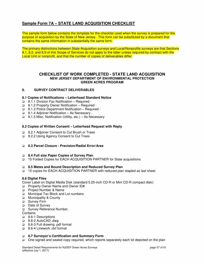
Standard Detail Requirements for NJDEP Green Acres Surveys page 57 of 61 (effective July 1, 2017)
Sample Form 7A – STATE LAND ACQUISITION CHECKLIST
The sample form below contains the template for the checklist used when the survey is prepared for the purpose of acquisition by the State of New Jersey. This form can be substituted by a document that contains the same information in substantially the same form. The primary distinctions between State Acquisition surveys and Local/Nonprofits surveys are that Sections 8.1, 8.2, and 8.9 of this Scope of Services do not apply to the latter unless required by contract with the Local Unit or nonprofit, and that the number of copies of deliverables differ.
CHECKLIST OF WORK COMPLETED - STATE LAND ACQUISITION NEW JERSEY DEPARTMENT OF ENVIRONMENTAL PROTECTION
GREEN ACRES PROGRAM 8. SURVEY CONTRACT DELIVERABLES 8.1 Copies of Notifications – Letterhead Standard Notice � 8.1.1 Division Fax Notification – Required - � 8.1.2 Property Owner Notification – Required - � 8.1.3 Police Department Notification – Required - � 8.1.4 Adjoiner Notification – As Necessary - � 8.1.5 Misc. Notification (Utility, etc.) – As Necessary
8.2 Copies of Written Consent – Letterhead Request with Reply
� 8.2.1 Adjoiner Consent to Cut Brush or Trees � 8.2.2 Using Agency Consent to Cut Trees
� 8.3 Parcel Closure - Precision/Radial Error/Area
� 8.4 Full size Paper Copies of Survey Plan � 15 Folded Copies for EACH ACQUISITION PARTNER for State acquisitions
� 8.5 Metes and Bound Description and Reduced Survey Plan � 15 copies for EACH ACQUISITION PARTNER with reduced plan stapled as last sheet 8.6 Digital Files Cover Label on Digital Media Disk (standard 5.25-inch CD-R or Mini CD-R compact disk): � Property Owner Name and Owner ID# � Project Number & Name � Municipal Tax Block and Lot numbers � Municipality & County � Survey Firm � Date of Survey � Survey Reference Number. Contains: � 8.6-1 Descriptions � 8.6-2 AutoCAD .dwg � 8.6-3 Full drawing .pdf format � 8.6-4 Linework .dxf format � 8.7 Surveyor’s Certification and Summary Form � One signed and sealed copy required, which reports separately each lot depicted on the plan

Standard Detail Requirements for NJDEP Green Acres Surveys page 58 of 61 (effective July 1, 2017)
� 8.8 This Checklist of Work completed, Detail Sheet from site-specific engagement and tax map
from site-specific engagement 8.9 Corner Marker Description Sheets � Corner Number /Character of Mark � Project Information/Seller Information � Location of Mark � Survey Firm � Cap Detail � Sketch with field witness marks � Photograph of south side of mark, looking northward. _____________________________________________ ___________ Prepared by New Jersey Professional Land Surveyor Date

Standard Detail Requirements for NJDEP Green Acres Surveys page 59 of 61 (effective July 1, 2017)
Sample Form 7B – LOCAL UNIT AND NONPROFIT LAND ACQUISITION CHECKLIST
The sample form below contains the template for the checklist used when the survey is prepared for the purpose of acquisition by a local unit or nonprofit. This form can be substituted by a document that contains the same information in substantially the same form. The primary distinctions between State Acquisition surveys and Local/Nonprofits surveys are that Sections 8.1, 8.2, and 8.9 of this Scope of Services do not apply to the latter unless required by contract with the Local Unit or nonprofit, and that the number of copies of deliverables differ.
CHECKLIST OF WORK COMPLETED - LOCAL UNIT AND NONPROFIT LAND ACQUISITION
NEW JERSEY DEPARTMENT OF ENVIRONMENTAL PROTECTION GREEN ACRES PROGRAM
8. SURVEY CONTRACT DELIVERABLES � 8.3 Parcel Closure - Precision/Radial Error/Area � 8.4 Full size Paper Copies of Survey Plan � 2 Folded Copies (unless otherwise notified0 � 8.5 Metes and Bound Description and Reduced Survey Plan � 2 copies for EACH ACQUISITION PARTNER with reduced plan stapled as last sheet 8.6 Digital Files Cover Label on Digital Media Disk (standard 5.25-inch CD-R or Mini CD-R compact disk): � Property Owner Name and Owner ID# � Project Number & Name � Municipal Tax Block and Lot numbers � Municipality & County � Survey Firm � Date of Survey � Survey Reference Number. Contains: � 8.6-1 Descriptions � 8.6-2 AutoCAD .dwg � 8.6-3 Full drawing .pdf format � 8.6-4 Linework .dxf format � 8.7 Surveyor’s Certification and Summary Form � One signed and sealed copy required, which reports separately each lot depicted on the plan � 8.8 This Checklist of Work completed _____________________________________________ ___________ Prepared by New Jersey Professional Land Surveyor Date
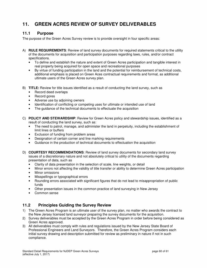
Standard Detail Requirements for NJDEP Green Acres Surveys page 60 of 61 (effective July 1, 2017)
11. GREEN ACRES REVIEW OF SURVEY DELIVERABLES
11.1 Purpose
The purpose of the Green Acres Survey review is to provide oversight in four specific areas:
A) RULE REQUIREMENTS: Review of land survey documents for required statements critical to the utility of the documents for acquisition and participation purposes regarding laws, rules, and/or contract specifications.
• To define and establish the nature and extent of Green Acres participation and tangible interest in real property being acquired for open space and recreational purposes
• By virtue of funding participation in the land and the potential for reimbursement of technical costs, additional emphasis is placed on Green Aces contractual requirements and format, as additional ultimate users of the Green Acres survey plan.
B) TITLE: Review for title issues identified as a result of conducting the land survey, such as
• Record deed overlaps
• Record gores
• Adverse use by adjoining owners
• Identification of conflicting or competing uses for ultimate or intended use of land
• The guidance of the technical documents to effectuate the acquisition
C) POLICY AND STEWARDSHIP: Review for Green Acres policy and stewardship issues, identified as a result of conducting the land survey, such as:
• The need to patrol, manage, and administer the land in perpetuity, including the establishment of limit lines or buffers
• Exclusion of funding from problem areas
• Designation of certain corner and line marking requirements
• Guidance in the production of technical documents to effectuation the acquisition
D) COURTESY RECOMMENDATIONS: Review of land survey documents for secondary land survey issues of a discretionary nature and not absolutely critical to utility of the documents regarding presentation of data, such as
• Clarity of data presentation in the selection of scale, line weights, or detail
• Minor errors not affecting the validity of title transfer or ability to determine Green Acres participation
• Minor omissions
• Misspellings or typographical errors
• Rounding errors associated with significant figures that do not lead to misappropriation of public funds
• Other presentation issues in the common practice of land surveying in New Jersey
• Common sense
11.2 Principles Guiding the Survey Review
1) The Green Acres Program is an ultimate user of the survey plan, no matter who awards the contract to the New Jersey licensed land surveyor preparing the survey documents for the acquisition.
2) Survey deliverables must be accepted by the Green Acres Program in order before being considered as Green Acres approved.
3) All deliverables must comply with rules and regulations issued by the New Jersey State Board of Professional Engineers and Land Surveyors. Therefore, the Green Acres Program considers each initial survey drawing and description submitted for review as preliminary in nature if not in such compliance.

Standard Detail Requirements for NJDEP Green Acres Surveys page 61 of 61 (effective July 1, 2017)
4) As a courtesy to the surveying licensee, any deficiencies related to rules and regulations of the State Board of Professional Engineers and Land Surveyors will be brought to the attention of the surveyor by Green Acres survey review staff for voluntary remedy.
5) Violations of the rules and regulations of the State Board of Professional Engineers and Land Surveyors not remedied voluntarily shall be brought to the attention of the surveyor’s client prior to referral of the surveyor to the State Board.
6) As an option to facilitate the final review process, Green Acres may offer to review an actual advance or check print of survey documents with the goal of eliminating any potential issues prior to issuance and distribution of a full set of contract deliverables. Only one such courtesy advance review is offered for a project. This advance review is meant to assist inexperienced surveyors who have not previously submitted any work to Green Acres and are unfamiliar with Green Acres requirements, and to assist all surveyors involved in complex projects that include partial acquisitions, a mix of Green Acres, SADC, and/or EIFP areas, diversions, or other out-of-the-ordinary circumstances. For such advance reviews, Green Acres must receive one set of survey plans, one set of descriptions, a DXF file in the appropriate datum, and a completed Surveyor’s Certification and Summary Form.
7) To facilitate approval of survey deliverables, Green Acres may elect to prepare or modify the metes and bounds description submitted by the surveyor for the area of Green Acres funding, participation or encumbrance, rather than directing the surveyor to rewrite the description. When a description submitted by a surveyor is modified by Green Acres, the letterhead and signature information is removed so that it becomes a document issued by Green Acres.
8) Reviews that reveal substantive deficiencies in meeting survey requirements, the existence of survey blunders, or violations of State Board rules allows Green Acres to make additional requests for refinements of the plan or description relative to any issue. These additional changes may address the presentation of data, plan clarity, minor errors or omissions, spelling or typographical errors, minor significant figure rounding errors, or issues in the common practice of land surveying in New Jersey.
11.3 Survey Reviews for Local Unit and Nonprofit Projects
1) Green Acres strives to approve documents as presented by local units or nonprofits, provided that the plans and descriptions are generally suitable for the intended acquisitions relative to Green Acres’ policy and practices and do not contain violations of the rules of the State Board of Professional Engineers and Land Surveyors. Minor inconsequential deficiencies such as presentation of data, plan clarity, minor errors or omissions, spelling or typographical errors, minor significant figure rounding errors, or issue in the common practice of land surveying in New Jersey or common sense may be overlooked, provided that the area of Green Acres participation is clearly and correctly delineated and described.
2) Communications regarding the review of surveys and descriptions submitted by local units or nonprofits for Green Aces Local Assistance shall be primarily between the Green Aces Project Manager and the local units or nonprofits, unless the applicant requests direct communication with the State Review Surveyor.
3) Outside land survey vendors may directly contact Green Acres Survey Review Staff for advice on how to address specific concerns or for advice on survey questions related to the specific project.
11.4 Survey Reviews for State Acquisition Projects
1) Communications regarding the review of surveys and descriptions submitted for areas where the State will acquire a tangible interest as purchaser or as acquisition partner shall be primarily between the State Review Surveyor and the surveyor preparing the acquisition survey documents.
2) Stat acquisition survey plans shall be examined for all aspects of the contract, including presentation of data, plan clarity, minor errors or omissions, spelling or typographical errors, minor significant figure rounding errors, or issues in the common practice of land surveying in New Jersey.
11.5 Survey Review Process
1) The Green Acres Project manager is responsible for the flow of work between the Local Unit and the Green Acres Survey Review Section for all county, municipal, and nonprofit surveys.
2) The Green Acres Project manager is responsible for the flow of work between the Survey Contract Section and the Survey Review Section for all State land acquisition surveys.