Embed Size (px)
Citation preview
STATE OF MARYLAND BOARD OF NATURAL RESOURCES
DEPARTMENT OF GEOLOGY, MINES AND WATER RESOURCES Joseph T. Singewald, Jr. D'^nnr
BULLETIN 7
THE CAVES
MARYLAN
By
William E. Davies
BALTIMORE, MARYLAND 1950

COMPOSED AMD PRINTED AT THE WAVERLY PRESS, INC.
BALTIMORE, MD. U.S.A.
COMMISSION ON GEOLOGY, MINES AND WATER RESOURCES
Arthur B. Stewart, Chairman Holmes D. Baker Harry R. Hall Joseph C. Lore, Jr.
Mervin A. Pentz
Baltimore Frederick Hyattsville Solomons Island Denton

PREFACE
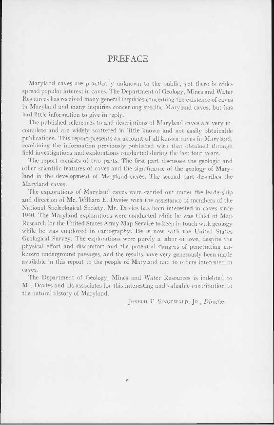
Maryland caves are practically unknown to the public, yet there is wide- spread popular interest in caves. The Department of Geology, Mines and Water Resources has received many general inquiries concerning the existence of caves in Maryland and many inquiries concerning specific Maryland caves, but has had little information to give in reply.
The published references to and descriptions of Maryland caves are very in- complete and are widely scattered in little known and not easily obtainable publications. This report presents an account of all known caves in Maryland, combining the information previously published with that obtained through field investigations and explorations conducted during the last four years.
The report consists of two parts. The first part discusses the geologic and other scientific features of caves and the significance of the geology of Mary- land in the development of Maryland caves. The second part describes the Maryland caves.
The explorations of Maryland caves were carried out under the leadership and direction of Mr. William E. Davies with the assistance of members of the National Speleological Society. Mr. Davies has been interested in caves since 1940. The Maryland explorations were conducted while he was Chief of Map Research for the United States Army Map Service to keep in touch with geology while he was employed in cartography. He is now with the United States Geological Survey. The explorations were purely a labor of love, despite the physical effort and discomfort and the potential dangers of penetrating un- known underground passages, and the results have very generously been made available in this report to the people of Maryland and to others interested in caves.
The Department of Geology, Mines and Water Resources is indebted to Mr. Davies and his associates for this interesting and valuable contribution to the natural history of Maryland.
Joseph T. Singewald, Jr., Director

CONTENTS
Preface Introduction
Acknowledgments Geologic Relations
Patterns Cavern Features Origin of Caves Age Mineralogy Karst
Temperature and Humidity Economic Use of Maryland Caves Biology of Maryland Caves Conventional Cave Map Signs Descriptions of Maryland Caves
Allegany County Atheys Cave
Location History Geology Description
Cumberland Bone Cave Location Geology Description
Cumberland Quarry Caves Devils Den
Location History . Geology Description
Devils Hole Goat Cave
Location History Geology Description
Horse Cave Location History Geology Description
Murley Branch Spring Location Geology Description
vii
v 1 2 2 5 5 7 9
10 10 11 12 13 15 15 15 15 15 15 15 16 18 18 18 18 19 19 19 19 19 21 21 21 21 23 23 23 24 24 24 24 24 25 25 25 25
viii Contents
Twiggs Cave 26 Location 26 History 26 Geology 26 Description 27
Baltimore County 28 Beaver Run Shelter 28
Carroll County 29 Westminster Cave 29
Frederick County 29 Buckeystown Cave 29 Centerville Cave 30 LeGore Quarry—Powells Cave 30 Linganore Shelter Caves 30 McKinstrys Mill Cave 30
Garrett County 30 Crabtree Cave 30
Location 30 History 32 Geology 32 Description 32
John Friends Cave 32 Location 32 History 32 Geology 33 Description 33
Muddy Creek Falls Shelters 34 Sand Cave 34
Location 34 History 34 Geology 34 Description 35
Woods Place Cave 36 Howard County 36
Camels Den 36 Washington County 36
Antietam Cave 36 Busheys Cavern 36
Location 36 History 36 Geology 37 Description 37
Crystal Grottoes 38 Location 38 History 38 Geology 38 Description 38
Dam Number 4 Cave 39 Location 39 Geology ■ 41 Description 41
Contents ix
Dargan Quarry Cave 41 Dellingers Cave 41
Location 41 Geology 41 Description 41
Fair view Cave 42 Houpt Cave 42 Howell Cave 42 Mt. Aetna Cave 43
Location 43 History 43 Geology : 43 Description 43
Pine Hill Cave 44 Pinesburg Cave 44 Revells Cave. 44 Rohrersville Caves 46 Round Top Cave No. 1 46 Round Top Cave No. 2 46 Round Top Cave No. 3 46 Round Top Cave No. 4 47 Round Top Cave No. 5 47 Round Top Cave No. 6 47 Round Top Cave No. 7 47 Sechrompf Cave 47 Sharpsburg Shelters .48 Snivelys Caves 48
Location 48 History 48 Geology 48 Description 48
Two Locks Caves 49 References 49
LIST OF FIGURES
Figure 1. Conventional Cave Map Symbols 16 2. Atheys Cave 17 3. Devils Den 20 4. Goat Cave 22 5. Horse Cave In pocket 6. Twiggs Cave In pocket 7. Crabtree Cave 31 8. John Friends Cave In pocket 9. Sand Cave 35
10. Crystal Grottoes In pocket 11. Dam No. 4 Cave 40 12. Dellingers Cave In pocket 13. Mt. Aetna Cave In pocket 14. Revells Cave 45
X Contents
15. Snivelys Caves In pocket 16. Map of Maryland showing locations of caves In pocket
LIST OF PLATES
I. Fig. 1. Lapiez, one mile west of Smithburg 52 Fig. 2. Murley Branch Spring 52
II. Fig. 1. Horse Cave, rear of first room 53 Fig. 2. Horse Cave, hibernating bats 53
III. Fig. 1. Twiggs Cave, entrance shaft 54 Fig. 2. Twiggs Cave sink pond 54
IV. Fig. 1. Twiggs Cave, mud glaciers 55 Fig. 2. Twiggs Cave, "hot shoppe" 55
V. Fig. 1. Twiggs Cave, breakdown covered with clay and flowstone 56 Fig. 2. Twiggs Cave, stream discharging into pool 57
VI. Fig. 1. Crabtree Cave, fissure passage in Greenbrier limestone 58 Fig. 2. John Friends Cave, stream passage 58
VII. Fig. 1. Sand Cave, entrance arch 59 Fig. 2. Sand Cave, rock falls on floor 59
VIII. Crystal Grottoes, flowstone drapes 60 IX. Fig. 1. Dellingers Cave, crawlway entrance 61
Fig. 2. Snivelys Cave, flowstone cascade 61 X. Fig. 1. Mt. Aetna Cave, upper level room 62
Fig. 2. Mt. Aetna Cave, column of stalactites and stalagmites 62 XI. Fig. 1. Mt. Aetna Cave, stalactites and flowstone drapes 63
Fig. 2. Mt. Aetna Cave, thin stalactites and massive stalagmites 63
t
I
THE CAVES OF MARYLAND
BY
WILLIAM E. DAVIES
Introduction
The study of caverns has been a rather neglected science in America. The geologist and biologist seldom give much attention to caves, and most of our knowledge concerning caverns has come from the archeologist and anthro- pologist. Since the war, public attention has been focussed on caves as possible defense sites and has given considerable stimulus to serious scientific study of them.
Systematic studies of caves have been published by State geological surveys covering Pennsylvania, West Virginia, and central Tennessee. Similar reports are underway in Arkansas, Missouri, and Alabama. In addition the National Speleological Society (founded in 1939) is accumulating considerable data on caves in the United States through the efforts of its members. In Maryland little systematic work had been done. Martin H. Muma's brief account {28)* cover- ing 15 caves is the only previous systematic work. The field work for this report was commenced in 1946 and carried on at irregular intervals into 1949.
In speleological studies the factor of completeness is always questionable. Descriptions contained in this report may be changed by explorers who will penetrate many small passages left unexplored, cross "impassable" pits, and traverse the deep pools now blocking exploration. Nor will the caves listed in the report be final as new caves will be recorded and explored as time goes on.
In naming caves, names that are well known locally have been given first preference. In the lack of a well-known name, the name of the owner or a geo- graphic feature in the area has been applied to the cave. Naming of features within the cave has been avoided unless they were established by previous use.
A word of caution concerning cave exploration is appropriate. Never explore a cave alone. Have at least one companion at all times. Use discretion as all undertakings are more difficult in the darkness and dampness of a cave. Caves are private property, and permission should be obtained from the owner before entering. Check out with the owner when leaving. Such small courtesies bring invitations for return visits.
The caves described in the report are located according to U. S. Geological Survey topographic quadrangles. Except for Hancock, Pawpaw, Flintstone, Frostburg, and Oakland quadrangles, that are 15 minute quadrangles, the
* Numbers in parentheses refer to the references. 1
2 The Caves of Maryland
names refer to the 7^ minute quadrangles. The caves may also be located on the county topographic maps of the Maryland Department of Geology, Mines and Water Resources by their latitude and longitude.
Acknowledgments: The author is indebted to the many members of the Na- tional Speleological Society who volunteered their services in the field. Much of this credit is due to William B. Brierly, Washington, D. C., who aided in the investigations of practically all caves. Thomas W. Richards of Cumberland assisted in the work in Allegany and Garrett Counties. Through his efforts it was possible to thoroughly investigate Twiggs cave. John P. St. Clair, Wash- ington, D. C., took many of the photographs in the report, and credit is due him for his excellent pictorial records of many of the caves. The maps of Mt. Aetna and Bellinger caves are from surveys by him and Donald Mears of Washington, D. C. The author owes much to the many property owners on whose land caves are located for their cooperation. Austin D. Twigg of Twiggtown aided in every possible way in providing facilities that made possible the exploration of caves in Allegany County. To my wife goes the credit for putting the manuscript in final form. It has not been possible to include the names of all who have aided in the work but the author expresses his sincere appreciation for their coopera- tion.
Geologic Relations Most caves develop as a result of solution excavation of relatively soluble
rocks, mainly limestone, marble, and gypsum. In Maryland, limestones or mar- bles are found in practically all of the physiographic provinces of the State, but gypsum deposits, thick enough to contain caves, are lacking.
The Coastal Plain, lying east of Baltimore and Washington and including the Eastern Shore, is an area of relatively low relief underlain by sands, gravels, and marls. No solution caves have been reported in this area, although small shelter caves are found occasionally.
The relatively uniform upland lying between the Coastal Plain and Catoctin Mountain is the Piedmont. It is an area of complex, folded rock, much of which is highly metamorphosed. Within this complex are two marbles, the Wakefield that crops out in Carroll County and the Cockeysville that is found in Baltimore and Howard Counties. The marbles are similar in appearance and vary from fine-grained to sugary in texture. The Wakefield marble is tinted pink, green and blue locally, but in most areas both marbles are white. In Carroll County the Wakefield is at least 150 feet thick, and in Baltimore County a maximum of 400 feet of Cockeysville has been observed {36). The Stoses assign the marbles to the Lower Cambrian and suggest they are equivalent to the lowest Cambrian carbonate rocks found in the Hagerstown Valley. Four caves are known in the marbles in Maryland. In addition numerous vertical shafts resulting from sink- hole collapses are developed near Westminster, Carroll County, but no extensive passages have been reported leading from the shafts.
Geologic Relations 3
Along the western edge of the Piedmont, in the vicinity of Frederick, Cam- brian and Ordovician limestones crop out. The area underlain by these lime- stones is a rolling lowland known as the Frederick Valley. The Frederick lime- stone, Upper Cambrian in age, is a massive dark-blue limestone that weathers into thin-bedded slabs. It is about 480 feet thick. The Grove limestone, Lower Ordovician in age, overlying the Frederick limestone, is a thick-bedded dove or blue-gray limestone, 590 feet thick. Two caves have been reported in these limestones. A narrow band of Tomstown dolomite extends along the east base of Catoctin Mountain, southwest of Frederick, but is covered by a deep mantle of wash except for isolated outcrops. No caves are reported along this band.
The Triassic limestone conglomerate, the New Oxford formation, that lies along the east side of Catoctin Mountain, south of U. S. Highway 40, is com- posed of pebbles of Paleozoic limestone cemented by fine-grained gray or red limestone. No caves are known in this formation.
West of the Piedmont is a mountainous belt of folded Paleozoic rocks. On the eastern side of the belt is a broad lowland, the Hagerstown Valley, that is underlain by broad expanses of limestone and shale. The oldest limestone formation, the Tomstown, is Upper Cambrian in age and is composed of thin- bedded to massive dolomites and limestones, light gray to pink in color, up to 1000 feet thick. Seven relatively large caves are known in this formation in Washington County.
The Waynesboro formation, consisting of sandstones, thin siliceous lime- stones, and some massive limestones, lies above the Tomstown. No caves have been reported in this formation. The Elbrook limestone, a series of light blue to gray, shaly limestones and calcareous shales, with some massive limestones and dolomites in the middle of the formation, lies above the Waynesboro. It is 3000 feet thick and contains two caves.
The highest Cambrian formation (often assigned indefinitely as Cambro- Ordovician), the Conococheague limestone, is massive, dark blue, and banded, with zones of oolites and cryptozoon reefs at the base. The formation averages 1500 feet in thickness. Three caves and several small shelters are known in the Conococheague.
The Beekmantown, the lowest Ordovician formation (or the upper part of the Cambro-Ordovician), consists of laminated, fine-grained, blue to gray, relatively pure limestones averaging 2400 feet in thickness. One cave and sev- eral small shelters are in the Beekmantown.
The Stones River formation, which lies above the Beekmantown, consists of black to dove-colored, thin-bedded to massive, pure limestones and dolo- mites, totaling 1000 feet thick. Three caves are reported in these limestones.
The highest limestones of the Ordovician are in the Black River group which consists of a series of blue to gray argillaceous limestones up to 300 feet thick. One cave is known in these limestones. The Upper Ordovician, above the Black
4 The Caves of Maryland
River group, is made up of shales and sandstones that underlie the Hagerstown Valley adjacent to the limestone areas.
The mountainous area lying between the Hagerstown Valley and Garrett County is underlain by a thick series of folded rocks that are middle Paleozoic in age. The terrain is an alternation of long uniform ridges and narrow valleys with a general northeasterly trend. In this area the oldest rocks are Silurian in age and lie directly above the shales and sandstones of the Ordovician. The lower portion of the Silurian contains mainly shales and sandstones. Thick limestones, suitable for cavern development, occur only in the Upper Silurian Cayugan series. Impure limestones of local extent occur in the McKenzie forma- tion, the lowest formation of the Cayugan series, but no caves are reported in them. The next higher formation, the Wills Creek formation, consists of 600 feet of alternating calcareous shales, argillaceous limestones, sandstones, and thin zones of relatively pure limestone. Two small caves are reported in the Wills Creek formation.
The Tonoloway formation is a series of interbedded limestones and calcareous shales totaling 600 feet thick. The limestones are mainly thin-bedded and banded and weather into plates. Some massive beds occur in the lower part of the formation. Ten small caves are in the Tonoloway formation.
Though the Tonoloway formation marks the top of the Silurian in Maryland, limestone formations continue uninterrupted into the Devonian. The Helder- berg formation, consisting of four limestone members, lies at the base of the Devonian. The Keyser limestone, the lowest member, is massive and nodular in the lower part and thin-bedded and shaly above. It averages 280 feet thick and contains four caves. The caves, all relatively large, lie near the top of the formation and extend into the overlying Coeymans limestone.
The Coeymans limestone is thin, averaging 8 to 13 feet thick, and by itself is of little significance in cavern development. However, in conjunction with the underlying Keyser limestone it contains one of the largest caves in the State. The Coeymans is a massive, blue, crystalline, at times crinoidal, limestone.
The limestones forming the upper part of the Helderberg formation, the New Scotland and Becraft members, are arenaceous and contain a large amount of chert. No caves are known to exist in them.
The Devonian system, above the Helderberg formation, consists of clastic rocks, and no limestones are met with until the Greenbrier formation in the Mississippian system. The Greenbrier formation crops out in Garrett County where the rocks lie relatively flat. The Allegheny Plateau, of which Garrett County is a part, is a rolling upland cut by deep rounded valleys. Several dis- tinct ridges, formed by broad gentle anticlines, cross the area with a northeast- southwest trend. The Greenbrier formation is brought to the surface along the flanks of these ridges and on the sides of deep valleys cut into the upland. It is an argillaceous to pure, gray to pink, massive, cross-bedded limestone, 65 feet
Geologic Relations 5
thick. It is underlain by 88 feet of shale and sandstone. Along the eastern edge of the plateau a lower, arenaceous limestone member, 46 feet thick, lies below the shale and sandstone. Three relatively large caves are developed in the upper limestone member of the Greenbrier formation.
In Garrett County the Pottsville series at the base of the Pennsylvanian contains several calcareous sandstone members in which one large and numer- ous small shelter caves are developed. These are the youngest rocks in Maryland that contain caves worthy of notice.
Patterns
With the exception of rock shelters, the caves of Maryland show a tendency to develop along joints. Faults, cleavages, or fractures are of no significance in controlling the direction of passages. In most caves one set of joints exerts major control over the pattern with the larger passages developed along them, and subordinate side passages follow the secondary joints.
In flat-lying limestones in Garrett County, caves are simple in pattern. Generally one main passage is developed that follows a major set of joints with occasional offsets along subordinate joints. Multiple levels are confined to local sections of caves and are connected by vertical cliffs or shafts. Passages slope uniformly along the dip of the rocks.
In folded strata, where caves lie on the flanks of folds, passages develop as fissure-like openings along vertical or nearly vertical joint planes. The passages vary from a few feet to over 100 feet high and consist of several parallel open- ings. Except in Twiggs cave, the passages are offset along the dip where they occur in more than one level. In Twiggs cave the joint control is so dominant that levels are not offset but are developed one above the other.
Caves lying near the crests of anticlines, like Revells Cave and Crystal Grot- toes, have a maze of interlacing passages equally developed along two or more sets of joints. This results in a plan resembling city blocks.
With the exception of Sand Cave and Devils Den, bedding exerts little con- trol in cavern development in Maryland except to modify the cross-sectional shape of some passages. In Sand Cave the bedding determines the extent of the cave. Joints tend to modify the shape of the walls but are otherwise un- important in controlling the pattern. In Devils Den the bedding determines the direction of the major passages.
Cavern Features
The shape of passages in Maryland caves is relatively simple. Practically all are rectangular in cross section with the height greater than the width. Some low, narrow passages, referred to as crawlways, are circular or elliptical in outline. Others are narrow vertical fissures that require considerable squeezing to traverse them. The most complicated type, consisting of a low broad opening
6 The Caves of Maryland
with a fissure at the base, is known as a "keyhole" because of its characteristic shape.
Cave walls and ceilings are generally bare limestone with fluted or pitted surfaces. In Twiggs cave, however, bare rock is seldom seen as it is covered with a thick deposit of laminated clay and silt. Floors of bare limestone are seldom seen except in stream channels. Clay fills or piles of fallen rock form the floors of all caves in the State except Atheys Cave where bare pitted limestone forms the bottom of the passages.
Circular openings, some up to 100 feet high, are developed in the ceilings of many caves. These openings, known as dome pits or chimneys, often have water falling down them. Their walls, ribbed or fluted, are covered with formations, and in some cases they connect with higher passages. They are best displayed in Twiggs, Atheys, Crabtree and John Friends caves. Pits of similar size, de- veloped in the floor, are known as wells. They are rare in Maryland caves, being found only in Twiggs Cave where they range up to 50 feet deep.
Descending vadose water in limestone terranes dissolves considerable amounts of calcium carbonate that is deposited in many beautiful structures, called formations, when the water enters cavern passages. The formations deposited by dripping water are known as dripstone and include stalactites, stalagmites, and columns. Others formed by deposition from thin films of water are flowstone and are typically mound or slab-shaped.
Popular conception pictures caves as having many beautiful formations, but this is far from actual conditions. Formations, except in two caves, are rare in Maryland. Mt. Aetna Cave and Boonesboro Crystal Grottoes are practically solid with formations. Mt. Aetna Cave has many stalactites and columns so closely crowded that they had to be cut away to open the passages. Flowstone, however, is scarce In Boonesboro Crystal Grottoes conditions are the reverse. Flowstone, in the form of curtains, lines the passages, and stalactites are rela- tively rare. In other caves, formations are the exception. Twiggs Cave contains some flowstone and stalactites on the upper level. Snivelys Cave has a large, white flowstone mound at the rear. Horse Cave has a number of delicate "soda straw" stalactites in the rear portion. In Atheys Cave the walls are lined with sharp barbed knobs known as cave coral which make traversing the narrow fissures difficult.
Earth fills, consisting of fine silts or clays with subordinate amounts of gravel and sand, are found in most caves. The deposits range from a few inches to many feet in thickness. In Twiggs Cave the deposits are distinctly laminated and cover the walls and ceilings as well as the floors. The laminae are of the order of a millimeter in thickness and consist of alternating gray and brown layers. The deposits on the walls range up to six inches thick, and those on the floor are over a foot thick. The clay deposits on the ceiling of Twiggs Cave are of considerable interest for they show evidence of being derived from the clay
Geologic Relations 7
in the limestone rather than from material brought into the cave. The surface of the ceiling deposits is a layer of brown clay one-quarter inch thick that has been developed into small "mud stalactites" by dripping water. Beneath this layer is a zone of gray limy clay, up to an inch thick, that grades into solid limestone.
The caves along the Potomac river (Two Locks, Sharpsburg, Bellingers) contain thick deposits of river gravel mixed with clays and silts. The gravel was deposited at the time the gravel-covered terraces in the vicinity were formed. One cave, Atheys, shows no evidence of clay fill. The floors and walls are of rock, and shelves and niches lack clay cover.
Earth fills, in general, are firm though damp. In Twiggs Cave, however, they are saturated with water and have the consistency of a thick mud. Under such conditions traverse of the cave is most difficult. At present cavern streams are removing clay fills rather than depositing them. Only in Twiggs Cave is there evidence of recent clay accumulation. Near the entrance two large mud flows, originating at the base of sinkholes, are gradually pushing into the passage and filling it. The flows are over 6 feet thick and cover an area 50 feet long and 15 feet wide.
Rockfalls, known as breakdown, are a common feature of caverns. In Mary- land, however, caves are practically free of this feature as passages are gener- ally not large enough to permit extensive falls. In Twiggs Cave large blocks, up to 50 feet on a side, bounded by joints, have pulled loose and dropped, with some rotation, to lower levels. The upper level passages, therefore, represent openings that are not entirely solutional in origin. The blocks are wedged against one another or against the walls and are stable.
Small slabs of rock measuring up to a foot square and several inches thick are scattered throughout the caves. They are most common near the entrance and result from breakage along bedding planes.
Origin of Caves
There is a general agreement among most speleologists that practically all caves are developed as a result of solution processes. Beyond this point, how- ever, there is considerable divergence of opinion. Until 1930, when William Morris Davis {6) published his paper on the origin of caves, there had been little effort to consolidate the information available and produce a theory of origin that was universally applicable. Individual workers proposed theories that pertained to a single cave or groups of caves and included postulations that caves were voids that have existed since the limestone was formed, that they were developed as a result of a great deluge, or that streams flowing under- ground cut them from the limestone.
Subsurface water, which is the solvent that acts on limestone to produce caves, occurs in two zones. In the upper zone (vadose) close to the surface pores
8 " The Caves of Maryland
and cracks in the rock are filled with air. Water in this zone is transient, passing from the surface to the deeper saturated zone. In the saturated zone, the phre- atic zone, the pores and cracks in the rock are filled with water. The junction between the phreatic and vadose zones, known as the water table, fluctuates according to climatic conditions; but, in general, it reflects the topography of an area, rising beneath the hills and dropping in the valleys.
According to the theory proposed by William Morris Davis, cavern develop- ment takes place in two distinct cycles. The first occurs in the phreatic zone where the pattern of the cave is established and passages and rooms excavated to maximum size. When passages are elevated above the phreatic zone by re- gional uplift, the second cycle is inaugurated. This cycle, in the vadose zone, is characterized by the development of flowstone and dripstone and the modi- fication of existing passages by subterranean streams or rock falls. Davis re- lated the first cycle to regional peneplanation and keyed the entire development of caverns to the peneplane cycle as follows;
1. Solutional development of deep-seated network of fissures, galleries, and shafts in the phreatic zone beneath a peneplane surface.
2. Enlargement of openings to mature proportions. 3. Regional uplift with change from phreatic to vadose conditions in cavern
passages. 4. Depositional replenishment by dripstone and flowstone. 5. Degradation of cavern roof and walls by erosion and final peneplanation. J Harlen Bretz (J) modified Davis' theory by introducing a third stage in
the cavern cycle. This stage, occurring in the transition from phreatic to vadose conditions, is characterized by deposition of clay fills in cavern openings. The clay is derived from the surface and transported to phreatic reservoirs where it forms deposits that may completely fill cavern passages. The structure and texture of fills indicate they were deposited in quiet water. Upon uplift vadose streams flowing along the cavern passages excavate channels in the clay and may ultimately remove it.
Theories opposing the two cycle development of caverns have been proposed by several authorities. Swinnerton (37) postulates a single vadose stage for cavern development in which both excavation and replenishment take place. In this theory cavern systems are developed by "near surface water which flows laterally in the fluctuating top of the water table towards the principle surface streams."
Malott's (24) theory of cavern origin agrees with Davis in that the patterns of caves evolve below the water table. However, Malott postulates that vadose streams develop underground courses along selected passages of primitive cavern systems and enlarge them, ultimately producing a mature, integrated system of passages.
A one cycle theory proposed by Gardner (7) postulates that the initial pat-
Geologic Relations 9
tern and cavern openings are developed in porous horizons where water is under hydrostatic pressure. As valleys cut these aquifers, vadose water actively circu- lates and enlarges the passages to mature size. As the valley is cut down, suc- cessively lower aquifers are tapped, and multiple cave levels develop. As relief increases, the vadose streams drop to lower levels, and the upper passages are dry. Dripstone and flowstone are formed at the same time that vadose waters are enlarging the primitive cavern openings to mature size. Gardner applied his theory to areas of thick limestones with gentle dips, a condition that is lacking in Maryland.
1 he cavern features observed in Maryland are best explained by the theories proposed by Davis and Bretz. However, certain modifications are necessary to explain more fully specific conditions. Though both Bretz and Davis related the phreatic cycle in cavern development to regional peneplanation, more specific correlations appear possible in caves in areas of folded rock. The caverns of Maryland are developed at uniform levels that are closely related to Pleisto- cene river terraces. Where a cave is composed of more than one level, the various levels are developed with uniform vertical spacing that coincides with terrace intervals. It is more appropriate, therefore, to relate the stage in which max- imum development of cavern passages occurs to a zone directly beneath the water table during a period when straths or local base levels are formed rather than to random development below a peneplane as Davis and Bretz proposed. Another modification in Bretz's theory is necessary in the case of clay fills. Those observed in Maryland caves contain cross-bedded deposits of gravel, sand, and silt as well as thick unstratified clays. Bretz's proposal that the fills were formed in phreatic reservoirs apparently does not apply here. The fills are a result of alternate vadose and phreatic conditions in which active sub- terranean streams deposit sand and gravel when the water table is low and fine silt and clay when the water table is high and phreatic conditions exist. Such alternations would occur as the phreatic stage of excavation drew to a close and uplift of the cavern passages began.
Age
I he age of caves has been a source of considerable speculation by both lay- men and scientists. Determinations based on the rate of solution, on the size of formations, as well as plain guesses have been proposed, but as yet no suitable method has been established. Caves are definitely younger than the rock that encloses them and are older than the deposits that fill them. The age between such limits, however, ranges over long periods of time and is not precise enough to be of value. An example is the Cumberland Bone Cave. Its age would range from Devonian (the age of the rock in which it lies) to Pleistocene (the age of the fossil fauna found in it).
In West \ irginia (5) and Maryland there is a noticeable tendency for cave
10 The Caves of Maryland
passages to develop at uniform levels that are related to peneplane or terrace levels. Since the caves are in highly folded rock the uniformity of levels cannot be ascribed to structural or lithological conditions. Studies now underway by the author indicate the development of the passages paralleled the develop- ment of terraces, and the age of the cave can be determined by its relation to terraces. The caves in Maryland are apparently related to Pleistocene erosion levels, but more study is necessary before this conclusion can be considered as final.
Mineralogy
Maryland caves are noticeably lacking in interesting minerals. Calcite is plentiful in most caves, forming the bulk of flowstone, dripstone, and similar deposits. It is clear to milky white in color and developed in rhombohedral plates. Dogtooth spar is rare and confined to linings of small hollows in cavern walls or ceilings. Aragonite has not been observed in any of the caves. Gypsum and niter occur in clay fills of practically all caves, but the size of the crystals and the quantities are so small that diligent searching is required to find them.
Karst
The unique topographic development of limestone areas, characterized by sinkholes, subterranean drainage, and thin soil interrupted by limestone out- crops, is known as karst. In Maryland karst is developed in various ways. The limestones of the plateau in Garrett County seldom show karst characteristics as they crop out on the sides of hills and do not form the surface over extended areas. Springs and bare ledges of limestones are common, but sinkholes are rare.
In the vicinity of Twiggtown the surface is composed of broad shallow sinks, several hundred feet in diameter but only 20 to 40 feet deep (PI. Ill, fig. 2). The soil is shallow and full of slabs of weathered limestone. In cleared areas, on the sides of hills, soil slumps are common and expose bare rock. Lapiez (bare bands of limestone) are not found in this area.
In the Hagerstown and Frederick Valleys karst features are more spectacular. The rolling surface is pitted by numerous sinkholes, ranging from 10 to 20 feet wide and 10 feet deep up to over 100 feet wide and 100 feet deep. The sides of the sinks attain steep slopes but are seldom vertical. Locally several sinks are united to form shallow Uvala. Lapiez are present over much of the valley, varying from isolated, interrupted bands of limestones to areas in which the surface is composed of nothing but low outcrops of limestones along the strike. Lapiez are developed to a maximum along outcrops of the Beekmantown, Conococheague, Chambersburg and Upper Stones River limestones (PI. I, fig. 1).
Karst features are generally lacking in the areas of marble in the Piedmont.
Temperature and Humidity 11
Valleys are broad with gentle slopes, and only occasional shallow sinkholes are met with. Surface exposures of the marble are infrequent and Lapiez are absent.
Subterranean drainage, characteristic of karst areas, is developed to a small extent in Maryland. In the Twiggtown area drainage is all subterranean. The large doline at Twiggtown, which contains several caves, is drained by a large stream flowing in Twiggs Cave. The stream is fed by the large sinkhole pond at Twiggtown which, in turn, is fed by several small springs in the vicinity. The point of resurgence of this stream is a matter of speculation. A large stream emerges at Rush as Murley Branch Spring (PI. I, fig. 2), 3 miles northeast of Twiggtown, and local residents report that chaff put in the pond at Twiggtown emerged there. The stream is also said to resurge at Blue Hole, a large spring adjacent to the Potomac, one-half mile west of Spring Gap. The rock structures make the latter assumption highly improbable. A third possible point of emer- gence is at the head of Frog Hollow. Dye placed in the pond at Twiggtown in 1948 was not observed in any of these assumed points of resurgence so the ques- tion is still unsettled.
A portion of Flintstone Creek follows a subterranean course from Flintstone southwest for a mile. In low water the entire creek flows underground, but in normal seasons its flow is divided. The stream disappears at the rear of the high school in Flintstone and passes under a hill to resurge in a large spring at the west end of the gap one mile to the southwest.
In the Hagerstown Valley major streams remain on the surface, but smaller tributaries are subterranean except in wet seasons. The subterranean drainage network in this area is extremely complex, and much study is necessary to un- ravel it.
The water flowing through caverns is close to neutral and contains only relatively small amounts of dissolved solids. Samples of water from the stream in Twiggs Cave contained 187 parts per million of dissolved substances. Similar results were obtained from Murley Branch Spring. The cave waters in Mary- land are generally slightly alkaline as indicated by the following pH values:
Twiggs Cave—stream 7.25-7.7 Twiggs Cave—film of water on wall 6.0 Murley Branch Spring 7. Q-g. o Atheys Cave—drip pool 6.0-7.0 Johns Friends Cave—stream 7.0-7. S Dam No. 4. Cave—stream 7.0-8.0
Temperature and Humidity
Three zones of temperature and humidity are encountered in most large caves. The area close to the entrance has conditions that approximate those at the earth's surface. A zone extending from just inside the entrance to variable depths in the cave has fairly constant temperature and humidity with slight
12 The Caves of Maryland
variations due to air currents. The inner zone that occupies most of the cave is of constant temperature and humidity.
The temperature in caves (inner zone) is close to the mathematical mean for the area in which the cave lies, which in Maryland ranges from 51° to 570F. The temperatures of the inner zone of the more important caves are;
Garrett County: John Friends Cave 54°; Crabtree Cave 50°; Sand Cave 55°. Allegany County: Atheys Cave 51°; Horse Cave 52°; Twiggs Cave 54°. Washington County: Crystal Grottoes 54°; Mt. Aetna Cave 56°; Snivelys
Caves 57°. Humidity in the inner zone of all Maryland caves is 100%. Streams entering caves quickly assume the temperature of the inner zone.
The stream in Twiggs cave has its source in a sinkhole pond where, on a sum- mer day, the temperature of the water was 720F. The cavern stream is first encountered on the lower level of the cave 1000 feet south of the pond. The temperature of the water at this point is 560F., the same as the cave air.
Economic Use or Maryland Caves
Except for sightseeing purposes the caves of Maryland have no economic value. Considerable attention has been focussed recently on the use of caves for defense in case of war. Maryland caves, however, must be ruled out for such considerations as they are too small, not easily accessible to established routes of communications, and, in some cases, subject to periodic flooding.
Two caves have been developed for sightseeing purposes in the last twenty years. Mt. Aetna Cave, discovered in 1931, was opened to the public in 1932. Pathways, concrete stairs, and electric lights were installed, but the develop- ment was not a financial success, and the caverns were closed after six months of operation. The improvements, including the electrical system, are in good condition despite 16 years without maintenance. Mt. Aetna Cave, which is beautifully decorated with formations, was handicapped by two conditions:— it was over six miles from a main tourist route (U. S. Highway 40) and its passages are short, small, and dead end. The recent relocation of U. S. 40, which brings it within two miles of the cave, to some extent removes one of the handicaps.
Boonesboro Crystal Grottoes is the only cave open to the public at present. It is located two miles south of U. S. Highway 40, on the Boonesboro-Keedys- ville Road, and has been operated commercially for 27 years. The tour through the cave is circuitous, and none of the public passages are dead end. Its loca- tion, plan, and beauty have made the cave a successful financial venture.
Saltpeter earth, which was formerly of economic importance in many caves in adjoining states, has been of little importance in Maryland. One cave, John Friends Cave, bears the title "Saltpeter," but no proof can be found that it was used as a source of saltpeter. Scharf {33) reports that Busheys Cavern at
Biology of Maryland Caves 13
Cavetown was used as a source of saltpeter early in the nineteenth century, but the hoppers and troughs in the cave were destroyed by quarry operations.
Caverns are important often in the supply of water for domestic purposes. Springs related to Twiggs, Murley Branch and John Friends caves are used for drinking water. The danger of contamination to water in these sources is ever present and frequent checks should be made of all springs rising from caverns that are used as water supplies. Unfortunately sinkholes and caves make excel- lent places in which to dump dead cattle, garbage, or sewage that pollute under- ground water. Since water in caverns travels great distances, with little or no filtration, the danger of contamination is relatively great in springs in limestone areas.
Biology of Maryland Caves
Cavern fauna and flora are of such interest that they warrant description in a geologic report. The brief notes presented here are based on observations made while investigating the geologic features of caverns and are not intended to represent a systematic study.
To most people the dominant characteristic of cavern life is the lack of sight, but this impression is quite erroneous as few cavern animals are blind. Most of the animals are normal forms that have adopted caves as their permanent or part-time dwelling places. In the latter category are such mammals as gray foxes, skunks, raccoons, woodchucks, and chipmunks that use caves as dens. Phoebes nest at the entrance of many caves and shelters. The small crawlways that open along the bluffs overlooking the Potomac at Two Locks, Sharpsburg, and elsewhere contain considerable evidence of occupation by these animals. The animals are seldom seen in their dens as they retreat to inaccessible sections of the cave or leave by other exits on the approach of humans.
Bats are seen more frequently than other cave animals. They use caves for hibernation, and large numbers hang in clusters on the ceiling from late October to early April. Two species, the Little Brown Bat and the Georgian Bat, are most common in Maryland caves and are found in great numbers in Revells, Horse, Devils Den and Snivelys caves (PI. II, fig. 2). In other caves bats are less numerous. In Twiggs and Atheys caves none were seen.
Bats suffer severely at the hands of humans because of the many fallacies that have been perpetrated concerning them. Actually bats are useful servants of man and, as far as those found in Maryland are concerned, carry no diseases affecting man. They are not aggressive and will not attack unless captured, but they are capable of inflicting painful bites if mishandled. Bats do not en- tangle themselves in people's hair nor do they deliberately collide with humans. Collisions may occur if the bat is flying immediately after it has been roused from hibernation as its flight is then erratic and sluggish.
Bats should be protected rather than exterminated and should not be dis-
14 The Caves of Maryland
turbed when found in caves. If awakened during hibernation the bat may- utilize considerable energy before settling down again and if disturbed too often may die from exhaustion before the hibernating period is over. Persons visiting caves should avoid areas in which bats are hibernating, and visits during winter should be infrequent so as to disturb the hibernating animals as little as possible.
Nests of the Allegheny Cave Rat were observed in several short crawlways along the Potomac River although no rats were seen. The nests are made of straw, grass, or twigs into which the rat has deposited everything from cigarette packages to leaves obtained while foraging on the surface.
Several species of salamanders, toads, and frogs were observed just inside the entrances to caves, but they are normal terrestrial forms. The Cave Sala- mander was not seen in any Maryland caves. Frogs were observed in great numbers far back in Dam No. 4 Cave, but since this cave is a watercourse ex- tending through a hill this is not surprising. Snakes do not inhabit caves and are met with only where they have fallen into pits or shafts where they soon die. Snakes are found, however, on rocky ledges at the entrances to caves so frequently that it is wise to carefully examine the entrance area before starting into a cave.
The most numerous cave animals are arthropods. Mosquitoes and flies are conspicuous in the entrance and twilight zones of caves. Harvestmen and cave crickets, often found together, are numerous throughout most caves. Gnats, mites, millipeds, spiders and beetles are abundant in or around decaying organic material that accumulates in cave passages. Moths were observed in Sechrompf and Dam No. 4 caves. Most of the arthropods, like the mammals, are terrestrial forms that have taken up cavern habitats. Only the cave crickets, cave spiders, and beetles are true cavern forms.
The flora of caves consists almost entirely of fungi which are found growing on wood, leather, or other organic material. The commonest form is the slime mould which develops as white paper-like sheets or filaments on wood. Algae and lichens are found in cave entrances and extend back into the zone of twi- light. In the zone of darkness dormant forms of lichen are occasionally observed on the walls.
Maryland caves have yielded a rich fossil fauna. The Cumberland Bone Cave, discovered in 1912 during the construction of the Western Maryland Railway, is one of three important deposits of its kind so far discovered in America. Considerable material from the cave was lost in excavation work before the value of the discovery was realized. Systematic excavation and recovery of the fauna was conducted by James W. Gidley of the United States National Mu- seum from 1912 to 1915. Remains of 46 species were identified of which 28 are believed to be extinct {IS). Bat, shrew, wood rat, lemming mouse, porcupine, wolf, deer, bear, hare, horse, squirrel, peccary, groundhog, woodchuck, mink, marten, beaver, lynx, wolverine, badger, tapir, antelope, pika, elk, crocodile.
Descriptions of Maryland Caves • 15
puma-like cat, coyote, otter, and grouse bones or teeth were recovered. The assemblage is interesting as it includes warm climate forms (crocodile and ta- pir) mixed with cold climate forms (wolverine, mink, marten). Gidley and Gazin conclude that the fossils were deposited in the cave over a long period of time during which climatic changes related to glacial and interglacial condi- tions took place. The fossil assemblage, compared with similar accumulations, indicates the deposit is probably middle Pleistocene in age.
Dr. Charles Peabody {20, pp. 96-109) collected a number of bones and teeth from fissure and cavernous openings in the quarry adjacent to Busheys Cavern at Cavetown during his archeological excavations. The remains, in red earth fills, were fractured and scattered but otherwise well preserved. Twenty-five species, of which 12 are extinct, were identified. They included horse, deer, elephant, squirrel, beaver, hare, rat, bear, cougar-like cat, porcupine, vole, woodchuck, and peccary.
Excavations of earth fills in other caves may yield similar finds. Once a find is made, the recovery of animal remains should be turned over to experts. Too often valuable material has been lost or destroyed through exploitation by un- trained persons. The amateur has more than performed his duty if he notifies the proper authorities of his finds.
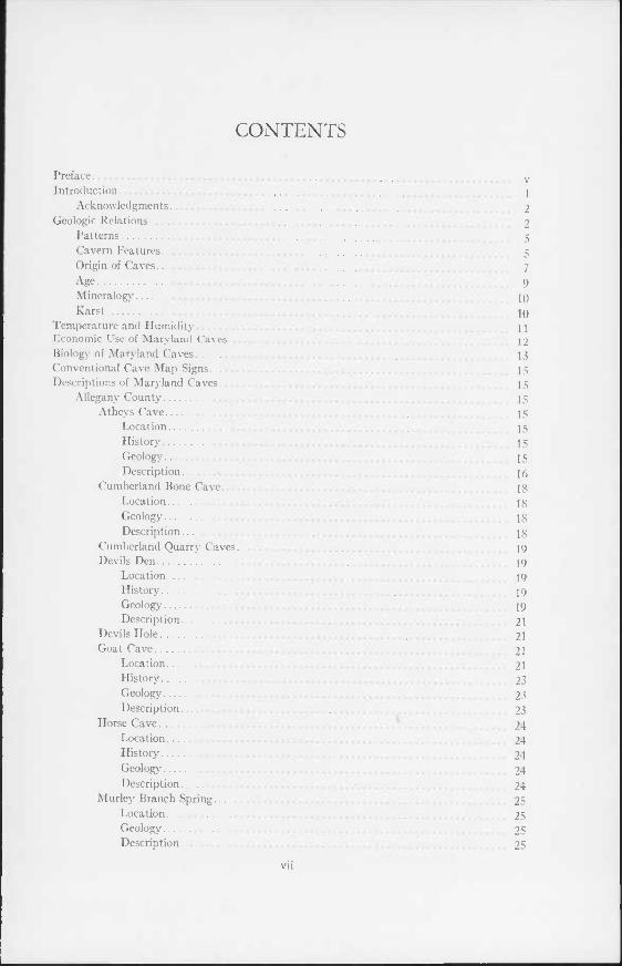
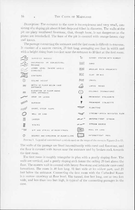
Conventional Cave Map Symbols
Figure 1 illustrates and explains the conventional symbols used on the maps of the caves in figures 2 to 15.
Descriptions of Maryland Caves
The locations of Maryland caves are shown on Figure 16.
A llegany Counly
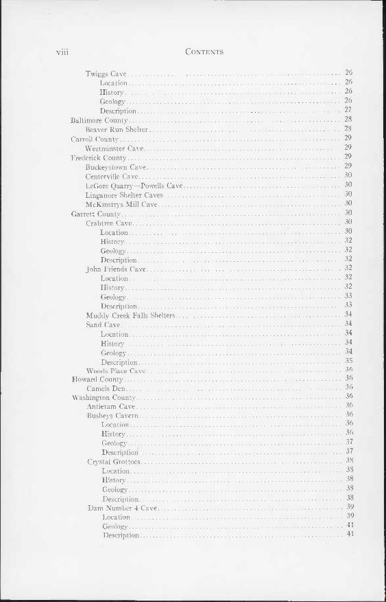
Atheys Cave (Figure 2). 39° 39' 48"N.; 78° 35' 28"W. Flintstone Quadrangle. Location: This cave is on the property of I. W. Athey, Route 2, Cumberland,
one mile east of Rush. The entrance is 100 feet inside the woods at a point east of the Athey barn.
Hislory: Little concerning the history of the cave could be ascertained except that it has been open for exploration for at least a generation. The oldest date within the cave is 1943, but reports indicate that thorough investigations were made about 20 years ago.
Geology: The cave is developed in the lower part of the Tonoloway formation, approximately 100 feet above the base. The Tonoloway is a massive to blocky, blue-black, pure limestone with a gentle dip of 20° to the southeast and a strike of N 30° E. The cave is developed along sets of vertical joints. The major set trends N 20° E to due north. Minor joints developed along the trend N 70" W. The cave is located on a series of subordinate folds on the east limb of the larger Tussey Mountain anticline.
16 The Caves of Maryland
Description: The entrance to the cave is inconspicuous and very small, con- sisting of a sloping pit about 6 feet deep and 4 feet in diameter. The walls of the pit are platy weathered limestone, that, though loose, is not dangerous as the plates are interlocked. The base of the pit is covered with orange-brown clay and leaves.
The passage connecting the entrance and the first room is difficult to traverse. It consists of a narrow crevice, 25 feet long, averaging one foot in width and with a height rising from two feet near the entrance to 10 feet at the first room.
'2'
©
SURVEYED PASSAGE UNSURVEYEO OR CONJECTURAL PASSAGE LOWER LEVEL (WHERE LEVELS COINCIDE)
CONTOURS
CEILING HEIGHT
DEPTH OF FLOOR BELOW CAVE ENTRANCE ELEVATION OF FLOOR ABOVE CAVE ENTRANCE
z\
\OeO ' o
€
DROP OR LEDGE
\\v BARRIER
SHORT, STEEP SLOPE
WELL OR SINK
LADDER
STAIRS
DIP AND STRIKE. OF ROCK STRATA
DEGREE AND DIRECTION OF FLOOR SLOPE
o A
SURVEY STATION WITH NUMBER
SAND
ANGULAR ROCK FRAGMENTS
CLAY OR MUD
5RAVEL
LARGE ROCKS
COLUMNS (FORMATIONS)
PROMINENT STALAGMITE
PROMINENT STALACTITE
FLOWSTONE
STREAM-ARROW INDICATES FLOW
INTERMITTENT STREAM
STREAM COURSE
POOL OR LAKE
INTERMITTENT POOL
////I#
o
s pso"
Figure 1. Legend of conventional symbols used on the maps of the caves in Figures 2 to 15.
The walls of the passage are lined intermittently with coral and flowstone, and the floor is covered with leaves near the entrance and by broken rock towards the first room.
The first room is roughly triangular in plan with a gently sloping floor. The walls are vertical, and a gently sloping arch forms the ceiling 20 feet above the floor. The eastern wall is covered with heavy flowstone and intricate cave-coral formations. The room is 30 feet long, 11 feet wide at its widest part, and 25 feet below the entrance. Connecting the first room with the Cathedral Room is a narrow crawlway at floor level. The tunnel, five feet long, one or two feet wide, and less than two feet high, is typical of the connecting passages in the cave.
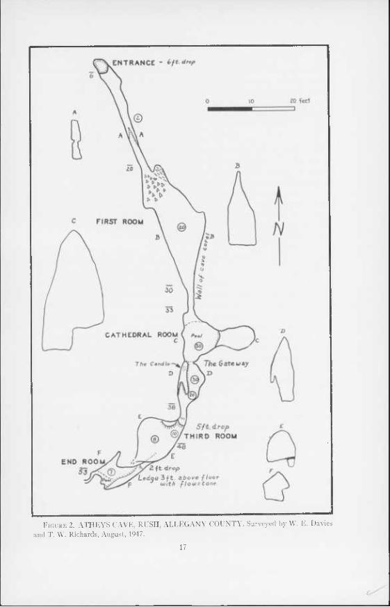
Figure 2. ATHEYS CAVE, RUSH, ALLEGANY COUNTY. Surveyed by W. E. Davies and T. W. Richards, August, 1947.
17
18 The Caves of Maryland
I he ( athedral Room is similar in plan to the first room, being triangular in shape, 12 feet long and 9 feet wide. The ceiling is over 30 feet high and caps a lofty chimney. On the east side of the room is a small alcove a few feet above the floor that merges with the chimney at a height of 15 feet. The floor of the Cathedral Room is covered by a shallow pool of water, averaging three inches deep.
I he C andle Room, separated from the Cathedral Room by narrow vertical slabs of rock at the base, merges with the Cathedral Room at a height of 10 feet The room is 10 feet long and 8 feet wide at floor level. On the west side of the room is a narrow ledge on which a delicate and beautiful formation resembling a candle with a trail of wax drippings has developed.
I he passage from the Candle Room to the third room is 8 feet long and large enough to walk erect in. It ends at a ledge 5 feet high at the entrance to the room. The third room is oblate in shape with a length of 13 feet, a width of 7 feet, and a ceiling height of 8 feet. At the far end of the room are a number of stalactites and flowstone, forming one of the prettiest parts of the cave.
The passage from the third room to the end room is extremely difficult to negotiate, having a width of I5 feet and a height of 2 feet, and ending in a ledge 5 feet high at the end room. The room is roughly triangular in plan with a length of 9 feet, a width of 6 feet, and a height of 6 feet. Along the east wall is a ledge of flowstone 3 feet above the floor, that is covered with stalactites at the far end. The floor is covered with rock debris with a shallow pool of water at the far end. A narrow, low, curving passage leads off at the end of the room, but it is too small to permit further exploration.
The temperature of the air in the cave varied from 51° to 530F. The humidity is 100 per cent. The temperature of the water in the shallow pools was 480F., and the water was weakly acidic with a pH in the range of 6 to 7.
C umberland Bone Cave. 39° 41' 24" N.; 78° 47' 11" W. Frostburg Quadrangle. Location: In building the Western Maryland Railway's Connellsville Ex-
tension in 1912, a small cave was encountered in a deep cut at the north end of a limestone ridge south of the town of Corriganville. The main part of the cave was at the level of the roadbed grade, 100 feet below the original surface. Although the cave was scarcely more than a small room filled with clay and cave breccia, it was among the most interesting in the State because of the remarkable assemblage of Pleistocene vertebrate remains it contained.
Geology: The cave was developed in the Keyser limestone which at this point is vertical. In addition to the main chamber, several smaller chambers were encountered at higher levels in the excavation, and one of these is reported to have connected with the surface at the top of the hill at a point which is now the center of the cut {18).
Description: The bones were excavated from 1912 to 1915 by J. W. Gidley
Descriptions of Maryland Caves 19
of the U. S. National Museum. The opening was removed in subsequent rail- road work. In a preliminary report Gidley (9, p. 95) described the occurrence as follows: "The bones for the most part are much broken, yet show no signs of being water worn. They are found scattered fairly uniformly throughout the entire mass of unstratified accumulations which consist entirely of cave clays and breccias, unevenly hardened and more or less cemented together by stalac- titic materials. There is an almost entire absence of admixture of sand or gravel, or in fact anything that would suggest the possible aid of stream currents in sorting or placing the material during the process of accumulation."
The fossil remains recovered from the cave totaled 46 species, 28 of which are now extinct. They are discussed in the section on Cave Biology.
Cumberland Quarry Cares. 39° 39' 24" N.; 78° 46' 35" W. Frostburg Quadrangle. Cumberland Quarry is on the south side of Wills Creek, opposite Valley
Street, in Cumberland. Two crawlways less than 20 feet long are developed in the east face of the quarry. The caves are in the Wills Creek formation that is closely folded here into a series of anticlines and synclines.
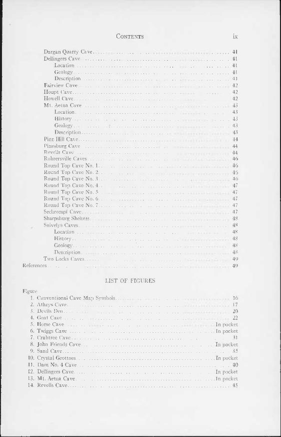
Devils Den (Figure 3). 39° 41' 26" N.; 78° 34' 30" W. Flintstone Quadrangle. Location: The farm of Harry Jackson, Route 2, Flintstone, is located one
quarter mile east on the side road that leaves the Flintstone-Rush road, one mile south of Flintstone. Devils Den is in a lightly forested area about 1000 feet northeast of Jackson's house. It is easily reached by following the strike of the rocks northeast from the large spring opposite the house.
History: Like many small caves the history of Devils Den is rather obscure. The cave has been well known to residents of Flintstone and, like Goat Cave, it has been the favorite play place for children for many years. No dates of any historical value occur in the cave.
Geology: Devils Den is developed in the top part of the Tonoloway limestone. The limestone is dense, fine-grained, platy, dark gray to black in color, and occurs in beds about one inch thick alternating with some massive beds. The dip is 70° E. and the strike N 40° E. The cave is developed along the steeply- dipping bedding planes, and jointing is obscure and plays a minor part. The structure in which Devils Den occurs is on the west limb of a subordinate syn- cline on the eastern limb of a large anticline.
The cave is tied closely to the branch of Flintstone Creek that sinks behind the school in Flintstone and reappears as a large spring and tributary to Murley Branch at the Jackson residence. This stream flows underground for about one mile along a course that directly follows the strike of the rock with elevation difference of 20 feet from Flintstone to the spring. About one-half the drainage flows underground; the remainder follows the longer course of Flintstone Creek through Gilpin to a point where it joins Murley Branch, about 3 miles from
Figure 3. DEVILS DEN, FLINTSTONE, ALLEGANY COUNTY. Surveyed by T. VV. Richards and W. E. Davies, November 9, 1947.
20
Descriptions of Maryland Caves 21
Flintstone. Devils Den lies directly above the underground course and is proba- bly a part of the network.
Description: The entrance to Devils Den is through a rectangular sinkhole about 10 feet long by 5 feet wide with a drop of 10 feet. Entrance is best gained along the southeast edge where ledges and a pile of debris make a very easy drop. Beneath the sink is a rectangular room about 18 feet long and 15 feet wide with a ceiling height of 8 feet. Leading northeastward and gently sloping is a passage that grows progressively smaller until it pinches out 55 feet from the entrance. The passage follows the bedding planes of the limestone, and the floor is covered with rough slabs of limestone that have peeled from the walls. At the far end of this passage is a low passage, 7 to 10 inches high and 6 feet wide, that opens eastward to a small room. The passage is close to the floor and is most difficult to negotiate. The room is about 45 feet long and is elliptical in shape with a maximum width of 12 feet directly opposite the connecting pas- sage. The maximum height is 4 feet near the entrance, and the flat arched ceil- ing tapers gradually in all directions. The long axis of the room is parallel to the entrance passage. The north side of the room is filled with clay to within one foot of the ceiling. Flowstone in the form of small terraces is found along the east wall and is the only formation of any size in the cave.
Another passage extends southwest from the entrance. The opening into it is constricted by rock debris, and the entire passage is low. Beyond 10 feet it is a crevice too narrow to traverse.
Most of the cave is very dry and somewhat dusty. The floor at the far end of the entrance passage and in the side room is damp and has a thin film of wet brown clay. The ceiling throughout is of clean, unaltered limestone.
The cave is rather shallow. The main passage drops only 27 feet which, com- bined with the entrance drop, gives a total drop of 37 feet. The surface rises only slightly along the axis of the cave.
Devils Hole. 39° 39' 14" N.; 78° 38' 23" W. Flintstone Quadrangle. On the property of H. V. Willison, on the west side of the Twiggtown-Flint-
stone road, one mile north of Twiggtown, is a vertical shaft that is reported to connect with small rooms at the base. The shaft, in a small wood lot behind the Willison house, is 1 to 3 feet in diameter and 30 feet deep. It is almost vertical and spirals slightly. A short distance below the surface, the walls are wet and muddy due to surface seepage. Small rooms are reported to open at the base of the shaft. Devils Hole is in the Keyser limestone.
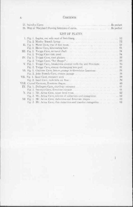
Goal Cave (Figure 4). 39° 38' 36" N.; 78° 47' 00" W. Frostburg Quadrangle. Location: At the end of Patterson Street in Cumberland, opposite the Kelly-
Springfield tire plant, is a small inconspicuous opening on the northwest side
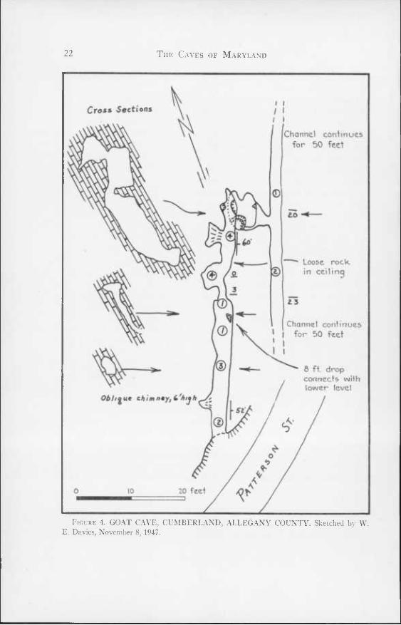
22 The Caves of Maryland
Cross Sections
Channel continues for 50 feet
Loose rock in ceilinq
Channel continues I for 50 feet
8 ft. drop connects with lower level
Figure 4. GOAT CAVE, CUMBERLAND, ALLEGANY COUNTY. Sketched by W. E. Davies, November 8, 1947.
Descriptions or Maryland Caves 23
of the road. The opening, partially obscured by low underbrush and weeds, is the entrance to Goat Cave.
History: The cave has been known as far back as local residents can recall, and the entrance passage has long been a favorite play place for the children of the neighborhood. No dates or initials were seen within the cave which leaves no clues as to the dates of former explorations.
Geology: Goat Cave is developed in a steeply-dipping limestone member of the W ills Creek formation. The limestone is 10 feet thick and is sandwiched be- tween beds of red shaly sandstone above and mottled, gray-green and red, sandy shales below. The limestone is thin-bedded and dark gray to black in color. The strike is N 20° E and the dip 54° E. The beds are strongly folded and contain many minor contortions and slickensides. Ripple marks are com- mon in the beds adjacent to the limestone.
The cave is developed along the bedding planes and reflects directly the dip of the formation. Because of the narrow width of the limestone in which it is developed it follows closely the strike of the formation. Because of the non- calcareous nature of the adjacent rocks there are no side passages.
Description: The entrance to the cave is a low narrow passage at the level of the road. It is 2 to 3 feet wide and 1 to 3 feet high. The cave continues as a narrow low tunnel with about the same dimensions as the entrance for 25 feet. In the first 25 feet the cave is very dry, and the floor is covered with gray dust. Twenty-two feet from the entrance is a small pit that slopes down steeply to the east to connect with the lower level. The pit is too narrow to permit pas- sage. Twenty-five feet from the entrance the cave is abruptly constricted, and the ceiling lowers to such an extent that the next 5 feet are barely passable. This constriction ends in a small alcove, 4 feet high, 5 feet wide, and 4 feet long, that is formed by a low chimney sloping upwards to the west. Between this alcove and the next alcove, four feet further on, the passage is low and con- stricted with the added danger of loose rock on the west side. The second alcove is a low chimney similar to the first but slightly larger. Five feet beyond, the upper passage ends in a solid rock wall.
Connection to the lower level is through a narrow low slot, 3 feet wide, and 2 feet high, that drops 8 feet vertically to a small room approximately 6 feet square. A hole in the floor of this room, on the southwest side, opens into a vertical drop of 5 feet that in turn gives way to a wet mud-covered passage that slopes 60° for a drop of 15 feet to the lower level. Ropes are needed to accomplish these drops safely.
The lower level is 30 feet below, parallel to the upper level, and continues in two directions at the base of the slope. The north section is 1 to 2 feet wide and from 1 to 3 feet high. It continues for 50 feet beyond which it is too low for further progress. The south passage is slightly larger than the north passage
24 The Caves of Maryland
but requires crawling for 75 feet to a point where the ceiling is too low to permit further exploration. Both passages are floored with damp gray clay.
No formations except small stalactites or films of flowstone are found in the cave.
Horse Cave (Figure 5). 39° 37' 45" N.; 78° 39' 30" W. Flintstone Quadrangle. Location: Horse Cave, also known as Dead Horse Cave, is located at the
south end of the cove at Twiggtown, about 1000 yards south of Twiggs Cave. The cave entrance is in a small clump of trees just to the south of the path leading from the cove southwestward toward the Twiggtown-Spring Gap road. It is on the property of Austin D. Twigg of Twiggtown.
History: The cave has been known for a considerable time, and there is no record of an actual "discoverer". No dates of any historical value were ob- served in the cave. The cave received its name from the misadventures of a horse that fell into the cave many years ago. Its remains are now scattered over the entrance room.
Geology: Horse Cave is in a Favosites zone of the Keyser limestone about 100 feet from the top of the formation. This is 40 feet below the beds in which Twiggs Cave is developed but is on the same general strike. At Horse Cave the strata dip 40° W and strike N 30° E. The limestone is fine-grained, dark gray in color, and quite fossiliferous, the predominant fossil being Favosites corals. The cave is developed along a set of joints parallel to the strike and at right angles to the bedding. In combination with the bedding, the joints produce many passages with triangular cross sections (PI. II, fig. 1).
Description: The entrance sink has an axis N 80° E and slopes gently towards the entrance hole at the east end. This hole, 4 feet in diameter, is in two sections. The first drop is 6 feet vertically to a ledge that occupies practically the entire diameter of the pit. The second stage, that carries to the floor of the cave, is a vertical drop of 10 feet offset to the south. An old ladder made of tree limbs and slats covers this drop but is in such dangerous condition as to be useless. The entrance drop opens into the northeast side of the entrance room.
The entrance room is tent shaped, with one wall reflecting the bedding plane and the other a set of joints at right angles to the bedding. The room is 20 feet long, 15 feet wide, and 13 feet high at its apex. Large masses of fallen rock cover the north end of the floor, and from some of the rocks excellent specimens of Favosites can be obtained. The floor, except for the rock masses, is fairly level and covered by a layer of wet brown clay. Along the north wall a small narrow tunnel-like passage parallels the room and is gently inclined towards the north.
From the north end of the room a small passage connects with a room 12 feet wide and 6 feet high that pinches out beyond 15 feet. The floor of this room is covered with angular fragments of limestone and chert blocks.
Descriptions of Maryland Caves 25
Along the southeast side of the entrance room is a wide ledge, 4 feet high, that leads to a low triangular-shaped passage, 15 feet long, 5 feet wide, and 5 feet high at the apex, that opens into a high room at its south end. This room is also connected to the south end of the entrance room by a narrow slit and a 5-foot drop. The room is 25 feet high, 20 feet long, and 15 feet wide. The south half is 10 feet below the remainder of the room, and a natural bridge crosses the depressed section and connects with a passage opening in the east wall. This passage is a crawlway that parallels the main part of the cave and extends to the north and south for 20 feet.
Beyond the bridge the cave consists of a series of irregular passages, some- times wide and low, at other times narrow and high, that continue to a point 105 feet from the entrance where the main passage ends in a room 20 feet long, 15 feet wide, and 3 to 4 feet high. The east side of the room slopes upward at 30° to join another segment of the cave. This higher level is parallel to the lower level and extends 35 feet to the north and 20 feet to the south. It is low and rounded with a height varying from 3 to 5 feet and a width of 7 to 10 feet. At numerous places it connects with the lower level by very small openings. A small crawlway at the south end of the upper level, now blocked by formations, may provide access to other parts of the cave if cleared.
The cave is comparatively shallow, having from 8 to 10 feet of cover over the entrance room. The ground slopes upwards along the axis of the cave but is paralleled by the slope of the cave so that the cover remains relatively uniform.
Formations, other than flowstone, are scarce except in the rear part of the cave where stalactites abound, many of them of the "soda straw" type. Throughout much of the cave there are stumps of broken stalactites and sta- lagmites that have resulted from breakage due to settling or from vandalism.
Murley Branch Spring. 39° 39' 38" N.; 78° 37' 07" W. Flintstone Quadrangle. Location: Two miles northeast of Twiggs cave is a low, water-filled opening
in a cliff facing north (PI. I, fig. 2). The opening is 100 feet east of the Twigg- town-Flintstone road, one half mile southwest of Rush.
Geology: Murley Branch Spring is developed in massive Tonoloway limestone just above the base of the formation. The rocks are horizontal at the crest of a subordinate anticline.
Description: A large stream of water, 10 to 15 feet wide and several inches deep, flows north from the opening. The cave is 6 feet wide and 4 feet high at the entrance and opens directly to a room 10 feet in diameter. A narrow crev- ice passage leads to the east and can be traversed with difficulty for 20 feet. The main passage continues to the south, but exploration is blocked by a siphon that extends 5 feet below the surface of the water. The water at the siphon is 10 feet deep. It is reported that a quarter of a century ago several young men penetrated the siphon during an exceptionally dry season. A passage is re-
26 The Caves of Maryland
ported to extend straight to the south for 300 feet from the siphon with at least three deep pits in the floor.
A small cave is reported to lie 100 yards south of the spring. It was not found during the field work.
Twiggs Cave (Figure 6). 39° 38' 09" N.; 78° 39' 11" W. Flintstone Quadrangle. Location: This cave, which is the largest in the State, is located on the prop-
erty of Austin D. Twigg at Twiggtown, 6 miles east of Cumberland. The en- trance to the cave is on the eastern slope of a limestone ridge 1500 feet south of the Twigg house. It is reached by a farm lane and is 100 feet west of and 30 feet above the lane in a low outcrop of rock partially concealed by logs and brush.
History: The history of the cave is rather short. The cave was opened and explored by the grandfather of the present owner in 1898. Subsequent extensive exploration was carried on by the present owner and his brother when they were boys. Further exploration was somewhat sporadic because of the difficul- ties presented by the entrance and muddy conditions. Dates and initials are rare as they are quickly obliterated in the clay that abounds in the cave. The oldest date seen was 1911.
Geology: In the vicinity of Twiggtown the Helderberg formation is made up of three members totaling about 325 feet in thickness. Twiggs cave is de- veloped in a series of dark gray to black crystalline limestone beds that lie about 25 feet below the base of the Coeymans member and 250 feet above the base of the Keyser member. The limestone is somewhat knobby and is high in clay content.
The cave is developed on the western side of an anticline. The beds dip 60° W and strike N 40° E. A series of master joints trends N 40° E and dips 60° E. A series of subordinate vertical joints trends N 50° W. The cave is developed as two large parallel fissure openings along the master joints. Bedding planes are relatively unimportant except at the entrance where they form a small sloping passage. In cases where collapse has occurred the bedding planes are reflected in the walls of passages. The subordinate joints show up only in a few small side passages and in the low tunnel connecting the parallel fissures.
The large amount of clay in this cave is of considerable interest. In the first room at the base of the entrance slope a large amount of clay in the form of two "mud glaciers" is encountered (PI. IV, fig. 1). The clay is entering the cave through two chimney-like passages in the south end of the room and is a result of the accumulation of surface-derived material. These mud glaciers have char- acteristics similar to normal ice glaciers although their power to excavate ma- terial is practically nil.
The clay encountered throughout the rest of the cave cannot be so easily accounted for. The high clay content of the original limestone (12% by weight)
Descriptions of Maryland Caves 27
contributes considerably. In the ceiling the process of leaching of the lime and development of residual clay is easily seen. The solid limestone forming the ceiling grades into a soft, light gray to white, somewhat coarse clay that has a thickness up to one inch. Outside of this is a zone of fine, wet, light brown clay about one quarter inch thick. The surface layer, less than an eighth of an inch in thickness, consists of somewhat coarse dark brown to dark gray clay. The surface of the clay has the shape of rough, blunt, clay stalactites, each stalactite being less than an inch long and about one quarter inch in diameter. The clay of the cave floor and lower walls is entirely different, and its origin is open to various interpretations. It is generally dark brown to dark gray in color, 6 inches to 1 foot thick, and laminated. The individual laminae average 2 to 4 millimeters in thickness and are distinguished by minute changes in grain size. Two methods of origin appear possible. The clay may be a result of deposition from the underground stream which in wet weather may flood considerable portions of the cave. However, since the laminations are often found a consider- able distance above the floor with the laminations following the contour of the walls, this hypothesis seems unlikely. The other hypothesis ascribes the source to the parent rock which is high in insolubles (PL IV, fig. 2). These insolubles are deposited by thin films of water as the limestone is dissolved. The water transports the material from the upper part of the walls and deposits it in the lower sections. The laminations reflect varying conditions in the amount of water seeping into the passages.
Description: The entrance to Twiggs Cave is through a vertical shaft, 25 feet deep, 4 to 8 feet long, and 1 foot wide (PL III, fig. 1). At the base of the shaft is a "Z" shaped passage about 40 feet long and sloping 45° which connects with the first room. This room has two mud "glaciers" at its south end that are slowly moving and covering the floor (PL IV, fig. 1). The cave continues in a northerly direction from this room as a passage, the Straightway, that is 10 to 15 feet wide and 10 feet high. Just north of the first room is a pile of broken rock leading down 25 feet to the level of the Straightway (PL V7, fig. 1). The floor of the Straightway is made of fallen rocks to a considerable depth and many minor passages exist beneath the main level. The Straightway, 85 feet long, ends in two chimneys at the base of which is a deep well. A narrow, crevice- like passage leads off the base of the first chimney and continues into a small room that ends in a mud wall. A small crawlway, 4 feet in diameter, leads off the west side and curves around to a narrow clay shelf at its junction with the second major fissure passage. Here is a row of six pits leading to a lower tunnel The largest pit, the Kings Chair, affords access to the lower level that is a low tunnel 3 feet wide, 2 to 5 feet high, and 40 feet long. The passage continues along the base of a high sloping crevice. The passage is 15 feet wide and slopes steeply for 100 feet to a drop of 14 feet. This point, 192 feet below and 375 feet from the entrance, is at the stream level of the cave.
28 The Caves of Maryland
The stream enters this section of the cave from below by a steeply sloping and curving shaft over 75 feet deep (PI. V, fig. 2). The stream forms three shallow pools, each about 10 feet long, and then flows along the floor of the cave. The stream is of considerable interest and is discussed in the section on karst. Twenty feet beyond the drop to the water level is a shallow pit into which the stream plunges with a loud roar. The cave continues as an ever- narrowing passage, decreasing from 20 feet high and 10 feet wide to 3 feet high and 2 feet wide. In places the route of traverse is in the stream bed, in other places along a clay ledge above the stream. At 120 feet this passage ends in a small tunnel 2 feet high and l j feet wide, the floor of which is occupied by the stream. This passage, which necessitates a crawl, is 25 feet long and ends in a narrow crevice-like passage 10 feet high, 4 feet wide, and 10 feet long. At the southwest corner is a narrow slit in the floor down which the stream plunges to a lower level. This falls is over 50 feet deep. Bottom was not reached in soundings.
In 1946 a small tunnel was excavated through packed clay and gravel to a low passage that leads 30 feet to a pit which is 40 feet deep and 5 feet in diam- eter at the top. The base of the pit is a slit 1 foot wide which leads off into a crevice passage less than a foot wide. Traverse of this passage was not possible, but the cave appears to open up somewhat 30 feet beyond. The floor at the base of the pit is covered by a thin veneer of yellow clay of recent deposition indicating that the stream backs up to this level. The base of the pit is 290 feet below and 750 feet from the entrance.
Above the Straightway is another passage resulting from the fall of large blocks of limestone that form the ceiling of the Straightway and the floor of the upper level. The two levels are connected by a number of openings between the rocks, but access to the upper level is accorded at only one point. At the south end of the Straightway, near the 25 foot drop, is a flowstone ledge on the west wall that slopes steeply to the east. A traverse diagonally across the liowstone leads to a small hole that gives access to the upper level. The upper level passage is 10 feet wide and extends for 100 feet as a fissure similar to the lower levels. The fissure is 30 feet high and tapers out at both ends. Several massive stalac- tite formations are developed on the east side of the passage, and one of them gives beautiful musical tones when struck.
An upper level exists above the Kings Chair. It is a ledge 10 feet wide that lies 30 feet above the base of the fissure passage. At the north end this level develops as a separate passage extending over 100 feet.
Baltimore County
Beaver Run Shelter. Not located. Muma {28) described a small shelter cave on the north bank of Beaver Run,
5 miles east of Alesia. The entrance, 3 feet high by 2 feet wide, opens into a
Descriptions or Maryland Caves 29
passage 20 feet long at the end of which is a small room, 10 feet in diameter and 3 to 4 feet high. A few charred bones and a section of a clay pipe were recovered from the talus near the entrance. The shelter was not found during fieldwork for this report.
Carroll County
Westminster Cave. 39° 34' 11" N.; 76° 59' 57" W. Westminster Quadrangle. Westminster cave is 100 feet west of the Western Maryland Railway, one-
half mile south of the railroad station at Westminster. The entrance, in an old quarry facing east on the property of Louisa Lash, is covered by a wooden door that gives access to a room 18 feet long, 15 feet wide, and 8 feet high. The room is blocked at the rear by a recent rock fall. A small passage, 4 feet high and 4 feet wide, extends 8 feet through the rock fall to a pinch out. The cave is reported to continue for a considerable distance to the west but no way through the rock fall could be found. The entrance room is floored with concrete and was formerly used as a milk cooler. A small stream formerly flowed along the south wall and discharged to the south through a narrow passage less than one foot high. The stream ceased flowing a decade ago when blasting was done nearby for the building of petroleum storage tanks.
The cave is in the Wakefield marble which is white, crystalline, and banded with gray-green zones high in mica. It is developed along a joint trending N 20° W with a dip of 60° W.
Frederick County
Buckeystown Care. 39° 19' 15" N.; 77° 27' 13" W. Buckeystown Quadrangle. In a large wooded area lying between Buckeystown and Adamstown are a
number of small quarries and prospect pits in the Frederick limestone. In the base of a small quarry along the eastern side of the woods midway between Buckeystown and Adamstown is a vertical opening that leads to a small cave. The cave is a quarter of a mile from the southeast corner of the woods and a similar distance east of the New Design road. The entrance is 6 feet in diameter and is a shaft 25 feet deep. At the base is a room 20 feet long by 18 feet wide, the ceiling of which is at the top of the entrance shaft. The rock along the walls of the room is shattered and broken due to collapse. One block over 20 feet long and 15 feet high has dropped en masse. The broken slabs of rock average 4 inches thick and up to 4 feet long. The floor of the room is covered with logs, animal bones, and other debris.
On the north side of the room is a passage 10 feet wide and 4 feet high that slopes steeply downwards for 15 feet over breakdown to a room 30 feet long and 20 feet wide. The ceiling of the room, which is 4 feet high, is made up of loose flat slabs of rock. The floor is covered with massive breakdown and is dry and dusty. No passages lead off from the room.
30 The Caves of Maryland
The cave is in the Frederick limestone on the east side of a small fault. The rock strikes N 40° W and dips 10° E. Little Brown Bats were observed hiber- nating in the second room of the cave in November, 1949.
The cave is dangerous to traverse and should be avoided as the walls and ceiling of loose rock are subject to collapse without warning.
Centerville Cave. 39° 30' N.; 77° 16' W. Woodsboro Quadrangle. A cave consisting of four small rooms is reported in an old quarry in the
Wakefield marble, one-half mile east of Centerville, along the Coppermine road. The cave was not located during field work.
Le Gore Quarry-Powells Cave. 39° 32' 55" N.; 77° 18' 38" W. Woodsboro Quad- rangle.
Powells Cave is on the west side of Israel Creek, 1 mile north of Woodsboro, on the property of Luther Powell. It is a low passage requiring considerable crawling that extends over 100 feet to the north. The entrance is now blocked with stone dumped into it.
In the Le Gore quarry, 100 yards northwest of Powells Cave, is a series of cavernous openings in the north face. Quarrymen report that subterranean passages from these openings circle to the east and south apparently to join with Powells Cave. During quarry operations a large room was encountered at the northwest edge of the quarry which collapsed and carried a man into it.
Powells Cave and the openings in Le Gore quarry are in the Grove limestone that strikes N 30° E and dips 60° E (overturned)
Linganore Shelter Caves. Libertytown Quadrangle. Several small shelter caves that contain Indian pictographs are reported to
lie near the settlement of Linganore. These shelters could not be located during field work.
McKinslrys Mill Cave. 39° 32' 05" N.; 77° 10' 18" W. Union Bridge Quadrangle. This cave is 2^ miles south of Union Bridge, on the west side of Sams Creek,
three-fifths of a mile due west of McKinstrys Mill. The cave is less than 100 feet long and is a crawlway with occasional stretches large enough to permit walk- ing.
Garrelt County
Crabtree Cave (Figure 7). 39° 30' 22" N.; 79° 08' 15" W. Bittinger Quadrangle. Location: This cave is on the north end of Backbone Mountain, 200 yards
west of the Savage River damsite, at Bond Station on the Baltimore and Ohio Railroad. The entrance is in a low ledge of limestone 700 feet due west of the
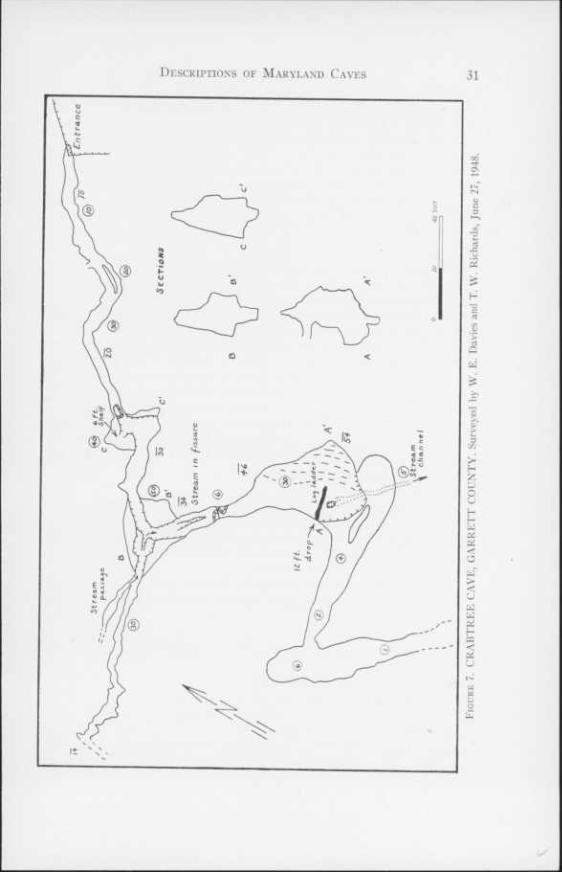
32 The Caves of Maryland
station at an elevation of 1660 feet. The cave is on the property of a Mr. New- land of Luke, Maryland.
History: The cave is of no interest historically. No old dates or initials were observed on the walls.
Geology: Crabtree Cave is in the Greenbrier limestone which is cross-bedded (PI. VI, fig. 1) and light gray to tan in color with a slight pink hue in some of the beds. Arenaceous limestone and red shale beds are mixed with the purer lime- stone. The beds strike N 60° E and dip 14° E. Joints striking N 30° W (dip 80° N), N 50° W (dip vertical), and N 50° E (dip 80° N) are developed in the limestone.
Description: The entrance is a cleft 2 feet wide that drops 10 feet to the cave floor. A narrow, irregular fissure-like passage, 3 to 5 feet wide and up to 40 feet high, trends southwest with a gentle slope to the southwest. At 75 feet from the entrance, the passage intersects a chimney 20 feet in diameter and 40 feet high. The west side of the chimney has a shelf 6 feet above the passage floor. A similar chimney is developed 120 feet from the entrance that has a passage 2 to 4 feet wide and 30 feet high extending to the west. The floor of this side passage, which is rough and blocked in part by fallen rock, slopes steeply upwards to the west and is difficult to traverse. A small stream enters the side passage near its junction with the main passage. The side passage was explored for 60 feet.
For 20 feet beyond the second chimney the passage is 5 to 8 feet wide and 6 feet high. A narrow fissure, 6 feet deep and 1 foot wide, is in the floor. The main cave passage terminates in a room 25 feet long, 15 feet wide, and 15 feet high. A stream flows south across the room and disappears in a low sewer be- neath the floor.
A low passage, 4 feet high and 2 to 6 feet wide, opens to the west 12 feet above the floor of the room. It is 20 feet long and connects with a similar pas- sage heading southeast which reduces to a narrow, low crawlway beyond 15 feet. The cave is reported to continue as a crawlway connecting with a series of rooms. This section was not explored.
The passages of the cave are covered with flowstone and cave coral through- out. A film of black, soot-like material, probably manganese dioxide, covers the walls.
John Friends Cave (Figure 8). 39° 34' 23" N.; 79° 24' 30" W. Sang Run Quad- rangle.
Location: John Friends Cave, a well known cavern, is located three-fourths of a mile east of Sang Run. The entrance, in a small clump of woods, is 800 feet north of the Ginseng Run road at an elevation of 2180 feet. The cave is on the property of Dicie Friend, Sang Run.
History: John Friends Cave has been known since colonial days. The cave is specifically cited in Colonel Francis Deakin's Survey of Military Lots in 1787.
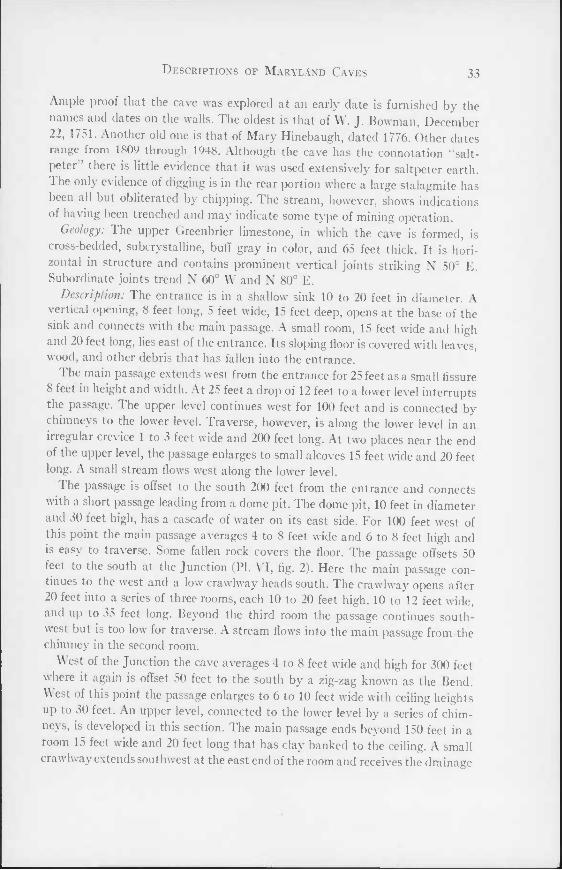
Descriptions of Maryland Caves 33
Ample proof that the cave was explored at an early date is furnished by the names and dates on the walls. The oldest is that of W. J. Bowman, December 22, 1751. Another old one is that of Mary Hinebaugh, dated 1776. Other dates range from 1809 through 1948. Although the cave has the connotation "salt- peter there is little evidence that it was used extensively for saltpeter earth. The only evidence of digging is in the rear portion where a large stalagmite has been all but obliterated by chipping. The stream, however, shows indications of having been trenched and may indicate some type of mining operation.
Geology: The upper Greenbrier limestone, in which the cave is formed, is cross-bedded, subcrystalline, buff gray in color, and 65 feet thick. It is hori- zontal in structure and contains prominent vertical joints striking N 50° E. Subordinate joints trend N 60° W and N 80° E.
Description: The entrance is in a shallow sink 10 to 20 feet in diameter. A vertical opening, 8 feet long, 5 feet wide, 15 feet deep, opens at the base of the sink and connects with the main passage. A small room, 15 feet wide and high and 20 feet long, lies east of the entrance. Its sloping floor is covered with leaves, wood, and other debris that has fallen into the entrance.
The main passage extends west from the entrance for 25 feet as a small fissure 8 feet in height and width. At 25 feet a drop of 12 feet to a lower level interrupts the passage. The upper level continues west for 100 feet and is connected by chimneys to the lower level. Traverse, however, is along the lower level in an irregular crevice 1 to 3 feet wide and 200 feet long. At two places near the end of the upper level, the passage enlarges to small alcoves 15 feet wide and 20 feet long. A small stream flows west along the lower level.
I he passage is offset to the south 200 feet from the entrance and connects with a short passage leading from a dome pit. The dome pit, 10 feet in diameter and 30 feet high, has a cascade of water on its east side. For 100 feet west of this point the main passage averages 4 to 8 feet wide and 6 to 8 feet high and is easy to traverse. Some fallen rock covers the floor. The passage offsets 50 feet to the south at the Junction (PI. VI, fig. 2). Here the main passage con- tinues to the west and a low crawlway heads south. The crawlway opens after 20 feet into a series of three rooms, each 10 to 20 feet high, 10 to 12 feet wide, and up to 35 feet long. Beyond the third room the passage continues south- west but is too low for traverse. A stream flows into the main passage from the chimney in the second room.
West of the Junction the cave averages 4 to 8 feet wide and high for 300 feet where it again is offset 50 feet to the south by a zig-zag known as the Bend. West of this point the passage enlarges to 6 to 10 feet wide with ceiling heights up to 30 feet. An upper level, connected to the lower level by a series of chim- neys, is developed in this section. The main passage ends beyond 150 feet in a room 15 feet wide and 20 feet long that has clay banked to the ceiling. A small crawlway extends southwest at the east end of the room and receives the drainage
34 The Caves of Maryland
of the cave. This passage extends for 248 feet but is low and narrow for most of its length. A small room, 58 feet from the entrance to the crawlway, 5 to 6 feet wide, 4 to 9 feet high, and 40 feet long, opens to the northwest. Two small streams enter this passage from the southeast.
The floor of the cave is compact brown clay and silt with occasional areas of fallen rock. Some stream gravel is mixed with the silt and clay. I he floor slopes gently to the west and, except for the connection between levels near the en- trance, has no steep slopes or vertical drops. The stream is entrenched in the clay to a depth of one or two feet. It is reported to drain to the large spring at the Sang Run School.
Formations are rare in John Friends Cave and consist only of a few flowstone drapes and stalactites.
Directly across the valley from John I riends Cave is a large cave. I he en- trance formerly led steeply downwards but was filled with rock 75 years ago. The cave is reported to be larger than John Friends and to contain many forma- tions.
Muddy Creek Falls Shelters. 39° 30' 04" N.; 79° 25' 03" W. Sang Run Quad- rangle.
Two small shelter caves lie at the base of Muddy Creek I'alls, Swallow l alls State Forest, 8 miles northwest of Oakland. The largest shelter, on the north side of the creek at the falls, is 25 feet long, 15 feet wide, and 4 feet high. The second shelter, 20 feet to the south, is slightly smaller. The shelters are in soft limy sandstone in the upper part of the Pottsville formation.
Sand Cave (Figure 9). 39° 21' 07" N.; 79° 21' 08" W. Oakland Quadrangle. Location: Sand Cave, the largest shelter type cave in Maryland, is on the
east flank of Backbone Mountain, four-fifths of a mile southwest of Kelso Gap. The cave, at an elevation of 2750 feet, is 400 yards west of the country road that parallels Backbone Mountain. A trail, that leaves the country road at an old sawmill site, leads to the cave.
History: Sand Cave is ideally suited for human habitation and its history goes back to Indian times. Arrowheads, charcoal, flint chips, charred bones, and a bone instrument have been recovered from the cave earth near the en- trance {27). Little of interest is connected with the cave since colonial times save that it has been frequently visited. Most initials and dates are obliterated,
' but a neat inscription—Elishas Cave—has been carved above the entrance. Geology: Sand Cave derives its name from the lithology of the rock in which
it lies. It is developed in a white to gray, brown-stained, fine-grained massive sandstone of the Pottsville formation. The strata strike N 40° E and dip 18 SE. Two prominent sets of joints cut the beds, one striking N 68° E and dipping 60° W and the other striking N 70° W with vertical dip.
Descriptions of Maryland Caves 35
Description: The entrance is a broad, low opening that is practically hidden by a luxurious growth of ferns, moss, and lichens (PI. VII, fig. 1). It is KK) feet
(1946) and corrected by W. E. Davies, 1948.
wide and 2 to 6 feet high. The cave is of similar width but has heights up to 10 or 15 feet. The ceiling is an irregular surface that forms a broad, flat arch. 1 he floor is covered by large angular blocks of sandstone that have fallen from tlie
36 The Caves of Maryland
ceiling (Pi. VII, lig. 2). Some of these measure up to 6 or 8 feet, but the average are 4 feet in maximum dimension. At the front the floor is of coarse sand mixed with humus and charcoal, 2 to 4 inches deep, underlain by coarse brown sand. At the rear a stream falls over a large pile of rock, flows along the floor for a short distance, and disappears beneath the floor following a course along the east side of the cave.
The cave apparently extended further to the south at one time. Large blocks of sandstone in a small depression and a low ledge on the northeast, similar in form to those in the cave, are indicative of this.
A second cave lies in this area, but it could not be located. It is reported to open in the face of a large cliff as a crawlway 8 feet long beyond which it en- larges enough to permit walking for 1000 feet.
Woods Place Cave. Oakland Quadrangle. This cave is reported to lie four miles north of Oakland, east of the road to
Swallow I'alls. The entrance leads down in step-like terraces for 50 feet to a passage of unknown length. The cave was not located.
Howard County
Camels Den. 39° 18' 55" N.; 76° 51' 06" W. Ellicott City Quadrangle. ( amels Den is on the Patapsco River, 1.5 miles southeast of Woodstock.
It is a shallow rock shelter, 15 feet long, 6 feet wide, and 8 feet high, in the Cockeysville marble. The cave is 20 feet above the river with a talus slope below the entrance.
Muma [29) reports that two separate archeological diggings have been made at this cave and a large number of artifacts recovered.
Washinglon County Antielam Cave. 39° 25' 07" N.; 77° 44' 12" W. Keedysville Quadrangle.
A crawlway over 100 feet long is located on the east side of a ravine 500 yards east of the village of Antietam. It is in the Tomstown dolomite. The cave is of little interest except for the local reports that insist it connects with an opening in a quarry at Burnside Bridge, 2 miles to the north.
Busheys Cavern. 39° 38' 54" N.; 77° 35' 09" W. Smithsburg Quadrangle. Location: Busheys Cavern was formerly a large cave, but quarrying has
removed a portion of it and the remainder has collapsed. The cave is 100 feet north of the quarry at Cavetown and is 50 feet above the level of the quarry floor. The quarry and cave are property of Frank E. Bushey, Cavetown, Mary- land.
History: Busheys Cavern is the oldest known cave in Maryland. Mention of the cavern is contained in early Moravian Journals dated 1748 where Joseph Spangenberg wrote . . . "On July 12 th. they passed over South Mountain and
Descriptions of Maryland Caves 37
came on the same day to the 'Canigotschik' (Conococheague), where they in- spected a remarkable cave, which passes through the earth for 300 yards. In its opening 1000 people can stand, then it separates into two branches" {22). Though the Journal places the cave on Conococheague Creek other notes in the journal and field searches indicate that Busheys Cavern is the cave in question.
For many years the cave was owned by Robert Hughes and later by Dr. Elisha Bishop. Dr. Bishop began quarry operations in 1883 that were continued until 1944. At the end of the 19th century, F. M. Bushey took over the quarry operations. The cave was used as a source of saltpeter early in the 19th century, and vats and troughs were installed.
The cave was open to the public in 1823 as evidenced by the following news- paper advertisement in a Washington County paper {33):
"James Camper, having been at considerable expense in fitting up the cave for the ac- commodation of the public, most respectfully informs them and his friends that he will, in commemoration of the glorious independence of the United States of America, bril- liantly illuminate it on the 4th, 5th, and 6th days of July next. That no one be disappointed, he begs leave to state that he cannot admit any person into the cave on those days for less than 12$ cents. Any person throwing stone or anything else in any part of the cave, par- ticularly the water at the extreme end of the subterranean passage, will be fined one dollar. The cave will be kept in good order during the summer. Families or parties wishing to visit this wonderful work of nature can have it illuminated at any time by sending a letter (post- paid) to James Camper, Cavetown, or they will be admitted and provided with light for 61 cents each. For the accommodation of visitors and others he will have a supply of good porter, beer and ale."
Quarrying operations ate into the cave in 1925. The entrance collapsed first, followed by the inner portions, due to blasting.
Geology: Busheys Cavern was in a black dolomite at the top of the Tomstown formation. The strike is N 60° E and the dip 45° W. The cave was developed along a series of joints that trend N 60° W. Overlying the Tomstown formation in the upper part of the quarry are 30 feet of massive, black, phyllitic, cal- careous shale of the Waynesboro formation.
Excavation in the cave and adjacent quarry area yielded a number of fossil bones. Twenty-five species, twelve of which are extinct, were obtained by Dr. Charles Peabody in 1905 and were described by Oliver P. Hay {20, pp. 96-109).
Description: Little is left of the cavern today except a small part of the large entrance hall. The entrance is a moss-covered shelter 11 feet wide and 6 feet high that ends in a small crevice passage leading to a room 23 feet long, 20 feet wide, and 5 feet high. This room is floored wifti large boulders that have dropped from the roof. In the roof and walls are large broken blocks that are precariously balanced and in danger of collapse. On the north side of the room a part of the original cave is seen at the base of a pile of rock 15 feet below the present floor. Old initials are discernible on the walls in this part. The treacherous condition of the rocks makes it dangerous to enter this cave and visitors should keep out.
38 The Caves of Maryland
The cave was reported to be 500 feet long and to consist of an entrance, 58 feet wide and 8 feet high, leading to a room about 140 feet in diameter. A series of passages varying from 4 to 40 feet in width led to a lake 100 feet long, 20 feet wide, and 7 feet deep that occupied the end of the cavern. The rooms were beautifully decorated with delicate stalactites and massive columns. In the southwest corner of the first room was a series of terraces (Venus Baths) made of oval rosette basins rising 25 feet above the floor. Complete description of the cave is in Scharf's History of Western Maryland (33) and in Peabody's archeo- logical study (31).
A second cave was discovered in the quarry during operations in May, 1881. It was a fissure 15 feet high, extending into a well decorated chamber 90 feet long, with a gallery 90 feet long at right angles to the fissure. The far end of this fissure exists as a shallow gallery 60 feet above the floor in the center part of the quarry. This small chamber is full of small stalactites and columns which have suffered little from the quarry operations.
Crystal Grottoes (Figure 10). 39° 29' 53" N.; 77° 40' 38" W. Keedysville Quad- rangle.
Location: Crystal Grottoes, the only commercial cave now open in Maryland, is located one mile southwest of Boonesboro on the road to Keedysville. The cave entrance is a stone building located east of the highway on the south bank of a small tributary of Antietam Creek.
History: The cave was discovered in 1920 as a result of quarry operations for road material. Drills penetrated the passages near the present entrance, and an opening was effected by blasting. Because of their beauty and commercial possibilities the caverns were spared in the quarrying; and, in 1922, after clear- ing and installation of electrical equipment, the caverns were opened to the public. The entrance house was originally a wooden structure. It was replaced in 1942 by the modern stone structure.
Geology: Crystal Grottoes are developed in the middle part of the Tomstown dolomite, which at this locality is a knotty, blue-black dolomite. In weathering it displays an irregular lamination. Structurally the caverns are located on the east side of a broad subordinate anticline with a dip of 20° E and a strike of N 30° E. Two sets of master joints, one parallel to the strike dipping vertical, the other trending N 60° W with a dip of 70° SW, control the pattern.
Description: Entrance to the grottoes is by a stairway in the entrance house. The first room is 8 feet below the entrance house and is oblate in shape, being 30 feet long, 10 feet wide, and 15 feet high. At each end it is pinched out by mud flows and narrowing of the passage. This room originally contained a con- siderable number of formations, but quarrying operations and clearing of pas- sages have removed them except along the west wall where flowstone and sta- lactites are abundant.
Descriptions of Maryland Caves 39
Connecting the entrance room with the rest of the cave is a small tunnel 6 feet high that is reached by stairs going down 6 feet. From this point on the cave is a series of fissure-like passages of unsurpassed beauty. The fissures are uni- formly 4 to 6 feet wide with ceiling heights varying from 6 to 40 feet. The floor shows little change in elevation throughout the cave. With the exception of the passage from the Blanket Room to the exit, the passages are continuously lined or covered by formations. Delicate drape-like stalactites, bacon rinds, and stout columns predominate. The colors are generally pure white or buff with occasional deeper tints. The passages forming Fairyland are studded with stalactites and stalagmites of a delicate light blue hue.
The passages between Fairyland and Blanket Room are dense with beautiful formations that are striking because of their clean white surfaces. In this area, where formations are occasionally absent, the ceiling and walls are covered by a green-gray residual clay, which combined with the graceful contours of the ceiling rivals the formations in beauty. This clay is an integral part of the dolomite and remains as a residual product upon the dissolving of the car- bonates. It is porous and retains the structure of the original beds. When dry it is quite strong although the surface is powdery, but when wet it is soft and weak.
The Blanket Room is the largest room in the caverns, being 30 feet long and 20 feet wide. Large sheets of stalactites and bacon rind hang in clusters from the ceiling, which is here 20 feet high (PI. VTII).
The passage leading to the Golden Lake is profuse with formations and in part is bridged by flat-lying travertine, a condition that is found in many of the passages not open to the public. The Golden Lake is a small pool fed by water dripping from the ceiling. In wet season the water accumulates at a rate necessi- tating periodic bailing.
The remainder of the cave is along a passageway similar in size to those al- ready described except that formations are sparse. The walls are soot}' brown in color and of a nodular texture. The last forty feet of the cave is through a stone-walled passage leading up a gentle grade to the exit.
The passages not open to the public are similar to those already described except they are constricted at many points. Orange-brown clay that covers the floor and lower walls of these passages is often overlain by calcareous forma- tions. With one exception these passages are developed at the same level as the main cave. The exception is the passage at the extreme end of the Flowstone Way that descends about 15 feet below the general level.
Dam Number 4 Cave (Figure 11). 39° 29' 32" N.; 11° 48' 26" W. Shepherdstown Quadrangle.
Location: On the north side of the Chesapeake and Ohio Canal, 1 mile east of Dam Number 4, at the level of the canal, is a large opening that extends north as a cave. The cave entrance is at the base of a cliff 100 feet high.
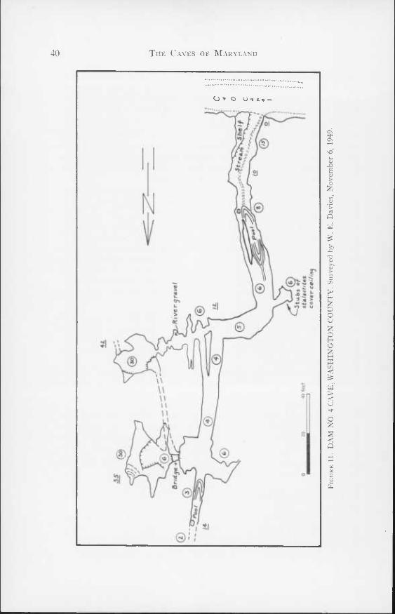
The Caves of Maryland
O ■* O O-flc^ —
Os
A S V > o
> rt Q W
T3
H z p o o Z o H O Z s m <C
w > < u
d
< o
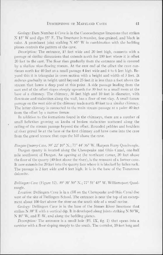
Descriptions of Maryland Caves 41
Geology: Dam Number 4 Cave is in the Conococheague limestone that strikes N 15° W and dips 55° E. The limestone is massive, fine-grained, and black in color. A prominent joint striking N 85° W in combination with the bedding planes controls the pattern of the cave.
Description: The entrance, 15 feet wide and 20 feet high, connects with a passage of similar dimensions that extends north for 100 feet where it is offset 20 feet to the east. The floor rises gradually from the entrance and is covered by a shallow slow-flowing stream. At the east end of the offset the cave con- tinues north for 40 feet as a small passage 4 feet wide and 4 to 6 feet high. Be- yond this it is triangular in cross section with a height and width of 3 feet. It reduces gradually in height until beyond 25 feet it is less than a foot above the stream that forms a deep pool at this point. A side passage leading from the east end of the offset slopes steeply upwards for 30 feet to a small room at the base of a chimney. The chimney, 30 feet high and 10 feet in diameter, with flowstone and stalactites along the wall, has a floor of wet clay. A small fissure passage on the west side of the chimney leads north 40 feet to a similar chimney. The latter chimney is connected to the main stream passage at a point 40 feet from the offset by a narrow fissure.
In addition to the formations found in the chimneys, there are a number of small helictites growing on knobs of broken stalactites scattered along the ceiling of the stream passage beyond the offset. Rounded pebbles and boulders of river gravel lie at the base of the first chimney and have come into the cave from the gravel terrace that caps the hill above the cave.
Dargan Quarry Cave. 39° 22' 10" N.; 77° 44' 36" W. Harpers Ferry Quadrangle. Dargan quarry is located along the Chesapeake and Ohio Canal, one-half
mile southwest of Dargan. An opening at the northeast corner, 20 feet above the floor of the quarry (40 feet above the river), is the remnant of a former cave. It now extends for 20 feet into the quarry face where it is blocked by fallen rock. The passage is 2 feet wide and 6 feet high. It is in the base of the Tomstown dolomite.
Dellingcrs Cave (Figure 12). 39° 31' 50" N.; 77° 51' 45" W. Williamsport Quad- rangle.
Location: Dellingers Cave is in a cliff on the Chesapeake and Ohio Canal due west of the site of Dellingers School. The entrance is near the top of an escarp- ment about 100 feet above the river on the south side of a small ravine.
Geology: Dellingers Cave is in the base of the Stones River limestone that strikes N 30° E with a vertical dip. It is developed along joints striking N 50oW, N 10° W, and E-W, and along the bedding planes.
Description: The entrance is a small hole (PI. IX, fig. 1) that opens into a corridor with a floor sloping steeply to the south. The corridor, 10 feet long and
42 The Caves of Maryland
10 feet wide, connects with a large room to the south. The second room is 19 feet wide and 35 feet long and slopes to the southeast. On the east side is a low scarp leading up to a small alcove. A low passage leads N 40° E for 50 feet from the alcove. From the room the main passage continues southwest, paral- leling the face of the cliff. For 70 feet it is rectangular in cross section, 4 to 8 feet high and 6 to 15 feet wide. Subordinate lower passages underlie and connect with the main passage in this section. Seventy feet from the large room the passage is a fissure, 4 to 8 feet wide and up to 30 feet high, that alternates in direction from S 10oE to S 40° W. Beyond 160 feet the fissure reduces in height to a crawlway less than a foot high.
The floor of the cave is covered with plates of broken limestone that are covered by thin flowstone near the rear of the cave. The cave is dry and few formations remain intact. The ceiling of the cave remains at a uniform level with the floor sloping down from the front and rear towards the center of the main passage.
Fairview Cave. 39° 42' 15" N.; 77° 50' 00" W. Mason-Dixon Quadrangle. Fairview Cave is on the west bank of Conococheague creek, 500 yards south
of Maryland Highway 494, near Fairview. The entrance is in a low cliff 40 feet above the creek.
The entrance passage is 4 feet square for the first 10 feet and then reduces to a crawlway for 6 feet. Beyond this is a small low room that in turn is connected by a short crawlway with a room 15 to 20 feet wide and long with a ceiling height of 6 to 10 feet. At the rear the cave is blocked by rock fall. The total length of the passages, which head west and curve to the north, is less than 100 feet. The floor is damp clay. Fairview Cave is in the Chambersburg limestone that strikes due north and dips 10° E.
Houpl Cave. 39° 35' 33" N.; 77° 38' 08" W. Funkstown Quadrangle. Houpt Cave is on the west side of Beaver Creek, four-fifths of a mile north
of the settlement of Beaver Creek. The entrance, in a low ledge in front of the house of Clifford Houpt, gives access to a single passage 6 to 8 feet high and wide and 40 feet long. A large stream flows out of the cave. Houpt Cave is in the base of the Elbrook limestone.
Hmvell Cave. 39° 31' 54" N.; 77° 49' 45" W. Williamsport Quadrangle. Several openings are developed in the limestone cliffs along the Chesapeake
and Ohio Canal towpath west of Charles Mills (Cedar Grove Mill). One of these openings, 200 yards west of the mill, develops into a small crawlway 12 feet long that connects with a room 15 to 18 feet wide and long and 6 feet high. Beyond this is another room 20 feet wide, 12 feet high, and 60 feet long. A fallen rock 20 feet from the rear of the room partitions it into two parts. The west
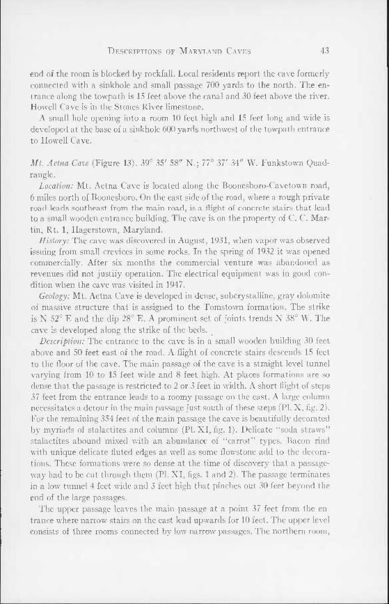
Descriptions of Maryland Caves 43
end of the room is blocked by rockfall. Local residents report the cave formerly connected with a sinkhole and small passage 700 yards to the north. The en- trance along the towpath is 15 feet above the canal and 30 feet above the river. Howell Cave is in the Stones River limestone.
A small hole opening into a room 10 feet high and 15 feet long and wide is developed at the base of a sinkhole 600 yards northwest of the towpath entrance to Howell Cave.
Mt. Aetna Cave (Figure 13). 39° 35' 58" N.; 77° 37' 34" W. Funkstown Quad- rangle.
Location: Mt. Aetna Cave is located along the Hoonesboro-Cavetown road, 6 miles north of Boonesboro. On the east side of the road, where a rough private road leads southeast from the main road, is a flight of concrete stairs that lead to a small wooden entrance building. The cave is on the property of C. C. Mar- tin, Rt. 1, Hagerstown, Maryland.
History: The cave was discovered in August, 1931, when vapor was observed issuing from small crevices in some rocks. In the spring of 1932 it was opened commercially. After six months the commercial venture was abandoned as revenues did not justify operation. The electrical equipment was in good con- dition when the cave was visited in 1947.
Geology: Mt. Aetna Cave is developed in dense, subcrystalline, gray dolomite of massive structure that is assigned to the Tomstown formation. The strike is N 52° E and the dip 28° E. A prominent set of joints trends N 38° W. The cave is developed along the strike of the beds.
Description: The entrance to the cave is in a small wooden building 30 feet above and 50 feet east of the road. A flight of concrete stairs descends 15 feet to the floor of the cave. The main passage of the cave is a straight level tunnel varying from 10 to 15 feet wide and 8 feet high. At places formations are so dense that the passage is restricted to 2 or 3 feet in width. A short flight of steps 37 feet from the entrance leads to a roomy passage on the east. A large column necessitates a detour in the main passage just south of these steps (PI. X, fig. 2). For the remaining 354 feet of the main passage the cave is beautifully decorated by myriads of stalactites and columns (PL XI, fig. 1). Delicate "soda straws" stalactites abound mixed with an abundance of "carrot" types. Bacon rind with unique delicate fluted edges as well as some flowstone add to the decora- tions. These formations were so dense at the time of discovery that a passage- way had to be cut through them (PL XI, figs. 1 and 2). The passage terminates in a low tunnel 4 feet wide and 3 feet high that pinches out 30 feet beyond the end of the large passages.
The upper passage leaves the main passage at a point 37 feet from the en- trance where narrow stairs on the east lead upwards for 10 feet. The upper level consists of three rooms connected by low narrow passages. The northern room.
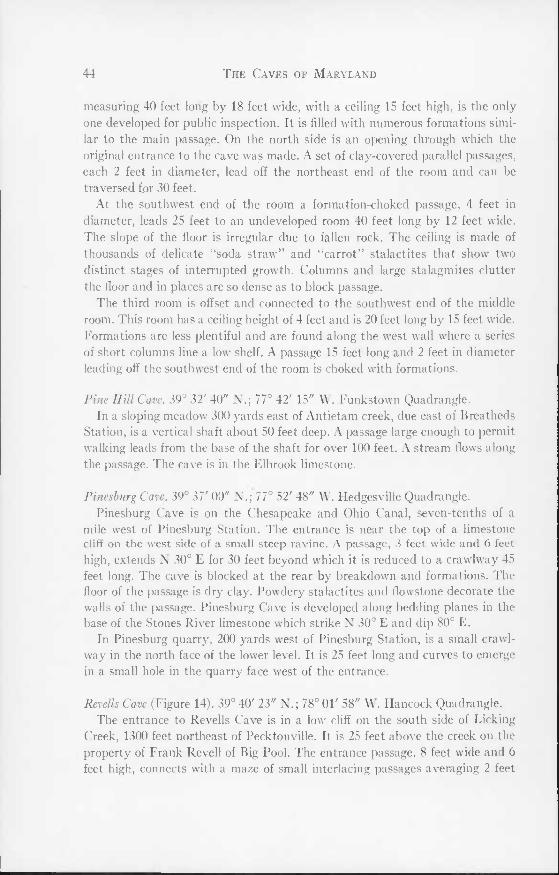
44 The Caves of Maryland
measuring 40 feet long by 18 feet wide, with a ceiling 15 feet high, is the only one developed for public inspection. It is filled with numerous formations simi- lar to the main passage. On the north side is an opening through which the original entrance to the cave was made. A set of clay-covered parallel passages, each 2 feet in diameter, lead off the northeast end of the room and can be traversed for 30 feet.
At the southwest end of the room a formation-choked passage, 4 feet in diameter, leads 25 feet to an undeveloped room 40 feet long by 12 feet wide. The slope of the floor is irregular due to fallen rock. The ceiling is made of thousands of delicate "soda straw" and "carrot" stalactites that show two distinct stages of interrupted growth. Columns and large stalagmites clutter the floor and in places are so dense as to block passage.
The third room is offset and connected to the southwest end of the middle room. This room has a ceiling height of 4 feet and is 20 feet long by 15 feet wide. Formations are less plentiful and are found along the west wall where a series of short columns line a low shelf. A passage 15 feet long and 2 feet in diameter leading off the southwest end of the room is choked with formations.
Pine Hill Cave. 39° 32' 40" N.; 77° 42' 15" W. Funkstown Quadrangle. In a sloping meadow 300 yards east of Antietam creek, due east of Breatheds
Station, is a vertical shaft about 50 feet deep. A passage large enough to permit walking leads from the base of the shaft for over 100 feet. A stream flows along the passage. The cave is in the Elbrook limestone.
Pinesburg Cave. 39° 37' 00" N.; 77° 52' 48" W. Hedgesville Quadrangle. Pinesburg Cave is on the Chesapeake and Ohio Canal, seven-tenths of a
mile west of Pinesburg Station. The entrance is near the top of a limestone cliff on the west side of a small steep ravine. A passage, 3 feet wide and 6 feet high, extends N 30° E for 30 feet beyond which it is reduced to a crawlway 45 feet long. The cave is blocked at the rear by breakdown and formations. The floor of the passage is dry clay. Powdery stalactites and flowstone decorate the walls of the passage. Pinesburg Cave is developed along bedding planes in the base of the Stones River limestone which strike N 30° E and dip 80° E.
In Pinesburg quarry, 200 yards west of Pinesburg Station, is a small crawl- way in the north face of the lower level. It is 25 feet long and curves to emerge in a small hole in the quarry face west of the entrance.
Revells Cave (Figure 14). 39° 40' 23" N.; 78° 01' 58" W. Hancock Quadrangle. The entrance to Revells Cave is in a low cliff on the south side of Licking
Creek, 1300 feet northeast of Pecktonville. It is 25 feet above the creek on the property of Frank Revell of Big Pool. The entrance passage, 8 feet wide and 6 feet high, connects with a maze of small interlacing passages averaging 2 feet
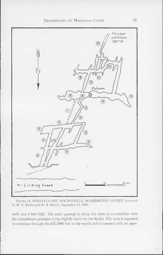
Descriptions of Maryland Caves 45
• , Passage / i con finoei " 300* ft
N
T
Lie K tncj Crec k 40 fed
Figure 14. REVELLS CAVE, PEKTONVILLE, WASHINGTON COUNTY. Surveyed by W. E. Da vies and VV. B. Brierly, September 25, 1949.
wide and 4 feet high. The main passage is along the crest of an anticline with the subordinate passages lying slightly lower on the flanks. The cave is reported to continue through the hill 1000 feet to the south and to connect with an open-
46 The Caves of Maryland
ing in a small quarry. The passage requires crawling and squeezing most of the way, but in one place it opens into a small room with a deep pit flanked by a narrow ledge. Formations consist of a few columns and stalactites scattered throughout the passages. The main passage has a floor of rock, and the sub- ordinate ones of clay.
Revells Cave is in thin-bedded black limestone of the Tonoloway formation at the crest of an anticline. On the east flank the dip is 15°; and on the west it is 10°. The strike is N 5° E.
Rohrersville Caves. 39° 26' 37" N.; 77° 40' 16" W. Keedysville Quadrangle. Two caves are located on the east side of Little Antietam Creek, 500 yards
north of the Rohrersville-Trego road, on the property of Frank Mullehdore. One cave entrance is in an old quarry and opens into a passage 4 feet in height and width that extends east for 100 feet. The ceilings and walls are much broken from blasting. The second cave is in a shallow sink 100 yards north of the quarry. The opening is a low crevice that requires crawling for 10 feet after which the passage enlarges to permit walking for 50 feet to a small room. A small stream flows along the cave passage. The caves are in the Tomstown dolomite.
Round Top Cave No. 1. 39° 40' 42" N.; 78° 14' 08" W. Hancock Quadrangle. Several caves are located in Round Top, 3 miles southwest of Hancock. A
cave entrance, 15 feet north of the lane leading to the cottage at the summit, is within 20 feet of the summit of Round Top. The entrance is a steeply sloping passage, 10 to 15 feet in width and height; that extends for 30 feet to the south. At the end, on the east side, is a small shaft that drops 30 feet to a narrow room extending to the south for 25 feet beyond which it pinches out. The cave is in a thick-bedded, knobby black limestone of the Keyser formation.
Round Top Cave Ao. 2. 39° 40' 40" N.; 78° 13' 53" W. Hancock Quadrangle. This cave is 500 feet east of the summit of Round Top in an escarpment 250
feet above the Western Maryland Railway. It consists of a straight passage extending north for over 400 feet. At two points small rooms are developed where the passage widens. The cave is in the Tonoloway limestone.
Round Top Cave No. 3. 39° 40' 42" N.; 78° 13' 28" W. Hancock Quadrangle. A large shelter cave lies on the north side of the Chesapeake and Ohio Canal,
300 yards east of the old Cement Mill at Round Top. The shelter is in the apex of a closely-folded anticline in the Bloomsburg sandstone, 25 feet above the canal. It is 50 feet wide, 20 feet high, and 40 feet long.
Descriptions of Maryland Caves 47
Round Top Cave No. 4. 39° 40' 40" N.; 78° 13' 48" W. Hancock Quadrangle. According to Duane Featherstonhaugh of Duanesburg, New York, four
other small caves (Round Top Caves Numbers 4, 5, 6, 7) are found in Round Top. Round Top Cave Number 4 is 35 feet above the Western Maryland Rail- way 400 feet west of the site of the old cement mill. It is a crawlway extending to the north for 100 feet and is developed in the base of the Tonoloway lime- stone.
Round Top Cave No. 5. 39° 40' 34" N.; 78° 13' 58" W. Hancock Quadrangle. This cave is 15 feet above the Western Maryland Railway 1100 feet west
of the site of the cement mill. The entrance is a crawlway that slopes steeply to the north for 75 feet to a room 100 feet long, 20 feet wide and 50 feet high. A low passage continues at the north end of the room. The cave is in the base of the Tonoloway limestone.
Round Top Cave No. 6. 39° 40' 30" N.; 78° 14' 00" W. Hancock Quadrangle. One half mile southwest of the cement mill is a small opening in a cut 20 feet
above the Western Maryland Railway. The entrance is a crawlway that slopes steeply northwest and opens into a room 400 feet long and up to 100 feet wide. At its highest point the ceiling is 75 feet above the floor. Fallen rocks cover most of the floor. A narrow fissure opens to the west near the end of the room. A small passage, partially blocked by rock fall, opens at the rear of the room. The cave is in the Tonoloway limestone.
Round Top Cave No. 7. 39° 40' 12" N.; 78° 14' 11" W. Hancock Quadrangle. At the south end of Round Top, 0.75 miles southwest of the site of the ce-
ment mill, is an opening 20 feet above the Western Maryland Railway. A low passage 30 feet long opens into a room 150 feet long and wide with a ceiling height of 50 feet. Large blocks of fallen rock cover the floor of the room. A nar- row northwesterly passage at the end of the room is blocked by silt beyond 50 feet. The cave is in the base of the Tonoloway limestone.
Sechrompf Cave. 39° 40' 57" N.; 77° 50' 07" W. Mason-Dixon Quadrangle. Sechrompf Cave is on the north side of a ravine, 200 yards east of ( ono-
cocheague Creek, 2 miles north of Wilson. The entrance is 40 feet above a large spring that feeds several water cress ponds. The cave is a fissure 2 feet wide and 8 feet high that extends 25 feet north. At 15 feet from the entrance is an offset to the west in which there is a narrow pit 15 feet deep that is reported to con- nect with a room 30 feet in diameter. Sechrompf Cave is in the Chambersburg limestone that strikes N 30° E and dips 65° W. The cave follows the bedding planes.
48 The Caves of Maryland
Sharpsburg Shelters. 39° 27' 33" N.; 77° 47' 12" W. Shepherdstown Quadrangle. Several small shelters are developed in the bluffs 100 feet above the Chesa-
peake and Ohio Canal, I5 miles west of Sharpsburg. One shelter is 35 feet wide and 25 feet high and extends 45 feet to a pinch down. Another shelter is a sinu- ous crawlway about 200 feet long. The shelters are in the Conococheague lime- stone.
Snivelys Caves (Figure 15). 39° 28' 16" N.; 77° 41' 08" W. Keedysville Quad- rangle.
Location: Snivelys No. 1 Cave is situated near Eakles Mills, a small settle- ment on the Hagerstown branch of the Baltimore and Ohio Railroad, one mile southeast of Keedysville. The entrance is in the face of an old quarry on the east side of Little Antietam creek at a point northeast of the barn on the Reeder farm. The owner of the cave is Roy G. Reeder, Route 1, Keedysville, Maryland. The cave is named for George Snively, a former owner.
IIistory: Snivelys No. 1 Cave was more extensive at one time but a great part has been removed in quarry operations carried on over a generation ago. The back room of the cave is a veritable guest register with its walls and ceiling covered by names and initials. The oldest is dated 1908 but most are 1921 and 1925.
Geology: The Tomstown dolomite, in which the cave is developed, is a mas- sive blue-black dolomite about 1000 feet thick that becomes light gray on weathering. The cave lies in beds 100 feet above the base of the formation. It is located on the east limb of a minor anticline dipping 20° E. The strike is due north. A major joint system trends N 60° E. Subordinate systems strike N 20° E and N 55° W. All joint planes are vertical.
Description: Snivelys No. 1 Cave is on the south wall of the old quarry work- ings at the north end of the quarry. The entrance is a small obscure hole hidden by a large tree near the junction of the north-south and east-west walls of the quarry. The hole is horizontal and 1 or 2 feet in diameter. The crawl through it is difficult because of projecting spines from the ceiling. At 10 feet the crawlway ends in an overhanging ledge with a drop of 8 feet to a room. The room is 15 feet in diameter and 20 feet high with a conical cross section. A passage, 8 feet high, leading from the room pinches down beyond 50 feet to a small crawlway 10 feet long. Midway along the passage a short side passage connects with a room on the east. From this room a narrow passage leads to the third and largest room in the cave. Midway along this passage a formation blocks it, making it necessary to crawl a short distance. The large room is 40 feet long 10 to 15 feet wide, and 8 feet high. At the end of the room a beautiful, pure white flowstone, resembling a frozen waterfall, is developed (PI. IX, fig. 2). This formation is among the largest and prettiest in any of the caves of Mary- land and, fortunately, has escaped defacing. A narrow low crawlway leads
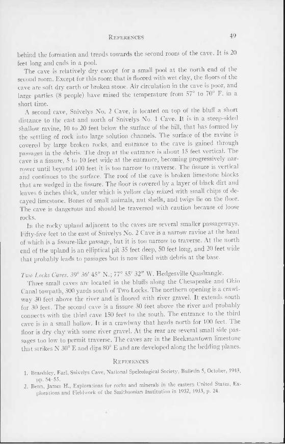
References 49
behind the formation and trends towards the second room of the cave. It is 20 feet long and ends in a pool.
The cave is relatively dry except for a small pool at the north end of the second room. Except for this room that is floored with wet clay, the floors of the cave are soft dry earth or broken stone. Air circulation in the cave is poor, and large parties (8 people) have raised the temperature from 57° to 70° F. in a short time.
A second cave, Snivelys No. 2 Cave, is located on top of the bluff a short distance to the east and north of Snivelys No. 1 Cave. It is in a steep-sided shallow ravine, 10 to 20 feet below the surface of the hill, that has formed by the settling of rock into large solution channels. The surface of the ravine is covered by large broken rocks, and entrance to the cave is gained through passages in the debris. The drop at the entrance is about 15 feet vertical. I he cave is a fissure, 5 to 10 feet wide at the entrance, becoming progressively nar- rower until beyond 100 feet it is too narrow to traverse. The fissure is vertical and continues to the surface. The roof of the cave is broken limestone blocks that are wedged in the fissure. The floor is covered by a layer of black dirt and leaves 6 inches thick, under which is yellow clay mixed with small chips of de- cayed limestone. Bones of small animals, nut shells, and twigs lie on the floor. The cave is dangerous and should be traversed with caution because of loose rocks.
In the rocky upland adjacent to the caves are several smaller passageways. Fifty-five feet to the east of Snivelys No. 2 Cave is a narrow ravine at the head of which is a fissure-like passage, but it is too narrow to traverse. At the north end of the upland is an elliptical pit 35 feet deep, 50 feet long, and 20 feet wide that probably leads to passages but is now filled with debris at the base.
Two Locks Caves. 39° 36' 45" N.; 77° 55' 32" W. Hedgesville Quadrangle. Three small caves are located in the bluffs along the Chesapeake and Ohio
Canal towpath, 300 yards south of Two Locks. The northern opening is a crawl- way 30 feet above the river and is floored with river gravel. It extends south for 30 feet. The second cave is a fissure 30 feet above the river and probably connects with the third cave 150 feet to the south. I he entrance to the third cave is in a small hollow. It is a crawlway that heads north for 100 feet. 1 he floor is dry clay with some river gravel. At the rear are several small side pas- sages too low to permit traverse. The caves are in the Beekmantown limestone that strikes N 30° E and dips 80° E and are developed along the bedding planes.
References
1. Beardsley, Earl, Snivelys Cave, National Speleological Society, Bulletin 5, October, 1943, pp. 54-55.
2. Benn, James H., Explorations for rocks and minerals in the eastern United States, Ex- plorations and Fieldwork of the Smithsonian Institution in 1932, 1933, p. 24.
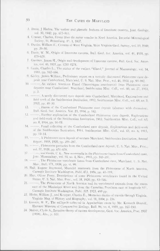
50 The Caves of Maryland
3. Bretz, J Harlen, The vadose and phreatic features of limestone caverns, Jour. Geology, vol. 50, 1942, pp. 675-811.
4. Cramer, Charles, Etwas iiber die natur wunder in Nord America, Imperial Mineralogical Society, St. Petersburg. Pt. 1, 1837.
5. Davies, William E., Caverns of West Virginia, West Virginia Geol. Survey, vol. 19 1949 pp. 29-30.
6. Davis, W. M., Origin of limestone caverns. Bull. Geol. Soc. America, vol. 41 1930 pp 475-628.
7. Gardner, James H., Origin and development of limestone caverns. Bull. Geol. Soc. Amer- ica, vol. 46, 1935, pp. 1255-1274.
8. Gazin, Charles L., The status of the extinct "Eland," Journal of Mammalogy, vol 14 1933, pp. 162-164.
9. Gidley, James William, Preliminary report on a recently discovered Pleistocene cave de- posit near Cumberland, Maryland, U. S. Nat. Mus. Proc., vol. 46, 1913, pp. 93-102.
10. —, An extinct American Eland (Taurotragus americanus) from Pleistocene cave deposits near Cumberland, Maryland, Smithsonian Misc. Coll., vol. 60, no. 27, 1913, p. 3.
^ ■ > A newly discovered cave deposit near Cumberland, Maryland, Explorations and field-work of the Smithsonian Institution, 1912, Smithsonian Misc. Coll., vol. 60 no 3 1913, pp. 49-50.
12. , l auna of the Cumberland Pleistocene cave deposit (abstract with discussion), Bull. Geol. Soc. America, Vol. 25, 1914, p. 142.
13- , further exploration of the Cumberland Pleistocene cave deposit. Explorations and field-work of the Smithsonian Institution, 1913, Smithsonian Misc. Coll., vol. 63, no. 8, 1914, pp. 16-18.
14- , Fossil collecting at the Cumberland cave deposit. Explorations and field-work of the Smithsonian Institution, 1914, Smithsonian Misc. Coll., vol. 65, no. 6, 1915, pp. 12-14.
15- —> A Pleistocene cave deposit of western Maryland, Smithsonian Institution, Annual Report, 1918, 1920, pp. 281-287.
16- 1 Pleistocene peccaries from the Cumberland cave deposit, U. S. Nat. Mus., Proc., vol. 57, 1920, pp. 651-678.
17- , and Gazin, C. L., New mammalia in the Pleistocene fauna from Cumberland cave. Jour. Mammalogy, vol. 14, no. 4, Nov., 1933, pp. 343-357.
18- . The Pleistocene vertebrate fauna from Cumberland cave, Maryland, U. S. Nat. Mus., Bull. 171, 1938, pp. vi, 99.
19. Hall, Eugene Raymond, Mustelid mammals from the Pleistocene of North America, Carnegie Institute Washington, Publ. 473, 1936, pp. 41-119.
20. Hay, Oliver Perry, Descriptions of some Pleistocene vertebrates found in the United States, U. S. Nat. Mus. Proc., vol. 58, 1920, pp. 83-146.
21- , The Pleistocene of North America and its vertebrated animals from the states east of the Mississippi River and from the Canadian Provinces east of longitude 95°, Carnegie Institute Washington, Publ. 322, 1923, 499 pp.
22. Hinke, \\ illiam J., and Kemper, Charles E., Moravian diaries of travels through Virginia, Virginia Mag. of History and Biography, vol. 11, 1904, p. 236.
23. Loomis, H. E., The miilipeds collected in Appalachian caves by Mr. Kenneth Dearolf, Harvard Museum of Comparative Zoology, Bull. 86, no. 4, 1939, pp. 165-193.
24. Malott, Clyde A., Invasion theory of cavern development, Geol. Soc. America, Proc. 1937 (1938), Abs., p. 323.
References 51
25. Muma, Kay, and Muma, Martin, John Friends Saltpeter Cave, National Speleological Society, Bull. 5, Oct., 1943, pp. 48-50.
26. Muma, Martin H., Interesting Maryland Cave, National Speleological Society, Bull. 4, Sept., 1942, pp. 24-25.
27. , Maryland's largest shelter cave: Maryland, A Journal of Natural History, vol. 14, no. 3, July, 1944, pp. 62-65.
28 . , A preliminary report on a cave survey of Maryland, National Spele logical Society, Bull. 7, Dec., 1945, pp. 15-17.
29. , Notes on several Maryland caves, Maryland, A Journal of Natural History, vol. 16, no. 2, April, 1946, pp. 27-32.
30. Patterson, Bryan, Upper molars of Canis arrnhnisleri Gidley from the Cumberland cave, Maryland, Amer. Jour. Science, 5th Series, vol. 23, April, 1932, pp. 334-336.
31. Peabody, Charles, The exploration of Busheys Cavern, near Cavetown, Maryland, Phil- lips Academy, Andover, Massachusetts, Dept. of Archeology, Bull. 4, Pt. 1, 1908, pp. 1-25.
32. Perry, Clay, George Talbots Cave, National Speleological Society, Bull. 9, Sept., 1947, p. 57.
33. Scharf, J. Thomas, History of Western Maryland, Lewis H. Everts, Philadelphia, 1882, vol. 2, pp. 34-35, 1270-1271.
34. Simpson, George Gaylord, Large Pleistocene felines of North America, Amer. Mus. Nat. Hist. Novitates, No. 1136, Aug. 11, 1941.
35. Stephenson, William J., John Friends Saltpeter cave. National Speleological Society, Bull. 4, Sept., 1942, pp. 9-10.
36. Stose, Anna J., and Stose, George W., The geology of Carroll and Frederick Counties, Maryland Department of Geology, Mines and Water Resources, 1946, pp. 55, 58-63, 83.
37. Swinnerton, A. C., Origin of limestone caverns. Bull. Geol. Soc. America, vol. 43, 1932, pp. 663-694.
38. Wetmore, Alexander, A record of the ruffed grouse from the Pleistocene of Maryland, Auk, vol. 44, 1927, p. 561.
39. Anonymous, Cavetown cave. National Speleological Society, Bull. 3, 1942, pp. 15-'16. 40. , Mt. Etna cave, National Speleological Society, Bull. 3, January, 1942, p. 36.
Newspaper articles:
Maryland cavemen and women. The Sun (Baltimore) Magazine, July 7, 1946. Virginian explores "muddiest" cave in state, located near Twiggtown, The Cumberland
News, July 29, 1946. Garrett County caves, The Republican (Oakland, Md.), June 17, 1948.
The Caves of Maryland Bulletin 7 Plate I
Plate I—Fig, 1. LAPIEZ. One mile west of Smithburg. Outcropping bands of limestone due to differential solution are common in the Hagerstown Valley.
Plate I—Fig. 2. MURLEY BRANCH SPRING. May be resurgence of water from Twiggs Cave.
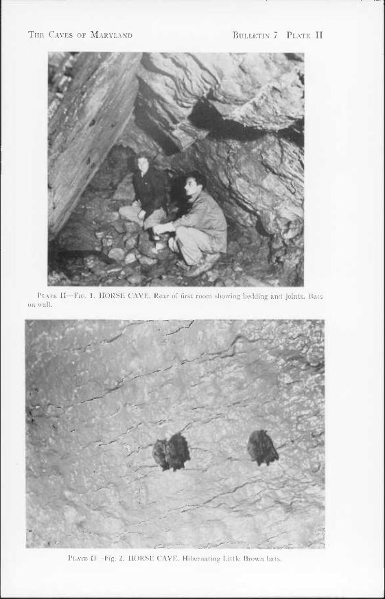
The Cavf.s of Maryland Bulletin' 7 Plate 11
Plate II—Fio. 1. HORSE CAVE. Rear of first room showing bedding and joints. Hats on wall.
Plate II—Fig. 2. HORSE CAVE. Hibernating Little lirown bats.
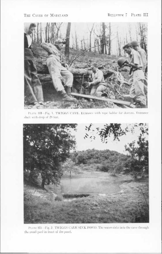
The Caves of Maryland Bulletin 7 Plate III
Plate III—Fig. 1. TWIGGS CAVE. Entrance with rope ladder for descent. Entrance shaft with drop of 25 feet.
Plate III- Fig. 2. TWIGGS CAVE SINK POND. The water sinks into the cave through the small pool in front of the pond.
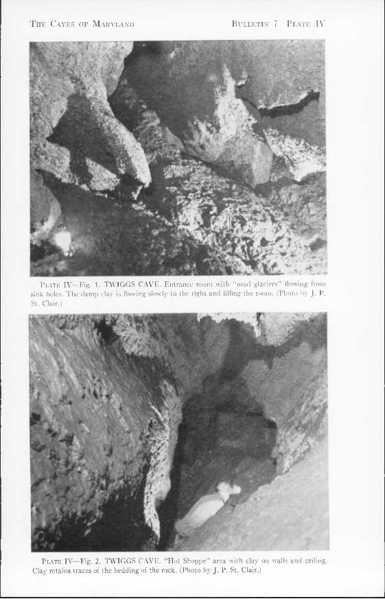
The Caves of Maryland Bulletin 7 Plate IV
Plate TV—Fig. 1. TWIGGS CAVE. Entrance room with "mud glaciers" flowing from sink holes. The dam]) clay is flowing slowly to the right and filling the room. (Photo by J. P. St. Clair.)
Plate IV—Fig. 2. TWIGGS CAVE. "Hot Shoppe" area with clay on walls and ceiling. Clay retains traces of the bedding of the rock. (Photo by J. P. St. Clair.)
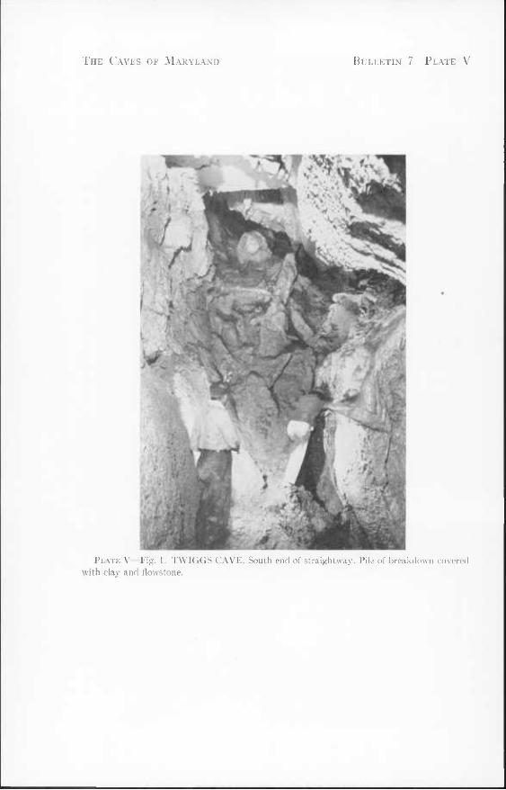
The Caves of Maryland Bulletin 7 Plate V
Plate V—Fig. 1. TWIGGS CAVE. South end of straightway. Pile of breakdown covered with clay and flowstone.
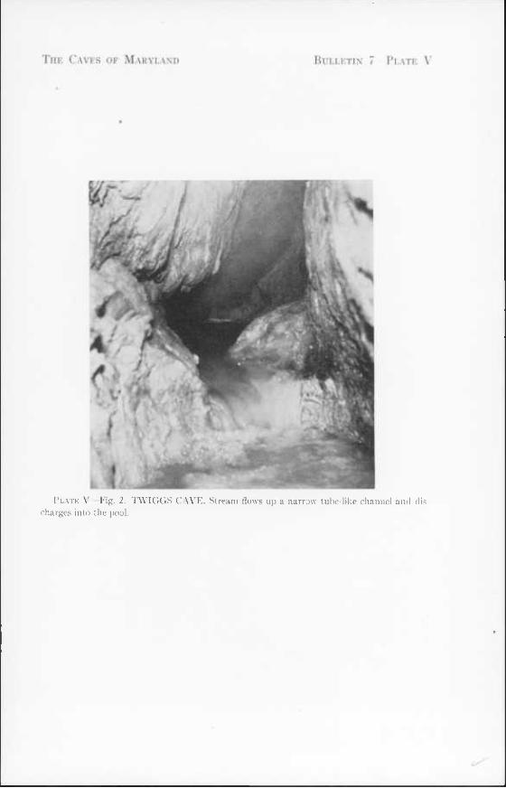
Plate V—Fig, 2. TWIGGS CAVE. Stream flows up a narrow lube-like channel and dis- charges into the pool.
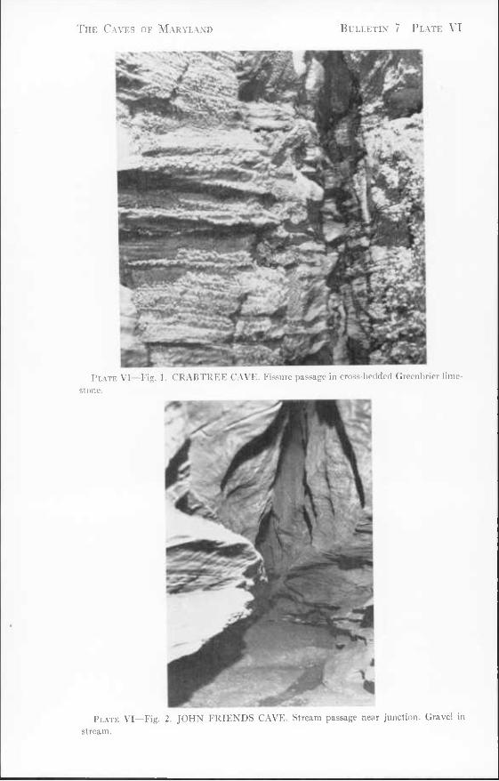
The Caves of Maryland Bulletin 7 Plate VI
Plate VI—Fig. 1. CRABTREE CAVE. Fissure passage in cross-bedded Greenbrier lime- stone.
Plate VI—Fig. 2. JOHN FRIENDS CAVE. Stream passage near junction. Gravel in stream.
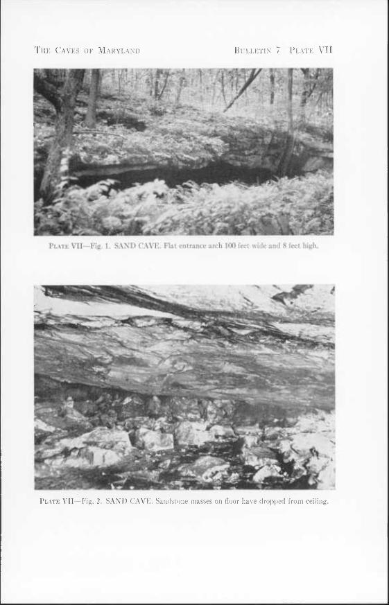
Fhe Caves of Maryland Bulletin 7 Plate VII
Plate VII—Fig. 1. SAND CAVE. Flat entrance arch 100 feet wide and 8 feet high
Plate VII—Fig. 2. SAND CAVE. Sandstone masses on floor have dropped from ceiling.
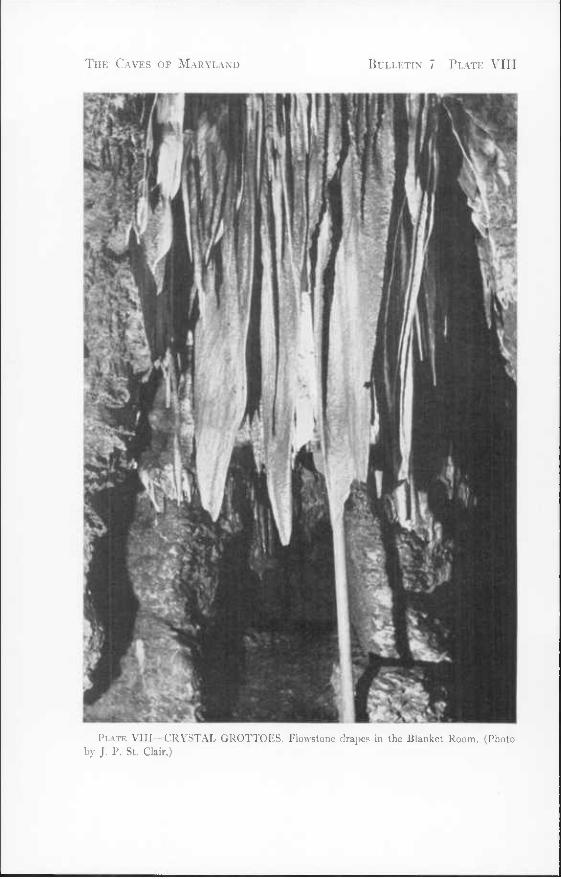
The Caves of Maryland Bulletin 7 Plate VIII
Plate VIII—CRYSTAL GROTTOES. Flowstone drapes in the Blanket Room. (Photo by J. P. St. Clair.)
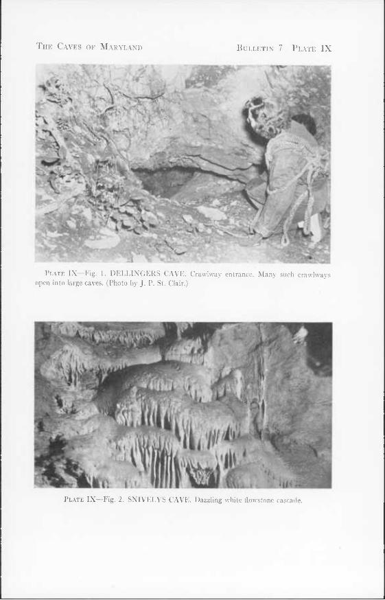
The Caves of Maryland Bulletin 7 Plate IX
Plate IX—Fig. 1. DELLINGERS CAVE. Crawlway entrance. Many such crawlways open into large caves. (Photo by J. P. St. Clair.)
Plate IX—Fig. 2. SNIVELYS CAVE. Dazzling white flowstone cascadc.
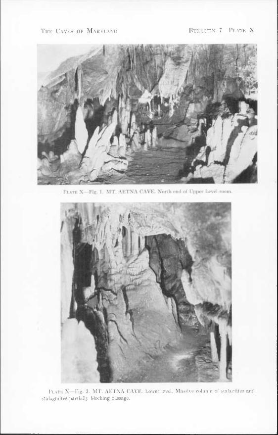
The Caves of Maryland Bulletin 7 Plate X
Plate X—Fig. I. MT. AETNA CAVE. North end of Upper Level room
Plate X—Fig. 2. MT. AETNA CAVE. Lower level. Massive column of stalactites and stalagmites partially blocking passage.
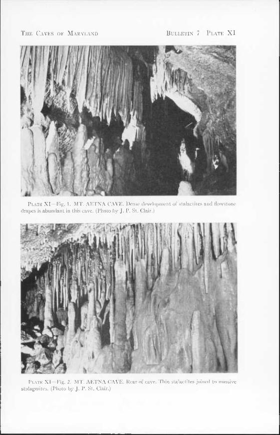
The Caves of Maryland Bulletin 7 Plate XI
Plate XI Fig. 1. MT. AETNA CAVE. Dense development of stalactites and flowstone drapes is abundant in this cave. (Photo by J. P. St. Clair.)
Plate XI Fig. 2, MT. AETNA CAVE. Rear of cave. Thin stalactites joined to massive stalagmites. (Photo by J. P. St. Clair.)


INDEX*
Acknowledgments 2 Adamstown 29 Age of Maryland caves 9 Alabama caves, Study of 1 Alesia 28 Algae in caves 14 Allegany County, Caves in IS Allegheny Cave Rat in caves, Evidence of 14 Analysis of water from caves 11
Atheys Cave 18 Animals in caves 13 Antietam 36 Antietam Cave 30 Antietam Creek 38, 44 Aragonite 10 Arkansas caves, Study of 1 Artifacts, Sand Cave, Indian 34 Athey, I. W. 15 Atheys Cave 6, 7, 12, 15; Fig. 2
Backbone Mountain 30, 34 Bacon rind
Crystal Grottoes 39 Mt. Aetna Cave 43
Baltimore County, Caves in 28 Bats in caves 13; PI. II, fig. 2 Beaver Creek 42 Beaver Run 28 Beaver Run Shelter 2H Becraft limestone 4 Beekmantown limestone 3, 10
Two Locks Caves 49 Beetles in caves 14 Bend, John Friends Cave 33 Big Pool 44 Biology of caves 13 Birds in caves 13 Bishop, Elisha 37 Black River group 3 Blanket Room, Crystal Grottoes 39; PI, VIII Bloomsburg sandstone, Round Top Cave No.
3 46 Blue Hole 11 Bond Station 30 Boonesboro 38, 43
Boonesboro Crystal Grottoes 6; see Crysta Grottoes
Bowman, W. J. 33 Breakdown 7 Breatheds Station 44 Breccia, Cumberland Bone Cave 18 Bretz, J H. 8, 9 Brierly, W. B. 2 Buckeystown 29 Buckeystown Cave 29 Burnside Bridge 36 Bushey, F. E. 36 Bushey, F. M. 37 Busheys Cavern 12, 36
Fossils in 15
Calcite 10 Cambrian rocks. Caves in 2 Camels Den 36 Camper, James 37 Candle Room, Atheys Cave 18 Carroll County, Caves in 29 Cathedral Room, Atheys Cave 16 Catoctin Mountain 3 Cave Salamander 14 Cavetown 13, 15, 36 Cayugan series 4 Cedar Grove Mill 42 Centerville Cave 30 Chambersburg limestone 10
Fairview Cave 42 Sechrompf Cave 47
Charles Mills 42 Chert, Horse Cave 24 Chesapeake and Ohio Canal 39, 41, 42, 44,
46, 48, 49 Chimneys 6 Chipmunks in caves 13 Clay
Crystal Grottoes 39 Cumberland Bone Cave 18 Dam No. 4 Cave 39 Derivation from limestone 6 Devils Den 21 Fairview Cave 42
* Page numbers in italics indicate detailed descriptions.
65
66 The Caves of Maryland
Clay {continued) Goat Cave 24 Horse Cave 24 John Friends Cave, 33, 34 Revells Cave 46 Twiggs Cave 26, 28; PI. IV, fig. 1
Cockeysville marble 2 Camels Den 36
Coeymans limestone 4 Twiggs Cave 26
Columns 6 Crystal Grottoes 39 Mt. Aetna Cave 43 Revells Cave 46
Conococheague 37 Conococheague Creek 37, 42, 47 Conococheague limestone 3, 10
Dam No. 4 Cave 41 Sharpsburg Shelters 48
Coral Atheys Cave 16 Crabtree Cave 32 Horse Cave 24
Corriganville 18 Crabtree Cave 6, 12, 30', Fig. 7; PI. VI, fig. 1 Crawlways 5 Crickets in caves 14 Crystal Grottoes 5, 6, 12, 3S] Fig. 10; PI. VIII
Use for sightseeing 12 Cumberland 15,19, 21 Cumberland Bone Cave 9, 18
Fossils in 14 Cumberland Quarry Caves 19
Dam No. 4 Cave 39; Fig. 11 Frogs in 14 Moths in 14
Dargan 41 Dargan Quarry Cave 41 Davies, W. E. v, 1, 9 Davies, Mrs. W. E. 2 Davis, W. M. 7, 8, 9 Dead Horse Cave; see Horse Cave Deaken, Col. Francis 32 Defense, Use of caves for 12 Dellingers Cave 7, 41; Fig. 12; PI. IX, fig. 1 Dellingers School 41 Department of Geology, Mines, and Water
Resources v, 2 Description of caves 5, 15
Devils Den 5, 19; Fig. 13 Bats in 13
Devils Hole 21 Devonian formations 4, 9 Dogtooth spar 10 Dolomite, Formation of caves in 2 Dome pits 6
John Friends Cave 33 Dripstone 6 Drinking water from caves 13
Eakles Mills 48 Earth fills 6 Economic use of caves 12» Elbrook limestone 3
Houpt Cave 42 Pine Hill Cave 44
Erosion levels. Relation of cave development to Pleistocene 10
Fairview 42 Fairview Cave 42 Fairyland, Crystal Grottoes 39 Favosites, Horse Cave 24 Featherstonhaugh, Duane 47 Flies in caves 14 Flintslone 11, 19 Flintstone Creek 11, 19 Flora of caves 14 Flowstone 6
Atheys Cave 16 Crabtree Cave 32 Dam No. 4 Cave 39 Dellingers Cave 42 Devils Den 21 Goat Cave 24 Horse Cave 25 John Friends Cave 34 Pinesburg Cave 44
Flowstone Way, Crystal Grottoes 39 Formation of caves 2 Fossils in caves 14
Busheys Cavern 37 Cumberland Bone Cave 18 Horse Cave 24
Foxes in caves 13 Frederick County, Caves in 29 Frederick limestone 3
Buckeystown Cave 30 Frederick Valley 3, 10
Index
Friend, Dicie 32 Frog Hollow 11 Frogs in caves 14 Fungi in caves 14
Gardner, J. H. 8 Garrett County, Caves in 30 Gazin, C. L. 14 Geologic relations 2 Georgian Bat 13 Gidley, J. W. 14, 18 Ginseng Run 32 Gnats in caves 14 Goat Cave 19, 21-, Fig. 4 Golden Lake, Crystal Grottoes 39 Gravel
Dam No. 4 Cave 41 John Friends Cave 34 Tvviggs Cave 28
Greenbrier limestone 4 Crabtree Cave 32 John Friends Cave 33
Grove limestone 3 LeGore quarry 30 Powells Cave 30
Gypsum 10 Formation of caves in 2
Hagerstown 43 Hagerstown Valley 3, 10, 11 Hancock 46 Harvestmen in caves 14 Hay, O. P. 37 Helderberg formation 4
Twiggs Cave 26 Helictites, Dam No. 4 Cave 41 Hinebaugh, Mary 33 Horse Cave 6, 12, 24\ Fig. 5; PL II, fig. 1
Bats in 13; PL II, fig. 2 Houpt, Clifford 42 Houpt Cave 42 Howard County, Caves in 36 Howell Cave 42 Hughes, Robert 37 Humidity of caves 11
Atheys Cave 18
Indian habitation, Sand Cave 34 — pictographs, Linganore Shelter Caves 30
67
Introduction 1 Israel Creek 30
Jackson, Harry 19 John Friends Cave 6, 12, 13, 32\ Fig. 8;
PI. VI, fig. 2 Joints, Tendency of caves to develop along 3 Junction, John Friends Cave 33; PI. VI, fig. 2
Karst, Twiggs Cave 28 — topography 10; PI. Ill, fig. 2 Keedysville 38, 48 Kelso Gap 34 Keyser limestone 4
Cumberland Bone Cave 18 Devils Hole 21 Horse Cave 24 Round Top Cave No. 1 46 Twiggs Cave 26
Kings Chair, Twiggs Cave 27
Lack of knowledge concerning caves 1 Lapiez 10; PI. I, fig. 1 Lash, Louise 29 Leaching of lime, Twiggs Cave 27 LeGore Quarry-Powell Cave 30 Lichen in caves 14 Licking Creek 44 Lime in Twiggs Cave, Leaching of 27 Limestone, Formation of caves in 2 — conglomerate, Triassic 3 Linganore 30 Linganore Shelter Caves 30 Little Antietam Creek 46, 48 Little Brown Bat 13
Buckeystown Cave 30 Location of caves 15; Fig, 16 Luke 32
Malott, C. A. 8 Manganese dioxide, Crabtree Cave 32 Map symbols for caves 15; Fig. 1 Marble, Formation of caves in 2 Maryland Dept. Geology, Mines, Water Re-
sources v, 2 Martin, G. C. 43 McKenzie formation 4 McKinstrys Mill 30 McKinstrys Mill Cave 30 Mears, Donald 2
68 The Caves of Maryland
Millipeds in caves 14 Mineralogy of caves 10 Mississippian system 4 Missouri caves, Study of 1 Mites in caves 14 Mosquitoes in caves 14 Moths in caves 14 Mt. Aetna Cave 6, 12, 43; Fig. 13; PI. X;
PI. XI Use for sightseeing 12
"Mud glaciers", Twiggs Cave 26; PI. IV, fig. 1
Muddy Creek Falls 34 Muddy Creek Falls Shelters 34 Mullendore, Frank 46 Muma, M. H. 1, 28, 34, 36 Murley Branch 19 Murley Branch Cave 13 Murley Branch Spring 11, 25; PI. I, fig. 2
Naming of caves 1 National Speleological Society v, 1, 2 New Oxford formation 3 New Scotland member 4 Newland, Mr. 32 Niter 10
Oakland 34, 36 Ordovician rocks. Caves in 3 Origin of caves 7
Paleozoic rocks 3 Patapsco River 36 Patterns of caves 5 Peabody, Charles 15, 37, 38 Pecktonville 44 Peneplane cycle
Correlation with cave formation 8 Pennsylvania caves. Study of 1 Pennsylvanian formations 5 pH values of cave waters 11
Atheys Cave 18 Phoebes in caves 13 Pictographs, Linganore Shelter Caves, In-
dian 30 Piedmont, Location of caves in 2 Pine Hill Cave 44 Pinesburg Cave 44 Pinesburg Station 44 Pleistocene 9
Pleistocene erosion levels. Relation of cave development to 10
— fossils, Cumberland Bone Cave 14, 18 — river terraces. Relation to cave develop-
ment 9 Pollution of cave water 13 Pottsville formations 5
Muddy Creek Falls Shelters 34 Sand Cave 34
Powell, Luther 30 Powells Cave 30 Preface v
Raccoons in caves 13 Reeder, R. G. 48 References 49 Revell, Frank 44 Revells Cave 5, 44; Fig. 14
Bats in 13 Richards, T. VV. 2 Ripple marks. Goat Cave 23 River terraces. Pleistocene
Relation to cave development 9 Rockfalls in caves 7 Rohrersville Caves 46 Round Top 46, 47 Round Top Caves 46, 47 Rush 11, IS, 25
St. Clair, J. P. 2 Salamanders in caves 14 Saltpeter in caves 12
Busheys Cavern 37 John Friends Cave 33
Sand Cave 5,12,34; Fig. 9; PI. VII Sandstone, Muddy Creek Falls Shelters 34 Sang Run 32 Scharf, J. T. 12, 37, 38 Sechrompf Cave 47
Moths in 14 Shape of passages in caves 5 Sharpsburg 13, 48 Sharpsburg Cave 7 Sharpsburg Shelters 48 Sightseeing in Maryland caves 12 Silt, John Friends Cave 34 Silurian rocks 4 Singewald, J. T, Jr. v Sinkholes 10 Skunks in caves 13
Index 69
Slickensides, Goat Cave 23 Snively, George 48 Snivelys Caves 6, 12, 48-, Fig. 15; PI. IX,
fig. 2 Bats in 13
Solution as process of cave making, 2, 7 Spangenberg, Joseph 36 Speleological Society v, 1, 2 Spiders in caves 14 Spring Gap 11 Springs related to caves 13 Stalactites 6
Atheys Cave 18 Busheys Cavern 38 Crystal Grottoes 38, 39 Cumberland Bone Cave 19 Dam No. 4 Cave 39 Goat Cave 24 Horse Cave 25 John Friends Cave 34 Mt. Aetna Cave 43 Pinesburg Cave 44 Revells Cave 46 Twiggs Cave 27
Stalagmites 6 Horse Cave 25 John Friends Cave 33 Mt. Aetna Cave 43
Stones River limestone 3, 10 Dellingers Cave 41 Howell Cave 43 Pinesburg Cave 44
Stose, A. J. 2 Stose, G. W. 2 Straightway, Twiggs Cave 27; PI. V, fig. Streams in caves 12 Structure, Geologic
Influence in development of caves 5 —of caves
Atheys Cave 15 Buckeystown Cave 29 Busheys Cavern 36 Crabtree Cave 30 Crystal Grottoes 38 Cumberland Bone Cave 18 Cumberland Quarry Caves 19 Dam No. 4 Cave 39 Dellingers Cave 41 Devils Den 19 Devils Hole 21
Structure, Geologic (continued) — of caves {continued)
Goat Cave 23 Horse Cave 24 Howell Cave 42 John Friends Cave 30 LeGore Quarry-Powell Cave 30 Mt. Aetna Cave 43 Murley Branch Spring 25 Pinesburg Cave 44 Revells Cave 44 Round Top Caves 46 Sand Cave 34 Snivelys Caves 48 Twiggs Cave 26 Westminster Cave 29
Subsurface water as factor in formation of caves 7
Swallow Falls 36 Swallow Falls State Forest 34 Swinnerton, A. C. 8 Symbols for caves. Map 15; Fig. 1
Temperature of caves 11 Atheys Cave 18
Tendency of caves to develop along joints 5 Tennessee caves. Study of 1 Terraces, Pleistocene river
Relation to cave development 9 Toads in caves 14 Tomston dolomite 3
Antietam Cave 36 Busheys Cavern 37 Crystal Grottoes 38 Dargan Quarry Cave 41
1 Mt. Aetna Cave 43 Rohrersville Cave 46 Snively Caves 48
Tonoloway formation 4 Atheys Cave 15 Devils Den 19 Murley Branch Spring 25 Revells Cave 46 Round Top Caves 46, 47
Travertine, Crystal Grottoes 39 Triassic limestone conglomerate 3 Twigg, A. D. 2, 24, 26 Twiggs Cave 5, 6, 7, 11, 12, 13, 24, 25, 26:
Fig. 6; PI. Ill, fig. 1; PI. IV, PI. V Twiggtown 10, 11, 21, 24, 26 Tussey Mountain anticline 15
70 The Caves of Maryland
Two Locks 13, 49 Two Locks Caves 7, 49
Union Bridge 30 U. S. Geological Survey 1 Use of caverns, Economic 12 — as possible defense sites 1 Uvala 10
Venus Baths, Busheys Cavern 38
Wakefield marble Centerville Cave 30 Westminister Cave 29
Washington County, Caves in 36 Water, Subsurface
Agent in formation of caves 7 —from caves. Drinking 13 —table 8
Waters, pH values of cave 11 Waynesboro formation 3
Busheys Cavern 37 West Virginia caves
Analogy of Maryland caves to Study of caves in 1
Westminster 29 Westminster Cave 29 Wills Creek 19 Wills Creek formation 4
Cumberland Quarry Caves 19 Goat Cave 23
Willison, H. V. 21 Wilson 47 Woodchucks in caves 13 Woods Place Cave 36 Woodsboro 30 Woodstock 36

i

i
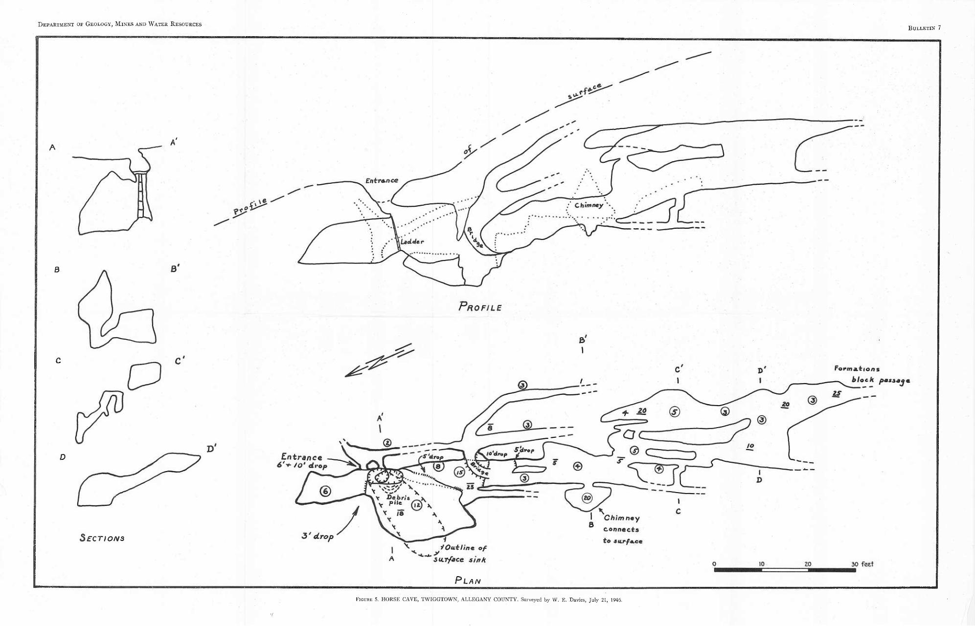
Figure 5. HORSE CAVE, TWIGGTOWN, ALLEGANY COUNTY. Surveyed by W. E. Da vies, July 21, 1946.
Department or Geology, Mines and Water Resources Bulletin 7
Sections
Plan
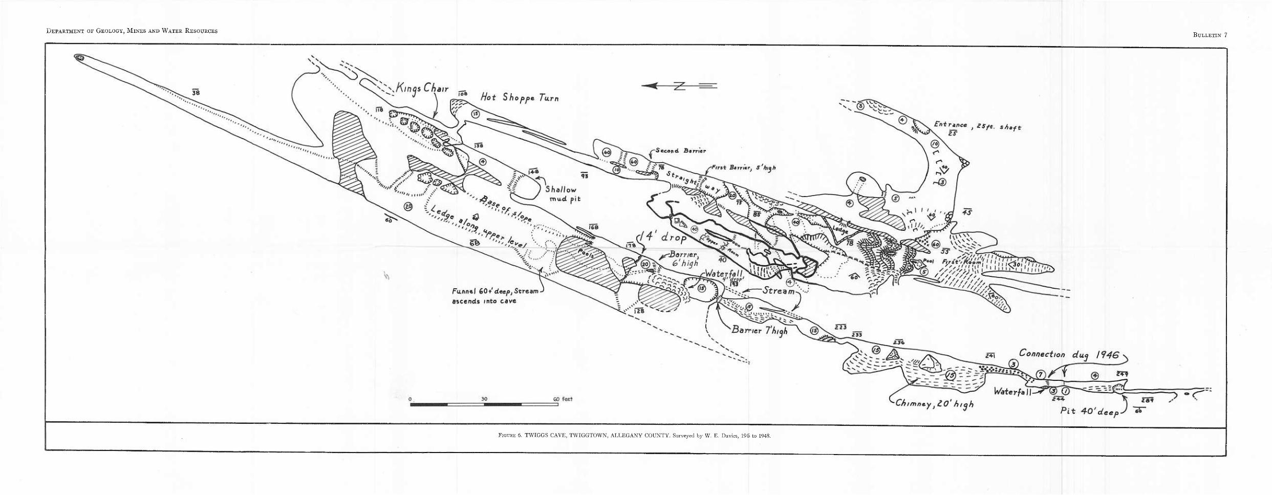
Department of Geology, Mines and Water Resources Bulletin 7
Barrier
fir at mer,
rr/er
rr/er
Figure 6. TWIGGS CAVE, TWIGGTOWN, ALLEGANY COUNTY. Surveyed by W. E. Davies, 194) to 1948.
Entrance ) aSfi. s/)Bft
ZS
s^.Kincs Chair
Funnel 60+ deepj Stream
ascends into cave
Connection dug 1946
r---?
GO feet
®
Waie rfa
Chimn&y HO' hiqh ^ ' ' 3 P:4- Art'J. ^ J Pii: -tf-O'oteepJ 60
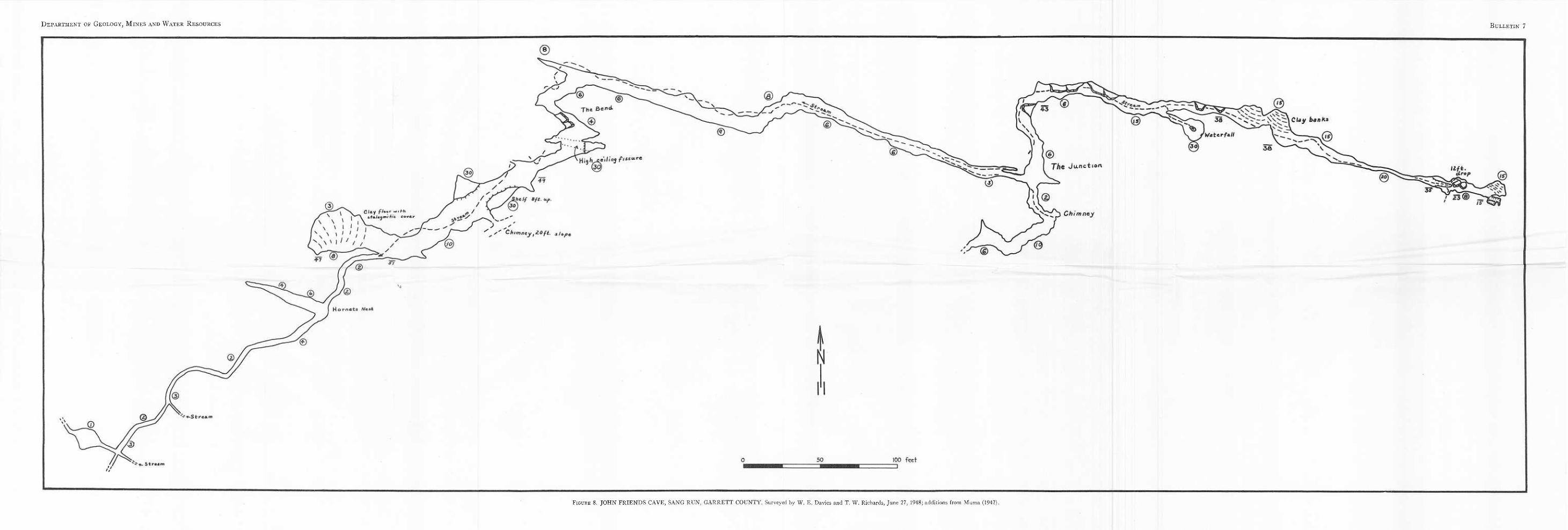
Department of Geology, Mines and Water Resources Bulletin 7
Figure 8. JOHN FRIENDS CAVE, SANG RUN, GARRETT COUNTY. Surveyed by W. E. Davies and T. W. Richards, June 27, 1948; additions from Muma (1942).
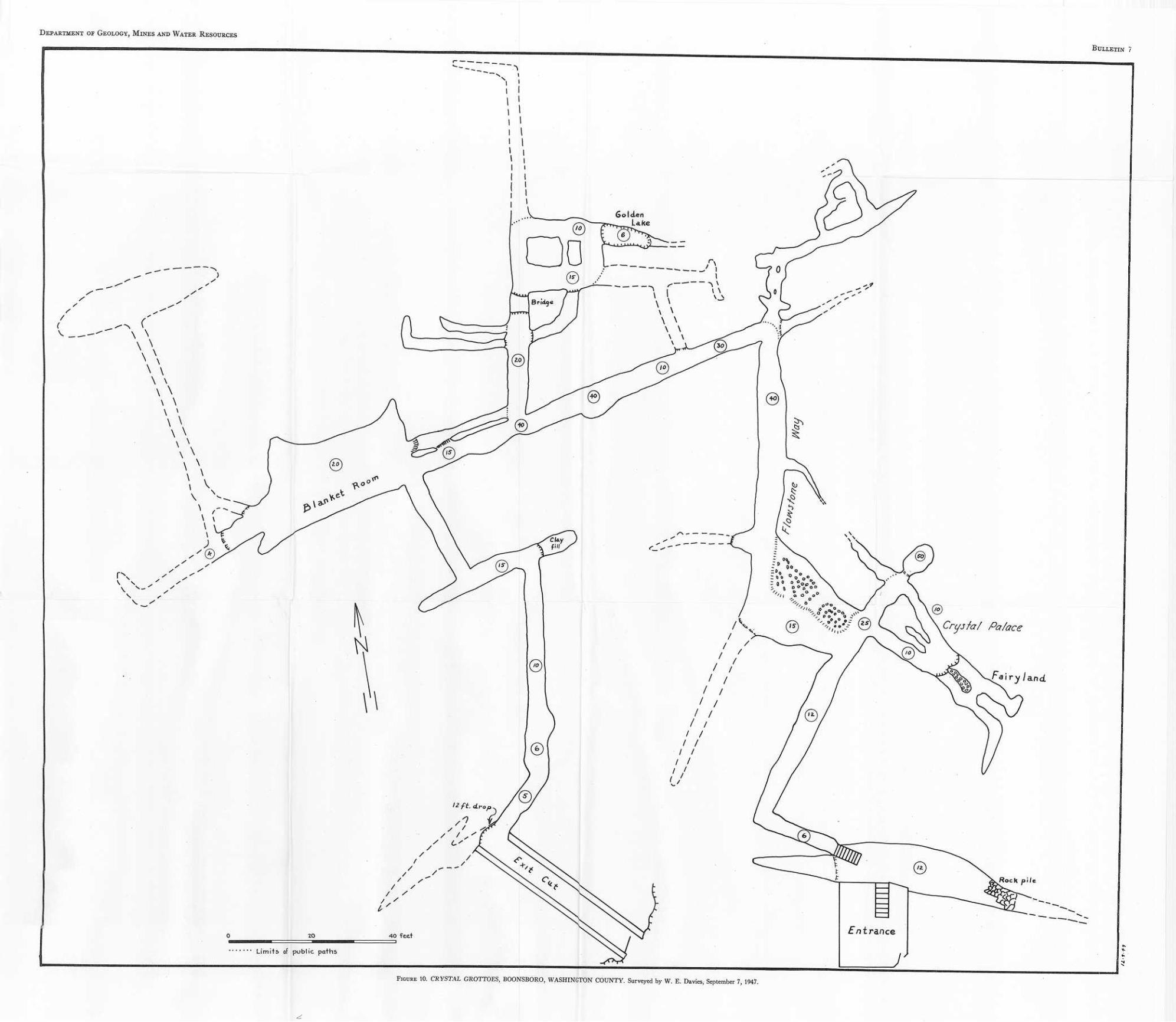
Department or Geology, Mines and Water Resources
Bulletin
Golden Lake
Pa/ace
RocK pile
Entrance
Limifs of public paths
Figure 10. CRYSTAL GROTTOES, BOONSBORO, WASHINGTON COUNTY. Surveyed by W. E. Davies, September 7, 1947,
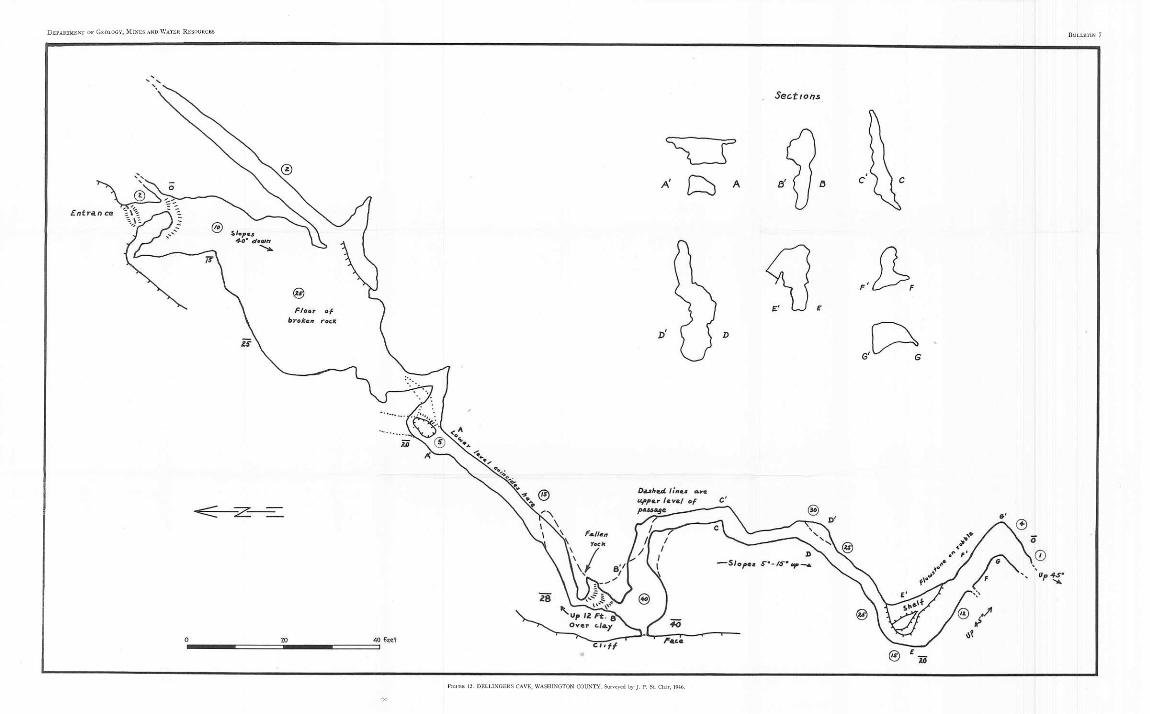
Department of Geology, Mines and Water Resources Bulletin 7
Figure 12. DELLINGERS CAVE, WASHINGTON COUNTY. Surveyed by J. P. St. Clair, 1946.
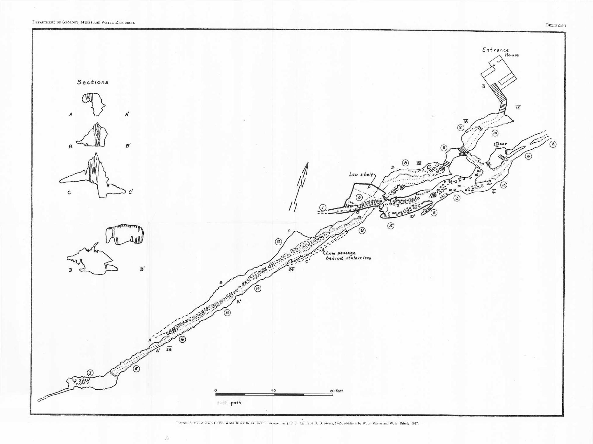
Department or Geology, Mines and Water Resources Bulletin 7
En-i r&nce
Figure 13. MT. AETNA CAVE, WASHINGTON COUNTY. Surveyed by J. P. St. Clair and D. D. Mears, 1946; additions by W. E. Davies and W. B. Brierly, 1947.
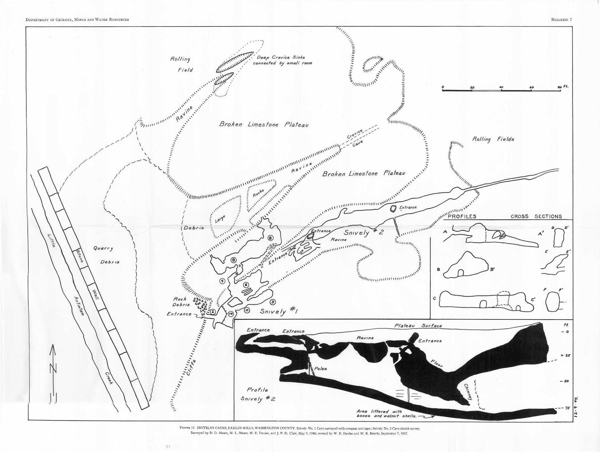
Department of Geology, Mines and Water Resources Bulletin 7
Figure IS. SNIVELYS CAVES, EAKLES MILLS, WASHINGTON COUNTY. Snively No. 1 Cave surveyed with compass and tape; Snively No. 2 Cave sketch survey. Surveyed by D. D. Mears, M. L. Mears, W. E. Davies, and J. P. St. Clair, May S, 1946; revised by W. E. Davies and W. B. Brierly, September 7, 1947.
0/
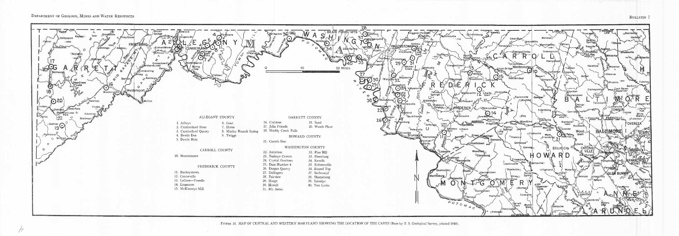
Department or Geology, Mines and Water Resources Bulletin 7
V—<7 >' / 'a.. /Sa ount ?/Savage
A ^ ckhartMines
oV^tllerslie r A- Corriganville
CiJMBERL offmarT"
/s
Cresaptowr^l ^^widlandAseoe
8
16
BloominetonC
Lonaconmg Klikep c?
^ Rawlings^; r ^ o ^
AWestjernport^
iHutton Jeer Park
rtainLake 4/ Park Lock ^ Lynn
jK^a^Svvanton
Vlndex
Kitzmiller^ ShallmarO
oGortne 19 3Q
O
tjjwig ^ Vn ^ tfl35& £ o\
^Oldtown
•v
Littli, , Orleansj
vBellegrove BE/iRf POIS/D/MTS
0J%34 "V
Z8
37.
CleiirSprYig
BigPooU
10 140^ 33
20 Miles
"27
yiamspoi ^Funkstqj
29
Chewsville/Cav( tow 1
f^inggoldO Qdihrnk MtA /
c. yEdgempnt, stow«!^
oitlasville
ALLEGANY COUNTY
1. Atheys 2. Cumberland Bone 3. Cumberland Quarry 4. Devils Den 5. Devils Hole
6. Goat 7. Horse
GARRETT COUNTY 16. Crabtree 19. Sand 17. John Friends 20. Woods Place
8. Murley Branch Spring ^ Muddy Creek Falls 9. Twiggs
CARROLL COUNTY
HOWARD COUNTY 21. Camels Den
WASHINGTON COUNTY 32. Pine Hill
10. Westminster
FREDERICK COUNTY 11. Buckeystown 12. Centerville 13. LeGore—Powells 14. Linganore 15. McKinstrys Mill
22. Antietam 23. Busheys Cavern 24. Crystal Grottoes 25. Dam Number 4 26. Dargan Quarry 27. Dellingers 28. Fairview 29. Houpt 30. Howell 31. Mt. Aetna
33. Pinesburg 34. Revel Is 35. Rohrersville 36. Round Top 37. Sechrompf 38. Sharpsburg 39. Snivelys 40. Two Locks
31 SBeaver I
Creek
° J
Boqiisboro / vZ5 joflsporo ' 024 VMyersV."
;ville \ S) _ u , ,39 > |
3BW /sharreburg^J ATNOj ^ VT^ohrersviiie "
Volfsville
-R Y<rtlov5
Springs^ (JA
^iddletdWn
' Creagerstown o
(imrpitsburg
R^dge\Detour_
13, LeGorrf New F Midway
Jnipn Bridge
Jieas^rtValley
R
^Unionti Westminste
Z6^
pland O, dargan /-.»
)UJ O W! ^ YftfTQ^burg
Q* v / o.
f i/-"0 L po f—
[VaddockV
Woodsborol ^qJ
, GC
Wajt^ersvllle #o Liberty- 0U' f I town
cu rj ' r.x0 <V0T- ^t Pleasant av ,
NewWindsor
0Taylorsville /oWinfi^k
Melroseo
^nch^«fero r^'Hcrs. //oa •
Greemnountj^
0/ L Q HampS^ead
f^parjolltpn /XUpperfco ^se0 W / ^atapsco^lj 4 "b^o^gl
Be»tley Sprr—' Rayyilte
BurkittsviU
3ER1CK/
^rtonsviile
<New London 14 /
^NewMa
Jeffers^ Lime Kiln/ Ridgevil
Petersville B/ckeys- Urbana yd^wn o
Ad am stow nP 11 m/ _ . . » ^<7 jy/ point ot
Rocks
i
N
South PoplarQ
. o Springs Long \Cor
Op
oDay
t-Aj/podbine
oCoaksville
Germantown
GaltfjeKburi
^Triadelphiafi 9 ♦. ^rr^e*' Laytonsville N
Brpokvilleo SandyN
Ineyo Spring Washington Gfrove
JV1
Darnestown Rockv/lle f/\\e
p o r o
fA oPotoraac
R )Y oNorbeck
C Colesyilie
vGgrrett D I >rk ^rn) 'Kensingtp^tX I ^
Hereford ^ gMonkton -JP A
3Glencoe lc
^Giyndon oRejsterstown B
CockeysvilU ^Texas'?
L T \l
• Phoenix Baldwinj
ch R&ven XResarvoir
Fallsto:
LpnaGreen 07 R E
Dwmgs ^ills Eldersburg o ;
^ ^Harris villeC Sykekville
- O Pikesville
TimoniumV ^OpperFail; oLutnerville .
^ TQWSD^ 0Heall Ca^pey white
uxto/T MarshO/
Randalls^5
_ . town ^ Branch ^ „ Rockdale Marriotts^oGranite
EAEKVJLLE^ oFullerton pOVERLE/ ' ® yo
vllle
0Friends?^p ^ f Aloerton Wood-, lawn
2.! Delia
Gleneiejo |t Ellicott City (%. CArONS^ I V1LLE
Hi O WdA R D ■ ^horpel
arksvllleo Elkridge
OHighland / Waterloo \ rtP
^SOINt •rt North
pJessups /VHanifSns ^Severn
_ s <& o i Odenton
Baysia
hPaszf^ena (boa
^Gambrills q Millers-
2^
pt
;eltsville
^Greenbel 5^3 ||OWi<
Figure 16. MAP OF CENTRAL AND WESTERN MARYLAND SHOWING THE LOCATION OF THE CAVES (Base by U. S. Geological Survey, printed 1948).


![Dynamic 3D Print of the Breathing Function - cpl.uh.edu · A. Experimental Design We recorded with a Mid-Wave Infra-Red (MWIR) FLIR SC6000 camera [9] the evolving thermal signature](https://img.pdfslide.us/doc/110x75/5d52013188c9932e188be466/dynamic-3d-print-of-the-breathing-function-cpluh-a-experimental-design.jpg)


![Yungang Grottoes[1]](https://img.pdfslide.us/doc/110x75/5695d22c1a28ab9b02995e30/yungang-grottoes1.jpg)