Embed Size (px)
Citation preview
1
Standard Summary Project Fiche
Project Number: SR9906.04
Title: Economic reform
Sub-Programme: Strengthening of the Geodesy, Cartography and Cadastre Authority ofthe Slovak Republic and implementation of the National Cadastre
Policy
Geographical Location: Slovak Republic
Objectives
Cadastre and Land Registration is one of the sectors providing essential services within a marketeconomy playing a large part in supporting the four freedoms (movement of goods, services, peopleand capital) of the acquis and hence the internal market.The establishment of a fully functional Cadastre and Land Registration sector is one of the keyelements of the economic transformation process as it provides the guarantee for private property andsafe and secure legal title to all land and property.This programme is designed to reinforce the activities of the Cadastre and Land Registration sector inSlovak Republic as part of the long term development of this sector. It will support the developmentof the National Cadastral Policy in providing user-oriented services based upon the cadastre. It willcontinue previous PHARE investment to strengthen the institutional and administrative capacity ofthe Geodesy, Cartography and Cadastral Authority of the Slovak Republic (GCCA) and CadastreOffice staff by training and provision of equipment.
Description
The proposed project conforms to the strategy for implementation of the Enhanced Cadastre in theSlovak Republic that was agreed by GCCA in December 1998 as a result of recommendations madeby the PHARE Project 9514.01.01. The TA element is divided into two stages (sub-projects) targetedtowards policy development, the technical development of the GCCA and meeting the needs of theuser community. The investment programme is designed to support these activities.
Sub-project 1
Sub-project 1 will set up the environment and infrastructure for further development:− Provision and management of user-oriented Cadastral and Land Information services including
strategic and policy planning, budgeting and analysis within supplier and user organisations ingovernment bodies, training in management and specific technical fields.
− A study/trial for a Parcel Information System suitable for the eventual support of IACS (IntegratedAdministrative and Control System).
− Setting up of Management and Technical Training services for staff of GCCA and other users ofCadastre and Land Registration in government organisations on how to deal with a change inemphasis towards a user focus.
Sub-project 2
Sub-project 2 will build on the results of Stage 1 and provide:− A study of requirements for valuation services in a market economy including− A trial of valuation services
2
− Specific technical training in management of user-oriented services
Investment in the 1999 programme will support further development of the Cadastre under Phase 2 ofthe agreed strategy to implement the Enhanced Cadastre. Phase 1 of this strategy will be completedwith the conclusion of the 1998 programme investment in mid-2000. By that time there will be astrong, stable and consistent infrastructure for the Cadastre that can be used immediately to supportthe next phase. Phase 2 will concentrate in improving technology to support services to customers andfurther improving data capture efficiency as well as integrating map and alphanumeric data.
Institutional Framework
The recipient institution is GCCA and its supporting institutions and offices which form anindependent body established at the Ministry level and reporting directly to the Deputy PrimeMinister, Mr. Fogas. At present, the District Cadastral Offices are under the control of the local StateAdministration. In a resolution adopted on 28.4.1999 the Government of the Slovak Republic includesCadastre in its list of priorities (see Annex 9, par. B1) and requires, with Measure No. 5 (see Annex 9)the rewording, by 30.11.1999, of related Acts with the aim of detaching cadastral activities from thesystem of local state administration. To speed up the legislative preparation, the Government of theSlovak Republic has included all necessary changes of Laws in the Plan of Legislative Tasks for theyear 1999 with a timetable for submission of changes in the Laws by 30.9.1999 (see Annex 9, par.B2). Taking these facts into consideration, it is expected that by end of year 1999 a final decision ofthe Slovak Parliament will be made. This means that in the year 2000 the GCCA will regainbudgetary and management control of the District Cadastral Offices that are responsible for all of thework in creation and maintenance of the Cadastre.
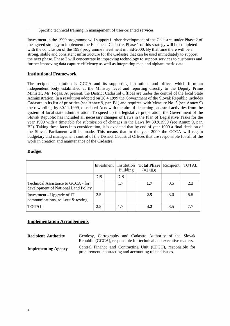
Budget
Investment InstitutionBuilding
Total Phare(=I+IB)
Recipient TOTAL
DIS DISTechnical Assistance to GCCA - fordevelopment of National Land Policy
1.7 1.7 0.5 2.2
Investment – Upgrade of IT,communications, roll-out & testing
2.5 2.5 3.0 5.5
TOTAL 2.5 1.7 4.2 3.5 7.7
Implementation Arrangements
Recipient Authority
Implementing Agency
Geodesy, Cartography and Cadastre Authority of the SlovakRepublic (GCCA), responsible for technical and executive matters.Central Finance and Contracting Unit (CFCU), responsible forprocurement, contracting and accounting related issues.
3
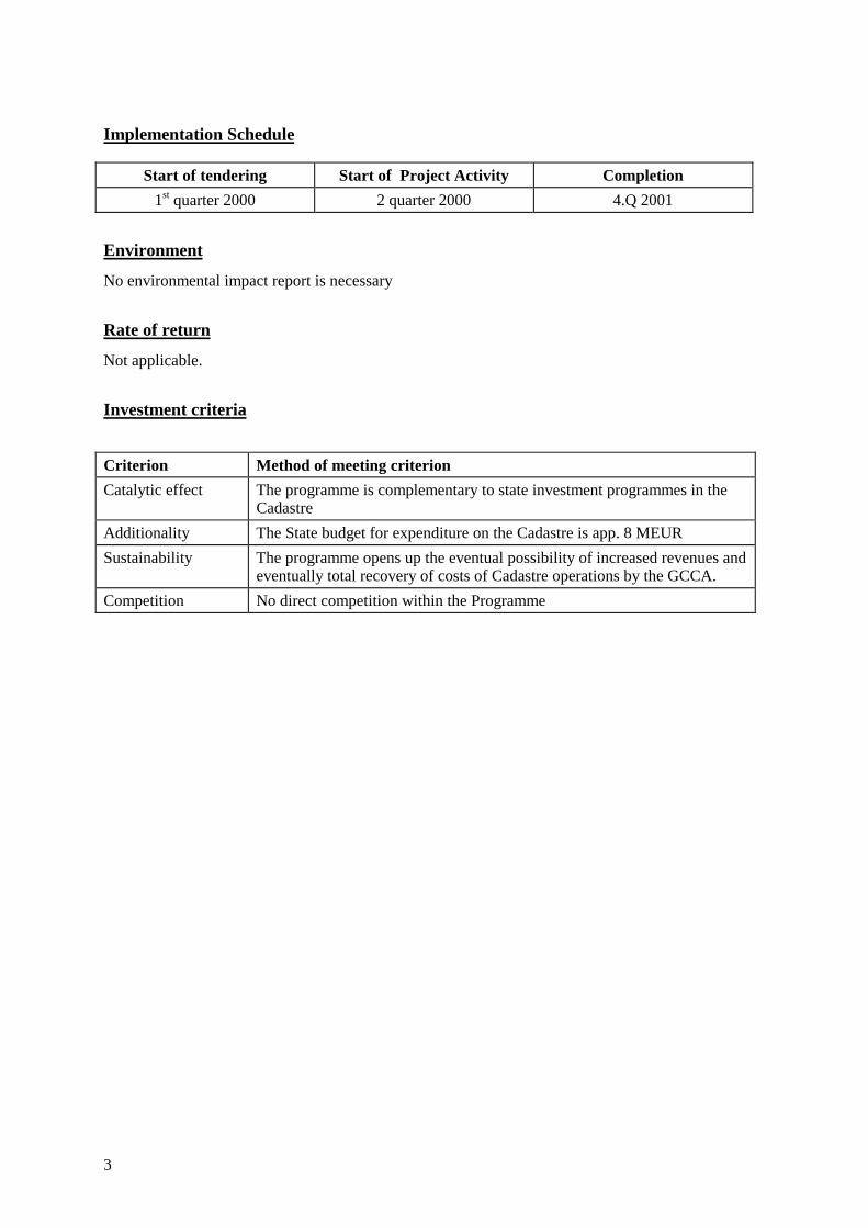
Implementation Schedule
Start of tendering Start of Project Activity Completion1st quarter 2000 2 quarter 2000 4.Q 2001
Environment
No environmental impact report is necessary
Rate of return
Not applicable.
Investment criteria
Criterion Method of meeting criterionCatalytic effect The programme is complementary to state investment programmes in the
CadastreAdditionality The State budget for expenditure on the Cadastre is app. 8 MEURSustainability The programme opens up the eventual possibility of increased revenues and
eventually total recovery of costs of Cadastre operations by the GCCA.Competition No direct competition within the Programme
4
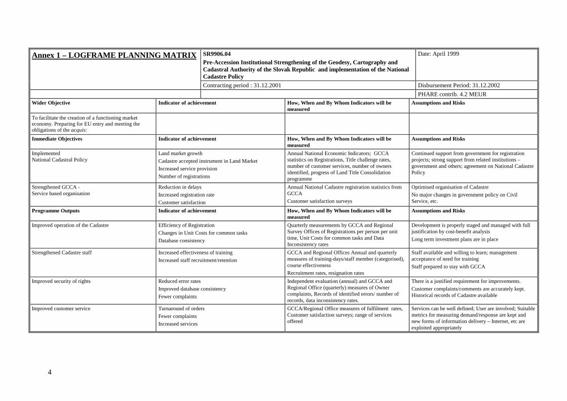
Annex 1 – LOGFRAME PLANNING MATRIX SR9906.04Pre-Accession Institutional Strengthening of the Geodesy, Cartography andCadastral Authority of the Slovak Republic and implementation of the NationalCadastre Policy
Date: April 1999
Contracting period : 31.12.2001 Disbursement Period: 31.12.2002PHARE contrib. 4.2 MEUR
Wider Objective Indicator of achievement How, When and By Whom Indicators will bemeasured
Assumptions and Risks
To facilitate the creation of a functioning marketeconomy. Preparing for EU entry and meeting theobligations of the acquis:Immediate Objectives Indicator of achievement How, When and By Whom Indicators will be
measuredAssumptions and Risks
ImplementedNational Cadastral Policy
Land market growthCadastre accepted instrument in Land MarketIncreased service provisionNumber of registrations
Annual National Economic Indicators; GCCAstatistics on Registrations, Title challenge rates,number of customer services, number of ownersidentified, progress of Land Title Consolidationprogramme
Continued support from government for registrationprojects; strong support from related institutions –government and others; agreement on National CadastrePolicy
Strengthened GCCA -Service based organisation
Reduction in delaysIncreased registration rateCustomer satisfaction
Annual National Cadastre registration statistics fromGCCACustomer satisfaction surveys
Optimised organisation of CadastreNo major changes in government policy on CivilService, etc.
Programme Outputs Indicator of achievement How, When and By Whom Indicators will bemeasured
Assumptions and Risks
Improved operation of the Cadastre Efficiency of RegistrationChanges in Unit Costs for common tasksDatabase consistency
Quarterly measurements by GCCA and RegionalSurvey Offices of Registrations per person per unittime, Unit Costs for common tasks and DataInconsistency rates
Development is properly staged and managed with fulljustification by cost-benefit analysisLong term investment plans are in place
Strengthened Cadastre staff Increased effectiveness of trainingIncreased staff recruitment/retention
GCCA and Regional Offices Annual and quarterlymeasures of training-days/staff member (categorised),course effectivenessRecruitment rates, resignation rates
Staff available and willing to learn; managementacceptance of need for trainingStaff prepared to stay with GCCA
Improved security of rights Reduced error ratesImproved database consistencyFewer complaints
Independent evaluation (annual) and GCCA andRegional Office (quarterly) measures of Ownercomplaints, Records of identified errors/ number ofrecords, data inconsistency rates.
There is a justified requirement for improvements.Customer complaints/comments are accurately kept.Historical records of Cadastre available
Improved customer service Turnaround of ordersFewer complaintsIncreased services
GCCA/Regional Office measures of fulfilment rates,Customer satisfaction surveys; range of servicesoffered
Services can be well defined; User are involved; Suitablemetrics for measuring demand/response are kept andnew forms of information delivery – Internet, etc areexploited appropriately
5
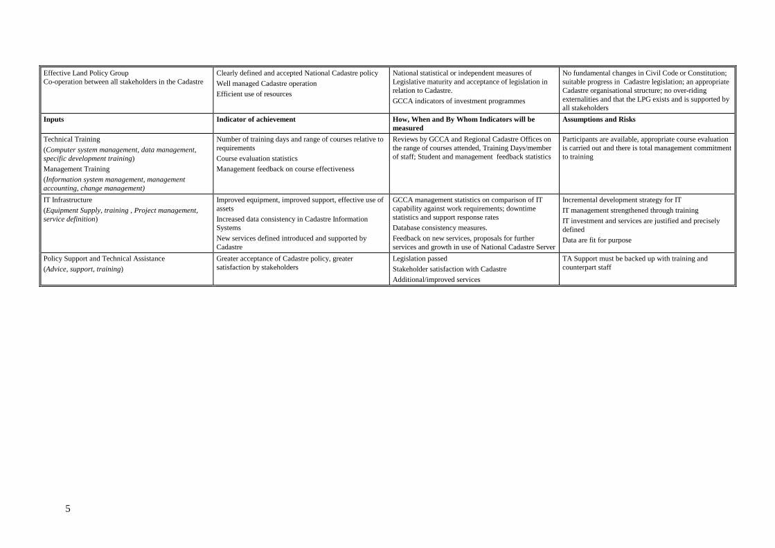
Effective Land Policy GroupCo-operation between all stakeholders in the Cadastre
Clearly defined and accepted National Cadastre policyWell managed Cadastre operationEfficient use of resources
National statistical or independent measures ofLegislative maturity and acceptance of legislation inrelation to Cadastre.GCCA indicators of investment programmes
No fundamental changes in Civil Code or Constitution;suitable progress in Cadastre legislation; an appropriateCadastre organisational structure; no over-ridingexternalities and that the LPG exists and is supported byall stakeholders
Inputs Indicator of achievement How, When and By Whom Indicators will bemeasured
Assumptions and Risks
Technical Training(Computer system management, data management,specific development training)Management Training(Information system management, managementaccounting, change management)
Number of training days and range of courses relative torequirementsCourse evaluation statisticsManagement feedback on course effectiveness
Reviews by GCCA and Regional Cadastre Offices onthe range of courses attended, Training Days/memberof staff; Student and management feedback statistics
Participants are available, appropriate course evaluationis carried out and there is total management commitmentto training
IT Infrastructure(Equipment Supply, training , Project management,service definition)
Improved equipment, improved support, effective use ofassetsIncreased data consistency in Cadastre InformationSystemsNew services defined introduced and supported byCadastre
GCCA management statistics on comparison of ITcapability against work requirements; downtimestatistics and support response ratesDatabase consistency measures.Feedback on new services, proposals for furtherservices and growth in use of National Cadastre Server
Incremental development strategy for ITIT management strengthened through trainingIT investment and services are justified and preciselydefinedData are fit for purpose
Policy Support and Technical Assistance(Advice, support, training)
Greater acceptance of Cadastre policy, greatersatisfaction by stakeholders
Legislation passedStakeholder satisfaction with CadastreAdditional/improved services
TA Support must be backed up with training andcounterpart staff

6
ANNEX 2 - Cumulative Contracting and Disbursement Schedule (MEUR) for Project Number SR9906.04
Name of programme: Pre-Accession Institutional Strengthening of the Geodesy,Cartography and Cadastre Authority of the Slovak Republicand implementation of the National Cadastre Policy
Project nr.: SR9906.04
4 Q. 1999 1.Q.2000 2.Q.2000 3.Q.2000 4.Q.2000 1.Q.2001 2.Q.2001 3.Q.2001 4.Q.2001
Contracted 1.3 2.0 4.20
Disbursed 0.35 0.7 2.95 3.3 4.0 4.20
Time Implementation Chart for Project Number SR9906.04
2000 2001 2002J F M A M J J A S O N D J F M A M J J A S O N D J F M A M J J A S O N D
ComponentInstitution BuildingTA Stage 1TA Stage 2
InvestmentEquipment supply
7
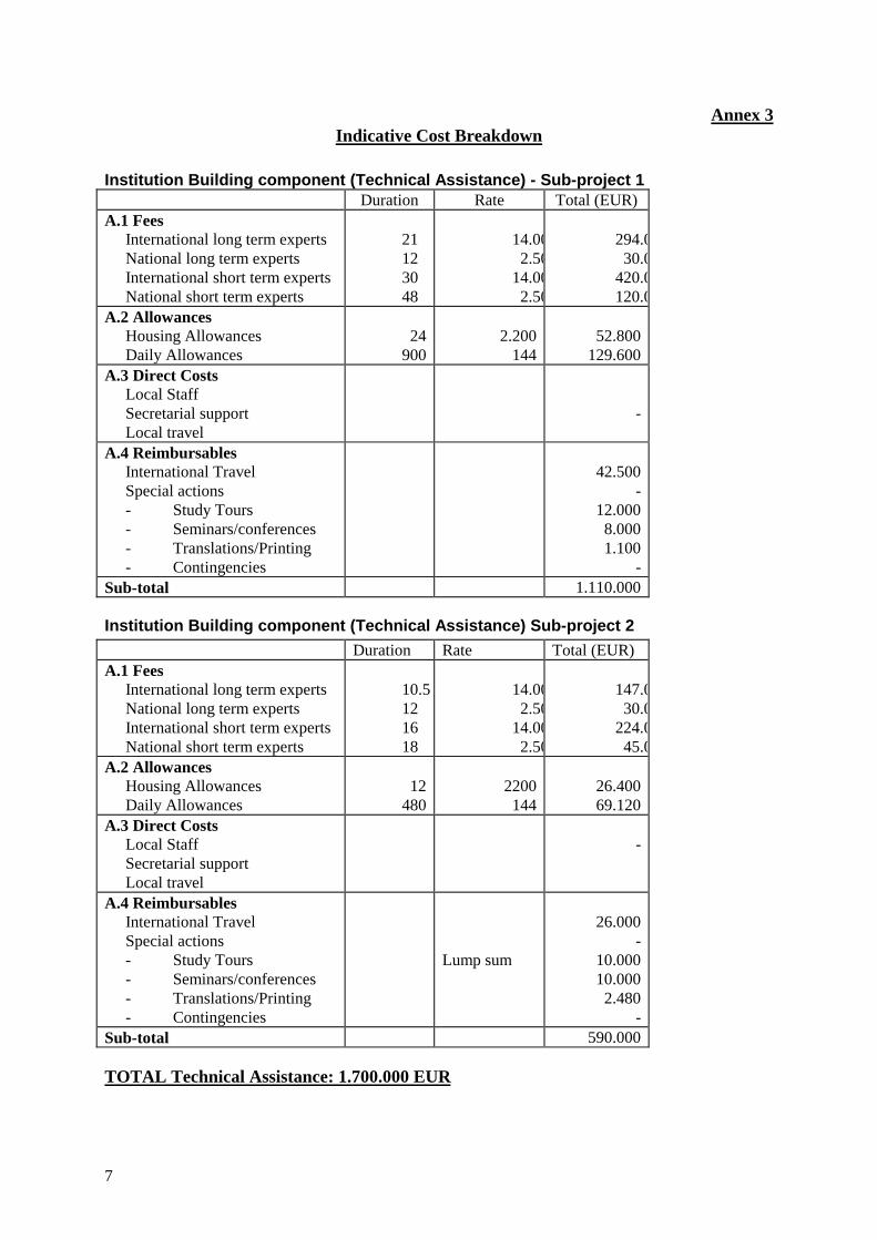
Annex 3Indicative Cost Breakdown
Institution Building component (Technical Assistance) - Sub-project 1Duration Rate Total (EUR)
A.1 FeesInternational long term expertsNational long term expertsInternational short term expertsNational short term experts
21123048
14.002.50
14.002.50
294.030.0
420.0120.0
A.2 AllowancesHousing AllowancesDaily Allowances
24900
2.200144
52.800129.600
A.3 Direct CostsLocal StaffSecretarial supportLocal travel
-
A.4 ReimbursablesInternational TravelSpecial actions- Study Tours- Seminars/conferences- Translations/Printing- Contingencies
42.500-
12.0008.0001.100
-Sub-total 1.110.000
Institution Building component (Technical Assistance) Sub-project 2Duration Rate Total (EUR)
A.1 FeesInternational long term expertsNational long term expertsInternational short term expertsNational short term experts
10.5121618
14.002.50
14.002.50
147.030.0
224.045.0
A.2 AllowancesHousing AllowancesDaily Allowances
12480
2200144
26.40069.120
A.3 Direct CostsLocal StaffSecretarial supportLocal travel
-
A.4 ReimbursablesInternational TravelSpecial actions- Study Tours- Seminars/conferences- Translations/Printing- Contingencies
Lump sum
26.000-
10.00010.0002.480
-Sub-total 590.000
TOTAL Technical Assistance: 1.700.000 EUR
8
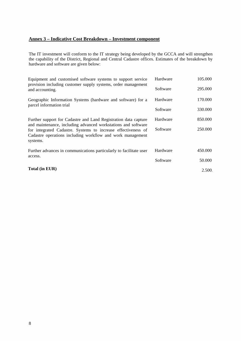
Annex 3 – Indicative Cost Breakdown – Investment component
The IT investment will conform to the IT strategy being developed by the GCCA and will strengthenthe capability of the District, Regional and Central Cadastre offices. Estimates of the breakdown byhardware and software are given below:
Equipment and customised software systems to support serviceprovision including customer supply systems, order managementand accounting.
Hardware
Software
105.000
295.000
Geographic Information Systems (hardware and software) for aparcel information trial
Hardware
Software
170.000
330.000
Further support for Cadastre and Land Registration data captureand maintenance, including advanced workstations and softwarefor integrated Cadastre. Systems to increase effectiveness ofCadastre operations including workflow and work managementsystems.
Hardware
Software
850.000
250.000
Further advances in communications particularly to facilitate useraccess.
Hardware
Software
450.000
50.000
Total (in EUR) 2.500.
9
Annex 4 – Relationship with previous PHARE activities and other financial sources
The GCCA has received significant foreign assistance from Phare during the period 1993 – 1998
The Phare 1993 programme provided 2 MEUR to this sector of which approximately 1.75 MEURwas allocated to Equipment Supply and 0.25 MEUR to TA. The Equipment Supply included thesupply to the cadastral Offices of PC LAN equipment, including servers, PC workstations andassociated peripherals and standard basic software to introduce the computerised title registrationsystem. A further supply of GIS equipment including hardware, software, large format scanners,output plotters and a large format high resolution film plotter was delivered. Provision was also madefor GPS equipment and an aerial photography campaign.The Phare 1994 programme provided 3 MEUR of which 2.5 MEUR was allocated to EquipmentSupply and 0.5 MEUR to TA. The Equipment Supply included servers, workstations, associatedperipherals and LANs for the cadastral offices (the number of cadastral offices was increased from 56to 79). Support for central computer (ATM network, DB2 database management system andUNIFACE development kit) was installed. Also procured were two analytical photogrammetricplotters and a digital photogrammetric instrument, GPS receivers and digital field survey equipmentinstrument, high-resolution scanners and high-resolution plotters. More than 25,000 sq. km of aerialphotography has also been contracted.The Phare 1995 programme provided 1 MEUR of which 0.54 MEUR was allocated to EquipmentSupply and 0.46 MEUR to TA. The Equipment Supply included the first phase of CentralCommunication Facilities (WAN with district offices), renewal of the cadastral map print facility andcompletion of aerial photography for territory of Slovak Republic.The TA programme under the 1995 programme has allowed GCCA to define and agree a high levelstrategy for the development of the Enhanced Cadastre. The Phases are firstly reinforcement andstabilisation of the existing modernisation programme followed secondly by development of customerservice systems and lastly by implementing a fully integrated Cadastre system.The Phare 1993 - 1995 funds are fully allocated and projects are implemented.The Phare 1998 programme has allocated 3.5 MEUR funding to this sector which is currently beingretargeted to complete the first stage modernisation and provide an urgent response to theadministrative reform. It has the following specific objectives :
• completion of the first phase of the re-equipment, modernisation and restructuring of theGCCA and its supporting institutions
• reinforcement of the methodological control of the work of the Cadastral Offices followingthe administration changes of 1996
• the establishment of a coherent National Cadastral Policy which will further elaborate theStrategic Plan of the GCCA (1998-2005), and the options for the methodological, human,legal and technical development of the cadastre, taking into account the specific policy issuesof the sector (institution building, market transition, EU accession, land markets,administrative sector reform). This include specifically the drafting of detailed technicalspecifications (detailed design) for the system design and an Introductory Study whichelaborates how to proceed with the system integration task.
Projects in the 1998 programme are adopting a practical approach to the development of the newsystem, and in particular, to address the problems created by the lack of maintenance of the variousreal estate registers and cadastral maps.On the Phare 1998 programme TORs were delivered to CFCU. The TS is in administrativeprocess with expected contracting starting in 3.Q 1999.
10
The GCCA itself has a number of ongoing state budget funding related projects :
1. Population of the cadastre of real estates with title informationThis is ongoing, to date 2.6 million urban parcels and 1.4 million rural parcels are fully loaded (afurther 2.7 million rural parcels are registered in simplified form). The remainder of rural parcelscannot be loaded until the ownership relations are clarified through the land title consolidationprogramme (or some other similar process). It should be noted that title data can be loaded incomplete form (i.e. with cadastral boundary information) or in so called “simplified form” wherethere is no boundary information recorded.
2. Cadastral Map renewalThe cadastral map renewal programme is under the control and supervision of the Cadastral Institute.The actual methodology used depends on the particular cadastral history of the cadastral unit inquestion. The recent Phare ES procurements have introduced the necessary technical systems, and themethodology to apply to a planned 100 cadastral units per year is now under development. The aim isto produce a digital vector cadastral map as the output deliverable. To date more than 190 out the3500 cadastral units have digital vector cadastral maps.
3. Land and Title Consolidation projectsThe number of projects started to date to the end of 1998 was 572: each cadastral unit requires 4man/years of effort. The result of this process is the resolution and satisfaction of all legal claims toproperties, and the regularisation of the titles. However, there is no attempt to rearrange the shape orsize of the property units, nor is there any attempt to mark out the results in the field. This work hasbeen carried out by private sector survey companies. The responsibility for financing of these projectsis split 60/40 between the Ministry of Agriculture and GCCA and the implementation is split betweenthe district land offices and the district cadastral offices. A further 616 projects have been started in1999.
4. Development of digital cartographic productsThe Institute for Geodesy and Cartography assisted by the Research Institute of Geodesy andCartography is developing procedures and assembling the necessary technical means for introducingdigital map production of the 1:10,000 map series. A topological database based on the 1:10,000series mapping is also under development, which is aimed at producing data for GIS purposes. Asimilar initiative is under way with the 1:50,000 scale base map series.
5. Development of national digital orthophotos coverage.Following the Phare supported photographic campaigns, there are experiments proceeding with thedevelopment and introduction of digital orthophotos at scale of 1:10,000, and also at a larger scale(1:2,000) for urban and cadastral purposes. This work is to be carried out by the IGC, CIZ, and withthe assistance of the RIGC.
6. Data Migration of the central databaseThis project involves the first stage data migration to the new central computer. The GCCA willdirectly fund work on the data model, and the preparation for connectivity with the cadastral offices isunder preparation

11
Annex 5 – Feasibility Studies
Strategic Review Study of the Cadastral System in the Slovak Republic was carried out in June 1997by Mr Theo Bogaerts, independent expert nominated from EC.A feasibility study on the Enhanced Cadastre was carried out in March 1998 by Mr Richard Baldwin,reinforced by the Project No. SR 9514.01.01
12
Annex 6 – Relevant Laws and Regulations
A. Regulations relating to the Cadastre
a) Law1. Act 162/1995 Real Estate Cadastre and entries for ownership and other rights to the real estates2. Act 67/1071 about the Administrative procedure (Procedural rules) 3. Act 99/1963 Civil Juridical Rule4. Act 40/1964 Civil Code (Code of Civil Law)5. Act 513/1991 Trade Code6. Act 180/1995 Land Title Consolidation Act7. Act 145/1995 Administrative charges
b) Decrees1. Decree of GCCA No: 79/1996, by which the Act 162/1995 is executed in the sense of decree
72/19972. Decree of GCCA No: 157/1996 by which the Act 180/1995 is executed3. Decree of GCCA No: 331/1996 which states
B. Related Basic Legal Norms (Acts, Decrees and Regulations of the Government)
1. Civil Code (Code of Civil Law)2. Trade Code3. Act 317/1992 on tax from Real Estate4. Act 3 18/1992 on Tax on Heritage, Donation, and on Transfer and Transition of Real Estate5. Act 328/1991 on Bankruptcy6. Act 51 1/1991 on Tax Administration and about the changes in the system local financialinstitutions7. Act 233/1995 about court prosecutors and execution /Rules of Execution/8. Act 1 I/1990 about the State owned enterprises9. Act 70/1997 on Expatriates Slovaks10. Act 202/1995 Foreign Exchange Act11. Act 372/1990 about offences (violations)12. Act 369/1990 about the municipalities13. Act 13 8/ 1991 about the Municipal property14. Act 278/1993 about the administration of the State property15. Act 282/1993 about the reduction of some property injuries made to churches and religioussocieties16. Act 92/1991 about the conditions about the transfer of State property to another entities (Act onbig privatisation)17. Act 229/1991 about the regulation of ownership rights to the land and the another agriculturalproperty18. Act 330/1991 about the land consolidation, land fund and the land societies19. Act 180/1995 about some measures on arrangement of ownership to land

13
20. Act 64/1997 on using of the land in garden colonies and about the settlement of the ownership tothem21. Act 293/1992 about the modification of ownership rights to Real Estate22. Act 323/1992 about the notaries /Notary rules/23. Act 138/1973 about the waters.24. Act 61/1977 about the forests25. Act 307/1992 about the protection of the agricultural land fund26. Act 50/1976 about the urban planning and the construction rule27. Act 182/1993 about the transfer of ownership to flats28. Act 221/1996 about the regional and administration arrangement29. Act 42/1992 about the reform of property relations and the settlement of property claims in co-operatives30. Act 215/1995 about the Geodesy and cartography31. Act 270/1995 about the State language of the SR32. Decree of the Ministry of Finance SR No: 465/1991 about the prices of buildings, lands, vesture,about the compensations for the temporary using of the land33. Regulation of the Government 208/1992 about the rent of the agriculture and forest Real Estatesand about the rent of the Agriculture farm34. Regulation of the Government 152/1996 about the basic tariffs of levies for the ablation of theagriculture land from Agriculture Land Fund
14
Annex 7 – Relevant Strategic Plans
The GCCA is formulating a cohesive Strategic Plan which will provide a framework for the furtherdevelopment of the cadastre and land registration sector over the medium term future period of 1998-2005. It is based on the "Concept of Development of the Cadastre until the year 2005" prepared by theGCCA (February 1998) and this is to be further developed by the GCCA in the light of the perceivedneeds of the Slovak society during the EU pre-accession phase. The present consultancy SR95.14.01.01 “Technical Assistance to the GCCA to support Policy Formulation and System Design” isoriented towards providing assistance in the more precise elaboration of the Strategic Plan, especiallyin connection with the identification of policy matters, the establishment of a policy framework toprovide clear strategic guidance, and the identification of the necessary steps needed to implement theagreed strategy.
15
Annex 8 – Status of Cadastre Policy Reform in the Slovak Republic
1. Background: the driving forces
The accession of the Slovak Republic to the European Union requires the establishment of compatibleeconomic and political structures able to support the internal market and is one of the major aims ofthe Slovak Government at the present time. This preparation involves fundamental reform activities,especially in the areas of legal approximation, public administration and institution building, and theadoption of the acquis communitaire.The cadastre and land registration sector is one of a number of sectors which provide essentialservices within a market economy and play a large part in supporting the four freedoms (movement ofgoods, services, people and capital).The establishment of a fully functional cadastre and land registration sector is one of the key elementsof the economic transformation process, as it provides the guarantee for private property and safe andsecure legal title to all land and property. It provides the fundamental mechanism for the recordingand transfer of assets from one legal entity to another, establishes usage rights, and provides the basisfor credit through mortgage and security for development financing, and hence provides the operatingframework for all Land Market activity.Unlike the accession process experienced by the existing 15 member states, all of the CEE countrieshave special problems in this sector, as, prior to 1989, these countries had little public institutional,administration, or legal support for private property. The records built up for more than one centurywere no longer systematically updated, rapidly became inaccurate or were modified to represent usagerather than ownership.The key policy forming issues at the present time are driven by :• The Accession to the European Union• Transition to the Market Economy• Land markets• The Role of the Land Administration Agency- Institution Building• Financing options and economic impact
1.2 The role of government institutionsWithin the market economies in recent years there has been a reappraisal of the role of governmentand its supporting institutions. Government is increasingly seeking ways of divesting itself ofresponsibilities for many aspects of administration, through contracting out, public / private sectorpartnerships / reassessment of core business areas and concentration of increasingly scarce publicsector resources on essential matters.An increasing amount of administration is concerned with information flows. This is highly suited toautomation and electronic data processing, and the rapid spread of Intranet and other networktechnology means that new opportunities are opened for information management and access. Theinfrastructure investments are very high, the operational costs are high, and the data loading / dataconversion tasks is immense. The traditional viewpoint of organisations that are considered to beoffices of the State Administration is that they are mandated with specific (usually administrative ortechnical) tasks, which must be carried out according to precise Government regulations, oftenspelling out in great detail the technical standards to be implemented.The following policy issues arise :• costs of modernisation• reassessment of the core business activities• determination of the market needs
16
• staff and professional development in order to retain staff in an increasingly competitive labourmarket
• modern management practices, staff retraining and the introduction of IT• reduction of state contribution and increase of cost recovery• public/private sector Cupertino and alternative structural models• quality control and standards;- there is a shift from licensing to quality assurance methodsGCCA is experiencing the affects of all of these policy issues and is formulating strategies to dealwith them. However, resources are essential to implement them in a controlled and predictablemanner.
1.3 Financing OptionsThere is an overriding political-ideological decision that will dictate policy development concerningfinance of the Cadastre and Land Registration sector. The Government is faced with a choice betweenthe following three alternatives.1. The state is correcting past injustice. The state is therefore responsible for correction of past
misdeeds or providing compensation. In this case the state must pay.2. The state must “kick start” the land market process and spur on the economic transition, and so
state investment is justified economically.3. The user pays. The person who receives the (financial) benefit of a process should bear the costs.There is a move in many governments towards increased cost recovery and most Cadastre authoritiesin market economy countries, where they exist, are able to reduce dependence on state funding. Some(Netherlands, New Zealand) are essentially private companies. The long term vision of GCCA is toreduce its direct funding and become a self-sustaining organisation. However, considerablestrengthening will be required.
2. Geodesy, Cartography and Cadastral Authority of the Slovak RepublicThe Geodesy, Cartography and Cadastre Authority (GCCA) of the Slovak Republic is charged withresponsibility for the management and upkeep of all land registration and cadastral records within thecountry. It also has responsibility for the provision of basic geographic data (geodetic control, statemap series and other geographic data). In the past ten years the GCCA has concentrated upon theimmediate reforms necessary to support the establishment of the legal framework for private property;the establishment of a national network of offices able to serve the needs of clients; the provision ofimmediate basic technical infrastructure within the cadastre and title sector (PC based LAN anddatabase systems), the introduction of modern technology (computer assisted cartography, digital andanalytical photogrammetry, GPS technology and GIS), and also support for the immediate objectivesof property restitution and land consolidation. PHARE support of 7.5MEUR has been allocated withinthe 1992-1998 programmes, and the completion of the SR 9807 programme will essentially completethe first phase of the reconstruction and modernisation.
2.1 Accession to the European Union.Preparation for the accession of the Slovak Republic to the European Union involves fundamentalreform activities, especially in the areas of legal approximation, institution building and publicadministration reform.Article 222 of the EC Treaty states that the Union shall in no way prejudice the rules in MemberStates governing the system of property ownership. Article 54(3) (e) explicitly calls on theCommission to establish the freedom whereby nationals of one member state may acquire and useland and buildings in another member state. This is further supported by Directives 63/261 and 63/282which concern the right to acquire, occupy or exploit any property.The following policy issues are important :
17
• Support for the internal market. There can be no discrimination in law between nationals of themember States with respect to property ownership.
• The Common Agricultural Policy and the Integrated Agricultural control system (IACS). Theenactment of the Common Agricultural Policy (CAP) requires the development of a system ofreporting for production of agricultural produce (for subsidies) based on farm unit and areas undercultivation. This requires a comprehensive database/ reporting system to be constructed in linewith regulation 3508 /92 (technical issue)
• Reform of public administration and institution building, This requires. investment anddevelopment of structures able to apply fully the acquis communitaire (especially in agriculture,environment)
• The establishment of functioning market economy. This implies the creation of an economicallyviable agricultural sector, including establishment of Land Administration institutions,development of private sector financing, information services and viable farm units as well assupport for the residential and industrial sectors of the land market.
2.2 The Transition to a Market EconomyThe transition to a market economy must rectify the consequences of the period of socialistgovernment. It requires the creation of a “framework” which provides the legal basis for the secureownership and transfer of property assets, affords legal protection (ultimately through the courts asthe last resort), and introduces the idea of “market value” and credit financing (i.e. professionalmarket valuation and mortgages) as the mechanism of facilitating exchange of property.The special problems in the Cadastre and Land Registration sector created by the socialist policiesneed to be comprehensively addressed:• the legacy of the socialist agricultural policy;- the creation of large field units reflecting
socialisation of agriculture and loss of ownership boundaries• the separation of usage and ownership;- the change of the land records system to reflect usage
rather ownership• expropriation of property followed by later restitution• lack or poor records of changes in ownership, especially in the cases of inheritance• accuracy and completeness of the records concerned with land administration;- the records were
not systematically updated• the state and the co-operative as the major owner and occupier of land• the lack of market mechanisms, e.g. valuation unconnected to market value, financing mechanism
absent and / or poorly understood• the creation of viable farm units: restitution has lead to excessive fragmentation leading to
uneconomic farm units
2.3 Land MarketsThe Land Market includes the regulating institutions (the land registers, the legal basis, the cadastre),the players (land owners and tenants), the goods and services (land and its usage) and the financialinstruments (mortgages, credit, valuation and taxation). The State plays an important role in each ofthese sectors - it is a regulator, a land owner itself, and also a major financier and revenue raiser. Thepolicies in the land market sector are therefore profoundly influenced by the role of the State, perhapsmore so than in other markets (e.g. financial or trade).A well developed land market can be characterised as follows :• a sound legal basis for ownership with open trading of property rights• recording and registering systems that are well implemented with secure institutional structures
and well regulated activities
18
• land owners and tenants that are active and represent a range of different stakeholders including astrong private sector and corporate players
• land and buildings can be traded, leased and be used as security; there is a variety of assetsavailable, apartments, residences (various sizes), offices, commercial building and agriculturalland holdings
• the financial instruments are clear and well supported with sufficient range and low risk• clear government policy to create strong and clearly understood regulating authorities with a
favourable environment for investments and providing strong individual motivating forces.
2.4 Developments in Cadastre and Land Registration sector during the period 1989-1998
Following the political changes of 1989, the cadastral and land registration sector was restructured inorder to try and quickly put in place a nation-wide cadastral system based on a new institutionalorganisation, a new legal framework supporting private property and also the supporting technicalinfrastructure based on relatively simple technical systems.
• The GCCA was established as an independent authority (at the Ministry level) consisting of acentral executive branch, two (later three) supporting institutes and a national network of regionaland district cadastral offices. However in 1996, management and budgetary responsibility of theDistrict Offices was transferred to the State Administration and each district cadastral officebecame simply one department of the district administration offices. GCCA lost direct control ofthese offices which are central to the maintenance and creation of the Cadastre.
• In 1991/3 new legislation was passed to establish the new “Cadastre of Real Estates” as a unifiedsystem consisting of both a textual part (legal and administrative record) and a graphical part(cadastral map) which would provide the registration of ownership (title) for all land andproperty. Additional legislation was concerned with the establishment of rules and regulations forland consolidation programmes and establishment of the basis for land restitution. These havebeen later amended by further acts, concerned with land title consolidation, entries to the cadastre,the role and responsibility of the GCCA, and the professional regulation of surveyors. There arealso amendments to the above acts which have been proposed or passed including amendments tothe Civil Code.
• The new “Cadastre of Real Estates” (CRE) came into operation on 1 January 1993. The CRE isunified; i.e. both the legal title and the physical description are contained in the CRE. At presentall of the title registration data is held in computerised databases; the longer term aim is toachieve a fully integrated computerised system. In February 1999, more than 190 out of the total3500 cadastral units are available in digital vector form.
• Each of the 79 district offices has been equipped with PC-based network which run systems tomanage the title information. There is also a ledger type application which tracks the applicationssubmitted to the cadastral offices.
• A central server contains the contents of the former central database which have been partlyported to a new (PHARE funded) machine. A project in the 1998 Programme will address how tofully integrate the databases between the central and district systems.
• A Virtual Private Network is being put in place, funded by PHARE, to allow district offices tocommunicate electronically with the central system.

19
2.4.1 AchievementsThe GCCA is currently completing the first phase of the modernisation of the sector. This hasinvolved the following steps :1. The establishment of an adequate legal framework able to support the title to land and property and
also support the conveyance process. Approximation with EU legislation is taking place2. The first phase establishment of a nation-wide network of offices, which manage the land and
property records in each district and provide some services to clients3. The completion of the first phase of the modernisation of the technical infrastructure of the land
registration sector through the provision of PC based LAN databases within the cadastral officesto manage the title information
4. The replacement of the old central mainframe computer and porting of the centralised databaseinto the new environment
5. The provision of information by the cadastral offices in response to requests in order to support therestitution programme (now largely completed)
6. A comprehensive re-equipment of the surveying and mapping sector has been carried out and theTraining Centre was created
7. Successful use of contracting-out to undertake land title consolidation in nearly 30% of thecadastral units.
In addition, GCCA has commenced renovation of the state mapping systems.
2.4.2 Land and Title ConsolidationTo address the problems in the agricultural sector, processes of land consolidation and land titleconsolidation have been developed. A total of 200 of the 3500 cadastral units that exist were subjectto the land consolidation process, but by December 1998, only ten were completed. The result of thisprocess, in principle, is the classic land consolidation, where all claims are processed and the land isrearranged into the best possible pattern consistent with legal ownership claims. It is extremelyexpensive, time consuming, requires the identification and agreement of all participants, and canresult in many small parcels if there are many claimants. This work is under the control of the landoffices (departments within the district offices of the state administration, not responsible to theGCCA). It is understood that there are no concrete plans to extend this programme to other cadastralunits.Based on experiences with this programme a new Land Title Consolidation Act was created to avoidsome of the previous difficulties by concentrating on the resolution of the Land Title problems. Thenumber of projects started to date to the end of 1998 was 572; each cadastral unit requires 4man/years of effort. The result of this process is the resolution and satisfaction of all legal claims toproperties, and the regularisation of the titles. However, there is no attempt to rearrange the shape orsize of the property units, nor is there any attempt to mark out the results in the field. This work hasbeen carried out by private sector survey companies. The responsibility for financing of these projectsis split 60/40 between the Ministry of Agriculture and GCCA and the implementation is split betweenthe district land offices and the district cadastral offices. A further 616 projects have been started in1999.
2.4.2 Surveying and MappingThe GCCA also has responsibility for the production of large and medium scale topographic maps,the maintenance of the geodetic network, and has various other duties associated with the provision ofgeographic information, international professional relations and the execution of geographic relatedresearch of national importanceA particular task has been the establishment of precise border demarcation and controls for the newterritory, the re-observation using modern GPS equipment of the geodetic network, and the upgradingand densification of the control network, in order to support the increased level of surveying andmapping activities carried out by both the GCCA bodies and the private sector.
20
During the period 1993-1998, the GCCA has also concentrated upon the introduction of moderntechnology and digital cartographic techniques, largely supported through the Phare programme tosupport the introduction of modern topographic mapping technology (computer based) and thedevelopment of products to support GIS (Geographic Information System) data sets, necessary tosupport other state bodies, local authorities as well as the private sector.
2.5 PHARE support and ongoing projectsThe GCCA has received significant foreign assistance from Phare during the period 1993 – 1998 :The Phare 1993 programme allocated 2M EUR to this sector of which approximately 1.75M EUR wasallocated to Equipment Supply and 0.25M EUR to TA. The Equipment Supply included the supply tothe cadastral Offices of PC LAN equipment, including servers, PC workstations and associatedperipherals and standard basic software to introduce the computerised title registration system. Afurther supply of GIS equipment including hardware, software, large format scanners, output plottersand a large format high resolution film plotter. Provision was also made for GPS equipment and anaerial photography campaign.The Phare 1994 programme provided 3MEUR of which 2.5M EUR was allocated to EquipmentSupply and 0.5M EUR to TA. The Equipment Supply included servers, workstations, associatedperipherals and LANs for the cadastral offices (the number of cadastral offices was increased from 56to 79). Support for a central computer (ATM network, DB2 database management system andUNIFACE development kit) was installed. Also procured were two analytical photogrammetricplotters and a digital photogrammetric instrument, GPS receivers and digital field survey equipmentinstruments, high-resolution scanners and high-resolution plotters. More than 25 000 sq. km of aerialphotography was also contracted.The Phare 1995 programme provided 1M EUR of which 0.54M EUR was allocated to EquipmentSupply and 0.46M EUR to TA. The Equipment Supply included the first phase of CentralCommunication Facilities (WAN including district offices), cadastral map renewal print facility andcompletion of aerial photography for the territory of the Slovak Republic.The 1998 programme has allocated 3.5M EUR funding to Cadastre which is currently beingretargeted to complete the first stage modernisation and provide an urgent response to theadministrative reform and has the following specific objectives :• completion of the first phase of re-equipment, modernisation and restructuring of the GCCA and
its supporting institutions• reinforcement of the methodological control of the work of the Cadastral Offices following the
administration changes of 1996• the establishment of a coherent National Cadastral Policy which will further elaborate the Strategic
Plan of the GCCA (1998-2005), and the options for the methodological, human, legal andtechnical development of the cadastre, taking into account the specific policy issues of the sector(institution building, market transition, EU accession, land markets, administrative sector reform).This include specifically the drafting of detailed technical specifications (detailed design) for thesystem design and an Introductory Study which elaborates how to proceed with the systemintegration task.
Projects in the 1998 Programme are seeking a conceptual approach to the development of the nextstage system, and in particular, will seek to address the problems created by the lack of harmonisationof the various real estate registers and cadastral maps.The Phare 1993 - 1995 funds are fully allocated and projects are implemented, those for 1998programme are under preparation (expected contracting period 3.Q 1999).
2.6 GCCA Funded activitiesThe GCCA itself has a number of ongoing state budget funding related projects :1. Data Migration of the central database
21
This project involves the first stage data migration to the new central computer. The GCCA willdirectly fund work on the data model, and the preparation for connectivity with the cadastraloffices is under preparation
2. Population of the cadastre of real estates with title information This is ongoing: to date more than 2.6 million urban parcels and 1.4 million rural parcels are fullyloaded (a further 2.7 million rural parcels are registered in simplified form, without cadastralboundary information). The remainder of rural parcels cannot be loaded until the ownershiprelations are clarified through the land title consolidation programme or some other similarprocess.
3. Cadastral Map renewal The cadastral map renewal programme is under the control and supervision of the CadastralInstitute. The actual methodology used depends on the particular cadastral history of the cadastralunit in question. The recent Phare ES procurements have introduced the necessary technicalsystems, and the methodology to apply to a planned 100 cadastral units per year is now underdevelopment.
4. Development of digital cartographic products The Institute for Geodesy and Cartography (IGC) assisted by the Research Institute of Geodesyand Cartography (RICG) is developing procedures and digital methods for production of the1:10 000 map series. A topological database based on the 1:10 000 series mapping is also underdevelopment, which is aimed at producing data for GIS purposes. A similar initiative is under waywith the 1:50 000 scale base map series.
5. Development of national digital orthophoto coverage.To complement the PHARE-supported aerial photography campaigns, experiments are in place todevelop and introduce digital ortho-photographs at a scale of 1:10 000 together with larger scale(1:2 000) for urban and cadastral purposes. This work is to be carried out by the IGC, CIZ, andwith the assistance of the RIGC.
2.7 Remaining Issues in the Cadastre sector
The land problems related to transition in Slovak Republic are particularly acute for the followingreasons :1. Historically, there have been many land reform programmes, which were started but were either
not completed before new legislation was introduced, or the programme was simply not continuedto completion (notably in 1918 and 1945). This makes the re-creation of the legal ownershipsituation very difficult
2. The historic land records basically show the situation in 1948, before the changes introduced bythe socialisation of agriculture and forestry. During the period 1948-1989, only some transferswere recorded, (the urban was mostly recorded, the rural sector was mostly not recorded), so therecords themselves rapidly became outdated and can no longer be considered accurate.
3. In the Slovak Republic it is normal to divide a property in the case of inheritance between alleligible heirs. Historically this has led to excessive fragmentation of the land and a large number ofsmall land units. Because there has been no systematic update of the records during the period1948-1989, there are now several claimants for each parcel, and so the parcels of 1948 areeffectively co-owned by several claimants today. An added complication is that it is often not clearexactly who are the legal heirs to these parcels.
22
4. The socialisation of agriculture and forestry has destroyed the historic field boundaries which areshown in the cadastral maps of 1948. Today, the agricultural parcels reflect usage, and consist oflarge undivided fields which have very few features. Alterations to roads and drainage have alsoaltered the shape of the large fields, cutting across historic ownership boundaries. This makes itvery difficult to relate ownership boundaries of the 1948 maps to the present situation on theground. Of the 12 million parcels that existed in 1948, it is estimated that 9.6 million were ruraland forest parcels. The best estimate of the GCCA is that today there are some 3-4 million ruralphysical parcels actually in existence, representing the result of the usage consolidation that tookplace under socialist agriculture. However, these parcels have a rather complex legal ownershipsituation as there is no simple connection between the field pattern of today and the historicalownership records of 1948.
5. Many buildings have been erected during the period 1948-1989, which was erected without regardto the underlying land ownership. Many situations exist where a building has been created by astate enterprise (or other organisation) which, according to the 1948 records, is now located onmore than one land parcel.
6. Apartment buildings constructed during the socialist era were not systematically recorded. Underpost-1989 legislation, the building co-operative, the state or the local authority is required totransfer the individual flats or apartments to the occupiers. However, in order to carry out thistransfer, the full building has to be apportioned in terms of individual ownership of the separateapartments, and (often) co-ownership of common parts. It is estimated that this process will create1-1.5 million new titles.
Most of the above issues will remain for many years and constrain the operation of the Cadastre whilenew developments are implemented.Concerning the GCCA itself, the following are the main residual issues:
1. The reorganisation of the state administration, the increase in the number of district cadastraloffices from 56 to 79 and the removal of their direct control creates a number of problems for theGCCA. These include:
Integrity and security. The cadastral offices have both a legal responsibility and also anadministrative responsibility. However, under the revised organisational structure, thedecisions of the case officers are subject to the approval of their administrative head. There isa potential conflict in this situation which might compromise the integrity of the legal process.
Staff difficulties. The increased number of district offices resulted in a shortage of trained andexperienced staff. It is especially difficult to develop skilled case officers as it takes time tobuild up the necessary experience to study the title applications. The recruitment of qualifiedsurveying staff is also difficult, as the private sector is very active and offers distinctly bettersalaries and opportunities for development. There are few specialist IT staff who are requiredto overcome day to day problems and cannot fully support the systems
Budgetary control. The loss of budgetary control of the GCCA over the cadastral officescreated difficulties for the cadastral offices in receiving necessary funding for investments asthey are competing for funds with the 19 (approximate) other departments of the stateadministration within a district.
Quality of data and operational efficiency. The problems described above will affect thequality of data and operational efficiency of the cadastral offices. Under the revisedadministrative structure, the GCCA has no direct responsibility for the efficiency andthroughput of the cadastral offices.
23
2. Centralisation versus decentralisation. From a technical viewpoint, the GCCA has responded tothe changes by trying to centralise the technical activities for which it has specific responsibilitysuch as the centralisation of the cadastral mapping renewal at the Cadastral Institute of Zilina (seebelow). The dilemma facing the GCCA is that while a decentralised organisation offers theopportunity for activities to proceed simultaneously and with local knowledge, the executionrequires strong local management, technical capability and professionalism - precisely thequalities that are most likely to be affected by the increased number of offices and the loss ofdirect control.
3. The Technical Infrastructure of the Cadastre is still weak. There are considerable risks to theintegrity and security of the Cadastre through lack of support for the systems and maintenance ofthe hardware and software. Investment in IT will be required for several more years to ensuresustainability and long term development.
4. A long term Strategic Plan is needed for the next stage developments of the Cadastre and LandRegistration sector. This Strategic Plan is in the course of preparation under programme SR9514(Support for Policy Formulation and System Design) and will supply a global vision for the wayahead, address the fundamental policy issues, the step by step plans for progressive improvementin the legal framework and the technical infrastructure. This will be further developed by theGCCA together with SR9807 (TA and Training for System Design) in the light of the perceivedneeds of the Slovak society during the EU pre-accession phase. Future support for policyformulation is essential to continue the process of institutional strengthening and managementtraining.
5. By no means least, the number of tasks undertaken by Cadastre staff is growing. During 1995 to1998 the number of tasks grew by more than 100% while staff numbers declined by 5%.Continued investment is essential to ensure that the backlog of cases is reduced to manageableand acceptable levels.
3. Conclusion
24
The GCCA is the government body most closely associated with Land Administration in the SlovakRepublic. It is not involved in high level government policy formulation. However, it is tasked withresponsibility for the development and operation of an efficient land registration sector able to meetthe needs of the citizens of the Slovak Republic. Traditionally, the approach has been to put in placethe legal framework, then identify the necessary technical matters to carry out the mandated tasks.Given the close connection between the performance of this state sector and the impact on declaredcabinet level policy (market transition, open and transparent markets, EU membership, the creation ofa viable agricultural sector, efficiency in the administration and the promotion of the private sector),land administration authorities cannot adopt a purely technical viewpoint and must consider the widerbenefits, - this leads to policy formulation within the cadastral / land registration sector. The cadastral/ land registration policy must be a response to the declared government policy aims and shouldinvolve active participation and discussion with other operators in the land sector - the othergovernment agencies, the regulating forces, the players, and a response to the introduction of thefinancing and valuation sectors which underpin the trade in goods and services which herald thetransition to the market economy. This area of policy formulation is new to GCCA and needs to bedeveloped to ensure that the Cadastre is a true service sector, able to underpin all its users’ needs.However, the biggest immediate issue facing the operation of the Cadastre is that there is a lack ofresources to overcome problems. Any changes are difficult to implement because of the need tocontinue provision of services vital to the citizens of the country. Many of the problems are long term,but can be overcome in a staged manner given suitable plans and resources. A single 'big bang'approach to change will not work because of the size of the problems, the widespread geographicextent and the implications on existing services. A viable implementation plan implies a long term,staged, capital investment programme in staff and equipment and data of which the government of theSlovak Republic can only afford part at this time. 'Stop-start' investment, whether by the Slovakgovernment or by the EU, is likely to increase problems rather than overcome them. Only if thisinvestment plan is realised can the Slovak Cadastre become self-sustaining.
25
Annex 8 RESOLUTION OF THE GOVERNMENT OF THE SLOVAK REPUBLIC1
On the short-term strategy for the Real Estate Cadastre.Report on the current state of progress of government tasks in the sector of Geodesy, Cartography andReal Estate Cadastre.
Resolution number 264Date 31 March 1999Number of material 1025/1999-04-24Presenter President of the Geodesy, Cartography and Cadastral
Authority of the Slovak RepublicProposal Working plan of the Government of the Slovak Republic
for the year 1999The Government
A. Takes into account
A.1 The report on the current situation in fulfilling the tasks of the State in the sector ofGeodesy, Cartography and Real Estate Cadastre.
B. Adopts
B.1 Inclusion of the Real Estate Cadastre in the list of priorities of the Slovak Republicfor the PHARE programme in the scope of preparation of the FinancialMemorandum for the year 1999.
C. Obliges
The President of the Geodesy, Cartography and Cadastral Authority of the Slovak Republic
C.1 to discuss with the Ministry of Finance of the Slovak Republic, in accordance with §51of the Budgetary Regulation Act, before preparing the initial proposals for the NationalBudget for the year 2000, the impacts resulting from the Report on the current state ofcompletion of the tasks of the State in the field of geodesy, cartography and real estatecadastre
Before preparing the initial proposals for the National Budget for the year 2000
C.2 to prepare and submit for Government negotiation the short-term strategy fordevelopment of the Cadastre of Real Estates
by 14th April 1999
C.3 to submit for a discussion in the Government a proposal for the developmentprogramme in the sector of geodesy, cartography and real estate cadastre oriented
1 Note: this Annex provides English translations of relevant extracts from the full Slovak original.
26
towards the tasks to be undertaken by the State under government contracts in the fieldof science and technology.
by 30th June 1999
Heads of the Regional Offices and Heads of the District Offices
C.4 to pay maximum attention to the personnel in the cadastre divisions, to the increasingthe number of employees in order to expedite the completion of the tasks in the realestate cadastre division.
in the year 1999
Measure No. 3
To the Heads of the District Offices to ensure that the ideal staff qualification structureof Cadastre department is met with a minimum of one University graduate surveyor, onelawyer and one computer programmer, as a vital condition for ensuring functioning ofthe Cadastre department of the District Office.
The term, by 30/4/99
Measure No. 5
To the President of the Geodesy, Cartography and Cadastral Authority of the SlovakRepublic, considering the negative aspects of the current state of fulfilment of the tasksof the State in the sector of Real Estate Cadastre as a result of the Act NC S No.162/1995 on Real Estate Cadastre and Registration of Ownership and other laws onReal Estates (Cadastre law), to reword the Act of the Slovak National Council No.222/1996 Coll. with the aim of detaching cadastral activities from the system of localstate administration and to create specialised state administration authoritiesaccording to Resolution No. 68/1999 of the Government of the Slovak Republic.
The term, as in the text, by 30/11/1999.
Measure No. 9
The Minister of Agriculture, the President of the Geodesy, Cartography and CadastralAuthority of the Slovak Republic and the Heads of Regional Offices, following thepassing of the law on the State Budget for the year 1999 – adopted chapters of the statebudget of Regional Offices to concentrate discussion on informing the interested publicabout the reasons for breaching the commitment of the Slovak Republic to finish theregistration of estate property rights by 2002 (as adopted in Resolution No. 237/1998 ofthe Government of the Slovak Republic – and the adopted national programme for theacceptance of the acquis communitaire in the Slovak Republic).
The term is as in the text. The task is ongoing.

27
DRAFT RESOLUTION
The Government of the Slovak Republic
Adopts
a short-term Strategy for development of the Real Estate Cadastre.
Agrees
B.1 to accept that the Real Estate Cadastre, directed towards the creation of an all-purposeinformation system of the State, is among the tasks to which the Government of theSlovak Republic gives priority.
B.2 to speed up the legislative preparation of a draft law that changes and amends the Actof the Slovak National Council No. 162/1995 Coll. on the Real Estate Cadastre and onRegistering Property and other Rights For Real Estates (the Cadastre Law); to rewordthe Act of the Slovak National Council No. 222/1996 Coll. with the aim of detachingcadastral activities from the system of local state administration and to createspecialised state administration authorities according to Resolution No. 68/1999 of theGovernment of the Slovak Republic (The Plan of Legislative Tasks of the Governmentof the Slovak Republic for the year 1999).
The term: to submit for discussion to the Government of the SR by 30 September 1999.
Obligesthe President of the Geodesy, Cartography and Cadastre Authority of the Slovak Republic
C.1 to ensure, within budgetary constraints, that the objectives of the short-termdevelopment strategy for Real Estate Cadastre are met.
The term: the task is ongoing.the Minister of Agriculture, the President of the Geodesy, Cartography and CadastreAuthority of the Slovak Republic and Directors of Regional and District Offices
C.2 in line with the EU regulations No. 3508/92 and 3887/92, to propose the creation of anintegrated administrative and control system in the Slovak Republic, based on the dataof the real estate cadastre.
The term: by 30 /6 /1999
the President of the Geodesy, Cartography and Cadastre Authority of the Slovak Republicin co-operation withthe Head of the Council for Informatics of the Government of the Slovak Republic
C.3 to create a managing group at the level of Council of the Government of the SlovakRepublic, which shall co-ordinate state policy concerning creation and usage of spatialand cadastral information in the framework of the State Information System.
The term: by 30 /6 /1999