Embed Size (px)
Citation preview

Document No: 1742
STAFFIN COMMUNITY TRUST
STAFFIN HARBOUR DEVELOPMENT
REPORT ON FEASIBILITY STUDY
(Final Version)
Staffin Community Trust
Church of Scotland Annex
Staffin
Isle of Skye
IV51 9JX
Tel: 01470 562464
Wallace Stone
Royal Bank Buildings
Dingwall
Ross-shire
IV15 9HA
Tel: 01349 866775
Fax: 01349 863197
April 2015

Project No: 1742
This Report was part-financed by the Scottish Government, the Highland European Fisheries
Fund Programme and the Highland Council
STAFFIN COMMUNITY TRUST
STAFFIN HARBOUR DEVELOPMENT
FEASIBILITY STUDY
Contents
1. Introduction 1
2. Background 2
3. Study Method 4
4. Proposed Layout 6
5. Dredging, Breakwaters & Reclamation 9
6. Rock Armour & Core materials 10
7. Road Access 12
8. Additional Studies 14
9. Services 16
10. Environmental Issues and Consents 18
11. Harbour Authority 20
12. Estimate of Cost 21
13. Conclusions 25
Appendix A: Detailed Assessment of Earthworks Quantities
Appendix B: Drawings

1
Project No: 1742
STAFFIN COMMUNITY TRUST
STAFFIN HARBOUR DEVELOPMENT
FEASIBILITY STUDY
1. Introduction
Staffin Community Trust, in association with Skye Sea Harvest, have proposed a major,
transformational project at and around Staffin Slipway, to create a fish processing unit with
dedicated pier for well boats, to improve the slipway facilities for local cruise boats and
fishing boats, and to provide a pontoon facility for local boats and visiting yachts. In
addition, it is proposed that support facilities and buildings for local businesses are built on
shore at the site to provide for the needs of visitors, staff and fishermen.
There are currently a number of constraints to the project. There is insufficient water depth
to allow well boats to gain access to the area or to berth once inshore. The proposed area
for marine facilities is too exposed for unattended berthing. The access road to the slipway
from the A855 is narrow and fragile, has few passing places, and is restricted by tight bends
at the bridge over the river Stenscholl. There is no water or electricity at the site.
Wallace Stone were appointed to consider all the issues around the implementation of the
proposals, to consult widely with statutory bodies, agencies and local interests, and to
produce an appraisal of the options available, with detailed estimates of cost, in providing
facilities to satisfy all the needs of Skye Sea Harvest, local fishermen and cruise boat
operators, visiting yachts, and the Staffin Community.
This report presents the findings of the appraisal.

2
Project No: 1742
2. Background
The slipway at Staffin was constructed in stone blocks in the early 1900s, and was built as a
raised slipway, allowing vessels drawing 1 metre or less to berth alongside for short
periods, while loading and unloading. In 2000, in response to calls for improvements to
berthing and shelter, the slipway was heightened and extended, and a sheltering rock
breakwater built to the east and north.
At that time funding restrictions dictated that the preferred option could not be achieved
within the timescale of the ERDF offer, and the improvements only went some way to
providing adequately for local vessels. Use of the upgraded facility has exposed limitations
in the number and type of vessels that can use the slipway, and restrictions on access at low
spring tides.
There are no services or amenities at the slipway. Extensive consultations were carried out
including environmental impact and otter displacement, allowing the project to proceed to a
successful planning application which included extraction of rock armour from the
surrounding foreshore.
Local users, including fishermen, cruise boat operators and leisure vessel owners have been
making increasingly strong representation for safe berths in sheltered water for their
vessels, and for visiting yachts over the summer months.
A study of the potential options, commissioned by the Staffin Trust, issued in 2013,
recommended a preferred layout with good berthing for up to 20 vessels, sheltered from all
directions by an extended breakwater. The proposals were seen to have the potential to
attract some small businesses to the area. However the high cost of the project was
considered likely to deter potential funders unless more substantial economic benefit could
be generated in the onshore activities.

3
Project No: 1742
Skye Sea Harvest, who were looking for a suitable location to build a new innovative fish
processing unit, have joined Staffin Trust as partners in the venture, providing the potential
for a substantial number of jobs and, as a transformational project, a strong incentive to
funders with a remit to support economic development.
The sheltered berthing and manoeuvring area required for the well boats generates
additional sheltered space for a large pontoon development and an extension to the existing
slipway.
The purpose of this study is to examine the feasibility of the proposals, to develop a suitable
layout, to consult widely with statutory bodies, council authorities, potential users, utility
providers and consenting authorities, to estimate the cost of the project, including
upgrading of the existing access road, and to report with findings and recommendations.

4
Project No: 1742
3. Study Method
The method proposed, and accepted, for the study was as follows: -
Meeting with Staffin Trust and Skye Sea Harvest and other potential users of the
harbour, to establish full details of the proposed development, vessel movements,
manoeuvring spaces, onshore requirements, power, water, phone and IT needs;
consider merits of retention of or improvements to existing structures.
Meeting with water, power and phone companies locally to assess the factors and
costs associated with provision of services.
Meeting with THC TEC Services Engineer on site to consider the improvements to
road alignment and (if necessary) bridge alignment to allow access for heavy
commercial vehicles; to consider any strengthening needed to support construction
traffic; and to discuss Staffin to Portree road and any improvements considered
necessary to ensure suitability for the intended traffic.
Assess rock sources for infill and armouring for new breakwater structures.
Consult with local landowners, Marine Scotland, Planning, and Crown Estate to
identify issues that will require assessment to facilitate consents (investigation and
study of these issues would not be part of the study).
Consider the conceptual drawing and vessel details provided with the tender
inquiry, amend as necessary to provide for the vessels listed, develop suitable layout
and consider issues of depth and access to the berths.
Consider the feasibility of dredging to improve access and to provide the proposed
water depth at the berths.
Consider size, location and orientation of onshore buildings, parking areas, storage
areas, services provision and drainage; consider improvements to access road and
A855 to Portree.
Consider environmental, aesthetic and archaeological issues raised by the scale of
the development and propose a range of potential mitigations.
Prepare layout or options for layout and consult with Staffin Trust, Skye Sea
Harvest, local boat users and THC TEC Services on proposals; amend as necessary.

5
Project No: 1742
Once an agreed layout is confirmed, estimate the cost of implementation and
consider likely maintenance costs.
Prepare and issue a draft report on the conclusions of the study, the estimated costs
of the project, and the next stages in moving towards funding and implementation.
Meet with Staffin Trust, Skye Sea Harvest and the local community to present the
draft proposals and invite comment and discussion.
Amend report and issue.

6
Project No: 1742
4. Proposed Layout
After consultations with the Client group, potential users and residents, a preferred layout
has been developed, which includes all the elements required by the remit (see drawing no.
1742/101C in the Appendices).
A large, sheltered harbour area is generated by two extensive rock armoured breakwaters.
The following are proposed in the Harbour: -
Pier to Accommodate Well Boats
The access to the harbour and a large area inside the harbour require to be
dredged to a suitable depth for the well boats that will serve the processing
unit. The well boats will berth at a substantial piled pier of sufficient length
and water depth. The pier is aligned towards the entrance, and has a large
adjacent manoeuvring area. Well boats generally draw 5 to 6 metres when
loaded and the resulting, preferred channel and harbour depth of 7 metres
below Chart Datum results in a very large quantity of dredged material.
For reasons of economy, it is proposed to limit the dredge depth in the
entrance channel and manoeuvring area to 6m below CD (see section 5).
Reclamation
It is assumed that some or all of the dredged material might be used in the
core of the breakwaters and to form a large reclaimed area at the south end of
the harbour, adjacent to the end of the existing access road. The proposed
fish processing unit and its associated office, parking area and welfare
facilities would be sited on the reclamation.

7
Project No: 1742
Fishing Boat Berths
The pier will have sufficient water depth at the east side of the shoreward
end to accommodate a number of fishing boats drawing up to 3 metres.
Slipway
The rock armoured breakwater protecting the existing slipway will be
demolished and the materials used in the new breakwaters. The existing
slipway will be widened, extended and raised in level, to allow fishing boats
to land fish straight to buyers’ vehicles at any state of the tide, and to allow
local cruise vessels to load and unload passengers at any time. The slipway
will also be suitable for landing craft transporting materials, stores etc., and
for launching and recovering trailer-transported vessels.
Pontoons
Between the new pier and the slipway, there is sufficient space for a pontoon
facility providing 30 berths for local vessels and visiting yachts. The berths
will accommodate yachts up to 15m in length, and vessels with draft up to
3.5 metres. The pontoons will have a separate access adjacent to the pier,
and past the fish processing area.
The pontoons will be provided with electricity and water bollards, and users
will have access to local wifi. The facility will be supported by a building on
the reclaimed area containing toilets, showers, laundry and a sauna.

8
Project No: 1742
Local Businesses
The reclamation will provide sufficient space for a number of local
businesses serving the pontoons and pier. These enterprises might include
café and food outlets, chandlers, bike hire, craft shop etc., There might be
demand for a water sports centre providing training and small boat hire, an
interpretation centre for local geological features, and, further round the bay
perhaps, an otter and bird hide.
Car Parking
It is expected that parking will be required for up to 80 vehicles, should the
above businesses and facilities all be implemented. There is sufficient space
on the reclamation area for this number of vehicles.
Effluent
The effluent from the fish processing plant, and from toilets supporting up to
200 people in the summer months, will require screening and treatment
before discharging along an outfall to deep water. The treatment plant will
be sited on a remote corner of the reclamation.

9
Project No: 1742
5. Dredging, Breakwaters and Reclamation
The dredge depth required by the remit for this study, throughout the approaches,
manoeuvring areas and berths, (7 metres below lowest astronomical tide (LAT)), was found
to generate a dredge volume of 130,000m³. When this material is removed from the seabed
and reused, it ‘bulks up’ by around 30% to a figure of around 175,000m³. Most of the
dredged material (some blasted, some dug without treatment) would be suitable for
incorporation in the works, with some, but not all, of the armour stone requirement coming
potentially from this source.
However, with a total rock requirement, for the breakwaters and reclamation detailed in the
study remit, of 131,000m³ (after incorporation of rock material from the existing
breakwater), it is clear that a substantial amount of the dredged material would require to be
dumped at sea at high cost. The nearest licenced disposal site is 50km away at Armadale,
and licencing a new site is a very protracted and expensive business (Marine Scotland
estimate a 2 year period to obtain approval).
The cost of dredging the material not required for reuse, and disposing of it at sea, is
estimated at £4.4m. This cost can be avoided by balancing the dredge volume to match the
reclamation requirement. The proposed layout assumes a dredge level of 6 metres below
LAT, which generates sufficient material to provide for the breakwaters and reclamation,
leaving an import requirement from quarry sources of 26,000m³ of the largest sizes of
primary armour. These large stones are not expected to be available from the dredged
material. Details of the assessment of dredge and import quantities are presented in
Appendix A.

10
Project No: 1742
6. Rock Armour and Core Material
The balance of the rock armour and core that will not be recovered from the existing
breakwater and dredged material will require to be imported from quarry sources. A
number of quarries are capable of providing some or all of the armour required. Sconser
and Kingsburgh quarries on Skye are likely to be suitable, but either would result in over
1,000 truckloads travelling through Portree, or, in the case of Kingsburgh, around the north
end of Skye. It is unlikely that this prospect would be accepted by the authorities without
serious challenge.
Lealt quarry, a few miles to the south of Staffin, and disused for 15 years, is ideally placed,
but is partly in a site of Special Scientific Interest (SSSI) and would require substantial
consultation and mitigation measures to gain consent for re-opening. The exposed faces
show weathered rock with close joints and fracture planes, and some investigation would be
necessary to confirm that the quarry would yield good quality armour stone of sufficient
size.
The most dependable and practical means of supply of the imported armour stone and core
material is by barge from an established west coast quarry or quarries, known to provide
good quality armour stone, with a marine loading facility; or by vessel from coastal quarry
sources in Scandinavia. In any of these cases, a temporary unloading pier would require to
be constructed at the site, to allow a barge or coaster to berth alongside while the armour
stone was unloaded.
While this method would be achievable without undue difficulty, it would result in
substantially higher cost than the use of Lealt quarry, which is only a few miles from
Staffin.
An assessment of the import quantities is included in Appendix A, and the relative costs of
the two methods are presented in the estimates of cost.

11
Project No: 1742
There would clearly be significant benefit in pursuing the re-opening of Lealt quarry, using
all necessary mitigations to satisfy environmental concerns; and in establishing whether the
quarry can provide the larger armour stone sizes.
In reality, the decision on sources and supply methods for imported armour stones would be
made by contractors pricing the works, with the decision affected by availability of suitable
plant, rock sources, market conditions, weather and risk.

12
Project No: 1742
7. Road Access
The existing road access from the A855 to Staffin slipway is a narrow, single-track road
with several sharp corners, and with infrequent passing places. The road construction is
fragile, and in many locations has failed at the edges. Loadings during construction from
heavy plant, delivery lorries and low-loaders cannot be sustained by the road in its current
condition. A programme of strengthening and improvement at damaged and vulnerable
areas will be required, to allow the construction to proceed. Once upgraded, the road would
be suitable as an access road to the fish processing unit, and for other harbour, business,
tourist and leisure traffic.
A survey has been undertaken with a Principal Engineer from The Highland Council TEC
Services, to identify what improvement works would be necessary. The works identified
include: -
The first 300m or so of the road (its condition and maintenance) will be subject to a
section 96 agreement, which requires the developer to repair damage caused to the
road during construction;
The rest of the route will require upgrading/strengthening to deal with loadings from
construction traffic, and it will then be subject to a section 96 agreement following
its construction;
In a few areas drainage will require upgrading on the high side of the road. This may
take the form of cleaning out ditches, installing new culverts in low points, replacing
old stone culverts and constructing filter drainage;
There are a few tight bends that will require widening. In one case, there is a large
shoulder of rock which will cause a hazard at construction time. A safety barrier will
also be required here on the low side over a 30m length;
Provision of inter-visible passing places. Two new passing places will require to be
constructed;

13
Project No: 1742
The bridge on the route has the capacity for standard HA loading (up to 44t gross
vehicle weight) and may require to be upgraded;
Once the road is upgraded, formal condition surveys will be required before, during
and after construction works;
Passing place (and other) signs will be required;
Construction works will require to be undertaken outwith the tourist season;
It should be noted that The Highland Council have indicated that their resources are limited
in relation to these improvements.

14
Project No: 1742
8. Additional Studies
8.1 Wave Study
The breakwaters have been arranged so as to provide sheltered water in the harbour.
However, a certain amount of wave energy will penetrate the basin, either directly
from the north westerly exposure, or from north easterly and easterly waves
refracted around the east breakwater.
Incident waves from the northwest are generated over the short fetch inside Staffin
Island and through the narrows at An Corran, and will be reduced by diffraction as
the wave-energy dissipates on expanding into the harbour.
The west breakwater is shaped to reflect wave energy away from the beach at An
Corran and prevent erosion effects in north westerly winds.
Incident waves from the northeast and east could be substantial in height, and they
will pass largely unmodified along the deepened entrance channel. However, in
refracting around the east breakwater and dissipating into the harbour, these waves
are also expected to attenuate to a level that will not disturb vessels at the pier or
pontoon berths.
These expectations require to be confirmed, to ensure that the berths, particularly at
the pontoons, will be sufficiently sheltered, to allow amendments to the layout, if
required, to optimise the shelter provided, and to minimise any impacts on the beach
at An Corran.
It will also be necessary, through the wave study, to assess the extent of overtopping
of the east breakwater in easterly storms, and to allow the design of a sheltering
wave wall.

15
Project No: 1742
8.2 Sedimentation Study
The proposed basin, with a level bed, is likely to accumulate silt which, in time, will
reduce the navigable depth. The extent and rate of siltation are difficult to predict
and a computational study, after sampling and analysis of the local sand, will be
necessary to assess the likely severity of siltation.
The study will also allow an assessment of the frequency of maintenance dredging
that will be required to maintain the design depths.
These studies would be undertaken at detailed design stage.
8.3 Geotechnical Study of Lealt Quarry
The estimated cost for the project assumes that 26,000m³ of primary armour can be
supplied by Lealt Quarry, a relatively short distance from the site at Staffin. In the
event that the quarry cannot produce armour stones of sufficient size in sufficient
quantity, the armour would require to be imported from more distant quarry sources,
most likely by barge. This operation would require the construction of a temporary
pier to allow unloading of barges. The overall additional cost of importing armour
stone in this manner is estimated at up to £1.4m, if all has to be imported (see
section 12 : Estimate of Cost).
In order to provide more certainty of cost, it is recommended that a feasibility study
is undertaken by geotechnical experts, at an early stage, to establish whether the
quarry is capable of providing the necessary armour stone.

16
Project No: 1742
9. Services
There are currently no services at the slipway, and the nearest water and power lines are
2km away by road to the A855, or 1km over the ridge to Garafad.
Estimated requirements, from discussions with Skye Sea Harvest, and an assessment of the
other needs at pontoons, lighting, small businesses etc. are: -
Electricity – 1200kVA
Water – 200m³ per day
Scottish Water currently do not provide any information on cost without a breakdown of
demand and a likely supply date. It is, therefore, not possible to obtain an estimated cost
for connection to the water supply. However, from recent projects of similar scale, and
with similar distance from supply lines, it is possible to estimate the likely cost.
The cost of the water supply will include pipework along the roadside or by the Cath
Riadhach, and connection charges. It will be necessary to obtain confirmation from
Scottish Water that they can meet the demand. If their supply is incapable of providing
sufficient water, some form of collection and storage would be required near to the site.
SSE have provided an estimate of cost for supplying the required level of electrical power
to the site. The power supply will require a small sub-station at the site and 1km to 2km of
cabling.
The effluent from toilets, staff canteen etc. will require treatment prior to discharge to a sea
outfall, and suitable licensing from SEPA will be necessary. The effluent from the
processing plant will be larger in volume and is likely to require screening prior to
treatment. The outfall will be sized to allow for all likely future expansion.
The treatment plant and outfall will be sited at the north-east corner of the reclamation.

17
Project No: 1742
Installation of telephone lines and ISDN lines for broadband will be essential, and it is now
generally expected that pontoon berths will provide wifi access to the internet. Proposals
for the roll out of Superfast Broadband throughout the Highlands do not include the Staffin
area but it is vital that this issue be addressed, as efficient and dependable broadband will
be essential for the success of the project.

18
Project No: 1742
10. Environmental Issues and Consents
This is a major project requiring large amounts of blasting, dredging, reclamation, piling
and concrete works. Environmental impact will be substantial, and an Environmental
Impact Assessment (EIA) will be required.
Studies of the existing seabed habitats and species, cetacean population, and otters and sea
birds will be specified by statutory authorities, and geological and archaeological features
local to the area will require assessing and protecting.
Mitigation measures will be expected for piling, blasting, dredging, reclamation, concrete
works, invasive alien species, noise and dust, and restrictions on the timing of certain
operations are likely.
In the event that Lealt quarry requires to be reopened, assessments of the sensitivities and
mitigations will be necessary to establish the conditions under which the use of the quarry
would be permitted.
Mitigation measures might include limitation to certain areas of the quarry, limiting the use
of explosives; and dedicated access routes.
The EIA will require extensive consultation and discussion, and will require sufficient time
to allow proper consideration of the many issues involved. At an early stage, a screening
request should be lodged with the lead agency, which will either be Marine Scotland or
Highland Council Planning. Scoping discussions will follow to ensure the Assessment
covers all areas of potential impact.
During the process, once sufficient details are established, a pre-application consultation
event will require to be held at a suitable local venue, with all statutory bodies, local
residents and other stakeholders invited. An Environmental Statement (ES) document will
be available at the event, detailing the findings of the studies, the impacts the project will
generate, and the mitigation measures proposed to minimise those impacts.

19
Project No: 1742
After all issues raised at the pre-application stage have been satisfactorily resolved, formal
applications can be made for Planning Consent, Discharge Consent for the outfall, a Marine
Construction Licence for the marine works, and a Disposal at Sea Licence for any surplus
dredged material requiring disposal at a licenced disposal site. A licence will also be
required for reuse of Lealt quarry, in addition to consent from the owners.
Consent will also be required from The Highland Council, who currently own and operate
Staffin Slipway, and also are the Harbour Authority (see Section 10 below). A rental
agreement will also require to be negotiated with Crown Estate, who own the sea bed.
It is essential that The Staffin Trust are given support, as a project management consultant
with adequate experience and skills will be needed to ensure a successful project, with good
control of costs and supervision of all conditions of planning including environmental
conditions.

20
Project No: 1742
11. Harbour Authority
As noted in Section 9, the slipway at Staffin is currently owned and operated by The
Highland Council, who are the Harbour Authority. There is no Harbour Order in place.
Some discussion would be required with The Highland Council to establish suitable
arrangements around the use of material from the existing breakwater and improvements to
the existing slipway.
The new harbour created by this project will require a formal Harbour Authority to operate
and maintain the facilities, to direct the movement and berthing of vessels and to raise
harbour dues. It is considered likely that a new Harbour Trust might be established,
constituted to act as the Harbour Authority and to administer the operation and regulation
of the harbour activities.
Given the scale of the new harbour works, it is likely that a Harbour Empowerment Order
will be required.

21
Project No: 1742
12. Estimate of Cost
The estimated costs of the project are detailed below. All marine works, road access,
services to the site, effluent disposal and lighting are included. No allowance is made for
any buildings, equipment or internal services.
Costs for the dredging operations are estimated making realistic assumptions on availability
of plant and likely mobilisation cost. The actual costs will be dictated by these factors at
the time of tendering.
Costs for import of rock materials are estimated on the assumption that Lealt quarry will be
the source. Additional costs are indicated for the unavailability of Lealt quarry, and the
consequent requirement to import by sea from Kishorn or Bonawe quarries.
12.1 Preliminary Costs
Site investigation boreholes 350,000
Wave Study 20,000
Sedimentation Study 20,000
Environmental Impact Assessment 130,000
Consents and Planning 50,000
Engineering Fees 400,000
CDM Coordination 15,000
Harbour Empowerment Order 100,000
£1,085,000
12.2 Construction Costs
Mobilise dredging plant 900,000
Rock dredging requiring blasting 4,295,000
Dredging of other materials 1,274,000
Sea disposal of unsuitable material 325,000
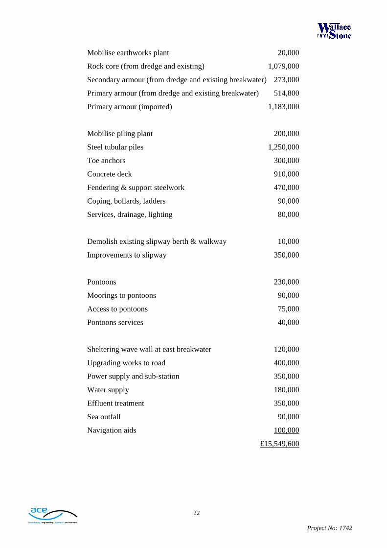
22
Project No: 1742
Mobilise earthworks plant 20,000
Rock core (from dredge and existing) 1,079,000
Secondary armour (from dredge and existing breakwater) 273,000
Primary armour (from dredge and existing breakwater) 514,800
Primary armour (imported) 1,183,000
Mobilise piling plant 200,000
Steel tubular piles 1,250,000
Toe anchors 300,000
Concrete deck 910,000
Fendering & support steelwork 470,000
Coping, bollards, ladders 90,000
Services, drainage, lighting 80,000
Demolish existing slipway berth & walkway 10,000
Improvements to slipway 350,000
Pontoons 230,000
Moorings to pontoons 90,000
Access to pontoons 75,000
Pontoons services 40,000
Sheltering wave wall at east breakwater 120,000
Upgrading works to road 400,000
Power supply and sub-station 350,000
Water supply 180,000
Effluent treatment 350,000
Sea outfall 90,000
Navigation aids 100,000
£15,549,600

23
Project No: 1742
12.3 Contract Management Costs
Contract Management 90,000
Site supervision 240,000
£330,000
12.4 Summary
Preliminary Costs 1,085,000
Construction Costs 15,549,600
Management & Supervision 330,000
16,964,600
Contingency (10%) 1,696,460
Estimated Total Project Cost £18,661,060
The estimated costs do not include buildings, services, bituminous surfacing,
effluent treatment works or outfall.
The additional cost to the project should Lealt quarry prove to be unavailable is
estimated at £1,428,500.
The additional cost of dredging the whole harbour and approach areas to 7m below
CD is estimated at £4,400,000.
The above figures include all contractors mobilisation, welfare, management,
insurance and supervision costs, but do not include VAT, land acquisition costs or
lawyers’ fees.

24
Project No: 1742
12.5 Potential Saving in Cost
If the harbour office, business units and car parking are relocated to the south side of
the access road, opposite the slipway, a saving can be made in the reclamation
material of 20,000m³. However, an additional 1,500m³ of armour would be required
to protect the west side of the approach road to the processing compound. In
addition, there would be a surplus of dredged material of 18,500m³.
If this material requires to be disposed of at sea, any financial advantage is
outweighed by the additional costs. If, however, a use can be found for the surplus
on land at low cost, a saving of around £300,000 could be made to the overall
project cost. Any such use would require to satisfy the requirements of planning,
and, potentially, of the project funders.
The potential alternative layout is detailed on drawing no. 1742-110 in the
Appendices.
25
Project No: 1742
13. Conclusions
The Staffin area has long been recognised as one of the areas in Scotland most
disadvantaged by its location, and it suffers particularly from lack of employment
opportunities and the resultant depopulation.
This ‘transformational’ project has the ability to reverse the decline, with the potential for
up to 40 jobs in the fish processing plant, up to 20 further jobs in the other marine and
tourism sections of the project, and a substantial number of additional jobs in the region. If
sufficient momentum can be developed, the water sports opportunities, wildlife and
geological interpretation centres, and high grade facilities and retail outlets for visiting
yachts, could turn Staffin into a principal destination on Skye for tourism, recreation and
training. The consequences for future generations would be of enormous significance,
securing the prosperity of the area for decades to come.
Funding a project of this size will always be a challenge, but the anticipated benefits to the
Staffin community, and to Skye in general, require an enthusiastic and determined effort
from all involved, in turning the vision into reality.

26
Project No: 1742
Appendix A
Detailed Assessment of Earthworks Quantities
27
Project No: 1742
Appendix A
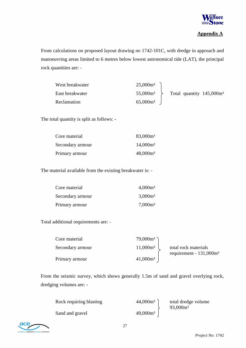
From calculations on proposed layout drawing no 1742-101C, with dredge in approach and
manoeuvring areas limited to 6 metres below lowest astronomical tide (LAT), the principal
rock quantities are: -
West breakwater 25,000m³
East breakwater 55,000m³ Total quantity 145,000m³
Reclamation 65,000m³
The total quantity is split as follows: -
Core material 83,000m³
Secondary armour 14,000m³
Primary armour 48,000m³
The material available from the existing breakwater is: -
Core material 4,000m³
Secondary armour 3,000m³
Primary armour 7,000m³
Total additional requirements are: -
Core material 79,000m³
Secondary armour 11,000m³ total rock materials
requirement - 131,000m³
Primary armour 41,000m³
From the seismic survey, which shows generally 1.5m of sand and gravel overlying rock,
dredging volumes are: -
Rock requiring blasting 44,000m³ total dredge volume
93,000m³
Sand and gravel 49,000m³

28
Project No: 1742
Appendix A
On digging, the rock will ‘bulk up’ by around 50% to 66,000m³, leading to a total dredge
yield of 115,000m³.
Assuming 10,000m³ of dredged material is unsuitable and requires sea disposal, material
available from the dredge is 105,000m³.
Thus earthworks quantities for are: -
Rock dredge 44,000m³ (bulks to 66,000m³)
Sand and gravel dredge 39,000m³
Unsuitable for disposal 10,000m³
Rock core from dredge and existing 83,000m³
Secondary armour (dredge and existing) 14,000m³
Primary armour (dredge and existing) 22,000m³
Primary armour (imported from Lealt) 26,000m³

29
Project No: 1742
Appendix B
Drawings


![Minimising Harbour Siltation (MHS) - IZW - … below Chart Datum [m] Old Outer Harbour 100 kHz Old Outer Harbour 15 kHz New Outer Harbour 100 kHz New Outer Harbour 15 kHz Old Locks](https://img.pdfslide.us/doc/110x75/5aa108c67f8b9ac67a8b45ec/minimising-harbour-siltation-mhs-izw-below-chart-datum-m-old-outer-harbour.jpg)