Embed Size (px)
Citation preview
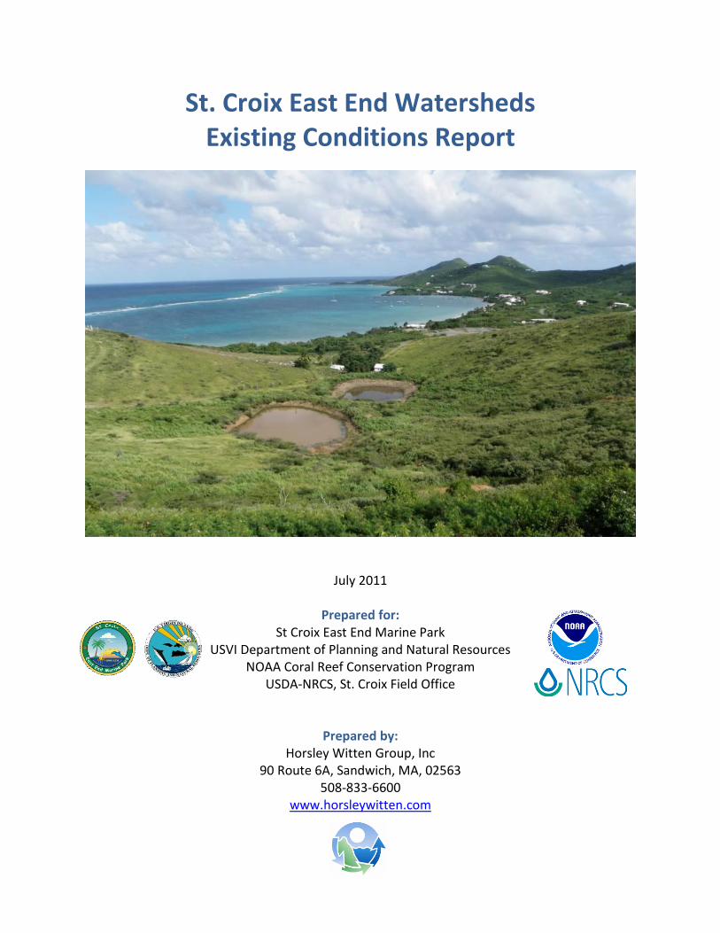
St. Croix East End Watersheds Existing Conditions Report
July 2011
Prepared for: St Croix East End Marine Park
USVI Department of Planning and Natural Resources NOAA Coral Reef Conservation Program
USDA-NRCS, St. Croix Field Office
Prepared by: Horsley Witten Group, Inc
90 Route 6A, Sandwich, MA, 02563 508-833-6600
www.horsleywitten.com

STX East End Watersheds Existing Conditions Report i
Table of Contents
Executive Summary ............................................................................................................ iv
1.0 Introduction ............................................................................................................... 1 1.1 Purpose .....................................................................................................................1 1.2 Watershed Issues ......................................................................................................3 1.3 Assessment Methods .................................................................................................4 1.2 Report Organization ...................................................................................................7
2.0 Characteristics of St. Croix’s East End .......................................................................... 9
2.1 Geomorphology .........................................................................................................9 2.2 Hydrology ...................................................................................................................14 2.3 Natural Resources .....................................................................................................20 2.4 Land Use and Infrastructure ......................................................................................26 2.5 Water Quality .............................................................................................................31 2.6 Existing Management Framework ............................................................................33
3.0 Southgate Watershed ................................................................................................ 43
3.1 Watershed Description .............................................................................................43 3.2 Potential Watershed Restoration/Project Sites ........................................................45 3.3 Neighborhood Summaries .........................................................................................56
4.0 Solitude Bay Watershed ............................................................................................. 61
4.1 Watershed Description .............................................................................................61 4.2 Potential Watershed Restoration/Project Sites ........................................................63 4.3 Neighborhood Summaries .........................................................................................85
5.0 Teague Bay Watershed............................................................................................... 93
5.1 Watershed Description .............................................................................................93 5.2 Potential Watershed Restoration/Project Sites ........................................................95 5.3 Neighborhood Summaries ....................................................................................... 101
6.0 Turner Hole Watershed ............................................................................................ 103
6.1 Watershed Description ........................................................................................... 103 6.2 Potential Watershed Restoration/Project Sites ...................................................... 105 6.3 Neighborhood Summaries ....................................................................................... 111
7.0 Madam Carty Watershed ......................................................................................... 115
7.1 Watershed Description ........................................................................................... 115 7.2 Potential Watershed Restoration/Project Sites ...................................................... 117 7.3 Neighborhood Summaries ....................................................................................... 117
STX East End Watersheds Existing Conditions Report ii
8.0 Great Pond Watershed ............................................................................................. 119 8.1 Watershed Description ........................................................................................... 119 8.2 Potential Watershed Restoration/Project Sites ...................................................... 121 8.3 Neighborhood Summaries ....................................................................................... 129
9.0 General Findings ...................................................................................................... 133 References ...................................................................................................................... 137 Appendices
Appendix A: Watershed Baseline Maps Appendix B: Field Forms and Sketches
STX East End Watersheds Existing Conditions Report iii
This page intentionally left blank.

STX East End Watersheds Existing Conditions Report iv
Executive Summary
This report is the first product in a watershed planning effort for the East End of St. Croix sponsored by the NOAA Coral Reef Conservation Program and conducted by the Horsley Witten Group, Inc. (HW) in partnership with the USVI Department of Planning and Natural Resources (DPNR), the USDA Natural Resource Conservation Service (NRCS), St. Croix Environmental Association (SEA), and The Nature Conservancy (TNC). Included here is a summary of known conditions, potential pollution sources, and candidate restoration opportunities in six watersheds draining to the St. Croix East End Marine Park (STXEEMP). These watersheds include Southgate, Solitude Bay, Teague Bay, Turner Hole, Madam Carty, and Great Pond Bay. Basic watershed characteristics such as soils, rainfall, land use, and infrastructure are summarized, as are the common sources of land-based sources of pollution (LBSP) generated within each watershed. Investigations of sources and potential opportunities to address these pollutants, as well as stakeholder meetings, were conducted in November 2010 and January 2011. Over 150 sites were investigated, including commercial businesses, resorts, gut/road crossings, farms, and 22 residential neighborhoods/condos. Based on field observations, new mapping data were produced for road culverts and unpaved/paved roads, and approximately five additional miles of gut channels were added to the existing map data provide by DPNR. Some of the watershed management opportunities indentified include:
7 gut stabilization projects; 2 pond restorations; 7 locations for unpaved road improvements; 24 stormwater retrofit sites (with multiple opportunities at some sites); 1 flowing discharge for further investigation; 7 locations for enhanced pollution prevention measures; 58 of 96 culverts in need of maintenance;
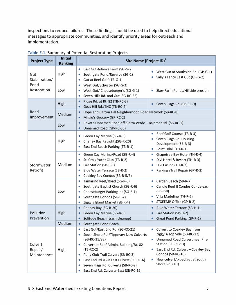
Table E.1 summarizes candidate restoration projects to be prioritized with stakeholders in the next phase of the project. Projects were initially ranked by field teams based on a number of preliminary factors including significance of problem; feasibility of implementation; benefits; visibility; stakeholder input; and integration with other initiatives. It should be noted that only culverts with important maintenance concerns are included. The locations of each site can be found in the maps in Appendix A. Each project is described in more detail in Sections 3-8 of this report, as well as in the field notes in Appendix B. Table E.2 summarizes key watershed management activities for each of the residential areas investigated. Activities include road/driveway/culvert maintenance to reduce erosion and improve drainage; gut management to protect buffers and reduce erosion; vegetation management to advance better landscaping practices; on-lot and large-scale stormwater retrofits; pollution prevention to reduce trash, oil, pet waste and other pollutants; management of residential construction for areas where more development is expected; and septic
STX East End Watersheds Existing Conditions Report v
inspections to reduce failures. These findings should be used to help direct educational messages to appropriate communities, and identify priority areas for outreach and implementation.
Table E.1. Summary of Potential Restoration Projects
Project Type Initial
Ranking Site Name (Project ID)1
Gut Stabilization/ Pond Restoration
High East Gut-Adam’s Farm (SG-G-2)
Southgate Pond/Reserve (SG-1)
Gut at Reef Golf (TB-G-1)
West Gut at Southside Rd. (GP-G-1)
Sally’s Fancy East Gut (GP-G-2)
Low West Gut/Schuster (SG-G-3)
West Gut/ Cheeseburger’s (SG-G-1)
Seven Hills Rd. and Gut (SG-RC-22)
Skov Farm Ponds/Hillside erosion
Road Improvement
High Ridge Rd. at Rt. 82 (TB-RC-3)
Goat Hill Rd./TNC (TB-RC-4) Seven Flags Rd. (SB-RC-9)
Medium Hope and Carton Hill Neighborhood Road Network (SB-RC-8)
Milgie’s Grocery (GP-RC-2)
Low Private Unnamed Road off Sierra Verde – Bajamar Rd. (SB-RC-1)
Unnamed Road (GP-RC-33)
Stormwater Retrofit
High Green Cay Marina (SG-R-3)
Chenay Bay Retrofits(SG-R-20)
East End Beach Parking (TB-R-1)
Reef Golf Course (TB-R-3)
Seven Flags Rd. Housing Development (SB-R-3)
Point Udall (TH-R-1)
Medium
Green Cay Marina/Road (SG-R-4)
St. Croix Yacht Club (TB-R-2)
Fire Station (SB-R-1)
Blue Water Terrace (SB-R-2)
Coakley Bay Condos (SB-R-5/6)
Grapetree Bay Hotel (TH-R-4)
Divi Hotel & Resort (TH-R-3)
Divi Casino (TH-R-2)
Parking /Trail Repair (GP-R-3)
Low
Tamarind Reef/Road (SG-R-5)
Southgate Baptist Church (SG-R-6)
Cheeseburger Parking lot (SG-R-1)
Southgate Condos (SG-R-2)
Ziggy’s Island Market (SB-R-4)
Carden Beach (SB-R-7)
Candle Reef II Condos Cul-de-sac (SB-R-8)
Villa Madeline (TH-R-5)
STXEEMP Office (GP-R-2)
Pollution Prevention
High Chenay Bay (SG-R-20)
Green Cay Marina (SG-R-3)
Solitude Beach (trash cleanup)
Blue Water Terrace (SB-H-1)
Fire Station (SB-H-2)
Great Pond Parking (GP-R-1)
Medium Southgate Pond Beach
Culvert Repair/ Maintenance
High
East Gut/East End Rd. (SG-RC-21)
South Shore Rd./Tipperary New Culverts (SG-RC-31/32)
Culvert at Reef Admin. Building/Rt. 82 (TB-RC-2)
Pony Club Trail Culvert (SB-RC-3)
East End Rd./Gut East Culvert (SB-RC-6)
Seven Flags Rd. Culverts (SB-RC-9)
East End Rd. Culverts-East (SB-RC-19)
Culvert to Coakley Bay from Ziggy’s/Top Side (SB-RC-12)
Unnamed Road Culvert near Fire Station (SB-RC-13)
East End Rd. Culvert – Coakley Bay Condos (SB-RC-16)
New culvert/piped gut at South Shore Rd. (TH)
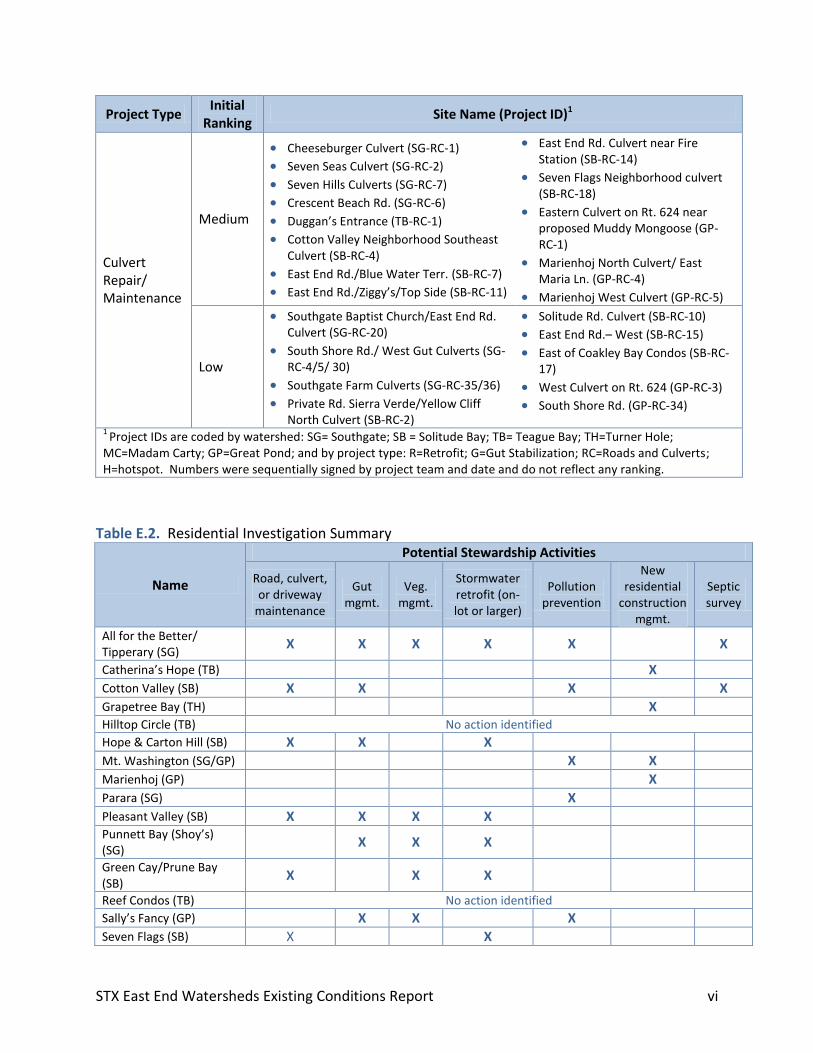
STX East End Watersheds Existing Conditions Report vi
Project Type Initial
Ranking Site Name (Project ID)1
Culvert Repair/ Maintenance
Medium
Cheeseburger Culvert (SG-RC-1)
Seven Seas Culvert (SG-RC-2)
Seven Hills Culverts (SG-RC-7)
Crescent Beach Rd. (SG-RC-6)
Duggan’s Entrance (TB-RC-1)
Cotton Valley Neighborhood Southeast Culvert (SB-RC-4)
East End Rd./Blue Water Terr. (SB-RC-7)
East End Rd./Ziggy’s/Top Side (SB-RC-11)
East End Rd. Culvert near Fire Station (SB-RC-14)
Seven Flags Neighborhood culvert (SB-RC-18)
Eastern Culvert on Rt. 624 near proposed Muddy Mongoose (GP-RC-1)
Marienhoj North Culvert/ East Maria Ln. (GP-RC-4)
Marienhoj West Culvert (GP-RC-5)
Low
Southgate Baptist Church/East End Rd. Culvert (SG-RC-20)
South Shore Rd./ West Gut Culverts (SG-RC-4/5/ 30)
Southgate Farm Culverts (SG-RC-35/36)
Private Rd. Sierra Verde/Yellow Cliff North Culvert (SB-RC-2)
Solitude Rd. Culvert (SB-RC-10)
East End Rd.– West (SB-RC-15)
East of Coakley Bay Condos (SB-RC-17)
West Culvert on Rt. 624 (GP-RC-3)
South Shore Rd. (GP-RC-34)
1 Project IDs are coded by watershed: SG= Southgate; SB = Solitude Bay; TB= Teague Bay; TH=Turner Hole;
MC=Madam Carty; GP=Great Pond; and by project type: R=Retrofit; G=Gut Stabilization; RC=Roads and Culverts; H=hotspot. Numbers were sequentially signed by project team and date and do not reflect any ranking.
Table E.2. Residential Investigation Summary
Name
Potential Stewardship Activities
Road, culvert, or driveway
maintenance
Gut mgmt.
Veg. mgmt.
Stormwater retrofit (on-lot or larger)
Pollution prevention
New residential
construction mgmt.
Septic survey
All for the Better/ Tipperary (SG)
X X X X X X
Catherina’s Hope (TB) X Cotton Valley (SB) X X X X Grapetree Bay (TH) X Hilltop Circle (TB) No action identified
Hope & Carton Hill (SB) X X X Mt. Washington (SG/GP) X X
Marienhoj (GP) X Parara (SG) X Pleasant Valley (SB) X X X X Punnett Bay (Shoy’s) (SG)
X X X
Green Cay/Prune Bay (SB)
X X X
Reef Condos (TB) No action identified
Sally’s Fancy (GP) X X X Seven Flags (SB) X X
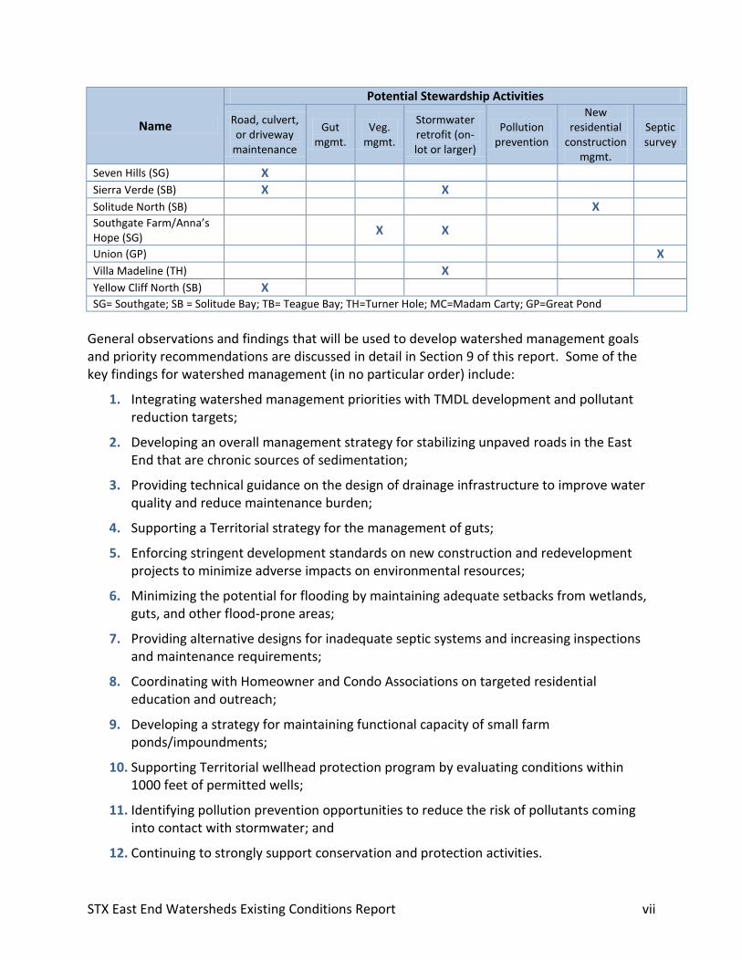
STX East End Watersheds Existing Conditions Report vii
Name
Potential Stewardship Activities
Road, culvert, or driveway
maintenance
Gut mgmt.
Veg. mgmt.
Stormwater retrofit (on-lot or larger)
Pollution prevention
New residential
construction mgmt.
Septic survey
Seven Hills (SG) X Sierra Verde (SB) X X
Solitude North (SB) X Southgate Farm/Anna’s Hope (SG)
X X
Union (GP) X Villa Madeline (TH) X Yellow Cliff North (SB) X SG= Southgate; SB = Solitude Bay; TB= Teague Bay; TH=Turner Hole; MC=Madam Carty; GP=Great Pond
General observations and findings that will be used to develop watershed management goals and priority recommendations are discussed in detail in Section 9 of this report. Some of the key findings for watershed management (in no particular order) include:
1. Integrating watershed management priorities with TMDL development and pollutant reduction targets;
2. Developing an overall management strategy for stabilizing unpaved roads in the East End that are chronic sources of sedimentation;
3. Providing technical guidance on the design of drainage infrastructure to improve water quality and reduce maintenance burden;
4. Supporting a Territorial strategy for the management of guts;
5. Enforcing stringent development standards on new construction and redevelopment projects to minimize adverse impacts on environmental resources;
6. Minimizing the potential for flooding by maintaining adequate setbacks from wetlands, guts, and other flood-prone areas;
7. Providing alternative designs for inadequate septic systems and increasing inspections and maintenance requirements;
8. Coordinating with Homeowner and Condo Associations on targeted residential education and outreach;
9. Developing a strategy for maintaining functional capacity of small farm ponds/impoundments;
10. Supporting Territorial wellhead protection program by evaluating conditions within 1000 feet of permitted wells;
11. Identifying pollution prevention opportunities to reduce the risk of pollutants coming into contact with stormwater; and
12. Continuing to strongly support conservation and protection activities.
STX East End Watersheds Existing Conditions Report 1
1.0 Introduction
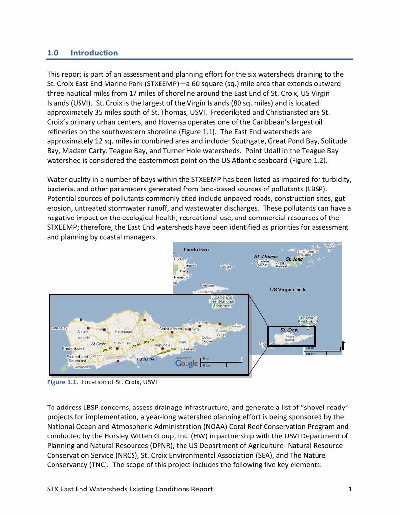
This report is part of an assessment and planning effort for the six watersheds draining to the St. Croix East End Marine Park (STXEEMP)—a 60 square (sq.) mile area that extends outward three nautical miles from 17 miles of shoreline around the East End of St. Croix, US Virgin Islands (USVI). St. Croix is the largest of the Virgin Islands (80 sq. miles) and is located approximately 35 miles south of St. Thomas, USVI. Frederiksted and Christiansted are St. Croix’s primary urban centers, and Hovensa operates one of the Caribbean’s largest oil refineries on the southwestern shoreline (Figure 1.1). The East End watersheds are approximately 12 sq. miles in combined area and include: Southgate, Great Pond Bay, Solitude Bay, Madam Carty, Teague Bay, and Turner Hole watersheds. Point Udall in the Teague Bay watershed is considered the easternmost point on the US Atlantic seaboard (Figure 1.2). Water quality in a number of bays within the STXEEMP has been listed as impaired for turbidity, bacteria, and other parameters generated from land-based sources of pollutants (LBSP). Potential sources of pollutants commonly cited include unpaved roads, construction sites, gut erosion, untreated stormwater runoff, and wastewater discharges. These pollutants can have a negative impact on the ecological health, recreational use, and commercial resources of the STXEEMP; therefore, the East End watersheds have been identified as priorities for assessment and planning by coastal managers.
Figure 1.1. Location of St. Croix, USVI
To address LBSP concerns, assess drainage infrastructure, and generate a list of “shovel-ready” projects for implementation, a year-long watershed planning effort is being sponsored by the National Ocean and Atmospheric Administration (NOAA) Coral Reef Conservation Program and conducted by the Horsley Witten Group, Inc. (HW) in partnership with the USVI Department of Planning and Natural Resources (DPNR), the US Department of Agriculture- Natural Resource Conservation Service (NRCS), St. Croix Environmental Association (SEA), and The Nature Conservancy (TNC). The scope of this project includes the following five key elements:

DRAFT STX East End Watersheds Existing Conditions Report 2
Figure 1.2. St. Croix East End Watersheds Locator Map
STX East End Watersheds Existing Conditions Report 3
1. The compilation of existing studies, mapping, and other information pertaining to the conditions of the East End watersheds;
2. A thorough field investigation to identify pollution sources and potential restoration opportunities;
3. Estimates of relative sediment loads under existing conditions and load reductions expected with various restoration activities;
4. Prioritization of restoration strategies and drafting of engineering design plans for priority projects; and
5. The development of a watershed management plan and implementation strategy for the six East End watersheds.
This report provides a summary of existing watershed conditions based on a review of existing information; observations made during field assessments; and information derived from project partners, key land owners, and input during a number of agency and public stakeholder meetings. 1.1 Purpose Much work has already been completed by Territorial and Federal agencies, researchers, and others to map land use conditions, monitor water quality, evaluate drainage patterns and pollutant sources, and restore problem areas in the East End watersheds. This report is intended to summarize this existing information on a watershed-basis in order to guide subsequent field work, inform modeling efforts and project designs, and provide a framework for prioritizing watershed management strategies. We acknowledge that the information presented here is limited to what has been gathered to date, that there are gaps to be filled, and that additional information can be incorporated as appropriate into the final watershed management plan. While general findings and initial restoration options are discussed, this report does not present prioritized recommendations for watershed management and should not be interpreted as more than a documentation of observations. 1.2 Watershed Issues
The negative effects of LBSP on coral reef ecosystem health and function have been well documented, most notably from sedimentation, nutrient loading, toxins, and pathogen introduction (NOAA, 2009). Derived from direct discharges, surface runoff, groundwater seepage, and atmospheric deposition, these pollutants can contribute to disease and mortality of sensitive species, disrupt ecological functions, and reduce community resilience to other stressors (i.e., bleaching events, overfishing, and hurricane damage). Recreational uses and commercial opportunities associated with a healthy marine environment, particularly on the East End of St. Croix, can also suffer from uncontrolled LBSP.
STX East End Watersheds Existing Conditions Report 4
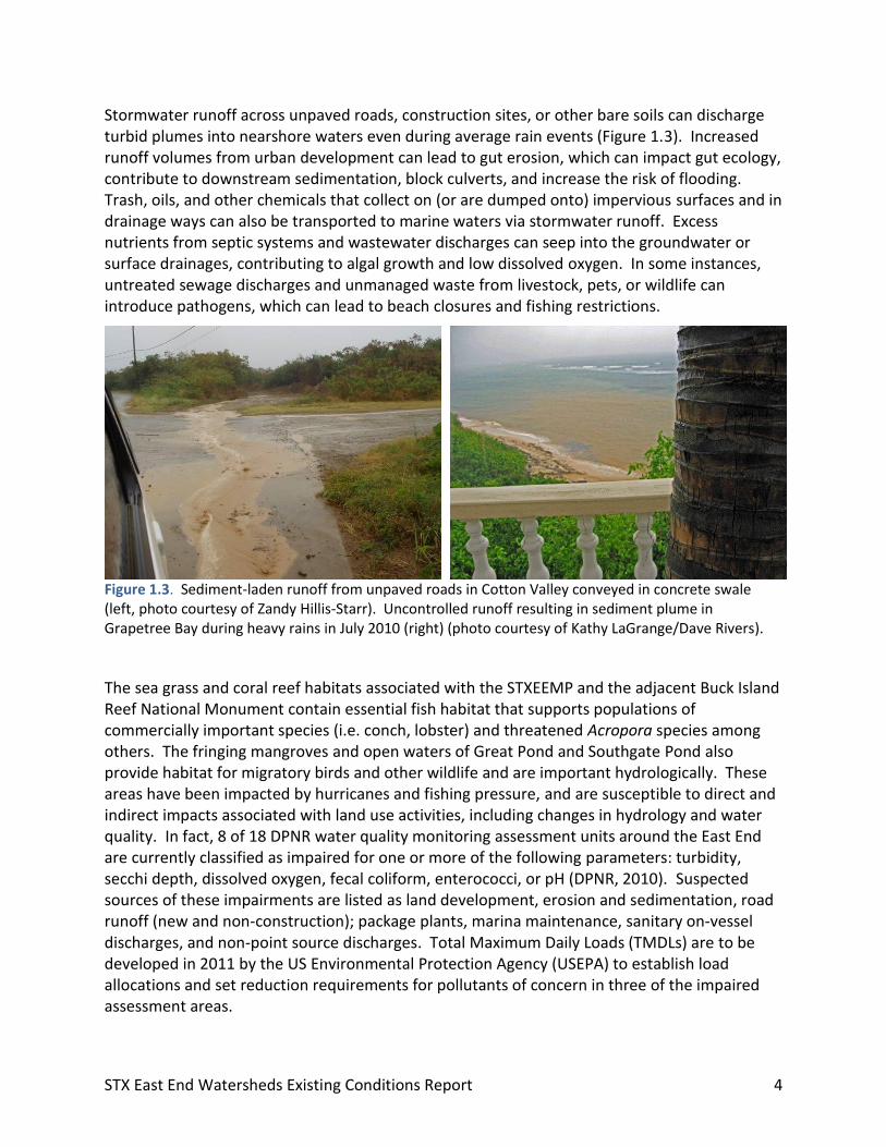
Stormwater runoff across unpaved roads, construction sites, or other bare soils can discharge turbid plumes into nearshore waters even during average rain events (Figure 1.3). Increased runoff volumes from urban development can lead to gut erosion, which can impact gut ecology, contribute to downstream sedimentation, block culverts, and increase the risk of flooding. Trash, oils, and other chemicals that collect on (or are dumped onto) impervious surfaces and in drainage ways can also be transported to marine waters via stormwater runoff. Excess nutrients from septic systems and wastewater discharges can seep into the groundwater or surface drainages, contributing to algal growth and low dissolved oxygen. In some instances, untreated sewage discharges and unmanaged waste from livestock, pets, or wildlife can introduce pathogens, which can lead to beach closures and fishing restrictions.
Figure 1.3. Sediment-laden runoff from unpaved roads in Cotton Valley conveyed in concrete swale (left, photo courtesy of Zandy Hillis-Starr). Uncontrolled runoff resulting in sediment plume in Grapetree Bay during heavy rains in July 2010 (right) (photo courtesy of Kathy LaGrange/Dave Rivers).
The sea grass and coral reef habitats associated with the STXEEMP and the adjacent Buck Island Reef National Monument contain essential fish habitat that supports populations of commercially important species (i.e. conch, lobster) and threatened Acropora species among others. The fringing mangroves and open waters of Great Pond and Southgate Pond also provide habitat for migratory birds and other wildlife and are important hydrologically. These areas have been impacted by hurricanes and fishing pressure, and are susceptible to direct and indirect impacts associated with land use activities, including changes in hydrology and water quality. In fact, 8 of 18 DPNR water quality monitoring assessment units around the East End are currently classified as impaired for one or more of the following parameters: turbidity, secchi depth, dissolved oxygen, fecal coliform, enterococci, or pH (DPNR, 2010). Suspected sources of these impairments are listed as land development, erosion and sedimentation, road runoff (new and non-construction); package plants, marina maintenance, sanitary on-vessel discharges, and non-point source discharges. Total Maximum Daily Loads (TMDLs) are to be developed in 2011 by the US Environmental Protection Agency (USEPA) to establish load allocations and set reduction requirements for pollutants of concern in three of the impaired assessment areas.
STX East End Watersheds Existing Conditions Report 5
1.3 Assessment Methods
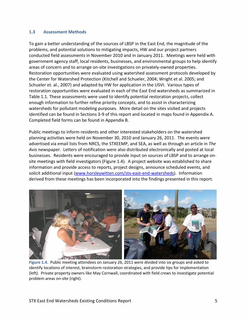
To gain a better understanding of the sources of LBSP in the East End, the magnitude of the problems, and potential solutions to mitigating impacts, HW and our project partners conducted field assessments in November 2010 and in January 2011. Meetings were held with government agency staff, local residents, businesses, and environmental groups to help identify areas of concern and to arrange on-site investigations on privately-owned properties. Restoration opportunities were evaluated using watershed assessment protocols developed by the Center for Watershed Protection (Kitchell and Schueler, 2004; Wright et al. 2005; and Schueler et. al., 2007) and adapted by HW for application in the USVI. Various types of restoration opportunities were evaluated in each of the East End watersheds as summarized in Table 1.1. These assessments were used to identify potential restoration projects, collect enough information to further refine priority concepts, and to assist in characterizing watersheds for pollutant modeling purposes. More detail on the sites visited and projects identified can be found in Sections 3-9 of this report and located in maps found in Appendix A. Completed field forms can be found in Appendix B. Public meetings to inform residents and other interested stakeholders on the watershed planning activities were held on November 30, 2010 and January 26, 2011. The events were advertised via email lists from NRCS, the STXEEMP, and SEA, as well as through an article in The Avis newspaper. Letters of notification were also distributed electronically and posted at local businesses. Residents were encouraged to provide input on sources of LBSP and to arrange on-site meetings with field investigators (Figure 1.4). A project website was established to share information and provide access to reports, project designs, announce scheduled events, and solicit additional input (www.horsleywitten.com/stx-east-end-watersheds). Information derived from these meetings has been incorporated into the findings presented in this report.
Figure 1.4. Public meeting attendees on January 26, 2011 were divided into six groups and asked to identify locations of interest, brainstorm restoration strategies, and provide tips for implementation (left). Private property owners like May Cornwall, coordinated with field crews to investigate potential problem areas on-site (right).
STX East End Watersheds Existing Conditions Report 6
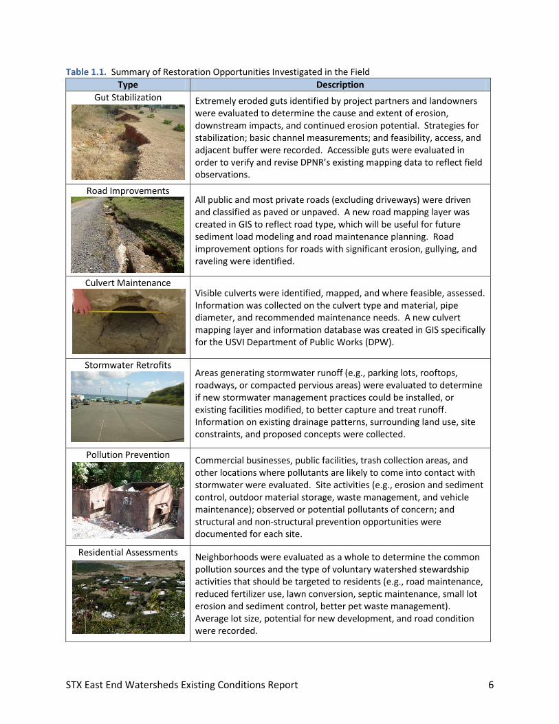
Table 1.1. Summary of Restoration Opportunities Investigated in the Field
Type Description
Gut Stabilization Extremely eroded guts identified by project partners and landowners were evaluated to determine the cause and extent of erosion, downstream impacts, and continued erosion potential. Strategies for stabilization; basic channel measurements; and feasibility, access, and adjacent buffer were recorded. Accessible guts were evaluated in order to verify and revise DPNR’s existing mapping data to reflect field observations.
Road Improvements All public and most private roads (excluding driveways) were driven
and classified as paved or unpaved. A new road mapping layer was created in GIS to reflect road type, which will be useful for future sediment load modeling and road maintenance planning. Road improvement options for roads with significant erosion, gullying, and raveling were identified.
Culvert Maintenance Visible culverts were identified, mapped, and where feasible, assessed.
Information was collected on the culvert type and material, pipe diameter, and recommended maintenance needs. A new culvert mapping layer and information database was created in GIS specifically for the USVI Department of Public Works (DPW).
Stormwater Retrofits
Areas generating stormwater runoff (e.g., parking lots, rooftops, roadways, or compacted pervious areas) were evaluated to determine if new stormwater management practices could be installed, or existing facilities modified, to better capture and treat runoff. Information on existing drainage patterns, surrounding land use, site constraints, and proposed concepts were collected.
Pollution Prevention
Commercial businesses, public facilities, trash collection areas, and other locations where pollutants are likely to come into contact with stormwater were evaluated. Site activities (e.g., erosion and sediment control, outdoor material storage, waste management, and vehicle maintenance); observed or potential pollutants of concern; and structural and non-structural prevention opportunities were documented for each site.
Residential Assessments
Neighborhoods were evaluated as a whole to determine the common pollution sources and the type of voluntary watershed stewardship activities that should be targeted to residents (e.g., road maintenance, reduced fertilizer use, lawn conversion, septic maintenance, small lot erosion and sediment control, better pet waste management). Average lot size, potential for new development, and road condition were recorded.
STX East End Watersheds Existing Conditions Report 7
Type Description
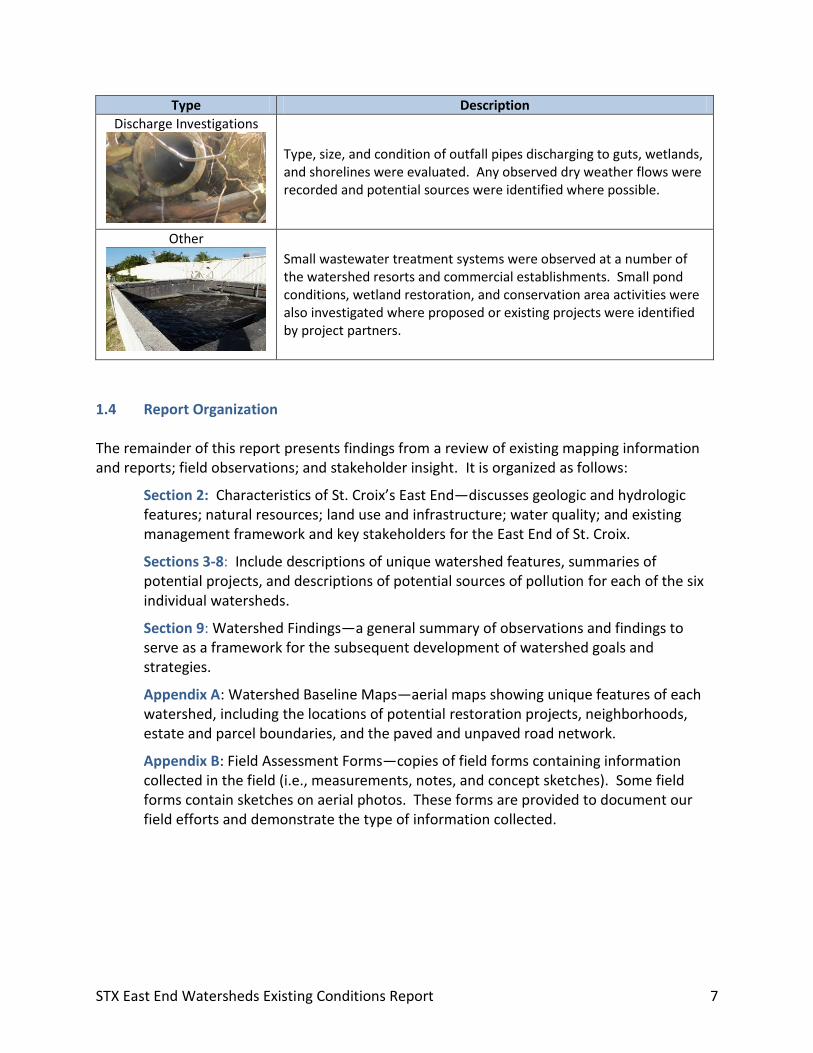
Discharge Investigations
Type, size, and condition of outfall pipes discharging to guts, wetlands, and shorelines were evaluated. Any observed dry weather flows were recorded and potential sources were identified where possible.
Other Small wastewater treatment systems were observed at a number of
the watershed resorts and commercial establishments. Small pond conditions, wetland restoration, and conservation area activities were also investigated where proposed or existing projects were identified by project partners.
1.4 Report Organization The remainder of this report presents findings from a review of existing mapping information and reports; field observations; and stakeholder insight. It is organized as follows:
Section 2: Characteristics of St. Croix’s East End—discusses geologic and hydrologic features; natural resources; land use and infrastructure; water quality; and existing management framework and key stakeholders for the East End of St. Croix.
Sections 3-8: Include descriptions of unique watershed features, summaries of potential projects, and descriptions of potential sources of pollution for each of the six individual watersheds.
Section 9: Watershed Findings—a general summary of observations and findings to serve as a framework for the subsequent development of watershed goals and strategies.
Appendix A: Watershed Baseline Maps—aerial maps showing unique features of each watershed, including the locations of potential restoration projects, neighborhoods, estate and parcel boundaries, and the paved and unpaved road network.
Appendix B: Field Assessment Forms—copies of field forms containing information collected in the field (i.e., measurements, notes, and concept sketches). Some field forms contain sketches on aerial photos. These forms are provided to document our field efforts and demonstrate the type of information collected.

STX East End Watersheds Existing Conditions Report 8
This page left intentionally blank.