Embed Size (px)
Citation preview
2017
Geographic Response StrategySt. Charles Parish
Southeast Louisiana Area Contingency Plan
U. S. Coast Guard Sector New Orleans
200 Hendee Street New Orleans, 70114

This page is intentionally left blank
Southeast Louisiana Area Contingency Plan Geographic Response Strategy - St. Charles Parish

Please Note: Signatures were obtained prior to official name change to Southeast Louisiana Area Committee and Geographic Response Strategy.
This page is intentionally left blank
Southeast Louisiana Area Contingency Plan Geographic Response Strategy - St. Charles Parish

Southeast Louisiana Area Contingency Plan Geographic Response Strategy - St. Charles Parish
Record of Changes
Date Change Number
Summary of Changes Initials of person making
changes
iii
Geographic Response Plan (GRP) changed to GeographicResponse Strategy (GRS)04AUG17 1 AMD

Southeast Louisiana Area Contingency Plan Geographic Response Strategy - St. Charles Parish
Table of Contents St. Charles Parish Geographic Response Strategy Signature Page ............................ i
Record of Changes ........................................................................................................... iii 1. Introduction ................................................................................................................... 1
1.1 Scope ...................................................................................................................... 2
1.2 Development ........................................................................................................... 2
1.3 Guiding Principles of the GRS ................................................................................. 3
1.4 Sensitive Resources Addressed by GRSs .............................................................. 4
1.5 Evaluation Criteria for GRSs ................................................................................... 5
1.6 Prioritization ............................................................................................................. 8
1.7 Strategy Selection ................................................................................................. 10
2. Site Description ............................................................................................................ 123. Maps ............................................................................................................................ 14
GRS Comments/Corrections/Suggestions .......................................................................33
iv
Southeast Louisiana Area Contingency Plan Geographic Response Strategy - St. Charles Parish
St. Charles Parish Geographic Response Strategy
1. IntroductionThis Geographic Response Strategy (GRS) is an annex to the Southeast Louisiana Area Contingency Plan (SELACP) and a key element of both facility and vessel contingency plans. This GRS has two main functions:
• From a planning perspective, the GRS provides a description of sensitive biological, cultural, and economic resources that must be addressed to be in compliance with:
o The National Oil and Hazardous Substance Pollution ContingencyPlan (NCP, 40 CFR Part 300.210(3)(i).). Area Contingency Plansare required to describe areas of special economic andenvironmental importance that could be impacted during an oil spill.
o The National Historic Preservation Act of 1966 contains applicable, relevant and appropriate requirements. The GRSs also address sensitive historic and prehistoric resources.
• From an operational perspective, the GRS guides responders in the first 24-48 hours of an oil spill by:
o Providing a prioritized list of tactical response strategies to beimplemented during the early hours of an oil spill (usually before theformation of the Unified Command).
o Providing detailed information for booming strategies that could beutilized to minimize impacts to predetermined sensitive resources.
Once the Unified Command is formed, additional operational strategies and tactics will be relayed to the field in the form of the ICS-204 work assignment sheets.
GRSs are the primary tool used during an initial phase of the response and fairly broad in their scope, they are not intended to minimize impacts to all possible sensitive areas that could be affected by an oil spill. GRSs are not intended to be an exhaustive list of all the tactical strategies that could, or should, be implemented during a spill.
1
Southeast Louisiana Area Contingency Plan Geographic Response Strategy - St. Charles Parish
1.1 Scope This Geographic Response Strategy (GRS) is intended to help the first responders of an oil discharge or hazardous substance release avoiding the initial confusion that generally accompanies any incident. This document serves as the federal and state on-scene-coordinators “orders” during an incident in the area covered by this GRS (see Section 2 for area covered). As such it has been approved by the U.S. Coast Guard Sector New Orleans, the Louisiana Oil Spill Coordinator’s Office, and St. Charles Parish. Changes to this document are expected as testing is conducted through drills, site visits, and actual use in an incident. To submit comments, corrections, or suggestions please refer to Comments/Corrections/Suggestions form at the end of this GRS.
The scope of this GRS is to identify sensitive sites to be considered for protection in the first 24 to 48 hours of an incident and the generic response strategy for this site considering unique characteristics, noted hydrology and climatic considerations. This index is not all encompassing as sites not identified in this index may need to be evaluated for protection as an incident progresses.
GRSs only address protection of sensitive public resources. It is the responsibility of private resource owners and/or potentially liable parties to address protection of private resources (such as commercial marina and private water intakes). 1.2 Development This Index has been developed for the Coastal Zone, as defined in the National Contingency Plan (40 CFR Part 300) for St. Charles Parish. It is prepared through the efforts and cooperation of Louisiana State Trustee Agencies, Parish Representatives, and Federal Trustee Agencies, other federal and state agencies, response organizations, and local emergency responders. This Index was developed through workshops involving federal, state, and local stakeholders. Workshop participants identified resources which require protection and developed operational strategies. Following the workshops, the data gathered was processed and reproduced in the form of maps and matrices which appear in Chapter 3. The maps were generated using ArcGIS, and the tables were created using Microsoft Access.
The first goal of a GRS is to identify resources needing protection; response resources needed; tribal and local response community contacts; and local conditions that may affect response strategies.
Secondly, response strategies were developed based on the sensitive resources noted hydrology and climatic considerations. Individual response strategies identify the appropriate boom implementation.
2

Southeast Louisiana Area Contingency Plan Geographic Response Strategy - St. Charles Parish
Draft maps and matrices were sent out for review and consideration of strategy viability. Verification at local, state, and federal levels was conducted and changed proposed by the participants were included in a semi-final draft, which was offered for final review.
Finally, the final GRS was compiled along with site description, reference maps, and information to support logistical needs.
1.3 Guiding Principles of the GRS Safety and health of the responders always takes precedence over the protection of sensitive environmental resources.
Source control and containment are always a HIGHER priority over GRS deployments.
The protection strategies in the GRSs have been designed for the use with persistent oils and may not be suitable for other petroleum or hazardous substances.
Environmental conditions (winds, currents, and tides), together with the physical limitations of existing spill response technology, may preclude the effective protection of some areas.
Once a coordinated response has been established during an oil spill incident, booming strategy selection and prioritization are refined and supplemented based on real-time assessments. The UC has the authority to supersede the strategies proposed in the GRSs.
Response personnel may find it necessary to deviate from the exact details provided for deploying a particular strategy. An onsite evaluation of actual conditions is often needed to determine whether a strategy is safe to deploy, whether it will be effective under existing environmental conditions, or effective for the particular type of oil involved. Therefore, field personnel should use their best judgment to modify existing strategies based on real-time conditions and notify command accordingly. Field personnel are also encouraged to notify the command post regarding opportunities for deployment additional strategies that might be used to take advantage of incident-specific conditions.
The GRSs Include the Following Types of Response Strategies Collection Booming with On-Water Recovery: Deploying various types of boom to collect oil for mechanical removal using sorbent materials, vacuum trucks, or near shore skimming devices.
3

Southeast Louisiana Area Contingency Plan Geographic Response Strategy - St. Charles Parish
Exclusion Booming: Deploying various types of boom to reduce oiling in sensitive areas.
Deflection Booming: Deploying various types of boom to divert oil away from a sensitive area and/or divert oil toward a collection point.
GRSs Do Not Include In-Situ Burning: Burning oil on the water; usually requires containment by fire-resistant boom. Chapter 9000, Appendix C for additional SELAC policy on in-situ burning use.
Dispersants: Applying chemical agents, usually by aircraft, to aid in breaking up surface slicks and dispersing oil within the water column. See Chapter 9000, Appendix D for SELAC policy on dispersant use.
Shoreline Cleanup: Physical removal or chemical treatment of stranded oil. See Chapter 9000, Appendix G for the NOAA Shoreline Countermeasure Manual for Tropical Coastal Environments and Appendix F Oil Spill Best Management Practices for guidance on shoreline cleanup.
Open-Water Mechanical Recovery: Physical removal of oil using boats and/or vessels specifically outfitted with collection and separation equipment.
No Action: Appropriate when weather, sea, or other conditions make deployments unsafe and/or infeasible and when response actions or site access will cause further environmental damage (e.g., wetlands).
1.4 Sensitive Resources Addressed by GRSs The NCP, 40 CFR Part 300.120(3)(i) requires that Area Committees identify and prioritize sensitive areas requiring protection. In the SELACP, sensitive areas are broken into three main categories described below.
Environmentally Sensitive Resources Key natural resource areas are identified using a wide of range data provided by resource trustees, tribes, plan holders, spill response organizations, contingency plan holders, and other interested stakeholders during the process of GRS development and review. The Environmental Sensitivity Index (ESI) maps developed by NOAA are one example of the type of natural resource information available (http://response.restoration.noaa.gov). When appropriate, tactical response strategies are designed for implementation during the early hours of an oil spill to reduce impacts to those areas, and trajectory models or other assessment techniques are used to establish initial response priorities.
4

Southeast Louisiana Area Contingency Plan Geographic Response Strategy - St. Charles Parish
Historically or Culturally Sensitive Resources Information on sensitive historic and cultural sites is coordinated through contact with various tribal governments, State Historic Preservation Office (SHPO), and the United States Department of the Interior may assist as needed. Due to the sensitive nature of this information, the specifics regarding the location and nature of such sites are not included in the GRS documents. However, in order to ensure that tactical response strategies do not inadvertently harm historical and culturally sensitive sites, historic preservation specialists are consulted to review the GRS documents prior to finalization. The Louisiana SHPO can be contacted at:
Physical Address: State Historic Preservation Office Division of Archaeology Capital Annex Building 1051 North Third Street Baton Rouge, Louisiana 70804
Mailing Address: P.O. Box 44247 Baton Rouge LA, 70804
Phone: (225) 342-8160 (general office) (225) 219-4598 (Division of Archaeology office)
Fax: (225) 342-4480
Socio-Economically Sensitive Resources Economically sensitive areas are facilities or locations that rely on a body of water to be economically viable and that could be severely impacted by an oil spill. Economically sensitive areas are broken down into three separate categories: Critical infrastructure, water dependent commercial and recreational areas. Information on economic resources will be gathered for inclusion as an appendix to the GRSs.
1.5 Evaluation Criteria for GRSs Specific strategies for response to spills in the sensitive areas are detailed in the GRSs. Below is a list of some of the biological, cultural, and booming criteria used to determine whether it is appropriate to develop and maintain GRSs at specific locations. These criteria are not intended to be exhaustive, or ranked in order of priority, they are meant to help frame the evaluation of GRSs.
Key Criteria for Biological Sites, Species, and Habitats of Concern • Temporal considerations -
o What is the expected recovery time for habitats or fish and wildliferesources?
o What is the residence time of the oil?
5
Southeast Louisiana Area Contingency Plan Geographic Response Strategy - St. Charles Parish
• Substrate -o What is the exposure risk? What is the likelihood that a habitat or
species will be exposed to direct contact with surface oil or todispersed/dissolved oil in the water column?
o Given the substrate, is clean-up feasible?
• Habitat quantity, quality, and pattern -o Is the impacted habitat considered scarce at local, regional, or
statewide scales?o Is the size of the impacted habitat significant compared to other
sites in the region?o Is the species diversity or endemism high? Is this true year-round
or is it seasonal?o Is abundance of fish and/or wildlife high? Is this true year-round or
is it seasonal?o What life stages of organisms are present?o Is the habitat important to threatened or endangered species?o What is the status of the habitat’s integrity (i.e., is the area
undeveloped or highly altered?)o Does the habitat have a special designation or status (i.e., Marine
Protected Area, biological research area, restoration site, etc.)?o Are the habitat and/or its associated fish and wildlife resources
especially susceptible to injury by oil?
Key Criteria for Archeological and Cultural Sites of Concern Deployment - Does the act of deploying the GRS threaten the archeological site (anchoring the boom, parking vehicles, etc.).
Purpose - Will implementing the GRS type (collection, diversion, deflection) negatively impact the site?
Review - If either of the above is possible, then a review of the site records is necessary to determine the exact location and sensitivity of the site. If the site records are old or insufficient, then a field visit is necessary.
Significant developments - Are there significant developments that may make any concern about the impacts irrelevant (housing developments etc.)?
Additional criteria for archaeological sites without existing GRSs -
• Impacts - Does the site extend below the high tide line?• Vulnerability - Will it be damaged or destroyed if oil were to hit the area (or
by the placement of response equipment in the area, e.g., vacuum trucks,etc.)?
6
Southeast Louisiana Area Contingency Plan Geographic Response Strategy - St. Charles Parish
• Integrity - Has the site be disturbed yet, or is it still intact?• Historic Importance - Is the site nominated for, or already on, the National
Register of Historic Places or the State equivalent?• Tribal Importance - Does the site hold special tribal importance?• Parish Importance - Does the site hold special Parish importance?• Feasibility - Is booming the site feasible?
Key Criteria for Socio-Economic Sites of Concern Strictly economic resources are designated as the third priority for dedication of oil spill response resources, following human health and safety and environmental resources. The designation of economic resources is highly dependent upon the priorities of the local government. Each GRS contains detailed information of economic sites in each Parish or Geographical Response Area. This information includes geographic locations of resources, a brief description of the resource at risk, contact names and numbers, and the priority response ranking.
Key Criteria for the Use of Boom Effectiveness - Is booming the most effective strategy for reducing oil spill impacts? Would other alternatives such as a phone call to an operator, shutting off a water intake, or closing a tidal gate be as effective?
Safety - Determine if safety of human responder will be put at risk for limited likelihood of strategy success.
Strategy - Determine what type of booming strategy would be the most effective at reducing oil impacts to the resource under prevailing conditions (collection, deflection, or exclusion).
Evaluation - Evaluate the site for advantageous characteristics based on: • Anchoring substrate. Does the substrate allow responders to easily anchor
the boom?
• Accessibility. Can the site be easily accessed by vessel or vehicles?
• Time to arrive on scene. How long will it take to get to the site?
• Potential for oiling. Is the site located near shipping activity or fuelingoperations?
• Beach substrate. Used Environmental Sensitivity Index (ESI) or Shore-Zone classification to determine vulnerability to oiling and likely oillongevity based on the shoreline type.
7

Southeast Louisiana Area Contingency Plan Geographic Response Strategy - St. Charles Parish
• Type and quantity of boom. How many sections of boom and what sizeanchors will be required for deployment? What is the anchoring depth?What type of boom tending will be required? Will this tending becomplicated by the amount of time it takes to arrive at the site or thedifficulty of access? Is the amount of boom required reasonable (<1000 ft)?
• Prevailing weather - especially wind and waves. Is a booming strategyrealistic for prevailing conditions?
• Tidal influence. At extreme lows where there may mud flats (very difficultto tend boom when it is stuck in the mud) or at extreme highs when theentire face of a coastal marsh be underwater (thus exposing the entireperimeter to oil)?
• Influence of currents. What velocities can be expected?
• Feasibility. Depends on: Boom size, boom length, the number and size ofanchors, the capability of the recruited workboats (to tow boom, set andrecover anchors, shelter boat crews, carry boom and associatedequipment), the experience of the boat crew, and the effectiveness of theanchoring system (both on shore and in water).
1.6 Prioritization Through the priority evaluation process, an area is broken down by type (human health and safety, environmental, economic and cultural) and sensitivity (high, medium, low). This evaluation process focuses on the sensitivities of areas and not jurisdictional boundaries. Once all areas have been evaluated and broken down, three levels of priority are generally all that is needed for pre-spill planning:
A – Protect First
B – Protect After A Areas
C – Protect After B Areas
The following prioritizations were determined by the GRS subcommittee:
Priority A • Public drinking water intakes
8

Southeast Louisiana Area Contingency Plan Geographic Response Strategy - St. Charles Parish
• Industrial water intakes with public health and safety impacts (e.g. publicutility intake, supported by state managed early warning network on MISSRIVER)
• Tidal Inlets – Primary Tidal Inlets that are protectable
• Secondary inlets inside bays that connect to extensive sensitive areas
• Breaches, wash-overs and other low areas where oil can enter sensitivehabitats
• Exceptional/Highly sensitive wetlands with high biodiversity site (e.g.NWR, State refuges)
• Important Bird Areas
o Bird nesting islands
o Other bird nesting concentrations including T&E species
o Seasonal bird concentration areas onshore
• Freshwater Diversion (Man-made and Natural)
Priority B • Exceptional Oyster beds in the intertidal
• Seagrass Beds in less than 1 meter of water
• High use recreational sites
• Important Industrial Areas (e.g. fishing ports, marinas, industrial corridors)
• Other water intakes not specified in Priority A
• Cultural/Historical sites of concern (e.g. contact SHPO/Tribes)
Priority C • Small tidal channels and canal openings
• Sheltered tidal flats
• Seagrass beds in greater than 1 meter of water
9
Southeast Louisiana Area Contingency Plan Geographic Response Strategy - St. Charles Parish
10
• Aquaculture sites and oyster lease areas
• Wetland restoration areas
• Other industrial areas
• Areas identified by local authorities not previously noted in Priority A or B
The following areas were not included due to the initial protection difficulty: • Open gulf beaches
• Exposed wetland shorelines (exposed to waves and currents) (as described in SELACP Chapter 9000 Appendix G)
• Exposed rip-rap
1.7 Strategy Selection Booming strategy recommendations were developed using local knowledge, scientific data, and know operational uses and limitation of common oil spill response equipment. Utilizing publications, such as the Exxon Mobil Oil Spill Response Manual and the National Oceanic Atmospheric Administration’s Characteristic Coastal Habitats Choosing Spill Response Alternatives) a quick reference job-aid was developed to assist with the selection of an appropriate site given the noted hydrology and climatic considerations. This process applies a consistent and standard analysis of each site.
All water body openings, cuts, and lengths between two points of land greater than one thousand feet (1,000 ft) received a strategy of Deferred Action due to limited resources available during initial response. All sites related to infrastructure or private resources received a strategy of Notification to Site Manager. However, these sites are considered sensitive and should be given due consideration for more defensive response actions by the Incident Command.

Southeast Louisiana Area Contingency Plan Geographic Response Strategy - St. Charles Parish
GRS Selection Job-Aid
Water Body Type Current/Wave Action Shoreline Strategy
Lake or Pond ESI 1-6 Containment
booming/collection point ESI 7-10 Exclusion booming
Rivers or Large Streams 1.6 feet (0.5) deep
Currents <1 knot ESI 1-6 Containment booming/collection point
ESI 7-10 Exclusion booming
Currents 1-2 knots ESI 1-6 Diversion booming to collection point
ESI 7-10 Deflection booming
Currents >2 knots ESI 1-6 Multi-layer diversion booming to collection point
ESI 7-10 Multi-layer deflection booming
Small Streams <33 ft wide (10m) and
1.6 ft (0.5 m) deep
Currents <1 knot ESI 1-6 Containment booming/collection point
ESI 7-10 Exclusion booming
Currents 1-2 knots ESI 1-6 Diversion booming to collection point
ESI 7-10 Deflection booming
Currents >2 knots ESI 1-6 Multi-layer diversion booming to collection point
ESI 7-10 Multi-layer deflection booming
Shallow Rivers or Streams Currents 0-2 knots ESI 1-6 Containment
booming/collection point
ESI 7-10 Diversion booming to collection point
Straight Coastline with Sensitive Areas
Breaking waves <1.5 ft (0.5m)
ESI 1-10
Diversion boom up current of sensitive area
Breaking waves > 1.5 ft Deferred Action
Entrance to Bays, Harbors, Lagoons, and
Estuaries
Breaking waves <1.5 ft (0.5m) and currents < 1 Kt (0.5 m/s) ESI 1-10 Exclusion booming
Breaking waves <1.5 ft (0.5m) and currents >1 Kt (0.5 m/s)
ESI 1-6 Diversion booming to collection point
ESI 7-10 Deflection booming
Breaking waves >1.5 ft (0.5m) ESI 1-10 Deferred Action
Narrow Channel/ Narrow Tidal Channel
Current <1 Kt (0.5 m/s) ESI 1-10 Exclusion Booming
Current >1 Kt (0.5 m/s) ESI 1-6 Diversion booming with collection point
ESI 7-10 Deflection booming
Open Water Breaking Waves < 1.5 ft N/A Exclusion Booming Breaking waves >1.5 ft Deferred Action
11
NOTE: All openings, cuts, and lengths between two points of land greater than one thousand feet (1,000 ft) will receive a strategy of Deferred Action due to limited resources for initial response. All sites related to infrastructure or private resources will receive a strategy of Notification to Site Manager.

Southeast Louisiana Area Contingency Plan Geographic Response Strategy - St. Charles Parish
Environmental Sensitivity Index Legend
Site Description St. Charles Parish has a total area of 411 square miles, of which 279 square miles is land and 132 square miles (32%) is water.
12

Southeast Louisiana Area Contingency Plan Geographic Response Strategy - St. Charles Parish
13
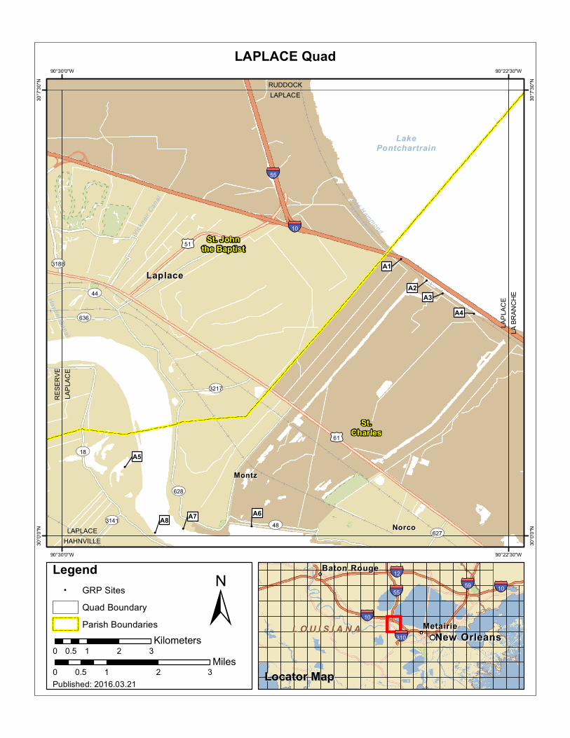
This Index is broken up into 5 maps listed on the following page.
BONNET CARRE NE
LAPLACE
LA BRANCHE
HAHNVILLE
LULING
Maps
The following pages contain the above mentioned maps and the associated sensitive sites and recommended response strategies.
Southeast Louisiana Area Contingency Plan Geographic Response Strategy - St. Charles Parish
This page is intentionally left blank

BaratariaPreserve
LakeCataouatche
LakeSalvador
Lac desAllemands
LakeMaurepas
LakePontchartrain
ÄÄ
182
ST3217
ST53
ST626
ST628
ST44
ST308
ST1
ST307
ST48
ST18
£¤51
£¤61
£¤90
§̈¦610
§̈¦310
§̈¦55
§̈¦10
MetairieMetairie
DestrehanDestrehan JeffersonJefferson
KennerKenner
LaplaceLaplace
LulingLuling
MarreroMarrero
RacelandRaceland
RiverRiverRidgeRidge
WestwegoWestwego
LafourcheParish
JeffersonParish
LivingstonParish
St. Johnthe Baptist
ParishSt. Tammany
Parish
St. CharlesParish
HAHNVILLE
LA BRANCHE
LULING
LAPLACE
BONNETCARRE NE
K
0 5 10 152.5Miles
Sector New Orleans GRPSector New Orleans GRPSt. Charles Parish Index MapSt. Charles Parish Index Map

Galva
Canal LakePontchartrain
RU
DD
OC
KBO
NN
ET C
AR
RE
NE
LA BRANCHEBONNET CARRE NE
BONNET CARRE NEPONCHATOULA SE
BON
NET
CA
RR
E N
ESO
UTH
OF
CO
VIN
GTO
N S
W
Tangipahoa
Jefferson
St.Charles
St. Johnthe Baptist
90°15'0"W
90°15'0"W
90°22'30"W
90°22'30"W
30°1
5'0"
N
30°1
5'0"
N
30°7
'30"
N
30°7
'30"
N
±0 1 2 30.5
Miles
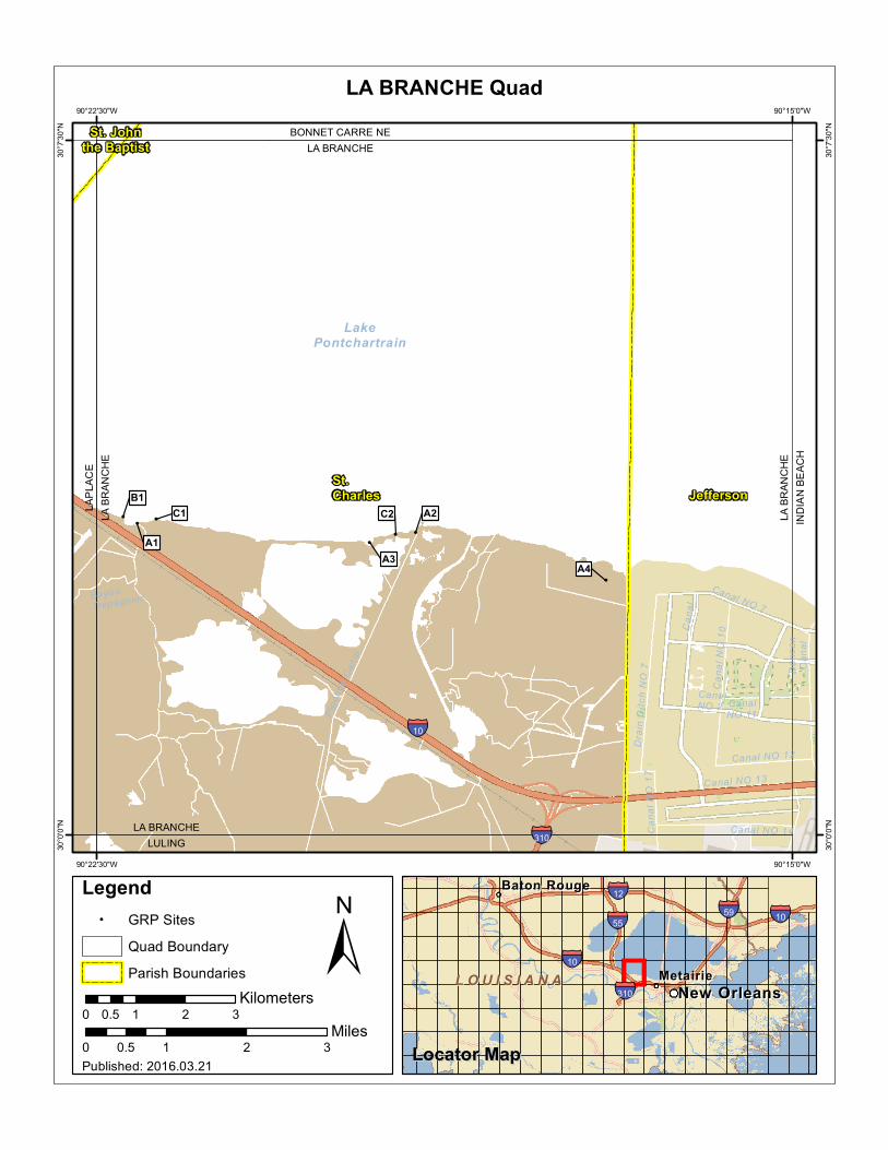
BONNET CARRE NE Quad
MetairieMetairie
Baton RougeBaton Rouge
New OrleansNew Orleans
§̈¦10
§̈¦12
§̈¦55§̈¦59
§̈¦310
§̈¦10
L O U I S I A N AL O U I S I A N A
Legend! GRP Sites
Quad Boundary
Parish Boundaries
0 1 2 30.5Kilometers
Locator MapLocator MapPublished: 2016.03.21

This page is intentionally left blank
!
!
!
!
!
!
!
!
Haydel C
anal
Vick
nair
Can
al Old Hamm
ond
Road Ditch
LakePontchartrain
ST628
ST627
ST3141
ST3188
ST636
ST3217
ST44
ST48
ST18
£¤51
£¤61
§̈¦55
§̈¦10
LaplaceLaplace
MontzMontz
NorcoNorco
HAHNVILLELAPLACE
RUDDOCKLAPLACE
LA B
RAN
CH
ELA
PLA
CE
RES
ERVE
LAP
LAC
E
St.Charles
St. Johnthe Baptist
A5
A7
A1
A2A3
A4
A6A8
90°22'30"W
90°22'30"W
90°30'0"W
90°30'0"W
30°7
'30"
N
30°7
'30"
N
30°0
'0"N
30°0
'0"N
±0 1 2 30.5
Miles
LAPLACE Quad
MetairieMetairie
Baton RougeBaton Rouge
New OrleansNew Orleans
§̈¦10
§̈¦12
§̈¦55§̈¦59
§̈¦310
§̈¦10
L O U I S I A N AL O U I S I A N A
Legend! GRP Sites
Quad Boundary
Parish Boundaries
0 1 2 30.5Kilometers
Locator MapLocator MapPublished: 2016.03.21
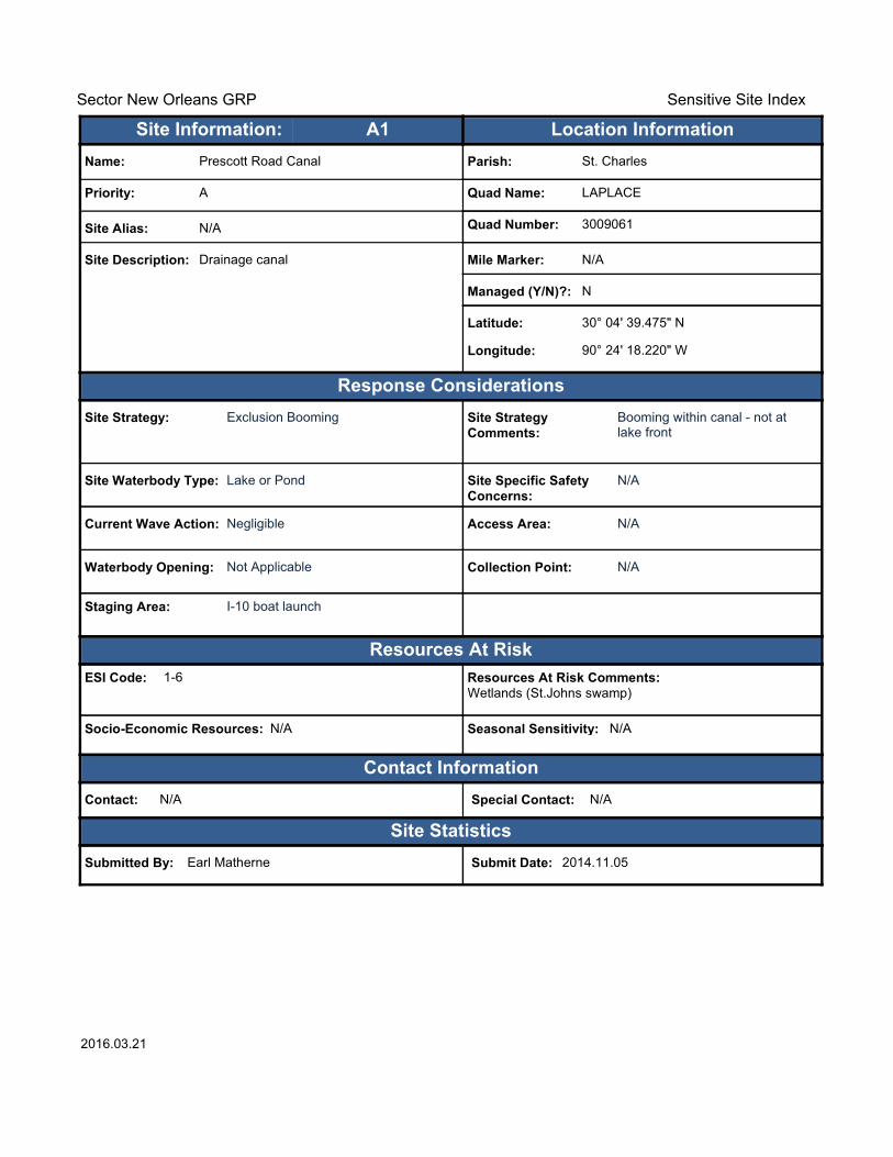
Sector New Orleans GRP Sensitive Site Index
Response Considerations
Resources At Risk
Contact Information
Site Statistics
Resources At Risk Comments:Wetlands (St.Johns swamp)
Contact: N/A Special Contact: N/A
Submitted By: Earl Matherne Submit Date: 2014.11.05
Site Strategy: Exclusion Booming Site Strategy Comments:
Booming within canal - not at lake front
Site Waterbody Type: Lake or Pond
Current Wave Action: Negligible
Waterbody Opening: Not Applicable
ESI Code: 1-6
Priority: A
Name: Prescott Road Canal
Site Alias: N/A
Site Description: Drainage canal
Parish: St. Charles
Quad Name: LAPLACE
Quad Number: 3009061
Mile Marker: N/A
Managed (Y/N)?: N
Latitude: 30° 04' 39.475" N
Longitude: 90° 24' 18.220" W
Site Information: Location InformationText416:A1
Site Specific Safety Concerns:
N/A
Access Area: N/A
Collection Point: N/A
Seasonal Sensitivity: N/A
Staging Area: I-10 boat launch
Socio-Economic Resources: N/A
2016.03.21

Sector New Orleans GRP Sensitive Site Index
Response Considerations
Resources At Risk
Contact Information
Site Statistics
Resources At Risk Comments:Lake Pontchartrain/spillway marsh
Contact: N/A Special Contact: N/A
Submitted By: Earl Matherne Submit Date: 2014.11.05
Site Strategy: Containment Booming to Collection Point
Site Strategy Comments:
N/A
Site Waterbody Type: Lake or Pond
Current Wave Action: Currents 1-2 kts.
Waterbody Opening: Not Applicable
ESI Code: 1-6
Priority: A
Name: Bonnet Carre Spillway
Site Alias: N/A
Site Description: Spillway
Parish: St. Charles
Quad Name: LAPLACE
Quad Number: 3009061
Mile Marker: 128
Managed (Y/N)?: Y - Wildlife Area
Latitude: 30° 04' 17.674" N
Longitude: 90° 23' 52.447" W
Site Information: Location InformationText416:A2
Site Specific Safety Concerns:
N/A
Access Area: N/A
Collection Point: N/A
Seasonal Sensitivity: N/A
Staging Area: Montz Park or Engineers Canal
Socio-Economic Resources: N/A
2016.03.21

Sector New Orleans GRP Sensitive Site Index
Response Considerations
Resources At Risk
Contact Information
Site Statistics
Resources At Risk Comments:Bonnet Carre Spillway
Contact: N/A Special Contact: N/A
Submitted By: Earl Matherne Submit Date: 2014.11.05
Site Strategy: Diversion Booming to Collection Point Site Strategy Comments:
N/A
Site Waterbody Type: Narrow Tidal Channel
Current Wave Action: Currents 1-2 kts.
Waterbody Opening: < 500 ft.
ESI Code: 1-6
Priority: A
Name: Cross Cut Canal West
Site Alias: N/A
Site Description: Drainage canal
Parish: St. Charles
Quad Name: LAPLACE
Quad Number: 3009061
Mile Marker: N/A
Managed (Y/N)?: Y - Wildlife Area
Latitude: 30° 04' 04.512" N
Longitude: 90° 23' 36.337" W
Site Information: Location InformationText416:A3
Site Specific Safety Concerns:
N/A
Access Area: N/A
Collection Point: N/A
Seasonal Sensitivity: N/A
Staging Area: I-10 Boat Launch
Socio-Economic Resources: N/A
2016.03.21

Sector New Orleans GRP Sensitive Site Index
Response Considerations
Resources At Risk
Contact Information
Site Statistics
Resources At Risk Comments:Bonnet Carre Spillway
Contact: N/A Special Contact: N/A
Submitted By: Earl Matherne Submit Date: 2014.11.05
Site Strategy: Diversion Booming to Collection Point Site Strategy Comments:
N/A
Site Waterbody Type: Narrow Tidal Channel
Current Wave Action: Currents 1-2 kts.
Waterbody Opening: < 500 ft.
ESI Code: 1-6
Priority: A
Name: Cross Cut Canal East
Site Alias: N/A
Site Description: Drainage canal
Parish: St. Charles
Quad Name: LAPLACE
Quad Number: 3009061
Mile Marker: N/A
Managed (Y/N)?: Y - Wildlife Area
Latitude: 30° 03' 44.197" N
Longitude: 90° 23' 04.686" W
Site Information: Location InformationText416:A4
Site Specific Safety Concerns:
N/A
Access Area: N/A
Collection Point: Yes
Seasonal Sensitivity: N/A
Staging Area: I-10 Boat launch
Socio-Economic Resources: N/A
2016.03.21
Sector New Orleans GRP Sensitive Site Index
Response Considerations
Resources At Risk
Contact Information
Site Statistics
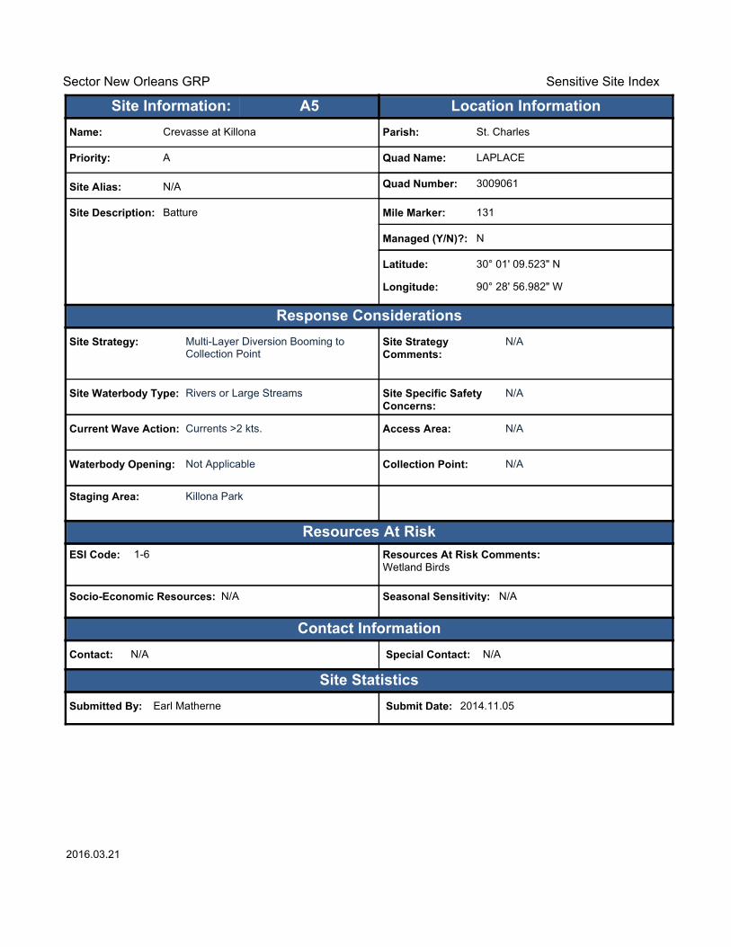
Resources At Risk Comments:Wetland Birds
Contact: N/A Special Contact: N/A
Submitted By: Earl Matherne Submit Date: 2014.11.05
Site Strategy: Multi-Layer Diversion Booming to Collection Point
Site Strategy Comments:
N/A
Site Waterbody Type: Rivers or Large Streams
Current Wave Action: Currents >2 kts.
Waterbody Opening: Not Applicable
ESI Code: 1-6
Priority: A
Name: Crevasse at Killona
Site Alias: N/A
Site Description: Batture
Parish: St. Charles
Quad Name: LAPLACE
Quad Number: 3009061
Mile Marker: 131
Managed (Y/N)?: N
Latitude: 30° 01' 09.523" N
Longitude: 90° 28' 56.982" W
Site Information: Location InformationText416:A5
Site Specific Safety Concerns:
N/A
Access Area: N/A
Collection Point: N/A
Seasonal Sensitivity: N/A
Staging Area: Killona Park
Socio-Economic Resources: N/A
2016.03.21
Sector New Orleans GRP Sensitive Site Index
Response Considerations
Resources At Risk
Contact Information
Site Statistics
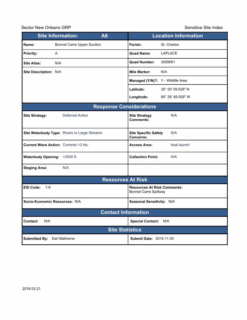
Resources At Risk Comments:Bonnet Carre Spillway
Contact: N/A Special Contact: N/A
Submitted By: Earl Matherne Submit Date: 2014.11.05
Site Strategy: Deferred Action Site Strategy Comments:
N/A
Site Waterbody Type: Rivers or Large Streams
Current Wave Action: Currents >2 kts.
Waterbody Opening: >2500 ft.
ESI Code: 1-6
Priority: A
Name: Bonnet Carre Upper Suction
Site Alias: N/A
Site Description: N/A
Parish: St. Charles
Quad Name: LAPLACE
Quad Number: 3009061
Mile Marker: N/A
Managed (Y/N)?: Y - Wildlife Area
Latitude: 30° 00' 09.626" N
Longitude: 90° 26' 49.009" W
Site Information: Location InformationText416:A6
Site Specific Safety Concerns:
N/A
Access Area: boat launch
Collection Point: N/A
Seasonal Sensitivity: N/A
Staging Area: N/A
Socio-Economic Resources: N/A
2016.03.21
Sector New Orleans GRP Sensitive Site Index
Response Considerations
Resources At Risk
Contact Information
Site Statistics
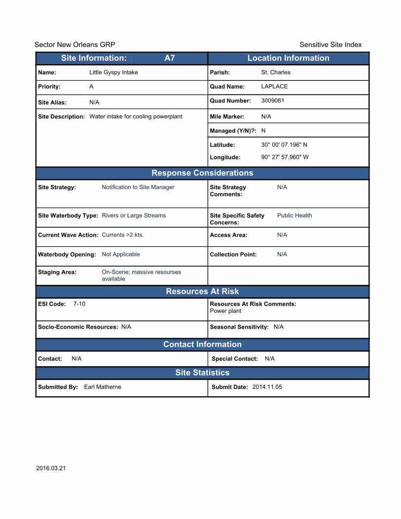
Resources At Risk Comments:Power plant
Contact: N/A Special Contact: N/A
Submitted By: Earl Matherne Submit Date: 2014.11.05
Site Strategy: Notification to Site Manager Site Strategy Comments:
N/A
Site Waterbody Type: Rivers or Large Streams
Current Wave Action: Currents >2 kts.
Waterbody Opening: Not Applicable
ESI Code: 7-10
Priority: A
Name: Little Gyspy Intake
Site Alias: N/A
Site Description: Water intake for cooling powerplant
Parish: St. Charles
Quad Name: LAPLACE
Quad Number: 3009061
Mile Marker: N/A
Managed (Y/N)?: N
Latitude: 30° 00' 07.196" N
Longitude: 90° 27' 57.960" W
Site Information: Location InformationText416:A7
Site Specific Safety Concerns:
Public Health
Access Area: N/A
Collection Point: N/A
Seasonal Sensitivity: N/A
Staging Area: On-Scene; massive resourses available
Socio-Economic Resources: N/A
2016.03.21

Sector New Orleans GRP Sensitive Site Index
Response Considerations
Resources At Risk
Contact Information
Site Statistics
Resources At Risk Comments:Water Intake for Cooling
Contact: Glen Savoie : 985-783-4017 Special Contact: N/A
Submitted By: St. Charles Parish Submit Date: 2014.11.05
Site Strategy: Notification to Site Manager Site Strategy Comments:
N/A
Site Waterbody Type: Rivers or Large Streams
Current Wave Action: Currents >2 kts.
Waterbody Opening: Not Applicable
ESI Code: N/A
Priority: A
Name: Entergy Waterford 1 & 2
Site Alias: N/A
Site Description: Power Plant (Natural Gas)
Parish: St. Charles
Quad Name: LAPLACE
Quad Number: 3009061
Mile Marker: 130
Managed (Y/N)?: N
Latitude: 30° 00' 03.226" N
Longitude: 90° 28' 26.346" W
Site Information: Location InformationText416:A8
Site Specific Safety Concerns:
Power production
Access Area: Water and Land Access
Collection Point: No
Seasonal Sensitivity: Water Levels
Staging Area: Gravel Lot
Socio-Economic Resources: High
2016.03.21
!
!
!
!
!!
!
CanalNO 2 Canal
NO 11
Can
al
BayouTrepagnier
Canal NO 12
Can
al N
O 1
7D
rain
Ditc
h N
O 7
Canal NO 14
Dun
can
Can
a l
Canal NO 7
Canal NO 13
Can
al N
O 1
0
Pipe
line
Can
al
LakePontchartrain
§̈¦310
§̈¦10
LA BRANCHEBONNET CARRE NE
LA BRANCHELULING
LA B
RAN
CH
EIN
DIA
N B
EAC
H
LA B
RAN
CH
ELA
PLA
CE
JeffersonSt.Charles
St. Johnthe Baptist
A1
A2
A3A4
B1C1 C2
90°15'0"W
90°15'0"W
90°22'30"W
90°22'30"W
30°7
'30"
N
30°7
'30"
N
30°0
'0"N
30°0
'0"N
±0 1 2 30.5
Miles
LA BRANCHE Quad
MetairieMetairie
Baton RougeBaton Rouge
New OrleansNew Orleans
§̈¦10
§̈¦12
§̈¦55§̈¦59
§̈¦310
§̈¦10
L O U I S I A N AL O U I S I A N A
Legend! GRP Sites
Quad Boundary
Parish Boundaries
0 1 2 30.5Kilometers
Locator MapLocator MapPublished: 2016.03.21

Sector New Orleans GRP Sensitive Site Index
Response Considerations
Resources At Risk
Contact Information
Site Statistics
Resources At Risk Comments:LaBranche Wetlands
Contact: N/A Special Contact: N/A
Submitted By: Earl Matherne Submit Date: 2014.11.05
Site Strategy: Diversion Booming to Collection Point Site Strategy Comments:
N/A
Site Waterbody Type: Narrow Tidal Channel
Current Wave Action: Current >1 kt.
Waterbody Opening: < 500 ft.
ESI Code: 1-6
Priority: A
Name: Bayou LaBrache at L. Pontchartrain
Site Alias: N/A
Site Description: Mouth of Bayou
Parish: St. Charles
Quad Name: LA BRANCHE
Quad Number: 3009062
Mile Marker: n/a
Managed (Y/N)?: N
Latitude: 30° 03' 21.892" N
Longitude: 90° 22' 03.878" W
Site Information: Location InformationText416:A1
Site Specific Safety Concerns:
N/A
Access Area: N/A
Collection Point: Yes
Seasonal Sensitivity: N/A
Staging Area: I-10 Boat launch
Socio-Economic Resources: N/A
2016.03.21
Sector New Orleans GRP Sensitive Site Index
Response Considerations
Resources At Risk
Contact Information
Site Statistics
Resources At Risk Comments:LaBranche Wetlands
Contact: N/A Special Contact: N/A
Submitted By: Earl Matherne Submit Date: 2014.11.05
Site Strategy: Deferred Action Site Strategy Comments:
N/A
Site Waterbody Type: Straight Coastline
Current Wave Action: Breaking Waves >1.5 ft.
Waterbody Opening: Not Applicable
ESI Code: 1-6
Priority: A
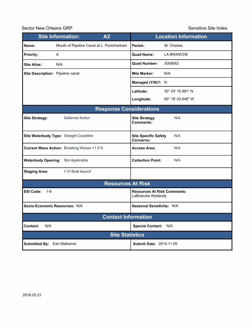
Name: Mouth of Pipeline Canal at L. Pontchartrain
Site Alias: N/A
Site Description: Pipeline canal
Parish: St. Charles
Quad Name: LA BRANCHE
Quad Number: 3009062
Mile Marker: N/A
Managed (Y/N)?: N
Latitude: 30° 03' 15.991" N
Longitude: 90° 19' 03.648" W
Site Information: Location InformationText416:A2
Site Specific Safety Concerns:
N/A
Access Area: N/A
Collection Point: N/A
Seasonal Sensitivity: N/A
Staging Area: I-10 Boat launch
Socio-Economic Resources: N/A
2016.03.21

Sector New Orleans GRP Sensitive Site Index
Response Considerations
Resources At Risk
Contact Information
Site Statistics
Resources At Risk Comments:LaBranche Wetlands
Contact: N/A Special Contact: N/A
Submitted By: Earl Matherne Submit Date: 2014.11.05
Site Strategy: Deferred Action Site Strategy Comments:
N/A
Site Waterbody Type: Straight Coastline
Current Wave Action: Breaking Waves >1.5 ft.
Waterbody Opening: Not Applicable
ESI Code: 1-6
Priority: A
Name: The Blowout
Site Alias: N/A
Site Description: Old drill pad
Parish: St. Charles
Quad Name: LA BRANCHE
Quad Number: 3009062
Mile Marker: N/A
Managed (Y/N)?: N
Latitude: 30° 03' 09.439" N
Longitude: 90° 19' 33.488" W
Site Information: Location InformationText416:A3
Site Specific Safety Concerns:
N/A
Access Area: N/A
Collection Point: Yes
Seasonal Sensitivity: N/A
Staging Area: I-10 Boat launch
Socio-Economic Resources: N/A
2016.03.21
Sector New Orleans GRP Sensitive Site Index
Response Considerations
Resources At Risk
Contact Information
Site Statistics
Resources At Risk Comments:LaBranche Wetlands
Contact: N/A Special Contact: N/A
Submitted By: Earl Matherne Submit Date: 2014.11.05
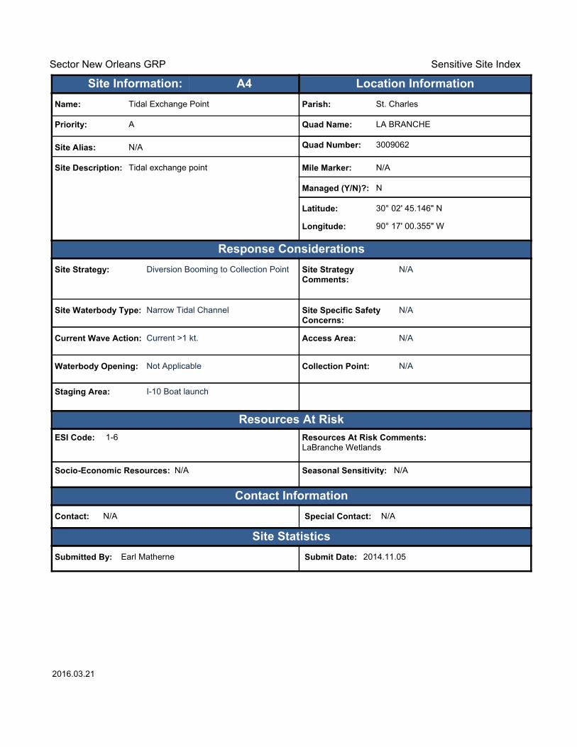
Site Strategy: Diversion Booming to Collection Point Site Strategy Comments:
N/A
Site Waterbody Type: Narrow Tidal Channel
Current Wave Action: Current >1 kt.
Waterbody Opening: Not Applicable
ESI Code: 1-6
Priority: A
Name: Tidal Exchange Point
Site Alias: N/A
Site Description: Tidal exchange point
Parish: St. Charles
Quad Name: LA BRANCHE
Quad Number: 3009062
Mile Marker: N/A
Managed (Y/N)?: N
Latitude: 30° 02' 45.146" N
Longitude: 90° 17' 00.355" W
Site Information: Location InformationText416:A4
Site Specific Safety Concerns:
N/A
Access Area: N/A
Collection Point: N/A
Seasonal Sensitivity: N/A
Staging Area: I-10 Boat launch
Socio-Economic Resources: N/A
2016.03.21
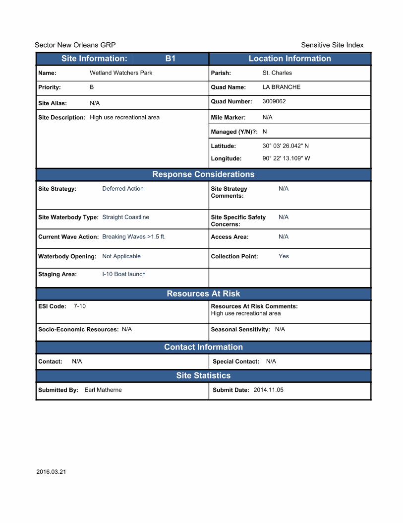
Sector New Orleans GRP Sensitive Site Index
Response Considerations
Resources At Risk
Contact Information
Site Statistics
Resources At Risk Comments:High use recreational area
Contact: N/A Special Contact: N/A
Submitted By: Earl Matherne Submit Date: 2014.11.05
Site Strategy: Deferred Action Site Strategy Comments:
N/A
Site Waterbody Type: Straight Coastline
Current Wave Action: Breaking Waves >1.5 ft.
Waterbody Opening: Not Applicable
ESI Code: 7-10
Priority: B
Name: Wetland Watchers Park
Site Alias: N/A
Site Description: High use recreational area
Parish: St. Charles
Quad Name: LA BRANCHE
Quad Number: 3009062
Mile Marker: N/A
Managed (Y/N)?: N
Latitude: 30° 03' 26.042" N
Longitude: 90° 22' 13.109" W
Site Information: Location InformationText416:B1
Site Specific Safety Concerns:
N/A
Access Area: N/A
Collection Point: Yes
Seasonal Sensitivity: N/A
Staging Area: I-10 Boat launch
Socio-Economic Resources: N/A
2016.03.21
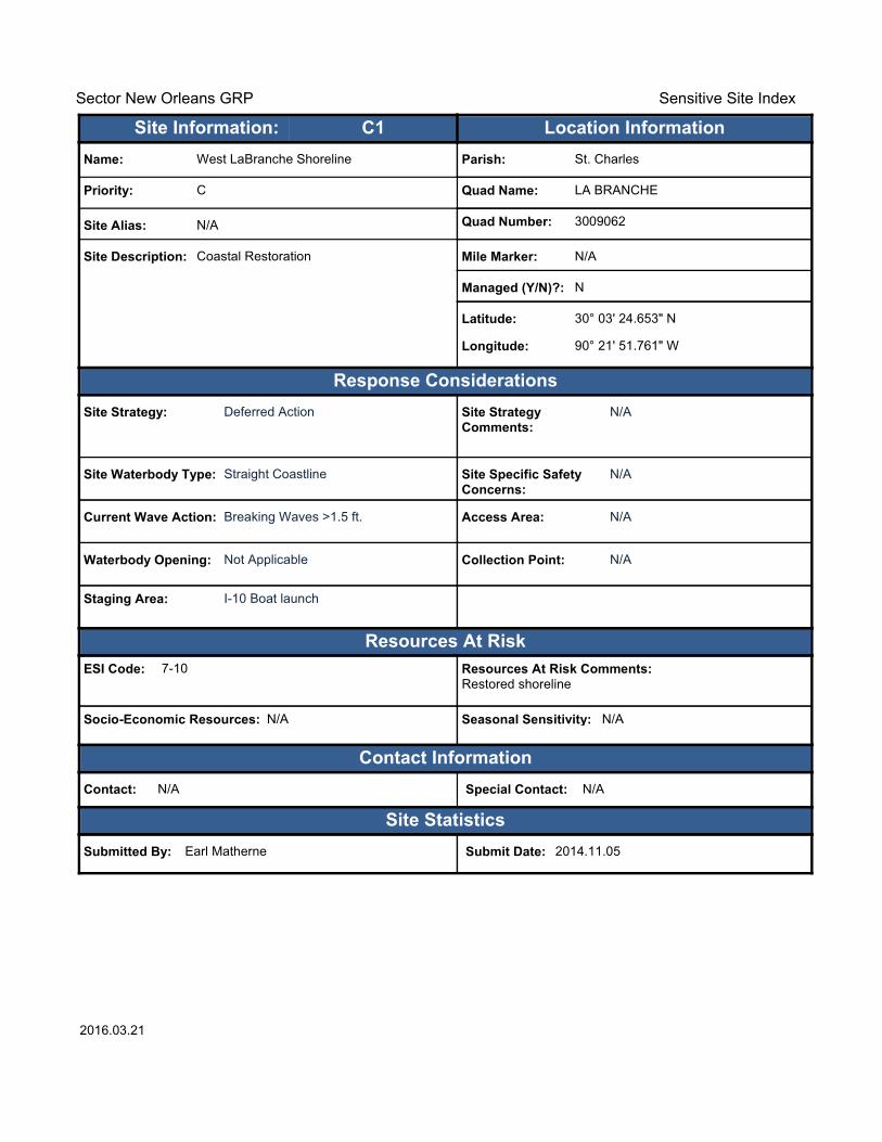
Sector New Orleans GRP Sensitive Site Index
Response Considerations
Resources At Risk
Contact Information
Site Statistics
Resources At Risk Comments:Restored shoreline
Contact: N/A Special Contact: N/A
Submitted By: Earl Matherne Submit Date: 2014.11.05
Site Strategy: Deferred Action Site Strategy Comments:
N/A
Site Waterbody Type: Straight Coastline
Current Wave Action: Breaking Waves >1.5 ft.
Waterbody Opening: Not Applicable
ESI Code: 7-10
Priority: C
Name: West LaBranche Shoreline
Site Alias: N/A
Site Description: Coastal Restoration
Parish: St. Charles
Quad Name: LA BRANCHE
Quad Number: 3009062
Mile Marker: N/A
Managed (Y/N)?: N
Latitude: 30° 03' 24.653" N
Longitude: 90° 21' 51.761" W
Site Information: Location InformationText416:C1
Site Specific Safety Concerns:
N/A
Access Area: N/A
Collection Point: N/A
Seasonal Sensitivity: N/A
Staging Area: I-10 Boat launch
Socio-Economic Resources: N/A
2016.03.21

Sector New Orleans GRP Sensitive Site Index
Response Considerations
Resources At Risk
Contact Information
Site Statistics
Resources At Risk Comments:Restored shoreline
Contact: N/A Special Contact: N/A
Submitted By: Earl Matherne Submit Date: 2014.11.05
Site Strategy: Deferred Action Site Strategy Comments:
N/A
Site Waterbody Type: Straight Coastline
Current Wave Action: Breaking Waves >1.5 ft.
Waterbody Opening: Not Applicable
ESI Code: 1-6
Priority: C
Name: East LaBranch Shoreline Phase 1
Site Alias: N/A
Site Description: Coastal restoration site
Parish: St. Charles
Quad Name: LA BRANCHE
Quad Number: 3009062
Mile Marker: N/A
Managed (Y/N)?: N
Latitude: 30° 03' 14.807" N
Longitude: 90° 19' 16.637" W
Site Information: Location InformationText416:C2
Site Specific Safety Concerns:
N/A
Access Area: N/A
Collection Point: N/A
Seasonal Sensitivity: N/A
Staging Area: I-10 Boat launch
Socio-Economic Resources: N/A
2016.03.21

!
!
!!
!! !
!
!
!
GrandBayou
Troxclair
Canal
BlouinCanal
Bayou
Crocodile
Hymel
Canal
Provi
denc
e Can
al
Eighty Arpent Canal
Para
dis
Can
al
St Charles Canal
ST18
ST306
ST3141 ST627
ST52
ST3160
ST631
ST48ST3127 £¤61
£¤90
§̈¦310
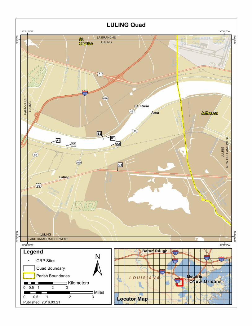
BoutteBoutte
DestrehanDestrehan
HahnvilleHahnville
KillonaKillona
NewNewSarpySarpy
NorcoNorco
ParadisParadis
TaftTaft
HAHNVILLELAPLACE
DES ALLEMANDSHAHNVILLE
HAH
NVI
LLE
LULI
NG
HAH
NVI
LLE
LAC
DES
ALL
EM
AN
DS
St.Charles
A1
A2
B1 B2B3
B4
B5 B6
B7
B8
90°22'30"W
90°22'30"W
90°30'0"W
90°30'0"W
30°0
'0"N
30°0
'0"N
29°5
2'30
"N
29°5
2'30
"N
±0 1 2 30.5
Miles
HAHNVILLE Quad
MetairieMetairie
Baton RougeBaton Rouge
New OrleansNew Orleans
§̈¦10
§̈¦12
§̈¦55§̈¦59
§̈¦310
§̈¦10
L O U I S I A N AL O U I S I A N A
Legend! GRP Sites
Quad Boundary
Parish Boundaries
0 1 2 30.5Kilometers
Locator MapLocator MapPublished: 2016.03.21

Sector New Orleans GRP Sensitive Site Index
Response Considerations
Resources At Risk
Contact Information
Site Statistics
Resources At Risk Comments:Power Production
Contact: Shift Manager : 504-464-3104 Special Contact: N/A
Submitted By: St. Charles Parish Submit Date: 2014.11.05
Site Strategy: Notification to Site Manager Site Strategy Comments:
N/A
Site Waterbody Type: Rivers or Large Streams
Current Wave Action: Currents >2 kts.
Waterbody Opening: Not Applicable
ESI Code: 7-10
Priority: A
Name: Waterford 3 Water Intake
Site Alias: N/A
Site Description: Nuclear Power Plant Water Intake
Parish: St. Charles
Quad Name: HAHNVILLE
Quad Number: 2909005
Mile Marker: 129.5
Managed (Y/N)?: N
Latitude: 29° 59' 53.732" N
Longitude: 90° 28' 10.427" W
Site Information: Location InformationText416:A1
Site Specific Safety Concerns:
750 employees, power
Access Area: Water and Land Access
Collection Point: Yes
Seasonal Sensitivity: Water Levels
Staging Area: Several large paved lots
Socio-Economic Resources: High
2016.03.21
Sector New Orleans GRP Sensitive Site Index
Response Considerations
Resources At Risk
Contact Information
Site Statistics
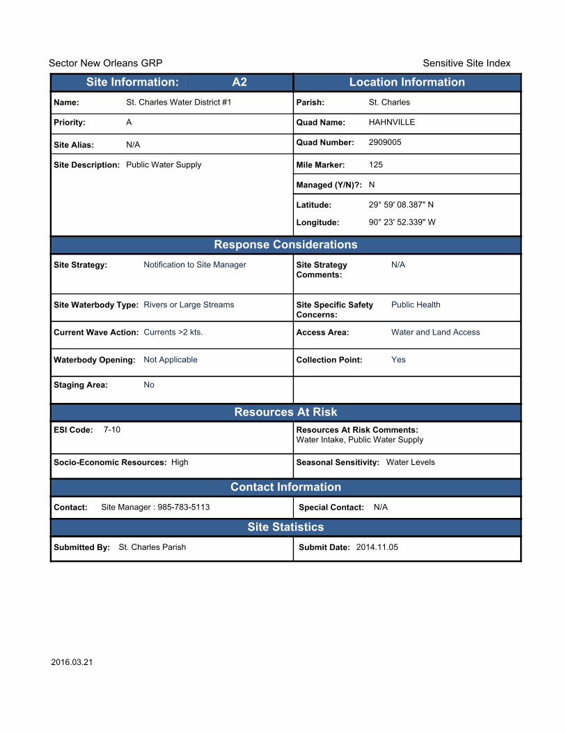
Resources At Risk Comments:Water Intake, Public Water Supply
Contact: Site Manager : 985-783-5113 Special Contact: N/A
Submitted By: St. Charles Parish Submit Date: 2014.11.05
Site Strategy: Notification to Site Manager Site Strategy Comments:
N/A
Site Waterbody Type: Rivers or Large Streams
Current Wave Action: Currents >2 kts.
Waterbody Opening: Not Applicable
ESI Code: 7-10
Priority: A
Name: St. Charles Water District #1
Site Alias: N/A
Site Description: Public Water Supply
Parish: St. Charles
Quad Name: HAHNVILLE
Quad Number: 2909005
Mile Marker: 125
Managed (Y/N)?: N
Latitude: 29° 59' 08.387" N
Longitude: 90° 23' 52.339" W
Site Information: Location InformationText416:A2
Site Specific Safety Concerns:
Public Health
Access Area: Water and Land Access
Collection Point: Yes
Seasonal Sensitivity: Water Levels
Staging Area: No
Socio-Economic Resources: High
2016.03.21

Sector New Orleans GRP Sensitive Site Index
Response Considerations
Resources At Risk
Contact Information
Site Statistics
Resources At Risk Comments:Water Intake
Contact: Chris Keran : 985-860-2090 Special Contact: N/A
Submitted By: St. Charles Parish Submit Date: 2014.11.05
Site Strategy: Notification to Site Manager Site Strategy Comments:
N/A
Site Waterbody Type: Rivers or Large Streams
Current Wave Action: Currents >2 kts.
Waterbody Opening: Not Applicable
ESI Code: 7-10
Priority: B
Name: Occidental Chemical
Site Alias: N/A
Site Description: Chemical Plant
Parish: St. Charles
Quad Name: HAHNVILLE
Quad Number: 2909005
Mile Marker: 129
Managed (Y/N)?: N
Latitude: 29° 59' 39.019" N
Longitude: 90° 27' 27.648" W
Site Information: Location InformationText416:B1
Site Specific Safety Concerns:
N/A
Access Area: Water and Land Access
Collection Point: No
Seasonal Sensitivity: Water Levels
Staging Area: No
Socio-Economic Resources: Low
2016.03.21
Sector New Orleans GRP Sensitive Site Index
Response Considerations
Resources At Risk
Contact Information
Site Statistics
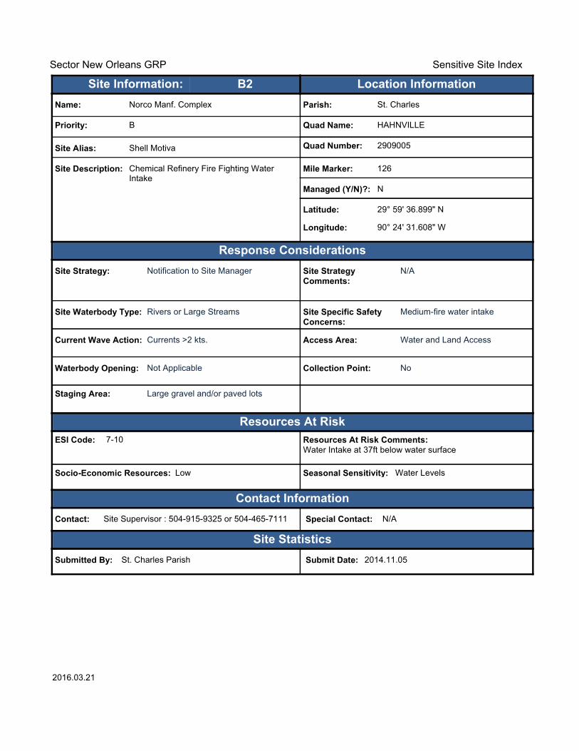
Resources At Risk Comments:Water Intake at 37ft below water surface
Contact: Site Supervisor : 504-915-9325 or 504-465-7111 Special Contact: N/A
Submitted By: St. Charles Parish Submit Date: 2014.11.05
Site Strategy: Notification to Site Manager Site Strategy Comments:
N/A
Site Waterbody Type: Rivers or Large Streams
Current Wave Action: Currents >2 kts.
Waterbody Opening: Not Applicable
ESI Code: 7-10
Priority: B
Name: Norco Manf. Complex
Site Alias: Shell Motiva
Site Description: Chemical Refinery Fire Fighting Water Intake
Parish: St. Charles
Quad Name: HAHNVILLE
Quad Number: 2909005
Mile Marker: 126
Managed (Y/N)?: N
Latitude: 29° 59' 36.899" N
Longitude: 90° 24' 31.608" W
Site Information: Location InformationText416:B2
Site Specific Safety Concerns:
Medium-fire water intake
Access Area: Water and Land Access
Collection Point: No
Seasonal Sensitivity: Water Levels
Staging Area: Large gravel and/or paved lots
Socio-Economic Resources: Low
2016.03.21

Sector New Orleans GRP Sensitive Site Index
Response Considerations
Resources At Risk
Contact Information
Site Statistics
Resources At Risk Comments:Plant Cooling Water Intake
Contact: Dispatch Operations : 985-783-4387 Special Contact: N/A
Submitted By: St. Charles Parish Submit Date: 2014.11.05
Site Strategy: Notification to Site Manager Site Strategy Comments:
N/A
Site Waterbody Type: Rivers or Large Streams
Current Wave Action: Currents >2 kts.
Waterbody Opening: Not Applicable
ESI Code: 7-10
Priority: B
Name: DOW Chemical-Union Carbide Dock #1
Site Alias: N/A
Site Description: PetroChemical
Parish: St. Charles
Quad Name: HAHNVILLE
Quad Number: 2909005
Mile Marker: 127.3
Managed (Y/N)?: N
Latitude: 29° 59' 33.446" N
Longitude: 90° 26' 48.091" W
Site Information: Location InformationText416:B3
Site Specific Safety Concerns:
N/A
Access Area: Water and Land Access
Collection Point: N/A
Seasonal Sensitivity: Water Levels
Staging Area: Large paved lots at gate 51 or gate 11
Socio-Economic Resources: Low
2016.03.21
Sector New Orleans GRP Sensitive Site Index
Response Considerations
Resources At Risk
Contact Information
Site Statistics
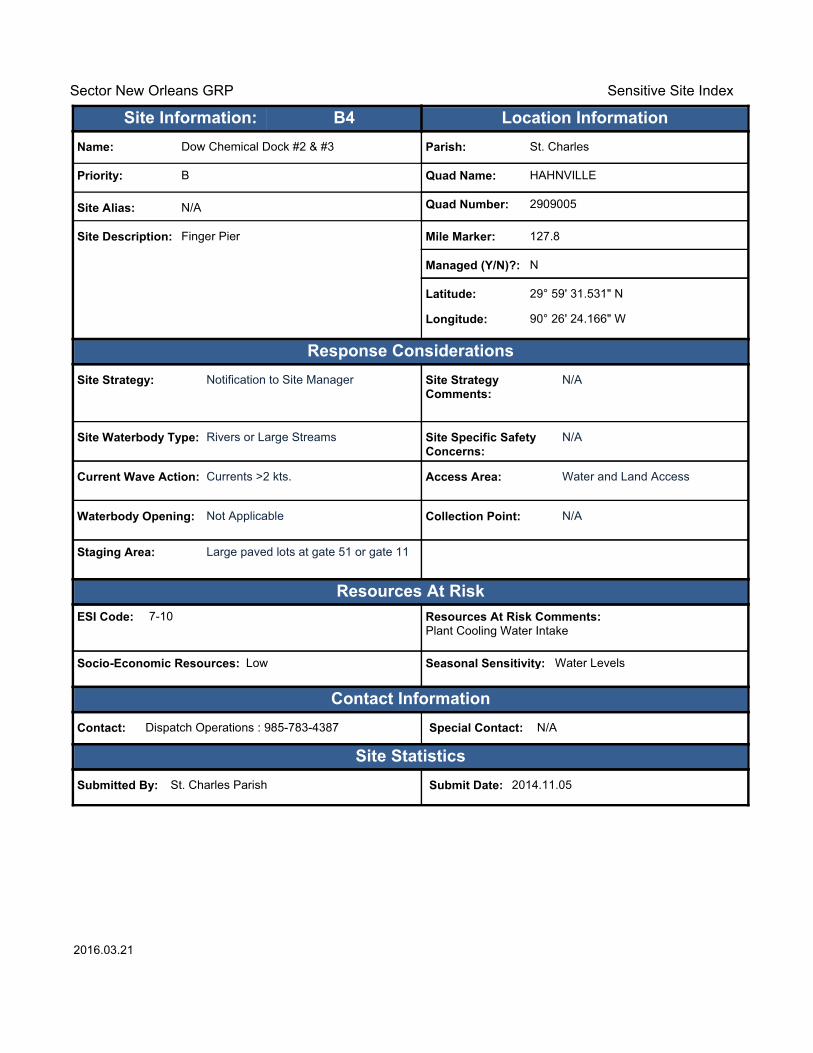
Resources At Risk Comments:Plant Cooling Water Intake
Contact: Dispatch Operations : 985-783-4387 Special Contact: N/A
Submitted By: St. Charles Parish Submit Date: 2014.11.05
Site Strategy: Notification to Site Manager Site Strategy Comments:
N/A
Site Waterbody Type: Rivers or Large Streams
Current Wave Action: Currents >2 kts.
Waterbody Opening: Not Applicable
ESI Code: 7-10
Priority: B
Name: Dow Chemical Dock #2 & #3
Site Alias: N/A
Site Description: Finger Pier
Parish: St. Charles
Quad Name: HAHNVILLE
Quad Number: 2909005
Mile Marker: 127.8
Managed (Y/N)?: N
Latitude: 29° 59' 31.531" N
Longitude: 90° 26' 24.166" W
Site Information: Location InformationText416:B4
Site Specific Safety Concerns:
N/A
Access Area: Water and Land Access
Collection Point: N/A
Seasonal Sensitivity: Water Levels
Staging Area: Large paved lots at gate 51 or gate 11
Socio-Economic Resources: Low
2016.03.21

Sector New Orleans GRP Sensitive Site Index
Response Considerations
Resources At Risk
Contact Information
Site Statistics
Resources At Risk Comments:Plant Cooling Water Intake
Contact: Dispatch Operations : 985-783-4387 Special Contact: N/A
Submitted By: St. Charles Parish Submit Date: 2014.11.05
Site Strategy: Notification to Site Manager Site Strategy Comments:
N/A
Site Waterbody Type: Rivers or Large Streams
Current Wave Action: Currents >2 kts.
Waterbody Opening: Not Applicable
ESI Code: 7-10
Priority: B
Name: Dow Chemical Dock #4
Site Alias: N/A
Site Description: Dock
Parish: St. Charles
Quad Name: HAHNVILLE
Quad Number: 2909005
Mile Marker: 127.6
Managed (Y/N)?: N
Latitude: 29° 59' 31.232" N
Longitude: 90° 26' 12.534" W
Site Information: Location InformationText416:B5
Site Specific Safety Concerns:
N/A
Access Area: Water and Land Access
Collection Point: N/A
Seasonal Sensitivity: Water Levels
Staging Area: Large paved lots at gate 51 or gate 11
Socio-Economic Resources: Low
2016.03.21

Sector New Orleans GRP Sensitive Site Index
Response Considerations
Resources At Risk
Contact Information
Site Statistics
Resources At Risk Comments:Cooling/Fire Fighting water
Contact: Shift Superintendant 24hr : 985-703-1819 Special Contact: N/A
Submitted By: St. Charles Parish Submit Date: 2014.11.05
Site Strategy: Notification to Site Manager Site Strategy Comments:
N/A
Site Waterbody Type: Rivers or Large Streams
Current Wave Action: Currents >2 kts.
Waterbody Opening: Not Applicable
ESI Code: 7-10
Priority: B
Name: Valero St. Charles
Site Alias: N/A
Site Description: Fire Water Intake at Dock #1
Parish: St. Charles
Quad Name: HAHNVILLE
Quad Number: 2909005
Mile Marker: 125
Managed (Y/N)?: N
Latitude: 29° 59' 23.086" N
Longitude: 90° 24' 10.181" W
Site Information: Location InformationText416:B6
Site Specific Safety Concerns:
N/A
Access Area: Water and Land Access
Collection Point: Yes
Seasonal Sensitivity: Water Levels
Staging Area: Large gravel lot off St. Charles Street
Socio-Economic Resources: Low
2016.03.21

Sector New Orleans GRP Sensitive Site Index
Response Considerations
Resources At Risk
Contact Information
Site Statistics
Resources At Risk Comments:Cooling/Fire Fighting water
Contact: Shift Superintendant 24hr : 985-703-1819 Special Contact: N/A
Submitted By: St. Charles Parish Submit Date: 2014.11.05
Site Strategy: Notification to Site Manager Site Strategy Comments:
N/A
Site Waterbody Type: Rivers or Large Streams
Current Wave Action: Currents >2 kts.
Waterbody Opening: Not Applicable
ESI Code: 7-10
Priority: B
Name: Valero St. Charles
Site Alias: N/A
Site Description: Fire Water Intake at Dock #2
Parish: St. Charles
Quad Name: HAHNVILLE
Quad Number: 2909005
Mile Marker: 125
Managed (Y/N)?: N
Latitude: 29° 59' 19.788" N
Longitude: 90° 24' 05.069" W
Site Information: Location InformationText416:B7
Site Specific Safety Concerns:
N/A
Access Area: Water and Land Access
Collection Point: Yes
Seasonal Sensitivity: Water Levels
Staging Area: Large gravel lot off St. Charles Street
Socio-Economic Resources: Low
2016.03.21

Sector New Orleans GRP Sensitive Site Index
Response Considerations
Resources At Risk
Contact Information
Site Statistics
Resources At Risk Comments:Cooling/Fire Fighting water
Contact: Shift Superintendant 24hr : 985-703-1819 Special Contact: N/A
Submitted By: St. Charles Parish Submit Date: 2014.11.05
Site Strategy: Notification to Site Manager Site Strategy Comments:
N/A
Site Waterbody Type: Rivers or Large Streams
Current Wave Action: Currents >2 kts.
Waterbody Opening: Not Applicable
ESI Code: 7-10
Priority: B
Name: Valero St. Charles
Site Alias: N/A
Site Description: RO Water Intake
Parish: St. Charles
Quad Name: HAHNVILLE
Quad Number: 2909005
Mile Marker: 125
Managed (Y/N)?: N
Latitude: 29° 58' 56.557" N
Longitude: 90° 23' 44.408" W
Site Information: Location InformationText416:B8
Site Specific Safety Concerns:
N/A
Access Area: Water and Land Access
Collection Point: Yes
Seasonal Sensitivity: Water Levels
Staging Area: Large gravel lot off St. Charles Street
Socio-Economic Resources: Low
2016.03.21
!
!
!
!
!
!
Cou
sin
Can
al
Gar
land
Can
al
Pet
erso
n C
anal
LakeCataouatche
LeveeC
ana ls
Can
alN
O 1
7
Dun
can
Can
al
Can
alN
O 7
Bayou
Verret
Saul
s C
anal
Cro
ss B
ayou
Can
al
Dus
uaus
Can
al
D r a i n
Di t c h NO
8
Lower Lanaux
Canal
Outfall
Canal
EllingtonCanal
Pip
eli n
eC
a na l
CanalNO 15
Canal NO 14
Blouin Canal
Sellers CanalST3060
ST52
ST626
ST48
ST18
£¤61
£¤90
§̈¦310
AmaAma
LulingLuling
St. RoseSt. Rose
LA BRANCHELULING
HAH
NVI
LLE
LULI
NG
LAKE CATAOUATCHE WESTLULING
LULI
NG
NEW
OR
LEAN
S W
EST
Jefferson
St.Charles
A1A2
B1B2
B3
C1
90°15'0"W
90°15'0"W
90°22'30"W
90°22'30"W
30°0
'0"N
30°0
'0"N
29°5
2'30
"N
29°5
2'30
"N
±0 1 2 30.5
Miles
LULING Quad
MetairieMetairie
Baton RougeBaton Rouge
New OrleansNew Orleans
§̈¦10
§̈¦12
§̈¦55§̈¦59
§̈¦310
§̈¦10
L O U I S I A N AL O U I S I A N A
Legend! GRP Sites
Quad Boundary
Parish Boundaries
0 1 2 30.5Kilometers
Locator MapLocator MapPublished: 2016.03.21

Sector New Orleans GRP Sensitive Site Index
Response Considerations
Resources At Risk
Contact Information
Site Statistics
Resources At Risk Comments:Water Intake, Public Water Supply
Contact: Site Manager : 985-783-5113 Special Contact: N/A
Submitted By: St. Charles Parish Submit Date: 2014.11.05
Site Strategy: Notification to Site Manager Site Strategy Comments:
N/A
Site Waterbody Type: Rivers or Large Streams
Current Wave Action: Currents >2 kts.
Waterbody Opening: Not Applicable
ESI Code: 7-10
Priority: A
Name: St. Charles Water District #2
Site Alias: N/A
Site Description: Public Water Intake
Parish: St. Charles
Quad Name: LULING
Quad Number: 2909006
Mile Marker: 120.6
Managed (Y/N)?: N
Latitude: 29° 56' 05.863" N
Longitude: 90° 21' 35.474" W
Site Information: Location InformationText416:A1
Site Specific Safety Concerns:
Public Health
Access Area: Water and Land Access
Collection Point: No
Seasonal Sensitivity: Water Levels
Staging Area: No
Socio-Economic Resources: High
2016.03.21

Sector New Orleans GRP Sensitive Site Index
Response Considerations
Resources At Risk
Contact Information
Site Statistics
Resources At Risk Comments:Environment/wetlands
Contact: Nicolas Palmisano : 504-330-0155 Special Contact: N/A
Submitted By: St. Charles Parish Submit Date: 2014.11.05
Site Strategy: Notification to Site Manager Site Strategy Comments:
Suction/Hydro Flow
Site Waterbody Type: Rivers or Large Streams
Current Wave Action: Currents >2 kts.
Waterbody Opening: Not Applicable
ESI Code: 7-10
Priority: A
Name: Davis Pond Fresh Water Diversion (River)
Site Alias: N/A
Site Description: Fresh Water Diversion/Control Structure
Parish: St. Charles
Quad Name: LULING
Quad Number: 2909006
Mile Marker: 118
Managed (Y/N)?: N
Latitude: 29° 55' 58.879" N
Longitude: 90° 19' 18.858" W
Site Information: Location InformationText416:A2
Site Specific Safety Concerns:
N/A
Access Area: Water and Land Access
Collection Point: Yes
Seasonal Sensitivity: Water Levels
Staging Area: Not Nearby
Socio-Economic Resources: Low
2016.03.21

Sector New Orleans GRP Sensitive Site Index
Response Considerations
Resources At Risk
Contact Information
Site Statistics
Resources At Risk Comments:Fire Fighting Water Intake
Contact: Mr. John Little Site Manager : 504-468-3997 Special Contact: N/A
Submitted By: St. Charles Parish Submit Date: 2014.11.05
Site Strategy: Notification to Site Manager Site Strategy Comments:
Site Manager also co-located with Shell Bituman
Site Waterbody Type: Rivers or Large Streams
Current Wave Action: Currents >2 kts.
Waterbody Opening: Not Applicable
ESI Code: 7-10
Priority: B
Name: IMTT St. Rose
Site Alias: N/A
Site Description: Petroleum Storage Facility
Parish: St. Charles
Quad Name: LULING
Quad Number: 2909006
Mile Marker: 118.5
Managed (Y/N)?: N
Latitude: 29° 56' 18.251" N
Longitude: 90° 19' 30.504" W
Site Information: Location InformationText416:B1
Site Specific Safety Concerns:
N/A
Access Area: Water and Land Access
Collection Point: N/A
Seasonal Sensitivity: River Levels
Staging Area: Large gravel lot gate 6
Socio-Economic Resources: Low
2016.03.21

Sector New Orleans GRP Sensitive Site Index
Response Considerations
Resources At Risk
Contact Information
Site Statistics
Resources At Risk Comments:Fire Fighting Water Intake
Contact: Mr. John Little Site Manager : 504-468-3997 Special Contact: N/A
Submitted By: St. Charles Parish Submit Date: 2014.11.05
Site Strategy: Notification to Site Manager Site Strategy Comments:
Site Manager also co-located with Shell Bituman
Site Waterbody Type: Rivers or Large Streams
Current Wave Action: Currents >2 kts.
Waterbody Opening: Not Applicable
ESI Code: 7-10
Priority: B
Name: IMTT St. Rose
Site Alias: Dock 8
Site Description: Fire Water Intake #2
Parish: St. Charles
Quad Name: LULING
Quad Number: 2909006
Mile Marker: 118.5
Managed (Y/N)?: N
Latitude: 29° 56' 13.085" N
Longitude: 90° 19' 37.103" W
Site Information: Location InformationText416:B2
Site Specific Safety Concerns:
N/A
Access Area: Water and Land Access
Collection Point: N/A
Seasonal Sensitivity: River Levels
Staging Area: Large gravel lot gate 6
Socio-Economic Resources: Low
2016.03.21
Sector New Orleans GRP Sensitive Site Index
Response Considerations
Resources At Risk
Contact Information
Site Statistics
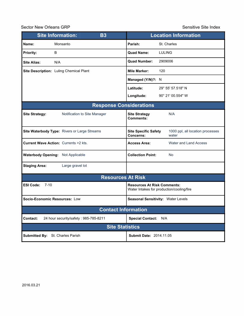
Resources At Risk Comments:Water Intakes for production/cooling/fire
Contact: 24 hour security/safety : 985-785-8211 Special Contact: N/A
Submitted By: St. Charles Parish Submit Date: 2014.11.05
Site Strategy: Notification to Site Manager Site Strategy Comments:
N/A
Site Waterbody Type: Rivers or Large Streams
Current Wave Action: Currents >2 kts.
Waterbody Opening: Not Applicable
ESI Code: 7-10
Priority: B
Name: Monsanto
Site Alias: N/A
Site Description: Luling Chemical Plant
Parish: St. Charles
Quad Name: LULING
Quad Number: 2909006
Mile Marker: 120
Managed (Y/N)?: N
Latitude: 29° 55' 57.518" N
Longitude: 90° 21' 00.554" W
Site Information: Location InformationText416:B3
Site Specific Safety Concerns:
1000 ppl, all location processes water
Access Area: Water and Land Access
Collection Point: No
Seasonal Sensitivity: Water Levels
Staging Area: Large gravel lot
Socio-Economic Resources: Low
2016.03.21

Sector New Orleans GRP Sensitive Site Index
Response Considerations
Resources At Risk
Contact Information
Site Statistics
Resources At Risk Comments:N/A
Contact: N/A Special Contact: N/A
Submitted By: LA CPRA Submit Date: 2014.11.05
Site Strategy: Multi-Layer Deflection Booming Site Strategy Comments:
Notification to Site Manager.
Site Waterbody Type: Rivers or Large Streams
Current Wave Action: Currents >2 kts.
Waterbody Opening: Not Applicable
ESI Code: N/A
Priority: C
Name: Davis Pond Freshwater Diversion (Channel
Site Alias: 4-LA CPRA-C (done)
Site Description: N/A
Parish: St. Charles
Quad Name: LULING
Quad Number: 2909006
Mile Marker: N/A
Managed (Y/N)?: N
Latitude: 29° 55' 01.003" N
Longitude: 90° 19' 04.001" W
Site Information: Location InformationText416:C1
Site Specific Safety Concerns:
N/A
Access Area: N/A
Collection Point: N/A
Seasonal Sensitivity: N/A
Staging Area: N/A
Socio-Economic Resources: N/A
2016.03.21

Southeast Louisiana Area Contingency Plan Geographic Response Strategy - St. Charles Parish
Comments/Corrections/Suggestions Form Directions: Fill in your name, address, agency, and phone number. Fill in the blanks regarding the location of information in the plan being commented on. Make Comments in space provided. Add extra sheets as necessary. Submit to:
Address: Commander U.S. Coast Guard Sector New Orleans Contingency Planning 200 Hendee Street New Orleans, LA 70114
Email: [email protected]
Name: Title: Agency:
Address:
City: State/Province: Zip/Postal Code:
Phone: ( ) E-Mail:
Site: Page:
Location on page (Chapter, section, paragraph) (e.g. 2.1, paragraph 3):
Comments: