Embed Size (px)
Citation preview

September 27, 2012 1
PenPlaceSPRC #6PenPlaceSPRC #6
September 27, 2012September 27, 2012
DRAFT

2September 27, 2012 DRAFT
Agenda• Site and Project Overview
• Multiple Transportation Options
• Traffic Analysis
• Neighborhood Analysis
• Street Network
• Street Sections/Sidewalk Width
• Pedestrian/Bicycle Circulation
• Secure Roads
• Parking and Loading Entrances
• Transportation Demand Management (TDM)

3
Site and Project OverviewSite and Project Overview
September 27, 2012 DRAFT
PenPlace
PenPlace• South of Army Navy Drive
• East of S. Fern Street
• West of S. Eads Street
• North of future 12th Street S. extension

4
Site and Project OverviewSite and Project Overview
Site ProgramOffice - 1,800,000 SF
Hotel - 300 Rooms
Retail – 25,000 SF
Program AnalyzedOffice - 1,800,000 SF
Hotel - 300 Rooms
Retail – 50,000 SF
September 27, 2012 DRAFT

Infrastructure/Multiple Transportation Options
5September 27, 2012 DRAFT

6
Multiple Transportation Options – Metro/VREMultiple Transportation Options – Metro/VRE
September 27, 2012 DRAFT
Walking Routes To/From Transit• Metro and VRE within short Walking
Distance to PenPlace
• Pentagon Metro – 8 to 9 minutes
• Pentagon City Metro – 3 minutes
• Crystal City Metro – 11 minutes
• Pentagon City Mall – 5 minutes
• VRE – 13 minutes
• Walking Paths Distributed on Adjacent Roads
• Pedestrians Primarily Approach via the 12th Street Corridor

7
Multiple Transportation Options - StreetcarMultiple Transportation Options - Streetcar
September 27, 2012 DRAFT
Future Street Car Stops• Significant Opportunity for both
Commuting and Off Peak Street Car Trips
• Streetcar Stop Directly Adjacent to the PenPlace Site, serving two routes:
• Columbia Pike Streetcar
• Crystal City/Potomac Yards Streetcar Line

8
Multiple Transportation Options – Bus RoutesMultiple Transportation Options – Bus Routes
September 27, 2012 DRAFT
Bus Routes• Significant Opportunity for Multi-Modal
Bus Related Travel
• Approximately 30 Bus Routes Within Proximity of PenPlace, including:
• WMATA (Approximately 21 Routes)
• ART (Approximately 4 Routes)
• Fairfax Connector (Approximately 2 Routes)
• Loudon County Transit
• Bus Transfer Center located at the Pentagon Metro Station

9
Multiple Transportation Options – Bike FacilitiesMultiple Transportation Options – Bike Facilities
September 27, 2012 DRAFT
Bike Facilities• Comprehensive Bike Network serving Pentagon
City
• Opportunities for both Commuting and Off Peak Bike Travel
• Ample Bikeshare Locations both on and off site
• Pentagon City
• 5 Existing Stations
• 1 Proposed Station at Pen Place
• Crystal City
• 6 Existing Stations
• Over 100 Docks in the Area
10
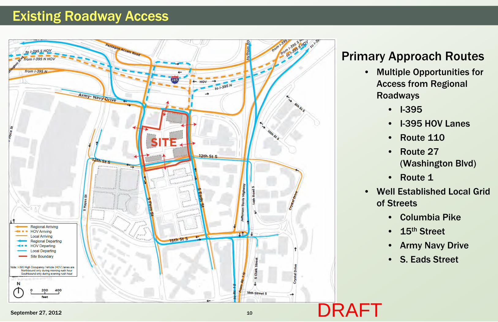
Existing Roadway AccessExisting Roadway Access
Primary Approach Routes• Multiple Opportunities for
Access from Regional Roadways
• I-395
• I-395 HOV Lanes
• Route 110
• Route 27 (Washington Blvd)
• Route 1
• Well Established Local Grid of Streets
• Columbia Pike
• 15th Street
• Army Navy Drive
• S. Eads Street
September 27, 2012 DRAFT

11
Traffic Analysis
September 27, 2012 DRAFT

12
Traffic AnalysisTraffic Analysis
September 27, 2012 DRAFT
Traffic Impact Analysis
• A Traffic Impact Analysis (TIA) was completed for the PenPlace site
• The TIA was scoped with VDOT and Arlington County
• The analysis was completed according to VDOT Chapter 527 guidelines
• VDOT reviewed and approved the study

13
Site Transportation CharacteristicsSite Transportation Characteristics
Crystal City Mode Splits*• Transit – 44%
• Carpool/Vanpool – 9%
• Bike/Walk – 4%
• Drive Alone (DA) - 41%
47% 48%
41%
79%
34%
40%
44%
11%10%
3% 4%1%
9% 8% 9%
4%
0%
20%
40%
60%
80%
100%
Ballston/Courthouse Rosslyn Crystal City Other
DA Transit Bike/walk Carpool/vanpool
September 27, 2012
*Based on the Arlington County Commercial Building Topline Research Report (July 2009) by LDA Consulting and Southeastern Institute of Research
DRAFT
PenPlace Development Mode Splits• Significant Opportunity for Multi Modal Travel
• Significant Multi Modal Infrastructure available to serve Multi Modal Trips

14
Intersections StudiedIntersections Studied
September 27, 2012 DRAFT
Intersections Studied
• Determined based on scoping meeting with Arlington County and VDOT
• Army Navy Drive
• 12th Street
• 15th Street
• S. Hayes Street
• S. Fern Street
• S. Eads Street
• Route 1 ramps

15
Existing Intersection OperationsExisting Intersection Operations
Existing Operations
• Intersections Operate at Acceptable Standards
– All signalized intersections have overall LOS D or better
– All Intersections have mainline non-turning movements at LOS D or better
• Unsignalized 12th and Army Navy SB approach unacceptable LOS in both peak hours and experiences some delay
September 27, 2012 DRAFT

16
Future Intersection OperationsFuture Intersection Operations
Future Operations
• Intersections Continue to Operate at Acceptable Levels
– All signalized intersections have overall LOS D or better
– All Intersections have mainline non-turning movements at LOS D or better
• Overall Intersection Operations consistent or improved from Background Conditions
September 27, 2012 DRAFT

17
Peak Hour Site Traffic ChangePeak Hour Site Traffic Change
Average (AM/PM) Peak Hour Site Traffic Change
96 Trips Site Roadway Trips
(2.14%) % Increase in Road Volume
Trip Distribution•Discussed with County and
VDOT during scoping process
•Based on:
•Existing Traffic Patterns
•Census Data
•Other Area Studies
•Site Trips Distributed overall multiple Routes
•Minimal Increases in Total Traffic on Adjacent Roads
•0.91% - 4.70%
September 27, 2012 DRAFT

18
Trip Distribution and Approach RoutesTrip Distribution and Approach Routes
Trip Distribution and Approach Routes
• Approach Routes Well Distributed on Adjacent Road Network
• Access Opportunities from all sides of Development
• I-395, I-395 (HOV), VA 244 (Columbia Pike), VA 27 (Washington Boulevard), VA 110 all approach the site from the north
• Route 1 and localized traffic approach site from the south
September 27, 2012 DRAFT

19
Neighborhood Analysis
September 27, 2012 DRAFT

20
Additional StudyAdditional Study
Inbound
Review of Regional vs. Neighborhood-Oriented or Local Routes
Regional Routes show Travel Time Advantage
Average Travel Times:
From Route 1 and S. Glebe:
• Route E – 7 Minute
• Route C – 7.5 Minute
• Route A – 8 Minute
• Route I – 10 Minute
From I-395 and S. Glebe:
• Route J – 4 Minute
• Route K – 8.5 Minute
• Route L – 10 Minute
September 27, 2012 DRAFT

21
Additional StudyAdditional Study
Outbound
Review of Regional vs. Neighborhood-Oriented or Local Routes
Regional Routes show Travel Time Advantage
Average Travel Times
To Route 1 and S. Glebe:
• Route E – 5.5 Minute
• Route A – 10 Minute
• Route I – 14 Minute
To I-395 and S. Glebe:
• Route J – 6 Minute
• Route M – 7.5 Minute
• Route K – 9 Minute
September 27, 2012 DRAFT

22
Street Network
September 27, 2012 DRAFT
23
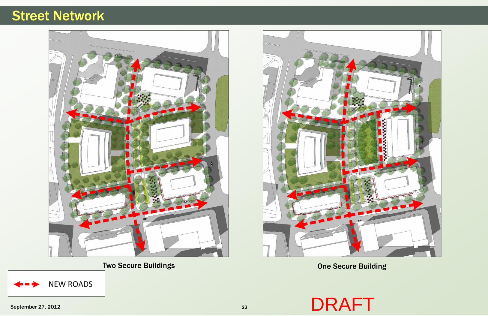
Street NetworkStreet Network
September 27, 2012 DRAFT
Two Secure Buildings One Secure Building
24
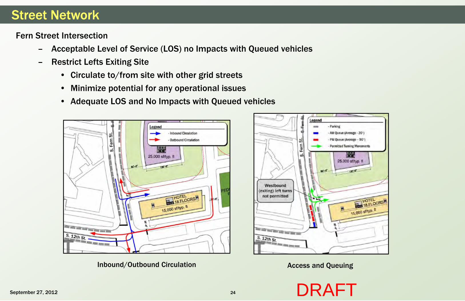
Street NetworkStreet NetworkFern Street Intersection
– Acceptable Level of Service (LOS) no Impacts with Queued vehicles
– Restrict Lefts Exiting Site
• Circulate to/from site with other grid streets
• Minimize potential for any operational issues
• Adequate LOS and No Impacts with Queued vehicles
Inbound/Outbound Circulation Access and Queuing
September 27, 2012 DRAFT

25
Street NetworkStreet NetworkInternal Elm Street Intersection
– No “Lock Up Lefts”
– Adequate Separation
– Less Total “Conflict Points”
• 18 vs. 32 with traditional 4-way intersection
– Raised Crosswalks on Elm (North and South Side of Intersection)
Left Turns Do Not Overlap
Intersection Separation
Source: Federal Highway Administration. (2004). Signalized Intersections: Informational Guide. (FHWA Report No. FHWA-HRT-04-091).
(http://www.fhwa.dot.gov/publications/research/safety/04091/index.cfm)
Reduced Conflict PointsSeptember 27, 2012 DRAFT
Raised Crosswalks

26
Street Sections/Sidewalk Width
September 27, 2012 DRAFT

27
Street Sections - OverviewStreet Sections - Overview
September 27, 2012 DRAFT
Two Secure Buildings One Secure Building

28
Street Sections – Army Navy Drive (A)Street Sections – Army Navy Drive (A)
September 27, 2012 DRAFT
PROPOSED BUILDING
20'-0"
EXISTING TRAVEL LANES AND MEDIAN
68'-0"
EXISTING EXISTING SIDEWALK (5'-0" +/-) PARKING LOT
--
r I
I I
I \
29
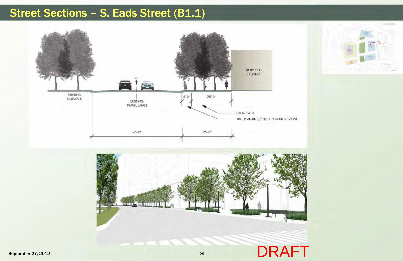
Street Sections – S. Eads Street (B1.1)Street Sections – S. Eads Street (B1.1)
September 27, 2012 DRAFT
EXISTING SIDEWALK
J
I EXISTING
TRAVEL LANES
45'-0"
l r
t 1 l
25'-0"
PROPOSED BUILDING
-......_---TREE PLANTING/ STREET FURNITURE ZONE
OHE SECIJJIE IUILOING
r I

30
Street Sections – S. Eads Street (B1.2)Street Sections – S. Eads Street (B1.2)
September 27, 2012 DRAFT
EXISTING SIDEWALK I
EXISTING TRAVEL LANES
'----L LEAR PATH
LANDSCAPE WITH TURF, TREES AND SHRUBS -HARDSCAPE AT BUILDING ENTRANCES
45' PLANTING/STREET FURNITURE ZONE
7f----------------------------------~~--------~ ~--~~~RK.INGLANE
82'-0"SECURE OPEN SPACE
PROPOSED BUILDING
r I
--
I I
I \

31
Street Sections – S. Eads Street (B2)Street Sections – S. Eads Street (B2)
September 27, 2012 DRAFT
EXISTING SIDEWALK
ct I
I EXISTING
TRAVEL LANES
48'-0" 15'-0"
PROPOSED BUILDING
"1------r LEAR PATH
"+---TREE PLANTING/ STREET FURNITURE ZONE
I {~
--
r I
I I
I \
32
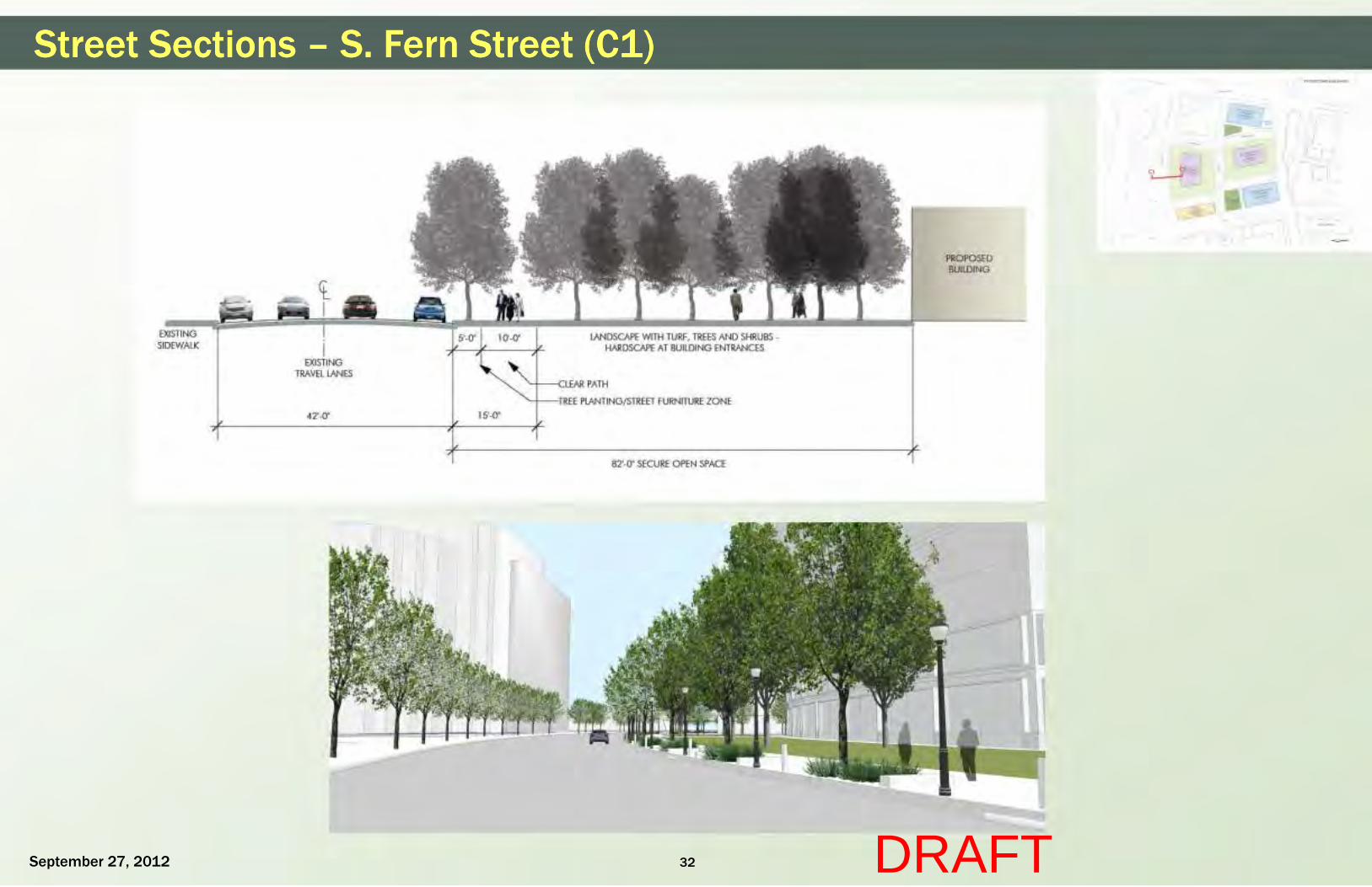
Street Sections – S. Fern Street (C1)Street Sections – S. Fern Street (C1)
September 27, 2012 DRAFT
EXISTING SIDEWALK
EXISnNG TRAVEL LANES
42'-0' 15'-0"
LANDSCAPE WITH TURF, TREES AND SHRUBS -HARDSCAPE AT BUILDING ENTRANCES
TREE PLANTING/STREET FURNITURE ZONE
82'-0' SECURE OPEN SPACE
PROPOSED BUILDING
r I
c~
--
I I
I \

33
Street Sections – S. Fern Street (C2)Street Sections – S. Fern Street (C2)
September 27, 2012 DRAFT
EXISTING BUILDING
EXISTING SIDEWALK I
EXISTING TRAVEL LANES
42'-0" 22'-0"
PROPOSED BUILDING
r I
ZONE
--
I I
I \

34
Street Sections – Internal Street (D1.1)Street Sections – Internal Street (D1.1)
September 27, 2012 DRAFT
PROPOSED BUILDING
TREE PLANTING/AMENITY ZONt-----"
PARKING
7'-0" 5'-0" 7'-0"
12'-0"
22'-0" 7'-0" 5 '-0"
TRAVEL LANES
36'-0"
1 0'-0"
PROPOSED BUILDING
"-t----{...Ltfi,K PATH
'--+--TREE PLANTING/ AMENITY ZONE
'-+--1-'ARKING LANE
OHE UCIJJIE IUILOING
r I

35
Street Sections – Internal Street (D1.2)Street Sections – Internal Street (D1.2)
September 27, 2012 DRAFT
PROPOSED BUILDING
TREE PLANTING/AMENITY 701NF------"'1
PARKING 30'-0" 15'-0'
'---1-------c:tEJ~ PATH
LANDSCAPE WITH TURF, TREES AND SHRUBS -HARDSCAPE AT BUILDING ENTRANCES
~f---TIRFF PLANTING/STREET FURNITURE ZONE
82'-0' SECURE OPEN SPACE
PROPOSED BUILDING
r I
I I
I \

36
Street Sections – Internal Street (D2)Street Sections – Internal Street (D2)
September 27, 2012 DRAFT
PROPOSED BUILDING
TREE PLANTING/AMENITY ?ONF----1
PARKING 30'-0" 15'-0'
.....__,f--cl EJliR PATH
LANDSCAPE WITH TURF, TREES AND SHRUBS -HARDSCAPE AT BUILDING ENTRANCES
......_1--TRFF PLANTING/STREET FURNITURE ZONE
82'-0' SECURE OPEN SPACE
PROPOSED BUILDING
r I
--
I I
I \

37
Street Sections – S. Elm Street (E1.2)Street Sections – S. Elm Street (E1.2)
September 27, 2012 DRAFT
PROPOSED BUILDING
82'-0' SECURE OPEN SPACE
15'-0' 30'-0' 15'-0'
'--1--- T>>> PlANTING/STREET FURNITURE ZONE
~--!';IRKING lANE
82'-0' SECURE OPEN SPACE
PROPOSED BUILDING
r I
--
1\
E1.,2 .....
I I
I I
I \

38
Street Sections – S. Elm Street (E1.1)Street Sections – S. Elm Street (E1.1)
September 27, 2012 DRAFT
PRUPU!>ED BUilDING
82'-0' SECURE OPEN SPACE
120'-0'
r I
15'-0' 30'-0' 15'-0'
PROPOSED BUilDING
-r---<..L.ti\J< PATH
OHE SECIJJIE IUILOING
"'---To« PlANTING/ STREET FURNITURE ZONE

39
Street Sections - 12th Street S. (F)Street Sections - 12th Street S. (F)
September 27, 2012 DRAFT
PROPOSED MET PARK BUILDING
20'-0"- 22'-0" 8'-0" 12'-0"
EXISTING PARKING
TRAVEL
LANE LANE
32'-0" I
I RAISED TROLLEY TRAVEL
LANE LANE
72 -0" 22'-0"
PROPOSED BUILDING
AMENITY ZONE
PATH
--
r I
40
Pedestrian/Bicycle Circulation
September 27, 2012 DRAFT

41
Pedestrian CirculationPedestrian Circulation
September 27, 2012 DRAFT
One Secure Building Two Secure Buildings
Note: Buildings not fully designed and entrances may shift along the designated frontage

42
Bike FacilitiesBike Facilities
• Plans for a Cycletrack to be provided along Army Navy Drive to 12th Street
• New Capital Bikeshare station proposed to be located in Pedestrian Plaza on PenPlace site
• Bike racks and storage will be provided, location is to be determined upon final building design
September 27, 2012 DRAFT
Planned Cycletrack Along Army Navy Drive

43
Secure Roads
September 27, 2012 DRAFT

44
Security Gate AnalysisSecurity Gate Analysis
Queuing Analysis• Analyzed for a range of processing times (from 5 - 20 seconds/vehicle)
• 2 inbound lanes recommended at each access
Booth 1
September 27, 2012
Booth 2Booth 1
DRAFT
Note: Final booth location to be determined with final building design

45
Security Gate Analysis - AlternateSecurity Gate Analysis - Alternate
Booth 1
September 27, 2012
Booth 2Booth 1
DRAFT
Note: Final booth location to be determined with final building design

46
Parking and Loading Entrances
September 27, 2012 DRAFT

On Street ParkingOn Street Parking
47September 27, 2012 DRAFT
TWO SECURE BUILDINGS SCHEME ONE SECURE BUILDINGS SCHEME
Note: Potential area for on street parking is subject to final design

48
Parking and LoadingParking and Loading
September 27, 2012 DRAFT
LOCATION – ONE SECURE BUILDING SCHEMELOCATION – TWO SECURE BUILDINGS SCHEME
Note: Final location to be determined with final building design
ZONE FOR FUTURE LOCATION OF PARKING AND LOADING ENTRY/EXIT
ZONE FOR FUTURE LOCATION OF PARKING AND LOADING ENTRY/EXIT

49
Transportation Demand Management (TDM)
September 27, 2012 DRAFT

50
TDMTDM– Immediate proximity to Metrorail, Metrobus, VRE, commuter buses, Capital
Bikeshare, ZipCar carsharing and the future Crystal City and Columbia Pike Transitways
– On-Site TDM Coordinator
– Arlington County Commuter Services (ACCS) contribution
– Preloaded SmarTrip Cards
– Internal bicycle storage, lockers, and shower facilities
– External bicycle parking facilities
– Designated vanpool and carpool spaces
September 27, 2012 DRAFT

51
Questions/Comments?Questions/Comments?
Questions/Comments?
September 27, 2012 DRAFT