Embed Size (px)
Citation preview
Phase 1A Archaeological Documentary Study
Sportime at Randall’s Island Park Tennis Center Annex
Block 1819, Lot 23 (part),
New York, New York
Prepared for:
Island Tennis, L.P. (dba Sportime) 275 Old Indian Head Road, PO Box 326
Kings Park, NY, 11754
Prepared by:
AKRF, Inc. 440 Park Avenue South
New York, New York 10016
March 2012
i
Table of Contents
Chapter 1: Introduction and Methodology .............................................................................................. 1
A.Project Overview .................................................................................................................................. 1
B. Research Goals and Methodology ........................................................................................................ 1
C. Summary of Previous Archaeological Investigations of Randall’s Island ........................................... 2
Chapter 2: Environmental and Physical Settings .................................................................................... 4
A.Geology and Topography ..................................................................................................................... 4
B. Hydrology ............................................................................................................................................ 4
C. Soils ...................................................................................................................................................... 5
D.Paleoenvironment ................................................................................................................................. 5
E. Current Conditions ............................................................................................................................... 5
Chapter 3: Precontact Period .................................................................................................................... 6
A.Introduction .......................................................................................................................................... 6
B. Paleo-Indian Period (11,000-10,000 BP) ............................................................................................. 6
C. Archaic Period (10,000-2,700 BP) ....................................................................................................... 6
D.Woodland Period (2,700 BP-AD 1500) ............................................................................................... 8
E. Contact Period (AD 1500-1700) .......................................................................................................... 8
F. Previously Identified Native American Archaeological Sites .............................................................. 9
Chapter 4: The Historic Period ............................................................................................................... 10
A.The Early History of Randall’s Island ................................................................................................ 10
B. The Development of the Project Site ................................................................................................. 11
C.The Randall’s Island Alms House Nursery ........................................................................................ 12
D.The Randall’s Island Potter’s Field .................................................................................................... 13
E.Subsurface Infrastructure on Randall’s Island .................................................................................... 15
Chapter 5: Conclusions and Recommendations .................................................................................... 17
A.Sensitivity Assessment ....................................................................................................................... 17
B. Recommendations .............................................................................................................................. 18
References .................................................................................................................................................. 19
Figures
Photographs
Sportime at Randall’s Island Park Tennis Center—Phase 1A Archaeological Documentary Study
ii
List of Figures
Figure 1: Project Location; United States Geological Survey (USGS) 7.5 Minute Topographic Map, Central Park Quadrangle.
Figure 2: Site Plan.
Figure 3: Aerial photograph and photograph key.
Figure 4: Site Photographs.
Figure 5: Site Photographs.
Figure 6: U.S. Coastal and Geodetic Survey of Blackwell’s, Wards, and Randall’s Islands. E. Hergesheimer, 1886.
Figure 7: E. Smith’s 1835 survey of Randall’s Island.
Figure 8: U.S. Coast Survey of Hell Gate; A.D. Bache, 1851.
Figure 9: Ca. 1849 Lithograph of the Alms House Nursery on Randall’s Island by G. Hayward.
Figure 10: Areas of Archaeological Sensitivity.
List of Tables
Table 1: Previously Identified Native American Archaeological Sites ....................................................... 9
1
Chapter 1: Introduction and Methodology
A. PROJECT OVERVIEW
Island Tennis L.P. (Sportime) is seeking an amendment to its existing License Agreement M104-IT, dated October 6, 2005, with the Randall’s Island Sports Foundation (RISF) and the New York City Department of Parks and Recreation (DPR) for the construction, operation, maintenance and management of a year-round tennis facility at Randall’s Island Park, Manhattan, NY. The proposed project would involve the construction of an annex to the existing Sportime at Randall’s Island Park Tennis Center (see Figure 1). The project site for the proposed tennis center annex is currently occupied by a paved lot (Randall’s Island Lot E). The proposed project could also include improvements to five other paved parking lots (Lots A through F). The project site and parking lot improvement sites are located on Block 1819, Lot 23 (part). Portions of the project site and parking lot improvement sites are located beneath the Robert F. Kennedy (RFK)-Triborough Bridge in Randall’s Island Park (see Figure 2).
The proposed project would include the construction of nine new tennis courts in three fabric frame structures that would total 66,500 gross square feet (gsf) and a 4,800-gsf support building. The proposed support building would accommodate reception, viewing areas to the courts, vending machines, office space, a multipurpose room, restrooms, and equipment/storage rooms, in a lightweight steel frame structure with steel cladding and HVAC systems. The fabric frame and support buildings would be constructed on concrete slab foundations.
The proposed project would be built on an existing, paved but unstriped parking area (Lot E) and would also encompass improvements to other existing parking areas, which could include some or all of Randall’s Island Park Lots A through D and F (see Figures 3 through 5). Improvements to these other existing parking areas could include restriping of parking spaces, pedestrian pathway and lighting improvements, an additional vehicle entrance into Lot F, and landscaping. Improvements to Lot C could include ten new bus parking spaces, a covered shelter waiting area with concrete benches, and an emergency call box. Lot F could include a 10,000-square foot green buffer that would be planted primarily on the southern portion of the lot where it would benefit from sunlight and capture surface stormwater.
The proposed actions are subject to New York City Environmental Quality Review (CEQR) and this Phase 1A Archaeological Documentary Study has been prepared as part of an Environmental Assessment Statement (EAS) that is being prepared for the project site. DPR is serving as lead agency during the environmental review. The New York City Landmarks Preservation Commission (LPC) identified the project site as archaeologically significant in a technical review memorandum issued on January 10, 2012. LPC requested this Phase 1A Archaeological Documentary Study to clarify their initial findings that the project site may be sensitive for archaeological resources including remnants of the Native American, colonial, and 19th century occupation of Randall’s Island as well as human remains associated with a potter’s field that was formerly located on the island.
B. RESEARCH GOALS AND METHODOLOGY
The goal of this archaeological documentary study is to determine the likelihood that potential archaeological resources have survived within the study area despite the destructive forces of time, including landscape modification and development, utility installation, and street and parking lot

Sportime at Randall’s Island Park Tennis Center —Phase 1A Archaeological Documentary Study
2
construction. This report has been designed to satisfy the requirements of the LPC and it follows the guidelines of the New York Archaeological Council (NYAC). The study documents the history of the project site and its potential to yield archaeological resources dating to both the precontact and historic periods. In addition, this Phase 1A study also documents the current conditions of the site and its environmental and physical contexts. Finally, this report includes a summary of previous archaeological investigations on Randall’s Island.
As part of the background research for this Archaeological Documentary Study, various primary and secondary resources were analyzed including historic maps and atlases, historic photographs, newspaper articles, local histories, and building records. These published and unpublished resources were consulted at various repositories, including the Main Research Branch of the New York Public Library (including the Local History and Map Divisions). Digital archives such as Google Books (www.googlebooks.com) and the Internet Archive (www.archive.org) were also accessed.
C. SUMMARY OF PREVIOUS ARCHAEOLOGICAL INVESTIGATIONS OF RANDALL’S ISLAND
Numerous archaeological investigations have been completed for sites on Randall’s Island. Reports on file at LPC were reviewed as part of this Phase 1A study and the results of these reports are summarized below.
WARDS ISLAND WATER POLLUTION CONTROL PLANT, 1980
Edward S. Rutsch and Richard L. Porter of Historic Conservation and Interpretation, Inc. completed a Phase 1 survey of a water pollution control plant on Wards and Randall’s Islands in 1980. The site analyzed in that study included a proposed access road on a small portion of Randall’s Island in the vicinity of modern Lot E in an area that was historically occupied by tidal marshland. Limited archaeological testing was completed in the vicinity of Lots B and E. This testing identified 0.6 to 3 feet of modern fill but did not identify an intact buried ground surface or original topsoil, only gravelly glacial till and clay without any cultural material (Rutsch and Porter 1980). This is not unexpected given the fact that the site was formerly inundated by tidal marshland. The report concluded that no archaeological resources would be impacted by the construction of an access road.
RANDALL’S ISLAND CULTURAL RESOURCES ASSESSMENT, 2000
In 2000, Historical Perspectives, Inc. (HPI) prepared a Phase 1A Archaeological Documentary Study for DPR that encompassed the southwestern quadrant of Randall’s Island, opposite the Sportime at Randall’s Island Park project site to the west of the RFK-Triborough Bridge. The report concluded that while it was likely that Native American activity took place on Randall’s Island, subsequent development made it unlikely that intact precontact archaeological resources are present. However, the study found that the area of investigation was sensitive for historic period archaeological resources including shaft features (i.e. privies, cisterns, and wells), refuse deposits, and architectural remnants of the former institutional structures that once stood on that part of Randall’s Island, including the former House of Refuge.
TRIBOROUGH BRIDGE REHABILITATION, 2001
Archaeologist Celia J. Bergoffen, Ph.D. prepared a Phase 1A study for a project through which the RFK-Triborough Bridge was to be rehabilitated and reconfigured. A portion of the site included within that study (referred to as “Site B” in the 2001 study) involved the proposed widening of the Queens toll plazas to the east and west of the bridge, which overlaps with the proposed Tennis Center Annex project site. To the east of the bridge, the site analyzed within Dr. Bergoffen’s report extended approximately 125 feet east of the bridge access ramp in an area with minimal documented disturbance with the exception of some utility installations in portions of the site. The report concluded that the area to the east of the bridge

Chapter 1: Introduction
3
was not archaeologically sensitive and that the potter’s field formerly located on Randall’s Island was further to the south of this portion of the site.
RANDALL’S ISLAND WATERPARK, 2001
Dr. Bergoffen prepared a Phase 1A study of the Randall’s Island Waterpark site, along the northwest shore of Randall’s Island, in 2001. The report concluded that the project site was not sensitive for precontact archaeological resources due to a lack of previously documented archaeological sites on the island and not sensitive for historic period resources due to a lack of historic development within the project site on which that study focused. However, because of the extent of disturbance to the site in the 20th century, the report recommended a Topic Intensive Documentary Study of the House of Refuge to determine if additional archaeological analysis was warranted.
RANDALL’S ISLAND AMPHITHEATRE, 2002
In 2002, archaeologist Joan H. Geismar, Ph.D. completed archaeological testing at the site of the proposed Randall’s Island Amphitheatre, on the western shore of Randall’s Island approximately 600 feet west of the Sportime at Randall’s Island Park project site. Dr. Geismar’s testing indicated that the site has been heavily disturbed by the historic development of the area and during the construction of the RFK-Triborough Bridge and that there were no archaeological resources, including human remains, on the site.
RANDALL’S ISLAND FIELD DEVELOPMENT PROJECT, 2008
In 2008, a Phase 1A Archaeological Investigation of the Randall’s Island Field Development Project was prepared by Geoarcheology Research Associates (GRA). That project involved the construction of five fields on Randall’s and Wards Islands as part of the Randall’s Island Sports Field Project. The project areas analyzed in the report were all located on Wards Island to the south of the Sportime at Randall’s Island Park project site. While Wards and Randall’s Islands were historically separated by a waterway known as “Little Hell Gate,” the two landforms have since been connected by landfill (described in greater detail below). The report summarized the history of both Randall’s and Wards Islands, including the potter’s fields that were historically located there. The report concluded that while there had been disturbance to the fields on Wards Island, the site did possess some archaeological sensitivity and GRA recommended subsurface testing and geo-probe coring.
4
Chapter 2: Environmental and Physical Settings
A. GEOLOGY AND TOPOGRAPHY
Randall’s Island is found near the boundary of several geographic bedrock regions: the Manhattan Prong of the New England (Upland) Physiographic Province (Manhattan), the Harlem Lowland Province (the Bronx), and the Atlantic Coastal Plain Province (Long Island). The bedrock in the area of Randall’s Island represents its proximity to these various regions and is largely composed of either Manhattan schist and Fordham Gneiss (characteristic of much of the southern Bronx) separated by ridges of Inwood Marble (Schuberth 1968). These metamorphic rock types date to the Lower Paleozoic and/or Precambrian Eras, formed approximately 500 to 4500 million years ago (ibid). The project site appears to be in the area underlain by Manhattan Schist.
The 1865 Viele map depicting the original topography of portions New York City indicates that Randall’s Island was historically much narrower, with the portion of the island to the east of the project site having been largely created through landfilling to connect Randall’s Island with a former marshy island known as “Sunken Meadow.” Significant landscape modification has transformed Randall’s Island from “one of nature’s failures” as a result of “its surface being so largely covered with malarious swamps and surmounted with hills of granite” (Richmond 1872).
Randall’s and Wards Islands were historically separated by a channel known as “Little Hell Gate,” and Randall’s Island was separated from the Bronx by the Harlem Kills. Both of these waterways have since been filled and as a result, Randall’s and Wards Islands are now a single landmass and the Harlem Kills reduced to a narrow channel. Historic maps suggest that a ridge encircled the central portion of the island, separating it from areas of tidal marsh at the northwest and southeast corners of the island.
An 1886 topographical map of a portion of the East River including Randall’s Island was prepared by E. Hergesheimer. That map shows that the proposed Tennis Center project site was largely occupied by the tidal marsh that was located at the southeastern portion of Randall’s Island (see Figure 6). The northern portion of Parking Lot E was originally dry land at the base of the hilly ridge that lined the island’s natural perimeter. The parking lots to the north of Lot E were at a higher elevation, possibly as high as 20 feet above sea level as depicted on historic USGS maps from 1891 and 1900. Significant landscape modification has occurred on Randall’s Island, and portions of the project site that were historically flat now appear to have a gentle slope while former waterways have been filled in and the land developed. The extent to which the ground surface may have been graded or disturbed is unclear given the inaccuracy of historic maps and discrepancies between the datum from which modern and historic elevations are or were measured.
B. HYDROLOGY
Glacial runoff also created many small streams, rivers, and lakes. As temperatures increased and this runoff ceased, many of these small water courses evolved into swamps and marshlands punctuated with brooks and streams while others continued to etch their way through the glacial bedrock. Historic maps show that the southeast and northeast portions of the island were once covered with tidal marshland, including a portion of the project site; these areas have since been filled.
Chapter 2: Environmental and Physical Settings
5
C. SOILS
Two soil types are present on Randall’s Island: the northwestern half of the island is covered with the Unadilla-Riverhead-Pavement and Buildings complex and the southeastern portion of the island contains LaGuardia-Ebbets-Pavement & Buildings soil complex. Both soil types are characterized by 0 to 8 percent slopes, with the former being developed with parks, hospitals, or cultural facilities with at least 15 percent developed with pavement and buildings and the latter being typified by fill (construction debris and natural soils) over natural swamp, tidal marsh or water (New York City Soil Survey Staff 2005).
D. PALEOENVIRONMENT
Due to the extended glacial period that left the Northeast blanketed in thick ice sheets for thousands of years, the area was not inhabited by humans until approximately 11,000 years ago. As temperatures increased, a variety of flora and fauna spread through the region. At this time, large open forests of spruce, fir, pine, and other tree species expanded across the Northeast, interspersed with open meadows and marshland. A wide variety of animal life could also be found, including large mammals such as mammoth, mastodon, caribou, musk ox, moose, as well as smaller mammals such as fox, beaver, hare, and many kinds of marine animals.
Climate changes continued to re-shape the environment of the Northeast as time progressed. As the climate grew increasingly warmer, jack pine, fir, spruce, and birch trees were replaced with hardwood forests of red and white pine, oak, and beech (Ritchie 1980). Furthermore, a decrease in glacial runoff resulted in the creation of small bodies of water such as lakes as well as, later on, low-lying marshes and swampy areas. By the time of the Early Archaic period, beginning approximately 10,000 BP, there was “considerable environmental diversity, with a mosaic of wetlands, oak stands, and a variety of other plant resources…[making it]…an attractive and hospitable quarter for both human and animal populations” (Cantwell and Wall 2001: 53).
Warmer temperatures forced the herds of large mammals to travel north before eventually dying out. The new surroundings attracted other animals such as rabbit, turkey, waterfowl, bear, turtles, and white-tailed deer. The expanded water courses became home to a variety of marine life, including many varieties of fish, clams, oysters, scallops, seals, and porpoises, among others (Cantwell and Wall 2001).
E. CURRENT CONDITIONS
The project site is currently occupied by a parking area comprising Parking Lots A through F (see Figures 4 and 5). The project site is part of Randall’s Island Park, a public park under the jurisdiction of the New York City Department of Parks and Recreation (NYCDPR). Lot E, the portion of the project site where the proposed tennis annex will be constructed, is currently an unimproved parking lot. Lots B, C, and D are currently paved parking lots. Lot F is an additional, unimproved parking area, and Lot A is an unimproved additional bus parking lot. Lots A through D are located under the elevated guideway of the RFK-Triborough Bridge—which is eligible for listing on the State and National Registers of Historic Places—on the north side of a service road. Lots E and F are located on the south side of the service road and the elevated guideway of the RFK-Triborough Bridge.
6
Chapter 3: Precontact Period
A. INTRODUCTION
Archaeologists have divided the time between the arrival of the first humans in northeastern North America and the arrival of Europeans more than 10,000 years later into three periods: Paleo-Indian (11,000-10,000 BP), Archaic (10,000-2,700 BP), and Woodland (2,700 BP–AD 1500). These divisions are based on certain changes in environmental conditions, technological advancements, and cultural adaptations, which are observable in the archaeological record.
B. PALEO-INDIAN PERIOD (11,000-10,000 BP)
As mentioned in Chapter 2, human populations did not inhabit the Northeast until the glaciers retreated some 11,000 years ago. These new occupants included Native American populations referred to by archaeologists as Paleo-Indians, the forbearers of the Delaware—also called the Lenape Indians—who would inhabit the land in later years.
The Paleo-Indians most likely exploited all the different resources provided by their environment. It has been suggested that they not only actively hunted the large mammals that roamed about the region (mammoths, mastodons, etc.), but they also hunted and trapped smaller animals and supplemented their diet with fish and gathered plants (Cantwell and Wall 2001).
There was a very distinct Paleo-Indian style of lithic technology, typified by fluted points. These were elaborately detailed stone points that would have been used for a variety of functions, most notably for hunting. They were often made of high-quality imported chert, but were also crafted from local materials. Other stone tools manufactured at this time included knives, scrapers, drills, and gravers. Wood, ivory, and other materials were also used for the manufacture of composite tools, such as hunting spears.
Archaeological evidence suggests that the Paleo-Indians were likely highly mobile hunters and gatherers. They appear to have lived in small groups of fewer than 50 individuals (Dincauze 2000) and did not maintain permanent campsites. In addition, most of the Paleo-Indian sites that have been investigated were located near water sources.
It is because of the close proximity of Paleo-Indian sites to the coastline that so few of them have been preserved in the New York City area. As the glaciers continued to melt, sea levels rose and much of what was once adjacent to the water line became submerged. In fact, only one Paleo-Indian site has been discovered in the entire New York City area—that of Port Mobil, on Staten Island. This location has yielded a collection of fluted points and other stone tools characteristic of the period.
C. ARCHAIC PERIOD (10,000-2,700 BP)
The Archaic period has been sub-divided into three chronological segments, based on trends identified in the archaeological record which reflect not only the ecological transformations that occurred during this period, but the cultural changes as well. These have been termed the Early Archaic (10,000–8,000 BP), the Middle Archaic (8,000–6,000 BP) and the Late Archaic (6,000–2,700 BP) (Cantwell and Wall 2001). The Late Archaic is sometimes further divided to include the Terminal Archaic (3,000-2,700 BP).
The aforementioned environmental transformations included a continued post-glacial warming trend, the extension of hardwood forests, and a decrease in glacial runoff which resulted in the creation of lakes and
Chapter 3: Precontact Period
7
other small bodies of water. There was a subsequent migration of new animal and plant species into the area, while the herds of large mammals traveled north, eventually dying out. The new surroundings attracted smaller animals, such as rabbit, turkey, waterfowl, and white-tailed deer.
As the Archaic period progressed and the number of plant and animal species inhabiting the area increased, so did the size of the human population. In general, archaeological research has shown that Archaic Native American sites were most often located near water sources. The abundance of food resources which arose during this period allowed the Native Americans to occupy individual sites on a permanent or semi-permanent basis, unlike their nomadic Paleo-Indian predecessors. These individuals migrated on a seasonal basis within specific territories and consistently returned to and reoccupied the same sites.
The arrival of new food sources allowed the human population to expand their subsistence strategies and at the same time forced them to develop different technologies that would allow such resources to be exploited. Perhaps the most important of these developments was the elaboration of Native American fishing technology, which occurred during the Middle Archaic in response to an increasing dependence on the area’s marine resources. This new technology included hooks and stone net sinkers. In addition, the influx of nut- and seed-bearing foliage resulted in the development of stone mortars and pestles in addition to stone axes used to process plant material.
In order to successfully hunt the smaller game animals that had established themselves in the region, narrower spear points and knives were manufactured, along with weighted spear throwers. Domestic technology was advanced at the same time, with the development of a wider variety of hide scrapers and, later in the period, the introduction of bowls made from steatite or soapstone. Tools continued to be crafted in part from foreign lithic materials, indicating that there was consistent trade among Native American groups from various regions in North America throughout the Archaic period.
Rising sea levels coupled with the dominance of coniferous forests created a habitat that was ill-fitted to human habitation (Boesch 1994). Few Early Archaic sites have been identified in New York City. Most of those that have been identified are located on Staten Island; including Wards Point, Richmond Hill, the H.F. Hollowell site, and the Old Place site. Sites such as Wards Point—a domestic habitation location which due to lowered sea levels was originally inland—tend to be deep and stratified and have yielded stone tools related to cooking, woodworking, and hide processing. Many years of constant Native American occupation caused the artifacts to be deeply buried under more recent debris deposits (Cantwell and Wall 2001). However, at the Old Place Site, the only artifacts which were discovered—stone tool assemblages—were found at relatively shallow depths of around 42 inches (3½ feet) (Ritchie 1980).
There are also few Middle Archaic sites in the region. The majority of these tend to consist of large shell middens, which are often found near major water courses such as the Hudson River, although stone points have also been found in such locations. These sites were in great danger of obliteration because of their proximity to the shrinking coastlines.
Unlike the Early and Middle periods, several Late Archaic sites have been found in the New York City area. Two notable sites, Tubby Hook and Inwood, are located at the northern end of the island of Manhattan. Both sites contain large shell middens, while the Inwood site also features rock shelters that were inhabited by Archaic populations. Both sites were continuously occupied for several thousand years.
In addition, many Terminal Archaic sites from all across the city have provided examples of the Orient culture, which is characterized by its long fishtail stone points and soapstone bowls. Although there are extremely elaborate burial sites attributed to the Orient culture on eastern Long Island, none have been identified in the immediate vicinity of New York City.
Sportime at Randall’s Island Park Tennis Center —Phase 1A Archaeological Documentary Study
8
D. WOODLAND PERIOD (2,700 BP-AD 1500)
The Woodland period represents a cultural revolution of sorts for the Northeast. During this time, Native Americans began to alter their way of life, focusing on a settled, agricultural lifestyle rather than one of nomadic hunting and gathering. Social rituals begin to become visible in the archaeological record at this time and many elaborate human and canine burial sites have been identified. The first evidence of smoking has also been found—stone pipes have been uncovered at Woodland sites—and it was at this time that pottery began to be produced.
In general, a greater emphasis was placed on composite tools during the Woodland period. While stone scrapers, knives, and hammerstones were still in use, there was an increased use of bone, shell, and wood in tool making. Furthermore, the development of bows and arrows revolutionized hunting practices. Many tools were still made from imported materials, indicating that the trade networks established earlier were still being maintained (Cantwell and Wall 2001).
Pottery was introduced into Native American society early in the Woodland period and by the time of European contact in the 1500s, well-crafted and elaborately-decorated pottery was being manufactured. Like the Archaic period, the Woodland has been divided into Early, Middle, and Late sections, which differ mostly based on the style of pottery which was produced at that time. Woodland pottery had simple beginnings; the first examples were coil pots with pointed bases, which were made with grit temper. These were replaced during the Middle Woodland period by shell-tempered vessels bearing a variety of stamped and imprinted decorations. As the period drew to a close, the decorative aspect of the pottery was further augmented with the addition of intricate ornamental rims (Louis Berger Group 2004).
Woodland-era sites across North America indicate that there was an overall shift toward full-time agriculture and permanently settled villages. Sites in New York City, however, suggest that the Native Americans there continued to hunt and forage on a part-time basis. This was most likely due to the incredibly diverse environmental niches that could be found across the region throughout the Woodland period (Cantwell and Wall 2001, Grumet 1995). Nevertheless, Woodland societies were considerably more sedentary than were their predecessors and there was some farming of maize, beans, squash, and tobacco. The development of pottery, increasingly complex burial sites, and the presence of domesticated dogs are all consistent with sedentary societies, which have a close association with a particular territory or piece of land.
E. CONTACT PERIOD (AD 1500-1700)
The Woodland period ended with the arrival of the first Europeans in the early 1500s. The Delaware Indians who occupied lower Manhattan at that time spoke a dialect now referred to as Munsee. They lived in villages consisting of multiple longhouses and practiced some farming, but subsisted mostly on food obtained by hunting, gathering, and fishing (Grumet 1995).
With the introduction of European culture into the indigenous society, the way of life once maintained by the Native Americans was thoroughly and rapidly altered. European guns, glass beads, copper kettles, and alcohol soon became incorporated into the Native American economy, while European diseases brought about the demise of huge portions of the population.
Native Americans at first maintained the village sites they had established near water sources and the two groups co-existed. As their trade with European settlers intensified, they became increasingly sedentary and as the European population grew and required more land, the relationship between the two groups turned sour. Fierce wars broke out between the Dutch and the Indians. Being armed with far more guns than the natives, the Dutch quickly forced the Indians out of the region.
Chapter 3: Precontact Period
9
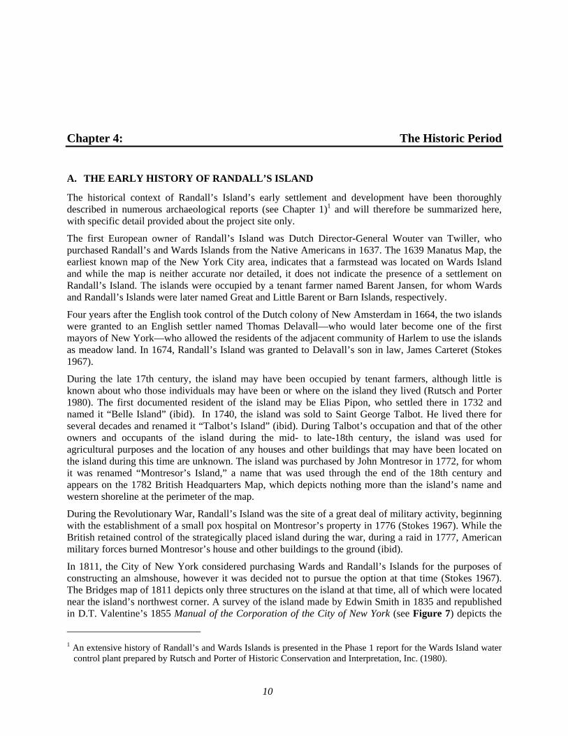
F. PREVIOUSLY IDENTIFIED NATIVE AMERICAN ARCHAEOLOGICAL SITES
As has been reported in the many archaeological investigations of sites on Randall’s Island (see Chapter 1), no Native American sites have been previously identified on the Island itself. However, two large Native American villages have been identified on the shores of Manhattan and the Bronx opposite Randall’s Island (see Table 1). These sites include Conykeekst, on the eastern shore of Manhattan in the vicinity of East 121st Street, and Aspetong, a village site on the southern shore of the Bronx immediately north of Randall’s Island (Bolton 1922). It is therefore likely that Native American activity, possibly resources exploitation, hunting, or camping, took place on Randall’s Island, which was known to the Native American as Minnahanonck, a name also used to describe modern Roosevelt Island (Grumet 1981).
Table 1Previously Identified Native American Archaeological Sites
Site Name Site #
Approximate Distance from
study area Time
Period Site Type Additional References
Conykeekst ----- 0.38 to 0.57 miles
(2,000 to 3,000 feet)Precontact Seasonal Native American village Bolton (1922)
Aspetong ----- 0.38 to 0.57 miles
(2,000 to 3,000 feet)Precontact Native American village Bolton (1922)
10
Chapter 4: The Historic Period
A. THE EARLY HISTORY OF RANDALL’S ISLAND
The historical context of Randall’s Island’s early settlement and development have been thoroughly described in numerous archaeological reports (see Chapter 1)1 and will therefore be summarized here, with specific detail provided about the project site only.
The first European owner of Randall’s Island was Dutch Director-General Wouter van Twiller, who purchased Randall’s and Wards Islands from the Native Americans in 1637. The 1639 Manatus Map, the earliest known map of the New York City area, indicates that a farmstead was located on Wards Island and while the map is neither accurate nor detailed, it does not indicate the presence of a settlement on Randall’s Island. The islands were occupied by a tenant farmer named Barent Jansen, for whom Wards and Randall’s Islands were later named Great and Little Barent or Barn Islands, respectively.
Four years after the English took control of the Dutch colony of New Amsterdam in 1664, the two islands were granted to an English settler named Thomas Delavall—who would later become one of the first mayors of New York—who allowed the residents of the adjacent community of Harlem to use the islands as meadow land. In 1674, Randall’s Island was granted to Delavall’s son in law, James Carteret (Stokes 1967).
During the late 17th century, the island may have been occupied by tenant farmers, although little is known about who those individuals may have been or where on the island they lived (Rutsch and Porter 1980). The first documented resident of the island may be Elias Pipon, who settled there in 1732 and named it “Belle Island” (ibid). In 1740, the island was sold to Saint George Talbot. He lived there for several decades and renamed it “Talbot’s Island” (ibid). During Talbot’s occupation and that of the other owners and occupants of the island during the mid- to late-18th century, the island was used for agricultural purposes and the location of any houses and other buildings that may have been located on the island during this time are unknown. The island was purchased by John Montresor in 1772, for whom it was renamed “Montresor’s Island,” a name that was used through the end of the 18th century and appears on the 1782 British Headquarters Map, which depicts nothing more than the island’s name and western shoreline at the perimeter of the map.
During the Revolutionary War, Randall’s Island was the site of a great deal of military activity, beginning with the establishment of a small pox hospital on Montresor’s property in 1776 (Stokes 1967). While the British retained control of the strategically placed island during the war, during a raid in 1777, American military forces burned Montresor’s house and other buildings to the ground (ibid).
In 1811, the City of New York considered purchasing Wards and Randall’s Islands for the purposes of constructing an almshouse, however it was decided not to pursue the option at that time (Stokes 1967). The Bridges map of 1811 depicts only three structures on the island at that time, all of which were located near the island’s northwest corner. A survey of the island made by Edwin Smith in 1835 and republished in D.T. Valentine’s 1855 Manual of the Corporation of the City of New York (see Figure 7) depicts the
1 An extensive history of Randall’s and Wards Islands is presented in the Phase 1 report for the Wards Island water
control plant prepared by Rutsch and Porter of Historic Conservation and Interpretation, Inc. (1980).
Chapter 4: Historic Period
11
island in the same manner. These structures stood for many years and no other development occurred on the other portions of the island, including the project site, until the mid-19th century, when the island was purchased by the City of New York and redeveloped with municipal institutions such as the Alms House, hospitals, and a Potter’s Field.
B. THE DEVELOPMENT OF THE PROJECT SITE
No development appears to have occurred on the project site before the mid-19th century. The Bridges map of 1811 depicts only the three structures making up the estate of John Randel in the northwest part of the island. The project site is depicted on the map as part marshland and part undeveloped upland. This map does not indicate any development in the vicinity of the project site, which is depicted as being covered with both marsh and upland. Subsequent maps, including those published in 1821 by John Randel, in 1836 by J.H. Colton, continue to depict the project site in a similar manner and the latter map indicates that the upland portions of the project site were wooded. A Coastal Survey map drafted by Charles Renard in 1837 does not depict any development in the project site but suggests that the upland area in the vicinity of the project site was laid out as farmland.
Coastal Surveys completed by H.L. Whiting in 1848 and 1857 and A. Bache in 1851 (Figure 8) are some of the first maps prepared after the construction of the Alms House Nursery—the juvenile department of the City’s Alms House—on Randall’s Island in 1845 (discussed in greater detail below). These three maps depict the project site in an almost identical manner: the southern portion of the project site extended through marshland and the northern half was occupied by a portion of the Alms House grounds or by vacant land. Few changes to the project site are depicted on different on Coastal Surveys published in 1886 (see Figure 6) and 1909 with the exception of the addition or expansion of buildings associated with the Alms House Nurseries. These coastal surveys indicate that structures were present within the project site in at least two locations. The first was a rectangular structure, later expanded into a T-shaped building at the southeast corner of the asylum property. This structure—which, as described below, appears to have been a playhouse/gymnasium—was surrounded by walkways and landscaped grounds. This structure and the remainder of the Nursery complex are depicted in a lithograph published in D.T. Valentine’s 1849 Manual of the Corporation of the City of New York (see Figure 9). The drawing also indicates that the grounds surrounding the building were relatively flat and planted with trees. Other structures associated with the Nurseries were immediately adjacent to the western side of the project site in this area.
Several different small structures were depicted on historic maps at the southern end of the upland portion of the project site. The 1848 and 1851 Coastal Surveys depict three small adjacent structures in this location while the 1857 map shows a single, larger structure. The 1886 Hergesheimer map depicts a greater amount of development in this portion of Randall’s Island and indicates that the formerly undeveloped central portion of the island had been developed with roads and small structures. The map depicts a long narrow structure and several smaller buildings at the southern end of the upland portion of the project site, bordering the marsh. It is likely that these were outbuildings associated with the maintenance of the grounds of the Nursery or the Potter’s Field to the south. A dwelling inhabited by the keeper of the Potter’s Field was constructed on the island in an unknown location the north of the cemetery, and it is possible that the dwelling is one of the larger structures depicted to the west of the project site on earlier maps.
A Coastal Survey published in 1913 depicts minor changes to the project site, most notably the expansion of the hospital building within the northern portion of the site and the demolition of the small outbuildings to the south. By 1915, the Hell Gate Bridge had been constructed to the east of the project site. The majority of the hospital buildings with the exception of the one within the project site were demolished circa 1936 when the RFK-Triborough Bridge was constructed. A Coastal Survey map from 1939 reflects
Sportime at Randall’s Island Park Tennis Center —Phase 1A Archaeological Documentary Study
12
the demolition of the structure on the project site, as well as all the other buildings on Randall’s Island. In the mid-20th century, a bridge was constructed in the vicinity of the project site to connect Randall’s and Wards Islands. This bridge is visible on historic aerial photographs of the island from the 1950s through the 1980s. It was demolished after landfilling connected the two islands. Those historic aerial photographs (which date to 1955, 1966, 1978, and 1984) do not depict major changes to the project site, which was by that time a paved parking lot, with the exception of the expansion of the bridge’s toll platform in the early-1970s.
C. THE RANDALL’S ISLAND ALMS HOUSE NURSERY
The cornerstone of the new Nursery establishment was laid in 1845 (Stokes 1967). Some of the buildings were destroyed by fire just a few days before children in a similar facility at the Long Island Farm School were about to be transferred to Randall’s Island (Albany Argus 1845). The fenced-in complex of buildings was constructed on the northeastern portion of Randall’s Island to accommodate children who had been orphaned, were living on the streets, or whose families simply could not provide a home for them. After three months, families could pay a monthly fee to keep their children on Randall’s Island; if a child had no family or if the family could not pay, the child was apprenticed (if old enough) or placed with an adoptive family (Richmond 1872). The House of Refuge, a separate, private institution for juvenile delinquents, was established on the southern end of Randall’s Island on land granted to the organization by the City in 1851 (Valentine 1859). A 6-foot-high wall ran across the island separating the Nurseries from the House of Refuge (ibid). A wall or property line may be depicted running through the project site on the 1886 Hergesheimer map (Figure 3), although the 1879 bird’s eye drawn by Will L. Taylor suggests that the House of Refuge complex was surrounded by its own set of walls that did not cross the entire island.
The original complex of 12 buildings included a quarantine house; a hospital; separate nurseries for boys, girls, and infants; an “idiot house” for mentally and physically handicapped children;1 separate schools and playhouses for boys and girls; a bake house; and a kitchen (New York Herald 1849a). These buildings were re-purposed in subsequent years as additional facilities were added and others expanded as the needs of the institution changed. Some or all of the structures appear to have been constructed from stone quarried on nearby Roosevelt Island (The New York Herald 1845a). Stone was also blasted from the east side of Randall’s Island and was used for various construction projects associated with the Nursery, including the enclosure of a coal yard in 1859 (Governors of the Alms House 1860). The grounds were cultivated and landscaped, and while initially the various buildings in the complex were connected by wood plank walks, these were replaced with brick walks and stone curbs in the 1850s (ibid).
The Nursery was described in detail by W.H. Davenport in an 1867 issue of Harper’s New Monthly Magazine. The article noted that the buildings at the east of the complex were used as the Nursery buildings while the buildings to the west served as the hospital facilities. The structure within the project site—which by that time appears to have been expanded with a southern wing and the addition of a third floor—is described as one of two “dwellings to relieve the other buildings” which by that time had become overcrowded (Davenport 1867: 10). The building, which was occupied by the Nursery’s “large boys,” contained a gymnasium on the ground floor, dormitories on the top floors, and a playhouse in what was then a newly-added extension (ibid). To the west of this structure was the Quarantine House, to the north of which was the dormitory for the larger boys, followed by a large structure used as the Nursery’s school and administrative offices.
In the late-19th century, various accounts indicate that between 1,000 and 3,000 children resided in the Nursery at any given time, the majority of which were boys (Davenport 1867 and Richmond 1872). In 1 A larger hospital for disabled children was later constructed further to the west.
Chapter 4: Historic Period
13
addition to their school work and regular military drills, older boys worked in the institution’s gardens and/or in its tailor shop, where boys who were not physically capable of labor were taught a trade (Davenport 1867). Larger boys bathed in the river in an enclosed salt water bath house located on the shore of the island to the east of the project site while smaller children were bathed in an indoor facility adjacent to the gymnasium to the north of the project site. By the late-19th century, the “infants” at the Nursery were actually children between the ages of three and five; children younger than age three were cared for at the Foundling Hospital on Roosevelt Island (ibid).
The Nursery was staffed by doctors, matrons and wardens, teachers, and other professional individuals, while additional work (including landscaping, farming, cooking, cleaning, childcare, etc.) was completed by adult inmates from the Alms House or the Work House on Roosevelt Island (Davenport 1867). The grounds were used for agricultural purposes, and most of the “ample and nutritious” food consumed by the children living at the Nursery was grown on the island (Richmond 1872: 36). Clothing for the children living on Randall’s Island was often produced by inmates in other City institutions, including the Penitentiary on Blackwell’s Island (Governors of the Alms House 1850).
The Nursery maintained its own cemetery on the grounds “in an orchard to the north of the Nursery buildings, not far distant from the boat landing…well nigh hid by shrubbery and tall grass” (Davenport 1867: 18). The graves were marked by a narrow wooden board inscribed with a number, written in pencil, noting the order of interment (ibid). The early coastal surveys of Randall’s Island depict a small dock, possibly the boat landing described above, along the eastern shore of Randall’s Island to the east of the project site and depict trees (possibly the orchard) along the island’s eastern and northern shorelines. It is therefore likely that the Nursery cemetery was located outside the project area near the northeastern end of the original island.
D. THE RANDALL’S ISLAND POTTER’S FIELD
The City’s Potter’s Field, where those who could not afford a burial or whose bodies went unclaimed were interred, was ordered to be moved to Randall’s Island from its former location at what is now Bryant Park near Fifth Avenue and 42nd Street in Manhattan in 1843 (Stokes 1967). The island was selected as the city’s new burial location because of its isolation from the populated areas—and the valuable real estate—of Manhattan (Board of Aldermen 1843). The land selected for the new burial place was “at the southerly extremity” of the island and was “an orchard partly insulated from the main island, and by its size, elevation, the character of the soil, and the facility of access, at all seasons of the year, admirably adapted to this purpose” (ibid: 257).
The Potter’s Field accepted the dead from all over the city, including many from the City’s institutional facilities on nearby Wards Island. A dead house was located on the northern shore of that island for the temporary storage of the deceased before they were brought to Randall’s Island for burial (Verplanck and Rodewald 1850). Additional bodies were transported from the dead house at Bellevue Hospital in Manhattan, but only after a sufficient number had accumulated (New York Herald 1849b).
Like its predecessors, the municipal burial ground on Randall’s Island was considered to be a “great evil” and an “abomination…found at the south side of the island…the horrid stench [of which] invade[d] not only invades the nostrils and the lungs of all…on the island, but…as far as Harlem” (New York Herald 1849a: 2). In 1845, the City’s Common Council ordered that the Potter’s Field on Randall’s Island be
Sportime at Randall’s Island Park Tennis Center —Phase 1A Archaeological Documentary Study
14
abandoned and the city’s cemetery relocated to another site, however, this does not occur at that time and the cemetery remained in use through at least 1852, and possibly later (Stokes 1967).1
Contemporary newspaper accounts suggest that coffins were stacked in long trenches that were either left open or were covered with only a small amount of earth until each trench was sufficiently full and only then was it buried (New York Herald 1845b, 1849a, and 1849b). Prisoners from the nearby Penitentiary on Roosevelt Island were regularly brought to the Potter’s Field to dig the burial trenches (Governors of the Alms House 1851). The New York Herald described the methods of interment in 1849:
A long pit is dug, of considerable width, but only about four feet deep, for that is the utmost extent that can be reached until the rock arrests the pickaxe. The coffins are piled in tiers upon this, till they are five or six feet above the surface, and then there is a little (very little) covering put on the top and on the south side, while the sides of the coffins facing the north are exposed from the top to the bottom of the pit. Never did we behold such a sight—never did we endure such a smell (New York Herald 1849a: 2).
William O. Webb—who served as the keeper of the cemetery in the early 1850s and would continue in that role when the cemetery moved to Wards Island—testified before a grand jury investigating the conditions of the cemetery in 1851. Webb stated that the shallow bedrock and the minimal soil covering the burial trenches (which he testified was as little at 18 inches thick) was a hindrance to decomposition and that during periods of high tide or heavy rain, the coffins would float within the trenches (Erbsen 1852). Unsurprisingly, rats were a common problem within the uncovered trenches (Burrows and Wallace 1999). The illegal sale of bodies to surgeons and medical professionals was also common at the Potter’s Field and bodies were allegedly “packed off to other places like pickled pork” on a regular basis (New York Herald 1845c: 2).
The keeper/grave digger and his family allegedly resided in a little house to the north of the cemetery (New York Herald 1849a). The city ordered that the keeper’s dwelling be constructed in April 1843 for a cost of $800 (Stokes 1967). William O. Webb was recorded as a resident of New York’s Twelfth Ward in the 1850 federal census, but not within the designated sections for Wards or Randall’s Islands, and neither the census nor historic directories can confirm if he actually lived on Randall’s Island during this time. It is therefore unknown who, if anyone, resided in the keeper’s house or if it was used only as an office. As documented in the 1850 census, his household included his wife, their four children, an older woman who may have been his mother-in-law, a young Irish woman who was likely a servant, and Matthew Gilmore, the assistant keeper for the Potter’s Field. The keeper’s house may be the one depicted to the west of the project site on the Coastal Surveys drafted by Whiting in 1848 and Bache in 1851. Both maps also depict three small structures within the orchard at the southern end of the island, which may have been receiving vaults and a chapel, which some accounts state was present at the Potter’s Field (see below).
In 1850—the same year that authority over the Potter’s Field was transferred to the Governors of the Alms House, which also oversaw the Nursery—the City ordered that two vaults capable of holding 2,000 coffins be constructed in the Potter’s Field, perhaps in an attempt to improve burial practices in the cemetery (Stokes 1967).2 Despite the addition of the receiving vaults, in 1851, the Board of Aldermen of the City of New York identified the Potter’s Field as an overcrowded risk to public health, especially to the children living in the Nurseries, and ordered that a committee be formed to identify a new location for 1 Salary information for the keeper of the City Cemetery at Randall’s Island (William O. Webb) appears in the
Annual Report of the Governors of the Alms House for 1854, although this may indicate that a keeper continued to maintain the grounds even if it was no longer actively used for burials.
2 A second “beautiful stone vault” may have been added in 1855, although it is unclear if this vault was constructed in the Potter’s Field on Randall’s Island or on Wards Island (Governors of the Alms House 1856).
Chapter 4: Historic Period
15
the City Cemetery (Board of Assistant Aldermen 1851). In 1850, Jonathan Stearns, the warden of Randall’s Island institutions, described the Potter’s Field to the Governors of the Alms House:
We have but six pits now dug out of the great number dug last summer. These pits will hold on average about 120, we are now burying 70 per week, sometimes more, which, at the present rate, cannot last more than 10 weeks with the present mortality. No more pits can be dug on the north, east, or west part of the ground; some more may be dug between the pits filled last summer, but I leave you to judge if there will not be a bad stench when pits are opened with a partition of earth only one foot thick, and that subject to cave in or be dug through with rats. The vault is nearly ready to receive dead bodies; it will hold, I think, instead of 20, considerably more than that number, but that is no relief, only to put strangers in that are brought for interment, that they may be recovered by their friends (Governors of the Alms House 1851: 150).
The new potter’s field opened at the southern end of Wards Island in August 1852 (Governors of the Alms House 1853). It appears that similar burial methods were used there, with the dirt excavated from a new trench used to cover the tower of coffins in the adjoining trench. The resulting soil mound would sink as the coffins decayed and once settled, the area would be planted with “cedars, willows, and other appropriate trees” (New York Daily Times 1855: 3).
THE LOCATION OF THE POTTER’S FIELD RELATIVE TO THE PROJECT SITE
The exact location of the Potter’s Field is unknown, as are its boundaries. No maps dating to the period when the cemetery was active appear to plot the location of the burial ground. Archaeologist Celia Bergoffen (2001) noted the possibility that the Potter’s Field may have been located within the hilly area on the central portion of Randall’s Island, which could have included the portion of the project site located to the south of the Nurseries. However, because there is no evidence that human remains were encountered during the construction of the Triborough Bridge in the 1930s, Bergoffen determined that this part of Randall’s Island, including a portion of the Sportime Tennis Center project site, was not sensitive for human remains.
Bergoffen, in conjunction with Geoarcheology Research Associates, later speculated that “the only area large enough to serve as a potter’s field on Randall’s Island…is at the southern tip, south/southwest of the Stadium” (2008: 17). This location is depicted as planted with trees on the 1836 Colton map, which pre-dates the potter’s field, and on Coastal Survey maps created by Whiting in 1848 and Bache in 1851, both published during the cemetery’s active period. The southern end of the island—which was bordered to the south and west by Little Hell Gate and the Harlem River, to the east by tidal marshland, and to the north by a hilly ledge—matches the historic description of the Potter’s Field as an orchard that was geographically separate from the rest of the island. Human remains were encountered in this area during the construction of the Triborough Bridge in 1935 (Bergoffen 2001). The land on which the House of Refuge was later constructed was granted in 1851, before the Potter’s Field was closed. Because of the shallow bedrock, “considerable blasting and grading were needed to prepare the southwest corner of the island for the foundations” of the facility (Rutsch and Porter 1980: 34). Despite the extensive work needed to construct the buildings, no contemporary accounts describing the removal of or encounter with human remains during the construction of the House of Refuge were located.
It would therefore appear that a small portion of the area of proposed parking lot refurbishment may overlap with the location of the former Potter’s Field. The extent to which this area was disturbed during the construction of the Triborough Bridge, which is elevated on this portion of Randall’s Island, and the existing parking lots in that part of the project site is unknown.
Sportime at Randall’s Island Park Tennis Center —Phase 1A Archaeological Documentary Study
16
E. SUBSURFACE INFRASTRUCTURE ON RANDALL’S ISLAND
Despite its status as one of America’s largest and most industrial cities, New York did not have a reliable network of water and sewer lines until the mid-19th century. Instead, water and waste management in domestic lots was handled by the use of shaft features such as privies, cisterns, and wells. As sewer and water lines were not yet consistently available, any buildings constructed within the study area in the late 18th or early 19th century would have relied on shaft features such as cisterns, privies, and wells for the purposes of sanitation and water gathering. In general, privies were located at a distance from both the house and the street, for the purposes of privacy and sanitation (Wheeler 2000). In New York City, privies have been found at depths of up to 13 feet (Cantwell and Wall 2001). For convenience, cisterns and wells would have been located closer to the home than privies. Cisterns are usually located up to 10 feet below the ground surface while wells would be dug to the depth of the water table (ibid).
Early New Yorkers relied on public wells in the streets for water for drinking and cooking. The first water pipes were installed in the early 19th century by the Manhattan Water Company, the precursor to the Chase Manhattan Bank. These wooden pipes carried water from local sources (i.e. the Collect Pond) to other areas in downtown Manhattan. The Manhattan Water Company began digging wells in the area of Lispenard’s Meadows, a large swampy area in the vicinity of modern Greenwich Village, in the late 18th century to supply the nearby areas with fresh water.
Despite its initial success, the wooden pipe water supply system could not be sustained for very long because local water sources became too polluted. It was not until 1842 that the Croton Aqueduct system brought significant amounts of clean water into Manhattan. When the new Alms House was constructed in 1845, it was planned that “water will be introduced in abundance from the beautiful and magnificent reservoirs which the enterprise and energy of our predecessors have introduced” (The New York Herald 1845: 2).
W.H. Davenport’s 1867 article describing the Randall’s Island Nursery that was published in Harper’s New Monthly Magazine notes that the complex was connected to the Croton water system via 3-inch pipes that ran under the Harlem River and connected to the network of water pipes running through Manhattan. By that time, sewers were also installed on the island which brought wastewater from the Nursery buildings and any associated outhouses into the waters surrounding the island. The annual report of the Governors of the Alms House for 1850 (published 1851) notes that planks and stone sewers were constructed on the island, as was a privy near the island’s farm house. Croton water was introduced to some floors of the hospital buildings in 1850 (ibid), but appears to have been available on only the first floor of most of the remaining buildings (Governors of the Alms House 1852). The Warden of the Nurseries recommended that a reservoir be constructed on Randall’s Island to provide a supply of clean Croton water in the event that the below-river pipes connecting the island with Manhattan’s water supply network were damaged (Governors of the Alms House 1860).
Maps included in Celia Bergoffen’s 2001 Phase 1A study of the Triborough Bridge improvements, which partially overlapped with the current project site, indicate the presence of some modern utilities within a portion of the proposed Tennis Center project site. However, these maps do not suggest that there has been significant disturbance caused by the installation of modern utilities beneath the parking lots that make up the project site.
17
Chapter 5: Conclusions and Recommendations
A. SENSITIVITY ASSESSMENT
As part of the background research for this Phase 1A Archaeological Documentary Study, various primary and secondary resources were analyzed, including historic maps and atlases, historic deeds, historic photographs, newspaper articles, local histories, census records, and historic directories. The information provided by these sources was analyzed to reach the following conclusions:
PRECONTACT SENSITIVITY ASSESSMENT
The precontact sensitivity of project sites in New York City is generally evaluated by a site’s proximity to high ground (but not exceeding 12 to 15 percent slopes), fresh water courses, well-drained soils, and previously identified precontact archaeological sites (NYAC 2005). In addition, precontact archaeological sites are generally located at shallow depths, usually within 5 feet of the original grounds surface. It is unlikely that permanent Native American habitation sites were located on Randall’s Island, a low-lying, flat area which may not have had fresh water given its proximity to the river. t is probable that short-term fishing or camp sites would have been located along the island’s shores.
The landscape of Randall’s Island, and the project site in particular, has been significantly modified since the 19th century. Portions of the site were graded and landscaped during the 19th century when the area was the site of the Alms House Nurseries. Significant disturbance would have occurred in the 1930s, when the area was redeveloped with the Triborough Bridge and the parking lots that occupy the property today. Other portions of the project site were historically occupied by marshland that has since been filled in. Therefore, because of the extensive development of the area, any Native American resources which may have been present within the portions of the study area that were historically occupied by dry land would likely have been disturbed. Therefore, the study area is determined to have no sensitivity for precontact archaeological resources.
HISTORIC SENSITIVITY ASSESSMENT
PROPOSED TENNIS CENTER ANNEX AND PARKING LOT REFURBISHMENT AREA – LOTS A, B, D, E, AND F
Improvements to these parking lots as part of the proposed project could include restriping of parking spaces, pedestrian pathway and lighting improvements, an additional vehicle entrance into Lot F, and landscaping. Lots B, D, and the southern half of Lot E are located on landfilled areas that were formerly marsh or the open waters of Little Hell Gate. These areas are determined to have no historic period archaeological sensitivity.
Lots A and F and the northern half of Lot E were historically part of the Alms House Nursery grounds and the adjacent hilly slope to the south which appears to have been incorporated into the grounds later. During the 19th century, Lot A contained various small structures, likely outbuildings associated with the maintenance of the grounds and facilities. Lot F contained one of the former Nursery buildings which appears to have been used as a playhouse and later as a dormitory. The remainder of the lot was landscaped and featured trees and brick and stone walkways. Lot A, which is situated beneath the Triborough Bridge, would have been extensively disturbed during the bridge’s construction as well as its subsequent expansion. Lots E and F would have been disturbed to a lesser extent, although the top 1 to 2
Sportime at Randall’s Island Park Tennis Center —Phase 1A Archaeological Documentary Study
18
feet are assumed to have been disturbed as a result of grading and paving associated with the construction of the existing parking lots
Absent disturbance, archaeological resources associated with the Alms House could include foundation remnants, shaft features (i.e., cisterns, wells, and privies), and surface artifact deposits. The locations of the major facilities associated with the Alms House Nursery which were located on the project site (i.e., the playhouse/dormitory) are all well documented by historic maps. Any surface deposits (i.e., items dropped by children on the nursery grounds, trash middens, etc.) would have been disturbed by the extensive grading and landscape modification that took place in the 1930s. While shaft features may have been in use on parts of the island during the 19th century, the documentary record suggests that the island was connected to the Croton water network at an early date and that outhouses and water closets were connected to pipes that discharged into the river. In addition, given the shallow bedrock and the extensive grading and disturbance that took place on the project site, it is not likely that intact shaft features are present on this portion of the property.
While Randall’s Island was a historically important location, it is unlikely that the project site contains archaeological resources that could provide new information about the lives of the individuals residing there during the 19th century. Therefore, the project site is determined to have low sensitivity for archaeological resources dating to the historic period with the exception of Lot C, discussed below.
PROPOSED PARKING LOT REFURBISHMENT AREA – LOT C
A portion of the proposed parking lot refurbishment area in the vicinity of Lot C appears to be located in the vicinity of the former Potter’s Field that was located at the southern end of Randall’s Island. Human remains were encountered in this area during the construction of the Triborough Bridge. While the construction of the bridge and the existing parking lot would have resulted in disturbance to this area, the extent to which the ground surface has been disturbed is unclear and therefore the possibility remains that intact burials or disarticulated human remains may be present in this portion of the project site. Improvements to Lot C could include ten new bus parking spaces, a covered shelter waiting area with concrete benches, and an emergency call box.
While some disturbance has occurred in this area as a result of grading and paving and the construction of the Triborough Bridge, the full extent to which burials may have been impacted in this area is unknown. Therefore, this portion of the project site is considered to be sensitive for human remains at a depth greater than 1 foot below the ground surface.
B. RECOMMENDATIONS
No further archaeological investigations are recommended for lots A, B, D, E, and F. Lot C has been identified as sensitive for human remains associated with the former Potter’s Field at the southern end of Randall’s Island (see Figure 10). As currently proposed, the project would not require subsurface excavations within Lot C, and therefore, the proposed project would not result in the disturbance of the ground surface in the area sensitive for human remains. However, if project plans change and any work will be completed in this location that would require excavation to a depth of more than 1 foot, archaeological testing is recommended to ensure that no human remains are present on the project site that would be impacted by the proposed project. In addition, while human remains are not expected to be located anywhere else on the project site, due to the fact that the cemetery’s boundaries are not documented, an Unanticipated Discoveries Plan should be prepared and submitted to LPC for review, in the event that human remains are encountered during the construction of the proposed project. The Plan should document the steps that would be taken in the event that human remains are unexpectedly encountered anywhere on the project site during the construction of the proposed project.
19
References
Albany Argus 1845 “New Alms House Buildings on Randall’s Island Burnt.” The Albany Argus. October 28, 1845:
page 1. Albany, New York.
Bache, A.D., superintendent 1851 Hell Gate and Its Approaches. U.S. Coast Survey: F.R. Hassler and A.D. Bache, superintendents.
Bergoffen, Celia, Ph.D. 2001a Triborough Bridge and Tunnel Authority; Triborough Bridge Rehabilitation Project, Randall’s
and Wards Islands, Manhattan: Phase 1A Archaeological Assessment Report. Prepared for: Philip Habib & Associates, New York, NY.
2001b Randall’s Island Water Park, Randall’s Island, New York, Aquatic Development Group Inc.: Phase 1A Archaeological Assessment Report. Prepared for: Philip Habib & Associates, New York, NY.
Bien, J.R. and C.C. Vermule 1891 Atlas of the Metropolitan District and Adjacent County comprising the Counties of New York,
Kings, Richmond, Westchester, and part of Queens in the State of New York. New York: Julius Bien & Co.
Board of Aldermen of the City of New York 1843 Proceedings of the Board of Aldermen from November 21, 1842 to May 8, 1843. Volume 24. New
York: Charles King.
Board of Assistant Aldermen of the City of New York 1851 Proceedings and Documents of the Board of Assistant Aldermen. Volume 34. New York:
McSpedon and Baker.
Boesch, Eugene 1994 Archaeological Evaluation and Sensitivity Assessment of Staten Island, New York. For: LPC.
Bolton, Reginald Pelham 1922 “Indian Paths in the Great Metropolis.” In Indian Notes and Monographs. Miscellaneous #22.
New York: Museum of the American Indian, Heye Foundation. 1934 Indian life of long ago in the city of New York. New York: J. Graham. 1975 New York City in Indian Possession. Museum of the American Indian, Heye Foundation, New
York.
Bridges, William 1811 Map of the city of New York and island of Manhattan, as laid out by the commissioners appointed
by the legislature, April 3d, 1807. New York: unknown.
Bromley, G.W. and Company 1879 Atlas of the City of New York, Complete in One Volume. New York: George W. Bromley and E.
Robinson.
Burrows, Edwin G. and Mike Wallace 1999 Gotham. New York: Oxford University Press.
Cantwell, Anne-Marie and Diana diZerega Wall 2001 Unearthing Gotham: The Archaeology of New York City. New Haven: Yale University Press.
Colton, J.H. 1836 Topographical Map of the City and County of New York and the Adjacent Country. New York:
J.H. Colton & Co.
Sportime at Randall’s Island Park Tennis Center —Phase 1A Archaeological Documentary Study
20
The Common Council of the City of New York 1905 Minutes of the Common Council of the City of New York 1674-1776. In Eight Volumes. New
York: Dodd, Mead and Company published under the authority of the City of New York. 1917 Minutes of the Common Council of the City of New York 1784-1831. In Nineteen Volumes. New
York: The City of New York.
Davenport, W.H. 1867 “The Nurseries on Randall’s Island.” Harper’s New Monthly Magazine 211(36): 8-24. Dincauze, Dena F. 2000 “The Earliest Americans: The Northeast.” Common Ground: Archaeology and Ethnography in
Public Interest. Washington, D.C.: National Park Service (NPS). Dripps, Matthew 1854 Topographical map of New York City, County, and Vicinity. New York: M. Dripps. 1872 Map of Kings County with Parts of Westchester, Queens, New York and Richmond. New York: M.
Dripps Erbsen, Henry, Foreman 1852 “Potter’s Field.” In, The Congressional Globe. Volume 24, Part 1. Washington, DC: John C.
Reeves. Geismar, Joan H., Ph.D. 2002 Randall’s Island, New York; Amphitheatre Site Test Pits; Archaeological Report. Prepared for
TDX Construction Corporation. Geoarchaeology Research Associates 2008 Phase 1A Archaeological Investigation for the Proposed Randall’s Island Field Development
Project. Prepared for: Randall’s Island Sports Foundation, Inc. and DMJM+Harris, Inc., New York, NY.
Governors of the Alms House 1850 First Annual Report of the Governors of the Alms House, New York, For the Year 1849. New
York: Hall, Clayton, & Co. New York: Governors of the Alms House. 1851 Second Annual Report of the Governors of the Alms House, New York, For the Year 1850. New
York: William C. Bryant & Co. 1852 Third Annual Report of the Governors of the Alms House, New York, For the Year 1851. New
York: William C. Bryant & Co. 1853 Fourth Annual Report of the Governors of the Alms House, New York, For the Year 1852. New
York: Hall, Clayton, & Co. 1854 Fifth Annual Report of the Governors of the Alms House, New York, For the Year 1853. New
York: Joseph W. Harrison. 1855 Sixth Annual Report of the Governors of the Alms House, New York, For the Year 1854. New
York: William C. Bryant & Co. 1856 Seventh Annual Report of the Governors of the Alms House, New York, For the Year 1855. New
York: Hall, Clayton, & Co. 1858 Ninth Annual Report of the Governors of the Alms House, New York, For the Year 1857. New
York: Governors of the Alms House. 1860 Eleventh Annual Report of the Governors of the Alms House, New York, For the Year 1859. New
York: Governors of the Alms House. Grumet, Robert S. 1981 Native American Place Names in New York City. New York: Museum of the City of New York. 1995 Historic Contact. Norman, OK: University of Oklahoma Press.
References
21
Hergesheimer, E. 1886 Blackwell's, Wards and Randall's islands and adjacent shores of East and Harlem Rivers. New
York: United States Coast and Geodetic Survey.
Historical Perspectives, Inc. 2001 New York City Economic Development Corporation; Randalls Island Cultural Resources
Assessment. Prepared for: Parsons Brinckerhoff, New York, NY.
Homberger, Eric 1994 The Historical Atlas of New York City. New York: An Owl Book, Henry Holt and Company. Isachsen, Y.W., E. Landing, J.M. Lauber, L.V. Rickard, W.B. Rogers, editors. 2000 Geology of New York: A Simplified Account. Second Edition. New York: New York State
Museum Educational Leaflet 28. Louis Berger Group, Inc. 2004 Proposed Fulton Street Transit Center. Prepared for New York City Transit, New York, New
York. New York Archaeological Council 2005 Standards for Cultural Resource Investigations and the Curation of Archaeological Collections in
New York State. New York: The New York Archaeological Council. New York City Soil Survey Staff 2005 New York City Reconnaissance Soil Survey. United States Department of Agriculture, Natural
Resources Conservation Service, Staten Island, New York. New York Daily Times 1855 “New York City: Rambling about Wards Island, a Visit to Potter’s Field.” The New York Daily
Times. August 21, 1855: page 3. New York, NY. New York Herald 1845a “Laying the Corner Stone of the New Alms House Building upon Randall’s Island.” The New
York Herald. May 9, 1845: page 2. New York, NY. 1845b “City Inspector’s Report.” The New York Herald. May 21, 1845: page 2. New York, NY. 1845c “City Intelligence.” The New York Herald. January 3, 1845: page 2. New York, NY. 1849a “Visit to Randall’s Island—The Alms House and the Potter’s Field.” The New York Herald.
August 12, 1849: page 2. New York, NY. 1849b “Cemetery Report.” The New York Herald. August 31, 1849: page 2. New York, NY. Parker, Arthur C. 1922 The Archaeological History of New York. Albany: The University of the State of New York. Randel, John 1821 The City of New York as Laid out by the Commissioners. New York: P. Maverick.
Renard, Charles 1837 U.S. Coast Survey, Hewlett’s Cove, Wilkin’s Point, and Great Bay, New York. Washington, DC:
U.S. Coast Survey, F.R. Hassler, superintendent.
Richmond, Rev. J.F. 1872 New York and its Institutions 1609-1873. New York: E.B. Treat. Ritchie, William A. 1980 The Archaeology of New York State: Revised Edition. Harrison, New York: Harbor Hill Books.
Sportime at Randall’s Island Park Tennis Center —Phase 1A Archaeological Documentary Study
22
Robinson, Elisha and R.H. Pidgeon 1885 Robinson’s Atlas of the City of New York. New York: E. Robinson.
Rutsch, Edward S. and Richard L. Porter 1980 Stage One Cultural Resource Survey of the Proposed Sludge Storage lagoon and the Proposed
Access Roadway Wards Island Water Pollution Control Plant, New York City. Newton, New Jersey: Historic Conservation and Interpretation, Inc. Prepared for: Camp, Dresser, & McKee, Inc.
Schuberth, Christopher J. 1968 The Geology of New York City and Environs. Garden City, New York: The American Museum of
Natural History, the Natural History Press. Stokes, I.N. Phelps. 1967 (reprint) The Iconography of Manhattan Island, 1498-1909 Volumes I-VI. New York: Robert Dodd. Taylor, Will L. 1879 The City of New York. New York: Galt-Hoy. United States of America, Bureau of the Census 1850 United States Federal Census. Washington, D.C.: National Archives and Records Administration.
Database on-line at http://www.ancestry.com. United States Coastal Survey 1909 Hell Gate and East River from Blackwell’s Island to Lawrence Point. Washington, DC: The U.S.
Coast and Geodetic Survey. From the historic image collection of the National Oceanic and Aeronautics Administration.
United States Geological Survey 1891 New York-New Jersey: Harlem Sheet. Washington, DC: U.S. Geological Survey. 1897 New York-New Jersey: Harlem Sheet. Washington, DC: Unites States Department of the Interior
Geological Survey. 1900 New York-New Jersey: Harlem Sheet. Washington, DC: U.S. Geological Survey. 1979 USGS Digital Raster Graphic (DRG) Quadrangle: Central Park. Washington, DC: U.S. Geological
Survey. Valentine, D.T. 1849 Manual of the Corporation of the City of New York for 1849. New York: McSpedon & Baker. 1855 Manual of the Corporation of the City of New York for 1855. New York: McSpedon & Baker. 1859 Manual of the Corporation of the City of New York for 1859. New York: Chas. W. Baker.
Verplanck, G.C. and Adolf Rodewald 1850 “Appendix No. 4.” In, Annual Reports of the Commissioners of Emigration of the State of New
York from the Organization of the Commission May 5, 1847 to 1860. Published 1861. New York: Commissioners of Emigration.
Viele, Egbert Ludovicus 1865 Sanitary & Topographical Map of the City and Island of New York. New York: Ferd. Mayer &
Co. 1874 Topographical atlas of the city of New York. New York: E. Viele.
Whiting, H.L. 1848 Hell Gate and Vicinity. Washington, DC: U.S. Coast Survey, A.D. Bache, superintendent. 1857 U.S. Coast Survey, New York Harbor including Wards Randall’s, North and South Brother, and
Riker’s Island, East River. Washington, DC: U.S. Coast Survey, A.D. Bache, superintendent.

Figures
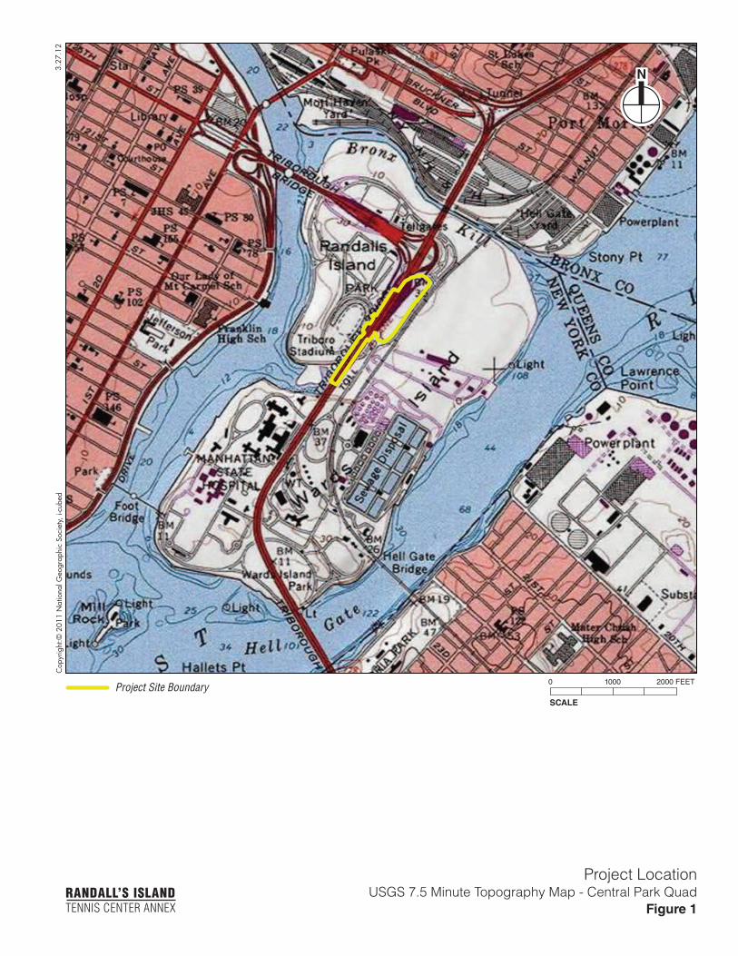
Cop
yrig
ht:©
201
1 N
atio
nal G
eogr
aphi
c So
ciet
y, i-
cube
d3.
27.1
2
SCALE
0 1000 2000 FEET
N
Project LocationUSGS 7.5 Minute Topography Map - Central Park Quad
Figure 1RANDALL’S ISLANDTENNIS CENTER ANNEX
Project Site Boundary
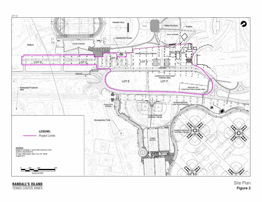
4.9.12
Site PlanFigure 2
RANDALL’S ISLANDTENNIS CENTER ANNEX
Project Limits
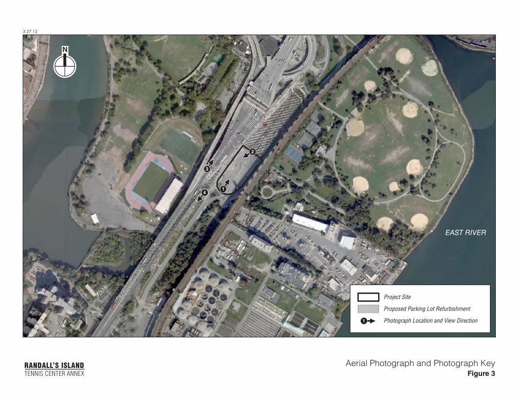
3.27.12
N
RANDALL’S ISLANDTENNIS CENTER ANNEX
Aerial Photograph and Photograph KeyFigure 3
EAST RIVER
TRIB
OROUG
H BR
Project Site
Proposed Parking Lot Refurbishment
Photograph Location and View Direction
2
3
41
1
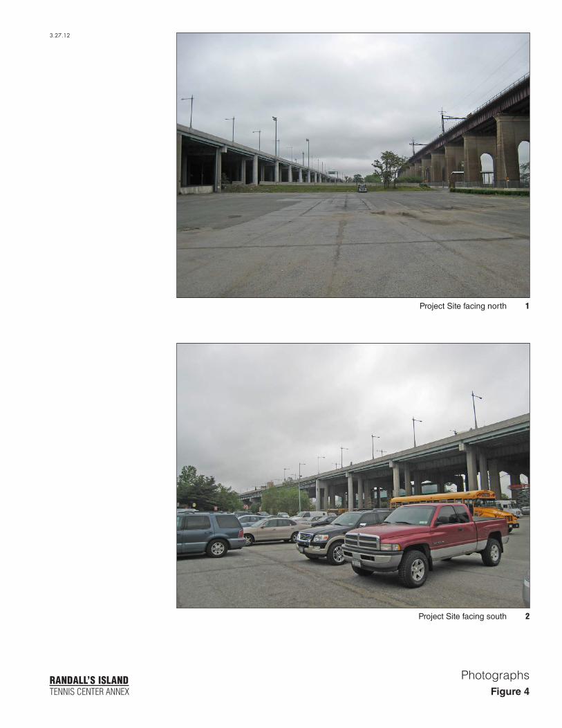
RANDALL’S ISLANDTENNIS CENTER ANNEX
Photographs
3.27.12
Figure 4
2Project Site facing south
1Project Site facing north
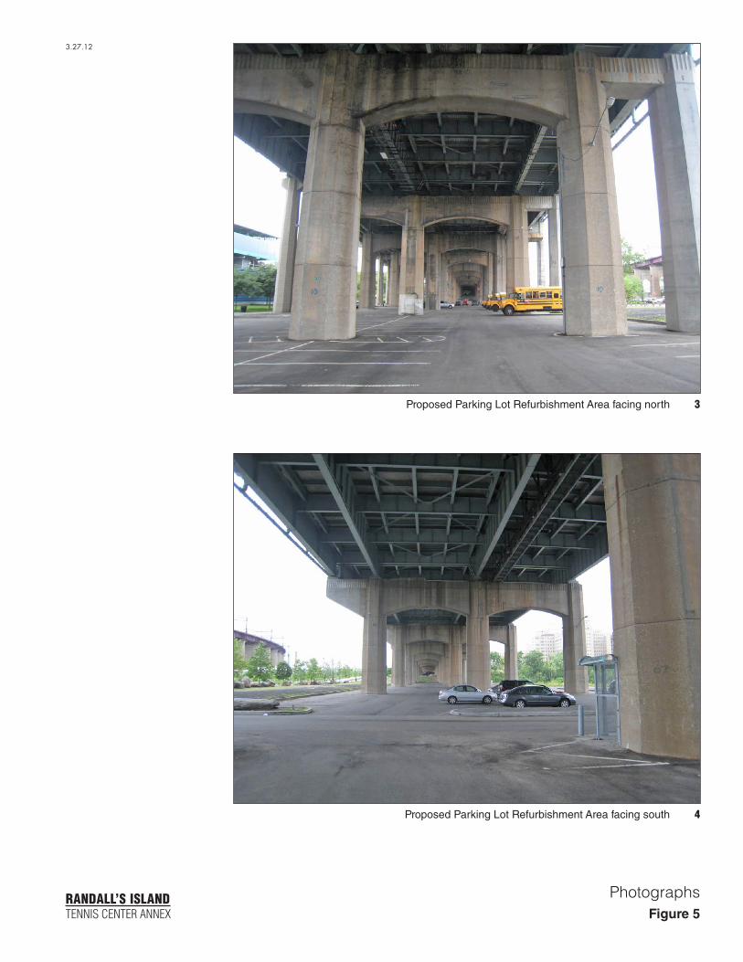
RANDALL’S ISLANDTENNIS CENTER ANNEX
Photographs
3.27.12
4Proposed Parking Lot Refurbishment Area facing south
3Proposed Parking Lot Refurbishment Area facing north
Figure 5

3.27
.12
SCALE
0 400 1000 FEET
N
U.S. Coast and Geodetic Survey of Blackwell’s, Ward’s, and Randall’s Islands,
E.Hergesheimer, 1886Figure 6
RANDALL’S ISLANDTENNIS CENTER ANNEX
Project Site Boundary
Proposed Parking Lot Refurbishment
Modern Shore Line
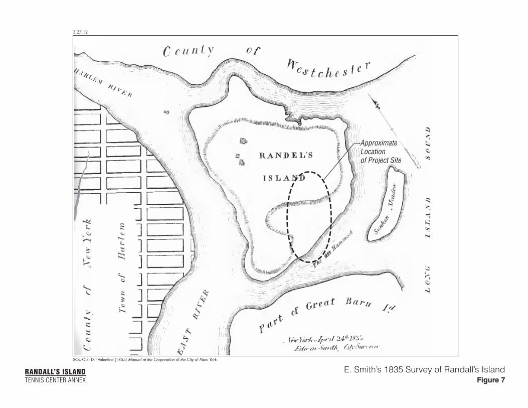
3.27.12
SOURCE: D.T.Valentine (1855) Manual at the Corporation of the City of New York.
E. Smith’s 1835 Survey of Randall’s IslandFigure 7
RANDALL’S ISLANDTENNIS CENTER ANNEX
ApproximateLocationof Project Site
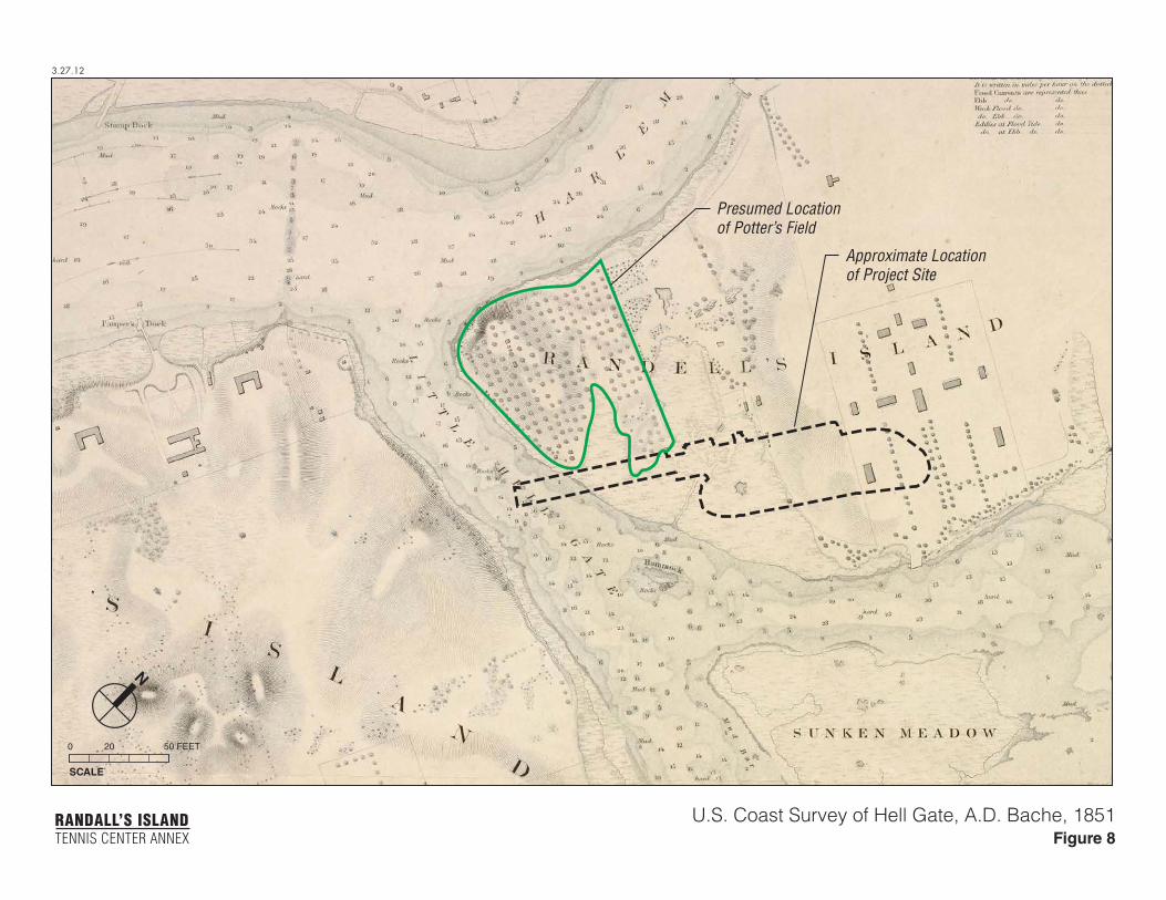
3.27.12
SCALE
0 20 50 FEET
N
U.S. Coast Survey of Hell Gate, A.D. Bache, 1851Figure 8
RANDALL’S ISLANDTENNIS CENTER ANNEX
Approximate Locationof Project Site
Presumed Locationof Potter’s Field
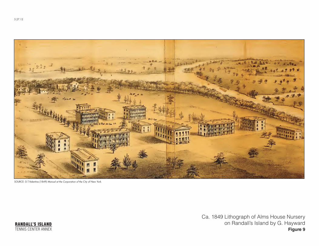
3.27.12
Ca. 1849 Lithograph of Alms House Nurseryon Randall’s Island by G. Hayward
Figure 9RANDALL’S ISLANDTENNIS CENTER ANNEX
SOURCE: D.T.Valentine (1849) Manual at the Corporation of the City of New York.
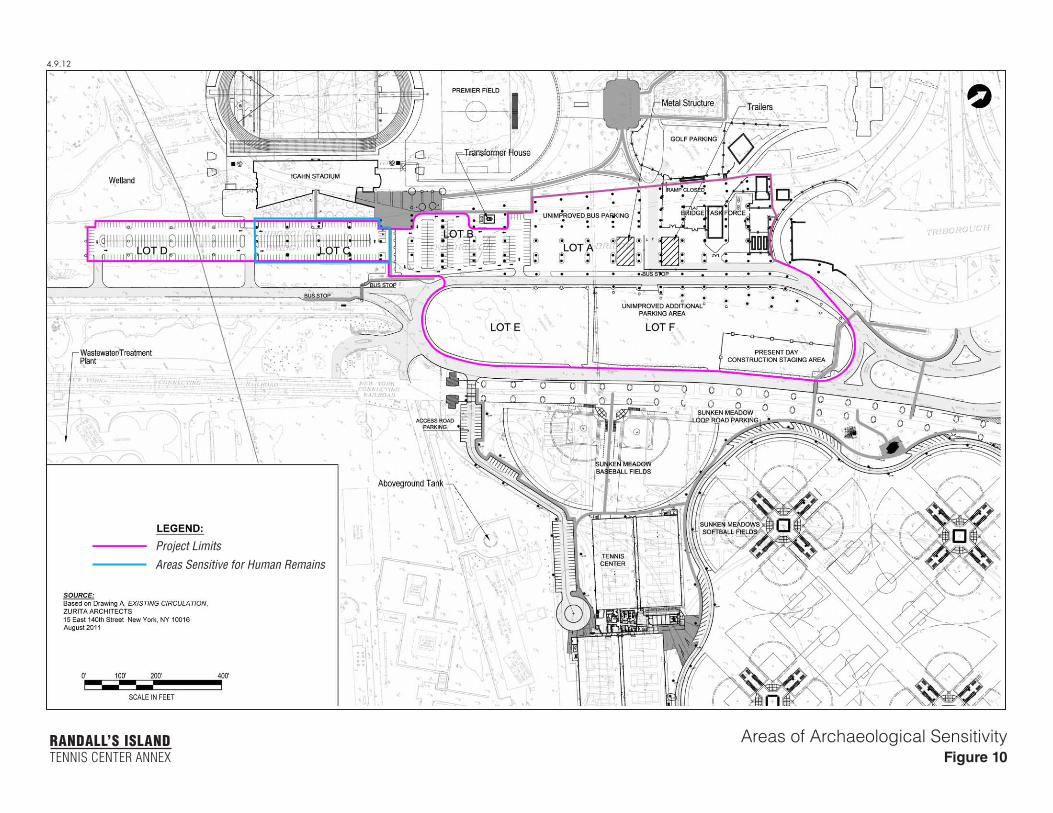
4.9.12
Areas of Archaeological SensitivityFigure 10
RANDALL’S ISLANDTENNIS CENTER ANNEX
Project LimitsAreas Sensitive for Human Remains


![Draft Pdr Report Annexs Rc141210[1]](https://img.pdfslide.us/doc/110x75/55cf8ed8550346703b963a7c/draft-pdr-report-annexs-rc1412101.jpg)