Embed Size (px)
Citation preview
Metric Survey for Preservation Uses: Past, Present, and FutureAuthor(s): PAUL BRYANSource: APT Bulletin, Vol. 41, No. 4, SPECIAL ISSUE ON DOCUMENTATION (2010), pp. 25-29Published by: Association for Preservation Technology International (APT)Stable URL: http://www.jstor.org/stable/41000034 .
Accessed: 24/08/2013 13:06
Your use of the JSTOR archive indicates your acceptance of the Terms & Conditions of Use, available at .http://www.jstor.org/page/info/about/policies/terms.jsp
.JSTOR is a not-for-profit service that helps scholars, researchers, and students discover, use, and build upon a wide range ofcontent in a trusted digital archive. We use information technology and tools to increase productivity and facilitate new formsof scholarship. For more information about JSTOR, please contact [email protected].
.
Association for Preservation Technology International (APT) is collaborating with JSTOR to digitize, preserveand extend access to APT Bulletin.
http://www.jstor.org
This content downloaded from 138.251.14.57 on Sat, 24 Aug 2013 13:06:22 PMAll use subject to JSTOR Terms and Conditions
Metric Survey for Preservation Uses: Past, Present, and Future
PAUL BRYAN
Trends in the use of metric-survey
equipment and standards pertaining to their usage from a British and
international perspective add
valuable insight into heritage
survey and documentation.
This article originated as a paper at the "Capturing the Past for Future Use" sympo- sium held in Los Angeles on Nov. 2-3, 2009, as part of the APT annual conference.
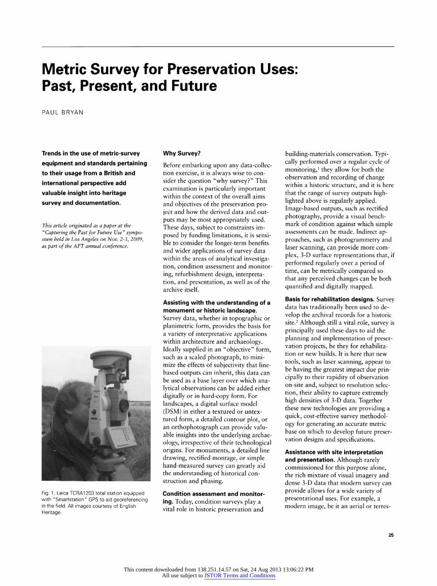
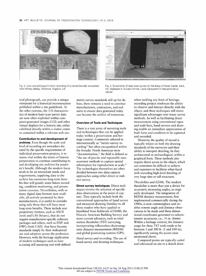
Fig. 1. Leica TCRA1203 total station equipped with "Smartstation" GPS to aid georeferencing in the field. All images courtesy of English Heritage.
Why Survey?
Before embarking upon any data-collec- tion exercise, it is always wise to con- sider the question "why survey?" This examination is particularly important within the context of the overall aims and objectives of the preservation pro- ject and how the derived data and out- puts may be most appropriately used. These days, subject to constraints im- posed by funding limitations, it is sensi- ble to consider the longer-term benefits and wider applications of survey data within the areas of analytical investiga- tion, condition assessment and monitor- ing, refurbishment design, interpreta- tion, and presentation, as well as of the archive itself.
Assisting with the understanding of a monument or historic landscape. Survey data, whether in topographic or planimetrie form, provides the basis for a variety of interpretative applications within architecture and archaeology. Ideally supplied in an "objective" form, such as a scaled photograph, to mini- mize the effects of subjectivity that line- based outputs can inherit, this data can be used as a base layer over which ana- lytical observations can be added either digitally or in hard-copy form. For landscapes, a digital surface model (DSM) in either a textured or untex- tured form, a detailed contour plot, or an orthophotograph can provide valu- able insights into the underlying archae- ology, irrespective of their technological origins. For monuments, a detailed line drawing, rectified montage, or simple hand-measured survey can greatly aid the understanding of historical con- struction and phasing.
Condition assessment and monitor- ing. Today, condition surveys play a vital role in historic preservation and
building-materials conservation. Typi- cally performed over a regular cycle of monitoring,1 they allow for both the observation and recording of change within a historic structure, and it is here that the range of survey outputs high- lighted above is regularly applied. Image-based outputs, such as rectified photography, provide a visual bench- mark of condition against which simple assessments can be made. Indirect ap- proaches, such as photogrammetry and laser scanning, can provide more com- plex, 3-D surface representations that, if performed regularly over a period of time, can be metrically compared so that any perceived changes can be both quantified and digitally mapped.
Basis for rehabilitation designs. Survey data has traditionally been used to de- velop the archival records for a historic site.2 Although still a vital role, survey is principally used these days to aid the planning and implementation of preser- vation projects, be they for rehabilita- tion or new builds. It is here that new tools, such as laser scanning, appear to be having the greatest impact due prin- cipally to their rapidity of observation on-site and, subject to resolution selec- tion, their ability to capture extremely high densities of 3-D data. Together these new technologies are providing a quick, cost-effective survey methodol- ogy for generating an accurate metric base on which to develop future preser- vation designs and specifications.
Assistance with site interpretation and presentation. Although rarely commissioned for this purpose alone, the rich mixture of visual imagery and dense 3-D data that modern survey can provide allows for a wide variety of presentational uses. For example, a modern image, be it an aerial or terres-
25
This content downloaded from 138.251.14.57 on Sat, 24 Aug 2013 13:06:22 PMAll use subject to JSTOR Terms and Conditions
26 APT BULLETIN: JOURNAL OF PRESERVATION TECHNOLOGY / 41:4, 2010
Fig. 2. Low-cost photogrammetric recording of a carved boulder excavated from Whitby Abbey, Yorkshire, England, UK.
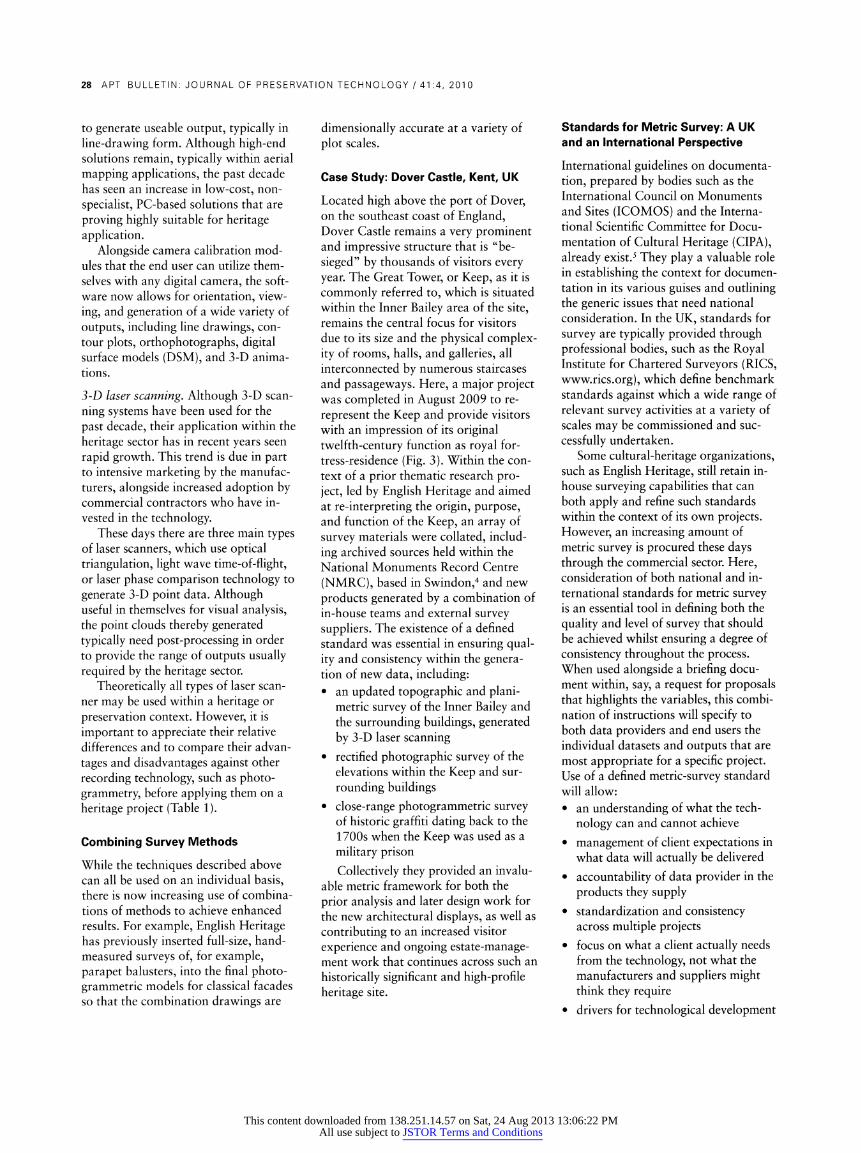
Fig. 3. Screenshot of laser-scan survey for the Keep of Dover Castle, Kent, UK, displayed in Truview format, Leica Geosystem's free point-cloud viewer.
trial photograph, can provide a unique viewpoint for a historical reconstruction published within a site guidebook. At the other extreme, the 3-D characteris- tics of modern laser-scan survey data are now often exploited within com- puter-generated images (CGI) and other virtual displays for a historic site, either exhibited directly within a visitor center or contained within a relevant web site.
Contribution to and development of archives. Even though the scale and level of recording are nowadays dic- tated by the specific requirements of individual preservation projects, it re- mains vital within the tenets of historic preservation to continue contributing to and developing site archives for poster- ity's benefit. Although the modern focus tends to be on immediate needs and requirements, supplying data to the archive has numerous long-term bene- fits that will greatly assist future record- ing, condition monitoring, and presen- tation exercises. Nevertheless, with so many digital data formats now avail- able, all actively promoted by their manufacturers, it is useful to consider using only those that will have most long-term benefits. These include non- proprietary formats, such as ASCII (text) and LAS (binary), that do not require manufacturer-specific software packages and others, such as DXF and DWG (both CAD) that have become standards simply by their widespread use and adoption across the profession. However, with the heritage application of modern techniques such as laser scanning still maturing and with defined
metric-survey standards still up for de- bate, there remains a need to convince manufacturers, contractors, and end users to ensure data generated today can become the archive of tomorrow.
Overview of Tools and Techniques
There is a vast array of surveying tools and technologies that can be applied today within a preservation and her- itage context. Commonly referred to internationally as "metric-survey re- cording" but often encapsulated within the broader North American term "documentation," the field is defined as "the use of precise and repeatable mea- surement methods to capture spatial information for reproduction at scale." The technologies themselves are often divided between two data-capture approaches using either direct or indi- rect survey.
Direct survey techniques. Direct tech- niques involve the selection of specific data observations at the point of cap- ture. They typically include both the conventional approaches of hand survey and measured drawing (familiar to all those readers who have applied or benefitted from fieldwork of HABS, the Historic American Building Survey) and more current advances, such as total- station theodolite (TST) surveying, incorporating reflectorless electromag- netic distance measurement (REDM) and global positioning systems (GPS). Hand survey and recording. The use of hand-survey and drawing techniques
when tackling any form of heritage- recording project reinforces the ability to observe and interact directly with the object, and these techniques still retain significant advantages over many survey methods. As well as facilitating direct measurement using conventional tapes and scale bars, hand surveys and draw- ing enable an immediate appreciation of both form and condition to be captured and recorded.
However, the quality of record is typically reliant on both the drawing standards of the surveyors and their ability to interpret detailing, be they architectural or archaeological, within a graphical form. These methods also require direct access to the object, which can sometimes be difficult to achieve and expensive to facilitate when faced with recording high-level detailing of very large sites or tall structures.
Theodolites and EDMs. The modern theodolite is more than just a device for accurately measuring angles, as origi- nally developed. The integration of REDM distance measurement, first implemented commercially during the 1980s, is now commonplace and en- ables remote angle and distance obser- vations to be made and three-dimen- sional coordinates generated to subcen- timeter accuracies, i.e., V4 in. (6mm). Within a heritage context, the distance range for these TST tools tends to be between 3 and 300 ft. (1 and 100 m), significantly easing the access issue mentioned above.
Computed points are typically coded and referenced on site to a sketch draw-
This content downloaded from 138.251.14.57 on Sat, 24 Aug 2013 13:06:22 PMAll use subject to JSTOR Terms and Conditions
METRIC SURVEY FOR PRESERVATION USES 27
ing before they are transferred into com- puter-aided drafting (CAD) software to enable detailed drawings to be created and outputted at suitable scales. The modern use of pen computers and tablet PCs, interfaced directly to a TST using software such as TheoLt (www.theolt .com), enables direct plotting of obser- vations in the field whilst also minimiz- ing any pointing errors that may be made during observations.
GPS. Since the 1960s, when the first satellite navigation system was launched, GPS has had an increasing effect on many human activities. The ability to use signals received from orbiting satellites to locate an object in three-dimensional space anywhere in the world to ±74 in. (6mm) accuracy has also had a profound impact across the entire survey profession. Although no direct application for GPS currently exists within building recording, it is increasingly being used to georeference entire recording projects to a common, national coordinate system - very useful when analyzing and comparing sites using geographical information systems (GIS) (Fig. 1).
Within the field of historic-landscape recording, GPS has now become the preferred measurement tool on site, albeit using one of the expensive survey- grade systems or one of the lower-cost but rapidly developing handheld devices that enable direct plotting and data interrogation out in the field.
Indirect survey techniques. Indirect survey techniques include the mass capture of nonspecific data. Typically incorporating some form of image cap- ture, for example, on traditional film or with the sensor of a modern digital camera, the approach also now includes the point cloud derived from 3-D laser scanners. Tools and techniques include the following:
Rectified photography. Rectified pho- tography is defined as photography taken square-on to an object, and it still remains the cheapest and simplest of the indirect approaches. By aligning the principal film or sensor planes of the camera with those of the object it is possible to acquire a single image that, with the inclusion of a suitable scale, is "rectified," or true to scale in two
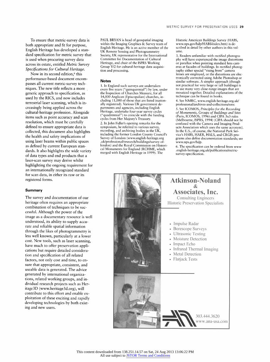
Table 1. Comparison of 3-D Laser Scanning and Photogrammetry within a Héritage Context
3-D LASER SCANNING I PHOTOGRAMMETRY Advantages Disadvantages Advantages Disadvantages
Applicable on all Produces very large Applicable on all Requires at least two 2-D and 3-D surfaces. data files, often 2-D and 3-D surfaces. overlapping photographs
difficult to view and to form the primary manipulate without stereoimagery.
decimation.
Depending on scanner Hardware still Depending on camera Traditionally requires selection, can provide expensive. Dedicated and methodology, can calibrated metric camera very detailed 3-D data, processing software provide detailed 3-D and expensive processing with sub-millimetric required to register data, with ± 1/16 in. equipment and software, accuracy. datasets and produce (1.5mm) accuracy.
useable outputs. Depending on scan The point cloud is not The stereo-pair Drawn data is often resolution, the point so good for recording provides for viewed as subjective and cloud is excellent for discrete edges. recording both surfaces removing object from recording surfaces. and discrete edges. surrounding context. Derived surface mesh Line (vector) output Stereophotography Requires lengthy is ideal for monitoring, still requires manual provides an excellent post-processing to modeling, and digitization. objective record. orientate images together visualization and generate useable data, applications. Very fast - some Heritage application Multiple lower-cost Still regarded sometimes scanners can generate still maturing. processing solutions are as expensive and 100,000s of 3-D now available using needlessly accurate, points per second. both compact and DSLR digital cameras.
dimensions, and can be immediately printed out for application within a recording project.3
As film-based photography is increas- ingly making way for digital imaging, so is the ease of rectification and the cre- ation of digital montages through the availability of numerous low-cost soft- ware packages, including, for example, Adobe Photoshop. Ranging from simple warping tools within image-editing soft- ware through to dedicated rectification plug-ins for CAD packages, most re- main within the financial reach of the heritage surveyor, making rectified pho- tography one of the most widely used survey products across heritage and preservation applications. Panoramic imaging. Panoramic imaging is a photographic technique that cap- tures images with a wide, elongated field of view and hence provides excel- lent contextual imagery for a project. A great deal of incidental information is thereby captured that, although not directly sought at the time of survey, may prove useful for future projects.
Although ultra-wide-angle lenses can provide similar coverage in a single exposure, they do so by distorting the image. Panoramic imaging typically comprises a number of images taken at set intervals and rotations around the
camera's central axis using narrower- angled, longer-focal-length lenses that reduce such distortion. Using software that is typically provided with most compact-digital or digital single-lens reflex (DSLR) camera purchases, adja- cent images can be digitally "stitched" together to create a montage. Dedicated panoramic cameras that can provide one continuously exposed image can pro- duce similar results, typically with a high dynamic range (HDR) to maximize exposure and viewing of detail. How- ever, they remain expensive and beyond the reach of most heritage-recording projects.
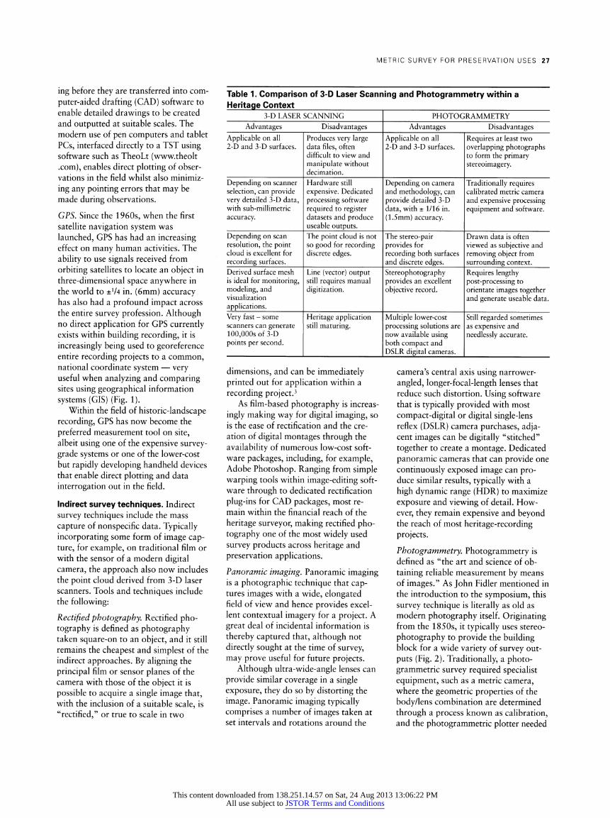
Photogrammetry. Photogrammetry is defined as "the art and science of ob- taining reliable measurement by means of images." As John Fidler mentioned in the introduction to the symposium, this survey technique is literally as old as modern photography itself. Originating from the 1850s, it typically uses stereo- photography to provide the building block for a wide variety of survey out- puts (Fig. 2). Traditionally, a photo- grammetric survey required specialist equipment, such as a metric camera, where the geometric properties of the body/lens combination are determined through a process known as calibration, and the photogrammetric plotter needed
This content downloaded from 138.251.14.57 on Sat, 24 Aug 2013 13:06:22 PMAll use subject to JSTOR Terms and Conditions
28 APT BULLETIN: JOURNAL OF PRESERVATION TECHNOLOGY / 41:4, 2010
to generate useable output, typically in line-drawing form. Although high-end solutions remain, typically within aerial mapping applications, the past decade has seen an increase in low-cost, non- specialist, PC-based solutions that are proving highly suitable for heritage application.
Alongside camera calibration mod- ules that the end user can utilize them- selves with any digital camera, the soft- ware now allows for orientation, view- ing, and generation of a wide variety of outputs, including line drawings, con- tour plots, orthophotographs, digital surface models (DSM), and 3-D anima- tions.
3-D laser scanning. Although 3-D scan- ning systems have been used for the past decade, their application within the heritage sector has in recent years seen rapid growth. This trend is due in part to intensive marketing by the manufac- turers, alongside increased adoption by commercial contractors who have in- vested in the technology.
These days there are three main types of laser scanners, which use optical triangulation, light wave time-of-flight, or laser phase comparison technology to generate 3-D point data. Although useful in themselves for visual analysis, the point clouds thereby generated typically need post-processing in order to provide the range of outputs usually required by the heritage sector.
Theoretically all types of laser scan- ner may be used within a heritage or preservation context. However, it is important to appreciate their relative differences and to compare their advan- tages and disadvantages against other recording technology, such as photo- grammetry, before applying them on a heritage project (Table 1).
Combining Survey Methods
While the techniques described above can all be used on an individual basis, there is now increasing use of combina- tions of methods to achieve enhanced results. For example, English Heritage has previously inserted full-size, hand- measured surveys of, for example, parapet balusters, into the final photo- grammetric models for classical facades so that the combination drawings are
dimensionally accurate at a variety of plot scales.
Case Study: Dover Castle, Kent, UK
Located high above the port of Dover, on the southeast coast of England, Dover Castle remains a very prominent and impressive structure that is "be- sieged" by thousands of visitors every year. The Great Tower, or Keep, as it is commonly referred to, which is situated within the Inner Bailey area of the site, remains the central focus for visitors due to its size and the physical complex- ity of rooms, halls, and galleries, all interconnected by numerous staircases and passageways. Here, a major project was completed in August 2009 to re- represent the Keep and provide visitors with an impression of its original twelfth-century function as royal for- tress-residence (Fig. 3). Within the con- text of a prior thematic research pro- ject, led by English Heritage and aimed at re-interpreting the origin, purpose, and function of the Keep, an array of survey materials were collated, includ- ing archived sources held within the National Monuments Record Centre (NMRC), based in Swindon,4 and new products generated by a combination of in-house teams and external survey suppliers. The existence of a defined standard was essential in ensuring qual- ity and consistency within the genera- tion of new data, including: • an updated topographic and plani-
metrie survey of the Inner Bailey and the surrounding buildings, generated by 3-D laser scanning
• rectified photographic survey of the elevations within the Keep and sur- rounding buildings
• close-range photogrammetric survey of historic graffiti dating back to the 1700s when the Keep was used as a military prison Collectively they provided an invalu-
able metric framework for both the prior analysis and later design work for the new architectural displays, as well as contributing to an increased visitor experience and ongoing estate-manage- ment work that continues across such an historically significant and high-profile heritage site.
Standards for Metric Survey: A UK and an International Perspective
International guidelines on documenta- tion, prepared by bodies such as the International Council on Monuments and Sites (ICOMOS) and the Interna- tional Scientific Committee for Docu- mentation of Cultural Heritage (CIPA), already exist.5 They play a valuable role in establishing the context for documen- tation in its various guises and outlining the generic issues that need national consideration. In the UK, standards for survey are typically provided through professional bodies, such as the Royal Institute for Chartered Surveyors (RICS, www.rics.org), which define benchmark standards against which a wide range of relevant survey activities at a variety of scales may be commissioned and suc- cessfully undertaken.
Some cultural-heritage organizations, such as English Heritage, still retain in- house surveying capabilities that can both apply and refine such standards within the context of its own projects. However, an increasing amount of metric survey is procured these days through the commercial sector. Here, consideration of both national and in- ternational standards for metric survey is an essential tool in defining both the quality and level of survey that should be achieved whilst ensuring a degree of consistency throughout the process. When used alongside a briefing docu- ment within, say, a request for proposals that highlights the variables, this combi- nation of instructions will specify to both data providers and end users the individual dataseis and outputs that are most appropriate for a specific project. Use of a defined metric-survey standard will allow: • an understanding of what the tech-
nology can and cannot achieve • management of client expectations in
what data will actually be delivered • accountability of data provider in the
products they supply • standardization and consistency
across multiple projects • focus on what a client actually needs
from the technology, not what the manufacturers and suppliers might think they require
• drivers for technological development
This content downloaded from 138.251.14.57 on Sat, 24 Aug 2013 13:06:22 PMAll use subject to JSTOR Terms and Conditions
METRIC SURVEY FOR PRESERVATION USES 29
To ensure that metric-survey data is both appropriate and fit for purpose, English Heritage has developed a stan- dard specification for metric survey that is used when procuring survey data across its estate, entitled Metric Survey Specifications for Cultural Heritage.
Now in its second edition,6 this performance-based document encom- passes all current metric-survey tech- niques. The new title reflects a more generic approach to specification, as used by the RICS, and now includes terrestrial laser scanning, which is in- creasingly being applied across the cultural-heritage profession. Alongside items such as point accuracy and scan resolution, which must be carefully defined to ensure appropriate data is collected, this document also highlights the health and safety implications of using laser beams within public spaces as defined by current European stan- dards. It also highlights the wide variety of data types and end products that a laser-scan survey may derive whilst highlighting the ongoing requirement for an internationally recognized standard for scan data, in either its raw or its registered forms.
Summary
The survey and documentation of our heritage often requires an appropriate combination of techniques to be suc- cessful. Although the power of the image as a documentary resource is well understood, its ability to supply accu- rate and reliable spatial information through the likes of photogrammetry is less well known, particularly at a lower cost. New tools, such as laser scanning, have much to offer preservation appli- cations but require detailed considera- tion and specification of all related factors, not only cost and time, to en- sure that appropriate, consistent, and useable data is generated. The advice generated by international organiza- tions, related working groups, and in- dividual research projects such as Her- itage3D (www.heritage3d.org), will contribute to this effort and enable ex- ploitation of these exciting and rapidly developing technologies by both exist- ing and new users.
PAUL BRYAN is head of geospatial imaging within the Imaging Graphics & Survey team of English Heritage. He is an active member of the UK Remote Sensing and Photogrammetry Society, UK representative for the International Committee for Documentation of Cultural Heritage, and chair of the ISPRS Working Group V/2 for cultural-heritage data acquisi- tion and processing.
Notes 1. In England such surveys are undertaken every five years ("quinquennial") by law, under the Inspection of Churches Measure, for all 14,000 Anglican (Episcopalian) churches, in- cluding 11,000 of those that are listed (nation- ally registered). Various UK government de- partments and agencies, including English Heritage, undertake four-year survey cycles ("quadrennial") to coincide with the funding cycles from Her Majesty's Treasury. 2. In John Fidler's opening remarks for the symposium, he referred to various survey, recording, and archiving bodies in the UK, including the former London County Council's Survey of London (www.english-heritage.org .uk/professional/research/buildings/survey-of- london) and the Royal Commission on Histori- cal Monuments for England (RCHME, which merged with English Heritage in 1999). The
Historic American Buildings Survey (HABS, www.nps.gov/hdp/HABS/index.htm) is de- scribed in detail by other authors in this vol- ume. 3. Readers unfamiliar with rectified photogra- phy will have experienced the image distortions or parallax when pointing standard lens cam- eras at facades of buildings. In rectified photog- raphy either special "rising front" camera lenses are employed, or the distortions are elec- tronically corrected using Adobe Photoshop or similar software. A simpler approach (though not practical for very large or tall buildings) is to use many very close-range images that are mosaiced together. Detailed explanations of the technique can be found in books. 4. See NMRC, www.english-heritage.org.uk/ professional/archives-and-collections/nmr. 5. See ICOMOS, Principles for the Recording of Monuments, Groups of Buildings and Sites (Paris, ICOMOS, 1996) and CIPA 3x3 rules (Melbourne, ISPRS, 1994) (CIPA should not be confused with the Camera and Imaging Prod- ucts Association which uses the same acronym). In the U.S., of course, the National Park Ser- vice's HABS, HAER, HALS, and CRGIS pro- grams also define documentation standards; see www.nps.gov/hdp. 6. lhe specmcation can be ordered rrom www .english-heritage.org.uk/publications/metric- survey-specification.
11 Atkinson-Noland
yfj Associates, Inc. ^H| Consulting Engineers ^^B Historic Preservation Specialists
IB ^■*7 • Impulse Radar Ml • Borescope Surveys B| • Ultrasonic Testing SJjj • Moisture Detection HI • Impact Echo
^^M • Infrared Thermal Imaging ^^M • Metal Detection ^^M • Flatjack Tests
Ï
T,^ Hj^^k 303.444.3620 JLI ^y^tf^ VL www.ana-usa.com
This content downloaded from 138.251.14.57 on Sat, 24 Aug 2013 13:06:22 PMAll use subject to JSTOR Terms and Conditions