Embed Size (px)
Citation preview

C04 WU088/Kelly February 19, 2004 17:24 Char Count= 0
4Using Coupled Land Surface andMicrowave Emission Models to
Address Issues in Satellite-BasedEstimates of Soil Moisture
Eleanor J. Burke, R. Chawn Harlow and W. James Shuttleworth
4.1 Introduction
Atmospheric models would benefit from improved initialization and description of theevolution of soil-moisture status, the main impact being through the local and regionalavailability of the soil moisture that can reach the atmosphere by evaporation from the soilor by transpiration from plants (Beljaars et al., 1996; Betts et al., 1996; Liu and Avissar,1999; Koster et al., 2000). At present, the most practical method of improving the accu-racy of soil moisture in models is via the use of land data assimilation systems (LDAS).LDAS are two-dimensional arrays of the land-surface scheme used in the relevant weather-or climate-forecast model forced, to the maximum extent possible, by observations. Theresulting modelled soil moisture status is less biased by poor simulation of the near-surfaceatmospheric forcing, especially precipitation. An example of an LDAS running in nearreal-time can be found at (http://ldas.gsfc.nasa.gov): it consists of several physically basedland-surface models running on a common 0.125◦-resolution grid covering the contiguousUnited States. It is driven by common surface forcing fields, which include observed hourlygauge-radar precipitation, and observed GOES-based satellite-derived surface solar inso-lation (Mitchell et al., 2000). In coming years, such LDAS may well become the routinemechanism by which many predictive weather and climate models will be initiated. If thisis so, it will be via assimilation into LDAS that other data relevant to the current status of the
Spatial Modelling of the Terrestrial Environment. Edited by R. Kelly, N. Drake, S. Barr.C© 2004 John Wiley & Sons, Ltd. ISBN: 0-470-84348-9.
59

C04 WU088/Kelly February 19, 2004 17:24 Char Count= 0
60 Spatial Modelling of the Terrestrial Environment
land surface, such as remotely sensed estimates of soil moisture, will find value. Couplinga description of microwave emission to the land surface models used in an LDAS shouldallow direct assimilation of measured microwave brightness temperatures and improve es-timates of the soil moisture fields calculated by the LDAS (Houser et al., 1998; Reichleet al., 2001; Galantowicz et al., 1999; Burke et al., 2003).
Remotely sensed observations of global surface soil moisture using an L-band (1.4 GHz)passive microwave radiometer are likely to become available within the next decade. Hence,there is considerable interest in developing methods to use this information effectively.However, such measurements have limitations, specifically:
1. The relationship between the measured microwave brightness temperature and soil mois-ture is strongly influenced by the presence of vegetation. A simple one-parameter (opticaldepth) model is usually used to specify the effect of the vegetation, with the optical depthtaken to be proportional to the vegetation water content. However, the constant of pro-portionality (the opacity coefficient) is an uncertain function of vegetation type andradiometer characteristics.
2. L-band microwave brightness temperatures are only directly related to soil moisture inthe top few centimetres of the soil and information about the soil moisture deeper in thesoil profile has to be inferred indirectly through the use of land surface models.
3. In the near future, any potential L-band mission will likely have a resolution ∼30–60km for technical reasons. At this resolution, the vegetation cover, soil type, and soilwater content within each pixel will necessarily be heterogeneous for all pixels and thiscould introduce errors. For some regional and local-scale applications, such as modellingrunoff from a catchment, for example, or for initializing a mesoscale model to predictconvective precipitation, higher resolution fields of soil moisture are important.
This chapter describes progress towards potential solutions to these issues through the useof coupled land surface and microwave emission models, where possible in the context ofpotential upcoming L-band satellite missions (SMOS – Kerr et al., 2001 and HYDROS –HYDROS homepage).
4.2 Models and Methods
4.2.1 Coupled Land Surface and Microwave Emission Models
Coupled land-surface and microwave emission models can be used as a tool to explorethe potential of L-band microwave radiometry and to evaluate the relationship betweenmicrowave brightness temperatures and soil moisture. The land surface model is forced bymeteorological data (incoming solar radiation, incoming longwave radiation, air tempera-ture, relative humidity, precipitation and wind speed). It uses these data to provide calcu-lations of the evolving (profiles of) soil water content and soil temperature and vegetationtemperature, which are input to the microwave emission model. The microwave emis-sion model then calculates the microwave brightness temperature of the soil–vegetation–atmosphere interface. Such forward modelling of microwave brightness temperature incor-porates model physics neglected in simple retrievals of near surface soil moisture, includingrepresentation of the effect of non-uniform near-surface profiles of soil moisture, and

C04 WU088/Kelly February 19, 2004 17:24 Char Count= 0
Coupled Land Surface and Microwave Emission Models 61
ensures consistency between the parameterizations used within the modelling system. Twocoupled models are commonly discussed in the literature, MICRO-SWEAT (Burke et al.,1997; 1998; 2003) and LSP/R (Judge et al., 1999, 2001; Liou et al., 1998; Liou andEngland, 1998). Both of these models produce excellent agreement with measurements:MICRO-SWEAT has been successfully compared with 1.4 GHz (L-band) truck-based dataand LSP/R with 19 GHz tower-based data. To date, most research has focused on runningthese models at point scale, but Burke et al. (2003) used data collected during the SouthernGreat Plains 1997 experiment (SGP97 homepage) to investigate the effectiveness of usinga 2-D array of MICRO-SWEAT models to predict distributed L-band microwave bright-ness temperatures measured by an aircraft. They found discrepancies between the spatialdistributions of modelled and measured brightness temperature which likely result fromimperfect knowledge of the spatial distributions of soil properties, precipitation, and therepresentation of vegetation.
In theory, any land-surface model [e.g. BATS (Dickinson et al., 1986); CLM (Zenget al., 2002); LSM (Bonan, 1996)] could be coupled with a microwave emission model.However, in practice, because the microwave brightness temperature is mainly sensitive tonear-surface soil moisture (in top 2–5 cm) and decreases with depth in the soil, the mostaccurate predictions of microwave brightness temperature result when using a land surfacemodel that represents very fine near-surface soil layers. For example, in their studies, Burkeet al. (1997; 1998) used SWEAT (Daamen and Simmonds, 1996), a land surface modelthat has 8 layers in the top 5 cm, with layer thickness increasing with depth from a 1 mmthick top layer.
In general, the microwave emission from the soil can be described using coherent(Wilheit, 1978; Njoku and Kong, 1977; England, 1976) or non-coherent models (Burkeet al., 1979; England, 1975). Schmugge and Choudhury (1981) and Ulaby et al. (1986)compared these two types of models, as follows. Non-coherent models estimate emissivityusing the dielectric contrast at the air/soil interface and are accurate only when the (vari-able) sampling depth within the soil is well known. Most retrieval algorithms are based onnon-coherent models, with the near-surface soil water content assumed to be uniform toa specified depth. In the case of L-band, this is usually 5 cm (e.g. Jackson et al., 1999).In coherent models, the value of the emissivity at the surface is coupled to the dielectricproperties of the soil below the surface; consequently, they provide better estimates of theemissivity when the soil water content profile is not uniform. One significant disadvantageof coherent models is that interference effects can occur, but these have only rarely beenwitnessed in nature (Schmugge et al., 1998).
The emission component of MICRO-SWEAT is based on the Wilheit (1978) coherentmodel of electromagnetic propagation through a plain stratified medium. The Wilheit (1978)model relates the brightness temperature emergent at the soil surface to the dielectricproperties and temperature of the underlying soil layers. For radiation with polarization, p,the microwave brightness temperature, TBp (K), is given (Wilheit, 1978) by:
TBp (θ ) =N∑
i=1
fip (θ ) Ti (1)
where Ti is the temperature of the ith layer (K), fip is the fraction of energy absorbed froman incident microwave with polarization p by the ith layer (a function of the dielectric
C04 WU088/Kelly February 19, 2004 17:24 Char Count= 0
62 Spatial Modelling of the Terrestrial Environment
constant of the soil), and N is the number of the layers in the semi-infinite medium. TheWilheit model assumes scattering is negligible, consequently the model is only applicable atlonger wavelengths. The Dobson et al. (1985) model can be used to calculate the profileof soil dielectric from knowledge of the profile of soil water content and soil particle sizedistribution. The Dobson et al. (1985) model is a simple, non-linear dielectric-mixingmodel that takes into account the proportions of free water (dielectric ∼80), bound water(dielectric ∼4), soil solids (dielectric ∼4), and air (dielectric ∼1) in the soil medium. Thesoil particle size distribution and the water content determine the relative proportions offree and bound water.
A rough soil surface will increase the microwave emission because the emitting surfacearea is greater. Its effect can be parameterized using the two-parameter Mo and Schmugge(1987) model, which includes the mixing of vertical and horizontal polarizations. At L-band,for a relatively smooth soil, the effect of soil surface roughness is small and, for simplicityin the analyses discussed here, the soil surface roughness is assumed to be zero.
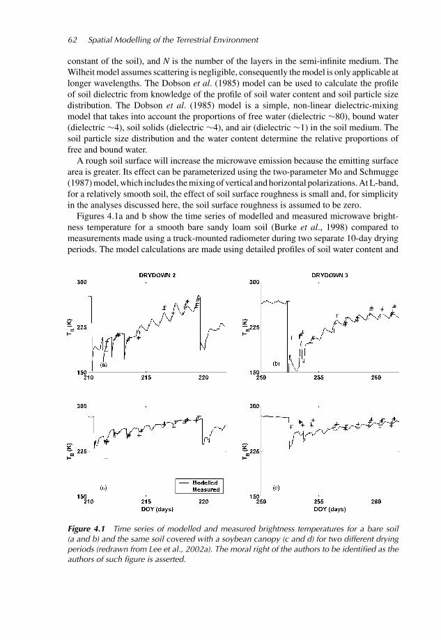
Figures 4.1a and b show the time series of modelled and measured microwave bright-ness temperature for a smooth bare sandy loam soil (Burke et al., 1998) compared tomeasurements made using a truck-mounted radiometer during two separate 10-day dryingperiods. The model calculations are made using detailed profiles of soil water content and
Figure 4.1 Time series of modelled and measured brightness temperatures for a bare soil(a and b) and the same soil covered with a soybean canopy (c and d) for two different dryingperiods (redrawn from Lee et al., 2002a). The moral right of the authors to be identified as theauthors of such figure is asserted.

C04 WU088/Kelly February 19, 2004 17:24 Char Count= 0
Coupled Land Surface and Microwave Emission Models 63
temperature calculated by a land surface model and the Wilheit (1978) microwave emissionmodel (Lee et al., 2002a). The sharp decrease in brightness temperatures on DOY 210 and252 is caused by irrigation while the decrease on DOY 253 results from rainfall. The near-surface water content ranges from 40% to 10% for both drying periods. Diurnal variationin the near-surface soil water content and temperature are also reflected in the modelledmicrowave brightness temperatures.
4.2.2 Effect of Vegetation on Microwave Emission from the Soil
The presence of vegetation has a significant impact on the relationship between near-surfacesoil moisture and microwave brightness temperature. For a bare soil, the dynamic rangein brightness temperature is approximately 180 K, whereas for a crop with canopy watercontent of only 3.3 kg m−2, the dynamic range is significantly reduced, to approximately60 K. In general, the effects of the vegetation on the microwave emission from the soil canbe described using radiative transfer equations. These can be solved either numerically orafter applying simplifying assumptions. The following sections describe radiative transfertheory, and its application to describing the effect of vegetation on microwave emissionfrom the soil.
Radiative transfer theory. A vegetation canopy will scatter and absorb microwave emis-sion from the soil. It will also contribute with its own emission, which will be scatteredand absorbed by the canopy through which it passes. Within an infinitesimal volume of thecanopy, the energy balance for upward radiative transfer with horizontal polarization is:
µdTBh(θ, z)
dz= KaTcan(z) − Ke(θ )TBh(θ, z)
+∫ 1
−1((h, h′)TBh(θ ′, z) + (h, v′)TBv(θ ′, z)) dµ′. (2)
The energy balance for downward radiative transfer with horizontal polarization is:
−µdTBh(π − θ, z)
dz= KaTcan(z) − Ke(π − θ )TBh(π − θ, z)
+∫ 1
−1((h(π − θ ), h′)TBh(θ ′, z) + (h(π − θ ), v′)TBv(θ ′, z)) dµ′ (3)
where TBh is the horizontally polarized microwave brightness temperature (K), Tcan is thephysical temperature of the canopy (K), z is the depth within the canopy (m), Ka is theabsorption coefficient, Ks is the scattering coefficient, Ke (= Ka + Ks) is the extinctioncoefficient, θ and θ ′ are incidence angles, with µ = cos θ and µ′ = cos θ ′, and (h,h′) and(h,v′) are scattering phase functions, where (p, q ′) represents the scattering probability ofp polarized radiation being scattered into q polarized radiation. (Note: p and q representhorizontally (h) and vertically (v) polarized radiation interchangeably.) The first term onthe right-hand side in equations (2) and (3) describes the thermal emission from the canopy,the second term represents the energy absorbed and scattered by the canopy, and the finalterm represents the redistribution of scattered energy among different look angles.
There are no analytical solutions to equations (1) and (2). However, they can be solvednumerically as they are, for example, in the complex ‘discrete’ model of Wigneron et al.

C04 WU088/Kelly February 19, 2004 17:24 Char Count= 0
64 Spatial Modelling of the Terrestrial Environment
(1993), or they can be simplified by assuming that the scattering effects (and hencethe phase functions) are negligible, as they are in the ‘simple’ model of Ulaby et al.(1986) and the ‘extended Wilheit’ (1978) model (Lee et al., 2002a). Both the simplemodel and the extended Wilheit (1978) model are only valid at longer wavelengthswhere the dimensions of portions of the canopy are of the same order of magnitude asthe wavelength of the radiation detected. These three approaches are discussed furtherbelow.
Discrete Model. Discrete models estimate the scattering phase functions and the absorp-tion and scattering coefficients from measurements of the vegetation characteristics. Discsare used to represent leaves and finite cylinders the stems of vegetation. Numerical solutionsof equations (2) and (3) can then be calculated and the microwave brightness temperatureabove the canopy estimated. Wigneron et al. (1993) and Ferrazzoli et al. (2000) discussedtwo different versions of a discrete model in detail. An example of the application of thediscrete model is given by Burke et al. (1999) who used the Wigneron et al. (1993) modelto successfully predict the time series of brightness temperatures measured over a soybeancanopy using a truck-mounted L-band radiometer.
Simple Model. The simple model assumes that the scattering phase functions and, thus,the final term in equations 2 and 3 above are negligible. The brightness temperature abovethe vegetation canopy is then given by the sum of the emission from the soil (the first termin equation (4) below), the upward emission from the canopy (the second term in equation(4)), and the downward emission from the canopy that is reflected by the soil (the thirdterm in equation (4)), the microwave emission being then attenuated by any vegetation itpasses through. The simple model therefore gives:
TBp = �TBpsoil + (1 − �)(1 − )Tcan + (1 − �)(1 − )�Tcanrsp (4)
with:
� = e−τ sec θ (5)
τ = Ked (6)
= Ks
Ke(7)
where TBpsoil (K) is the brightness temperature of the soil for polarization p, rs is thereflectivity of the soil surface, � is the transmissivity of the canopy, τ is the optical depth, dis the canopy height (m), is the single scattering albedo, Ke is the extinction coefficientof the canopy, and Ks is the scattering coefficient of the canopy. The single scatteringalbedo () determines the relative importance of absorption and scattering by the canopy.For L-band radiation, Ks and, therefore, are close to zero (equation (7) – Jackson andSchmugge, 1991). However, has rarely been estimated (Kerr and Wigneron, 1994) andits dependence on vegetation characteristics is unknown. The optical depth, τ , representsthe amount of absorption and emission by the canopy and is often approximated by:
τ = βθveg (8)

C04 WU088/Kelly February 19, 2004 17:24 Char Count= 0
Coupled Land Surface and Microwave Emission Models 65
where θveg is the vegetation water content and β is the opacity coefficient. One outputfrom the Wigneron et al. (1993) discrete model is the extinction coefficient (Ke). Burkeet al. (1999) showed that the optical depth calculated using the extinction coefficient (equa-tion (7)) could be used in the simple model to predict accurate time series of microwavebrightness temperatures.
Extended Wilheit (1978) Model. Unlike the previous two models, which assume thecanopy consists of one uniform layer; the extended Wilheit (1978) model assumes a multi-layered vegetation canopy. The energy balance of each layer is determined using simplifiedradiative transfer theory. This model requires as input profiles of both the dielectric andtemperature within the vegetation. Currently, there is only limited information on the di-electric permittivity of either the vegetation matter (El-Rayes and Ulaby, 1987; Ulaby andJedlicka, 1984; Chuah et al., 1997; Colpitts and Coleman, 1997; Franchois et al., 1998;Ulaby et al., 1986) or the canopy as a whole (Ulaby et al., 1986; Ulaby and Jedlicka, 1984;Brunfeldt and Ulaby, 1984; Schmugge and Jackson, 1992). In order to model the dielectricproperties of a vegetation canopy, two separate mixing effects must be recognized. Thefirst is the mixing between constituents of the vegetation, which determines the dielectricof the vegetation matter itself. One plausible approach to modelling the dielectric of thevegetation matter is analogous to a linear version of the Dobson et al. (1985) mixing modelfor soils, i.e., to assume:
εv = εdryVdry + εfwVfw + εbwVbw (9)
where εv is the dielectric permittivity for leaf material as a whole, εdry, εfw, and εbw are thedielectric permittivities, and Vdry, Vfw, and Vbw are the volume fractions of dry matter, freewater and bound water, respectively. It is assumed that εdry, εfw, and εbw are independent ofthe vegetation water content. The second mixing model determines the dielectric permit-tivity of the mixture of vegetation matter and air that make up the vegetation canopy (εcan).If non-linear mixing is assumed:
εαcan = εα
v VV + εαair(1 − VV)
where εair is the dielectric permittivity of air; Vv is the fractional volume of vegetationelements per unit volume canopy; and α is a so-called “shape factor”. [Note: in the caseof the Dobson et al. (1985) mixing model for soils, α = 0.65.] Schmugge and Jackson(1992) suggested that the refractive model [α = 0.5] provides a better representation ofthe dielectric properties of the canopy than a linear model [α = 1]. Lee et al. (2002a)optimized time series of modelled brightness temperatures against measurements from thefield experiment evaluated by Burke et al. (1998) and retrieved values ranging between 1.1and 2.2.
Equations (9) and (10) together calculate the dielectric constant for the canopy as a wholeand, in the extended Wilheit (1978) model, this amount of dielectric is then distributedvertically among the plane parallel layers above the soil. The heights of the top and bottomof the canopy are specified, but gradual changes in dielectric permittivity are simulatedaround these levels by introducing broadening that follows a Gaussian distribution withspecified standard deviations. This broadening reflects the natural variability between theindividual plants that make up the canopy, and its presence is also critical to the reliableoperation of this coherent emission model because avoiding sharp transitions in dielectric at
C04 WU088/Kelly February 19, 2004 17:24 Char Count= 0
66 Spatial Modelling of the Terrestrial Environment
canopy boundaries suppresses internal reflections in the canopy and associated interferencepatterns in the microwave emission (Lee et al., 2002a).
Figures 4.1c and d show the time series of modelled and measured brightness temper-atures for the same time periods as in Figure 4.1a and b but in the presence of a soybean canopy. During drying period 2 (Figure 4.1c), the fresh weight of the canopy was3.45 kg m −2 and the height was 0.89 m, while during drying period 3 (Figure 4.1d), thefresh weight of the canopy was 4.41 kg m−2 and the height was 1.15 m. The effect ofvegetation on the microwave emission from the soil is included using the extended Wilheit(1978) model (Lee et al., 2002a). As in the bare soil examples, the soil near-surface watercontents range from 40% to 10% for drying period 2 (Figure 4.1c), and span a similar rangefor drying period 3 (Figure 4.1d). However, this is not as readily apparent in the presenceof vegetation because the vegetation perturbs the emission from the soil.
4.2.3 Potential Near-Future L-Band Missions
The European Space Agency (ESA) has approved the Soil Moisture Ocean Salinity (SMOS)mission (SMOS homepage) with a proposed launch date between 2005 and 2007. TheSMOS mission will be based on a dual polarization, L-band radiometer with an inno-vative aperture synthesis concept (a two-dimensional interferometer) that can achieve anon-the-ground resolution of around 50 km and provide global measurements of microwavebrightness temperature at a range of different angles. The proposed SMOS retrieval algo-rithm is based on a non-coherent model of emission from soil and vegetation using thesimple model discussed in section 4.2.2 and will simultaneously retrieve the soil moistureand the vegetation optical depth by exploiting the range of available look-angles (Kerr et al.,2001; Wigneron et al., 2000). Wigneron et al. (2000) used simulated SMOS observations(created by adding random and systematic errors to the model proposed for the SMOSretrieval algorithm) and showed that the retrieval lost accuracy as the number of availableindependent measures of microwave brightness temperatures at different angles decreased.
NASA has selected the HYDROspheric States mission (HYDROS) as a reserve mission.It will consist of an L-band passive microwave radiometer with a resolution of around40 km and an active microwave radar with a resolution of up to 3 km. Both instrumentswill measure at multi-polarizations but constant look-angle.
4.3 Discussion
The use of coupled land surface and microwave emission models to explore potential solu-tions to three of the limitations of L-band passive microwave remote sensing is discussed.
4.3.1 Accounting for Effects of Vegetation in Retrieval Algorithms
Retrieval algorithms typically use the simple optical depth model to account for the effectsof vegetation. If the only brightness temperature measurements available are at a singlepolarization and look-angle, such as those measured during the Southern Great Plains1997 (SGP97) field experiment, the algorithms require ancillary information to estimatethe optical depth. One commonly used method is to define the vegetation water contentand opacity coefficient for each class of vegetation within a land cover classification, and
C04 WU088/Kelly February 19, 2004 17:24 Char Count= 0
Coupled Land Surface and Microwave Emission Models 67
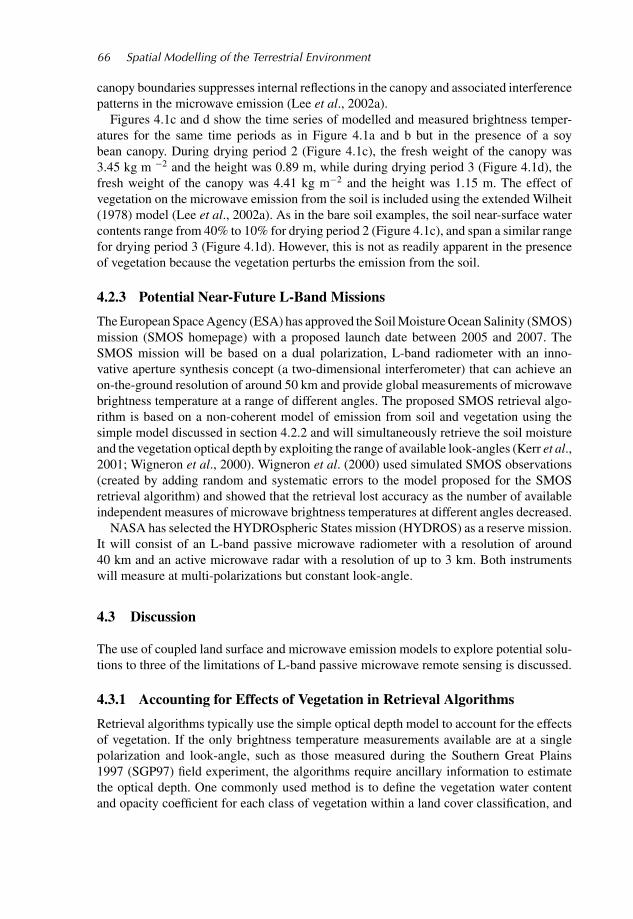
Figure 4.2 Relationship between derived optical depth and Landsat-TM measured NDVI for15 of the sites intensively monitored during SGP97 (redrawn from Burke et al., 2001a). Themoral right of the authors to be identified as the authors of such figure is asserted.
to estimate the optical depth using equation (8), see, for example, Jackson et al. (1999).An alternative method is to use vegetation indices derived from visible wavelength satellitedata. These two methods for deriving the optical depth can both potentially introducesignificant errors into the retrieved soil moisture. For example, Burke et al. (2001a) usedthe Normalized Difference Vegetation Index (NDVI) to derive optical depths for selectedsites intensively monitored during SGP97. They assumed that, at specific measurement sites,the only unknown in the relationship between the measured soil moisture and measuredmicrowave brightness temperature was the optical depth. They then related the opticaldepth derived in this way to the local NDVI estimated by Landsat-TM (Figure 4.2). A linearfunction was fitted to this relationship, with 78% of the variation in the derived optical depthexplained by the variation in NDVI. Figure 4.2 also shows the 66% confidence intervalsof the fitted relationship which correspond to one standard deviation of the optical depth,or approximately ±0.08. This empirical relationship was found to be dependent on theresolution of the microwave sensor used to measure brightness temperature (Burke et al.,2001a).
The SMOS mission provides an opportunity to retrieve estimates of the optical depth aspart of the retrieval algorithm because it will measure brightness temperatures at multiplelook-angles and both polarizations over similar areas at similar times. Therefore, there isenough information for the proposed retrieval algorithm to retrieve both the near-surfacesoil water content and the optical depth. The proposed retrieval algorithm assumes that theopacity coefficient of the vegetation (equation 8) does not depend on either the polarizationof the radiation or the look-angle of the sensor. There is, however, some evidence that itdepends on both of these radiometer characteristics (van de Griend and Owe, 1996; Leeet al., 2002b). Figure 4.3 shows the look-angle and polarization dependence of the meanopacity coefficient retrieved (using the method described by Lee et al. (2002b)) from thetime series of brightness temperatures given in Figures 4.1c and d, this time series havingbeen calculated using the arguably more realistic extended Wilheit (1978) model. Values

C04 WU088/Kelly February 19, 2004 17:24 Char Count= 0
68 Spatial Modelling of the Terrestrial Environment
look-angle (degs)
look-angle (degs)
Figure 4.3 Opacity coefficient derived for the soyabean canopies in (a) Figure 4.1c and (b)Figure 4.1d as a function of look angle and polarization
found at look-angle 10◦ (0.36 for drying period 2, and 0.43 for drying period 3) fall withinthe range of those found by Burke et al. (1999) using the simple model for the same dataset,i.e., 0.31–0.39 for drying period 2, and 0.44–0.52 for drying period 3. They are also similarto those found by Burke et al. (1999) using the discrete model of Wigneron et al. (1993),i.e., 0.36 and 0.49. However, Figure 4.3 also shows that the opacity coefficient is a distinctfunction of both look angle and polarization. Moreover, the opacity coefficient is greaterfor drying period 3 when the canopy is denser, implying that the opacity coefficient mightalso be a function of vegetation water content, as suggested by Le Vine and Karam (1996)and Wigneron et al. (1996; 2000). Wigneron (2002, personal communication) also found adependence of the optical depth on look angle using the discrete model of Ferrazzoli et al.(2000).
To quantify the errors introduced by assumptions about the vegetation made in soilmoisture retrieval algorithms, field experiments are required that focus on the dependenceof the opacity coefficient on look-angle and polarization, canopy size and type and ambienttemperature. Quantifying these dependences will provide useful information relevant to apotential soil moisture product, in particular, on its reliability when used in data assimi-lation systems. Burke et al. (2003) quantified the errors in the distributed optical depthestimated using a distributed measure of NDVI and the relationship shown in Figure 4.2,

C04 WU088/Kelly February 19, 2004 17:24 Char Count= 0
Coupled Land Surface and Microwave Emission Models 69
translated these into errors in the retrieved soil moisture, and used this information tocalculate an ‘Assimilation Value Index’ which defines the worth of assimilating the soilmoisture information retrieved from microwave brightness temperature data. Burke et al.(2003) showed that, for their example, errors in the estimated optical depth resulted inthe microwave brightness temperature data having little use over about 50% of the areamodelled.
4.3.2 Extending Estimates of Soil Moisture Deeper Within the Profile
Only soil moisture in the top (∼5 cm) of the soil are amenable to L-band remote sensing,but studies suggest (e.g. Houser et al., 1998; Walker et al., 2001) that merely modifyingsurface soil moisture during data assimilation into a land surface model does not provide asufficiently strong updating of the deeper soil moisture profile. A method to propagate thesurface layer information deeper into the profile is therefore needed.
The simplest approach is to use statistical methods (Kostov and Jackson, 1993). Oneexample is that proposed by Burke et al. (2001b), who suggest that, in practice, therealways exists a modelled relationship between near-surface soil water content and deepersoil water content for each different patch of vegetation and for each grid cell in a particularLDAS (2-D array of land surface models). This relationship can be estimated from historicsimulations but is clearly model-dependent. The main concern when using this method toestimate the deeper soil water content is that the LDAS modelled soil profile, and hence thederived relationship, may not be realistic, but this issue is not new as it is already presentwhenever the LDAS approach is used. Figure 4.4a shows the relationship between surface
Figure 4.4 (a) Relationship between near-surface water content and the ratio of near-surfaceto deep water content; (b) agreement between predicted and actual ratio of near surface to deepwater content (redrawn from Burke et al., 2002a). c© 2003 IEEE, reproduced with permission
C04 WU088/Kelly February 19, 2004 17:24 Char Count= 0
70 Spatial Modelling of the Terrestrial Environment
soil moisture (0–5 cm) and deeper soil moisture (5–120 cm) predicted using MICRO-SWEAT derived over one year for a typical crop growing in sandy soil using hourly drivingdata from the SGP97 study area. There is a significant, but noisy, relationship that isstructured around several separate linear correlations, which are themselves related to thewater content in the soil profile immediately after the most recent precipitation event. (Note:at the time of precipitation the modelled relationship between surface and deep soil moisturedepends strongly on the amount of precipitation and modelled runoff, but once precipitationhas ceased, the modelled relationship between the surface and deep soil moisture changesmainly as a result of the surface soil drying.) Figure 4.4b shows the good agreement betweenthe MICRO-SWEAT modelled values of the ratio of near-surface to deep-soil moisture andthe values calculated using a simple derived relationship that acknowledges the effect ofrecent precipitation.
Other methods of extending estimates of surface soil moisture deep in the soil profilegenerally involve assimilation techniques, such as direct insertion of the surface soil mois-ture (Walker et al., 2001) or use of the extended Kalman filter (Walker et al., 2001; Walkerand Houser, 2001; Hoeben and Troch, 2000) or variational assimilation (Reichle et al.,2001). Walker et al. (2001) compared the direct insertion and Kalman filter assimilationmethods using synthetic data and demonstrated that using the Kalman filtering is superior,with correction of the soil moisture profile being achieved in 12 hours as compared to8 days or more with direct insertion. Variational data assimilation is computationally moreeffective than using the Kalman filter, but variational assimilation requires an adjoint modelthat is numerically well behaved and there are currently no adjoint models available for thecommonly used land surface models.
Assimilation procedures either introduce retrieved soil moisture into the land surfacemodel (Walker et al., 2001; Montaldo et al., 2001; Hoeben and Troch, 2000; Wigneronet al., 1999; Li and Islam; 2002, Calvet and Noilhan, 2000), or the measured microwavebrightness temperatures is itself assimilated through the use of a coupled land surfaceand microwave emission model (Crosson et al., 2002; Galantowicz et al., 1999). Theygenerally build on information already present in a land surface model and, in general,result in improved profile soil moisture estimates by the land surface model, regardless ofthe assimilation methods used. It has been demonstrated (Walker and Houser, 2001) thatthrough the assimilation of near-surface soil moisture observations, errors in forecast soilmoisture profiles that result from poor initialization may be removed, and the resultingpredictions of runoff and evapotranspiration by a hydrological model improved.
4.3.3 Subpixel Heterogeneity
In the near future, any passive microwave satellite mission is likely to measure with reso-lution between approximately 30 and 60 km. At this resolution, the land surface is stronglyheterogeneous and the impact of this heterogeneity on the accuracy of the retrieved soilmoisture is a significant issue.
In the case of a heterogeneous bare soil, both Burke and Simmonds (2002) andGalantowicz et al. (2000) demonstrated that errors in the retrieved soil moisture are negli-gible. For a pixel with heterogeneous vegetation, Drusch et al. (1999), Liou et al. (1998),Crow et al. (2001), Crow and Wood (2002), and Burke and Simmonds (2002) suggestedthat errors in the retrieved soil moisture are generally less than 0.03 cm3 cm−3. This is a

C04 WU088/Kelly February 19, 2004 17:24 Char Count= 0
Coupled Land Surface and Microwave Emission Models 71
comparatively small error, but potentially significant, particularly when there are alreadyother sources of errors in the retrieval algorithm.
Crow and Wood (2002) demonstrated that area-average soil moisture, when used in aland surface model, can lead to potentially large errors in surface energy fluxes of up to 50 Wm−2. One method of incorporating subgrid scale heterogeneity into land surface models isto represent such heterogeneity using a probability density function (PDF) (e.g. Famigliettiand Wood, 1995). However, if the model grid scale corresponds to the scale of the satellitefootprint for which soil moisture information is available, estimating subgrid statistics is nota trivial task. Crow and Wood (2002) discuss a possible soil moisture downscaling procedurebased on an assumption of spatial scaling (i.e., a power-law relationship between statisticalmoments and scale), and demonstrate that the downscaled soil moisture derived from coarse-resolution soil moisture imagery can improve prediction of grid-scale surface energy fluxes.Recently, Kim and Barros (2002) developed a modified fractal interpolation technique todownscale soil moisture estimates, based on an analysis of the effects of topography, soilproperties, and vegetation on the measured distribution of soil moisture. Reichle et al.(2001) used a four-dimensional assimilation algorithm to show that soil moisture can besatisfactorily estimated at scales finer than the resolution of the microwave brightnesstemperature image. Their downscaling experiment suggests that brightness temperatureimages with a resolution of tens of kilometres can yield soil moisture profile estimates on ascale of a few kilometres, provided that micrometeorological, soil texture, and land coverinputs are available at the finer scale.
The high-resolution active and low-resolution passive combination of the HYDROSmission may provide an opportunity to develop a novel method of downscaling. Bindlish andBarros (2002) have demonstrated the potential of this using an L-band satellite-based radarand an L-band aircraft-based radiometer. They successfully demonstrated downscaling ofsoil moisture estimates from 200 m to 40 m.
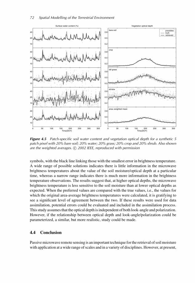
The SMOS mission may also provide enough information to allow downscaled estimatesof soil moisture. Burke et al. (2002a) explored this potential by using MICRO-SWEATin a year-long simulation to define the patch-specific soil moisture, optical depth, and thesynthetic, pixel-average microwave brightness temperatures for the range of angles that willbe provided by SMOS. The microwave emission component of MICRO-SWEAT was usedas the basis of an exploratory SMOS retrieval algorithm in which the RMSE between thesynthetic and modelled pixel-average microwave brightness temperatures was minimizedby optimizing the soil moisture and optical depth in different patches of vegetation. Theoptimization was made using the Shuffled Complex Evolution optimization procedure(Duan et al., 1993). An example five-patch pixel comprising equal areas of water, bare soil,short grass, crop, and shrub was studied, assuming a uniform sandy loam soil (75% sand,5% clay). Simulation of the growth of the vegetation through the year was also included.It is assumed that the portion of the pixel occupied by each land-cover type was knownand that each vegetation type was homogeneous. Figure 4.5 shows the prescribed andretrieved near-surface soil moisture and vegetation optical depth for the four land patches(it was assumed that the contribution of water to the area-average brightness temperatureis known). The last plot in Figure 4.5 is the area weighted mean soil moisture (excludingthe water patch) for the pixel. The SCE-UA algorithm, which was run ten times, gaveeach time, ten possible values of soil moisture, optical depth and ten possible values ofthe errors in brightness temperature. The ten possible solutions are plotted as individual
C04 WU088/Kelly February 19, 2004 17:24 Char Count= 0
72 Spatial Modelling of the Terrestrial Environment
10
25
40
Surface water content (%)
0.2
0.5
0.8
Vegetation optical depth
bare soil possiblestruthretrieved
10
25
40
0.2
0.5
0.8crop
10
25
40
0.2
0.5
0.8tall grass
10
25
40
0.2
0.5
0.8shrubs
0 50 100 150 200 250 300 350
10
25
40
Time(DOY)0 50 100 150 200 250 300 350
0.2
0.5
0.8area–weighted mean
Time(DOY)
Figure 4.5 Patch-specific soil water content and vegetation optical depth for a synthetic 5patch pixel with 20% bare soil; 20% water; 20% grass; 20% crop and 20% shrub. Also shownare the weighted averages. c© 2002 IEEE, reproduced with permission
symbols, with the black line linking those with the smallest error in brightness temperature.A wide range of possible solutions indicates there is little information in the microwavebrightness temperatures about the value of the soil moisture/optical depth at a particulartime, whereas a narrow range indicates there is much more information in the brightnesstemperature observations. The results suggest that, at higher optical depths, the microwavebrightness temperature is less sensitive to the soil moisture than at lower optical depths asexpected. When the preferred values are compared with the true values, i.e., the values forwhich the original area-average brightness temperatures were calculated, it is gratifying tosee a significant level of agreement between the two. If these results were used for dataassimilation, potential errors could be evaluated and included in the assimilation process.This study assumes that the optical depth is independent of both look-angle and polarization.However, if the relationship between optical depth and look-angle/polarization could beparameterized, a similar, but more realistic, study could be made.
4.4 Conclusion
Passive microwave remote sensing is an important technique for the retrieval of soil moisturewith application at a wide range of scales and in a variety of disciplines. However, at present,

C04 WU088/Kelly February 19, 2004 17:24 Char Count= 0
Coupled Land Surface and Microwave Emission Models 73
there are no satellite-based sensors optimally configured for the retrieval of soil moistureand there are still issues associated with the technology and retrieval methods to be resolved,some of which are discussed in this chapter. In summary, the primary conclusions of thischapter are as follows:
1. The impact of vegetation on the microwave emission from soil is significant and smallerrors in its estimation can lead to significant errors in the retrieved soil moisture. Threemodels accounting for the effect of vegetation were discussed. The most commonlyused method is a simple, one-parameter, optical-depth model, and several methods aresuggested for obtaining the required value of optical depth (a) using visible remotesensing; (b) by comparison with more complex models; and (c) simultaneous retrievalsof both soil moisture and vegetation optical depth using multi-angle dual polarizationbrightness temperatures. A further issue with the optical depth approach emerges, namelythat there is now evidence that the optical depth of vegetation is a function of, amongstother things, the look-angle and polarization of the radiometer.
2. Although passive microwave remote sensing can provide estimates of near-surface soilmoisture, by itself, this is not enough to significantly improve the performance of landsurface models. Additional information about the whole soil profile is needed. Simplestatistically based methods and more complex assimilation methods have been proposedto address this issue.
3. Land surface heterogeneity will impact the estimate of area-average soil moisture. Re-cently, downscaling methods have been developed using either statistical techniquesor land surface modelling techniques with higher resolution information on vegetation,soils and topography. Both the HYDROS and SMOS missions will provide simultaneousobservations that should allow some exploration of downscaling techniques.
Acknowledgements
Primary support for Dr. Eleanor Burke, while preparing this chapter, came from NASAgrant No. NAG5-8214.
References
Beljaars, A.C.M., Viterbo, P., Miller, M.J. and Betts, A.K., 1996, Anomalous rainfall over the U.S.during July 1993: sensitivity to land surface parameterization, Monthly Weather Review, 124,364–383.
Betts, A.K., Ball, J.H., Beljaars, A.C.M., Miller, M.J. and Viterbo, P., 1996, The land–surface–atmosphere interaction: a review based on observational and global modeling perspectives, Journalof Geophysical Research, 101, 7209–7225.
Bindlish, R. and Barros, A.P., 2002, Subpixel variability of remotely sensed soil moisture: an inter-comparison study of SAR and ESTAR, IEEE Transactions on Geoscience and Remote Sensing,40, 326–337.
Bonan, G.B., 1996, A land surface model [LSM version 1.0] for ecological, hydrological, andatmospheric studies: technical description and user’s guide, NCAR Technical Note, NCAR/TN-417+STR, Boulder, CO.
Brunfeldt, D.R. and Ulaby, F.T., 1984, Measured microwave emission and scattering in vegetationcanopies, IEEE Transactions on Geoscience and Remote Sensing, 22, 520–524.
C04 WU088/Kelly February 19, 2004 17:24 Char Count= 0
74 Spatial Modelling of the Terrestrial Environment
Burke, E.J. and Simmonds, L.P., 2003, Effects of sub-pixel heterogeneity on the retrievalof soil moisture from passive microwave radiometry, International Journal of RemoteSensing, 24, 2085–2104.
Burke, E.J., Bastidas, L.A. and Shuttleworth, W.J., 2002a, Multi-patch retrieval for the SMOS mission,IEEE Transactions on Geoscience and Remote Sensing, 40, 1114–1120.
Burke, W.J., Schmugge, T.J. and Paris, J.F., 1979, Comparison of 2.8 and 21 cm microwave radiometerobservations over soils with emission model calculations, Journal of Geophysical Research, 84,287–294.
Burke, E.J., Shuttleworth, W.J. and French, A.N. 2001a, Vegetation indices for soil moisture re-trievals from passive microwave radiometry, Hydrology and Earth Systems Sciences, 5, 671–677.
Burke, E.J., Shuttleworth, W.J. and Harlow, R.C., 2003, Modeling microwave brightness temperaturesmeasured during SGP97 using MICRO-SWEAT, Journal of Hydrometeorology, 2, 460–472.
Burke, E.J., Wigneron, J.-P. and Gurney, R.J., 1999, The comparison of two models that determinethe effects of a vegetation canopy on passive microwave emission, Hydrology and Earth SystemSciences, 3, 439–444.
Burke, E.J., Gurney, R.J., Simmonds, L.P. and Jackson, T.J., 1997, Calibrating a soil water and energybudget model with remotely sensed data to obtain quantitative information about the soil, WaterResources Research, 33, 1689–1697.
Burke, E.J., Gurney, R.J., Simmonds, L.P. and O’Neill, P.E., 1998, Using a modeling approach topredict soil hydraulic properties from passive microwave measurements, IEEE Transactions onGeoscience and Remote Sensing, 36, 454–462.
Burke, E.J., Shuttleworth, W.J., Lee, K. and Bastidas, L.A., 2001b, Using area-average remotelysensed surface soil moisture in multi-patch Land Data Assimilation Systems, IEEE Transactionson Geoscience and Remote Sensing, 39, 2091–2100.
Calvet, J.-C. and Noilhan, J., 2000, From near-surface to root-zone soil moisture using year-rounddata, Journal of Hydrometeorology, 1, 393–411.
Chuah, H.T., Kam, S.W. and Chye, Y.H., 1997, Microwave dielectric properties of rubber and oilpalm leaf samples: measurement and modelling, International Journal of Remote Sensing, 18,2623–2639.
Colpitts, B.G., and Coleman, W.K., 1997, Complex permittivity of the potato leaf during imposeddrought stress, IEEE Transactions on Geoscience and Remote Sensing, 35, 1059–1064.
Crosson, W.L., Laymon, C.A., Inguva, R. and Schamschula, M.P., 2002, Assimilating remote sensingdata in a surface flux-soil moisture model, Hydrological Processes, 16, 1645–1662.
Crow, W.T., and Wood, E.F., 2002, The value of coarse-scale soil moisture observations for regionalsurface energy balance modeling, Journal of Hydrometeorology, 3, 467–482.
Crow, W.T., Drusch, M. and Wood, E.F., 2001, An observation system simulation experiment for theimpact of land surface heterogeneity on AMSR-E soil moisture retrieval, IEEE Transactions onGeoscience and Remote Sensing, 39, 1622–1631.
Daamen, C.C. and Simmonds, L.P., 1996, Measurement of evaporation from bare soil and its estima-tion using surface-resistance, Water Resources Research, 32, 1393–1402.
Dickinson, R.E., Henderson-Sellers, A., Kennedy, P.J. and Wilson, M.F., 1986, Biosphere-Atmosphere Transfer Scheme [BATS] for the NCAR Community Climate Model, Technical Note,NCAR/TN-275+STR, National Center for Atmospheric Research, Boulder, CO.
Dobson, M.C., Ulaby, F.T., Hallikainen, M.T. and El-Rayes, M.A., 1985, Microwave behavior ofwet soil, 2: dielectric mixing models, IEEE Transactions in Geoscience and Remote Sensing, 23,35–46.
Drusch, M., Wood, E.F. and Simmer, C., 1999, Up-scaling effects in passive microwave remotesensing: ESTAR 1.4 GHz measurements during SGP ’97, Geophysical Research Letters, 26, 879–882.
Duan, Q.Y., Gupta, V.K. and Sorooshian, S., 1993, Shuffled complex evolution approach for ef-fective and efficient global minimization, Journal of Optimization Theory Applications, 76,501–521.
El-Rayes, M.A. and Ulaby, F.T., 1987, Microwave dielectric spectrum of vegetation, 1: experimentalobservations, IEEE Transactions on Geoscience and Remote Sensing, 25, 541–549.
C04 WU088/Kelly February 19, 2004 17:24 Char Count= 0
Coupled Land Surface and Microwave Emission Models 75
England, A.W., 1975, Thermal microwave emission from a scattering layer, Journal of GeophysicalResearch, 32, 4484–4496.
England, A.W., 1976, Relative influence upon microwave emissivity of fine-scale stratigraphy, Pureand Applied Geophysics, 114, 287–299.
Famiglietti, J.F. and Wood, E.F., 1995, Effects of spatial variability and scale on areally averagedevapotranspiration, Water Resources Research, 31, 699–712.
Ferrazzoli, P., Wigneron, J.-P., Guerriero, L. and Chanzy, A., 2000, Multifrequency emission ofwheat: modeling and applications, IEEE Transactions on Geoscience and Remote Sensing, 38,2598–2607.
Franchois, A., Pineiro, Y. and Lang, R.H., 1998, Microwave permittivity measurements of twoconifers, IEEE Transactions on Geoscience and Remote Sensing, 36, 1384–1395.
Galantowicz, J.F., Entekhabi, D. and Njoku, E.G., 1999, Tests of sequential data assimilation for re-trieving profile soil moisture and temperature from observed L-band radiobrightness, IEEE Trans-actions in Geoscience and Remote Sensing, 37, 1860–1870.
Galantowicz, J.F., Entekhabi, D. and Njoku, E.G., 2000, Estimation of soil-type heterogeneity effectsin the retrieval of soil moisture from radiobrightness, IEEE Transactions in Geoscience and RemoteSensing, 38, 312–316.
Hoeben, R. and Troch, P.A., 2000, Assimilation of active microwave observation data for soil moistureprofile estimation, Water Resources Research, 36, 2805–2819.
Houser, P.R., Shuttleworth, W.J., Famiglietti, J.S., Gupta, H.V., Syed, K.H. and Goodrich, D.C., 1998,Integration of soil moisture remote sensing and hydrological modeling using data assimilation,Water Resources Research, 34, 3405–3420.
HYDROS homepage, http://hydros.gsfc.nasa.govJackson, T.J. and Schmugge, T.J., 1991, Vegetation effects on the microwave emission of soils, Remote
Sensing of the Environment, 36, 203–212.Jackson, T.J., Le Vine, D.M., Hsu, A.Y., Oldak, A., Starks, P.J., Swift, C.T., Isham, J.D. and Haken,
M., 1999, Soil moisture mapping at regional scales using microwave radiometry: the SouthernGreat Plains hydrology experiment, IEEE Transactions on Geoscience and Remote Sensing, 37,2136–2151.
Judge, J., England, A.W., Crosson, W.L., Laymon, C.A., Hornbuckle, B.K., Boprie, D.L., Kim, E.J.and Liou, Y.A., 1999, A growing season Land Surface Process/Radiobrightness model for wheatstubble in the Southern Great Plains, IEEE Transactions on Geoscience and Remote Sensing, 37,2152–2158.
Judge, J., Galantowicz, J.F. and England, A.W., 2001, A comparison of ground-based and satellite-borne microwave radiometric observations in the Great Plains, IEEE Transactions in Geoscienceand Remote Sensing, 9, 1686–1696.
Kerr, Y.H. and Wigneron, J.-P., 1994, Vegetation models and observations: a review, in B.J.Choudhury,Y.H. Kerr, E.G. Njoku and P. Pampaloni (eds), ESA/NASA International Workshop on PassiveMicrowave Remote Sensing Research Related to Land-Atmosphere Interactions, 317–344.
Kerr, Y.H., Waldteufel, P., Wigneron, J.-P., Martinuzzi, J.-M., Font, J. and Berger, M., 2001, Soilmoisture retrieval from space: the Soil Moisture and Ocean Salinity (SMOS), IEEE Transactionsin Geoscience and Remote Sensing, 39, 1729–1735.
Kim, G. and Barros, A.P., 2002, Space-time characterization of soil moisture from passive mi-crowave remotely sensed imagery and ancillary data, Remote Sensing of the Environment, 81,393–403.
Koster, R.D., Suarez, M.J. and Heiser, M., 2000, Variance and predictability of precipitation atseasonal-to-interannual timescales, Journal of Hydrometeorology, 1, 26–46.
Kostov, K.G. and Jackson, T.J., 1993, Estimating profile soil moisture from surface layer measure-ments – a review, in H.N. Nasr (ed.), Ground Sensing, SPIE Proceedings, 1941, 125–136.
LDAS Homepage, http://ldas.gsfc.nasa.govLe Vine, D.M. and Karam, M.A., 1996, Dependence of attenuation in a vegetation canopy on fre-
quency and plant water content, IEEE Transactions in Geoscience and Remote Sensing, 34, 1090–1096.
Lee, K.H., Burke, E.J., Shuttleworth, W.J. and Harlow, R.C., 2002b, Influence of vegetation on SMOSmission retrievals, Hydrology and Earth Systems Sciences, 6, 153–166.

C04 WU088/Kelly February 19, 2004 17:24 Char Count= 0
76 Spatial Modelling of the Terrestrial Environment
Lee, K.H., Harlow, R.C., Burke, E.J. and Shuttleworth, W.J. 2002a. A plane stratified emission modelfor use in the prediction of vegetation effects on passive microwave radiometry, Hydrology andEarth Systems Sciences, 6, 139–151.
Li, J.K. and Isham, S., 2002, Estimation of root zone soil moisture and surface fluxes partitioningusing near surface soil moisture measurements, Journal of Hydrology, 259, 1–14.
Liou, Y.A. and England, A.W., 1998, A land surface process radiobrightness model with coupledheat and moisture transport in soils, IEEE Transactions in Geoscience and Remote Sensing, 36,273–286.
Liou, Y.A., Kim, E.J. and England, A.W., 1998, Radiobrightness of prairie soil and grassland duringdry-down simulations, Radio Science, 33, 259–265.
Liu, Y.Q. and Avissar, R., 1999, A study of persistence in the land-atmosphere system with a fourth-order analytical model, Journal of Climate, 12, 2154–2168.
Mitchell, K., Marshall, C., Lohmann, D., Ek, M., Lin, Y., Grunmann, P., Houser, P., Wood, E.,Schaake, J., Lettenmaier, D., Tarpley, D., Higgins, W., Pinker, R., Robock, A., Cosgrove, B.,Entin, J. and Duan, Q., 2000, The collaborative GCIP land data assimilation (LDAS) project andsupportive NCEP uncoupled land-surface modeling initiatives, Proceedings of the 15th AmericanMeteorological Society Conference on Hydrology.
Mo, T. and Schmugge, T.J., 1987, A parameterization of the effect of surface roughness on microwaveemission, IEEE Transactions on Geoscience and Remote Sensing, 25, 481–486.
Montaldo, N., Albertson, J.D., Mancini, M. and Kiely, G., 2001, Robust simulation of root zone soilmoisture with assimilation of surface soil moisture data, Water Resources Research, 37, 2889–2900.
Njoku, E.G. and Kong, J.A., 1977, Theory for passive microwave sensing of near surface soil moisture,Journal of Geophysical Research, 82, 3108–3118.
Reichle, R., Entekhabi, D. and McLaughlin, D.B., 2001, Downscaling of radiobrightness measure-ments for soil moisture estimation: a four-dimensional variational data assimilation approach,Water Resources Research, 37, 2353–2364.
Schmugge, T.J., and Choudhury, B.J., 1981, A comparison of radiative transfer models for predictingthe microwave emission from soils, Radio Science, 16, 927–938.
Schmugge, T.J. and Jackson, T.J., 1992, A dielectric model of the vegetation effects on the microwaveemission from soils, IEEE Transactions on Geoscience and Remote Sensing, 30, 757–760.
Schmugge, T.J., Jackson, T.J., O’Neill, P.E. and Parlange, M.B., 1998, Observations of coherentemissions from soils, Radio Science, 33, 267–272.
SGP97 Homepage, http://daac.gsfc.nasa.gov/CAMPAIGN DOCS/SGP97/sgp97.htmlSMOS Homepage, http://www-sv.cict.fr/cesbio/smosUlaby, F.T., and Jedlicka, R.P., 1984, Microwave dielectric-properties of plant materials, IEEE Trans-
actions on Geoscience and Remote Sensing, 22, 406–415.Ulaby, F.T., Moore, R.K. and Fung, A.K., 1986, Microwave Remote Sensing: Active and Passive
(Reading, MA: Addison-Wesley).van de Griend, A.A. and Owe, M., 1996, Measurement and behavior of dual-polarization vegeta-
tion optical depth and single scattering albedo at 1.4 and 5 GHz microwave frequencies, IEEETransactions on Geoscience and Remote Sensing, 34, 957–965.
Walker, J.P. and Houser, P.R., 2001, A methodology for initializing soil moisture in a global climatemodel: assimilation of near-surface soil moisture observations, Journal of Geophysical Research,106, 11761–11774.
Walker, J.P., Willgoose, G.R. and Kalma, J.D., 2001, One-dimensional soil moisture profile retrievalby assimilation of near-surface observations: a comparison of retrieval algorithms, Advances inWater Resources, 24, 631–650.
Wigneron, J.-P., Calvet, J.-C. and Kerr, Y.H., 1996, Monitoring water interception by crop fields frompassive microwave observations, Agricultural Forest Meteorology, 80, 177–194.
Wigneron, J.-P., Olioso, A., Calvet, J.-C. and Bertuzzi, P., 1999, Estimating root zone soil moisturefrom surface soil moisture data and soil-vegetation-atmosphere transfer modeling, Water ResourcesResearch, 35, 3735–3745.
Wigneron, J.-P., Waldteufel, P., Chanzy, A.C. and Calvet, J.-C., 2000., Two-dimensional microwaveinterferometer retrieval capabilities over land surfaces (SMOS mission), Remote Sensing of theEnvironment, 73, 270–282.

C04 WU088/Kelly February 19, 2004 17:24 Char Count= 0
Coupled Land Surface and Microwave Emission Models 77
Wigneron, J.-P., Calvert, J.-C., Kerr, Y.H., Chanzy A. and Lopes, A., 1993, Microwave emissionof vegetation, sensitivity to leaf characteristics, IEEE Transactions in Geoscience and RemoteSensing, 31, 716–726.
Wilheit, T.T., 1978, Radiative transfer in a plane stratified dielectric, IEEE Transactions onGeoscience and Electronics, 16, 138–143.
Zeng, X.B., Shaikh, M., Dai, Y.J., Dickinson, R.E. and Myneni, R., 2002, Coupling of the commonland model to the NCAR community climate model, Journal of Climate, 15, 1832–1854.