Embed Size (px)
Citation preview

47th session of the Scientific and Technical Subcommittee of COPUOS, 15 February 2010, Vienna, Austria Page 1
Space Weather Impact on Radio Systems
N. Jakowski
Institute of Communications und NavigationGerman Aerospace Center
Kalkhorstweg 53, D-17235 Neustrelitz, Germany
E-mail: Norbert.Jakowski@ dlr.de
47th session of the Scientific and Technical Subcommittee of COPUOS, 15 February 2010, Vienna, Austria Page 2
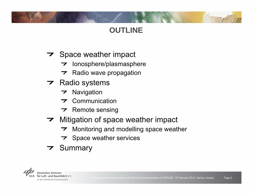
OUTLINE
Space weather impactIonosphere/plasmasphereRadio wave propagation
Radio systemsNavigationCommunicationRemote sensing
Mitigation of space weather impactMonitoring and modelling space weatherSpace weather services
Summary
47th session of the Scientific and Technical Subcommittee of COPUOS, 15 February 2010, Vienna, Austria Page 3
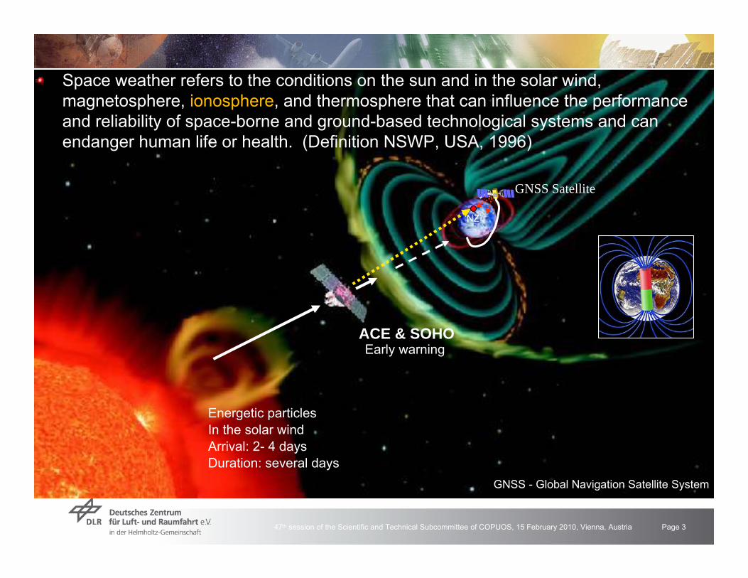
Energetic particlesIn the solar windArrival: 2- 4 daysDuration: several days
ACE & SOHO
GNSS Satellite
Early warning
NZ
GNSS - Global Navigation Satellite System
Space weather refers to the conditions on the sun and in the solar wind, magnetosphere, ionosphere, and thermosphere that can influence the performanceand reliability of space-borne and ground-based technological systems and canendanger human life or health. (Definition NSWP, USA, 1996)

47th session of the Scientific and Technical Subcommittee of COPUOS, 15 February 2010, Vienna, Austria Page 4
Magnetosphere
Das ionospheric weather is strongly coupled with processes in the magnetosphere
47th session of the Scientific and Technical Subcommittee of COPUOS, 15 February 2010, Vienna, Austria Page 5
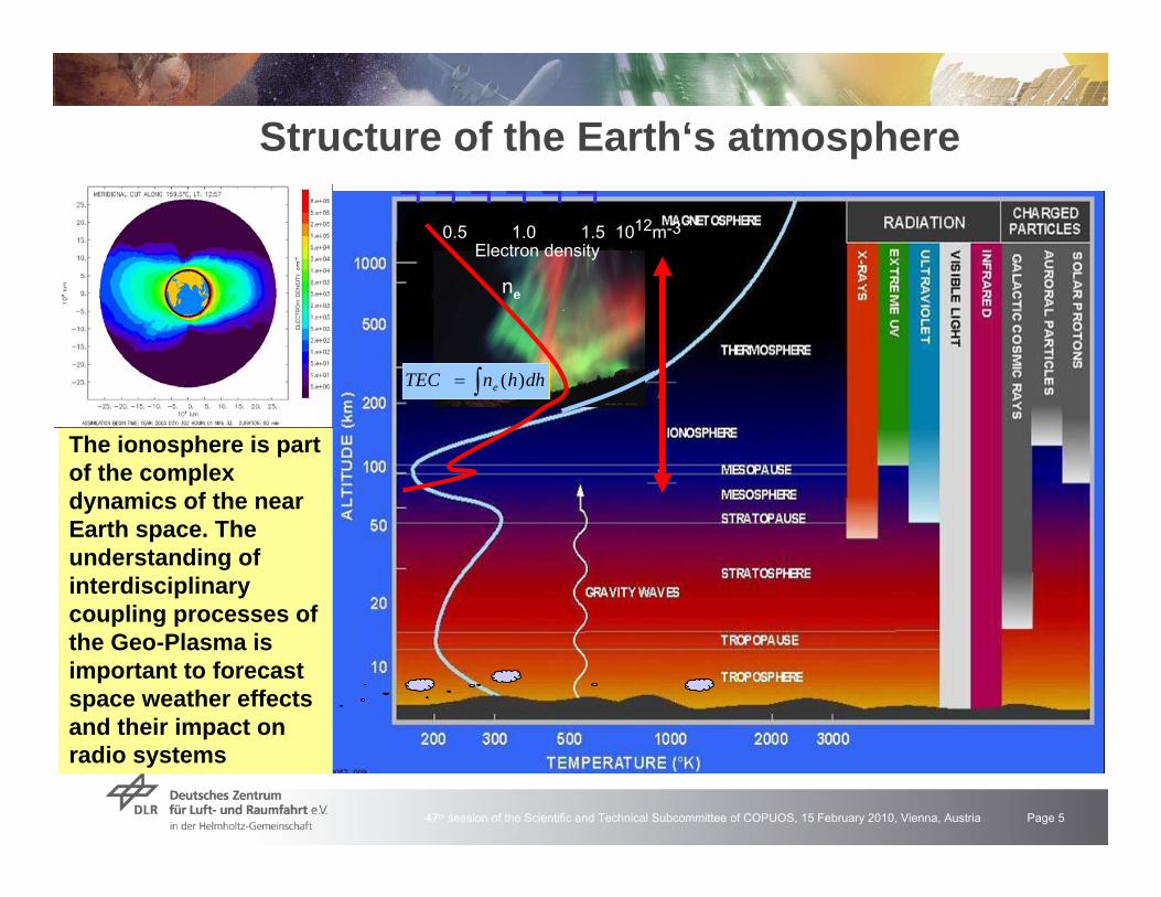
Structure of the Earth‘s atmosphere
The ionosphere is part of the complex dynamics of the near Earth space. The understanding of interdisciplinary coupling processes of the Geo-Plasma is important to forecast space weather effects and their impact on radio systems
¬ ¬ ¬ ¬ ¬ ¬0.5 1.0 1.5 1012m-3
Electron density
dhhnTEC e )(∫=
ne

47th session of the Scientific and Technical Subcommittee of COPUOS, 15 February 2010, Vienna, Austria Page 6
Radio wave propagation in the ionosphere
Ionosphere causes• Regular effects due to the
presence of plasma- signal delay- rotation of polarisation
• Irregular effects due to plasmadistortions, turbulences- misinterpretation of data due to
horizontal gradients (HMI)- Radio scintillations
All radio systemsoperating at frequencies < 10 GHz are impacted
Night
DayHei
ght/
km
100
20
0
300
ρ
Refraction
LoSRay path
f1 > f2f2f1
s
1995 1996 1997 1998 1999 2000 2001 2002 2003 2004 20050
20
40
60
80
Tota
l Ele
ctro
n C
onte
nt/ T
EC
U
Year
1995 1996 1997 1998 1999 2000 2001 2002 2003 2004 2005
100
200
300
Year
Sol
ar F
lux
Inde
x F 10
.7cm
0
4
8
12
Iono
sphe
ric R
ange
Err
or/ m
Total Electron Content50°N; 15°E13UT
Solar Flux Index F10.7cmSolar Flux
TEC50°N, 15°E
Electron density ne
dhhnTEC eV )(∫=
Ionosphere
Electron density ne & Total Electron Content (TEC) are closely related to the solar irradiance
47th session of the Scientific and Technical Subcommittee of COPUOS, 15 February 2010, Vienna, Austria Page 7
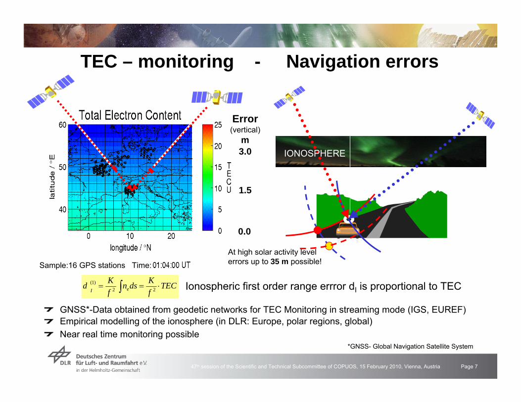
TEC – monitoring - Navigation errors
GNSS*-Data obtained from geodetic networks for TEC Monitoring in streaming mode (IGS, EUREF) Empirical modelling of the ionosphere (in DLR: Europe, polar regions, global)Near real time monitoring possible
Sample:16 GPS stations Time:
3.0
1.5
Error(vertical)
m
0.0
*GNSS- Global Navigation Satellite System
IONOSPHERE
At high solar activity levelerrors up to 35 m possible!
TECfKdsn
fKd eI
⋅== ∫ 22)1( Ionospheric first order range errror dI is proportional to TEC
47th session of the Scientific and Technical Subcommittee of COPUOS, 15 February 2010, Vienna, Austria Page 8
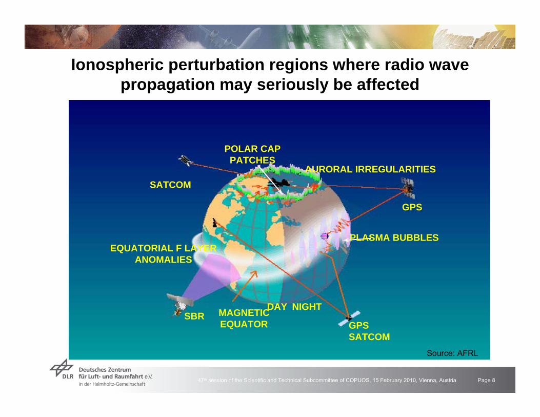
Ionospheric perturbation regions where radio wavepropagation may seriously be affected
SATCOMAURORAL IRREGULARITIES
GPS
PLASMA BUBBLES
GPS SATCOM
MAGNETICEQUATOR
DAY NIGHT
EQUATORIAL F LAYERANOMALIES
SBR
POLAR CAPPATCHES
Source: AFRL

47th session of the Scientific and Technical Subcommittee of COPUOS, 15 February 2010, Vienna, Austria Page 9
Performance degradation of the GPS reference networkof ascos on 25 July 2004
12 UT
1X1 deg grid resolution
SWACI product: TEC rate
19:30 UT
16:30 UT
NW
MW
MW
SW
SW
NW
Performance of the GPS referencenetwork of Allsat GmbH, Hannover degrades during the ionospheric stormon 25 July 2004
Different effects in different networkareas over Germany
Propagation of perturbationfrom high to mid-latitudes
Provision of ionospheric now-and forecast informationvaluable for users
Perturbation degree should bequantified by a perturbationindex that can directly be usedby customers
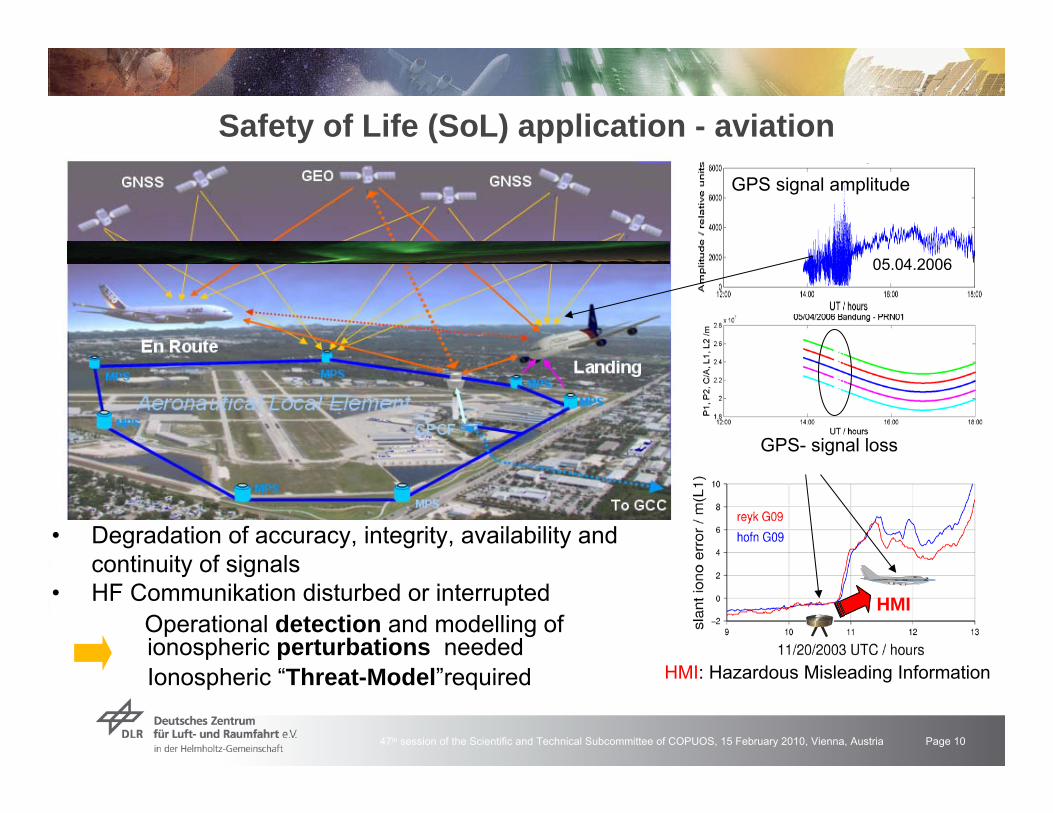
47th session of the Scientific and Technical Subcommittee of COPUOS, 15 February 2010, Vienna, Austria Page 10
• Degradation of accuracy, integrity, availability and continuity of signals
• HF Communikation disturbed or interruptedOperational detection and modelling ofionospheric perturbations neededIonospheric “Threat-Model”required
Safety of Life (SoL) application - aviationGPS signal amplitude
05.04.2006
GPS- signal loss
HMI: Hazardous Misleading Information
HMI

47th session of the Scientific and Technical Subcommittee of COPUOS, 15 February 2010, Vienna, Austria Page 11
Solar flare induced storm on 28 October 2003Strong Solar Flare was observedon 28 October 2003 at 11:05 UTTotal solar irradiation enhances within a fewminutes by 267 ppmRapid and strong increase of TEC at all GPS measurements (range error up to 3.5 m)Number of usable GPS measurements droppeddown from 30 to 7
Geographic Latitude / °NTime UT/ hrs.
TEC
r/ T
EC
u
47th session of the Scientific and Technical Subcommittee of COPUOS, 15 February 2010, Vienna, Austria Page 12
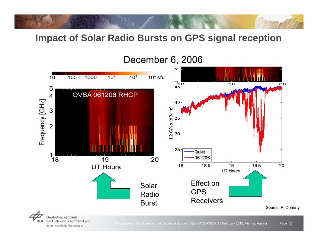
Impact of Solar Radio Bursts on GPS signal reception
December 6, 2006
SolarRadioBurst
Effect onGPSReceivers
Source: P. Doherty
47th session of the Scientific and Technical Subcommittee of COPUOS, 15 February 2010, Vienna, Austria Page 13
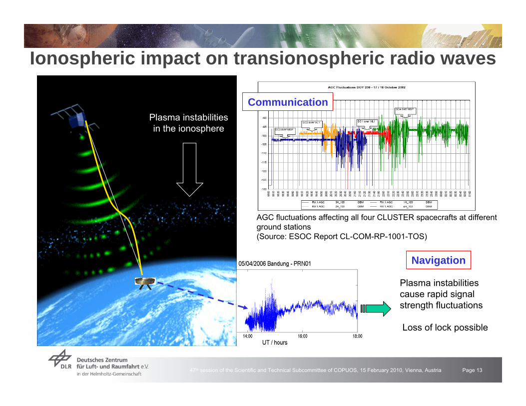
Ionospheric impact on transionospheric radio waves
Plasma instabilitiesin the ionosphere
Plasma instabilitiescause rapid signalstrength fluctuations
Loss of lock possible
AGC fluctuations affecting all four CLUSTER spacecrafts at different ground stations(Source: ESOC Report CL-COM-RP-1001-TOS)
Communication
Navigation

47th session of the Scientific and Technical Subcommittee of COPUOS, 15 February 2010, Vienna, Austria Page 14
Terrestrial Telecommunication - IonosphereRadio waves at frequencies below 10 MHz are mostlyreflected by the ionosphereThis results in a long distantpropagation of wavesSolar flares and particleprecipitation can prevent theionosphere from reflecting orrefracting radio waves
Polar routes
Short wave radio waves may be absorbed byenhanced plasma density in the lowerionosphere leading to a blackout in radiocommunications (Short wave fading) Ionospheric disturbance may enhance longwave radio propagation (measurements of Sudden Ionospheric Disturbances - SIDs )

47th session of the Scientific and Technical Subcommittee of COPUOS, 15 February 2010, Vienna, Austria Page 15
Remote sensing - Radar measurementsThe ionospheric plasma impacts the phase and polarisation angle of transionospheric radio waves in C-, L- und P- bands, i.e. numerous radarsystems
2000.4P251.2L25.0C
ΩF [°](100 TECu)
f (GHz)Band
Plasma turbulences cause defocussing effects in particular in L- and P- band radarsPlanned ESA Biomass Explorer will use P-band radar
Development of methods and algorithms for correction and mitigation of ionospheric propagation errors needed
PALSAR Observation GeometryPALSAR Observation Geometry
Off-nadir : 9.9 deg. - 50.8 deg.(nominal operation : 34.3 deg.)
#1
#18
#1
#5
350km
Off-nadir : 20.1 deg. - 36.5 deg.
870km
90 kmIncident : 8 deg. - 60 deg.
Fine mode ( #1 - #18)Direct downlink mode ( #1 - #18)Polarimetric mode ( #1 - #12)
ScanSAR mode (3scans - 5scans)
380 km70km
Sub-satellite track

47th session of the Scientific and Technical Subcommittee of COPUOS, 15 February 2010, Vienna, Austria Page 16
http://swaciweb.dlr.de
EOWEB- Katalog
200
400
0
22000
44000
Sei
ten/
Zugr
iffe
0Bes
uche
r/Mby
te
SWACI Service - Data access

47th session of the Scientific and Technical Subcommittee of COPUOS, 15 February 2010, Vienna, Austria Page 17
night day
1 h TEC forecast Quality control / %
Ground and space based ionosphere service productsTopside reconstructions
28 / 29 October 2003
Ionospheric services help studythe ionosphere and relationshipsbetween ionosphere and spaceweather, to correct/mitigatepropagation errors, to detectionospheric perturbation, to warnand forecast users
Services: ISES, Space WeatherPrediction Center Boulder, Int. GNSS Service (IGS), SWACI
CHAMP
CHAMP
IRO Profiling

47th session of the Scientific and Technical Subcommittee of COPUOS, 15 February 2010, Vienna, Austria Page 18
Sun & Ionosphere MOnitoring NEtwork - SIMONE
Receiver
Antenna
EMAG Bergen
DLR Neustrelitz
Signal strength1 June 2007
EMAG Bergen NAA Cutler Schools inGermany
ca. 6000 km
24 kHz
IonosphereSolar flare
Time / hrs
SR SS
Solar flare
47th session of the Scientific and Technical Subcommittee of COPUOS, 15 February 2010, Vienna, Austria Page 19
SummaryRadio wave propagation is strongly affected by space weather effectsvia their interaction with the non-isotropic ionospheric plasmaImpacted are technical systems related to:
Terrrestrial radio wave propagationTelecommunicationRadar systems
Transionospheric radio wave propagationTelecommunicationSatellite navigation /positioningRemote sensing, altimetryResearch facilities
Space weather / ionospheric monitoring and provision of actual and forecasted information helps to mitigate the space weather impactA number of ionospheric data and information services exist(e.g. ISES, SWPC, SWACI), data products with higher temporal and spatial resolution are required to improve the Space SituationalAwareness (SSA)The International Space Weather Initiative (ISWI) is a uniqueopportunity to improve our understanding of space weather effects.

47th session of the Scientific and Technical Subcommittee of COPUOS, 15 February 2010, Vienna, Austria Page 20
Thank you for your attention

47th session of the Scientific and Technical Subcommittee of COPUOS, 15 February 2010, Vienna, Austria Page 21
Dual frequency GNSS measurements
TEC can be derived from dual frequency GNSS measurements.
offTECffffKPPP ε+−
=−=Δ 22
21
22
21
12
ne(h)e
GNSS
Center of Earth
raypath s
Receiver
χ
hI
dhhnTEC eV )(∫=
RE
Total Electron Content
TECfKdI ⋅= 2
GPS based TEC measurementsand mapping in DLR Neustrelitz
Europe post proc. (1 day) since 1995 http://www.kn.nz.dlr.de/daily/tec-eu
operational (5 min) since 2005 http://swaciweb.dlr.deNorth Polepost proc. (1 day) since 2002http://www.kn.nz.dlr.de/daily/tec-np
Ionospheric rangeerror up to about100 mEstimation of ionospheric perturbation degreeis a practical needStatistics and casestudies required

47th session of the Scientific and Technical Subcommittee of COPUOS, 15 February 2010, Vienna, Austria Page 22
GPS Signal amplitudeBandung
05.04.2006
Impact of Ionospheric perturbations on navigation and positioning
IntegrityRisk of undetected failures resulting in the
violation of the protection level
Availability, continuity

47th session of the Scientific and Technical Subcommittee of COPUOS, 15 February 2010, Vienna, Austria Page 23
Ionospheric perturbations on 29 / 30 October 2003Numerous perturbations in Com/NavSystems in Europe and in the USA
Close correlation of TEC behaviour withthe southward component of the IMF
UNPERTURBEDUNPERTURBED
IMF
/ nT
47th session of the Scientific and Technical Subcommittee of COPUOS, 15 February 2010, Vienna, Austria Page 24
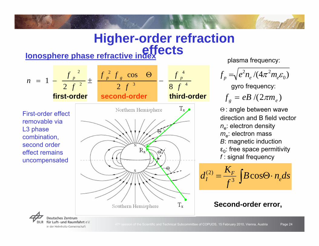
Higher-order refraction effectsIonosphere phase refractive index
Θ : angle between wavedirection and B field vectorne: electron densityme: electron massB: magnetic inductionε0: free space permitivityf : signal frequency
4
4
3
2
2
2
82cos
21
ff
fff
ff
n pgpp −Θ
±−=
first-order second-order third-order
)4/( 022 επ eep mnef =
plasma frequency:
gyro frequency:
)2/( eg meBf π=
∫ ⋅Θ= dsnBfKd e
FI cos3
)2(
Second-order error,
First-order effectremovable via L3 phasecombination, second order effect remainsuncompensated

47th session of the Scientific and Technical Subcommittee of COPUOS, 15 February 2010, Vienna, Austria Page 25
ε: 10°ε: 30°ε: 60°
TECV: 100 TECU ε: elevation angle
ΦRx: 51° N,λTx: 10° E
∫ ⋅Θ= dsnBf
Kd eF
Icos3
)2(
Anisotropy of the ionospheredue to the geomagnetic field B
Hoque,M.M., N. Jakowski, Mitigation of higher order ionospheric effects on GNSS users in Europe, GPS Solutions, DOI 10.1007/s10291-007-0069-5, 2007Hoque, M. M., N. Jakowski, Estimate of higher order ionospheric errors in GNSS positioning, Radio Science, 2008
B
Ionospheric 2nd order errors areusually ignored in the measurementpraxis (< 20 cm). When Galileo becomes operational, these errors have to be routinelymitigated in precise applications
Ionospheric Range Error – 2nd order (1)

47th session of the Scientific and Technical Subcommittee of COPUOS, 15 February 2010, Vienna, Austria Page 26
GPS sounding of the Ionosphere onboard a LEO satellite
GPS Satellite
CHAMP GRACE
LEO Orbit
Radio Signal
GPS

47th session of the Scientific and Technical Subcommittee of COPUOS, 15 February 2010, Vienna, Austria Page 27
Auroral particle precipitation - ELDI
Particle precipitation from the magnetospherecauses a locally enhanced ionization in thelower ionosphere
ELDI : E-Layer Dominated Ionosphere

47th session of the Scientific and Technical Subcommittee of COPUOS, 15 February 2010, Vienna, Austria Page 28
Anwendung – Fernerkundung (1)
Begin
Filtered TEC from GPS2.5 - 10.0 min
Sampali: 3.62°N; 98.71°E
Sumatra earthquakeon 26 December 2004
ionospheric wave about 10 minutes later
detectable
Rayleigh waveat the groundfromseismograms
speed: 3.5 km/s
Weg-Zeit-Diagramm
Alaska Earthquake on November 3, 2002( M=7.9 ; 63.5N /147.4 W )
GITEWS Nachweis ionosphärischer Erdbeben / Tsunami -Signaturen in der Ionosphäre (ETSI)
TEC-Messungen (blau) über dem Ort des Epi-zentrums bis zu 7 Tage vorher im Vergleich zu 27-tägigen Median-werten (rot).Wettbewerb der Visionen des DLR
Ionisationsanomalie
Vorhersage möglich ???
47th session of the Scientific and Technical Subcommittee of COPUOS, 15 February 2010, Vienna, Austria Page 29
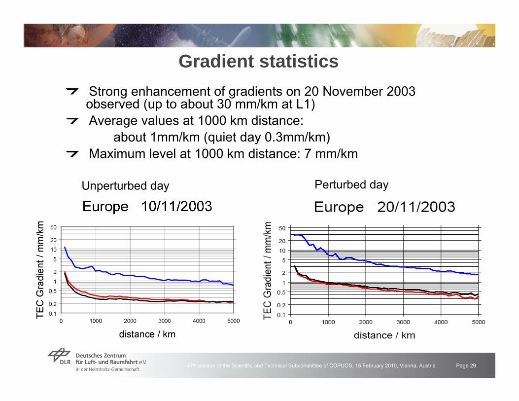
Gradient statisticsStrong enhancement of gradients on 20 November 2003 observed (up to about 30 mm/km at L1)Average values at 1000 km distance:
about 1mm/km (quiet day 0.3mm/km) Maximum level at 1000 km distance: 7 mm/km
Unperturbed day Perturbed day

47th session of the Scientific and Technical Subcommittee of COPUOS, 15 February 2010, Vienna, Austria Page 30
Ionosphärisch bedingte Radioszintillationen
Radioszintillationen stellen auch für Galileo ein Problem dar.
(Source: ESOC Report CL-COM-RP-1001-TOS)
18 19 20 21 22 23 240
0.1
0.2
0.3
0.4
0.5
30. Oct. 200331. Oct. 2003
S4-Index
UT [hour]
Kiruna/Schweden
S4 Index, GPS-Signale
AGC Fluktuationen, CLUSTER-Signale
DLR
ESOC
Superposition von RadiowellenStarke FeldstärkeschwankungenSignalverlust möglich
Plasmaturbulenzen• Hohe Breiten
Teilchenpräzipitation• Niedere Breiten
‚Bubbles‘
Jicamarca, Peru
2/1
2
22
4 ⎟⎟
⎠
⎞
⎜⎜
⎝
⎛ −=
I
IIS

47th session of the Scientific and Technical Subcommittee of COPUOS, 15 February 2010, Vienna, Austria Page 31
Satellitennavigation
Die Entfernungsmessung basiert auf der Messung der Signallaufzeit
„Anwendungsbeispiel“ für präzise Navigation
Operationelle und geplantesatellitengestützte Navigationssysteme
GPS (USA)GLONASS (Russland)Galileo (Europa)Compass (China)

47th session of the Scientific and Technical Subcommittee of COPUOS, 15 February 2010, Vienna, Austria Page 32
Weltraumwetterprojekt SIMONE (Sonnen & Ionosphären MOnitoring NEtzwerk)
An Schulen in Niedersachsen, Hamburg und Mecklenburg-Vorpommern werden kontinuierlich Messungen durchgeführt, archiviert und analysiert.