Embed Size (px)
Citation preview

Space for Agriculture Development
and Food SecurityUse of Space Technology within
the United Nations System
UNITED NATIONS
UNITED NATIONSOFFICE FOR OUTER SPACE AFFAIRS
Contents
Foreword 1
Background 2
United Nations Office for Outer Space Affairs (UNOOSA) 3
THEMATIC AREAS
Agricultural research and development 5
Biodiversity 7
Desertification 8
Drought 11
Floods 14
Fisheries and aquaculture 17
Irrigation and water 18
Land-use mapping 21
Managing, mitigating and preparing for disasters 24
Monitoring agricultural production 26
Vegetation fires 28
Weather monitoring and forecasting 30
Acronyms and abbreviations 31
Contributors 32
www.unoosa.org
COPYRIGHT • DISCLAIMER
page i

UNITED NATIONS CONVENTIONS, ENTITIES AND PROGRAMMES RELATED TO APPLICATIONS OF SPACE TECHNOLOGY FOR AGRICULTURE
Convention on Biological Diversity (CBD) 6
Convention to Combat Desertification (UNCCD) 6
Economic Commission for Africa (ECA) 9
Economic Commission for Latin America and the Caribbean (ECLAC) 10
Economic and Social Commission for Asia and the Pacific (ESCAP) 12
Economic and Social Commission for Western Asia (ESCWA) 13
Food and Agriculture Organization of the United Nations (FAO) 15
International Atomic Energy Agency (IAEA) 16
United Nations Educational, Scientific and Cultural Organization (UNESCO) 19
United Nations Environment Programme (UNEP) 20
United Nations Office for Disaster Reduction (UNISDR) 22
United Nations Institute for Training and Research/Operational Satellite Applications Programme (UNITAR/UNOSAT) 23
United Nations Platform for Space-based Information for Disaster Management and Emergency Response (UN-SPIDER) 25
United Nations Programme on Space Applications 27
World Food Programme (WFP) 29
World Meteorological Organization (WMO) 29
page i i

CONTENTS
Foreword
Food security and proper nutrition have become pressing global challenges, and the
interrelated targets of ending hunger, achieving food security and improved nutrition, and
promoting sustainable agriculture have been recognized collectively as a core sustainable
development goal.
Achieving this goal will require concerted global actions and advanced tools and solutions to
eradicate hunger and guarantee food and nutrition security for all, as well as to promote,
enhance and support more sustainable agriculture while conserving land, water, plant and
animal genetic resources, biodiversity and ecosystems.
Such tools are offered by space science, technology and applications, which help in the
monitoring of crops, livestock, forestry, fisheries, aquaculture, and in supporting farmers,
fisherfolk, foresters and policymakers in efforts to employ diverse methods of achieving
sustainable food production and to respond to related challenges, such as adverse weather
conditions, droughts, floods, desertification and land degradation, vegetation fires, and
disasters triggered by natural phenomena.
This publication features how space-based technologies are used for supporting decision-
making in the fields of agriculture and food security and for overcoming challenges posed to
future prosperity, security and the well-being of all humankind. It also features United Nations
organizations that use space-based technologies in their efforts to ensure access to sufficient
nutritious food for all.
I encourage policymakers to familiarize themselves with the multifaceted applications of these
technologies to enhance our ability to advance economically, socially and environmentally.
Simonetta Di Pippo Director, United Nations Office for Outer Space Affairs
page 1

page 2CONTENTS
Background
The United Nations Inter-Agency Meeting on Outer Space Activities (UN-Space), led by the
United Nations Office for Outer Space Affairs (UNOOSA), has served as the focal point for
inter-agency coordination and cooperation in space-related activities since 1975. This
coordination mechanism aims to promote inter-agency cooperation and to prevent duplication
of effort related to the use of space applications by United Nations organizations.
At the 32nd session of UN-Space, held in Rome in 2012, representatives of participating
organizations agreed to issue a special report outlining the way in which United Nations
organizations use space-based technologies for agriculture and food security.
This publication, a synthesis of the longer report (A/AC.105/1042), illustrates a wide variety of
activities, including observations, data collection and dissemination, research and development
of standards, policy formulation and emergency operations, and presents vivid examples of
synergies among different entities, as envisioned under the framework of the United Nations
system “Delivering as One” initiative, established by the Secretary-General of the United Nations
in 2009.
The present publication features, in alphabetical order, both the thematic areas related to food
security and sustainable food production, and United Nations entities that employ space
technology in their routine operations in those areas. Organizations of the United Nations
system also support Member States in advancing their capacities, promoting policy-science
dialogue, developing institutional frameworks and bridging the gaps between knowledge,
governance and the capacity to use such technology to enable early detection of threats to
agriculture and food security, and informed decision-making in preventing and mitigating the
effects of such threats.

page 3CONTENTS
United Nations Office for Outer Space Affairs (UNOOSA)
The United Nations Office for Outer Space Affairs (UNOOSA), headquartered in Vienna,
Austria, is the United Nations office responsible for promoting international cooperation in the
peaceful uses of outer space for all humankind.
UNOOSA serves as the secretariat for the General Assembly’s only committee dealing
exclusively with international cooperation in the peaceful uses of outer space: the United
Nations Committee on the Peaceful Uses of Outer Space (COPUOS), established in 1958,
and its subsidiary bodies.
The Office is also responsible for discharging the Secretary-General’s responsibilities under
international space law, and builds, through the United Nations Programme on Space
Applications, national capacities on topics that include remote sensing, satellite navigation,
satellite meteorology, tele-education and basic space sciences for the benefit of developing
countries.
The Office also implements the United Nations Platform for Space-based Information for
Disaster Management and Emergency Response (UN-SPIDER) and acts as the executive
secretariat of the International Committee on Global Navigation Satellite Systems (ICG).
UNOOSA is the secretariat of UN-Space, a United Nations system-wide coordination
mechanism aimed at increasing coordination and cooperation in space-related activities
within the system.

THEMATIC AREAS
page 4CONTENTS
SPACE FOR AGRICULTURE DEVELOPMENT AND FOOD SECURITY CONTENTS page 5
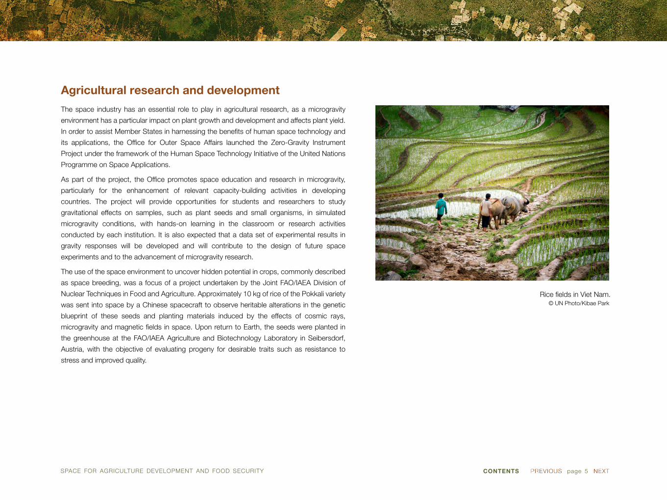
Agricultural research and development
The space industry has an essential role to play in agricultural research, as a microgravity
environment has a particular impact on plant growth and development and affects plant yield.
In order to assist Member States in harnessing the benefits of human space technology and
its applications, the Office for Outer Space Affairs launched the Zero-Gravity Instrument
Project under the framework of the Human Space Technology Initiative of the United Nations
Programme on Space Applications.
As part of the project, the Office promotes space education and research in microgravity,
particularly for the enhancement of relevant capacity-building activities in developing
countries. The project will provide opportunities for students and researchers to study
gravitational effects on samples, such as plant seeds and small organisms, in simulated
microgravity conditions, with hands-on learning in the classroom or research activities
conducted by each institution. It is also expected that a data set of experimental results in
gravity responses will be developed and will contribute to the design of future space
experiments and to the advancement of microgravity research.
The use of the space environment to uncover hidden potential in crops, commonly described
as space breeding, was a focus of a project undertaken by the Joint FAO/IAEA Division of
Nuclear Techniques in Food and Agriculture. Approximately 10 kg of rice of the Pokkali variety
was sent into space by a Chinese spacecraft to observe heritable alterations in the genetic
blueprint of these seeds and planting materials induced by the effects of cosmic rays,
microgravity and magnetic fields in space. Upon return to Earth, the seeds were planted in
the greenhouse at the FAO/IAEA Agriculture and Biotechnology Laboratory in Seibersdorf,
Austria, with the objective of evaluating progeny for desirable traits such as resistance to
stress and improved quality.
Rice fields in Viet Nam.© UN Photo/Kibae Park
SPACE FOR AGRICULTURE DEVELOPMENT AND FOOD SECURITY CONTENTS page 6
SECRETARIAT OF THE UNITED NATIONS CONVENTION TO COMBAT DESERTIFICATION
P.O. Box 260129
Platz der Vereinten Nationen 1
D-53153 Bonn, Germany
Tel.: +49-228/815-2800
Fax: +49-228/815-2898/99
E-mail: [email protected]
Website: www.unccd.int
CONVENTION TO COMBAT DESERTIFICATION (UNCCD)
Desertification, along with climate change and loss of biodiversity, were identified as the
greatest challenges to sustainable development at the 1992 Rio Earth Summit. Established in
1994, the United Nations Convention to Combat Desertification (UNCCD) is the sole legally
binding international agreement linking environment and development to sustainable land
management.
The Convention specifically addresses arid, semi-arid and dry subhumid areas, known as
drylands, where some of the most vulnerable ecosystems and peoples can be found. In
Sustainable Development Goal 15, Member States committed themselves to combating
desertification and halting and reversing land degradation. The permanent secretariat of the
Convention facilitates cooperation among the Convention’s 195 parties in improving living
conditions for people in drylands, maintaining and restoring land and soil productivity, and
mitigating the effects of drought.
SECRETARIAT OF THE CONVENTION ON BIOLOGICAL DIVERSITY
413 Saint Jacques Street, suite 800
Montreal QC H2Y 1N9 Canada
Tel.: +1 514 288 2220
Fax: +1 514 288 6588
E-mail: [email protected]
Website: www.cbd.int
CONVENTION ON BIOLOGICAL DIVERSITY (CBD)
The Convention on Biological Diversity (CBD) was signed at the Earth Summit in Rio de
Janeiro, Brazil, in 1992 and entered into force on 29 December 1993. It is the first global
agreement to cover all aspects of biological diversity: the conservation of biological diversity,
the sustainable use of its components and the fair and equitable sharing of benefits arising
from the use of genetic resources.
The Secretariat of the Convention on Biological Diversity (SCBD), based in Montreal, Canada,
was established to support the goals of the Convention. Its assists member Governments in
mainstreaming biodiversity into broader national policies, facilitates national implementation
of the Strategic Plan for biodiversity 2011-2020, compiles national reports on measures taken
for the implementation of the Convention and the effectiveness of those measures,
coordinates related activities with other international organizations and collects and
disseminates information. The Secretariat also acts as an information clearing house.
SPACE FOR AGRICULTURE DEVELOPMENT AND FOOD SECURITY CONTENTS page 7
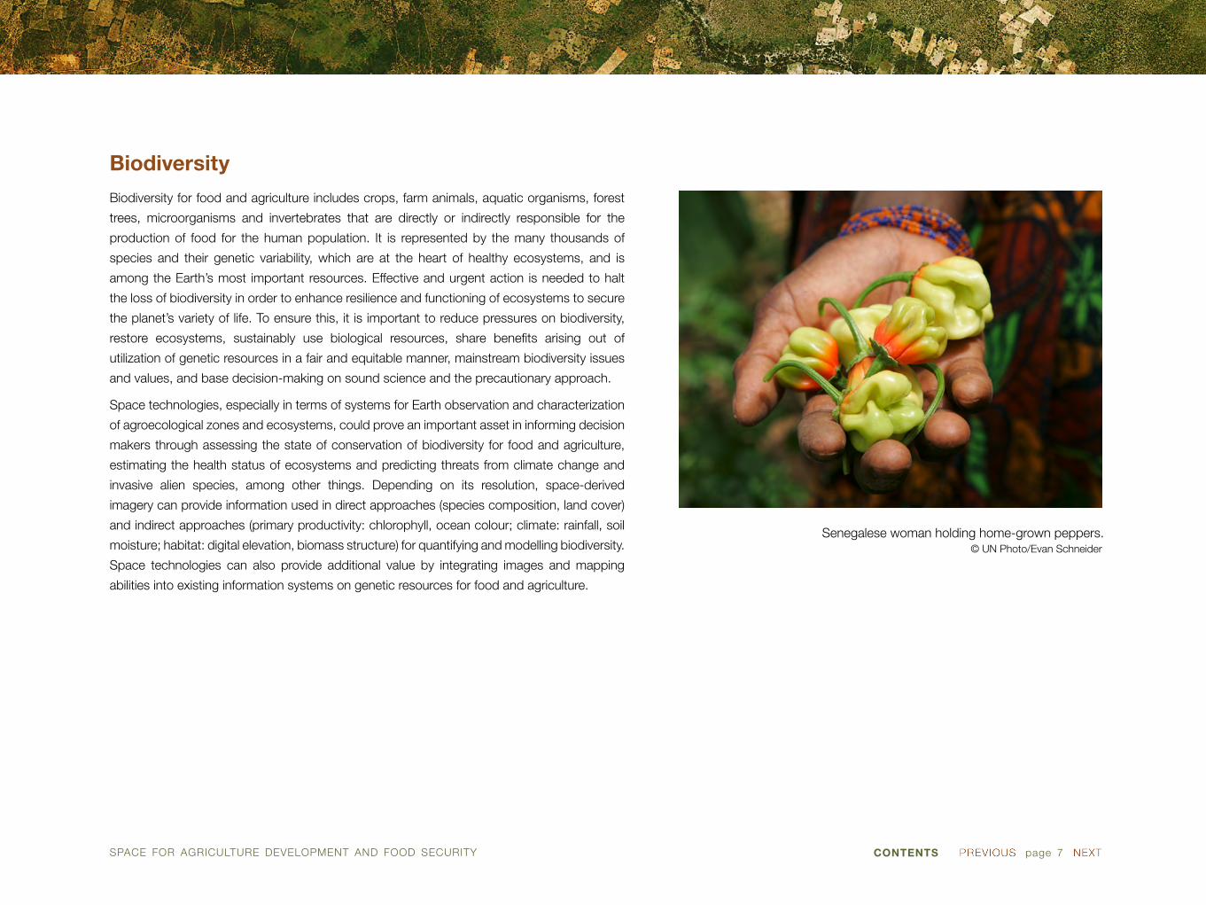
Biodiversity
Biodiversity for food and agriculture includes crops, farm animals, aquatic organisms, forest
trees, microorganisms and invertebrates that are directly or indirectly responsible for the
production of food for the human population. It is represented by the many thousands of
species and their genetic variability, which are at the heart of healthy ecosystems, and is
among the Earth’s most important resources. Effective and urgent action is needed to halt
the loss of biodiversity in order to enhance resilience and functioning of ecosystems to secure
the planet’s variety of life. To ensure this, it is important to reduce pressures on biodiversity,
restore ecosystems, sustainably use biological resources, share benefits arising out of
utilization of genetic resources in a fair and equitable manner, mainstream biodiversity issues
and values, and base decision-making on sound science and the precautionary approach.
Space technologies, especially in terms of systems for Earth observation and characterization
of agroecological zones and ecosystems, could prove an important asset in informing decision
makers through assessing the state of conservation of biodiversity for food and agriculture,
estimating the health status of ecosystems and predicting threats from climate change and
invasive alien species, among other things. Depending on its resolution, space-derived
imagery can provide information used in direct approaches (species composition, land cover)
and indirect approaches (primary productivity: chlorophyll, ocean colour; climate: rainfall, soil
moisture; habitat: digital elevation, biomass structure) for quantifying and modelling biodiversity.
Space technologies can also provide additional value by integrating images and mapping
abilities into existing information systems on genetic resources for food and agriculture.
Senegalese woman holding home-grown peppers.© UN Photo/Evan Schneider

SPACE FOR AGRICULTURE DEVELOPMENT AND FOOD SECURITY CONTENTS page 8
Dryland in Timor-Leste.Image: UN Photo/Martine Perret
Desertification
Sustainable land use is a prerequisite for lifting billions of people out of poverty, enabling
food and nutrition security and safeguarding water supplies. Desertification includes land
degradation in arid, semi-arid and dry subhumid areas resulting from various factors,
including climatic variations and human activities such as overgrazing and overcultivation.
Desertification affects as much as one-sixth of the world’s population, 70 per cent of all
drylands, and one quarter of the total land area of the world.
Building on the recognition by the United Nations Conference on Sustainable Development
(Rio+20), in its outcome document, of the need for urgent action to reverse land degradation,
Sustainable Development Goal 16 is aimed at combating desertification and restoring
degraded land and soil, including land affected by desertification, drought and floods, and
strives to achieve a land degradation-neutral world by 2020.
Space technology offers unbeatable advantages in view of homogeneity and spatial and
temporal coverage of observations, and allows the monitoring of various elements of
desertification processes. These elements include climate-related variables, surface albedo
(fraction of reflected radiation), surface temperature, moisture, vegetation indices, as well
as changes in vegetation cover, land surface composition, sand transport and wind
transportation. Since desertification is a complex, cross-sector environmental problem
promoted by multiple drivers, its monitoring requires the integration of human- and
environment-based variables. Being essential for early warning and monitoring of
desertification development and its extent, remotely sensed information also assists in
evaluating the impacts of policies to combat desertification.

SPACE FOR AGRICULTURE DEVELOPMENT AND FOOD SECURITY CONTENTS page 9
UNITED NATIONS ECONOMIC COMMISSION FOR AFRICA
Menelik II Ave.
P.O. Box 3001, Addis Ababa, Ethiopia
Tel.: 251-11-551 7200
Fax: 251-11-551 4416
Website: www.uneca.org
ECONOMIC COMMISSION FOR AFRICA (ECA)
Established by the Economic and Social Council of the United Nations in 1958 as one of the
five regional commissions of the United Nations, ECA’s mandate is to promote the economic
and social development of its member States, foster intra-regional integration, and promote
international cooperation for Africa’s development. Made up of 54 member States, and
playing a dual role as a regional arm of the United Nations and as a key component of the
African institutional landscape, ECA is well positioned to make unique contributions to
address the continent’s development challenges.
The ECA report “Status of Food Security in Africa” indicated that food security remains a
challenge for the continent and that African countries need to shape their policy responses
around increased agricultural productivity and production, development of markets and
building the resilience of vulnerable populations. ECA works to build capacities for risk
and disaster management systems through the use of information and communication
technologies in Africa and to address the lack of both awareness and established systems
for prevention, preparedness and monitoring of natural disasters.

SPACE FOR AGRICULTURE DEVELOPMENT AND FOOD SECURITY CONTENTS page 10
ECONOMIC COMMISSION FOR LATIN AMERICA AND THE CARIBBEAN
Av. Dag Hammarskjöld 3477, Vitacura,
Santiago de Chile
Tel.: (56-2) 2471 2000 • 2210 2000
Fax: (56-2) 2208-0252
Address: Casilla 179-D, Santiago de Chile
Postal code: 7630412
Website: www.cepal.org
ECONOMIC COMMISSION FOR LATIN AMERICA AND THE CARIBBEAN (ECLAC)
The Economic Commission for Latin America and the Caribbean (ECLAC), headquartered in
Santiago, Chile, is one of the five regional commissions of the United Nations. It was founded
in 1948 with the purpose of contributing to the economic development of Latin America,
coordinating actions directed towards that end, and reinforcing economic ties among
countries and with other nations of the world. The promotion of the region’s social
development was later included among its primary objectives.
ECLAC has been engaged in the identification of best practices in the use of satellite remote
sensing data to enhance agricultural productivity and sustainability and to mitigate the effects
of climate change, and in the regional dissemination of such experiences through publications,
seminars, workshops and technical assistance activities. ECLAC has also organized
international seminars to discuss, among other subjects, experiences related to the use of
spatial imagery, satellite data and satellite Internet access for agricultural purposes, including
in areas such as precision agriculture and precision irrigation.

SPACE FOR AGRICULTURE DEVELOPMENT AND FOOD SECURITY CONTENTS page 11
Mauritian village affected by drought.Image: UN Photo/John Isaac
Drought
Drought forecasting and early detection relies on, among other things, satellite imaging
systems, and enables decisions to be taken to prevent and mitigate the effects of drought.
Monitoring that is built on knowledge acquired from past events and that uses archived
imagery can help profile current trends and events so that the effects of droughts can be
mitigated and famine can be avoided.
To mitigate the impact of agricultural drought, it is of great importance to have at one’s
disposal timely and reliable information on the condition of food crops in all regions and
countries. The Global Information and Early Warning System on Food and Agriculture and the
Climate, Energy and Tenure Division of FAO have as their aim the development of an
agricultural stress index system, based on meteorological operational satellite-advanced very
high resolution radiometer (METOP-AVHRR) composite imagery over 10 days and with a
resolution of 1 km, for detecting, on a global scale, agricultural areas with a high likelihood of
water stress (drought).
The agricultural stress index system is based on the vegetation health index (VHI), which was
derived from the normalized difference vegetation index (NDVI) and developed by the Center
for Satellite Applications and Research of the National Environmental Satellite, Data and
Information Service of the United States. VHI has been successfully applied under many
different environmental conditions around the globe, including in Asia, Africa, Europe, and
North and South America. It can detect drought conditions at any time of the year. For
agriculture, however, only the period that is most sensitive for crop growth (temporal
integration) is of interest, so the analysis is performed only between the start and end of the
crop season.

SPACE FOR AGRICULTURE DEVELOPMENT AND FOOD SECURITY CONTENTS page 12
UNESCAP SECRETARIAT
The United Nations Building
Rajadamnern Nok Avenue
Bangkok 10200 Thailand
Tel.: (66-2) 288-1234
Fax: (66-2) 288-1000
Website: www.unescap.org
ECONOMIC AND SOCIAL COMMISSION FOR ASIA AND THE PACIFIC (ESCAP)
Established in 1947 with its headquarters in Bangkok, Thailand, the United Nations Economic
and Social Commission for Asia and the Pacific (ESCAP) is made up of 53 member States
and 9 associate members and is the regional development arm of the United Nations for the
Asia-Pacific region, which is home to 4.1 billion people, or two thirds of the world’s population.
Through its Space Applications Section, ESCAP assists its members in the implementation of
the Asia-Pacific Years of Action for Applications of Space Technology and Geographic
Information System for Disaster Risk Reduction and Sustainable Development, 2012-2017,
and the underlying five-year regional Plan of Action. The Regional Cooperative Mechanism on
Disaster Monitoring and Early Warning, Particularly Drought, provides substantive technical
support to the region for development of national (agricultural) drought disaster monitoring
and early warning capacities and services.

SPACE FOR AGRICULTURE DEVELOPMENT AND FOOD SECURITY CONTENTS page 13
ESCWA SECRETARIAT
P.O. Box 11-8575, Riad el-Solh Square,
Beirut, Lebanon
Tel.: +961-1-981301
Fax: +961-1-981510
Website: www.escwa.un.org
ECONOMIC AND SOCIAL COMMISSION FOR WESTERN ASIA (ESCWA)
The Economic and Social Commission for Western Asia (ESCWA) was established on 9 August
1973 with the objectives of raising the level of economic activity in member countries and
strengthening cooperation among them. It was also intended to meet the need of the countries
in Western Asia for the services of a regional economic commission to promote the development
efforts in the region. Located in Beirut, ESCWA provides a framework for the formulation and
harmonization of sectoral policies for member countries, a platform for congress and
coordination, a home for expertise and knowledge, and an information observatory.
Under its Regular Programme for Technical Cooperation, ESCWA has advocated for the use
of space-based technology in water resource management. To provide policymakers and
researchers with greatly improved data in the management of water resources, ESCWA
contributes to the development of the Inventory of Shared Water Resources in Western Asia.
The inventory compiles and explores information on shared groundwater systems and surface
water basins in Western Asia, with an emphasis on hydrology, hydrogeology, water resource
development and use, and the status of cooperation.
SPACE FOR AGRICULTURE DEVELOPMENT AND FOOD SECURITY CONTENTS page 14
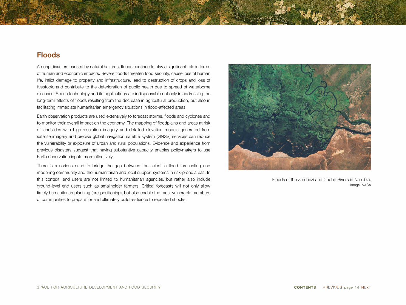
Floods of the Zambezi and Chobe Rivers in Namibia.Image: NASA
Floods
Among disasters caused by natural hazards, floods continue to play a significant role in terms
of human and economic impacts. Severe floods threaten food security, cause loss of human
life, inflict damage to property and infrastructure, lead to destruction of crops and loss of
livestock, and contribute to the deterioration of public health due to spread of waterborne
diseases. Space technology and its applications are indispensable not only in addressing the
long-term effects of floods resulting from the decrease in agricultural production, but also in
facilitating immediate humanitarian emergency situations in flood-affected areas.
Earth observation products are used extensively to forecast storms, floods and cyclones and
to monitor their overall impact on the economy. The mapping of floodplains and areas at risk
of landslides with high-resolution imagery and detailed elevation models generated from
satellite imagery and precise global navigation satellite system (GNSS) services can reduce
the vulnerability or exposure of urban and rural populations. Evidence and experience from
previous disasters suggest that having substantive capacity enables policymakers to use
Earth observation inputs more effectively.
There is a serious need to bridge the gap between the scientific flood forecasting and
modelling community and the humanitarian and local support systems in risk-prone areas. In
this context, end users are not limited to humanitarian agencies, but rather also include
ground-level end users such as smallholder farmers. Critical forecasts will not only allow
timely humanitarian planning (pre-positioning), but also enable the most vulnerable members
of communities to prepare for and ultimately build resilience to repeated shocks.

SPACE FOR AGRICULTURE DEVELOPMENT AND FOOD SECURITY CONTENTS page 15
FAO HEADQUARTERS
Viale delle Terme di Caracalla
00153 Rome, Italy
Tel.: (+39) 06 57051
E-mail: [email protected]
Website: www.fao.org
FOOD AND AGRICULTURE ORGANIZATION OF THE UNITED NATIONS (FAO)
The Food and Agriculture Organization of the United Nations (FAO), established in 1945 and
presently headquartered in Rome, Italy, is an agency of the United Nations that leads
international efforts to defeat hunger. Serving both developed and developing countries,
FAO acts as a neutral forum where all nations meet as equals to negotiate agreements and
debate policy.
FAO provides support to countries to promote and enhance sustainable land use and land
resources management through, among other things, the development of geo-referenced
databases on land cover and global land, water and forest resources, and has created a
global fisheries information system. FAO has initiated global inventories of livestock production
systems and mapping of generalized farming systems. It provides national land use statistics
and maintains an online overview of crop characteristics, ecology and management. FAO
holds the ARTEMIS satellite-based environmental and agrometeorological databases and
analysis tools and assures the documentation (metadata) and distribution of FAO’s spatial
information through the GeoNetwork.
SPACE FOR AGRICULTURE DEVELOPMENT AND FOOD SECURITY CONTENTS page 16
INTERNATIONAL ATOMIC ENERGY AGENCY
Vienna International Centre
P.O. Box 100
1400 Vienna, Austria
Tel.: (+431) 2600-0
Fax: (+431) 2600-7
Website: www.iaea.org
INTERNATIONAL ATOMIC ENERGY AGENCY (IAEA)
IAEA is the world’s centre of cooperation in the nuclear field. It was set up as the world’s
“Atoms for Peace” organization in 1957 within the United Nations family. The Agency works
with its member States and multiple partners worldwide to promote safe, secure and peaceful
nuclear technologies. The IAEA secretariat is headquartered in Vienna, Austria, and has its
operational liaison and regional offices in Geneva, New York, Tokyo and Toronto. The work of
the Agency is as diverse as the landscape of peaceful nuclear technologies, and encompasses
experiments conducted in outer space.
The use of the space environment to uncover hidden potential in crops was a focus of a
project undertaken by the Joint FAO/IAEA Division of Nuclear Techniques in Food and
Agriculture. As part of the project, a package of rice was sent into space by a Chinese
spacecraft to observe heritable alterations in the genetic blueprint of these seeds and planting
materials induced by the effects of cosmic rays, microgravity and magnetic fields in space.
Upon returning to Earth, the seeds were planted with the objective of evaluating progeny for
desirable traits such as resistance to stress and improved quality.

SPACE FOR AGRICULTURE DEVELOPMENT AND FOOD SECURITY CONTENTS page 17
Lighthouse Atoll in the Belize Barrier Reef.Image: ESA
Fisheries and aquaculture
Fish, either produced through fish farming and aquaculture activity or caught from wild marine
or freshwater stocks, make an important contribution to global animal protein supplies, and
there is a growing recognition of the contribution of fisheries and aquaculture to food security
and nutrition. At the same time, marine and freshwater fisheries around the world continue to
be seriously threatened as a result of fishing overcapacity and a range of environmental
problems, and the rising demand for fish products is largely being supported by increased
aquaculture output. Changes in the sourcing of fish will continue to cause significant spatially
variable effects on marine and other aquatic environments, effects that are best managed
through the application of geographic information systems and remote sensing methods.
Direct detection of fish through the use of space technology is not always feasible, although
the latest acoustic techniques allow detection and imaging of fish schools at long distances
using the continental shelf as a waveguide. Nevertheless, remote sensing technology is
valuable for indirect detection of fish through observation of sea phenomena. These
phenomena include bioluminescence (production and emission of light by certain types of
plankton when they are disturbed by the movement of fish), changes in ocean colour,
chlorophyll distribution and abundance, currents, turbidity, salinity and water temperature.
Space technology is of great value when it comes to characterizing marine and coastal
environments. Satellite navigation technology allows authorities to track the position, course
and speed of fishing vessels, which is necessary in fighting illegal, unregulated and unreported
fishing practices, and contributes to the efficiency of fishing management. Secure satellite
communications assist in the transfer of information between ships and shore. Improved
weather forecasting through the use of meteorological satellites contributes to safety for
fishermen at sea.

SPACE FOR AGRICULTURE DEVELOPMENT AND FOOD SECURITY CONTENTS page 18
Rural areas along Okavango River in northern Namibia and southern Angola.
Image: ESA
Irrigation and water
Water is a key strategic resource in agriculture, and water scarcity represents both a critical
constraint to food production and a major cause of poverty and hunger. At present, 45 per
cent of food supplies comes from areas without any water management system (i.e. only
rain-fed). Special attention is needed to sustainably manage water sources, including
groundwater, non-conventional waters, and stored water.
Space technology provides spatial information regarding water and food production, which is
used for assessing water productivity and evapotranspiration and for identifying irrigated
areas. Assessing the water productivity of irrigated and rain-fed agriculture, in terms of yield
per cubic metre of water transpired, allows the benchmarking of the performance of different
agricultural systems and the identification of possibilities for improving such performance.
Data on evapotranspiration is useful in water accounting frameworks and in the assessment,
under irrigated circumstances, of the amount of water used beneficially for crop growth in
comparison with the amount of water withdrawn for irrigation.
Available high-resolution satellite remote sensing data combined with satellite navigation data
are also used in precision irrigation and precision farming techniques. Those techniques help
in gathering data on factors such as soil condition, humidity, temperature, intensity of planting
and other variables in order to precisely identify water, fertilizer and pesticides requirements.
Accurate targeting of such areas contributes to an optimal distribution of water and fertilizers,
which not only improves crop yields but also reduces costs and the environmental impact of
agricultural activities.
SPACE FOR AGRICULTURE DEVELOPMENT AND FOOD SECURITY CONTENTS page 19
UNESCO HEADQUARTERS
7 Place de Fontenoy
75007 Paris, France
Tel.: +33 (0) 145 68 10 00
Website: www.unesco.org
UNITED NATIONS EDUCATIONAL, SCIENTIFIC AND CULTURAL ORGANIZATION (UNESCO)
In 1945, UNESCO was created in order to respond to the firm belief of nations that lasting
peace must be established through humanity’s moral and intellectual solidarity. UNESCO
strives to enhance intercultural understanding through protection of heritage and support for
cultural diversity, universal access to quality education, and scientific cooperation and
protection of freedom of expression as an essential condition for democracy, development
and human dignity.
UNESCO’s space-related activities are aimed at creating awareness among member States
by showing them, with a series of applications, the full potential of space technologies for the
well-being of humanity. UNESCO space activities are mainly focused on (1) the Global Ocean
Observing System (GOOS), implemented by the International Oceanographic Commission
(UNESCO-IOC); (2) Earth observation, through the Global Earth Observation (GEO and
GEOOS) forums, in which UNESCO is represented by its Earth Sciences Programme; and
(3) support of the activities of the World Heritage Convention with the assistance of a large
network of UNESCO space partners.

SPACE FOR AGRICULTURE DEVELOPMENT AND FOOD SECURITY CONTENTS page 20
UNITED NATIONS ENVIRONMENT PROGRAMME
United Nations Avenue, Gigiri
P.O. Box 30552, 00100
Nairobi, Kenya
Tel.: (254-20) 7621234
Website: www.unep.org
UNITED NATIONS ENVIRONMENT PROGRAMME (UNEP)
UNEP, established in 1972, is the voice for the environment within the United Nations system.
UNEP acts as a catalyst, advocate, educator and facilitator to promote the wise use and
sustainable development of the global environment. UNEP’s mission is to provide leadership
and encourage partnership in caring for the environment by inspiring, informing and enabling
nations and peoples to improve their quality of life without compromising that of future
generations.
UNEP works to build the ecological foundation of food security through sustainable food
systems. It assists its members in strengthening their agricultural, environmental and
macroeconomic policies to create the conditions for sustainable agriculture and rural
development. Through education initiatives, utilization of economic incentives and the
development of appropriate and new technologies, UNEP aspires to ensure stable supplies
of nutritionally adequate food, access to those supplies by vulnerable groups, and production
for markets; employment and income-generation to alleviate poverty; and natural resource
management and environmental protection.

SPACE FOR AGRICULTURE DEVELOPMENT AND FOOD SECURITY CONTENTS page 21
Agricultural crops in Aragon and Catalonia, Spain.Image: ESA
Land-use mapping
Land-use and land-cover maps are essential tools for decision makers in formulating policies
for sustainable rural development. Remote sensing data are a source of information used to
map the risk of desertification, soil erosion, oversalinization and acidification. There are over
50 Earth observation satellites, including those of the Landsat and the Sentinel-2 series, that
are used for monitoring land cover. Some of these are high-resolution (submetre) imagery
platforms that assist in enhancing sustainable land use and land resource management
across a range of agroecological zones and production systems, such as rain-fed and
irrigated cropping, intensive and extensive livestock production, agroforestry and sustainable
forest management.
Satellite images enable direct observation of the land surface at repetitive intervals, making
possible the evaluation of the static and dynamic attributes of land cover (types, area and
arrangement, and types and rates of change). Soil and fertility analysis and irrigated landscape
mapping are examples of some common applications of space technology in land-use
mapping. The resulting data and maps of status and trends, combined with best practices
and lessons learned, are intended to allow decision makers to identify areas at risk and to
better plan, and monitor and assess afterwards, the effectiveness of their implementation and
investment strategies and supporting policies in regard to improving sustainable land
management.
Promoting a participatory process with land users and service providers at the subnational
level improves their inputs and access to information, technical knowledge and know-how,
and thereby facilitates the empowerment of farmers, livestock keepers and foresters in
implementing sustainable production systems. The combined use of geospatial information
and participatory assessments provides an effective decision-making process for enhanced
spatial planning (land use/territorial) and sustainable land resource management among the
various sectors and actors.

SPACE FOR AGRICULTURE DEVELOPMENT AND FOOD SECURITY CONTENTS page 22
UNISDR SECRETARIAT
9-11 Rue de Varembé
CH1202 Geneva, Switzerland
Tel.: +41 229178907-8
Fax: +41 227339531, +41 227339855
E-mail: [email protected]
Website: www.unisdr.org
UNITED NATIONS OFFICE FOR DISASTER REDUCTION (UNISDR)
The secretariat of the International Strategy for Disaster Reduction (UNISDR) was created in
December 1999 by General Assembly resolution 54/219 as a successor arrangement of the
secretariat of the International Decade for Natural Disaster Reduction (IDNDR) with the
purpose of ensuring the implementation of the International Strategy for Disaster Reduction
(ISDR). The Strategy reflects a major shift from the traditional emphasis on disaster response
to disaster reduction, and in effect seeks to promote a “culture of prevention”.
UNISDR supports the implementation, follow-up and review of the Sendai Framework for
Disaster Risk Reduction 2015-2030 (Sendai Framework) adopted by the Third United Nations
World Conference on Disaster Risk Reduction on 18 March 2015 in Sendai, Japan. The
Sendai Framework is a 15-year voluntary, non-binding agreement that maps out a broad,
people-centred approach to disaster risk reduction, succeeding the Hyogo Framework for
Action that served as a 2005-2015 roadmap for building resilience to disasters.

SPACE FOR AGRICULTURE DEVELOPMENT AND FOOD SECURITY CONTENTS page 23
UNITAR/UNOSAT
Palais des Nations
CH-1211 Geneva 10, Switzerland
Tel.: +41 22 767 4020
E-mail: [email protected]
Website: www.unitar.org/unosat
UNITED NATIONS INSTITUTE FOR TRAINING AND RESEARCH/OPERATIONAL SATELLITE APPLICATIONS PROGRAMME (UNITAR/UNOSAT)
The United Nations Institute for Training and Research (UNITAR) is a training arm of the United
Nations system, serving some 36,000 beneficiaries annually by conducting more than 500
capacity development and research activities around the world. The mission of UNITAR is to
develop capacities of individuals, organizations and institutions to enhance global decision-
making and to support country-level action for shaping a better future.
The Operational Satellite Applications Programme (UNOSAT) of UNITAR is a technology-
intensive programme delivering imagery analysis and satellite solutions to relief and
development organizations within and outside the United Nations system to help make a
difference in critical areas such as humanitarian relief, human security, and strategic territorial
and development planning. UNOSAT develops applied research solutions, keeping in sight
the needs of the beneficiaries at the end of the process.

SPACE FOR AGRICULTURE DEVELOPMENT AND FOOD SECURITY CONTENTS page 24
Flooded streets in Gonaives, Haiti, after a hurricane.Image: UN Photo/UNICEF/Marco Dormino
Managing, mitigating and preparing for disasters
Every year disasters take the lives of around 90,000 people and affect close to 160 million
people worldwide. In cases of disasters caused by natural hazards, such as earthquakes,
tsunamis, volcanic eruptions, landslides, hurricanes, floods, wildfires, heatwaves and droughts,
and at each phase of the disaster management cycle—response, recovery, mitigation and
preparedness—space technology provides information for emergency planning and response
interventions.
In disasters and complex humanitarian emergencies, space technology is crucial to the
effectiveness of response and relief operations when it comes to ensuring food security for
the affected population. While the role of space technology applications in early warning and
monitoring of slow-onset disasters such as drought is clear, it is of no less importance when
it comes to rapid-onset disasters. In such cases, space technology facilitates data collection
and transmission, as well as the use of crowdsource communities and social networks,
through which relevant and validated data can more easily be shared.
Furthermore, as communications capabilities are often limited by emergency-related
destruction, satellite communications facilitate smooth and expedient coordination that is
critical for prompt understanding of the extent of damage and complex planning with respect
to food, water and other necessities, without the need for costly ground-based infrastructure.
Satellite navigation and positioning technology is indispensable for tracking and tracing food
security efforts during such devastating events, as well as for fleet management related to
food delivery. United Nations entities assist Member States by addressing institutional
challenges, strengthening policy formulation and building technical capacities to use space
technology for disaster management and emergency response.
SPACE FOR AGRICULTURE DEVELOPMENT AND FOOD SECURITY CONTENTS page 25
UN-SPIDER BONN OFFICE
UN Campus
Platz der Vereinten Nationen 1
D-53113 Bonn
Germany
Tel.: +49-228-815 0678
Fax: +49-228-815 0699
UNITED NATIONS OFFICE FOR OUTER SPACE AFFAIRS/UN-SPIDER
Vienna International Centre
P.O. Box 500, 1400 Vienna, Austria
Tel.: (+43-1) 26060-4951
Fax: (+43-1) 26060-5830
Website: www.un-spider.org
UNITED NATIONS PLATFORM FOR SPACE-BASED INFORMATION FOR DISASTER MANAGEMENT AND EMERGENCY RESPONSE (UN-SPIDER)
The United Nations Platform for Space-based Information for Disaster Management and
Emergency Response (UN-SPIDER) was established in 2006 under the aegis of the United
Nations Office for Outer Space Affairs (UNOOSA). UN-SPIDER develops solutions to address
the limited access developing countries have to specialized technologies that can be essential
in the management of disasters and in reducing disaster risks.
Remote sensing for Earth observation, satellite-based telecommunication and global
navigation satellite systems contribute to more effective disaster risk management and
emergency response. It is UN-SPIDER’s mandate to enable developing countries to use all
types of space-based information in all phases of the disaster management cycle, including
prevention, preparedness, early warning, response and reconstruction.
UN-SPIDER aims at improving actions to reduce disaster risk or support disaster response
operations through knowledge sharing and the strengthening of institutions in the use of
space technologies. UN-SPIDER also facilitates cooperation between satellite data and
information providers and the different groups of users of such data, such as policymakers,
disaster risk managers and emergency responders. The objective is a better flow of
information on disaster risks or disaster impacts between all stakeholders and affected
populations.
UN-SPIDER’s Knowledge Portal is a hub for pertinent information, links and resources.
Jointly with its network of international partners, UN-SPIDER builds the capacities of
developing countries to access and use space technologies. Through its tailor-made
technical advisory support, UN-SPIDER assesses the individual potential of a country,
makes specific recommendations and carries out specialized training courses for
government staff. Additionally, through its conferences, workshops and expert meetings,
UN-SPIDER brings together relevant stakeholders from both the space and the disaster
management communities in order to foster an exchange of innovations and experiences.
UN-SPIDER BEIJING OFFICE
Room 514, No. 6
Guangbai East Road
Chaoyang District
Beijing 100124 China
Tel.: +86-10-5281-1371
Fax: +86-10-5281-1374

SPACE FOR AGRICULTURE DEVELOPMENT AND FOOD SECURITY CONTENTS page 26
Agricultural plots in Libya.Image: ESA
Monitoring agricultural production
Monitoring crop growth and producing early forecasts of planted crops are of immense
importance for planners and policymakers at the national level in areas related to food
security. Reliable, timely and credible information enables planners and decision makers to
handle deficits or surpluses of food crops in a given year in an optimal manner. Timely and
reliable national agricultural statistics can be obtained through the establishment of an
adequate, periodic national agricultural survey based on probability-sampling methods,
image classification and adherence to well-defined and reproducible techniques.
Spectral analysis of high resolution satellite images enables the performance of real-time
monitoring of crop vegetation indices for different fields and crops as well as the identification
and tracking of positive and negative dynamics of crop development. Such dynamics,
revealed by differences in vegetation indices, provide signals about disproportions in single
crop development. In addition to crop health and change detection, space-based platforms
provide inputs for environmental analysis, irrigated landscape mapping, yield determination
and soil analysis. All of these techniques, when integrated in decision-making models, may
inform of the necessity of specific agricultural interventions in particular field zones.
The use of a number of ancillary data, including the integral use of remotely sensed data, is a
key component in effective monitoring of agricultural production. Earth observation data is
now used regularly to monitor the crop season, and satellite imagery coverage integrated
with field surveys allows the quantification of areas planted and to be harvested during crop
seasons. United Nations entities continue to provide support to Member States in enhancing
their national capacities to make improved crop forecasts and production estimates.

SPACE FOR AGRICULTURE DEVELOPMENT AND FOOD SECURITY CONTENTS page 27
PROGRAMME ON SPACE APPLICATIONS, UNOOSA
Vienna International Centre,
Wagramerstrasse 5
1400 Vienna, Austria
Tel.: (+43-1) 26060-4950
Fax: (+43-1) 26060-5830
E-mail: [email protected]
Website: www.unoosa.org
UNITED NATIONS PROGRAMME ON SPACE APPLICATIONS
The United Nations Programme on Space Applications was established in 1971 on the recommendation of the first United Nations Conference on the Exploration and Peaceful Uses of Outer Space (UNISPACE), which took place in Vienna, Austria, in 1968. The Programme’s initial mandate was to create awareness among policymakers and government agencies of the benefits of space technology and to assist people from developing countries in acquiring the knowledge, skills and practical experience necessary for its application. A United Nations Expert on Space Applications was also appointed at that time to oversee the Programme.
Since its establishment, the Programme on Space Applications has made substantial progress in furthering knowledge and experience of space applications around the world. Provision of country capacity-building, education, research and development support and technical advisory services by the Programme have all helped to reduce the gap between the industrialized and developing countries. However, much more remains to be accomplished.
The support of Member States and their participation in the Programme on Space Applications are vital. It is only through the commitment of all nations that the Programme can achieve its primary objective of putting space technology to work for sustainable economic and social development, not just in individual countries, but on a global basis.
The Programme on Space Applications is implemented by the United Nations Office for Outer Space Affairs. In fulfilling the Programme’s mission, the Office strives to enhance the understanding and subsequent use of space technology for peaceful purposes in general, and for national development in particular, in response to expressed needs in different geographic regions of the world.
Some of the activities organized under the framework of the Programme by the Office for Outer Space Affairs in the area of agriculture and food security include workshops focusing on the use of space technology for sustainable development towards food security (India), integrated space technology applications for monitoring the impact of climate change on agricultural development and food security (Kenya), and integrated use of space technology for food and water security (Pakistan). The workshops are aimed at building capacities in the use of space technology applications, information and services that contribute to sustainable economic and social development programmes supporting agricultural and water security, primarily in developing countries.
SPACE FOR AGRICULTURE DEVELOPMENT AND FOOD SECURITY CONTENTS page 28
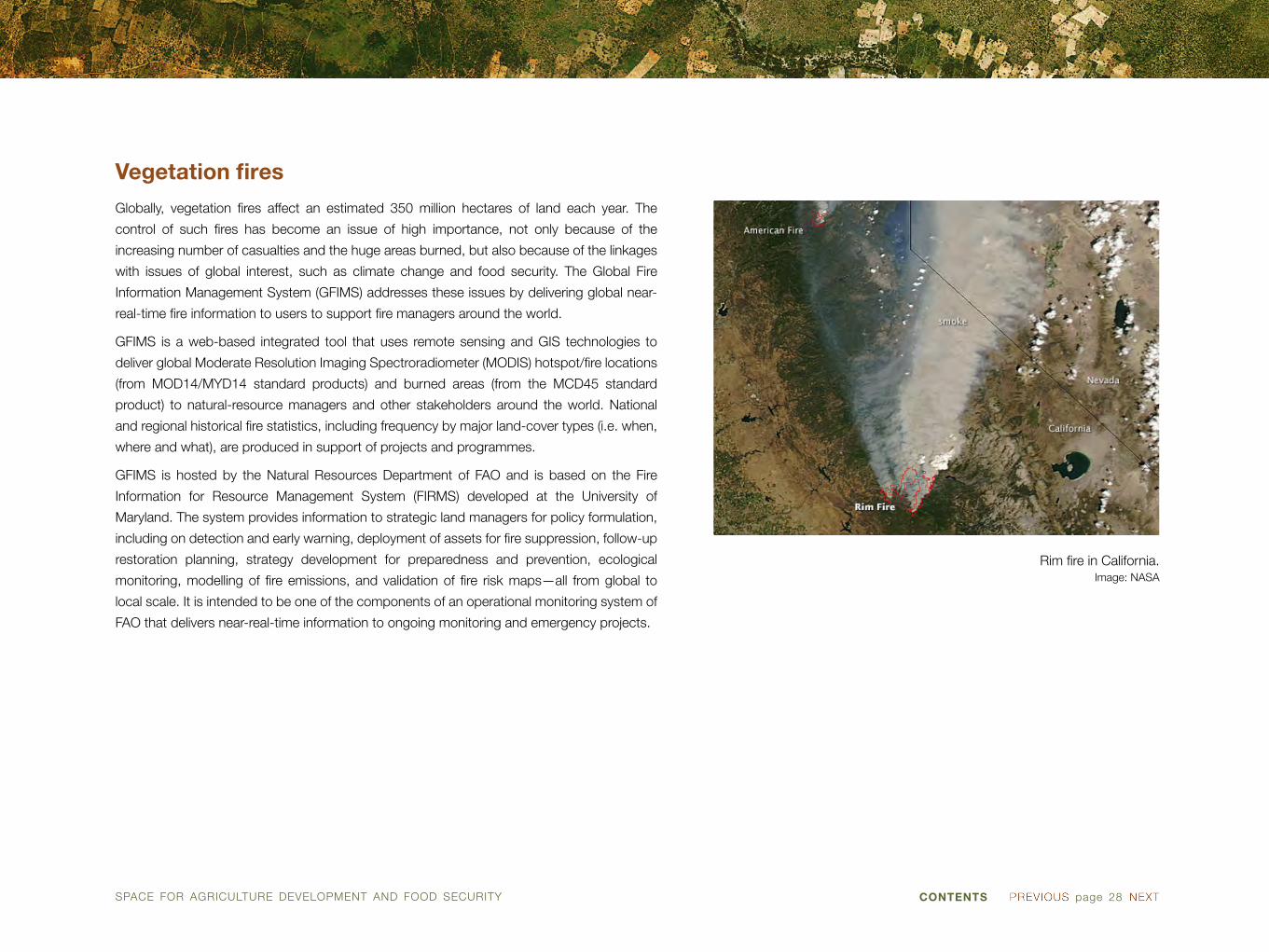
Rim fire in California.Image: NASA
Vegetation fires
Globally, vegetation fires affect an estimated 350 million hectares of land each year. The
control of such fires has become an issue of high importance, not only because of the
increasing number of casualties and the huge areas burned, but also because of the linkages
with issues of global interest, such as climate change and food security. The Global Fire
Information Management System (GFIMS) addresses these issues by delivering global near-
real-time fire information to users to support fire managers around the world.
GFIMS is a web-based integrated tool that uses remote sensing and GIS technologies to
deliver global Moderate Resolution Imaging Spectroradiometer (MODIS) hotspot/fire locations
(from MOD14/MYD14 standard products) and burned areas (from the MCD45 standard
product) to natural-resource managers and other stakeholders around the world. National
and regional historical fire statistics, including frequency by major land-cover types (i.e. when,
where and what), are produced in support of projects and programmes.
GFIMS is hosted by the Natural Resources Department of FAO and is based on the Fire
Information for Resource Management System (FIRMS) developed at the University of
Maryland. The system provides information to strategic land managers for policy formulation,
including on detection and early warning, deployment of assets for fire suppression, follow-up
restoration planning, strategy development for preparedness and prevention, ecological
monitoring, modelling of fire emissions, and validation of fire risk maps—all from global to
local scale. It is intended to be one of the components of an operational monitoring system of
FAO that delivers near-real-time information to ongoing monitoring and emergency projects.

SPACE FOR AGRICULTURE DEVELOPMENT AND FOOD SECURITY CONTENTS page 29
WORLD METEOROLOGICAL ORGANIZATION
7bis, avenue de la Paix
Case postale No. 2300
CH-1211 Geneva 2, Switzerland
Tel.: +41(0)22 730 81 11
Fax: +41(0)22 730 81 81
Website: www.wmo.int
WORLD FOOD PROGRAMME
Via Cesare Giulio Viola 68
Parco dei Medici
00148 Rome, Italy
Tel.: +39-06-65131
Fax: +39-06-6590632
Web: www.wfp.org
WORLD FOOD PROGRAMME (WFP)
The World Food Programme is the world’s largest humanitarian agency fighting hunger
worldwide. Established in 1961, WFP pursues a vision of the world in which every man,
woman and child has access at all times to the food needed for an active and healthy life. The
core policies and strategies that govern WFP activities are to provide food aid in order to save
lives in refugee and other emergency situations; to improve the nutrition and quality of life of
the most vulnerable people at critical times in their lives; and to help build assets and promote
the self-reliance of poor people and communities, particularly through labour-intensive works
programmes.
WFP has been extensively using space applications, in particular Earth observation data, to
support emergency response activities and operations. As leader or co-leader of the clusters
on global food security, global logistics and emergency telecommunications of the Inter-
Agency Standing Committee, WFP coordinates responses to major emergencies.
WORLD METEOROLOGICAL ORGANIZATION (WMO)
Established in 1950, the World Meteorological Organization (WMO) in 1951 became the
specialized agency of the United Nations for meteorology (weather and climate), operational
hydrology and related geophysical sciences. It originated from the International Meteorological
Organization (IMO), which was founded in 1873. Today, WMO is the United Nations system’s
authoritative voice on the state and behaviour of the Earth’s atmosphere, its interaction with
the oceans, the climate it produces and the resulting distribution of water resources. WMO
has a membership of 191 member States and Territories.
The development of the Global Framework for Climate Services became a major milestone in
the work of WMO. In that context, space-based observations had an essential role to play in
the four priority areas identified among climate application services, namely, health, agriculture
and food security, water, and disaster risk reduction.

SPACE FOR AGRICULTURE DEVELOPMENT AND FOOD SECURITY page 30CONTENTS
Tropical cyclone off the coast of Brazil.Image: NASA
Weather monitoring and forecasting
Global food security, linked to a wide array of agriculture and water supply systems as well as
natural ecosystems, is under constant threat from weather and climate extremes, making the
monitoring and forecasting of weather of crucial importance to farmers. Such monitoring and
forecasting is effectively provided by satellite observations, complemented with ground-based
weather stations for predicting storms, flooding and frost.
Space-based weather observations are performed by a constellation of geostationary
meteorological satellites for permanent monitoring, as well as by a constellation of low-Earth
orbit satellites, which are generally near-polar and sun-synchronous, for global coverage with
a comprehensive suite of active or passive instruments. Meteorological satellites provide
measurements of atmospheric humidity, temperature and atmospheric winds, concentrations
of greenhouse gases and aerosols, cloud-cover density and cloud particle properties; and
allow for near-continuous monitoring of global weather conditions and forecasting.
Observations derived from satellites are extensively assimilated in numerical weather
prediction models to support short- to medium-range weather forecasts. Rainfall estimations
derived from infrared and/or microwave satellite imagery help farmers plan the timing and
amount of irrigation for their crops. Land-surface temperature and soil moisture products are
starting to be operationally available. At the same time, ground-based measurements of air
and soil temperature and soil moisture continue to be used for verification.
page 31CONTENTS
ACRONYMS AND ABBREVIATIONS
CBD United Nations Convention on Biological Diversity
ECA Economic Commission for Africa
ECLAC Economic Commission for Latin America and the Caribbean
ESCAP Economic and Social Commission for Asia and the Pacific
ESCWA Economic and Social Commission for Western Asia
FAO Food and Agriculture Organization of the United Nations
IAEA International Atomic Energy Agency
UNCCD United Nations Convention to Combat Desertification in Those Countries Experiencing Serious Drought and/or Desertification, Particularly in Africa
UNEP United Nations Environment Programme
UNESCO United Nations Educational, Scientific and Cultural Organization
UNISDR United Nations Office for Disaster Risk Reduction
UNITAR/UNOSAT Operational Satellite Applications Programme (UNOSAT) of the United Nations Institute for Training and Research (UNITAR)
UNOOSA United Nations Office for Outer Space Affairs
UN-SPIDER United Nations Platform for Space-based information for Disaster Management and Emergency Response
WFP World Food Programme
WMO World Meteorological Organization

page 32CONTENTS
CONTRIBUTORS TO THE SPECIAL REPORT ON SPACE FOR AGRICULTURE DEVELOPMENT AND FOOD SECURITY (A/AC.105/1042)
Economic Commission for Africa (ECA)
Economic Commission for Latin America and the Caribbean (ECLAC)
Economic and Social Commission for Asia and the Pacific (ESCAP)
Economic and Social Commission for Western Asia (ESCWA)
Food and Agriculture Organization of the United Nations (FAO)
International Atomic Energy Agency (IAEA)
Operational Satellite Applications Programme (UNOSAT) of the United Nations Institute for Training and Research (UNITAR)
Secretariat of the United Nations Convention on Biological Diversity
Secretariat of the United Nations Convention to Combat Desertification in Those Countries Experiencing Serious Drought and/or Desertification, Particularly in Africa
United Nations Educational, Scientific and Cultural Organization (UNESCO)
United Nations Environment Programme (UNEP)
United Nations Office for Disaster Risk Reduction (UNISDR)
United Nations Office for Outer Space Affairs (UNOOSA)
World Food Programme (WFP)
World Meteorological Organization (WMO)
© United Nations, December 2015. All rights reserved worldwide.
The designations employed and the presentation of material in this publication do not imply the
expression of any opinion whatsoever on the part of the Secretariat of the United Nations concerning
the legal status of any country, territory, city or area, or of its authorities, or concerning the delimitation of
its frontiers or boundaries. This publication has not been formally edited.
Publishing production: English, Publishing and Library Section, United Nations Office at Vienna.

UNITED NATIONS OFFICE FOR OUTER SPACE AFFAIRS (UNOOSA)
United Nations Office at Vienna
Vienna International Centre, Wagramerstrasse 5
1400 Vienna, Austria
Tel.: (+43-1) 260 60 4950
Fax: (+43-1) 260 60 5830
E-mail: [email protected]
Website: www.unoosa.org
The United Nations Office for Outer Space Affairs (UNOOSA) is responsible for promoting
international cooperation in the peaceful uses of outer space and assisting developing
countries in using space science and technology.
V.15-06451