Embed Size (px)
Citation preview

Space-based services for civil protection ARTES Applications Workshop – CASD Rome, 19th April 2013
www.protezionecivile.gov.it Risks in Italian Territory
FLOOD
HEARTHQUAKES VOLCANIC ERUPTIONS
LANDSLIDES
NUMBERS OF CASUALTIES
DEN
SITY
OF
FREQ
UEN
CE

www.protezionecivile.gov.it Satellite Data
www.protezionecivile.gov.it
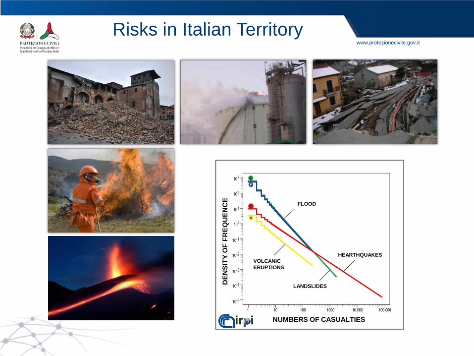
PREVISION Forecasting, Monitoring & Surveillance
Assimilation of meteorological satellite data in the numerical weather prediction

www.protezionecivile.gov.it
Forecasting, Monitoring & Surveillance
Elba, 7 Nov. 2011
H-SAF CNMCA, CNR-ISAC
MONITORING
Precipitation estimation derived by European Geostationary and Polar meteorological satellites

www.protezionecivile.gov.it
Forecasting, Monitoring & Surveillance
MONITORING
Meteorological satellite (MSG) and radar data integration for the precipitation monitoring
www.protezionecivile.gov.it
H-SAF, CNMCA, CNR-ISAC
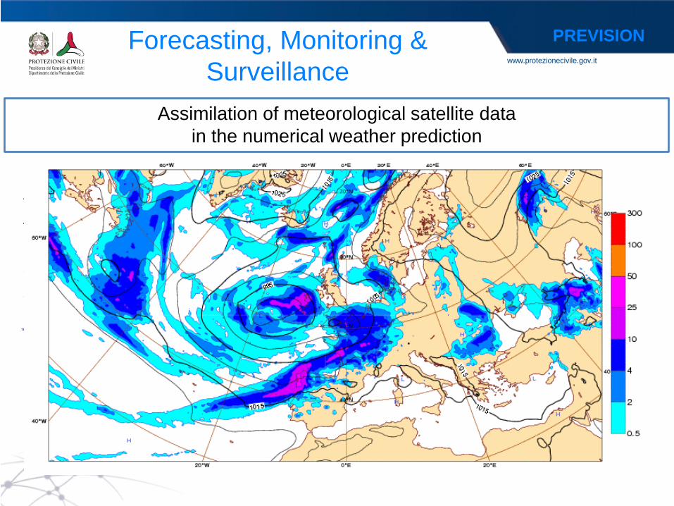
Forecasting, Monitoring & Surveillance
MONITORING
Snow and Soil Moisture products derived by European Geostationary and Polar meteorological satellites
www.protezionecivile.gov.it
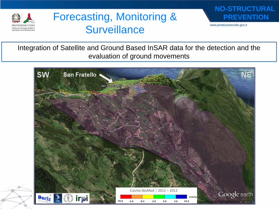
Integration of Satellite and Ground Based InSAR data for the detection and the evaluation of ground movements
Forecasting, Monitoring & Surveillance
NO-STRUCTURAL PREVENTION
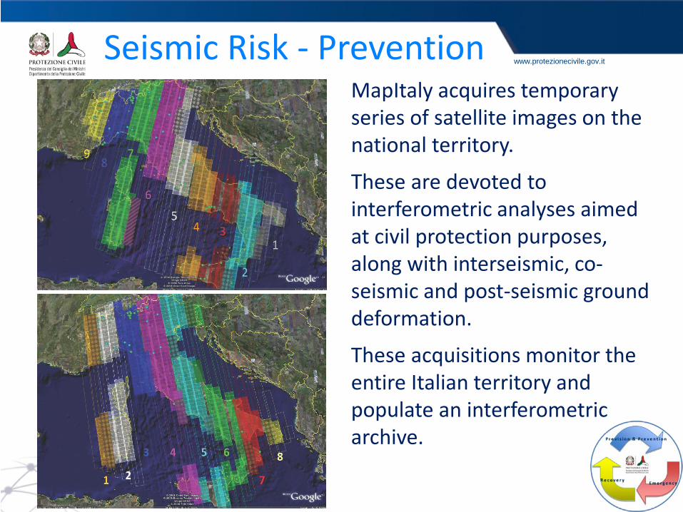
www.protezionecivile.gov.it Seismic Risk - Prevention MapItaly acquires temporary series of satellite images on the national territory.
These are devoted to interferometric analyses aimed at civil protection purposes, along with interseismic, co-seismic and post-seismic ground deformation.
These acquisitions monitor the entire Italian territory and populate an interferometric archive.

www.protezionecivile.gov.it Volcanic Risk – Monitoring LO
S ve
loci
ty [c
m/y
ear]
- 2
+ 2 Cumulative displacement of the Campi Flegrei area obtained by processing COSMO-SkyMed images acquired between 2009 and 2011 with a SBAS technique.
Deformation time series of a point
in the Pozzuoli Harbour.
www.protezionecivile.gov.it
BEFORE AFTER
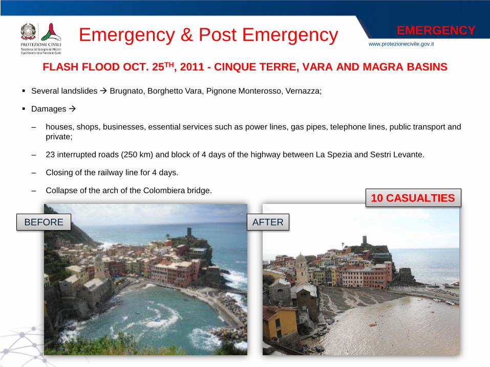
Several landslides Brugnato, Borghetto Vara, Pignone Monterosso, Vernazza;
Damages
– houses, shops, businesses, essential services such as power lines, gas pipes, telephone lines, public transport and private;
– 23 interrupted roads (250 km) and block of 4 days of the highway between La Spezia and Sestri Levante.
– Closing of the railway line for 4 days.
– Collapse of the arch of the Colombiera bridge.
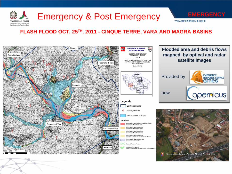
FLASH FLOOD OCT. 25TH, 2011 - CINQUE TERRE, VARA AND MAGRA BASINS
10 CASUALTIES
Emergency & Post Emergency
EMERGENCY
www.protezionecivile.gov.it
Flooded area and debris flows mapped by optical and radar
satellite images Provided by now
Emergency & Post Emergency
EMERGENCY
FLASH FLOOD OCT. 25TH, 2011 - CINQUE TERRE, VARA AND MAGRA BASINS
www.protezionecivile.gov.it Emergency & Post Emergency
EMERGENCY
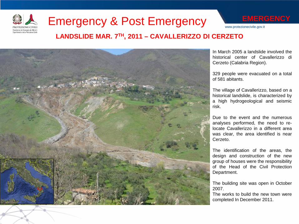
In March 2005 a landslide involved the historical center of Cavallerizzo di Cerzeto (Calabria Region). 329 people were evacuated on a total of 581 abitants. The village of Cavallerizzo, based on a historical landslide, is characterized by a high hydrogeological and seismic risk. Due to the event and the numerous analyses performed, the need to re-locate Cavallerizzo in a different area was clear, the area identified is near Cerzeto.
The identification of the areas, the design and construction of the new group of houses were the responsibility of the Head of the Civil Protection Department.
The building site was open in October 2007. The works to build the new town were completed In December 2011.
LANDSLIDE MAR. 7TH, 2011 – CAVALLERIZZO DI CERZETO

www.protezionecivile.gov.it Emergency & Post Emergency
ACTIVITIES:
• Ground deformation assessment
• Detection and mapping of unstable area
• Residual risk assessment
• Detection of an area for the new town
Loc. Pianette
SATELLITE DATA:
• ERS1/2 (1992-2000)
• ENVISAT (2002-2005)
• RADARSAT (2002-2005)
• RADARSAT update (2004-2010)
LANDSLIDE MAR. 7TH, 2011 – CAVALLERIZZO DI CERZETO
POST EMERGENCY

www.protezionecivile.gov.it
Friday, January 13, late in the evening the Costa Concordia cruise ship with 4,228 people on board begins to embark water due to a collision with the rock of Scole and is grounded off the shore of the island of Giglio.
With the OPCM n. 3998 of 20 January 2012 , the Council of Ministers appoints the Head of Civil Protection Department emergency response coordinator . The duties of the Head of Civil Protection include: - coordinating efforts to overcome the emergency; -supervising the implementation of interventions for securing the vessel and remediation by the Costa Concordia cruiseline company; - the power to replace, in the event of default , the persons responsible; - verify that the removal of the wreck takes place in safety.
COSTA CONCORDIA JAN. 13TH, 2011 – GIGLIO ISLAND
Emergency & Post Emergency
EMERGENCY
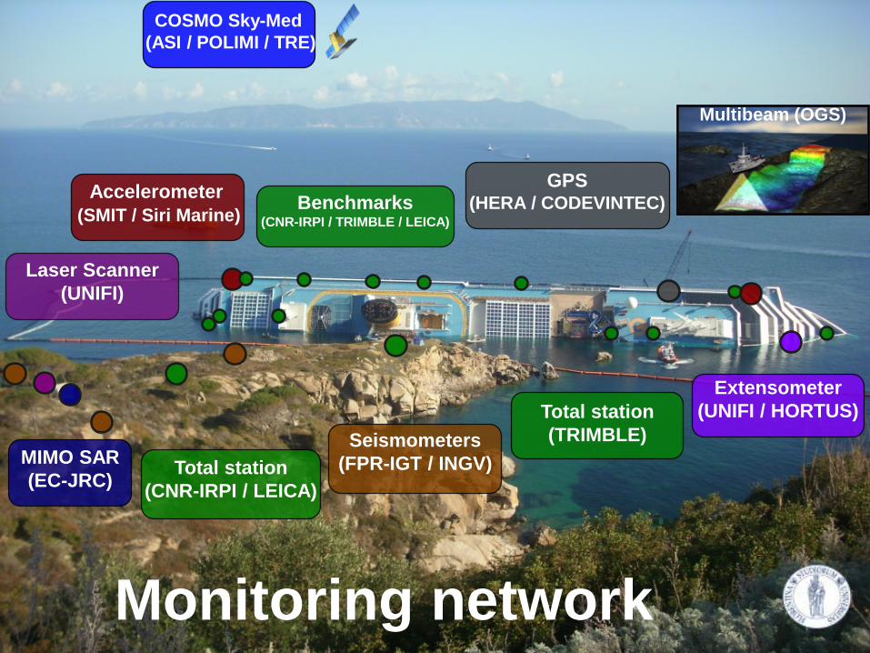
Accelerometer (SMIT / Siri Marine) Benchmarks
(CNR-IRPI / TRIMBLE / LEICA)
Multibeam (OGS)
Extensometer (UNIFI / HORTUS)
GPS (HERA / CODEVINTEC)
COSMO Sky-Med (ASI / POLIMI / TRE)
Laser Scanner (UNIFI)
MIMO SAR (EC-JRC)
Seismometers (FPR-IGT / INGV) Total station
(CNR-IRPI / LEICA)
Total station (TRIMBLE)
Monitoring network
www.protezionecivile.gov.it
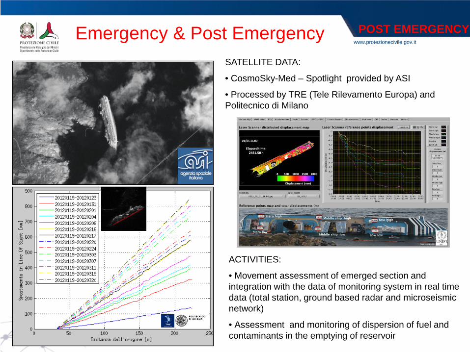
ACTIVITIES:
• Movement assessment of emerged section and integration with the data of monitoring system in real time data (total station, ground based radar and microseismic network)
• Assessment and monitoring of dispersion of fuel and contaminants in the emptying of reservoir
SATELLITE DATA:
• CosmoSky-Med – Spotlight provided by ASI
• Processed by TRE (Tele Rilevamento Europa) and Politecnico di Milano
Emergency & Post Emergency
POST EMERGENCY
www.protezionecivile.gov.it
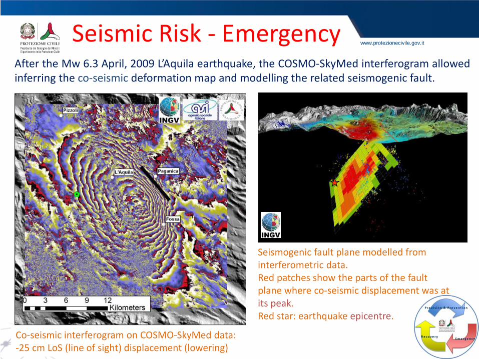
After the Mw 6.3 April, 2009 L’Aquila earthquake, the COSMO-SkyMed interferogram allowed inferring the co-seismic deformation map and modelling the related seismogenic fault.
Co-seismic interferogram on COSMO-SkyMed data: -25 cm LoS (line of sight) displacement (lowering)
Seismogenic fault plane modelled from interferometric data. Red patches show the parts of the fault plane where co-seismic displacement was at its peak. Red star: earthquake epicentre.
Seismic Risk - Emergency
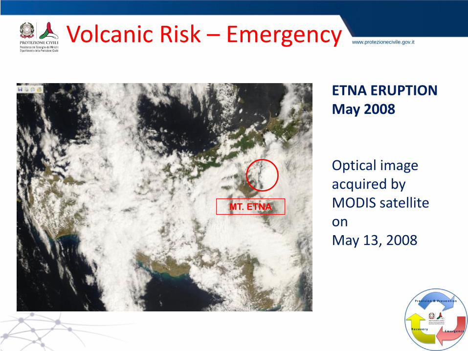
www.protezionecivile.gov.it Volcanic Risk – Emergency
ETNA ERUPTION May 2008 Optical image acquired by MODIS satellite on May 13, 2008
MT. ETNA
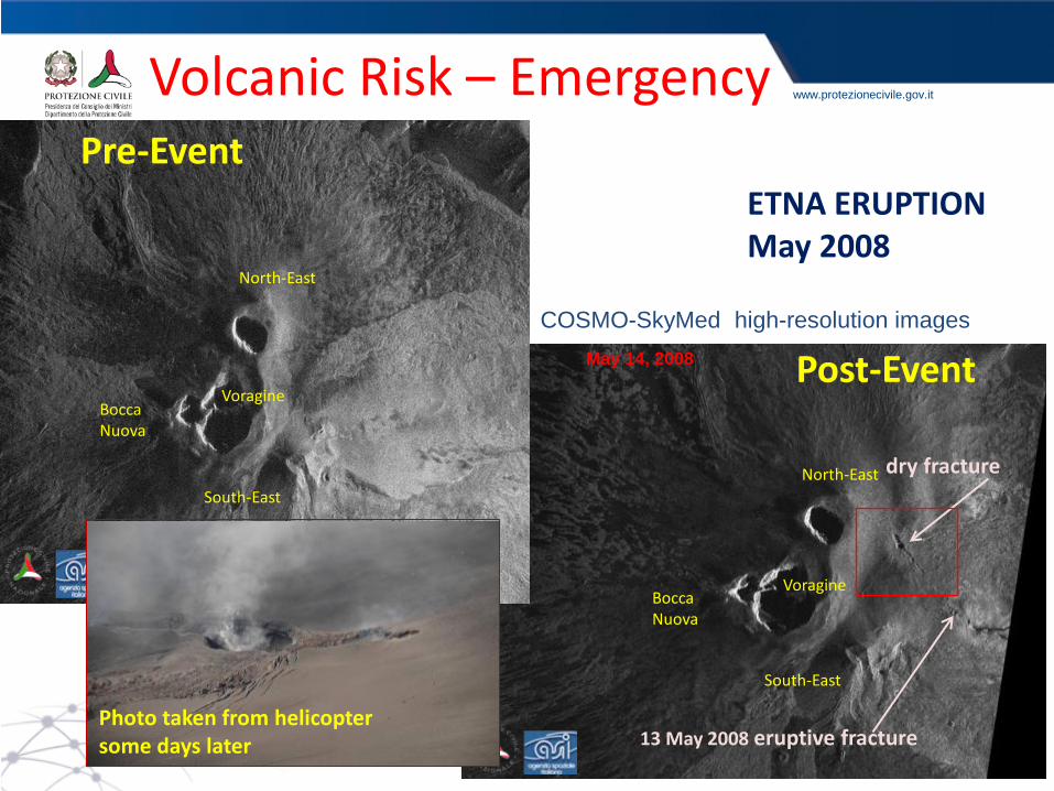
www.protezionecivile.gov.it
North-East
Voragine Bocca Nuova
South-East
13 May 2008 eruptive fracture
dry fracture
May 14, 2008 Post-Event COSMO-SkyMed high-resolution images
Pre-Event
North-East
Voragine Bocca Nuova
South-East
Volcanic Risk – Emergency
ETNA ERUPTION May 2008
Photo taken from helicopter some days later
www.protezionecivile.gov.it
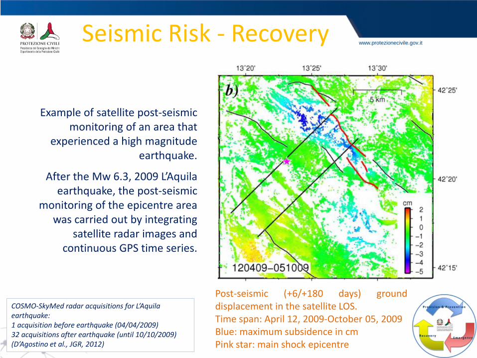
Example of satellite post-seismic monitoring of an area that
experienced a high magnitude earthquake.
After the Mw 6.3, 2009 L’Aquila earthquake, the post-seismic
monitoring of the epicentre area was carried out by integrating
satellite radar images and continuous GPS time series.
Seismic Risk - Recovery
COSMO-SkyMed radar acquisitions for L’Aquila earthquake: 1 acquisition before earthquake (04/04/2009) 32 acquisitions after earthquake (until 10/10/2009) (D’Agostino et al., JGR, 2012)
Post-seismic (+6/+180 days) ground displacement in the satellite LOS. Time span: April 12, 2009-October 05, 2009 Blue: maximum subsidence in cm Pink star: main shock epicentre
www.protezionecivile.gov.it
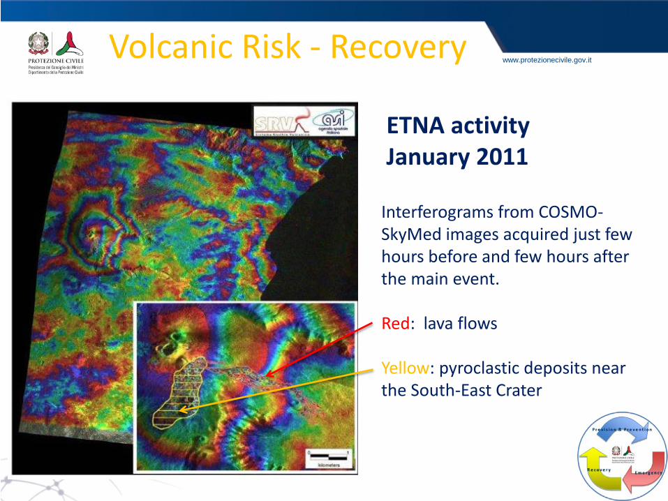
Interferograms from COSMO-SkyMed images acquired just few hours before and few hours after the main event. Red: lava flows Yellow: pyroclastic deposits near the South-East Crater
Volcanic Risk - Recovery
ETNA activity January 2011
www.protezionecivile.gov.it Conclusions
Selection and integration of space-based data derived by different data sources for the optimization of the product performances in terms of: - timely of delivery; - accuracy; - spatial and temporal resolution
Close collaboration between Users, Space Agencies, research and technological partners, in order to improve the operational application and the reliability of the products.