Embed Size (px)
Citation preview

A partnership project by
SOUTHSEA AND NORTH PORTSEA ISLAND COASTAL FLOOD AND EROSION RISK MANAGEMENT SCHEMES
SCOPING STAGE REPORT
TECHNICAL REPORT 5: CONTAMINATED LAND
November 2012 Final Report

2 | SOUTHSEA AND NORTH PORTSEA ISLAND COASTAL FLOOD AND EROSION RISK MANAGEMENT SCHEMES
Eastern Solent Coastal Partnership Public Service Plaza Civic Centre Road Havant Borough Council Havant PO9 2AX
Telephone: +44 2392
Email: [email protected]
Internet: www.escp.org.uk
Documenttitle Southsea and North Portsea Island Coastal Flood and Erosion Risk Management Schemes
Scoping Stage Report
Contaminated Land
Documentshorttitle Technical Report 5: Contaminated Land
Status Draft
Version 0.1
Date 06 February 2013
Client Portsmouth City Council

TECHNICAL REPORT 5: CONTAMINATED LAND | 3
GLOSSARY........................................................................................................5
1 VISION,AIMSANDOBJECTIVES............................................................61.1 The Vision ..................................................................................................61.2 The Aims ....................................................................................................61.3 The Objectives ...........................................................................................6
2 INTRODUCTION........................................................................................72.1 Background to the Scoping Study ..............................................................72.2 Purpose of the Scoping Study ....................................................................72.3 Format of the Scoping Study ......................................................................9
3 OBJECTIVEANDFORMATOFTHETECHNICALREPORT................103.1 Technical Report Objective ......................................................................103.2 Technical Report Format ..........................................................................12
4 APPROACH.............................................................................................134.1 Scoping Stage Scheme Parameters ........................................................134.2 Working in Partnership .............................................................................154.3 Links to the Wider Scoping Stage ...........................................................16
5 REVIEWOFEXISTINGDATA.................................................................175.1 PICSS Review .........................................................................................175.2 Scoping Stage Data Collation and Review ..............................................17
6 SITELOCATIONANDLANDUSE.........................................................186.1 Current Land Use .....................................................................................186.2 Former Land Use (Historical Map Review) ..............................................21
7 ENVIRONMENTALSETTING..................................................................277.1 Published Geology ..................................................................................277.2 Coal Mining Affected Areas and Ground Stability ...................................307.3 Hydrogeology and Groundwater Vulnerability .........................................307.4 Hydrology .................................................................................................317.5 Flood Risk ...............................................................................................337.6 Environmentally Sensitive Land Uses .....................................................337.7 Radon Gas ..............................................................................................337.8 Underground Utilities ................................................................................34
8 AUTHORISATIONS,CONSENTS&LICENCESFROMREGULATORYAUTHORITIES.........................................................................................35
8.1 Flood Cell 1 – Southsea ...........................................................................358.2 Flood Cell 2 – Fraser Battery/ Eastney ....................................................368.3 Flood Cell 4 – North Portsea Island .........................................................37
CONTENTS

4 | SOUTHSEA AND NORTH PORTSEA ISLAND COASTAL FLOOD AND EROSION RISK MANAGEMENT SCHEMES
9 EXISTINGCONTAMINATEDLANDINVESTIGATIONREPORTS.........419.1 PICSS Contamination/Risk Assessment Report ......................................419.2 Reports from the Portsmouth City Council Contaminated Land Archive ..429.3 Canoe Lake ..............................................................................................449.4 The Glory Hole, Eastney and Remediation of the Eastney Barracks
Married Quarters (within Flood Cell 2) .....................................................459.5 Tangier Road Ground Investigation (adjacent to Flood Cell 4) ................489.6 Kendalls Wharf (within Flood Cell 4) ........................................................509.7 H&S Aviation Site (adjacent to Flood Cell 4) ............................................519.8 Alexandra Park (within Flood Cell 4) ........................................................529.9 Horsea Allotments (within Flood Cell 4) ...................................................539.10 Tipner Quay (adjacent to Flood Cell 4) ....................................................549.11 Former HMS Phoenix Site, Matapan Road, Stamshaw, Portsmouth
(partially within Flood Cell 4) ....................................................................56
10 INITIALCONCEPTUALSITEMODELANDPRELIMINARYRISKASSESSMENT.......................................................................................58
10.1 Conceptual Site Model .............................................................................5810.2 Summary of Pollutant Linkages and Preliminary Qualitative Risk
Assessment ..............................................................................................62
11 CONCLUSIONSANDRECOMMENDATIONS........................................6811.1 Conclusions .............................................................................................6811.2 Recommendations ...................................................................................69
12 BIBLIOGRAPHY......................................................................................74
ANNEX1:REPORTLIMITATIONS.........................................................75
ANNEX2:FIGURES...............................................................................76
ANNEX3:ENVIROCHECKREPORT.....................................................77
ANNEX4:OUTPUTSFROMTHEPCCCONTAMINATEDLANDARCHIVESEARCH.................................................................................78

TECHNICAL REPORT 5: CONTAMINATED LAND | 5
AEP Annual Exceedence Probability (of flooding)BGS British Geological SurveycSAC Candidate Special Area of ConservationDETR Former Department of the Environment Transport and the RegionsEIA Environmental Impact AssessmentFDGiA Flood Defence Grant in Aid
ICRCL Interdepartmental Committee on the Redevelopment of Contaminated Land
LPRG Large Project Review GroupMoD Ministry of DefencePAH Polycyclic Aromatic HydrocarbonPAR Project Appraisal ReportPCB Polychlorinated BiphenylPRBD Portsmouth River Basin DistrictPCC Portsmouth City CouncilPICSS Portsea Island Coastal Strategy StudySAC Special Area of ConservationSoP Standard of ProtectionSPA Special Protection AreaSPOSH Significant Possibility of Significant HarmSSSI Site of Special Scientific InterestStAR Strategy Appraisal ReportTPH Total Petroleum HydrocarbonsWFD Water Framework Directive
GLOSSARY

6 | SOUTHSEA AND NORTH PORTSEA ISLAND COASTAL FLOOD AND EROSION RISK MANAGEMENT SCHEMES
1 VISION,AIMSANDOBJECTIVES
1.1 TheVisionThe vision for this and subsequent phases of the Southsea and North Portsea Island Coastal Flood and Erosion Risk Management Schemes is to:
“Ensure the sustainable future of the City of Portsmouth by managing coastal flood and erosion risk.”
1.2 TheAimsWe will achieve this vision by:
1. Working together with our partners;
2. Providing cost effective methods for adapting to climate change;
3. Recognising the importance of communities, cultural heritage and the environment;
4. Maximising funding and contributions.
We will use this opportunity to explore and deliver broader benefits to shape the future of Portsmouth
1.3 TheObjectivesThe objectives of the next phase of the project are to:
● Manage the risk of flooding and coastal erosion to people and their property, now and in the future;
● Develop and prepare an adaptable flood and coastal risk management scheme to provide a safe standard of protection;
● Develop a robust business case to deliver the scheme;
● Obtain the necessary licenses, consents and approvals to deliver and manage the scheme;
● Provide a clear action and implementation plan for scheme delivery.
TECHNICAL REPORT 5: CONTAMINATED LAND | 7
2.1 BackgroundtotheScopingStudyIn accordance with Defra and the Environment Agency’s guidance on coastal and flood risk management, the Eastern Solent Coastal Partnership completed a Strategy Appraisal Report (StAR) in 2011. The StAR identifies that the City is at significant risk of flooding with 4,211 residecCLntial, 364 commercial and 48 Ministry of Defence (MoD) properties currently at risk from a 0.5% annual exceedance probability of flooding (AEP) due to breaching of the existing coastal defences.
The StAR described the proposals for a 100 year flood and coastal erosion risk management strategy for Portsea Island, Portsmouth, Hampshire. In 2012, the Eastern Solent Coastal Partnership, in collaboration with the Environment Agency, gained formal approval to proceed with the Project Appraisal Report (PAR) development for Cells 1 and 4 of the StAR (Southsea and North Portsea Island respectively).
The coverage of Flood Cells 1 and 4 is shown in Figure2.1 and can be described as follows:
● Flood Cell 1: Southsea (Portsmouth Harbour Railway Station to the Royal Marine Museum);
● Flood Cell 4: North Portsea Island (The Mountbatten Centre to, and including, Milton Common).
In addition, the eastern part of the southern frontage is included within the study area to inform potential future beach management activities.
2.2 PurposeoftheScopingStudyDue to the importance of reducing flood risk to the City and due to the complexity of developing a robust scheme, that maximises benefits and funding opportunities, the Eastern Solent Coastal Partnership has scoped the work required to deliver the Southsea and North Portsea Island Coastal Flood and Erosion Risk Management Schemes (the Schemes).
This Scoping Stage guides all subsequent work towards the realisation of the Schemes, and is focused toward the next stage; the development of the PARs.
The purpose of the Scoping study is, therefore, to:
● Document the role and requirements of the PAR Stage to inform any future schemes’ technical content and future approval processes such as;
○ PAR for Large Project Review Group (LPRG) approval;
○ Planning Permissions and other approvals for the Schemes by the Local Planning Authority (LPA) and other statutory regulators and/or consultees;
2 INTRODUCTION

8 | SOUTHSEA AND NORTH PORTSEA ISLAND COASTAL FLOOD AND EROSION RISK MANAGEMENT SCHEMES
○ Preparation, completion and submission of an Environmental Impact Assessment (EIA) for any Schemes to support any approval processes.
● Understand and identify the suitability and limitations of the existing Portsea Island Coastal Strategy Study (2002-2012) (PICSS);
● Identify the data requirements to support any scheme approval, design and construction process, including the sourcing of existing data and the identification, commissioning and collation of additional data;
● Identify a robust and resilient approach for managing data through the Scoping Stage and future scheme stages;
● Identify an engaging and proactive approach to communication within the project team, Council Members and influential internal and external stakeholders;
● Identify, share, allocate and cost project risks for managing and monitoring throughout the project;
● Generate a Project Implementation Plan;
● Produce a methodology for undertaking the PAR, and summarise this methodology in an Overview and Urgency Report.
Figure2.1: Flood Cell 1: Southsea (shown in Red) and Flood Cell 4: North Portsea (shown
in Yellow). The blue zone is included to
inform potential future beach management
activities.

TECHNICAL REPORT 5: CONTAMINATED LAND | 9
2.3 FormatoftheScopingStudyThe Scoping Study comprises an Overview and Urgency Report and a number of individual assessments, which explore the requirement for delivering the PAR to achieve the necessary consents and funding to deliver an appropriate flood and coastal risk management scheme. These individual assessments are contained in the 14 Technical Reports noted in Figure2.2 below, with key aspects highlighted further in Technical Report 1: Overview and Urgency.
Figure2.2: Format of the Scoping Study
Scopingstage
ProjectDelivery
Sets the requirements and process for preparing a successful business case to deliver the schemes
OperationandMaintenance
KeydeliverablesoftheScopingStage
1.OverviewandUrgencyReport
2. Flood Risk Modelling3. Economics4. Contributions5. Contaminated Land6. Surveys7. Asset Condition8. Data Management9. Risk and Programme Management10. Communications Plan11. Environmental12. Archeology, Heritage and Monuments13. Landscape Character Report14. Beach Management Plan Scope
ProjectAppraisalReport
Including: Business Case Funding Licenses & Consents Approvals
Detaileddesign Construction
CurrentStrategies,PlansandData
North Solent Shoreline Management Plan
Portsea Island Coastal Strategy Study
Portsmouth Strategic Flood Risk Assessment
Portsea Island Surface Water Management
Shaping the Future of Portsmouth
Portsmouth Seafront Masterplan
++ extensive existing studies and data, held both internally and externally
10 | SOUTHSEA AND NORTH PORTSEA ISLAND COASTAL FLOOD AND EROSION RISK MANAGEMENT SCHEMES
3.1 TechnicalReportObjectiveThis report has been prepared by Royal Haskoning for the sole benefit of the Eastern Solent Coastal Defence Partnership on behalf of Portsmouth City Council (PCC) (the Client). The objectives of the report are to identify, as far as is reasonably possible, any potential sources of land contamination within or in the vicinity of the study area in question at the time of the study, which could impact works associated with the Schemes.
Contaminated Land assessments assist in understanding both how a development will be affected by land contamination (e.g. additional costs to ensure development site users do not come into contact with harmful levels of contaminants) and how a development may affect land contamination on or around the site (e.g. whether it will introduce new pathways for contaminant migration to other sites or sensitive receptors).
In this case, the assessment is intended to assist in understanding issues such as:
● Where land contamination exists in an area which may need to be protected by flood defences to prevent pollution of the environment;
● Where contamination is present which may place constraints on changes of land use (e.g. if the Schemes, once the design is further developed, include giving public access to land which was previously not accessible);
● Where contamination is present which may increase the costs of the Schemes (e.g. through the need for disposal of contaminated soils during construction).
It is intended that this assessment should provide the starting point of a process and that the relevance of land contamination issues to the Schemes should be further assessed in conjunction with the development of the Schemes’ engineering options and design. The steps of this process are likely to include:
● Refining of the conceptual model – with further design detail for the Schemes and narrowing of the study area, refinement of desk based assessment can be undertaken to look at specific pollutant linkages at these locations to allow targeting (and therefore cost reduction) of any site investigation required.
● Intrusive site investigation – where the conceptual model identifies potential contaminant risks from pollutant linkages either in relation to specific work in specific locations associated with the Schemes or within areas identified as at risk (e.g. from erosion), site investigation is likely to be required to allow quantification of actual contaminant concentrations.
● Quantitative Risk Assessment – following intrusive site investigation and laboratory analysis of soil and water samples, evaluation of contaminant concentrations involves risk assessment of the identified
3 OBJECTIVEANDFORMATOFTHETECHNICALREPORT

TECHNICAL REPORT 5: CONTAMINATED LAND | 11
pollutant linkages to establish whether there are any unacceptable risks to human health or controlled waters in any part of the Schemes’ area.
● Remediation – should unacceptable risks be identified, it may be necessary to implement a remediation process in order to reduce these risks to acceptable levels. The remediation process involves an appraisal of appropriate remediation options, development of a remediation strategy, implementation of the chosen option and verification after completion that the remediation has been successful. Remediation options include altering the scheme design which can be a highly cost-effective approach to risk reduction.
● Materials Management – In relation to the potential construction methodology of the Schemes, results from the site investigation and risk assessment should be used to control potential movements of excavated soil. As a waste, excavated soil requires a suitability assessment before it can be re-used within a development scheme for instance as landscaping or flood prevention bunds. Using the results of the site investigation and undertaking ‘suitability for use’ assessments for waste soils is intended to ensure maximum use is made of soils which are safe to reuse on site and to minimise the need to import additional clean soil to site, benefiting both sustainability and cost efficiencies.
3.1.1ContextofthisAssessmentThis report has been produced as part of a wider assessment for the Schemes, to identify any potential constraints with respect to any land contamination issues which may impact the Schemes. Figure1 in Annex 2 illustrates the process required for best practice to investigate, assess and manage land contamination. This report provides the initial Preliminary Risk Assessment and shows the iterative approach employed whereby, if risks are identified, further collection and assessment of data is required. This may be through further gathering of desk based information or by intrusive site investigation and recovery of soil, water and gas samples (as appropriate). Within this report, desk based data sources and information from a site walkover have been assessed to build a source-pathway-receptor pollutant linkage model (conceptual site model) for the three Flood Cells.
This report has been prepared with all reasonable skill and care, within the terms of the contract with the Client. The conclusions in this report are professional opinions, based on interpretation of environmental and historical information identified in this report. This report should be read in conjunction with the limitations provided in Annex 1 of this report. Geotechnical risks and risks from unexploded ordnance are excluded from this assessment and are discussed in Technical Report 6: Surveys.

12 | SOUTHSEA AND NORTH PORTSEA ISLAND COASTAL FLOOD AND EROSION RISK MANAGEMENT SCHEMES
3.2 TechnicalReportFormatThe remainder of the report comprises the following principal sections:
● Section 4 Approach – presents the agreed potential Scheme parameters to be considered at Scoping Stage in the context of this Technical Report, the partnership approach to working and links to the wider Technical Reports prepared as part of this Scoping Study;
● Section 5 Review of existing data – outlines the data available from the PICSS and data obtained for this Technical Report;
● Section 6 Site Location and Land Use – presents observations made during the site walkover and potentially contaminative land uses identified from historical maps;
● Section 7 Environmental Setting – summarises current site conditions including geology, hydrogeology, hydrology and nearby environmentally sensitive land uses;
● Section 8 Authorisations, Consents and Licences from Regulatory Authorities presents a review of additional information on potentially contaminative land uses;
● Section 9 Existing Contaminated Land Investigation Reports - provides summarised information gathered from for selected sites in or near the study area;
● Section 10 Initial Conceptual Site model and Preliminary Risk Assessment - uses the information in Sections 6 to 9 to construct a conceptual site model (source-pathway-receptor pollutant linkage model) and to assign qualitative risk levels for each Flood Cell;
● Section 11 presents the conclusions and recommendations;
● Section 12 provides a bibliography.

TECHNICAL REPORT 5: CONTAMINATED LAND | 13
4.1 ScopingStageSchemeParametersA long-term strategic approach to the management of the Portsea Island coastline has been developed through the PICSS completed in April 2010 and approved by Defra in May 2012.
The Strategy identified flood and coastal risk management proposals for the whole of Portsea Island (Flood Cells 1 to 7) over a 100 year horizon. Based on the findings of the Strategy, proposals for Flood Cells 1 and 4 (the highest risk areas) are being progressed as a priority, within the first 10 years of the Strategy.
The Scoping Stage will form the basis for subsequent work towards the realisation of the Schemes, which will go through a number of stages over a period of several years. It is therefore crucial to undertake this stage of work with an understanding of the desired outcomes of the Schemes and also the approval, design and construction process that should be followed.
In order to prepare this Contaminated Land Technical Report, it is important to define the parameters that future flood and coastal management schemes for Flood Cells 1 and 4 may include.
The PICSS identified preferred options for Flood Cells 1 and 4 based on considered analysis from a long list of options and these preferred options are illustrated in Table4.1.
Table4.1: PICSS Preferred Options
FloodCell Strategyrecommendedmanagementapproach
Strategypreferredschemeoptions
1 Southsea
“Raise (improve) the current Standard of Protection (SoP) from 100% to 0.5% Annual Exceedence Probability (AEP) to protect properties in 100 years’ time”.
“Raising sea walls, improving sea wall integrity and establishing sustainable methods of retaining beach material”.
4 North Portsea Island Sustain 0.5% AEP to keep pace with sea level rise”.
“Raising sea wall and embankment crest heights and replacing some of the existing structures with enhanced defences”.
In addition, the Strategy confirmed the Shoreline Management Plan policy for Portsea Island of ‘Hold the Line’, to protect the populated frontages and to reduce the risk of contaminating the harbours from erosion of the landfill sites.
The Outline Implementation Programme identified in the Strategy gives some detail about the potential scheme works. The programme includes detail on the lengths of defences to be improved or sustained and the footprint of the scheme works.
4 APPROACH

14 | SOUTHSEA AND NORTH PORTSEA ISLAND COASTAL FLOOD AND EROSION RISK MANAGEMENT SCHEMES
However, while the Strategy clearly establishes preferred options and develops a business case for central government funding based on scheme costs and economic damage avoided from coastal flooding, it is important to note that at this Scoping Stage, the Scheme development needs to be progressed in a manner which does not preclude possible changes to the Strategy proposals. Such changes may arise through factors such as stakeholder engagement, changes in national policy and guidance. A recent example of this is the change to the national Flood Defence Grant in Aid (FDGiA) funding. Schemes are now expected to be part funded via contributions, as set out by the Environment Agency’s Flood and Coastal Resilience Partnership Funding Policy. This links well with PCC’s aspirations for the Schemes to deliver broader outcomes, wider benefits and increasing the opportunity for contributions through appropriate stakeholder engagement.
It is recognised that an adaptive management approach to achieving an improved standard of protection will be needed to maximise the alternative funding opportunities. The project should not, therefore, constrain itself simply to the Strategy preferred options and footprint.
On this basis we have therefore considered the following potential scheme works and scheme footprint in the context of this Contaminated Land Scoping Stage Technical Report, generally broadening the Schemes’ parameters and possible scheme construction area (footprint) which were established through the Strategy (Table4.2).
FloodCell StrategyManagementapproach StrategySchemeworks ScopingStagepotential
Schemeworks
ScopingStagepotentialbuild/constructionapproach
1 Southsea
“Raise (improve) the current SoP from 100% to 0.5% AEP to protect properties in 100 year time”.
“Raising sea walls, improving sea wall integrity and establishing sustainable methods of retaining beach material”.
● Raising existing walls ● Creating a new line of defence (set back)
● Active beach management
● Removal of certain structures
● Steel Sheet Piling ● Reinforced concrete ● Mass concrete ● Rock armour ● Groynes ● Gabion baskets ● Earth embankments ● Shingle management
4 North Portsea
“Sustain the current AEP provided by the defences to keep pace with sea level rise”.
“Raising sea wall and embankment crest heights and replacing some of the existing structures with enhanced defences”.
● Raising existing walls ● Creating a new line of defence (set back)
● Removal of certain structures
● Tidal barrier
● Steel Sheet Piling ● Reinforced concrete ● Mass concrete ● Rock armour ● Groynes ● Gabion baskets ● Earth embankments
Table4.2: Potential Scheme Works (PICSS, 2012)

TECHNICAL REPORT 5: CONTAMINATED LAND | 15
The potential future schemes footprint considered at this Scoping Stage for this Technical Report was reduced in size from the overall Scoping Stage study area as presented in Figure4.1.
4.2 WorkinginPartnershipThis Technical Report has been produced as a partnership between Royal Haskoning and the Eastern Solent Coastal Partnership, with key members of the team as follows (Table4.3):
Figure4.1: Potential Schemes Footprint at Scoping Stage considered for Contaminated Land Technical Report.

16 | SOUTHSEA AND NORTH PORTSEA ISLAND COASTAL FLOOD AND EROSION RISK MANAGEMENT SCHEMES
Table4.3: Team Members
Teammember OrganisationAlison Hallas (Author) Royal Haskoning
Gavin Holder Eastern Solent Coastal Partnership
Sarah Hayne Portsmouth City Council Contaminated Land Team
Caroline Timlett Eastern Solent Coastal Partnership
Bret Davies Eastern Solent Coastal Partnership
Liz Williams PCC Contaminated Land Team
4.3 LinkstotheWiderScopingStageAs part of the suite of stand-alone Technical Reports produced as part of this Scoping Stage, the data collated and produced and the findings from this Technical Report will contribute to the wider outputs from the Scoping Stage.
This Technical Report, however, is particularly key in developing the understanding of risks, opportunities and constraints to scheme option development in terms of contaminated land.
The Scoping Stage Technical Reports that will, therefore, directly draw on the findings presented in this Technical Report are presented in Table4.4.
Table4.4: Wider Technical Reports with Direct Links to this Technical Report
TechnicalReportreferencenumber TechnicalReporttitle
1 Overview and Urgency
6 Surveys
9 Risk and Programme Management
11 Environment

TECHNICAL REPORT 5: CONTAMINATED LAND | 17
5.1 PICSSReviewThe Strategy considered potentially contaminated land within Portsea Island, which included a contaminated land risk assessment report. It specifically focused on the risks from landfills and areas of fill to ecologically designated sites under the Habitats Regulations, 1994.
The following aspects have not been assessed:
● Risks from sources of land or water contamination other than landfill or areas of infill;
● Risks to other sensitive receptors (including human health and groundwater) from the development from contamination;
● Risks to the development from contamination in terms of the quality of material which may need to be moved within the Schemes or disposed of off-site.
In addition, since the Contamination Risk Assessment Report (2004) was completed, additional contamination events may have occurred and/or additional land quality reports may have been completed.
5.2 ScopingStageDataCollationandReviewThe data presented in Table5.1 was requested for this Technical Report, with notes to record whether such data was made available to inform the Technical Report and whether it may be available for any further related studies.
Table5.1: Data Request at Scoping Stage and Availability
Data Source Format Procurementroute
Licensing&IPR
Received(date)
Futureavailabilityandothercomment
Environmental Sensitivity Report (Envirocheck® Report)
Landmark Information Group
pdf Direct purchase
Licenced to PCC
March/April 2012 Available on Box
PCC Contaminated Land Archive reports
PCC Contaminated Land Team
word/pdfVia PCC Contaminated Land Team
Archive reports are part of the public record
April/May 2012
10 reports received as listed in Section 9.2 and available on Box
5 REVIEWOFEXISTINGDATA
18 | SOUTHSEA AND NORTH PORTSEA ISLAND COASTAL FLOOD AND EROSION RISK MANAGEMENT SCHEMES
6.1 CurrentLandUseThe site comprises three areas of the Portsea Island coastal frontage, known as Flood Cells 1, 4 and part of 2 (Eastney area). The locations of the Flood Cells are shown in Figure2.1. In order to maximise the cost-effectiveness of data purchases, the study area for the contaminated land assessment has been restricted to areas considered likely to be within the construction footprint of the Schemes and those areas where pollutant linkages are likely to be directly affected by the construction works.
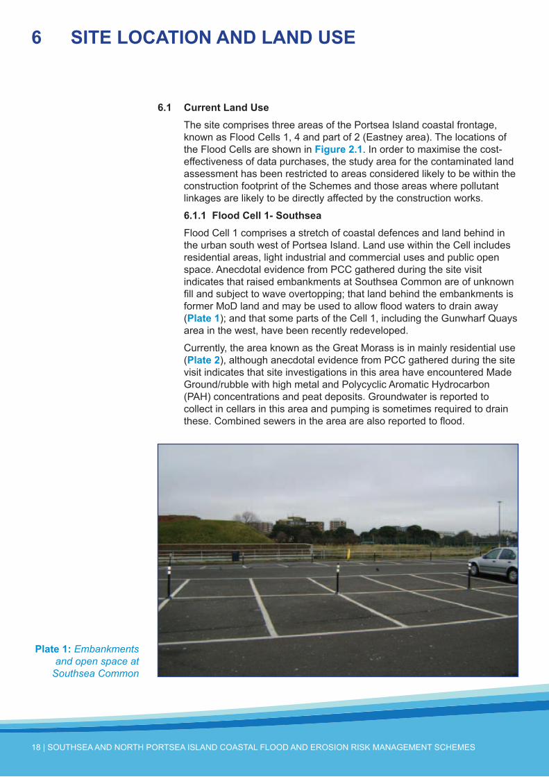
6.1.1FloodCell1-SouthseaFlood Cell 1 comprises a stretch of coastal defences and land behind in the urban south west of Portsea Island. Land use within the Cell includes residential areas, light industrial and commercial uses and public open space. Anecdotal evidence from PCC gathered during the site visit indicates that raised embankments at Southsea Common are of unknown fill and subject to wave overtopping; that land behind the embankments is former MoD land and may be used to allow flood waters to drain away (Plate1); and that some parts of the Cell 1, including the Gunwharf Quays area in the west, have been recently redeveloped.
Currently, the area known as the Great Morass is in mainly residential use (Plate2), although anecdotal evidence from PCC gathered during the site visit indicates that site investigations in this area have encountered Made Ground/rubble with high metal and Polycyclic Aromatic Hydrocarbon (PAH) concentrations and peat deposits. Groundwater is reported to collect in cellars in this area and pumping is sometimes required to drain these. Combined sewers in the area are also reported to flood.
6 SITELOCATIONANDLANDUSE
Plate1: Embankments and open space at
Southsea Common

TECHNICAL REPORT 5: CONTAMINATED LAND | 19
According to information provided by PCC, Canoe Lake is a site at which site investigation for land contamination was undertaken (see Section 9.3). The water level in the lake is understood to be controlled via a connection to a tidal sluice and it is understood to flood regularly, from anecdotal information provided by PCC during the site walkover.
6.1.2FloodCell2–FraserBattery/EastneyFlood Cell 2 comprises open and derelict land in the south east with residential estates (Plate3) and a marina behind. Current coastal protection along the shore of Lock Lake is restricted to rock armour (Plate4).
Plate2: Great Morass Area
Plate3: Residential Use in Flood Cell 2

20 | SOUTHSEA AND NORTH PORTSEA ISLAND COASTAL FLOOD AND EROSION RISK MANAGEMENT SCHEMES
Anecdotal evidence from the walkover suggests that there are extensive former MoD landfills in this area and that industrial uses on the currently derelict land included chemical testing and weathering of plastics.
6.1.3FloodCell4–NorthPortseaIsland(describedfromsoutheasttonorthwest)The far south east of Flood Cell 4 comprises a former landfill at Milton Common. This is currently used as public open space and vegetated with rough grass, brambles/scrub vegetation and footpaths. A concrete structure passes through the landfill (Plate5) which is indicated to be a continuation of the sea wall which currently protects the south of the landfill. The north of the landfill is protected by rock armour (Plate6). At the time of the site walkover there was visual evidence that leachate may be permeating the sea wall (Plate7).
Great Salterns Quay lies to the north of Milton Common and comprises a short quay structure fully covered with concrete. Immediately behind this is the A2030 Eastney Road and, behind this, open land and a golf course. The coastal defences along this stretch of the Flood Cell comprise a concrete wall.
Anecdotal information suggests that the north east corner of Flood Cell 4 includes a former airfield. This area currently incorporates residential and commercial/industrial uses. Along the north of Flood Cell 4, Ports Creek is bordered by a concrete wall and earth embankment (Plate8) with a bastion structure and open land behind.
Plate4: Shoreline of Lock Lake

TECHNICAL REPORT 5: CONTAMINATED LAND | 21
6.2 FormerLandUse(HistoricalMapReview)Historical maps from 1878 to 2011 were obtained from Landmark Information Group as part of an Envirocheck® Report, copies of which are included in Annex 3. In this initial desk based study of land quality constraints, only the 1:10,000 scale maps have been reviewed. Once engineering options have been developed further, assessment of relevant 1:2,500 and 1:1,250 may be required to provide additional detail on the historic land uses. These have been provided as part of the Envirocheck® reports for the
Plate5: Concrete wall structure passing through Milton Common
Plate6: Rock armour protecting north of Milton Common (in distance)

22 | SOUTHSEA AND NORTH PORTSEA ISLAND COASTAL FLOOD AND EROSION RISK MANAGEMENT SCHEMES
flood cells. PCC Contaminated Land team should be consulted to establish if such a review has already been undertaken.
The distances provided within this section are in relation to the approximate site boundary, shown on Figure4.1. Potentially contaminative land uses are summarised in Tables6.1 to 6.3 with those considered to pose a potentially significant risk to the Schemes in terms of land or water quality highlighted in bold. They are shown on Figure2 of Annex 2. These potential sources, together with the environmental setting information in Section 7 and information on consents and licences in Section 8 have been considered in constructing the Conceptual Site Model in Section 10. The Conceptual Site Model, and the Preliminary Risk Assessment, focus on potential sources, pathways and receptors which may pose a potentially significant risk to the Schemes.
Plate7: Evidence of seepage through Milton
Common sea wall
Plate8: Wall and embankment at Ports
Creek

TECHNICAL REPORT 5: CONTAMINATED LAND | 23
6.2.1FloodCell1-SouthseaTable6.1: Potentially Contaminative Land Uses based on Historical Maps: Flood Cell 1
EnvirocheckSliceRef
MapRef1 Feature
Approximatedistance/directionfromSite
Firstshown
Lastshown Comments2
C 1 Wharves – Gunwharf Quays Area5 On-site 1870 2000
In N of flood Cell. Majority of wharf buildings no longer shown by 2000. Wharves redeveloped by 2006.
C 2 Basin Partially on-site 1870 1938 Basin crosses the NE site boundary. Indicated
now to be partially infilled.
C 3 Royal Dockyard4 200m N/NE 1870 20113Dockyards already well developed to the north including jetties, basins, timber pond, timber yards etc.
C 4 Railway Line Partially on-site 1870 20113
Railway lines and sidings serving the Royal Dockyard, Portsmouth Harbour station and the wharf buildings on-site.
C 5 Works 150m to E 1962 1978 On Gunwharf Road. Circular structures (tanks?) shown on 1978 map.
A 6 Point Battery On-site 1931 20114 On coastal frontage in W of Flood Cell.
A 7 West Battery and Embankments On-site 1931 20114 In area of Southsea Castle.
A 8 King’s Bastion Embankments On-site 1931 20113 -
A 9 Depot On-site 1991 20114 North of the West Battery.
A 10 Infirmary 50m to N 1931 1938To S of Clarence Barracks. Last labelled as infirmary in 1938 although buildings remained on site on later maps.
B 11 Canoe Lake On-site 1870 20113 Outline of lake changes between 1870 and 1898 indicating possible infilling.
B 12 Lumps Fort Embankments On-site 1931 20114 To E of Canoe Lake. Already marked as
dismantled in 1931.
B 13 Highland Road Cemetery 350m to N 1898 20114 (See also Flood Cell 2.)
B 14 Railway – Southsea Branch 200m N 1898 1938 Redeveloped by 1972.
B 15 Old Gravel PitAdjacent to N flood cell boundary
1898 1998 To W of Canoe Lake. Indicated to be infilled by 1911; redeveloped by 1931.
B 16 Eastney Fort Embankments 250m to E 1932 20114 (See also Flood Cell 2.)
1. Map reference relates to Figure 2 of Annex 22. Comments have been made in the Table only where the historical maps or photographs supplied additional information.3. Still present at time of site walkover4. Possibly still present5. The wharf buildings and Naval Base are not shown in detail on the 1898 or 1911 historical maps, but the outline of their coastal
frontages is unchanged. It is assumed that the detail was removed from these maps for security reasons

24 | SOUTHSEA AND NORTH PORTSEA ISLAND COASTAL FLOOD AND EROSION RISK MANAGEMENT SCHEMES
6.2.2FloodCell2–FraserBattery/EastneyTable6.2: Potentially Contaminative Land Uses based on Historical Maps: Flood Cell 2
EnvirocheckSliceRef
MapRef1 Feature
Approximatedistance/directionfromSite
Firstshown
Lastshown Comments2
A 17 Glory Hole LandfillOn-site near NW flood cell boundary
1871 1911 Shown as mud on historical maps. Redeveloped by 1972.
A 18 Gravel Pit On-site 1871 1911 S of Glory Hole. Redeveloped by 1932.
A 19 Brickfields/Gravel pits350m NW of flood cell boundary
1871 1898 Gravel Pit shown on brickfield site in 1898; redeveloped by 1911.
A 20 Old Canal 400m to N 1872 1911 Embankments shown to either side of canal. Partially infilled by 1911.
A 21 Rifle Ranges On-site 1898 1972
Crossing the Flood Cell NE - SW to the SE of the Glory Hole and SE to NW to S of Glory Hole. Targets labelled close to the shoreline. Disused by 1972. Mainly redeveloped by 2000.
A 22 Sewage Pumping Station
Adjacent to site boundary to W
1898 20113Shown as Sewage Pumping station and Refuse Destructor, and tramway shown linking site to Eastney Lake shore in 1932.
A 23 Eastney Barracks and Hospital 50m to NW 1898 1972 Redeveloped by 2000.
A 13 Highland Road Cemetery 450m to NW 1898 20114 -
A 24 Possible Refuse/Slag Heap On-site 1911 1911 Adjacent to NW site boundary. Developed into
caravan site by 1962.
A 25 Isolation Hospital 450m to N 1911 1962 Later Langstone Hospital/Sanatorium.
A 26 Possible Refuse/Slag Heap 200m NW 1911 1911 Part of Eastney Recreation Ground by 1932.
A 27 Royal Marines Infirmary On-site 1911 1972 In W of Flood Cell. Redeveloped by 2000.
A 16 Embankments Partially within site 1932 20113 Embankments along southern boundary of
Eastney Barracks. Partially removed by 1962.
B 28 Old Battery On-site 1871 1871 In east of site on spit.
B 29 Old Gravel Pit On-site 1898 1911 In east of site on spit; redeveloped by 1972.
B 30 Sewage Outfalls On eastern site boundary 1911 20114 -
B 31 Embankments On-site 1932 20114 Associated with Fort Cumberland in east of flood cell.
B 32 Sewage Tanks On-site 1932 1962Associated with Fort Cumberland in east of flood cell. Northernmost sewage tanks replaced by sewage works by 1972.
1. Map reference relates to Figure 2 of Annex 22. Comments have been made in the Table only where the historical maps or photographs supplied additional information3. Still present at time of site walkover4. Possibly still present

TECHNICAL REPORT 5: CONTAMINATED LAND | 25
6.2.3FloodCell4–NorthPortseaIslandTable6.3: Potentially Contaminative Land Uses based on Historical Maps: Flood Cell 4
EnvirocheckSliceRef
MapRef1 Feature
Approximatedistance/directionfromSite
Firstshown
Lastshown Comments2
A 33 Sand Pit 150m S 1871 1871
A 34 Sanatorium 400m to SW 1898 20114 Later St James Hospital.
A 35 Gravel Pit 350m to SW 1898 1910
A 36 Sand Pit 325m to SW 1898 1910
A 37 Possible Gravel PitAdjacent to S Flood Cell Boundary
1910 1910
A 25 Isolation Hospital 200m to S 1911 1962 (See also Flood Cell 2.)
A 38Sewage Lifting Station/Pumping Station
400m to NW 1910 20114 Last labelled as pumping station in 2000; buildings still indicated to be present.
A 39 Isolation Hospital 300m to W 1910 2006
Later Infectious Diseases Hospital and St Mary’s General Hospital. South of hospital site redeveloped as a school by 2006. Remainder redeveloped by 2011.
A 40 Milton cemetery 100m to SW 1932 20114 -
A 41 Bafffins Refuse Destructor/Works 150m to NW 1932 1963 Labelled ‘works’ in 1963.
A 42 Works 350m to NW 1963 1963 -
A 43 Central DepotAdjacent to SW Flood Cell Boundary
1963 2000 Redeveloped by 2006.
A 44 Milton Common On-site 1972 20113 Indicated to be mainly infilled and protected by a sea wall.
A 45 Great Salterns Quay On-site 1973 20113 Quay structure shown.
C 46 Railway Partially on-site 1870 20113 Railway line crosses Flood Cell in NE
C 47 Coastal Embankments On-site 1870 20113 Embankments indicated to be present for large
stretches of the coastal frontage.
C 48 Rifle Range On-site 1898 1932 In NE of Flood Cell.
C 49 Hilsea Gas Works(5) 850m to W 1910 2006 Gasholders still shown as present in 2006; removed by 2011.
C 50Embankments of Hilsea Lines and Bastions
Partially on-site 1910 20114 -
D 51 Pumping Station200m to N of Flood Cell Boundary
1932 1938 On N side of Ports Creek.

26 | SOUTHSEA AND NORTH PORTSEA ISLAND COASTAL FLOOD AND EROSION RISK MANAGEMENT SCHEMES
EnvirocheckSliceRef
MapRef1 Feature
Approximatedistance/directionfromSite
Firstshown
Lastshown Comments2
C 52 Works200m to N of Flood Cell Boundary
1973 20114 On N side of Ports Creek .
D 53 Works500m to NW of Flood Cell Boundary
1978 20114 On N side of Ports Creek Outline of buildings present in 2006.
C 54Aerodrome & Associated Industrial Estate
Adjacent to W Flood Cell Boundary
1942 1983
Latter labelled Portsmouth City Airport. Works, stores, factories and tanks shown on this site from 1963. Aerodrome last shown on 1983 (Russian) map. Site later developed into Bilton Business Park.
C 55 Hilsea Lines Depot/Industrial Park
Adjacent to S Flood Cell Boundary
1932 20114 Timber yard and tanks shown from 1973.
C 56 Factory 300m to S 1963 20114 Later marked as Broad Oak Works and Browns Lane Works.
C 57 Works 100m to S 1963 20114 -
C 58 Works250m to N of Flood Cell Boundary
1973 20114 To N of Ports Creek. Shown as Industrial Estate by 2000.
C 59 Works On-site 1990 20114 At Kendalls Wharf.
B 60Stamshaw Brick Works / Shamshaw Chemical Works
Adjacent to W Flood Cell Boundary
1870 20114
Labelled as Brick Works in 1970. Shown as Chemical Works in 1898. Tanks shown on-site from 1932. Works buildings removed by 1962 and replaced by Coal Depot by 1973. Buildings subsequently marked as ‘Depot’.
B 61 Brick Works 200m to S 1870 1870 -
B 62 Alexandra Park Area On-site 1898 20114 Outline of seafront altered, indicating possible infilling in area later labelled Alexandra Park.
B 63 Laundry 450m to S 1898 1898 On Gladys Avenue.
B 64 Hospital 400m to E 1911 1973 At Hilsea Artillery Barracks; redeveloped by 1990.
B 65 Tank 250m to S 1962 1962 At TA centre on Military Road.
B 66 Depot 100m to W 1962 20114 North of Stamshaw Chemical Works.
B 67 Works 450m to S 1963 1990 In Hilsea area on Copnor Road. Redeveloped by 2000 – new development not labelled.
B 68 Motorway Adjacent to N Flood Cell Boundary
1973 20113 North side of Ports Creek rebuilt to construct motorway.
1. Map reference relates to Figure 2 of Annex 22. Comments have been made in the Table only where the historical maps or photographs supplied additional information3. Still present at time of site walkover4. Possibly still present5. Potentially significant source of contamination identified greater than 500m from the Flood Cell boundary

TECHNICAL REPORT 5: CONTAMINATED LAND | 27
7.1 PublishedGeologyTo obtain information about the geology of the area, reference has been made to the British Geological Survey (BGS) Maps of Portsmouth (Sheet 331) and Fareham (Sheet 316) in the 1:50,000 series (Solid and Drift Edition). In this initial desk based study of land quality constraints, BGS borehole logs have not been assessed. Once engineering options have been developed further, logs may be required to provide additional detail on the geology which is likely to be encountered during excavations or which may affect the Schemes. Information from BGS logs and local thicknesses of strata has been summarised in Technical Report 6: Surveys.
The three Flood Cells are indicated to be underlain by a variety of superficial and bedrock geologies. These are described below and an extract from the geological maps is shown in Figure3 of Annex 2.
7.1.1FloodCell1-SouthseaThe majority of Cell 1 is shown as underlain by Storm Gravel Beach deposits underlain by the Bracklesham Group Formations (Earnley Sand and Marsh Farm Formation underlain by the Wittering Formation). In the north of the Flood Cell the bedrock changes to the Wittering Formation, which is generally overlain by Second River Terrace Gravels. In the far west of the Flood Cell, a large deposit of Made Ground is shown to overlie the natural strata. Towards the centre, north of the site, localised superficial deposits of Marine and Estuarine Alluvium and Peat are shown to overlie the Second River Terrace deposits. The area of the Great Morass is clearly visible on the geological map as an area overlain by alluvium, with overlying discrete peat deposits.
Towards the east of the Flood Cell, the River Terrace Gravels are overlain by River Terrace and Aolian Deposits (‘Brickearth’) which is described as mainly loam and clay. A second small deposit of Made Ground is shown to overlie the Brickearth and Storm Gravel Beach Deposits in this area.
The Bracklesham Group is underlain by the Thames Group (London Clay Formation), which overlies the Lambeth Group (Reading Formation) and the Upper Chalk.
7.1.2FloodCell2–FraserBattery/EastneyAlmost the entire area of Flood Cell 2 is indicated to be underlain by Storm Gravel Beach deposits over the Bracklesham Group (Formations not specified). In the north and north east of the Flood Cell, deposits of Made Ground are present and, at the western boundary of the Flood Cell, Second River Terrace Gravels are indicated to overly the Bracklesham Group bedrock.
7.1.3FloodCell4–NorthPortseaIsland
7 ENVIRONMENTALSETTING

28 | SOUTHSEA AND NORTH PORTSEA ISLAND COASTAL FLOOD AND EROSION RISK MANAGEMENT SCHEMES
Flood Cell 4 extends north along the eastern coast of Portsea Island through several changes of bedrock geology. At its southernmost point (underlying the Milton Common area) the bedrock is indicated to be London Clay, overlain by Marine and Estuarine Alluvium or Marine Beach and Tidal Flat Deposits. A large deposit of Made Ground is shown in this area corresponding to known areas of landfilling (see Section 8). Immediately to the north of Milton Common, the superficial Marine and Estuarine deposits are shown to be underlain by Bognor Sand of the London Clay Formation, with London Clay beneath and, to the north of this, in the Great Salterns Quay area, the superficial deposits are again directly underlain by London Clay. Immediately to the west of these areas, significant deposits of Made Ground are shown, again corresponding to known areas of landfilling (see Section 8). North of Salterns Quay, the superficial deposits are underlain by the Reading Formation.
In the north east of Flood Cell 4 a significant deposit of Made Ground does shown, overlying bedrock geology comprise the Upper Chalk. It is not clear whether there is an intervening stratum of Marine and Estuarine Alluvium.
In the north of Flood Cell 4 and in the north west, the Upper Chalk is indicated to be overlain by Marine and Estuarine Alluvial deposits adjacent to Ports Creek, and by Brickearth in the central northern part of Portsea Island.
7.1.4GeologicalDescriptionsTable7.1 presents a generalised summary of nature of the geological strata in Sections7.1.1 to 7.1.3. The descriptions were obtained from the BGS Lexicon of Rock Units web site (http://www.bgs.ac.uk/Lexicon/) and Geology of the Fareham and Portsmouth District, BGS, 2000.
Table7.1: Generalised Summary Descriptions of Geological Strata
Group Stratum BedrockGeology
Quaternary Superficial Deposits
Aeolian (Brickearth) DepositsYellow/brown mainly non-calcareous silt or clayey silt which may locally contain a few flint and chalk fragments
Alluvium Soft organic mottled silty and sandy clay
Second River Terrace Gravels
Gravels and sandy gravels (only the higher terraces are described as clayey). In the south of the Portsmouth district, the gravels are predominately flint
Estuarine Alluvium Brown and grey mottled soft silty clay and silt
Storm Gravel Beach Deposits Fine to medium gravels with some interstitial sand and shell debris

TECHNICAL REPORT 5: CONTAMINATED LAND | 29
Group Stratum BedrockGeology
Bracklesham Group
Earnley Sand Formation
Glauconitic silty sands and sandy silts, with thickness given as 22-25m. The Earnley Sand rests on the Wittering Formation, with the base of the Formation marked by the transgressive surface (a boundary formed by rapid sea level rise) overlain by glauconitic silty sands and pebble bed
The Earnley Sand is overlain by the Marsh Farm Formation. The boundary is marked by the upward change from the Glauconitic Sands of the Earnley Sand Formation to the thin-bedded clays and silts with Glauconitic Sand laminae of the Marsh Farm Formation
Marsh Farm Formation
Laminated clay; sand interbedded with clay in equal proportions; and fine- to medium-grained sparsely Glauconitic Sand with laminae and intercalations of clay, with a thickness of 12 – 13.5m. As noted above, the formation rests on the Earnley Sand. It is overlain by the Selsey Sand Formation whose base is marked by a sharply change to thinly bedded clays and silts with glauconitic sand laminae.
Wittering Formation
Greyish brown laminated clay; sand interbedded with clay in equal proportions; and fine- to medium-grained sparsely Glauconitic Sand. It rests on London Clay, a dark grey bioturbated clay and its thickness is given as 40-53m.
The Wittering formation is overlain by Earnley Sand Formation, with the boundary marked by the transgressive basal surface of Glauconitic silty sands with pebbles
Thames Group
London Clay Formation
Grey, pyritic, bioturbaded silty and fine-grained sandy clay with seams of calcareous cementstone and flint pebble beds. It has a sandy bed at the base
Bognor Sand
5-10m thick and comprising Glauconitic bioturbated or cross-bedded fine- and medium-grained sands, partially cemented
Chalk Group Upper Chalk White chalk with flint seams

30 | SOUTHSEA AND NORTH PORTSEA ISLAND COASTAL FLOOD AND EROSION RISK MANAGEMENT SCHEMES
7.2 CoalMiningAffectedAreasandGroundStabilityNo coal-bearing formations have been identified underlying the site. Hazards relating to ground stability have not been considered as they are outside the scope of this report. These are considered as part of the geotechnical assessment for the Schemes. The Schemes, as currently developed, will undergo geotechnical risk assessment with particular reference to ground stability.
7.3 HydrogeologyandGroundwaterVulnerabilityThe site is not indicated to lie within a groundwater Source Protection Zone. It is, however, shown as being partially underlain by a Secondary Aquifer (Class A) which is interpreted as relating to the Brickearth Second River Terrace Gravels and Storm Gravel Beach Deposits. The remainder (mainly eastern, northern and western coastal areas) are underlain by a Secondary Undifferentiated Aquifer, which corresponds to the Marine and Estuarine Alluvium.
In terms of the bedrock geology, the southern part of Portsea Island is underlain by a further Secondary Aquifer (Class A), corresponding to the Bracklesham Group, Whitecliff Sand and Portsmouth Sand (see Annex 3). The central part of Portsea Island is mainly underlain by unproductive strata (London Clay), although the Bognor Sand is also classed as a Secondary Aquifer (Class A). In the north of the Island, the Reading Formation is a Secondary Aquifer (Class A) and the Upper Chalk is classed as a Principal Aquifer.
A summary of the status of the aquifers underlying each Flood Cell is provided in Table7.2 and on Figure4 of Annex 2. The aquifer classification definitions provided by the Environment Agency are provided in Table7.3.
Table7.2: Generalised Summary of Aquifers Underlying the Flood Cells
FloodCell SuperficialGeology BedrockGeology
1Mainly Secondary A
Some unproductive strataSecondary A
2 Secondary A Secondary A
4Mainly unproductive strata
Secondary A in northern central area
Unproductive Strata (south east)
Secondary A (east/west)
Principal (north)

TECHNICAL REPORT 5: CONTAMINATED LAND | 31
Table7.3: Generalised Summary of Aquifers Underlying the Flood Cells
AquiferClassification BedrockGeology
Principal Aquifer
Strata that have high inter-granular and/or fracture permeability - meaning they usually provide a high level of water storage. They may support water supply and/or river base flow on a strategic scale
Secondary A AquiferPermeable layers capable of supporting water supplies at a local rather than strategic scale, and in some cases forming an important source of base flow to rivers
Secondary Undifferentiated Aquifer
A stratum which has previously been designated as both minor and non-aquifer in different locations due to the variable characteristics of the rock type
Non-productive Strata Strata with low permeability that have negligible significance for water supply or river base flow.
According to Environment Agency information on groundwater vulnerability (see Annex 3) soils overlying Portsea Island are likely to be of high permeability, with limited capacity to attenuate pollutants. Groundwater vulnerability is, therefore designated as high. No groundwater abstractions were identified within the study area. No licensed groundwater abstractions were identified; however private water abstractions may be present within or close to the study area.
The Environment Agency website1 indicates that the Water Framework Directive (WFD) status of groundwater chemical quality beneath the majority of Portsea Island is ‘good’ (relating to water quality within the Bracklesham Group). In the north of the island, where the superficial geology is underlain by the Upper Chalk Group, the WFD status is shown as ‘poor’ relating to the quality of water within the Chalk (due to abstraction and water quality pressures).
7.4 HydrologyTable7.4 and Figure5 in Annex 2 shows the main surface water features identified in the vicinity of the site.

32 | SOUTHSEA AND NORTH PORTSEA ISLAND COASTAL FLOOD AND EROSION RISK MANAGEMENT SCHEMES
Table7.4: Surface Water Features identified within 500m of the Site Boundary
FloodCell Feature DistanceandDirection
1
Canoe Lake On-site
King’s Bastion Moat On-site
Portsmouth Harbour and the Solent Adjacent to S and W
2 Chichester and Langstone Harbours and the Solent Adjacent to N, E and S
4
Ponds on Milton Common (Frog Lake, Duck Lake and Swan Lake) On-site
Great Saltern’s Lake
Adjacent to W (fed by drain flowing south east through Great Salterns Golf Course)
Ponds on Great Saltern’s Golf Course 200m-350m to W
Baffins Pond 125m to W
Ports Creek Adjacent to N
Hilsea Lines Bastion Moat Adjacent to S
Chichester and Langstone Harbours Adjacent to E
Portsmouth Harbour Adjacent to W
There are eight transitional and coastal water bodies in the wider Portsmouth River Basin District (PRBD) whose catchments fall within the study area1. The current status, objectives, mitigation and risks to these water bodies are detailed in Table6.1 in Technical Report 11: Environmental. The objective for all these water bodies is for Good Ecological Potential by 2027, with 4 having a target of Good Chemical Status by 2015 or 2027, of which 3 already achieve this target but one (C4 - Solent) is currently failing. The key risk or constraint is to ensure that any scheme preserves and where possible enhances ecological value of marginal aquatic habitat, banks and riparian zone.
A summary of surface water abstractions licensed by the Environment Agency is provided in Table7.5.
Table7.5: Generalised Summary of Surface Water Abstractions
FloodCell
On-siteabstractions Abstractionswithin500mofFloodCellboundary
1Two abstractions from tidal waters located at Gunwharf Quays for ‘lake and pond throughflow)
None
2
One abstraction from tidal waters located at Hayling Island Ferry Pontoon for fish farm/cress pond throughflow
None
4
None Three abstractions at 480-490m from the Flood Cell boundary (tidal water). All are for spray irrigation at North Harbour, Cosham
1. http://maps.environment-agency.gov.uk/wiyby/ accessed on 22nd March 2012.

TECHNICAL REPORT 5: CONTAMINATED LAND | 33
7.5 FloodRiskFlood risk within the Flood Cells is assessed within the PICSS and is not considered further within this assessment.
7.6 EnvironmentallySensitiveLandUsesThe whole of Portsea Island lies within a Nitrate Vulnerable Zone. The Schemes are not expected to be impacted by this designation2.
7.6.1FloodCell1-SouthseaThe boundary of the Portsmouth Harbour Site of Special Scientific Interest lies 430m to the north west and south west. This is discussed further in Technical Report 11: Environmental.
7.6.2FloodCell2–FraserBattery/EastneyTo the north east and east, the Flood Cell borders a Ramsar Site/Special Protection Area (Chichester and Langstone Harbours) and a Site of Special Scientific Interest (Langstone Harbour). To the north east, east and south east, the site borders a Special Area of Conservation (Solent Maritime SAC). Approximately 340m to the east lies the Sinah Common Local Nature Reserve. This is discussed further in Technical Report 11: Environmental.
7.6.3FloodCell4–NorthPortseaIslandThe Chichester and Langstone Harbours Ramsar Site and Special Protection Areas, Langstone Harbour Site of Special Scientific Interest and the Solent Maritime Special Area of Conservation lie adjacent to Flood Cell 4 to the east. Langstone Harbour is also designated as a Local Nature Reserve and Local Wildlife Trust Reserve.
Portsmouth Harbour Ramsar Site, Site of Special Scientific Interest and Special Protection Area lie adjacent to the Flood Cell to the west. The Portsmouth Harbour Site of Special Scientific Interest also extends to the north, along Ports Creek. This is discussed further in Technical Report 11: Environmental.
7.7 RadonGasThe Envirocheck® report states that some areas of the Flood Cells are within radon affected areas but that radon protective measures are unlikely to be required for dwellings and extensions within the Flood Cell areas. However, the Health Protection Agency has recently indicated that radon risk may not be restricted to the defined ‘radon affected areas’3. Should any confined spaces be proposed as part of the Schemes, risks from radon should be further considered.
2. Nitrate Vulnerable Zones are areas in which water quality has been impacted by concentrations of nitrate. The largest contributor to nitrate pollution is farming, mainly by application of nitrogen-rich fertilisers, and hence controls within Nitrate Vulnerable Zones focus on farming practices. Given that the Flood Cells are not predominantly in agricultural use, it is considered unlikely that the Schemes will have a significant impact on nitrate pollution in water receptors.
3. Radon and Public Health: Report of the independent Advisory Group on Ionising Radiation, Health Protection Agency, June 2009

34 | SOUTHSEA AND NORTH PORTSEA ISLAND COASTAL FLOOD AND EROSION RISK MANAGEMENT SCHEMES
7.8 UndergroundUtilitiesAn underground utilities assessment is beyond the scope of this report at this scoping stage; however, data have been collected and are reported in Technical Report 6: Surveys. Underground service conduits can act as preferential pathways for contaminant migration and some underground services (e.g. drinking water supply pipes) can be at risk of impact from contamination. Potential pathways should be assessed further once the Schemes design is known in more detail.

TECHNICAL REPORT 5: CONTAMINATED LAND | 35
A search was carried out of Environment Agency and Local Authority records for potentially polluting processes, discharge consents, landfill sites, water abstraction points and other potential sources of pollution that have been registered and are present on public registers within 500m of the site. The results are summarised inTables8.1 to 8.3. These searches provide additional indications (to those identified from the historical map review and site walkover) of potentially contaminated areas within or close to the study area.
The information referred to herein is contained within the appended Envirocheck® report (Annex 3) produced by Landmark Information Group. In this section, all distances are approximate and are in relation to the site boundary as shown in Figure4.1. Where an authorisation type is not listed in the table, the Envirocheck® report indicates that no such records exist within 500m of the site. Entries which are considered to be associated with a potentially significant risk to the Schemes in terms of land or water quality are shown on Figure2 of Annex 2 and assessed in Section 9.
8 AUTHORISATIONS,CONSENTS&LICENCESFROMREGULATORYAUTHORITIES
8.1 FloodCell1–Southsea Table8.1: Summary of Records for Potentially Polluting Processes: Flood Cell 1
AuthorisationType
Numberon-site
Numberoff-sitewithin500mofthesiteboundary
Comments
Dischargeconsents
1 7 On-site licence relates to storm sewage overflow from Pembroke Road Pumping Station
Off-site licences all relate to sewage discharges (four revoked) except one which is for trade effluent discharge from a warehouse on East Street
IntegratedPollutionPreventionandControlPermits
0 9 Four current and five superseded permits for BAE Systems fleet support services on HM Naval Base
LocalAuthorityPollutionPreventionandControlPermits
0 8 Permits refer to: waste oil burners on ‘The Hard’ for; coating of metal and plastic on Fleet Way; dry cleaning on Palmerston Road; waste oil burning on Malvern Road; Petrol filling station on Richmond Road; Waste oil burning on Richmond Road; dry cleaning on Albert Road; Petrol filling station on Highland Road
RadioactiveSubstancesRegistrations
0 12 All relate to HM Naval Base for the disposal of radioactive waste (nine superseded and three current)

36 | SOUTHSEA AND NORTH PORTSEA ISLAND COASTAL FLOOD AND EROSION RISK MANAGEMENT SCHEMES
AuthorisationType
Numberon-site
Numberoff-sitewithin500mofthesiteboundary
Comments
PollutionIncidents
3 6 On-site incidents relate to bund overtopping at Gun Wharf in 1999 (the pollutant is listed as clay); release of oils from Southsea beach in 1999; release of oils from a road traffic accident on Clarence Esplanade in 1995.Off-site incidents relate to surcharged sewage release at the Harbour Road slipway in 1993 and released of caustic wash down chemicals to sea 380m north of the Flood Cell in 1994; release of diesel due to a containment failure at camber dock in 1999; release of oils from Clarence Parade in 1992; release of oils from a traffic accident on Alhambra Road in 1996; release of petrol from a domestic residence on St Romans Road in 1997. All incidents were categorised as minor
ProsecutionsrelatingtoAuthorisedProcesses
0 1 Prosecution for failure to ensure correct disposal of household waste 106m east of the Flood Cell in 2003
SubstantiatedPollutionIncidentRegister
0 1 Relates to significant impact to water by storm sewage discharge in 2001, 356m north of the Flood Cell
ContemporaryTradeDirectoryEntries
5 7 Active industries identified on-site are: marine engineers and chandlers.Inactive entries for the site include: domestic door manufacture, boat builders and repairers, sail makers and repairers.Off-site industries include manufacturers (unspecified, active) at The Admirals, Gunwharf Quays; commercial cleaning services (inactive)
LicensedWastemanagementFacilities
0 1 Relates to a special waste transfer station operated on HM Naval Base 340m NW of the Flood Cell
FuelStations 0 3 Fuel station entries refer to:(1) White Heather Garage, Richmond Road, 273m west of the Flood Cell (open)(2) Southsea Service Station, Victoria Road South, 411m north west of the Flood Cell (closed)(3) Highland road Service Station, 386m north east of the Flood Cell (closed).
8.2 FloodCell2–FraserBattery/Eastney Table8.2: Summary of Records for Potentially Polluting Processes: Flood Cell 2
AuthorisationType
Numberon-site
Numberoff-sitewithin500mofthesiteboundary
Comments
Dischargeconsents
2 19 On-site consents:(1) Marples International Ltd Decontamination Unit, Langstone Marina Dev. Revoked 1997(2) Daniel Homes Ltd, Langstone Marina Village. Revoked 1996Off-site consents refer to trade effluent and sewage discharges to the harbour

TECHNICAL REPORT 5: CONTAMINATED LAND | 37
AuthorisationType
Numberon-site
Numberoff-sitewithin500mofthesiteboundary
Comments
PollutionIncidents
0 10 All relate to minor releases, mainly of oils or sewage. Most recent 1998
SubstantiatedPollutionIncidentRegister
0 3 (1) significant impact to water; minor impact to air – gas and fuel oil release in 2001, 23m from site(2) significant impact on water and land – sewage release in 2010, 140m from site(3) significant impact on water; minor impact on land – storm sewage release in 2006, 169m from site
ContemporaryTradeDirectoryEntries
8 2 On-site industries include boat builders and repairers and marine engineers on Fort Cumberland Road (both active); diesel engine equipment and services (inactive) on Henderson Road; commercial cleaning services on Lumsden Road (inactive)
HistoricallandfillSites
4 0 Locations named as:(1) The Glory Hole, Ferry Road – accepted wastes including commercial and household (Fig 2 Ref 17)(2) Eastney Lake – accepted wastes including industrial, commercial and household (Fig 2 Ref 69)(3) Henderson Road Caravan Park – accepted wastes including industrial and commercial (Fig 2 Ref 70)(4) Site B South of Ferry Road – accepted wastes including commercial and household (Fig 2 Ref 71)
8.3 FloodCell4–NorthPortseaIsland Table8.3: Summary of Records for Potentially Polluting Processes: Flood Cell 4
AuthorisationType
Numberon-site
Numberoff-sitewithin500mofthesiteboundary
Comments
Dischargeconsents
8 23 On-site consents:(1) 4 for storm sewage overflow from Cosham Pumping Station (3 revoked)(2) 2 for trade effluent discharge from Kendalls Wharf (both revoked)(3) discharge of treated sewage from a site at Ports Creek (revoked)(4) storm sewage overflow from Court Lane Pumping Station (revoked)(5) surface water discharge from Alexandra ParkOff- site consents refer to discharge of treated sewage to soakaway, storm sewage overflow from Mainland Pumping Station; St Andrews Road, Burrfields Road and Kirtley Close Drayton Combined Sewer Overflows, cooling water, trade effluent and surface water from sites on Walston Road; site drainage from Paulsgrove Landfill Site; surface water from Trafalgar Wharfs, Tipner

38 | SOUTHSEA AND NORTH PORTSEA ISLAND COASTAL FLOOD AND EROSION RISK MANAGEMENT SCHEMES
AuthorisationType
Numberon-site
Numberoff-sitewithin500mofthesiteboundary
Comments
IntegratedPollutionControlPermits
0 4 Relate to inorganic chemical processes (use of mercury and cadmium compounds) at Portsmouth Aviation Ltd, Airport Service Road (Fig 1 Ref 72)
IntegratedPollutionPreventionandControlPermits
0 2
LocalAuthorityIntegratedPollutionPreventionandControlPermits
0 1 Relates to revoked permit for printing activities on Limberline Road, Hilsea
LocalAuthorityPollutionPreventionandControlPermits
1 29 On-site permit is for blending, packing, loading and use of bulk cement at Kendall’s Wharf (Fig 1 Ref 59).Off-site permits relate to Star Service Station (Fig 1 Ref 73), Eastern Road, coating of metal and plastic/spraying of road vehicles/ waste oil burners /quarry processes on Ackworth Road, coating processes at Airport Service Road (Fig 1 Ref 54), surface treatment of metals/coating of metal and plastic/blending, packing, loading and use of bulk cement/ di-isocyanate processes/manufacture of plastics on Walton Road, aluminium & aluminium alloy processes/coating of metal and plastic at Broad Oak Works on The Airport site (Fig 1 Ref 54); textile coating/rubber processing on Airport Service Road; coating of metal and plastic on Dundas Lane; Portsbridge Service Station (Fig 1 Ref 74); blending, packing, loading and use of bulk cement at Tipnor Point & Tipnor Wharf(Fig 1 Ref 75), spraying of road vehicles/ petrol filling stations/dry cleaning/printworks on London Road; waste oil burners on Hartley Road; coating of metal and plastic on Gunstore Road
RadioactiveSubstancesRegistrations
0 6 All relate to activities of Pall Europe Limited on Walton Road for the disposal of radioactive waste. All either revoked or superseded
PollutionIncidents
2 18 On-site incidents were both minor and occurred in 1995 and 1998. Both related to releases of oils into Port CreekTwo off-site incidents were classed as ‘significant’. These relate to gas oil releases to water at Walton Road in 1965 and 1996 respectively. The remainder were classed as minor incidents and occurred in 1998 or before
SubstantiatedPollutionIncidentRegister
0 7 (1) significant impact to air by dust emission; no impact to land or water in 2010(2) significant impact to water by an unidentified contaminant in 2003 near Hilsea Bastion Gardens/recreation ground(3) four incidents in 2002 and 2003 at the same location in the Tipner area, three relating to construction/demolition and asbestos wastes and one to release of fumes to atmosphere
ContemporaryTradeDirectoryEntries
3 13 On-site entries relate to cleaning services (inactive) on Salterns Avenue and aggregates/concrete at Kendal Wharf (active)

TECHNICAL REPORT 5: CONTAMINATED LAND | 39
AuthorisationType
Numberon-site
Numberoff-sitewithin500mofthesiteboundary
Comments
BGSRecordedLandfillSites
0 1 Licence refers to Paulsgrove Tip on Southampton Road (Fig 2 Ref 76)
HistoricallandfillSites
8 11 On-site landfills relate to:(1) Land South of Burfields Road – accepted wastes including household (Fig 1 Ref 77)(2) Land East of Baffins Pond – accepted wastes including household (Fig 1 Ref 78)(3) Milton Common – accepted wastes including industrial and household (Fig 1 Ref 44)(4) Great Salterns Quay – accepted wastes including household (Fig 1 Ref 45)(5) Sports Field East of Eastern Road – accepted wastes including household. Last accepted waste in 1960 (Fig 1 Ref 79)(6) Kendalls Quay, Anchorage Park – deposited wastes unknown (Fig 1 Ref 59)(7) Alexandra Park, Normandy Road – accepted wastes including household (Fig 1 Ref 62)(8) Horsea Allotments – accepted wastes including household (Fig 1 Ref 80)Of-site landfills relate to:(1) Site at North Harbour – accepted wastes including industrial and household (Fig 1 Ref 81)(2) Reclaimed Land in Paulsgrove Area – accepted wastes including commercial and household (Fig 1 Ref 76)(3) Stamshaw Area Site A – accepted wastes including inert (Fig 1 Ref 82)(4) Stamshaw Chemical Works – accepted wastes including industrial (Fig 1 Ref 60)(5) King Geroge V Playing Field, North Harbour – accepted wastes including industrial and household (Fig 1 Ref 83)(6) Tipner – Stamshaw, Gladys Avenue – accepted wastes including inert, industrial and household(Fig 1 Ref 84)(7) Tipner – Stamshaw Area 1, North of Newcomb Road – accepted wastes including inert, industrial and household (Fig 1 Ref 85)(8) Stamshaw Area Site B, adjacent to Waldern Road – accepted wastes including inert (Fig 1 Ref 85)(9) Reclaimed land In Pauslgrove Area – accepted wastes including commercial and household (Fig 1 Ref 76)(10) MoD site, Tipner – no waste types supplied. Last accepted waste in 1970 (Fig 1 Ref 85)(11) Paulsgrove Tip, Southampton Road – accepted wastes including inert, industrial, commercial, household, special waste and liquid sludge (Fig 1 Ref 77)
RegisteredLandfillSites
0 1 Paulsgrove Landfill Site accepted degradable commercial, household and industrial wastes, difficult wastes, inert materials and special wastes (Fig 1 Ref 76)

40 | SOUTHSEA AND NORTH PORTSEA ISLAND COASTAL FLOOD AND EROSION RISK MANAGEMENT SCHEMES
AuthorisationType
Numberon-site
Numberoff-sitewithin500mofthesiteboundary
Comments
LicensedWasteManagementFacilities
0 9 These licences and registrations identify:(1) Two household/commercial/industrial waste transfer stations at Central Depot on Eastern Road which handles inert and non-hazardous wastes including metals, paper, plastics, litter and green wastes and also asbestos and construction/demolition/road maintenance wastes(2) A metal recycling site at Artillery Row, Ackworth Road Industrial Estate, Hilsea(3) A physical treatment facility (Bridge Skips Ltd) and a household/commercial/industrial transfer station at Howards yard, Ackworth Road(4) A household/commercial/industrial waste transfer station at Walkers Yard, Ackworth Road Industrial Estate(5) A recycling/reclamation centre at Venture Industrial Park, Hilsea, accepting cardboard and plastic for recycling(6) Pyramids at Paulsgrove Landfill Site, Port Way(7) Portsmouth Water Plc transfer station at Portsbridge Depot, handling highways construction/maintenance wastes(8) Scrapyard at Airport Industrial Estate (Fig 1 Ref 54)
RegisteredWasteTransferSites
0 5
RegisteredWasteTreatmentorDisposalSites
0 3 Relate to:(1) An operational scrapyard on the Ackworth Road Industrial Estate, Hilsea(2) A former cardboard and plastic recycling centre at Venture Industrial Park, Hilsea(3) An operational scrapyard on the Airport Industrial Estate
ControlofMajorAccidentHazards(COMAH)sites
0 1 This relates to a site operated by RS Hill & Sons at Limberline Industrial Estate (Fig 1 Ref 86), Hilsea but is indicated no longer to be in use
ExplosiveSites 0 1 This relates to a site owned by Portsmouth Aviation Ltd at Portsmouth Airport
NotificationofInstallationsHandlingHazardousSubstances(NIHHS)
0 2 These relate to:- The RS Hill & Sons site, (see above) and is listed as active (Fig 1 Ref 86)- PD Wharfage Ltd at Tipner Wharf (Fig 1 Ref 75)
PlanningHazardousSubstancesConsents
0 3 These relate to- The RS Hill & Sons site (see above) for use of gases flammable in air (Fig 1 Ref 86)- Stagecoach South Ltd on Walton road for use of flammable liquids- PD Wharfage at Tipner Wharf for use of flammable gases (Fig 1 Ref 75)
FuelStations 7 These relate to :- Portsbridge Service Station on Portsmouth Road (open) (Fig 1 Ref 74)- Eastern Road Service Station (open) (Fig 1 Ref 73)- Portsmouth Truckstop & Lorry Park, Walton Road (status not known)- Hilsea Service Station, London Road (closed)- Shell Bastion, London Road (open) (Fig 1 Ref 87)- Ophir Service Station, London Road (closed)- Boundary Filling Station on London Road (closed)

TECHNICAL REPORT 5: CONTAMINATED LAND | 41
9.1 PICSSContamination/RiskAssessmentReportThis report, completed by Halcrow Group Ltd for PCC as part of the PICSS in 2004, provides valuable summaries of land quality reports connected with areas of landfilling around the Portsea Island coast. The report was therefore reviewed in order to capture information from the previous phase of assessment. A summary of the findings of this review is provided in Table9.1.
Table9.1: Summary of PICSS Contamination Report
Aspect ● DescriptionScope ● An initial assessment of risks from waste landfill areas on
Portsea Island to the adjacent nature conservation sites under the Habitats Regulations should the coastal defences not be maintained
● Did not consider the wider risk posed by land contamination to human health, controlled waters and the environment
InformationSourcesUsed
● Previous consultants’ reports ● Information from PCC (a search of records office for landfill licensing information; numerous desk studies and site investigations at several sites commissioned/undertaken by PCC)
● Consultation with the Environment Agency (on current and former landfill site, abstraction licences, discharge consents, water quality data and pollution incidents)
ContaminationSourcesConsidered
● Landfill sites – numerous landfills operated since the 18th Century ● Contaminants listed as metals, oils/tars, sulphates, cyanides and asbestos
ReceptorsConsidered
● Harbour water quality ○ Portsmouth Harbour to the west (the northern part is a SPA for birds and a Ramsar site and the Harbour is a SSSI)
○ Langstone Harbour to the east (forms part of a SPA, Ramsar Site and The Solent candidate SAC and the harbour is a SSSI)
● Flora and fauna – particularly species protected under the Habitats Regulations
● SSSIs, cSACs, SPAs and Ramsar sites were identified as ecological receptors for contaminated land (DETR Circular, September 1999)
PollutantLinkagesConsidered
● Release of wastes into the harbour via coastal defence breach ● Release of leachate into the harbour through the sea wall ● Accelerated release of leachate due to flooding ● Migration of surface runoff ● Migration of liquates via permeable strata (either through or over sea defences)
● Release of landfill material due to a collapse of the sea defence ● Potential for leachate to build up behind sea walls and overflow during long periods of wet weather
9 EXISTINGCONTAMINATEDLANDINVESTIGATIONREPORTS

42 | SOUTHSEA AND NORTH PORTSEA ISLAND COASTAL FLOOD AND EROSION RISK MANAGEMENT SCHEMES
Aspect ● DescriptionIdentifiedLandfillSites
● Within the study areas (Flood Cells 1 and 4) ● Kendall’s Quay ● Sportsfield Est of Eastern Road ● Great Saltern Quay ● Land South of Burfields Road ● Land East of Baffins Pond ● Milton Common ● Horsea Allotments ● Alexandra Park ● Landfills inland of study area ● Victoria Trading Estate ● Hilsea Gasworks ● Longmeadow Allotments ● Moneyfield Allotments
ReportedRiskAssessmentConclusions
Release of contaminants following a breach (landfill waste release): Moderate riskContinuing release of leachate via permeable sections of sea wall and drains: Moderate riskRelease of leachate due to coastal flooding via permeable sections of sea wall and drains: Low risk
Uncertainties/RelevancetoSchemes
● Risk of unexploded ordnance in waste due to presence of rifle ranges and potential historic explosive manufacturing
● Cell 2 indicated to contain ship breaking wastes and asbestos ● Cell 4 Indicated to contain unlined domestic refuse, clinker and ash, demolition waste, incinerator ash
● The report notes evidence of possible disposal of ‘toxic waste’ from chemical works, but the date, composition and locations were not certain
The collation of site investigation data indicates elevated levels of some contaminants (e.g. metals, total PAHs, sulphate) but testing did not include speciated PAH, Total Petroleum Hydrocarbons (TPH) or asbestosN.B. The report text and appendices were available for review but some report figures were missing
9.2 ReportsfromthePortsmouthCityCouncilContaminatedLandArchiveIn order to provide additional information on areas of land which may be affected by the Schemes, the Eastern Solent Coastal Partnership provided ten reports from the PCC Contaminated Land archive for review as part of this Scoping Stage.
These reports were selected from the archives by limiting the archive search to land in, or within 250m of the study areas, in partnership with the PCC Contaminated Land team and Eastern Solent Coastal Partnership. The reports were then selected on the following basis:

TECHNICAL REPORT 5: CONTAMINATED LAND | 43
● Contaminated land focused reports (rather than geotechnical);
● Sites for which there is little information in the Envirocheck on the actual use;
● Reports not already reviewed in the PICSS (Halcrow, 2004) report;
● In general, reports were selected for review for each site with the following order of preference; remediation reports, site investigation and desk studies. This approach has been taken to reflect the order in which these reports will have been produced i.e. a remediation report will have been produced most recently giving information on the most recent condition of the site;
● Reports for more sensitive areas of the site (e.g. not those for sites north of Ports Creek since the creek is likely to act as a hydraulic barrier).
The outputs from the archive search are provided in Annex 4 and give details of all the reports available, from which the ten were selected.
The study area may be impacted by areas of contaminated land within its boundary or by off-site sources where contaminants are able to migrate onto the study area. Areas of contaminated land or groundwater outside the study area boundary might also be affected by the Schemes if the development causes any changes in the groundwater regime. Changes in groundwater levels or flow direction might, for example, provide pathways for contaminant migration. The sites selected were therefore either in or very close to the study area
The reports selected were:
1. ESI (2010). Canoe Lake Contaminated Land Investigation: Detailed Inspection and Assessment of Canoe Lake, Portsmouth
2. Parkman Buck Ltd (1993). The Glory Hole Eastney Quantified Risk Assessment for the Glory Hole Eastney Vol 1 & 2
3. Hyder Consulting (2000). Eastney Married Quarters, Portsmouth: Method Statement in Support of Planning Application
4. Clayton Environmental Consultants Limited (1995). Ground Investigation, Tangier Road Portsmouth
5. Soils Limited (2007). Report on a Ground Investigation on Kendalls Wharf, Eastern Road, Portsmouth
6. ERM (2009). H&S Aviation, Portsmouth, Human Health Generic Quantitative Risk Assessment
7. Parkman Buck Limited (1993). Alexandra Park, Portsmouth Contaminated Land Site Investigation Report
8. Leigh Analytical Services (1994). Horsea Allotment Ground Investigation

44 | SOUTHSEA AND NORTH PORTSEA ISLAND COASTAL FLOOD AND EROSION RISK MANAGEMENT SCHEMES
9. Parkman Buck Limited (1993). Tipner Quay, Twyford Avenue, Desk Study
10. PCC and Wimpey Homes Holdings Limited (1997). Agreement in Pursuance of Section 106 of the Town and Country Planning Act 1990 and Section 111 of the Local Government Act 1972 relating to Former HMS Phoenix Site, Matapan Road, Stamshaw, Portsmouth
The information contained within these reports and its potential significance for the next stages of the project is summarised in the sections below. The approximate locations and extent of the sites are shown on Figure6 in Annex 2. Although the reports contain information which is considered useful in understanding the history of contamination issues associated with the sites, many are several years old and produced before publication of the current contaminated land quantitative risk assessment frameworks were published. The fieldwork data may no longer be representative of current site conditions and the assessments are unlikely to be against currently acceptable criteria. Further testing and assessment is therefore likely to be necessary should works be planned in the vicinity of these sites.
9.3 CanoeLake Table9.2: Summary of Land Quality Report for the Site at Canoe Lake
(within Flood Cell 1)
Aspect DescriptionSiteLocation/Extent
Public open space surrounding Canoe Lake
ScopeofAssessment
This report was prepared for PCC to support their investigation of the site under Part 2A of the Environmental Protection Act and focused on human health risks and excluded risks to other receptors, including controlled waters
LandUseSiteHistory
Part of the Great Morass extended beneath the lake. Made into public gardens and Canoe Lake constructed in the late 19th century with later additions of car parks, public conveniences, children’s playground etc. During World War II the area between Canoe Lake and Lumps Fort was used by the military. Canoe Lake is indicated to be clay lined
GeologyandHydrogeology
Tidal Flat Deposits (an Undifferentiated Secondary Aquifer) and River Terrace Gravels (Secondary A Aquifer). These are underlain by Earnley Sand and Marsh Farm Formations (Secondary A Aquifers)

TECHNICAL REPORT 5: CONTAMINATED LAND | 45
Aspect DescriptionAssessmentofContamination
A desk study for the site indicated that the area had been used to dispose of rubbish. The origin of any fill material used to landscape the site when the lake and gardens were created was not known. An infilled gravel pit was also identified to the north east of the site.
Elevated concentrations of lead and benzo(a)pyrene were detected within the top 2.5m of soil during a preliminary site investigation centred on a new playground area. The origin of the contamination was not established. A subsequent detailed investigation of the site focussed on shallow soil samples (between 0.1mbgl and 0.5mbgl). The materials encountered in the shallow excavations were consistent with infill material deposited in the late 19th Century (i.e. containing brick and glass but not plastics). The assessment concluded that elevated lead (and zinc) concentrations were likely to be only in very localised areas. No asbestos was detected. Elevated heavy fraction TPH and PAHs were noted. TPH was attributed to two separate sources. The assessment concluded that none of the contaminants were assessed as posing a ‘significant possibility of significant harm’ (SPOSH) to human health
Uncertainties/RelevancetoScheme
No assessment of risks to controlled waters was undertaken. The site investigation focussed mainly on shallow contamination. Additional contamination may be present at depth
Although shallow soil contaminant levels were found not to constitute SPOSH, they may not be suitable for reuse if excavated as part of the Scheme, since risk assessment for development planning applications is undertaken at a lower risk level than SPOSH
9.4 TheGloryHole,EastneyandRemediationoftheEastneyBarracksMarriedQuarters(withinFloodCell2)The PCC Contaminated Land archive GIS reports indicate that the Eastney Barracks Married Quarters appear to overlie the former Glory Hole area of landfilling. The Quantitative Risk Assessment reports (volumes 1 and 2) for the Glory Hole (1993) have therefore been reviewed in order to provide information on the contamination originally present as a result of the landfilling and military use. The Remediation Method Statement report for the Married Quarters (2000) has been reviewed in order to establish whether all risks were addressed by remediation or whether some may remain. No verification report for the remediation was identified.

46 | SOUTHSEA AND NORTH PORTSEA ISLAND COASTAL FLOOD AND EROSION RISK MANAGEMENT SCHEMES
Table9.3: Summary of Land Quality Report for the Eastney Barracks
Aspect DescriptionSiteLocation/Extent
The remediation area comprised:Front of Finch Road Flats “North East”Finch Road Flats North Areas – Odd Numbers 1-69 inclusiveFinch Road Flats South Areas – Odd Numbers 1-47 inclusiveFerry Road South and Gibraltar Road North West HousesFinch Road Flats – Even Nos 2-36 and 38-48Finch Road Flats – Works to the Rear of Even Nos 2-36Communal Area to Rear of Even Nos 2-8 Gibraltar RoadGibraltar Road North – Front Gardens Nos 24-2Gibraltar Road South – Front Gardens Nos 27-13Gibraltar Road South – Front Gardens Nos 11-1Ferry Road Flats – Fenced Back Garden Areas
ScopeofAssessment
The report risk assesses data gathered by previous investigations:AEA Harwell August 1985AEA Harwell August 1991AEA Harwell November 1991AEA Harwell December 1991PSA August 1886PSA October 1986J. Locke March 1993PCC November – February 1992
LandUseSiteHistory
Historic use as a landfill for naval wastes. MoD commenced landfilling in 1930. No records were kept.Between 1956 and 1966 the MoD built housing on the former tip. Investigations indicated no capping layer was installed.In 1971 the Council bought a section of the site (Eastern Glory Hole). Between 1980 and 1985 a site investigation was undertaken prior to construction of a marina in 1985-1987 and marina village in 1986-1992. In 1986 and 1987 the council “leased sections of the Lumsden Road Estate in order to fulfil its commitments to Council housing stock”. Further testing carried out by both the MoD and Portsmouth Housing Association in 1991. PCC took a precautionary step of removing its tenants from the site.In 1992 MoD asked for bids for purchase of some of the housing. 1992 an enquiry was carried out to determine whether all practicable steps were taken to safeguard the future wellbeing of residents and users of the site.
GeologyandHydrogeology
Not discussed.

TECHNICAL REPORT 5: CONTAMINATED LAND | 47
Aspect DescriptionAssessmentofContamination
Previous investigations identified the presence of contaminants including asbestos, cadmium, lead and mercury. Boron, chromium, cobalt, molybdenum and cyanide were concluded probably to “exist at the site in background levels”.The risk assessment cited the following principal concerns:
● Potentially toxic dose for children from consuming soil; ● Potential chronic risks to children mainly from soil lead concentrations;
● Risks from inhalation of asbestos (mainly from children playing in soils where asbestos matting or rope is exposed);
● Insufficient data on soils and tars to allow full risk assessment; ● No analysis of PCBs, pesticides, dioxins or radionuclides; ● No chromium speciation; ● No assessment of exposure from ingestion of contaminated fish and shellfish from the adjacent creek; and
● No testing for PAHs or chlorinated solvents.
RemediationMethodProposed
A thickness of contaminated soil to be removed from gardens and open space and replaced with a barrier system of clean granular material and topsoil. Installation of a gas venting system. It is indicated that residents remained in-situ during remediation.Gibraltar Road front gardens – excavation of 350mm of material, laying of a geotextile separator and backfilling with clean material.Communal areas – excavation of 100mm of material, laying of a geotextile separator and backfilling with clean material.In some communal areas, no excavation but raising of existing ground level using 250mm of clean material.Noted that contaminated groundwater existed beneath the site, although this was described as ‘relatively immobile’ and posting ‘an acceptable risk to the wider environment’. Excess application of water prohibited to avoid leachates being formed which could impact surface water or groundwater quality.Radiological screening. The report notes that “there is a high degree of confidence that the radioactive dial which was located and has since been removed is the only significant source within soil to 500mm depth”.A principal concern during remediation appears to have been the release of asbestos fibres.
Uncertainties/RelevancetoScheme
● Due to the age of this study, the quantitative risk assessment approach used may not be compliant with current guidelines
● The majority of soil samples appeared to be from shallow depth, with the maximum depth of sample being 2.9mbgl. All results appeared to be for total contaminant concentrations in soil, with no soil leachate or groundwater testing
● Contamination is indicated to remain below the capping layer and some contaminants may be present in leachable form, potentially presenting a risk if the land is eroded or inundated or if groundwater conditions change

48 | SOUTHSEA AND NORTH PORTSEA ISLAND COASTAL FLOOD AND EROSION RISK MANAGEMENT SCHEMES
9.5 TangierRoadGroundInvestigation(adjacenttoFloodCell4) Table9.4: Summary of Ground Investigation, Tangier Road
Aspect DescriptionSiteLocation/Extent
An area of approximately 8.5ha of predominantly grassed, flat public open space in the east of Portsea Island, to the west of Portsmouth Sixth Form Collage and to the east of Baffins Pond
ScopeofAssessment
Drilling of 79 window sample holes either to 2mbgl or to base of fill (maximum of 4mbgl) on a 30m grid, and an additional 13 on land previously occupied by an incinerator and two highway depots. These supplemented 18 existing boreholes. 85 soil samples recovered from 0.2- 0.5mbgl and 26 deeper samples. The aims were to:
● Characterise the nature, degree and extent of contamination including in groundwater beneath the site;
● Provide data for risk assessment for the current and intended future use of the site; and
● To determine the concentrations of methane, carbon dioxide and oxygen in probe holes in the south and east corner of the site. Gas monitoring was undertaken within 44 probe holes in the south and east of the site, where domestic waste landfilling was suspected during drilling.
Water and sludge samples recovered from land drain interceptors.
LandUseSiteHistory
An area of public open space intended for redevelopment as a secondary school. The report references a potential area of domestic landfilling in the south and east of the site.
GeologyandHydrogeology
The site investigation encountered grass over an average of 0.1m of topsoil containing fragments of brick, ash etc. in places. This was found to overlie Made Ground of gravelly sandy ash, glass and brick fill often mixed with clay fill (maximum depth 3.55mbgl) overlying alluvium (with an intervening layer of black peaty gravel in places), with clay beneath.Groundwater was encountered at an average depth of 1.6mbgl. The report concluded that groundwater was probably in continuity between the different strata encountered and that groundwater flow was likely to be towards the north east but could not be confirmed.

TECHNICAL REPORT 5: CONTAMINATED LAND | 49
Aspect DescriptionAssessmentofContamination
Contaminant concentrations were assessed against the (now withdrawn) ICRCL trigger values for parks playing fields and open space and, for some areas, domestic gardens. Soil leachate and groundwater contaminant concentrations were assessed against the Dutch Intervention Values.A yellow viscous oil was encountered at one location, possibly due to the window sampler puncturing an oil container. pH was noted to be generally neutral or alkaline, although an acidic pH of 3.7 was recorded in one location.Elevated concentrations of lead, PAHs, mercury, arsenic, copper, zinc, antimony and phenol were found in shallow samples with similar but generally lower concentrations in the saturated zone. Leachability testing indicated mobile lead, barium, mercury and PAHs. Groundwater sampling indicated elevated lead, mercury, zinc, copper and PAHs so it was considered possible that leachable contamination was able to migrate off-site. Significant concentrations of methane and carbon dioxide, with depleted oxygen levels, were detected in the south east of the site. Widespread elevated sulphate concentrations were noted.Cement sheeting was found in one location.The yellow oil was found not to contain either PCBs or PAHs (at a level considered to be significant).A maximum of 17% methane was detected but this was noted to be associated with the alluvium rather than the fill material. Carbon dioxide up to 2.25% and depleted oxygen levels were also recorded.
Uncertainties/RelevancetoScheme
Four reports were available for this site: ● A risk assessment of public open space ● A ground investigation report ● A geotechnical report ● A risk assessment of open space to be developed into a secondary school
Of these, the ground investigation report was reviewed since the risk assessments did not follow current best practice methodologies and the geotechnical report was considered unlikely to be relevant to contaminated land assessment. The risk assessment contained in the site investigation report uses thresholds which have since been withdrawn, therefore the results should be treated with caution.The site investigation report recommended the preparation of a method statement for remedial works at the site prior to redevelopment. If remediation was subsequently carried out, risks from contamination may have been significantly reduced. However, it is possible that this area of the Flood Cell still contains contaminated soil with some contaminants present in leachable form, potentially allowing migration of contamination as a result of inundation, infiltration or change in groundwater regime. Contamination may also remain in shallow soils, if left unremediated, potentially posing a risk to human health.

50 | SOUTHSEA AND NORTH PORTSEA ISLAND COASTAL FLOOD AND EROSION RISK MANAGEMENT SCHEMES
9.6 KendallsWharf(withinFloodCell4) Table9.5: Summary of Land Quality Report for the Site at Kendalls Wharf
Aspect DescriptionSiteLocation/Extent
Site investigation covered an industrial site between the A2030 Eastern Road and the access road to Kendalls Wharf, north of the sports ground
ScopeofAssessment
Geo-environmental investigation for contaminated land assessment and foundation design for a new development. The nature of the development was not described
LandUseSiteHistory
The Site Investigation Report does not provide a summary of the site history but does make reference to the presence of reclaimed land in proximity to the site
GeologyandHydrogeology
Made Ground underlain by Head Deposits (orange brown to dark blue/grey slightly sandy gravelly clay) and the Upper Chalk Formation (classified at the time the report was written as a Major Aquifer; now a Principal Aquifer)
AssessmentofContamination
Made Ground was described as dark brown/orange brown sandy gravelly clay with abundant brick, ash, clinker and concrete fragments.Shallow soil samples (taken from the top 1.1m) were analysed for heavy metal, benzo(a)pyrene and asbestos and assessed against residential with plant uptake assessment criteria (assuming that the development might include residential use with gardens). Elevated concentrations of several metals and benzo(a)pyrene were noted in the Made Ground, but no asbestos fibres were detected. During initial gas monitoring, elevated concentrations of carbon dioxide were detected but no methane. Further gas monitoring accompanied by groundwater monitoring was planned.No leachate or groundwater testing was reported. The report recommended removal of Made Ground if the site was redeveloped for residential use but also recommended further monitoring, testing and assessment of risks to groundwater and risks from ground gases
Uncertainties/RelevancetoScheme
● No assessment of risks to controlled waters was undertaken ● Some contamination was detected in soils ● Unless remediation has since been undertaken at the site to address the contamination, risks may remain to human health and potentially also to controlled waters
● Any soils excavated as part of the Scheme may not be suitable for reuse. Any contamination in leachable form may be mobilised by inundation, infiltration or change in groundwater regime

TECHNICAL REPORT 5: CONTAMINATED LAND | 51
9.7 H&SAviationSite(adjacenttoFloodCell4) Table9.6: Summary of Land Quality Report for the Site at H&S Aviation
Aspect DescriptionSiteLocation/Extent
H&S Aviation site of approximately 5.2 acres, located off Airport Service Road on an industrial estate to the south of the A27 and west of the A2030. The site comprised four workshops, two test bed buildings, a chemical store and an office block
ScopeofAssessment
Site investigation was undertaken in 2008, with additional investigation, designed to fill data gaps in the human health quantitative risk assessment, in 2009. Restricted to two specific areas of the site proposed for the construction of new test beds; one located on the site of a chemical store.This included indoor air monitoring for volatile organic compounds.
LandUseSiteHistory
The site is indicated to have been reclaimed from marshland before becoming part of the Napoleonic Hilsea Lines fortifications. These were later reconstructed with brick, earth and a moat. With the development of Portsmouth Airport in the 1920’s areas of the site were levelled, resulting in the partial infilling of the moat. Aero-engineering development followed, with hangars, engine test cells and associated waste processing and storage, and chemicals and oil storage. Other industrial usages of adjacent land were noted, including a timber yard.The airport site was later redeveloped for housing and industrial use.Several previous ground investigations had been carried out between 1996 and 2007 which highlighted contaminated groundwater (and some soil) by chlorinated and non-chlorinated hydrocarbons (including petroleum hydrocarbon free product). The petroleum hydrocarbons were indicated to be derived from kerosene from accidental spills or leaks from underground storage tanks and pipes.In 1999 remediation was undertaken to treat volatile organic compounds in the chalk groundwater which is indicated to have been a combinations of hydraulic containment and ‘pump and treat’. Simultaneously, free product was pumped from the shallow strata.Further impacted soil and groundwater were removed during site redevelopment in 2005.
GeologyandHydrogeology
Identified, by site investigation, to be concrete over Made Ground (aggregate over varied cohesive and granular soils). Beneath this were Holocene silty clays, cut through in the west of the site by a channel complex of gravelly and silty sands overlain by silty clay. These overlay Head Deposits and the Upper Chalk.The Made Ground and drift deposits contained water.A layer of putty chalk confined groundwater in the Upper Chalk and was indicated to inhibit contaminant migration.

52 | SOUTHSEA AND NORTH PORTSEA ISLAND COASTAL FLOOD AND EROSION RISK MANAGEMENT SCHEMES
Aspect DescriptionAssessmentofContamination
The QRA undertaken focused only on risks to human health. Risks to controlled waters were not discussed in detail. Given similar industrial uses on nearby sites, off-site contaminant sources were not ruled out.Risks to human health from direct contact were not considered to be significant due to the presence of a layer of hard standing across much of the site.The assessment focussed on risk from organic vapours from soil and groundwater, dust inhalation and risks from soil gases.The report concluded that risk to human health did not warrant additional remediation, assuming continued industrial usage of the site but recommended further routine monitoring. Ground gas protection measures were recommended for the new development
Uncertainties/RelevancetoScheme
The report indicates that remediation was undertaken at this site to address soil and groundwater contamination. However, it notes that nearby sites have had a similar industrial past. It is not known if these were also contaminated and whether they have since been remediated. It is considered possible that significant soil and groundwater contamination may remain in this industrial areaSoils excavated in this area as part of the Scheme may not be suitable for reuse Care should be exercised should any dewatering operations encounter contaminated groundwaterAny leachable or dissolved contaminants present could be mobilised by inundation, infiltration or change in groundwater regime.
9.8 AlexandraPark(withinFloodCell4) Table9.7: Summary of Land Quality Report for the Site at Alexandra Park
Aspect DescriptionSiteLocation/Extent
An area covering 12.9ha located in the north west of Portsea Island.
ScopeofAssessment
Focused on the need to identify the nature of fill material and assess the risk to local residents and site users and the potential for landfill gas generation and migration.
LandUseSiteHistory
Indicated to have been a landfill site before 1989.
GeologyandHydrogeology
Reported as consisting of alluvium and brickearth over Reading Beds in the South and Upper Chalk in the remainder of the site.The site investigation recorded fill comprising clays, silts and domestic refuse (in isolated pockets) including bottles, ceramics, ash and tins.The clay and silt fill material encountered was considered likely to be derived from estuarine deposits dredged from the nearby channels.

TECHNICAL REPORT 5: CONTAMINATED LAND | 53
Aspect DescriptionAssessmentofContamination
A series of trial pits and boreholes were completed in 1993 and samples were tested for phenols, cyanides and metals. Ground gas measurements were also taken. Little degradable matter was found in the Made Ground and, on this basis, no long term gas monitoring was undertaken. A spike survey was completed. This methodology is no longer considered best practice.Chemical testing results were compared against the ICRCL levels (which have since been withdrawn). There were exceedences noted for copper, boron and zinc.High arsenic concentrations were noted to be consistent with background levels in Portsmouth. PAHs, recorded at up to 270mg/kg would now be considered elevated. However no speciated testing was completed, which would now be required for quantitative risk assessment. Occasional elevated levels of lead were noted. Neutral to alkaline soil conditions were considered likely to inhibit mobility and uptake of contaminants. Contamination in groundwater was considered to be at a generally low level.The report concluded that the site was suitable for its use as park and playing fields without remediation. Some physical hazards were highlighted due to the presence of broken glass in shallow soils. Low levels of gas encountered were considered to be consistent with estuarine/alluvial deposits. Asbestos was not tested but considered unlikely to be present due to the age of the fill and was not observed visually during the site investigation.
Uncertainties/RelevancetoScheme
● The risk assessment compared contaminant concentrations against thresholds which have now been withdrawn. The report concluded that contaminant concentrations were not unacceptably high. However, risk assessment using current best practice methodologies might not produce the same conclusion.
● Further testing and assessment would be needed to establish if soils at the site were suitable for reuse, should excavations be planned in this area.
9.9 HorseaAllotments(withinFloodCell4) Table9.8: Summary of Land Quality Report for the Site at Horsea Allotments
Aspect DescriptionSiteLocation/Extent
Horsea Lane Allotments covering approximately 3.5ha at OS grid reference SU650040 in the north west of Portsea Island.
ScopeofAssessment
An investigation of shallow soils was undertaken due to reported crop failures and poor growth even of weeds in one area of the allotments. 20 shallow pits were excavated on a 20m grid to sample topsoil and some groundwater samples were also recovered. Samples were tested for phenols, Total Organic Carbon, Total PAHs, metals and pH.

54 | SOUTHSEA AND NORTH PORTSEA ISLAND COASTAL FLOOD AND EROSION RISK MANAGEMENT SCHEMES
Aspect DescriptionLandUseSiteHistory
No history of industrial use was recorded but the land was formerly owned by the war department. The site was indicated to be pasture until after 1910; purchased by PCC from the War Department in 1926; and to have been used as allotments since before 1932.
GeologyandHydrogeology
The investigation encountered topsoil with small amounts of Made Ground (attributed to localised tipping of domestic waste by allotment users) over clayey alluvium. A very high water table was encountered at 0.3mbgl) perched in the topsoil overlying clay. Brick fragments, china, glass rusted metal fragments, clinker and ash as well as burnt and degraded paper, magazines and cardboard were encountered in the Made Ground.
AssessmentofContamination
Exceedences of zinc, mercury, lead, copper, cadmium, cyanide and phenols were recorded when compared against the (now withdrawn) ICRCL trigger levels. The report noted indications of some hydrocarbons being present.6 groundwater samples were tested and the results compared against drinking water standards and the Dutch guidelines. The results were reported to be generally below the ‘action levels’ used, although exceedences were reported for lead ,cadmium, mercury, chromium, copper, molybdenum, cyanide and phenols.Results from the testing of soil leachates were recorded as being similar to groundwater results, indicating that groundwater quality was related to the quality of the topsoil. Some limited concentrations of methane were detected (to a maximum of 1.3%). Higher than background levels of zinc were attributed to the use of gardening products at the site. Concentrations of many contaminants were higher in topsoil than in Made Ground or natural ground. This was attributed, in the report, to cultivation.
Uncertainties/RelevancetoScheme
● The site investigation detected contaminants in both soil and perched groundwater.
● The risk assessment compared contaminant concentrations against thresholds which have now been withdrawn. Risk assessment using current best practice methodologies might not produce the same conclusion.
● Further testing and assessment would be needed to establish if soils at the site were suitable for reuse, should excavations be planned in this area.
9.10 TipnerQuay(adjacenttoFloodCell4) Table9.9: Summary of Land Quality Report for the Site at Tipner Quay
Aspect DescriptionSiteLocation/Extent
The desk study covered an area of 2.3ha of industrial land around OS grid reference SU644030.
ScopeofAssessment
Assessed published records and previous site investigation results for the site.

TECHNICAL REPORT 5: CONTAMINATED LAND | 55
Aspect DescriptionLandUseSiteHistory
At the time of the desk study the northern third of the site was occupied by a container stockyard; the centre was a cement loading depot; and the southern third was a coal merchant’s yard. A military hardware dismantlers (scrapyard) was adjacent to the north west.The site was reported to be in agricultural use with fortifications in 1773 in the south, the northern two thirds not having been reclaimed yet from the sea.Part of the site was marked as ‘waste’ in 1838. Small clay pits and brick works were indicated in 1840-1870. A chemical works was visible in 1870-1923 with the clay pit infilled. A further brick pit was shown in 1979 but infilled by 1898. By 1929 the chemical works had become a tar distillery and National Benzole occupied the north of the site with a tank farm including a road tanker filling depot and quary. Some of the north of the site is assumed to have been reclaimed by land raising. The tar distillery was sold in 1949 and planning permission granted for conversion into a timber yard. However, there are indications that this was never built and by 1956 the southern third of the site was occupied by a coal merchant’s.The centre of the site was recorded as a cement depot by 1962 with the north sold to a shipbreaking company.The quay may have become disused with the building of the motorway in the 1970’s.In 1985 consent was granted to change the benzole plant into a plant hire yard.
GeologyandHydrogeology
Site investigation in 1969 encountered up to 33m of blue and brown sandy soft clay (Reading Beds); the top 4m comprised loose yellow sand with Chalk beneath.Made Ground was described as sandy clay (likely to be dredged material). Green ash deposits were encountered on the sports field to the south of the site, considered likely to have come from the tar distillery. Groundwater was encountered between 1.5 and 2.0mbgl.
AssessmentofContamination
The desk study highlighted contaminants associated with tar distillation (including benzene, phenol, PAHs, and aliphatic hydrocarbons and possibly cyanides, sulphur and ammonia from associated processing). Fill material was considered likely to contain boiler ash and clinker and coal dust was considered likely to be present from coal storage. Methane, carbon dioxide, hydrogen sulphide and hydrogen cyanide gases were considered to be potentially present due to infilling and distillery activities.
Uncertainties/RelevancetoScheme
A number of intrusive site investigations are indicated to have been undertaken on or around this site (which have not been reviewed at this stage), although the site is not indicated to have remediation reports associated with it. Information from the PCC Contaminated Land Team (personal communication from L Williams to G Holder 01/05/2012) notes that “a lot of this area bordering the south shore of Tipner Lake has contamination issues and a major redevelopment is planned including housing and a new slip road from the motorway”. It is understood that the Team have undertaken a review of a number of contaminated land reports associated with this area. Further information is therefore available from the Team should this area be of concern to the Scheme.

56 | SOUTHSEA AND NORTH PORTSEA ISLAND COASTAL FLOOD AND EROSION RISK MANAGEMENT SCHEMES
9.11 FormerHMSPhoenixSite,MatapanRoad,Stamshaw,Portsmouth(partiallywithinFloodCell4)
Table9.10: Summary of Land Quality Report for the Site at Matapan Road
Aspect DescriptionSiteLocation/Extent
An area of land lying to the north of Alexandra Park and to the south of Horsea Allotments, adjacent to the coastal frontage.
ScopeofAssessment
Section 106 agreement between PCC and Wimpey Homes Holdings Limited, October 1997, associated with planning permission for development including the constructions of homes, garages and parking, a children’s play area, public open space and landscaping at the site. Schedule 5 provides a method statement for remediation.
LandUseSiteHistory
Noted to be a former naval training school including workshops. The method statement states that the majority of the site’s drainage runs were contaminated with hydrocarbons and that some were constructed with asbestos containing material. Pockets or layers of ash were noted to have been found in a number of locations. Hydrocarbon contamination was indicated to be present in the south east corner of the site, identified by black streaks and staining of the clay.
GeologyandHydrogeology
Not described.

TECHNICAL REPORT 5: CONTAMINATED LAND | 57
Aspect DescriptionAssessmentofContamination
The method statement included: ● Demolition of remaining buildings, including those with asbestos roofs.
● Marking out of areas of contamination (the method statement references a desk study completed by the Laboratory of the Government Chemist which identified “ a number of locations across the site where it was considered that contamination was possible”).
● Removal of the concrete slab in the north of the site and remaining road with inspection of the ground underneath by an environmental scientist.
● Analysis of any areas considered likely to be contaminated. ● Removal off-site to a licensed facility of any material found to be contaminated.
● Removal of contaminated drainage runs. ● Removal and off-site disposal of ashy material encountered within the soils.
● Removal of hydrocarbon contaminated material beneath the proposed housing area, and in any other areas where it was encountered, for off-site disposal.
● Placement of imported, clean topsoil and subsoil in garden areas.
● Placement of uncontaminated material from on-site and imported topsoil to raise ground levels in the area of public open space.
● Control of stockpiling of contaminated and uncontaminated materials.
● Aeration of the Public Open Space (Southern Area) 6 months prior to placement of clean material to reduce hydrocarbon contamination.
Uncertainties/RelevancetoScheme
The site investigation and risk assessment reports for this site have not been reviewed. However, if the Section 106 agreement was adhered to, significant remediation appears to have taken place at the site to remove shallow contaminated soils. It is not clear if the contamination extended deeper and whether risks to groundwater were considered.A review of the relevant reports and further testing and assessment would be needed to establish if soils at the site were suitable for reuse, should excavations be planned in this area.Should deep foundations or other potential pathways to groundwater be planned as part of the Scheme, further assessment of the risks to groundwater quality are likely to be needed as this site is indicated to overlie the Upper Chalk.

58 | SOUTHSEA AND NORTH PORTSEA ISLAND COASTAL FLOOD AND EROSION RISK MANAGEMENT SCHEMES
In accordance with the Environmental Protection Act 1990, for contaminated land to exist there should be a source of contamination, a receptor where ‘significant harm’ or ‘significant possibility of harm’ may be caused or pollution of controlled waters is being or is likely to be caused and a pathway which connects the two. Should any element of this contaminant linkage not be present (or severed) then the land may not be regarded as contaminated land, as defined in Part 2A of the Environmental Protection Act, 1990.
10.1 ConceptualSiteModelIn accordance with the above approach, a conceptual model (source-pathway-receptor linkage model) of the site has been produced, based on the review summarised in Sections 6 to 9, and describes the likely sources and pathways associated with the site and the potential receptors which may be adversely impacted by a pollutant linkage.
This initial appraisal of land quality risks has identified a large number of potentially contaminated sites within, or close to, the study area. The following sections summarise some of the likely pollutant linkages which may impact the Schemes. The conceptual model should be refined as the design of the Schemes progresses.
10.1.1PotentialContaminantSourcesContamination sources can include neighbouring land uses and historical activities both on and off-site. Within this contaminated land assessment, a number of potential contamination sources have been identified in Sections 6 to 9. These are shown in Figure2 of Annex 2 and discussed below. The potential sources can be grouped into seven broad categories:
● Historic Landfilling – extensive landfilling appears to have taken place along the eastern and north western coastal frontages of Portsea Island, with low lying coastal land being reclaimed by infilling. A range of wastes are indicated to have been disposed of in these areas, including domestic and industrial wastes and military wastes within landfills operated by the Ministry of Defence. Landfill sites also have the potential to produce landfill leachate and hazardous gases, with the potential to migrate and impact nearby receptors. Landfill sites may be associated with a very wide range of contaminants, depending on the waste types accepted. These may include (but not be limited to) asbestos, heavy metals, PAH, TPH, Volatile Organic Compounds (VOC), Semi-volatile Organic Compounds (SVOC), pesticides, explosives, pathogens, phenols, cyanides, ammonium, chlorides and sulphates.
● Industrial Estates and Industrial Premises – The Trade Directory entries and authorisation records indicate the presence of a range of activities including:
○ Engineering- potentially associated with contaminants such as fuel and lubricating oils, degreasing solvents and metals;
10 INITIALCONCEPTUALSITEMODELANDPRELIMINARYRISKASSESSMENT

TECHNICAL REPORT 5: CONTAMINATED LAND | 59
○ Chandlery – may be associated with potentially contaminative materials depending on the boating equipment stocked and whether any manufacturing or repair activities are undertaken
○ Cleaning – activities such as dry cleaning may use organic solvents including chlorinated solvents
○ Aggregate/concrete storage/processing – may be associated with contaminants including fuels and lubricating oils from vehicles and machinery and sediments (including alkaline sediments) from concrete products,
○ Waste management – waste management sites may be associated with a range of contaminants depending on the wastes accepted and the activities undertaken. These might include fuels, oils, metals and antifreeze from vehicle dismantling but a much wider range of potential contaminants from municipal wastes (see ‘historic landfilling’ above); and
○ Fuel stations – these may have been associated with releases from underground fuel tanks.
A number of electricity substations are also likely to be present. Industrial estates may, over time, be impacted by a range of potentially contaminative activities. Older electricity substations may be associated with polychlorinated biphenyl contamination. A substantial gas works site (Hilsea Gas Works) was also present 850m to the west of Flood Cell 4 prior to 2006. Gas works sites are most commonly associated with TPH (including benzene), PAH, metals and inorganic cyanides.
● Military Sites – Portsea Island has a military presence stretching back several centuries. Over the years defence embankments, batteries and fortifications have been constructed with barracks, rifle ranges, training centres and depots some of which were also associated with areas of landfilling (see above). Military sites can, depending on their precise uses, be associated with contaminants such as fuels and lubricating oils from vehicles and machinery, heavy metals and asbestos from plant, buildings and munitions, solvents and a wide range of chemicals from manufacturing and maintenance activities. Radioactive sources may also have been used or stored on these sites, for example luminous dials used in aircraft.
● Hospitals – Hospital sites may be associated with a number of potential contaminants or sources of contamination, include radioisotopes, asbestos from demolished buildings and areas of landfilling.
● Sewage Works – As a result of leaks or spills from equipment and pipework, sewage works may become a source of contaminants such as heavy metals, nutrients and pathogens.

60 | SOUTHSEA AND NORTH PORTSEA ISLAND COASTAL FLOOD AND EROSION RISK MANAGEMENT SCHEMES
● Cemetery – Cemeteries may be sources of contamination, such as metals, nutrients and pathogens and are also sites which may be associated with ground gases are potentially highly sensitive to changes in groundwater level.
● Made Ground (including embankments and potentially infilled gravel or clay pits) – PCC records indicate extensive areas of ‘waste disposal and unknown infill’ within or close to the study area. It is likely that there are some extensive deposits of Made Ground within the study area in addition to the identified areas of landfilling. Some fill may have been derived from estuarine sediments dredged from the harbour channel. However, as the origin of the fill is often not known, it may also have come from industrial sites and be associated with a range of contaminants.
10.1.2PotentialPathwaysThe precise nature and location of flood management works which will be implemented as part of the Schemes have not yet been established. However, as outlined in section 3.1, elements of work may include raising or replacing walls and measures for retaining beach material. Technical Report 6: Surveys gives initial indications of possible foundation types and engineering solutions including sheet piled walls, gravity structures, earth embankments and Groynes. In the north of Flood Cell 4, indications are that any piled foundations would be founded in the Upper Chalk. The Schemes have also not ruled out the need for temporary storage of water, either saline water from overtopping or rainwater retained until the tide falls sufficiently for it to be discharged to sea.
A number of migration pathways may therefore be present currently or as a result of any of the Schemes, which may aid the migration of contamination either to the site from adjacent land or from the site towards sensitive receptors. These include:
● Permeable ground – Groundwater vulnerability information indicates that the study area is underlain by high permeability soils with limited capacity to attenuate pollutants. Where present, Made Ground may also be permeable. The review of site geology indicates that large parts of the site are underlain by superficial deposits which are classed as Secondary Aquifers. These deposits may allow the migration of mobile contaminants including ground gases.
● Groundwater – The aquifers beneath the study area (both the superficial Secondary Aquifers and the Bedrock Secondary and Principal Aquifers) may hold quantities of groundwater which may allow the migration of contaminants.
● Surface water – Several lakes/ponds, ditches and moats were identified in, or close to, the study area. In addition, the flood cells boarder Portsmouth, Chichester and Langstone Harbours and the Solent. Where overland flow occurs, surface waters may rapidly transmit contaminants deposited at the ground surface. Additionally,

TECHNICAL REPORT 5: CONTAMINATED LAND | 61
where surface water flooding occurs (for example due to overtopping or planned temporary storage of water), contaminants may be redistributed across the land surface. Surface water and groundwater may be in hydraulic continuity in the study site and surrounding area where permeable strata are present.
● Erosion – Where landfill sites or other areas of contaminated soil lie adjacent to the coast, erosion of the waste/soils may allow contamination to enter the water environment. Infiltration of seawater into the waste/soil may also mobilise contamination and allow this to leach out into the water environment.
● Direct contact – Ingestion or dermal contact may occur where contaminants are present at or near the surface or are exposed as a result of construction activities. Ingestion may include consumption of home grown vegetables in areas of residential or allotment land use.
● Inhalation – From airborne particles, ground gases and vapours that may be present on site and/or mobilised by construction activities.
● Drains / underground utilities – Contaminants may be transported onto or off the site through surface water drains, field drains, sewers or other underground service conduits.
● Contact with underground structures – Direct contact of contaminants to buildings/ construction where foundations are laid in contaminated soils.
10.1.3PotentialReceptorsReceptors which may be significantly harmed or polluted by contaminative materials (if present) are considered to be:
● Human health (Future users of the site – residents, visitors, trespassers, neighbours) – it is understood that land use within the study area will remain the same i.e. domestic, commercial, industry and amenity uses.
● Human health (Contractors and construction workers) – construction workers may be required to work close to potentially contaminated soils and water, although it is recognised that there may be limited exposure due to the short-term nature of the proposed earthworks activity. Short term risks may be mitigated by the use of appropriate personal protective equipment (PPE) and health and safety regulations but will require further assessment by the contractor (this is discussed in Table10.1).
● Groundwater – Shallow groundwater may be present in the vicinity of the site within the Secondary and Principal Aquifers. No Environment Agency licensed groundwater abstractions have been identified on the site; however additional private water abstractions may exist in the vicinity of the study area.

62 | SOUTHSEA AND NORTH PORTSEA ISLAND COASTAL FLOOD AND EROSION RISK MANAGEMENT SCHEMES
● Surface water – Several lakes/ponds, ditches and moats were identified in, or close to, the study area which could be impacted by mobile contamination. In addition, the flood cells boarder Portsmouth, Chichester and Langstone Harbours and the Solent, which are ecologically designated sites.
● Ecological receptors – The flood cells boarder Portsmouth, Chichester and Langstone harbours and the Solent, all of which are designated for ecological sensitivity .
● Buildings and Structures – Some contaminants such as hydrocarbons and sulphates, if present, may be deleterious to building materials used in below ground structure, for example concrete piled foundations. Structures including confined spaces may also be susceptible to the accumulation of ground gases.
10.2 SummaryofPollutantLinkagesandPreliminaryQualitativeRiskAssessment10.2.1MethodologyThe preliminary qualitative assessment is based on guidance presented in CIRIA C552 ‘Contaminated Land Risk Assessment’, London 2001. The process involves the classification of the following:
● The magnitude of the potential consequence, which takes into account both the potential severity of the hazard and the sensitivity of the receptor;
● The magnitude of the probability (likelihood) which takes into account both the presence of the hazard and the receptor and the integrity of the pathway.
The resultant risk categories are shown in Table10.1 and 10.2.
Table10.1: Contamination Risk Categories
ConsequenceSevere Medium Mild Minor
Prob
ability
HighLikelihood Very High Risk High Risk Moderate Risk Moderate /
Low Risk
Likely High Risk Moderate Risk Moderate / Low Risk Low Risk
LowLikelihood Moderate Risk Moderate /
Low Risk Low Risk Very Low Risk
Unlikely Moderate / Low Risk Low Risk Very Low Risk Very Low Risk

TECHNICAL REPORT 5: CONTAMINATED LAND | 63
Table10.2: Definition of Risk Categories
RiskCategory Definition
Very High Risk
There is a high probability that severe harm could arise to a designated receptor from an identified hazard or there is evidence that severe harm to a designated receptor is currently happening. The risk, if realised is likely to result in a substantial liability. Urgent investigation (if not undertaken already) and remediation are likely to be required
High Risk
Harm is likely to arise to a designated receptor from an identified hazard. Realisation of the risk is likely to present a substantial liability. Urgent investigation (if not undertaken already) is required and remedial works may be necessary in the short term and are likely over the longer term
Moderate Risk
It is possible that, harm could arise to a designated receptor from an identified hazard. However it is either relatively unlikely that any such harm would be severe, or if any harm were to occur, it is more likely that the harm would be relatively mild. Investigation (if not already undertaken) is normally required to clarify the risk and to determine the potential liability. Some remedial works may be required in the longer term
Low RiskIt is possible that harm could arise to a designated receptor from an identified hazard but it is likely that at worst this harm if realised would at worst normally be mild
Very Low Risk There is a low probability that harm could arise to a receptor, in the event of such being realised it is not likely to be severe
10.2.2AssessmentThrough the review of historic and current environmental information, and the development of the conceptual site model (source, pathway and receptor contaminant linkage model) a number of potential pollutant linkages may be present. The following tables (Tables10.3 and 10.5) provide further assessment of these potential linkages.
This preliminary risk assessment has been undertaken at the scoping stage of the Schemes. Information has been brought together from a range of data sources which has identified the potential for contamination across significant parts of the study area. Details of the Schemes’ design are not yet available and hence the following risk assessment has been undertaken at the Flood Cell scale, with risks identified at a high level. It is strongly recommended that, in close conjunction with the development of engineering options, these risks are considered further and both the conceptual site model and the preliminary risk assessment refined as the Schemes’ progress. The information provided in this report, particularly Sections 6 to 9 and Annex 3 should be reviewed, supplemented and updated as further information becomes available. This is in accordance with the process detailed in CLR11 (Figure1, Annex 2).

64 | SOUTHSEA AND NORTH PORTSEA ISLAND COASTAL FLOOD AND EROSION RISK MANAGEMENT SCHEMES
Table10.3: Summary of Potential Pollutant Linkages and Preliminary Risk Assessment: Flood Cell 1 – Southsea
Receptor LikelyRiskLevel
Comment/Linkage
HumanHealth(FutureSiteUsers/LandOwners)
Moderate
Land use in Flood Cell 1 is predominantly residential and public open space, with some industrial and commercial sites. Risks may already exist from site users coming into contact with contaminated soil/water. Without mitigation, earthworks and structures introduced as part of the scheme may provide additional pathways for exposure to contamination by bringing contaminated soils to the surface or influencing shallow groundwater levels
HumanHealth(Contractors/ConstructionWorkers)
Moderate
Significant areas of historic potential infilling have been identified in Flood Cell 1, together with a number of historical industrial land uses. Some sites already have remediation reports associated with them; however the extent of that remediation is unknown (whether this extends to removal of all contaminated material, treatment of any deeper contamination or was restricted to treatment or covering of shallow contamination). Construction workers may therefore encounter significant areas of contaminated soil/water during the construction period
Groundwater
Moderate
The majority of Flood Cell 1 is underlain by Secondary A Superficial Aquifers underlain by Secondary A Bedrock Aquifers. Groundwater vulnerability is classified as high. Groundwater is therefore likely to be relatively sensitive to impacts from contaminated land including migration of mobile contamination via preferential pathways such as piled foundations
SurfaceWatersHigh
Flood cell 1 lies adjacent to coastal waters which are designated for environmental sensitivity. These are therefore considered to be sensitive receptors to impacts from contamination via pathways such as coastal erosion of soils or wastes and leaching of contamination due to infiltration of surface water
EcologicalReceptors(i.efaunaandflora)
High
Buildings,StructuresandConstructionMaterials Moderate
Underground structures may be affected by some contaminants such as hydrocarbons and sulphates. Areas of fill material may have the potential to generate hazardous gas which may migrate via permeable strata or preferential structures such as pipework ducts and accumulate in confined spaces and / or buildings
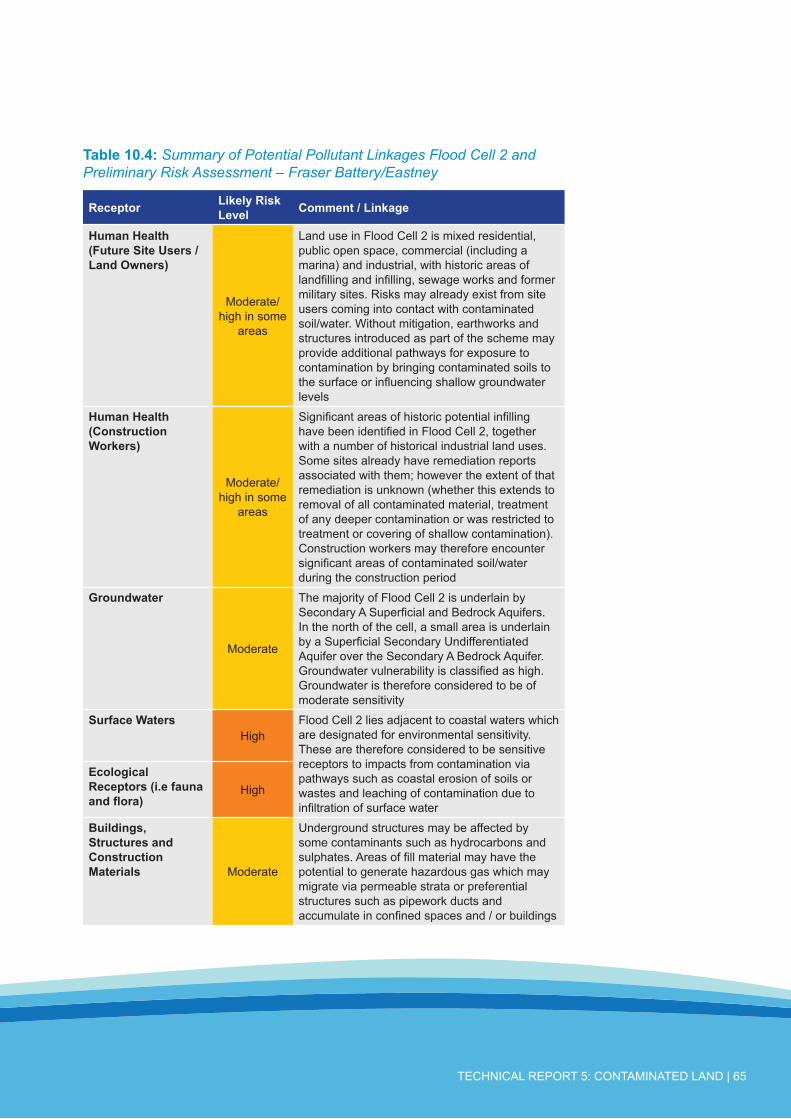
TECHNICAL REPORT 5: CONTAMINATED LAND | 65
Table10.4: Summary of Potential Pollutant Linkages Flood Cell 2 and Preliminary Risk Assessment – Fraser Battery/Eastney
Receptor LikelyRiskLevel Comment/Linkage
HumanHealth(FutureSiteUsers/LandOwners)
Moderate/high in some
areas
Land use in Flood Cell 2 is mixed residential, public open space, commercial (including a marina) and industrial, with historic areas of landfilling and infilling, sewage works and former military sites. Risks may already exist from site users coming into contact with contaminated soil/water. Without mitigation, earthworks and structures introduced as part of the scheme may provide additional pathways for exposure to contamination by bringing contaminated soils to the surface or influencing shallow groundwater levels
HumanHealth(ConstructionWorkers)
Moderate/high in some
areas
Significant areas of historic potential infilling have been identified in Flood Cell 2, together with a number of historical industrial land uses. Some sites already have remediation reports associated with them; however the extent of that remediation is unknown (whether this extends to removal of all contaminated material, treatment of any deeper contamination or was restricted to treatment or covering of shallow contamination). Construction workers may therefore encounter significant areas of contaminated soil/water during the construction period
Groundwater
Moderate
The majority of Flood Cell 2 is underlain by Secondary A Superficial and Bedrock Aquifers. In the north of the cell, a small area is underlain by a Superficial Secondary Undifferentiated Aquifer over the Secondary A Bedrock Aquifer. Groundwater vulnerability is classified as high. Groundwater is therefore considered to be of moderate sensitivity
SurfaceWatersHigh
Flood Cell 2 lies adjacent to coastal waters which are designated for environmental sensitivity. These are therefore considered to be sensitive receptors to impacts from contamination via pathways such as coastal erosion of soils or wastes and leaching of contamination due to infiltration of surface water
EcologicalReceptors(i.efaunaandflora)
High
Buildings,StructuresandConstructionMaterials Moderate
Underground structures may be affected by some contaminants such as hydrocarbons and sulphates. Areas of fill material may have the potential to generate hazardous gas which may migrate via permeable strata or preferential structures such as pipework ducts and accumulate in confined spaces and / or buildings

66 | SOUTHSEA AND NORTH PORTSEA ISLAND COASTAL FLOOD AND EROSION RISK MANAGEMENT SCHEMES
Table10.5: Summary of Potential Pollutant Linkages Flood Cell 4 and Preliminary Risk Assessment – North Portsea Island
Receptor LikelyRiskLevel
Comment/Linkage
HumanHealth(FutureSiteUsers/LandOwners)
Moderate
Land use in the Flood Cell is predominantly public open space, incorporating significant areas of former landfill or other infilling, together with a number of industrial and commercial sites. The industrial sites include the former aerodrome, which once included aero-engineering facilities, hospitals, wharves, factories depots and, inland of the Flood Cell, a former gas works site. Risks may already exist from site users coming into contact with contaminated soil/water. Without mitigation, earthworks and structures introduced as part of the scheme may provide additional pathways for exposure to contamination by bringing contaminated soils to the surface or influencing shallow groundwater levels
HumanHealth(ConstructionWorkers)
Moderate
Significant areas of historic potential infilling have been identified in Flood Cell 4, together with a number of historical industrial land uses. Some sites already have remediation reports associated with them; however the extent of that remediation is unknown (whether this extends to removal of all contaminated material, treatment of any deeper contamination or was restricted to treatment or covering of shallow contamination). Construction workers may therefore encounter significant areas of contaminated soil/water during the construction period
GroundwaterLow
(unproductive strata)
The north of Flood Cell 4 is underlain by a Principal Bedrock Aquifer (the Upper Chalk) which is overlain predominantly by a Secondary Undifferentiated Superficial Aquifer. Groundwater vulnerability is classified as high. Groundwater is therefore likely to be more sensitive to impacts from contaminated land (including migration of mobile contamination via preferential pathways such as piled foundations) than in other parts of the study area. Further south, along the east coast of Portsea Island, Flood Cell 4 is underlain by a Secondary A Bedrock Aquifer (moderate sensitivity) or unproductive strata (low sensitivity), with a Secondary Undifferentiated Superficial Aquifer overlying these. Groundwater is therefore likely to be less sensitive to impacts from contaminated land in these areas
Moderate (Secondary Aquifers)
High (Principal Aquifer)

TECHNICAL REPORT 5: CONTAMINATED LAND | 67
Receptor LikelyRiskLevel
Comment/Linkage
SurfaceWaters
High
Flood Cell 4 lies adjacent to coastal waters which are designated for environmental sensitivity. These are therefore considered to be sensitive receptors to impacts from contamination via pathways such as coastal erosion of soils or wastes and leaching of contamination due to infiltration of surface water. Visual evidence from the site walkover indicated that this pathway might currently be active in some places (indications were noted of leachate potentially seeping through the existing sea wall).
EcologicalReceptors(i.efaunaandflora) High
Buildings,StructuresandConstructionMaterials
Moderate
Underground structures may be affected by some contaminants such as hydrocarbons and sulphates. Areas of fill material may have the potential to generate hazardous gas which may migrate via permeable strata or preferential structures such as pipework ducts and accumulate in confined spaces and / or buildings. Extensive areas of fill have been identified within this Flood Cell

68 | SOUTHSEA AND NORTH PORTSEA ISLAND COASTAL FLOOD AND EROSION RISK MANAGEMENT SCHEMES
11.1 ConclusionsA desk-based assessment of contamination risks has been undertaken for the Scoping Stage of the proposed Schemes. The Schemes have been divided into three Flood Cells and a number of potential sources of contamination have been identified both within and near each Flood Cell. These include extensive areas of historic landfilling and infilling.
Within each Flood Cell, land use is mixed, with residential, commercial and industrial premises and public open space. Each of the Flood Cells borders coastal waters which are designated for environmental sensitivity and are therefore a sensitive receptor to contaminated material eroded from the coastal frontage or leached from contaminated land by infiltrated water.
Risks to groundwater receptors are likely to be higher in the north of Flood Cell 4, which is underlain by the Chalk Principal Bedrock Aquifer (the Upper Chalk), than in the remainder of the study area. The south eastern areas of Flood Cell 4 are mainly underlain by unproductive bedrock strata (London Clay). However, all parts of Flood Cells 1 and 2 are underlain by Secondary Superficial and Bedrock Aquifers.
Foundations, particularly piled foundations which extend into the aquifers can act as preferential pathways for the transfer of contamination. Care will need to be exercised to ensure that appropriate piling methods and pile types are used and that contamination levels in strata surrounding the piles is adequately characterised in order to manage these risks to groundwater quality.
All three Flood Cells have historical and/or current industrial and potentially contaminative land uses indicating that significant areas of soil and/or groundwater contamination may exist. Extensive areas of historical landfilling have been identified in Flood Cells 2 and 4; however significant areas of historic infilling have also been indicated in Flood Cell 1. Some sites already have remediation reports associated with them; however the extent of that remediation is unknown (whether this extends to removal of all contaminated material, treatment of any deeper contamination or was restricted to treatment or covering of shallow contamination).
Risks via direct contact may exist already within the Flood Cells, although remediation reports obtained for some key sites of concern indicate that capping layers have been introduced in order to limit risks to human receptors. Risks could be increased by the Schemes’ works if contaminated material is brought to the surface by excavation or if contaminated materials are used in the construction of earth flood embankments. Care will be needed to ensure that only uncontaminated materials are used where sensitive receptors could come into contact with the soil.
Given the likelihood of contamination and landfilled waste being present at the coastal frontage, risked posed by these areas as a result of erosion and inundation (e.g. by wave overtopping and/or flood storage) are likely to be significant.
11 CONCLUSIONSANDRECOMMENDATIONS

TECHNICAL REPORT 5: CONTAMINATED LAND | 69
Based on the information reviewed, it is considered that soils at the site may contain significant levels of contamination, including deeper soils beneath remedial capping layers. The risk from contamination has been assessed as:
● Medium for human health receptors;
● High for surface water ecological receptors;
● Low to high for groundwater receptors, depending on the classification of the aquifers.
Care will need to be taken throughout the design, construction and operational phases of the Schemes to ensure that sensitive receptors are protected and that excavated materials are suitable for re-use.
A conservative approach has been applied to the preliminary risk assessment due to current uncertainties concerning the location and design of the works associated with the Schemes and the presence of a large number of potential sources of contamination. The risk levels may be able to be reduced significantly by more detailed characterisation of individual locations of flood defence works and as a result of knowledge of the Schemes’ detailed design.
11.2 RecommendationsRecommendations for managing risks associated with land quality and materials management are presented below, with additional detail provided in Table11.1.
This preliminary risk assessment has been undertaken at the scoping stage of the Schemes. Information has been brought together from a range of data sources which has identified the potential for contamination across significant parts of the study area. Details of the Schemes’ design are not yet available and hence the following risk assessment has been undertaken at the Flood Cell scale, with risks identified at a high level. It is strongly recommended that, in close conjunction with the development of engineering options, these risks are considered further and both the conceptual site model and the preliminary risk assessment refined as the Schemes progress. The information provided in this report, particularly Sections 6 to 9 and Annex 3 should be reviewed, supplemented and updated as further information becomes available. This is in accordance with the process detailed in CLR11 (Figure1, Annex 2).
As discussed in Section 3.1, it is intended that the assessment contained in this report should provide the starting point of an ongoing assessment process and that the relevance of land contamination issues to the Schemes should be further assessed in conjunction with the development of the Schemes engineering options and design. Depending on the level

70 | SOUTHSEA AND NORTH PORTSEA ISLAND COASTAL FLOOD AND EROSION RISK MANAGEMENT SCHEMES
of risk identified, the steps of this process may include some or all of the following:
● Refining of the conceptual model;
● Intrusive Site Investigation;
● Quantitative Risk Assessment;
● Remediation;
● Controls during construction including materials management controls.
It is not possible to determine next steps on a site-specific basis until the outline design stage. As part of this assessment general recommendations have been made on likely next steps.
In particular, elements of further work have been highlighted throughout this report which should be undertaken as the design is progressed. These include:
● Review of the smaller scale historical maps (1:2,500 and 1:1250 scale) which may provide additional information on site history for specific areas of concern. These have been provided as part of the Envirocheck® reports for the flood cells. PCC Contaminated Land team should be consulted to establish if such a review has already been undertaken.
● Review all remaining available reports held within the PCC contaminated land archive for specific areas of concern. Further intrusive site investigation is likely to be needed for areas of concern since some of the reports reviewed are a number of years old and site conditions may since have changed. Other reports reviewed were focused on particular pathways or particular areas of the site and hence may not provide all the information necessary for the assessment of the Schemes.
● In considering the potential contaminants associated with each land use, reference should be made to publications including the former Department of Environment Industry Profiles.
● Obtaining and review of private water supply information available from the Local Planning Authority records.
● Review of underground utilities information to establish whether preferential pathways or sensitive utilities may be affected by the Schemes.
● Assessment of risks from radon on any confined spaces.
● A specification for ground investigation should be produced once the desk based investigations have been completed (bullet points 1 to 3 above) and sufficient design information is available concerning where the construction works will take place and the nature of the works. This will enable expenditure on ground investigation to be focused on particular areas of concern and/or risk to the Schemes.

TECHNICAL REPORT 5: CONTAMINATED LAND | 71
Table11.1: Recommendations
AspectofSchemes
Concern Recommendation PotentialcostsandbenefitstotheSchemes
Potential for areas of contamination to be present
Protection of sensitive receptors
● Undertake further focused desk based assessment once the preferred option has been developed and the footprint of the proposed works is more defined with the objective of refining the initial Conceptual Site Model presented in this report
● Based on this focused study, appropriate contamination testing, focused on areas to be excavated and, if necessary, any areas where material will be placed on site. This should be combined, where possible, with geotechnical ground investigation in order to achieve cost efficiencies
● Completion of a Land Quality interpretative assessment (risk assessment) for all appropriate sensitive receptors
- The cost of ground investigation, soil and water analysis and production of assessments and reports can be significant, but can be minimised by investigating only those areas identified by the outline design as being affected by the Schemes. This may include the footprint of excavation works, any areas where land use will change and any areas where surface water will be stored or the groundwater/infiltration regime will be altered by the Schemes
+ Site investigation will allow any necessary remediation or mitigation to be developed and, if possible, integrated into the Schemes design to maximise cost efficiency
Note that, if samples are required from the intertidal zone, a marine licence would be required from the Marine Management Organisation and consent from Natural England for work in any European designated sites. These works may require an EIA, Appropriate Assessment, and potentially Water Framework Directive Assessment, which could constrain or impact on the project programme and cost.
Materials Reuse
Compliance with the CL :AIRE Code of Practice entitled ‘The definition of waste: Development Industry Code of Practice’ for any materials reused on-site or intended to be used on another site via ‘direct transfer’
● Use results of the Land Quality interpretative assessment (see above) to complete Materials Management Plan (MMP). This should be completed prior to soils being reused or removed from the site
● Complete Site Waste Management Plan (SWMP) if required. This should be started during the design phase, refined and completed prior to the construction phase
- Costs for production of the MMP and SWMP
+ Benefits in avoiding the disposal costs for material which is suitable for reuse within the Schemes; minimising costs for purchasing and importing of soils needed for the Schemes; and avoiding (wherever possible) the costs/time involved in applying for Environmental Permits or Exemptions

72 | SOUTHSEA AND NORTH PORTSEA ISLAND COASTAL FLOOD AND EROSION RISK MANAGEMENT SCHEMES
AspectofSchemes
Concern Recommendation PotentialcostsandbenefitstotheSchemes
Disposal of unsuitable materials and importation of clean fill
Compliance with waste management legislation including the Landfill Regulations 2002 (as amended) and the Hazardous Waste Regulations 2005
Characterisation (prior to disposal) and disposal off-site of any materials demonstrated not to be suitable for reusePre-treatment prior to disposal to either reduce the volume of hazardous waste requiring disposal or to reduce the hazardous nature of the materialDisposal of wastes in accordance with the waste hierarchyTesting and verification of any soils imported to the site to ensure that they do not pose an unacceptable risk to human health or controlled waters (prior to importation). They will also need to be accompanied by all relevant Duty of Care documentation
- Possible costs for completion of waste characterisation if any soil arisings are proven to be unsuitable for reuse
+ Benefits of managing potential risks and compliance with legislation
- Costs –disposal costs of unusable waste (possibly including landfill tax and gate fees if no other disposal route is found)
Control of groundwater
Best practice for construction site management. Avoidance of pollution incidents
If dewatering of excavations is undertaken as part of the proposed Schemes these should be contained and disposed of appropriately to ensure that sediment and/or contaminated water is not discharged to waterBest practice guidance should be followed (for example, Pollution Prevention Guidance Note (PPG) 5: Works and maintenance in or near water and PPG6: Working at construction and demolition sites)Preparation of a method statement prior to construction, identifying the procedures to be followed should previously unidentified contamination be encountered. This should include seeking professional advice from a suitably qualified environmental consultant
- Possible costs to supply containment of groundwater and obtain consent to discharge to foul sewer or for appropriate off-site disposal
+ Benefits of managing potential risks and compliance with legislation

TECHNICAL REPORT 5: CONTAMINATED LAND | 73
AspectofSchemes
Concern Recommendation PotentialcostsandbenefitstotheSchemes
Construction Phase Health and Safety - potential exposure of construction workers to contaminants in soil or water
Compliance with Health and Safety Legislation including the Health and Safety at Work Act 1974 and Construction Design & Management) Regulations 2007
Good site practice and hygiene in addition to the use of appropriate Personal Protective Equipment (PPE) and Respiratory Protective Equipment (RPE), where necessaryMethod statements and risk assessments should be developed prior to construction for all site works to aid identification of such risks and appropriate risk avoidance and reduction measures. The works should be undertaken in accordance with the requirements of the Construction (Design & Management) Regulations 2007 where appropriateShould any work be undertaken in confined spaces on the site, an appropriate risk assessment should be undertaken and appropriate PPE used. Particularly as logs indicate that made ground or peaty layers may be present in alluvial deposits and reports indicate historic landfill containing domestic and unknown wastes may be present.
- Costs for provision of PPE, RPE if necessary and for production of method statements and risk assessments
+ Benefits of managing risks and compliance with legislation;
- Costs for specialist contractors / appropriate training etc (e.g. Asbestos removal)
Specification of materials for below ground structures
Impact of aggressive ground conditions
Soil and water sampling and testing may be required to characterise ground conditions where underground structures are planned to enable suitable materials to be specified. This should be undertaken once the footprint of the proposed works is more defined and the design of the works has been further progressed.Where sensitive underground utilities are to be introduced or moved as a result of the Schemes (e.g. potable water supply pipes) the utility provider should be contacted in order to agree a suitable specification
+ Protection of human health and integrity of below ground structures
- Cost of sampling and analysis of soils
- Possible cost of material disposal if excess material is unable to be reused.

74 | SOUTHSEA AND NORTH PORTSEA ISLAND COASTAL FLOOD AND EROSION RISK MANAGEMENT SCHEMES
British Geological Survey (BGS) Map of Portsmouth 1:50,000 series, Sheet 331 (Solid and Drift Edition).
British Geological Survey (BGS) Map of Fareham 1:50,000 series, Sheet 316 (Solid and Drift Edition).
CIRIA, 2005 Environmental Good Practice on site (second edition), London
CL:AIRE (2008). The Definition of Waste: Development Industry Code of Practice.
Clayton Environmental Consultants Limited (1995) Ground Investigation, Tangier Road Portsmouth.
Environment Agency website: http://maps.environment-agency.gov.uk/wiyby
Environment Agency (2000) Pollution Prevention Guidelines. Works in, near or liable to affect watercourses: PPG5 and Pollution Prevention Guidelines. Works in, near or liable to affect watercourses: PPG5.
Environment Agency (2004) Contaminated Land Report 11 (CLR11): Model Procedures for the Management of Land Contamination
ERM (2009) H&S Aviation, Portsmouth, Human Health Generic Quantitative Risk Assessment
ESI (2010). Canoe Lake Contaminated Land Investigation: Detailed Inspection and Assessment of Canoe Lake, Portsmouth.
Halcrow Group Limited (2004) Portsea Island Coastal Strategy Study: Contamination Risk Assessment Report
Hyder Consulting (2000) Eastney Married Quarters, Portsmouth: Method Statement in Support of Planning Application.
Leigh Analytical Services (1994) Horsea Allotment Ground Investigation
Parkman Buck Limited (1993) Alexandra Park, Portsmouth Contaminated Land Site Investigation Report
Parkman Buck Ltd (1993) The Glory Hole Eastney Quantified Risk Assessment for the Glory Hole Eastney Vol 1 & 2.
Parkman Buck Limited (1993) Tipner Quay, Twyford Avenue, Desk Study
PCC and Wimpey Homes Holdings Limited (1997) Agreement in Pursuance of Section 106 of the Town and Country Planning Act 1990 and Section 111 of the Local Government Act 1972 relating to Former HMS Phoenix Site Matapan Road Stamshaw Portsmouth.
Soils Limited (2007) Report on a Ground Investigation on Kendalls Wharf, Eastern Road, Portsmouth.
12 BIBLIOGRAPHY

TECHNICAL REPORT 5: CONTAMINATED LAND | 75
LIMITATIONSThe direct assessments and judgements given in this report are limited by both the finite data on which they are based and the proposed works to which they are addressed. The acquisition of data is constrained by both physical and economic factors and, by definition, is subject to limitations. Conditions at the site will change over time due to natural variations and may be affected by human activities.
This document has been prepared for the titled project and should not be relied upon or used for any other project. Royal Haskoning accepts no responsibility or liability for the consequences of this document being used for a purpose other than that purpose for which it was commissioned. The assessments and judgements contained herein should not be relied upon as legal opinion.
The findings and opinions are relevant to the dates of the information reviewed and should not be relied upon to represent conditions at later dates. The opinions included herein are based on the information obtained from the assessments undertaken in the study area and from the experience of the reviewers.
This Phase I Land Quality Assessment has utilised a variety of publicly available data sources such as the Environment Agency, Landmark Group, historical maps and the British Geological Survey. Therefore, the study is limited by the age and limitations inherent in the data described.
ANNEX1:REPORTLIMITATIONS

76 | SOUTHSEA AND NORTH PORTSEA ISLAND COASTAL FLOOD AND EROSION RISK MANAGEMENT SCHEMES
ANNEX2:FIGURES

TECHNICAL REPORT 5: CONTAMINATED LAND | 77
ANNEX3:ENVIROCHECKREPORT

78 | SOUTHSEA AND NORTH PORTSEA ISLAND COASTAL FLOOD AND EROSION RISK MANAGEMENT SCHEMES
ANNEX4:OUTPUTSFROMTHEPCCCONTAMINATEDLANDARCHIVESEARCH

TECHNICAL REPORT 5: CONTAMINATED LAND | 79