Embed Size (px)
Citation preview
SCIPPAnnualReport June2015-May2016 1
SouthernClimateImpactsPlanningProgramAnnualReport:June2015-May2016
SCIPPAnnualReport June2015-May2016 2
TableofContentsC
ON
TE
NT
S1.SCIPPTeam3
2.NewAreasofFocus,PartnershipandEngagement4
3.ClimateServices6
4.ProgramImpact9
5.BuildingExpertise11
6.Accomplishment12
7.Research13
8.Outreach16
9.Publications18
10.Narrative19
11.CopingWithDrought20
12.Appendix22
TheSouthernClimate ImpactsPlanning Program(SCIPP)Phase IIwasfundedonawardNA13OAR4310183.Forthe pasttwoyears,ourannualperformancereporthasbeensubmittedunderthetitle"SouthernClimateImpactsPlanningProgram(SCIPP) Phase II" and hasbeen accepted. Please accept the annual report entitled “Southern Climate ImpactsPlanningProgram(SCIPP)PhaseIIfortheperiod6/1/2015-5/31/2016.

SCIPPAnnualReport June2015-May2016 3
PrincipalInvestigators:MarkShafer(OU);BarryKeim(LSU)
Co-Principal Investigators:HaroldBrooks(OU);ReneeEdwards(LSU);MichaelHayes(NDMC);YangHong(OU);ReneeMcPherson(OU);RandyPeppler(OU);StevenQuiring(TAMU);KevinRobbins(LSU)
CoreOf6ice:MargretBoone-ProgramManager(OU);HalNeedham-ProgramManager(LSU);RachelRiley(OU)AssociateProgram Manager; Katy Christian (Research Associate); Amanda Lewis (Research Associate); Leah Kos - ClimateAssessmentSpecialist(OU);ChristineKuhn-StudentAssistant(OU);GinaFujan-StudentAssistant(OU)
ResearchandSupportStaff: JaredBostic(OU);KyleBrehe (LSU);KyleDavis(OU);LuigiRomolo(LSU);DavidSathiaraj(LSU);AdaShih(OU)
GraduateStudents:RudyBartels(LSU);CorynCollins(LSU); JoshGilliland(LSU);PrestonHartmann (OU);ZackLeasor(TAMU);DarrienNoyes(OU);CarriePavlowsky(OU);DerekThompson(LSU)
Advisory Committee: David Brown (NOAA); Jeffrey Gaffney (University of Arkansas); Gregg Garbin (University ofArizona); Marilu Hastings (Cynthia and George Mitchell Foundation); Bill Hooke (American Meteorological Society);Rebecca Jennings(FederalEmergencyManagementAgency);BillKiene(NOAA);VictorMurphy(NOAA);SaschaPetersen(Adaptation International); Putnam Reiter (Oklahoma Department of Emergency Management); Bob Rose (LowerColoradoRiverAuthority);DavidSchlotzhauer(NWSLowerMississippiRiverForecastCenter);MelissaStults(UniversityofMichigan);andTomWilbanks(OakRidgeNationalLaboratory)
SCIPPAf6iliates: Jeff Basara (OU); Jerry Brotzge (OU); Sean Crowell (OU); Scott Greene (OU); CodyKnutson (NDMC);Patrick Marsh (NWS SPC); Heather McCarthy (OU); Mike Richman (OU); Kodi Monroe (OU); John Nielsen-Gammon(TAMU);CindyRosenthal(OU);ChieSakakibara(OU);TheodoreTrafalis(OU);andKaiZhang(UTHealth)
TE
AM
SCIPPTeam
The Southern Climate Impacts Planning Program team consists of the following investigators, core office staff, research & support staff, summer interns, and graduate students from the University of Oklahoma (OU), Louisiana State University (LSU), Texas A&M University (TAMU), and the National Drought Mitigation Center (NDMC). SCIPP’s Stakeholder Services Committee (Advisory Committee) is also detailed above. Team personnel are current as of May 31, 2016.

SCIPPAnnualReport June2015-May2016 4
NewAreasofFocusorPartnershipsPlanningforextremeweatherandclimateeventsarecentraltotheworkoftheSouthernClimateImpactsPlanningProgram,thougharenotouronlyfocus.ThefollowingrepresentthevariousnewareasoffocusandpartnershipsofSCIPPwithabriefdescriptionofthequestionsandissuestheSCIPPteamisworkingtoaddress.
Planners andtheAmericanPlanningAssociation(APA) –One of the goals since SCIPP’s inceptionhasbeen toimproveclimatehazardpreparednessand reduce the impactsthatthose hazardshave oncommunitiesandstates.Overthe yearswehaveengagedwithemergencymanagersandafewplannersonaproject-by-projectbasis.MorerecentlyweidentiDiedtheneedforplannersandemergencymanagers,whotypicallyworkinveryseparatesilos,tocollaborateifhazardmitigationplanningisto improve. SCIPP has historically been better connected to emergencymanagers and has a good understanding of theiroperatingcontext.Withinthelastfewmonths,however,wehavebeguntoengagewithplannersthroughtheAmericanPlanningAssociation’snationalchapterandthestatechaptersinArkansasandOklahoma.Theinteractionsarecurrentlyintheirinfancy,butweareplanningmore formal interactionsandpartnershipsoverthenextseveralmonths.Furthermore,weareplanningmoreformalinteractionwiththenewlyestablishedAPAHazardMitigationandDisasterRecoveryDivision.
CHARM (Community HealthandResourcesManagement) Model -One of SCIPP’smajor efforts for expanding outreachamongstour regionincluded getting involvedwiththehazard planning process. Initial researchrevealed variousSea Grantswereinvolvedwithholdingclimateadaptationplanningworkshopsandthereforetheprogramwasassumedtobeakeycontactinstartingthese conversations.Withinourregion,outreachtotheTexasSeaGrantledtoaninvitationtotheir CHARMModelworkshop inCorpusChristi,TX. LedbytheTexasCoastalWatershedProgram(TCWP),a partnership betweenthe TexasSeaGrantandtheTexasA&MAgriLifeExtension,theireffortsaresupportedbyFEMA,USACEandvariousotherorganizations.Asamoretechnicalmappingapplicationaimedatincreasingresiliencyinplanningefforts,CHARMutilizesArcGIS toincorporatealocalizedlandscapeof variouscitiesand“giveslocalofDicials, stakeholders,andcitizensthepower tomapandanalyzegrowthwithreal-timefeedback.”TCWPspokewithSCIPPaboutapotentialpartnershipwithCHARM,expressingtheirinterestinaddinga climatecomponentto themodel.Additionally,as supportedbyFEMA, CHARMisplanningonexpanding theirefforts toallstateswithinthe FEMA6region,beginningwithOklahoma.SCIPPwillpotentiallybecome theclimate resourcewithinOK, TXandLA,andconversationsarecontinuingwithTCWPtoexplorethispartnership.
ArkansasNaturalResourcesCommission -BeginninginOctober2015,SCIPPbeganworkingwithANRCtohelpthemdevelopadroughtresponseandpreparednessplan.SCIPPhelpeddevelopanagendaandpresentationmaterialsforaworkshop(heldinJune2016inLittleRock,AR),identifyorganizationsfromArkansastoparticipateinthatworkshop,andlinktoexpertisewithinSCIPP andNationalDroughtMitigationCenter. Arkansas isone of three statesthatpresentlydoesnothaveorhasnotbeenactivelydevelopingadroughtplan.They havebeenaffectedbyseveredroughtsinfourofthepastDiveyearsandrecognizedtheneedtobetter connecttotheU.S.DroughtMonitorandreviewagencyoperations.SCIPP'sworkwithArkansaswillserveasatemplateforotherstates,includingupdatingOklahoma'sdroughtplaninthecomingyear.
RISAcollaboration-SCIPPparticipatedinsurgemappingwithCISAandCCRUNduringtheatmosphericriverevent/HurricaneJoaquininOctober2015. SCIPPappliedthetoolsandmappingcapacitybuiltaspartofSURGEDATtoanotherregionandasomewhatdifferenttypeofevent.
PA
RT
NE
RS
HIP
S

SCIPPAnnualReport June2015-May2016 5
EmergencyManagement-ExpandingagainontheeffortofSCIPPtoexplore theconnectionbetweenplanningandemergencymanagers, we have been involved with outreach effortswith the Arkansas Department of EmergencyManagement (ADEM).CombinedwiththeProfessionalAssociationofEmergencyManagers,ADEMisholdingtheir annualconference thisfallandhasofferedasessionforSCIPPtopresent.Weplantotakethisopportunity toexploretheemergencymanagementsideofthehazardplanning process, incorporating ahighlyinteractivediscussionfocusedaround theirvariouscollaborations,resourcesusedandopinionsonworkingwiththeplanningcommunity.
Architecture - One of themostresponsive andprominentsectorsfromourinitialoutreachwasfromarchitecture. Alongwithplanners,we discovered their heavypresence in a varietyof resiliencemeasures including the 100 ResilientCities. SCIPP iscurrently building relationshipswith two different architecture groups: a private company named PerkinsandWill, and thenationalorganization,AmericanInstituteofArchitects(AIA).
*PerkinsandWill isaglobaldesign DirmthathousesaResiliencyTaskForce.Thisforce iscurrentlyseekinganetwork ofclimate science partnerstocollaboratewith. Initial conversationsstartedat the100ResilientCitiesmeetinginDallas, however, astheDirmisnationwide,itwasmutuallydiscoveredthateffortsshouldextendacrosstheentireRISAnetwork. SCIPPconnectedPerkinsandWillwithSarahCloseandCaitlinSimpsonwheretheydiscussedthenewfound idea of RISA teamsworking as contractors and quickly shared an introduction to ournetwork of teams. Relationships are moving forwardwiththeSCIPPteamaboutwhatprojectstheymayneedourexpertise,andareinthe initial stages across the rest oftheRISAnetwork. *AIA is a nationwide organization consisting of over 100,000 architects. Upon the discovery of their AIA Resilience Dirm, informal conversations revealed that their largest climate challenge was relying on climate data fordetermining baselines,withtheneedforbetterhistoricaldataof thechangingclimate.Thisquicklyled intothe ideaof apilotproject in our SCIPP region, with the potential of expanding tonational support. Conversations are currently being discussed aroundthepotentialforthispilot,withAIA’ssuggestionofhostingitinTulsa,OK.Themainreasonbehindthissuggestionis because the city’s 100 Resilient Cities Chief Resilience OfDicerMaryKell, is a member of AIA. Coincidentally, SCIPP’s involvementwithTulsaPartnersledtotheinvitationforMaryKelltospeakatourAnnualCommitteeMeetinginMay,and initialconversationsareinplacebetween100RC,AIANational,AIAEasternOklahomaandSCIPPforthecomingmonths.
National Renewable Energy Laboratory (NREL) contacted SCIPP to assist in the development of a Climate Change RiskAssessment(CCRA)fortheStrategicPetroleumReserve’s(SPR)siteslocatedinTexasandLouisiana.WithSCIPPassistance, theCCRA will build off relevant previous work that has been completed at the SPR and will focus on developing a generalunderstandingof regionalclimatesciencefor the coastalregionofLouisianaandTexas. SCIPPwillprovide technicalassistanceandinformationtohelpinidentifyingtheSPR’ssite-speciDicclimatechangerisks,evaluatingtheriskstotheSPR’soperationsandmission, and developing strategies to address these risks through the CCRA. To achieve these goals SCIPPwill complete thefollowing,1) Preparationof aregionally-speciDic,high-leveloverviewofclimateprojections;2)Ananalysisof the likelihoodforeachpotentialclimatehazard-supportingtheriskanalysis;and3)Awrittenclimatechangesummaryreportforthesouth-centralU.S. region(includingTexasandLouisiana)thatshallbeanaddendumtothe Dinalclimatechangeriskassessmentreportandaresource for information incorporated in the report. This report should assist in taking steps sooner rather than later to develop resilience to climate change.
EN
GA
GE
ME
NT
SCIPPAnnualReport June2015-May2016 6
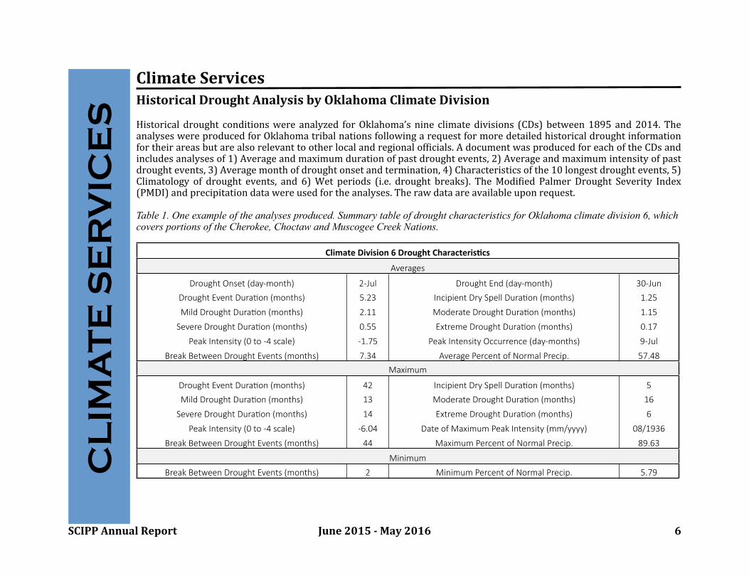
ClimateServicesHistoricalDroughtAnalysisbyOklahomaClimateDivision
Historicaldroughtconditionswere analyzed forOklahoma’snineclimate divisions(CDs)between1895 and2014. TheanalyseswereproducedforOklahomatribalnationsfollowingarequestformoredetailedhistoricaldroughtinformationfortheirareasbutarealsorelevanttootherlocalandregionalofbicials.AdocumentwasproducedforeachoftheCDsandincludesanalysesof1)Averageandmaximumdurationofpastdroughtevents,2)Averageandmaximumintensityofpastdroughtevents,3)Averagemonthofdroughtonsetandtermination,4)Characteristicsofthe10longestdroughtevents,5)Climatologyof droughtevents, and 6)Wet periods (i.e. droughtbreaks). The ModibiedPalmerDroughtSeverity Index(PMDI)andprecipitationdatawereusedfortheanalyses.Therawdataareavailableuponrequest.
Table 1. One example of the analyses produced. Summary table of drought characteristics for Oklahoma climate division 6, which covers portions of the Cherokee, Choctaw and Muscogee Creek Nations.
ClimateDivision6DroughtCharacteris4csClimateDivision6DroughtCharacteris4csClimateDivision6DroughtCharacteris4csClimateDivision6DroughtCharacteris4cs
AveragesAveragesAveragesAverages
Drought Onset (day-month) 2-Jul Drought End (day-month) 30-Jun
Drought Event Dura<on (months) 5.23 Incipient Dry Spell Dura<on (months) 1.25
Mild Drought Dura<on (months) 2.11 Moderate Drought Dura<on (months) 1.15
Severe Drought Dura<on (months) 0.55 Extreme Drought Dura<on (months) 0.17
Peak Intensity (0 to -4 scale) -1.75 Peak Intensity Occurrence (day-months) 9-Jul
Break Between Drought Events (months) 7.34 Average Percent of Normal Precip. 57.48
MaximumMaximumMaximumMaximum
Drought Event Dura<on (months) 42 Incipient Dry Spell Dura<on (months) 5
Mild Drought Dura<on (months) 13 Moderate Drought Dura<on (months) 16
Severe Drought Dura<on (months) 14 Extreme Drought Dura<on (months) 6
Peak Intensity (0 to -4 scale) -6.04 Date of Maximum Peak Intensity (mm/yyyy) 08/1936
Break Between Drought Events (months) 44 Maximum Percent of Normal Precip. 89.63
MinimumMinimumMinimumMinimum
Break Between Drought Events (months) 2 Minimum Percent of Normal Precip. 5.79CL
IMA
TE
SE
RV
ICE
S

SCIPPAnnualReport June2015-May2016 7
Table 2: Tribal jurisdiction map with Oklahoma climate division boundaries overlaid.
GulfCoastJointVenture(Lafayette,LA)
SCIPPprovidedasummerinternwhoworkedalongsidestaffattheGCJVduring2015toconductananalysisoftheeffectsofdroughtonhabitatsuitabilityformigratorywaterfowl.TheanalysisincludedthewesternGulfCoast(Texas,Louisiana,Mississippi).Theoutcomeoftheresearchwasananalysisofmultipledrought,temperature,andprecipitationvariablesinrelation to the GCJV's satellite-based habitatassessments. The analysis founddifferent variables in eachof the regionsalong the coast as being signibicant factors in explaining inter-annual variabilityof suitable habitat (i.e., precipitationappearedamore importantpredictorinsouthernareaswhiletemperaturewasmoredominantinnortherncoastalareas).Althoughthisisnotanoperationaltool, theanalysis/ technicalassistanceprovidesafoundationforbuildingapredictionsystem.
CL
IMA
TE
SE
RV
ICE
S
SCIPPAnnualReport June2015-May2016 8
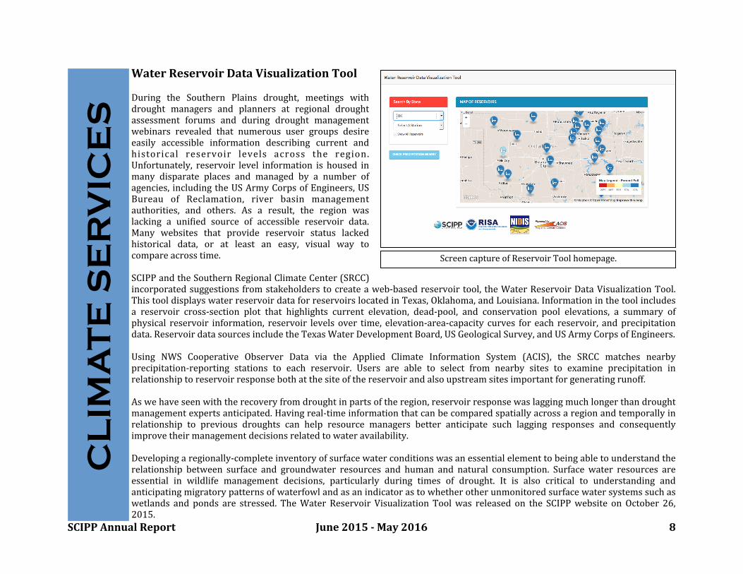
WaterReservoirDataVisualizationTool
During the Southern Plains drought, meetings withdrought managers and planners at regional droughtassessment forums and during drought managementwebinars revealed that numerous user groups desireeasily accessible information describing current andhistorical reservoir levels across the region.Unfortunately, reservoir level information ishoused inmany disparate places and managed by a number ofagencies, including theUSArmyCorpsofEngineers,USBureau of Reclamation, river basin managementauthorities, and others. As a result, the region waslacking a uniDied source of accessible reservoir data.Many websites that provide reservoir status lackedhistorical data, or at least an easy, visual way tocompareacrosstime.
SCIPPandtheSouthernRegionalClimateCenter(SRCC)incorporatedsuggestionsfromstakeholderstocreate aweb-basedreservoir tool,theWaterReservoirDataVisualizationTool.ThistooldisplayswaterreservoirdataforreservoirslocatedinTexas,Oklahoma,andLouisiana.Informationinthetoolincludesa reservoir cross-section plot that highlights current elevation, dead-pool, and conservation pool elevations, a summary ofphysical reservoirinformation, reservoir levelsovertime,elevation-area-capacitycurves foreach reservoir, and precipitationdata.ReservoirdatasourcesincludetheTexasWaterDevelopmentBoard,USGeologicalSurvey,andUSArmyCorpsofEngineers.
Using NWS Cooperative Observer Data via the Applied Climate Information System (ACIS), the SRCC matches nearbyprecipitation-reporting stations to each reservoir. Users are able to select from nearby sites to examine precipitation inrelationshiptoreservoirresponsebothatthesiteofthereservoirandalsoupstreamsitesimportantforgeneratingrunoff.
Aswehaveseenwiththerecoveryfromdroughtinpartsoftheregion,reservoirresponsewaslaggingmuchlongerthandroughtmanagementexpertsanticipated.Havingreal-timeinformationthatcanbecomparedspatiallyacrossaregionandtemporallyinrelationship to previous droughts can help resource managers better anticipate such lagging responses and consequentlyimprovetheirmanagementdecisionsrelatedtowateravailability.
Developingaregionally-completeinventoryofsurfacewaterconditionswasanessentialelementtobeingabletounderstandtherelationshipbetween surface and groundwaterresourcesand humanandnatural consumption. Surfacewaterresourcesareessential in wildlife management decisions, particularly during times of drought. It is also critical to understanding andanticipatingmigratorypatternsofwaterfowlandasanindicatorastowhetherotherunmonitoredsurfacewater systemssuchaswetlands andpondsare stressed. TheWaterReservoirVisualization Tool was releasedon the SCIPPwebsite onOctober26,2015.
CL
IMA
TE
SE
RV
ICE
S
ScreencaptureofReservoirToolhomepage.
SCIPPAnnualReport June2015-May2016 9
OverallProgramImpactMeasuring success inanyworking relationshipcanbedifbicult, whetherthere isanattempt toquantifythe success,orproveanactionwassuccessful.SCIPPhasnotconducteda formalevaluationprocess. Informally,thevolumeofrequestsfor information and partnershipsonprojects suggests thatSCIPP isa useful contributortoward building resiliencytoclimatehazardswithintheregion.
Subsequently, onewaySCIPPmeasuressuccess isthroughourrelationshipswithourstakeholders. SCIPP iscurrentlyinPhase IIof ourproposal. Since the beginning of Phase Iin 2008,wehavepartiallymeasuredsuccessbycontinuing theaforementionedstakeholderrelationships.Inessence,wemeasuresuccessbymaintainingaworkingrelationshipbeyondtheinitialstakeholdercontact,whetherthatwasapresentation,phonecall,e-mail,etc.Weconsideraworkingrelationshipsuccessfulifweareapproachedwithadditionalquestionsafterthisinitialcorrespondence. SCIPP remainsblexible totheneedsofthestakeholderswithinourregion,andasnewopportunitiespresentthemselves,weformnewpartnerships.
Overall program impactalso depends on ourrelationship with the decisionmaker. Some points are quantitative (howmanypeopleattendedawebinarorforum,numberofpeoplewhohaveaccessedourdocuments,etc.),andsomearemorequalitative(presenting information).SCIPPhasnotformallyassessedouroverallprogramimpact,butratherweuse thefollowingasaninformalmethodtomeasuresuccess,therebyguidingourresearchandcommunityoutreach.
Whenapplicable,wehaveaskedstakeholderstoprovideuswithtestimonyregarding howourinformationwasused,orhowusefulourtoolshavebeen.Throughthisavenue, wehave learnedhowourtoolsare being usedbeyondourSCIPPregionandarehavingbothanationalandinternationalimpact.
Testimonyincludes:
“Excellentwebinar!Ihadnoideathesituationwassoverydire.”(FromManagingDroughtWebinarSeriesfeedback)
“Those[droughtwebinars]arereallygreat.Thankstoall.”(FromManagingDroughtWebinarSeriesfeedback)
“Thanksfortheseinformativegraphicdisplays.”(Frome-mailregardingClimographTool)
“Everytimewespeaktoawaterstakeholdergroup,thegraphisusedandgeneratesverypositivecomments.”(Frome-mailregardingHistoricalTrendsTool)
Since November2015, SCIPP has been utilizing Google Analytics to understand the patterns of those who access ourwebsite andsocialmediasites.UsingGoogleAnalytics,we canseethenumberof visitstoourwebsite, eachpageon thewebsite,andhowtheyaccessedourwebsite.Wearealsoabletoseewherepeoplewhoaccessthisinformationarelocated.MostofourwebsitevisitscomefromNorman,OK,followedbyFortWorth,TXandBatonRouge,LA.OthercitiesshownonthetrafbicmapbelowincludeNewYork,NY,Holland,MI,Dallas,TX,Boulder,CO,andOklahomaCity,OK.
PR
OG
RA
M I
MP
AC
T

SCIPPAnnualReport June2015-May2016 10
The return rates of visitors to ourwebs i t e - a way f o r u s t o t r a ckstakeholders versus spam-is 31.9%,showing that our website is bringingnew visitors, but also holds value fordeeper connections with about 1/3returning visitors. Through GoogleAnalytics, we can see that the SCIPPHomePage,Data Tools, and People tabsare our most visited sections of thewebsite.
Another aspect of Google Analytics isthatwe cansee the referralsites to ourwebsite. The majority of referrals comefrom Carleton College in Minnesota.They have an online EarthLabs course,inwhichoneof theironline lessonsison“Climate,Weather,andTrees.”Theyreferto SCIPP, and SCIPP’s website, saying“Use the Southern Climate ImpactsPlanningProgram(SCIPP)dataproductswebsite toresearchotherclimatetrends,suchasprecipitation,orclimatetrendsin other regions or states.” Other top referral sites include CoCoRaHS, Facebook, Twitter, and Drought.gov. Facebookaccountsfor56.5%ofournetworkreferrals,andTwitteraccountsfor43.4%.
GoogleAnalyticsalsoallowsustoannotatevariousevents/newsreleases/postsandmonitorthepotentialuserincrease.Forexample, the 20 MayTornado Assessmentwasannotated, and we documented an increase of 128 page views onFebruary15.Similarly,wesawanincreasetoourwebsiteviaFacebookthatdayaswell.OnMarch11,anonlineEarthLabscourseincreasedourpageviewsby123.
Separately,SCIPPconductedausersatisfactionsurveyfortheNWS-SRHSouthernPlainsDroughtOutlookSummaryinFall2015. Surveybindingsindicatedthatusersweresatisbiedwiththe formatandcharacteristicsof the outlook. Thesurveyshowedsome level of value beyondbackground information, particularly in that 54%of respondents shared it with acolleagueandmorethan20%usedspecibicproductsorusedabigureormaterialfromtheOutlook.PR
OG
RA
M I
MP
AC
T
GoogleAnalyticsMapofLocationsofSCIPPwebsiteusers.
SCIPPAnnualReport June2015-May2016 11
BuildingExpertiseOurprimarymethodistoengageorganizations(stateagencies,federalpartners, non-governmentalorganizations)ontheirneedsfor climateandweatherinformation.WethenworkwiththemiterativelytoreDinetheserequestsandtoidentifyavailablesourcesof informationthatcanmeettheirneedsortoconduct targeted analysisorresearchtoaddressremainingquestions.Eachjurisdictionandsectorhasdifferentprocesses,documents,procedures,andinformationsourcesuponwhichitrelies,soithasbeendifDiculttodevelopaone-size-Dits-allapproachtotheconversation. Consequently,SCIPPworksbothatstatelevelstoidentifycommoninterestsacrossasub-regionandlocalcommunitiestoidentifyamoredetailed,nuancedunderstandingofhowinformationisusedindecision-makingandplanningprocesses.
In2014wedevelopedandtaughtclimatetrainingmaterialstoNativeAmericantribesinOklahomaandTexas.Thisspring,asaresultofthatandother interactionsoverthelastfewyears,individualsfromtheDelawareTribeofIndiansinpartnershipwiththeOklahomaKansasTribalCoalitionandtheQuapawTribeofOklahomainpartnershipwithseveralnortheastOklahomatribesaskedustoprovidesupportlettersforfunding theywereseekingthroughtheBureauofIndianAffairstoexpandclimateadaptationplanningeffortsintheirtribalnationsandseveralotherswithwhomtheywerepartnering.Lastfall,arepresentativeoftheKiowaTribeofOklahomaapproachedusforinformationonclimatemitigationstrategiesfortribesashewasworkingonaclimatemitigationplanforhistribe.WehaveengagedwiththistribeinvaryingcapacitiesoverthelastDiveyears.
SCIPPacknowledgesthattherearemultipleavenueswithintheengineeringworldthatareaffectedbyclimateandhasactivelyreachedoutfor theirengagementoverthe past few months. From thesecurrentefforts,wehavemadethemostengagementwiththeenergyengineersector.SpeciDically,theOklahomaChapteroftheAssociationofEnergyEngineers(AEE)requestedforSCIPPtopresentintheir monthlyLunchandLearninMay.Pre-meetingconversationsledtoAEE’srequestofa“Climate101”lessonforOklahoma.Followingthepresentation,memberswereactivelyengagedwithquestionsonhistoricaldataandrequestsforasimilar presentationtotheirvariouscompanies.Additionally,aninvitationtositintheproceedingboardmeetingledtoanenthusiasticdiscussion about a larger one-dayworkshop. Key insights for this workshopwould include a panel of expertsranging fromweatherandclimate toengineering.Topicsexpressedbybothpresentationsandopendiscussionswill focusonrevealingthegreaterneedsofclimateinformationfromenergyengineers,aswellaspresentonthehistoricaltrendsrelatedtoenergydemandandtherelevantimplicationswithachangingclimate.
NOAA/SARPThresholdsProject,SanAngelo:Within theThresholdsproject, therewere manyobjectivesdesigned tohelpbuild capacity toclimatevariabilityand change forlocal/regionaldecision-makers. Oneof themosttangible deliverablesthisprojecthasbroughttolightarethedevelopmentofthe“Climateof”documents.DesignedtooutlinetheaverageclimatetrendsofSanAngeloaswellasa historical climatehazardsproDile, thesedocumentsraiseawarenessof the city’sclimateandweatherpatternsdatingbacktothe 1800’s. Having thisdatawritten out in aneasytounderstand, graphicalwayallows fordecision-makerstoidentifyrecentlife-impactingeventsandcomparethemtodecadesofclimatedatatounderstandthetruefrequency ofvariousevents.TheDinalproductofthisdocumentwillcombineboththehistoricalanalysiswiththefutureprojectionsdonebyATMOSResearch.Withthepast,currentandfutureanalysesoftheregionalareaofSanAngelocombinedintoonedocument,thistangible item can serve as a reputable science resource in the variousplanning anddecision-making processes in the city.Discussionsfromtheworkshopsrevealedthatvarioussectorssuchasplanning,parksandrecreation,watermanagementandcitygovernmentwouldgreatlybeneDitfromhavingascienceresourcelikethisdocumenttoaidintheir ability tounderstandtheclimatevariabilityandrisktotheircity.
BU
ILD
ING
EX
PE
RT
ISE
SCIPPAnnualReport June2015-May2016 12
AccomplishmentOver thepastyear, SCIPPhas increaseddirect interactionwithstateandlocal jurisdictions.Creating these direct connections takes sustainedeffort. The relationships are difbicult tobuild,butoncebuilttheyallowresearchondecision-makingprocessesandanabilitytobetterconnect NOAA andpartner climate services to meet the needs those stakeholders identify.These relationships are critical for building long-term resilience. Through these types ofefforts,SCIPPisfacilitatingdialogamongnewpartners thathavenotbeenwell-connectedtootherNOAAefforts.
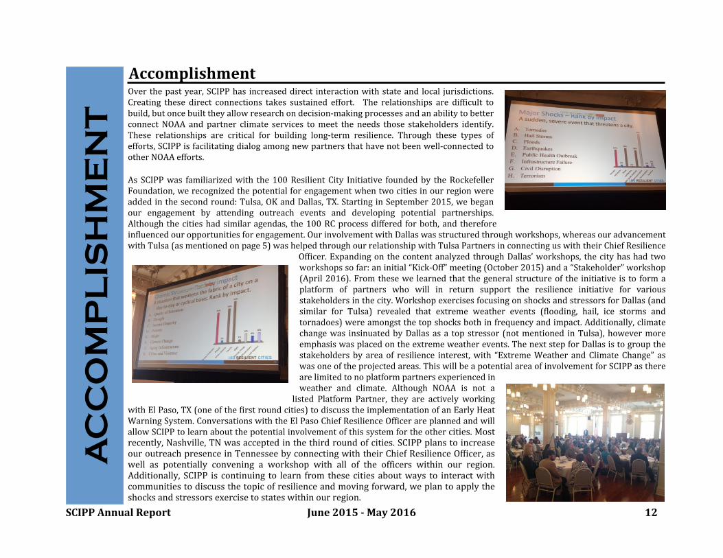
As SCIPPwas familiarizedwiththe100ResilientCity Initiativefoundedby theRockefellerFoundation,werecognizedthepotentialforengagementwhentwocities inourregionwereaddedinthesecondround:Tulsa,OKandDallas,TX.StartinginSeptember2015,webeganour engagement by attending outreach events and developing potential partnerships.Althoughthe citieshadsimilar agendas, the100RCprocessdifferedforboth, andthereforeinbluencedouropportunitiesforengagement.OurinvolvementwithDallaswasstructuredthroughworkshops,whereasouradvancementwithTulsa(asmentionedonpage5)washelpedthroughourrelationshipwithTulsaPartnersinconnectinguswiththeirChiefResilience
Ofbicer.Expandingonthecontent analyzedthroughDallas’workshops, thecity hashadtwoworkshopssofar:aninitial“Kick-Off”meeting(October2015)anda“Stakeholder”workshop(April2016). Fromthesewe learnedthat the generalstructureof the initiativeis to formaplatform of partners who will in return support the resilience initiative for variousstakeholdersinthecity.WorkshopexercisesfocusingonshocksandstressorsforDallas(andsimilar for Tulsa) revealed that extreme weather events (blooding, hail, ice storms andtornadoes)wereamongstthetopshocksbothinfrequencyandimpact.Additionally,climatechangewas insinuatedbyDallas asa topstressor (notmentioned inTulsa), howevermoreemphasiswasplacedontheextremeweatherevents.ThenextstepforDallasistogroupthestakeholders by areaof resilience interest,with“ExtremeWeather andClimateChange”aswasoneoftheprojectedareas.ThiswillbeapotentialareaofinvolvementforSCIPPastherearelimitedtonoplatformpartnersexperiencedinweather and climate. Although NOAA is not a
listed Platform Partner, they are actively workingwithElPaso,TX(oneofthebirst roundcities)todiscuss theimplementationofanEarlyHeatWarningSystem.ConversationswiththeElPasoChiefResilienceOfbicerareplannedandwillallowSCIPPto learnabout thepotentialinvolvementofthissystemfortheothercities.Mostrecently,Nashville,TNwasacceptedinthe thirdroundofcities.SCIPPplanstoincreaseouroutreachpresence inTennesseebyconnectingwiththeirChiefResilienceOfDicer,aswell as potentially convening a workshop with all of the ofDicers within our region.Additionally, SCIPP iscontinuing to learn fromthese citiesaboutwaystointeractwithcommunitiestodiscussthetopicofresilienceandmovingforward,weplantoapplytheshocksandstressorsexercisetostateswithinourregion.
AC
CO
MP
LIS
HM
EN
T

SCIPPAnnualReport June2015-May2016 13
ResearchFindingsRelationships and prior planning are key to successful disaster response. Investigators:RachelRileyandAlekKrautmann
The EF-5 tornado that struck the centralOklahoma communities of Newcastle,OklahomaCityandMooreon20May2013requiredthefullengagement of local,stateandfederalemergencymanagementandcapturedtheattentionofthenationandevensomepartsof theworld.Eventhoughtheeventwasexceptionallywell-forecasted, 24 people were killed and 387 were treated for injuries at localhospitals. Yet, it provided aunique opportunity to learnhowwellthe planning,preparedness andresponseefforts thatwere implementedafterprevious violenttornadoesstruckthesecommunities(e.g.,anF-5on3May1999andF-4on8May2003)workedduring thisdisaster andwhatmight beimprovedshould anotherdisasterofthismagnitudeoccurinthearea.SCIPPresearchersattheUniversityofOklahomastudied theperspectives of eight city, countyandmedicalemergencymanagement ofbicials and a non-probit organization involved in planning andpreparingforandrespondingtothedisaster.Allbutoneofthestudyparticipantswere involvedinmanaging and responding to previous tornadodisasters in thearea.
Acomparisonbetweenthe20Mayeventtopriorplansandexperiencesrevealedthat many facets of the response went well. Past experience and planningdemonstratedthat relationships are a key component to disaster planning andresponse. Not only are relationships among police, bire, and other emergencypersonnel important, but relationships with tribal nations, churches, and non-probit organizations are also vital to successfully dealingwitha disaster. Manyactions takenon20Maywereonlypossiblebecauseoftherelationships thathadalreadybeenformedpriortotheevent.
Followingtheevent,supporttotheaffectedcommunitiespouredinthroughlocal,national,andeveninternationalavenues.Whilethisattentionwas benebicial, it also createdmany challenges,most notably themanagement of a largenumber ofvolunteers andahighvolume of donations. In fact, donation management almost became a second disaster. Since the event, several of the affectedjurisdictionshaveinstitutedorareworkingoninstitutingadonationmanagementplan,andparticipants suggestedthat communitieswho havenot yet experiencedadisaster of thismagnitudedo thesame.Thedonationmanagementplanningprocess shouldincludeidentifying possible locations such as empty warehouses in advance, making contact with the owners of those empty spaces,determiningwhowillrunthewarehouse,andcommunicatingtovariousorganizationswhat itemswillandwillnotbeacceptedat thetimethedisasteroccurs.timethedisasteroccurs.
RE
SE
AR
CH

SCIPPAnnualReport June2015-May2016 14
ImprovedSeasonalClimate/DroughtForecastingintheSCIPPRegionInvestigators:ZacharyLeasor,StevenM.Quiring
Improvedseasonalforecastingcouldhelptomitigatetheimpactsofextremeheat,aprominent climatehazardinthesouth-centralU.S. Temperature anomalies in this region exhibit temporalautocorrelationfrommonthtomonthaswellas longertimelags,and the magnitude of temperature persistence can provideinformation that is useful for seasonal climate forecasts. Usinghighresolutiontemperaturedatafrom1900-2015,thisstudyhasexamined the spatiotemporal distribution of temperaturepersistence.Pearson’spairwisecorrelationwasusedtocalculatethe temporal autocorrelation, whichrepresents the persistenceof monthly temperature anomalies at one, three, six, nine, andtwelve-monthtime lags. Allautocorrelations canthenbe testedto verify if the correlation is signibicantly different than zero.Using this information,aclimatologyoftemperaturepersistenceacrossthesouth-centralU.S.canbeexamined.
Initial results suggest that temperature persistence is strongest during thesummer months, andthat there is a seasonalcycleof temperaturepersistence.Figure1displaysthestrengthof temperaturepersistence foralllocations intheSCIPP region at one-month time lag. The strength of temperature persistencethroughout the entire SCIPP region decreases for all months as the lag timeincreases.Most statistically signibicant temporalautocorrelations arepresentatmonth-to-month timescales, however some locations do see signibicanttemperature persistence at longer lag times. There is characteristic spatialvariabilityintemperaturepersistencethroughouttheentireSCIPPregion.Figure2highlightsthedifferencebetweentwomonth-to-monthpairswiththeminimumand maximum extremes of spatial variability. When examining thespatiotemporaldistributionof temperaturepersistence, this informationcanbeutilizedinorder todeterminethe locations, seasons,andtimescaleswhereit ismost appropriate to weigh heavily on persistence in constructing a seasonaltemperature forecast. Further research will use the information provided tocreateaclimatology+persistenceforecastwhichcanserveasaforecastthatcanbeusedasabaselineforcomparisonwithmorecomplexseasonalforecasts.
Figure 1. Boxplots displaying distributions of temporal autocorrelations formaximum temperatures at a one-month time lag. The month along the x-axisrepresents the initial month that the temperature anomaly arises and theautocorrelationre:lectsthestrengthwithwhichtheinitialanomalypersistsintothesubsequentmonth.
Figure2.Mapsdisplayingthemagnitudeoftemperaturepersistenceasexpressedbythemonth-to-monthtemporalautocorrelationsintheSCIPPregions.
RE
SE
AR
CH

SCIPPAnnualReport June2015-May2016 15
SpatialandTemporalPatternsofInSituSeaSurfaceTemperatureswithintheGulfofMexico(GoM),1901-2010Investigators:JasonM.Allard,JohnV.ClarkeIII,andB.D.Keim
This work examines the spatial and temporal patterns of seasonal sea surfacetemperatures (SSTs)across theGulf ofMexico (GoM)fortheperiod1901-2010.The Extended Reconstructed Sea Surface Temperature, version 4 (ERSST.v4),datasetwasselectedforthis studyoverotherreconstructions becauseof its2°×2°gridcellspatialresolution,itsrecentupdatetoadjustfor knownbiases inSSTobservations, anditsabilitytobecomparedtoother insitustudies ofGoMSSTs.ThemonthlyERSST.v4datawereaveragedseasonally foreachyear andgridcellin the GoM. Seasonal SST trends were then calculated for each grid cell withvarying start dates (e.g., 1901-2010, 1911-2010) to account for nonlinear SSTchanges over the study period. Results indicate that the GoM SSTs closelyresemblethoseofglobalannual temperature trends:SSTswarmedfrom 1901to~1940, followed by a period with little trend or a slight cooling until themid-1970s, and thenawarmingafterwards through2010. The spatial patternsandmagnitudesofSSTchanges,however,variedbyseasonandlocationwithintheGoM.Thespatialpatternsinvolvedgradientswithlatitudinaland/orlongitudinalcomponents:asouthwest-northeast(warmer-cooler)gradient inwinter,aneast-west (warmer-cooler)gradient inspring andfall, andanorthwest-southeast(warmer-cooler)gradient insummer. The magnitude of SST changes tended to be largest in summer, followed by spring, fall, andwinter. The long-term(1901-2010)SSTtrendsweresignibicantthroughouttheGoMinsummerandfall,butonlysignibicanttowardsthesouthwesternGoMinwinterandspring.TheseresultshaveimplicationsindiscussionofclimatechangeanditsimpactsontropicalactivityintheGoMBasin.
PerceptionsofChangingHurricaneStrengthAlongtheU.S.GulfCoastInvestigators:WanyunShao,SiyuanXian,BarryKeim,KirbyGoidel,NingLin
The scientibic debate on the impact of climate change on hurricane intensity/strength continues. Regardless of its causes, theconsequence of increasing hurricane intensity is undeniably immense among coastal residents. In this study, we investigate howvarious objective measures of hurricane strength affect people’s perception of changing hurricane strengthover time.We utilizeoriginal surveydata to examinethe relationshipbetween perceived andactual shift in hurricanestrength. In this paper, hurricanestrength is indicated as maximum windspeed at landfall, storm surge and economic damage. We bind that the characteristics ofhurricanestrengthassociatedwiththemostrecentlandfallaremuchmorecloselyassociatedwithperceptionsofchanginghurricanestrengththanobjectivelymeasuredtrends.This result is consistentwithavailabilitybias, suggesting that perceptionsareassociatedwithmostaccessibleandretrievableevents.Wealso bindthatpeople’sbeliefinclimatechangeplayapowerfulroleinone’sperceptionofchanginghurricanestrength.Politicalpredispositionsarefoundtoaffectone’sperceptionsofchanginghurricanestrength.ComparedtoDemocratsandIndependents,Republicansarefarlesslikelytobelievethatclimateischangingandthustheytendtonotbelievethathurricanes arebecoming stronger.Given that this study focuses on howphysicalcharacteristics ofpast hurricane events inbluenceindividual perceptions of hurricanestrengthshift, futureresearchshouldfocus onhowexpectations of futureclimate andweather-relatedeventsinbluenceindividualattitudesandbehaviors.
RE
SE
AR
CH
SCIPPAnnualReport June2015-May2016 16
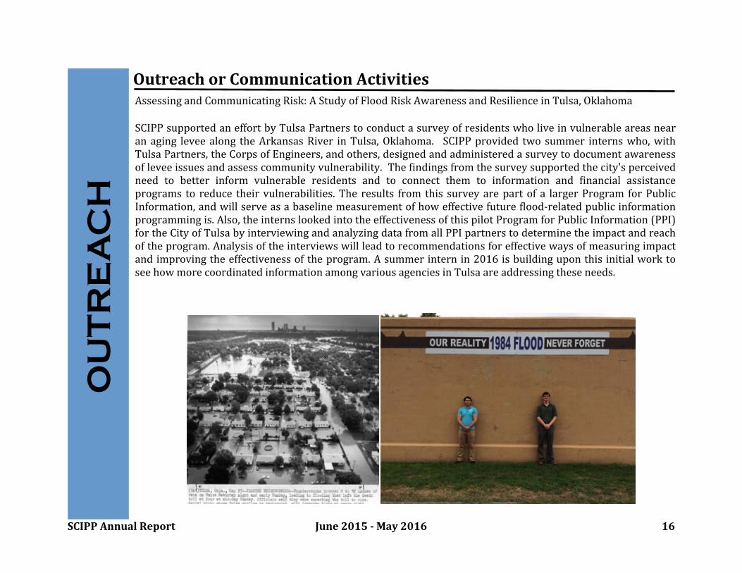
OutreachorCommunicationActivitiesAssessingandCommunicatingRisk:AStudyofFloodRiskAwarenessandResilienceinTulsa,Oklahoma
SCIPPsupportedaneffortbyTulsaPartnerstoconductasurveyofresidentswho liveinvulnerableareasnearanaging leveealongtheArkansasRiverinTulsa, Oklahoma. SCIPPprovidedtwo summer internswho, withTulsaPartners, theCorpsofEngineers,andothers,designedandadministeredasurveytodocumentawarenessofleveeissuesandassesscommunityvulnerability. TheEindingsfromthesurveysupportedthecity'sperceivedneed to better inform vulnerable residents and to connect them to information and Einancial assistanceprograms to reduce theirvulnerabilities. The results from thissurvey are partof a largerProgram forPublicInformation,andwill serveasabaselinemeasurementofhoweffectivefutureElood-relatedpublic informationprogrammingis.Also,theinternslookedintotheeffectivenessofthispilotProgramforPublicInformation(PPI)fortheCityofTulsabyinterviewingandanalyzingdatafromallPPIpartnerstodeterminetheimpactandreachoftheprogram.Analysisoftheinterviewswillleadtorecommendationsforeffectivewaysofmeasuringimpactandimprovingtheeffectivenessoftheprogram.Asummerinternin2016isbuildinguponthisinitialworktoseehowmorecoordinatedinformationamongvariousagenciesinTulsaareaddressingtheseneeds.
OU
TR
EA
CH

SCIPPAnnualReport June2015-May2016 17
Texas and Oklahoma Climate Extremes Workshop: Learning from the Recent Four-Year Drought and SpringFloodingEvents: SCIPPservedasapresenter,facilitatorandnotetakeratthisevent.AsaSouthernPlainsDroughtEarlyWarning System activitywith the goalof improving disaster reduction andbuilding capacityforbetterdecision-makingrelating to drought planning andmitigation, theworkshop included presentations anddiscussions about the shift fromextremedroughttobloodsin2015andtacticstheparticipants’agenciesusedtomanagethoseevents.Participantsincludedrepresentatives from the broad areas of watermanagement, public safety, infrastructure, and environment. Discussiontopicsincludedmonitoring tools,agencycoordination,unexpectedimpacts, successes, andpublicoutreach. Following theworkshop, SCIPP produced a summary report that revealed a numerous amount of opportunities suggested based ondiscussions, suchasthe increasedinterest in collaboration across agencies and borders, the establishmentof a monthlyclimate webinar, and the addition of a “train the trainer” workshop geared to assist the participants in bringing theinformationbacktotheirownagencies.
TheNOAA/SARPThresholdsProject:Aspartof theproject’ssecondyear,Adaptation InternationalandSCIPPhosted2workshopsinSanAngelothisyear(JanuaryandApril).SCIPPservedastheclimateresourceandduringthe birstworkshopweprovidedthecitywitha“ClimateofSanAngelo”documentthataccompaniedaninteractivepresentationdiscussingthecity’sviewofthesehazards.Wethendiscussedthedebinitionofa thresholdandfound the quantibiable thresholdsforthevarious stakeholdersin the room.The secondworkshop used the projectionsof these thresholds(calculatedbyATMOSResearch) to brainstorm resilience actions for the city. A very engaged and productive session led to the decision toimplementarainwatercapturesystem,designedtocreatepublicawarenessofwaterconservationandtoreducetheCity’smunicipalwateruse.ThelessonsfromthisprojectareveryvaluableforSCIPPandthe“thresholds”conceptisprovingtobeahottopicamongstnewpotentialstakeholders.Additionally,the“Climateof”documentsarehighlyvaluableinprovidingahistoricalcontextofthehazardsinstakeholder’scommunitiesandSCIPPplansondevelopingmorethroughoutourregion.BelowarepicturesfromtheworkshopinSanAngelo.
OU
TR
EA
CH
SCIPPAnnualReport June2015-May2016 18
KeyPublications1)Shafer, M., D. Brown, and C. McNutt, 2016. Managing the 2011 drought: a climate services partnership, inClimateinContext:ScienceandSocietyPartneringforAdaptation,A.Parris,G.GarEin,K.Dow,R.MeyerandS.L.Close,eds.,AmericanGeophysicalUnion.
Understandingthelong-lastingeffectsandhelpingpeoplemanageduringdroughthasbeenagrowingareaofresearchandservices. Information Dlowbetween operational forecasters, the monitoring community, and those affected by drought werestudiedinthecontextofanintensemulti-yeardroughtacrosstheSouthernPlains.Thebookchapterexplorestheuniqueaspectsofeachpartner,whyallpartnerswerenecessaryforeffectivemanagement,howtheyinformedeachother,andwhatprovidersandscientistslearnedfrom these interactions. Thesepartnershipssupporteddiscussionsandinteractionsthathelpedtobuildtrustand receptivity of drought information and provided multiple points-of-entry into the collective drought monitoring andmanagementsystem.2)Simpson, C. F., L. Dilling, K. Dow, K. L. Lackstrom,M. C. Lemos, andR. E. Riley, 2016: Assessing needs anddecisioncontexts:RISAapproachestoengagementresearch.ClimateinContext:ScienceandSocietyPartneringforAdaptation,A.S.Parris,G.M.GarEin,K.Dow,R.Meyer,andS.L.Close,Eds.,WileyandSons,3-26. In this chapter, we discussthe approachesusedbyfourRISA teams tounderstandthe contextwithinwhich decision-makersoperateanduse information.Someof theapproachesareformalandarebasedonsocialscienceresearchmethods,andothersaremoreinformalbasedonlong-termengagementwithstakeholders.
3)Needham,H.F.,B.D.Keim,andD.Sathiaraj,2015: AReviewofTropicalCyclone-GeneratedStormSurges:GlobalDataSources,ObservationsandImpacts.ReviewsofGeophysics53(2):545-591. Tropicalcyclone-generatedstormsurgesareamong theworld'smostdeadlyanddestructivenaturalhazards.Thispaperprovidesthe Dirstcomprehensiveglobalreviewof tropicalstorm surgedatasources,observationsand impacts,while archivingdatainSURGEDAT,aglobaldatabase.
4)Ban,R.J., C.M. Bitz,A.Brown, E.Chassignet, J.A. Dutton, R.Hallberg,A.Kamrath,D. Kleist,P.F.J.Lermusiaux, H.Lin, L.Myeers, J. Pullen, S. Sandgathe,M. Shafer, D.Waliser,C.Zhang,E.Dunlea, C. Mengelt, A.Macaldy, 2016.Next GenerationEarth SystemPrediction: Strategies for Subseasonal to Seasonal Forecasts, Washington DC:NationalAcademiesofSciences
ExtendingweatherandoceanforecaststopredictEarthsystemconditionsweekstomonthsinadvancewillhelpdecisionmakersplan ahead to save lives, protect property, and increase economic vitality. The reportpresentsa research agenda thatemphasizesincreasing theskillof forecasts;expandingthe breadthof forecastmodelandvariables;improving thepredictionofextreme and disruptive events; and bringing researchers anddecision makers togetherto develop more actionable forecasts.Decisionmakersare central to thisprocess, andimprovingunderstanding of theirdecision-making contexts andincorporatingsocialandbehavioralsciencetounderstandhowseasonaltosubseasonalforecastsarebeingusedareanessentialelementofthisresearchagenda.
PU
BL
ICA
TIO
NS

SCIPPAnnualReport June2015-May2016 19
NarrativeExamples
5)Trepanier, J.C.,M.J.Roberts,andB.D.Keim,2015:TrendsandSpatialVariabilityinDrySpellsAcrosstheSouth-CentralUnitedStates. JournalofAppliedMeteorologyandClimatology54:2261-2272. DOI:http://dx.doi.org/10.1175/JAMC-D-14-0319.1
Annualaverage andmaximumspellswithnoprecipitationinthesouthernUnitedStatesareanalyzed. Inthisstudy,dryspells are deDined as consecutive days with no measurable rainfall. The strongest geographical indicator for the number ofconsecutivedrydaysacrossthisregionwaslongitude.Dryspellstendtohavehad longerdurationsatthewesternmoststationsbecauseofnaturalclimatologicalcontrols.
NA
RR
AT
IVE
ConstructionoftheIke-DikeinHouston-Galveston
SCIPP personnel are engaged in the research and discussionabout the construction of the “Ike Dike,” which is a surgebarrier that may be constructed to protect the Galveston-Houstonregionfromstorm surge. The impetus fortherecentdiscussiontobuildasurgebarrierwasthedevastatingbloodingthatstemmedfromHurricaneIkein2008(Figure1),alongwiththe long-term historyof local catastrophic surge events. Ikeproduceda17.5 footstorm surge along the BolivarPeninsula,which ranksas the 9th largest surge event along the U.S. GulfCoast since 1880, andthe eventdevastatedGalveston and thesurrounding region, much like the Galveston Hurricanes of1900 and1915,among others. SCIPP isusing the SURGEDATdatabasetoassesstherangeofhistoricalsurgesintheareaandthen determine the 500-year, 100-year, and 50-year surgeevents to be used forassessment and planning. In addition,SCIPP personnel tooka team from the SSPEED (Severe StormPrediction, Education, and Evacuation fromDisasters) Centerfrom Rice University - who are also heavily involved in thediscussion about the Ike-Dike - on a Katrina tour of NewOrleans to assess modern surge mitigation measures thatwouldberelevanttotheIkeDike.Earlyestimatesarethatthe“Ike-Dike”surgewallwillcostbetween$4-6billionandwilltakeabout2yearstobuild.TherearecompetingproposalstotheIke-Dikethatwouldprovideahigherlevelofprotectionatalowercost,butwouldprotectasmallerregion.
Figure1.SurgedamageinGilchrist,TexasontheBolivarPeninsulaafterHurricaneIkein2008.TheimagewastakenbyJocelynAugusitnoofFEMAandisinthepublicdomain.Itcanbeobtainedathttps://en.wikipedia.org/wiki/Hurricane_Ike#/media/File:Hurricane_Ike_Gilchrist_damage_edit.jpg.

SCIPPAnnualReport June2015-May2016 20
CopingWithDroughtDroughthasbeen a predominant theme of SCIPP in recentyears, but gave wayasattentionturned toward bloods. Thedroughtof 2011-2015 endedabruptlyasrecord blooding envelopedmuchof TexasandOklahoma.Thisopenedup newavenuesofdiscussionandresearchconcerning thenature ofhydrologicextremes.ThisbitswellwithinSCIPP’sthemeofintegratedmulti-hazardplanning.Eventhoughattentionshiftedfromdrought,droughtremainedacorestrengthofSCIPP.ActivitiesundertakenduringthispastyeararedetailedaccordingtotheworkinggroupstructureofNIDIS.ObservationsandMonitoringSCIPP contributedtoimprovedmonitoring throughlaunchingthenewWaterReservoir Data Visualization Tool (http://reservoir.srcc.lsu.edu/; see p. 8),conductingthreemoreFieldPhotosWeekends,anddevelopingnewtoolsforreportingimpacts.Thereservoirdatatoolwasthedirectresultofaneedidentibiedin2011-2012through interactions with stakeholders in drought forums and webinars.Initial funding for the project was provided by the National Centers forEnvironmental Information through the Southern Regional Climate CenterandNOAARegionalClimateServicesDirector. SCIPPisnowmaintainingandexpandingtheavailabledataaspartofitssuiteoftools.The Field PhotosProjectwasbegun in 2012 in partnership withCoCoRaHSand the Earth Observation and Modeling Facility (EOMF; University ofOklahoma). Three timesperyear–PresidentsDay,MemorialDay,andLaborDay,CoCoRaHSobserversandothercitizenscientistsareaskedtotakephotosof theirlandscapeandsubmitthemtotheEOMF Field Photosarchive. A total of796photoswere received anduploaded. These photosare being characterizedaccordingtodroughtintensityinanotherprojectfundedbyNOAASectoralApplicationsResearchProgram(SARP).SCIPPworkedwithcolleaguesatWeatherDecisionsTechnologies(WDT)andtheNationalDroughtMitigationCenteronadroughtappformobilephonesbeingdevelopedbyWDT,onaseparateprojectfundedbyNIDIS. Inaddition toprovidingaccess to commonly-used drought products, the app will enable “condition reporting” for different types of impacts(pastures,cropland,lawn&garden,waterresources,wildbire,andsoilmoisture).Forecasts&PredictionsPredicting summertemperaturesareadifbicultchallenge in theSouthern Plains,yetonewhich iscriticaltoanticipatingdrought-relatedimpacts.The region issusceptibletoblashdroughtscenarios;consequentlybeingabletoanticipatehightemperatures in subsequent months could give farmers and ranchersmore time to prepare. To address this, StevenQuiringandZacharyLeasorexaminedspatialandtemporalcorrelationsintemperaturesbetweensubsequentmonths(seep.14).Theresultsdidindeedshowsomelevelofpredictabilityinthesummermonths.
CO
PIN
G W
ITH
DR
OU
GH
T
FieldPhotossubmittedbyRRichterSep2015
The Sou
SCIPPAnnualReport June2015-May2016 21
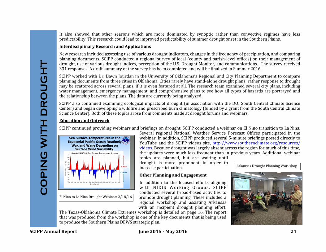
It also showed that other seasons which are more dominated by synoptic rather than convective regimes have lesspredictability.ThisresearchcouldleadtoimprovedpredictabilityofsummerdroughtonsetintheSouthernPlains.InterdisciplinaryResearchandApplicationsNewresearchincludedassessinguseofvariousdroughtindicators,changesinthefrequencyofprecipitation,andcomparingplanningdocuments.SCIPP conducteda regionalsurveyof local (countyandparish-levelofbices)on theirmanagementofdrought,useofvariousdroughtindices,perceptionoftheU.S.DroughtMonitor, andcommunications. Thesurveyreceived331responses.AdraftsummaryofthesurveyhasbeencompletedandwillbebinalizedinSummer2016.SCIPPworkedwithDr.DawnJourdanin theUniversityof Oklahoma’sRegionalandCityPlanningDepartmenttocompareplanningdocumentsfromthreecitiesinOklahoma.Citiesrarelyhavestand-alonedroughtplans;ratherresponsetodroughtmaybescatteredacrossseveralplans,if itisevenfeaturedatall.The research teamexaminedseveralcityplans,includingwatermanagement, emergencymanagement, and comprehensiveplanstosee howalltypesofhazardsareportrayedandtherelationshipbetweentheplans.Thedataarecurrentlybeinganalyzed.SCIPP also continued examining ecological impactsof drought (inassociationwith theDOISouthCentralClimate ScienceCenter)andbegandevelopingawildbireandprescribedburnclimatology(fundedbyagrantfromtheSouthCentralClimateScienceCenter).Bothofthesetopicsarosefromcommentsmadeatdroughtforumsandwebinars.EducationandOutreachSCIPPcontinuedprovidingwebinarsandbriebingsondrought.SCIPPconductedawebinaronElNinotransitiontoLaNina.
Several regional National Weather Service Forecast Ofbices participated in thewebinar.Inaddition,SCIPPproducedseveral5-minutebriebingsposteddirectlytoYouTube and the SCIPP videos site, http://www.southernclimate.org/resources/videos.Becausedroughtwaslargelyabsentacrosstheregionformuchofthistime,the updatesweremuch lessfrequent than inpreviousyears. Additionalwebinartopics are planned, but are waiting untildrought is more prominent in order toincreaseparticipation.OtherPlanningandEngagementIn addition to the focused efforts aligningwith NIDIS Working Groups, SCIPPconducted several broad-based activities topromote droughtplanning.These includedaregional workshop and assisting Arkansaswith an incipient drought planning effort.
TheTexas-OklahomaClimate Extremesworkshop isdetailedonpage 16. ThereportthatwasproducedfromtheworkshopisoneofthekeydocumentsthatisbeingusedtoproducetheSouthernPlainsDEWSstrategicplan.
CO
PIN
G W
ITH
DR
OU
GH
T
ArkansasDroughtPlanningWorkshop
ElNinotoLaNinaDroughtWebinar:2/18/16
SCIPPAnnualReport June2015-May2016 22
Appendix:Publications
*Allard, J.M., J.V.Clarke, andB.D.Keim, InPress: SpatialandTemporalPatternsofInSituSeaSurfaceTemperatureswithintheGulfofMexico(GoM),1901–2010.AmericanJournalofClimateChange.*Allard, J.M., C.R. Thompson, andB.D. Keim, 2015: How Robust is the Pre-1931 National Climatic Data Center - ClimateDivisional Dataset? Examples from Georgia and Louisiana. Theoretical and Applied Climatology 120(1-2):323-330, DOI10.1007/s007.*Ford, T.W., D. B.McRoberts,S.M.Quiring, andR. Hall, 2015: On theutility ofinsitusoilmoistureobservations for ElashdroughtearlywarninginOklahoma,USA.GeophysicalResearchLetters,42:9790–9798.doi:10.1002/2015GL066600*Ford, T. W., S. M. Quiring, O. W. Frauenfeld, and A. D. Rapp, 2015: Synoptic conditions related to land-atmosphereinteractionsandunorganizedconvectioninOklahoma. JournalofGeophysical Research-Atmospheres,120:11,519–11,535.doi:10.1002/2015JD023975*Gustafson,D.,M.Hayes,E. Janssen,D. Lobell, S. Long,G.Nelson,H. Pakrasi,P.Raven,G. P. Robertson,R. Robertson, andD.Wuebbles, 2015: Pharaoh’s dream revisited: an integrated U.S. Midwest Eield research network for climate adaptation.BioScience,DOI:10.1093/biosci/biv164.*Hamilton, L.C, J. Hartter, B.D. Keim, A.E. Boag, M.W. Palace, F.R. Stevens, M.J. Ducey, In Press: WildEire, Climate andPerceptionsinNortheastOregon.RegionalEnvironmentalChange.*Kos,L.,2016:WorkshopSummaryReportfortheTexasandOklahomaClimateExtremesWorkshopinOctober2015.*Kuster, E., C. Lunday, andR.A.McPherson, 2015: A comparisonofNorthAmericanRegionalClimate ChangeAssessmentProgram(NARCCAP)outputandOklahomaMesonetobservations.TheGeographicalBulletin,56,102-106.*Lewis, A.B., and B.D. Keim, 2015: History and Applications of Manual Synoptic ClassiEication. Earth Systems andEnvironmentalSciences.ReferenceModule.DOI:http://dx.doi.org/10.1016/B978-0-12-409548-9.09521-X1*QuiringS.M., FordT.W.,Wang J. K.,KhongA., Harris E., LindgrenT.,GoldbergD.W., Li Z., InPress:NorthAmericanSoilMoisture Database: Development andApplications. Bulletin of theAmericanMeteorological Society. doi: 10.1175/BAMS-D-13-00263.1*Peppler,R.A.,K.E.,Kehoe,J.W.Monroe,A.K.Theisen,andS.T.Moore,2016:“TheARMDataQualityProgram.”Chapter12in,TheAtmosphericRadiationMeasurement(ARM)Program.MeteorologicalMonographs,AmericanMeteorologicalSociety,inpress.*Shankman,D.,andB.D.Keim,2016:FloodRiskForecastforChina’sPoyangLakeRegion.PhysicalGeography37(1):88-91.*Sisterson,D.L.,R.A.Peppler, T. S.Cress,P. J. Lamb, andD. D.Turner, 2016: “TheARMSouthernGreat Plains (SGP)Site.”Chapter 6 in, The Atmospheric Radiation Measurement (ARM) Program. Meteorological Monographs, AmericanMeteorologicalSociety,inpress.*Shao,W., S. Xian,B.Keim,K. Goidel,N. Lin, InPress:UnderstandingPerceptionsofChangingHurricaneStrengthAlongtheU.S.GulfCoast.InternationalJournalofClimatology.

SCIPPAnnualReport June2015-May2016 23
Appendix:Publications
*Shao,W., J.C.Garand,B.D.Keim, and L.C. Hamilton, InPress: Science, Scientists, andLocalWeather:UnderstandingMassPerceptionsofGlobalWarming.SocialScienceQuarterly.*Tonn,G.,Guikema,S., Ferreira,C.andS.M.Quiring, InPress:Alongitudinalanalysisofthedriversofpoweroutagesduringhurricanes:AcasestudywithHurricaneIsaac.RiskAnalysis.DOI:10.1111/risa.12552*Trepanier, J.C., M.J. Roberts, andB.D.Keim, 2015: Trends and Spatial Variability in Dry Spells Across the South-CentralUnited States. Journal of Applied Meteorology and Climatology 54:2261-2272. DOI: http://dx.doi.org/10.1175/JAMC-D-14-0319.1*XianwuXue, KeZhang,YangHong, JonathanJ. Gourley, WayneKellogg,ReneeA.McPherson, ZhanmingWan,BarneyN.Austin, 2015: NewMultisiteCascadingCalibrationApproach for HydrologicalModels: Case Study inthe RedRiverBasinUsingtheVICModel.JournalofHydrologicEngineering,05015019.doi:10.1061/(ASCE)HE.1943-5584.0001282.PDF*Xue,X.,K.Zhang,Y.Hong,J.J.Gourley,W.Kellogg,R.A.McPherson,Z.WanandB.N.Austin,2015:Newmultisitecascadingcalibration approach for hydrological models: Case study in theRedRiverBasinusing the VICmodel. J. of Hydrol. Eng.,10.1061/(ASCE)HE.1943-5584.0001282,05015019.*You, J., K.G. Hubbard,M.Shulski,M. Svoboda,M.Hayes, 2015:Developmentofalong-term(1884-2006)seriallycompletedataset of U.S. temperatures and precipitation for climate services. Journal Service Climatology, 8(1): https://www.stateclimate.org/sites/default/Eiles/upload/pdf/journal-articles/2015_You_et_al_2015.pdf.*Zhang,K., J.S.Kimball, R.R.Nemani, S.W. Running, Y.Hong, J.J. Gourley, andZ. Yu, 2015: VegetationGreening andClimateChangePromoteMultidecadal RisesofGlobal LandEvapotranspiration. NatureScientiEicReports,5,15956. doi:10.1038/srep15956.*Zhanming Wan, Ke Zhang, Xianwu Xue, Zhen Hong, Yang Hong, Jonathan Gourley, 2015: Water Balance Based ActualEvapotranspiration Reconstruction fromGround and Satellite Observations Over the Conterminous United States.WaterResourcesResearch,51,6485–6499.doi:10.1002/2015WR017311.PDF.