Embed Size (px)
Citation preview

La Niña Impacts and Outlook
Southern Region | La Nina Impacts and Outlooks | November 2017
Southern RegionNovember 2017
A La Niña develops when equatorial Pacific sea surface temperatures are cooler than normal for an extended period of time. La Niña episodes affect the placement of the jet stream throughout North America, which has a major impact on the weather patterns throughout the United States.
Each La Niña event is different in terms of strength, duration, and direct impacts. The typical La Niña pattern (image on the left) results in a northward shift on the polar jet stream in the eastern Pacific and a southward shift in the Lower 48 United States. This takes the jet stream into the Gulf of Alaska, through the central United States, and across the northeastern United States. This setup brings cooler than normal air into the northern United States and warmer than normal air throughout the south and southeastern United States. Wetter than normal conditions are usually found in the Pacific Northwest and midwestern United States with drier than normal conditions extending from Southern California to South Carolina.
During a La Niña event, chances are the Southern Region will experience warmer than normal temperatures. These chances increase from north to south. Much of the Southern Region can expect drier than normal conditions as well, also with increasing chance from north to south; exceptions are northern Mississippi, northern Arkansas, and Tennessee.
La Niña in Winter
Typical La Niña Winter Pattern
Winter OutlookLa Niña Evolution
The current outlooks issued by the Climate Prediction Center for winter align with a typical winter La Niña. During a typical La Niña winter, the Southern Region experiences warmer than normal temperatures and drier than normal conditions; however, the exact effects can depend on the strength of the La Niña episode.
According to the Climate Prediction Center, winter (December through February) temperatures for the Southern Region have a greater chance to be above normal in all six states, with the greatest chances in Texas, southern Louisiana, and extreme southern Mississippi.
For most of the region, chances are that precipitation amounts will be below normal this winter. The greatest chance for below normal precipitation is in southern Texas, southern Louisiana, and southern Mississippi. Tennessee has a slight chance to receive above normal precipitation. Northern Oklahoma and northern Arkansas have equal chances of being drier or wetter than normal this winter.
Temperature and Precipitation Outlook
During October, sea surfaces temperatures in the central and eastern Pacific were below normal. Weekly Niño indices were variable with values averaging around −0.5°C in the Niño-3.4 and Niño-3 regions. Also, sub-surface temperatures continued to be below average. That, along with cooler than normal sea surface temperatures and weekly Niño indices around −0.5°C, reflect the onset of La Niña conditions.
La Niña is favored to occur in the winter by many models, including the IRI/CPC plume model and the North American Multimodel Ensemble (NMME). Forecasters agree that La Niña conditions are expected to continue throughout the winter until February–April (around 65–75% chance).
Typical winter temperature and precipitation impacts during a La Niña event in the United States. This is a compiled average of past La Niña episodes, and every La Niña episode can be different. For more information please visit: https://www.ncei.noaa.gov/news/la-nina-outlook-impacts -winter-2016-17
• EC means equal chances• A means above normal
A) Temperature B) Precipitation
Average sea surface temperature (SST) anomalies (°C) for the week of November 1, 2017. Anomalies are computed with respect to the 1981–2010 base period weekly means.
• N means normal• B means below normal
Contact: Rudy Bartels ([email protected]), Southern Regional Climate Center
Southern Region | La Niña Impacts and Outlooks | November 2017
Climate Impacts
Gulf Region Partners
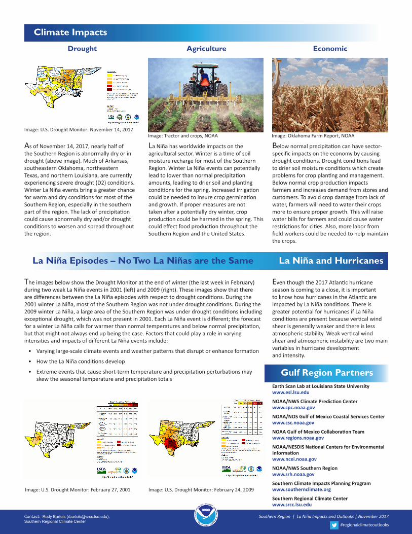
The images below show the Drought Monitor at the end of winter (the last week in February) during two weak La Niña events in 2001 (left) and 2009 (right). These images show that there are differences between the La Niña episodes with respect to drought conditions. During the 2001 winter La Niña, most of the Southern Region was not under drought conditions. During the 2009 winter La Niña, a large area of the Southern Region was under drought conditions including exceptional drought, which was not present in 2001. Each La Niña event is different; the forecast for a winter La Niña calls for warmer than normal temperatures and below normal precipitation, but that might not always end up being the case. Factors that could play a role in varying intensities and impacts of different La Niña events include:
• Varying large-scale climate events and weather patterns that disrupt or enhance formation
• How the La Niña conditions develop
• Extreme events that cause short-term temperature and precipitation perturbations may skew the seasonal temperature and precipitation totals
Drought Agriculture Economic
As of November 14, 2017, nearly half of the Southern Region is abnormally dry or in drought (above image). Much of Arkansas, southeastern Oklahoma, northeastern Texas, and northern Louisiana, are currently experiencing severe drought (D2) conditions. Winter La Niña events bring a greater chance for warm and dry conditions for most of the Southern Region, especially in the southern part of the region. The lack of precipitation could cause abnormally dry and/or drought conditions to worsen and spread throughout the region.
Image: U.S. Drought Monitor: November 14, 2017
Image: U.S. Drought Monitor: February 27, 2001 Image: U.S. Drought Monitor: February 24, 2009
Image: Tractor and crops, NOAA Image: Oklahoma Farm Report, NOAA
La Niña has worldwide impacts on the agricultural sector. Winter is a time of soil moisture recharge for most of the Southern Region. Winter La Niña events can potentially lead to lower than normal precipitation amounts, leading to drier soil and planting conditions for the spring. Increased irrigation could be needed to insure crop germination and growth. If proper measures are not taken after a potentially dry winter, crop production could be harmed in the spring. This could effect food production throughout the Southern Region and the United States.
Below normal precipitation can have sector-specific impacts on the economy by causing drought conditions. Drought conditions lead to drier soil moisture conditions which create problems for crop planting and management. Below normal crop production impacts farmers and increases demand from stores and customers. To avoid crop damage from lack of water, farmers will need to water their crops more to ensure proper growth. This will raise water bills for farmers and could cause water restrictions for cities. Also, more labor from field workers could be needed to help maintain the crops.
Even though the 2017 Atlantic hurricane season is coming to a close, it is important to know how hurricanes in the Atlantic are impacted by La Niña conditions. There is greater potential for hurricanes if La Niña conditions are present because vertical wind shear is generally weaker and there is less atmospheric stability. Weak vertical wind shear and atmospheric instability are two main variables in hurricane development and intensity.
La Niña Episodes – No Two La Niñas are the Same
Contact: Rudy Bartels ([email protected]), Southern Regional Climate Center
#regionalclimateoutlooks
La Niña and Hurricanes
Earth Scan Lab at Louisiana State University www.esl.lsu.edu
NOAA/NWS Climate Prediction Center www.cpc.noaa.gov
NOAA/NOS Gulf of Mexico Coastal Services Center www.csc.noaa.gov
NOAA Gulf of Mexico Collaboration Team www.regions.noaa.gov
NOAA/NESDIS National Centers for Environmental Information www.ncei.noaa.gov
NOAA/NWS Southern Region www.srh.noaa.gov
Southern Climate Impacts Planning Program www.southernclimate.org
Southern Regional Climate Center www.srcc.lsu.edu