Embed Size (px)
Citation preview
Land Description for
South ½ Tsimpsean Indian Reserve No. 2 Metlakatla
British Columbia
Prepared under First Nations Land Management (S.C. 1999, C.24)
Prepared on: September 29th, 2015
September 29, 2015
Page 2 of 5
Table of Contents Section 1 – Introduction
Section 2 – Land Description
Section 3 – Administrative Sketch and Image Overlay
Section 4 – Additional Items
September 29, 2015
Page 3 of 5
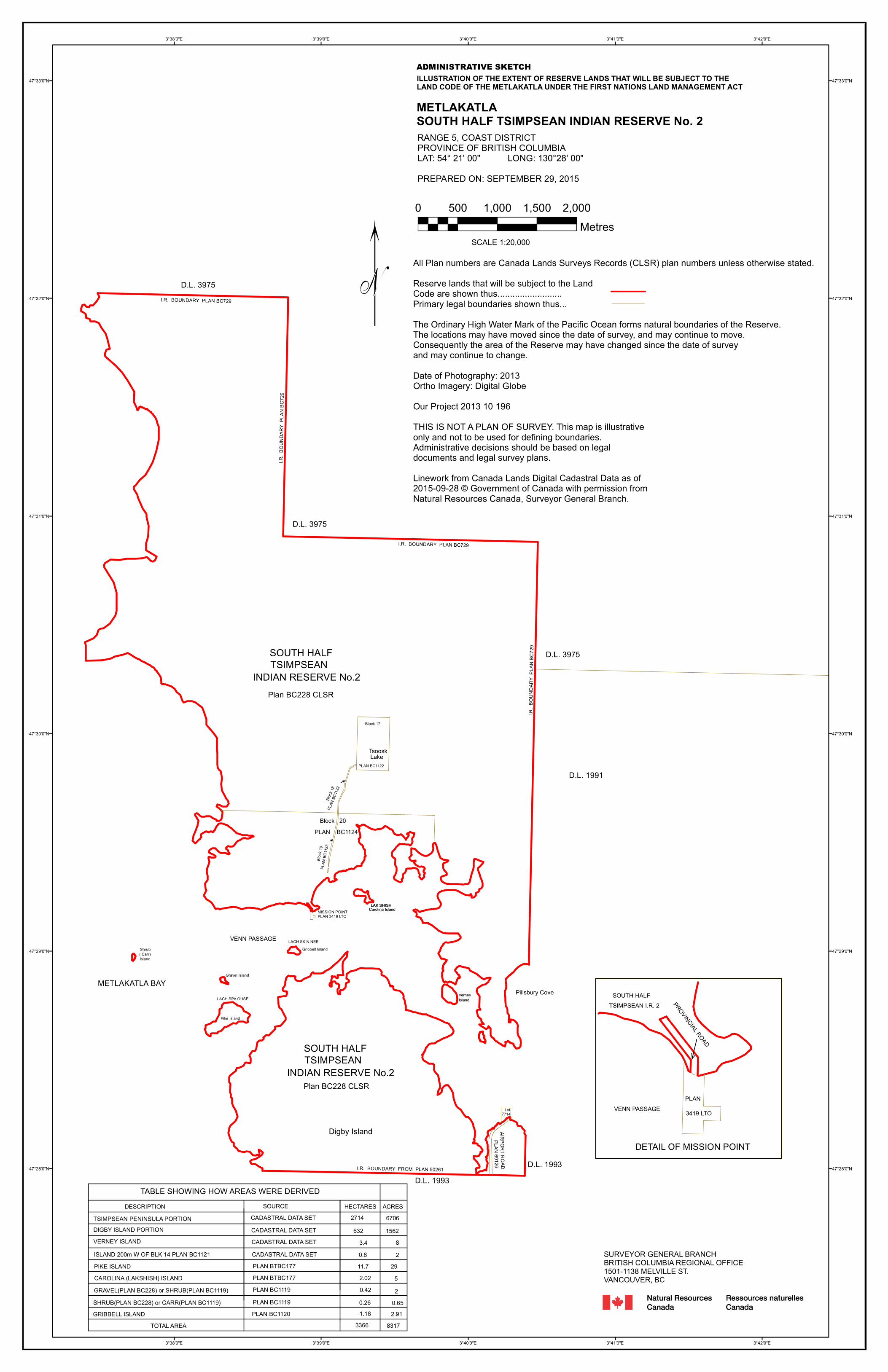
2. Land Description South ½ Tsimpsean Indian Reserve No. 2 Land Description of the Extent of Reserve Lands that will be subject to the Land Code of the Metlakatla under the First Nations Land Management Act.
Reserve Lands within the Province of British Columbia, Canada In Coast District, more particularly described as:
All of South ½ of Tsimpsean Indian Reserve No. 2 shown on Plan BC228 and Parcels 1 and 2 shown on Provincial Plan 3124 (recorded in the Canada Lands Surveys Records as FB 32424). Save and except all those portions of South ½ Tsimpsean Indian Reserve No. 2 more particularly described as: Firstly: 13,519 acres more or less, described by metes and bounds on: Kaien Island, Digby Island, Lak-anian Island, Lak-wilgiapsh Island and Islets numbered 1 through 8 on Plan BC228 CLSR and portion of the mainland reservation, bordering on Tuck Inlet and Venn Passage. Total Lands containing by admeasurement 3,366 hectares, (8,318 acres) more or less (see Note 5).
The above described Reserve Lands are subject to: The rights and reservations contained in provincial Order in Council 1938-1036, registered in the Indian Lands Registry as No 8042, transferring the land from the Province of British Columbia to Canada, as amended by provincial Order in Council 1969-1555, registered in the Indian Lands Registry as No 4111-118. Notes
1. The Administrative Sketch in Section 3 illustrates this land description. 2. Refer to the pertinent survey plans and instruments for authoritative boundary definition
and nature of the interest in the land. 3. The extent of Oil and Gas Rights are not dealt with in this description. 4. Mines and minerals are managed according to the British Columbia Indian Reserves
Mineral Resources Act 1943-44 c.19. 5. The area was derived from a combination of legal survey plans and the Surveyor General
Branch’s digital data set and is subject to any errors/omissions inherent within the data and is not considered conclusive but is reflective of the best available information.
September 29, 2015
Page 4 of 5
3. Administrative Sketch and Image Overlay (Attached)
Block
18PL
AN BC
1122
Block 20
INDIAN RESERVE No.2
Block 17
PLAN BC1122
PLAN BC1124
Island
Digby Island
VENN PASSAGE
Pillsbury CoveVerney
Pike Island
Gribbell Island
Carolina Island
Gravel Island
( Carr)
TSIMPSEAN
LACH SPA OUSE
LACH SKIN NEE
LAK SHISH
METLAKATLA BAY
Tsoosk
I.R. BOUNDARY FROM PLAN 50261
PLAN 69126
I.R. BOUNDARY PLAN BC729
D.L. 1991
D.L. 3975
D.L. 3975
D.L. 3975I.R. BOUNDARY PLAN BC729
I.R. B
OUND
ARY
PLAN
BC7
29
I.R. B
OUND
ARY
PLAN
BC7
29SOUTH HALF
INDIAN RESERVE No.2TSIMPSEANSOUTH HALF
Island
Lake
Block
19PL
AN BC
1123
D.L. 1993D.L. 1993
7714Lot
Carolina IslandLAK SHISH
MISSION POINTPLAN 3419 LTO
Shrub
Plan BC228 CLSR
Plan BC228 CLSR
DETAIL OF MISSION POINT
PLAN
PROVINCIAL ROAD
3419 LTO
AIRPORT ROAD
TABLE SHOWING HOW AREAS WERE DERIVED
TSIMPSEAN PENINSULA PORTIONDIGBY ISLAND PORTIONVERNEY ISLANDISLAND 200m W OF BLK 14 PLAN BC1121
SOURCE HECTARES
PIKE ISLAND CAROLINA (LAKSHISH) ISLANDGRAVEL(PLAN BC228) or SHRUB(PLAN BC1119)SHRUB(PLAN BC228) or CARR(PLAN BC1119)GRIBBELL ISLAND
DESCRIPTION
PLAN BC1120
PLAN BTBC177
PLAN BC1119PLAN BC1119
PLAN BTBC177
CADASTRAL DATA SETCADASTRAL DATA SETCADASTRAL DATA SETCADASTRAL DATA SET
6322714
3.40.811.72.020.420.261.18
TOTAL AREA 3366
ACRES67061562
82
2952
0.652.91
8317
VENN PASSAGE
SOUTH HALFTSIMPSEAN I.R. 2
3°42'0"E
3°42'0"E
3°41'0"E
3°41'0"E
3°40'0"E
3°40'0"E
3°39'0"E
3°39'0"E
3°38'0"E
3°38'0"E
47°33'0"N 47°33'0"N
47°32'0"N 47°32'0"N
47°31'0"N 47°31'0"N
47°30'0"N 47°30'0"N
47°29'0"N 47°29'0"N
47°28'0"N 47°28'0"N
ILLUSTRATION OF THE EXTENT OF RESERVE LANDS THAT WILL BE SUBJECT TO THE LAND CODE OF THE METLAKATLA UNDER THE FIRST NATIONS LAND MANAGEMENT ACT
METLAKATLASOUTH HALF TSIMPSEAN INDIAN RESERVE No. 2RANGE 5, COAST DISTRICTPROVINCE OF BRITISH COLUMBIALAT: 54° 21' 00" LONG: 130°28' 00"PREPARED ON: SEPTEMBER 29, 2015
All Plan numbers are Canada Lands Surveys Records (CLSR) plan numbers unless otherwise stated.Reserve lands that will be subject to the LandCode are shown thus..........................Primary legal boundaries shown thus...The Ordinary High Water Mark of the Pacific Ocean forms natural boundaries of the Reserve.The locations may have moved since the date of survey, and may continue to move. Consequently the area of the Reserve may have changed since the date of surveyand may continue to change.Date of Photography: 2013Ortho Imagery: Digital GlobeOur Project 2013 10 196THIS IS NOT A PLAN OF SURVEY. This map is illustrativeonly and not to be used for defining boundaries.Administrative decisions should be based on legal documents and legal survey plans.Linework from Canada Lands Digital Cadastral Data as of 2015-09-28 © Government of Canada with permission fromNatural Resources Canada, Surveyor General Branch.
SURVEYOR GENERAL BRANCHBRITISH COLUMBIA REGIONAL OFFICE1501-1138 MELVILLE ST.VANCOUVER, BC
0 500 1,000 1,500 2,000Metres
SCALE 1:20,000
"
ADMINISTRATIVE SKETCH

Bloc
k 18
PLAN
BC
1122
Block 20
INDIAN RESERVE No.2
Block 17
PLAN BC1122
PLAN BC1124
Island
Digby Island
VENN PASSAGE
Pillsbury CoveVerney
Pike Island
Gribbell Island
Carolina Island
Gravel Island
( Carr)
TSIMPSEAN
LACH SPA OUSE
LACH SKIN NEE
LAK SHISH
METLAKATLA BAY
Tsoosk
I.R. BOUNDARY FROM PLAN 50261
PLA
N 69126
I.R. BOUNDARY PLAN BC729
D.L. 1991
D.L. 3975
D.L. 3975
D.L. 3975
I.R. BOUNDARY PLAN BC729
I.R.
BO
UN
DA
RY
PLA
N B
C72
9
I.R.
BO
UN
DA
RY
PLA
N B
C72
9
SOUTH HALF
INDIAN RESERVE No.2TSIMPSEANSOUTH HALF
Island
Lake
Bloc
k 19
PLAN
BC
1123
D.L. 1993D.L. 1993
7714Lot
Carolina IslandLAK SHISH
MISSION POINTPLAN 3419 LTO
Shrub
Plan BC228 CLSR
Plan BC228 CLSR
AIR
PO
RT R
OA
D
Source: Esri, DigitalGlobe, GeoEye, i-cubed, Earthstar Geographics, CNES/Airbus DS, USDA, USGS, AEX, Getmapping, Aerogrid, IGN, IGP, swisstopo, and the GIS User Community
130°22'0"W
130°22'0"W
130°23'0"W
130°23'0"W
130°24'0"W
130°24'0"W
130°25'0"W
130°25'0"W
130°26'0"W
130°26'0"W
130°27'0"W
130°27'0"W
130°28'0"W
130°28'0"W
130°29'0"W
130°29'0"W
130°30'0"W
130°30'0"W
54°26'0"N
54°26'0"N
54°25'0"N
54°25'0"N
54°24'0"N
54°24'0"N
54°23'0"N
54°23'0"N
54°22'0"N
54°22'0"N
54°21'0"N
54°21'0"N
54°20'0"N
54°20'0"N
54°19'0"N
54°19'0"N
54°18'0"N
54°18'0"N
ORTHOPHOTO MAP
METLAKATLASOUTH HALF TSIMPSEAN INDIAN RESERVE No. 2RANGE 5, COAST DISTRICTPROVINCE OF BRITISH COLUMBIALAT: 54° 21' 00" LONG: 130°28' 00"PREPARED ON: SEPTEMBER 25, 2015
Reserve lands that will be subject to the LandCode are shown thus..........................Primary legal boundaries shown thus...Natural Boundaries are from Subdivision Plans or T.R.I.M. mapping.
Date of Photography: 2013Ortho Imagery: Digital Globe
Our Project 2013 10 196
THIS IS NOT A PLAN OF SURVEY. This map is illustrativeonly and not to be used for defining boundaries.Administrative decisions should be based on legal documents and legal survey plans.
Linework from Canada Lands Digital Cadastral Data as of 2015-09-23 © Government of Canada with permission fromNatural Resources Canada, Surveyor General Branch.SURVEYOR GENERAL BRANCHBRITISH COLUMBIA REGIONAL OFFICE1501-1138 MELVILLE ST.VANCOUVER, BC
0 500 1,000 1,500 2,000
MetresSCALE 1:20,000
"
September 29, 2015
Page 5 of 5
4. Additional Items (None)


![Further Greek-epigrams -[1981] -By d.l. Page](https://img.pdfslide.us/doc/110x75/55cf9979550346d0339d93b7/further-greek-epigrams-1981-by-dl-page.jpg)