Embed Size (px)
Citation preview
LEG 184
SOUTH CHINA SEA: EAST ASIAN MONSOON HISTORY
Modified by Pinxian Wang from Proposal 484-Rev Submitted by:
P. Wang, M. Sarnthein, L. Wang, Z. Jian, S. Xu, L. Zheng, Y. Luo, K. Xia, D. Xu, H-K.
Wong, T. Luedmann, and W. Kuhnt
Staff Scientist: Peter Blum Co-Chief Scientists: TBN
ABSTRACT
Leg 184 will core hemipelagic sediments in the South China Sea (SCS) to determine the evolution
and variability of the East Asian monsoon in the late Cenozoic. Of the six proposed drill sites (Fig.
1), five are located on the northeastern continental slope southeast of the Dongsha Islands, and one
is on the southern slope south of the Nansha Islands near the Sunda Shelf, with water depths
ranging from 625 m to 3190 m.
The main goal of Leg 184 is to improve our knowledge of the link between climate and tectonics.
Land-based studies in China and other parts of East Asia have developed a four-stage model of
monsoon evolution. The proposed drilling will calibrate the terrestrial record with that of the global
ocean. It is suggested that uplift of the Tibetan Plateau is responsible for both the late Cenozoic
global cooling and for the intensification of the Asian monsoon; therefore, a comparison between
records of monsoons, denudation rates, and climate cooling in the SCS will test this hypothesis.
Drilling of high-sedimentation-rate hemipelagic deposits in the SCS will provide the proxy records
for this test.
There are four major scientific objectives for the leg: (1) to obtain a continuous marine record of
East Asian climate history for the late Cenozoic and to compare the evolution of the East Asian
monsoon system with the South Asian or Indian monsoon system; (2) to examine the possible
relationship between the Tibetan Plateau uplift, monsoon evolution, and global cooling; (3) to
improve our understanding of the stability of the Western Pacific Warm Pool and the role of
seasonality changes in low-latitude marginal seas; and (4) to establish a detailed history of sea-level
changes for the SCS.
1
...Leg 184 - S. China Sea...
INTRODUCTION
The atmospheric circulation of the Asian monsoon system is of primary importance in our
understanding of global climate evolution. Despite the equally prominent significance of the two
subsystems (East Asian and South Asian or Indian), paleo-monsoon studies up to now are very
much dominated by those about the Indian monsoon. The East Asian paleo-monsoon studies have
been restricted mainly to land-based work, with monsoon information commonly being obtained
from the Chinese loess. Very little attention had been paid to the marine aspects of the East Asian
monsoon until recently. Extensive hydrocarbon exploration in China and its surrounding offshore
areas has accumulated tremendous amounts of geological data that are rich in Cenozoic paleo-
monsoon information. Together with recent progress in Quaternary science for East Asia and the
western Pacific, the data have led to the development of a four-stage model of East Asian
monsoon evolution: the pre-monsoon stage (Paleocene and early Eocene), the transitional stage
(late Eocene to Oligocene), the monsoon Stage I (Miocene and Pliocene), and the monsoon Stage
II (late Pliocene [2.4 Ma] to present) (Table 1; Wang, 1997).
Table 1. Evolution stages of the East Asian monsoon in the Cenozoic based on land studies from
China.
Stage Time interval Monsoon Paleogeography
Pre-monsoon Paleocene toearly Eocene
Absent or insignificant Smaller Asia withoutTibetan Plateau
Transitional late Eocene to Oligocene Unstable India joined with Asia
Monsoon I Miocene to Pliocene Summer monsoondeveloped
Plateau uplift started
Monsoon II late Pliocene toPleistocene
Summer and wintermonsoon developed
Intensive plateau uplift
As shown by palynologic, paleobotanic, and lithologic data, the climate pattern in China underwent
a profound reorganization around the beginning of the Neogene (Wang, 1990; Sun and Wang, in
prep.). The Paleocene in China inherited the Late Cretaceous environmental pattern ("Pre-monsoon
Stage"), with a broad arid zone traversing the whole country from west to east (Fig. 2A). In the
2
...Leg 184 - S. China Sea...
Miocene the arid zone retreated to northwest China, and eastern China became more humid (Fig.
2B; "Monsoon Stage I") because of the strengthening of the southeast summer monsoon, which
brings moisture from the sea. This general regime has existed from the Miocene to the Holocene.
The middle-late Eocene and Oligocene climate in China ("Transitional Stage") has been variable
and intermediate between the Paleocene and Neogene regimes. During this time, unstable summer
monsoons brought moisture to the otherwise dry areas, creating the most favorable conditions for
nonmarine oil accumulation in China. The initiation of the winter monsoon in eastern Asia was
much later, and it marked the beginning of deposition of the Chinese loess deposits at about 2.4
Ma ("Monsoon Stage II"; Liu and Ding, 1982). The loess deposits are a joint product of winter
and summer monsoons. Because the Indian and East Asian monsoons share the same tectonic
control factor in their evolution, we would expect to find the same more-or-less synchronous
evolutionary stages. Deep Sea Drilling Project (DSDP) and Ocean Drilling Program (ODP) core
studies have revealed the onset of the Indian monsoon at about 20 Ma and its intensification
around 8 Ma (Prell and Kutzbach, 1992). If the East Asian monsoon record in the SCS supports
this timing, it will be a strong argument in support of tectonic forcing as a cause for both of the
Asian monsoons.
Among the continents of the world, Asia has been subjected to the most significant Cenozoic
deformation. The Cretaceous-Paleocene topography of China was generally tilted to the west, with
the coastal areas of the Tethys in the west and relatively high land and endorheic basins in the east.
This paleogeographic pattern lasted until the late Eocene when India collided with Asia, thereby
bringing the maritime conditions in western China to an end. The uplift of the Tibetan Plateau
started about 21-20 Ma (Copeland et al., 1987; Harrison et al., 1991) and was accompanied by a
general subsidence of East China. These tectonic changes led to a reversal of the topographic trend
in China from west-tilting to east-tilting, with the west-east gradient in altitude increasing
continuously since then. In addition, the early Miocene was also the time of formation for many of
the western Pacific marginal seas. The radical changes that occurred in the topography of Asia
during the Cenozoic must have had a profound impact on climate, including the onset or
strengthening of the monsoon circulation in East Asia. The further development of east-sloping
topography and monsoon precipitation has brought about the large river systems discharging
enormous amounts of sediments into the newly formed marginal seas along the East Asian coast,
3
...Leg 184 - S. China Sea...
building up extensive coastal plains and continental shelves.
The accelerating uplift of the Tibetan Plateau is thought to be responsible not only for the Asian
monsoon, but also for late Cenozoic global cooling (e.g., Ruddiman and Kutzbach, 1989). Raymo
et al. (1988) proposed that long-term increased chemical erosion in rapidly uplifted areas could
reduce atmospheric CO2 (Raymo, 1994). If this is the case, the evolution of Asian monsoon and
global cooling should be correlated with each other. The proposed drilling in the SCS will test the
hypothetical causal relationship between the three major environmental features in the late
Cenozoic: global cooling, enhanced denudation, and the Asian monsoon.
BACKGROUND
Tectonic Settings
The opening of the SCS was genetically related to the deformation of Asia. The rhomboid-shaped
Central Basin is the major deep-water oceanic crust feature of the SCS (Fig. 3A). Judging from the
magnetic anomalies in the SCS Central Basin, seafloor spreading lasted from 32 Ma (magnetic
Anomaly 11) to 16 Ma (Anomaly 5c), with a southward ridge jump at ~27 Ma (Anomaly 7/6b). It
is suggested that the opening of the SCS basin is linked with the Red River fault zone, with at least
500 to 600 km of left-lateral displacement during the Oligocene and Miocene (Briais et al., 1993).
The terrain system that migrated during the SCS opening is composed of coral reef groups: the
Nansha (Reed Bank and Dangerous Ground) Terrain, the Xisha-Zhongsha Terrain (Macclesfield
Bank and Paracel Island) Terrain and others (Jin, 1992).
One of the geologically best-studied parts of the SCS is in the northern continental margin where
extensive oil exploration and geophysical studies have been done on crustal extension (e.g., Hayes
et al., 1995). The sedimentary basins of the northern shelf show a typical double-layer structure,
consisting of a lower section characterized by half-grabens formed during Paleogene rifting and an
upper section with a wider distribution of deposits resulting from broad subsidence in the Neogene
(Fig. 3B; Ru et al., 1994).
4
...Leg 184 - S. China Sea...
Sedimentology and Stratigraphy
Modern sedimentation in the SCS consists mainly of terrigenous material, biogenic carbonate and
opal production, and a small portion of volcanic sediment input. Clastic sediment discharged into
the SCS is mainly from the Mekong River, Red River, and Pearl River. The paleo-Sunda River
system provided a great amount of sediment into the SCS during glacial time. However, sediment
trap studies in the northern SCS have shown that the highest particle-flux rates are correlated with
high wind speed during the winter monsoon and, hence, the suspended matter from the East China
Sea and the Pacific may exceed the amount of river input into the SCS (Jennerjahn et al., 1992).
With the high terrigenous input and the location of the modern carbonate compensation depth
(CCD) at 3500 m, the SCS bottom is covered by abyssal clay in the deep-sea basin and biogenic
carbonates around coral reef islands, but the hemipelagic sediments are the main component of the
extensive continental slope. Two types of carbonate cycles are found in the late Quaternary SCS:
the "Atlantic" type (above the lysocline), where the controlling factor is dilution by terrigenous
clasts, and the "Pacific" type (below the lysocline). where deep-sea dissolution is the controlling
factor (Wang et al., 1986; Bian et al., 1992; Thunell et al., 1992; Zheng et al., 1993; Miao et al.,
1994; P. Wang et al., 1995).
Cenozoic deposits thousands of meters thick have been drilled by petroleum companies in many
sedimentary basins in the SCS. They found nonmarine sequences underlying marine sediments
that were deposited during the Miocene or late Oligocene. Reworked Paleocene and Eocene marine
microfossils were present in Neogene deposits from the northern shelf, and Paleocene deltaic and
Eocene marine sediments were found in the southern part of the SCS such as the Liyue Bank
(Reed Bank) Basin, where carbonate deposition started from the middle Oligocene (ASCOPE,
1981; Jin, 1989; Fig. 4). Among the basins in the northern SCS, the Pearl River Mouth Basin is
the most studied. Over 80 wells were drilled there and a quite detailed stratigraphy established for
the marine sequence from the uppermost Oligocene to Pleistocene on the basis of various groups
of planktonic microfossils (Huang, 1997).
5
...Leg 184 - S. China Sea...
Late Quaternary Paleoceanography
During the last glacial maximum (LGM), sea-level lowering caused remarkable alteration in the
configuration and area of the western Pacific marginal seas. The three major shelf areas that
emerged during the LGM (East China Sea Shelf, Sunda Shelf or the Great Asian Bank [Fig. 5A],
Sahul Shelf or the Great Australian Bank) amount to 3,900,000 km2, which is comparable in size
to the Indian Subcontinent (Fig. 5A). The SCS lost half its area (over 52%) as a result of shelf
exposure, which changed its configuration into a semi-isolated basin (Wang et al., 1997).
Moreover, the most extensive shelf area of the SCS is located in the modern Western Pacific
Warm Pool bounded approximately by the 28°C surface isotherm. The reduction in size must
have profoundly influenced the thermodynamic role played by the Global Warm Pool.
The central portion of the SCS experienced a considerable decline in the sea-surface temperature
(SST) during the LGM. The winter monsoon strengthened, the polar front shifted southward, and
the Kuroshio Current migrated eastward. All these changes caused a drastic decrease in the winter
SST in the West Pacific marginal seas in general and in the SCS particularly (Wang and Wang,
1990; Miao et al., 1994; P. Wang et al., 1995). Together with the negligible changes in the summer
SST, the decrease in winter SST resulted in a much more intensive seasonality during the LGM
(Fig. 5B; Wang, in press). Among the important consequences of the glacial changes of the SCS
is the intensified aridity in China. The SCS is the main source of water vapor for precipitation in
East China (Chen et al., 1991). The above-described shelf emergence and SST decline must have
led to a reduction in evaporation and vapor supply from the sea to the land. A very preliminary
estimate shows that the reduction in evaporation from the SCS during the LGM could correspond
to 1/8 to 1/4 of the annual precipitation in all of China (Wang et al., 1997). The glacial reduction in
vapor supply from the sea at least partially explains the intensification of aridity in the China
hinterland as evidenced, for example, by the extensive distribution of loess deposits. Moreover, the
glacial increase of seasonality in the marginal seas may offer an alternative approach (Wang, in
press) to the tropical paleoclimate enigma in the Pacific, that is, the discrepancy between marine
and terrestrial indicators of paleotemperature during the LGM (Stuijts et al., 1988; Andersen and
Webb, 1994).
Before 1992, at least 31 cores from the SCS were studied for paleoceanographic and
6
...Leg 184 - S. China Sea...
sedimentologic research. Deep-sea sediment cores from 39 sites recovered from the SCS during
the joint German-Chinese expedition Monitor Monsoon in 1994 (Sarnthein et al., 1994) provide
for the first time systematic and high-quality material for paleo-monsoon studies in the region
(e.g., L.Wang et al., 1995; Sun, 1996). The IMAGES III Cruise in 1997 has taken several long
cores of late Quaternary deposits from the SCS. The late Quaternary studies have demonstrated the
great potential of the SCS’s hemipelagic sediments to provide high-resolution paleoenvironment
records.
SCIENTIFIC OBJECTIVES
The main goal of Leg 184 is to determine the evolution and variability of the East Asian monsoon
during the late Cenozoic to improve our knowledge of the link between climate and tectonics.
There are four major scientific objectives of the leg.
1. Obtain a continuous marine record of the climate history of East Asia during the late
Cenozoic and compare the evolution of the East Asian with the South Asian or Indian
monsoon system. One advantage of the SCS is the high average sedimentation rates of its
hemipelagic deposits that are suitable for high-resolution stratigraphy. The sedimentation rate
in the continental slope varies from 0.7 to 15 cm/k.y. for the Holocene to 1.3-31 cm/k.y. for
the last glaciation, with the maximum values found near the mouth of the Pearl River and the
paleo-Sunda River's entry to the SCS (P. Wang et al., 1995). Recent studies of a core near
the Dongsha Islands, northeast of the SCS, revealed a new sedimentation rate record for
hemipelagic deposits in the SCS, where the Holocene is nearly 7 m in thickness (Core
17940, 20°07´N, 117°23´E, in water depth of 1727 m; Sarnthein et al., 1994). This core
enables a temporal resolution of less than 15 yr. The proposed drilling during Leg 184 will
provide continuous records of monsoon variations back to the late Paleogene, enabling a
comparison with the Indian monsoon records.
Tremendous amounts of Cenozoic paleoenvironmental information have been gained from
petroleum exploration and academic studies in East Asia, particularly in inland and offshore
China. Due to the language barrier and commercial restrictions, little of this data has been
7
...Leg 184 - S. China Sea...
available to the global scientific community, and the poor stratigraphic control of the mostly
nonmarine deposits has made it difficult to correlate the sediment records with the global
paleoenvironmental history. The proposed deep-sea drilling is expected to provide a direct
stratigraphic calibration and to bridge the local or regional land-based studies with global
ones. Special attention will be paid to the timing of drastic changes in denudation, monsoon
and cooling, and to the leads or lags between terrestrial and marine records.
2. Examine possible relationship between plateau uplift, monsoon evolution, and global
cooling. Land-based studies in China and other parts of East Asia have resulted in a four-
stage model of monsoon evolution. The proposed drilling will calibrate the terrestrial records
with those of the global ocean. Because it is suggested that uplift of the Tibetan Plateau was
responsible for both the late Cenozoic global cooling and for the intensification of the Asian
monsoon, a comparison between records of monsoons, denudation rates, and climate
cooling in the SCS will test the hypotheses.
However, the relationships between tectonics, erosion, and climate are complex and highly
nonlinear. The tectonic control of the Asian monsoons, for example, is by no means limited
to the plateau uplift. Only recently has the marine factor for monsoon evolution been
discussed, but then only the role of the Paratethys was considered (Ramstein et al., 1997);
whereas, the western Pacific marginal seas should have more direct impact on the evolution
of the East Asian monsoon. SCS drilling will allow insights into the mechanisms of
monsoon variation and will also throw new light on the debatable questions about the relative
role of climate vs. tectonics in erosion and uplift.
3. Improve our understanding of the stability of the Western Pacific Warm Pool and the affect
of seasonality changes on low-latitude marginal seas. Drilling in the southern part of the SCS
will recover a continuous late Cenozoic sequence record of climate changes preserved in the
pool. It will show whether the warm pool was formed during closure of the Indonesian
Seaway, and whether the pool remained stable during glacial cycles. Moreover, seasonal
variations must be considered in areas with monsoon circulation.
8
...Leg 184 - S. China Sea...
Although seasonality is not necessarily related to monsoon circulation, intensification of
monsoon circulation can trigger an increase in seasonality. The glacial increase in seasonality
within the SCS is at least partly attributed to the strengthening of the East Asian winter
monsoon. Aside from SST estimates, seasonality can also be recognized through abundance
of index species in planktonic fauna, for example, the planktonic foraminifer Pulleniatina
obliquiloculata, which is a winter species found in tropical waters. The enhanced
glacial/Holocene contrast in deposits demonstrates the conspicuous change in winter SST
and seasonality there.
4. Establish a detailed history of sea-level changes for the SCS. The SCS area off the mouth of
the Pearl River would be an ideal location for sea-level history studies because of the high
sedimentation rates and its appropriate "Ice-House" age of development. Recently, the
Research Center of the China Offshore Oil Nanhai East Corp., Guangzhou (CONHE) has
proposed a sequence-stratigraphic profile across the Pearl River Mouth Basin to show the
retrograding sequence since the Oligocene. The general trend of rising sea level is
distinguished from that shown by Haq et al. (1988), implying that regional tectonics are
superimposed on global sea-level fluctuations. In view of the significance of sea-level
information for this densely populated region, sea-level history should be studied from the
data collected at the proposed drilling sites in the northeast SCS and linked to the seismic
stratigraphic framework under study (Wong et al., 1994) and the existing industrial wells.
DRILLING STRATEGY/PROPOSED SITES
Six sites are proposed for drilling (Table 2) and fall into two groups: northeastern continental slope
and southern slope (Fig. 1).
1. Northeastern Continental Slope
Sites SCS-1 to 5 are located south of the Dongsha Islands in the northeast SCS. The five sites are
designed to cover successive time intervals since the Oligocene (SCS-1: Pleistocene; SCS-2:
middle Pliocene onward; SCS-3: Pliocene and Pleistocene; SCS-4: middle Miocene to Pliocene;
SCS-5: Oligocene to Miocene). The continuous sequence will provide an opportunity to compare
9
...Leg 184 - S. China Sea...
the timing of monsoon events in relation to changes in sedimentation rates and dissolved fluxes as
possible responses to the uplift of Tibet, to verify and date the proposed stages of monsoon
evolution in East Asia, and to establish a sequence of Cenozoic climate events, as well as to study
the timing and amplitude of sea-level changes in the basin.
Site SCS-1
Proposed Site SCS-1 is distinguished by the highest sedimentation rate record in the SCS. The
Holocene deposits in the nearby Core 17940 (20°07´N, 117°23´E, water depth 1727 m) reach
almost 7 m in thickness, enabling decadal resolution in paleoreconstruction. Core MD97.2.146
taken from the same site by the IMAGES III Cruise in 1997 exceeds 38 m in length and its record
extends back to the oxygen stages 4/5 boundary (C.Y. Huang, pers. comm., 1997). The summer
monsoon cyclicity of 102 yr in the Holocene and the dry/humid cyclicity of 103 yr in the late
Pleistocene found in Core 17940 (L.Wang et al., 1995; Sun, 1996) indicate the great potential of
this site in delivering high-resolution monsoon records for the Pleistocene.
Site SCS-2
Proposed Site SCS-2 is located to the south of Site SCS-1 in water that is over 3000 m deep. With
its lower sedimentation rate, this site will provide a continuous record of the middle Pliocene to
Pleistocene (Holocene). As the sill depth of the Bashi Strait is located at ~2600 m, Sites SCS-1
and SCS-2 will also document the difference in water mass changes below and above the sill at the
only connection of the SCS with the deeper water of the Pacific.
Site SCS-3
This is the only site from the upper slope (water depth 650 m) within the modern oxygen
minimum zone. This site is expected to provide not only the sequence of Pliocene and Pleistocene
history but also show the variations in paleoproductivity and oxygen content since the end of the
Miocene.
Site SCS-4
The site is located south of Site SCS-3 in water that is over 2000 m deep. Judging from seismic
records, the proposed site will recover the middle Miocene to Pliocene sequence, underlying very
10
...Leg 184 - S. China Sea...
thin Pleistocene deposits.
Site SCS-5B
The purpose of drilling Site SCS-5B is to reveal the Oligocene to Miocene paleoclimate history,
including the onset of the East Asian monsoon.
2. Southern Slope
One drill site is proposed for the southern slope south of the Nansha Islands. This area is
characterized by a wide distribution of hemipelagic sediments with parallel seismic reflectors
(Jiang et al., 1990). The two major sources of terrigenous deposits are the paleo-Sunda River and
Mekong River, which directly drain the Tibetan Plateau. Drilling at this site will reveal the history
of tropical East Asia and the Western Pacific Warm Pool.
Site SCS-8
Proposed Site SCS-8 is located south of the Nansha Islands, off northwestern Kalimantan at a
water depth of 1800 m. The site is close to Cores V35-5 (7°11´N, 112°05´E, water depth 1953 m)
and 17962. Core V35-5 is one of the first late Quaternary sequence cores dated by accelerator
mass spectrometry (AMS) C14 in the 1980s (Broecker et al., 1988), and both Cores V35-5 and
17962 have high sedimentation rates and display high-frequency climate variations since the last
glaciation. We propose to drill Site SCS-8, the only site from the southern part of the SCS within
the Western Pacific Warm Pool, to 1100 mbsf to recover a sediment sequence of Eocene to
Pleistocene age.
LOGGING PLAN
Leg 184 sites will recover mainly hemipelagic deposits with alternating carbonate-rich and -poor
layers. Density, porosity, magnetic susceptibility, and resistivity variations will be valuable for
constructing sediment composition time series as proxy records for paleoclimatic and
paleoceanographic changes. Downhole logging will prove useful in sections that cannot be
recovered completely by high-quality cores. All proposed sites will be drilled deeper than 400 m
and will be logged using the triple-combo and geochemical logging (GLT) tools, geological high-
11
...Leg 184 - S. China Sea...
resolution magnetometer (GHMT), and formation microscanner (FMS).
REFERENCES
ASCOPE, 1981. Tertiary Sedimentary Basins of the Gulf of Thailand and South China Sea:
Stratigraphy, Structure and Hydrocarbon Occurrences. ASCOPE, Jakarta, 57pp.
Anderson, D., and Webb, R.S., 1994. Ice-age tropics revisited. Nature, 367:23-24.
Bian, Y., Wang, P., and Zheng, L., 1992. Deep-water dissolution cycles of late Quaternary
planktonic foraminifera in the South China Sea. In Ye, Z., and Wang, P. (Eds.),
Contributions to Late Quaternary Paleoceanography of the South China Sea. Qingdao
Ocean University Press, 261-273 (in Chinese, with English abstract).
Briais, A., Patriat, P., and Tapponnier, P., 1993. Updated interpretation of magnetic anomalies and
seafloor spreading stages in the South China Sea: implications for the Tertiary tectonics of
Southeast Asia. J. Geophys. Res., 98:6299-6328.
Broecker, W.S., Andree, M., Klas, M., Bonani, G., Wolfli, W., Oeschger, H., 1988. Comparison
between radiocarbon ages obtained on coexisting planktonic foraminifers.
Paleoceanography, 3:647-657.
Chen, L., Zhu, G., Luo, H., He, J., Dong, M., and Feng, Z., 1991. The East Asian Monsoons.
China Meteorological Press, Beijing, 362pp. (in Chinese).
Copeland, P., Harrison, T.M., Kidd, W.S.F., Ronghua, X., and Yuquan, Z., 1987. Rapid early
Miocene acceleration of uplift in the Gangdese Belt, Xizang (southern Tibet), and its bearing
on accommodation mechanisms of the India-Asia collision. Earth Planet. Sci. Lett., 86:240-
252.
Haq, B.U., Hardenbol, J., and Vail, P.R., 1988. Mesozoic and Cenozoic Chronostratigraphy and
Cycles of Sea-Level Change, Sea-Level Changes – An Integrated Approach, SEPM Special
Publication, 42:71-108.
Harrison, T.M., Copeland, P., Kidd, W.S.F., and Yin, A., 1991. Raising Tibet. Science, 255:1663-
1670.
Hayes D.E., Nissen, S.S., Buhl, P., Diebold, J., Yao, B., Zeng, W., Chen, Y., 1995.
Throughgoing crustal faults along the northern margin of the South China Sea and their role
in crustal extension. J. Geophy. Res., 100:22435-22446.
Huang, L., 1997. Calcareous nannofossil biostratigraphy in the Pearl River Mouth Basin, South
China Sea, and Neogene reticulofenestrid coccoliths size distribution pattern. Marine
12
...Leg 184 - S. China Sea...
Micropaleontology, 32:31-57.
Jennerjahn, T.C., et al., 1992. Particle flux in the northern South China Sea. In Jin, X., Hudrass,
H.R., Pautot, G. (Eds.), Marine Geology and Geophysics of the South China Sea. China
Ocean Press, Beijing, 228-235.
Jiang, S., Zhou, X., Huang, C., Xia, K., Liu, D., Huang, Z., 1990. Zengmu Basin: Geological
structure and evolution. Marine Geology and Quaternary Geology, Qingdao, 10:25-36 (in
Chinese, with English abstract).
Jin, Q. (Ed.), 1989. Geology and oil-gas resources of the South China Sea. Geological Publishing
House, Beijing, 417 p. (in Chinese).
Jin, X., 1992. Tectogenesis and origin of northern South China Sea. In Jin, X., Hudrass, H.R.,
Pautot, G. (Eds.), Marine Geology and Geophysics of the South China Sea. China Ocean
Press, Beijing, 1-9.
Liu, G. (Ed.), 1992. Map Series of Geology and Geophysics of China Seas and Adjacent Regions.
Geological Publishing House, Beijing.
Liu, T., and Ding, M., 1982. Pleistocene stratigraphy and Plio/Pleistocene boundary in China.
Quaternary Geology and Environment of China. China Ocean Press, Beijing, 1-6.
Miao, Q., Thunell, R.C. and Anderson, D.M., 1994. Glacial-Holocene carbonate dissolution and
sea surface temperatures in the South China and Sulu seas. Paleoceanography, 9:269-290.
Prell, W.L., and Kutzbach, J.E., 1992. Sensitivity of the Indian monsoon to forcing parameters
and implications for its evolution. Nature, 360:647-652.
Ramstein, G., Fluteau, F., Besse, J., and Joussaume, S., 1997. Effect of orogeny, plate motion and
land-sea distribution on Euroasian climate change over the past 30 million years. Nature,
386:788-795.
Raymo, M.E., 1994. The Himalayas, organic carbon burial, and climate in the Miocene.
Paleoceanography, 9:399-404.
Raymo, M.E., Ruddiman, W.F., and Froelich, P.N., 1988. The influence of late Cenozoic
mountain building on ocean geochemical cycles. Geology, 16:649-653.
Ru, K., Zhou, D., and Chen, H., 1994. Basin evolution and hydrocarbon potential of the northern
South China Sea. In Zhou, D., Liang, Y., Zeng, C. (Eds.), Oceanology of China Seas,
Kluwer, 2:361-372.
Ruddiman, W.F., and Kutzbach, J.E., 1989. Forcing of Late Cenozoic Northern Hemisphere
Climate by Plateau Uplift in Southern Asia and the American West. J. Geophys. Res.,
94:18409-18427.
13
...Leg 184 - S. China Sea...
Sarnthein, M., Pflaumann, U., Wang, P.X., and Wong, H.K. (Eds.), 1994. Preliminary Report on
Sonne-95 Cruise "Monitor Monsoon" to the South China Sea. Reports, Geol.- Palaont. Inst.
Univ. Kiel, 68, 125pp.
Stuijts, I., Newsome, J.C., and Flenley, J.R., 1988. Evidence for late Quaternary vegetational
change in the Sumatran and Javan highlands. Review of Palaeobotany and Palynology,
55:207-216.
Sun, X., 1996. Environmental changes of the northern South China Sea since the last 30 ky based
on pollen data of deep sea core 17940-2 (Abstract). IGC-30 Abstracts, 2:254.
Sun, X., and Wang, P. (in prep.). Evolution of monsoon climate in China: paleobotanical and
sedimentological evidence.
Thunell, R.C., Miao, Q., Calvert, S.E., and Pedersen, T.F., 1992. Glacial-Holocene biogenic
sedimentation patterns in the South China Sea: productivity variations and surface water
CO2. Paleoceanography, 7:143-162.
Wang, L., and Wang, P., 1990. Late Quaternary paleoceanography of the South China Sea: glacial-
interglacial contrasts in an enclosed basin. Paleoceanography, 5:77-90.
Wang, L., Pflaumann, U., and Sarnthein, M., 1995. High-resolution sediment records of climatic
change in the South China Sea during the last 30,000 years (Abstract). ICP-V Program and
Abstracts, 175-176.
Wang, P., 1990. Neogene stratigraphy and paleoenvironments of China. Palaeogeogr.,
Palaeoclimatol., Palaeoecol., 77:315-334.
Wang, P., 1997. Late Cenozoic environment evolution in China: marine factors and records.
Proceedings of the Fourth International Conference on the Evolution of the East Asian
Environment, January 3-6, 1995, Hong Kong University, 264-274.
Wang, P., in press. Response of West Pacific marginal seas to glacial cycles: Paleoceanographic
and sedimentological features. Marine Geology.
Wang, P., Min, Q., Bian, Y., and Feng, W., 1986. Planktonic foraminifera in the continental slope
of the northern South China Sea during the last 130,000 years and their paleoceanographic
implications. Acta Geologica Sinica (Trial English Edition), 60:1-11.
Wang, P., Wang, L., Bain, Y., and Jian, Z., 1995. Late Quaternary paleoceanography of the South
China Sea: surface circulation and carbonate cycles. Marine Geology, 127:145-165.
Wang, P., Bradshaw, M., Ganzei, S.S., Tsukawaki, S., Hanssan, K.B., Hantoro, W.S.,
Poobrasert, S., Burne, R., Zhao, Q., and Kagami, H., 1997. West Pacific marginal seas
14

...Leg 184 - S. China Sea...
during last glacial maximum: amplification of environmental signals and its impact on
monsoon climate. 30th International Geological Congress, Proceedings, VSP, the
Netherlands, 13:65-85.
Wong, H.-K., Lüdmann, T., and Wollschläger, M., 1994. Seismic reflection profiling at the
northern continental margin of the South China Sea (SONNE-95 cruise). Reports, Geol.-
Palont. Ins. Univ. Kiel, 68:41-53.
Zheng, L., KE, J., Winn, K., Stoffers, P., 1993. Carbonate sedimentation cycles in the northern
South China Sea during the late Quaternary. In Zheng, L., and Chen, W. (Eds.),
Contributions to Sedimentation Process and Geochemistry of the South China Sea. China
Ocean Press, 109-123 (in Chinese, with English abstract).
15
...Leg 184 - S. China Sea...
FIGURE CAPTIONS
Figure 1. Location map of proposed drill sites for Leg 184 ( solid circles). Open circles show
previous ODP drill sites.
Figure 2. Distribution of the arid zones in China during the Cenozoic. A. Paleocene; B. Neogene;
C. Location of sites with paleobotanic and/or lithologic data (from Sun and Wang, in prep.).
Figure 3. Tectonic setting of the South China Sea. A. Major tectonic elements of the northern and
central parts of the South China Sea. Thick dotted line outlines the Central Basin with selected
magnetic anomaly lineaments. Thin dotted and solid lines are isobaths of 200 m and 2000 m
(Hayes et al., 1995). Thick dashed box corresponds to Figure 3B. B. Geological framework of the
northern margin of the South China Sea (Ru et al., 1994). YGHB = Yinggehai Basin; QDNB =
Qiongdongnan Basin; BBWB = Baibiwan Basin; PRMB = Pearl River Mouth Basin; SWTB =
Southwest Taiwan Basin.
Figure 4. Cenozoic stratigraphy in some of the sedimentary basins in the South China Sea.
Column A = Yinggehai Basin; Column B = Pearl River Mouth Basin; Column C = Liyue Bank
(Reed Bank) Basin; Column D = Zengmu Basin; Column E = Bruneo-Sabah Basin (data from
Jin, 1989; Liu, 1992).
Figure 5. Western Pacific marginal seas at the last glacial maximum (LGM). A. Black area
denotes that portion of shelf seas emerged at the glacial maximum (Wang et al., 1997). Area A =
East China Sea Shelf; Area B = Sunda Shelf or the Great Asian Bank; Area C = Sahul Shelf or the
Great Australian Bank. B. Paleotemperature: seasonality in SST (summer SST minus winter SST)
in the South China Sea and its adjacent western Pacific and marginal seas at the LGM (Wang, in
press).
16
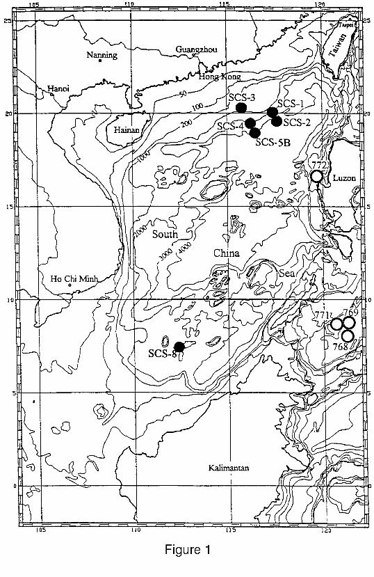

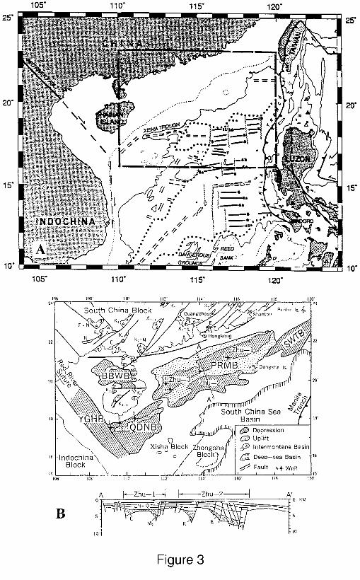
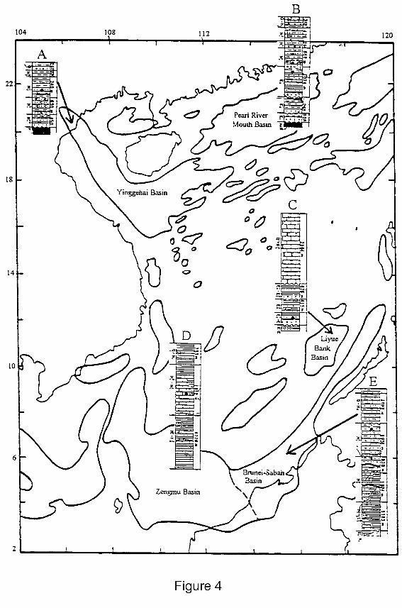
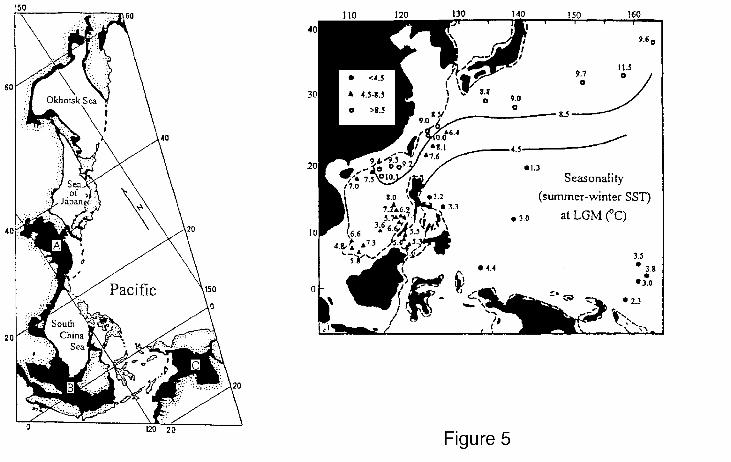

TABLE 2*
PROPOSED SITE INFORMATION AND DRILLING STRATEGY
SITE: SCS-1 PRIORITY: 1 POSITION: 20.0526°N, 117.4194°E WATER DEPTH: 2050 m SED THICKNESS: ~760 m TOTAL PENETRATION: 450 mSEISMIC COVERAGE: Intersection of SO-95 Profiles 10 and 20
Objectives: Recover a continuous high-sediment-rate marine sequence hemipelagic sediment record toreconstruct the Pleistocene paleo-monsoon history.
Drilling Program: Triple APC to refusal, XCB to 450 mbsf
Logging and Downhole Operations: Triple-combo, GLT, GHMT, and FMS
Nature of Rock Anticipated: Hemipelagic mud
SITE: SCS-2 PRIORITY: 1 POSITION: 19.5835°N, 117.6313°EWATER DEPTH: 3190 m SED THICKNESS: ~870 m TOTAL PENETRATION: 400 mSEISMIC COVERAGE: Intersection of SO-95 Profiles 10 and Vema Profile 3068
Objectives: Recover a continuous marine sequence hemipelagic sediment record to reconstruct the middlePliocene to Pleistocene/Holocene paleo-monsoon history
Drilling Program: Triple APC to refusal, XCB to 400 mbsf
Logging and Downhole Operations: Triple-combo, GLT, GHMT, and FMS
Nature of Rock Anticipated: Hemipelagic mud and mudstone
SITE: SCS-3C PRIORITY: 1 POSITION: 19.90°N, 116.07°EWATER DEPTH: 1275 m SED THICKNESS: TOTAL PENETRATION: 300 mSEISMIC COVERAGE: CPD 15600 on Line 5
Objectives: Recover a hemipelagic sediment record to reconstruct the late Miocene to Pleistocene paleo-monsoon history; determine variations in oxygen content
Drilling Program: Triple APC to refusal, XCB to 550 mbsf
Logging and Downhole Operations: Triple-combo, GLT, GHMT, and FMS
Nature of Rock Anticipated: Hemipelagic mud and silt
*Site localities and/or drilling depths may be altered.
SITE: SCS-4 PRIORITY: 1 POSITION: 19.4540°N, 116.2642°EWATER DEPTH: 2093 m SED THICKNESS: TOTAL PENETRATION: 520 mSEISMIC COVERAGE: Intersection of SO-95 Profiles 4 and SO-72A Profile 18
Objectives: Recover a hemipelagic sediment record to reconstruct the middle Miocene to Pliocene paleo-monsoon history.
Drilling Program: Triple APC to refusal, XCB to 520 mbsf
Logging and Downhole Operations: Triple-combo, GLT, GHMT, and FMS
Nature of Rock Anticipated: Hemipelagic mud and silt
SITE: SCS-5C PRIORITY: 1 POSITION: 18.84°N, 116.55°EWATER DEPTH: 3250 m SED THICKNESS: TOTAL PENETRATION: 700 mSEISMIC COVERAGE: CPD 7500 on Line 5
Objectives: Recover hemipelagic sediments to reconstruct the paleoclimate history from Oligocene toMiocene
Drilling Program: Triple APC to refusal, XCB to 450 m, RCB to 850 m
Logging and Downhole Operations: Triple-combo, GLT, GHMT, and FMS
Nature of Rock Anticipated: Hemipelagic mud and silt
SITE: SCS-8 PRIORITY: 1 POSITION: 7.3619°N, 112.5453°EWATER DEPTH: 1800 m SED THICKNESS: TOTAL PENETRATION: 400 mSEISMIC COVERAGE: Intersection SCS Profiles N9 and N15
Objectives: Recover sediment record to reconstruct the paleoclimate history in the tropical SCS sinceEocene; determine variations in supply of terrigenous sediment from the Mekong and other rivers
Drilling Program: Triple APC to refusal, XCB to 450 m, RCB to 1100 m
Logging and Downhole Operations: Triple-combo, GLT, GHMT, and FMS
Nature of Rock Anticipated: Hemipelagic mud, silt, and other clastic sediments and rocks
*Site localities and/or drilling depths may be altered.


![1 MONSOON DEPENDENT ECOSYSTEMS: IMPLICATIONS OF THE ... · with good representation of dryland ecohydrological triggers [Wang et al., 2012]. Arid and semiarid regions are characterized](https://img.pdfslide.us/doc/110x75/5f89872adddb812f8122e619/1-monsoon-dependent-ecosystems-implications-of-the-with-good-representation.jpg)