Embed Size (px)
Citation preview

1
South Boulder Creek Flood Mitigation Project
Regional Detention at US36
Open HouseJune 7, 2018
www.southbouldercreek.com
1

Meeting Format
Presentation Side
Staff Presentation
Q&A on presentation
Open House Side
Information boards with staff available to answer questions
Tables available to complete the questionnaire and for informal discussions
2
Complete questionnaire here or online at www.southbouldercreek.com
2

Purpose of the Meeting
To provide information about South Boulder Creek flood mitigation project status Evaluation of flood mitigation concepts Feedback from the April 23rd open house Project timeline and next steps
To seek input on Flood mitigation concept evaluation
3
• Thank you for coming tonight to learn more about the City’s plans for South Boulder Creek flood mitigation.
• The City is evaluating various flood detention concepts on the CU South property to reduce risk of future flooding in the west valley.
• The purpose of tonight’s meeting is to provide you with the staff evaluation of the different concept variations, answer questions and get your feedback.
• The evaluation is based on criteria we reviewed at a public open house in April, and so we will also share what we heard then and through an online questionnaire about which criteria the people who responded felt were most important to them.
• All of this information will be provided to boards and Council this summer to help select which concept to move forward into the next steps of engineering and discussions with landowners.
• So again, thank you for being here, and now I’ll turn it over to Kurt Bauer, City of Boulder Engineering Project Manager to tell us more about the flood mitigation project.
3
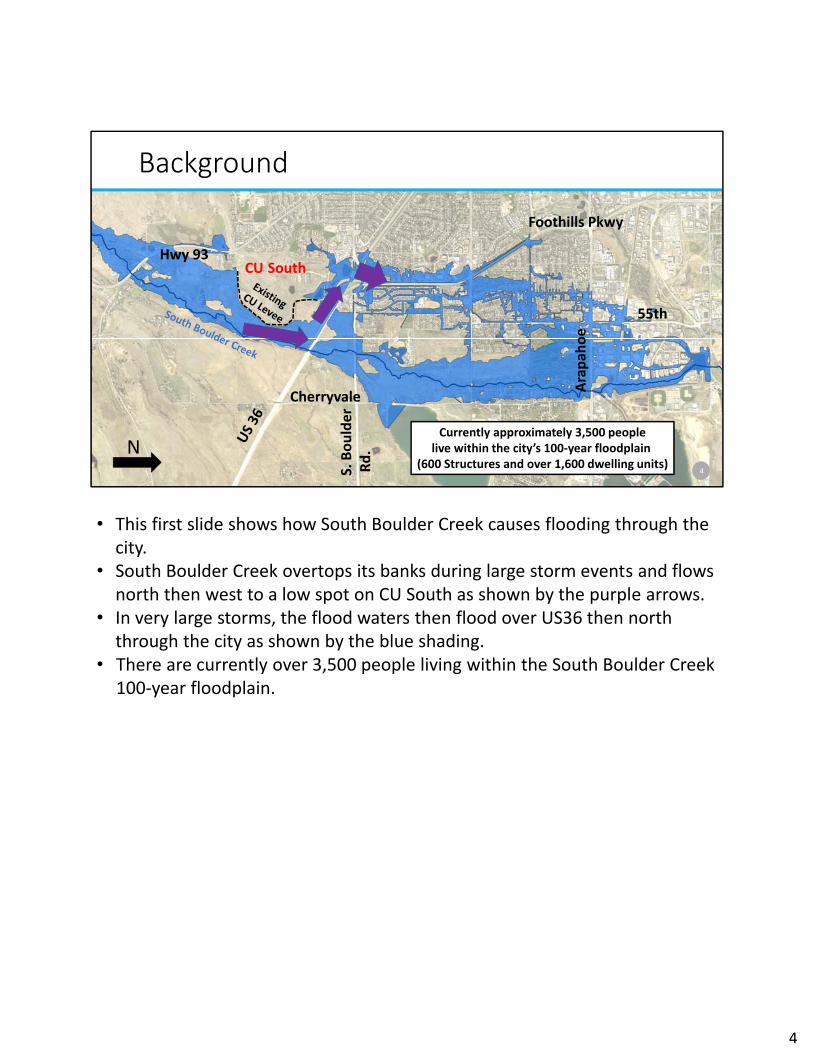
Background
55th
Hwy 93CU South
Arapah
oe
Ave.
S. Boulder
Rd.
Foothills Pkwy
Currently approximately 3,500 peoplelive within the city’s 100‐year floodplain
(600 Structures and over 1,600 dwelling units)N
4
Arapah
oe
Cherryvale
• This first slide shows how South Boulder Creek causes flooding through the city.
• South Boulder Creek overtops its banks during large storm events and flows north then west to a low spot on CU South as shown by the purple arrows.
• In very large storms, the flood waters then flood over US36 then north through the city as shown by the blue shading.
• There are currently over 3,500 people living within the South Boulder Creek 100‐year floodplain.
4

Flood History
5
• Past flood events on South Boulder Creek have occurred in 1938, the 1950s (1951, 1952 and 1957), 1969 and in 2013.
• This photo in the upper right shows flooding from the 1969 storm looking at the Thunderbird Apartments.
• The left photo shows Qualla Dr. during the 2013 flood where the water depth was estimated to be about 4 feet during the flood.
• US36 overtopped during both storm events and overall that storm and damages from the 2013 flood in the South Boulder Creek drainageway were reported to be some of the highest in the city.
5

Background – Master Plan Phases
Phase IIPhase III
Phase I
N
CU South
Arapah
oe Ave
6
Baseline Road
• The city completed a flood mitigation master plan for South Boulder Creek in 2015.
• The plan recommended flood mitigation in 3 phases with this slide showing the phases:• In the far left in white is Phase I: regional detention at US36, which
is what we are here to talk about tonight• Phase I was selected to be the first phase because of the large
downstream flood benefits• The plan also included two other future phases with Phase II shown
in purple. This phase would include improvements in the West Valley.
• The 3rd Phase is shown in green and would include stormwaterdetention at Flatirons Golf Course just south of Arapahoe Avenue
6

Background
7
Establishes land use designations and guiding principles
Guides future intergovernmental agreement between the University of Colorado and the City of Boulder
BVCP CU South Guiding Principles
• The master plan showed regional detention to be located on the CU South property. • The CU South parcel is 300 acres owned by University of Colorado, and currently located
within the county.• CU has stated that it would like this property to be annexed into the city limits, and with
annexation, the university would agree to allow the city to construct regional detention. • Because of this, the 2017 Boulder Valley Comprehensive Plan update included changing
land uses on CU South and corresponding Guiding Principles. • These new land use designations and guiding principles are intended to guide a future
agreement between the City and CU for the long‐term uses on the site. • The blue area labeled Public is where future development by CU could take place. • The dark green area labeled Parks, Urban and Other is the area envisioned for regional
flood detention with the boundaries based on the South Boulder Creek Master Plan 100 –year concept.
• The lighter green labeled Open Space‐Other corresponds with the 500 year floodplain, and envisions some sort of open space protections with no habitable structural development.
7

Public Input from April 23rd Open House
8
Very Important or
ImportantCriteria
95% Reduce flood risks69% Minimize time to build58% Minimize environmental impacts 56% Adaptability for climate change41% Improve riparian connectivity and habitat32% Minimize maintenance28% Limit dam size
26% Minimize construction cost
• Over 120 people attended the first open house and 122 people responded to the questionnaire
• People were asked to identify the criteria most important to them.• The top two criteria for respondents was reducing the flood risk for the most people and
doing this quickly • Environmental issues and being able to adapt to future climate change came next for
people • Cost and size of infrastructure rounded out the list. • We also heard that groundwater mitigation was important to a number of respondents
so we have since added that as an evaluation criterion.
8

Project Concepts Being Evaluated
9
Master Plan Concept
Variant 1: Dam modified to avoid Viele Channel
Variant 2: Dam with flow restriction at US36 Bridge
• We have revisited the master plan concept and also added two other variations for stormwater detention at US36.
• We evaluated all of these 3 concepts for the FEMA 100‐year design storm, a long‐duration storm and the FEMA 500‐year storm
• Hydraulic modeling indicates that the long‐duration storm does not control – meaning that storm would result in a smaller concept than the 100‐year design storm so we have excluded it from further evaluation
• We also looked at the concepts with the existing CU levee in place and with the levee removed
• I will now step through each of the concepts in the next series of slides
9

Master Plan Concept‐100 year with CU Levee
10
N
CU SouthArea of Fill
OSMP
Outlet Tunnel
Floodwall/spillway
Approx. limit of excavationApprox. limits of 100‐year inundationPrebles mouse critical habitatApprox. post project 100‐yr floodplainApprox. post project 500‐yr floodplain
Proposed Dam
Syphon Foothills Pkwy
Existing CU Levee
• This slide shows the master plan concept sized for a 100‐year storm. • This slide shows the existing CU levee in place but the remainder of the concept figures
do not show the levee as it does not impact the hydraulics of the concepts.• This concept would construct a floodwall / dam starting at the US36 South Boulder
Creek bridge, follow the US36 right of way northwest and then wrap around the inside of the CU South parcel.
• To avoid impacting the existing floodplain on Viele Channel, this concept would include a pipe (syphon) to convey flows from Viele Channel under the detention area.
• The concept includes areas of fill and excavation.• The approximate maximum ponding is shown by the dark blue shading.
10

Master Plan Concept‐500 year without CU Levee
N
CU South
OSMP
Outlet Tunnel
Floodwall/spillway
Approx. limit of excavationApprox. limits of 500‐year inundationPrebles mouse critical habitatApprox. post project 100‐yr floodplainApprox. post project 500‐yr floodplain
Proposed Dam
Syphon Foothills Pkwy
Remove Existing CU Levee
• This slide shows the master plan concept designed for a 500‐year event. • It is identical to the 100‐year concept except that the area of fill is not shown due to the
need for much large storage volume required by the larger storm event and a taller dam / floodwall would be required.
• This is shown by the larger dark blue area of maximum ponding
11

PROPOSED DAM
Master Plan Concept Rendering – 100 yr
12
• This slide shows a rendering of the proposed US36 regional detention concept looking southeast from above the RTD parking structure.
• US36 is in the foreground
12

Variant 1 Concept‐ 100 year without CU Levee
13
N
CU South
Area of Fill
Realigned Portion of Proposed Dam
OSMP
Outlet Tunnel
Floodwall/spillway
Approx. limit of excavationApprox. limits of 100‐year inundationPrebles mouse critical habitatApprox. post project 100‐yr floodplainApprox. post project 500‐yr floodplain
Foothills Pkwy
Remove Existing CU Levee
• This next concept is very similar to the master plan concept except that a portion of the dam would be moved south to eliminate the need to put Viele Channel in a pipe.
• This area of the dam is shown by the purple circle. • Other than this, it has the same configuration as the master plan concept.
13
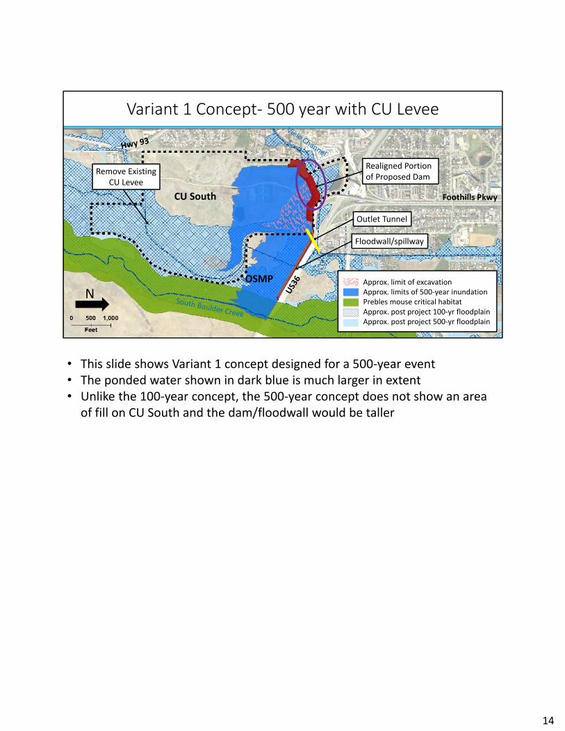
Variant 1 Concept‐ 500 year with CU Levee
14
N
CU South
Realigned Portion of Proposed Dam
OSMP
Outlet Tunnel
Floodwall/spillway
Approx. limit of excavationApprox. limits of 500‐year inundationPrebles mouse critical habitatApprox. post project 100‐yr floodplainApprox. post project 500‐yr floodplain
Foothills Pkwy
Remove Existing CU Levee
• This slide shows Variant 1 concept designed for a 500‐year event• The ponded water shown in dark blue is much larger in extent • Unlike the 100‐year concept, the 500‐year concept does not show an area
of fill on CU South and the dam/floodwall would be taller
14

PROPOSED DAM
Variant 1 Rendering – 100 year with CU Levee
15
• This slide shows a rendering of Variant 1.• You can see that a portion of the dam would be located further to the
south away from Viele Channel
15

Variant 2 Concept‐100 year without CU Levee
N
CU South Proposed Dam
OSMP
Floodwall/spillway
Prebles mouse critical habitatApprox. limits of 100‐year inundationApprox. post project 100‐yr floodplainApprox. post project 500‐yr floodplain
US36 Flow restriction
Remove Existing CU Levee
Reserve Area for Inflow and Restoration
Foothills Pkwy
• The third concept differs from the master plan concept as it would store most of the flood waters on Open Space and Mountain Park lands next to South Boulder Creek.
• To do this, a flow restriction would need to be constructed at the South Boulder Creek US36 bridge.
• Similar to the first two concepts, the dam would be located within the US36 right of way but would then wrap to the south inside of the CU South parcel.
• This existing CU levee would need to be removed for this concept and the portion of land on CU South shown in light blue would need to be reserved for flood waters to flow into this concept.
16
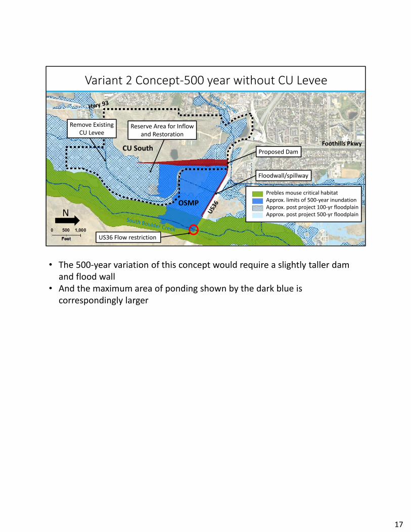
Variant 2 Concept‐500 year without CU Levee
N
CU South Proposed Dam
OSMP
Floodwall/spillway
Prebles mouse critical habitatApprox. limits of 500‐year inundationApprox. post project 100‐yr floodplainApprox. post project 500‐yr floodplain
US36 Flow restriction
Remove Existing CU Levee
Reserve Area for Inflow and Restoration
Foothills Pkwy
• The 500‐year variation of this concept would require a slightly taller dam and flood wall
• And the maximum area of ponding shown by the dark blue is correspondingly larger
17

PROPOSED DAM
Variant 2 Rendering – 100 year
18
PROPOSED FLOOD WALL
• This slide shows a rendering of Variant 2 concept
18

Variant II Rendering of US36 Flow Restriction Concept
19
US36 Bridge Existing Conditions
• These next slides show a concept to restrict flow at the US36 bridge as required by the Variant 2 concept.
• This slide shows the existing conditions at the bridge
19

Variant 2 Rendering of US36 Flow Restriction Concept
20
• This slide shows a concept for how to restrict flows at US36 along with a portion of the flood wall
• The US36 multi‐use path configuration would not change in this concept• A flood wall is shown on the south side of US36 and a new front to the
US36 bridge with a smaller opening would restrict flows under the bridge• Included in this concept is narrowing of the creek to match the
configuration that OSMP just completed on the other side of the bridge for channel restoration
• It also includes a wildlife crossing under the bridge
20

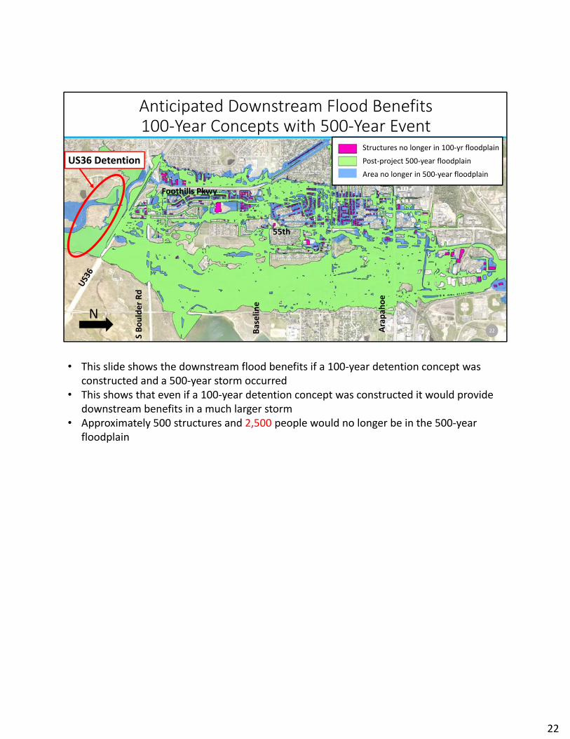
Anticipated Downstream Flood Benefits100‐Year Concepts with 100‐Year Storm
21
N
Structures no longer in 100‐yr floodplain
Post‐project 100‐year floodplain
Area no longer in 100‐year floodplain
US36 Detention
Foothills Pkwy
55th
Arapah
oe
S Boulder Rd
Baselin
e
• These next set of slides present the anticipated downstream flood benefits from regional detention at US36
• This first slide shows the downstream flood benefits if a 100‐year detention concept was constructed
• We are zoomed out in this slide with US36 in the far left, the red oval showing the location of the proposed regional detention and Arapahoe Avenue and the confluence with Boulder Creek in the right side of this slide.
• The post‐project 100‐year floodplain is shown in green• The areas no longer in the 100‐year floodplain in blue• And the structures that would no longer be in the floodplain in pink• Approximately 260 structures and 2300 people would no longer be in the 100‐year
floodplain
21
Anticipated Downstream Flood Benefits100‐Year Concepts with 500‐Year Event
22
N
Structures no longer in 100‐yr floodplain
Post‐project 500‐year floodplain
Area no longer in 500‐year floodplain
US36 Detention
Foothills Pkwy
55th
Arapah
oe
S Boulder Rd
Baselin
e
• This slide shows the downstream flood benefits if a 100‐year detention concept was constructed and a 500‐year storm occurred
• This shows that even if a 100‐year detention concept was constructed it would provide downstream benefits in a much larger storm
• Approximately 500 structures and 2,500 people would no longer be in the 500‐year floodplain
22

Anticipated Downstream Flood Benefits 500‐Year Concepts with 500‐Year Event
23
N
Structures no longer in 100‐yr floodplain
Post‐project 500‐year floodplain
Area no longer in 500‐year floodplain
US36 Detention
Foothills Pkwy
55th
Arapah
oe
S Boulder Rd
Baselin
e
• This slide shows the downstream flood benefits if a 500‐year detention concept was constructed and a 500‐year storm occurred
• Approximately 730 structures and 4,100 people would no longer be in the 100‐ or 500‐year floodplain
23

Baseline Criteria
Concepts must:
Prevent US36 overtopping during 100‐year storm
Be permittable by regulatory agencies
Be acceptable to State Engineers Office
Be acceptable to Land owners
Be able to mitigate groundwater impacts
24
• A set of criteria have been developed to evaluate the concept variations. First and foremost, a concept variation must meet what we are calling a set of baseline criteria that includes the following:
• At a minimum, a concept variation must prevent overtopping of US36 during a FEMA 100‐year design storm
• A concept variation must be able to be permittable by regulatory agencies (FEMA, EPA, USACE and USFWS)
• A concept variation must be acceptable to the State Engineers Office• Land owners (CU, CDOT and OSMP) must be willing to allow construction of the concept• Groundwater impacts can be mitigated
24

25
Evaluation Criteria – Flood Benefits
• These next series of slides step through a summary of an evaluation of the concepts based on a set of criteria.
• Your handout packet contains this summary and also a much larger matrix with the actual numbers behind the summary
• The darker the blue the better the concept in relationship to the criteria as compared across all concepts in the rows
• Criteria is listed in the first column with the 100‐year concepts in the first set of blue boxes and the 500‐year concepts on the right‐hand set of blue boxes
• All of the concepts would provide similar downstream benefits by design storm –meaning there is no difference in downstream benefits between the 100‐year concepts and similarly no differences between the 500‐year concepts.
• Not surprisingly the 500‐year concepts would all provide greater downstream benefits
25

26
Evaluation Criteria – Climate Change
• Variant 2 concepts would be the easiest to modify in the future to accommodate any changes in climate as they do not include syphons or outlet pipes or excavation.
• Variant 2 also would not be impeded by future development on CU South as the detention is largely adjacent to South Boulder Creek
26

27
Evaluation Criteria ‐ Costs
• Estimated costs for the concept variations range from $30 to $45 million with the master plan variations having the highest estimated cost of the three concepts.
27

28
Evaluation Criteria ‐ Schedule
• It is anticipated that any of the variations could be constructed on a similar timeframe and therefore the construction schedule does not vary between the concepts.
28

29
Evaluation Criteria –Operations/Maintenance
• Variant 2 would be the least complex to construct, operate and maintain as it does not include a syphon, outlet pipe or excavation and associated impermeable barrier wall.
29

30
Evaluation Criteria ‐ Groundwater
Variant 2 concepts would be the least complex to mitigate any potential groundwater impacts from the project as it does not include excavation and associated impermeable barrier wall.
30

31
Evaluation Criteria – Environmental Impacts
• Variants 1 and 2 that include removal of the existing CU levee would have the least direct environmental impacts of the concept variations.
31
32
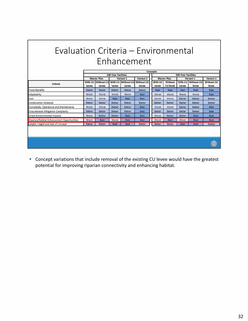
Evaluation Criteria – Environmental Enhancement
• Concept variations that include removal of the existing CU levee would have the greatest potential for improving riparian connectivity and enhancing habitat.
32

33
Evaluation Criteria – Dam Size
• Variant 1 has a slightly smaller overall dam footprint and heights of the three concepts
33

34
Landowner Acceptability and Project Timeline
Today’s Meeting
Land owners (CU, CDOT and OSMP) must be willing to allow construction of the project
• Kurt just reviewed with you the evaluation of the concepts from an engineering and environmental permitting perspective. I’m now going to talk to you about some of other factors important to building the project, including getting permission from landowners to use their land for flood mitigation.
• As Kurt mentioned previously, in order for the flood mitigation project to be constructed, all three landowners (CU, CDOT, OSMP) –three governmental entities ‐must be willing to allow construction of the project on their land and/or allow a greater inundation on their property because of the project during a large flood event.
• Each of these landowners have different interests in how the flood mitigation project may affect their property.
• In a moment I will highlight some key issues which, at this concept evaluation stage of the project, we think MAY affect landowners decisions about the ability to use their property for the flood mitigation project.
• Ultimately, we will want to have approval to use the land for flood mitigation from all property owners, CU, CDOT, and OSMP before we move into final design and construction of the project.
• However, as you will hear, the final determination by property owners of whether we can construct a particular project concept on their land, in some cases, will rely on information that will be developed during the preliminary design phase, or on the
34

discussions and negotiations around future annexation of the CU South property. • Some people have asked– how do we make a decision on which concept to move forward
into preliminary engineering and property owner negotiations, when the property owners might need more information from those processes to make a decision?
• Well what we can do now is present the best information we have available about the potential landowner acceptance issues so Council can weigh the potential complexity of discussions with landowners when making a decision on which concept to move forward into preliminary engineering and landowner negotiations.
• It may be that Council deem some of the landowner acceptance issues too complex or potentially insurmountable, and therefore not worth pursuing for a particular concept.
• In other cases, even though it may be more complex to reach landowner acceptance on a particular concept, Council may feel the potential for a win‐win on all sides with that concept would be worth taking the next steps with engineering and landowner negotiations.
• Those are political decisions that will be for City Council to decide.
34

Landowner Acceptance
Land owners (CU, CDOT and OSMP) must be willing to allow construction of the project
35
3 Land owners indicated acceptability of Option D during the SBC Master Plan and BVCP update processes. OSBT conditioned this upon staff returning to OSBT in the event construction will involve non‐trivial impacts to OSMP land.
• So for now, we are leaving question marks on the evaluation table regarding the acceptability of the concepts to each of the landowners, with one exception.
• The good news is, that we have a general understanding that all three property owners could allow construction of the Master Plan‐100 year‐with CU levee concept variation.
• That concept is a refinement of Option D, which was accepted by all three during the SBC Master Plan process, and was the basis for the CU South Guiding Principles approved as part of the BVCP update. So we have already had a lot of public process and agreement amongst the property owners around the acceptability of that concept from a landowner perspective.
• I want to mention that OSBT did condition their recommendation to accept the SBC Master Plan on that staff should come back to the board if the project would result in non‐trivial impacts to OSMP land. That is something that will continue to considered and addressed as part of the project design for any concept.
• So the question becomes, are there other variations for which we can also reach agreement with property owners, and that Council would prefer we pursue?
35

Landowner Acceptance Issues
Inundation area on OSMP land Stream restoration included as part of the project
Opportunity for habitat restoration and enhancement on CU South to achieve net Open Space benefit
Use of CDOT right‐of‐way
Change in land required for flood mitigation on CU South, by BVCP land use designation Parks, Urban, Other (PK‐U/O) Public (PUB) Open Space Other (OS‐O)
36
They key landowner acceptance issues that city staff have identified when considering other concept variations revolve around these 3 factors:
1. The amount of inundation area on OSMP land, with the corresponding changes to sediment and debris deposition during rare flood events. And then, in order to potentially counteract that, what are the opportunities each variation has for potential habitat enhancement so the project can achieve a net Open Space benefit overall –which would be of interest to OSBT.
2. The use of CDOT ROW – all concepts assume use of CDOT ROW – which was also assumed during the SBC Master Plan Option D. At that time, CDOT indicated that they would consider our use of US36 ROW for flood mitigation – which makes sense given that the project would take this portion of the highway out of the 100‐year floodplain so it would be a benefit to them. However we will need to go back to CDOT when we have more design details from the preliminary design in order to get final approval of any of the concepts.
3. And then the 3rd key issue is the change in land required for flood mitigation on CU South, compared to the assumptions that were part of development of the CU South Guiding Principles and land uses for the site during the BVCP update.
36

Inundation Area on OSMP Land & Habitat Enhancement Opportunities
37
• Next I’m going to dive a little deeper into the evaluation of the inundation area on OSMP land and habitat enhancement opportunities.
• The Master Plan and Variant 1 100‐year options result in the least amount of OSMP land inundated by the project in a large flood event. The 500‐year options result in a greater area of inundation on OSMP land, and Variant 2 500‐year has the greatest area inundated.
• Both the Master Plan and Variant 1 100‐year options would result in the same amount of inundation on OSMP land as was previously considered for Option D as part of the accepted SBC Master Plan..
37

Inundation area on OSMP land & habitat enhancement opportunities
38
• Now to counter the potential negative impacts from greater inundation on OSMP land, we also have evaluated the ability of different variations to provide opportunities for habitat restoration and enhancement to achieve an overall net Open Space benefit.
• As you can see here ‐ the Variant 2 concept includes some stream restoration just upstream of US36 already as part of the flood mitigation project. This is related to the design of the flow constriction at US36, and would also have beneficial environmental effects for the stream.
• The variations that remove the CU levee may also be able to provide opportunities through the annexation negotiation process with CU for habitat restoration and protection on the CU South property – which could also help achieve a net open space benefit.
• These are all factors that the OSBT can take into account when considering the acceptability of the various concept variations.
38

Master Plan Concept‐100 year over BVCP Land Uses
39
N
Open Space Other(OS‐O)
Parks Urban Other(PK‐UO) Area of maximum
inundation
CU South
OSMP
Public (PUB)
• The BVCP land use designations and CU South Guiding Principles are intended to guide a future agreement between the City and CU for the long‐term uses on the site.
• So the degree to which the flood mitigation concepts vary from what was agreed to as part of the Guiding Principles, there may be greater complexity in reaching a future agreement with CU.
• To re‐orient you to this diagram – the dotted black lines show the CU south property boundary. The dark green area labeled Parks, Urban and Other is the area that was envisioned in the CU South Guiding Principles for regional flood detention, based on the SBC Master Plan Option D concept. The blue Public land use is the area envisioned for future development on CU South, and the light green Open Space Other would be retained for open space, ball fields, solar gardens, or other such uses.
• In general, the Master Plan 100‐year options have very similar acreage requirements for flood mitigation on CU South as was discussed during the development of the CU South Guiding Principles.
• As you can see here in the blue hatching, most of the flood mitigation dam, structures and inundation area are located within the Parks Urban Other land use designation on the CU South property.
• For this concept, CU will also likely be interested in the specific details that will be developed during preliminary design phase regarding how the access to the site can be designed around the dam. But generally this concept is in line with the assumptions for
39

flood mitigation in the Guiding Principles.
39

Master Plan Concept‐500 year over BVCP Land Uses
N
Public (PUB)
Open Space Other(OS‐O)
Parks Urban Other(PK‐UO) Area of maximum
inundation
CU South
OSMP
40
• However, as you can see here, the Master Plan 500‐year variations inundate a significant portion of the Public (PUB) land use as part of the flood mitigation. The land use area within the CU South parcel designated as Public was intended to be for future development by the university.
• This concept appears to limit CU’s use of the property beyond what was agreed to in the comprehensive plan Guiding Principles, which could make the annexation agreement discussions with CU more complex.
40

Variant 1 Concept‐ 100 year over BVCP Land Uses
41
N
Public (PUB)
Open Space Other(OS‐O)
Parks Urban Other(PK‐UO) Area of maximum
inundation
CU South
OSMP
• The Variant 1,100‐year concept, which moves the dam to the south to avoid Vielechannel, is similar to the Master Plan concept in that the majority of the flood mitigation structures and inundation area are in the Parks Urban Other category.
• Similarly, CU will likely be interested in the details during preliminary design regarding how to access the site around the dam.
• But generally this concept is also in line with the assumptions for flood mitigation in the Guiding Principles.
41

Variant 1 Concept‐ 500 year over BVCP Land Uses
42
N
Public (PUB)
Open Space Other(OS‐O)
Parks Urban Other(PK‐UO) Area of maximum
inundation
CU South
OSMP
Again, similar to the Master Plan concept, the Variant 1 500‐year concept results in a significant amount of the Public land use inundated. This concept limits CU’s use of the property beyond what was agreed to in the comprehensive plan Guiding Principles, which could make the annexation agreement discussions with CU more complex.
42

Variant 2 Concept‐ 100 year over BVCP Land Uses
43
N
Public (PUB)
Open Space Other(OS‐O)
Parks Urban Other(PK‐UO)
Area of maximum inundation
CU South
OSMP
As you can see here, the Variant 2 100‐year option would use significantly less of the Parks, Urban/Other land use area for flood mitigation. This option also would not affect the future development potential on the Public land use area of the property.
43

Variant 2 Concept‐ 500 year over BVCP Land Uses
44
N
Public (PUB)
Open Space Other(OS‐O)
Parks Urban Other(PK‐UO)
Area of maximum inundation
CU South
OSMP
• Here’s the diagram for Variant 2 500‐year concept. • This has some additional inundation area on the Open Space‐Other portion of CU South.
CU would need to consider how that might limit the future uses agreed to in the Guiding Principles for that area. This includes the potential for recreation, solar gardens, habitat conservation or other open space uses.
• But this concept would not affect the future development potential on the Public land use area of the property.
• CU staff are evaluating the effects of all the different concept variations on the future uses of CU South. The changes in where flood mitigation would occur on the site will need to be considered by CU within the context of any other asks or conditions the City would be looking for during the annexation negotiation process.
44

45
Today’s Meeting
• That concludes our review and evaluation of the different concepts. I’ll quickly highlight next steps on the project and then we’ll open it up to questions.
• This diagram – which you also have in your handout ‐ shows the community engagement and advisory board and council input planned for the concept evaluation phase that we are currently in, and also for the next phase of preliminary design.
• To orient you, the central bar shows the flood mitigation project phases and estimated timelines for those.
• Above the bar shows completed and planned community engagement. The star shows today’s open house.
• And below the bar shows planned advisory board and council meetings – there are several coming up this summer
• Coming next, on June 25th we will be going to WRAB and OSBT at a joint meeting to review the evaluation of the different design concepts that we discussed today. This will also include a public hearing so you can provide your feedback directly to the boards if you wish.
• We will then come back to each of those boards separately in July for their deliberations and recommendations to Council.
• OSBT will be asked to provide a recommendation to Council regarding which concepts would be acceptable to move forward into design from the Open Space and Mountain
45

Parks (OSMP) property owner perspective, which could be acceptable with conditions, and which, if any, would not be acceptable from their perspective.
• We will then be asking WRAB to make a recommendation to Council on which project concept should move forward into preliminary design.
• We will then provide an update to Planning Board on Aug. 2 on how we have applied the BVCP guiding principles to the project, and how the OSBT and WRAB recommendations relate to the BVCP land uses and CU South guiding principles
• We will then go to Council on Aug. 7 for a decision on which project concept to move forward into the next phase of preliminary engineering and to begin property owner negotiations.
• After that decision, staff will then bring our draft plans for the annexation process and associated community engagement to Planning Board and then Council to get their feedback on these plans and the topics to be discussed during annexation before we reach out to the community and engage around those issues in the Fall.
45
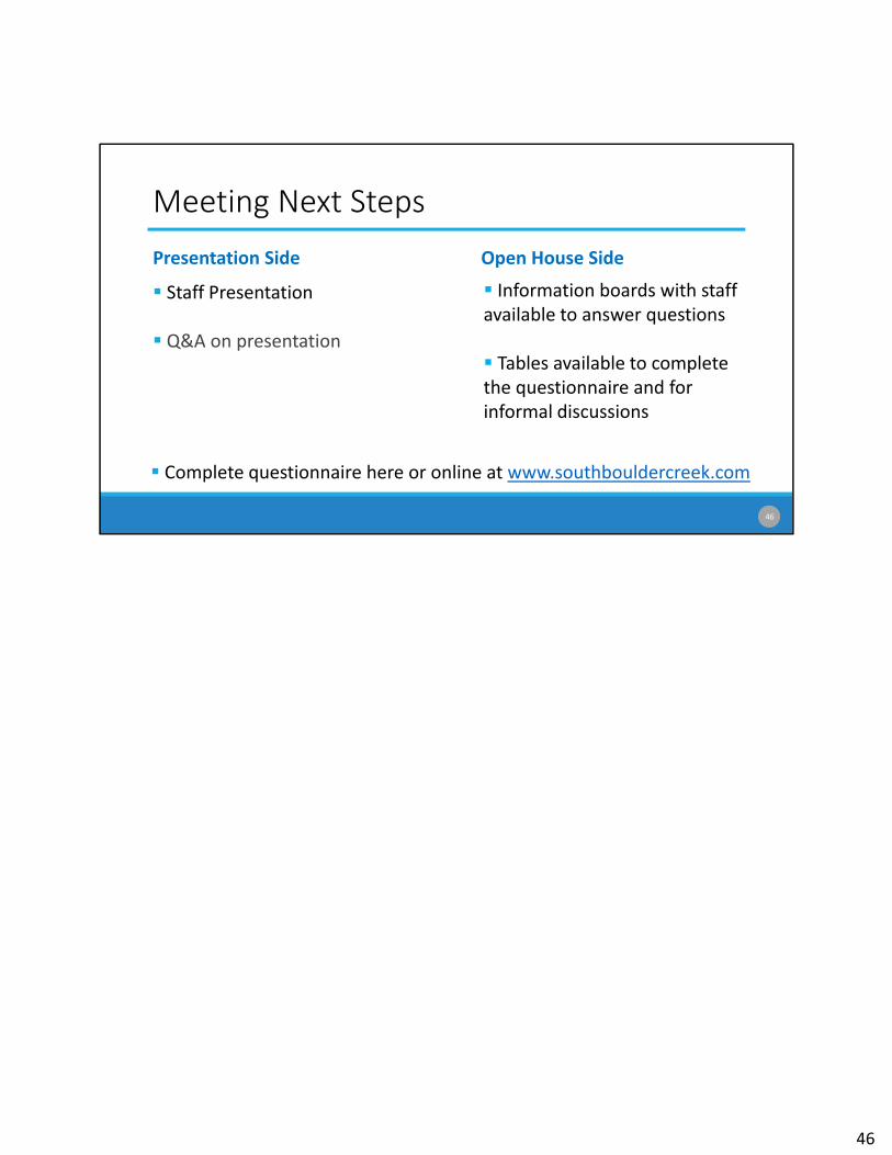
Meeting Next Steps
Presentation Side
Staff Presentation
Q&A on presentation
Open House Side
Information boards with staff available to answer questions
Tables available to complete the questionnaire and for informal discussions
46
Complete questionnaire here or online at www.southbouldercreek.com
46
Ground Rules
Listen to understand not to respond
Talk about what you think and know; let others do the same
Be brief with questions and answers
Treat everyone with respect
Help ensure everyone feels safe in the discussion
Agree to disagree
47
47