Embed Size (px)
Citation preview

County Louth Archaeological and History Society
Souterrain at Muirhevnamore, Marshes Upper, DundalkAuthor(s): Kieran CampbellSource: Journal of the County Louth Archaeological and Historical Society, Vol. 25, No. 2(2002), pp. 202-207Published by: County Louth Archaeological and History SocietyStable URL: http://www.jstor.org/stable/27729908 .
Accessed: 14/06/2014 07:06
Your use of the JSTOR archive indicates your acceptance of the Terms & Conditions of Use, available at .http://www.jstor.org/page/info/about/policies/terms.jsp
.JSTOR is a not-for-profit service that helps scholars, researchers, and students discover, use, and build upon a wide range ofcontent in a trusted digital archive. We use information technology and tools to increase productivity and facilitate new formsof scholarship. For more information about JSTOR, please contact [email protected].
.
County Louth Archaeological and History Society is collaborating with JSTOR to digitize, preserve and extendaccess to Journal of the County Louth Archaeological and Historical Society.
http://www.jstor.org
This content downloaded from 195.34.79.214 on Sat, 14 Jun 2014 07:06:06 AMAll use subject to JSTOR Terms and Conditions
Souterrain at Muirhevnamore, Marshes Upper, Dundalk
By Kieran Campbell
INTRODUCTION
The souterrain was discovered on 11 April 1995 during construction of a basketball court at
Scoil Cr?ost R? M?inteoir?, Muirhevnamore, Dundalk, by building contractors, Murnaghan
Brothers Ltd., Ballybay, Co Monaghan. A site inspection was made on 13 April by the present
writer and Mr Noel Ross, following which the souterrain was closed up for the duration of the
Easter holiday. The souterrain was reopened
on 24 April and surveyed by the writer, assisted by
Mr Colm O'Brien. On completion of the survey the entrance was sealed up with loose stone fill
and the souterrain has been preserved intact under the basketball court. In 1996 the site was
designated as Recorded Monument LH007-092 in the Record of Monuments and Places: County
Louth issued by the National Monuments and Historic Properties Service, then of the Office of
Public Works.
The souterrain is located in the townland of Marshes Upper, barony of Upper Dundalk (Fig.
1; O.S. six-inch sheet Louth 7, 468mm from W, 129mm from S; National Grid co-ordinates 30613
30551). The site is on the northern slope of a low eminence which is indicated on the 1:50,000
O.S. Discovery Series map (sheet 36) as a small circle defined by the 10m contour. Housing and
commercial developments have taken place to the north and east of the site but much open
ground remains within the church grounds to the south. The field to the west is now set out in
allotments (Fig. 2). Before the discovery of the souterrain an estimated depth of 0.8m of topsoil and subsoil had
been stripped from the 31m by 18m area of the ball court and a hardcore surface had been laid
down and rolled. An examination of the section face along the south side of the ball court and
the open foundation trenches for the school building, 35m to the east of the souterrain site,
revealed no further evidence of archaeological features.
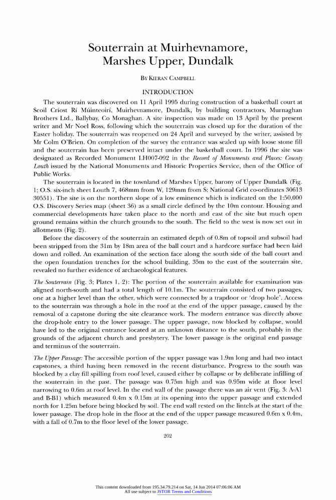
The Souterrain (Fig. 3; Plates 1,2): The portion of the souterrain available for examination was
aligned north-south and had a total length of 10.1m. The souterrain consisted of two passages,
one at a higher level than the other, which were connected by
a trapdoor
or 'drop hole'. Access
to the souterrain was through
a hole in the roof at the end of the upper passage, caused by the
removal of a capstone during the site clearance work. The modern entrance was directly above
the drop-hole entry to the lower passage. The upper passage, now blocked by collapse, would
have led to the original entrance located at an unknown distance to the south, probably in the
grounds of the adjacent church and presbytery. The lower passage is the original end passage
and terminus of the souterrain.
The Upper Passage: The accessible portion of the upper passage was 1.9m long and had two intact
capstones, a third having been removed in the recent disturbance. Progress to the south was
blocked by a clay fill spilling from roof level, caused either by collapse or by deliberate infilling of
the souterrain in the past. The passage was 0.75m high and was 0.95m wide at floor level
narrowing to 0.6m at roof level. In the end wall of the passage there was an air vent
(Fig. 3: A-Al
and B-Bl) which measured 0.4m x 0.15m at its opening into the upper passage and extended
north for 1.25m before being blocked by soil. The end wall rested on the lintels at the start of the
lower passage. The drop hole in the floor at the end of the upper passage measured 0.6m x 0.4m,
with a fall of 0.7m to the floor level of the lower passage.
202
This content downloaded from 195.34.79.214 on Sat, 14 Jun 2014 07:06:06 AMAll use subject to JSTOR Terms and Conditions

Souterrain at Muirhevnamore 203
Fig. 1. Location of souterrain and other sites in Marshes Upper townland.
I 46 i- ,-;
Fig. 2. Location of souterrain in the modern streetscape.
This content downloaded from 195.34.79.214 on Sat, 14 Jun 2014 07:06:06 AMAll use subject to JSTOR Terms and Conditions

204 County Louth Archaeological and Historical Journal
Fig. 3. Plan and sections of Muirhevnamoie souterrain.
The Lower Passage: Entry into the lower passage proper from the drop hole was restricted by a low
lintel positioned at a height of 0.55m above the floor. Beyond the opening into the lower
passage, which measured 0.55m high by 0.9m wide, the roof rose sharply. However, access was
made difficult by the presence of a large quantity of limestone chippings brought in by children
evidently with the intention of flooring the souterrain following its recent discovery, a
job that
was not completed. The chippings lay piled to a height of 0.45m at the beginning of the lower
passage.
The total length of the lower passage, including the drop-hole space, was 9.4m. The passage
ran due north and was 1.45m high, with a width of lm at floor level and 0.5m on average at roof
level. A broadening of the passage approximately 3.5m from the north end, together with a slight
curve to the west, formed a chamber area with a maximum width of 1.75m. There was little
variation in the roof height over most of the passage length.
This content downloaded from 195.34.79.214 on Sat, 14 Jun 2014 07:06:06 AMAll use subject to JSTOR Terms and Conditions

Souterrain at Muirhevnamore 205
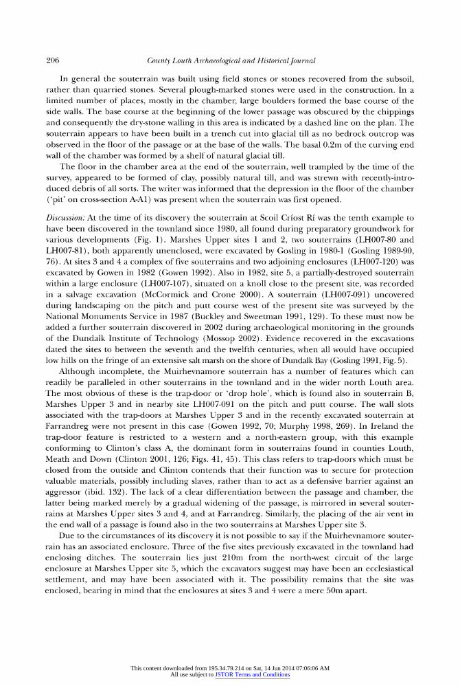
> -*W.
Plate 1. View from above showing modern access into upper passage of souterrain, and trap-door to lower passage. Scale = 2m.
Plate 2. View from chamber area at north end of lower passage, looking towards trap-door. Scale = lm.
This content downloaded from 195.34.79.214 on Sat, 14 Jun 2014 07:06:06 AMAll use subject to JSTOR Terms and Conditions
206 County Louth Archaeological and Historical Journal
In general the souterrain was built using field stones or stones recovered from the subsoil,
rather than quarried stones. Several plough-marked stones were used in the construction. In a
limited number of places, mostly in the chamber, large boulders formed the base course of the
side walls. The base course at the beginning of the lower passage was obscured by the chippings
and consequently the dry-stone walling in this area is indicated by a dashed line on the plan. The
souterrain appears to have been built in a trench cut into glacial till as no bedrock outcrop was
observed in the floor of the passage or at the base of the walls. The basal 0.2m of the curving end
wall of the chamber was formed by a shelf of natural glacial till.
The floor in the chamber area at the end of the souterrain, well trampled by the time of the
survey, appeared to be formed of clay, possibly natural till, and was strewn with recently-intro
duced debris of all sorts. The writer was informed that the depression in the floor of the chamber
('pit' on cross-section A-Al) was
present when the souterrain was first opened.
Discussion: At the time of its discovery the souterrain at Scoil Cr?ost Ri was the tenth example to
have been discovered in the townland since 1980, all found during preparatory groundwork for
various developments (Fig. 1). Marshes Upper sites 1 and 2, two souterrains (LH007-80 and
LH007-81), both apparently unenclosed, were excavated by Gosling in 1980-1 (Gosling 1989-90,
76). At sites 3 and 4 a complex of five souterrains and two
adjoining enclosures (LH007-120) was
excavated by Gowen in 1982 (Gowen 1992). Also in 1982, site 5, a partially-destroyed souterrain
within a large enclosure (LH007-107), situated on a knoll close to the present site, was recorded
in a salvage excavation (McCormick and Crone 2000). A souterrain (LH007-091) uncovered
during landscaping on the pitch and putt course west of the present site was
surveyed by the
National Monuments Service in 1987 (Buckley and Sweetman 1991, 129). To these must now be
added a further souterrain discovered in 2002 during archaeological monitoring in the grounds
of the Dundalk Institute of Technology (Mossop 2002). Evidence recovered in the excavations
dated the sites to between the seventh and the twelfth centuries, when all would have occupied
low hills on the fringe of an extensive salt marsh on the shore of Dundalk Bay (Gosling 1991, Fig. 5).
Although incomplete, the Muirhevnamore souterrain has a number of features which can
readily be paralleled in other souterrains in the townland and in the wider north Louth area.
The most obvious of these is the trap-door or
'drop hole', which is found also in souterrain B,
Marshes Upper 3 and in nearby site LH007-091 on the pitch and putt course. The wall slots
associated with the trap-doors at Marshes Upper 3 and in the recently excavated souterrain at
Farrandreg were not present in this case (Gowen 1992, 70; Murphy 1998, 269). In Ireland the
trap-door feature is restricted to a western and a north-eastern group, with this example
conforming to Clinton's class A, the dominant form in souterrains found in counties Louth,
Meath and Down (Clinton 2001, 126; Figs. 41, 45). This class refers to trap-doors which must be
closed from the outside and Clinton contends that their function was to secure for protection
valuable materials, possibly including slaves, rather than to act as a defensive barrier against an
aggressor (ibid. 132). The lack of a clear differentiation between the passage and chamber, the
latter being marked merely by a
gradual widening of the passage, is mirrored in several souter
rains at Marshes Upper sites 3 and 4, and at Farrandreg. Similarly, the placing of the air vent in
the end wall of a passage is found also in the two souterrains at Marshes Upper site 3.
Due to the circumstances of its discovery it is not possible
to say if the Muirhevnamore souter
rain has an associated enclosure. Three of the five sites previously excavated in the townland had
enclosing ditches. The souterrain lies just 210m from the north-west circuit of the large
enclosure at Marshes Upper site 5, which the excavators suggest may have been an ecclesiastical
settlement, and may have been associated with it. The possibility remains that the site was
enclosed, bearing in mind that the enclosures at sites 3 and 4 were a mere 50m apart.
This content downloaded from 195.34.79.214 on Sat, 14 Jun 2014 07:06:06 AMAll use subject to JSTOR Terms and Conditions

Souterrain at Muirhevnamore 207
BIBLIOGRAPHY
Buckley, V.M. and 1991
Sweetman, P.D.
Clinton, M. 2001
Gosling, P. 1982
Gosling, P. 1989-90
Gosling, P. 1991
Gowen, M. 1992
McCormick, F. and 2000
Crone, F. J.
Mossop, M. 2002
Archaeological Survey of County Louth, Dublin.
The Souterrains of Ireland, Bray.
A Survey and Report on the Archaeology of the Town and
District, 3 vols., Dundalk.
'Marshes Upper: Early Christian settlement' in C. Manning
and D. Hurl (eds), 'Excavations Bulletin 1980-84: Summary
Account of Archaeological Excavations in Ireland', 76,
Journal of Irish Archaeology, v, 65-80.
'From Dun Delca to Dundalk: the topography and
archaeology of a medieval frontier town AD c. 1187
1700', C.L.A.H.J, xxii, 3, 217-353.
'Excavation of two souterrain complexes at Marshes
Upper, Dundalk, Co. Louth', PRIA, 92C, 55-121.
'A Destroyed Enclosure at Site 5, Marshes Upper,
County Louth', C.L.A.H.J., xxiv, 4, 553-62.
Report on the Archaeological Monitoring and Investigation at
Dundalk Institute of Technology. Report prepared by ACS Ltd.
submitted to Duchas, The Heritage Service.
Murphy, D. 1998 'Archaeological Excavation of a Souterrain at Farrandreg,
Dundalk, County Louth', C.L.A.H.J, xxiv, 2, 261-80.
This content downloaded from 195.34.79.214 on Sat, 14 Jun 2014 07:06:06 AMAll use subject to JSTOR Terms and Conditions