Embed Size (px)
Citation preview

1
Copy obtained from the National Performance of Dams Program: http://npdp.stanford.edu
11/04/2011
i
“Good wine is a necessity of life.” - -Thomas Jefferson Ron’s wine pick of the week: Bodega Catena Zapata - Catena Malbec Mendoza 2008 “No nation was ever drunk when wine was cheap.” - - Thomas Jefferson
OOtthheerr SSttuuffff: (This is where hydro stands in the energy mix as of 2010 – Excerpts from full article) The U.S. Energy Information Administration invites you to study the trends appearing in this update of Energy Perspectives. For greater detail of data and illustrations, please see the main report, the Annual Energy Review 2010. For the most current data for many of the time series, see the Monthly Energy Review. http://www.eia.gov/totalenergy/data/annual/perspectives.cfm
Renewable Energy as Share of Total Primary Energy Consumption, 2010
Some Dam – Hydro News TM And Other Stuff
Quote of Note: “The man who trims himself to suit everybody will soon whittle himself away." -- Charles Schwab
2
Copy obtained from the National Performance of Dams Program: http://npdp.stanford.edu
DDaammss:: (Mmmm! The way to get a dam fixed is to give it to a public entity and then you can get tax money. What’s wrong with this picture?)
Votes on Lake Delhi ownership set for November Associated Press, chicagotribune.com, October 23, 2011
Delhi, Iowa — Lake Delhi residents will vote next month on two measures related to rebuilding a dam and restoring the lake that was drained when the dam failed last year. Gary Grant, a lobbyist working to obtain state and county support for the rebuilding project, told residents that if they don't approve the measures "you can count on no help from the state or county." "All levels of government are experiencing extreme shortages of revenue and great pressure to reduce spending," Grant told the Cedar Rapids Gazette (http://bit.ly/ndnSJs). The dam in Delaware County gave way under the rapidly rising Maquoketa River in July 2010, quickly draining the 9-mile-long lake and decimating adjacent property values. The river rose to unprecedented levels after days of torrential rain, causing the earthen portions of the dam to collapse and sending a torrent of water downstream. Members of the Lake Delhi Recreation Association, which owns the failed dam and other property around the now-empty lake, will be asked to give the association's board the authority to transfer ownership to the Lake Delhi Combined Recreational Facility and Water Quality District during a Nov. 6 vote.
"We have heard from the governor, from legislators, from FEMA and from the Delaware County supervisors that we need to transfer ownership of the dam to a public entity" in order to get consideration of financial assistance in rebuilding the dam, said Jim Locke, a member of the association's board of directors. Two days after the ownership vote, the 832 property owners in the taxing district will vote to issue more than $6 million in general obligation bonds to help rebuild the dam. The measure needs 60 percent approval to pass. Several of the more than 100 people gathered at Maquoketa High School for an Oct. 16 meeting on the project called approval of the two measures a "no-brainer." "We don't have any choice. Otherwise you can forget about your property values," said Paul Atherton, whose family has had a home on the Maquoketa River impoundment for the past 62 years. (Another major dam removal in the Northwest begins. If you want to watch the blast to release the reservoir storage, look here: http://photoblog.msnbc.msn.com/_news/2011/10/26/8500522-hole-blasted-in-condit-dam-to-restore-endangered-fish-habitat)
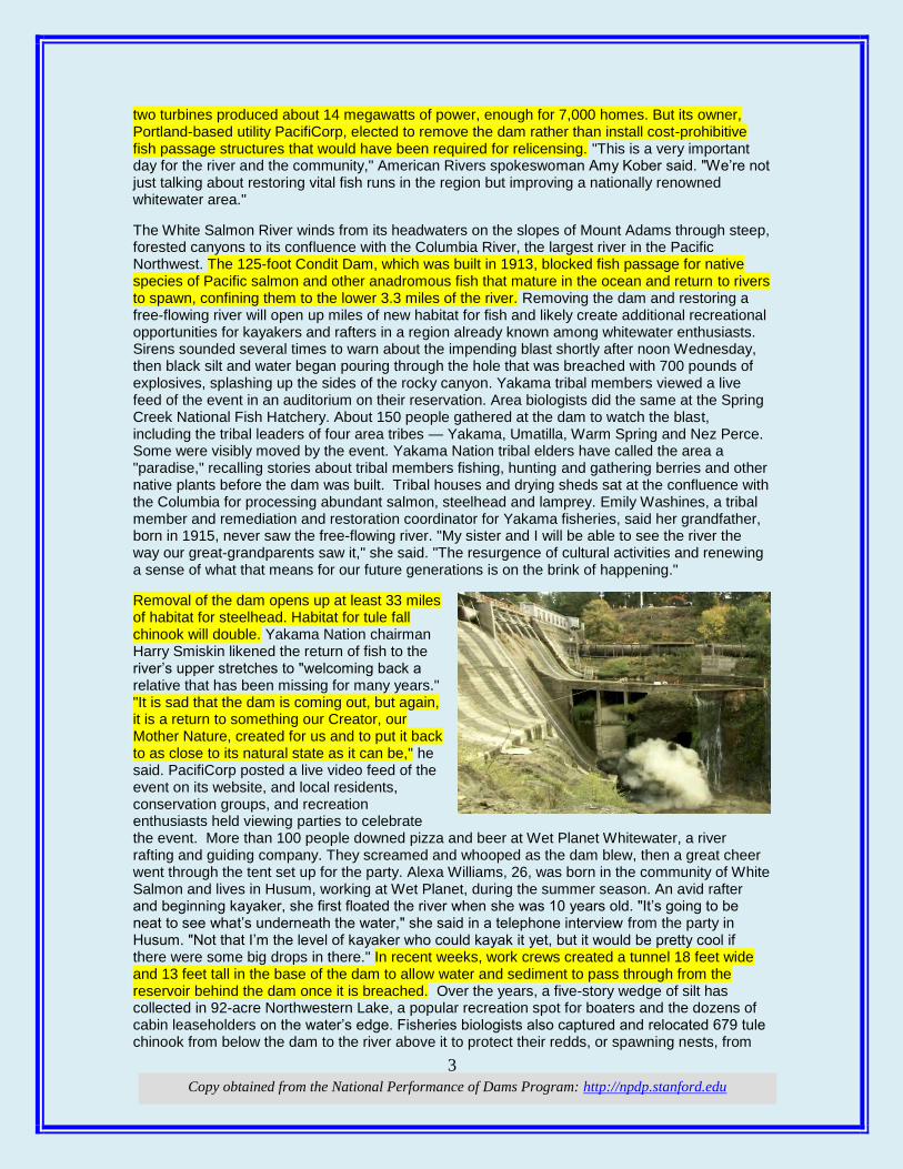
After 100 years, Condit Dam breached and White Salmon River will run free By Shannon Dininny, The Associated Press, yakima-herald.com
A muddy stew of black silt and water roared through a hole breached by workers in a nearly century-old dam Wednesday in Washington’s south Cascades, marking another step in ongoing efforts to restore habitat for threatened and endangered fish in the Pacific Northwest. The more than 12-story Condit Dam on the White Salmon River is the second-tallest dam in U.S. history to be breached for fish passage, according to the advocacy group American Rivers. Its
3
Copy obtained from the National Performance of Dams Program: http://npdp.stanford.edu
two turbines produced about 14 megawatts of power, enough for 7,000 homes. But its owner, Portland-based utility PacifiCorp, elected to remove the dam rather than install cost-prohibitive fish passage structures that would have been required for relicensing. "This is a very important day for the river and the community," American Rivers spokeswoman Amy Kober said. "We’re not just talking about restoring vital fish runs in the region but improving a nationally renowned whitewater area."
The White Salmon River winds from its headwaters on the slopes of Mount Adams through steep, forested canyons to its confluence with the Columbia River, the largest river in the Pacific Northwest. The 125-foot Condit Dam, which was built in 1913, blocked fish passage for native species of Pacific salmon and other anadromous fish that mature in the ocean and return to rivers to spawn, confining them to the lower 3.3 miles of the river. Removing the dam and restoring a free-flowing river will open up miles of new habitat for fish and likely create additional recreational opportunities for kayakers and rafters in a region already known among whitewater enthusiasts. Sirens sounded several times to warn about the impending blast shortly after noon Wednesday, then black silt and water began pouring through the hole that was breached with 700 pounds of explosives, splashing up the sides of the rocky canyon. Yakama tribal members viewed a live feed of the event in an auditorium on their reservation. Area biologists did the same at the Spring Creek National Fish Hatchery. About 150 people gathered at the dam to watch the blast, including the tribal leaders of four area tribes — Yakama, Umatilla, Warm Spring and Nez Perce. Some were visibly moved by the event. Yakama Nation tribal elders have called the area a "paradise," recalling stories about tribal members fishing, hunting and gathering berries and other native plants before the dam was built. Tribal houses and drying sheds sat at the confluence with the Columbia for processing abundant salmon, steelhead and lamprey. Emily Washines, a tribal member and remediation and restoration coordinator for Yakama fisheries, said her grandfather, born in 1915, never saw the free-flowing river. "My sister and I will be able to see the river the way our great-grandparents saw it," she said. "The resurgence of cultural activities and renewing a sense of what that means for our future generations is on the brink of happening."
Removal of the dam opens up at least 33 miles of habitat for steelhead. Habitat for tule fall chinook will double. Yakama Nation chairman Harry Smiskin likened the return of fish to the river’s upper stretches to "welcoming back a relative that has been missing for many years." "It is sad that the dam is coming out, but again, it is a return to something our Creator, our Mother Nature, created for us and to put it back to as close to its natural state as it can be," he said. PacifiCorp posted a live video feed of the event on its website, and local residents, conservation groups, and recreation enthusiasts held viewing parties to celebrate the event. More than 100 people downed pizza and beer at Wet Planet Whitewater, a river rafting and guiding company. They screamed and whooped as the dam blew, then a great cheer went through the tent set up for the party. Alexa Williams, 26, was born in the community of White Salmon and lives in Husum, working at Wet Planet, during the summer season. An avid rafter and beginning kayaker, she first floated the river when she was 10 years old. "It’s going to be neat to see what’s underneath the water," she said in a telephone interview from the party in Husum. "Not that I’m the level of kayaker who could kayak it yet, but it would be pretty cool if there were some big drops in there." In recent weeks, work crews created a tunnel 18 feet wide and 13 feet tall in the base of the dam to allow water and sediment to pass through from the reservoir behind the dam once it is breached. Over the years, a five-story wedge of silt has collected in 92-acre Northwestern Lake, a popular recreation spot for boaters and the dozens of cabin leaseholders on the water’s edge. Fisheries biologists also captured and relocated 679 tule chinook from below the dam to the river above it to protect their redds, or spawning nests, from
4
Copy obtained from the National Performance of Dams Program: http://npdp.stanford.edu
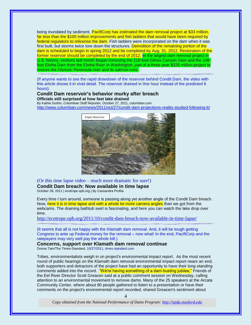
being inundated by sediment. PacifiCorp has estimated the dam removal project at $33 million, far less than the $100 million improvements and fish ladders that would have been required by federal regulators to relicense the dam. Fish ladders were incorporated on the dam when it was first built, but storms twice tore down the structures. Demolition of the remaining portion of the dam is scheduled to begin in spring 2012 and be completed by Aug. 31, 2012. Restoration of the former reservoir should be completed by the end of 2012. In the largest dam removal project in U.S. history, workers last month began removing the 210-foot Glines Canyon Dam and the 108-foot Elwha Dam from the Elwha River in Washington, part of a three-year $325 million project to restore the Olympic Peninsula river and its salmon runs. (If anyone wants to see the rapid drawdown of the reservoir behind Condit Dam, the video with this article shows it in vivid detail. The reservoir drained in 0ne hour instead of the predicted 6 hours):
Condit Dam reservoir's behavior murky after breach Officials still surprised at how fast lake drained By Kathie Durbin, Columbian Staff Reporter, October 27, 2011, columbian.com
http://www.columbian.com/news/2011/oct/27/condit-dam-projections-reality-studied-following-b/
(Or this time lapse video – much more dramatic for sure!)
Condit Dam breach: Now available in time lapse October 28, 2011 | ecotrope.opb.org | By Cassandra Profita
Every time I turn around, someone is passing along yet another angle of the Condit Dam breach. Now, here it is in time lapse and with a whole lot more camera angles than we got from the webcams. The draining bathtub swirl is fascinating, and here you can watch the lake drop over time.
http://ecotrope.opb.org/2011/10/condit-dam-breach-now-available-in-time-lapse/
(It seems that all is not happy with the Klamath dam removal. And, it will be tough getting Congress to ante up Federal money for the removal – now what! In the end, PacifiCorp and the ratepayers may very well pay the whole bill.)
Concerns, support over Klamath dam removal continue Donna Tam/The Times-Standard, 10/27/2011, times-standard.com
Tribes, environmentalists weigh in on project's environmental impact report. As the most recent round of public hearings on the Klamath dam removal environmental impact report nears an end, both supporters and detractors of the project have had an opportunity to have their long-standing comments added into the record. ”We're having something of a dam-busting jubilee,” Friends of the Eel River Director Scott Greacen said at a public comment session on Wednesday, calling attention to an environmental movement to remove dams. Many of the 25 speakers at the Arcata Community Center, where about 80 people gathered to listen to a presentation or have their comments on the project's environmental report recorded, shared Greacen's sentiment about
Empty Reservoir

5
Copy obtained from the National Performance of Dams Program: http://npdp.stanford.edu
dam removal. The comments will be published, along with responses, in the final document after the Nov. 21 deadline. The regulatory agencies are holding its last event of the week in Klamath today at 4:30 p.m. in the Yurok Tribal Administration Office, 190 Klamath Blvd.
The report and comments will help U.S. Secretary of the Interior Ken Salazar decide if the dam removal project is in the best interest of the public. Wednesday's night seemed to be a far cry from last Thursday's meeting in Siskiyou County, where dam removal supporters joined those who wanted the dams to stay in place for fear of being unable to recover from a drop in property values or a loss of recreational lakefront property created by the dams. While the report does discuss property values, scientists said there is not enough data to sufficiently predict the extent of property value decline. There are about 130 properties in the area. Siskiyou County District 2 Supervisor Ed Valenzulea said his county still has many concerns over the project. When Siskiyou County decided not to sign the agreement last year, Valenzuela voted against the motion because he wanted to stay in the conversation. His concerns regarding the EIR include a need for more studies, particularly on economic impact and property values. “It should have been more broad based,” he said after Wednesday night's meeting. “I don't think it's fair to (Secretary Salazar), it's certainly not fair to the people or the ratepayers.” The report has bolstered project proponents and seems to have done little to quell the concerns of those who oppose the circumstances -- and namely the Klamath Hydroelectric Settlement Agreement -- that surrounds the project. The report boasts the development of more than 4,000 new jobs related to the dam removal and restoration efforts. Additionally, it concluded that average adult Coho salmon production would increase by more than 80 percent. And while representatives of several environmental advocacy groups, including Environmental Protection Information Center, Northcoast Environmental Center, Sierra Club, Klamath River Keeper and Ancient Forests International, said they supported dam removal in general, many had concerns that the project doesn't go far enough. Some called for increased restoration efforts -- including a higher allotment of water for fisheries. Hoopa Valley Tribal Councilwoman Hayley Hutt agreed that there would not be enough water for fisheries. She said that if left alone, the dam's operator Pacificorp would have no choice but to pay for dam removal themselves because retrofitting the dams -- which is required by the California State Water Resources Control Board-- would be too expensive. The Hoopa Valley Tribe chose not to sign the agreements. The agreement, signed by 40 parties in February 2010, marked a major milestone for tribes, fishermen and farmers who put aside years of conflict to negotiate the deal. Participants said the agreement will help avoid potential litigation that may stem from the relicensing process for Pacificorp. The agreement invests more than $700 million in the Klamath Basin over the next 15 years. Proponents said the plan protects and enhances a natural resource that is worth more than $750 million a year to the local economy.
Residents in the areas near the dams have had a 2 percent increase in their energy bill to help pay for part of the project's funding. Troy Fletcher, policy analyst for the Yurok Tribe, which has signed the agreement, said the tribes and tribal groups outside of the agreement have yet to present studies on their concerns. He said the Klamath River is important to the spiritual and economic health of the tribe. ”It's important to the Yurok Tribe that people understand that we actually harvest Klamath fish,” he said. Representatives from commercial fishing community emphasized the need for job creation and the importance of acting swiftly now. Dave Bitts, president of the Pacific Coast Federation of Fishermen's Associations said there is no guarantee dam removal will happen on its own without a push from the community. ”Some think the water board could come charging in on their white horse with a lance and save us,” he said in his comment. “We are not at all confidant that they have a white horse in their stable or that they own a lance.” (Web site has several good photos of failure: http://www.timesunion.com/local/article/Court-Town-owes-dam-failure-costs-2239655.php#photo-1704100)
Court: Town owes dam failure costs Appeal ruling says Fort Ann must pay 23 percent of damage after collapse
6
Copy obtained from the National Performance of Dams Program: http://npdp.stanford.edu
By Brian Nearing Staff writer, October 27, 2011, timesunion.com
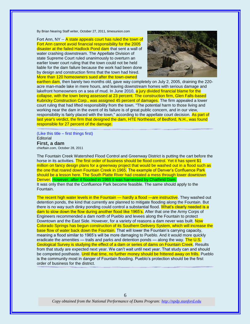
Fort Ann, NY -- A state appeals court has ruled the town of Fort Ann cannot avoid financial responsibility for the 2005 disaster at the failed Hadlock Pond dam that sent a wall of water crashing downstream. The Appellate Division of state Supreme Court ruled unanimously to overturn an earlier lower court ruling that the town could not be held liable for the dam failure because the work had been done by design and construction firms that the town had hired. More than 120 homeowners sued after the town-owned earthen dam, then barely two months old, gave way completely on July 2, 2005, draining the 220-acre man-made lake in mere hours, and leaving downstream homes with serious damage and lakefront homeowners on a sea of mud. In June 2010, a jury divided financial blame for the collapse, with the town being assessed at 23 percent. The construction firm, Glen Falls-based Kubricky Construction Corp., was assigned 45 percent of damages. The firm appealed a lower court ruling that had lifted responsibility from the town. "The potential harm to those living and working near the dam in the event of its failure is of great public concern, and in our view, responsibility is fairly placed with the town," according to the appellate court decision. As part of last year's verdict, the firm that designed the dam, HTE Northeast, of Bedford, N.H., was found responsible for 27 percent of the damage. (Like this title – first things first) Editorial
First, a dam chieftain.com, October 28, 2011
The Fountain Creek Watershed Flood Control and Greenway District is putting the cart before the horse in its activities. The first order of business should be flood control. Yet it has spent $1 million on fancy design plans for a greenway project that would be washed out in a flood such as the one that roared down Fountain Creek in 1965. The example of Denver’s Confluence Park should be a lesson here. The South Platte River had created a mess through lower downtown Denver. However, after it flooded in 1965 it was harnessed by Chatfield Dam. It was only then that the Confluence Park become feasible. The same should apply to the Fountain.
The recent high water levels in the Fountain — hardly a flood —are instructive. They washed out detention ponds, the kind that currently are planned to mitigate flooding along the Fountain. But there is no way such dinky ponding could control a substantial flood. What’s clearly needed is a dam to slow down the flow during another flood like 1965’s. After that one the Army Corps of Engineers recommended a dam north of Pueblo and levees along the Fountain to protect Downtown and the East Side. However, for a variety of reasons a dam never was built. Now Colorado Springs has begun construction of its Southern Delivery System, which will increase the base flow of water back down the Fountain. That will lower the Fountain’s carrying capacity, meaning a flood similar to 1965’s will be more damaging to Pueblo. And it would more quickly eradicate the amenities — trails and parks and detention ponds — along the way. The U.S. Geological Survey is studying the effect of a dam or series of dams on Fountain Creek. Results from that study are expected next year. We can’t wait until next year. That study can and should be competed posthaste. Until that time, no further money should be frittered away on frills. Pueblo is the community most in danger of Fountain flooding. Pueblo’s protection should be the first order of business for the district.
7
Copy obtained from the National Performance of Dams Program: http://npdp.stanford.edu
HHyyddrroo: (It’s a really old NE mill that could use some help from a hydro project even though small)
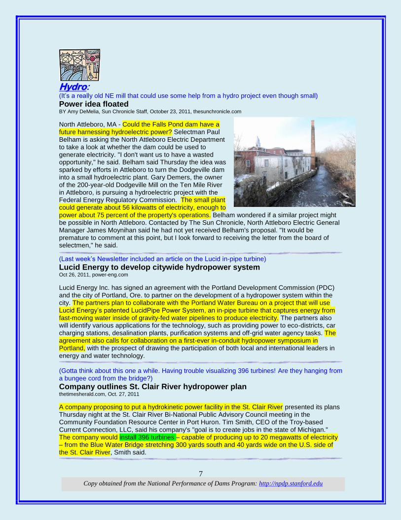
Power idea floated BY Amy DeMelia, Sun Chronicle Staff, October 23, 2011, thesunchronicle.com
North Attleboro, MA - Could the Falls Pond dam have a future harnessing hydroelectric power? Selectman Paul Belham is asking the North Attleboro Electric Department to take a look at whether the dam could be used to generate electricity. "I don't want us to have a wasted opportunity," he said. Belham said Thursday the idea was sparked by efforts in Attleboro to turn the Dodgeville dam into a small hydroelectric plant. Gary Demers, the owner of the 200-year-old Dodgeville Mill on the Ten Mile River in Attleboro, is pursuing a hydroelectric project with the Federal Energy Regulatory Commission. The small plant could generate about 56 kilowatts of electricity, enough to power about 75 percent of the property's operations. Belham wondered if a similar project might be possible in North Attleboro. Contacted by The Sun Chronicle, North Attleboro Electric General Manager James Moynihan said he had not yet received Belham's proposal. "It would be premature to comment at this point, but I look forward to receiving the letter from the board of selectmen," he said.
(Last week’s Newsletter included an article on the Lucid in-pipe turbine)
Lucid Energy to develop citywide hydropower system Oct 26, 2011, power-eng.com
Lucid Energy Inc. has signed an agreement with the Portland Development Commission (PDC) and the city of Portland, Ore. to partner on the development of a hydropower system within the city. The partners plan to collaborate with the Portland Water Bureau on a project that will use Lucid Energy’s patented LucidPipe Power System, an in-pipe turbine that captures energy from fast-moving water inside of gravity-fed water pipelines to produce electricity. The partners also will identify various applications for the technology, such as providing power to eco-districts, car charging stations, desalination plants, purification systems and off-grid water agency tasks. The agreement also calls for collaboration on a first-ever in-conduit hydropower symposium in Portland, with the prospect of drawing the participation of both local and international leaders in energy and water technology. (Gotta think about this one a while. Having trouble visualizing 396 turbines! Are they hanging from a bungee cord from the bridge?)
Company outlines St. Clair River hydropower plan thetimesherald.com, Oct. 27, 2011
A company proposing to put a hydrokinetic power facility in the St. Clair River presented its plans Thursday night at the St. Clair River Bi-National Public Advisory Council meeting in the Community Foundation Resource Center in Port Huron. Tim Smith, CEO of the Troy-based Current Connection, LLC, said his company's "goal is to create jobs in the state of Michigan." The company would install 396 turbines – capable of producing up to 20 megawatts of electricity – from the Blue Water Bridge stretching 300 yards south and 40 yards wide on the U.S. side of the St. Clair River, Smith said.
8
Copy obtained from the National Performance of Dams Program: http://npdp.stanford.edu
(This is back in the news again. It’s an important case because if the Company loses, every other state will look to this as a new source of revenue which really will be a tax on ratepayers.)
Montana fights for control of riverbeds in US Supreme Court battle with dam owner PPL Matt Gouras Associated Press, therepublic.com, October 28, 2011
Helena, Mont. — Montana is asking the U.S. Supreme Court to stick with a lower court ruling that the state owns the riverbeds where hydroelectric dams sit and can charge power companies rent for their usage. PPL Montana has gone to the nation's high court, asking it to reverse a 2010 ruling by the Montana Supreme Court that declared the riverbeds were state property. The U.S. Supreme Court is scheduled to hear the case in December. Montana Attorney General Steve Bullock argued in a Thursday filing that state title to the riverbeds stretches back to the 1800s. The argument relies upon historical records that even include notes from the expedition of Meriwether Lewis and William Clark more than 200 years ago.
The state is expecting PPL to pay $40 million in current rent, plus damages for not paying rent for land its dams sit on from 2000 through 2007, and even more in future rent. The court decision declared that the land under the dams is like other public land that is rented out by the state, such as to those who graze cattle or drill for oil. PPL Montana, however, argues that the state overstepped its authority in a decision that reverses more than a century of precedent treating the riverbed under the dams either as private property or federal land. The company argues federal permits grant it the right of usage. PPL has said that the court needs to enforce its right to use the land or see other states make belated claims for past rent in similar situations. Much of the legal arguments hinge on whether the river was navigable at statehood, part of a test to determined state ownership. PPL Montana argues that the portions of the rivers where its dams are located were not navigable at time of statehood in 1889, saying early expeditions took weeks to portage around sections of the river. The state says that portions of three rivers that are in dispute have a history of navigation dating back to Lewis' description of rivers that run through "such a mountainous country and at the same time are so navigable as they are." Bullock argues in its latest court filing that adoption of PPL's ownership definition would have far-reaching consequences that would hinder river and wildlife management, and lead to more legal fights. PPL Montana says the rent charged on its dams is a "hidden tax" that will be passed onto ratepayers. The attorney general's office has pointed out the argument is flawed, since after deregulation the company can only sell the electricity for what the market will bear.
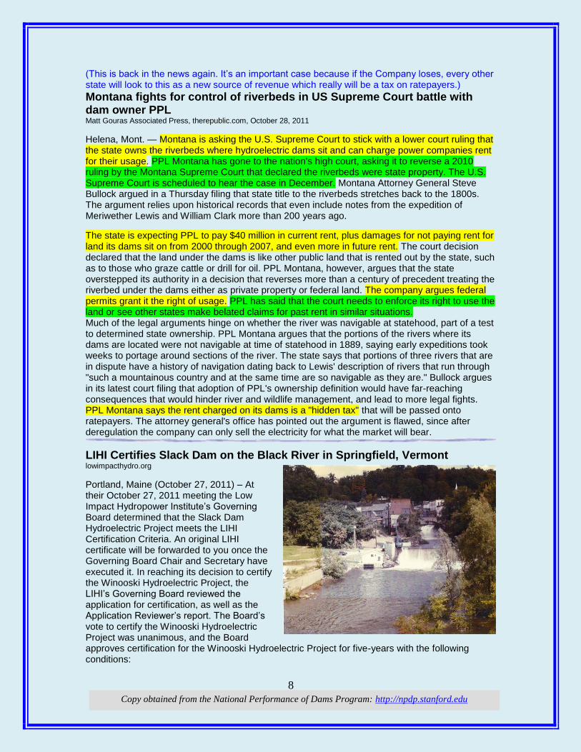
LIHI Certifies Slack Dam on the Black River in Springfield, Vermont lowimpacthydro.org
Portland, Maine (October 27, 2011) – At their October 27, 2011 meeting the Low Impact Hydropower Institute’s Governing Board determined that the Slack Dam Hydroelectric Project meets the LIHI Certification Criteria. An original LIHI certificate will be forwarded to you once the Governing Board Chair and Secretary have executed it. In reaching its decision to certify the Winooski Hydroelectric Project, the LIHI’s Governing Board reviewed the application for certification, as well as the Application Reviewer’s report. The Board’s vote to certify the Winooski Hydroelectric Project was unanimous, and the Board approves certification for the Winooski Hydroelectric Project for five-years with the following conditions:
9
Copy obtained from the National Performance of Dams Program: http://npdp.stanford.edu
• Upon receipt of certification, Springfield Hydroelectric Company (“Springfield”) must initiate a new round of consultation with the USFWS and the Vermont Department of Fish and Wildlife Department (collectively, the agencies) to determine whether the current downstream passage at its project is appropriately protective, and to report to LIHI by March 1, 2012 as to whether the agencies have deemed it appropriately protective. If the agencies determine that it is not appropriately protective, Springfield shall provide an agreement has been reached with the agencies providing for either fishway modifications or downstream passage effectiveness testing by Springfield in 2012.
• If downstream effectiveness testing is required, Springfield shall report to LIHI by November 1, 2012 on the results of the testing unless a different date is mutually agreed upon by Springfield and the agencies.
• If results do not show adequate effectiveness to be appropriately protective, Springfield shall also report to LIHI as to whether agreement has been reached on fishway modifications that will be implemented and operational by April 1, 2013.
• LIHI reserves right to suspend certification if the above steps are not completed, if no agreement is reached with the agencies; or if required measures to ensure downstream passage is appropriately protective of the Atlantic salmon resource are not made by April 1, 2013.
The effective certification date for the Winooski Hydroelectric Project is February 28, 2011 and will expire on February 28, 2016. Any Commenter may submit a letter to the Certification Administrator requesting an appeal within 30 days of the posting of the Certification Decision on the Institute’s Web page. An appeal request must include specific reasons why the hydropower facility should have failed one or more criteria. If an individual or organization did not comment on the initial Application Package, they may not file an appeal. During the time the Project is certified, you may market the Winooski Hydroelectric Project facilities as LIHI certified. The project is located at the Slack Dam in Springfield, Vermont. The dam is one of five existing concrete gravity dams on the Black River. (Comtu Falls site is immediately upstream, and the Lovejoy site is just downstream.) The project was reconstructed in 1986 and has an installed capacity of 400 KW. Annual energy production has averaged 2,000,000 KWH. The project is strict run-of-river utilizing 21-feet of gross head, between the headwater and tailwater. There is no bypass reach. The project is served by a 190 square mile drainage area on the Black River, 75% of which is controlled by the U.S. Army Corps of Engineers Flood Control Project in N. Springfield, 4.5 miles upstream. A steel penstock 8’ in diameter and 80’ in length conducts water from the intake to the powerhouse. The power house is 20’ x 20’ square and houses one horizontal full Kaplan turbine driving a vertical induction generator by means of an internal bevel gear, together with associated hydraulic, mechanical, electrical and electronic equipment. The powerhouse is constructed of reinforced concrete to an elevation greater than the 100 year flood level. A pad mounted transformer connects the station to 3-phase 4,160 V electrical service. A fishway, constructed in 2007 provides for downstream fish passage.
EEnnvviirroonnmmeenntt:: (It’s amazing what little people know about a river. There are a number of dams in the Willamette River basin that control the river flows and provide huge benefits, including much needed flood control. The river is not wild; it is controlled for the good of everyone, including the paddlers. And, compared to many states, OR doesn’t really have that many dams. Watch out for those dam builders – the beavers!) (Note: if interested in a map of the Willamette River basin, go here: http://or.water.usgs.gov/proj/will_temp/map.html)
Author: Willamette 'A River Of The People' Ed Jahn | October 24, 2011, news.opb.org | Salem, OR
10
Copy obtained from the National Performance of Dams Program: http://npdp.stanford.edu
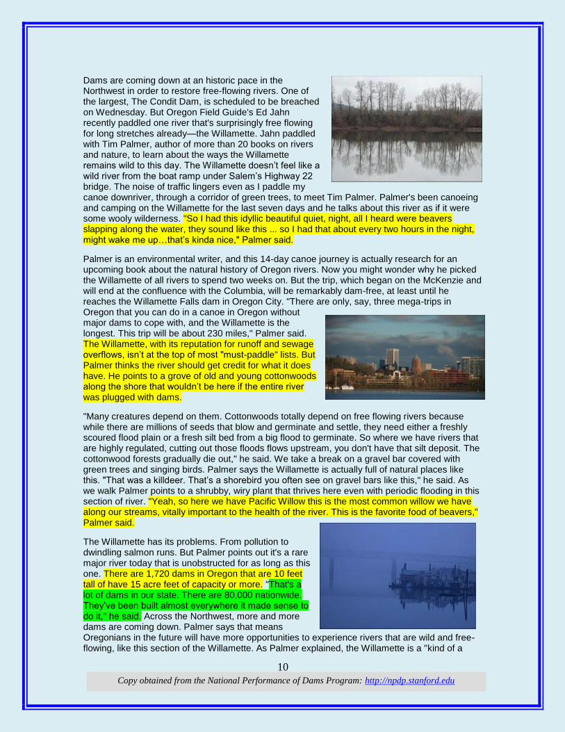
Dams are coming down at an historic pace in the Northwest in order to restore free-flowing rivers. One of the largest, The Condit Dam, is scheduled to be breached on Wednesday. But Oregon Field Guide's Ed Jahn recently paddled one river that's surprisingly free flowing for long stretches already—the Willamette. Jahn paddled with Tim Palmer, author of more than 20 books on rivers and nature, to learn about the ways the Willamette remains wild to this day. The Willamette doesn’t feel like a wild river from the boat ramp under Salem’s Highway 22 bridge. The noise of traffic lingers even as I paddle my canoe downriver, through a corridor of green trees, to meet Tim Palmer. Palmer's been canoeing and camping on the Willamette for the last seven days and he talks about this river as if it were some wooly wilderness. "So I had this idyllic beautiful quiet, night, all I heard were beavers slapping along the water, they sound like this ... so I had that about every two hours in the night, might wake me up…that’s kinda nice," Palmer said.
Palmer is an environmental writer, and this 14-day canoe journey is actually research for an upcoming book about the natural history of Oregon rivers. Now you might wonder why he picked the Willamette of all rivers to spend two weeks on. But the trip, which began on the McKenzie and will end at the confluence with the Columbia, will be remarkably dam-free, at least until he reaches the Willamette Falls dam in Oregon City. "There are only, say, three mega-trips in Oregon that you can do in a canoe in Oregon without major dams to cope with, and the Willamette is the longest. This trip will be about 230 miles," Palmer said. The Willamette, with its reputation for runoff and sewage overflows, isn’t at the top of most "must-paddle" lists. But Palmer thinks the river should get credit for what it does have. He points to a grove of old and young cottonwoods along the shore that wouldn’t be here if the entire river was plugged with dams.
"Many creatures depend on them. Cottonwoods totally depend on free flowing rivers because while there are millions of seeds that blow and germinate and settle, they need either a freshly scoured flood plain or a fresh silt bed from a big flood to germinate. So where we have rivers that are highly regulated, cutting out those floods flows upstream, you don't have that silt deposit. The cottonwood forests gradually die out," he said. We take a break on a gravel bar covered with green trees and singing birds. Palmer says the Willamette is actually full of natural places like this. "That was a killdeer. That’s a shorebird you often see on gravel bars like this," he said. As we walk Palmer points to a shrubby, wiry plant that thrives here even with periodic flooding in this section of river. "Yeah, so here we have Pacific Willow this is the most common willow we have along our streams, vitally important to the health of the river. This is the favorite food of beavers," Palmer said.
The Willamette has its problems. From pollution to dwindling salmon runs. But Palmer points out it's a rare major river today that is unobstructed for as long as this one. There are 1,720 dams in Oregon that are 10 feet tall of have 15 acre feet of capacity or more. "That's a lot of dams in our state. There are 80,000 nationwide. They’ve been built almost everywhere it made sense to do it," he said. Across the Northwest, more and more dams are coming down. Palmer says that means Oregonians in the future will have more opportunities to experience rivers that are wild and free-flowing, like this section of the Willamette. As Palmer explained, the Willamette is a "kind of a

11
Copy obtained from the National Performance of Dams Program: http://npdp.stanford.edu
river for the people, ya know it’s a river for almost anybody with even a little experience to get out and do -- mile after mile after mile, on and on. To me it's the real tour of Oregon." (Photos by
Michael Clapp / OPB)
(The $100 million fish. A good fish story for a dam)
At Pelton Round Butte dams: $100 million later, a steelhead returns Cassandra Profita | October 25, 2011, news.opb.org
Mike Gauvin of Oregon Department of Fish and Wildlife shows off the first of the reintroduced steelhead to return after a massive effort to bring back fish runs that were wiped out by the Pelton and Round Butte dams in Central Oregon. Sometimes the return of one adult salmon or steelhead is more exciting than runs of hundreds or thousands. That’s the situation this year in Central Oregon’s Deschutes River Basin. A massive fish reintroduction effort above the Pelton Rounde Butte hydro project saw its first steelhead return this month. The picture of the fish (above) has been circulating among the many people who have helped install a $100 million fish passage project, overhaul stream habitat above the dams, and start up a new crop of fish to replace the ones that were lost when the dams were built. “It’s pretty exciting,” said MerryAnn Moore, who lives on Whychus Creek, a tributary above the dams where the steelhead smolts were released last year. “It’s like our first grandkid just got to college. This is what we all dreamed about.” Even with all the work that has gone into the project so far, coordinators say they’re still in the early stages of replacing historic runs to Whychus and the Metolius and Crooked Rivers above the Pelton and Round Butte dams. The adult fish still can’t get up around the dams on their own, and there aren’t enough adults yet for them to spawn naturally.
But the return of the first reintroduced steelhead, chinook and sockeye to the Pelton dam fish trap this year suggests there are more on the way. As part of the relicensing process for the Pelton Round Butte hydro project, Portland General Electric and the Warm Springs tribes put more than $100 million into an underwater tower that adjusts water temperatures in the Lake Billy Chinook reservoir to help young salmon and steelhead make it down the Deschutes and Columbia rivers and out to the Pacific ocean. The dams blocked the natural route for several runs of salmon and steelhead in the 1960s, and while adult fish had a route around the dams to reach their spawning grounds, their babies couldn’t find their way out of the reservoirs because of the dramatic changes in water temperature. That interrupted the life cycle of the fish and prevented the runs from reproducing. In 1968, a fish hatchery was built below the dams to replace the lost fish runs. Since 1995, a huge team of 22 organizations and agencies has been working on way to redesign the project to help young fish downstream. Meanwhile, a huge habitat restoration effort has been underway to make sure the returning fish will have a place to spawn and their babies will have a place to feed and grow (see Oregon Field Guide video above for more on that effort). Mike Gauvin, mitigation coordinator for Oregon Department of Fish and Wildlife, said biologists have been “planting” baby steelhead above the dams since 2007, and the fish tower has been operating for two full years to help them out to sea. But this is the first year they’ve seen returning adults from the fish they planted. Four other tagged steelhead from the reintroduction project have been detected at Bonneville Dam. And the first reintroduced sockeye and chinook found their way back this year, too. “It is all pretty exciting,” said Don Ratliff, project coordinator for PGE. “We’re in this transition where significant numbers of fish are moving to the ocean. … The fish this year are the first vanguard of what we hope will be bigger runs in the future.” This story originally appeared on ecotrope.opb.org

12
Copy obtained from the National Performance of Dams Program: http://npdp.stanford.edu
iThis compilation of articles and other information is provided at no cost for those interested in hydropower, dams, and water resources issues and development, and should not be used for any commercial or other purpose. Any copyrighted material herein is distributed without profit or payment from those who have an interest in receiving this information for non-profit and educational purposes only.
1
Copy obtained from the National Performance of Dams Program: http://npdp.stanford.edu
11/11/2011
i
“Good wine is a necessity of life.” - -Thomas Jefferson Ron’s wine pick of the week: Chateau Ste. Michelle - Cabernet Sauvignon Columbia Valley 2008 “No nation was ever drunk when wine was cheap.” - - Thomas Jefferson OOtthheerr SSttuuffff: (Did you notice the date of this Newsletter [11-11-11]? I wonder how many people will play that number in the Lotto.)
DDaammss:: (A sign of things to come. The Country is so poor that we can’t even do what needs to be done – pathetic!) Dam Infrastructure Could Fall Victim to Cuts huntingtonnews.ne, October 31, 2011 Rep. Nick Rahall Release Hinton, WV – At a ceremony marking the completion of the latest phase of safety improvements at Bluestone Dam, U.S. Rep. Nick J. Rahall (D-WV) Monday warned that slashing federal funding for U.S. Army Corps of Engineers infrastructure projects could stall badly needed dam safety improvements across the country. “Protecting life and limb and property, improving our quality of life, and laying a solid foundation for job creation – these are the bread and butter tasks of a government that works,” said Rahall, the top Democrat of the House Transportation and Infrastructure Committee who is calling for greater federal funding for such construction projects throughout the Nation. “Nationally, the American Society of Civil Engineers in their last report card on the state of our Nation’s infrastructure could only score our dams with the grade of ‘D.’ That’s a ‘D’ as in too doggone low. Of the more than 85,000 dams in the country, a majority of them are over 51 years of age. This Nation cannot continue to flirt with disaster.” Earlier this year, the House of Representatives approved the Fiscal Year 2012 Energy and Water Development
Some Dam – Hydro News TM And Other Stuff
Quote of Note: “Too many people overvalue what they are not and undervalue what they are."
-- Malcolm Forbes
2
Copy obtained from the National Performance of Dams Program: http://npdp.stanford.edu
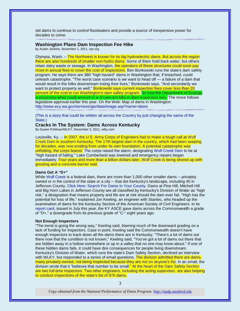
Appropriations bill, which cut funding for the Corps by $677 million below FY 2010 levels. Both Houses of Congress now await the work of a Congressional “Super Committee,” created to produce further budget savings, likely resulting in more cuts to basic infrastructure programs, as well as other areas of the budget. The Super Committee is scheduled to report its recommendations by November 23rd. Rahall stressed that Army Corps of Engineer infrastructure efforts make economic sense as public investments that return significant economic savings to the families, businesses, and communities in the regions they serve. “This is one of those great Corps projects that baffle the mind in its scope and importance,” said Rahall in acknowledging the importance of the Corps’ efforts to reduce overall flood risk in the region. “Since Bluestone Dam became operational, the Corps calculates it has saved us almost $5 billion by controlling flood threats and spared countless families and businesses days of misery.” Today’s ceremony marked the completion of the Bluestone Dam Safety Assurance Project Phase 2B Initial Anchor Installation. Phase 2B is the latest step in the Corps’ work to ensure the dam’s stability and provide an increase in the amount of flood waters that can safely be held by the dam. Rahall, who has been working for years to secure funding to modernize and make safer the Bluestone Dam, noted that, teaming with former Senator Robert C. Byrd, he helped to secure over $219 million for upgrades to the Bluestone Dam. The American Recovery and Reinvestment Act provided funding to increase the number of anchors to be installed in this phase and provided for reaming of gallery drains in the dam, making it possible for the dam to hold an additional 19 feet of flood storage. (Not many things would look this could after being under water 75 years.) An inside-look at two TVA dams wbir.com, Oct 31, 2011 The Tennessee Valley Authority built its first dam in 1936 to provide electricity and flood control to rural Appalachia. Over the past 75 years the agency has grown into coal, natural gas, nuclear, wind and solar generation. However, the dams are still a key part of TVA's mission. TVA's first dam, Norris, is still generating at full capacity and holding back the waters of the Clinch River. It and the other dams on the Tennessee River system are aging. TVA is working constantly to keep them churning out power and controlling the floodwaters that once plagued the region. During the early morning fog, inspection crews are working on the lake side of Norris Dam. A remote controlled mini-submarine dives deep as it goes 170 feet to the bottom of the dam. "With these guys he can throw his ROV in the water and he can stay in whatever time we need him in, where the divers he may have a bottom limit of maybe 10 or 15 minutes," explained TVA Program Administrator Jerry Stiner. Crews are inspecting the steel grates guarding the entrance to the sluiceways. They have been under water since 1936. The sluiceways allow cold water from the bottom of the dam to be released downstream. At Norris that process is important to control the water levels in the lake and for the trout habitat below the dam. At Ft. Loudon Dam, contract divers do the work on the downriver side of the dam. "We look for corrosion and deterioration of the concrete and of the metal structures involved in those components," said TVA Program Manager Chris Hutt. Those workers want to make sure giant steel head gates will drop into place to seal off of the turbine. "To be able to dry the unit out, to get in to work on the unit if we need to pull out internal components and just to be able to dry the unit out," said Hutt. With 49 dams along the river system, these guys stay busy. Loudon was finished in 1943. However, like many other dams, it gets inspected more often now. Mother Nature is constantly working to erode the dams. Racks help to keep debris out of the turbines and when the inspectors find a problem, the divers return. TVA officials said the constant cycle of inspection and maintenance should allow
Norris Dam
3
Copy obtained from the National Performance of Dams Program: http://npdp.stanford.edu
old dams to continue to control floodwaters and provide a source of inexpensive power for decades to come. Washington Plans Dam Inspection Fee Hike by Austin Jenkins, November 1, 2011, npr.org Olympia, Wash. – The Northwest is known for its big hydroelectric dams. But across the region there are also hundreds of smaller non-hydro dams. Some of them hold back water, but others retain dairy waste or sewage. In Washington, the operators of these structures could soon pay more in annual fees to cover the cost of inspections. Ben Bonkowski runs the state's dam safety program. He says there are 380 "high hazard" dams in Washington that, if breached, could unleash catastrophe. "The worst case scenario is we want to head off — a failure of a dam that would result in the folks downstream losing their lives," Bonkowski says. "And secondarily we want to protect property as well." Bonkowski says current inspection fees cover less than 20 percent of the cost to run Washington's dam safety program. So now the Department of Ecology is proposing what could amount to a 40 percent hike in dam inspection fees. The move follows legislative approval earlier this year. On the Web: Map of dams in Washington: http://www.ecy.wa.gov/services/gis/data/image.asp?name=dams (This is a story that could be written all across the Country by just changing the name of the State.) Cracks In The System: Dams Across Kentucky By Duane Pohlman/WLKY, November 3, 2011, wlky.com Louisville, Ky. -- In 2007, the U.S. Army Corps of Engineers had to make a tough call at Wolf Creek Dam in southern Kentucky. The 17th largest dam in the country, which had been seeping for decades, was now eroding from under its own foundation. A potential catastrophe was unfolding, the corps feared. The corps raised the alarm, designating Wolf Creek Dam to be at "high hazard of failing." Lake Cumberland was lowered and emergency repairs began immediately. Four years and more than a billion dollars later, Wolf Creek is being shored up with grouting and a concrete barrier wall. Dams Get A “D+” While Wolf Creek is a federal dam, there are more than 1,000 other smaller dams -- privately owned or in the control of the state or a city -- that dot Kentucky's landscape, including 40 in Jefferson County. Click Here: Search For Dams In Your County. Dams at Pine Hill, Mitchell Hill and Big Horn Lakes in Jefferson County are all classified by Kentucky's Division of Water as "high risk," a designation that means property and life are at risk should the dam ever fail. "High has the potential for loss of life," explained Jon Keeling, an engineer with Stantec, who headed up the examination of dams for the Kentucky Section of the American Society of Civil Engineers. In its report card, issued in July this year, the KY ASCE gave dams across the Commonwealth a grade of "D+," a downgrade from its previous grade of "C-“ eight years ago. Not Enough Inspectors "The trend is going the wrong way," Keeling said, blaming much of the downward grading on a lack of funding for inspectors. Case in point, Keeling said the Commonwealth doesn't have enough inspectors to track down all the dams there are in Kentucky. "There's a lot of dams out there now that the condition is not known," Keeling said, "You've got a lot of dams out there that are hidden away in a hollow somewhere or up in a valley that no one may know about." If one of these hidden dams fails, it could have dire consequences for people living downstream. Kentucky's Division of Water, which runs the state's Dam Safety Section, declined an interview with WLKY, but responded to a series of email questions. The division admitted there are dams, many privately-owned, not being inspected because they are not on anyone's list. In an email, the division wrote that it "believes that number to be small." At the heart of the Dam Safety Section are two full-time inspectors. Two other engineers, including the acting supervisor, are also helping to conduct inspections of the state's list of 976 dams.
4
Copy obtained from the National Performance of Dams Program: http://npdp.stanford.edu
While the state said they have enough personnel to inspect dams. In the upcoming 2012 budget, the Division of Water is asking for three additional positions, including two more full time dam inspectors and a permanent supervisor to oversee the program. That's nearly double the staff it has right now. Dam Consequences Keeling said the consequences are clear for the aging dams across Kentucky. "A lot of these dams can't pass the design storm that they were built for," Keeling said. That means many of the
dams could fail in a catastrophic flood, either because the face of the dam needs to be taller or because the spillway is not large enough to get rid of the excess water. Kentucky's Division of Water said it is "concerned about all dams" in Kentucky. In a follow-up, the state provided a list of seven state-owned dams, including McNeely Lake Dam in Jefferson County, that are "prioritized for repair work." The Division of Water said it is too early to estimate the costs, but Keeling, who has noted the need to deal with these dams, said the repair work will run in to the many millions of dollars. "It's going to be a large investment required,” he said.
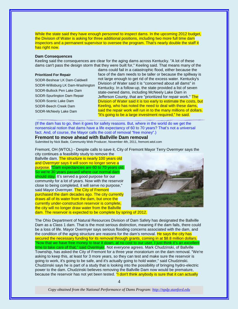
(If the dam has to go, then it goes for safety reasons. But, where in the world do we get the nonsensical notion that dams have a life expectancy of 60 to 70 years? That’s not a universal fact. And, of course, the Mayor calls the cost of removal “free money”.) Fremont to move ahead with Ballville Dam removal Submitted by Nick Bade, Community Web Producer, November 4th, 2011, fremont.wtol.com Fremont, OH (WTOL) - Despite calls to save it, City of Fremont Mayor Terry Overmyer says the city continues a feasibility study to remove the Ballville dam. The structure is nearly 100 years old and Overmyer says it will soon no longer serve a purpose. "Dam expectancies are 60 to 70 years old. So we're 30 years passed where our normal dam should stay. It’s served a good purpose for our community for a lot of years. Now with the reservoir close to being completed, it will serve no purpose," said Mayor Overmyer. The City of Fremont purchased the dam decades ago. The city currently draws all of its water from the dam, but once the currently under-construction reservoir is complete, the city will no longer draw water from the Ballville dam. The reservoir is expected to be complete by spring of 2012. The Ohio Department of Natural Resources Division of Dam Safety has designated the Ballville Dam as a Class 1 dam. That is the most serious distinction, meaning if the dam fails, there could be a loss of life. Mayor Overmyer says serious flooding concerns associated with the dam, and the condition of the aging structure are reasons for the dam's removal. He says the city has secured the necessary funding for its removal through grants, coming in at $8.8 million dollars. "Now that we have free money to tear it down, at no cost to our user, I just think it’s an excellent time to take care of that," said Overmyer. Not everyone agrees. Mark Chudzinski, of Ballville Township, has asked the City of Fremont for a three year moratorium on the dam removal. "We're asking to keep this, at least for 3 more years, so they can test and make sure the reservoir is going to work, it's going to be safe, and it's actually going to hold water," said Chudzinski. Chudzinski says he is part of a study that is looking into the possibility of bringing hydro-electric power to the dam. Chudzinski believes removing the Ballville Dam now would be premature, because the reservoir has not yet been tested. "I don't think anybody is sure that it can actually
Prioritized For Repair SODR-Beshear LK Dam-Caldwell SODR-Willisburg LK Dam-Washington SODR-Bullock Pen Lake Dam SODR-Spurlington Dam Repair SODR-Scenic Lake Dam SODR-Beech Creek Dam SODR-McNeely Lake Dam
5
Copy obtained from the National Performance of Dams Program: http://npdp.stanford.edu
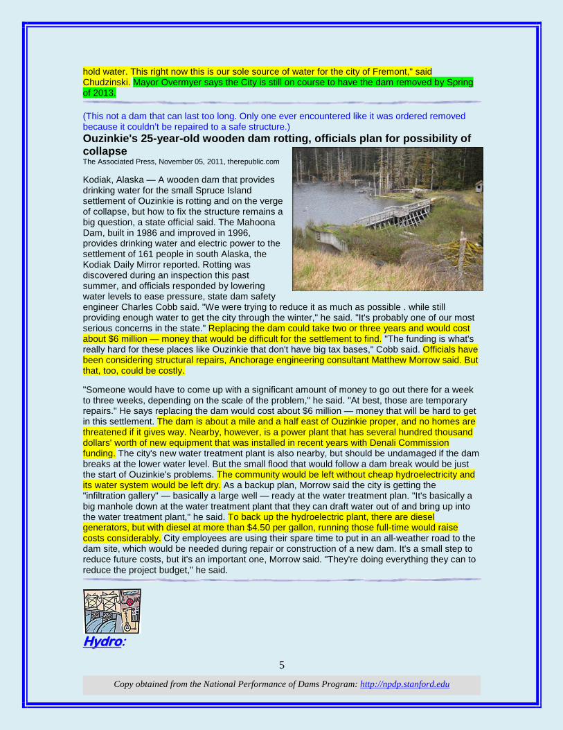
hold water. This right now this is our sole source of water for the city of Fremont," said Chudzinski. Mayor Overmyer says the City is still on course to have the dam removed by Spring of 2013. (This not a dam that can last too long. Only one ever encountered like it was ordered removed because it couldn’t be repaired to a safe structure.) Ouzinkie's 25-year-old wooden dam rotting, officials plan for possibility of collapse The Associated Press, November 05, 2011, therepublic.com Kodiak, Alaska — A wooden dam that provides drinking water for the small Spruce Island settlement of Ouzinkie is rotting and on the verge of collapse, but how to fix the structure remains a big question, a state official said. The Mahoona Dam, built in 1986 and improved in 1996, provides drinking water and electric power to the settlement of 161 people in south Alaska, the Kodiak Daily Mirror reported. Rotting was discovered during an inspection this past summer, and officials responded by lowering water levels to ease pressure, state dam safety engineer Charles Cobb said. "We were trying to reduce it as much as possible . while still providing enough water to get the city through the winter," he said. "It's probably one of our most serious concerns in the state." Replacing the dam could take two or three years and would cost about $6 million — money that would be difficult for the settlement to find. "The funding is what's really hard for these places like Ouzinkie that don't have big tax bases," Cobb said. Officials have been considering structural repairs, Anchorage engineering consultant Matthew Morrow said. But that, too, could be costly. "Someone would have to come up with a significant amount of money to go out there for a week to three weeks, depending on the scale of the problem," he said. "At best, those are temporary repairs." He says replacing the dam would cost about $6 million — money that will be hard to get in this settlement. The dam is about a mile and a half east of Ouzinkie proper, and no homes are threatened if it gives way. Nearby, however, is a power plant that has several hundred thousand dollars' worth of new equipment that was installed in recent years with Denali Commission funding. The city's new water treatment plant is also nearby, but should be undamaged if the dam breaks at the lower water level. But the small flood that would follow a dam break would be just the start of Ouzinkie's problems. The community would be left without cheap hydroelectricity and its water system would be left dry. As a backup plan, Morrow said the city is getting the "infiltration gallery" — basically a large well — ready at the water treatment plan. "It's basically a big manhole down at the water treatment plant that they can draft water out of and bring up into the water treatment plant," he said. To back up the hydroelectric plant, there are diesel generators, but with diesel at more than $4.50 per gallon, running those full-time would raise costs considerably. City employees are using their spare time to put in an all-weather road to the dam site, which would be needed during repair or construction of a new dam. It's a small step to reduce future costs, but it's an important one, Morrow said. "They're doing everything they can to reduce the project budget," he said.
HHyyddrroo:
6
Copy obtained from the National Performance of Dams Program: http://npdp.stanford.edu
(And this from our friends in Canada. Catchy title too! How come they are so enlightened and we have a struggle?) Dam, that's powerful The future of hydropower is bright Ryan Lee, mcgilldaily.com, October 31, 2011 Hydroelectricity is a renewable energy resource that harnesses the energy of flowing water. It is currently the most widely used form of renewable energy on the planet. Canada is the world’s second largest producer of hydroelectricity. Hydro-Quebec accounts for almost half of Canada’s total energy production. Humans have been harnessing hydropower for thousands of years. The ancient Greeks used water wheels to grind their wheat and flour nearly 2000 years ago. Although the central tenets behind the usage of hydropower are much the same, technology has come a long way since then. The invention of the hydraulic reaction turbine has been a boon to the industry. By the early 1900s, 40 per cent of America’s electricity was produced by hydroelectric production. As this form of renewable energy became more abundant and reliable, it was termed “white coal” to distinguish its gradual substitution for the primary source of energy at the time. The basic theory of hydroelectric power generation is the principle of converting mechanical energy into electricity. When water rotates a turbine, the kinetic energy of the water is transferred to the turbine, and this mechanical energy is converted to electricity. The amount of power produced is dependent on the volume and height difference between the main water body and outflow. This height difference is called “the head”, and it is directly proportional to the energy output of the water source. Although dams are presently the primary method of producing hydroelectric power, there do exist a variety of other methods by which hydropower can be harnessed. Hydroelectric power holds a wealth of potential in regards to energy production. Almost two thirds of economically feasible hydro-potential is yet to be developed on a global scale, specifically in the regions of Latin America, Central Africa, and Asia. Operational and maintenance costs are relatively low and it is also a reliable and abundant source of renewable energy. The industry is still improving as new technologies are discovered and old methods are refined to increase efficiency. Hydropower remains an extremely regional source of energy as it requires a large water source. Although operational and maintenance costs may be low, there are high initial investment costs. In addition, hydropower plants tend to disturb the natural environment and can often mean a loss of wildlife and aquatic habitats. Still, the future of hydropower remains bright. Electricity demand is expected to grow by about 1.2 per cent per annum for decades to come, and hydropower is expected to play an important role in reducing emissions and relieving the demands of an ever-growing population and economy. (How’d they get that bird to show up for a Photo-Op?) PUDs Jackson Hydro Receives Low Impact Certification snohomishtimes.com, 2011-10-30 Business Snohomish County Public Utility District has received low impact certification from the Low Impact Hydropower Institute (LIHI) for its Jackson Hydroelectric Project. The utility’s project is located in the Sultan River Basin, northeast of Everett in Western Washington. It provides about 4 percent of the PUD’s power needs and 80 percent of Snohomish County’s water supply. LIHI certifies dams that have not been recommended for removal. They must adequately protect or mitigate their impacts in eight key resource areas: river flows; water quality; fish passage and protection;
7
Copy obtained from the National Performance of Dams Program: http://npdp.stanford.edu
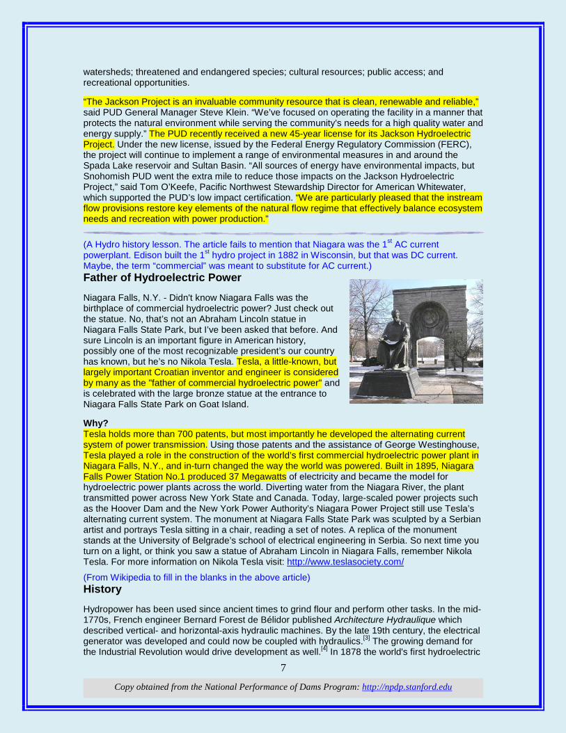
watersheds; threatened and endangered species; cultural resources; public access; and recreational opportunities. “The Jackson Project is an invaluable community resource that is clean, renewable and reliable,” said PUD General Manager Steve Klein. “We’ve focused on operating the facility in a manner that protects the natural environment while serving the community’s needs for a high quality water and energy supply.” The PUD recently received a new 45-year license for its Jackson Hydroelectric Project. Under the new license, issued by the Federal Energy Regulatory Commission (FERC), the project will continue to implement a range of environmental measures in and around the Spada Lake reservoir and Sultan Basin. “All sources of energy have environmental impacts, but Snohomish PUD went the extra mile to reduce those impacts on the Jackson Hydroelectric Project,” said Tom O’Keefe, Pacific Northwest Stewardship Director for American Whitewater, which supported the PUD’s low impact certification. “We are particularly pleased that the instream flow provisions restore key elements of the natural flow regime that effectively balance ecosystem needs and recreation with power production.” (A Hydro history lesson. The article fails to mention that Niagara was the 1st AC current powerplant. Edison built the 1st hydro project in 1882 in Wisconsin, but that was DC current. Maybe, the term “commercial” was meant to substitute for AC current.) Father of Hydroelectric Power Niagara Falls, N.Y. - Didn't know Niagara Falls was the birthplace of commercial hydroelectric power? Just check out the statue. No, that’s not an Abraham Lincoln statue in Niagara Falls State Park, but I’ve been asked that before. And sure Lincoln is an important figure in American history, possibly one of the most recognizable president’s our country has known, but he’s no Nikola Tesla. Tesla, a little-known, but largely important Croatian inventor and engineer is considered by many as the "father of commercial hydroelectric power" and is celebrated with the large bronze statue at the entrance to Niagara Falls State Park on Goat Island. Why? Tesla holds more than 700 patents, but most importantly he developed the alternating current system of power transmission. Using those patents and the assistance of George Westinghouse, Tesla played a role in the construction of the world’s first commercial hydroelectric power plant in Niagara Falls, N.Y., and in-turn changed the way the world was powered. Built in 1895, Niagara Falls Power Station No.1 produced 37 Megawatts of electricity and became the model for hydroelectric power plants across the world. Diverting water from the Niagara River, the plant transmitted power across New York State and Canada. Today, large-scaled power projects such as the Hoover Dam and the New York Power Authority’s Niagara Power Project still use Tesla’s alternating current system. The monument at Niagara Falls State Park was sculpted by a Serbian artist and portrays Tesla sitting in a chair, reading a set of notes. A replica of the monument stands at the University of Belgrade’s school of electrical engineering in Serbia. So next time you turn on a light, or think you saw a statue of Abraham Lincoln in Niagara Falls, remember Nikola Tesla. For more information on Nikola Tesla visit: http://www.teslasociety.com/
(From Wikipedia to fill in the blanks in the above article) History Hydropower has been used since ancient times to grind flour and perform other tasks. In the mid-1770s, French engineer Bernard Forest de Bélidor published Architecture Hydraulique which described vertical- and horizontal-axis hydraulic machines. By the late 19th century, the electrical generator was developed and could now be coupled with hydraulics.[3] The growing demand for the Industrial Revolution would drive development as well.[4] In 1878 the world's first hydroelectric
8
Copy obtained from the National Performance of Dams Program: http://npdp.stanford.edu
power scheme was developed at Cragside in Northumberland, England by William George Armstrong. It was used to power a single arc lamp in his art gallery.[5] The old Schoelkopf Power Station No. 1 near Niagara Falls in the U.S. side began to produce electricity in 1881. The first Edison hydroelectric power plant, the Vulcan Street Plant, began operating September 30, 1882, in Appleton, Wisconsin, with an output of about 12.5 kilowatts.[6] By 1886 there were 45 hydroelectric power plants in the U.S. and Canada. By 1889 there were 200 in the U.S. alone.[3]
At the beginning of the 20th century, many small hydroelectric power plants were being constructed by commercial companies in mountains near metropolitan areas. Grenoble, France held the International Exhibition of Hydropower and Tourism with over one million visitors. By 1920 as 40% of the power produced in the United States was hydroelectric, the Federal Power Act was enacted into law. The Act created the Federal Power Commission to regulate hydroelectric power plants on federal land and water. As the power plants became larger, their associated dams developed additional purposes to include flood control, irrigation and navigation. Federal funding became necessary for large-scale development and federally owned corporations, such as the Tennessee Valley Authority (1933) and the Bonneville Power Administration (1937) were created.[4] Additionally, the Bureau of Reclamation which had begun a series of western U.S. irrigation projects in the early 20th century was now constructing large hydroelectric projects such as the 1928 Hoover Dam.[7] The U.S. Army Corps of Engineers was also involved in hydroelectric development, completing the Bonneville Dam in 1937 and being recognized by the Flood Control Act of 1936 as the premier federal flood control agency.[8]
Hydroelectric power plants continued to become larger throughout the 20th century. Hydropower was referred to as white coal for its power and plenty.[9] Hoover Dam's initial 1,345 MW power plant was the world's largest hydroelectric power plant in 1936; it was eclipsed by the 6809 MW Grand Coulee Dam in 1942.[10] The Itaipu Dam opened in 1984 in South America as the largest, producing 14,000 MW but was surpassed in 2008 by the Three Gorges Dam in China at 22,500 MW. Hydroelectricity would eventually supply some countries, including Norway, Democratic Republic of the Congo, Paraguay and Brazil, with over 85% of their electricity. The United States currently has over 2,000 hydroelectric power plants which supply 49% of its renewable electricity.[4] If you want to read more: http://en.wikipedia.org/wiki/Hydroelectricity
(This is an obviously biased article, but it does give us reason to think. There is the remote possibility that we may lose our senses and go down a crooked path. We are learning more every day that the promise of salvation from wind and solar power is a far distant dream paved with projections that won’t come true. The Country has plenty of energy resources, but we do not exploit them to the fullest. The quote of the article: “the wind doesn't always blow but the rivers always flow”.) Breaching Condit Dam: In the Northwest, hydropower is still king oregonlive.com, November 05, 2011, By Terry Flores More than a dozen years ago, I was part of the team at PacifiCorp, the owner of Condit dam on the White Salmon River, working to obtain a new federal operating license for the project, built in 1918. After years of legal wrangling and collaborating, an agreement was reached to remove it. The decision to remove it was a business one; the dam was not equipped with fish ladders, and the costs to customers of bringing the project up to modern standards was simply too high. Last week, a huge hole was blown in the side of the dam, the lake behind it drained, and a different era ensued. The occasion generated tears and cheers. The dam had reliably and affordably provided clean energy to power and warm homes and businesses through the Great Depression, World Wars I and II, and our recent recession. It helped minimize and prevent downstream flooding, and it could have continued to perform these critical services for many years to come. Only time will tell whether significant benefits accrue to salmon, ostensibly the prime reason for removal, since the amount and quality of habitat in the White Salmon is not great. But, I hope the salmon return. Today, as executive director of Northwest RiverPartners, I defend, and advocate for, the federal hydropower system on the Columbia and Snake River
9
Copy obtained from the National Performance of Dams Program: http://npdp.stanford.edu
dams on behalf of families and businesses that depend on them for clean, reliable power; flood protection; food; and an ingenious river navigation system that contributes $19 billion in trade, commerce and thousands of jobs. I am concerned that anti-dam activists will use Condit's removal to renew their calls for removal of the Snake River dams. This is where I draw a line and point out that there simply is no comparing Condit or other small, antique dams with the larger, more modernized facilities in the federal system. For starters, the dams on the Columbia and Snake rivers give us a lot of energy -- more than 4,400 megawatts -- enough to power four cities the size of Seattle. Hydropower is a clean, non-polluting, renewable source of energy that makes us far less dependent than the rest of the country on electricity from coal, natural gas or nuclear plants. As a result, according to the Northwest Power and Conservation Council, our carbon footprint is about half that of the rest of the nation. But their contribution doesn't stop there. Our hydropower system played a critical role this past spring as in past years in protecting Portland and Vancouver from potentially devastating flooding. It also provides vital irrigation to farmers in Idaho and eastern Washington and Oregon to grow the crops that feed Northwest residents and are exported to the world. And, as we all know, the wind doesn't always blow but the rivers always flow. Hydropower is consistent and fills in the energy gap when wind turbines are not spinning. In addition, let's not forget that we are getting salmon safely around these structures and reclaiming natural spawning areas in river tributaries with a massive investment in habitat improvement. These efforts for salmon are working; this decade we've seen some of the strongest salmon runs in the Columbia and Snake rivers in years. The removal of old, outmoded dams in the Northwest provides the opportunity to reflect on the benefits that our federal hydropower system brings to our everyday lives and makes this region special. Dams and salmon can co-exist, and it is up to us to remain staunch stewards of both of these prized Northwest resources. Terry Flores is executive director of Northwest RiverPartners, an alliance of utilities, ports, farmers and businesses that promote the economic and environmental benefits of the Columbia and Snake rivers.
EEnnvviirroonnmmeenntt:: Yuba County Water Agency looks at restoring a salmon run By Matt Weiser, sacbee.com, Nov. 4, 2011 No salmon or steelhead has swum in the North Yuba River since at least 1941. But if a trial program is successful, it could be one of the first major Sierra Nevada streams to welcome back the majestic fish. The Yuba County Water Agency is preparing a plan to move spring-run Chinook salmon and Central Valley steelhead around its New Bullards Bar Dam. The dramatic arc of concrete – 645 feet tall – is the nation's sixth-tallest dam, making a traditional fish ladder infeasible. Instead, the agency proposes a "trap and haul" operation, in which adult fish are collected downstream, driven upstream in tanker trucks and released above the dam to spawn naturally in the river. After birth, their young offspring likely would be transported downstream in a similar manner to make their way to the ocean. The plan may be one of the last hopes to restore California's spring-run salmon, a threatened species. "We see this as really important to have this project be a success," said Curt Aikens,
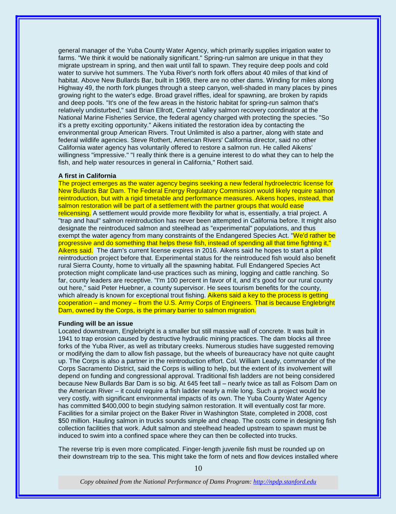
10
Copy obtained from the National Performance of Dams Program: http://npdp.stanford.edu
general manager of the Yuba County Water Agency, which primarily supplies irrigation water to farms. "We think it would be nationally significant." Spring-run salmon are unique in that they migrate upstream in spring, and then wait until fall to spawn. They require deep pools and cold water to survive hot summers. The Yuba River's north fork offers about 40 miles of that kind of habitat. Above New Bullards Bar, built in 1969, there are no other dams. Winding for miles along Highway 49, the north fork plunges through a steep canyon, well-shaded in many places by pines growing right to the water's edge. Broad gravel riffles, ideal for spawning, are broken by rapids and deep pools. "It's one of the few areas in the historic habitat for spring-run salmon that's relatively undisturbed," said Brian Ellrott, Central Valley salmon recovery coordinator at the National Marine Fisheries Service, the federal agency charged with protecting the species. "So it's a pretty exciting opportunity." Aikens initiated the restoration idea by contacting the environmental group American Rivers. Trout Unlimited is also a partner, along with state and federal wildlife agencies. Steve Rothert, American Rivers' California director, said no other California water agency has voluntarily offered to restore a salmon run. He called Aikens' willingness "impressive." "I really think there is a genuine interest to do what they can to help the fish, and help water resources in general in California," Rothert said. A first in California The project emerges as the water agency begins seeking a new federal hydroelectric license for New Bullards Bar Dam. The Federal Energy Regulatory Commission would likely require salmon reintroduction, but with a rigid timetable and performance measures. Aikens hopes, instead, that salmon restoration will be part of a settlement with the partner groups that would ease relicensing. A settlement would provide more flexibility for what is, essentially, a trial project. A "trap and haul" salmon reintroduction has never been attempted in California before. It might also designate the reintroduced salmon and steelhead as "experimental" populations, and thus exempt the water agency from many constraints of the Endangered Species Act. "We'd rather be progressive and do something that helps these fish, instead of spending all that time fighting it," Aikens said. The dam's current license expires in 2016. Aikens said he hopes to start a pilot reintroduction project before that. Experimental status for the reintroduced fish would also benefit rural Sierra County, home to virtually all the spawning habitat. Full Endangered Species Act protection might complicate land-use practices such as mining, logging and cattle ranching. So far, county leaders are receptive. "I'm 100 percent in favor of it, and it's good for our rural county out here," said Peter Huebner, a county supervisor. He sees tourism benefits for the county, which already is known for exceptional trout fishing. Aikens said a key to the process is getting cooperation – and money – from the U.S. Army Corps of Engineers. That is because Englebright Dam, owned by the Corps, is the primary barrier to salmon migration. Funding will be an issue Located downstream, Englebright is a smaller but still massive wall of concrete. It was built in 1941 to trap erosion caused by destructive hydraulic mining practices. The dam blocks all three forks of the Yuba River, as well as tributary creeks. Numerous studies have suggested removing or modifying the dam to allow fish passage, but the wheels of bureaucracy have not quite caught up. The Corps is also a partner in the reintroduction effort. Col. William Leady, commander of the Corps Sacramento District, said the Corps is willing to help, but the extent of its involvement will depend on funding and congressional approval. Traditional fish ladders are not being considered because New Bullards Bar Dam is so big. At 645 feet tall – nearly twice as tall as Folsom Dam on the American River – it could require a fish ladder nearly a mile long. Such a project would be very costly, with significant environmental impacts of its own. The Yuba County Water Agency has committed $400,000 to begin studying salmon restoration. It will eventually cost far more. Facilities for a similar project on the Baker River in Washington State, completed in 2008, cost $50 million. Hauling salmon in trucks sounds simple and cheap. The costs come in designing fish collection facilities that work. Adult salmon and steelhead headed upstream to spawn must be induced to swim into a confined space where they can then be collected into trucks. The reverse trip is even more complicated. Finger-length juvenile fish must be rounded up on their downstream trip to the sea. This might take the form of nets and flow devices installed where

11
Copy obtained from the National Performance of Dams Program: http://npdp.stanford.edu
the Yuba River's north fork spills into New Bullards Bar. Such projects may be the only antidote to climate change for California salmon and steelhead. Cold water flow at higher elevations, blocked for so long by dams, could become their only refuge as downstream habitat warms up. "We think there's a real good opportunity here, and we want to have that success story to turn to for other, future initiatives," Ellrott said. iThis compilation of articles and other information is provided at no cost for those interested in hydropower, dams, and water resources issues and development, and should not be used for any commercial or other purpose. Any copyrighted material herein is distributed without profit or payment from those who have an interest in receiving this information for non-profit and educational purposes only.
1
Copy obtained from the National Performance of Dams Program: http://npdp.stanford.edu
11/18/2011
i
“Good wine is a necessity of life.” - -Thomas Jefferson Ron’s wine pick of the week: Chateau Ste. Michelle - Merlot Columbia Valley Indian Wells Vineyard 2008 “No nation was ever drunk when wine was cheap.” - - Thomas Jefferson
TThhiiss wweeeekk sseeeemmss ttoo bbee aallll aabboouutt DDaamm nneewwss ssppeelllleedd wwiitthhoouutt aann ““nn””!!
DDaammss:: (Ames Pond looks innocent enough, but is it really?) Groups urge action on Massachusetts dam safety bill that would help several Brockton-area dams Over 100 municipal dams in unsafe or poor condition By David Riley, gatehouse news service, Nov 07, 2011, wickedlocal.com Easton, MA — Advocates for a dam safety bill are calling for action from state lawmakers who represent 62 Bay State towns and cities that own 100 dams rated in unsafe or poor condition, including in Brockton, Easton, Norton and Pembroke. A coalition of environmental, local government and engineering groups recently sent letters to every state representative with such a dam in his or her district, warning of “the potential to cause loss of life or significant property damage in the event of dam failure.” The letter asked legislators to tell House Ways and Means Committee Chairman Brian Dempsey and Speaker Robert DeLeo they support the dam safety bill. The Senate passed a version of the legislation in July. Some of the dams date back more than a century – with Easton’s historic Long Pond Dam completed in 1850 and Brockton’s Thirty Acre Pond Dam in 1900. Steve Long,
Some Dam – Hydro News TM And Other Stuff
Quote of Note: “Computers are useless. They can only give you answers." -- Pablo Picasso
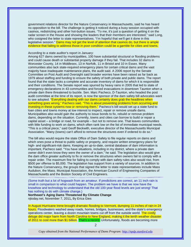
2
Copy obtained from the National Performance of Dams Program: http://npdp.stanford.edu
government relations director for the Nature Conservancy in Massachusetts, said he has heard no opposition to the bill. The challenge is getting it noticed during a busy session occupied with casinos, redistricting and other hot-button issues. “To me, it’s just a question of getting it on the radar screen in the House and showing the leaders that their members are interested,” said Long, who cosigned the letter to state representatives. “I’m hopeful that we’ll get it done in this legislative session.” Dams may not get the level of attention that casinos do, but there is ample evidence that failing to address those in poor condition could be a gamble for cities and towns. According to a state auditor’s report in January: Among 627 dams owned by municipalities, 100 have substantial structural or flooding problems and could cause death or substantial property damage if they fail. That includes 32 dams in Worcester County, 14 in Middlesex, 13 in Norfolk, 11 in Bristol and 10 in Essex. Many communities also lack state-required emergency plans for certain critical dams and the vast majority have inadequate maintenance plans, the audit said. A 2006 report by the Senate Committee on Post Audit and Oversight said broader worries have been raised as far back as 1979 about staffing and funding to ensure the safety of both private and public dams. The report found that the state lacks a complete and accurate inventory of dams for which it is responsible and their conditions. The Senate report was spurred by heavy rains in 2005 that led to state of emergency declarations in 43 communities and forced evacuations in downtown Taunton when a private dam there threatened to buckle. Sen. Marc Pacheco, D-Taunton, who headed the post audit committee at the time of its report, is now the sponsor of the dam safety bill advocates want to see adopted. “Everything dealing with our dams certainly does grab the headlines when something goes wrong,” Pacheco said. “This is about preventing problems from occurring and investing in these systems now or removing them.” Pacheco’s bill would set up a state fund to loan cities and towns money at low interest to inspect, repair or remove unsafe dams. Municipalities also would gain the authority to issue bonds to fix, rebuild or remove problem dams, depending on the situation. Currently, towns and cities can borrow to build or repair a capital asset – a bridge or road, for example – but not to remove one. That leaves communities with little funding to work on dams, which often rank low on the list of immediate municipal needs. “This is a critical piece,” said Geoff Beckwith, executive director of the Massachusetts Municipal Association. “Many (towns) can’t afford to remove the structures even if ordered to do so.” The bill also would require the state Office of Dam Safety to file regular reports on dams and which ones pose a threat to public safety or property, and require written emergency plans for high- and significant-risk dams. Keeping an up-to-date, central database of dam information is important, Pacheco said. “You have situations, including in my district, where a private dam owner didn’t even know they were the owner of a dam,” he said. The legislation also would give the dam office greater authority to fix or remove the structures when owners fail to comply with a repair order. The maximum fine for failing to comply with dam safety rules also would rise, from $500 per offense to $5,000. The legislation has support from a variety of sources. In addition to the Nature Conservancy, the groups that signed the letter to state representatives include Mass Audubon, the Mass. Municipal Association, the American Council of Engineering Companies of Massachusetts and the Boston Society of Civil Engineers. (Some truth but a lot of hogwash from an amateur. If predictions are correct, an 11 inch rain is small in comparison to what could happen. The problem we have is that we now have the knowhow and technology to understand that the old 100-year flood levels are just wrong! That has nothing to do with climate change.) Northeast’s Aging Dams Threatened By Climate Change njtoday.net, November 7, 2011, By Erica Gies In August Hurricane Irene brought dramatic flooding to Vermont, dumping 11 inches of rain in 24 hours. Floodwaters washed away roads, homes, bridges, businesses, and the state’s emergency operations center, leaving a dozen mountain towns cut off from the outside world. The costly deluge did major harm from North Carolina to New England, making it the tenth weather disaster of 2011 to cost more than $1 billion. That’s a record. Unfortunately, floods are becoming more

3
Copy obtained from the National Performance of Dams Program: http://npdp.stanford.edu
common across the Northeast because climate change is creating greater fluctuations in watershed flows that U.S. infrastructure was not built to withstand. Add the fact that dams are aging and ill-maintained because federal and state budget cupboards are bare, and wherever you look, there’s the possibility for a perfect storm of flooding and costly infrastructure failure. In Massachusetts, for example, emergency workers were forced to tear down the 200-year-old Forge Pond Dam in Freetown when rainstorms last year pushed the structure to its limit. If the dam had failed, two others downstream probably would have failed as well, said a public safety official. Ultimately, taxpayers bear the costs of rebuilding after such “natural disasters.” But solutions won’t be easy or cheap. During the twentieth century, water managers planned for future needs based on past precipitation patterns. But with climate change, weather patterns are more unpredictable, and we haven’t yet learned to adapt. The now-regular occurrence of “100-year” and “500-year” floods is putting increased pressure on dams not designed to withstand it. There are 87,000 dams in the United States, says the Association of State Dam Safety Officials (ASDSO). The vast majority are privately owned, and many no longer serve their planned function. About 10 percent have no known owner. ASDSO found that 10,127 dams nationwide pose a serious threat to human life if they fail, and of those, 1,333 were structurally deficient or unsafe. Even worse, many eastern cities and towns have developed their floodplains, putting new businesses and homes in the path of future floods or dam breaks. Increased flooding is predicted in 10 out of 12 U.S. cities evaluated in a climate change study by the Natural Resources Defense Council (NRDC). We can also expect saltwater floods. Sea level rise could flood parts of New York City; Boston; Norfolk, Va.; San Francisco; Seattle; Los Angeles; Miami; and New Orleans, says NRDC. Saltwater intrusion into drinking water supplies threatens New York, Los Angeles, San Francisco, and Miami. Floods, sea level rise, and storm surges also jeopardize critical, low-lying infrastructure: airports (such as New York’s JFK International), bridges, highways, pipelines, railroads, refineries, ports, water treatment plants, and even nuclear plants (such as the Salem, N.J., plant just south of Philadelphia). Eastern cities need to adapt now – and many are. For example, in Montpelier, Vt., which suffered back-to-back “100-year” floods this year, officials have increased the capacity of city culverts. All new infrastructure plans must pass muster not only under past climate conditions, but also those modeled fifty years from now. These plans should meet bars for resiliency and common sense – and are beginning to. For example, during the 20th century, federal agencies dreamed of engineering an expensive tunnel system to ease natural flooding on New Jersey’s Passaic River. Now state and federal governments are instead buying out area properties prone to flooding. We should spend limited funds shoring up critical infrastructure that we can’t do without, or can’t move, and embrace new types of infrastructure designed for “soft failure” by bending rather than breaking. I’m talking about innovations like low-impact development – porous pavements and rain gardens that absorb rainwater, decreasing flooding. We also need regulations that discourage construction in floodplains and along vulnerable coasts (like New Jersey’s Barrier Islands), by pushing developers to shoulder the financial risk of disaster. Building codes must be updated, reducing flood risk. Dams that have outlived their function should be removed. The evidence of changing water patterns is all around us. We have a choice: adapt now, and prepare for the floods to come, or pay a high price in property damage and human suffering later. (An interesting perspective on why we can’t do anything anymore in this Country. The Footnote shows how far we have sunk when one of the primary contractors is foreign!) Marty: The Hoover Dam revisited in 2011 Nov 8, 2011, By Marty Richman, freelancenews.com Every politician wants to rebuild the Hoover Dam - at least metaphorically. At one time the national frustration phrase was, "If we can put a man on the moon why can't we...?" Now the moon is "old cheese" and we're invoking the Hoover Dam, but could we even build it today? A private company under government contract constructed the Hoover Dam in five years, from 1931 to 1936, two years ahead of schedule and in budget at the cost of less than $50 million, within 0.05 percent of the original government estimate. This would certainly present challenges
4
Copy obtained from the National Performance of Dams Program: http://npdp.stanford.edu
for 2011. The Economist's Lexington blog points out that Michael Hiltzik, the dam's modern historian, says in his book "Colossus" that we probably could not build it today because back then "no one cared about the down-river rights of the southwestern Indians, let alone the Mexicans, or the creatures whose habitats were eradicated when the river was dammed." Conservative commentator George Will had the short version, "You couldn't build [it] today because they'd discover a snail darter in the Colorado River and would stop it." Let's say those serious - perhaps insurmountable - hurdles just disappeared. Using the government's Consumer Price Index, CPI, calculator, $50 million would equal $750 million today. Does anyone believe we could build the dam or $750 million or even 10 times that, $7.5 billion? Thanks to the Department of the Interior, we know exactly what the workers earned in 1931; it ranged from 50 cents an hour for helpers, muckers, and dumpmen to $1.25 an hour for shovel operators. The average was about 62.5 cents and their average annual income was $1,825, which means many were working seven days a week. No wonder it came in early. Inflating those wages to 2011 equals $26,325 a year for 56 hours a week of backbreaking and often dangerous work that resulted in more than 100 construction associated deaths not including "illness." If the snail darter doesn't shut it down, OSHA certainly would. Let's skip that too. Safety is much better today as it should be, but it comes with a cost. There was no Social Security or Medicare and no retirement or healthcare in 1931 except for company nurses and doctors. However, those were very good jobs at the time. Civil Service employees were averaging $1,234 a year in 1931, which equates to only $18,525 today. Construction employment peaked at 5,251 in 1934. Assuming the average labor force was 5,000 - it was less - the annual payroll would have be only $132 million in 2011 dollars. The five-year modern total, $660 million, equals a minuscule 0.08 percent of the current $800 billion stimulus package. On a CPI basis, we should have enough stimulus funding to pay for more than 1,000 Hoover Dams, but that does not reflect the real world. Skilled workers have made giant strides in relative pay, and benefits, so giant that we've just priced ourselves out of many opportunities; unskilled workers have not done nearly as well. Technically, we could build Hoover Dam today, but even ignoring the environmental and water rights issues, it would take a long time and cost an incredible amount. The Hoover Dam remains a fantastic accomplishment; however, as the Economist said, it's "no panacea for modern ills." Footnote: The dam's new bypass and bridge were completed with one fatality in five years and eight months, two years behind schedule but within the original $240 million budget due to falling material prices. One primary contractor was the U.S. division of a Japanese construction company. Marty Richman is a Hollister resident. Sierra Watch: Placer County Joins Growing Opposition To Bear River Dam Board of Supervisors adopts "official position of opposition" to proposed Garden Bar Dam By: Sierra Watch, Published on Nov 8, 2011, yubanet.com Auburn, Calif. November 8, 2011 – In a unanimous vote Tuesday November 8, the Placer County Board of Supervisors expressed "an official position of opposition" to the proposed Garden Bar Dam. The dam would block off the Bear River on the County's northern border and flood some of the most highly prized canyons in the Sierra foothills. "This is a great example of local representatives taking a stand for our local values," said Peter Van Zant of Sierra Watch, the conservation non-profit spearheading the effort to stop the dam. "The Bear River Canyon is worth more than a dam." South Sutter Water District partnered with distant water providers – as far as 470 miles from the Bear River watershed – to release a ‘Preliminary Study' on the proposed dam earlier this year. According to that study, urban districts would finance a 300-foot tall dam at Garden Bar Preserve, backing up Bear River water to be shipped through the Delta and end up as far away as Los Angeles County. But conservation groups, local ranchers, and elected officials have rallied to express increasingly overwhelming opposition. Placer County's opposition is based on the County's longstanding plans for responsible development and permanently protected open space – Garden Bar Preserve is an important piece of the County's visionary Placer Legacy program. In its action Tuesday, the Placer Board of Supervisors approved a letter to South Sutter Water
5
Copy obtained from the National Performance of Dams Program: http://npdp.stanford.edu
District, clearly stating "an official position of opposition" and citing potential "negative impacts" to the County, including:
• flooding up to 2,000 acres of the Bear River Canyon, putting large portions of the Placer County Land Trust's Garden Bar Preserve and Harvego Bear River Preserve under water;
• destroying important Native American cultural resources; and • blocking significant wildlife corridors through the largest remaining contiguous blue oak
woodland in Placer County.
Additional local jurisdictions are conducting their own assessments. Upstream water provider Nevada Irrigation District is reviewing the impacts of a new dam on its own water needs and ratepayers. Neighboring Nevada County is expected to take up the issue as well. As opposition mounts, proponents are still simultaneously seeking commitments from its funders – urban water providers. However, one original proponent, Castaic Lake Water Agency, has already backed out. Now that the other funders – Palmdale Water District, San Bernardino Valley Municipal Water District, and the Cities of Napa and American Canyon – have a sense of what they're up against, they will also likely realize that the Sierra's Bear River is not going to be a source for Southern California water.
HHyyddrroo: (We can only wish that hydro would be treated like other renewables and get the same PTC instead of ½ of the PTC for wind and solar, but at least hydro is on the radar!) For Immediate Release Bill to extend production tax credit for hydropower introduced Statement of NHA Executive Director Linda Church Ciocci Washington, D.C. (November 3, 2011) – The following is a statement from Linda Church Ciocci, Executive Director of the National Hydropower Association, on the introduction of H.R. 3307, the American Renewable Energy Tax Credit Extension Act: “Providing financial certainty to hydropower developers is exactly the type of policy the industry needs out of Washington during these economic times. NHA applauds the leadership of Reps. Dave Reichert and Earl Blumenauer in introducing the American Renewable Energy Tax Credit Extension Act and encourages other members of Congress to join them by co-sponsoring this important piece of legislation. “This bipartisan bill would send a market signal supporting project development, in turn leveraging significant private investment that will help bring additional clean, affordable and reliable hydroelectric power to more American families. It promotes job creation and local economic benefits across the country in the hydropower industry, helping to create over one million new jobs and access over 60,000 MW of untapped capacity by 2025. “NHA urges the Ways and Means Committee to take up this bill quickly and, as always, stands ready to work with Congress on this and other issues affecting the hydropower industry.” (It would good if this law could counter the green energy debacle which has turned into a Made In China affair!) For Immediate Release Stabenow introduces bill to promote American renewable energy manufacturing Statement of NHA Executive Director Linda Church Ciocci
6
Copy obtained from the National Performance of Dams Program: http://npdp.stanford.edu
Washington, D.C. (November 9, 2011) – The following is a statement from Linda Church Ciocci, Executive Director of the National Hydropower Association, on the introduction of S. 1764, the Make It in America Tax Credit Act: “NHA applauds Senator Debbie Stabenow for her work to bolster clean energy manufacturing in the United States. During these tough economic times, Americans are calling on Washington to enact policies that promote job creation. The Make It in America Act introduced last week answers that call. “This bill would provide an additional $5 billion for the highly successful Advanced Manufacturers Tax Credit program. As more and more developers look to construct all forms of hydropower throughout the country, ensuring manufacturing is done here will help us tap over one million new U.S. jobs in the hydropower industry. “NHA has previously supported various Congressional efforts to provide additional allocations to the program. “NHA urges the quick passage of this legislation and looks forward to working with Congress on other policies beneficial to hydropower and America’s clean energy future.” (The battle goes on! ALCOA says give me the license and I’ll give you jobs. The Governor doesn’t believe them!) Alcoa says it's good for jobs in NC if state, county drop fight over 50-year dams license Emery P. Dalesio, AP Business Writer, November 10, 2011, therepublic.com Raleigh, N.C. — Aluminum maker and Energy company Alcoa said Thursday it is making a $50 million promise to create hundreds of jobs for residents along the Yadkin River valley in a few years — but only if officials stop fighting a 50-year federal license to keep operating a series of dams that could generate billions of dollars in electricity sales. The pledge came after state and local officials recently refused to give up a battle they believe could result in thousands of jobs in coming decades, as well as the freedom to use the river's water as supplies tighten for the state's 9.5 million residents. This summer, Alcoa Inc. and a newly formed start-up company, Clean Tech Silicon and Bar LLC, announced the company would hire 250 workers near the site where Alcoa once ran a smelting plant that employed about 1,000. But there were doubts that Clean Tech, incorporated in Delaware in August and led by former Nucor Corp. CEO John Correnti, could make good on the promise. Stanly County commissioners and Gov. Beverly Perdue's administration have refused to end regulatory challenges blocking Alcoa from securing a dam-operating license for as much as 50 years from the Federal Energy Regulatory Commission (FERC). Alcoa vice president Kevin Anton told The Associated Press Thursday that to clear the path to its license the company is willing to sign a contract paying Stanley County if within four years it fails to recruit hundreds of jobs with a total payroll of $30 million a year, or about 750 jobs each paying $40,000. The promised penalty of up to $50 million would be spread over the course of the operating license, Anton said, meaning about $1 million per year to Stanley County if the license lasted 50 years and the jobs never come. But first, the company must have its license, Anton said. "We can't proceed with this without having our FERC license. So that is absolutely a condition," he said. Pittsburgh-based Alcoa now sells the electricity generated by its four Yadkin River dams to commercial customers. The company estimated in 2006 that the dams generated almost $44 million a year in revenues. Over 50 years, that could mean revenues of more than $2 billion, an amount that could multiply if demand for clean power booms. The country's largest aluminum maker generated about $18.7 million in sales from its Yadkin River dams in the year ending in September, down from its average of about $30 million in the previous three, recession-scarred years due to reduced rainfall spinning the power turbines. Perdue and local officials said Alcoa's settlement offer sounds good until people look at the fine print. "That water that they're using, it belongs to the people. There has to be fair and reasonable compensation and public benefit for the free use of that water to generate electricity, which we know over the next 20 years is going to rise in value substantially," Lucas
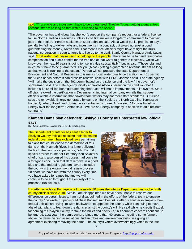
7
Copy obtained from the National Performance of Dams Program: http://npdp.stanford.edu
said. "Those jobs and investment have to be guaranteed. They're (Alcoa) getting a guaranteed revenue stream as long as that water is running to the ocean." "The governor has told Alcoa that she won't support the company's request for a federal license to use North Carolina's resources unless Alcoa first makes a long-term commitment to maintain jobs in the region," Perdue spokesman Mark Johnson said. Alcoa would put its promise to pay a penalty for failing to deliver jobs and investments in a contract, but would not post a bond guaranteeing the money, Anton said. That means local officials might have to fight the multi-national corporation in court to force it to live up to the deal, Stanly County Manager Andy Lucas said. "That water that they're using, it belongs to the people. There has to be fair and reasonable compensation and public benefit for the free use of that water to generate electricity, which we know over the next 20 years is going to rise in value substantially," Lucas said. "Those jobs and investment have to be guaranteed. They're (Alcoa) getting a guaranteed revenue stream as long as that water is running to the ocean." Perdue will not pressure the state Department of Environment and Natural Resources to issue a crucial water quality certification, or 401 permit, that Alcoa needs before it can press its renewal case with FERC, Johnson said. The state agency "will make the decision on the 401 permit based on the science and the law," the governor's spokesman said. The state agency initially approved Alcoa's permit on the condition that it include a $240 million bond guaranteeing that Alcoa will make improvements to its system. State officials revoked the certification in December, citing internal company e-mails that suggest officials withheld information that downstream waters may not meet state standards. But Alcoa sees the renewable Energy generated by dams on the Yadkin, the North Carolina-Tennessee border, Quebec, Brazil, and Suriname as central to its future, Anton said. "Alcoa is bullish on Energy over the long term," Anton said. "We are an Energy company in addition to an aluminum company." Klamath Dams plan defended; Siskiyou County misinterpreted law, official says By Ryan Sabalow, November 9, 2011, redding.com The Department of Interior has sent a letter to Siskiyou County officials rejecting their claims the federal government has violated laws pertaining to plans that could lead to the demolition of four dams on the Klamath River. In a letter delivered Friday to the county's supervisors, John Bezdek, special adviser to Interior Secretary Ken Salazar's chief of staff, also denied his bosses had come to a foregone conclusion that dam removal is a good idea and that federal regulators haven't included the county in the environmental review process. "In short, we have met with the county every time you have asked for a meeting and we will continue to do so throughout the entirety of this process," Bezdek said. His letter includes a 1½ page list of the nearly 30 times the Interior Department has spoken with county officials since 2010. "While I am disappointed we have been unable to resolve our differences on certain issues, I am not disappointed in the efforts of the federal team to engage the county," he wrote. Supervisor Michael Kobseff said Bezdek's letter is another example of how federal officials are trying "to work backwards" to appease the county while continuing to move ahead with plans to tear down the dams against the county's will. He said while he credits Bezdek for coming to Siskiyou County to "take the bullet and pacify us," his county's concerns continue to be ignored. Last year, the dam's owners joined more than 40 groups, including some farmers above the dams, fishing associations, Indian tribes and environmentalists, in signing an agreement exploring removing the dams. The county's voters overwhelmingly voted in the last
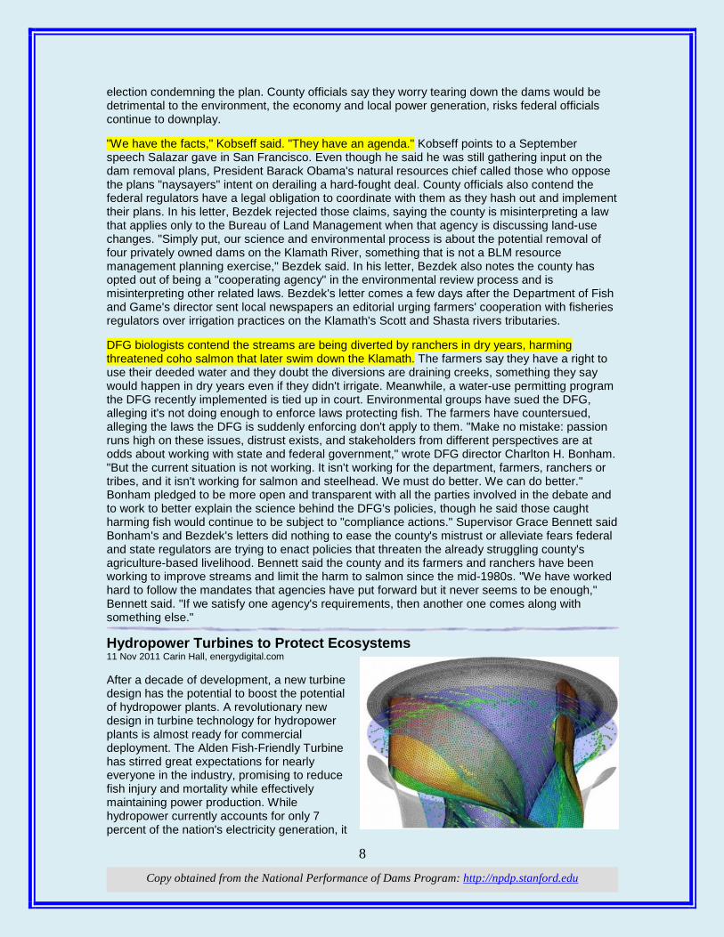
8
Copy obtained from the National Performance of Dams Program: http://npdp.stanford.edu
election condemning the plan. County officials say they worry tearing down the dams would be detrimental to the environment, the economy and local power generation, risks federal officials continue to downplay. "We have the facts," Kobseff said. "They have an agenda." Kobseff points to a September speech Salazar gave in San Francisco. Even though he said he was still gathering input on the dam removal plans, President Barack Obama's natural resources chief called those who oppose the plans "naysayers" intent on derailing a hard-fought deal. County officials also contend the federal regulators have a legal obligation to coordinate with them as they hash out and implement their plans. In his letter, Bezdek rejected those claims, saying the county is misinterpreting a law that applies only to the Bureau of Land Management when that agency is discussing land-use changes. "Simply put, our science and environmental process is about the potential removal of four privately owned dams on the Klamath River, something that is not a BLM resource management planning exercise," Bezdek said. In his letter, Bezdek also notes the county has opted out of being a "cooperating agency" in the environmental review process and is misinterpreting other related laws. Bezdek's letter comes a few days after the Department of Fish and Game's director sent local newspapers an editorial urging farmers' cooperation with fisheries regulators over irrigation practices on the Klamath's Scott and Shasta rivers tributaries. DFG biologists contend the streams are being diverted by ranchers in dry years, harming threatened coho salmon that later swim down the Klamath. The farmers say they have a right to use their deeded water and they doubt the diversions are draining creeks, something they say would happen in dry years even if they didn't irrigate. Meanwhile, a water-use permitting program the DFG recently implemented is tied up in court. Environmental groups have sued the DFG, alleging it's not doing enough to enforce laws protecting fish. The farmers have countersued, alleging the laws the DFG is suddenly enforcing don't apply to them. "Make no mistake: passion runs high on these issues, distrust exists, and stakeholders from different perspectives are at odds about working with state and federal government," wrote DFG director Charlton H. Bonham. "But the current situation is not working. It isn't working for the department, farmers, ranchers or tribes, and it isn't working for salmon and steelhead. We must do better. We can do better." Bonham pledged to be more open and transparent with all the parties involved in the debate and to work to better explain the science behind the DFG's policies, though he said those caught harming fish would continue to be subject to "compliance actions." Supervisor Grace Bennett said Bonham's and Bezdek's letters did nothing to ease the county's mistrust or alleviate fears federal and state regulators are trying to enact policies that threaten the already struggling county's agriculture-based livelihood. Bennett said the county and its farmers and ranchers have been working to improve streams and limit the harm to salmon since the mid-1980s. "We have worked hard to follow the mandates that agencies have put forward but it never seems to be enough," Bennett said. "If we satisfy one agency's requirements, then another one comes along with something else." Hydropower Turbines to Protect Ecosystems 11 Nov 2011 Carin Hall, energydigital.com After a decade of development, a new turbine design has the potential to boost the potential of hydropower plants. A revolutionary new design in turbine technology for hydropower plants is almost ready for commercial deployment. The Alden Fish-Friendly Turbine has stirred great expectations for nearly everyone in the industry, promising to reduce fish injury and mortality while effectively maintaining power production. While hydropower currently accounts for only 7 percent of the nation's electricity generation, it
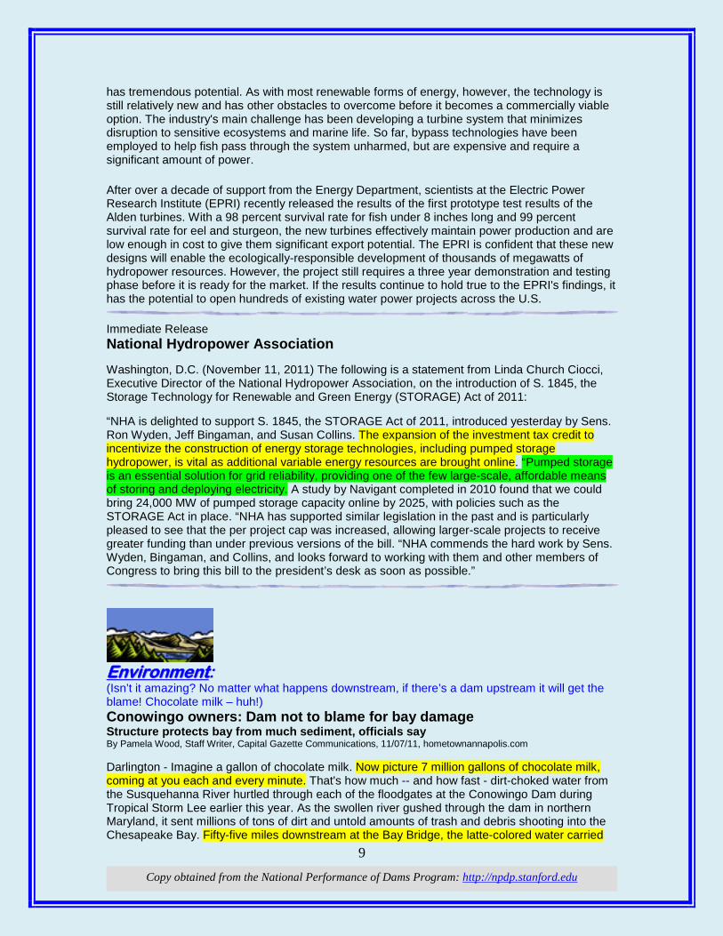
9
Copy obtained from the National Performance of Dams Program: http://npdp.stanford.edu
has tremendous potential. As with most renewable forms of energy, however, the technology is still relatively new and has other obstacles to overcome before it becomes a commercially viable option. The industry's main challenge has been developing a turbine system that minimizes disruption to sensitive ecosystems and marine life. So far, bypass technologies have been employed to help fish pass through the system unharmed, but are expensive and require a significant amount of power.
After over a decade of support from the Energy Department, scientists at the Electric Power Research Institute (EPRI) recently released the results of the first prototype test results of the Alden turbines. With a 98 percent survival rate for fish under 8 inches long and 99 percent survival rate for eel and sturgeon, the new turbines effectively maintain power production and are low enough in cost to give them significant export potential. The EPRI is confident that these new designs will enable the ecologically-responsible development of thousands of megawatts of hydropower resources. However, the project still requires a three year demonstration and testing phase before it is ready for the market. If the results continue to hold true to the EPRI's findings, it has the potential to open hundreds of existing water power projects across the U.S.
Immediate Release National Hydropower Association Washington, D.C. (November 11, 2011) The following is a statement from Linda Church Ciocci, Executive Director of the National Hydropower Association, on the introduction of S. 1845, the Storage Technology for Renewable and Green Energy (STORAGE) Act of 2011: “NHA is delighted to support S. 1845, the STORAGE Act of 2011, introduced yesterday by Sens. Ron Wyden, Jeff Bingaman, and Susan Collins. The expansion of the investment tax credit to incentivize the construction of energy storage technologies, including pumped storage hydropower, is vital as additional variable energy resources are brought online. “Pumped storage is an essential solution for grid reliability, providing one of the few large-scale, affordable means of storing and deploying electricity. A study by Navigant completed in 2010 found that we could bring 24,000 MW of pumped storage capacity online by 2025, with policies such as the STORAGE Act in place. “NHA has supported similar legislation in the past and is particularly pleased to see that the per project cap was increased, allowing larger-scale projects to receive greater funding than under previous versions of the bill. “NHA commends the hard work by Sens. Wyden, Bingaman, and Collins, and looks forward to working with them and other members of Congress to bring this bill to the president’s desk as soon as possible.”
EEnnvviirroonnmmeenntt:: (Isn’t it amazing? No matter what happens downstream, if there’s a dam upstream it will get the blame! Chocolate milk – huh!) Conowingo owners: Dam not to blame for bay damage Structure protects bay from much sediment, officials say By Pamela Wood, Staff Writer, Capital Gazette Communications, 11/07/11, hometownannapolis.com Darlington - Imagine a gallon of chocolate milk. Now picture 7 million gallons of chocolate milk, coming at you each and every minute. That's how much -- and how fast - dirt-choked water from the Susquehanna River hurtled through each of the floodgates at the Conowingo Dam during Tropical Storm Lee earlier this year. As the swollen river gushed through the dam in northern Maryland, it sent millions of tons of dirt and untold amounts of trash and debris shooting into the Chesapeake Bay. Fifty-five miles downstream at the Bay Bridge, the latte-colored water carried
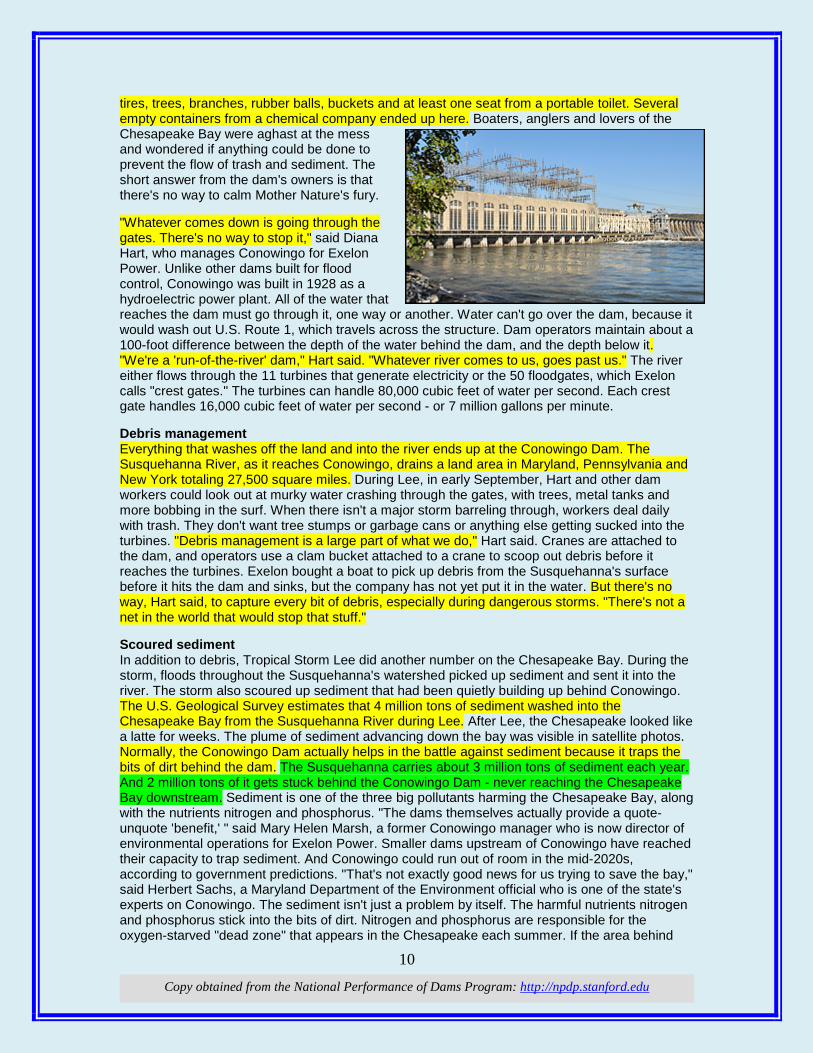
10
Copy obtained from the National Performance of Dams Program: http://npdp.stanford.edu
tires, trees, branches, rubber balls, buckets and at least one seat from a portable toilet. Several empty containers from a chemical company ended up here. Boaters, anglers and lovers of the Chesapeake Bay were aghast at the mess and wondered if anything could be done to prevent the flow of trash and sediment. The short answer from the dam's owners is that there's no way to calm Mother Nature's fury. "Whatever comes down is going through the gates. There's no way to stop it," said Diana Hart, who manages Conowingo for Exelon Power. Unlike other dams built for flood control, Conowingo was built in 1928 as a hydroelectric power plant. All of the water that reaches the dam must go through it, one way or another. Water can't go over the dam, because it would wash out U.S. Route 1, which travels across the structure. Dam operators maintain about a 100-foot difference between the depth of the water behind the dam, and the depth below it. "We're a 'run-of-the-river' dam," Hart said. "Whatever river comes to us, goes past us." The river either flows through the 11 turbines that generate electricity or the 50 floodgates, which Exelon calls "crest gates." The turbines can handle 80,000 cubic feet of water per second. Each crest gate handles 16,000 cubic feet of water per second - or 7 million gallons per minute. Debris management Everything that washes off the land and into the river ends up at the Conowingo Dam. The Susquehanna River, as it reaches Conowingo, drains a land area in Maryland, Pennsylvania and New York totaling 27,500 square miles. During Lee, in early September, Hart and other dam workers could look out at murky water crashing through the gates, with trees, metal tanks and more bobbing in the surf. When there isn't a major storm barreling through, workers deal daily with trash. They don't want tree stumps or garbage cans or anything else getting sucked into the turbines. "Debris management is a large part of what we do," Hart said. Cranes are attached to the dam, and operators use a clam bucket attached to a crane to scoop out debris before it reaches the turbines. Exelon bought a boat to pick up debris from the Susquehanna's surface before it hits the dam and sinks, but the company has not yet put it in the water. But there's no way, Hart said, to capture every bit of debris, especially during dangerous storms. "There's not a net in the world that would stop that stuff." Scoured sediment In addition to debris, Tropical Storm Lee did another number on the Chesapeake Bay. During the storm, floods throughout the Susquehanna's watershed picked up sediment and sent it into the river. The storm also scoured up sediment that had been quietly building up behind Conowingo. The U.S. Geological Survey estimates that 4 million tons of sediment washed into the Chesapeake Bay from the Susquehanna River during Lee. After Lee, the Chesapeake looked like a latte for weeks. The plume of sediment advancing down the bay was visible in satellite photos. Normally, the Conowingo Dam actually helps in the battle against sediment because it traps the bits of dirt behind the dam. The Susquehanna carries about 3 million tons of sediment each year. And 2 million tons of it gets stuck behind the Conowingo Dam - never reaching the Chesapeake Bay downstream. Sediment is one of the three big pollutants harming the Chesapeake Bay, along with the nutrients nitrogen and phosphorus. "The dams themselves actually provide a quote-unquote 'benefit,' " said Mary Helen Marsh, a former Conowingo manager who is now director of environmental operations for Exelon Power. Smaller dams upstream of Conowingo have reached their capacity to trap sediment. And Conowingo could run out of room in the mid-2020s, according to government predictions. "That's not exactly good news for us trying to save the bay," said Herbert Sachs, a Maryland Department of the Environment official who is one of the state's experts on Conowingo. The sediment isn't just a problem by itself. The harmful nutrients nitrogen and phosphorus stick into the bits of dirt. Nitrogen and phosphorus are responsible for the oxygen-starved "dead zone" that appears in the Chesapeake each summer. If the area behind
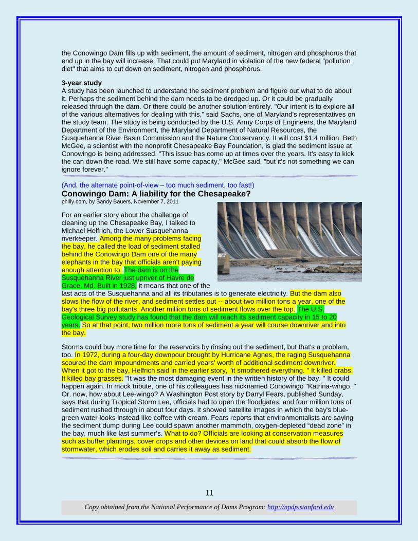
11
Copy obtained from the National Performance of Dams Program: http://npdp.stanford.edu
the Conowingo Dam fills up with sediment, the amount of sediment, nitrogen and phosphorus that end up in the bay will increase. That could put Maryland in violation of the new federal "pollution diet" that aims to cut down on sediment, nitrogen and phosphorus. 3-year study A study has been launched to understand the sediment problem and figure out what to do about it. Perhaps the sediment behind the dam needs to be dredged up. Or it could be gradually released through the dam. Or there could be another solution entirely. "Our intent is to explore all of the various alternatives for dealing with this," said Sachs, one of Maryland's representatives on the study team. The study is being conducted by the U.S. Army Corps of Engineers, the Maryland Department of the Environment, the Maryland Department of Natural Resources, the Susquehanna River Basin Commission and the Nature Conservancy. It will cost $1.4 million. Beth McGee, a scientist with the nonprofit Chesapeake Bay Foundation, is glad the sediment issue at Conowingo is being addressed. "This issue has come up at times over the years. It's easy to kick the can down the road. We still have some capacity," McGee said, "but it's not something we can ignore forever." (And, the alternate point-of-view – too much sediment, too fast!) Conowingo Dam: A liability for the Chesapeake? philly.com, by Sandy Bauers, November 7, 2011 For an earlier story about the challenge of cleaning up the Chesapeake Bay, I talked to Michael Helfrich, the Lower Susquehanna riverkeeper. Among the many problems facing the bay, he called the load of sediment stalled behind the Conowingo Dam one of the many elephants in the bay that officials aren't paying enough attention to. The dam is on the Susquehanna River just upriver of Havre de Grace, Md. Built in 1928, it means that one of the last acts of the Susquehanna and all its tributaries is to generate electricity. But the dam also slows the flow of the river, and sediment settles out -- about two million tons a year, one of the bay's three big pollutants. Another million tons of sediment flows over the top. The U.S. Geological Survey study has found that the dam will reach its sediment capacity in 15 to 20 years. So at that point, two million more tons of sediment a year will course downriver and into the bay. Storms could buy more time for the reservoirs by rinsing out the sediment, but that's a problem, too. In 1972, during a four-day downpour brought by Hurricane Agnes, the raging Susquehanna scoured the dam impoundments and carried years' worth of additional sediment downriver. When it got to the bay, Helfrich said in the earlier story, "it smothered everything. " It killed crabs. It killed bay grasses. "It was the most damaging event in the written history of the bay. " It could happen again. In mock tribute, one of his colleagues has nicknamed Conowingo "Katrina-wingo. " Or, now, how about Lee-wingo? A Washington Post story by Darryl Fears, published Sunday, says that during Tropical Storm Lee, officials had to open the floodgates, and four million tons of sediment rushed through in about four days. It showed satellite images in which the bay's blue-green water looks instead like coffee with cream. Fears reports that environmentalists are saying the sediment dump during Lee could spawn another mammoth, oxygen-depleted “dead zone” in the bay, much like last summer’s. What to do? Officials are looking at conservation measures such as buffer plantings, cover crops and other devices on land that could absorb the flow of stormwater, which erodes soil and carries it away as sediment.

12
Copy obtained from the National Performance of Dams Program: http://npdp.stanford.edu
iThis compilation of articles and other information is provided at no cost for those interested in hydropower, dams, and water resources issues and development, and should not be used for any commercial or other purpose. Any copyrighted material herein is distributed without profit or payment from those who have an interest in receiving this information for non-profit and educational purposes only.
1 Copy obtained from the National Performance of Dams Program: http://npdp.stanford.edu
11/25/2011
i
“Good wine is a necessity of life.” - -Thomas Jefferson Ron’s wine pick of the week: Girard Artistry Red Blend 2008 “No nation was ever drunk when wine was cheap.” - - Thomas Jefferson
DDaammss:: (You might say that there’s a little disagreement! As always, the truth is somewhere between the extremes. The end game is that they want taxpayers to foot the bill.) Editorial: 'Perfectly good' dams? Klamath's are anything but November 13, 2011, redding.com North Coast Congressman Mike Thompson's introduction of legislation in the House of Representatives to knock down four Klamath River dams and spend upwards of a billion U.S. taxpayer dollars restoring the river is a reminder of just how costly an endeavor the Klamath agreements are. If for no other reason than the sums involved, the plans deserve the closest possible scrutiny to ensure the public is getting its money's worth — even if it can be difficult to pin down a precise dollar value on coho and clean water. But if Democrat Thompson and the dam busters' plan is expensive, at least it attempts to deal with the real world in 2011. The Republican congressmen who represent inland Northern California? Not so much. Rep. Tom McClintock, whose district includes the upper reaches of the Klamath Basin in Modoc County, has repeatedly argued that "to tear down four perfectly good hydro-electric dams at enormous cost is insane." Well, yes, it would be insane if they were perfectly good dams. They are not. It was in 2007 — under that den of environmental radicals known as the George W. Bush administration — that federal resource agencies, in compliance with the law, insisted that relicensing Pacific Power's four dams on the long-troubled river would require installing fish passages. It was the Federal Energy Regulatory Agency, which is not a sub rosa branch of the Sierra Club but routinely renews dam licenses, that found that the dams would be money-losers if they complied with today's laws. It was Pacific Power — the dams' corporate owner, which has a bigger stake than
Some Dam – Hydro News TM And Other Stuff
Quote of Note:
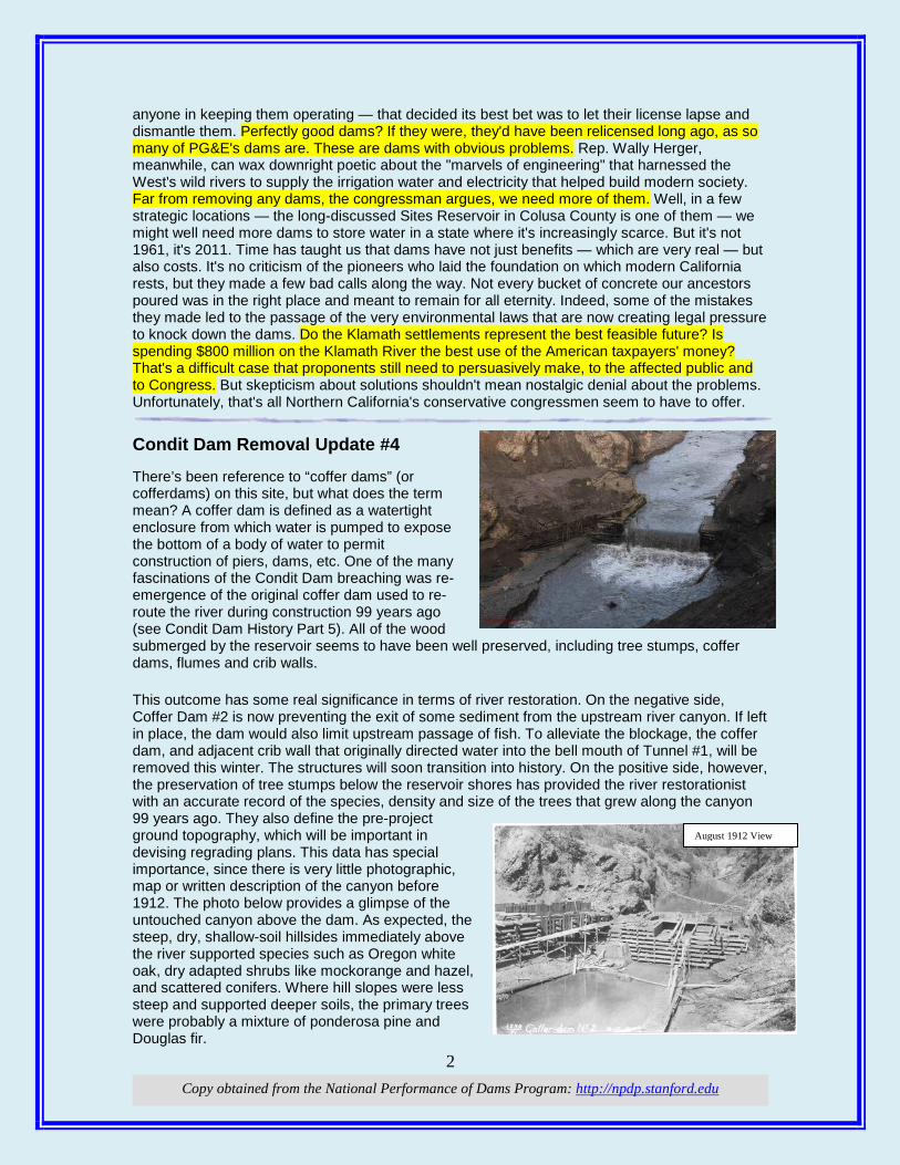
2 Copy obtained from the National Performance of Dams Program: http://npdp.stanford.edu
anyone in keeping them operating — that decided its best bet was to let their license lapse and dismantle them. Perfectly good dams? If they were, they'd have been relicensed long ago, as so many of PG&E's dams are. These are dams with obvious problems. Rep. Wally Herger, meanwhile, can wax downright poetic about the "marvels of engineering" that harnessed the West's wild rivers to supply the irrigation water and electricity that helped build modern society. Far from removing any dams, the congressman argues, we need more of them. Well, in a few strategic locations — the long-discussed Sites Reservoir in Colusa County is one of them — we might well need more dams to store water in a state where it's increasingly scarce. But it's not 1961, it's 2011. Time has taught us that dams have not just benefits — which are very real — but also costs. It's no criticism of the pioneers who laid the foundation on which modern California rests, but they made a few bad calls along the way. Not every bucket of concrete our ancestors poured was in the right place and meant to remain for all eternity. Indeed, some of the mistakes they made led to the passage of the very environmental laws that are now creating legal pressure to knock down the dams. Do the Klamath settlements represent the best feasible future? Is spending $800 million on the Klamath River the best use of the American taxpayers' money? That's a difficult case that proponents still need to persuasively make, to the affected public and to Congress. But skepticism about solutions shouldn't mean nostalgic denial about the problems. Unfortunately, that's all Northern California's conservative congressmen seem to have to offer. Condit Dam Removal Update #4 There’s been reference to “coffer dams” (or cofferdams) on this site, but what does the term mean? A coffer dam is defined as a watertight enclosure from which water is pumped to expose the bottom of a body of water to permit construction of piers, dams, etc. One of the many fascinations of the Condit Dam breaching was re-emergence of the original coffer dam used to re-route the river during construction 99 years ago (see Condit Dam History Part 5). All of the wood submerged by the reservoir seems to have been well preserved, including tree stumps, coffer dams, flumes and crib walls. This outcome has some real significance in terms of river restoration. On the negative side, Coffer Dam #2 is now preventing the exit of some sediment from the upstream river canyon. If left in place, the dam would also limit upstream passage of fish. To alleviate the blockage, the coffer dam, and adjacent crib wall that originally directed water into the bell mouth of Tunnel #1, will be removed this winter. The structures will soon transition into history. On the positive side, however, the preservation of tree stumps below the reservoir shores has provided the river restorationist with an accurate record of the species, density and size of the trees that grew along the canyon 99 years ago. They also define the pre-project ground topography, which will be important in devising regrading plans. This data has special importance, since there is very little photographic, map or written description of the canyon before 1912. The photo below provides a glimpse of the untouched canyon above the dam. As expected, the steep, dry, shallow-soil hillsides immediately above the river supported species such as Oregon white oak, dry adapted shrubs like mockorange and hazel, and scattered conifers. Where hill slopes were less steep and supported deeper soils, the primary trees were probably a mixture of ponderosa pine and Douglas fir.
August 1912 View
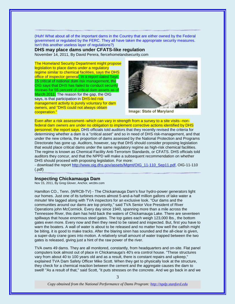
3 Copy obtained from the National Performance of Dams Program: http://npdp.stanford.edu
(Huh! What about all of the important dams in the Country that are either owned by the Federal government or regulated by the FERC. They all have taken the appropriate security measures. Isn’t this another useless layer of regulations?) DHS may place dams under CFATS-like regulation November 14, 2011, By David Perera, fiercehomelandsecurity.com The Homeland Security Department might propose legislation to place dams under a regulatory regime similar to chemical facilities, says the DHS office of inspector general. In a report dated Sept. 15 critical of national dam risk management, the OIG says that DHS has failed to conduct security reviews for 55 percent of critical dam assets as of March 2011. The reason for the gap, the OIG says, is that participation in DHS-led risk management activity is purely voluntary for dam owners, and "DHS could not always obtain cooperation." Even after a risk assessment--which can vary in strength from a survey to a site visits--non-federal dam owners are under no obligation to implement corrective actions identified by DHS personnel, the report says. DHS officials told auditors that they recently revised the criteria for determining whether a dam is a "critical asset" and so in need of DHS risk-management, and that under the new criteria, the proportion of dams assessed by the National Protection and Programs Directorate has gone up. Auditors, however, say that DHS should consider proposing legislation that would place critical dams under the same regulatory regime as high-risk chemical facilities. The regime is known as Chemical Facility Anti-Terrorism Standards, or CFATS. DHS officials told auditors they concur, and that the NPPD will make a subsequent recommendation on whether DHS should proceed with proposing legislation. For more: - download the report http://www.oig.dhs.gov/assets/Mgmt/OIG_11-110_Sep11.pdf, OIG-11-110 (.pdf) Inspecting Chickamauga Dam Nov 15, 2011, By Greg Glover, Anchor, wrcbtv.com Hamilton CO., Tenn. (WRCB-TV) - The Chickamauga Dam's four hydro-power generators light our homes. Just one of its turbines moves almost 5-and-a-half million gallons of lake water a minute! We tagged along with TVA inspectors for an exclusive look. "Our dams and the communities around our dams are top priority," said TVA Senior Vice President of River Operations john McCormick. Every day since 1940, spanning more than a mile across the Tennessee River, this dam has held back the waters of Chickamauga Lake. There are seventeen spillways that house enormous steel gates. The top gates each weigh 123,000 lbs., the bottom gates even more. Every now and then they need to be raised and inspected. But, first you have to warn the boaters. A wall of water is about to be released and no matter how well the catfish might be biting, it is good to make tracks. After the blaring siren has sounded and the all-clear is given, a super-duty crane goes into motion. A relatively small amount of water trapped between the two gates is released, giving just a hint of the raw power of the river. TVA owns 49 dams. They are all monitored, constantly, from headquarters and on-site. Flat panel computers look almost out of place in Chickamauga's 40's era control house. "These structures vary from about 40 to 100 years old and as a result, there is constant repairs and upkeep," explained TVA Dam Safety Officer Mike Scott. When they get to physically look at the structure, they check for a chemical reaction between the cement and the aggregate causes the dam to swell! "As a result of that," said Scott, "it puts stresses on the concrete. And we go back in and we
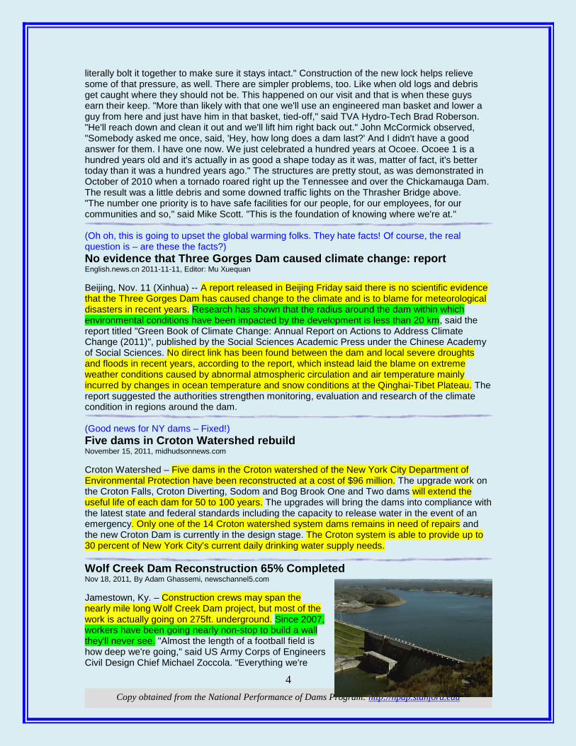
4 Copy obtained from the National Performance of Dams Program: http://npdp.stanford.edu
literally bolt it together to make sure it stays intact." Construction of the new lock helps relieve some of that pressure, as well. There are simpler problems, too. Like when old logs and debris get caught where they should not be. This happened on our visit and that is when these guys earn their keep. "More than likely with that one we'll use an engineered man basket and lower a guy from here and just have him in that basket, tied-off," said TVA Hydro-Tech Brad Roberson. "He'll reach down and clean it out and we'll lift him right back out." John McCormick observed, "Somebody asked me once, said, 'Hey, how long does a dam last?' And I didn't have a good answer for them. I have one now. We just celebrated a hundred years at Ocoee. Ocoee 1 is a hundred years old and it's actually in as good a shape today as it was, matter of fact, it's better today than it was a hundred years ago." The structures are pretty stout, as was demonstrated in October of 2010 when a tornado roared right up the Tennessee and over the Chickamauga Dam. The result was a little debris and some downed traffic lights on the Thrasher Bridge above. "The number one priority is to have safe facilities for our people, for our employees, for our communities and so," said Mike Scott. "This is the foundation of knowing where we're at." (Oh oh, this is going to upset the global warming folks. They hate facts! Of course, the real question is – are these the facts?) No evidence that Three Gorges Dam caused climate change: report English.news.cn 2011-11-11, Editor: Mu Xuequan Beijing, Nov. 11 (Xinhua) -- A report released in Beijing Friday said there is no scientific evidence that the Three Gorges Dam has caused change to the climate and is to blame for meteorological disasters in recent years. Research has shown that the radius around the dam within which environmental conditions have been impacted by the development is less than 20 km, said the report titled "Green Book of Climate Change: Annual Report on Actions to Address Climate Change (2011)", published by the Social Sciences Academic Press under the Chinese Academy of Social Sciences. No direct link has been found between the dam and local severe droughts and floods in recent years, according to the report, which instead laid the blame on extreme weather conditions caused by abnormal atmospheric circulation and air temperature mainly incurred by changes in ocean temperature and snow conditions at the Qinghai-Tibet Plateau. The report suggested the authorities strengthen monitoring, evaluation and research of the climate condition in regions around the dam. (Good news for NY dams – Fixed!) Five dams in Croton Watershed rebuild November 15, 2011, midhudsonnews.com Croton Watershed – Five dams in the Croton watershed of the New York City Department of Environmental Protection have been reconstructed at a cost of $96 million. The upgrade work on the Croton Falls, Croton Diverting, Sodom and Bog Brook One and Two dams will extend the useful life of each dam for 50 to 100 years. The upgrades will bring the dams into compliance with the latest state and federal standards including the capacity to release water in the event of an emergency. Only one of the 14 Croton watershed system dams remains in need of repairs and the new Croton Dam is currently in the design stage. The Croton system is able to provide up to 30 percent of New York City’s current daily drinking water supply needs. Wolf Creek Dam Reconstruction 65% Completed Nov 18, 2011, By Adam Ghassemi, newschannel5.com Jamestown, Ky. – Construction crews may span the nearly mile long Wolf Creek Dam project, but most of the work is actually going on 275ft. underground. Since 2007, workers have been going nearly non-stop to build a wall they'll never see. "Almost the length of a football field is how deep we're going," said US Army Corps of Engineers Civil Design Chief Michael Zoccola. "Everything we're
5 Copy obtained from the National Performance of Dams Program: http://npdp.stanford.edu
building is below ground so you can't see it." It will keep water from further eroding the limestone underneath Wolf Creek Dam and hopefully stop any future leaks. Everything they're doing is reinforcing patch work done after sink holes started popping up in the 1960s. "It did what it was meant to do over that 40 or 50 years of course we discovered that wasn't a permanent fix and we needed to come in with a permanent fix," said Lieutenant Colonel James DeLapp, who assumed command of the Corps' Nashville Branch last summer. DeLapp says if the dam ever failed it would devastate Nashville worse than the May 2010 floods. "It would be about 3 or 4 feet higher water in downtown Nashville than what they experienced in 2010," he said. The Corps has lowered Lake Cumberland 43 ft. to relieve pressure so massive equipment, like the "HydroMill," can drill and pour some of the 365,000 cubic yards of concrete. The project is 65% complete yet workers are only inching their way towards the most challenging portion, called "Critical Area One", where the dam itself meets the embankment. "It's really the area where we have the worst geology," Project Manager David Hendrix. Crews won't stop working until the wall is fully extended underground, but they say every day the work they are one step closer to avoiding a disaster. "The dam is much safer than it was two years ago, four years ago, no questions," Hendrix said. The Corps estimates crews will finish their work in late 2013. They hope winter and spring rains will replenish Lake Cumberland in time to resume normal recreation in the summer of 2014, seven years after the project began. The dam will be monitored on a regular basis for years to come. Crews stopped work briefly last spring, allowing Lake Cumberland to fill for a short time to relieve towns from flooding up and down the Mississippi River.
HHyyddrroo: (Have no idea what this will do to the amount of annual charges Licensees pay the FERC!) News Release: November 17, 2011, Docket No. RM11-6-000, Item No. H-1 FERC proposes revision to annual charges for use of federal lands The Federal Energy Regulatory Commission (FERC) today issued a proposal to revise the methodology for calculating rental rates for the use of government lands by hydropower projects. FERC-regulated hydropower licensees must compensate the U.S. government for the use of federal lands through payment of an annual charge. Today’s Notice of Proposed Rulemaking proposes to adopt the U.S. Bureau of Land Management’s (BLM) formula for calculating an annual charge. However, FERC proposes to create its own fee schedule of per-acre rental rates using the BLM formula, subject to one change in the land value component. The Commission would use actual county land values from a national census, rather than assign counties to zones. The fee schedule will be updated every five years with new land values, and adjusted annually for inflation. The Commission also proposes to stop doubling the per-acre rental rate for non-transmission line lands. Today’s proposal stems from a February 2011 Notice of Inquiry seeking public comments on publicly available indices to calculate rental rates for use of government lands. It addressed a Jan. 4, 2011, decision by the U.S. Court of Appeals for the District of Columbia Circuit vacating the Commission’s earlier attempt to implement the fee schedule. The court said the Administrative Procedure Act requires FERC to seek notice and comment on the methodology used to calculate annual charges because the fee schedule is based on the 1987 BLM formula, and BLM made changes to the formula. Comments are due 45 days after publication in the Federal Register. (Sometimes you have to state the obvious about hydro and dams.) Hydropower helps manage water for energy and food By Kari Williamson, 18 November 2011, renewableenergyfocus.com

6 Copy obtained from the National Performance of Dams Program: http://npdp.stanford.edu
The International Hydropower Association (IHA) says hydropower is contributing to water, energy and food security. Following introductions by HRH the Prince of Orange, the Head of the UN-Water Decade Programme on Capacity Development, and the German Government (BMU), IHA was represented in a thought-leaders panel to debate the challenges that the world faces to achieve water, energy and food security. Richard Taylor, IHA Executive Director, said: “Hydropower lies at the heart of the water, energy and food security nexus. Within the family of renewables, it offers huge potential, provided its multiple benefits are identified and distributed within the context of sustainability – this is why the hydro sector has committed to the Hydropower Sustainability Assessment Protocol.” Within the context of assessing the impacts of energy on water, Taylor warned that there was a danger of over simplification through a ‘foot printing’ approach: “We should take note of the advice of HRH the Prince of Orange and recognize the diversity of local realities. The impacts of energy, being both quantitative and qualitative, are far too complex to be captured in a single number.” Taylor added that an evaluation framework for the impacts of energy on water was being developed as a target within the World Water Forum process. He urged interested parties to engage in this initiative. (This is a piece of history from 50 years ago and probably one of worst decisions ever made by the Commission. This would not happen today!) Short-sighted policy Nov 18, 2011 | newsminer.com Editor’s note: With the price of fuel, hydroelectric dams are getting a second look all around Alaska. Fifty years ago, a growing economy had people in Fairbanks gazing hopefully at nearby rivers, including the Chatanika, just north of Fairbanks, as described in this Daily News-Miner editorial from Nov. 24, 1961. We are dismayed with the short-sighted view of the Federal Power Commission in dismissing an application by the Chatanika Power Company for a preliminary permit for investigation of a proposed hydroelectric development on the Chatanika River. The Fairbanks area at the present is taxing its power capabilities nearly to the limit and if there is anything we are going to need in the immediate future — it is power. The outcome of the power commission’s decision is to show up a proposed $7 million hydroelectric development in the Tanana Valley. The local firm needed the permit to go ahead with a preliminary investigation for its proposed power project, because the frozen core dam which would be utilized on the Chatanika River is on federal land. The plan of the local firm calls for a dam and power plant that would produce 15,000 added kilowatts for this area as a supplement to other power units in the Fairbanks area. This added power would be used for “peaking demand” carrying loads when other plants are taxed to capacity ... not as a power company in the sense of the Municipal Utilities System and Golden Valley Electric, who sell to the individual consumer. In this respect the Chatanika Power Company already has a small plant at 32 Mile on the Steese Highway, which in the summer season sells “dump power” to Golden Valley Electric Association for 10 mills per kilowatt. We feel the Federal Power Commission, while possibly not overstepping its authority, is being unnecessarily “officious” in this case. As we understand the commission’s function, it is to “police” the power industry, not to discourage further development. In view of “New Frontiers,” as the expressed slogan of the present administration, it is paradoxical that the only dissenting vote of the commission was by Commissioner Jerome K. Kuykendall, former chairman of the commission and the only holdover from the former administration. He said, “The commission should encourage, and not discourage, efforts to develop such projects. I can see no possible harm from issuing the requested permit.” We concur in seeing no possible harm in encouraging this venture. If the cutting of “red tape” is necessary to get such a proposed project on the road, then by all means, that tape should be cut. We are going to need that power, and more, in the very near future. For the present, at least, policy of the “New Frontier” administration clearly mandates “no

7 Copy obtained from the National Performance of Dams Program: http://npdp.stanford.edu
free enterprise desired” in developing “America’s Last Frontier. We did not build America on this type of short-sighted philosophy. Duke Energy to Begin Work on Linville-Paddy Creek Spillway By Caitlin Byrd on 11/19/2011, mountainx.com While the new Bridgewater Hydro Station project nears completion, a separate construction team will begin to mobilize for upcoming work on the Linville-Paddy Creek Spillway. Three dams form Lake James—Linville, Paddy Creek and Catawba dams. The Linville-Paddy Creek Spillway is between the Linville and Paddy Creek dams on the southeast side of the lake. This 240-foot long spillway, constructed in the late 1920s, is designed to release flood waters downstream to protect the adjacent dams. A concrete wall extension was added in 1941 to better direct flood waters. Since then, the Federal Energy Regulatory Commission (FERC) issued new guidelines that increase the safety factors needed during severe flood scenarios. Duke Energy will be initiating construction on the spillway to raise the height of a portion of the concrete wall by approximately nine feet and to provide increased stability against extreme flood conditions. The spillway remains safe today; this is simply an added measure of safety to comply with new federal guidelines. Duke Energy plans to begin mobilizing for this work November 28 by building access roads and support structures. Actual spillway construction will begin in January and continue through May 2012. This will include a work team of about 10 people, accessing the spillway by North Powerhouse Road. This work should not impact those living or traveling nearby. Duke Energy plans to operate Lake James within its normal operating range of 92 to 100 feet during the spillway work, though significant rainfall or dry conditions may impact lake levels. Bridgewater Hydro Station Update As of November 14, all three units at the new Bridgewater Hydro Station are operable and available for service. Duke Energy retired the two units at the original Bridgewater station on October 17. Duke Energy continues to plan for a 30-day hydro station outage beginning in mid-January to complete the disconnection of the old powerhouse. It expects to operate Lake James within the normal operating range of 92 to 100 feet during that time. There will be no flow releases from either the old or new powerhouse during this outage; however, the flow valve at the Catawba Dam will be operating to provide flow downstream. The new 31.5-megawatt station increases capacity by 8.5 megawatts and is being constructed just downstream as Duke Energy makes room for federally-required seismic stability work in 2012.
EEnnvviirroonnmmeenntt:: (Mmmm! This is an interesting turn of events in the heavily emotional issue that exists at Lake of the Ozarks. FERC does quick turn-about! Phew – dodged that bullet!) Ameren pledges quick fix for lake dispute By Jeffrey Tomich • STLtoday.com | November 18, 2011 Ameren Missouri said it will move swiftly to resolve a dispute threatening more than 1,200 waterfront homes at Lake of the Ozarks that are on land currently set aside for the utility's Bagnell Dam project. The St. Louis-based company on Friday promised to deliver a proposal to adjust the dam project boundary around the 93-mile serpentine lake to federal regulators before March 31 -- two months before a deadline set by the Federal Energy Regulatory Commission (FERC). FERC last week ordered the plan in an effort to assuage property owners who feared their homes faced
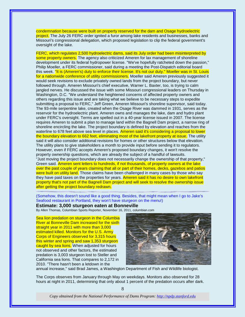
8 Copy obtained from the National Performance of Dams Program: http://npdp.stanford.edu
condemnation because were built on property reserved for the dam and Osage hydroelectric project. The July 26 FERC order ignited a furor among lake residents and businesses, banks and Missouri's congressional delegation, which proposed legislation to clip the federal government's oversight of the lake. FERC, which regulates 2,500 hydroelectric dams, said its July order had been misinterpreted by some property owners. The agency also criticized Ameren for lax management of shoreline development under its federal hydropower license. "We've hopefully ratcheted down the passion," Philip Moeller, a FERC commissioner, said during a meeting the Post-Dispatch editorial board this week. "It is (Ameren's) duty to enforce their license. It's not our duty." Moeller was in St. Louis for a nationwide conference of utility commissioners. Moeller said Ameren previously suggested it would seek revisions to exclude privately owned lands from the project boundary, but never followed through. Ameren Missouri's chief executive, Warner L. Baxter, too, is trying to calm jangled nerves. He discussed the issue with some Missouri congressional leaders on Thursday in Washington, D.C. "We understand the heightened concerns of affected property owners and others regarding this issue and are taking what we believe to be necessary steps to expedite submitting a proposal to FERC," Jeff Green, Ameren Missouri's shoreline supervisor, said today. The 93-mile serpentine lake, created when the Osage River was dammed in 1931, serves as the reservoir for the hydroelectric plant. Ameren owns and manages the lake, dam and hydro plant under FERC's oversight. Terms are spelled out in a 40-year license issued in 2007. The license requires Ameren to submit a plan to manage land within the Bagnell Dam project, a narrow ring of shoreline encircling the lake. The project boundary is defined by elevation and reaches from the waterline to 678 feet above sea level in places. Ameren said it's considering a proposal to lower the boundary elevation to 662 feet, eliminating most of the lakefront property at issue. The utility said it will also consider additional revisions for homes or other structures below that elevation. The utility plans to give stakeholders a month to provide input before sending it to regulators. However, even if FERC accepts Ameren's proposed boundary changes, it won't resolve the property ownership questions, which are already the subject of a handful of lawsuits. "Just moving the project boundary does not necessarily change the ownership of that property," Green said. Ameren sent letters to hundreds, if not thousands, of property owners at the lake over the past couple of years claiming that all or part of their homes, decks, gazebos and patios were built on utility land. Those claims have been challenged in many cases by those who say they have paid taxes on the properties for years. Ameren said it has no desire to own lakefront property that's not part of the Bagnell Dam project and will seek to resolve the ownership issue after getting the project boundary redrawn. (Somehow, this doesn’t sound like a good thing. Besides, that might mean when I go to Jake’s Seafood restaurant in Portland, they won’t have sturgeon on the menu!) Estimate: 3,000 sturgeon eaten at Bonneville By Allen Thomas, Columbian Sports Reporter, November 16, 2011, columbian.com Sea lion predation on sturgeon in the Columbia River at Bonneville Dam increased for the sixth straight year in 2011 with more than 3,000 estimated killed. Monitors for the U.S. Army Corps of Engineers observed for 3,315 hours this winter and spring and saw 1,353 sturgeon caught by sea lions. When adjusted for hours not observed and other factors, the estimated predation is 3,003 sturgeon lost to Steller and California sea lions. That compares to 2,172 in 2010. "There hasn't been a letdown in the annual increase,'' said Brad James, a Washington Department of Fish and Wildlife biologist. The Corps observes from January through May on weekdays. Monitors also observed for 28 hours at night in 2011, determining that only about 1 percent of the predation occurs after dark.
9 Copy obtained from the National Performance of Dams Program: http://npdp.stanford.edu
The data also showed all size of sturgeon are being killed, but fish between 2 feet and 4 feet are hit the hardest. Steller sea lions start showing up at Bonneville Dam as early as October. The Corps annual report says its predation estimates should be considered minimums. Steller seasons prefer sturgeon. Observers saw only three sturgeon killed by California sea lions this year. Predation on sturgeon dropped substantially during the last week of March when spring chinook salmon arrived at the dam. Overall, salmon and steelhead made up 48.7 percent of the predation observed by the Corps, sturgeon were 30.1 percent and shad were 2.1 percent. Slightly more than 18 percent of the fish killed could not be identified. It is estimated 3,298 spring chinook were lost to marine mammals, which was 1.2 percent of the run including jacks. Spring chinook were 91.9 percent of the salmonids taken and steelhead 8.1 percent. In the past few years, Steller sea lions have been observed swallowing steelhead whole, suggesting they can eat steelhead and spring chinook jacks entirely below the surface. Two California sea lions were documented upstream of Bonneville Dam in mid-April, having passed through the navigation lock. One was trapped in mid-May and released downstream of the dam. The other has eluded capture and been seen as far upstream as The Dalles marina. The Washington and Oregon departments of Fish and Wildlife also conducted intermittent observations between Rooster Rock and Tanner Creek, a 16-mile stretch of the Columbia, from early January to early April. In 361 hours, the states' observed 192 sturgeon caught by Steller sea lions, said James. Washington and Oregon factor in a kill of 11,000 sturgeon annually to sea lions in their lower Columbia River population model. Biologist Chris Kern of the Oregon Department of Fish and Wildlife said he thinks the kill is actually a bit less than 10,000. (The other consequences of breaching a dam) With Condit Dam breached, cabin owners nearby facing winter without water, they worry By The Oregonian, oregonlive.com, November 17, 2011 Two weeks ago, the Condit Dam near White Salmon, Wash., was breached and Northwestern Lake above the dam began to drain. The latest: owners of cabs that surrounded the lake are saying their wells are drying up. Here's a report on that as well as back stories on the breaching of Condit Dam: Homeowners concerned about erosion, dry wells after dam breach (KATU News) Two weeks after the Condit Dam was blown open, homeowners along the White Salmon River have concerns about erosion and their water wells. Before the 127-foot dam was breached, a dock floated on Northwestern Lake. Now it sits upon dry ground, and the lake has been replaced with a muddy canyon, 80 feet deep in some areas. The ground continues to move every day on the old lake bed, and there are fears the earth below that dock could fall into the chasm. In addition to losing their lake, homeowners say they have also lost water to their houses. PacifiCorp has about three dozen leases to homeowners where the lake once sat behind the dam. There are about a dozen private homes and many water wells are drying up now that the lake is gone. While residents can't do anything about losing the lake, they want the power company to help with the wells. With a boom and a flash of light, Condit Dam is breached and White Salmon River unleashed (The Oregonian) For 31 years, Phyllis Clausen had waited for Condit Dam to relinquish its hold on the White Salmon River. On Wednesday at noon, she sat near the dam, black cane by her side, watching a live feed set to broadcast the dam's demise. A Cape Canaveral-like hush settled over the crowd. "Fire in the hole!" came a shout from below. Then a flash of light, a boom, a tremor in the ground and an astonishing surge of charcoal gray water gushed from a hole blown through dam's base, the first time in a century that the wild-and-scenic river has run free. A White Salmon River free of Condit Dam is monumental for tribal elder, kayaker and a fish biologist (The Oregonian)
10 Copy obtained from the National Performance of Dams Program: http://npdp.stanford.edu
Driving upstream along the curves of the White Salmon River brings you to Husum. Just before the raft and kayak guide shops and the thunder of Husum Falls, Indian Creek Road branches to the right and leads to Indian Cemetery Road, running past signs that highlight settlers' wagon tracks. Tony Washines, 66, stands in the cemetery's deepest corner, in front of the oldest stone. Streaks of gray run through his ponytail, dark green firs reflect in his thick glasses. His great-great-grandfather and tribal leader, Jacob Hunt Sr., was buried here in 1913. That's the year Condit Dam went up near the mouth of the White Salmon, supplying electricity to a paper mill but stopping salmon cold. $60 million fish passage going up at Toketee's Soda Springs Dam DD Bixby, The News-Review, nrtoday.com, November 20, 2011 Toketee, OR — Depending on the weather, anywhere from 50 to 100 people are hammering, welding and scraping away at the Soda Springs Dam every day. The workers are building a $60 million fish passage to open up for the first time in 60 years spawning beds on the upper reaches of the North Umpqua River. The fish passage, expected to be completed before the end of 2012, also will be the last word in a 17-year debate on whether to build a ladder or tear out the dam. But the debate will close with a few lingering complaints from conservationists who hope the ladder will work but remain skeptical. “It's an amazing amount of engineering and when you look at it, it's kind of awesomely cool. But if fish can truly make it up the ladder, I will be stunned and amazed and pleased,” said Diana Wales, president of the Umpqua Valley Audubon Society. “I think it was a mistake not to remove the dam.'” The dam was put into operation in 1952 as part of the North Umpqua Hydroelectric Project, a network of hydroelectric generators in the Umpqua National Forest that creates enough power for 40,000 homes. The dam regulates the natural flow of the river to generate electricity during times of peak demand, making the power “more valuable” to PacifiCorp, said Monte Garrett, who oversees the project. But the dam also prevents fish from swimming upstream to historic spawning grounds. In 2003, federal regulators renewed PacifiCorp's license to operate the dam on a public waterway, but the utility company was required to build the fish passage. “This is a good facility. (Fish passage is) in the best interest for our customers and social values,” Garrett said. Construction began in June 2010, and the weather, confines of the canyon and the geology of the North Umpqua River have put the project a year behind schedule and increased costs many times above the original estimate. “It's an engineering challenge that leaves everyone amazed that it can be done,” Garrett said. Conservation groups had pushed for the dam's removal, arguing that the dam not only blocks spawning grounds but also keeps gravel and woody debris from replenishing downstream spawning beds. “Spawning gravel is as important as fish passage. What's behind the Soda Springs Dam is a lot of good spawning ground material that would benefit the whole river,” said Stan Vejtasa of the Umpqua Valley Audubon Society. “We're all hoping this works. I've sort of made peace with them now, but I've had frustrations over this process in the past.” Conservation groups in the 1990s accused PacifiCorp of underestimating the cost of building a fish passage and overestimating the cost of removing the dam. The company estimated in the mid-1990s that a fish ladder would cost between $8 million and $10 million. “Our people kept saying they were low-balling the cost to sell (fish passage) to FERC (Federal Energy Regulatory Commission), but they dismissed us. Now that the cost estimates are coming in way more than they said, I get angry,” Wales said. Garrett said the company's estimates in the late 1990s were closer to $12 million but seemed to double every few years for various reasons. “A project doubling or quadrupling when it's this size is not uncommon. The original cost estimates were based on ideal situations, and we did everything we could to keep costs down,” he said. Garrett said the company believes removing the dam would have cost as much as the fish passage and also would have raised electric rates more because of the lost hydropower. Besides the $60 million fish ladder, PacifiCorp estimates that over the 35-year license period it will spend another $60 million on maintenance and other capital improvements on the North Umpqua project. Still, PacifiCorp estimates the fish passage will increase rates by less than 1 percent, spokesman
11 Copy obtained from the National Performance of Dams Program: http://npdp.stanford.edu
Monte Mendenhall said. The increase hasn't concerned the Citizens' Utility Board, a Portland-based ratepayer advocacy group. “At this point Soda Springs is not something that has hit our radar. It's a relatively nominal cost. For something that's an ongoing project like this, I doubt this would make our list of concerns,” said the group's organizing director, Jeff Bissonnette. The project has meant much-needed work for construction companies. Todd Weekly, co-owner of Weekly Bros. Inc. of Idleyld Park, has 32 workers on-site doing concrete, excavation and mechanical work as a subcontractor. Weekly, whose company specializes in construction projects in remote areas and is the largest subcontractor to the general contractor, Todd Construction of Tualatin, said the Soda Springs fish passage has been an “anchor point” for the company since June 2010. The company, which had 80 workers on the job in the summer, hired extra employees for Soda Springs, Weekly said. “We've been fortunate to have work when work has been hard to get right now, so that's been a blessing for us,” Weekly said. With the project well under way, rancor over Soda Springs has dulled, though Garrett said he believes there are still “hard feelings” among some conservation groups. If the fish passage works, it will open up habitat for steelhead, spring chinook and coho salmon and Pacific lamprey. “I'm optimistic that they'll find the ladder,” said Dave Harris, the Oregon Department of Fish and Wildlife official monitoring the project. The new habitat includes three miles of Fish Creek and almost four miles of the North Umpqua River up to Slide Creek. “From a habitat view, there's lots of room (for more fish),” Harris said. PacifiCorp aquatic scientist Rich Grost said the new spawning grounds are expected to produce hundreds of steelhead and spring chinook salmon. Grost said a small number of coho salmon and an unknown number Pacific lamprey also will come from the new beds. Despite a 50-year exile from those upper spawning grounds, the fish should find their way up the ladder, Grost said. He said fish are used to adapting to shifting spawning beds caused by beaver dams, rock slides and changing river channels. “So boundaries aren't always the same, and in any given species of anadromous fish, some will hit those upper boundaries,” he said. Soda Springs is 180 miles inland for the fish that swim in from the Pacific Ocean to spawn. “The extra three miles up Fish Creek is a tiny percentage of how far they travel,” Grost said. Once the dam and fish passage are functioning again, Pacific Power will conduct a yearlong evaluation to make sure fish are making it up and down the passage, Garrett said. Grost said it's hard to anticipate how many fish will use the ladder. “We'll be at the mercy of the fish,” Grost said. “So it's tough to say for sure.” iThis compilation of articles and other information is provided at no cost for those interested in hydropower, dams, and water resources issues and development, and should not be used for any commercial or other purpose. Any copyrighted material herein is distributed without profit or payment from those who have an interest in receiving this information for non-profit and educational purposes only.