Embed Size (px)
Citation preview

S o l u t i o n s f o r L a n d D e v e l o p m e n t P r o f e s s i o n a l s
Office Software
Data Collection
Instruments
Survey & GIS
Civil Engineering
Construction
Accident Reconstruction

2
Tab
le o
f C
on
ten
ts
Carlson Software produces a complete suite of solutions for land development professionals, across the disciplines of data collection, surveying, engineering design and drafting. In addition, utilizing its expertise in data collection, Carlson also offers accident and crime reconstruction field and office software for law enforcement personnel or law consultants.
We at Carlson recognize the paramount importance of free choice to the professional consumer in the land industry. We are committed to providing consistent software interfaces across hardware and across disciplines. This is the mission of Carlson Software.
--R. Bruce CarlsonFounder and President
Carlson Software
Founded in 1983 and based in Maysville, Kentucky, U.S.A., Carlson has branch offices and local representatives around the world.
Carlson Works for You ...................................3Carlson iCAD / Survey ...................................4Carlson Civil Suite ............................................6Carlson Takeoff Suite ......................................8Carlson PhotoCapture .................................. 10Carlson Precision 3D ...................................... 11Carlson P3D Hydro ........................................ 12Crime Scene Investigation .......................... 13Carlson Field .................................................... 13Carlson SurvCE | SurvPC............................. 14Carlson Hybrid+ .............................................. 15SurvPC with ESRI® .......................................... 16Carlson Layout .................................................17Surveyor2 .......................................................... 18Carlson RT4 ...................................................... 19Carlson BRx7 ..................................................20Carlson NR3 ..................................................... 21Listen Listen / Atlas ......................................22Carlson CR+ Series ....................................... 23Carlson FiX1 ..................................................... 23Contact info..................................................... 24

3
Carlson Works for You
Carlson Software encourages a “positive feedback loop” from our customers ensuring that our annual software releases are full of customer-driven new features. We are grateful for our high rate of customer retention over our history and firmly believe in providing free technical support, which Carlson has done since the day of its founding.
“With RoadNETwork [in
Carlson Civil], you can grip/
edit a centerline and have the
whole thing seamlessly and
dynamically update. That is the
coolest thing I’ve experienced
in the software.”
-- Christian Smith
Beals & AssociatesStratham, NH
“Carlson, with their hardware
and their software, as far as I’m
concerned, they’re number one
in the market. You just can’t
beat them. I recommend it to
everybody.”
-- John Hill
President, CEO, Alphatec Surveyors LTD
Chesapeake, VA
“We started with SurvCE on
the Carlson GPS receiver and
expanded to Carlson Survey
and then moved over to Carlson
Construction for its estimating
capabilities, 3D drawings and
the ability to make 3D models
for machine control. The more
you get to know it, the more
you can do it with it.”
-- Sean RobertsConstruction Surveyor
Van Etten/BlijdorpVlaardingen,
The Netherlands
“Biggest benefit I’ve seen
from SurvPC is really the time
management and just how
compatible it is with multiple
types of software, whether it’s
a Carlson software, not a CAD
software, or simply just Esri®.
Because of being able to do so
many different data file types, I
can work in any of those and I
don’t have to worry about how I
am going to convert files.”
-- Clay White
GIS Coordinator, Berea Municipal Utilities
Berea, KY

■ Get full tool kit – everything from network least squares to surface modeling
■ Work seamlessly between office and field
■ Establish company-wide design styles
■ Create GIS links & exchange Esri® data
Choose your platform – Carlson Survey works on:
■ AutoCAD® (sold separately)
■ IntelliCAD® (built-in)
Or choose Carlson Survey OEM with built-in engine Powered with Autodesk® Technology.
Get the Power of Carlson Field-to-Finish
Carlson Survey together with Carlson’s popular data collection software options, SurvCE, SurvPC, and Field, provide powerful, effective, and accurate “Field-to-Finish”:
■ Symbols, points and linework are drawn automatically in Carlson Survey
■ Drawings in SurvCE, SurvPC, and Field process perfectly and easily in Carlson Survey
Carlson iCAD is an affordable CAD program that is .dwg file based and designed to fit into your production workflow. Carlson iCAD allows drafters to finish drawings and engineers to review drawings.
Basic Features:
■ 2D and 3D CAD package
■ Based on .dwg, .dng file
■ Built on IntelliCAD® 8.3 engine
■ Carlson Software drafting and annotation tools
■ Perpetual license
■ Free tech support
■ Open/Save .dwg, .dng and .dxf files: Supports 2017 and earlier formats
■ Plot: Output to printers and PDF
■ Google Earth: Import and Export KML/KMZ
■ Civil 3D: Convert Civil 3D custom objects to standard CAD entities
■ Xref: Manage external references
■ Drawing Utilities: Functions include spell check and purge
Twist to 3D view
Least Squares Adjustments
Carlson SurveySurveyors’ #1 Software Choice
Carlson iCADSimple but Powerful CAD solution
4
Car
lso
n iC
AD
/ C
arls
on
Su
rvey
5
Car
lso
n S
urv
ey
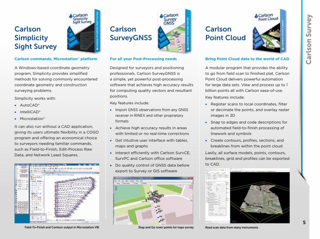
Carlson commands, Microstation© platform
A Windows-based coordinate geometry program, Simplicity provides simplified methods for solving commonly encountered coordinate geometry and construction surveying problems.
Simplicity works with:
■ AutoCAD®
■ IntelliCAD®
■ Microstation©
It can also run without a CAD application, giving its users ultimate flexibility in a COGO program and offering an economical choice to surveyors needing familiar commands, such as Field-to-Finish, Edit-Process Raw Data, and Network Least Squares.
For all your Post-Processing needs
Designed for surveyors and positioning professionals, Carlson SurveyGNSS is a simple, yet powerful post-processing software that achieves high accuracy results for computing quality vectors and resultant positions.
Key features include:
■ Import GNSS observations from any GNSS receiver in RINEX and other proprietary formats
■ Achieve high accuracy results in areas with limited or no real-time corrections
■ Get intuitive user interface with tables, maps and graphs
■ Interact efficiently with Carlson SurvCE, SurvPC and Carlson office software
■ Do quality control of GNSS data before export to Survey or GIS software
Bring Point Cloud data to the world of CAD
A modular program that provides the ability to go from field scan to finished plat, Carlson Point Cloud delivers powerful automation for large data sets. View and process up to 1 billion points all with Carlson ease-of-use.
Key features include:
■ Register scans to local coordinates, filter or decimate the points, and overlay raster images in 3D
■ Snap to edges and code descriptions for automated field-to-finish processing of linework and symbols
■ Create contours, profiles, sections, and breaklines from within the point cloud
Lastly, all surface models, points, contours, breaklines, grid and profiles can be exported to CAD.
Stop and Go rover points for topo surveyField-To-Finish and Contour output in Microstation V8i
Carlson Simplicity Sight Survey
Carlson SurveyGNSS
Carlson Point Cloud
Read scan data from many instruments

Carlson Civil SuiteThe Ultimate Civil Package
Get Fair Price, Full Featured CAD, and Free Support with Carlson Software’s Civil Suite, a powerful bundle made up of: Carlson Survey (see page 4), Carlson Civil, Carlson Hydrology, and Carlson GIS. These four civil-related modular programs, working together, provide the ultimate civil package that dramatically increases productivity while helping users create better designs.
All Carlson office software modules come with perpetual and maintenance licensing with Carlson customers allowed to own the software and to upgrade when they choose. They come with IntelliCAD® built-in, plus run on top of any AutoCAD®, Civil 3D®, or Map® from versions 2010 and up. Carlson has offered free support since the founding of the company. It’s what we’re based on – Carlson works for you!
6
Car
lso
n C
ivil
Su
ite
Full Featured CAD
Carlson CivilThe ‘Civil’ Choice
Carlson Civil provides the most robust automation and ease-of-use of any civil design solution available today, and it does dynamic updating without a single custom object. What might take days with other civil software takes just hours, or even minutes, with the powerful, intuitive Carlson Civil:
■ Road NETwork. Build all roads, intersections and cul- de-sacs in 2D and 3D with a single click of the “PROCESS” button.
■ Site NETwork. Elevate your estimating accuracy with this intuitive layer-based surface generator for easy cut/fill and material quantities calculations.
■ Lot NETwork. Quickly define an entire subdivision of lots based on an outer boundary, interior ROWs or Centerlines, and a simple set of user-defined “rules,” then pick “PROCESS” and the lots appear, defined and labeled.
With Carlson’s fully dynamic design environment, its trademark “networking,” changes made to one aspect of design are reflected in all other related aspects. Plus, Carlson Civil users get true 2D, easy-to-use 3D, intersection design, multi-baseline road networks, lot layout, storm and utility analysis and design, plus much, much more.
Road NETwork: Approach to Over-pass with Cloverleaf, Trapezoidal Ditch
Car
lso
n C
ivil
Su
ite
7
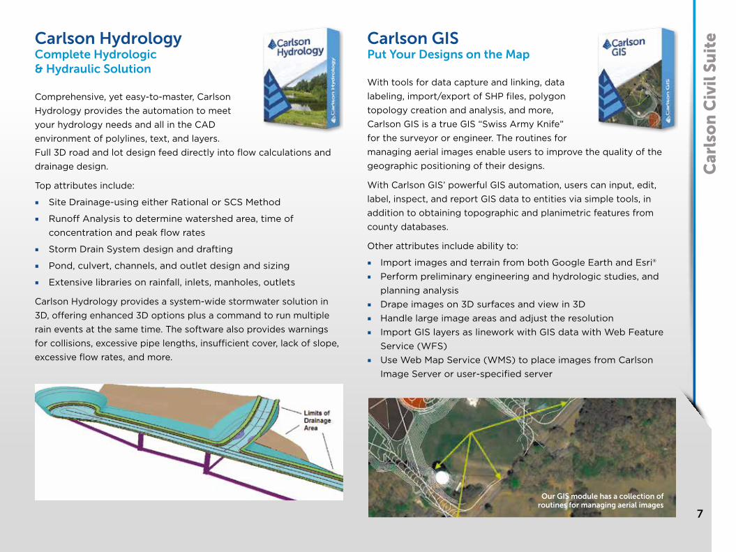
Our GIS module has a collection ofroutines for managing aerial images
Carlson Hydrology Complete Hydrologic & Hydraulic Solution
Comprehensive, yet easy-to-master, Carlson Hydrology provides the automation to meet your hydrology needs and all in the CAD environment of polylines, text, and layers. Full 3D road and lot design feed directly into flow calculations and drainage design.
Top attributes include:
■ Site Drainage-using either Rational or SCS Method
■ Runoff Analysis to determine watershed area, time of concentration and peak flow rates
■ Storm Drain System design and drafting
■ Pond, culvert, channels, and outlet design and sizing
■ Extensive libraries on rainfall, inlets, manholes, outlets
Carlson Hydrology provides a system-wide stormwater solution in 3D, offering enhanced 3D options plus a command to run multiple rain events at the same time. The software also provides warnings for collisions, excessive pipe lengths, insufficient cover, lack of slope, excessive flow rates, and more.
Carlson GISPut Your Designs on the Map
With tools for data capture and linking, data labeling, import/export of SHP files, polygon topology creation and analysis, and more, Carlson GIS is a true GIS “Swiss Army Knife” for the surveyor or engineer. The routines for managing aerial images enable users to improve the quality of the geographic positioning of their designs.
With Carlson GIS’ powerful GIS automation, users can input, edit, label, inspect, and report GIS data to entities via simple tools, in addition to obtaining topographic and planimetric features from county databases.
Other attributes include ability to:
■ Import images and terrain from both Google Earth and Esri®■ Perform preliminary engineering and hydrologic studies, and
planning analysis■ Drape images on 3D surfaces and view in 3D■ Handle large image areas and adjust the resolution■ Import GIS layers as linework with GIS data with Web Feature
Service (WFS) ■ Use Web Map Service (WMS) to place images from Carlson
Image Server or user-specified server

8
Car
lso
n T
akeo
ff S
uit
e Carlson Takeoff Suite
Carlson Takeoff is a cut/fill volumes and data prep (for layout or machine control) solution that can estimate jobs using paper plan digitizing, PDFs, or electronic CAD files. It is available in two configurations--Takeoff OEM (comes with AutoCAD engine built-in) and the Takeoff Suite, comprised of Carlson Construction, CADnet, Trench, and GeoTech (see following).
Carlson Takeoff is the only estimating software that works in the .dwg environment natively, which gives its users a distinct “CAD Advantage” when estimating from an engineer’s electronic files.
The Takeoff OEM has all of the same ingredients as the Takeoff Suite, which works on AutoCAD sold separately, or with IntelliCAD built-in. The Takeoff Suite’s four modules are all fully integrated with Carlson Civil and Hydrology to meet the variety of customers’ needs.
Carlson ConstructionFor Estimating & 3D Modeling
Carlson Construction is an integrated cut/fill takeoff and 3D surface modeling software solution designed for site and road construction from CAD files. It offers powerful section and 3D viewing tools for elevating 2D designs to 3D model files.
Core Abilities:
Cut/Fill EstimatingOutput 3D Machine Control Files (Carlson Grade, Trimble, CAT-Accugrade, Leica,
and Topcon)Output Construction Staking files for site, roadway, and building columns and
offsets As-Built Mapping
Carlson Construction’s Material Quantities Reports give estimators the volume, area, length and/or count for items such as asphalt, gravel, curb, or any “subgrade” or “select fill” that’s defined. For construction data prep, Carlson Construction creates surfaces from points and contours and can easily move lines from the “wrong” elevation and slope to the correct elevation and slope.
Subgrade Color Map

Car
lso
n T
akeo
ff S
uit
e
9
Carlson CADnet Create CAD from PDF, BIM, and more
Carlson CADnet allows users to create CAD from non-CAD documents such as PDFs, raster images, and paper plans. CAD text can also be generated from raster images with CADnet’s built-in Optical Character Recognition (OCR).
With Carlson CADnet, users can access a full set of digitizing routines for: Points, Polylines, Areas, Contours, Profiles, Sections, End-Areas.
CADnet gives users the ability to import BIM models (doors, windows, walls, roofs, etc.) and bring them into CAD as CAD entities; plus, CADnet includes a routine to export surfaces into BIM.
Carlson TrenchFor Trench Quantities & Modeling
Carlson Trench is for calculations related to installing pipes, sewers, or utility lines. The software calculates the volume of the trench cut, the volume of backfill (excluding pipe size), and the linear footage of pipe broken down by the pipe material, size, and/or depth.
Core capabilities in Carlson Trench include:
Calculates trench excavation and backfill quantities
Draws trench network in plan view, profile and 3D
Automatically adjusts trench design based on pipe size
Produces Trench Reports including Manhole Depth Summary, Pipe Length By Size, Stations Depth Summary, Structure Details, etc.
Carlson GeoTechKnow your Strata Cut
Designed for geotechnicians, civil engineers, and construction professionals, Carlson GeoTech provides the ability to import borehole data for analyzing subsurface conditions and materials. It models all core samples, producing a detailed, easy-to-read report for drill logs, cross sections, and plan view. This information is fully integrated with Carlson Civil, for determining site stability and suitability, and also Carlson Construction, for accurate strata takeoff estimation.
PDF Auto Trace Trench Depth Zone Map Strata Cut Map

10
Car
lso
n P
ho
to C
aptu
re Carlson Photo Capture
Surveyors, Meet the Newest Tool in Your KitAerial surveying is rapidly becoming a vital part of any surveyor’s toolkit. Thousands of people use drone site flyovers every day to help boost efficiency and lower costs.
With Carlson Photo Capture processing, you can use flyover data to:
■ Instantly generate interactive 3D maps of sites■ Capture highly accurate 3D site data from any camera■ Share site maps with customers -anywhere, anytime!■ Save man-hours in the field
Our proprietary technology helps you track and share every metric about your site from anywhere in the world
Powerful Features:■ View and edit your 3D map the minute it’s done uploading■ Capture the full 3D layout of your land from any camera angle■ Composite an accurate map from multiple flyovers■ Turns pixels into accurate 3D models of your worksite■ Set control points to fine-tune the accuracy of your survey data■ Get topographic elevations of landscape features with just a
click■ Show your 3D job site to customers and employees with our
web app■ Instantly calculate the mass of any feature to learn how big
your project is■ Get precise location-based data no matter what state you’re in

11
Car
lso
n P
reci
sio
n 3
DCarlson Precision 3D TopoBridge the gap between drones and CAD
Designed for use by surveyors, civil engineers, and contractors, Precision 3D Topo allows users to import survey data, points, polylines, surfaces, point clouds, both traditional LIDAR and aerial drone survey data, and more from a wide variety of programs and entities to create usable 3D surfaces.
■ Importing Point Cloud data from Lidar and Aerial Drone mapping.
■ Merge and edit point clouds to create surface models.■ Import survey data to further refine surface models.■ Powerful surface Editing tools to perfect surface models.
Including Google Maps photographic background, automated Google surface creation.
■ Easy surface volume tools directly from point clouds or surfaces.
■ Advanced Texturing and Presentation Tools■ Import / Export all data as LandXML, DXF, and Surface Models
as TIN, TN3, and TTM.
Import Point Cloud data from Lidar and Aerial Drone mapping.
■ Import up to 50 point cloud files at once■ Bare earth classification filter .las, .laz,
.ply, .xyz, .pts, .e57, .pcd files■ Remove outliers■ Apply thinning factor■ Automatically merge clouds.
Once the point clouds are loaded use the powerful editing tools.
■ Point Cloud point selector tool for crop, delete, with the ability to create a totally new cloud from a the selection.
■ Save point cloud to LAS/LAZ version 1.2, 1.3 and 1.4 including coordinate projection WKT.
■ Merge multiple point clouds together.■ Crop point cloud to smaller area.■ Delete point cloud points.■ Crop/delete points using polygons.■ Remove trees, vegetation, cars,
building using baregound filter.■ and much more....

12
Car
lso
n P
reci
sio
n 3
D Carlson Precision 3D HydroPowerful 3D Design, Traditional CAD Deliverables
A smart, new software, with game-like ease of use, providing users tools for rigorous, precise engineering in 3D.
Dynamic CAD automated plan and profile CAD design documentation Speed design with revolutionary drag and drop options for selecting headwalls and endwalls Delineate drainage and ponding areas Calculate runoff from surface models Size culverts and place at low points Curb Line Snap and low point snap for fast inlet placement Robust drainage structure library and the ability to customize their dimensions Grade surfaces for both upstream and downstream designs Move culverts and headwalls to new locations with full dtm restoration Choose from multiple barrel options Integrate easily into Carlson Civil Suite, AutoCAD and Microstation
Carlson Precision 3D 2020 provides the analytical tools to design with ease in a 3D environment while creating your CAD deliverables seamlessly and simultaneously.
13
Car
lso
n C
SI /
Car
lso
n F
ieldCSI Mobile & CSI Office
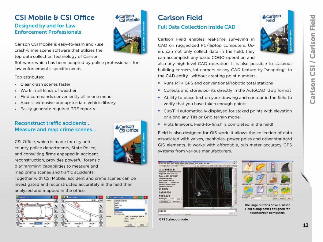
Designed by and for Law Enforcement Professionals
Carlson CSI Mobile is easy-to-learn and -use crash/crime scene software that utilizes the top data collection technology of Carlson Software, which has been adapted by police professionals for law enforcement’s specific needs.
Top attributes:
■ Clear crash scenes faster■ Work in all kinds of weather■ Find commands conveniently all in one menu■ Access extensive and up-to-date vehicle library■ Easily generate required PDF reports
Reconstruct traffic accidents… Measure and map crime scenes…
CSI Office, which is made for city and county police departments, State Police, and consulting firms engaged in accident reconstruction, provides powerful forensic diagramming capabilities to measure and map crime scenes and traffic accidents. Together with CSI Mobile, accident and crime scenes can be investigated and reconstructed accurately in the field then analyzed and mapped in the office.
The large buttons on all Carlson Field dialog boxes designed for
touchscreen computers
GPS Stakeout mode.
Carlson FieldFull Data Collection Inside CAD
Carlson Field enables real-time surveying in CAD on ruggedized PC/laptop computers. Us-ers can not only collect data in the field, they can accomplish any basic COGO operation and also any high-level CAD operation. It is also possible to stakeout building corners, lot corners or any CAD feature by “snapping” to the CAD entity—without creating point numbers.
Runs RTK GPS and conventional/robotic total stations
Collects and stores points directly in the AutoCAD .dwg format
Ability to place text on your drawing and contour in the field to verify that you have taken enough points
Cut/Fill automatically displayed for staked points with elevation or along any TIN or Grid terrain model
Plots linework. Field-to-finish is completed in the field!
Field is also designed for GIS work. It allows the collection of data associated with valves, manholes, power poles and other standard GIS elements. It works with affordable, sub-meter accuracy GPS systems from various manufacturers.

With SurvCE (for Windows Mobile) and SurvPC (for Windows) you are using the most flexible software on the market to get your work done in the most efficient and productive way.
Almost every surveying instrument from the following manufacturers is supported: Altus, Ashtech, Carlson, Geomax, Leica, Pentax, Sokkia, Spectra-
Precision, Stonex, Topcon and many more...
Carlson SurvCE and SurvPC are combining advanced functionality, ease-of-use, and sheer capability with excellent service and technical support to make it surveyors’ first choice in data collection software.
This complete data collection system for Real Time (RTK) GPS and total stations with in-field coordinate geometry supports the widest range of popular and new release RTK GPS and conventional/robotic total stations.
These powerful features help you do more, do itaccurately and in less time:
■ Powerful Roading: favored by U.S. DOTs and heavy highway contractors around the world
■ Advanced functionality for staking intersections and culde-sacs using Carlson Road Network Files
■ Highly graphical and intuitive user interface – the software prompts you so no detail is missed
■ Strong GIS features for accurate data capture, including attribute data, that allows seamless links to Esri®
■ True versatility: SurvCE and SurvPC run on most all GPS and total station equipment models in service today
■ Optimal Field-to-Finish: no need to spend extra hours in the office to make drawings
■ Easy data exchange due to rich support of CAD file formats and .dwg, .dgn, .shp
■ More field capabilities with quick and easy volume calculation and ability to generate points from polylines
■ Cut/Fill stakeout using surface files
Car
lso
n S
urv
CE
/ Su
rvP
C
14
Take Your Pick
Get the world’s most flexible & powerful data collection software:■ SurvCE for handheld
data collectors■ SurvPC for rugged PCs
Carlson SurvCE / SurvPCThe data collection software for the professional surveyor

15
Carlson Hybrid+
Follow Me
An alternative to optical tracking, Follow Me continuously turns the total station towards the prism using the GNSS location. Say goodbye to stray reflectors and lengthy searches, and say hello to a total station that is ready when you are.
Smart Lock
Use smart lock for a smarter survey. The software will automatically detect when you are slowing to take a measurement and lock on the prism so that it’s ready to go as fast as you can hit store.
Smart Staking
With smart staking, it will no longer be necessary to maintain optical tracking during stakeout. Keep your stakeout directions fresh using the GNSS receiver as you make your way to your stakeout point. When you get close, the total station will automatically turn and lock on the prism for the final staking precision you need.
Cross Check
SurvCE will automatically cross-check your total station and GNSS positions and warn you when they differ, so you can cross stray reflectors and false-fixes off your worry list.Backup Tracking
You always know where you are, and now your software will too. With backup tracking, SurvCE will automatically show your GNSS position on the map when your total station isn’t locked.
Hybrid-Resection
Easy hybrid-resection allows for setup anywhere using GPS positions to calculate the total station occupied point and orientation. Measurements from the GPS and RTS are time-synchronized for an accurate and simple one-tap resection measurement.
Auto-Localize
Simplify setup by seamlessly auto-localizing your GPS receiver as you store total station points.
Easy Setup Wizard
The easy setup wizard walks you through setup using auto-localization, hybrid resection, or hybrid localization, then finishes with a Cross-Check to get you up and running quickly and confidently.
Car
lso
n H
ybri
d+
in C
arls
on
Su
rvC
E6
16
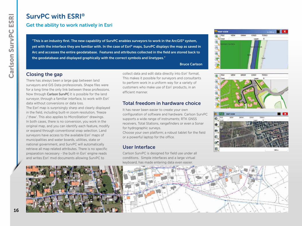
SurvPC with ESRI®
Get the ability to work natively in Esri
Closing the gapThere has always been a large gap between land surveyors and GIS Data professionals. Shape files were for a long time the only link between these professions. Now through Carlson SurvPC it is possible for the land surveyor, through a familiar interface, to work with Esri® data without conversions or data loss.The Esri® map is surprisingly sharp and clearly displayed in the field, including built-in zoom resolution, ‘freeze / thaw’. This also applies to MicroStation® drawings. In both cases, there is no conversion, you work in the original map, and you can identify each feature, modify or expand through conventional snap selection. Land surveyors have access to the available Esri® maps of municipalities and water boards, utilities, state or national government, and SurvPC will automatically retrieve all map related attributes. There is no specific preparation necessary - the built-in Esri® engine reads and writes Esri® mxd documents allowing SurvPC to
collect data and edit data directly into Esri® format. This makes it possible for surveyors and consultants to perform work in a uniform way for a variety of customers who make use of Esri® products, in an efficient manner.
Total freedom in hardware choiceIt has never been easier to create your own configuration of software and hardware. Carlson SurvPC supports a wide range of instruments; RTK GNSS receivers, Total Stations, rangefinders or even a Sonar for hydrographic surveys.Choose your own platform; a robust tablet for the field or a powerful laptop for the office.
User InterfaceCarlson SurvPC is designed for field use under all conditions. Simple interfaces and a large virtual keyboard, has made entering data even easier.
“This is an industry first. The new capability of SurvPC enables surveyors to work in the ArcGIS® system,
yet with the interface they are familiar with. In the case of Esri® maps, SurvPC displays the map as saved in
Arc and accesses the entire geodatabase. Features and attributes collected in the field are stored back to
the geodatabase and displayed graphically with the correct symbols and linetypes.”
Bruce Carlson
Car
lso
n S
urv
PC
ESR
I

17
Carlson Layout®
Fast, Efficient Software for the Construction Layout Professional
Spend less time learning software and more time getting the job done with Layout’s intuitive user experience• ANDROID BASED The Android platform allows stability and performance while operating on a wide range of mobile and tablet options • THE LARGEST DRIVER LIBRARY ANYWHERE With the full Carlson driver library, Layout delivers the widest range of hardware options available anywhere • Full support for DXF and DWG files through the all-new mobile IntelliCAD engine • Supports the full Carlson projection library • Compatible with Carlson CRD and CRDB files • Integration with Google Drive and other cloud storage for simple file handling • Get GPS RTK connections from a cell phone, internal modem, internal radio, or external radio • Simple, two-tap layout for points, lines, and surfaces • Powerful reporting options to get your deliverables out the door • Easily check surface or fixed elevations without creating points

Dat
a C
oll
ecto
rs
18
Surveyor2The world’s most reliable data collector!
Powered with SurvCE
FASTER PROCESSOR
More on-board storage space – now 8GB; and 1.0 GHz processor
LONG-RANGE BLUETOOTH
Up to 450m paired with class I device
EXTENDED BATTERY LIFE
Up to 20 hours
LARGE, BRIGHT DISPLAY SCREEN
Higher resolution, easier to read colour display with scratch-resistant glass
COMPLETELY RUGGEDIZED
IP68 water & dustproof; shock resistant
EASY TO USE
Now with a QWERTY keyboard for faster data entry
MORE OPTIONS■ Integrated camera
■ 3G modem
■ GNSS receiver
PROCESSOR AND MEMORY
• 1.0 GHz ARM Cortex A8 i.MX53 processor• 512 MB RAM
OPERATING SYSTEM AND SOFTWARE
• Microsoft® Windows Embedded Handheld 6.5.3
MEMORY AND DATA STORAGE
• 8 GB flash storage• User-accessible micro SD / SDHC slot
DISPLAY
• Active viewing area: 4.3” (109 mm) • High-visibility backlit LCD
TOUCHSCREEN
• Projected capacitive touch interface• Chemically-strengthened glass
PORTS
• COM1, RS-232C 9-pin D connector with 5VDC power output on pin 9 software-enabled• USB host (Full A), USB client (Micro B)• 12, 24VDC input, 10-36V unregulated• 3.5 mm audio jack, supports speaker / microphone or stereo output (pin detect)• IO docking ports for charging• USB port connector protector
BATTERY
• Intelligent Li-Ion battery 3.7VDC @ 10600 mAh, 38.7 Whr• Operates 20+ hours on a single charge• Charges in 2 to 4 hours• Battery easily changeable in field• Optimized for excellent performance in cold temperatures
PHYSICAL
• Size, Standard models: 5.4” w x 10.2” l x 1.6” d (138 mm x 256 mm x 40 mm)• Weight: 2 lbs (908 g), with battery
ENVIRONMENTAL
• IP68 waterproof and dustproof
19
Car
lso
n R
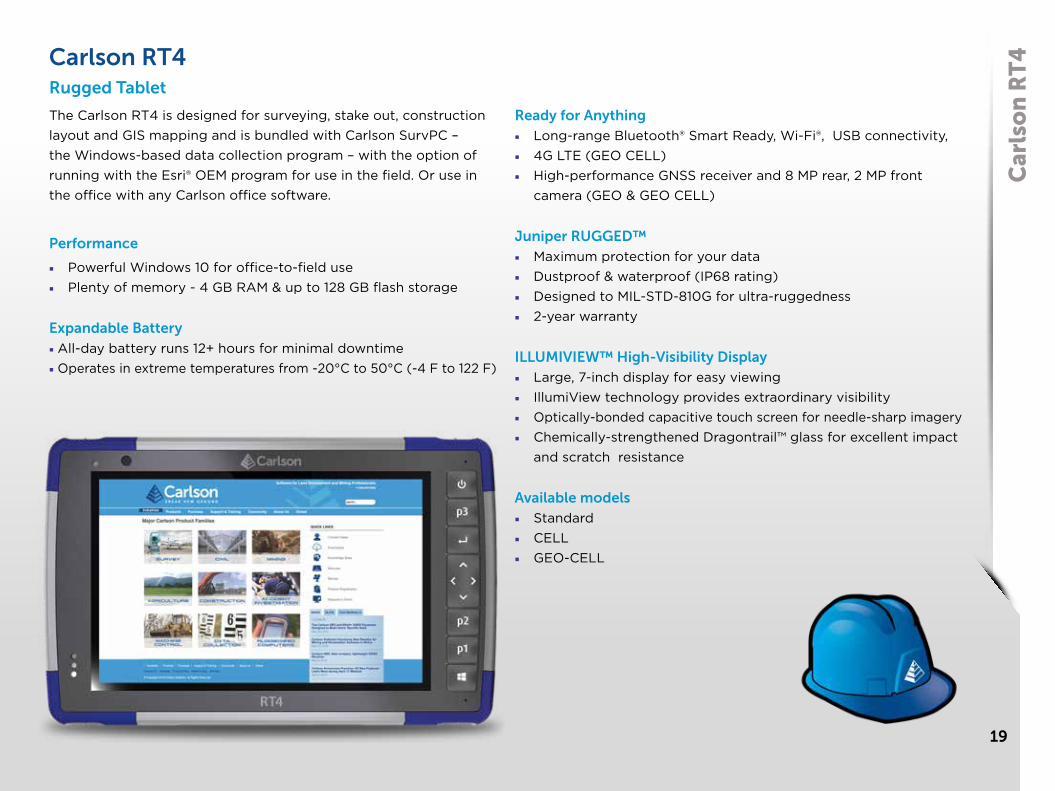
T4Carlson RT4
Rugged Tablet
The Carlson RT4 is designed for surveying, stake out, construction layout and GIS mapping and is bundled with Carlson SurvPC – the Windows-based data collection program – with the option of running with the Esri® OEM program for use in the field. Or use in the office with any Carlson office software.
Performance
■ Powerful Windows 10 for office-to-field use■ Plenty of memory - 4 GB RAM & up to 128 GB flash storage
Expandable Battery■ All-day battery runs 12+ hours for minimal downtime■ Operates in extreme temperatures from -20°C to 50°C (-4 F to 122 F)
Ready for Anything■ Long-range Bluetooth® Smart Ready, Wi-Fi®, USB connectivity,■ 4G LTE (GEO CELL)■ High-performance GNSS receiver and 8 MP rear, 2 MP front
camera (GEO & GEO CELL)
Juniper RUGGED™■ Maximum protection for your data■ Dustproof & waterproof (IP68 rating)■ Designed to MIL-STD-810G for ultra-ruggedness■ 2-year warranty
ILLUMIVIEW™ High-Visibility Display■ Large, 7-inch display for easy viewing■ IllumiView technology provides extraordinary visibility■ Optically-bonded capacitive touch screen for needle-sharp imagery■ Chemically-strengthened Dragontrail™ glass for excellent impact
and scratch resistance
Available models■ Standard■ CELL■ GEO-CELL

20
Car
lso
n B
Rx7 Carlson BRx7
The BRx7 is Carlson’s flagship GNSS receiver
GNSS Technology
The BRx7 features best-in-class RTK
performance provided by the Athena
GNSS engine, supporting multi-frequency
GPS, GLONASS, BeiDou, Galileo, QZSS,
IRNSS, and Atlas L-band capability. Users
will experience fast initialization to Fixed
RTK, as well as stable and repeatable
performance in varied conditions thanks
to its SureFix® RTK quality indicating
technology. Magnetic interference-free
tilt capabilities allow flexible and accurate
surveying, while the 11+ hours of battery
life add versatility and productivity. The
lightweight BRx7 receiver may be used as
a Base or Rover on demand.
Wireless Communications
The BRx7 has an integrated dual-band
UHF transceiver with spread spectrum
technology, and a Quad-Band GSM LTE
modem together with Wi-Fi and Bluetooth
for modern wireless capabilities. Carlson’s
Listen-Listen service allows Base/Rover
operation via the cellular modem for
better correction transmission ranges.
In addition, SurvCE|PC provides the
option to utilize the cellular modem or
Wi-Fi in the hand-held computer via the
SurvCE|PC Data Collector Internet feature.
SurvCE/SurvPC
Carlson’s SurvCE/SurvPC is combined
with the BRx7 on either the Surveyor 2
field computer or RT4 Windows tablet for
a full field solution. SurvCE/SurvPC has
full BRx7 configuration, system status and
data logging via Bluetooth. For improved
Quality Control and efficiency, SurvCE/
SurvPC features an intuitive Live Digital
Level with an auto record option when the
BRx7 is level. With SurvCE/SurvPC, users
leverage Carlson’s expert team to expand
features for quality and productivity.
The BRx7 smart antenna expands GNSS capabilities for premium GNSS RTK performance with 800+ channels.
Key Features
■ Multi-Frequency GPS, GLONASS, BeiDou, Galileo, QZSS, IRNSS, and Atlas® L-Band
■ Best-in-class RTK performance with the Athena GNSS engine
■ Internal tilt sensor corrects collected point coordinates to within 2 cm
■ Dual, Hot-Swappable Lithium-Ion Batteries for 11+ Hours of Use
■ Quad-Band LTE Modem, Wi-Fi, Bluetooth
■ 8 GB Internal Memory

21
Carlson NR3
The Carlson NR3 is a compact GNSS Smart Antenna designed for Network Rover applications. The NR3 and a prism make a light weight survey pole assembly to utilize SurvCE/PC 6.0 with Hybrid+ for simultaneous GNSS and Robotic Total Station surveys.
GNSS Technology
The NR3 utilizes 4 constellations to produce reliable
GNSS RTK, with triple-frequency tracking on GPS,
GLONASS and Galileo. The solution incorporates
multipath and ionospheric detection algorithms to
maintain accuracy, while exhibiting stable satellite
tracking during shocks or vibration. The lightweight
NR3 receiver may be used as a Base or Rover.
Wireless Communications
The NR3 has an integrated 4G LTE cellular
modem, Wi-Fi and Bluetooth for modern wireless
capabilities. Carlson’s Listen-Listen service allows
Base/Rover operation via the cellular modem for
better correction transmission ranges compared to
traditional terrestrial UHF radios.
SurvCE/SurvPC
The new Hybrid+ feature allows simultaneous
interaction with GNSS and a Robotic Total Station,
with the GNSS and prism both mounted on the
survey pole.
Hybrid+ provides increased Quality Control as there
are two instruments measuring the same point. In
addition, GNSS position at the pole allows a faster
prism acquisition than traditional searching, as well
as improved tracking.
Hybrid+ allows easy setup anywhere using GNSS
coordinates, and minimizes common survey
challenges from stray reflectors, false fixes and
obstructions.
KEY FEATURES
• GPS, GLONASS, BeiDou,
Galileo
• Light weight 820 g (1.8 lbs)
• Hot-Swap Batteries
• 4G LTE Cellular Modem
• Wi-Fi 802.11 b/g/n
• Bluetooth 2.1 + EDR
• 16 GB Internal Memory
Car
lso
n N
R3

22
List
en L
iste
n |
Atl
as Carlson Listen-ListenCloud connect your base/rover
Carlson Listen-Listen is a cloud-based, low latency, high performance service. Carlson Listen-Listen utilizes an internet connection at the base and rover, thus eliminating traditional UHF radio limiting factors.
■ Available to Carlson SurvCE/PC customers using Carlson’s BRx6 GNSS receiver as a base station
■ Multiple rovers can simultaneously connect to a base using Carlson Listen-Listen
■ Hosted through Amazon Web Services for unlimited processing power, speed and bandwidth
■ The system eliminates base line length restrictions encountered when using UHF radios
Carlson Listen-Listen is available by subscription and is easy to use and configure. The internet connection can be provided by fixed line broadband, a WiFi or MiFi dongle, or a gprs modem in the GNSS unit or data collector. A fixed or static IP address sims is not required.
AtlasGNSS Global Correction Service
Atlas is Carlson’s innovative correction service for RTK-capable GNSS receivers. Using approximately 200 reference stations worldwide, Atlas produces its correction signals via L-Band satellites distributing coverage from 75°N to 75°S ensuring Earth’s landmass is covered.
Industry-Leading Capabilities:
■ Positioning Accuracy: Atlas provides positioning accuracies down to 2 cm RMS in certain applications
■ Positioning Sustainability: Cutting-edge position quality maintenance in the absence of correction signals
■ Convergence Time: Industry-leading convergence times of 10 – 40 minutes
Atlas is available through subscription to Carlson SurvCE/PC customers using Carlson’s BRx6 GNSS receiver. Additionally, through Carlson SurvCE’s vast library of compatible drivers, any third-party GNSS receiver utilizing an Athena™ engine can also use Atlas.
23
Car
lso
n C
R+
| C
arls
on
FiX
1Carlson CR1+, CR2+ and CR5+ Carlson FiX1Advanced Technology
The advanced positioning of STReAM 360, X-motion hybrid drives and accXess EDM Technology incorporated in Carlson’s super reliable CR+ series robotic total stations provides the most efficient way to survey. Leading edge technologies minimize the time needed to complete any type of survey task.
STReAM360: Fully Robotic
Scout: Scans the entire working area within seconds to quickly find the target.
TRack: Continuously track targets. Once locked onto, the instrument remains accurately aimed on the moving target.
AiM: The telescope is accurately aimed at any prism, without need to look through the telescope.
Measurements are performed automatically with consistently high and repeatable dependability.
X-MOTION™ Hybrid Drives
The CR1+, CR2+ and CR5+ incorporate highly innovative X-motion hybrid drives, promoting up to 20% automation performance compared to conventional drives. It follows your targets at 90 km/h at 100m distances.
accXess™ EDM Technology
accXess EDM Technology provides leading reflectorless measurements up to 1000 m.
The extra small laser footprint and the sophisticated signal-processing technology, ensure maximum accuracy – regardless of the distance or conditions.
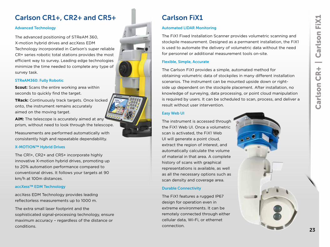
Automated LIDAR Monitoring
The FiX1 Fixed Installation Scanner provides volumetric scanning and stockpile measurement. Designed as a permanent installation, the FiX1 is used to automate the delivery of volumetric data without the need for personnel or additional measurement tools on-site.
Flexible, Simple, Accurate
The Carlson FiX1 provides a simple, automated method for obtaining volumetric data of stockpiles in many different installation scenarios. The instrument can be mounted upside down or right-side up dependent on the stockpile placement. After installation, no knowledge of surveying, data processing, or point cloud manipulation is required by users. It can be scheduled to scan, process, and deliver a result without user intervention.
Easy Web UI
The instrument is accessed through the FiX1 Web UI. Once a volumetric scan is activated, the FiX1 Web UI will generate a point cloud, extract the region of interest, and automatically calculate the volume of material in that area. A complete history of scans with graphical representations is available, as well as all the necessary options such as scan density and coverage area.
Durable Connectivity
The FiX1 features a rugged IP67 design for operation even in extreme environments. It can be remotely connected through either cellular data, Wi-Fi, or ethernet connection.

38.6473778,-83.7651394
Carlson Software Inc.33 East Second StreetMaysville, KY, USA 41056
42.3659274, -71.2080285480 Pleasant St, Suite C100Watertown, MA, USA 02472
52.379588,5.2133703Carlson EMEA BV, Markerkant 13381314 AN Almere, The Netherlands
-37.7920151, 144.9363224APAC LMD Sales and Service43 Stubbs Street, KensingtonVictoria, Australia 3031
-26.4049109,144.4454041Carlson Software Australia Pty LtdAPAC Sales and Service Suite 260 Township Drive, Burleigh Heads, Queensland, Australia 4219
46.3633691,-76.3850919Laser Measurement Devices11 Rosemount Ave., Unit 100Ottawa ON, K1Y 4R8
52.8616595,-3.1670545Laser Measurement DevicesHalifax House/Unit 2, TockwithYork, YO26 7QP
Offering powerful software, with comprehensive yet easy-to-use features, backed by dedicated customer service,
Carlson is used world-wide by professionals in land surveying, civil engineering, construction, machine control,
mining, crash/crime investigation, and agriculture.
The Complete Workflow
Carlson Works for You
www.carlsonsw.com