Embed Size (px)
Citation preview
SOL Review6th Grade
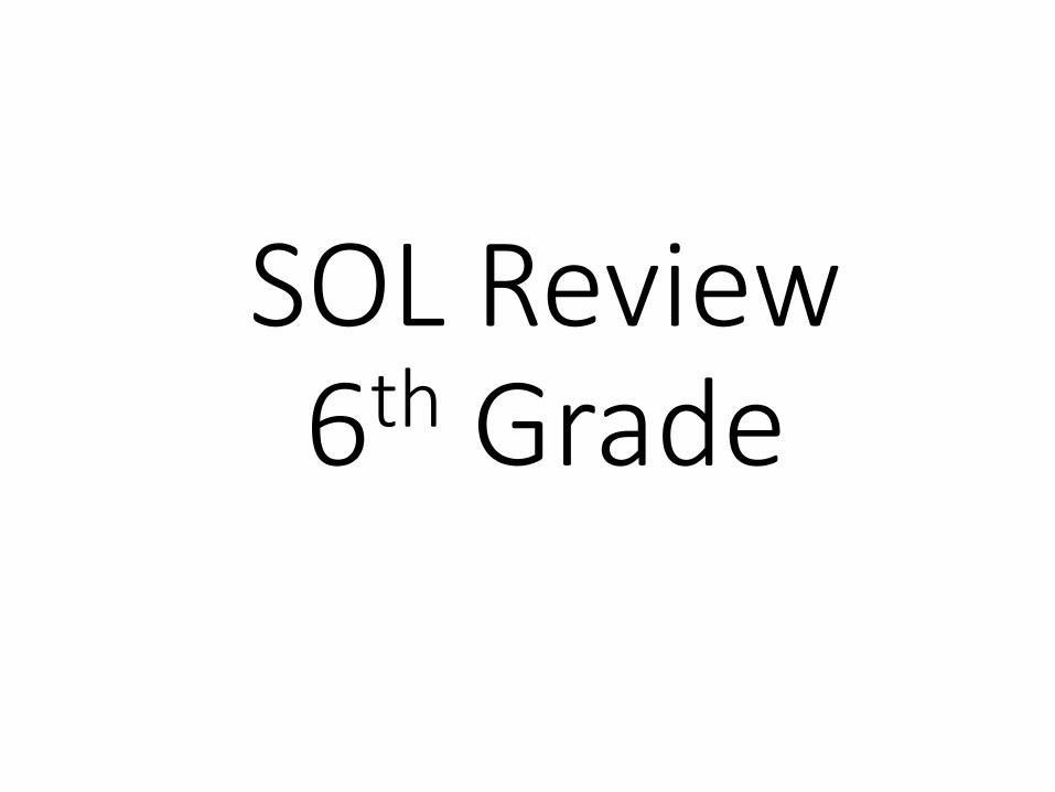
Oceanography – the study of oceans

Scientific Investigation
Scientific Method
Problem
Hypothesis
Test the hypothesis
Analyze the results
Draw conclusions
Varibles & Constants
Independent variable – changed by the experimenter.Dependent variable – responds to the changes in the independent variable.Constants (controlled variables) keep the same.A table is used to record the data.The data gets plotted onto a graph
Density
International system of measurement is (SI) – called the metric systemMeter (m) – is used to measure lengthLiter (L) – is used to measure volumeSolids are measured in cm3Volume – of an irregular object is found by water displacement.Mass (g)– is a measure of the amount of matter in an object.Weight – a measure of the pull of the Earth's gravity on an object.Three states of matter – solid, liquid, gas
Density – is a measure of the amount of matter that occupies a particular space. It is determined by dividing the mass of an object by its volume.
Formula for density: Density = Mass/Volume
The SI units are g/cm3 or g/mL.Specific Gravity is the comparison of the density of a substance to the density of water.
Measurement
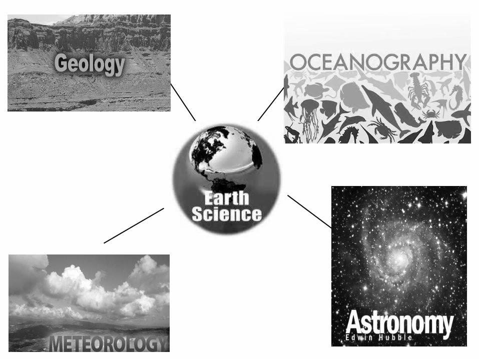
Latitude & Longitude Basic Map Reading
Road maps, topographic map, Bathymetric map, geologic map, star chart, weather map, physical relief map, and globe.
Latitude – linear show lines in degrees North & South of the equator. Latitude lines are referred to as parallels.Longitude – lines show distance in degrees East and West of the Prime Meridian. Longitude lines are referred to as meridians. The Prime Meridian runs through Greenwich, England.The International Date Line – halfway around the Earth from the Prime Meridian, halfway between China & California in the middle of the Pacific Ocean.Four Time Zones: Pacific, Mountain, Central, & Eastern
Topographic Maps
Global Positioning System (GPS)
Topographic Maps – show relief using contour lines. Relief is the highs and lows of the land.Elevation refers to the height above sea level. Contour interval is the difference between the elevation of the contour lines on the map.Index contour – heavier lines with elevation marked.Hachure – depression on the map (crater or sinkhole).Gentle slopes = indicated by wide spaced lines.Steep slopes = indicated by lines close together.A profile is a vertical section or "side view".Rivers & Streams are always shown with a “V” & it points upstream
GPS are used to identify places on Earth. It uses a system of satellitesthat orbit the Earth, sent our radio signals and communicate with base stations. It can tell you:• Latitude/Longitude• Speed of travel and direction of
travel• elevation
Mapping the Earth
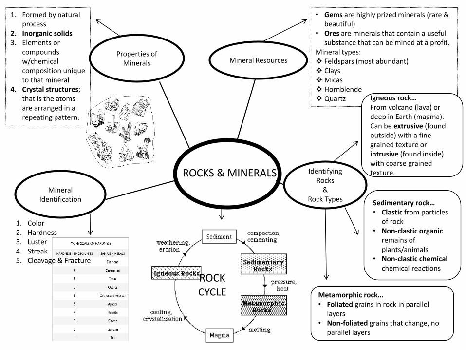
Properties of Minerals
1. Formed by natural process
2. Inorganic solids3. Elements or
compounds w/chemical composition unique to that mineral
4. Crystal structures; that is the atoms are arranged in a repeating pattern.
ROCKCYCLE
Mineral Identification
1. Color 2. Hardness3. Luster4. Streak5. Cleavage & Fracture
Mineral Resources
Identifying Rocks
& Rock Types
ROCKS & MINERALS
• Gems are highly prized minerals (rare & beautiful)
• Ores are minerals that contain a useful substance that can be mined at a profit.
Mineral types: Feldspars (most abundant) Clays Micas Hornblende Quartz
Sedimentary rock…• Clastic from particles
of rock• Non-clastic organic
remains of plants/animals
• Non-clastic chemical chemical reactions
Metamorphic rock…• Foliated grains in rock in parallel
layers• Non-foliated grains that change, no
parallel layers
Igneous rock…From volcano (lava) or deep in Earth (magma). Can be extrusive (found outside) with a fine grained texture or intrusive (found inside) with coarse grained texture.
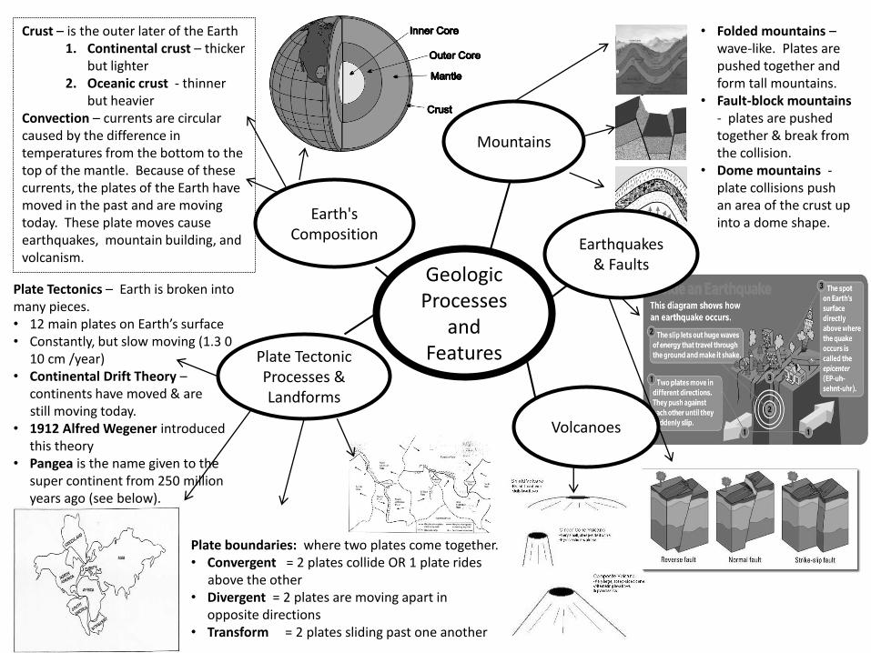
Crust – is the outer later of the Earth 1. Continental crust – thicker
but lighter2. Oceanic crust - thinner
but heavierConvection – currents are circular caused by the difference in temperatures from the bottom to the top of the mantle. Because of these currents, the plates of the Earth have moved in the past and are moving today. These plate moves cause earthquakes, mountain building, and volcanism.
Plate Tectonics – Earth is broken into many pieces. • 12 main plates on Earth’s surface• Constantly, but slow moving (1.3 0
10 cm /year)• Continental Drift Theory –
continents have moved & are still moving today.
• 1912 Alfred Wegener introduced this theory
• Pangea is the name given to the super continent from 250 million years ago (see below).
Earth's Composition
Geologic Processes
and FeaturesPlate Tectonic
Processes & Landforms
Plate boundaries: where two plates come together.• Convergent = 2 plates collide OR 1 plate rides
above the other • Divergent = 2 plates are moving apart in
opposite directions• Transform = 2 plates sliding past one another
Mountains
• Folded mountains –wave-like. Plates are pushed together and form tall mountains.
• Fault-block mountains - plates are pushed together & break from the collision.
• Dome mountains -plate collisions push an area of the crust up into a dome shape.
Earthquakes & Faults
Volcanoes
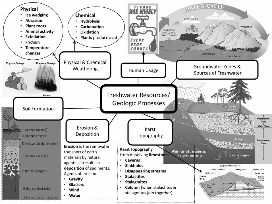
Freshwater Resources/Geologic Processes
Physical & Chemical Weathering
Physical • Ice wedging• Abrasion • Plant roots • Animal activity• Exfoliation • Friction• Temperature
changes
Chemical• Hydrolysis• Carbonation• Oxidation• Plants produce acid
Soil Formation
Erosion & Deposition
Erosion is the removal & transport of earth materials by natural agents. It results in deposition of sediments.Agents of erosion:• Gravity• Glaciers• Wind• Water
Karst Topography
Karst Topography from dissolving limestone.• Caverns• Sinkholes• Disappearing streams• Stalactites• Stalagmites• Column (when stalactites &
stalagmites join together)
Groundwater Zones &Sources of FreshwaterHuman Usage
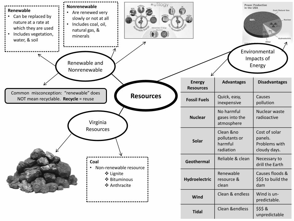
Resources
Virginia Resources
Renewable and Nonrenewable
Renewable• Can be replaced by
nature at a rate at which they are used
• Includes vegetation, water, & soil
Nonrenewable• Are renewed very
slowly or not at all• Includes coal, oil,
natural gas, & minerals
EnergyResources
Advantages Disadvantages
Fossil FuelsQuick, easy, inexpensive
Causespollution
NuclearNo harmfulgases into the atmosphere
Nuclear wasteradioactive
Solar
Clean &no pollutants or harmful radiation
Cost of solar panels. Problems with cloudy days.
GeothermalReliable & clean Necessary to
drill the Earth
HydroelectricRenewable resource & clean
Causes floods & $$$ to build the dam
WindClean & endless Wind is un-
predictable.
TidalClean &endless $$$ &
unpredictable
Common misconception: “renewable” does NOT mean recyclable. Recycle = reuse
Environmental Impacts of
Energy
Coal• Non-renewable resource
Lignite Bituminous Anthracite
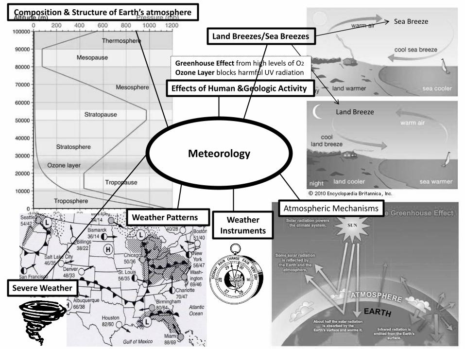
Effects of Human &Geologic Activity
Composition & Structure of Earth’s atmosphere
Land Breezes/Sea Breezes
Land Breeze
Sea Breeze
Atmospheric MechanismsWeather Patterns Weather
Instruments
Severe Weather
Meteorology
Greenhouse Effect from high levels of O2
Ozone Layer blocks harmful UV radiation
Astronomy &Space
Solar System
Stars
History & Contributions of Space Program
Origin & Evolution of the Universe
Sun-Earth-Moon System
Eclipse
Moon Phases
Constellations
Using Doppler Effect, Edwin Hubble & other astronomers saw that the galaxies were red shifted which means they are ;moving away from each other. Astronomers needed a theory to explain this observation. Today scientist have a theory called The Big Bang Theory. Approx. 15 million years ago the universe began expanding out of an enormous explosion.
1957 – Soviet Union launched Sputnik1958 – U. S. launched 1st satellite, Exlorer 1July 20, 1969 – Apollo 11 – Neil Armstrong & Edwin “Buzz” Aldrin,
Galaxies
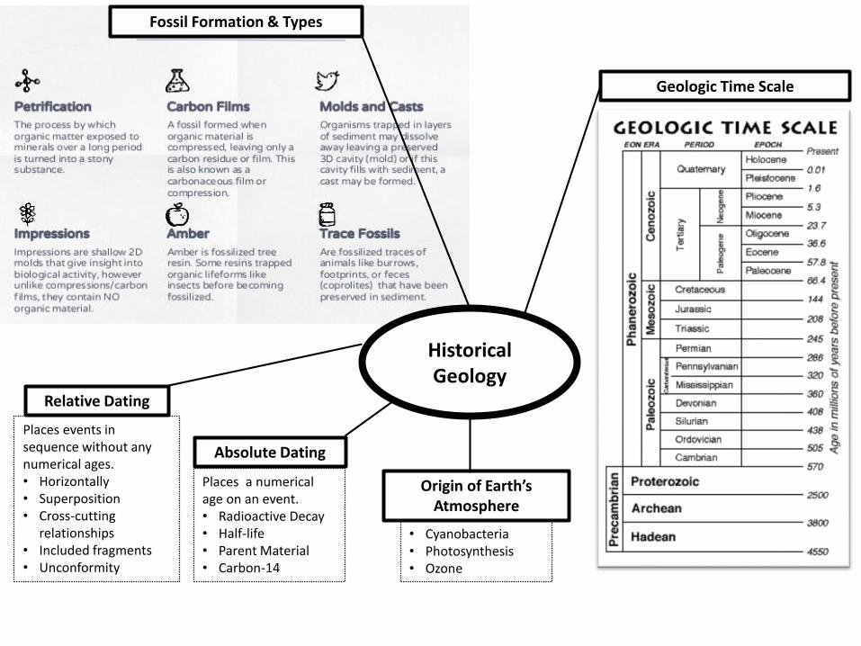
Relative Dating
Absolute Dating
Geologic Time Scale
Origin of Earth’s Atmosphere
Fossil Formation & Types
Historical Geology
Places events in sequence without any numerical ages.• Horizontally• Superposition• Cross-cutting
relationships• Included fragments• Unconformity
Places a numerical age on an event.• Radioactive Decay• Half-life• Parent Material• Carbon-14
• Cyanobacteria• Photosynthesis• Ozone

Characteristics of Virginia’s 5 Physiographic ProvincesCoastal Plain• Contains youngest sedimentary rocks• Sediments have sand, gravel, shells, & clay• Fossil beds with shells, bones, & teeth• Eastern Shore of the Coastal Plain shows growth & destruction due to changing sealevels during the Ice Ages. Sediments are from the Appalachian Mountains.• Mineral Resources are oil & natural gas
Piedmont Region• Low & high valleys• Dominant rocks = slates, marble, granite, &quartz. Sandstone & shale found from 205-245 mya• Many preserved fossils – dinosaur traces.• Important minerals are gold and pyrite.• Some coal beds & methane are also found here.
Blue Ridge• Mountain change that ranges from 2 miles wide are the Potomac Riverto 50 miles wide at the VA-NC border.• Very rugged and covered with weather rock.• Major rivers: The James, The Potomac , and The Roanoke.
Valley and Ridge• Contain sedimentary rocks that date back 550 million years ago• Rocks include limestone, sandstone, and shale. Caves in VA are formed from limestone deposits in this province.• Mineral resources include lime, lead, since, & iron.• Oil, gas and coal are also found here.
Appalachian Plateau• Deep, narrow valleys, and steep, rugged mountain sides• Coal beds found throughout
Chesapeake Bay
• Estuary• Watershed• Bay Pollution
Point source Non-Point source
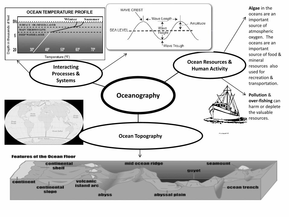
Oceanography
Interacting Processes &
Systems
Ocean Resources & Human Activity
Algae in the oceans are an importantsource of atmospheric oxygen. The oceans are an important source of food & mineral resources also used for recreation & transportation.
Pollution & over-fishing can harm or deplete the valuable resources.
Ocean Topography