Embed Size (px)
Citation preview

United StatesDepartment ofAgriculture
NaturalResourcesConservationService
Soil Survey ofBerkeley County,West Virginia
In cooperation withWest Virginia Agriculturaland Forestry ExperimentStation

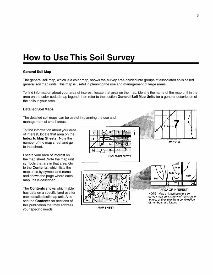
General Soil Map
The general soil map, which is a color map, shows the survey area divided into groups of associated soils calledgeneral soil map units. This map is useful in planning the use and management of large areas.
To find information about your area of interest, locate that area on the map, identify the name of the map unit in thearea on the color-coded map legend, then refer to the section General Soil Map Units for a general description ofthe soils in your area.
Detailed Soil Maps
The detailed soil maps can be useful in planning the use andmanagement of small areas.
To find information about your areaof interest, locate that area on theIndex to Map Sheets. Note thenumber of the map sheet and go to that sheet.
Locate your area of interest onthe map sheet. Note the map unitsymbols that are in that area. Goto the Contents, which lists themap units by symbol and nameand shows the page where eachmap unit is described.
The Contents shows which tablehas data on a specific land use foreach detailed soil map unit. Alsosee the Contents for sections ofthis publication that may addressyour specific needs.
3
How to Use This Soil Survey
4
Additional information about the Nation’s natural resources is available on theNatural Resources Conservation Service home page on the World Wide Web. Theaddress is http://www.nrcs.usda.gov.
This soil survey is a publication of the National Cooperative Soil Survey, a joint effortof the United States Department of Agriculture and other Federal agencies, Stateagencies including the Agricultural Experiment Stations, and local agencies. TheNatural Resources Conservation Service (formerly the Soil Conservation Service) hasleadership for the Federal part of the National Cooperative Soil Survey.
Major fieldwork for this soil survey was completed in 1994. Soil names anddescriptions were approved in 1997. Unless otherwise indicated, statements in thispublication refer to conditions in the survey area in 1994. This survey was madecooperatively by the Natural Resources Conservation Service and the West VirginiaAgricultural and Forestry Experiment Station. It is part of the technical assistancefurnished to the Eastern Panhandle Soil Conservation District.
Soil maps in this survey may be copied without permission. Enlargement of thesemaps, however, could cause misunderstanding of the detail of mapping. If enlarged,maps do not show the small areas of contrasting soils that could have been shown at alarger scale.
The United States Department of Agriculture (USDA) prohibits discrimination in all itsprograms and activities on the basis of race, color, national origin, gender, religion, age,disability, political beliefs, sexual orientation, and marital or family status. (Not allprohibited bases apply to all programs.) Persons with disabilities who require alternativemeans for communication of program information (Braille, large print, audiotape, etc.)should contact USDA’s TARGET Center at 202-720-2600 (voice and TDD).
To file a complaint of discrimination, write USDA, Director, Office of Civil Rights,Room 326-W, Whitten Building, 14th and Independence Avenue, SW, Washington, DC20250-9410 or call 202-720-5964 (voice and TDD). USDA is an equal opportunityprovider and employer.
Cover: Sleepy Creek Lake, an impoundment of Meadow Branch in Sleepy Creek Public Huntingand Fishing Area. It is an excellent largemouth bass fishery. Calvin channery loam, 8 to 15 percentslopes, and Dekalb channery sandy loam, 3 to 15 percent slopes, extremely stony, are on theadjacent uplands.
5
Contents
Cover ....................................................................... 1How to Use This Soil Survey .................................. 3Contents .................................................................. 5Foreword ................................................................. 9General Nature of the County ................................. 11
Settlement and Population .................................. 11Farming .............................................................. 11Transportation and Industry ................................ 12Relief and Drainage ............................................ 12Climate ............................................................... 13Water Supply ...................................................... 13
How This Survey Was Made ................................... 13Map Unit Composition ........................................ 15
General Soil Map Units ........................................ 17Soil Descriptions ................................................ 17
1. Buchanan-Poorhouse ............................ 172. Calvin .................................................... 183. Dekalb-Hazleton .................................... 184. Downsville ............................................. 205. Duffield-Ryder-Nollville .......................... 216. Hagerstown-Funkstown ......................... 227. Monongahela-Pope-Tygart-Philo ............ 238. Pecktonville-Blackthorn-Caneyville ........ 259. Swanpond-Carbo-Opequon ................... 26
10. Urban Land ............................................ 2711. Weikert-Berks-Clearbrook ..................... 27
Detailed Soil Map Units ........................................ 29Soil Descriptions ................................................ 29
At—Atkins silt loam ........................................ 29BkE—Blackthorn very gravelly loam, 15 to
35 percent slopes, extremely stony ....... 31BpE—Blackthorn-Pecktonville very gravelly
loams, 15 to 35 percent slopes,extremely stony ..................................... 32
BpF—Blackthorn-Pecktonville very gravellyloams, 35 to 45 percent slopes,extremely stony ..................................... 34
BuB—Buchanan gravelly loam, 3 to8 percent slopes .................................... 36
BuC—Buchanan gravelly loam, 8 to15 percent slopes .................................. 38
BxC—Buchanan loam, 3 to 15 percentslopes, extremely stony ......................... 39
BxE—Buchanan loam, 15 to 35 percentslopes, extremely stony ......................... 41
CaB—Calvin channery loam, 3 to8 percent slopes .................................... 43
CaC—Calvin channery loam, 8 to15 percent slopes .................................. 45
CaD—Calvin channery loam, 15 to25 percent slopes .................................. 46
CaE—Calvin channery loam, 25 to35 percent slopes .................................. 48
CaF—Calvin channery loam, 35 to65 percent slopes .................................. 49
CbB—Caneyville silt loam, 3 to 8 percentslopes .................................................... 51
CcC—Caneyville silty clay loam, 8 to15 percent slopes .................................. 53
CcD—Caneyville silty clay loam, 15 to25 percent slopes .................................. 54
CeB—Carbo-Endcav silty clay loams, 3 to8 percent slopes .................................... 56
CeC—Carbo-Endcav silty clay loams, 8 to15 percent slopes .................................. 58
CgB—Carbo-Opequon complex, 3 to8 percent slopes .................................... 61
CgC—Carbo-Opequon complex, 8 to15 percent slopes .................................. 63
ChC—Carbo-Opequon complex, 3 to15 percent slopes, very rocky ................ 66
ChE—Carbo-Opequon complex, 15 to35 percent slopes, very rocky ................ 69
CkB—Clearbrook silt loam, 0 to 8 percentslopes .................................................... 71
CmB—Clearbrook channery silt loam, 0 to8 percent slopes .................................... 73
CrB—Clearbrook-Berks channery siltloams, 3 to 8 percent slopes .................. 74
Cs—Combs fine sandy loam.......................... 77DaC—Dekalb channery loam, 8 to
15 percent slopes .................................. 78DaD—Dekalb channery loam, 15 to
25 percent slopes .................................. 79DaE—Dekalb channery loam, 25 to
35 percent slopes .................................. 81DkC—Dekalb channery sandy loam, 3 to
15 percent slopes, extremely stony ....... 83DrE—Dekalb-Rock outcrop complex, 15 to
25 percent slopes, rubbly ...................... 84
6
DsB—Downsville gravelly loam, 3 to8 percent slopes .................................... 85
DsC—Downsville gravelly loam, 8 to15 percent slopes .................................. 88
DsD—Downsville gravelly loam, 15 to25 percent slopes .................................. 89
DuB—Duffield silt loam, 3 to 8 percentslopes .................................................... 90
DuC—Duffield silt loam, 8 to 15 percentslopes .................................................... 92
DyB—Duffield gravelly silt loam, 3 to8 percent slopes .................................... 94
DyC—Duffield gravelly silt loam, 8 to15 percent slopes .................................. 95
Dz—Dunning silt loam.................................... 97Fa—Fairplay (marl) silt loam .......................... 98Fk—Funkstown silt loam .............................. 100FnA—Funkstown silt loam, nonflooded ........ 101FsA—Funkstown gravelly silt loam,
nonflooded........................................... 102HbA—Hagerstown silt loam, 0 to
3 percent slopes .................................. 104HbB—Hagerstown silt loam, 3 to
8 percent slopes .................................. 105HbC—Hagerstown silt loam, 8 to
15 percent slopes ................................ 107HcB—Hagerstown silty clay loam, 3 to
8 percent slopes .................................. 109HcC—Hagerstown silty clay loam, 8 to
15 percent slopes ................................ 111HcD—Hagerstown silty clay loam, 15 to
25 percent slopes ................................ 113HdB—Hagerstown gravelly silt loam, 3 to
8 percent slopes .................................. 114HdC—Hagerstown gravelly silt loam, 8 to
15 percent slopes ................................ 116HdD—Hagerstown gravelly silt loam, 15
to 25 percent slopes ............................ 118HgC—Hagerstown-Opequon-Rock outcrop
complex, 3 to 15 percent slopes .......... 120HgE—Hagerstown-Opequon-Rock outcrop
complex, 15 to 35 percent slopes ........ 122HkF—Hazleton-Berks channery loams,
35 to 65 percent slopes, extremelystony.................................................... 125
HsE—Hazleton-Dekalb complex, 15 to35 percent slopes, extremely stony ..... 127
HsF—Hazleton-Dekalb complex, 35 to65 percent slopes, extremely stony ..... 129
Hu—Huntington silt loam ............................. 130La—Lappans (marl) loam............................. 132Ln—Lindside silt loam .................................. 134MhA—Monongahela silt loam, 0 to
3 percent slopes .................................. 135MhB—Monongahela silt loam, 3 to
8 percent slopes .................................. 137MhC—Monongahela silt loam, 8 to
15 percent slopes ................................ 139MoB—Monongahela gravelly loam, 3 to
8 percent slopes .................................. 141MrB—Murrill gravelly loam, 3 to 8 percent
slopes .................................................. 142MrC—Murrill gravelly loam, 8 to
15 percent slopes ................................ 144PeB—Pecktonville gravelly loam, 3 to
8 percent slopes .................................. 145PeC—Pecktonville gravelly loam, 8 to
15 percent slopes ................................ 147PeD—Pecktonville gravelly loam, 15 to
25 percent slopes ................................ 148PgC—Pecktonville very gravelly loam,
3 to 15 percent slopes, extremelystony.................................................... 150
Ph—Philo silt loam ....................................... 151PoA—Poorhouse silt loam, 0 to 3 percent
slopes .................................................. 153PoB—Poorhouse silt loam, 3 to 8 percent
slopes .................................................. 154Ps—Pope fine sandy loam ........................... 156Px—Pope silt loam ....................................... 158Qm—Quarry, limestone ............................... 159Qs—Quarry, shale ....................................... 159ReF—Rock outcrop-Opequon complex,
25 to 60 percent slopes ....................... 160RnB—Ryder-Nollville channery silt loams,
3 to 8 percent slopes ........................... 161RnC—Ryder-Nollville channery silt loams,
8 to 15 percent slopes ......................... 163RnD—Ryder-Nollville channery silt loams,
15 to 25 percent slopes ....................... 165
7
RvC—Ryder-Nollville channery silt loams,8 to 15 percent slopes, very rocky ....... 167
SwA—Swanpond silt loam, 0 to 3 percentslopes .................................................. 169
SwB—Swanpond silt loam, 3 to 8 percentslopes .................................................. 171
TyA—Tygart silt loam, 0 to 3 percentslopes .................................................. 173
TyB—Tygart silt loam, 3 to 8 percentslopes .................................................. 175
Ua—Udorthents, smoothed ......................... 176Ub—Urban land ........................................... 177UkC—Urban land-Berks complex, 0 to
15 percent slopes ................................ 178UvC—Urban land-Carbo-Endcav complex,
0 to 15 percent slopes ......................... 179UwC—Urban land-Hagerstown complex,
0 to 15 percent slopes ......................... 181W—Water .................................................... 182WbB—Weikert-Berks channery silt loams
complex, 3 to 8 percent slopes ............ 182WbC—Weikert-Berks channery silt loams,
8 to 15 percent slopes ......................... 184WbD—Weikert-Berks channery silt loams,
15 to 25 percent slopes ....................... 186WkF—Weikert-Berks very channery silt
loams, 25 to 70 percent slopes ............ 188Prime Farmland .................................................. 191Use and Management of the Soils .................... 193
Crops and Pasture ........................................... 193Yields per Acre ............................................. 194Land Capability Classification ...................... 195
Woodland Management and Productivity ......... 197Recreation ........................................................ 199Wildlife Habitat ................................................. 201Engineering ...................................................... 202
Building Site Development ........................... 202Sanitary Facilities ......................................... 203Construction Materials ................................. 204Water Management ...................................... 205
Soil Properties .................................................... 209Engineering Index Properties ........................... 209Physical and Chemical Properties .................... 210Soil and Water Features ................................... 211
Classification of the Soils .................................. 213Taxonomic Units and Their Morphology ................ 213
Atkins Series .................................................... 214Berks Series ..................................................... 215Blackthorn Series ............................................. 215Buchanan Series .............................................. 217Calvin Series .................................................... 218Caneyville Series ............................................. 219Carbo Series .................................................... 220Clearbrook Series ............................................ 220Combs Series .................................................. 221Dekalb Series ................................................... 222Downsville Series ............................................. 223Duffield Series .................................................. 224Dunning Series ................................................. 225Endcav Series .................................................. 226Fairplay Series ................................................. 226Funkstown Series ............................................. 228Hagerstown Series ........................................... 228Hazleton Series ................................................ 229Huntington Series ............................................. 230Lappans Series ................................................ 231Lindside Series ................................................. 232Monongahela Series ........................................ 233Murrill Series .................................................... 234Nollville Series .................................................. 235Opequon Series ............................................... 236Pecktonville Series ........................................... 237Philo Series ...................................................... 238Poorhouse Series ............................................. 239Pope Series ...................................................... 240Ryder Series .................................................... 241Swanpond Series ............................................. 242Tygart Series .................................................... 243Udorthents ....................................................... 244Weikert Series .................................................. 244
Formation of the Soils ........................................ 247Factors of Soil Formation ................................. 247
Parent Material, Time, and Climate .............. 247Living Organisms ......................................... 247Topography .................................................. 247
Morphology of the Soils .................................... 248Geology ............................................................ 248
References .......................................................... 251
8
Glossary .............................................................. 253Tables .................................................................. 265
Table 1.—Temperature and Precipitation .......... 266Table 2.—Freeze Dates in Spring and
Fall ............................................................. 267Table 3.—Growing Season ............................... 267Table 4.—Acreage and Proportionate
Extent of the Soils ...................................... 268Table 5.—Prime Farmland ................................ 270Table 6.—Land Capability and Yields per
Acre of Crops and Pasture ......................... 271Table 7.—Capability Classes and
Subclasses ................................................ 276
Table 8.—Woodland Management andProductivity ................................................ 277
Table 9.—Recreational Development ............... 285Table 10.—Wildlife Habitat ................................ 294Table 11.—Building Site Development .............. 301Table 12.—Sanitary Facilities ........................... 310Table 13.—Construction Materials .................... 319Table 14.—Water Management ........................ 326Table 15.—Engineering Index Properties ......... 333Table 16.—Physical and Chemical
Properties of the Soils ................................ 352Table 17.—Soil and Water Features ................. 361Table 18.—Classification of the Soils ................ 366
Issued 2002
9
This soil survey contains information that can be used in land-planning programs inBerkeley County. It contains predictions of soil behavior for selected land uses. Thesurvey also highlights limitations and hazards inherent in the soil, improvementsneeded to overcome the limitations, and the impact of selected land uses on theenvironment.
This soil survey is designed for many different users. Farmers, foresters, andagronomists can use it to evaluate the potential of the soil and the management neededfor maximum food and fiber production. Planners, community officials, engineers,developers, builders, and home buyers can use the survey to plan land use, select sitesfor construction, and identify special practices needed to ensure proper performance.Conservationists, teachers, students, and specialists in recreation, wildlifemanagement, waste disposal, and pollution control can use the survey to help themunderstand, protect, and enhance the environment.
Great differences in soil properties can occur within short distances. Some soils areseasonally wet or subject to flooding. Some are shallow to bedrock. Some are toounstable to be used as a foundation for buildings or roads. Clayey or wet soils arepoorly suited to use as septic tank absorption fields. A high water table makes a soilpoorly suited to basements or underground installations.
These and many other soil properties that affect land use are described in this soilsurvey. Broad areas of soils are shown on the general soil map. The location of eachsoil is shown on the detailed soil maps. Each soil in the survey area is described.Information on specific uses is given for each soil. Help in using this publication andadditional information are available at the local office of the Natural ResourcesConservation Service or the Cooperative Extension Service.
William J. HartmanState ConservationistNatural Resources Conservation Service
Foreword
10
CHARLESTON✪
Parkersburg
Morgantown
Winchester, VA
Martinsburg144 miles
255 miles
296 miles 23 miles
Baltimore, MD81 miles
Washington, DC80 miles
Location of Berkeley County in West Virginia.
11
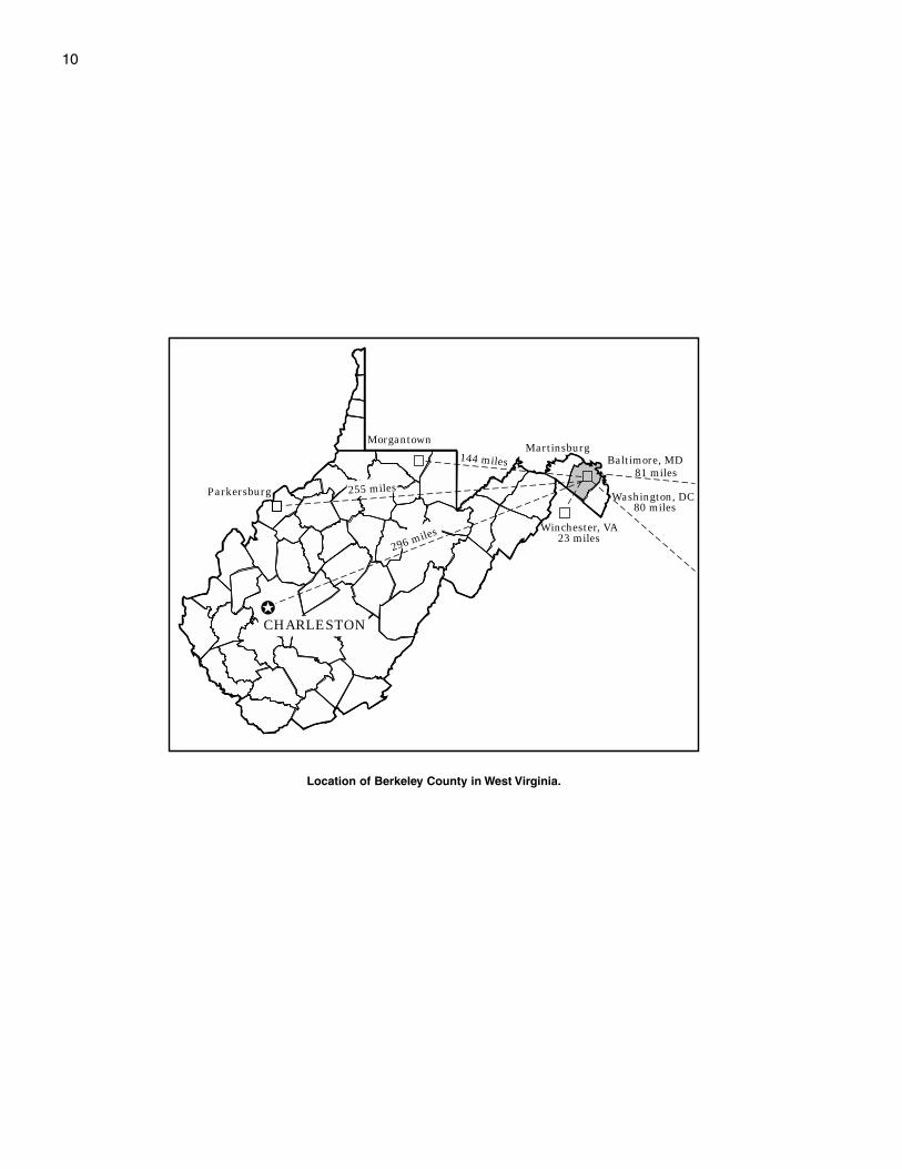
BERKELEY COUNTY is in the eastern panhandle ofWest Virginia (see map on page 10). It has an areaof 205,900 acres, or approximately 322 square miles.The county is bounded on the north by the PotomacRiver, which separates it from Washington County,Maryland; on the east by Jefferson County, WestVirginia; on the west by Morgan County, West Virginia;and on the south by Frederick County, Virginia. Theeastern three-fifths of the county is part of the smooth,fertile Shenandoah Valley. The landscape in thewestern two-fifths of the county is characterized bynarrow valleys and steep, rugged mountains.
This soil survey updates the survey of the countythat was completed in 1960 (Gorman, Pasto, andCrocker 1966). It provides additional information andhas a more recent aerial photobase.
General Nature of the CountyThis section provides general information about
Berkeley County. It describes settlement andpopulation, farming, transportation and industry, reliefand drainage, climate, and water supply.
Settlement and Population
Berkeley County was formed in 1772 from thenorthern third of Frederick County by an Act of theVirginia Assembly (Doherty 1972). It was named for
Norborne Berkeley (Baron de Botetourt), who was theColonial Governor of Virginia from 1768 to 1770.
In about 1726, Colonel Morgan Morgan founded thefirst permanent settlement when he built a log cabinnear what is now Bunker Hill. German and Scots-Irishimmigrants from the northern colonies next settled inthe area. They were attracted by the fertile soils,flowing springs, and abundant game in theShenandoah Valley.
Martinsburg, the county seat, was founded byAdam Stephen and named in honor of Thomas BryanMartin, a nephew of Lord Fairfax and member of theVirginia House of Burgesses. It was incorporated in1778.
In 1990, Berkeley County had a population of59,253, which ranked as the eighth largest populationin West Virginia (West Virginia State Senate 1992). Inrecent years, it has experienced a significant influx ofpeople from the urban centers to the east. It is nowconsidered to be part of the Greater Baltimore-Washington, DC, metropolitan area. The population ofMartinsburg, the largest town in the county, was14,073 in 1990.
Farming
In 1997, the county had 509 farms, averaging about143 acres in size. The total acreage of farmland was72,603, which was down from 80,255 acres in 1987
Soil Survey of
Berkeley County, West VirginiaBy James W. Bell, Natural Resources Conservation Service
Fieldwork by James W. Bell, Mary Ellen M. Cook, Luis A. Hernandez, andS. Jason Teets, Natural Resources Conservation Service
Map finishing by Timothy Prescott, Denise Donelson, Linda Handley, andDebra Murphy, Natural Resources Conservation Service
United States Department of Agriculture, Natural Resources Conservation Service,in cooperation with theWest Virginia Agricultural and Forestry Experiment Station
12 Soil Survey
(USDA 1999; U.S. Department of Commerce 1994).About 37 percent of the farms in the county wereoperated on a full-time commercial basis. Croplandand pasture made up about 29 percent of the county.Most of the farmland is in the Shenandoah Valley.Farming and the acreage used for farming havedeclined in recent years because of an increase inurbanization.
The total market value of all farm products sold inBerkeley County in 1997 was $17,114,000. Theprinciple sources of farm income were fruit, dairyproducts, beef, hogs, and poultry. The county was thenumber one producer of fruit, chiefly apples andpeaches, in West Virginia.
Transportation and Industry
Interstate 81 and U.S. Route 11 are the mainhighways that run north and south through the county.They run roughly parallel to each other through theShenandoah Valley. Interstate 81 has seveninterchanges in the county. State Routes 45, 51, and 9are the main east-west thoroughfares in the county.Two major railroads serve the county, along withAmtrak passenger service and a commuter railservice from Martinsburg. The Eastern RegionalAirport, located south of Martinsburg, provides serviceto private airplanes.
The county has a diverse economy. Goodsmanufactured in the county include bricks, cement,cookware, fiberglass products, and prefabricatedhomes. The manufacture of apple products alsocontributes to the economy. Limestone continues to bequarried in several locations. The county is a center forproduct supply and distribution because of itsaccessibility to the interstate highway system.
Relief and Drainage
Berkeley County lies completely within the NorthernAppalachian Ridges and Valleys physiographicprovince (Austin 1965). The major landforms consist ofa series of parallel ridges and valleys that have asouthwest-northeast orientation. The county is drainedby the Potomac River and its tributaries. The lowestelevation in the county is 340 feet, where the PotomacRiver leaves the county.
The eastern three-fifths of the county is locatedwithin the Shenandoah Valley, which is part of theGreat Valley of the Appalachians that extends fromGeorgia to New York. The average elevation in theShenandoah Valley is about 650 feet. The valley isunderlain by Ordovician and Cambrian age limestonesand shales. Most of the valley is drained by Opequon
Creek and its tributaries—Dry Run, Evans Run, HokeRun, Middle Creek, Mill Creek, Sylvan Run, andTuscarora Creek. In addition, significant areas aredrained by Harland Run and Rockymarsh Run, whichflow directly into the Potomac River.
The part of the valley that is underlain by limestoneis characterized by gently sloping and strongly sloping,low upland ridges. These ridges are shallowlydissected by nearly level valleys, depressions, andintermittent drainageways. In many areas the slopesare complex, giving the landscape an undulatingappearance. Sinkholes are common in many areas.Surface water often disappears underground throughsinkholes and solution channels in the limestonebedrock. Intermittent drainageways commonly do nothave a defined channel.
The part of the valley that is underlain by shale ischaracterized by gently sloping and strongly slopingridgetops and steep and very steep side slopes. Thelandscape is strongly dissected by intermittent andperennial streams. The flood plains along streams aregenerally narrow.
North Mountain is a prominent landscape featurethat marks the western flank of the ShenandoahValley. It rises dramatically from 400 to 1,000 feetabove the valley floor to the east. It bisects the countycompletely from north to south and is broken by gapsthrough which the major east-west roadways run. Themost prominent gap is at Hedgesville in the northernpart of the county, where State Route 9 breaches themountain.
To the west of North Mountain, the landscape ischaracterized by narrower valleys and low ridgesunderlain by Devonian and Silurian age shales andlimestones and by higher, prominent ridges formed byMississippian and Devonian age sandstones. Most ofthis area is drained by Back Creek and its tributaries—Elk Branch and Tilhance Creek. These drainagewaysform a trellis pattern, which is typical in the NorthernAppalachian Ridges and Valleys physiographicprovince. Broad areas of nearly level flood plains andalluvial terraces are along Back Creek.
The shale uplands are strongly dissected and havelow, narrow to broad, gently sloping or strongly slopingridgetops and steep or very steep side slopes. Thestreams dissecting these uplands have narrow floodplains. The relief from the flood plains to the ridgetopsgenerally ranges from 100 to 300 feet.
The limestone forms a narrow valley that hasstrongly sloping valley sides. This valley is surroundedby low, rather broad sandstone ridges, including Ferreland Wilson Ridges.
Third Hill and Sleepy Creek Mountains dominatethe landscape along the western edge of the county.
Berkeley County, West Virginia 13
These mountains are very steep and rugged and arecapped by hard sandstone that outcrops in manyareas along their crest. They rise about 1,000 to 1,600feet above the flood plain of Back Creek to the east.About 51/2 miles north of the West Virginia-VirginiaState line, the mountains are united at “Locks of theMountain.” Directly southeast of this point, along thecrest of Third Hill Mountain is “Shanghai Beacon,”which at 2,172 feet is the highest point in the county.The high, narrow valley between Sleepy Creek andThird Hill Mountains is drained by Meadow Branch,which is impounded near its headwaters to formSleepy Creek Lake.
Climate
Table 1 gives data on temperature and precipitationfor the survey area as recorded at Martinsburg in theperiod 1961 to 1990. Table 2 shows probable dates ofthe first freeze in the fall and the last freeze in spring.Table 3 provides data on the length of the growingseason.
In winter, the average temperature is 32 degrees Fand the average daily minimum temperature is 23degrees. The lowest temperature on record, whichoccurred at Martinsburg on January 17, 1982, is -13degrees. In summer, the average temperature is 73degrees and the average daily maximum is 85degrees. The highest temperature, which occurred atMartinsburg on July 11, 1936, is 112 degrees.
Growing degree days are shown in table 1. Theyare equivalent to “heat units.” During the month,growing degree days accumulate by the amount thatthe average temperature each day exceeds a basetemperature (40 degrees F). The normal monthlyaccumulation is used to schedule single or successiveplantings of a crop between the last freeze in springand the first freeze in fall.
The total annual precipitation is 37.54 inches. Ofthis, about 20.38 inches, or 54 percent, usually falls inApril through September. The growing season for mostcrops falls within this period. The heaviest 1-dayrainfall during the period of record was 4.15 inches atMartinsburg on October 15, 1942. Thunderstormsoccur on about 28 days each year, and most occur inJuly.
The average seasonal snowfall is 25.3 inches. Thegreatest snow depth at any one time during the periodof record was 37 inches. On an average, 7 days peryear have at least 1 inch of snow on the ground. Thenumber of such days varies greatly from year to year.The heaviest 1-day snowfall on record is 26 inches.
The average relative humidity in midafternoon isabout 54 percent. Humidity is higher at night, and theaverage at dawn is about 77 percent. The sun shines
63 percent of the time in summer and 52 percent inwinter. The prevailing wind is from the west-northwest.Average windspeed is highest, 11 miles per hour, inMarch.
Water Supply
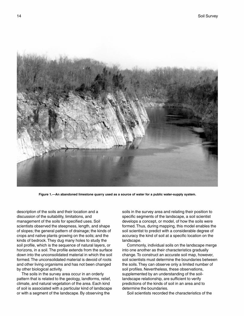
Most parts of the county have an adequate watersupply from wells, springs, or streams. Drilled wellscommonly supply domestic water systems in ruralareas. Sources of water for public water-supplysystems include abandoned limestone quarries, largelimestone springs, and drilled wells (fig. 1). Farmponds often supply water for livestock and fireprotection in rural areas. There is an abundance ofsprings in the county. The springs are most numerousand most productive in the areas of limestone.
The primary source of water for most domestic andpublic water-supply systems is ground water. Theground water of the county can be divided into twocategories in accordance with its rock source. The twoprincipal types of rocks from which water is obtainedare carbonate rocks, mostly limestone and dolomite,and noncarbonate rocks, mostly shale (Beiber 1961).
In those areas underlain by limestone, the supply ofground water is generally abundant, but the depth togood water-bearing strata varies and water levels aresubject to a rapid and wide range of seasonalfluctuations. The average depth of wells in these areasis about 150 to 200 feet, but some wells may be muchdeeper. The ground water obtained from limestonesources generally is very hard. It is high in dissolvedcalcium and magnesium but generally is low in iron.
The ground water in the areas underlain bylimestone is especially vulnerable to contaminationfrom poor land use practices. Precautions should betaken to prevent pollutants from entering the groundwater through sinkholes and solution channels in thelimestone bedrock
The yield of ground water in areas underlain byshale generally is less than that in areas underlain bylimestone, but the depth to and yield of the groundwater generally are dependable. Most wells in theseareas are 100 to 150 feet deep. The ground water fromshale sources generally is hard and often is high iniron and sometimes high in sulfur.
Farm ponds in areas underlain by limestone aresubject to seepage and have a high failure rate. Manyponds can be successfully built in areas underlain byshale if dams are constructed across drainageways.
How This Survey Was MadeThis survey was made to provide information about
the soils in the survey area. The information includes a
14 Soil Survey
description of the soils and their location and adiscussion of the suitability, limitations, andmanagement of the soils for specified uses. Soilscientists observed the steepness, length, and shapeof slopes; the general pattern of drainage; the kinds ofcrops and native plants growing on the soils; and thekinds of bedrock. They dug many holes to study thesoil profile, which is the sequence of natural layers, orhorizons, in a soil. The profile extends from the surfacedown into the unconsolidated material in which the soilformed. The unconsolidated material is devoid of rootsand other living organisms and has not been changedby other biological activity.
The soils in the survey area occur in an orderlypattern that is related to the geology, landforms, relief,climate, and natural vegetation of the area. Each kindof soil is associated with a particular kind of landscapeor with a segment of the landscape. By observing the
soils in the survey area and relating their position tospecific segments of the landscape, a soil scientistdevelops a concept, or model, of how the soils wereformed. Thus, during mapping, this model enables thesoil scientist to predict with a considerable degree ofaccuracy the kind of soil at a specific location on thelandscape.
Commonly, individual soils on the landscape mergeinto one another as their characteristics graduallychange. To construct an accurate soil map, however,soil scientists must determine the boundaries betweenthe soils. They can observe only a limited number ofsoil profiles. Nevertheless, these observations,supplemented by an understanding of the soil-landscape relationship, are sufficient to verifypredictions of the kinds of soil in an area and todetermine the boundaries.
Soil scientists recorded the characteristics of the
Figure 1.—An abandoned limestone quarry used as a source of water for a public water-supply system.
Berkeley County, West Virginia 15
soil profiles that they studied. They noted soil color,texture, size and shape of soil aggregates, kind andamount of rock fragments, distribution of plant roots,reaction, and other features that enable them toidentify soils. After describing the soils in the surveyarea and determining their properties, the soilscientists assigned the soils to taxonomic classes(units). Taxonomic classes are concepts. Eachtaxonomic class has a set of soil characteristics withprecisely defined limits. The classes are used as abasis for comparison to classify soils systematically.The system of taxonomic classification used in theUnited States is based mainly on the kind andcharacter of soil properties and the arrangement ofhorizons within the profile. After the soil scientistsclassified and named the soils in the survey area, theycompared the individual soils with similar soils in thesame taxonomic class in other areas so that theycould confirm data and assemble additional databased on experience and research.
While a soil survey is in progress, samples of someof the soils in the area generally are collected forlaboratory analyses and for engineering tests. Soilscientists interpret the data from these analyses andtests as well as the field-observed characteristics andthe soil properties to determine the expected behaviorof the soils under different uses. Interpretations for allof the soils are field tested through observation of thesoils in different uses under different levels ofmanagement. Some interpretations are modified to fitlocal conditions, and some new interpretations aredeveloped to meet local needs. Data are assembledfrom other sources, such as research information,production records, and field experience of specialists.For example, data on crop yields under defined levelsof management are assembled from farm records andfrom field or plot experiments on the same kinds ofsoil.
Predictions about soil behavior are based notonly on soil properties but also on such variablesas climate and biological activity. Soil conditionsare predictable over long periods of time, but theyare not predictable from year to year. For example,soil scientists can predict with a fairly high degreeof accuracy that a given soil will have a highwater table within certain depths in most years,but they cannot assure that a high water table willalways be at a specific level in the soil on a specificdate.
After soil scientists located and identified thesignificant natural bodies of soil in the survey area,they drew the boundaries of these bodies on aerialphotographs and identified each as a specific map
unit. Aerial photographs show trees, buildings, fields,roads, and rivers, all of which help in locatingboundaries accurately.
Some of the boundaries on the soil maps ofBerkeley County do not match those on the soil mapsof Jefferson and Morgan Counties, West Virginia, orFrederick County, Virginia, and some of the soil namesand descriptions do not fully agree. The differencesare a result of improvements in the classification ofsoils, particularly modifications or refinements in soilseries concepts. Also, there may be differences in theintensity of mapping or in the extent of the soils withinthe survey area.
Map Unit Composition
A map unit delineation on a soil map represents anarea dominated by one major kind of soil or an areadominated by two or three kinds of soil. A map unit isidentified and named according to the taxonomicclassification of the dominant soil or soils. Within ataxonomic class there are precisely defined limits forthe properties of the soils. On the landscape, however,the soils are natural objects. In common with othernatural objects, they have a characteristic variability intheir properties. Thus, the range of some observedproperties may extend beyond the limits defined for ataxonomic class. Areas of soils of a single taxonomicclass rarely, if ever, can be mapped without includingareas of soils of other taxonomic classes.Consequently, every map unit is made up of the soil orsoils for which it is named and some soils that belongto other taxonomic classes. These latter soils arecalled inclusions or included soils.
Most inclusions have properties and behavioralpatterns similar to those of the dominant soil or soils inthe map unit, and thus they do not affect use andmanagement. These are called noncontrasting(similar) inclusions. They may or may not bementioned in the map unit descriptions. Otherinclusions, however, have properties and behaviordivergent enough to affect use or require differentmanagement. These are contrasting (dissimilar)inclusions. They generally occupy small areas andcannot be shown separately on the soil maps becauseof the scale used in mapping. The inclusions ofcontrasting soils are mentioned in the map unitdescriptions. A few inclusions may not have beenobserved and consequently are not mentioned in thedescriptions, especially where the soil pattern was socomplex that it was impractical to make enoughobservations to identify all of the kinds of soil on thelandscape.

16
The presence of inclusions in a map unit in no waydiminishes the usefulness or accuracy of the soil data.The objective of soil mapping is not to delineate puretaxonomic classes of soils but rather to separate thelandscape into segments that have similar use and
management requirements. The delineation of suchlandscape segments on the map provides sufficientinformation for the development of resource plans, butonsite investigation is needed to plan for intensiveuses in small areas.
17
The general soil map at the back of this publicationshows broad areas that have a distinctive pattern ofsoils, relief, and drainage. Each map unit on thegeneral soil map is a unique natural landscape.Typically, it consists of one or more major soils andsome minor soils. It is named for the major soils. Thesoils making up one unit can occur in another but in adifferent pattern.
The general soil map can be used to compare thesuitability of large areas for general land uses. Areasof suitable soils can be identified on the map. Likewise,areas where the soils are not suitable can beidentified.
Because of its small scale, the map is not suitablefor planning the management of a farm or field or forselecting a site for a road or building or other structure.The soils in any one map unit differ from place to placein slope, depth, drainage, and other characteristicsthat affect management.
Soil Descriptions
1. Buchanan-Poorhouse
Nearly level to steep, moderately well drained andsomewhat poorly drained soils that have a mediumtextured or fine textured subsoil and formed in materialweathered from acid sandstone, shale, or limestone;on uplands
Setting
These soils are mainly on slightly concavefootslopes and toeslopes of North Mountain, Third HillMountain, and Sleepy Creek Mountain. Slopes rangefrom 0 to 35 percent. Many areas of the Buchanansoils have an extremely stony surface.
Composition
Extent of the general soil map unit: 7 percentPercentage of components in the map unit:
Buchanan soils—68 percentPoorhouse soils—10 percent
Minor soils—22 percent (including the somewhatexcessively drained Weikert soils, the welldrained Berks and Murrill soils, the moderatelywell drained Swanpond soils, and thesomewhat poorly drained Clearbrook soils)
Soil Characteristics
Buchanan
Surface layer: Organic duff from hardwood leaf litterunderlain by very dark gray loam
Subsurface layer: Light yellowish brown loamSubsoil: Upper part—brownish yellow loam; next
part—light yellowish brown gravelly loam that hasstrong brown mottles; next part—strong browngravelly loam mottled in shades of red, brown, andgray; lower part—strong brown, firm and brittlegravelly loam mottled in shades of yellow, gray,and red
Depth: Very deepDrainage class: Moderately well drainedDepth to the seasonal high water table: 1.5 to 3.0 feetSlope: 3 to 35 percentParent material: Material weathered from acid
sandstone and shale
Poorhouse
Surface layer: Light olive brown silt loamSubsoil: Yellowish brown to brown silty clay or clay
mottled in shades of gray and brownDepth: Very deepDrainage class: Somewhat poorly drainedDepth to the seasonal high water table: 0.5 foot to
1.5 feetSlope: 0 to 8 percentParent material: Material weathered from limestone
mixed with some colluvial material
Use and Management
Most areas of the Buchanan soils are wooded. Mostareas of the Poorhouse soils have been cleared andare used for pasture or hay. Some areas are used ascropland or for orchards.
General Soil Map Units
18 Soil Survey
Cropland
The Buchanan soils are suited to cropland if thesurface is free of stones. The Poorhouse soils aresuited to cropland if they are adequately drained. Thehazard of erosion is slight or moderate in most areas.
Pasture and Hayland
These soils are suited to pasture and hay.Establishing and maintaining a healthy cover of sodand preventing overgrazing are major pasturemanagement concerns. Because of the seasonalwetness, these soils are better suited to grasses thanto legumes.
Woodland
These soils have moderately high potentialproductivity for trees. The seasonal wetness is alimitation affecting logging operations.
Community Development
The seasonal wetness is the main limitationaffecting community development.
2. Calvin
Gently sloping to very steep, well drained,moderately deep soils that have a medium texturedsubsoil and formed in material weathered from reddishbrown, fine grained sandstone and shale; on uplands
Setting
These soils are on convex ridges, nose slopes, andside slopes in the western part of the county. Slopesrange from 3 to 65 percent.
Composition
Extent of the general soil map unit: 4 percentPercentage of components in the map unit:
Calvin soils—87 percentMinor soils—13 percent (including the well drained
Berks soils, the somewhat excessively drainedDekalb soils, and the somewhat poorly drainedClearbrook soils on uplands; and the poorlydrained Atkins soils, the moderately welldrained Philo soils, and the well drained Popesoils on narrow flood plains)
Soil Characteristics
Surface layer: Organic duff from hardwood leaf litterunderlain by very dark brown channery loam
Subsoil: Reddish brown very channery loamDepth: Moderately deep
Drainage class: Well drainedDepth to the seasonal high water table: More than
6 feetSlope: 3 to 65 percentParent material: Material weathered from reddish
brown, fine grained sandstone and shale
Use and Management
Most of the gently sloping and strongly slopingareas have been cleared and are used for pasture orhay. Cultivated crops are grown in a few areas. Almostall of the moderately steep to very steep hillsides areforested. The woodland consists mainly of the oak-hickory and Virginia pine-pitch pine forest types.
Cropland
Droughtiness and the slope are the main limitationsaffecting crop production.
Pasture and Hayland
Establishing and maintaining a healthy cover of sodand preventing overgrazing are major pasturemanagement concerns. The droughtiness limits forageproduction during midsummer.
Woodland
These soils have moderate or moderately highpotential productivity for woodland. Erosion is a hazardaffecting logging operations.
Community Development
The depth to bedrock and the slope are limitationsaffecting community development.
3. Dekalb-Hazleton
Gently sloping to very steep, somewhat excessivelydrained and well drained soils that have a mediumtextured subsoil and formed in material weatheredfrom acid sandstone and shale; on uplands
Setting
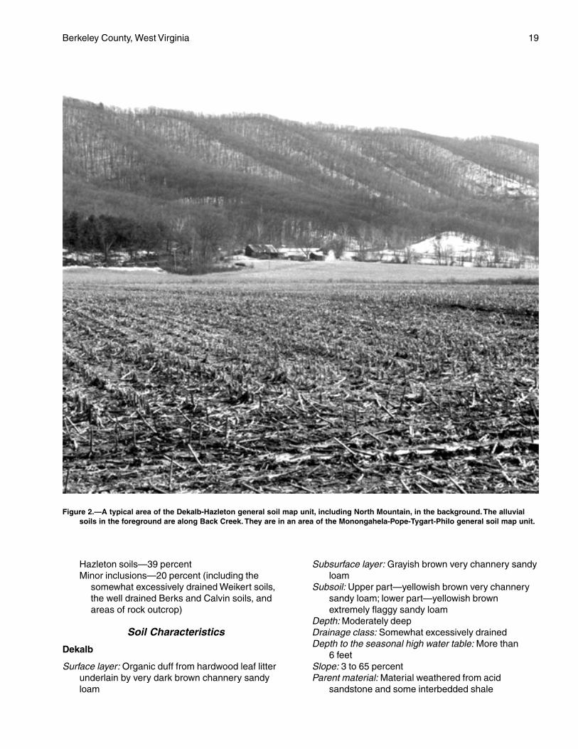
These soils are on the convex ridgetopsand convex to slightly concave side slopes ofNorth Mountain (fig. 2), Third Hill Mountain, andSleepy Creek Mountain. Slopes range from 3 to65 percent.
Composition
Extent of the general soil map unit: 7 percentPercentage of components in the map unit:
Dekalb soils—41 percent
Berkeley County, West Virginia 19
Hazleton soils—39 percentMinor inclusions—20 percent (including the
somewhat excessively drained Weikert soils,the well drained Berks and Calvin soils, andareas of rock outcrop)
Soil Characteristics
Dekalb
Surface layer: Organic duff from hardwood leaf litterunderlain by very dark brown channery sandyloam
Subsurface layer: Grayish brown very channery sandyloam
Subsoil: Upper part—yellowish brown very channerysandy loam; lower part—yellowish brownextremely flaggy sandy loam
Depth: Moderately deepDrainage class: Somewhat excessively drainedDepth to the seasonal high water table: More than
6 feetSlope: 3 to 65 percentParent material: Material weathered from acid
sandstone and some interbedded shale
Figure 2.—A typical area of the Dekalb-Hazleton general soil map unit, including North Mountain, in the background. The alluvialsoils in the foreground are along Back Creek. They are in an area of the Monongahela-Pope-Tygart-Philo general soil map unit.
20 Soil Survey
Hazleton
Surface layer: Organic duff from hardwood leaf litterunderlain by very dark brown gravelly loam
Subsurface layer: Dark yellowish brown gravelly loamSubsoil: Upper part—yellowish brown very gravelly
loam; next part—strong brown very gravelly loam;lower part—strong brown very gravelly sandyloam
Depth: Very deepDrainage class: Well drainedDepth to the seasonal high water table: More than
6 feetSlope: 15 to 65 percentParent material: Material weathered from acid
sandstone and shale
Use and Management
Most areas are forested. A few small areas areused for orchards or pasture. The woodland consistsmainly of the oak-hickory and Virginia pine-pitch pineforest types.
Cropland
Most areas are not suited to cropland. The slopeand the stones on the surface make cultivationimpractical.
Pasture and Hayland
Most areas are not suited to hay and are difficult tomanage for pasture. The slope and the stones on thesurface are the main limitations.
Woodland
Potential productivity is moderate on south aspectsand moderate or moderately high on north aspects.The slope is the main limitation affecting loggingoperations.
Community Development
Many areas are not suited to development becauseof the very steep slope. The depth to bedrock is anadditional limitation in areas of the Dekalb soils.
4. Downsville
Gently sloping to moderately steep, well drainedsoils that have a medium textured subsoil and formedin material washed from upland soils; on high riverterraces
Setting
These soils are on old river terraces high above thePotomac River. Some areas that are underlain by
limestone have sinkholes. Slopes range from 3 to25 percent.
Composition
Extent of the general soil map unit: 1 percentPercentage of components in the map unit:
Downsville soils—84 percentMinor soils—16 percent (including the well drained
Hagerstown, Murrill, and Berks soils onadjacent uplands; and the moderately welldrained Monongahela soils on the lower riverterraces)
Soil Characteristics
Surface layer: Dark yellowish brown gravelly loamSubsoil: Upper part—brown gravelly loam; lower
part—yellowish red very gravelly loam andyellowish red very gravelly sandy clay loam
Depth: Very deepDrainage class: Well drainedDepth to the seasonal high water table: More than
6 feetSlope: 3 to 25 percentParent material: Material washed from upland soils
Use and Management
Many areas have been cleared and are used forcrops, hay, or community development. Some areasare forested. The woodland consists of the oak-hickoryand mixed hardwood forest types.
Cropland
Most areas are suited to cropland. The gentlysloping areas are prime farmland. The hazardof erosion is moderate or severe in unprotectedareas.
Pasture and Hayland
These soils are suited to pasture and hay.Establishing and maintaining a healthy cover of sodand preventing overgrazing are major pasturemanagement concerns.
Woodland
These soils have moderately high potentialproductivity for trees. Erosion on logging roads andskid trails is a management concern.
Community Development
The slope is the main limitation affecting communitydevelopment. In some areas solution channels in theunderlying limestone bedrock increase the hazard ofground-water pollution from septic tank absorptionfields.
Berkeley County, West Virginia 21
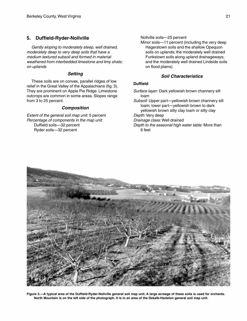
5. Duffield-Ryder-Nollville
Gently sloping to moderately steep, well drained,moderately deep to very deep soils that have amedium textured subsoil and formed in materialweathered from interbedded limestone and limy shale;on uplands
Setting
These soils are on convex, parallel ridges of lowrelief in the Great Valley of the Appalachians (fig. 3).They are prominent on Apple Pie Ridge. Limestoneoutcrops are common in some areas. Slopes rangefrom 3 to 25 percent.
Composition
Extent of the general soil map unit: 5 percentPercentage of components in the map unit:
Duffield soils—32 percentRyder soils—32 percent
Nollville soils—25 percentMinor soils—11 percent (including the very deep
Hagerstown soils and the shallow Opequonsoils on uplands; the moderately well drainedFunkstown soils along upland drainageways;and the moderately well drained Lindside soilson flood plains)
Soil Characteristics
Duffield
Surface layer: Dark yellowish brown channery siltloam
Subsoil: Upper part—yellowish brown channery siltloam; lower part—yellowish brown to darkyellowish brown silty clay loam or silty clay
Depth: Very deepDrainage class: Well drainedDepth to the seasonal high water table: More than
6 feet
Figure 3.—A typical area of the Duffield-Ryder-Nollville general soil map unit. A large acreage of these soils is used for orchards.North Mountain is on the left side of the photograph. It is in an area of the Dekalb-Hazleton general soil map unit.
22 Soil Survey
Slope: 3 to 15 percentParent material: Limestone
Ryder
Surface layer: Dark yellowish brown channery siltloam
Subsoil: Strong brown channery silt loamDepth: Moderately deepDrainage class: Well drainedDepth to the seasonal high water table: More than
6 feetSlope: 3 to 25 percentParent material: Interbedded limestone and limy shale
Nollville
Surface layer: Dark yellowish brown channery siltloam
Subsoil: Upper part—yellowish brown channery siltyclay loam; lower part—strong brown silty clay
Depth: DeepDrainage class: Well drainedDepth to the seasonal high water table: More than
6 feetSlope: 3 to 25 percentParent material: Interbedded limestone and limy
shale
Use and Management
Most areas have been cleared. A large acreage isused for orchards. These soils are also used forcultivated crops, hay, and pasture. A small acreagesupports mixed hardwoods. Some areas have beenused for community development.
Cropland
Most areas are suited to cropland. The gentlysloping areas are prime farmland. The hazardof erosion is moderate or severe in unprotectedareas.
Pasture and Hayland
These soils are suited to pasture and hayland.Establishing and maintaining a mixture of grasses andlegumes and preventing overgrazing are major pasturemanagement concerns. Ponds constructed forlivestock water are susceptible to seepage and have ahigh failure rate.
Woodland
These soils have moderately high potentialproductivity for trees. Erosion on logging roads andskid trails is a management concern.
Community Development
In some areas solution channels and fractures inthe limestone bedrock increase the hazard of ground-water pollution from septic tank absorption fields. Thedepth to bedrock is a limitation on homesites in areasof the Ryder and Nollville soils.
6. Hagerstown-Funkstown
Very deep, well drained and moderately welldrained, nearly level to steep soils that have a mediumtextured or fine textured subsoil and formed in materialweathered from limestone; on uplands and alongupland drainageways
Setting
These soils are on broad, rolling uplands that areshallowly dissected by narrow drainageways.Limestone outcrops are common throughout the mapunit. Sinkholes also are common. Many large springsare in the unit. Slopes range from 0 to 35 percent.They are generally short and often complex, giving thelandscape an undulating appearance.
Composition
Extent of the general soil map unit: 26 percentPercentage of components in the map unit:
Hagerstown soils—52 percentFunkstown soils—9 percentMinor inclusions—39 percent (including the well
drained Duffield soils on ridges and hillsides;the moderately well drained Swanpond soils onhead slopes and in upland depressions; thewell drained Murrill soils on the toeslopes ofNorth Mountain; the shallow Opequon soils onrocky uplands; the well drained Combs soils onthe flood plain along the Potomac River; thewell drained Lappans soils and the very poorlydrained Fairplay soils on narrow flood plainsbelow limestone springs; and areas oflimestone outcrops)
Soil Characteristics
Hagerstown
Surface layer: Brown silt loamSubsoil: Upper part—strong brown silt loam; next
part—yellowish red and strong brown silty clay;next part—yellowish red and strong brown siltyclay loam; lower part—strong brown and darkyellowish brown silty clay loam
Berkeley County, West Virginia 23
Depth: Very deepDrainage class: Well drainedDepth to the seasonal high water table: More than
6 feetParent material: Limestone
Funkstown
Surface layer: Dark yellowish brown silt loamSubsoil: Upper part—yellowish brown gravelly loam;
next part—yellowish brown very gravelly loam;lower part—strong brown and brownish yellowclay
Depth: Very deepDrainage class: Moderately well drainedDepth to the seasonal high water table: 2.0 to
3.5 feetParent material: Local alluvial or colluvial material
washed from upland soils that are underlain bylimestone
Use and Management
About 70 percent of this unit has been cleared oftrees and is used for cultivated crops, orchards, hay,pasture, or community development. The remainingwooded areas include up to 30 percent limestoneoutcrops. They support hardwoods or hardwoodsmixed with eastern redcedar.
Cropland
Most areas are suited to cultivated crops. Manyareas of prime farmland are in this unit. Sinkholes andsolution channels in the limestone bedrock increasethe hazard of ground-water pollution.
Pasture and Hayland
Most areas are suited to pasture and hay. Pondsconstructed for livestock water are susceptible toseepage and have a high failure rate.
Woodland
These soils have moderately high potentialproductivity for trees.
Community Development
The depth to hard limestone bedrock is a limitationin many areas. Sinkholes and solution channels in thebedrock increase the hazard of ground-water pollutionfrom septic tank absorption fields. Some areas of theFunkstown soils are subject to occasional periods offlooding or ponding.
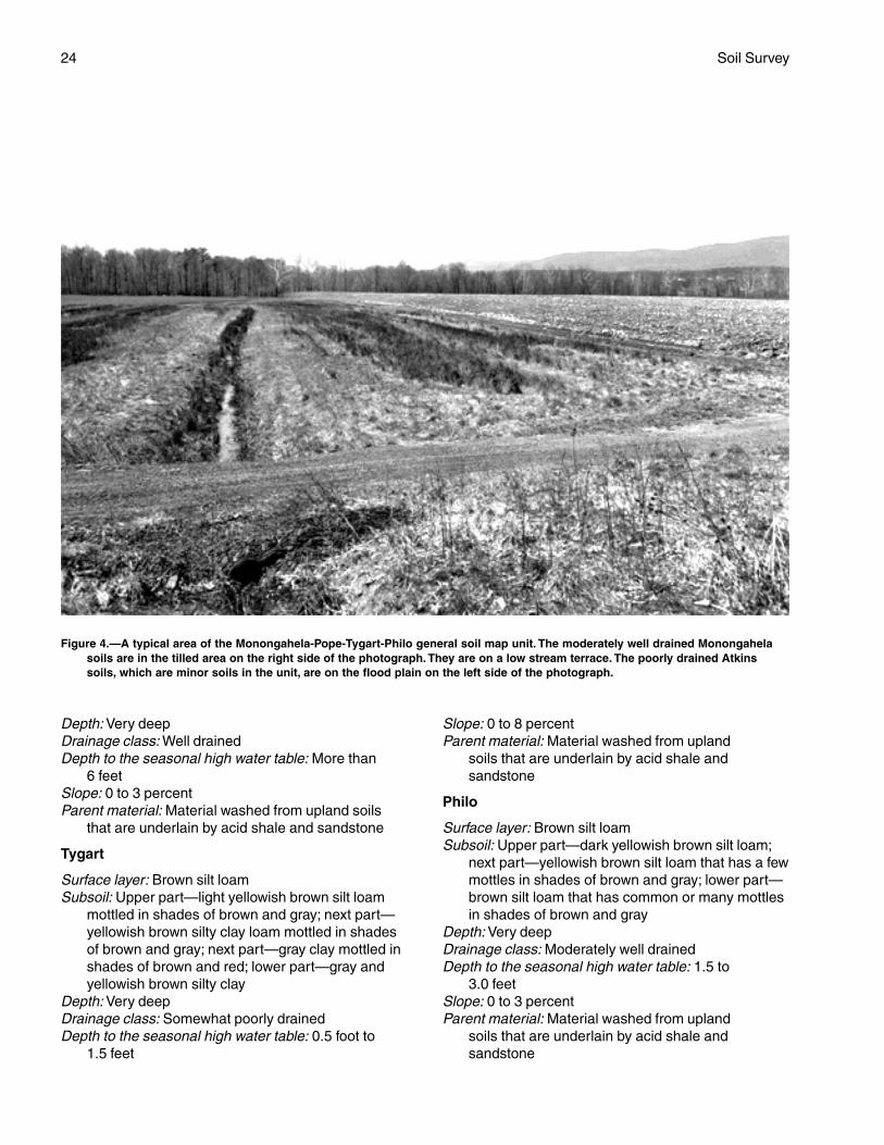
7. Monongahela-Pope-Tygart-Philo
Nearly level to strongly sloping, well drained andsomewhat poorly drained, very deep soils that have amedium textured or fine textured subsoil; formed inmaterial washed from upland soils that are underlainmainly by acid shale and sandstone; on flood plainsand terraces
Setting
These soils are mainly on the flood plain and lowstream terraces along Back Creek in the westernpart of the county (fig. 4). Slopes range from 0 to15 percent.
Composition
Extent of the general soil map unit: 4 percentPercentage of components in the map unit:
Monongahela soils—33 percentPope soils—18 percentTygart soils—17 percentPhilo soils—14 percentMinor soils—18 percent (including the poorly
drained Atkins soils on flood plains; thesomewhat excessively drained Weikert soils,the well drained Berks soils, and the somewhatpoorly drained Clearbrook soils on the adjacentshale uplands; and the moderately well drainedBuchanan soils on concave footslopes)
Soil Characteristics
Monongahela
Surface layer: Dark yellowish brown silt loamSubsoil: Upper part—yellowish brown silt loam; next
part—dark yellowish brown silt loam mottled inshades of brown and gray; next part—light olivebrown, firm and brittle silt loam mottled in shadesof brown and gray; lower part—yellowish brownclay loam that has gray mottles
Depth: Very deepDrainage class: Moderately well drainedDepth to the seasonal high water table: 1.5 to
3.0 feetSlope: 0 to 8 percentParent material: Material washed from upland soils
that are underlain by acid shale and sandstone
Pope
Surface layer: Brown silt loamSubsoil: Brown silt loam
24 Soil Survey
Depth: Very deepDrainage class: Well drainedDepth to the seasonal high water table: More than
6 feetSlope: 0 to 3 percentParent material: Material washed from upland soils
that are underlain by acid shale and sandstone
Tygart
Surface layer: Brown silt loamSubsoil: Upper part—light yellowish brown silt loam
mottled in shades of brown and gray; next part—yellowish brown silty clay loam mottled in shadesof brown and gray; next part—gray clay mottled inshades of brown and red; lower part—gray andyellowish brown silty clay
Depth: Very deepDrainage class: Somewhat poorly drainedDepth to the seasonal high water table: 0.5 foot to
1.5 feet
Slope: 0 to 8 percentParent material: Material washed from upland
soils that are underlain by acid shale andsandstone
Philo
Surface layer: Brown silt loamSubsoil: Upper part—dark yellowish brown silt loam;
next part—yellowish brown silt loam that has a fewmottles in shades of brown and gray; lower part—brown silt loam that has common or many mottlesin shades of brown and gray
Depth: Very deepDrainage class: Moderately well drainedDepth to the seasonal high water table: 1.5 to
3.0 feetSlope: 0 to 3 percentParent material: Material washed from upland
soils that are underlain by acid shale andsandstone
Figure 4.—A typical area of the Monongahela-Pope-Tygart-Philo general soil map unit. The moderately well drained Monongahelasoils are in the tilled area on the right side of the photograph. They are on a low stream terrace. The poorly drained Atkinssoils, which are minor soils in the unit, are on the flood plain on the left side of the photograph.
Berkeley County, West Virginia 25
Use and Management
Most areas have been cleared and are used forcrops, hay, or pasture. Some areas that are frequentlyflooded support mixed hardwoods.
Cropland
The Monongahela, Pope, and Philo soils are suitedto cropland. The Tygart soils are suited to cropland ifthey are adequately drained. Some areas are primefarmland. Flooding in areas of the Pope and Philo soilsmay occasionally damage crops.
Pasture and Hayland
These soils are suited to pasture and hay. Becauseof the seasonal wetness, the Tygart and Philo soils arebetter suited to grasses than to legumes.
Woodland
These soils have moderately high potentialproductivity for trees. The seasonal wetness may limitlogging operations in areas of the Monongahela, Philo,and Tygart soils.
Community Development
The seasonal wetness is the main limitationaffecting community development in areas of theMonongahela and Tygart soils. The Pope and Philosoils are not suited to community developmentbecause of the flooding.
8. Pecktonville-Blackthorn-Caneyville
Gently sloping to very steep, well drained,moderately deep and very deep soils that have a finetextured or medium textured subsoil and formed inmaterial weathered from limestone and sandstone; onuplands
Setting
These soils are in many areas of the smalllimestone valley and the adjacent ridges in thewestern part of the county. The areas extend fromnear Jones Springs northward to Ferrel Ridge. Thesoils are on gently sloping and strongly sloping,convex ridges and valley sides and on steep and verysteep, convex or slightly concave hillsides. Slopesrange from 3 to 45 percent.
Composition
Extent of the general soil map unit: 3 percentPercentage of components in the map unit:
Pecktonville soils—45 percentBlackthorn soils—22 percentCaneyville soils—18 percent
Minor soils—15 percent (including the somewhatexcessively drained Dekalb soils on ridges; themoderately well drained Buchanan soils onfootslopes; and the somewhat poorly drainedPoorhouse soils in concave uplanddepressions)
Soil Characteristics
Pecktonville
Surface layer: Organic duff from hardwood leaf litterunderlain by very dark grayish brown very gravellyloam
Subsurface layer: Yellowish brown gravelly loamSubsoil: Upper part—strong brown silt loam; next
part—yellowish red gravelly silty clay loam; nextpart—yellowish red gravelly clay mottled in shadesof brown and red; lower part—yellowish redgravelly clay mottled in shades of red, yellow, andgray
Depth: Very deepDrainage class: Well drainedDepth to the seasonal high water table: 3.5 to 6.0 feetSlope: 3 to 45 percentParent material: Material weathered from limestone
mixed with some material weathered fromsandstone and chert
Blackthorn
Surface layer: Organic duff from hardwood leaf litterunderlain by very dark brown very gravelly loam
Subsurface layer: Brown very gravelly sandy loamSubsoil: Upper part—light yellowish brown gravelly
sandy loam; next part—yellowish brown verygravelly sandy loam; next part—strong brown verygravelly loam; next part—red and strong brownvery gravelly clay; lower part—red and strongbrown clay
Depth: Very deepDrainage class: Well drainedDepth to the seasonal high water table: More than
6 feetSlope: 15 to 45 percentParent material: Material weathered from limestone
mixed with some material weathered fromsandstone and chert
Caneyville
Surface layer: Dark grayish brown silty clay loamunderlain by brown silty clay loam
Subsoil: Upper part—strong brown silty clay that hasyellowish brown mottles; lower part—yellowish redsilty clay
Depth: Moderately deep
26 Soil Survey
Drainage class: Well drainedDepth to the seasonal high water table: More than
6 feetSlope: 3 to 25 percentParent material: Material weathered from limestone
interbedded with thin layers of shale and siltstone
Use and Management
Most stony areas are forested. The woodlandconsists of the oak-hickory or mixed hardwood foresttypes. Most of the nonstony areas have been clearedand are used for pasture, hay, or crops. A few smallareas are used for orchards.
Cropland
The nonstony, gently sloping and strongly slopingPecktonville and Caneyville soils are suited tocropland. The hazard of erosion is moderate or severein unprotected areas. Solution channels in thelimestone bedrock increase the hazard of ground-water pollution.
Pasture and Hayland
The nonstony areas are suited to pasture andhayland. The stony areas are not suited to hay and aredifficult to manage for pasture. Ponds constructed forlivestock water are susceptible to seepage and have ahigh failure rate.
Woodland
Potential productivity is moderately high in mostareas.
Community Development
The slope is a limitation affecting communitydevelopment in many areas of these soils. Aseasonally wet subsoil and slow permeability areadditional limitations in areas of the Pecktonville soils,and the depth to bedrock is an additional limitation inareas of the Caneyville soils. In most areas solutionchannels in the limestone bedrock increase the hazardof ground-water pollution from septic tank absorptionfields.
9. Swanpond-Carbo-Opequon
Gently sloping to steep, moderately well drainedand well drained, very deep to shallow soils that havea very fine textured subsoil and formed in materialweathered from limestone; on uplands
Setting
The Swanpond soils generally are on broad,topographically low, slightly convex to slightly concave
uplands. The Carbo and Opequon soils are on long,narrow, slightly convex uplands. Sinkholes occur insome areas. Limestone outcrops are common in otherareas. Slopes are generally short and often complex.They range from 3 to 35 percent.
Composition
Extent of the general soil map unit: 4 percentPercentage of components in the map unit:
Swanpond soils—39 percentCarbo soils—30 percentOpequon soils—15 percentMinor soils—16 percent (including the very deep
Hagerstown soils and the deep Endcav soils onuplands; the moderately well drainedFunkstown soils along upland drainageways;and the shallow Weikert soils and themoderately deep Berks and Clearbrook soils onadjacent shale uplands)
Soil Characteristics
Swanpond
Surface layer: Brown silt loamSubsoil: Upper part—yellowish brown clay; lower
part—yellowish brown and strong brown clay thathas gray mottles
Depth: Very deepDrainage class: Moderately well drainedDepth to the seasonal high water table: 2.5 to 3.5 feetParent material: Limestone
Carbo
Surface layer: Dark yellowish brown silty claySubsoil: Strong brown and yellowish brown clayDepth: Moderately deepDrainage class: Well drainedDepth to the seasonal high water table: More than
6 feetSlope: 3 to 35 percentParent material: Limestone
Opequon
Surface layer: Dark yellowish brown silty claySubsoil: Yellowish brown clayDepth: ShallowDrainage class: Well drainedDepth to the seasonal high water table: More than
6 feetSlope: 3 to 35 percentParent material: Limestone
Use and Management
Most areas have been cleared of trees and areused for pasture or hay. A small acreage is used for
Berkeley County, West Virginia 27
cultivated crops. Some areas are used for communitydevelopment. The wooded areas are in hardwoods orhardwoods mixed with eastern redcedar. Thelimestone underlying this map unit is of very highquality and has been extensively quarried. Both activeand abandoned quarries are common throughout theunit.
Cropland
Most areas are generally suited to cultivated crops.Sinkholes and solution channels in the limestonebedrock increase the hazard of ground-water pollution.The high content of clay in the surface layer makesthese soils difficult to till. The Opequon soils aredroughty during the growing season.
Pasture and Hayland
These soils are suited to pasture and hay. Pondsconstructed for livestock water are susceptible toseepage and have a high failure rate.
Woodland
Potential productivity is moderately high in areas ofthe Swanpond and Carbo soils and moderate in areasof the Opequon soils. The high content of clay limitsthe use of logging equipment during wet periods.
Community Development
The depth to hard limestone bedrock and a highshrink-swell potential are the main limitations affectingcommunity development. Sinkholes and solutionchannels in the bedrock increase the hazard ofground-water pollution from septic tank absorptionfields.
10. Urban Land
Setting
This map unit consists of areas where the majorityof the landscape has been altered during communitydevelopment. It is mostly in the city of Martinsburg andthe surrounding area.
Composition
Extent of the general soil map unit: 2 percentPercentage of components in the map unit:
Urban land—62 percentMinor soils—38 percent (including areas of the
very deep Hagerstown and Swanpond soils; thedeep Endcav soils; the moderately deep Carbo,Berks, and Clearbrook soils; the shallowOpequon and Weikert soils; and Udorthents)
Characteristics of Urban Land
Urban land consists of areas where at least 90percent of the land surface is covered by asphalt,concrete, or other impervious material.
Use and Management
This map unit has been used for industrial,commercial, and residential development.
11. Weikert-Berks-Clearbrook
Nearly level to very steep, somewhat excessivelydrained to somewhat poorly drained, shallow andmoderately deep soils that have a medium texturedsubsoil and formed in material weathered from acidshale; on uplands
Setting
The Weikert and Berks soils are generally onconvex upland ridges, nose slopes, and side slopesthat have been deeply dissected by drainageways. TheClearbrook soils are generally on broad, smoothridges and concave head slopes, mostly in the easternpart of the county. Slopes range from 3 to 70 percentin areas of the Weikert and Berks soils and from 0 to8 percent in areas of the Clearbrook soils.
Composition
Extent of the general soil map unit: 37 percentPercentage of components in the map unit:
Weikert soils—34 percentBerks soils—31 percentClearbrook soils—11 percentMinor soils—24 percent (including the poorly
drained Atkins soils and the moderately welldrained Philo soils on narrow flood plains)
Soil Characteristics
Weikert
Surface layer: Dark brown channery silt loamSubsoil: Yellowish brown very channery silt loamDepth: ShallowDrainage class: Somewhat excessively drainedDepth to the seasonal high water table: More than
6 feetParent material: Soft, rippable, acid shale
Berks
Surface layer: Brown channery silt loamSubsoil: Upper part—yellowish brown channery silt
loam; lower part—yellowish brown and strongbrown very channery silt loam
28
Depth: Moderately deepDrainage class: Well drainedDepth to the seasonal high water table: More than
6 feetParent material: Soft, rippable, acid shale
Clearbrook
Surface layer: Brown silt loamSubsoil: Upper part—light olive brown very channery
silty clay loam that has yellowish brown and graymottles; lower part—gray extremely channery siltyclay loam that has yellowish brown mottles
Depth: Moderately deepDrainage class: Somewhat poorly drainedDepth to the seasonal high water table: 0.5 foot to
2.5 feetParent material: Soft, rippable, acid shale
Use and Management
Most of the broad ridgetops have been cleared andare used for pasture, hay, cultivated crops, orcommunity development. Many areas are forested. Afew small areas are used for orchards. The steep andvery steep side slopes are generally forested. The
woodland consists of the oak-hickory and Virginiapine-pitch pine forest types.
Cropland
The gently sloping and strongly sloping areas aregenerally suited to cropland, but production generallyis low. Droughtiness and low natural fertility are themain limitations.
Pasture and Hayland
These soils are suited to pasture and hay. Thedroughtiness limits forage production duringmidsummer.
Woodland
Potential productivity is moderate in most areas.The droughtiness and the low natural fertility result in ahigh seedling mortality rate in tree plantations,especially on south-facing slopes.
Community Development
The depth to bedrock and the slope are limitationsaffecting community development. The seasonal highwater table is an additional limitation in areas of theClearbrook soils.
29
The map units on the detailed soil maps at the backof this survey represent the soils in the survey area.The map unit descriptions in this section, along withthe soil maps, can be used to determine the suitabilityand potential of a soil for specific uses. They also canbe used to plan the management needed for thoseuses. More information on each map unit, or soil, isgiven under the heading “Use and Management of theSoils.”
Each map unit on the detailed soil maps representsan area on the landscape and consists of one or moresoils for which the unit is named.
A symbol identifying the soil precedes the map unitname in the soil descriptions. Each descriptionincludes general facts about the soil and gives theprincipal hazards and limitations to be considered inplanning for specific uses.
Soils that have profiles that are almost alike makeup a soil series. Except for differences in texture of thesurface layer or of the underlying material, all the soilsof a series have major horizons that are similar incomposition, thickness, and arrangement.
Soils of one series can differ in texture of thesurface layer or of the underlying material. They alsocan differ in slope, stoniness, salinity, wetness, degreeof erosion, and other characteristics that affect theiruse. On the basis of such differences, a soil series isdivided into soil phases. Most of the areas shown onthe detailed soil maps are phases of soil series. Thename of a soil phase commonly indicates a featurethat affects use or management. For example,Monongahela silt loam, 3 to 8 percent slopes, is aphase of the Monongahela series.
Some map units are made up of two or more majorsoils. These map units are called soil complexes. A soilcomplex consists of two or more soils, or one or moresoils and a miscellaneous area, in such an intricatepattern or in such small areas that they cannot beshown separately on the soil maps. The pattern andproportion of the soils are somewhat similar in allareas. Weikert-Berks channery silt loams, 8 to 15percent slopes, is an example.
Most map units include small scattered areas ofsoils other than those for which the map unit is named.Some of these included soils have properties that
differ substantially from those of the major soil or soils.Such differences could significantly affect use andmanagement of the soils in the map unit. The includedsoils are identified in each map unit description. Somesmall areas of strongly contrasting soils are identifiedby a special symbol on the soil maps.
This survey includes miscellaneous areas. Suchareas have little or no soil material and support little orno vegetation. Urban land is an example.Miscellaneous areas are shown on the soil maps.Some that are too small to be shown are identified bya special symbol on the soil maps.
Table 4 gives the acreage and proportionate extentof each map unit. Other tables give properties of thesoils and the limitations, capabilities, and potentials formany uses. The Glossary defines many of the termsused in describing the soils.
Soil Descriptions
At—Atkins silt loam
Setting
This soil is on nearly level, slightly concave floodplains, mainly along Back Creek and its tributariesand, to a lesser extent, along the Potomac River and,in many areas, on the backside of the flood plainnearest the uplands. Most areas of the soil that havenot been drained previously are considered to bewetlands. A Federal permit may be required beforethese areas are disturbed.
Composition
Atkins soil and similar soils: 80 percentDissimilar inclusions: 20 percent
Representative Profile
Surface layer:0 to 4 inches—dark grayish brown silt loam
Subsoil:4 to 20 inches—gray silt loam that has strong brown
and grayish brown mottles20 to 26 inches—light gray silt loam that has grayish
Detailed Soil Map Units
30 Soil Survey
brown, strong brown, and yellowish brown mottles26 to 36 inches—light gray silty clay loam that has
grayish brown, strong brown, and yellowish brownmottles
Underlying material:36 to 50 inches—light brownish gray loam that has
gray and yellowish brown mottles50 to 70 inches—light gray, stratified gravelly silt loam
and gravelly sandy loam having brownish yellowmottles
Soil Properties and Qualities
Drainage class: Poorly drainedPermeability: Slow (0.06 to 0.2 inch per hour)Available water capacity: Moderate or highDepth to the seasonal high water table: Within a depth
of 1 footFlooding: Frequently flooded (more than a 50 percent
chance of flooding in any year) for brief periodsShrink-swell potential: LowErosion hazard: SlightStoniness: NoneRockiness: NoneNatural fertility: MediumReaction: In unlimed areas, very strongly acid or
strongly acid (pH 4.5 to 5.5) above a depth of 40inches ranging to moderately acid (pH 5.6 to 6.0)below a depth of 40 inches
Surface runoff: Very slowDepth to bedrock: More than 60 inches
Minor Components
Dissimilar inclusions:• The moderately well drained Philo soils• The well drained Pope soilsSimilar soils:• Soils that have silty clay or clay in the subsoil• Very poorly drained soils that are subject to ponding• Soils that are frequently flooded• Soils that are moderately acid to neutral throughout
Use and Management
Uses: In many areas, the Atkins soil is wooded or theacreage is idle land. Some areas are used aspasture. Some large areas along Back Creek havebeen drained and are used for crops.
Cropland
Suitability: Suited if the soil has been adequatelydrained
Management concerns:• Most climatically adapted crops cannot be grownunless an adequate drainage system has beeninstalled.
• Tilling or harvesting when the soil is wet may causecompaction and deterioration of tilth.• The flooding may damage crops and delay fieldworkin some years.• This soil must be properly protected if cultivatedcrops are grown year after year.Management measures:• Applying a system of conservation tillage, growinggreen manure crops, returning crop residue to the soil,and deferring tillage and harvest when the soil is wethelp to improve or maintain tilth.
Pasture and Hayland
Suitability: Suited; better suited to grasses than tolegumes because of the seasonal high water table
Management concerns:• Establishing and maintaining a healthy cover of sodand preventing overgrazing are major pasturemanagement concerns.• Grazing when the soil is too wet may damage thesod.• Unless the soil is drained, harvesting of hay iscommonly restricted to long, dry periods.• Debris may be deposited on the grassland duringperiods of flooding.Management measures:• The hay and pasture plants that can withstand thewetness should be selected for planting.• Proper stocking rates, a planned grazing system,and deferred grazing during wet periods help to keeppastures in good condition.• Applying lime and fertilizer according to the resultsof soil tests helps to ensure the maximum growth ofplants.
Woodland
Potential productivity: Moderately high for water-tolerant species
Management concerns:• The use of equipment is restricted during wetperiods when the soil is soft.• The wetness may result in a high seedling mortalityrate.• The windthrow hazard is moderate because of thewetness.• Competition from undesirable plants may slow thegrowth of planted tree seedlings.Management measures:• Year-round logging roads require additions of roadfilland gravel.• The tree species that can withstand the wetnessshould be selected for planting.• Windthrow can be minimized by harvest methodsthat do not leave the remaining trees widely spaced.
Berkeley County, West Virginia 31
• Adequately preparing the site helps to control theinitial plant competition in tree plantations, andspraying helps to control subsequent competition.
Community Development
Suitability: Not suitedManagement concerns:• Because of the flooding and the wetness, this soil isnot suited to building site development.• Because of the flooding, the wetness, and the slowpermeability, this soil is not suited to septic tankabsorption fields.• The flooding, the wetness, and the potential for frostaction are severe limitations affecting the constructionof local roads and streets.Management measures:• Soils that are better suited to buildings and septictank absorption fields should be selected fordevelopment.• Installing a drainage system and providing a suitableroad base that includes the installation of properlydesigned geotextiles help to prevent the road damagecaused by wetness.
Interpretive Groups
Land capability classification: IIIwWoodland ordination symbol: 5W
BkE—Blackthorn very gravelly loam, 15to 35 percent slopes, extremely stony
Setting
This soil is on moderately steep or steep, slightlyconcave benches on the west side of North Mountain.
Composition
Blackthorn soil and similar soils: 75 percentDissimilar inclusions: 25 percent
Representative Profile
Surface layer:0 to 4 inches—very dark brown very gravelly loam
Subsurface layer:4 to 7 inches—brown gravelly loam
Subsoil:7 to 12 inches—brown gravelly loam12 to 65 inches—brown very gravelly loam
Soil Properties and Qualities
Drainage class: Well drainedPermeability: Moderate or moderately rapid (0.6 inch
to 6.0 inches per hour) in the surface layer and
upper part of the subsoil and moderate ormoderately slow (0.2 inch to 2.0 inches per hour)in the lower part of the subsoil
Available water capacity: ModerateDepth to the seasonal high water table: More than
6 feetFlooding: NoneShrink-swell potential: Low in the surface layer and the
upper part of the subsoil and moderate in thelower part of the subsoil
Erosion hazard: SevereSlope class: Moderately steep or steepStoniness: 3 to 15 percent of the surface covered with
stones and bouldersRockiness: NoneNatural fertility: MediumReaction: In unlimed areas, very strongly acid to
moderately acid (pH 4.5 to 6.0)Surface runoff: Rapid or very rapidDepth to bedrock: More than 60 inchesBedrock type: Limestone
Minor Components
Dissimilar inclusions:• The moderately deep Berks and Calvin soils, whichare in small convex areas• Small areas of the moderately well drainedBuchanan soils• Small very rubbly areas of soils that have more than50 percent of their surface covered with stones andboulders• Areas of limestone rock outcropSimilar soils:• The well drained Hazleton soils• Small rubbly areas of soils that have 15 to 50percent of their surface covered with stones andboulders• Soils that are not stony• Soils that have slopes of less than 15 percent ormore than 35 percent
Use and Management
Uses: All areas of the Blackthorn soil are wooded.
Cropland
Suitability: Not suitedManagement concerns:• The slope and the stones and boulders on thesurface of the soil make cultivation impractical.
Pasture and Hayland
Suitability: Not suited to hayland; difficult to manage forpasture
32 Soil Survey
Management concerns:• Because of the slope and the stones and boulderson the surface of the soil, it is difficult to operateconventional equipment used in applying fertilizer andin clipping.• Establishing and maintaining a mixture of grassesand legumes and preventing overgrazing are majorpasture management concerns.• If pastures are overgrazed, erosion is a severehazard in areas where the plant cover has beendestroyed.Management measures:• Proper stocking rates, uniform distribution of grazing,and a planned grazing system help to keep pasturesin good condition.• Applying lime and fertilizer according to the resultsof soil tests helps to ensure the maximum growth ofplants, especially legumes.
Woodland
Potential productivity: Moderately highManagement concerns:• Erosion is a management concern on logging roadsand skid trails.• The large stones on the surface of the soil canhinder harvesting operations and damage equipment.• The slope is a moderate limitation affecting the useof logging equipment.• The stones and boulders on the surface of the soilmay interfere with site preparation when tree seedlingsare planted.• Competition from brush can delay or prevent naturalregeneration of desired species after trees areharvested.Management measures:• The hazard of erosion can be reduced by buildinglogging roads and skid trails on the contour; seedinglogging roads, log landings, and areas that havebeen cut and filled; and installing water bars andculverts.
Community Development
Suitability: Poorly suitedManagement concerns:• Erosion is a severe hazard on construction sites.• Because of the slope, this soil is poorly suited tobuilding site development unless extensive landshaping is done.• Solution channels in the limestone bedrock increasethe hazard of ground-water pollution caused bysurface runoff and by seepage from septic tankabsorption fields.• The moderate shrink-swell potential is a limitation onsites for dwellings with basements.
• Low strength and the potential for frost action aremoderate limitations affecting the construction ofroads.• Rock fragments in the surface layer may interferewith the establishment of lawns and with landscaping.Management measures:• Maintaining the plant cover on construction sites,establishing a plant cover in unprotected areas, andproviding for proper disposal of surface runoff help tocontrol erosion and sedimentation and to protect theground water from pollution.• Buildings should be designed so that they conformto the natural slope of the land.• Septic tank absorption fields should not be installedin areas that are near limestone rock outcrop or whereexcavation has exposed the limestone bedrock.• Properly designing and strengthening footings andfoundations can help to prevent the structural damagecaused by shrinking and swelling.• Placing a filter fabric between the subgrade and theroad base when roads are constructed helps toprevent the damage caused by low strength.
Interpretive Groups
Land capability classification: VIIsWoodland ordination symbol: 4R
BpE—Blackthorn-Pecktonville verygravelly loams, 15 to 35 percentslopes, extremely stony
Setting
These soils are on moderately steep or steep,slightly concave hillsides and benches and slightlyconvex shoulder slopes and hillsides on Ferrell andWilson Ridges in the western part of the county. TheBlackthorn soil is mainly in concave areas of thelandscape, and the Pecktonville soil is mainly in theconvex areas. The two soils occur as areas sointermingled on the landscape that it was impracticalto separate them in mapping.
Composition
Blackthorn soil and similar soils: 50 percentPecktonville soil and similar soils: 40 percentDissimilar inclusions: 10 percent
Representative Profile
Blackthorn
Surface layer:0 to 1 inch—organic duff from hardwood leaf litter1 to 3 inches—very dark brown very gravelly loam
Berkeley County, West Virginia 33
Subsurface layer:3 to 6 inches—brown very gravelly sandy loam
Subsoil:6 to 14 inches—light yellowish brown gravelly sandy
loam14 to 24 inches—yellowish brown very gravelly sandy
loam24 to 35 inches—strong brown very gravelly loam35 to 75 inches—red and strong brown very gravelly
clay75 to 90 inches—red and strong brown clay
Pecktonville
Surface layer:0 to 1 inch—organic duff from hardwood leaf litter1 to 3 inches—very dark grayish brown very gravelly
loam
Subsurface layer:3 to 7 inches—yellowish brown gravelly loam
Subsoil:7 to 12 inches—strong brown silt loam12 to 17 inches—yellowish red gravelly silty clay loam17 to 32 inches—yellowish red, strong brown, and
brownish yellow gravelly clay32 to 48 inches—yellowish red, red, and brownish
yellow gravelly clay48 to 62 inches—yellowish red, red, and brownish
yellow gravelly clay that has pinkish gray mottles62 to 65 inches—red clay
Soil Properties and Qualities
Blackthorn
Drainage class: Well drainedPermeability: Moderate or moderately rapid (0.6 inch
to 6.0 inches per hour) in the upper part of thesubsoil and moderately slow (0.2 to 0.6 inch perhour) in the lower part of the subsoil
Available water capacity: ModerateDepth to the seasonal high water table: More than
6 feetFlooding: NoneShrink-swell potential: Moderate in the lower part of
the subsoilErosion hazard: SevereStoniness: 3 to 15 percent of the surface covered with
stones and bouldersRockiness: NoneNatural fertility: LowReaction: In unlimed areas, very strongly acid to
moderately acid (pH 4.5 to 6.0) in the surface layerand upper part of the subsoil and very strongly
acid or strongly acid (pH 4.5 to 5.5) in the lowerpart of the subsoil
Surface runoff: RapidDepth to bedrock: More than 60 inches
Pecktonville
Drainage class: Well drainedPermeability: Moderate (0.6 inch to 2.0 inches per
hour) in the upper part of the subsoil and slow ormoderately slow (0.06 to 0.6 inch per hour) in thelower part
Available water capacity: Moderate or highDepth to the seasonal high water table: 3.5 to 6.0 feetFlooding: NoneShrink-swell potential: High in the lower part of the
subsoilErosion hazard: SevereStoniness: 3 to 15 percent of the surface covered with
stones and bouldersRockiness: NoneNatural fertility: LowReaction: In unlimed areas, very strongly acid to
moderately acid (pH 4.5 to 6.0)Surface runoff: RapidDepth to bedrock: More than 60 inchesBedrock type: Siliceous limestone that contains fairly
high amounts of sandstone and chert
Minor Components
Dissimilar inclusions:• The moderately well drained Buchanan soils, whichare on concave foot slopes• The moderately deep Caneyville soils• The moderately deep Berks soils and the shallowWeikert soils, which are on convex hillsidesSimilar soils:• Small areas of rubbly or extremely bouldery soils• Soils that have slopes of less than 15 percent ormore than 35 percent• Soils that have less than 3 percent of their surfacecovered with stones
Use and Management
Uses: Most areas of the Blackthorn and Pecktonvillesoils are wooded. A few small areas have beencleared and are used as pasture. A few areashave been developed as homesites.
Cropland
Suitability: Not suitedManagement concerns:• The stones on the surface of the soils and the slopemake cultivation impractical.
34 Soil Survey
Pasture and Hayland
Suitability: Not suited for hay; difficult to manage forpasture
Management concerns:• Because of the slope and the stones on the surfaceof the soils, it is difficult to operate conventionalequipment used in clipping and in applying fertilizer.• Establishing and maintaining a mixture of grassesand legumes and preventing overgrazing are majorpasture management concerns.• Overgrazing causes surface compaction, increasesthe runoff rate and the hazard of erosion, and reducesthe vigor of the plant cover.• If pastures are overgrazed, erosion is a severehazard in areas where the plant cover has beendestroyed.Management measures:• Proper stocking rates, uniform distribution of grazing,and a planned grazing system help to keep pasturesin good condition.• Applying lime and fertilizer according to the resultsof soil tests helps to ensure the maximum growth ofplants, especially legumes.
Woodland
Potential productivity: Moderately highManagement concerns:• Erosion is a management concern on logging roadsand skid trails.• The large stones on the surface of the soils canhinder harvesting operations and damage equipment.• Competition from weeds may slow the growth ofplanted tree seedlings.• Seedling mortality may be a problem on southaspects because of droughtiness during the summer.• The stones and rock fragments in the surface layermay interfere with the planting of tree seedlings.Management measures:• The hazard of erosion can be reduced by seedinglogging roads, log landings, and areas that have beencut and filled and by installing water bars and culverts.• Drought-tolerant species, such as white pine, Scotchpine, and Norway spruce, should be selected forplanting on south aspects.• Logging roads should be designed so that theyconform to the topography.• Adequately preparing the site helps to control theinitial plant competition in tree plantations, andspraying helps to control subsequent competition.
Community Development
Suitability: Poorly suitedManagement concerns:• Erosion is a severe hazard on construction sites.
• Because of the slope, these soils are poorly suitedto building site development unless extensive landshaping is done.• The high shrink-swell potential and the seasonallywet subsoil are additional limitations affecting buildingsite development in areas of the Pecktonville soil.• The stones and boulders may interfere withconstruction, with the establishment of lawns, and withlandscaping.• The slope and the slow or moderately slowpermeability in the clayey layer of the subsoil arelimitations affecting septic tank absorption fields inareas of the Pecktonville soil.• The slope, the high shrink-swell potential, and thelow strength of the Pecktonville soil are limitations onsites for local roads and streets.Management measures:• Maintaining the plant cover on construction sites,establishing a plant cover in unprotected areas, andproviding for proper disposal of surface runoff help tocontrol erosion and sedimentation.• Properly designing and strengthening footings andfoundations can help to prevent the structural damagecaused by shrinking and swelling.• Installing a drainage system around structures thathave basements or crawl spaces helps to overcomethe wetness.• Enlarging or pressurizing septic tank absorptionfields or installing alternating drainfields helps toovercome the restricted permeability.• Providing a suitable road base that includes theinstallation of properly designed geotextiles helps toprevent the road damage caused by low strength andby shrinking and swelling.• Seeding and mulching roadbanks after constructionis completed helps to control erosion.
Interpretive Groups
Land capability classification: VIIsWoodland ordination symbol: Blackthorn—4R;
Pecktonville—4R
BpF—Blackthorn-Pecktonville verygravelly loams, 35 to 45 percentslopes, extremely stony
Setting
These soils are on very steep, slightly concavehillsides and benches and slightly convex shoulderslopes and hillsides on Ferrell and Wilson Ridges inthe western part of the county. The Blackthorn soil ismainly in concave areas of the landscape, and thePecktonville soil is mainly in convex areas. The two
Berkeley County, West Virginia 35
soils occur as areas so intermingled on the landscapethat it was impractical to separate them in mapping.
Composition
Blackthorn soil and similar soils: 60 percentPecktonville soil and similar soils: 30 percentDissimilar inclusions: 10 percent
Representative Profile
Blackthorn
Surface layer:0 to 1 inch—organic duff from hardwood leaf litter1 to 3 inches—very dark brown very gravelly loam
Subsurface layer:3 to 6 inches—brown very gravelly sandy loam
Subsoil:6 to 14 inches—light yellowish brown gravelly sandy
loam14 to 24 inches—yellowish brown very gravelly sandy
loam24 to 35 inches—strong brown very gravelly loam35 to 75 inches—red and strong brown very gravelly
clay75 to 90 inches—red and strong brown clay
Pecktonville
Surface layer:0 to 1 inch—organic duff from hardwood leaf litter1 to 3 inches—very dark grayish brown very gravelly
loam
Subsurface layer:3 to 7 inches—yellowish brown gravelly loam
Subsoil:7 to 12 inches—strong brown silt loam12 to 17 inches—yellowish red gravelly silty clay
loam17 to 32 inches—yellowish red, strong brown, and
brownish yellow gravelly clay32 to 48 inches—yellowish red, red, and brownish
yellow gravelly clay48 to 62 inches—yellowish red, red, and brownish
yellow gravelly clay that has pinkish gray mottles62 to 65 inches—red clay
Soil Properties and Qualities
Blackthorn
Drainage class: Well drainedPermeability: Moderate or moderately rapid (0.6 inch
to 6.0 inches per hour) in the upper part of thesubsoil and moderately slow (0.2 to 0.6 inch perhour) in the lower part of the subsoil
Available water capacity: ModerateDepth to the seasonal high water table: More than
6 feetFlooding: NoneShrink-swell potential: Moderate in the lower part of
the subsoilErosion hazard: Very severeStoniness: 3 to 15 percent of the surface covered with
stones and bouldersRockiness: NoneNatural fertility: LowReaction: In unlimed areas, very strongly acid to
moderately acid (pH 4.5 to 6.0) in the surface layerand upper part of the subsoil and very stronglyacid or strongly acid (pH 4.5 to 5.5 percent) in thelower part of the subsoil
Surface runoff: Very rapidDepth to bedrock: More than 60 inches
Pecktonville
Drainage class: Well drainedPermeability: Moderate (0.6 inch to 2.0 inches per
hour) in the upper part of the subsoil and slow ormoderately slow (0.06 to 0.6 inch per hour) in thelower part of the subsoil
Available water capacity: Moderate or highDepth to the seasonal high water table: 3.5 to 6.0 feetFlooding: NoneShrink-swell potential: High in the lower part of the
subsoilErosion hazard: Very severeStoniness: 3 to 15 percent of the surface covered with
stones and bouldersRockiness: NoneNatural fertility: LowReaction: In unlimed areas, very strongly acid to
moderately acid (pH 4.5 to 6.0)Surface runoff: Very rapidDepth to bedrock: More than 60 inchesBedrock type: Siliceous limestone that has a fairly high
content of sandstone and chert
Minor Components
Dissimilar inclusions:• The moderately deep Caneyville and Berks soils andthe shallow Weikert soils, which are in convex areas ofthe landscape• The very deep Buchanan soils, which are onconcave footslopes• Areas of rock outcropSimilar soils:• Rubbly or extremely bouldery soils• Soils that have slopes of less than 35 percent ormore than 45 percent
36 Soil Survey
• Soils that have less than 3 percent of their surfacecovered with stones
Use and Management
Uses: Nearly all areas of the Blackthorn andPecktonville soils are wooded.
Cropland
Suitability: Not suitedManagement concerns:• The stones on the surface of the soils and the slopemake cultivation impractical.
Pasture and Hayland
Suitability: Not suited for hay; difficult to manage forpasture
Management concerns:• Because of the slope and the stones on the surfaceof the soils, it is difficult to operate conventionalequipment used in clipping and in applying fertilizer.• Establishing and maintaining a mixture of grassesand legumes and preventing overgrazing are majorpasture management concerns.• Overgrazing causes surface compaction, increasesthe runoff rate and the hazard of erosion, and reducesthe vigor of the plant cover.• If pastures are overgrazed, erosion is a severehazard in areas where the plant cover has beendestroyed.Management measures:• Proper stocking rates, uniform distribution of grazing,and a planned grazing system help to keep pasturesin good condition.• Applying lime and fertilizer according to the resultsof soil tests helps to ensure the maximum growth ofplants, especially legumes.
Woodland
Potential productivity: Moderately highManagement concerns:• Erosion is a severe hazard on logging roads andskid trails.• Operating logging equipment is hazardous becauseof the very steep slope.• Competition from weeds may slow the growth ofplanted tree seedlings.• Seedling mortality may be a problem on southaspects because of the droughtiness during thesummer.• The stones and chert fragments in the surface layermay interfere with the planting of tree seedlings.Management measures:• Logging roads should be designed so that theyconform to the topography.
• The hazard of erosion can be reduced by seedinglogging roads, log landings, and areas that have beencut and filled and by installing water bars and culverts.• Adequately preparing the site helps to control theinitial plant competition in tree plantations, andspraying helps to control subsequent competition.• Drought-tolerant species, such as white pine, Scotchpine, and Norway spruce, should be selected forplanting on south aspects.
Community Development
Suitability: Not suitedManagement concerns:• Because of the very steep slope, these soils areunsuited to building site development, septic tankabsorption fields, and local roads and streets. A bettersuited soil should be selected for development.
Interpretive Groups
Land capability classification: VIIsWoodland ordination symbol: Blackthorn—4R;
Pecktonville—4R
BuB—Buchanan gravelly loam, 3 to8 percent slopes
Setting
This soil is on gently sloping, slightly concavemountain footslopes and toeslopes.
Composition
Buchanan soil and similar soils: 85 percentDissimilar inclusions: 15 percent
Representative Profile
Surface layer:0 to 8 inches—dark brown gravelly loam
Subsoil:8 to 10 inches—yellowish brown gravelly loam10 to 20 inches—yellowish brown gravelly loam20 to 32 inches—yellowish brown gravelly clay loam
that has light brownish gray mottles32 to 42 inches—light brown, very firm and brittle very
gravelly loam that has light gray and strong brownmottles
42 to 65 inches—strong brown, very firm and brittlevery gravelly clay loam that has light brown andstrong brown mottles
Soil Properties and Qualities
Drainage class: Moderately well drained; commonseepy spots during wet periods in winter andspring
Berkeley County, West Virginia 37
Permeability: Moderate (0.6 inch to 2.0 inches perhour) above the firm layer in the subsoil and slow(0.06 to 0.2 inch per hour) in the firm layer
Available water capacity: Very low to moderateDepth to the seasonal high water table: 1.5 to
3.0 feetFlooding: NoneShrink-swell potential: LowErosion hazard: ModerateNatural fertility: Low or mediumReaction: In unlimed areas, extremely acid to strongly
acid (pH 3.5 to 5.5)Surface runoff: MediumDepth to bedrock: More than 60 inches
Minor Components
Dissimilar inclusions:• Small areas of the moderately deep, well drainedBerks soils• Small areas of the well drained Murrill soils• Poorly drained soils, which are in depressions• Soils that do not have a firm and brittle layer in theirsubsoilSimilar soils:• Soils that have stones on the surface• Soils that have a surface layer of sandy loam• Soils that have slopes of less than 3 percent or morethan 8 percent
Use and Management
Uses: About one-half of the acreage of the Buchanansoil is wooded. Most of the cleared areas are usedfor pasture or hay. A few small areas are used forcultivated crops or as sites for communitydevelopment.
Cropland
Suitability: Suited. This soil is prime farmland.Management concerns:• The seasonal high water table and the firm layer inthe subsoil may restrict the rooting depth of somecrops.• Erosion is a moderate hazard in unprotected areas.• Because of the restricted rooting depth, crops maybe adversely affected by a shortage of water as thesoil dries out in summer.• The wetness may delay planting in the spring.Management measures:• Conservation tillage, contour farming, winter covercrops, and crop residue management help to controlerosion and to maintain fertility and tilth.• Leaving crop residue on the surface and addingother organic material help to conserve soil moisturein summer.
Pasture and Hayland
Suitability: Suited; better suited to grasses than tolegumes because of the seasonal high watertable
Management concerns:• Establishing and maintaining a healthy cover of sodand preventing overgrazing are major pasturemanagement concerns.• Overgrazing causes surface compaction, increasesthe runoff rate and the hazard of erosion, and reducesthe vigor of the plant cover.• If pastures are overgrazed, erosion is a severehazard in areas where the plant cover has beendestroyed.• Grazing early in spring when the soil is soft and wetcan damage the sod.Management measures:• Proper stocking rates, a planned grazing system,and deferred grazing during wet periods help to keeppastures in good condition.• Restricted grazing during wet periods helps tominimize compaction and maintain tilth.• Applying lime and fertilizer according to the resultsof soil tests helps to ensure the maximum growth offorage plants.
Woodland
Potential productivity: Moderately highManagement concerns:• Erosion is a management concern on logging roadsand skid trails.• Competition from weeds may slow the growth ofplanted tree seedlings.• The use of equipment is restricted during wetperiods because this soil is soft when wet.Management measures:• Building logging roads and skid trails on the contourand seeding the roads and trails when they are nolonger being used help to control erosion.• Adequately preparing the site helps to control theinitial plant competition in tree plantations, andspraying helps to control subsequent competition.
Community Development
Suitability: Poorly suitedManagement concerns:• The seasonal high water table is the main limitationaffecting building site development and septic tankabsorption fields.• The seasonal high water table and the potential forfrost action are limitations on sites for local roads andstreets. Because this soil is soft when wet, pavementmay crack under heavy loads.
38 Soil Survey
• The wetness is a limitation affecting excavation andtrafficability and may delay construction in winter andspring.• Erosion is a moderate hazard on construction sites.Management measures:• The included well drained soils, which are bettersuited to buildings and septic tank absorption fieldsthan the Buchanan soil, should be selected fordevelopment.• Installing a drainage system around structures thathave basements or crawl spaces helps to overcomethe wetness.• Buildings can be constructed on well compacted fillmaterial, which raises the site a sufficient distanceabove the water table.• Installing tile drainage lines upslope from absorptionfields can be effective in lowering the seasonal highwater table.• Enlarging septic tank absorption fields, installingalternating absorption fields, installing distribution lineson the contour, and backfilling lines with gravel help toovercome the restricted permeability in the lower partof the subsoil.• Installing a drainage system and providing a suitableroad base that includes the installation of properlydesigned geotextiles help to prevent the road damagecaused by wetness and frost action.• Maintaining the plant cover on construction sites,establishing a plant cover in unprotected areas, andproviding for proper disposal of surface runoff help tocontrol erosion and sedimentation.
Interpretive Groups
Land capability classification: IIeWoodland ordination symbol: 4A
BuC—Buchanan gravelly loam, 8 to15 percent slopes
Setting
This soil is on strongly sloping, slightly concavemountain footslopes and toeslopes.
Composition
Buchanan soil and similar soils: 80 percentDissimilar inclusions: 20 percent
Representative Profile
Surface layer:0 to 6 inches—brown gravelly loam
Subsoil:6 to 10 inches—olive brown gravelly loam10 to 21 inches—yellowish brown gravelly loam
21 to 48 inches—yellowish brown, firm and brittlegravelly loam that has light brownish gray andstrong brown mottles
48 to 65 inches—strong brown, very firm and brittlegravelly loam that has light brownish gray andreddish brown mottles
Soil Properties and Qualities
Drainage class: Moderately well drained; seepyspots common during wet periods in winter andspring
Permeability: Moderate (0.6 inch to 2.0 inches perhour) above the firm layer in the subsoil and slow(0.06 to 0.2 inch per hour) in the firm layer
Available water capacity: Very low to moderateDepth to the seasonal high water table: 1.5 to 3.0 feetFlooding: NoneShrink-swell potential: LowErosion hazard: SevereNatural fertility: Low or mediumReaction: In unlimed areas, extremely acid to strongly
acid (pH 3.5 to 5.5)Surface runoff: RapidDepth to bedrock: More than 60 inches
Minor Components
Dissimilar inclusions:• Poorly drained soils, which are in depressions• Small areas of the moderately deep Berks soils• Small areas of the well drained Murrill soils• Soils that do not have a very firm and brittle layer inthe subsoilSimilar soils:• Soils that have slopes of less than 8 percent or morethan 15 percent• Soils that have stones on the surface
Use and Management
Uses: Most areas of the Buchanan soil are used aswoodland. Some areas are used for cultivatedcrops or for hay and pasture. A few small areasare used as sites for community development.
Cropland
Suitability: SuitedManagement concerns:• The seasonal high water table and the firm layer inthe subsoil may restrict the rooting depth of somecrops.• Erosion is a severe hazard in unprotected areas.• Because of the restricted rooting depth, some cropsmay be adversely affected by a shortage of water asthe soil dries out in summer.• The wetness may delay planting in the spring.
Berkeley County, West Virginia 39
Management measures:• Conservation tillage, contour farming, winter covercrops, and crop residue management help to controlerosion and to maintain fertility and tilth.• Leaving crop residue on the surface and addingother organic material help to conserve moisture insummer.
Pasture and Hayland
Suitability: Suited; better suited to grasses than tolegumes because of the seasonal high water table
Management concerns:• Establishing and maintaining a healthy cover of sodand preventing overgrazing are major pasturemanagement concerns.• Overgrazing causes surface compaction, increasesthe runoff rate and the hazard of erosion, and reducesthe vigor of the plant cover.• If pastures are overgrazed, erosion is a severehazard in areas where the plant cover has beendestroyed.• Because this soil is soft when wet, grazing early inspring can damage the sod.Management measures:• Proper stocking rates, a planned grazing system,and deferred grazing during wet periods help to keeppastures in good condition.• Restricted grazing during wet periods helps tominimize compaction and maintain tilth.• Applying lime and fertilizer according to the resultsof soil tests helps to ensure the maximum growth offorage plants.
Woodland
Potential productivity: Moderately highManagement concerns:• Erosion is a management concern on logging roadsand skid trails.• Competition from weeds may slow the growth ofplanted tree seedlings.• The use of equipment is restricted during wetperiods because this soil is soft when wet.Management measures:• Building logging roads and skid trails on the contourand seeding the roads and trails when they are nolonger being used help to control erosion.• Adequately preparing the site helps to control theinitial plant competition in tree plantations, andspraying helps to control subsequent competition.
Community Development
Suitability: Poorly suitedManagement concerns:• The seasonal high water table is the main limitation
affecting building site development and septic tankabsorption fields.• The slope increases the extent of excavationrequired during the construction of roads andbuildings.• The seasonal high water table and the potential forfrost action are limitations on sites for local roads andstreets. Because this soil is soft when wet, pavementmay crack under heavy loads.• The wetness is a limitation affecting excavation andtrafficability and may delay construction in winter andspring.• Erosion is a severe hazard on construction sites.Management measures:• The included well drained soils, which are bettersuited to buildings and septic tank absorption fieldsthan the Buchanan soil, should be selected fordevelopment.• Installing a drainage system around structures thathave basements or crawl spaces helps to overcomethe wetness.• Buildings can be constructed on well compacted fillmaterial, which raises the site a sufficient distanceabove the water table.• Installing tile drainage lines upslope from absorptionfields can be effective in lowering the seasonal highwater table.• Enlarging septic tank absorption fields, installingalternating absorption fields, installing distribution lineson the contour, and backfilling lines with gravel help toovercome the restricted permeability in the lower partof the subsoil.• Installing a drainage system and providing a suitableroad base that includes the installation of properlydesigned geotextiles help to prevent the road damagecaused by wetness and frost action.• Roads and streets should be built on the contour.• Maintaining the plant cover on construction sites,establishing a plant cover in unprotected areas, andproviding for proper disposal of surface runoff help tocontrol erosion and sedimentation.
Interpretive Groups
Land capability classification: IIIeWoodland ordination symbol: 4A
BxC—Buchanan loam, 3 to 15 percentslopes, extremely stony
Setting
This soil is on gently sloping or strongly sloping,slightly concave mountain footslopes and toeslopes.Seeps and springs are common in some areas.
40 Soil Survey
Composition
Buchanan soil and similar soils: 80 percentDissimilar inclusions: 20 percent
Representative Profile
Surface layer:0 to 1 inch—organic duff from hardwood leaf litter1 to 2 inches—very dark gray loam
Subsurface layer:2 to 4 inches—light yellowish brown loam
Subsoil:4 to 13 inches—brownish yellow gravelly loam13 to 21 inches—light yellowish brown gravelly loam
that has strong brown mottles21 to 30 inches—strong brown gravelly loam that has
yellowish red, pale brown, and light brownish graymottles
30 to 49 inches—strong brown, firm and brittle gravellyloam that has brownish yellow, light brownish gray,and dark red mottles
Underlying material:49 to 65 inches—reddish brown, very firm and brittle
gravelly loam that has gray and red mottles
Soil Properties and Qualities
Drainage class: Moderately well drainedPermeability: Moderate (0.6 inch to 2.0 inches per
hour) above the firm or very firm layer in thesubsoil and slow (0.06 to 0.2 inch per hour) in thefirm or very firm layer
Available water capacity: Low or moderateDepth to the seasonal high water table: 1.5 to 3.0 feetFlooding: NoneShrink-swell potential: LowErosion hazard: Moderate or severeStoniness: 3 to 15 percent of the surface covered with
stones and bouldersRockiness: NoneNatural fertility: Low or mediumReaction: In unlimed areas, extremely acid to strongly
acid (pH 3.5 to 5.5)Surface runoff: Medium or rapidDepth to bedrock: More than 60 inches
Minor Components
Dissimilar inclusions:• Small areas of the poorly drained Atkins soils, themoderately well drained Philo soils, and the welldrained Pope soils, which are along narrowdrainageways• Very rubbly soils that have more than 50 percent oftheir surface covered with stones and boulders; mainly
on the footslopes of Sleepy Creek and Third HillMountains• Small areas of soils that are not stony• Soils that do not have a firm or very firm and brittlelayer in the subsoilSimilar soils:• Rubbly soils that have 15 to 50 percent of theirsurface covered with stones and boulders• Soils that have slopes of less than 3 percent or morethan 15 percent
Use and Management
Uses: Most areas of the Buchanan soil are wooded. Afew small areas are used as pasture.
Cropland
Suitability: Not suitedManagement concerns:• The stones and boulders on the surface of the soilmake cultivation impractical.
Pasture and Hayland
Suitability: Not suited to hayland; difficult to managefor pasture; better suited to grasses than tolegumes because of the seasonal high watertable
Management concerns:• Establishing and maintaining a healthy cover of sodand preventing overgrazing are major pasturemanagement concerns.• Overgrazing causes surface compaction, increasesthe runoff rate and the hazard of erosion, and reducesthe vigor of the plant cover.• If pastures are overgrazed, erosion is a moderate orsevere hazard in areas where the plant cover hasbeen destroyed.• Because this soil is soft when wet, grazing early inspring damages the sod.• Because of the slope and the stones on thesurface of the soil, it is difficult to operateconventional equipment used in clipping and inapplying fertilizer.Management measures:• Proper stocking rates, uniform distribution of grazing,and a planned grazing system help to keep pasturesin good condition.• Restricted grazing during wet periods helps tominimize compaction and maintain tilth.• Applying lime and fertilizer according to the resultsof soil tests helps to ensure the maximum growth offorage plants.
Woodland
Potential productivity: Moderately high
Berkeley County, West Virginia 41
Management concerns:• The large stones on the surface of the soil canhinder harvesting operations and damage equipment.• The use of equipment is restricted during wetperiods because this soil is soft when wet.• Plant competition is moderate if openings are madein the canopy.• The stones and boulders on the surface of the soilmay interfere with the planting of tree seedlings.• Erosion is a management concern on logging roadsand skid trails.Management measures:• The hazard of erosion can be reduced by buildinglogging roads and skid trails on the contour; seedinglogging roads, log landings, and areas that have beencut and filled; and installing water bars and culverts.
Community Development
Suitability: Poorly suitedManagement concerns:• The seasonal high water table is the main limitationaffecting building site development, septic tankabsorption fields, and local roads and streets.• The slow permeability in the lower part of the subsoilis a severe limitation on sites for septic tank absorptionfields.• The wetness is a limitation affecting excavation andtrafficability and may delay construction in winter andspring.• Water may seep from cutbanks during wet periods.• The slope and the potential for frost action arelimitations on sites for local roads and streets.• The wetness is an additional limitation on sites forlocal roads and streets. Because this soil is soft whenwet, pavement cracks under heavy loads.• The stones and boulders may interfere withconstruction, with the establishment of lawns, and withlandscaping.• Erosion is a moderate or severe hazard inunprotected areas on construction sites.Management measures:• Installing a drainage system around structures thathave basements or crawl spaces helps to overcomethe wetness.• Buildings should be designed so that they conformto the natural slope of the land. Land shaping isnecessary in some areas.• Installing tile drainage lines upslope from septic tankabsorption fields can be effective in lowering theseasonal high water table.• Enlarging septic tank absorption fields, installingalternating absorption fields, installing distribution lineson the contour, and backfilling lines with gravel help to
overcome the restricted permeability in the lower partof the subsoil.• Roads and streets should be built on the contour.• Installing a drainage system and providing a suitableroad base that includes the installation of properlydesigned geotextiles help to prevent the road damagecaused by wetness and frost action.• Maintaining the plant cover on construction sites,establishing a plant cover in unprotected areas, andproviding for proper disposal of surface runoff help tocontrol erosion and sedimentation.
Interpretive Groups
Land capability classification: VIIsWoodland ordination symbol: 4X
BxE—Buchanan loam, 15 to 35 percentslopes, extremely stony
Setting
This soil is on moderately steep or steep, slightlyconcave mountain benches, footslopes, and toeslopes.Seeps and springs are common in some areas.
Composition
Buchanan soil and similar soils: 75 percentDissimilar inclusions: 25 percent
Representative Profile
Surface layer:0 to 1 inch—organic duff from hardwood leaf litter1 to 2 inches—very dark gray loam
Subsurface layer:2 to 4 inches—light yellowish brown loam
Subsoil:4 to 13 inches—brownish yellow gravelly loam13 to 21 inches—light yellowish brown gravelly loam
that has strong brown mottles21 to 30 inches—strong brown gravelly loam that has
yellowish red, pale brown, and light brownish graymottles
30 to 49 inches—strong brown, firm and brittle gravellyloam that has brownish yellow, light brownish gray,and dark red mottles
49 to 65 inches—reddish brown, very firm and brittlegravelly loam that has gray and red mottles
Soil Properties and Qualities
Drainage class: Moderately well drainedPermeability: Moderate (0.6 inch to 2.0 inches per
hour) above the firm or very firm layer in the
42 Soil Survey
subsoil and slow (0.06 to 0.2 inch per hour) in thefirm or very firm layer
Available water capacity: Low or moderateDepth to the seasonal high water table: 1.5 to
3.0 feetFlooding: NoneShrink-swell potential: LowErosion hazard: Severe or very severeStoniness: 3 to 15 percent of the surface covered with
stones and bouldersRockiness: NoneNatural fertility: Low or mediumReaction: In unlimed areas, extremely acid to strongly
acid (pH 3.5 to 5.5)Surface runoff: Rapid or very rapidDepth to bedrock: More than 60 inches
Minor Components
Dissimilar inclusions:• Small areas of the moderately deep Berks andDekalb soils and the shallow Weikert soils, which areon adjacent convex hillsides• Very rubbly soils that have more than 50 percent oftheir surface covered with stones and boulders; mainlyon the footslopes of Sleepy Creek and Third HillMountains• Small areas of the well drained Hazleton soils• Soils that do not have a firm or very firm and brittlelayer in the subsoilSimilar soils:• Rubbly soils that have 15 to 50 percent of theirsurface covered with stones and boulders• Soils that have slopes of less than 15 percent ormore than 35 percent• Soils that are not stony
Use and Management
Uses: Most areas of the Buchanan soil are used aswoodland. A few small areas are used as pasture.
Cropland
Suitability: Not suitedManagement concerns:• The slope and the stones and boulders on thesurface of the soil make cultivation impractical.
Pasture and Hayland
Suitability: Not suited to hayland; difficult to manage forpasture; better suited to grasses than to legumesbecause of the seasonal high water table
Management concerns:• Establishing and maintaining a healthy cover of sodand preventing overgrazing are major pasturemanagement concerns.
• Overgrazing causes surface compaction, increasesthe runoff rate and the hazard of erosion, and reducesthe vigor of the plant cover.• If pastures are overgrazed, erosion is a severe orvery severe hazard in areas where the plant cover hasbeen destroyed.• Because this soil is soft when wet, grazing early inspring damages the sod.• Because of the slope and the stones on the surfaceof the soil, it is difficult to operate conventionalequipment used in clipping and in applying fertilizer.Management measures:• Proper stocking rates, uniform distribution of grazing,and a planned grazing system help to keep pasturesin good condition.• Restricted grazing during wet periods helps tominimize compaction and maintain tilth.• Applying lime and fertilizer according to the resultsof soil tests helps to ensure the maximum growth offorage plants.
Woodland
Potential productivity: Moderately highManagement concerns:• Erosion is a management concern on logging roadsand skid trails.• The large stones on the surface of the soil canhinder harvesting operations and damage equipment.• The use of equipment is restricted during wetperiods because this soil is soft when wet.• Plant competition is moderate if openings are madein the canopy.• The stones and boulders on the surface mayinterfere with the planting of tree seedlings.Management measures:• The hazard of erosion can be reduced by buildinglogging roads and skid trails on the contour; seedinglogging roads, log landings, and areas that have beencut and filled; and installing water bars and culverts.
Community Development
Suitability: Poorly suitedManagement concerns:• The slope and the seasonal high water table are themain limitations affecting building site development,septic tank absorption fields, and local roads andstreets.• The slow permeability in the lower part of the subsoilis a severe limitation on sites for septic tank absorptionfields.• The wetness is a limitation affecting excavation andtrafficability and may delay construction in winter andspring.• Water may seep from cutbanks during wet periods.
Berkeley County, West Virginia 43
• The potential for frost action is a limitation on sitesfor local roads and streets.• The wetness is an additional limitation on sites forlocal roads and streets. Because this soil is soft whenwet, pavement cracks under heavy loads.• The stones and boulders may interfere withconstruction, with the establishment of lawns, and withlandscaping.• Erosion is a severe hazard in unprotected areas onconstruction sites.Management measures:• Installing a drainage system around structures thathave basements or crawl spaces helps to overcomethe wetness.• Buildings should be designed so that they conformto the natural slope of the land. Extensive land shapingis necessary in most areas.• Installing tile drainage lines upslope from septic tankabsorption fields can be effective in lowering theseasonal high water table.• Enlarging septic tank absorption fields, installingalternating absorption fields, installing distribution lineson the contour, and backfilling lines with gravel help toovercome the restricted permeability in the lower partof the subsoil.• Roads and streets should be built on the contour.• Maintaining the plant cover on construction sites,establishing a plant cover in unprotected areas, andproviding for proper disposal of surface runoff help tocontrol erosion and sedimentation.• Installing a drainage system and providing a suitableroad base that includes the installation of properlydesigned geotextiles help to prevent the road damagecaused by wetness and frost action.
Interpretive Groups
Land capability classification: VIIsWoodland ordination symbol: 4X
CaB—Calvin channery loam, 3 to8 percent slopes
Setting
This soil is on convex, dissected uplands, mainly ongently sloping, low ridges in the western part of thecounty.
Composition
Calvin soil and similar soils: 95 percentDissimilar inclusions: 5 percent
Representative Profile
Surface layer:0 to 8 inches—reddish brown channery loam
Subsoil:8 to 24 inches—yellowish red very channery silt loam24 to 30 inches—yellowish red very channery loam30 to 34 inches—reddish brown very channery loam
Underlying material:34 to 35 inches—reddish brown extremely channery
loam
Bedrock:35 inches—dusky red, fractured shale
Soil Properties and Qualities
Drainage class: Well drainedPermeability: Moderately rapid (2.0 to 6.0 inches per
hour)Available water capacity: Low or moderateDepth to the seasonal high water table: More than
6 feetFlooding: NoneShrink-swell potential: LowErosion hazard: ModerateStoniness: NoneRockiness: NoneNatural fertility: LowReaction: In unlimed areas, very strongly acid or
strongly acid (pH 4.5 to 5.5)Surface runoff: MediumDepth to bedrock: 20 to 40 inchesBedrock type: Reddish shale, fine grained sandstone,
or siltstone; interbedded in some areas
Minor Components
Dissimilar inclusions:• The somewhat excessively drained Dekalb soils,which are underlain by hard, gray sandstone• Moderately well drained soils, which are on headslopes• Severely eroded soilsSimilar soils:• Soils that are less than 20 inches deep over bedrock• The moderately deep Berks soils and the shallowWeikert soils that are yellowish brown in the subsoil• Soils that have slopes of less than 3 percent• Soils that have slopes ranging from 8 to 15 percent• Stony soils• Soils in which the subsoil has a fine-earth texture ofsandy loam• Soils that have a lower content of rock fragmentsthroughout the profile than is typical for the Calvin soil
Use and Management
Uses: Most areas of the Calvin soil are wooded. Someareas have been cleared and are used for pastureor hay. A few small areas are used for cultivated
44 Soil Survey
crops or orchards or as sites for communitydevelopment.
Cropland
Suitability: SuitedManagement concerns:• The hazard of erosion is moderate in unprotectedareas.• Droughtiness during the growing season and the lownatural fertility are management concerns.Management measures:• Conservation tillage, winter cover crops, and cropresidue management help to control erosion and tomaintain fertility and tilth.• Because of the droughtiness, this soil is better suitedto early maturing small grain than to late maturingcrops, such as corn.• A system of conservation tillage that leaves cropresidue on the surface helps to conserve soilmoisture.• Applying lime and fertilizer according to theresults of soil tests helps to ensure maximumproduction.
Pasture and Hayland
Suitability: SuitedManagement concerns:• Establishing and maintaining a mixture of grassesand legumes and preventing overgrazing are majorpasture management concerns.• Overgrazing causes surface compaction, increasesthe runoff rate and the hazard of erosion, and reducesthe vigor of the plant cover.• The droughtiness limits forage production duringmidsummer.• Water for livestock is scarce, but potentialsites where ponds or springs can be developedgenerally are available along nearbydrainageways.Management measures:• Proper stocking rates, uniform distribution of grazing,and a planned grazing system help to keep pasturesin good condition.• Applying lime and fertilizer according to the resultsof soil tests helps to ensure the maximum growth offorage, especially legumes.
Woodland
Potential productivity: Moderately highManagement concerns:• Seedling mortality is a management concernbecause of the droughtiness.• Competition from weeds may slow the growth ofplanted tree seedlings.
• Erosion is a management concern on logging roadsand skid trails.Management measures:• Planting should be timed so that seedlings can takefull advantage of spring rains.• Drought-tolerant species, such as Virginia pine,white pine, Scotch pine, and Norway spruce, shouldbe selected for planting.• Planting nursery stock that is larger than is typical orplanting containerized seedlings reduces the seedlingmortality rate.• Adequately preparing the site helps to controlthe initial plant competition in tree plantations,and spraying helps to control subsequentcompetition.• Building logging roads and skid trails on the contourand seeding the roads and trails when they are nolonger being used help to control erosion.
Community Development
Suitability: LimitedManagement concerns:• The bedrock may interfere with excavations forroads and foundations. In most areas, however, it issoft enough to be excavated with conventionalearthmoving equipment.• The bedrock may interfere with the properfunctioning of septic tank absorption fields on somesites.• The rock fragments in the surface layer mayinterfere with the establishment of lawns and withlandscaping.• Establishing and maintaining vegetation onroadbanks is difficult on this droughty soil, especiallyon south aspects.• The hazard of erosion is moderate on constructionsites.Management measures:• Selecting the deepest areas of this soil as sitesfor septic tank absorption fields, installing theabsorption fields on the contour, and enlarging theabsorption fields can help to overcome the depth tobedrock.• Drought-tolerant species, such as tall fescue andcrownvetch, should be selected for planting onroadbanks.• Maintaining the plant cover on construction sites,establishing a plant cover in unprotected areas, andproviding for proper disposal of surface runoff help tocontrol erosion and sedimentation.
Interpretive Groups
Land capability classification: IIeWoodland ordination symbol: 4F
Berkeley County, West Virginia 45
CaC—Calvin channery loam, 8 to15 percent slopes
Setting
This soil is on convex, dissected uplands, mainly onstrongly sloping hillsides and low ridges in the westernpart of the county.
Composition
Calvin soil and similar soils: 90 percentDissimilar inclusions: 10 percent
Representative Profile
Surface layer:0 to 8 inches—reddish brown channery loam
Subsoil:8 to 24 inches—yellowish red very channery silt
loam24 to 30 inches—yellowish red very channery loam30 to 34 inches—reddish brown very channery loam
Underlying material:34 to 35 inches—reddish brown extremely channery
loam
Bedrock:35 inches—fractured, dusky red shale
Soil Properties and Qualities
Drainage class: Well drainedPermeability: Moderately rapid (2.0 to 6.0 inches per
hour)Available water capacity: Low or moderateDepth to the seasonal high water table: More than
6 feetFlooding: NoneShrink-swell potential: LowErosion hazard: SevereStoniness: NoneRockiness: NoneNatural fertility: LowReaction: In unlimed areas, very strongly acid or
strongly acid (pH 4.5 to 5.5)Surface runoff: RapidDepth to bedrock: 20 to 40 inchesBedrock type: Reddish shale, fine grained sandstone,
or siltstone; interbedded in some areas
Minor Components
Dissimilar inclusions:• The somewhat excessively drained Dekalb soils,which are underlain by hard, gray sandstone• The moderately well drained Buchanan soils• Moderately well drained to poorly drained soils,
which are on head slopes and along intermittentdrainagewaysSimilar soils:• Soils that are less than 20 inches deep over bedrock• The moderately deep Berks soils and the shallowWeikert soils that are yellowish brown in the subsoil• Soils that have slopes ranging from 3 to 8 percent orfrom 15 to 25 percent• Soils that have a lower content of rock fragmentsthroughout the profile than is typical for the Calvin soil• Stony soils
Use and Management
Uses: Most areas of the Calvin soil are wooded. Somehave been cleared and are used for pasture orhay. A few small areas are used for cultivatedcrops or orchards or as sites for communitydevelopment.
Cropland
Suitability: SuitedManagement concerns:• The erosion hazard is severe in unprotected areas.• Droughtiness during the growing season and the lownatural fertility are management concerns.Management measures:• Conservation tillage, winter cover crops, and cropresidue management help to control erosion and tomaintain fertility and tilth.• Because of the droughtiness, this soil is better suitedto early maturing small grain than to late maturingcrops, such as corn.• A system of conservation tillage that leaves cropresidue on the surface conserves soil moisture.• Applying lime and fertilizer according to the resultsof soil tests helps to ensure maximum production.
Pasture and Hayland
Suitability: SuitedManagement concerns:• Establishing and maintaining a mixture of grassesand legumes and preventing overgrazing are majorpasture management concerns.• Overgrazing causes surface compaction, increasesthe runoff rate and the hazard of erosion, and reducesthe vigor of the plant cover.• If pastures are overgrazed, erosion is a severehazard in areas where the plant cover has beendestroyed.• The droughtiness limits forage production duringmidsummer.• Water for livestock is scarce, but potential siteswhere ponds or springs can be developed generallyare available along nearby drainageways.

46 Soil Survey
Management measures:• Proper stocking rates, uniform distribution of grazing,and a planned grazing system help to keep pasturesin good condition.• Applying lime and fertilizer according to the resultsof soil tests helps to ensure the maximum growth offorage, especially legumes.
Woodland
Potential productivity: Moderately highManagement concerns:• Seedling mortality is a management concernbecause of the droughtiness.• Competition from weeds may slow the growth ofplanted tree seedlings.• Erosion is a hazard on logging roads and skid trails.Management measures:• Planting should be timed so that seedlings can takefull advantage of spring rains.• Drought-tolerant species, such as Virginia pine,white pine, Scotch pine, and Norway spruce, shouldbe selected for planting.• Planting nursery stock that is larger than is typical orplanting containerized seedlings reduces the seedlingmortality rate.• Adequately preparing the site helps to control theinitial plant competition in tree plantations, andspraying helps to control subsequent competition.• Building logging roads and skid trails on the contourand seeding the roads and trails when they are nolonger being used help to control erosion.
Community Development
Suitability: LimitedManagement concerns:• The bedrock may interfere with excavations forroads and foundations. In most areas, however, it issoft enough to be excavated with conventionalearthmoving equipment.• The bedrock may interfere with the properfunctioning of septic tank absorption fields on somesites.• The slope is a moderate limitation affecting buildingsite development.• The rock fragments in the surface layer may interferewith the establishment of lawns and with landscaping.• Establishing and maintaining vegetation onroadbanks is difficult on this droughty soil, especiallyon south aspects.• The erosion hazard is severe on construction sites.Management measures:• Selecting the deepest areas of this soil as sites forseptic tank absorption fields, installing the absorption
fields on the contour, and enlarging the absorptionfields can help to overcome the depth to bedrock.• Buildings should be designed so that they conformto the natural slope of the land. Land shaping isnecessary in some areas.• Drought-tolerant species, such as tall fescue andcrownvetch, should be selected for planting onroadbanks.• Maintaining the plant cover on construction sites,establishing a plant cover in unprotected areas, andproviding for proper disposal of surface runoff help tocontrol erosion and sedimentation.
Interpretive Groups
Land capability classification: IIIeWoodland ordination symbol: 4F
CaD—Calvin channery loam, 15 to25 percent slopes
Setting
This soil is on convex, dissected uplands, mainly onmoderately steep hillsides and ridges in the westernpart of the county.
Composition
Calvin soil and similar soils: 85 percentDissimilar inclusions: 15 percent
Representative Profile
Surface layer:0 to 6 inches—reddish brown channery loam
Subsoil:6 to 24 inches—yellowish red very channery silt loam24 to 30 inches—yellowish red very channery loam30 to 34 inches—reddish brown very channery loam
Underlying material:34 to 35 inches—reddish brown extremely channery
loam
Bedrock:34 inches—dusky red, weathered shale
Soil Properties and Qualities
Drainage class: Well drainedPermeability: Moderately rapid (2.0 to 6.0 inches per
hour)Available water capacity: Low or moderateDepth to the seasonal high water table: More than
6 feetFlooding: NoneShrink-swell potential: Low
Berkeley County, West Virginia 47
Erosion hazard: SevereStoniness: NoneRockiness: NoneNatural fertility: LowReaction: In unlimed areas, very strongly acid or
strongly acid (pH 4.5 to 5.5)Surface runoff: RapidDepth to bedrock: 20 to 40 inchesBedrock type: Reddish shale, fine grained sandstone,
or siltstone; interbedded in some areas
Minor Components
Dissimilar inclusions:• The somewhat excessively drained Dekalb soils,which are underlain by hard, gray sandstone• The moderately well drained Buchanan soil, whichare on footslopes and head slopes• The moderately well drained Philo soils and thepoorly drained Atkins soils, which are alongdrainagewaysSimilar soils:• Soils that are less than 20 inches deep over bedrock• The moderately deep Berks soils and the shallowWeikert soils that are yellowish brown in the subsoil• Soils that have slopes ranging from 8 to 15 percentor from 25 to 35 percent• Stony soils
Use and Management
Uses: Most areas of the Calvin soil are wooded. A fewsmall areas have been cleared and are used forpasture, hay, cultivated crops, or orchards.
Cropland
Suitability: Poorly suited; better suited to hay andpasture because of the hazard of erosion
Management concerns:• The hazard of erosion is severe in unprotectedareas.• Droughtiness during the growing season and the lownatural fertility are management concerns.Management measures:• Conservation tillage, contour farming, contourstripcropping, cover crops, a cropping system thatincludes grasses and legumes, and crop residuemanagement help to control erosion and to maintainfertility and tilth.• Because of the droughtiness, this soil is better suitedto early maturing small grain than to late maturingcrops, such as corn.• A system of conservation tillage that leaves cropresidue on the surface conserves soil moisture.• Applying lime and fertilizer according to the resultsof soil tests helps to ensure maximum production.
Pasture and Hayland
Suitability: SuitedManagement concerns:• Establishing and maintaining a mixture of grassesand legumes and preventing overgrazing are majorpasture management concerns.• If pastures are overgrazed, erosion is a severehazard where the plant cover has been destroyed.• The droughtiness limits forage production duringmidsummer.Management measures:• Proper stocking rates, uniform distribution of grazing,and a planned grazing system help to keep pasturesin good condition.• Applying lime and fertilizer according to the resultsof soil tests helps to ensure the maximum growth offorage, especially legumes.
Woodland
Potential productivity: Moderate on south aspects;moderately high on north aspects
Management concerns:• Because this soil is droughty, seedling mortality is amanagement concern, especially on south aspects.• Competition from weeds may slow the growth ofplanted tree seedlings.• Erosion is a hazard on logging roads and skid trails.Management measures:• Planting should be timed so that seedlings can takefull advantage of spring rains.• Drought-tolerant species, such as Virginia pine,white pine, Scotch pine, and Norway spruce, shouldbe selected for planting.• Planting nursery stock that is larger than is typical orplanting containerized seedlings reduces the seedlingmortality rate.• Adequately preparing the site helps to control theinitial plant competition in tree plantations, andspraying helps to control subsequent competition.• The hazard of erosion can be reduced by buildinglogging roads and skid trails on the contour; seedinglogging roads, log landings, and areas that have beencut and filled to perennial grasses and legumes; andinstalling water bars and culverts.
Community Development
Suitability: Poorly suitedManagement concerns:• The slope is a severe limitation affecting building sitedevelopment. This soil is poorly suited to buildings andto local roads and streets unless extensive landshaping is done.• The bedrock may interfere with excavations for
48 Soil Survey
roads and foundations. In most areas, however, it issoft enough to be excavated with conventionalearthmoving equipment.• The bedrock may interfere with the properfunctioning of septic tank absorption fields on somesites.• The rock fragments in the surface layer may interferewith the establishment of lawns and with landscaping.• Establishing and maintaining vegetation onroadbanks is difficult on this droughty soil, especiallyon south aspects.• The hazard of erosion is severe on constructionsites.Management measures:• Selecting the deepest areas of this soil as sites forseptic tank absorption fields, installing the absorptionfields on the contour, and enlarging the absorptionfields can help to overcome the depth to bedrock andthe slope.• Drought-tolerant species, such as tall fescue andcrownvetch, should be selected for planting onroadbanks.• Maintaining the plant cover on construction sites,establishing a plant cover in unprotected areas, andproviding for proper disposal of surface runoff help tocontrol erosion and sedimentation.
Interpretive Groups
Land capability classification: IVeWoodland ordination symbol: 3R on south aspects; 4R
on north aspects
CaE—Calvin channery loam, 25 to35 percent slopes
Setting
This soil is on convex, dissected uplands, mainly onsteep hillsides in the western part of the county.
Composition
Calvin soil and similar soils: 85 percentDissimilar inclusions: 15 percent
Representative Profile
Surface layer:0 to 2 inches—very dark brown channery loam
Subsoil:2 to 8 inches—reddish brown very channery loam8 to 23 inches—reddish brown very channery loam
Underlying material:23 to 34 inches—reddish brown extremely channery
loam
Bedrock:34 inches—fractured, reddish brown, fine grained
sandstone
Soil Properties and Qualities
Drainage class: Well drainedPermeability: Moderately rapid (2.0 to 6.0 inches per
hour)Available water capacity: Low or moderateDepth to the seasonal high water table: More than
6 feetFlooding: NoneShrink-swell potential: LowErosion hazard: Very severeStoniness: NoneRockiness: NoneNatural fertility: LowReaction: In unlimed areas, very strongly acid or
strongly acid (pH 4.5 to 5.5)Surface runoff: Very rapidDepth to bedrock: 20 to 40 inchesBedrock type: Reddish, fine grained sandstone;
interbedded with siltstone in some areas
Minor Components
Dissimilar inclusions:• The somewhat excessively drained Dekalb soils,which are underlain by hard, gray sandstone• The moderately well drained Buchanan soils, whichare on footslopes and head slopes• The moderately well drained Philo soils and thepoorly drained Atkins soils, which are alongdrainageways• Extremely stony soilsSimilar soils:• Soils that are less than 20 inches deep overbedrock• The moderately deep Berks soils and the shallowWeikert soils that are yellowish brown in the subsoil• Soils that have slopes ranging from 15 to 25 percent• Soils that have slopes of more than 35 percent• Soils that have a lower content of rock fragmentsthroughout the profile than is typical for the Calvin soil
Use and Management
Uses: Most areas of the Calvin soil are wooded. A fewsmall areas are used as pasture.
Cropland
Suitability: Not suitedManagement concerns:• This soil is unsuited to cultivated crops because ofthe steep slope, the very severe hazard of erosion,droughtiness, and the low fertility level.
Berkeley County, West Virginia 49
Pasture and Hayland
Suitability: Not suited to hay; difficult to manage forpasture
Management concerns:• Establishing and maintaining a healthy cover of sodand preventing overgrazing are major pasturemanagement concerns.• Overgrazing causes surface compaction andincreases the runoff rate and the hazard of erosion.• If pastures are overgrazed, erosion is a very severehazard in areas where the plant cover has beendestroyed.• The droughtiness limits forage production duringmidsummer.• Because of the slope, it is difficult to safely operateconventional equipment used in clipping and inapplying fertilizer.Management measures:• Proper stocking rates, uniform distribution of grazing,and a planned grazing system help to keep pasturesin good condition.• Applying lime and fertilizer according to the resultsof soil tests helps to ensure the maximum growth offorage, especially legumes.
Woodland
Potential productivity: Moderate on south aspects;moderately high on north aspects
Management concerns:• Because the soil is droughty, seedling mortalityis a management concern, especially on southaspects.• Competition from weeds may slow the growth ofplanted tree seedlings.• Erosion is a management concern on logging roadsand skid trails.Management measures:• Planting should be timed so that seedlings can takefull advantage of spring rains.• Drought-tolerant species, such as Virginia pine,white pine, Scotch pine, and Norway spruce, shouldbe selected for planting.• Planting nursery stock that is larger than is typical orplanting containerized seedlings reduces the seedlingmortality rate.• Adequately preparing the site helps to controlthe initial plant competition in tree plantations,and spraying helps to control subsequentcompetition.• The hazard of erosion can be reduced by buildinglogging roads and skid trails on the contour; seedinglogging roads, log landings, and areas that have been
cut and filled to perennial grasses and legumes; andinstalling water bars and culverts.
Community Development
Suitability: Poorly suitedManagement concerns:• The steep slope and the depth to bedrock are themain limitations affecting community development.• Because of the slope, this soil is generally unsuitedto building site development.• Because of the slope and the depth to bedrock, thissoil is generally unsuited to septic tank absorptionfields.• The hazard of erosion is very severe on constructionsites.Management measures:• A better suited soil should be selected fordevelopment.• Maintaining the plant cover on construction sites,establishing a plant cover in unprotected areas, andproviding for proper disposal of surface runoff help tocontrol erosion and sedimentation.
Interpretive Groups
Land capability classification: VIIeWoodland ordination symbol: 3R on south aspects; 4R
on north aspects
CaF—Calvin channery loam, 35 to65 percent slopes
Setting
This soil is on convex, dissected uplands, mainly onvery steep hillsides in the western part of the county.
Composition
Calvin soil and similar soils: 75 percentDissimilar inclusions: 25 percent
Representative Profile
Surface layer:0 to 2 inches—very dark brown channery loam
Subsoil:2 to 8 inches—reddish brown very channery loam8 to 23 inches—reddish brown very channery loam
Underlying material:23 to 34 inches—reddish brown extremely channery
loam
Bedrock:34 inches—fractured, reddish brown, fine grained
sandstone
50 Soil Survey
Soil Properties and Qualities
Drainage class: Well drainedPermeability: Moderately rapid (2.0 to 6.0 inches
per hour)Available water capacity: Very low to moderateDepth to the seasonal high water table: More than
6 feetFlooding: NoneShrink-swell potential: LowErosion hazard: Very severeStoniness: NoneRockiness: NoneNatural fertility: LowReaction: In unlimed areas, very strongly acid or
strongly acid (pH 4.5 to 5.5)Surface runoff: Very rapidDepth to bedrock: 20 to 40 inchesBedrock type: Reddish, fine grained sandstone;
interbedded with siltstone in some areas
Minor Components
Dissimilar inclusions:• The somewhat excessively drained Dekalb soils,which are underlain by hard, gray sandstone• The very deep Hazleton soils, which are on concavehillsides• The moderately well drained Buchanan soils, whichare on footslopes and benches• The moderately well drained Philo soils and thepoorly drained Atkins soils, which are alongdrainageways• Extremely stony soilsSimilar soils:• Soils that are less than 20 inches deep overbedrock• The moderately deep Berks soils and the shallowWeikert soils that are yellowish brown in the subsoil• Soils that have slopes ranging from 25 to 35 percent• Soils that have slopes of more than 65 percent• Soils that have a lower content of rock fragmentsthroughout the profile than is typical for the Calvin soil
Use and Management
Uses: Nearly all areas of the Calvin soil are wooded.
Cropland
Suitability: Not suitedManagement concerns:• The very steep slope and the very severe hazard oferosion make tillage unsafe and impractical.
Pasture and Hayland
Suitability: Not suited to hay; difficult to manage forpasture
Management concerns:• Establishing and maintaining a healthy cover of sodand preventing overgrazing are major pasturemanagement concerns.• Overgrazing causes surface compaction andincreases the runoff rate and the hazard of erosion.• If pastures are overgrazed, erosion is a very severehazard in areas where the plant cover has beendestroyed.• Droughtiness limits forage production duringmidsummer.• Because of the very steep slope, it is difficult tosafely operate conventional equipment used in clippingand in applying fertilizer.Management measures:• Proper stocking rates, uniform distribution of grazing,and a planned grazing system help to keep pasturesin good condition.• Applying lime and fertilizer according to the resultsof soil tests helps to ensure the maximum growth offorage plants.
Woodland
Potential productivity: Moderate on south aspects;moderately high on north aspects
Management concerns:• Because of the very steep slope, special careshould be taken when logging roads and log landingsare laid out.• Operating logging equipment is hazardous becauseof the very steep slope.• Erosion is a management concern on logging roadsand skid trails.• Because this soil is droughty, seedling mortalityis a management concern, especially on southaspects.• Competition from weeds may slow the growth ofplanted tree seedlings.Management measures:• Cable yarding generally is safer than other loggingmethods and causes less surface disturbance.• Because of the erosion hazard, water should beremoved from logging roads by water bars, out-slopingor in-sloping road surfaces, culverts, and dropstructures. Building logging roads on the contour or onthe gentler slopes and seeding logging roads, skidtrails, and log landings after the trees are logged alsohelp to prevent excessive erosion.• Drought-tolerant species, such as Virginia pine,white pine, Scotch pine, and Norway spruce, shouldbe selected for planting.• Planting nursery stock that is larger than is typical orplanting containerized seedlings reduces the seedlingmortality rate.
Berkeley County, West Virginia 51
• Planting should be timed so that seedlings can takefull advantage of spring rains.• Adequately preparing the site helps to control theinitial plant competition in tree plantations, andspraying helps to control subsequent competition.
Community Development
Suitability: Not suitedManagement concerns:• The very steep slope and the depth to bedrock arethe main limitations affecting community development.• Because of the very steep slope, this soil is unsuitedto building site development.• Because of the slope and the depth to bedrock, thissoil is unsuited to septic tank absorption fields.• The hazard of erosion is very severe on constructionsites.Management measures:• A better suited soil should be selected fordevelopment.• Maintaining the plant cover on construction sites,establishing a plant cover in unprotected areas, andproviding for proper disposal of surface runoff help tocontrol erosion and sedimentation.
Interpretive Groups
Land capability classification: VIIeWoodland ordination symbol: 3R on south aspects; 4R
on north aspects
CbB—Caneyville silt loam, 3 to 8 percentslopes
Setting
This soil is on gently sloping, slightly convexuplands underlain by limestone. It is in an oblong bandfrom Ferrel Ridge south to Jones Springs in thewestern part of the county.
Composition
Caneyville soil and similar soils: 90 percentDissimilar inclusions: 10 percent
Representative Profile
Surface layer:0 to 7 inches—brown silt loam
Subsoil:7 to 15 inches—yellowish red silty clay15 to 22 inches—yellowish red clay that has coarse
yellowish brown pockets
Underlying material:22 to 24 inches—strong brown and dark yellowish
brown clay
Bedrock:24 inches—grayish limestone
Soil Properties and Qualities
Drainage class: Well drainedPermeability: Moderately slow (0.2 to 0.6 inch per
hour)Available water capacity: ModerateDepth to the seasonal high water table: More than
6 feetFlooding: NoneShrink-swell potential: Moderate in the subsoilErosion hazard: ModerateStoniness: NoneRockiness: NoneNatural fertility: HighReaction: In unlimed areas, strongly acid to neutral
(pH 5.1 to 7.3) in the surface layer and the upperpart of the subsoil and moderately acid to slightlyalkaline (pH 5.6 to 7.8) in the lower part of thesubsoil and in the underlying material
Surface runoff: MediumDepth to bedrock: 20 to 40 inchesBedrock type: Limestone interbedded with thin layers
of shale and siltstone
Minor Components
Dissimilar inclusions:• Small areas of the very deep Pecktonville soils• Moderately well drained soils• Areas of limestone rock outcrop• Very shallow soils that are less than 10 inches deepover bedrock• Severely eroded soils that have a surface layer ofsilty clay loam or silty claySimilar soils:• The shallow Opequon soils• The deep Endcav soils• The moderately deep Carbo soils• Soils that have slopes of less than 3 percent• Soils that have slopes ranging from 8 to15 percent• Soils that have a channery or flaggy surfacelayer
Use and Management
Uses: Most areas of the Caneyville soil have beencleared and are used for cultivated crops, hay, orpasture. Some are used for orchards. A few areashave been developed for housing, and a few smallareas are wooded.
Cropland
Suitability: Suited
52 Soil Survey
Management concerns:• The hazard of erosion is moderate in unprotectedareas.• Solution channels in the limestone bedrock increasethe hazard of ground-water pollution caused byapplications of pesticides, fertilizers, and manure;runoff from feedlots; and seepage from manure pits.• An excessive amount of nutrients in manure andfertilizer applications can result in the pollution ofground water and surface water by nutrients.• This soil tends to be droughty during the growingseason.Management measures:• Using crop rotations that include grasses, legumes,and small grain, applying a system of conservationtillage, growing cover crops and green manure crops,and applying good crop residue management help toprevent excessive erosion and to maintain fertility andtilth.• Designing fertilizer and manure applications to meetcrop nutrient needs, using split fertilizer applications,and applying fertilizer in bands may reduce the risk ofnutrient leaching.• Manure should be stored in a properly designedstorage facility.• Because of the droughtiness, this soil is better suitedto early maturing small grain than to late maturingcrops, such as corn.• A system of conservation tillage that leavescrop residue on the surface helps to conserve soilmoisture.
Pasture and Hayland
Suitability: SuitedManagement concerns:• Establishing and maintaining a mixture of grassesand legumes and preventing overgrazing are majorpasture management concerns.• Overgrazing causes surface compaction, increasesthe runoff rate and the hazard of erosion, and reducesthe vigor of the plant cover.• If pastures are overgrazed, erosion is a moderatehazard in areas where the plant cover has beendestroyed.• The droughtiness limits forage production duringmidsummer.• Ponds constructed for livestock water aresusceptible to seepage and have a high failure rate.Management measures:• Proper stocking rates, uniform distribution of grazing,and a planned grazing system help to keep pasturesin good condition.• Applying lime and fertilizer according to the results
of soil tests helps to ensure the maximum growth offorage, especially legumes.
Woodland
Potential productivity: Moderately highManagement concerns:• Erosion is a management concern on logging roadsand skid trails.• Operating logging equipment during wet periodswhen the soil is soft results in excessive rutting.Management measures:• Building logging roads and skid trails on the contourand seeding the roads and trails when they are nolonger being used help to control erosion.
Community Development
Suitability: Poorly suitedManagement concerns:• In many areas the nonrippable limestone bedrockmay interfere with excavations, including those forroads, septic tank absorption fields, foundations, andsewer lines.• The depth to bedrock and the slow permeability aresevere limitations on sites for septic tank absorptionfields.• Solution channels in the limestone bedrock increasethe hazard of ground-water pollution by seepage fromseptic tank absorption fields.• The moderate shrink-swell potential is a limitationaffecting the construction of buildings.• Low strength is a severe limitation affecting theconstruction of roads. Because this soil is soft whenwet, pavement cracks and buckles under heavy loads.• Erosion is a moderate hazard on construction sites.Management measures:• Selecting the deepest areas of this soil as sites forseptic tank absorption fields, installing the absorptionfields on the contour, pressurizing or enlarging theabsorption fields, or installing alternating drainfieldscan help to overcome the limitations in absorptionareas.• Septic tank absorption fields should not be installedin areas that are near limestone rock outcrop or inareas where excavation exposes the limestonebedrock.• Properly designing and strengthening footings andfoundations can help to prevent the structural damagecaused by shrinking and swelling.• Providing a suitable road base that includes theinstallation of properly designed geotextiles helps toprevent the road damage caused by low strength.• Maintaining the plant cover on construction sites,establishing a plant cover in unprotected areas, and
Berkeley County, West Virginia 53
providing for proper disposal of surface runoff help tocontrol erosion and sedimentation.
Interpretive Groups
Land capability classification: IIIeWoodland ordination symbol: 4C
CcC—Caneyville silty clay loam, 8 to15 percent slopes
Setting
This soil is on strongly sloping, convex uplandsunderlain by limestone. It is in an oblong band fromFerrel Ridge south to Jones Springs in the westernpart of the county.
Composition
Caneyville soil and similar soils: 85 percentDissimilar inclusions: 15 percent
Representative Profile
Surface layer:0 to 4 inches—dark grayish brown silty clay loam4 to 8 inches—brown silty clay loam that has a few
medium yellowish brown pockets
Subsoil:8 to 16 inches—strong brown silty clay that has
common fine to coarse yellowish brown mottles16 to 28 inches—yellowish red silty clay
Bedrock:28 inches—unweathered, grayish limestone
Soil Properties and Qualities
Drainage class: Well drainedPermeability: Moderately slow (0.2 to 0.6 inch per
hour)Available water capacity: ModerateDepth to the seasonal high water table: More than
6 feetFlooding: NoneShrink-swell potential: Moderate in the subsoilErosion hazard: SevereStoniness: NoneRockiness: NoneNatural fertility: HighReaction: In unlimed areas, strongly acid to neutral
(pH 5.1 to 7.3) in the surface layer and the upperpart of the subsoil and moderately acid to slightlyalkaline (pH 5.6 to 7.8) in the lower part of thesubsoil
Surface runoff: RapidDepth to bedrock: 20 to 40 inches
Bedrock type: Limestone interbedded with thin layersof shale and siltstone
Minor Components
Dissimilar inclusions:• Small areas of the very deep Pecktonville andBlackthorn soils• Moderately well drained soils• Areas of limestone rock outcrop• Severely eroded soils that have a surface layer ofsilty claySimilar soils:• The deep Endcav soils• The shallow Opequon soils• The moderately deep Carbo soils• Soils that have a surface layer of silt loam• Soils that have a channery surface layer• Soils that have slopes ranging from 3 to 8 percent orfrom 15 to 25 percent
Use and Management
Uses: Many areas of the Caneyville soil have beencleared and are used for pasture or hay. A fewareas are used for cultivated crops or orchards.Some areas have been developed as homesites,and some are wooded.
Cropland
Suitability: SuitedManagement concerns:• The hazard of erosion is severe in unprotectedareas.• Solution channels in the limestone bedrock increasethe hazard of ground-water pollution caused byapplications of pesticides, fertilizers, and manure;runoff from feedlots; and seepage from manure pits.• An excessive amount of nutrients in manure andfertilizer applications can result in the pollution ofground water and surface water by nutrients.• This soil tends to be droughty during the growingseason.• In some areas limestone channers may interferewith tillage.Management measures:• Using crop rotations that include grasses, legumes,and small grain, applying a system of conservationtillage, growing cover crops and green manure crops,and applying good crop residue management help toprevent excessive erosion and to maintain fertility andtilth.• Designing fertilizer and manure applications to meetcrop nutrient needs, using split fertilizer applications,and applying fertilizer in bands may reduce the risk ofnutrient leaching.
54 Soil Survey
• Manure should be stored in a properly designedstorage facility.• Because of the droughtiness, this soil is better suitedto early maturing small grain than to late maturingcrops, such as corn.• A system of conservation tillage that leaves cropresidue on the surface helps to conserve soil moisture.
Pasture and Hayland
Suitability: SuitedManagement concerns:• Establishing and maintaining a mixture of grassesand legumes and preventing overgrazing are majorpasture management concerns.• Overgrazing causes surface compaction, increasesthe runoff rate and the hazard of erosion, and reducesthe vigor of the plant cover.• If pastures are overgrazed, erosion is a severehazard in areas where the plant cover has beendestroyed.• The droughtiness limits forage production duringmidsummer.• Ponds constructed for livestock water aresusceptible to seepage and have a high failure rate.Management measures:• Proper stocking rates, uniform distribution of grazing,and a planned grazing system help to keep pasturesin good condition.• Applying lime and fertilizer according to the resultsof soil tests helps to ensure the maximum growth offorage, especially legumes.
Woodland
Potential productivity: Moderately highManagement concerns:• Erosion is a management concern on logging roadsand skid trails.• Operating logging equipment during wet periodswhen the soil is soft results in excessive rutting.• Seedling mortality may be a problem because of thedroughtiness during the summer.Management measures:• Building logging roads and skid trails on the contourand seeding the roads and trails when they are nolonger being used help to control erosion.• Planting nursery stock that is larger than is typical orplanting containerized seedlings reduces the seedlingmortality rate.
Community Development
Suitability: Poorly suitedManagement concerns:• In many areas nonrippable limestone bedrock mayinterfere with excavations, including those for roads,
septic tank absorption fields, foundations, and sewerlines.• The depth to bedrock and the slow permeability aresevere limitations on sites for septic tank absorptionfields.• Solution channels in the limestone bedrock increasethe hazard of ground-water pollution by seepage fromseptic tank absorption fields.• The moderate shrink-swell potential is a limitationaffecting the construction of buildings.• Low strength is a severe limitation affecting theconstruction of roads. Because this soil is soft whenwet, pavement cracks and buckles under heavyloads.• Erosion is a severe hazard on constructionsites.Management measures:• Buildings should be designed so that they conformto the natural slope of the land. Land shaping isnecessary in some areas.• Selecting the deepest areas of this soil as sites forseptic tank absorption fields, installing the absorptionfields on the contour, pressurizing or enlarging theabsorption fields, or installing alternating drainfieldscan help to overcome the limitations in absorptionareas.• Septic tank absorption fields should not be installedin areas that are near limestone rock outcrop or inareas where excavation exposes the limestonebedrock.• Properly designing and strengthening footings andfoundations can help to prevent the structural damagecaused by shrinking and swelling.• Providing a suitable road base that includes theinstallation of properly designed geotextiles helps toprevent the road damage caused by low strength.• Maintaining the plant cover on construction sites,establishing a plant cover in unprotected areas, andproviding for proper disposal of surface runoff help tocontrol erosion and sedimentation.
Interpretive Groups
Land capability classification: IVeWoodland ordination symbol: 4C
CcD—Caneyville silty clay loam, 15 to25 percent slopes
Setting
This soil is on moderately steep, convex uplandsunderlain by limestone. It is in an oblong band fromFerrel Ridge south to Jones Springs in the westernpart of the county.
Berkeley County, West Virginia 55
Composition
Caneyville soil and similar soils: 85 percentDissimilar inclusions: 15 percent
Representative Profile
Surface layer:0 to 2 inches—dark grayish brown silty clay loam2 to 6 inches—brown silty clay loam that has a few
medium yellowish brown pockets
Subsoil:6 to 14 inches—strong brown silty clay that has
common fine to coarse yellowish brown mottles14 to 26 inches—yellowish red silty clay
Bedrock:26 inches—unweathered, grayish limestone
Soil Properties and Qualities
Drainage class: Well drainedPermeability: Moderately slow (0.2 to 0.6 inch per
hour)Available water capacity: ModerateDepth to the seasonal high water table: More than
6 feetFlooding: NoneShrink-swell potential: Moderate in the subsoilErosion hazard: SevereStoniness: NoneRockiness: NoneNatural fertility: HighReaction: In unlimed areas, strongly acid to neutral
(pH 5.1 to 7.3) in the surface layer and the upperpart of the subsoil and moderately acid to slightlyalkaline (pH 5.6 to 7.8) in the lower part of thesubsoil
Surface runoff: RapidDepth to bedrock: 20 to 40 inchesBedrock type: Limestone interbedded with thin layers
of shale and siltstone
Minor Components
Dissimilar inclusions:• Small areas of the very deep Pecktonville andBlackthorn soils• Moderately well drained soils• Areas of limestone rock outcrop• Severely eroded soils that have a surface layer ofsilty claySimilar soils:• The shallow Opequon soils• The deep Endcav soils• The moderately deep Carbo soils• Soils that have a surface layer of silt loam• Soils that have a channery surface layer
• Soils that have slopes ranging from 8 to 15 percentor from 25 to 35 percent
Use and Management
Uses: Most areas of the Caneyville soil have beencleared and are used as pasture or woodland. Afew areas are used for orchards, and a few havebeen developed as homesites.
Cropland
Suitability: Not suitedManagement concerns:• Because of the slope and the severe hazard oferosion, this soil is generally unsuited to cultivatedcrops.
Pasture and Hayland
Suitability: Not suited to hay; suited to pastureManagement concerns:• Establishing and maintaining a mixture of grassesand legumes and preventing overgrazing are majorpasture management concerns.• Overgrazing causes surface compaction, increasesthe runoff rate and the hazard of erosion, and reducesthe vigor of the plant cover.• If pastures are overgrazed, erosion is a severehazard in areas where the plant cover has beendestroyed.• Droughtiness limits forage production duringmidsummer.• Ponds constructed for livestock water aresusceptible to seepage and have a high failure rate.Management measures:• Proper stocking rates, uniform distribution of grazing,and a planned grazing system help to keep pasturesin good condition.• Applying lime and fertilizer according to the resultsof soil tests helps to ensure the maximum growth offorage, especially legumes.
Woodland
Potential productivity: Moderate on south aspects;moderately high on north aspects
Management concerns:• Erosion is a management concern on logging roadsand skid trails.• Operating logging equipment during wet periodswhen the soil is soft results in excessive rutting.• Because of the droughtiness during the summer,seedling mortality may be a problem, especially onsouth aspects.Management measures:• The hazard of erosion can be reduced by buildinglogging roads and skid trails on the contour; seeding
56 Soil Survey
logging roads, log landings, and areas that have beencut and filled to perennial grasses and legumes; andinstalling water bars and culverts.• Drought-tolerant species, such as white pine, Scotchpine, and Norway spruce, should be selected forplanting.• Planting nursery stock that is larger than is typical orplanting containerized seedlings reduces the seedlingmortality rate.• Planting should be timed so that seedlings can takefull advantage of spring rains.• Tree plantations should be on north-facing slopeswhere possible.
Community Development
Suitability: Poorly suitedManagement concerns:• Because of the slope, this soil is poorly suited tobuildings and to local roads and streets unlessextensive land shaping is done.• In many areas nonrippable limestone bedrock mayinterfere with excavations, including those for roads,septic tank absorption fields, foundations, and sewerlines.• The depth to bedrock, the slow permeability, and theslope are severe limitations on sites for septic tankabsorption fields.• Solution channels in the limestone bedrock increasethe hazard of ground-water pollution by seepage fromseptic tank absorption fields.• The moderate shrink-swell potential is a limitationaffecting the construction of buildings.• Low strength is a severe limitation affecting theconstruction of roads. Because this soil is soft whenwet, pavement cracks and buckles under heavyloads.• Erosion is a severe hazard on construction sites.Management measures:• Buildings should be designed so that they conformto the natural slope of the land. Land shaping isnecessary in some areas.• Selecting the deepest areas of this soil as sites forseptic tank absorption fields, installing the absorptionfields on the contour, pressurizing or enlarging theabsorption fields, or installing alternating drainfieldscan help to overcome the limitations in absorptionareas.• Septic tank absorption fields should not be installedin areas that are near limestone rock outcrop or inareas where excavation exposes the limestonebedrock.• Properly designing and strengthening footings andfoundations can help to prevent the structural damagecaused by shrinking and swelling.
• Providing a suitable road base that includes theinstallation of properly designed geotextiles helps toprevent the road damage caused by low strength.• Maintaining the plant cover on construction sites,establishing a plant cover in unprotected areas, andproviding for proper disposal of surface runoff help tocontrol erosion and sedimentation.
Interpretive Groups
Land capability classification: VIeWoodland ordination symbol: 3R on south aspects; 4R
on north aspects
CeB—Carbo-Endcav silty clay loams, 3 to8 percent slopes
Setting
These soils are on gently sloping, slightly convexlimestone upland ridges and hillsides that areshallowly dissected by intermittent drainageways. Theyare in the Great Valley. Sinkholes occur in some areas.The two soils occur as areas so intermingled on thelandscape that it was impractical to separate them inmapping.
Composition
Carbo soil and similar soils: 45 percentEndcav soil and similar soils: 40 percentDissimilar inclusions: 15 percent
Representative Profile
Carbo
Surface layer:0 to 2 inches—dark yellowish brown silty clay loam2 to 9 inches—silty clay that has medium strong brown
pockets
Subsoil:9 to 18 inches—variegated strong brown and yellowish
brown clay18 to 28 inches—variegated yellowish brown and
strong brown clay28 to 34 inches—variegated dark yellowish brown,
strong brown, and yellowish brown clay
Bedrock:34 inches—hard limestone
Endcav
Surface layer:0 to 8 inches—brown silty clay loam
Subsoil:8 to 23 inches—strong brown clay
Berkeley County, West Virginia 57
23 to 41 inches—strong brown clay that has coarsepockets of yellowish brown loam aroundweathered limestone channers
Bedrock:41 inches—weathered limestone
Soil Properties and Qualities
Carbo
Drainage class: Well drainedPermeability: Slow (0.06 to 0.2 inch per hour)Available water capacity: ModerateDepth to the seasonal high water table: More than
6 feetFlooding: NoneShrink-swell potential: HighErosion hazard: ModerateStoniness: NoneRockiness: NoneNatural fertility: HighReaction: In unlimed areas, moderately acid to slightly
alkaline (pH 5.6 to 7.8)Surface runoff: MediumDepth to bedrock: 20 to 40 inchesBedrock type: Limestone
Endcav
Drainage class: Well drainedPermeability: Slow (0.06 to 0.2 inch per hour)Available water capacity: Moderate or highDepth to the seasonal high water table: More than
6 feetFlooding: NoneShrink-swell potential: HighErosion hazard: ModerateStoniness: NoneRockiness: NoneNatural fertility: HighReaction: In unlimed areas, moderately acid to slightly
alkaline (pH 5.6 to 7.8)Surface runoff: MediumDepth to bedrock: 40 to 60 inchesBedrock type: Limestone
Minor Components
Dissimilar inclusions:• The very deep Hagerstown soils• The very deep Funkstown soils, which are subject toflooding and ponding and are along intermittentdrainageways• The moderately well drained Swanpond soils• Severely eroded soils that have a surface layer ofsilty clay or clay• Areas of rock outcrop
Similar soils:• The shallow Opequon soils• Soils that have slopes of less than 3 percent• Soils that have slopes ranging from 8 to 15 percent
Use and Management
Uses: Most areas of this map unit have been clearedand are used for pasture or hay. A few areas areused for cultivated crops. Some areas are usedas sites for community development. In a fewareas, the acreage is idle land or the soils arewooded.
Cropland
Suitability: SuitedManagement concerns:• The hazard of erosion is moderate in unprotectedareas.• The high clay content in the surface layer makestillage difficult and soil compaction a problem.• Limestone rock outcrop may limit the direction oftillage in some areas.• Sinkholes and solution channels in the limestonebedrock increase the hazard of ground-water pollutioncaused by applications of pesticides, fertilizers, andmanure; runoff from feedlots; and seepage frommanure pits.• An excessive amount of nutrients in manure andfertilizer applications can result in the pollution ofground water and surface water by nutrients.Management measures:• Using crop rotations that include grasses, legumes,and small grain, applying a system of conservationtillage, growing cover crops and green manure crops,and applying good crop residue management help toprevent excessive erosion and to maintain fertility andtilth.• Returning crop residue to the soil, adding otherorganic material, and including grasses and legumesin the cropping sequence help to improve soilstructure, increase the rate of water infiltration, andovercome the restricted permeability of the soils.• Minimizing tillage and tilling and harvesting at theproper soil moisture content help to prevent excessivecompaction and maintain tilth.• Maintaining sod filter strips around sinkholesreduces the hazard of ground-water pollution.• Designing fertilizer and manure applications to meetcrop nutrient needs, using split fertilizer applications,and applying fertilizer in bands may reduce the risk ofnutrient leaching.
Pasture and Hayland
Suitability: Suited
58 Soil Survey
Management concerns:• Establishing and maintaining a mixture of grassesand legumes and preventing overgrazing are majorpasture management concerns.• Overgrazing causes surface compaction, increasesthe runoff rate and the hazard of erosion, and reducesthe vigor of the plant cover.• If pastures are overgrazed, erosion is a moderatehazard in areas where the plant cover has beendestroyed.• Ponds constructed for livestock water aresusceptible to seepage and have a high failure rate.Management measures:• Proper stocking rates, uniform distribution of grazing,and a planned grazing system help to keep pasturesin good condition.• Applying lime and fertilizer according to the resultsof soil tests helps to ensure the maximum growth offorage, especially legumes.
Woodland
Potential productivity: Moderately highManagement concerns:• Erosion is a management concern on logging roadsand skid trails.• Operating logging equipment during wet periodswhen the soils are soft and sticky results in excessiverutting.• Competition from weeds may slow the growth ofplanted tree seedlings.• Seedling mortality may be a problem because ofdroughtiness during the summer.Management measures:• Building logging roads and skid trails on the contourand seeding the roads and trails to perennial grassesand legumes when they are no longer being used helpto control erosion.• Adequately preparing the site helps to control theinitial plant competition in tree plantations, andspraying helps to control subsequent competition.• Planting nursery stock that is larger than is typical orplanting containerized seedlings reduces the seedlingmortality rate.
Community Development
Suitability: Poorly suitedManagement concerns:• The depth to bedrock and the slow permeability aresevere limitations on sites for septic tank absorptionfields.• Sinkholes and solution channels in the limestonebedrock increase the hazard of ground-water pollutionby seepage from septic tank absorption fields.• The high shrink-swell potential in the subsoil is a
limitation on sites for buildings if foundations andfooters are improperly constructed.• In many areas nonrippable limestone bedrock mayinterfere with excavations, including those for roads,septic tank absorption fields, foundations, and sewerlines. Blasting may be necessary in some areas.• Low strength and the high shrink-swell potential aresevere limitations affecting the construction of roads.Because these soils are soft when wet, pavementcracks under heavy loads if roads are improperlyconstructed.• Erosion is a moderate hazard on construction sites.Management measures:• Selecting the deepest areas of these soils as sitesfor septic tank absorption fields, installing theabsorption fields on the contour, oversizing orpressurizing the absorption fields, or installingalternating drainfields can help to overcome thelimitations in absorption areas.• Septic tank absorption fields should not be installedin areas that are near limestone rock outcrop orsinkholes or in areas where excavation exposes thelimestone bedrock.• Properly designing and strengthening footings andfoundations can help to prevent the structural damagecaused by shrinking and swelling.• Providing a suitable road base that includes theinstallation of properly designed geotextiles helps toprevent the road damage caused by low strength andby shrinking and swelling.• Maintaining the plant cover on construction sites,establishing a plant cover in unprotected areas, andproviding for proper disposal of surface runoff help tocontrol erosion and sedimentation.
Interpretive Groups
Land capability classification: IIIeWoodland ordination symbol: Carbo—4C; Endcav—5C
CeC—Carbo-Endcav silty clay loams, 8 to15 percent slopes
Setting
These soils are on strongly sloping, convexlimestone upland ridges and hillsides in the GreatValley. Sinkholes occur in some areas. The two soilsoccur as areas so intermingled on the landscape thatit was impractical to separate them in mapping.
Composition
Carbo soil and similar soils: 55 percentEndcav soil and similar soils: 35 percentDissimilar inclusions: 10 percent
Berkeley County, West Virginia 59
Representative Profile
Carbo
Surface layer:0 to 2 inches—dark yellowish brown silty clay
loam2 to 9 inches—silty clay that has medium strong
brown pockets
Subsoil:9 to 18 inches—variegated strong brown and yellowish
brown clay18 to 28 inches—variegated yellowish brown and
strong brown clay28 to 34 inches—variegated dark yellowish brown,
strong brown, and yellowish brown clay
Bedrock:34 inches—hard limestone
Endcav
Surface layer:0 to 6 inches—brown silty clay loam
Subsoil:6 to 23 inches—strong brown clay23 to 41 inches—strong brown clay that has coarse
pockets of yellowish brown loam aroundweathered limestone channers
Bedrock:41 inches—weathered limestone
Soil Properties and Qualities
Carbo
Drainage class: Well drainedPermeability: Slow (0.06 to 0.2 inch per hour)Available water capacity: ModerateDepth to the seasonal high water table: More than
6 feetFlooding: NoneShrink-swell potential: HighErosion hazard: SevereStoniness: NoneRockiness: NoneNatural fertility: HighReaction: In unlimed areas, moderately acid to slightly
alkaline (pH 5.6 to 7.8)Surface runoff: RapidDepth to bedrock: 20 to 40 inchesBedrock type: Limestone
Endcav
Drainage class: Well drainedPermeability: Slow (0.06 to 0.2 inch per hour)Available water capacity: Moderate or high
Depth to the seasonal high water table: More than6 feet
Flooding: NoneShrink-swell potential: HighErosion hazard: SevereStoniness: NoneRockiness: NoneNatural fertility: HighReaction: In unlimed areas, moderately acid to slightly
alkaline (pH 5.6 to 7.8)Surface runoff: RapidDepth to bedrock: 40 to 60 inchesBedrock type: Limestone
Minor Components
Dissimilar inclusions:• The very deep Hagerstown soils• The moderately well drained Swanpond soils• Severely eroded soils that have a surface layer ofsilty clay or clay• Areas of rock outcropSimilar soils:• The shallow Opequon soils• Soils that have slopes ranging from 15 to 25 percentor from 3 to 8 percent
Use and Management
Uses: Most areas of the map unit have been clearedand are used for pasture or hay. A few areas areused for cultivated crops. Some areas are used assites for community development. In a few areas,the acreage is idle land or the soils are wooded.
Cropland
Suitability: Limited; better suited to hay and pastureManagement concerns:• The hazard of erosion is severe in unprotectedareas.• The high clay content in the surface layer makestillage difficult and soil compaction a problem.• Limestone rock outcrop may limit the direction oftillage in some areas.• Sinkholes and solution channels in the limestonebedrock increase the hazard of ground-water pollutioncaused by applications of pesticides, fertilizers, andmanure; runoff from feedlots; and seepage frommanure pits.• An excessive amount of nutrients in manure andfertilizer applications can result in the pollution ofground water and surface water by nutrients.Management measures:• Using crop rotations that include grasses, legumes,and small grain, applying a system of conservationtillage, growing cover crops and green manure crops,
60 Soil Survey
and applying good crop residue management help toprevent excessive erosion and to maintain fertility andtilth.• Grassed waterways, diversions, and gradestabilization structures help to prevent gullyerosion.• Returning crop residue to the soil, adding otherorganic material, and including grasses and legumesin the cropping sequence help to improve soilstructure, increase the rate of water infiltration, andovercome the restricted permeability of the soils.• Minimizing tillage and tilling and harvesting at theproper soil moisture content help to prevent excessivecompaction and maintain tilth.• Designing fertilizer and manure applications to meetcrop nutrient needs, using split fertilizer applications,and applying fertilizer in bands may reduce the risk ofnutrient leaching.
Pasture and Hayland
Suitability: SuitedManagement concerns:• Establishing and maintaining a mixture of grassesand legumes and preventing overgrazing are majorpasture management concerns.• Overgrazing causes surface compaction, increasesthe runoff rate and the hazard of erosion, and reducesthe vigor of the plant cover.• If pastures are overgrazed, erosion is a severehazard in areas where the plant cover has beendestroyed.• Ponds constructed for livestock water aresusceptible to seepage and have a high failure rate.Management measures:• Proper stocking rates, uniform distribution of grazing,and a planned grazing system help to keep pasturesin good condition.• Applying lime and fertilizer according to the resultsof soil tests helps to ensure the maximum growth offorage, especially legumes.
Woodland
Potential productivity: Moderately highManagement concerns:• Erosion is a management concern on logging roadsand skid trails.• Because the soils are soft and sticky when wet,operating logging equipment during wet periodsresults in excessive rutting.• Competition from weeds may slow the growth ofplanted tree seedlings.Management measures:• Building logging roads and skid trails on the contourand seeding the roads and trails to perennial grasses
and legumes when they are no longer being used helpto control erosion.• Adequately preparing the site helps to control theinitial plant competition in tree plantations, andspraying helps to control subsequent competition.
Community Development
Suitability: Poorly suitedManagement concerns:• The depth to bedrock and the slow permeability aresevere limitations on sites for septic tank absorptionfields.• Sinkholes and solution channels in the limestonebedrock increase the hazard of ground-water pollutionby seepage from septic tank absorption fields.• The high shrink-swell potential in the subsoil is alimitation on building sites.• In many areas nonrippable limestone bedrockmay interfere with excavations, including those forroads, septic tank absorption fields, foundations,and sewer lines. Blasting may be necessary insome areas.• Low strength and the high shrink-swell potential aresevere limitations affecting the construction of roads.Because these soils are soft when wet, pavementcracks under heavy loads if roads are improperlyconstructed.• Erosion is a severe hazard on constructionsites.Management measures:• Selecting the deepest areas of these soils as sitesfor septic tank absorption fields, installing theabsorption fields on the contour, oversizing orpressurizing the absorption fields, or installingalternating drainfields can help to overcome thelimitations in absorption areas.• Septic tank absorption fields should not be installedin areas that are near limestone rock outcrop orsinkholes or in areas where excavation exposes thelimestone bedrock.• Properly designing and strengthening footings andfoundations can help to prevent the structural damagecaused by shrinking and swelling.• Providing a suitable road base that includes theinstallation of properly designed geotextiles helps toprevent the road damage caused by low strength andby shrinking and swelling.• Buildings should be designed so that they conformto the natural slope of the land. Land shaping isnecessary in some areas.• Maintaining the plant cover on construction sites,establishing a plant cover in unprotected areas, andproviding for proper disposal of surface runoff help tocontrol erosion and sedimentation.
Berkeley County, West Virginia 61
Interpretive Groups
Land capability classification: IVeWoodland ordination symbol: Carbo—4C; Endcav—5C
CgB—Carbo-Opequon complex, 3 to8 percent slopes
Setting
These soils are on gently sloping limestone uplandsin the eastern and central parts of the Great Valley.Sinkholes are common in some areas. The bedrock issteeply tilted under the soils, and soil depth may varygreatly within short distances. The two soils occur asareas so intermingled on the landscape that it wasimpractical to separate them in mapping.
Composition
Carbo soil and similar soils: 55 percentOpequon soil and similar soils: 25 percentDissimilar inclusions: 20 percent
Representative Profile
Carbo
Surface layer:0 to 2 inches—dark yellowish brown silty clay loam2 to 9 inches—dark yellowish brown silty clay
Subsoil:9 to 18 inches—variegated strong brown and yellowish
brown clay18 to 28 inches—variegated yellowish brown and
strong brown clay28 to 34 inches—variegated dark yellowish brown,
strong brown, and yellowish brown clay
Bedrock:34 inches—hard, bluish gray limestone
Opequon
Surface layer:0 to 8 inches—dark yellowish brown silty clay
Subsoil:8 to 14 inches—variegated yellowish brown and strong
brown clay14 to 17 inches—variegated yellowish brown and dark
yellowish brown clay
Bedrock:17 inches—hard, bluish gray limestone
Soil Properties and Qualities
Carbo
Drainage class: Well drained
Permeability: Slow (0.06 to 0.2 inch per hour)Available water capacity: LowDepth to the seasonal high water table: More than
6 feetFlooding: NoneShrink-swell potential: HighErosion hazard: ModerateStoniness: NoneRockiness: NoneNatural fertility: HighReaction: In unlimed areas, moderately acid to slightly
alkaline (pH 5.6 to 7.8)Surface runoff: MediumDepth to bedrock: 20 to 40 inchesBedrock type: Hard, nearly pure Chambersburg and
New Market Limestones
Opequon
Drainage class: Well drainedPermeability: Moderately slow or moderate (0.2 inch to
2.0 inches per hour)Available water capacity: Very low or lowDepth to the seasonal high water table: More than
6 feetFlooding: NoneShrink-swell potential: HighErosion hazard: ModerateStoniness: NoneRockiness: NoneNatural fertility: HighReaction: In unlimed areas, moderately acid to slightly
alkaline (pH 5.6 to 7.8)Surface runoff: MediumDepth to bedrock: 12 to 20 inchesBedrock type: Hard, nearly pure Chambersburg and
New Market Limestones
Minor Components
Dissimilar inclusions:• The very deep Swanpond soils• Severely eroded soils that have a surface layer ofclay• Areas of limestone rock outcrop• Soils that are less than 12 inches deep overbedrockSimilar soils:• The deep Endcav soils• Soils that have slopes of less than 3 percent or morethan 8 percent• Soils that have a channery or flaggy surface layer
Use and Management
Uses: Most areas of this map unit are used as pasture.Some areas are used for cultivated crops. A few
62 Soil Survey
small areas are used as sites for communitydevelopment or are wooded.
Cropland
Suitability: SuitedManagement concerns:• The hazard of erosion is moderate in unprotectedareas.• These soils are droughty during the growing seasonand generally have poor tilth.• The limestone rock outcrop may limit the extent anddirection of cultivation in some areas.• In some areas rock fragments in the surface layermay interfere with tillage and planting.• Sinkholes and solution channels in the limestonebedrock increase the hazard of ground-water pollutioncaused by applications of pesticides, fertilizers, andmanure; runoff from feedlots; and seepage frommanure pits.• An excessive amount of nutrients in manure andfertilizer applications can result in the pollution ofground water and surface water by nutrients.Management measures:• Using crop rotations that include grasses, legumes,and small grain, applying a system of conservationtillage, growing cover crops and green manure crops,and applying good crop residue management help toprevent excessive erosion and to maintain fertility andtilth.• Because of the droughtiness, these soils are bettersuited to early maturing small grain than to latematuring crops, such as corn.• Leaving crop residue on the surface and addingother organic material help to improve tilth andconserve soil moisture.• Minimizing tillage and tilling and harvesting at theproper soil moisture content help to prevent excessivecompaction and maintain tilth.• Designing fertilizer and manure applications to meetcrop nutrient needs, using split fertilizer applications,and applying fertilizer in bands may reduce the risk ofnutrient leaching.• Maintaining sod filter strips around sinkholesreduces the hazard of ground-water pollution.• Manure should be stored in a properly designedstorage facility.
Pasture and Hayland
Suitability: SuitedManagement concerns:• Establishing and maintaining a mixture of grassesand legumes and preventing overgrazing are majorpasture management concerns.
• Overgrazing causes surface compaction, increasesthe runoff rate and the hazard of erosion, and reducesthe vigor of the plant cover.• The droughtiness limits forage production duringmidsummer.• Ponds constructed for livestock water aresusceptible to seepage and have a high failure rate.Management measures:• Proper stocking rates, uniform distribution of grazing,and a planned grazing system help to keep pasturesin good condition.• Applying lime and fertilizer according to the resultsof soil tests helps to ensure the maximum growth offorage, especially legumes.
Woodland
Potential productivity: Moderate or moderatelyhigh
Management concerns:• Erosion is a management concern on logging roadsand skid trails.• Operating logging equipment during wet periodswhen the soils are soft results in excessive rutting.• Because of the droughtiness during the summer,seedling mortality may be a problem, especially inareas of the Opequon soil.• Because the bedrock restricts the growth of roots,trees may be uprooted during periods of strong windsor heavy snowfall, especially in areas of the Opequonsoil.• Competition from weeds may slow the growth ofplanted tree seedlings.Management measures:• Building logging roads and skid trails on the contourand seeding the roads and trails to perennial grassesand legumes when they are no longer used help tocontrol erosion.• Because of the sticky and plastic subsoil, loggingroads should be graveled.• Drought-tolerant species, such as white pine, Scotchpine, Virginia pine, and Norway spruce, should beselected for planting.• Planting should be timed so that seedlings can takefull advantage of spring rains.• Adequately preparing the site helps to control theinitial plant competition in tree plantations, andspraying helps to control subsequent competition.
Community Development
Suitability: Poorly suitedManagement concerns:• The depth to hard, nonrippable limestone bedrockand the high shrink-swell potential are the main
Berkeley County, West Virginia 63
limitations affecting building site development,local roads and streets, and septic tank absorptionfields.• In most areas the bedrock has to be blasted before itcan be excavated.• Low strength is an additional limitation affecting theconstruction of roads. Because these soils are softwhen wet, pavement cracks and buckles under heavyloads.• The slow permeability and the depth to bedrock aresevere limitations on sites for septic tank absorptionfields.• Sinkholes and solution channels in the bedrockincrease the hazard of ground-water pollution bysurface runoff and by seepage from septic tankabsorption fields.• Establishing and maintaining vegetation onroadbanks is difficult on these droughty soils,especially on south aspects.• The hard bedrock may interfere with landscaping inmany areas.• In some areas rock fragments in the surface layermay interfere with the establishment of lawns.• Erosion is a moderate hazard on constructionsites.Management measures:• Building on the bedrock and landscaping withadditional fill may be preferable to excavating thebedrock.• Properly designing and strengthening footings andfoundations can help to prevent the structural damagecaused by shrinking and swelling.• Providing a suitable road base that includes theinstallation of properly designed geotextiles helps toprevent the road damage caused by low strength andby shrinking and swelling.• Septic tank absorption fields should not be installedin areas that are near limestone rock outcrop orsinkholes or in areas where excavation exposes thelimestone bedrock.• Selecting deeper areas of the included soils as sitesfor septic tank absorption fields, installing theabsorption fields on the contour, pressurizing orenlarging the absorption fields, or installing alternatingdrainfields can help to overcome the limitations inabsorption areas.• Drought-tolerant species, such as tall fescue andcrownvetch, should be selected for planting onroadbanks. Seeded areas should be mulched withstraw.• Maintaining the plant cover on construction sites,establishing a plant cover in unprotected areas, andproviding for proper disposal of surface runoff help tocontrol erosion and sedimentation.
Interpretive Groups
Land capability classification: IIIeWoodland ordination symbol: Carbo—4C; Opequon—
3C
CgC—Carbo-Opequon complex, 8 to15 percent slopes
Setting
These soils are on strongly sloping limestoneupland ridges and hillsides in the eastern and centralparts of the Great Valley. Sinkholes are common insome areas. The bedrock is steeply tilted under thesoils, and the depth to bedrock may vary greatly withinshort distances. The two soils occur as areas sointermingled on the landscape that it was impracticalto separate them in mapping.
Composition
Carbo soil and similar soils: 50 percentOpequon soil and similar soils: 35 percentDissimilar inclusions: 15 percent
Representative Profile
Carbo
Surface layer:0 to 2 inches—dark yellowish brown silty clay
loam2 to 7 inches—dark yellowish brown silty clay
Subsoil:7 to 16 inches—variegated strong brown and
yellowish brown clay16 to 26 inches—variegated yellowish brown and
strong brown clay26 to 32 inches—variegated dark yellowish
brown, strong brown, and yellowish brownclay
Bedrock:32 inches—hard, bluish gray limestone
Opequon
Surface layer:0 to 6 inches—dark yellowish brown silty clay
Subsoil:6 to 12 inches—variegated yellowish brown and strong
brown clay12 to 15 inches—variegated yellowish brown and dark
yellowish brown clay
Bedrock:15 inches—hard, bluish gray limestone
64 Soil Survey
Soil Properties and Qualities
Carbo
Drainage class: Well drainedPermeability: Slow (0.06 to 0.2 inch per hour)Available water capacity: LowDepth to the seasonal high water table: More than
6 feetFlooding: NoneShrink-swell potential: HighErosion hazard: SevereStoniness: NoneRockiness: NoneNatural fertility: HighReaction: In unlimed areas, moderately acid to slightly
alkaline (pH 5.6 to 7.8)Surface runoff: RapidDepth to bedrock: 20 to 40 inchesBedrock type: Hard, nearly pure Chambersburg and
New Market Limestones
Opequon
Drainage class: Well drainedPermeability: Moderately slow or moderate (0.2 inch to
2.0 inches per hour)Available water capacity: Very low or lowDepth to the seasonal high water table: More than
6 feetFlooding: NoneShrink-swell potential: HighErosion hazard: SevereStoniness: NoneRockiness: NoneNatural fertility: HighReaction: In unlimed areas, moderately acid to slightly
alkaline (pH 5.6 to 7.8)Surface runoff: RapidDepth to bedrock: 12 to 20 inchesBedrock type: Hard, nearly pure Chambersburg and
New Market Limestones
Minor Components
Dissimilar inclusions:• The very deep Swanpond soils• Severely eroded soils that have a surface layer ofclay• Areas of rock outcrop• Soils that are less than 12 inches deep overbedrockSimilar soils:• The deep Endcav soils• Soils that have slopes of less than 8 percent or morethan 15 percent• Soils that have a channery or flaggy surface layer
Use and Management
Uses: Most areas of this map unit are used as pasture(fig. 5). Some are used for cultivated crops. A fewsmall areas are used as sites for communitydevelopment or are wooded.
Cropland
Suitability: LimitedManagement concerns:• The hazard of erosion is severe in unprotectedareas.• These soils are droughty during the growing seasonand generally have poor tilth.• Limestone rock outcrop may limit the extent anddirection of cultivation in some areas.• In some areas rock fragments in the surface layermay interfere with tillage and planting.• Sinkholes and solution channels in the limestonebedrock increase the hazard of ground-water pollutioncaused by applications of pesticides, fertilizers, andmanure; runoff from feedlots; and seepage frommanure pits.• An excessive amount of nutrients in manureand fertilizer applications can result in thepollution of ground water and surface water bynutrients.Management measures:• Using crop rotations that include grasses, legumes,and small grain, applying a system of conservationtillage, growing cover crops and green manure crops,and applying good crop residue management help toprevent excessive erosion and to maintain fertility andtilth.• Grassed waterways, diversions, and gradestabilization structures help to prevent gully erosion.• Because of the droughtiness, these soils are bettersuited to early maturing small grain than to latematuring crops, such as corn.• Leaving crop residue on the surface and addingother organic material help to conserve soil moisture.• Minimizing tillage and tilling and harvesting at theproper soil moisture content help to prevent excessivecompaction and maintain tilth.• Designing fertilizer and manure applications to meetcrop nutrient needs, using split fertilizer applications,and applying fertilizer in bands may reduce the risk ofnutrient leaching.• Maintaining sod filter strips around sinkholesreduces the hazard of ground-water pollution.• Manure should be stored in a properly designedstorage facility.
Pasture and Hayland
Suitability: Suited
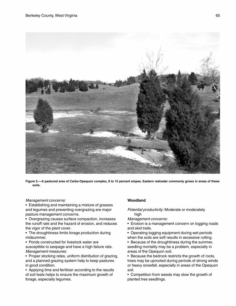
Berkeley County, West Virginia 65
Management concerns:• Establishing and maintaining a mixture of grassesand legumes and preventing overgrazing are majorpasture management concerns.• Overgrazing causes surface compaction, increasesthe runoff rate and the hazard of erosion, and reducesthe vigor of the plant cover.• The droughtiness limits forage production duringmidsummer.• Ponds constructed for livestock water aresusceptible to seepage and have a high failure rate.Management measures:• Proper stocking rates, uniform distribution of grazing,and a planned grazing system help to keep pasturesin good condition.• Applying lime and fertilizer according to the resultsof soil tests helps to ensure the maximum growth offorage, especially legumes.
Woodland
Potential productivity: Moderate or moderatelyhigh
Management concerns:• Erosion is a management concern on logging roadsand skid trails.• Operating logging equipment during wet periodswhen the soils are soft results in excessive rutting.• Because of the droughtiness during the summer,seedling mortality may be a problem, especially inareas of the Opequon soil.• Because the bedrock restricts the growth of roots,trees may be uprooted during periods of strong windsor heavy snowfall, especially in areas of the Opequonsoil.• Competition from weeds may slow the growth ofplanted tree seedlings.
Figure 5.—A pastured area of Carbo-Opequon complex, 8 to 15 percent slopes. Eastern redcedar commonly grows in areas of thesesoils.
66 Soil Survey
Management measures:• The hazard of erosion can be reduced by buildinglogging roads and skid trails on the contour; seedinglogging roads, log landings, and areas that have beencut and filled to perennial grasses and legumes; andinstalling water bars and culverts.• Because of the sticky and plastic subsoil, loggingroads should be graveled and, in some areas, loglandings should be stabilized.• Drought-tolerant species, such as white pine, Scotchpine, Virginia pine, and Norway spruce, should beselected for planting.• Planting should be timed so that seedlings can takefull advantage of spring rains.• Adequately preparing the site helps to control theinitial plant competition in tree plantations, andspraying helps to control subsequent competition.
Community Development
Suitability: Poorly suitedManagement concerns:• The depth to hard, nonrippable limestone bedrock,the high shrink-swell potential, and the slope are themain limitations affecting building site development,local roads and street, and septic tank absorptionfields.• In most areas the bedrock has to be blasted before itcan be excavated.• Low strength is an additional limitation affecting theconstruction of roads. Because these soils are softwhen wet, pavement cracks and buckles under heavyloads.• The slow permeability and the depth to bedrock aresevere limitations on sites for septic tank absorptionfields.• Sinkholes and solution channels in the bedrockincrease the hazard of ground-water pollution bysurface runoff and by seepage from septic tankabsorption fields.• Establishing and maintaining vegetation onroadbanks is difficult on these droughty soils,especially on south aspects.• The hard bedrock may interfere with landscaping inmany areas.• The rock fragments in the surface layer may interferewith the establishment of lawns.• Erosion is a severe hazard on construction sites.Management measures:• Building on the bedrock and landscaping withadditional fill may be preferable to excavating thebedrock.• Buildings should be designed so that they conformto the natural slope of the land. Land shaping isnecessary in some areas.
• Properly designing and strengthening footings andfoundations can help to prevent the structural damagecaused by shrinking and swelling.• Providing a suitable road base that includes theinstallation of properly designed geotextiles helps toprevent the road damage caused by low strength andby shrinking and swelling.• Septic tank absorption fields should not be installedin areas that are near limestone rock outcrop orsinkholes or in areas where excavation exposes thelimestone bedrock.• Selecting deeper areas of the included soils as sitesfor septic tank absorption fields, installing theabsorption fields on the contour, pressurizing orenlarging the absorption fields, or installing alternatingdrainfields can help to overcome the limitations inabsorption areas.• Drought-tolerant species, such as tall fescue andcrownvetch, should be selected for planting onroadbanks. Seeded areas should be mulched withstraw.• Maintaining the plant cover on construction sites,establishing a plant cover in unprotected areas, andproviding for proper disposal of surface runoff help tocontrol erosion and sedimentation.
Interpretive Groups
Land capability classification: IVeWoodland ordination symbol: Carbo—4C; Opequon—
3C
ChC—Carbo-Opequon complex, 3 to15 percent slopes, very rocky
Setting
These soils are on gently sloping or strongly slopingridges and hillsides in the eastern and central parts ofthe Great Valley. Sinkholes are common in someareas. The bedrock is steeply tilted under the soils,and soil depth may vary greatly within short distances.The two soils occur as areas so intermingled on thelandscape that it was impractical to separate them inmapping.
Composition
Carbo soil and similar soils: 50 percentOpequon soil and similar soils: 35 percentDissimilar inclusions: 15 percent
Representative Profile
Carbo
Surface layer:0 to 2 inches—dark yellowish brown silty clay loam
Berkeley County, West Virginia 67
2 to 9 inches—dark yellowish brown silty clay
Subsoil:9 to 18 inches—variegated strong brown and yellowish
brown clay18 to 28 inches—variegated yellowish brown and
strong brown clay28 to 34 inches—variegated dark yellowish brown,
strong brown, and yellowish brown clay
Bedrock:34 inches—hard, bluish gray limestone
Opequon
Surface layer:0 to 7 inches—dark yellowish brown silty clay
Subsoil:7 to 14 inches—variegated yellowish brown and strong
brown clay14 to 17 inches—variegated yellowish brown and dark
yellowish brown clay
Bedrock:17 inches—hard, bluish gray limestone
Soil Properties and Qualities
Carbo
Drainage class: Well drainedPermeability: Slow (0.06 to 0.2 inch per hour)Available water capacity: Low or moderateDepth to the seasonal high water table: More than
6 feetFlooding: NoneShrink-swell potential: HighErosion hazard: SevereStoniness: NoneRockiness: 2 to 10 percent limestone rock outcropNatural fertility: HighReaction: In unlimed areas, moderately acid to slightly
alkaline (pH 5.6 to 7.8)Surface runoff: RapidDepth to bedrock: 20 to 40 inchesBedrock type: Hard, nearly pure Chambersburg and
New Market Limestones
Opequon
Drainage class: Well drainedPermeability: Moderately slow or moderate (0.2 inch to
2.0 inches per hour)Available water capacity: Very low or lowDepth to the seasonal high water table: More than
6 feetFlooding: NoneShrink-swell potential: HighErosion hazard: Severe
Stoniness: NoneRockiness: 2 to 10 percent limestone rock outcropNatural fertility: HighReaction: In unlimed areas, moderately acid to slightly
alkaline (pH 5.6 to 7.8)Surface runoff: RapidDepth to bedrock: 12 to 20 inchesBedrock type: Hard, nearly pure Chambersburg and
New Market Limestones
Minor Components
Dissimilar inclusions:• The very deep Swanpond soils• Severely eroded soils that have a surface layer ofclay• Soils that are less than 12 inches deep over bedrockSimilar soils:• The deep Endcav soils• Soils that have slopes of less than 8 percent or morethan 15 percent• Soils that have a channery or flaggy surface layer
Use and Management
Uses: Most areas of this map unit are wooded. Someareas have been cleared and are used as pasture.
Cropland
Suitability: Not suitedManagement concerns:• The droughtiness of these soils and the limestonerock outcrop make cultivation impractical.
Pasture and Hayland
Suitability: Not suited to hay; limited suitability forpasture
Management concerns:• Establishing and maintaining a mixture of grassesand legumes and preventing overgrazing are majorpasture management concerns.• Because of the limestone rock outcrop, it is difficultin many areas to operate conventional equipmentused in clipping and in applying fertilizer.• Overgrazing causes surface compaction, increasesthe runoff rate and the hazard of erosion, and reducesthe vigor of the plant cover.• If pastures are overgrazed, erosion is a severehazard in areas where the plant cover has beendestroyed.• The droughtiness limits forage production duringmidsummer.• Ponds constructed for livestock water have a highfailure rate.Management measures:• Proper stocking rates, controlled grazing, and
68 Soil Survey
restricted use during dry periods help to keeppastures in good condition.• Applying lime and fertilizer according to the resultsof soil tests helps to ensure the maximum growth offorage, especially legumes.
Woodland
Potential productivity: Moderate or moderately highManagement concerns:• Erosion is a management concern on logging roadsand skid trails.• The rock outcrop and the clayey texture of thesesoils limit the use of vehicular equipment.• Operating logging equipment during wet periodswhen the soils are soft results in excessive rutting.• Because the bedrock restricts the growth of roots,trees may be uprooted during periods of strong windsor heavy snowfall, especially in areas of the Opequonsoil.• The seedling mortality rate is high because of thedroughtiness.• Competition from weeds may slow the growth ofplanted tree seedlings.Management measures:• Building logging roads and skid trails on the contourand seeding the roads and trails when they are nolonger being used help to control erosion.• Because of the sticky and plastic subsoil, loggingroads should be graveled and, in some areas, loglandings should be stabilized.• The rock outcrop and the depth to bedrock shouldbe considered when planning the location of roadsand log landings.• Harvest methods that do not leave the remainingtrees widely spaced reduce the hazard of windthrow.• Drought-tolerant species, such as white pine, Scotchpine, Virginia pine, and Norway spruce, should beselected for planting.• Planting should be timed so that seedlings can takefull advantage of spring rains.
Community Development
Suitability: Poorly suitedManagement concerns:• The hard, nonrippable limestone bedrock interfereswith excavations, including those for roads, septic tankabsorption fields, foundations, and sewer lines.Blasting is necessary in most areas before thebedrock can be excavated.• The slope is a limitation affecting building sitedevelopment in some areas.• The high shrink-swell potential is a limitation on sitesfor buildings if foundations and footers are improperlyconstructed.
• The depth to bedrock, the slow permeability, and, insome areas, the slope are severe limitations affectingthe proper functioning of septic tank absorption fields.• Sinkholes and solution channels in the limestonebedrock increase the hazard of ground-water pollutionby surface runoff and by seepage from septic tankabsorption fields.• The high shrink-swell potential and low strength arelimitations affecting the construction of local roads andstreets. Because these soils are soft when wet,pavement cracks and buckles cracks under heavyloads.• The slope, the droughtiness, and the thin layer oftopsoil make the establishment of lawns difficult onthese soils, especially on south aspects.• Establishing and maintaining vegetation onroadbanks is difficult on these droughty soils,especially on south aspects.• The bedrock may interfere with landscaping.• Erosion can be severe on construction sites.Management measures:• Buildings should be designed so that they conformto the natural slope of the land. Land shaping isnecessary in some areas.• Building on the bedrock and landscaping withadditional fill may be preferable to excavating thebedrock.• Properly designing and strengthening footings andfoundations can help to prevent the structural damagecaused by shrinking and swelling.• Selecting deeper areas of the included soils as sitesfor septic tank absorption fields, installing theabsorption fields on the contour, enlarging orpressurizing the absorption fields, or installingalternating drainfields helps to overcome thelimitations in absorption areas.• Septic tank absorption fields should not be installedin areas that are near limestone rock outcrop orsinkholes or in areas where excavation exposes thelimestone bedrock.• The rock outcrop and the depth to bedrock shouldbe considered when planning the location of roads.• Providing a suitable road base that includes theinstallation of properly designed geotextiles helps toprevent the road damage caused by low strength andby shrinking and swelling.• Drought-tolerant species, such as tall fescue andcrownvetch, should be selected for planting onroadbanks. Seeded areas should be mulched withstraw.• Maintaining the plant cover on construction sites,establishing a plant cover in unprotected areas, andproviding for proper disposal of surface runoff help tocontrol erosion and sedimentation.
Berkeley County, West Virginia 69
Interpretive Groups
Land capability classification: VIsWoodland ordination symbol: Carbo—4C; Opequon—
3C
ChE—Carbo-Opequon complex, 15 to35 percent slopes, very rocky
Setting
These soils are on moderately steep or steepupland limestone hillsides in the eastern and centralparts of the Great Valley. Sinkholes are common insome areas. The bedrock is steeply tilted under thesoils, and soil depth may vary greatly within shortdistances.The two soils occur as areas sointermingled on the landscape that it was impracticalto separate them in mapping.
Composition
Carbo soil and similar soils: 45 percentOpequon soil and similar soils: 40 percentDissimilar inclusions: 15 percent
Representative Profile
Carbo
Surface layer:0 to 1 inch—dark yellowish brown silty clay
loam1 to 5 inches—dark yellowish brown silty
clay
Subsoil:5 to 16 inches—variegated strong brown and
yellowish brown clay16 to 24 inches—variegated yellowish brown and
strong brown clay24 to 30 inches—variegated dark yellowish brown,
strong brown, and yellowish brown clay
Bedrock:30 inches—hard, bluish gray limestone
Opequon
Surface layer:0 to 3 inches—dark yellowish brown silty clay
Subsoil:3 to 12 inches—variegated yellowish brown and strong
brown clay12 to 15 inches—variegated yellowish brown and dark
yellowish brown clay
Bedrock:15 inches—hard, bluish gray limestone
Soil Properties and Qualities
Carbo
Drainage class: Well drainedPermeability: Slow (0.06 to 0.2 inch per hour)Available water capacity: Low or moderateDepth to the seasonal high water table: More than
6 feetFlooding: NoneShrink-swell potential: HighErosion hazard: Very severeStoniness: NoneRockiness: 2 to 10 percent limestone rock outcropNatural fertility: HighReaction: In unlimed areas, moderately acid to slightly
alkaline (pH 5.6 to 7.8)Surface runoff: Very rapidDepth to bedrock: 20 to 40 inchesBedrock type: Hard, nearly pure Chambersburg and
New Market Limestones
Opequon
Drainage class: Well drainedPermeability: Moderately slow or moderate (0.2 inch to
2.0 inches per hour)Available water capacity: Very low or lowDepth to the seasonal high water table: More than
6 feetFlooding: NoneShrink-swell potential: HighErosion hazard: Very severeStoniness: NoneRockiness: 2 to 10 percent limestone rock outcropNatural fertility: HighReaction: In unlimed areas, moderately acid to slightly
alkaline (pH 5.6 to 7.8)Surface runoff: Very rapidDepth to bedrock: 12 to 20 inchesBedrock type: Hard, nearly pure Chambersburg and
New Market Limestones
Minor Components
Dissimilar inclusions:• The very deep Swanpond soils• Severely eroded soils that have a surface layer ofclay• Soils that are less than 12 inches deep overbedrockSimilar soils:• The deep Endcav soils• Soils that have slopes of less than 15 percent ormore than 35 percent• Soils that have a channery or flaggy surfacelayer
70 Soil Survey
Use and Management
Uses: Most areas of this map unit are wooded. A fewsmall areas have been cleared and are used aspasture.
Cropland
Suitability: Not suitedManagement concerns:• The rock outcrop and the slope make cultivationimpractical.
Pasture and Hayland
Suitability: Not suited to hay; difficult to manage forpasture
Management concerns:• Establishing and maintaining a mixture of grassesand legumes and preventing overgrazing are majorpasture management concerns.• Because of the slope and the rock outcrop, it isdifficult to operate conventional equipment used inclipping and in applying fertilizer.• Overgrazing causes surface compaction, increasesthe runoff rate and the hazard of erosion, and reducesthe vigor of the plant cover.• If pastures are overgrazed, erosion is a severehazard in areas where the plant cover has beendestroyed.• The droughtiness limits forage production duringmidsummer.• Ponds constructed for livestock water aresusceptible to seepage and have a high failure rate.Management measures:• Proper stocking rates, controlled grazing, andrestricted use during dry periods help to keeppastures in good condition.• Applying lime and fertilizer according to the resultsof soil tests helps to ensure the maximum growth offorage, especially legumes.
Woodland
Potential productivity: Moderate on south aspects;moderate or moderately high on north aspects
Management concerns:• Erosion is a severe hazard on logging sites.• The slope, the rock outcrop, the clayey texture of thesoils, and a hazard of slippage severely limit the use ofvehicular equipment.• Operating logging equipment during wet periodswhen the soils are soft results in excessive rutting.• Because the bedrock restricts the growth of roots,trees may be uprooted during periods of strong windsor heavy snowfall, especially in areas of the Opequonsoil.
• Because of the droughtiness, seedling mortality maybe a problem, especially on south aspects.• Competition from weeds may slow the growth ofplanted tree seedlings.Management measures:• The hazard of erosion can be reduced by buildinglogging roads and skid trails on the contour; seedinglogging roads, log landings, and areas that have beencut and filled to perennial grasses and legumes; andinstalling water bars and culverts.• The rock outcrop and the depth to bedrock shouldbe considered when planning the location of roadsand log landings.• Because of the sticky and plastic subsoil, loggingroads should be graveled and, in some areas, loglandings should be stabilized.• Harvest methods that do not leave the remainingtrees widely spaced, selective cutting, and strip cuttingreduce the hazard of windthrow.• Drought-tolerant species, such as white pine, Scotchpine, Virginia pine, and Norway spruce, should beselected for planting.• Tree plantations should be on north-facing slopeswhere possible.• Planting should be timed so that seedlings can takefull advantage of spring rains.• Adequately preparing the site helps to control theinitial plant competition in tree plantations, andspraying helps to control subsequent competition.
Community Development
Suitability: Poorly suitedManagement concerns:• The hard, nonrippable limestone bedrock interfereswith excavations, including those for roads, septic tankabsorption fields, foundations, and sewer lines.Blasting is necessary in most areas before thebedrock can be excavated.• Because of the slope, these soils are poorly suitedto building site development unless extensive landshaping is done.• The high shrink-swell potential is a limitation on sitesfor buildings if foundations and footers are improperlyconstructed.• The slope, the depth to bedrock, and the slowpermeability are severe limitations affecting the properfunctioning of septic tank absorption fields.• Sinkholes and solution channels in the bedrockincrease the hazard of ground-water pollution bysurface runoff and by seepage from septic tankabsorption fields.• The high shrink-swell potential, low strength, and ahazard of slippage are limitations affecting the
Berkeley County, West Virginia 71
construction of local roads and streets. Because thesesoils are soft when wet, pavement cracks and bucklesunder heavy loads.• The slope, the droughtiness, and the thin layer oftopsoil make the establishment of lawns difficult onthese soils, especially on south aspects.• Establishing and maintaining vegetation onroadbanks is difficult on these droughty soils,especially on south aspects.• The bedrock may interfere with landscaping.• Erosion is a severe hazard on constructionsites.Management measures:• Buildings should be designed so that they conformto the natural slope of the land.• Building on the bedrock and landscaping withadditional fill may be preferable to excavating thebedrock.• Properly designing and strengthening footings andfoundations can help to prevent the structural damagecaused by shrinking and swelling.• An alternative to a septic tank absorption field or abetter suited soil should be considered for onsitesewage disposal.• Roads should be built on the contour.• The rock outcrop and the depth to bedrock shouldbe considered when planning the location of roads.• Providing a suitable road base that includes theinstallation of properly designed geotextiles helps toprevent the road damage caused by low strength andby shrinking and swelling.• Drought-tolerant species, such as tall fescue andcrownvetch, should be selected for planting onroadbanks. Seeded areas should be mulched withstraw.• Maintaining the plant cover on construction sites,establishing a plant cover in unprotected areas, andproviding for proper disposal of surface runoff help tocontrol erosion and sedimentation.
Interpretive Groups
Land capability classification: VIIsWoodland ordination symbol: Carbo—3R on south
aspects and 4R on north aspects; Opequon—2Ron south aspects and 3R on north aspects
CkB—Clearbrook silt loam, 0 to 8 percentslopes
Setting
This soil is on nearly level or gently sloping,concave head slopes and in broad upland depressionsin the eastern part of the county.
Composition
Clearbrook soil and similar soils: 80 percentDissimilar inclusions: 20 percent
Representative Profile
Surface layer:0 to 9 inches—brown silt loam
Subsoil:9 to 11 inches—light olive brown very channery silty
clay loam that has yellowish brown and brownishgray mottles
11 to 22 inches—gray extremely channery silty clayloam that has yellowish brown mottles
Bedrock:22 inches—soft shale
Soil Properties and Qualities
Drainage class: Somewhat poorly drainedPermeability: Moderately slow (0.2 to 0.6 inch per
hour)Available water capacity: Very low or lowDepth to the seasonal high water table: 0.5 foot to
1.5 feetFlooding: NoneShrink-swell potential: Moderate in the subsoilErosion hazard: ModerateStoniness: NoneRockiness: NoneNatural fertility: LowReaction: In unlimed areas, very strongly acid or
strongly acid (pH 4.5 to 5.5)Surface runoff: MediumDepth to bedrock: 20 to 40 inchesBedrock type: Soft, acid Martinsburg Shale
Minor Components
Dissimilar inclusions:• The very deep Poorhouse soils, which have asubsoil of heavy clay• The well drained Berks soils and the somewhatexcessively drained Weikert soils, which are on thehigher, convex part of the landscape• The poorly drained Atkins soils, which areflooded and are along drainageways and indepressionsSimilar soils:• Soils that are less than 20 inches or more than40 inches deep over bedrock• Soils that have fewer rock fragments in the subsoilthan is typical for the Clearbrook soil• Moderately well drained soils

72 Soil Survey
Use and Management
Uses: Most areas of the Clearbrook soil are used forpasture or hay. A few areas are used for cultivatedcrops or are wooded.
Cropland
Suitability: LimitedManagement concerns:• Erosion is a moderate hazard if cultivated crops aregrown.• The seasonal high water table is near the surfaceduring wet periods. It may restrict the roots of someplants and delay tillage in the spring.• Droughtiness during the growing season and the lownatural fertility are management concerns.Management measures:• Using crop rotations that include grasses and smallgrain, applying a system of conservation tillage,growing cover crops and green manure crops, andapplying good crop residue management help toprevent excessive erosion and to maintain fertility andtilth.• Because of the droughtiness, this soil is better suitedto early maturing small grain than to late maturingcrops, such as corn.• Leaving crop residue on the surface and addingother organic material help to conserve soil moisture.• Minimizing tillage and tilling and harvesting at theproper soil moisture content help to prevent excessivecompaction and maintain tilth.• Applying lime and fertilizer according to the resultsof soil tests helps to ensure maximum crop production.
Pasture and Hayland
Suitability: Suited; better suited to grasses than tolegumes because of the seasonal high water table
Management concerns:• Establishing and maintaining a healthy cover of sodand preventing overgrazing are major pasturemanagement concerns.• Grazing during wet periods causes surfacecompaction and poor tilth and can damage the sod.Management measures:• Proper stocking rates, a planned grazing system,and deferred grazing during wet periods help to keeppastures in good condition.• The hay and pasture species that can withstand thewetness should be selected for planting.• Applying lime and fertilizer according to the resultsof soil tests helps to ensure the maximum growth offorage plants.
Woodland
Potential productivity: Moderately high
Management concerns:• The limited depth to bedrock, the low natural fertility,and the droughtiness result in a high seedling mortalityrate.• Competition from undesirable plants may slow thegrowth of planted tree seedlings.• This soil is soft when wet and will not support heavylogging equipment.• Because the rooting depth is limited by the bedrockand the seasonal high water table, trees are subject towindthrow during wet periods.Management measures:• Drought-tolerant species, such as Virginia pine,white pine, Scotch pine, and Norway spruce, shouldbe selected for planting.• Planting should be timed so that seedlings can takefull advantage of spring rains.• Adequately preparing the site helps to control theinitial plant competition in tree plantations, andspraying helps to control subsequent competition.• Logging should be deferred during wet periods.• Year-round logging roads and log landings requireadditions of roadfill and gravel.• Harvest methods that do not leave the remainingtrees widely spaced, selective cutting, and strip cuttingreduce the hazard of windthrow.
Community Development
Suitability: Poorly suitedManagement concerns:• The wetness is a severe limitation affecting buildingsite development.• The wetness and the depth to bedrock are severelimitations on sites for septic tank absorption fields.• The wetness is a limitation on sites for local roadsand streets. Because this soil is soft when wet,pavement cracks and buckles under heavy loads.• The wetness is a limitation affecting excavation andtrafficability and may delay construction in winter andspring.• Establishing and maintaining lawns is difficult on thisdroughty soil.• The shale bedrock generally is rippable withconventional earthmoving equipment.• Erosion is a moderate hazard on construction sites.Management measures:• An alternative to a septic tank absorption field or abetter suited soil should be considered for onsitesewage disposal. If an alternative system is used, itshould be approved by the health department.• Installing a drainage system around structures thathave basements or crawl spaces helps to overcomethe wetness.• Buildings can be constructed on well compacted fill
Berkeley County, West Virginia 73
material, which raises the site a sufficient distanceabove the water table.• Installing a drainage system and providing a suitableroad base that includes the installation of properlydesigned geotextiles help to prevent the road damagecaused by wetness.• Maintaining the plant cover on construction sites,establishing a plant cover in unprotected areas, andproviding for proper disposal of surface runoff help tocontrol erosion and sedimentation.
Interpretive Groups
Land capability classification: IVwWoodland ordination symbol: 4W
CmB—Clearbrook channery silt loam, 0 to8 percent slopes
Setting
This soil is on nearly level or gently sloping, slightlyconcave head slopes, in broad upland depressions,and on interfluves, mainly in the Great Valley.
Composition
Clearbrook soil and similar soils: 80 percentDissimilar inclusions: 20 percent
Representative Profile
Surface layer:0 to 7 inches—brown channery silt loam
Subsoil:7 to 13 inches—brown very channery silt loam that
has strong brown mottles13 to 22 inches—light brownish gray extremely
channery silty clay loam that has strong brownmottles
Bedrock:22 inches—soft, rippable shale
Soil Properties and Qualities
Drainage class: Somewhat poorly drainedPermeability: Moderately slow (0.2 to 0.6 inch per
hour)Available water capacity: Very low or lowDepth to the seasonal high water table: 0.5 foot to
1.5 feetFlooding: NoneShrink-swell potential: Moderate in the subsoilErosion hazard: ModerateStoniness: NoneRockiness: NoneNatural fertility: Low
Reaction: In unlimed areas, very strongly acid orstrongly acid (pH 4.5 to 5.5)
Surface runoff: MediumDepth to bedrock: 20 to 40 inchesBedrock type: Soft, gray, acid Martinsburg Shale
Minor Components
Dissimilar inclusions:• Poorly drained soils that have a subsoil of heavy clay• The well drained Berks soils and the somewhatexcessively drained Weikert soils, which are on thehigher, slightly convex part of the landscape• The poorly drained Atkins soils, which are floodedand are along drainageways and in depressionsSimilar soils:• Soils that are more than 40 inches deep overbedrock• Soils that have fewer rock fragments in the subsoilthan is typical for the Clearbrook soil• Moderately well drained soils
Use and Management
Uses: Most areas of the Clearbrook soil are used forpasture or hay. A few areas are used for cultivatedcrops, and a few areas are wooded.
Cropland
Suitability: LimitedManagement concerns:• Erosion is a moderate hazard in unprotected areas.• The seasonal high water table is near the surfaceduring wet periods. It may restrict the roots of someplants and delay tillage in the spring.• Droughtiness during the growing season and the lownatural fertility are management concerns.Management measures:• Conservation tillage, winter cover crops, and cropresidue management help to control erosion and tomaintain fertility and tilth.• Leaving crop residue on the surface and addingother organic material help to conserve soil moisture.• Minimizing tillage and tilling and harvesting at theproper soil moisture content help to prevent excessivecompaction and maintain tilth.• Because of the droughtiness, this soil is better suitedto early maturing small grain than to late maturingcrops, such as corn.• Applying lime and fertilizer according to the resultsof soil tests helps to ensure maximum crop production.
Pasture and Hayland
Suitability: Suited; better suited to grasses than tolegumes because of the seasonal high water table
74 Soil Survey
Management concerns:• Establishing and maintaining a healthy cover of sodand preventing overgrazing are major pasturemanagement concerns.• Overgrazing causes surface compaction, increasesthe runoff rate and the hazard of erosion, and reducesthe vigor of the plant cover.• Grazing during wet periods causes surfacecompaction and poor tilth and damages the sod.• The droughtiness limits forage production duringmidsummer.Management measures:• Proper stocking rates, a planned grazing system,and deferred grazing during wet periods help to keeppastures in good condition.• The hay and pasture species that can withstand thewetness should be selected for planting.• Applying lime and fertilizer according to the resultsof soil tests helps to ensure the maximum growth offorage plants.
Woodland
Potential productivity: Moderately highManagement concerns:• The limited depth to bedrock, the low natural fertility,and the droughtiness result in a high seedling mortalityrate.• Competition from weeds may slow the growth ofplanted tree seedlings.• Operating logging equipment during wetperiods when the soil is soft results in excessiverutting.• Because the rooting depth is limited by the bedrockand the seasonal high water table, trees are subject towindthrow during wet periods.Management measures:• Planting nursery stock that is larger than is typical orplanting containerized seedlings reduces the seedlingmortality rate.• Drought-tolerant species, such as Virginia pine,white pine, Scotch pine, and Norway spruce, shouldbe selected for planting.• Planting should be timed so that seedlings can takefull advantage of spring rains.• Adequately preparing the site helps to controlthe initial plant competition in tree plantations,and spraying helps to control subsequentcompetition.• Logging should be deferred during wet periods.• Year-round logging roads and log landings requireadditions of roadfill and gravel.• Harvest methods that do not leave the remainingtrees widely spaced, selective cutting, and strip cuttingreduce the hazard of windthrow.
Community Development
Suitability: Poorly suitedManagement concerns:• The wetness is a severe limitation affecting buildingsite development.• The depth to bedrock and the wetness are severelimitations affecting the proper functioning of septictank absorption fields.• The wetness is a limitation on sites for local roadsand streets. Because this soil is soft when wet,pavement cracks and buckles under heavy loads.• The wetness is a limitation affecting excavation andtrafficability and may delay construction in winter andspring.• The underlying shale bedrock is generally rippablewith conventional earthmoving equipment.• Establishing and maintaining lawns is difficult on thisdroughty soil.• Erosion is a moderate hazard on construction sites.Management measures:• An alternative to a septic tank absorption field or abetter suited soil should be considered for onsitesewage disposal. If an alternative system is used, itshould be approved by the health department.• Installing a drainage system around structures thathave basements or crawl spaces helps to overcomethe wetness.• Buildings can be constructed on well compacted fillmaterial, which raises the site a sufficient distanceabove the water table.• Installing a drainage system and providing a suitableroad base that includes the installation of properlydesigned geotextiles help to prevent the road damagecaused by wetness.• Maintaining the plant cover on construction sites,establishing a plant cover in unprotected areas, andproviding for proper disposal of surface runoff help tocontrol erosion and sedimentation.
Interpretive Groups
Land capability classification: IVwWoodland ordination symbol: 4W
CrB—Clearbrook-Berks channery siltloams, 3 to 8 percent slopes
Setting
These soils are on gently sloping, shallowlydissected shale uplands in the Great Valley. TheClearbrook soil is on the less sloping, smoothridgetops and the slightly convex saddles and headslopes, and the Berks soil is on the more sloping,
Berkeley County, West Virginia 75
slightly convex shoulder slopes and ridgetops. The twosoils occur as areas so intermingled on the landscapethat it was impractical to separate them in mapping.
Composition
Clearbrook soil and similar soils: 45 percentBerks soil and similar soils: 40 percentDissimilar inclusions: 15 percent
Representative Profile
Clearbrook
Surface layer:0 to 8 inches—brown channery silt loam
Subsoil:8 to 19 inches—yellowish brown channery silt loam
that has light gray mottles19 to 24 inches—light brownish gray extremely
channery silty clay loam that has yellowish redmottles
Bedrock:24 inches—soft, gray shale
Berks
Surface layer:0 to 8 inches—brown channery silt loam
Subsoil:8 to 16 inches—light yellowish brown very channery
silt loam16 to 22 inches—yellowish brown very channery silt
loam
Bedrock:22 inches—yellowish brown, fractured shale
Soil Properties and Qualities
Clearbrook
Drainage class: Somewhat poorly drainedPermeability: Moderately slow (0.2 to 0.6 inch per
hour)Available water capacity: Very low or lowDepth to the seasonal high water table: 1.0 to 2.5 feetFlooding: NoneShrink-swell potential: ModerateErosion hazard: ModerateStoniness: NoneRockiness: NoneNatural fertility: LowReaction: In unlimed areas, strongly acid or very
strongly acid (pH 4.5 to 5.5)Surface runoff: MediumDepth to bedrock: 20 to 40 inches
Bedrock type: Fractured and tilted, rippable shale;mainly members of the Martinsburg Formation
Berks
Drainage class: Well drainedPermeability: Moderate or moderately rapid (0.6 inch
to 6.0 inches per hour)Available water capacity: Very low or lowDepth to the seasonal high water table: More than
60 inchesFlooding: NoneShrink-swell potential: LowErosion hazard: ModerateStoniness: NoneRockiness: NoneNatural fertility: LowReaction: In unlimed areas, very strongly acid to
slightly acid (pH 4.5 to 6.5)Surface runoff: MediumDepth to bedrock: 20 to 40 inchesBedrock type: Fractured and tilted, rippable shale;
mainly members of the Martinsburg Formation
Minor Components
Dissimilar inclusions:• Small areas of the shallow, somewhat excessivelydrained Weikert soils• Small areas of the well drained Carbo and Opequonsoils and the moderately well drained Swanpond soils,which are clayey and underlain by limestone bedrockSimilar soils:• Soils that have slopes of less than 3 percent or morethan 8 percent• Soils that are more than 40 inches deep over shalebedrock• Soils that do not have as many shale fragments inthe subsoil as is typical of the Clearbrook and Berkssoils
Use and Management
Uses: Most areas of the unit have been cleared andare used for pasture or hay. Some areas are usedfor cultivated crops, orchards, or woodland or assites for community development.
Cropland
Suitability: SuitedManagement concerns:• Erosion is a moderate hazard in unprotected areas.• Tillage may be delayed in the spring because of theseasonal high water table in the Clearbrook soil.• Droughtiness during the growing season and the lownatural fertility are management concerns.
76 Soil Survey
Management measures:• Conservation tillage, contour farming, winter covercrops, and crop residue management help to controlerosion and to maintain fertility and tilth.• Because of the droughtiness, these soils are bettersuited to early maturing small grain, than to latematuring crops, such as corn.• Leaving crop residue on the surface and addingother organic material help to conserve soilmoisture.• Applying lime and fertilizer according to theresults of soil tests helps to ensure maximum cropproduction.
Pasture and Hayland
Suitability: Suited; better suited to grasses than tolegumes because of the limited rooting depth andthe seasonal high water table in the Clearbrooksoil
Management concerns:• Establishing and maintaining a healthy cover of sodand preventing overgrazing are major pasturemanagement concerns.• Overgrazing causes surface compaction, increasesthe runoff rate and the hazard of erosion, and reducesthe vigor of the plant cover.• Grazing during wet periods causes surfacecompaction and poor tilth and damages thesod.Management measures:• Proper stocking rates, a planned grazing system,and deferred grazing during wet periods help to keeppastures in good condition.• Applying lime and fertilizer according to the resultsof soil tests helps to ensure the maximum growth offorage plants.
Woodland
Potential productivity: Moderately highManagement concerns:• Seedling mortality is a problem because of thedroughtiness during the growing season.• Competition from weeds may slow the growth ofplanted tree seedlings.• The wetness may limit the use of logging equipmentduring the winter and spring in areas of the Clearbrooksoil.Management measures:• Planting nursery stock that is larger than is typical orplanting containerized seedlings reduces the seedlingmortality rate.• Planting should be timed so that seedlings can takefull advantage of spring rains.
• Drought-tolerant species, such as Virginia pine,Scotch pine, white pine, and Norway spruce, shouldbe selected for planting.• Site preparation by mechanical or chemical meansis necessary to control competing vegetation.
Community Development
Suitability: Poorly suitedManagement concerns:• The depth to bedrock in both soils and the seasonalhigh water table in the Clearbrook soil are severelimitations on sites for septic tank absorption fields.Sewage effluent may come to the surface causing foulodors and unhealthy conditions.• The wetness of the Clearbrook soil is a limitationaffecting building site development and construction ofroads. It also is a limitation affecting excavation andtrafficability and may delay construction in the winterand spring.• Establishing and maintaining vegetation onroadbanks is difficult on these droughty soils.• The hazard of erosion is moderate on constructionsites.Management measures:• The included deep soils, which are better suitedto septic tank absorption fields than the Clearbrookand Berks soils, should be selected for development.• When building in areas of the Clearbrook soil,installing wide reinforced footers and footer drains,sealing the foundation walls, and backfilling withporous material help to keep basements dry and toprevent walls and foundations from cracking.• Buildings can be constructed on well compacted fillmaterial, which raises the site a sufficient distanceabove the bedrock and the water table.• Installing a drainage system and providing asuitable road base that includes the installation ofproperly designed geotextiles help to prevent theroad damage caused by the wetness of theClearbrook soil.• Drought-tolerant species, such as tall fescue andcrownvetch, should be selected for planting onroadbanks. Seeded areas should be mulched withstraw.• Maintaining the plant cover on construction sites,establishing a plant cover in unprotected areas, andproviding for proper disposal of surface runoff help tocontrol erosion and sedimentation.
Interpretive Groups
Land capability classification: IIIeWoodland ordination symbol: Clearbrook—4W;
Berks—4F
Berkeley County, West Virginia 77
Cs—Combs fine sandy loam
Setting
This soil is on nearly level flood plains along thePotomac River.
Composition
Combs soil and similar soils: 85 percentDissimilar inclusions: 15 percent
Representative Profile
Surface layer:0 to 10 inches—dark brown fine sandy loam
Subsurface layer:10 to 20 inches—dark brown fine sandy loam
Subsoil:20 to 53 inches—dark yellowish brown fine sandy
loam
Underlying material:53 to 65 inches—brown to dark brown fine sandy
loam
Soil Properties and Qualities
Drainage class: Well drainedPermeability: Moderate or moderately rapid (0.6 inch
to 6.0 inches per hour)Available water capacity: Moderate or highDepth to the seasonal high water table: More than
6 feetFlooding: Occasionally flooded (a 5 to 50 percent
chance of flooding in any year) for brief periodsShrink-swell potential: LowErosion hazard: SlightStoniness: NoneRockiness: NoneNatural fertility: HighReaction: In unlimed areas, moderately acid to neutral
(pH 5.6 to 7.3)Surface runoff: SlowDepth to bedrock: More than 60 inches
Minor Components
Dissimilar inclusions:• The moderately well drained Lindside soils and thepoorly drained Atkins soils, which are in sloughs andhigh water channels• The well drained Huntington soils, which have ahigher content of silt than the Combs soil• Soils that have a subsoil of loamy sand and are onnatural levees• Soils that do not have the thick, dark surface layerthat is typical of the Combs soil
Similar soils:• Soils that have slopes of more than 3 percent• Soils that have a surface layer of loam
Use and Management
Uses: Most areas of the Combs soil are used forcultivated crops or hay. Some are used as pasture.A few small areas are wooded.
Cropland
Suitability: Well suited. This soil is prime farmland.Management concerns:• This soil is suited to cultivated crops, but it must beproperly protected if cultivated crops are grown yearafter year.• An excessive amount of nutrients in manure andfertilizer applications can result in the pollution ofsurface water by nutrients.• The flooding occasionally damages crops or delaysfieldwork.• This soil is subject to streambank erosion in manyareas.Management measures:• Conservation tillage, winter cover crops, and cropresidue management help to maintain soil tilth andfertility and to control erosion.• Designing fertilizer and manure applications to meetcrop nutrient needs, using split fertilizer applications,and applying fertilizer in bands may reduce the risk ofnutrient leaching.• Leaving a border of trees along streams helps toprevent excessive erosion on streambanks.
Pasture and Hayland
Suitability: Well suitedManagement concerns:• Establishing and maintaining a mixture of grassesand legumes and preventing overgrazing are majorpasture management concerns.• Overgrazing causes surface compaction, increasesthe runoff rate and the hazard of erosion, and reducesthe vigor of the plant cover.• Unrestricted access to streams by livestockincreases the hazards of streambank erosion andwater pollution.• The flooding occasionally deposits debris on thegrassland.Management measures:• Proper stocking rates, a planned grazing system,and deferred grazing during wet periods help to keeppastures in good condition.• Streambanks should be fenced. Access to streamsby livestock should be limited to protected crossings.• Applying lime and fertilizer according to the results
78 Soil Survey
of soil tests helps to ensure the maximum growth ofplants, especially legumes.
Woodland
Potential productivity: Moderately highManagement concerns:• Competition from undesirable plants may slow thegrowth of planted tree seedlings.Management measures:• Adequately preparing the site helps to control theinitial plant competition in tree plantations, andspraying helps to control subsequent competition.
Community Development
Suitability: Not suitedManagement concerns:• Because of the flooding, this soil is not suited toseptic tank absorption fields or buildings.• The flooding is a severe limitation affecting localroads and streets.Management measures:• Soils that are better suited to buildings and septictank absorption fields should be selected fordevelopment.• Constructing roads on raised fill material helps toprevent the damage caused by flooding.
Interpretive Groups
Land capability classification: IIwWoodland ordination symbol: 5A
DaC—Dekalb channery loam, 8 to15 percent slopes
Setting
This soil is on strongly sloping, convex ridgetops inthe western part of the county.
Composition
Dekalb soil and similar soils: 90 percentDissimilar inclusions: 10 percent
Representative Profile
Surface layer:0 to 2 inches—very dark grayish brown channery loam
Subsurface layer:2 to 4 inches—brown channery loam
Subsoil:4 to 10 inches—yellowish brown very channery loam10 to 22 inches—yellowish brown very channery loam
Bedrock:22 inches—fractured, fine grained sandstone
Soil Properties and Qualities
Drainage class: Somewhat excessively drainedPermeability: Rapid (6.0 to 20 inches per hour)Available water capacity: Very lowDepth to the seasonal high water table: More than
6 feetFlooding: NoneShrink-swell potential: LowErosion hazard: SevereStoniness: NoneRockiness: NoneNatural fertility: LowReaction: In unlimed areas, extremely acid to strongly
acid (pH 3.5 to 5.5)Surface runoff: RapidDepth to bedrock: 20 to 40 inchesBedrock type: Hard sandstone
Minor Components
Dissimilar inclusions:• Moderately well drained soils, which are in slightdepressions and on head slopesSimilar soils:• The well drained Berks soils• Stony soils• Soils that have slopes ranging from 15 to 25 percentor from 3 to 8 percent• Soils that have fewer rock fragments in the subsoilthan is typical for the Dekalb soil• Soils that are more than 40 inches deep overbedrock
Use and Management
Uses: Most areas of the Dekalb soil are wooded. A fewsmall areas have been cleared and are used aspasture. A few areas have been developed ashomesites.
Cropland
Suitability: SuitedManagement concerns:• Erosion is a severe hazard in unprotected areas.• This soil is commonly droughty during the growingseason.• The low natural fertility is a limitation in areas of thissoil.Management measures:• Conservation tillage, contour farming, winter covercrops, and crop residue management help to controlerosion and to maintain fertility and tilth.• Because of the droughtiness, this soil is better suitedto early maturing small grain than to late maturingcrops, such as corn.• Leaving crop residue on the surface and adding
Berkeley County, West Virginia 79
other organic material help to conserve soil moisture.• Applying lime and fertilizer according to the resultsof soil tests helps to ensure the maximum growth ofcrops.
Pasture and Hayland
Suitability: SuitedManagement concerns:• Establishing and maintaining a mixture of grassesand legumes and preventing overgrazing are majorpasture management concerns.• Overgrazing causes surface compaction, increasesthe runoff rate and the hazard of erosion, and reducesthe vigor of the plant cover.• If pastures are overgrazed, erosion is a severehazard in areas where the plant cover has beendestroyed.• The droughtiness limits forage production duringmidsummer.• Water for livestock is scarce, and ponds constructedfor livestock water are susceptible to seepage.Management measures:• Proper stocking rates, uniform distribution of grazing,and a planned grazing system help to keep pasturesin good condition.• Applying lime and fertilizer according to the resultsof soil tests helps to ensure the maximum growth ofplants, especially legumes.
Woodland
Potential productivity: ModerateManagement concerns:• Erosion is a management concern on logging roadsand skid trails.• The low natural fertility and the droughtiness resultin a high seedling mortality rate.• Because the bedrock restricts the growth of roots,trees may be uprooted during periods of strong windsor heavy snowfall.Management measures:• Building logging roads and skid trails on the contourand seeding the roads and trails when they are nolonger being used help to control erosion.• Planting should be timed so that seedlings can takefull advantage of spring rains.• Drought-tolerant species, such as white pine, Scotchpine, and Norway spruce, should be selected forplanting.• Planting nursery stock that is larger than is typical orplanting containerized seedlings reduces the seedlingmortality rate.
Community Development
Suitability: Poorly suited
Management concerns:• Erosion is a severe hazard on construction sites.• The hard bedrock may interfere with excavations forroads and foundations. In many areas the bedrock istoo hard to be excavated with conventional equipment.• The slope is a moderate limitation affecting buildingsite development.• The depth to bedrock is a severe limitation on sitesfor septic tank absorption fields.• Establishing and maintaining vegetation onroadbanks is difficult on this droughty soil, especiallyon south aspects.• The rock fragments in the surface layer may interferewith the establishment of lawns and with landscaping.Management measures:• Maintaining the plant cover on construction sites,establishing a plant cover in unprotected areas, andproviding for proper disposal of surface runoff help tocontrol erosion and sedimentation.• Buildings should be designed so that they conformto the natural slope of the land. Land shaping isnecessary in some areas.• Building on the bedrock and landscaping withadditional fill can help to overcome the depth tobedrock.• Selecting the deepest areas of this soil as sites forseptic tank absorption fields, installing the absorptionfields on the contour, and enlarging the absorptionfields can help to overcome the depth to bedrock.• Drought-tolerant species, such as tall fescue andcrownvetch, should be selected for planting onroadbanks.
Interpretive Groups
Land capability classification: IIIeWoodland ordination symbol: 3F
DaD—Dekalb channery loam, 15 to25 percent slopes
Setting
This soil is on moderately steep, convex shoulderslopes and hillsides in the western part of the county.
Composition
Dekalb soil and similar soils: 85 percentDissimilar inclusions: 15 percent
Representative Profile
Surface layer:0 to 2 inches—very dark grayish brown channery loam
Subsurface layer:2 to 4 inches—brown channery loam
80 Soil Survey
Subsoil:4 to 10 inches—yellowish brown very channery loam10 to 22 inches—yellowish brown very channery loam
Bedrock:22 inches—fractured, fine grained sandstone
Soil Properties and Qualities
Drainage class: Somewhat excessively drainedPermeability: Rapid (6.0 to 20 inches per hour)Available water capacity: Very lowDepth to the seasonal high water table: More than
6 feetFlooding: NoneShrink-swell potential: LowErosion hazard: SevereStoniness: NoneRockiness: NoneNatural fertility: LowReaction: In unlimed areas, extremely acid to strongly
acid (pH 3.5 to 5.5)Surface runoff: RapidDepth to bedrock: 20 to 40 inchesBedrock type: Hard sandstone
Minor Components
Dissimilar inclusions:• The moderately well drained Buchanan soils, whichare on footslopes• The very deep Hazleton soilsSimilar soils:• The well drained Berks soils• Soils that have slopes ranging from 25 to 35 percentor from 8 to 15 percent• Soils that have fewer rock fragments in the subsoilthan is typical for the Dekalb soil• Stony soils
Use and Management
Uses: Most areas of the Dekalb soil are wooded. A fewsmall areas have been cleared and are used forpasture or orchards. A few areas have beendeveloped as homesites.
Cropland
Suitability: Poorly suited; better suited to hay andpasture because of the hazard of erosion
Management concerns:• Erosion is a severe hazard in unprotected areas.• This soil commonly is droughty during the growingseason.• The low natural fertility is a limitation in areas of thissoil.Management measures:• Conservation tillage, contour farming, winter cover
crops, and crop residue management help to controlerosion and to maintain fertility and tilth.• Because of the droughtiness, this soil is better suitedto early maturing small grain than to late maturingcrops, such as corn.• Leaving crop residue on the surface and addingother organic material help to conserve soil moisture.• Applying lime and fertilizer according to the resultsof soil tests helps to ensure the maximum growth ofcrops.
Pasture and Hayland
Suitability: SuitedManagement concerns:• Establishing and maintaining a mixture of grassesand legumes and preventing overgrazing are majorpasture management concerns.• Overgrazing causes surface compaction, increasesthe runoff rate and the hazard of erosion, and reducesthe vigor of the plant cover.• If pastures are overgrazed, erosion is a severehazard in areas where the plant cover has beendestroyed.• The droughtiness limits forage production duringmidsummer.• Water for livestock is scarce, and pondsconstructed for livestock water are susceptible toseepage.Management measures:• Proper stocking rates, uniform distribution of grazing,and a planned grazing system help to keep pasturesin good condition.• Applying lime and fertilizer according to the resultsof soil tests helps to ensure the maximum growth ofplants, especially legumes.
Woodland
Potential productivity: ModerateManagement concerns:• Erosion is a management concern on logging roadsand skid trails.• The low natural fertility and the droughtiness resultin a high seedling mortality rate, especially on southaspects.• Because the bedrock restricts the growth of roots,trees may be uprooted during periods of strong windsor heavy snowfall.Management measures:• Building logging roads and skid trails on thecontour and seeding the roads and trails whenthey are no longer being used help to controlerosion.• Planting should be timed so that seedlings can takefull advantage of spring rains.
Berkeley County, West Virginia 81
• Drought-tolerant species, such as white pine, Scotchpine, and Norway spruce, should be selected forplanting.• Planting nursery stock that is larger than is typical orplanting containerized seedlings reduces the seedlingmortality rate.
Community Development
Suitability: Poorly suitedManagement concerns:• Erosion is a severe hazard on constructionsites.• The hard bedrock may interfere with excavations forroads and foundations. In many areas it is too hard tobe excavated with conventional equipment.• The slope is a severe limitation affecting building sitedevelopment.• The depth to bedrock and the slope are severelimitations on sites for septic tank absorptionfields.• Establishing and maintaining vegetation onroadbanks is difficult on this droughty soil, especiallyon south aspects.• The rock fragments in the surface layer mayinterfere with the establishment of lawns and withlandscaping.• The droughtiness and the slope make it difficult tomaintain lawns.Management measures:• Maintaining the plant cover on construction sites,establishing a plant cover in unprotected areas, andproviding for proper disposal of surface runoff help tocontrol erosion and sedimentation.• Buildings should be designed so that they conformto the natural slope of the land. Extensive land shapingis necessary in most areas.• Building on the bedrock and landscaping withadditional fill can help to overcome the depth tobedrock.• Selecting areas where the soil is deeper and lesssloping, installing absorption fields on the contour, andenlarging absorption fields can help to overcome thedepth to bedrock and the slope on sites for septic tankabsorption fields.• Drought-tolerant species, such as tall fescue andcrownvetch, should be selected for planting onroadbanks.
Interpretive Groups
Land capability classification: IVeWoodland ordination symbol: 2R on south aspects; 3R
on north aspects
DaE—Dekalb channery loam, 25 to35 percent slopes
Setting
This soil is on steep, convex shoulder slopes andhillsides in the western part of the county.
Composition
Dekalb soil and similar soils: 80 percentDissimilar inclusions: 20 percent
Representative Profile
Surface layer:0 to 2 inches—very dark grayish brown channery loam
Subsurface layer:2 to 4 inches—brown channery loam
Subsoil:4 to 10 inches—yellowish brown very channery loam10 to 22 inches—yellowish brown very channery loam
Bedrock:22 inches—fractured, fine grained sandstone
Soil Properties and Qualities
Drainage class: Somewhat excessively drainedPermeability: Rapid (6.0 to 20 inches per hour)Available water capacity: Very lowDepth to the seasonal high water table: More than
6 feetFlooding: NoneShrink-swell potential: LowErosion hazard: Very severeStoniness: NoneRockiness: NoneNatural fertility: LowReaction: In unlimed areas, extremely acid to strongly
acid (pH 3.5 to 5.5)Surface runoff: RapidDepth to bedrock: 20 to 40 inchesBedrock type: Hard sandstone
Minor Components
Dissimilar inclusions:• The moderately well drained Buchanan soils, whichare on footslopes• The very deep Hazleton soils• Extremely stony soils• Areas of rock outcropSimilar soils:• The well drained Berks soils• Soils that have slopes ranging from 15 to 25 percent

82 Soil Survey
• Soils on slopes of more than 35 percent• Stony soils• Soils that have fewer rock fragments in the subsoilthan is typical for the Dekalb soil
Use and Management
Uses: All areas of the Dekalb soil are wooded.
Cropland
Suitability: Not suitedManagement concerns:• This soil is unsuited to conventional row cropsbecause of the steep slope, the severe hazard oferosion, droughtiness, and the low natural fertility.
Pasture and Hayland
Suitability: Not suited to hay; suited to pastureManagement concerns:• Establishing and maintaining a mixture of grassesand legumes and preventing overgrazing are majorpasture management concerns.• Overgrazing causes surface compaction, increasesthe runoff rate and the hazard of erosion, and reducesthe vigor of the plant cover.• If pastures are overgrazed, erosion is a very severehazard in areas where the plant cover has beendestroyed.• The droughtiness limits forage production duringmidsummer.• Water for livestock is scarce in areas of this soil.Management measures:• Proper stocking rates, uniform distribution of grazing,and a planned grazing system help to keep pasturesin good condition.• Applying lime and fertilizer according to the resultsof soil tests helps to ensure the maximum growth ofplants, especially legumes.
Woodland
Potential productivity: ModerateManagement concerns:• Erosion is a management concern on logging roadsand skid trails.• The low natural fertility and the droughtiness resultin a high seedling mortality rate, especially on southaspects.• Because the bedrock restricts the growth of roots,trees may be uprooted during periods of strong windsor heavy snowfall.Management measures:• Building logging roads and skid trails on the contourand seeding the roads and trails when they are nolonger being used help to control erosion.
• Planting should be timed so that seedlings can takefull advantage of spring rains.• Drought-tolerant species, such as Virginia pine,white pine, Scotch pine, and Norway spruce, shouldbe selected for planting.• Planting nursery stock that is larger than is typical orplanting containerized seedlings reduces the seedlingmortality rate.
Community Development
Suitability: Poorly suitedManagement concerns:• Erosion is a very severe hazard on constructionsites.• The hard sandstone bedrock may interfere withexcavations for roads and foundations. In many areasit is too hard to be excavated with conventionalequipment.• The slope is a severe limitation affecting building sitedevelopment.• Because of the slope and the depth to bedrock, thissoil is generally unsuited to septic tank absorptionfields.• Establishing and maintaining vegetation onroadbanks is difficult on this droughty soil, especiallyon south aspects.• The rock fragments in the surface layer mayinterfere with the establishment of lawns and withlandscaping.• The droughtiness and the slope make it difficult tomaintain lawns.Management measures:• Maintaining the plant cover on construction sites,establishing a plant cover in unprotected areas, andproviding for proper disposal of surface runoff help tocontrol erosion and sedimentation.• Buildings should be designed so that they conformto the natural slope of the land. Extensive land shapingis necessary in most areas.• Building on the bedrock and landscaping withadditional fill can help to overcome the depth tobedrock.• An alternative to a septic tank absorption field or abetter suited soil should be considered for onsitesewage disposal.• Drought-tolerant species, such as tall fescue andcrownvetch, should be selected for planting onroadbanks.
Interpretive Groups
Land capability classification: VIeWoodland ordination symbol: 2R on south aspects; 3R
on north aspects
Berkeley County, West Virginia 83
DkC—Dekalb channery sandy loam, 3 to15 percent slopes, extremely stony
Setting
This soil is on gently sloping or strongly sloping,convex ridgetops, mainly on Third Hill and SleepyCreek Mountains.
Composition
Dekalb soil and similar soils: 85 percentDissimilar inclusions: 15 percent
Representative Profile
Surface layer:0 to 1 inch—organic duff from hardwood leaf litter1 to 4 inches—very dark brown channery sandy loam
Subsurface layer:4 to 6 inches—grayish brown very channery loamy
sand
Subsoil:6 to 15 inches—yellowish brown very channery sandy
loam15 to 24 inches—yellowish brown extremely flaggy
sandy loam
Bedrock:24 inches—fractured, gray sandstone
Soil Properties and Qualities
Drainage class: Somewhat excessively drainedPermeability: Rapid (6.0 to 20 inches per hour)Available water capacity: Very low or lowDepth to the seasonal high water table: More than
6 feetFlooding: NoneShrink-swell potential: LowErosion hazard: Moderate or severeStoniness: 3 to 15 percent of the surface covered with
stonesRockiness: NoneNatural fertility: LowReaction: In unlimed areas, extremely acid to strongly
acid (pH 3.5 to 5.5)Surface runoff: Medium or rapidDepth to bedrock: 20 to 40 inchesBedrock type: Mainly acid sandstone; interbedded with
shale and siltstone in some areas
Minor Components
Dissimilar inclusions:• Moderately well drained soils, which are in shallowdepressions• Small areas of the very deep Hazleton soils
• The moderately well drained Buchanan soils, whichare on concave head slopes• Small areas of sandstone rock outcrop• Very rubbly soils that have more than 50 percent oftheir surface covered with stonesSimilar soils:• Soils that are 10 to 20 inches deep over bedrock• Soils that have slopes ranging from 15 to 25 percent• Soils that have slopes of less than 3 percent• Rubbly soils that have 15 to 50 percent of theirsurface covered with stones• Soils that have less than 3 percent of their surfacecovered with stones
Use and Management
Uses: Most areas of the Dekalb soil are wooded.
Cropland
Suitability: Not suitedManagement concerns:• The stones at or near the surface of the soil maketilling, planting, and harvesting with conventional farmequipment impractical.
Pasture and Hayland
Suitability: Not suited to hay; limited suitability forpasture
Management concerns:• Establishing and maintaining a mixture of grassesand legumes and preventing overgrazing are majorpasture management concerns.• Overgrazing causes surface compaction andincreases the runoff rate and the hazard of erosion.• Because of the stones on the surface of the soil, it isdifficult to operate conventional equipment used inclipping and in applying fertilizer.• Droughtiness limits forage production duringmidsummer.• Water for livestock is scarce, and ponds constructedfor livestock water are susceptible to seepage.Management measures:• Proper stocking rates, uniform distribution of grazing,and a planned grazing system help to keep pasturesin good condition.• Applying lime and fertilizer according to the resultsof soil tests helps to ensure the maximum growth offorage, especially legumes.
Woodland
Potential productivity: ModerateManagement concerns:• The large stones on the surface of the soil canhinder harvesting operations and damage equipment.• The limited depth to bedrock, the low natural fertility,
84 Soil Survey
and the droughtiness result in a high seedling mortalityrate.• The stones on the surface and other rock fragmentsinterfere with the planting of seedlings.• Because the bedrock restricts the growth of roots,trees may be uprooted during periods of strong windsor heavy snowfall.Management measures:• Planting nursery stock that is larger than is typical orplanting containerized seedlings reduces the seedlingmortality rate.• Planting should be timed so that seedlings can takefull advantage of spring rains.• Drought-tolerant species, such as Virginia pine,white pine, Scotch pine, and Norway spruce, shouldbe selected for planting.
Community Development
Suitability: Poorly suitedManagement concerns:• The depth to bedrock is the main limitation affectingbuilding site development, septic tank absorptionfields, excavations, and local roads and streets. Inmost areas the bedrock is too hard to be excavatedwith conventional earthmoving equipment.• The large stones may interfere with the operation ofconstruction equipment.• Establishing and maintaining vegetation onroadbanks is difficult on this droughty soil, especiallyon south aspects.• The large stones on the surface of the soil mayinterfere with the establishment of lawns and withlandscaping.• The hazard of erosion is moderate or severe onconstruction sites.Management measures:• Building on the bedrock and landscaping withadditional fill may be preferable to excavating thebedrock.• Selecting the deepest areas of this soil as sites forseptic tank absorption fields, installing the absorptionfields on the contour, and enlarging the absorptionfields can help to overcome the depth to bedrock.• Drought-tolerant species, such as tall fescue andcrownvetch, should be selected for planting onroadbanks.• Maintaining the plant cover on construction sites,establishing a plant cover in unprotected areas, andproviding for proper disposal of surface runoff help tocontrol erosion and sedimentation.
Interpretive Groups
Land capability classification: VIIsWoodland ordination symbol: 3X
DrE—Dekalb-Rock outcrop complex, 15 to25 percent slopes, rubbly
Setting
This map unit is on narrow ridges (hogbacks ofsandstone rock outcrop) on North, Third Hill, andSleepy Creek Mountains. The Dekalb soil and theRock outcrop occur as areas so intermingled on thelandscape that it was impractical to separate them inmapping.
Composition
Dekalb soil and similar soils: 70 percentRock outcrop: 15 percentDissimilar inclusions: 15 percent
Representative Profile
Dekalb
Surface layer:0 to 1 inch—organic duff from hardwood leaf litter1 to 3 inches—very dark gray channery sandy loam
Subsurface layer:3 to 6 inches—brown very channery sandy loam
Subsoil:6 to 24 inches—brownish yellow very channery sandy
loam
Underlying material:24 to 34 inches—yellowish brown extremely flaggy
sandy loam
Bedrock:34 inches—fractured, gray sandstone
Rock outcrop
The Rock outcrop occurs as exposed areas ofsandstone bedrock. In some areas it forms nearlyvertical cliffs.
Soil Properties and Qualities
Dekalb
Drainage class: Somewhat excessively drainedPermeability: Rapid (6.0 to 20 inches per hour)Available water capacity: Very low or lowDepth to the seasonal high water table: More than
6 feetFlooding: NoneShrink-swell potential: LowErosion hazard: Severe or very severeStoniness: 15 to 50 percent of the surface covered
with rocks and bouldersNatural fertility: Low
Berkeley County, West Virginia 85
Reaction: In unlimed areas, extremely acid to stronglyacid (pH 3.5 to 5.5)
Surface runoff: Rapid or very rapidDepth to bedrock: 20 to 40 inchesBedrock type: Mainly acid sandstone; interbedded with
shale and siltstone in some areas
Minor Components
Dissimilar inclusions:• The very deep Hazleton soilsSimilar soils:• The well drained Berks soils• Shallow soils that are less than 20 inches deep overbedrock• Soils that are on slopes ranging from 8 to 15 percent• Soils that have slopes of more than 35 percent• Soils that have 3 to 15 percent of their surfacecovered with stones
Use and Management
Uses: All areas of this map unit are wooded.
Cropland
Suitability: Not suitedManagement concerns:• The slope and the stones, boulders, and rockoutcrop prevent the operation of conventional farmequipment.
Pasture and Hayland
Suitability: Not suitedManagement concerns:• The slope and the stones, boulders, and rockoutcrop prevent the operation of conventional farmequipment.
Woodland
Potential productivity: ModerateManagement concerns:• Erosion is a management concern on logging roadsand skid trails.• The stones and boulders on the surface of the soilcan hinder harvesting operations and damageequipment.• Short escarpments in this map unit may interferewith the use of harvesting equipment.• Because the bedrock restricts the growth of roots,trees may be uprooted during periods of strong windsor heavy snowfall.• The trees produced in areas of this map unitgenerally are of low commercial value.Management measures:• The hazard of erosion can be reduced by buildinglogging roads and skid trails on the contour; seeding
logging roads, log landings, and areas that have beencut and filled to perennial grasses and legumes; andinstalling water bars and culverts.• The rock outcrop should be considered whenplanning the location of roads and log landings.• Planting should be timed so that seedlings can takefull advantage of spring rains.• Drought-tolerant species, such as Virginia pine,white pine, Scotch pine, and Norway spruce, shouldbe selected for planting.• Tree plantations should be on north-facing slopeswhere possible.
Community Development
Suitability: Not suitedManagement concerns:• The moderately steep or steep slope, the commonareas of sandstone rock outcrop, and the depth tobedrock are the main limitations affecting building sitedevelopment, septic tank absorption fields, and localroads and streets. A better suited soil should beselected for development.
Interpretive Groups
Land capability classification: Dekalb—VIIsWoodland ordination symbol: Dekalb—2R
DsB—Downsville gravelly loam, 3 to8 percent slopes
Setting
This soil is on gently sloping, convex, slightlydissected, old river terraces high above the PotomacRiver. Sinkholes occur in some areas that areunderlain by limestone.
Composition
Downsville soil and similar soils: 85 percentDissimilar inclusions: 15 percent
Representative Profile
Surface layer:0 to 10 inches—dark yellowish brown gravelly loam
Subsoil:10 to 18 inches—yellowish brown gravelly loam18 to 30 inches—strong brown very gravelly loam30 to 41 inches—yellowish red very gravelly clay loam41 to 99 inches—red very gravelly sandy clay loam
Soil Properties and Qualities
Drainage class: Well drainedPermeability: Moderate (0.6 inch to 2.0 inches per
hour)
86 Soil Survey
Available water capacity: Moderate or highDepth to the seasonal high water table: More than
6 feetFlooding: NoneShrink-swell potential: LowErosion hazard: ModerateStoniness: NoneRockiness: NoneNatural fertility: LowReaction: In unlimed areas, very strongly acid or
strongly acid (pH 4.5 to 5.5)Surface runoff: MediumDepth to bedrock: More than 60 inches
Minor Components
Dissimilar inclusions:• Small areas of the moderately well drainedMonongahela soils• Small areas of the moderately deep Berks soils• Small areas of the well drained Hagerstown soils• A few small areas of limestone rock outcrop andshallow sinkholes• Severely eroded soilsSimilar soils:• Soils that have a very gravelly or very cobbly surfacelayer• Small areas of the well drained Murrill soils• Soils that have slopes of less than 3 percent or morethan 8 percent
Use and Management
Uses: Most areas of the Downsville soil have beencleared. Many areas are used as sites forcommunity development. Some areas are used forcrops, hay, or pasture.
Cropland
Suitability: Suited. This soil is prime farmland.Management concerns:• Erosion is a moderate hazard in unprotectedareas.• Sinkholes and solution channels in the areasunderlain by limestone bedrock increase the hazard ofground-water pollution caused by applications ofpesticides, fertilizers, and manure; runoff from feedlots;and seepage from manure pits.• In many areas gravel and cobbles in the surfacelayer interfere with the use of tillage, planting, andsome harvesting equipment (fig. 6).Management measures:• Conservation tillage, contour farming, covercrops, a cropping sequence that includes grassesand legumes, and good crop residue management
help to control erosion and to maintain fertility andtilth.• Maintaining sod filter strips aroundsinkholes reduces the hazard of ground-waterpollution.• Timing fertilizer applications to meet crop nutrientneeds, using split fertilizer applications, and applyingfertilizer in bands may reduce the risk of nutrientleaching.• Manure should be stored in a properly designedstorage facility.
Pasture and Hayland
Suitability: SuitedManagement concerns:• Establishing and maintaining a mixture of grassesand legumes and preventing overgrazing are majorpasture management concerns.• Overgrazing causes surface compaction, increasesthe runoff rate and the hazard of erosion, and reducesthe vigor of the plant cover.• If pastures are overgrazed, erosion is a moderatehazard in areas where the plant cover has beendestroyed.Management measures:• Proper stocking rates, uniform distribution of grazing,and a planned grazing system help to keep pasturesin good condition.• Applying lime and fertilizer according to the resultsof soil tests helps to ensure the maximum growth ofplants, especially legumes.
Woodland
Potential productivity: Moderately highManagement concerns:• Competition from weeds may slow the growth ofplanted tree seedlings.• Erosion is a management concern on logging roadsand skid trails.Management measures:• Adequately preparing the site helps to control theinitial plant competition in tree plantations, andspraying helps to control subsequent competition.• Building logging roads and skid trails on the contourand seeding the roads and trails when they are nolonger being used help to control erosion.
Community Development
Suitability: Well suitedManagement concerns:• Sinkholes and solution channels in the areasunderlain by limestone bedrock increase the hazard of
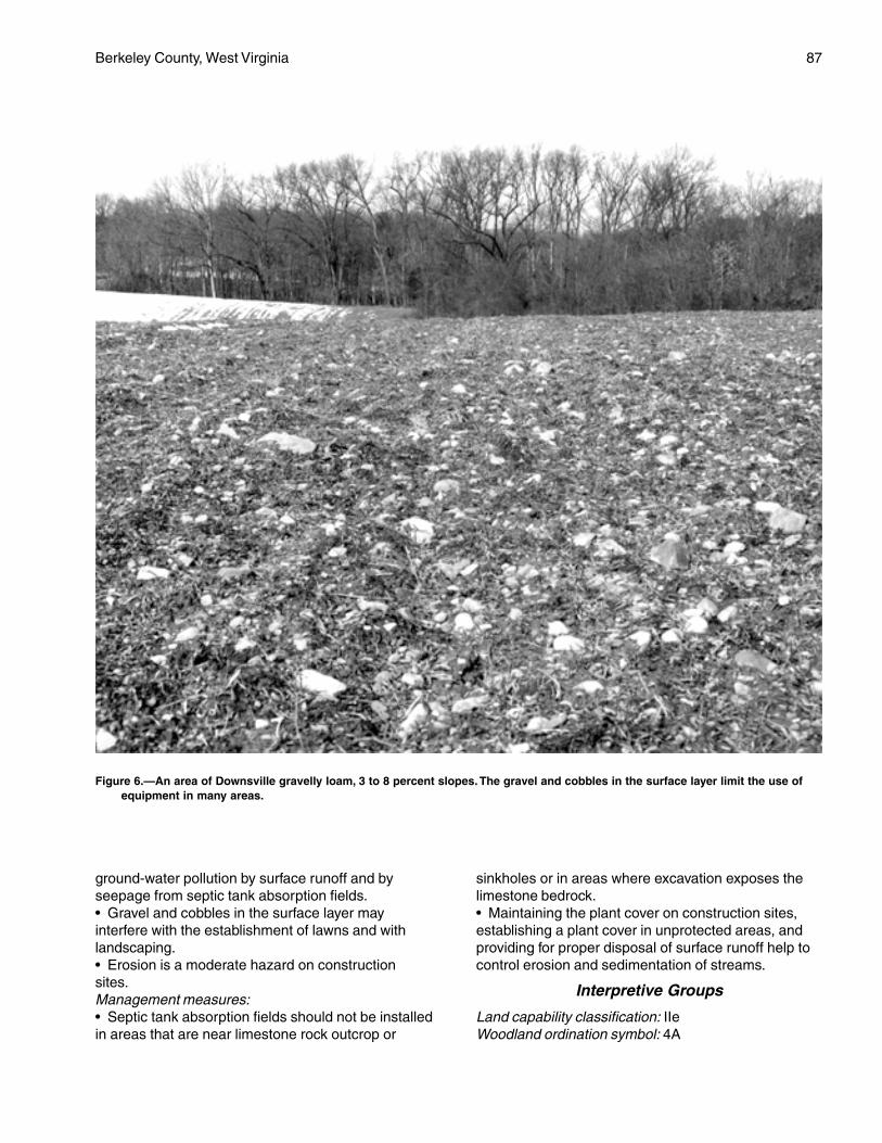
Berkeley County, West Virginia 87
ground-water pollution by surface runoff and byseepage from septic tank absorption fields.• Gravel and cobbles in the surface layer mayinterfere with the establishment of lawns and withlandscaping.• Erosion is a moderate hazard on constructionsites.Management measures:• Septic tank absorption fields should not be installedin areas that are near limestone rock outcrop or
sinkholes or in areas where excavation exposes thelimestone bedrock.• Maintaining the plant cover on construction sites,establishing a plant cover in unprotected areas, andproviding for proper disposal of surface runoff help tocontrol erosion and sedimentation of streams.
Interpretive Groups
Land capability classification: IIeWoodland ordination symbol: 4A
Figure 6.—An area of Downsville gravelly loam, 3 to 8 percent slopes. The gravel and cobbles in the surface layer limit the use ofequipment in many areas.
88 Soil Survey
DsC—Downsville gravelly loam, 8 to15 percent slopes
Setting
This soil is on strongly sloping, convex, slightlydissected, old river terraces high above the PotomacRiver. Sinkholes occur in some areas that areunderlain by limestone.
Composition
Downsville soil and similar soils: 85 percentDissimilar inclusions: 15 percent
Representative Profile
Surface layer:0 to 5 inches—dark yellowish brown gravelly loam
Subsoil:5 to 13 inches—yellowish brown gravelly loam13 to 25 inches—strong brown very gravelly loam25 to 36 inches—yellowish red very gravelly clay loam36 to 99 inches—red very gravelly sandy clay loam
Soil Properties and Qualities
Drainage class: Well drainedPermeability: Moderate (0.6 inch to 2.0 inches per
hour)Available water capacity: Moderate or highDepth to the seasonal high water table: More than
6 feetFlooding: NoneShrink-swell potential: LowErosion hazard: SevereStoniness: NoneRockiness: NoneNatural fertility: LowReaction: In unlimed areas, very strongly acid or
strongly acid (pH 4.5 to 5.5)Surface runoff: RapidDepth to bedrock: More than 60 inches
Minor Components
Dissimilar inclusions:• Small areas of the moderately well drainedMonongahela soils• Small areas of the moderately deep Berks soils• Small areas of the well drained Hagerstown soils• A few small areas of limestone rock outcrop andshallow sinkholes• Severely eroded soilsSimilar soils:• Small areas of the well drained Murrill soils• Soils that have a very gravelly or very cobbly surfacelayer
• Soils that have slopes of less than 8 percent or morethan 15 percent
Use and Management
Uses: Most areas of the Downsville soil are wooded.Many areas are used as sites for communitydevelopment. Some areas have been cleared andare used for crops, hay, pasture, or orchards.
Cropland
Suitability: LimitedManagement concerns:• Erosion is a severe hazard in unprotected areas.• Sinkholes and solution channels in the areasunderlain by limestone bedrock increase the hazard ofground-water pollution caused by applications ofpesticides, fertilizers, and manure; runoff from feedlots;and seepage from manure pits.• In many areas pebbles and cobbles in the surfacelayer interfere with the use of tilling and plantingequipment and some kinds of harvesting equipment.Management measures:• Conservation tillage, contour farming, cover crops, acropping sequence that includes grasses andlegumes, and good crop residue management help tocontrol erosion and to maintain fertility and tilth.• Maintaining sod filter strips around sinkholesreduces the hazard of ground-water pollution.• Timing fertilizer applications to meet crop nutrientneeds, using split fertilizer applications, and applyingfertilizer in bands may reduce the risk of nutrientleaching.• Manure should be stored in a properly designedstorage facility.
Pasture and Hayland
Suitability: SuitedManagement concerns:• Establishing and maintaining a mixture of grassesand legumes and preventing overgrazing are majorpasture management concerns.• Overgrazing causes surface compaction, increasesthe runoff rate and the hazard of erosion, and reducesthe vigor of the plant cover.• If pastures are overgrazed, erosion is a severehazard in areas where the plant cover has beendestroyed.Management measures:• Proper stocking rates, uniform distribution of grazing,and a planned grazing system help to keep pasturesin good condition.• Applying lime and fertilizer according to the resultsof soil tests helps to ensure the maximum growth ofplants, especially legumes.
Berkeley County, West Virginia 89
Woodland
Potential productivity: Moderately highManagement concerns:• Competition from weeds may slow the growth ofplanted tree seedlings.• Erosion is a management concern on logging roadsand skid trails.Management measures:• Adequately preparing the site helps to control theinitial plant competition in tree plantations, andspraying helps to control subsequent competition.• Building logging roads and skid trails on the contourand seeding the roads and trails when they are nolonger being used help to control erosion.
Community Development
Suitability: LimitedManagement concerns:• The slope is a moderate limitation affecting mosturban uses. Land shaping is necessary in some areas.• In areas underlain by limestone, sinkholes andsolution channels in the limestone bedrock increasethe hazard of ground-water pollution by surface runoffand by seepage from septic tank absorption fields.• Gravel and cobbles in the surface layer may interferewith the establishment of lawns and with landscaping.• Erosion is a severe hazard on construction sites.Management measures:• Buildings should be designed so that they conformto the natural slope of the land.• Septic tank absorption fields should be installed onthe contour. They should not be installed in areas thatare near limestone rock outcrop or sinkholes or inareas where excavation exposes the limestonebedrock.• Maintaining the plant cover on construction sites,establishing a plant cover in unprotected areas, andproviding for proper disposal of surface runoff help tocontrol erosion and sedimentation of streams.
Interpretive Groups
Land capability classification: IIIeWoodland ordination symbol: 4A
DsD—Downsville gravelly loam, 15 to25 percent slopes
Setting
This soil is on moderately steep, slightly concavebenches and hillsides, mostly on uplands above thePotomac River. It formed in old alluvial deposits.Sinkholes occur in some areas that are underlain bylimestone.
Composition
Downsville soil and similar soils: 70 percentDissimilar inclusions: 30 percent
Representative Profile
Surface layer:0 to 5 inches—dark yellowish brown gravelly loam
Subsoil:5 to 13 inches—yellowish brown gravelly loam13 to 25 inches—strong brown very gravelly loam25 to 36 inches—yellowish red very gravelly clay loam36 to 99 inches—red very gravelly sandy clay loam
Soil Properties and Qualities
Drainage class: Well drainedPermeability: Moderate (0.6 inch to 2.0 inches per
hour)Available water capacity: Moderate or highDepth to the seasonal high water table: More than
6 feetFlooding: NoneShrink-swell potential: LowErosion hazard: SevereStoniness: NoneRockiness: NoneNatural fertility: LowReaction: In unlimed areas, very strongly acid or
strongly acid (pH 4.5 to 5.5)Surface runoff: RapidDepth to bedrock: More than 60 inches
Minor Components
Dissimilar inclusions:• The well drained Hagerstown and Murrill soils• Areas of limestone rock outcropSimilar soils:• Soils that have slopes of less than 15 percent ormore than 25 percent• Soils that do not have a gravelly surface layer
Use and Management
Uses: Most areas of the Downsville soil are wooded.
Cropland
Suitability: Poorly suited; better suited to hay andpasture because of the hazard of erosion
Management concerns:• Erosion is a severe hazard in unprotected areas.• Sinkholes and solution channels in the limestonebedrock increase the hazard of ground-water pollutioncaused by applications of pesticides, fertilizers, andmanure; runoff from feedlots; and seepage frommanure pits.
90 Soil Survey
• An excessive amount of nutrients in manure andfertilizer applications can result in the pollution ofground water and surface water by nutrients.• In some areas rock fragments in the surface layermay interfere with tillage and planting.• In some areas the rock outcrop will interfere withtillage.Management measures:• Using crop rotations that include grasses, legumes,and small grain, applying a system of conservationtillage, growing cover crops and green manure crops,and applying good crop residue management help toprevent excessive erosion and to maintain fertility andtilth.• Designing fertilizer and manure applications to meetcrop nutrient needs, using split fertilizer applications,and applying fertilizer in bands may reduce the risk ofnutrient leaching.• Maintaining sod filter strips around sinkholesreduces the hazard of ground-water pollution.• Manure should be stored in a properly designedstorage facility.
Pasture and Hayland
Suitability: SuitedManagement concerns:• Establishing and maintaining a mixture of grassesand legumes and preventing overgrazing are majorpasture management concerns.• Overgrazing causes surface compaction andincreases the runoff rate and the hazard of erosion.Management measures:• Proper stocking rates, uniform distribution of grazing,and a planned grazing system help to keep pasturesin good condition.• Applying lime and fertilizer according to the resultsof soil tests helps to ensure the maximum growth ofplants, especially legumes.
Woodland
Potential productivity: Moderately highManagement concerns:• The slope is a moderate limitation affecting the useof logging equipment.• Competition from weeds may slow the growth ofplanted tree seedlings.Management measures:• Building logging roads and skid trails on the contourhelps to control erosion.• The grade on logging roads and skid trails should bekept as low as possible.• The hazard of erosion can be reduced by seedinglogging roads, log landings, and areas that have beencut and filled and by installing water bars and culverts.
• Adequately preparing the site helps to control theinitial plant competition in tree plantations, andspraying helps to control subsequent competition.
Community Development
Suitability: Poorly suitedManagement concerns:• Erosion is a severe hazard on construction sites.• Because of the slope, this soil is poorly suited tobuilding site development unless extensive landshaping is done.• Sinkholes and solution channels in the limestonebedrock increase the hazard of ground-water pollutionby surface runoff and by seepage from septic tankabsorption fields.• The rock fragments in the surface layer may interferewith the establishment of lawns.Management measures:• Maintaining the plant cover on construction sites,establishing a plant cover in unprotected areas, andproviding for proper disposal of surface runoff help tocontrol erosion and sedimentation and to protect theground water from pollution.• Buildings should be designed so that they conformto the natural slope of the land.• Septic tank absorption fields should not be installedin areas that are near limestone rock outcrop orsinkholes or in areas where excavation exposes thelimestone bedrock.
Interpretive Groups
Land capability classification: IVeWoodland ordination symbol: 4R
DuB—Duffield silt loam, 3 to 8 percentslopes
Setting
This soil is on gently sloping, slightly convex uplandridges and hillsides in the Great Valley, mainly on theeast side of Apple Pie Ridge. Shallow sinkholes occurin some areas.
Composition
Duffield soil and similar soils: 90 percentDissimilar inclusions: 10 percent
Representative Profile
Surface layer:0 to 9 inches—brown silt loam
Subsurface layer:9 to 11 inches—yellowish brown silt loam
Berkeley County, West Virginia 91
Subsoil:11 to 25 inches—yellowish brown silt loam25 to 32 inches—yellowish red silt loam32 to 54 inches—strong brown and yellowish brown
silty clay loam
Underlying material:54 to 65 inches—brown and yellowish brown silt loam
Soil Properties and Qualities
Drainage class: Well drainedPermeability: Moderate (0.6 inch to 2.0 inches per
hour)Available water capacity: HighDepth to the seasonal high water table: More than
6 feetFlooding: NoneShrink-swell potential: ModerateErosion hazard: ModerateStoniness: NoneRockiness: NoneNatural fertility: HighReaction: In unlimed areas, strongly acid to neutral
(pH 5.1 to 7.3) to a depth of 50 inches andstrongly acid to slightly acid (pH 5.1 to 6.5) belowa depth of 50 inches
Surface runoff: MediumDepth to bedrock: More than 60 inchesBedrock type: Limestone that has a fairly high content
of silty shale
Minor Components
Dissimilar inclusions:• The moderately deep Ryder soils• The moderately well drained Funkstown soils, whichare subject to flooding and ponding and are alongconcave upland drainageways• Areas of limestone rock outcropSimilar soils:• The very deep Hagerstown soils• The deep Nollville soils• Soils that have a gravelly surface layer• Soils that have slopes of less than 3 percent• Soils that have slopes ranging from 8 to15 percent
Use and Management
Uses: Nearly all areas of the Duffield soil have beencleared. This soil is used extensively for orchards.It is also used for crops, hay, or pasture. Manyareas have been developed as homesites.
Cropland
Suitability: Suited. This soil is prime farmland.
Management concerns:• The hazard of erosion is moderate in unprotectedareas.• Sinkholes and solution channels in the limestonebedrock increase the hazard of ground-water pollutioncaused by applications of pesticides, fertilizers, andmanure; runoff from feedlots; and seepage frommanure pits.• An excessive amount of nutrients in manure andfertilizer applications can result in the pollution ofground water and surface water by nutrients.Management measures:• Using crop rotations that include grasses, legumes,and small grain, applying a system of conservationtillage, growing cover crops and green manure crops,and applying good crop residue management help toprevent excessive erosion and to maintain fertility andtilth.• Designing fertilizer and manure applications to meetcrop nutrient needs, using split fertilizer applications,and applying fertilizer in bands may reduce the risk ofnutrient leaching.• Maintaining sod filter strips around sinkholesreduces the hazard of ground-water pollution.• Manure should be stored in a properly designedstorage facility.
Pasture and Hayland
Suitability: SuitedManagement concerns:• Establishing and maintaining a mixture of grassesand legumes and preventing overgrazing are majorpasture management concerns.• Overgrazing causes surface compaction, increasesthe runoff rate and the hazard of erosion, and reducesthe vigor of the plant cover.• If pastures are overgrazed, erosion is a moderatehazard in areas where the plant cover has beendestroyed.• Ponds constructed for livestock water aresusceptible to seepage and have a high failure rate.Management measures:• Proper stocking rates, uniform distribution of grazing,and a planned grazing system help to keep pasturesin good condition.• Applying lime and fertilizer according to the resultsof soil tests helps to ensure the maximum growth offorage, especially legumes.
Woodland
Potential productivity: Moderately highManagement concerns:• Competition from weeds may slow the growth ofplanted tree seedlings.
92 Soil Survey
Management measures:• Adequately preparing the site helps to control theinitial plant competition in tree plantations, andspraying helps to control subsequent competition.
Community Development
Suitability: LimitedManagement concerns:• The slow permeability or the depth to bedrock insome areas may be a limitation on sites for septic tankabsorption fields.• Sinkholes and solution channels in the limestonebedrock increase the hazard of ground-water pollutionby seepage from septic tank absorption fields.• The moderate shrink-swell potential may be alimitation affecting the construction of buildings.• Low strength is a severe limitation affecting theconstruction of roads.• Erosion is a moderate hazard on construction sites.Management measures:• Septic tank absorption fields should not be installedin areas that are near limestone rock outcrop orsinkholes or in areas where excavation exposes thelimestone bedrock. They should be installed in thedeepest areas of this soil.• Properly designing and strengthening footings andfoundations can help to prevent the structural damagecaused by shrinking and swelling.• Providing a suitable road base that includes theinstallation of properly designed geotextiles helpsto prevent the road damage caused by lowstrength.• Maintaining the plant cover on construction sites,establishing a plant cover in unprotected areas, andproviding for proper disposal of surface runoff help tocontrol erosion and sedimentation.
Interpretive Groups
Land capability classification: IIeWoodland ordination symbol: 5A
DuC—Duffield silt loam, 8 to 15 percentslopes
Setting
This soil is on strongly sloping, convex uplandridges and hillsides in the Great Valley, mainly on theeast side of Apple Pie Ridge. Shallow sinkholes occurin some areas.
Composition
Duffield soil and similar soils: 85 percentDissimilar inclusions: 15 percent
Representative Profile
Surface layer:0 to 7 inches—brown silt loam
Subsurface layer:7 to 11 inches—yellowish brown silt loam
Subsoil:11 to 25 inches—yellowish brown silt loam25 to 32 inches—yellowish red silt loam32 to 54 inches—strong brown and yellowish brown
silty clay loam
Underlying layer:54 to 65 inches—brown and yellowish brown silt loam
Soil Properties and Qualities
Drainage class: Well drainedPermeability: Moderate (0.6 inch to 2.0 inches per
hour)Available water capacity: HighDepth to the seasonal high water table: More than
6 feetFlooding: NoneShrink-swell potential: ModerateErosion hazard: SevereStoniness: NoneRockiness: NoneNatural fertility: HighReaction: In unlimed areas, strongly acid to neutral
(pH 5.1 to 7.3) to a depth of 50 inches andstrongly acid to slightly acid (pH 5.1 to 6.5) belowa depth of 50 inches
Surface runoff: RapidDepth to bedrock: More than 60 inchesBedrock type: Limestone that has a fairly high content
of silty shale
Minor Components
Dissimilar inclusions:• The moderately deep Ryder soils• The moderately well drained Funkstown soils, whichare subject to flooding and ponding and are alongconcave upland drainageways• Areas of limestone rock outcropSimilar soils:• The well drained Hagerstown soils• The deep Nollville soils• Soils that have a gravelly surface layer• Soils that have slopes ranging from 3 to 8 percent orfrom 15 to 25 percent
Use and Management
Uses: Nearly all areas of the Duffield soil have beencleared. This soil is used extensively for orchards.
Berkeley County, West Virginia 93
It is also used for crops, hay, or pasture. Manyareas have been developed as homesites. A fewsmall areas are used as woodland. The trees inthe wooded areas are mixed hardwoods.
Cropland
Suitability: SuitedManagement concerns:• The hazard of erosion is severe in unprotectedareas.• Sinkholes and solution channels in the limestonebedrock increase the hazard of ground-water pollutioncaused by applications of pesticides, fertilizers, andmanure; runoff from feedlots; and seepage frommanure pits.• An excessive amount of nutrients in manure andfertilizer applications can result in the pollution ofground water and surface water by nutrients.Management measures:• Using crop rotations that include grasses, legumes,and small grain, applying a system of conservationtillage, growing cover crops and green manure crops,and applying good crop residue management help toprevent excessive erosion and to maintain fertility andtilth.• Grassed waterways, diversions, and gradestabilization structures help to prevent gully erosion.• Designing fertilizer and manure applications to meetcrop nutrient needs, using split fertilizer applications,and applying fertilizer in bands may reduce the risk ofnutrient leaching.• Maintaining sod filter strips around sinkholesreduces the hazard of ground-water pollution.• Manure should be stored in a properly designedstorage facility.
Pasture and Hayland
Suitability: SuitedManagement concerns:• Establishing and maintaining a mixture of grassesand legumes and preventing overgrazing are majorpasture management concerns.• Overgrazing causes surface compaction, increasesthe runoff rate and the hazard of erosion, and reducesthe vigor of the plant cover.• If pastures are overgrazed, erosion is a severehazard in areas where the plant cover has beendestroyed.• Ponds constructed for livestock water aresusceptible to seepage and have a high failure rate.Management measures:• Proper stocking rates, uniform distribution of grazing,and a planned grazing system help to keep pasturesin good condition.
• Applying lime and fertilizer according to the resultsof soil tests helps to ensure the maximum growth offorage, especially legumes.
Woodland
Potential productivity: Moderately highManagement concerns:• Erosion is a management concern on logging roadsand skid trails.• Competition from weeds may slow the growth ofplanted tree seedlings.Management measures:• Building logging roads and skid trails on the contourand seeding the roads and trails when they are nolonger being used help to control erosion.• Adequately preparing the site helps to control theinitial plant competition in tree plantations, andspraying helps to control subsequent competition.
Community Development
Suitability: LimitedManagement concerns:• Erosion is a severe hazard on construction sites.• The slope is a moderate limitation on sites for septictank absorption fields.• The slow permeability or the depth to bedrock insome areas may be a limitation on sites for septic tankabsorption fields.• Sinkholes and solution channels in the limestonebedrock increase the hazard of ground-water pollutionby seepage from septic tank absorption fields.• The slope is a moderate limitation affecting theconstruction of buildings.• The moderate shrink-swell potential may be alimitation on building sites.• Low strength is a severe limitation affecting theconstruction of roads.Management measures:• Maintaining the plant cover on construction sites,establishing a plant cover in unprotected areas, andproviding for proper disposal of surface runoff help tocontrol erosion and sedimentation.• Septic tank absorption fields should not be installedin areas that are near limestone rock outcrop orsinkholes or in areas where excavation exposes thelimestone bedrock. They should be installed in thedeepest areas of this soil.• Buildings should be designed so that they conformto the natural slope of the land. Land shaping isnecessary in some areas.• Properly designing and strengthening footings andfoundations can help to prevent the structural damagecaused by shrinking and swelling.• Providing a suitable road base that includes the
94 Soil Survey
installation of properly designed geotextiles helps toprevent the road damage caused by low strength.
Interpretive Groups
Land capability classification: IIIeWoodland ordination symbol: 5A
DyB—Duffield gravelly silt loam, 3 to8 percent slopes
Setting
This soil is on gently sloping, slightly convex uplandridges and hillsides in the Great Valley, mainly on theeast side of Apple Pie Ridge. Shallow sinkholes occurin some areas.
Composition
Duffield soil and similar soils: 90 percentDissimilar inclusions: 10 percent
Representative Profile
Surface layer:0 to 9 inches—dark yellowish brown gravelly silt loam
Subsoil:9 to 15 inches—yellowish brown gravelly silt loam15 to 36 inches—yellowish brown silty clay loam36 to 51 inches—dark yellowish brown silty clay51 to 65 inches—dark yellowish brown silty clay loam
that has pockets of coarse brownish yellow siltloam
Soil Properties and Qualities
Drainage class: Well drainedPermeability: Moderate (0.6 inch to 2.0 inches per
hour)Available water capacity: HighDepth to the seasonal high water table: More than
6 feetFlooding: NoneShrink-swell potential: ModerateErosion hazard: ModerateStoniness: NoneRockiness: NoneNatural fertility: HighReaction: In unlimed areas, strongly acid to neutral
(pH 5.1 to 7.3) to a depth of 50 inches andstrongly acid to slightly acid (pH 5.1 to 6.5) belowa depth of 50 inches
Surface runoff: MediumDepth to bedrock: More than 60 inchesBedrock type: Limestone that has a fairly high content
of silty shale
Minor Components
Dissimilar inclusions:• The moderately deep Ryder soils• The moderately well drained Funkstown soils thatare subject to flooding and ponding; along concaveupland drainageways• Areas of limestone rock outcropSimilar soils:• The deep Nollville soils• The very deep Hagerstown soils• Soils that do not have a gravelly surface layer• Soils that have slopes ranging from 8 to 15 percent• Soils that have slopes of less than 3 percent
Use and Management
Uses: Nearly all areas of the Duffield soil have beencleared. This soil is used extensively for orchards.It is also used for crops, hay, or pasture. Manyareas have been developed as homesites.
Cropland
Suitability: Suited. This soil is prime farmland.Management concerns:• The rock fragments in the surface layer can interferewith cultivation, but generally they are not a problem.• The hazard of erosion is moderate in unprotectedareas.• Sinkholes and solution channels in the limestonebedrock increase the hazard of ground-water pollutioncaused by applications of pesticides, fertilizers, andmanure; runoff from feedlots; and seepage frommanure pits.• An excessive amount of nutrients in manure andfertilizer applications can result in the pollution ofground water and surface water by nutrients.Management measures:• Using crop rotations that include grasses, legumes,and small grain, applying a system of conservationtillage, growing cover crops and green manure crops,and applying good crop residue management help toprevent excessive erosion and to maintain fertility andtilth.• Designing fertilizer and manure applications to meetcrop nutrient needs, using split fertilizer applications,and applying fertilizer in bands may reduce the risk ofnutrient leaching.• Maintaining sod filter strips around sinkholesreduces the hazard of ground-water pollution.• Manure should be stored in a properly designedstorage facility.
Pasture and Hayland
Suitability: Suited
Berkeley County, West Virginia 95
Management concerns:• Establishing and maintaining a mixture of grassesand legumes and preventing overgrazing are majorpasture management concerns.• Overgrazing causes surface compaction, increasesthe runoff rate and the hazard of erosion, and reducesthe vigor of the plant cover.• If pastures are overgrazed, erosion is a moderatehazard in areas where the plant cover has beendestroyed.• Ponds constructed for livestock water aresusceptible to seepage and have a high failurerate.Management measures:• Proper stocking rates, uniform distribution of grazing,and a planned grazing system help to keep pasturesin good condition.• Applying lime and fertilizer according to the resultsof soil tests helps to ensure the maximum growth offorage, especially legumes.
Woodland
Potential productivity: Moderately highManagement concerns:• Competition from weeds may slow the growth ofplanted tree seedlings.Management measures:• Adequately preparing the site helps to control theinitial plant competition in tree plantations, andspraying helps to control subsequent competition.
Community Development
Suitability: LimitedManagement concerns:• The slow permeability or the depth to bedrock insome areas may be a limitation on sites for septic tankabsorption fields.• Sinkholes and solution channels in the limestonebedrock increase the hazard of ground-water pollutionby seepage from septic tank absorption fields.• The moderate shrink-swell potential may be alimitation affecting building site development.• Low strength is a severe limitation affecting theconstruction of roads.• The rock fragments in the surface layer may interferewith the establishment of lawns.• Erosion on construction sites is a moderate hazard.Management measures:• Septic tank absorption fields should not be installedin areas that are near limestone rock outcrop orsinkholes or in areas where excavation exposes thelimestone bedrock. They should be installed in thedeepest areas of this soil.• Properly designing and strengthening footings and
foundations can help to prevent the structural damagecaused by shrinking and swelling.• Providing a suitable road base that includes theinstallation of properly designed geotextiles helps toprevent the road damage caused by low strength.• Maintaining the plant cover on construction sites,establishing a plant cover in unprotected areas, andproviding for proper disposal of surface runoff help tocontrol erosion and sedimentation.
Interpretive Groups
Land capability classification: IIeWoodland ordination symbol: 5A
DyC—Duffield gravelly silt loam, 8 to15 percent slopes
Setting
This soil is on strongly sloping, convex uplandridges and hillsides in the Great Valley, mainly on theeast side of Apple Pie Ridge. Shallow sinkholes occurin some areas.
Composition
Duffield soil and similar soils: 85 percentDissimilar inclusions: 15 percent
Representative Profile
Surface layer:0 to 7 inches—dark yellowish brown gravelly silt loam
Subsoil:7 to 15 inches—yellowish brown gravelly silt loam15 to 36 inches—yellowish brown silty clay loam36 to 51 inches—dark yellowish brown silty clay51 to 65 inches—dark yellowish brown silty clay loam
that has pockets of coarse brownish yellow siltloam
Soil Properties and Qualities
Drainage class: Well drainedPermeability: Moderate (0.6 inch to 2.0 inches per
hour)Available water capacity: HighDepth to the seasonal high water table: More than
6 feetFlooding: NoneShrink-swell potential: ModerateErosion hazard: SevereStoniness: NoneRockiness: NoneNatural fertility: HighReaction: In unlimed areas, strongly acid to neutral
(pH 5.1 to 7.3) to a depth of 50 inches and
96 Soil Survey
strongly acid to slightly acid (pH 5.1 to 6.5) belowa depth of 50 inches
Surface runoff: RapidDepth to bedrock: More than 60 inchesBedrock type: Limestone that has a fairly high content
of silty shale
Minor Components
Dissimilar inclusions:• The moderately deep Ryder soils• The moderately well drained Funkstown soils thatare subject to flooding and ponding; along concaveupland drainageways• Areas of limestone rock outcropSimilar soils:• The very deep Hagerstown soils• The deep Nollville soils• Soils that do not have a gravelly surface layer• Soils that have slopes ranging from 3 to 8 percent orfrom 15 to 25 percent
Use and Management
Uses: Nearly all areas of the Duffield soil have beencleared. This soil is used extensively for orchards.It is also used for crops, hay, or pasture. Manyareas have been developed as homesites. A fewsmall areas are used as woodland. The trees inthe wooded areas are mixed hardwoods.
Cropland
Suitability: SuitedManagement concerns:• The rock fragments in the surface layer can interferewith cultivation, but generally they are not a problem.• The hazard of erosion is severe in unprotectedareas.• Sinkholes and solution channels in the limestonebedrock increase the hazard of ground-water pollutioncaused by applications of pesticides, fertilizers, andmanure; runoff from feedlots; and seepage frommanure pits.• An excessive amount of nutrients in manure andfertilizer applications can result in the pollution ofground water and surface water by nutrients.Management measures:• Using crop rotations that include grasses, legumes,and small grain, applying a system of conservationtillage, growing cover crops and green manure crops,and applying good crop residue management help toprevent excessive erosion and to maintain fertility andtilth.• Grassed waterways, diversions, and gradestabilization structures help to prevent gully erosion.• Designing fertilizer and manure applications to meet
crop nutrient needs, using split fertilizer applications,and applying fertilizer in bands may reduce the risk ofnutrient leaching.• Maintaining sod filter strips around sinkholesreduces the hazard of ground-water pollution.• Manure should be stored in a properly designedstorage facility.
Pasture and Hayland
Suitability: SuitedManagement concerns:• Establishing and maintaining a mixture of grassesand legumes and preventing overgrazing are majorpasture management concerns.• Overgrazing causes surface compaction, increasesthe runoff rate and the hazard of erosion, and reducesthe vigor of the plant cover.• If pastures are overgrazed, erosion is a severehazard in areas where the plant cover has beendestroyed.• Ponds constructed for livestock water aresusceptible to seepage and have a high failure rate.Management measures:• Proper stocking rates, uniform distribution of grazing,and a planned grazing system help to keep pasturesin good condition.• Applying lime and fertilizer according to the resultsof soil tests helps to ensure the maximum growth offorage, especially legumes.
Woodland
Potential productivity: Moderately highManagement concerns:• Competition from weeds may slow the growth ofplanted tree seedlings.Management measures:• Adequately preparing the site helps to controlthe initial plant competition in tree plantations,and spraying helps to control subsequentcompetition.
Community Development
Suitability: LimitedManagement concerns:• Erosion is a severe hazard on construction sites.• The slope is a moderate limitation on sites for septictank absorption fields.• The slow permeability or the depth to bedrock insome areas may be a limitation on sites for septic tankabsorption fields.• Sinkholes and solution channels in the limestonebedrock increase the hazard of ground-water pollutionby surface runoff and by seepage from septic tankabsorption fields.
Berkeley County, West Virginia 97
• The slope is a moderate limitation affecting theconstruction of buildings.• The moderate shrink-swell potential may be alimitation on sites for buildings.• Low strength is a severe limitation affecting theconstruction of roads.Management measures:• Maintaining the plant cover on construction sites,establishing a plant cover in unprotected areas, andproviding for proper disposal of surface runoff help tocontrol erosion and sedimentation.• Septic tank absorption fields should not be installedin areas that are near limestone rock outcrop orsinkholes or in areas where excavation exposes thelimestone bedrock. They should be installed in thedeepest areas of this soil.• Buildings should be designed so that they conformto the natural slope of the land. Land shaping isnecessary in some areas.• Properly designing and strengthening footings andfoundations can help to prevent the structural damagecaused by shrinking and swelling.• Providing a suitable road base that includes theinstallation of properly designed geotextiles helps toprevent the road damage caused by low strength.
Interpretive Groups
Land capability classification: IIIeWoodland ordination symbol: 5A
Dz—Dunning silt loam
Setting
This soil is on nearly level flood plains, mainly alongOpequon Creek and its tributaries in the Great Valley.Most areas of the soil that have not been drainedpreviously are considered to be wetlands. A Federalpermit may be required before these areas aredisturbed.
Composition
Dunning soil and similar soils: 85 percentDissimilar inclusions: 15 percent
Representative Profile
Surface layer:0 to 10 inches—black silt loam10 to 16 inches—very dark gray silty clay loam that
has brown mottles
Subsoil:16 to 21 inches—dark gray silty clay that has light
olive brown mottles21 to 40 inches—yellowish brown silty clay that has
light gray and light brownish gray mottles40 to 48 inches—yellowish brown loam that has light
gray mottles
Underlying material:48 to 70 inches—yellowish brown sandy clay loam
Soil Properties and Qualities
Drainage class: Poorly drainedPermeability: Slow (0.06 to 0.2 inch per hour)Available water capacity: HighDepth to the seasonal high water table: Within a depth
of 6 inchesFlooding: Occasionally flooded (a 5 to 50 percent
chance in any year) for brief periodsShrink-swell potential: ModerateErosion hazard: SlightStoniness: NoneRockiness: NoneNatural fertility: HighReaction: In unlimed areas, moderately acid to slightly
alkaline (pH 5.6 to 7.8)Surface runoff: SlowDepth to bedrock: More than 60 inches
Minor Components
Dissimilar inclusions:• The moderately well drained Lindside soils• Soils that do not have the thick, dark surface layertypical of the Dunning soilSimilar soils:• The very poorly drained Fairplay soils• Soils that are not clayey in the subsoil andunderlying material
Use and Management
Uses: Most areas of the Dunning soil have beencleared and are used for pasture or hay. Someareas have been drained and are used ascropland. Many areas are used as woodland. Thetrees in the wooded areas are mixed hardwoods.
Cropland
Suitability: SuitedManagement concerns:• This soil must be properly protected if cultivatedcrops are grown year after year.• Most climatically adapted crops cannot be grownunless an adequate drainage system is installed.• The wetness may delay tillage and planting in thespring.• The flooding occasionally delays fieldwork ordamages crops.• This soil is subject to streambank erosion in someareas.
98 Soil Survey
Management measures:• Conservation tillage, winter cover crops, and cropresidue management help to control erosion and tomaintain fertility and tilth.• An excessive amount of nutrients in manureand fertilizer applications can result in the pollution ofground water and surface water by nutrients.• Leaving a border of trees along streams helps toprevent excessive erosion on streambanks.
Pasture and Hayland
Suitability: Suited; better suited to grasses than tolegumes because of the seasonal high watertable
Management concerns:• Establishing and maintaining a healthy cover of sodand preventing overgrazing are major pasturemanagement concerns.• Grazing during wet periods causes surfacecompaction and poor tilth and damages the sod.• The flooding occasionally deposits debris on thegrassland.• Unrestricted access to streams by livestockincreases the hazards of streambank erosion andwater pollution.Management measures:• Proper stocking rates, a planned grazing system,and deferred grazing during wet periods help to keeppastures in good condition.• Restricted grazing during wet periods helps tominimize compaction and maintain tilth.• The hay and pasture plants that can withstand thewetness should be selected for planting.• Streambanks should be fenced. Access to streamsby livestock should be limited to protected crossings.• Applying lime and fertilizer according to the resultsof soil tests helps to ensure the maximum growth offorage plants.
Woodland
Potential productivity: Moderately highManagement concerns:• The use of equipment is restricted during wetperiods because this soil is soft when wet.• The seasonal high water table may restrict therooting depth of some trees, resulting in a highseedling mortality rate and windthrow.• Competition from weeds may slow the growth ofplanted tree seedlings.• Plant competition is severe if openings are made inthe canopy.Management measures:• Year-round logging roads require additions of roadfilland gravel.
• The tree species that can withstand the wetnessshould be selected for planting.• Harvest methods that do not leave the remainingtrees widely spaced reduce the hazard of windthrow.• Adequately preparing the site helps to control theinitial plant competition in tree plantations, andspraying helps to control subsequent competition.
Community Development
Suitability: Not suitedManagement concerns:• Because of the flooding and the wetness, this soil isnot suited to building site development.• Because of the flooding, the wetness, and the slowpermeability, this soil is not suited to septic tankabsorption fields.• The flooding, low strength, and the wetness aresevere limitations affecting the construction of localroads and streets.Management measures:• Soils that are better suited to buildings and septictank absorption fields should be selected fordevelopment.• Installing a drainage system and providing a suitableroad base that includes the installation of properlydesigned geotextiles help to prevent the road damagecaused by low strength and wetness.
Interpretive Groups
Land capability classification: IVwWoodland ordination symbol: 5W
Fa—Fairplay (marl) silt loam
Setting
This soil is on nearly level flood plains belowlimestone springs in the Great Valley. Most areas ofthe soil that have not been drained previously areconsidered to be wetlands. A Federal permit may berequired before these areas are disturbed.
Composition
Fairplay soil and similar soils: 90 percentDissimilar inclusions: 10 percent
Representative Profile
Surface layer:0 to 6 inches—very dark grayish brown marly silt loam
that has common yellowish brown mottles6 to 15 inches—very dark gray marly silt loam that has
common light olive brown mottles
Subsoil:15 to 23 inches—dark gray marly silt loam that has
Berkeley County, West Virginia 99
common light olive brown mottles
Underlying material:23 to 30 inches—dark grayish brown marly loam that
has common light olive brown mottles30 to 36 inches—dark grayish brown marly loam that
has common olive yellow mottles36 to 39 inches—very dark gray marly silt loam that
has common light brownish gray and few olivebrown mottles
39 to 49 inches—gray marly loam that has commonlight brownish gray and few light olive brownmottles
49 to 65 inches—grayish brown marly loam that hascommon light brownish gray and few light olivebrown mottles
Soil Properties and Qualities
Drainage class: Very poorly drainedPermeability: Slow to moderately rapid (0.06 inch to
6.0 inches per hour)Available water capacity: HighDepth to the seasonal high water table: Within a depth
of 6 inchesFlooding: Frequently flooded (more than a 50 percent
chance of flooding in any year)Shrink-swell potential: LowErosion hazard: SlightStoniness: NoneRockiness: NoneNatural fertility: HighReaction: In unlimed areas, slightly alkaline or
moderately alkaline (pH 7.4 to 8.4)Surface runoff: Slow or pondedDepth to bedrock: More than 60 inches
Minor Components
Dissimilar inclusions:• The well drained Lappans soils• The moderately well drained Lindside soilsSimilar soils:• The poorly drained Dunning soils• Soils that have a thick, organic surface layer
Use and Management
Uses: Most areas of the Fairplay soil have beencleared and are used as pasture. Some areas areponded and used for growing watercress. Someare wooded.
Cropland
Suitability: Not suitedManagement concerns:• This soil is not suited to conventional row cropsbecause of the wetness. Water ponded on the
surface of the soil restricts the rooting depth of manyplants.
Pasture and Hayland
Suitability: Not suited to hay; limited suitability forpasture because of the wetness; better suited tograsses than to legumes because of the seasonalhigh water table
Management concerns:• Establishing and maintaining a healthy cover of sodand preventing overgrazing are major pasturemanagement concerns.• Because this soil is soft when wet, grazing early inspring damages the sod.• Unrestricted access to streams by livestockincreases the hazards of streambank erosion andwater pollution.Management measures:• Proper stocking rates, a planned grazing system,and deferred grazing during wet periods help to keeppastures in good condition.• Pasture plants that can withstand the flooding, theponding, and the wetness should be selected forplanting.• Grazing should be deferred in the spring until thesoil is firm.• Streambanks should be fenced. Access tostreams by livestock should be limited to protectedcrossings.• Applications of fertilizer generally are necessary toincrease the amount of available nutrients in the soil.Applications of lime generally are not needed.
Woodland
Potential productivity: Moderately high for water-tolerant species
Management concerns:• Because of the wetness, the seedling mortality rate,and plant competition, trees generally are not plantedin areas of this soil.• The use of vehicular equipment may be limitedbecause of the wetness.Management measures:• The tree species that can withstand the wetnessshould be selected for planting.
Community Development
Suitability: Not suitedManagement concerns:• Because of the flooding, the ponding, and thewetness, this soil is unsuited to building sitedevelopment, septic tank absorption fields, and localroads and streets. A better suited soil should beselected for development.
100 Soil Survey
Interpretive Groups
Land capability classification: VwWoodland ordination symbol: 4W
Fk—Funkstown silt loam
Setting
This soil is in nearly level, slightly concave uplanddrainageways in the Great Valley. It is in areas thathave no defined stream channels. Sinkholes arecommon in some areas.
Composition
Funkstown soil and similar soils: 70 percentDissimilar inclusions: 30 percent
Representative Profile
Surface layer:0 to 11 inches—dark yellowish brown silt loam
Subsoil:11 to 16 inches—dark yellowish brown gravelly loam16 to 27 inches—yellowish brown very gravelly loam27 to 47 inches—variegated strong brown and
brownish yellow clay47 to 65 inches—variegated brownish yellow and
strong brown clay
Soil Properties and Qualities
Drainage class: Moderately well drainedPermeability: Moderate (0.6 inch to 2.0 inches per
hour)Available water capacity: HighDepth to the seasonal high water table: 2.0 to 3.5 feetFlooding: Occasionally flooded (a 10 to 50 percent
chance in any year) for brief periods by runofffrom higher, adjacent uplands; ponded for longerperiods of time in some areas
Shrink-swell potential: Moderate in the lower part ofthe subsoil
Erosion hazard: SlightStoniness: NoneRockiness: NoneNatural fertility: HighReaction: In unlimed areas, moderately acid to neutral
(pH 5.6 to 7.3)Surface runoff: SlowDepth to bedrock: More than 60 inchesBedrock type: Limestone
Minor Components
Dissimilar inclusions:• The well drained Hagerstown and Duffield soils and
the moderately well drained Swanpond soils, whichare on the slightly higher, convex part of thelandscape• Areas of Funkstown soils that are not subject toflooding or ponding; on the slightly higher, linear partof the landscape• Soils that are less than 60 inches deep over bedrock• Areas of limestone rock outcropSimilar soils:• Soils that have slopes of more than 3 percent• Well drained soils
Use and Management
Uses: Most areas of the Funkstown soil are used forcultivated crops, orchards, hay, or pasture. A fewareas are wooded.
Cropland
Suitability: Well suited. This soil is prime farmland.Management concerns:• This soil must be properly protected if cultivatedcrops are grown year after year.• The flooding may occasionally damage crops ordelay fieldwork.• Sinkholes and solution channels in the bedrockincrease the hazard of ground-water pollution causedby applications of pesticides, fertilizers, and manure;runoff from feedlots; and seepage from manure pits.• This soil is poorly suited to fruits, nuts, and berriesbecause of the poor air drainage, which increases thechance for frost damage.Management measures:• Conservation tillage, winter cover crops, and cropresidue management help to control erosion and tomaintain fertility and tilth.• An excessive amount of nutrients in manure andfertilizer applications can result in the pollution ofground water and surface water by nutrients.• Timing fertilizer applications to meet crop nutrientneeds, using split fertilizer applications, and applyingfertilizer in bands may reduce the risk of nutrientleaching.• Maintaining sod filter strips around sinkholesreduces the hazard of ground-water pollution.• Manure should be stored in a properly designedstorage facility.
Pasture and Hayland
Suitability: Well suitedManagement concerns:• Establishing and maintaining a mixture of grassesand legumes and preventing overgrazing are majorpasture management concerns.• Overgrazing causes surface compaction, increases
Berkeley County, West Virginia 101
the runoff rate and the hazard of erosion, and reducesthe vigor of the plant cover.Management measures:• Proper stocking rates, uniform distribution of grazing,and a planned grazing system help to keep pasturesin good condition.• Applying lime and fertilizer according to the resultsof soil tests helps to ensure the maximum growth ofplants, especially legumes.
Woodland
Potential productivity: Moderately highManagement concerns:• Competition from weeds may slow the growth ofplanted tree seedlings.Management measures:• Adequately preparing the site helps to controlthe initial plant competition in tree plantations,and spraying helps to control subsequentcompetition.
Community Development
Suitability: Not suitedManagement concerns:• Because of the flooding and the ponding, this soilgenerally is not suited to buildings and septic tankabsorption fields.• The flooding and the ponding are severe limitationson sites for local roads and streets.Management measures:• Areas of the included soils that are not subject toflooding should be selected for development.• In many areas buildings and roads can beconstructed on well compacted fill material, whichraises the site above the level of flooding or ponding.Culverts are needed to maintain the natural drainagesystem.
Interpretive Groups
Land capability classification: IIwWoodland ordination symbol: 5A
FnA—Funkstown silt loam, nonflooded
Setting
This soil is on nearly level, smooth, topographicallylow uplands in the Great Valley. Sinkholes occur insome areas.
Composition
Funkstown soil and similar soils: 80 percentDissimilar inclusions: 20 percent
Representative Profile
Surface layer:0 to 8 inches—dark brown silt loam8 to 14 inches—brown silt loam
Subsurface layer:14 to 19 inches—yellowish brown silt loam
Subsoil:19 to 30 inches—brown silt loam30 to 40 inches—strong brown gravelly loam40 to 65 inches—yellowish red clay
Soil Properties and Qualities
Drainage class: Moderately well drainedPermeability: Moderate (0.6 inch to 2.0 inches per
hour)Available water capacity: HighDepth to the seasonal high water table: 2.0 to 3.5 feetFlooding: NoneShrink-swell potential: Moderate in the lower part of
the subsoilErosion hazard: SlightStoniness: NoneRockiness: NoneNatural fertility: HighReaction: In unlimed areas, moderately acid to neutral
(pH 5.6 to 7.3)Surface runoff: SlowDepth to bedrock: More than 60 inchesBedrock type: Limestone
Minor Components
Dissimilar inclusions:• Areas of Funkstown soils that are subject to shallowflooding or to ponding for brief periods; alongdrainageways and in depressions• The well drained Hagerstown and Duffield soils andthe moderately well drained Swanpond soils, whichare on the slightly higher, convex part of the landscape• Soils that are less than 60 inches over bedrock• Areas of limestone rock outcropSimilar soils:• Soils that have a gravelly surface layer
Use and Management
Uses: Most areas of the Funkstown soil are used forcultivated crops, orchards, hay, or pasture. A fewsmall areas are wooded or are used as sites forcommunity development.
Cropland
Suitability: Well suited. This soil is prime farmland.
102 Soil Survey
Management concerns:• This soil must be properly protected if cultivatedcrops are grown year after year.• Sinkholes and solution channels in the bedrockincrease the hazard of ground-water pollution causedby applications of pesticides, fertilizers, and manure;runoff from feedlots; and seepage from manurepits.• An excessive amount of nutrients in manure andfertilizer applications can result in the pollution ofground water and surface water by nutrients.• Poor air drainage limits the use of this soil fororchards.Management measures:• Conservation tillage, winter cover crops, and cropresidue management help to control erosion and tomaintain fertility and tilth.• Designing fertilizer and manure applications to meetcrop nutrient needs, using split fertilizer applications,and applying fertilizer in bands may reduce the risk ofnutrient leaching.• Maintaining sod filter strips around sinkholesreduces the hazard of ground-water pollution.• Manure should be stored in a properly designedstorage facility.
Pasture and Hayland
Suitability: SuitedManagement concerns:• Establishing and maintaining a mixture of grassesand legumes and preventing overgrazing are majorpasture management concerns.• Overgrazing causes surface compaction, increasesthe runoff rate and the hazard of erosion, and reducesthe vigor of the plant cover.Management measures:• Proper stocking rates, uniform distribution of grazing,and a planned grazing system help to keep pasturesin good condition.• Applying lime and fertilizer according to the resultsof soil tests helps to ensure the maximum growth offorage, especially legumes.
Woodland
Potential productivity: Moderately highManagement concerns:• Competition from weeds may slow the growth ofplanted tree seedlings.Management measures:• Adequately preparing the site helps to controlthe initial plant competition in tree plantations,and spraying helps to control subsequentcompetition.
Community Development
Suitability: Poorly suitedManagement concerns:• The seasonal high water table is the main limitationaffecting building sites, septic tank absorption fields,and local roads and streets.• Sinkholes and solution channels in the bedrockincrease the hazard of ground-water pollution bysurface runoff and by seepage from septic tankabsorption fields.• The moderate shrink-swell potential is a limitation onsites for dwellings with basements.Management measures:• The included Hagerstown and Duffield soils, whichare better suited to buildings and septic tankabsorption fields than the Funkstown soil, should beselected for development.• Buildings can be constructed on well compacted fill,which raises the site a sufficient distance above thewater table.• Septic tank absorption fields should not be installedin areas that are near limestone rock outcrop orsinkholes or in areas where excavation exposes thelimestone bedrock.• Maintaining the plant cover on construction sites,establishing a plant cover in unprotected areas, andproviding for proper disposal of surface runoff help tocontrol erosion and to protect the ground water frompollution.
Interpretive Groups
Land capability classification: IIwWoodland ordination symbol: 5A
FsA—Funkstown gravelly silt loam,nonflooded
Setting
This soil is on nearly level, smooth, topographicallylow uplands in the Great Valley. Sinkholes occur insome areas.
Composition
Funkstown soil and similar soils: 80 percentDissimilar inclusions: 20 percent
Representative Profile
Surface layer:0 to 10 inches—dark grayish brown gravelly silt loam
Subsoil:10 to 26 inches—yellowish brown gravelly silt loam
Berkeley County, West Virginia 103
26 to 65 inches—variegated strong brown and red siltyclay
Soil Properties and Qualities
Drainage class: Moderately well drainedPermeability: Moderate (0.6 inch to 2.0 inches per
hour)Available water capacity: HighDepth to the seasonal high water table: 2.0 to 3.5 feetFlooding: NoneShrink-swell potential: Moderate in the lower part of
the subsoilErosion hazard: SlightStoniness: NoneRockiness: NoneNatural fertility: HighReaction: In unlimed areas, moderately acid to neutral
(pH 5.6 to 7.3)Surface runoff: SlowDepth to bedrock: More than 60 inchesBedrock type: Limestone
Minor Components
Dissimilar inclusions:• Areas of Funkstown soils that are subject to shallowflooding or to ponding for brief periods; alongdrainageways and in depressions• The well drained Hagerstown and Duffield soils andthe moderately well drained Swanpond soils, whichare on the slightly higher, convex part of the landscape• Soils that are less than 60 inches deep over bedrock• Areas of limestone rock outcropSimilar soils:• Soils that have a very gravelly surface layer
Use and Management
Uses: Most areas of the Funkstown soil are used forcultivated crops, orchards, hay, or pasture. A fewareas are wooded or are used as sites forcommunity development.
Cropland
Suitability: Well suited. This soil is prime farmland.Management concerns:• This soil must be properly protected if cultivatedcrops are grown year after year.• In some areas large numbers of rock fragments inthe surface layer may interfere with planting andcultivation.• Sinkholes and solution channels in the limestonebedrock increase the hazard of ground-water pollutioncaused by applications of pesticides, fertilizers, andmanure; runoff from feedlots; and seepage frommanure pits.
• An excessive amount of nutrients in manureand fertilizer applications can result in thepollution of ground water and surface water bynutrients.• This soil is limited as a site for orchards becausefrost pockets can cause crop damage.Management measures:• Conservation tillage, winter cover crops, and cropresidue management help to control erosion and tomaintain fertility and tilth.• Designing fertilizer and manure applications to meetcrop nutrient needs, using split fertilizer applications,and applying fertilizer in bands may reduce the risk ofnutrient leaching.• Maintaining sod filter strips around sinkholesreduces the hazard of ground-water pollution.• Manure should be stored in a properly designedstorage facility.
Pasture and Hayland
Suitability: Well suitedManagement concerns:• Establishing and maintaining a mixture of grassesand legumes and preventing overgrazing are majorpasture management concerns.• Overgrazing causes surface compaction, increasesthe runoff rate and the hazard of erosion, and reducesthe vigor of the plant cover.Management measures:• Proper stocking rates, uniform distribution of grazing,and a planned grazing system help to keep pasturesin good condition.• Applying lime and fertilizer according to the resultsof soil tests helps to ensure the maximum growth offorage, especially legumes.
Woodland
Potential productivity: Moderately highManagement concerns:• Competition from weeds may slow the growth ofplanted tree seedlings.Management measures:• Adequately preparing the site helps to control theinitial plant competition in tree plantations, andspraying helps to control subsequent competition.
Community Development
Suitability: Poorly suitedManagement concerns:• The seasonal high water table is the main limitationon sites for buildings, septic tank absorption fields, andlocal roads and streets.• Sinkholes and solution channels in the bedrockincrease the hazard of ground-water pollution by
104 Soil Survey
surface runoff and by seepage from septic tankabsorption fields.• The rock fragments in the surface layer may interferewith landscaping and establishment of lawns.Management measures:• The included Hagerstown and Duffield soils, whichare better suited to buildings and septic tankabsorption fields than the Funkstown soil, should beselected for development.• Buildings can be constructed on well compacted fillmaterial, which raises the site a sufficient distanceabove the water table.• Septic tank absorption fields should not be installedin areas that are near limestone rock outcrop orsinkholes or in areas where excavation exposes thelimestone bedrock.• Maintaining the plant cover on construction sites,establishing a plant cover in unprotected areas, andproviding for proper disposal of surface runoff help tocontrol erosion and to protect the ground water frompollution.
Interpretive Groups
Land capability classification: IIwWoodland ordination symbol: 5A
HbA—Hagerstown silt loam, 0 to3 percent slopes
Setting
This soil is on nearly level, slightly convex uplandsin the eastern and central parts of the Great Valley. Itis in areas dissected by shallow, intermittentdrainageways. Sinkholes occur in some areas.
Composition
Hagerstown soil and similar soils: 75 percentDissimilar inclusions: 25 percent
Representative Profile
Surface layer:0 to 10 inches—brown silt loam
Subsurface layer:10 to 17 inches—strong brown silt loam
Subsoil:17 to 26 inches—yellowish red silty clay loam that has
common very dark gray stains and concretions ofiron and manganese oxide
26 to 45 inches—reddish brown silty clay that hasmany very dark gray stains and concretions of ironand manganese oxide
45 to 63 inches—red clay that has brownish yellow
mottles and many very dark gray stains of ironand manganese oxide
Underlying layer:63 to 71 inches—variegated yellowish brown, brown,
and yellowish red silty clay loam
Soil Properties and Qualities
Drainage class: Well drainedPermeability: Moderate (0.6 inch to 2.0 inches per
hour)Available water capacity: Moderate or highDepth to the seasonal high water table: More than
6 feetFlooding: NoneShrink-swell potential: Moderate in the subsoilErosion hazard: ModerateStoniness: NoneRockiness: NoneNatural fertility: Medium or highReaction: In unlimed areas, strongly acid to neutral
(pH 5.1 to 7.3)Surface runoff: MediumDepth to bedrock: More than 60 inchesBedrock type: Limestone
Minor Components
Dissimilar inclusions:• The moderately well drained Swanpond soils• The moderately well drained Funkstown soils thatare subject to flooding and ponding; in shallow,intermittent drainageways and in sinkholes• Areas of limestone rock outcrop, which can occursingly or in parallel ridges• The moderately deep Carbo soils and the shallowOpequon soils, which commonly are in areas nearlimestone rock outcropSimilar soils:• Soils that have slopes ranging from 3 to 8 percent• Soils that are not as red in the subsoil as is typical ofthe Hagerstown soil
Use and Management
Uses: Most areas of the Hagerstown soil have beencleared and are used for cultivated crops,orchards, hay, or pasture or as sites forcommunity development. A few small areas arewooded.
Cropland
Suitability: Well suited. This soil is prime farmland.Management concerns:• This soil must be properly protected if cultivatedcrops are grown year after year.• Sinkholes and solution channels in the bedrock
Berkeley County, West Virginia 105
increase the hazard of ground-water pollution causedby applications of pesticides, manure, and fertilizers;runoff from feedlots; and seepage from manure pits.• An excessive amount of nutrients in manure andfertilizer applications can result in the pollution ofground water by nutrients.• The limestone rock outcrop may limit the direction ofcultivation in some areas.• Poor air drainage may limit the use of this soil fororchards.Management measures:• Using crop rotations that include grasses, legumes,and small grain, applying a system of conservationtillage, growing cover crops and green manure crops,and applying good crop residue management help toprevent excessive erosion and to maintain fertility andtilth.• Designing fertilizer and manure applications to meetcrop nutrient needs, using split fertilizer applications,and applying fertilizer in bands may reduce the risk ofnutrient leaching.• Maintaining sod filter strips around sinkholesreduces the hazard of ground-water pollution.• Manure should be stored in a properly designedstorage facility.
Pasture and Hayland
Suitability: Well suitedManagement concerns:• Establishing and maintaining a mixture of grassesand legumes and preventing overgrazing are majorpasture management concerns.• Ponds constructed for livestock water aresusceptible to seepage and have a high failure rate.Management measures:• Proper stocking rates, uniform distribution of grazing,and a planned grazing system help to keep pasturesin good condition.• Applying lime and fertilizer according to the resultsof soil tests helps to ensure the maximum growth ofplants, especially legumes.
Woodland
Potential productivity: Moderately highManagement concerns:• Low strength may limit the use of logging equipment,especially during wet periods.• Competition from weeds may slow the growth ofplanted tree seedlings.Management measures:• Logging should be deferred during wet periods.• Adequately preparing the site helps to control theinitial plant competition in tree plantations, andspraying helps to control subsequent competition.
Community Development
Suitability: LimitedManagement concerns:• Sinkholes and solution channels in the bedrockincrease the hazard of ground-water pollution byseepage from septic tank absorption fields.• In some areas restricted permeability is a limitation.• Low strength is a limitation affecting the constructionof roads. Because this soil is soft when wet, pavementcracks and buckles under heavy loads.• The moderate shrink-swell potential is a limitation onsites for buildings.• In some areas the hard, nonrippable limestonebedrock may limit excavations, including those forroads, septic tank absorption fields, and foundations.In most areas the bedrock has to be blasted before itcan be excavated.Management measures:• Septic tank absorption fields should not be installedin areas that are near limestone rock outcrop orsinkholes or in areas where excavation exposes thelimestone bedrock.• Providing a suitable road base that includes theinstallation of properly designed geotextiles helps toprevent the road damage caused by low strength.• Properly designing and strengthening footings andfoundations can help to prevent the structural damagecaused by shrinking and swelling.• Maintaining the plant cover on construction sites,establishing a plant cover in unprotected areas, andproviding for proper disposal of surface runoff help tocontrol erosion and sedimentation.
Interpretive Groups
Land capability classification: IWoodland ordination symbol: 5C
HbB—Hagerstown silt loam, 3 to8 percent slopes
Setting
This soil is on gently sloping, convex limestoneuplands in the eastern and central parts of the GreatValley. It is in areas dissected by shallow, intermittentdrainageways. Sinkholes are common in some areas.
Composition
Hagerstown soil and similar soils: 85 percentDissimilar inclusions: 15 percent
Representative Profile
Surface layer:0 to 10 inches—brown silt loam
106 Soil Survey
Subsurface layer:10 to 17 inches—strong brown silt loam
Subsoil:17 to 26 inches—yellowish red silty clay loam that has
common very dark gray stains and concretions ofiron and manganese oxide
26 to 45 inches—reddish brown silty clay that hasmany very dark gray stains and concretions of ironand manganese oxide
45 to 63 inches—red clay that has brownish yellowmottles and many very dark gray stains of ironand manganese oxide
Underlying layer:63 to 71 inches—variegated yellowish brown, brown,
and yellowish red silty clay loam
Soil Properties and Qualities
Drainage class: Well drainedPermeability: Moderate (0.6 inch to 2.0 inches per
hour)Available water capacity: Moderate or highDepth to the seasonal high water table: More than
6 feetFlooding: NoneShrink-swell potential: Moderate in the subsoilErosion hazard: ModerateStoniness: NoneRockiness: NoneNatural fertility: Medium or highReaction: In unlimed areas, strongly acid to neutral
(pH 5.1 to 7.3)Surface runoff: MediumDepth to bedrock: More than 60 inchesBedrock type: Limestone
Minor Components
Dissimilar inclusions:• The moderately well drained Funkstown soils thatare subject to flooding and ponding; along shallow,intermittent drainageways and in sinkholes• The moderately well drained Swanpond soils• Severely eroded soils that have a surface layer ofsilty clay loam or silty clay• Areas of limestone rock outcrop, which can occursingly or in parallel ridges• The moderately deep Carbo soils and the shallowOpequon soils, which commonly are in areas nearlimestone rock outcrop• The deep Endcav soilsSimilar soils:• The well drained Duffield soils on ridges• Soils that are not as red in the subsoil as is typical ofthe Hagerstown soil
• Soils that have slopes of less than 3 percent.• Soils that have slopes ranging from 8 to 15 percent
Use and Management
Uses: Most areas of the Hagerstown soil have beencleared and are used for cultivated crops,orchards, hay, or pasture or as sites forcommunity development. A few small areas arewooded.
Cropland
Suitability: Suited. This soil is prime farmland.Management concerns:• The hazard of erosion is moderate in unprotectedareas.• Sinkholes and solution channels in the bedrockincrease the hazard of ground-water pollution causedby applications of pesticides, manure, and fertilizers;runoff from feedlots; and seepage from manure pits.• An excessive amount of nutrients in manure andfertilizer applications can result in the pollution ofground water by nutrients.• The limestone rock outcrop may limit the direction ofcultivation in some areas.• Poor air drainage may limit the use of this soil fororchards in some areas.Management measures:• Using crop rotations that include grasses, legumes,and small grain, applying a system of conservationtillage, growing cover crops and green manure crops,and applying good crop residue management help toprevent excessive erosion and to maintain fertility andtilth.• Designing fertilizer and manure applications to meetcrop nutrient needs, using split fertilizer applications,and applying fertilizer in bands may reduce the risk ofnutrient leaching.• Maintaining sod filter strips around sinkholesreduces the hazard of ground-water pollution.• Manure should be stored in a properly designedstorage facility.
Pasture and Hayland
Suitability: SuitedManagement concerns:• Establishing and maintaining a mixture of grassesand legumes and preventing overgrazing are majorpasture management concerns.• Overgrazing causes surface compaction, increasesthe runoff rate and the hazard of erosion, and reducesthe vigor of the plant cover.• Ponds constructed for livestock water aresusceptible to seepage and have a high failurerate.
Berkeley County, West Virginia 107
Management measures:• Proper stocking rates, uniform distribution of grazing,and a planned grazing system help to keep pasturesin good condition.• Applying lime and fertilizer according to the resultsof soil tests helps to ensure the maximum growth ofplants, especially legumes.
Woodland
Potential productivity: Moderately highManagement concerns:• Low strength may limit the use of logging equipment,especially during wet periods.• Competition from weeds may slow the growth ofplanted tree seedlings.• Erosion is a management concern on logging roadsand skid trails.Management measures:• Logging should be deferred during wet periods.• Adequately preparing the site helps to control theinitial plant competition in tree plantations, andspraying helps to control subsequent competition.• The hazard of erosion can be reduced by buildinglogging roads and skid trails on the contour and byseeding logging roads, log landings, and areas thathave been cut and filled to perennial grasses andlegumes.
Community Development
Suitability: LimitedManagement concerns:• Sinkholes and solution channels in the bedrockincrease the hazard of ground-water pollution byseepage from septic tank absorption fields.• In some areas restricted permeability is a limitation.• Low strength is a limitation affecting the constructionof roads. Because this soil is soft when wet, pavementcracks and buckles under heavy loads.• The moderate shrink-swell potential is a limitationaffecting the construction of buildings.• In some areas the hard, nonrippable limestonebedrock may limit excavations, including those forroads, septic tank absorption fields, and foundations.In most areas the bedrock has to be blasted before itcan be excavated.• Erosion is a moderate hazard on construction sites.Management measures:• Septic tank absorption fields should not be installedin areas that are near limestone rock outcrop orsinkholes or in areas where excavation exposes thelimestone bedrock.• Providing a suitable road base that includes theinstallation of properly designed geotextiles helps toprevent the road damage caused by low strength.
• Properly designing and strengthening footings andfoundations can help to prevent the structural damagecaused by shrinking and swelling.• Maintaining the plant cover on construction sites,establishing a plant cover in unprotected areas, andproviding for proper disposal of surface runoff help tocontrol erosion and sedimentation.
Interpretive Groups
Land capability classification: IIeWoodland ordination symbol: 5C
HbC—Hagerstown silt loam, 8 to15 percent slopes
Setting
This soil is on strongly sloping uplands in the GreatValley. It is in areas dissected by shallow, intermittentdrainageways. Shallow sinkholes occur in some areas.
Composition
Hagerstown soil and similar soils: 80 percentDissimilar inclusions: 20 percent
Representative Profile
Surface layer:0 to 7 inches—brown silt loam
Subsurface layer:7 to 14 inches—strong brown silt loam
Subsoil:14 to 23 inches—yellowish red silty clay loam that has
common very dark gray stains and concretions ofiron and manganese oxide
23 to 42 inches—reddish brown silty clay that hasmany very dark gray stains and concretions of ironand manganese oxide
42 to 60 inches—red clay that has brownish yellowmottles and many very dark gray stains of ironand manganese oxide
Underlying layer:60 to 68 inches—variegated yellowish brown, brown,
and yellowish red silty clay loam
Soil Properties and Qualities
Drainage class: Well drainedPermeability: Moderate (0.6 inch to 2.0 inches per
hour)Available water capacity: Moderate or highDepth to the seasonal high water table: More than
6 feetFlooding: NoneShrink-swell potential: Moderate in the subsoil
108 Soil Survey
Erosion hazard: SevereStoniness: NoneRockiness: NoneNatural fertility: Medium or highReaction: In unlimed areas, strongly acid to neutral
(pH 5.1 to 7.3)Surface runoff: RapidDepth to bedrock: More than 60 inchesBedrock type: Hard limestone; interbedded with
sandstone in some areas
Minor Components
Dissimilar inclusions:• The moderately well drained Funkstown soils thatare subject to flooding and ponding; along shallowdrainageways and in sinkholes• The moderately well drained Swanpond soils• The deep Endcav soils• The moderately deep Carbo soils and the shallowOpequon soils, which commonly are in areas nearlimestone rock outcrop• Severely eroded soils that have a surface layer ofsilty clay• Areas of limestone rock outcrop, which can occursingly or in parallel ridgesSimilar soils:• Duffield soils, which are on ridges• Soils that have a gravelly surface layer• Soils that have slopes ranging from 3 to 8 percent orfrom 15 to 25 percent
Use and Management
Uses: Most areas of the Hagerstown soil have beencleared and are used for cultivated crops,orchards, hay, or pasture or as sites forcommunity development. A few small areas arewooded.
Cropland
Suitability: SuitedManagement concerns:• The hazard of erosion is severe in unprotectedareas.• Solution channels in the bedrock increase thehazard of ground-water pollution caused byapplications of pesticides, manure, and fertilizers.• An excessive amount of nutrients in manure andfertilizer applications can result in the pollution ofground water and surface water by nutrients.• The limestone rock outcrop may limit the direction ofcultivation in some areas.Management measures:• Using crop rotations that include grasses, legumes,and small grain, applying a system of conservation
tillage, growing cover crops and green manure crops,and applying good crop residue management help toprevent excessive erosion and to maintain fertility andtilth.• Grassed waterways, diversions, and gradestabilization structures help to prevent gully erosion.• Including grasses and legumes in crop rotationshelps to minimize the loss of nutrients, improve soilstructure, and provide nitrogen for use by succeedingcrops.• Designing fertilizer and manure applications to meetcrop nutrient needs, using split fertilizer applications,and applying fertilizer in bands may reduce the risk ofnutrient leaching.• Maintaining sod filter strips around sinkholesreduces the hazard of ground-water pollution.• Manure should be stored in a properly designedstorage facility.
Pasture and Hayland
Suitability: SuitedManagement concerns:• Establishing and maintaining a mixture of grassesand legumes and preventing overgrazing are majorpasture management concerns.• Overgrazing causes surface compaction, increasesthe runoff rate and the hazard of erosion, and reducesthe vigor of the plant cover.• If pastures are overgrazed, erosion is a severehazard in areas where the plant cover has beendestroyed.• Ponds constructed for livestock water aresusceptible to seepage and have a high failure rate.Management measures:• Proper stocking rates, uniform distribution of grazing,and a planned grazing system help to keep pasturesin good condition.• Applying lime and fertilizer according to the resultsof soil tests helps to ensure the maximum growth ofplants, especially legumes.
Woodland
Potential productivity: Moderately highManagement concerns:• Erosion is a management concern on logging roadsand skid trails.• Operating logging equipment during wet periodswhen the soil is soft results in excessive rutting.• Competition from undesirable weeds may slow thegrowth of planted tree seedlings.Management measures:• The hazard of erosion can be reduced by buildinglogging roads and skid trails on the contour; seedinglogging roads, log landings, and areas that have been
Berkeley County, West Virginia 109
cut and filled to perennial grasses and legumes; andinstalling water bars and culverts.• Logging should be deferred during wet periods.• Adequately preparing the site helps to controlthe initial plant competition in tree plantations,and spraying helps to control subsequent competition.
Community Development
Suitability: LimitedManagement concerns:• The slope is a moderate limitation affecting buildingsite development.• Sinkholes and solution channels in the bedrockincrease the hazard of ground-water pollution byseepage from septic tank absorption fields.• In some areas restricted permeability is alimitation.• Low strength is a limitation affecting the constructionof roads. Because this soil is soft when wet, pavementcracks and buckles under heavy loads.• The moderate shrink-swell potential is a limitationaffecting the construction of buildings.• In some areas the hard, nonrippable limestonebedrock may limit excavations, including those forroads, septic tank absorption fields, foundations, andsewer lines. In most areas the bedrock must beblasted before it can be excavated.• Erosion is a severe hazard on constructionsites.Management measures:• Buildings should be designed so that they conformto the natural slope of the land. Land shaping isnecessary in some areas.• Septic tank absorption fields should not be installedin areas that are near limestone rock outcrop orsinkholes or in areas where excavation exposes thelimestone bedrock.• Providing a suitable road base that includes theinstallation of properly designed geotextiles helpsto prevent the road damage caused by lowstrength.• Properly designing and strengthening footings andfoundations can help to prevent the structural damagecaused by shrinking and swelling.• The rock fragments in the surface layer may interferewith the establishment of lawns and with landscaping.• Maintaining the plant cover on construction sites,establishing a plant cover in unprotected areas, andproviding for proper disposal of surface runoff help tocontrol erosion and sedimentation.
Interpretive Groups
Land capability classification: IIIeWoodland ordination symbol: 5C
HcB—Hagerstown silty clay loam, 3 to8 percent slopes
Setting
This soil is on gently sloping, convex limestoneupland ridges or hillsides in the Great Valley. It is inareas dissected by shallow, intermittent drainageways.Sinkholes occur in some areas.
Composition
Hagerstown soil and similar soils: 80 percentDissimilar inclusions: 20 percent
Representative Profile
Surface layer:0 to 7 inches—dark yellowish brown silty clay
loam
Subsoil:7 to 31 inches—variegated yellowish red and strong
brown silty clay31 to 65 inches—yellowish red silty clay
Soil Properties and Qualities
Drainage class: Well drainedPermeability: Moderate (0.6 inch to 2.0 inches per
hour)Available water capacity: Moderate or highDepth to the seasonal high water table: More than
6 feetFlooding: NoneShrink-swell potential: Moderate in the subsoilErosion hazard: ModerateStoniness: NoneRockiness: NoneNatural fertility: Medium or highReaction: In unlimed areas, strongly acid to neutral
(pH 5.1 to 7.3)Surface runoff: MediumDepth to bedrock: More than 60 inchesBedrock type: Hard, nonrippable limestone
Minor Components
Dissimilar inclusions:• The moderately well drained Swanpond soils, whichare in shallow, nearly level depressions and on headslopes• The moderately well drained Funkstown soils thatare subject to flooding and ponding; along shallow,intermittent drainageways and in sinkholes• Severely eroded soils that have a surface layer ofsilty clay or clay• Areas of limestone rock outcrop, which can occursingly or in parallel ridges
110 Soil Survey
• The moderately deep Carbo soils and the shallowOpequon soils, which commonly are in areas nearlimestone rock outcrop• The deep Endcav soilsSimilar soils:• The well drained Duffield soils• Soils that have slopes of less than 3 percent• Soils that have slopes ranging from 8 to 15 percent
Use and Management
Uses: Most areas of the Hagerstown soil have beencleared and are used for crops, hay, or pasture. Afew small areas are used for orchards, aswoodlots, or as sites for community development.
Cropland
Suitability: Suited. This soil is prime farmland.Management concerns:• The hazard of erosion is moderate in unprotectedareas.• Sinkholes and solution channels in the limestonebedrock increase the hazard of ground-water pollutioncaused by applications of pesticides, fertilizers, andmanure; runoff from feedlots; and seepage frommanure pits.• An excessive amount of nutrients in manure andfertilizer applications can result in the pollution ofground water by nutrients.• The high clay content in the surface layer makestillage difficult and soil compaction a problem.• The limestone rock outcrop may limit the direction oftillage in some areas.• Poor air drainage may limit the use of this soil fororchards in some areas.Management measures:• Using crop rotations that include grasses, legumes,and small grain, applying a system of conservationtillage, growing cover crops and green manure crops,and applying good crop residue management help toprevent excessive erosion and to maintain fertility andtilth.• Designing fertilizer and manure applications to meetcrop nutrient needs, using split fertilizer applications,and applying fertilizer in bands may reduce the risk ofnutrient leaching.• Maintaining sod filter strips around sinkholesreduces the hazard of ground-water pollution.• Manure should be stored in a properly designedstorage facility.• Returning crop residue to the soil, adding otherorganic material, and including grasses and legumesin the cropping sequence help to improve soilstructure, increase the rate of water infiltration, andovercome the restricted permeability of the soils.
• Minimizing tillage and tilling and harvesting at theproper soil moisture content help to prevent excessivecompaction and maintain tilth.
Pasture and Hayland
Suitability: SuitedManagement concerns:• Establishing and maintaining a mixture of grassesand legumes and preventing overgrazing are majorpasture management concerns.• Overgrazing causes surface compaction, increasesthe runoff rate and the hazard of erosion, and reducesthe vigor of the plant cover.• Ponds constructed for livestock water aresusceptible to seepage and are often unsuccessful.Management measures:• Proper stocking rates, uniform distribution of grazing,and a planned grazing system help to keep pasturesin good condition.• Applying lime and fertilizer according to the resultsof soil tests helps to ensure the maximum growth offorage, especially legumes.
Woodland
Potential productivity: Moderately highManagement concerns:• Operating logging equipment during wet periodswhen the soil is soft results in excessive rutting.• Competition from weeds may slow the growth ofplanted tree seedlings.• Erosion is a management concern on logging roadsand skid trails.Management measures:• Logging should be deferred during wet periods.• Adequately preparing the site helps to control theinitial plant competition in tree plantations, andspraying helps to control subsequent competition.• The hazard of erosion can be reduced by buildinglogging roads and skid trails on the contour and byseeding logging roads, log landings, and areas thathave been cut and filled to perennial grasses andlegumes.
Community Development
Suitability: LimitedManagement concerns:• Sinkholes and solution channels in the limestonebedrock increase the hazard of ground-water pollutionby seepage from septic tank absorption fields.• In some areas restricted permeability is a limitation.• Low strength is a limitation affecting the constructionof roads. Because this soil is soft when wet, pavementcracks under heavy loads if roads are improperlyconstructed.
Berkeley County, West Virginia 111
• The moderate shrink-swell potential is a limitationaffecting the construction of buildings.• In some areas the nonrippable limestone bedrockmay interfere with excavations, including those forroads, septic tank absorption fields, foundations, andsewer lines. In most areas the bedrock has to beblasted before it can be excavated.• Erosion is a moderate hazard on construction sites.Management measures:• Septic tank absorption fields should not be installedin areas that are near limestone rock outcrop orsinkholes or in areas where excavation exposes thelimestone bedrock.• Enlarging the absorption area and backfilling withgravel help to overcome the restricted permeability.• Providing a suitable road base that includes theinstallation of properly designed geotextiles helps toprevent the road damage caused by low strength.• Properly designing and strengthening footings andfoundations can help to prevent the structural damagecaused by shrinking and swelling.• Maintaining the plant cover on construction sites,establishing a plant cover in unprotected areas, andproviding for proper disposal of surface runoff help tocontrol erosion and sedimentation.
Interpretive Groups
Land capability classification: IIeWoodland ordination symbol: 5C
HcC—Hagerstown silty clay loam, 8 to15 percent slopes
Setting
This soil is on strongly sloping, convex uplandlimestone ridges and hillsides in the Great Valley. It isin areas dissected by shallow, intermittentdrainageways. Sinkholes occur in a few areas.
Composition
Hagerstown soil and similar soils: 80 percentDissimilar inclusions: 20 percent
Representative Profile
Surface layer:0 to 6 inches—dark yellowish brown silty clay loam
Subsoil:6 to 29 inches—variegated yellowish red and strong
brown silty clay29 to 65 inches—yellowish red silty clay
Soil Properties and Qualities
Drainage class: Well drained
Permeability: Moderate (0.6 inch to 2.0 inches perhour)
Available water capacity: Moderate or highDepth to the seasonal high water table: More than
6 feetFlooding: NoneShrink-swell potential: Moderate in the subsoilErosion hazard: SevereStoniness: NoneRockiness: NoneNatural fertility: Medium or highReaction: In unlimed areas, strongly acid to neutral
(pH 5.1 to 7.3)Surface runoff: RapidDepth to bedrock: More than 60 inchesBedrock type: Hard, nonrippable limestone
Minor Components
Dissimilar inclusions:• The moderately well drained Swanpond soils, whichare in depressions and on head slopes• The moderately well drained Funkstown soilsthat are flooded or ponded; along shallowdrainageways• Severely eroded soils that have a surface layer ofsilty clay or clay• Areas of limestone rock outcrop, which can occursingly or in parallel ridges• The moderately deep Carbo soils and the shallowOpequon soils, which commonly are in areas nearlimestone rock outcrop• The deep Endcav soilsSimilar soils:• The well drained Duffield soils• Soils that have slopes ranging from 3 to 8 percent orfrom 15 to 25 percent
Use and Management
Uses: Most areas of the Hagerstown soil have beencleared and are used for cultivated crops,orchards, hay, or pasture or as sites forcommunity development. A few small areas arewooded.
Cropland
Suitability: SuitedManagement concerns:• The hazard of erosion is severe in unprotectedareas.• Sinkholes and solution channels in the bedrockincrease the hazard of ground-water pollutioncaused by applications of pesticides, fertilizers, andmanure; runoff from feedlots; and seepage frommanure pits.
112 Soil Survey
• An excessive amount of nutrients in manure andfertilizer applications can result in the pollution ofground water and surface water by nutrients.• The high clay content in the surface layermakes tillage difficult and soil compaction aproblem.• Limestone rock outcrop may limit the direction ofcultivation in some areas.Management measures:• Using crop rotations that include grasses, legumes,and small grain, applying a system of conservationtillage, growing cover crops and green manure crops,and applying good crop residue management help toprevent excessive erosion and to maintain fertility andtilth.• Designing fertilizer and manure applications to meetcrop nutrient needs, using split fertilizer applications,and applying fertilizer in bands may reduce the risk ofnutrient leaching.• Maintaining sod filter strips around sinkholesreduces the hazard of ground-water pollution.• Manure should be stored in a properly designedstorage facility.• Returning crop residue to the soil, adding otherorganic material, and including grasses and legumesin the cropping sequence help to improve soilstructure, increase the rate of water infiltration, andovercome the restricted permeability of the soil.• Including grasses and legumes in crop rotations alsohelps to minimize the loss of nutrients and providenitrogen for use by succeeding crops.• Minimizing tillage and tilling and harvesting at theproper soil moisture content help to prevent excessivecompaction and maintain tilth.
Pasture and Hayland
Suitability: SuitedManagement concerns:• Establishing and maintaining a mixture of grassesand legumes and preventing overgrazing are majorpasture management concerns.• Overgrazing causes surface compaction, increasesthe runoff rate and the hazard of erosion, and reducesthe vigor of the plant cover.• If pastures are overgrazed, erosion is a severehazard in areas where the plant cover has beendestroyed.Management measures:• Proper stocking rates, uniform distribution of grazing,and a planned grazing system help to keep pasturesin good condition.• Applying lime and fertilizer according to the resultsof soil tests helps to ensure the maximum growth ofplants, especially legumes.
Woodland
Potential productivity: Moderately highManagement concerns:• Erosion is a management concern on logging roadsand skid trails.• Operating logging equipment during wet periodswhen the soil is soft results in excessive rutting.• Competition from weeds may slow the growth ofplanted tree seedlings.Management measures:• The hazard of erosion can be reduced by buildinglogging roads and skid trails on the contour and byseeding logging roads, log landings, and areas thathave been cut and filled to perennial grasses andlegumes.• Logging should be deferred during wet periods.• Adequately preparing the site helps to control theinitial plant competition in tree plantations, andspraying helps to control subsequent competition.
Community Development
Suitability: LimitedManagement concerns:• Sinkholes and solution channels in the bedrockincrease the hazard of ground-water pollution byseepage from septic tank absorption fields.• In some areas restricted permeability is a limitation.• The slope is a limitation affecting most urban uses.• The moderate shrink-swell potential is a limitation onsites for buildings.• Low strength is a limitation affecting the constructionof roads. Because this soil is soft when wet, pavementmay crack under heavy loads.• In some areas the nonrippable limestone bedrockmay interfere with excavations, including those forroads, septic tank absorption fields, foundations, andsewer lines. In most areas the bedrock has to beblasted before it can be excavated.• Erosion is a severe hazard on construction sites.Management measures:• Septic tank absorption fields should not be installedin areas that are near limestone rock outcrop orsinkholes or in areas where excavation exposes thelimestone bedrock.• Septic tank absorption fields should be installed onthe contour.• Enlarging the absorption area and backfilling withgravel help to overcome the restricted permeability.• Buildings should be designed so that they conformto the natural slope of the land. Land shaping isnecessary in some areas.• Properly designing and strengthening footings andfoundations can help to prevent the structural damagecaused by shrinking and swelling.
Berkeley County, West Virginia 113
• Providing a suitable road base that includesthe installation of properly designed geotextileshelps to prevent the road damage caused by lowstrength.• Maintaining the plant cover on construction sites,establishing a plant cover in unprotected areas, andproviding for proper disposal of surface runoff help tocontrol erosion and sedimentation.
Interpretive Groups
Land capability classification: IIIeWoodland ordination symbol: 5C
HcD—Hagerstown silty clay loam, 15 to25 percent slopes
Setting
The soil is on moderately steep hillsides in theGreat Valley. Sinkholes occur in a few areas.
Composition
Hagerstown soil and similar soils: 75 percentDissimilar inclusions: 25 percent
Representative Profile
Surface layer:0 to 5 inches—dark yellowish brown silty clay loam
Subsoil:5 to 28 inches—variegated yellowish red and strong
brown silty clay28 to 65 inches—yellowish red silty clay
Soil Properties and Qualities
Drainage class: Well drainedPermeability: Moderate (0.6 inch to 2.0 inches per
hour)Available water capacity: Moderate or highDepth to the seasonal high water table: More than
6 feetFlooding: NoneShrink-swell potential: Moderate in the subsoilErosion hazard: SevereSlope class: Moderately steepStoniness: NoneRockiness: NoneNatural fertility: Medium or highReaction: In unlimed areas, strongly acid to neutral
(pH 5.1 to 7.3)Surface runoff: RapidDepth to bedrock: More than 60 inchesBedrock type: Hard, nonrippable limestone
Minor Components
Dissimilar inclusions:• The moderately deep Carbo soils and the shallowOpequon soils, which commonly are in areas nearlimestone rock outcrop• The deep Endcav soils• Severely eroded soils that have a surface layer ofsilty clay or clay• Areas of limestone rock outcrop, which can occursingly or in parallel ridgesSimilar soils:• Soils that have slopes ranging from 8 to 15 percentor from 25 to 35 percent
Use and Management
Uses: Most areas of the Hagerstown soil have beencleared and are used as pasture. A few smallareas are used as cropland or woodland or fororchards.
Cropland
Suitability: Poorly suited; better suited to hay andpasture because of the hazard of erosion
Management concerns:• The hazard of erosion is severe in unprotectedareas.• Sinkholes and solution channels in the bedrockincrease the hazard of ground-water pollution causedby applications of pesticides, fertilizers, and manure;runoff from feedlots; and seepage from manure pits.• An excessive amount of nutrients in manure andfertilizer applications can result in the pollution ofground water and surface water by nutrients.• The high clay content in the surface layer makestillage difficult and soil compaction a problem.• The limestone rock outcrop may limit the direction ofcultivation in some areas.Management measures:• Using crop rotations that include grasses, legumes,and small grain, applying a system of conservationtillage, growing cover crops and green manure crops,and applying good crop residue management help toprevent excessive erosion and to maintain fertility andtilth.• Returning crop residue to the soil, adding otherorganic material, and including grasses and legumesin the cropping sequence help to improve soilstructure, increase the rate of water infiltration, andovercome the restricted permeability of the soil.• Including grasses and legumes in crop rotations alsohelps to minimize the loss of nutrients and providenitrogen for use by succeeding crops.
114 Soil Survey
• Designing fertilizer and manure applications to meetcrop nutrient needs, using split fertilizer applications,and applying fertilizer in bands may reduce the risk ofnutrient leaching.• Maintaining sod filter strips around sinkholesreduces the hazard of ground-water pollution.• Manure should be stored in a properly designedstorage facility.• Minimizing tillage and tilling and harvesting at theproper soil moisture content help to prevent excessivecompaction and maintain tilth.
Pasture and Hayland
Suitability: SuitedManagement concerns:• Establishing and maintaining a mixture of grassesand legumes and preventing overgrazing are majorpasture management concerns.• Overgrazing causes surface compaction, increasesthe runoff rate and the hazard of erosion, and reducesthe vigor of the plant cover.• If pastures are overgrazed, erosion is a severehazard in areas where the plant cover has beendestroyed.Management measures:• Proper stocking rates, uniform distribution of grazing,and a planned grazing system help to keep pasturesin good condition.• Applying lime and fertilizer according to the resultsof soil tests helps to ensure the maximum growth ofplants, especially legumes.
Woodland
Potential productivity: Moderately highManagement concerns:• Operating logging equipment during wet periodswhen the soil is soft results in excessive rutting.• Slippage is a hazard on the moderately steep slopeswhen the soil is wet and soft.• Erosion is a management concern on logging roadsand skid trails.• Competition from weeds may slow the growth ofplanted tree seedlings.Management measures:• Logging should be deferred during wet periods.• Building logging roads and skid trails on the contourand seeding the roads and trails when they are nolonger being used help to control erosion.• Adequately preparing the site helps to control theinitial plant competition in tree plantations, andspraying helps to control subsequent competition.
Community Development
Suitability: Limited
Management concerns:• Sinkholes and solution channels in the bedrockincrease the hazard of ground-water pollution byseepage from septic tank absorption fields.• In some areas restricted permeability is a limitation.• The slope is a limitation affecting most urban uses.• The moderate shrink-swell potential is a limitation onsites for buildings.• Low strength is a limitation affecting the constructionof roads. Because this soil is soft when wet, pavementmay crack under heavy loads.• In some areas the nonrippable limestone bedrockmay interfere with excavations, including those forroads, septic tank absorption fields, foundations, andsewer lines. In most areas the bedrock has to beblasted before it can be excavated.• Erosion is a severe hazard on construction sites.Management measures:• Septic tank absorption fields should not be installedin areas that are near limestone rock outcrop orsinkholes or in areas where excavation exposes thelimestone bedrock.• Septic tank absorption fields should be installed onthe contour.• Enlarging the absorption area and backfilling withgravel help to overcome the restricted permeability.• Buildings should be designed so that they conformto the natural slope of the land. Extensive land shapingis necessary in most areas.• Properly designing and strengthening footings andfoundations can help to prevent the structural damagecaused by shrinking and swelling.• Providing a suitable road base that includesthe installation of properly designed geotextileshelps to prevent the road damage caused by lowstrength.• Maintaining the plant cover on construction sites,establishing a plant cover in unprotected areas, andproviding for proper disposal of surface runoff help tocontrol erosion and sedimentation.
Interpretive Groups
Land capability classification: IVeWoodland ordination symbol: 5C
HdB—Hagerstown gravelly silt loam, 3 to8 percent slopes
Setting
This soil is on gently sloping, slightly convexlimestone uplands in the Great Valley. It is in areasdissected by shallow, intermittent drainageways.Sinkholes occur in some areas.
Berkeley County, West Virginia 115
Composition
Hagerstown soil and similar soils: 80 percentDissimilar inclusions: 20 percent
Representative Profile
Surface layer:0 to 9 inches—brown gravelly silt loam
Subsoil:9 to 15 inches—yellowish red silty clay loam15 to 65 inches—red clay
Soil Properties and Qualities
Drainage class: Well drainedPermeability: Moderate (0.6 inch to 2.0 inches per
hour)Available water capacity: Moderate or highDepth to the seasonal high water table: More than
6 feetFlooding: NoneShrink-swell potential: Moderate in the subsoilErosion hazard: ModerateSlope class: Gently slopingStoniness: NoneRockiness: NoneNatural fertility: Medium or highReaction: In unlimed areas, strongly acid to neutral
(pH 5.1 to 7.3)Surface runoff: MediumDepth to bedrock: More than 60 inchesBedrock type: Limestone
Minor Components
Dissimilar inclusions:• The moderately well drained Funkstown soils thatare subject to flooding; along shallow, intermittentdrainageways and in sinkholes• The deep Endcav soils• The moderately well drained Carbo soils and theshallow Opequon soils, which commonly are in areasnear limestone rock outcrop• Severely eroded soils that have a surface layer ofsilty clay• Areas of limestone rock outcrop, which can occursingly or in parallel ridgesSimilar soils:• The well drained Duffield soils• Soils that do not have a gravelly surface layer• Soils that have slopes of less than 3 percent• Soils that have slopes ranging from 8 to 15 percent
Use and Management
Uses: Most areas of the Hagerstown soil have beencleared and are used for cultivated crops,
orchards, hay, or pasture or as sites forcommunity development. A few small areas arewooded.
Cropland
Suitability: Suited. This soil is prime farmland.Management concerns:• The hazard of erosion is moderate.• Sinkholes and solution channels in the bedrockincrease the hazard of ground-water pollution causedby applications of pesticides, manure, and fertilizers;runoff from feedlots; and seepage from manure pits.• An excessive amount of nutrients in manure andfertilizer applications can result in the pollution ofground water and surface water by nutrients.• Rock fragments may interfere with tillage; however,they are neither abundant, only about 15 to 20 percentby volume, nor large enough to interfere seriously.• Poor air drainage may limit the use of this soil fororchards in some areas.Management measures:• Using crop rotations that include grasses, legumes,and small grain, applying a system of conservationtillage, growing cover crops and green manure crops,and applying good crop residue management help toprevent excessive erosion and to maintain fertility andtilth.• Designing fertilizer and manure applications to meetcrop nutrient needs, using split fertilizer applications,and applying fertilizer in bands may reduce the risk ofnutrient leaching.• Maintaining sod filter strips around sinkholesreduces the hazard of ground-water pollution.• Manure should be stored in a properly designedstorage facility.
Pasture and Hayland
Suitability: SuitedManagement concerns:• Establishing and maintaining a mixture of grassesand legumes and preventing overgrazing are majorpasture management concerns.• Overgrazing causes surface compaction, increasesthe runoff rate and the hazard of erosion, and reducesthe vigor of the plant cover.• Ponds constructed for livestock water aresusceptible to seepage and have a high failure rate.Management measures:• Proper stocking rates, uniform distribution of grazing,and a planned grazing system help to keep pasturesin good condition.• Applying lime and fertilizer according to the resultsof soil tests helps to ensure the maximum growth ofplants, especially legumes.
116 Soil Survey
Woodland
Potential productivity: Moderately highManagement concerns:• Low strength may limit the use of logging equipment,especially during wet periods.• Competition from undesirable plants may slow thegrowth of planted tree seedlings.• Erosion is a management concern on logging roadsand skid trails.Management measures:• Logging should be deferred during wet periods.• Adequately preparing the site helps to control theinitial plant competition in tree plantations, andspraying helps to control subsequent competition.• The hazard of erosion can be reduced by buildinglogging roads and skid trails on the contour and byseeding logging roads, log landings, and areas thathave been cut and filled to perennial grasses andlegumes.
Community Development
Suitability: LimitedManagement concerns:• Sinkholes and solution channels in the bedrockincrease the hazard of ground-water pollution byseepage from septic tank absorption fields.• In some areas restricted permeability is a limitation.• Low strength is a limitation affecting the constructionof roads. Because this soil is soft when wet, pavementcracks and buckles under heavy loads.• The moderate shrink-swell potential is a limitation onsites for buildings.• The rock fragments in the surface layer may interferewith the establishment of lawns and with landscaping.• In some areas the hard, nonrippable limestonebedrock may limit excavations, including those forroads, septic tank absorption fields, and foundations.In most areas the bedrock has to be blasted before itcan be excavated.• Erosion is a moderate hazard on construction sites.Management measures:• Septic tank absorption fields should not be installedin areas that are near limestone rock outcrop or inareas where excavation exposes the limestonebedrock.• Providing a suitable road base that includes theinstallation of properly designed geotextiles helps toprevent the road damage caused by low strength.• Properly designing and strengthening footings andfoundations can help to prevent the structural damagecaused by shrinking and swelling.• Maintaining the plant cover on construction sites,establishing a plant cover in unprotected areas, and
providing for proper disposal of surface runoff help tocontrol erosion and sedimentation.
Interpretive Groups
Land capability classification: IIeWoodland ordination symbol: 5C
HdC—Hagerstown gravelly silt loam, 8 to15 percent slopes
Setting
This soil is on strongly sloping, convex limestoneuplands in the eastern and central parts of the GreatValley. It is dissected by shallow, intermittentdrainageways. Sinkholes occur in a few areas.
Composition
Hagerstown soil and similar soils: 75 percentDissimilar inclusions: 25 percent
Representative Profile
Surface layer:0 to 8 inches—dark yellowish brown gravelly silt
loam
Subsoil:8 to 65 inches—variegated yellowish red, red, and
strong brown clay
Soil Properties and Qualities
Drainage class: Well drainedPermeability: Moderate (0.6 inch to 2.0 inches per
hour)Available water capacity: Moderate or highDepth to the seasonal high water table: More than
6 feetFlooding: NoneShrink-swell potential: Moderate in the subsoilErosion hazard: SevereStoniness: NoneRockiness: NoneNatural fertility: Medium or highReaction: In unlimed areas, strongly acid to neutral
(pH 5.1 to 7.3)Surface runoff: RapidDepth to bedrock: More than 60 inchesBedrock type: Limestone
Minor Components
Dissimilar inclusions:• The moderately well drained Funkstown soils thatare subject to flooding; along shallow, intermittentdrainageways
Berkeley County, West Virginia 117
• The moderately deep Carbo soils and the shallowOpequon soils, which commonly are in areas nearlimestone rock outcrop• The deep Endcav soils• Severely eroded soils that have a surface layer ofgravelly silty clay• Areas of limestone rock outcrop, which can occursingly or in parallel ridgesSimilar soils:• The well drained Duffield soils• Soils that do not have a gravelly surface layer• Soils that have slopes ranging from 3 to 8 percent orfrom 15 to 25 percent
Use and Management
Uses: Most areas of the Hagerstown soil have beencleared and are used for cultivated crops,orchards, hay, or pasture or as sites forcommunity development. A few small areas arewooded.
Cropland
Suitability: SuitedManagement concerns:• The severe hazard of erosion is a majormanagement concern.• Sinkholes and solution channels in the bedrockincrease the hazard of ground-water pollutioncaused by applications of pesticides, fertilizers, andmanure; runoff from feedlots; and seepage frommanure pits.• An excessive amount of nutrients in manure andfertilizer applications can result in the pollution ofground water by nutrients.• The limestone rock outcrop may limit the direction ofcultivation in some areas.• Rock fragments may interfere with tillage; however,they are neither abundant, only about 15 to 20 percentby volume, nor large enough to interfere seriously.Management measures:• Using crop rotations that include grasses, legumes,and small grain, applying a system of conservationtillage, growing cover crops and green manure crops,and applying good crop residue management help toprevent excessive erosion and to maintain fertility andtilth.• Designing fertilizer and manure applications to meetcrop nutrient needs, using split fertilizer applications,and applying fertilizer in bands may reduce the risk ofnutrient leaching.• Maintaining sod filter strips around sinkholesreduces the hazard of ground-water pollution.• Manure should be stored in a properly designedstorage facility.
Pasture and Hayland
Suitability: SuitedManagement concerns:• Establishing and maintaining a mixture of grassesand legumes and preventing overgrazing are majorpasture management concerns.• Overgrazing causes surface compaction andincreases the runoff rate and the hazard of erosion.• If pastures are overgrazed, erosion is a severehazard in areas where the plant cover has beendestroyed.• Ponds constructed for livestock water aresusceptible to seepage and have a high failure rate.Management measures:• Proper stocking rates, uniform distribution of grazing,and a planned grazing system help to keep pasturesin good condition.• Applying lime and fertilizer according to the resultsof soil tests helps to ensure the maximum growth ofplants, especially legumes.
Woodland
Potential productivity: Moderately highManagement concerns:• Erosion is a management concern on logging roadsand skid trails.• Low strength may limit the use of logging equipment,especially during wet periods.• Competition from weeds may slow the growth ofplanted tree seedlings.Management measures:• The hazard of erosion can be reduced by buildinglogging roads and skid trails on the contour; seedinglogging roads, log landings, and areas that have beencut and filled to perennial grasses and legumes; andinstalling water bars and culverts.• Logging should be deferred during wet periods.• Adequately preparing the site helps to control theinitial plant competition in tree plantations, andspraying helps to control subsequent competition.
Community Development
Suitability: LimitedManagement concerns:• Sinkholes and solution channels in the bedrockincrease the hazard of ground-water pollution byseepage from septic tank absorption fields.• In some areas restricted permeability is a limitation.• The slope is a limitation affecting most urban uses.• Low strength is a limitation affecting the constructionof roads. Because this soil is soft when wet, pavementcracks and buckles under heavy loads.• The moderate or high shrink-swell potential is alimitation on sites for buildings.
118 Soil Survey
• In some areas the nonrippable limestone bedrockmay limit excavations, including those for roads, septictank absorption fields, and foundations. In most areasthe bedrock has to be blasted before it can beexcavated.• Erosion is a severe hazard on construction sites.Management measures:• Septic tank absorption fields should not be installedin areas that are near limestone rock outcrop orsinkholes or in areas where excavation exposes thelimestone bedrock.• Septic tank absorption fields should be installed onthe contour.• Buildings should be designed so that they conformto the natural slope of the land. Land shaping isnecessary in some areas.• Providing a suitable road base that includes theinstallation of properly designed geotextiles helps toprevent the road damage caused by low strength.• Properly designing and strengthening footings andfoundations can help to prevent the structural damagecaused by shrinking and swelling.• Maintaining the plant cover on construction sites,establishing a plant cover in unprotected areas, andproviding for proper disposal of surface runoff help tocontrol erosion and sedimentation.
Interpretive Groups
Land capability classification: IIIeWoodland ordination symbol: 5C
HdD—Hagerstown gravelly silt loam, 15 to25 percent slopes
Setting
This soil is on moderately steep, convex hillsides inthe Great Valley.
Composition
Hagerstown soil and similar soils: 75 percentDissimilar inclusions: 25 percent
Representative Profile
Surface layer:0 to 7 inches—brown to dark brown gravelly silt loam
Subsoil:7 to 42 inches—variegated yellowish red and strong
brown silty clay42 to 55 inches—variegated yellowish red and strong
brown silty clay loam55 to 71 inches—variegated strong brown and dark
yellowish brown silt clay loam
Bedrock:71 inches—hard, bluish gray limestone
Soil Properties and Qualities
Drainage class: Well drainedPermeability: Moderate (0.6 inch to 2.0 inches per
hour)Available water capacity: ModerateDepth to the seasonal high water table: More than
6 feetFlooding: NoneShrink-swell potential: Moderate in the subsoilErosion hazard: SevereStoniness: NoneRockiness: NoneNatural fertility: Medium or highReaction: In unlimed areas, strongly acid to neutral
(pH 5.1 to 7.3)Surface runoff: RapidDepth to bedrock: More than 60 inchesBedrock type: Hard limestone; interbedded with
sandstone in some areas
Minor Components
Dissimilar inclusions:• The moderately well drained Funkstown soils thatare subject to flooding; along shallow drainageways• The deep Endcav soils• The moderately deep Carbo soils and the shallowOpequon soils, which commonly are in areas nearlimestone rock outcrop• Severely eroded soils that have a surface layer ofgravelly silty clay loam• Areas of limestone rock outcrop, which can occursingly or in parallel ridgesSimilar soils:• Duffield soils• Soils that do not have a gravelly surface layer• Soils that have slopes ranging from 8 to 15 percentor from 25 to 35 percent
Use and Management
Uses: Most areas of the Hagerstown soil have beencleared and are used for pasture or orchards.
Cropland
Suitability: Poorly suited; better suited to hay andpasture because of the hazard of erosion
Management concerns:• The severe hazard of erosion in unprotected areasis a major management concern.• Solution channels in the bedrock increase thehazard of ground-water pollution caused byapplications of pesticides, fertilizers, and manure.

Berkeley County, West Virginia 119
• An excessive amount of nutrients in manureand fertilizer applications can result in thepollution of ground water and surface water bynutrients.• Limestone rock outcrop may limit the direction ofcultivation in some areas.Management measures:• Using crop rotations that include grasses, legumes,and small grain, applying a system of conservationtillage, growing cover crops and green manure crops,and applying good crop residue management help toprevent excessive erosion and to maintain fertility andtilth.• Grassed waterways and diversions help to preventgully erosion.• Designing fertilizer and manure applications to meetcrop nutrient needs, using split fertilizer applications,and applying fertilizer in bands may reduce the risk ofnutrient leaching.
Pasture and Hayland
Suitability: SuitedManagement concerns:• Establishing and maintaining a mixture of grassesand legumes and preventing overgrazing are majorpasture management concerns.• Overgrazing causes surface compaction, increasesthe runoff rate and the hazard of erosion, and reducesthe vigor of the plant cover.• If pastures are overgrazed, erosion is a severehazard in areas where the plant cover has beendestroyed.Management measures:• Proper stocking rates, uniform distribution of grazing,and a planned grazing system help to keep pasturesin good condition.• Applying lime and fertilizer according to the resultsof soil tests helps to ensure the maximum growth ofplants, especially legumes.
Woodland
Potential productivity: Moderately highManagement concerns:• Erosion is a management concern on logging roadsand skid trails.• Operating logging equipment during wet periodswhen the soil is soft results in excessive rutting.• Competition from undesirable plants may slow thegrowth of planted tree seedlings.Management measures:• Building logging roads and skid trails on the contourand seeding the roads and trails when they are nolonger being used help to control erosion.• Adequately preparing the site helps to control the
initial plant competition in tree plantations, andspraying helps to control subsequent competition.
Community Development
Suitability: Poorly suitedManagement concerns:• The slope is a severe limitation affecting communitydevelopment.• Because of the slope, this soil is poorly suited tobuilding site development unless extensive landshaping is done.• Solution channels in the bedrock increase thehazard of ground-water pollution by seepage fromseptic tank absorption fields.• In some areas restricted permeability is a limitation.• Low strength is a limitation affecting the constructionof roads. Because this soil is soft when wet, pavementcracks under heavy loads if roads are not constructedproperly.• The moderate shrink-swell potential is a limitation onsites for buildings.• The rock fragments in the surface layer may interferewith the establishment of lawns and with landscaping.• In some areas the nonrippable limestone bedrockmay interfere with excavations, including those forroads, septic tank absorption fields, foundations, andsewer lines. In most areas the bedrock must beblasted before it can be excavated.• Erosion is a severe hazard on construction sites.Management measures:• Septic tank absorption fields should not be installedin areas that are near limestone rock outcrop orsinkholes or in areas where excavation exposes thelimestone bedrock.• Land shaping and installing the distribution linesacross the slope help to ensure that the absorptionfield functions properly.• Buildings should be designed so that they conformto the natural slope of the land. Extensive land shapingis necessary in most areas.• Providing a suitable road base that includes theinstallation of properly designed geotextiles helps toprevent the road damage caused by low strength.• Properly designing and strengthening footings andfoundations can help to prevent the structural damagecaused by shrinking and swelling.• Maintaining the plant cover on construction sites,establishing a plant cover in unprotected areas, andproviding for proper disposal of surface runoff help tocontrol erosion and sedimentation.
Interpretive Groups
Land capability classification: IVeWoodland ordination symbol: 5C
120 Soil Survey
HgC—Hagerstown-Opequon-Rockoutcrop complex, 3 to 15 percentslopes
Setting
This map unit is on gently sloping or stronglysloping, low ridges in the Great Valley. The limestonerock outcrop generally occurs in parallel clusters thatextend in a north-south direction. Sinkholes arecommon. The bedrock under the soils is steeply tilted,and soil depth may vary greatly within short distances.The two soils and the Rock outcrop occur as areas sointermingled on the landscape that it was impracticalto separate them in mapping.
Composition
Hagerstown soil and similar soils: 50 percentOpequon soil and similar soils: 20 percentRock outcrop: 15 percentDissimilar inclusions: 15 percent
Representative Profile
Hagerstown
Surface layer:0 to 5 inches—brown silt loam
Subsurface layer:5 to 9 inches—brown silty clay loam
Subsoil:9 to 42 inches—yellowish red clay42 to 71 inches—yellowish red silty clay
Bedrock:71 inches—hard, bluish gray limestone
Opequon
Surface layer:0 to 5 inches—brown silty clay loam
Subsoil:5 to 18 inches—red clay
Bedrock:18 inches—hard, bluish gray limestone
Rock outcrop
The Rock outcrop occurs as exposed areas of hard,nonrippable limestone.
Soil Properties and Qualities
Hagerstown
Drainage class: Well drainedPermeability: Moderate (0.6 inch to 2.0 inches per
hour)Available water capacity: Moderate or high
Depth to the seasonal high water table: More than6 feet
Flooding: NoneShrink-swell potential: Moderate in the subsoilErosion hazard: Moderate or severeStoniness: NoneRockiness: 15 percent limestone rock outcropNatural fertility: Medium or highReaction: In unlimed areas, strongly acid to neutral
(pH 5.1 to 7.3)Surface runoff: Medium or rapidDepth to bedrock: More than 60 inchesBedrock type: Hard, nonrippable limestone
Opequon
Drainage class: Well drainedPermeability: Moderately slow or moderate (0.2 inch to
2.0 inches per hour)Available water capacity: LowDepth to the seasonal high water table: More than
6 feetFlooding: NoneShrink-swell potential: HighErosion hazard: Moderate or severeStoniness: NoneRockiness: 15 percent limestone rock outcropNatural fertility: HighReaction: In unlimed areas, moderately acid to slightly
alkaline (pH 5.6 to 7.8)Surface runoff: Medium or rapidDepth to bedrock: 12 to 20 inchesBedrock type: Hard, nonrippable limestone
Minor Components
Dissimilar inclusions:• The moderately well drained Funkstown soils thatare subject to flooding and ponding; along narrow,concave drainageways and in sinkholes• The moderately well drained Swanpond soils• The deep Endcav soilsSimilar soils:• The moderately deep Carbo soils• Soils that have slopes of less than 3 percent• Soils that have slopes ranging from 15 to25 percent• Soils that have loose limestone flagstones andchanners on the surface
Use and Management
Uses: Most areas of this map unit are wooded. Someareas are used as pasture, and a few small areashave been developed as homesites. In the pastthe small areas between the rock outcroppingswere commonly cultivated.
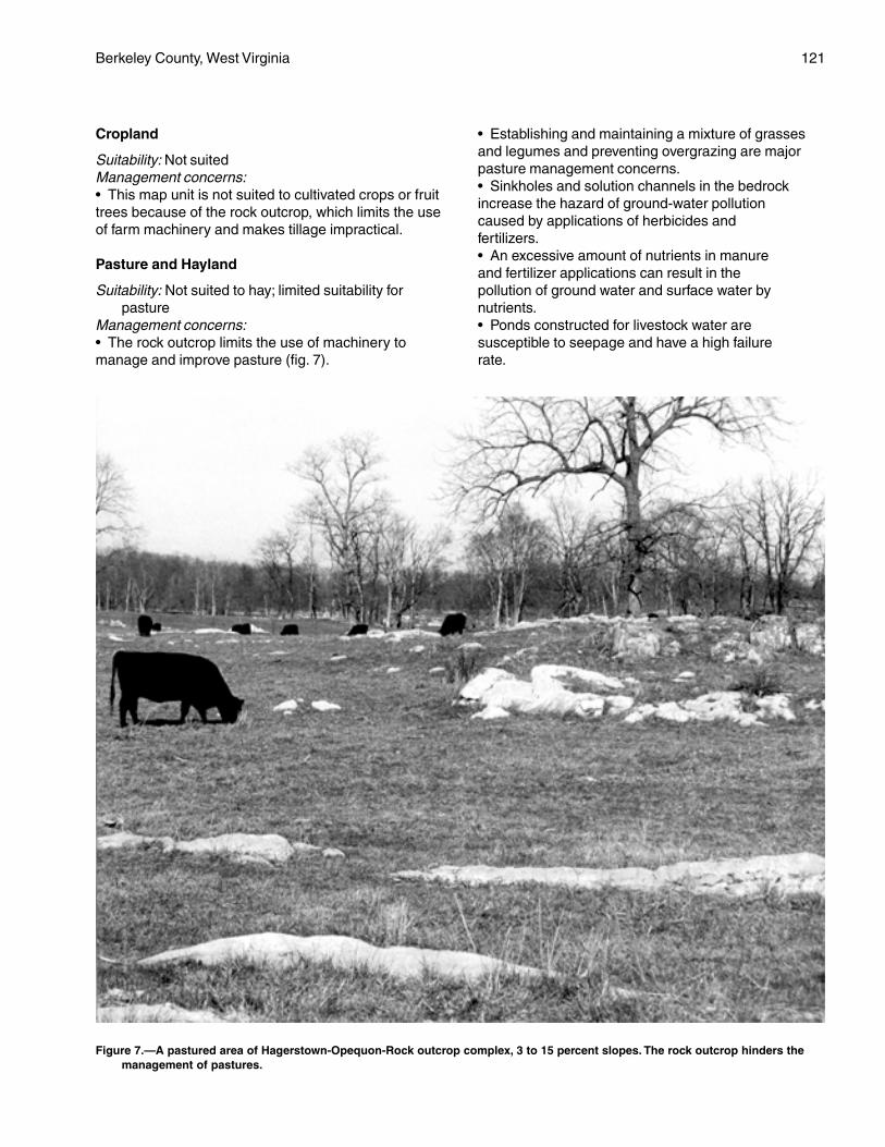
Berkeley County, West Virginia 121
Cropland
Suitability: Not suitedManagement concerns:• This map unit is not suited to cultivated crops or fruittrees because of the rock outcrop, which limits the useof farm machinery and makes tillage impractical.
Pasture and Hayland
Suitability: Not suited to hay; limited suitability forpasture
Management concerns:• The rock outcrop limits the use of machinery tomanage and improve pasture (fig. 7).
• Establishing and maintaining a mixture of grassesand legumes and preventing overgrazing are majorpasture management concerns.• Sinkholes and solution channels in the bedrockincrease the hazard of ground-water pollutioncaused by applications of herbicides andfertilizers.• An excessive amount of nutrients in manureand fertilizer applications can result in thepollution of ground water and surface water bynutrients.• Ponds constructed for livestock water aresusceptible to seepage and have a high failurerate.
Figure 7.—A pastured area of Hagerstown-Opequon-Rock outcrop complex, 3 to 15 percent slopes. The rock outcrop hinders themanagement of pastures.
122 Soil Survey
Management measures:• Proper stocking rates, uniform distribution of grazing,and a planned grazing system help to keep pasturesin good condition.• Applying lime and fertilizer according to the resultsof soil tests helps to ensure the maximum growth offorage.
Woodland
Potential productivity: Moderate or moderately highManagement concerns:• The rock outcrop limits use of logging equipment.• The rock outcrop and the depth to bedrock shouldbe considered when planning the location of roadsand log landings.• Operating logging equipment during wet periodswhen the soils are soft results in excessive rutting.• Competition from weeds may slow the growth ofplanted tree seedlings.• The seedling mortality rate may be high in areas ofthe Opequon soil because of droughtiness.• Because the bedrock restricts the growth of roots,trees may be uprooted during periods of strong windsor heavy snowfall, especially in areas of the Opequonsoil.• Erosion is a management concern on logging roadsand skid trails.Management measures:• Because of the sticky and plastic subsoil, loggingroads should be graveled and, in some areas, loglandings should be stabilized.• Adequately preparing the site helps to control theinitial plant competition in tree plantations, andspraying helps to control subsequent competition.• Drought-tolerant species, such as Virginia pine,Scotch pine, Norway spruce, and white pine, shouldbe selected for planting in areas of the Opequon soil.• Planting should be timed so that seedlings can takefull advantage of spring rains.• The hazard of erosion can be reduced by buildinglogging roads and skid trails on the contour; seedinglogging roads, log landings, and areas that have beencut and filled to perennial grasses and legumes; andinstalling water bars and culverts.
Community Development
Suitability: Poorly suitedManagement concerns:• The nonrippable bedrock and the rock outcrop mayinterfere with excavations, including those for roads,foundations, and absorption fields. The depth tobedrock can vary from less than 20 inches to morethan 6 feet over a short distance. In most areas thebedrock has to be blasted before it can be excavated.
• The shrink-swell potential is a limitation affecting theconstruction of footings, foundations, and roads.• Low strength is an additional limitation affecting theconstruction of roads.• The restricted permeability in the subsoil of theHagerstown soil may prevent the proper functioning ofabsorption fields in some areas.• The depth to bedrock and the restricted permeabilityin the Opequon soil are severe limitations on sites forseptic tank absorption fields.• Sinkholes and solution channels in the bedrockincrease the hazard of ground-water pollution byseepage from septic tank absorption fields.• Erosion is a moderate or severe hazard onconstruction sites.Management measures:• Buildings should be designed so that they conformto the natural slope of the land. Land shaping isnecessary in some areas.• Properly designing and strengthening footings andfoundations can help to prevent the structural damagecaused by shrinking and swelling.• Providing a suitable road base that includes theinstallation of properly designed geotextiles helps toprevent the road damage caused by low strength andby shrinking and swelling.• Septic tank absorption fields should not be installedin areas that are near limestone rock outcrop or inareas where excavation exposes the bedrock becauseof the hazard of ground-water pollution.• Selecting areas of the deeper Hagerstown soil assites for septic tank absorption fields, installingabsorption fields on the contour, and enlarging theabsorption fields can help to overcome the limitationsin absorption areas.• Maintaining the plant cover on construction sites,establishing a plant cover in unprotected areas, andproviding for proper disposal of surface runoff help tocontrol erosion and sedimentation.
Interpretive Groups
Land capability classification: VIsWoodland ordination symbol: Hagerstown—5C;
Opequon—3C
HgE—Hagerstown-Opequon-Rockoutcrop complex, 15 to 35 percentslopes
Setting
This map unit is on moderately steep or steephillsides in the Great Valley. The limestone rockoutcrop generally occurs in parallel clusters thatextend in a north-south direction. Sinkholes are
Berkeley County, West Virginia 123
common. The bedrock under the soils is steeply tilted,and soil depth may vary greatly within short distances.The two soils and the Rock outcrop occur as areas sointermingled on the landscape that it was impracticalto separate them in mapping.
Composition
Hagerstown soil and similar soils: 40 percentOpequon soil and similar soils: 30 percentRock outcrop: 20 percentDissimilar inclusions: 10 percent
Representative Profile
Hagerstown
Surface layer:0 to 3 inches—very dark grayish brown silt loam3 to 5 inches—brown silt loam
Subsoil:5 to 9 inches—reddish brown silty clay9 to 36 inches—reddish brown clay36 to 65 inches—variegated yellowish red, red, and
strong brown clay
Opequon
Surface layer:0 to 5 inches—brown silty clay loam
Subsoil:5 to 18 inches—red clay
Bedrock:18 inches—hard, bluish gray limestone
Rock outcrop
The Rock outcrop occurs as exposed areas of hard,nonrippable limestone.
Soil Properties and Qualities
Hagerstown
Drainage class: Well drainedPermeability: Moderate (0.6 inch to 2.0 inches per
hour)Available water capacity: Moderate or highDepth to the seasonal high water table: More than
6 feetFlooding: NoneShrink-swell potential: Moderate in the subsoilErosion hazard: Very severeStoniness: NoneNatural fertility: Medium or highReaction: In unlimed areas, strongly acid to neutral
(pH 5.1 to 7.3)Surface runoff: Rapid or very rapidDepth to bedrock: More than 60 inches
Bedrock type: Hard, nonrippable limestone
Opequon
Drainage class: Well drainedPermeability: Moderately slow or moderate (0.2 inch to
2.0 inches per hour)Available water capacity: LowDepth to the seasonal high water table: More than
6 feetFlooding: NoneShrink-swell potential: HighErosion hazard: Very severeStoniness: NoneNatural fertility: HighReaction: In unlimed areas, moderately acid to slightly
alkaline (pH 5.6 to 7.8)Surface runoff: Rapid or very rapidDepth to bedrock: 12 to 20 inchesBedrock type: Hard, nonrippable limestone
Minor Components
Dissimilar inclusions:• The deep Endcav soils• Severely eroded soils that have a surface layer ofsilty clay or claySimilar soils:• The moderately deep Carbo soils• Soils that have slopes ranging from 8 to 15 percent• Soils that have slopes of more than 35 percent• Soils that have loose limestone flagstones andchanners on the surface
Use and Management
Uses: Most areas of this map unit are wooded. A fewsmall areas are used as pasture. In a few areasthe acreage is idle land.
Cropland
Suitability: Not suitedManagement concerns:• This map unit is not suited to cultivated crops or fruittrees because of the slope and the rock outcrop,which limit the use of modern farm machinery andmake cultivation impractical.
Pasture and Hayland
Suitability: Not suited to hay; difficult to manage forpasture
Management concerns:• The slope and the rock outcrop limit the use ofmachinery to manage and improve pasture.• Establishing and maintaining a mixture of grassesand legumes and preventing overgrazing are majorpasture management concerns.
124 Soil Survey
• Overgrazing causes surface compaction, increasesthe runoff rate and the hazard of erosion, and reducesthe vigor of the plant cover.• If pastures are overgrazed, erosion is a severehazard in areas where the plant cover has beendestroyed.• Sinkholes and solution channels in the bedrockincrease the hazard of ground-water pollution causedby applications of herbicides and fertilizers.• An excessive amount of nutrients in manure andfertilizer applications can result in the pollution ofground water and surface water by nutrients.Management measures:• Proper stocking rates, uniform distribution of grazing,and a planned grazing system help to keep pasturesin good condition.• Applying lime and fertilizer according to the resultsof soil tests helps to ensure the maximum growth offorage.
Woodland
Potential productivity: Moderate or moderately highManagement concerns:• The rock outcrop limits the use of loggingequipment.• The rock outcrop and the depth to bedrock shouldbe considered when planning the location of roadsand log landings.• Operating logging equipment during wet periodswhen the soils are soft results in excessive rutting.• Slippage is a hazard on the moderately steep andsteep slopes when the soils are wet and soft.• Competition from weeds may slow the growth ofplanted tree seedlings.• Because of the droughtiness, seedling mortality maybe a problem, especially on south aspects of theOpequon soil.• Because the bedrock restricts the growth of roots,trees may be uprooted during periods of strong windsor heavy snowfall, especially in areas of the Opequonsoil.• Erosion is a severe hazard on logging sites.Management measures:• Because of the sticky and plastic subsoil, loggingroads should be graveled and, in some areas, loglandings should be stabilized.• Drought-tolerant species, such as Virginia pine,Scotch pine, Norway spruce, and white pine, shouldbe selected for planting in areas of the Opequonsoil.• Planting should be timed so that seedlings can takefull advantage of spring rains.• Tree plantations should be on north-facing slopeswhere possible.
• Seedlings should be mulched in areas wheremulching is practical.• Adequately preparing the site helps to control theinitial plant competition in tree plantations, andspraying helps to control subsequent competition.• The hazard of erosion can be reduced by buildinglogging roads and skid trails on the contour; seedinglogging roads, log landings, and areas that have beencut and filled to perennial grasses and legumes; andinstalling water bars and culverts.
Community Development
Suitability: Poorly suitedManagement concerns:• The slope is a severe limitation affecting most urbanuses. Extensive land shaping is necessary in mostareas.• The depth to hard, nonrippable limestone bedrockand the rock outcrop may limit excavations, includingthose for roads, foundations, septic tank absorptionfields, and sewer lines. The depth to bedrock may varyfrom less than 20 inches to more than 6 feet over ashort distance. In most areas the bedrock has to beblasted before it is excavated.• The moderate or high shrink-swell potential is alimitation affecting the construction of footings,foundations, and roads.• Low strength is a limitation on sites for roads.Because these soils are soft when wet, pavement maycrack under heavy loads.• Slippage is a hazard on the moderately steep andsteep slopes when the soils are wet and soft.• Sinkholes and solution channels in the bedrockincrease the hazard of ground-water pollution byseepage from septic tank absorption fields.• The slope, the depth to bedrock, and the restrictedpermeability of the Opequon soil are severe limitationson sites for septic tank absorption fields.• Erosion is a moderate or severe hazard onconstruction sites.Management measures:• Properly designing and strengthening footings andfoundations can help to prevent the structural damagecaused by shrinking and swelling.• Providing a suitable road base that includes theinstallation of properly designed geotextiles helps toprevent the road damage caused by low strength andby shrinking and swelling.• Septic tank absorption fields should not be installedin areas that are near limestone rock outcrop orsinkholes or in areas where excavation exposes thelimestone bedrock because of the hazard of ground-water pollution.• Selecting areas of the deeper Hagerstown soil as
Berkeley County, West Virginia 125
sites for absorption fields, installing absorption fieldson the contour, and enlarging the absorption fields canhelp to overcome the limitations in absorption areas.• Maintaining the plant cover on construction sites,establishing a plant cover in unprotected areas, andproviding for proper disposal of surface runoff help tocontrol erosion and sedimentation.
Interpretive Groups
Land capability classification: VIIsWoodland ordination symbol: Hagerstown—5C;
Opequon—2R on south aspects and 3R on northaspects
HkF—Hazleton-Berks channery loams,35 to 65 percent slopes, extremelystony
Setting
These soils are on very steep hillsides on thewestern side of North Mountain. The Hazleton soil isgenerally on the less sloping middle and lower parts ofthe hillsides, and the Berks soil is generally on themore sloping shoulder slopes, nose slopes, and higherpart of the hillsides. The two soils occur as areas sointermingled on the landscape that it was impracticalto separate them in mapping.
Composition
Hazleton soil and similar soils: 50 percentBerks soil and similar soils: 40 percentDissimilar inclusions: 10 percent
Representative Profile
Hazleton
Surface layer:0 to 1 inch—organic duff from hardwood leaf litter1 to 4 inches—black channery loam
Subsurface layer:4 to 11 inches—dark yellowish brown channery loam
Subsoil:11 to 15 inches—yellowish brown very channery loam15 to 37 inches—strong brown very channery loam37 to 48 inches—strong brown very channery sandy
loam
Underlying material:48 to 65 inches—strong brown very channery sandy
loam
Berks
Surface layer:0 to 3 inches—very dark grayish brown channery loam
Subsurface layer:3 to 8 inches—brown to dark brown channery loam
Subsoil:8 to 30 inches—strong brown very channery silt
loam30 to 36 inches—strong brown extremely channery
silt loam
Bedrock:36 inches—fractured, grayish brown shale
Soil Properties and Qualities
Hazleton
Drainage class: Well drainedPermeability: Moderately rapid or rapid (2.0 to
20.0 inches per hour)Available water capacity: ModerateDepth to the seasonal high water table: More than
6 feetFlooding: NoneShrink-swell potential: LowErosion hazard: Very severeStoniness: 3 to 15 percent of the surface covered with
stonesRockiness: NoneNatural fertility: LowReaction: In unlimed areas, extremely acid to strongly
acid (pH 3.6 to 5.5)Surface runoff: Very rapidDepth to bedrock: More than 60 inchesBedrock type: Mainly acid sandstone; interbedded with
shale and siltstone in some areas
Berks
Drainage class: Well drainedPermeability: Moderate or moderately rapid (0.6 inch
to 6.0 inches per hour)Available water capacity: Very low to moderateDepth to the seasonal high water table: More than
6 feetFlooding: NoneShrink-swell potential: LowErosion hazard: Very severeSlope class: Very steepStoniness: 3 to 15 percent of the surface covered with
stonesRockiness: NoneNatural fertility: LowReaction: In unlimed areas, extremely acid to strongly
acid (pH 3.6 to 5.5)Surface runoff: Very rapidDepth to bedrock: 20 to 40 inchesBedrock type: Mainly acid shale and siltstone;
interbedded with sandstone in some areas
126 Soil Survey
Minor Components
Dissimilar inclusions:• Areas of rock outcrop• The moderately well drained Buchanan soils, whichare on footslopes and benches• The well drained Blackthorn soils that have a clayeysubsoil and are underlain by limestone; on benchesSimilar soils:• Small areas of the shallow Weikert soils• Rubbly soils that have 15 to 50 percent of theirsurface covered with stones and boulders• The well drained, reddish Calvin soils• The somewhat excessively drained Dekalb soils• Areas where stones cover less than 3 percent of thesurface• Soils that have slopes of more than 65 percent orless than 35 percent
Use and Management
Uses: Nearly all areas of the Hazleton and Berks soilsare wooded.
Cropland
Suitability: Not suitedManagement concerns:• The very steep slope, the very severe hazard oferosion, and the stones on the surface of the soilsmake cultivation impractical.
Pasture and Hayland
Suitability: Not suited to hay; limited suitability forpasture
Management concerns:• Establishing and maintaining a mixture of grassesand legumes and preventing overgrazing are majorpasture management concerns.• Overgrazing causes surface compaction andincreases the runoff rate and the hazard of erosion.• If pastures are overgrazed, erosion is a very severehazard in areas where the plant cover has beendestroyed.• Because of the slope and the stones on the surfaceof the soils, it is difficult to safely operate conventionalfarm equipment.Management measures:• Proper stocking rates, uniform distribution of grazing,and a planned grazing system help to keep pasturesin good condition.• Applying lime and fertilizer according to the resultsof soil tests helps to ensure the maximum growth offorage, especially legumes.
Woodland
Potential productivity: Moderate on south aspects;
moderately high on north aspectsManagement concerns:• Erosion is a severe hazard on logging sites.• Operating logging equipment is hazardous becauseof the very steep slope.• The large stones on the surface of the soilscan hinder harvesting operations and damageequipment.• The limited rooting depth, the low natural fertility, andthe droughtiness of the Berks soil result in a highseedling mortality rate, especially on south aspects.Management measures:• Because of the slope, special care should be takenwhen logging roads and log landings are laid out andlogging equipment is operated. Logging roads shouldbe designed so that they conform to the topography.• Because of the erosion hazard, water should beremoved from logging roads by water bars, out-slopingor in-sloping road surfaces, culverts, and dropstructures. Building logging roads on the contour or onthe gentler slopes and seeding logging roads, skidtrails, and log landings to perennial grasses andlegumes after the trees are logged also help to preventexcessive erosion.• Planting nursery stock that is larger than is typical orplanting containerized seedlings reduces the seedlingmortality rate.• Drought-tolerant species, such as Virginia pine,white pine, Scotch pine, and Norway spruce, shouldbe selected for planting.• Planting should be timed so that seedlings can takefull advantage of spring rains.• Tree plantations should be on north-facing slopeswhere possible.
Community Development
Suitability: Not suitedManagement concerns:• The very steep slope is a severe limitation affectingcommunity development. A better suited soil should beselected for development.• Erosion is a very severe hazard on constructionsites.Management measures:• Maintaining the plant cover on construction sites,establishing a plant cover in unprotected areas, andproviding for proper disposal of surface runoff help tocontrol erosion and sedimentation.
Interpretive Groups
Land capability classification: VIIsWoodland ordination symbol: Hazleton—3R on south
aspects and 4R on north aspects; Berks—3R onsouth aspects and 4R on north aspects
Berkeley County, West Virginia 127
HsE—Hazleton-Dekalb complex, 15 to35 percent slopes, extremely stony
Setting
These soils are on moderately steep or steephillsides, mainly on Third Hill and Sleepy CreekMountains. The Hazleton soil is on the linear orconcave middle and lower parts of the hillsides, andthe Dekalb soil is on convex shoulder slopes, noseslopes, and the upper part of hillsides. The two soilsoccur as areas so intermingled on the landscape thatit was impractical to separate them in mapping.
Composition
Hazleton soil and similar soils: 45 percentDekalb soil and similar soils: 40 percentDissimilar inclusions: 15 percent
Representative Profile
Hazleton
Surface layer:0 to 1 inch—organic duff from hardwood leaf
litter1 to 4 inches—very dark brown channery loam
Subsurface layer:4 to 11 inches—dark yellowish brown channery sandy
loam
Subsoil:11 to 15 inches—yellowish brown very channery
loam15 to 37 inches—strong brown very channery
loam37 to 48 inches—strong brown very channery sandy
loam
Underlying material:48 to 65 inches—strong brown very channery sandy
loam
Dekalb
Surface layer:0 to 1 inch—organic duff from hardwood leaf litter1 to 2 inches—very dark brown channery sandy
loam
Subsurface layer:2 to 4 inches—brown channery sandy loam
Subsoil:4 to 13 inches—yellowish brown very channery sandy
loam13 to 26 inches—brown very channery sandy loam
Bedrock:26 inches—fractured, gray sandstone
Soil Properties and Qualities
Hazleton
Drainage class: Well drainedPermeability: Moderately rapid or rapid (2.0 to
20 inches per hour)Available water capacity: Moderate or highDepth to the seasonal high water table: More than
6 feetFlooding: NoneShrink-swell potential: LowErosion hazard: Very severeStoniness: 3 to 15 percent of the surface covered with
stonesRockiness: NoneNatural fertility: LowReaction: In unlimed areas, extremely acid to strongly
acid (pH 3.5 to 5.5)Surface runoff: Very rapidDepth to bedrock: More than 60 inchesBedrock type: Interbedded, acid sandstone, shale, and
siltstone
Dekalb
Drainage class: Somewhat excessively drainedPermeability: Rapid (6.0 to 20 inches per hour)Available water capacity: Very low or lowDepth to the seasonal high water table: More than
6 feetFlooding: NoneShrink-swell potential: LowErosion hazard: Very severeStoniness: 3 to 15 percent of the surface covered with
stonesRockiness: NoneNatural fertility: LowReaction: In unlimed areas, extremely acid to strongly
acid (pH 3.5 to 5.5)Surface runoff: Very rapidDepth to bedrock: 20 to 40 inchesBedrock type: Mainly acid sandstone; interbedded with
shale and siltstone in some areas
Minor Components
Dissimilar inclusions:• The moderately well drained Buchanan soils, whichare on the less sloping benches and the lower part ofhillsides• Very rubbly soils that have more than 50 percent oftheir surface covered with stones and boulders
128 Soil Survey
• Areas of rock outcrop• Areas of soils that are not stonySimilar soils:• The well drained Berks soils, which are on noseslopes and are underlain by shale• The well drained, reddish Calvin soils, which are onconvex nose slopes• Soils that have slopes ranging from 8 to 15 percent• Soils that have slopes of more than 35 percent• Areas where stones cover less than 3 percent of thesurface• Rubbly soils that have 15 to 50 percent of theirsurface covered with stones and boulders
Use and Management
Uses: Most areas of this map unit are wooded.
Cropland
Suitability: Not suitedManagement concerns:• The slope and the stones on the surface of the soilsmake tillage impractical and unsafe.
Pasture and Hayland
Suitability: Not suited to hay; limited suitability forpasture
Management concerns:• Overgrazing causes surface compaction andincreases the runoff rate and the hazard of erosion.• If pastures are overgrazed, erosion is a very severehazard in areas where the plant cover has beendestroyed.• Because of the slope and the stones on the surfaceof the soils, it is difficult to operate conventionalequipment used in clipping and in applying fertilizer.• Water for livestock is scarce, but potential siteswhere ponds or springs can be developed generallyare available along nearby drainageways.Management measures:• Proper stocking rates, uniform distribution of grazing,and a planned grazing system help to keep pasturesin good condition.• Applying lime and fertilizer according to the resultsof soil tests helps to ensure the maximum growth offorage, especially legumes.
Woodland
Potential productivity: Moderate on south aspects;moderate or moderately high on north aspects
Management concerns:• Erosion is a very severe hazard on logging sites.• The large stones on the surface of the soilscan hinder harvesting operations and damageequipment.
• The low natural fertility and the droughtiness of theDekalb soil result in a high seedling mortality rate,especially on south aspects.• Competition from weeds may slow the growthof planted tree seedlings in areas of the Hazletonsoil.• Because the bedrock restricts the growth of roots,trees may be uprooted during periods of strong windsor heavy snowfall, especially in areas of the Dekalbsoil.Management measures:• The hazard of erosion can be reduced by buildinglogging roads and skid trails on the contour; seedinglogging roads, log landings, and areas that have beencut and filled to perennial grasses and legumes; andinstalling water bars and culverts.• Planting nursery stock that is larger than is typical orplanting containerized seedlings reduces the seedlingmortality rate.• Planting should be timed so that seedlings can takefull advantage of spring rains.• Drought-tolerant species, such as Virginia pine,white pine, Scotch pine, and Norway spruce, shouldbe selected for planting.• Tree plantations should be on north-facing slopeswhere possible.• Adequately preparing the site helps to controlthe initial plant competition in tree plantations,and spraying helps to control subsequentcompetition.
Community Development
Suitability: Poorly suitedManagement concerns:• The slope is a severe limitation on sites for buildings,septic tank absorption fields, and local roads andstreets. Extensive land shaping is necessary in mostareas.• The depth to hard bedrock is a severe limitation inareas of the Dekalb soil. In many areas the bedrockhas to be blasted before it can be excavated.• Erosion is a very severe hazard on constructionsites.Management measures:• Selecting areas of the very deep Hazleton soil assites for septic tank absorption fields, installingdistribution lines on the contour, selecting the lesssloping areas for absorption fields, and land shapingcan help to overcome the limitations in absorptionareas.• Maintaining the plant cover on construction sites,establishing a plant cover in unprotected areas, andproviding for proper disposal of surface runoff help tocontrol erosion and sedimentation.
Berkeley County, West Virginia 129
Interpretive Groups
Land capability classification: VIIsWoodland ordination symbol: Hazleton—3R on south
aspects and 4R on north aspects; Dekalb—2R onsouth aspects and 3R on north aspects
HsF—Hazleton-Dekalb complex, 35 to65 percent slopes, extremely stony
Setting
These soils are on very steep hillsides on Third Hilland Sleepy Creek Mountains and on the easternaspect of North Mountain. The Hazleton soil is on thelinear or concave middle and lower parts of thehillsides, and the Dekalb soil is on convex shoulderslopes, nose slopes, and the upper part of hillsides.The two soils occur as areas so intermingled on thelandscape that it was impractical to separate them inmapping.
Composition
Hazleton soil and similar soils: 60 percentDekalb soil and similar soils: 25 percentDissimilar inclusions: 15 percent
Representative Profile
Hazleton
Surface layer:0 to 1 inch—organic duff from hardwood leaf litter1 to 4 inches—very dark brown channery loam
Subsurface layer:4 to 11 inches—dark yellowish brown channery loam
Subsoil:11 to 15 inches—yellowish brown very channery loam15 to 37 inches—strong brown very channery loam37 to 48 inches—strong brown very channery sandy
loam
Underlying material:48 to 65 inches—strong brown very channery sandy
loam
Dekalb
Surface layer:0 to 1 inch—organic duff from hardwood leaf litter1 to 2 inches—very dark brown channery sandy loam
Subsurface layer:2 to 4 inches—brown channery sandy loam
Subsoil:4 to 13 inches—yellowish brown very channery sandy
loam
13 to 26 inches—brown very channery sandy loam
Bedrock:26 inches—fractured, gray sandstone
Soil Properties and Qualities
Hazleton
Drainage class: Well drainedPermeability: Moderately rapid or rapid (2.0 to
20 inches per hour)Available water capacity: ModerateDepth to the seasonal high water table: More than
6 feetFlooding: NoneShrink-swell potential: LowErosion hazard: Very severeStoniness: 3 to 15 percent of the surface covered with
stonesRockiness: NoneNatural fertility: LowReaction: In unlimed areas, extremely acid to strongly
acid (pH 3.5 to 5.5)Surface runoff: Very rapidDepth to bedrock: More than 60 inchesBedrock type: Interbedded acid sandstone, siltstone,
and shale
Dekalb
Drainage class: Somewhat excessively drainedPermeability: Rapid (6.0 to 20 inches per hour)Available water capacity: Very low or lowDepth to the seasonal high water table: More than
6 feetFlooding: NoneShrink-swell potential: LowErosion hazard: Very severeStoniness: 3 to 15 percent of the surface covered with
stonesRockiness: NoneNatural fertility: LowReaction: In unlimed areas, extremely acid to strongly
acid (pH 3.5 to 5.5)Surface runoff: Very rapidDepth to bedrock: 20 to 40 inchesBedrock type: Mainly acid sandstone; interbedded with
shale and siltstone in some areas
Minor Components
Dissimilar inclusions:• The moderately well drained Buchanan soils, whichare on the less sloping benches and the lower part ofthe hillsides• Very rubbly soils that have more than 50 percent oftheir surface covered with stones and boulders
130 Soil Survey
• Areas of rock outcropSimilar soils:• The well drained Berks soils• The reddish, well drained Calvin soils• Stony areas where stones cover less than 3 percentof the surface• Rubbly areas where stones cover 15 to 50 percentof the surface• Soils that have slopes ranging from 25 to 35 percent• Soils that have slopes of more than 65 percent
Use and Management
Uses: Most areas of this map unit are wooded.
Cropland
Suitability: Not suitedManagement concerns:• Because of the slope and the stones on the surfaceof the soils, it is difficult to safely operate conventionalfarm equipment.
Pasture and Hayland
Suitability: Not suited to hay; limited suitability forpasture
Management concerns:• Establishing and maintaining a mixture of grassesand legumes and preventing overgrazing are majorpasture management concerns.• Overgrazing causes surface compaction andincreases the runoff rate and the hazard of erosion.• If pastures are overgrazed, erosion is a very severehazard in areas where the plant cover has beendestroyed.• Because of the very steep slope and the stones onthe surface of the soils, it is difficult to safely operateconventional equipment used in clipping and inapplying fertilizer.Management measures:• Proper stocking rates, uniform distribution of grazing,and a planned grazing system help to keep pasturesin good condition.
Woodland
Potential productivity: Moderate on south aspects;moderate or moderately high on north aspects
Management concerns:• Erosion is a severe hazard on logging sites.• Operating logging equipment is hazardous becauseof the very steep slope.• The large stones on the surface of the soils canhinder harvesting operations and damage equipment.• The limited depth to bedrock, the low natural fertility,and the droughtiness of the Dekalb soil result in a highseedling mortality rate, especially on south aspects.
• Because the bedrock restricts the growth of roots,trees may be uprooted during periods of strong windsor heavy snowfall, especially in areas of the Dekalbsoil.Management measures:• Because of the slope, special care should be takenwhen logging roads and log landings are laid out andlogging equipment is operated. Logging roads shouldbe designed so that they conform to the topography.• The hazard of erosion can be reduced by buildinglogging roads and skid trails on the contour; seedinglogging roads, log landings, and areas that have beencut and filled to perennial grasses and legumes; andinstalling water bars and culverts.• Planting should be timed so that seedlings can takefull advantage of spring rains.• Drought-tolerant species, such as Virginia pine,white pine, Scotch pine, and Norway spruce, shouldbe selected for planting.• Tree plantations should be on north-facing slopeswhere possible.
Community Development
Suitability: Not suitedManagement concerns:• Because of the very steep slope, these soils are notsuited to building site development, septic tankabsorption fields, or local roads and streets. A bettersuited soil should be selected for development.
Interpretive Groups
Land capability classification: VIIsWoodland ordination symbol: Hazleton—3R on south
aspects and 4R on north aspects; Dekalb—2R onsouth aspects and 3R on north aspects
Hu—Huntington silt loam
Setting
This soil is on nearly level flood plains, mainly alongOpequon Creek and its tributaries.
Composition
Huntington soil and similar soils: 80 percentDissimilar inclusions: 20 percent
Representative Profile
Surface layer:0 to 11 inches—dark brown silt loam
Subsoil:11 to 21 inches—dark grayish brown silt loam21 to 42 inches—dark yellowish brown silt loam42 to 58 inches—yellowish brown silt loam
Berkeley County, West Virginia 131
58 to 65 inches—dark yellowish brown silt loam
Soil Properties and Qualities
Drainage class: Well drainedPermeability: Moderate (0.6 inch to 2.0 inches per
hour)Available water capacity: HighDepth to the seasonal high water table: More than
6 feetFlooding: Occasionally flooded (a 5 to 50 percent
chance of flooding in any year) for brief periodsShrink-swell potential: LowErosion hazard: SlightStoniness: NoneRockiness: NoneNatural fertility: HighReaction: In unlimed areas, moderately acid to slightly
alkaline (pH 5.6 to 7.8)Surface runoff: SlowDepth to bedrock: More than 60 inches
Minor Components
Dissimilar inclusions:• The moderately well drained Lindside soils• The poorly drained Dunning soils• The well drained Combs soils, which have a highercontent of sand than the Huntington soil• Soils that do not have the thick, dark surface layerthat is typical of the Huntington soilSimilar soils:• The well drained Lappans soils• Soils that have slopes of more than 3 percent
Use and Management
Uses: Most areas of the Huntington soil are used forcultivated crops or hay. Some areas are used aspasture. A few areas are wooded.
Cropland
Suitability: Suited. This soil is prime farmland.Management concerns:• This soil must be properly protected if cultivatedcrops are grown year after year.• The flooding occasionally damages crops or delaysfieldwork.• An excessive amount of nutrients in manure andfertilizer applications can result in the pollution ofsurface water by nutrients.• This soil is poorly suited to orchards because of thepoor air drainage, which increases the chance for frostdamage.• This soil is subject to streambank erosion in manyareas.
Management measures:• Conservation tillage, winter cover crops, and cropresidue management help to maintain soil tilth andfertility and to control erosion.• Designing fertilizer and manure applications to meetcrop nutrient needs, using split fertilizer applications,and applying fertilizer in bands may reduce the risk ofnutrient leaching.• Leaving a border of trees along streams helps toprevent excessive erosion on streambanks.
Pasture and Hayland
Suitability: SuitedManagement concerns:• Establishing and maintaining a mixture of grassesand legumes and preventing overgrazing are majorpasture management concerns.• Overgrazing causes surface compaction, increasesthe runoff rate and the hazard of erosion, and reducesthe vigor of the plant cover.• Unrestricted access to streams by livestockincreases the hazards of streambank erosion andwater pollution.• The flooding occasionally deposits debris on thegrassland.Management measures:• Proper stocking rates, uniform distribution of grazing,and a planned grazing system help to keep pasturesin good condition.• Streambanks should be fenced. Access to streamsby livestock should be limited to protected crossings.• Applying lime and fertilizer according to the resultsof soil tests helps to ensure the maximum growth ofplants, especially legumes.
Woodland
Potential productivity: Moderately highManagement concerns:• Competition from weeds may slow the growth ofplanted tree seedlings.Management measures:• Adequately preparing the site helps to control theinitial plant competition in tree plantations, andspraying helps to control subsequent competition.
Community Development
Suitability: Not suitedManagement concerns:• Because of the flooding, this soil is not suited tobuilding site development or septic tank absorptionfields.• The flooding is a severe limitation on sites for localroads and streets.
132 Soil Survey
Management measures:• Soils that are better suited to buildings and septictank absorption fields than the Huntington soil shouldbe selected for development.• Constructing roads on raised fill material helps toprevent the damage caused by flooding.
Interpretive Groups
Land capability classification: IIwWoodland ordination symbol: 5A
La—Lappans (marl) loam
Setting
This soil is on nearly level flood plains alongstreams fed by springs flowing from limestone bedrockin the Great Valley.
Composition
Lappans soil and similar soils: 90 percentDissimilar inclusions: 10 percent
Representative Profile
Surface layer:0 to 7 inches—very dark brown marly loam
Subsurface layer:7 to 13 inches—light olive brown marly sandy
loam13 to 20 inches—dark grayish brown marly sandy
loam
Subsoil:20 to 26 inches—light yellowish brown marly sandy
loam26 to 42 inches—gray marly loam that has pale brown
and white mottles42 to 47 inches—white marly clay loam that has gray
and pale brown mottles47 to 54 inches—light brownish gray marly clay loam
that has yellowish brown mottles54 to 64 inches—light gray marly clay loam that has
very pale brown mottles64 to 71 inches—light gray marly sandy loam that has
very pale brown mottles71 to 78 inches—gray marly clay loam that has dark
yellowish brown mottles78 to 85 inches—light brownish gray marly clay loam
that has light yellowish brown and white mottles
Underlying material:85 to 99 inches—light gray marly loam
Soil Properties and Qualities
Drainage class: Well drained
Permeability: Moderately rapid or rapid (2.0 to20 inches per hour)
Available water capacity: HighDepth to the seasonal high water table: 4 to 6 feetFlooding: Occasionally flooded (a 5 to 50 percent
chance of flooding in any year) for brief periodsShrink-swell potential: LowErosion hazard: SlightStoniness: NoneRockiness: NoneNatural fertility: HighReaction: In unlimed areas, slightly alkaline or
moderately alkaline (pH 7.4 to 8.4)Surface runoff: SlowDepth to bedrock: More than 60 inches
Minor Components
Dissimilar inclusions:• The very poorly drained Fairplay soils• The poorly drained Dunning soilsSimilar soils:• Moderately well drained soils
Use and Management
Uses: Most areas of the Lappans soil are used aspasture. Some are used for cultivated crops or hay(fig. 8). A few small areas are forested. In someareas marl from this soil has been quarried andused as a source of agricultural lime.
Cropland
Suitability: Suited. This soil is prime farmland.Management concerns:• This soil must be properly protected if cultivatedcrops are grown year after year.• The flooding occasionally damages crops or delaysfieldwork.• This soil is poorly suited to orchards because of thepoor air drainage, which increases the risk of frostdamage.• This soil is subject to streambank erosion in someareas.• Some crops may suffer deficiencies of certainmicronutrients, such as iron and manganese, becausethis soil is alkaline.Management measures:• Conservation tillage, winter cover crops, and cropresidue management help to maintain soil tilth andfertility and to control erosion.• An excessive amount of nutrients in manure andfertilizer applications can result in the pollution ofground water and surface water by nutrients.• Timing fertilizer applications to meet crop nutrientneeds, using split fertilizer applications, and applying
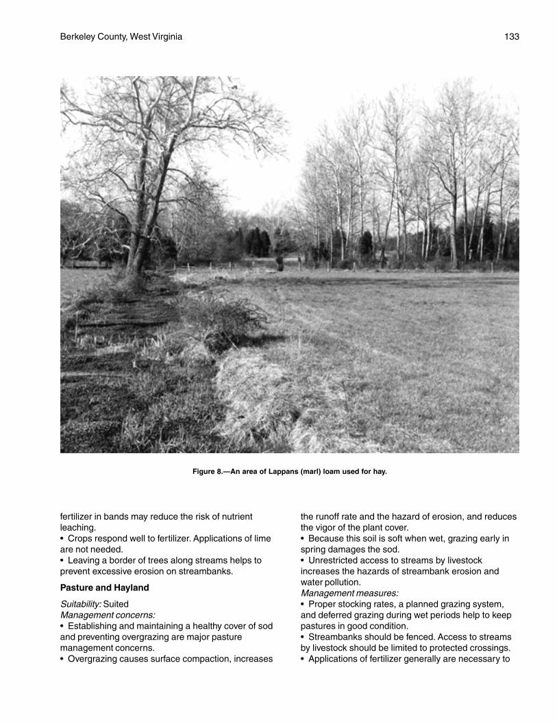
Berkeley County, West Virginia 133
fertilizer in bands may reduce the risk of nutrientleaching.• Crops respond well to fertilizer. Applications of limeare not needed.• Leaving a border of trees along streams helps toprevent excessive erosion on streambanks.
Pasture and Hayland
Suitability: SuitedManagement concerns:• Establishing and maintaining a healthy cover of sodand preventing overgrazing are major pasturemanagement concerns.• Overgrazing causes surface compaction, increases
the runoff rate and the hazard of erosion, and reducesthe vigor of the plant cover.• Because this soil is soft when wet, grazing early inspring damages the sod.• Unrestricted access to streams by livestockincreases the hazards of streambank erosion andwater pollution.Management measures:• Proper stocking rates, a planned grazing system,and deferred grazing during wet periods help to keeppastures in good condition.• Streambanks should be fenced. Access to streamsby livestock should be limited to protected crossings.• Applications of fertilizer generally are necessary to
Figure 8.—An area of Lappans (marl) loam used for hay.
134 Soil Survey
increase the amount of available nutrients in the soil.Applications of lime generally are not needed.
Woodland
Potential productivity: Moderately highManagement concerns:• Competition from weeds may slow the growth ofplanted tree seedlings.Management measures:• Adequately preparing the site helps to control theinitial plant competition in tree plantations, andspraying helps to control subsequent competition.
Community Development
Suitability: Not suitedManagement concerns:• Because of the flooding, this soil is not suited tobuilding site development or septic tank absorptionfields.• Because of the flooding, low strength, and thepotential for frost action, this soil is severely limited asa site for local roads and streets.Management measures:• Soils that are better suited to buildings and septictank absorption fields than the Lappans soil should beselected for development.• Constructing local roads and streets on raised fillmaterial and installing a drainage system help toovercome the limitations.
Interpretive Groups
Land capability classification: IIwWoodland ordination symbol: 5A
Ln—Lindside silt loam
Setting
This soil is on nearly level flood plains, mainly alongOpequon Creek and its tributaries.
Composition
Lindside soil and similar soils: 80 percentDissimilar inclusions: 20 percent
Representative Profile
Surface layer:0 to 12 inches—dark yellowish brown silt loam
Subsoil:12 to 28 inches—dark yellowish brown silt loam28 to 34 inches—brown silt loam34 to 40 inches—very dark gray silt loam that has dark
gray mottles40 to 46 inches—dark gray silt loam that has strong
brown and yellowish brown mottles
Underlying material:46 to 66 inches—variegated dark yellowish brown and
grayish brown silt loam that has strong brown andwhite mottles
Soil Properties and Qualities
Drainage class: Moderately well drainedPermeability: Moderately slow or moderate (0.2 inch to
2.0 inches per hour).Available water capacity: HighDepth to the seasonal high water table: 1.5 to 3.0 feetFlooding: Frequently flooded (more than a 50 percent
chance in any year) for brief periodsShrink-swell potential: LowErosion hazard: SlightStoniness: NoneRockiness: NoneNatural fertility: HighReaction: In unlimed areas, strongly acid to slightly
alkaline (pH 5.1 to 7.8)Surface runoff: SlowDepth to bedrock: More than 60 inches
Minor Components
Dissimilar inclusions:• The poorly drained Dunning soils• The well drained Huntington and Lappans soils• The moderately well drained Monongahela soils andthe somewhat poorly drained Tygart soils, which areon small terraces and are not subject to floodingSimilar soils:• Soils that have a clayey subsoil• Soils that have slopes ranging from 3 to 8 percent• Soils that have a gravelly surface layer
Use and Management
Uses: Most areas of the Lindside soil are used forpasture, hay, or cultivated crops. A few areas areused as woodland. The trees in the wooded areasare mixed hardwoods.
Cropland
Suitability: SuitedManagement concerns:• This soil must be properly protected if cultivatedcrops are grown year after year.• An excessive amount of nutrients in manure andfertilizer applications can result in the pollution ofsurface water by nutrients.• The flooding occasionally delays fieldwork ordamages crops.• This soil is subject to streambank erosion in a fewareas.
Berkeley County, West Virginia 135
Management measures:• Conservation tillage, winter cover crops, and cropresidue management help to control erosion and tomaintain fertility and tilth.• Designing fertilizer and manure applications to meetcrop nutrient needs, using split fertilizer applications,and applying fertilizer in bands may reduce the risk ofnutrient leaching.• Leaving a border of trees along streams helps toprevent excessive erosion on streambanks.
Pasture and Hayland
Suitability: Suited; better suited to grasses than tolegumes because of the seasonal high water table
Management concerns:• Establishing and maintaining a healthy cover of sodand preventing overgrazing are major pasturemanagement concerns.• Overgrazing causes surface compaction, increasesthe runoff rate and the hazard of erosion, and reducesthe vigor of the plant cover.• Grazing during wet periods causes surfacecompaction and poor tilth and damages the sod.• Unrestricted access to streams by livestockincreases the hazards of streambank erosion andwater pollution.• The flooding occasionally deposits debris on thegrassland.Management measures:• Proper stocking rates, a planned grazing system,and deferred grazing during wet periods help to keeppastures in good condition.• Streambanks should be fenced. Access to streamsby livestock should be limited to protected crossings.• Applying lime and fertilizer according to the resultsof soil tests helps to ensure the maximum growth offorage plants.
Woodland
Potential productivity: Moderately highManagement concerns:• Competition from weeds may slow the growth ofplanted tree seedlings.Management measures:• Adequately preparing the site helps to control theinitial plant competition in tree plantations, andspraying helps to control subsequent competition.
Community Development
Suitability: Not suitedManagement concerns:• Because of the flooding and the wetness, this soil isnot suited to building site development or septic tankabsorption fields.
• The flooding is a severe limitation on sites for localroads and streets.Management measures:• Soils that are better suited to buildings and septictank absorption fields than the Lindside soil should beselected for development.• Constructing roads on raised fill material andinstalling a drainage system help to overcome thelimitations.
Interpretive Groups
Land capability classification: IIwWoodland ordination symbol: 5A
MhA—Monongahela silt loam, 0 to3 percent slopes
Setting
This soil is on nearly level, slightly convex, lowstream terraces (fig. 9).
Composition
Monongahela soil and similar soils: 80 percentDissimilar inclusions: 20 percent
Representative Profile
Surface layer:0 to 10 inches—dark yellowish brown silt loam
Subsoil:10 to 21 inches—yellowish brown silt loam21 to 27 inches—dark yellowish brown silt loam that
has yellowish brown and gray mottles27 to 45 inches—light olive brown, very firm and brittle
silt loam that has yellowish brown and graymottles
45 to 53 inches—yellowish brown, firm and brittle clayloam that has gray mottles
Underlying material:53 to 65 inches—yellowish brown sandy loam that has
gray mottles
Soil Properties and Qualities
Drainage class: Moderately well drainedPermeability: Moderate (0.6 inch to 2.0 inches per
hour) above the very firm and brittle layer in thesubsoil and moderately slow or slow (0.06 to0.6 inch per hour) in the layer
Available water capacity: ModerateDepth to the seasonal high water table: 1.5 to 3.0 feetFlooding: NoneShrink-swell potential: LowErosion hazard: Slight
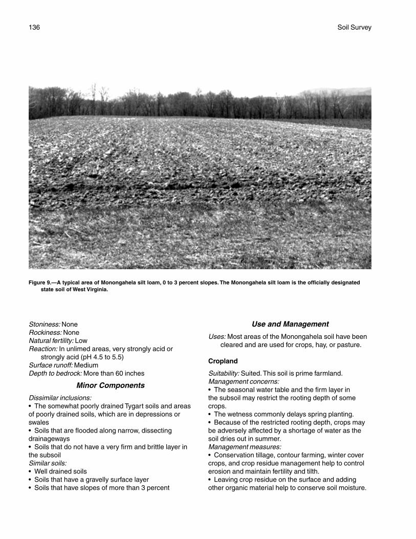
136 Soil Survey
Stoniness: NoneRockiness: NoneNatural fertility: LowReaction: In unlimed areas, very strongly acid or
strongly acid (pH 4.5 to 5.5)Surface runoff: MediumDepth to bedrock: More than 60 inches
Minor Components
Dissimilar inclusions:• The somewhat poorly drained Tygart soils and areasof poorly drained soils, which are in depressions orswales• Soils that are flooded along narrow, dissectingdrainageways• Soils that do not have a very firm and brittle layer inthe subsoilSimilar soils:• Well drained soils• Soils that have a gravelly surface layer• Soils that have slopes of more than 3 percent
Use and Management
Uses: Most areas of the Monongahela soil have beencleared and are used for crops, hay, or pasture.
Cropland
Suitability: Suited. This soil is prime farmland.Management concerns:• The seasonal water table and the firm layer inthe subsoil may restrict the rooting depth of somecrops.• The wetness commonly delays spring planting.• Because of the restricted rooting depth, crops maybe adversely affected by a shortage of water as thesoil dries out in summer.Management measures:• Conservation tillage, contour farming, winter covercrops, and crop residue management help to controlerosion and maintain fertility and tilth.• Leaving crop residue on the surface and addingother organic material help to conserve soil moisture.
Figure 9.—A typical area of Monongahela silt loam, 0 to 3 percent slopes. The Monongahela silt loam is the officially designatedstate soil of West Virginia.
Berkeley County, West Virginia 137
Pasture and Hayland
Suitability: Suited; better suited to grasses than tolegumes because of the seasonal high water table
Management concerns:• Establishing and maintaining a healthy cover of sodand preventing overgrazing are major pasturemanagement concerns.• Overgrazing causes surface compaction, increasesthe runoff rate and the hazard of erosion, and reducesthe vigor of the plant cover.• Because this soil is soft when wet, grazing early inspring damages the sod.Management measures:• Proper stocking rates, a planned grazing system,and deferred grazing during wet periods help to keeppastures in good condition.• Applying lime and fertilizer according to the resultsof soil tests helps to ensure the maximum growth offorage plants.
Woodland
Potential productivity: Moderately highManagement concerns:• The use of equipment is restricted during wetperiods because this soil is soft when wet.• Competition from undesirable plants may slow thegrowth of planted tree seedlings.Management measures:• Adequately preparing the site helps to control theinitial plant competition in tree plantations, andspraying helps to control subsequent competition.
Community Development
Suitability: LimitedManagement concerns:• The seasonal high water table is the main limitationaffecting building site development and septic tankabsorption fields.• The seasonal high water table and the potential forfrost action are limitations on sites for local roads andstreets. Because this soil is soft when wet, pavementmay crack under heavy loads.• The wetness is a limitation affecting excavation andtrafficability and may delay construction in the winterand spring.• Erosion is a slight hazard on construction sites.Management measures:• The included well drained soils, which are bettersuited to buildings and septic tank absorption fieldsthan the Monongahela soil, should be selected fordevelopment.• Installing a drainage system around structures thathave basements or crawl spaces helps to overcomethe wetness.
• Buildings can be constructed on well compacted fillmaterial, which raises the site a sufficient distanceabove the water table.• Installing tile drainage lines upslope from absorptionfields can be effective in lowering the seasonal highwater table.• Installing large absorption fields on the contourhelps to overcome the restricted permeability in thelower part of the subsoil.• Installing a drainage system and providing a suitableroad base that includes the installation of properlydesigned geotextiles help to prevent the road damagecaused by wetness and frost action.• Maintaining the plant cover on construction sites,establishing a plant cover in unprotected areas, andproviding for proper disposal of surface runoff help tocontrol erosion and sedimentation of streams.
Interpretive Groups
Land capability classification: IIwWoodland ordination symbol: 4A
MhB—Monongahela silt loam, 3 to8 percent slopes
Setting
This soil is on gently sloping, slightly convex, lowstream terraces.
Composition
Monongahela soil and similar soils: 85 percentDissimilar inclusions: 15 percent
Representative Profile
Surface layer:0 to 8 inches—brown silt loam
Subsoil:8 to 13 inches—yellowish brown silt loam13 to 25 inches—yellowish brown silt loam25 to 30 inches—yellowish brown loam that has strong
brown and light brownish gray mottles30 to 51 inches—yellowish brown, very firm and brittle
loam that has strong brown and light brownishgray mottles
Underlying material:51 to 65 inches—yellowish brown loam that has strong
brown and gray mottles
Soil Properties and Qualities
Drainage class: Moderately well drainedPermeability: Moderate (0.6 inch to 2.0 inches per
hour) above the very firm and brittle layer in the
138 Soil Survey
subsoil and moderately slow or slow (0.06 to 0.6inch per hour) in the layer
Available water capacity: ModerateDepth to the seasonal high water table: 1.5 to 3.0 feetFlooding: NoneShrink-swell potential: LowErosion hazard: ModerateStoniness: NoneRockiness: NoneNatural fertility: LowReaction: In unlimed areas, very strongly acid or
strongly acid (pH 4.5 to 5.5)Surface runoff: MediumDepth to bedrock: More than 60 inches
Minor Components
Dissimilar inclusions:• The well drained Berks soils, which are along uplandmargins in some areas• The somewhat poorly drained Tygart soils, which arein depressions and swales• Soils that do not have a very firm and brittle layer inthe subsoil• Severely eroded soilsSimilar soils:• Well drained soils• Soils that have a gravelly surface layer• Soils that have slopes of less than 3 percent or morethan 8 percent
Use and Management
Uses: Most areas of the Monongahela soil have beencleared and are used for crops, hay, or pasture.Some areas are used as sites for communitydevelopment or are wooded. In some areas theacreage is idle land.
Cropland
Suitability: SuitedManagement concerns:• The seasonal high water table and the firm layer inthe subsoil may restrict the rooting depth of somecrops.• Erosion is a moderate hazard in unprotected areas.• The wetness commonly delays spring planting.• Because of the restrictive rooting depth, crops maybe adversely affected by a shortage of water as thesoil dries out in summer.Management measures:• Conservation tillage, contour farming, winter covercrops, and crop residue management help to controlerosion and maintain fertility and tilth.• Leaving crop residue on the surface and addingother organic material help to conserve soil moisture.
Pasture and Hayland
Suitability: Suited; better suited to grasses than tolegumes because of the seasonal high water table
Management concerns:• Establishing and maintaining a healthy cover of sodand preventing overgrazing are major pasturemanagement concerns.• Overgrazing causes surface compaction, increasesthe runoff rate and the hazard of erosion, and reducesthe vigor of the plant cover.• If pastures are overgrazed, erosion is a moderatehazard in areas where the plant cover has beendestroyed.• Because this soil is soft when wet, grazing early inspring damages the sod.Management measures:• Proper stocking rates, a planned grazing system,and deferred grazing during wet periods help to keeppastures in good condition.• Applying lime and fertilizer according to the resultsof soil tests helps to ensure the maximum growth offorage plants.
Woodland
Potential productivity: Moderately highManagement concerns:• Erosion is a management concern on logging roadsand skid trails.• The use of equipment is restricted during wetperiods because this soil is soft when wet.• Competition from undesirable plants may slow thegrowth of planted tree seedlings.Management measures:• Building logging roads and skid trails on the contourand seeding the roads and trails when they are nolonger being used help to control erosion.• Adequately preparing the site helps to control theinitial plant competition in tree plantations, andspraying helps to control subsequent competition.
Community Development
Suitability: LimitedManagement concerns:• The seasonal high water table is the main limitationaffecting building site development and septic tankabsorption fields.• The seasonal high water table and the potential forfrost action are limitations on sites for local roads andstreets. Because this soil is soft when wet, pavementmay crack under heavy loads.• The wetness is a limitation affecting excavation andtrafficability and may delay construction in winter andspring.
Berkeley County, West Virginia 139
• Erosion is a moderate hazard on construction sites.Management measures:• The included well drained soils, which are bettersuited to buildings and septic tank absorption fieldsthan the Monongahela soil, should be selected fordevelopment.• Installing a drainage system around structures thathave basements or crawl spaces helps to overcomethe wetness.• Buildings can be constructed on well compacted fillmaterial, which raises the site a sufficient distanceabove the water table.• Installing tile drainage lines upslope from absorptionfields can be effective in lowering the seasonal highwater table.• Installing large absorption fields on the contourhelps to overcome the restricted permeability in thelower part of the subsoil.• Installing a drainage system and providing a suitableroad base that includes the installation of properlydesigned geotextiles help to prevent the road damagecaused by wetness and frost action.• Maintaining the plant cover on construction sites,establishing a plant cover in unprotected areas, andproviding for proper disposal of surface runoff help tocontrol erosion and sedimentation of streams.
Interpretive Groups
Land capability classification: IIeWoodland ordination symbol: 4A
MhC—Monongahela silt loam, 8 to15 percent slopes
Setting
This soil is on strongly sloping, convex, low streamterraces.
Composition
Monongahela soil and similar soils: 80 percentDissimilar inclusions: 20 percent
Representative Profile
Surface layer:0 to 6 inches—brown silt loam
Subsoil:6 to 8 inches—yellowish brown silt loam8 to 23 inches—yellowish brown silt loam23 to 28 inches—yellowish brown loam that has strong
brown and light brownish gray mottles28 to 49 inches—yellowish brown, very firm and brittle
loam that has strong brown and light brownishgray mottles
Underlying material:49 to 65 inches—yellowish brown loam that has strong
brown and gray mottles
Soil Properties and Qualities
Drainage class: Moderately well drainedPermeability: Moderate (0.6 inch to 2.0 inches per
hour) above the very firm and brittle layer in thesubsoil and moderately slow or slow (0.06 to 0.6inch per hour) in the layer
Available water capacity: ModerateDepth to the seasonal high water table: 1.5 to
3.0 feetFlooding: NoneShrink-swell potential: LowErosion hazard: SevereStoniness: NoneRockiness: NoneNatural fertility: LowReaction: In unlimed areas, very strongly acid or
strongly acid (pH 4.5 to 5.5)Surface runoff: RapidDepth to bedrock: More than 60 inches
Minor Components
Dissimilar inclusions:• The well drained Berks soils, which are along uplandmargins in some areas• The somewhat poorly drained Tygart soils, which arein depressions• Soils that do not have a very firm and brittle layer inthe subsoil• Severely eroded soilsSimilar soils:• Well drained soils• Soils that have slopes of less than 8 percent or morethan 15 percent• Soils that have a gravelly surface layer
Use and Management
Uses: Most areas of the Monongahela soil have beencleared and are used for hay or pasture. In someareas, the soil is used as cropland or the acreageis idle land. A few small areas are used as sites forcommunity development or are wooded.
Cropland
Suitability: SuitedManagement concerns:• The seasonal high water table and the firm layer inthe subsoil may restrict the rooting depth of somecrops.• Erosion is a severe hazard in unprotected areas.• The wetness commonly delays spring planting.
140 Soil Survey
• Because of the restrictive rooting depth, crops maybe adversely affected by a shortage of water as thesoil dries out in summer.Management measures:• Conservation tillage, contour farming, winter covercrops, and crop residue management help to controlerosion and maintain fertility and tilth.• Leaving crop residue on the surface and addingother organic material help to conserve soil moisture.
Pasture and Hayland
Suitability: Suited; better suited to grasses than tolegumes because of the seasonal high water table
Management concerns:• Establishing and maintaining a healthy cover of sodand preventing overgrazing are major pasturemanagement concerns.• Overgrazing causes surface compaction, increasesthe runoff rate and the hazard of erosion, and reducesthe vigor of the plant cover.• If pastures are overgrazed, erosion is a severehazard in areas where the plant cover has beendestroyed.• Because this soil is soft when wet, grazing early inspring damages the sod.Management measures:• Proper stocking rates, a planned grazing system,and deferred grazing during wet periods help to keeppastures in good condition.• Grazing should be deferred in the spring until thesoil is firm.• Applying lime and fertilizer according to the resultsof soil tests helps to ensure the maximum growth offorage plants.
Woodland
Potential productivity: Moderately highManagement concerns:• Erosion is a management concern on logging roadsand skid trails.• The use of equipment is restricted during wetperiods because this soil is soft when wet.• Competition from undesirable plants may slow thegrowth of planted tree seedlings.Management measures:• Building logging roads and skid trails on the contourhelps to control erosion.• Adequately preparing the site helps to control the initial plant competition in tree plantations,and spraying helps to control subsequentcompetition.
Community Development
Suitability: LimitedManagement concerns:• The seasonal high water table is the main limitationaffecting building site development and septic tankabsorption fields.• The seasonal high water table and the potential forfrost action are limitations on sites for local roads andstreets. Because this soil is soft when wet, pavementmay crack under heavy loads.• The wetness is a limitation affecting excavation andtrafficability and may delay construction in the winterand spring.• The slope increases the extent of excavationrequired during the construction of roads andbuildings.• Erosion is a severe hazard on constructionsites.Management measures:• The included well drained soils, which are bettersuited to buildings and septic tank absorption fieldsthan the Monongahela soil, should be selected fordevelopment.• Installing a drainage system around structures thathave basements or crawl spaces helps to overcomethe wetness.• Buildings can be constructed on well compacted fillmaterial, which raises the site a sufficient distanceabove the water table.• Buildings should be designed so that they conformto the natural slope of the land.• Installing tile drainage lines upslope from absorptionfields can be effective in lowering the seasonal highwater table.• Installing large absorption fields on the contourhelps to overcome the restricted permeability in thelower part of the subsoil.• Installing a drainage system and providing a suitableroad base that includes the installation of properlydesigned geotextiles help to prevent the road damagecaused by wetness and frost action.• Roads and streets should be built on thecontour.• Maintaining the plant cover on construction sites,establishing a plant cover in unprotected areas, andproviding for proper disposal of surface runoff help tocontrol erosion and sedimentation.
Interpretive Groups
Land capability classification: IIIeWoodland ordination symbol: 4A
Berkeley County, West Virginia 141
MoB—Monongahela gravelly loam, 3 to8 percent slopes
Setting
This soil is on gently sloping, slightly convex, lowstream terraces.
Composition
Monongahela soil and similar soils: 80 percentDissimilar inclusions: 20 percent
Representative Profile
Surface layer:0 to 8 inches—brown gravelly loam
Subsoil:8 to 13 inches—yellowish brown gravelly silt
loam13 to 25 inches—yellowish brown silt loam25 to 30 inches—yellowish brown loam that has strong
brown and light brownish gray mottles30 to 51 inches—yellowish brown, very firm and brittle
loam that has strong brown and light brownishgray mottles
Underlying material:51 to 65 inches—yellowish brown loam that has strong
brown and gray mottles
Soil Properties and Qualities
Drainage class: Moderately well drainedPermeability: Moderate (0.6 inch to 2.0 inches per
hour) above the very firm and brittle layer in thesubsoil and moderately slow or slow (0.06 to 0.6inch per hour) in the layer
Available water capacity: Moderate or highDepth to the seasonal high water table: 1.5 to 3.0 feetFlooding: NoneShrink-swell potential: LowErosion hazard: ModerateStoniness: NoneRockiness: NoneNatural fertility: LowReaction: In unlimed areas, very strongly acid or
strongly acid (pH 4.5 to 5.5)Surface runoff: MediumDepth to bedrock: More than 60 inches
Minor Components
Dissimilar inclusions:• Berks soils, which are along upland margins in someareas• Somewhat poorly drained Tygart soils and areas ofpoorly drained soils, which are in depressions orswales
• Soils that are flooded and are along narrow,dissecting drainageways• Soils that do not have a very firm and brittle layer inthe subsoilSimilar soils:• Well drained soils• Soils that have slopes of less than 3 percent or morethan 8 percent• Soils that do not have a gravelly surface layer
Use and Management
Uses: Most areas of the Monongahela soil have beencleared and are used for crops, hay, or pasture.Some areas are used as sites for communitydevelopment. In a few small areas, the soil iswooded or the acreage is idle land.
Cropland
Suitability: SuitedManagement concerns:• The seasonal water table and the firm layer in thesubsoil may restrict the rooting depth of some crops.• Erosion is a moderate hazard in unprotected areas.• The wetness commonly delays spring planting.• Because of the restricted rooting depth, crops maybe adversely affected by a shortage of water as thesoil dries out in summer.• In some areas gravel in the surface layer mayinterfere with tillage and planting.Management measures:• Conservation tillage, contour farming, winter covercrops, and crop residue management help to controlerosion and to maintain fertility and tilth.• Leaving crop residue on the surface andadding other organic material help to conserve soilmoisture.
Pasture and Hayland
Suitability: Suited; better suited to grasses than tolegumes because of the seasonal high water table
Management concerns:• Establishing and maintaining a healthy cover of sodand preventing overgrazing are major pasturemanagement concerns.• Overgrazing causes surface compaction, increasesthe runoff rate and the hazard of erosion, and reducesthe vigor of the plant cover.• If pastures are overgrazed, erosion is a moderatehazard in areas where the plant cover has beendestroyed.• Because this soil is soft when wet, grazing early inspring damages the sod.Management measures:• Proper stocking rates, a planned grazing system,
142 Soil Survey
and deferred grazing during wet periods help to keeppastures in good condition.• Applying lime and fertilizer according to the resultsof soil tests helps to ensure the maximum growth ofplants.
Woodland
Potential productivity: Moderately highManagement concerns:• Erosion is a management concern on logging roadsand skid trails.• The use of equipment is restricted during wetperiods because this soil is soft when wet.• Competition from undesirable plants may slow thegrowth of planted tree seedlings.Management measures:• Building logging roads and skid trails on the contourand seeding the roads and trails when they are nolonger being used help to control erosion.• Adequately preparing the site helps to control theinitial plant competition in tree plantations, andspraying helps to control subsequent competition.
Community Development
Suitability: LimitedManagement concerns:• The seasonal high water table is the main limitationaffecting building site development and septic tankabsorption fields.• The seasonal high water table and the potential forfrost action are limitations on sites for local roads andstreets. Because this soil is soft when wet, pavementmay crack under heavy loads.• The wetness is a limitation affecting excavation andtrafficability and may delay construction in the winterand spring.• Gravel in the surface layer may interfere with theestablishment of lawns and with landscaping.• Erosion is a moderate hazard on construction sites.Management measures:• The included well drained soils, which are bettersuited to buildings and septic tank absorption fieldsthan the Monongahela soil, should be selected fordevelopment.• Installing a drainage system around structures thathave basements or crawl spaces helps to overcomethe wetness.• Buildings can be constructed on well compacted fillmaterial, which raises the site a sufficient distanceabove the water table.• Installing tile drainage lines upslope from absorptionfields can be effective in lowering the seasonal highwater table.• Installing large absorption fields on the contour
helps to overcome the restricted permeability in thelower part of the subsoil.• Installing a drainage system and providing a suitableroad base that includes the installation of properlydesigned geotextiles help to prevent the road damagecaused by wetness and frost action.• Maintaining the plant cover on construction sites,establishing a plant cover in unprotected areas, andproviding for proper disposal of surface runoff help tocontrol erosion and sedimentation of streams.
Interpretive Groups
Land capability classification: IIeWoodland ordination symbol: 4A
MrB—Murrill gravelly loam, 3 to 8 percentslopes
Setting
This soil is on broad, gently sloping, slightlyconcave to slightly convex footslopes and valley sides.It is underlain by limestone. Sinkholes occur in someareas.
Composition
Murrill soil and similar soils: 90 percentDissimilar inclusions: 10 percent
Representative Profile
Surface layer:0 to 9 inches—dark brown gravelly loam
Subsoil:9 to 14 inches—yellowish brown loam14 to 24 inches—brown gravelly clay loam24 to 55 inches—strong brown gravelly clay loam55 to 72 inches—yellowish red silty clay loam that has
red mottles
Soil Properties and Qualities
Drainage class: Well drainedPermeability: Moderate (0.6 inch to 2.0 inches per
hour)Available water capacity: Moderate or highDepth to the seasonal high water table: More than
6 feetFlooding: NoneShrink-swell potential: Low in the surface layer and
upper part of the subsoil and moderate in thelower part of the subsoil
Erosion hazard: ModerateStoniness: NoneRockiness: NoneNatural fertility: Medium
Berkeley County, West Virginia 143
Reaction: In unlimed areas, very strongly acid tomoderately acid (pH 4.5 to 6.0)
Surface runoff: MediumDepth to bedrock: More than 60 inchesBedrock type: Limestone
Minor Components
Dissimilar inclusions:• The somewhat poorly drained Poorhouse soils,which are in depressions and along drainageways• The moderately well drained Buchanan soils• The moderately deep Ryder soils and the deepNollville soils, which are in small convex areas of theunit• Areas of limestone rock outcropSimilar soils:• The well drained Hagerstown soils• Stony soils• Soils that have slopes of less than 3 percent or morethan 8 percent
Use and Management
Uses: Most areas of the Murrill soil have been clearedand are used for cultivated crops, orchards, hay,or pasture or as sites for community development.A few small areas are wooded.
Cropland
Suitability: Suited. This soil is prime farmland.Management concerns:• The hazard of erosion is moderate.• Sinkholes and solution channels in the limestonebedrock increase the hazard of ground-water pollutioncaused by applications of pesticides, fertilizers, andmanure; runoff from feedlots; and seepage frommanure pits.• An excessive amount of nutrients in manure andfertilizer applications can result in the pollution ofground water and surface water by nutrients.• In some areas rock fragments in the surface layermay interfere with tillage and planting.Management measures:• Using crop rotations that include grasses, legumes,and small grain, applying a system of conservationtillage, growing cover crops and green manure crops,and applying good crop residue management help toprevent excessive erosion and to maintain fertility andtilth.• Designing fertilizer and manure applications to meetcrop nutrient needs, using split fertilizer applications,and applying fertilizer in bands may reduce the risk ofnutrient leaching.• Maintaining sod filter strips around sinkholesreduces the hazard of ground-water pollution.
• Manure should be stored in a properly designedstorage facility.
Pasture and Hayland
Suitability: SuitedManagement concerns:• Establishing and maintaining a mixture of grassesand legumes and preventing overgrazing are majorpasture management concerns.• Overgrazing causes surface compaction andincreases the runoff rate and the hazard of erosion.• Ponds constructed for livestock water aresusceptible to seepage.Management measures:• Proper stocking rates, uniform distribution of grazing,and a planned grazing system help to keep pasturesin good condition.• Installing a plastic or bentonite liner helps to preventseepage from constructed ponds.• Applying lime and fertilizer according to the resultsof soil tests helps to ensure the maximum growth ofplants, especially legumes.
Woodland
Potential productivity: Moderately highManagement concerns:• Erosion is a management concern on logging roadsand skid trails.• Competition from weeds may slow the growth ofplanted tree seedlings.Management measures:• Adequately preparing the site helps to control theinitial plant competition in tree plantations, andspraying helps to control subsequent competition.• Building logging roads and skid trails on the contourand seeding the roads and trails when they are nolonger being used help to control erosion.
Community Development
Suitability: Well suitedManagement concerns:• Erosion is a moderate hazard on construction sites.• Sinkholes and solution channels in the limestonebedrock increase the hazard of ground-water pollutionby surface runoff and by seepage from septic tankabsorption fields.• The moderate shrink-swell potential is a limitation onsites for dwellings with basements.• The rock fragments in the surface layer may interferewith the establishment of lawns.• The wetness in the included Poorhouse soils is asevere limitation affecting development.• The included Nollville and Ryder soils aremoderately or severely limited as sites for septic
144 Soil Survey
tank absorption fields because of the depth tobedrock.Management measures:• Maintaining the plant cover on construction sites,establishing a plant cover in unprotected areas, andproviding for proper disposal of surface runoff help tocontrol erosion and sedimentation and to protect theground water from pollution.• Septic tank absorption fields should not be installedin areas that are near limestone rock outcrop orsinkholes or in areas where excavation exposes thelimestone bedrock.• Properly designing and strengthening footings andfoundations can help to prevent the structural damagecaused by shrinking and swelling.
Interpretive Groups
Land capability classification: IIeWoodland ordination symbol: 4A
MrC—Murrill gravelly loam, 8 to15 percent slopes
Setting
This soil is on strongly sloping, convex toeslopes onthe eastern side of North Mountain. It is underlain bylimestone. Sinkholes occur in some areas.
Composition
Murrill soil and similar soils: 90 percentDissimilar inclusions: 10 percent
Representative Profile
Surface layer:0 to 9 inches—dark brown gravelly loam
Subsoil:9 to 14 inches—yellowish brown gravelly loam14 to 24 inches—brown gravelly loam24 to 55 inches—strong brown gravelly clay
loam55 to 72 inches—yellowish red silty clay loam that
has red mottles
Soil Properties and Qualities
Drainage class: Well drainedPermeability: Moderate (0.6 inch to 2.0 inches per
hour)Available water capacity: Moderate or highDepth to the seasonal high water table: More than
6 feetFlooding: NoneShrink-swell potential: Low in the surface layer and the
upper part of the subsoil and moderate in thelower part of the subsoil
Erosion hazard: SevereStoniness: NoneRockiness: NoneNatural fertility: MediumReaction: In unlimed areas, very strongly acid to
moderately acid (pH 4.5 to 6.0)Surface runoff: RapidDepth to bedrock: More than 60 inchesBedrock type: Limestone
Minor Components
Dissimilar inclusions:• The moderately well drained Buchanan soils• Areas of limestone rock outcrop• The moderately deep Ryder soils and the deepNollville soilsSimilar soils:• The well drained Hagerstown soils• Stony soils• Soils that have slopes of less than 8 percent or morethan 15 percent
Use and Management
Uses: Most areas of the Murrill soil are wooded. A fewareas have been cleared and are used forcultivated crops, orchards, hay, or pasture.
Cropland
Suitability: SuitedManagement concerns:• Erosion is a severe hazard in unprotected areas.• Sinkholes and solution channels in the limestonebedrock increase the hazard of ground-water pollutioncaused by applications of pesticides, fertilizers, andmanure; runoff from feedlots; and seepage frommanure pits.• An excessive amount of nutrients in manure andfertilizer applications can result in the pollution ofground water and surface water by nutrients.• In some areas rock fragments in the surface layermay interfere with tillage and planting.Management measures:• Using crop rotations that include grasses, legumes,and small grain, applying a system of conservationtillage, growing cover crops and green manure crops,and applying good crop residue management help toprevent excessive erosion and to maintain fertility andtilth.• Designing fertilizer and manure applications to meetcrop nutrient needs, using split fertilizer applications,and applying fertilizer in bands may reduce the risk ofnutrient leaching.
Berkeley County, West Virginia 145
• Maintaining sod filter strips around sinkholesreduces the hazard of ground-water pollution.• Manure should be stored in a properly designedstorage facility.
Pasture and Hayland
Suitability: SuitedManagement concerns:• Establishing and maintaining a mixture of grassesand legumes and preventing overgrazing are majorpasture management concerns.• Overgrazing causes surface compaction, increasesthe runoff rate and the hazard of erosion, and reducesthe vigor of the plant cover.• If pastures are overgrazed, erosion is a severehazard in areas where the plant cover has beendestroyed.Management measures:• Proper stocking rates, uniform distribution of grazing,and a planned grazing system help to keep pasturesin good condition.• Applying lime and fertilizer according to the resultsof soil tests helps to ensure the maximum growth ofplants, especially legumes.
Woodland
Potential productivity: Moderately highManagement concerns:• Erosion is a management concern on logging roadsand skid trails.• Competition from weeds may slow the growth ofplanted tree seedlings.Management measures:• The hazard of erosion can be reduced by buildinglogging roads and skid trails on the contour; seedinglogging roads, log landings, and areas that have beencut and filled to perennial grasses and legumes; andinstalling water bars and culverts.• Adequately preparing the site helps to controlthe initial plant competition in tree plantations,and spraying helps to control subsequentcompetition.
Community Development
Suitability: LimitedManagement concerns:• The slope is a moderate limitation affectingdevelopment.• Sinkholes and solution channels in the limestonebedrock increase the hazard of ground-water pollutionby surface runoff and by seepage from septic tankabsorption fields.• The moderate shrink-swell potential is a limitation onsites for dwellings with basements.
• The rock fragments in the surface layer may interferewith the establishment of lawns.• Erosion is a severe hazard on construction sites.Management measures:• Buildings should be designed so that they conformto the natural slope of the land. Land shaping isnecessary in some areas.• Septic tank absorption fields should not be installedin areas that are near limestone rock outcrop orsinkholes or in areas where excavation exposes thelimestone bedrock.• Properly designing and strengthening footings andfoundations can help to prevent the structural damagecaused by shrinking and swelling.• Maintaining the plant cover on construction sites,establishing a plant cover in unprotected areas, andproviding for proper disposal of surface runoff help tocontrol erosion and sedimentation.
Interpretive Groups
Land capability classification: IIIeWoodland ordination symbol: 4A
PeB—Pecktonville gravelly loam, 3 to8 percent slopes
Setting
This soil is on gently sloping hillsides in the smalllimestone valleys associated with Ferrel Ridge in thewestern part of the county.
Composition
Pecktonville soil and similar soils: 75 percentDissimilar inclusions: 25 percent
Representative Profile
Surface layer:0 to 7 inches—dark yellowish brown gravelly loam
Subsoil:7 to 11 inches—yellowish brown gravelly loam11 to 48 inches—yellowish red clay48 to 65 inches—yellowish red clay that has very pale
brown mottles
Soil Properties and Qualities
Drainage class: Well drainedPermeability: Slow or moderately slow in the subsoil
(0.06 to 0.6 inch per hour)Available water capacity: Moderate or highDepth to the seasonal high water table: 3.5 to 6.0 feetFlooding: NoneShrink-swell potential: High in the subsoilErosion hazard: Moderate
146 Soil Survey
Stoniness: NoneRockiness: NoneNatural fertility: LowReaction: In unlimed areas, very strongly acid to
moderately acid (pH 4.5 to 6.0)Surface runoff: MediumDepth to bedrock: More than 60 inchesBedrock type: Siliceous limestone that contains fairly
high amounts of chert and sandstone
Minor Components
Dissimilar inclusions:• The well drained Blackthorn soils• Soils that are less than 60 inches deep overbedrockSimilar soils:• Stony soils• Soils that have a very gravelly or very cobbly surfacelayer• Soils that have slopes of less than 3 percent or morethan 8 percent• Soils that are not seasonally wet in the lower part ofthe subsoil
Use and Management
Uses: About one-half of the acreage of thePecktonville soil is used as woodland. Most of therest is used for pasture or hay. A small acreage isused for orchards.
Cropland
Suitability: Suited. This soil is prime farmland.Management concerns:• Erosion is a moderate hazard in unprotectedareas.• Solution channels in the limestone bedrock increasethe hazard of ground-water pollution caused byapplications of pesticides, fertilizers, and manure.• An excessive amount of nutrients in manure andfertilizer applications can result in the pollution ofground water and surface water by nutrients.• Chert in the surface layer may interfere with tillage insome areas.Management measures:• Conservation tillage, contour farming, winter covercrops, a crop rotation that includes hay, and good cropresidue management help to control erosion and tomaintain fertility and tilth.• Crop rotations that include grasses, legumes, andsmall grain help to control runoff and erosion.• Designing fertilizer and manure applications to meetcrop nutrient needs, using split fertilizer applications,and applying fertilizer in bands may reduce the risk ofnutrient leaching.
Pasture and Hayland
Suitability: SuitedManagement concerns:• Establishing and maintaining a mixture of grassesand legumes and preventing overgrazing are majorpasture management concerns.• Overgrazing causes surface compaction, increasesthe runoff rate and the hazard of erosion, and reducesthe vigor of the plant cover.Management measures:• Proper stocking rates, uniform distribution of grazing,and a planned grazing system help to keep pasturesin good condition.• Applying lime and fertilizer according to the resultsof soil tests helps to ensure the maximum growth ofplants, especially legumes.
Woodland
Potential productivity: Moderately highManagement concerns:• Erosion is a management concern on logging roadsand skid trails.• Competition from weeds may slow the growth ofplanted tree seedlings.Management measures:• Building logging roads and skid trails on the contourand seeding the roads and trails when they are nolonger being used help to control erosion.• Adequately preparing the site helps to control theinitial plant competition in tree plantations, andspraying helps to control subsequent competition.
Community Development
Suitability: Poorly suitedManagement concerns:• The high shrink-swell potential in the subsoil is alimitation affecting building site development.• The slow or moderately slow permeability and thewetness in the subsoil are limitations on sites forseptic tank absorption fields.• The high shrink-swell potential and low strength arelimitations affecting the construction of local roads andstreets. These limitations may cause pavement tobuckle under heavy loads.• The rock fragments in the surface layer may interferewith the establishment of lawns and with landscaping.• Erosion is a moderate hazard on construction sites.Management measures:• Properly designing and strengthening footings andfoundations can help to prevent the structural damagecaused by shrinking and swelling.• Installing a drainage system around structures thathave basements or crawl spaces helps to overcomethe wetness.

Berkeley County, West Virginia 147
• Enlarging or pressurizing septic tank absorptionfields or installing alternating drainfields helps toovercome the restricted permeability.• Providing a suitable road base that includes theinstallation of properly designed geotextiles helps toprevent the road damage caused by low strength andby shrinking and swelling.• Maintaining the plant cover on construction sites,establishing a plant cover in unprotected areas, andproviding for proper disposal of surface runoff help tocontrol erosion and sedimentation.
Interpretive Groups
Land capability classification: IIeWoodland ordination symbol: 4A
PeC—Pecktonville gravelly loam, 8 to15 percent slopes
Setting
This soil is on strongly sloping hillsides in the smalllimestone valleys associated with Ferrel Ridge in thewestern part of the county.
Composition
Pecktonville soil and similar soils: 75 percentDissimilar inclusions: 25 percent
Representative Profile
Surface layer:0 to 6 inches—brown gravelly loam
Subsoil:6 to 12 inches—yellowish brown gravelly loam12 to 18 inches—yellowish red silty clay loam18 to 43 inches—yellowish red and strong brown silty
clay43 to 57 inches—yellowish red, strong brown, and red
clay that has very pale brown mottles57 to 65 inches—red clay
Soil Properties and Qualities
Drainage class: Well drainedPermeability: Slow or moderately slow in the subsoil
(0.06 to 0.6 inch per hour)Available water capacity: Moderate or highDepth to the seasonal high water table: 3.5 to
6.0 feetFlooding: NoneShrink-swell potential: High in the subsoilErosion hazard: SevereStoniness: NoneRockiness: None
Natural fertility: LowReaction: In unlimed areas, very strongly acid to
moderately acid (pH 4.5 to 6.0)Surface runoff: RapidDepth to bedrock: More than 60 inchesBedrock type: Siliceous limestone that contains fairly
high amounts of chert and sandstone
Minor Components
Dissimilar inclusions:• The well drained Blackthorn soils• Soils that are less than 60 inches deep overbedrockSimilar soils:• Stony soils• Soils that have a very gravelly or very cobbly surfacelayer• Soils that have slopes of less than 8 percent or morethan 15 percent• Soils that are not seasonally wet in the lower part ofthe subsoil
Use and Management
Uses: About two-thirds of the acreage of thePecktonville soil is wooded. Most of the remainingacreage is used for pasture or hay. A smallacreage is used for orchards.
Cropland
Suitability: SuitedManagement concerns:• Erosion is a severe hazard in unprotected areas.• Solution channels in the limestone bedrock increasethe hazard of ground-water pollution caused byapplications of pesticides, fertilizers, and manure.• An excessive amount of nutrients in manure andfertilizer applications can result in the pollution ofground water and surface water by nutrients.• Chert in the surface layer may interfere with tillage insome areas.Management measures:• Conservation tillage, contour farming, winter covercrops, a crop rotation that includes hay, and good cropresidue management help to control erosion and tomaintain fertility and tilth.• Crop rotations that include grasses, legumes, andsmall grain help to control runoff and erosion.• Grassed waterways, diversions, and gradestabilization structures help to prevent gully erosion.• Designing fertilizer and manure applications to meetcrop nutrient needs, using split fertilizer applications,and applying fertilizer in bands may reduce the risk ofnutrient leaching.
148 Soil Survey
Pasture and Hayland
Suitability: SuitedManagement concerns:• Establishing and maintaining a mixture of grassesand legumes and preventing overgrazing are majorpasture management concerns.• Overgrazing causes surface compaction, increasesthe runoff rate and the hazard of erosion, and reducesthe vigor of the plant cover.Management measures:• Proper stocking rates, uniform distribution of grazing,and a planned grazing system help to keep pasturesin good condition.• Applying lime and fertilizer according to the resultsof soil tests helps to ensure the maximum growth ofplants, especially legumes.
Woodland
Potential productivity: Moderately highManagement concerns:• Erosion is a management concern on logging roadsand skid trails.• Competition from weeds may slow the growth ofplanted tree seedlings.Management measures:• Building logging roads and skid trails on the contourand seeding the roads and trails when they are nolonger being used help to control erosion.• Adequately preparing the site helps to control theinitial plant competition in tree plantations, andspraying helps to control subsequent competition.
Community Development
Suitability: Poorly suitedManagement concerns:• The high shrink-swell potential in the subsoil and theslope are limitations affecting building sitedevelopment.• The slow or moderately slow permeability, thewetness in the subsoil, and the slope are limitations onsites for septic tank absorption fields.• The high shrink-swell potential and low strength arelimitations affecting the construction of local roads andstreets. These limitations may cause pavement tobuckle under heavy loads.• The rock fragments in the surface layer may interferewith the establishment of lawns and with landscaping.• Erosion is a severe hazard on constructionsites.Management measures:• Properly designing and strengthening footings andfoundations can help to prevent the structural damagecaused by shrinking and swelling.• Installing a drainage system around structures that
have basements or crawl spaces helps to overcomethe wetness.• Buildings should be designed so that they conformto the natural slope of the land. Land shaping isnecessary in some areas.• Enlarging or pressurizing septic tank absorptionfields or installing alternating drainfields helps toovercome the restricted permeability.• Land shaping and installing the distribution lines onthe contour help to overcome the slope in absorptionareas.• Providing a suitable road base that includes theinstallation of properly designed geotextiles helps toprevent the road damage caused by low strength andby shrinking and swelling.• Maintaining the plant cover on construction sites,establishing a plant cover in unprotected areas, andproviding for proper disposal of surface runoff help tocontrol erosion and sedimentation.
Interpretive Groups
Land capability classification: IIIeWoodland ordination symbol: 4A
PeD—Pecktonville gravelly loam, 15 to25 percent slopes
Setting
This soil is on moderately steep hillsides on FerrelRidge in the western part of the county.
Composition
Pecktonville soil and similar soils: 75 percentDissimilar inclusions: 25 percent
Representative Profile
Surface layer:0 to 3 inches—very dark grayish brown gravelly loam
Subsurface layer:3 to 7 inches—yellowish brown gravelly loam
Subsoil:7 to 16 inches—yellowish brown gravelly loam16 to 22 inches—yellowish red silty clay loam22 to 47 inches—yellowish red and strong brown silty
clay47 to 61 inches—yellowish red, strong brown, and red
clay that has very pale brown mottles61 to 65 inches—red clay
Soil Properties and Qualities
Drainage class: Well drainedPermeability: Slow or moderately slow in the subsoil
(0.06 to 0.6 inch per hour)
Berkeley County, West Virginia 149
Available water capacity: Moderate or highDepth to the seasonal high water table: 3.5 to 6.0 feetFlooding: NoneShrink-swell potential: High in the subsoilErosion hazard: SevereStoniness: NoneRockiness: NoneNatural fertility: LowReaction: In unlimed areas, very strongly acid to
moderately acid (pH 4.5 to 6.0)Surface runoff: RapidDepth to bedrock: More than 60 inchesBedrock type: Siliceous limestone that contains fairly
high amounts of chert and sandstone
Minor Components
Dissimilar inclusions:• The well drained Blackthorn soils• Soils that are less than 60 inches deep over bedrockSimilar soils:• Stony soils• Soils that have a very gravelly or very cobbly surfacelayer• Soils that have slopes of less than 15 percent ormore than 25 percent• Soils that are not seasonally wet in the lower part ofthe subsoil
Use and Management
Uses: Most of the acreage of the Pecktonville soil iswooded. The rest is used for pasture or hay.
Cropland
Suitability: Poorly suited; better suited to hay andpasture because of the hazard of erosion
Management concerns:• Erosion is a severe hazard in unprotected areas.• Solution channels in the limestone bedrock increasethe hazard of ground-water pollution caused byapplications of pesticides, fertilizers, and manure.• An excessive amount of nutrients in manure andfertilizer applications can result in the pollution ofground water and surface water by nutrients.• Chert in the surface layer may interfere with tillage insome areas.Management measures:• Conservation tillage, contour farming, contourstripcropping, winter cover crops, a crop rotation thatincludes hay, and good crop residue managementhelp to control erosion and to maintain fertility and tilth.• Grassed waterways and diversions help to preventgully erosion.• Designing fertilizer and manure applications to meetcrop nutrient needs, using split fertilizer applications,
and applying fertilizer in bands may reduce the risk ofnutrient leaching.
Pasture and Hayland
Suitability: SuitedManagement concerns:• Establishing and maintaining a mixture of grassesand legumes and preventing overgrazing are majorpasture management concerns.• Overgrazing causes surface compaction, increasesthe runoff rate and the hazard of erosion, and reducesthe vigor of the plant cover.Management measures:• Proper stocking rates, uniform distribution of grazing,and a planned grazing system help to keep pasturesin good condition.• Applying lime and fertilizer according to the resultsof soil tests helps to ensure the maximum growth ofplants, especially legumes.
Woodland
Potential productivity: Moderately highManagement concerns:• Erosion is a management concern on logging roadsand skid trails.• Competition from weeds may slow the growth ofplanted tree seedlings.• Seedling mortality may be a problem on south-facing slopes because of droughtiness during thesummer.Management measures:• Building logging roads and skid trails on the contourand seeding the roads and trails when they are nolonger being used help to control erosion.• Adequately preparing the site helps to control theinitial plant competition in tree plantations, andspraying helps to control subsequent competition.• Drought-tolerant species, such as white pine, Scotchpine, and Norway spruce, should be selected forplanting on south aspects.
Community Development
Suitability: Poorly suitedManagement concerns:• The high shrink-swell potential in the subsoil and theslope are limitations affecting building sitedevelopment.• The slow or moderately slow permeability, thewetness in the subsoil, and the slope are limitationsaffecting septic tank absorption fields.• The high shrink-swell potential, low strength, and theslope are limitations on sites for local roads andstreets. Because this soil is soft when wet, pavementmay crack under heavy loads.
150 Soil Survey
• The rock fragments in the surface layer mayinterfere with the establishment of lawns and withlandscaping.• Erosion is a severe hazard on construction sites.Management measures:• Properly designing and strengthening footings andfoundations can help to prevent the structural damagecaused by shrinking and swelling.• Installing a drainage system around structures thathave basements or crawl spaces helps to overcomethe wetness.• Buildings should be designed so that they conformto the natural slope of the land.• Enlarging or pressurizing septic tank absorptionfields or installing alternating drainfields helps toovercome the restricted permeability. Land shapingand installing the distribution lines on the contour helpto overcome the slope.• Providing a suitable road base that includes theinstallation of properly designed geotextiles helps toprevent the road damage caused by low strength andby shrinking and swelling.• Roads should be built on the contour. Seedingroadbanks after construction helps to prevent erosion.• Maintaining the plant cover on construction sites,establishing a plant cover in unprotected areas, andproviding for proper disposal of surface runoff help tocontrol erosion and sedimentation.
Interpretive Groups
Land capability classification: IVeWoodland ordination symbol: 4R
PgC—Pecktonville very gravelly loam,3 to 15 percent slopes, extremelystony
Setting
This soil is on gently sloping or strongly sloping,convex ridgetops on Ferrell and Wilson Ridges in thewestern part of the county.
Composition
Pecktonville soil and similar soils: 85 percentDissimilar inclusions: 15 percent
Representative Profile
Surface layer:0 to 1 inch—organic duff from hardwood leaf litter1 to 3 inches—very dark grayish brown very gravelly
loam
Subsurface layer:3 to 7 inches—yellowish brown gravelly loam
Subsoil:7 to 12 inches—strong brown silt loam12 to 17 inches—yellowish red gravelly silty clay loam17 to 32 inches—yellowish red, strong brown, and
brownish yellow gravelly clay32 to 48 inches—yellowish red, red, and brownish
yellow gravelly clay48 to 62 inches—yellowish red, red, and brownish
yellow gravelly clay that has pinkish gray mottles62 to 65 inches—red clay
Soil Properties and Qualities
Drainage class: Well drainedPermeability: Slow or moderately slow (0.06 to
0.6 inch per hour) in the subsoilAvailable water capacity: Moderate or highDepth to the seasonal high water table: 3.5 to 6.0 feetFlooding: NoneShrink-swell potential: High in the subsoilErosion hazard: Moderate or severeStoniness: 3 to 15 percent of the surface covered with
stones and bouldersRockiness: NoneNatural fertility: LowReaction: In unlimed areas, very strongly acid to
moderately acid (pH 4.5 to 6.0)Surface runoff: Medium or rapidDepth to bedrock: More than 60 inchesBedrock type: Siliceous limestone that contains fairly
high amounts of chert and sandstone
Minor Components
Dissimilar inclusions:• The moderately deep Dekalb and Caneyville soils• The very deep Blackthorn soils• Areas of rock outcropSimilar soils:• Small areas of rubbly or extremely bouldery soils• Soils that have slopes of less than 3 percent or morethan 15 percent• Soils that have less than 3 percent of their surfacecovered with stones
Use and Management
Uses: Most areas of the Pecktonville soil are wooded.A few small areas have been cleared and areused as pasture. A few areas have beendeveloped as homesites.
Cropland
Suitability: Not suitedManagement concerns:• The stones on the surface of the soil makecultivation impractical.
Berkeley County, West Virginia 151
Pasture and Hayland
Suitability: Not suited for hay; difficult to manage forpasture
Management concerns:• Because of the stones and boulders on the surfaceof the soil, it is difficult to operate conventionalequipment used in clipping and in applying fertilizer.• Establishing and maintaining a mixture of grassesand legumes and preventing overgrazing are majorpasture management concerns.• Overgrazing causes surface compaction, increasesthe runoff rate and the hazard of erosion, and reducesthe vigor of the plant cover.Management measures:• Proper stocking rates, uniform distribution of grazing,and a planned grazing system help to keep pasturesin good condition.• Applying lime and fertilizer according to the resultsof soil tests helps to ensure the maximum growth ofplants, especially legumes.
Woodland
Potential productivity: Moderately highManagement concerns:• Erosion is a management concern on logging roadsand skid trails.• The large stones on the surface of the soil canhinder harvesting operations and damage equipment.• Competition from weeds may slow the growth ofplanted tree seedlings.• Seedling mortality may be a problem on southaspects because of droughtiness during the summer.• The stones and chert fragments in the surface layermay interfere with the planting of tree seedlings.Management measures:• The hazard of erosion can be reduced by seedinglogging roads, log landings, and areas that havebeen cut and filled and by installing water bars andculverts.• Logging roads should be designed so that theyconform to the topography.• Adequately preparing the site helps to control theinitial plant competition in tree plantations, andspraying helps to control subsequent competition.
Community Development
Suitability: Poorly suitedManagement concerns:• Erosion is a moderate or severe hazard onconstruction sites.• The high shrink-swell potential and the wetness inthe subsoil are limitations affecting building sitedevelopment.• The stones and boulders may interfere with
construction, with the establishment of lawns, and withlandscaping.• The slope, the slow or moderately slow permeabilityin the clayey layer of the subsoil, and the wetness arelimitations on sites for septic tank absorption fields.• The high shrink-swell potential and the low strengthare limitations affecting the construction of roads andstreets.Management measures:• Maintaining the plant cover on construction sites,establishing a plant cover in unprotected areas, andproviding for proper disposal of surface runoff help tocontrol erosion and sedimentation.• Properly designing and strengthening footings andfoundations can help to prevent the structural damagecaused by shrinking and swelling.• Installing a drainage system around structures thathave basements or crawl spaces helps to overcomethe wetness.• Enlarging or pressurizing septic tank absorptionfields or installing alternating drainfields helps toovercome the restricted permeability.• Providing a suitable road base that includes theinstallation of properly designed geotextiles helps toprevent the road damage caused by low strength andby shrinking and swelling.• Seeding and mulching roadbanks after constructionis completed helps to control erosion.
Interpretive Groups
Land capability classification: VIIsWoodland ordination symbol: 4X
Ph—Philo silt loam
Setting
This soil is on nearly level flood plains, mostly alongBack Creek and its tributaries in the western part ofthe county.
Composition
Philo soil and similar soils: 75 percentDissimilar inclusions: 25 percent
Representative Profile
Surface layer:0 to 3 inches—dark grayish brown silt loam
Subsoil:3 to 9 inches—dark brown silt loam9 to 17 inches—yellowish brown silt loam17 to 29 inches—yellowish brown silt loam that has
light brownish gray and dark yellowish brownmottles
152 Soil Survey
Underlying material:29 to 48 inches—dark grayish brown fine sandy loam
that has light brownish gray and yellowish brownmottles
48 to 65 inches—dark grayish brown, stratified gravellysand and loam
Soil Properties and Qualities
Drainage class: Moderately well drainedPermeability: Moderate (0.6 inch to 2.0 inches per
hour)Available water capacity: Moderate or highDepth to the seasonal high water table: 1.5 to 3.0 feetFlooding: Occasionally flooded (a 5 to 50 percent
chance of flooding in any year) for brief periodsShrink-swell potential: LowErosion hazard: SlightStoniness: NoneRockiness: NoneNatural fertility: MediumReaction: In unlimed areas, very strongly acid to
moderately acid (pH 4.5 to 6.0)Surface runoff: SlowDepth to bedrock: More than 60 inches
Minor Components
Dissimilar inclusions:• The poorly drained Atkins soils• The well drained Pope soilsSimilar soils:• Soils that are gravelly throughout• Soils that are frequently flooded• Soils that have a surface layer of fine sandy loam• Soils that have slopes of more than 3 percent
Use and Management
Uses: Most areas of the Philo soil are used for pastureor hay. Some areas are used for cultivated crops.A few areas are wooded.
Cropland
Suitability: Suited. This soil is prime farmland.Management concerns:• This soil must be properly protected if crops aregrown year after year.• The flooding may occasionally damage crops anddelay fieldwork.• The wetness may delay tillage and planting in thespring.• This soil is subject to streambank erosion in manyareas.Management measures:• Conservation tillage, a crop rotation that includeshay, winter cover crops, and good crop residue
management help to control erosion and maintainfertility and tilth.• Leaving a border of trees along streams helps toprevent excessive erosion on streambanks.
Pasture and Hayland
Suitability: Suited; better suited to grasses than tolegumes because of the seasonal high watertable
Management concerns:• Establishing and maintaining a healthy cover of sodand preventing overgrazing are major pasturemanagement concerns.• Overgrazing causes surface compaction, increasesthe runoff rate and the hazard of erosion, and reducesthe vigor of the plant cover.• Unrestricted access to streams by livestockincreases the hazards of streambank erosion andwater pollution.• Debris may be deposited on the grassland duringperiods of flooding.• Grazing when the soil is too wet may damage thesod.Management measures:• Proper stocking rates, a planned grazing system,and deferred grazing during wet periods help to keeppastures in good condition.• Streambanks should be fenced. Access to streamsby livestock should be limited to protected crossings.• Applying lime and fertilizer according to the resultsof soil tests helps to ensure the maximum growth offorage plants.
Woodland
Potential productivity: Moderately highManagement concerns:• The use of equipment is restricted during wetperiods because this soil is soft when wet.• Competition from weeds may slow the growth ofplanted tree seedlings.Management measures:• The tree species that can withstand the wetnessshould be selected for planting.• Adequately preparing the site helps to control theinitial plant competition in tree plantations, andspraying helps to control subsequent competition.• Year-round logging roads require additions of roadfilland gravel.
Community Development
Suitability: Not suitedManagement concerns:• Because of the flooding and the wetness, this soil isnot suited to buildings and septic tank absorption
Berkeley County, West Virginia 153
fields and is severely limited as a site for local roadsand streets.• Excavations are unstable and are subject to caving.Management measures:• Soils that are better suited to buildings and septictank absorption fields than the Philo soil should beselected for development.• Constructing roads on raised fill material andinstalling a drainage system help to overcome thewetness and prevent the damage caused by flooding.• Trench walls should be reinforced to prevent caving.
Interpretive Groups
Land capability classification: IIwWoodland ordination symbol: 5A
PoA—Poorhouse silt loam, 0 to 3 percentslopes
Setting
This soil is on nearly level, slightly concave uplands,mainly on the eastern toeslope of North Mountain. Asmaller acreage of the soil is in slight depressionsscattered throughout the Great Valley. The soil isunderlain by limestone.
Composition
Poorhouse soil and similar soils: 85 percentDissimilar inclusions: 15 percent
Representative Profile
Surface layer:0 to 12 inches—light olive brown silt loam that has
yellowish brown pockets
Subsoil:12 to 18 inches—yellowish brown silty clay that has
light brownish gray and strong brown mottles18 to 26 inches—yellowish brown clay that has gray
and strong brown mottles26 to 54 inches—brown clay that has gray and strong
brown mottles54 to 65 inches—gray silty clay that has dark grayish
brown and strong brown mottles
Soil Properties and Qualities
Drainage class: Somewhat poorly drainedPermeability: Slow (0.06 to 0.2 inch per hour)Available water capacity: HighDepth to the seasonal high water table: 0.5 foot to
1.5 feetFlooding: NoneShrink-swell potential: High in the subsoilErosion hazard: Slight
Stoniness: NoneRockiness: NoneNatural fertility: HighReaction: In unlimed areas, very strongly acid to
neutral (pH 4.5 to 7.3) in the surface layer andupper part of the subsoil and moderately acid toslightly alkaline (pH 5.6 to 7.8) in the lower part ofthe subsoil
Surface runoff: Slow or mediumDepth to bedrock: More than 60 inchesBedrock type: Limestone
Minor Components
Dissimilar inclusions:• The poorly drained Dunning soils, which are subjectto flooding and ponding; along concave drainagewaysand in depressions• The moderately well drained Swanpond soils• The well drained Murrill soils• Areas of rock outcropSimilar soils:• Soils that are 40 to 60 inches deep over bedrock• Soils that have a surface layer of loam or silty clayloam• Soils that have a gravelly surface layer
Use and Management
Uses: Most areas of the Poorhouse soil have beencleared. About half of the cleared acreage hasbeen drained and is used for cultivated crops orhay. The rest of the cleared acreage is in pasture.Some areas are wooded.
Cropland
Suitability: Suited if the soil is drainedManagement concerns:• This soil must be properly protected if cultivatedcrops are grown year after year.• Draining this soil is difficult because of the slowpermeability in the clayey subsoil, and draining someareas is difficult because adequate subsurface outletsare not available.• The wetness commonly delays spring planting.• Sinkholes and solution channels in the limestonebedrock increase the hazard of ground-water pollutioncaused by applications of pesticides, fertilizers, andmanure.• An excessive amount of nutrients in manure andfertilizer applications can result in the pollution ofground water and surface water by nutrients.Management measures:• Using crop rotations that include grasses and smallgrain, applying a system of conservation tillage,growing cover crops and green manure crops, and
154 Soil Survey
applying good crop residue management help toprevent excessive erosion and to maintain fertility andtilth.• Applying a system of conservation tillage anddeferring tillage when the soil is wet help to preventdeterioration of tilth.• Deep tillage may help to increase the rate of waterinfiltration and to overcome the restricted permeabilityif performed when the soil is dry.• Because of the slow permeability, subsurface drainsshould be narrowly spaced.• Designing fertilizer and manure applications to meetcrop nutrient needs, using split fertilizer applications,and applying fertilizer in bands may reduce the risk ofnutrient leaching.• Maintaining sod filter strips around sinkholesreduces the hazard of ground-water pollution.• Manure should be stored in a properly designedstorage facility.
Pasture and Hayland
Suitability: Suited; better suited to grasses than tolegumes because of the wetness
Management concerns:• Establishing and maintaining a healthy cover of sodand preventing overgrazing are major pasturemanagement concerns.• Grazing during wet periods causes surfacecompaction and poor tilth and damages the sod.Management measures:• Proper stocking rates, uniform distribution of grazing,and a planned grazing system help to keep pasturesin good condition.• Restricted grazing during wet periods helps tominimize compaction and maintain tilth.• Water-tolerant species should be selected forplanting.• Applying lime and fertilizer according to the resultsof soil tests helps to ensure the maximum growth ofplants.
Woodland
Potential productivity: Moderately highManagement concerns:• Because this soil is soft when wet, the use of loggingequipment is limited during wet periods.• Plant competition is severe. Competition fromundesirable plants may slow the growth of planted treeseedlings.Management measures:• Adequately preparing the site helps to control theinitial plant competition in tree plantations, andspraying helps to control subsequent competition.
• The tree species that can withstand the wetnessshould be selected for planting.
Community Development
Suitability: Poorly suitedManagement concerns:• The wetness and the high shrink-swell potential arelimitations on sites for dwellings.• The wetness and the slow permeability aresevere limitations affecting septic tank absorptionfields.• The wetness, the high shrink-swell potential, and thelow strength are limitations on sites for local roads andstreets. Because this soil is soft when wet, pavementmay crack under heavy loads.• The wetness is a limitation affecting excavation andtrafficability and may delay construction in the winterand spring.Management measures:• A surface or subsurface drainage system helps tolower the water table around buildings.• Buildings can be constructed on well compacted fillmaterial, which raises the site a sufficient distanceabove the water table.• Properly designing and strengthening footings andfoundations can help to prevent the structural damagecaused by shrinking and swelling.• Installing a drainage system and providing a suitableroad base that includes the installation of properlydesigned geotextiles help to prevent the road damagecaused by wetness, shrinking and swelling, and lowstrength.• Because a conventional septic tank absorption fieldwill not function properly in this soil, an alternativesystem, such as a mound system, or a better suitedsoil should be considered.
Interpretive Groups
Land capability classification: IIIwWoodland ordination symbol: 5w
PoB—Poorhouse silt loam, 3 to 8 percentslopes
Setting
This soil is on gently sloping, slightly concaveuplands, mainly on the eastern toeslopes of NorthMountain. It is underlain by limestone bedrock.
Composition
Poorhouse soil and similar soils: 80 percentDissimilar inclusions: 20 percent
Berkeley County, West Virginia 155
Representative Profile
Surface layer:0 to 11 inches—dark grayish brown silt loam
Subsoil:11 to 29 inches—yellowish brown silty clay that has
light brownish gray and strong brown mottles29 to 40 inches—light brownish gray clay that has
yellowish brown mottles40 to 65 inches—yellowish brown silty clay that has
light brownish gray and strong brown mottles
Soil Properties and Qualities
Drainage class: Somewhat poorly drainedPermeability: Slow (0.06 to 0.2 inch per hour)Available water capacity: HighDepth to the seasonal high water table: 0.5 foot to
1.5 feetFlooding: NoneShrink-swell potential: High in the subsoilErosion hazard: ModerateStoniness: NoneRockiness: NoneNatural fertility: HighReaction: In unlimed areas, very strongly acid to
neutral in the surface layer and upper part of thesubsoil (pH 5.1 to 7.3) and moderately acid toslightly alkaline in the lower part of the subsoil(pH 5.6 to 7.8)
Surface runoff: MediumDepth to bedrock: More than 60 inchesBedrock type: Limestone
Minor Components
Dissimilar inclusions:• The poorly drained Dunning soils that are subject toflooding and ponding; along concave drainagewaysand in depressions• The moderately well drained Swanpond soils• The well drained Murrill soils• Areas of rock outcropSimilar soils:• Soils that are 40 to 60 inches deep overbedrock• Soils that have a surface layer of loam or silty clayloam• Soils that have a gravelly or cobbly surface layer
Use and Management
Uses: Most areas of the Poorhouse soil have beencleared and are used as pasture. Some areashave been drained and are used for cultivatedcrops, orchards, or hay. A few small areas arewooded.
Cropland
Suitability: Suited if the soil is drainedManagement concerns:• The hazard of erosion is moderate.• Draining this soil is difficult because of the slowpermeability in the clayey subsoil, and draining someareas is difficult because adequate subsurface outletsare not available.• The wetness commonly delays spring planting.• Sinkholes and solution channels in the limestonebedrock increase the hazard of ground-water pollutioncaused by applications of pesticides, fertilizers, andmanure.• An excessive amount of nutrients in manure andfertilizer applications can result in the pollution ofground water and surface water by nutrients.Management measures:• Using crop rotations that include grasses and smallgrain, applying a system of conservation tillage,growing cover crops and green manure crops, andapplying good crop residue management help toprevent excessive erosion and to maintain fertility andtilth.• Applying a system of conservation tillage anddeferring tillage when the soil is wet help to preventdeterioration of tilth.• Deep tillage may help to increase the rate of waterinfiltration and to overcome the restricted permeabilityif performed when the soil is dry.• Because of the slow permeability, subsurface drainsshould be narrowly spaced.• Designing fertilizer and manure applications to meetcrop nutrient needs, using split fertilizer applications,and applying fertilizer in bands may reduce the risk ofnutrient leaching.• Maintaining sod filter strips around sinkholesreduces the hazard of ground-water pollution.• Manure should be stored in a properly designedstorage facility.
Pasture and Hayland
Suitability: Suited; better suited to grasses than tolegumes because of the wetness
Management concerns:• Establishing and maintaining a healthy cover of sodand preventing overgrazing are major pasturemanagement concerns.• Grazing during wet periods causes surfacecompaction and poor tilth and damages the sod.Management measures:• Proper stocking rates, uniform distribution of grazing,and a planned grazing system help to keep pasturesin good condition.• Restricted grazing during wet periods helps to
156 Soil Survey
minimize compaction and maintain tilth.• Water-tolerant species should be selected forplanting.• Applying lime and fertilizer according to the resultsof soil tests helps to ensure the maximum growth ofplants.
Woodland
Potential productivity: Moderately highManagement concerns:• The operation of logging equipment is limited duringwet periods.• Erosion is a management concern on logging roadsand skid trails.• Plant competition is severe. Competition fromundesirable plants may slow the growth of planted treeseedlings.Management measures:• Building logging roads and skid trails on the contourand seeding the roads and trails when they are nolonger being used help to control erosion.• Adequately preparing the site helps to control theinitial plant competition in tree plantations, andspraying helps to control subsequent competition.• The tree species that can withstand the wetnessshould be selected for planting.
Community Development
Suitability: Poorly suitedManagement concerns:• The wetness and the high shrink-swell potential arelimitations on sites for dwellings.• The wetness, the high shrink-swell potential, and thelow strength are limitations on sites for local roads andstreets. Because this soil is soft when wet, pavementmay crack under heavy loads.• The wetness and the slow permeability aresevere limitations affecting septic tank absorptionfields.• The wetness is a limitation affecting excavation andtrafficability and may delay construction in the winterand spring.• Erosion is a moderate hazard on construction sites.Management measures:• A surface or subsurface drainage system helps tolower the water table around buildings.• Buildings can be constructed on well compacted fillmaterial, which raises the site a sufficient distanceabove the water table.• Properly designing and strengthening footings andfoundations can help to prevent the structural damagecaused by shrinking and swelling.• Installing a drainage system and providing a suitableroad base that includes the installation of properly
designed geotextiles help to prevent the road damagecaused by wetness, shrinking and swelling, and lowstrength.• Because a conventional septic tank absorption fieldwill not function properly in this soil, an alternativesystem, such as a mound system, or a better suitedsoil should be considered.• Maintaining the plant cover on construction sites,establishing a plant cover in unprotected areas, andproviding for proper disposal of surface runoff help tocontrol erosion and sedimentation.
Interpretive Groups
Land capability classification: IIIwWoodland ordination symbol: 5w
Ps—Pope fine sandy loam
Setting
This soil is on nearly level, first bottom flood plains,mainly along Back Creek and its tributaries in thewestern part of the county.
Composition
Pope soil and similar soils: 90 percentDissimilar inclusions: 10 percent
Representative Profile
Surface layer:0 to 10 inches—dark yellowish brown fine sandy
loam
Subsoil:10 to 42 inches—dark yellowish brown fine sandy
loam
Underlying material:42 to 65 inches—strong brown sandy loam
Soil Properties and Qualities
Drainage class: Well drainedPermeability: Moderate or moderately rapid (0.6 inch
to 6.0 inches per hour)Available water capacity: Moderate or highDepth to the seasonal high water table: More than
6 feetFlooding: Frequently flooded (more than a
50 percent chance of flooding in any year) forbrief periods
Shrink-swell potential: LowErosion hazard: SlightStoniness: NoneRockiness: NoneNatural fertility: Medium
Berkeley County, West Virginia 157
Reaction: In unlimed areas, extremely acid to stronglyacid (pH 3.6 to 5.5)
Surface runoff: SlowDepth to bedrock: More than 60 inches
Minor Components
Dissimilar inclusions:• The poorly drained Atkins soils and the moderatelywell drained Philo soils, which are in sloughs anddepressions• Sand and gravel bars directly adjacent tostreamsSimilar soils:• The Pope soils that have a texture of silt loam• Soils that are gravelly throughout• Soils that have a texture of loamy sand and aresomewhat excessively drained or excessively drained• Soils that have slopes of more than 3 percent
Use and Management
Uses: Most areas of this Pope soil are wooded. Someareas have been cleared and are used for crops,hay, or pasture.
Cropland
Suitability: SuitedManagement concerns:• This soil must be properly protected if cultivatedcrops are grown year after year.• The flooding frequently delays fieldwork or damagescrops.• This soil is subject to streambank erosion in manyareas.• An excessive amount of nutrients in manure andfertilizer applications can result in the pollution ofground water and nearby streams by nutrients.• This soil is sometimes droughty during the growingseason.Management measures:• Conservation tillage, winter cover crops, and cropresidue management help to control erosion and tomaintain fertility and tilth.• Including grasses and legumes in crop rotationshelps to minimize the loss of nutrients, improve soilstructure, and provide nitrogen for use by succeedingcrops.• Leaving a border of trees along streams helps toprevent excessive erosion on streambanks.• Timing fertilizer applications to meet crop nutrientneeds, using split fertilizer applications, and applyingfertilizer in bands may reduce the risk of nutrientleaching.• Leaving crop residue on the surface and addingother organic material help to conserve soil moisture.
Pasture and Hayland
Suitability: SuitedManagement concerns:• Establishing and maintaining a mixture of grassesand legumes and preventing overgrazing are majorpasture management concerns.• Overgrazing causes surface compaction, increasesthe runoff rate and the hazard of erosion, and reducesthe vigor of the plant cover.• The flooding frequently deposits debris on thegrassland.• Unrestricted access to streams by livestockincreases the hazards of streambank erosion andwater pollution.Management measures:• Proper stocking rates, uniform distribution of grazing,and a planned grazing system help to keep pasturesin good condition.• Streambanks should be fenced. Access to streamsby livestock should be limited to protected crossings.• Applying lime and fertilizer according to the resultsof soil tests helps to ensure the maximum growth ofplants, especially legumes.
Woodland
Potential productivity: Moderately highManagement concerns:• Competition from weeds may slow the growth ofplanted tree seedlings.Management measures:• Adequately preparing the site helps to control theinitial plant competition in tree plantations, andspraying helps to control subsequent competition.
Community Development
Suitability: Not suitedManagement concerns:• Because of the flooding, this soil is generallyunsuited to buildings and septic tank absorption fieldsand is severely limited as a site for local roads andstreets.• Excavations are commonly unstable and are subjectto caving.Management measures:• Soils that are better suited to buildings and septictank absorption fields than this Pope soil should beselected for development.• Constructing roads on raised fill material helps toprevent the damage caused by flooding.• Trench walls should be reinforced to prevent caving.
Interpretive Groups
Land capability classification: IIwWoodland ordination symbol: 4A
158 Soil Survey
Px—Pope silt loam
Setting
This soil is on nearly level flood plains, mainly alongBack Creek and its tributaries in the western part ofthe county.
Composition
Pope soil and similar soils: 90 percentDissimilar inclusions: 10 percent
Representative Profile
Surface layer:0 to 10 inches—dark brown silt loam
Subsoil:10 to 20 inches—yellowish brown loam20 to 40 inches—brown sandy loam
Underlying material:40 to 65 inches—strong brown loamy
sand
Soil Properties and Qualities
Drainage class: Well drainedPermeability: Moderate (0.6 inch to 2.0 inches per
hour)Available water capacity: Moderate or highDepth to the seasonal high water table: More than
6 feetFlooding: Occasionally flooded (a 5 to 50 percent
chance of flooding in any year) for very briefperiods
Shrink-swell potential: LowErosion hazard: SlightStoniness: NoneRockiness: NoneNatural fertility: MediumReaction: In unlimed areas, very strongly acid or
strongly acid (pH 4.5 to 5.5)Surface runoff: SlowDepth to bedrock: More than 60 inches
Minor Components
Dissimilar inclusions:• The poorly drained Atkins soils and the moderatelywell drained Philo soils, which are in sloughs ordepressions• Sand and gravel bars directly adjacent to streamsSimilar soils:• The Pope soils that have a texture of fine sandyloam• Soils that have slopes of more than 3 percent
Use and Management
Uses: Most areas of this Pope soil are wooded. Someareas have been cleared and are used for crops,hay, or pasture.
Cropland
Suitability: Suited. This soil is prime farmland.Management concerns:• This soil must be properly protected if cultivatedcrops are grown year after year.• The flooding occasionally delays fieldwork ordamages crops.• This soil is subject to streambank erosion in someareas.• Nutrients in manure and fertilizer applications canresult in the pollution of ground water and nearbystreams.Management measures:• Conservation tillage, winter cover crops, and cropresidue management help to control erosion and tomaintain fertility and tilth.• Including grasses and legumes in crop rotationshelps to minimize the loss of nutrients, improve soilstructure, and provide nitrogen for use by succeedingcrops.• Leaving a border of trees along streams helps toprevent excessive erosion on streambanks.• Timing fertilizer applications to meet crop nutrientneeds, using split fertilizer applications, and applyingfertilizer in bands may reduce the risk of nutrientleaching.
Pasture and Hayland
Suitability: SuitedManagement concerns:• Establishing and maintaining a mixture of grassesand legumes and preventing overgrazing are majorpasture management concerns.• Overgrazing causes surface compaction, increasesthe runoff rate and the hazard of erosion, and reducesthe vigor of the plant cover.• The flooding occasionally deposits debris on thegrassland.• Unrestricted access to streams by livestockincreases the hazards of streambank erosion andwater pollution.Management measures:• Proper stocking rates, uniform distribution of grazing,and a planned grazing system help to keep pasturesin good condition.• Streambanks should be fenced. Access to streamsby livestock should be limited to protected crossings.
Berkeley County, West Virginia 159
• Applying lime and fertilizer according to the resultsof soil tests helps to ensure the maximum growth ofplants, especially legumes.
Woodland
Potential productivity: Moderately highManagement concerns:• Competition from weeds may slow the growth ofplanted tree seedlings.Management measures:• Adequately preparing the site helps to control theinitial plant competition in tree plantations, andspraying helps to control subsequent competition.
Community Development
Suitability: Not suitedManagement concerns:• Because of the flooding, this soil is generallyunsuited to buildings and septic tank absorption fieldsand is severely limited as a site for local roads andstreets.• Excavations are commonly unstable and are subjectto caving.Management measures:• Soils that are better suited to buildings and septictank absorption fields than this Pope soil should beselected for development.• Constructing roads on raised fill material helps toprevent the damage caused by flooding.• Trench walls should be reinforced to prevent caving.
Interpretive Groups
Land capability classification: IIwWoodland ordination symbol: 4A
Qm—Quarry, limestone
Setting
This map unit consists of open excavations fromwhich limestone has been quarried. Surrounding theexcavations are dump areas consisting of a mixture ofrock fragments and soil material that were removedduring the quarrying operation. These areas aremainly in the central and eastern parts of the GreatValley, overlying the Chambersburg and New MarketLimestones.
Composition
Quarry, limestone: 95 percentDissimilar inclusions: 5 percent
Representative Profile
This map unit is considered to be a nonsoil area;therefore, a representative profile is not given.
Properties and Qualities
The quarries generally have vertical walls rangingfrom 15 to 100 feet or more in height. Many of thequarries are inactive and are partially filled with water.The soil material in the dump areas generally has anextremely bouldery surface. The fine-earth fraction ofthe soil generally has a high content of clay and isslightly alkaline.
Some areas of the map unit are sparsely woodedwith a mixture of red cedar, black locust, tree-of-heaven, and red maple. Many areas are barren.Slopes are gently sloping to very steep.
Minor Components
Dissimilar inclusions:• The moderately deep Carbo soils and the shallowOpequon soils, which are along the margins of thismap unit and in small, undisturbed areas within theunit
Use and Management
Uses: Limestone excavated from areas of this mapunit is used for road construction, for themanufacture of cement, as a source of agriculturallime, and as a source of flux in the steel-makingprocess. Onsite investigation is necessary todetermine the suitability of the map unit for mostuses.
Interpretive Groups
Land capability classification: Not assignedWoodland ordination symbol: Not assigned
Qs—Quarry, shale
Setting
This map unit consists of open pits from whichshale has been excavated. The pits are in areasthroughout the county.
Composition
Quarry, shale: 95 percentDissimilar inclusions: 5 percent
Representative Profile
This map unit is considered to be a nonsoil area;therefore, a representative profile is not given.
Properties and Qualities
Some areas of this unit have nearly verticalhighwalls ranging from 5 to 30 feet in height. Shalebedrock is exposed throughout the unit. The reactionof the shale material ranges from extremely acid to

160 Soil Survey
strongly acid (pH 3.5 to 5.5). Most areas of the unit arebarren or support a limited amount of vegetation.
Minor Components
Dissimilar inclusions:• The shallow Weikert soils and the moderately deepBerks and Clearbrook soils, which are along themargins of this map unit and in small, undisturbedareas within the unit
Use and Management
Uses: Shale excavated from areas of this mapunit is used as a road base and for fill onconstruction sites. Onsite investigation isneeded to determine the suitability of themap unit for most uses.
Interpretive Groups
Land capability classification: Not assignedWoodland ordination symbol: Not assigned
ReF—Rock outcrop-Opequon complex,25 to 60 percent slopes
Setting
This map unit is on very steep limestone bluffs andhillsides along the Potomac River. The Opequon soiland the Rock outcrop occur as areas so intermingledon the landscape that it was impractical to separatethem in mapping.
Composition
Rock outcrop: 50 percentOpequon soil and similar soils: 40 percentDissimilar inclusions: 10 percent
Representative Profile
Rock outcrop
In most areas the Rock outcrop occurs as nearlyvertical limestone bluffs ranging from 10 to 80 feet inheight.
Opequon
Surface layer:0 to 2 inches—dark brown silty clay loam
Subsoil:2 to 7 inches—brown silty clay7 to 18 inches—yellowish red clay
Bedrock:18 inches—limestone
Soil Properties and Qualities
Opequon
Drainage class: Well drainedPermeability: Moderately slow or moderate (0.2 inch to
2.0 inches per hour)Available water capacity: Very low or lowDepth to the seasonal high water table: More than
6 feetFlooding: NoneShrink-swell potential: HighErosion hazard: Very severeStoniness: NoneNatural fertility: HighReaction: In unlimed areas, moderately acid to slightly
alkaline (pH 6.1 to 7.8)Surface runoff: Very rapidDepth to bedrock: 12 to 20 inchesBedrock type: Hard, nonrippable limestone
Minor Components
Dissimilar inclusions:• The deep Endcav soils• The very deep Hagerstown soilsSimilar soils:• The moderately deep Carbo soils• Soils that have slopes of more than 60 percent
Use and Management
Uses: Most areas of this map unit are wooded.Because of the very steep slope and the verysevere hazard of erosion, the unit is only suited towoodland.
Cropland
Suitability: Not suited
Pasture and Hayland
Suitability: Not suited
Woodland
Potential productivity: Moderate on south aspects;moderately high on north aspects
Management concerns:• Erosion is a very severe hazard on logging sites.• Operating logging equipment is hazardous becauseof the very steep slope.• Low strength and the high shrink-swell potentialincrease the hazard of slippage.• Limestone bluffs in the unit may interfere with theuse of harvesting equipment.
Berkeley County, West Virginia 161
• Droughtiness results in a high seedling mortalityrate, especially on south aspects.• Windthrow is a hazard because of the depth tobedrock in areas of the Opequon soil.Management measures:• Because of the very steep slope and the hazard ofslippage, special logging methods, such as cableyarding, should be considered.• Drought-tolerant species, such as Virginia pine,Scotch pine, Norway spruce, and white pine,should be selected for planting in areas of theOpequon soil.• Tree plantations should be on north-facing slopeswhere possible.
Community Development
Suitability: Not suitedManagement concerns:• Because of the very steep slope, the depth tobedrock, the Rock outcrop, and a hazard ofslippage, this map unit is unsuited to communitydevelopment.
Interpretive Groups
Land capability classification: VIIIsWoodland ordination symbol: Opequon—2R on south
aspects and 3R on north aspects
RnB—Ryder-Nollville channery silt loams,3 to 8 percent slopes
Setting
These soils are on gently sloping, convex uplandridges that are characterized by low relief. They are inthe western part of the Great Valley. The two soilsoccur as areas so intermingled on the landscape thatit was impractical to separate them in mapping.
Composition
Ryder soil and similar soils: 45 percentNollville soil and similar soils: 45 percentDissimilar inclusions: 10 percent
Representative Profile
Ryder
Surface layer:0 to 8 inches—yellowish brown channery silt loam
Subsoil:8 to 19 inches—yellowish brown silt loam19 to 30 inches—light yellowish brown channery silty
clay loam
Underlying material:30 to 35 inches—yellowish brown and brown very
channery silt loam
Bedrock:35 inches—slightly weathered, fractured and tilted,
interbedded limestone and limy shale
Nollville
Surface layer:0 to 10 inches—dark yellowish brown channery silt
loam
Subsoil:10 to 20 inches—yellowish brown channery silty clay
loam20 to 29 inches—yellowish brown silty clay loam29 to 41 inches—strong brown silty clay
Underlying material:41 to 57 inches—strong brown very channery silty
clay loam
Bedrock:57 inches—slightly weathered, fractured and tilted,
interbedded limestone and limy shale
Soil Properties and Qualities
Ryder
Drainage class: Well drainedPermeability: Moderate (0.6 inch to 2.0 inches per
hour)Available water capacity: Moderate or highDepth to the seasonal high water table: More than
6 feetFlooding: NoneShrink-swell potential: LowErosion hazard: ModerateStoniness: NoneRockiness: NoneNatural fertility: MediumReaction: In unlimed areas, strongly acid to neutral
(pH 5.1 to 7.3)Surface runoff: RapidDepth to bedrock: 24 to 40 inchesBedrock type: Interbedded limestone and limy shales;
mainly members of the Elbrook Formation
Nollville
Drainage class: Well drainedPermeability: Moderate (0.6 inch to 2.0 inches per
hour)Available water capacity: HighDepth to the seasonal high water table: More than
6 feetFlooding: None
162 Soil Survey
Shrink-swell potential: LowErosion hazard: ModerateStoniness: NoneRockiness: NoneNatural fertility: MediumReaction: In unlimed areas, strongly acid to neutral
(pH 5.1 to 7.3)Surface runoff: RapidDepth to bedrock: 40 to 60 inchesBedrock type: Interbedded limestone and limy shales;
mainly members of the Elbrook Formation
Minor Components
Dissimilar inclusions:• The very deep Hagerstown soils• The moderately deep Carbo soils• The very deep Funkstown soils that are subject toflooding and ponding; along concave, intermittentdrainageways• Severely eroded soils• Areas of limestone rock outcrop that occur singly orin parallel ridgesSimilar soils:• The very deep Duffield soils• Soils that are 10 to 20 inches deep over bedrock• Soils that have slopes of less than 3 percent• Soils that have slopes ranging from 8 to15 percent
Use and Management
Uses: Most areas of this map unit have been clearedand are used for crop, orchards, hay, or pasture. Afew areas are used as sites for communitydevelopment.
Cropland
Suitability: Suited. These soils are prime farmland.Management concerns:• The moderate hazard of erosion is a managementconcern.• Solution channels and fractures in the bedrockincrease the hazard of ground-water pollution causedby applications of pesticides, fertilizers, and manure;runoff from feedlots; and seepage from manure pits.• An excessive amount of nutrients in manure andfertilizer applications can result in the pollution ofground water and surface water by nutrients.Management measures:• Using crop rotations that include grasses, legumes,and small grain, applying a system of conservationtillage, growing cover crops and green manure crops,and applying good crop residue management help toprevent excessive erosion and to maintain fertility andtilth.
• Designing fertilizer and manure applications to meetcrop nutrient needs, using split fertilizer applications,and applying fertilizer in bands may reduce the risk ofnutrient leaching.• Maintaining sod filter strips around sinkholesreduces the hazard of ground-water pollution.• Manure should be stored in a properly designedstorage facility.
Pasture and Hayland
Suitability: SuitedManagement concerns:• Establishing and maintaining a mixture of grassesand legumes and preventing overgrazing are majorpasture management concerns.• If pastures are overgrazed, erosion is a moderatehazard in areas where the plant cover has beendestroyed.• Overgrazing causes surface compaction, increasesthe runoff rate and the hazard of erosion, and reducesthe vigor of the plant cover.• Ponds constructed for livestock water aresusceptible to seepage and have a high failurerate.Management measures:• Proper stocking rates, uniform distribution of grazing,and a planned grazing system help to keep pasturesin good condition.• Applying lime and fertilizer according to the resultsof soil tests helps to ensure the maximum growth ofplants, especially legumes.
Woodland
Potential productivity: Moderately highManagement concerns:• Erosion is a management concern on logging roadsand skid trails.• Competition from weeds may slow the growth ofplanted tree seedlings.Management measures:• Building logging roads and skid trails on the contourand seeding the roads and trails when they are nolonger being used help to control erosion.• Adequately preparing the site helps to controlthe initial plant competition in tree plantations,and spraying helps to control subsequentcompetition.
Community Development
Suitability: LimitedManagement concerns:• Solution channels and fractures in the bedrockincrease the hazard of ground-water pollution byseepage from septic tank absorption fields.
Berkeley County, West Virginia 163
• The depth to bedrock is a limitation affecting septictank absorption fields, excavations, and dwellings withbasements.• The moderate shrink-swell potential in areas of theNollville soil may be a limitation affecting theconstruction of buildings.• Low strength is a limitation affecting the constructionof roads in areas of the Nollville soil. Because the soilis soft when wet, pavement cracks and buckles underheavy loads.• Erosion is a moderate hazard on construction sites.Management measures:• Selecting the deepest areas of this map unit as sitesfor septic tank absorption fields, installing theabsorption fields on the contour, and enlarging theabsorption fields can help to overcome the depth tobedrock.• Septic tank absorption fields should not be installedin areas that are near limestone rock outcrop or inareas where excavation exposes the limestonebedrock because of the hazard of ground-waterpollution.• Properly designing and strengthening footings andfoundations can help to prevent the structural damagecaused by shrinking and swelling.• Providing a suitable road base that includes theinstallation of properly designed geotextiles helps toprevent the road damage caused by the low strengthof the Nollville soil.• Maintaining the plant cover on construction sites,establishing a plant cover in unprotected areas, andproviding for proper disposal of surface runoff help tocontrol erosion and sedimentation and to protect theground water from pollution.
Interpretive Groups
Land capability classification: IIeWoodland ordination symbol: Ryder—4A; Nollville—5A
RnC—Ryder-Nollville channery silt loams,8 to 15 percent slopes
Setting
These soils are on strongly sloping, convex uplandridges that are characterized by low relief. They are inthe western part of the Great Valley. The two soilsoccur as areas so intermingled on the landscape thatit was impractical to separate them in mapping.
Composition
Ryder soil and similar soils: 50 percentNollville soil and similar soils: 40 percentDissimilar inclusions: 10 percent
Representative Profile
Ryder
Surface layer:0 to 8 inches—dark yellowish brown channery silt
loam
Subsoil:8 to 19 inches—yellowish brown silt loam19 to 30 inches—light yellowish brown channery silty
clay loam
Underlying material:30 to 35 inches—yellowish brown and brown very
channery silt loam
Bedrock:35 inches—slightly weathered, fractured and tilted,
interbedded limestone and limy shale
Nollville
Surface layer:0 to 10 inches—dark yellowish brown channery silt
loam
Subsoil:10 to 20 inches—yellowish brown channery silty
clay loam20 to 29 inches—yellowish brown silty clay
loam29 to 41 inches—strong brown silty clay
Underlying material:41 to 57 inches—strong brown very channery silty
clay loam
Bedrock:57 inches—slightly weathered, fractured and tilted,
interbedded limestone and limy shale
Soil Properties and Qualities
Ryder
Drainage class: Well drainedPermeability: Moderate (0.6 inch to 2.0 inches per
hour)Available water capacity: Moderate or highDepth to the seasonal high water table: More than
6 feetFlooding: NoneShrink-swell potential: LowErosion hazard: SevereStoniness: NoneRockiness: NoneNatural fertility: MediumReaction: In unlimed areas, strongly acid to neutral
(pH 5.1 to 7.3)Surface runoff: Rapid
164 Soil Survey
Depth to bedrock: 24 to 40 inchesBedrock type: Interbedded limestone and limy shales;
mainly members of the Elbrook Formation
Nollville
Drainage class: Well drainedPermeability: Moderate (0.6 inch to 2.0 inches per
hour)Available water capacity: HighDepth to the seasonal high water table: More than
6 feetFlooding: NoneShrink-swell potential: LowErosion hazard: SevereStoniness: NoneRockiness: NoneNatural fertility: MediumReaction: In unlimed areas, strongly acid to neutral
(pH 5.1 to 7.3)Surface runoff: RapidDepth to bedrock: 40 to 60 inchesBedrock type: Interbedded limestone and limy shales;
mainly members of the Elbrook Formation
Minor Components
Dissimilar inclusions:• The very deep Hagerstown soils• The moderately deep Carbo soils• The very deep Funkstown soils that are subject toflooding and ponding; along concave, intermittentdrainageways• Severely eroded soils• Areas of limestone rock outcrop that occur singly orin parallel ridgesSimilar soils:• The very deep Duffield soils• Soils that are 10 to 20 inches deep overbedrock• Soils that have slopes ranging from 3 to 8 percent orfrom 15 to 25 percent
Use and Management
Uses: Most areas of this map unit have been clearedand are used for crops, orchards, hay, or pasture.A few areas are used as sites for communitydevelopment.
Cropland
Suitability: SuitedManagement concerns:• The severe hazard of erosion is a majormanagement concern.• Solution channels and fractures in the bedrockincrease the hazard of ground-water pollution caused
by applications of pesticides, fertilizers, and manure;runoff from feedlots; and seepage from manure pits.• An excessive amount of nutrients in manure andfertilizer applications can result in the pollution ofground water and surface water by nutrients.Management measures:• Using crop rotations that include grasses, legumes,and small grain, applying a system of conservationtillage, growing cover crops and green manure crops,and applying good crop residue management help toprevent excessive erosion and to maintain fertility andtilth.• Grassed waterways, diversions, and gradestabilization structures help to prevent gully erosion.• Designing fertilizer and manure applications to meetcrop nutrient needs, using split fertilizer applications,and applying fertilizer in bands may reduce the risk ofnutrient leaching.• Maintaining sod filter strips around sinkholesreduces the hazard of ground-water pollution.• Manure should be stored in a properly designedstorage facility.
Pasture and Hayland
Suitability: SuitedManagement concerns:• Establishing and maintaining a mixture of grassesand legumes and preventing overgrazing are majorpasture management concerns.• Overgrazing causes surface compaction, increasesthe runoff rate and the hazard of erosion, and reducesthe vigor of the plant cover.• If pastures are overgrazed, erosion is a severehazard in areas where the plant cover has beendestroyed.• Ponds constructed for livestock water aresusceptible to seepage and have a high failure rate.Management measures:• Proper stocking rates, uniform distribution of grazing,and a planned grazing system help to keep pasturesin good condition.• Applying lime and fertilizer according to the resultsof soil tests helps to ensure the maximum growth ofplants, especially legumes.
Woodland
Potential productivity: Moderately highManagement concerns:• Erosion is a management concern on logging roadsand skid trails.• Competition from weeds may slow the growth ofplanted tree seedlings.Management measures:• Building logging roads and skid trails on the contour
Berkeley County, West Virginia 165
and seeding the roads and trails when they are nolonger being used help to control erosion.• Adequately preparing the site helps to controlthe initial plant competition in tree plantations,and spraying helps to control subsequentcompetition.
Community Development
Suitability: LimitedManagement concerns:• The slope is a moderate limitation affecting buildingsite development.• Solution channels and fractures in the bedrockincrease the hazard of ground-water pollution byseepage from septic tank absorption fields.• The depth to bedrock is a limitation affecting septictank absorption fields, excavations, and dwellings withbasements.• The moderate shrink-swell potential of the Nollvillesoil may be a limitation affecting the construction ofbuildings.• Low strength is a limitation affecting the constructionof roads in areas of the Nollville soil. Because the soilis soft when wet, pavement cracks and buckles underheavy loads.• Erosion is a severe hazard on constructionsites.Management measures:• Buildings should be designed so that they conformto the natural slope of the land. Land shaping isnecessary in some areas.• Selecting the deepest areas of this map unit as sitesfor septic tank absorption fields, installing theabsorption fields on the contour, and enlarging theabsorption fields can help to overcome the depth tobedrock.• Septic tank absorption fields should not be installedin areas that are near limestone rock outcrop or inareas where excavation exposes the limestonebedrock because of the hazard of ground-waterpollution.• Properly designing and strengthening footings andfoundations can help to prevent the structural damagecaused by shrinking and swelling.• Providing a suitable road base that includes theinstallation of properly designed geotextiles helps toprevent the road damage caused by the low strengthof the Nollville soil.• Maintaining the plant cover on construction sites,establishing a plant cover in unprotected areas, andproviding for proper disposal of surface runoff help tocontrol erosion and sedimentation and to protect theground water from pollution.
Interpretive Groups
Land capability classification: IIIeWoodland ordination symbol: Ryder—4A; Nollville—5A
RnD—Ryder-Nollville channery silt loams,15 to 25 percent slopes
Setting
These soils are on moderately steep, convexupland ridges and hillsides that are characterized bylow relief. They are in the western part of the GreatValley. The two soils occur as areas so intermingled onthe landscape that it was impractical to separate themin mapping.
Composition
Ryder soil and similar soils: 60 percentNollville soil and similar soils: 30 percentDissimilar inclusions: 10 percent
Representative Profile
Ryder
Surface layer:0 to 8 inches—yellowish brown channery silt
loam
Subsoil:8 to 19 inches—yellowish brown silt loam19 to 30 inches—light yellowish brown channery
silty clay loam
Underlying material:30 to 35 inches—yellowish brown and brown very
channery silty clay loam
Bedrock:35 inches—slightly weathered, fractured and tilted,
interbedded limestone and limy shale
Nollville
Surface layer:0 to 8 inches—dark yellowish brown channery silt
loam
Subsoil:8 to 18 inches—yellowish brown channery silty
clay loam18 to 27 inches—yellowish brown silty clay loam27 to 39 inches—strong brown silty clay
Underlying material:39 to 55 inches—strong brown very channery silty
clay loam
166 Soil Survey
Bedrock:55 inches—slightly weathered, fractured and tilted,
interbedded limestone and limy shale
Soil Properties and Qualities
Ryder
Drainage class: Well drainedPermeability: Moderate (0.6 inch to 2.0 inches per
hour)Available water capacity: Moderate or highDepth to the seasonal high water table: More than
6 feetFlooding: NoneShrink-swell potential: LowErosion hazard: SevereStoniness: NoneRockiness: NoneNatural fertility: MediumReaction: In unlimed areas, strongly acid to neutral
(pH 5.1 to 7.3)Surface runoff: RapidDepth to bedrock: 24 to 40 inchesBedrock type: Interbedded limestone and limy shales;
mainly members of the Elbrook Formation
Nollville
Drainage class: Well drainedPermeability: Moderate (0.6 inch to 2.0 inches per
hour)Available water capacity: HighDepth to the seasonal high water table: More than
6 feetFlooding: NoneShrink-swell potential: LowErosion hazard: SevereStoniness: NoneRockiness: NoneNatural fertility: MediumReaction: In unlimed areas, strongly acid to neutral
(pH 5.1 to 7.3)Surface runoff: RapidDepth to bedrock: 40 to 60 inchesBedrock type: Interbedded limestone and limy shales;
mainly members of the Elbrook Formation
Minor Components
Dissimilar inclusions:• The very deep Hagerstown soils• The moderately deep Carbo soils• Severely eroded soils• Areas of limestone rock outcrop that occur singly orin parallel ridgesSimilar soils:• The very deep Duffield soils
• Soils that are 10 to 20 inches deep over bedrock• Soils that have slopes ranging from 8 to 15 percentor from 25 to 35 percent
Use and Management
Uses: Most areas of this map unit have been clearedand are used for orchards or pasture. A few areasare used for hay or crops or as sites forcommunity development.
Cropland
Suitability: Poorly suited; better suited to hay andpasture because of the severe hazard of erosion
Management concerns:• The severe hazard of erosion is a majormanagement concern.• Solution channels and fractures in the bedrockincrease the hazard of ground-water pollution causedby applications of pesticides, fertilizers, and manure;runoff from feedlots; and seepage from manure pits.• An excessive amount of nutrients in manure andfertilizer applications can result in the pollution ofground water and surface water by nutrients.Management measures:• Using crop rotations that include grasses, legumes,and small grain, applying a system of conservationtillage, growing cover crops and green manure crops,and applying good crop residue management help toprevent excessive erosion and to maintain fertility andtilth.• Grassed waterways and diversions help to preventgully erosion.• Designing fertilizer and manure applications to meetcrop nutrient needs, using split fertilizer applications,and applying fertilizer in bands may reduce the risk ofnutrient leaching.• Manure should be stored in a properly designedstorage facility.
Pasture and Hayland
Suitability: SuitedManagement concerns:• Establishing and maintaining a mixture of grassesand legumes and preventing overgrazing are majorpasture management concerns.• Overgrazing causes surface compaction andincreases the runoff rate and the hazard of erosion.• If pastures are overgrazed, erosion is a severehazard in areas where the plant cover has beendestroyed.Management measures:• Proper stocking rates, uniform distribution of grazing,and a planned grazing system help to keep pasturesin good condition.
Berkeley County, West Virginia 167
• Applying lime and fertilizer according to the resultsof soil tests helps to ensure the maximum growth ofplants, especially legumes.
Woodland
Potential productivity: Moderately highManagement concerns:• Erosion is a management concern on logging roadsand skid trails.• The slope is a moderate limitation affecting theoperation of equipment.• Competition from weeds may slow the growth ofplanted tree seedlings.Management measures:• Because of the slope, special care should be takenwhen logging roads and log landings are laid out andlogging equipment is operated. Logging roads shouldbe designed so that they conform to the topography.• The hazard of erosion can be reduced by seedinglogging roads, log landings, and areas that have beencut and filled and by installing water bars and culverts.• Adequately preparing the site helps to control theinitial plant competition in tree plantations, andspraying helps to control subsequent competition.
Community Development
Suitability: Poorly suitedManagement concerns:• The slope is a severe limitation affecting communitydevelopment.• Solution channels and fractures in the bedrockincrease the hazard of ground-water pollution bysurface runoff and by seepage from septic tankabsorption fields.• The depth to bedrock is a limitation affecting septictank absorption fields, excavations, and dwellings withbasements.• The moderate shrink-swell potential in areas of theNollville soil may be a limitation affecting theconstruction of buildings.• Low strength is a limitation affecting the constructionof roads in areas of the Nollville soil. Because the soilis soft when wet, pavement cracks and buckles underheavy loads.• Erosion is a severe hazard on construction sites.Management measures:• Buildings and roads should be designed so that theyconform to the natural slope of the land. Extensiveland shaping is necessary in most areas.• Selecting the deepest areas of this map unit as sitesfor septic tank absorption fields, installing theabsorption fields on the contour, and enlarging theabsorption fields can help to overcome the depth tobedrock and the slope.
• Septic tank absorption fields should not be installedin areas that are near limestone rock outcrop or inareas where excavation exposes the limestonebedrock because of the hazard of ground-waterpollution.• Properly designing and strengthening footings andfoundations can help to prevent the structural damagecaused by shrinking and swelling.• Providing a suitable road base that includes theinstallation of properly designed geotextiles helps toprevent the road damage caused by the low strengthof the Nollville soil.• Maintaining the plant cover on construction sites,establishing a plant cover in unprotected areas, andproviding for proper disposal of surface runoff help tocontrol erosion and sedimentation and to protect theground water from pollution.
Interpretive Groups
Land capability classification: IVeWoodland ordination symbol: Ryder—4R; Nollville—
5R
RvC—Ryder-Nollville channery silt loams,8 to 15 percent slopes, very rocky
Setting
These soils are on strongly sloping, convex uplandridges and hillsides that are characterized by low relief.They are in the Great Valley. The two soils occur asareas so intermingled on the landscape that it wasimpractical to separate them in mapping.
Composition
Ryder soil and similar soils: 50 percentNollville soil and similar soils: 40 percentDissimilar inclusions: 10 percent
Representative Profile
Ryder
Surface layer:0 to 9 inches—dark yellowish brown channery silt
loam
Subsoil:9 to 25 inches—strong brown channery silty clay loam
Underlying material:25 to 33 inches—yellowish brown extremely channery
silty clay loam
Bedrock:33 inches—slightly weathered, fractured and tilted,
interbedded limestone and limy shale
168 Soil Survey
Nollville
Surface layer:0 to 10 inches—dark yellowish brown channery silt
loam
Subsoil:10 to 20 inches—yellowish brown channery silty clay
loam20 to 29 inches—yellowish brown silty clay loam29 to 41 inches—strong brown silty clay
Underlying material:41 to 57 inches—strong brown very channery silty
clay loam
Bedrock:57 inches—slightly weathered, fractured and tilted,
interbedded limestone and limy shale
Soil Properties and Qualities
Ryder
Drainage class: Well drainedPermeability: Moderate (0.6 inch to 2.0 inches per
hour)Available water capacity: Moderate or highDepth to the seasonal high water table: More than
6 feetFlooding: NoneShrink-swell potential: LowErosion hazard: SevereStoniness: NoneRockiness: 2 to 10 percent limestone rock outcropNatural fertility: MediumReaction: In unlimed areas, strongly acid to neutral
(pH 5.1 to 7.3)Surface runoff: RapidDepth to bedrock: 24 to 40 inchesBedrock type: Interbedded limestone and limy shales;
mainly members of the Elbrook Formation
Nollville
Drainage class: Well drainedPermeability: Moderate (0.6 inch to 2.0 inches per
hour)Available water capacity: HighDepth to the seasonal high water table: More than
6 feetFlooding: NoneShrink-swell potential: LowErosion hazard: SevereStoniness: NoneRockiness: 2 to 10 percent limestone rock outcropNatural fertility: MediumReaction: In unlimed areas, strongly acid to neutral
(pH 5.1 to 7.3)
Surface runoff: RapidDepth to bedrock: 40 to 60 inchesBedrock type: Interbedded limestone and limy shales;
mainly members of the Elbrook Formation
Minor Components
Dissimilar inclusions:• The very deep Hagerstown soils• The moderately deep Carbo soils• The shallow Opequon soils• Severely eroded soilsSimilar soils:• The very deep Duffield soils• Soils that have slopes ranging from 3 to 8 percent orfrom 15 to 25 percent
Use and Management
Uses: Most areas of the Ryder and Nollville soils havebeen cleared and are used as pasture. Manyareas are wooded. A few areas are used as sitesfor community development.
Cropland
Suitability: Not suitedManagement concerns:• The rock outcrop makes tillage impractical.
Pasture and Hayland
Suitability: Not suited for hay; limited suitability forpasture
Management concerns:• These soils are difficult to manage for pasture. Therock outcrop limits the use of farm machinery tomanage and improve pasture.• Establishing and maintaining a mixture of grassesand legumes and preventing overgrazing are majorpasture management concerns.• Overgrazing causes surface compaction andincreases the runoff rate and the hazard of erosion.• Solution channels and fractures in the bedrockincrease the hazard of ground-water pollution causedby applications of herbicides and fertilizers.• Ponds constructed for livestock water aresusceptible to seepage and have a high failure rate.Management measures:• Proper stocking rates, uniform distribution of grazing,and a planned grazing system help to keep pasturesin good condition.• Applying lime and fertilizer according to the resultsof soil tests helps to ensure the maximum growth ofplants, especially legumes.• To protect the ground water from pollution, nutrientsin fertilizer and manure applications should not exceedthe plant requirements.
Berkeley County, West Virginia 169
Woodland
Potential productivity: Moderately highManagement concerns:• Erosion is a management concern on logging roadsand skid trails.• Competition from weeds may slow the growth ofplanted tree seedlings.Management measures:• Building logging roads and skid trails on the contourand seeding the roads and trails when they are nolonger being used help to control erosion.• Adequately preparing the site helps to control theinitial plant competition in tree plantations, andspraying helps to control subsequent competition.
Community Development
Suitability: Poorly suitedManagement concerns:• The slope is a moderate limitation affectingcommunity development.• The limestone rock outcrop may interfere withexcavations, including those for roads, foundations,and septic tank absorption fields.• Solution channels and fractures in the bedrockincrease the hazard of ground-water pollution byseepage from septic tank absorption fields.• The depth to bedrock is a limitation affecting septictank absorption fields, excavations, and dwellings withbasements.• The moderate shrink-swell potential in areas of theNollville soil may be a limitation on sites for buildings.• Low strength is a limitation affecting the constructionof roads in areas of the Nollville soil. Because the soilis soft when wet, pavement cracks and buckles underheavy loads.• Erosion is a severe hazard on construction sites.Management measures:• Buildings should be designed so that they conformto the natural slope of the land. Land shaping isnecessary in some areas.• Selecting the deepest areas of this map unit as sitesfor septic tank absorption fields, installing theabsorption fields on the contour, and enlarging theabsorption fields can help to overcome the depth tobedrock.• Septic tank absorption fields should not be installedin areas that are near limestone rock outcrop or inareas where excavation exposes the bedrock becauseof the hazard of ground-water pollution.• Properly designing and strengthening footings andfoundations can help to prevent the structural damagecaused by shrinking and swelling.• Providing a suitable road base that includes theinstallation of properly designed geotextiles helps to
prevent the road damage caused by the low strengthof the Nollville soil.• Maintaining the plant cover on construction sites,establishing a plant cover in unprotected areas, andproviding for proper disposal of surface runoff help tocontrol erosion and sedimentation and to protect theground water from pollution.
Interpretive Groups
Land capability classification: VIsWoodland ordination symbol: Ryder—4A; Nollville—5A
SwA—Swanpond silt loam, 0 to 3 percentslopes
Setting
This soil is on nearly level, linear to slightly convexuplands in the Great Valley. It is in areas dissected byshallow, intermittent drainageways. Sinkholes occur insome areas.
Composition
Swanpond soil and similar soils: 80 percentDissimilar inclusions: 20 percent
Representative Profile
Surface layer:0 to 7 inches—brown silt loam
Subsoil:7 to 32 inches—yellowish brown clay32 to 65 inches—yellowish brown and strong brown
clay that has gray mottles
Soil Properties and Qualities
Drainage class: Moderately well drainedPermeability: Slow (0.06 to 0.2 inch per hour)Available water capacity: Moderate or highDepth to the seasonal high water table: 2.5 to 3.5 feetFlooding: NoneShrink-swell potential: High in the subsoilErosion hazard: SlightStoniness: NoneRockiness: NoneNatural fertility: Medium or highReaction: In unlimed areas, strongly acid to slightly
alkaline (pH 5.1 to 7.8)Surface runoff: MediumDepth to bedrock: More than 60 inchesBedrock type: Hard, nonrippable limestone
Minor Components
Dissimilar inclusions:• The well drained Hagerstown and Endcav soils,
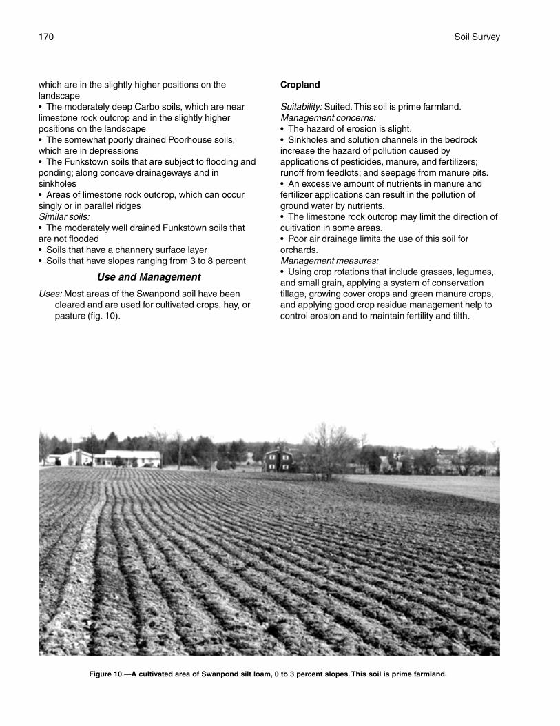
170 Soil Survey
which are in the slightly higher positions on thelandscape• The moderately deep Carbo soils, which are nearlimestone rock outcrop and in the slightly higherpositions on the landscape• The somewhat poorly drained Poorhouse soils,which are in depressions• The Funkstown soils that are subject to flooding andponding; along concave drainageways and insinkholes• Areas of limestone rock outcrop, which can occursingly or in parallel ridgesSimilar soils:• The moderately well drained Funkstown soils thatare not flooded• Soils that have a channery surface layer• Soils that have slopes ranging from 3 to 8 percent
Use and Management
Uses: Most areas of the Swanpond soil have beencleared and are used for cultivated crops, hay, orpasture (fig. 10).
Cropland
Suitability: Suited. This soil is prime farmland.Management concerns:• The hazard of erosion is slight.• Sinkholes and solution channels in the bedrockincrease the hazard of pollution caused byapplications of pesticides, manure, and fertilizers;runoff from feedlots; and seepage from manure pits.• An excessive amount of nutrients in manure andfertilizer applications can result in the pollution ofground water by nutrients.• The limestone rock outcrop may limit the direction ofcultivation in some areas.• Poor air drainage limits the use of this soil fororchards.Management measures:• Using crop rotations that include grasses, legumes,and small grain, applying a system of conservationtillage, growing cover crops and green manure crops,and applying good crop residue management help tocontrol erosion and to maintain fertility and tilth.
Figure 10.—A cultivated area of Swanpond silt loam, 0 to 3 percent slopes. This soil is prime farmland.

Berkeley County, West Virginia 171
• Designing fertilizer and manure applications to meetcrop nutrient needs, using split fertilizer applications,and applying fertilizer in bands may reduce the risk ofnutrient leaching.• Maintaining sod filter strips around sinkholesreduces the hazard of ground-water pollution.• Manure should be stored in a properly designedstorage facility.• Including grasses and legumes in crop rotationshelps to minimize the loss of nutrients, improve soilstructure, and provide nitrogen for use by succeedingcrops.
Pasture and Hayland
Suitability: SuitedManagement concerns:• Establishing and maintaining a mixture of grassesand legumes and preventing overgrazing are majorpasture management concerns.• Overgrazing causes surface compaction, increasesthe runoff rate and the hazard of erosion, and reducesthe vigor of the plant cover.Management measures:• Proper stocking rates, uniform distribution of grazing,and a planned grazing system help to keep pasturesin good condition.• Applying lime and fertilizer according to the resultsof soil tests helps to ensure the maximum growth ofplants, especially legumes.
Woodland
Potential productivity: Moderately highManagement concerns:• Operating logging equipment during wet periodswhen the soil is soft results in excessive rutting.• Competition from undesirable plants may slow thegrowth of planted tree seedlings.Management measures:• Logging should be deferred during wet periods.• Adequately preparing the site helps to control theinitial plant competition in tree plantations, andspraying helps to control subsequent competition.
Community Development
Suitability: Poorly suitedManagement concerns:• The slow permeability in the subsoil and the wetnesslimit the proper functioning of septic tank absorptionfields.• The wetness is a limitation on sites for dwellings withbasements.• The high shrink-swell potential in the subsoil is alimitation affecting foundations and footings.
• Low strength and the high shrink-swell potential arelimitations affecting the construction of roads. Becausethis soil is soft when wet, pavement cracks andbuckles under heavy loads.• Sinkholes and solution channels in the bedrockincrease the hazard of ground-water pollution byseepage from septic tank absorption fields.• In some areas the nonrippable limestone bedrockmay interfere with excavations, including those forroads, septic tank absorption fields, foundations, andsewer lines.• Erosion on construction sites is a managementconcern.Management measures:• Enlarging or pressurizing septic tank absorptionfields or installing alternating drainfields helps toovercome the restricted permeability.• Septic tank absorption fields should not be installedin areas that are near limestone rock outcrop orsinkholes or in areas where excavation exposes thelimestone bedrock.• Installing a drainage system around structures thathave basements or crawl spaces helps to overcomethe wetness.• Properly designing and strengthening footings andfoundations can help to prevent the structural damagecaused by shrinking and swelling.• Providing a suitable road base that includes theinstallation of properly designed geotextiles helps toprevent the road damage caused by low strength andby shrinking and swelling.• Maintaining the plant cover on construction sites,establishing a plant cover in unprotected areas, andproviding for proper disposal of surface runoff help tocontrol erosion and sedimentation.
Interpretive Groups
Land capability classification: IIwWoodland ordination symbol: 4C
SwB—Swanpond silt loam, 3 to 8 percentslopes
Setting
This soil is on gently sloping limestone uplands inthe Great Valley. It is in areas dissected by shallow,intermittent drainageways. Sinkholes occur in someareas.
Composition
Swanpond soil and similar soils: 75 percentDissimilar inclusions: 25 percent
172 Soil Survey
Representative Profile
Surface layer:0 to 7 inches—brown silt loam
Subsoil:7 to 35 inches—yellowish brown clay35 to 65 inches—yellowish brown clay that has gray
mottles
Soil Properties and Qualities
Drainage class: Moderately well drainedPermeability: Slow (0.06 to 0.2 inch per hour)Available water capacity: HighDepth to the seasonal high water table: 2.5 to
3.5 feetFlooding: NoneShrink-swell potential: High in the subsoilErosion hazard: ModerateStoniness: NoneRockiness: NoneNatural fertility: Medium or highReaction: In unlimed areas, strongly acid to slightly
alkaline (pH 5.1 to 7.8)Surface runoff: MediumDepth to bedrock: More than 60 inchesBedrock type: Hard, nonrippable limestone
Minor Components
Dissimilar inclusions:• The well drained Hagerstown and Endcav soils,which are in the slightly higher positions on thelandscape• The moderately deep Carbo soils, which are nearlimestone rock outcrop and in the slightly higherpositions on the landscape• The Funkstown soils that are subject to flooding andponding; along concave drainageways and insinkholes• Areas of limestone rock outcrop, which can occursingly or in parallel ridgesSimilar soils:• The moderately well drained Funkstown soils thatare not subject to flooding• Soils that have slopes ranging from 8 to15 percent• Soils that have slopes of less than 3 percent
Use and Management
Uses: Most areas of the Swanpond soil have beencleared and are used for cultivated crops, hay, orpasture.
Cropland
Suitability: Suited. This soil is prime farmland.
Management concerns:• The hazard of erosion is moderate in unprotectedareas.• Sinkholes and solution channels in the bedrockincrease the hazard of pollution caused byapplications of pesticides, manure, and fertilizers;runoff from feedlots; and seepage from manure pits.• An excessive amount of nutrients in manure andfertilizer applications can result in the pollution ofground water by nutrients.• The limestone rock outcrop may limit the direction ofcultivation in some areas.Management measures:• Using crop rotations that include grasses, legumes,and small grain, applying a system of conservationtillage, growing cover crops and green manure crops,and applying good crop residue management help toprevent excessive erosion and to maintain fertility andtilth.• Designing fertilizer and manure applications to meetcrop nutrient needs, using split fertilizer applications,and applying fertilizer in bands may reduce the risk ofnutrient leaching.• Maintaining sod filter strips around sinkholesreduces the hazard of ground-water pollution.• Including grasses and legumes in crop rotationshelps to minimize the loss of nutrients, improve soilstructure, and provide nitrogen for use by succeedingcrops.• Manure should be stored in a properly designedstorage facility.
Pasture and Hayland
Suitability: SuitedManagement concerns:• Establishing and maintaining a mixture of grassesand legumes and preventing overgrazing are majorpasture management concerns.• Overgrazing causes surface compaction, increasesthe runoff rate and the hazard of erosion, and reducesthe vigor of the plant cover.Management measures:• Proper stocking rates, uniform distribution of grazing,and a planned grazing system help to keep pasturesin good condition.• Applying lime and fertilizer according to the resultsof soil tests helps to ensure the maximum growth ofplants, especially legumes.
Woodland
Potential productivity: Moderately highManagement concerns:• Operating logging equipment during wet periodswhen the soil is soft results in excessive rutting.
Berkeley County, West Virginia 173
• Competition from undesirable plants may slow thegrowth of planted tree seedlings.• Erosion is a management concern on logging roadsand skid trails.Management measures:• Logging should be deferred during wet periods.• Adequately preparing the site helps to control theinitial plant competition in tree plantations, andspraying helps to control subsequent competition.• Building logging roads and skid trails on the contourand seeding the roads and trails when they are nolonger being used help to control erosion.
Community Development
Suitability: Poorly suitedManagement concerns:• The slow permeability in the subsoil and the wetnesslimit the proper functioning of septic tank absorptionfields.• The wetness is a limitation on sites for dwellings withbasements.• The high shrink-swell potential in the subsoil is alimitation affecting foundations and footings.• Low strength and the high shrink-swell potential arelimitations affecting the construction of roads. Becausethis soil is soft when wet, pavement cracks andbuckles under heavy loads.• Sinkholes and solution channels in the bedrockincrease the hazard of ground-water pollution byseepage from septic tank absorption fields.• In some areas the nonrippable limestone bedrockmay interfere with excavations, including those forroads, septic tank absorption fields, foundations, andsewer lines.• Erosion is a moderate hazard on construction sites.Management measures:• Enlarging or pressurizing septic tank absorptionfields or installing alternating drainfields helps toovercome the restricted permeability.• Septic tank absorption fields should not be installedin areas that are near limestone rock outcrop orsinkholes or in areas where excavation exposes thelimestone bedrock.• Installing a drainage system around structures thathave basements or crawl spaces helps to overcomethe wetness.• Properly designing and strengthening footings andfoundations can help to prevent the structural damagecaused by shrinking and swelling.• Providing a suitable road base that includes theinstallation of properly designed geotextiles helps toprevent the road damage caused by low strength andby shrinking and swelling.• Maintaining the plant cover on construction sites,
establishing a plant cover in unprotected areas, andproviding for proper disposal of surface runoff help tocontrol erosion and sedimentation.
Interpretive Groups
Land capability classification: IIeWoodland ordination symbol: 4C
TyA—Tygart silt loam, 0 to 3 percentslopes
Setting
This soil is on nearly level, low stream terraces,mainly along Back Creek and, to a lesser extent, alongOpequon Creek and the Potomac River.
Composition
Tygart soil and similar soils: 85 percentDissimilar inclusions: 15 percent
Representative Profile
Surface layer:0 to 10 inches—brown silt loam
Subsoil:10 to 15 inches—light yellowish brown silt loam that
has strong brown and brownish gray mottles15 to 24 inches—yellowish brown silty clay loam that
has gray and strong brown mottles24 to 47 inches—gray clay that has yellowish brown
and yellowish red mottles47 to 59 inches—50 percent gray and 50 percent
yellowish brown silty clay that has yellowish redmottles
Underlying material:59 to 65 inches—gray silty clay that has yellowish
brown and yellowish red mottles
Soil Properties and Qualities
Drainage class: Somewhat poorly drainedPermeability: Slow (0.06 to 0.2 inch per hour)Available water capacity: Moderate or highDepth to the seasonal high water table: 0.5 foot to
1.5 feetFlooding: NoneShrink-swell potential: Moderate in the subsoilErosion hazard: SlightStoniness: NoneRockiness: NoneNatural fertility: LowReaction: In unlimed areas, very strongly acid to
moderately acid (pH 4.5 to 6.0)Surface runoff: Slow
174 Soil Survey
Depth to bedrock: More than 60 inches
Minor Components
Dissimilar inclusions:• The poorly drained Atkins soils, which are alongdrainageways• The moderately well drained Monongahela soilsSimilar soils:• Poorly drained soils• Soils that have a gravelly surface layer• Soils that slopes of more than 3 percent• Soils that are not as clayey in the subsoil as theTygart soil
Use and Management
Uses: Most areas of the Tygart soil are used forpasture or hay. Some areas are used for cultivatedcrops. A few areas are forested.
Cropland
Suitability: Suited if the soil is adequately drainedManagement concerns:• This soil must be properly protected if cultivatedcrops are grown year after year.• The wetness may delay tillage and planting in thespring.• Draining this soil is difficult because of the slowpermeability in the subsoil.Management measures:• Conservation tillage, deferred tillage during wetperiods, winter cover crops, a crop rotation thatincludes hay, and good crop residue managementhelp to maintain soil tilth and fertility and to controlerosion.
Pasture and Hayland
Suitability: Suited; better suited to grasses than tolegumes because of the seasonal high watertable
Management concerns:• Establishing and maintaining a healthy cover of sodand preventing overgrazing are major pasturemanagement concerns.• Overgrazing causes surface compaction, increasesthe runoff rate and the hazard of erosion, and reducesthe vigor of the plant cover.• Because this soil is soft when wet, grazing early inspring damages the sod.Management measures:• Proper stocking rates, a planned grazing system,and deferred grazing during wet periods help to keeppastures in good condition.• Grazing should be deferred in the spring until thesoil is firm.
• Water-tolerant species should be selected forplanting.• Applying lime and fertilizer according to the resultsof soil tests helps to ensure the maximum growth offorage plants.
Woodland
Potential productivity: Moderately highManagement concerns:• The use of equipment is restricted during wetperiods because this soil is soft when wet.• Competition from weeds may slow the growth ofplanted tree seedlings.• Trees are susceptible to windthrow when the soil iswet.Management measures:• The tree species that can withstand the wetnessshould be selected for planting.• Year-round logging roads require additions of roadfilland gravel.• Adequately preparing the site helps to control theinitial plant competition in tree plantations, andspraying helps to control subsequent competition.• Harvest methods that do not leave the remainingtrees widely spaced reduce the hazard of windthrow.
Community Development
Suitability: Poorly suitedManagement concerns:• The wetness is the main limitation on sites forbuildings, especially buildings with basements.• The wetness is a limitation affecting excavation andtrafficability and may delay construction in the winterand spring.• The wetness and the slow permeability aresevere limitations on sites for septic tank absorptionfields.• Low strength and the wetness are limitations onsites for local roads and streets. Because this soil issoft when wet, pavement cracks under heavy loads.Management measures:• Buildings can be constructed on well compacted fillmaterial, which raises the site a sufficient distanceabove the water table.• Installing a drainage system around structures thathave basements or crawl spaces helps to overcomethe wetness.• An alternative to a septic tank absorption field or abetter suited soil should be considered for onsitesewage disposal.• Installing a drainage system and providing a suitableroad base that includes the installation of properlydesigned geotextiles help to prevent the road damagecaused by low strength and wetness.
Berkeley County, West Virginia 175
• Maintaining the plant cover on construction sites,establishing a plant cover in unprotected areas, andproviding for proper disposal of surface runoff help tocontrol erosion and sedimentation.
Interpretive Groups
Land capability classification: IIIwWoodland ordination symbol: 4W
TyB—Tygart silt loam, 3 to 8 percentslopes
Setting
This soil is on gently sloping, low stream terraces,mainly along Back Creek and, to a lesser extent, alongOpequon Creek.
Composition
Tygart soil and similar soils: 80 percentDissimilar inclusions: 20 percent
Representative Profile
Surface layer:0 to 10 inches—brown silt loam
Subsoil:10 to 17 inches—yellowish brown silty clay that has
gray, light yellowish brown, and strong brownmottles
17 to 35 inches—gray silty clay that has yellowishbrown and grayish brown mottles
35 to 55 inches—dark gray silty clay that has strongbrown mottles
Underlying material:55 to 59 inches—light brownish gray clay that has
strong brown and gray mottles59 to 65 inches—gray clay that has brown, yellowish
brown, and yellowish red mottles
Soil Properties and Qualities
Drainage class: Somewhat poorly drainedPermeability: Slow (0.06 to 0.2 inch per hour)Available water capacity: Moderate or highDepth to the seasonal high water table: 0.5 foot to
1.5 feetFlooding: NoneShrink-swell potential: Moderate in the subsoilErosion hazard: ModerateStoniness: NoneRockiness: NoneNatural fertility: LowReaction: In unlimed areas, very strongly acid to
moderately acid (pH 4.5 to 6.0)
Surface runoff: MediumDepth to bedrock: More than 60 inches
Minor Components
Dissimilar inclusions:• The moderately deep Clearbrook soils• The moderately well drained Monongahela soils• The poorly drained Atkins soils, which are alongdrainagewaysSimilar soils:• Poorly drained soils• Soils that have a gravelly surface layer• Soils that are not as clayey in the subsoil as theTygart soil• Soils that have slopes of less than 3 percent or morethan 8 percent
Use and Management
Uses: Most areas of the Tygart soil are used forpasture or hay. Some areas are used for cultivatedcrops. A few areas are forested.
Cropland
Suitability: Suited if the soil is adequately drainedManagement concerns:• Erosion is a moderate hazard in unprotectedareas.• The wetness may delay tillage and planting in thespring.• Draining this soil is difficult because of the slowpermeability in the subsoil.Management measures:• Conservation tillage, contour farming, deferredtillage when the soil is wet, winter cover crops, a croprotation that includes hay, and good crop residuemanagement help to maintain soil tilth and fertility andto control erosion.
Pasture and Hayland
Suitability: Suited; better suited to grasses than tolegumes because of the seasonal high watertable
Management concerns:• Establishing and maintaining a healthy cover of sodand preventing overgrazing are major pasturemanagement concerns.• Overgrazing causes surface compaction, increasesthe runoff rate and the hazard of erosion, and reducesthe vigor of the plant cover.• If pastures are overgrazed, erosion is a moderatehazard in areas where the plant cover has beendestroyed.• Because this soil is soft when wet, grazing early inspring damages the sod.
176 Soil Survey
Management measures:• Proper stocking rates, a planned grazing system,and deferred grazing during wet periods help to keeppastures in good condition.• Grazing should be deferred in the spring until thesoil is firm.• Water-tolerant species should be selected forplanting.• Applying lime and fertilizer according to the resultsof soil tests helps to ensure the maximum growth offorage plants.
Woodland
Potential productivity: Moderately highManagement concerns:• Erosion is a management concern on logging roadsand skid trails.• The use of equipment is restricted during wetperiods because this soil is soft when wet.• Competition from weeds may slow the growth ofplanted tree seedlings.• Trees are susceptible to windthrow when this soil iswet.Management measures:• Building logging roads and skid trails on the contourand seeding the roads and trails when they are nolonger being used help to control erosion.• Year-round logging roads require additions of roadfilland gravel.• Adequately preparing the site helps to control theinitial plant competition in tree plantations, andspraying helps to control subsequent competition.• Harvest methods that do not leave the remainingtrees widely spaced reduce the hazard of windthrow.• The tree species that can withstand the wetnessshould be selected for planting.
Community Development
Suitability: Poorly suitedManagement concerns:• The wetness is the main limitation on sites forbuildings, especially buildings with basements.• The wetness is a limitation affecting excavation andtrafficability and may delay construction in the winterand spring.• The wetness and the slow permeability are severelimitations on sites for septic tank absorption fields.• Low strength and the wetness are limitations onsites for local roads and streets. Because this soil issoft when wet, pavement cracks under heavy loads.• The hazard of erosion is moderate on constructionsites.Management measures:• Buildings can be constructed on well compacted fill
material, which raises the site a sufficient distanceabove the water table.• Installing a drainage system around structures thathave basements or crawl spaces helps to overcomethe wetness.• An alternative to a septic tank absorption field or abetter suited soil should be considered for onsitesewage disposal.• Installing a drainage system and providing a suitableroad base that includes the installation of properlydesigned geotextiles help to prevent the road damagecaused by low strength and wetness.• Maintaining the plant cover on construction sites,establishing a plant cover in unprotected areas, andproviding for proper disposal of surface runoff help tocontrol erosion and sedimentation.
Interpretive Groups
Land capability classification: IIIwWoodland ordination symbol: 4W
Ua—Udorthents, smoothed
Setting
These soils are in nearly level to very steep areasthat have been drastically disturbed by excavating,grading, filling, or a combination of these practices.Most areas of the soils are the result of roadconstruction, such as those along Interstate 81, orconstruction of commercial or industrial buildings,schools, or recreational sites, such as ball fields.
Composition
Udorthents: 90 percentDissimilar inclusions: 10 percent
Representative Profile
Because the characteristics of these soils vary somuch, a representative profile is not given. The surfacelayer of these soils ranges from sandy loam to claywith a wide range in size, amount, and kind of rockfragments. Generally, the soils derived from materialsexcavated from areas underlain by limestone areclayey in texture, while the soils derived from materialsexcavated from areas underlain by shale or sandstoneare loamy in texture.
Soil Properties and Qualities
Drainage class: VariesPermeability: Varies; commonly slow or very slow
because the soils have been compacted by heavyequipment
Available water capacity: Varies
Berkeley County, West Virginia 177
Seasonal high water table: VariesFlooding: VariesShrink-swell potential: VariesErosion hazard: VariesStoniness: VariesRockiness: VariesNatural fertility: VariesReaction: In unlimed areas, variesSurface runoff: VariesDepth to bedrock: Varies from very shallow in
excavated areas to very deep in filled areasBedrock type: Varies; bedrock exposed in some of the
excavated areas
Minor Components
Dissimilar inclusions:• The very deep Hagerstown, Duffield, Funkstown,and Swanpond soils• The deep Nollville soils• The moderately deep Berks, Carbo, and Ryder soils• The shallow Opequon and Weikert soils• Wet soils• Areas of rock outcrop• Areas of urban land• Areas that are subject to flooding
Use and Management
Uses: Most areas of these soils are used as interstaterights-of-way, for commercial or industrialpurposes, as school grounds, or for recreation.
Cropland
Suitability: Generally not suited
Pasture and Hayland
Suitability: Generally not suited
Woodland
Potential productivity: Varies, but generally lowManagement concerns: Because these soils
commonly are compacted and have a low contentof organic matter, it may be necessary to addorganic matter, in the form of compost or peatmoss, to the soils when trees are planted.
Community Development
Suitability: Varies too much to rate. An onsiteinvestigation is necessary to determine thesuitability of these soils as sites for sanitaryfacilities, buildings, and other development.
Interpretive Groups
Land capability classification: Not assignedWoodland ordination symbol: Not assigned
Ub—Urban land
Setting
This map unit consists of highly developed areas,mostly in Martinsburg and along Interstate 81.
Composition
Urban land: 90 percentDissimilar inclusions: 10 percent
Representative Profile
Because the original soil has been disturbed, arepresentative pedon is not given.
Soil Properties and Qualities
Most areas of this unit have been smoothed, andthe original soil has been disturbed, filled over, orotherwise destroyed prior to construction. The unitconsist of areas where at least 90 percent of thesurface is covered by asphalt, concrete, or otherimpervious material (fig. 11). Examples of urbanstructures and works include industrial complexes,shopping malls, business center parking lots, andbuildings.
Minor Components
Dissimilar inclusions:• The well drained Hagerstown soils• The moderately well drained Swanpond soils• The shallow Opequon soils• The moderately deep Carbo soils• Small areas of the Funkstown soils that are subjectto flooding; along concave drainageways• Areas of rock outcrop• Areas of Udorthents, smoothed
Use and Management
Uses: The Urban land is used for homes, shoppingmalls, schools, factories, roads, cemeteries,railroads, and industrial facilities.
Cropland
Suitability: Not suited
Pasture and Hayland
Suitability: Not suited
Community Development
Suitability: Onsite investigation is needed to determinethe limitations affecting any proposed use.
Interpretive Groups
Land capability classification: Not assignedWoodland ordination symbol: Not assigned
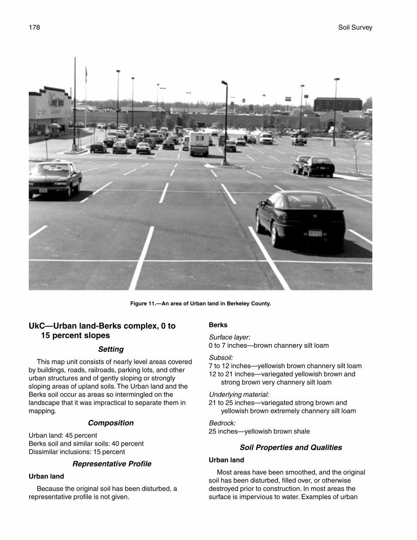
178 Soil Survey
UkC—Urban land-Berks complex, 0 to15 percent slopes
Setting
This map unit consists of nearly level areas coveredby buildings, roads, railroads, parking lots, and otherurban structures and of gently sloping or stronglysloping areas of upland soils. The Urban land and theBerks soil occur as areas so intermingled on thelandscape that it was impractical to separate them inmapping.
Composition
Urban land: 45 percentBerks soil and similar soils: 40 percentDissimilar inclusions: 15 percent
Representative Profile
Urban land
Because the original soil has been disturbed, arepresentative profile is not given.
Berks
Surface layer:0 to 7 inches—brown channery silt loam
Subsoil:7 to 12 inches—yellowish brown channery silt loam12 to 21 inches—variegated yellowish brown and
strong brown very channery silt loam
Underlying material:21 to 25 inches—variegated strong brown and
yellowish brown extremely channery silt loam
Bedrock:25 inches—yellowish brown shale
Soil Properties and Qualities
Urban land
Most areas have been smoothed, and the originalsoil has been disturbed, filled over, or otherwisedestroyed prior to construction. In most areas thesurface is impervious to water. Examples of urban
Figure 11.—An area of Urban land in Berkeley County.
Berkeley County, West Virginia 179
structures and works include industrial complexes,shopping malls, business center parking lots, andbuildings.
Berks
Drainage class: Well drainedPermeability: Moderate or moderately rapid (0.6 inch
to 6.0 inches per hour)Available water capacity: Very low or lowDepth to the seasonal high water table: More than
6 feetFlooding: NoneShrink-swell potential: LowErosion hazard: Moderate or severeStoniness: NoneRockiness: NoneNatural fertility: LowReaction: In unlimed areas, very strongly acid to
slightly acid (pH 4.5 to 6.5)Surface runoff: Medium or rapidDepth to bedrock: 20 to 40 inchesBedrock type: Soft, rippable, acid Martinsburg
Shale
Minor Components
Dissimilar inclusions:• The somewhat poorly drained Clearbrook soils• The well drained Pope soils, moderately well drainedPhilo soils, and poorly drained Atkins soils that aresubject to flooding; along narrow drainageways• Areas of Udorthents, smoothed, that have been cutand filled• Severely eroded soilsSimilar soils:• The shallow Weikert soils• Soils that have slopes ranging from 8 to 15 percent• Soils that are 40 to 60 inches deep over bedrock
Use and Management
Uses: This map unit is used for urban development.
Community Development
Suitability: LimitedManagement concerns:• The hazard of erosion is moderate or severe onconstruction sites.• The depth to bedrock is a limitation on sites forseptic tank absorption fields.• The depth to bedrock and the slope are moderatelimitations affecting excavations, building sitedevelopment, and construction of roads. In mostareas, however, the shale bedrock is soft enough tobe excavated with conventional earthmovingequipment.
• Establishing and maintaining vegetation onroadbanks is difficult on the droughty Berks soil,especially on south aspects.• The rock fragments in the surface layer and thedroughtiness make establishment of lawns difficult inareas of the Berks soil.Management measures:• Maintaining the plant cover on construction sites,establishing a plant cover in unprotected areas, andproviding for proper disposal of surface runoff help tocontrol erosion and sedimentation.• Sanitary facilities should be connected to publicsewers and sewage treatment facilities.• Drought-tolerant species, such as tall fescue andcrownvetch, should be selected for planting onroadbanks. Seeded areas should be mulched withstraw.
Interpretive Groups
Land capability classification: Not assignedWoodland ordination symbol: Not assigned
UvC—Urban land-Carbo-Endcav complex,0 to 15 percent slopes
Setting
This map unit consists of nearly level areas coveredby buildings, roads, railroads, parking lots, and otherurban structures and of gently sloping or stronglysloping areas in the uplands. Sinkholes are common insome areas. The Urban land and the Carbo andEndcav soils overlie the Chambersburg and NewMarket Limestones, generally in Martinsburg and thesurrounding area. The Urban land and the two soilsoccur as areas so intermingled on the landscape thatit was impractical to separate them in mapping.
Composition
Urban land: 45 percentCarbo soil and similar soils: 25 percentEndcav soil and similar soils: 20 percentDissimilar inclusions: 10 percent
Representative Profile
Urban land
Because the original soil has been disturbed, arepresentative profile is not given.
Carbo
Surface layer:0 to 2 inches—dark yellowish brown silty clay loam2 to 9 inches—dark yellowish brown silty clay
180 Soil Survey
Subsoil:9 to 18 inches—variegated strong brown and yellowish
brown clay18 to 28 inches—variegated yellowish brown and
strong brown clay28 to 34 inches—variegated dark yellowish brown,
strong brown, and yellowish brown clay
Bedrock:34 inches—hard, bluish gray limestone
Endcav
Surface layer:0 to 8 inches—brown silty clay loam
Subsoil:8 to 23 inches—strong brown clay23 to 41 inches—strong brown clay that has
many pockets of coarse yellowish brownloam
Bedrock:41 inches—gray limestone
Soil Properties and Qualities
Urban land
Most areas have been smoothed, and the originalsoils have been disturbed, filled over, or otherwisedestroyed prior to construction. In most areas thesurface is impervious to water. Examples of urbanstructures and works include industrial complexes,shopping malls, business center parking lots, andbuildings.
Carbo
Drainage class: Well drainedPermeability: Slow (0.06 to 0.2 inch per hour)Available water capacity: LowDepth to the seasonal high water table: More than
6 feetFlooding: NoneShrink-swell potential: High in the subsoilErosion hazard: Moderate or severeStoniness: NoneRockiness: NoneNatural fertility: HighReaction: In unlimed areas, moderately acid to slightly
alkaline (pH 5.6 to 7.8)Surface runoff: Medium or rapidDepth to bedrock: 20 to 40 inches; the bedrock is
steeply tilted under this soil, and soil depth mayvary greatly within short distances
Bedrock type: Hard, nearly pure Chambersburg andNew Market Limestones
Endcav
Drainage class: Well drainedPermeability: Slow (0.06 to 0.2 inch per hour)Available water capacity: Moderate or highDepth to the seasonal high water table: More than
6 feetFlooding: NoneShrink-swell potential: High in the subsoilErosion hazard: Moderate or severeStoniness: NoneRockiness: NoneNatural fertility: HighReaction: In unlimed areas, moderately acid to slightly
alkaline (pH 5.6 to 7.8)Surface runoff: Medium or rapidDepth to bedrock: 40 to 60 inches; the bedrock is
steeply tilted under this soil, and soil depth mayvary greatly within short distances
Bedrock type: Hard, nearly pure limestone, mainlymembers of the Chambersburg and New MarketFormations
Minor Components
Dissimilar inclusions:• The moderately well drained Swanpond soils• Areas of Udorthents, smoothed, that have been cutand filled• The moderately well drained Funkstown soils thatare subject to flooding; along narrow drainageways• Areas of rock outcrop• Severely eroded soils that have a surface layer ofclaySimilar soils:• The shallow Opequon soils• The very deep Hagerstown soils• Soils that have slopes ranging from 15 to 25 percent
Use and Management
Uses: This map unit is not suited to cultivated crops,hay, pasture, or woodland. Most areas are used assites for community development. Open areas areused mainly for lawns or home gardens.
Community Development
Suitability: LimitedManagement concerns:• The depth to hard, nonrippable limestone bedrock,the high shrink-swell potential, and, in some areas, theslope are the main limitations affecting theconstruction of buildings and excavations, includingthose for roads, sewer systems, and foundations. Inmost areas the hard bedrock has to be blasted beforeit can be excavated.
Berkeley County, West Virginia 181
• The slow permeability limits the proper functioning ofseptic tank absorption fields.• Sinkholes and solution channels in the bedrockincrease the hazard of ground-water pollution byseepage from septic tank absorption fields and bystorm-water runoff.• Low strength is a limitation affecting the constructionof roads.• Erosion can be severe on construction sites.Management measures:• Properly designing and strengthening footings andfoundations can help to prevent the structural damagecaused by shrinking and swelling.• Sanitary facilities should be connected to publicsewers and sewage treatment facilities.• Providing a suitable road base that includes theinstallation of properly designed geotextiles helps toprevent the road damage caused by low strength andby shrinking and swelling.• Maintaining the plant cover on construction sites,establishing a plant cover in unprotected areas, andproviding for proper disposal of surface runoff help tocontrol erosion and sedimentation.
Interpretive Groups
Land capability classification: Not assignedWoodland ordination symbol: Not assigned
UwC—Urban land-Hagerstown complex,0 to 15 percent slopes
Setting
This map unit consists of nearly level areas coveredby buildings, roads, railroads, parking lots, and otherurban structures and of gently sloping or stronglysloping areas on uplands. Sinkholes are common insome areas. The Urban land and the Hagerstown soilare mapped mostly in Martinsburg and thesurrounding area, but they occur throughout the GreatValley. They occur as areas so intermingled on thelandscape that it was impractical to separate them inmapping.
Composition
Urban land: 40 percentHagerstown and similar soils: 40 percentDissimilar inclusions: 20 percent
Representative Profile
Urban land
Because the original soil has been disturbed, arepresentative profile is not given.
Hagerstown
Surface layer:0 to 12 inches—brown silt loam
Subsoil:12 to 20 inches—strong brown silt loam20 to 42 inches—variegated yellowish red and strong
brown silty clay42 to 55 inches—variegated yellowish red and strong
brown silty clay loam55 to 71 inches—variegated strong brown and dark
yellowish brown silty clay loam
Bedrock:71 inches—hard, bluish gray limestone
Soil Properties and Qualities
Urban land
Most areas have been smoothed, and the originalsoil has been disturbed, filled over, or otherwisedestroyed prior to construction. In most areas thesurface is impervious to water. Examples of urbanstructures and works include industrial complexes,shopping malls, business center parking lots, andbuildings.
Hagerstown
Drainage class: Well drainedPermeability: Moderate (0.6 inch to 2.0 inches per
hour)Available water capacity: Moderate or highDepth to the seasonal high water table: More than
6 feetFlooding: NoneShrink-swell potential: Moderate in the subsoilErosion hazard: Moderate or severeStoniness: NoneRockiness: NoneNatural fertility: Medium or highReaction: In unlimed areas, strongly acid to neutral
(pH 5.1 to 7.3)Surface runoff: Medium or rapidDepth to bedrock: More than 60 inchesBedrock type: Hard, nonrippable limestone
Minor Components
Dissimilar inclusions:• The moderately deep Carbo soils and the shallowOpequon soils• The moderately well drained Funkstown soils thatare subject to flooding and ponding; along shallowdrainageways and in sinkholes• The moderately well drained Swanpond soils
182 Soil Survey
• Areas of Udorthents, smoothed, that have been cutand filled• Areas of rock outcrop• Severely eroded soils that have a surface layer ofsilty claySimilar soils:• The well drained Duffield soils• Soils that have slopes ranging from 15 to25 percent• The deep Endcav soils
Use and Management
Uses: This map unit is not suited to cultivated crops,hay, pasture, or woodland. Most areas are used assites for community development. Open areas areused mainly for lawns or home gardens.
Community Development
Suitability: LimitedManagement concerns:• The depth to hard, nonrippable limestone bedrockand the slope are the main limitations affectingthe construction of buildings and excavations,including those for roads, sewer systems, andfoundations.• Sinkholes and solution channels in the bedrockincrease the hazard of ground-water pollution byseepage from septic tank absorption fields and bystorm-water runoff.• Low strength is a limitation affecting the constructionof roads.• Erosion can be severe on construction sites.Management measures:• Sanitary facilities should be connected to publicsewers and sewage treatment facilities.• Providing a suitable road base that includes theinstallation of properly designed geotextiles helps toprevent the road damage caused by low strength.• Maintaining the plant cover on construction sites,establishing a plant cover in unprotected areas, andproviding for proper disposal of surface runoff help tocontrol erosion and sedimentation and to protect theground water from pollution.
Interpretive Groups
Land capability classification: Not assignedWoodland ordination symbol: Not assigned
W—WaterThis map unit consists of areas inundated with
water for most of the year and generally includesrivers, lakes, and ponds. No interpretations are givenfor this map unit.
WbB—Weikert-Berks channery silt loamscomplex, 3 to 8 percent slopes
Setting
These soils are on gently sloping, slightly convex,dissected shale uplands, mostly in the western part ofthe county. They occur as areas so intermingled on thelandscape that it was impractical to separate them inmapping.
Composition
Weikert soil and similar soils: 40 percentBerks soil and similar soils: 40 percentDissimilar inclusions: 20 percent
Representative Profile
Weikert
Surface layer:0 to 6 inches—dark brown channery silt loam
Subsoil:6 to 14 inches—yellowish brown very channery silt
loam
Underlying material:14 to 18 inches—yellowish brown extremely channery
silt loam
Bedrock:18 inches—dark gray to light gray, fractured shale and
siltstone
Berks
Surface layer:0 to 6 inches—dark brown channery silt loam
Subsoil:6 to 14 inches—brown very channery silt loam14 to 26 inches—yellowish brown very channery loam
Underlying material:26 to 36 inches—yellowish brown extremely channery
silt loam
Bedrock:36 inches—light olive brown and dark grayish brown,
fractured shale
Soil Properties and Qualities
Weikert
Drainage class: Somewhat excessively drainedPermeability: Moderately rapid (2.0 to 6.0 inches per
hour)Available water capacity: Very lowDepth to the seasonal high water table: More than
6 feet
Berkeley County, West Virginia 183
Flooding: NoneShrink-swell potential: LowErosion hazard: ModerateStoniness: NoneRockiness: NoneNatural fertility: LowReaction: In unlimed areas, extremely acid to
moderately acid (pH 3.5 to 6.0)Surface runoff: MediumDepth to bedrock: 10 to 20 inchesBedrock type: Soft, rippable, acid shale
Berks
Drainage class: Well drainedPermeability: Moderate or moderately rapid (0.6 inch
to 6.0 inches per hour)Available water capacity: Very low or lowDepth to the seasonal high water table: More than
6 feetFlooding: NoneShrink-swell potential: LowErosion hazard: ModerateStoniness: NoneRockiness: NoneNatural fertility: LowReaction: In unlimed areas, extremely acid to
moderately acid (pH 3.6 to 6.0)Surface runoff: MediumDepth to bedrock: 20 to 40 inchesBedrock type: Soft, rippable, acid shale
Minor Components
Dissimilar inclusions:• The somewhat poorly drained Clearbrook soils,which are in depressions and on head slopes• Severely eroded soilsSimilar soils:• The well drained, reddish Calvin soils• Soils that are more than 40 inches deep overbedrock• Soils that have a very channery surfacelayer• Soils that have slopes of less than 3 percentor more than 8 percent
Use and Management
Uses: Most areas of the Weikert and Berks soils havebeen cleared and are used for pasture or hay.Some areas are wooded. A few small areas areused for cultivated crops or orchards or as buildingsites.
Cropland
Suitability: Suited
Management concerns:• The hazard of erosion is moderate in unprotectedareas.• Droughtiness during the growing season and the lownatural fertility are management concerns.Management measures:• Conservation tillage, contour farming, cover crops,a cropping sequence that includes grasses andlegumes, and good crop residue managementhelp to control erosion and to maintain fertility andtilth.• Because of the droughtiness, these soils are bettersuited to early maturing small grain than to latematuring crops, such as corn.• Leaving crop residue on the surface and addingother organic material help to conserve soil moisture.• Applying lime and fertilizer according to the resultsof soil tests helps to ensure maximum production.
Pasture and Hayland
Suitability: SuitedManagement concerns:• Establishing and maintaining a mixture of grassesand legumes and preventing overgrazing are majorpasture management concerns.• Overgrazing causes surface compaction, increasesthe runoff rate and the hazard of erosion, and reducesthe vigor of the plant cover.• The droughtiness limits forage production duringmidsummer.• Water for livestock is scarce, but potential siteswhere ponds or springs can be developed generallyare available along nearby drainageways.Management measures:• Proper stocking rates, a rotation grazing system,and applications of lime and fertilizer help to keeppastures productive and to control runoff and erosion.• Applying lime and fertilizer according to the resultsof soil tests helps to ensure the maximum results.
Woodland
Potential productivity: Moderate or moderately highManagement concerns:• The limited depth to bedrock, the low natural fertility,and the droughtiness result in a high seedling mortalityrate.• Erosion is a management concern on logging roadsand skid trails.Management measures:• Planting nursery stock that is larger than is typical orplanting containerized seedlings reduces the seedlingmortality rate.• Planting should be timed so that seedlings can takefull advantage of spring rains.
184 Soil Survey
• Drought-tolerant species, such as Virginia pine,white pine, Scotch pine, and Norway spruce, shouldbe selected for planting.• Tree plantations should be on north-facing slopeswhere possible.• Building logging roads and skid trails on the contourand seeding the roads and trails when they are nolonger being used help to control erosion.
Community Development
Suitability: LimitedManagement concerns:• The hazard of erosion is moderate on constructionsites.• The depth to bedrock is a limitation on sites forseptic tank absorption fields.• The depth to bedrock is a moderate limitationaffecting excavations, building site development, andconstruction of roads. In most areas, however, theshale bedrock is soft enough to be excavated withconventional earthmoving equipment.• Establishing and maintaining vegetation onroadbanks is difficult on these droughty soils,especially on south aspects.• The rock fragments in the surface layer and thedroughtiness make establishment of lawns difficult.Management measures:• Maintaining the plant cover on construction sites,establishing a plant cover in unprotected areas, andproviding for proper disposal of surface runoff help tocontrol erosion and sedimentation.• Selecting the deepest areas of these soils as sitesfor septic tank absorption fields, installing theabsorption fields on the contour, and enlarging theabsorption fields can help to overcome the depth tobedrock.• Drought-tolerant species, such as tall fescue andcrownvetch, should be selected for planting onroadbanks.
Interpretive Groups
Land capability classification: IIIeWoodland ordination symbol: Weikert—3D; Berks—4F
WbC—Weikert-Berks channery silt loams,8 to 15 percent slopes
Setting
These soils are on strongly sloping, convex,dissected shale uplands. The Weikert soil is on themore sloping shoulder slopes and nose slopes, andthe Berks soil is on the less sloping ridgetops andshoulder slopes. The two soils occur as areas so
intermingled on the landscape that it was impracticalto separate them in mapping.
Composition
Weikert soil and similar soils: 45 percentBerks soil and similar soils: 40 percentDissimilar inclusions: 15 percent
Representative Profile
Weikert
Surface layer:0 to 6 inches—dark brown channery silt loam
Subsoil:6 to 14 inches—yellowish brown very channery silt
loam
Underlying material:14 to 18 inches—yellowish brown extremely channery
silt loam
Bedrock:18 inches—dark gray to light gray, fractured shale and
siltstone
Berks
Surface layer:0 to 6 inches—dark brown channery silt loam
Subsoil:6 to 14 inches—brown very channery silt loam14 to 26 inches—yellowish brown very channery silt
loam
Underlying material:26 to 36 inches—yellowish brown extremely channery
silt loam
Bedrock:36 inches—light olive brown and dark grayish brown,
fractured shale
Soil Properties and Qualities
Weikert
Drainage class: Somewhat excessively drainedPermeability: Moderately rapid (2.0 to 6.0 inches per
hour)Available water capacity: Very lowDepth to the seasonal high water table: More than
6 feetFlooding: NoneShrink-swell potential: LowErosion hazard: SevereStoniness: NoneRockiness: NoneNatural fertility: Low
Berkeley County, West Virginia 185
Reaction: In unlimed areas, extremely acid tomoderately acid (pH 3.5 to 6.0)
Surface runoff: RapidDepth to bedrock: 10 to 20 inchesBedrock type: Soft, rippable, acid shale
Berks
Drainage class: Well drainedPermeability: Moderate or moderately rapid (0.6 inch
to 6.0 inches per hour)Available water capacity: Very low or lowDepth to the seasonal high water table: More than
6 feetFlooding: NoneShrink-swell potential: LowErosion hazard: SevereStoniness: NoneRockiness: NoneNatural fertility: LowReaction: In unlimed areas, extremely acid to
moderately acid (pH 3.6 to 6.0)Surface runoff: RapidDepth to bedrock: 20 to 40 inchesBedrock type: Soft, rippable, acid shale
Minor Components
Dissimilar inclusions:• The somewhat poorly drained Clearbrook soils,which are on gently sloping ridgetops and on headslopes• Severely eroded soilsSimilar soils:• Small areas of the well drained, reddish Calvin soils,which are in the western part of the county• Soils that are more than 40 inches deep overbedrock• Soils that have slopes of less than 8 percent or morethan 15 percent
Use and Management
Uses: Most areas of the Weikert and Berks soils arewooded. Some areas have been cleared and areused for pasture or hay. A few small areas areused for cultivated crops or orchards or as sitesfor community development.
Cropland
Suitability: Poorly suited; better suited to hay andpasture because of the severe hazard of erosionand droughtiness
Management concerns:• The hazard of erosion is severe.• The droughtiness during the growing season and thelow natural fertility are management concerns.
Management measures:• Conservation tillage, contour farming, contourstripcropping, cover crops, a cropping sequence thatincludes grasses and legumes, and good crop residuemanagement help to control erosion and to maintainfertility and tilth.• Because of the droughtiness, these soils are bettersuited to early maturing small grain than to latematuring crops, such as corn.• Leaving crop residue on the surface andadding other organic material help to conserve soilmoisture.• Applying lime and fertilizer according to the resultsof soil tests helps to ensure maximum production.
Pasture and Hayland
Suitability: SuitedManagement concerns:• Establishing and maintaining a mixture of grassesand legumes and preventing overgrazing are majorpasture management concerns.• Overgrazing causes surface compaction, increasesthe runoff rate and the hazard of erosion, and reducesthe vigor of the plant cover.• If pastures are overgrazed, erosion is a severehazard in areas where the plant cover has beendestroyed.• The droughtiness limits forage production duringmidsummer.• Water for livestock is scarce, but potential siteswhere ponds or springs can be developed generallyare available along nearby drainageways.Management measures:• Proper stocking rates, uniform distribution of grazing,and a planned grazing system help to keep pasturesin good condition.• Applying lime and fertilizer according to the resultsof soil tests helps to ensure the maximum growth offorage, especially legumes.
Woodland
Potential productivity: Moderate or moderately highManagement concerns:• The depth to bedrock, the low natural fertility, andthe droughtiness result in a high seedling mortalityrate, especially on south aspects.• Erosion is a management concern on logging roadsand skid trails.Management measures:• Planting nursery stock that is larger than is typical orplanting containerized seedlings reduces the seedlingmortality rate.• Planting should be timed so that seedlings can takefull advantage of spring rains.
186 Soil Survey
• Drought-tolerant species, such as Virginia pine,white pine, Scotch pine, and Norway spruce, shouldbe selected for planting.• Tree plantations should be on north-facing slopeswhere possible.• The hazard of erosion can be reduced by buildinglogging roads and skid trails on the contour; seedinglogging roads, log landings, and areas that have beencut and filled to perennial grasses and legumes; andinstalling water bars and culverts.
Community Development
Suitability: Poorly suitedManagement concerns:• The hazard of erosion is severe on constructionsites.• The depth to bedrock is a limitation on sites forseptic tank absorption fields.• The depth to bedrock and the slope are moderatelimitations affecting excavations, building sitedevelopment, and construction of roads. In mostareas, however, the shale bedrock is soft enoughto be excavated with conventional earthmovingequipment.• Establishing and maintaining vegetation onroadbanks is difficult on these droughty soils,especially on south aspects.• The rock fragments in the surface layer andthe droughtiness make establishment of lawnsdifficult.Management measures:• Maintaining the plant cover on construction sites,establishing a plant cover in unprotected areas, andproviding for proper disposal of surface runoff help tocontrol erosion and sedimentation.• Selecting the deepest areas of these soils as sitesfor septic tank absorption fields, installing theabsorption fields on the contour, and enlarging theabsorption fields can help to overcome the depth tobedrock and the slope.• Buildings should be designed so that they conformto the natural slope of the land. Land shaping isnecessary in some areas.• Drought-tolerant species, such as tall fescue andcrownvetch, should be selected for planting onroadbanks. Seeded areas should be mulched withstraw.
Interpretive Groups
Land capability classification: IVeWoodland ordination symbol: Weikert—3D; Berks—4F
WbD—Weikert-Berks channery silt loams,15 to 25 percent slopes
Setting
These soils are on moderately steep, convex,dissected shale uplands. The Weikert soil is on themore sloping shoulder slopes and nose slopes, andthe Berks soil is on the less sloping ridgetops andshoulder slopes. The two soils occur as areas sointermingled on the landscape that it was impracticalto separate them in mapping.
Composition
Weikert soil and similar soils: 50 percentBerks soil and similar soils: 35 percentDissimilar inclusions: 15 percent
Representative Profile
Weikert
Surface layer:0 to 4 inches—dark brown channery silt
loam
Subsoil:4 to 14 inches—yellowish brown very channery
silt loam
Underlying material:14 to 18 inches—yellowish brown, extremely friable
channery silt loam
Bedrock:18 inches—dark gray to light gray, fractured shale
and siltstone
Berks
Surface layer:0 to 4 inches—dark brown channery silt
loam
Subsoil:4 to 14 inches—brown very channery silt
loam14 to 26 inches—yellowish brown very channery
silt loam
Underlying material:26 to 36 inches—yellowish brown extremely
channery loam
Bedrock:36 inches—light olive brown and dark grayish brown,
fractured shale
Berkeley County, West Virginia 187
Soil Properties and Qualities
Weikert
Drainage class: Somewhat excessively drainedPermeability: Moderately rapid (2.0 to 6.0 inches per
hour)Available water capacity: Very lowDepth to the seasonal high water table: More than
6 feetFlooding: NoneShrink-swell potential: LowErosion hazard: SevereStoniness: NoneRockiness: NoneNatural fertility: LowReaction: In unlimed areas, extremely acid to
moderately acid (pH 3.5 to 6.0)Surface runoff: RapidDepth to bedrock: 10 to 20 inchesBedrock type: Soft, rippable, acid shale
Berks
Drainage class: Well drainedPermeability: Moderate or moderately rapid (0.6 inch
to 6.0 inches per hour)Available water capacity: Very low or lowDepth to the seasonal high water table: More than
6 feetFlooding: NoneShrink-swell potential: LowErosion hazard: SevereStoniness: NoneRockiness: NoneNatural fertility: LowReaction: In unlimed areas, extremely acid to
moderately acid (pH 3.6 to 6.0)Surface runoff: RapidDepth to bedrock: 20 to 40 inchesBedrock type: Soft, rippable, acid shale
Minor Components
Dissimilar inclusions:• Soils that are less than 10 inches deep over bedrock• Severely eroded soils• Small areas of shale rock outcrop• Small areas of the Atkins, Philo, and Pope soils thatare subject to flooding; along narrow drainagewaysSimilar soils:• Small areas of the well drained, reddish Calvin soils,which are in the western part of the county• Soils that are more than 40 inches deep overbedrock• Soils that have slopes of less than 15 percent ormore than 25 percent
Use and Management
Uses: Most areas of the Weikert and Berks soils arewooded. Some areas are used for pasture or hay.A few small areas are used as sites for communitydevelopment.
Cropland
Suitability: Not suitedManagement concerns:• The moderately steep slope, the severe hazard oferosion, droughtiness, and the low natural fertilitymake cultivation impractical.
Pasture and Hayland
Suitability: Not suited to hay; limited suitability forpasture
Management concerns:• Establishing and maintaining a mixture of grassesand legumes and preventing overgrazing are majorpasture management concerns.• Overgrazing causes surface compaction, increasesthe runoff rate and the hazard of erosion, and reducesthe vigor of the plant cover.• If pastures are overgrazed, erosion is a severehazard in areas where the plant cover has beendestroyed.• The droughtiness limits forage production duringmidsummer.• Water for livestock is scarce, but potential siteswhere ponds or springs can be developed generallyare available along nearby drainageways.Management measures:• Proper stocking rates, uniform distribution of grazing,and a planned grazing system help to keep pasturesin good condition.• Applying lime and fertilizer according to the resultsof soil tests helps to ensure the maximum growth offorage, especially legumes.
Woodland
Potential productivity: Moderate on south aspects;moderate or moderately high on north aspects
Management concerns:• Erosion is a management concern on logging roadsand skid trails.• The slope is a moderate limitation affecting theoperation of equipment.• The depth to bedrock, the low natural fertility, andthe droughtiness result in a high seedling mortalityrate, especially on south aspects.Management measures:• The hazard of erosion can be reduced by buildinglogging roads and skid trails on the contour; seedinglogging roads, log landings, and areas that have been
188 Soil Survey
cut and filled to perennial grasses and legumes; andinstalling water bars and culverts.• Planting nursery stock that is larger than is typical orplanting containerized seedlings reduces the seedlingmortality rate.• Planting should be timed so that seedlings can takefull advantage of spring rains.• Drought-tolerant species, such as Virginia pine,Scotch pine, white pine, and Norway spruce, shouldbe selected for planting.• Tree plantations should be on north-facing slopeswhere possible.
Community Development
Suitability: Poorly suitedManagement concerns:• The hazard of erosion is severe on constructionsites.• The depth to bedrock and the slope are severelimitations on sites for septic tank absorption fields.Effluent from absorption fields may surface indownslope areas.• The slope is a severe limitation affectingexcavations, building site development, andconstruction of roads. In most areas extensive landshaping is necessary. The shale bedrock in mostareas is soft enough to be excavated with conventionalearthmoving equipment.• Establishing and maintaining vegetation onroadbanks is difficult on these droughty soils,especially on south aspects.• The rock fragments in the surface layer and thedroughtiness make establishment of lawns difficult.Management measures:• Maintaining the plant cover on construction sites,establishing a plant cover in unprotected areas, andproviding for proper disposal of surface runoff help tocontrol erosion and sedimentation.• Selecting the deepest areas of these soils as sitesfor septic tank absorption fields, installing theabsorption fields on the contour, and enlarging theabsorption fields can help to overcome the depth tobedrock.• Buildings and roads should be designed so that theyconform to the natural slope of the land.• Drought-tolerant species, such as tall fescue andcrownvetch, should be selected for planting onroadbanks. Seeded areas should be mulched withstraw.
Interpretive Groups
Land capability classification: VIeWoodland ordination symbol: Weikert—3R; Berks—3R
on south aspects and 4R on north aspects
WkF—Weikert-Berks very channery siltloams, 25 to 70 percent slopes
Setting
These soils are on steep or very steep, convex,dissected shale uplands. The Weikert soil is dominanton south aspects and on very steep shoulder slopesand nose slopes, and the Berks soil is dominant onnorth aspects and on steep side slopes. The two soilsoccur as areas so intermingled on the landscape thatit was impractical to separate them in mapping.
Composition
Weikert soil and similar soils: 50 percentBerks soil and similar soils: 35 percentDissimilar inclusions: 15 percent
Representative Profile
Weikert
Surface layer:0 to 2 inches—very dark grayish brown very channery
silt loam
Subsoil:2 to 13 inches—yellowish brown very channery silt
loam
Bedrock:13 inches—tilted and fractured, gray shale
Berks
Surface layer:0 to 2 inches—dark brown very channery silt loam
Subsoil:2 to 12 inches—dark yellowish brown very channery
loam12 to 24 inches—yellowish brown very channery silt
loam
Bedrock:24 inches—yellowish brown shale
Soil Properties and Qualities
Weikert
Drainage class: Somewhat excessively drainedPermeability: Moderately rapid (2.0 to 6.0 inches per
hour)Available water capacity: Very lowDepth to the seasonal high water table: More than
6 feetFlooding: NoneShrink-swell potential: LowErosion hazard: Very severeStoniness: None

Berkeley County, West Virginia 189
Rockiness: NoneNatural fertility: LowReaction: In unlimed areas, extremely acid to
moderately acid (pH 3.5 to 6.0)Surface runoff: Very rapidDepth to bedrock: 10 to 20 inchesBedrock type: Soft, rippable, acid shale
Berks
Drainage class: Well drainedPermeability: Moderate or moderately rapid (0.6 inch
to 6.0 inches per hour)Available water capacity: Very low or lowDepth to the seasonal high water table: More than
6 feetFlooding: NoneShrink-swell potential: LowErosion hazard: Very severeStoniness: NoneRockiness: NoneNatural fertility: LowReaction: In unlimed areas, extremely acid to
moderately acid (pH 3.6 to 6.0)Surface runoff: Very rapidDepth to bedrock: 20 to 40 inchesBedrock type: Soft, rippable, acid shale
Minor Components
Dissimilar inclusions:• The moderately well drained Buchanan soils, whichare on small, concave footslopes• Small areas of the Atkins, Philo, and Pope soils thatare subject to flooding; along narrow drainageways• Severely eroded soils• Areas of shale rock outcrop• Soils that are less than 10 inches deep over bedrockSimilar soils:• The somewhat excessively drained Dekalb soils• The well drained, reddish Calvin soils, which are inthe western part of the county• Soils that are more than 40 inches deep overbedrock• Soils that have slopes of less than 25 percent ormore than 70 percent
Use and Management
Uses: Most areas of the Weikert and Berks soils arewooded. A few small areas have been cleared andare used as pasture.
Cropland
Suitability: Not suitedManagement concerns:• The steep or very steep slope, the droughtiness,
and the low natural fertility make cultivationimpractical.
Pasture and Hayland
Suitability: Not suited to hay; difficult to manage forpasture
Management concerns:• Establishing and maintaining a mixture of grassesand legumes and preventing overgrazing are majorpasture management concerns.• Overgrazing causes surface compaction, increasesthe runoff rate and the hazard of erosion, and reducesthe vigor of the plant cover.• If pastures are overgrazed, erosion is a severehazard in areas where the plant cover has beendestroyed.• The droughtiness limits forage production duringmidsummer.• Because of the slope, it is difficult to safely operateconventional equipment used in clipping and inapplying fertilizer.• Water for livestock is scarce, but potential siteswhere ponds or springs can be developed generallyare available along nearby drainageways.Management measures:• Proper stocking rates, uniform distribution of grazing,and a planned grazing system help to keep pasturesin good condition.• Applying lime and fertilizer according to the resultsof soil tests helps to ensure the maximum growth offorage, especially legumes.
Woodland
Potential productivity: Moderate on south aspects;moderate or moderately high on northaspects
Management concerns:• Erosion is a severe hazard on logging sites.• Operating logging equipment is hazardous becauseof the steep and very steep slopes.• The depth to bedrock, the low natural fertility, andthe droughtiness result in a high seedling mortalityrate, especially on south aspects.Management measures:• Because of the slope, special care should be takenwhen logging roads and log landings are laid outand logging equipment is operated. Logging roadsshould be designed so that they conform to thetopography.• Because of the erosion hazard, water should beremoved from logging roads by water bars, out-slopingor in-sloping road surfaces, culverts, and dropstructures. Building logging roads on the contour or onthe gentler slopes and seeding logging roads, skid

190
trails, and log landings to perennial grasses andlegumes after the trees are logged also help to preventexcessive erosion.• Planting nursery stock that is larger than is typical orplanting containerized seedlings reduces the seedlingmortality rate.• Planting should be timed so that seedlings can takefull advantage of spring rains.• Drought-tolerant species, such as Virginia pine,Scotch pine, white pine, and Norway spruce, shouldbe selected for planting.• Tree plantations should be on north-facing slopeswhere possible.
Community Development
Suitability: Not suitedManagement concerns:• The steep and very steep slopes and the depth tobedrock are severe limitations affecting communitydevelopment. A better suited soil should be selectedfor development.
Interpretive Groups
Land capability classification: VIIeWoodland ordination symbol: Weikert—3R; Berks—3R
on south aspects and 4R on north aspects
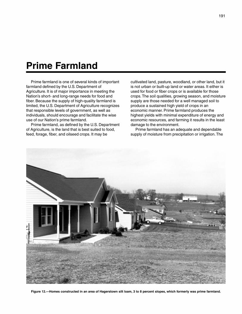
191
Prime farmland is one of several kinds of importantfarmland defined by the U.S. Department ofAgriculture. It is of major importance in meeting theNation’s short- and long-range needs for food andfiber. Because the supply of high-quality farmland islimited, the U.S. Department of Agriculture recognizesthat responsible levels of government, as well asindividuals, should encourage and facilitate the wiseuse of our Nation’s prime farmland.
Prime farmland, as defined by the U.S. Departmentof Agriculture, is the land that is best suited to food,feed, forage, fiber, and oilseed crops. It may be
cultivated land, pasture, woodland, or other land, but itis not urban or built-up land or water areas. It either isused for food or fiber crops or is available for thosecrops. The soil qualities, growing season, and moisturesupply are those needed for a well managed soil toproduce a sustained high yield of crops in aneconomic manner. Prime farmland produces thehighest yields with minimal expenditure of energy andeconomic resources, and farming it results in the leastdamage to the environment.
Prime farmland has an adequate and dependablesupply of moisture from precipitation or irrigation. The
Prime Farmland
Figure 12.—Homes constructed in an area of Hagerstown silt loam, 3 to 8 percent slopes, which formerly was prime farmland.
192
temperature and growing season are favorable. Thelevel of acidity or alkalinity is acceptable. Primefarmland has few or no rocks and is permeable towater and air. It is not excessively erodible orsaturated with water for long periods and is notfrequently flooded during the growing season. Theslope ranges mainly from 0 to 6 percent. More detailedinformation about the criteria for prime farmland isavailable at the local office of the Natural ResourcesConservation Service.
About 43,000 acres in the survey area, or nearly 21percent of the total acreage, meets the soilrequirements for prime farmland. Many areas of thisland are along Back Creek in the western part of thecounty, but most are in the Shenandoah Valley. Most ofthis prime farmland is used for crops or orchards. Thecrops grown on this land, mainly corn, soybeans, andapples, account for much of the county’s totalagricultural income each year.
A recent trend in land use in some parts of thecounty has been the loss of some prime farmland tourban uses (fig. 12). The loss of prime farmland toother uses puts pressure on marginal lands, whichgenerally are more erodible, droughty, less productive,and cannot be easily cultivated.
The map units in the survey area that areconsidered prime farmland are listed in table 5. Thislist does not constitute a recommendation for aparticular land use. The extent of each listed map unitis shown in table 4. The location is shown on thedetailed soil maps at the back of this publication. Thesoil qualities that affect use and management aredescribed under the heading “Detailed Soil Map Units.”
Some soils not listed in table 5 would be classifiedas prime farmland if certain limitations were overcome.For example, Atkins silt loam, Dunning silt loam, andTygart silt loam would be considered prime farmland ifthey were adequately drained.
193
This soil survey is an inventory and evaluation ofthe soils in the survey area. It can be used to adjustland uses to the limitations and potentials of naturalresources and the environment. Also, it can help toprevent soil-related failures in land uses.
In preparing a soil survey, soil scientists,conservationists, engineers, and others collectextensive field data about the nature and behavioralcharacteristics of the soils. They collect data onerosion, droughtiness, flooding, and other factors thataffect various soil uses and management. Fieldexperience and collected data on soil properties andperformance are used as a basis in predicting soilbehavior.
Information in this section can be used to plan theuse and management of soils for crops and pasture;as woodland; as sites for buildings, sanitary facilities,highways and other transportation systems, and parksand other recreational facilities; and for wildlife habitat.It can be used to identify the potentials and limitationsof each soil for specific land uses and to help preventconstruction failures caused by unfavorable soilproperties.
Planners and others using soil survey informationcan evaluate the effect of specific land uses onproductivity and on the environment in all or part of thesurvey area. The survey can help planners to maintainor create a land use pattern in harmony with thenatural soil.
Contractors can use this survey to locatesources of sand and gravel, roadfill, and topsoil.They can use it to identify areas where bedrock,wetness, or very firm soil layers can cause difficultyin excavation.
Health officials, highway officials, engineers,and others may also find this survey useful. Thesurvey can help them plan the safe disposal ofwastes and locate sites for pavements, sidewalks,campgrounds, playgrounds, lawns, and trees andshrubs.
Crops and Pasture
Norman L. DeLawder, district conservationist, and Orland C.Parks, Jr., staff agronomist, Natural Resources ConservationService, helped to prepare this section.
General management needed for crops and pastureis suggested in this section. The crops or pastureplants best suited to the soils, including some notcommonly grown in the survey area, are identified; thesystem of land capability classification used by theNatural Resources Conservation Service is explained;and the estimated yields of the main crops and hayand pasture plants are listed for each soil.
Planners of management systems for individualfields or farms should consider the detailedinformation given in the description of each soil underthe heading “Detailed Soil Map Units.” Specificinformation can be obtained from the local office of theNatural Resources Conservation Service or theCooperative Extension Service.
In 1997, about 59,600 acres in the survey area wasused for crops, hay, or pasture (USDA 1999). Of thistotal, about 5,400 acres was used for row crops,mainly corn; 2,600 acres was used for close-growingcrops, mainly soybeans, wheat, oats, and barley;17,400 acres was used as hayland; 24,200 acres wasin pasture; and 7,000 acres was used for orchards.The field crops that can be grown in the county includecorn, soybeans, sorghum/sudan, wheat, oats, rye, andbarley. In recent years a considerable acreage offarmland has been converted to nonfarm uses. Thetotal acreage for all land in farms in the county wasabout 72,600 acres in 1997, down from about 80,300acres in 1987 (USDA 1999; U.S. Department ofCommerce 1994).
Most of the soils in the county respond well toapplications of lime and fertilizer. The amount of limeand fertilizer needed depends on the types of soils,the cropping history, the kinds of crops to be grown,and the desired yields. Soils that formed in material
Use and Management of the Soils
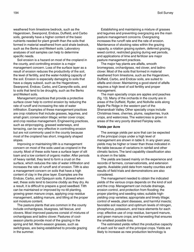
194 Soil Survey
weathered from limestone bedrock, such as theHagerstown, Swanpond, Endcav, Duffield, and Carbosoils, generally have a higher content of the basicnutrients needed for plant growth than the soils thatformed in material weathered from acid shale bedrock,such as the Berks and Weikert soils. Laboratoryanalyses of soil samples can help to determinespecific needs.
Soil erosion is a hazard on most of the cropland inthe county, and controlling erosion is a majormanagement concern. Loss of the surface layer as aresult of erosion reduces the productivity of the soil,the level of fertility, and the water-holding capacity ofthe soil. Erosion is especially damaging to soils thathave a clayey subsoil, such as the Hagerstown,Swanpond, Endcav, Carbo, and Caneyville soils, andto soils that tend to be droughty, such as the Berksand Weikert soils.
Management practices that provide a protectivesurface cover help to control erosion by reducing therate of runoff and increasing the rate of waterinfiltration. Examples of these management practicesare crop rotations that include grasses, legumes, andsmall grain; conservation tillage; winter cover crops;and crop residue management. Engineering practices,such as stripcropping, grassed waterways, andterracing, can be very effective in controlling erosionbut are not commonly used in the county becausemost of the cropland has short, irregularly shapedslopes.
Improving or maintaining tilth is a managementconcern on most of the soils used as cropland in thecounty. Most of these soils have a surface layer of siltloam and a low content of organic matter. After periodsof heavy rainfall, they tend to form a crust on thesurface, which reduces the rate of water infiltration andincreases the rate of runoff and of erosion. Tilth is alsoa management concern on soils that have a highcontent of clay in the plow layer. Examples are theEndcav, Carbo, and Opequon soils. If plowed whenwet, these soils tend to become cloddy as they dry. Asa result, it is difficult to prepare a good seedbed. Tilthcan be maintained or improved by no-till planting,growing green manure crops, applying crop residuemanagement, adding manure, and tilling at the propersoil moisture content.
The pasture plants that are common in the countyinclude orchardgrass, bluegrass, tall fescue, andclovers. Most improved pastures consist of mixtures oforchardgrass and ladino clover. Pastures of cool-season plants provide most of the grazing in thespring and fall. Warm-season grasses, such asswitchgrass, are being established to provide grazingin the summer.
Establishing and maintaining a mixture of grassesand legumes and preventing overgrazing are the mainpasture management concerns. Overgrazingincreases the runoff rate and the rate of erosion.Maintenance of stocking rates within the grazingcapacity, a rotation grazing system, deferred grazing,weed control, restricted grazing during wet periods,and applications of lime and fertilizer are majorpasture management practices.
The major hay plants are alfalfa, smoothbromegrass, orchardgrass, red clover, and ladinoclover. Most of the soils that formed in materialweathered from limestone, such as the Hagerstown,Duffield, Carbo, and Endcav soils, are suited toalfalfa and clover. Maintaining a good stand of alfalfarequires a high level of soil fertility and propermanagement.
The main specialty crops are apples and peaches(fig. 13). Many of the orchards in the county are inareas of the Duffield, Ryder, and Nollville soils alongApple Pie Ridge in the western part of theShenandoah Valley. Other specialty crops includeChristmas trees, cherries, plums, raspberries, truckcrops, and watercress. The watercress is grown inareas of the very poorly drained Fairplay soils.
Yields per Acre
The average yields per acre that can be expectedof the principal crops under a high level ofmanagement are shown in table 6. In any given year,yields may be higher or lower than those indicated inthe table because of variations in rainfall and otherclimatic factors. The land capability classification alsois shown in the table.
The yields are based mainly on the experience andrecords of farmers, conservationists, and extensionagents. Available yield data from nearby counties andresults of field trials and demonstrations are alsoconsidered.
The management needed to obtain the indicatedyields of the various crops depends on the kind of soiland the crop. Management can include drainage,erosion control, and protection from flooding; theproper planting and seeding rates; suitable high-yielding crop varieties; appropriate and timely tillage;control of weeds, plant diseases, and harmful insects;favorable soil reaction and optimum levels of nitrogen,phosphorus, potassium, and trace elements for eachcrop; effective use of crop residue, barnyard manure,and green manure crops; and harvesting that ensuresthe smallest possible loss.
The estimated yields reflect the productive capacityof each soil for each of the principal crops. Yields arelikely to increase as new production technology is
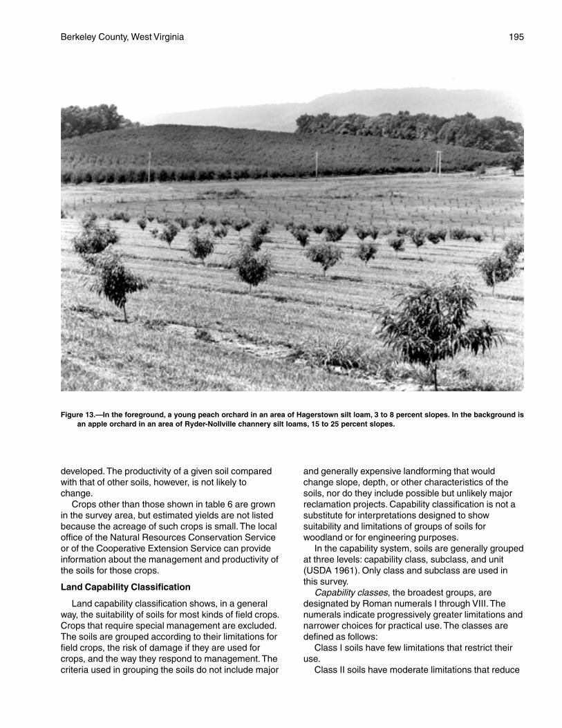
Berkeley County, West Virginia 195
developed. The productivity of a given soil comparedwith that of other soils, however, is not likely tochange.
Crops other than those shown in table 6 are grownin the survey area, but estimated yields are not listedbecause the acreage of such crops is small. The localoffice of the Natural Resources Conservation Serviceor of the Cooperative Extension Service can provideinformation about the management and productivity ofthe soils for those crops.
Land Capability Classification
Land capability classification shows, in a generalway, the suitability of soils for most kinds of field crops.Crops that require special management are excluded.The soils are grouped according to their limitations forfield crops, the risk of damage if they are used forcrops, and the way they respond to management. Thecriteria used in grouping the soils do not include major
and generally expensive landforming that wouldchange slope, depth, or other characteristics of thesoils, nor do they include possible but unlikely majorreclamation projects. Capability classification is not asubstitute for interpretations designed to showsuitability and limitations of groups of soils forwoodland or for engineering purposes.
In the capability system, soils are generally groupedat three levels: capability class, subclass, and unit(USDA 1961). Only class and subclass are used inthis survey.
Capability classes, the broadest groups, aredesignated by Roman numerals I through VIII. Thenumerals indicate progressively greater limitations andnarrower choices for practical use. The classes aredefined as follows:
Class I soils have few limitations that restrict theiruse.
Class II soils have moderate limitations that reduce
Figure 13.—In the foreground, a young peach orchard in an area of Hagerstown silt loam, 3 to 8 percent slopes. In the background isan apple orchard in an area of Ryder-Nollville channery silt loams, 15 to 25 percent slopes.
196 Soil Survey
the choice of plants or that require moderateconservation practices.
Class III soils have severe limitations that reducethe choice of plants or that require specialconservation practices, or both.
Class IV soils have very severe limitations thatreduce the choice of plants or that require very carefulmanagement, or both.
Class V soils are not likely to erode but have otherlimitations, impractical to remove, that limit their use.
Class VI soils have severe limitations that makethem generally unsuitable for cultivation.
Class VII soils have very severe limitations thatmake them unsuitable for cultivation.
Class VIII soils and miscellaneous areas havelimitations that nearly preclude their use forcommercial crop production.
Capability subclasses are soil groups within oneclass. They are designated by adding a small letter, e,w, s, or c, to the class numeral, for example, IIe. Theletter e shows that the main hazard is the risk oferosion unless close-growing plant cover is maintained(fig. 14); w shows that water in or on the soil interfereswith plant growth or cultivation (in some soils thewetness can be partly corrected by artificialdrainage); s shows that the soil is limited mainlybecause it is shallow, droughty, or stony; and c,used in only some parts of the United States, showsthat the chief limitation is climate that is very cold orvery dry.
In class I there are no subclasses because the soilsof this class have few limitations. Class V contains onlythe subclasses indicated by w, s, or c because thesoils in class V are subject to little or no erosion. They
Figure 14.—A cultivated area of Hagerstown silt loam, 3 to 8 percent slopes, which has a moderate hazard of erosion. The landcapability subclass is IIe.
Berkeley County, West Virginia 197
have other limitations that restrict their use to pasture,woodland, wildlife habitat, or recreation.
The acreage of soils in each capability class andsubclass is shown in table 7. The capabilityclassification of the map units in this survey area isgiven in the section “Detailed Soil Map Units” and inthe yields table.
Woodland Management and Productivity
Barbara A. McWhorter, staff forester, Natural ResourcesConservation Service, helped to prepare this section.
About 122,900 acres, or nearly 60 percent of thecounty, is forested. Most of this acreage is privatelyowned. Only about 1,200 acres is noncommercialforest land (Bones 1978). The West VirginiaDepartment of Natural Resources manages a largetract of forest land on Sleepy Creek and Third HillMountains in the western part of the county.
The most common forest types, or naturalassociations of tree species, are the oak-hickory type,which makes up about 62 percent of the commercialforest land, and the Virginia-pitch pine type, whichmakes up about 11 percent. The maple-beech-birchtype makes up about 7 percent, and the remainder ofthe acreage is covered by other hardwood and pinetypes.
The oak-hickory type is in areas throughout thecounty. Most of the Virginia-pitch pine type is onsouthern or western exposures or in areas of soils thatare shallow over bedrock, such as the Weikert soils.The maple-beech-birch type is on north aspects at thehigher elevations in the county.
Soil properties have a strong influence on treespecies, tree growth, and woodland management. Thedepth and texture of soils, for example, affect theavailable water-holding capacity, which influences theoccurrence of a species and the rate of growth. Otherfeatures, such as slope, stoniness or rockiness, or aclayey subsoil, influence the kinds of managementneeded. Aspect, or the direction a slope faces, alsoaffects tree growth and woodland management.
A large acreage of soils in Berkeley County has alow or very low water-holding capacity, which limits thepotential productivity for trees. The soils in thisacreage are mainly the shallow Weikert soils andmoderately deep Berks soils, which formed in materialweathered from shale, and the moderately deepDekalb soils, which formed in material weathered fromsandstone.
In recent years the gypsy moth has had a seriouslydetrimental effect on the forests in the county. Largeacreages of trees are defoliated every year, and many
trees have died. Oak trees, the most abundant treetype in the county, are the preferred food of the gypsymoth larvae. Forest management plans shouldaddress how to control gypsy moths.
Table 8 can be used by woodland owners or forestmanagers in planning the use of soils for wood crops.Only those soils suitable for wood crops are listed.
Because of the variability between soils on southaspects versus those on north aspects, dual entriesare given for the ordination symbol, site index, averageannual growth, seedling mortality rate, and plantcompetition rating of some soils, specifically those thatare less than 40 inches deep to bedrock and haveslopes of more than 15 percent. North aspects arethose that face the compass directions from 315 to135 degrees. South aspects are those that face thecompass directions from 135 to 315 degrees. Aspectaffects the potential productivity of sloping soils. Thesoils on north aspects generally are more moist andhave a higher site index than those on south aspects.Aspect also affects the occurrence of a tree species,the seedling mortality rate, and the managementpractices needed.
The table lists the ordination symbol for each soil.Soils assigned the same ordination symbol require thesame general management and have about the samepotential productivity.
The first part of the ordination symbol, a number,indicates the potential productivity of the soils for anindicator tree species. The number indicates thevolume, in cubic meters per hectare per year, whichthe indicator species can produce. The number 1indicates low potential productivity; 2 and 3, moderate;4 and 5, moderately high; 6 to 8, high; 9 to 11, veryhigh; and 12 to 39, extremely high. The second part ofthe symbol, a letter, indicates the major kind of soillimitation. The letter R indicates steep slopes; X,stoniness or rockiness (fig. 15); W, excess water in oron the soil; T, toxic substances in the soil; D, restrictedrooting depth; C, clay in the upper part of the soil; S,sandy texture; and F, a high content of rock fragmentsin the soil. The letter A indicates that limitations orrestrictions are insignificant. If a soil has more thanone limitation, the priority is as follows: R, X, W, T, D,C, S, and F.
In table 8, slight, moderate, and severe indicate thedegree of the major soil limitations to be considered inmanagement.
Erosion hazard is the probability that damage willoccur as a result of site preparation and cutting wherethe soil is exposed along roads, skid trails, and firelanes and in log-handling areas. Forests that havebeen burned or overgrazed are also subject to erosion.Ratings of the erosion hazard are based on the
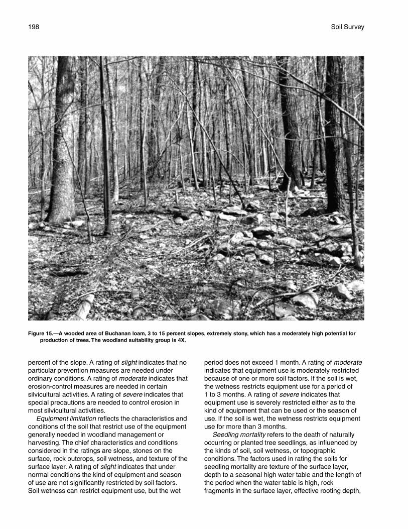
198 Soil Survey
percent of the slope. A rating of slight indicates that noparticular prevention measures are needed underordinary conditions. A rating of moderate indicates thaterosion-control measures are needed in certainsilvicultural activities. A rating of severe indicates thatspecial precautions are needed to control erosion inmost silvicultural activities.
Equipment limitation reflects the characteristics andconditions of the soil that restrict use of the equipmentgenerally needed in woodland management orharvesting. The chief characteristics and conditionsconsidered in the ratings are slope, stones on thesurface, rock outcrops, soil wetness, and texture of thesurface layer. A rating of slight indicates that undernormal conditions the kind of equipment and seasonof use are not significantly restricted by soil factors.Soil wetness can restrict equipment use, but the wet
period does not exceed 1 month. A rating of moderateindicates that equipment use is moderately restrictedbecause of one or more soil factors. If the soil is wet,the wetness restricts equipment use for a period of1 to 3 months. A rating of severe indicates thatequipment use is severely restricted either as to thekind of equipment that can be used or the season ofuse. If the soil is wet, the wetness restricts equipmentuse for more than 3 months.
Seedling mortality refers to the death of naturallyoccurring or planted tree seedlings, as influenced bythe kinds of soil, soil wetness, or topographicconditions. The factors used in rating the soils forseedling mortality are texture of the surface layer,depth to a seasonal high water table and the length ofthe period when the water table is high, rockfragments in the surface layer, effective rooting depth,
Figure 15.—A wooded area of Buchanan loam, 3 to 15 percent slopes, extremely stony, which has a moderately high potential forproduction of trees. The woodland suitability group is 4X.
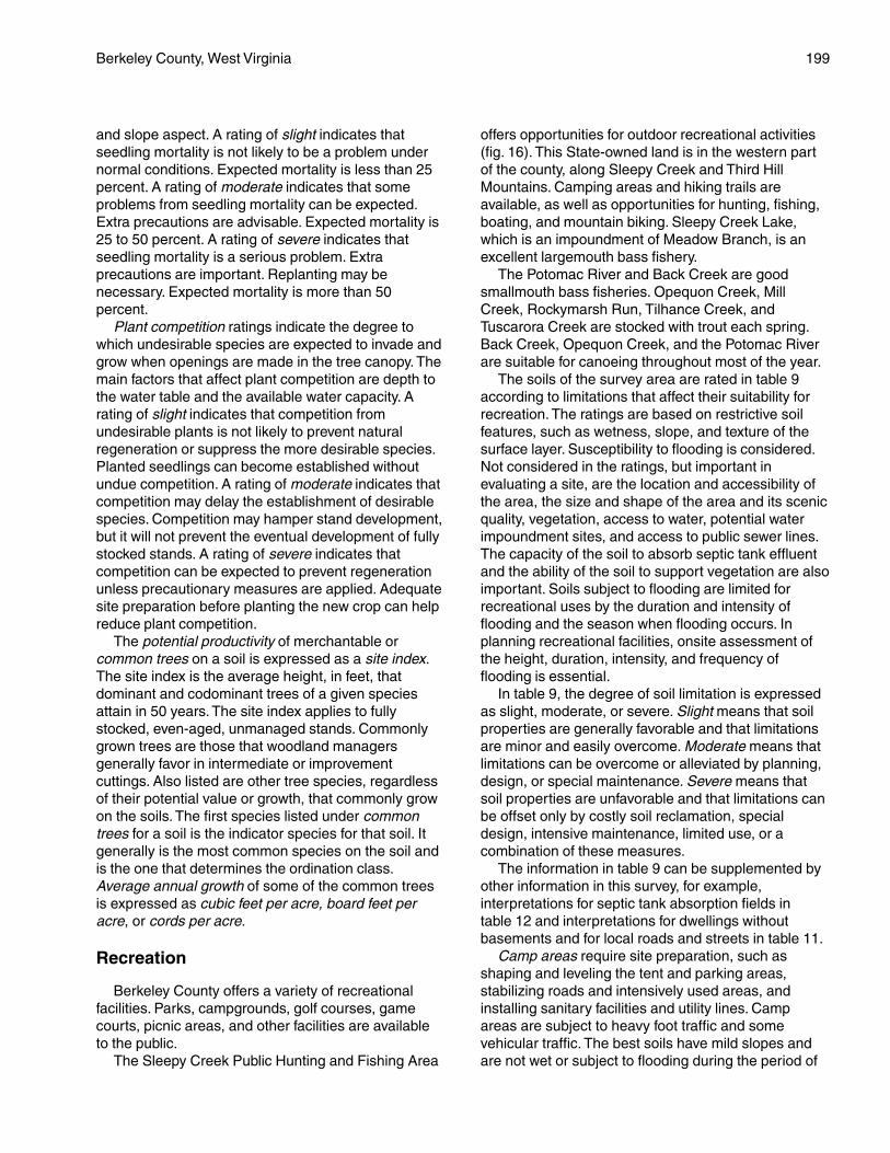
Berkeley County, West Virginia 199
and slope aspect. A rating of slight indicates thatseedling mortality is not likely to be a problem undernormal conditions. Expected mortality is less than 25percent. A rating of moderate indicates that someproblems from seedling mortality can be expected.Extra precautions are advisable. Expected mortality is25 to 50 percent. A rating of severe indicates thatseedling mortality is a serious problem. Extraprecautions are important. Replanting may benecessary. Expected mortality is more than 50percent.
Plant competition ratings indicate the degree towhich undesirable species are expected to invade andgrow when openings are made in the tree canopy. Themain factors that affect plant competition are depth tothe water table and the available water capacity. Arating of slight indicates that competition fromundesirable plants is not likely to prevent naturalregeneration or suppress the more desirable species.Planted seedlings can become established withoutundue competition. A rating of moderate indicates thatcompetition may delay the establishment of desirablespecies. Competition may hamper stand development,but it will not prevent the eventual development of fullystocked stands. A rating of severe indicates thatcompetition can be expected to prevent regenerationunless precautionary measures are applied. Adequatesite preparation before planting the new crop can helpreduce plant competition.
The potential productivity of merchantable orcommon trees on a soil is expressed as a site index.The site index is the average height, in feet, thatdominant and codominant trees of a given speciesattain in 50 years. The site index applies to fullystocked, even-aged, unmanaged stands. Commonlygrown trees are those that woodland managersgenerally favor in intermediate or improvementcuttings. Also listed are other tree species, regardlessof their potential value or growth, that commonly growon the soils. The first species listed under commontrees for a soil is the indicator species for that soil. Itgenerally is the most common species on the soil andis the one that determines the ordination class.Average annual growth of some of the common treesis expressed as cubic feet per acre, board feet peracre, or cords per acre.
Recreation
Berkeley County offers a variety of recreationalfacilities. Parks, campgrounds, golf courses, gamecourts, picnic areas, and other facilities are availableto the public.
The Sleepy Creek Public Hunting and Fishing Area
offers opportunities for outdoor recreational activities(fig. 16). This State-owned land is in the western partof the county, along Sleepy Creek and Third HillMountains. Camping areas and hiking trails areavailable, as well as opportunities for hunting, fishing,boating, and mountain biking. Sleepy Creek Lake,which is an impoundment of Meadow Branch, is anexcellent largemouth bass fishery.
The Potomac River and Back Creek are goodsmallmouth bass fisheries. Opequon Creek, MillCreek, Rockymarsh Run, Tilhance Creek, andTuscarora Creek are stocked with trout each spring.Back Creek, Opequon Creek, and the Potomac Riverare suitable for canoeing throughout most of the year.
The soils of the survey area are rated in table 9according to limitations that affect their suitability forrecreation. The ratings are based on restrictive soilfeatures, such as wetness, slope, and texture of thesurface layer. Susceptibility to flooding is considered.Not considered in the ratings, but important inevaluating a site, are the location and accessibility ofthe area, the size and shape of the area and its scenicquality, vegetation, access to water, potential waterimpoundment sites, and access to public sewer lines.The capacity of the soil to absorb septic tank effluentand the ability of the soil to support vegetation are alsoimportant. Soils subject to flooding are limited forrecreational uses by the duration and intensity offlooding and the season when flooding occurs. Inplanning recreational facilities, onsite assessment ofthe height, duration, intensity, and frequency offlooding is essential.
In table 9, the degree of soil limitation is expressedas slight, moderate, or severe. Slight means that soilproperties are generally favorable and that limitationsare minor and easily overcome. Moderate means thatlimitations can be overcome or alleviated by planning,design, or special maintenance. Severe means thatsoil properties are unfavorable and that limitations canbe offset only by costly soil reclamation, specialdesign, intensive maintenance, limited use, or acombination of these measures.
The information in table 9 can be supplemented byother information in this survey, for example,interpretations for septic tank absorption fields intable 12 and interpretations for dwellings withoutbasements and for local roads and streets in table 11.
Camp areas require site preparation, such asshaping and leveling the tent and parking areas,stabilizing roads and intensively used areas, andinstalling sanitary facilities and utility lines. Campareas are subject to heavy foot traffic and somevehicular traffic. The best soils have mild slopes andare not wet or subject to flooding during the period of
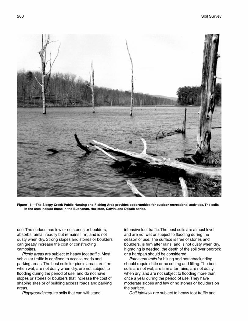
200 Soil Survey
use. The surface has few or no stones or boulders,absorbs rainfall readily but remains firm, and is notdusty when dry. Strong slopes and stones or boulderscan greatly increase the cost of constructingcampsites.
Picnic areas are subject to heavy foot traffic. Mostvehicular traffic is confined to access roads andparking areas. The best soils for picnic areas are firmwhen wet, are not dusty when dry, are not subject toflooding during the period of use, and do not haveslopes or stones or boulders that increase the cost ofshaping sites or of building access roads and parkingareas.
Playgrounds require soils that can withstand
intensive foot traffic. The best soils are almost leveland are not wet or subject to flooding during theseason of use. The surface is free of stones andboulders, is firm after rains, and is not dusty when dry.If grading is needed, the depth of the soil over bedrockor a hardpan should be considered.
Paths and trails for hiking and horseback ridingshould require little or no cutting and filling. The bestsoils are not wet, are firm after rains, are not dustywhen dry, and are not subject to flooding more thanonce a year during the period of use. They havemoderate slopes and few or no stones or boulders onthe surface.
Golf fairways are subject to heavy foot traffic and
Figure 16.—The Sleepy Creek Public Hunting and Fishing Area provides opportunities for outdoor recreational activities. The soilsin the area include those in the Buchanan, Hazleton, Calvin, and Dekalb series.
Berkeley County, West Virginia 201
some light vehicular traffic. Cutting or filling may berequired. The best soils for use as golf fairways arefirm when wet, are not dusty when dry, and are notsubject to prolonged flooding during the period of use.They have moderate slopes and no stones or boulderson the surface. The suitability of the soil for tees orgreens is not considered in rating the soils.
Wildlife Habitat
Richard D. Heaslip, resource conservationist, NaturalResources Conservation Service, helped to prepare this section.
Berkeley County supports a large number of nativewildlife species because of the favorable land usepatterns and suitable climate. It includes large tracts ofwoodland in Back Creek Valley and in the SleepyCreek Public Hunting and Fishing Area. These woodedareas, which consist of uneven-aged stands of oak-hickory-pine forest type, provide excellent habitat forwhite-tailed deer, wild turkey, ruffed grouse, andsquirrels. In the Shenandoah Valley, open farmlandand transitional areas between woodland andfarmland provide habitat for cottontail rabbit, mourningdoves, bobwhite quail, and ring-necked pheasants.
Soils affect the kind and amount of vegetation thatis available to wildlife as food and cover. Well drainedsoils can be used as cropland or can be forested withoak-hickory types. These areas can be used by uplandwildlife species. Poorly drained soils support wetlandvegetation, which is desirable for waterfowl habitat.Wildlife habitat can be created or improved by plantingappropriate vegetation, by maintaining the existingplant cover, or by promoting the natural establishmentof desirable plants.
In table 10, the soils in the survey area are ratedaccording to their potential for providing habitat forvarious kinds of wildlife. This information can be usedin planning parks, wildlife refuges, nature study areas,and other developments for wildlife; in selecting soilsthat are suitable for establishing, improving, ormaintaining specific elements of wildlife habitat; and indetermining the intensity of management needed foreach element of the habitat.
The potential of the soil is rated good, fair, poor, orvery poor. A rating of good indicates that the elementor kind of habitat is easily established, improved, ormaintained. Few or no limitations affect management,and satisfactory results can be expected. A rating offair indicates that the element or kind of habitat can beestablished, improved, or maintained in most places.Moderately intensive management is required forsatisfactory results. A rating of poor indicates thatlimitations are severe for the designated element orkind of habitat. Habitat can be created, improved, or
maintained in most places, but management is difficultand must be intensive. A rating of very poor indicatesthat restrictions for the element or kind of habitat arevery severe and that unsatisfactory results can beexpected. Creating, improving, or maintaining habitatis impractical or impossible.
The elements of wildlife habitat are described in thefollowing paragraphs.
Grain and seed crops are domestic grains andseed-producing herbaceous plants. Soil propertiesand features that affect the growth of grain and seedcrops are depth of the root zone, texture of the surfacelayer, available water capacity, wetness, slope, surfacestoniness, and flooding. Soil temperature and soilmoisture are also considerations. Examples of grainand seed crops are corn, wheat, oats, and barley.
Grasses and legumes are domestic perennialgrasses and herbaceous legumes. Soil properties andfeatures that affect the growth of grasses and legumesare depth of the root zone, texture of the surface layer,available water capacity, wetness, surface stoniness,flooding, and slope. Soil temperature and soil moistureare also considerations. Examples of grasses andlegumes are fescue, orchardgrass, switchgrass,bromegrass, clover, and alfalfa.
Wild herbaceous plants are native or naturallyestablished grasses and forbs, including weeds. Soilproperties and features that affect the growth of theseplants are depth of the root zone, texture of thesurface layer, available water capacity, wetness,surface stoniness, and flooding. Soil temperature andsoil moisture are also considerations. Examples of wildherbaceous plants are goldenrod, blackberry, mullein,beggartick, milkweed, and ironweed.
Hardwood trees and woody understory producenuts or other fruit, buds, catkins, twigs, bark, andfoliage. Soil properties and features that affect thegrowth of hardwood trees and shrubs are depth of theroot zone, available water capacity, and wetness.Examples of these plants are oak, poplar, cherry,apple, hackberry, hawthorn, blackgum, dogwood,hickory, and redbud. Examples of fruit-producingshrubs that are suitable for planting on soils ratedgood are crabapple, bayberry, and hazelnut.
Coniferous plants furnish browse and seeds. Soilproperties and features that affect the growth ofconiferous trees, shrubs, and ground cover are depthof the root zone, available water capacity, andwetness. Examples of coniferous plants are pine,spruce, red cedar, and juniper.
Wetland plants are annual and perennial wild,woody or herbaceous plants that grow on moist or wetsites. Submerged or floating aquatic plants areexcluded. Soil properties and features affecting
202 Soil Survey
wetland plants are texture of the surface layer,wetness, reaction, slope, and surface stoniness.Examples of wetland plants are alder, smartweed, wildmillet, wildrice, cattail, rushes, sedges, and reeds.
Shallow water areas have an average depth of lessthan 3 feet. Some are naturally wet areas. Others arecreated by dams, dikes, or other water-controlstructures. Soil properties and features affectingshallow water areas are depth to bedrock, wetness,surface stoniness, slope, and permeability. Examplesof shallow water areas are marshes and ponds.
The habitat for various kinds of wildlife is describedin the following paragraphs.
Habitat for openland wildlife consists of cropland,pasture, meadows, and areas that are overgrown withgrasses, herbs, shrubs, and vines. These areasproduce grain and seed crops, grasses and legumes,and wild herbaceous plants. Wildlife attracted to theseareas include bobwhite quail, pheasant, meadowlark,field sparrow, cottontail, and red fox.
Habitat for woodland wildlife consists of areas ofdeciduous plants or coniferous plants or both andassociated grasses, legumes, and wild herbaceousplants. Wildlife attracted to these areas include wildturkey, ruffed grouse, thrushes, woodpeckers,squirrels, gray fox, raccoon, and deer.
Habitat for wetland wildlife consists of open, marshyor swampy shallow water areas. Some of the wildlifeattracted to such areas are ducks, geese, herons,shore birds, woodcock, muskrat, and beaver.
Engineering
Craig E. Savela, staff geologist, Natural ResourcesConservation Service, helped to prepare this section.
This section provides information for planning landuses related to urban development and to watermanagement. Soils are rated for various uses, and themost limiting features are identified. Ratings are givenfor building site development, sanitary facilities,construction materials, and water management. Theratings are based on observed performance of thesoils and on the estimated data and test data in the“Soil Properties” section.
Information in this section is intended for land useplanning, for evaluating land use alternatives, and forplanning site investigations prior to design andconstruction. The information, however, has limitations.For example, estimates and other data generally applyonly to that part of the soil within a depth of 5 or 6 feet.Because of the map scale, small areas of differentsoils may be included within the mapped areas of aspecific soil.
The information is not site specific and does not
eliminate the need for onsite investigation of the soilsor for testing and analysis by personnel experienced inthe design and construction of engineering works.
Government ordinances and regulations thatrestrict certain land uses or impose specific designcriteria were not considered in preparing theinformation in this section. Local ordinances andregulations should be considered in planning, in siteselection, and in design.
Soil properties, site features, and observedperformance were considered in determining theratings in this section. During the fieldwork for this soilsurvey, determinations were made about grain-sizedistribution, liquid limit, plasticity index, soil reaction,depth to bedrock, hardness of bedrock within 5 or 6feet of the surface, soil wetness, depth to a seasonalhigh water table, slope, likelihood of flooding, naturalsoil structure aggregation, and soil density. Data werecollected about kinds of clay minerals, mineralogy ofthe sand and silt fractions, and the kinds of adsorbedcations. Estimates were made for erodibility,permeability, corrosivity, shrink-swell potential,available water capacity, and other behavioralcharacteristics affecting engineering uses.
This information can be used to evaluate thepotential of areas for residential, commercial,industrial, and recreational uses; make preliminaryestimates of construction conditions; evaluatealternative routes for roads, streets, highways,pipelines, and underground cables; evaluatealternative sites for sanitary landfills, septic tankabsorption fields, and sewage lagoons; plan detailedonsite investigations of soils and geology; locatepotential sources of gravel, sand, earthfill, and topsoil;plan drainage systems, irrigation systems, ponds,terraces, and other structures for soil and waterconservation; and predict performance of proposedsmall structures and pavements by comparing theperformance of existing similar structures on the sameor similar soils.
The information in the tables, along with the soilmaps, the soil descriptions, and other data provided inthis survey, can be used to make additionalinterpretations.
Some of the terms used in this soil survey have aspecial meaning in soil science and are defined in theGlossary.
Building Site Development
Table 11 shows the degree and kind of soillimitations that affect shallow excavations, dwellingswith and without basements, small commercialbuildings, local roads and streets, and lawns andlandscaping. The limitations are considered slight if
Berkeley County, West Virginia 203
soil properties and site features are generallyfavorable for the indicated use and limitations areminor and easily overcome; moderate if soil propertiesor site features are not favorable for the indicated useand special planning, design, or maintenance isneeded to overcome or minimize the limitations; andsevere if soil properties or site features are sounfavorable or so difficult to overcome that specialdesign, significant increases in construction costs, andpossibly increased maintenance are required. Specialfeasibility studies may be required where the soillimitations are severe.
Shallow excavations are trenches or holes dug to amaximum depth of 5 or 6 feet for basements, graves,utility lines, open ditches, and other purposes. Theratings are based on soil properties, site features, andobserved performance of the soils. The ease ofdigging, filling, and compacting is affected by the depthto bedrock, a cemented pan, or a very firm denselayer; stone content; soil texture; and slope. The timeof the year that excavations can be made is affectedby the depth to a seasonal high water table and thesusceptibility of the soil to flooding. The resistanceof the excavation walls or banks to sloughing orcaving is affected by soil texture and depth to thewater table.
Dwellings and small commercial buildings arestructures built on shallow foundations on undisturbedsoil. The load limit is the same as that for single-familydwellings no higher than three stories. Ratings aremade for small commercial buildings withoutbasements, for dwellings with basements, and fordwellings without basements. The ratings are basedon soil properties, site features, and observedperformance of the soils. A high water table, flooding,shrinking and swelling, and organic layers can causethe movement of footings. A high water table, depth tobedrock or to a cemented pan, large stones, slope,and flooding affect the ease of excavation andconstruction. Landscaping and grading that requirecuts and fills of more than 5 or 6 feet are notconsidered.
Local roads and streets have an all-weather surfaceand carry automobile and light truck traffic all year.They have a subgrade of cut or fill soil material; a baseof gravel, crushed rock, or stabilized soil material; anda flexible or rigid surface. Cuts and fills are generallylimited to less than 6 feet. The ratings are based onsoil properties, site features, and observedperformance of the soils. Depth to bedrock or to acemented pan, a high water table, flooding, largestones, and slope affect the ease of excavating andgrading. Soil strength (as inferred from the engineeringclassification of the soil), shrink-swell potential, frost
action potential, and depth to a high water table affectthe traffic-supporting capacity.
Lawns and landscaping require soils on which turfand ornamental trees and shrubs can be establishedand maintained. The ratings are based on soilproperties, site features, and observed performance ofthe soils. Soil reaction, a high water table, depth tobedrock or to a cemented pan, the available watercapacity in the upper 40 inches, and the content ofsalts, sodium, and sulfidic materials affect plantgrowth. Flooding, wetness, slope, stoniness, and theamount of sand, clay, or organic matter in the surfacelayer affect trafficability after vegetation is established.
Sanitary Facilities
Table 12 shows the degree and kind of soillimitations that affect septic tank absorption fields,sewage lagoons, and sanitary landfills. The limitationsare considered slight if soil properties and site featuresare generally favorable for the indicated use andlimitations are minor and easily overcome; moderate ifsoil properties or site features are not favorable for theindicated use and special planning, design, ormaintenance is needed to overcome or minimize thelimitations; and severe if soil properties or site featuresare so unfavorable or so difficult to overcome thatspecial design, significant increases in constructioncosts, and possibly increased maintenance arerequired.
Table 12 also shows the suitability of the soils foruse as daily cover for landfill. A rating of goodindicates that soil properties and site features arefavorable for the use and good performance and lowmaintenance can be expected; fair indicates that soilproperties and site features are moderately favorablefor the use and one or more soil properties or sitefeatures make the soil less desirable than the soilsrated good; and poor indicates that one or more soilproperties or site features are unfavorable for the useand overcoming the unfavorable properties requiresspecial design, extra maintenance, or costly alteration.
Septic tank absorption fields are areas in whicheffluent from a septic tank is distributed into the soilthrough subsurface tiles or perforated pipe. Only thatpart of the soil between depths of 24 and 72 inches isevaluated. The ratings are based on soil properties,site features, and observed performance of the soils.Permeability, a high water table, depth to bedrock or toa cemented pan, and flooding affect absorption of theeffluent. Large stones and bedrock or a cemented paninterfere with installation.
Unsatisfactory performance of septic tankabsorption fields, including excessively slowabsorption of effluent, surfacing of effluent, and hillside
204 Soil Survey
seepage, can affect public health. Ground water canbe polluted if highly permeable sand and gravel orfractured bedrock is less than 4 feet below the baseof the absorption field, if slope is excessive, or if thewater table is near the surface. There must beunsaturated soil material beneath the absorptionfield to filter the effluent effectively. Many localordinances require that this material be of a certainthickness.
Sewage lagoons are shallow ponds constructed tohold sewage while aerobic bacteria decompose thesolid and liquid wastes. Lagoons should have a nearlylevel floor surrounded by cut slopes or embankmentsof compacted soil. Lagoons generally are designed tohold the sewage within a depth of 2 to 5 feet. Nearlyimpervious soil material for the lagoon floor and sidesis required to minimize seepage and contamination ofground water.
Table 12 gives ratings for the natural soil that makesup the lagoon floor. The surface layer and, generally, 1or 2 feet of soil material below the surface layer areexcavated to provide material for the embankments.The ratings are based on soil properties, site features,and observed performance of the soils. Considered inthe ratings are slope, permeability, a high water table,depth to bedrock or to a cemented pan, flooding, largestones, and content of organic matter.
Excessive seepage resulting from rapidpermeability in the soil or a water table that is highenough to raise the level of sewage in the lagooncauses a lagoon to function unsatisfactorily. Pollutionresults if seepage is excessive or if floodwaterovertops the lagoon. A high content of organic matteris detrimental to proper functioning of the lagoonbecause it inhibits aerobic activity. Slope, bedrock, andcemented pans can cause construction problems, andlarge stones can hinder compaction of the lagoonfloor.
Sanitary landfills are areas where solid waste isdisposed of by burying it in soil. There are two types oflandfill—trench and area. In a trench landfill, the wasteis placed in a trench. It is spread, compacted, andcovered daily with a thin layer of soil excavated at thesite. In an area landfill, the waste is placed insuccessive layers on the surface of the soil. The wasteis spread, compacted, and covered daily with a thinlayer of soil from a source away from the site.
Both types of landfill must be able to bear heavyvehicular traffic. Both types involve a risk of ground-water pollution. Ease of excavation and revegetationshould be considered.
The ratings in table 12 are based on soil properties,site features, and observed performance of the soils.Permeability, depth to bedrock or to a cemented pan, a
high water table, slope, and flooding affect both typesof landfill. Texture, stones and boulders, highly organiclayers, soil reaction, and content of salts and sodiumaffect trench landfills. Unless otherwise stated, theratings apply only to that part of the soil within a depthof about 6 feet. For deeper trenches, a limitation ratedslight or moderate may not be valid. Onsiteinvestigation is needed.
Daily cover for landfill is the soil material that isused to cover compacted solid waste in an areasanitary landfill. The soil material is obtained offsite,transported to the landfill, and spread over the waste.
Soil texture, wetness, coarse fragments, and slopeaffect the ease of removing and spreading the materialduring wet and dry periods. Loamy or silty soils thatare free of large stones or excess gravel are the bestcover for a landfill. Clayey soils are sticky or cloddyand are difficult to spread; sandy soils are subject towind erosion.
After soil material has been removed, the soilmaterial remaining in the borrow area must be thickenough over bedrock, a cemented pan, or the watertable to permit revegetation. The soil material used asthe final cover for a landfill should be suitable forplants. The surface layer generally has the bestworkability, more organic matter, and the best potentialfor plants. Material from the surface layer should bestockpiled for use as the final cover.
Construction Materials
Table 13 gives information about the soils as asource of roadfill, sand, gravel, and topsoil. The soilsare rated good, fair, or poor as a source of roadfill andtopsoil. They are rated as a probable or improbablesource of sand and gravel. The ratings are based onsoil properties and site features that affect the removalof the soil and its use as construction material. Normalcompaction, minor processing, and other standardconstruction practices are assumed. Each soil isevaluated to a depth of 5 or 6 feet.
Roadfill is soil material that is excavated in oneplace and used in road embankments in anotherplace. In this table, the soils are rated as a source ofroadfill for low embankments, generally less than 6feet high and less exacting in design than higherembankments.
The ratings are for the soil material below thesurface layer to a depth of 5 or 6 feet. It is assumedthat soil layers will be mixed during excavating andspreading. Many soils have layers of contrastingsuitability within their profile. The table showingengineering index properties provides detailedinformation about each soil layer. This informationcan help to determine the suitability of each layer
Berkeley County, West Virginia 205
for use as roadfill. The performance of soil after it isstabilized with lime or cement is not considered in theratings.
The ratings are based on soil properties, sitefeatures, and observed performance of the soils. Thethickness of suitable material is a major consideration.The ease of excavation is affected by large stones, ahigh water table, and slope. How well the soil performsin place after it has been compacted and drained isdetermined by its strength (as inferred from theengineering classification of the soil) and shrink-swellpotential.
Soils rated good contain significant amounts ofsand or gravel or both. They have at least 5 feet ofsuitable material, a low shrink-swell potential, fewcobbles and stones, and slopes of 15 percent or less.Depth to the water table is more than 3 feet. Soilsrated fair are more than 35 percent silt- and clay-sizedparticles and have a plasticity index of less than 10.They have a moderate shrink-swell potential, slopes of15 to 25 percent, or many stones. Depth to the watertable is 1 to 3 feet. Soils rated poor have a plasticityindex of more than 10, a high shrink-swell potential,many stones, or slopes of more than 25 percent. Theyare wet and have a water table at a depth of less than1 foot. They may have layers of suitable material, butthe material is less than 3 feet thick.
Sand and gravel are natural aggregates suitable forcommercial use with a minimum of processing. Theyare used in many kinds of construction. Specificationsfor each use vary widely. In table 13, only theprobability of finding material in suitable quantity isevaluated. The suitability of the material for specificpurposes is not evaluated, nor are factors that affectexcavation of the material.
The properties used to evaluate the soil as a sourceof sand or gravel are gradation of grain sizes (asindicated by the engineering classification of the soil),the thickness of suitable material, and the content ofrock fragments. Kinds of rock, acidity, and stratificationare given in the soil series descriptions. Gradation ofgrain sizes is given in the table on engineering indexproperties.
A soil rated as a probable source has a layer ofclean sand or gravel or a layer of sand or gravel that isup to 12 percent silty fines. This material must be atleast 3 feet thick and less than 50 percent, by weight,large stones. All other soils are rated as an improbablesource. Coarse fragments of soft bedrock, such asshale and siltstone, are not considered to be sand andgravel.
Topsoil is used to cover an area so that vegetationcan be established and maintained. The upper 40inches of a soil is evaluated for use as topsoil. Also
evaluated is the reclamation potential of the borrowarea.
Plant growth is affected by toxic material and bysuch properties as soil reaction, available watercapacity, and fertility. The ease of excavating, loading,and spreading is affected by rock fragments, slope, awater table, soil texture, and thickness of suitablematerial. Reclamation of the borrow area is affected byslope, a water table, rock fragments, bedrock, andtoxic material.
Soils rated good have friable, loamy material to adepth of at least 40 inches. They are free of stonesand cobbles, have little or no gravel, and have slopesof less than 8 percent. They are low in content ofsoluble salts, are naturally fertile or respond well tofertilizer, and are not so wet that excavation is difficult.
Soils rated fair are sandy soils, loamy soils thathave a relatively high content of clay, soils that haveonly 20 to 40 inches of suitable material, soils thathave an appreciable amount of gravel, stones, orsoluble salts, or soils that have slopes of 8 to 15percent. The soils are not so wet that excavation isdifficult.
Soils rated poor are very sandy or clayey, have lessthan 20 inches of suitable material, have a largeamount of gravel, stones, or soluble salts, have slopesof more than 15 percent, or have a seasonal highwater table at or near the surface.
The surface layer of most soils is generallypreferred for topsoil because of its organic mattercontent. Organic matter greatly increases theabsorption and retention of moisture and nutrients forplant growth.
Water Management
Table 14 gives information on the soil propertiesand site features that affect water management. Thedegree and kind of soil limitations are given for pondreservoir areas and for embankments, dikes, andlevees. The limitations are considered slight if soilproperties and site features are generally favorable forthe indicated use and limitations are minor and areeasily overcome; moderate if soil properties or sitefeatures are not favorable for the indicated use andspecial planning, design, or maintenance is needed toovercome or minimize the limitations; and severe if soilproperties or site features are so unfavorable or sodifficult to overcome that special design, significantincrease in construction costs, and possibly increasedmaintenance are required.
This table also gives for each soil the restrictivefeatures that affect drainage, terraces and diversions,and grassed waterways.
Pond reservoir areas hold water behind a dam or
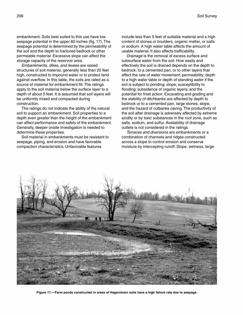
206 Soil Survey
embankment. Soils best suited to this use have lowseepage potential in the upper 60 inches (fig. 17). Theseepage potential is determined by the permeability ofthe soil and the depth to fractured bedrock or otherpermeable material. Excessive slope can affect thestorage capacity of the reservoir area.
Embankments, dikes, and levees are raisedstructures of soil material, generally less than 20 feethigh, constructed to impound water or to protect landagainst overflow. In this table, the soils are rated as asource of material for embankment fill. The ratingsapply to the soil material below the surface layer to adepth of about 5 feet. It is assumed that soil layers willbe uniformly mixed and compacted duringconstruction.
The ratings do not indicate the ability of the naturalsoil to support an embankment. Soil properties to adepth even greater than the height of the embankmentcan affect performance and safety of the embankment.Generally, deeper onsite investigation is needed todetermine these properties.
Soil material in embankments must be resistant toseepage, piping, and erosion and have favorablecompaction characteristics. Unfavorable features
include less than 5 feet of suitable material and a highcontent of stones or boulders, organic matter, or saltsor sodium. A high water table affects the amount ofusable material. It also affects trafficability.
Drainage is the removal of excess surface andsubsurface water from the soil. How easily andeffectively the soil is drained depends on the depth tobedrock, to a cemented pan, or to other layers thataffect the rate of water movement; permeability; depthto a high water table or depth of standing water if thesoil is subject to ponding; slope; susceptibility toflooding; subsidence of organic layers; and thepotential for frost action. Excavating and grading andthe stability of ditchbanks are affected by depth tobedrock or to a cemented pan, large stones, slope,and the hazard of cutbanks caving. The productivity ofthe soil after drainage is adversely affected by extremeacidity or by toxic substances in the root zone, such assalts, sodium, and sulfur. Availability of drainageoutlets is not considered in the ratings.
Terraces and diversions are embankments or acombination of channels and ridges constructedacross a slope to control erosion and conservemoisture by intercepting runoff. Slope, wetness, large
Figure 17.—Farm ponds constructed in areas of Hagerstown soils have a high failure rate due to seepage.

Berkeley County, West Virginia 207
stones, and depth to bedrock or to a cemented panaffect the construction of terraces and diversions. Arestricted rooting depth, a severe hazard of winderosion or water erosion, an excessively coarsetexture, and restricted permeability adversely affectmaintenance.
Grassed waterways are natural or constructedchannels, generally broad and shallow, that conduct
surface water to outlets at a nonerosive velocity. Largestones, wetness, slope, and depth to bedrock or to acemented pan affect the construction of grassedwaterways. A hazard of wind erosion, low availablewater capacity, restricted rooting depth, toxicsubstances such as salts and sodium, and restrictedpermeability adversely affect the growth andmaintenance of the grass after construction.

209
Data relating to soil properties are collected duringthe course of the soil survey. The data and theestimates of soil and water features, listed in tables,are explained on the following pages.
Soil properties are determined by field examinationof the soils and by laboratory index testing of somebenchmark soils. Established standard procedures arefollowed. During the survey, many shallow borings aremade and examined to identify and classify the soilsand to delineate them on the soil maps. Samples aretaken from some typical profiles and tested in thelaboratory to determine grain-size distribution,plasticity, and compaction characteristics.
Estimates of soil properties are based on fieldexaminations, on laboratory tests of samples from thesurvey area, and on laboratory tests of samples ofsimilar soils in nearby areas. Tests verify fieldobservations, verify properties that cannot beestimated accurately by field observation, and help tocharacterize key soils.
The estimates of soil properties shown in the tablesinclude the range of grain-size distribution andAtterberg limits, the engineering classification, and thephysical and chemical properties of the major layers ofeach soil. Pertinent soil and water features also aregiven.
Engineering Index Properties
Table 15 gives estimates of the engineeringclassification and of the range of index properties forthe major layers of each soil in the survey area. Mostsoils have layers of contrasting properties within theupper 5 or 6 feet.
Depth to the upper and lower boundaries of eachlayer is indicated. The range in depth and informationon other properties of each layer are given for eachsoil series under the heading “Taxonomic Units andTheir Morphology.”
Texture is given in the standard terms used by theU.S. Department of Agriculture. These terms aredefined according to percentages of sand, silt, andclay in the fraction of the soil that is less than 2millimeters in diameter. “Loam,” for example, is soil thatis 7 to 27 percent clay, 28 to 50 percent silt, and less
than 52 percent sand. If the content of particlescoarser than sand is as much as about 15 percent, anappropriate modifier is added, for example, “gravelly.”Textural terms are defined in the Glossary.
Classification of the soils is determined according tothe Unified soil classification system (ASTM 1993) andthe system adopted by the American Association ofState Highway and Transportation Officials (AASHTO1986).
The Unified system classifies soils according toproperties that affect their use as constructionmaterial. Soils are classified according to grain-sizedistribution of the fraction less than 3 inches indiameter and according to plasticity index, liquid limit,and organic matter content. Sandy and gravelly soilsare identified as GW, GP, GM, GC, SW, SP, SM, andSC; silty and clayey soils as ML, CL, OL, MH, CH, andOH; and highly organic soils as PT. Soils exhibitingengineering properties of two groups can have a dualclassification, for example, CL-ML.
The AASHTO system classifies soils according tothose properties that affect roadway construction andmaintenance. In this system, the fraction of a mineralsoil that is less than 3 inches in diameter is classifiedin one of seven groups from A-1 through A-7 on thebasis of grain-size distribution, liquid limit, andplasticity index. Soils in group A-1 are coarse grainedand low in content of fines (silt and clay). At the otherextreme, soils in group A-7 are fine grained. Highlyorganic soils are classified in group A-8 on the basis ofvisual inspection.
If laboratory data are available, the A-1, A-2, andA-7 groups are further classified as A-1-a, A-1-b,A-2-4, A-2-5, A-2-6, A-2-7, A-7-5, or A-7-6. As anadditional refinement, the suitability of a soil assubgrade material can be indicated by a group indexnumber. Group index numbers range from 0 for thebest subgrade material to 20 or higher for the poorest.
Rock fragments larger than 3 inches in diameterare indicated as a percentage of the total soil on a dry-weight basis. The percentages are estimatesdetermined mainly by converting volume percentagein the field to weight percentage.
Percentage (of soil particles) passing designatedsieves is the percentage of the soil fraction less than
Soil Properties
210 Soil Survey
3 inches in diameter based on an ovendry weight. Thesieves, numbers 4, 10, 40, and 200 (USA StandardSeries), have openings of 4.76, 2.00, 0.420, and0.074 millimeters, respectively. Estimates are basedon laboratory tests of soils sampled in the survey areaand in nearby areas and on estimates made in thefield.
Liquid limit and plasticity index (Atterberg limits)indicate the plasticity characteristics of a soil. Theestimates are based on test data from the survey areaor from nearby areas and on field examination.
The estimates of grain-size distribution, liquid limit,and plasticity index are generally rounded to thenearest 5 percent. Thus, if the ranges of gradation andAtterberg limits extend a marginal amount (1 or2 percentage points) across classification boundaries,the classification in the marginal zone is omitted in thetable.
Physical and Chemical Properties
Table 16 shows estimates of some characteristicsand features that affect soil behavior. These estimatesare given for the major layers of each soil in the surveyarea. The estimates are based on field observationsand on test data for these and similar soils.
Clay as a soil separate consists of mineral soilparticles that are less than 0.002 millimeter indiameter. In this table, the estimated clay content ofeach major soil layer is given as a percentage, byweight, of the soil material that is less than2 millimeters in diameter.
The amount and kind of clay greatly affect thefertility and physical condition of the soil. Theydetermine the ability of the soil to adsorb cations andto retain moisture. They influence shrink-swellpotential, permeability, plasticity, the ease of soildispersion, and other soil properties. The amount andkind of clay in a soil also affect tillage and earthmovingoperations.
Moist bulk density is the weight of soil (ovendry) perunit volume. Volume is measured when the soil is atfield moisture capacity, that is, the moisture content at1/3-bar moisture tension. Weight is determined afterdrying the soil at 105 degrees C. In this table, theestimated moist bulk density of each major soilhorizon is expressed in grams per cubic centimeter ofsoil material that is less than 2 millimeters in diameter.Bulk density data are used to compute shrink-swellpotential, available water capacity, total pore space,and other soil properties. The moist bulk density of asoil indicates the pore space available for water androots. A bulk density of more than 1.6 can restrict
water storage and root penetration. Moist bulk densityis influenced by texture, kind of clay, content of organicmatter, and soil structure.
Permeability refers to the ability of a soil to transmitwater or air. The estimates indicate the rate ofdownward movement of water when the soil issaturated. They are based on soil characteristicsobserved in the field, particularly structure, porosity,and texture. Permeability is considered in the design ofsoil drainage systems and septic tank absorptionfields.
Available water capacity refers to the quantity ofwater that the soil is capable of storing for use byplants. The capacity for water storage is given ininches of water per inch of soil for each major soillayer. The capacity varies, depending on soilproperties that affect the retention of water and thedepth of the root zone. The most important propertiesare the content of organic matter, soil texture, bulkdensity, and soil structure. Available water capacity isan important factor in the choice of plants or crops tobe grown and in the design and management ofirrigation systems. Available water capacity is not anestimate of the quantity of water actually available toplants at any given time.
Soil reaction is a measure of acidity or alkalinity andis expressed as a range in pH values. The range in pHof each major horizon is based on many field tests. Formany soils, values have been verified by laboratoryanalyses. Soil reaction is important in selecting cropsand other plants, in evaluating soil amendments forfertility and stabilization, and in determining the risk ofcorrosion.
Shrink-swell potential is the potential for volumechange in a soil with a loss or gain in moisture. Volumechange occurs mainly because of the interaction ofclay minerals with water and varies with the amountand type of clay minerals in the soil. The size of theload on the soil and the magnitude of the change insoil moisture content influence the amount of swellingof soils in place. Laboratory measurements of swellingof undisturbed clods were made for many soils. Forothers, swelling was estimated on the basis of the kindand amount of clay minerals in the soil and on thebasis of measurements of similar soils.
If the shrink-swell potential is rated moderate tovery high, shrinking and swelling can cause damageto buildings, roads, and other structures. Specialdesign is often needed.
Shrink-swell potential classes are based on thechange in length of an unconfined clod as moisturecontent is increased from air-dry to field capacity.The classes are low, a change of less than
Berkeley County, West Virginia 211
3 percent; moderate, 3 to 6 percent; and high, 6 to9 percent. Very high, more than 9 percent, issometimes used.
Erosion factor K indicates the susceptibility of a soilto sheet and rill erosion by water. Factor K is one of sixfactors used in the Universal Soil Loss Equation(USLE) to predict the average annual rate of soil lossby sheet and rill erosion in tons per acre per year. Theestimates are based primarily on percentage of silt,sand, and organic matter (up to 4 percent) and on soilstructure and permeability. Values of K range from0.05 to 0.69. The higher the value, the moresusceptible the soil is to sheet and rill erosion bywater.
Erosion factor T is an estimate of the maximumaverage annual rate of soil erosion by wind or waterthat can occur without affecting crop productivity overa sustained period. The rate is in tons per acre peryear.
Organic matter is the plant and animal residue inthe soil at various stages of decomposition. Intable 16, the estimated content of organic matter isexpressed as a percentage, by weight, of the soilmaterial that is less than 2 millimeters in diameter.
The content of organic matter in a soil can bemaintained or increased by returning crop residue tothe soil, including green manure crops in the plantingsequence, no-till planting, and applying animal waste.Organic matter affects the available water capacity,infiltration rate, and tilth. It is a source of nitrogen andother nutrients for crops.
Soil and Water Features
Table 17 gives estimates of various soil and waterfeatures. The estimates are used in land use planningthat involves engineering considerations.
Hydrologic soil groups are used to estimate runofffrom precipitation. Soils not protected by vegetationare assigned to one of four groups. They are groupedaccording to the infiltration of water when the soils arethoroughly wet and receive precipitation from long-duration storms.
The four hydrologic soil groups are:Group A. Soils having a high infiltration rate (low
runoff potential) when thoroughly wet. These consistmainly of deep, well drained to excessively drainedsands or gravelly sands. These soils have a high rateof water transmission.
Group B. Soils having a moderate infiltration ratewhen thoroughly wet. These consist chiefly ofmoderately deep or deep, moderately well drained orwell drained soils that have moderately fine texture to
moderately coarse texture. These soils have amoderate rate of water transmission.
Group C. Soils having a slow infiltration rate whenthoroughly wet. These consist chiefly of soils having alayer that impedes the downward movement of wateror soils of moderately fine texture or fine texture.These soils have a slow rate of water transmission.
Group D. Soils having a very slow infiltration rate(high runoff potential) when thoroughly wet. Theseconsist chiefly of clays that have a high shrink-swellpotential, soils that have a permanent high water table,soils that have a claypan or clay layer at or near thesurface, and soils that are shallow over nearlyimpervious material. These soils have a very slow rateof water transmission.
If a soil is assigned to two hydrologic groups intable 17, the first letter is for drained areas and thesecond is for undrained areas.
Flooding, the temporary inundation of an area, iscaused by overflowing streams, by runoff fromadjacent slopes, or by tides. Water standing for shortperiods after rainfall or snowmelt is not consideredflooding, nor is water in swamps and marshes.
Table 17 gives the estimated frequency of flooding.Frequency is expressed as none, rare, occasional,and frequent. None means that flooding is notprobable; rare that it is unlikely but possible underunusual weather conditions (the chance of flooding isnearly 0 percent to 5 percent in any year); occasionalthat it occurs infrequently under normal weatherconditions (the chance of flooding is 5 to 50 percent inany year); and frequent that it occurs often undernormal conditions (the chance of flooding is more than50 percent in any year).
The information is based on evidence in the soilprofile, namely thin strata of gravel, sand, silt, or claydeposited by floodwater; irregular decrease in organicmatter content with increasing depth; and little or nohorizon development.
Also considered are local information about theextent and levels of flooding and the relation of eachsoil on the landscape to historic floods. Information onthe extent of flooding based on soil data is lessspecific than that provided by detailed engineeringsurveys that delineate flood-prone areas at specificflood frequency levels.
High water table (seasonal) is the highest level of asaturated zone in the soil in most years. The estimatesare based mainly on the evidence of a saturated zone,namely grayish colors or mottles in the soil. Indicatedin table 17 are depth to the seasonal high water table;the kind of water table—that is, perched or apparent;and the months of the year that the water table
212
commonly is high. A water table that is seasonallyhigh for less than 1 month is not indicated intable 17.
An apparent water table is a thick zone of free waterin the soil. It is indicated by the level at which waterstands in an uncased borehole after adequate time isallowed for adjustment in the surrounding soil. Aperched water table is water standing above anunsaturated zone. In places an upper, or perched,water table is separated from a lower one by a dryzone.
Only saturated zones within a depth of about 6 feetare indicated. A plus sign preceding the range in depthindicates that the water table is above the surface ofthe soil. The first numeral in the range indicates howhigh the water rises above the surface. The secondnumeral indicates the depth below the surface.
Depth to bedrock is given if bedrock is within adepth of 5 feet. The depth is based on many soilborings and on observations during soil mapping. Therock is either soft or hard. If the rock is soft orfractured, excavations can be made with trenchingmachines, backhoes, or small rippers. If the rock ishard or massive, blasting or special equipmentgenerally is needed for excavation.
Potential frost action is the likelihood of upward orlateral expansion of the soil caused by the formation ofsegregated ice lenses (frost heave) and thesubsequent collapse of the soil and loss of strength onthawing. Frost action occurs when moisture movesinto the freezing zone of the soil. Temperature, texture,density, permeability, content of organic matter, anddepth to the water table are the most important factors
considered in evaluating the potential for frost action. Itis assumed that the soil is not insulated by vegetationor snow and is not artificially drained. Silty and highlystructured, clayey soils that have a high water table inwinter are the most susceptible to frost action. Welldrained, very gravelly, or very sandy soils are the leastsusceptible. Frost heave and low soil strength duringthawing cause damage mainly to pavements and otherrigid structures.
Risk of corrosion pertains to potential soil-inducedelectrochemical or chemical action that dissolves orweakens uncoated steel or concrete. The rate ofcorrosion of uncoated steel is related to such factorsas soil moisture, particle-size distribution, acidity, andelectrical conductivity of the soil. The rate of corrosionof concrete is based mainly on the sulfate and sodiumcontent, texture, moisture content, and acidity of thesoil. Special site examination and design may beneeded if the combination of factors results in a severehazard of corrosion. The steel in installations thatintersect soil boundaries or soil layers is moresusceptible to corrosion than steel in installations thatare entirely within one kind of soil or within one soillayer.
For uncoated steel, the risk of corrosion, expressedas low, moderate, or high, is based on soil drainageclass, total acidity, electrical resistivity near fieldcapacity, and electrical conductivity of the saturationextract.
For concrete, the risk of corrosion is also expressedas low, moderate, or high. It is based on soil texture,acidity, and amount of sulfates in the saturationextract.
213
The system of soil classification used by theNational Cooperative Soil Survey has six categories(USDA 1975). Beginning with the broadest, thesecategories are the order, suborder, great group,subgroup, family, and series. Classification is based onsoil properties observed in the field or inferred fromthose observations or from laboratory measurements.Table 18 shows the classification of the soils in thesurvey area. The categories are defined in thefollowing paragraphs.
ORDER. Eleven soil orders are recognized. Thedifferences among orders reflect the dominant soil-forming processes and the degree of soil formation.Each order is identified by a word ending in sol. Anexample is Alfisol.
SUBORDER. Each order is divided into subordersprimarily on the basis of properties that influence soilgenesis and are important to plant growth orproperties that reflect the most important variableswithin the orders. The last syllable in the name of asuborder indicates the order. An example is Udalf (Ud,meaning humid, plus alf, from Alfisol).
GREAT GROUP. Each suborder is divided into greatgroups on the basis of close similarities in kind,arrangement, and degree of development ofpedogenic horizons; soil moisture and temperatureregimes; and base status. Each great group isidentified by the name of a suborder and by a prefixthat indicates a property of the soil. An example isHapludalfs (Hapl, meaning minimal horizonation, plusudalf, the suborder of the Alfisols that has a udicmoisture regime).
SUBGROUP. Each great group has a typicsubgroup. Other subgroups are intergrades orextragrades. The typic is the central concept of thegreat group; it is not necessarily the most extensive.Intergrades are transitions to other orders, suborders,or great groups. Extragrades have some propertiesthat are not representative of the great group but donot indicate transitions to any other known kind of soil.Each subgroup is identified by one or more adjectivespreceding the name of the great group. The adjectiveTypic identifies the subgroup that typifies the greatgroup. An example is Typic Hapludalfs.
FAMILY. Families are established within a subgroupon the basis of physical and chemical properties andother characteristics that affect management.Generally, the properties are those of horizons belowplow depth where there is much biological activity.Among the properties and characteristics consideredare particle-size class, mineral content, temperatureregime, depth of the root zone, consistence, moistureequivalent, slope, and permanent cracks. A familyname consists of the name of a subgroup preceded byterms that indicate soil properties. An example is fine,mixed, mesic Typic Hapludalfs.
SERIES. The series consists of soils that havesimilar horizons in their profile. The horizons aresimilar in color, texture, structure, reaction,consistence, mineral and chemical composition, andarrangement in the profile. The texture of the surfacelayer or of the underlying material can differ within aseries.
Taxonomic Units and TheirMorphology
Dr. John Sencindiver, professor of agronomy, West VirginiaAgricultural and Forestry Experiment Station, helped to preparethis section.
In this section, each soil series recognized in thesurvey area is described. The descriptions arearranged in alphabetic order.
Characteristics of the soil and the material in whichit formed are identified for each series. A pedon, asmall three-dimensional area of soil, that is typical ofthe series in the survey area is described. Thedetailed description of each soil horizon followsstandards in the “Soil Survey Manual” (USDA 1993).Many of the technical terms used in the descriptionsare defined in “Soil Taxonomy” (USDA 1975). Unlessotherwise stated, colors in the descriptions are formoist soil. Following the pedon description is therange of important characteristics of the soils in theseries.
The map units of each soil series are described inthe section “Detailed Soil Map Units.”
Classification of the Soils
214 Soil Survey
Atkins Series
Depth class: Very deepDrainage class: Poorly drainedPermeability: SlowLandscape position: Nearly level, slightly concave
flood plainsFlooding: Frequently flooded (more than a 50 percent
chance of flooding in any year) for brief periodsParent material: Recent alluvial deposits washed from
upland soils underlain by acid sandstone andshale
Slope range: 0 to 3 percentClassification: Fine-loamy, mixed, acid, mesic Typic
Fluvaquents
Representative Pedon
Atkins silt loam, in an abandoned area that waspreviously used as cropland; about 600 feet west ofBack Creek; 4,000 feet east-southeast from theintersection of County Routes 7 and 18 on a bearingof 102 degrees; in the Shanghai area; USGS TablersStation topographic quadrangle; lat. 39 degrees 26minutes 08 seconds N. and long. 78 degrees 07minutes 15 seconds W.
Ap—0 to 8 inches; brown (10YR 4/3) silt loam;moderate fine and medium granular structure;very friable; common fine to coarse roots; few finegrayish brown (10YR 5/2) iron depletions and fewfine strong brown (7.5YR 4/6) iron concentrations;slightly acid; abrupt smooth boundary.
BA—8 to 11 inches; brown (10YR 5/3) silt loam; weakmedium and coarse subangular blocky structure;very friable; few very fine and fine roots; fewpatchy stains of manganese or of iron andmanganese on faces of peds; many mediumgrayish brown (10YR 5/2) iron depletions and fewfine strong brown (7.5YR 4/6) iron concentrations;moderately acid; clear smooth boundary.
Bg1—11 to 29 inches; light brownish gray (10YR 6/2)silty clay loam; weak coarse prismatic structureparting to weak fine and medium subangularblocky; friable, slightly sticky and slightly plastic;common patchy stains of manganese or of ironand manganese on faces of peds; many mediumstrong brown (7.5YR 5/6) and common yellowishbrown (10YR 5/6) iron concentrations; stronglyacid; clear wavy boundary.
Bg2—29 to 57 inches; silty clay loam, 75 percentbrown (7.5YR 5/2) and 25 percent grayish brown(10YR 5/2); weak very coarse prismatic structureparting to moderate medium subangular blocky;firm, slightly sticky and slightly plastic; commonpatchy stains of manganese or of iron and
manganese on faces of peds; common mediumstrong brown (7.5YR 4/6) iron concentrations;strongly acid; clear wavy boundary.
Cg—57 to 65 inches; very gravelly silty clay loam, 75percent brown (7.5YR 5/2) and 25 percent darkgrayish brown (10YR 4/2); massive; firm, slightlysticky and slightly plastic; common patchy stainsof manganese or of iron and manganese on rockfragments; 50 percent gravel; moderately acid.
Range in Characteristics
Solum thickness: 25 to 60 inchesDepth to bedrock: More than 60 inchesReaction: In unlimed areas, very strongly acid or
strongly acid (pH 4.5 to 5.5) above a depth of 40inches ranging to moderately acid (pH 5.6 to 6.0)below a depth of 40 inches
Content of rock fragments: Commonly no fragments; inplaces, however, 0 to 20 percent, by volume, in thesolum and 0 to 60 percent in the C horizon
Ap horizon:Hue—10YRValue—4 or 5Chroma—1 to 3Texture—silt loamOther features—high-chroma iron concentrations
in shades of red and low-chroma irondepletions in shades of gray
A horizon (if it occurs):Hue—10YRValue—2 to 4Chroma—1 to 3Texture—silt loamOther features—high-chroma iron concentrations
in shades of red and low-chroma irondepletions in shades of gray
BA horizon (if it occurs):Hue—10YRValue—4 or 5Chroma—3 or 4Texture—silt loam, fine sandy loam, loam, or silty
clay loamOther features—high-chroma iron concentrations
in shades of red and low-chroma irondepletions in shades of gray
Bg horizon:Hue—7.5YR to 5Y or NValue—4 to 7Chroma—0 to 2Texture—silt loam, fine sandy loam, loam, silty
clay loam, or the gravelly analogs of thosetextures
Berkeley County, West Virginia 215
Other features—high-chroma iron concentrationsin shades of red or yellowish brown
Cg horizon:Hue—7.5YR to 5Y or NValue—4 to 7Chroma—0 to 8Texture—loam, silty clay loam, sandy loam, or the
gravelly or very gravelly analogs of thosetextures
Other features—high-chroma iron concentrationsin shades of red or yellowish brown
Berks Series
Depth class: Moderately deepDrainage class: Well drainedPermeability: Moderate or moderately rapidLandscape position: Gently sloping to very steep
uplandsFlooding: NoneParent material: Material weathered from shale or
siltstoneSlope range: 3 to 70 percentClassification: Loamy-skeletal, mixed, mesic Typic
Dystrochrepts
Representative Pedon
Berks channery silt loam, in a pastured area ofWeikert-Berks channery silt loams, 8 to 15 percentslopes; the pastured area was previously used ascropland; about 1,800 feet north-northwest of theintersection of Routes 45/4 and 5/9 on a bearing of356 degrees; in the Greensburg area; USGSMartinsburg topographic quadrangle; lat. 39 degrees28 minutes 17 seconds N. and long. 77 degrees 53minutes 52 seconds W.
Ap—0 to 7 inches; brown (10YR 4/3) channery siltloam; moderate fine and medium granularstructure; friable; many fine and medium roots;15 percent shale channers; neutral; abrupt smoothboundary.
Bw1—7 to 12 inches; yellowish brown (10YR 5/6)channery silt loam; moderate fine and mediumsubangular blocky structure; friable; common veryfine and fine roots; 30 percent shale channers;slightly acid; clear smooth boundary.
Bw2—12 to 21 inches; variegated very channery siltloam, 80 percent yellowish brown (10YR 5/6) and20 percent strong brown (7.5YR 5/6); weakmedium and coarse subangular blocky structure;friable; few very fine and fine roots; 40 percentshale channers; strongly acid; clear wavyboundary.
C—21 to 25 inches; variegated extremely channerysilt loam, 75 percent strong brown (7.5YR 5/6) and25 percent yellowish brown (10YR 5/6); massive;friable; 70 percent shale channers; strongly acid,clear wavy boundary.
R—25 inches; yellowish brown shale bedrock.
Range in Characteristics
Solum thickness: 12 to 40 inchesDepth to bedrock: 20 to 40 inchesReaction: In unlimed areas, extremely acid to slightly
acid (pH 3.6 to 6.5)Content of rock fragments: 15 to 40 percent in the A
horizon, 15 to 60 percent in the B horizon, and 40to 80 percent in the C horizon; fragments areshale or siltstone
Ap or A horizon:Hue—10YRValue—3 or 4Chroma—2 to 4Texture—channery or very channery silt loam
Bw horizon:Hue—10YR or 7.5YRValue—5 or 6Chroma—4 to 6Texture—silt loam, silty clay loam, loam, or the
channery or very channery analogs of thosetextures
C horizon:Hue—10YR or 7.5YRValue—4 to 6Chroma—4 to 8Texture—silt loam, loam, or the very channery or
extremely channery analogs of those textures
Blackthorn Series
Depth class: Very deepDrainage class: Well drainedPermeability: Moderate or moderately rapid above the
2Bt horizon and moderate or moderately slow inthe 2Bt horizon and below the 2Bt horizon
Landscape position: Gently sloping to very steepuplands on Wilson Ridge, Ferrel Ridge, and otheroutlying areas that are underlain by limestonebedrock; near Jones Spring
Flooding: NoneParent material: Acid, colluvial material overlying
siliceous limestone residuumSlope range: 3 to 50 percentClassification: Loamy-skeletal, mixed, mesic Typic
Hapludults
216 Soil Survey
Representative Pedon
Blackthorn very gravelly loam, in a wooded area ofBlackthorn-Pecktonville very gravelly loams, 15 to 35percent slopes, extremely stony; about 1,650 feetwest-southwest of the entrance to Camp Tomahawkon a bearing of 265 degrees; on Wilson Ridge; USGSTablers Station topographic quadrangle; lat. 39degrees 29 minutes 50 seconds N. and long. 78degrees 04 minutes 13 seconds W.
Oi—2 inches to 1 inch; slightly decomposed hardwoodleaf litter.
Oe—1 inch to 0; partially decomposed hardwood duff.A—0 to 3 inches; very dark brown (10YR 3/2) very
gravelly loam; moderate fine and medium granularstructure; very friable; many fine to coarse roots;50 percent sandstone gravel; very strongly acid;abrupt wavy boundary.
E—3 to 6 inches; brown (10YR 5/3) very gravellysandy loam; weak fine granular structure; veryfriable; many fine to coarse roots; 50 percentsandstone gravel; very strongly acid; clear wavyboundary.
BE—6 to 14 inches; light yellowish brown (10YR 6/4)gravelly sandy loam; weak fine and mediumsubangular blocky structure; friable; common fineand medium roots; 30 percent sandstone gravel;very strongly acid; clear wavy boundary.
Bt1—14 to 24 inches; yellowish brown (10YR 5/4) verygravelly sandy loam; weak fine and mediumsubangular blocky structure; friable; common fineand medium roots; few distinct patchy clay films onfaces of peds and in pores; 35 percent sandstonegravel; very strongly acid; gradual wavy boundary.
Bt2—24 to 35 inches; strong brown (7.5YR 5/6) verygravelly loam; moderate medium subangularblocky structure; friable; few very fine and fineroots; common distinct patchy clay films on facesof peds and in pores; 40 percent sandstone andchert gravel; very strongly acid; clear wavyboundary.
2Bt3—35 to 75 inches; variegated very gravelly clay,85 percent red (2.5YR 4/6) and 15 percent strongbrown (7.5YR 5/6); moderate fine and mediumsubangular blocky structure; firm, moderatelysticky and moderately plastic; few very fine andfine roots; many distinct patchy clay films on pedfaces and rock surfaces; 30 percent sandstoneand chert gravel and 20 percent stones; verystrongly acid; clear wavy boundary.
3Bt4—75 to 90 inches; variegated clay, 65 percent red(2.5YR 4/6) and 35 percent strong brown (7.5YR5/6); moderate fine and medium subangularblocky structure; firm, moderately sticky and
moderately plastic; many distinct patchy clay filmson ped faces and rock surfaces; 10 percent chertgravel; very strongly acid.
Range in Characteristics
Solum thickness: More than 60 inchesDepth to 2Bt horizon: 30 inches or moreDepth to bedrock: More than 60 inchesReaction: In unlimed areas, very strongly acid to
moderately acid (pH 4.5 to 6.0) above the 2Bthorizon and very strongly acid or strongly acid (pH4.5 to 5.5) in the 2Bt horizon and below the 2Bthorizon
Content of rock fragments: 15 to 65 percent inindividual subhorizons above the 2Bt horizon and0 to 55 percent in the 2Bt horizon and below the2Bt horizon
A horizon:Hue—10YRValue—2 to 4Chroma—2 or 3Texture—very gravelly loam
E horizon:Hue—10YR or 7.5YRValue—5 or 6Chroma—2 to 4Texture—loam, sandy loam, or the gravelly, very
gravelly, or extremely gravelly analogs of thosetextures
BE horizon:Hue—10YR or 7.5YRValue—5 or 6Chroma—3 or 4Texture—loam, sandy loam, or the gravelly, very
gravelly, or extremely gravelly analogs of thosetextures
Bt horizon:Hue—10YR or 7.5YRValue—5 or 6Chroma—4 to 6Texture—loam, sandy loam, or the gravelly, very
gravelly, or extremely gravelly analogs of thosetextures
2Bt horizon:Hue—2.5YR to 7.5YRValue—4 to 6Chroma—4 to 8Texture—clay, silty clay, or the gravelly or very
gravelly analogs of those textures
3Bt horizon (if it occurs):Hue—2.5YR to 7.5YR
Berkeley County, West Virginia 217
Value—4 to 6Chroma—4 to 8Texture—clay, silty clay, or the gravelly or very
gravelly analogs of those textures
Buchanan Series
Depth class: Very deepDrainage class: Moderately well drainedPermeability: Moderate above the fragipan and slow in
the fragipanLandscape position: Gently sloping to steep, slightly
concave footslopes, benches, and lower sideslopes of mountains
Flooding: NoneParent material: Colluvial material derived from acid
sandstone, siltstone, and shaleSlope range: 3 to 35 percentClassification: Fine-loamy, mixed, mesic Aquic
Fragiudults
Representative Pedon
Buchanan loam, 3 to 15 percent slopes, extremelystony, in a wooded area on Third Hill Mountain; about1.9 miles north-northeast of the intersection ofRoutes 7/13 and 826 on a bearing of 18 degrees;USGS Glengary topographic quadrangle; lat. 39degrees 29 minutes 02 seconds N. and long. 78degrees 09 minutes 40 seconds W.
Oi—3 inches to 0; slightly decomposed organicmaterial from hardwood leaf litter.
Oe—0 to 1 inch; organic material of intermediatedecomposition from hardwood leaf litter.
A—1 to 2 inches; very dark gray (10YR 3/1) loam;weak fine and medium granular structure; veryfriable, nonsticky and nonplastic; common veryfine to coarse roots; 5 percent gravel; very stronglyacid; clear wavy boundary.
E—2 to 4 inches; light yellowish brown (10YR 6/4)loam; weak fine subangular blocky structure;friable, nonsticky and nonplastic; common fine tocoarse roots; 5 percent gravel; very strongly acid;clear wavy boundary.
BE—4 to 13 inches; brownish yellow (10YR 6/6)gravelly loam; weak fine and medium subangularblocky structure; friable, nonsticky and slightlyplastic; common fine and medium roots; 15percent gravel; very strongly acid; clear wavyboundary.
Bt1—13 to 21 inches; light yellowish brown (10YR 6/4)gravelly loam; moderate fine and mediumsubangular blocky structure; friable, nonsticky andslightly plastic; few fine and medium roots; few
faint patchy clay films on faces of peds and inpores; common medium faint strong brown (7.5YR5/8) iron concentrations; 20 percent gravel; verystrongly acid; clear wavy boundary.
Bt2—21 to 30 inches; strong brown (7.5YR 5/6)gravelly loam; moderate fine and mediumsubangular blocky structure; friable, slightly stickyand slightly plastic; few fine and medium roots; fewpatchy clay films on faces of peds and in pores;many coarse distinct pale brown (10YR 6/3) andfew fine light brownish gray (10YR 6/2) irondepletions and few medium prominent yellowishred (5YR 4/6) iron concentrations; 10 percentstones; 10 percent gravel; strongly acid; clearwavy boundary.
Btx1—30 to 49 inches; strong brown (7.5YR 5/6)gravelly loam; weak coarse prismatic structureparting to moderate fine subangular blocky; firmand brittle, slightly sticky and slightly plastic; fewfine and medium roots between peds; few faintpatchy clays films on faces of peds and in pores;many coarse prominent light brownish gray (10YR6/2) iron depletions; few medium distinct dark red(2.5YR 3/6) and few fine distinct brownish yellow(10YR 6/8) iron concentrations; 30 percent gravel;strongly acid; clear wavy boundary.
Btx2—49 to 65 inches; reddish brown (5YR 4/4) verygravelly loam; weak coarse prismatic structureparting to weak fine and medium subangularblocky; very firm and brittle, nonsticky and slightlyplastic; few faint patchy clay films on faces of pedsand in pores; common coarse prominent gray(10YR 6/1) iron depletions and few mediumdistinct red (2.5YR 4/6) iron concentrations; 35percent gravel; strongly acid.
Range in Characteristics
Solum thickness: 40 to 70 inchesDepth to bedrock: More than 60 inchesReaction: In unlimed areas, extremely acid to strongly
acid (pH 3.5 to 5.5)Content of rock fragments: 0 to 40 percent in individual
subhorizons above the fragipan and 5 to 60percent in the fragipan and in the C horizon
Depth to the fragipan: 20 to 36 inches
A horizon:Hue—7.5YR or 10YRValue—3 or 4Chroma—1 to 3Texture—loam or gravelly loam
E horizon:Hue—10YRValue—4 to 6
218 Soil Survey
Chroma—2 to 4Texture—loam, sandy loam, fine sandy loam, or
the gravelly or very gravelly analogs of thosetextures
BE horizon (if it occurs):Hue—10YRValue—5 or 6Chroma—5 or 6Texture—loam, gravelly loam, or very gravelly
loam
Bt horizon:Hue—7.5YR or 10YRValue—5 or 6Chroma—4 to 6Texture—loam, clay loam, sandy clay loam, or the
gravelly or very gravelly analogs of thosetextures
Other features—low-chroma iron depletions inshades of gray and high-chroma ironconcentrations in shades of red and brown inthe top 10 inches of the horizon
Btx horizon:Hue—10YR to 5YRValue—4 to 6Chroma—4 to 6Texture—loam, clay loam, sandy clay loam, or the
gravelly or very gravelly analogs of thosetextures
Other features—low-chroma iron depletions inshades of gray and high-chroma ironconcentrations in shades of red and brown
C horizon (if it occurs):Hue—10YR to 5YRValue—4 to 6Chroma—1 to 6Texture—loam, sandy loam, clay loam, sandy clay
loam, or the gravelly or very gravelly analogs ofthose textures
Other features—low-chroma iron depletions inshades of gray and high-chroma ironconcentrations in shades of red and brown insome pedons
Calvin Series
Depth class: Moderately deepDrainage class: Well drainedPermeability: Moderately rapidLandscape position: Gently sloping to very steep,
convex uplandsFlooding: NoneParent material: Material weathered from reddish, fine
grained sandstone or siltstone; mainly members ofthe Hampshire Formation
Slope range: 3 to 65 percentClassification: Loamy-skeletal, mixed, mesic Typic
Dystrochrepts
Representative Pedon
Calvin channery loam, 8 to 15 percent slopes, in awooded area; about 2,200 feet south-southeast ofSleepy Creek Lake Dam on a bearing of 162 degrees;USGS Stotlers Crossroads topographic quadrangle;lat. 39 degrees 31 minutes 35 seconds N. and long. 78degrees 08 minutes 48 seconds W.
Oi—1 inch to 0; slightly decomposed hardwood leaflitter.
A—0 to 2 inches; very dark brown (7.5YR 2/2)channery loam; moderate fine and mediumgranular structure; very friable; many fine tocoarse roots; 25 percent channers; very stronglyacid; abrupt wavy boundary.
Bw1—2 to 8 inches; reddish brown (5YR 4/4) verychannery loam; weak fine and medium subangularblocky structure; friable; common fine to coarseroots; 35 percent channers; very strongly acid;clear wavy boundary.
Bw2—8 to 23 inches; reddish brown (2.5YR 4/4) verychannery loam; weak medium subangular blockystructure; friable; few fine to coarse roots; 50percent channers; very strongly acid; gradualwavy boundary.
C—23 to 34 inches; reddish brown (2.5YR 4/4)extremely channery loam; massive; friable; fewfine to coarse roots; 75 percent channers; verystrongly acid; clear wavy boundary.
R—34 inches; fractured, reddish brown, fine grainedsandstone; few fine to coarse roots in cracks.
Range in Characteristics
Solum thickness: 18 to 30 inchesDepth to bedrock: 20 to 40 inchesReaction: In unlimed areas, very strongly acid or
strongly acid (pH 4.5 to 5.5) throughoutContent of rock fragments: 15 to 25 percent in the A
and BA horizons, 25 to 55 percent in the Bwhorizon, and 40 to 80 percent in the C horizon
A horizon:Hue—7.5YRValue—2 to 4Chroma—2 or 3Texture—channery loam
BA horizon (if it occurs):Hue—7.5YR or 5YRValue—4
Berkeley County, West Virginia 219
Chroma—2 to 6Texture—channery or very channery analogs of
loam or silt loam
Bw horizon:Hue—2.5YR or 5YRValue—4 or 5Chroma—3 to 6Texture—channery or very channery analogs of
loam or silt loam
C horizon:Hue—2.5YR or 5YRValue—3 to 5Chroma—2 to 4Texture—very channery or extremely channery
analogs of loam or silt loam
Caneyville Series
Depth class: Moderately deepDrainage class: Well drainedPermeability: Moderately slowLandscape position: Gently sloping to moderately
steep uplands, mainly in a band from Ferrel Ridgeto Jones Spring in the western part of the county
Flooding: NoneParent material: Limestone residuum interbedded with
thin layers of shale and siltstone, mainly in areasof the Bossardville, Helderberg, and Salinageologic deposits
Slope range: 3 to 25 percent slopesClassification: Fine, mixed, mesic Typic Hapludalfs
Representative Pedon
Caneyville silty clay loam, 8 to 15 percent slopes, inan abandoned area that was previously used ascropland; about 2,350 feet west-northwest of theintersection of County Routes 7 and 7/2 on a bearingof 296 degrees; near Tomahawk; USGS Big Pooltopographic quadrangle; lat. 39 degrees 31 minutes 55seconds N. and long. 78 degrees 03 minutes 22seconds W.
Ap1—0 to 4 inches; dark grayish brown (10YR 4/2)silty clay loam; moderate fine and mediumgranular structure; friable, slightly sticky andslightly plastic; many very fine and fine roots; 5percent limestone channers; neutral; clear wavyboundary.
Ap2—4 to 8 inches; brown (10YR 4/3) silty clay loam;few medium yellowish brown (10YR 5/4) mottles;weak medium subangular blocky structure partingto moderate fine and medium granular; friable,slightly sticky and slightly plastic; many very fine
and fine roots; 10 percent limestone channers;neutral; abrupt smooth boundary.
Bt1—8 to 16 inches; strong brown (7.5YR 5/6) siltyclay; few fine yellowish brown (10YR 5/8) andcommon coarse yellowish brown (10YR 5/4)mottles; moderate fine and medium subangularblocky structure; firm, very sticky and very plastic;common very fine and fine roots; fewdiscontinuous clay films on faces of peds and inpores; few fine soft masses of iron andmanganese; 3 percent shale channers; neutral;clear wavy boundary.
Bt2—16 to 28 inches; yellowish red (5YR 4/6) siltyclay; moderate fine and medium subangularblocky structure; firm, very sticky and very plastic;common very fine and fine roots; fewdiscontinuous clay films on ped faces, in pores,and on rock surfaces; few fine soft masses of ironand manganese; 3 percent shale channers;slightly alkaline; abrupt irregular boundary.
R—28 inches; unweathered limestone bedrock.
Range in Characteristics
Solum thickness: 20 to 40 inchesDepth to bedrock: 20 to 40 inchesReaction: In unlimed areas, strongly acid to neutral
(pH 5.1 to 7.3) in the upper part of the solum andmoderately acid to slightly alkaline (pH 5.6 to 7.8)in the lower part of the solum and in thesubstratum
Content of rock fragments: 0 to 10 percent in thesolum and as much as 35 percent in the Chorizon, if it occurs
Ap horizon:Hue—10YRValue—3 or 4Chroma—2 or 3Texture—silty clay loam
BA horizon (if it occurs):Hue—10YR or 7.5YRValue—5Chroma—4 or 5Texture—silt loam or silty clay loam
Bt horizon:Hue—10YR to 5YRValue—4 to 6Chroma—4 to 8Texture—silty clay, clay, or silty clay loam
BC horizon (if it occurs):Hue—10YR to 5YRValue—4 to 6Chroma—4 to 8
220 Soil Survey
Texture—silty clay, clay, or clay loam
C horizon (if it occurs):Hue—10YR to 5YRValue—4 to 6Chroma—4 to 8Texture—clay, silty clay, clay loam, or the
channery analogs of those textures
Carbo Series
Depth class: Moderately deepDrainage class: Well drainedPermeability: SlowLandscape position: Gently sloping to steep uplands in
the Great ValleyFlooding: NoneParent material: Material weathered from
Chambersburg and New Market LimestonesSlope range: 3 to 35 percentClassification: Very fine, mixed, mesic Typic Hapludalfs
Representative Pedon
Carbo silty clay loam, in an area of Carbo-Opequoncomplex, 3 to 8 percent slopes, in a hay field; about4,300 feet east-northeast of the intersection of U.S.Highway 60 and Route 26 on a bearing of 79 degrees;in the Bunker Hill area; USGS Inwood topographicquadrangle; lat. 39 degrees 20 minutes 12 seconds N.and long. 78 degrees 02 minutes 23 seconds W.
Ap1—0 to 2 inches; dark yellowish brown (10YR 4/4)silty clay loam; weak fine and medium granularstructure; friable; few very fine and fine roots;neutral; abrupt smooth boundary.
Ap2—2 to 9 inches; dark yellowish brown (10YR 4/4)silty clay that has common medium pockets ofstrong brown (7.5YR 5/6) clay; weak mediumgranular structure; friable, moderately sticky andmoderately plastic; common very fine and fineroots; 2 percent limestone channers; neutral;abrupt wavy boundary.
Bt1—9 to 18 inches; variegated clay, 95 percent strongbrown (7.5YR 5/6) and 5 percent yellowish brown(10YR 5/6); moderate fine and mediumsubangular blocky structure; firm, very sticky andvery plastic; few very fine and fine roots; manycontinuous clay films on faces of peds; 2 percentlimestone channers; neutral; clear wavy boundary.
Bt2—18 to 28 inches; variegated clay, 55 percentyellowish brown (10YR 5/6) and 45 percent strongbrown (7.5YR 5/6); moderate fine and mediumsubangular blocky structure; firm, very sticky andvery plastic; few very fine and fine roots; commonpatchy clay films on faces of peds; 2 percent
limestone channers; slightly acid; clear wavyboundary.
BC—28 to 34 inches; variegated clay, 75 percent darkyellowish brown (10YR 4/4), 20 percent strongbrown (7.5YR 5/6), and 5 percent yellowish brown(10YR 5/6); weak fine and medium subangularblocky structure; firm, very sticky and very plastic;few very fine and fine roots; few patchy clay filmson faces of peds; neutral; 10 percent limestonechanners; abrupt wavy boundary.
R—34 inches; hard, bluish gray limestone.
Range in Characteristics
Solum thickness: 20 to 40 inchesDepth to bedrock: 20 to 40 inchesReaction: In unlimed areas, slightly acid or neutral (pH
6.1 to 7.3) in the Ap horizon and moderately acidto slightly alkaline (pH 5.6 to 7.8) in the B and Chorizons
Content of rock fragments: 0 to 10 percent, by volume,in the A horizon and 0 to 15 percent, by volume, inthe B and C horizons; mainly limestone channers
Ap horizon:Hue—7.5YR or 10YRValue—4 or 5Chroma—3 or 4Texture—silty clay loam or silty clay
Bt horizon:Hue—5YR to 10YRValue—4 or 5Chroma—4 to 6Texture—clay
BC horizon (if it occurs):Hue—7.5YR or 10YRValue—4 or 5Chroma—4 to 6Texture—clay or silty clay
C horizon (if it occurs):Hue—7.5YR or 10YRValue—4 or 5Chroma—4 to 6Texture—clay or silty clay
Clearbrook Series
Depth class: Moderately deepDrainage class: Somewhat poorly drainedPermeability: Moderately slowLandscape position: Nearly level or gently sloping
heads of drainageways, broad, gently slopingridges, and broad upland flats and depressions;mostly east of Interstate 81 but also in a narrow
Berkeley County, West Virginia 221
belt directly east of North Mountain in theGreat Valley and, to a much lesser extent, in theBack Creek Valley near Shanghai and JonesSpring
Flooding: NoneParent material: Material weathered from gray
Martinsburg Shales in the Great Valley and, to alesser extent, from gray Hamilton Shales andblack Marcellus Shales in the Back Creek Valley
Slope range: 0 to 8 percentClassification: Loamy-skeletal, mixed, mesic Aeric
Epiaquults
Representative Pedon
Clearbrook silt loam, in an area of Clearbrook siltloam, 0 to 8 percent slopes, in a hay field; about 3,800feet north-northeast of the intersection of StateHighway 51 and Route 51/7 on a bearing of 43degrees; in the Inwood area; USGS Inwoodtopographic quadrangle; lat. 39 degrees 21 minutes 27seconds N. and long. 78 degrees 01 minutes 10seconds W.
Ap—0 to 9 inches; brown (10YR 4/3) silt loam;moderate fine granular structure; friable; manyvery fine and fine roots; 10 percent shalechanners; slightly acid; abrupt smooth boundary.
Bt—9 to 11 inches; light olive brown (2.5YR 5/4) verychannery silty clay loam; moderate fine and veryfine subangular blocky structure; friable, slightlysticky and slightly plastic; many very fine and fineroots; common patchy clay films; few fine yellowishbrown (10YR 5/6) iron concentrations and few finelight brownish gray (10YR 6/2) iron depletions; 50percent shale channers; strongly acid; clear wavyboundary.
Btg—11 to 22 inches; gray (10YR 6/1) extremelychannery silty clay loam; moderate fine and veryfine subangular blocky structure; friable, slightlysticky and slightly plastic; common very fine andfine roots; many patchy clay films on ped facesand on rock fragments; few fine yellowish brown(10YR 5/6) iron concentrations; 65 percent shalechanners; very strongly acid; clear wavy boundary.
Cr—22 inches; rippable shale bedrock.
Range in Characteristics
Solum thickness: 18 to 36 inchesDepth to bedrock: 20 to 40 inchesReaction: In unlimed areas, very strongly acid or
strongly acid (pH 4.5 to 5.5)Content of rock fragments: 10 to 35 percent in the A
horizon, 20 to 70 percent in the B horizon, and 50to 90 percent in the C horizon
Ap or A horizon:Hue—10YRValue—3 to 5Chroma—2 or 3Texture—silt loam or channery silt loam
Bt horizon:Hue—10YR or 2.5YValue—4 to 6Chroma—1 to 4Texture—channery to extremely channery analogs
of silty clay loam, silty clay, or silt loamOther features—high-chroma iron concentrations
in shades of red and brown and low-chromairon depletions in shades of gray
C horizon (if it occurs):Hue—10YR or 2.5YValue—4 to 6Chroma—1 to 4Texture—very channery or extremely channery
analogs of silty clay loam, silty clay, or silt loamOther features—high-chroma iron concentrations
in shades of red and brown and low-chromairon depletions in shades of gray
Combs Series
Depth class: Very deepDrainage class: Well drainedPermeability: Moderate or moderately rapidLandscape position: On the flood plain along the
Potomac RiverFlooding: Occasionally flooded (a 5 to 50 percent
chance of flooding in any year)Parent material: Alluvial deposits washed from upland
soilsSlope range: 0 to 3 percentClassification: Coarse-loamy, mixed, mesic Fluventic
Hapludolls
Representative Pedon
Combs fine sandy loam, in a hay field; about 9,200feet north-northeast of the intersection of Routes 12/5and 5/4 on a bearing of 22 degrees; in the WhitingsNeck area along the Potomac River; USGSWilliamsport topographic quadrangle; lat. 39 degrees31 minutes 54 seconds N. and long. 77 degrees 50minutes 13 seconds W.
Ap—0 to 10 inches; dark brown (10YR 3/3) fine sandyloam, brown (10YR 5/3) dry; weak fine andmedium granular structure; very friable; commonvery fine and fine roots; mildly alkaline; abruptsmooth boundary.
222 Soil Survey
AB—10 to 20 inches; dark brown (7.5YR 3/2) finesandy loam, brown (10YR 5/3) dry; weakmedium and coarse subangular blocky structure;friable; few fine to coarse roots; many very darkbrown (10YR 2/2) organic coatings on faces ofpeds and in pores; neutral; gradual wavyboundary.
Bw—20 to 53 inches; dark yellowish brown (10YR 4/4)fine sandy loam; weak coarse prismatic structureparting to weak medium subangular blocky;friable; few fine to coarse roots; many dark brown(10YR 2/2) organic coatings on faces of peds andin pores; common krotovinas; neutral; clear wavyboundary.
C—53 to 65 inches; brown to dark brown (10YR 4/3)fine sandy loam; massive; friable; neutral.
Range in Characteristics
Solum thickness: 40 to 60 inchesDepth to bedrock: More than 60 inchesReaction: In unlimed areas, moderately acid to neutral
(pH 5.6 to 7.3)Content of rock fragments: Averages less than 15
percent throughout the profile
A, Ap, or AB horizon:Hue—10YRValue—3 (moist)Chroma—2 or 3 (moist)Texture—fine sandy loam
Bw horizon:Hue—10YRValue—4Chroma—4Texture—fine sandy loam, very fine sandy loam,
sandy loam, or loam
C horizon:Hue—10YRValue—4 or 5Chroma—4Texture—fine sandy loam, sandy loam, loamy
sand, loamy fine sand, loam, or silt loamOther features—high-chroma redox
concentrations and low-chroma redoxdepletions in some pedons
Ab horizon (if it occurs):Hue—10YRValue—3 or 4Chroma—3 or 4Texture—fine sandy loam, very fine sandy loam,
sandy loam, loam, or silt loam
Dekalb Series
Depth class: Moderately deepDrainage class: Somewhat excessively drainedPermeability: RapidLandscape position: Convex, gently sloping to steep
ridgetops and steep or very steep shoulder slopesand nose slopes on mountainsides
Flooding: NoneParent material: Dominantly material weathered from
acid sandstone; interbedded with shale andsiltstone in some pedons
Slope range: 3 to 65 percentClassification: Loamy-skeletal, siliceous, mesic Typic
Dystrochrepts
Representative Pedon
Dekalb channery sandy loam, 3 to 15 percent slopes,extremely stony, in a wooded area; about 2,250 feetwest-southwest of Neglar Spring along Route 7/13 ona bearing of 227 degrees; in the Sleepy Creek PublicHunting and Fishing Area; USGS Glengarytopographic quadrangle; lat. 39 degrees 27 minutes 09seconds N. and long. 78 degrees 11 minutes 01seconds W.
Oi—2 inches to 0; slightly decomposed hardwoodleaf litter.
Oa—0 to 1 inch; decomposed hardwood leaflitter.
A—1 to 4 inches; very dark brown (10YR 3/2)channery sandy loam; weak fine granularstructure; very friable; many fine to coarse roots;30 percent channers; extremely acid; clear smoothboundary.
E—4 to 6 inches; grayish brown (10YR 5/2) verychannery loamy sand; weak fine granularstructure; very friable; common fine and mediumroots; 45 percent channers; extremely acid; clearwavy boundary.
Bw1—6 to 15 inches; yellowish brown (10YR 5/6) verychannery sandy loam; weak fine and mediumsubangular blocky structure; friable; common fineto coarse roots; 35 percent channers; verystrongly acid; abrupt wavy boundary.
Bw2—15 to 24 inches; yellowish brown (10YR 5/4)extremely flaggy sandy loam; weak medium andcoarse subangular blocky structure; friable;common fine to coarse roots; 60 percentflagstones; very strongly acid; abrupt wavyboundary.
R—24 inches; fractured, gray sandstone.
Berkeley County, West Virginia 223
Range in Characteristics
Solum thickness: 20 to 40 inchesDepth to bedrock: 20 to 40 inchesReaction: In unlimed areas, extremely acid or very
strongly acid (pH 3.5 to 5.0)Content of rock fragments: 20 to 35 percent in the A
horizon, 35 to 60 percent in the E and Bwhorizons, and 50 to 90 percent in the C horizon;fragments are sandstone
A horizon:Hue—10YRValue—2 or 3Chroma—1 or 2Texture—channery analogs of sandy loam and
loam
E horizon:Hue—10YRValue—5Chroma—2 to 4Texture—channery to extremely channery analogs
of loamy sand, sandy loam, or loam
Bw horizon:Hue—7.5YR or 10YRValue—5 or 6Chroma—4 to 6Texture—very channery, very flaggy, extremely
channery, or extremely flaggy analogs of sandyloam and loam
C horizon (if it occurs):Hue—7.5YR or 10YRValue—5 or 6Chroma—4 to 6Texture—very channery, very flaggy, extremely
channery, or extremely flaggy analogs of sandyloam and loamy sand
Downsville Series
Depth class: Very deepDrainage class: Well drainedPermeability: ModerateLandscape position: Gently sloping or strongly sloping,
old terraces high above the Potomac RiverFlooding: NoneParent material: Alluvial deposits washed from upland
soils that are underlain by acid sandstone,siltstone, and shale
Slope range: 3 to 15 percentClassification: Loamy-skeletal, mixed, mesic Typic
Paleudults
Representative Pedon
Downsville gravelly loam, 3 to 8 percent slopes, in acommunity subdivision; about 5,400 feet north-northwest of the intersection of U.S. Highway 11 andRoute 11/1 on a bearing of 321 degrees; in theMarlowe area; USGS Williamsport topographicquadrangle; lat. 39 degrees 36 minutes 17 seconds N.and long. 77 degrees 51 minutes 44 seconds W.
Ap—0 to 8 inches; dark yellowish brown (10YR 4/4)gravelly loam; weak fine and medium subangularblocky structure; friable; many fine to coarse roots;25 percent gravel; slightly acid; abrupt smoothboundary.
BE—8 to 20 inches; brown (7.5YR 4/4) gravelly loam;weak medium and coarse subangular blockystructure; friable; few fine and medium roots; 30percent gravel; moderately acid; gradual wavyboundary.
Bt1—20 to 39 inches; yellowish red (5YR 4/6) verygravelly loam; common coarse strong brown(7.5YR 5/6) mottles; moderate fine and mediumsubangular blocky structure; friable; few fine roots;many distinct discontinuous dark red (2.5YR 3/6)clay films on faces of peds and on rock fragments;many medium black (10YR 2/1) stains of iron andmanganese on rock fragments; few medium softblack (10YR 2/1) masses of iron and manganese;40 percent gravel and 10 percent cobbles; verystrongly acid; gradual wavy boundary.
Bt2—39 to 70 inches; yellowish red (5YR 4/6) verygravelly sandy clay loam; moderate fine andmedium subangular blocky structure; friable; fewfine roots; many distinct discontinuous dark red(2.5YR 3/6) clay films on faces of peds and onrock fragments; common coarse black (10YR 2/1)stains of iron and manganese on rock fragments;40 percent gravel; very strongly acid.
Range in Characteristics
Solum thickness: 60 to 110 inchesDepth to bedrock: More than 60 inchesReaction: In unlimed areas, very strongly acid or
strongly acid (pH 4.5 to 5.5)Content of rock fragments: Pebbles and cobbles range
from 15 to 30 percent in the surface horizon andfrom 25 to 60 percent in the subsoil
A or Ap horizon:Hue—7.5YR or 10YRValue—3 to 5Chroma—2 to 4Texture—gravelly loam
224 Soil Survey
BE horizon (if it occurs):Hue—7.5YR or 10YRValue—4 or 5Chroma—4 to 6Texture—gravelly or very gravelly analogs of loam,
fine sandy loam, or sandy loam
Bt horizon:Hue—2.5YR to 7.5YRValue—4 or 5Chroma—4 to 8Texture—gravelly or very gravelly analogs of loam,
sandy loam, clay loam, sandy clay loam, orsandy clay
Duffield Series
Depth class: Very deepDrainage class: Well drainedPermeability: ModerateLandscape position: Gently sloping or strongly sloping
upland ridges and side slopes in the Great ValleyFlooding: NoneParent material: Limestone residuum that has a fairly
high content of impurities from silty shale; mainlyConococheaque Limestone and, to a lesserextent, Elbrook Formation and BeekmantownGroup
Slope range: 3 to 15 percentClassification: Fine-loamy, mixed, mesic Ultic
Hapludalfs
Representative Pedon
Duffield gravelly silt loam, 3 to 8 percent slopes, in anorchard; about 1,300 feet west-southwest of theintersection of County Routes 24 and 30/5 on abearing of 246 degrees; near Arden; USGS TablersStation topographic quadrangle; lat. 39 degrees 24minutes 05 seconds N. and long. 78 degrees 03minutes 50 seconds W.
Ap—0 to 9 inches; dark yellowish brown (10YR 4/4)gravelly silt loam; weak medium subangular blockystructure parting to moderate fine granular; friable;common very fine to medium roots; 15 percentgravel; strongly acid; abrupt smooth boundary.
Bt1—9 to 15 inches; yellowish brown (10YR 5/8)gravelly silt loam; weak fine and mediumsubangular blocky structure; friable, slightly stickyand slightly plastic; common very fine and fineroots; few discontinuous clay films on faces ofpeds and in pores; 15 percent sandstone andchert gravel; strongly acid; clear wavy boundary.
Bt2—15 to 36 inches; yellowish brown (10YR 5/8) siltyclay loam; moderate fine and medium subangular
blocky structure; friable, moderately stickyand moderately plastic; few very fine roots;common discontinuous clay films on faces ofpeds and in pores; few iron and manganesestains on faces of peds; 10 percent sandstoneand chert gravel; moderately acid; gradual wavyboundary.
Bt3—36 to 51 inches; dark yellowish brown (10YR 4/6)silty clay; weak medium platy structure parting tomoderate fine and medium subangular blocky;friable, slightly sticky and slightly plastic; few veryfine roots; common discontinuous clay films andblack stains of iron and manganese on faces ofpeds and in pores; 10 percent shale channers;moderately acid; gradual wavy boundary.
BC—51 to 65 inches; dark yellowish brown (10YR 4/6)silty clay loam that has common coarse pockets ofbrownish yellow (10YR 6/8) silt loam; weakmedium platy structure parting to weak finesubangular blocky; friable; few very fine roots;common black stains of iron and manganese onped faces and rock surfaces; 10 percent shalechanners; slightly acid.
Range in Characteristics
Solum thickness: 40 to 70 inchesDepth to bedrock: More than 60 inchesReaction: In unlimed areas, strongly acid to neutral
(pH 5.1 to 7.3) to a depth of 50 inches andstrongly acid to slightly acid (pH 5.1 to 6.5) belowa depth of 50 inches
Content of rock fragments: 0 to 20 percent in theupper part of the solum and 0 to 30 percent in thelower part of the solum and in the C horizon, if itoccurs
Ap horizon:Hue—10YR or 7.5YRValue—3 or 4Chroma—3 or 4Texture—silt loam or gravelly silt loam
BA horizon (if it occurs):Hue—10YR or 7.5YRValue—4 or 5Chroma—4Texture—silt loam, silty clay loam, or the gravelly
analogs of those textures
Bt horizon:Hue—dominantly 10YR or 7.5YR; subhorizons of
5YR in the lower part of the horizonValue—4 to 6Chroma—4 to 8Texture—dominantly silt loam, clay loam, loam,
silty clay loam, or the gravelly analogs of those
Berkeley County, West Virginia 225
textures; subhorizons of silty clay or clay arecommon
BC horizon (if it occurs):Hue—10YR to 5YRValue—4 or 5Chroma—4 to 6Texture—silt loam, clay loam, silty clay loam,
loam, silty clay, clay, or the gravelly analogs ofthose textures
C horizon (if it occurs):Hue—2.5YR to 7.5YRValue—4 to 8Chroma—4 to 8Texture—silt loam, clay loam, silty clay loam,
loam, silty clay, clay, or the gravelly analogs ofthose textures
Dunning Series
Depth class: Very deepDrainage class: Poorly drainedPermeability: SlowLandscape position: On flood plains along streams
that drain the limestone uplands in the GreatValley
Flooding: Occasionally flooded (a 5 to 50 percentchance of flooding in any year)
Parent material: Alluvial deposits washed mainly fromlimestone-influenced upland soils
Slope range: 0 to 3 percentClassification: Fine, mixed, mesic Fluvaquentic
Endoaquolls
Representative Pedon
Dunning silt loam in a pastured area; about 400 feetnorth-northwest of the intersection of County Routes30 and 30/7 on a bearing of 326 degrees; along MiddleCreek; USGS Tablers Station topographic quadrangle;lat. 39 degrees 22 minutes 47 seconds N. and long. 78degrees 02 minutes 33 seconds W.
Ap—0 to 6 inches; very dark grayish brown (10YR 3/2)silt loam; weak medium subangular blockystructure parting to moderate fine granular; friable;many very fine and fine roots; common finereddish brown (5YR 4/4) iron concentrations;slightly alkaline; abrupt smooth boundary.
Ag—6 to 11 inches; very dark grayish brown (2.5Y3/2) silt loam; weak medium subangular blockystructure parting to moderate fine granular; friable;common very fine and fine roots; common finereddish brown (5YR 4/4) iron concentrations;slightly alkaline; abrupt smooth boundary.
Bg1—11 to 19 inches; dark gray (2.5Y 4/1) silty clay;moderate very fine and fine subangular blockystructure; firm, moderately sticky and moderatelyplastic; few very fine roots; common fine brown(7.5YR 5/4) iron concentrations; slightly alkaline;clear wavy boundary.
Bg2—19 to 33 inches; very dark gray (2.5Y 3/1) siltyclay; weak medium prismatic structure parting tomoderate very fine and fine subangular blocky;firm, moderately sticky and moderately plastic; fewvery fine roots; common fine brown (7.5YR 5/4)iron concentrations; slightly alkaline; gradual wavyboundary.
Bg3—33 to 51 inches; grayish brown (2.5Y 5/2) clay;moderate fine and medium subangular blockystructure; firm, moderately sticky and moderatelyplastic; few very fine roots; many mediumyellowish brown (10YR 5/6) iron concentrations;slightly alkaline; clear wavy boundary.
Cg—51 to 65 inches; grayish brown (2.5Y 5/2) sandyclay loam; massive; friable, slightly sticky andslightly plastic; many coarse yellowish brown(10YR 5/6) iron concentrations; 10 percentsubrounded pebbles of sandstone and shale;slightly alkaline.
Range in Characteristics
Solum thickness: 30 to 60 inchesDepth to bedrock: More than 60 inchesReaction: In unlimed areas, moderately acid to slightly
alkaline (pH 5.6 to 7.8) throughoutContent of rock fragments: 0 to 10 percent in the
solum and 0 to 30 percent in the C horizon
Ap and Ag horizons:Hue—10YR or 2.5YValue—2 or 3Chroma—1 to 3Texture—silt loamOther features—high-chroma iron concentrations
in shades of red
Bg horizon:Hue—10YR or 2.5YValue—3 to 5Chroma—1 or 2Texture—silty clay or clayOther features—high-chroma iron concentrations
in shades of red
Cg horizon:Hue—10YR or 2.5YValue—3 to 5Chroma—1 or 2Texture—silty clay, clay, silty clay loam, sandy clay
loam, or clay loam
226 Soil Survey
Other features—high-chroma iron concentrationsin shades of red
Endcav Series
Depth class: DeepDrainage class: Well drainedPermeability: SlowLandscape position: Gently sloping or strongly sloping,
convex upland valley sides in the Great ValleyFlooding: NoneParent material: Material weathered mainly from
Chambersburg Limestone and, to a lesser extent,from limestones in the Beekmantown Group andthe Waynesboro Formation
Slope range: 3 to 15 percentClassification: Very fine, mixed, mesic Typic Hapludalfs
Representative Pedon
Endcav silty clay loam, in an area of Carbo-Endcavsilty clay loams, 3 to 8 percent slopes, in a meadow;about 4,700 feet south-southwest of the intersection ofCounty Routes 1 and 1/4 on a bearing of 209 degrees;northwest of Falling Waters; USGS Hedgesvilletopographic quadrangle; lat. 39 degrees 34 minutes 37seconds N. and long. 77 degrees 53 minutes 14seconds W.
Ap—0 to 8 inches; brown (10YR 4/3) silty clay loam;moderate fine and medium subangular blockystructure; friable, slightly sticky and slightly plastic;common very fine and fine roots; 5 percentlimestone channers; slightly acid; abrupt smoothboundary.
Bt1—8 to 23 inches; strong brown (7.5YR 4/6) clay;moderate fine and medium subangular blockystructure; firm, very sticky and very plastic; fewvery fine and fine roots; common distinct clayfilms on faces of peds; few patchy distinct stainsof iron and manganese on faces of peds; 1percent limestone channers; neutral; clear wavyboundary.
Bt2—23 to 41 inches; strong brown (7.5YR 4/6) clay;many coarse pockets of yellowish brown (10YR5/8) loam around weathered limestone channers;moderate fine and medium subangular blockystructure; firm, very sticky and very plastic; fewvery fine roots; common distinct clay films onfaces of peds; few patchy distinct stains of ironand manganese on faces of peds; fewnonintersecting slickensides; 10 percent limestonechanners; slightly alkaline; abrupt irregularboundary.
R—41 inches; weathered limestone.
Range in Characteristics
Solum thickness: 40 to 60 inchesDepth to bedrock: 40 to 60 inchesReaction: In unlimed areas, slightly acid or neutral
(pH 6.1 to 7.3) in the A horizon and the upperpart of the B horizon and moderately acid toslightly alkaline (pH 5.6 to 7.8) in the lowerpart of the B horizon and in the C horizon, if itoccurs
Content of rock fragments: 0 to 15 percent in the Aand B horizons and 0 to 75 in the C horizon, if itoccurs
Ap horizon:Hue—10YR or 7.5YRValue—4Chroma—3 or 4Texture—silty clay loam
Bt horizon:Hue—10YR or 7.5YRValue—4 to 6Chroma—4 to 8Texture—clay, silty clay, or the channery analogs
of those textures
C horizon (if it occurs):Hue—5YR to 10YRValue—4 to 6Chroma—4 to 8Texture—clay, silty clay, clay loam, or the
channery, very channery, or extremelychannery analogs of those textures
Fairplay Series
Depth class: Very deepDrainage class: Very poorly drainedPermeability: Slow to moderately rapidLandscape position: Nearly level flood plains below
limestone springs in the Great ValleyFlooding: Frequently flooded or ponded (more than a
50 percent chance of flooding or ponding in anyyear)
Parent material: Alluvial and lacustrine, calcareousmarl sediments
Slope range: 0 to 3 percentClassification: Fine-loamy, carbonatic, mesic
Fluvaquentic Endoaquolls
Representative Pedon
Fairplay (marl) silt loam, in a wooded area along HokeRun; about 1,900 feet west-southwest of the crossingof the Winchester and Western Railroad on Route 5 on
Berkeley County, West Virginia 227
a bearing of 248 degrees; in the Bedington area;USGS Hedgesville topographic quadrangle; lat. 39degrees 31 minutes 04 seconds N. and long. 77degrees 54 minutes 33 seconds W.
A1—0 to 6 inches; very dark grayish brown (2.5Y 3/2)marly silt loam; moderate fine and mediumgranular structure; friable; many very fine tocoarse roots; about 1 percent gastropod shells;common fine and medium yellowish brown(10YR 5/6) iron concentrations; stronglyeffervescent; moderately alkaline; clear wavyboundary.
A2—6 to 15 inches; very dark gray (2.5Y 3/1) marlysilt loam; moderate fine and medium granularstructure; friable; common very fine to mediumroots; about 3 percent gastropod shells; commonfine and medium light olive brown (2.5Y 5/6) ironconcentrations; strongly effervescent; moderatelyalkaline; clear wavy boundary.
Bkg—15 to 23 inches; dark gray (2.5Y 4/1) marly siltloam; weak coarse prismatic structure parting toweak medium subangular blocky; friable; few veryfine and fine roots; about 2 percent gastropodshells; common fine and medium light olive brown(2.5Y 5/6) iron concentrations; stronglyeffervescent; moderately alkaline; gradual wavyboundary.
Ckg1—23 to 30 inches; dark grayish brown (2.5Y4/2) marly loam; massive; friable; common fine tocoarse roots; about 2 percent gastropod shells;common fine and medium light olive brown(2.5Y 5/6) iron concentrations; stronglyeffervescent; moderately alkaline; clear irregularboundary.
Ckg2—30 to 36 inches; dark grayish brown (2.5Y 4/2)marly loam; massive; few fine and very fine roots;about 5 percent gastropod shells; common (10percent) fine and medium hard carbonate nodulesand stems and common (15 percent) very coarsehard carbonate nodules; common medium andcoarse olive yellow (2.5Y 6/8) iron concentrations;violently effervescent; moderately alkaline; abruptbroken boundary.
Agb—36 to 39 inches; very dark gray (2.5Y 3/1) marlysilt loam; massive; friable; few fine roots; about 5percent gastropod shells; common (5 percent) fineand medium hard carbonate nodules and stems;common medium light brownish gray (2.5Y 6/2)iron depletions and few fine and medium olivebrown (2.5Y 4/4) iron concentrations; violentlyeffervescent; moderately alkaline; clear brokenboundary.
Bkgb—39 to 49 inches; gray (2.5Y 5/1) marly loam;weak coarse prismatic structure parting to weak
medium subangular blocky; friable; about 3percent gastropod shells; many (25 percent) fineand medium hard carbonate nodules and stems;common medium light brownish gray (2.5Y 6/2)iron depletions and few medium light olive brown(2.5Y 5/6) iron concentrations; violentlyeffervescent; moderately alkaline; gradual wavyboundary.
Ckgb—49 to 65 inches; grayish brown (2.5Y 5/2)marly loam; massive; friable; about 5 percentgastropod shells; many (25 percent) fine andmedium hard carbonate nodules and stems;common medium light brownish gray (2.5Y 6/2)iron depletions and few medium light olive brown(2.5Y 5/6) iron concentrations; violentlyeffervescent; moderately alkaline.
Range in Characteristics
Solum thickness: 20 to 90 inchesDepth to bedrock: More than 60 inchesReaction: In unlimed areas, slightly alkaline or
moderately alkaline (pH 7.4 to 8.4) throughoutand strongly effervescent or violently effervescentthroughout
Content of rock fragments: 0 to 10 percent in thesurface layer and 0 to 15 percent in the subsoiland substratum
Gastropod shells and secondary calcium carbonatenodules and stems: 0 to 10 percent in the surfacelayer and 5 to 30 percent in the subsoil andsubstratum
A horizon:Hue—10YR or 2.5YValue—2 or 3Chroma—1 to 3Texture—marly silt loam
Agb horizon:Hue—10YR or 2.5YValue—3 to 5Chroma—1 to 2Texture—marly silt loam or marly loam
Bkg or Bkgb horizon:Hue—10YR or 2.5YValue—4 to 6Chroma—1 or 2Texture—marly silt loam or marly loam
Ckg or Ckgb horizon:Hue—10YR or 2.5YValue—4 to 7Chroma—1 or 2Texture—marly silt loam, marly loam, or marly
sandy loam
228 Soil Survey
Funkstown Series
Depth class: Very deepDrainage class: Moderately well drainedPermeability: ModerateLandscape position: Nearly level, slightly concave
upland drainageways, colluvial fans, depressions,and head slopes in the Great Valley
Flooding: Not flooded or occasionally flooded (a 10 to50 percent chance of flooding in any year) for briefperiods
Parent material: Alluvial and colluvial material washedfrom upland soils that formed dominantly inlimestone residuum and some interbeddedsandstone and shale
Slope range: 0 to 3 percentClassification: Fine-loamy, mixed, mesic Oxyaquic
Hapludalfs
Representative Pedon
Funkstown silt loam, in a pastured area; about 1,100feet south-southwest of the intersection of Routes 5/9and 5/3 on a bearing of 186 degrees; in theGreensburg area; USGS Martinsburg topographicquadrangle; lat. 39 degrees 28 minutes 01 second N.and long. 77 degrees 53 minutes 19 seconds W.
Ap—0 to 11 inches; dark yellowish brown (10YR 3/4)silt loam; moderate fine and medium granularstructure; friable; common very fine and fine roots;5 percent chert gravel; neutral; abrupt smoothboundary.
Bt1—11 to 16 inches; dark yellowish brown (10YR 4/6)gravelly loam; moderate medium subangularblocky structure; friable; few very fine and fineroots; few faint patchy clay films on faces of peds;20 percent chert gravel; neutral; clear smoothboundary.
Bt2—16 to 27 inches; yellowish brown (10YR 5/6) verygravelly loam; weak fine and medium subangularblocky structure; firm; few very fine and fine roots;few medium iron and manganese concretions; fewfaint patchy clay films on faces of peds; 35 percentchert gravel and 5 percent sandstone cobbles;neutral; clear wavy boundary.
2Bt3—27 to 47 inches; variegated clay, 90 percentstrong brown (7.5YR 5/6) and 10 percentbrownish yellow (10YR 6/6); moderate finesubangular blocky structure; firm; few very fineroots; common prominent black manganese stainson faces of peds and in pores; common distinctclay films on faces of peds; 10 percent chertgravel; neutral; clear wavy boundary.
2Bt4—47 to 65 inches; variegated clay, 90 percentbrownish yellow (10YR 6/8) and 10 percent strong
brown (7.5YR 5/8); moderate fine and mediumsubangular blocky structure; firm; common distinctclay films on faces of peds; moderately acid.
Range in Characteristics
Solum thickness: More than 60 inchesDepth to lithologic discontinuity: 25 to 60 inchesDepth to bedrock: More than 60 inchesReaction: In unlimed areas, slightly acid or neutral in
the upper part of the solum and slightly acid ormoderately acid in the lower part of the solum
Content of rock fragments: 0 to 15 percent in thesurface layer and 0 to 50 percent in individualhorizons of the subsoil and substratum; fragmentsare chert and sandstone
Ap horizon:Hue—10YRValue—3 or 4Chroma—3 or 4Texture—silt loam
Bt horizon:Hue—7.5YR or 10YRValue—4 or 5Chroma—4 to 6Texture—loam, silt loam, silty clay loam, clay
loam, or the gravelly or very gravelly analogs ofthose textures
2Bt horizon:Hue—5YR to 10YRValue—4 to 6Chroma—6 to 8Texture—clay, silty clay loam, silty clay, or clay
loam
2C horizon (if it occurs):Hue—5YR to 2.5YValue—5Chroma—4 to 8Texture—silty clay loam or silty clay
Hagerstown Series
Depth class: Very deepDrainage class: Well drainedPermeability: ModerateLandscape position: Nearly level to steep uplands in
the Great ValleyFlooding: NoneParent material: Limestone residuum, mainly members
of the Beekmantown GroupSlope range: 0 to 35 percentClassification: Fine, mixed, mesic Typic Hapludalfs
Berkeley County, West Virginia 229
Representative Pedon
Hagerstown silt loam, 3 to 8 percent slopes, in a hayfield that has been stripcropped; about 2,600 feet east-northeast of the intersection of Routes 45/3 and 40 ona bearing of 66 degrees; in the area of WinebrennersCrossroads; USGS Martinsburg topographicquadrangle; lat. 39 degrees 28 minutes 02 seconds N.and long. 77 degrees 52 minutes 49 seconds W.
Ap—0 to 12 inches; brown (10YR 4/3) silt loam;moderate fine and medium granular structure;friable; common very fine and fine roots; 5 percentchert gravel; neutral; abrupt smooth boundary.
BA—12 to 20 inches; strong brown (7.5YR 4/6) siltloam; moderate fine and medium subangularblocky structure; friable; common very fine andfine roots; few faint clay films on faces of peds andfew prominent stains of iron and manganese; 10percent chert gravel; neutral; clear wavy boundary.
Bt1—20 to 30 inches; variegated silty clay, 85 percentyellowish red (5YR 4/6) and 15 percent strongbrown (7.5YR 4/6); strong fine and mediumsubangular blocky structure; firm; few very fineroots; many distinct clay films on faces of pedsand few prominent black stains of iron andmanganese; neutral; clear wavy boundary.
Bt2—30 to 42 inches; variegated silty clay, 95 percentyellowish red (5YR 4/6) and 5 percent strongbrown (7.5YR 4/6); strong fine and mediumsubangular blocky structure; firm; many distinctclay films on faces of peds and very few prominentblack stains of iron and manganese; neutral; clearwavy boundary.
Bt3—42 to 55 inches; variegated silty clay loam, 90percent yellowish red (5YR 4/6) and 10 percentstrong brown (7.5YR 4/6); moderate mediumsubangular blocky structure; friable; common faintclay films on faces of peds and very few prominentblack stains of iron and manganese; neutral; clearwavy boundary.
BC—55 to 71 inches; variegated silty clay loam, 85percent strong brown (7.5YR 4/6) and 15 percentdark yellowish brown (10YR 4/6); moderatemedium prismatic structure parting to moderatemedium subangular blocky; friable; very few faintclay films on faces of peds and very few distinctblack stains of iron and manganese; 5 percentlimestone channers; neutral; abrupt irregularboundary.
R—71 inches; hard, bluish gray limestone.
Range in Characteristics
Solum thickness: 40 to 72 inchesDepth to bedrock: 60 to 72 inches or more
Reaction: In unlimed areas, strongly acid to neutral(pH 5.1 to 7.3)
Content of rock fragments: 0 to 25 percent in the Aphorizon and 0 to 20 percent in individualsubhorizons of the subsoil and substratum;average content throughout the profile less than15 percent; fragments are limestone, chert, orsandstone
Ap or A horizon:Hue—10YR or 7.5YRValue—3 or 4Chroma—3 or 4Texture—silt loam, silty clay loam, or gravelly silt
loam
BA horizon (if it occurs):Hue—7.5YRValue—4 or 5Chroma—4 to 6Texture—silt loam, silty clay loam, or the gravelly
analogs of those textures
Bt horizon:Hue—7.5YR to 2.5YRValue—4 or 5Chroma—4 to 8Texture—clay, silty clay, silty clay loam, or the
gravelly analogs of those textures
BC and C horizons (if they occur):Hue—10YR to 2.5YRValue—4 or 5Chroma—6 to 8Texture—silty clay, clay, silty clay loam, silt loam,
or the gravelly analogs of those textures
Hazleton Series
Depth class: Very deepDrainage class: Well drainedPermeability: Moderately rapid or rapidLandscape position: Steep or very steep side slopes
of North, Third Hill, and Sleepy Creek MountainsFlooding: NoneParent material: Colluvial material derived from acid
sandstone and shaleSlope range: 15 to 65 percentClassification: Loamy-skeletal, siliceous, mesic Typic
Dystrochrepts
Representative Pedon
Hazleton channery loam, in a wooded area ofHazleton-Dekalb complex, 35 to 65 percent slopes,extremely stony, on Third Hill Mountain; about 1,200feet east-southeast of the intersection of Park and
230 Soil Survey
Forest Routes 825 and 826 on a bearing of 129degrees; in the Sleepy Creek Public Hunting andFishing Area; USGS Stotlers Crossroads topographicquadrangle; lat. 39 degrees 30 minutes 01 second N.and long. 78 degrees 08 minutes 28 seconds W.
Oi—1 inch to 0; slightly decomposed hardwood leaflitter.
Oe—0 to 1 inch; partially decomposed hardwood leaflitter.
A—1 to 4 inches; very dark brown (10YR 2/2)channery loam; weak fine and medium granularstructure; very friable; common fine to coarseroots; 20 percent channers; very strongly acid;clear smooth boundary.
E—4 to 11 inches; dark yellowish brown (10YR 4/4)channery loam; weak fine and medium subangularblocky structure parting to weak fine granular;very friable; many fine to coarse roots; 30 percentchanners; very strongly acid; clear wavyboundary.
BE—11 to 15 inches; yellowish brown (10YR 5/6) verychannery loam; weak fine and medium subangularblocky structure; friable; common fine and mediumroots; 40 percent channers; very strongly acid;clear wavy boundary.
Bw1—15 to 22 inches; strong brown (7.5YR 5/6) verychannery loam; weak medium and coarsesubangular blocky structure; friable; few fine roots;very few clay films on faces of peds, in pores, andon rock fragments; 45 percent channers; verystrongly acid; clear wavy boundary.
Bw2—22 to 37 inches; strong brown (7.5YR 5/6) verychannery loam; weak medium and coarsesubangular blocky structure; friable; few fine roots;common discontinuous faint clay films on facesof peds, in pores, and on rock fragments; 45percent channers; very strongly acid; clear wavyboundary.
Bw3—37 to 48 inches; strong brown (7.5YR 5/6) verychannery sandy loam; weak medium platystructure parting to weak medium subangularblocky; firm; few fine roots; common discontinuousclay films on faces of peds, in pores, and on rockfragments; 50 percent channers; very stronglyacid; gradual wavy boundary.
C—48 to 65 inches; strong brown (7.5YR 4/6) verychannery sandy loam; massive; firm; 55 percentchanners; very strongly acid.
Range in Characteristics
Solum thickness: 30 to 50 inchesDepth to bedrock: More than 60 inchesReaction: In unlimed areas, extremely acid to strongly
acid (pH 3.5 to 5.5) throughout
Content of rock fragments: 10 to 40 percent in the Aand E horizons, 15 to 70 percent in the BE and Bwhorizons, and 35 to 85 percent in the C horizon
A horizon:Hue—10YRValue—2 or 3Chroma—1 to 3Texture—channery loam
E horizon:Hue—10YRValue—4 or 5Chroma—2 to 4Texture—channery or very channery analogs of
loam or sandy loam
BE horizon:Hue—10YR or 7.5YRValue—4 to 6Chroma—4 to 8Texture—channery, very channery, or extremely
channery analogs of loam or sandy loam
Bw horizon:Hue—10YR or 7.5YRValue—4 to 6Chroma—4 to 8Texture—channery, very channery, or extremely
channery analogs of loam or sandy loam in theupper part of the horizon and channery, verychannery, or extremely channery analogs ofloamy sand in the lower part
C horizon:Hue—10YR or 7.5YRValue—4 to 6Chroma—4 to 8Texture—channery, very channery, or extremely
channery analogs of sandy loam, loam, orloamy sand
Huntington Series
Depth class: Very deepDrainage class: Well drainedPermeability: ModerateLandscape position: On flood plains, mainly along
Opequon Creek and its tributariesFlooding: Occasionally flooded (a 5 to 50 percent
chance of flooding in any year)Parent material: Alluvial deposits washed from upland
soils that formed in limestone or shaleSlope range: 0 to 3 percentClassification: Fine-silty, mixed, mesic Fluventic
Hapludolls
Berkeley County, West Virginia 231
Representative Pedon
Huntington silt loam, in a meadow; about 100 feet eastof Opequon Creek; 1,420 feet north-northeast of theRoute 9 bridge on a bearing of 12 degrees; USGSMartinsburg topographic quadrangle; lat. 39 degrees25 minutes 46 seconds N. and long. 75 degrees 56minutes 07 seconds W.
Ap—0 to 11 inches; silt loam, dark brown (10YR 3/3)rubbed; moderate fine and medium granularstructure; friable; common very fine to mediumroots; strongly effervescent (1N HCl); slightlyalkaline; clear smooth boundary.
Bw1—11 to 17 inches; silt loam, dark yellowish brown(10YR 4/4) rubbed; weak fine and mediumsubangular blocky structure; friable; few very fineto medium roots; common dark brown (10YR 3/3)organic coatings on faces of peds and in pores;strongly effervescent (1N HCl); slightly alkaline;clear smooth boundary.
Bw2—17 to 20 inches; silt loam, brown (10YR 4/3)rubbed; weak fine and medium subangular blockystructure; friable; few very fine and fine roots;many dark brown (10YR 3/3) organic coatingson faces of peds and in pores; stronglyeffervescent (1N HCl); slightly alkaline; clearsmooth boundary.
Ab—20 to 29 inches; very dark grayish brown (10YR3/2) silt loam; moderate fine and medium granularstructure; friable; few very fine to coarse roots;strongly effervescent (1N HCl); slightly alkaline;clear wavy boundary.
Bwb1—29 to 36 inches; silt loam, brown (10YR 4/3)rubbed; weak medium prismatic structure partingto weak fine and medium subangular blocky;friable; few very fine and fine roots; many darkbrown (10YR 3/3) organic coatings on faces ofpeds and in pores; strongly effervescent (1N HCl);slightly alkaline; clear wavy boundary.
Bwb2—36 to 42 inches; silt loam, dark yellowishbrown (10YR 4/4) rubbed; weak fine and mediumsubangular blocky structure; friable; few very fineroots; few dark brown (10YR 3/3) organic coatingson faces of peds and in pores; stronglyeffervescent (1N HCl); slightly alkaline; clear wavyboundary.
Cb1—42 to 62 inches; yellowish brown (10YR 5/4) finesandy loam; massive; friable; few very fine roots;strongly effervescent (1N HCl); slightly alkaline;clear wavy boundary.
Cb2—62 to 65 inches; yellowish brown (10YR 5/4)loamy fine sand; single grain; loose; stronglyeffervescent (1N HCl); slightly alkaline.
Range in Characteristics
Solum thickness: Commonly 40 to 60 inches butranges to 70 inches
Depth to bedrock: More than 60 inchesReaction: In unlimed areas, neutral to moderately
alkaline (pH 6.6 to 8.4); most pedons effervescewith 1N HCl throughout the profile
Content of rock fragments: 0 to 2 percent in the upper40 inches and 0 to 25 percent below a depth of 40inches
Relic snail shells and shell fragments: In many peds,especially in the lower horizons
Ap horizon:Hue—10YR or 7.5YRValue—2 or 3Chroma—2 or 3Texture—silt loam
AB or BA horizon (if it occurs):Hue—10YR or 7.5YRValue—4 or 5Chroma—2 or 3Ped surface colors—similar to the matrix colors of
the Ap horizonTexture—silt loam or silty clay loam
Ab horizon (if it occurs):Hue—10YR or 7.5YRValue—3Chroma—2 or 3Texture—silt loam or silty clay loam
Bw or Bwb horizon:Hue—10YR or 7.5YRValue—4 or 5Chroma—3 or 4Ped coatings—commonly have value of 3 but
value ranges from 2 to 4Texture—silt loam or silty clay loam
C or Cb horizon (if it occurs):Hue—10YR or 7.5YRValue—4 or 5Chroma—3 or 4Texture—silt loam, fine sandy loam, loamy fine
sand, loam, or silty clay loam; C horizoncommonly stratified
Lappans Series
Depth class: Very deepDrainage class: Well drainedPermeability: Moderately rapid or rapid
232 Soil Survey
Landscape position: Flood plains along streams belowlimestone springs in the Great Valley
Flooding: Occasionally flooded (a 5 to 50 percentchance of flooding in any year)
Parent material: Alluvial and lacustrine, calcareousmarl sediments
Slope range: 0 to 3 percentClassification: Fine-loamy, carbonatic, mesic Typic
Calciudolls
Representative Pedon
Lappans (marl) loam, in a pastured area; about 4,100feet east-southeast of the intersection of Routes 5/3and 5 on a bearing of 124 degrees; in the Greensburgarea; USGS Shepherdstown topographic quadrangle;lat. 39 degrees 29 minutes 03 seconds N. and long. 77degrees 52 minutes 24 seconds W.
Ap—0 to 10 inches; very dark grayish brown (10YR3/2) marly loam; moderate fine and mediumgranular structure; friable; common fine and veryfine roots; less that 1 percent snail shells and shellfragments; strongly effervescent; moderatelyalkaline; clear smooth boundary.
BA—10 to 18 inches; gray (10YR 5/2) marly loam;weak medium and coarse subangular blockystructure; friable; few very fine and fine roots; lessthan 1 percent snail shells and shell fragments;strongly effervescent; moderately alkaline; clearwavy boundary.
Bk—18 to 38 inches; light gray (10YR 7/1) marly loam;weak coarse prismatic structure parting to weakmedium and coarse subangular blocky; friable; fewvery fine and fine roots between peds; very darkgrayish brown (10YR 3/2) wormcasts and soilmaterial filling old root channels; stronglyeffervescent; moderately alkaline; gradual wavyboundary.
Ck1—38 to 46 inches; light gray (10YR 7/1)marly loam; massive; friable; stronglyeffervescent; moderately alkaline; clear wavyboundary.
Ck2—46 to 65 inches; light gray (10YR 7/2) marlysandy loam; massive; friable; stronglyeffervescent; moderately alkaline.
Range in Characteristics
Solum thickness: 35 to 90 inchesDepth to bedrock: More than 60 inchesReaction: In unlimed areas, slightly alkaline or
moderately alkaline (pH 7.4 to 8.4) throughout;effervesces violently with acid throughout theprofile
Content of rock fragments: Averages less than15 percent throughout
Secondary lime concretions and snail shells: 0 to 20percent throughout
Ap horizon:Hue—10YRValue—3 or 4Chroma—2 or 3Texture—marly loam
BA horizon:Hue—10YRValue—4 or 5Chroma—2 to 4Texture—marly analog of loam, sandy loam, or silt
loam
Bk horizon:Hue—10YRValue—4 to 7Chroma—1 to 3Texture—marly analog of loam, clay loam, or
sandy loamOther features—high-chroma iron concentrations
in shades of red and brown and low-chromairon depletions in shades of gray below a depthof 30 inches in some pedons
Ck horizon:Hue—10YRValue—4 to 7Chroma—1 or 2Texture—marly analog of loam, clay loam, or
sandy loamOther features—high-chroma iron concentrations
in shades of red and brown and low-chromairon depletions in shades of gray in somepedons
Lindside Series
Depth class: Very deepDrainage class: Moderately well drainedPermeability: Moderately slow or moderateLandscape position: Nearly level flood plains, mainly
along streams in the Great ValleyFlooding: Frequently flooded (more than a 50 percent
chance of flooding in any year)Parent material: Alluvial deposits washed from upland
soils that formed in limestoneSlope range: 0 to 3 percentClassification: Fine-silty, mixed, mesic Fluvaquentic
Eutrochrepts
Representative Pedon
Lindside silt loam, in a hay field; about 6,150 feeteast-northeast of Full Gospel Church on a bearing of
Berkeley County, West Virginia 233
60 degrees; along Opequon Creek; USGSMartinsburg topographic quadrangle; lat. 39 degrees29 minutes 22 seconds N. and long. 77 degrees 54minutes 42 seconds W.
Ap1—0 to 3 inches; dark grayish brown (10YR 4/2) siltloam; moderate fine granular structure; friable;many very fine to coarse roots; slightly alkaline;abrupt wavy boundary.
Ap2—3 to 10 inches; dark grayish brown (10YR4/2) silt loam; moderate fine and mediumgranular structure; friable; common very fine tomedium roots; slightly alkaline; clear smoothboundary.
Bw1—10 to 20 inches; brown (10YR 4/3) silt loam;weak fine and medium subangular blockystructure; friable; few very fine to medium roots;few fine and medium irregular soft masses ofcarbonates; slightly alkaline; clear wavy boundary.
Bw2—20 to 28 inches; brown (10YR 4/3) silt loam;moderate very fine and fine subangular blockystructure; friable; few very fine to medium roots;few fine dark gray (10YR 4/1) iron depletions andcommon dark yellowish brown (10YR 4/4) ironconcentrations; slightly alkaline; clear smoothboundary.
Bg—28 to 46 inches; dark gray (10YR 4/1) silty clayloam; weak coarse prismatic structure parting toweak medium subangular blocky; friable, slightlysticky and slightly plastic; few very fine and fineroots; few patchy iron and manganese stains onfaces of peds; few medium dark grayish brown(10YR 4/2) iron depletions and few fine reddishbrown (5YR 4/4) iron concentrations; slightlyalkaline; gradual wavy boundary.
Cg—46 to 65 inches; silty clay loam, 85 percent gray(10YR 6/1) and 15 percent grayish brown (10YR5/2); massive; firm, slightly sticky and slightlyplastic; common medium and coarse strong brown(7.5YR 5/6) iron concentrations; slightly alkaline.
Range in Characteristics
Solum thickness: 25 to 50 inchesDepth to bedrock: More than 60 inchesReaction: In unlimed areas, strongly acid to slightly
alkaline (pH 5.1 to 7.8) throughoutContent of rock fragments: 0 to 5 percent above a
depth of 40 inches and 0 to 30 percent below adepth of 40 inches
Ap horizon:Hue—10YRValue—3 or 4Chroma—2 or 3Texture—silt loam
BA horizon: (if it occurs)Hue—10YR or 2.5YValue—4 or 5Chroma—3 or 4Texture—silt loam
Bw horizon:Hue—10YR or 2.5YValue—4 or 5Chroma—3 to 6Texture—silt loam or silty clay loamOther features—high-chroma iron concentrations
in shades of red and low-chroma irondepletions in shades of gray below a depth of14 inches
Bg horizon:Hue—10YR or 2.5YValue—3 to 5Chroma—1 or 2Texture—silt loam or silty clay loamOther features—high-chroma iron concentrations
in shades of red
Cg horizon:Hue—10YRValue—4 to 6Chroma—1 or 2Texture—silt loam, loam, silty clay loam, sandy
loam, the gravelly analogs of those textures, orstratified layers of any of those textures
Other features—high-chroma iron concentrationsin shades of red
Monongahela Series
Depth class: Very deepDrainage class: Moderately well drainedPermeability: Moderate above the fragipan and
moderately slow or slow in the fragipanLandscape position: Nearly level to strongly sloping
stream terraces, mainly along Back Creek and, toa lesser extent, along Opequon Creek and thePotomac River
Flooding: NoneParent material: Old, acid, alluvial deposits washed
from upland soils that are underlain by sandstone,siltstone, or shale
Slope range: 0 to 15 percentClassification: Fine-loamy, mixed, mesic Typic
Fragiudults
Representative Pedon
Monongahela silt loam, 0 to 3 percent slopes, in a hayfield; about 1,650 feet west-southwest of the iron
234 Soil Survey
bridge crossing Back Creek along Route 18 on abearing of 265 degrees; in the Shanghai area; USGSTablers Station topographic quadrangle; lat. 39degrees 26 minutes 08 seconds N and long. 78degrees 07 minutes 25 seconds W.
Ap—0 to 10 inches; dark yellowish brown (10YR 4/4)silt loam; moderate very fine and fine granularstructure; very friable; common medium andcoarse roots; slightly acid; abrupt smoothboundary.
Bt1—10 to 21 inches; yellowish brown (10YR 5/6) siltloam; moderate fine and medium subangularblocky structure; friable; many very fine and fineroots; many distinct continuous clay films on facesof peds and in pores; 5 percent gravel; verystrongly acid; clear wavy boundary.
Bt2—21 to 27 inches; dark yellowish brown (10YR 4/6)silt loam; moderate fine and medium subangularblocky structure; friable; few very fine and fineroots; common distinct continuous clay films onfaces of peds and in pores; common fine andmedium distinct yellowish brown (10YR 5/8) ironconcentrations and common fine and mediumprominent gray (10YR 6/1) iron depletions; 5percent gravel; very strongly acid; clear wavyboundary.
Btx1—27 to 45 inches; light olive brown (2.5Y 5/4) siltloam; strong coarse prismatic structure parting toweak fine and medium platy; very firm and brittle;common distinct continuous clay films on faces ofpeds; common fine and medium prominentyellowish brown (10YR 5/8) iron concentrationsand common fine and medium prominent gray(10YR 6/1) iron depletions; very strongly acid;gradual wavy boundary.
Btx2—45 to 53 inches; yellowish brown (10YR 5/8)clay loam; strong coarse prismatic structureparting to weak medium platy; firm and brittle; fewdistinct discontinuous clay films on faces of peds;common medium prominent gray (10YR 6/1) irondepletions; 10 percent gravel; very strongly acid;gradual wavy boundary.
C—53 to 65 inches; yellowish brown (10YR 5/6) sandyloam; weak very coarse prismatic structure;friable; many medium and coarse prominent gray(10YR 6/1) iron depletions; 10 percent gravel; verystrongly acid.
Range in Characteristics
Solum thickness: 40 to 72 inchesDepth to bedrock: More than 60 inchesDepth to the fragipan: 18 to 30 inchesReaction: In unlimed areas, strongly acid or very
strongly acid (pH 4.5 to 5.5)
Content of rock fragments: 0 to 20 percent above theBtx horizon, 0 to 25 percent in the Btx horizon,and 10 to 40 percent in the C horizon
Ap horizon:Hue—10YRValue—4 or 5Chroma—2 to 4Texture—silt loam or gravelly loam
Bt horizon:Hue—10YR or 7.5YRValue—4 to 6Chroma—4 to 8Texture—silt loam, silty clay loam, loam, clay
loam, or the gravelly analogs of those texturesOther features—high-chroma iron concentrations
in shades of red or yellow and low-chroma irondepletions in shades of gray in the lower part ofthe Bt horizon
Btx horizon:Hue—7.5YR to 2.5YValue—5 or 6Chroma—3 to 8Texture—loam, silt loam, clay loam, sandy clay
loam, or the gravelly analogs of those texturesOther features—high-chroma iron concentrations
in shades of red or yellow and low-chroma irondepletions in shades of gray
C horizon:Hue—7.5YR to 2.5YValue—4 to 7Chroma—2 to 8Texture—sandy loam, loam, silt loam, silty clay
loam, clay loam, or the gravelly or very gravellyanalogs of those textures
Other features—high-chroma iron concentrationsin shades of red and yellow and low-chromairon depletions in shades of gray
Murrill Series
Depth class: Very deepDrainage class: Well drainedPermeability: ModerateLandscape position: Mainly on footslopes on the east
side of North Mountain and, to a lesser extent, onsteep limestone uplands directly above thePotomac River
Flooding: NoneParent material: Partly in colluvial material derived
mainly from acid sandstone and shale and partlyin the underlying material weathered fromlimestone
Berkeley County, West Virginia 235
Slope range: 3 to 35 percentClassification: Fine-loamy, mixed, mesic Typic
Hapludults
Representative Pedon
Murrill gravelly loam, 3 to 8 percent slopes, in anorchard; about 2,500 feet north-northeast of theintersection of Routes 45/8 and 15 on a bearing of 10degrees; in the Nollville area; USGS Tablers Stationtopographic quadrangle; lat. 39 degrees 28 minutes 37seconds N. and long. 78 degrees 01 minutes 54seconds W.
Oe—1 inch to 0; organic material of intermediatedecomposition.
Ap—0 to 9 inches; dark yellowish brown (10YR 4/4)gravelly loam; moderate fine and medium granularstructure; friable; many very fine and fine roots; 15percent gravel; neutral; abrupt smooth boundary.
Bt1—9 to 17 inches; yellowish brown (10YR 5/6) loam;moderate fine and medium subangular blockystructure; common very fine and fine roots; fewdistinct discontinuous clay films on faces of pedsand on rock fragments; 10 percent gravel; slightlyacid; clear wavy boundary.
Bt2—17 to 24 inches; strong brown (7.5YR 5/6)gravelly clay loam; moderate medium and coarsesubangular blocky structure; friable; common veryfine and fine roots; common distinct continuousclay films on faces of peds and on rock fragments;15 percent gravel; moderately acid; clear wavyboundary.
Bt3—24 to 34 inches; strong brown (7.5YR 5/6)gravelly clay loam; moderate medium and coarsesubangular blocky structure; friable; few very fineand fine roots; common prominent continuous clayfilms throughout; 25 percent gravel; moderatelyacid; clear wavy boundary.
2Bt4—34 to 72 inches; silty clay, 60 percent yellowishred (5YR 4/6) and 40 percent strong brown(7.5YR 5/6); strong medium and coarsesubangular blocky structure; firm; many prominentcontinuous clay films throughout; slightly acid.
Range in Characteristics
Solum thickness: More than 60 inchesDepth to bedrock: More than 60 inchesReaction: In unlimed areas, very strongly acid to
moderately acid (pH 4.5 to 6.0)Content of rock fragments: 10 to 30 percent in the
upper part of the solum and 0 to 25 percent in the2Bt horizon
Ap horizon:Hue—10YR
Value—3 or 4Chroma—2 to 4Texture—gravelly loam
E horizon (if it occurs):Hue—10YRValue—5 or 6Chroma—3 to 6Texture—loam, sandy loam, silt loam, or the
gravelly analogs of those textures
Bt horizon:Hue—10YR or 7.5YRValue—4 to 6Chroma—4 to 6Texture—silty clay loam, sandy clay loam, clay
loam, silt loam, loam, or the gravelly analogs ofthose textures
2Bt horizon:Hue—2.5YR to 10YRValue—4 or 5Chroma—6Texture—silty clay loam, silty clay, clay loam, or
the gravelly analogs of those textures
Nollville Series
Depth class: DeepDrainage class: Well drainedPermeability: ModerateLandscape position: Gently sloping to moderately
steep upland ridges and side slopes in the GreatValley
Flooding: NoneParent material: Material weathered from interbedded
limestone and limy shales, mainly on the ElbrookFormation
Slope range: 3 to 25 percentClassification: Fine-loamy, mixed, mesic Typic
Hapludalfs
Representative Pedon
Nollville channery silt loam, in an area of Ryder-Nollville channery silt loams, 8 to 15 percent slopes, ina hay field; about 1 mile north-northeast of theintersection of Routes 15 and 16 on a bearing of 24degrees; near Nollville; USGS Tablers Stationtopographic quadrangle; lat. 39 degrees 28 minutes 50seconds N. and long. 78 degrees 00 minutes 59seconds W.
Ap—0 to 10 inches; dark yellowish brown (10YR 4/4)channery silt loam; moderate fine and mediumgranular structure; friable; common very fine to
236 Soil Survey
medium roots; 20 percent shale channers; neutral;abrupt smooth boundary.
Bt1—10 to 20 inches; yellowish brown (10YR 5/8)channery silty clay loam that has few streaks andpockets of strong brown (7.5YR 5/6); moderatefine and medium subangular blocky structure;friable, slightly sticky and slightly plastic; few veryfine and fine roots; few patchy clay films on facesof peds and in pores; few black stains of iron andmanganese on faces of peds and on shalefragments; 20 percent shale fragments; neutral;clear wavy boundary.
Bt2—20 to 29 inches; yellowish brown (10YR 5/8) siltyclay loam that has common streaks and pocketsof strong brown (7.5YR 5/6); moderate fine andmedium subangular blocky structure; friable,slightly sticky and slightly plastic; few very fine andfine roots; common discontinuous clay films onfaces of ped and in pores; few black stains of ironand manganese on faces of peds and on shalefragments; 5 percent shale fragments; neutral;clear wavy boundary.
Bt3—29 to 41 inches; strong brown (7.5YR 5/6) siltyclay that has few streaks and pockets of yellowishbrown (10YR 5/8); weak medium prismaticstructure parting to moderate medium subangularblocky; friable, moderately sticky and moderatelyplastic; many continuous clay films on faces ofpeds and in pores; few black stains of iron andmanganese on faces of peds and on shalefragments; 5 percent shale fragments; slightlyacid; clear wavy boundary.
C—41 to 57 inches; strong brown (7.5YR 5/6) verychannery silty clay loam that has common streaksand pockets of brownish yellow (10YR 6/8);massive; friable, slightly sticky and slightly plastic;few patchy clay films on shale fragments; fewblack stains of iron and manganese on shalefragments; 55 percent shale fragments; slightlyacid; abrupt wavy boundary.
R—57 inches; slightly weathered, fractured and tilted,interbedded limestone and limy shale.
Range in Characteristics
Solum thickness: 40 to 60 inchesDepth to bedrock: 40 to 60 inchesReaction: In unlimed areas, strongly acid to neutral
(pH 5.1 to 7.3)Content of rock fragments: 15 to 25 percent in the Ap
horizon, 0 to 20 percent in the upper part of the Bthorizon, 0 to 40 percent in the lower part of the Bthorizon, and 0 to 60 percent in the C horizon
Ap horizon:Hue—10YR
Value—3 or 4Chroma—2 to 4Texture—channery silt loam
BE horizon (if it occurs):Hue—10YRValue—4 to 6Chroma—4 to 6Texture—silt loam, loam, or the channery analogs
of those textures
Bt horizon:Hue—10YR or 7.5YRValue—4 to 6Chroma—6 to 8Texture—silty clay loam, silt loam, or the
channery or very channery analogs ofthose textures; subhorizons of silty clay orclay in the lower part of the Bt horizon inmany pedons
BC horizon (if it occurs):Hue—10YR or 7.5YRValue—5 or 6Chroma—6 to 8Texture—silty clay loam, silty clay, silt loam, or the
channery or very channery analogs of thosetextures
C horizon:Hue—10YR or 7.5YRValue—4 to 6Chroma—6 to 8Texture—silty clay loam, silt loam, loam, silty clay,
or the channery or very channery analogs ofthose textures
Opequon Series
Depth class: ShallowDrainage class: Well drainedPermeability: Moderate or moderately slowLandscape position: Gently sloping to steep uplands in
the Great ValleyFlooding: NoneParent material: Material weathered from
Chambersburg and New Market LimestonesSlope range: 3 to 60 percentClassification: Clayey, mixed, mesic Lithic Hapludalfs
Representative Pedon
Opequon silty clay, in an area of Carbo-Opequoncomplex, 3 to 8 percent slopes, in a hay field; about4,450 feet east-northeast of the intersection of U.S.Route 60 and Route 26 on a bearing of 77 degrees; inthe Bunker Hill area; USGS Inwood topographic
Berkeley County, West Virginia 237
quadrangle; lat. 39 degrees 20 minutes 13 seconds N.and long. 78 degrees 02 minutes 20 seconds W.
Ap—0 to 8 inches; dark yellowish brown (10YR 4/4)silty clay; moderate fine subangular blockystructure; friable; common very fine and fine roots;5 percent limestone channers; slightly alkaline;abrupt smooth boundary.
Bt1—8 to 13 inches; variegated clay, 95 percentyellowish brown (10YR 5/6) and 5 percent strongbrown (7.5YR 5/6); moderate fine angular blockystructure; firm, very sticky and very plastic;common very fine and fine roots; common distinctclay films on faces of peds; 5 percent limestonechanners; slightly alkaline; clear wavy boundary.
Bt2—13 to 17 inches; variegated clay, 85 percentyellowish brown (10YR 5/6) and 15 percent darkyellowish brown (10YR 4/4); moderate fine angularblocky structure; firm, very sticky and very plastic;few very fine and fine roots; common distinct clayfilms on faces of peds; 10 percent limestonechanners; slightly alkaline; abrupt wavy boundary.
R—17 inches; hard, bluish gray limestone.
Range in Characteristics
Solum thickness: 12 to 20 inchesDepth to bedrock: 12 to 20 inchesReaction: In unlimed areas, moderately acid to slightly
alkaline (pH 5.6 to 7.8)Content of rock fragments: 0 to 35 percent, by volume,
throughout; fragments are mostly limestonechanners
Ap or A horizon:Hue—10YR or 7.5YRValue—3 or 4Chroma—3 or 4Texture—silty clay
Bt horizon:Hue—5YR to 10YRValue—4 or 5Chroma—4 to 6Texture—clay or silty clay
C horizon (if it occurs):Hue—5YR to 10YRValue—4 or 5Chroma—4 to 6Texture—clay or silty clay
Pecktonville Series
Depth class: Very deepDrainage class: Well drainedPermeability: Moderate in the upper part of the solum
and slow or moderately slow in the lower partLandscape position: Gently sloping or strongly sloping,
convex ridges and moderately steep to very steep,convex side slopes in the western part of thecounty, mainly on Ferrel Ridge, on Wilson Ridge,and in other outlying areas; limestone bedrocknear Jones Spring
Flooding: NoneParent material: Dominantly material weathered from
stratified, siliceous limestone that has a fairly highcontent of angular chert fragments and in somematerial weathered from sandstone
Slope range: 3 to 50 percentClassification: Clayey, mixed, mesic Typic Paleudults
Representative Pedon
Pecktonville very gravelly loam, in a wooded area ofBlackthorn-Pecktonville very gravelly loams, 15 to 35percent slopes, extremely stony; about 3,000 feetwest-northwest of the entrance to Camp Tomahawk ona bearing of 274 degrees; on Wilson Ridge; USGSTablers Station topographic quadrangle; lat. 39degrees 29 minutes 59 seconds N and long. 78degrees 04 minutes 19 seconds W.
Oe—0 to 1 inch; partially decomposed hardwood leaflitter.
A—1 to 3 inches; very dark grayish brown (10YR 3/2)very gravelly loam; moderate fine and mediumgranular structure; very friable; many very fine tocoarse roots; 40 percent gravel; moderately acid;clear wavy boundary.
E—3 to 7 inches; yellowish brown (10YR 5/4)gravelly loam; weak medium subangular blockystructure; friable; many very fine to medium roots;20 percent gravel; strongly acid; clear wavyboundary.
BE—7 to 12 inches; strong brown (7.5YR 5/6) siltloam; moderate medium and coarse subangularblocky structure; friable; common very fine tocoarse roots; 10 percent gravel; strongly acid;clear wavy boundary.
Bt1—12 to 17 inches; yellowish red (5YR 5/6) gravellysilty clay loam; weak fine and medium subangularblocky structure; friable, slightly sticky and slightlyplastic; common fine roots; few patchy clay filmson faces of peds; 15 percent gravel; strongly acid;clear wavy boundary.
Bt2—17 to 32 inches; variegated gravelly clay, 65percent yellowish red (5YR 5/6), 25 percent strongbrown (7.5YR 5/6), and 10 percent brownishyellow (10YR 6/6); moderate medium and coarsesubangular blocky structure; firm, moderatelysticky and moderately plastic; few very fine andfine roots; common continuous clay films on rock
238 Soil Survey
fragments and faces of peds; 15 percent gravel;strongly acid; clear wavy boundary.
Bt3—32 to 46 inches; variegated gravelly clay, 85percent yellowish red (5YR 5/8), 10 percent red(2.5YR 4/8), and 5 percent brownish yellow (10YR6/6); moderate medium and coarse subangularblocky structure; firm, moderately sticky andmoderately plastic; few very fine to coarse roots;many continuous clay films on rock fragments andfaces of peds; 20 percent gravel; very stronglyacid; clear wavy boundary.
Bt4—46 to 62 inches; variegated gravelly clay, 75percent yellowish red (5YR 5/6), 15 percent red(2.5YR 4/8), and 10 percent brownish yellow(10YR 6/6); moderate medium platy structureparting to moderate medium subangular blocky;firm, very sticky and very plastic; few very fine andfine roots; many continuous clay films on faces ofpeds, on rock fragments, and in root channels;common coarse pinkish gray (7.5YR 7/2) irondepletions along faces of peds; 20 percent gravel;strongly acid; clear wavy boundary.
Bt5—62 to 65 inches; red (2.5YR 4/6) clay; moderatemedium and coarse subangular blocky structure;firm, very sticky and very plastic; few fine roots;common distinct patchy stains of manganese or ofiron and manganese throughout; many continuousclay films on faces of peds, on rock fragments,and in root channels; 10 percent gravel; stronglyacid.
Range in Characteristics
Solum thickness: More than 60 inchesDepth to bedrock: More than 72 inchesReaction: In unlimed areas, very strongly acid to
moderately acid (pH 4.5 to 6.0)Content of rock fragments: 35 to 60 percent in the A
horizon, 10 to 60 percent in the E and BEhorizons, and 0 to 35 percent in the Bt horizon;fragments are mostly angular chert pebbles
A horizon:Hue—10YRValue—3 or 4Chroma—1 to 3Texture—very gravelly loam
E horizon:Hue—10YRValue—5 or 6Chroma—3 to 6Texture—silt loam, loam, or the gravelly or very
gravelly analogs of those textures
BE horizon:Hue—7.5YR or 10YR
Value—4 to 6Chroma—4 to 6Texture—loam, silt loam, silty clay loam, or the
gravelly or very gravelly analogs of thosetextures
Bt horizon:Hue—2.5YR or 5YRValue—4 or 5Chroma—6 to 8Texture—silty clay loam, clay loam, silty clay, clay,
or the gravelly analogs of those texturesOther features—redoximorphic features below a
depth of 42 inches
Philo Series
Depth class: Very deepDrainage class: Moderately well drainedPermeability: ModerateLandscape position: Nearly level flood plains, mainly
along Back Creek and its tributariesFlooding: Occasionally flooded (a 5 to 50 percent
chance of flooding in any year)Parent material: Recent alluvial deposits washed from
upland soils that formed in material weatheredfrom acid sandstone and shale
Slope range: 0 to 3 percentClassification: Coarse-loamy, mixed, mesic
Fluvaquentic Dystrochrepts
Representative Pedon
Philo silt loam in a hay field; about 5,800 feet north-northeast of the County Route 18 bridge over BackCreek on a bearing of 24 degrees; east of Shanghai;USGS Tablers Station topographic quadrangle; lat. 39degrees 26 minutes 57 seconds N and long. 78degrees 06 minutes 25 seconds W.
Ap—0 to 10 inches; brown (10YR 4/3) silt loam;moderate fine and medium granular structure;friable; common very fine to coarse roots; 5percent gravel; slightly acid; abrupt smoothboundary.
Bw1—10 to 17 inches; dark yellowish brown (10YR4/4) silt loam; weak medium and coarsesubangular blocky structure parting to weakmedium granular; friable; common very fine andfine roots; common fine and medium very darkbrown concretions of iron and manganese; slightlyacid; clear wavy boundary.
Bw2—17 to 29 inches; yellowish brown (10YR 5/4) siltloam; weak medium and coarse subangular blockystructure parting to moderate medium granular;friable; few very fine roots; common fine and
Berkeley County, West Virginia 239
medium very dark brown concretions of iron andmanganese; few fine light brownish gray (10YR6/2) iron depletions and few fine dark yellowishbrown (10YR 4/6) iron concentrations; verystrongly acid; clear wavy boundary.
Bw3—29 to 45 inches; brown (7.5YR 5/4) silt loam;moderate medium subangular blocky structure;friable; few very fine and fine roots; common fineand medium very dark brown concretions of ironand manganese; common medium light brownishgray (10YR 6/2) iron depletions and commonmedium yellowish brown (10YR 5/6) ironconcentrations; very strongly acid; clear wavyboundary.
BC—45 to 53 inches; brown (7.5YR 5/4) silt loam;weak coarse subangular blocky structure; friable;few very fine and fine roots; few fine and mediumvery dark brown concretions of iron andmanganese; many medium and coarse lightbrownish gray (10YR 6/2) iron depletions andcommon fine and medium yellowish brown (10YR5/6) iron concentrations; very strongly acid; clearwavy boundary.
C—53 to 65 inches; brown (7.5YR 4/4) silt loam;massive; friable; few fine and medium very darkbrown concretions of iron and manganese;common medium and coarse light brownish gray(10YR 6/2) iron depletions and common mediumstrong brown (7.5YR 5/6) iron concentrations; verystrongly acid.
Range in Characteristics
Solum thickness: 25 to 60 inchesDepth to bedrock: More than 60 inchesReaction: In unlimed areas, very strongly acid to
moderately acid throughoutContent of rock fragments: 0 to 10 percent in the
surface layer, 0 to 20 percent in the subsoil, and 0to 40 percent in the substratum
Ap horizon:Hue—10YRValue—3 or 4Chroma—2 or 3Texture—silt loam
Bw horizon:Hue—7.5YR to 2.5YValue—4 or 5Chroma—3 to 6Texture—silt loam or loamOther features—high-chroma iron concentrations
in shades of red and brown and low-chromairon depletions in shades of gray
BC horizon:Colors and textures—similar to those of the Bw
horizon
C horizon:Hue—7.5YR to 2.5YValue—4 or 5Chroma—1 to 4Texture—silt loam, loam, sandy loam, loamy sand,
sand, the gravelly or very gravelly analogs ofthose textures, or stratified layers of any ofthose textures
Other features—high-chroma iron concentrationsin shades of red and brown and low-chromairon depletions in shades of gray; gleyed insome pedons
Poorhouse Series
Depth class: Very deepDrainage class: Somewhat poorly drainedPermeability: SlowLandscape position: Nearly level or gently sloping,
slightly concave slopes near the eastern foot ofNorth Mountain and small areas in slightdepressions scattered throughout the Great Valley
Flooding: NoneParent material: Material weathered from limestone
mixed with some colluvial materialSlope range: 0 to 8 percentClassification: Fine, mixed, mesic Aquic Hapludalfs
Representative Pedon
Poorhouse silt loam, 0 to 3 percent slopes, in an areaof cropland; about 2,000 feet east-northeast of theintersection of Routes 45/8 and 30/1 on a bearing of66 degrees; east of North Mountain; USGS TablersStation topographic quadrangle; lat. 39 degrees 26minutes 24 seconds N. and long. 78 degrees 03minutes 15 seconds W.
Ap—0 to 12 inches; silt loam, 95 percent light olivebrown (2.5Y 5/3) and 5 percent yellowish brown(10YR 5/6); moderate medium and coarsesubangular blocky structure; friable; common veryfine and fine roots; slightly acid; abrupt smoothboundary.
Bt1—12 to 18 inches; yellowish brown (10YR 5/6) siltyclay; moderate coarse prismatic structure partingto moderate medium and coarse subangularblocky; firm, moderately sticky and moderatelyplastic; very few very fine roots; commondiscontinuous clay films on faces of peds and inpores; common fine and medium light brownish
240 Soil Survey
gray (10YR 6/2) iron depletions and few finestrong brown (7.5YR 5/6) iron concentrations; verystrongly acid; clear wavy boundary.
Bt2—18 to 26 inches; yellowish brown (10YR 5/4) clay;moderate coarse prismatic structure parting tomoderate medium and coarse subangular blocky;firm, moderately sticky and moderately plastic;very few very fine roots; many discontinuous clayfilms on faces of peds and in pores; many mediumgray (10YR 5/1) iron depletions and few finestrong brown (7.5YR 5/6) iron concentrations; verystrongly acid; clear wavy boundary.
Bt3—26 to 36 inches; brown (10YR 5/3) clay;moderate medium prismatic structure parting tomoderate medium subangular blocky; firm,moderately sticky and moderately plastic; veryfew very fine roots; few pressure faces; manydiscontinuous clay films on faces of peds andin pores; few black stains of iron andmanganese; common medium gray (10YR 5/1)iron depletions and few fine strong brown (7.5YR5/6) iron concentrations; neutral; clear wavyboundary.
Bt4—36 to 49 inches; brown (10YR 5/3) clay;moderate medium prismatic structure parting tomoderate medium subangular blocky; firm,moderately sticky and moderately plastic; very fewvery fine roots; common pressure faces; manydiscontinuous clay films on faces of peds and inpores; few black stains of iron and manganese;few fine gray (10YR 5/1) iron depletions and fewfine strong brown (7.5YR 5/6) iron concentrations;neutral; clear wavy boundary.
Bt5—49 to 54 inches; brown (10YR 5/3) clay;moderate medium prismatic structure parting tomoderate medium subangular blocky; firm,moderately sticky and moderately plastic; very fewvery fine roots; common pressure faces; manydiscontinuous clay films on faces of peds and inpores; many medium gray (10YR 5/1) irondepletions and many fine strong brown (7.5YR4/6) iron concentrations; neutral; clear wavyboundary.
Btg—54 to 65 inches; gray (2.5Y 5/0) silty clay;moderate medium prismatic structure parting tomoderate medium subangular blocky; firm,moderately sticky and moderately plastic; very fewfine roots; common discontinuous clay films onfaces of peds and in pores; few black stains of ironand manganese; many fine and medium strongbrown (7.5YR 4/6) iron concentrations andcommon coarse dark grayish brown (2.5Y 4/2)iron depletions; 5 percent limestone channers;slightly alkaline.
Range in Characteristics
Solum thickness: 40 to 70 inches or moreDepth to bedrock: More than 60 inchesReaction: In unlimed areas, very strongly acid to
neutral (pH 4.5 to 7.3) in the upper part of thesolum and moderately acid to slightly alkaline (pH5.6 to 7.8) in the lower part of the solum and in theC horizon, if it occurs
Content of rock fragments: 0 to 25 percent throughoutthe profile; fragments are mainly sandstone
Ap horizon:Hue—10YR or 2.5YValue—3 to 5Chroma—2 to 4Texture—silt loam
Bt horizon:Hue—10YR, 2.5Y, or NValue—4 to 6Chroma—0 to 6Texture—clay, silty clay, clay loam, silty clay loam,
or the channery or gravelly analogs of thosetextures
Other features—high-chroma iron concentrationsin shades of red and brown and low-chromairon depletions in shades of gray; gleyed colorsin the lower part of the horizon in many pedons
Consistence—firm or very firm when moist; hardwhen dry; and moderately plastic andmoderately sticky when wet
C horizon (if it occurs):Hue—10YR, 2.5Y, or NValue—4 to 6Chroma—0 to 6Texture—clay, silty clay, clay loam, silty clay loam,
or the channery or gravelly analogs of thosetextures
Other features—high-chroma iron concentrationsin shades of red and brown and low-chromairon depletions in shades of gray; gleyed inmany pedons
Consistence—similar to that of the Bt horizon
Pope Series
Depth class: Very deepDrainage class: Well drainedPermeability: Moderate or moderately rapidLandscape position: Nearly level flood plains, mainly
along Back Creek and its tributaries in the westernpart of the county
Flooding: Frequent or occasionalParent material: Loamy, alluvial deposits washed from
Berkeley County, West Virginia 241
upland soils that are underlain by acid sandstone,siltstone, and shale
Slope range: 0 to 3 percentClassification: Coarse-loamy, mixed, mesic Fluventic
Dystrochrepts
Representative Pedon
Pope silt loam, in an abandoned area of cropland;about 9,600 feet south-southeast of the intersection ofRoutes 7 and 7/8 on a bearing of 170 degrees; in theJones Springs area; USGS Tablers Stationtopographic quadrangle; lat. 39 degrees 27 minutes 55seconds N. and long. 78 degrees 05 minutes 25seconds W.
Ap—0 to 11 inches; brown (10YR 4/3) silt loam; weakfine granular structure; very friable; common veryfine and fine roots; moderately acid; clear smoothboundary.
Bw1—11 to 28 inches; brown (10YR 4/3) silt loam;weak medium and coarse subangular blockystructure; very friable; few very fine and fine roots;few faint organic coatings in root channels and inpores; moderately acid; clear smooth boundary.
Bw2—28 to 34 inches; brown (10YR 4/3) silt loam;weak fine and medium subangular blockystructure; very friable; few very fine and fine roots;moderately acid; clear wavy boundary.
Bw3—34 to 51 inches; brown (7.5YR 4/4) silt loam;weak medium and coarse subangular blockystructure; friable; few very fine and fine roots; verystrongly acid; many faint organic coatings in rootchannels and in pores; very strongly acid; clearwavy boundary.
C—51 to 65 inches; brown (7.5YR 4/4) loam; massive;friable; very strongly acid.
Range in Characteristics
Solum thickness: 30 to 60 inchesDepth to bedrock: More than 60 inchesReaction: In unlimed areas, extremely acid to strongly
acid (pH 3.6 to 5.5)Content of rock fragments: Averages less than 15
percent in the surface layer, 0 to 30 percent in thesubsoil, and 0 to 75 percent in the substratum
Ap or A horizon:Hue—10YRValue—4 or 5; some pedons have an Ap horizon
that has value of 3 to 6 or more when dryChroma—2 to 4Texture—silt loam or fine sandy loam
Bw horizon:Hue—10YR or 7.5YRValue—4 to 6
Chroma—3 to 6Texture—silt loam, loam, sandy loam, fine sandy
loam, very fine sandy loam, or the gravellyanalogs of those textures
Other features—high-chroma iron concentrationsin shades of red and low-chroma irondepletions in shades of gray below a depth of24 inches in some pedons
C horizon (if it occurs):Hue—10YR or 7.5YRValue—4 to 6Chroma—4 to 6Texture—loam, sandy loam, fine sandy loam,
loamy sand, the gravelly or very gravellyanalogs of those textures, or stratified layers ofany of those textures
Other features—high-chroma iron concentrationsin shades of red and low-chroma irondepletions in shades of gray in some pedons
Ryder Series
Depth class: Moderately deepDrainage class: Well drainedPermeability: ModerateLandscape position: Gently sloping to moderately
steep upland ridges and side slopes in the GreatValley
Flooding: NoneParent material: Material weathered from interbedded
limestone and limy shales, mainly on the ElbrookFormation
Slope range: 3 to 25 percentClassification: Fine-loamy, mixed, mesic Ultic
Hapludalfs
Representative Pedon
Ryder channery silt loam, in an area of Ryder-Nollvillechannery silt loams, 8 to 15 percent slopes, in a hayfield; about 1 mile north-northeast of the intersection ofRoutes 15 and 16 on a bearing of 28 degrees; nearNollville; USGS Tablers Station topographicquadrangle; lat. 39 degrees 28 minutes 50 seconds N.and long. 78 degrees 00 minutes 57 seconds W.
Ap—0 to 9 inches; dark yellowish brown (10YR 4/4)channery silt loam mixed with a few coarsepockets of yellowish brown (10YR 5/6) channerysilty clay loam; moderate fine and mediumgranular structure; friable; common very fine tomedium roots; 20 percent shale fragments;neutral; abrupt smooth boundary.
Bt—9 to 25 inches; strong brown (7.5YR 5/6)channery silty clay loam that has common coarse
242 Soil Survey
pockets and streaks of yellowish brown (10YR5/6); moderate fine and medium subangularblocky structure; friable, slightly sticky and slightlyplastic; few very fine and fine roots; commonpatchy clay films on faces of peds and in pores;very few black stains of iron and manganese onfaces of peds; 25 percent shale fragments; slightlyacid; clear wavy boundary.
C—25 to 33 inches; yellowish brown (10YR 5/6)extremely channery silty clay loam that hascommon medium pockets and streaks of strongbrown (7.5YR 5/6) and yellowish red (5YR 4/6);massive; friable, slightly sticky and slightly plastic;few black stains of iron and manganese on shalefragments; 65 percent shale fragments; slightlyacid; abrupt irregular boundary.
R—33 inches; slightly weathered, fractured and tilted,interbedded limestone and limy shale.
Range in Characteristics
Solum thickness: 20 to 36 inchesDepth to bedrock: 24 to 40 inchesReaction: In unlimed areas, strongly acid to neutral
(pH 5.1 to 7.3) in the solum and moderately acidto neutral (pH 5.6 to 7.3) in the C horizon
Content of rock fragments: 15 to 25 percent in the Aphorizon, 10 to 25 percent in the Bt horizon, and 25to 75 percent in the C horizon
Ap horizon:Hue—10YRValue—3 or 4Chroma—3 or 4Texture—channery silt loam
Bt horizon:Hue—10YR or 7.5YRValue—5 or 6Chroma—4 to 6Texture—silty clay loam, silt loam, loam, or the
channery analogs of those textures
C horizon:Hue—10YR or 7.5YRValue—4 or 5Chroma—4 to 6Texture—channery, very channery, or extremely
channery analogs of silty clay loam, silt loam,or loam
Swanpond Series
Depth class: Very deepDrainage class: Moderately well drainedPermeability: Slow
Landscape position: Nearly level or gently slopinguplands in the Great Valley
Flooding: NoneParent material: Material weathered from limestoneSlope range: 0 to 8 percentClassification: Very fine, mixed, active, mesic Vertic
Paleudalfs
Representative Pedon
Swanpond silt loam, 0 to 3 percent slopes, in an areaof cropland; 1,300 feet north-northwest of theintersection of Routes 5/9 and 5/3 on a bearing of 339degrees; in the Greensburg area; USGS Martinsburgtopographic quadrangle; lat. 39 degrees 28 minutes 24seconds N. and long. 77 degrees 53 minutes 23seconds W.
Ap—0 to 7 inches; brown (10YR 4/3) silt loam;moderate fine and medium granular structure;friable; few very fine roots; neutral; abrupt smoothboundary.
Bt1—7 to 25 inches; yellowish brown (10YR 5/6) clay;weak coarse prismatic structure parting tomoderate fine and medium subangular blocky;friable, very sticky and very plastic; very few veryfine roots; common distinct clay films on faces ofpeds; strongly acid; clear wavy boundary.
Bt2—25 to 32 inches; yellowish brown (10YR 5/6) clay;weak coarse prismatic structure parting tomoderate fine and medium subangular blocky;friable, very sticky and very plastic; very few veryfine roots; common distinct clay films on faces ofpeds; few prominent black stains of manganeseon faces of peds; strongly acid; clear wavyboundary.
Btss1—32 to 39 inches; yellowish brown (10YR 5/6)clay; moderate coarse prismatic structure partingto moderate fine and medium angular blocky;friable, very sticky and very plastic; very few veryfine roots between peds; common slickensides;many prominent clay films on faces of peds;common prominent black stains of manganese onfaces of peds; few fine distinct gray (10YR 6/1)iron depletions along faces of peds; strongly acid;clear wavy boundary.
Btss2—39 to 49 inches; yellowish brown (10YR 5/6)clay; moderate coarse prismatic structure partingto moderate fine and medium angular blocky; firm,very sticky and very plastic; very few very fineroots between peds; common slickensides; manyprominent clay films on faces of peds; commonprominent black stains of manganese on faces ofpeds; common coarse distinct gray (10YR 6/1)iron depletions along faces of peds; strongly acid;clear wavy boundary.
Berkeley County, West Virginia 243
Btss3—49 to 65 inches; strong brown (7.5YR 5/6)clay; strong coarse prismatic structure parting tomoderate fine and medium angular blocky; firm,very sticky and very plastic; common slickensides;many prominent clay films on faces of peds;common prominent black stains of manganese onfaces of peds; many coarse distinct gray (10YR6/1) iron depletions along faces of peds; stronglyacid.
Range in Characteristics
Solum thickness: More than 60 inchesDepth to bedrock: More than 60 inchesReaction: In unlimed areas, strongly acid to slightly
alkaline (pH 5.1 to 7.8)Content of rock fragments: 0 to 15 percent throughout
Ap horizon:Hue—10YRValue—3 or 4Chroma—3 to 5Texture—silt loam
BA horizon (if it occurs):Hue—10YRValue—4Chroma—3 to 6Texture—silt loam or silty clay loam
Bt horizon:Hue—7.5YR or 10YRValue—4 or 5Chroma—4 to 8Texture—clay with some subhorizons of silty clayOther features—low-chroma iron depletions in
shades of gray and high-chroma ironconcentrations in shades of red begin at adepth of 30 to 40 inches; few or commonslickensides generally in one or moresubhorizons
BC and C horizons (if they occur):Hue—7.5YR or 10YRValue—4 or 5Chroma—4 to 8Texture—clay or silty clayOther features—low-chroma iron depletions in
shades of gray and high-chroma ironconcentrations in shades of red in most pedons
Tygart Series
Depth class: Very deepDrainage class: Somewhat poorly drainedPermeability: SlowLandscape position: Nearly level or gently sloping, low
stream terraces, mainly along Back Creek and, toa lesser extent, along Opequon Creek and thePotomac River
Flooding: NoneParent material: Acid, slackwater alluviumSlope range: 0 to 8 percentClassification: Clayey, mixed, mesic Aeric Endoaquults
Representative Pedon
Tygart silt loam, 0 to 3 percent slopes, in a pasturedarea; about 4,400 feet north-northeast of the CountyRoute 18 bridge over Back Creek on a bearing of 35degrees; near Shanghai; USGS Tablers Stationtopographic quadrangle; lat. 39 degrees 26 minutes 38seconds N. and long. 78 degrees 62 minutes 25seconds W.
Ap—0 to 10 inches; brown (10YR 5/3) silt loam;moderate fine granular structure; friable; commonvery fine to medium roots; few fine charcoalfragments; slightly acid; abrupt smooth boundary.
BA—10 to 15 inches; light yellowish brown (10YR 6/4)silt loam; weak medium subangular blockystructure; friable; few fine and very fine roots; fewfine charcoal fragments; many medium or coarsestrong brown (7.5YR 5/6) iron concentrations andfew medium light brownish gray (10YR 6/2) irondepletions; very strongly acid; clear smoothboundary.
Bt—15 to 24 inches; yellowish brown (10YR 5/6) siltyclay loam; weak coarse prismatic structure partingto moderate fine and medium subangular blocky;firm, moderately sticky and moderately plastic; fewvery fine roots along faces of peds; commondiscontinuous clay films on faces of peds and inpores; many coarse gray (10YR 6/1) irondepletions and common medium strong brown(7.5YR 5/8) iron concentrations; very stronglyacid; gradual wavy boundary.
Btg—24 to 47 inches; gray (10YR 6/1) clay; moderatecoarse prismatic structure parting to moderatemedium and coarse platy; firm, moderately stickyand moderately plastic; few very fine roots alongfaces of peds; many discontinuous clay films onfaces of peds and in pores; many coarse yellowishbrown (10YR 5/6) and few fine yellowish red (5YR4/6) iron concentrations; 2 percent gravel; verystrongly acid; clear wavy boundary.
BCg—47 to 59 inches; silty clay, 50 percent gray(10YR 6/1) and 50 percent yellowish brown (10YR5/6); weak fine and medium subangular blockystructure; firm, moderately sticky and moderatelyplastic; few fine and medium yellowish red (5YR5/6) iron concentrations; 2 percent gravel; stronglyacid; clear wavy boundary.
244 Soil Survey
Cg—59 to 65 inches; gray (2.5Y 6/1) silty clay;massive; firm, moderately sticky and moderatelyplastic; common fine and medium yellowish brown(10YR 5/6) and few fine yellowish red (5YR 4/6)iron concentrations; 2 percent gravel; moderatelyacid.
Range in Characteristics
Solum thickness: 40 to 60 inchesDepth to bedrock: More than 60 inchesReaction: In unlimed areas, very strongly acid to
moderately acid (pH 4.5 to 6.0)Content of rock fragments: 0 to 3 percent
throughout
Ap horizon:Hue—10YR or 2.5YValue—4 or 5Chroma—2 to 4Texture—silt loam
BA horizon:Hue—10YR or 2.5YValue—5 or 6Chroma—3 or 4Texture—silt loam or silty clay loam
Bt horizon:Hue—10YR or 2.5YValue—5 or 6Chroma—3 to 6Texture—silty clay or silty clay loamOther features—high-chroma iron concentrations
in shades of red and yellow and low-chromairon depletions in shades of gray
Btg horizon:Hue—10YR, 2.5Y, or NValue—5 or 6Chroma—0 to 2Texture—clay, silty clay, or silty clay loamOther features—high-chroma iron concentrations
in shades of red and yellow
BCg horizon:Hue—10YR or 2.5YValue—5 or 6Chroma—1 to 6Texture—clay, silty clay, or silty clay loamOther features—high-chroma iron concentrations
in shades of red and yellow
Cg horizon:Hue—10YR or 2.5YValue—5 or 6Chroma—1 or 2Texture—clay, silty clay, or silty clay loam
Other features—high-chroma iron concentrationsin shades of red and yellow
Udorthents
Depth class: VariesDrainage class: VariesPermeability: Varies; generally moderately slow or slow
in areas that have been heavily compacted byequipment
Landscape position: Nearly level to very steep areasthat have been drastically disturbed by excavating,grading, filling, or a combination of these practices.Most of these areas are the result of roadconstruction, such as along Interstate 81, orconstruction of commercial or industrial buildings,schools, or recreational areas, such as ball fields.
Parent material: VariesSlope range: 0 percent to nearly vertical in excavated
areasClassification: Udorthents
Representative Pedon
Because the characteristics of these soils vary somuch, a representative profile is not given. The surfacelayer of these soils ranges from sandy loam to claywith a wide range in size, amount, and kind of rockfragments. Generally, the soils derived from materialsexcavated from areas underlain by limestone areclayey in texture, while the soils derived from materialsexcavated from areas underlain by shale or sandstoneare loamy in texture.
Range in Characteristics
Solum thickness: VariesDepth to bedrock: Varies from very shallow in
excavated areas to very deep in filled areasReaction: VariesContent of rock fragments: Varies
Weikert Series
Depth class: ShallowDrainage class: Somewhat excessively drainedPermeability: Moderately rapidLandscape position: Gently sloping to very steep
uplandsFlooding: NoneParent material: Material weathered from shale or
siltstoneSlope range: 3 to 70 percentClassification: Loamy-skeletal, mixed, mesic Lithic
Dystrochrepts
Berkeley County, West Virginia 245
Representative Pedon
Weikert very channery silt loam, in an area of Weikert-Berks very channery silt loams, 25 to 70 percentslopes, in a grazed woodlot; about 1,400 feet north-northwest of the intersection of Routes 45/4 and 5/9on a bearing of 354 degrees; in the Greensburg area;USGS Martinsburg topographic quadrangle; lat. 39degrees 28 minutes 13 seconds N. and long. 77degrees 53 minutes 52 seconds W.
Oi—1 inch to 0; slightly decomposed, mixed litter fromoaks and pines.
A—0 to 2 inches; very dark grayish brown (10YR 3/2)very channery silt loam; moderate fine granularstructure; very friable; many fine to coarse andcommon very fine roots; 40 percent shalechanners; very strongly acid; clear smoothboundary.
Bw—2 to 13 inches; yellowish brown (10YR 5/6)very channery silt loam; weak fine and mediumsubangular blocky structure; friable; many fineto coarse and common very fine roots; commondistinct silt coatings on faces of peds, inpores, and on shale fragments; 60 percentshale channers; extremely acid; clear wavyboundary.
R—13 inches; tilted and fractured, grayshale.
Range in Characteristics
Solum thickness: 8 to 20 inchesDepth to bedrock: 10 to 20 inches
Reaction: In unlimed areas, extremely acid tomoderately acid (pH 3.5 to 6.0)
Content of rock fragments: 15 to 50 percent in the Ahorizon, 35 to 60 percent in the B horizon, and 60to 85 percent in the C horizon; fragments areshale or siltstone
A horizon:Hue—10YRValue—3 to 5Chroma—2 to 4Texture—channery silt loam or very channery silt
loam
E horizon (if it occurs):Hue—10YRValue—5 or 6Chroma—4Texture—channery or very channery analogs of
silt loam or loam
Bw horizon:Hue—10YRValue—4 to 6Chroma—4 to 6Texture—very channery silt loam or very channery
loam
C horizon (if it occurs):Hue—10YRValue—4 to 6Chroma—4 to 6Texture—extremely channery silt loam or
extremely channery loam

247
This section explains the origin and development ofthe soils in Berkeley County. It describes the influenceof the five factors of soil formation on the soils in thecounty. It also describes the morphology of the soilsas it applies to horizon nomenclature and thegeological characteristics of the county.
Factors of Soil Formation
The soils in Berkeley County have resulted from theinteraction of five major factors of soil formation—parent material, time, climate, living organisms, andtopography (Jenny 1941). Each factor modifies theeffect of the other factors. Parent material, topography,and time have produced the major differences amongthe soils in Berkeley County. Climate and livingorganisms generally show their influence throughoutbroad areas.
Parent Material, Time, and Climate
The character of the parent material stronglyinfluences the time required for soil formation and thenature of the soils produced. The soils in BerkeleyCounty formed in residual, colluvial, and alluvialmaterials.
Most of the soils formed in residual materialweathered from limestone, shale, sandstone, orsiltstone. The residual material is the oldest parentmaterial in the county. Some of the soils that formed inresidual material, such as the Hagerstown soils, showa high degree of development. Other soils are not sowell developed because the soil-forming processeshave been hindered by slope or by rock that isresistant to weathering. Dekalb soils, for example,formed in material weathered from hard sandstoneand show a very limited degree of development.
The colluvial parent material on foot slopes, on toeslopes, and near the head of drainageways has moveddownslope from residual soils. This material is youngerthan the residual material, but the soil-formingprocesses have had a considerable amount of time toact on the parent material. The resulting soils, such asthose in the Buchanan series, are strongly leachedand moderately well developed.
The alluvial parent material on terraces and flood
plains has washed from upland soils that formed inresidual and colluvial material. The soils on theterraces, such as the Monongahela soils, are mucholder than the soils on the flood plains. They also arestrongly leached and have a moderately welldeveloped soil profile. The soils on the flood plains,such as the Pope soils, are the youngest soils in thecounty. They exhibit a weakly developed profile.
Climate generally is relatively uniform throughoutthe county and is not responsible for any majordifferences among the soils. Rainfall and temperature,however, have had a general influence on thedevelopment of layers in the soil profile. The waterfrom rainfall dissolves minerals, supports biologicalactivity, and transports mineral and organic residuethrough the soil profile. Because more water enters thesoil as precipitation than is lost through evaporation,the humid climate in the county has caused the soilsto be leached. The temperature determines the type ofphysical, chemical, and biological activities that takeplace and the speed at which they act. A detaileddescription of the climate is given in the section“General Nature of the County.”
Living Organisms
Living organisms, including plants, animals,bacteria, fungi, and humans, affect soil formation. Thekind and amount of vegetation generally areresponsible for the amount of organic matter in thesoil, the color of the surface layer, and, in part, theamount of nutrients in the soil. Earthworms andburrowing animals help to keep the soil open andporous, and they mix organic and mineral material bymoving the soil to the surface. Bacteria and fungidecompose organic matter and can be instrumental inreleasing nutrients for plant uptake. Humans influencethe characteristics of the surface layer by clearingvegetation, plowing, or adding lime and fertilizer.
Topography
Topography affects soil formation through its effecton the amount of water moving through the soil, theamount and rate of runoff, and the rate of erosion.Large amounts of water have moved through gentlysloping and strongly sloping soils. This movement of
Formation of the Soils
248 Soil Survey
water favors the formation of moderately developed orwell developed soils that are uniform in depth. Onsteep and very steep hillsides, less water movesthrough the profile and the amount and rate of runoffare greater. Also, the soil material may be washedaway almost as rapidly as a soil forms. Thus, it is likelythat some of the steeper soils will be more shallowover bedrock and less developed than the soils on themore gentle slopes.
The topography in the county favors the formationof soils on flood plains and terraces, and soil formationis progressing at a rapid rate. Soils on the flood plainsare young and weakly developed, however, mainlybecause too little time has elapsed since the materialwas deposited.
Morphology of the Soils
Soils are formed as a result of the physicalweathering of parent rock, the chemical weathering ofrock fragments and organic matter, the transfer ofmaterials within the soil profile, and the gains andlosses of organic matter and minerals. The results ofthese soil-forming processes are evident in thedifferent layers, or horizons, in the soil profile. Theprofile extends from the surface downward to materialthat is little changed by the soil-forming processes.The layers include the O, A, E, B, and C horizons.
The O horizon is a very dark, organic layer. It mayoverlie either mineral or organic soils. Soils that havean O horizon are almost exclusively in forested areasof the county. The O horizon mainly is undecomposedor partially decomposed hardwood leaf litter. It isquickly destroyed by such activities as land clearingand plowing.
The A horizon is the surface layer. It is the minerallayer that has the maximum accumulation of organicmatter. It becomes darker as the organic matteraccumulates.
The E horizon underlies the A or O horizon and is alight-colored mineral layer. It is the horizon ofmaximum leaching, or eluviation, of clay, iron, andaluminum. In areas that have been farmed, the Ehorizon commonly is no longer evident because it hasbeen mixed with the A horizon when the soil wasplowed.
The B horizon underlies the A, E, or O horizon andis commonly called the subsoil. It is the horizon ofmaximum accumulation, or illuviation, of clay, iron,aluminum, and other compounds leached from the Ehorizon. It generally has blocky structure and is firmerand lighter in color than the overlying horizons.
The C horizon is commonly called the substratum. Itconsists of material that has been modified by
weathering but has been altered little by the soil-forming processes. It generally is structureless andcontains few, if any, roots.
In Berkeley County many processes have beeninvolved in the formation of soil horizons. The moreimportant of these are the accumulation of organicmatter, the reduction and transfer of iron, the formationand translocation of clay minerals, and the formationof soil structure. These processes are continuous andhave been taking place for thousands of years.
Most of the well drained and moderately welldrained soils on uplands in the county have ayellowish brown to yellowish red B horizon. Thesecolors are caused mainly by the presence of ironoxides. The B horizon in these soils has blockystructure.
A fragipan has formed in the B horizon of many ofthe soils on foot slopes and terraces. This layer isdense and brittle, mottled in color, and moderatelyslowly permeable or slowly permeable to water andair.
Some of the soils in the county have gray colorsthat are the result of gleying, or the reduction of iron,during soil formation. These soils are moderately welldrained, somewhat poorly drained, poorly drained, orvery poorly drained.
Geology
Craig E. Savela, staff geologist, Natural ResourcesConservation Service, helped to prepare this section.
The landforms of Berkeley County clearly show theeffects of uplift, folding, and geologic erosion. Therelative resistance of various rocks to erosion andfolding has affected the topography of the county. Theridgetops formed in areas of resistant sandstone, andthe valleys formed mainly in areas of softer, erosiveshale and limestone. The parallel ridges and valleysare oriented in a northeast-southwest direction.Outcrops of rocks also follow this orientation.
The county lies entirely within the NorthernAppalachian Ridges and Valleys physiographicprovince. The bedrock is steeply folded and highlyfaulted. A system of generally parallel streams drainsthe county northeastward to the Potomac River. Theexposed rocks in the county are all sedimentary inorigin and belong to the Mississippian, Devonian,Silurian, Ordovician, and Cambrian geologic periods(Grimsley 1916).
Limestone, shale, sandstone, and siltstone are thecommon types of rock. Most of the soils in the countyformed in material weathered from these rocks.
The youngest rocks in the county are PoconoGroup Sandstones, which are of Mississippian age.

Berkeley County, West Virginia 249
They are exposed on Sleepy Creek Mountain. Dekalbsoils are dominant in this area.
The oldest rocks in the county are the limestonesand limy shales of the Elbrook and WaynesboroFormations, which are of Middle Cambrian age. Theyare exposed in a band that is along the eastern flankand parallel to North Mountain. Ryder, Nollville, andDuffield soils are dominant in this area, which is themajor apple-growing region in the county.
Rocks of Ordovician age are extensive in theOpequon Creek drainage area of the ShenandoahValley. Hagerstown soils commonly formed in materialweathered from the limestones and dolomites of theBeekmantown Group. Berks, Weikert, and Clearbrooksoils are dominant on the shales of the MartinsburgFormation. Chambersburg and New Market
Limestones have been extensively quarried. Carbo,Opequon, and Swanpond soils are common in areasunderlain by these rocks.
Rocks of Silurian age are exposed in the FerrelRidge area, directly west of the community ofTomahawk, and in the Wilson Ridge area, east ofJones Springs. Caneyville and Pecktonville soilsformed in material weathered from BossardvilleLimestone, Rondout Waterlime, and Bloomsburg RedShale.
Rocks of Devonian age outcrop extensively west ofNorth Mountain. They include the shales of theHampshire Formation, Chemung Group, and Braillierand Mahantango Formations. Calvin, Berks, andWeikert soils formed in material weathered from theseshales.

251
American Association of State Highway and Transportation Officials. 1986. Standardspecifications for highway materials and methods of sampling and testing. Ed. 14,2 vols.
American Society for Testing and Materials. 1993. Standard classification of soils forengineering purposes. ASTM Stand. D 2487.
Austin, Morris E. 1965. Land resource regions and major land resource areas of theUnited States. U.S. Dep. Agric. Handb. 296.
Beiber, Paul P. 1961. Ground-water features of Berkeley and Jefferson Counties, WestVirginia. W. Va. Geol. Surv. Bull. 21.
Bones, James T. 1978. The forest resources of West Virginia. U.S. Dep. Agric., For. Serv.Resour. Bull. NE-56.
Doherty, W.T. 1972. Berkeley County, U.S.A., a bicentennial history of a Virginia andWest Virginia county, 1772-1972.
Gorman, J.L., J.K. Pasto, and C.D. Crocker. 1966. Soil survey of Berkeley County, WestVirginia. U.S. Dep. Agric.
Grimsley, G.P. 1916. West Virginia Geological Survey, Jefferson, Berkeley, and MorganCounties.
Jenny, Hans. 1941. Factors of soil formation.
United States Department of Agriculture, National Agricultural Statistics Service.1999. 1997 census of agriculture, West Virginia state and county data. Vol. 1,Part 48.
United States Department of Agriculture, Soil Conservation Service. 1961. Landcapability classification. U.S. Dep. Agric. Handb. 210.
United States Department of Agriculture, Soil Conservation Service. 1975. Soiltaxonomy: A basic system of soil classification for making and interpreting soil surveys.U.S. Dep. Agric. Handb. 436. (Revised in 1999)
United States Department of Agriculture, Soil Conservation Service. 1993. Soil surveymanual. Soil Surv. Staff, U.S. Dep. Agric. Handb. 18.
References

252
United States Department of Commerce, Economics and Statistics Administration,Bureau of the Census. 1994. 1992 census of agriculture, West Virginia state and countydata. Vol. 1, Part 48.
West Virginia State Senate. 1992. West Virginia Blue Book. Vol. 74.
253
ABC soil. A soil having an A, a B, and a C horizon.Ablation till. Loose, permeable till deposited during
the final downwasting of glacial ice. Lenses ofcrudely sorted sand and gravel are common.
AC soil. A soil having only an A and a C horizon.Commonly, such soil formed in recent alluvium oron steep, rocky slopes.
Aeration, soil. The exchange of air in soil with air fromthe atmosphere. The air in a well aerated soil issimilar to that in the atmosphere; the air in apoorly aerated soil is considerably higher incarbon dioxide and lower in oxygen.
Aggregate, soil. Many fine particles held in a singlemass or cluster. Natural soil aggregates, such asgranules, blocks, or prisms, are called peds. Clodsare aggregates produced by tillage or logging.
Alkali (sodic) soil. A soil having so high a degree ofalkalinity (pH 8.5 or higher) or so high apercentage of exchangeable sodium (15 percentor more of the total exchangeable bases), or both,that plant growth is restricted.
Alluvium. Material, such as sand, silt, or clay,deposited on land by streams.
Area reclaim (in tables). An area difficult to reclaimafter the removal of soil for construction and otheruses. Revegetation and erosion control areextremely difficult.
Association, soil. A group of soils geographicallyassociated in a characteristic repeating patternand defined and delineated as a single map unit.
Available water capacity (available moisturecapacity). The capacity of soils to hold wateravailable for use by most plants. It is commonlydefined as the difference between the amount ofsoil water at field moisture capacity and theamount at wilting point. It is commonly expressedas inches of water per inch of soil. The capacity, ininches, in a 60-inch profile or to a limiting layer isexpressed as:
Very low ............................................................ 0 to 3
Low ................................................................... 3 to 6
Moderate .......................................................... 6 to 9
High ................................................................ 9 to 12
Very high .............................................. more than 12
Badland. Steep or very steep, commonly nonstony,barren land dissected by many intermittentdrainage channels. Badland is most common insemiarid and arid regions where streams areentrenched in soft geologic material. Local reliefgenerally ranges from 25 to 500 feet. Runoffpotential is very high, and geologic erosion isactive.
Basal till. Compact glacial till deposited beneath theice.
Base saturation. The degree to which material havingcation-exchange properties is saturated withexchangeable bases (sum of Ca, Mg, Na, and K),expressed as a percentage of the total cation-exchange capacity.
Bedding planes. Fine stratifications, less than 5millimeters thick, in unconsolidated alluvial, eolian,lacustrine, or marine sediments.
Bedding system. A drainage system made byplowing, grading, or otherwise shaping the surfaceof a flat field. It consists of a series of low ridgesseparated by shallow, parallel dead furrows.
Bedrock. The solid rock that underlies the soil andother unconsolidated material or that is exposed atthe surface.
Bench terrace. A raised, level or nearly level strip ofearth constructed on or nearly on the contour,supported by a barrier of rocks or similar material,and designed to make the soil suitable for tillageand to prevent accelerated erosion.
Bisequum. Two sequences of soil horizons, each ofwhich consists of an illuvial horizon and theoverlying eluvial horizons.
Blowout. A shallow depression from which all or mostof the soil material has been removed by the wind.A blowout has a flat or irregular floor formed by aresistant layer or by an accumulation of pebbles orcobbles. In some blowouts the water table isexposed.
Bottom land. The normal flood plain of a stream,subject to flooding.
Boulders. Rock fragments larger than 2 feet (60centimeters) in diameter.
Calcareous soil. A soil containing enough calciumcarbonate (commonly combined with magnesium
Glossary
254 Soil Survey
carbonate) to effervesce visibly when treated withcold, dilute hydrochloric acid.
Caliche. A more or less cemented deposit of calciumcarbonate in soils of warm-temperate, subhumidto arid areas. Caliche occurs as soft, thin layers inthe soil or as hard, thick beds directly beneath thesolum, or it is exposed at the surface by erosion.
California bearing ratio (CBR). The load-supportingcapacity of a soil as compared to that of standardcrushed limestone, expressed as a ratio. Firststandardized in California. A soil having a CBR of16 supports 16 percent of the load that would besupported by standard crushed limestone, per unitarea, with the same degree of distortion.
Capillary water. Water held as a film around soilparticles and in tiny spaces between particles.Surface tension is the adhesive force that holdscapillary water in the soil.
Catena. A sequence, or “chain,” of soils on alandscape that formed in similar kinds of parentmaterial but have different characteristics as aresult of differences in relief and drainage.
Cation. An ion carrying a positive charge of electricity.The common soil cations are calcium, potassium,magnesium, sodium, and hydrogen.
Cation-exchange capacity. The total amount ofexchangeable cations that can be held by the soil,expressed in terms of milliequivalents per 100grams of soil at neutrality (pH 7.0) or at someother stated pH value. The term, as applied tosoils, is synonymous with base-exchange capacitybut is more precise in meaning.
Catsteps. Very small, irregular terraces on steephillsides, especially in pasture, formed by thetrampling of cattle or the slippage of saturated soil.
Cement rock. Shaly limestone used in themanufacture of cement.
Channery soil. A soil that is, by volume, more than 15percent thin, flat fragments of sandstone, shale,slate, limestone, or schist as much as 6 inchesalong the longest axis. A single piece is called achanner.
Chiseling. Tillage with an implement having one ormore soil-penetrating points that shatter or loosenhard, compacted layers to a depth below normalplow depth.
Clay. As a soil separate, the mineral soil particles lessthan 0.002 millimeter in diameter. As a soil texturalclass, soil material that is 40 percent or more clay,less than 45 percent sand, and less than 40percent silt.
Clay film. A thin coating of oriented clay on thesurface of a soil aggregate or lining pores or rootchannels. Synonyms: clay coating, clay skin.
Claypan. A slowly permeable soil horizon thatcontains much more clay than the horizons aboveit. A claypan is commonly hard when dry andplastic or stiff when wet.
Climax vegetation. The stabilized plant community ona particular site. The plant cover reproduces itselfand does not change so long as the environmentremains the same.
Coarse fragments. If round, mineral or rock particles2 millimeters to 25 centimeters (10 inches) indiameter; if flat, mineral or rock particles(flagstone) 15 to 38 centimeters (6 to 15 inches)long.
Coarse textured soil. Sand or loamy sand.Cobblestone (or cobble). A rounded or partly
rounded fragment of rock 3 to 10 inches (7.6 to25 centimeters) in diameter.
Colluvium. Soil material or rock fragments, or both,moved by creep, slide, or local wash anddeposited at the base of steep slopes.
Complex slope. Irregular or variable slope. Planningor establishing terraces, diversions, and otherwater-control structures on a complex slope isdifficult.
Complex, soil. A map unit of two or more kinds of soilin such an intricate pattern or so small in area thatit is not practical to map them separately at theselected scale of mapping. The pattern andproportion of the soils are somewhat similar in allareas.
Concretions. Grains, pellets, or nodules of varioussizes, shapes, and colors consisting ofconcentrated compounds or cemented soil grains.The composition of most concretions is unlike thatof the surrounding soil. Calcium carbonate andiron oxide are common compounds in concretions.
Congeliturbate. Soil material disturbed by frostaction.
Conservation tillage. A tillage system that does notinvert the soil and that leaves a protective amountof crop residue on the surface throughout the year.
Consistence, soil. The feel of the soil and the easewith which a lump can be crushed by the fingers.Terms commonly used to describe consistenceare:Loose.—Noncoherent when dry or moist; does nothold together in a mass.Friable.—When moist, crushes easily under gentlepressure between thumb and forefinger and canbe pressed together into a lump.Firm.—When moist, crushes under moderatepressure between thumb and forefinger, butresistance is distinctly noticeable.Plastic.—When wet, readily deformed by

Berkeley County, West Virginia 255
moderate pressure but can be pressed into alump; will form a “wire” when rolled between thumband forefinger.Sticky.—When wet, adheres to other material andtends to stretch somewhat and pull apart ratherthan to pull free from other material.Hard.—When dry, moderately resistant topressure; can be broken with difficulty betweenthumb and forefinger.Soft.—When dry, breaks into powder or individualgrains under very slight pressure.Cemented.—Hard; little affected by moistening.
Contour stripcropping. Growing crops in strips thatfollow the contour. Strips of grass or close-growingcrops are alternated with strips of clean-tilledcrops or summer fallow.
Control section. The part of the soil on whichclassification is based. The thickness variesamong different kinds of soil, but for many it is thatpart of the soil profile between depths of 10 inchesand 40 or 80 inches.
Coprogenous earth (sedimentary peat). Fecalmaterial deposited in water by aquatic organisms.
Corrosion. Soil-induced electrochemical or chemicalaction that dissolves or weakens concrete oruncoated steel.
Cover crop. A close-growing crop grown primarily toimprove and protect the soil between periods ofregular crop production, or a crop grown betweentrees and vines in orchards and vineyards.
Cutbanks cave (in tables). The walls of excavationstend to cave in or slough.
Decreasers. The most heavily grazed climax rangeplants. Because they are the most palatable, theyare the first to be destroyed by overgrazing.
Deferred grazing. Postponing grazing or restinggrazing land for a prescribed period.
Depth to rock (in tables). Bedrock is too near thesurface for the specified use.
Diversion (or diversion terrace). A ridge ofearth, generally a terrace, built to protectdownslope areas by diverting runoff from itsnatural course.
Drainage class (natural). Refers to the frequency andduration of periods of saturation or partialsaturation during soil formation, as opposed toaltered drainage, which is commonly the result ofartificial drainage or irrigation but may be causedby the sudden deepening of channels or theblocking of drainage outlets. Seven classes ofnatural soil drainage are recognized:Excessively drained.—Water is removed from thesoil very rapidly. Excessively drained soils arecommonly very coarse textured, rocky, or shallow.
Some are steep. All are free of the mottling relatedto wetness.Somewhat excessively drained.—Water isremoved from the soil rapidly. Many somewhatexcessively drained soils are sandy and rapidlypervious. Some are shallow. Some are so steepthat much of the water they receive is lost asrunoff. All are free of the mottling related towetness.Well drained.—Water is removed from the soilreadily, but not rapidly. It is available to plantsthroughout most of the growing season, andwetness does not inhibit growth of roots forsignificant periods during most growing seasons.Well drained soils are commonly medium textured.They are mainly free of mottling.Moderately well drained.—Water is removed fromthe soil somewhat slowly during some periods.Moderately well drained soils are wet for only ashort time during the growing season, butperiodically they are wet long enough that mostmesophytic crops are affected. They commonlyhave a slowly pervious layer within or directlybelow the solum or periodically receive highrainfall, or both.Somewhat poorly drained.—Water is removedslowly enough that the soil is wet for significantperiods during the growing season. Wetnessmarkedly restricts the growth of mesophytic cropsunless artificial drainage is provided. Somewhatpoorly drained soils commonly have a slowlypervious layer, a high water table, additional waterfrom seepage, nearly continuous rainfall, or acombination of these.Poorly drained.—Water is removed so slowly thatthe soil is saturated periodically during the growingseason or remains wet for long periods. Freewater is commonly at or near the surface for longenough during the growing season that mostmesophytic crops cannot be grown unless the soilis artificially drained. The soil is not continuouslysaturated in layers directly below plow depth. Poordrainage results from a high water table, a slowlypervious layer within the profile, seepage, nearlycontinuous rainfall, or a combination of these.Very poorly drained.—Water is removed from thesoil so slowly that free water remains at or on thesurface during most of the growing season.Unless the soil is artificially drained, mostmesophytic crops cannot be grown. Very poorlydrained soils are commonly level or depressedand are frequently ponded. Yet, where rainfall ishigh and nearly continuous, they can havemoderate or high slope gradients.
256 Soil Survey
Drainage, surface. Runoff, or surface flow of water,from an area.
Eluviation. The movement of material in true solutionor colloidal suspension from one place to anotherwithin the soil. Soil horizons that have lost materialthrough eluviation are eluvial; those that havereceived material are illuvial.
Eolian soil material. Earthy parent materialaccumulated through wind action; commonlyrefers to sandy material in dunes or to loess inblankets on the surface.
Erosion. The wearing away of the land surface bywater, wind, ice, or other geologic agents and bysuch processes as gravitational creep.Erosion (geologic).—Erosion caused by geologicprocesses acting over long geologic periods andresulting in the wearing away of mountains andthe building up of such landscape features asflood plains and coastal plains. Synonym: naturalerosion.Erosion (accelerated).—Erosion much more rapidthan geologic erosion, mainly as a result of humanor animal activities or of a catastrophe in nature,for example, fire, that exposes the surface.
Erosion pavement. A layer of gravel or stones thatremains on the surface after fine particles areremoved by sheet or rill erosion.
Esker (geology). A narrow, winding ridge of stratifiedgravelly and sandy drift deposited by a streamflowing in a tunnel beneath a glacier.
Excess fines (in tables). Excess silt and clay in thesoil. The soil is not a source of gravel or sand forconstruction purposes.
Fallow. Cropland left idle in order to restoreproductivity through accumulation of moisture.Summer fallow is common in regions of limitedrainfall where cereal grains are grown. The soil istilled for at least one growing season for weedcontrol and decomposition of plant residue.
Fertility, soil. The quality that enables a soil to provideplant nutrients, in adequate amounts and in properbalance, for the growth of specified plants whenlight, moisture, temperature, tilth, and other growthfactors are favorable.
Fibric soil material (peat). The least decomposed ofall organic soil material. Peat contains a largeamount of well preserved fiber that is readilyidentifiable according to botanical origin. Peat hasthe lowest bulk density and the highest watercontent at saturation of all organic soil material.
Field moisture capacity. The moisture content of asoil, expressed as a percentage of the ovendryweight, after the gravitational, or free, water hasdrained away; the field moisture content 2 or
3 days after a soaking rain; also called normal fieldcapacity, normal moisture capacity, or capillarycapacity.
Fine textured soil. Sandy clay, silty clay, or clay.First bottom. The normal flood plain of a stream,
subject to frequent or occasional flooding.Flagstone. A thin fragment of sandstone, limestone,
slate, shale, or (rarely) schist, 6 to 15 inches (15to 38 centimeters) long.
Flood plain. A nearly level alluvial plain that borders astream and is subject to flooding unless protectedartificially.
Foot slope. The inclined surface at the base of ahill.
Forb. Any herbaceous plant not a grass or a sedge.Fragipan. A loamy, brittle subsurface horizon low in
porosity and content of organic matter and low ormoderate in clay but high in silt or very fine sand.A fragipan appears cemented and restricts roots.When dry, it is hard or very hard and has a higherbulk density than the horizon or horizons above.When moist, it tends to rupture suddenly underpressure rather than to deform slowly.
Frost action (in tables). Freezing and thawing of soilmoisture. Frost action can damage roads,buildings and other structures, and plant roots.
Genesis, soil. The mode of origin of the soil. Refersespecially to the processes or soil-forming factorsresponsible for the formation of the solum, or truesoil, from the unconsolidated parent material.
Gilgai. Commonly, a succession of microbasins andmicroknolls in nearly level areas or of microvalleysand microridges parallel with the slope. Typically,the microrelief of clayey soils that shrink and swellconsiderably with changes in moisture content.
Glacial drift (geology). Pulverized and other rockmaterial transported by glacial ice and thendeposited. Also, the sorted and unsorted materialdeposited by streams flowing from glaciers.
Glacial outwash (geology). Gravel, sand, and silt,commonly stratified, deposited by glacialmeltwater.
Glacial till (geology). Unsorted, nonstratified glacialdrift consisting of clay, silt, sand, and boulderstransported and deposited by glacial ice.
Glaciofluvial deposits (geology). Material moved byglaciers and subsequently sorted and depositedby streams flowing from the melting ice. Thedeposits are stratified and occur as kames,eskers, deltas, and outwash plains.
Glaciolacustrine deposits. Material ranging from fineclay to sand derived from glaciers and depositedin glacial lakes mainly by glacial meltwater. Manydeposits are interbedded or laminated.
Berkeley County, West Virginia 257
Gleyed soil. Soil that formed under poor drainage,resulting in the reduction of iron and otherelements in the profile and in gray colors andmottles.
Graded stripcropping. Growing crops in strips thatgrade toward a protected waterway.
Grassed waterway. A natural or constructedwaterway, typically broad and shallow, seeded tograss as protection against erosion. Conductssurface water away from cropland.
Gravel. Rounded or angular fragments of rock up to 3inches (2 millimeters to 7.6 centimeters) indiameter. An individual piece is a pebble.
Gravelly soil material. Material that is 15 to 50percent, by volume, rounded or angular rockfragments, not prominently flattened, up to 3inches (7.6 centimeters) in diameter.
Green manure crop (agronomy). A soil-improvingcrop grown to be plowed under in an early stageof maturity or soon after maturity.
Ground water (geology). Water filling all theunblocked pores of the material below the watertable.
Gully. A miniature valley with steep sides cut byrunning water and through which water ordinarilyruns only after rainfall. The distinction between agully and a rill is one of depth. A gully generally isan obstacle to farm machinery and is too deep tobe obliterated by ordinary tillage; a rill is of lesserdepth and can be smoothed over by ordinarytillage.
Hardpan. A hardened or cemented soil horizon, orlayer. The soil material is sandy, loamy, or clayeyand is cemented by iron oxide, silica, calciumcarbonate, or other substance.
Hemic soil material (mucky peat). Organic soilmaterial intermediate in degree of decompositionbetween the less decomposed fibric and the moredecomposed sapric material.
Horizon, soil. A layer of soil, approximately parallel tothe surface, having distinct characteristicsproduced by soil-forming processes. In theidentification of soil horizons, an uppercase letterrepresents the major horizons. Numbers orlowercase letters that follow representsubdivisions of the major horizons. The majorhorizons are as follows:O horizon.—An organic layer of fresh anddecaying plant residue.A horizon.—The mineral horizon at or near thesurface in which an accumulation of humifiedorganic matter is mixed with the mineral material.Also, any plowed or disturbed surface layer.E horizon.—The mineral horizon in which the main
feature is loss of silicate clay, iron, aluminum, orsome combination of these.B horizon.—The mineral horizon below an O, A, orE horizon. The B horizon is in part a layer oftransition from the overlying horizon to theunderlying C horizon. It also has distinctivecharacteristics, such as (1) accumulation of clay,sesquioxides, humus, or a combination of these;(2) granular, prismatic, or blocky structure;(3) redder or browner colors than those in theA horizon; or (4) a combination of these.C horizon.—The mineral horizon or layer,excluding indurated bedrock, that is little affectedby soil-forming processes and does not have theproperties typical of the overlying horizon. Thematerial of a C horizon may be either like or unlikethat in which the solum formed. If the material isknown to differ from that in the solum, an Arabicnumeral, commonly a 2, precedes the letter C.Cr horizon.—Soft, consolidated bedrock beneaththe soil.R layer.—Hard, consolidated bedrock beneath thesoil. The bedrock commonly underlies a C horizonbut can be directly below an A or a B horizon.
Humus. The well decomposed, more or less stablepart of the organic matter in mineral soils.
Hydrologic soil groups. Refers to soils groupedaccording to their runoff-producing characteristics.The chief consideration is the inherent capacity ofsoil bare of vegetation to permit infiltration. Theslope and the kind of plant cover are notconsidered but are separate factors in predictingrunoff. Soils are assigned to four groups. In groupA are soils having a high infiltration rate whenthoroughly wet and having a low runoff potential.They are mainly deep, well drained, and sandy orgravelly. In group D, at the other extreme, are soilshaving a very slow infiltration rate and thus a highrunoff potential. They have a claypan or clay layerat or near the surface, have a permanent highwater table, or are shallow over nearly imperviousbedrock or other material. A soil is assigned to twohydrologic groups if part of the acreage isartificially drained and part is undrained.
Illuviation. The movement of soil material from onehorizon to another in the soil profile. Generally,material is removed from an upper horizon anddeposited in a lower horizon.
Impervious soil. A soil through which water, air, orroots penetrate slowly or not at all. No soil isabsolutely impervious to air and water all the time.
Increasers. Species in the climax vegetation thatincrease in amount as the more desirable plantsare reduced by close grazing. Increasers
258 Soil Survey
commonly are the shorter plants and are lesspalatable to livestock.
Infiltration. The downward entry of water into theimmediate surface of soil or other material, ascontrasted with percolation, which is movement ofwater through soil layers or material.
Infiltration capacity. The maximum rate at whichwater can infiltrate into a soil under a given set ofconditions.
Infiltration rate. The rate at which water penetratesthe surface of the soil at any given instant, usuallyexpressed in inches per hour. The rate can belimited by the infiltration capacity of the soil or therate at which water is applied at the surface.
Intake rate. The average rate of water entering thesoil under irrigation. Most soils have a fast initialrate; the rate decreases with application time.Therefore, intake rate for design purposes is not aconstant but is a variable depending on the netirrigation application. The rate of water intake, ininches per hour, is expressed as follows:
Less than 0.2 ............................................... very low
0.2 to 0.4 .............................................................. low
0.4 to 0.75 ......................................... moderately low
0.75 to 1.25 ................................................ moderate
1.25 to 1.75 ..................................... moderately high
1.75 to 2.5 .......................................................... high
More than 2.5 ............................................. very high
Invaders. On range, plants that encroach into an areaand grow after the climax vegetation has beenreduced by grazing. Generally, invader plantsfollow disturbance of the surface.
Irrigation. Application of water to soils to assist inproduction of crops. Methods of irrigation are:Basin.—Water is applied rapidly to nearly levelplains surrounded by levees or dikes.Border.—Water is applied at the upper end of astrip in which the lateral flow of water is controlledby small earth ridges called border dikes, orborders.Controlled flooding.—Water is released atintervals from closely spaced field ditches anddistributed uniformly over the field.Corrugation.—Water is applied to small, closelyspaced furrows or ditches in fields of close-growing crops or in orchards so that it flows in onlyone direction.Drip (or trickle).—Water is applied slowly andunder low pressure to the surface of the soil orinto the soil through such applicators as emitters,porous tubing, or perforated pipe.Furrow.—Water is applied in small ditches made
by cultivation implements. Furrows are used fortree and row crops.Sprinkler.—Water is sprayed over the soil surfacethrough pipes or nozzles from a pressure system.Subirrigation.—Water is applied in open ditches ortile lines until the water table is raised enough towet the soil.Wild flooding.—Water, released at high points, isallowed to flow onto an area without controlleddistribution.
Iron concentrations. Areas in the soil where iron insolution has precipitated upon oxidation. Ironconcentrations generally appear as reddishmottles and are commonly found along rootchannels, in pores, and along faces of peds. Theyare common in soils that are seasonally saturated.
Iron depletions. Areas in the soil where iron insolution has been removed from the soil matrix.These areas generally appear as grayish mottles,which is the color of the stripped soil particles. Irondepletions are common in soils that areseasonally saturated.
Kame (geology). An irregular, short ridge or hill ofstratified glacial drift.
Karst (topography). The relief of an area underlain bylimestone that dissolves in differing degrees, thusforming numerous depressions or small basins.
Lacustrine deposit (geology). Material deposited inlake water and exposed when the water level islowered or the elevation of the land is raised.
Landslide. The rapid downhill movement of a mass ofsoil and loose rock, generally when wet orsaturated. The speed and distance of movement,as well as the amount of soil and rock material,vary greatly.
Large stones (in tables). Rock fragments 3 inches(7.6 centimeters) or more across. Large stonesadversely affect the specified use of the soil.
Leaching. The removal of soluble material from soil orother material by percolating water.
Limiting inclusion. A soil that is unlike the named soilin the map unit and that has properties limiting orrestricting its use compared to the named soil.Limiting inclusions generally are dissimilar soils.
Liquid limit. The moisture content at which the soilpasses from a plastic to a liquid state.
Loam. Soil material that is 7 to 27 percent clayparticles, 28 to 50 percent silt particles, and lessthan 52 percent sand particles.
Loess. Fine grained material, dominantly of silt-sizedparticles, deposited by the wind.
Low strength. The soil is not strong enough tosupport loads.
Berkeley County, West Virginia 259
Medium textured soil. Very fine sandy loam, loam,silt loam, or silt.
Metamorphic rock. Rock of any origin altered inmineralogical composition, chemical composition,or structure by heat, pressure, and movement.Nearly all such rocks are crystalline.
Mineral soil. Soil that is mainly mineral material andlow in organic material. Its bulk density is morethan that of organic soil.
Minimum tillage. Only the tillage essential to cropproduction and prevention of soil damage.
Miscellaneous area. An area that has little or nonatural soil and supports little or no vegetation.
Moderately coarse textured soil. Coarse sandyloam, sandy loam, or fine sandy loam.
Moderately fine textured soil. Clay loam, sandy clayloam, or silty clay loam.
Moraine (geology). An accumulation of earth, stones,and other debris deposited by a glacier. Sometypes are terminal, lateral, medial, and ground.
Morphology, soil. The physical makeup of the soil,including the texture, structure, porosity,consistence, color, and other physical, mineral,and biological properties of the various horizons,and the thickness and arrangement of thosehorizons in the soil profile.
Mottling, soil. Irregular spots of different colors thatvary in number and size. Mottling generallyindicates poor aeration and impeded drainage.Descriptive terms are as follows: abundance—few,common, and many; size—fine, medium, andcoarse; and contrast—faint, distinct, andprominent. The size measurements are of thediameter along the greatest dimension. Fineindicates less than 5 millimeters (about 0.2 inch);medium, from 5 to 15 millimeters (about 0.2 to 0.6inch); and coarse, more than 15 millimeters (about0.6 inch).
Muck. Dark, finely divided, well decomposed organicsoil material. (See Sapric soil material.)
Munsell notation. A designation of color by degreesof three simple variables—hue, value, andchroma. For example, a notation of 10YR 6/4 is acolor with hue of 10YR, value of 6, and chroma of4.
Neutral soil. A soil having a pH value between 6.6and 7.3. (See Reaction, soil.)
Nonlimiting inclusion. A soil that is unlike the namedsoil in the map unit but that has no propertieslimiting or restricting its use compared to thenamed soil. Nonlimiting inclusions can be similaror dissimilar soils.
Nutrient, plant. Any element taken in by a plantessential to its growth. Plant nutrients are mainly
nitrogen, phosphorus, potassium, calcium,magnesium, sulfur, iron, manganese, copper,boron, and zinc obtained from the soil and carbon,hydrogen, and oxygen obtained from the air andwater.
Organic matter. Plant and animal residue in the soil invarious stages of decomposition.
Outwash plain. A landform of mainly sandy or coarsetextured material of glaciofluvial origin. Anoutwash plain is commonly smooth; where pitted,it is generally low in relief.
Pan. A compact, dense layer in a soil that impedes themovement of water and the growth of roots. Forexample, hardpan, fragipan, claypan, plowpan,and traffic pan.
Parent material. The unconsolidated organic andmineral material in which soil forms.
Peat. Unconsolidated material, largely undecomposedorganic matter, that has accumulated underexcess moisture. (See Fibric soil material.)
Ped. An individual natural soil aggregate, such as agranule, a prism, or a block.
Pedon. The smallest volume that can be called “a soil.”A pedon is three dimensional and large enough topermit study of all horizons. Its area ranges fromabout 10 to 100 square feet (1 square meter to 10square meters), depending on the variability of thesoil.
Percolation. The downward movement of waterthrough the soil.
Percs slowly (in tables). The slow movement of waterthrough the soil, adversely affecting the specifieduse.
Permafrost. Layers of soil, or even bedrock, occurringin arctic or subarctic regions, in which atemperature below freezing has existedcontinuously for a long time.
Permeability. The quality of the soil that enables waterto move downward through the profile.Permeability is measured as the number ofinches per hour that water moves downwardthrough the saturated soil. Terms describingpermeability are:
Very slow ..................................... less than 0.06 inch
Slow .................................................. 0.06 to 0.2 inch
Moderately slow ................................. 0.2 to 0.6 inch
Moderate ................................ 0.6 inch to 2.0 inches
Moderately rapid ............................ 2.0 to 6.0 inches
Rapid ............................................... 6.0 to 20 inches
Very rapid ................................. more than 20 inches
Phase, soil. A subdivision of a soil series based onfeatures that affect its use and management, suchas slope, stoniness, and thickness.
260 Soil Survey
pH value. A numerical designation of acidity andalkalinity in soil. (See Reaction, soil.)
Piping (in tables). Formation of subsurface tunnels orpipelike cavities by water moving through the soil.
Plasticity index. The numerical difference betweenthe liquid limit and the plastic limit; the range ofmoisture content within which the soil remainsplastic.
Plastic limit. The moisture content at which a soilchanges from semisolid to plastic.
Plinthite. The sesquioxide-rich, humus-poor, highlyweathered mixture of clay with quartz and otherdiluents. It commonly appears as red mottles,usually in platy, polygonal, or reticulate patterns.Plinthite changes irreversibly to an ironstonehardpan or to irregular aggregates on repeatedwetting and drying, especially if it is exposed alsoto heat from the sun. In a moist soil, plinthite canbe cut with a spade. It is a form of laterite.
Plowpan. A compacted layer formed in the soildirectly below the plowed layer.
Ponding. Standing water on soils in closeddepressions. Unless the soils are artificiallydrained, the water can be removed only bypercolation or evapotranspiration.
Poor filter (in tables). Because of rapid permeability,the soil may not adequately filter effluent from awaste disposal system.
Poorly graded. Refers to a coarse grained soil or soilmaterial consisting mainly of particles of nearlythe same size. Because there is little difference insize of the particles, density can be increased onlyslightly by compaction.
Productivity, soil. The capability of a soil forproducing a specified plant or sequence of plantsunder specific management.
Profile, soil. A vertical section of the soil extendingthrough all its horizons and into the parentmaterial.
Range condition. The present composition of theplant community on a range site in relation to thepotential natural plant community for that site.Range condition is expressed as excellent, good,fair, or poor on the basis of how much the presentplant community has departed from the potential.
Rangeland. Land on which the potential naturalvegetation is predominantly grasses, grasslikeplants, forbs, or shrubs suitable for grazing orbrowsing. It includes natural grasslands,savannas, many wetlands, some deserts, tundras,and areas that support certain forb and shrubcommunities.
Range site. An area of rangeland where climate, soil,and relief are sufficiently uniform to produce a
distinct natural plant community. A range site is theproduct of all the environmental factorsresponsible for its development. It is typified by anassociation of species that differ from those onother range sites in kind or proportion of speciesor total production.
Reaction, soil. A measure of acidity or alkalinity of asoil, expressed in pH values. A soil that tests to pH7.0 is described as precisely neutral in reactionbecause it is neither acid nor alkaline. Thedegrees of acidity or alkalinity, expressed as pHvalues, are:
Extremely acid ........................................... below 4.5
Very strongly acid ...................................... 4.5 to 5.0
Strongly acid .............................................. 5.1 to 5.5
Moderately acid .......................................... 5.6 to 6.0
Slightly acid ................................................ 6.1 to 6.5
Neutral ........................................................ 6.6 to 7.3
Slightly alkaline .......................................... 7.4 to 7.8
Moderately alkaline .................................... 7.9 to 8.4
Strongly alkaline ........................................ 8.5 to 9.0
Very strongly alkaline ......................... 9.1 and higher
Regolith. The unconsolidated mantle of weatheredrock and soil material on the earth’s surface; theloose earth material above the solid rock.
Relief. The elevations or inequalities of a land surface,considered collectively.
Residuum (residual soil material). Unconsolidated,weathered or partly weathered mineral materialthat accumulated as consolidated rockdisintegrated in place.
Rill. A steep-sided channel resulting from acceleratederosion. A rill is generally a few inches deep andnot wide enough to be an obstacle to farmmachinery.
Rippable. Bedrock or hardpan can be excavatedusing a single-tooth ripping attachment mountedon a tractor with a 200-300 drawbar horsepowerrating.
Rock fragments. Rock or mineral fragments having adiameter of 2 millimeters or more; for example,pebbles, cobbles, stones, and boulders.
Rooting depth (in tables). Shallow root zone. The soilis shallow over a layer that greatly restricts roots.
Root zone. The part of the soil that can be penetratedby plant roots.
Runoff. The precipitation discharged into streamchannels from an area. The water that flows off thesurface of the land without sinking into the soil iscalled surface runoff. Water that enters the soilbefore reaching surface streams is called ground-water runoff or seepage flow from ground water.
Saline soil. A soil containing soluble salts in an

Berkeley County, West Virginia 261
amount that impairs growth of plants. A saline soildoes not contain excess exchangeable sodium.
Sand. As a soil separate, individual rock or mineralfragments from 0.05 millimeter to 2.0 millimeters indiameter. Most sand grains consist of quartz. As asoil textural class, a soil that is 85 percent or moresand and not more than 10 percent clay.
Sandstone. Sedimentary rock containing dominantlysand-sized particles.
Sapric soil material (muck). The most highlydecomposed of all organic soil material. Muck hasthe least amount of plant fiber, the highest bulkdensity, and the lowest water content at saturationof all organic soil material.
Saprolite (soil science). Unconsolidated residualmaterial underlying the soil and grading to hardbedrock below.
Sedimentary rock. Rock made up of particlesdeposited from suspension in water. The chiefkinds of sedimentary rock are conglomerate,formed from gravel; sandstone, formed from sand;shale, formed from clay; and limestone, formedfrom soft masses of calcium carbonate. There aremany intermediate types. Some wind-depositedsand is consolidated into sandstone.
Seepage (in tables). The movement of water throughthe soil. Seepage adversely affects the specifieduse.
Sequum. A sequence consisting of an illuvial horizonand the overlying eluvial horizon. (See Eluviation.)
Series, soil. A group of soils that have profiles that arealmost alike, except for differences in texture ofthe surface layer or of the underlying material. Allthe soils of a series have horizons that are similarin composition, thickness, and arrangement.
Shale. Sedimentary rock formed by the hardening of aclay deposit.
Sheet erosion. The removal of a fairly uniform layer ofsoil material from the land surface by the action ofrainfall and surface runoff.
Shrink-swell. The shrinking of soil when dry and theswelling when wet. Shrinking and swelling candamage roads, dams, building foundations, andother structures. It can also damage plant roots.
Silica. A combination of silicon and oxygen. Themineral form is called quartz.
Silica-sesquioxide ratio. The ratio of the number ofmolecules of silica to the number of molecules ofalumina and iron oxide. The more highlyweathered soils or their clay fractions in warm-temperate, humid regions, and especially those inthe tropics, generally have a low ratio.
Silt. As a soil separate, individual mineral particlesthat range in diameter from the upper limit of clay
(0.002 millimeter) to the lower limit of very finesand (0.05 millimeter). As a soil textural class, soilthat is 80 percent or more silt and less than12 percent clay.
Siltstone. Sedimentary rock made up of dominantlysilt-sized particles.
Similar soils. Soils that share limits of diagnosticcriteria, behave and perform in a similar manner,and have similar conservation needs ormanagement requirements for the major land usesin the survey area.
Sinkhole. A depression in the landscape wherelimestone has been dissolved.
Site index. A designation of the quality of a forest sitebased on the height of the dominant stand at anarbitrarily chosen age. For example, if the averageheight attained by dominant and codominant treesin a fully stocked stand at the age of 50 years is75 feet, the site index is 75 feet.
Slickensides. Polished and grooved surfacesproduced by one mass sliding past another. Insoils, slickensides may occur at the bases of slipsurfaces on the steeper slopes; on faces of blocks,prisms, and columns; and in swelling clayey soils,where there is marked change in moisturecontent.
Slick spot. A small area of soil having a puddled,crusted, or smooth surface and an excess ofexchangeable sodium. The soil is generally silty orclayey, is slippery when wet, and is low inproductivity.
Slope. The inclination of the land surface from thehorizontal. Percentage of slope is the verticaldistance divided by horizontal distance, thenmultiplied by 100. Thus, a slope of 20 percent is adrop of 20 feet in 100 feet of horizontal distance. Inthis survey, classes for simple slopes are asfollows:
Nearly level ..................................................... 0 to 3
Gently sloping .................................................. 3 to 8
Strongly sloping ............................................. 8 to 15
Moderately steep ......................................... 15 to 25
Steep ............................................................ 25 to 35
Very steep .................................................... 35 to 70
Slope (in tables). Slope is great enough that specialpractices are required to ensure satisfactoryperformance of the soil for a specific use.
Small stones (in tables). Rock fragments less than 3inches (7.6 centimeters) in diameter. Small stonesadversely affect the specified use of the soil.
Sodicity. The degree to which a soil is affected byexchangeable sodium. Sodicity is expressed as asodium adsorption ratio (SAR) of a saturation
262 Soil Survey
extract, or the ratio of Na+ to Ca++ + Mg++. Thedegrees of sodicity and their respective ratios are:
Slight .................................................. less than 13:1
Moderate ....................................................... 13-30:1
Strong ................................................ more than 30:1
Soil. A natural, three-dimensional body at the earth’ssurface. It is capable of supporting plants and hasproperties resulting from the integrated effect ofclimate and living matter acting on earthy parentmaterial, as conditioned by relief over periods oftime.
Soil separates. Mineral particles less than 2millimeters in equivalent diameter and rangingbetween specified size limits. The names andsizes, in millimeters, of separates recognized inthe United States are as follows:
Very coarse sand ....................................... 2.0 to 1.0
Coarse sand ............................................... 1.0 to 0.5
Medium sand ........................................... 0.5 to 0.25
Fine sand ............................................... 0.25 to 0.10
Very fine sand ........................................ 0.10 to 0.05
Silt ........................................................ 0.05 to 0.002
Clay .................................................. less than 0.002
Solum. The upper part of a soil profile, above the Chorizon, in which the processes of soil formationare active. The solum in soil consists of the A, E,and B horizons. Generally, the characteristics ofthe material in these horizons are unlike those ofthe underlying material. The living roots and plantand animal activities are largely confined to thesolum.
Stone line. A concentration of coarse fragments in asoil. Generally, it is indicative of an old weatheredsurface. In a cross section, the line may be onefragment or more thick. It generally overliesmaterial that weathered in place and is overlain byrecent sediment of variable thickness.
Stones. Rock fragments 10 to 24 inches (25 to 60centimeters) in diameter if rounded or 15 to 24inches (38 to 60 centimeters) in length if flat.
Stony. Refers to a soil containing stones in numbersthat interfere with or prevent tillage.
Stripcropping. Growing crops in a systematicarrangement of strips or bands that providevegetative barriers to wind erosion and watererosion.
Structure, soil. The arrangement of primary soilparticles into compound particles or aggregates.The principal forms of soil structure are—platy(laminated), prismatic (vertical axis of aggregateslonger than horizontal), columnar (prisms withrounded tops), blocky (angular or subangular),
and granular. Structureless soils are either singlegrain (each grain by itself, as in dune sand) ormassive (the particles adhering without anyregular cleavage, as in many hardpans).
Stubble mulch. Stubble or other crop residue left onthe soil or partly worked into the soil. It protectsthe soil from wind erosion and water erosion afterharvest, during preparation of a seedbed for thenext crop, and during the early growing period ofthe new crop.
Subsoil. Technically, the B horizon; roughly, the part ofthe solum below plow depth.
Subsoiling. Breaking up a compact subsoil by pullinga special chisel through the soil.
Subsurface layer. Any surface soil horizon (A, E, AB,or EB) below the surface layer.
Summer fallow. The tillage of uncropped land duringthe summer to control weeds and allow storage ofmoisture in the soil for the growth of a later crop. Apractice common in semiarid regions, whereannual precipitation is not enough to produce acrop every year. Summer fallow is frequentlypracticed before planting winter grain.
Surface layer. The soil ordinarily moved in tillage, orits equivalent in uncultivated soil, ranging in depthfrom about 4 to 10 inches (10 to 25 centimeters).Frequently designated as the “plow layer,” or the“Ap horizon.”
Surface soil. The A, E, AB, and EB horizons. Itincludes all subdivisions of these horizons.
Taxadjuncts. Soils that cannot be classified in aseries recognized in the classification system.Such soils are named for a series they stronglyresemble and are designated as taxadjuncts tothat series because they differ in ways too small tobe of consequence in interpreting their use andbehavior.
Terminal moraine. A belt of thick glacial drift thatgenerally marks the termination of importantglacial advances.
Terrace. An embankment, or ridge, constructedacross sloping soils on the contour or at a slightangle to the contour. The terrace interceptssurface runoff so that water soaks into the soil orflows slowly to a prepared outlet.
Terrace (geologic). An old alluvial plain, ordinarily flator undulating, bordering a river, a lake, or the sea.
Texture, soil. The relative proportions of sand, silt,and clay particles in a mass of soil. The basictextural classes, in order of increasing proportionof fine particles, are sand, loamy sand, sandyloam, loam, silt loam, silt, sandy clay loam, clayloam, silty clay loam, sandy clay, silty clay, andclay. The sand, loamy sand, and sandy loam
Berkeley County, West Virginia 263
classes may be further divided by specifying“coarse,” “fine,” or “very fine.”
Thin layer (in tables). A layer of otherwise suitable soilmaterial that is too thin for the specified use.
Till plain. An extensive area of nearly level toundulating soils underlain by glacial till.
Tilth, soil. The physical condition of the soil as relatedto tillage, seedbed preparation, seedlingemergence, and root penetration.
Toe slope. The outermost inclined surface at the baseof a hill; part of a footslope.
Topsoil. The upper part of the soil, which is themost favorable material for plant growth. It isordinarily rich in organic matter and is used totopdress roadbanks, lawns, and land affected bymining.
Trace elements. Chemical elements, for example,zinc, cobalt, manganese, copper, and iron, in soilsin extremely small amounts. They are essential toplant growth.
Tuff. A compacted deposit that is 50 percent or morevolcanic ash and dust.
Upland (geology). Land at a higher elevation, ingeneral, than the alluvial plain or stream terrace;land above the lowlands along streams.
Valley fill. In glaciated regions, material deposited instream valleys by glacial meltwater. In
nonglaciated regions, alluvium deposited byheavily loaded streams.
Variegation. Refers to patterns of contrasting colorsassumed to be inherited from the parent materialrather than to be the result of poor drainage.
Varve. A sedimentary layer of a lamina or sequence oflaminae deposited in a body of still water within ayear. Specifically, a thin pair of gradedglaciolacustrine layers seasonally deposited,usually by meltwater streams, in a glacial lake orother body of still water in front of a glacier.
Weathering. All physical and chemical changesproduced in rocks or other deposits at or near theearth’s surface by atmospheric agents. Thesechanges result in disintegration anddecomposition of the material.
Well graded. Refers to soil material consisting ofcoarse grained particles that are well distributedover a wide range in size or diameter. Such soilnormally can be easily increased in density andbearing properties by compaction. Contrasts withpoorly graded soil.
Wilting point (or permanent wilting point). Themoisture content of soil, on an ovendry basis, atwhich a plant (specifically a sunflower) wilts somuch that it does not recover when placed in ahumid, dark chamber.


265
Tables
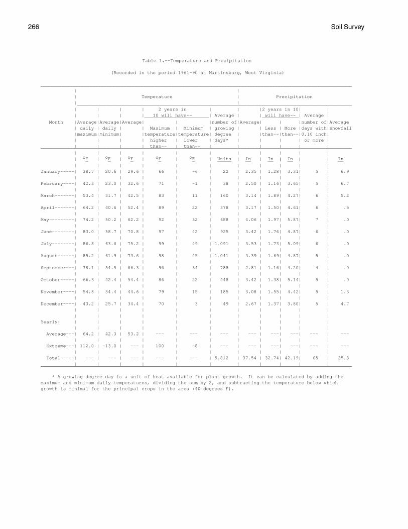
266 Soil Survey
Table 1.--Temperature and Precipitation
(Recorded in the period 1961-90 at Martinsburg, West Virginia)
_______________________________________________________________________________________________________________ | | | Temperature | Precipitation | | __________________________________________________________________________________________________ | | | | 2 years in | | |2 years in 10| | | | | | 10 will have-- | Average | | will have-- | Average | _______________________ _____________ Month |Average|Average|Average| | |number of|Average| | |number of|Average | daily | daily | | Maximum | Minimum | growing | | Less | More |days with|snowfall |maximum|minimum| |temperature|temperature| degree | |than--|than--|0.10 inch| | | | | higher | lower | days* | | | | or more | | | | | than-- | than-- | | | | | |_______________________________________________________________________________________________________________ | | | | | | | | | | | | oF | oF | oF | oF | oF | Units | In | In | In | | In _ _ _ _ _ _____ __ __ | __ | | __ | | | | | | | | | | |January-----| 38.7 | 20.6 | 29.6 | 66 | -6 | 22 | 2.35 | 1.28| 3.31| 5 | 6.9 | | | | | | | | | | |February----| 42.3 | 23.0 | 32.6 | 71 | -1 | 38 | 2.50 | 1.16| 3.65| 5 | 6.7 | | | | | | | | | | |March-------| 53.4 | 31.7 | 42.5 | 83 | 11 | 160 | 3.14 | 1.89| 4.27| 6 | 5.2 | | | | | | | | | | |April-------| 64.2 | 40.6 | 52.4 | 89 | 22 | 378 | 3.17 | 1.50| 4.61| 6 | .5 | | | | | | | | | | |May---------| 74.2 | 50.2 | 62.2 | 92 | 32 | 688 | 4.06 | 1.97| 5.87| 7 | .0 | | | | | | | | | | |June--------| 83.0 | 58.7 | 70.8 | 97 | 42 | 925 | 3.42 | 1.76| 4.87| 6 | .0 | | | | | | | | | | |July--------| 86.8 | 63.6 | 75.2 | 99 | 49 | 1,091 | 3.53 | 1.73| 5.09| 6 | .0 | | | | | | | | | | |August------| 85.2 | 61.9 | 73.6 | 98 | 45 | 1,041 | 3.39 | 1.69| 4.87| 5 | .0 | | | | | | | | | | |September---| 78.1 | 54.5 | 66.3 | 96 | 34 | 788 | 2.81 | 1.16| 4.20| 4 | .0 | | | | | | | | | | |October-----| 66.3 | 42.4 | 54.4 | 86 | 22 | 448 | 3.42 | 1.38| 5.14| 5 | .0 | | | | | | | | | | |November----| 54.8 | 34.4 | 44.6 | 79 | 15 | 185 | 3.08 | 1.55| 4.42| 5 | 1.3 | | | | | | | | | | |December----| 43.2 | 25.7 | 34.4 | 70 | 3 | 49 | 2.67 | 1.37| 3.80| 5 | 4.7 | | | | | | | | | | | | | | | | | | | | | |Yearly: | | | | | | | | | | | | | | | | | | | | | | Average---| 64.2 | 42.3 | 53.2 | --- | --- | --- | --- | ---| ---| --- | --- | | | | | | | | | | | Extreme---| 112.0 | -13.0 | --- | 100 | -8 | --- | --- | ---| ---| --- | --- | | | | | | | | | | | Total-----| --- | --- | --- | --- | --- | 5,812 | 37.54 | 32.74| 42.19| 65 | 25.3 | | | | | | | | | | |_______________________________________________________________________________________________________________
* A growing degree day is a unit of heat available for plant growth. It can be calculated by adding themaximum and minimum daily temperatures, dividing the sum by 2, and subtracting the temperature below whichgrowth is minimal for the principal crops in the area (40 degrees F).
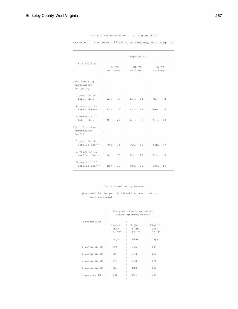
Berkeley County, West Virginia 267
Table 2.--Freeze Dates in Spring and Fall
(Recorded in the period 1961-90 at Martinsburg, West Virginia)
______________________________________________________________ | | Temperature |___________________________________________ Probability | | | | 24 oF | 28 oF | 32 oF | or lower | or lower | or lower______________________________________________________________ | | | | | |Last freezing | | | temperature | | | in spring: | | | | | | 1 year in 10 | | | later than-- | Apr. 10 | Apr. 24 | May 8 | | | 2 years in 10 | | | later than-- | Apr. 5 | Apr. 19 | May 3 | | | 5 years in 10 | | | later than-- | Mar. 27 | Apr. 8 | Apr. 23 | | |First freezing | | | temperature | | | in fall: | | | | | | 1 year in 10 | | | earlier than-- | Oct. 24 | Oct. 10 | Sep. 29 | | | 2 years in 10 | | | earlier than-- | Oct. 30 | Oct. 15 | Oct. 5 | | | 5 years in 10 | | | earlier than-- | Nov. 10 | Oct. 24 | Oct. 16 | | |______________________________________________________________
Table 3.--Growing Season
(Recorded in the period 1961-90 at Martinsburg, West Virginia)
___________________________________________________ | | Daily minimum temperature | during growing season |____________________________________ Probability | | | | Higher | Higher | Higher | than | than | than | 24 oF | 28 oF | 32 oF | | |___________________________________________________ | Days | Days | Days ____ ____ ____ | | |9 years in 10 | 196 | 175 | 149 | | |8 years in 10 | 203 | 183 | 158 | | |5 years in 10 | 215 | 198 | 175 | | |2 years in 10 | 227 | 213 | 192 | | |1 year in 10 | 234 | 221 | 201 | | |___________________________________________________
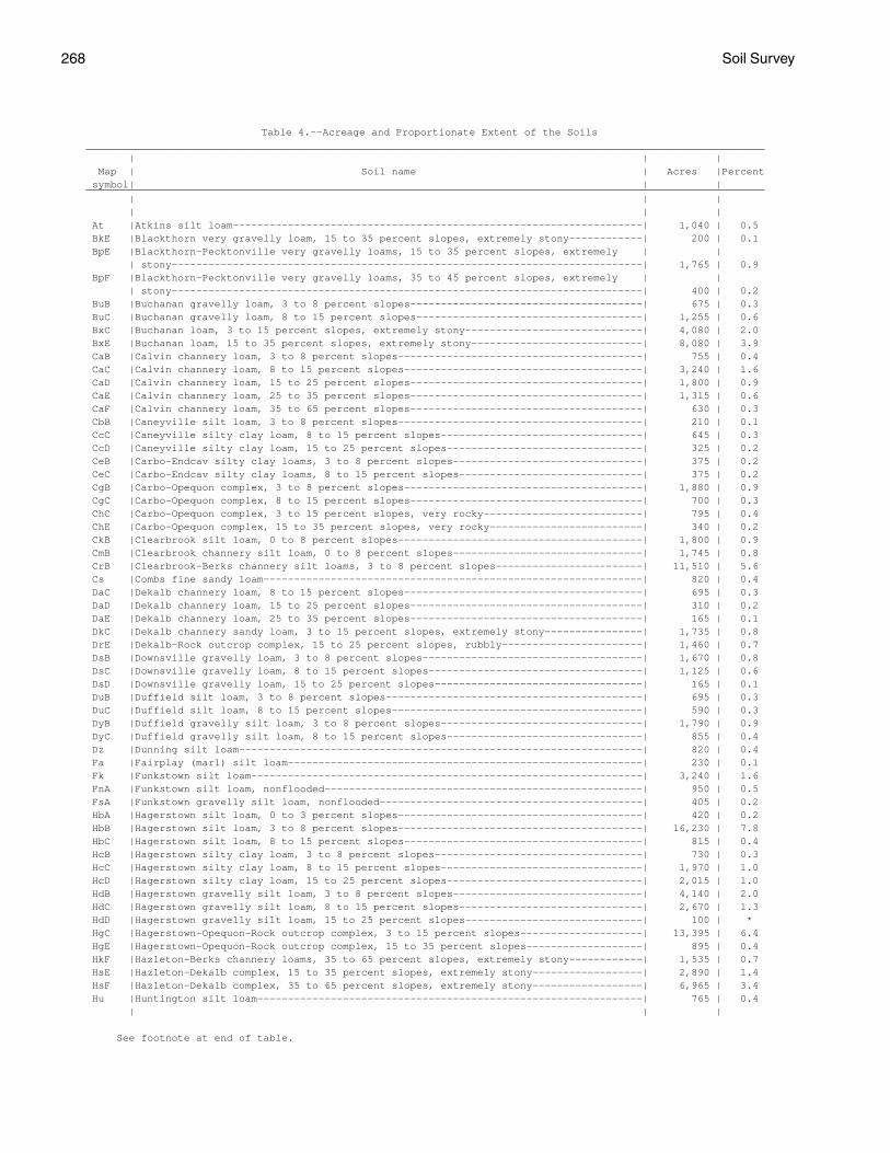
268 Soil Survey
Table 4.--Acreage and Proportionate Extent of the Soils_______________________________________________________________________________________________________________ | | | Map | Soil name | Acres |Percent symbol| | |_______________________________________________________________________________________________________________ | | | | | | At |Atkins silt loam-------------------------------------------------------------------| 1,040 | 0.5 BkE |Blackthorn very gravelly loam, 15 to 35 percent slopes, extremely stony------------| 200 | 0.1 BpE |Blackthorn-Pecktonville very gravelly loams, 15 to 35 percent slopes, extremely | | | stony-----------------------------------------------------------------------------| 1,765 | 0.9 BpF |Blackthorn-Pecktonville very gravelly loams, 35 to 45 percent slopes, extremely | | | stony-----------------------------------------------------------------------------| 400 | 0.2 BuB |Buchanan gravelly loam, 3 to 8 percent slopes--------------------------------------| 675 | 0.3 BuC |Buchanan gravelly loam, 8 to 15 percent slopes-------------------------------------| 1,255 | 0.6 BxC |Buchanan loam, 3 to 15 percent slopes, extremely stony-----------------------------| 4,080 | 2.0 BxE |Buchanan loam, 15 to 35 percent slopes, extremely stony----------------------------| 8,080 | 3.9 CaB |Calvin channery loam, 3 to 8 percent slopes----------------------------------------| 755 | 0.4 CaC |Calvin channery loam, 8 to 15 percent slopes---------------------------------------| 3,240 | 1.6 CaD |Calvin channery loam, 15 to 25 percent slopes--------------------------------------| 1,800 | 0.9 CaE |Calvin channery loam, 25 to 35 percent slopes--------------------------------------| 1,315 | 0.6 CaF |Calvin channery loam, 35 to 65 percent slopes--------------------------------------| 630 | 0.3 CbB |Caneyville silt loam, 3 to 8 percent slopes----------------------------------------| 210 | 0.1 CcC |Caneyville silty clay loam, 8 to 15 percent slopes---------------------------------| 645 | 0.3 CcD |Caneyville silty clay loam, 15 to 25 percent slopes--------------------------------| 325 | 0.2 CeB |Carbo-Endcav silty clay loams, 3 to 8 percent slopes-------------------------------| 375 | 0.2 CeC |Carbo-Endcav silty clay loams, 8 to 15 percent slopes------------------------------| 375 | 0.2 CgB |Carbo-Opequon complex, 3 to 8 percent slopes---------------------------------------| 1,880 | 0.9 CgC |Carbo-Opequon complex, 8 to 15 percent slopes--------------------------------------| 700 | 0.3 ChC |Carbo-Opequon complex, 3 to 15 percent slopes, very rocky--------------------------| 795 | 0.4 ChE |Carbo-Opequon complex, 15 to 35 percent slopes, very rocky-------------------------| 340 | 0.2 CkB |Clearbrook silt loam, 0 to 8 percent slopes----------------------------------------| 1,800 | 0.9 CmB |Clearbrook channery silt loam, 0 to 8 percent slopes-------------------------------| 1,745 | 0.8 CrB |Clearbrook-Berks channery silt loams, 3 to 8 percent slopes------------------------| 11,510 | 5.6 Cs |Combs fine sandy loam--------------------------------------------------------------| 820 | 0.4 DaC |Dekalb channery loam, 8 to 15 percent slopes---------------------------------------| 695 | 0.3 DaD |Dekalb channery loam, 15 to 25 percent slopes--------------------------------------| 310 | 0.2 DaE |Dekalb channery loam, 25 to 35 percent slopes--------------------------------------| 165 | 0.1 DkC |Dekalb channery sandy loam, 3 to 15 percent slopes, extremely stony----------------| 1,735 | 0.8 DrE |Dekalb-Rock outcrop complex, 15 to 25 percent slopes, rubbly-----------------------| 1,460 | 0.7 DsB |Downsville gravelly loam, 3 to 8 percent slopes------------------------------------| 1,670 | 0.8 DsC |Downsville gravelly loam, 8 to 15 percent slopes-----------------------------------| 1,125 | 0.6 DsD |Downsville gravelly loam, 15 to 25 percent slopes----------------------------------| 165 | 0.1 DuB |Duffield silt loam, 3 to 8 percent slopes------------------------------------------| 695 | 0.3 DuC |Duffield silt loam, 8 to 15 percent slopes-----------------------------------------| 590 | 0.3 DyB |Duffield gravelly silt loam, 3 to 8 percent slopes---------------------------------| 1,790 | 0.9 DyC |Duffield gravelly silt loam, 8 to 15 percent slopes--------------------------------| 855 | 0.4 Dz |Dunning silt loam------------------------------------------------------------------| 820 | 0.4 Fa |Fairplay (marl) silt loam----------------------------------------------------------| 230 | 0.1 Fk |Funkstown silt loam----------------------------------------------------------------| 3,240 | 1.6 FnA |Funkstown silt loam, nonflooded----------------------------------------------------| 950 | 0.5 FsA |Funkstown gravelly silt loam, nonflooded-------------------------------------------| 405 | 0.2 HbA |Hagerstown silt loam, 0 to 3 percent slopes----------------------------------------| 420 | 0.2 HbB |Hagerstown silt loam, 3 to 8 percent slopes----------------------------------------| 16,230 | 7.8 HbC |Hagerstown silt loam, 8 to 15 percent slopes---------------------------------------| 815 | 0.4 HcB |Hagerstown silty clay loam, 3 to 8 percent slopes----------------------------------| 730 | 0.3 HcC |Hagerstown silty clay loam, 8 to 15 percent slopes---------------------------------| 1,970 | 1.0 HcD |Hagerstown silty clay loam, 15 to 25 percent slopes--------------------------------| 2,015 | 1.0 HdB |Hagerstown gravelly silt loam, 3 to 8 percent slopes-------------------------------| 4,140 | 2.0 HdC |Hagerstown gravelly silt loam, 8 to 15 percent slopes------------------------------| 2,670 | 1.3 HdD |Hagerstown gravelly silt loam, 15 to 25 percent slopes-----------------------------| 100 | * HgC |Hagerstown-Opequon-Rock outcrop complex, 3 to 15 percent slopes--------------------| 13,395 | 6.4 HgE |Hagerstown-Opequon-Rock outcrop complex, 15 to 35 percent slopes-------------------| 895 | 0.4 HkF |Hazleton-Berks channery loams, 35 to 65 percent slopes, extremely stony------------| 1,535 | 0.7 HsE |Hazleton-Dekalb complex, 15 to 35 percent slopes, extremely stony------------------| 2,890 | 1.4 HsF |Hazleton-Dekalb complex, 35 to 65 percent slopes, extremely stony------------------| 6,965 | 3.4 Hu |Huntington silt loam---------------------------------------------------------------| 765 | 0.4 | | |
See footnote at end of table.
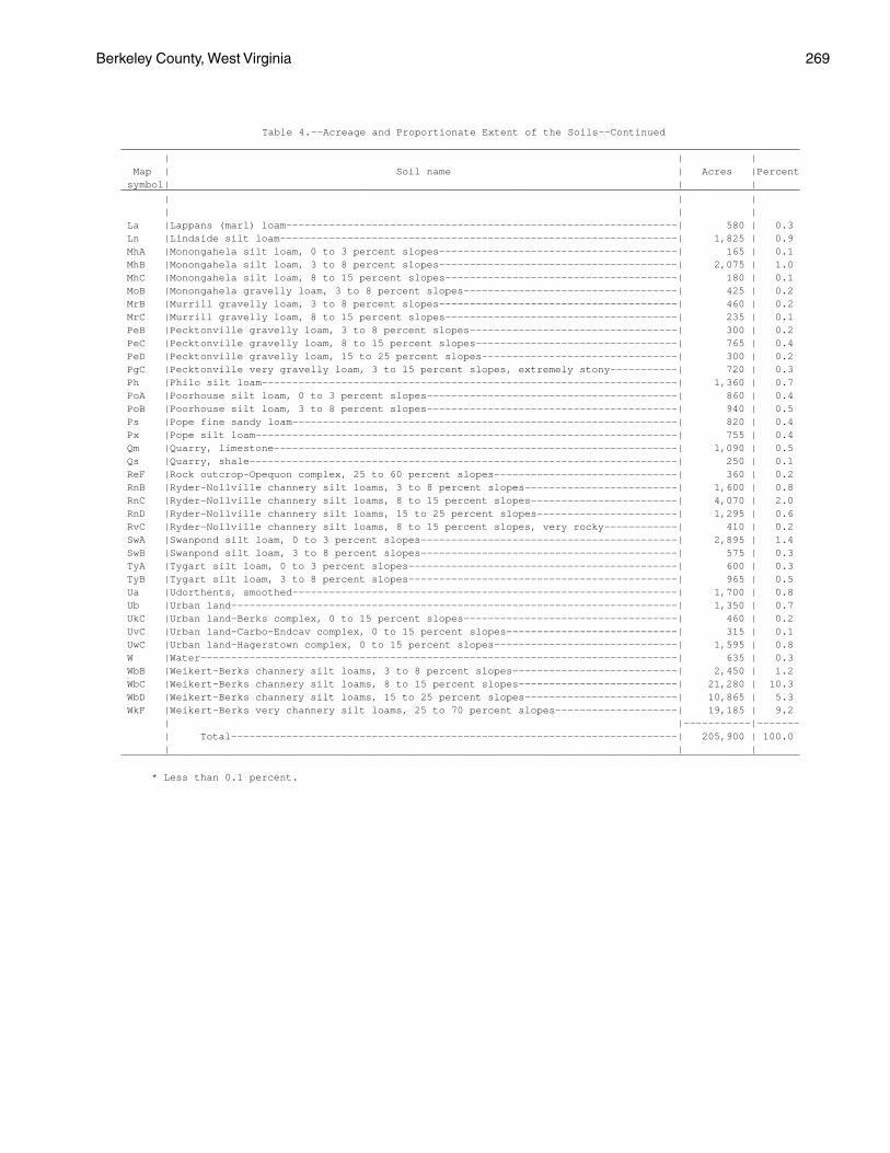
Berkeley County, West Virginia 269
Table 4.--Acreage and Proportionate Extent of the Soils--Continued_______________________________________________________________________________________________________________ | | | Map | Soil name | Acres |Percent symbol| | |_______________________________________________________________________________________________________________ | | | | | | La |Lappans (marl) loam----------------------------------------------------------------| 580 | 0.3 Ln |Lindside silt loam-----------------------------------------------------------------| 1,825 | 0.9 MhA |Monongahela silt loam, 0 to 3 percent slopes---------------------------------------| 165 | 0.1 MhB |Monongahela silt loam, 3 to 8 percent slopes---------------------------------------| 2,075 | 1.0 MhC |Monongahela silt loam, 8 to 15 percent slopes--------------------------------------| 180 | 0.1 MoB |Monongahela gravelly loam, 3 to 8 percent slopes-----------------------------------| 425 | 0.2 MrB |Murrill gravelly loam, 3 to 8 percent slopes---------------------------------------| 460 | 0.2 MrC |Murrill gravelly loam, 8 to 15 percent slopes--------------------------------------| 235 | 0.1 PeB |Pecktonville gravelly loam, 3 to 8 percent slopes----------------------------------| 300 | 0.2 PeC |Pecktonville gravelly loam, 8 to 15 percent slopes---------------------------------| 765 | 0.4 PeD |Pecktonville gravelly loam, 15 to 25 percent slopes--------------------------------| 300 | 0.2 PgC |Pecktonville very gravelly loam, 3 to 15 percent slopes, extremely stony-----------| 720 | 0.3 Ph |Philo silt loam--------------------------------------------------------------------| 1,360 | 0.7 PoA |Poorhouse silt loam, 0 to 3 percent slopes-----------------------------------------| 860 | 0.4 PoB |Poorhouse silt loam, 3 to 8 percent slopes-----------------------------------------| 940 | 0.5 Ps |Pope fine sandy loam---------------------------------------------------------------| 820 | 0.4 Px |Pope silt loam---------------------------------------------------------------------| 755 | 0.4 Qm |Quarry, limestone------------------------------------------------------------------| 1,090 | 0.5 Qs |Quarry, shale----------------------------------------------------------------------| 250 | 0.1 ReF |Rock outcrop-Opequon complex, 25 to 60 percent slopes------------------------------| 360 | 0.2 RnB |Ryder-Nollville channery silt loams, 3 to 8 percent slopes-------------------------| 1,600 | 0.8 RnC |Ryder-Nollville channery silt loams, 8 to 15 percent slopes------------------------| 4,070 | 2.0 RnD |Ryder-Nollville channery silt loams, 15 to 25 percent slopes-----------------------| 1,295 | 0.6 RvC |Ryder-Nollville channery silt loams, 8 to 15 percent slopes, very rocky------------| 410 | 0.2 SwA |Swanpond silt loam, 0 to 3 percent slopes------------------------------------------| 2,895 | 1.4 SwB |Swanpond silt loam, 3 to 8 percent slopes------------------------------------------| 575 | 0.3 TyA |Tygart silt loam, 0 to 3 percent slopes--------------------------------------------| 600 | 0.3 TyB |Tygart silt loam, 3 to 8 percent slopes--------------------------------------------| 965 | 0.5 Ua |Udorthents, smoothed---------------------------------------------------------------| 1,700 | 0.8 Ub |Urban land-------------------------------------------------------------------------| 1,350 | 0.7 UkC |Urban land-Berks complex, 0 to 15 percent slopes-----------------------------------| 460 | 0.2 UvC |Urban land-Carbo-Endcav complex, 0 to 15 percent slopes----------------------------| 315 | 0.1 UwC |Urban land-Hagerstown complex, 0 to 15 percent slopes------------------------------| 1,595 | 0.8 W |Water------------------------------------------------------------------------------| 635 | 0.3 WbB |Weikert-Berks channery silt loams, 3 to 8 percent slopes---------------------------| 2,450 | 1.2 WbC |Weikert-Berks channery silt loams, 8 to 15 percent slopes--------------------------| 21,280 | 10.3 WbD |Weikert-Berks channery silt loams, 15 to 25 percent slopes-------------------------| 10,865 | 5.3 WkF |Weikert-Berks very channery silt loams, 25 to 70 percent slopes--------------------| 19,185 | 9.2 | |-----------|------- | Total-------------------------------------------------------------------------| 205,900 | 100.0 | | |_______________________________________________________________________________________________________________
* Less than 0.1 percent.
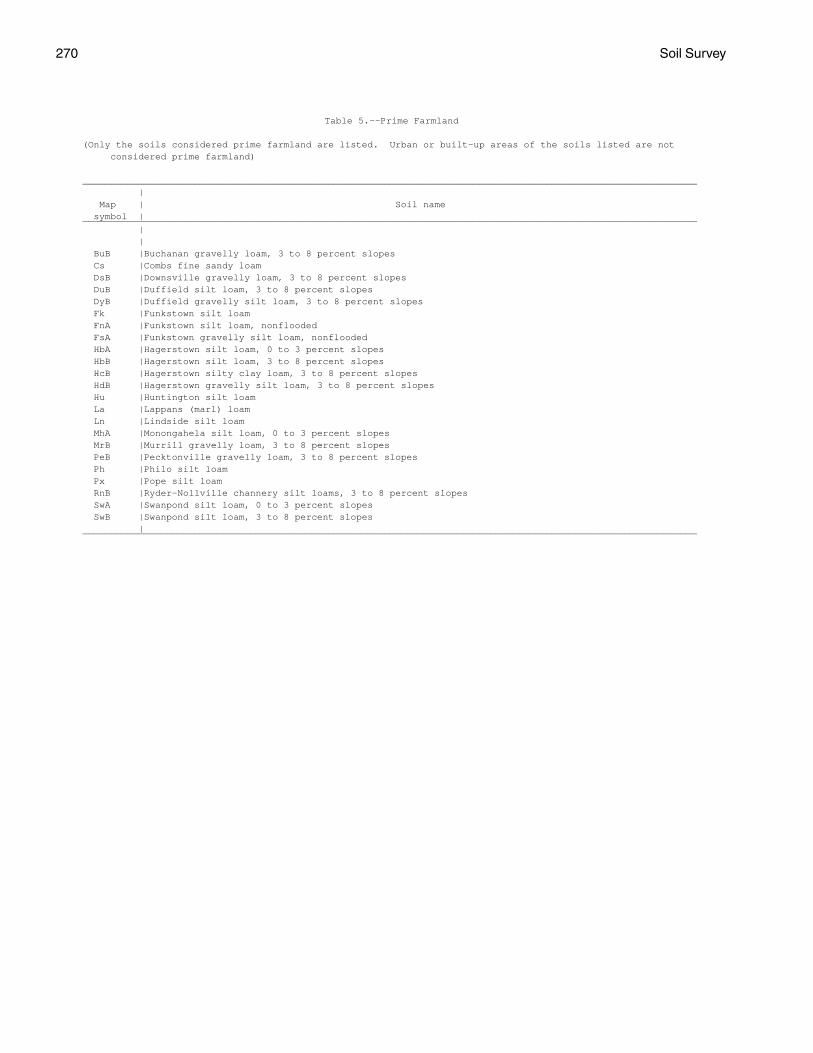
270 Soil Survey
Table 5.--Prime Farmland
(Only the soils considered prime farmland are listed. Urban or built-up areas of the soils listed are not considered prime farmland)
______________________________________________________________________________________________________________ | Map | Soil name symbol |______________________________________________________________________________________________________________ | | BuB |Buchanan gravelly loam, 3 to 8 percent slopes Cs |Combs fine sandy loam DsB |Downsville gravelly loam, 3 to 8 percent slopes DuB |Duffield silt loam, 3 to 8 percent slopes DyB |Duffield gravelly silt loam, 3 to 8 percent slopes Fk |Funkstown silt loam FnA |Funkstown silt loam, nonflooded FsA |Funkstown gravelly silt loam, nonflooded HbA |Hagerstown silt loam, 0 to 3 percent slopes HbB |Hagerstown silt loam, 3 to 8 percent slopes HcB |Hagerstown silty clay loam, 3 to 8 percent slopes HdB |Hagerstown gravelly silt loam, 3 to 8 percent slopes Hu |Huntington silt loam La |Lappans (marl) loam Ln |Lindside silt loam MhA |Monongahela silt loam, 0 to 3 percent slopes MrB |Murrill gravelly loam, 3 to 8 percent slopes PeB |Pecktonville gravelly loam, 3 to 8 percent slopes Ph |Philo silt loam Px |Pope silt loam RnB |Ryder-Nollville channery silt loams, 3 to 8 percent slopes SwA |Swanpond silt loam, 0 to 3 percent slopes SwB |Swanpond silt loam, 3 to 8 percent slopes |______________________________________________________________________________________________________________
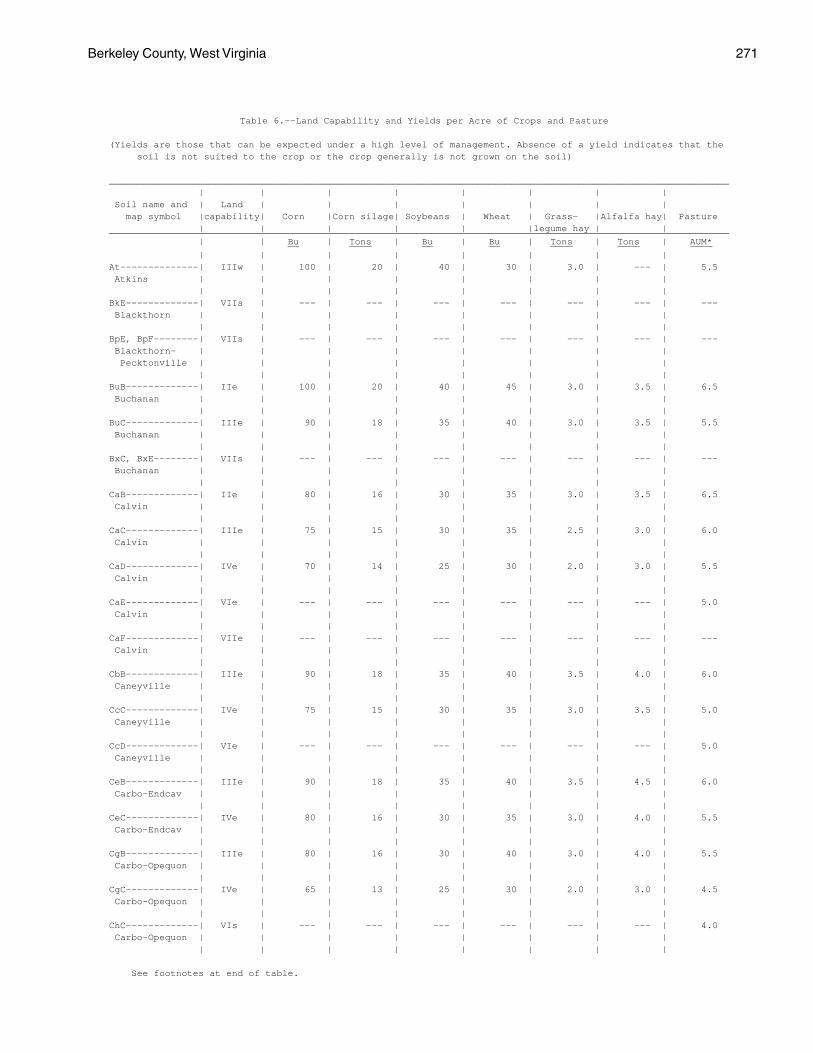
Berkeley County, West Virginia 271
Table 6.--Land Capability and Yields per Acre of Crops and Pasture
(Yields are those that can be expected under a high level of management. Absence of a yield indicates that the soil is not suited to the crop or the crop generally is not grown on the soil)
_______________________________________________________________________________________________________________ | | | | | | | | Soil name and | Land | | | | | | | map symbol |capability| Corn |Corn silage| Soybeans | Wheat | Grass- |Alfalfa hay| Pasture | | | | | |legume hay | |_______________________________________________________________________________________________________________ | | Bu | Tons | Bu | Bu | Tons | Tons | AUM* __ ____ __ __ ____ ____ ____ | | | | | | | |At--------------| IIIw | 100 | 20 | 40 | 30 | 3.0 | --- | 5.5 Atkins | | | | | | | | | | | | | | | |BkE-------------| VIIs | --- | --- | --- | --- | --- | --- | --- Blackthorn | | | | | | | | | | | | | | | |BpE, BpF--------| VIIs | --- | --- | --- | --- | --- | --- | --- Blackthorn- | | | | | | | | Pecktonville | | | | | | | | | | | | | | | |BuB-------------| IIe | 100 | 20 | 40 | 45 | 3.0 | 3.5 | 6.5 Buchanan | | | | | | | | | | | | | | | |BuC-------------| IIIe | 90 | 18 | 35 | 40 | 3.0 | 3.5 | 5.5 Buchanan | | | | | | | | | | | | | | | |BxC, BxE--------| VIIs | --- | --- | --- | --- | --- | --- | --- Buchanan | | | | | | | | | | | | | | | |CaB-------------| IIe | 80 | 16 | 30 | 35 | 3.0 | 3.5 | 6.5 Calvin | | | | | | | | | | | | | | | |CaC-------------| IIIe | 75 | 15 | 30 | 35 | 2.5 | 3.0 | 6.0 Calvin | | | | | | | | | | | | | | | |CaD-------------| IVe | 70 | 14 | 25 | 30 | 2.0 | 3.0 | 5.5 Calvin | | | | | | | | | | | | | | | |CaE-------------| VIe | --- | --- | --- | --- | --- | --- | 5.0 Calvin | | | | | | | | | | | | | | | |CaF-------------| VIIe | --- | --- | --- | --- | --- | --- | --- Calvin | | | | | | | | | | | | | | | |CbB-------------| IIIe | 90 | 18 | 35 | 40 | 3.5 | 4.0 | 6.0 Caneyville | | | | | | | | | | | | | | | |CcC-------------| IVe | 75 | 15 | 30 | 35 | 3.0 | 3.5 | 5.0 Caneyville | | | | | | | | | | | | | | | |CcD-------------| VIe | --- | --- | --- | --- | --- | --- | 5.0 Caneyville | | | | | | | | | | | | | | | |CeB-------------| IIIe | 90 | 18 | 35 | 40 | 3.5 | 4.5 | 6.0 Carbo-Endcav | | | | | | | | | | | | | | | |CeC-------------| IVe | 80 | 16 | 30 | 35 | 3.0 | 4.0 | 5.5 Carbo-Endcav | | | | | | | | | | | | | | | |CgB-------------| IIIe | 80 | 16 | 30 | 40 | 3.0 | 4.0 | 5.5 Carbo-Opequon | | | | | | | | | | | | | | | |CgC-------------| IVe | 65 | 13 | 25 | 30 | 2.0 | 3.0 | 4.5 Carbo-Opequon | | | | | | | | | | | | | | | |ChC-------------| VIs | --- | --- | --- | --- | --- | --- | 4.0 Carbo-Opequon | | | | | | | | | | | | | | | |
See footnotes at end of table.
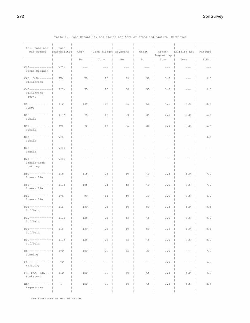
272 Soil Survey
Table 6.--Land Capability and Yields per Acre of Crops and Pasture--Continued_______________________________________________________________________________________________________________ | | | | | | | | Soil name and | Land | | | | | | | map symbol |capability| Corn |Corn silage| Soybeans | Wheat | Grass- |Alfalfa hay| Pasture | | | | | |legume hay | |_______________________________________________________________________________________________________________ | | Bu | Tons | Bu | Bu | Tons | Tons | AUM* __ ____ __ __ ____ ____ ____ | | | | | | | |ChE-------------| VIIs | --- | --- | --- | --- | --- | --- | --- Carbo-Opequon | | | | | | | | | | | | | | | |CkB, CmB--------| IVw | 70 | 15 | 25 | 30 | 3.0 | --- | 5.5 Clearbrook | | | | | | | | | | | | | | | |CrB-------------| IIIe | 75 | 16 | 30 | 35 | 3.0 | --- | 5.5 Clearbrook- | | | | | | | | Berks | | | | | | | | | | | | | | | |Cs--------------| IIw | 135 | 25 | 55 | 60 | 4.5 | 5.5 | 8.5 Combs | | | | | | | | | | | | | | | |DaC-------------| IIIe | 75 | 15 | 30 | 35 | 2.5 | 3.0 | 5.5 Dekalb | | | | | | | | | | | | | | | |DaD-------------| IVe | 70 | 14 | 25 | 30 | 2.0 | 3.0 | 5.5 Dekalb | | | | | | | | | | | | | | | |DaE-------------| VIe | --- | --- | --- | --- | --- | --- | 4.5 Dekalb | | | | | | | | | | | | | | | |DkC-------------| VIIs | --- | --- | --- | --- | --- | --- | --- Dekalb | | | | | | | | | | | | | | | |DrE-------------| VIIs | --- | --- | --- | --- | --- | --- | --- Dekalb-Rock | | | | | | | | outcrop | | | | | | | | | | | | | | | |DsB-------------| IIe | 115 | 23 | 40 | 40 | 3.5 | 5.0 | 7.0 Downsville | | | | | | | | | | | | | | | |DsC-------------| IIIe | 105 | 21 | 35 | 40 | 3.0 | 4.5 | 7.0 Downsville | | | | | | | | | | | | | | | |DsD-------------| IVe | 90 | 18 | 30 | 30 | 3.0 | 4.5 | 6.0 Downsville | | | | | | | | | | | | | | | |DuB-------------| IIe | 130 | 26 | 40 | 50 | 3.5 | 5.0 | 8.5 Duffield | | | | | | | | | | | | | | | |DuC-------------| IIIe | 125 | 25 | 35 | 45 | 3.0 | 4.5 | 8.0 Duffield | | | | | | | | | | | | | | | |DyB-------------| IIe | 130 | 26 | 40 | 50 | 3.5 | 5.0 | 8.5 Duffield | | | | | | | | | | | | | | | |DyC-------------| IIIe | 125 | 25 | 35 | 45 | 3.0 | 4.5 | 8.0 Duffield | | | | | | | | | | | | | | | |Dz--------------| IVw | 100 | 20 | 35 | 30 | 3.0 | --- | 7.0 Dunning | | | | | | | | | | | | | | | |Fa--------------| Vw | --- | --- | --- | --- | 3.0 | --- | 6.0 Fairplay | | | | | | | | | | | | | | | |Fk, FnA, FsA----| IIw | 150 | 30 | 60 | 65 | 3.5 | 5.0 | 9.0 Funkstown | | | | | | | | | | | | | | | |HbA-------------| I | 150 | 30 | 60 | 65 | 3.5 | 5.5 | 8.5 Hagerstown | | | | | | | | | | | | | | | |
See footnotes at end of table.
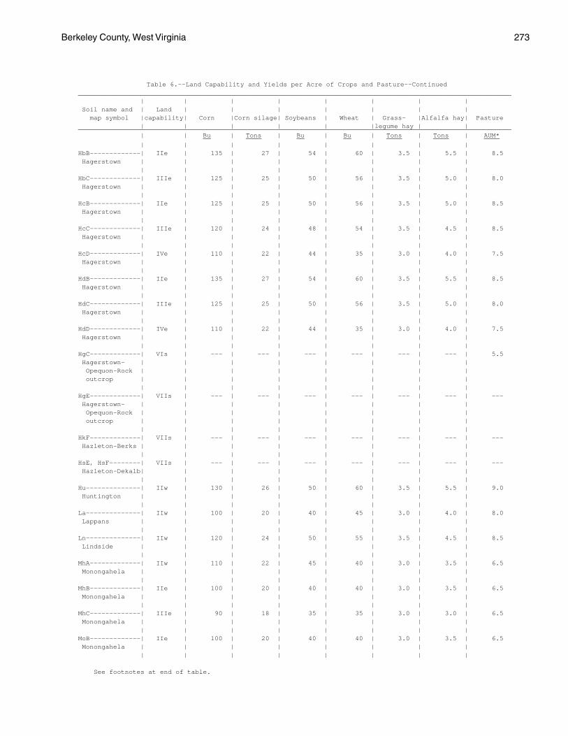
Berkeley County, West Virginia 273
Table 6.--Land Capability and Yields per Acre of Crops and Pasture--Continued_______________________________________________________________________________________________________________ | | | | | | | | Soil name and | Land | | | | | | | map symbol |capability| Corn |Corn silage| Soybeans | Wheat | Grass- |Alfalfa hay| Pasture | | | | | |legume hay | |_______________________________________________________________________________________________________________ | | Bu | Tons | Bu | Bu | Tons | Tons | AUM* __ ____ __ __ ____ ____ ____ | | | | | | | |HbB-------------| IIe | 135 | 27 | 54 | 60 | 3.5 | 5.5 | 8.5 Hagerstown | | | | | | | | | | | | | | | |HbC-------------| IIIe | 125 | 25 | 50 | 56 | 3.5 | 5.0 | 8.0 Hagerstown | | | | | | | | | | | | | | | |HcB-------------| IIe | 125 | 25 | 50 | 56 | 3.5 | 5.0 | 8.5 Hagerstown | | | | | | | | | | | | | | | |HcC-------------| IIIe | 120 | 24 | 48 | 54 | 3.5 | 4.5 | 8.5 Hagerstown | | | | | | | | | | | | | | | |HcD-------------| IVe | 110 | 22 | 44 | 35 | 3.0 | 4.0 | 7.5 Hagerstown | | | | | | | | | | | | | | | |HdB-------------| IIe | 135 | 27 | 54 | 60 | 3.5 | 5.5 | 8.5 Hagerstown | | | | | | | | | | | | | | | |HdC-------------| IIIe | 125 | 25 | 50 | 56 | 3.5 | 5.0 | 8.0 Hagerstown | | | | | | | | | | | | | | | |HdD-------------| IVe | 110 | 22 | 44 | 35 | 3.0 | 4.0 | 7.5 Hagerstown | | | | | | | | | | | | | | | |HgC-------------| VIs | --- | --- | --- | --- | --- | --- | 5.5 Hagerstown- | | | | | | | | Opequon-Rock | | | | | | | | outcrop | | | | | | | | | | | | | | | |HgE-------------| VIIs | --- | --- | --- | --- | --- | --- | --- Hagerstown- | | | | | | | | Opequon-Rock | | | | | | | | outcrop | | | | | | | | | | | | | | | |HkF-------------| VIIs | --- | --- | --- | --- | --- | --- | --- Hazleton-Berks | | | | | | | | | | | | | | | |HsE, HsF--------| VIIs | --- | --- | --- | --- | --- | --- | --- Hazleton-Dekalb| | | | | | | | | | | | | | | |Hu--------------| IIw | 130 | 26 | 50 | 60 | 3.5 | 5.5 | 9.0 Huntington | | | | | | | | | | | | | | | |La--------------| IIw | 100 | 20 | 40 | 45 | 3.0 | 4.0 | 8.0 Lappans | | | | | | | | | | | | | | | |Ln--------------| IIw | 120 | 24 | 50 | 55 | 3.5 | 4.5 | 8.5 Lindside | | | | | | | | | | | | | | | |MhA-------------| IIw | 110 | 22 | 45 | 40 | 3.0 | 3.5 | 6.5 Monongahela | | | | | | | | | | | | | | | |MhB-------------| IIe | 100 | 20 | 40 | 40 | 3.0 | 3.5 | 6.5 Monongahela | | | | | | | | | | | | | | | |MhC-------------| IIIe | 90 | 18 | 35 | 35 | 3.0 | 3.0 | 6.5 Monongahela | | | | | | | | | | | | | | | |MoB-------------| IIe | 100 | 20 | 40 | 40 | 3.0 | 3.5 | 6.5 Monongahela | | | | | | | | | | | | | | | |
See footnotes at end of table.
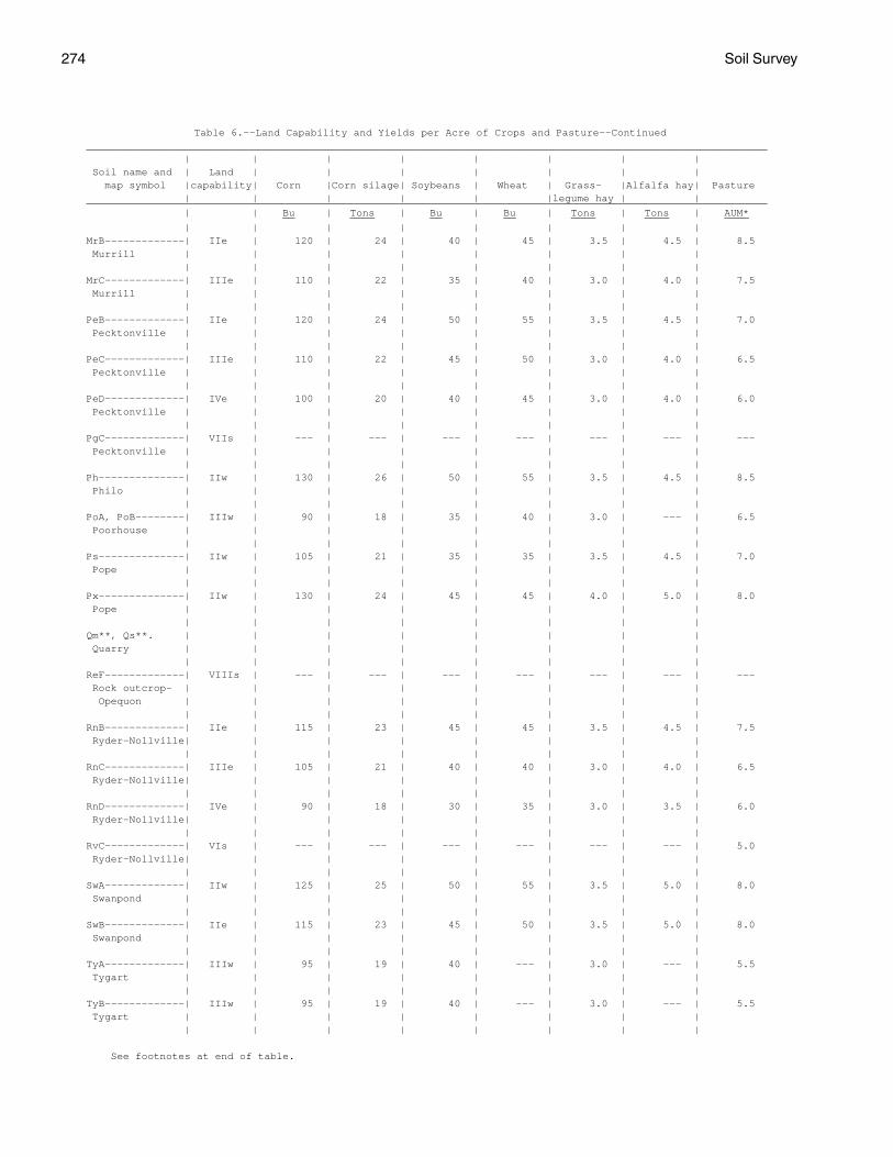
274 Soil Survey
Table 6.--Land Capability and Yields per Acre of Crops and Pasture--Continued_______________________________________________________________________________________________________________ | | | | | | | | Soil name and | Land | | | | | | | map symbol |capability| Corn |Corn silage| Soybeans | Wheat | Grass- |Alfalfa hay| Pasture | | | | | |legume hay | |_______________________________________________________________________________________________________________ | | Bu | Tons | Bu | Bu | Tons | Tons | AUM* __ ____ __ __ ____ ____ ____ | | | | | | | |MrB-------------| IIe | 120 | 24 | 40 | 45 | 3.5 | 4.5 | 8.5 Murrill | | | | | | | | | | | | | | | |MrC-------------| IIIe | 110 | 22 | 35 | 40 | 3.0 | 4.0 | 7.5 Murrill | | | | | | | | | | | | | | | |PeB-------------| IIe | 120 | 24 | 50 | 55 | 3.5 | 4.5 | 7.0 Pecktonville | | | | | | | | | | | | | | | |PeC-------------| IIIe | 110 | 22 | 45 | 50 | 3.0 | 4.0 | 6.5 Pecktonville | | | | | | | | | | | | | | | |PeD-------------| IVe | 100 | 20 | 40 | 45 | 3.0 | 4.0 | 6.0 Pecktonville | | | | | | | | | | | | | | | |PgC-------------| VIIs | --- | --- | --- | --- | --- | --- | --- Pecktonville | | | | | | | | | | | | | | | |Ph--------------| IIw | 130 | 26 | 50 | 55 | 3.5 | 4.5 | 8.5 Philo | | | | | | | | | | | | | | | |PoA, PoB--------| IIIw | 90 | 18 | 35 | 40 | 3.0 | --- | 6.5 Poorhouse | | | | | | | | | | | | | | | |Ps--------------| IIw | 105 | 21 | 35 | 35 | 3.5 | 4.5 | 7.0 Pope | | | | | | | | | | | | | | | |Px--------------| IIw | 130 | 24 | 45 | 45 | 4.0 | 5.0 | 8.0 Pope | | | | | | | | | | | | | | | |Qm**, Qs**. | | | | | | | | Quarry | | | | | | | | | | | | | | | |ReF-------------| VIIIs | --- | --- | --- | --- | --- | --- | --- Rock outcrop- | | | | | | | | Opequon | | | | | | | | | | | | | | | |RnB-------------| IIe | 115 | 23 | 45 | 45 | 3.5 | 4.5 | 7.5 Ryder-Nollville| | | | | | | | | | | | | | | |RnC-------------| IIIe | 105 | 21 | 40 | 40 | 3.0 | 4.0 | 6.5 Ryder-Nollville| | | | | | | | | | | | | | | |RnD-------------| IVe | 90 | 18 | 30 | 35 | 3.0 | 3.5 | 6.0 Ryder-Nollville| | | | | | | | | | | | | | | |RvC-------------| VIs | --- | --- | --- | --- | --- | --- | 5.0 Ryder-Nollville| | | | | | | | | | | | | | | |SwA-------------| IIw | 125 | 25 | 50 | 55 | 3.5 | 5.0 | 8.0 Swanpond | | | | | | | | | | | | | | | |SwB-------------| IIe | 115 | 23 | 45 | 50 | 3.5 | 5.0 | 8.0 Swanpond | | | | | | | | | | | | | | | |TyA-------------| IIIw | 95 | 19 | 40 | --- | 3.0 | --- | 5.5 Tygart | | | | | | | | | | | | | | | |TyB-------------| IIIw | 95 | 19 | 40 | --- | 3.0 | --- | 5.5 Tygart | | | | | | | | | | | | | | | |
See footnotes at end of table.
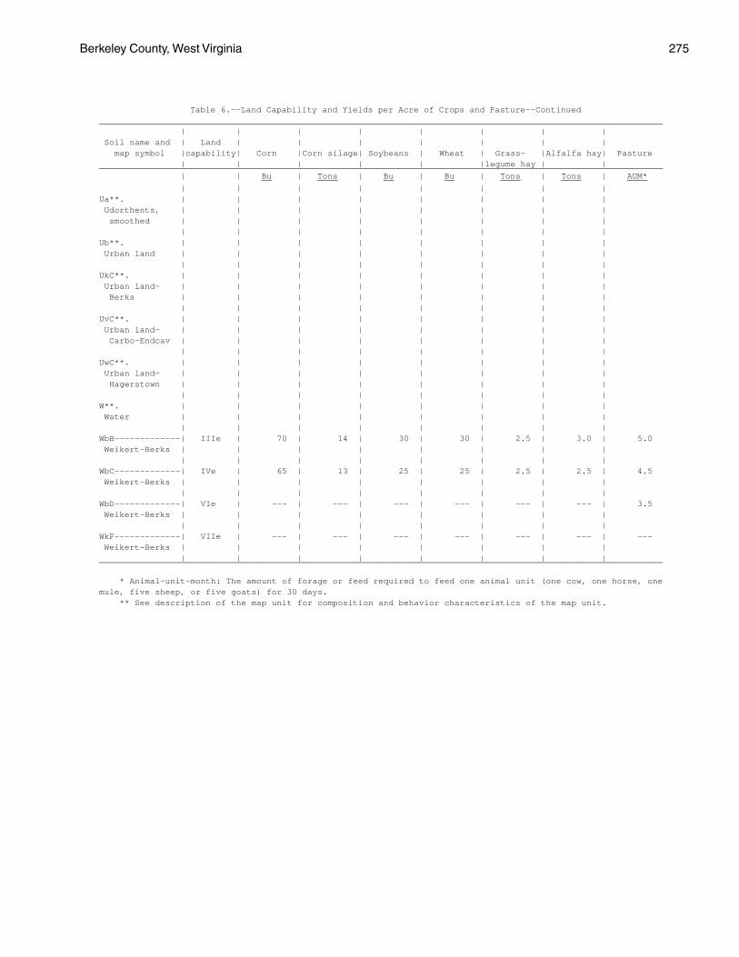
Berkeley County, West Virginia 275
Table 6.--Land Capability and Yields per Acre of Crops and Pasture--Continued_______________________________________________________________________________________________________________ | | | | | | | | Soil name and | Land | | | | | | | map symbol |capability| Corn |Corn silage| Soybeans | Wheat | Grass- |Alfalfa hay| Pasture | | | | | |legume hay | |_______________________________________________________________________________________________________________ | | Bu | Tons | Bu | Bu | Tons | Tons | AUM* __ ____ __ __ ____ ____ ____ | | | | | | | |Ua**. | | | | | | | | Udorthents, | | | | | | | | smoothed | | | | | | | | | | | | | | | |Ub**. | | | | | | | | Urban land | | | | | | | | | | | | | | | |UkC**. | | | | | | | | Urban land- | | | | | | | | Berks | | | | | | | | | | | | | | | |UvC**. | | | | | | | | Urban land- | | | | | | | | Carbo-Endcav | | | | | | | | | | | | | | | |UwC**. | | | | | | | | Urban land- | | | | | | | | Hagerstown | | | | | | | | | | | | | | | |W**. | | | | | | | | Water | | | | | | | | | | | | | | | |WbB-------------| IIIe | 70 | 14 | 30 | 30 | 2.5 | 3.0 | 5.0 Weikert-Berks | | | | | | | | | | | | | | | |WbC-------------| IVe | 65 | 13 | 25 | 25 | 2.5 | 2.5 | 4.5 Weikert-Berks | | | | | | | | | | | | | | | |WbD-------------| VIe | --- | --- | --- | --- | --- | --- | 3.5 Weikert-Berks | | | | | | | | | | | | | | | |WkF-------------| VIIe | --- | --- | --- | --- | --- | --- | --- Weikert-Berks | | | | | | | | | | | | | | | |_______________________________________________________________________________________________________________
* Animal-unit-month: The amount of forage or feed required to feed one animal unit (one cow, one horse, onemule, five sheep, or five goats) for 30 days. ** See description of the map unit for composition and behavior characteristics of the map unit.
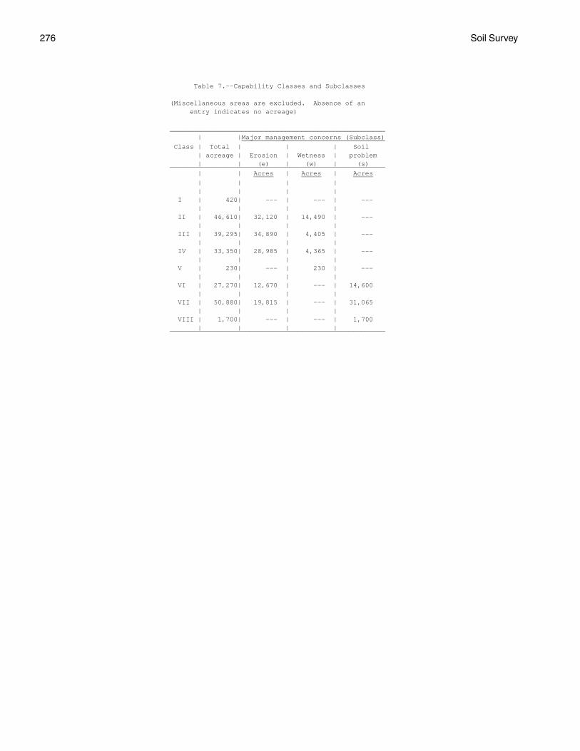
276 Soil Survey
Table 7.--Capability Classes and Subclasses
(Miscellaneous areas are excluded. Absence of an entry indicates no acreage)
______________________________________________________ | |Major management concerns (Subclass) ____________________________________ Class | Total | | | Soil | acreage | Erosion | Wetness | problem | | (e) | (w) | (s)______________________________________________________ | | Acres | Acres | Acres _____ _____ _____ | | | | | | | | I | 420| --- | --- | --- | | | | II | 46,610| 32,120 | 14,490 | --- | | | | III | 39,295| 34,890 | 4,405 | --- | | | | IV | 33,350| 28,985 | 4,365 | --- | | | | V | 230| --- | 230 | --- | | | | VI | 27,270| 12,670 | --- | 14,600 | | | | VII | 50,880| 19,815 | --- | 31,065 | | | | VIII | 1,700| --- | --- | 1,700 | | | |______________________________________________________
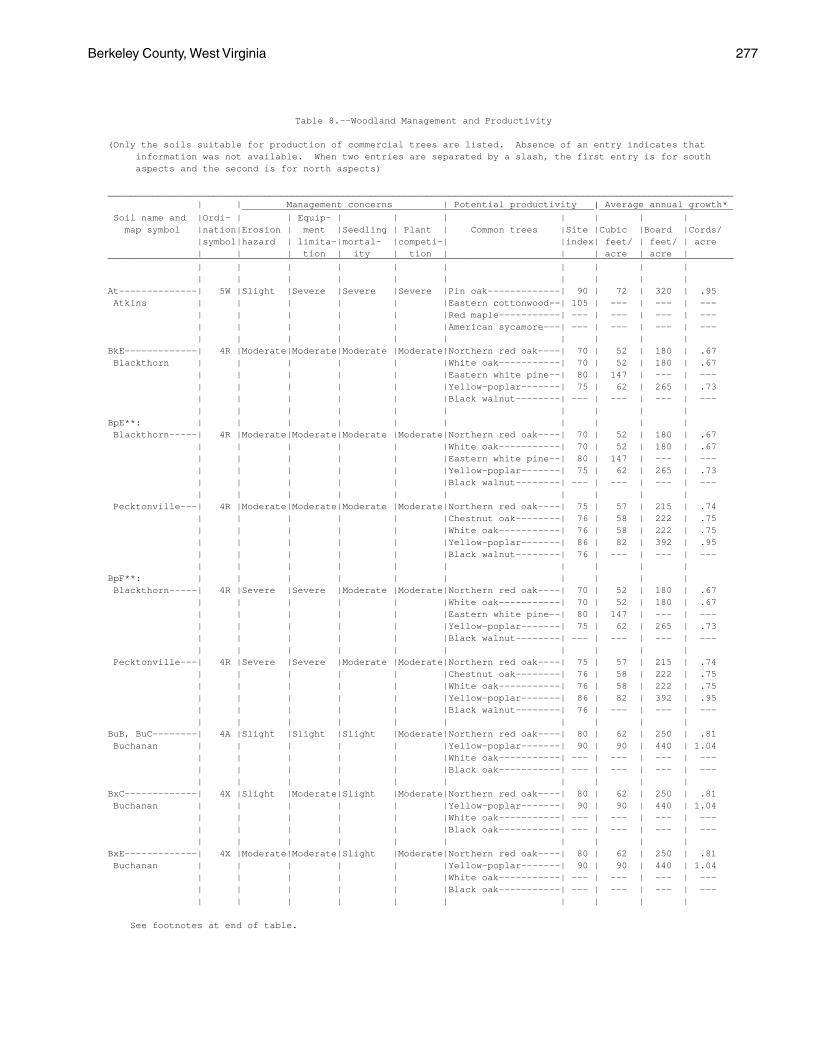
Berkeley County, West Virginia 277
Table 8.--Woodland Management and Productivity
(Only the soils suitable for production of commercial trees are listed. Absence of an entry indicates that information was not available. When two entries are separated by a slash, the first entry is for south aspects and the second is for north aspects)
________________________________________________________________________________________________________________ | | Management concerns | Potential productivity | Average annual growth* _______________________________________________________________|________________________ Soil name and |Ordi- | | Equip- | | | | | | | map symbol |nation|Erosion | ment |Seedling | Plant | Common trees |Site |Cubic |Board |Cords/ |symbol|hazard | limita-|mortal- |competi-| |index| feet/ | feet/ | acre | | | tion | ity | tion | | | acre | acre |________________________________________________________________________________________________________________ | | | | | | | | | | | | | | | | | | | |At--------------| 5W |Slight |Severe |Severe |Severe |Pin oak-------------| 90 | 72 | 320 | .95 Atkins | | | | | |Eastern cottonwood--| 105 | --- | --- | --- | | | | | |Red maple-----------| --- | --- | --- | --- | | | | | |American sycamore---| --- | --- | --- | --- | | | | | | | | | |BkE-------------| 4R |Moderate|Moderate|Moderate |Moderate|Northern red oak----| 70 | 52 | 180 | .67 Blackthorn | | | | | |White oak-----------| 70 | 52 | 180 | .67 | | | | | |Eastern white pine--| 80 | 147 | --- | --- | | | | | |Yellow-poplar-------| 75 | 62 | 265 | .73 | | | | | |Black walnut--------| --- | --- | --- | --- | | | | | | | | | |BpE**: | | | | | | | | | | Blackthorn-----| 4R |Moderate|Moderate|Moderate |Moderate|Northern red oak----| 70 | 52 | 180 | .67 | | | | | |White oak-----------| 70 | 52 | 180 | .67 | | | | | |Eastern white pine--| 80 | 147 | --- | --- | | | | | |Yellow-poplar-------| 75 | 62 | 265 | .73 | | | | | |Black walnut--------| --- | --- | --- | --- | | | | | | | | | | Pecktonville---| 4R |Moderate|Moderate|Moderate |Moderate|Northern red oak----| 75 | 57 | 215 | .74 | | | | | |Chestnut oak--------| 76 | 58 | 222 | .75 | | | | | |White oak-----------| 76 | 58 | 222 | .75 | | | | | |Yellow-poplar-------| 86 | 82 | 392 | .95 | | | | | |Black walnut--------| 76 | --- | --- | --- | | | | | | | | | |BpF**: | | | | | | | | | | Blackthorn-----| 4R |Severe |Severe |Moderate |Moderate|Northern red oak----| 70 | 52 | 180 | .67 | | | | | |White oak-----------| 70 | 52 | 180 | .67 | | | | | |Eastern white pine--| 80 | 147 | --- | --- | | | | | |Yellow-poplar-------| 75 | 62 | 265 | .73 | | | | | |Black walnut--------| --- | --- | --- | --- | | | | | | | | | | Pecktonville---| 4R |Severe |Severe |Moderate |Moderate|Northern red oak----| 75 | 57 | 215 | .74 | | | | | |Chestnut oak--------| 76 | 58 | 222 | .75 | | | | | |White oak-----------| 76 | 58 | 222 | .75 | | | | | |Yellow-poplar-------| 86 | 82 | 392 | .95 | | | | | |Black walnut--------| 76 | --- | --- | --- | | | | | | | | | |BuB, BuC--------| 4A |Slight |Slight |Slight |Moderate|Northern red oak----| 80 | 62 | 250 | .81 Buchanan | | | | | |Yellow-poplar-------| 90 | 90 | 440 | 1.04 | | | | | |White oak-----------| --- | --- | --- | --- | | | | | |Black oak-----------| --- | --- | --- | --- | | | | | | | | | |BxC-------------| 4X |Slight |Moderate|Slight |Moderate|Northern red oak----| 80 | 62 | 250 | .81 Buchanan | | | | | |Yellow-poplar-------| 90 | 90 | 440 | 1.04 | | | | | |White oak-----------| --- | --- | --- | --- | | | | | |Black oak-----------| --- | --- | --- | --- | | | | | | | | | |BxE-------------| 4X |Moderate|Moderate|Slight |Moderate|Northern red oak----| 80 | 62 | 250 | .81 Buchanan | | | | | |Yellow-poplar-------| 90 | 90 | 440 | 1.04 | | | | | |White oak-----------| --- | --- | --- | --- | | | | | |Black oak-----------| --- | --- | --- | --- | | | | | | | | | |
See footnotes at end of table.
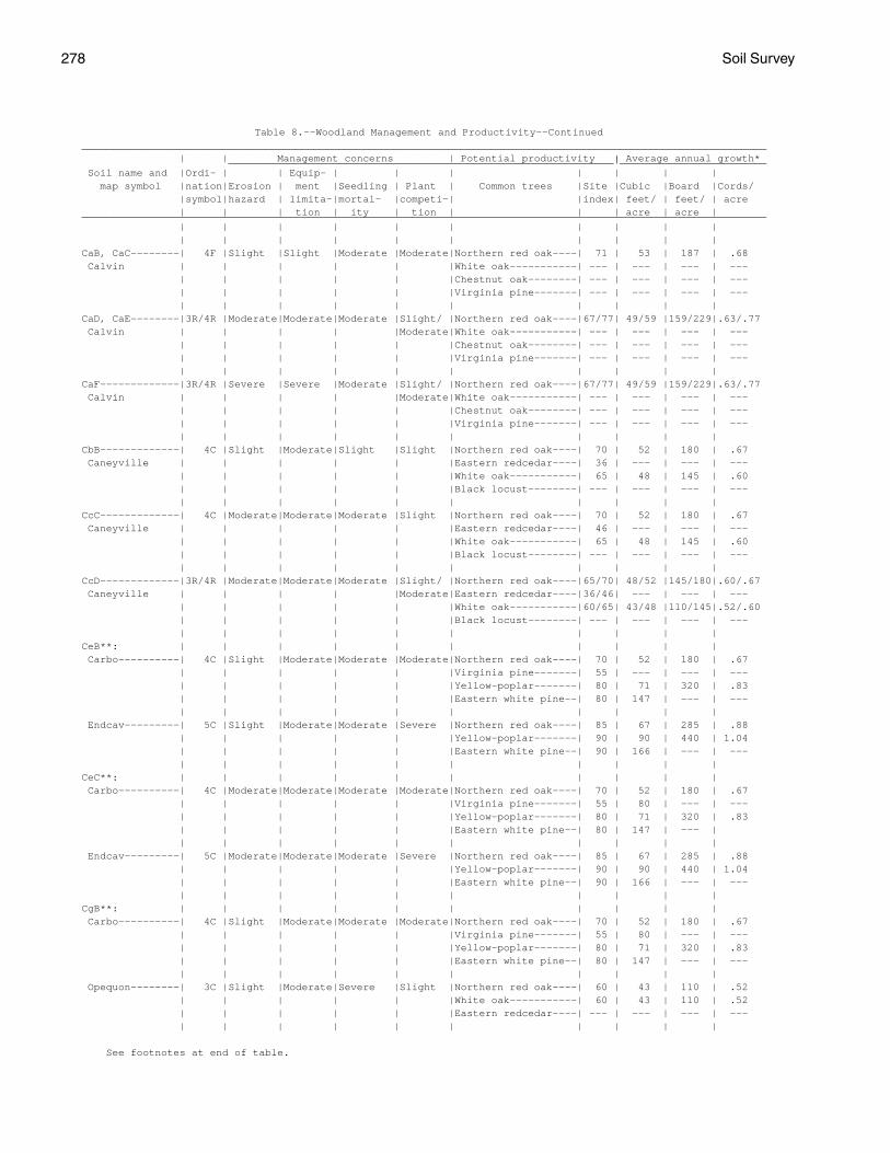
278 Soil Survey
Table 8.--Woodland Management and Productivity--Continued________________________________________________________________________________________________________________ | | Management concerns | Potential productivity | Average annual growth* _______________________________________________________________|________________________ Soil name and |Ordi- | | Equip- | | | | | | | map symbol |nation|Erosion | ment |Seedling | Plant | Common trees |Site |Cubic |Board |Cords/ |symbol|hazard | limita-|mortal- |competi-| |index| feet/ | feet/ | acre | | | tion | ity | tion | | | acre | acre |________________________________________________________________________________________________________________ | | | | | | | | | | | | | | | | | | | |CaB, CaC--------| 4F |Slight |Slight |Moderate |Moderate|Northern red oak----| 71 | 53 | 187 | .68 Calvin | | | | | |White oak-----------| --- | --- | --- | --- | | | | | |Chestnut oak--------| --- | --- | --- | --- | | | | | |Virginia pine-------| --- | --- | --- | --- | | | | | | | | | |CaD, CaE--------|3R/4R |Moderate|Moderate|Moderate |Slight/ |Northern red oak----|67/77| 49/59 |159/229|.63/.77 Calvin | | | | |Moderate|White oak-----------| --- | --- | --- | --- | | | | | |Chestnut oak--------| --- | --- | --- | --- | | | | | |Virginia pine-------| --- | --- | --- | --- | | | | | | | | | |CaF-------------|3R/4R |Severe |Severe |Moderate |Slight/ |Northern red oak----|67/77| 49/59 |159/229|.63/.77 Calvin | | | | |Moderate|White oak-----------| --- | --- | --- | --- | | | | | |Chestnut oak--------| --- | --- | --- | --- | | | | | |Virginia pine-------| --- | --- | --- | --- | | | | | | | | | |CbB-------------| 4C |Slight |Moderate|Slight |Slight |Northern red oak----| 70 | 52 | 180 | .67 Caneyville | | | | | |Eastern redcedar----| 36 | --- | --- | --- | | | | | |White oak-----------| 65 | 48 | 145 | .60 | | | | | |Black locust--------| --- | --- | --- | --- | | | | | | | | | |CcC-------------| 4C |Moderate|Moderate|Moderate |Slight |Northern red oak----| 70 | 52 | 180 | .67 Caneyville | | | | | |Eastern redcedar----| 46 | --- | --- | --- | | | | | |White oak-----------| 65 | 48 | 145 | .60 | | | | | |Black locust--------| --- | --- | --- | --- | | | | | | | | | |CcD-------------|3R/4R |Moderate|Moderate|Moderate |Slight/ |Northern red oak----|65/70| 48/52 |145/180|.60/.67 Caneyville | | | | |Moderate|Eastern redcedar----|36/46| --- | --- | --- | | | | | |White oak-----------|60/65| 43/48 |110/145|.52/.60 | | | | | |Black locust--------| --- | --- | --- | --- | | | | | | | | | |CeB**: | | | | | | | | | | Carbo----------| 4C |Slight |Moderate|Moderate |Moderate|Northern red oak----| 70 | 52 | 180 | .67 | | | | | |Virginia pine-------| 55 | --- | --- | --- | | | | | |Yellow-poplar-------| 80 | 71 | 320 | .83 | | | | | |Eastern white pine--| 80 | 147 | --- | --- | | | | | | | | | | Endcav---------| 5C |Slight |Moderate|Moderate |Severe |Northern red oak----| 85 | 67 | 285 | .88 | | | | | |Yellow-poplar-------| 90 | 90 | 440 | 1.04 | | | | | |Eastern white pine--| 90 | 166 | --- | --- | | | | | | | | | |CeC**: | | | | | | | | | | Carbo----------| 4C |Moderate|Moderate|Moderate |Moderate|Northern red oak----| 70 | 52 | 180 | .67 | | | | | |Virginia pine-------| 55 | 80 | --- | --- | | | | | |Yellow-poplar-------| 80 | 71 | 320 | .83 | | | | | |Eastern white pine--| 80 | 147 | --- | | | | | | | | | | | Endcav---------| 5C |Moderate|Moderate|Moderate |Severe |Northern red oak----| 85 | 67 | 285 | .88 | | | | | |Yellow-poplar-------| 90 | 90 | 440 | 1.04 | | | | | |Eastern white pine--| 90 | 166 | --- | --- | | | | | | | | | |CgB**: | | | | | | | | | | Carbo----------| 4C |Slight |Moderate|Moderate |Moderate|Northern red oak----| 70 | 52 | 180 | .67 | | | | | |Virginia pine-------| 55 | 80 | --- | --- | | | | | |Yellow-poplar-------| 80 | 71 | 320 | .83 | | | | | |Eastern white pine--| 80 | 147 | --- | --- | | | | | | | | | | Opequon--------| 3C |Slight |Moderate|Severe |Slight |Northern red oak----| 60 | 43 | 110 | .52 | | | | | |White oak-----------| 60 | 43 | 110 | .52 | | | | | |Eastern redcedar----| --- | --- | --- | --- | | | | | | | | | |
See footnotes at end of table.
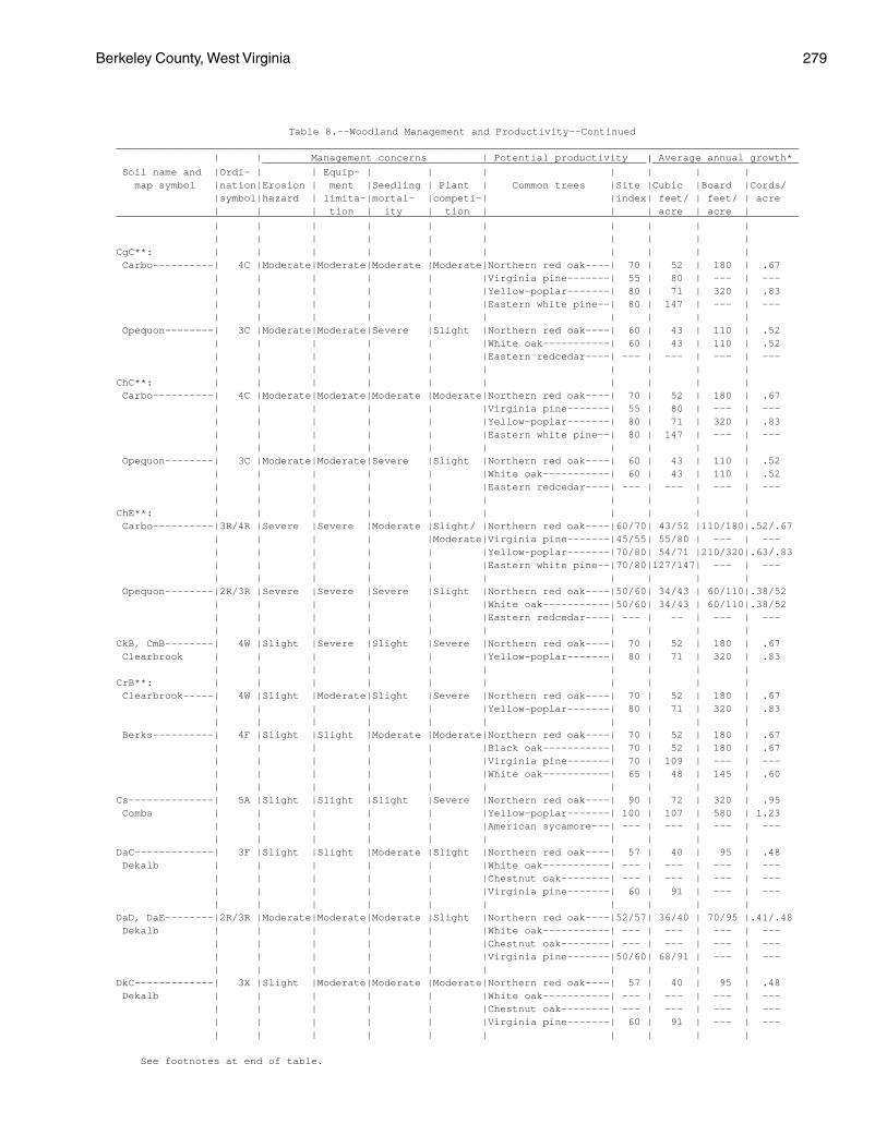
Berkeley County, West Virginia 279
Table 8.--Woodland Management and Productivity--Continued________________________________________________________________________________________________________________ | | Management concerns | Potential productivity | Average annual growth* _______________________________________________________________|________________________ Soil name and |Ordi- | | Equip- | | | | | | | map symbol |nation|Erosion | ment |Seedling | Plant | Common trees |Site |Cubic |Board |Cords/ |symbol|hazard | limita-|mortal- |competi-| |index| feet/ | feet/ | acre | | | tion | ity | tion | | | acre | acre |________________________________________________________________________________________________________________ | | | | | | | | | | | | | | | | | | | |CgC**: | | | | | | | | | | Carbo----------| 4C |Moderate|Moderate|Moderate |Moderate|Northern red oak----| 70 | 52 | 180 | .67 | | | | | |Virginia pine-------| 55 | 80 | --- | --- | | | | | |Yellow-poplar-------| 80 | 71 | 320 | .83 | | | | | |Eastern white pine--| 80 | 147 | --- | --- | | | | | | | | | | Opequon--------| 3C |Moderate|Moderate|Severe |Slight |Northern red oak----| 60 | 43 | 110 | .52 | | | | | |White oak-----------| 60 | 43 | 110 | .52 | | | | | |Eastern redcedar----| --- | --- | --- | --- | | | | | | | | | |ChC**: | | | | | | | | | | Carbo----------| 4C |Moderate|Moderate|Moderate |Moderate|Northern red oak----| 70 | 52 | 180 | .67 | | | | | |Virginia pine-------| 55 | 80 | --- | --- | | | | | |Yellow-poplar-------| 80 | 71 | 320 | .83 | | | | | |Eastern white pine--| 80 | 147 | --- | --- | | | | | | | | | | Opequon--------| 3C |Moderate|Moderate|Severe |Slight |Northern red oak----| 60 | 43 | 110 | .52 | | | | | |White oak-----------| 60 | 43 | 110 | .52 | | | | | |Eastern redcedar----| --- | --- | --- | --- | | | | | | | | | |ChE**: | | | | | | | | | | Carbo----------|3R/4R |Severe |Severe |Moderate |Slight/ |Northern red oak----|60/70| 43/52 |110/180|.52/.67 | | | | |Moderate|Virginia pine-------|45/55| 55/80 | --- | --- | | | | | |Yellow-poplar-------|70/80| 54/71 |210/320|.63/.83 | | | | | |Eastern white pine--|70/80|127/147| --- | --- | | | | | | | | | | Opequon--------|2R/3R |Severe |Severe |Severe |Slight |Northern red oak----|50/60| 34/43 | 60/110|.38/52 | | | | | |White oak-----------|50/60| 34/43 | 60/110|.38/52 | | | | | |Eastern redcedar----| --- | -- | --- | --- | | | | | | | | | |CkB, CmB--------| 4W |Slight |Severe |Slight |Severe |Northern red oak----| 70 | 52 | 180 | .67 Clearbrook | | | | | |Yellow-poplar-------| 80 | 71 | 320 | .83 | | | | | | | | | |CrB**: | | | | | | | | | | Clearbrook-----| 4W |Slight |Moderate|Slight |Severe |Northern red oak----| 70 | 52 | 180 | .67 | | | | | |Yellow-poplar-------| 80 | 71 | 320 | .83 | | | | | | | | | | Berks----------| 4F |Slight |Slight |Moderate |Moderate|Northern red oak----| 70 | 52 | 180 | .67 | | | | | |Black oak-----------| 70 | 52 | 180 | .67 | | | | | |Virginia pine-------| 70 | 109 | --- | --- | | | | | |White oak-----------| 65 | 48 | 145 | .60 | | | | | | | | | |Cs--------------| 5A |Slight |Slight |Slight |Severe |Northern red oak----| 90 | 72 | 320 | .95 Combs | | | | | |Yellow-poplar-------| 100 | 107 | 580 | 1.23 | | | | | |American sycamore---| --- | --- | --- | --- | | | | | | | | | |DaC-------------| 3F |Slight |Slight |Moderate |Slight |Northern red oak----| 57 | 40 | 95 | .48 Dekalb | | | | | |White oak-----------| --- | --- | --- | --- | | | | | |Chestnut oak--------| --- | --- | --- | --- | | | | | |Virginia pine-------| 60 | 91 | --- | --- | | | | | | | | | |DaD, DaE--------|2R/3R |Moderate|Moderate|Moderate |Slight |Northern red oak----|52/57| 36/40 | 70/95 |.41/.48 Dekalb | | | | | |White oak-----------| --- | --- | --- | --- | | | | | |Chestnut oak--------| --- | --- | --- | --- | | | | | |Virginia pine-------|50/60| 68/91 | --- | --- | | | | | | | | | |DkC-------------| 3X |Slight |Moderate|Moderate |Moderate|Northern red oak----| 57 | 40 | 95 | .48 Dekalb | | | | | |White oak-----------| --- | --- | --- | --- | | | | | |Chestnut oak--------| --- | --- | --- | --- | | | | | |Virginia pine-------| 60 | 91 | --- | --- | | | | | | | | | |
See footnotes at end of table.
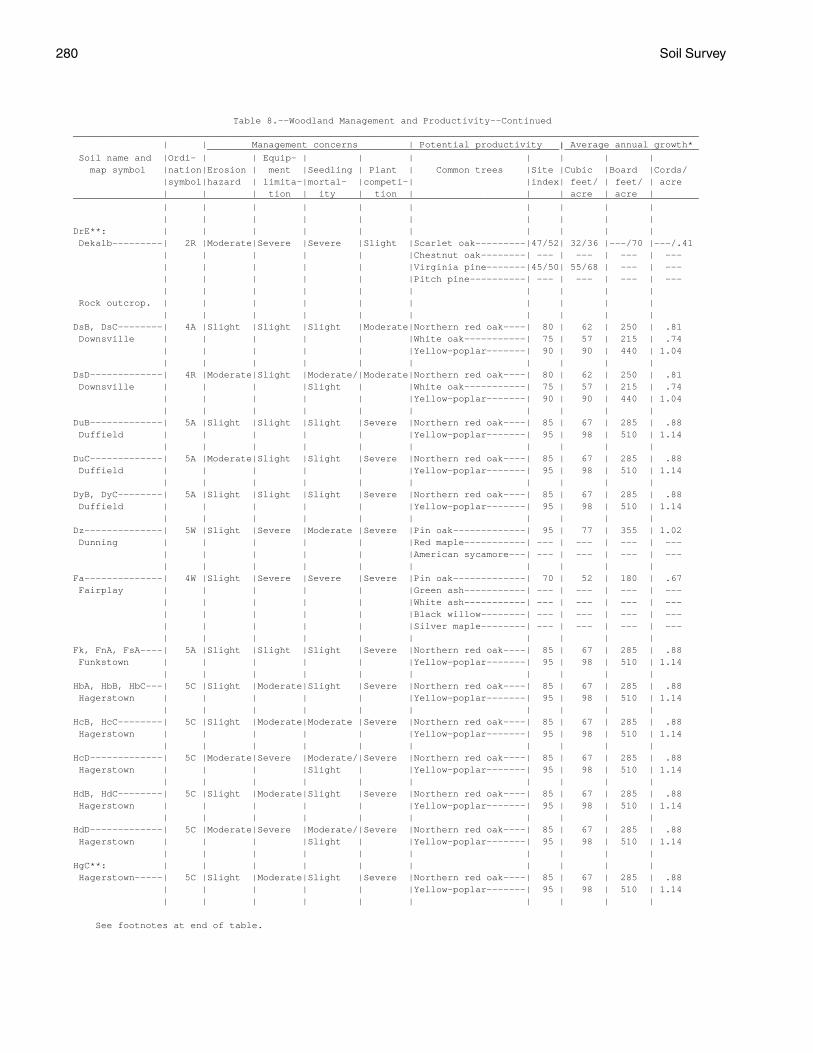
280 Soil Survey
Table 8.--Woodland Management and Productivity--Continued________________________________________________________________________________________________________________ | | Management concerns | Potential productivity | Average annual growth* _______________________________________________________________|________________________ Soil name and |Ordi- | | Equip- | | | | | | | map symbol |nation|Erosion | ment |Seedling | Plant | Common trees |Site |Cubic |Board |Cords/ |symbol|hazard | limita-|mortal- |competi-| |index| feet/ | feet/ | acre | | | tion | ity | tion | | | acre | acre |________________________________________________________________________________________________________________ | | | | | | | | | | | | | | | | | | | |DrE**: | | | | | | | | | | Dekalb---------| 2R |Moderate|Severe |Severe |Slight |Scarlet oak---------|47/52| 32/36 |---/70 |---/.41 | | | | | |Chestnut oak--------| --- | --- | --- | --- | | | | | |Virginia pine-------|45/50| 55/68 | --- | --- | | | | | |Pitch pine----------| --- | --- | --- | --- | | | | | | | | | | Rock outcrop. | | | | | | | | | | | | | | | | | | | |DsB, DsC--------| 4A |Slight |Slight |Slight |Moderate|Northern red oak----| 80 | 62 | 250 | .81 Downsville | | | | | |White oak-----------| 75 | 57 | 215 | .74 | | | | | |Yellow-poplar-------| 90 | 90 | 440 | 1.04 | | | | | | | | | |DsD-------------| 4R |Moderate|Slight |Moderate/|Moderate|Northern red oak----| 80 | 62 | 250 | .81 Downsville | | | |Slight | |White oak-----------| 75 | 57 | 215 | .74 | | | | | |Yellow-poplar-------| 90 | 90 | 440 | 1.04 | | | | | | | | | |DuB-------------| 5A |Slight |Slight |Slight |Severe |Northern red oak----| 85 | 67 | 285 | .88 Duffield | | | | | |Yellow-poplar-------| 95 | 98 | 510 | 1.14 | | | | | | | | | |DuC-------------| 5A |Moderate|Slight |Slight |Severe |Northern red oak----| 85 | 67 | 285 | .88 Duffield | | | | | |Yellow-poplar-------| 95 | 98 | 510 | 1.14 | | | | | | | | | |DyB, DyC--------| 5A |Slight |Slight |Slight |Severe |Northern red oak----| 85 | 67 | 285 | .88 Duffield | | | | | |Yellow-poplar-------| 95 | 98 | 510 | 1.14 | | | | | | | | | |Dz--------------| 5W |Slight |Severe |Moderate |Severe |Pin oak-------------| 95 | 77 | 355 | 1.02 Dunning | | | | | |Red maple-----------| --- | --- | --- | --- | | | | | |American sycamore---| --- | --- | --- | --- | | | | | | | | | |Fa--------------| 4W |Slight |Severe |Severe |Severe |Pin oak-------------| 70 | 52 | 180 | .67 Fairplay | | | | | |Green ash-----------| --- | --- | --- | --- | | | | | |White ash-----------| --- | --- | --- | --- | | | | | |Black willow--------| --- | --- | --- | --- | | | | | |Silver maple--------| --- | --- | --- | --- | | | | | | | | | |Fk, FnA, FsA----| 5A |Slight |Slight |Slight |Severe |Northern red oak----| 85 | 67 | 285 | .88 Funkstown | | | | | |Yellow-poplar-------| 95 | 98 | 510 | 1.14 | | | | | | | | | |HbA, HbB, HbC---| 5C |Slight |Moderate|Slight |Severe |Northern red oak----| 85 | 67 | 285 | .88 Hagerstown | | | | | |Yellow-poplar-------| 95 | 98 | 510 | 1.14 | | | | | | | | | |HcB, HcC--------| 5C |Slight |Moderate|Moderate |Severe |Northern red oak----| 85 | 67 | 285 | .88 Hagerstown | | | | | |Yellow-poplar-------| 95 | 98 | 510 | 1.14 | | | | | | | | | |HcD-------------| 5C |Moderate|Severe |Moderate/|Severe |Northern red oak----| 85 | 67 | 285 | .88 Hagerstown | | | |Slight | |Yellow-poplar-------| 95 | 98 | 510 | 1.14 | | | | | | | | | |HdB, HdC--------| 5C |Slight |Moderate|Slight |Severe |Northern red oak----| 85 | 67 | 285 | .88 Hagerstown | | | | | |Yellow-poplar-------| 95 | 98 | 510 | 1.14 | | | | | | | | | |HdD-------------| 5C |Moderate|Severe |Moderate/|Severe |Northern red oak----| 85 | 67 | 285 | .88 Hagerstown | | | |Slight | |Yellow-poplar-------| 95 | 98 | 510 | 1.14 | | | | | | | | | |HgC**: | | | | | | | | | | Hagerstown-----| 5C |Slight |Moderate|Slight |Severe |Northern red oak----| 85 | 67 | 285 | .88 | | | | | |Yellow-poplar-------| 95 | 98 | 510 | 1.14 | | | | | | | | | |
See footnotes at end of table.
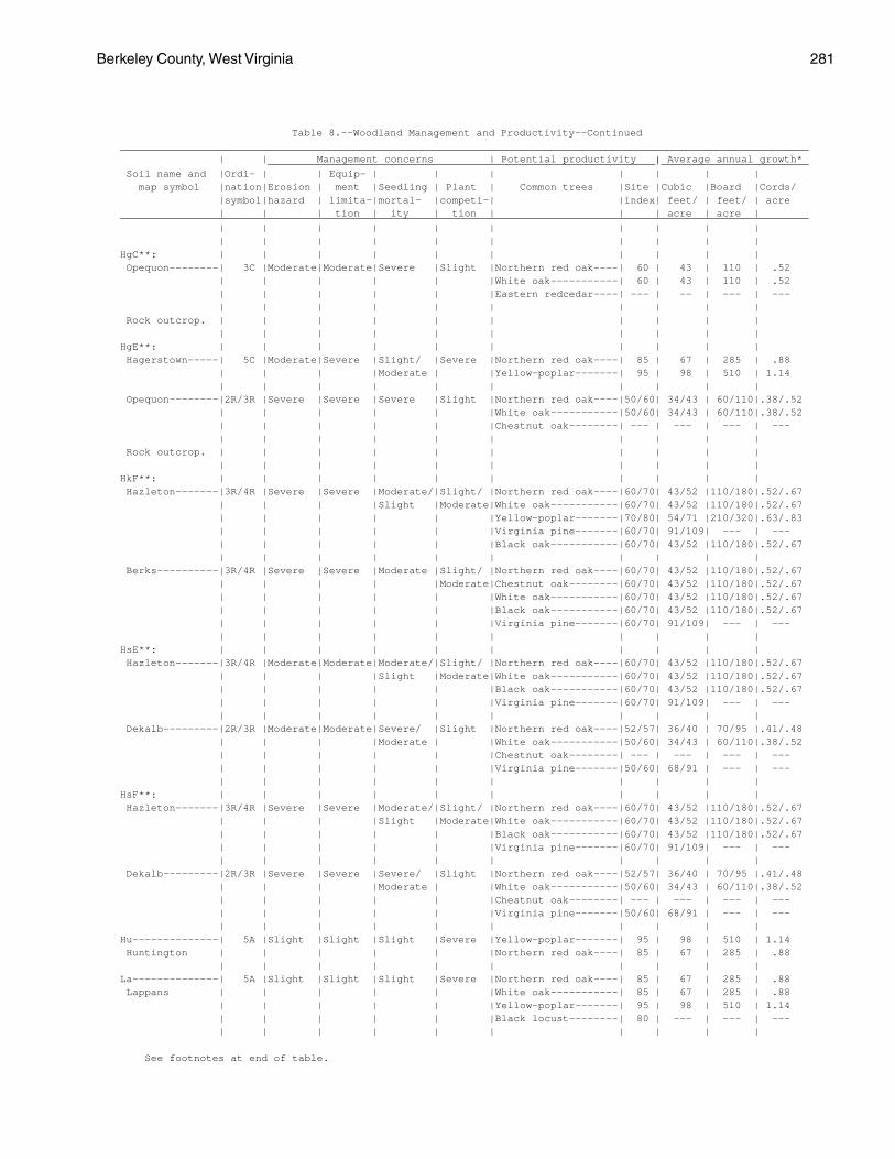
Berkeley County, West Virginia 281
Table 8.--Woodland Management and Productivity--Continued________________________________________________________________________________________________________________ | | Management concerns | Potential productivity | Average annual growth* _______________________________________________________________|________________________ Soil name and |Ordi- | | Equip- | | | | | | | map symbol |nation|Erosion | ment |Seedling | Plant | Common trees |Site |Cubic |Board |Cords/ |symbol|hazard | limita-|mortal- |competi-| |index| feet/ | feet/ | acre | | | tion | ity | tion | | | acre | acre |________________________________________________________________________________________________________________ | | | | | | | | | | | | | | | | | | | |HgC**: | | | | | | | | | | Opequon--------| 3C |Moderate|Moderate|Severe |Slight |Northern red oak----| 60 | 43 | 110 | .52 | | | | | |White oak-----------| 60 | 43 | 110 | .52 | | | | | |Eastern redcedar----| --- | -- | --- | --- | | | | | | | | | | Rock outcrop. | | | | | | | | | | | | | | | | | | | |HgE**: | | | | | | | | | | Hagerstown-----| 5C |Moderate|Severe |Slight/ |Severe |Northern red oak----| 85 | 67 | 285 | .88 | | | |Moderate | |Yellow-poplar-------| 95 | 98 | 510 | 1.14 | | | | | | | | | | Opequon--------|2R/3R |Severe |Severe |Severe |Slight |Northern red oak----|50/60| 34/43 | 60/110|.38/.52 | | | | | |White oak-----------|50/60| 34/43 | 60/110|.38/.52 | | | | | |Chestnut oak--------| --- | --- | --- | --- | | | | | | | | | | Rock outcrop. | | | | | | | | | | | | | | | | | | | |HkF**: | | | | | | | | | | Hazleton-------|3R/4R |Severe |Severe |Moderate/|Slight/ |Northern red oak----|60/70| 43/52 |110/180|.52/.67 | | | |Slight |Moderate|White oak-----------|60/70| 43/52 |110/180|.52/.67 | | | | | |Yellow-poplar-------|70/80| 54/71 |210/320|.63/.83 | | | | | |Virginia pine-------|60/70| 91/109| --- | --- | | | | | |Black oak-----------|60/70| 43/52 |110/180|.52/.67 | | | | | | | | | | Berks----------|3R/4R |Severe |Severe |Moderate |Slight/ |Northern red oak----|60/70| 43/52 |110/180|.52/.67 | | | | |Moderate|Chestnut oak--------|60/70| 43/52 |110/180|.52/.67 | | | | | |White oak-----------|60/70| 43/52 |110/180|.52/.67 | | | | | |Black oak-----------|60/70| 43/52 |110/180|.52/.67 | | | | | |Virginia pine-------|60/70| 91/109| --- | --- | | | | | | | | | |HsE**: | | | | | | | | | | Hazleton-------|3R/4R |Moderate|Moderate|Moderate/|Slight/ |Northern red oak----|60/70| 43/52 |110/180|.52/.67 | | | |Slight |Moderate|White oak-----------|60/70| 43/52 |110/180|.52/.67 | | | | | |Black oak-----------|60/70| 43/52 |110/180|.52/.67 | | | | | |Virginia pine-------|60/70| 91/109| --- | --- | | | | | | | | | | Dekalb---------|2R/3R |Moderate|Moderate|Severe/ |Slight |Northern red oak----|52/57| 36/40 | 70/95 |.41/.48 | | | |Moderate | |White oak-----------|50/60| 34/43 | 60/110|.38/.52 | | | | | |Chestnut oak--------| --- | --- | --- | --- | | | | | |Virginia pine-------|50/60| 68/91 | --- | --- | | | | | | | | | |HsF**: | | | | | | | | | | Hazleton-------|3R/4R |Severe |Severe |Moderate/|Slight/ |Northern red oak----|60/70| 43/52 |110/180|.52/.67 | | | |Slight |Moderate|White oak-----------|60/70| 43/52 |110/180|.52/.67 | | | | | |Black oak-----------|60/70| 43/52 |110/180|.52/.67 | | | | | |Virginia pine-------|60/70| 91/109| --- | --- | | | | | | | | | | Dekalb---------|2R/3R |Severe |Severe |Severe/ |Slight |Northern red oak----|52/57| 36/40 | 70/95 |.41/.48 | | | |Moderate | |White oak-----------|50/60| 34/43 | 60/110|.38/.52 | | | | | |Chestnut oak--------| --- | --- | --- | --- | | | | | |Virginia pine-------|50/60| 68/91 | --- | --- | | | | | | | | | |Hu--------------| 5A |Slight |Slight |Slight |Severe |Yellow-poplar-------| 95 | 98 | 510 | 1.14 Huntington | | | | | |Northern red oak----| 85 | 67 | 285 | .88 | | | | | | | | | |La--------------| 5A |Slight |Slight |Slight |Severe |Northern red oak----| 85 | 67 | 285 | .88 Lappans | | | | | |White oak-----------| 85 | 67 | 285 | .88 | | | | | |Yellow-poplar-------| 95 | 98 | 510 | 1.14 | | | | | |Black locust--------| 80 | --- | --- | --- | | | | | | | | | |
See footnotes at end of table.
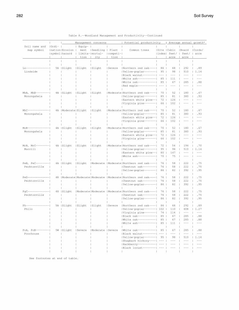
282 Soil Survey
Table 8.--Woodland Management and Productivity--Continued________________________________________________________________________________________________________________ | | Management concerns | Potential productivity | Average annual growth* _______________________________________________________________|________________________ Soil name and |Ordi- | | Equip- | | | | | | | map symbol |nation|Erosion | ment |Seedling | Plant | Common trees |Site |Cubic |Board |Cords/ |symbol|hazard | limita-|mortal- |competi-| |index| feet/ | feet/ | acre | | | tion | ity | tion | | | acre | acre |________________________________________________________________________________________________________________ | | | | | | | | | | | | | | | | | | | |Ln--------------| 5A |Slight |Slight |Slight |Severe |Northern red oak----| 86 | 68 | 292 | .89 Lindside | | | | | |Yellow-poplar-------| 95 | 98 | 510 | 1.14 | | | | | |Black walnut--------| --- | --- | --- | --- | | | | | |White ash-----------| 85 | 111 | --- | --- | | | | | |White oak-----------| 85 | 67 | 285 | .88 | | | | | |Red maple-----------| --- | --- | --- | --- | | | | | | | | | |MhA, MhB--------| 4A |Slight |Slight |Slight |Moderate|Northern red oak----| 70 | 52 | 180 | .67 Monongahela | | | | | |Yellow-poplar-------| 85 | 81 | 380 | .93 | | | | | |Eastern white pine--| 72 | 126 | --- | --- | | | | | |Virginia pine-------| 66 | 102 | --- | --- | | | | | | | | | |MhC-------------| 4A |Moderate|Slight |Slight |Moderate|Northern red oak----| 70 | 52 | 180 | .67 Monongahela | | | | | |Yellow-poplar-------| 85 | 81 | 380 | .93 | | | | | |Eastern white pine--| 72 | 126 | --- | --- | | | | | |Virginia pine-------| 66 | 102 | --- | --- | | | | | | | | | |MoB-------------| 4A |Slight |Slight |Slight |Moderate|Northern red oak----| 70 | 52 | 180 | .67 Monongahela | | | | | |Yellow-poplar-------| 85 | 81 | 380 | .93 | | | | | |Eastern white pine--| 72 | 126 | --- | --- | | | | | |Virginia pine-------| 66 | 102 | --- | --- | | | | | | | | | |MrB, MrC--------| 4A |Slight |Slight |Slight |Moderate|Northern red oak----| 72 | 54 | 194 | .70 Murrill | | | | | |Yellow-poplar-------| 95 | 98 | 510 | 1.14 | | | | | |Eastern white pine--| 80 | 147 | --- | --- | | | | | |White ash-----------| 70 | 75 | --- | --- | | | | | | | | | |PeB, PeC--------| 4A |Slight |Slight |Moderate |Moderate|Northern red oak----| 76 | 58 | 222 | .75 Pecktonville | | | | | |Chestnut oak--------| 76 | 58 | 222 | .75 | | | | | |Yellow-poplar-------| 86 | 82 | 392 | .95 | | | | | | | | | |PeD-------------| 4R |Moderate|Moderate|Moderate |Moderate|Northern red oak----| 76 | 58 | 222 | .75 Pecktonville | | | | | |Chestnut oak--------| 76 | 58 | 222 | .75 | | | | | |Yellow-poplar-------| 86 | 82 | 392 | .95 | | | | | | | | | |PgC-------------| 4X |Slight |Moderate|Moderate |Moderate|Northern red oak----| 76 | 58 | 222 | .75 Pecktonville | | | | | |Chestnut oak--------| 76 | 58 | 222 | .75 | | | | | |Yellow-poplar-------| 86 | 82 | 392 | .95 | | | | | | | | | |Ph--------------| 5A |Slight |Slight |Slight |Severe |Northern red oak----| 86 | 68 | 292 | .89 Philo | | | | | |Yellow-poplar-------| 102 | 110 | 608 | 1.27 | | | | | |Virginia pine-------| 74 | 114 | --- | --- | | | | | |Black oak-----------| 85 | 67 | 285 | .88 | | | | | |White oak-----------| 85 | 67 | 285 | .88 | | | | | |White ash-----------| 85 | 111 | --- | --- | | | | | | | | | |PoA, PoB--------| 5W |Slight |Severe |Moderate |Severe |White oak-----------| 85 | 67 | 285 | .88 Poorhouse | | | | | |Black walnut--------| --- | --- | --- | --- | | | | | |Yellow-poplar-------| 95 | 98 | 510 | 1.14 | | | | | |Shagbark hickory----| --- | --- | --- | --- | | | | | |Hackberry-----------| --- | --- | --- | --- | | | | | |Black locust--------| --- | --- | --- | --- | | | | | | | | | |
See footnotes at end of table.
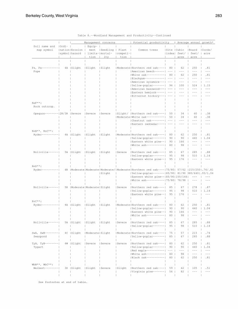
Berkeley County, West Virginia 283
Table 8.--Woodland Management and Productivity--Continued________________________________________________________________________________________________________________ | | Management concerns | Potential productivity | Average annual growth* _______________________________________________________________|________________________ Soil name and |Ordi- | | Equip- | | | | | | | map symbol |nation|Erosion | ment |Seedling | Plant | Common trees |Site |Cubic |Board |Cords/ |symbol|hazard | limita-|mortal- |competi-| |index| feet/ | feet/ | acre | | | tion | ity | tion | | | acre | acre |________________________________________________________________________________________________________________ | | | | | | | | | | | | | | | | | | | |Ps, Px----------| 4A |Slight |Slight |Slight |Moderate|Northern red oak----| 80 | 62 | 250 | .81 Pope | | | | | |American beech------| --- | --- | --- | --- | | | | | |White oak-----------| 80 | 62 | 250 | .81 | | | | | |Blackgum------------| --- | --- | --- | --- | | | | | |American sycamore---| --- | --- | --- | --- | | | | | |Yellow-poplar-------| 96 | 100 | 524 | 1.15 | | | | | |American basswood---| --- | --- | --- | --- | | | | | |Eastern hemlock-----| --- | --- | --- | --- | | | | | |Bitternut hickory---| --- | --- | --- | --- | | | | | | | | | |ReF**: | | | | | | | | | | Rock outcrop. | | | | | | | | | | | | | | | | | | | | Opequon--------|2R/3R |Severe |Severe |Severe |Slight/ |Northern red oak----| 50 | 34 | 60 | .38 | | | | |Moderate|White oak-----------| 50 | 34 | 60 | .38 | | | | | |Chestnut oak--------| --- | --- | --- | --- | | | | | |Eastern redcedar----| --- | --- | --- | --- | | | | | | | | | |RnB**, RnC**: | | | | | | | | | | Ryder----------| 4A |Slight |Slight |Slight |Moderate|Northern red oak----| 80 | 62 | 250 | .81 | | | | | |Yellow-poplar-------| 90 | 90 | 440 | 1.04 | | | | | |Eastern white pine--| 90 | 166 | --- | --- | | | | | |White ash-----------| 80 | 98 | --- | --- | | | | | | | | | | Nollville------| 5A |Slight |Slight |Slight |Severe |Northern red oak----| 85 | 67 | 285 | .88 | | | | | |Yellow-poplar-------| 95 | 98 | 510 | 1.14 | | | | | |Eastern white pine--| 95 | 176 | --- | --- | | | | | | | | | |RnD**: | | | | | | | | | | Ryder----------| 4R |Moderate|Moderate|Moderate/|Moderate|Northern red oak----|75/80| 57/62 |215/250|.74/.81 | | | |Slight | |Yellow-poplar-------|85/90| 81/90 380/440|.93/1.04 | | | | | |Eastern white pine--|85/90|155/166| --- | --- | | | | | |White ash-----------|75/80| 78/98 | --- | --- | | | | | | | | | | Nollville------| 5R |Moderate|Moderate|Slight |Severe |Northern red oak----| 85 | 67 | 278 | .87 | | | | | |Yellow-poplar-------| 95 | 98 | 510 | 1.14 | | | | | |Eastern white pine--| 95 | 176 | --- | --- | | | | | | | | | |RvC**: | | | | | | | | | | Ryder----------| 4A |Slight |Slight |Slight |Moderate|Northern red oak----| 80 | 62 | 250 | .81 | | | | | |Yellow-poplar-------| 90 | 90 | 440 | 1.04 | | | | | |Eastern white pine--| 90 | 166 | --- | --- | | | | | |White ash-----------| 80 | 98 | --- | --- | | | | | | | | | | Nollville------| 5A |Slight |Slight |Slight |Severe |Northern red oak----| 85 | 67 | 285 | .88 | | | | | |Yellow-poplar-------| 95 | 98 | 510 | 1.14 | | | | | | | | | |SwA, SwB--------| 4C |Slight |Moderate|Slight |Moderate|Northern red oak----| 75 | 57 | 215 | .74 Swanpond | | | | | |Yellow-poplar-------| 85 | 67 | 285 | .88 | | | | | | | | | |TyA, TyB--------| 4W |Slight |Severe |Severe |Severe |Northern red oak----| 80 | 62 | 250 | .81 Tygart | | | | | |Yellow-poplar-------| 90 | 90 | 440 | 1.04 | | | | | |Red maple-----------| --- | --- | --- | --- | | | | | |White ash-----------| 80 | 98 | --- | --- | | | | | |Black oak-----------| 80 | 62 | 250 | .81 | | | | | | | | | |WbB**, WbC**: | | | | | | | | | | Weikert--------| 3D |Slight |Slight |Severe |Slight |Northern red oak----| 59 | 42 | 105 | .51 | | | | | |Virginia pine-------| 56 | 82 | --- | --- | | | | | | | | | |
See footnotes at end of table.
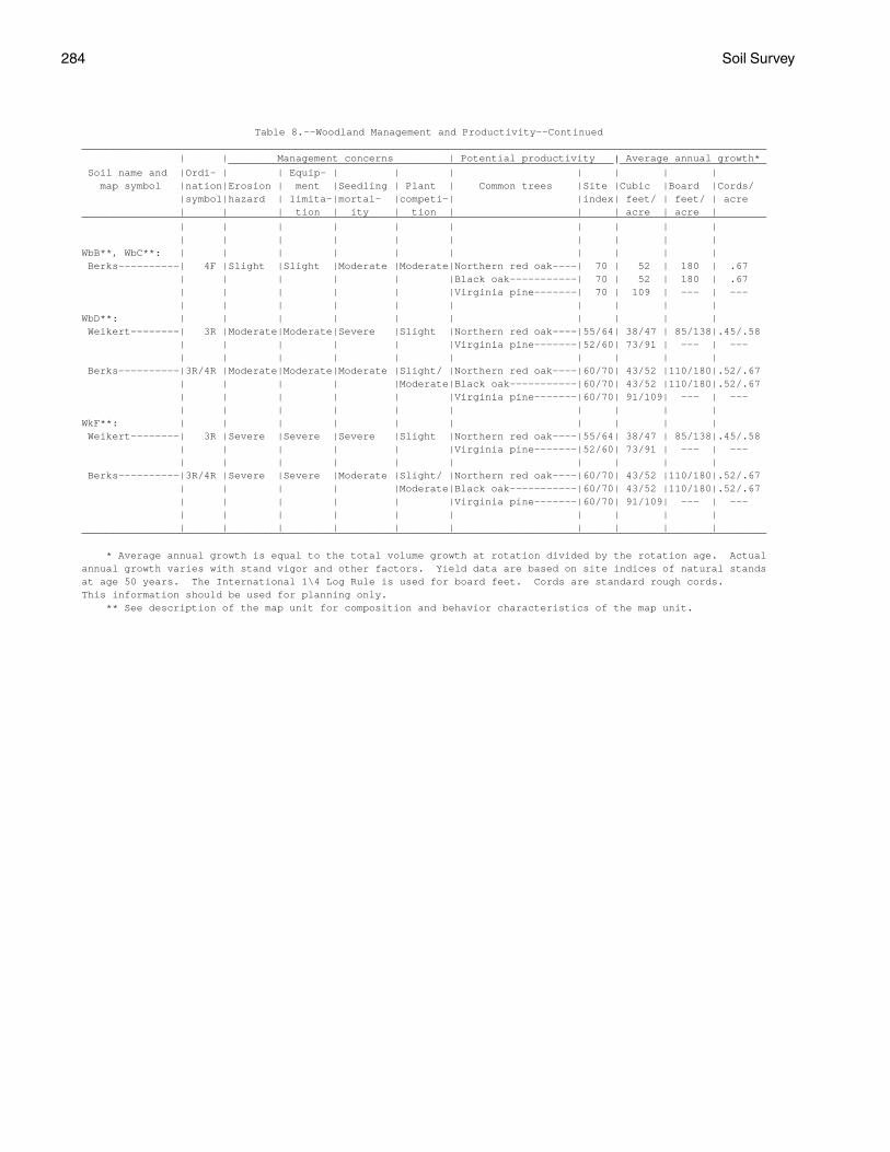
284 Soil Survey
Table 8.--Woodland Management and Productivity--Continued________________________________________________________________________________________________________________ | | Management concerns | Potential productivity | Average annual growth* _______________________________________________________________|________________________ Soil name and |Ordi- | | Equip- | | | | | | | map symbol |nation|Erosion | ment |Seedling | Plant | Common trees |Site |Cubic |Board |Cords/ |symbol|hazard | limita-|mortal- |competi-| |index| feet/ | feet/ | acre | | | tion | ity | tion | | | acre | acre |________________________________________________________________________________________________________________ | | | | | | | | | | | | | | | | | | | |WbB**, WbC**: | | | | | | | | | | Berks----------| 4F |Slight |Slight |Moderate |Moderate|Northern red oak----| 70 | 52 | 180 | .67 | | | | | |Black oak-----------| 70 | 52 | 180 | .67 | | | | | |Virginia pine-------| 70 | 109 | --- | --- | | | | | | | | | |WbD**: | | | | | | | | | | Weikert--------| 3R |Moderate|Moderate|Severe |Slight |Northern red oak----|55/64| 38/47 | 85/138|.45/.58 | | | | | |Virginia pine-------|52/60| 73/91 | --- | --- | | | | | | | | | | Berks----------|3R/4R |Moderate|Moderate|Moderate |Slight/ |Northern red oak----|60/70| 43/52 |110/180|.52/.67 | | | | |Moderate|Black oak-----------|60/70| 43/52 |110/180|.52/.67 | | | | | |Virginia pine-------|60/70| 91/109| --- | --- | | | | | | | | | |WkF**: | | | | | | | | | | Weikert--------| 3R |Severe |Severe |Severe |Slight |Northern red oak----|55/64| 38/47 | 85/138|.45/.58 | | | | | |Virginia pine-------|52/60| 73/91 | --- | --- | | | | | | | | | | Berks----------|3R/4R |Severe |Severe |Moderate |Slight/ |Northern red oak----|60/70| 43/52 |110/180|.52/.67 | | | | |Moderate|Black oak-----------|60/70| 43/52 |110/180|.52/.67 | | | | | |Virginia pine-------|60/70| 91/109| --- | --- | | | | | | | | | | | | | | | | | | | |________________________________________________________________________________________________________________
* Average annual growth is equal to the total volume growth at rotation divided by the rotation age. Actualannual growth varies with stand vigor and other factors. Yield data are based on site indices of natural standsat age 50 years. The International 1\4 Log Rule is used for board feet. Cords are standard rough cords.This information should be used for planning only. ** See description of the map unit for composition and behavior characteristics of the map unit.
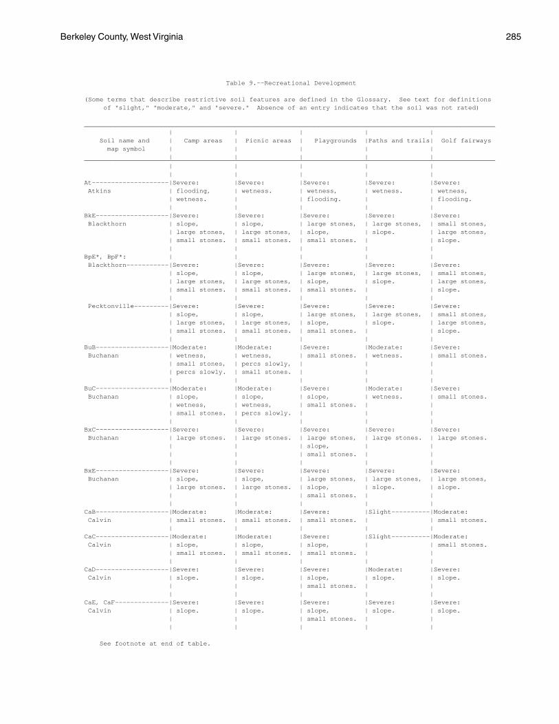
Berkeley County, West Virginia 285
Table 9.--Recreational Development
(Some terms that describe restrictive soil features are defined in the Glossary. See text for definitions of "slight," "moderate," and "severe." Absence of an entry indicates that the soil was not rated)
___________________________________________________________________________________________________________ | | | | | Soil name and | Camp areas | Picnic areas | Playgrounds |Paths and trails| Golf fairways map symbol | | | | | | | | | |___________________________________________________________________________________________________________ | | | | | | | | | |At--------------------|Severe: |Severe: |Severe: |Severe: |Severe: Atkins | flooding, | wetness. | wetness, | wetness. | wetness, | wetness. | | flooding. | | flooding. | | | | |BkE-------------------|Severe: |Severe: |Severe: |Severe: |Severe: Blackthorn | slope, | slope, | large stones, | large stones, | small stones, | large stones, | large stones, | slope, | slope. | large stones, | small stones. | small stones. | small stones. | | slope. | | | | |BpE*, BpF*: | | | | | Blackthorn-----------|Severe: |Severe: |Severe: |Severe: |Severe: | slope, | slope, | large stones, | large stones, | small stones, | large stones, | large stones, | slope, | slope. | large stones, | small stones. | small stones. | small stones. | | slope. | | | | | Pecktonville---------|Severe: |Severe: |Severe: |Severe: |Severe: | slope, | slope, | large stones, | large stones, | small stones, | large stones, | large stones, | slope, | slope. | large stones, | small stones. | small stones. | small stones. | | slope. | | | | |BuB-------------------|Moderate: |Moderate: |Severe: |Moderate: |Severe: Buchanan | wetness, | wetness, | small stones. | wetness. | small stones. | small stones, | percs slowly, | | | | percs slowly. | small stones. | | | | | | | |BuC-------------------|Moderate: |Moderate: |Severe: |Moderate: |Severe: Buchanan | slope, | slope, | slope, | wetness. | small stones. | wetness, | wetness, | small stones. | | | small stones. | percs slowly. | | | | | | | |BxC-------------------|Severe: |Severe: |Severe: |Severe: |Severe: Buchanan | large stones. | large stones. | large stones, | large stones. | large stones. | | | slope, | | | | | small stones. | | | | | | |BxE-------------------|Severe: |Severe: |Severe: |Severe: |Severe: Buchanan | slope, | slope, | large stones, | large stones, | large stones, | large stones. | large stones. | slope, | slope. | slope. | | | small stones. | | | | | | |CaB-------------------|Moderate: |Moderate: |Severe: |Slight----------|Moderate: Calvin | small stones. | small stones. | small stones. | | small stones. | | | | |CaC-------------------|Moderate: |Moderate: |Severe: |Slight----------|Moderate: Calvin | slope, | slope, | slope, | | small stones. | small stones. | small stones. | small stones. | | | | | | |CaD-------------------|Severe: |Severe: |Severe: |Moderate: |Severe: Calvin | slope. | slope. | slope, | slope. | slope. | | | small stones. | | | | | | |CaE, CaF--------------|Severe: |Severe: |Severe: |Severe: |Severe: Calvin | slope. | slope. | slope, | slope. | slope. | | | small stones. | | | | | | |
See footnote at end of table.
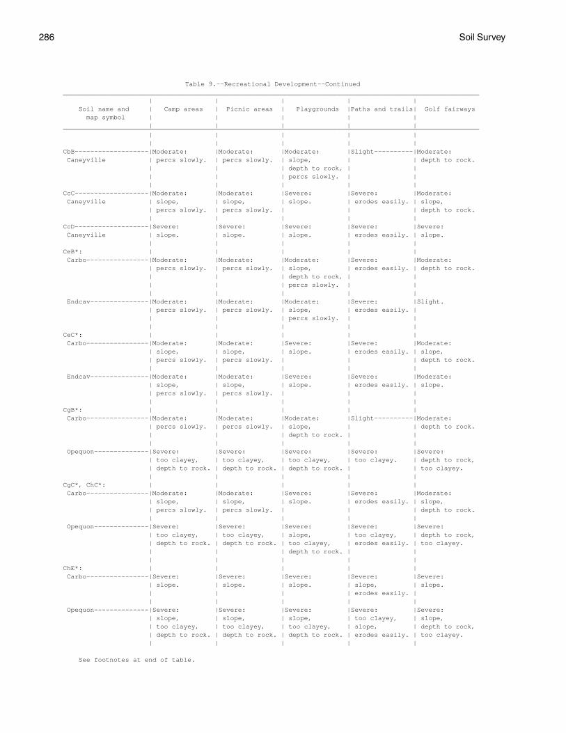
286 Soil Survey
Table 9.--Recreational Development--Continued___________________________________________________________________________________________________________ | | | | | Soil name and | Camp areas | Picnic areas | Playgrounds |Paths and trails| Golf fairways map symbol | | | | | | | | | |___________________________________________________________________________________________________________ | | | | | | | | | |CbB-------------------|Moderate: |Moderate: |Moderate: |Slight----------|Moderate: Caneyville | percs slowly. | percs slowly. | slope, | | depth to rock. | | | depth to rock, | | | | | percs slowly. | | | | | | |CcC-------------------|Moderate: |Moderate: |Severe: |Severe: |Moderate: Caneyville | slope, | slope, | slope. | erodes easily. | slope, | percs slowly. | percs slowly. | | | depth to rock. | | | | |CcD-------------------|Severe: |Severe: |Severe: |Severe: |Severe: Caneyville | slope. | slope. | slope. | erodes easily. | slope. | | | | |CeB*: | | | | | Carbo----------------|Moderate: |Moderate: |Moderate: |Severe: |Moderate: | percs slowly. | percs slowly. | slope, | erodes easily. | depth to rock. | | | depth to rock, | | | | | percs slowly. | | | | | | | Endcav---------------|Moderate: |Moderate: |Moderate: |Severe: |Slight. | percs slowly. | percs slowly. | slope, | erodes easily. | | | | percs slowly. | | | | | | |CeC*: | | | | | Carbo----------------|Moderate: |Moderate: |Severe: |Severe: |Moderate: | slope, | slope, | slope. | erodes easily. | slope, | percs slowly. | percs slowly. | | | depth to rock. | | | | | Endcav---------------|Moderate: |Moderate: |Severe: |Severe: |Moderate: | slope, | slope, | slope. | erodes easily. | slope. | percs slowly. | percs slowly. | | | | | | | |CgB*: | | | | | Carbo----------------|Moderate: |Moderate: |Moderate: |Slight----------|Moderate: | percs slowly. | percs slowly. | slope, | | depth to rock. | | | depth to rock. | | | | | | | Opequon--------------|Severe: |Severe: |Severe: |Severe: |Severe: | too clayey, | too clayey, | too clayey, | too clayey. | depth to rock, | depth to rock. | depth to rock. | depth to rock. | | too clayey. | | | | |CgC*, ChC*: | | | | | Carbo----------------|Moderate: |Moderate: |Severe: |Severe: |Moderate: | slope, | slope, | slope. | erodes easily. | slope, | percs slowly. | percs slowly. | | | depth to rock. | | | | | Opequon--------------|Severe: |Severe: |Severe: |Severe: |Severe: | too clayey, | too clayey, | slope, | too clayey, | depth to rock, | depth to rock. | depth to rock. | too clayey, | erodes easily. | too clayey. | | | depth to rock. | | | | | | |ChE*: | | | | | Carbo----------------|Severe: |Severe: |Severe: |Severe: |Severe: | slope. | slope. | slope. | slope, | slope. | | | | erodes easily. | | | | | | Opequon--------------|Severe: |Severe: |Severe: |Severe: |Severe: | slope, | slope, | slope, | too clayey, | slope, | too clayey, | too clayey, | too clayey, | slope, | depth to rock, | depth to rock. | depth to rock. | depth to rock. | erodes easily. | too clayey. | | | | |
See footnotes at end of table.
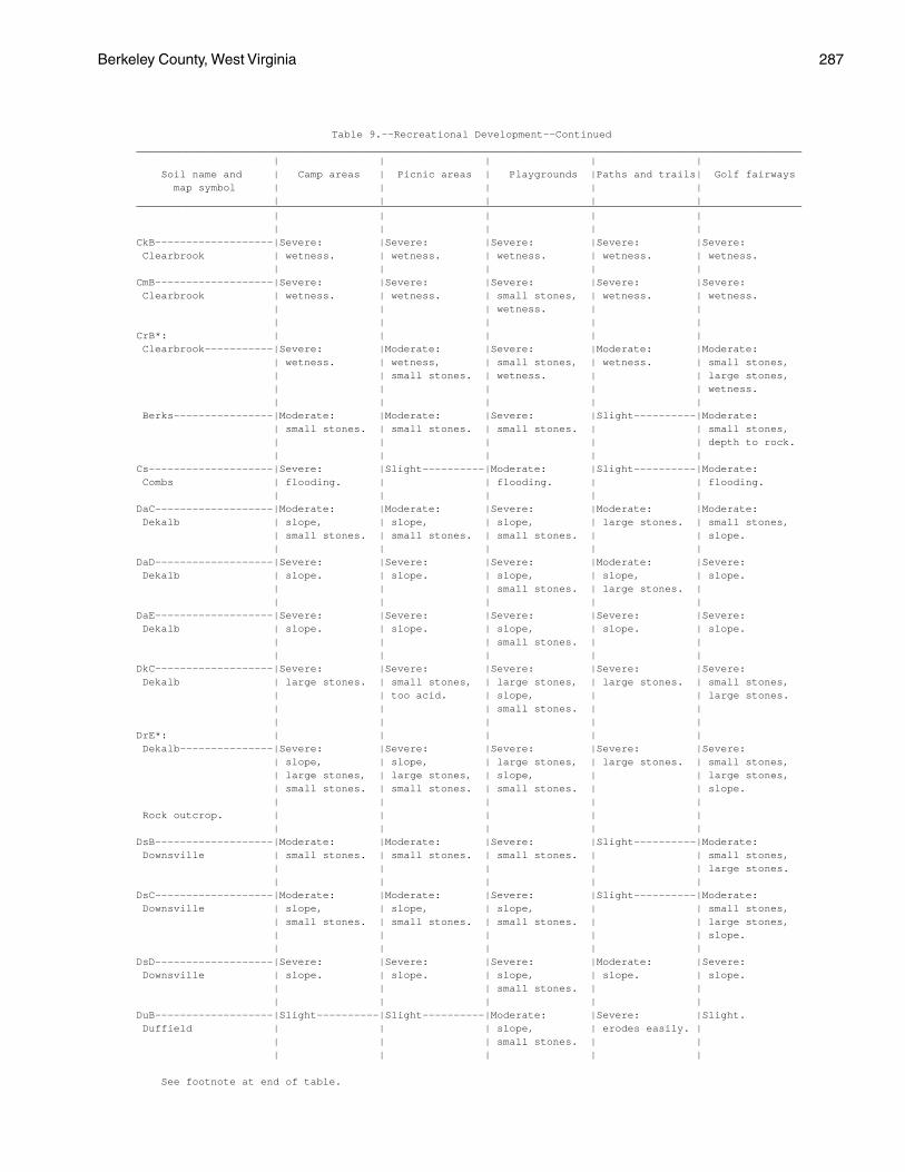
Berkeley County, West Virginia 287
Table 9.--Recreational Development--Continued___________________________________________________________________________________________________________ | | | | | Soil name and | Camp areas | Picnic areas | Playgrounds |Paths and trails| Golf fairways map symbol | | | | | | | | | |___________________________________________________________________________________________________________ | | | | | | | | | |CkB-------------------|Severe: |Severe: |Severe: |Severe: |Severe: Clearbrook | wetness. | wetness. | wetness. | wetness. | wetness. | | | | |CmB-------------------|Severe: |Severe: |Severe: |Severe: |Severe: Clearbrook | wetness. | wetness. | small stones, | wetness. | wetness. | | | wetness. | | | | | | |CrB*: | | | | | Clearbrook-----------|Severe: |Moderate: |Severe: |Moderate: |Moderate: | wetness. | wetness, | small stones, | wetness. | small stones, | | small stones. | wetness. | | large stones, | | | | | wetness. | | | | | Berks----------------|Moderate: |Moderate: |Severe: |Slight----------|Moderate: | small stones. | small stones. | small stones. | | small stones, | | | | | depth to rock. | | | | |Cs--------------------|Severe: |Slight----------|Moderate: |Slight----------|Moderate: Combs | flooding. | | flooding. | | flooding. | | | | |DaC-------------------|Moderate: |Moderate: |Severe: |Moderate: |Moderate: Dekalb | slope, | slope, | slope, | large stones. | small stones, | small stones. | small stones. | small stones. | | slope. | | | | |DaD-------------------|Severe: |Severe: |Severe: |Moderate: |Severe: Dekalb | slope. | slope. | slope, | slope, | slope. | | | small stones. | large stones. | | | | | |DaE-------------------|Severe: |Severe: |Severe: |Severe: |Severe: Dekalb | slope. | slope. | slope, | slope. | slope. | | | small stones. | | | | | | |DkC-------------------|Severe: |Severe: |Severe: |Severe: |Severe: Dekalb | large stones. | small stones, | large stones, | large stones. | small stones, | | too acid. | slope, | | large stones. | | | small stones. | | | | | | |DrE*: | | | | | Dekalb---------------|Severe: |Severe: |Severe: |Severe: |Severe: | slope, | slope, | large stones, | large stones. | small stones, | large stones, | large stones, | slope, | | large stones, | small stones. | small stones. | small stones. | | slope. | | | | | Rock outcrop. | | | | | | | | | |DsB-------------------|Moderate: |Moderate: |Severe: |Slight----------|Moderate: Downsville | small stones. | small stones. | small stones. | | small stones, | | | | | large stones. | | | | |DsC-------------------|Moderate: |Moderate: |Severe: |Slight----------|Moderate: Downsville | slope, | slope, | slope, | | small stones, | small stones. | small stones. | small stones. | | large stones, | | | | | slope. | | | | |DsD-------------------|Severe: |Severe: |Severe: |Moderate: |Severe: Downsville | slope. | slope. | slope, | slope. | slope. | | | small stones. | | | | | | |DuB-------------------|Slight----------|Slight----------|Moderate: |Severe: |Slight. Duffield | | | slope, | erodes easily. | | | | small stones. | | | | | | |
See footnote at end of table.
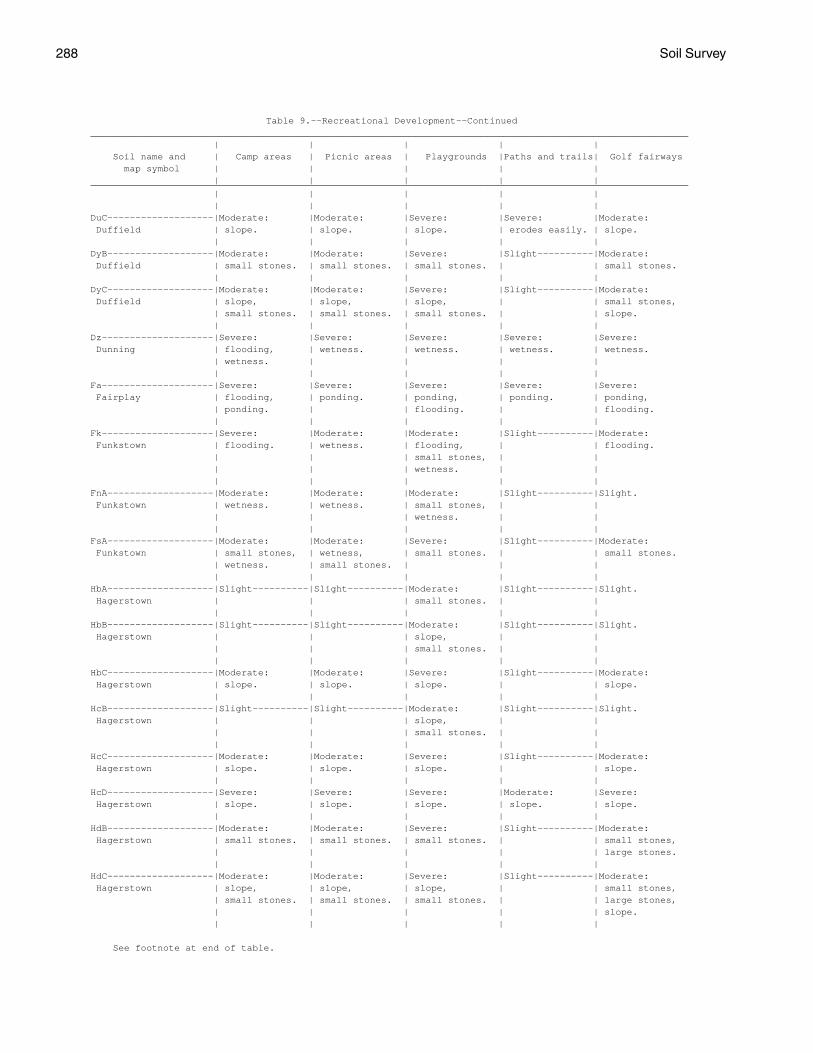
288 Soil Survey
Table 9.--Recreational Development--Continued___________________________________________________________________________________________________________ | | | | | Soil name and | Camp areas | Picnic areas | Playgrounds |Paths and trails| Golf fairways map symbol | | | | | | | | | |___________________________________________________________________________________________________________ | | | | | | | | | |DuC-------------------|Moderate: |Moderate: |Severe: |Severe: |Moderate: Duffield | slope. | slope. | slope. | erodes easily. | slope. | | | | |DyB-------------------|Moderate: |Moderate: |Severe: |Slight----------|Moderate: Duffield | small stones. | small stones. | small stones. | | small stones. | | | | |DyC-------------------|Moderate: |Moderate: |Severe: |Slight----------|Moderate: Duffield | slope, | slope, | slope, | | small stones, | small stones. | small stones. | small stones. | | slope. | | | | |Dz--------------------|Severe: |Severe: |Severe: |Severe: |Severe: Dunning | flooding, | wetness. | wetness. | wetness. | wetness. | wetness. | | | | | | | | |Fa--------------------|Severe: |Severe: |Severe: |Severe: |Severe: Fairplay | flooding, | ponding. | ponding, | ponding. | ponding, | ponding. | | flooding. | | flooding. | | | | |Fk--------------------|Severe: |Moderate: |Moderate: |Slight----------|Moderate: Funkstown | flooding. | wetness. | flooding, | | flooding. | | | small stones, | | | | | wetness. | | | | | | |FnA-------------------|Moderate: |Moderate: |Moderate: |Slight----------|Slight. Funkstown | wetness. | wetness. | small stones, | | | | | wetness. | | | | | | |FsA-------------------|Moderate: |Moderate: |Severe: |Slight----------|Moderate: Funkstown | small stones, | wetness, | small stones. | | small stones. | wetness. | small stones. | | | | | | | |HbA-------------------|Slight----------|Slight----------|Moderate: |Slight----------|Slight. Hagerstown | | | small stones. | | | | | | |HbB-------------------|Slight----------|Slight----------|Moderate: |Slight----------|Slight. Hagerstown | | | slope, | | | | | small stones. | | | | | | |HbC-------------------|Moderate: |Moderate: |Severe: |Slight----------|Moderate: Hagerstown | slope. | slope. | slope. | | slope. | | | | |HcB-------------------|Slight----------|Slight----------|Moderate: |Slight----------|Slight. Hagerstown | | | slope, | | | | | small stones. | | | | | | |HcC-------------------|Moderate: |Moderate: |Severe: |Slight----------|Moderate: Hagerstown | slope. | slope. | slope. | | slope. | | | | |HcD-------------------|Severe: |Severe: |Severe: |Moderate: |Severe: Hagerstown | slope. | slope. | slope. | slope. | slope. | | | | |HdB-------------------|Moderate: |Moderate: |Severe: |Slight----------|Moderate: Hagerstown | small stones. | small stones. | small stones. | | small stones, | | | | | large stones. | | | | |HdC-------------------|Moderate: |Moderate: |Severe: |Slight----------|Moderate: Hagerstown | slope, | slope, | slope, | | small stones, | small stones. | small stones. | small stones. | | large stones, | | | | | slope. | | | | |
See footnote at end of table.
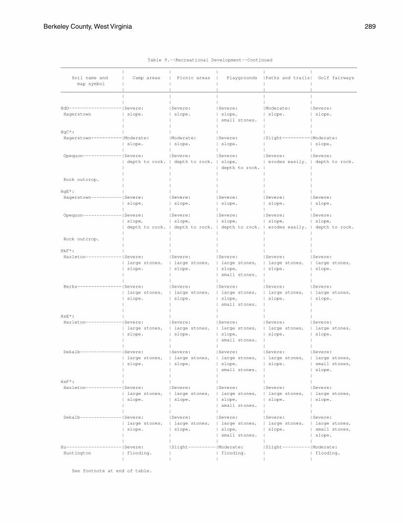
Berkeley County, West Virginia 289
Table 9.--Recreational Development--Continued___________________________________________________________________________________________________________ | | | | | Soil name and | Camp areas | Picnic areas | Playgrounds |Paths and trails| Golf fairways map symbol | | | | | | | | | |___________________________________________________________________________________________________________ | | | | | | | | | |HdD-------------------|Severe: |Severe: |Severe: |Moderate: |Severe: Hagerstown | slope. | slope. | slope, | slope. | slope. | | | small stones. | | | | | | |HgC*: | | | | | Hagerstown-----------|Moderate: |Moderate: |Severe: |Slight----------|Moderate: | slope. | slope. | slope. | | slope. | | | | | Opequon--------------|Severe: |Severe: |Severe: |Severe: |Severe: | depth to rock. | depth to rock. | slope, | erodes easily. | depth to rock. | | | depth to rock. | | | | | | | Rock outcrop. | | | | | | | | | |HgE*: | | | | | Hagerstown-----------|Severe: |Severe: |Severe: |Severe: |Severe: | slope. | slope. | slope. | slope. | slope. | | | | | Opequon--------------|Severe: |Severe: |Severe: |Severe: |Severe: | slope, | slope, | slope, | slope, | slope, | depth to rock. | depth to rock. | depth to rock. | erodes easily. | depth to rock. | | | | | Rock outcrop. | | | | | | | | | |HkF*: | | | | | Hazleton-------------|Severe: |Severe: |Severe: |Severe: |Severe: | large stones, | large stones, | large stones, | large stones, | large stones, | slope. | slope. | slope, | slope. | slope. | | | small stones. | | | | | | | Berks----------------|Severe: |Severe: |Severe: |Severe: |Severe: | large stones, | large stones, | large stones, | large stones, | large stones, | slope. | slope. | slope, | slope. | slope. | | | small stones. | | | | | | |HsE*: | | | | | Hazleton-------------|Severe: |Severe: |Severe: |Severe: |Severe: | large stones, | large stones, | large stones, | large stones, | large stones, | slope. | slope. | slope, | slope. | slope. | | | small stones. | | | | | | | Dekalb---------------|Severe: |Severe: |Severe: |Severe: |Severe: | large stones, | large stones, | large stones, | large stones, | large stones, | slope. | slope. | slope, | slope. | small stones, | | | small stones. | | slope. | | | | |HsF*: | | | | | Hazleton-------------|Severe: |Severe: |Severe: |Severe: |Severe: | large stones, | large stones, | large stones, | large stones, | large stones, | slope. | slope. | slope, | slope. | slope. | | | small stones. | | | | | | | Dekalb---------------|Severe: |Severe: |Severe: |Severe: |Severe: | large stones, | large stones, | large stones, | large stones, | large stones, | slope. | slope. | slope, | slope. | small stones, | | | small stones. | | slope. | | | | |Hu--------------------|Severe: |Slight----------|Moderate: |Slight----------|Moderate: Huntington | flooding. | | flooding. | | flooding. | | | | |
See footnote at end of table.
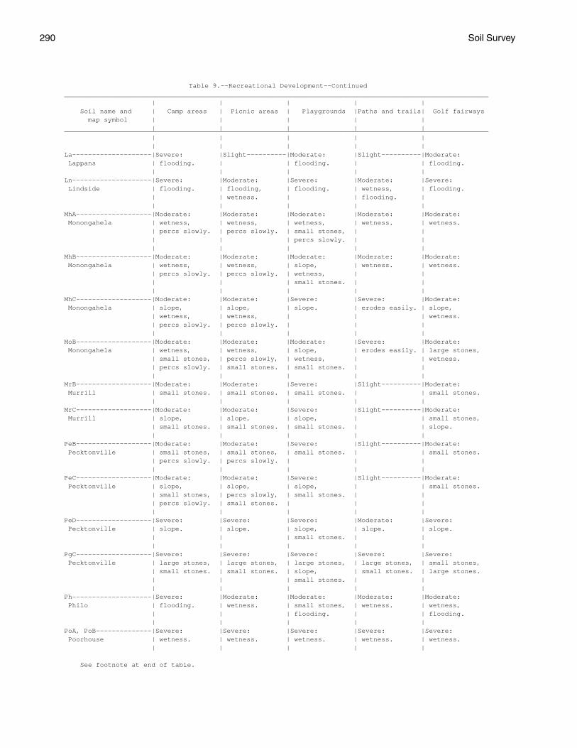
290 Soil Survey
Table 9.--Recreational Development--Continued___________________________________________________________________________________________________________ | | | | | Soil name and | Camp areas | Picnic areas | Playgrounds |Paths and trails| Golf fairways map symbol | | | | | | | | | |___________________________________________________________________________________________________________ | | | | | | | | | |La--------------------|Severe: |Slight----------|Moderate: |Slight----------|Moderate: Lappans | flooding. | | flooding. | | flooding. | | | | |Ln--------------------|Severe: |Moderate: |Severe: |Moderate: |Severe: Lindside | flooding. | flooding, | flooding. | wetness, | flooding. | | wetness. | | flooding. | | | | | |MhA-------------------|Moderate: |Moderate: |Moderate: |Moderate: |Moderate: Monongahela | wetness, | wetness, | wetness, | wetness. | wetness. | percs slowly. | percs slowly. | small stones, | | | | | percs slowly. | | | | | | |MhB-------------------|Moderate: |Moderate: |Moderate: |Moderate: |Moderate: Monongahela | wetness, | wetness, | slope, | wetness. | wetness. | percs slowly. | percs slowly. | wetness, | | | | | small stones. | | | | | | |MhC-------------------|Moderate: |Moderate: |Severe: |Severe: |Moderate: Monongahela | slope, | slope, | slope. | erodes easily. | slope, | wetness, | wetness, | | | wetness. | percs slowly. | percs slowly. | | | | | | | |MoB-------------------|Moderate: |Moderate: |Moderate: |Severe: |Moderate: Monongahela | wetness, | wetness, | slope, | erodes easily. | large stones, | small stones, | percs slowly, | wetness, | | wetness. | percs slowly. | small stones. | small stones. | | | | | | |MrB-------------------|Moderate: |Moderate: |Severe: |Slight----------|Moderate: Murrill | small stones. | small stones. | small stones. | | small stones. | | | | |MrC-------------------|Moderate: |Moderate: |Severe: |Slight----------|Moderate: Murrill | slope, | slope, | slope, | | small stones, | small stones. | small stones. | small stones. | | slope. | | | | |PeB-------------------|Moderate: |Moderate: |Severe: |Slight----------|Moderate: Pecktonville | small stones, | small stones, | small stones. | | small stones. | percs slowly. | percs slowly. | | | | | | | |PeC-------------------|Moderate: |Moderate: |Severe: |Slight----------|Moderate: Pecktonville | slope, | slope, | slope, | | small stones. | small stones, | percs slowly, | small stones. | | | percs slowly. | small stones. | | | | | | | |PeD-------------------|Severe: |Severe: |Severe: |Moderate: |Severe: Pecktonville | slope. | slope. | slope, | slope. | slope. | | | small stones. | | | | | | |PgC-------------------|Severe: |Severe: |Severe: |Severe: |Severe: Pecktonville | large stones, | large stones, | large stones, | large stones, | small stones, | small stones. | small stones. | slope, | small stones. | large stones. | | | small stones. | | | | | | |Ph--------------------|Severe: |Moderate: |Moderate: |Moderate: |Moderate: Philo | flooding. | wetness. | small stones, | wetness. | wetness, | | | flooding. | | flooding. | | | | |PoA, PoB--------------|Severe: |Severe: |Severe: |Severe: |Severe: Poorhouse | wetness. | wetness. | wetness. | wetness. | wetness. | | | | |
See footnote at end of table.
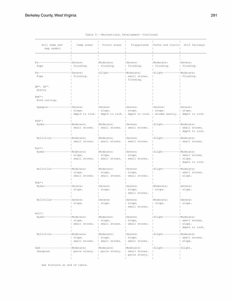
Berkeley County, West Virginia 291
Table 9.--Recreational Development--Continued___________________________________________________________________________________________________________ | | | | | Soil name and | Camp areas | Picnic areas | Playgrounds |Paths and trails| Golf fairways map symbol | | | | | | | | | |___________________________________________________________________________________________________________ | | | | | | | | | |Ps--------------------|Severe: |Moderate: |Severe: |Moderate: |Severe: Pope | flooding. | flooding. | flooding. | flooding. | flooding. | | | | |Px--------------------|Severe: |Slight----------|Moderate: |Slight----------|Moderate: Pope | flooding. | | small stones, | | flooding. | | | flooding. | | | | | | |Qm*, Qs*. | | | | | Quarry | | | | | | | | | |ReF*: | | | | | Rock outcrop. | | | | | | | | | | Opequon--------------|Severe: |Severe: |Severe: |Severe: |Severe: | slope, | slope, | slope, | slope, | slope, | depth to rock. | depth to rock. | depth to rock. | erodes easily. | depth to rock. | | | | |RnB*: | | | | | Ryder----------------|Moderate: |Moderate: |Severe: |Slight----------|Moderate: | small stones. | small stones. | small stones. | | small stones, | | | | | depth to rock. | | | | | Nollville------------|Moderate: |Moderate: |Severe: |Slight----------|Moderate: | small stones. | small stones. | small stones. | | small stones. | | | | |RnC*: | | | | | Ryder----------------|Moderate: |Moderate: |Severe: |Slight----------|Moderate: | slope, | slope, | slope, | | small stones, | small stones. | small stones. | small stones. | | slope, | | | | | depth to rock. | | | | | Nollville------------|Moderate: |Moderate: |Severe: |Slight----------|Moderate: | slope, | slope, | slope, | | small stones, | small stones. | small stones. | small stones. | | slope. | | | | |RnD*: | | | | | Ryder----------------|Severe: |Severe: |Severe: |Moderate: |Severe: | slope. | slope. | slope, | slope. | slope. | | | small stones. | | | | | | | Nollville------------|Severe: |Severe: |Severe: |Moderate: |Severe: | slope. | slope. | slope, | slope. | slope. | | | small stones. | | | | | | |RvC*: | | | | | Ryder----------------|Moderate: |Moderate: |Severe: |Slight----------|Moderate: | slope, | slope, | slope, | | small stones, | small stones. | small stones. | small stones. | | slope, | | | | | depth to rock. | | | | | Nollville------------|Moderate: |Moderate: |Severe: |Slight----------|Moderate: | slope, | slope, | slope, | | small stones, | small stones. | small stones. | small stones. | | slope. | | | | |SwA-------------------|Moderate: |Moderate: |Moderate: |Slight----------|Slight. Swanpond | percs slowly. | percs slowly. | small stones, | | | | | percs slowly. | | | | | | |
See footnote at end of table.
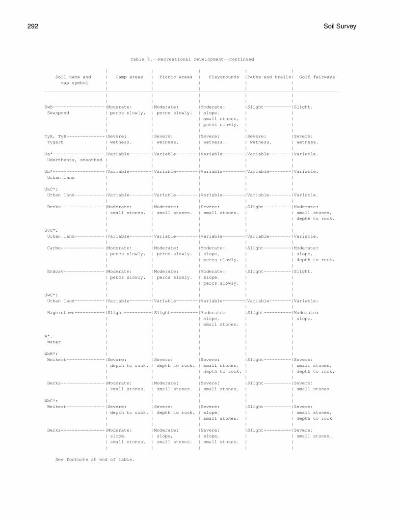
292 Soil Survey
Table 9.--Recreational Development--Continued___________________________________________________________________________________________________________ | | | | | Soil name and | Camp areas | Picnic areas | Playgrounds |Paths and trails| Golf fairways map symbol | | | | | | | | | |___________________________________________________________________________________________________________ | | | | | | | | | |SwB-------------------|Moderate: |Moderate: |Moderate: |Slight----------|Slight. Swanpond | percs slowly. | percs slowly. | slope, | | | | | small stones, | | | | | percs slowly. | | | | | | |TyA, TyB--------------|Severe: |Severe: |Severe: |Severe: |Severe: Tygart | wetness. | wetness. | wetness. | wetness. | wetness. | | | | |Ua*-------------------|Variable--------|Variable--------|Variable--------|Variable--------|Variable. Udorthents, smoothed | | | | | | | | | |Ub*-------------------|Variable--------|Variable--------|Variable--------|Variable--------|Variable. Urban land | | | | | | | | | |UkC*: | | | | | Urban land-----------|Variable--------|Variable--------|Variable--------|Variable--------|Variable. | | | | | Berks----------------|Moderate: |Moderate: |Severe: |Slight----------|Moderate: | small stones. | small stones. | small stones. | | small stones, | | | | | depth to rock. | | | | |UvC*: | | | | | Urban land-----------|Variable--------|Variable--------|Variable--------|Variable--------|Variable. | | | | | Carbo----------------|Moderate: |Moderate: |Moderate: |Slight----------|Moderate: | percs slowly. | percs slowly. | slope, | | slope, | | | percs slowly. | | depth to rock. | | | | | Endcav---------------|Moderate: |Moderate: |Moderate: |Slight----------|Slight. | percs slowly. | percs slowly. | slope, | | | | | percs slowly. | | | | | | |UwC*: | | | | | Urban land-----------|Variable--------|Variable--------|Variable--------|Variable--------|Variable. | | | | | Hagerstown-----------|Slight----------|Slight----------|Moderate: |Slight----------|Moderate: | | | slope, | | slope. | | | small stones. | | | | | | |W*. | | | | | Water | | | | | | | | | |WbB*: | | | | | Weikert--------------|Severe: |Severe: |Severe: |Slight----------|Severe: | depth to rock. | depth to rock. | small stones, | | small stones, | | | depth to rock. | | depth to rock. | | | | | Berks----------------|Moderate: |Moderate: |Severe: |Slight----------|Severe: | small stones. | small stones. | small stones. | | small stones. | | | | |WbC*: | | | | | Weikert--------------|Severe: |Severe: |Severe: |Slight----------|Severe: | depth to rock. | depth to rock. | slope, | | small stones, | | | small stones. | | depth to rock | | | | | Berks----------------|Moderate: |Moderate: |Severe: |Slight----------|Severe: | slope, | slope, | slope, | | small stones. | small stones. | small stones. | small stones. | | | | | | |
See footnote at end of table.
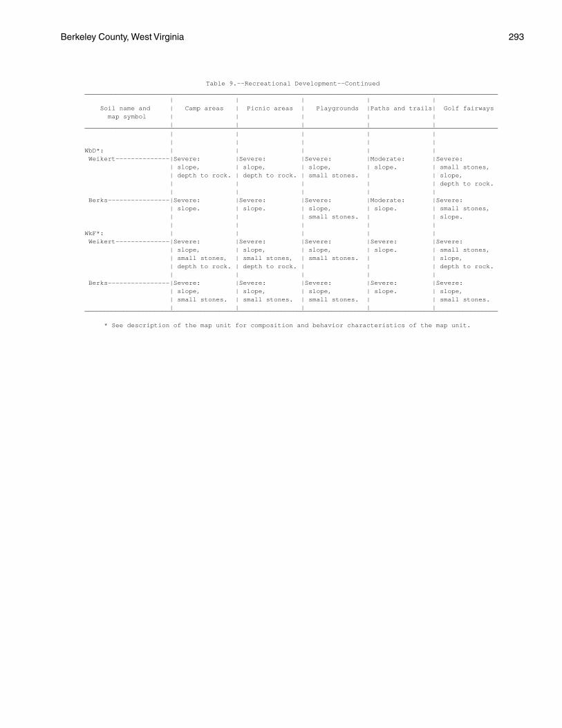
Berkeley County, West Virginia 293
Table 9.--Recreational Development--Continued___________________________________________________________________________________________________________ | | | | | Soil name and | Camp areas | Picnic areas | Playgrounds |Paths and trails| Golf fairways map symbol | | | | | | | | | |___________________________________________________________________________________________________________ | | | | | | | | | |WbD*: | | | | | Weikert--------------|Severe: |Severe: |Severe: |Moderate: |Severe: | slope, | slope, | slope, | slope. | small stones, | depth to rock. | depth to rock. | small stones. | | slope, | | | | | depth to rock. | | | | | Berks----------------|Severe: |Severe: |Severe: |Moderate: |Severe: | slope. | slope. | slope, | slope. | small stones, | | | small stones. | | slope. | | | | |WkF*: | | | | | Weikert--------------|Severe: |Severe: |Severe: |Severe: |Severe: | slope, | slope, | slope, | slope. | small stones, | small stones, | small stones, | small stones. | | slope, | depth to rock. | depth to rock. | | | depth to rock. | | | | | Berks----------------|Severe: |Severe: |Severe: |Severe: |Severe: | slope, | slope, | slope, | slope. | slope, | small stones. | small stones. | small stones. | | small stones. | | | | |___________________________________________________________________________________________________________
* See description of the map unit for composition and behavior characteristics of the map unit.
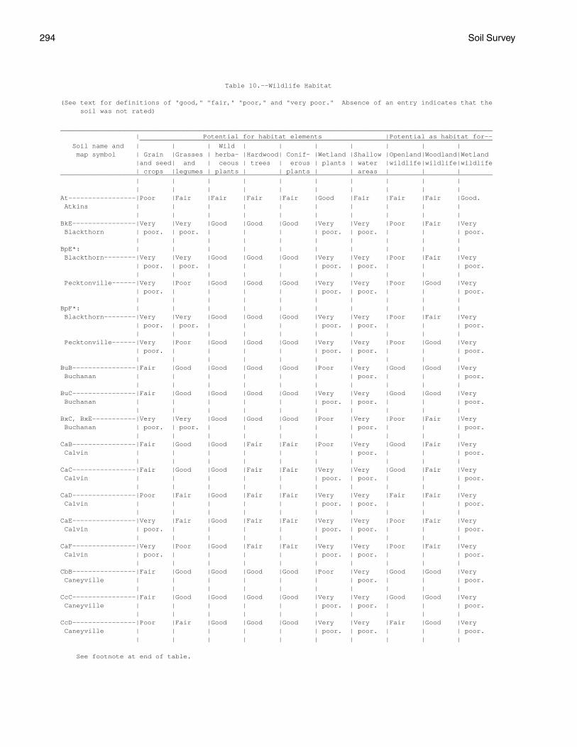
294 Soil Survey
Table 10.--Wildlife Habitat
(See text for definitions of "good," "fair," "poor," and "very poor." Absence of an entry indicates that the soil was not rated)
_____________________________________________________________________________________________________________ | Potential for habitat elements |Potential as habitat for-- _________________________________________________________________________________________ Soil name and | | | Wild | | | | | | | map symbol | Grain |Grasses | herba- |Hardwood| Conif- |Wetland |Shallow |Openland|Woodland|Wetland |and seed| and | ceous | trees | erous | plants | water |wildlife|wildlife|wildlife | crops |legumes | plants | | plants | | areas | | |_____________________________________________________________________________________________________________ | | | | | | | | | | | | | | | | | | | |At-----------------|Poor |Fair |Fair |Fair |Fair |Good |Fair |Fair |Fair |Good. Atkins | | | | | | | | | | | | | | | | | | | |BkE----------------|Very |Very |Good |Good |Good |Very |Very |Poor |Fair |Very Blackthorn | poor. | poor. | | | | poor. | poor. | | | poor. | | | | | | | | | |BpE*: | | | | | | | | | | Blackthorn--------|Very |Very |Good |Good |Good |Very |Very |Poor |Fair |Very | poor. | poor. | | | | poor. | poor. | | | poor. | | | | | | | | | | Pecktonville------|Very |Poor |Good |Good |Good |Very |Very |Poor |Good |Very | poor. | | | | | poor. | poor. | | | poor. | | | | | | | | | |BpF*: | | | | | | | | | | Blackthorn--------|Very |Very |Good |Good |Good |Very |Very |Poor |Fair |Very | poor. | poor. | | | | poor. | poor. | | | poor. | | | | | | | | | | Pecktonville------|Very |Poor |Good |Good |Good |Very |Very |Poor |Good |Very | poor. | | | | | poor. | poor. | | | poor. | | | | | | | | | |BuB----------------|Fair |Good |Good |Good |Good |Poor |Very |Good |Good |Very Buchanan | | | | | | | poor. | | | poor. | | | | | | | | | |BuC----------------|Fair |Good |Good |Good |Good |Very |Very |Good |Good |Very Buchanan | | | | | | poor. | poor. | | | poor. | | | | | | | | | |BxC, BxE-----------|Very |Very |Good |Good |Good |Poor |Very |Poor |Fair |Very Buchanan | poor. | poor. | | | | | poor. | | | poor. | | | | | | | | | |CaB----------------|Fair |Good |Good |Fair |Fair |Poor |Very |Good |Fair |Very Calvin | | | | | | | poor. | | | poor. | | | | | | | | | |CaC----------------|Fair |Good |Good |Fair |Fair |Very |Very |Good |Fair |Very Calvin | | | | | | poor. | poor. | | | poor. | | | | | | | | | |CaD----------------|Poor |Fair |Good |Fair |Fair |Very |Very |Fair |Fair |Very Calvin | | | | | | poor. | poor. | | | poor. | | | | | | | | | |CaE----------------|Very |Fair |Good |Fair |Fair |Very |Very |Poor |Fair |Very Calvin | poor. | | | | | poor. | poor. | | | poor. | | | | | | | | | |CaF----------------|Very |Poor |Good |Fair |Fair |Very |Very |Poor |Fair |Very Calvin | poor. | | | | | poor. | poor. | | | poor. | | | | | | | | | |CbB----------------|Fair |Good |Good |Good |Good |Poor |Very |Good |Good |Very Caneyville | | | | | | | poor. | | | poor. | | | | | | | | | |CcC----------------|Fair |Good |Good |Good |Good |Very |Very |Good |Good |Very Caneyville | | | | | | poor. | poor. | | | poor. | | | | | | | | | |CcD----------------|Poor |Fair |Good |Good |Good |Very |Very |Fair |Good |Very Caneyville | | | | | | poor. | poor. | | | poor. | | | | | | | | | |
See footnote at end of table.
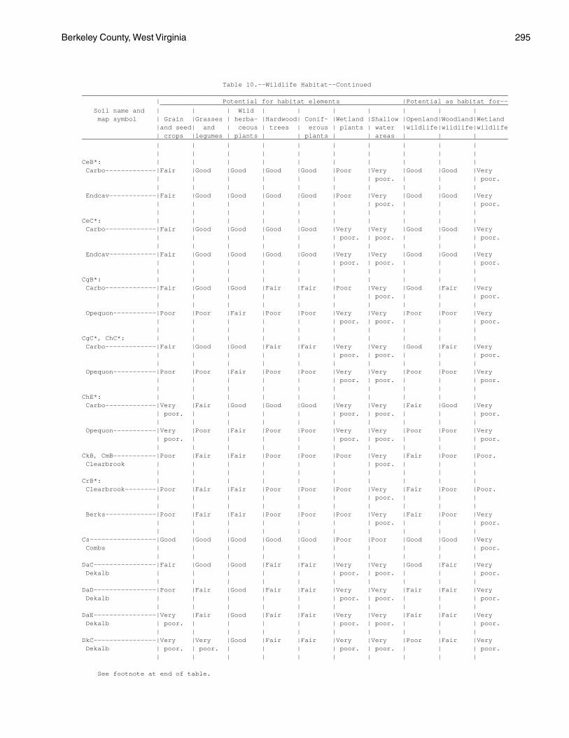
Berkeley County, West Virginia 295
Table 10.--Wildlife Habitat--Continued_____________________________________________________________________________________________________________ | Potential for habitat elements |Potential as habitat for-- _________________________________________________________________________________________ Soil name and | | | Wild | | | | | | | map symbol | Grain |Grasses | herba- |Hardwood| Conif- |Wetland |Shallow |Openland|Woodland|Wetland |and seed| and | ceous | trees | erous | plants | water |wildlife|wildlife|wildlife | crops |legumes | plants | | plants | | areas | | |_____________________________________________________________________________________________________________ | | | | | | | | | | | | | | | | | | | |CeB*: | | | | | | | | | | Carbo-------------|Fair |Good |Good |Good |Good |Poor |Very |Good |Good |Very | | | | | | | poor. | | | poor. | | | | | | | | | | Endcav------------|Fair |Good |Good |Good |Good |Poor |Very |Good |Good |Very | | | | | | | poor. | | | poor. | | | | | | | | | |CeC*: | | | | | | | | | | Carbo-------------|Fair |Good |Good |Good |Good |Very |Very |Good |Good |Very | | | | | | poor. | poor. | | | poor. | | | | | | | | | | Endcav------------|Fair |Good |Good |Good |Good |Very |Very |Good |Good |Very | | | | | | poor. | poor. | | | poor. | | | | | | | | | |CgB*: | | | | | | | | | | Carbo-------------|Fair |Good |Good |Fair |Fair |Poor |Very |Good |Fair |Very | | | | | | | poor. | | | poor. | | | | | | | | | | Opequon-----------|Poor |Poor |Fair |Poor |Poor |Very |Very |Poor |Poor |Very | | | | | | poor. | poor. | | | poor. | | | | | | | | | |CgC*, ChC*: | | | | | | | | | | Carbo-------------|Fair |Good |Good |Fair |Fair |Very |Very |Good |Fair |Very | | | | | | poor. | poor. | | | poor. | | | | | | | | | | Opequon-----------|Poor |Poor |Fair |Poor |Poor |Very |Very |Poor |Poor |Very | | | | | | poor. | poor. | | | poor. | | | | | | | | | |ChE*: | | | | | | | | | | Carbo-------------|Very |Fair |Good |Good |Good |Very |Very |Fair |Good |Very | poor. | | | | | poor. | poor. | | | poor. | | | | | | | | | | Opequon-----------|Very |Poor |Fair |Poor |Poor |Very |Very |Poor |Poor |Very | poor. | | | | | poor. | poor. | | | poor. | | | | | | | | | |CkB, CmB-----------|Poor |Fair |Fair |Poor |Poor |Poor |Very |Fair |Poor |Poor. Clearbrook | | | | | | | poor. | | | | | | | | | | | | |CrB*: | | | | | | | | | | Clearbrook--------|Poor |Fair |Fair |Poor |Poor |Poor |Very |Fair |Poor |Poor. | | | | | | | poor. | | | | | | | | | | | | | Berks-------------|Poor |Fair |Fair |Poor |Poor |Poor |Very |Fair |Poor |Very | | | | | | | poor. | | | poor. | | | | | | | | | |Cs-----------------|Good |Good |Good |Good |Good |Poor |Poor |Good |Good |Very Combs | | | | | | | | | | poor. | | | | | | | | | |DaC----------------|Fair |Good |Good |Fair |Fair |Very |Very |Good |Fair |Very Dekalb | | | | | | poor. | poor. | | | poor. | | | | | | | | | |DaD----------------|Poor |Fair |Good |Fair |Fair |Very |Very |Fair |Fair |Very Dekalb | | | | | | poor. | poor. | | | poor. | | | | | | | | | |DaE----------------|Very |Fair |Good |Fair |Fair |Very |Very |Fair |Fair |Very Dekalb | poor. | | | | | poor. | poor. | | | poor. | | | | | | | | | |DkC----------------|Very |Very |Good |Fair |Fair |Very |Very |Poor |Fair |Very Dekalb | poor. | poor. | | | | poor. | poor. | | | poor. | | | | | | | | | |
See footnote at end of table.
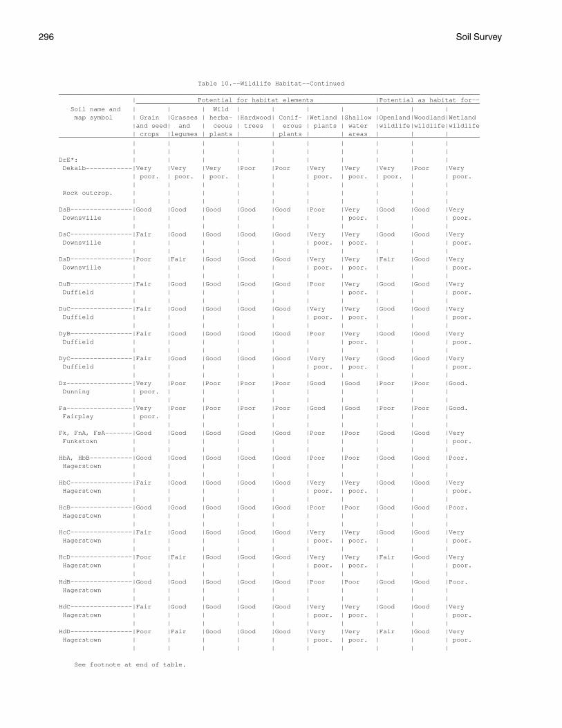
296 Soil Survey
Table 10.--Wildlife Habitat--Continued_____________________________________________________________________________________________________________ | Potential for habitat elements |Potential as habitat for-- _________________________________________________________________________________________ Soil name and | | | Wild | | | | | | | map symbol | Grain |Grasses | herba- |Hardwood| Conif- |Wetland |Shallow |Openland|Woodland|Wetland |and seed| and | ceous | trees | erous | plants | water |wildlife|wildlife|wildlife | crops |legumes | plants | | plants | | areas | | |_____________________________________________________________________________________________________________ | | | | | | | | | | | | | | | | | | | |DrE*: | | | | | | | | | | Dekalb------------|Very |Very |Very |Poor |Poor |Very |Very |Very |Poor |Very | poor. | poor. | poor. | | | poor. | poor. | poor. | | poor. | | | | | | | | | | Rock outcrop. | | | | | | | | | | | | | | | | | | | |DsB----------------|Good |Good |Good |Good |Good |Poor |Very |Good |Good |Very Downsville | | | | | | | poor. | | | poor. | | | | | | | | | |DsC----------------|Fair |Good |Good |Good |Good |Very |Very |Good |Good |Very Downsville | | | | | | poor. | poor. | | | poor. | | | | | | | | | |DsD----------------|Poor |Fair |Good |Good |Good |Very |Very |Fair |Good |Very Downsville | | | | | | poor. | poor. | | | poor. | | | | | | | | | |DuB----------------|Fair |Good |Good |Good |Good |Poor |Very |Good |Good |Very Duffield | | | | | | | poor. | | | poor. | | | | | | | | | |DuC----------------|Fair |Good |Good |Good |Good |Very |Very |Good |Good |Very Duffield | | | | | | poor. | poor. | | | poor. | | | | | | | | | |DyB----------------|Fair |Good |Good |Good |Good |Poor |Very |Good |Good |Very Duffield | | | | | | | poor. | | | poor. | | | | | | | | | |DyC----------------|Fair |Good |Good |Good |Good |Very |Very |Good |Good |Very Duffield | | | | | | poor. | poor. | | | poor. | | | | | | | | | |Dz-----------------|Very |Poor |Poor |Poor |Poor |Good |Good |Poor |Poor |Good. Dunning | poor. | | | | | | | | | | | | | | | | | | |Fa-----------------|Very |Poor |Poor |Poor |Poor |Good |Good |Poor |Poor |Good. Fairplay | poor. | | | | | | | | | | | | | | | | | | |Fk, FnA, FsA-------|Good |Good |Good |Good |Good |Poor |Poor |Good |Good |Very Funkstown | | | | | | | | | | poor. | | | | | | | | | |HbA, HbB-----------|Good |Good |Good |Good |Good |Poor |Poor |Good |Good |Poor. Hagerstown | | | | | | | | | | | | | | | | | | | |HbC----------------|Fair |Good |Good |Good |Good |Very |Very |Good |Good |Very Hagerstown | | | | | | poor. | poor. | | | poor. | | | | | | | | | |HcB----------------|Good |Good |Good |Good |Good |Poor |Poor |Good |Good |Poor. Hagerstown | | | | | | | | | | | | | | | | | | | |HcC----------------|Fair |Good |Good |Good |Good |Very |Very |Good |Good |Very Hagerstown | | | | | | poor. | poor. | | | poor. | | | | | | | | | |HcD----------------|Poor |Fair |Good |Good |Good |Very |Very |Fair |Good |Very Hagerstown | | | | | | poor. | poor. | | | poor. | | | | | | | | | |HdB----------------|Good |Good |Good |Good |Good |Poor |Poor |Good |Good |Poor. Hagerstown | | | | | | | | | | | | | | | | | | | |HdC----------------|Fair |Good |Good |Good |Good |Very |Very |Good |Good |Very Hagerstown | | | | | | poor. | poor. | | | poor. | | | | | | | | | |HdD----------------|Poor |Fair |Good |Good |Good |Very |Very |Fair |Good |Very Hagerstown | | | | | | poor. | poor. | | | poor. | | | | | | | | | |
See footnote at end of table.
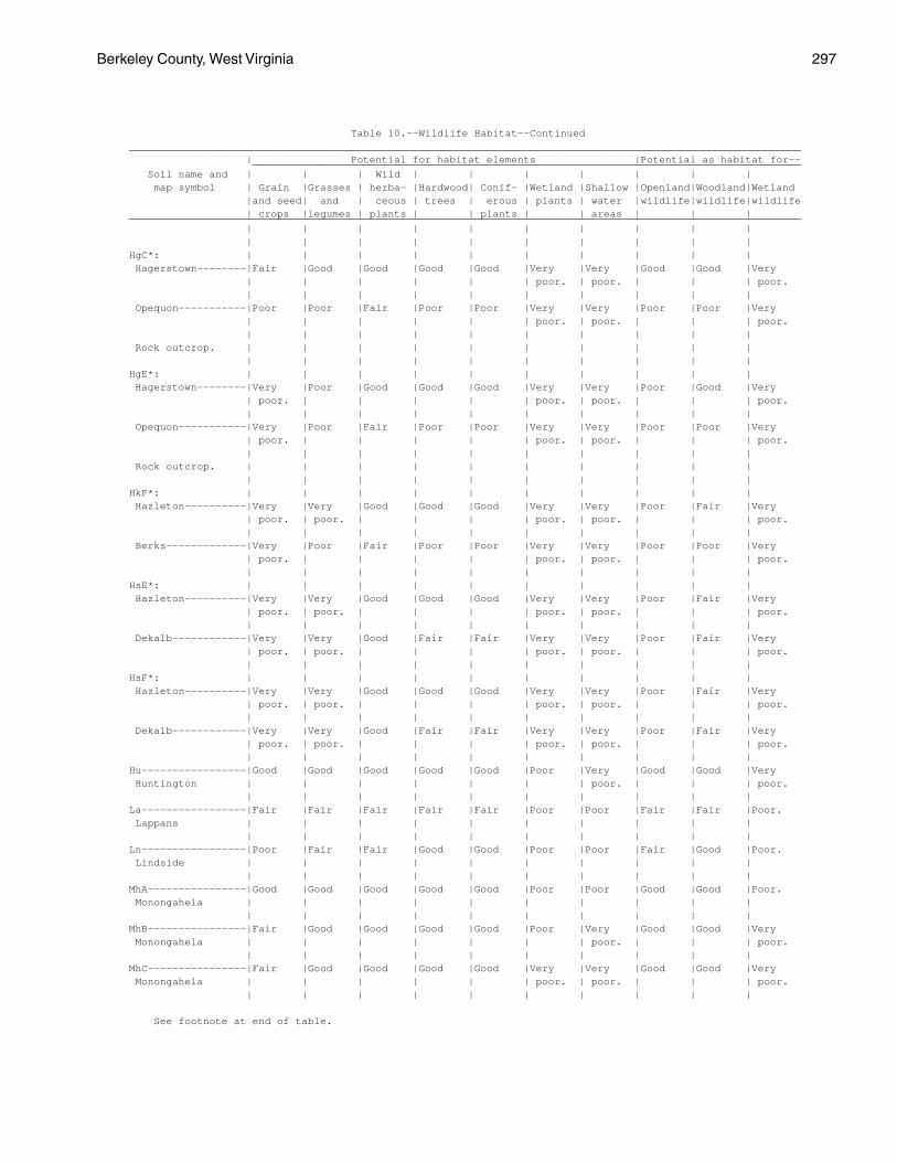
Berkeley County, West Virginia 297
Table 10.--Wildlife Habitat--Continued_____________________________________________________________________________________________________________ | Potential for habitat elements |Potential as habitat for-- _________________________________________________________________________________________ Soil name and | | | Wild | | | | | | | map symbol | Grain |Grasses | herba- |Hardwood| Conif- |Wetland |Shallow |Openland|Woodland|Wetland |and seed| and | ceous | trees | erous | plants | water |wildlife|wildlife|wildlife | crops |legumes | plants | | plants | | areas | | |_____________________________________________________________________________________________________________ | | | | | | | | | | | | | | | | | | | |HgC*: | | | | | | | | | | Hagerstown--------|Fair |Good |Good |Good |Good |Very |Very |Good |Good |Very | | | | | | poor. | poor. | | | poor. | | | | | | | | | | Opequon-----------|Poor |Poor |Fair |Poor |Poor |Very |Very |Poor |Poor |Very | | | | | | poor. | poor. | | | poor. | | | | | | | | | | Rock outcrop. | | | | | | | | | | | | | | | | | | | |HgE*: | | | | | | | | | | Hagerstown--------|Very |Poor |Good |Good |Good |Very |Very |Poor |Good |Very | poor. | | | | | poor. | poor. | | | poor. | | | | | | | | | | Opequon-----------|Very |Poor |Fair |Poor |Poor |Very |Very |Poor |Poor |Very | poor. | | | | | poor. | poor. | | | poor. | | | | | | | | | | Rock outcrop. | | | | | | | | | | | | | | | | | | | |HkF*: | | | | | | | | | | Hazleton----------|Very |Very |Good |Good |Good |Very |Very |Poor |Fair |Very | poor. | poor. | | | | poor. | poor. | | | poor. | | | | | | | | | | Berks-------------|Very |Poor |Fair |Poor |Poor |Very |Very |Poor |Poor |Very | poor. | | | | | poor. | poor. | | | poor. | | | | | | | | | |HsE*: | | | | | | | | | | Hazleton----------|Very |Very |Good |Good |Good |Very |Very |Poor |Fair |Very | poor. | poor. | | | | poor. | poor. | | | poor. | | | | | | | | | | Dekalb------------|Very |Very |Good |Fair |Fair |Very |Very |Poor |Fair |Very | poor. | poor. | | | | poor. | poor. | | | poor. | | | | | | | | | |HsF*: | | | | | | | | | | Hazleton----------|Very |Very |Good |Good |Good |Very |Very |Poor |Fair |Very | poor. | poor. | | | | poor. | poor. | | | poor. | | | | | | | | | | Dekalb------------|Very |Very |Good |Fair |Fair |Very |Very |Poor |Fair |Very | poor. | poor. | | | | poor. | poor. | | | poor. | | | | | | | | | |Hu-----------------|Good |Good |Good |Good |Good |Poor |Very |Good |Good |Very Huntington | | | | | | | poor. | | | poor. | | | | | | | | | |La-----------------|Fair |Fair |Fair |Fair |Fair |Poor |Poor |Fair |Fair |Poor. Lappans | | | | | | | | | | | | | | | | | | | |Ln-----------------|Poor |Fair |Fair |Good |Good |Poor |Poor |Fair |Good |Poor. Lindside | | | | | | | | | | | | | | | | | | | |MhA----------------|Good |Good |Good |Good |Good |Poor |Poor |Good |Good |Poor. Monongahela | | | | | | | | | | | | | | | | | | | |MhB----------------|Fair |Good |Good |Good |Good |Poor |Very |Good |Good |Very Monongahela | | | | | | | poor. | | | poor. | | | | | | | | | |MhC----------------|Fair |Good |Good |Good |Good |Very |Very |Good |Good |Very Monongahela | | | | | | poor. | poor. | | | poor. | | | | | | | | | |
See footnote at end of table.
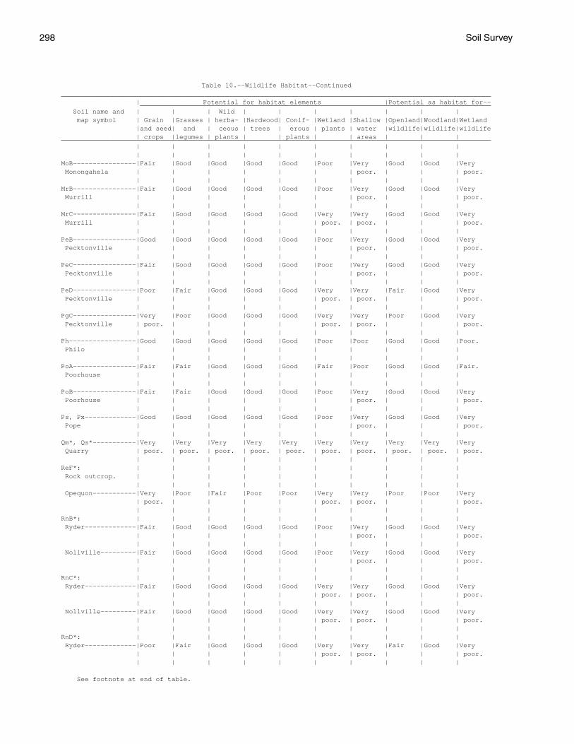
298 Soil Survey
Table 10.--Wildlife Habitat--Continued_____________________________________________________________________________________________________________ | Potential for habitat elements |Potential as habitat for-- _________________________________________________________________________________________ Soil name and | | | Wild | | | | | | | map symbol | Grain |Grasses | herba- |Hardwood| Conif- |Wetland |Shallow |Openland|Woodland|Wetland |and seed| and | ceous | trees | erous | plants | water |wildlife|wildlife|wildlife | crops |legumes | plants | | plants | | areas | | |_____________________________________________________________________________________________________________ | | | | | | | | | | | | | | | | | | | |MoB----------------|Fair |Good |Good |Good |Good |Poor |Very |Good |Good |Very Monongahela | | | | | | | poor. | | | poor. | | | | | | | | | |MrB----------------|Fair |Good |Good |Good |Good |Poor |Very |Good |Good |Very Murrill | | | | | | | poor. | | | poor. | | | | | | | | | |MrC----------------|Fair |Good |Good |Good |Good |Very |Very |Good |Good |Very Murrill | | | | | | poor. | poor. | | | poor. | | | | | | | | | |PeB----------------|Good |Good |Good |Good |Good |Poor |Very |Good |Good |Very Pecktonville | | | | | | | poor. | | | poor. | | | | | | | | | |PeC----------------|Fair |Good |Good |Good |Good |Poor |Very |Good |Good |Very Pecktonville | | | | | | | poor. | | | poor. | | | | | | | | | |PeD----------------|Poor |Fair |Good |Good |Good |Very |Very |Fair |Good |Very Pecktonville | | | | | | poor. | poor. | | | poor. | | | | | | | | | |PgC----------------|Very |Poor |Good |Good |Good |Very |Very |Poor |Good |Very Pecktonville | poor. | | | | | poor. | poor. | | | poor. | | | | | | | | | |Ph-----------------|Good |Good |Good |Good |Good |Poor |Poor |Good |Good |Poor. Philo | | | | | | | | | | | | | | | | | | | |PoA----------------|Fair |Fair |Good |Good |Good |Fair |Poor |Good |Good |Fair. Poorhouse | | | | | | | | | | | | | | | | | | | |PoB----------------|Fair |Fair |Good |Good |Good |Poor |Very |Good |Good |Very Poorhouse | | | | | | | poor. | | | poor. | | | | | | | | | |Ps, Px-------------|Good |Good |Good |Good |Good |Poor |Very |Good |Good |Very Pope | | | | | | | poor. | | | poor. | | | | | | | | | |Qm*, Qs*-----------|Very |Very |Very |Very |Very |Very |Very |Very |Very |Very Quarry | poor. | poor. | poor. | poor. | poor. | poor. | poor. | poor. | poor. | poor. | | | | | | | | | |ReF*: | | | | | | | | | | Rock outcrop. | | | | | | | | | | | | | | | | | | | | Opequon-----------|Very |Poor |Fair |Poor |Poor |Very |Very |Poor |Poor |Very | poor. | | | | | poor. | poor. | | | poor. | | | | | | | | | |RnB*: | | | | | | | | | | Ryder-------------|Fair |Good |Good |Good |Good |Poor |Very |Good |Good |Very | | | | | | | poor. | | | poor. | | | | | | | | | | Nollville---------|Fair |Good |Good |Good |Good |Poor |Very |Good |Good |Very | | | | | | | poor. | | | poor. | | | | | | | | | |RnC*: | | | | | | | | | | Ryder-------------|Fair |Good |Good |Good |Good |Very |Very |Good |Good |Very | | | | | | poor. | poor. | | | poor. | | | | | | | | | | Nollville---------|Fair |Good |Good |Good |Good |Very |Very |Good |Good |Very | | | | | | poor. | poor. | | | poor. | | | | | | | | | |RnD*: | | | | | | | | | | Ryder-------------|Poor |Fair |Good |Good |Good |Very |Very |Fair |Good |Very | | | | | | poor. | poor. | | | poor. | | | | | | | | | |
See footnote at end of table.
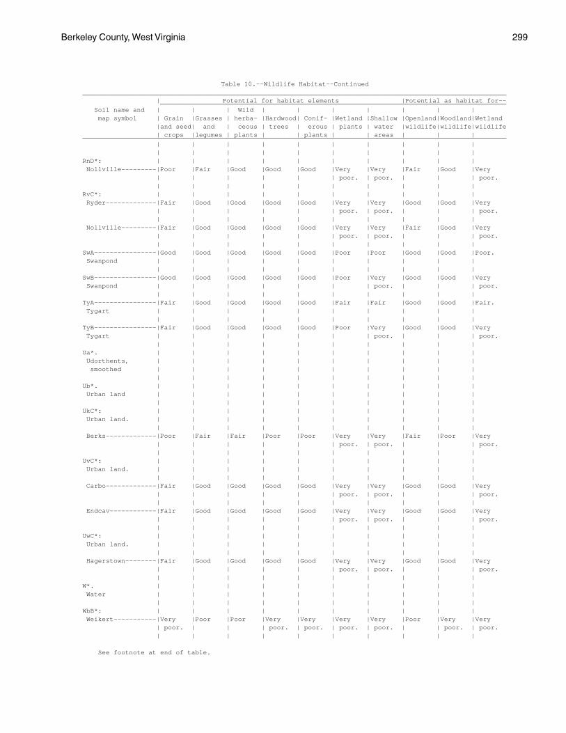
Berkeley County, West Virginia 299
Table 10.--Wildlife Habitat--Continued_____________________________________________________________________________________________________________ | Potential for habitat elements |Potential as habitat for-- _________________________________________________________________________________________ Soil name and | | | Wild | | | | | | | map symbol | Grain |Grasses | herba- |Hardwood| Conif- |Wetland |Shallow |Openland|Woodland|Wetland |and seed| and | ceous | trees | erous | plants | water |wildlife|wildlife|wildlife | crops |legumes | plants | | plants | | areas | | |_____________________________________________________________________________________________________________ | | | | | | | | | | | | | | | | | | | |RnD*: | | | | | | | | | | Nollville---------|Poor |Fair |Good |Good |Good |Very |Very |Fair |Good |Very | | | | | | poor. | poor. | | | poor. | | | | | | | | | |RvC*: | | | | | | | | | | Ryder-------------|Fair |Good |Good |Good |Good |Very |Very |Good |Good |Very | | | | | | poor. | poor. | | | poor. | | | | | | | | | | Nollville---------|Fair |Good |Good |Good |Good |Very |Very |Fair |Good |Very | | | | | | poor. | poor. | | | poor. | | | | | | | | | |SwA----------------|Good |Good |Good |Good |Good |Poor |Poor |Good |Good |Poor. Swanpond | | | | | | | | | | | | | | | | | | | |SwB----------------|Good |Good |Good |Good |Good |Poor |Very |Good |Good |Very Swanpond | | | | | | | poor. | | | poor. | | | | | | | | | |TyA----------------|Fair |Good |Good |Good |Good |Fair |Fair |Good |Good |Fair. Tygart | | | | | | | | | | | | | | | | | | | |TyB----------------|Fair |Good |Good |Good |Good |Poor |Very |Good |Good |Very Tygart | | | | | | | poor. | | | poor. | | | | | | | | | |Ua*. | | | | | | | | | | Udorthents, | | | | | | | | | | smoothed | | | | | | | | | | | | | | | | | | | |Ub*. | | | | | | | | | | Urban land | | | | | | | | | | | | | | | | | | | |UkC*: | | | | | | | | | | Urban land. | | | | | | | | | | | | | | | | | | | | Berks-------------|Poor |Fair |Fair |Poor |Poor |Very |Very |Fair |Poor |Very | | | | | | poor. | poor. | | | poor. | | | | | | | | | |UvC*: | | | | | | | | | | Urban land. | | | | | | | | | | | | | | | | | | | | Carbo-------------|Fair |Good |Good |Good |Good |Very |Very |Good |Good |Very | | | | | | poor. | poor. | | | poor. | | | | | | | | | | Endcav------------|Fair |Good |Good |Good |Good |Very |Very |Good |Good |Very | | | | | | poor. | poor. | | | poor. | | | | | | | | | |UwC*: | | | | | | | | | | Urban land. | | | | | | | | | | | | | | | | | | | | Hagerstown--------|Fair |Good |Good |Good |Good |Very |Very |Good |Good |Very | | | | | | poor. | poor. | | | poor. | | | | | | | | | |W*. | | | | | | | | | | Water | | | | | | | | | | | | | | | | | | | |WbB*: | | | | | | | | | | Weikert-----------|Very |Poor |Poor |Very |Very |Very |Very |Poor |Very |Very | poor. | | | poor. | poor. | poor. | poor. | | poor. | poor. | | | | | | | | | |
See footnote at end of table.
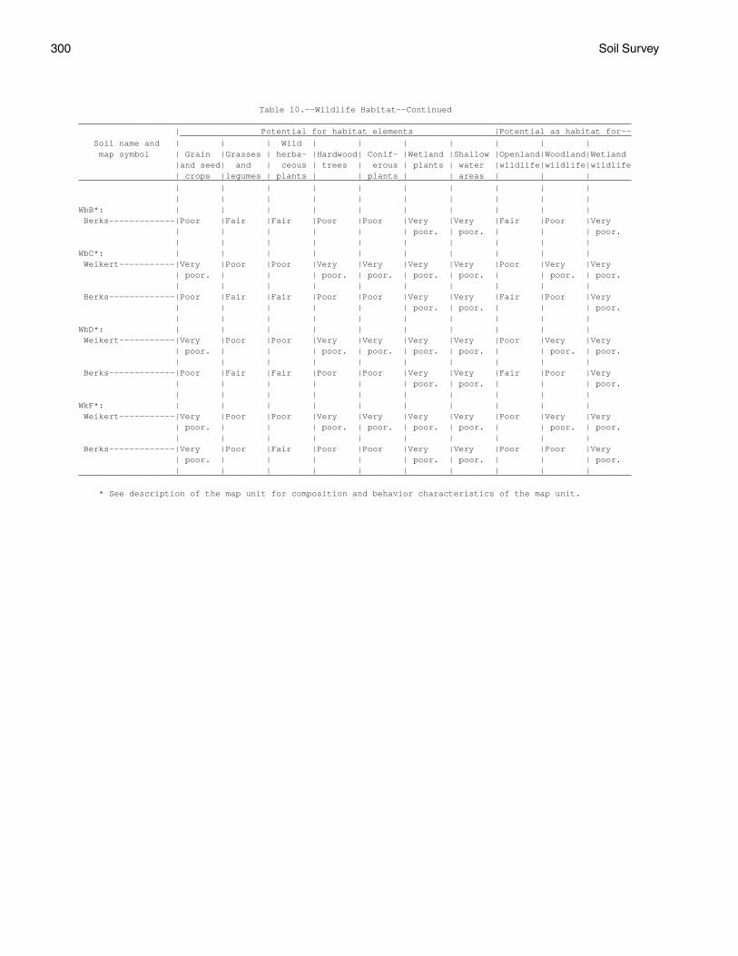
300 Soil Survey
Table 10.--Wildlife Habitat--Continued_____________________________________________________________________________________________________________ | Potential for habitat elements |Potential as habitat for-- _________________________________________________________________________________________ Soil name and | | | Wild | | | | | | | map symbol | Grain |Grasses | herba- |Hardwood| Conif- |Wetland |Shallow |Openland|Woodland|Wetland |and seed| and | ceous | trees | erous | plants | water |wildlife|wildlife|wildlife | crops |legumes | plants | | plants | | areas | | |_____________________________________________________________________________________________________________ | | | | | | | | | | | | | | | | | | | |WbB*: | | | | | | | | | | Berks-------------|Poor |Fair |Fair |Poor |Poor |Very |Very |Fair |Poor |Very | | | | | | poor. | poor. | | | poor. | | | | | | | | | |WbC*: | | | | | | | | | | Weikert-----------|Very |Poor |Poor |Very |Very |Very |Very |Poor |Very |Very | poor. | | | poor. | poor. | poor. | poor. | | poor. | poor. | | | | | | | | | | Berks-------------|Poor |Fair |Fair |Poor |Poor |Very |Very |Fair |Poor |Very | | | | | | poor. | poor. | | | poor. | | | | | | | | | |WbD*: | | | | | | | | | | Weikert-----------|Very |Poor |Poor |Very |Very |Very |Very |Poor |Very |Very | poor. | | | poor. | poor. | poor. | poor. | | poor. | poor. | | | | | | | | | | Berks-------------|Poor |Fair |Fair |Poor |Poor |Very |Very |Fair |Poor |Very | | | | | | poor. | poor. | | | poor. | | | | | | | | | |WkF*: | | | | | | | | | | Weikert-----------|Very |Poor |Poor |Very |Very |Very |Very |Poor |Very |Very | poor. | | | poor. | poor. | poor. | poor. | | poor. | poor. | | | | | | | | | | Berks-------------|Very |Poor |Fair |Poor |Poor |Very |Very |Poor |Poor |Very | poor. | | | | | poor. | poor. | | | poor. | | | | | | | | | |_____________________________________________________________________________________________________________
* See description of the map unit for composition and behavior characteristics of the map unit.
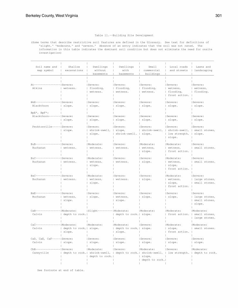
Berkeley County, West Virginia 301
Table 11.--Building Site Development
(Some terms that describe restrictive soil features are defined in the Glossary. See text for definitions of "slight," "moderate," and "severe." Absence of an entry indicates that the soil was not rated. The information in this table indicates the dominant soil condition but does not eliminate the need for onsite investigation)
________________________________________________________________________________________________________________ | | | | | | Soil name and | Shallow | Dwellings | Dwellings | Small | Local roads | Lawns and map symbol | excavations | without | with | commercial | and streets | landscaping | | basements | basements | buildings | |________________________________________________________________________________________________________________ | | | | | | | | | | | |At----------------|Severe: |Severe: |Severe: |Severe: |Severe: |Severe: Atkins | wetness. | flooding, | flooding, | flooding, | wetness, | wetness, | | wetness. | wetness. | wetness. | flooding, | flooding. | | | | | frost action. | | | | | | |BkE---------------|Severe: |Severe: |Severe: |Severe: |Severe: |Severe: Blackthorn | slope. | slope. | slope. | slope. | slope. | slope. | | | | | |BpE*, BpF*: | | | | | | Blackthorn-------|Severe: |Severe: |Severe: |Severe: |Severe: |Severe: | slope. | slope. | slope. | slope. | slope. | slope. | | | | | | Pecktonville-----|Severe: |Severe: |Severe: |Severe: |Severe: |Severe: | slope. | shrink-swell, | slope, | shrink-swell, | shrink-swell, | small stones, | | slope. | shrink-swell. | slope. | low strength, | slope. | | | | | slope. | | | | | | |BuB---------------|Severe: |Moderate: |Severe: |Moderate: |Moderate: |Severe: Buchanan | wetness. | wetness. | wetness. | wetness, | wetness, | small stones. | | | | slope. | frost action. | | | | | | |BuC---------------|Severe: |Moderate: |Severe: |Severe: |Moderate: |Severe: Buchanan | wetness. | wetness, | wetness. | slope. | wetness, | small stones. | | slope. | | | slope, | | | | | | frost action. | | | | | | |BxC---------------|Severe: |Moderate: |Severe: |Severe: |Moderate: |Severe: Buchanan | wetness. | wetness, | wetness. | slope. | wetness, | large stones, | | slope. | | | slope, | small stones. | | | | | frost action. | | | | | | |BxE---------------|Severe: |Severe: |Severe: |Severe: |Severe: |Severe: Buchanan | wetness, | slope. | wetness, | slope. | slope. | large stones, | slope. | | slope. | | | small stones, | | | | | | slope. | | | | | |CaB---------------|Moderate: |Slight---------|Moderate: |Moderate: |Moderate: |Moderate: Calvin | depth to rock.| | depth to rock.| slope. | frost action. | small stones, | | | | | | large stones. | | | | | |CaC---------------|Moderate: |Moderate: |Moderate: |Severe: |Moderate: |Moderate: Calvin | depth to rock,| slope. | depth to rock,| slope. | slope, | small stones. | slope. | | slope. | | frost action. | | | | | | |CaD, CaE, CaF-----|Severe: |Severe: |Severe: |Severe: |Severe: |Severe: Calvin | slope. | slope. | slope. | slope. | slope. | slope. | | | | | |CbB---------------|Severe: |Moderate: |Severe: |Moderate: |Severe: |Moderate: Caneyville | depth to rock.| shrink-swell, | depth to rock.| shrink-swell, | low strength. | depth to rock. | | depth to rock.| | slope, | | | | | | depth to rock.| | | | | | | |
See footnote at end of table.
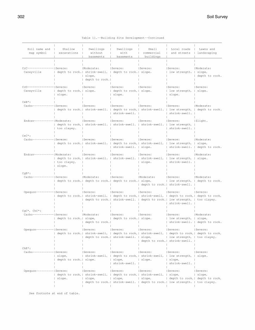
302 Soil Survey
Table 11.--Building Site Development--Continued__________________________________________________________________________________________________________________ | | | | | | Soil name and | Shallow | Dwellings | Dwellings | Small | Local roads | Lawns and map symbol | excavations | without | with | commercial | and streets | landscaping | | basements | basements | buildings | |__________________________________________________________________________________________________________________ | | | | | | | | | | | |CcC---------------|Severe: |Moderate: |Severe: |Severe: |Severe: |Moderate: Caneyville | depth to rock.| shrink-swell, | depth to rock.| slope. | low strength. | slope, | | slope, | | | | depth to rock. | | depth to rock.| | | | | | | | | |CcD---------------|Severe: |Severe: |Severe: |Severe: |Severe: |Severe: Caneyville | depth to rock,| slope. | depth to rock,| slope. | low strength, | slope. | slope. | | slope. | | slope. | | | | | | |CeB*: | | | | | | Carbo------------|Severe: |Severe: |Severe: |Severe: |Severe: |Moderate: | depth to rock.| shrink-swell. | depth to rock,| shrink-swell. | low strength, | depth to rock. | | | shrink-swell. | | shrink-swell. | | | | | | | Endcav-----------|Moderate: |Severe: |Severe: |Severe: |Severe: |Slight. | depth to rock,| shrink-swell. | shrink-swell. | shrink-swell. | low strength, | | too clayey. | | | | shrink-swell. | | | | | | |CeC*: | | | | | | Carbo------------|Severe: |Severe: |Severe: |Severe: |Severe: |Moderate: | depth to rock.| shrink-swell. | depth to rock,| shrink-swell, | low strength, | slope, | | | shrink-swell. | slope. | shrink-swell. | depth to rock. | | | | | | Endcav-----------|Moderate: |Severe: |Severe: |Severe: |Severe: |Moderate: | depth to rock,| shrink-swell. | shrink-swell. | shrink-swell, | low strength, | slope. | too clayey, | | | slope. | shrink-swell. | | slope. | | | | | | | | | | |CgB*: | | | | | | Carbo------------|Severe: |Moderate: |Severe: |Moderate: |Severe: |Moderate: | depth to rock.| depth to rock.| depth to rock.| slope, | low strength, | depth to rock. | | | | depth to rock.| shrink-swell. | | | | | | | Opequon----------|Severe: |Severe: |Severe: |Severe: |Severe: |Severe: | depth to rock.| shrink-swell, | depth to rock,| shrink-swell, | depth to rock,| depth to rock, | | depth to rock.| shrink-swell. | depth to rock.| low strength, | too clayey. | | | | | shrink-swell. | | | | | | |CgC*, ChC*: | | | | | | Carbo------------|Severe: |Moderate: |Severe: |Severe: |Severe: |Moderate: | depth to rock.| slope, | depth to rock.| slope. | low strength, | slope, | | depth to rock.| | | shrink-swell. | depth to rock. | | | | | | Opequon----------|Severe: |Severe: |Severe: |Severe: |Severe: |Severe: | depth to rock.| shrink-swell, | depth to rock,| shrink-swell, | depth to rock,| depth to rock, | | depth to rock.| shrink-swell. | slope, | low strength, | too clayey. | | | | depth to rock.| shrink-swell. | | | | | | |ChE*: | | | | | | Carbo------------|Severe: |Severe: |Severe: |Severe: |Severe: |Severe: | slope, | shrink-swell, | depth to rock,| shrink-swell, | low strength, | slope. | depth to rock.| slope. | slope, | slope. | slope, | | | | shrink-swell. | | shrink-swell. | | | | | | | Opequon----------|Severe: |Severe: |Severe: |Severe: |Severe: |Severe: | depth to rock,| shrink-swell, | depth to rock,| shrink-swell, | slope, | slope, | slope. | slope, | slope, | slope, | depth to rock,| depth to rock, | | depth to rock.| shrink-swell. | depth to rock.| low strength. | too clayey. | | | | | |
See footnote at end of table.
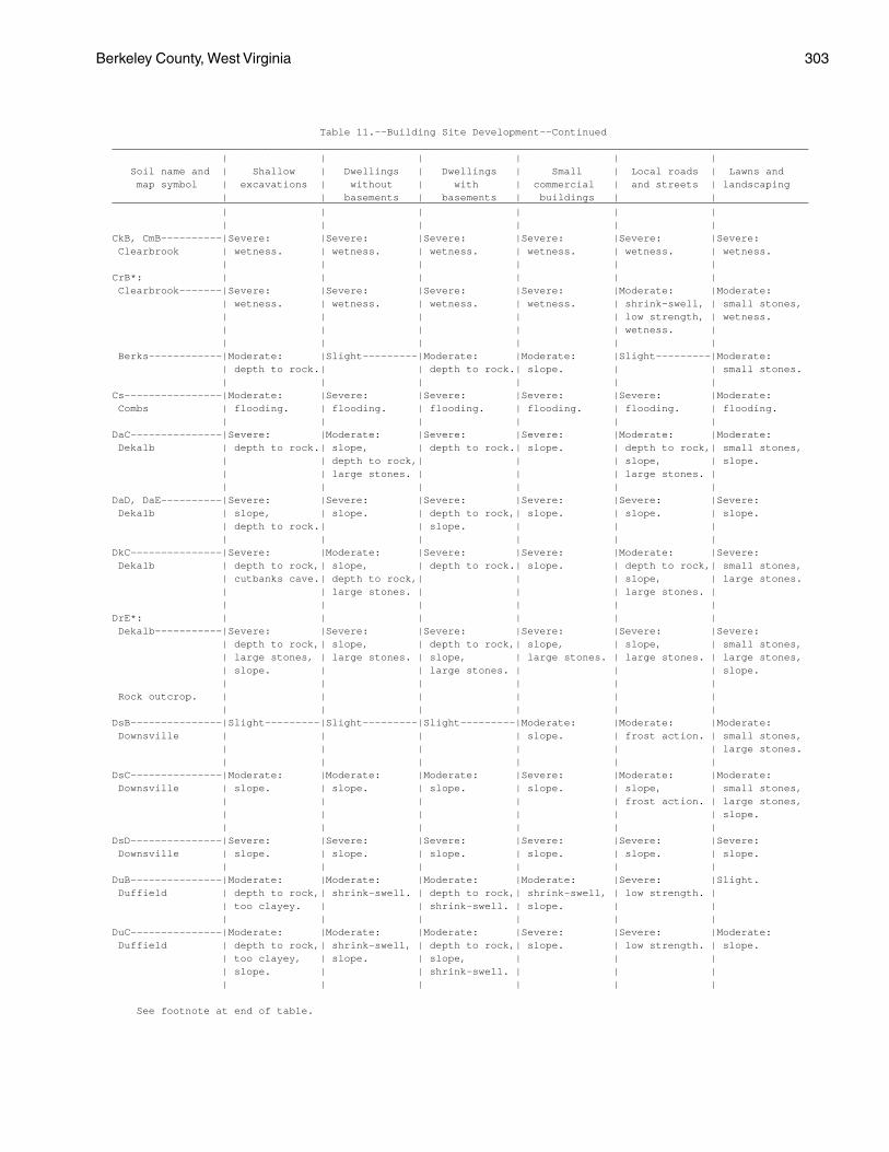
Berkeley County, West Virginia 303
Table 11.--Building Site Development--Continued__________________________________________________________________________________________________________________ | | | | | | Soil name and | Shallow | Dwellings | Dwellings | Small | Local roads | Lawns and map symbol | excavations | without | with | commercial | and streets | landscaping | | basements | basements | buildings | |__________________________________________________________________________________________________________________ | | | | | | | | | | | |CkB, CmB----------|Severe: |Severe: |Severe: |Severe: |Severe: |Severe: Clearbrook | wetness. | wetness. | wetness. | wetness. | wetness. | wetness. | | | | | |CrB*: | | | | | | Clearbrook-------|Severe: |Severe: |Severe: |Severe: |Moderate: |Moderate: | wetness. | wetness. | wetness. | wetness. | shrink-swell, | small stones, | | | | | low strength, | wetness. | | | | | wetness. | | | | | | | Berks------------|Moderate: |Slight---------|Moderate: |Moderate: |Slight---------|Moderate: | depth to rock.| | depth to rock.| slope. | | small stones. | | | | | |Cs----------------|Moderate: |Severe: |Severe: |Severe: |Severe: |Moderate: Combs | flooding. | flooding. | flooding. | flooding. | flooding. | flooding. | | | | | |DaC---------------|Severe: |Moderate: |Severe: |Severe: |Moderate: |Moderate: Dekalb | depth to rock.| slope, | depth to rock.| slope. | depth to rock,| small stones, | | depth to rock,| | | slope, | slope. | | large stones. | | | large stones. | | | | | | |DaD, DaE----------|Severe: |Severe: |Severe: |Severe: |Severe: |Severe: Dekalb | slope, | slope. | depth to rock,| slope. | slope. | slope. | depth to rock.| | slope. | | | | | | | | |DkC---------------|Severe: |Moderate: |Severe: |Severe: |Moderate: |Severe: Dekalb | depth to rock,| slope, | depth to rock.| slope. | depth to rock,| small stones, | cutbanks cave.| depth to rock,| | | slope, | large stones. | | large stones. | | | large stones. | | | | | | |DrE*: | | | | | | Dekalb-----------|Severe: |Severe: |Severe: |Severe: |Severe: |Severe: | depth to rock,| slope, | depth to rock,| slope, | slope, | small stones, | large stones, | large stones. | slope, | large stones. | large stones. | large stones, | slope. | | large stones. | | | slope. | | | | | | Rock outcrop. | | | | | | | | | | | |DsB---------------|Slight---------|Slight---------|Slight---------|Moderate: |Moderate: |Moderate: Downsville | | | | slope. | frost action. | small stones, | | | | | | large stones. | | | | | |DsC---------------|Moderate: |Moderate: |Moderate: |Severe: |Moderate: |Moderate: Downsville | slope. | slope. | slope. | slope. | slope, | small stones, | | | | | frost action. | large stones, | | | | | | slope. | | | | | |DsD---------------|Severe: |Severe: |Severe: |Severe: |Severe: |Severe: Downsville | slope. | slope. | slope. | slope. | slope. | slope. | | | | | |DuB---------------|Moderate: |Moderate: |Moderate: |Moderate: |Severe: |Slight. Duffield | depth to rock,| shrink-swell. | depth to rock,| shrink-swell, | low strength. | | too clayey. | | shrink-swell. | slope. | | | | | | | |DuC---------------|Moderate: |Moderate: |Moderate: |Severe: |Severe: |Moderate: Duffield | depth to rock,| shrink-swell, | depth to rock,| slope. | low strength. | slope. | too clayey, | slope. | slope, | | | | slope. | | shrink-swell. | | | | | | | | |
See footnote at end of table.
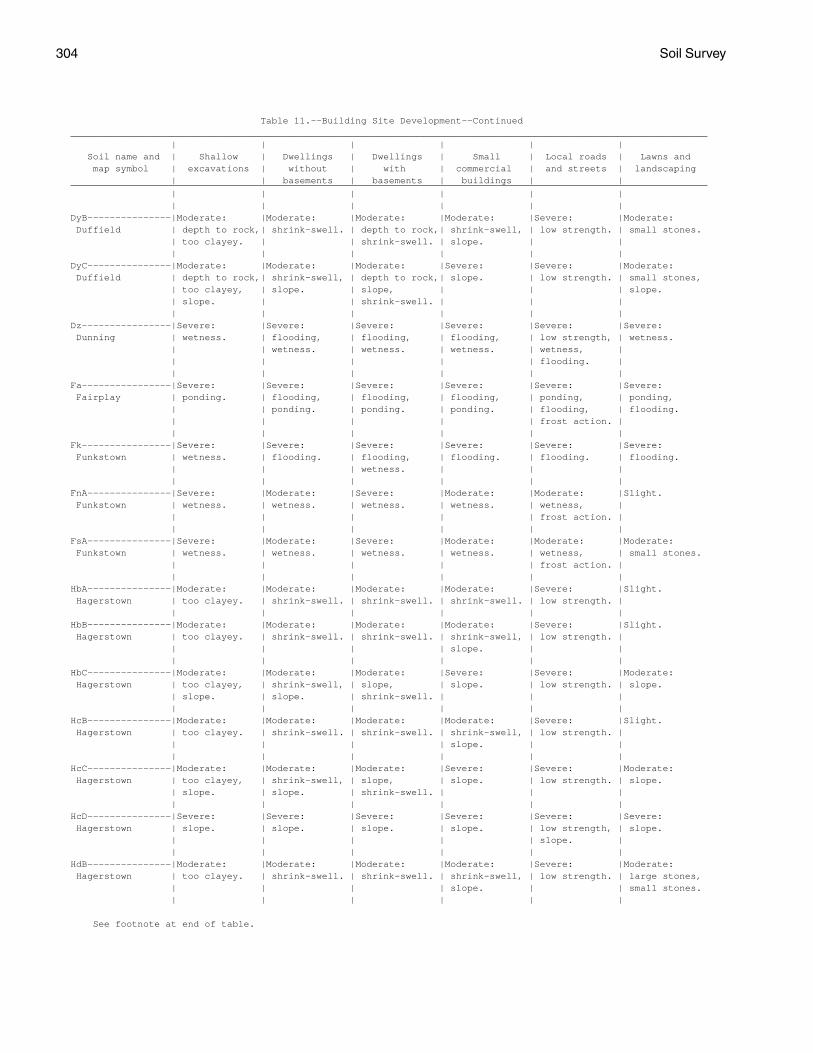
304 Soil Survey
Table 11.--Building Site Development--Continued__________________________________________________________________________________________________________________ | | | | | | Soil name and | Shallow | Dwellings | Dwellings | Small | Local roads | Lawns and map symbol | excavations | without | with | commercial | and streets | landscaping | | basements | basements | buildings | |__________________________________________________________________________________________________________________ | | | | | | | | | | | |DyB---------------|Moderate: |Moderate: |Moderate: |Moderate: |Severe: |Moderate: Duffield | depth to rock,| shrink-swell. | depth to rock,| shrink-swell, | low strength. | small stones. | too clayey. | | shrink-swell. | slope. | | | | | | | |DyC---------------|Moderate: |Moderate: |Moderate: |Severe: |Severe: |Moderate: Duffield | depth to rock,| shrink-swell, | depth to rock,| slope. | low strength. | small stones, | too clayey, | slope. | slope, | | | slope. | slope. | | shrink-swell. | | | | | | | | |Dz----------------|Severe: |Severe: |Severe: |Severe: |Severe: |Severe: Dunning | wetness. | flooding, | flooding, | flooding, | low strength, | wetness. | | wetness. | wetness. | wetness. | wetness, | | | | | | flooding. | | | | | | |Fa----------------|Severe: |Severe: |Severe: |Severe: |Severe: |Severe: Fairplay | ponding. | flooding, | flooding, | flooding, | ponding, | ponding, | | ponding. | ponding. | ponding. | flooding, | flooding. | | | | | frost action. | | | | | | |Fk----------------|Severe: |Severe: |Severe: |Severe: |Severe: |Severe: Funkstown | wetness. | flooding. | flooding, | flooding. | flooding. | flooding. | | | wetness. | | | | | | | | |FnA---------------|Severe: |Moderate: |Severe: |Moderate: |Moderate: |Slight. Funkstown | wetness. | wetness. | wetness. | wetness. | wetness, | | | | | | frost action. | | | | | | |FsA---------------|Severe: |Moderate: |Severe: |Moderate: |Moderate: |Moderate: Funkstown | wetness. | wetness. | wetness. | wetness. | wetness, | small stones. | | | | | frost action. | | | | | | |HbA---------------|Moderate: |Moderate: |Moderate: |Moderate: |Severe: |Slight. Hagerstown | too clayey. | shrink-swell. | shrink-swell. | shrink-swell. | low strength. | | | | | | |HbB---------------|Moderate: |Moderate: |Moderate: |Moderate: |Severe: |Slight. Hagerstown | too clayey. | shrink-swell. | shrink-swell. | shrink-swell, | low strength. | | | | | slope. | | | | | | | |HbC---------------|Moderate: |Moderate: |Moderate: |Severe: |Severe: |Moderate: Hagerstown | too clayey, | shrink-swell, | slope, | slope. | low strength. | slope. | slope. | slope. | shrink-swell. | | | | | | | | |HcB---------------|Moderate: |Moderate: |Moderate: |Moderate: |Severe: |Slight. Hagerstown | too clayey. | shrink-swell. | shrink-swell. | shrink-swell, | low strength. | | | | | slope. | | | | | | | |HcC---------------|Moderate: |Moderate: |Moderate: |Severe: |Severe: |Moderate: Hagerstown | too clayey, | shrink-swell, | slope, | slope. | low strength. | slope. | slope. | slope. | shrink-swell. | | | | | | | | |HcD---------------|Severe: |Severe: |Severe: |Severe: |Severe: |Severe: Hagerstown | slope. | slope. | slope. | slope. | low strength, | slope. | | | | | slope. | | | | | | |HdB---------------|Moderate: |Moderate: |Moderate: |Moderate: |Severe: |Moderate: Hagerstown | too clayey. | shrink-swell. | shrink-swell. | shrink-swell, | low strength. | large stones, | | | | slope. | | small stones. | | | | | |
See footnote at end of table.
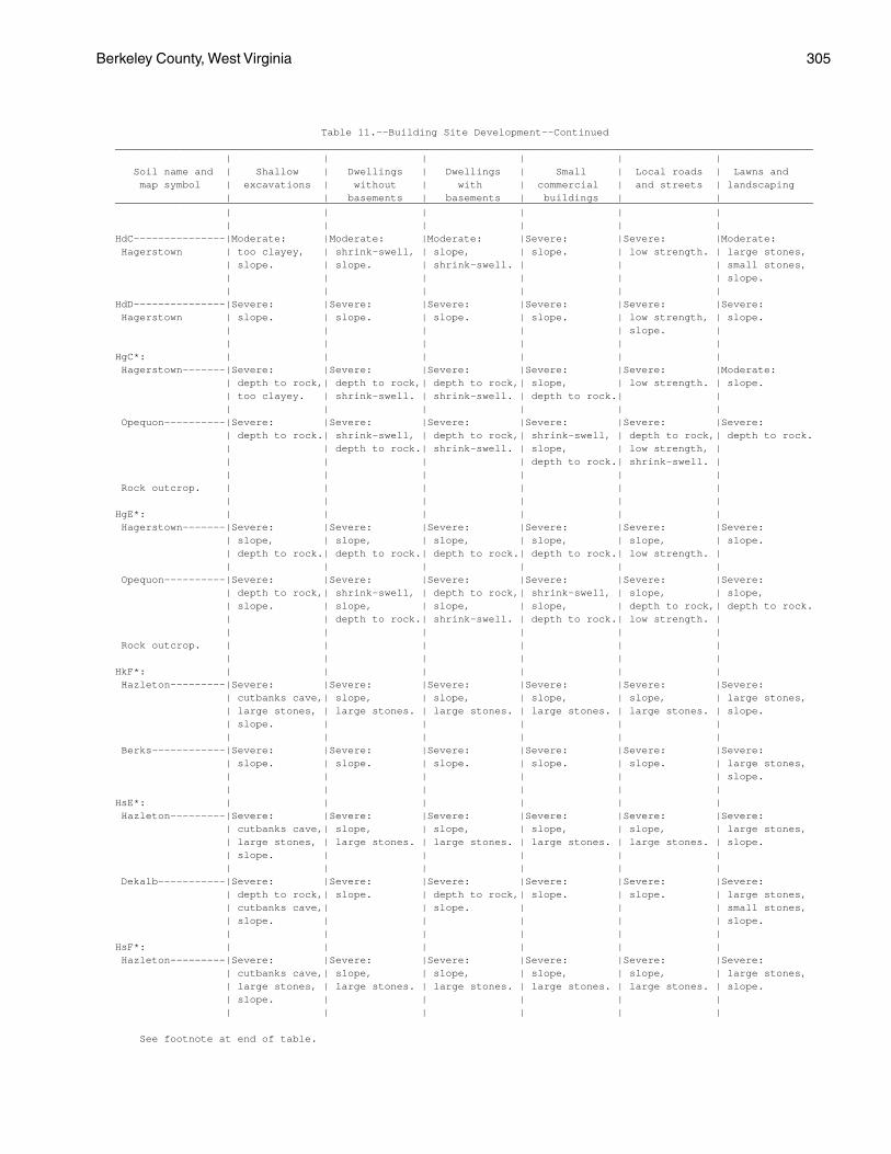
Berkeley County, West Virginia 305
Table 11.--Building Site Development--Continued__________________________________________________________________________________________________________________ | | | | | | Soil name and | Shallow | Dwellings | Dwellings | Small | Local roads | Lawns and map symbol | excavations | without | with | commercial | and streets | landscaping | | basements | basements | buildings | |__________________________________________________________________________________________________________________ | | | | | | | | | | | |HdC---------------|Moderate: |Moderate: |Moderate: |Severe: |Severe: |Moderate: Hagerstown | too clayey, | shrink-swell, | slope, | slope. | low strength. | large stones, | slope. | slope. | shrink-swell. | | | small stones, | | | | | | slope. | | | | | |HdD---------------|Severe: |Severe: |Severe: |Severe: |Severe: |Severe: Hagerstown | slope. | slope. | slope. | slope. | low strength, | slope. | | | | | slope. | | | | | | |HgC*: | | | | | | Hagerstown-------|Severe: |Severe: |Severe: |Severe: |Severe: |Moderate: | depth to rock,| depth to rock,| depth to rock,| slope, | low strength. | slope. | too clayey. | shrink-swell. | shrink-swell. | depth to rock.| | | | | | | | Opequon----------|Severe: |Severe: |Severe: |Severe: |Severe: |Severe: | depth to rock.| shrink-swell, | depth to rock,| shrink-swell, | depth to rock,| depth to rock. | | depth to rock.| shrink-swell. | slope, | low strength, | | | | | depth to rock.| shrink-swell. | | | | | | | Rock outcrop. | | | | | | | | | | | |HgE*: | | | | | | Hagerstown-------|Severe: |Severe: |Severe: |Severe: |Severe: |Severe: | slope, | slope, | slope, | slope, | slope, | slope. | depth to rock.| depth to rock.| depth to rock.| depth to rock.| low strength. | | | | | | | Opequon----------|Severe: |Severe: |Severe: |Severe: |Severe: |Severe: | depth to rock,| shrink-swell, | depth to rock,| shrink-swell, | slope, | slope, | slope. | slope, | slope, | slope, | depth to rock,| depth to rock. | | depth to rock.| shrink-swell. | depth to rock.| low strength. | | | | | | | Rock outcrop. | | | | | | | | | | | |HkF*: | | | | | | Hazleton---------|Severe: |Severe: |Severe: |Severe: |Severe: |Severe: | cutbanks cave,| slope, | slope, | slope, | slope, | large stones, | large stones, | large stones. | large stones. | large stones. | large stones. | slope. | slope. | | | | | | | | | | | Berks------------|Severe: |Severe: |Severe: |Severe: |Severe: |Severe: | slope. | slope. | slope. | slope. | slope. | large stones, | | | | | | slope. | | | | | |HsE*: | | | | | | Hazleton---------|Severe: |Severe: |Severe: |Severe: |Severe: |Severe: | cutbanks cave,| slope, | slope, | slope, | slope, | large stones, | large stones, | large stones. | large stones. | large stones. | large stones. | slope. | slope. | | | | | | | | | | | Dekalb-----------|Severe: |Severe: |Severe: |Severe: |Severe: |Severe: | depth to rock,| slope. | depth to rock,| slope. | slope. | large stones, | cutbanks cave,| | slope. | | | small stones, | slope. | | | | | slope. | | | | | |HsF*: | | | | | | Hazleton---------|Severe: |Severe: |Severe: |Severe: |Severe: |Severe: | cutbanks cave,| slope, | slope, | slope, | slope, | large stones, | large stones, | large stones. | large stones. | large stones. | large stones. | slope. | slope. | | | | | | | | | | |
See footnote at end of table.
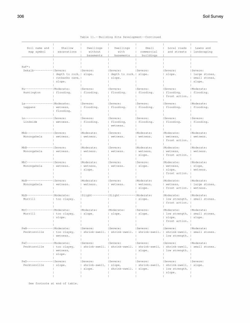
306 Soil Survey
Table 11.--Building Site Development--Continued__________________________________________________________________________________________________________________ | | | | | | Soil name and | Shallow | Dwellings | Dwellings | Small | Local roads | Lawns and map symbol | excavations | without | with | commercial | and streets | landscaping | | basements | basements | buildings | |__________________________________________________________________________________________________________________ | | | | | | | | | | | |HsF*: | | | | | | Dekalb-----------|Severe: |Severe: |Severe: |Severe: |Severe: |Severe: | depth to rock,| slope. | depth to rock,| slope. | slope. | large stones, | cutbanks cave,| | slope. | | | small stones, | slope. | | | | | slope. | | | | | |Hu----------------|Moderate: |Severe: |Severe: |Severe: |Severe: |Moderate: Huntington | flooding. | flooding. | flooding. | flooding. | flooding, | flooding. | | | | | frost action. | | | | | | |La----------------|Moderate: |Severe: |Severe: |Severe: |Severe: |Moderate: Lappans | wetness, | flooding. | flooding. | flooding. | flooding. | flooding. | flooding. | | | | | | | | | | |Ln----------------|Severe: |Severe: |Severe: |Severe: |Severe: |Severe: Lindside | wetness. | flooding. | flooding, | flooding. | flooding. | flooding. | | | wetness. | | | | | | | | |MhA---------------|Severe: |Moderate: |Severe: |Moderate: |Moderate: |Moderate: Monongahela | wetness. | wetness. | wetness. | wetness. | wetness, | wetness. | | | | | frost action. | | | | | | |MhB---------------|Severe: |Moderate: |Severe: |Moderate: |Moderate: |Moderate: Monongahela | wetness. | wetness. | wetness. | wetness, | wetness, | wetness. | | | | slope. | frost action. | | | | | | |MhC---------------|Severe: |Moderate: |Severe: |Severe: |Moderate: |Moderate: Monongahela | wetness. | wetness, | wetness. | slope. | wetness, | slope, | | slope. | | | slope, | wetness. | | | | | frost action. | | | | | | |MoB---------------|Severe: |Moderate: |Severe: |Moderate: |Moderate: |Moderate: Monongahela | wetness. | wetness. | wetness. | wetness, | wetness, | large stones, | | | | slope. | frost action. | wetness. | | | | | |MrB---------------|Moderate: |Slight---------|Slight---------|Moderate: |Moderate: |Moderate: Murrill | too clayey. | | | slope. | low strength, | small stones. | | | | | frost action. | | | | | | |MrC---------------|Moderate: |Moderate: |Moderate: |Severe: |Moderate: |Moderate: Murrill | too clayey, | slope. | slope. | slope. | low strength, | small stones, | slope. | | | | slope, | slope. | | | | | frost action. | | | | | | |PeB---------------|Moderate: |Severe: |Severe: |Severe: |Severe: |Moderate: Pecktonville | too clayey, | shrink-swell. | shrink-swell. | shrink-swell. | shrink-swell, | small stones. | wetness. | | | | low strength. | | | | | | |PeC---------------|Moderate: |Severe: |Severe: |Severe: |Severe: |Moderate: Pecktonville | too clayey, | shrink-swell. | shrink-swell. | shrink-swell, | shrink-swell, | small stones. | wetness, | | | slope. | low strength. | | slope. | | | | | | | | | | |PeD---------------|Severe: |Severe: |Severe: |Severe: |Severe: |Severe: Pecktonville | slope. | shrink-swell, | slope, | shrink-swell, | shrink-swell, | slope. | | slope. | shrink-swell. | slope. | low strength, | | | | | | slope. | | | | | | |
See footnote at end of table.

Berkeley County, West Virginia 307
Table 11.--Building Site Development--Continued__________________________________________________________________________________________________________________ | | | | | | Soil name and | Shallow | Dwellings | Dwellings | Small | Local roads | Lawns and map symbol | excavations | without | with | commercial | and streets | andscaping | | basements | basements | buildings | |__________________________________________________________________________________________________________________ | | | | | | | | | | | |PgC---------------|Moderate: |Severe: |Severe: |Severe: |Severe: |Severe: Pecktonville | too clayey, | shrink-swell. | shrink-swell. | shrink-swell, | shrink-swell, | small stones, | wetness, | | | slope. | low strength. | large stones. | slope. | | | | | | | | | | |Ph----------------|Severe: |Severe: |Severe: |Severe: |Severe: |Moderate: Philo | cutbanks cave,| flooding. | flooding, | flooding. | flooding. | wetness, | wetness. | | wetness. | | | flooding. | | | | | |PoA, PoB----------|Severe: |Severe: |Severe: |Severe: |Severe: |Severe: Poorhouse | wetness. | wetness, | wetness, | wetness, | shrink-swell, | wetness. | | shrink-swell. | shrink-swell. | shrink-swell. | low strength, | | | | | | wetness. | | | | | | |Ps----------------|Severe: |Severe: |Severe: |Severe: |Severe: |Severe: Pope | cutbanks cave.| flooding. | flooding. | flooding. | flooding. | flooding. | | | | | |Px----------------|Severe: |Severe: |Severe: |Severe: |Severe: |Moderate: Pope | cutbanks cave.| flooding. | flooding. | flooding. | flooding. | flooding. | | | | | |Qm*, Qs*. | | | | | | Quarry | | | | | | | | | | | |ReF*: | | | | | | Rock outcrop. | | | | | | | | | | | | Opequon----------|Severe: |Severe: |Severe: |Severe: |Severe: |Severe: | depth to rock,| shrink-swell, | depth to rock,| shrink-swell, | slope, | slope, | slope. | slope, | slope, | slope, | depth to rock,| depth to ock. | | depth to rock.| shrink-swell. | depth to rock.| low strength. | | | | | | |RnB*: | | | | | | Ryder------------|Moderate: |Slight---------|Moderate: |Moderate: |Moderate: |Moderate: | depth to rock.| | depth to rock.| slope. | frost action. | small stones, | | | | | | depth to ock. | | | | | | Nollville--------|Moderate: |Moderate: |Moderate: |Moderate: |Severe: |Moderate: | depth to rock,| shrink-swell. | depth to rock,| shrink-swell, | low strength. | small stones. | too clayey. | | shrink-swell. | slope. | | | | | | | |RnC*: | | | | | | Ryder------------|Moderate: |Moderate: |Moderate: |Severe: |Moderate: |Moderate: | depth to rock,| slope. | depth to rock,| slope. | slope, | small stones, | slope. | | slope. | | frost action. | slope, | | | | | | depth to ock. | | | | | | Nollville--------|Moderate: |Moderate: |Moderate: |Severe: |Severe: |Moderate: | depth to rock,| shrink-swell, | depth to rock,| slope. | low strength. | small stones, | too clayey, | slope. | slope, | | | slope. | slope. | | shrink-swell. | | | | | | | | |RnD*: | | | | | | Ryder------------|Severe: |Severe: |Severe: |Severe: |Severe: |Severe: | slope. | slope. | slope. | slope. | slope. | slope. | | | | | | Nollville--------|Severe: |Severe: |Severe: |Severe: |Severe: |Severe: | slope. | slope. | slope. | slope. | low strength, | slope. | | | | | slope. | | | | | | |
See footnote at end of table.
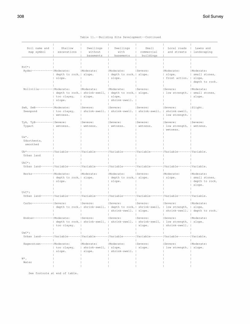
308 Soil Survey
Table 11.--Building Site Development--Continued__________________________________________________________________________________________________________________ | | | | | | Soil name and | Shallow | Dwellings | Dwellings | Small | Local roads | Lawns and map symbol | excavations | without | with | commercial | and streets | landscaping | | basements | basements | buildings | |__________________________________________________________________________________________________________________ | | | | | | | | | | | |RvC*: | | | | | | Ryder------------|Moderate: |Moderate: |Moderate: |Severe: |Moderate: |Moderate: | depth to rock,| slope. | depth to rock,| slope. | slope, | small stones, | slope. | | slope. | | frost action. | slope, | | | | | | depth to rock. | | | | | | Nollville--------|Moderate: |Moderate: |Moderate: |Severe: |Severe: |Moderate: | depth to rock,| shrink-swell, | depth to rock,| slope. | low strength. | small stones, | too clayey, | slope. | slope, | | | slope. | slope. | | shrink-swell. | | | | | | | | |SwA, SwB----------|Moderate: |Severe: |Severe: |Severe: |Severe: |Slight. Swanpond | too clayey, | shrink-swell. | shrink-swell. | shrink-swell. | shrink-swell, | | wetness. | | | | low strength. | | | | | | |TyA, TyB----------|Severe: |Severe: |Severe: |Severe: |Severe: |Severe: Tygart | wetness. | wetness. | wetness. | wetness. | low strength, | wetness. | | | | | wetness. | | | | | | |Ua*. | | | | | | Udorthents, | | | | | | smoothed | | | | | | | | | | | |Ub*---------------|Variable-------|Variable-------|Variable-------|Variable-------|Variable-------|Variable. Urban land | | | | | | | | | | | |UkC*: | | | | | | Urban land-------|Variable-------|Variable-------|Variable-------|Variable-------|Variable-------|Variable. | | | | | | Berks------------|Moderate: |Moderate: |Moderate: |Severe: |Moderate: |Moderate: | depth to rock,| slope. | depth to rock,| slope. | slope. | small stones, | slope. | | slope. | | | depth to rock, | | | | | | slope. | | | | | |UvC*: | | | | | | Urban land-------|Variable-------|Variable-------|Variable-------|Variable-------|Variable-------|Variable. | | | | | | Carbo------------|Severe: |Severe: |Severe: |Severe: |Severe: |Moderate: | depth to rock.| shrink-swell. | depth to rock,| shrink-swell, | low strength, | slope, | | | shrink-swell. | slope. | shrink-swell. | depth to rock. | | | | | | Endcav-----------|Moderate: |Severe: |Severe: |Severe: |Severe: |Moderate: | depth to rock,| shrink-swell. | shrink-swell. | shrink-swell, | low strength, | slope. | too clayey. | | | slope. | shrink-swell. | | | | | | |UwC*: | | | | | | Urban land-------|Variable-------|Variable-------|Variable-------|Variable-------|Variable-------|Variable. | | | | | | Hagerstown-------|Moderate: |Moderate: |Moderate: |Severe: |Severe: |Moderate: | too clayey, | shrink-swell, | slope, | slope. | low strength. | slope. | slope. | slope. | shrink-swell. | | | | | | | | |W*. | | | | | | Water | | | | | | | | | | | |
See footnote at end of table.

Berkeley County, West Virginia 309
Table 11.--Building Site Development--Continued__________________________________________________________________________________________________________________ | | | | | | Soil name and | Shallow | Dwellings | Dwellings | Small | Local roads | Lawns and map symbol | excavations | without | with | commercial | and streets | landscaping | | basements | basements | buildings | |__________________________________________________________________________________________________________________ | | | | | | | | | | | |WbB*: | | | | | | Weikert----------|Severe: |Moderate: |Severe: |Moderate: |Moderate: |Severe: | depth to rock.| depth to rock.| depth to rock.| slope, | depth to rock,| depth to rock. | | | | depth to rock.| frost action. | | | | | | | Berks------------|Moderate: |Slight---------|Moderate: |Moderate: |Slight---------|Moderate: | depth to rock.| | depth to rock.| slope. | | small stones, | | | | | | depth to rock. | | | | | |WbC*: | | | | | | Weikert----------|Severe: |Moderate: |Severe: |Severe: |Moderate: |Severe: | depth to rock.| slope, | depth to rock.| slope. | depth to rock,| depth to rock. | | depth to rock.| | | slope, | | | | | | frost action. | | | | | | | Berks------------|Moderate: |Moderate: |Moderate: |Severe: |Moderate: |Moderate: | depth to rock,| slope. | depth to rock,| slope. | slope. | small stones, | slope. | | slope. | | | slope, | | | | | | depth to rock. | | | | | |WbD*: | | | | | | Weikert----------|Severe: |Severe: |Severe: |Severe: |Severe: |Severe: | depth to rock,| slope. | depth to rock,| slope. | slope. | droughty, | slope. | | slope. | | | depth to rock. | | | | | | Berks------------|Severe: |Severe: |Severe: |Severe: |Severe: |Severe: | slope. | slope. | slope. | slope. | slope. | slope. | | | | | | | | | | | |WkF*: | | | | | | Weikert----------|Severe: |Severe: |Severe: |Severe: |Severe: |Severe: | depth to rock,| slope. | depth to rock,| slope. | slope. | droughty, | slope. | | slope. | | | depth to rock. | | | | | | Berks------------|Severe: |Severe: |Severe: |Severe: |Severe: |Severe: | slope. | slope. | slope. | slope. | slope. | slope. | | | | | |__________________________________________________________________________________________________________________
* See description of the map unit for composition and behavior characteristics of the map unit.
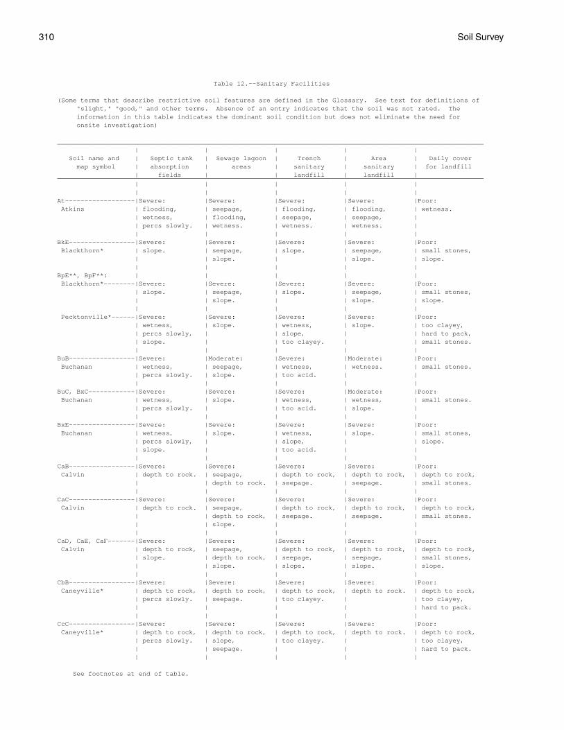
310 Soil Survey
Table 12.--Sanitary Facilities
(Some terms that describe restrictive soil features are defined in the Glossary. See text for definitions of "slight," "good," and other terms. Absence of an entry indicates that the soil was not rated. The information in this table indicates the dominant soil condition but does not eliminate the need for onsite investigation)
______________________________________________________________________________________________________________ | | | | | Soil name and | Septic tank | Sewage lagoon | Trench | Area | Daily cover map symbol | absorption | areas | sanitary | sanitary | for landfill | fields | | landfill | landfill |______________________________________________________________________________________________________________ | | | | | | | | | |At------------------|Severe: |Severe: |Severe: |Severe: |Poor: Atkins | flooding, | seepage, | flooding, | flooding, | wetness. | wetness, | flooding, | seepage, | seepage, | | percs slowly. | wetness. | wetness. | wetness. | | | | | |BkE-----------------|Severe: |Severe: |Severe: |Severe: |Poor: Blackthorn* | slope. | seepage, | slope. | seepage, | small stones, | | slope. | | slope. | slope. | | | | |BpE**, BpF**: | | | | | Blackthorn*--------|Severe: |Severe: |Severe: |Severe: |Poor: | slope. | seepage, | slope. | seepage, | small stones, | | slope. | | slope. | slope. | | | | | Pecktonville*------|Severe: |Severe: |Severe: |Severe: |Poor: | wetness, | slope. | wetness, | slope. | too clayey, | percs slowly, | | slope, | | hard to pack, | slope. | | too clayey. | | small stones. | | | | |BuB-----------------|Severe: |Moderate: |Severe: |Moderate: |Poor: Buchanan | wetness, | seepage, | wetness, | wetness. | small stones. | percs slowly. | slope. | too acid. | | | | | | |BuC, BxC------------|Severe: |Severe: |Severe: |Moderate: |Poor: Buchanan | wetness, | slope. | wetness, | wetness, | small stones. | percs slowly. | | too acid. | slope. | | | | | |BxE-----------------|Severe: |Severe: |Severe: |Severe: |Poor: Buchanan | wetness, | slope. | wetness, | slope. | small stones, | percs slowly, | | slope, | | slope. | slope. | | too acid. | | | | | | |CaB-----------------|Severe: |Severe: |Severe: |Severe: |Poor: Calvin | depth to rock. | seepage, | depth to rock, | depth to rock, | depth to rock, | | depth to rock. | seepage. | seepage. | small stones. | | | | |CaC-----------------|Severe: |Severe: |Severe: |Severe: |Poor: Calvin | depth to rock. | seepage, | depth to rock, | depth to rock, | depth to rock, | | depth to rock, | seepage. | seepage. | small stones. | | slope. | | | | | | | |CaD, CaE, CaF-------|Severe: |Severe: |Severe: |Severe: |Poor: Calvin | depth to rock, | seepage, | depth to rock, | depth to rock, | depth to rock, | slope. | depth to rock, | seepage, | seepage, | small stones, | | slope. | slope. | slope. | slope. | | | | |CbB-----------------|Severe: |Severe: |Severe: |Severe: |Poor: Caneyville* | depth to rock, | depth to rock, | depth to rock, | depth to rock. | depth to rock, | percs slowly. | seepage. | too clayey. | | too clayey, | | | | | hard to pack. | | | | |CcC-----------------|Severe: |Severe: |Severe: |Severe: |Poor: Caneyville* | depth to rock, | depth to rock, | depth to rock, | depth to rock. | depth to rock, | percs slowly. | slope, | too clayey. | | too clayey, | | seepage. | | | hard to pack. | | | | |
See footnotes at end of table.
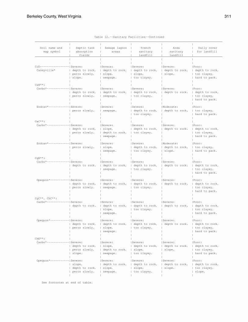
Berkeley County, West Virginia 311
Table 12.--Sanitary Facilities--Continued______________________________________________________________________________________________________________ | | | | | Soil name and | Septic tank | Sewage lagoon | Trench | Area | Daily cover map symbol | absorption | areas | sanitary | sanitary | for landfill | fields | | landfill | landfill |______________________________________________________________________________________________________________ | | | | | | | | | |CcD-----------------|Severe: |Severe: |Severe: |Severe: |Poor: Caneyville* | depth to rock, | depth to rock, | depth to rock, | depth to rock, | depth to rock, | percs slowly, | slope, | slope, | slope. | too clayey, | slope. | seepage. | too clayey. | | hard to pack. | | | | |CeB**: | | | | | Carbo*-------------|Severe: |Severe: |Severe: |Severe: |Poor: | depth to rock, | depth to rock, | depth to rock, | depth to rock. | depth to rock, | percs slowly. | seepage. | too clayey. | | too clayey, | | | | | hard to pack. | | | | | Endcav*------------|Severe: |Severe: |Severe: |Moderate: |Poor: | percs slowly. | seepage. | depth to rock, | depth to rock. | too clayey, | | | too clayey. | | hard to pack. | | | | |CeC**: | | | | | Carbo*-------------|Severe: |Severe: |Severe: |Severe: |Poor: | depth to rock, | slope, | depth to rock, | depth to rock. | depth to rock, | percs slowly. | depth to rock, | too clayey. | | too clayey, | | seepage. | | | hard to pack. | | | | | Endcav*------------|Severe: |Severe: |Severe: |Moderate: |Poor: | percs slowly. | slope, | depth to rock, | depth to rock, | too clayey, | | seepage. | too clayey. | slope. | hard to pack. | | | | |CgB**: | | | | | Carbo*-------------|Severe: |Severe: |Severe: |Severe: |Poor: | depth to rock. | depth to rock, | depth to rock, | depth to rock. | depth to rock, | | seepage. | too clayey. | | too clayey, | | | | | hard to pack. | | | | | Opequon*-----------|Severe: |Severe: |Severe: |Severe: |Poor: | depth to rock, | depth to rock, | depth to rock, | depth to rock. | depth to rock, | percs slowly. | seepage. | too clayey. | | too clayey, | | | | | hard to pack. | | | | |CgC**, ChC**: | | | | | Carbo*-------------|Severe: |Severe: |Severe: |Severe: |Poor: | depth to rock. | depth to rock, | depth to rock, | depth to rock. | depth to rock, | | slope, | too clayey. | | too clayey, | | seepage. | | | hard to pack. | | | | | Opequon*-----------|Severe: |Severe: |Severe: |Severe: |Poor: | depth to rock, | depth to rock, | depth to rock, | depth to rock. | depth to rock, | percs slowly. | slope, | too clayey. | | too clayey, | | seepage. | | | hard to pack. | | | | |ChE**: | | | | | Carbo*-------------|Severe: |Severe: |Severe: |Severe: |Poor: | depth to rock, | slope, | depth to rock, | depth to rock, | depth to rock, | percs slowly, | depth to rock, | slope, | slope. | too clayey, | slope. | seepage. | too clayey. | | hard to pack. | | | | | Opequon*-----------|Severe: |Severe: |Severe: |Severe: |Poor: | slope, | depth to rock, | depth to rock, | depth to rock, | depth to rock, | depth to rock, | slope, | slope, | slope. | too clayey, | percs slowly. | seepage. | too clayey. | | slope. | | | | |
See footnotes at end of table.
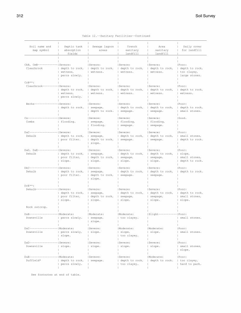
312 Soil Survey
Table 12.--Sanitary Facilities--Continued______________________________________________________________________________________________________________ | | | | | Soil name and | Septic tank | Sewage lagoon | Trench | Area | Daily cover map symbol | absorption | areas | sanitary | sanitary | for landfill | fields | | landfill | landfill |______________________________________________________________________________________________________________ | | | | | | | | | |CkB, CmB------------|Severe: |Severe: |Severe: |Severe: |Poor: Clearbrook | depth to rock, | depth to rock, | depth to rock, | depth to rock, | depth to rock, | wetness, | wetness. | wetness. | wetness. | too clayey, | percs slowly. | | | | large stones. | | | | |CrB**: | | | | | Clearbrook---------|Severe: |Severe: |Severe: |Severe: |Poor: | depth to rock, | depth to rock, | depth to rock, | depth to rock, | depth to rock, | wetness, | wetness. | wetness. | wetness. | wetness. | percs slowly. | | | | | | | | | Berks--------------|Severe: |Severe: |Severe: |Severe: |Poor: | depth to rock. | seepage, | depth to rock, | depth to rock, | depth to rock, | | depth to rock. | seepage. | seepage. | small stones. | | | | |Cs------------------|Severe: |Severe: |Severe: |Severe: |Good. Combs | flooding. | seepage, | flooding, | flooding, | | | flooding. | seepage. | seepage. | | | | | |DaC-----------------|Severe: |Severe: |Severe: |Severe: |Poor: Dekalb | depth to rock, | seepage, | depth to rock, | depth to rock, | small stones, | poor filter. | depth to rock, | seepage. | seepage. | depth to rock. | | slope. | | | | | | | |DaD, DaE------------|Severe: |Severe: |Severe: |Severe: |Poor: Dekalb | depth to rock, | seepage, | depth to rock, | depth to rock, | slope, | poor filter, | depth to rock, | seepage, | seepage, | small stones, | slope. | slope. | slope. | slope. | depth to rock. | | | | |DkC-----------------|Severe: |Severe: |Severe: |Severe: |Poor: Dekalb | depth to rock, | seepage, | depth to rock, | depth to rock, | depth to rock. | poor filter. | depth to rock, | seepage. | seepage. | | | slope. | | | | | | | |DrE**: | | | | | Dekalb-------------|Severe: |Severe: |Severe: |Severe: |Poor: | depth to rock, | seepage, | depth to rock, | depth to rock, | depth to rock, | poor filter, | depth to rock, | seepage, | seepage, | small stones, | slope. | slope. | slope. | slope. | slope. | | | | | Rock outcrop. | | | | | | | | | |DsB-----------------|Moderate: |Moderate: |Moderate: |Slight-----------|Poor: Downsville | percs slowly. | seepage, | too clayey. | | small stones. | | slope. | | | | | | | |DsC-----------------|Moderate: |Severe: |Moderate: |Moderate: |Poor: Downsville | percs slowly, | slope. | slope, | slope. | small stones. | slope. | | too clayey. | | | | | | |DsD-----------------|Severe: |Severe: |Severe: |Severe: |Poor: Downsville | slope. | slope. | slope. | slope. | small stones, | | | | | slope. | | | | |DuB-----------------|Moderate: |Severe: |Severe: |Moderate: |Poor: Duffield* | depth to rock, | seepage. | depth to rock, | depth to rock. | too clayey, | percs slowly. | | too clayey. | | hard to pack. | | | | |
See footnotes at end of table.
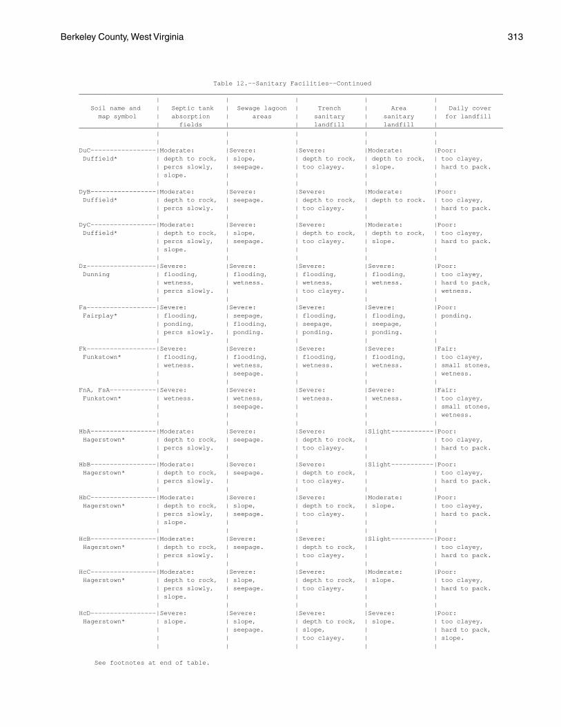
Berkeley County, West Virginia 313
Table 12.--Sanitary Facilities--Continued______________________________________________________________________________________________________________ | | | | | Soil name and | Septic tank | Sewage lagoon | Trench | Area | Daily cover map symbol | absorption | areas | sanitary | sanitary | for landfill | fields | | landfill | landfill |______________________________________________________________________________________________________________ | | | | | | | | | |DuC-----------------|Moderate: |Severe: |Severe: |Moderate: |Poor: Duffield* | depth to rock, | slope, | depth to rock, | depth to rock, | too clayey, | percs slowly, | seepage. | too clayey. | slope. | hard to pack. | slope. | | | | | | | | |DyB-----------------|Moderate: |Severe: |Severe: |Moderate: |Poor: Duffield* | depth to rock, | seepage. | depth to rock, | depth to rock. | too clayey, | percs slowly. | | too clayey. | | hard to pack. | | | | |DyC-----------------|Moderate: |Severe: |Severe: |Moderate: |Poor: Duffield* | depth to rock, | slope, | depth to rock, | depth to rock, | too clayey, | percs slowly, | seepage. | too clayey. | slope. | hard to pack. | slope. | | | | | | | | |Dz------------------|Severe: |Severe: |Severe: |Severe: |Poor: Dunning | flooding, | flooding, | flooding, | flooding, | too clayey, | wetness, | wetness. | wetness, | wetness. | hard to pack, | percs slowly. | | too clayey. | | wetness. | | | | |Fa------------------|Severe: |Severe: |Severe: |Severe: |Poor: Fairplay* | flooding, | seepage, | flooding, | flooding, | ponding. | ponding, | flooding, | seepage, | seepage, | | percs slowly. | ponding. | ponding. | ponding. | | | | | |Fk------------------|Severe: |Severe: |Severe: |Severe: |Fair: Funkstown* | flooding, | flooding, | flooding, | flooding, | too clayey, | wetness. | wetness, | wetness. | wetness. | small stones, | | seepage. | | | wetness. | | | | |FnA, FsA------------|Severe: |Severe: |Severe: |Severe: |Fair: Funkstown* | wetness. | wetness, | wetness. | wetness. | too clayey, | | seepage. | | | small stones, | | | | | wetness. | | | | |HbA-----------------|Moderate: |Severe: |Severe: |Slight-----------|Poor: Hagerstown* | depth to rock, | seepage. | depth to rock, | | too clayey, | percs slowly. | | too clayey. | | hard to pack. | | | | |HbB-----------------|Moderate: |Severe: |Severe: |Slight-----------|Poor: Hagerstown* | depth to rock, | seepage. | depth to rock, | | too clayey, | percs slowly. | | too clayey. | | hard to pack. | | | | |HbC-----------------|Moderate: |Severe: |Severe: |Moderate: |Poor: Hagerstown* | depth to rock, | slope, | depth to rock, | slope. | too clayey, | percs slowly, | seepage. | too clayey. | | hard to pack. | slope. | | | | | | | | |HcB-----------------|Moderate: |Severe: |Severe: |Slight-----------|Poor: Hagerstown* | depth to rock, | seepage. | depth to rock, | | too clayey, | percs slowly. | | too clayey. | | hard to pack. | | | | |HcC-----------------|Moderate: |Severe: |Severe: |Moderate: |Poor: Hagerstown* | depth to rock, | slope, | depth to rock, | slope. | too clayey, | percs slowly, | seepage. | too clayey. | | hard to pack. | slope. | | | | | | | | |HcD-----------------|Severe: |Severe: |Severe: |Severe: |Poor: Hagerstown* | slope. | slope, | depth to rock, | slope. | too clayey, | | seepage. | slope, | | hard to pack, | | | too clayey. | | slope. | | | | |
See footnotes at end of table.
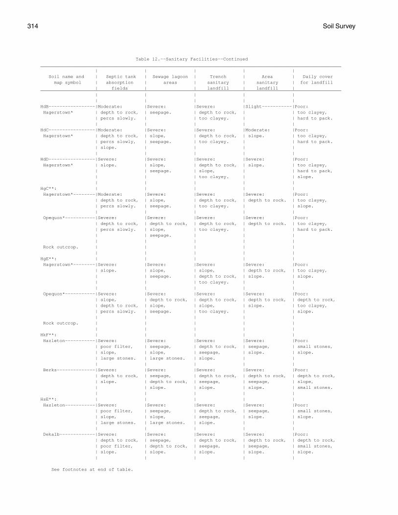
314 Soil Survey
Table 12.--Sanitary Facilities--Continued______________________________________________________________________________________________________________ | | | | | Soil name and | Septic tank | Sewage lagoon | Trench | Area | Daily cover map symbol | absorption | areas | sanitary | sanitary | for landfill | fields | | landfill | landfill |______________________________________________________________________________________________________________ | | | | | | | | | |HdB-----------------|Moderate: |Severe: |Severe: |Slight-----------|Poor: Hagerstown* | depth to rock, | seepage. | depth to rock, | | too clayey, | percs slowly. | | too clayey. | | hard to pack. | | | | |HdC-----------------|Moderate: |Severe: |Severe: |Moderate: |Poor: Hagerstown* | depth to rock, | slope, | depth to rock, | slope. | too clayey, | percs slowly, | seepage. | too clayey. | | hard to pack. | slope. | | | | | | | | |HdD-----------------|Severe: |Severe: |Severe: |Severe: |Poor: Hagerstown* | slope. | slope, | depth to rock, | slope. | too clayey, | | seepage. | slope, | | hard to pack, | | | too clayey. | | slope. | | | | |HgC**: | | | | | Hagerstown*--------|Moderate: |Severe: |Severe: |Severe: |Poor: | depth to rock, | slope, | depth to rock, | depth to rock. | too clayey, | percs slowly. | seepage. | too clayey. | | slope. | | | | | Opequon*-----------|Severe: |Severe: |Severe: |Severe: |Poor: | depth to rock, | depth to rock, | depth to rock, | depth to rock. | too clayey, | percs slowly. | slope, | too clayey. | | hard to pack. | | seepage. | | | | | | | | Rock outcrop. | | | | | | | | | |HgE**: | | | | | Hagerstown*--------|Severe: |Severe: |Severe: |Severe: |Poor: | slope. | slope, | slope, | depth to rock, | too clayey, | | seepage. | depth to rock, | slope. | slope. | | | too clayey. | | | | | | | Opequon*-----------|Severe: |Severe: |Severe: |Severe: |Poor: | slope, | depth to rock, | depth to rock, | depth to rock, | depth to rock, | depth to rock, | slope, | slope, | slope. | too clayey, | percs slowly. | seepage. | too clayey. | | slope. | | | | | Rock outcrop. | | | | | | | | | |HkF**: | | | | | Hazleton-----------|Severe: |Severe: |Severe: |Severe: |Poor: | poor filter, | seepage, | depth to rock, | seepage, | small stones, | slope, | slope, | seepage, | slope. | slope. | large stones. | large stones. | slope. | | | | | | | Berks--------------|Severe: |Severe: |Severe: |Severe: |Poor: | depth to rock, | seepage, | depth to rock, | depth to rock, | depth to rock, | slope. | depth to rock, | seepage, | seepage, | slope, | | slope. | slope. | slope. | small stones. | | | | |HsE**: | | | | | Hazleton-----------|Severe: |Severe: |Severe: |Severe: |Poor: | poor filter, | seepage, | depth to rock, | seepage, | small stones, | slope, | slope, | seepage, | slope. | slope. | large stones. | large stones. | slope. | | | | | | | Dekalb-------------|Severe: |Severe: |Severe: |Severe: |Poor: | depth to rock, | seepage, | depth to rock, | depth to rock, | depth to rock, | poor filter, | depth to rock, | seepage, | seepage, | small stones, | slope. | slope. | slope. | slope. | slope. | | | | |
See footnotes at end of table.
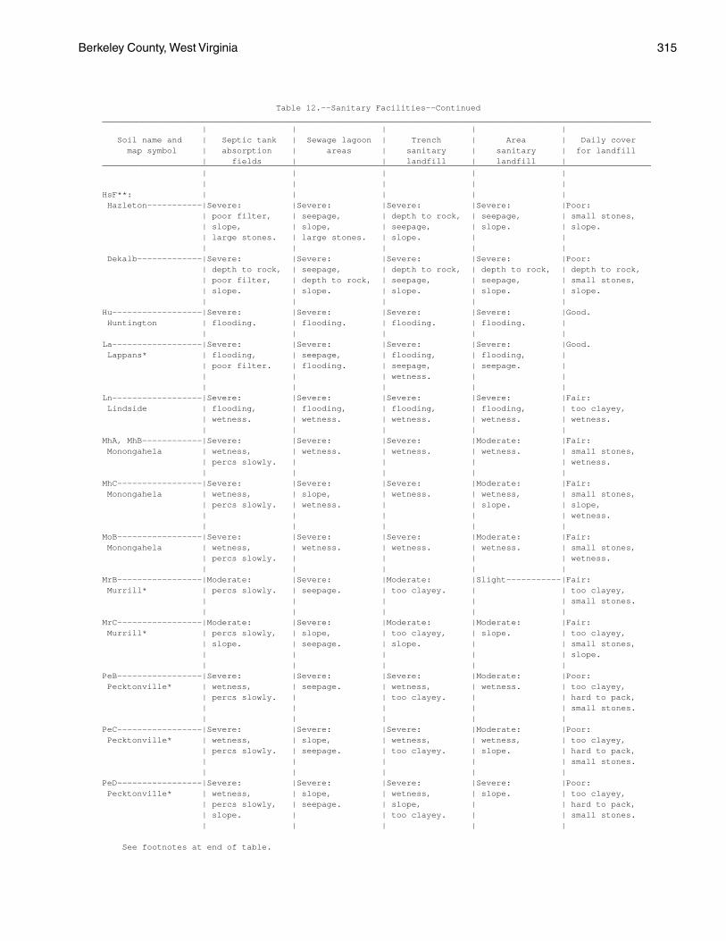
Berkeley County, West Virginia 315
Table 12.--Sanitary Facilities--Continued______________________________________________________________________________________________________________ | | | | | Soil name and | Septic tank | Sewage lagoon | Trench | Area | Daily cover map symbol | absorption | areas | sanitary | sanitary | for landfill | fields | | landfill | landfill |______________________________________________________________________________________________________________ | | | | | | | | | |HsF**: | | | | | Hazleton-----------|Severe: |Severe: |Severe: |Severe: |Poor: | poor filter, | seepage, | depth to rock, | seepage, | small stones, | slope, | slope, | seepage, | slope. | slope. | large stones. | large stones. | slope. | | | | | | | Dekalb-------------|Severe: |Severe: |Severe: |Severe: |Poor: | depth to rock, | seepage, | depth to rock, | depth to rock, | depth to rock, | poor filter, | depth to rock, | seepage, | seepage, | small stones, | slope. | slope. | slope. | slope. | slope. | | | | |Hu------------------|Severe: |Severe: |Severe: |Severe: |Good. Huntington | flooding. | flooding. | flooding. | flooding. | | | | | |La------------------|Severe: |Severe: |Severe: |Severe: |Good. Lappans* | flooding, | seepage, | flooding, | flooding, | | poor filter. | flooding. | seepage, | seepage. | | | | wetness. | | | | | | |Ln------------------|Severe: |Severe: |Severe: |Severe: |Fair: Lindside | flooding, | flooding, | flooding, | flooding, | too clayey, | wetness. | wetness. | wetness. | wetness. | wetness. | | | | |MhA, MhB------------|Severe: |Severe: |Severe: |Moderate: |Fair: Monongahela | wetness, | wetness. | wetness. | wetness. | small stones, | percs slowly. | | | | wetness. | | | | |MhC-----------------|Severe: |Severe: |Severe: |Moderate: |Fair: Monongahela | wetness, | slope, | wetness. | wetness, | small stones, | percs slowly. | wetness. | | slope. | slope, | | | | | wetness. | | | | |MoB-----------------|Severe: |Severe: |Severe: |Moderate: |Fair: Monongahela | wetness, | wetness. | wetness. | wetness. | small stones, | percs slowly. | | | | wetness. | | | | |MrB-----------------|Moderate: |Severe: |Moderate: |Slight-----------|Fair: Murrill* | percs slowly. | seepage. | too clayey. | | too clayey, | | | | | small stones. | | | | |MrC-----------------|Moderate: |Severe: |Moderate: |Moderate: |Fair: Murrill* | percs slowly, | slope, | too clayey, | slope. | too clayey, | slope. | seepage. | slope. | | small stones, | | | | | slope. | | | | |PeB-----------------|Severe: |Severe: |Severe: |Moderate: |Poor: Pecktonville* | wetness, | seepage. | wetness, | wetness. | too clayey, | percs slowly. | | too clayey. | | hard to pack, | | | | | small stones. | | | | |PeC-----------------|Severe: |Severe: |Severe: |Moderate: |Poor: Pecktonville* | wetness, | slope, | wetness, | wetness, | too clayey, | percs slowly. | seepage. | too clayey. | slope. | hard to pack, | | | | | small stones. | | | | |PeD-----------------|Severe: |Severe: |Severe: |Severe: |Poor: Pecktonville* | wetness, | slope, | wetness, | slope. | too clayey, | percs slowly, | seepage. | slope, | | hard to pack, | slope. | | too clayey. | | small stones. | | | | |
See footnotes at end of table.
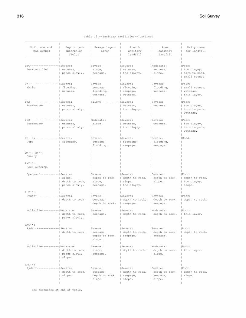
316 Soil Survey
Table 12.--Sanitary Facilities--Continued______________________________________________________________________________________________________________ | | | | | Soil name and | Septic tank | Sewage lagoon | Trench | Area | Daily cover map symbol | absorption | areas | sanitary | sanitary | for landfill | fields | | landfill | landfill |______________________________________________________________________________________________________________ | | | | | | | | | |PgC-----------------|Severe: |Severe: |Severe: |Moderate: |Poor: Pecktonville* | wetness, | slope, | wetness, | wetness, | too clayey, | percs slowly. | seepage. | too clayey. | slope. | hard to pack, | | | | | small stones. | | | | |Ph------------------|Severe: |Severe: |Severe: |Severe: |Fair: Philo | flooding, | seepage, | flooding, | flooding, | small stones, | wetness. | flooding, | seepage, | wetness. | wetness, | | wetness. | wetness. | | thin layer. | | | | |PoA-----------------|Severe: |Slight-----------|Severe: |Severe: |Poor: Poorhouse* | wetness, | | wetness, | wetness. | too clayey, | percs slowly. | | too clayey. | | hard to pack, | | | | | wetness. | | | | |PoB-----------------|Severe: |Moderate: |Severe: |Severe: |Poor: Poorhouse* | wetness, | slope. | wetness, | wetness. | too clayey, | percs slowly. | | too clayey. | | hard to pack, | | | | | wetness. | | | | |Ps, Px--------------|Severe: |Severe: |Severe: |Severe: |Good. Pope | flooding. | seepage, | flooding, | flooding, | | | flooding. | seepage. | seepage. | | | | | |Qm**, Qs**. | | | | | Quarry | | | | | | | | | |ReF**: | | | | | Rock outcrop. | | | | | | | | | | Opequon*-----------|Severe: |Severe: |Severe: |Severe: |Poor: | slope, | depth to rock, | depth to rock, | depth to rock, | depth to rock, | depth to rock, | slope, | slope, | slope. | too clayey, | percs slowly. | seepage. | too clayey. | | slope. | | | | |RnB**: | | | | | Ryder*-------------|Severe: |Severe: |Severe: |Severe: |Poor: | depth to rock. | seepage, | depth to rock, | depth to rock, | depth to rock. | | depth to rock. | seepage. | seepage. | | | | | | Nollville*---------|Moderate: |Severe: |Severe: |Moderate: |Poor: | depth to rock, | seepage. | depth to rock. | depth to rock. | thin layer. | percs slowly. | | | | | | | | |RnC**: | | | | | Ryder*-------------|Severe: |Severe: |Severe: |Severe: |Poor: | depth to rock. | seepage, | depth to rock, | depth to rock, | depth to rock. | | depth to rock, | seepage. | seepage. | | | slope. | | | | | | | | Nollville*---------|Moderate: |Severe: |Severe: |Moderate: |Poor: | depth to rock, | slope, | depth to rock. | depth to rock, | thin layer. | percs slowly, | seepage. | | slope. | | slope. | | | | | | | | |RnD**: | | | | | Ryder*-------------|Severe: |Severe: |Severe: |Severe: |Poor: | depth to rock, | seepage, | depth to rock, | depth to rock, | depth to rock, | slope. | depth to rock, | seepage, | seepage, | slope. | | slope. | slope. | slope. | | | | | |
See footnotes at end of table.
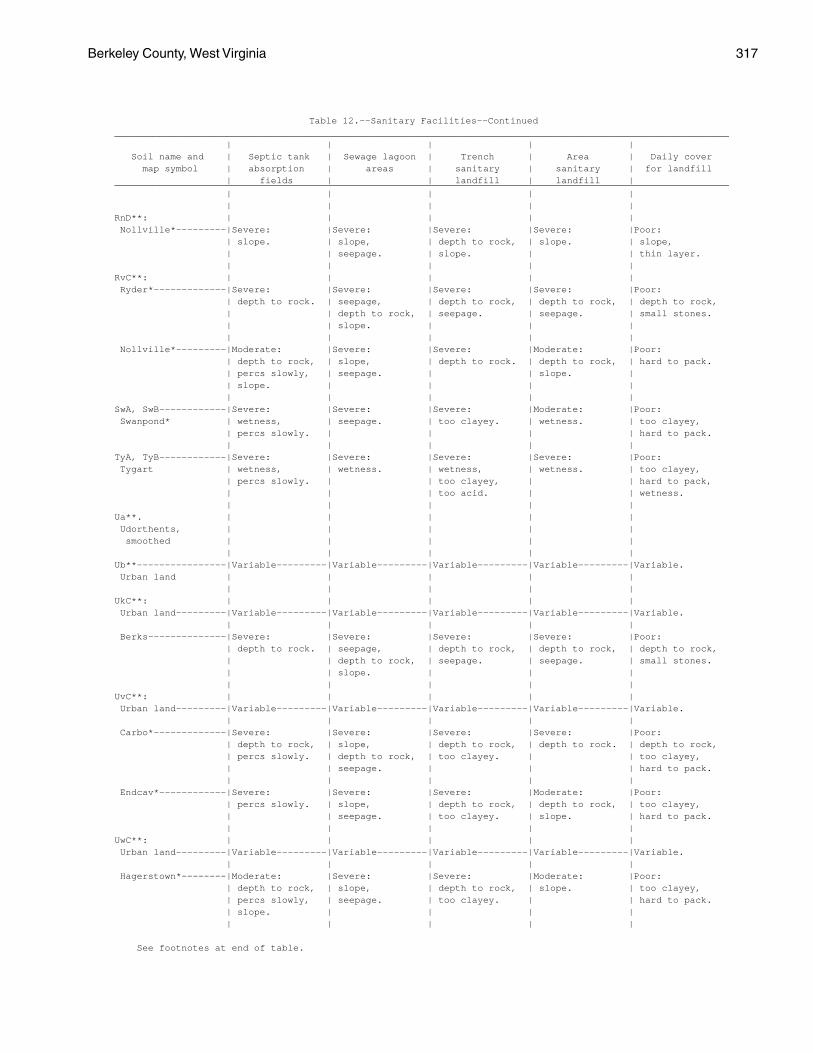
Berkeley County, West Virginia 317
Table 12.--Sanitary Facilities--Continued______________________________________________________________________________________________________________ | | | | | Soil name and | Septic tank | Sewage lagoon | Trench | Area | Daily cover map symbol | absorption | areas | sanitary | sanitary | for landfill | fields | | landfill | landfill |______________________________________________________________________________________________________________ | | | | | | | | | |RnD**: | | | | | Nollville*---------|Severe: |Severe: |Severe: |Severe: |Poor: | slope. | slope, | depth to rock, | slope. | slope, | | seepage. | slope. | | thin layer. | | | | |RvC**: | | | | | Ryder*-------------|Severe: |Severe: |Severe: |Severe: |Poor: | depth to rock. | seepage, | depth to rock, | depth to rock, | depth to rock, | | depth to rock, | seepage. | seepage. | small stones. | | slope. | | | | | | | | Nollville*---------|Moderate: |Severe: |Severe: |Moderate: |Poor: | depth to rock, | slope, | depth to rock. | depth to rock, | hard to pack. | percs slowly, | seepage. | | slope. | | slope. | | | | | | | | |SwA, SwB------------|Severe: |Severe: |Severe: |Moderate: |Poor: Swanpond* | wetness, | seepage. | too clayey. | wetness. | too clayey, | percs slowly. | | | | hard to pack. | | | | |TyA, TyB------------|Severe: |Severe: |Severe: |Severe: |Poor: Tygart | wetness, | wetness. | wetness, | wetness. | too clayey, | percs slowly. | | too clayey, | | hard to pack, | | | too acid. | | wetness. | | | | |Ua**. | | | | | Udorthents, | | | | | smoothed | | | | | | | | | |Ub**----------------|Variable---------|Variable---------|Variable---------|Variable---------|Variable. Urban land | | | | | | | | | |UkC**: | | | | | Urban land---------|Variable---------|Variable---------|Variable---------|Variable---------|Variable. | | | | | Berks--------------|Severe: |Severe: |Severe: |Severe: |Poor: | depth to rock. | seepage, | depth to rock, | depth to rock, | depth to rock, | | depth to rock, | seepage. | seepage. | small stones. | | slope. | | | | | | | |UvC**: | | | | | Urban land---------|Variable---------|Variable---------|Variable---------|Variable---------|Variable. | | | | | Carbo*-------------|Severe: |Severe: |Severe: |Severe: |Poor: | depth to rock, | slope, | depth to rock, | depth to rock. | depth to rock, | percs slowly. | depth to rock, | too clayey. | | too clayey, | | seepage. | | | hard to pack. | | | | | Endcav*------------|Severe: |Severe: |Severe: |Moderate: |Poor: | percs slowly. | slope, | depth to rock, | depth to rock, | too clayey, | | seepage. | too clayey. | slope. | hard to pack. | | | | |UwC**: | | | | | Urban land---------|Variable---------|Variable---------|Variable---------|Variable---------|Variable. | | | | | Hagerstown*--------|Moderate: |Severe: |Severe: |Moderate: |Poor: | depth to rock, | slope, | depth to rock, | slope. | too clayey, | percs slowly, | seepage. | too clayey. | | hard to pack. | slope. | | | | | | | | |
See footnotes at end of table.
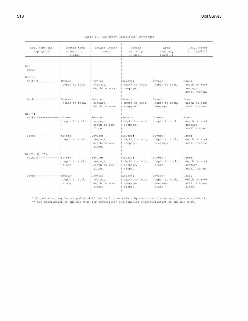
318 Soil Survey
Table 12.--Sanitary Facilities--Continued______________________________________________________________________________________________________________ | | | | | Soil name and | Septic tank | Sewage lagoon | Trench | Area | Daily cover map symbol | absorption | areas | sanitary | sanitary | for landfill | fields | | landfill | landfill |______________________________________________________________________________________________________________ | | | | | | | | | |W**. | | | | | Water | | | | | | | | | |WbB**: | | | | | Weikert------------|Severe: |Severe: |Severe: |Severe: |Poor: | depth to rock. | seepage, | depth to rock, | depth to rock. | depth to rock, | | depth to rock. | seepage. | | seepage, | | | | | small stones. | | | | | Berks--------------|Severe: |Severe: |Severe: |Severe: |Poor: | depth to rock. | seepage, | depth to rock, | depth to rock, | depth to rock, | | depth to rock. | seepage. | seepage. | small stones. | | | | |WbC**: | | | | | Weikert------------|Severe: |Severe: |Severe: |Severe: |Poor: | depth to rock. | seepage, | depth to rock, | depth to rock. | depth to rock, | | depth to rock, | seepage. | | seepage, | | slope. | | | small stones. | | | | | Berks--------------|Severe: |Severe: |Severe: |Severe: |Poor: | depth to rock. | seepage, | depth to rock, | depth to rock, | depth to rock, | | depth to rock, | seepage. | seepage. | small stones. | | slope. | | | | | | | |WbD**, WkF**: | | | | | Weikert------------|Severe: |Severe: |Severe: |Severe: |Poor: | depth to rock, | seepage, | depth to rock, | depth to rock, | depth to rock, | slope. | depth to rock, | seepage, | slope. | seepage, | | slope. | slope. | | small stones. | | | | | Berks--------------|Severe: |Severe: |Severe: |Severe: |Poor: | depth to rock, | seepage, | depth to rock, | depth to rock, | depth to rock, | slope. | depth to rock, | seepage, | seepage, | small stones, | | slope. | slope. | slope. | slope. | | | | |______________________________________________________________________________________________________________
* Ground water may become polluted if the soil is underlain by cavernous limestone or pervious bedrock. ** See description of the map unit for composition and behavior characteristics of the map unit.
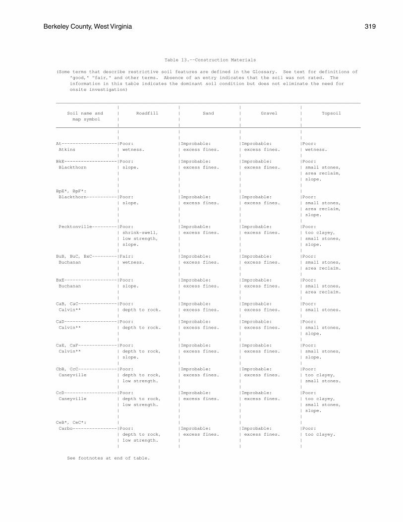
Berkeley County, West Virginia 319
Table 13.--Construction Materials
(Some terms that describe restrictive soil features are defined in the Glossary. See text for definitions of "good," "fair," and other terms. Absence of an entry indicates that the soil was not rated. The information in this table indicates the dominant soil condition but does not eliminate the need for onsite investigation)
______________________________________________________________________________________________________________ | | | | Soil name and | Roadfill | Sand | Gravel | Topsoil map symbol | | | | | | | |______________________________________________________________________________________________________________ | | | | | | | |At--------------------|Poor: |Improbable: |Improbable: |Poor: Atkins | wetness. | excess fines. | excess fines. | wetness. | | | |BkE-------------------|Poor: |Improbable: |Improbable: |Poor: Blackthorn | slope. | excess fines. | excess fines. | small stones, | | | | area reclaim, | | | | slope. | | | |BpE*, BpF*: | | | | Blackthorn-----------|Poor: |Improbable: |Improbable: |Poor: | slope. | excess fines. | excess fines. | small stones, | | | | area reclaim, | | | | slope. | | | | Pecktonville---------|Poor: |Improbable: |Improbable: |Poor: | shrink-swell, | excess fines. | excess fines. | too clayey, | low strength, | | | small stones, | slope. | | | slope. | | | |BuB, BuC, BxC---------|Fair: |Improbable: |Improbable: |Poor: Buchanan | wetness. | excess fines. | excess fines. | small stones, | | | | area reclaim. | | | |BxE-------------------|Poor: |Improbable: |Improbable: |Poor: Buchanan | slope. | excess fines. | excess fines. | small stones, | | | | area reclaim. | | | |CaB, CaC--------------|Poor: |Improbable: |Improbable: |Poor: Calvin** | depth to rock. | excess fines. | excess fines. | small stones. | | | |CaD-------------------|Poor: |Improbable: |Improbable: |Poor: Calvin** | depth to rock. | excess fines. | excess fines. | small stones, | | | | slope. | | | |CaE, CaF--------------|Poor: |Improbable: |Improbable: |Poor: Calvin** | depth to rock, | excess fines. | excess fines. | small stones, | slope. | | | slope. | | | |CbB, CcC--------------|Poor: |Improbable: |Improbable: |Poor: Caneyville | depth to rock, | excess fines. | excess fines. | too clayey, | low strength. | | | small stones. | | | |CcD-------------------|Poor: |Improbable: |Improbable: |Poor: Caneyville | depth to rock, | excess fines. | excess fines. | too clayey, | low strength. | | | small stones, | | | | slope. | | | |CeB*, CeC*: | | | | Carbo----------------|Poor: |Improbable: |Improbable: |Poor: | depth to rock, | excess fines. | excess fines. | too clayey. | low strength. | | | | | | |
See footnotes at end of table.
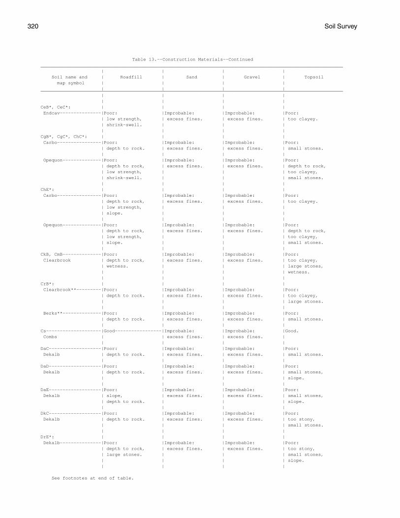
320 Soil Survey
Table 13.--Construction Materials--Continued______________________________________________________________________________________________________________ | | | | Soil name and | Roadfill | Sand | Gravel | Topsoil map symbol | | | | | | | |______________________________________________________________________________________________________________ | | | | | | | |CeB*, CeC*: | | | | Endcav---------------|Poor: |Improbable: |Improbable: |Poor: | low strength, | excess fines. | excess fines. | too clayey. | shrink-swell. | | | | | | |CgB*, CgC*, ChC*: | | | | Carbo----------------|Poor: |Improbable: |Improbable: |Poor: | depth to rock. | excess fines. | excess fines. | small stones. | | | | Opequon--------------|Poor: |Improbable: |Improbable: |Poor: | depth to rock, | excess fines. | excess fines. | depth to rock, | low strength, | | | too clayey, | shrink-swell. | | | small stones. | | | |ChE*: | | | | Carbo----------------|Poor: |Improbable: |Improbable: |Poor: | depth to rock, | excess fines. | excess fines. | too clayey. | low strength, | | | | slope. | | | | | | | Opequon--------------|Poor: |Improbable: |Improbable: |Poor: | depth to rock, | excess fines. | excess fines. | depth to rock, | low strength, | | | too clayey, | slope. | | | small stones. | | | |CkB, CmB--------------|Poor: |Improbable: |Improbable: |Poor: Clearbrook | depth to rock, | excess fines. | excess fines. | too clayey, | wetness. | | | large stones, | | | | wetness. | | | |CrB*: | | | | Clearbrook**---------|Poor: |Improbable: |Improbable: |Poor: | depth to rock. | excess fines. | excess fines. | too clayey, | | | | large stones. | | | | Berks**--------------|Poor: |Improbable: |Improbable: |Poor: | depth to rock. | excess fines. | excess fines. | small stones. | | | |Cs--------------------|Good-----------------|Improbable: |Improbable: |Good. Combs | | excess fines. | excess fines. | | | | |DaC-------------------|Poor: |Improbable: |Improbable: |Poor: Dekalb | depth to rock. | excess fines. | excess fines. | small stones. | | | |DaD-------------------|Poor: |Improbable: |Improbable: |Poor: Dekalb | depth to rock. | excess fines. | excess fines. | small stones, | | | | slope. | | | |DaE-------------------|Poor: |Improbable: |Improbable: |Poor: Dekalb | slope, | excess fines. | excess fines. | small stones, | depth to rock. | | | slope. | | | |DkC-------------------|Poor: |Improbable: |Improbable: |Poor: Dekalb | depth to rock. | excess fines. | excess fines. | too stony, | | | | small stones. | | | |DrE*: | | | | Dekalb---------------|Poor: |Improbable: |Improbable: |Poor: | depth to rock, | excess fines. | excess fines. | too stony, | large stones. | | | small stones, | | | | slope. | | | |
See footnotes at end of table.
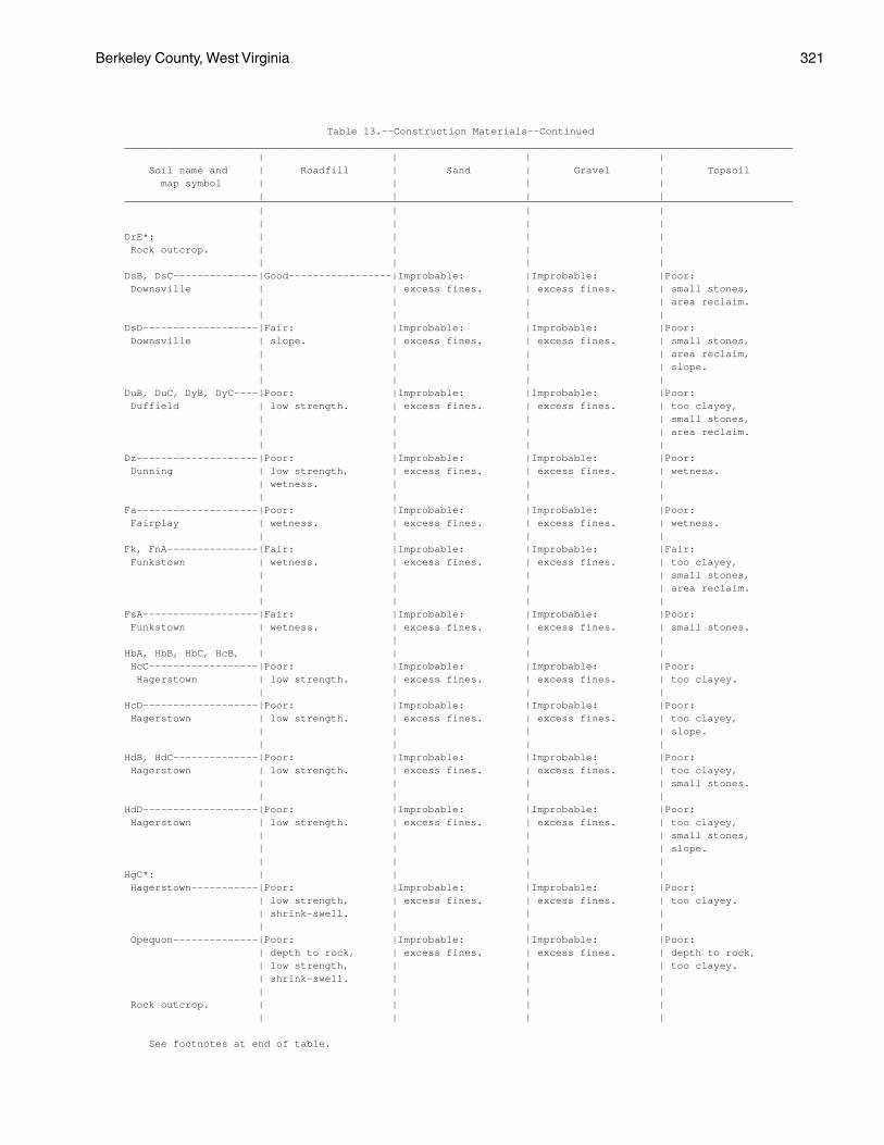
Berkeley County, West Virginia 321
Table 13.--Construction Materials--Continued______________________________________________________________________________________________________________ | | | | Soil name and | Roadfill | Sand | Gravel | Topsoil map symbol | | | | | | | |______________________________________________________________________________________________________________ | | | | | | | |DrE*: | | | | Rock outcrop. | | | | | | | |DsB, DsC--------------|Good-----------------|Improbable: |Improbable: |Poor: Downsville | | excess fines. | excess fines. | small stones, | | | | area reclaim. | | | |DsD-------------------|Fair: |Improbable: |Improbable: |Poor: Downsville | slope. | excess fines. | excess fines. | small stones, | | | | area reclaim, | | | | slope. | | | |DuB, DuC, DyB, DyC----|Poor: |Improbable: |Improbable: |Poor: Duffield | low strength. | excess fines. | excess fines. | too clayey, | | | | small stones, | | | | area reclaim. | | | |Dz--------------------|Poor: |Improbable: |Improbable: |Poor: Dunning | low strength, | excess fines. | excess fines. | wetness. | wetness. | | | | | | |Fa--------------------|Poor: |Improbable: |Improbable: |Poor: Fairplay | wetness. | excess fines. | excess fines. | wetness. | | | |Fk, FnA---------------|Fair: |Improbable: |Improbable: |Fair: Funkstown | wetness. | excess fines. | excess fines. | too clayey, | | | | small stones, | | | | area reclaim. | | | |FsA-------------------|Fair: |Improbable: |Improbable: |Poor: Funkstown | wetness. | excess fines. | excess fines. | small stones. | | | |HbA, HbB, HbC, HcB, | | | | HcC------------------|Poor: |Improbable: |Improbable: |Poor: Hagerstown | low strength. | excess fines. | excess fines. | too clayey. | | | |HcD-------------------|Poor: |Improbable: |Improbable: |Poor: Hagerstown | low strength. | excess fines. | excess fines. | too clayey, | | | | slope. | | | |HdB, HdC--------------|Poor: |Improbable: |Improbable: |Poor: Hagerstown | low strength. | excess fines. | excess fines. | too clayey, | | | | small stones. | | | |HdD-------------------|Poor: |Improbable: |Improbable: |Poor: Hagerstown | low strength. | excess fines. | excess fines. | too clayey, | | | | small stones, | | | | slope. | | | |HgC*: | | | | Hagerstown-----------|Poor: |Improbable: |Improbable: |Poor: | low strength, | excess fines. | excess fines. | too clayey. | shrink-swell. | | | | | | | Opequon--------------|Poor: |Improbable: |Improbable: |Poor: | depth to rock, | excess fines. | excess fines. | depth to rock, | low strength, | | | too clayey. | shrink-swell. | | | | | | | Rock outcrop. | | | | | | | |
See footnotes at end of table.
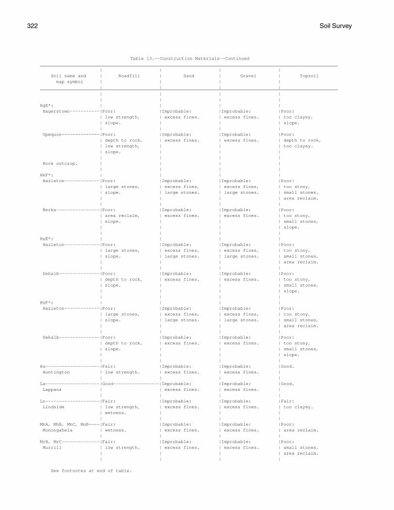
322 Soil Survey
Table 13.--Construction Materials--Continued______________________________________________________________________________________________________________ | | | | Soil name and | Roadfill | Sand | Gravel | Topsoil map symbol | | | | | | | |______________________________________________________________________________________________________________ | | | | | | | |HgE*: | | | | Hagerstown-----------|Poor: |Improbable: |Improbable: |Poor: | low strength, | excess fines. | excess fines. | too clayey, | slope. | | | slope. | | | | Opequon--------------|Poor: |Improbable: |Improbable: |Poor: | depth to rock, | excess fines. | excess fines. | depth to rock, | low strength, | | | too clayey. | slope. | | | | | | | Rock outcrop. | | | | | | | |HkF*: | | | | Hazleton-------------|Poor: |Improbable: |Improbable: |Poor: | large stones, | excess fines, | excess fines, | too stony, | slope. | large stones. | large stones. | small stones, | | | | area reclaim. | | | | Berks----------------|Poor: |Improbable: |Improbable: |Poor: | area reclaim, | excess fines. | excess fines. | too stony, | slope. | | | small stones, | | | | slope. | | | |HsE*: | | | | Hazleton-------------|Poor: |Improbable: |Improbable: |Poor: | large stones, | excess fines, | excess fines, | too stony, | slope. | large stones. | large stones. | small stones, | | | | area reclaim. | | | | Dekalb---------------|Poor: |Improbable: |Improbable: |Poor: | depth to rock, | excess fines. | excess fines. | too stony, | slope. | | | small stones, | | | | slope. | | | |HsF*: | | | | Hazleton-------------|Poor: |Improbable: |Improbable: |Poor: | large stones, | excess fines, | excess fines, | too stony, | slope. | large stones. | large stones. | small stones, | | | | area reclaim. | | | | Dekalb---------------|Poor: |Improbable: |Improbable: |Poor: | depth to rock, | excess fines. | excess fines. | too stony, | slope. | | | small stones, | | | | slope. | | | |Hu--------------------|Fair: |Improbable: |Improbable: |Good. Huntington | low strength. | excess fines. | excess fines. | | | | |La--------------------|Good-----------------|Improbable: |Improbable: |Good. Lappans | | excess fines. | excess fines. | | | | |Ln--------------------|Fair: |Improbable: |Improbable: |Fair: Lindside | low strength, | excess fines. | excess fines. | too clayey. | wetness. | | | | | | |MhA, MhB, MhC, MoB----|Fair: |Improbable: |Improbable: |Poor: Monongahela | wetness. | excess fines. | excess fines. | area reclaim. | | | |MrB, MrC--------------|Fair: |Improbable: |Improbable: |Poor: Murrill | low strength. | excess fines. | excess fines. | small stones, | | | | area reclaim. | | | |
See footnotes at end of table.
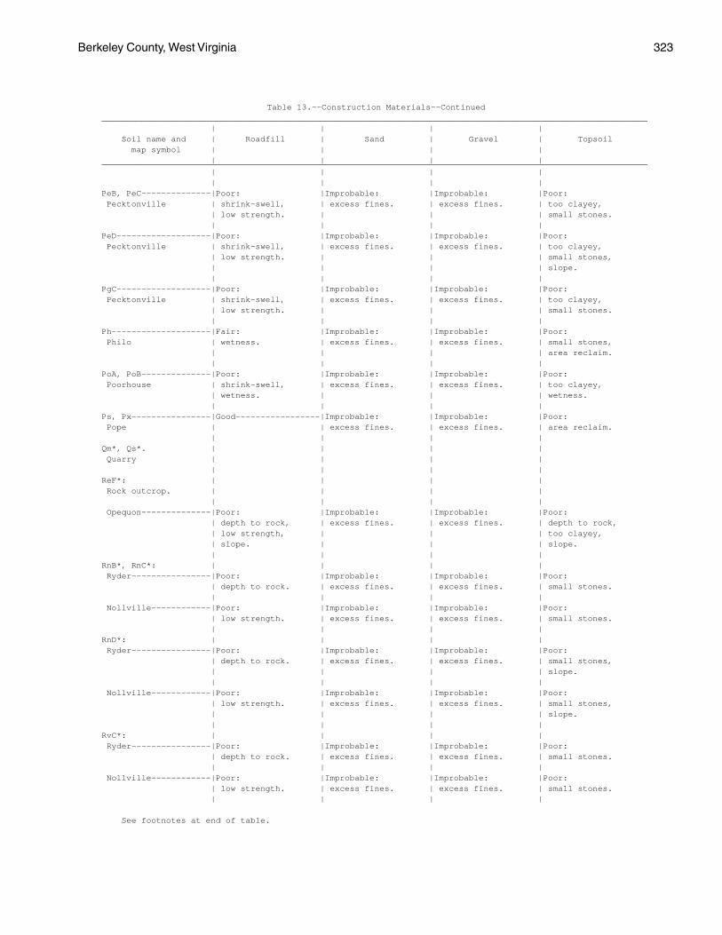
Berkeley County, West Virginia 323
Table 13.--Construction Materials--Continued______________________________________________________________________________________________________________ | | | | Soil name and | Roadfill | Sand | Gravel | Topsoil map symbol | | | | | | | |______________________________________________________________________________________________________________ | | | | | | | |PeB, PeC--------------|Poor: |Improbable: |Improbable: |Poor: Pecktonville | shrink-swell, | excess fines. | excess fines. | too clayey, | low strength. | | | small stones. | | | |PeD-------------------|Poor: |Improbable: |Improbable: |Poor: Pecktonville | shrink-swell, | excess fines. | excess fines. | too clayey, | low strength. | | | small stones, | | | | slope. | | | |PgC-------------------|Poor: |Improbable: |Improbable: |Poor: Pecktonville | shrink-swell, | excess fines. | excess fines. | too clayey, | low strength. | | | small stones. | | | |Ph--------------------|Fair: |Improbable: |Improbable: |Poor: Philo | wetness. | excess fines. | excess fines. | small stones, | | | | area reclaim. | | | |PoA, PoB--------------|Poor: |Improbable: |Improbable: |Poor: Poorhouse | shrink-swell, | excess fines. | excess fines. | too clayey, | wetness. | | | wetness. | | | |Ps, Px----------------|Good-----------------|Improbable: |Improbable: |Poor: Pope | | excess fines. | excess fines. | area reclaim. | | | |Qm*, Qs*. | | | | Quarry | | | | | | | |ReF*: | | | | Rock outcrop. | | | | | | | | Opequon--------------|Poor: |Improbable: |Improbable: |Poor: | depth to rock, | excess fines. | excess fines. | depth to rock, | low strength, | | | too clayey, | slope. | | | slope. | | | |RnB*, RnC*: | | | | Ryder----------------|Poor: |Improbable: |Improbable: |Poor: | depth to rock. | excess fines. | excess fines. | small stones. | | | | Nollville------------|Poor: |Improbable: |Improbable: |Poor: | low strength. | excess fines. | excess fines. | small stones. | | | |RnD*: | | | | Ryder----------------|Poor: |Improbable: |Improbable: |Poor: | depth to rock. | excess fines. | excess fines. | small stones, | | | | slope. | | | | Nollville------------|Poor: |Improbable: |Improbable: |Poor: | low strength. | excess fines. | excess fines. | small stones, | | | | slope. | | | |RvC*: | | | | Ryder----------------|Poor: |Improbable: |Improbable: |Poor: | depth to rock. | excess fines. | excess fines. | small stones. | | | | Nollville------------|Poor: |Improbable: |Improbable: |Poor: | low strength. | excess fines. | excess fines. | small stones. | | | |
See footnotes at end of table.
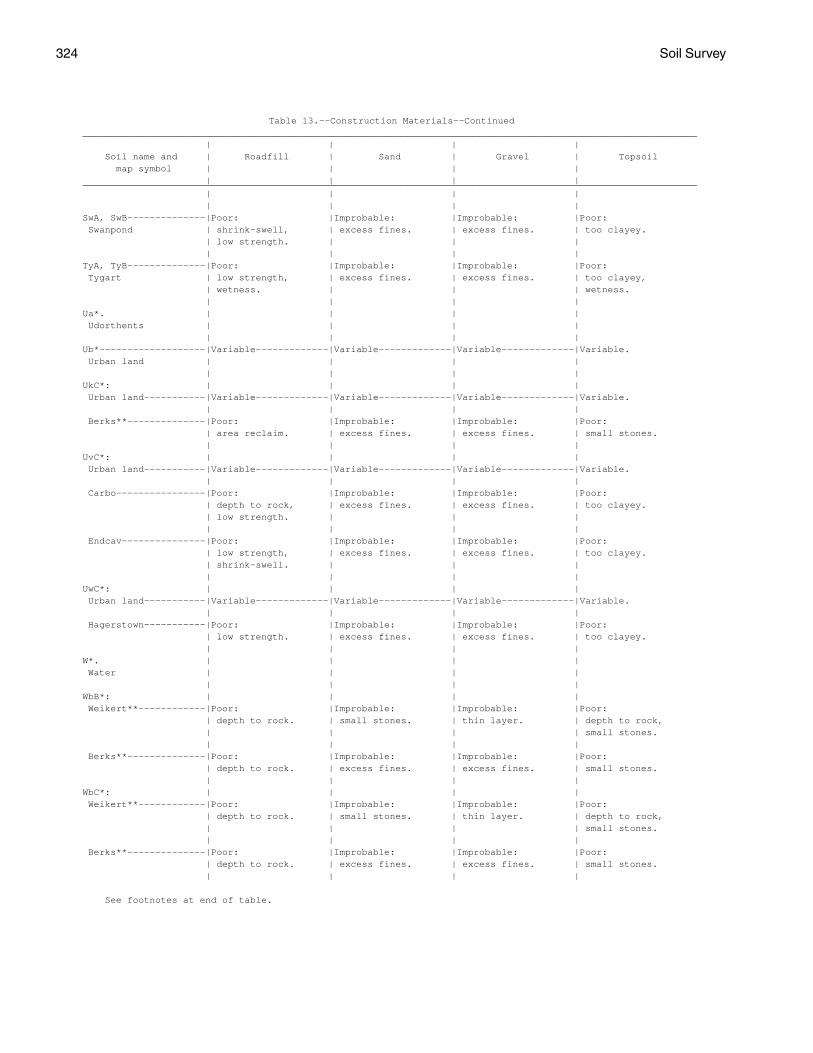
324 Soil Survey
Table 13.--Construction Materials--Continued______________________________________________________________________________________________________________ | | | | Soil name and | Roadfill | Sand | Gravel | Topsoil map symbol | | | | | | | |______________________________________________________________________________________________________________ | | | | | | | |SwA, SwB--------------|Poor: |Improbable: |Improbable: |Poor: Swanpond | shrink-swell, | excess fines. | excess fines. | too clayey. | low strength. | | | | | | |TyA, TyB--------------|Poor: |Improbable: |Improbable: |Poor: Tygart | low strength, | excess fines. | excess fines. | too clayey, | wetness. | | | wetness. | | | |Ua*. | | | | Udorthents | | | | | | | |Ub*-------------------|Variable-------------|Variable-------------|Variable-------------|Variable. Urban land | | | | | | | |UkC*: | | | | Urban land-----------|Variable-------------|Variable-------------|Variable-------------|Variable. | | | | Berks**--------------|Poor: |Improbable: |Improbable: |Poor: | area reclaim. | excess fines. | excess fines. | small stones. | | | |UvC*: | | | | Urban land-----------|Variable-------------|Variable-------------|Variable-------------|Variable. | | | | Carbo----------------|Poor: |Improbable: |Improbable: |Poor: | depth to rock, | excess fines. | excess fines. | too clayey. | low strength. | | | | | | | Endcav---------------|Poor: |Improbable: |Improbable: |Poor: | low strength, | excess fines. | excess fines. | too clayey. | shrink-swell. | | | | | | |UwC*: | | | | Urban land-----------|Variable-------------|Variable-------------|Variable-------------|Variable. | | | | Hagerstown-----------|Poor: |Improbable: |Improbable: |Poor: | low strength. | excess fines. | excess fines. | too clayey. | | | |W*. | | | | Water | | | | | | | |WbB*: | | | | Weikert**------------|Poor: |Improbable: |Improbable: |Poor: | depth to rock. | small stones. | thin layer. | depth to rock, | | | | small stones. | | | | Berks**--------------|Poor: |Improbable: |Improbable: |Poor: | depth to rock. | excess fines. | excess fines. | small stones. | | | |WbC*: | | | | Weikert**------------|Poor: |Improbable: |Improbable: |Poor: | depth to rock. | small stones. | thin layer. | depth to rock, | | | | small stones. | | | | Berks**--------------|Poor: |Improbable: |Improbable: |Poor: | depth to rock. | excess fines. | excess fines. | small stones. | | | |
See footnotes at end of table.
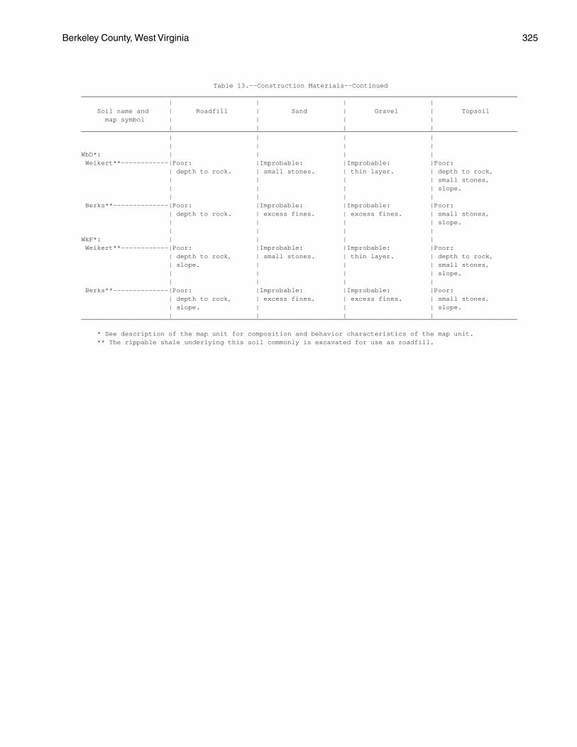
Berkeley County, West Virginia 325
Table 13.--Construction Materials--Continued______________________________________________________________________________________________________________ | | | | Soil name and | Roadfill | Sand | Gravel | Topsoil map symbol | | | | | | | |______________________________________________________________________________________________________________ | | | | | | | |WbD*: | | | | Weikert**------------|Poor: |Improbable: |Improbable: |Poor: | depth to rock. | small stones. | thin layer. | depth to rock, | | | | small stones, | | | | slope. | | | | Berks**--------------|Poor: |Improbable: |Improbable: |Poor: | depth to rock. | excess fines. | excess fines. | small stones, | | | | slope. | | | |WkF*: | | | | Weikert**------------|Poor: |Improbable: |Improbable: |Poor: | depth to rock, | small stones. | thin layer. | depth to rock, | slope. | | | small stones, | | | | slope. | | | | Berks**--------------|Poor: |Improbable: |Improbable: |Poor: | depth to rock, | excess fines. | excess fines. | small stones, | slope. | | | slope. | | | |______________________________________________________________________________________________________________
* See description of the map unit for composition and behavior characteristics of the map unit. ** The rippable shale underlying this soil commonly is excavated for use as roadfill.
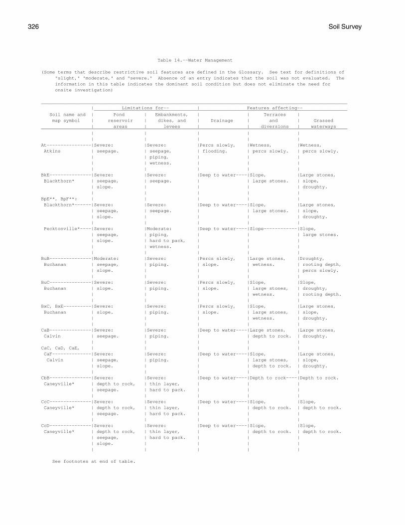
326 Soil Survey
Table 14.--Water Management
(Some terms that describe restrictive soil features are defined in the Glossary. See text for definitions of "slight," "moderate," and "severe." Absence of an entry indicates that the soil was not evaluated. The information in this table indicates the dominant soil condition but does not eliminate the need for onsite investigation)
______________________________________________________________________________________________________________ | Limitations for-- | Features affecting-- ___________________________________________________________________________________________ Soil name and | Pond | Embankments, | | Terraces | map symbol | reservoir | dikes, and | Drainage | and | Grassed | areas | levees | | diversions | waterways______________________________________________________________________________________________________________ | | | | | | | | | |At----------------|Severe: |Severe: |Percs slowly, |Wetness, |Wetness, Atkins | seepage. | seepage, | flooding. | percs slowly. | percs slowly. | | piping, | | | | | wetness. | | | | | | | |BkE---------------|Severe: |Severe: |Deep to water----|Slope, |Large stones, Blackthorn* | seepage, | seepage. | | large stones. | slope, | slope. | | | | droughty. | | | | |BpE**, BpF**: | | | | | Blackthorn*------|Severe: |Severe: |Deep to water----|Slope, |Large stones, | seepage, | seepage. | | large stones. | slope, | slope. | | | | droughty. | | | | | Pecktonville*----|Severe: |Moderate: |Deep to water----|Slope------------|Slope, | seepage, | piping, | | | large stones. | slope. | hard to pack, | | | | | wetness. | | | | | | | |BuB---------------|Moderate: |Severe: |Percs slowly, |Large stones, |Droughty, Buchanan | seepage, | piping. | slope. | wetness. | rooting depth, | slope. | | | | percs slowly. | | | | |BuC---------------|Severe: |Severe: |Percs slowly, |Slope, |Slope, Buchanan | slope. | piping. | slope. | large stones, | droughty, | | | | wetness. | rooting depth. | | | | |BxC, BxE----------|Severe: |Severe: |Percs slowly, |Slope, |Large stones, Buchanan | slope. | piping. | slope. | large stones, | slope, | | | | wetness. | droughty. | | | | |CaB---------------|Severe: |Severe: |Deep to water----|Large stones, |Large stones, Calvin | seepage. | piping. | | depth to rock. | droughty. | | | | |CaC, CaD, CaE, | | | | | CaF--------------|Severe: |Severe: |Deep to water----|Slope, |Large stones, Calvin | seepage, | piping. | | large stones, | slope, | slope. | | | depth to rock. | droughty. | | | | |CbB---------------|Severe: |Severe: |Deep to water----|Depth to rock----|Depth to rock. Caneyville* | depth to rock, | thin layer, | | | | seepage. | hard to pack. | | | | | | | |CcC---------------|Severe: |Severe: |Deep to water----|Slope, |Slope, Caneyville* | depth to rock, | thin layer, | | depth to rock. | depth to rock. | seepage. | hard to pack. | | | | | | | |CcD---------------|Severe: |Severe: |Deep to water----|Slope, |Slope, Caneyville* | depth to rock, | thin layer, | | depth to rock. | depth to rock. | seepage, | hard to pack. | | | | slope. | | | | | | | | |
See footnotes at end of table.
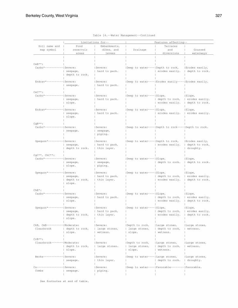
Berkeley County, West Virginia 327
Table 14.--Water Management--Continued______________________________________________________________________________________________________________ | Limitations for-- | Features affecting-- ___________________________________________________________________________________________ Soil name and | Pond | Embankments, | | Terraces | map symbol | reservoir | dikes, and | Drainage | and | Grassed | areas | levees | | diversions | waterways______________________________________________________________________________________________________________ | | | | | | | | | |CeB**: | | | | | Carbo*-----------|Severe: |Severe: |Deep to water----|Depth to rock, |Erodes easily, | seepage, | hard to pack. | | erodes easily. | depth to rock. | depth to rock. | | | | | | | | | Endcav*----------|Severe: |Severe: |Deep to water----|Erodes easily----|Erodes easily. | seepage. | hard to pack. | | | | | | | |CeC**: | | | | | Carbo*-----------|Severe: |Severe: |Deep to water----|Slope, |Slope, | seepage, | hard to pack. | | depth to rock, | erodes easily, | slope. | | | erodes easily. | depth to rock. | | | | | Endcav*----------|Severe: |Severe: |Deep to water----|Slope, |Slope, | seepage, | hard to pack. | | erodes easily. | erodes easily. | slope. | | | | | | | | |CgB**: | | | | | Carbo*-----------|Severe: |Severe: |Deep to water----|Depth to rock----|Depth to rock. | seepage. | seepage, | | | | | piping. | | | | | | | | Opequon*---------|Severe: |Severe: |Deep to water----|Depth to rock, |Erodes easily, | seepage, | hard to pack, | | erodes easily. | depth to rock, | depth to rock. | thin layer. | | | droughty. | | | | |CgC**, ChC**: | | | | | Carbo*-----------|Severe: |Severe: |Deep to water----|Slope, |Slope, | seepage, | seepage, | | depth to rock. | depth to rock. | slope. | piping. | | | | | | | | Opequon*---------|Severe: |Severe: |Deep to water----|Slope, |Slope, | seepage, | hard to pack, | | depth to rock, | erodes easily, | depth to rock, | thin layer. | | erodes easily. | depth to rock. | slope. | | | | | | | | |ChE*: | | | | | Carbo*-----------|Severe: |Severe: |Deep to water----|Slope, |Slope, | seepage, | hard to pack. | | depth to rock, | erodes easily, | slope. | | | erodes easily. | depth to rock. | | | | | Opequon*---------|Severe: |Severe: |Deep to water----|Slope, |Slope, | seepage, | hard to pack, | | depth to rock, | erodes easily, | depth to rock, | thin layer. | | erodes easily. | depth to rock. | slope. | | | | | | | | |CkB, CmB----------|Moderate: |Severe: |Depth to rock, |Large stones, |Large stones, Clearbrook | depth to rock, | large stones, | large stones, | depth to rock, | wetness. | slope. | wetness. | slope. | wetness. | | | | | |CrB**: | | | | | Clearbrook-------|Moderate: |Severe: |Depth to rock, |Large stones, |Large stones, | depth to rock, | large stones. | large stones, | depth to rock, | wetness. | slope. | | slope. | wetness. | | | | | | Berks------------|Severe: |Severe: |Deep to water----|Large stones, |Large stones, | seepage. | thin layer. | | depth to rock. | droughty. | | | | |Cs----------------|Severe: |Severe: |Deep to water----|Favorable--------|Favorable. Combs | seepage. | piping. | | | | | | | |
See footnotes at end of table.
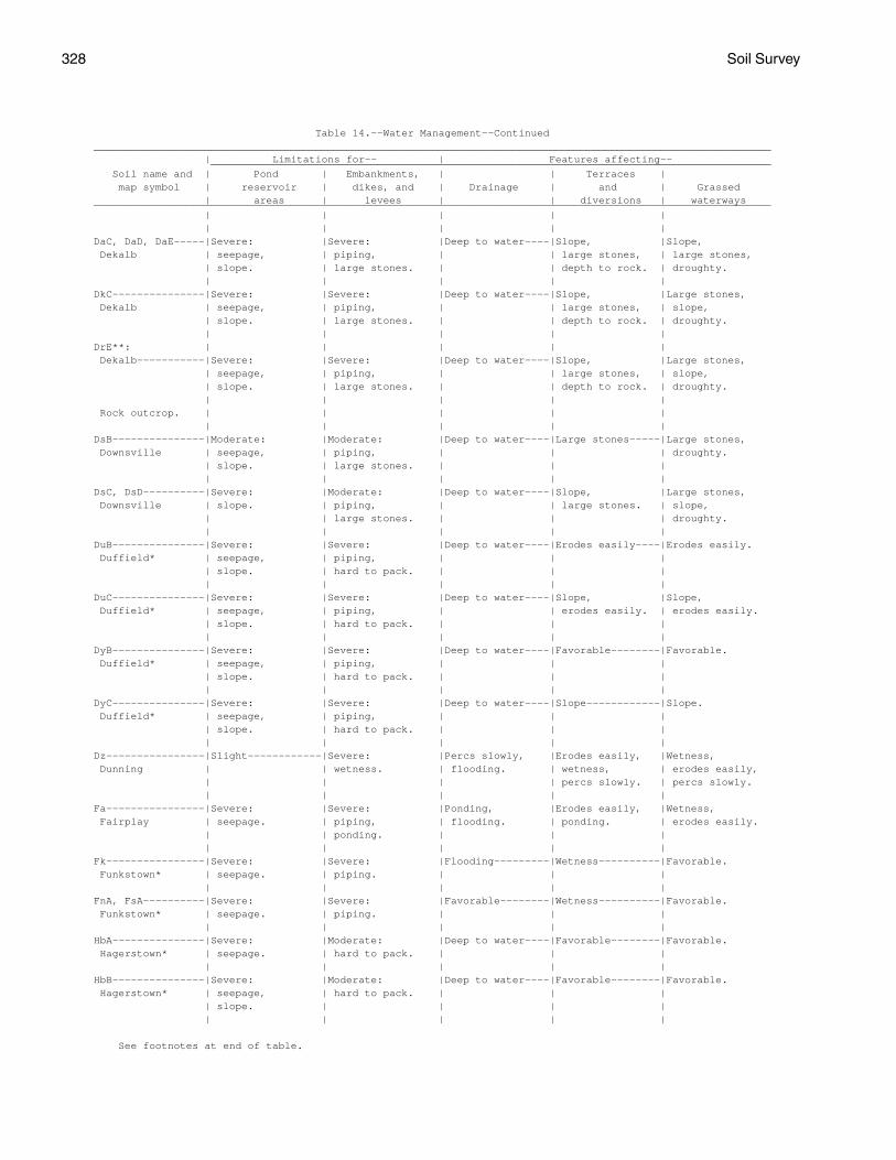
328 Soil Survey
Table 14.--Water Management--Continued______________________________________________________________________________________________________________ | Limitations for-- | Features affecting-- ___________________________________________________________________________________________ Soil name and | Pond | Embankments, | | Terraces | map symbol | reservoir | dikes, and | Drainage | and | Grassed | areas | levees | | diversions | waterways______________________________________________________________________________________________________________ | | | | | | | | | |DaC, DaD, DaE-----|Severe: |Severe: |Deep to water----|Slope, |Slope, Dekalb | seepage, | piping, | | large stones, | large stones, | slope. | large stones. | | depth to rock. | droughty. | | | | |DkC---------------|Severe: |Severe: |Deep to water----|Slope, |Large stones, Dekalb | seepage, | piping, | | large stones, | slope, | slope. | large stones. | | depth to rock. | droughty. | | | | |DrE**: | | | | | Dekalb-----------|Severe: |Severe: |Deep to water----|Slope, |Large stones, | seepage, | piping, | | large stones, | slope, | slope. | large stones. | | depth to rock. | droughty. | | | | | Rock outcrop. | | | | | | | | | |DsB---------------|Moderate: |Moderate: |Deep to water----|Large stones-----|Large stones, Downsville | seepage, | piping, | | | droughty. | slope. | large stones. | | | | | | | |DsC, DsD----------|Severe: |Moderate: |Deep to water----|Slope, |Large stones, Downsville | slope. | piping, | | large stones. | slope, | | large stones. | | | droughty. | | | | |DuB---------------|Severe: |Severe: |Deep to water----|Erodes easily----|Erodes easily. Duffield* | seepage, | piping, | | | | slope. | hard to pack. | | | | | | | |DuC---------------|Severe: |Severe: |Deep to water----|Slope, |Slope, Duffield* | seepage, | piping, | | erodes easily. | erodes easily. | slope. | hard to pack. | | | | | | | |DyB---------------|Severe: |Severe: |Deep to water----|Favorable--------|Favorable. Duffield* | seepage, | piping, | | | | slope. | hard to pack. | | | | | | | |DyC---------------|Severe: |Severe: |Deep to water----|Slope------------|Slope. Duffield* | seepage, | piping, | | | | slope. | hard to pack. | | | | | | | |Dz----------------|Slight------------|Severe: |Percs slowly, |Erodes easily, |Wetness, Dunning | | wetness. | flooding. | wetness, | erodes easily, | | | | percs slowly. | percs slowly. | | | | |Fa----------------|Severe: |Severe: |Ponding, |Erodes easily, |Wetness, Fairplay | seepage. | piping, | flooding. | ponding. | erodes easily. | | ponding. | | | | | | | |Fk----------------|Severe: |Severe: |Flooding---------|Wetness----------|Favorable. Funkstown* | seepage. | piping. | | | | | | | |FnA, FsA----------|Severe: |Severe: |Favorable--------|Wetness----------|Favorable. Funkstown* | seepage. | piping. | | | | | | | |HbA---------------|Severe: |Moderate: |Deep to water----|Favorable--------|Favorable. Hagerstown* | seepage. | hard to pack. | | | | | | | |HbB---------------|Severe: |Moderate: |Deep to water----|Favorable--------|Favorable. Hagerstown* | seepage, | hard to pack. | | | | slope. | | | | | | | | |
See footnotes at end of table.

Berkeley County, West Virginia 329
Table 14.--Water Management--Continued______________________________________________________________________________________________________________ | Limitations for-- | Features affecting-- ___________________________________________________________________________________________ Soil name and | Pond | Embankments, | | Terraces | map symbol | reservoir | dikes, and | Drainage | and | Grassed | areas | levees | | diversions | waterways______________________________________________________________________________________________________________ | | | | | | | | | |HbC---------------|Severe: |Moderate: |Deep to water----|Slope------------|Slope. Hagerstown* | seepage, | hard to pack. | | | | slope. | | | | | | | | |HcB---------------|Severe: |Moderate: |Deep to water----|Favorable--------|Favorable. Hagerstown* | seepage. | hard to pack. | | | | | | | |HcC, HcD----------|Severe: |Moderate: |Deep to water----|Slope------------|Slope. Hagerstown* | seepage, | hard to pack. | | | | slope. | | | | | | | | |HdB---------------|Severe: |Moderate: |Deep to water----|Favorable--------|Favorable. Hagerstown* | seepage. | hard to pack. | | | | | | | |HdC, HdD----------|Severe: |Moderate: |Deep to water----|Slope------------|Slope. Hagerstown* | seepage, | hard to pack. | | | | slope. | | | | | | | | |HgC**, HgE**: | | | | | Hagerstown*------|Severe: |Severe: |Deep to water----|Slope, |Slope, | depth to rock, | hard to pack. | | depth to rock. | depth to rock. | slope, | | | | | seepage. | | | | | | | | | Opequon*---------|Severe: |Severe: |Deep to water----|Slope, |Slope, | depth to rock, | hard to pack, | | depth to rock, | erodes easily, | slope. | thin layer. | | erodes easily. | depth to rock. | | | | | Rock outcrop. | | | | | | | | | |HkF**: | | | | | Hazleton---------|Severe: |Severe: |Deep to water----|Slope, |Large stones, | seepage, | seepage, | | large stones, | slope, | slope. | large stones. | | too sandy. | droughty. | | | | | Berks. | | | | | | | | | |HsE**: | | | | | Hazleton---------|Severe: |Severe: |Deep to water----|Slope, |Large stones, | seepage, | seepage, | | large stones, | slope, | slope. | large stones. | | too sandy. | droughty. | | | | | Dekalb-----------|Severe: |Severe: |Deep to water----|Slope, |Large stones, | seepage, | piping, | | large stones, | slope, | slope. | large stones. | | depth to rock. | droughty. | | | | |HsF**: | | | | | Hazleton---------|Severe: |Severe: |Deep to water----|Slope, |Large stones, | seepage, | seepage, | | large stones, | slope, | slope. | large stones. | | too sandy. | droughty. | | | | | Dekalb-----------|Severe: |Severe: |Deep to water----|Slope, |Large stones, | seepage, | piping, | | large stones, | slope, | slope. | large stones. | | depth to rock. | droughty. | | | | |Hu----------------|Moderate: |Severe: |Deep to water----|Favorable--------|Favorable. Huntington | seepage. | piping. | | | | | | | |La----------------|Severe: |Severe: |Deep to water----|Erodes easily----|Erodes easily. Lappans | seepage. | piping. | | | | | | | |
See footnotes at end of table.
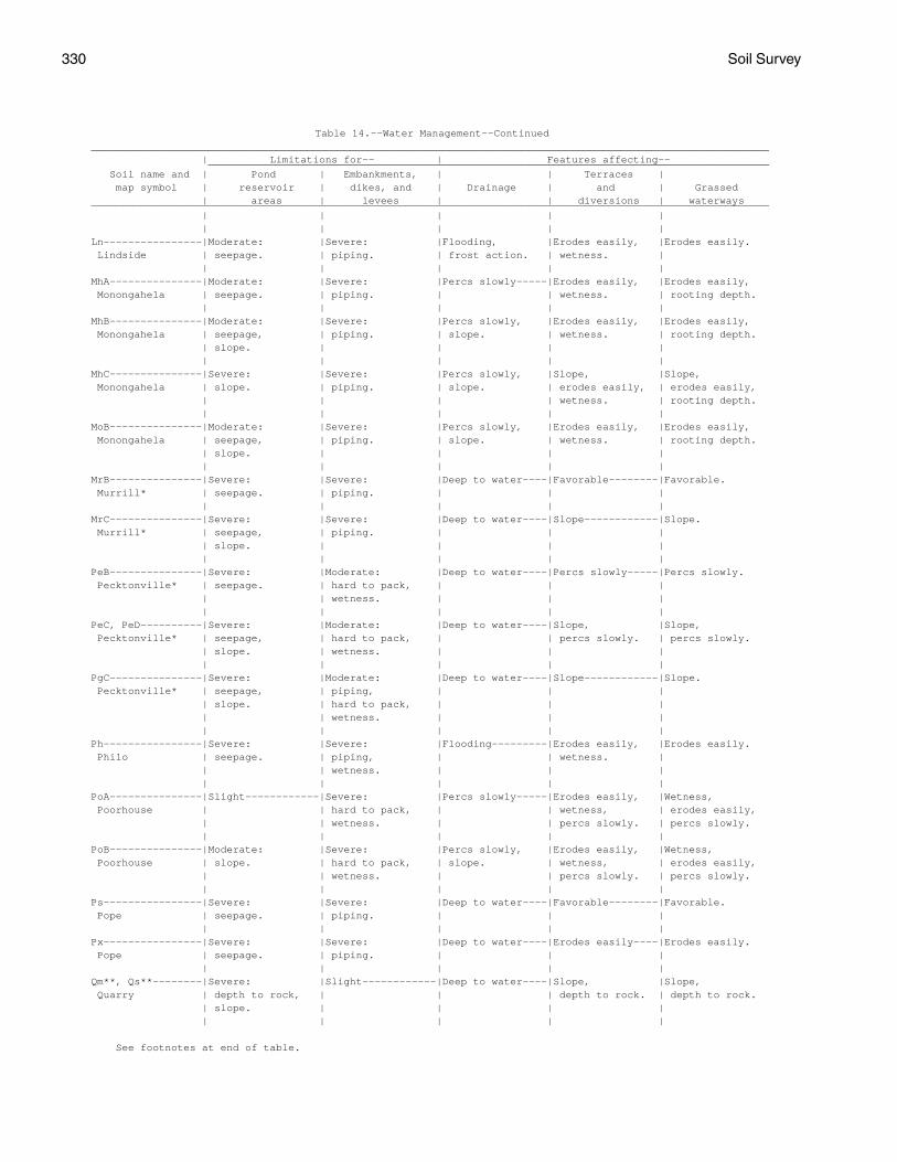
330 Soil Survey
Table 14.--Water Management--Continued______________________________________________________________________________________________________________ | Limitations for-- | Features affecting-- ___________________________________________________________________________________________ Soil name and | Pond | Embankments, | | Terraces | map symbol | reservoir | dikes, and | Drainage | and | Grassed | areas | levees | | diversions | waterways______________________________________________________________________________________________________________ | | | | | | | | | |Ln----------------|Moderate: |Severe: |Flooding, |Erodes easily, |Erodes easily. Lindside | seepage. | piping. | frost action. | wetness. | | | | | |MhA---------------|Moderate: |Severe: |Percs slowly-----|Erodes easily, |Erodes easily, Monongahela | seepage. | piping. | | wetness. | rooting depth. | | | | |MhB---------------|Moderate: |Severe: |Percs slowly, |Erodes easily, |Erodes easily, Monongahela | seepage, | piping. | slope. | wetness. | rooting depth. | slope. | | | | | | | | |MhC---------------|Severe: |Severe: |Percs slowly, |Slope, |Slope, Monongahela | slope. | piping. | slope. | erodes easily, | erodes easily, | | | | wetness. | rooting depth. | | | | |MoB---------------|Moderate: |Severe: |Percs slowly, |Erodes easily, |Erodes easily, Monongahela | seepage, | piping. | slope. | wetness. | rooting depth. | slope. | | | | | | | | |MrB---------------|Severe: |Severe: |Deep to water----|Favorable--------|Favorable. Murrill* | seepage. | piping. | | | | | | | |MrC---------------|Severe: |Severe: |Deep to water----|Slope------------|Slope. Murrill* | seepage, | piping. | | | | slope. | | | | | | | | |PeB---------------|Severe: |Moderate: |Deep to water----|Percs slowly-----|Percs slowly. Pecktonville* | seepage. | hard to pack, | | | | | wetness. | | | | | | | |PeC, PeD----------|Severe: |Moderate: |Deep to water----|Slope, |Slope, Pecktonville* | seepage, | hard to pack, | | percs slowly. | percs slowly. | slope. | wetness. | | | | | | | |PgC---------------|Severe: |Moderate: |Deep to water----|Slope------------|Slope. Pecktonville* | seepage, | piping, | | | | slope. | hard to pack, | | | | | wetness. | | | | | | | |Ph----------------|Severe: |Severe: |Flooding---------|Erodes easily, |Erodes easily. Philo | seepage. | piping, | | wetness. | | | wetness. | | | | | | | |PoA---------------|Slight------------|Severe: |Percs slowly-----|Erodes easily, |Wetness, Poorhouse | | hard to pack, | | wetness, | erodes easily, | | wetness. | | percs slowly. | percs slowly. | | | | |PoB---------------|Moderate: |Severe: |Percs slowly, |Erodes easily, |Wetness, Poorhouse | slope. | hard to pack, | slope. | wetness, | erodes easily, | | wetness. | | percs slowly. | percs slowly. | | | | |Ps----------------|Severe: |Severe: |Deep to water----|Favorable--------|Favorable. Pope | seepage. | piping. | | | | | | | |Px----------------|Severe: |Severe: |Deep to water----|Erodes easily----|Erodes easily. Pope | seepage. | piping. | | | | | | | |Qm**, Qs**--------|Severe: |Slight------------|Deep to water----|Slope, |Slope, Quarry | depth to rock, | | | depth to rock. | depth to rock. | slope. | | | | | | | | |
See footnotes at end of table.
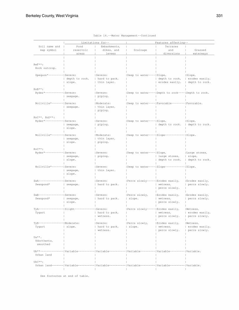
Berkeley County, West Virginia 331
Table 14.--Water Management--Continued______________________________________________________________________________________________________________ | Limitations for-- | Features affecting-- ___________________________________________________________________________________________ Soil name and | Pond | Embankments, | | Terraces | map symbol | reservoir | dikes, and | Drainage | and | Grassed | areas | levees | | diversions | waterways______________________________________________________________________________________________________________ | | | | | | | | | |ReF**: | | | | | Rock outcrop. | | | | | | | | | | Opequon*---------|Severe: |Severe: |Deep to water----|Slope, |Slope, | depth to rock, | hard to pack, | | depth to rock, | erodes easily, | slope. | thin layer. | | erodes easily. | depth to rock. | | | | |RnB**: | | | | | Ryder*-----------|Severe: |Severe: |Deep to water----|Depth to rock----|Depth to rock. | seepage. | piping. | | | | | | | | Nollville*-------|Severe: |Moderate: |Deep to water----|Favorable--------|Favorable. | seepage. | thin layer, | | | | | piping. | | | | | | | |RnC**, RnD**: | | | | | Ryder*-----------|Severe: |Severe: |Deep to water----|Slope, |Slope, | seepage, | piping. | | depth to rock. | depth to rock. | slope. | | | | | | | | | Nollville*-------|Severe: |Moderate: |Deep to water----|Slope------------|Slope. | seepage, | thin layer, | | | | slope. | piping. | | | | | | | |RvC**: | | | | | Ryder*-----------|Severe: |Severe: |Deep to water----|Slope, |Large stones, | seepage, | piping. | | large stones, | slope, | slope. | | | depth to rock. | depth to rock. | | | | | Nollville*-------|Severe: |Severe: |Deep to water----|Slope------------|Slope. | seepage, | thin layer. | | | | slope. | | | | | | | | |SwA---------------|Severe: |Severe: |Percs slowly-----|Erodes easily, |Erodes easily, Swanpond* | seepage. | hard to pack. | | wetness, | percs slowly. | | | | percs slowly. | | | | | |SwB---------------|Severe: |Severe: |Percs slowly, |Erodes easily, |Erodes easily, Swanpond* | seepage, | hard to pack. | slope. | wetness, | percs slowly. | slope. | | | percs slowly. | | | | | |TyA---------------|Slight------------|Severe: |Percs slowly-----|Erodes easily, |Wetness, Tygart | | hard to pack, | | wetness, | erodes easily, | | wetness. | | percs slowly. | percs slowly. | | | | |TyB---------------|Moderate: |Severe: |Percs slowly, |Erodes easily, |Wetness, Tygart | slope. | hard to pack, | slope. | wetness, | erodes easily, | | wetness. | | percs slowly. | percs slowly. | | | | |Ua**. | | | | | Udorthents, | | | | | smoothed | | | | | | | | | |Ub**--------------|Variable----------|Variable----------|Variable---------|Variable---------|Variable. Urban land | | | | | | | | | |UkC**: | | | | | Urban land-------|Variable----------|Variable----------|Variable---------|Variable---------|Variable. | | | | |
See footnotes at end of table.
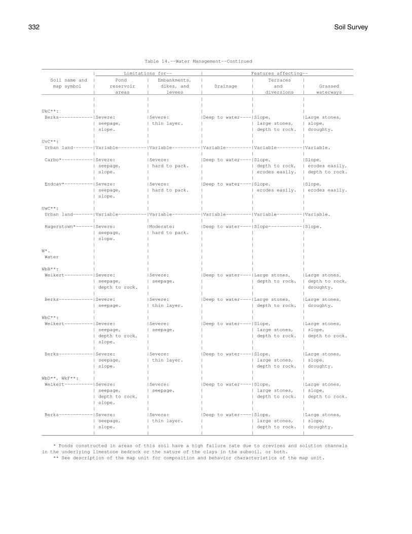
332 Soil Survey
Table 14.--Water Management--Continued______________________________________________________________________________________________________________ | Limitations for-- | Features affecting-- ___________________________________________________________________________________________ Soil name and | Pond | Embankments, | | Terraces | map symbol | reservoir | dikes, and | Drainage | and | Grassed | areas | levees | | diversions | waterways______________________________________________________________________________________________________________ | | | | | | | | | |UkC**: | | | | | Berks------------|Severe: |Severe: |Deep to water----|Slope, |Large stones, | seepage, | thin layer. | | large stones, | slope, | slope. | | | depth to rock. | droughty. | | | | |UvC**: | | | | | Urban land-------|Variable----------|Variable----------|Variable---------|Variable---------|Variable. | | | | | Carbo*-----------|Severe: |Severe: |Deep to water----|Slope, |Slope, | seepage, | hard to pack. | | depth to rock, | erodes easily, | slope. | | | erodes easily. | depth to rock. | | | | | Endcav*----------|Severe: |Severe: |Deep to water----|Slope, |Slope, | seepage, | hard to pack. | | erodes easily. | erodes easily. | slope. | | | | | | | | |UwC**: | | | | | Urban land-------|Variable----------|Variable----------|Variable---------|Variable---------|Variable. | | | | | Hagerstown*------|Severe: |Moderate: |Deep to water----|Slope------------|Slope. | seepage, | hard to pack. | | | | slope. | | | | | | | | |W*. | | | | | Water | | | | | | | | | |WbB**: | | | | | Weikert----------|Severe: |Severe: |Deep to water----|Large stones, |Large stones, | seepage, | seepage. | | depth to rock. | depth to rock, | depth to rock. | | | | droughty. | | | | | Berks------------|Severe: |Severe: |Deep to water----|Large stones, |Large stones, | seepage. | thin layer. | | depth to rock. | droughty. | | | | |WbC**: | | | | | Weikert----------|Severe: |Severe: |Deep to water----|Slope, |Large stones, | seepage, | seepage. | | large stones, | slope, | depth to rock, | | | depth to rock. | depth to rock. | slope. | | | | | | | | | Berks------------|Severe: |Severe: |Deep to water----|Slope, |Large stones, | seepage, | thin layer. | | large stones, | slope, | slope. | | | depth to rock. | droughty. | | | | |WbD**, WkF**: | | | | | Weikert----------|Severe: |Severe: |Deep to water----|Slope, |Large stones, | seepage, | seepage. | | large stones, | slope, | depth to rock, | | | depth to rock. | depth to rock. | slope. | | | | | | | | | Berks------------|Severe: |Severe: |Deep to water----|Slope, |Large stones, | seepage, | thin layer. | | large stones, | slope, | slope. | | | depth to rock. | droughty. | | | | |______________________________________________________________________________________________________________
* Ponds constructed in areas of this soil have a high failure rate due to crevices and solution channelsin the underlying limestone bedrock or the nature of the clays in the subsoil, or both. ** See description of the map unit for composition and behavior characteristics of the map unit.
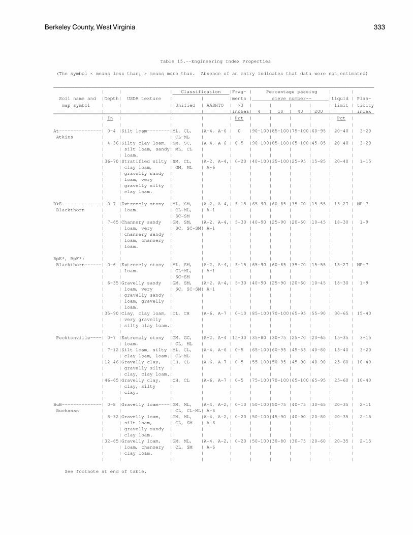
Berkeley County, West Virginia 333
Table 15.--Engineering Index Properties
(The symbol < means less than; > means more than. Absence of an entry indicates that data were not estimated)
_________________________________________________________________________________________________________________ | | | Classification |Frag- | Percentage passing | | ____________________ Soil name and |Depth| USDA texture | | |ments | sieve number-- |Liquid | Plas- ___________________________ map symbol | | | Unified | AASHTO | >3 | | | | | limit | ticity | | | | |inches| 4 | 10 | 40 | 200 | | index_________________________________________________________________________________________________________________ | In | | | | Pct | | | | | Pct | __ ___ ___ | | | | | | | | | | |At---------------| 0-4 |Silt loam--------|ML, CL, |A-4, A-6 | 0 |90-100|85-100|75-100|60-95 | 20-40 | 3-20 Atkins | | | CL-ML | | | | | | | | | 4-36|Silty clay loam, |SM, SC, |A-4, A-6 | 0-5 |90-100|85-100|65-100|45-85 | 20-40 | 3-20 | | silt loam, sandy| ML, CL | | | | | | | | | | loam. | | | | | | | | | |36-70|Stratified silty |SM, CL, |A-2, A-4,| 0-20 |40-100|35-100|25-95 |15-85 | 20-40 | 1-15 | | clay loam, | GM, ML | A-6 | | | | | | | | | gravelly sandy | | | | | | | | | | | loam, very | | | | | | | | | | | gravelly silty | | | | | | | | | | | clay loam. | | | | | | | | | | | | | | | | | | | |BkE--------------| 0-7 |Extremely stony |ML, SM, |A-2, A-4,| 5-15 |65-90 |60-85 |35-70 |15-55 | 15-27 | NP-7 Blackthorn | | loam. | CL-ML, | A-1 | | | | | | | | | | SC-SM | | | | | | | | | 7-65|Channery sandy |GM, SM, |A-2, A-4,| 5-30 |40-90 |25-90 |20-60 |10-45 | 18-30 | 1-9 | | loam, very | SC, SC-SM| A-1 | | | | | | | | | channery sandy | | | | | | | | | | | loam, channery | | | | | | | | | | | loam. | | | | | | | | | | | | | | | | | | | |BpE*, BpF*: | | | | | | | | | | | Blackthorn------| 0-6 |Extremely stony |ML, SM, |A-2, A-4,| 5-15 |65-90 |60-85 |35-70 |15-55 | 15-27 | NP-7 | | loam. | CL-ML, | A-1 | | | | | | | | | | SC-SM | | | | | | | | | 6-35|Gravelly sandy |GM, SM, |A-2, A-4,| 5-30 |40-90 |25-90 |20-60 |10-45 | 18-30 | 1-9 | | loam, very | SC, SC-SM| A-1 | | | | | | | | | gravelly sandy | | | | | | | | | | | loam, gravelly | | | | | | | | | | | loam. | | | | | | | | | |35-90|Clay, clay loam, |CL, CH |A-6, A-7 | 0-10 |85-100|70-100|65-95 |55-90 | 30-65 | 15-40 | | very gravelly | | | | | | | | | | | silty clay loam.| | | | | | | | | | | | | | | | | | | | Pecktonville----| 0-7 |Extremely stony |GM, GC, |A-2, A-4 |15-30 |35-80 |30-75 |25-70 |20-65 | 15-35 | 3-15 | | loam. | CL, ML | | | | | | | | | 7-12|Silt loam, silty |ML, CL, |A-4, A-6 | 0-5 |65-100|60-95 |45-85 |40-80 | 15-40 | 3-20 | | clay loam, loam.| CL-ML | | | | | | | | |12-46|Gravelly clay, |CH, CL |A-6, A-7 | 0-5 |55-100|50-95 |45-90 |40-90 | 25-60 | 10-40 | | gravelly silty | | | | | | | | | | | clay, clay loam.| | | | | | | | | |46-65|Gravelly clay, |CH, CL |A-6, A-7 | 0-5 |75-100|70-100|65-100|65-95 | 25-60 | 10-40 | | clay, silty | | | | | | | | | | | clay. | | | | | | | | | | | | | | | | | | | |BuB--------------| 0-8 |Gravelly loam----|GM, ML, |A-4, A-2,| 0-10 |50-100|50-75 |40-75 |30-65 | 20-35 | 2-11 Buchanan | | | CL, CL-ML| A-6 | | | | | | | | 8-32|Gravelly loam, |GM, ML, |A-4, A-2,| 0-20 |50-100|45-90 |40-90 |20-80 | 20-35 | 2-15 | | silt loam, | CL, SM | A-6 | | | | | | | | | gravelly sandy | | | | | | | | | | | clay loam. | | | | | | | | | |32-65|Gravelly loam, |GM, ML, |A-4, A-2,| 0-20 |50-100|30-80 |30-75 |20-60 | 20-35 | 2-15 | | loam, channery | CL, SM | A-6 | | | | | | | | | clay loam. | | | | | | | | | | | | | | | | | | | |
See footnote at end of table.
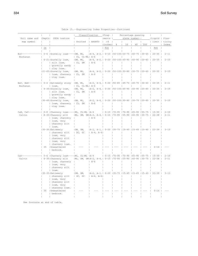
334 Soil Survey
Table 15.--Engineering Index Properties--Continued_________________________________________________________________________________________________________________ | | | Classification |Frag- | Percentage passing | | ____________________ Soil name and |Depth| USDA texture | | |ments | sieve number-- |Liquid | Plas- ___________________________ map symbol | | | Unified | AASHTO | >3 | | | | | limit | ticity | | | | |inches| 4 | 10 | 40 | 200 | | index_________________________________________________________________________________________________________________ | In | | | | Pct | | | | | Pct | __ ___ ___ | | | | | | | | | | |BuC--------------| 0-6 |Gravelly loam----|GM, ML, |A-4, A-2,| 0-10 |50-100|50-75 |40-75 |30-65 | 20-35 | 2-11 Buchanan | | | CL, CL-ML| A-6 | | | | | | | | 6-21|Gravelly loam, |GM, ML, |A-4, A-2,| 0-20 |50-100|45-90 |40-90 |20-80 | 20-35 | 2-15 | | silt loam, | CL, SM | A-6 | | | | | | | | | gravelly sandy | | | | | | | | | | | clay loam. | | | | | | | | | |21-65|Gravelly loam, |GM, ML, |A-4, A-2,| 0-20 |50-100|30-80 |30-75 |20-60 | 20-35 | 2-15 | | loam, channery | CL, SM | A-6 | | | | | | | | | clay loam. | | | | | | | | | | | | | | | | | | | |BxC, BxE---------| 0-4 |Extremely stony |GM, ML, |A-2, A-4,| 5-20 |50-85 |45-70 |40-70 |30-60 | 20-35 | 2-11 Buchanan | | loam. | CL, CL-ML| A-6 | | | | | | | | 4-30|Gravelly loam, |GM, ML, |A-2, A-4,| 0-20 |50-100|45-90 |40-90 |20-80 | 20-35 | 2-15 | | silt loam, | CL, SM | A-6 | | | | | | | | | gravelly sandy | | | | | | | | | | | clay loam. | | | | | | | | | |30-65|Gravelly loam, |GM, ML, |A-2, A-4,| 0-20 |50-100|30-80 |30-75 |20-60 | 20-35 | 2-15 | | loam, channery | CL, SM | A-6 | | | | | | | | | clay loam. | | | | | | | | | | | | | | | | | | | |CaB, CaC---------| 0-8 |Channery loam----|ML, CL-ML |A-4 | 0-15 |70-95 |70-90 |65-90 |55-75 | 15-30 | 2-10 Calvin | 8-30|Channery silt |ML, SM, GM|A-2, A-4,| 0-15 |70-95 |55-90 |40-90 |30-75 | 22-38 | 2-11 | | loam, channery | | A-6 | | | | | | | | | loam, very | | | | | | | | | | | channery silt | | | | | | | | | | | loam. | | | | | | | | | |30-35|Extremely |GM, SM, |A-2, A-1,| 0-20 |35-75 |15-45 |15-45 |15-40 | 23-39 | 3-13 | | channery silt | SC, GC | A-4, A-6| | | | | | | | | loam, very | | | | | | | | | | | channery silt | | | | | | | | | | | loam, very | | | | | | | | | | | channery loam. | | | | | | | | | | 35 |Unweathered | --- | --- | --- | --- | --- | --- | --- | 0-14 | --- | | bedrock. | | | | | | | | | | | | | | | | | | | |CaD--------------| 0-6 |Channery loam----|ML, CL-ML |A-4 | 0-15 |70-95 |70-90 |65-90 |55-75 | 15-30 | 2-10 Calvin | 6-30|Channery silt |ML, SM, GM|A-2, A-4,| 0-15 |70-95 |55-90 |40-90 |30-75 | 22-38 | 2-11 | | loam, channery | | A-6 | | | | | | | | | loam, very | | | | | | | | | | | channery silt | | | | | | | | | | | loam. | | | | | | | | | |30-35|Extremely |GM, SM, |A-2, A-1,| 0-20 |35-75 |15-45 |15-45 |15-40 | 23-39 | 3-13 | | channery silt | SC, GC | A-4, A-6| | | | | | | | | loam, very | | | | | | | | | | | channery silt | | | | | | | | | | | loam, very | | | | | | | | | | | channery loam. | | | | | | | | | | 35 |Unweathered | --- | --- | --- | --- | --- | --- | --- | 0-14 | --- | | bedrock. | | | | | | | | | | | | | | | | | | | |
See footnote at end of table.
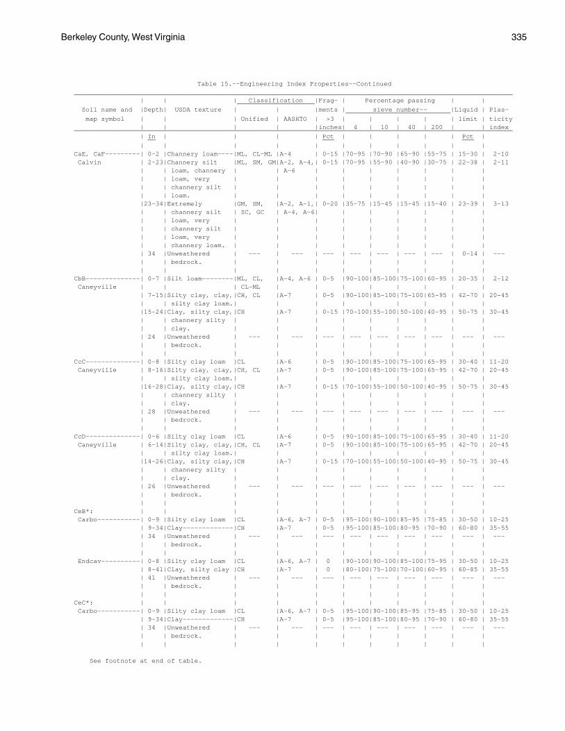
Berkeley County, West Virginia 335
Table 15.--Engineering Index Properties--Continued_________________________________________________________________________________________________________________ | | | Classification |Frag- | Percentage passing | | ____________________ Soil name and |Depth| USDA texture | | |ments | sieve number-- |Liquid | Plas- ___________________________ map symbol | | | Unified | AASHTO | >3 | | | | | limit | ticity | | | | |inches| 4 | 10 | 40 | 200 | | index_________________________________________________________________________________________________________________ | In | | | | Pct | | | | | Pct | __ ___ ___ | | | | | | | | | | |CaE, CaF---------| 0-2 |Channery loam----|ML, CL-ML |A-4 | 0-15 |70-95 |70-90 |65-90 |55-75 | 15-30 | 2-10 Calvin | 2-23|Channery silt |ML, SM, GM|A-2, A-4,| 0-15 |70-95 |55-90 |40-90 |30-75 | 22-38 | 2-11 | | loam, channery | | A-6 | | | | | | | | | loam, very | | | | | | | | | | | channery silt | | | | | | | | | | | loam. | | | | | | | | | |23-34|Extremely |GM, SM, |A-2, A-1,| 0-20 |35-75 |15-45 |15-45 |15-40 | 23-39 | 3-13 | | channery silt | SC, GC | A-4, A-6| | | | | | | | | loam, very | | | | | | | | | | | channery silt | | | | | | | | | | | loam, very | | | | | | | | | | | channery loam. | | | | | | | | | | 34 |Unweathered | --- | --- | --- | --- | --- | --- | --- | 0-14 | --- | | bedrock. | | | | | | | | | | | | | | | | | | | |CbB--------------| 0-7 |Silt loam--------|ML, CL, |A-4, A-6 | 0-5 |90-100|85-100|75-100|60-95 | 20-35 | 2-12 Caneyville | | | CL-ML | | | | | | | | | 7-15|Silty clay, clay,|CH, CL |A-7 | 0-5 |90-100|85-100|75-100|65-95 | 42-70 | 20-45 | | silty clay loam.| | | | | | | | | |15-24|Clay, silty clay,|CH |A-7 | 0-15 |70-100|55-100|50-100|40-95 | 50-75 | 30-45 | | channery silty | | | | | | | | | | | clay. | | | | | | | | | | 24 |Unweathered | --- | --- | --- | --- | --- | --- | --- | --- | --- | | bedrock. | | | | | | | | | | | | | | | | | | | |CcC--------------| 0-8 |Silty clay loam |CL |A-6 | 0-5 |90-100|85-100|75-100|65-95 | 30-40 | 11-20 Caneyville | 8-16|Silty clay, clay,|CH, CL |A-7 | 0-5 |90-100|85-100|75-100|65-95 | 42-70 | 20-45 | | silty clay loam.| | | | | | | | | |16-28|Clay, silty clay,|CH |A-7 | 0-15 |70-100|55-100|50-100|40-95 | 50-75 | 30-45 | | channery silty | | | | | | | | | | | clay. | | | | | | | | | | 28 |Unweathered | --- | --- | --- | --- | --- | --- | --- | --- | --- | | bedrock. | | | | | | | | | | | | | | | | | | | |CcD--------------| 0-6 |Silty clay loam |CL |A-6 | 0-5 |90-100|85-100|75-100|65-95 | 30-40 | 11-20 Caneyville | 6-14|Silty clay, clay,|CH, CL |A-7 | 0-5 |90-100|85-100|75-100|65-95 | 42-70 | 20-45 | | silty clay loam.| | | | | | | | | |14-26|Clay, silty clay,|CH |A-7 | 0-15 |70-100|55-100|50-100|40-95 | 50-75 | 30-45 | | channery silty | | | | | | | | | | | clay. | | | | | | | | | | 26 |Unweathered | --- | --- | --- | --- | --- | --- | --- | --- | --- | | bedrock. | | | | | | | | | | | | | | | | | | | |CeB*: | | | | | | | | | | | Carbo-----------| 0-9 |Silty clay loam |CL |A-6, A-7 | 0-5 |95-100|90-100|85-95 |75-85 | 30-50 | 10-25 | 9-34|Clay-------------|CH |A-7 | 0-5 |95-100|85-100|80-95 |70-90 | 60-80 | 35-55 | 34 |Unweathered | --- | --- | --- | --- | --- | --- | --- | --- | --- | | bedrock. | | | | | | | | | | | | | | | | | | | | Endcav----------| 0-8 |Silty clay loam |CL |A-6, A-7 | 0 |90-100|90-100|85-100|75-95 | 30-50 | 10-25 | 8-41|Clay, silty clay |CH |A-7 | 0 |80-100|75-100|70-100|60-95 | 60-85 | 35-55 | 41 |Unweathered | --- | --- | --- | --- | --- | --- | --- | --- | --- | | bedrock. | | | | | | | | | | | | | | | | | | | |CeC*: | | | | | | | | | | | Carbo-----------| 0-9 |Silty clay loam |CL |A-6, A-7 | 0-5 |95-100|90-100|85-95 |75-85 | 30-50 | 10-25 | 9-34|Clay-------------|CH |A-7 | 0-5 |95-100|85-100|80-95 |70-90 | 60-80 | 35-55 | 34 |Unweathered | --- | --- | --- | --- | --- | --- | --- | --- | --- | | bedrock. | | | | | | | | | | | | | | | | | | | |
See footnote at end of table.
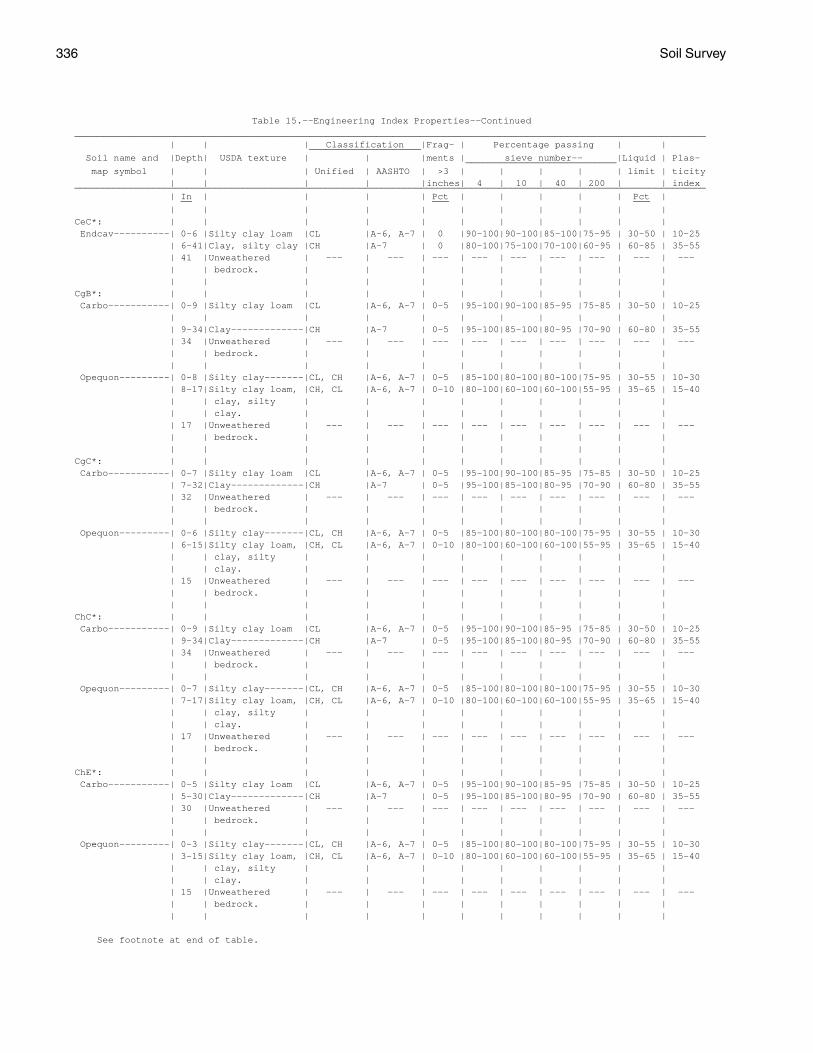
336 Soil Survey
Table 15.--Engineering Index Properties--Continued_________________________________________________________________________________________________________________ | | | Classification |Frag- | Percentage passing | | ____________________ Soil name and |Depth| USDA texture | | |ments | sieve number-- |Liquid | Plas- ___________________________ map symbol | | | Unified | AASHTO | >3 | | | | | limit | ticity | | | | |inches| 4 | 10 | 40 | 200 | | index_________________________________________________________________________________________________________________ | In | | | | Pct | | | | | Pct | __ ___ ___ | | | | | | | | | | |CeC*: | | | | | | | | | | | Endcav----------| 0-6 |Silty clay loam |CL |A-6, A-7 | 0 |90-100|90-100|85-100|75-95 | 30-50 | 10-25 | 6-41|Clay, silty clay |CH |A-7 | 0 |80-100|75-100|70-100|60-95 | 60-85 | 35-55 | 41 |Unweathered | --- | --- | --- | --- | --- | --- | --- | --- | --- | | bedrock. | | | | | | | | | | | | | | | | | | | |CgB*: | | | | | | | | | | | Carbo-----------| 0-9 |Silty clay loam |CL |A-6, A-7 | 0-5 |95-100|90-100|85-95 |75-85 | 30-50 | 10-25 | | | | | | | | | | | | 9-34|Clay-------------|CH |A-7 | 0-5 |95-100|85-100|80-95 |70-90 | 60-80 | 35-55 | 34 |Unweathered | --- | --- | --- | --- | --- | --- | --- | --- | --- | | bedrock. | | | | | | | | | | | | | | | | | | | | Opequon---------| 0-8 |Silty clay-------|CL, CH |A-6, A-7 | 0-5 |85-100|80-100|80-100|75-95 | 30-55 | 10-30 | 8-17|Silty clay loam, |CH, CL |A-6, A-7 | 0-10 |80-100|60-100|60-100|55-95 | 35-65 | 15-40 | | clay, silty | | | | | | | | | | | clay. | | | | | | | | | | 17 |Unweathered | --- | --- | --- | --- | --- | --- | --- | --- | --- | | bedrock. | | | | | | | | | | | | | | | | | | | |CgC*: | | | | | | | | | | | Carbo-----------| 0-7 |Silty clay loam |CL |A-6, A-7 | 0-5 |95-100|90-100|85-95 |75-85 | 30-50 | 10-25 | 7-32|Clay-------------|CH |A-7 | 0-5 |95-100|85-100|80-95 |70-90 | 60-80 | 35-55 | 32 |Unweathered | --- | --- | --- | --- | --- | --- | --- | --- | --- | | bedrock. | | | | | | | | | | | | | | | | | | | | Opequon---------| 0-6 |Silty clay-------|CL, CH |A-6, A-7 | 0-5 |85-100|80-100|80-100|75-95 | 30-55 | 10-30 | 6-15|Silty clay loam, |CH, CL |A-6, A-7 | 0-10 |80-100|60-100|60-100|55-95 | 35-65 | 15-40 | | clay, silty | | | | | | | | | | | clay. | | | | | | | | | | 15 |Unweathered | --- | --- | --- | --- | --- | --- | --- | --- | --- | | bedrock. | | | | | | | | | | | | | | | | | | | |ChC*: | | | | | | | | | | | Carbo-----------| 0-9 |Silty clay loam |CL |A-6, A-7 | 0-5 |95-100|90-100|85-95 |75-85 | 30-50 | 10-25 | 9-34|Clay-------------|CH |A-7 | 0-5 |95-100|85-100|80-95 |70-90 | 60-80 | 35-55 | 34 |Unweathered | --- | --- | --- | --- | --- | --- | --- | --- | --- | | bedrock. | | | | | | | | | | | | | | | | | | | | Opequon---------| 0-7 |Silty clay-------|CL, CH |A-6, A-7 | 0-5 |85-100|80-100|80-100|75-95 | 30-55 | 10-30 | 7-17|Silty clay loam, |CH, CL |A-6, A-7 | 0-10 |80-100|60-100|60-100|55-95 | 35-65 | 15-40 | | clay, silty | | | | | | | | | | | clay. | | | | | | | | | | 17 |Unweathered | --- | --- | --- | --- | --- | --- | --- | --- | --- | | bedrock. | | | | | | | | | | | | | | | | | | | |ChE*: | | | | | | | | | | | Carbo-----------| 0-5 |Silty clay loam |CL |A-6, A-7 | 0-5 |95-100|90-100|85-95 |75-85 | 30-50 | 10-25 | 5-30|Clay-------------|CH |A-7 | 0-5 |95-100|85-100|80-95 |70-90 | 60-80 | 35-55 | 30 |Unweathered | --- | --- | --- | --- | --- | --- | --- | --- | --- | | bedrock. | | | | | | | | | | | | | | | | | | | | Opequon---------| 0-3 |Silty clay-------|CL, CH |A-6, A-7 | 0-5 |85-100|80-100|80-100|75-95 | 30-55 | 10-30 | 3-15|Silty clay loam, |CH, CL |A-6, A-7 | 0-10 |80-100|60-100|60-100|55-95 | 35-65 | 15-40 | | clay, silty | | | | | | | | | | | clay. | | | | | | | | | | 15 |Unweathered | --- | --- | --- | --- | --- | --- | --- | --- | --- | | bedrock. | | | | | | | | | | | | | | | | | | | |
See footnote at end of table.
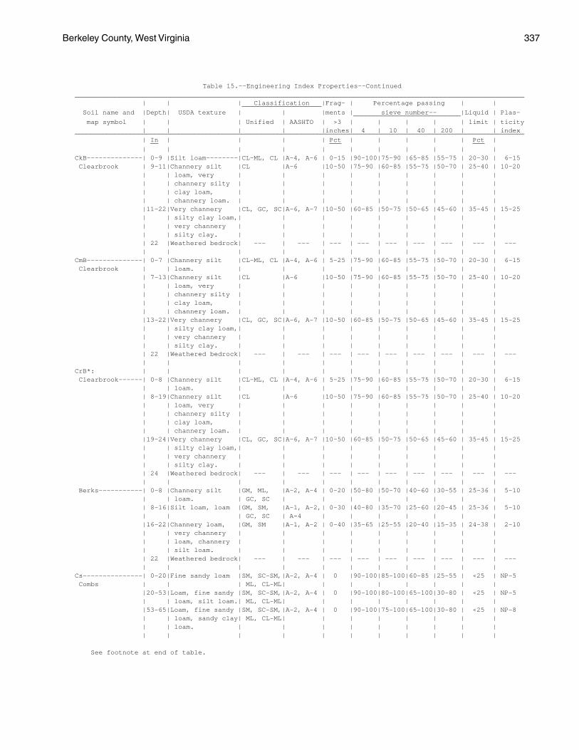
Berkeley County, West Virginia 337
Table 15.--Engineering Index Properties--Continued_________________________________________________________________________________________________________________ | | | Classification |Frag- | Percentage passing | | ____________________ Soil name and |Depth| USDA texture | | |ments | sieve number-- |Liquid | Plas- ___________________________ map symbol | | | Unified | AASHTO | >3 | | | | | limit | ticity | | | | |inches| 4 | 10 | 40 | 200 | | index_________________________________________________________________________________________________________________ | In | | | | Pct | | | | | Pct | __ ___ ___ | | | | | | | | | | |CkB--------------| 0-9 |Silt loam--------|CL-ML, CL |A-4, A-6 | 0-15 |90-100|75-90 |65-85 |55-75 | 20-30 | 6-15 Clearbrook | 9-11|Channery silt |CL |A-6 |10-50 |75-90 |60-85 |55-75 |50-70 | 25-40 | 10-20 | | loam, very | | | | | | | | | | | channery silty | | | | | | | | | | | clay loam, | | | | | | | | | | | channery loam. | | | | | | | | | |11-22|Very channery |CL, GC, SC|A-6, A-7 |10-50 |60-85 |50-75 |50-65 |45-60 | 35-45 | 15-25 | | silty clay loam,| | | | | | | | | | | very channery | | | | | | | | | | | silty clay. | | | | | | | | | | 22 |Weathered bedrock| --- | --- | --- | --- | --- | --- | --- | --- | --- | | | | | | | | | | |CmB--------------| 0-7 |Channery silt |CL-ML, CL |A-4, A-6 | 5-25 |75-90 |60-85 |55-75 |50-70 | 20-30 | 6-15 Clearbrook | | loam. | | | | | | | | | | 7-13|Channery silt |CL |A-6 |10-50 |75-90 |60-85 |55-75 |50-70 | 25-40 | 10-20 | | loam, very | | | | | | | | | | | channery silty | | | | | | | | | | | clay loam, | | | | | | | | | | | channery loam. | | | | | | | | | |13-22|Very channery |CL, GC, SC|A-6, A-7 |10-50 |60-85 |50-75 |50-65 |45-60 | 35-45 | 15-25 | | silty clay loam,| | | | | | | | | | | very channery | | | | | | | | | | | silty clay. | | | | | | | | | | 22 |Weathered bedrock| --- | --- | --- | --- | --- | --- | --- | --- | --- | | | | | | | | | | |CrB*: | | | | | | | | | | | Clearbrook------| 0-8 |Channery silt |CL-ML, CL |A-4, A-6 | 5-25 |75-90 |60-85 |55-75 |50-70 | 20-30 | 6-15 | | loam. | | | | | | | | | | 8-19|Channery silt |CL |A-6 |10-50 |75-90 |60-85 |55-75 |50-70 | 25-40 | 10-20 | | loam, very | | | | | | | | | | | channery silty | | | | | | | | | | | clay loam, | | | | | | | | | | | channery loam. | | | | | | | | | |19-24|Very channery |CL, GC, SC|A-6, A-7 |10-50 |60-85 |50-75 |50-65 |45-60 | 35-45 | 15-25 | | silty clay loam,| | | | | | | | | | | very channery | | | | | | | | | | | silty clay. | | | | | | | | | | 24 |Weathered bedrock| --- | --- | --- | --- | --- | --- | --- | --- | --- | | | | | | | | | | | Berks-----------| 0-8 |Channery silt |GM, ML, |A-2, A-4 | 0-20 |50-80 |50-70 |40-60 |30-55 | 25-36 | 5-10 | | loam. | GC, SC | | | | | | | | | 8-16|Silt loam, loam |GM, SM, |A-1, A-2,| 0-30 |40-80 |35-70 |25-60 |20-45 | 25-36 | 5-10 | | | GC, SC | A-4 | | | | | | | |16-22|Channery loam, |GM, SM |A-1, A-2 | 0-40 |35-65 |25-55 |20-40 |15-35 | 24-38 | 2-10 | | very channery | | | | | | | | | | | loam, channery | | | | | | | | | | | silt loam. | | | | | | | | | | 22 |Weathered bedrock| --- | --- | --- | --- | --- | --- | --- | --- | --- | | | | | | | | | | |Cs---------------| 0-20|Fine sandy loam |SM, SC-SM,|A-2, A-4 | 0 |90-100|85-100|60-85 |25-55 | <25 | NP-5 Combs | | | ML, CL-ML| | | | | | | | |20-53|Loam, fine sandy |SM, SC-SM,|A-2, A-4 | 0 |90-100|80-100|65-100|30-80 | <25 | NP-5 | | loam, silt loam.| ML, CL-ML| | | | | | | | |53-65|Loam, fine sandy |SM, SC-SM,|A-2, A-4 | 0 |90-100|75-100|65-100|30-80 | <25 | NP-8 | | loam, sandy clay| ML, CL-ML| | | | | | | | | | loam. | | | | | | | | | | | | | | | | | | | |
See footnote at end of table.
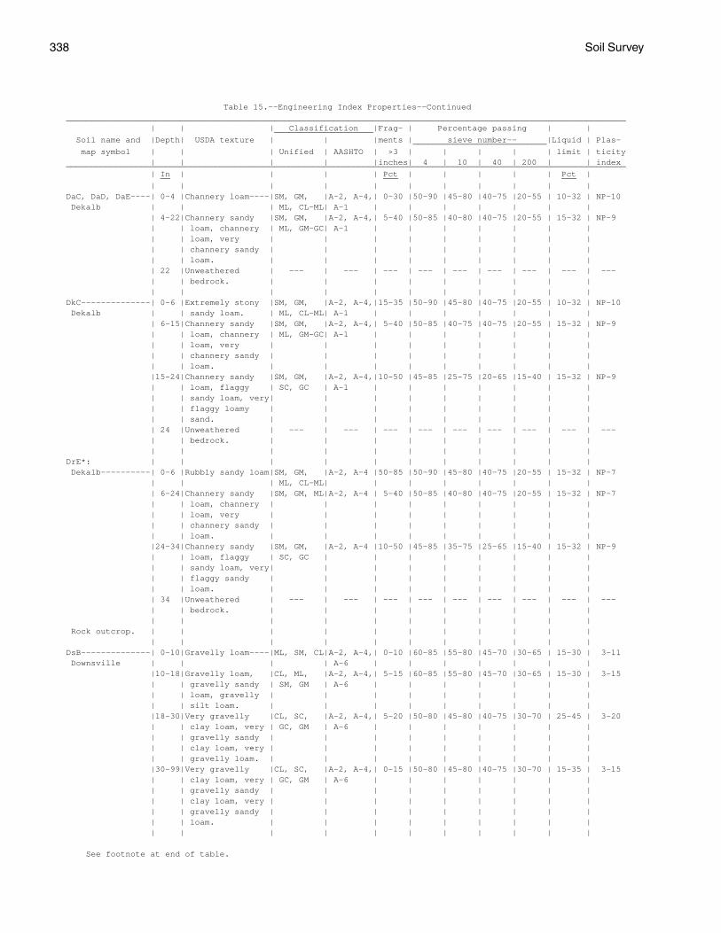
338 Soil Survey
Table 15.--Engineering Index Properties--Continued_________________________________________________________________________________________________________________ | | | Classification |Frag- | Percentage passing | | ____________________ Soil name and |Depth| USDA texture | | |ments | sieve number-- |Liquid | Plas- ___________________________ map symbol | | | Unified | AASHTO | >3 | | | | | limit | ticity | | | | |inches| 4 | 10 | 40 | 200 | | index_________________________________________________________________________________________________________________ | In | | | | Pct | | | | | Pct | __ ___ ___ | | | | | | | | | | |DaC, DaD, DaE----| 0-4 |Channery loam----|SM, GM, |A-2, A-4,| 0-30 |50-90 |45-80 |40-75 |20-55 | 10-32 | NP-10 Dekalb | | | ML, CL-ML| A-1 | | | | | | | | 4-22|Channery sandy |SM, GM, |A-2, A-4,| 5-40 |50-85 |40-80 |40-75 |20-55 | 15-32 | NP-9 | | loam, channery | ML, GM-GC| A-1 | | | | | | | | | loam, very | | | | | | | | | | | channery sandy | | | | | | | | | | | loam. | | | | | | | | | | 22 |Unweathered | --- | --- | --- | --- | --- | --- | --- | --- | --- | | bedrock. | | | | | | | | | | | | | | | | | | | |DkC--------------| 0-6 |Extremely stony |SM, GM, |A-2, A-4,|15-35 |50-90 |45-80 |40-75 |20-55 | 10-32 | NP-10 Dekalb | | sandy loam. | ML, CL-ML| A-1 | | | | | | | | 6-15|Channery sandy |SM, GM, |A-2, A-4,| 5-40 |50-85 |40-75 |40-75 |20-55 | 15-32 | NP-9 | | loam, channery | ML, GM-GC| A-1 | | | | | | | | | loam, very | | | | | | | | | | | channery sandy | | | | | | | | | | | loam. | | | | | | | | | |15-24|Channery sandy |SM, GM, |A-2, A-4,|10-50 |45-85 |25-75 |20-65 |15-40 | 15-32 | NP-9 | | loam, flaggy | SC, GC | A-1 | | | | | | | | | sandy loam, very| | | | | | | | | | | flaggy loamy | | | | | | | | | | | sand. | | | | | | | | | | 24 |Unweathered | --- | --- | --- | --- | --- | --- | --- | --- | --- | | bedrock. | | | | | | | | | | | | | | | | | | | |DrE*: | | | | | | | | | | | Dekalb----------| 0-6 |Rubbly sandy loam|SM, GM, |A-2, A-4 |50-85 |50-90 |45-80 |40-75 |20-55 | 15-32 | NP-7 | | | ML, CL-ML| | | | | | | | | 6-24|Channery sandy |SM, GM, ML|A-2, A-4 | 5-40 |50-85 |40-80 |40-75 |20-55 | 15-32 | NP-7 | | loam, channery | | | | | | | | | | | loam, very | | | | | | | | | | | channery sandy | | | | | | | | | | | loam. | | | | | | | | | |24-34|Channery sandy |SM, GM, |A-2, A-4 |10-50 |45-85 |35-75 |25-65 |15-40 | 15-32 | NP-9 | | loam, flaggy | SC, GC | | | | | | | | | | sandy loam, very| | | | | | | | | | | flaggy sandy | | | | | | | | | | | loam. | | | | | | | | | | 34 |Unweathered | --- | --- | --- | --- | --- | --- | --- | --- | --- | | bedrock. | | | | | | | | | | | | | | | | | | | | Rock outcrop. | | | | | | | | | | | | | | | | | | | | | |DsB--------------| 0-10|Gravelly loam----|ML, SM, CL|A-2, A-4,| 0-10 |60-85 |55-80 |45-70 |30-65 | 15-30 | 3-11 Downsville | | | | A-6 | | | | | | | |10-18|Gravelly loam, |CL, ML, |A-2, A-4,| 5-15 |60-85 |55-80 |45-70 |30-65 | 15-30 | 3-15 | | gravelly sandy | SM, GM | A-6 | | | | | | | | | loam, gravelly | | | | | | | | | | | silt loam. | | | | | | | | | |18-30|Very gravelly |CL, SC, |A-2, A-4,| 5-20 |50-80 |45-80 |40-75 |30-70 | 25-45 | 3-20 | | clay loam, very | GC, GM | A-6 | | | | | | | | | gravelly sandy | | | | | | | | | | | clay loam, very | | | | | | | | | | | gravelly loam. | | | | | | | | | |30-99|Very gravelly |CL, SC, |A-2, A-4,| 0-15 |50-80 |45-80 |40-75 |30-70 | 15-35 | 3-15 | | clay loam, very | GC, GM | A-6 | | | | | | | | | gravelly sandy | | | | | | | | | | | clay loam, very | | | | | | | | | | | gravelly sandy | | | | | | | | | | | loam. | | | | | | | | | | | | | | | | | | | |
See footnote at end of table.
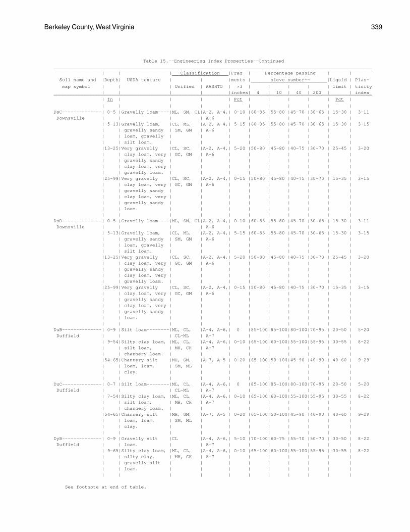
Berkeley County, West Virginia 339
Table 15.--Engineering Index Properties--Continued_________________________________________________________________________________________________________________ | | | Classification |Frag- | Percentage passing | | ____________________ Soil name and |Depth| USDA texture | | |ments | sieve number-- |Liquid | Plas- ___________________________ map symbol | | | Unified | AASHTO | >3 | | | | | limit | ticity | | | | |inches| 4 | 10 | 40 | 200 | | index_________________________________________________________________________________________________________________ | In | | | | Pct | | | | | Pct | __ ___ ___ | | | | | | | | | | |DsC--------------| 0-5 |Gravelly loam----|ML, SM, CL|A-2, A-4,| 0-10 |60-85 |55-80 |45-70 |30-65 | 15-30 | 3-11 Downsville | | | | A-6 | | | | | | | | 5-13|Gravelly loam, |CL, ML, |A-2, A-4,| 5-15 |60-85 |55-80 |45-70 |30-65 | 15-30 | 3-15 | | gravelly sandy | SM, GM | A-6 | | | | | | | | | loam, gravelly | | | | | | | | | | | silt loam. | | | | | | | | | |13-25|Very gravelly |CL, SC, |A-2, A-4,| 5-20 |50-80 |45-80 |40-75 |30-70 | 25-45 | 3-20 | | clay loam, very | GC, GM | A-6 | | | | | | | | | gravelly sandy | | | | | | | | | | | clay loam, very | | | | | | | | | | | gravelly loam. | | | | | | | | | |25-99|Very gravelly |CL, SC, |A-2, A-4,| 0-15 |50-80 |45-80 |40-75 |30-70 | 15-35 | 3-15 | | clay loam, very | GC, GM | A-6 | | | | | | | | | gravelly sandy | | | | | | | | | | | clay loam, very | | | | | | | | | | | gravelly sandy | | | | | | | | | | | loam. | | | | | | | | | | | | | | | | | | | |DsD--------------| 0-5 |Gravelly loam----|ML, SM, CL|A-2, A-4,| 0-10 |60-85 |55-80 |45-70 |30-65 | 15-30 | 3-11 Downsville | | | | A-6 | | | | | | | | 5-13|Gravelly loam, |CL, ML, |A-2, A-4,| 5-15 |60-85 |55-80 |45-70 |30-65 | 15-30 | 3-15 | | gravelly sandy | SM, GM | A-6 | | | | | | | | | loam, gravelly | | | | | | | | | | | silt loam. | | | | | | | | | |13-25|Very gravelly |CL, SC, |A-2, A-4,| 5-20 |50-80 |45-80 |40-75 |30-70 | 25-45 | 3-20 | | clay loam, very | GC, GM | A-6 | | | | | | | | | gravelly sandy | | | | | | | | | | | clay loam, very | | | | | | | | | | | gravelly loam. | | | | | | | | | |25-99|Very gravelly |CL, SC, |A-2, A-4,| 0-15 |50-80 |45-80 |40-75 |30-70 | 15-35 | 3-15 | | clay loam, very | GC, GM | A-6 | | | | | | | | | gravelly sandy | | | | | | | | | | | clay loam, very | | | | | | | | | | | gravelly sandy | | | | | | | | | | | loam. | | | | | | | | | | | | | | | | | | | |DuB--------------| 0-9 |Silt loam--------|ML, CL, |A-4, A-6,| 0 |85-100|85-100|80-100|70-95 | 20-50 | 5-20 Duffield | | | CL-ML | A-7 | | | | | | | | 9-54|Silty clay loam, |ML, CL, |A-4, A-6,| 0-10 |65-100|60-100|55-100|55-95 | 30-55 | 8-22 | | silt loam, | MH, CH | A-7 | | | | | | | | | channery loam. | | | | | | | | | |54-65|Channery silt |MH, GM, |A-7, A-5 | 0-20 |65-100|50-100|45-90 |40-90 | 40-60 | 9-29 | | loam, loam, | SM, ML | | | | | | | | | | clay. | | | | | | | | | | | | | | | | | | | |DuC--------------| 0-7 |Silt loam--------|ML, CL, |A-4, A-6,| 0 |85-100|85-100|80-100|70-95 | 20-50 | 5-20 Duffield | | | CL-ML | A-7 | | | | | | | | 7-54|Silty clay loam, |ML, CL, |A-4, A-6,| 0-10 |65-100|60-100|55-100|55-95 | 30-55 | 8-22 | | silt loam, | MH, CH | A-7 | | | | | | | | | channery loam. | | | | | | | | | |54-65|Channery silt |MH, GM, |A-7, A-5 | 0-20 |65-100|50-100|45-90 |40-90 | 40-60 | 9-29 | | loam, loam, | SM, ML | | | | | | | | | | clay. | | | | | | | | | | | | | | | | | | | |DyB--------------| 0-9 |Gravelly silt |CL |A-4, A-6,| 5-10 |70-100|60-75 |55-70 |50-70 | 30-50 | 8-22 Duffield | | loam. | | A-7 | | | | | | | | 9-65|Silty clay loam, |ML, CL, |A-4, A-6,| 0-10 |65-100|60-100|55-100|55-95 | 30-55 | 8-22 | | silty clay, | MH, CH | A-7 | | | | | | | | | gravelly silt | | | | | | | | | | | loam. | | | | | | | | | | | | | | | | | | | |
See footnote at end of table.
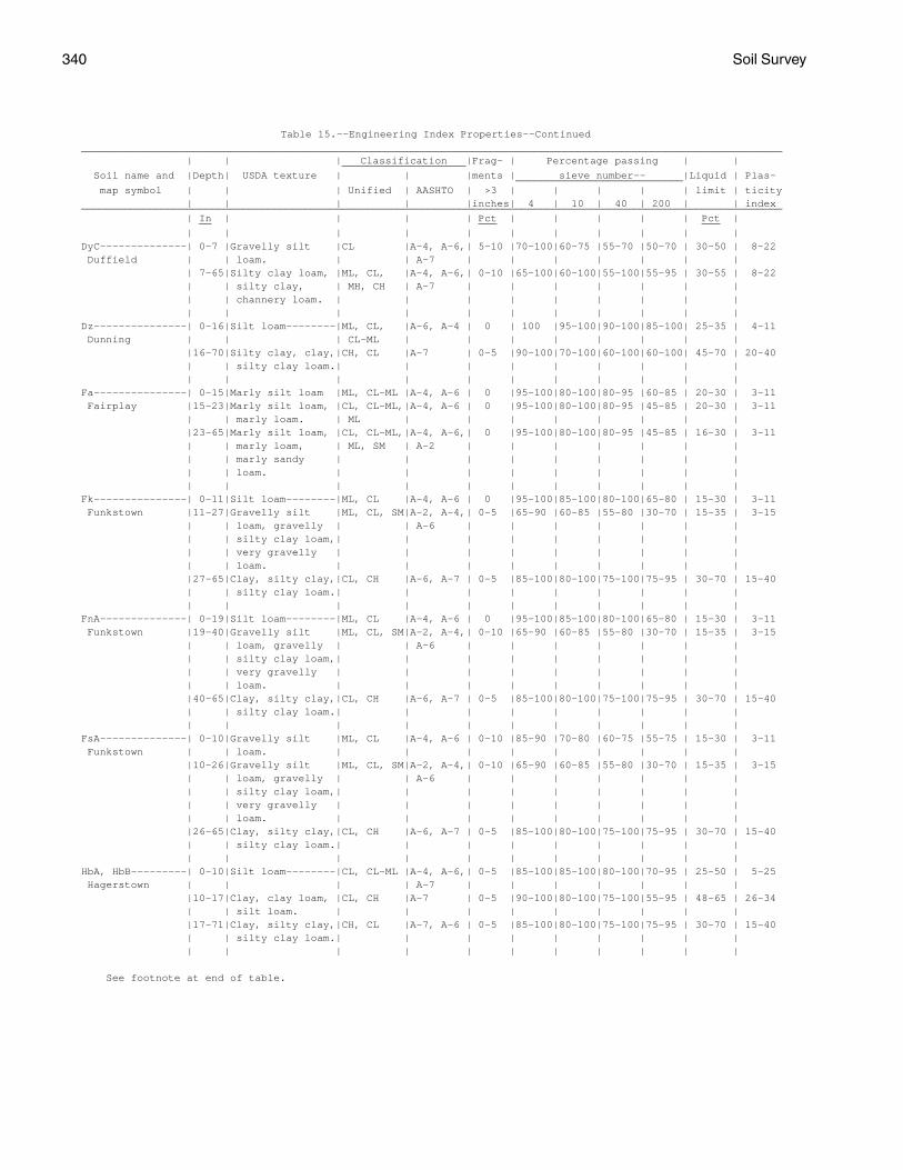
340 Soil Survey
Table 15.--Engineering Index Properties--Continued_________________________________________________________________________________________________________________ | | | Classification |Frag- | Percentage passing | | ____________________ Soil name and |Depth| USDA texture | | |ments | sieve number-- |Liquid | Plas- ___________________________ map symbol | | | Unified | AASHTO | >3 | | | | | limit | ticity | | | | |inches| 4 | 10 | 40 | 200 | | index_________________________________________________________________________________________________________________ | In | | | | Pct | | | | | Pct | __ ___ ___ | | | | | | | | | | |DyC--------------| 0-7 |Gravelly silt |CL |A-4, A-6,| 5-10 |70-100|60-75 |55-70 |50-70 | 30-50 | 8-22 Duffield | | loam. | | A-7 | | | | | | | | 7-65|Silty clay loam, |ML, CL, |A-4, A-6,| 0-10 |65-100|60-100|55-100|55-95 | 30-55 | 8-22 | | silty clay, | MH, CH | A-7 | | | | | | | | | channery loam. | | | | | | | | | | | | | | | | | | | |Dz---------------| 0-16|Silt loam--------|ML, CL, |A-6, A-4 | 0 | 100 |95-100|90-100|85-100| 25-35 | 4-11 Dunning | | | CL-ML | | | | | | | | |16-70|Silty clay, clay,|CH, CL |A-7 | 0-5 |90-100|70-100|60-100|60-100| 45-70 | 20-40 | | silty clay loam.| | | | | | | | | | | | | | | | | | | |Fa---------------| 0-15|Marly silt loam |ML, CL-ML |A-4, A-6 | 0 |95-100|80-100|80-95 |60-85 | 20-30 | 3-11 Fairplay |15-23|Marly silt loam, |CL, CL-ML,|A-4, A-6 | 0 |95-100|80-100|80-95 |45-85 | 20-30 | 3-11 | | marly loam. | ML | | | | | | | | |23-65|Marly silt loam, |CL, CL-ML,|A-4, A-6,| 0 |95-100|80-100|80-95 |45-85 | 16-30 | 3-11 | | marly loam, | ML, SM | A-2 | | | | | | | | | marly sandy | | | | | | | | | | | loam. | | | | | | | | | | | | | | | | | | | |Fk---------------| 0-11|Silt loam--------|ML, CL |A-4, A-6 | 0 |95-100|85-100|80-100|65-80 | 15-30 | 3-11 Funkstown |11-27|Gravelly silt |ML, CL, SM|A-2, A-4,| 0-5 |65-90 |60-85 |55-80 |30-70 | 15-35 | 3-15 | | loam, gravelly | | A-6 | | | | | | | | | silty clay loam,| | | | | | | | | | | very gravelly | | | | | | | | | | | loam. | | | | | | | | | |27-65|Clay, silty clay,|CL, CH |A-6, A-7 | 0-5 |85-100|80-100|75-100|75-95 | 30-70 | 15-40 | | silty clay loam.| | | | | | | | | | | | | | | | | | | |FnA--------------| 0-19|Silt loam--------|ML, CL |A-4, A-6 | 0 |95-100|85-100|80-100|65-80 | 15-30 | 3-11 Funkstown |19-40|Gravelly silt |ML, CL, SM|A-2, A-4,| 0-10 |65-90 |60-85 |55-80 |30-70 | 15-35 | 3-15 | | loam, gravelly | | A-6 | | | | | | | | | silty clay loam,| | | | | | | | | | | very gravelly | | | | | | | | | | | loam. | | | | | | | | | |40-65|Clay, silty clay,|CL, CH |A-6, A-7 | 0-5 |85-100|80-100|75-100|75-95 | 30-70 | 15-40 | | silty clay loam.| | | | | | | | | | | | | | | | | | | |FsA--------------| 0-10|Gravelly silt |ML, CL |A-4, A-6 | 0-10 |85-90 |70-80 |60-75 |55-75 | 15-30 | 3-11 Funkstown | | loam. | | | | | | | | | |10-26|Gravelly silt |ML, CL, SM|A-2, A-4,| 0-10 |65-90 |60-85 |55-80 |30-70 | 15-35 | 3-15 | | loam, gravelly | | A-6 | | | | | | | | | silty clay loam,| | | | | | | | | | | very gravelly | | | | | | | | | | | loam. | | | | | | | | | |26-65|Clay, silty clay,|CL, CH |A-6, A-7 | 0-5 |85-100|80-100|75-100|75-95 | 30-70 | 15-40 | | silty clay loam.| | | | | | | | | | | | | | | | | | | |HbA, HbB---------| 0-10|Silt loam--------|CL, CL-ML |A-4, A-6,| 0-5 |85-100|85-100|80-100|70-95 | 25-50 | 5-25 Hagerstown | | | | A-7 | | | | | | | |10-17|Clay, clay loam, |CL, CH |A-7 | 0-5 |90-100|80-100|75-100|55-95 | 48-65 | 26-34 | | silt loam. | | | | | | | | | |17-71|Clay, silty clay,|CH, CL |A-7, A-6 | 0-5 |85-100|80-100|75-100|75-95 | 30-70 | 15-40 | | silty clay loam.| | | | | | | | | | | | | | | | | | | |
See footnote at end of table.
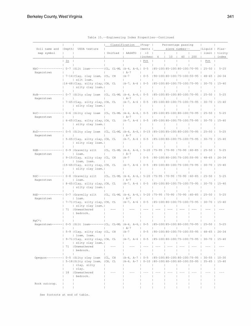
Berkeley County, West Virginia 341
Table 15.--Engineering Index Properties--Continued_________________________________________________________________________________________________________________ | | | Classification |Frag- | Percentage passing | | ____________________ Soil name and |Depth| USDA texture | | |ments | sieve number-- |Liquid | Plas- ___________________________ map symbol | | | Unified | AASHTO | >3 | | | | | limit | ticity | | | | |inches| 4 | 10 | 40 | 200 | | index_________________________________________________________________________________________________________________ | In | | | | Pct | | | | | Pct | __ ___ ___ | | | | | | | | | | |HbC--------------| 0-7 |Silt loam--------|CL, CL-ML |A-4, A-6,| 0-5 |85-100|85-100|80-100|70-95 | 25-50 | 5-25 Hagerstown | | | | A-7 | | | | | | | | 7-14|Clay, clay loam, |CL, CH |A-7 | 0-5 |90-100|80-100|75-100|55-95 | 48-65 | 26-34 | | silt loam. | | | | | | | | | |14-68|Clay, silty clay,|CH, CL |A-7, A-6 | 0-5 |85-100|80-100|75-100|75-95 | 30-70 | 15-40 | | silty clay loam.| | | | | | | | | | | | | | | | | | | |HcB--------------| 0-7 |Silty clay loam |CL, CL-ML |A-4, A-6,| 0-5 |85-100|85-100|80-100|70-95 | 25-50 | 5-25 Hagerstown | | | | A-7 | | | | | | | | 7-65|Clay, silty clay,|CH, CL |A-7, A-6 | 0-5 |85-100|80-100|75-100|75-95 | 30-70 | 15-40 | | silty clay loam.| | | | | | | | | | | | | | | | | | | |HcC--------------| 0-6 |Silty clay loam |CL, CL-ML |A-4, A-6,| 0-5 |85-100|85-100|80-100|70-95 | 25-50 | 5-25 Hagerstown | | | | A-7 | | | | | | | | 6-65|Clay, silty clay,|CH, CL |A-7, A-6 | 0-5 |85-100|80-100|75-100|75-95 | 30-70 | 15-40 | | silty clay loam.| | | | | | | | | | | | | | | | | | | |HcD--------------| 0-5 |Silty clay loam |CL, CL-ML |A-4, A-6,| 0-15 |85-100|85-100|80-100|70-95 | 25-50 | 5-25 Hagerstown | | | | A-7 | | | | | | | | 5-65|Clay, silty clay,|CH, CL |A-7, A-6 | 0-5 |85-100|80-100|75-100|75-95 | 30-70 | 15-40 | | silty clay loam.| | | | | | | | | | | | | | | | | | | |HdB--------------| 0-9 |Gravelly silt |CL, CL-ML |A-4, A-6,| 5-20 |75-95 |70-90 |70-90 |60-85 | 25-50 | 5-25 Hagerstown | | loam. | | A-7 | | | | | | | | 9-15|Clay, silty clay |CL, CH |A-7 | 0-5 |90-100|80-100|75-100|55-95 | 48-65 | 26-34 | | loam, loam. | | | | | | | | | |15-65|Clay, silty clay,|CH, CL |A-7, A-6 | 0-5 |85-100|80-100|75-100|75-95 | 30-70 | 15-40 | | silty clay loam.| | | | | | | | | | | | | | | | | | | |HdC--------------| 0-8 |Gravelly silt |CL, CL-ML |A-4, A-6,| 5-20 |75-95 |70-90 |70-90 |60-85 | 25-50 | 5-25 Hagerstown | | loam. | | A-7 | | | | | | | | 8-65|Clay, silty clay,|CH, CL |A-7, A-6 | 0-5 |85-100|80-100|75-100|75-95 | 30-70 | 15-40 | | silty clay loam.| | | | | | | | | | | | | | | | | | | |HdD--------------| 0-7 |Gravelly silt |CL, CL-ML |A-4, A-6,| 5-20 |75-95 |70-90 |70-90 |60-85 | 25-50 | 5-25 Hagerstown | | loam. | | A-7 | | | | | | | | 7-71|Clay, silty clay,|CH, CL |A-7, A-6 | 0-5 |85-100|80-100|75-100|75-95 | 30-70 | 15-40 | | silty clay loam.| | | | | | | | | | 71 |Unweathered | --- | --- | --- | --- | --- | --- | --- | --- | --- | | bedrock. | | | | | | | | | | | | | | | | | | | |HgC*: | | | | | | | | | | | Hagerstown------| 0-5 |Silt loam--------|CL, CL-ML |A-4, A-6,| 0-5 |85-100|85-100|80-100|70-95 | 25-50 | 5-25 | | | | A-7 | | | | | | | | 5-9 |Clay, silty clay |CL, CH |A-7 | 0-5 |90-100|80-100|75-100|55-95 | 48-65 | 26-34 | | loam, loam. | | | | | | | | | | 9-71|Clay, silty clay,|CH, CL |A-7, A-6 | 0-5 |85-100|80-100|75-100|75-95 | 30-70 | 15-40 | | silty clay loam.| | | | | | | | | | 71 |Unweathered | --- | --- | --- | --- | --- | --- | --- | --- | --- | | bedrock. | | | | | | | | | | | | | | | | | | | | Opequon---------| 0-5 |Silty clay loam |CL, CH |A-6, A-7 | 0-5 |85-100|80-100|80-100|75-95 | 30-55 | 10-30 | 5-18|Silty clay loam, |CH, CL |A-6, A-7 | 0-10 |80-100|60-100|60-100|55-95 | 35-65 | 15-40 | | clay, silty | | | | | | | | | | | clay. | | | | | | | | | | 18 |Unweathered | --- | --- | --- | --- | --- | --- | --- | --- | --- | | bedrock. | | | | | | | | | | | | | | | | | | | | Rock outcrop. | | | | | | | | | | | | | | | | | | | | | |
See footnote at end of table.
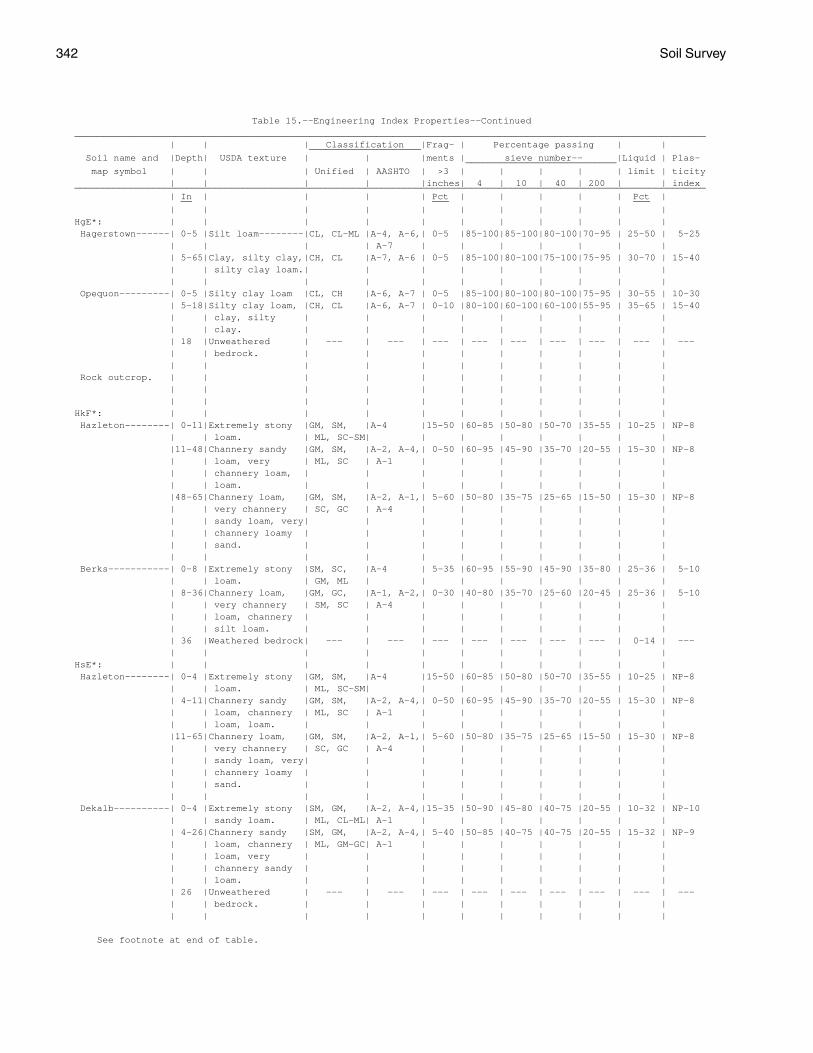
342 Soil Survey
Table 15.--Engineering Index Properties--Continued_________________________________________________________________________________________________________________ | | | Classification |Frag- | Percentage passing | | ____________________ Soil name and |Depth| USDA texture | | |ments | sieve number-- |Liquid | Plas- ___________________________ map symbol | | | Unified | AASHTO | >3 | | | | | limit | ticity | | | | |inches| 4 | 10 | 40 | 200 | | index_________________________________________________________________________________________________________________ | In | | | | Pct | | | | | Pct | __ ___ ___ | | | | | | | | | | |HgE*: | | | | | | | | | | | Hagerstown------| 0-5 |Silt loam--------|CL, CL-ML |A-4, A-6,| 0-5 |85-100|85-100|80-100|70-95 | 25-50 | 5-25 | | | | A-7 | | | | | | | | 5-65|Clay, silty clay,|CH, CL |A-7, A-6 | 0-5 |85-100|80-100|75-100|75-95 | 30-70 | 15-40 | | silty clay loam.| | | | | | | | | | | | | | | | | | | | Opequon---------| 0-5 |Silty clay loam |CL, CH |A-6, A-7 | 0-5 |85-100|80-100|80-100|75-95 | 30-55 | 10-30 | 5-18|Silty clay loam, |CH, CL |A-6, A-7 | 0-10 |80-100|60-100|60-100|55-95 | 35-65 | 15-40 | | clay, silty | | | | | | | | | | | clay. | | | | | | | | | | 18 |Unweathered | --- | --- | --- | --- | --- | --- | --- | --- | --- | | bedrock. | | | | | | | | | | | | | | | | | | | | Rock outcrop. | | | | | | | | | | | | | | | | | | | | | | | | | | | | | | | | |HkF*: | | | | | | | | | | | Hazleton--------| 0-11|Extremely stony |GM, SM, |A-4 |15-50 |60-85 |50-80 |50-70 |35-55 | 10-25 | NP-8 | | loam. | ML, SC-SM| | | | | | | | |11-48|Channery sandy |GM, SM, |A-2, A-4,| 0-50 |60-95 |45-90 |35-70 |20-55 | 15-30 | NP-8 | | loam, very | ML, SC | A-1 | | | | | | | | | channery loam, | | | | | | | | | | | loam. | | | | | | | | | |48-65|Channery loam, |GM, SM, |A-2, A-1,| 5-60 |50-80 |35-75 |25-65 |15-50 | 15-30 | NP-8 | | very channery | SC, GC | A-4 | | | | | | | | | sandy loam, very| | | | | | | | | | | channery loamy | | | | | | | | | | | sand. | | | | | | | | | | | | | | | | | | | | Berks-----------| 0-8 |Extremely stony |SM, SC, |A-4 | 5-35 |60-95 |55-90 |45-90 |35-80 | 25-36 | 5-10 | | loam. | GM, ML | | | | | | | | | 8-36|Channery loam, |GM, GC, |A-1, A-2,| 0-30 |40-80 |35-70 |25-60 |20-45 | 25-36 | 5-10 | | very channery | SM, SC | A-4 | | | | | | | | | loam, channery | | | | | | | | | | | silt loam. | | | | | | | | | | 36 |Weathered bedrock| --- | --- | --- | --- | --- | --- | --- | 0-14 | --- | | | | | | | | | | |HsE*: | | | | | | | | | | | Hazleton--------| 0-4 |Extremely stony |GM, SM, |A-4 |15-50 |60-85 |50-80 |50-70 |35-55 | 10-25 | NP-8 | | loam. | ML, SC-SM| | | | | | | | | 4-11|Channery sandy |GM, SM, |A-2, A-4,| 0-50 |60-95 |45-90 |35-70 |20-55 | 15-30 | NP-8 | | loam, channery | ML, SC | A-1 | | | | | | | | | loam, loam. | | | | | | | | | |11-65|Channery loam, |GM, SM, |A-2, A-1,| 5-60 |50-80 |35-75 |25-65 |15-50 | 15-30 | NP-8 | | very channery | SC, GC | A-4 | | | | | | | | | sandy loam, very| | | | | | | | | | | channery loamy | | | | | | | | | | | sand. | | | | | | | | | | | | | | | | | | | | Dekalb----------| 0-4 |Extremely stony |SM, GM, |A-2, A-4,|15-35 |50-90 |45-80 |40-75 |20-55 | 10-32 | NP-10 | | sandy loam. | ML, CL-ML| A-1 | | | | | | | | 4-26|Channery sandy |SM, GM, |A-2, A-4,| 5-40 |50-85 |40-75 |40-75 |20-55 | 15-32 | NP-9 | | loam, channery | ML, GM-GC| A-1 | | | | | | | | | loam, very | | | | | | | | | | | channery sandy | | | | | | | | | | | loam. | | | | | | | | | | 26 |Unweathered | --- | --- | --- | --- | --- | --- | --- | --- | --- | | bedrock. | | | | | | | | | | | | | | | | | | | |
See footnote at end of table.
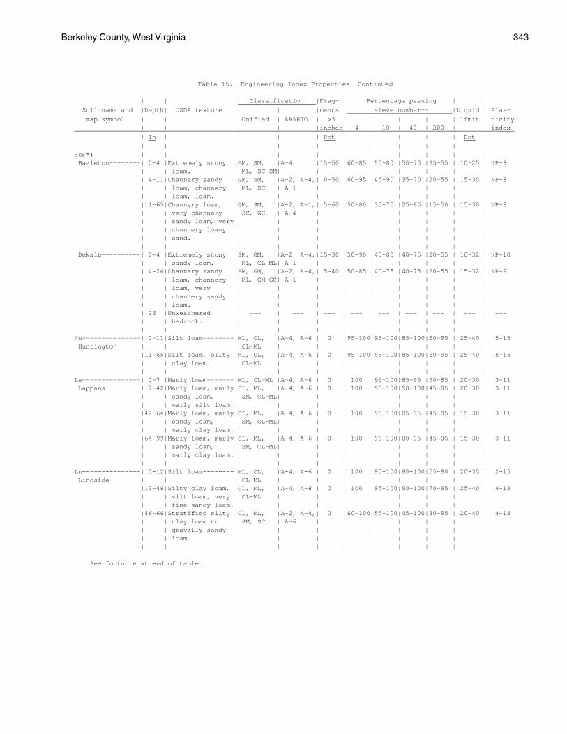
Berkeley County, West Virginia 343
Table 15.--Engineering Index Properties--Continued_________________________________________________________________________________________________________________ | | | Classification |Frag- | Percentage passing | | ____________________ Soil name and |Depth| USDA texture | | |ments | sieve number-- |Liquid | Plas- ___________________________ map symbol | | | Unified | AASHTO | >3 | | | | | limit | ticity | | | | |inches| 4 | 10 | 40 | 200 | | index_________________________________________________________________________________________________________________ | In | | | | Pct | | | | | Pct | __ ___ ___ | | | | | | | | | | |HsF*: | | | | | | | | | | | Hazleton--------| 0-4 |Extremely stony |GM, SM, |A-4 |15-50 |60-85 |50-80 |50-70 |35-55 | 10-25 | NP-8 | | loam. | ML, SC-SM| | | | | | | | | 4-11|Channery sandy |GM, SM, |A-2, A-4,| 0-50 |60-95 |45-90 |35-70 |20-55 | 15-30 | NP-8 | | loam, channery | ML, SC | A-1 | | | | | | | | | loam, loam. | | | | | | | | | |11-65|Channery loam, |GM, SM, |A-2, A-1,| 5-60 |50-80 |35-75 |25-65 |15-50 | 15-30 | NP-8 | | very channery | SC, GC | A-4 | | | | | | | | | sandy loam, very| | | | | | | | | | | channery loamy | | | | | | | | | | | sand. | | | | | | | | | | | | | | | | | | | | Dekalb----------| 0-4 |Extremely stony |SM, GM, |A-2, A-4,|15-30 |50-90 |45-80 |40-75 |20-55 | 10-32 | NP-10 | | sandy loam. | ML, CL-ML| A-1 | | | | | | | | 4-26|Channery sandy |SM, GM, |A-2, A-4,| 5-40 |50-85 |40-75 |40-75 |20-55 | 15-32 | NP-9 | | loam, channery | ML, GM-GC| A-1 | | | | | | | | | loam, very | | | | | | | | | | | channery sandy | | | | | | | | | | | loam. | | | | | | | | | | 26 |Unweathered | --- | --- | --- | --- | --- | --- | --- | --- | --- | | bedrock. | | | | | | | | | | | | | | | | | | | |Hu---------------| 0-11|Silt loam--------|ML, CL, |A-4, A-6 | 0 |95-100|95-100|85-100|60-95 | 25-40 | 5-15 Huntington | | | CL-ML | | | | | | | | |11-65|Silt loam, silty |ML, CL, |A-4, A-6 | 0 |95-100|95-100|85-100|60-95 | 25-40 | 5-15 | | clay loam. | CL-ML | | | | | | | | | | | | | | | | | | |La---------------| 0-7 |Marly loam-------|ML, CL-ML |A-4, A-6 | 0 | 100 |95-100|85-95 |50-85 | 20-30 | 3-11 Lappans | 7-42|Marly loam, marly|CL, ML, |A-4, A-6 | 0 | 100 |95-100|90-100|45-85 | 20-30 | 3-11 | | sandy loam, | SM, CL-ML| | | | | | | | | | marly silt loam.| | | | | | | | | |42-64|Marly loam, marly|CL, ML, |A-4, A-6 | 0 | 100 |95-100|85-95 |45-85 | 15-30 | 3-11 | | sandy loam, | SM, CL-ML| | | | | | | | | | marly clay loam.| | | | | | | | | |64-99|Marly loam, marly|CL, ML, |A-4, A-6 | 0 | 100 |95-100|80-95 |45-85 | 15-30 | 3-11 | | sandy loam, | SM, CL-ML| | | | | | | | | | marly clay loam.| | | | | | | | | | | | | | | | | | | |Ln---------------| 0-12|Silt loam--------|ML, CL, |A-4, A-6 | 0 | 100 |95-100|80-100|55-90 | 20-35 | 2-15 Lindside | | | CL-ML | | | | | | | | |12-46|Silty clay loam, |CL, ML, |A-4, A-6 | 0 | 100 |95-100|90-100|70-95 | 25-40 | 4-18 | | silt loam, very | CL-ML | | | | | | | | | | fine sandy loam.| | | | | | | | | |46-66|Stratified silty |CL, ML, |A-2, A-4,| 0 |60-100|55-100|45-100|30-95 | 20-40 | 4-18 | | clay loam to | SM, SC | A-6 | | | | | | | | | gravelly sandy | | | | | | | | | | | loam. | | | | | | | | | | | | | | | | | | | |
See footnote at end of table.
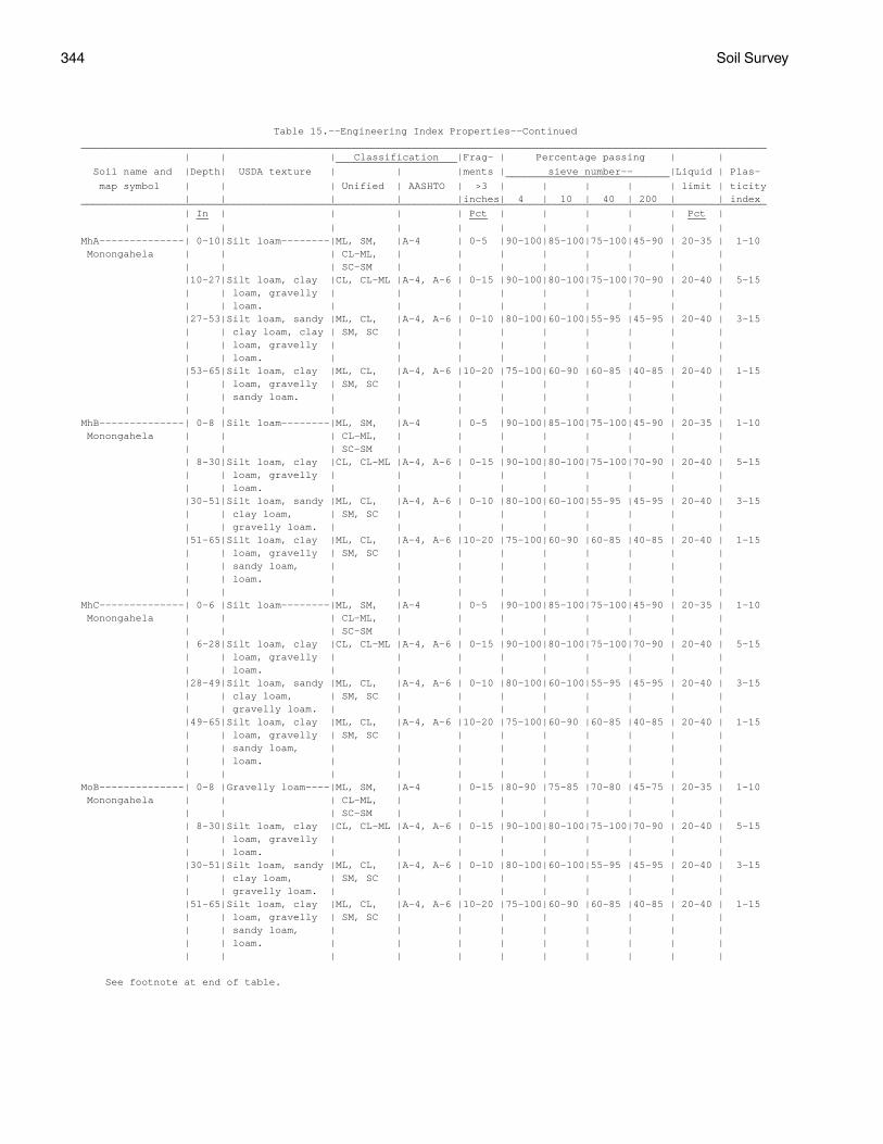
344 Soil Survey
Table 15.--Engineering Index Properties--Continued_________________________________________________________________________________________________________________ | | | Classification |Frag- | Percentage passing | | ____________________ Soil name and |Depth| USDA texture | | |ments | sieve number-- |Liquid | Plas- ___________________________ map symbol | | | Unified | AASHTO | >3 | | | | | limit | ticity | | | | |inches| 4 | 10 | 40 | 200 | | index_________________________________________________________________________________________________________________ | In | | | | Pct | | | | | Pct | __ ___ ___ | | | | | | | | | | |MhA--------------| 0-10|Silt loam--------|ML, SM, |A-4 | 0-5 |90-100|85-100|75-100|45-90 | 20-35 | 1-10 Monongahela | | | CL-ML, | | | | | | | | | | | SC-SM | | | | | | | | |10-27|Silt loam, clay |CL, CL-ML |A-4, A-6 | 0-15 |90-100|80-100|75-100|70-90 | 20-40 | 5-15 | | loam, gravelly | | | | | | | | | | | loam. | | | | | | | | | |27-53|Silt loam, sandy |ML, CL, |A-4, A-6 | 0-10 |80-100|60-100|55-95 |45-95 | 20-40 | 3-15 | | clay loam, clay | SM, SC | | | | | | | | | | loam, gravelly | | | | | | | | | | | loam. | | | | | | | | | |53-65|Silt loam, clay |ML, CL, |A-4, A-6 |10-20 |75-100|60-90 |60-85 |40-85 | 20-40 | 1-15 | | loam, gravelly | SM, SC | | | | | | | | | | sandy loam. | | | | | | | | | | | | | | | | | | | |MhB--------------| 0-8 |Silt loam--------|ML, SM, |A-4 | 0-5 |90-100|85-100|75-100|45-90 | 20-35 | 1-10 Monongahela | | | CL-ML, | | | | | | | | | | | SC-SM | | | | | | | | | 8-30|Silt loam, clay |CL, CL-ML |A-4, A-6 | 0-15 |90-100|80-100|75-100|70-90 | 20-40 | 5-15 | | loam, gravelly | | | | | | | | | | | loam. | | | | | | | | | |30-51|Silt loam, sandy |ML, CL, |A-4, A-6 | 0-10 |80-100|60-100|55-95 |45-95 | 20-40 | 3-15 | | clay loam, | SM, SC | | | | | | | | | | gravelly loam. | | | | | | | | | |51-65|Silt loam, clay |ML, CL, |A-4, A-6 |10-20 |75-100|60-90 |60-85 |40-85 | 20-40 | 1-15 | | loam, gravelly | SM, SC | | | | | | | | | | sandy loam, | | | | | | | | | | | loam. | | | | | | | | | | | | | | | | | | | |MhC--------------| 0-6 |Silt loam--------|ML, SM, |A-4 | 0-5 |90-100|85-100|75-100|45-90 | 20-35 | 1-10 Monongahela | | | CL-ML, | | | | | | | | | | | SC-SM | | | | | | | | | 6-28|Silt loam, clay |CL, CL-ML |A-4, A-6 | 0-15 |90-100|80-100|75-100|70-90 | 20-40 | 5-15 | | loam, gravelly | | | | | | | | | | | loam. | | | | | | | | | |28-49|Silt loam, sandy |ML, CL, |A-4, A-6 | 0-10 |80-100|60-100|55-95 |45-95 | 20-40 | 3-15 | | clay loam, | SM, SC | | | | | | | | | | gravelly loam. | | | | | | | | | |49-65|Silt loam, clay |ML, CL, |A-4, A-6 |10-20 |75-100|60-90 |60-85 |40-85 | 20-40 | 1-15 | | loam, gravelly | SM, SC | | | | | | | | | | sandy loam, | | | | | | | | | | | loam. | | | | | | | | | | | | | | | | | | | |MoB--------------| 0-8 |Gravelly loam----|ML, SM, |A-4 | 0-15 |80-90 |75-85 |70-80 |45-75 | 20-35 | 1-10 Monongahela | | | CL-ML, | | | | | | | | | | | SC-SM | | | | | | | | | 8-30|Silt loam, clay |CL, CL-ML |A-4, A-6 | 0-15 |90-100|80-100|75-100|70-90 | 20-40 | 5-15 | | loam, gravelly | | | | | | | | | | | loam. | | | | | | | | | |30-51|Silt loam, sandy |ML, CL, |A-4, A-6 | 0-10 |80-100|60-100|55-95 |45-95 | 20-40 | 3-15 | | clay loam, | SM, SC | | | | | | | | | | gravelly loam. | | | | | | | | | |51-65|Silt loam, clay |ML, CL, |A-4, A-6 |10-20 |75-100|60-90 |60-85 |40-85 | 20-40 | 1-15 | | loam, gravelly | SM, SC | | | | | | | | | | sandy loam, | | | | | | | | | | | loam. | | | | | | | | | | | | | | | | | | | |
See footnote at end of table.
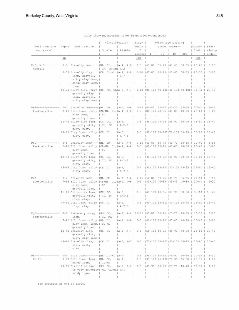
Berkeley County, West Virginia 345
Table 15.--Engineering Index Properties--Continued_________________________________________________________________________________________________________________ | | | Classification |Frag- | Percentage passing | | ____________________ Soil name and |Depth| USDA texture | | |ments | sieve number-- |Liquid | Plas- ___________________________ map symbol | | | Unified | AASHTO | >3 | | | | | limit | ticity | | | | |inches| 4 | 10 | 40 | 200 | | index_________________________________________________________________________________________________________________ | In | | | | Pct | | | | | Pct | __ ___ ___ | | | | | | | | | | |MrB, MrC---------| 0-9 |Gravelly loam----|ML, CL, |A-4, A-6,| 0-5 |65-80 |55-70 |45-65 |30-65 | 20-45 | 3-15 Murrill | | | GM, SC-SM| A-2 | | | | | | | | 9-55|Gravelly clay |CL, CL-ML |A-4, A-6,| 0-10 |65-85 |60-70 |55-65 |50-65 | 20-50 | 5-25 | | loam, gravelly | | A-7 | | | | | | | | | silty clay loam,| | | | | | | | | | | sandy clay loam,| | | | | | | | | | | loam. | | | | | | | | | |55-72|Silty clay, very |CH, MH, CL|A-6, A-7 | 0-10 |80-100|50-100|45-100|40-100| 35-75 | 20-40 | | gravelly clay | | | | | | | | | | | loam, gravelly | | | | | | | | | | | silty clay loam.| | | | | | | | | | | | | | | | | | | |PeB--------------| 0-7 |Gravelly loam----|ML, GM |A-4, A-6 | 0-15 |60-80 |50-75 |40-70 |35-65 | 20-40 | 3-15 Pecktonville | 7-11|Silt loam, silty |CL-ML, CL,|A-4, A-6 | 0-5 |80-100|70-95 |45-85 |40-80 | 20-40 | 5-20 | | clay loam, | SC | | | | | | | | | | gravelly loam. | | | | | | | | | |11-48|Silty clay loam, |CH, GC, |A-6, | 0-5 |45-100|40-95 |35-90 |30-90 | 35-60 | 15-40 | | gravelly silty | CL, SC | A-2-6 | | | | | | | | | clay, clay. | | | | | | | | | |48-65|Clay loam, silty |CH, CL |A-6, | 0-5 |90-100|85-100|70-100|65-95 | 35-60 | 15-40 | | clay, clay. | | A-7-6 | | | | | | | | | | | | | | | | | |PeC--------------| 0-6 |Gravelly loam----|ML, GM |A-4, A-6 | 0-15 |60-80 |50-75 |40-70 |35-65 | 20-40 | 3-15 Pecktonville | 6-12|Silt loam, silty |CL-ML, CL,|A-4, A-6 | 0-5 |80-100|70-95 |45-85 |40-80 | 20-40 | 5-20 | | clay loam, | SC | | | | | | | | | | gravelly loam. | | | | | | | | | |12-43|Silty clay loam, |CH, GC, |A-6, | 0-5 |45-100|40-95 |35-90 |30-90 | 35-60 | 15-40 | | gravelly silty | CL, SC | A-2-6 | | | | | | | | | clay, clay. | | | | | | | | | |43-65|Clay loam, silty |CH, CL |A-6, | 0-5 |90-100|85-100|70-100|65-95 | 35-60 | 15-40 | | clay, clay. | | A-7-6 | | | | | | | | | | | | | | | | | |PeD--------------| 0-7 |Gravelly loam----|ML, GM |A-4, A-6 | 0-15 |60-80 |50-75 |40-70 |35-65 | 20-40 | 3-15 Pecktonville | 7-16|Silt loam, silty |CL-ML, CL,|A-4, A-6 | 0-5 |80-100|70-95 |45-85 |40-80 | 20-40 | 5-20 | | clay loam, | SC | | | | | | | | | | gravelly loam. | | | | | | | | | |16-47|Silty clay loam, |CH, GC, |A-6, | 0-5 |45-100|40-95 |35-90 |30-90 | 35-60 | 15-40 | | gravelly silty | CL, SC | A-2-6 | | | | | | | | | clay, clay. | | | | | | | | | |47-65|Clay loam, silty |CH, CL |A-6, | 0-5 |90-100|85-100|70-100|65-95 | 35-60 | 15-40 | | clay, clay. | | A-7-6 | | | | | | | | | | | | | | | | | |PgC--------------| 0-7 |Extremely stony |GM, GC, |A-2, A-4 |15-35 |35-80 |30-75 |25-70 |20-65 | 15-35 | 3-15 Pecktonville | | loam. | CL, ML | | | | | | | | | 7-12|Silt loam, silty |ML, CL, |A-4, A-6 | 0-5 |80-100|70-95 |45-85 |40-80 | 15-40 | 3-20 | | clay loam, loam,| CL-ML | | | | | | | | | | gravelly loam. | | | | | | | | | |12-48|Gravelly clay, |CH, CL |A-6, A-7 | 0-5 |55-100|50-95 |45-90 |40-90 | 25-60 | 10-40 | | gravelly silty | | | | | | | | | | | clay, clay loam.| | | | | | | | | |48-65|Gravelly clay, |CH, CL |A-6, A-7 | 0-5 |75-100|70-100|65-100|65-95 | 25-60 | 10-40 | | clay, silty | | | | | | | | | | | clay. | | | | | | | | | | | | | | | | | | | |Ph---------------| 0-9 |Silt loam--------|ML, CL-ML |A-4 | 0-5 |95-100|80-100|75-90 |60-80 | 20-35 | 1-10 Philo | 9-29|Silt loam, loam, |ML, SM, |A-4 | 0-5 |95-100|75-100|70-90 |45-80 | 20-35 | 1-10 | | sandy loam. | CL-ML | | | | | | | | |29-65|Stratified sand |GM, SM, |A-2, A-4,| 0-5 |45-95 |40-90 |20-70 |10-70 | 15-30 | 1-10 | | to very gravelly| ML, CL-ML| A-1 | | | | | | | | | sandy loam. | | | | | | | | | | | | | | | | | | | |
See footnote at end of table.
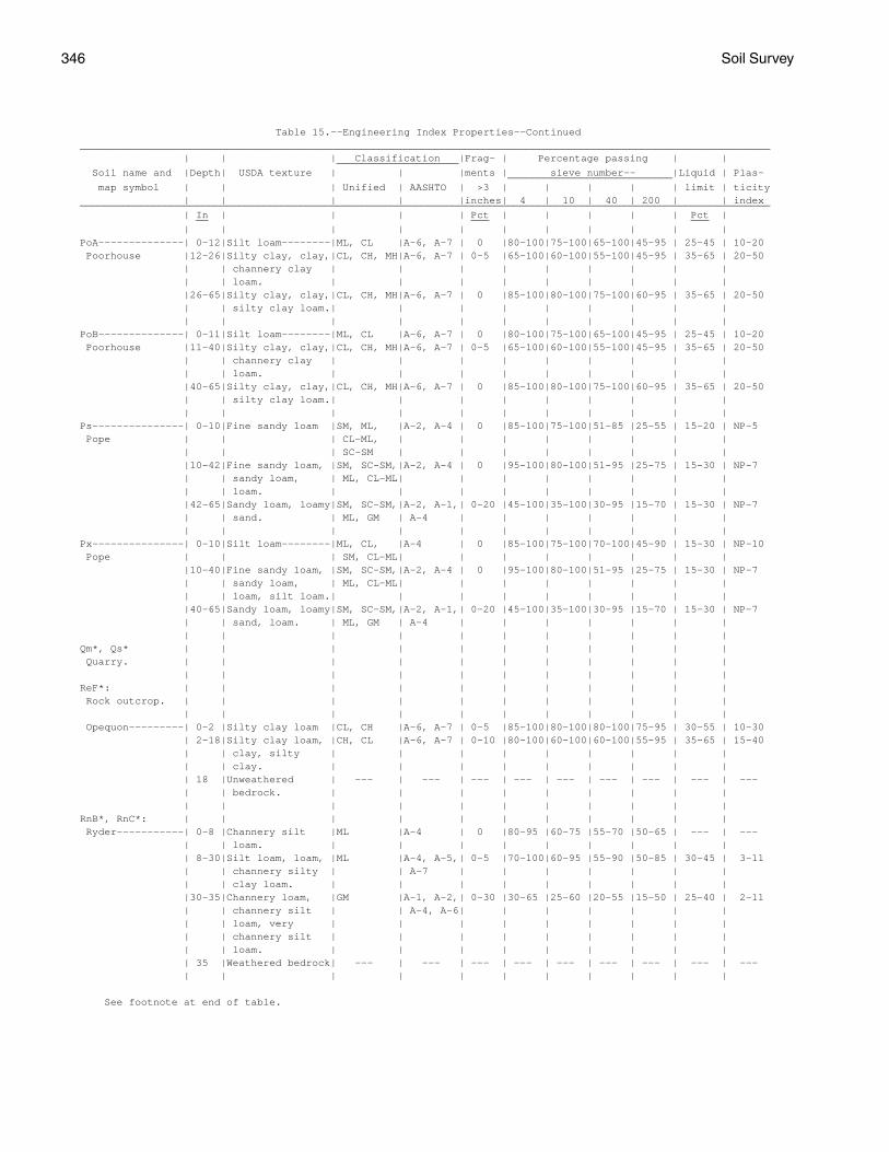
346 Soil Survey
Table 15.--Engineering Index Properties--Continued_________________________________________________________________________________________________________________ | | | Classification |Frag- | Percentage passing | | ____________________ Soil name and |Depth| USDA texture | | |ments | sieve number-- |Liquid | Plas- ___________________________ map symbol | | | Unified | AASHTO | >3 | | | | | limit | ticity | | | | |inches| 4 | 10 | 40 | 200 | | index_________________________________________________________________________________________________________________ | In | | | | Pct | | | | | Pct | __ ___ ___ | | | | | | | | | | |PoA--------------| 0-12|Silt loam--------|ML, CL |A-6, A-7 | 0 |80-100|75-100|65-100|45-95 | 25-45 | 10-20 Poorhouse |12-26|Silty clay, clay,|CL, CH, MH|A-6, A-7 | 0-5 |65-100|60-100|55-100|45-95 | 35-65 | 20-50 | | channery clay | | | | | | | | | | | loam. | | | | | | | | | |26-65|Silty clay, clay,|CL, CH, MH|A-6, A-7 | 0 |85-100|80-100|75-100|60-95 | 35-65 | 20-50 | | silty clay loam.| | | | | | | | | | | | | | | | | | | |PoB--------------| 0-11|Silt loam--------|ML, CL |A-6, A-7 | 0 |80-100|75-100|65-100|45-95 | 25-45 | 10-20 Poorhouse |11-40|Silty clay, clay,|CL, CH, MH|A-6, A-7 | 0-5 |65-100|60-100|55-100|45-95 | 35-65 | 20-50 | | channery clay | | | | | | | | | | | loam. | | | | | | | | | |40-65|Silty clay, clay,|CL, CH, MH|A-6, A-7 | 0 |85-100|80-100|75-100|60-95 | 35-65 | 20-50 | | silty clay loam.| | | | | | | | | | | | | | | | | | | |Ps---------------| 0-10|Fine sandy loam |SM, ML, |A-2, A-4 | 0 |85-100|75-100|51-85 |25-55 | 15-20 | NP-5 Pope | | | CL-ML, | | | | | | | | | | | SC-SM | | | | | | | | |10-42|Fine sandy loam, |SM, SC-SM,|A-2, A-4 | 0 |95-100|80-100|51-95 |25-75 | 15-30 | NP-7 | | sandy loam, | ML, CL-ML| | | | | | | | | | loam. | | | | | | | | | |42-65|Sandy loam, loamy|SM, SC-SM,|A-2, A-1,| 0-20 |45-100|35-100|30-95 |15-70 | 15-30 | NP-7 | | sand. | ML, GM | A-4 | | | | | | | | | | | | | | | | | |Px---------------| 0-10|Silt loam--------|ML, CL, |A-4 | 0 |85-100|75-100|70-100|45-90 | 15-30 | NP-10 Pope | | | SM, CL-ML| | | | | | | | |10-40|Fine sandy loam, |SM, SC-SM,|A-2, A-4 | 0 |95-100|80-100|51-95 |25-75 | 15-30 | NP-7 | | sandy loam, | ML, CL-ML| | | | | | | | | | loam, silt loam.| | | | | | | | | |40-65|Sandy loam, loamy|SM, SC-SM,|A-2, A-1,| 0-20 |45-100|35-100|30-95 |15-70 | 15-30 | NP-7 | | sand, loam. | ML, GM | A-4 | | | | | | | | | | | | | | | | | |Qm*, Qs* | | | | | | | | | | | Quarry. | | | | | | | | | | | | | | | | | | | | | |ReF*: | | | | | | | | | | | Rock outcrop. | | | | | | | | | | | | | | | | | | | | | | Opequon---------| 0-2 |Silty clay loam |CL, CH |A-6, A-7 | 0-5 |85-100|80-100|80-100|75-95 | 30-55 | 10-30 | 2-18|Silty clay loam, |CH, CL |A-6, A-7 | 0-10 |80-100|60-100|60-100|55-95 | 35-65 | 15-40 | | clay, silty | | | | | | | | | | | clay. | | | | | | | | | | 18 |Unweathered | --- | --- | --- | --- | --- | --- | --- | --- | --- | | bedrock. | | | | | | | | | | | | | | | | | | | |RnB*, RnC*: | | | | | | | | | | | Ryder-----------| 0-8 |Channery silt |ML |A-4 | 0 |80-95 |60-75 |55-70 |50-65 | --- | --- | | loam. | | | | | | | | | | 8-30|Silt loam, loam, |ML |A-4, A-5,| 0-5 |70-100|60-95 |55-90 |50-85 | 30-45 | 3-11 | | channery silty | | A-7 | | | | | | | | | clay loam. | | | | | | | | | |30-35|Channery loam, |GM |A-1, A-2,| 0-30 |30-65 |25-60 |20-55 |15-50 | 25-40 | 2-11 | | channery silt | | A-4, A-6| | | | | | | | | loam, very | | | | | | | | | | | channery silt | | | | | | | | | | | loam. | | | | | | | | | | 35 |Weathered bedrock| --- | --- | --- | --- | --- | --- | --- | --- | --- | | | | | | | | | | |
See footnote at end of table.
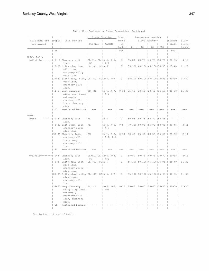
Berkeley County, West Virginia 347
Table 15.--Engineering Index Properties--Continued_________________________________________________________________________________________________________________ | | | Classification |Frag- | Percentage passing | | ____________________ Soil name and |Depth| USDA texture | | |ments | sieve number-- |Liquid | Plas- ___________________________ map symbol | | | Unified | AASHTO | >3 | | | | | limit | ticity | | | | |inches| 4 | 10 | 40 | 200 | | index_________________________________________________________________________________________________________________ | In | | | | Pct | | | | | Pct | __ ___ ___ | | | | | | | | | | |RnB*, RnC*: | | | | | | | | | | | Nollville-------| 0-10|Channery silt |CL-ML, CL,|A-4, A-6,| 0 |55-80 |60-75 |40-75 |30-70 | 20-35 | 4-12 | | loam. | GC | A-2 | | | | | | | |10-29|Silty clay loam, |CL, GC, SC|A-6 | 0 |55-100|60-100|45-100|35-95 | 25-40 | 11-23 | | silt loam, | | | | | | | | | | | channery silty | | | | | | | | | | | clay loam. | | | | | | | | | |29-41|Silty clay, silty|CL, GC, SC|A-6, A-7 | 0 |55-100|60-100|45-100|35-95 | 30-50 | 11-30 | | clay loam, | | | | | | | | | | | channery silt | | | | | | | | | | | loam. | | | | | | | | | |41-57|Very channery |GC, CL |A-6, A-7,| 0-10 |25-65 |20-60 |20-60 |15-55 | 30-50 | 11-30 | | silty clay loam,| | A-2 | | | | | | | | | extremely | | | | | | | | | | | channery silt | | | | | | | | | | | loam, channery | | | | | | | | | | | clay. | | | | | | | | | | 57 |Weathered bedrock| --- | --- | --- | --- | --- | --- | --- | --- | --- | | | | | | | | | | |RnD*: | | | | | | | | | | | Ryder-----------| 0-8 |Channery silt |ML |A-4 | 0 |80-95 |60-75 |55-70 |50-65 | --- | --- | | loam. | | | | | | | | | | 8-30|Silt loam, loam, |ML |A-4, A-5,| 0-5 |70-100|60-95 |55-90 |50-85 | 30-45 | 3-11 | | channery silty | | A-7 | | | | | | | | | clay loam. | | | | | | | | | |30-35|Channery loam, |GM |A-1, A-2,| 0-30 |30-65 |25-60 |20-55 |15-50 | 25-40 | 2-11 | | channery silt | | A-4, A-6| | | | | | | | | loam, very | | | | | | | | | | | channery silt | | | | | | | | | | | loam. | | | | | | | | | | 35 |Weathered bedrock| --- | --- | --- | --- | --- | --- | --- | --- | --- | | | | | | | | | | | Nollville-------| 0-8 |Channery silt |CL-ML, CL,|A-4, A-6,| 0 |55-80 |50-75 |40-75 |30-70 | 20-35 | 4-12 | | loam. | GC | A-2 | | | | | | | | 8-27|Silty clay loam, |CL, GC, SC|A-6 | 0 |55-100|50-100|45-100|35-95 | 25-40 | 11-23 | | silt loam, | | | | | | | | | | | channery silty | | | | | | | | | | | clay loam. | | | | | | | | | |27-39|Silty clay, silty|CL, GC, SC|A-6, A-7 | 0 |55-100|50-100|45-100|35-95 | 30-50 | 11-30 | | clay loam, | | | | | | | | | | | channery silt | | | | | | | | | | | loam. | | | | | | | | | |39-55|Very channery |GC, CL |A-6, A-7,| 0-10 |25-65 |20-60 |20-60 |15-55 | 30-50 | 11-30 | | silty clay loam,| | A-2 | | | | | | | | | extremely | | | | | | | | | | | channery silt | | | | | | | | | | | loam, channery | | | | | | | | | | | clay. | | | | | | | | | | 55 |Weathered bedrock| --- | --- | --- | --- | --- | --- | --- | --- | --- | | | | | | | | | | |
See footnote at end of table.
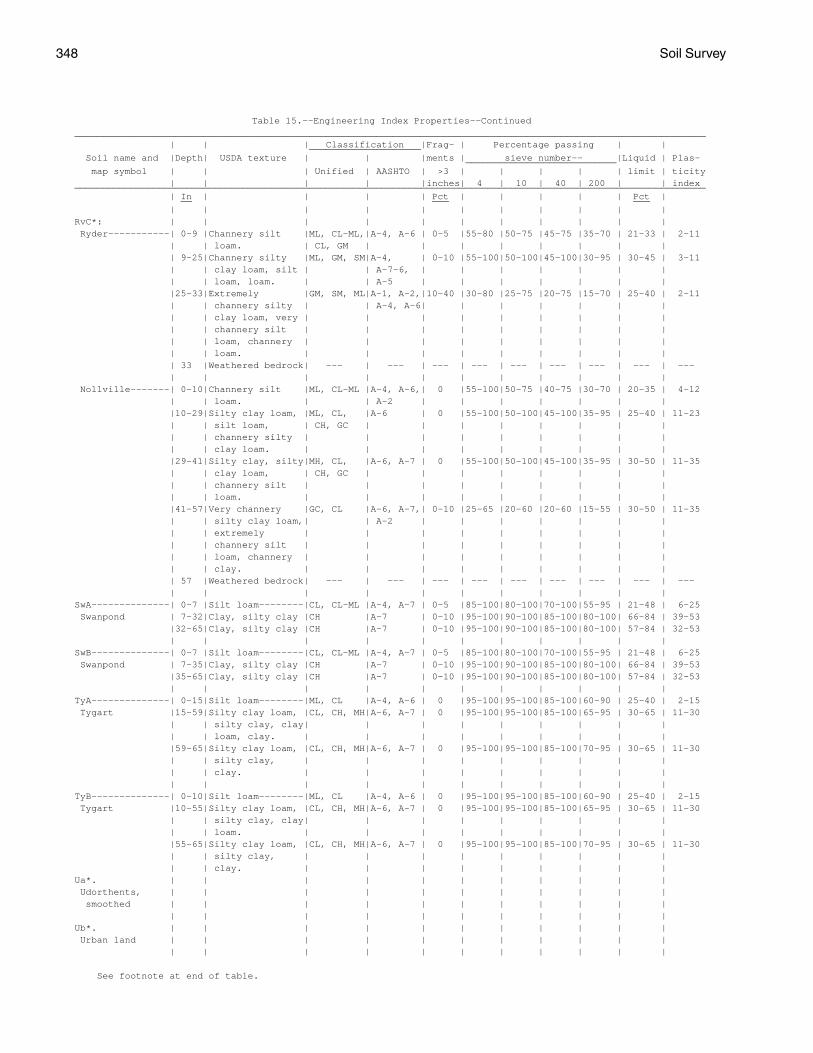
348 Soil Survey
Table 15.--Engineering Index Properties--Continued_________________________________________________________________________________________________________________ | | | Classification |Frag- | Percentage passing | | ____________________ Soil name and |Depth| USDA texture | | |ments | sieve number-- |Liquid | Plas- ___________________________ map symbol | | | Unified | AASHTO | >3 | | | | | limit | ticity | | | | |inches| 4 | 10 | 40 | 200 | | index_________________________________________________________________________________________________________________ | In | | | | Pct | | | | | Pct | __ ___ ___ | | | | | | | | | | |RvC*: | | | | | | | | | | | Ryder-----------| 0-9 |Channery silt |ML, CL-ML,|A-4, A-6 | 0-5 |55-80 |50-75 |45-75 |35-70 | 21-33 | 2-11 | | loam. | CL, GM | | | | | | | | | 9-25|Channery silty |ML, GM, SM|A-4, | 0-10 |55-100|50-100|45-100|30-95 | 30-45 | 3-11 | | clay loam, silt | | A-7-6, | | | | | | | | | loam, loam. | | A-5 | | | | | | | |25-33|Extremely |GM, SM, ML|A-1, A-2,|10-40 |30-80 |25-75 |20-75 |15-70 | 25-40 | 2-11 | | channery silty | | A-4, A-6| | | | | | | | | clay loam, very | | | | | | | | | | | channery silt | | | | | | | | | | | loam, channery | | | | | | | | | | | loam. | | | | | | | | | | 33 |Weathered bedrock| --- | --- | --- | --- | --- | --- | --- | --- | --- | | | | | | | | | | | Nollville-------| 0-10|Channery silt |ML, CL-ML |A-4, A-6,| 0 |55-100|50-75 |40-75 |30-70 | 20-35 | 4-12 | | loam. | | A-2 | | | | | | | |10-29|Silty clay loam, |ML, CL, |A-6 | 0 |55-100|50-100|45-100|35-95 | 25-40 | 11-23 | | silt loam, | CH, GC | | | | | | | | | | channery silty | | | | | | | | | | | clay loam. | | | | | | | | | |29-41|Silty clay, silty|MH, CL, |A-6, A-7 | 0 |55-100|50-100|45-100|35-95 | 30-50 | 11-35 | | clay loam, | CH, GC | | | | | | | | | | channery silt | | | | | | | | | | | loam. | | | | | | | | | |41-57|Very channery |GC, CL |A-6, A-7,| 0-10 |25-65 |20-60 |20-60 |15-55 | 30-50 | 11-35 | | silty clay loam,| | A-2 | | | | | | | | | extremely | | | | | | | | | | | channery silt | | | | | | | | | | | loam, channery | | | | | | | | | | | clay. | | | | | | | | | | 57 |Weathered bedrock| --- | --- | --- | --- | --- | --- | --- | --- | --- | | | | | | | | | | |SwA--------------| 0-7 |Silt loam--------|CL, CL-ML |A-4, A-7 | 0-5 |85-100|80-100|70-100|55-95 | 21-48 | 6-25 Swanpond | 7-32|Clay, silty clay |CH |A-7 | 0-10 |95-100|90-100|85-100|80-100| 66-84 | 39-53 |32-65|Clay, silty clay |CH |A-7 | 0-10 |95-100|90-100|85-100|80-100| 57-84 | 32-53 | | | | | | | | | | |SwB--------------| 0-7 |Silt loam--------|CL, CL-ML |A-4, A-7 | 0-5 |85-100|80-100|70-100|55-95 | 21-48 | 6-25 Swanpond | 7-35|Clay, silty clay |CH |A-7 | 0-10 |95-100|90-100|85-100|80-100| 66-84 | 39-53 |35-65|Clay, silty clay |CH |A-7 | 0-10 |95-100|90-100|85-100|80-100| 57-84 | 32-53 | | | | | | | | | | |TyA--------------| 0-15|Silt loam--------|ML, CL |A-4, A-6 | 0 |95-100|95-100|85-100|60-90 | 25-40 | 2-15 Tygart |15-59|Silty clay loam, |CL, CH, MH|A-6, A-7 | 0 |95-100|95-100|85-100|65-95 | 30-65 | 11-30 | | silty clay, clay| | | | | | | | | | | loam, clay. | | | | | | | | | |59-65|Silty clay loam, |CL, CH, MH|A-6, A-7 | 0 |95-100|95-100|85-100|70-95 | 30-65 | 11-30 | | silty clay, | | | | | | | | | | | clay. | | | | | | | | | | | | | | | | | | | |TyB--------------| 0-10|Silt loam--------|ML, CL |A-4, A-6 | 0 |95-100|95-100|85-100|60-90 | 25-40 | 2-15 Tygart |10-55|Silty clay loam, |CL, CH, MH|A-6, A-7 | 0 |95-100|95-100|85-100|65-95 | 30-65 | 11-30 | | silty clay, clay| | | | | | | | | | | loam. | | | | | | | | | |55-65|Silty clay loam, |CL, CH, MH|A-6, A-7 | 0 |95-100|95-100|85-100|70-95 | 30-65 | 11-30 | | silty clay, | | | | | | | | | | | clay. | | | | | | | | |Ua*. | | | | | | | | | | | Udorthents, | | | | | | | | | | | smoothed | | | | | | | | | | | | | | | | | | | | | |Ub*. | | | | | | | | | | | Urban land | | | | | | | | | | | | | | | | | | | | | |
See footnote at end of table.

Berkeley County, West Virginia 349
Table 15.--Engineering Index Properties--Continued_________________________________________________________________________________________________________________ | | | Classification |Frag- | Percentage passing | | ____________________ Soil name and |Depth| USDA texture | | |ments | sieve number-- |Liquid | Plas- ___________________________ map symbol | | | Unified | AASHTO | >3 | | | | | limit | ticity | | | | |inches| 4 | 10 | 40 | 200 | | index_________________________________________________________________________________________________________________ | In | | | | Pct | | | | | Pct | __ ___ ___ | | | | | | | | | | |UkC*: | | | | | | | | | | | Urban land. | | | | | | | | | | | | | | | | | | | | | | Berks-----------| 0-7 |Channery silt |GM, ML, |A-2, A-4 | 0-20 |50-80 |50-70 |40-60 |30-55 | 25-36 | 5-10 | | loam. | GC, SC | | | | | | | | | 7-21|Silt loam, loam, |GM, SM, |A-1, A-2,| 0-30 |40-80 |35-70 |25-60 |20-45 | 25-36 | 5-10 | | channery silt | GC, SC | A-4 | | | | | | | | | loam, very | | | | | | | | | | | channery silt | | | | | | | | | | | loam. | | | | | | | | | |21-25|Channery loam, |GM, SM |A-1, A-2 | 0-40 |35-65 |25-55 |20-40 |15-35 | 24-38 | 2-10 | | very channery | | | | | | | | | | | loam, extremely | | | | | | | | | | | channery silt | | | | | | | | | | | loam. | | | | | | | | | | 25 |Weathered bedrock| --- | --- | --- | --- | --- | --- | --- | --- | --- | | | | | | | | | | |UvC*: | | | | | | | | | | | Urban land. | | | | | | | | | | | | | | | | | | | | | | Carbo-----------| 0-9 |Silty clay loam |CL |A-6, A-7 | 0-5 |95-100|90-100|85-95 |75-85 | 30-50 | 10-25 | 9-34|Clay-------------|CH |A-7 | 0-5 |95-100|85-100|80-95 |70-90 | 60-80 | 35-55 | 34 |Unweathered | --- | --- | --- | --- | --- | --- | --- | --- | --- | | bedrock. | | | | | | | | | | | | | | | | | | | | Endcav----------| 0-8 |Silty clay loam |CL |A-6, A-7 | 0 |90-100|90-100|85-100|75-95 | 30-50 | 10-25 | 8-41|Clay, silty clay |CH |A-7 | 0 |80-100|75-100|70-100|60-95 | 60-85 | 35-55 | 41 |Unweathered | --- | --- | --- | --- | --- | --- | --- | --- | --- | | bedrock. | | | | | | | | | | | | | | | | | | | |UwC*: | | | | | | | | | | | Urban land. | | | | | | | | | | | | | | | | | | | | | | Hagerstown------| 0-12|Silt loam--------|CL, CL-ML |A-4, A-6,| 0-5 |85-100|80-100|80-100|70-95 | 25-50 | 5-25 | | | | A-7 | | | | | | | |12-20|Clay, clay loam, |CL, CH |A-7 | 0-5 |90-100|80-100|75-100|55-95 | 48-65 | 26-34 | | loam, silt loam.| | | | | | | | | |20-71|Clay, silty clay,|CH, CL |A-7, A-6 | 0-5 |85-100|80-100|75-100|75-95 | 30-70 | 15-40 | | silty clay loam.| | | | | | | | | | 71 |Unweathered | --- | --- | --- | --- | --- | --- | --- | --- | --- | | bedrock. | | | | | | | | | | | | | | | | | | | |W*. | | | | | | | | | | | Water | | | | | | | | | | | | | | | | | | | | | |WbB*: | | | | | | | | | | | Weikert---------| 0-6 |Channery silt |GM, ML, SM|A-1, A-2,| 0-10 |35-70 |35-70 |25-65 |20-55 | 30-40 | 4-10 | | loam. | | A-4 | | | | | | | | 6-18|Channery loam, |GM, GP-GM |A-1, A-2 | 0-20 |15-60 |10-55 | 5-45 | 5-35 | 28-36 | 3-9 | | very channery | | | | | | | | | | | silt loam, | | | | | | | | | | | gravelly loam. | | | | | | | | | | 18 |Weathered bedrock| --- | --- | --- | --- | --- | --- | --- | --- | --- | | | | | | | | | | |
See footnote at end of table.
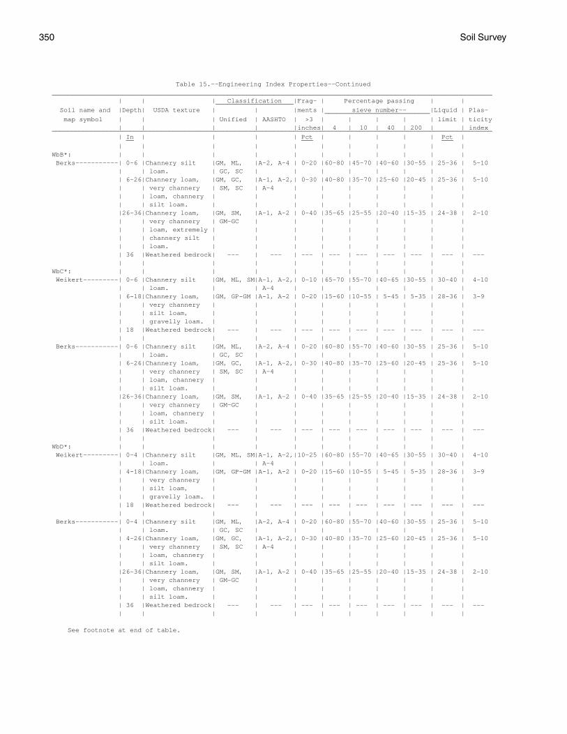
350 Soil Survey
Table 15.--Engineering Index Properties--Continued_________________________________________________________________________________________________________________ | | | Classification |Frag- | Percentage passing | | ____________________ Soil name and |Depth| USDA texture | | |ments | sieve number-- |Liquid | Plas- ___________________________ map symbol | | | Unified | AASHTO | >3 | | | | | limit | ticity | | | | |inches| 4 | 10 | 40 | 200 | | index_________________________________________________________________________________________________________________ | In | | | | Pct | | | | | Pct | __ ___ ___ | | | | | | | | | | |WbB*: | | | | | | | | | | | Berks-----------| 0-6 |Channery silt |GM, ML, |A-2, A-4 | 0-20 |60-80 |45-70 |40-60 |30-55 | 25-36 | 5-10 | | loam. | GC, SC | | | | | | | | | 6-26|Channery loam, |GM, GC, |A-1, A-2,| 0-30 |40-80 |35-70 |25-60 |20-45 | 25-36 | 5-10 | | very channery | SM, SC | A-4 | | | | | | | | | loam, channery | | | | | | | | | | | silt loam. | | | | | | | | | |26-36|Channery loam, |GM, SM, |A-1, A-2 | 0-40 |35-65 |25-55 |20-40 |15-35 | 24-38 | 2-10 | | very channery | GM-GC | | | | | | | | | | loam, extremely | | | | | | | | | | | channery silt | | | | | | | | | | | loam. | | | | | | | | | | 36 |Weathered bedrock| --- | --- | --- | --- | --- | --- | --- | --- | --- | | | | | | | | | | |WbC*: | | | | | | | | | | | Weikert---------| 0-6 |Channery silt |GM, ML, SM|A-1, A-2,| 0-10 |65-70 |55-70 |40-65 |30-55 | 30-40 | 4-10 | | loam. | | A-4 | | | | | | | | 6-18|Channery loam, |GM, GP-GM |A-1, A-2 | 0-20 |15-60 |10-55 | 5-45 | 5-35 | 28-36 | 3-9 | | very channery | | | | | | | | | | | silt loam, | | | | | | | | | | | gravelly loam. | | | | | | | | | | 18 |Weathered bedrock| --- | --- | --- | --- | --- | --- | --- | --- | --- | | | | | | | | | | | Berks-----------| 0-6 |Channery silt |GM, ML, |A-2, A-4 | 0-20 |60-80 |55-70 |40-60 |30-55 | 25-36 | 5-10 | | loam. | GC, SC | | | | | | | | | 6-26|Channery loam, |GM, GC, |A-1, A-2,| 0-30 |40-80 |35-70 |25-60 |20-45 | 25-36 | 5-10 | | very channery | SM, SC | A-4 | | | | | | | | | loam, channery | | | | | | | | | | | silt loam. | | | | | | | | | |26-36|Channery loam, |GM, SM, |A-1, A-2 | 0-40 |35-65 |25-55 |20-40 |15-35 | 24-38 | 2-10 | | very channery | GM-GC | | | | | | | | | | loam, channery | | | | | | | | | | | silt loam. | | | | | | | | | | 36 |Weathered bedrock| --- | --- | --- | --- | --- | --- | --- | --- | --- | | | | | | | | | | |WbD*: | | | | | | | | | | | Weikert---------| 0-4 |Channery silt |GM, ML, SM|A-1, A-2,|10-25 |60-80 |55-70 |40-65 |30-55 | 30-40 | 4-10 | | loam. | | A-4 | | | | | | | | 4-18|Channery loam, |GM, GP-GM |A-1, A-2 | 0-20 |15-60 |10-55 | 5-45 | 5-35 | 28-36 | 3-9 | | very channery | | | | | | | | | | | silt loam, | | | | | | | | | | | gravelly loam. | | | | | | | | | | 18 |Weathered bedrock| --- | --- | --- | --- | --- | --- | --- | --- | --- | | | | | | | | | | | Berks-----------| 0-4 |Channery silt |GM, ML, |A-2, A-4 | 0-20 |60-80 |55-70 |40-60 |30-55 | 25-36 | 5-10 | | loam. | GC, SC | | | | | | | | | 4-26|Channery loam, |GM, GC, |A-1, A-2,| 0-30 |40-80 |35-70 |25-60 |20-45 | 25-36 | 5-10 | | very channery | SM, SC | A-4 | | | | | | | | | loam, channery | | | | | | | | | | | silt loam. | | | | | | | | | |26-36|Channery loam, |GM, SM, |A-1, A-2 | 0-40 |35-65 |25-55 |20-40 |15-35 | 24-38 | 2-10 | | very channery | GM-GC | | | | | | | | | | loam, channery | | | | | | | | | | | silt loam. | | | | | | | | | | 36 |Weathered bedrock| --- | --- | --- | --- | --- | --- | --- | --- | --- | | | | | | | | | | |
See footnote at end of table.
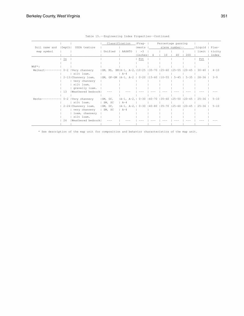
Berkeley County, West Virginia 351
Table 15.--Engineering Index Properties--Continued_________________________________________________________________________________________________________________ | | | Classification |Frag- | Percentage passing | | ____________________ Soil name and |Depth| USDA texture | | |ments | sieve number-- |Liquid | Plas- ___________________________ map symbol | | | Unified | AASHTO | >3 | | | | | limit | ticity | | | | |inches| 4 | 10 | 40 | 200 | | index_________________________________________________________________________________________________________________ | In | | | | Pct | | | | | Pct | __ ___ ___ | | | | | | | | | | |WkF*: | | | | | | | | | | | Weikert---------| 0-2 |Very channery |GM, ML, SM|A-1, A-2,|10-25 |35-70 |25-60 |25-55 |20-45 | 30-40 | 4-10 | | silt loam. | | A-4 | | | | | | | | 2-13|Channery loam, |GM, GP-GM |A-1, A-2 | 0-20 |15-60 |10-55 | 5-45 | 5-35 | 28-36 | 3-9 | | very channery | | | | | | | | | | | silt loam, | | | | | | | | | | | gravelly loam. | | | | | | | | | | 13 |Weathered bedrock| --- | --- | --- | --- | --- | --- | --- | --- | --- | | | | | | | | | | | Berks-----------| 0-2 |Very channery |GM, GC, |A-1, A-2,| 0-30 |40-70 |35-60 |25-50 |20-45 | 25-36 | 5-10 | | silt loam. | SM, SC | A-4 | | | | | | | | 2-24|Channery loam, |GM, GC, |A-1, A-2,| 0-30 |40-80 |35-70 |25-60 |20-45 | 25-36 | 5-10 | | very channery | SM, SC | A-4 | | | | | | | | | loam, channery | | | | | | | | | | | silt loam. | | | | | | | | | | 24 |Weathered bedrock| --- | --- | --- | --- | --- | --- | --- | --- | --- | | | | | | | | | | |_________________________________________________________________________________________________________________
* See description of the map unit for composition and behavior characteristics of the map unit.
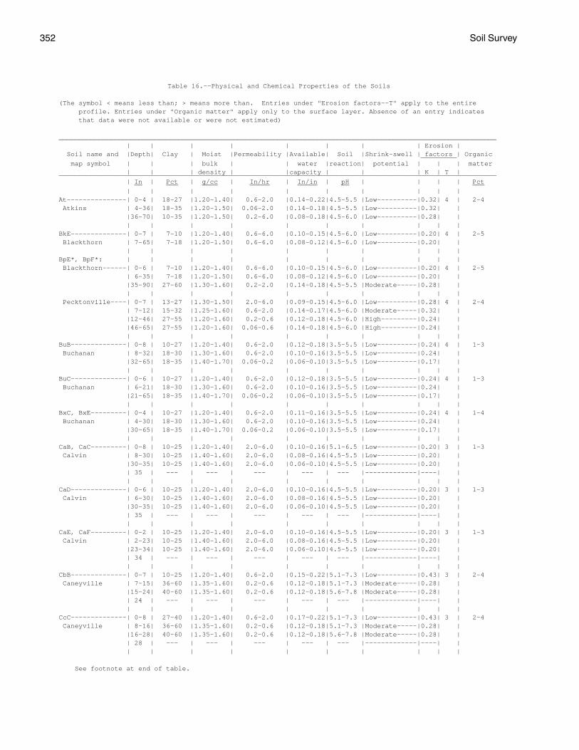
352 Soil Survey
Table 16.--Physical and Chemical Properties of the Soils
(The symbol < means less than; > means more than. Entries under "Erosion factors--T" apply to the entire profile. Entries under "Organic matter" apply only to the surface layer. Absence of an entry indicates that data were not available or were not estimated)
______________________________________________________________________________________________________________ | | | | | | | | Erosion | Soil name and |Depth| Clay | Moist |Permeability |Available| Soil |Shrink-swell | factors | Organic _________ map symbol | | | bulk | | water |reaction| potential | | | matter | | | density | |capacity | | | K | T |______________________________________________________________________________________________________________ | In | Pct | g/cc | In/hr | In/in | pH | | | | Pct __ ___ ____ _____ _____ __ ___ | | | | | | | | | |At---------------| 0-4 | 18-27 |1.20-1.40| 0.6-2.0 |0.14-0.22|4.5-5.5 |Low----------|0.32| 4 | 2-4 Atkins | 4-36| 18-35 |1.20-1.50| 0.06-2.0 |0.14-0.18|4.5-5.5 |Low----------|0.32| | |36-70| 10-35 |1.20-1.50| 0.2-6.0 |0.08-0.18|4.5-6.0 |Low----------|0.28| | | | | | | | | | | |BkE--------------| 0-7 | 7-10 |1.20-1.40| 0.6-6.0 |0.10-0.15|4.5-6.0 |Low----------|0.20| 4 | 2-5 Blackthorn | 7-65| 7-18 |1.20-1.50| 0.6-6.0 |0.08-0.12|4.5-6.0 |Low----------|0.20| | | | | | | | | | | |BpE*, BpF*: | | | | | | | | | | Blackthorn------| 0-6 | 7-10 |1.20-1.40| 0.6-6.0 |0.10-0.15|4.5-6.0 |Low----------|0.20| 4 | 2-5 | 6-35| 7-18 |1.20-1.50| 0.6-6.0 |0.08-0.12|4.5-6.0 |Low----------|0.20| | |35-90| 27-60 |1.30-1.60| 0.2-2.0 |0.14-0.18|4.5-5.5 |Moderate-----|0.28| | | | | | | | | | | | Pecktonville----| 0-7 | 13-27 |1.30-1.50| 2.0-6.0 |0.09-0.15|4.5-6.0 |Low----------|0.28| 4 | 2-4 | 7-12| 15-32 |1.25-1.60| 0.6-2.0 |0.14-0.17|4.5-6.0 |Moderate-----|0.32| | |12-46| 27-55 |1.20-1.60| 0.2-0.6 |0.12-0.18|4.5-6.0 |High---------|0.24| | |46-65| 27-55 |1.20-1.60| 0.06-0.6 |0.14-0.18|4.5-6.0 |High---------|0.24| | | | | | | | | | | |BuB--------------| 0-8 | 10-27 |1.20-1.40| 0.6-2.0 |0.12-0.18|3.5-5.5 |Low----------|0.24| 4 | 1-3 Buchanan | 8-32| 18-30 |1.30-1.60| 0.6-2.0 |0.10-0.16|3.5-5.5 |Low----------|0.24| | |32-65| 18-35 |1.40-1.70| 0.06-0.2 |0.06-0.10|3.5-5.5 |Low----------|0.17| | | | | | | | | | | |BuC--------------| 0-6 | 10-27 |1.20-1.40| 0.6-2.0 |0.12-0.18|3.5-5.5 |Low----------|0.24| 4 | 1-3 Buchanan | 6-21| 18-30 |1.30-1.60| 0.6-2.0 |0.10-0.16|3.5-5.5 |Low----------|0.24| | |21-65| 18-35 |1.40-1.70| 0.06-0.2 |0.06-0.10|3.5-5.5 |Low----------|0.17| | | | | | | | | | | |BxC, BxE---------| 0-4 | 10-27 |1.20-1.40| 0.6-2.0 |0.11-0.16|3.5-5.5 |Low----------|0.24| 4 | 1-4 Buchanan | 4-30| 18-30 |1.30-1.60| 0.6-2.0 |0.10-0.16|3.5-5.5 |Low----------|0.24| | |30-65| 18-35 |1.40-1.70| 0.06-0.2 |0.06-0.10|3.5-5.5 |Low----------|0.17| | | | | | | | | | | |CaB, CaC---------| 0-8 | 10-25 |1.20-1.40| 2.0-6.0 |0.10-0.16|5.1-6.5 |Low----------|0.20| 3 | 1-3 Calvin | 8-30| 10-25 |1.40-1.60| 2.0-6.0 |0.08-0.16|4.5-5.5 |Low----------|0.20| | |30-35| 10-25 |1.40-1.60| 2.0-6.0 |0.06-0.10|4.5-5.5 |Low----------|0.20| | | 35 | --- | --- | --- | --- | --- |-------------|----| | | | | | | | | | | |CaD--------------| 0-6 | 10-25 |1.20-1.40| 2.0-6.0 |0.10-0.16|4.5-5.5 |Low----------|0.20| 3 | 1-3 Calvin | 6-30| 10-25 |1.40-1.60| 2.0-6.0 |0.08-0.16|4.5-5.5 |Low----------|0.20| | |30-35| 10-25 |1.40-1.60| 2.0-6.0 |0.06-0.10|4.5-5.5 |Low----------|0.20| | | 35 | --- | --- | --- | --- | --- |-------------|----| | | | | | | | | | | |CaE, CaF---------| 0-2 | 10-25 |1.20-1.40| 2.0-6.0 |0.10-0.16|4.5-5.5 |Low----------|0.20| 3 | 1-3 Calvin | 2-23| 10-25 |1.40-1.60| 2.0-6.0 |0.08-0.16|4.5-5.5 |Low----------|0.20| | |23-34| 10-25 |1.40-1.60| 2.0-6.0 |0.06-0.10|4.5-5.5 |Low----------|0.20| | | 34 | --- | --- | --- | --- | --- |-------------|----| | | | | | | | | | | |CbB--------------| 0-7 | 10-25 |1.20-1.40| 0.6-2.0 |0.15-0.22|5.1-7.3 |Low----------|0.43| 3 | 2-4 Caneyville | 7-15| 36-60 |1.35-1.60| 0.2-0.6 |0.12-0.18|5.1-7.3 |Moderate-----|0.28| | |15-24| 40-60 |1.35-1.60| 0.2-0.6 |0.12-0.18|5.6-7.8 |Moderate-----|0.28| | | 24 | --- | --- | --- | --- | --- |-------------|----| | | | | | | | | | | |CcC--------------| 0-8 | 27-40 |1.20-1.40| 0.6-2.0 |0.17-0.22|5.1-7.3 |Low----------|0.43| 3 | 2-4 Caneyville | 8-16| 36-60 |1.35-1.60| 0.2-0.6 |0.12-0.18|5.1-7.3 |Moderate-----|0.28| | |16-28| 40-60 |1.35-1.60| 0.2-0.6 |0.12-0.18|5.6-7.8 |Moderate-----|0.28| | | 28 | --- | --- | --- | --- | --- |-------------|----| | | | | | | | | | | |
See footnote at end of table.
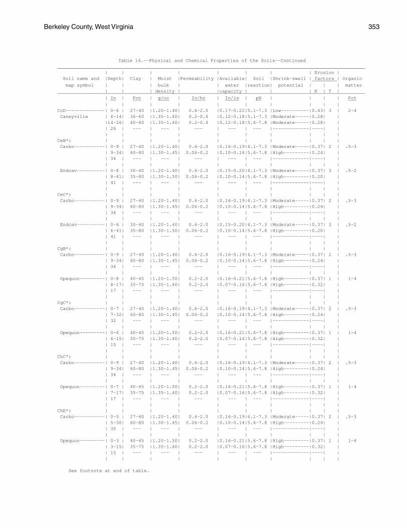
Berkeley County, West Virginia 353
Table 16.--Physical and Chemical Properties of the Soils--Continued______________________________________________________________________________________________________________ | | | | | | | | Erosion | Soil name and |Depth| Clay | Moist |Permeability |Available| Soil |Shrink-swell | factors | Organic _________ map symbol | | | bulk | | water |reaction| potential | | | matter | | | density | |capacity | | | K | T |______________________________________________________________________________________________________________ | In | Pct | g/cc | In/hr | In/in | pH | | | | Pct __ ___ ____ _____ _____ __ ___ | | | | | | | | | |CcD--------------| 0-6 | 27-40 |1.20-1.40| 0.6-2.0 |0.17-0.22|5.1-7.3 |Low----------|0.43| 3 | 2-4 Caneyville | 6-14| 36-60 |1.35-1.60| 0.2-0.6 |0.12-0.18|5.1-7.3 |Moderate-----|0.28| | |14-26| 40-60 |1.35-1.60| 0.2-0.6 |0.12-0.18|5.6-7.8 |Moderate-----|0.28| | | 26 | --- | --- | --- | --- | --- |-------------|----| | | | | | | | | | | |CeB*: | | | | | | | | | | Carbo-----------| 0-9 | 27-40 |1.20-1.40| 0.6-2.0 |0.16-0.19|6.1-7.3 |Moderate-----|0.37| 2 | .5-3 | 9-34| 60-80 |1.30-1.45| 0.06-0.2 |0.10-0.14|5.6-7.8 |High---------|0.24| | | 34 | --- | --- | --- | --- | --- |-------------|----| | | | | | | | | | | | Endcav----------| 0-8 | 30-40 |1.20-1.40| 0.6-2.0 |0.15-0.20|6.1-7.3 |Moderate-----|0.37| 3 | .5-2 | 8-41| 35-80 |1.30-1.50| 0.06-0.2 |0.10-0.14|5.6-7.8 |High---------|0.20| | | 41 | --- | --- | --- | --- | --- |-------------|----| | | | | | | | | | | |CeC*: | | | | | | | | | | Carbo-----------| 0-9 | 27-40 |1.20-1.40| 0.6-2.0 |0.16-0.19|6.1-7.3 |Moderate-----|0.37| 2 | .5-3 | 9-34| 60-80 |1.30-1.45| 0.06-0.2 |0.10-0.14|5.6-7.8 |High---------|0.24| | | 34 | --- | --- | --- | --- | --- |-------------|----| | | | | | | | | | | | Endcav----------| 0-6 | 30-40 |1.20-1.40| 0.6-2.0 |0.15-0.20|6.1-7.3 |Moderate-----|0.37| 3 | .5-2 | 6-41| 35-80 |1.30-1.50| 0.06-0.2 |0.10-0.14|5.6-7.8 |High---------|0.20| | | 41 | --- | --- | --- | --- | --- |-------------|----| | | | | | | | | | | |CgB*: | | | | | | | | | | Carbo-----------| 0-9 | 27-40 |1.20-1.40| 0.6-2.0 |0.16-0.19|6.1-7.3 |Moderate-----|0.37| 2 | .5-3 | 9-34| 60-80 |1.30-1.45| 0.06-0.2 |0.10-0.14|5.6-7.8 |High---------|0.24| | | 34 | --- | --- | --- | --- | --- |-------------|----| | | | | | | | | | | | Opequon---------| 0-8 | 40-45 |1.20-1.50| 0.2-2.0 |0.16-0.21|5.6-7.8 |High---------|0.37| 1 | 1-4 | 8-17| 35-75 |1.35-1.60| 0.2-2.0 |0.07-0.16|5.6-7.8 |High---------|0.32| | | 17 | --- | --- | --- | --- | --- |-------------|----| | | | | | | | | | | |CgC*: | | | | | | | | | | Carbo-----------| 0-7 | 27-40 |1.20-1.40| 0.6-2.0 |0.16-0.19|6.1-7.3 |Moderate-----|0.37| 2 | .5-3 | 7-32| 60-80 |1.30-1.45| 0.06-0.2 |0.10-0.14|5.6-7.8 |High---------|0.24| | | 32 | --- | --- | --- | --- | --- |-------------|----| | | | | | | | | | | | Opequon---------| 0-6 | 40-45 |1.20-1.50| 0.2-2.0 |0.16-0.21|5.6-7.8 |High---------|0.37| 1 | 1-4 | 6-15| 35-75 |1.35-1.60| 0.2-2.0 |0.07-0.16|5.6-7.8 |High---------|0.32| | | 15 | --- | --- | --- | --- | --- |-------------|----| | | | | | | | | | | |ChC*: | | | | | | | | | | Carbo-----------| 0-9 | 27-40 |1.20-1.40| 0.6-2.0 |0.16-0.19|6.1-7.3 |Moderate-----|0.37| 2 | .5-3 | 9-34| 60-80 |1.30-1.45| 0.06-0.2 |0.10-0.14|5.6-7.8 |High---------|0.24| | | 34 | --- | --- | --- | --- | --- |-------------|----| | | | | | | | | | | | Opequon---------| 0-7 | 40-45 |1.20-1.50| 0.2-2.0 |0.16-0.21|5.6-7.8 |High---------|0.37| 1 | 1-4 | 7-17| 35-75 |1.35-1.60| 0.2-2.0 |0.07-0.16|5.6-7.8 |High---------|0.32| | | 17 | --- | --- | --- | --- | --- |-------------|----| | | | | | | | | | | |ChE*: | | | | | | | | | | Carbo-----------| 0-5 | 27-40 |1.20-1.40| 0.6-2.0 |0.16-0.19|6.1-7.3 |Moderate-----|0.37| 2 | .5-3 | 5-30| 60-80 |1.30-1.45| 0.06-0.2 |0.10-0.14|5.6-7.8 |High---------|0.24| | | 30 | --- | --- | --- | --- | --- |-------------|----| | | | | | | | | | | | Opequon---------| 0-3 | 40-45 |1.20-1.50| 0.2-2.0 |0.16-0.21|5.6-7.8 |High---------|0.37| 1 | 1-4 | 3-15| 35-75 |1.35-1.60| 0.2-2.0 |0.07-0.16|5.6-7.8 |High---------|0.32| | | 15 | --- | --- | --- | --- | --- |-------------|----| | | | | | | | | | | |
See footnote at end of table.
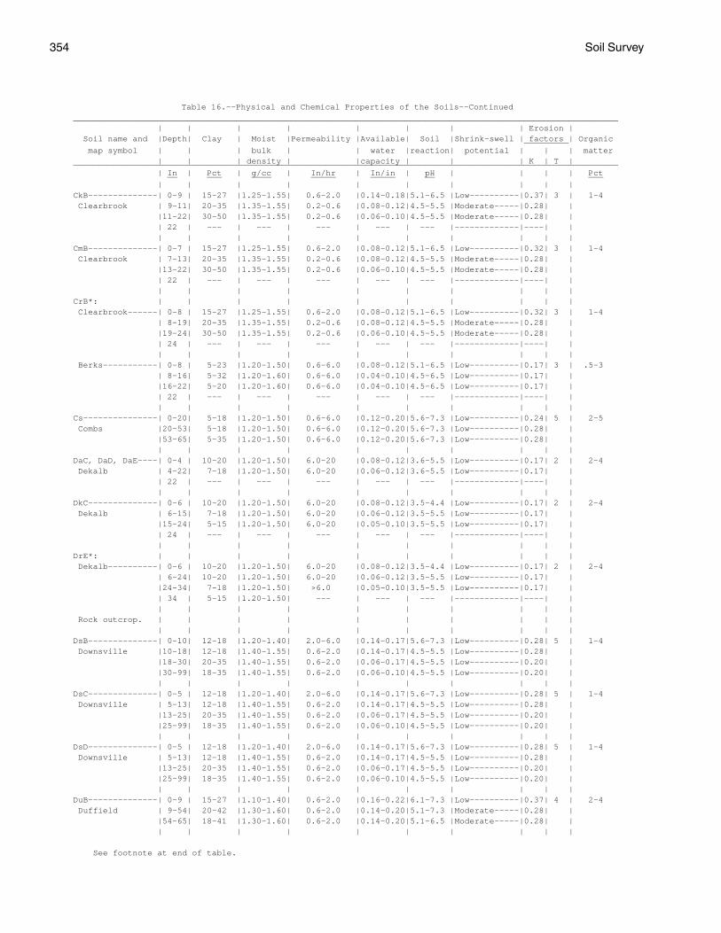
354 Soil Survey
Table 16.--Physical and Chemical Properties of the Soils--Continued______________________________________________________________________________________________________________ | | | | | | | | Erosion | Soil name and |Depth| Clay | Moist |Permeability |Available| Soil |Shrink-swell | factors | Organic _________ map symbol | | | bulk | | water |reaction| potential | | | matter | | | density | |capacity | | | K | T |______________________________________________________________________________________________________________ | In | Pct | g/cc | In/hr | In/in | pH | | | | Pct __ ___ ____ _____ _____ __ ___ | | | | | | | | | |CkB--------------| 0-9 | 15-27 |1.25-1.55| 0.6-2.0 |0.14-0.18|5.1-6.5 |Low----------|0.37| 3 | 1-4 Clearbrook | 9-11| 20-35 |1.35-1.55| 0.2-0.6 |0.08-0.12|4.5-5.5 |Moderate-----|0.28| | |11-22| 30-50 |1.35-1.55| 0.2-0.6 |0.06-0.10|4.5-5.5 |Moderate-----|0.28| | | 22 | --- | --- | --- | --- | --- |-------------|----| | | | | | | | | | | |CmB--------------| 0-7 | 15-27 |1.25-1.55| 0.6-2.0 |0.08-0.12|5.1-6.5 |Low----------|0.32| 3 | 1-4 Clearbrook | 7-13| 20-35 |1.35-1.55| 0.2-0.6 |0.08-0.12|4.5-5.5 |Moderate-----|0.28| | |13-22| 30-50 |1.35-1.55| 0.2-0.6 |0.06-0.10|4.5-5.5 |Moderate-----|0.28| | | 22 | --- | --- | --- | --- | --- |-------------|----| | | | | | | | | | | |CrB*: | | | | | | | | | | Clearbrook------| 0-8 | 15-27 |1.25-1.55| 0.6-2.0 |0.08-0.12|5.1-6.5 |Low----------|0.32| 3 | 1-4 | 8-19| 20-35 |1.35-1.55| 0.2-0.6 |0.08-0.12|4.5-5.5 |Moderate-----|0.28| | |19-24| 30-50 |1.35-1.55| 0.2-0.6 |0.06-0.10|4.5-5.5 |Moderate-----|0.28| | | 24 | --- | --- | --- | --- | --- |-------------|----| | | | | | | | | | | | Berks-----------| 0-8 | 5-23 |1.20-1.50| 0.6-6.0 |0.08-0.12|5.1-6.5 |Low----------|0.17| 3 | .5-3 | 8-16| 5-32 |1.20-1.60| 0.6-6.0 |0.04-0.10|4.5-6.5 |Low----------|0.17| | |16-22| 5-20 |1.20-1.60| 0.6-6.0 |0.04-0.10|4.5-6.5 |Low----------|0.17| | | 22 | --- | --- | --- | --- | --- |-------------|----| | | | | | | | | | | |Cs---------------| 0-20| 5-18 |1.20-1.50| 0.6-6.0 |0.12-0.20|5.6-7.3 |Low----------|0.24| 5 | 2-5 Combs |20-53| 5-18 |1.20-1.50| 0.6-6.0 |0.12-0.20|5.6-7.3 |Low----------|0.28| | |53-65| 5-35 |1.20-1.50| 0.6-6.0 |0.12-0.20|5.6-7.3 |Low----------|0.28| | | | | | | | | | | |DaC, DaD, DaE----| 0-4 | 10-20 |1.20-1.50| 6.0-20 |0.08-0.12|3.6-5.5 |Low----------|0.17| 2 | 2-4 Dekalb | 4-22| 7-18 |1.20-1.50| 6.0-20 |0.06-0.12|3.6-5.5 |Low----------|0.17| | | 22 | --- | --- | --- | --- | --- |-------------|----| | | | | | | | | | | |DkC--------------| 0-6 | 10-20 |1.20-1.50| 6.0-20 |0.08-0.12|3.5-4.4 |Low----------|0.17| 2 | 2-4 Dekalb | 6-15| 7-18 |1.20-1.50| 6.0-20 |0.06-0.12|3.5-5.5 |Low----------|0.17| | |15-24| 5-15 |1.20-1.50| 6.0-20 |0.05-0.10|3.5-5.5 |Low----------|0.17| | | 24 | --- | --- | --- | --- | --- |-------------|----| | | | | | | | | | | |DrE*: | | | | | | | | | | Dekalb----------| 0-6 | 10-20 |1.20-1.50| 6.0-20 |0.08-0.12|3.5-4.4 |Low----------|0.17| 2 | 2-4 | 6-24| 10-20 |1.20-1.50| 6.0-20 |0.06-0.12|3.5-5.5 |Low----------|0.17| | |24-34| 7-18 |1.20-1.50| >6.0 |0.05-0.10|3.5-5.5 |Low----------|0.17| | | 34 | 5-15 |1.20-1.50| --- | --- | --- |-------------|----| | | | | | | | | | | | Rock outcrop. | | | | | | | | | | | | | | | | | | | |DsB--------------| 0-10| 12-18 |1.20-1.40| 2.0-6.0 |0.14-0.17|5.6-7.3 |Low----------|0.28| 5 | 1-4 Downsville |10-18| 12-18 |1.40-1.55| 0.6-2.0 |0.14-0.17|4.5-5.5 |Low----------|0.28| | |18-30| 20-35 |1.40-1.55| 0.6-2.0 |0.06-0.17|4.5-5.5 |Low----------|0.20| | |30-99| 18-35 |1.40-1.55| 0.6-2.0 |0.06-0.10|4.5-5.5 |Low----------|0.20| | | | | | | | | | | |DsC--------------| 0-5 | 12-18 |1.20-1.40| 2.0-6.0 |0.14-0.17|5.6-7.3 |Low----------|0.28| 5 | 1-4 Downsville | 5-13| 12-18 |1.40-1.55| 0.6-2.0 |0.14-0.17|4.5-5.5 |Low----------|0.28| | |13-25| 20-35 |1.40-1.55| 0.6-2.0 |0.06-0.17|4.5-5.5 |Low----------|0.20| | |25-99| 18-35 |1.40-1.55| 0.6-2.0 |0.06-0.10|4.5-5.5 |Low----------|0.20| | | | | | | | | | | |DsD--------------| 0-5 | 12-18 |1.20-1.40| 2.0-6.0 |0.14-0.17|5.6-7.3 |Low----------|0.28| 5 | 1-4 Downsville | 5-13| 12-18 |1.40-1.55| 0.6-2.0 |0.14-0.17|4.5-5.5 |Low----------|0.28| | |13-25| 20-35 |1.40-1.55| 0.6-2.0 |0.06-0.17|4.5-5.5 |Low----------|0.20| | |25-99| 18-35 |1.40-1.55| 0.6-2.0 |0.06-0.10|4.5-5.5 |Low----------|0.20| | | | | | | | | | | |DuB--------------| 0-9 | 15-27 |1.10-1.40| 0.6-2.0 |0.16-0.22|6.1-7.3 |Low----------|0.37| 4 | 2-4 Duffield | 9-54| 20-42 |1.30-1.60| 0.6-2.0 |0.14-0.20|5.1-7.3 |Moderate-----|0.28| | |54-65| 18-41 |1.30-1.60| 0.6-2.0 |0.14-0.20|5.1-6.5 |Moderate-----|0.28| | | | | | | | | | | |
See footnote at end of table.
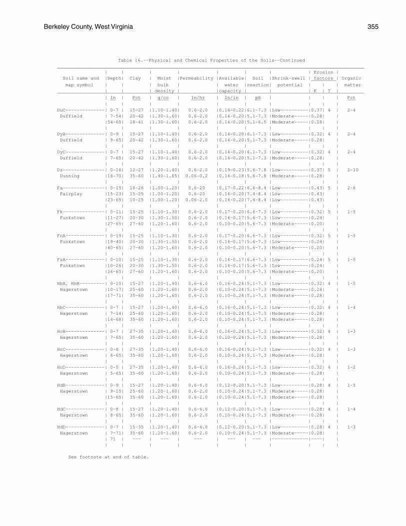
Berkeley County, West Virginia 355
Table 16.--Physical and Chemical Properties of the Soils--Continued______________________________________________________________________________________________________________ | | | | | | | | Erosion | Soil name and |Depth| Clay | Moist |Permeability |Available| Soil |Shrink-swell | factors | Organic _________ map symbol | | | bulk | | water |reaction| potential | | | matter | | | density | |capacity | | | K | T |______________________________________________________________________________________________________________ | In | Pct | g/cc | In/hr | In/in | pH | | | | Pct __ ___ ____ _____ _____ __ ___ | | | | | | | | | |DuC--------------| 0-7 | 15-27 |1.10-1.40| 0.6-2.0 |0.16-0.22|6.1-7.3 |Low----------|0.37| 4 | 2-4 Duffield | 7-54| 20-42 |1.30-1.60| 0.6-2.0 |0.14-0.20|5.1-7.3 |Moderate-----|0.28| | |54-65| 18-41 |1.30-1.60| 0.6-2.0 |0.14-0.20|5.1-6.5 |Moderate-----|0.28| | | | | | | | | | | |DyB--------------| 0-9 | 15-27 |1.10-1.40| 0.6-2.0 |0.14-0.20|6.1-7.3 |Low----------|0.32| 4 | 2-4 Duffield | 9-65| 20-42 |1.30-1.60| 0.6-2.0 |0.14-0.20|5.1-7.3 |Moderate-----|0.28| | | | | | | | | | | |DyC--------------| 0-7 | 15-27 |1.10-1.40| 0.6-2.0 |0.14-0.20|6.1-7.3 |Low----------|0.32| 4 | 2-4 Duffield | 7-65| 20-42 |1.30-1.60| 0.6-2.0 |0.14-0.20|5.1-7.3 |Moderate-----|0.28| | | | | | | | | | | |Dz---------------| 0-16| 12-27 |1.20-1.40| 0.6-2.0 |0.19-0.23|5.6-7.8 |Low----------|0.37| 5 | 2-10 Dunning |16-70| 35-60 |1.40-1.65| 0.06-0.2 |0.14-0.18|5.6-7.8 |Moderate-----|0.28| | | | | | | | | | | |Fa---------------| 0-15| 18-26 |1.00-1.20| 0.6-20 |0.17-0.22|6.6-8.4 |Low----------|0.43| 5 | 2-6 Fairplay |15-23| 15-25 |1.00-1.20| 0.6-20 |0.14-0.20|7.4-8.4 |Low----------|0.43| | |23-65| 10-25 |1.00-1.20| 0.06-2.0 |0.14-0.20|7.4-8.4 |Low----------|0.43| | | | | | | | | | | |Fk---------------| 0-11| 15-25 |1.10-1.30| 0.6-2.0 |0.17-0.20|6.6-7.3 |Low----------|0.32| 5 | 1-5 Funkstown |11-27| 20-30 |1.30-1.50| 0.6-2.0 |0.14-0.17|5.6-7.3 |Low----------|0.24| | |27-65| 27-60 |1.20-1.60| 0.6-2.0 |0.10-0.20|5.6-7.3 |Moderate-----|0.20| | | | | | | | | | | |FnA--------------| 0-19| 15-25 |1.10-1.30| 0.6-2.0 |0.17-0.20|6.6-7.3 |Low----------|0.32| 5 | 1-5 Funkstown |19-40| 20-30 |1.30-1.50| 0.6-2.0 |0.14-0.17|5.6-7.3 |Low----------|0.24| | |40-65| 27-60 |1.20-1.60| 0.6-2.0 |0.10-0.20|5.6-7.3 |Moderate-----|0.20| | | | | | | | | | | |FsA--------------| 0-10| 15-25 |1.10-1.30| 0.6-2.0 |0.14-0.17|6.6-7.3 |Low----------|0.24| 5 | 1-5 Funkstown |10-26| 20-30 |1.30-1.50| 0.6-2.0 |0.14-0.17|5.6-7.3 |Low----------|0.24| | |26-65| 27-60 |1.20-1.60| 0.6-2.0 |0.10-0.20|5.6-7.3 |Moderate-----|0.20| | | | | | | | | | | |HbA, HbB---------| 0-10| 15-27 |1.20-1.40| 0.6-6.0 |0.16-0.24|5.1-7.3 |Low----------|0.32| 4 | 1-5 Hagerstown |10-17| 25-60 |1.20-1.60| 0.6-2.0 |0.10-0.24|5.1-7.3 |Moderate-----|0.28| | |17-71| 35-60 |1.20-1.60| 0.6-2.0 |0.10-0.24|5.1-7.3 |Moderate-----|0.28| | | | | | | | | | | |HbC--------------| 0-7 | 15-27 |1.20-1.40| 0.6-6.0 |0.16-0.24|5.1-7.3 |Low----------|0.32| 4 | 1-4 Hagerstown | 7-14| 25-60 |1.20-1.60| 0.6-2.0 |0.10-0.24|5.1-7.3 |Moderate-----|0.28| | |14-68| 35-60 |1.20-1.60| 0.6-2.0 |0.10-0.24|5.1-7.3 |Moderate-----|0.28| | | | | | | | | | | |HcB--------------| 0-7 | 27-35 |1.20-1.40| 0.6-6.0 |0.16-0.24|5.1-7.3 |Low----------|0.32| 4 | 1-3 Hagerstown | 7-65| 35-60 |1.20-1.60| 0.6-2.0 |0.10-0.24|5.1-7.3 |Moderate-----|0.28| | | | | | | | | | | |HcC--------------| 0-6 | 27-35 |1.20-1.40| 0.6-6.0 |0.16-0.24|5.1-7.3 |Low----------|0.32| 4 | 1-3 Hagerstown | 6-65| 35-60 |1.20-1.60| 0.6-2.0 |0.10-0.24|5.1-7.3 |Moderate-----|0.28| | | | | | | | | | | |HcD--------------| 0-5 | 27-35 |1.20-1.40| 0.6-6.0 |0.16-0.24|5.1-7.3 |Low----------|0.32| 4 | 1-2 Hagerstown | 5-65| 35-60 |1.20-1.60| 0.6-2.0 |0.10-0.24|5.1-7.3 |Moderate-----|0.28| | | | | | | | | | | |HdB--------------| 0-9 | 15-27 |1.20-1.40| 0.6-6.0 |0.12-0.20|5.1-7.3 |Low----------|0.28| 4 | 1-5 Hagerstown | 9-15| 25-60 |1.20-1.60| 0.6-2.0 |0.10-0.24|5.1-7.3 |Moderate-----|0.28| | |15-65| 35-60 |1.20-1.60| 0.6-2.0 |0.10-0.24|5.1-7.3 |Moderate-----|0.28| | | | | | | | | | | |HdC--------------| 0-8 | 15-27 |1.20-1.40| 0.6-6.0 |0.12-0.20|5.1-7.3 |Low----------|0.28| 4 | 1-4 Hagerstown | 8-65| 35-60 |1.20-1.60| 0.6-2.0 |0.10-0.24|5.1-7.3 |Moderate-----|0.28| | | | | | | | | | | |HdD--------------| 0-7 | 15-35 |1.20-1.40| 0.6-6.0 |0.12-0.20|5.1-7.3 |Low----------|0.28| 4 | 1-3 Hagerstown | 7-71| 35-60 |1.20-1.60| 0.6-2.0 |0.10-0.24|5.1-7.3 |Moderate-----|0.28| | | 71 | --- | --- | --- | --- | --- |-------------|----| | | | | | | | | | | |
See footnote at end of table.
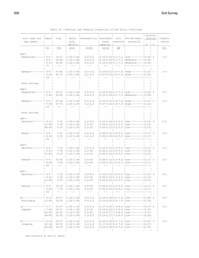
356 Soil Survey
Table 16.--Physical and Chemical Properties of the Soils--Continued______________________________________________________________________________________________________________ | | | | | | | | Erosion | Soil name and |Depth| Clay | Moist |Permeability |Available| Soil |Shrink-swell | factors | Organic _________ map symbol | | | bulk | | water |reaction| potential | | | matter | | | density | |capacity | | | K | T |______________________________________________________________________________________________________________ | In | Pct | g/cc | In/hr | In/in | pH | | | | Pct __ ___ ____ _____ _____ __ ___ | | | | | | | | | |HgC*: | | | | | | | | | | Hagerstown------| 0-5 | 15-27 |1.20-1.40| 0.6-6.0 |0.16-0.24|5.1-7.3 |Low----------|0.32| 4 | 1-5 | 5-9 | 23-60 |1.20-1.60| 0.6-2.0 |0.10-0.24|5.1-7.3 |Moderate-----|0.28| | | 9-71| 35-60 |1.20-1.60| 0.6-2.0 |0.10-0.24|5.1-7.3 |Moderate-----|0.28| | | 71 | --- | --- | --- | --- | --- |-------------|----| | | | | | | | | | | | Opequon---------| 0-5 | 27-45 |1.20-1.50| 0.2-2.0 |0.16-0.21|5.6-7.8 |High---------|0.37| 1 | 1-4 | 5-18| 35-75 |1.35-1.60| 0.2-2.0 |0.07-0.16|5.6-7.8 |High---------|0.32| | | 18 | --- | --- | --- | --- | --- |-------------|----| | | | | | | | | | | | Rock outcrop. | | | | | | | | | | | | | | | | | | | |HgE*: | | | | | | | | | | Hagerstown------| 0-5 | 15-27 |1.20-1.40| 0.6-6.0 |0.16-0.24|5.1-7.3 |Low----------|0.32| 4 | 1-5 | 5-65| 35-60 |1.20-1.60| 0.6-2.0 |0.10-0.24|5.1-7.3 |Moderate-----|0.28| | | | | | | | | | | | Opequon---------| 0-5 | 27-40 |1.20-1.50| 0.2-2.0 |0.16-0.21|5.6-7.8 |High---------|0.37| 1 | 1-4 | 5-18| 35-75 |1.35-1.60| 0.2-2.0 |0.07-0.16|5.6-7.8 |High---------|0.32| | | 18 | --- | --- | --- | --- | --- |-------------|----| | | | | | | | | | | | Rock outcrop. | | | | | | | | | | | | | | | | | | | |HkF*: | | | | | | | | | | Hazleton--------| 0-11| 7-18 |1.20-1.40| 2.0-6.0 |0.10-0.16|3.5-5.5 |Low----------|0.15| 3 | 2-4 |11-48| 7-18 |1.20-1.40| 2.0-20 |0.08-0.12|3.5-5.5 |Low----------|0.15| | |48-65| 5-15 |1.20-1.40| 2.0-20 |0.06-0.12|3.5-5.5 |Low----------|0.15| | | | | | | | | | | | Berks-----------| 0-8 | 7-23 |1.20-1.50| 0.6-6.0 |0.08-0.12|3.6-5.5 |Low----------|0.17| 3 | 2-4 | 8-36| 5-32 |1.20-1.60| 0.6-6.0 |0.04-0.10|3.6-5.5 |Low----------|0.17| | | 36 | --- | --- | --- | --- | --- |-------------|----| | | | | | | | | | | |HsE*: | | | | | | | | | | Hazleton--------| 0-4 | 7-18 |1.20-1.40| 2.0-6.0 |0.10-0.16|3.5-5.5 |Low----------|0.15| 3 | 2-4 | 4-11| 7-18 |1.20-1.40| 2.0-20 |0.08-0.12|3.5-5.5 |Low----------|0.15| | |11-65| 5-15 |1.20-1.40| 2.0-20 |0.06-0.12|3.5-5.5 |Low----------|0.15| | | | | | | | | | | | Dekalb----------| 0-4 | 10-20 |1.20-1.50| 6.0-20 |0.08-0.12|3.5-4.4 |Low----------|0.17| 2 | 2-5 | 4-26| 7-18 |1.20-1.50| 6.0-20 |0.06-0.12|3.5-5.5 |Low----------|0.17| | | 26 | --- | --- | --- | --- | --- |-------------|----| | | | | | | | | | | |HsF*: | | | | | | | | | | Hazleton--------| 0-4 | 7-18 |1.20-1.40| 2.0-6.0 |0.10-0.16|3.5-5.5 |Low----------|0.15| 3 | 2-4 | 4-11| 7-18 |1.20-1.40| 2.0-20 |0.08-0.12|3.5-5.5 |Low----------|0.15| | |11-65| 5-15 |1.20-1.40| 2.0-20 |0.06-0.12|3.5-5.5 |Low----------|0.15| | | | | | | | | | | | Dekalb----------| 0-4 | 10-20 |1.20-1.50| 6.0-20 |0.08-0.12|3.5-4.4 |Low----------|0.17| 2 | 2-5 | 4-26| 7-18 |1.20-1.50| 6.0-20 |0.06-0.12|3.5-5.5 |Low----------|0.17| | | 26 | --- | --- | --- | --- | --- |-------------|----| | | | | | | | | | | |Hu---------------| 0-11| 18-27 |1.10-1.30| 0.6-2.0 |0.18-0.24|6.1-7.8 |Low----------|0.28| 5 | 3-6 Huntington |11-65| 18-30 |1.30-1.50| 0.6-2.0 |0.16-0.22|5.6-7.8 |Low----------|0.32| | | | | | | | | | | |La---------------| 0-7 | 15-27 |1.05-1.10| 0.6-6.0 |0.17-0.20|7.4-8.4 |Low----------|0.37| 5 | 3-6 Lappans | 7-42| 15-27 |1.05-1.20| 2.0-20 |0.14-0.20|7.4-8.4 |Low----------|0.37| | |42-64| 20-35 |1.10-1.30| 2.0-20 |0.14-0.17|7.4-8.4 |Low----------|0.37| | |64-99| 15-35 |1.20-1.40| 2.0-6.0 |0.14-0.17|7.4-8.4 |Low----------|0.28| | | | | | | | | | | |Ln---------------| 0-12| 15-27 |1.20-1.40| 0.6-2.0 |0.20-0.26|6.1-7.8 |Low----------|0.32| 5 | 2-4 Lindside |12-46| 18-35 |1.20-1.40| 0.2-2.0 |0.17-0.22|5.1-7.8 |Low----------|0.37| | |46-66| 18-35 |1.20-1.40| 0.2-6.0 |0.12-0.18|5.6-7.8 |Low----------|0.32| | | | | | | | | | | |
See footnote at end of table.
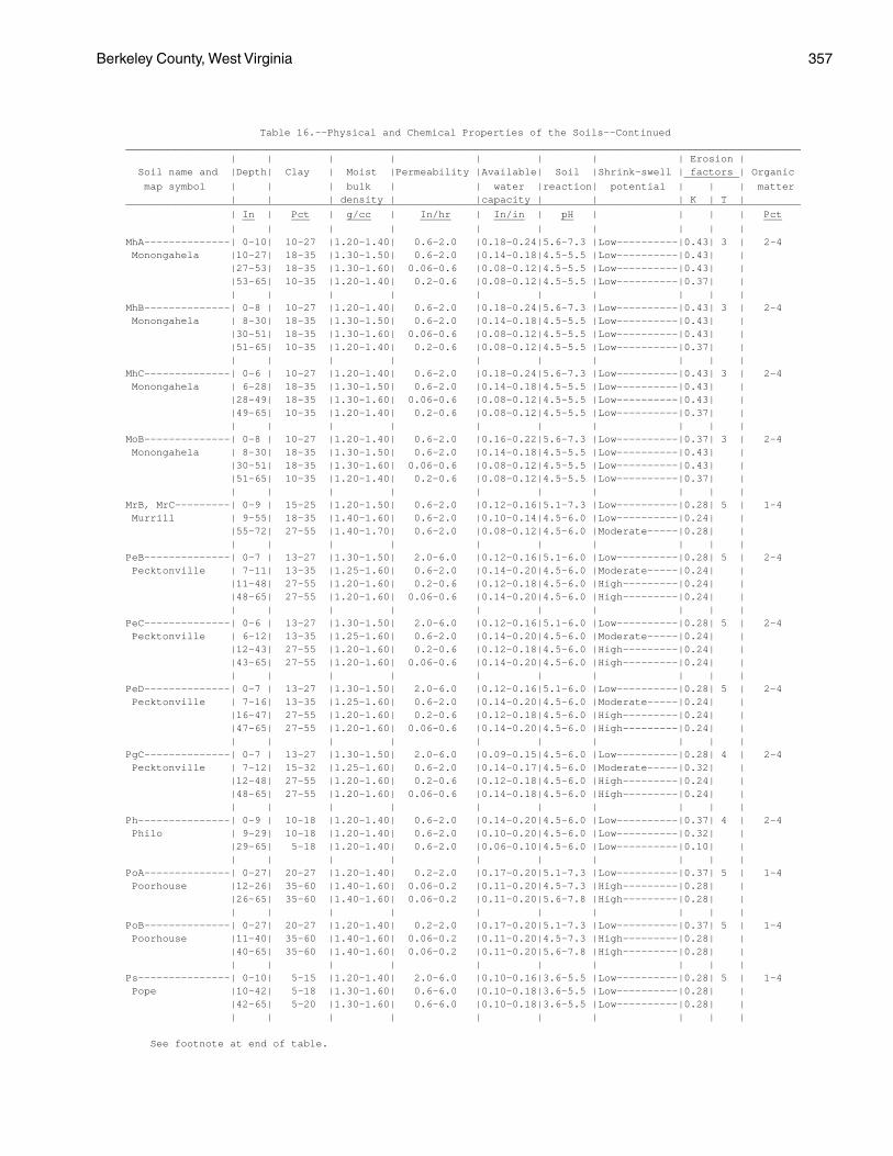
Berkeley County, West Virginia 357
Table 16.--Physical and Chemical Properties of the Soils--Continued______________________________________________________________________________________________________________ | | | | | | | | Erosion | Soil name and |Depth| Clay | Moist |Permeability |Available| Soil |Shrink-swell | factors | Organic _________ map symbol | | | bulk | | water |reaction| potential | | | matter | | | density | |capacity | | | K | T |______________________________________________________________________________________________________________ | In | Pct | g/cc | In/hr | In/in | pH | | | | Pct __ ___ ____ _____ _____ __ ___ | | | | | | | | | |MhA--------------| 0-10| 10-27 |1.20-1.40| 0.6-2.0 |0.18-0.24|5.6-7.3 |Low----------|0.43| 3 | 2-4 Monongahela |10-27| 18-35 |1.30-1.50| 0.6-2.0 |0.14-0.18|4.5-5.5 |Low----------|0.43| | |27-53| 18-35 |1.30-1.60| 0.06-0.6 |0.08-0.12|4.5-5.5 |Low----------|0.43| | |53-65| 10-35 |1.20-1.40| 0.2-0.6 |0.08-0.12|4.5-5.5 |Low----------|0.37| | | | | | | | | | | |MhB--------------| 0-8 | 10-27 |1.20-1.40| 0.6-2.0 |0.18-0.24|5.6-7.3 |Low----------|0.43| 3 | 2-4 Monongahela | 8-30| 18-35 |1.30-1.50| 0.6-2.0 |0.14-0.18|4.5-5.5 |Low----------|0.43| | |30-51| 18-35 |1.30-1.60| 0.06-0.6 |0.08-0.12|4.5-5.5 |Low----------|0.43| | |51-65| 10-35 |1.20-1.40| 0.2-0.6 |0.08-0.12|4.5-5.5 |Low----------|0.37| | | | | | | | | | | |MhC--------------| 0-6 | 10-27 |1.20-1.40| 0.6-2.0 |0.18-0.24|5.6-7.3 |Low----------|0.43| 3 | 2-4 Monongahela | 6-28| 18-35 |1.30-1.50| 0.6-2.0 |0.14-0.18|4.5-5.5 |Low----------|0.43| | |28-49| 18-35 |1.30-1.60| 0.06-0.6 |0.08-0.12|4.5-5.5 |Low----------|0.43| | |49-65| 10-35 |1.20-1.40| 0.2-0.6 |0.08-0.12|4.5-5.5 |Low----------|0.37| | | | | | | | | | | |MoB--------------| 0-8 | 10-27 |1.20-1.40| 0.6-2.0 |0.16-0.22|5.6-7.3 |Low----------|0.37| 3 | 2-4 Monongahela | 8-30| 18-35 |1.30-1.50| 0.6-2.0 |0.14-0.18|4.5-5.5 |Low----------|0.43| | |30-51| 18-35 |1.30-1.60| 0.06-0.6 |0.08-0.12|4.5-5.5 |Low----------|0.43| | |51-65| 10-35 |1.20-1.40| 0.2-0.6 |0.08-0.12|4.5-5.5 |Low----------|0.37| | | | | | | | | | | |MrB, MrC---------| 0-9 | 15-25 |1.20-1.50| 0.6-2.0 |0.12-0.16|5.1-7.3 |Low----------|0.28| 5 | 1-4 Murrill | 9-55| 18-35 |1.40-1.60| 0.6-2.0 |0.10-0.14|4.5-6.0 |Low----------|0.24| | |55-72| 27-55 |1.40-1.70| 0.6-2.0 |0.08-0.12|4.5-6.0 |Moderate-----|0.28| | | | | | | | | | | |PeB--------------| 0-7 | 13-27 |1.30-1.50| 2.0-6.0 |0.12-0.16|5.1-6.0 |Low----------|0.28| 5 | 2-4 Pecktonville | 7-11| 13-35 |1.25-1.60| 0.6-2.0 |0.14-0.20|4.5-6.0 |Moderate-----|0.24| | |11-48| 27-55 |1.20-1.60| 0.2-0.6 |0.12-0.18|4.5-6.0 |High---------|0.24| | |48-65| 27-55 |1.20-1.60| 0.06-0.6 |0.14-0.20|4.5-6.0 |High---------|0.24| | | | | | | | | | | |PeC--------------| 0-6 | 13-27 |1.30-1.50| 2.0-6.0 |0.12-0.16|5.1-6.0 |Low----------|0.28| 5 | 2-4 Pecktonville | 6-12| 13-35 |1.25-1.60| 0.6-2.0 |0.14-0.20|4.5-6.0 |Moderate-----|0.24| | |12-43| 27-55 |1.20-1.60| 0.2-0.6 |0.12-0.18|4.5-6.0 |High---------|0.24| | |43-65| 27-55 |1.20-1.60| 0.06-0.6 |0.14-0.20|4.5-6.0 |High---------|0.24| | | | | | | | | | | |PeD--------------| 0-7 | 13-27 |1.30-1.50| 2.0-6.0 |0.12-0.16|5.1-6.0 |Low----------|0.28| 5 | 2-4 Pecktonville | 7-16| 13-35 |1.25-1.60| 0.6-2.0 |0.14-0.20|4.5-6.0 |Moderate-----|0.24| | |16-47| 27-55 |1.20-1.60| 0.2-0.6 |0.12-0.18|4.5-6.0 |High---------|0.24| | |47-65| 27-55 |1.20-1.60| 0.06-0.6 |0.14-0.20|4.5-6.0 |High---------|0.24| | | | | | | | | | | |PgC--------------| 0-7 | 13-27 |1.30-1.50| 2.0-6.0 |0.09-0.15|4.5-6.0 |Low----------|0.28| 4 | 2-4 Pecktonville | 7-12| 15-32 |1.25-1.60| 0.6-2.0 |0.14-0.17|4.5-6.0 |Moderate-----|0.32| | |12-48| 27-55 |1.20-1.60| 0.2-0.6 |0.12-0.18|4.5-6.0 |High---------|0.24| | |48-65| 27-55 |1.20-1.60| 0.06-0.6 |0.14-0.18|4.5-6.0 |High---------|0.24| | | | | | | | | | | |Ph---------------| 0-9 | 10-18 |1.20-1.40| 0.6-2.0 |0.14-0.20|4.5-6.0 |Low----------|0.37| 4 | 2-4 Philo | 9-29| 10-18 |1.20-1.40| 0.6-2.0 |0.10-0.20|4.5-6.0 |Low----------|0.32| | |29-65| 5-18 |1.20-1.40| 0.6-2.0 |0.06-0.10|4.5-6.0 |Low----------|0.10| | | | | | | | | | | |PoA--------------| 0-27| 20-27 |1.20-1.40| 0.2-2.0 |0.17-0.20|5.1-7.3 |Low----------|0.37| 5 | 1-4 Poorhouse |12-26| 35-60 |1.40-1.60| 0.06-0.2 |0.11-0.20|4.5-7.3 |High---------|0.28| | |26-65| 35-60 |1.40-1.60| 0.06-0.2 |0.11-0.20|5.6-7.8 |High---------|0.28| | | | | | | | | | | |PoB--------------| 0-27| 20-27 |1.20-1.40| 0.2-2.0 |0.17-0.20|5.1-7.3 |Low----------|0.37| 5 | 1-4 Poorhouse |11-40| 35-60 |1.40-1.60| 0.06-0.2 |0.11-0.20|4.5-7.3 |High---------|0.28| | |40-65| 35-60 |1.40-1.60| 0.06-0.2 |0.11-0.20|5.6-7.8 |High---------|0.28| | | | | | | | | | | |Ps---------------| 0-10| 5-15 |1.20-1.40| 2.0-6.0 |0.10-0.16|3.6-5.5 |Low----------|0.28| 5 | 1-4 Pope |10-42| 5-18 |1.30-1.60| 0.6-6.0 |0.10-0.18|3.6-5.5 |Low----------|0.28| | |42-65| 5-20 |1.30-1.60| 0.6-6.0 |0.10-0.18|3.6-5.5 |Low----------|0.28| | | | | | | | | | | |
See footnote at end of table.
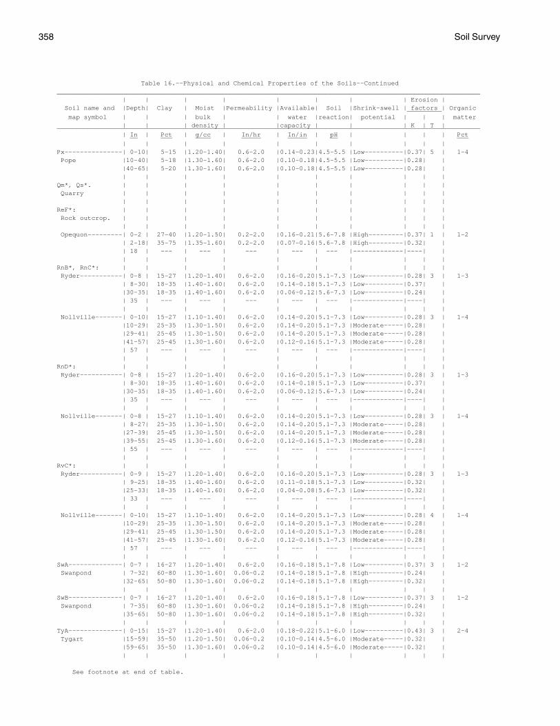
358 Soil Survey
Table 16.--Physical and Chemical Properties of the Soils--Continued______________________________________________________________________________________________________________ | | | | | | | | Erosion | Soil name and |Depth| Clay | Moist |Permeability |Available| Soil |Shrink-swell | factors | Organic _________ map symbol | | | bulk | | water |reaction| potential | | | matter | | | density | |capacity | | | K | T |______________________________________________________________________________________________________________ | In | Pct | g/cc | In/hr | In/in | pH | | | | Pct __ ___ ____ _____ _____ __ ___ | | | | | | | | | |Px---------------| 0-10| 5-15 |1.20-1.40| 0.6-2.0 |0.14-0.23|4.5-5.5 |Low----------|0.37| 5 | 1-4 Pope |10-40| 5-18 |1.30-1.60| 0.6-2.0 |0.10-0.18|4.5-5.5 |Low----------|0.28| | |40-65| 5-20 |1.30-1.60| 0.6-2.0 |0.10-0.18|4.5-5.5 |Low----------|0.28| | | | | | | | | | | |Qm*, Qs*. | | | | | | | | | | Quarry | | | | | | | | | | | | | | | | | | | |ReF*: | | | | | | | | | | Rock outcrop. | | | | | | | | | | | | | | | | | | | | Opequon---------| 0-2 | 27-40 |1.20-1.50| 0.2-2.0 |0.16-0.21|5.6-7.8 |High---------|0.37| 1 | 1-2 | 2-18| 35-75 |1.35-1.60| 0.2-2.0 |0.07-0.16|5.6-7.8 |High---------|0.32| | | 18 | --- | --- | --- | --- | --- |-------------|----| | | | | | | | | | | |RnB*, RnC*: | | | | | | | | | | Ryder-----------| 0-8 | 15-27 |1.20-1.40| 0.6-2.0 |0.16-0.20|5.1-7.3 |Low----------|0.28| 3 | 1-3 | 8-30| 18-35 |1.40-1.60| 0.6-2.0 |0.14-0.18|5.1-7.3 |Low----------|0.37| | |30-35| 18-35 |1.40-1.60| 0.6-2.0 |0.06-0.12|5.6-7.3 |Low----------|0.24| | | 35 | --- | --- | --- | --- | --- |-------------|----| | | | | | | | | | | | Nollville-------| 0-10| 15-27 |1.10-1.40| 0.6-2.0 |0.14-0.20|5.1-7.3 |Low----------|0.28| 3 | 1-4 |10-29| 25-35 |1.30-1.50| 0.6-2.0 |0.14-0.20|5.1-7.3 |Moderate-----|0.28| | |29-41| 25-45 |1.30-1.50| 0.6-2.0 |0.14-0.20|5.1-7.3 |Moderate-----|0.28| | |41-57| 25-45 |1.30-1.60| 0.6-2.0 |0.12-0.16|5.1-7.3 |Moderate-----|0.28| | | 57 | --- | --- | --- | --- | --- |-------------|----| | | | | | | | | | | |RnD*: | | | | | | | | | | Ryder-----------| 0-8 | 15-27 |1.20-1.40| 0.6-2.0 |0.16-0.20|5.1-7.3 |Low----------|0.28| 3 | 1-3 | 8-30| 18-35 |1.40-1.60| 0.6-2.0 |0.14-0.18|5.1-7.3 |Low----------|0.37| | |30-35| 18-35 |1.40-1.60| 0.6-2.0 |0.06-0.12|5.6-7.3 |Low----------|0.24| | | 35 | --- | --- | --- | --- | --- |-------------|----| | | | | | | | | | | | Nollville-------| 0-8 | 15-27 |1.10-1.40| 0.6-2.0 |0.14-0.20|5.1-7.3 |Low----------|0.28| 3 | 1-4 | 8-27| 25-35 |1.30-1.50| 0.6-2.0 |0.14-0.20|5.1-7.3 |Moderate-----|0.28| | |27-39| 25-45 |1.30-1.50| 0.6-2.0 |0.14-0.20|5.1-7.3 |Moderate-----|0.28| | |39-55| 25-45 |1.30-1.60| 0.6-2.0 |0.12-0.16|5.1-7.3 |Moderate-----|0.28| | | 55 | --- | --- | --- | --- | --- |-------------|----| | | | | | | | | | | |RvC*: | | | | | | | | | | Ryder-----------| 0-9 | 15-27 |1.20-1.40| 0.6-2.0 |0.16-0.20|5.1-7.3 |Low----------|0.28| 3 | 1-3 | 9-25| 18-35 |1.40-1.60| 0.6-2.0 |0.11-0.18|5.1-7.3 |Low----------|0.32| | |25-33| 18-35 |1.40-1.60| 0.6-2.0 |0.04-0.08|5.6-7.3 |Low----------|0.32| | | 33 | --- | --- | --- | --- | --- |-------------|----| | | | | | | | | | | | Nollville-------| 0-10| 15-27 |1.10-1.40| 0.6-2.0 |0.14-0.20|5.1-7.3 |Low----------|0.28| 4 | 1-4 |10-29| 25-35 |1.30-1.50| 0.6-2.0 |0.14-0.20|5.1-7.3 |Moderate-----|0.28| | |29-41| 25-45 |1.30-1.50| 0.6-2.0 |0.14-0.20|5.1-7.3 |Moderate-----|0.28| | |41-57| 25-45 |1.30-1.60| 0.6-2.0 |0.12-0.16|5.1-7.3 |Moderate-----|0.28| | | 57 | --- | --- | --- | --- | --- |-------------|----| | | | | | | | | | | |SwA--------------| 0-7 | 16-27 |1.20-1.40| 0.6-2.0 |0.16-0.18|5.1-7.8 |Low----------|0.37| 3 | 1-2 Swanpond | 7-32| 60-80 |1.30-1.60| 0.06-0.2 |0.14-0.18|5.1-7.8 |High---------|0.24| | |32-65| 50-80 |1.30-1.60| 0.06-0.2 |0.14-0.18|5.1-7.8 |High---------|0.32| | | | | | | | | | | |SwB--------------| 0-7 | 16-27 |1.20-1.40| 0.6-2.0 |0.16-0.18|5.1-7.8 |Low----------|0.37| 3 | 1-2 Swanpond | 7-35| 60-80 |1.30-1.60| 0.06-0.2 |0.14-0.18|5.1-7.8 |High---------|0.24| | |35-65| 50-80 |1.30-1.60| 0.06-0.2 |0.14-0.18|5.1-7.8 |High---------|0.32| | | | | | | | | | | |TyA--------------| 0-15| 15-27 |1.20-1.40| 0.6-2.0 |0.18-0.22|5.1-6.0 |Low----------|0.43| 3 | 2-4 Tygart |15-59| 35-50 |1.20-1.50| 0.06-0.2 |0.10-0.14|4.5-6.0 |Moderate-----|0.32| | |59-65| 35-50 |1.30-1.60| 0.06-0.2 |0.10-0.14|4.5-6.0 |Moderate-----|0.32| | | | | | | | | | | |
See footnote at end of table.
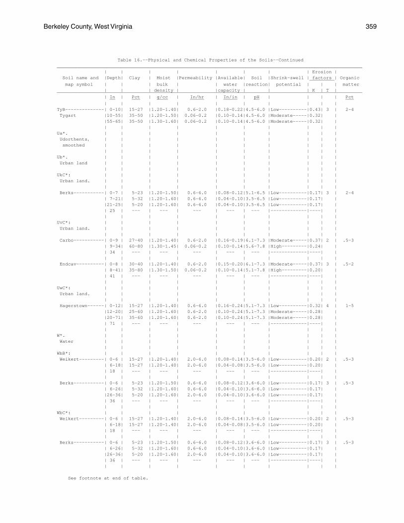
Berkeley County, West Virginia 359
Table 16.--Physical and Chemical Properties of the Soils--Continued______________________________________________________________________________________________________________ | | | | | | | | Erosion | Soil name and |Depth| Clay | Moist |Permeability |Available| Soil |Shrink-swell | factors | Organic _________ map symbol | | | bulk | | water |reaction| potential | | | matter | | | density | |capacity | | | K | T |______________________________________________________________________________________________________________ | In | Pct | g/cc | In/hr | In/in | pH | | | | Pct __ ___ ____ _____ _____ __ ___ | | | | | | | | | |TyB--------------| 0-10| 15-27 |1.20-1.40| 0.6-2.0 |0.18-0.22|4.5-6.0 |Low----------|0.43| 3 | 2-4 Tygart |10-55| 35-50 |1.20-1.50| 0.06-0.2 |0.10-0.14|4.5-6.0 |Moderate-----|0.32| | |55-65| 35-50 |1.30-1.60| 0.06-0.2 |0.10-0.14|4.5-6.0 |Moderate-----|0.32| | | | | | | | | | | |Ua*. | | | | | | | | | | Udorthents, | | | | | | | | | | smoothed | | | | | | | | | | | | | | | | | | | |Ub*. | | | | | | | | | | Urban land | | | | | | | | | | | | | | | | | | | |UkC*: | | | | | | | | | | Urban land. | | | | | | | | | | | | | | | | | | | | Berks-----------| 0-7 | 5-23 |1.20-1.50| 0.6-6.0 |0.08-0.12|5.1-6.5 |Low----------|0.17| 3 | 2-4 | 7-21| 5-32 |1.20-1.60| 0.6-6.0 |0.04-0.10|3.5-6.5 |Low----------|0.17| | |21-25| 5-20 |1.20-1.60| 0.6-6.0 |0.04-0.10|3.5-6.5 |Low----------|0.17| | | 25 | --- | --- | --- | --- | --- |-------------|----| | | | | | | | | | | |UvC*: | | | | | | | | | | Urban land. | | | | | | | | | | | | | | | | | | | | Carbo-----------| 0-9 | 27-40 |1.20-1.40| 0.6-2.0 |0.16-0.19|6.1-7.3 |Moderate-----|0.37| 2 | .5-3 | 9-34| 60-80 |1.30-1.45| 0.06-0.2 |0.10-0.14|5.6-7.8 |High---------|0.24| | | 34 | --- | --- | --- | --- | --- |-------------|----| | | | | | | | | | | | Endcav----------| 0-8 | 30-40 |1.20-1.40| 0.6-2.0 |0.15-0.20|6.1-7.3 |Moderate-----|0.37| 3 | .5-2 | 8-41| 35-80 |1.30-1.50| 0.06-0.2 |0.10-0.14|5.1-7.8 |High---------|0.20| | | 41 | --- | --- | --- | --- | --- |-------------|----| | | | | | | | | | | |UwC*: | | | | | | | | | | Urban land. | | | | | | | | | | | | | | | | | | | | Hagerstown------| 0-12| 15-27 |1.20-1.40| 0.6-6.0 |0.16-0.24|5.1-7.3 |Low----------|0.32| 4 | 1-5 |12-20| 25-60 |1.20-1.60| 0.6-2.0 |0.10-0.24|5.1-7.3 |Moderate-----|0.28| | |20-71| 35-60 |1.20-1.60| 0.6-2.0 |0.10-0.24|5.1-7.3 |Moderate-----|0.28| | | 71 | --- | --- | --- | --- | --- |-------------|----| | | | | | | | | | | |W*. | | | | | | | | | | Water | | | | | | | | | | | | | | | | | | | |WbB*: | | | | | | | | | | Weikert---------| 0-6 | 15-27 |1.20-1.40| 2.0-6.0 |0.08-0.14|3.5-6.0 |Low----------|0.20| 2 | .5-3 | 6-18| 15-27 |1.20-1.40| 2.0-6.0 |0.04-0.08|3.5-6.0 |Low----------|0.20| | | 18 | --- | --- | --- | --- | --- |-------------|----| | | | | | | | | | | | Berks-----------| 0-6 | 5-23 |1.20-1.50| 0.6-6.0 |0.08-0.12|3.6-6.0 |Low----------|0.17| 3 | .5-3 | 6-26| 5-32 |1.20-1.60| 0.6-6.0 |0.04-0.10|3.6-6.0 |Low----------|0.17| | |26-36| 5-20 |1.20-1.60| 2.0-6.0 |0.04-0.10|3.6-6.0 |Low----------|0.17| | | 36 | --- | --- | --- | --- | --- |-------------|----| | | | | | | | | | | |WbC*: | | | | | | | | | | Weikert---------| 0-6 | 15-27 |1.20-1.40| 2.0-6.0 |0.08-0.14|3.5-6.0 |Low----------|0.20| 2 | .5-3 | 6-18| 15-27 |1.20-1.40| 2.0-6.0 |0.04-0.08|3.5-6.0 |Low----------|0.20| | | 18 | --- | --- | --- | --- | --- |-------------|----| | | | | | | | | | | | Berks-----------| 0-6 | 5-23 |1.20-1.50| 0.6-6.0 |0.08-0.12|3.6-6.0 |Low----------|0.17| 3 | .5-3 | 6-26| 5-32 |1.20-1.60| 0.6-6.0 |0.04-0.10|3.6-6.0 |Low----------|0.17| | |26-36| 5-20 |1.20-1.60| 2.0-6.0 |0.04-0.10|3.6-6.0 |Low----------|0.17| | | 36 | --- | --- | --- | --- | --- |-------------|----| | | | | | | | | | | |
See footnote at end of table.
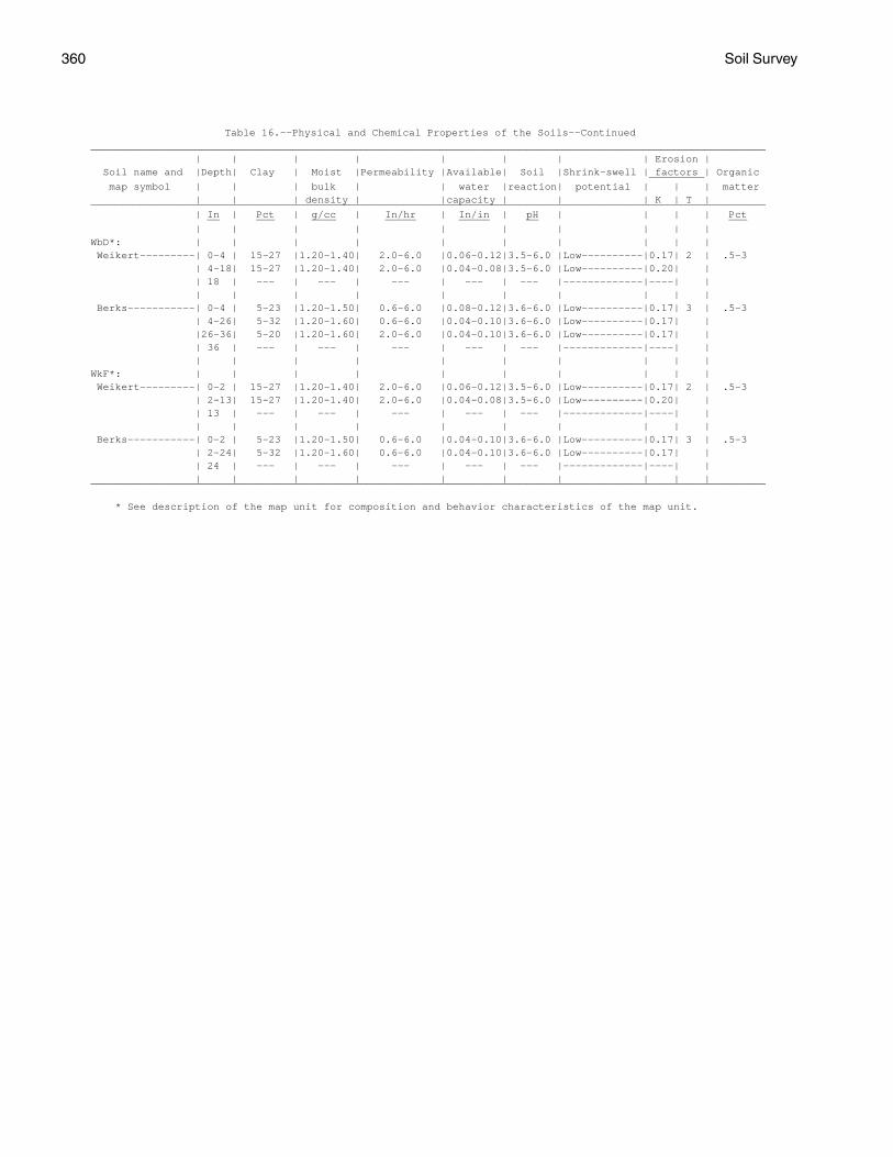
360 Soil Survey
Table 16.--Physical and Chemical Properties of the Soils--Continued______________________________________________________________________________________________________________ | | | | | | | | Erosion | Soil name and |Depth| Clay | Moist |Permeability |Available| Soil |Shrink-swell | factors | Organic _________ map symbol | | | bulk | | water |reaction| potential | | | matter | | | density | |capacity | | | K | T |______________________________________________________________________________________________________________ | In | Pct | g/cc | In/hr | In/in | pH | | | | Pct __ ___ ____ _____ _____ __ ___ | | | | | | | | | |WbD*: | | | | | | | | | | Weikert---------| 0-4 | 15-27 |1.20-1.40| 2.0-6.0 |0.06-0.12|3.5-6.0 |Low----------|0.17| 2 | .5-3 | 4-18| 15-27 |1.20-1.40| 2.0-6.0 |0.04-0.08|3.5-6.0 |Low----------|0.20| | | 18 | --- | --- | --- | --- | --- |-------------|----| | | | | | | | | | | | Berks-----------| 0-4 | 5-23 |1.20-1.50| 0.6-6.0 |0.08-0.12|3.6-6.0 |Low----------|0.17| 3 | .5-3 | 4-26| 5-32 |1.20-1.60| 0.6-6.0 |0.04-0.10|3.6-6.0 |Low----------|0.17| | |26-36| 5-20 |1.20-1.60| 2.0-6.0 |0.04-0.10|3.6-6.0 |Low----------|0.17| | | 36 | --- | --- | --- | --- | --- |-------------|----| | | | | | | | | | | |WkF*: | | | | | | | | | | Weikert---------| 0-2 | 15-27 |1.20-1.40| 2.0-6.0 |0.06-0.12|3.5-6.0 |Low----------|0.17| 2 | .5-3 | 2-13| 15-27 |1.20-1.40| 2.0-6.0 |0.04-0.08|3.5-6.0 |Low----------|0.20| | | 13 | --- | --- | --- | --- | --- |-------------|----| | | | | | | | | | | | Berks-----------| 0-2 | 5-23 |1.20-1.50| 0.6-6.0 |0.04-0.10|3.6-6.0 |Low----------|0.17| 3 | .5-3 | 2-24| 5-32 |1.20-1.60| 0.6-6.0 |0.04-0.10|3.6-6.0 |Low----------|0.17| | | 24 | --- | --- | --- | --- | --- |-------------|----| | | | | | | | | | | |______________________________________________________________________________________________________________
* See description of the map unit for composition and behavior characteristics of the map unit.
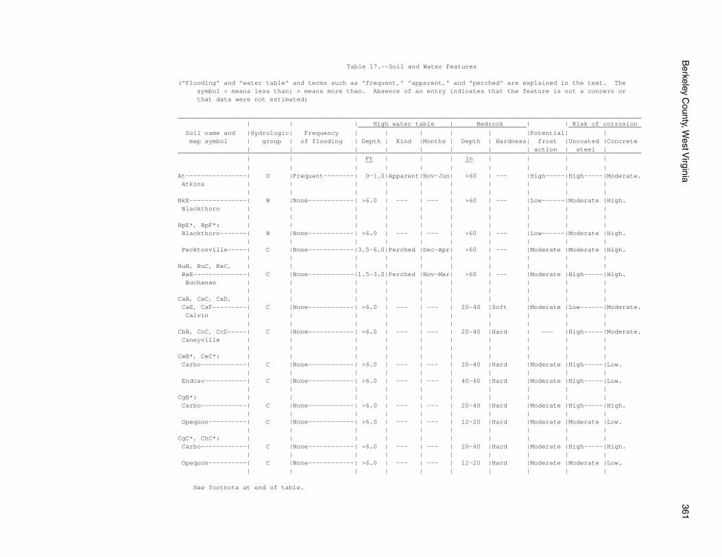
Berkeley C
ounty, West V
irginia361
Table 17.--Soil and Water Features
("Flooding" and "water table" and terms such as "frequent," "apparent," and "perched" are explained in the text. The symbol < means less than; > means more than. Absence of an entry indicates that the feature is not a concern or that data were not estimated)
_________________________________________________________________________________________________________________________ | | | High water table | Bedrock | | Risk of corrosion ____________________________________________ ___________________ Soil name and |Hydrologic| Frequency | | | | | |Potential| | map symbol | group | of flooding | Depth | Kind |Months | Depth | Hardness| frost |Uncoated |Concrete | | | | | | | | action | steel |_________________________________________________________________________________________________________________________ | | | Ft | | | In | | | | __ __ | | | | | | | | | |At----------------| D |Frequent--------| 0-1.0|Apparent|Nov-Jun| >60 | --- |High-----|High-----|Moderate. Atkins | | | | | | | | | | | | | | | | | | | |BkE---------------| B |None------------| >6.0 | --- | --- | >60 | --- |Low------|Moderate |High. Blackthorn | | | | | | | | | | | | | | | | | | | |BpE*, BpF*: | | | | | | | | | | Blackthorn-------| B |None------------| >6.0 | --- | --- | >60 | --- |Low------|Moderate |High. | | | | | | | | | | Pecktonville-----| C |None------------|3.5-6.0|Perched |Dec-Apr| >60 | --- |Moderate |Moderate |High. | | | | | | | | | |BuB, BuC, BxC, | | | | | | | | | | BxE--------------| C |None------------|1.5-3.0|Perched |Nov-Mar| >60 | --- |Moderate |High-----|High. Buchanan | | | | | | | | | | | | | | | | | | | |CaB, CaC, CaD, | | | | | | | | | | CaE, CaF---------| C |None------------| >6.0 | --- | --- | 20-40 |Soft |Moderate |Low------|Moderate. Calvin | | | | | | | | | | | | | | | | | | | |CbB, CcC, CcD-----| C |None------------| >6.0 | --- | --- | 20-40 |Hard | --- |High-----|Moderate. Caneyville | | | | | | | | | | | | | | | | | | | |CeB*, CeC*: | | | | | | | | | | Carbo------------| C |None------------| >6.0 | --- | --- | 20-40 |Hard |Moderate |High-----|Low. | | | | | | | | | | Endcav-----------| C |None------------| >6.0 | --- | --- | 40-60 |Hard |Moderate |High-----|Low. | | | | | | | | | |CgB*: | | | | | | | | | | Carbo------------| C |None------------| >6.0 | --- | --- | 20-40 |Hard |Moderate |High-----|High. | | | | | | | | | | Opequon----------| C |None------------| >6.0 | --- | --- | 12-20 |Hard |Moderate |Moderate |Low. | | | | | | | | | |CgC*, ChC*: | | | | | | | | | | Carbo------------| C |None------------| >6.0 | --- | --- | 20-40 |Hard |Moderate |High-----|High. | | | | | | | | | | Opequon----------| C |None------------| >6.0 | --- | --- | 12-20 |Hard |Moderate |Moderate |Low. | | | | | | | | | |
See footnote at end of table.
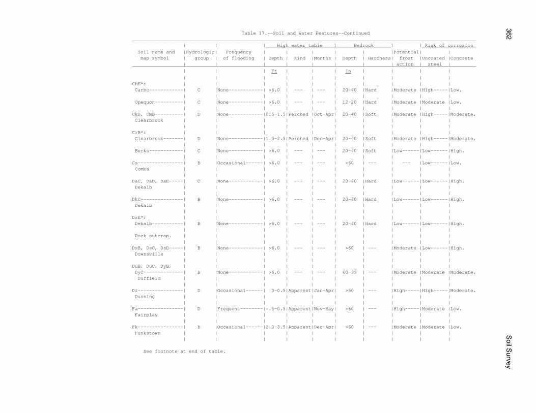
362S
oil Survey
Table 17.--Soil and Water Features--Continued_________________________________________________________________________________________________________________________ | | | High water table | Bedrock | | Risk of corrosion ____________________________________________ ___________________ Soil name and |Hydrologic| Frequency | | | | | |Potential| | map symbol | group | of flooding | Depth | Kind |Months | Depth | Hardness| frost |Uncoated |Concrete | | | | | | | | action | steel |_________________________________________________________________________________________________________________________ | | | Ft | | | In | | | | __ __ | | | | | | | | | |ChE*: | | | | | | | | | | Carbo------------| C |None------------| >6.0 | --- | --- | 20-40 |Hard |Moderate |High-----|Low. | | | | | | | | | | Opequon----------| C |None------------| >6.0 | --- | --- | 12-20 |Hard |Moderate |Moderate |Low. | | | | | | | | | |CkB, CmB----------| D |None------------|0.5-1.5|Perched |Oct-Apr| 20-40 |Soft |Moderate |High-----|Moderate. Clearbrook | | | | | | | | | | | | | | | | | | | |CrB*: | | | | | | | | | | Clearbrook-------| D |None------------|1.0-2.5|Perched |Dec-Apr| 20-40 |Soft |Moderate |High-----|Moderate. | | | | | | | | | | Berks------------| C |None------------| >6.0 | --- | --- | 20-40 |Soft |Low------|Low------|High. | | | | | | | | | |Cs----------------| B |Occasional------| >6.0 | --- | --- | >60 | --- | --- |Low------|Low. Combs | | | | | | | | | | | | | | | | | | | |DaC, DaD, DaE-----| C |None------------| >6.0 | --- | --- | 20-40 |Hard |Low------|Low------|High. Dekalb | | | | | | | | | | | | | | | | | | | |DkC---------------| B |None------------| >6.0 | --- | --- | 20-40 |Hard |Low------|Low------|High. Dekalb | | | | | | | | | | | | | | | | | | | |DrE*: | | | | | | | | | | Dekalb-----------| B |None------------| >6.0 | --- | --- | 20-40 |Hard |Low------|Low------|High. | | | | | | | | | | Rock outcrop. | | | | | | | | | | | | | | | | | | | |DsB, DsC, DsD-----| B |None------------| >6.0 | --- | --- | >60 | --- |Moderate |Low------|High. Downsville | | | | | | | | | | | | | | | | | | | |DuB, DuC, DyB, | | | | | | | | | | DyC--------------| B |None------------| >6.0 | --- | --- | 60-99 | --- |Moderate |Moderate |Moderate. Duffield | | | | | | | | | | | | | | | | | | | |Dz----------------| D |Occasional------| 0-0.5|Apparent|Jan-Apr| >60 | --- |High-----|High-----|Moderate. Dunning | | | | | | | | | | | | | | | | | | | |Fa----------------| D |Frequent--------|+.5-0.5|Apparent|Nov-May| >60 | --- |High-----|Moderate |Low. Fairplay | | | | | | | | | | | | | | | | | | | |Fk----------------| B |Occasional------|2.0-3.5|Apparent|Dec-Apr| >60 | --- |Moderate |Moderate |Low. Funkstown | | | | | | | | | | | | | | | | | | | |
See footnote at end of table.
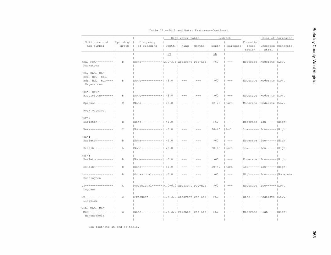
Berkeley C
ounty, West V
irginia363
Table 17.--Soil and Water Features--Continued_________________________________________________________________________________________________________________________ | | | High water table | Bedrock | | Risk of corrosion ____________________________________________ ___________________ Soil name and |Hydrologic| Frequency | | | | | |Potential| | map symbol | group | of flooding | Depth | Kind |Months | Depth | Hardness| frost |Uncoated |Concrete | | | | | | | | action | steel |_________________________________________________________________________________________________________________________ | | | Ft | | | In | | | | __ __ | | | | | | | | | |FnA, FsA----------| B |None------------|2.0-3.5|Apparent|Dec-Apr| >60 | --- |Moderate |Moderate |Low. Funkstown | | | | | | | | | | | | | | | | | | | |HbA, HbB, HbC, | | | | | | | | | | HcB, HcC, HcD, | | | | | | | | | | HdB, HdC, HdD----| B |None------------| >6.0 | --- | --- | >60 | --- |Moderate |Moderate |Low. Hagerstown | | | | | | | | | | | | | | | | | | | |HgC*, HgE*: | | | | | | | | | | Hagerstown-------| B |None------------| >6.0 | --- | --- | >60 | --- |Moderate |Moderate |Low. | | | | | | | | | | Opequon----------| C |None------------| >6.0 | --- | --- | 12-20 |Hard |Moderate |Moderate |Low. | | | | | | | | | | Rock outcrop. | | | | | | | | | | | | | | | | | | | |HkF*: | | | | | | | | | | Hazleton---------| B |None------------| >6.0 | --- | --- | >60 | --- |Moderate |Low------|High. | | | | | | | | | | Berks------------| C |None------------| >6.0 | --- | --- | 20-40 |Soft |Low------|Low------|High. | | | | | | | | | |HsE*: | | | | | | | | | | Hazleton---------| B |None------------| >6.0 | --- | --- | >60 | --- |Moderate |Low------|High. | | | | | | | | | | Dekalb-----------| A |None------------| >6.0 | --- | --- | 20-40 |Hard |Low------|Low------|High. | | | | | | | | | |HsF*: | | | | | | | | | | Hazleton---------| B |None------------| >6.0 | --- | --- | >60 | --- |Moderate |Low------|High. | | | | | | | | | | Dekalb-----------| B |None------------| >6.0 | --- | --- | 20-40 |Hard |Low------|Low------|High. | | | | | | | | | |Hu----------------| B |Occasional------| >6.0 | --- | --- | >60 | --- |High-----|Low------|Moderate. Huntington | | | | | | | | | | | | | | | | | | | |La----------------| A |Occasional------|4.0-6.0|Apparent|Dec-Mar| >60 | --- |Moderate |Low------|Low. Lappans | | | | | | | | | | | | | | | | | | | |Ln----------------| C |Frequent--------|1.5-3.0|Apparent|Dec-Apr| >60 | --- |High-----|Moderate |Low. Lindside | | | | | | | | | | | | | | | | | | | |MhA, MhB, MhC, | | | | | | | | | | MoB--------------| C |None------------|1.5-3.0|Perched |Dec-Apr| >60 | --- |Moderate |High-----|High. Monongahela | | | | | | | | | | | | | | | | | | | |
See footnote at end of table.
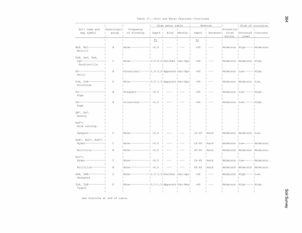
364S
oil Survey
Table 17.--Soil and Water Features--Continued_________________________________________________________________________________________________________________________ | | | High water table | Bedrock | | Risk of corrosion ____________________________________________ ___________________ Soil name and |Hydrologic| Frequency | | | | | |Potential| | map symbol | group | of flooding | Depth | Kind |Months | Depth | Hardness| frost |Uncoated |Concrete | | | | | | | | action | steel |_________________________________________________________________________________________________________________________ | | | Ft | | | In | | | | __ __ | | | | | | | | | |MrB, MrC----------| B |None------------| >6.0 | --- | --- | >60 | --- |Moderate |High-----|Moderate. Murrill | | | | | | | | | | | | | | | | | | | |PeB, PeC, PeD, | | | | | | | | | | PgC--------------| C |None------------|3.5-6.0|Perched |Dec-Apr| >60 | --- |Moderate |Moderate |High. Pecktonville | | | | | | | | | | | | | | | | | | | |Ph----------------| B |Occasional------|1.5-3.0|Apparent|Dec-Apr| >60 | --- |Moderate |Low------|High. Philo | | | | | | | | | | | | | | | | | | | |PoA, PoB----------| D |None------------|0.5-1.5|Apparent|Dec-Apr| >60 | --- |Moderate |Moderate |Low. Poorhouse | | | | | | | | | | | | | | | | | | | |Ps----------------| B |Frequent--------| >6.0 | --- | --- | >60 | --- |Moderate |Low------|High. Pope | | | | | | | | | | | | | | | | | | | |Px----------------| B |Occasional------| >6.0 | --- | --- | >60 | --- |Moderate |Low------|High. Pope | | | | | | | | | | | | | | | | | | | |Qm*, Qs*. | | | | | | | | | | Quarry | | | | | | | | | | | | | | | | | | | |ReF*: | | | | | | | | | | Rock outcrop. | | | | | | | | | | | | | | | | | | | | Opequon----------| C |None------------| >6.0 | --- | --- | 12-20 |Hard |Moderate |Moderate |Low. | | | | | | | | | |RnB*, RnC*, RnD*: | | | | | | | | | | Ryder------------| C |None------------| >6.0 | --- | --- | 24-40 |Hard |Moderate |Low------|Moderate. | | | | | | | | | | Nollville--------| B |None------------| >6.0 | --- | --- | 40-60 |Hard |Moderate |Moderate |Moderate. | | | | | | | | | |RvC*: | | | | | | | | | | Ryder------------| C |None------------| >6.0 | --- | --- | 24-40 |Hard |Moderate |Low------|Moderate. | | | | | | | | | | Nollville--------| B |None------------| >6.0 | --- | --- | 40-60 |Hard |Moderate |Moderate |Moderate. | | | | | | | | | |SwA, SwB----------| C |None------------|2.5-3.5|Perched |Dec-Apr| >60 | --- |Moderate |High-----|Low. Swanpond | | | | | | | | | | | | | | | | | | | |TyA, TyB----------| D |None------------|0.5-1.5|Apparent|Dec-May| >60 | --- |Moderate |High-----|High. Tygart | | | | | | | | | | | | | | | | | | | |
See footnote at end of table.
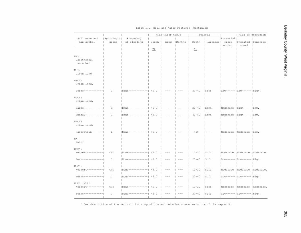
Berkeley C
ounty, West V
irginia365
Table 17.--Soil and Water Features--Continued_________________________________________________________________________________________________________________________ | | | High water table | Bedrock | | Risk of corrosion ____________________________________________ ___________________ Soil name and |Hydrologic| Frequency | | | | | |Potential| | map symbol | group | of flooding | Depth | Kind |Months | Depth | Hardness| frost |Uncoated |Concrete | | | | | | | | action | steel |_________________________________________________________________________________________________________________________ | | | Ft | | | In | | | | __ __ | | | | | | | | | |Ua*. | | | | | | | | | | Udorthents, | | | | | | | | | | smoothed | | | | | | | | | | | | | | | | | | | |Ub*. | | | | | | | | | | Urban land | | | | | | | | | | | | | | | | | | | |UkC*: | | | | | | | | | | Urban land. | | | | | | | | | | | | | | | | | | | | Berks------------| C |None------------| >6.0 | --- | --- | 20-40 |Soft |Low------|Low------|High. | | | | | | | | | |UvC*: | | | | | | | | | | Urban land. | | | | | | | | | | | | | | | | | | | | Carbo------------| C |None------------| >6.0 | --- | --- | 20-40 |Hard |Moderate |High-----|Low. | | | | | | | | | | Endcav-----------| C |None------------| >6.0 | --- | --- | 40-60 |Hard |Moderate |High-----|Low. | | | | | | | | | |UwC*: | | | | | | | | | | Urban land. | | | | | | | | | | | | | | | | | | | | Hagerstown-------| B |None------------| >6.0 | --- | --- | >60 | --- |Moderate |Moderate |Low. | | | | | | | | | |W*. | | | | | | | | | | Water | | | | | | | | | | | | | | | | | | | |WbB*: | | | | | | | | | | Weikert----------| C/D |None------------| >6.0 | --- | --- | 10-20 |Soft |Moderate |Moderate |Moderate. | | | | | | | | | | Berks------------| C |None------------| >6.0 | --- | --- | 20-40 |Soft |Low------|Low------|High. | | | | | | | | | |WbC*: | | | | | | | | | | Weikert----------| C/D |None------------| >6.0 | --- | --- | 10-20 |Soft |Moderate |Moderate |Moderate. | | | | | | | | | | Berks------------| C |None------------| >6.0 | --- | --- | 20-40 |Soft |Low------|Low------|High. | | | | | | | | | |WbD*, WkF*: | | | | | | | | | | Weikert----------| C/D |None------------| >6.0 | --- | --- | 10-20 |Soft |Moderate |Moderate |Moderate. | | | | | | | | | | Berks------------| C |None------------| >6.0 | --- | --- | 20-40 |Soft |Low------|Low------|High. | | | | | | | | | |_________________________________________________________________________________________________________________________
* See description of the map unit for composition and behavior characteristics of the map unit.
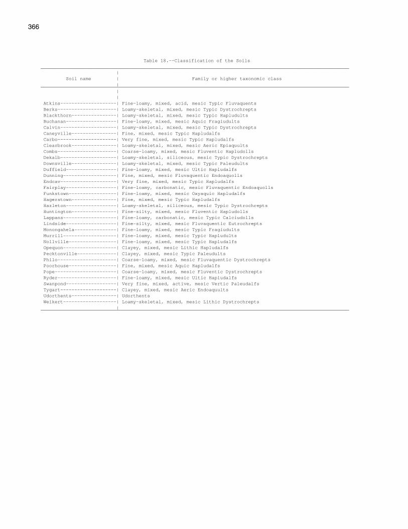
366
Table 18.--Classification of the Soils______________________________________________________________________________________________________________ | Soil name | Family or higher taxonomic class |______________________________________________________________________________________________________________ | | Atkins--------------------| Fine-loamy, mixed, acid, mesic Typic Fluvaquents Berks---------------------| Loamy-skeletal, mixed, mesic Typic Dystrochrepts Blackthorn----------------| Loamy-skeletal, mixed, mesic Typic Hapludults Buchanan------------------| Fine-loamy, mixed, mesic Aquic Fragiudults Calvin--------------------| Loamy-skeletal, mixed, mesic Typic Dystrochrepts Caneyville----------------| Fine, mixed, mesic Typic Hapludalfs Carbo---------------------| Very fine, mixed, mesic Typic Hapludalfs Clearbrook----------------| Loamy-skeletal, mixed, mesic Aeric Epiaquults Combs---------------------| Coarse-loamy, mixed, mesic Fluventic Hapludolls Dekalb--------------------| Loamy-skeletal, siliceous, mesic Typic Dystrochrepts Downsville----------------| Loamy-skeletal, mixed, mesic Typic Paleudults Duffield------------------| Fine-loamy, mixed, mesic Ultic Hapludalfs Dunning-------------------| Fine, mixed, mesic Fluvaquentic Endoaquolls Endcav--------------------| Very fine, mixed, mesic Typic Hapludalfs Fairplay------------------| Fine-loamy, carbonatic, mesic Fluvaquentic Endoaquolls Funkstown-----------------| Fine-loamy, mixed, mesic Oxyaquic Hapludalfs Hagerstown----------------| Fine, mixed, mesic Typic Hapludalfs Hazleton------------------| Loamy-skeletal, siliceous, mesic Typic Dystrochrepts Huntington----------------| Fine-silty, mixed, mesic Fluventic Hapludolls Lappans-------------------| Fine-loamy, carbonatic, mesic Typic Calciudolls Lindside------------------| Fine-silty, mixed, mesic Fluvaquentic Eutrochrepts Monongahela---------------| Fine-loamy, mixed, mesic Typic Fragiudults Murrill-------------------| Fine-loamy, mixed, mesic Typic Hapludults Nollville-----------------| Fine-loamy, mixed, mesic Typic Hapludalfs Opequon-------------------| Clayey, mixed, mesic Lithic Hapludalfs Pecktonville--------------| Clayey, mixed, mesic Typic Paleudults Philo---------------------| Coarse-loamy, mixed, mesic Fluvaquentic Dystrochrepts Poorhouse-----------------| Fine, mixed, mesic Aquic Hapludalfs Pope----------------------| Coarse-loamy, mixed, mesic Fluventic Dystrochrepts Ryder---------------------| Fine-loamy, mixed, mesic Ultic Hapludalfs Swanpond------------------| Very fine, mixed, active, mesic Vertic Paleudalfs Tygart--------------------| Clayey, mixed, mesic Aeric Endoaquults Udorthents----------------| Udorthents Weikert-------------------| Loamy-skeletal, mixed, mesic Lithic Dystrochrepts |______________________________________________________________________________________________________________

The Natural Resources Conservation Service (NRCS) is committed to making itsinformation accessible to all of its customers and employees. If you are experiencingaccessibility issues and need assistance, please contact our Helpdesk by phone at1-800-457-3642 or by e-mail at [email protected]. For assistancewith publications that include maps, graphs, or similar forms of information, you mayalso wish to contact our State or local office. You can locate the correct office andphone number at http://offices.sc.egov.usda.gov/locator/app.
NRCS Accessibility Statement