Embed Size (px)
Citation preview

NPS Form 10-900 (Rev. 10-90)
OMB No. 1024-0018
United States Department of the Interior National Park Service
NATIONAL REGISTER OF HISTORIC PLACES REGISTRATION FORM . -
historic name: Tygart River Reservoir Dam
other names/site number: Tygart Dam
2. Location ........................................................................... Street & number: 2.25 miles upstream from Grafton, on the Tygart River
not for publication - city or town: Grafton vicinity: x state: WV code: WV091 county: Taylor code: WV
zip code: 26354 ........................................................................... 3. State/Federal Agency Certification ..................... ..................................................................... ------- AS the designated authority under the National Historic Preservation Act of 1986, as amended, I hereby certify that this x nomination request for determination of eligibility meets the documentation standards for registering properties in the National Register of Historic Places and meets the procedural and professional requirements set forth in 36 CFR Part 60. In my opinion, the property x meets does not meet the National Register Criteria. I recommend that this property be considered significant - nationally x statewide - locally. ( - See continuation sheet for additional comments.)
Signature of certifying official Date
State or Federal agency and bureau
In my opinion, the property X meets does not meet the National Reg'ster criteria f in i?' - See continuation sheet for additional comments.)
XL- other official fj State or Federal agency and bureau

I, hereby certify that this property is:
entered in the National Register - See continuation sheet. determined eligible for the National Register - See continuation sheet. determined not eligible for the National Register removed from the National Register
other (explain):
Signature of Keeper Date
of Action
5 . Classification --- --- ----- ---------
Ownership of Property (Check as many boxes as apply) - private - public-local - public-State
x public-Federal 7
Category of Property (Check only one box) - building(s) - district -
- site x structure - - object
Number of Resources within Property
Contributing Noncontributing 4 3 buildings
sites 2 structures
objects 3 Total
Number of contributing resources previously listed in the National Register: None
Name of related multiple property listing (Enter "N/A" if property is not part of a multiple property listing.): N/A

8. Statement of Significance ........................................................................... Applicable National Register Criteria (Mark " x " in one or more boxes for the criteria qualifying the property for National Register listing)
x A Property is associated with events that have made a significant - contribution to the broad patterns of our history.
- B Property is associated with the lives of persons significant in our past.
x C Property embodies the distinctive characteristics of a type, - period, or method of construction or represents the work of a master, or possesses high artistic values, or represents a sianificant and distinguishable entity whose components lack - a
individual distinction.
- D Property has yielded, or is likely to yield information important in prehistory or history.
Criteria Considerations (Mark "X" in all the boxes that apply.)
A owned by a religious institution or used for religious - - purposes.
removed from its original
- C a birthplace or a grave.
- D a cemetery.
E a reconstructed building,
location.
object,or structure.
- F a commemorative property.
- G less than 50 years of age past 50 years.
Areas of Significance (Enter categories
or achieved significance within the
from instructions) aovernment/~olitics maritime historv enaineerina
Period of Significance
Significant
Significant
Dates 1934-38
Person (Complete if Criterion B is marked above)

6. Function or Use
Historic Functions (Enter categories from instructions) Cat: aovernment Sub: public works
transportation water-related
Current Functions (Enter categories from instructions) Cat: aovernment Sub: public works
trans~ortation water-related
Art Deco
Materials (Enter cateqories from instructions) foundation: reinforced concrete L U U A
walls: reinforced concrete
other: steel
Narrative Description (Describe the historic and current condition of the property on one or more continuation sheets.)

Cultural Affiliation N/A
Architect/Builder US Armv Corus of Enaineers-desian Frederick Snare Cor~oration-builder Paul Philli~e Cret-architect
Narrative Statement of Significance (Explain the significance of the property on one or more continuation sheets.)
Previous documentation on file (NPS) - preliminary determination of individual listing (36 CFR 67) has been
requested. - previously listed in the National Register - previously determined eligible by the National Register - designated a National Historic Landmark - recorded by Historic American Buildings Survey # - recorded by Historic American Engineering Record #
Primary Location of Additional Data - State Historic Preservation Office - Other State agency x Federal agency - - Local government - University - Other Name of repository: National Archives, Suitland Marvland
National Archives, Philadelphia, Pennsylvania US Army Corus of Enaineers, Pittsburah District,
Pittsburah, Pennsvlvania -- ----
10. Geographical Data -- -- --
Acreage of Property 143.42
UTM References (Place additional UTM references on a continuation sheet)
Zone Easting Northing Zone Easting Northing
x See continuation sheet. - Verbal Boundary Description (Describe t,he boundaries of the property on a continuation sheet.)
Boundary Justification (Explain why the boundaries were selected on a continuation sheet.)
11. Form Prepared By - -- - ---
name/title: Lee R. Maddex organization: Kemp and Associates date September 7, 1994 street & number: 429 Riley Street city or town: Morgantown
telephone: (304)599-4838 state: WV zip code: 26505

NPS Form 10-900 (Rev. 10-90)
OMB No. 1024-0018
United States Department of the Interior National Park Service
NATIONAL REGISTER OF HISTORIC PLACES CONTINUATION SHEET
Section 7 Page 1 Tygart Dam Taylor County, WV
Summary Paragraph
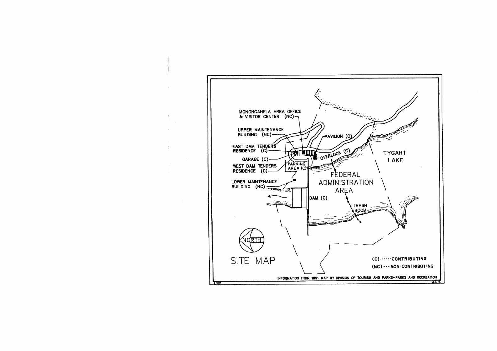
The Tygart River Reservoir Dam, or Tygart Dam, is a straight-crested concrete gravity dam with an uncontrolled spillway. Owned and operated by the US Army Corps of Engineers, Pittsburgh District, it is located approximately 2.25 miles south of Grafton, Taylor County, West Virginia on the Tygart River.' Tygart Dam's impoundment creates Tygart Lake, a 10-mile long reservoir, that drains 1,184 square miles of Taylor and Barbour counties. The reservoir has a storage capacity of 111,200 acre-feet in the summer with a maximum capacity of 377,400 acre-feet. The summer pool elevation is 1,094 feet above mean sea level (msl), with a maximum elevation of 1,167 feet above msl. Eight slide gates and two gate valves control the pool level. Tygart Dam is 1,921 feet long and 209 feet thick at the base, with a 489 foot long spillway. It rises 230 feet from the streambed at the abutments and 209 feet at the spillway. The $18.4 million US Army Corps of Engineers' construction project began in 1934 and ended in 1938.' Within the National Register boundary are Tygart Dam; two damtender dwellings; two maintenance buildings; comfort, storage and concession building; overlook; parking area; and resource manager's office. Tygart Dam is in excellent condition, with no structural changes and limited mechanical modifications, and thus it maintains a very high degree of integrity.
General Description
Tygart Dam is a multipurpose concrete gravity dam operated by the Pittsburgh District as part of a system of dams and reservoirs in the upper Ohio River drainage basin. Classified as a multipurpose dam, it is authorized for flood control in the Monongahela Valley and Pittsburgh, and for low flow augmentation for navigation purposes on the Monongahela River. Additional benefits derived from the reservoir include downstream water quality improvement, particularly during low flow periods, and recreation at Tygart Lake State Park. Further, the reservoir is the water supply source for the City of Grafton, and the dam is designed to be potentially retrofitted for hydroelectric power production.
' The Tygart River (or as it was historically known, the Tygarts Valley River), rises in Randolph County, West Virginia flowing northward to Fairmont where it joins the West Fork River to form the Monongahela River.
' Gannett Fleming Corddry and Carpenter, A Historv of Naviaational ImDrovements on the Mononaahela: Su~~lement No. 1 - A Historv of Develo~ments Leadina to the Construction of the Tvaart River Reservoir Dam (Pittsburgh: US Army Corps of Engineers, Pittsburgh District, 1981), pp. 11-12.

NPS Form 10-900 (Rev. 10-90)
OMB No. 1024-0018
United States Department of the Interior National Park Service
NATIONAL REGISTER OF HISTORIC PLACES CONTINUATION SHEET
Section 7 Page 3 Tygart Dam Taylor County, WV
Company, St. Louis, Missouri provided the trashrack frames and bars, screens, and grilled doors.' These are only a few of the numerous sub-contractors that provided equipment and services to the Tygart Dam project.
Tygart Dam consists of 34 individual reinforced concrete sections or monoliths (see illustration 1). The east and west abutment monoliths are each 60-feet thick with a triangular cross-section. Conversely, each of the spillway monoliths are 52-feet thick and have an ogival, or "S"-shaped, cross-section (see photograph 1).
Controlling the reservoir outflow are 10 gate controlled sluices: two 42-inch gate valves (originally needle valves) and eight 5-foot 8-inch by 10- foot slide valves. The outflow sluices discharge onto "dragon's teeth" or deflector piers (see photograph 1). The deflector piers' tetrahedral shape function to dissipate the energy of the outlet flow, thus reducing downstream erosion.
Integrity
Tygart Dam remains structurally unchanged. Mechanical changes to the dam structure are minimal. In the 1 9 5 0 ~ ~ the Corps installed the present 42-inch gate valves replacing the original 1938 needle valves, and installed new interior lighting. Additionally, the Corps replaced the original hydraulic pump start-up motors. The Corps replaced the parapet light standards as well, prior to 1974.9 These are the most significant alterations to the structure and do not ef feet the historic fabric of the dam. Tygart Dam has a high degree of integrity and is a contributing structure.
Architectural Descriptions
When reading the following descriptions, please refer to the illustrations and photographs as noted. Reference to the site map may prove helpful .
Maj. W.D. Styer to the Frederick Snare Corporation, "Change Order No. 2," 5 June 1935, File 115, RG 77, NARA.
Patrick A. Docherty, Monongahela Area Resource Manager, telephone conversation with Lee R. Maddex, 23 June 1994.
NPS Form 10-900 (Rev. 10-90)
OMB No. 1024-0018
United States Department of the Interior National Park Service
NATIONAL REGISTER OF HISTORIC PLACES CONTINUATION SHEET
Section 7 Page 2 Tygart Dam Taylor County, WV
Following the Public Works Administration's authorization of Tygart Dam in January 1934, principal engineer Charles M. Wellons and his staff designed Tygart Dam's structure, with Paul Cret as consulting architect. Emil P. Schuleen of the district office and Professor Harold Thomas of Carnegie Institute of Technology (now Carnegie Mellon University) in Pittsburgh conducted hydraulic experiments using scale model dams to determine the correct spillway design. Furthermore, their experiments determined the deflector pier and stilling basin designs. Ohio River Division engineer Robert G. West calculated the reservoir capacity. Pittsburgh District Engineer Major Wilhelm D. Styer oversaw Tygart's design and hydraulic studies (Lt. Colonel W.E.R. Cove11 replaced Styer as District Engineer in 1936). Additionally, Louis G. Hill of Quinton, Code and Hill-Leeds and Barnard Engineers Consolidated; L.F. Harza of Harza Engineering Company; consulting engineers James P. Growdon and Warren Mead (all noted dam engineers); and Office of the Chief of Engineers engineers William Gerig and William H. McAlpine, formed an unofficial group known as the Tygart Board of Consultants3 that acted as dam and hydraulics design consultants to the Pittsburgh District o f f i ~ e . ~
The Frederick Snare Corporation of New York City constructed Tygart Dam. Snare commenced work in January 1935 and placed the first concrete in May of that year. In September 1937, Snare placed the last lift of concrete (they placed 1,252,550 cubic yards of concrete during Tygart's constr~ction).~ Sub-contractors carried out various phases of construction under the Snare Corporation and the Corps. The H.P. Gazzam Company, Pittsburgh, Pennsylvania furnished the butterfly valves6 and the Michigan Valve and Foundry Company, Detroit, Michigan supplied the slide valve^.^ The Spuck Iron & Foundry
On large projects such as Tygart Dam, the Corps frequently convened a board of experts to oversee the design phase.
William E. Potter, "Tygart River Reservoir Dam," The Militarv Enaineer September-October 1936, p. 332; and Leland R. Johnson, The Headwaters ~istrict: A Historv of the Pittsburah District, US Armv Cor~s of Enaineers (Pittsburgh: US Army Corps of Engineer, Pittsburgh District, nd), pp. 200- 202; "Hydraulics of the Tygart River Reservoir Project," File 115, RG 77, National Archives and Records Administration (NARA), Suitland, Maryland.
Potter, "Tygart River," The Militarv Enaineer, p. 332.
R.G. Powell to the Chief of Engineers, 10 June 1935, File 115, RG 77, NARA .
' "Bids for slide gates for the Tygart River Reservoir Dam, West Virginia," File 115, RG 77, NARA.
NPS Form 10-900 (Rev. 10-90)
OMB No. 1024-0018
United States Department of the Interior National Park Service
NATIONAL REGISTER OF HISTORIC PLACES CONTINUATION SHEET
Section 7 Page 4 Tygart Dam Taylor County, WV
North Elevation
Tygart Dam's alignment is east to west, with the north elevation facing downstream. The downstream face is the principal elevation (see photograph 2). The most significant feature of the downstream face is the 489-foot long overflow spillway, which is flanked by the east and west abutment sections. Beneath the spillway is a stilling basin and stilling dam. East and west training walls flank the stilling basin. Located at the south end of the stilling basin are the two outlet sluices with 42-inch gate valves. These flank the eight 5-foot, 8-inch by 10-foot slide valve sluices. The outlet works discharge onto the deflector piers (see photograph 1).
Another significant feature of the downstream face are the closed spandrel arches with projecting pilasters or piers. These arches form the east and west abutment parapets and support the roadway (see photograph 3). Formed at the top of each pier is an art deco-style concrete pedestal. At every third pedestal is a light standard. Historic Corps photographs show the original light standards with dual drooping acorn globes. The existing light standards are 1960s "mushroom" type with globes capped by inverted aluminum crowns. Immediately flanking the spillway are two concrete pier houses or towers (see photograph 1). These pier houses permit covered access to the interior of the dam and its operational machinery. At the base of the dam, on either side of the training walls, are adits, or entrances, that also permit access to the interior of the dam. Slightly above the adits are observational platforms.
At the east and west ends of Tygart Dam are the concrete end buildings (see photograph 4). These square, flat roofed structures, with octagonal windows and steel doors serve as sheltered access to the interior of the dam. Additionally at the east end is the former maintenance building. Constructed of concrete, it is now a Corps storage building. Please note these buildings are considered part of the dam and are not counted separate resources.
South Elevation
The south elevation, or upstream face, depending on the pool level, is generally submerged beneath the waters of Tygart Lake (see photograph 5). The east and west abutment monoliths taper into the spillway section, while the spillway monoliths have a slight upward batter. The architectural details on this facade reflect the north elevation, with the exception that there are no arches. Parapets and pedestals support light standards and beneath each light standard pedestal is a projecting concrete bracket serving as a storm water outlet. At low water, the trashracks (large metal grates to prevent debris from entering the sluices) are visible.

NPS Form 10-900 (Rev. 10-90)
OMB No. 1024-0018
United States Department of the Interior National Park Service
NATIONAL REGISTER OF HISTORIC PLACES CONTINUATION SHEET
Section 7 Page 5 Tygart Dam Taylor County, WV
East and West Elevations
Dominating the east and west elevations are the pier houses (see photograph 5). They rise three stories with projecting observation decks. The second stories feature a band of double-hung 2/2 windows. Access to the pier houses are via two roadways, with one roadway to each pier house. Each roadway is approximately 10 feet wide. Parapets flank the roadways on both the east and west approaches.
Interior
Contained within Tygart Dam are four galleries or levels (air vent, inspection, operating, and grouting) with connecting stairways, that permit access to the interior of the dam for both operation and maintenance purposes. A typical gallery has an arched ceiling with straight vertical walls and horizontal floor. On downstream side of the floor are drainage gutters. The slide gate and valve locations in the operating gallery have high ceilings. Hydraulic piping and electrical conduits line the interior walls (see photograph 6).
Other Buildings
Included within the nominated area (the Federal Administration Area) are other contributing and non-contributing resources. In addition to Tygart Dam itself, there are two damtender dwellings and a detached garage; comfort, storage and concession building; an overlook; parking area; resource manager's office; and two maintenance buildings. Furthermore, it should be noted that the Corps constructed a temporary field office, hospital, a concrete batching plant, rail sidings, and other construction related structures; these were razed following the dam's completion.
Damtender Dwellinus and Garaue
In late 1938, the Corps constructed two damtender dwellings to house the dam personnel (see photograph 7). They are identical in construction, but are opposite hand. Each dwelling is a wood frame four-square building faced with red brick with a black asphalt shingled hip roof and a central chimney. The second floor of each building features three brick belt courses. The south facades have small awning-covered stoops. Decorative metal columns now support the awnings, replacing the original oak posts. On the east and west facades respectively, are clapboard-sided second story projections. The north elevations are partially enclosed by covered porches. Here, again decorative metal posts have replaced the original timber posts. Historic

NPS Form 10-900 (Rev. 10-90)
OMB No. 1024-0018
United States Department of the Interior National Park Service
NATIONAL REGISTER OF HISTORIC PLACES CONTINUATION SHEET
Section 7 Page 6 Tygart Dam Taylor County, WV
construction photographs show the original windows as divided-lite casement windows. In the 1970s, double-hung single-pane windows replaced the original casement windows. Except for the window replacements and minor changes to the porches, these two buildings have not been significantly altered. Both damtender residences are contributing buildings.
Of a similar design is a detached two car garage. It is a single-story, four-square building with a black asphalt shingled hip roof. The garage is of concrete block construction and faced with red brick. The south facade features twin overhead garage doors. The garage retains its original windows and fenestration and appears unaltered. It is a contributing building.
Comfort, Storaqe and Concession Buildinq
The comfort, storage and concession building is at the south end of the parking lot. Work Progress Administration personnel constructed the building in the spring of 1939 (see photograph 8). Within the building are a picnic shelter and public rest rooms. It is a single-story building constructed of native stone, rough-cut and irregularly coursed, with a split roofline. Red- brown asphalt shingles cover the roof and the end gables feature wide horizontal clapboards. Heavy square timbers form the wall's top plate and roof rafters. Fenestration includes 3/2 awning windows on the north and south facades, and an octagonal window on the north elevation. Doors have raised x-style panels, and the rest room doors have 3/2 lites. A few mature evergreen trees and shrubs surround the building. The comfort, storage and concession building has high integrity and is a contributing building.
Overlook and Parkina Area
Above Tygart Dam is an observation platform or overlook (see photograph 9). Constructed in 1939, the overlook features a view of the dam, benches, a water fountain, a bulletin board, and interpretive signage. A low chain link fence supported by concrete posts replaces an earlier two-rail wooden fence. The dam can be reached from the overlook by an asphalt-paved, switchback path (see photograph 4).
Adjacent to the overlook is the parking area (see photograph 10) . It was constructed concurrently with the overlook and comfort, storage and concession building. The parking lot features long narrow planting islands with light standards (matching those on the parapets) and space for 100 automobiles. The parking area's circulation remains intact and is unaltered

r:
OMB No. 1024-0018 NPS Form 10-900 (Rev. 10-90)
United States Department of the Interior National Park Service
NATIONAL REGISTER OF HISTORIC PLACES CONTINUATION SHEET
Section 7 Page 7 Tygart Dam Taylor County, WV
except for the replacement of the light standards. Present light standards were installed prior to 1974.1°
Both the overlook and parking area have high integrity. They are a combined contributing structure.
Resource Manaaer's Office
The resource manager's office consists of two single-story wood frame octagonal structures connected by a wood frame front-gabled "dogtrot" (see photograph 10). The dogtrot in a glass enclosed structure with a steeply pitched roof. Both octagonal structures have vertical wood siding. A ventilator caps the east wing roof and the west wing has tandem single-pane sliding windows. Red-brown asphalt shingles cover the dogtrot and octagonal roofs. Constructed in 1982-83, it reflects a modern rustic ,style."
The east wing houses interpretive displays and rest rooms and the west wing houses the US Army Corps of Engineers Monongahela Area administrative offices. This is a non-contributing building.
Maintenance Buildinas
There are two maintenance buildings associated with the Tygart Dam. One is adjacent to the stilling pool, below the dam on the east bank (see photograph 11). It is of metal frame construction with a low pitched copper- colored roof and clad with tan-colored steel siding, The south facade features three garage bays and an entranceway. Constructed circa 1980, it is a non-contributing building.
Located south of the damtender dwellings is a second maintenance building (see photograph 12). It is a single-story side-gabled frame construction building. The red brick veneered structure has horizontal wood siding beneath the gables, and red-brown asphalt shingles covering the roof. The south and north facades feature garage bays. It was built in 1968 and is a non-contributing building.
" Taylor County Historical and Genealogical Society, A Historv of Tavlor Countv West Virainia (Parsons, WV: McClain Printing Co., 1986), p. 109.

NPS Form 10-900 (Rev. 10-90)
OMB No. 1024-0018
United States Department of the Interior National Park Service
NATIONAL REGISTER OF HISTORIC PLACES CONTINUATION SHEET
Section 8 Page 1 Tygart Dam Taylor County, WV
Statement of Significance
The Tygart River Reservoir Dam is significant under Criterion A for the themes of politics and government and maritime history. Tygart Dam is significant in political and governmental history for its association with the flood control movement of the early twentieth century and the resulting US Army Corps of Engineers policy shift from "levees only" to one including reservoirs. Tygart is significant for maritime history for its association with the Monongahela River Navigation System. Water impounded during periods of high rainfall are released from Tygart Lake during periods of low rainfall, thus maintaining flows for barge traffic on the Monongahela River slackwater navigation year-round. Lastly, Tygart Dam is significant under Criterion C for the theme of engineering. The hydraulic modeling used in Tygart Dam's design embodies the transition from empirically rooted engineering to one based on scientific principles.
Historic Context
The gravity dam is probably the oldest form of dam construction. An earthen and rockfill dam in the Jordanian desert dates to the third millennium B.C and is considered the earliest known gravity dam. These first dams held reservoirs of water created by the damming of a river to be later released for irrigation purposes; this process was integral in the development of irrigation based societies. Dams evolved from simple rock and earth storage structures to complex cut stone masonry ones; and by the eighteenth century Spanish dam builders had begun to rationalize dam design. French and British engineers furthered rational dam design and in the late nineteenth century mathematical methods to dam design gained acceptance.' By the 1920s and ' ~ O S , when the US Army Corps of Engineers began to construct high concrete gravity dams (dams greater than 100 feet high), the transition of dam building as a craft tradition to one based in analytical methods was complete.
The first federal involvement in dam and reservoir construction began in 1902 with the enactment of the National Reclamation Act. The Bureau of Reclamation initiated a program of storage dam construction to meet Western irrigation needs.' The Corps of Engineers first multipurpose high concrete
' Leland R. Johnson. The Headwaters District: A History of the pittsburqh District, U.S. Army Corps of Enaineers (Pittsburgh: US Army Corps of Engineers, Pittsburgh District, 1979), p. 175.

NPS Form 10-900 (Rev. 10-90)
OMB NO. 1024-0018
United States Department of the Interior National Park Service
NATIONAL REGISTER OF HISTORIC PLACES CONTINUATION SHEET
Section 8 Page 2 Tygart Dam Taylor County, WV
gravity dam (a dam with two or more functions) was the Wilson Dam on the Tennessee River near Florence, Alabama. Begun in 1918, World War I interrupted its completion and it was not finished until 1926. Not an irrigation storage dam, Wilson's storage capacity generated hydroelectric power and augmented low flow for the Tennessee River Navigation System. Wilson Dam was the first of over eighty dams constructed by the Corps in the next seventy years in the Ohio River Di~ision.~ The next high concrete gravity dam built by the Corps was near Grafton, West Virginia on the Tygart River. When completed in 1938, Tygart Dam (formerly Tygart River Reservoir Dam) was the highest concrete gravity dam east of the Mississippi and the first Corps constructed high concrete dam in the Pittsburgh District (part of the Ohio River Division). Tygart Dam, like Wilson, was a multipurpose dam and both were designed for low flow augmentation. However Tygart, unlike Wilson, was designed for flood abatement. Tygart was the first high flood control dam in the Pittsburgh District, and subsequently, the Corps constructed fifteen additional flood control dams in the. district which provide flood protection in the Upper Ohio watershedB4
Building Tygart Dam
The decision to build Tygart Dam can be traced to the devastating 1907 Pittsburgh Flood that nearly destroyed the city. As a result, the Pittsburgh Flood Commission was established to study flood control measures. In their 1912 report on flood control, the commission recommended the construction of reservoirs on the headwaters of the Monongahela and Allegheny rivers to control flooding at Pittsburgh and on the upper Ohio River. The reservoirs would be multipurpose, functioning not only to abate flooding, but also to maintain navigation and improve water quality. While not immediately accepted by the Corps, the commission's recommendations became the basis of the New Deal flood control plan initiated by the Corps of Engineers for the Ohio watershed.
The Great Depression became the driving force behind Tygart Dam's construction, The Flood Commission's reservoir system was entirely practical, but the commission lacked funding to undertake its construction.
Leland R. Johnson, The Ohio River Division, U.S. Armv Corps of Enaineers: The Historv of a Central Command (Pittsburgh: US Army Corps of Engineers, Pittsburgh District, 1994), p. 11.
Tygart Dam was not however the first multipurpose dam constructed in the Ohio River Division. Using Public Works Administration funding, the Corps constructed fourteen flood control dams on the Muskingum watershed from 1934-1938.

NPS Form 10-900 (Rev. 10-90)
OMB No. 1024-0018
United States Department of the Interior Yational Park Service
NATIONAL REGISTER OF HISTORIC PLACES CONTINUATION SHEET
Section 8 Page 3 Tygart Dam Taylor County, WV
So, when funding became available under the 1933 National Industry Recovery Act (NIRA), the Pittsburgh Flood Commission petitioned the Public Works Administration (PWA) to fund the construction of flood control dams on the Allegheny and Monongahela watersheds. Upon the Corps review and recommendation, the PWA agreed to fund Tygart Dam as an unemployment relief project.
President Franklin Roosevelt created the PWA in June 1933 by an executive order under the authority of the NIRA. The pWA was established to administer the granting and loaning of federal money for federal and non- federal public works. Authorized January 11, 1934 as Federal Works Project Number 44, Tygart Dam received a $4,000,000 appropriation from the Public Works Administration Emergency Appropriation Act. More funding came from the Emergency Relief Appropriation Act of 1935 (this legislation extended the NIRA until 1937). Congress then adopted the project under the 1935 Rivers and Harbors Act and construction funding for 1936, 1937, and.1938, came from the War Department Appropriation ~ct.'
The design of Tygart Dam was a team effort. Corps of Engineers Pittsburgh District engineers Charles M. Wellons (principal engineer), J.H. Dodds (masonry engineer), and W.E. Sydney (mechanical engineer) oversaw the structure's design; while noted architect Paul Phillipe Cret, contributed the parapet arches, pier structures, and lamp posts. Carnegie Institute Professor Harold A. and Emil P. Schuleen Tygart Dam. Robert plan and operation. his replacement Lt. construction.
Overseeinq the
Thomas and corps engineers N.W. Bowden, H.E. Anderson, experimentally determined the correct spillway shape for West was responsible for developing the dam's reservoir Major Wilhelm D. Styer, Pittsburgh District Engineer and Colonel William E. R. Cove11 supervised Tygart Dam's
design process was the Board of Consultants. This informal board-of experts in high dam construction consisted of the Chief of Engineers Office engineers William H. McAlpine and William Gerig, and private
Gannett, Fleming, Corddry and Carpenter, Inc., A Histom of Naviaational Improvements on the Mononsahela River: Supplement No. 1- A History of Developments Leadinq to the Construction of the Tyaart River Reservoir Dam (Pittsburgh: US Army Corps of Engineers, Pittsburgh District, 1981), p. 9.
W.E. Potter, "Tygart River Reservoir Dam," The Militarv Enoineer September-October 1936, p. 332.

NPS Form 10-900 (Rev. 10-90)
OMB No. 1024-0018
United States Department of the Interior National Park Service
NATIONAL REGISTER OF HISTORIC PLACES CONTINUATION SHEET
Section 8 Page 4 Tygart Dam Taylor County, WV
The Pittsburgh District used staff landscape architects for locating access roads, the overlook and supporting facilities, and designing planting plans for scenic and erosion control purposes. They also planned the damtender dwellings' orchard and garden. Washington, DC landscape architect Horace W. Peaslee was consultant to the District for landscaping and the design of the damtender dwellings.'
In October 1934, the Corps accepted the low bid of $6,305,773 and the Frederick Snare Corporation of New York City was contracted to construct Tygart Dam. Established in 1900, Snare had an international reputation for constructing dams, waterworks and reservoirs, bridges, power plants, and other engineering works around the world, before undertaking Tygart.'
Workers cleared the damsite and reservoir of trees and brush during the spring and summer of 1934. Actual construction commenced in January, 1935 and Snare placed the first concrete in late May of that year.'' By mid 1936, the dam undertaking was 50 percent complete." A year later, in June 1937, the Corps reported that the dam project was 95 percent finished. Snare placed the last concrete in November 1937." Tygart Dam began operations in February 1938 and was dedicated in October 1938.
Johnson, Ohio River Division, p. 140.
8 1520-03, Tygart Lake-Specifications Damtenders Dwelling; and 1520-03, Tygart Lake-Specifications Landscaping. US Army Corps of Engineers, Pittsburgh District Files. Pittsburgh, Pennsylvania.
lo "Construction of Tygart River Dam, West Virginia, " Pittsburgh District Annual Report 1935, p. 22. Corps Of Engineers (Hereafter COE) Annual Reports, RG 77, National Archives Records Administration (hereafter NARA), Philadelphia.
" "Tygart River Dam, W.Va.," Pittsburgh District Annual Report 1936, p. 19. COE Annual Reports, RG 77, NARA, Philadelphia.
l2 "Tygart River Dam," Pittsburgh District Annual Report 1937, p. 16. COE Annual Reports, RG 77, NARA, Philadelphia.

NPS Form 10-900 (Rev. 10-90)
OMB No. 1024-0018
United States Department of the Interior National Park Service
NATIONAL REGISTER OF HISTORIC PLACES CONTINUATION SHEET
Section 8 Page 5 Tygart Dam Taylor County, WV
To facilitate Tygart Dam's construction, a concrete mixing plant was erected at the damsite. Serviced by a rail siding, it was a completely modern plant using pneumatics and conveyor belts to deliver cement and concrete aggregates to the batch plant. Cement and aggregates were weighed automatically, then sent to the batchers and mixed in tilting mixers. Following mixing, the wet concrete was dumped into a central hopper and delivered by conveyor belt to a satellite hopper on the construction trestle. This hopper filled three-yard buckets and delivered them to the cranes, or whirleys, on flatbed cars. The cranes placed the concrete in the forms. The concrete plant had a maximum capacity to mix and place 180 cubic yards per hour using three of its four mixers.13
Land Issues
Despite the willingness of landowners to sign Corps clearing agreements in 1934, they proved particularly recalcitrant when it came to settling on a price for the fee title and flowage agreements. The construction of Tygart Dam required the acquisition of 221 tracts totaling 5,789 acres. However, only 89 tracts were obtained by direct purchase and the Corps acquired the remaining 132 tracts, comprising 4,407 acres, through condemnation proceedings. The Corps initiated condemnation proceedings in May 1937, concluding them in 1942.14
During Tygart Dam's construction, the question of surplus land utilization arose. The Corps acquired many properties above the highest pool level (1090 mean sea level) because it was cheaper to purchase them in fee than to acquire flowage easements and then have to build access roads. These lands extended on both sides of the reservoir for a distance of approximately five miles upstream. The Corps wanted to dispose of these tracts to avoid the expense of policing them and maintaining their scenic quality.15 In January 1941, Congressman Jennings Randolph (D-West Virginia) introduced in the House of Representatives a joint resolution authorizing the Secretary of
If Potter, "Tygart River," Militarv Enaineer, pp. 333-34.
l4 Herbert D. Vogel to the Real Estate Branch, "Reports on Land Acquisition (Civil)," 9 July 1942. File 115, RG 77, NARA, Suitland.
W.E.R. Cove11 to The Chief of Engineers, "Utilization of Surplus Lands, Tygart River Reservoir Area," 2 August 1937. File 115, RG 77, NARA, Suitland.

NPS Form 10-900 (Rev. 10-90)
OMB No. 1024-0018
United States Department of the Interior National Park Service
NATIONAL REGISTER OF HISTORIC PLACES CONTINUATION SHEET
Section 8 Page 6 Tygart Dam Taylor County, WV
War to grant and convey the surplus lands to the state of West Virginia." Because of World War I1 these lands were not conveyed until 1945, when the federal government deeded West Virginia 1,775 acres of land adjoining the reservoir. Of this acreage, the state of West Virginia developed 539 acres into Tygart Lake State Park. In 1947, another 1,430 acres were leased to the state park under a long-term agreement." Tygart Lake State Park is a multiple use recreational area, with facilities for boating, cabins, and campgrounds.
Tygart Dam is significant under Criterion A for politics and government. Tygart Dam, which is a flood control structure, is the result of the flood control movement of the early twentieth century. The dam represents the subsequent US Army Corps of Engineers flood control policy change from one of "levees only" to one advocating the reservoir system together with levees to abate flooding on the nation's waterways.
Prior to the 1917 Flood Control Act, Congress did not address flood control legislation--with the exception of the lower Mississippi River-- despite the continued, annual flooding of the nation's rivers. Accounting for this lack of flood control legislation were the meager federal resources available during the nineteenth century to pay the cost of designing and constructing flood control structures, and flood damage was still low until the rapid growth of American cities along rivers in the late nineteenth and early twentieth centuries. Most importantly, many political leaders considered federal aid for flood control unconstitutional. These leaders believed that tax money should not be spent on flood control improvements that only benefitted a local con~tituency.~~ On the other hand, many prominent nineteenth century politicians, in particular Henry Clay and John C. Calhoun, embraced federal funding of navigation related internal improvements.
l6 House of Representatives Joint Resolution 22, 77th Congress, 1st sess. File 115, RG 77, NARA, Suitland.
l7 Stan Cohen, Where Peowle and Nature Meet: A Historv of the West Virainia State Parks (Charleston, WV: Pictorial Histories Publishing Co., l988), p. 143.
le Joseph L. Arnold, The Evolution of the 1936 Flood Control Act (Washington, D.C.: U.S. Government Printing Office, 1988), pp. 3-4.

NPS Form 10-900 (Rev. 10-90)
OMB No. 1024-0018
United States Department of the Interior National Park Service
NATIONAL REGISTER OF HISTORIC PLACES CONTINUATION SHEET
Section 8 Page 7 Tygart Dam Taylor County, WV
The federal government's involvement in river improvement (making rivers navigable) dates to Gibbons v. Oqden (1824). Chief Justice John Marshall's ruling established the right of Congress to regulate interstate commerce, and thus the constitutionality of federal funding of navigational (internal) improvements. Congress assigned the US Army Corps of Engineers the task of maintaining and improving the nation's rivers. While not mandated by Congress, the Corps did engage in flood control activities. Federal funding of Corps flood control projects was often the indirect result of river and harbor improvement legislation. These projects generally took the form of levee building on the lower Mississippi River.lg
Levee building as Corps policy began as the result of a controversy begun in 1850 with Secretary of War Charles M. Conrad's appointment of Captain A.A. Humphreys and Colonel Stephen Long of the US Corps of Topographical Engineers and Charles Ellet, Jr. to study flooding on the lower Mississippi River. Ellet completed his study first and in the report published in 1852, The Mississi~~i and Ohio Rivers, he promoted levees to mitigate flooding on the lower Mississippi. Ellet also proposed a system of reservoirs be built at the headwaters of the tributaries of the Mississippi and Ohio rivers to control flooding. Ellet further argued that the reservoir system could be used to maintain navigation as well, believing this system particularly well suited for the Ohio River watershed. When Ellet first approached Congress with his ideas in 1850, Henry Clay, a noted advocate of internal improvements, recognized their importance. Clay convinced the Senate to appropriate money for a Monongahela and Allegheny river study, but the appropriation was defeated in the House. The controversy continued when William Milnor Roberts, builder of the Pennsylvania Mainline Canal, published a damaging critique of Ellet's proposals. In the 1857 paper, Roberts insisted Ellet's system was too complex and expensive to construct and operate. The ten year Humphreys-Abbot (Henry L. Abbot replaced Long) study, Phvsics and Hvdraulics of the Mississip~i River published in 1861, advocated "levees only." The Humphrey-Abbot report and Roberts' criticism proved fatal for Ellet's proposals and "levees only" became the accepted flood control doctrine. This mandate was reinforced when Humphreys became Chief of Engineers in 1866, and his influence thereafter set a sixty year Corps1 policy of utilizing only levees to alleviate flooding on the nation's waterways. 20
This remained the case until the early twentieth century when a number of devastating floods--the 1907 Pittsburgh Flood, Mississippi floods in 1912
Ibid, pp. 4-5.
20 Arnold, Flood Control, p. 4-7; and Johnson, The Headwaters District, p. 104.

NPS Form 10-900 (Rev. 10-90)
OMB No. 1024-0018
United States Department of the Interior National Park Service
NATIONAL REGISTER OF HISTORIC PLACES CONTINUATION SHEET
Section 8 Page 8 Tygart Dam Taylor County, WV
and 19 13, and the Miami River (Ohio) Flood of 19 13--directed Congressional interest to develop a national flood control policy. At the vanguard of this flood control movement was Senator Francis Newlands (R-Nevada), who advocated a multipurpose inland waterway program that incorporated flood control, navigation, water power, and irrigation in its mission. The Inland Waterways Commission, created in 1909 in response to the Pittsburgh flood, recommended that the federal government develop a comprehensive multipurpose river program. Newlands introduced a multipurpose rivers bill in the Senate, but it was defeated. He continued to introduce similar legislation, but none passed. The 1916 establishment of the House of Representatives Committee on Flood Control was the first permanent congressional body created to study flood control. 21
The subsequent enactment of the Flood Control Act of 1917 was the most significant result of the flood control movement before World War I. Although directed at flood control on the Mississippi and Sacramento rivers, this legislation set several precedents for future flood control measures. For the first time, the 1917 act directly appropriated federal funds for flood control activities, it defined a long-term congressional commitment to resolving flooding problems on the nation's waterways, and created the requirement of matching federal funds with local funds for flood control improvements. Section 3 of this act also authorized the Corps of Engineers to undertake flood control studies. These studies were never undertaken with the advent of World War I, but the act changed government policy from navigation only to one with the dual purposes of navigation and flood control. 22
Following World War I, Congress returned its attention to the water resource issues raised before the war, particularly the need to develop hydroelectric power. It enacted the Water Power Act of 1920. As a result of this act's failure to coordinate hydroelectric power with flood control and navigation needs, the House of Representatives Rivers and Harbors Committee suggested the federal government determine the cost of a comprehensive survey of America's navigable waterways. Congress directed the Corps to prepare a cost estimate for such a survey. Transmitted to Congress in April 1926, House Document 308 of the 69th Congress estimated it would cost $7.3 million to survey 180 of the nation's major rivers and their tributaries. Congress funded the survey under the 1927 Rivers and Harbors Act. The "308" reports, as they were known, became a complete survey of the nation's navigable rivers. These reports, while focusing on hydroelectric power, also addressed what potential measures the Corps could take to develop multipurpose rivers
Arnold, Flood Control, pp. 11-13.
22 Arnold, Flood Control, pp. 14-15.

NPS Form 10-900 (Rev. 10-90)
OMB No. 1024-0018
United States Department of the Interior National Park Service
NATIONAL REGISTER OF HISTORIC PLACES CONTINUATION SHEET
Section 8 Page 9 Tygart Dam Taylor County, WV
balancing the issues of flood control, navigation, irrigation, and water power. 23
A year after the devastating 1907 "Fifty Million Dollar" flood that nearly destroyed downtown Pittsburgh, the Chamber of Commerce formed a Citizens' Committee to decide the cost and extent of flood damage. However, their mission quickly changed to one with an expanded examination of the Pittsburgh flood problem and the consideration of flood control solutions. Initially consisting of seven members, the committee evolved into the Flood Commission of Pittsburgh, growing to include thirty-four businessmen, engineers, and other profes~ionals.~~ After four years of study, the commission published its findings. In the 1912 report, the commission, drawing on Ellet's 1852 reservoir studyz5 and others, recommended a program of reforestation to minimize surface runoff, a system of reservoirs to impound flood waters, and the construction of levees and flood walls to alleviate flooding at Pittsburgh and the upper Ohio River Valley. The Commission further concluded that the impounded flood waters could be used to aid navigation and interstate commerce, and that the reservoir system would improve water quality downstream, particularly in remedy of sewage problems at ~ittsburgh. 26
Furthermore, the Pittsburgh commissioners identified 42 potential reservoir sites within the Ohio River basin. Of these 42 sites, 32 were surveyed and 17 recommended for flood control dams. The commission identified Tygart River watershed as the primary cause of flooding on the Monongahela and proposed four dams for Tygart's principal tributaries: two on the Middle Fork River, one on Teters Creek, and one on the Buckhannon River. 27 The Corps rejected the Pittsburgh Flood Commission's
23 Arnold, Flood Control, pp. 15-17; and US Congress. House. Estimate of Cost of Examination, Etc., of Streams Where power Development Appears Feasible. 69th Cong., 1st sess. 1925. H. Doc. 308., p. 1.
24 W.E.R. Covell, "Flood Control in the Pittsburgh District," The Militarv Enaineer May-June 1939, p. 177.
" The commissioners make numerous references to Charles Ellet, Jr.'s reservoir plan in their Report of Flood Commission of Pittsburah, Penna. and include his reservoir study in Appendix No. 6, "Previous Papers and Reports."
26 Report of Flood Commission of Pittsburah, Penna. (Pittsburgh: Flood Commission of Pittsburgh, Penna., 1912), pp. 11-15.
'' Report of Flood Commission Of Pittsburah, p. 128.

NPS Form 10-900 (Rev. 10-90)
OMB No. 1024-0018
United States Department of the Interior National Park Service
NATIONAL REGISTER OF HISTORIC PLACES CONTINUATION SHEET
Section 8 Page 10 Tygart Dam Taylor County, WV
Despite the Corps rejection of its recommendations, the Pittsburgh Flood Commission continued to lobby Congress for flood control legislation and was successful in gaining matching funds to initiate a Corps Pittsburgh District study of the Monongahela and Allegheny watershed under the Flood Control Act of 1924. This study began in 1924 and later expanded under the 1925 Rivers and Harbors Act. The Flood Commission rejected the Corps 1928 report as too conservative, claiming it overestimated the design costs and underestimated the resulting benefits. After the commissioners hired Harold Thomas and Ross Riegle to reestimate the Corps' plan, they eliminated several expensive features. In 1930, Thomas and Riegle submitted the revised report to Pittsburgh District Office and it received a favorable review. However, the economically feasible Thomas and Riegle plan would remain undeveloped until funding became available during the New Deal.''
By the time of the Thomas and Reigle report, the Corps of Engineers' flood control philosophy began to change. As the result of the 1927 flood of the lower Mississippi, Congress started questioning the Corps' "levees only" policy. Chief of Engineers, General Edgar Jadwin, an advocate of the levees policy, retired in September 1929, and he was replaced by General Lytle Brown. Brown's administration marks the shift of the Corps philosophy from "levees only" to one embracing reservoirs (however, levees along with floodways still had effective applications, particularly on the lower Mississippi), but the Corps legislative mandate was still navigational improvements. This mandate did not change until the passage of the Flood Control Act of 1936 .29
The Great Depression proved a blessing for the Pittsburgh Flood C O ~ ~ ~ S S ~ O ~ ' S efforts. Enacted in 1933, the National Industrial Recovery ~ c t (NIRA), allocated funds for economic recovery and work relief through the construction of public works, such as dams. Construction of depression era public works was administered by the Public Works Administration (PWA), the New Deal agency created to relieve unemployment. The Pittsburgh commissioners solicited the PWA to fund the construction of nine dams, of which three were designated for the tributaries of the Monongahela: the West Fork River, the Middle Fork of the Tygart, and Tygart River. This funding request was forwarded to Major Wilhelm D. Styer, Pittsburgh District Engineer, for his review. Simultaneously, the Tri-State Authority superseded the Pittsburgh Flood Commission. This new organization, consisting of
28 Johnson, Headwaters District, p. 199.
29 Arnold, Flood Control, pp. 17-19.

NPS Form 10-900 (Rev. 10-90)
OMB No. 1024-0018
United States Department of the Interior National Park Service
NATIONAL REGISTER OF HISTORIC PLACES CONTINUATION SHEET
Section 8 Page 11 Tygart Dam Taylor County, WV
members from over 230 municipalities in Pennsylvania, West Virginia, and Ohio formed to strengthen their congressional lobbying effort. Styer issued his report on the day after the formation of the Tri-State Authority. In it, he recommended construction of eight of the dams, but eliminated the Middle ~ o r k dam. Styer further concluded that seven of the dams would be funded as partnerships under the 1917 Flood Control Act, but Tygart Dam would be funded entirely by the Corps based on its navigational benefits. In October 1933, the PWA approved Styer's recommendations and in January 1934, funded the Tygart Dam project . 30
Construction of Tygart Dam, by the Corps of Engineers, was the direct result of the efforts of the Pittsburgh Flood Commission;31 in fact, the dam's functions of flood control, navigation, and water quality improvement mirror exactly those recommendations set forth in the 1912 Report of Flood Commission of Pittsburqh Thus, Tygart Dam's construction embodies the flood control movement of the early twentieth century and the shift in Corps of Engineers policy from "levees only" to the use of reservoirs to abate flooding.
The best illustrations of Tygart Dam's success as a flood control structure are its flood damage reduction figures. Since its completion in 1938, Tygart Dam has contributed significantly in reducing flood damage downstream. In fact, even before Tygart Dam's completion it stemmed the October 1937 flood, noticeably reducing flood damage. Tygart's first real test came in the 1939 winter floods, when the dam reduced the crests at Pittsburgh by 1.3 feet and 2 feet, respectively. When Hurricane Agnes devastated the eastern United States in June 1972, the impounded floodwaters Came within twelve feet of cresting Tygart Dam's spillway, However, the record pool level at Tygart occurred during the November 1985 flood, when the water rose to 10.4 feet below the spillway. By 1975, after thirty-f ive years of service, the $18.4 million dam had saved an estimated $140 million in potential flood damage.12 As of 1992 the Corps of Engineers estimates, Tygart Dam's flood damage reduction totalled $554.4 million.33
30 Johnson, Headwaters District, pp. 200-201.
31 Potter, "Tygart River," Military Enqineer, p . 331.
32 Taylor County Historical and Genealogical Society, A Historv of Tavlor COuntv West Viruinia (Parsons, WV: McClain Printing Co., 1986), p. 109.
33 Memorandum for Chief, Hydrology and Hydraulics Branch, Estimated ~ l o o d Damages Prevented by Reservoirs and Local Flood Protection Projects for Fiscal Year 1992, 24 November 1992, enclosure 1.

NPS F O m 10-900 (Rev. 10-90)
OMB No. 1024-0018
United States Department of the Interior National Park Service
NATIONAL REGISTER OF HISTORIC PLACES CONTINUATION SHEET
Section 8 Page 12 Tygart Dam Taylor County, WV
Maritime Historv
Tygart Dam is significant under Criterion A for maritime history. The Monongahela River Navigation System contributed to the development of Pittsburgh and the Monongahela Valley as the center of American iron and steel production by the turn of the twentieth century. Historically, droughts crippled navigation on the Monongahela slackwater system. Tygart Lake, the reservoir created by Tygart Dam's construction, supplies supplemental water for this important slackwater system.
The Monongahela River was historically a route for settlement and trade to the Monongahela backcountry of Pennsylvania and Virginia. Recognizing its importance as a transportation corridor, the Virginia General Assembly in 1800 declared the river a public highway. Still, the unimproved Monongahela, with its many shoals and riffles, was passable only during the spring and fall freshets. The drive to improve the Monongahela dates to 1793, when the Virginia assembly appointed trustees to raise private subscriptions for the improvement of the Monongahela to the Pennsylvania state line. Since no subscriptions were raised, these improvements, chiefly the clearing the river channel of snags and obstructions, were never undertaken and the river remained only seasonally navigable.34 The first serious Virginia effort to improve the Monongahela came in 1817, when the General Assembly incorporated the Monongahela Navigation Company. Chartered with the purpose of improving the Monongahela and West Fork rivers, this company failed in the 1830s without building a single lock or dame3'
The 1820s and '30s was the era of American canal "mania," and popular agitation for Monongahela slackwater navigation was not limited to Virginia. The state of Pennsylvania in 1817 chartered the Monongahela Navigation Company to improve the Monongahela from Pittsburgh to the state line, but its charter lapsed without effecting any improvements. Successful slackwater navigation came with the Commonwealth of Pennsylvania's incorporation of the second Monongahela Navigation Company. Chartered in 1836, construction of the first of seven locks and dams began at Pittsburgh in 1838. The company completed slackwater navigation to Brownsville, Pennsylvania on the National
34 Isaac F. Broughter, "Internal Improvements in Northern Virginia: A Study in State Policy Prior to the Civil War," (Ph.D. diss. University of Pittsburgh, 1930), pp. 75-76.
35 Broughter, "Internal Improvements," pp. 116-137.

NPS Form 10-900 (Rev. 10-90)
OMB No. 1024-0018
United States Department of the Interior National Park Service
NATIONAL REGISTER OF HISTORIC PLACES CONTINUATION SHEET
Section 8 Page 13 Tygart Dam Taylor County, WV
Road, about 60 miles, in 1844. It reached Rices Landing, Pennsylvania in 1856, with the completion of Lock and Dam No. 6.36
During the Civil War the demand for slackwater on the upper Monongahela continued, but all ventures failed. Postwar efforts of the new state of West Virginia again failed. Repeated failures of private corporations and state attempts at funding the improvement of the upper Monongahela led the federal government to address the slackwater issue. The River and Harbor Act of 1871 funded a survey of the Monongahela from New Geneva, Pennsylvania to Morgantown, West Virginia, approximately 15 river miles. In a separate proposal, Colonel William E. Merrill, US Army Corps of Engineers, recommended that three locks be constructed to extend slackwater to Morgantown. He advocated two be built by the federal government and the third by the Monongahela Navigation Company. The federal government completed Lock and Dam No. 9 near Morgantown at Hoards Rocks in 1879 and finished Lock and Dam No. 8, at the mouth of Dunkards Creek, in 1889. The Monongahela Navigation 'ompany completed Lock and Dam No. 7 in 1883 at New Geneva. Slackwater navigation reached Fairmont, West Virginia in 1903, with the completion of Locks and Dams Nos. 10, 11, 12, 13, 14, and 15. 37
This system of locks and dams was a commercial boon to the lower Monongahela Valley and Pittsburgh, in particular. Barges of coal from Monongahela River mines and Connellsville region coke shipped on the navigation system contributed to the development of Pittsburgh and the Monongahela Valley as the major iron and steelmaking centers of the late- nineteenth century. Coal and coke shipments represented the greatest commodity transported on the navigation system, but flour, iron and steel, gasoline and oil, livestock, and a myriad of other products were shipped on the slackwater system.3e As of 1994, coal is still the chief commodity shipped on the Monongahela River Navigation System.
Acquisition of the Monongahela Navigation Company by the federal government in 1897 was also significant. The River and Harbor Act of 1884 established toll-free navigation for rivers with federally built and
36 Gannett, Fleming Corddry and Carpenter, Inc., A Historv of Naviaation Im~rovements on the Mononqahela River (Pittsburgh: US Army Corps of Engineers, Pittsburgh District, 1980), pp. 2 - 4 .
37 Gannett, et al., Mononaahela River, pp. 5-15.
38 US Congress. House. Mononaahela Naviqation Com~anv. 49th Cong., 2d sess. 1886. Ex. Doc. 112, p. 5; and US Congress. House. Develo~ment of the Rivers of the United States. 73rd Cong., 2d sess. 1934. H. Doc. 395, pp. 209-13.

NPS Form 10-900 (Rev. 10-90)
OMB No. 1024-0018
United States Department of the Interior National Park Service
NATIONAL REGISTER OF HISTORIC PLACES CONTINUATION SHEET
Section 8 Page 14 Tygart Dam Taylor County, WV
administered improvements. Since the Corps was improving the Kanawha River in West Virginia, Pennsylvania coal operators and sellers lobbied for the Corps to acquire the Monongahela slackwater system. They argued that the toll-free Kanawha system would give the West Virginia coal producers an unfair price advantage, and the Pennsylvania interests wanted free navigation for the lower Monongahela so they could remain competitive with the West Virginia coal fields. Beginning in 1888, the Corps initiated steps to purchase the Monongahela system. Congress directed the Secretary of War to acquire Lock and Dam No. 7 for no more than $161,733.13, the original cost of the structure. If a sales agreement was not reached, Congress directed the Secretary of War to initiate condemnation proceedings. When the company refused to sell, several years of litigation followed and the federal government's right to acquire the company's property was upheld by the US Supreme Court. In late March 1897, the Circuit Court of the United States for the Western District of Pennsylvania awarded the Monongahela Navigation Company a settlement of $3,761,615 for the property and franchise. In July 1897, the slackwater navigation system was transferred to the federal government and the Monongahela River became toll free.39
Over the last ninety years, the Corps of Engineers has administered the Monongahela River Navigation System. In 1930, before Tygart Dam's construction, a severe July to December drought halted navigation above Morgantown at Lock and Dam No. 8. The Corps sealed Locks and Dams Nos. 9-15 to conserve water for sanitation and water supply. The drought threatened navigation below Morgantown, but the West Penn Power Company agreed to release water from Lake Lynn (now known as Cheat Lake) and navigation ~ontinued.~' These events underscore the importance of a reservoir system on the headwaters of the Monongahela River for maintaining slackwater navigation. The Corps viewed the construction of a reservoir of particular importance so that the events of 1930 would not be repeated. Tygart Dam's ability to satisfy river flow requirements for navigation was demonstrated during another severe drought in 1938. Corps releases of Tygart water maintained navigation on both the upper and lower Monongahela.
Since its completion in 1903, the Corps has continually improved the Monongahela River Navigation System by upgrading the locks and dams, increasinq pool depth, and by eliminatinq certain locks. In 1904, there were 15 locks and dams; and in 1964 there
- were nine. As of 1994, the Corps is
3 9 US Army, Corps of Engineers, Government Printing Office, 1915), Mononuahela River, pp. 11-12.
'' W.D. Styer, "The Tygart River June 1935, p. 342.
Annual Report, 19 15 (Washington, DC: pp. 1910-13; and Gannett, et al.,
Reservoir Project," Civil Enqineerinq

NPS Form 10-900 (Rev. 10-90)
OMB No. 1024-0018
United States Department of the Interior National Park Service
NATIONAL REGISTER OF HISTORIC PLACES CONTINUATION SHEET
Section 8 Page 15 Tygart Dam Taylor County, WV
continuing to upgrade the Monongahela slackwater system. Although the industrial strength of Pittsburgh and the Monongahela Valley has declined since the early 1980s, the Monongahela River Navigation System is still an important commercial highway and Tygart Dam still plays an integral role in maintaining navigation on both the upper and lower Monongahela.
Enaineerinq
Tygart Dam is significant for engineering under Criterion C. The use of small-scale hydraulic modeling in the design of Tygart Dam's emergency spillway embodies a transition of an engineering method from a craft tradition based in empiricism, to one rooted in scientific principles.
Tygart Dam is a conventional concrete gravity dam, rigorously designed using scientific principles first developed and institutionalized by engineers in the mid-nineteenth century. 41 Furthermore, by the early twentieth century, engineers'deterrnined that inadequate spillway capacity caused most dam failures. One traces modern spillway design to the 1840s work of John Jervis, who designed the Old Croton Dam located in New York. Jervis's empirically developed spillway design, while correct, was rooted in a craft tradition. Jervis determined through trial and error constr~ction~~ that the "SW-shape of his spillway directed the water's force outward rather than downward, thus reducing the destructive nature of the falling water.
Instead of trial and error on a large scale, the Corps of Engineers used small-scale hydraulic modeling to design Tygart Dam's spillway shape because they could not determine the spillway's design mathematically. Dam engineers used these models to simulate actual conditions. The Hydraulics Laboratory at Carnegie Institute of Technology (now Carnegie Mellon University) in Pittsburgh constructed two wooden dam models. The first was a 1/80 scale model, painted to resist warping and used granulated slag concrete to replicate the Tygart River streambed and surrounding topography. A volume of water proportional to a real flow rate, flowed over the model's spillway and the "S"-shape of the water plotted. Furthermore, it was used to study the dam's conduit flow. However, the first model proved inadequate and a second model was constructed to modify the conduit flow and stilling basin design. Carnegie Institute Professor Harold A. Thomas and Pittsburgh District
42 Jervis learned his lesson the hard way, when his first Croton Dam was overtopped and destroyed prior to completion. The replacement dam provided adequate spillway capacity.

NPS Form 10-900 (Rev. 10-90)
OMB No. 1024-0018
United States Department of the Interior National Park Service
NATIONAL REGISTER OF HISTORIC PLACES CONTINUATION SHEET
Section 8 Page 16 Tygart Dam Taylor County, WV
engineers N.W. Bowden, H.E. Anderson, and Emil P. Schuleen directed the hydraulic experiments to ascertain not only the correct spillway shape and conduit flow for Tygart Dam, but also for the stilling, or cushioning basin, and the deflector pier designs.43
While a useful tool, hydraulic modeling had limitations. During the dam's construction, Corps engineers found the original stilling basin and deflector piers would not adequately dissipate the energy of the outflow and they issued new specifications and construction drawings remedying these problems in 1 9 3 ~ . ~ ~ Tygart Dam's design problems were minimal and hydraulic modeling proved a reliable method for spillway design.
43 Emil P. Schuleen, "Hydraulic Model Studies, Tygart Dam," 1935; and Memorandum, Ohio River Division, "Hydraulics of the Tygart River Reservoir," 1 November 1934. US Army Corps of Engineers, Pittsburgh District Engineering Department, Pittsburgh, Pennsylvania.
44 Maj. Wilhelm D. Styer to the Frederick Snare Corporation, "Change Order No. 2 , " 5 June 1935. File 115, RG 77, NARA, Suitland.

NPS Form 10-900 (Rev. 10-90)
OMB No. 1024-0018
United States Department of the Interior National Park Service
NATIONAL REGISTER OF HISTORIC PLACES CONTINUATION SHEET
Section 9 Page 1 Tygart Dam Taylor County, WV
Arnold, Joseph L. The Evolution of the 1936 Flood Control Act. Washington, DC: Government Printing Office, 1988.
Broughter, Isaac F. "Internal Improvements in Northern Virginia: A Study in State Policy Prior to the Civil War." Ph.D. diss. University of Pittsburgh, 1930.
Cohen, Stan. Where People and Nature Meet: A History of the West Virainia State Parks. Charleston, WV: Pictorial Histories Publishing Co., 1988.
Covell, W.E.R. "Flood Control in the Pittsburgh, District." - The Military Enaineer. May-June 1939.
Ellet, Charles, Jr. The Mississippi and Ohio Rivers. Philadelphia: Lippincott, Grarnbo, and Co., 1853.
Flood Commission of Pittsburgh, Pennsylvania. Report of Flood Commission of Pittsburah, Penna. Pittsburgh: Flood Commission of Pittsburgh, Penna, 1912.
Gannett Fleming Corddry and Carpenter. A History of Naviaational Improvements on the Mononaahela River. Pittsburgh: US Army Corps of Engineers, Pittsburgh District, 1980.
Gannett Fleming Corddry and Carpenter. A Historv of Naviaational Improvements on the Mononaahela: Sumlement No. 1 - A Historv of Developments Leadina to the Construction of the Tvaart River Reservoir Dam. Pittsburgh: US Army Corps of Engineers, Pittsburgh District, 1981. -
Golze, Alfred R. Handbook of Dam Enaineerinq. New York: Van D. Nostrand Reinhold Co., 1977.
Jackson, Donald C. Great American Bridaes and Dams. Washington, DC: The Preservation Press, 1988.
Johnson, Leland R. The Headwaters District: A Historv of the Pittsburah District, US Army Corps of Enaineers. Pittsburgh: US Army Corps of Engineers, Pittsburgh District, 1979.
. The Ohio River Division, U.S. Army Corws of Enaineers: The History of a Central Command. Pittsburgh: US Army Corps of Engineers, Pittsburgh District, 1994.
Potter, William E. "Tygart River Reservoir Dam." The Militarv Encrineer. September-October 1936.
NPS Form 10-900 (Rev. 10-90)
OMB No. 1024-0018
United States Department of the Interior National Park Service
NATIONAL REGISTER OF HISTORIC PLACES CONTINUATION SHEET
Section 9 Page 2 Tygart Dam Taylor County, WV
Reuss, Martin. "Andrew A. Humphreys and the Development of Hydraulic Engineering: Politics and Technology in the Army Corps of Engineers, 1850-1950." Technoloay and Culture 26 (January 1985):l-33.
Styer, Wilhelm D. "The Tygart River Reservoir Project." Civil Enuineerinq. June 1935.
Taylor County Historical Society, Inc. A History of Taylor County West Virainia. Parsons, WV: McClain Printing Co., 1986.
"Tygart Reservoir Dam, West Virginia." Enaineerina-News Record 20 December 1934.
U.S. Army Corps of Engineers. Annual Report of the Chief of Enuineers, Fiscal Year 1915. Washington, DC: Government Printing Office, 1915.
. Annual Report of the Chief of Enaineers, Fiscal Year 1938. Washington, DC: Government Printing Office, 1938.
. Annual Report of the Chief of Enaineers on Civil Activities, 1951: Part 1, Vol 3. Washington DC: Government Printing Office, 1951.
. Pittsburgh District. Annual Re~orts, 1934-1942. U.S. Congress. House of Representatives. Mononaahela Naviaation Company. Ex.
Doc. 112, 49th Cong., 2nd sess., 1886.
. Estimate of Cost of Examination, Etc., of Streams Where Power Development Appears Feasible. H. Doc. 308, 69th Cong., 1st sess., 1926.
. Development of the Rivers of the United States. H. Doc. 395, 73rd Cong., 2nd sess., 1934.
. Committee on Public Works and Transportation. Subcommittee on Water Resources. Flood Damaaes Alona The Mononaahela and Cheat Rivers In Pennsylvania and West Virainia As. The Result Of Severe Floodina In November 1985. Washington, DC: Government Printing Office, 1986.

NPS Form 10-900 (Rev. 10-90)
OMB No. 1024-0018
United States Department of the Interior Yational Park Service
NATIONAL REGISTER OF HISTORIC PLACES CONTINUATION SHEET
Photograph Log Page 1 Tygart Dam Taylor County, WV
Tygart Dam Taylor County, West Virginia Lee R. Maddex September 10, 1993 Institute for the History of Technology and Industrial Archaeology
(hereafter IHTIA) View of "S" shaped spillway, with gate controlled sluices and deflector piers (foreground); and west training wall and stilling basin -
(center); looking southwest. Photograph 1
Tygart Dam Taylor County, West Virginia Lee R. Maddex January 29, 1994 IHTIA View of downstream face; looking south. Photograph 2
Tygart Dam Taylor County, West Virginia Lee R. Maddex November 20, 1993 IHTIA View of closed spandrel arches with pilasters and art deco-style pedestals; note parapet lighting; looking southwest.
Photograph 3
Tygart Dam Taylor County, West Virginia Lee R. Maddex November 20, 1993 IHTIA View of east end house (right) and former maintenance building (left); note path to overlook (background); looking south.
Photograph 4
Tygart Dam Taylor County, West Virginia Lee R. Maddex September 10, 1993 IHTIA View of upstream face; note pier houses, roadway and storm sewer brackets;
looking northwest. Photograph 5

NPS Form 10-900 (Rev. 10-90)
OMB No. 1024-0018
United States Department of the Interior Vational Park Service
NATIONAL REGISTER OF HISTORIC PLACES CONTINUATION SHEET
Photograph Log Page 2 Tygart Dam Taylor County, WV
Tygart Dam Taylor County, West Virginia Lee R. Maddex September 10, 1993 IHTIA View of galleq; note hydraulic piping and electrical conduits; looking west.
Photograph 6
Tygart Dam Taylor County, West Virginia Lee R. Maddex November 20, 1993 IHTIA View of damtender dwelling, sh owinq sol uth and west elevations with detached garage (right center); looGing northeast.
Photograph 7
Tygart Dam Taylor County, West Virginia Lee R. Maddex September 10, 1993 IHTIA View of comfort, storage and concession building; looking south. Photograph 8
Tygart Dam Taylor County, West Virginia ~ e e R. add ex November 20, 1993 IHTIA View of overlook; looking southwest. Photograph 9
Tygart Dam Taylor County, West Virginia Lee R. Maddex September 10, 1993 IHTIA View of parking area with planting islands and light standards; and resource manager's office (background); looking north.
Photograph 10

NPS Form 10-90Q (Rev. 10-90)
United States Department of the Interior National Park Service
NATIONAL REGISTER OF HISTORIC PLACES CONTINUATION SHEET
Photograph Log Page 3
OMB No. 1024-0018
Tygart Dam Taylor County, WV
Tygart Dam Taylor County, West Virginia Lee R. Maddex September 10, 1993 IHTIA View of lower maintenance building; looking northeast. Photograph 11
Tygart Dam Taylor County, West Virginia Lee R. Maddex September 10, 1993 IHTIA View of upper maintenance Building; looking northwest. Photograph 12
NPS Form 10-900 (Rev. 10-90)
OMB No. 1024-0018
United States Department of the Interior National Park Service
NATIONAL REGISTER OF HISTORIC PLACES CONTINUATION SHEET
Section 10 Page 1 Tygart Dam Taylor County, WV
UTM References
Quad: Grafton, W.VA.
Zone Easting Northing A: 17 583200 4351950 B: 17 583070 4351940 C: 17 583060 4351890 D: 17 582760 4351810 E: 17 582760 4351680 F: 17 582820 4351690 G: 17 582880 4351610 H: 17 582980 4351620 I: 17 582990 4351670 J: 17 583120 4351170 K: 17 583720 4351270 L: 17 584000 4351670
Zone Easting Northing M: 17 583860 4351710 N: 17 583710 4352020
Verbal Boundary Description:
The nominated boundary for Tygart Dam is delineated by the US Army Corps of Engineers Federal Administration Area. The legal description follows:
Beginning at a lead plug and tack designated as Monument No. R-1/7-B-F set on the Tygart Lake Reservoir Boundary Line, said Monument having coordinate values of N297,158.04 and E1,849,173.22; thence, following along and coincident with the said Boundary Line the following eleven bearings and distances:
South 23' 35' 53" East 161.10 feet to Monument No. R-1/7-C-F, South 08' 02' 45" East 28.00 feet to Monument No. R-1/7-D-F, South 72' 04' 42" East 202.31 feet to Monument No. R-1/5-B-F, South 17" 54' 45" West 67.40 feet to Monument No. R-1/5-A-F, South 71' 33' 12" East 101.14 feet .to Monument No. R-1/4-A-F, North 06' 49' 42" East 347.88 feet to Monument No. R-3/4-A-F, South 82" 55' 15" East 324.72 feet to Monument No. R-3/4-B-F, South 83' 06' 44" East 402.26 feet to Monument No. R-1/2-A-F, South 07' 53' 11" East 541.55 feet to Monument No. R-1-A-F, South 71" 33' 12" East 1,042.39 feet to Monument No. R-1-D-F, South 40' 26' 15" West 1,250.00 feet to a point; thence, leaving said Boundary Line and severing the land of the United States of America crossing Tygart Lake,
South 76" 13' 19" West 2,174.07 feet to Monument No. L-4-H-F set on the said Boundary Line; thence, following along and coincident with the said

NPS Form 10-900 (Rev. 10-90)
OMB No. 1024-0018
United States Department of the Interior National Park Service
NATIONAL REGISTER OF HISTORIC PLACES CONTINUATION SHEET
Section 10 Page 2 Tygart Dam Taylor County, WV
Boundary Line by the following sixteen bearings and distances:
South 82' 06' 09" West 39.01 feet to Monument No. L-1-A-F, North 31' 52' 11" West 757.20 feet to Monument No. L-1-B-F, North 00' 54' 42" West 848.75 feet to Monument No. L-1-D-F, South 89' 05' 45" West 351.82 feet to Monument No. L-1-E-F, North 32' 54' 51" West 305.01 feet to Monument No. L-1-F-F, North 62' 21' 38" West 169.77 feet to Monument No. L-1-G-F, North 00" 57' 22" West 368.38 feet to Monument No. L-1-H-F, North 82' 07' 19" East 150.00 feet to Monument No. L-1-I-F, North 00' 57' 56" West 20.00 feet to Monument No. L-1-J-F, North 82" 07' 08" East 827.06 feet to Monument No. L-1-M-F, North 11" 08' 30" East 163.45 feet to Monument No. L-1 1/2-A-F, North 82' 07' 08" East 370.00 feet to Monument No. L-1 1/2-C-F; thence, leaving said Boundary Line and crossing the Tygart River,
North 82" 07' 08" East 278 feet to the center of said river; thence, in a southerly direction with the center of said river a distance of 191 feet; thence, leaving said center and crossing said river, North 86' 17 ' 15" East 250 feet to the monument at the place of beginning and contains 143.42 acres, more or less.
Verbal Boundary Justification:
The nominated boundary is the Tygart Dam Federal Administatration Area, the area owned and operated by the US Army Corps of Engineers.

TYPICAL SECTION SPILLWAY MONOLITH
TYPICAL SECTION ABUTMENT MONOLITH
TYGART RIVER DAM
ILLUSTRATION - I J.T
MONONGAHELA AREA OFFICE & VISITOR CENTER (NC)
LOWER MAINTEN
- ( c ) ...... CONTRIBUTING
(NC).** *'NON-CONTRIBUTING
INFWA'TION FROM 1991 MAP BY DlVlSlON OF TOURISM AND PARKS-PARKS AND RECREA'IION i