Embed Size (px)
Citation preview

Soil Survey of Allegheny Portage National Historic Site, Pennsylvania
United States Department of Agriculture
Natural Resources Conservation Service
United States Department of the Interior
National Park Service


i
This publication consists of text, tables, and maps. The text includes descriptions of detailed soil map units and provides an explanation of the information presented in the tables. It also includes a glossary of terms used in the text and tables and a list of references.
The detailed soil maps can be useful in planning the use and management of small areas. To find information about your area of interest, locate that area on the map sheet. Note the map unit symbols that are in that area. Go to the Contents, which lists the map units by symbol and name and shows where each map unit is described.
The Contents shows which table has data on a specific land use for each detailed soil map unit. Also see the Contents for sections of this publication that may address your specific needs.
How To Use This Soil Survey

ii
National Cooperative Soil SurveyThis soil survey is a publication of the National Cooperative Soil Survey, a joint
effort of the United States Department of Agriculture and other Federal agencies, State agencies including the Agricultural Experiment Stations, and local agencies. The Natural Resources Conservation Service has leadership for the Federal part of the National Cooperative Soil Survey.
The soil maps in this survey may be copied without permission. Enlargement of these maps, however, could cause misunderstanding of the detail of mapping. If enlarged, the maps do not show the small areas of contrasting soils that could have been shown at a larger scale.
Literature CitationThe correct citation for this survey is as follows:
United States Department of Agriculture, Natural Resources Conservation Service, and United States Department of the Interior, National Park Service. 2013. Soil survey of Allegheny Portage Railroad National Historic Site, Pennsylvania. (Accessible online at: http://soils.usda.gov/survey/printed_surveys/)
Cover CaptionThe engine house #6 lies on a break between map units Buchanan extremely stony
silt loam, 8 to 25 percent slopes, and Cookport and Ernest soils, 3 to 8 percent slopes.
Additional information about the Nation’s natural resources is available online from the Natural Resources Conservation Service at http://www.nrcs.usda.gov/.

iii
Nondiscrimination StatementNondiscrimination Policy
The U.S. Department of Agriculture (USDA) prohibits discrimination against its customers, employees, and applicants for employment on the basis of race, color, national origin, age, disability, sex, gender identity, religion, reprisal, and, where applicable, political beliefs, marital status, familial or parental status, sexual orientation, whether all or part of an individual’s income is derived from any public assistance program, or protected genetic information. The Department prohibits discrimination in employment or in any program or activity conducted or funded by the Department. (Not all prohibited bases apply to all programs and/or employment activities.)
To File an Employment ComplaintIf you wish to file an employment complaint, you must contact your agency’s EEO
Counselor (http://directives.sc.egov.usda.gov/33081.wba) within 45 days of the date of the alleged discriminatory act, event, or personnel action. Additional information can be found online at http://www.ascr.usda.gov/complaint_filing_file.html.
To File a Program ComplaintIf you wish to file a Civil Rights program complaint of discrimination, complete the
USDA Program Discrimination Complaint Form, found online at http://www.ascr.usda.gov/complaint_filing_cust.html or at any USDA office, or call (866) 632-9992 to request the form. You may also write a letter containing all of the information requested in the form. Send your completed complaint form or letter by mail to U.S. Department of Agriculture; Director, Office of Adjudication; 1400 Independence Avenue, S.W.; Washington, D.C. 20250-9419; by fax to (202) 690-7442; or by email to [email protected].
Persons with DisabilitiesIf you are deaf, are hard of hearing, or have speech disabilities and you wish to file
either an EEO or program complaint, please contact USDA through the Federal Relay Service at (800) 877-8339 or (800) 845-6136 (in Spanish).
If you have other disabilities and wish to file a program complaint, please see the contact information above. If you require alternative means of communication for program information (e.g., Braille, large print, audiotape, etc.), please contact USDA’s TARGET Center at (202) 720-2600 (voice and TDD).
Supplemental Nutrition Assistance ProgramFor additional information dealing with Supplemental Nutrition Assistance Program
(SNAP) issues, call either the USDA SNAP Hotline Number at (800) 221-5689, which is also in Spanish, or the State Information/Hotline Numbers (http://directives.sc.egov.usda.gov/33085.wba).
All Other InquiriesFor information not pertaining to civil rights, please refer to the listing of the USDA
Agencies and Offices (http://directives.sc.egov.usda.gov/33086.wba).


v
ContentsHow To Use This Soil Survey ....................................................................................... iPreface.......................................................................................................................... ixIntroduction ..................................................................................................................1
How This Survey Was Made .....................................................................................1Detailed Soil Map Units ................................................................................................3
541887—Armagh silt loam, 0 to 8 percent slopes .....................................................4541890—Berks channery silt loam, 8 to 15 percent slopes .......................................5541892—Blairton silt loam, 3 to 8 percent slopes ......................................................7541893—Blairton silt loam, 8 to 15 percent slopes ....................................................8541903—Cookport and Ernest soils, 3 to 8 percent slopes .......................................9541906—Cookport and Ernest very stony soils, 0 to 8 percent slopes ....................12541907—Cookport and Ernest very stony soils, 8 to 25 percent slopes ..................14541908—Dumps, industrial wastes ..........................................................................16541909—Dumps, mine ............................................................................................16541911—Gilpin silt loam, 3 to 8 percent slopes .......................................................17541914—Gilpin-Rayne silt loams, 8 to 15 percent slopes .......................................19541919—Hazleton channery loam, 3 to 8 percent slopes .......................................21541922—Hazleton channery sandy loam, 3 to 8 percent slopes, extremely
stony ..................................................................................................................22541925—Laidig soils, 25 to 70 percent slopes ........................................................23541938—Udorthents, strip mine, sloping .................................................................24541940—Urban land-Udorthents complex, gently sloping .......................................26541942—Water ........................................................................................................27541943—Wharton silt loam, 3 to 8 percent slopes ..................................................27541944—Wharton silt loam, 8 to 15 percent slopes ................................................29542311—Albrights gravelly silt loam, 3 to 8 percent slopes .....................................31542321—Berks channery silt loam, 3 to 8 percent slopes .......................................32542322—Berks channery silt loam, 8 to 15 percent slopes .....................................33542323—Berks channery silt loam, 15 to 25 percent slopes ...................................35542324—Berks-Weikert channery silt loams, 8 to 15 percent slopes ......................36542325—Berks-Weikert channery silt loams, 15 to 25 percent slopes ....................38542326—Berks-Weikert channery silt loams, 25 to 70 percent slopes ....................40542329—Brinkerton silt loam, 3 to 8 percent slopes ................................................42542330—Brinkerton silt loam, 8 to 15 percent slopes ..............................................44542333—Buchanan extremely stony silt loam, 3 to 8 percent slopes ......................46542334—Buchanan extremely stony silt loam, 8 to 25 percent slopes ....................47542338—Clymer loam, 3 to 8 percent slopes ..........................................................49542348—Ernest silt loam, 3 to 8 percent slopes ......................................................50542349—Ernest silt loam, 8 to 15 percent slopes ....................................................53542350—Gilpin channery silt loam, 3 to 8 percent slopes .......................................54542351—Gilpin channery silt loam, 8 to 15 percent slopes .....................................56542352—Gilpin channery silt loam, 15 to 25 percent slopes ...................................57542366—Leck Kill channery silt loam, very steep ....................................................59542370—Laidig extremely stony loam, 3 to 8 percent slopes ..................................60

vi
542371—Laidig extremely stony loam, 8 to 25 percent slopes ................................61542372—Laidig extremely stony loam, 25 to 45 percent slopes ..............................62542375—Leck Kill channery silt loam, 15 to 25 percent slopes ...............................63542383—Meckesville very stony silt loam, 3 to 8 percent slopes ............................65542384—Meckesville very stony silt loam, 8 to 25 percent slopes ..........................66542406—Tyler silt loam ............................................................................................67542407—Udifluvents-Dystrochrepts complex ..........................................................69542410—Urban land-Berks complex, 8 to 25 percent slopes ..................................71542420—Wharton silt loam, 3 to 8 percent slopes ..................................................72542421—Wharton silt loam, 8 to 15 percent slopes ................................................74
Use and Management of the Soils ............................................................................77Interpretive Ratings ..................................................................................................77
Rating Class Terms ..............................................................................................77Numerical Ratings ...............................................................................................77
Land Capability Classification ..................................................................................78Prime and Other Important Farmland ......................................................................79Hydric Soils ..............................................................................................................80Landform and Parent Material ..................................................................................81Land Management ...................................................................................................81Recreation ................................................................................................................83Engineering ..............................................................................................................84
Dwellings and Small Commercial Buildings .........................................................85Roads and Streets, Shallow Excavations, and Landscaping ...............................86Sewage Disposal .................................................................................................87Source of Gravel and Sand .................................................................................88Source of Reclamation Material, Roadfill, and Topsoil .........................................88Ponds and Embankments ....................................................................................89
Soil Properties ............................................................................................................91Engineering Properties .............................................................................................91Physical Soil Properties ...........................................................................................92Erosion Properties ....................................................................................................93Total Soil Carbon ......................................................................................................94Chemical Soil Properties ..........................................................................................95Water Features .........................................................................................................95Soil Features ............................................................................................................96
Formation and Classification of the Soils ................................................................99Factors of Soil Formation .........................................................................................99Classification of the Soils .......................................................................................112
References ................................................................................................................117Glossary ....................................................................................................................119Tables ........................................................................................................................129
Table 1.—Soil Legend ............................................................................................130Table 2.—Land Capability Classification ................................................................137Table 3.—Prime and Other Important Farmland ....................................................140

vii
Table 4.—Hydric Soils ............................................................................................141Table 5.—Landform and Parent Material ...............................................................144Table 6.—Land Management, Part I (Planting) ......................................................150Table 6.—Land Management, Part II (Hazard of Erosion and Suitability
for Roads) ........................................................................................................155Table 6.—Land Management, Part III (Site Preparation) .......................................160Table 6.—Land Management, Part IV (Site Restoration) .......................................164Table 7.—Recreation, Part I (Camp and Picnic Areas) ..........................................169Table 7.—Recreation, Part II (Trail Management) ..................................................176Table 8.—Dwellings and Small Commercial Buildings ...........................................180Table 9.—Roads and Streets, Shallow Excavations, and Landscaping .................186Table 10.—Sewage Disposal .................................................................................194Table 11.—Source of Gravel and Sand ..................................................................201Table 12.—Source of Reclamation Material, Roadfill, and Topsoil .........................206Table 13.—Ponds and Embankments ....................................................................213Table 14.—Engineering Properties ........................................................................219Table 15.—Physical Soil Properties .......................................................................233Table 16.—Erosion Properties ...............................................................................239Table 17.—Total Soil Carbon ..................................................................................245Table 18.—Chemical Soil Properties ......................................................................248Table 19.—Water Features ....................................................................................254Table 20.—Soil Features ........................................................................................261Table 21.—Taxonomic Classification of the Soils ...................................................271Table 22.—Soil Classification Key ..........................................................................272
Issued 2013

ix
This soil survey was developed in conjunction with the National Park Service’s Soil Inventory and Monitoring Program and is intended to serve as the official source document for soils occurring within Allegheny Portage Railroad National Historic Site, Pennsylvania.
This soil survey contains information that affects current and future land use planning in the park. It contains predictions of soil behavior for selected land uses. The survey highlights soil limitations, actions needed to overcome the limitations, and the impact of selected land uses on the environment. It is designed to meet the needs of the National Park Service and its partners to better understand the properties of the soils in the park and the effects of these properties on various natural ecological characteristics. This knowledge can help the National Park Service and its partners to understand, protect, and enhance the environment.
Various land use regulations of Federal, State, and local governments may impose special restrictions on land use or land treatment. The information in this report is intended to identify soil properties that are used in making various land use or land treatment decisions. Statements made in this report are intended to help the land users identify and reduce the effects of soil limitations on various land uses. The landowner or user is responsible for identifying and complying with existing laws and regulations.
Great differences in soil properties can occur within short distances. Some soils are seasonally wet or subject to flooding. Some are shallow to bedrock. Some are too unstable to be used as a foundation for buildings or roads. Clayey or wet soils are poorly suited to use as septic tank absorption fields. A high water table makes a soil poorly suited to basements or underground installations.
These and many other soil properties that affect land use are described in this soil survey. The location of each map unit is shown on the detailed soil maps. Each soil in the survey area is described, and information on specific uses is given. Help in using this publication and additional information are available at the local office of the Natural Resources Conservation Service or the park office for Allegheny Portage Railroad National Historic Site.
Preface

1
United States Department of Agriculture, Natural Resources Conservation Service, and United States Department of the Interior, National Park Service
How This Survey Was Made This survey was made in conjunction with the National Park Service’s Soil Inventory
and Monitoring Program to provide information about the soils and miscellaneous areas within Allegheny Portage Railroad National Historic Site.
The soil survey data was extracted from the county-based soil surveys of Blair and Cambria Counties, Pennsylvania. The Blair County survey was correlated in May 1978 and re-certified in March, 2003. The Cambria County soil survey was correlated in May 1978 and re-certified in 2003. Quality assurance of the data was conducted by the NRCS Morgantown MLRA office. The original fieldwork was conducted at a scale of 1:20,000. At the time when this data was extracted, there were 48 soil map units within the park and 157 map unit components. In some instances, because data was clipped from more than one county-based set of soil maps, some same-named detailed soil map units may have more than one map symbol and their properties may vary.
The information includes a description of the soils and miscellaneous areas and their location and a discussion of their suitability, limitations, and management for specified uses. Soil scientists observed the steepness, length, and shape of the slopes; the general pattern of drainage; the kinds of native plants; and the kinds of bedrock. They dug many holes to study the soil profile, which is the sequence of natural layers, or horizons, in a soil. The profile extends from the surface down into the unconsolidated material in which the soil formed. The unconsolidated material is devoid of roots and other living organisms and has not been changed by other biological activity.
The soils and miscellaneous areas in the survey area occur in an orderly pattern that is related to the geology, landforms, relief, climate, and natural vegetation of the area. Each kind of soil and miscellaneous area is associated with a particular kind of landform or with a segment of the landform. By observing the soils and miscellaneous areas in the survey area and relating their position to specific segments of the landform, a soil scientist develops a concept, or model, of how they were formed. Thus, during mapping, this model enables the soil scientist to predict with a considerable degree of accuracy the kind of soil or miscellaneous area at a specific location on the landscape.
Commonly, individual soils on the landscape merge into one another as their characteristics gradually change. To construct an accurate soil map, however, soil scientists must determine the boundaries between the soils. They can observe only a limited number of soil profiles. Nevertheless, these observations, supplemented by an understanding of the soil-vegetation-landscape relationship, are sufficient to verify predictions of the kinds of soil in an area and to determine the boundaries.
Soil scientists recorded the characteristics of the soil profiles that they studied. They noted soil color, texture, size and shape of soil aggregates, kind and amount of rock fragments, distribution of plant roots, reaction, and other features that enable them
Soil Survey of Allegheny Portage Railroad National Historic Site, Pennsylvania
Soil Survey of Allegheny Portage Railroad National Historic Site, Pennsylvania
2
to identify soils. After describing the soils in the survey area and determining their properties, the soil scientists assigned the soils to taxonomic classes (units).
Taxonomic classes are concepts. Each taxonomic class has a set of soil characteristics with precisely defined limits. The classes are used as a basis for comparison to classify soils systematically. Soil taxonomy, the system of taxonomic classification used in the United States, is based mainly on the kind and character of soil properties and the arrangement of horizons within the profile. After the soil scientists classified and named the soils in the survey area, they compared the individual soils with similar soils in the same taxonomic class in other areas so that they could confirm data and assemble additional data based on experience and research.
While a soil survey is in progress, samples of some of the soils in the area generally are collected for laboratory analyses and for engineering tests. Soil scientists interpret the data from these analyses and tests as well as the field-observed characteristics and the soil properties to determine the expected behavior of the soils under different uses. Interpretations for all of the soils are field tested through observation of the soils in different uses and under different levels of management. Some interpretations are modified to fit local conditions, and some new interpretations are developed to meet local needs. Data are assembled from other sources, such as research information, production records, and field experience of specialists.
Predictions about soil behavior are based not only on soil properties but also on such variables as climate and biological activity. Soil conditions are predictable over long periods of time, but they are not predictable from year to year. For example, soil scientists can predict with a fairly high degree of accuracy that a given soil will have a high water table within certain depths in most years, but they cannot predict that a high water table will always be at a specific level in the soil on a specific date.
After soil scientists located and identified the significant natural bodies of soil in the survey area, they delineated the boundaries of these bodies on digital imagery and identified each as a specific map unit.
3
The map units delineated on the detailed soil maps in this survey represent the soils or miscellaneous areas in the park. The map unit descriptions in this section, along with the maps, can be used to determine the suitability and potential of a unit for specific uses. They also can be used to plan the management needed for those uses.
A map unit delineation on a soil map represents an area dominated by one or more major kinds of soil or miscellaneous areas. A map unit is identified and named according to the taxonomic classification of the dominant soils. Within a taxonomic class there are precisely defined limits for the properties of the soils. On the landscape, however, the soils are natural phenomena and they have the characteristic variability of all natural phenomena. Thus, the range of some observed properties may extend beyond the limits defined for a taxonomic class. Areas of soils of a single taxonomic class rarely, if ever, can be mapped without including areas of other taxonomic classes. Consequently, every map unit is made up of the soils or miscellaneous areas for which it is named and some minor components that belong to taxonomic classes other than those of the major soils.
Most minor soils have properties similar to those of the dominant soil or soils in the map unit, and thus they do not affect use and management. These are called noncontrasting, or similar, components. They may or may not be mentioned in a particular map unit description. Other minor components, however, have properties and behavioral characteristics divergent enough to affect use or to require different management. These are called contrasting, or dissimilar, components. They generally are in small areas and could not be mapped separately because of the scale used. Some small areas of strongly contrasting soils or miscellaneous areas are identified by a special symbol on the maps. The contrasting components are mentioned in the map unit descriptions. A few areas of minor components may not have been observed, and consequently they are not mentioned in the descriptions, especially where the pattern was so complex that it was impractical to make enough observations to identify all the soils and miscellaneous areas on the landscape.
The presence of minor components in a map unit in no way diminishes the usefulness or accuracy of the data. The objective of mapping is not to delineate pure taxonomic classes but rather to separate the landscape into landforms or landform segments that have similar use and management requirements. The delineation of such segments on the map provides sufficient information for the development of resource plans. If intensive use of small areas is planned, however, onsite investigation is needed to define and locate the soils and miscellaneous areas.
An identifying symbol precedes the map unit name in the map unit descriptions. Each description includes general facts about the unit and gives the principal hazards and limitations to be considered in planning for specific uses.
Soils that have profiles that are almost alike make up a soil series. All the soils of a series have major horizons that are similar in composition, thickness, and arrangement. The soils of a given series can differ in texture of the surface layer, slope, stoniness, salinity, degree of erosion, and other characteristics that affect their use. On the basis of such differences, a soil series is divided into soil phases. Most of the areas shown on the detailed soil maps are phases of soil series. The name
Detailed Soil Map Units

Soil Survey of Allegheny Portage Railroad National Historic Site, Pennsylvania
4
of a soil phase commonly indicates a feature that affects use or management. For example, Armagh silt loam, 0 to 8 percent slopes, is a phase of the Armagh series.
Some map units are made up of two or more major soils or miscellaneous areas. These map units are complexes. A complex consists of two or more soils or miscellaneous areas in such an intricate pattern or in such small areas that they cannot be shown separately on the maps. The pattern and proportion of the soils or miscellaneous areas are somewhat similar in all areas. Cookport and Ernest soils, 3 to 8 percent slopes, is an example.
This survey includes miscellaneous areas. Such areas have little or no soil material and support little or no vegetation. Dumps, industrial wastes, is an example.
Table 1 lists each map unit in the park, its major and minor components, and the percentage of each component in the unit. Other tables give properties of the soils and the limitations, capabilities, and potentials for many uses. The Glossary defines many of the terms used in describing the soils or miscellaneous areas.
541887—Armagh silt loam, 0 to 8 percent slopesMap Unit Setting
Major land resource area (MLRA): 127—Eastern Allegheny Plateau and MountainsMean annual precipitation: 35 to 51 inchesMean annual air temperature: 46 to 55 degrees FFrost-free period: 115 to 165 days
Map Unit Composition
Armagh and similar soils: 85 percentDissimilar minor components: 15 percent
Description of Armagh Soil
ClassificationClayey, mixed, active, mesic Typic Endoaquults
SettingLandform: DepressionLandform position (two-dimensional): SummitLandform position (three-dimensional): InterfluveSlope range: 0 to 8 percentDown-slope shape: LinearAcross-slope shape: LinearRepresentative aspect: SoutheastAspect range: All aspectsSoil temperature class: MesicSoil temperature regime: Mesic
Properties and QualitiesRunoff: Very highParent material: Residuum weathered from shaleRestrictive feature(s): Paralithic bedrock at a depth of 48 to 72 inchesFrequency of flooding: NoneFrequency of ponding: NoneDepth to water table: At the soil surface to 6 inchesDrainage class: Poorly drainedShrink-swell potential: Moderate (about 4.5 LEP)Salinity maximum: Not salineSodicity maximum: Not sodic

Soil Survey of Allegheny Portage Railroad National Historic Site, Pennsylvania
5
Calcium carbonate equivalent (maximum weight percentage): 0Available water capacity: Moderate (about 7.9 inches)
Interpretive GroupsLand capability subclass (nonirrigated): 4wMeets hydric soil criteria: YesHydrologic soil group: D
Typical Profile0 to 12 inches; silt loam12 to 48 inches; silty clay loam48 to 60 inches; very channery silty clay loam
Minor Components
Cavode soilsPercent of map unit: 10 percentLandform: HillGeomorphic position (two-dimensional): SummitGeomorphic position (three-dimensional): InterfluveRepresentative aspect: SouthAspect range: All aspectsSlope range: 3 to 8 percentDown-slope shape: LinearAcross-slope shape: LinearMeets hydric soil criteria: No
Armagh, very stony soilsPercent of map unit: 5 percentLandform: Depression on hillGeomorphic position (two-dimensional): SummitGeomorphic position (three-dimensional): InterfluveRepresentative aspect: SoutheastAspect range: All aspectsSlope range: 3 to 8 percentDown-slope shape: ConcaveAcross-slope shape: LinearMeets hydric soil criteria: Yes
541890—Berks channery silt loam, 8 to 15 percent slopesMap Unit Setting
Major land resource area (MLRA): 127—Eastern Allegheny Plateau and Mountains and 147—Northern Appalachian Ridges and Valleys
Elevation: 295 to 2,995 feet Mean annual precipitation: 30 to 65 inchesMean annual air temperature: 46 to 59 degrees FFrost-free period: 120 to 214 days
Map Unit Composition
Berks and similar soils: 85 percentDissimilar minor components: 15 percent
Description of Berks Soil
ClassificationLoamy-skeletal, mixed, active, mesic Typic Dystrudepts
Soil Survey of Allegheny Portage Railroad National Historic Site, Pennsylvania
6
SettingLandform: Shale hillslopeLandform position (two-dimensional): ShoulderLandform position (three-dimensional): Side slopeSlope range: 8 to 15 percentDown-slope shape: Convex and linearAcross-slope shape: Linear and convexRepresentative aspect: SouthAspect range: All aspectsSoil temperature class: MesicSoil temperature regime: Mesic
Properties and QualitiesRunoff: LowParent material: Acid silty residuum weathered from shale and siltstoneRestrictive feature(s): Lithic bedrock at a depth of 20 to 40 inchesFrequency of flooding: NoneFrequency of ponding: NoneDepth to water table: More than 72 inchesDrainage class: Well drainedShrink-swell potential: Low (about 1.5 LEP)Salinity maximum: Not salineSodicity maximum: Not sodicCalcium carbonate equivalent (maximum weight percentage): 0Available water capacity: Very low (about 2.6 inches)
Interpretive GroupsLand capability subclass (nonirrigated): 3eMeets hydric soil criteria: NoHydrologic soil group: C
Typical Profile0 to 7 inches; channery silt loam7 to 29 inches; very channery silt loam29 to 34 inches; extremely channery silt loam34 to 38 inches; bedrock
Minor Components
Bedington soilsPercent of map unit: 5 percentRepresentative aspect: NorthMeets hydric soil criteria: No
Weikert soilsPercent of map unit: 4 percentRepresentative aspect: SouthAspect range: All aspectsSlope range: 8 to 15 percentMeets hydric soil criteria: No
Blairton soilsPercent of map unit: 3 percentRepresentative aspect: SouthAspect range: All aspectsSlope range: 8 to 15 percentMeets hydric soil criteria: No

Soil Survey of Allegheny Portage Railroad National Historic Site, Pennsylvania
7
Ernest soilsPercent of map unit: 3 percentRepresentative aspect: SouthAspect range: All aspectsSlope range: 8 to 15 percentMeets hydric soil criteria: No
541892—Blairton silt loam, 3 to 8 percent slopesMap Unit Setting
Major land resource area (MLRA): 127—Eastern Allegheny Plateau and MountainsElevation: 295 to 1,295 feet Mean annual precipitation: 35 to 50 inchesMean annual air temperature: 46 to 57 degrees FFrost-free period: 120 to 214 days
Map Unit Composition
Blairton and similar soils: 90 percentDissimilar minor components: 5 percent
Description of Blairton Soil
ClassificationFine-loamy, mixed, active, mesic Aquic Hapludults
SettingLandform: DepressionLandform position (two-dimensional): SummitLandform position (three-dimensional): Head slopeSlope range: 3 to 8 percentDown-slope shape: ConcaveAcross-slope shape: ConcaveRepresentative aspect: SouthAspect range: All aspectsSoil temperature class: MesicSoil temperature regime: Mesic
Properties and QualitiesRunoff: HighParent material: Local silty colluvium derived from shale and siltstone over acid silty
residuum weathered from shale and siltstoneRestrictive feature(s): Lithic bedrock at a depth of 20 to 40 inchesFrequency of flooding: NoneFrequency of ponding: NoneWater table (depth, kind): About 6 to 36 inches, perched (see table 19)Drainage class: Somewhat poorly drainedShrink-swell potential: Low (about 1.5 LEP)Salinity maximum: Not salineSodicity maximum: Not sodicCalcium carbonate equivalent (maximum weight percentage): 0Available water capacity: Low (about 3.2 inches)
Interpretive GroupsLand capability subclass (nonirrigated): 3wMeets hydric soil criteria: NoHydrologic soil group: C
Soil Survey of Allegheny Portage Railroad National Historic Site, Pennsylvania
8
Typical Profile0 to 9 inches; silt loam9 to 22 inches; channery silty clay loam22 to 26 inches; very channery loam26 to 30 inches; bedrock
Minor Components
Brinkerton soilsPercent of map unit: 5 percentLandform: HillGeomorphic position (two-dimensional): FootslopeGeomorphic position (three-dimensional): Base slopeRepresentative aspect: SouthAspect range: All aspectsSlope range: 3 to 8 percentDown-slope shape: ConcaveAcross-slope shape: ConcaveMeets hydric soil criteria: Yes
541893—Blairton silt loam, 8 to 15 percent slopesMap Unit Setting
Major land resource area (MLRA): 127—Eastern Allegheny Plateau and MountainsElevation: 295 to 1,295 feet Mean annual precipitation: 35 to 50 inchesMean annual air temperature: 46 to 57 degrees FFrost-free period: 120 to 214 days
Map Unit Composition
Blairton and similar soils: 90 percentDissimilar minor components: 5 percent
Description of Blairton Soil
ClassificationFine-loamy, mixed, active, mesic Aquic Hapludults
SettingLandform: HillLandform position (two-dimensional): BackslopeLandform position (three-dimensional): Side slopeSlope range: 8 to 15 percentDown-slope shape: ConcaveAcross-slope shape: ConcaveRepresentative aspect: SouthAspect range: All aspectsSoil temperature class: MesicSoil temperature regime: Mesic
Properties and QualitiesRunoff: HighParent material: Local silty colluvium derived from shale and siltstone over acid silty
residuum weathered from shale and siltstoneRestrictive feature(s): Lithic bedrock at a depth of 20 to 40 inches

Soil Survey of Allegheny Portage Railroad National Historic Site, Pennsylvania
9
Frequency of flooding: NoneFrequency of ponding: NoneWater table (depth, kind): About 6 to 36 inches, perched (see table 19)Drainage class: Moderately well drainedShrink-swell potential: Low (about 1.5 LEP)Salinity maximum: Not salineSodicity maximum: Not sodicCalcium carbonate equivalent (maximum weight percentage): 0Available water capacity: Low (about 4.6 inches)
Interpretive GroupsLand capability subclass (nonirrigated): 4eMeets hydric soil criteria: NoHydrologic soil group: C
Typical Profile0 to 12 inches; silt loam12 to 34 inches; channery silt loam34 to 38 inches; very channery silt loam38 to 42 inches; bedrock
Minor Components
Brinkerton soilsPercent of map unit: 5 percentLandform: HillGeomorphic position (two-dimensional): FootslopeGeomorphic position (three-dimensional): Base slopeRepresentative aspect: SouthAspect range: All aspectsSlope range: 8 to 15 percentDown-slope shape: ConcaveAcross-slope shape: ConcaveMeets hydric soil criteria: Yes
541903—Cookport and Ernest soils, 3 to 8 percent slopesMap Unit Setting (fig. 1)
Major land resource area (MLRA): 127—Eastern Allegheny Plateau and MountainsElevation: 295 to 2,995 feet Mean annual precipitation: 30 to 65 inchesMean annual air temperature: 45 to 59 degrees FFrost-free period: 110 to 214 days
Map Unit Composition
Cookport and similar soils: 65 percentErnest and similar soils: 25 percentDissimilar minor components: 10 percent
Description of Cookport Soil
ClassificationFine-loamy, mixed, active, mesic Aquic Fragiudults
SettingLandform: Uplands and ridgetopsLandform position (two-dimensional): Summit

Soil Survey of Allegheny Portage Railroad National Historic Site, Pennsylvania
10
Landform position (three-dimensional): MountaintopSlope range: 3 to 8 percentDown-slope shape: ConcaveAcross-slope shape: ConcaveRepresentative aspect: SouthAspect range: All aspectsSoil temperature class: MesicSoil temperature regime: Mesic
Properties and QualitiesRunoff: HighParent material: Residuum weathered from acid sandstoneRestrictive feature(s): Fragipan at a depth of 26 inches; lithic bedrock at a depth of 40
to 72 inchesFrequency of flooding: NoneFrequency of ponding: NoneWater table (depth, kind): About 18 to 30 inches, perched (see table 19)Drainage class: Moderately well drainedShrink-swell potential: Low (about 1.5 LEP)Salinity maximum: Not salineSodicity maximum: Not sodicCalcium carbonate equivalent (maximum weight percentage): 0Available water capacity: Moderate (about 7.0 inches)
Interpretive GroupsLand capability subclass (nonirrigated): 2e
Figure 1.—The Lemon House sits on a leveled area of Cookport and Ernest soils, 3 to 8 percent slopes.

Soil Survey of Allegheny Portage Railroad National Historic Site, Pennsylvania
11
Meets hydric soil criteria: NoHydrologic soil group: C
Typical Profile0 to 14 inches; channery loam14 to 26 inches; channery loam26 to 40 inches; channery loam40 to 60 inches; channery sandy loam60 to 62 inches; bedrock
Description of Ernest Soil
ClassificationFine-loamy, mixed, superactive, mesic Aquic Fragiudults
SettingLandform: Uplands and ridgetopsLandform position (two-dimensional): ToeslopeLandform position (three-dimensional): Base slopeSlope range: 3 to 8 percentDown-slope shape: ConcaveAcross-slope shape: ConcaveRepresentative aspect: SouthAspect range: All aspectsSoil temperature class: MesicSoil temperature regime: Mesic
Properties and QualitiesRunoff: MediumParent material: Colluvium derived from shale and siltstoneRestrictive feature(s): Fragipan at a depth of 17 to 36 inchesFrequency of flooding: NoneFrequency of ponding: NoneWater table (depth, kind): About 4 to 20 inches, perched (see table 19)Drainage class: Moderately well drainedShrink-swell potential: Moderate (about 4.5 LEP)Salinity maximum: Not salineSodicity maximum: Not sodicCalcium carbonate equivalent (maximum weight percentage): 0Available water capacity: Moderate (about 7.4 inches)
Interpretive GroupsLand capability subclass (nonirrigated): 2eMeets hydric soil criteria: NoHydrologic soil group: C
Typical Profile0 to 8 inches; silt loam8 to 26 inches; silty clay loam26 to 41 inches; channery silt loam41 to 61 inches; channery silt loam
Minor Components
Brinkerton soilsPercent of map unit: 10 percentLandform: DepressionRepresentative aspect: SoutheastAspect range: All aspects

Soil Survey of Allegheny Portage Railroad National Historic Site, Pennsylvania
12
Slope range: 0 to 8 percentDown-slope shape: ConcaveAcross-slope shape: ConcaveMeets hydric soil criteria: Yes
541906—Cookport and Ernest very stony soils, 0 to 8 percent slopes
Map Unit Setting
Major land resource area (MLRA): 127—Eastern Allegheny Plateau and MountainsElevation: 475 to 2,995 feet Mean annual precipitation: 30 to 65 inchesMean annual air temperature: 45 to 59 degrees FFrost-free period: 110 to 180 days
Map Unit Composition
Cookport and similar soils: 65 percentErnest and similar soils: 25 percentDissimilar minor components: 10 percent
Description of Cookport Soil
ClassificationFine-loamy, mixed, active, mesic Aquic Fragiudults
SettingLandform: Uplands and ridgetopsLandform position (two-dimensional): SummitLandform position (three-dimensional): MountaintopSlope range: 0 to 8 percentDown-slope shape: ConcaveAcross-slope shape: ConcaveRepresentative aspect: SouthAspect range: All aspectsSoil temperature class: MesicSoil temperature regime: Mesic
Properties and QualitiesRunoff: HighParent material: Colluvium derived from sandstone and siltstoneRestrictive feature(s): Fragipan at a depth of 20 inches; lithic bedrock at a depth of 40
to 72 inchesFrequency of flooding: NoneFrequency of ponding: NoneWater table (depth, kind): At the soil surface to 6 inches, perched (see table 19)Drainage class: Moderately well drainedShrink-swell potential: Low (about 1.5 LEP)Salinity maximum: Not salineSodicity maximum: Not sodicCalcium carbonate equivalent (maximum weight percentage): 0Available water capacity: Moderate (about 7.0 inches)
Interpretive GroupsLand capability subclass (nonirrigated): 6s

Soil Survey of Allegheny Portage Railroad National Historic Site, Pennsylvania
13
Meets hydric soil criteria: NoHydrologic soil group: C
Typical Profile0 to 10 inches; channery loam10 to 26 inches; channery loam26 to 40 inches; channery loam40 to 60 inches; channery sandy loam60 to 62 inches; bedrock
Description of Ernest Soil
ClassificationFine-loamy, mixed, superactive, mesic Aquic Fragiudults
SettingLandform: Uplands and ridgetopsLandform position (two-dimensional): ToeslopeLandform position (three-dimensional): Base slopeSlope range: 0 to 8 percentDown-slope shape: ConcaveAcross-slope shape: ConcaveRepresentative aspect: SouthAspect range: All aspectsSoil temperature class: MesicSoil temperature regime: Mesic
Properties and QualitiesRunoff: MediumParent material: Colluvium derived from shale and siltstoneRestrictive feature(s): Fragipan at a depth of 17 to 36 inchesFrequency of flooding: NoneFrequency of ponding: NoneWater table (depth, kind): About 4 to 20 inches, perched (see table 19)Drainage class: Moderately well drainedShrink-swell potential: Moderate (about 4.5 LEP)Salinity maximum: Not salineSodicity maximum: Not sodicCalcium carbonate equivalent (maximum weight percentage): 0Available water capacity: Moderate (about 7.4 inches)
Interpretive GroupsLand capability subclass (nonirrigated): 6sMeets hydric soil criteria: NoHydrologic soil group: C
Typical Profile0 to 8 inches; silt loam8 to 26 inches; silty clay loam26 to 41 inches; channery silt loam41 to 61 inches; channery silt loam
Minor Components
Brinkerton soilsPercent of map unit: 10 percentLandform: DepressionRepresentative aspect: South

Soil Survey of Allegheny Portage Railroad National Historic Site, Pennsylvania
14
Aspect range: All aspectsSlope range: 0 to 8 percentDown-slope shape: LinearAcross-slope shape: LinearMeets hydric soil criteria: Yes
541907—Cookport and Ernest very stony soils, 8 to 25 percent slopes
Map Unit Setting
Major land resource area (MLRA): 127—Eastern Allegheny Plateau and MountainsElevation: 475 to 2,995 feet Mean annual precipitation: 30 to 65 inchesMean annual air temperature: 34 to 59 degrees FFrost-free period: 110 to 180 days
Map Unit Composition
Cookport and similar soils: 70 percentErnest and similar soils: 25 percentDissimilar minor components: 5 percent
Description of Cookport Soil
ClassificationFine-loamy, mixed, active, mesic Aquic Fragiudults
SettingLandform: Uplands and ridgetopsLandform position (two-dimensional): BackslopeLandform position (three-dimensional): MountaintopSlope range: 8 to 25 percentDown-slope shape: ConcaveAcross-slope shape: ConcaveRepresentative aspect: SouthAspect range: All aspectsSoil temperature class: MesicSoil temperature regime: Mesic
Properties and QualitiesRunoff: HighParent material: Colluvium derived from sandstone and siltstoneRestrictive feature(s): Fragipan at a depth of 26 inches; lithic bedrock at a depth of 40
to 72 inchesFrequency of flooding: NoneFrequency of ponding: NoneWater table (depth, kind): At the soil surface to 6 inches, perched (see table 19)Drainage class: Moderately well drainedShrink-swell potential: Low (about 1.5 LEP)Salinity maximum: Not salineSodicity maximum: Not sodicCalcium carbonate equivalent (maximum weight percentage): 0Available water capacity: Moderate (about 7.0 inches)
Interpretive GroupsLand capability subclass (nonirrigated): 6s

Soil Survey of Allegheny Portage Railroad National Historic Site, Pennsylvania
15
Meets hydric soil criteria: NoHydrologic soil group: C
Typical Profile0 to 10 inches; channery loam10 to 26 inches; channery loam26 to 40 inches; channery loam40 to 60 inches; channery sandy loam60 to 62 inches; bedrock
Description of Ernest Soil
ClassificationFine-loamy, mixed, superactive, mesic Aquic Fragiudults
SettingLandform: Uplands and ridgetopsLandform position (two-dimensional): BackslopeLandform position (three-dimensional): Base slopeSlope range: 8 to 25 percentDown-slope shape: ConcaveAcross-slope shape: ConcaveRepresentative aspect: SouthAspect range: All aspectsSoil temperature class: MesicSoil temperature regime: Mesic
Properties and QualitiesRunoff: MediumParent material: Colluvium derived from shale and siltstoneRestrictive feature(s): Fragipan at a depth of 17 to 36 inchesFrequency of flooding: NoneFrequency of ponding: NoneWater table (depth, kind): About 4 to 20 inches, perched (see table 19)Drainage class: Moderately well drainedShrink-swell potential: Moderate (about 4.5 LEP)Salinity maximum: Not salineSodicity maximum: Not sodicCalcium carbonate equivalent (maximum weight percentage): 0Available water capacity: Moderate (about 7.2 inches)
Interpretive GroupsLand capability subclass (nonirrigated): 6sMeets hydric soil criteria: NoHydrologic soil group: C
Typical Profile0 to 8 inches; channery silt loam8 to 26 inches; silty clay loam26 to 41 inches; channery silt loam41 to 61 inches; channery silt loam
Minor Components
Brinkerton soilsPercent of map unit: 5 percentLandform: DepressionRepresentative aspect: SouthAspect range: All aspects

Soil Survey of Allegheny Portage Railroad National Historic Site, Pennsylvania
16
Slope range: 0 to 8 percentDown-slope shape: LinearAcross-slope shape: LinearMeets hydric soil criteria: Yes
541908—Dumps, industrial wastesMap Unit Setting
Major land resource area (MLRA): 127—Eastern Allegheny Plateau and MountainsElevation: 295 to 1,295 feet Mean annual precipitation: 35 to 50 inchesMean annual air temperature: 43 to 55 degrees FFrost-free period: 100 to 214 days
Map Unit Composition
Dumps, industrial wastes: 90 percentDissimilar minor components: 1 percent
Description of Dumps, Industrial Wastes
SettingRepresentative aspect: SoutheastAspect range: All aspects
Properties and QualitiesParent material: Mine spoil or earthy fillRestrictive feature(s): None within a depth of 60 inchesFrequency of flooding: NoneFrequency of ponding: NoneDepth to water table: More than 72 inchesSalinity maximum: Not salineSodicity maximum: Not sodicCalcium carbonate equivalent (maximum weight percentage): 0
Minor Components
Wet spotsPercent of map unit: 1 percentLandform: DepressionRepresentative aspect: SouthAspect range: All aspectsSlope range: 0 to 8 percentMeets hydric soil criteria: Yes
541909—Dumps, mineMap Unit Setting
Major land resource area (MLRA): 127—Eastern Allegheny Plateau and MountainsElevation: 1,000 to 1,495 feet Mean annual precipitation: 36 to 46 inchesMean annual air temperature: 41 to 62 degrees FFrost-free period: 130 to 170 days

Soil Survey of Allegheny Portage Railroad National Historic Site, Pennsylvania
17
Map Unit Composition
Dumps, mine: 99 percentDissimilar minor components: 1 percent
Description of Dumps, Mine
SettingSlope range: 0 to 50 percentRepresentative aspect: SoutheastAspect range: All aspects
Properties and QualitiesParent material: Coal waste and rock residuum weathered from sedimentary rockRestrictive feature(s): None within a depth of 60 inchesFrequency of flooding: NoneFrequency of ponding: NoneDepth to water table: More than 72 inchesSalinity maximum: Not salineSodicity maximum: Not sodicCalcium carbonate equivalent (maximum weight percentage): 0
Minor Components
Wet spotsPercent of map unit: 1 percentLandform: DepressionRepresentative aspect: SouthAspect range: All aspectsSlope range: 0 to 3 percentMeets hydric soil criteria: Yes
541911—Gilpin silt loam, 3 to 8 percent slopesMap Unit Setting
Major land resource area (MLRA): 127—Eastern Allegheny Plateau and MountainsElevation: 1,495 to 2,350 feet Mean annual precipitation: 35 to 50 inchesMean annual air temperature: 46 to 55 degrees FFrost-free period: 110 to 160 days
Map Unit Composition
Gilpin and similar soils: 75 percentDissimilar minor components: 25 percent
Description of Gilpin Soil
ClassificationFine-loamy, mixed, active, mesic Typic Hapludults
SettingLandform: Mountain slopeLandform position (two-dimensional): Shoulder and backslopeLandform position (three-dimensional): Upper third of mountain flankSlope range: 3 to 8 percentDown-slope shape: Convex and linearAcross-slope shape: Linear and convex
Soil Survey of Allegheny Portage Railroad National Historic Site, Pennsylvania
18
Representative aspect: SouthAspect range: All aspectsSoil temperature class: MesicSoil temperature regime: Mesic
Properties and QualitiesRunoff: LowParent material: Residuum weathered from shale and siltstoneRestrictive feature(s): Lithic bedrock at a depth of 20 to 40 inchesFrequency of flooding: NoneFrequency of ponding: NoneDepth to water table: More than 72 inchesDrainage class: Well drainedShrink-swell potential: Low (about 1.5 LEP)Salinity maximum: Not salineSodicity maximum: Not sodicCalcium carbonate equivalent (maximum weight percentage): 0Available water capacity: Low (about 3.4 inches)
Interpretive GroupsLand capability subclass (nonirrigated): 2eMeets hydric soil criteria: NoHydrologic soil group: C
VegetationExisting plants: Common pawpaw, flowering dogwood, eastern hophornbeam, Virginia
creeper, roundleaf greenbrier, eastern poison ivy, mapleleaf viburnum, and summer grape
Typical ProfileA—0 to 3 inches; silt loamBt1—3 to 11 inches; channery silt loamBt2—11 to 29 inches; channery silty clay loamR—29 to 39 inches; bedrock
Minor Components
Wharton soilsPercent of map unit: 10 percentLandform: HillGeomorphic position (two-dimensional): BackslopeGeomorphic position (three-dimensional): Head slope, side slope, and interfluveRepresentative aspect: SouthAspect range: All aspectsSlope range: 3 to 8 percentDown-slope shape: ConcaveAcross-slope shape: ConcaveMeets hydric soil criteria: No
Clymer soilsPercent of map unit: 5 percentRepresentative aspect: SouthAspect range: All aspectsSlope range: 3 to 8 percentMeets hydric soil criteria: No
Cookport soilsPercent of map unit: 5 percent

Soil Survey of Allegheny Portage Railroad National Historic Site, Pennsylvania
19
Landform: Broad ridge on plateauGeomorphic position (two-dimensional): SummitGeomorphic position (three-dimensional): Upper third of mountain flankRepresentative aspect: SouthAspect range: All aspectsSlope range: 0 to 8 percentDown-slope shape: Linear and concaveAcross-slope shape: ConcaveMeets hydric soil criteria: No
Tilsit soilsPercent of map unit: 5 percentRepresentative aspect: SouthAspect range: All aspectsSlope range: 0 to 8 percentMeets hydric soil criteria: No
541914—Gilpin-Rayne silt loams, 8 to 15 percent slopesMap Unit Setting
Major land resource area (MLRA): 127—Eastern Allegheny Plateau and MountainsMean annual precipitation: 37 to 65 inchesMean annual air temperature: 45 to 55 degrees FFrost-free period: 110 to 180 days
Map Unit Composition
Gilpin and similar soils: 70 percentRayne and similar soils: 30 percent
Description of Gilpin Soil
ClassificationFine-loamy, mixed, active, mesic Typic Hapludults
SettingLandform: HillslopeLandform position (two-dimensional): Shoulder and backslopeSlope range: 8 to 15 percentDown-slope shape: Linear and convexAcross-slope shape: ConvexRepresentative aspect: SouthAspect range: All aspectsSoil temperature class: MesicSoil temperature regime: Mesic
Properties and QualitiesRunoff: MediumParent material: Residuum weathered from interbedded sedimentary rockRestrictive feature(s): Lithic bedrock at a depth of 20 to 40 inchesFrequency of flooding: NoneFrequency of ponding: NoneDepth to water table: More than 72 inchesDrainage class: Well drainedShrink-swell potential: Low (about 1.5 LEP)
Soil Survey of Allegheny Portage Railroad National Historic Site, Pennsylvania
20
Salinity maximum: Not salineSodicity maximum: Not sodicCalcium carbonate equivalent (maximum weight percentage): 0Available water capacity: Low (about 5.0 inches)
Interpretive GroupsLand capability subclass (nonirrigated): 3eMeets hydric soil criteria: NoHydrologic soil group: C
Typical Profile0 to 10 inches; silt loam10 to 28 inches; channery silty clay loam28 to 38 inches; very channery silt loam38 to 42 inches; bedrock
Description of Rayne Soil
ClassificationFine-loamy, mixed, active, mesic Typic Hapludults
SettingLandform: HillLandform position (two-dimensional): SummitLandform position (three-dimensional): Side slopeSlope range: 8 to 15 percentDown-slope shape: ConvexAcross-slope shape: ConvexRepresentative aspect: SouthAspect range: All aspectsSoil temperature class: MesicSoil temperature regime: Mesic
Properties and QualitiesRunoff: MediumParent material: Residuum weathered from interbedded sedimentary rockRestrictive feature(s): Lithic bedrock at a depth of 40 to 72 inchesFrequency of flooding: NoneFrequency of ponding: NoneDepth to water table: More than 72 inchesDrainage class: Well drainedShrink-swell potential: Low (about 1.5 LEP)Salinity maximum: Not salineSodicity maximum: Not sodicCalcium carbonate equivalent (maximum weight percentage): 0Available water capacity: Moderate (about 8.3 inches)
Interpretive GroupsLand capability subclass (nonirrigated): 3eMeets hydric soil criteria: NoHydrologic soil group: B
Typical Profile0 to 8 inches; silt loam8 to 40 inches; channery silty clay loam40 to 60 inches; very channery silty clay loam60 to 64 inches; bedrock

Soil Survey of Allegheny Portage Railroad National Historic Site, Pennsylvania
21
541919—Hazleton channery loam, 3 to 8 percent slopesMap Unit Setting
Major land resource area (MLRA): 127—Eastern Allegheny Plateau and MountainsElevation: 1,095 to 2,795 feet Mean annual precipitation: 37 to 65 inchesMean annual air temperature: 45 to 57 degrees FFrost-free period: 110 to 180 days
Map Unit Composition
Hazleton and similar soils: 90 percentDissimilar minor components: 10 percent
Description of Hazleton Soil
ClassificationLoamy-skeletal, siliceous, active, mesic Typic Dystrudepts
SettingLandform: Hillside and mountainsideLandform position (two-dimensional): Summit and backslopeLandform position (three-dimensional): Mountaintop and interfluveSlope range: 3 to 8 percentDown-slope shape: ConvexAcross-slope shape: ConvexRepresentative aspect: SoutheastAspect range: All aspectsSoil temperature class: MesicSoil temperature regime: Mesic
Properties and QualitiesRunoff: LowParent material: Acid sandy residuum weathered from noncalcareous sandstoneRestrictive feature(s): Lithic bedrock at a depth of 40 to 60 inchesFrequency of flooding: NoneFrequency of ponding: NoneDepth to water table: More than 72 inchesDrainage class: Well drainedShrink-swell potential: Low (about 1.5 LEP)Salinity maximum: Not salineSodicity maximum: Not sodicCalcium carbonate equivalent (maximum weight percentage): 0Available water capacity: Low (about 5.3 inches)
Interpretive GroupsLand capability subclass (nonirrigated): 2eMeets hydric soil criteria: NoHydrologic soil group: A
Typical ProfileAp—0 to 6 inches; channery loamBw—6 to 36 inches; very channery sandy loamC—36 to 54 inches; extremely channery loamy sandR—54 to 58 inches; bedrock
Soil Survey of Allegheny Portage Railroad National Historic Site, Pennsylvania
22
Minor Components
Cookport soilsPercent of map unit: 10 percentLandform: MountainGeomorphic position (two-dimensional): SummitGeomorphic position (three-dimensional): MountaintopRepresentative aspect: SoutheastAspect range: All aspectsSlope range: 3 to 8 percentDown-slope shape: ConcaveAcross-slope shape: ConcaveMeets hydric soil criteria: No
541922—Hazleton channery sandy loam, 3 to 8 percent slopes, extremely stony
Map Unit Setting
Major land resource area (MLRA): 127—Eastern Allegheny Plateau and MountainsElevation: 1,145 to 2,795 feet Mean annual precipitation: 35 to 54 inchesMean annual air temperature: 37 to 58 degrees FFrost-free period: 110 to 165 days
Map Unit Composition
Hazleton and similar soils: 75 percentDissimilar minor components: 25 percent
Description of Hazleton Soil
ClassificationLoamy-skeletal, siliceous, active, mesic Typic Dystrudepts
SettingLandform: Hillside and mountainsideLandform position (two-dimensional): BackslopeLandform position (three-dimensional): Mountaintop and interfluveSlope range: 0 to 8 percentDown-slope shape: LinearAcross-slope shape: LinearRepresentative aspect: SoutheastAspect range: All aspectsSoil temperature class: MesicSoil temperature regime: Mesic
Properties and QualitiesRunoff: LowParent material: Acid sandy residuum weathered from noncalcareous sandstoneRestrictive feature(s): Lithic bedrock at a depth of 40 to 72 inchesFrequency of flooding: NoneFrequency of ponding: NoneDepth to water table: More than 72 inchesDrainage class: Well drainedShrink-swell potential: Low (about 1.5 LEP)Salinity maximum: Not saline
Soil Survey of Allegheny Portage Railroad National Historic Site, Pennsylvania
23
Sodicity maximum: Not sodicCalcium carbonate equivalent (maximum weight percentage): 0Available water capacity: Low (about 4.5 inches)
Interpretive GroupsLand capability subclass (nonirrigated): 6sMeets hydric soil criteria: NoHydrologic soil group: B
Typical ProfileOi—0 to 1 inch; slightly decomposed plant materialOe—1 to 2 inches; moderately decomposed plant materialA—2 to 8 inches; channery sandy loamBw—8 to 34 inches; very channery sandy loamC—34 to 58 inches; extremely channery sandy loamR—58 to 60 inches; bedrock
Minor Components
Clymer soilsPercent of map unit: 15 percentLandform: MountainGeomorphic position (two-dimensional): SummitGeomorphic position (three-dimensional): MountaintopRepresentative aspect: SoutheastAspect range: All aspectsSlope range: 0 to 8 percentDown-slope shape: ConvexAcross-slope shape: ConvexMeets hydric soil criteria: No
Cookport soilsPercent of map unit: 10 percentLandform: MountainGeomorphic position (two-dimensional): SummitGeomorphic position (three-dimensional): MountaintopRepresentative aspect: SoutheastAspect range: All aspectsSlope range: 0 to 8 percentDown-slope shape: ConcaveAcross-slope shape: ConcaveMeets hydric soil criteria: No
541925—Laidig soils, 25 to 70 percent slopesMap Unit Setting
Major land resource area (MLRA): 127—Eastern Allegheny Plateau and MountainsElevation: 400 to 3,795 feet Mean annual precipitation: 34 to 60 inchesMean annual air temperature: 50 to 57 degrees FFrost-free period: 120 to 175 days
Map Unit Composition
Laidig and similar soils: 100 percent
Soil Survey of Allegheny Portage Railroad National Historic Site, Pennsylvania
24
Description of Laidig Soil
ClassificationFine-loamy, siliceous, active, mesic Typic Fragiudults
SettingLandform: MountainsLandform position (two-dimensional): BackslopeLandform position (three-dimensional): Mountain baseSlope range: 25 to 70 percentDown-slope shape: ConcaveAcross-slope shape: ConcaveRepresentative aspect: SouthAspect range: All aspectsSoil temperature class: MesicSoil temperature regime: Mesic
Properties and QualitiesRunoff: HighParent material: Mountain slope fine-loamy colluvium derived from interbedded
sedimentary rockRestrictive feature(s): Fragipan at a depth of 30 to 50 inchesFrequency of flooding: NoneFrequency of ponding: NoneWater table (depth, kind): About 28 to 36 inches, perched (see table 19)Drainage class: Well drainedShrink-swell potential: Low (about 1.5 LEP)Salinity maximum: Not salineSodicity maximum: Not sodicCalcium carbonate equivalent (maximum weight percentage): 0Available water capacity: Moderate (about 6.1 inches)
Interpretive GroupsLand capability subclass (nonirrigated): 7eMeets hydric soil criteria: NoHydrologic soil group: C
Typical Profile0 to 7 inches; channery loam7 to 36 inches; channery loam36 to 50 inches; very channery sandy loam50 to 65 inches; channery sandy loam
541938—Udorthents, strip mine, slopingMap Unit Setting
Major land resource area (MLRA): 127—Eastern Allegheny Plateau and MountainsElevation: 800 to 2,795 feet Mean annual precipitation: 36 to 54 inchesMean annual air temperature: 37 to 62 degrees FFrost-free period: 130 to 160 days
Map Unit Composition
Bethesda, unstable fill and similar soils: 90 percentDissimilar minor components: 10 percent

Soil Survey of Allegheny Portage Railroad National Historic Site, Pennsylvania
25
Description of Bethesda, Unstable Fill Soil
ClassificationLoamy-skeletal, mixed, active, acid, mesic Typic Udorthents
SettingLandscape: UplandsLandform position (two-dimensional): BackslopeSlope range: 8 to 25 percentDown-slope shape: LinearAcross-slope shape: LinearRepresentative aspect: SoutheastAspect range: All aspectsSoil temperature class: MesicSoil temperature regime: Mesic
Properties and QualitiesRunoff: MediumParent material: Acid loamy coal extraction mine spoil derived from interbedded
sedimentary rockRestrictive feature(s): None within a depth of 60 inchesFrequency of flooding: NoneFrequency of ponding: NoneDepth to water table: More than 72 inchesDrainage class: Well drainedShrink-swell potential: Low (about 1.5 LEP)Salinity maximum: Not salineSodicity maximum: Not sodicCalcium carbonate equivalent (maximum weight percentage): 0Available water capacity: Low (about 5.0 inches)
Interpretive GroupsLand capability subclass (nonirrigated): 6eMeets hydric soil criteria: NoHydrologic soil group: C
Typical ProfileA—0 to 7 inches; very channery silt loamC—7 to 65 inches; extremely channery silt loam
Minor Components
Gilpin soilsPercent of map unit: 5 percentLandform: HillslopeGeomorphic position (two-dimensional): Shoulder and backslopeGeomorphic position (three-dimensional): Side slopeRepresentative aspect: SoutheastAspect range: All aspectsSlope range: 15 to 25 percentDown-slope shape: ConvexAcross-slope shape: ConvexMeets hydric soil criteria: No
Wharton soilsPercent of map unit: 4 percentLandform: HillslopeGeomorphic position (two-dimensional): Backslope

Soil Survey of Allegheny Portage Railroad National Historic Site, Pennsylvania
26
Geomorphic position (three-dimensional): Side slopeRepresentative aspect: SoutheastAspect range: All aspectsSlope range: 15 to 25 percentDown-slope shape: LinearAcross-slope shape: ConcaveMeets hydric soil criteria: No
Wet spotsPercent of map unit: 1 percentLandform: DepressionRepresentative aspect: SoutheastAspect range: All aspectsSlope range: 0 to 25 percentDown-slope shape: ConcaveAcross-slope shape: ConcaveMeets hydric soil criteria: Yes
541940—Urban land-Udorthents complex, gently slopingMap Unit Setting
Major land resource area (MLRA): 127—Eastern Allegheny Plateau and MountainsElevation: 200 to 1,295 feet Mean annual precipitation: 35 to 50 inchesMean annual air temperature: 46 to 55 degrees FFrost-free period: 100 to 214 days
Map Unit Composition
Urban land: 60 percentUdorthents and similar soils: 30 percentDissimilar minor components: 1 percent
Description of Urban Land
Urban land consists of residential, commercial, and institutional land; construction sites; public administrative sites; railroad yards; cemeteries; airports; golf courses; sanitary landfills; sewage treatment plants; water-control structures and spillways; small parks (less than 10 acres in size) within urban and built-up areas; and highways, railroads, and other transportation facitilies, if they are surrounded by urban areas.
Description of Udorthents
ClassificationUdorthents
SettingSlope range: 3 to 8 percentDown-slope shape: LinearAcross-slope shape: LinearRepresentative aspect: SouthAspect range: All aspects
Properties and QualitiesParent material: Manmade and altered materials from mixed rock typesRestrictive feature(s): None within a depth of 60 inchesFrequency of flooding: NoneFrequency of ponding: None

Soil Survey of Allegheny Portage Railroad National Historic Site, Pennsylvania
27
Depth to water table: More than 72 inchesDrainage class: Moderately well drainedShrink-swell potential: Low (about 1.5 LEP)Salinity maximum: Not salineSodicity maximum: Not sodicCalcium carbonate equivalent (maximum weight percentage): 0Available water capacity: Very low (about 1.8 inches)
Interpretive GroupsLand capability subclass (nonirrigated): 7sMeets hydric soil criteria: NoHydrologic soil group: A
Typical Profile0 to 6 inches; very channery silt loam6 to 60 inches; very channery silt loam
Minor Components
Wet spotsPercent of map unit: 1 percentLandform: DepressionRepresentative aspect: SouthAspect range: All aspectsSlope range: 0 to 8 percentMeets hydric soil criteria: Yes
541942—WaterMap Unit Setting
Major land resource area (MLRA): 127—Eastern Allegheny Plateau and MountainsMean annual precipitation: 36 to 50 inchesMean annual air temperature: 46 to 59 degrees F
Map Unit Composition
Water: 100 percent
Description of Water
This map unit consists of small streams and ponds.
541943—Wharton silt loam, 3 to 8 percent slopesMap Unit Setting
Major land resource area (MLRA): 127—Eastern Allegheny Plateau and MountainsElevation: 295 to 2,400 feet Mean annual precipitation: 35 to 50 inchesMean annual air temperature: 46 to 57 degrees FFrost-free period: 120 to 214 days
Map Unit Composition
Wharton and similar soils: 80 percentDissimilar minor components: 20 percent

Soil Survey of Allegheny Portage Railroad National Historic Site, Pennsylvania
28
Description of Wharton Soil
ClassificationFine-loamy, mixed, active, mesic Aquic Hapludults
SettingLandform: HillLandform position (two-dimensional): BackslopeLandform position (three-dimensional): Head slope, side slope, and interfluveSlope range: 3 to 8 percentDown-slope shape: LinearAcross-slope shape: LinearRepresentative aspect: SoutheastAspect range: All aspectsSoil temperature class: MesicSoil temperature regime: Mesic
Properties and QualitiesRunoff: HighParent material: Fine-loamy residuum weathered from shale and siltstoneRestrictive feature(s): Lithic bedrock at a depth of 40 to 70 inches Frequency of flooding: NoneFrequency of ponding: NoneWater table (depth, kind): About 18 to 36 inches, perched (see table 19)Drainage class: Moderately well drainedShrink-swell potential: Moderate (about 4.5 LEP)Salinity maximum: Not salineSodicity maximum: Not sodicCalcium carbonate equivalent (maximum weight percentage): 0Available water capacity: Moderate (about 8.0 inches)
Interpretive GroupsLand capability subclass (nonirrigated): 2eMeets hydric soil criteria: NoHydrologic soil group: C/D
Typical Profile0 to 7 inches; silt loam7 to 44 inches; channery silty clay loam44 to 60 inches; very channery silty clay loam60 to 70 inches; bedrock
Minor Components
Cavode soilsPercent of map unit: 8 percentRepresentative aspect: SouthAspect range: All aspectsSlope range: 3 to 8 percentMeets hydric soil criteria: No
Buchanan soilsPercent of map unit: 5 percentRepresentative aspect: SouthAspect range: All aspectsSlope range: 3 to 8 percentMeets hydric soil criteria: No

Soil Survey of Allegheny Portage Railroad National Historic Site, Pennsylvania
29
Hartleton soilsPercent of map unit: 5 percentGeomorphic position (two-dimensional): Shoulder and backslopeGeomorphic position (three-dimensional): Side slopeRepresentative aspect: SouthAspect range: All aspectsSlope range: 3 to 8 percentDown-slope shape: Linear and concaveAcross-slope shape: Linear and concaveMeets hydric soil criteria: No
Brinkerton soilsPercent of map unit: 2 percentLandform: SloughRepresentative aspect: SouthAspect range: All aspectsSlope range: 0 to 6 percentDown-slope shape: ConcaveAcross-slope shape: ConcaveMeets hydric soil criteria: Yes
541944—Wharton silt loam, 8 to 15 percent slopesMap Unit Setting
Major land resource area (MLRA): 127—Eastern Allegheny Plateau and MountainsElevation: 295 to 2,400 feet Mean annual precipitation: 35 to 50 inchesMean annual air temperature: 46 to 57 degrees FFrost-free period: 120 to 214 days
Map Unit Composition
Wharton and similar soils: 80 percentDissimilar minor components: 20 percent
Description of Wharton Soil
ClassificationFine-loamy, mixed, active, mesic Aquic Hapludults
SettingLandform: HillLandform position (two-dimensional): BackslopeLandform position (three-dimensional): Head slope, side slope, and interfluveSlope range: 8 to 15 percentDown-slope shape: ConcaveAcross-slope shape: ConcaveRepresentative aspect: SoutheastAspect range: All aspectsSoil temperature class: MesicSoil temperature regime: Mesic
Properties and QualitiesRunoff: HighParent material: Fine-loamy residuum weathered from shale and siltstoneRestrictive feature(s): Lithic bedrock at a depth of 40 to 70 inches

Soil Survey of Allegheny Portage Railroad National Historic Site, Pennsylvania
30
Frequency of flooding: NoneFrequency of ponding: NoneWater table (depth, kind): About 18 to 36 inches, perched (see table 19)Drainage class: Moderately well drainedShrink-swell potential: Moderate (about 4.5 LEP)Salinity maximum: Not salineSodicity maximum: Not sodicCalcium carbonate equivalent (maximum weight percentage): 0Available water capacity: Moderate (about 8.0 inches)
Interpretive GroupsLand capability subclass (nonirrigated): 3eMeets hydric soil criteria: NoHydrologic soil group: C/D
Typical Profile0 to 7 inches; silt loam7 to 44 inches; channery silty clay loam44 to 60 inches; very channery silty clay loam60 to 70 inches; bedrock
Minor Components
Cavode soilsPercent of map unit: 8 percentRepresentative aspect: SouthAspect range: All aspectsSlope range: 8 to 15 percentMeets hydric soil criteria: No
Buchanan soilsPercent of map unit: 5 percentRepresentative aspect: SouthAspect range: All aspectsSlope range: 8 to 15 percentMeets hydric soil criteria: No
Hartleton soils Percent of map unit: 5 percentGeomorphic position (two-dimensional): Shoulder and backslopeGeomorphic position (three-dimensional): Side slopeRepresentative aspect: SouthAspect range: All aspectsSlope range: 8 to 15 percentDown-slope shape: Linear and concaveAcross-slope shape: Linear and concaveMeets hydric soil criteria: No
Brinkerton soilsPercent of map unit: 2 percentLandform: HillRepresentative aspect: SouthAspect range: All aspectsSlope range: 2 to 8 percentDown-slope shape: ConcaveAcross-slope shape: ConcaveMeets hydric soil criteria: Yes
Soil Survey of Allegheny Portage Railroad National Historic Site, Pennsylvania
31
542311—Albrights gravelly silt loam, 3 to 8 percent slopes
Map Unit Setting
Major land resource area (MLRA): 147—Northern Appalachian Ridges and ValleysElevation: 295 to 1,495 feet Mean annual precipitation: 35 to 50 inchesMean annual air temperature: 46 to 55 degrees FFrost-free period: 120 to 220 days
Map Unit Composition
Albrights and similar soils: 90 percentDissimilar minor components: 5 percent
Description of Albrights Soil
ClassificationFine-loamy, mixed, semiactive, mesic Aquic Fragiudalfs
SettingLandform: RidgeLandform position (two-dimensional): Footslope and toeslopeLandform position (three-dimensional): Base slope and head slopeSlope range: 3 to 8 percentDown-slope shape: ConcaveAcross-slope shape: Convex and concaveRepresentative aspect: SoutheastAspect range: All aspectsSoil temperature class: MesicSoil temperature regime: Mesic
Properties and QualitiesRunoff: MediumParent material: Colluvium derived from acid, red sandstone, siltstone, and shaleRestrictive feature(s): Fragipan at a depth of 18 to 32 inchesFrequency of flooding: NoneFrequency of ponding: NoneWater table (depth, kind): About 6 to 36 inches, perched (see table 19)Drainage class: Moderately well drainedShrink-swell potential: Low (about 1.5 LEP)Salinity maximum: Not salineSodicity maximum: Not sodicCalcium carbonate equivalent (maximum weight percentage): 0Available water capacity: Low (about 5.3 inches)
Interpretive GroupsLand capability subclass (nonirrigated): 2eMeets hydric soil criteria: NoHydrologic soil group: C
Typical Profile0 to 10 inches; gravelly silt loam10 to 22 inches; gravelly silt loam22 to 60 inches; gravelly silty clay loam

Soil Survey of Allegheny Portage Railroad National Historic Site, Pennsylvania
32
Minor Components
Brinkerton soilsPercent of map unit: 5 percentLandform: HillGeomorphic position (two-dimensional): FootslopeGeomorphic position (three-dimensional): Base slopeRepresentative aspect: SoutheastAspect range: All aspectsSlope range: 3 to 8 percentDown-slope shape: ConcaveAcross-slope shape: ConcaveMeets hydric soil criteria: Yes
542321—Berks channery silt loam, 3 to 8 percent slopesMap Unit Setting
Major land resource area (MLRA): 147—Northern Appalachian Ridges and ValleysElevation: 295 to 2,995 feet Mean annual precipitation: 30 to 65 inchesMean annual air temperature: 45 to 59 degrees FFrost-free period: 120 to 214 days
Map Unit Composition
Berks and similar soils: 85 percentDissimilar minor components: 10 percent
Description of Berks Soil
ClassificationLoamy-skeletal, mixed, active, mesic Typic Dystrudepts
SettingLandform: Shale hillslopeLandform position (two-dimensional): SummitLandform position (three-dimensional): InterfluveSlope range: 3 to 8 percentDown-slope shape: Convex and linearAcross-slope shape: Linear and convexRepresentative aspect: SouthAspect range: All aspectsSoil temperature class: MesicSoil temperature regime: Mesic
Properties and QualitiesRunoff: LowParent material: Acid silty residuum weathered from shale and siltstoneRestrictive feature(s): Lithic bedrock at a depth of 20 to 40 inchesFrequency of flooding: NoneFrequency of ponding: NoneDepth to water table: More than 72 inchesDrainage class: Well drainedShrink-swell potential: Low (about 1.5 LEP)Salinity maximum: Not salineSodicity maximum: Not sodic

Soil Survey of Allegheny Portage Railroad National Historic Site, Pennsylvania
33
Calcium carbonate equivalent (maximum weight percentage): 0Available water capacity: Very low (about 2.6 inches)
Interpretive GroupsLand capability subclass (nonirrigated): 2eMeets hydric soil criteria: NoHydrologic soil group: C
Typical Profile0 to 7 inches; channery silt loam7 to 29 inches; very channery silt loam29 to 34 inches; extremely channery silt loam34 to 38 inches; bedrock
Minor Components
Bedington soilsPercent of map unit: 3 percentRepresentative aspect: SouthAspect range: All aspectsSlope range: 8 to 15 percentMeets hydric soil criteria: No
Ernest soilsPercent of map unit: 3 percentRepresentative aspect: SouthAspect range: All aspectsSlope range: 3 to 8 percentMeets hydric soil criteria: No
Blairton soilsPercent of map unit: 2 percentRepresentative aspect: SouthAspect range: All aspectsSlope range: 3 to 8 percentMeets hydric soil criteria: No
Weikert soilsPercent of map unit: 2 percentRepresentative aspect: SouthAspect range: All aspectsSlope range: 8 to 15 percentMeets hydric soil criteria: No
542322—Berks channery silt loam, 8 to 15 percent slopesMap Unit Setting
Major land resource area (MLRA): 127—Eastern Allegheny Plateau and Mountains and 147—Northern Appalachian Ridges and Valleys
Elevation: 295 to 2,995 feet Mean annual precipitation: 30 to 65 inchesMean annual air temperature: 46 to 59 degrees FFrost-free period: 120 to 214 days
Map Unit Composition
Berks and similar soils: 85 percentDissimilar minor components: 15 percent

Soil Survey of Allegheny Portage Railroad National Historic Site, Pennsylvania
34
Description of Berks Soil
ClassificationLoamy-skeletal, mixed, active, mesic Typic Dystrudepts
SettingLandform: Shale hillslopeLandform position (two-dimensional): ShoulderLandform position (three-dimensional): Side slopeSlope range: 8 to 15 percentDown-slope shape: Convex and linearAcross-slope shape: Linear and convexRepresentative aspect: SouthAspect range: All aspectsSoil temperature class: MesicSoil temperature regime: Mesic
Properties and QualitiesRunoff: LowParent material: Acid silty residuum weathered from shale and siltstoneRestrictive feature(s): Lithic bedrock at a depth of 20 to 40 inchesFrequency of flooding: NoneFrequency of ponding: NoneDepth to water table: More than 72 inchesDrainage class: Well drainedShrink-swell potential: Low (about 1.5 LEP)Salinity maximum: Not salineSodicity maximum: Not sodicCalcium carbonate equivalent (maximum weight percentage): 0Available water capacity: Very low (about 2.6 inches)
Interpretive GroupsLand capability subclass (nonirrigated): 3eMeets hydric soil criteria: NoHydrologic soil group: C
Typical Profile0 to 7 inches; channery silt loam7 to 29 inches; very channery silt loam29 to 34 inches; extremely channery silt loam34 to 38 inches; bedrock
Minor Components
Bedington soilsPercent of map unit: 5 percentRepresentative aspect: NorthMeets hydric soil criteria: No
Weikert soilsPercent of map unit: 4 percentRepresentative aspect: SouthAspect range: All aspectsSlope range: 8 to 15 percentMeets hydric soil criteria: No
Blairton soilsPercent of map unit: 3 percent

Soil Survey of Allegheny Portage Railroad National Historic Site, Pennsylvania
35
Representative aspect: SouthAspect range: All aspectsSlope range: 8 to 15 percentMeets hydric soil criteria: No
Ernest soilsPercent of map unit: 3 percentRepresentative aspect: SouthAspect range: All aspectsSlope range: 8 to 15 percentMeets hydric soil criteria: No
542323—Berks channery silt loam, 15 to 25 percent slopes
Map Unit Setting
Major land resource area (MLRA): 147—Northern Appalachian Ridges and ValleysElevation: 295 to 2,995 feet Mean annual precipitation: 30 to 65 inchesMean annual air temperature: 46 to 59 degrees FFrost-free period: 120 to 214 days
Map Unit Composition
Berks and similar soils: 85 percentDissimilar minor components: 15 percent
Description of Berks Soil
ClassificationLoamy-skeletal, mixed, active, mesic Typic Dystrudepts
SettingLandform: Shale hillslopeLandform position (two-dimensional): ShoulderLandform position (three-dimensional): Side slopeSlope range: 15 to 25 percentDown-slope shape: Convex and linearAcross-slope shape: Linear and convexRepresentative aspect: SouthAspect range: All aspectsSoil temperature class: MesicSoil temperature regime: Mesic
Properties and QualitiesRunoff: MediumParent material: Acid silty residuum weathered from shale and siltstoneRestrictive feature(s): Lithic bedrock at a depth of 20 to 40 inchesFrequency of flooding: NoneFrequency of ponding: NoneDepth to water table: More than 72 inchesDrainage class: Well drainedShrink-swell potential: Low (about 1.5 LEP)Salinity maximum: Not salineSodicity maximum: Not sodic

Soil Survey of Allegheny Portage Railroad National Historic Site, Pennsylvania
36
Calcium carbonate equivalent (maximum weight percentage): 0Available water capacity: Very low (about 2.6 inches)
Interpretive GroupsLand capability subclass (nonirrigated): 4eMeets hydric soil criteria: NoHydrologic soil group: C
Typical Profile0 to 7 inches; channery silt loam7 to 29 inches; very channery silt loam29 to 34 inches; extremely channery silt loam34 to 38 inches; bedrock
Minor Components
Bedington soilsPercent of map unit: 5 percentRepresentative aspect: NorthMeets hydric soil criteria: No
Weikert soilsPercent of map unit: 5 percentRepresentative aspect: SouthAspect range: All aspectsSlope range: 15 to 25 percentMeets hydric soil criteria: No
Blairton soilsPercent of map unit: 3 percentRepresentative aspect: SouthAspect range: All aspectsSlope range: 15 to 25 percentMeets hydric soil criteria: No
Ernest soilsPercent of map unit: 2 percentRepresentative aspect: SouthAspect range: All aspectsSlope range: 8 to 15 percentMeets hydric soil criteria: No
542324—Berks-Weikert channery silt loams, 8 to 15 percent slopes
Map Unit Setting
Major land resource area (MLRA): 147—Northern Appalachian Ridges and ValleysElevation: 295 to 1,800 feet Mean annual precipitation: 36 to 50 inchesMean annual air temperature: 41 to 62 degrees FFrost-free period: 120 to 214 days
Map Unit Composition
Berks and similar soils: 50 percentWeikert and similar soils: 35 percentDissimilar minor components: 5 percent

Soil Survey of Allegheny Portage Railroad National Historic Site, Pennsylvania
37
Description of Berks Soil
ClassificationLoamy-skeletal, mixed, active, mesic Typic Dystrudepts
SettingLandform: Gently sloping shale hillslopeLandform position (two-dimensional): BackslopeLandform position (three-dimensional): Side slopeSlope range: 8 to 15 percentDown-slope shape: Convex and linearAcross-slope shape: Linear and convexRepresentative aspect: SouthAspect range: All aspectsSoil temperature class: MesicSoil temperature regime: Mesic
Properties and QualitiesRunoff: LowParent material: Acid silty residuum from shale and siltstoneRestrictive feature(s): Lithic bedrock at a depth of 20 to 40 inchesFrequency of flooding: NoneFrequency of ponding: NoneDepth to water table: More than 72 inchesDrainage class: Well drainedShrink-swell potential: Low (about 1.5 LEP)Salinity maximum: Not salineSodicity maximum: Not sodicCalcium carbonate equivalent (maximum weight percentage): 0Available water capacity: Very low (about 2.4 inches)
Interpretive GroupsLand capability subclass (nonirrigated): 3eMeets hydric soil criteria: NoHydrologic soil group: C
Typical Profile0 to 12 inches; channery silt loam12 to 25 inches; very channery silt loam25 to 29 inches; very channery silt loam29 to 33 inches; bedrock
Description of Weikert Soil
ClassificationLoamy-skeletal, mixed, active, mesic Lithic Dystrudepts
SettingLandform: HillLandform position (two-dimensional): Shoulder and backslopeLandform position (three-dimensional): Crest and side slopeSlope range: 8 to 15 percentDown-slope shape: ConvexAcross-slope shape: ConvexRepresentative aspect: SouthAspect range: All aspectsSoil temperature class: MesicSoil temperature regime: Mesic

Soil Survey of Allegheny Portage Railroad National Historic Site, Pennsylvania
38
Properties and QualitiesRunoff: LowParent material: Residuum weathered from shale and siltstoneRestrictive feature(s): Lithic bedrock at a depth of 10 to 20 inchesFrequency of flooding: NoneFrequency of ponding: NoneDepth to water table: More than 72 inchesDrainage class: Somewhat excessively drainedShrink-swell potential: Low (about 1.5 LEP)Salinity maximum: Not salineSodicity maximum: Not sodicCalcium carbonate equivalent (maximum weight percentage): 0Available water capacity: Very low (about 1.3 inches)
Interpretive GroupsLand capability subclass (nonirrigated): 4eMeets hydric soil criteria: NoHydrologic soil group: C
Typical Profile0 to 10 inches; channery silt loam10 to 14 inches; very channery silt loam14 to 18 inches; bedrock
Minor Components
Ernest soilsPercent of map unit: 5 percentLandform: HillslopeGeomorphic position (two-dimensional): ToeslopeGeomorphic position (three-dimensional): Head slopeRepresentative aspect: SouthAspect range: All aspectsSlope range: 3 to 8 percentDown-slope shape: ConcaveAcross-slope shape: ConcaveMeets hydric soil criteria: No
542325—Berks-Weikert channery silt loams, 15 to 25 percent slopes
Map Unit Setting
Major land resource area (MLRA): 147—Northern Appalachian Ridges and ValleysElevation: 295 to 1,800 feet Mean annual precipitation: 35 to 50 inchesMean annual air temperature: 41 to 62 degrees FFrost-free period: 120 to 214 days
Map Unit Composition
Berks and similar soils: 45 percentWeikert and similar soils: 40 percentDissimilar minor components: 10 percent
Soil Survey of Allegheny Portage Railroad National Historic Site, Pennsylvania
39
Description of Berks Soil
ClassificationLoamy-skeletal, mixed, active, mesic Typic Dystrudepts
SettingLandform: Shale hillslopeLandform position (two-dimensional): BackslopeLandform position (three-dimensional): Side slopeSlope range: 15 to 25 percentDown-slope shape: Convex and linearAcross-slope shape: Linear and convexRepresentative aspect: SouthAspect range: All aspectsSoil temperature class: MesicSoil temperature regime: Mesic
Properties and QualitiesRunoff: MediumParent material: Acid silty residuum from shale and siltstoneRestrictive feature(s): Lithic bedrock at a depth of 20 to 40 inchesFrequency of flooding: NoneFrequency of ponding: NoneDepth to water table: More than 72 inchesDrainage class: Well drainedShrink-swell potential: Low (about 1.5 LEP)Salinity maximum: Not salineSodicity maximum: Not sodicCalcium carbonate equivalent (maximum weight percentage): 0Available water capacity: Very low (about 2.4 inches)
Interpretive GroupsLand capability subclass (nonirrigated): 4eMeets hydric soil criteria: NoHydrologic soil group: C
Typical Profile0 to 12 inches; channery silt loam12 to 25 inches; very channery silt loam25 to 29 inches; very channery silt loam29 to 33 inches; bedrock
Description of Weikert Soil
ClassificationLoamy-skeletal, mixed, active, mesic Lithic Dystrudepts
SettingLandform: HillLandform position (two-dimensional): Shoulder and backslopeLandform position (three-dimensional): Crest and side slopeSlope range: 15 to 25 percentDown-slope shape: ConvexAcross-slope shape: ConvexRepresentative aspect: SouthAspect range: All aspectsSoil temperature class: MesicSoil temperature regime: Mesic

Soil Survey of Allegheny Portage Railroad National Historic Site, Pennsylvania
40
Properties and QualitiesRunoff: MediumParent material: Residuum weathered from shale and siltstoneRestrictive feature(s): Lithic bedrock at a depth of 10 to 20 inchesFrequency of flooding: NoneFrequency of ponding: NoneDepth to water table: More than 72 inchesDrainage class: Somewhat excessively drainedShrink-swell potential: Low (about 1.5 LEP)Salinity maximum: Not salineSodicity maximum: Not sodicCalcium carbonate equivalent (maximum weight percentage): 0Available water capacity: Very low (about 1.3 inches)
Interpretive GroupsLand capability subclass (nonirrigated): 6eMeets hydric soil criteria: NoHydrologic soil group: C
Typical Profile0 to 10 inches; channery silt loam10 to 14 inches; very channery silt loam14 to 18 inches; bedrock
Minor Components
Bedington soilsPercent of map unit: 5 percentRepresentative aspect: SouthAspect range: All aspectsSlope range: 8 to 15 percentMeets hydric soil criteria: No
Ernest soilsPercent of map unit: 5 percentLandform: HillslopeGeomorphic position (two-dimensional): FootslopeGeomorphic position (three-dimensional): Base slopeRepresentative aspect: SouthAspect range: All aspectsSlope range: 8 to 15 percentDown-slope shape: ConcaveAcross-slope shape: ConcaveMeets hydric soil criteria: No
542326—Berks-Weikert channery silt loams, 25 to 70 percent slopes
Map Unit Setting
Major land resource area (MLRA): 147—Northern Appalachian Ridges and ValleysElevation: 295 to 1,600 feet Mean annual precipitation: 35 to 50 inchesMean annual air temperature: 45 to 57 degrees FFrost-free period: 120 to 214 days

Soil Survey of Allegheny Portage Railroad National Historic Site, Pennsylvania
41
Map Unit Composition
Berks and similar soils: 50 percentWeikert and similar soils: 40 percentDissimilar minor components: 5 percent
Description of Berks Soil
ClassificationLoamy-skeletal, mixed, active, mesic Typic Dystrudepts
SettingLandform: Valley and ridgeLandform position (two-dimensional): BackslopeLandform position (three-dimensional): Side slopeSlope range: 35 to 70 percentDown-slope shape: Convex and linearAcross-slope shape: Linear and convexRepresentative aspect: SoutheastAspect range: All aspectsSoil temperature class: MesicSoil temperature regime: Mesic
Properties and QualitiesRunoff: MediumParent material: Residuum weathered from shale and siltstoneRestrictive feature(s): Lithic bedrock at a depth of 20 to 40 inchesFrequency of flooding: NoneFrequency of ponding: NoneDepth to water table: More than 72 inchesDrainage class: Well drainedShrink-swell potential: Low (about 1.5 LEP)Salinity maximum: Not salineSodicity maximum: Not sodicCalcium carbonate equivalent (maximum weight percentage): 0Available water capacity: Very low (about 2.4 inches)
Interpretive GroupsLand capability subclass (nonirrigated): 7eMeets hydric soil criteria: NoHydrologic soil group: C
Typical Profile0 to 12 inches; channery silt loam12 to 25 inches; very channery silt loam25 to 29 inches; very channery silt loam29 to 33 inches; bedrock
Description of Weikert Soil
ClassificationLoamy-skeletal, mixed, active, mesic Lithic Dystrudepts
SettingLandform: HillLandform position (two-dimensional): Shoulder and backslopeLandform position (three-dimensional): Crest and side slopeSlope range: 35 to 70 percentDown-slope shape: Convex

Soil Survey of Allegheny Portage Railroad National Historic Site, Pennsylvania
42
Across-slope shape: ConvexRepresentative aspect: SoutheastAspect range: All aspectsSoil temperature class: MesicSoil temperature regime: Mesic
Properties and QualitiesRunoff: MediumParent material: Residuum weathered from shale and siltstoneRestrictive feature(s): Lithic bedrock at a depth of 10 to 20 inchesFrequency of flooding: NoneFrequency of ponding: NoneDepth to water table: More than 72 inchesDrainage class: Somewhat excessively drainedShrink-swell potential: Low (about 1.5 LEP)Salinity maximum: Not salineSodicity maximum: Not sodicCalcium carbonate equivalent (maximum weight percentage): 0Available water capacity: Very low (about 1.3 inches)
Interpretive GroupsLand capability subclass (nonirrigated): 7eMeets hydric soil criteria: NoHydrologic soil group: C
Typical Profile0 to 10 inches; channery silt loam10 to 14 inches; very channery silt loam14 to 18 inches; bedrock
Minor Components
Bedington soilsPercent of map unit: 3 percentRepresentative aspect: NorthSlope range: 8 to 15 percentMeets hydric soil criteria: No
Brinkerton soilsPercent of map unit: 2 percentLandform: HillGeomorphic position (two-dimensional): FootslopeGeomorphic position (three-dimensional): Base slopeRepresentative aspect: SoutheastAspect range: All aspectsSlope range: 8 to 15 percentDown-slope shape: ConcaveAcross-slope shape: ConcaveMeets hydric soil criteria: Yes
542329—Brinkerton silt loam, 3 to 8 percent slopesMap Unit Setting
Major land resource area (MLRA): 147—Northern Appalachian Ridges and ValleysElevation: 295 to 2,995 feet Mean annual precipitation: 30 to 65 inches
Soil Survey of Allegheny Portage Railroad National Historic Site, Pennsylvania
43
Mean annual air temperature: 46 to 59 degrees FFrost-free period: 120 to 217 days
Map Unit Composition
Brinkerton and similar soils: 75 percentDissimilar minor components: 25 percent
Description of Brinkerton Soil
ClassificationFine-silty, mixed, superactive, mesic Typic Fragiaqualfs
SettingLandform: DepressionLandform position (two-dimensional): ToeslopeLandform position (three-dimensional): Base slopeSlope range: 3 to 8 percentDown-slope shape: ConcaveAcross-slope shape: ConcaveRepresentative aspect: SouthAspect range: All aspectsSoil temperature class: MesicSoil temperature regime: Mesic
Properties and QualitiesRunoff: Very highParent material: Local fine-silty colluvium derived from sedimentary rockRestrictive feature(s): Fragipan at a depth of 15 to 34 inchesFrequency of flooding: NoneFrequency of ponding: NoneWater table (depth, kind): At the soil surface to 6 inches, perched (see table 19)Drainage class: Poorly drainedShrink-swell potential: Moderate (about 4.5 LEP)Salinity maximum: Not salineSodicity maximum: Not sodicCalcium carbonate equivalent (maximum weight percentage): 0Available water capacity: High (about 9.2 inches)
Interpretive GroupsLand capability subclass (nonirrigated): 4wMeets hydric soil criteria: YesHydrologic soil group: D
VegetationExisting plants: Sedge, fringed loosestrife, swamp white oak, and black willow
Typical Profile0 to 9 inches; silt loam9 to 18 inches; silty clay loam18 to 46 inches; silty clay loam46 to 65 inches; channery silt loam
Minor Components
Ernest soilsPercent of map unit: 10 percentRepresentative aspect: SouthAspect range: All aspects

Soil Survey of Allegheny Portage Railroad National Historic Site, Pennsylvania
44
Slope range: 3 to 8 percentMeets hydric soil criteria: No
Berks soilsPercent of map unit: 5 percentLandform: Valley and ridgeGeomorphic position (two-dimensional): BackslopeGeomorphic position (three-dimensional): Side slopeRepresentative aspect: SouthAspect range: All aspectsSlope range: 3 to 8 percentDown-slope shape: Convex and linearAcross-slope shape: Linear and convexMeets hydric soil criteria: No
Laidig soilsPercent of map unit: 5 percentLandform: MountainGeomorphic position (two-dimensional): FootslopeGeomorphic position (three-dimensional): Lower third of mountain flankRepresentative aspect: SouthAspect range: All aspectsSlope range: 3 to 8 percentDown-slope shape: ConcaveAcross-slope shape: ConcaveMeets hydric soil criteria: No
Atkins soilsPercent of map unit: 3 percentLandform: Flood plainRepresentative aspect: SouthAspect range: All aspectsSlope range: 0 to 3 percentDown-slope shape: ConcaveAcross-slope shape: ConcaveMeets hydric soil criteria: Yes
Philo soilsPercent of map unit: 2 percentRepresentative aspect: SouthAspect range: All aspectsSlope range: 0 to 3 percentMeets hydric soil criteria: No
542330—Brinkerton silt loam, 8 to 15 percent slopes
Map Unit Setting
Major land resource area (MLRA): 147—Northern Appalachian Ridges and ValleysElevation: 295 to 2,995 feet Mean annual precipitation: 30 to 65 inchesMean annual air temperature: 46 to 59 degrees FFrost-free period: 120 to 214 days

Soil Survey of Allegheny Portage Railroad National Historic Site, Pennsylvania
45
Map Unit Composition
Brinkerton and similar soils: 85 percentDissimilar minor components: 10 percent
Description of Brinkerton Soil
ClassificationFine-silty, mixed, superactive, mesic Typic Fragiaqualfs
SettingLandform: Upland drainagewayLandform position (two-dimensional): FootslopeLandform position (three-dimensional): Base slope and head slopeSlope range: 8 to 15 percentDown-slope shape: Linear and concaveAcross-slope shape: ConcaveRepresentative aspect: SouthAspect range: All aspectsSoil temperature class: MesicSoil temperature regime: Mesic
Properties and QualitiesRunoff: Very highParent material: Colluvium derived from shale and siltstoneRestrictive feature(s): Fragipan at a depth of 15 to 36 inchesFrequency of flooding: NoneFrequency of ponding: NoneWater table (depth, kind): At the soil surface to 6 inches, perched (see table 19)Drainage class: Poorly drainedShrink-swell potential: Moderate (about 4.5 LEP)Salinity maximum: Not salineSodicity maximum: Not sodicCalcium carbonate equivalent (maximum weight percentage): 0Available water capacity: Moderate (about 8.4 inches)
Interpretive GroupsLand capability subclass (nonirrigated): 4wMeets hydric soil criteria: YesHydrologic soil group: D
Typical Profile0 to 8 inches; silt loam8 to 19 inches; silty clay loam19 to 45 inches; channery silt loam45 to 60 inches; very channery silt loam
Minor Components
Ernest soilsPercent of map unit: 10 percentRepresentative aspect: SouthAspect range: All aspectsSlope range: 8 to 15 percentMeets hydric soil criteria: No

Soil Survey of Allegheny Portage Railroad National Historic Site, Pennsylvania
46
542333—Buchanan extremely stony silt loam, 3 to 8 percent slopes
Map Unit Setting
Major land resource area (MLRA): 147—Northern Appalachian Ridges and ValleysElevation: 295 to 2,400 feet Mean annual precipitation: 35 to 50 inchesMean annual air temperature: 46 to 57 degrees FFrost-free period: 120 to 217 days
Map Unit Composition
Buchanan and similar soils: 90 percentDissimilar minor components: 10 percent
Description of Buchanan Soil
ClassificationFine-loamy, mixed, semiactive, mesic Aquic Fragiudults
SettingLandform: Valley side and mountain slopeLandform position (two-dimensional): FootslopeLandform position (three-dimensional): Lower third of mountain flank and base slopeSlope range: 0 to 8 percentDown-slope shape: Concave and linearAcross-slope shape: Linear and concaveRepresentative aspect: SouthAspect range: All aspectsSoil temperature class: MesicSoil temperature regime: Mesic
Properties and QualitiesRunoff: MediumParent material: Mountain slope colluvium derived from sedimentary rockRestrictive feature(s): Fragipan at a depth of 20 to 36 inches Frequency of flooding: NoneFrequency of ponding: NoneWater table (depth, kind): About 18 to 36 inches, perched (see table 19)Drainage class: Moderately well drainedShrink-swell potential: Low (about 1.5 LEP)Salinity maximum: Not salineSodicity maximum: Not sodicCalcium carbonate equivalent (maximum weight percentage): 0Available water capacity: Moderate (about 6.7 inches)
Interpretive GroupsLand capability subclass (nonirrigated): 7sMeets hydric soil criteria: NoHydrologic soil group: C
Typical Profile0 to 4 inches; cobbly loam4 to 30 inches; gravelly clay loam30 to 65 inches; channery clay loam

Soil Survey of Allegheny Portage Railroad National Historic Site, Pennsylvania
47
Minor Components
Andover soilsPercent of map unit: 5 percentLandform: DepressionGeomorphic position (three-dimensional): Mountain baseRepresentative aspect: SouthAspect range: All aspectsSlope range: 3 to 8 percentDown-slope shape: ConcaveAcross-slope shape: ConcaveMeets hydric soil criteria: Yes
Alluvial soilsPercent of map unit: 3 percentRepresentative aspect: NorthMeets hydric soil criteria: No
Berks soilsPercent of map unit: 2 percentRepresentative aspect: SouthAspect range: All aspectsSlope range: 3 to 8 percentMeets hydric soil criteria: No
542334—Buchanan extremely stony silt loam, 8 to 25 percent slopes
Map Unit Setting
Major land resource area (MLRA): 147—Northern Appalachian Ridges and ValleysElevation: 295 to 2,495 feet Mean annual precipitation: 35 to 55 inchesMean annual air temperature: 45 to 57 degrees FFrost-free period: 110 to 217 days
Map Unit Composition
Buchanan and similar soils: 85 percentDissimilar minor components: 15 percent
Description of Buchanan Soil
ClassificationFine-loamy, mixed, semiactive, mesic Aquic Fragiudults
SettingLandform: Valley side and mountain slopeLandform position (two-dimensional): FootslopeLandform position (three-dimensional): Lower third of mountain flank and base slopeSlope range: 8 to 25 percentDown-slope shape: Concave and linearAcross-slope shape: Linear and concaveRepresentative aspect: SouthAspect range: All aspectsSoil temperature class: MesicSoil temperature regime: Mesic
Soil Survey of Allegheny Portage Railroad National Historic Site, Pennsylvania
48
Properties and QualitiesRunoff: HighParent material: Mountain slope colluvium derived from sedimentary rockRestrictive feature(s): Fragipan at a depth of 20 to 36 inches Frequency of flooding: NoneFrequency of ponding: NoneWater table (depth, kind): About 18 to 36 inches, perched (see table 19)Drainage class: Moderately well drainedShrink-swell potential: Low (about 1.5 LEP)Salinity maximum: Not salineSodicity maximum: Not sodicCalcium carbonate equivalent (maximum weight percentage): 0Available water capacity: Moderate (about 6.7 inches)
Interpretive GroupsLand capability subclass (nonirrigated): 7sMeets hydric soil criteria: NoHydrologic soil group: C
Typical Profile0 to 4 inches; cobbly loam4 to 30 inches; gravelly clay loam30 to 65 inches; channery clay loam
Minor Components
Hazleton soilsPercent of map unit: 5 percentRepresentative aspect: SouthAspect range: All aspectsSlope range: 25 to 75 percentMeets hydric soil criteria: No
Andover soilsPercent of map unit: 3 percentLandform: DepressionGeomorphic position (three-dimensional): Mountain baseRepresentative aspect: SouthAspect range: All aspectsSlope range: 3 to 8 percentDown-slope shape: ConcaveAcross-slope shape: ConcaveMeets hydric soil criteria: Yes
Alluvial soilsPercent of map unit: 2 percentRepresentative aspect: NorthMeets hydric soil criteria: No
Bedington soilsPercent of map unit: 2 percentRepresentative aspect: SouthAspect range: All aspectsSlope range: 15 to 25 percentMeets hydric soil criteria: No
Berks soilsPercent of map unit: 2 percent
Soil Survey of Allegheny Portage Railroad National Historic Site, Pennsylvania
49
Representative aspect: SouthAspect range: All aspectsSlope range: 15 to 25 percentMeets hydric soil criteria: No
Springs and seepsPercent of map unit: 1 percentLandform: DepressionRepresentative aspect: SouthAspect range: All aspectsSlope range: 3 to 8 percentMeets hydric soil criteria: Yes
542338—Clymer loam, 3 to 8 percent slopesMap Unit Setting
Major land resource area (MLRA): 127—Eastern Allegheny Plateau and MountainsElevation: 995 to 2,495 feet Mean annual precipitation: 35 to 60 inchesMean annual air temperature: 46 to 55 degrees FFrost-free period: 110 to 170 days
Map Unit Composition
Clymer and similar soils: 80 percentDissimilar minor components: 20 percent
Description of Clymer Soil
ClassificationCoarse-loamy, siliceous, active, mesic Typic Hapludults
SettingLandform: Ridge on plateauLandform position (two-dimensional): Summit and backslopeLandform position (three-dimensional): Upper third of mountain flank and mountaintopSlope range: 3 to 8 percentDown-slope shape: ConvexAcross-slope shape: ConvexRepresentative aspect: SoutheastAspect range: All aspectsSoil temperature class: MesicSoil temperature regime: Mesic
Properties and QualitiesRunoff: MediumParent material: Residuum weathered from sandstone and shaleRestrictive feature(s): Lithic bedrock at a depth of 40 to 60 inchesFrequency of flooding: NoneFrequency of ponding: NoneDepth to water table: More than 72 inchesDrainage class: Well drainedShrink-swell potential: Low (about 1.5 LEP)Salinity maximum: Not salineSodicity maximum: Not sodicCalcium carbonate equivalent (maximum weight percentage): 0Available water capacity: Low (about 4.4 inches)

Soil Survey of Allegheny Portage Railroad National Historic Site, Pennsylvania
50
Interpretive GroupsLand capability subclass (nonirrigated): 2eMeets hydric soil criteria: NoHydrologic soil group: B
Typical ProfileA—0 to 2 inches; loamBt—2 to 28 inches; channery loamC—28 to 50 inches; channery sandy loamR—50 to 60 inches; bedrock
Minor Components
Hazleton soilsPercent of map unit: 10 percentLandform: Mountain slopeGeomorphic position (two-dimensional): Summit and backslopeGeomorphic position (three-dimensional): Upper third of mountain flank, mountaintop,
and mountain flankRepresentative aspect: NorthSlope range: 3 to 8 percentDown-slope shape: Linear and convexAcross-slope shape: Linear and convexMeets hydric soil criteria: No
Cookport soilsPercent of map unit: 5 percentLandform: Broad ridge on plateauGeomorphic position (two-dimensional): SummitGeomorphic position (three-dimensional): Upper third of mountain flankRepresentative aspect: NorthSlope range: 3 to 8 percentDown-slope shape: Linear and concaveAcross-slope shape: ConcaveMeets hydric soil criteria: No
Unnamed soilsPercent of map unit: 5 percentRepresentative aspect: NorthMeets hydric soil criteria: No
542348—Ernest silt loam, 3 to 8 percent slopesMap Unit Setting (fig. 2)
Major land resource area (MLRA): 147—Northern Appalachian Ridges and ValleysElevation: 295 to 2,995 feet Mean annual precipitation: 30 to 65 inchesMean annual air temperature: 44 to 59 degrees FFrost-free period: 120 to 214 days
Map Unit Composition
Ernest and similar soils: 85 percentDissimilar minor components: 15 percent
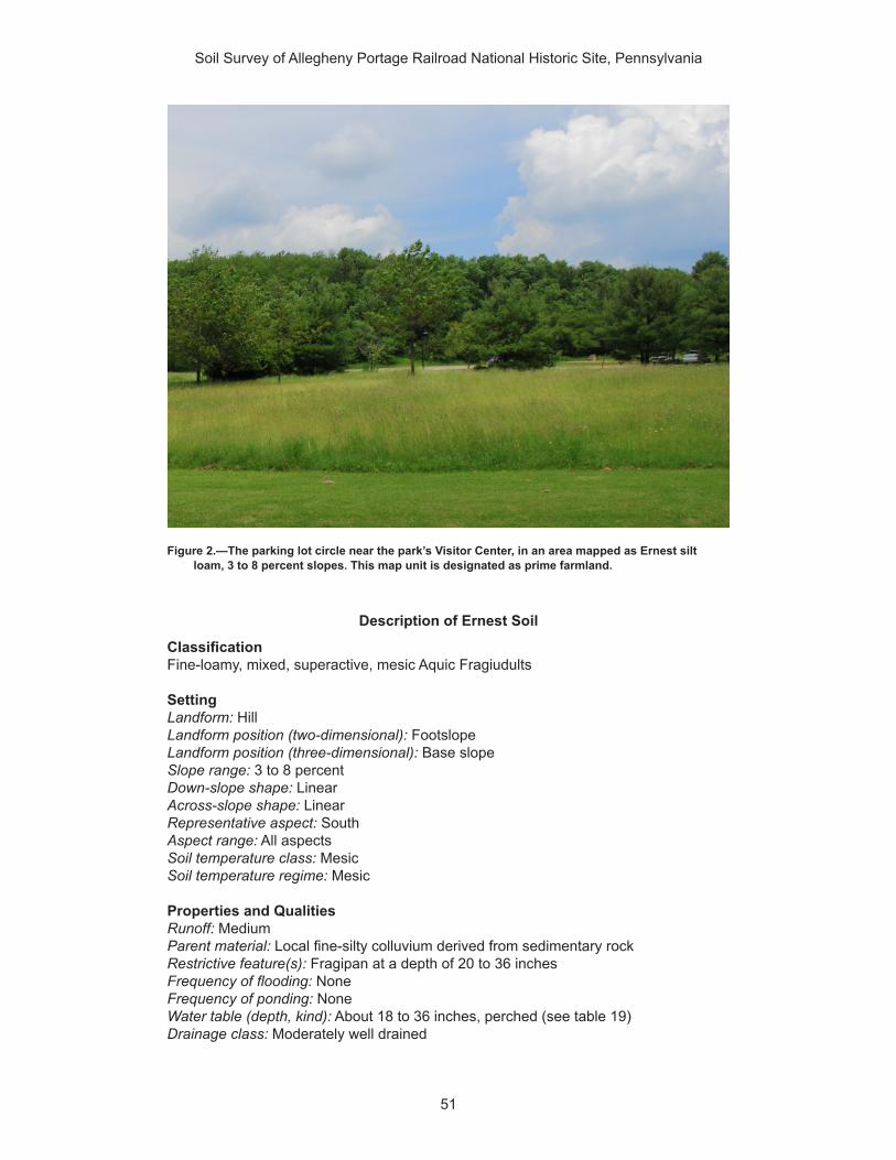
Soil Survey of Allegheny Portage Railroad National Historic Site, Pennsylvania
51
Description of Ernest Soil
ClassificationFine-loamy, mixed, superactive, mesic Aquic Fragiudults
SettingLandform: HillLandform position (two-dimensional): FootslopeLandform position (three-dimensional): Base slopeSlope range: 3 to 8 percentDown-slope shape: LinearAcross-slope shape: LinearRepresentative aspect: SouthAspect range: All aspectsSoil temperature class: MesicSoil temperature regime: Mesic
Properties and QualitiesRunoff: MediumParent material: Local fine-silty colluvium derived from sedimentary rockRestrictive feature(s): Fragipan at a depth of 20 to 36 inches Frequency of flooding: NoneFrequency of ponding: NoneWater table (depth, kind): About 18 to 36 inches, perched (see table 19)Drainage class: Moderately well drained
Figure 2.—The parking lot circle near the park’s Visitor Center, in an area mapped as Ernest silt loam, 3 to 8 percent slopes. This map unit is designated as prime farmland.
Soil Survey of Allegheny Portage Railroad National Historic Site, Pennsylvania
52
Shrink-swell potential: Moderate (about 4.5 LEP)Salinity maximum: Not salineSodicity maximum: Not sodicCalcium carbonate equivalent (maximum weight percentage): 0Available water capacity: Moderate (about 7.8 inches)
Interpretive GroupsLand capability subclass (nonirrigated): 2eMeets hydric soil criteria: NoHydrologic soil group: C
Typical Profile0 to 7 inches; silt loam7 to 27 inches; channery silty clay loam27 to 43 inches; channery silty clay loam43 to 65 inches; channery silt loam
Minor Components
Berks soilsPercent of map unit: 8 percentLandform: Valley and ridgeGeomorphic position (two-dimensional): BackslopeGeomorphic position (three-dimensional): Side slopeRepresentative aspect: SouthAspect range: All aspectsSlope range: 3 to 8 percentDown-slope shape: Convex and linearAcross-slope shape: Linear and convexMeets hydric soil criteria: No
Brinkerton soilsPercent of map unit: 5 percentLandform: DepressionGeomorphic position (two-dimensional): ToeslopeGeomorphic position (three-dimensional): Base slopeRepresentative aspect: SouthAspect range: All aspectsSlope range: 3 to 8 percentDown-slope shape: ConcaveAcross-slope shape: ConcaveMeets hydric soil criteria: Yes
Atkins soilsPercent of map unit: 2 percentLandform: Flood plainGeomorphic position (two-dimensional): ToeslopeGeomorphic position (three-dimensional): DipRepresentative aspect: SoutheastAspect range: All aspectsSlope range: 0 to 3 percentDown-slope shape: LinearAcross-slope shape: ConcaveMeets hydric soil criteria: Yes

Soil Survey of Allegheny Portage Railroad National Historic Site, Pennsylvania
53
542349—Ernest silt loam, 8 to 15 percent slopesMap Unit Setting
Major land resource area (MLRA): 147—Northern Appalachian Ridges and ValleysElevation: 295 to 2,995 feet Mean annual precipitation: 30 to 65 inchesMean annual air temperature: 46 to 59 degrees FFrost-free period: 120 to 214 days
Map Unit Composition
Ernest and similar soils: 85 percentDissimilar minor components: 15 percent
Description of Ernest Soil
ClassificationFine-loamy, mixed, superactive, mesic Aquic Fragiudults
SettingLandform: Hillslope in upland valleyLandform position (two-dimensional): BackslopeLandform position (three-dimensional): Side slopeSlope range: 8 to 15 percentDown-slope shape: Linear and convexAcross-slope shape: Linear and convexRepresentative aspect: SouthAspect range: All aspectsSoil temperature class: MesicSoil temperature regime: Mesic
Properties and QualitiesRunoff: MediumParent material: Local fine-silty colluvium derived from sedimentary rockRestrictive feature(s): Fragipan at a depth of 18 to 36 inchesFrequency of flooding: NoneFrequency of ponding: NoneWater table (depth, kind): About 18 to 36 inches, perched (see table 19)Drainage class: Moderately well drainedShrink-swell potential: Moderate (about 4.5 LEP)Salinity maximum: Not salineSodicity maximum: Not sodicCalcium carbonate equivalent (maximum weight percentage): 0Available water capacity: Moderate (about 7.8 inches)
Interpretive GroupsLand capability subclass (nonirrigated): 3eMeets hydric soil criteria: NoHydrologic soil group: C
Typical Profile0 to 10 inches; silt loam10 to 31 inches; silty clay loam31 to 43 inches; channery silt loam43 to 63 inches; channery silt loam
Soil Survey of Allegheny Portage Railroad National Historic Site, Pennsylvania
54
Minor Components
Berks soilsPercent of map unit: 5 percentRepresentative aspect: SouthAspect range: All aspectsSlope range: 8 to 15 percentMeets hydric soil criteria: No
Brinkerton soilsPercent of map unit: 5 percentLandform: DepressionGeomorphic position (two-dimensional): ToeslopeGeomorphic position (three-dimensional): Base slopeRepresentative aspect: SouthAspect range: All aspectsSlope range: 3 to 8 percentDown-slope shape: ConcaveAcross-slope shape: ConcaveMeets hydric soil criteria: Yes
Wharton soilsPercent of map unit: 3 percentLandform: HillGeomorphic position (two-dimensional): BackslopeGeomorphic position (three-dimensional): Head slope, side slope, and interfluveRepresentative aspect: SouthAspect range: All aspectsSlope range: 3 to 8 percentDown-slope shape: ConcaveAcross-slope shape: ConcaveMeets hydric soil criteria: No
Blairton soilsPercent of map unit: 2 percentRepresentative aspect: SouthAspect range: All aspectsSlope range: 8 to 15 percentMeets hydric soil criteria: No
542350—Gilpin channery silt loam, 3 to 8 percent slopesMap Unit Setting
Major land resource area (MLRA): 127—Eastern Allegheny Plateau and MountainsElevation: 800 to 1,695 feet Mean annual precipitation: 36 to 46 inchesMean annual air temperature: 41 to 62 degrees FFrost-free period: 130 to 160 days
Map Unit Composition
Gilpin and similar soils: 85 percentDissimilar minor components: 15 percent

Soil Survey of Allegheny Portage Railroad National Historic Site, Pennsylvania
55
Description of Gilpin Soil
ClassificationFine-loamy, mixed, active, mesic Typic Hapludults
SettingLandscape: UplandsLandform: HillLandform position (two-dimensional): Summit and shoulderLandform position (three-dimensional): InterfluveSlope range: 3 to 8 percentDown-slope shape: ConvexAcross-slope shape: Linear and convexRepresentative aspect: SoutheastAspect range: All aspectsSoil temperature class: MesicSoil temperature regime: Mesic
Properties and QualitiesRunoff: MediumParent material: Acid fine-loamy residuum weathered from shale and siltstoneRestrictive feature(s): Lithic bedrock at a depth of 20 to 40 inchesFrequency of flooding: NoneFrequency of ponding: NoneDepth to water table: More than 72 inchesDrainage class: Well drainedShrink-swell potential: Low (about 1.5 LEP)Salinity maximum: Not salineSodicity maximum: Not sodicCalcium carbonate equivalent (maximum weight percentage): 0Available water capacity: Low (about 4.5 inches)
Interpretive GroupsLand capability subclass (nonirrigated): 2eMeets hydric soil criteria: NoHydrologic soil group: C
VegetationExisting plants: Common pawpaw, flowering dogwood, eastern hophornbeam, Virginia
creeper, roundleaf greenbrier, eastern poison ivy, mapleleaf viburnum, and summer grape
Typical ProfileAp—0 to 8 inches; channery silt loamBt—8 to 24 inches; channery silt loamC—24 to 30 inches; very channery loamR—30 to 35 inches; bedrock
Minor Components
Wharton soilsPercent of map unit: 10 percentLandform: HillGeomorphic position (two-dimensional): Summit and backslopeGeomorphic position (three-dimensional): Base slopeRepresentative aspect: SoutheastAspect range: All aspectsSlope range: 3 to 8 percent

Soil Survey of Allegheny Portage Railroad National Historic Site, Pennsylvania
56
Down-slope shape: LinearAcross-slope shape: LinearMeets hydric soil criteria: No
Weikert soilsPercent of map unit: 5 percentLandform: HillGeomorphic position (two-dimensional): ShoulderGeomorphic position (three-dimensional): Nose slopeRepresentative aspect: SoutheastAspect range: All aspectsSlope range: 3 to 8 percentDown-slope shape: ConvexAcross-slope shape: ConvexMeets hydric soil criteria: No
542351—Gilpin channery silt loam, 8 to 15 percent slopesMap Unit Setting
Major land resource area (MLRA): 127—Eastern Allegheny Plateau and MountainsElevation: 800 to 1,695 feet Mean annual precipitation: 36 to 46 inchesMean annual air temperature: 41 to 62 degrees FFrost-free period: 130 to 160 days
Map Unit Composition
Gilpin and similar soils: 85 percentDissimilar minor components: 15 percent
Description of Gilpin Soil
ClassificationFine-loamy, mixed, active, mesic Typic Hapludults
SettingLandscape: UplandsLandform: HillslopeLandform position (two-dimensional): Summit, shoulder, and backslopeLandform position (three-dimensional): Side slopeSlope range: 8 to 15 percentDown-slope shape: ConvexAcross-slope shape: Linear and convexRepresentative aspect: SoutheastAspect range: All aspectsSoil temperature class: MesicSoil temperature regime: Mesic
Properties and QualitiesRunoff: MediumParent material: Acid fine-loamy residuum weathered from shale and siltstoneRestrictive feature(s): Lithic bedrock at a depth of 20 to 40 inchesFrequency of flooding: NoneFrequency of ponding: NoneDepth to water table: More than 72 inchesDrainage class: Well drainedShrink-swell potential: Low (about 1.5 LEP)

Soil Survey of Allegheny Portage Railroad National Historic Site, Pennsylvania
57
Salinity maximum: Not salineSodicity maximum: Not sodicCalcium carbonate equivalent (maximum weight percentage): 0Available water capacity: Low (about 4.5 inches)
Interpretive GroupsLand capability subclass (nonirrigated): 3eMeets hydric soil criteria: NoHydrologic soil group: C
VegetationExisting plants: Common pawpaw, flowering dogwood, eastern hophornbeam, Virginia
creeper, roundleaf greenbrier, eastern poison ivy, mapleleaf viburnum, and summer grape
Typical ProfileAp—0 to 8 inches; channery silt loamBt—8 to 24 inches; channery silt loamC—24 to 30 inches; very channery loamR—30 to 35 inches; bedrock
Minor Components
Wharton soilsPercent of map unit: 10 percentLandform: HillslopeGeomorphic position (two-dimensional): Summit and backslopeGeomorphic position (three-dimensional): InterfluveRepresentative aspect: SoutheastAspect range: All aspectsSlope range: 8 to 15 percentDown-slope shape: LinearAcross-slope shape: ConcaveMeets hydric soil criteria: No
Weikert soilsPercent of map unit: 5 percentLandform: HillslopeGeomorphic position (two-dimensional): ShoulderGeomorphic position (three-dimensional): Nose slopeRepresentative aspect: SoutheastAspect range: All aspectsSlope range: 8 to 15 percentDown-slope shape: ConvexAcross-slope shape: ConvexMeets hydric soil criteria: No
542352—Gilpin channery silt loam, 15 to 25 percent slopes
Map Unit Setting
Major land resource area (MLRA): 127—Eastern Allegheny Plateau and MountainsElevation: 800 to 1,695 feet Mean annual precipitation: 36 to 46 inchesMean annual air temperature: 41 to 62 degrees FFrost-free period: 130 to 160 days
Soil Survey of Allegheny Portage Railroad National Historic Site, Pennsylvania
58
Map Unit Composition
Gilpin and similar soils: 85 percentDissimilar minor components: 15 percent
Description of Gilpin Soil
ClassificationFine-loamy, mixed, active, mesic Typic Hapludults
SettingLandscape: UplandsLandform: HillslopeLandform position (two-dimensional): Shoulder and backslopeLandform position (three-dimensional): Side slopeSlope range: 15 to 25 percentDown-slope shape: ConvexAcross-slope shape: Linear and convexRepresentative aspect: SoutheastAspect range: All aspectsSoil temperature class: MesicSoil temperature regime: Mesic
Properties and QualitiesRunoff: HighParent material: Acid fine-loamy residuum weathered from shale and siltstoneRestrictive feature(s): Lithic bedrock at a depth of 20 to 40 inchesFrequency of flooding: NoneFrequency of ponding: NoneDepth to water table: More than 72 inchesDrainage class: Well drainedShrink-swell potential: Low (about 1.5 LEP)Salinity maximum: Not salineSodicity maximum: Not sodicCalcium carbonate equivalent (maximum weight percentage): 0Available water capacity: Low (about 4.3 inches)
Interpretive GroupsLand capability subclass (nonirrigated): 4eMeets hydric soil criteria: NoHydrologic soil group: C
VegetationExisting plants: Common pawpaw, flowering dogwood, eastern hophornbeam, Virginia
creeper, roundleaf greenbrier, eastern poison ivy, mapleleaf viburnum, and summer grape
Typical ProfileAp—0 to 8 inches; channery silt loamBt—8 to 24 inches; channery silt loamC—24 to 30 inches; very channery loamR—30 to 35 inches; bedrock
Minor Components
Weikert soilsPercent of map unit: 10 percentLandform: HillslopeGeomorphic position (two-dimensional): Shoulder and backslope

Soil Survey of Allegheny Portage Railroad National Historic Site, Pennsylvania
59
Geomorphic position (three-dimensional): Nose slopeRepresentative aspect: SoutheastAspect range: All aspectsSlope range: 15 to 25 percentDown-slope shape: ConvexAcross-slope shape: ConvexMeets hydric soil criteria: No
Wharton soilsPercent of map unit: 5 percentLandform: HillslopeGeomorphic position (two-dimensional): BackslopeGeomorphic position (three-dimensional): Side slopeRepresentative aspect: SoutheastAspect range: All aspectsSlope range: 15 to 25 percentDown-slope shape: LinearAcross-slope shape: LinearMeets hydric soil criteria: No
542366—Leck Kill channery silt loam, very steepMap Unit Setting
Major land resource area (MLRA): 147—Northern Appalachian Ridges and ValleysElevation: 495 to 2,795 feet Mean annual precipitation: 34 to 48 inchesMean annual air temperature: 45 to 55 degrees FFrost-free period: 130 to 190 days
Map Unit Composition
Leck Kill and similar soils: 90 percentDissimilar minor components: 10 percent
Description of Leck Kill Soil
ClassificationFine-loamy, mixed, semiactive, mesic Typic Hapludults
SettingLandform: Mountain slopeLandform position (two-dimensional): BackslopeLandform position (three-dimensional): Mountain flankSlope range: 25 to 60 percentDown-slope shape: ConvexAcross-slope shape: ConvexRepresentative aspect: SoutheastAspect range: All aspectsSoil temperature class: MesicSoil temperature regime: Mesic
Properties and QualitiesRunoff: MediumParent material: Reddish residuum derived from sedimentary rockRestrictive feature(s): Lithic bedrock at a depth of 40 to 60 inchesFrequency of flooding: None

Soil Survey of Allegheny Portage Railroad National Historic Site, Pennsylvania
60
Frequency of ponding: NoneDepth to water table: More than 72 inchesDrainage class: Well drainedShrink-swell potential: Low (about 1.5 LEP)Salinity maximum: Not salineSodicity maximum: Not sodicCalcium carbonate equivalent (maximum weight percentage): 0Available water capacity: Low (about 6.0 inches)
Interpretive GroupsLand capability subclass (nonirrigated): 7eMeets hydric soil criteria: NoHydrologic soil group: B
Typical Profile0 to 12 inches; channery silt loam12 to 38 inches; channery silty clay loam38 to 45 inches; very channery silt loam45 to 49 inches; bedrock
Minor Components
Meckesville soilsPercent of map unit: 10 percentLandform: Mountain valleyGeomorphic position (two-dimensional): FootslopeGeomorphic position (three-dimensional): Lower third of mountain flankRepresentative aspect: NorthSlope range: 15 to 25 percentDown-slope shape: ConcaveAcross-slope shape: LinearMeets hydric soil criteria: No
542370—Laidig extremely stony loam, 3 to 8 percent slopes
Map Unit Setting
Major land resource area (MLRA): 147—Northern Appalachian Ridges and ValleysElevation: 400 to 3,795 feet Mean annual precipitation: 34 to 46 inchesMean annual air temperature: 46 to 57 degrees FFrost-free period: 120 to 175 days
Map Unit Composition
Laidig and similar soils: 90 percentDissimilar minor components: 5 percent
Description of Laidig Soil
ClassificationFine-loamy, siliceous, active, mesic Typic Fragiudults
SettingLandform: MountainLandform position (two-dimensional): FootslopeLandform position (three-dimensional): Lower third of mountain flank

Soil Survey of Allegheny Portage Railroad National Historic Site, Pennsylvania
61
Slope range: 3 to 8 percentDown-slope shape: ConcaveAcross-slope shape: LinearRepresentative aspect: SoutheastAspect range: All aspectsSoil temperature class: MesicSoil temperature regime: Mesic
Properties and QualitiesRunoff: MediumParent material: Mountain slope colluvium derived from sedimentary rockRestrictive feature(s): Fragipan at a depth of 18 to 36 inchesFrequency of flooding: NoneFrequency of ponding: NoneWater table (depth, kind): About 30 to 48 inches, perched (see table 19)Drainage class: Well drainedShrink-swell potential: Low (about 1.5 LEP)Salinity maximum: Not salineSodicity maximum: Not sodicCalcium carbonate equivalent (maximum weight percentage): 0Available water capacity: Moderate (about 6.3 inches)
Interpretive GroupsLand capability subclass (nonirrigated): 7sMeets hydric soil criteria: NoHydrologic soil group: C
Typical Profile0 to 6 inches; channery loam6 to 32 inches; channery loam32 to 71 inches; very channery loam
Minor Components
Buchanan soilsPercent of map unit: 5 percentRepresentative aspect: NorthSlope range: 3 to 8 percentMeets hydric soil criteria: No
542371—Laidig extremely stony loam, 8 to 25 percent slopes
Map Unit Setting
Major land resource area (MLRA): 147—Northern Appalachian Ridges and ValleysElevation: 400 to 3,795 feet Mean annual precipitation: 34 to 46 inchesMean annual air temperature: 46 to 57 degrees FFrost-free period: 120 to 175 days
Map Unit Composition
Laidig and similar soils: 90 percentDissimilar minor components: 5 percent

Soil Survey of Allegheny Portage Railroad National Historic Site, Pennsylvania
62
Description of Laidig Soil
ClassificationFine-loamy, siliceous, active, mesic Typic Fragiudults
SettingLandform: MountainSlope range: 15 to 25 percentRepresentative aspect: NorthSoil temperature class: MesicSoil temperature regime: Mesic
Properties and QualitiesRunoff: HighParent material: Colluvium derived from sandstone and siltstoneRestrictive feature(s): Fragipan at a depth of 30 to 50 inchesFrequency of flooding: NoneFrequency of ponding: NoneWater table (depth, kind): About 30 to 48 inches, perched (see table 19)Drainage class: Well drainedShrink-swell potential: Low (about 1.5 LEP)Salinity maximum: Not salineSodicity maximum: Not sodicCalcium carbonate equivalent (maximum weight percentage): 0Available water capacity: Moderate (about 6.3 inches)
Interpretive GroupsLand capability subclass (nonirrigated): 7sMeets hydric soil criteria: NoHydrologic soil group: C
Typical Profile0 to 6 inches; channery loam6 to 32 inches; channery loam32 to 71 inches; very channery loam
Minor Components
Buchanan soilsPercent of map unit: 5 percentRepresentative aspect: NorthSlope range: 15 to 25 percentMeets hydric soil criteria: No
542372—Laidig extremely stony loam, 25 to 45 percent slopes
Map Unit Setting
Major land resource area (MLRA): 147—Northern Appalachian Ridges and ValleysElevation: 400 to 3,795 feet Mean annual precipitation: 34 to 55 inchesMean annual air temperature: 46 to 57 degrees FFrost-free period: 110 to 180 days
Map Unit Composition
Laidig and similar soils: 90 percentDissimilar minor components: 10 percent

Soil Survey of Allegheny Portage Railroad National Historic Site, Pennsylvania
63
Description of Laidig Soil
ClassificationFine-loamy, siliceous, active, mesic Typic Fragiudults
SettingLandform: MountainLandform position (two-dimensional): FootslopeLandform position (three-dimensional): Lower third of mountain flankSlope range: 35 to 45 percentDown-slope shape: ConcaveAcross-slope shape: ConcaveRepresentative aspect: SoutheastAspect range: All aspectsSoil temperature class: MesicSoil temperature regime: Mesic
Properties and QualitiesRunoff: HighParent material: Colluvium derived from sandstone and siltstoneRestrictive feature(s): Fragipan at a depth of 18 to 36 inchesFrequency of flooding: NoneFrequency of ponding: NoneWater table (depth, kind): About 30 to 48 inches, perched (see table 19)Drainage class: Well drainedShrink-swell potential: Low (about 1.5 LEP)Salinity maximum: Not salineSodicity maximum: Not sodicCalcium carbonate equivalent (maximum weight percentage): 0Available water capacity: Moderate (about 6.3 inches)
Interpretive GroupsLand capability subclass (nonirrigated): 7sMeets hydric soil criteria: NoHydrologic soil group: C
Typical Profile0 to 6 inches; channery loam6 to 32 inches; channery loam32 to 71 inches; very channery loam
Minor Components
Hazleton soilsPercent of map unit: 10 percentRepresentative aspect: NorthSlope range: 35 to 70 percentMeets hydric soil criteria: No
542375—Leck Kill channery silt loam, 15 to 25 percent slopes
Map Unit Setting
Major land resource area (MLRA): 147—Northern Appalachian Ridges and ValleysElevation: 295 to 2,795 feet Mean annual precipitation: 34 to 50 inches

Soil Survey of Allegheny Portage Railroad National Historic Site, Pennsylvania
64
Mean annual air temperature: 45 to 57 degrees FFrost-free period: 120 to 200 days
Map Unit Composition
Leck Kill and similar soils: 80 percentDissimilar minor components: 20 percent
Description of Leck Kill Soil
ClassificationFine-loamy, mixed, semiactive, mesic Typic Hapludults
SettingLandform: Shale hillslopeLandform position (two-dimensional): SummitLandform position (three-dimensional): InterfluveSlope range: 15 to 25 percentDown-slope shape: Convex and linearAcross-slope shape: Linear and convexRepresentative aspect: SouthAspect range: All aspectsSoil temperature class: MesicSoil temperature regime: Mesic
Properties and QualitiesRunoff: MediumParent material: Residuum weathered from shale and siltstoneRestrictive feature(s): Lithic bedrock at a depth of 40 to 80 inchesFrequency of flooding: NoneFrequency of ponding: NoneDepth to water table: More than 72 inchesDrainage class: Well drainedShrink-swell potential: Low (about 1.5 LEP)Salinity maximum: Not salineSodicity maximum: Not sodicCalcium carbonate equivalent (maximum weight percentage): 0Available water capacity: Moderate (about 7.1 inches)
Interpretive GroupsLand capability subclass (nonirrigated): 4eMeets hydric soil criteria: NoHydrologic soil group: B
Typical Profile0 to 10 inches; channery silt loam10 to 43 inches; channery silt loam43 to 58 inches; very channery silt loam58 to 62 inches; unweathered bedrock
Minor Components
Calvin soilsPercent of map unit: 10 percentRepresentative aspect: SouthAspect range: All aspectsSlope range: 15 to 25 percentMeets hydric soil criteria: No

Soil Survey of Allegheny Portage Railroad National Historic Site, Pennsylvania
65
Klinesville soilsPercent of map unit: 5 percentRepresentative aspect: SouthAspect range: All aspectsSlope range: 20 to 35 percentMeets hydric soil criteria: No
Meckesville soilsPercent of map unit: 5 percentLandform: Mountain valleyGeomorphic position (two-dimensional): FootslopeGeomorphic position (three-dimensional): Lower third of mountain flankRepresentative aspect: SouthAspect range: All aspectsSlope range: 15 to 25 percentDown-slope shape: ConcaveAcross-slope shape: LinearMeets hydric soil criteria: No
542383—Meckesville very stony silt loam, 3 to 8 percent slopes
Map Unit Setting
Major land resource area (MLRA): 147—Northern Appalachian Ridges and ValleysElevation: 600 to 2,795 feet Mean annual precipitation: 34 to 48 inchesMean annual air temperature: 46 to 55 degrees FFrost-free period: 130 to 210 days
Map Unit Composition
Meckesville and similar soils: 90 percentDissimilar minor components: 5 percent
Description of Meckesville Soil
ClassificationFine-loamy, mixed, active, mesic Typic Fragiudults
SettingLandform: Mountain valleyLandform position (two-dimensional): FootslopeLandform position (three-dimensional): Lower third of mountain flankSlope range: 3 to 8 percentDown-slope shape: ConcaveAcross-slope shape: LinearRepresentative aspect: SoutheastAspect range: All aspectsSoil temperature class: MesicSoil temperature regime: Mesic
Properties and QualitiesRunoff: MediumParent material: Sandstone, siltstone, and shale colluvium derived from sedimentary
rock

Soil Survey of Allegheny Portage Railroad National Historic Site, Pennsylvania
66
Restrictive feature(s): Fragipan at a depth of 25 to 48 inches; lithic bedrock at a depth of 72 to 99 inches
Frequency of flooding: NoneFrequency of ponding: NoneWater table (depth, kind): About 27 to 45 inches, perched (see table 19)Drainage class: Well drainedShrink-swell potential: Low (about 1.5 LEP)Salinity maximum: Not salineSodicity maximum: Not sodicCalcium carbonate equivalent (maximum weight percentage): 0Available water capacity: Moderate (about 7.1 inches)
Interpretive GroupsLand capability subclass (nonirrigated): 6sMeets hydric soil criteria: NoHydrologic soil group: C
Typical Profile0 to 7 inches; channery silt loam7 to 31 inches; gravelly silty clay loam31 to 60 inches; gravelly clay loam60 to 64 inches; gravelly clay loam
Minor Components
Albrights soilsPercent of map unit: 5 percentRepresentative aspect: NorthSlope range: 3 to 8 percentMeets hydric soil criteria: No
542384—Meckesville very stony silt loam, 8 to 25 percent slopes
Map Unit Setting
Major land resource area (MLRA): 147—Northern Appalachian Ridges and ValleysElevation: 600 to 2,795 feet Mean annual precipitation: 34 to 48 inchesMean annual air temperature: 46 to 55 degrees FFrost-free period: 130 to 210 days
Map Unit Composition
Meckesville and similar soils: 90 percentDissimilar minor components: 5 percent
Description of Meckesville Soil
ClassificationFine-loamy, mixed, active, mesic Typic Fragiudults
SettingLandform: Mountain slopeLandform position (two-dimensional): FootslopeLandform position (three-dimensional): Lower third of mountain flankSlope range: 15 to 25 percent

Soil Survey of Allegheny Portage Railroad National Historic Site, Pennsylvania
67
Down-slope shape: ConcaveAcross-slope shape: LinearRepresentative aspect: SoutheastAspect range: All aspectsSoil temperature class: MesicSoil temperature regime: Mesic
Properties and QualitiesRunoff: HighParent material: Sandstone, siltstone, and shale colluvium derived from sedimentary
rockRestrictive feature(s): Fragipan at a depth of 25 to 48 inches; lithic bedrock at a depth
of 72 to 99 inchesFrequency of flooding: NoneFrequency of ponding: NoneWater table (depth, kind): About 27 to 45 inches, perched (see table 19)Drainage class: Well drainedShrink-swell potential: Low (about 1.5 LEP)Salinity maximum: Not salineSodicity maximum: Not sodicCalcium carbonate equivalent (maximum weight percentage): 0Available water capacity: Moderate (about 7.1 inches)
Interpretive GroupsLand capability subclass (nonirrigated): 6sMeets hydric soil criteria: NoHydrologic soil group: C
Typical Profile0 to 7 inches; channery silt loam7 to 31 inches; gravelly silty clay loam31 to 60 inches; gravelly clay loam60 to 64 inches; gravelly clay loam
Minor Components
Albrights soilsPercent of map unit: 5 percentRepresentative aspect: NorthSlope range: 15 to 25 percentMeets hydric soil criteria: No
542406—Tyler silt loamMap Unit Setting
Major land resource area (MLRA): 127—Eastern Allegheny Plateau and MountainsElevation: 295 to 2,000 feet Mean annual precipitation: 35 to 55 inchesMean annual air temperature: 45 to 59 degrees FFrost-free period: 120 to 180 days
Map Unit Composition
Tyler and similar soils: 90 percentDissimilar minor components: 10 percent

Soil Survey of Allegheny Portage Railroad National Historic Site, Pennsylvania
68
Description of Tyler Soil
ClassificationFine-silty, mixed, active, mesic Aeric Fragiaquults
SettingLandform: TerraceLandform position (two-dimensional): ToeslopeLandform position (three-dimensional): TreadSlope range: 0 to 3 percentDown-slope shape: LinearAcross-slope shape: LinearRepresentative aspect: SouthAspect range: All aspectsSoil temperature class: MesicSoil temperature regime: Mesic
Properties and QualitiesRunoff: Very highParent material: Old alluvium derived from sedimentary rockRestrictive feature(s): Fragipan at a depth of 15 to 36 inchesFrequency of flooding: NoneFrequency of ponding: NoneWater table (depth, kind): About 6 to 18 inches, perched (see table 19)Drainage class: Somewhat poorly drainedShrink-swell potential: Moderate (about 4.5 LEP)Salinity maximum: Not salineSodicity maximum: Not sodicCalcium carbonate equivalent (maximum weight percentage): 0Available water capacity: Moderate (about 6.9 inches)
Interpretive GroupsLand capability subclass (nonirrigated): 3wMeets hydric soil criteria: NoHydrologic soil group: D
Typical Profile0 to 9 inches; silt loam9 to 19 inches; silty clay loam19 to 50 inches; silty clay loam50 to 60 inches; stratified gravelly loam to silty clay loam
Minor Components
Monongahela soilsPercent of map unit: 5 percentRepresentative aspect: SouthAspect range: All aspectsSlope range: 0 to 3 percentMeets hydric soil criteria: No
Purdy soilsPercent of map unit: 5 percentLandform: DepressionGeomorphic position (two-dimensional): ToeslopeRepresentative aspect: SouthAspect range: All aspectsSlope range: 0 to 3 percent

Soil Survey of Allegheny Portage Railroad National Historic Site, Pennsylvania
69
Down-slope shape: LinearAcross-slope shape: ConcaveMeets hydric soil criteria: Yes
542407—Udifluvents-Dystrochrepts complexMap Unit Setting
Major land resource area (MLRA): 127—Eastern Allegheny Plateau and MountainsElevation: 200 to 1,295 feet Mean annual precipitation: 30 to 50 inchesMean annual air temperature: 45 to 55 degrees FFrost-free period: 120 to 214 days
Map Unit Composition
Udifluvents and similar soils: 50 percentDystrochrepts and similar soils: 30 percentDissimilar minor components: 4 percent
Description of Udifluvents
ClassificationUdifluvents
SettingLandform: Flood plainLandform position (two-dimensional): ToeslopeLandform position (three-dimensional): Base slopeSlope range: 0 to 3 percentDown-slope shape: LinearAcross-slope shape: LinearRepresentative aspect: SoutheastAspect range: All aspects
Properties and QualitiesRunoff: LowParent material: AlluviumRestrictive feature(s): None within a depth of 60 inchesFrequency of flooding: FrequentFrequency of ponding: NoneDepth to water table: About 36 inches (see table 19)Drainage class: Moderately well drainedShrink-swell potential: Low (about 1.5 LEP)Salinity maximum: Not salineSodicity maximum: Not sodicCalcium carbonate equivalent (maximum weight percentage): 0Available water capacity: Moderate (about 6.1 inches)
Interpretive GroupsLand capability subclass (nonirrigated): 7sMeets hydric soil criteria: NoHydrologic soil group: B
Typical Profile0 to 6 inches; channery silt loam6 to 42 inches; gravelly loam42 to 60 inches; silt loam

Soil Survey of Allegheny Portage Railroad National Historic Site, Pennsylvania
70
Description of Dystrochrepts
ClassificationDystrochrepts
SettingLandform: Mountain slopeLandform position (two-dimensional): BackslopeLandform position (three-dimensional): Mountain flankSlope range: 0 to 3 percentDown-slope shape: Linear and convexAcross-slope shape: Linear and convexRepresentative aspect: SoutheastAspect range: All aspects
Properties and QualitiesRunoff: LowParent material: Residuum weathered from sandstone and shaleRestrictive feature(s): None within a depth of 60 inchesFrequency of flooding: FrequentFrequency of ponding: NoneDepth to water table: About 36 inches (see table 19)Drainage class: Moderately well drainedShrink-swell potential: Low (about 1.5 LEP)Salinity maximum: Not salineSodicity maximum: Not sodicCalcium carbonate equivalent (maximum weight percentage): 0Available water capacity: Low (about 6.0 inches)
Interpretive GroupsLand capability subclass (nonirrigated): 7sMeets hydric soil criteria: NoHydrologic soil group: B
Typical Profile0 to 6 inches; loam with flagstones6 to 42 inches; gravelly loam42 to 60 inches; silt loam
Minor Components
Brinkerton soilsPercent of map unit: 2 percentLandform: HillGeomorphic position (two-dimensional): FootslopeGeomorphic position (three-dimensional): Base slopeRepresentative aspect: SoutheastAspect range: All aspectsSlope range: 8 to 15 percentDown-slope shape: ConcaveAcross-slope shape: ConcaveMeets hydric soil criteria: Yes
Holly soilsPercent of map unit: 2 percentLandform: Depression on flood plain and backswampGeomorphic position (two-dimensional): ToeslopeGeomorphic position (three-dimensional): Base slope

Soil Survey of Allegheny Portage Railroad National Historic Site, Pennsylvania
71
Representative aspect: SoutheastAspect range: All aspectsSlope range: 0 to 3 percentDown-slope shape: ConcaveAcross-slope shape: LinearMeets hydric soil criteria: Yes
542410—Urban land-Berks complex, 8 to 25 percent slopes
Map Unit Setting
Major land resource area (MLRA): 147—Northern Appalachian Ridges and ValleysElevation: 295 to 1,495 feet Mean annual precipitation: 35 to 50 inchesMean annual air temperature: 44 to 57 degrees FFrost-free period: 120 to 214 days
Map Unit Composition
Urban land: 65 percentBerks and similar soils: 25 percentDissimilar minor components: 10 percent
Description of Urban Land
Urban land consists of residential, commercial, and institutional land; construction sites; public administrative sites; railroad yards; cemeteries; airports; golf courses; sanitary landfills; sewage treatment plants; water-control structures and spillways; small parks (less than 10 acres in size) within urban and built-up areas; and highways, railroads, and other transportation facitilies, if they are surrounded by urban areas.
Description of Berks Soil
ClassificationLoamy-skeletal, mixed, active, mesic Typic Dystrudepts
SettingLandform: Valley and ridgeLandform position (two-dimensional): BackslopeLandform position (three-dimensional): Side slopeSlope range: 8 to 25 percentDown-slope shape: Convex and linearAcross-slope shape: Linear and convexRepresentative aspect: SouthAspect range: All aspectsSoil temperature class: MesicSoil temperature regime: MesicSoil moisture class: Udic
Properties and QualitiesRunoff: LowParent material: Acid brown residuum weathered from shale and siltstoneRestrictive feature(s): Lithic bedrock at a depth of 20 to 40 inchesFrequency of flooding: NoneFrequency of ponding: NoneDepth to water table: More than 72 inchesDrainage class: Well drained

Soil Survey of Allegheny Portage Railroad National Historic Site, Pennsylvania
72
Shrink-swell potential: Low (about 1.5 LEP)Salinity maximum: Not salineSodicity maximum: Not sodicCalcium carbonate equivalent (maximum weight percentage): 0Available water capacity: Very low (about 2.6 inches)
Interpretive GroupsLand capability subclass (nonirrigated): 4eMeets hydric soil criteria: NoHydrologic soil group: C
Typical ProfileAp—0 to 10 inches; channery loamBw—10 to 26 inches; very channery silt loamC—26 to 33 inches; extremely channery loamR—33 to 43 inches; bedrock
Minor Components
Brinkerton soilsPercent of map unit: 5 percentLandform: DepressionGeomorphic position (two-dimensional): FootslopeGeomorphic position (three-dimensional): Head slopeRepresentative aspect: SoutheastAspect range: All aspectsSlope range: 3 to 8 percentDown-slope shape: ConcaveAcross-slope shape: ConcaveMeets hydric soil criteria: Yes
Comly soilsPercent of map unit: 5 percentLandform: Shale hillGeomorphic position (two-dimensional): FootslopeGeomorphic position (three-dimensional): Base slopeRepresentative aspect: SoutheastAspect range: All aspectsSlope range: 3 to 8 percentDown-slope shape: Concave and linearAcross-slope shape: Linear and concaveMeets hydric soil criteria: No
542420—Wharton silt loam, 3 to 8 percent slopesMap Unit Setting
Major land resource area (MLRA): 127—Eastern Allegheny Plateau and MountainsElevation: 800 to 1,800 feet Mean annual precipitation: 36 to 46 inchesMean annual air temperature: 41 to 62 degrees FFrost-free period: 130 to 160 days
Map Unit Composition
Wharton and similar soils: 80 percentDissimilar minor components: 20 percent

Soil Survey of Allegheny Portage Railroad National Historic Site, Pennsylvania
73
Description of Wharton Soil
ClassificationFine-loamy, mixed, active, mesic Aquic Hapludults
SettingLandscape: UplandsLandform: HillLandform position (two-dimensional): Summit and backslopeLandform position (three-dimensional): Base slopeSlope range: 3 to 8 percentDown-slope shape: LinearAcross-slope shape: LinearRepresentative aspect: SoutheastAspect range: All aspectsSoil temperature class: MesicSoil temperature regime: Mesic
Properties and QualitiesRunoff: MediumParent material: Acid fine-loamy residuum weathered from shale and siltstoneRestrictive feature(s): Lithic bedrock at a depth of 40 to 72 inchesFrequency of flooding: NoneFrequency of ponding: NoneWater table (depth, kind): About 18 to 36 inches, perched (see table 19)Drainage class: Moderately well drainedShrink-swell potential: Moderate (about 4.5 LEP)Salinity maximum: Not salineSodicity maximum: Not sodicCalcium carbonate equivalent (maximum weight percentage): 0Available water capacity: High (about 9.1 inches)
Interpretive GroupsLand capability subclass (nonirrigated): 2eMeets hydric soil criteria: NoHydrologic soil group: C/D
Typical ProfileAp—0 to 9 inches; silt loamBt—9 to 46 inches; silty clay loamC—46 to 69 inches; channery silty clay loamR—69 to 75 inches; bedrock
Minor Components
Gilpin soilsPercent of map unit: 7 percentLandform: HillGeomorphic position (two-dimensional): Summit and shoulderGeomorphic position (three-dimensional): InterfluveRepresentative aspect: SoutheastAspect range: All aspectsSlope range: 3 to 8 percentDown-slope shape: ConvexAcross-slope shape: Linear and convexMeets hydric soil criteria: No

Soil Survey of Allegheny Portage Railroad National Historic Site, Pennsylvania
74
Cavode soilsPercent of map unit: 5 percentLandform: HillGeomorphic position (two-dimensional): Summit and backslopeGeomorphic position (three-dimensional): InterfluveRepresentative aspect: SoutheastAspect range: All aspectsSlope range: 3 to 8 percentDown-slope shape: Linear and concaveAcross-slope shape: ConcaveMeets hydric soil criteria: No
Ernest soilsPercent of map unit: 5 percentLandform: HillslopeGeomorphic position (two-dimensional): ToeslopeGeomorphic position (three-dimensional): Head slopeRepresentative aspect: SoutheastAspect range: All aspectsSlope range: 3 to 8 percentDown-slope shape: ConcaveAcross-slope shape: ConcaveMeets hydric soil criteria: No
Brinkerton soilsPercent of map unit: 3 percentLandform: Hill and drawsGeomorphic position (two-dimensional): Footslope and toeslopeGeomorphic position (three-dimensional): Base slope and head slopeRepresentative aspect: SoutheastAspect range: All aspectsSlope range: 3 to 8 percentDown-slope shape: Linear and concaveAcross-slope shape: Linear and concaveMeets hydric soil criteria: Yes
542421—Wharton silt loam, 8 to 15 percent slopesMap Unit Setting
Major land resource area (MLRA): 127—Eastern Allegheny Plateau and MountainsElevation: 800 to 1,800 feet Mean annual precipitation: 36 to 46 inchesMean annual air temperature: 41 to 62 degrees FFrost-free period: 130 to 160 days
Map Unit Composition
Wharton and similar soils: 75 percentDissimilar minor components: 25 percent
Description of Wharton Soil
ClassificationFine-loamy, mixed, active, mesic Aquic Hapludults
SettingLandscape: Uplands

Soil Survey of Allegheny Portage Railroad National Historic Site, Pennsylvania
75
Landform: HillslopeLandform position (two-dimensional): Summit and backslopeLandform position (three-dimensional): InterfluveSlope range: 8 to 15 percentDown-slope shape: LinearAcross-slope shape: ConcaveRepresentative aspect: SoutheastAspect range: All aspectsSoil temperature class: MesicSoil temperature regime: Mesic
Properties and QualitiesRunoff: MediumParent material: Acid fine-loamy residuum weathered from shale and siltstoneRestrictive feature(s): Lithic bedrock at a depth of 40 to 72 inchesFrequency of flooding: NoneFrequency of ponding: NoneWater table (depth, kind): About 18 to 36 inches, perched (see table 19)Drainage class: Moderately well drainedShrink-swell potential: Moderate (about 4.5 LEP)Salinity maximum: Not salineSodicity maximum: Not sodicCalcium carbonate equivalent (maximum weight percentage): 0Available water capacity: High (about 9.1 inches)
Interpretive GroupsLand capability subclass (nonirrigated): 3eMeets hydric soil criteria: NoHydrologic soil group: C/D
Typical ProfileAp—0 to 9 inches; silt loamBt—9 to 46 inches; silty clay loamC—46 to 69 inches; channery silty clay loamR—69 to 75 inches; bedrock
Minor Components
Gilpin soilsPercent of map unit: 12 percentLandform: HillslopeGeomorphic position (two-dimensional): Summit, shoulder, and backslopeGeomorphic position (three-dimensional): Side slopeRepresentative aspect: SoutheastAspect range: All aspectsSlope range: 8 to 15 percentDown-slope shape: ConvexAcross-slope shape: Linear and convexMeets hydric soil criteria: No
Cavode soilsPercent of map unit: 5 percentLandform: HillslopeGeomorphic position (two-dimensional): Summit and backslopeGeomorphic position (three-dimensional): Side slopeRepresentative aspect: SoutheastAspect range: All aspects

Soil Survey of Allegheny Portage Railroad National Historic Site, Pennsylvania
76
Slope range: 8 to 15 percentDown-slope shape: Linear and concaveAcross-slope shape: ConcaveMeets hydric soil criteria: No
Ernest soilsPercent of map unit: 5 percentLandform: HillslopeGeomorphic position (two-dimensional): FootslopeGeomorphic position (three-dimensional): Base slopeRepresentative aspect: SoutheastAspect range: All aspectsSlope range: 8 to 15 percentDown-slope shape: ConcaveAcross-slope shape: ConcaveMeets hydric soil criteria: No
Brinkerton soilsPercent of map unit: 3 percentLandform: Hill and drawsGeomorphic position (two-dimensional): Footslope and toeslopeGeomorphic position (three-dimensional): Base slope and head slopeRepresentative aspect: SoutheastAspect range: All aspectsSlope range: 3 to 8 percentDown-slope shape: Linear and concaveAcross-slope shape: Linear and concaveMeets hydric soil criteria: Yes

77
This soil survey is an inventory and evaluation of the soils within Allegheny Portage Railroad National Historic Site. It can be used to adjust land uses to the limitations and potentials of natural resources and the environment. Also, it can help to prevent soil-related failures in land uses.
In preparing a soil survey, soil scientists, conservationists, engineers, and others collect extensive field data about the nature and behavioral characteristics of the soils. They collect data on erosion, droughtiness, flooding, and other factors that affect various soil uses and management. Field experience and collected data on soil properties and performance are used as a basis in predicting soil behavior.
Information in this section can be used to plan the use and management of soils as rangeland and as sites for buildings, sanitary facilities, highways and other transportation systems, and recreational facilities. It can be used to identify the potentials and limitations of each soil for specific land uses and to help prevent construction failures caused by unfavorable soil properties.
Planners and others using soil survey information can evaluate the effect of specific land uses on productivity and on the environment in all or part of the park. The survey can help planners to maintain or create a land use pattern in harmony with the natural soil.
Contractors can use this survey to locate sources of sand and gravel, roadfill, and topsoil. They can use it to identify areas where bedrock, wetness, or very firm soil layers can cause difficulty in excavation.
Health officials, highway officials, engineers, and others may also find this survey useful. The survey can help them plan the safe disposal of wastes and locate sites for pavements, sidewalks, campgrounds, playgrounds, and trees and shrubs.
Interpretive RatingsThe interpretive tables in this survey rate the soils in the park for various uses.
Many of the tables identify the limitations that affect specified uses and indicate the severity of those limitations. The ratings in these tables are both verbal and numerical.
Rating Class TermsRating classes are expressed in the tables in terms that indicate the extent to which
the soils are limited by all of the soil features that affect a specified use or in terms that indicate the suitability of the soils for the use. Thus, the tables may show limitation classes or suitability classes. Terms for the limitation classes are not limited, slightly limited, somewhat limited, and very limited. The suitability ratings are expressed as well suited, moderately well suited, poorly suited, and unsuited or as good, fair, and poor.
Numerical RatingsNumerical ratings in the tables indicate the relative severity of individual limitations.
The ratings are shown as decimal fractions ranging from 0.00 to 1.00. They indicate gradations between the point at which a soil feature has the greatest negative impact
Use and Management of the Soils
Soil Survey of Allegheny Portage Railroad National Historic Site, Pennsylvania
78
on the use and the point at which the soil feature is not a limitation. The limitations appear in order from the most limiting to the least limiting. Thus, if more than one limitation is identified, the most severe limitation is listed first and the least severe one is listed last.
Land Capability ClassificationLand capability classification shows, in a general way, the suitability of soils for
most kinds of field crops. Crops that require special management are excluded. The soils are grouped according to their limitations for field crops, the risk of damage if they are used for crops, and the way they respond to management. The criteria used in grouping the soils do not include major and generally expensive landforming that would change slope, depth, or other characteristics of the soils, nor do they include possible but unlikely major reclamation projects. Capability classification is not a substitute for interpretations designed to show suitability and limitations of groups of soils for rangeland, for forestland, or for engineering purposes.
In the capability system, soils are generally grouped at three levels—capability class, subclass, and unit (USDA-SCS, 1961). Only class and subclass are used in this survey.
Capability classes, the broadest groups, are designated by the numbers 1 through 8. The numbers indicate progressively greater limitations and narrower choices for practical use. The classes are defined as follows:
Class 1 soils have slight limitations that restrict their use.Class 2 soils have moderate limitations that restrict the choice of plants or that
require moderate conservation practices.Class 3 soils have severe limitations that restrict the choice of plants or that require
special conservation practices, or both.Class 4 soils have very severe limitations that restrict the choice of plants or that
require very careful management, or both.Class 5 soils are subject to little or no erosion but have other limitations, impractical
to remove, that restrict their use mainly to pasture, rangeland, forestland, or wildlife habitat.
Class 6 soils have severe limitations that make them generally unsuitable for cultivation and that restrict their use mainly to pasture, rangeland, forestland, or wildlife habitat.
Class 7 soils have very severe limitations that make them unsuitable for cultivation and that restrict their use mainly to grazing, forestland, or wildlife habitat.
Class 8 soils and miscellaneous areas have limitations that preclude commercial plant production and that restrict their use to recreational purposes, wildlife habitat, watershed, or esthetic purposes.
Capability subclasses are soil groups within one class. They are designated by adding a small letter, e, w, s, or c, to the class numeral, for example, 2e. The letter e shows that the main hazard is the risk of erosion unless close-growing plant cover is maintained; w shows that water in or on the soil interferes with plant growth or cultivation (in some soils the wetness can be partly corrected by artificial drainage); s shows that the soil is limited mainly because it is shallow, droughty, or stony; and c, used in only some parts of the United States, shows that the chief limitation is climate that is very cold or very dry.
In class 1 there are no subclasses because the soils of this class have few limitations. Class 5 contains only the subclasses indicated by w, s, or c because the soils in class 5 are subject to little or no erosion. They have other limitations that restrict their use to pasture, rangeland, forestland, wildlife habitat, or recreation.
The capability classification of map units in this park is given in the section “Detailed Soil Map Units” and in table 2.

Soil Survey of Allegheny Portage Railroad National Historic Site, Pennsylvania
79
Prime and Other Important FarmlandTable 3 lists the map units in the park that are considered important farmlands.
Important farmlands consist of prime farmland, unique farmland, and farmland of statewide or local importance. This list does not constitute a recommendation for a particular land use.
In an effort to identify the extent and location of important farmlands, the Natural Resources Conservation Service, in cooperation with other interested Federal, State, and local government organizations, has inventoried land that can be used for the production of the Nation’s food supply.
Prime farmland is of major importance in meeting the Nation’s short- and long-range needs for food and fiber. Because the supply of high-quality farmland is limited, the U.S. Department of Agriculture recognizes that responsible levels of government, as well as individuals, should encourage and facilitate the wise use of our Nation’s prime farmland.
Prime farmland, as defined by the U.S. Department of Agriculture, is land that has the best combination of physical and chemical characteristics for producing food, feed, forage, fiber, and oilseed crops and is available for these uses. It could be cultivated land, pastureland, forestland, or other land, but it is not urban or built-up land or water areas. The soil quality, growing season, and moisture supply are those needed for the soil to economically produce sustained high yields of crops when proper management, including water management, and acceptable farming methods are applied. In general, prime farmland has an adequate and dependable supply of moisture from precipitation or irrigation, a favorable temperature and growing season, acceptable acidity or alkalinity, an acceptable salt and sodium content, and few or no rocks. The water supply is dependable and of adequate quality. Prime farmland is permeable to water and air. It is not excessively erodible or saturated with water for long periods, and it either is not frequently flooded during the growing season or is protected from flooding. Slope ranges mainly from 0 to 6 percent. More detailed information about the criteria for prime farmland is available at the local office of the Natural Resources Conservation Service.
For some soils identified as prime farmland, measures that overcome a hazard or limitation, such as flooding, wetness, and droughtiness, are needed. Onsite evaluation is needed to determine whether or not the hazard or limitation has been overcome by corrective measures.
A recent trend in land use in some areas has been the loss of some prime farmland to industrial and urban uses. The loss of prime farmland to other uses puts pressure on marginal lands, which generally are more erodible, droughty, and less productive and cannot be easily cultivated.
Unique farmland is land other than prime farmland that is used for the production of specific high-value food and fiber crops, such as citrus, tree nuts, olives, cranberries, and other fruits and vegetables. It has the special combination of soil quality, growing season, moisture supply, temperature, humidity, air drainage, elevation, and aspect needed for the soil to economically produce sustainable high yields of these crops when properly managed. The water supply is dependable and of adequate quality. Nearness to markets is an additional consideration. Unique farmland is not based on national criteria. It commonly is in areas where there is a special microclimate, such as the wine country in California.
In some areas, land that does not meet the criteria for prime or unique farmland is considered to be farmland of statewide importance for the production of food, feed, fiber, forage, and oilseed crops. The criteria for defining and delineating farmland of statewide importance are determined by the appropriate State agencies. Generally, this land includes areas of soils that nearly meet the requirements for prime farmland and that economically produce high yields of crops when treated and managed according to acceptable farming methods. Some areas may produce as high a yield

Soil Survey of Allegheny Portage Railroad National Historic Site, Pennsylvania
80
as prime farmland if conditions are favorable. Farmland of statewide importance may include tracts of land that have been designated for agriculture by State law.
In some areas that are not identified as having national or statewide importance, land is considered to be farmland of local importance for the production of food, feed, fiber, forage, and oilseed crops. This farmland is identified by the appropriate local agencies. Farmland of local importance may include tracts of land that have been designated for agriculture by local ordinance.
Hydric SoilsTable 4 lists the map unit components that are rated as hydric soils in the park. This
list can help in planning land uses; however, onsite investigation is recommended to determine the hydric soils on a specific site (National Research Council, 1995; USDA-NRCS, 2010).
The three essential characteristics of wetlands are hydrophytic vegetation, hydric soils, and wetland hydrology (Cowardin et al., 1979; U.S. Army Corps of Engineers, 1987; National Research Council, 1995; Tiner, 1985). Criteria for all of the characteristics must be met for areas to be identified as wetlands. Undrained hydric soils that have natural vegetation should support a dominant population of ecological wetland plant species. Hydric soils that have been converted to other uses should be capable of being restored to wetlands.
Hydric soils are defined by the National Technical Committee for Hydric Soils (NTCHS) as soils that formed under conditions of saturation, flooding, or ponding long enough during the growing season to develop anaerobic conditions in the upper part (Federal Register, 1994). These soils, under natural conditions, are either saturated or inundated long enough during the growing season to support the growth and reproduction of hydrophytic vegetation.
The NTCHS definition identifies general soil properties that are associated with wetness. In order to determine whether a specific soil is a hydric soil or nonhydric soil, however, more specific information, such as information about the depth and duration of the water table, is needed. Thus, criteria that identify those estimated soil properties unique to hydric soils have been established (Federal Register, 2002). These criteria are used to identify map unit components that normally are associated with wetlands. The criteria used are selected estimated soil properties that are described in “Soil Taxonomy” (Soil Survey Staff, 1999) and “Keys to Soil Taxonomy” (Soil Survey Staff, 2010) and in the “Soil Survey Manual” (Soil Survey Division Staff, 1993).
If soils are wet enough for a long enough period of time to be considered hydric, they should exhibit certain properties that can be easily observed in the field. These visible properties are indicators of hydric soils. The indicators used to make onsite determinations of hydric soils are specified in “Field Indicators of Hydric Soils in the United States” (USDA-NRCS, 2010).
Hydric soils are identified by examining and describing the soil to a depth of about 20 inches. This depth may be greater if determination of an appropriate indicator so requires. It is always recommended that soils be excavated and described to the depth necessary for an understanding of the redoximorphic processes. Then, using the completed soil descriptions, soil scientists can compare the soil features required by each indicator and specify which indicators have been matched with the conditions observed in the soil. The soil can be identified as a hydric soil if at least one of the approved indicators is present.
Map units that are dominantly made up of hydric soils may have small areas, or inclusions, of nonhydric soils in the higher positions on the landform, and map units dominantly made up of nonhydric soils may have inclusions of hydric soils in the lower positions on the landform.
The criteria for hydric soils are represented by codes in the table (for example, 2B3). Definitions for the codes are as follows:

Soil Survey of Allegheny Portage Railroad National Historic Site, Pennsylvania
81
1. All Histels except for Folistels and Histosols except for Folists.2. Soils in Aquic suborders, great groups, or subgroups, Albolls suborder, Historthels great group, Histoturbels great group, Pachic subgroups, or Cumulic subgroups that: A. are somewhat poorly drained and have a water table at the surface (0.0 feet) during the growing season, or B. are poorly drained or very poorly drained and have either: 1) a water table at the surface (0.0 feet) during the growing season if textures are coarse sand, sand, or fine sand in all layers within a depth of 20 inches, or 2) a water table at a depth of 0.5 foot or less during the growing season if saturated hydraulic conductivity (Ksat) is equal to or greater than 6.0 in/hr in all layers within a depth of 20 inches, or 3) a water table at a depth of 1.0 foot or less during the growing season if saturated hydraulic conductivity (Ksat) is less than 6.0 in/hr in any layer within a depth of 20 inches.3. Soils that are frequently ponded for periods of long or very long duration during the growing season.4. Soils that are frequently flooded for periods of long or very long duration during the growing season.
Landform and Parent MaterialTable 5 displays information about the climate, location, and parent material of each
soil in the map units. Percent of the map unit is the extent of the named soil in the map unit.Slope is the inclination of the land surface from the horizontal. Percentage of slope
is the vertical distance divided by horizontal distance, then multiplied by 100. Thus, a slope of 20 percent is a drop of 20 feet in 100 feet of horizontal distance. The table shows the low and high range of slope for the named component or soil.
Elevation is the height of an object or area on the earth’s surface in reference to a fixed point, such as mean sea level. The typical low and high range of elevation is displayed for each soil.
MAP is the mean annual precipitation for areas of the soil in the map unit.Landform is a specific shape of the earth in the area where a soil typically occurs.
Examples are a mountain summit and a valley bottom.Parent material is the material in which soils formed. Examples are the underlying
geological material (including bedrock), a surficial deposit (such as volcanic ash), and organic material. Soils inherit their chemical and physical properties from the parent material.
Land ManagementIn table 6, parts I through IV, interpretive ratings are given for various aspects of
land management. The ratings are both verbal and numerical. Some rating class terms indicate the degree to which the soils are suited to a
specified land management practice. Well suited indicates that the soil has features that are favorable for the specified practice and has no limitations. Good performance can be expected, and little or no maintenance is needed. Moderately suited indicates that the soil has features that are moderately favorable for the specified practice. One or more soil properties are less than desirable, and fair performance can be expected. Some maintenance is needed. Poorly suited indicates that the soil has one or more properties that are unfavorable for the specified practice. Overcoming the unfavorable properties requires special design, extra maintenance, and costly alteration. Unsuited indicates that the expected performance of the soil is unacceptable for the specified
Soil Survey of Allegheny Portage Railroad National Historic Site, Pennsylvania
82
practice or that extreme measures are needed to overcome the undesirable soil properties.
Numerical ratings in the table indicate the severity of individual limitations. The ratings are shown as decimal fractions ranging from 0.01 to 1.00. They indicate gradations between the point at which a soil feature has the greatest negative impact on the specified land management practice (1.00) and the point at which the soil feature is not a limitation (0.00).
Rating class terms for fire damage and seedling mortality are expressed as low, moderate, and high. Where these terms are used, the numerical ratings indicate gradations between the point at which the potential for fire damage or seedling mortality is highest (1.00) and the point at which the potential is lowest (0.00).
Rating class terms for hazard of erosion are expressed as slight, moderate, severe, and very severe. Where these terms are used, the numerical ratings indicate gradations between the point at which the potential for erosion is highest (1.00) and the point at which the potential is lowest (0.00).
The paragraphs that follow indicate the soil properties considered in rating the soils for land management practices.
Planting
Ratings in the columns suitability for hand planting and suitability for mechanical planting are based on slope, depth to a restrictive layer, content of sand, plasticity index, rock fragments on or below the surface, depth to a water table, and ponding. The soils are described as well suited, moderately suited, poorly suited, or unsuited to these methods of planting. It is assumed that necessary site preparation is completed before seedlings are planted.
Ratings in the column soil rutting hazard are based on depth to a water table, rock fragments on or below the surface, the Unified classification, depth to a restrictive layer, and slope. Ruts form as a result of the operation of planting equipment. The hazard is described as slight, moderate, or severe. A rating of slight indicates that the soil is subject to little or no rutting, moderate indicates that rutting is likely, and severe indicates that ruts form readily.
Hazard of Erosion and Suitability for Roads
Ratings in the column hazard of erosion are based on slope and on soil erodibility factor K. The soil loss is caused by sheet or rill erosion in areas where 50 to 75 percent of the surface has been exposed by different kinds of disturbance. The hazard is described as slight, moderate, severe, or very severe. A rating of slight indicates that erosion is unlikely under ordinary climatic conditions; moderate indicates that some erosion is likely and that erosion-control measures may be needed; severe indicates that erosion is very likely and that erosion-control measures, including revegetation of bare areas, are advised; and very severe indicates that significant erosion is expected, loss of soil productivity and off-site damage are likely, and erosion-control measures are costly and generally impractical.
Ratings in the column hazard of erosion on roads and trails are based on the soil erodibility factor K, slope, and content of rock fragments. The ratings apply to unsurfaced roads and trails. The hazard is described as slight, moderate, or severe. A rating of slight indicates that little or no erosion is likely; moderate indicates that some erosion is likely, that the roads or trails may require occasional maintenance, and that simple erosion-control measures are needed; and severe indicates that significant erosion is expected, that the roads or trails require frequent maintenance, and that costly erosion-control measures are needed.
Ratings in the column suitability for roads (natural surface) are based on slope, rock fragments on the surface, plasticity index, content of sand, the Unified classification, depth to a water table, ponding, flooding, and the hazard of soil slippage. The ratings
Soil Survey of Allegheny Portage Railroad National Historic Site, Pennsylvania
83
indicate the suitability for using the natural surface of the soil for roads. The soils are described as well suited, moderately suited, or poorly suited to this use.
Site Preparation
Ratings in the column suitability for mechanical site preparation (deep) are based on slope, depth to a restrictive layer, rock fragments on or below the surface, depth to a water table, and ponding. The soils are described as well suited, poorly suited, or unsuited to this management activity. The part of the soil from the surface to a depth of about 3 feet is considered in the ratings.
Ratings in the column suitability for mechanical site preparation (surface) are based on slope, depth to a restrictive layer, plasticity index, rock fragments on or below the surface, depth to a water table, and ponding. The soils are described as well suited, poorly suited, or unsuited to this management activity. The part of the soil from the surface to a depth of about 1 foot is considered in the ratings.
Site Restoration
Ratings in the column potential for damage to soil by fire are based on texture of the surface layer, content of rock fragments and organic matter in the surface layer, thickness of the surface layer, and slope. The soils are described as having a low, moderate, or high potential for this kind of damage. The ratings indicate an evaluation of the potential impact of prescribed fires or wildfires that are intense enough to remove the duff layer and consume organic matter in the surface layer.
Ratings in the column potential for seedling mortality are based on flooding, ponding, depth to a water table, content of lime, reaction, salinity, available water capacity, soil moisture regime, soil temperature regime, aspect, and slope. The soils are described as having a low, moderate, or high potential for seedling mortality.
RecreationThe soils of the park are rated in table 7, parts I and II, according to limitations that
affect their suitability for recreation. The ratings are both verbal and numerical. Rating class terms indicate the extent to which the soils are limited by all of the soil features that affect the recreational uses. Not limited indicates that the soil has features that are very favorable for the specified use. Good performance and very low maintenance can be expected. Somewhat limited indicates that the soil has features that are moderately favorable for the specified use. The limitations can be overcome or minimized by special planning, design, or installation. Fair performance and moderate maintenance can be expected. Very limited indicates that the soil has one or more features that are unfavorable for the specified use. The limitations generally cannot be overcome without major soil reclamation, special design, or expensive installation procedures. Poor performance and high maintenance can be expected.
Numerical ratings in the table indicate the severity of individual limitations. The ratings are shown as decimal fractions ranging from 0.01 to 1.00. They indicate gradations between the point at which a soil feature has the greatest negative impact on the use (1.00) and the point at which the soil feature is not a limitation (0.00).
The ratings in the table are based on restrictive soil features, such as wetness, slope, and texture of the surface layer. Susceptibility to flooding is considered. Not considered in the ratings, but important in evaluating a site, are the location and accessibility of the area, the size and shape of the area and its scenic quality, vegetation, access to water, potential water impoundment sites, and access to public sewer lines. The capacity of the soil to absorb septic tank effluent and the ability of the soil to support vegetation also are important. Soils that are subject to flooding are limited for recreational uses by the duration and intensity of flooding and the season when flooding occurs. In planning recreational facilities, onsite assessment of the height, duration, intensity, and frequency of flooding is essential.
Soil Survey of Allegheny Portage Railroad National Historic Site, Pennsylvania
84
The information in table 7 can be supplemented by other information in this survey, for example, interpretations for building site development, construction materials, and water management.
Camp areas require site preparation, such as shaping and leveling the tent and parking areas, stabilizing roads and intensively used areas, and installing sanitary facilities and utility lines. Camp areas are subject to heavy foot traffic and some vehicular traffic. The ratings are based on the soil properties that affect the ease of developing camp areas and the performance of the areas after development. Slope, stoniness, and depth to bedrock or a cemented pan are the main concerns affecting the development of camp areas. The soil properties that affect the performance of the areas after development are those that influence trafficability and promote the growth of vegetation, especially in heavily used areas. For good trafficability, the surface of camp areas should absorb rainfall readily, remain firm under heavy foot traffic, and not be dusty when dry. The soil properties that influence trafficability are texture of the surface layer, depth to a water table, ponding, flooding, permeability, and large stones. The soil properties that affect the growth of plants are depth to bedrock or a cemented pan, permeability, and toxic substances in the soil.
Picnic areas are subject to heavy foot traffic. Most vehicular traffic is confined to access roads and parking areas. The ratings are based on the soil properties that affect the ease of developing picnic areas and that influence trafficability and the growth of vegetation after development. Slope and stoniness are the main concerns affecting the development of picnic areas. For good trafficability, the surface of picnic areas should absorb rainfall readily, remain firm under heavy foot traffic, and not be dusty when dry. The soil properties that influence trafficability are texture of the surface layer, depth to a water table, ponding, flooding, permeability, and large stones. The soil properties that affect the growth of plants are depth to bedrock or a cemented pan, permeability, and toxic substances in the soil.
Foot traffic and equestrian trails for hiking and horseback riding should require little or no slope modification through cutting and filling. The ratings are based on the soil properties that affect trafficability and erodibility. These properties are stoniness, depth to a water table, ponding, flooding, slope, and texture of the surface layer.
Mountain bike and off-road vehicle trails require little or no site preparation. They are not covered with surfacing material or vegetation. Considerable compaction of the soil material is likely. The ratings are based on the soil properties that influence erodibility, trafficability, dustiness, and the ease of revegetation. These properties are stoniness, depth to a water table, ponding, slope, flooding, and texture of the surface layer.
EngineeringThis section provides information for planning land uses related to urban
development and to water management. Soils are rated for various uses, and the most limiting features are identified. Ratings are given for building site development, landscaping, sanitary facilities, construction materials, and water management. The ratings are based on observed performance of the soils and on the estimated data and test data in the “Soil Properties” section.
Information in this section is intended for land use planning, for evaluating land use alternatives, and for planning site investigations prior to design and construction. The information, however, has limitations. For example, estimates and other data generally apply only to that part of the soil between the surface and a depth of 5 to 7 feet. Because of the map scale, small areas of different soils may be included within the mapped areas of a specific soil.
The information is not site specific and does not eliminate the need for onsite investigation of the soils or for testing and analysis by personnel experienced in the design and construction of engineering works.

Soil Survey of Allegheny Portage Railroad National Historic Site, Pennsylvania
85
Government ordinances and regulations that restrict certain land uses or impose specific design criteria were not considered in preparing the information in this section. Local ordinances and regulations should be considered in planning, in site selection, and in design.
Soil properties, site features, and observed performance were considered in determining the ratings in this section. During the fieldwork for this soil survey, determinations were made about particle-size distribution, liquid limit, plasticity index, soil reaction, depth to bedrock, hardness of bedrock within 5 to 7 feet of the surface, soil wetness, depth to a water table, ponding, slope, likelihood of flooding, natural soil structure aggregation, and soil density. Data were collected about kinds of clay minerals, mineralogy of the sand and silt fractions, and the kinds of adsorbed cations. Estimates were made for erodibility, permeability, corrosivity, shrink-swell potential, available water capacity, and other behavioral characteristics affecting engineering uses.
This information can be used to evaluate the potential of areas for residential, commercial, and recreational uses; make preliminary estimates of construction conditions; evaluate alternative routes for roads, streets, highways, pipelines, and underground cables; evaluate alternative sites for septic tank absorption fields and sewage lagoons; plan detailed onsite investigations of soils and geology; locate potential sources of gravel, sand, earthfill, and topsoil; plan drainage systems, ponds, and other structures for soil and water conservation; and predict performance of proposed small structures and pavements by comparing the performance of existing similar structures on the same or similar soils.
The information in the tables, along with the soil map, the soil descriptions, and other data provided in this survey, can be used to make additional interpretations.
Some of the terms used in this soil survey have a special meaning in soil science and are defined in the Glossary.
Dwellings and Small Commercial BuildingsSoil properties influence the development of building sites, including the selection of
the site, the design of the structure, construction, performance after construction, and maintenance. Table 8 shows the degree and kind of soil limitations that affect dwellings and small commercial buildings.
The ratings in the table are both verbal and numerical. Rating class terms indicate the extent to which the soils are limited by all of the soil features that affect building site development. Not limited indicates that the soil has features that are very favorable for the specified use. Good performance and very low maintenance can be expected. Somewhat limited indicates that the soil has features that are moderately favorable for the specified use. The limitations can be overcome or minimized by special planning, design, or installation. Fair performance and moderate maintenance can be expected. Very limited indicates that the soil has one or more features that are unfavorable for the specified use. The limitations generally cannot be overcome without major soil reclamation, special design, or expensive installation procedures. Poor performance and high maintenance can be expected.
Numerical ratings in the table indicate the severity of individual limitations. The ratings are shown as decimal fractions ranging from 0.01 to 1.00. They indicate gradations between the point at which a soil feature has the greatest negative impact on the use (1.00) and the point at which the soil feature is not a limitation (0.00).
Dwellings are single-family houses of three stories or less. For dwellings without basements, the foundation is assumed to consist of spread footings of reinforced concrete built on undisturbed soil at a depth of 2 feet or at the depth of maximum frost penetration, whichever is deeper. For dwellings with basements, the foundation is assumed to consist of spread footings of reinforced concrete built on undisturbed soil at a depth of about 7 feet. The ratings for dwellings are based on the soil properties

Soil Survey of Allegheny Portage Railroad National Historic Site, Pennsylvania
86
that affect the capacity of the soil to support a load without movement and on the properties that affect excavation and construction costs. The properties that affect the load-supporting capacity include depth to a water table, ponding, flooding, subsidence, linear extensibility (shrink-swell potential), and compressibility. Compressibility is inferred from the Unified classification. The properties that affect the ease and amount of excavation include depth to a water table, ponding, flooding, slope, depth to bedrock or a cemented pan, hardness of bedrock or a cemented pan, and the amount and size of rock fragments.
Small commercial buildings are structures that are less than three stories high and do not have basements. The foundation is assumed to consist of spread footings of reinforced concrete built on undisturbed soil at a depth of 2 feet or at the depth of maximum frost penetration, whichever is deeper. The ratings are based on the soil properties that affect the capacity of the soil to support a load without movement and on the properties that affect excavation and construction costs. The properties that affect the load-supporting capacity include depth to a water table, ponding, flooding, subsidence, linear extensibility (shrink-swell potential), and compressibility (which is inferred from the Unified classification). The properties that affect the ease and amount of excavation include flooding, depth to a water table, ponding, slope, depth to bedrock or a cemented pan, hardness of bedrock or a cemented pan, and the amount and size of rock fragments.
Roads and Streets, Shallow Excavations, and LandscapingSoil properties influence the development of building sites, including the selection
of the site, the design of the structure, construction, performance after construction, and maintenance. Table 9 shows the degree and kind of soil limitations that affect local roads and streets, shallow excavations, and landscaping.
The ratings in the table are both verbal and numerical. Rating class terms indicate the extent to which the soils are limited by all of the soil features that affect building site development. Not limited indicates that the soil has features that are very favorable for the specified use. Good performance and very low maintenance can be expected. Somewhat limited indicates that the soil has features that are moderately favorable for the specified use. The limitations can be overcome or minimized by special planning, design, or installation. Fair performance and moderate maintenance can be expected. Very limited indicates that the soil has one or more features that are unfavorable for the specified use. The limitations generally cannot be overcome without major soil reclamation, special design, or expensive installation procedures. Poor performance and high maintenance can be expected.
Numerical ratings in the table indicate the severity of individual limitations. The ratings are shown as decimal fractions ranging from 0.01 to 1.00. They indicate gradations between the point at which a soil feature has the greatest negative impact on the use (1.00) and the point at which the soil feature is not a limitation (0.00).
Local roads and streets have an all-weather surface and carry automobile and light truck traffic all year. They have a subgrade of cut or fill soil material; a base of gravel, crushed rock, or soil material stabilized by lime or cement; and a surface of flexible material (asphalt), rigid material (concrete), or gravel with a binder. The ratings are based on the soil properties that affect the ease of excavation and grading and the traffic-supporting capacity. The properties that affect the ease of excavation and grading are depth to bedrock or a cemented pan, hardness of bedrock or a cemented pan, depth to a water table, ponding, flooding, the amount of large stones, and slope. The properties that affect the traffic-supporting capacity are soil strength (as inferred from the AASHTO group index number), subsidence, linear extensibility (shrink-swell potential), the potential for frost action, depth to a water table, and ponding.
Shallow excavations are trenches or holes dug to a maximum depth of 5 or 6 feet for graves, utility lines, open ditches, or other purposes. The ratings are based on

Soil Survey of Allegheny Portage Railroad National Historic Site, Pennsylvania
87
the soil properties that influence the ease of digging and the resistance to sloughing. Depth to bedrock or a cemented pan, hardness of bedrock or a cemented pan, the amount of large stones, and dense layers influence the ease of digging, filling, and compacting. Depth to the seasonal high water table, flooding, and ponding may restrict the period when excavations can be made. Slope influences the ease of using machinery. Soil texture, depth to the water table, and linear extensibility (shrink-swell potential) influence the resistance to sloughing.
Landscaping requires soils on which turf, trees, and shrubs can be established and maintained. Irrigation is not considered in the ratings. The ratings are based on the soil properties that affect plant growth and trafficability after vegetation is established. The properties that affect plant growth are reaction; depth to a water table; ponding; depth to bedrock or a cemented pan; the available water capacity in the upper 40 inches; the content of salts, sodium, or calcium carbonate; and sulfidic materials. The properties that affect trafficability are flooding, depth to a water table, ponding, slope, stoniness, and the amount of sand, clay, or organic matter in the surface layer.
Sewage DisposalTable 10 shows the degree and kind of soil limitations that affect septic tank
absorption fields and sewage lagoons. The ratings are both verbal and numerical. Rating class terms indicate the extent to which the soils are limited by all of the soil features that affect these uses. Not limited indicates that the soil has features that are very favorable for the specified use. Good performance and very low maintenance can be expected. Somewhat limited indicates that the soil has features that are moderately favorable for the specified use. The limitations can be overcome or minimized by special planning, design, or installation. Fair performance and moderate maintenance can be expected. Very limited indicates that the soil has one or more features that are unfavorable for the specified use. The limitations generally cannot be overcome without major soil reclamation, special design, or expensive installation procedures. Poor performance and high maintenance can be expected.
Numerical ratings in the table indicate the severity of individual limitations. The ratings are shown as decimal fractions ranging from 0.01 to 1.00. They indicate gradations between the point at which a soil feature has the greatest negative impact on the use (1.00) and the point at which the soil feature is not a limitation (0.00).
Septic tank absorption fields are areas in which effluent from a septic tank is distributed into the soil through subsurface tiles or perforated pipe. Only that part of the soil between depths of 24 and 72 inches or between a depth of 24 inches and a restrictive layer is evaluated. The ratings are based on the soil properties that affect absorption of the effluent, construction and maintenance of the system, and public health. Saturated hydraulic conductivity (Ksat), depth to a water table, ponding, depth to bedrock or a cemented pan, and flooding affect absorption of the effluent. Stones and boulders, ice, and bedrock or a cemented pan interfere with installation. Subsidence interferes with installation and maintenance. Excessive slope may cause lateral seepage and surfacing of the effluent in downslope areas.
Some soils are underlain by loose sand and gravel or fractured bedrock at a depth of less than 4 feet below the distribution lines. In these soils the absorption field may not adequately filter the effluent, particularly when the system is new. As a result, the ground water may become contaminated.
Sewage lagoons are shallow ponds constructed to hold sewage while aerobic bacteria decompose the solid and liquid wastes. Lagoons should have a nearly level floor surrounded by cut slopes or embankments of compacted soil. Nearly impervious soil material for the lagoon floor and sides is required to minimize seepage and contamination of ground water. Considered in the ratings are slope, saturated hydraulic conductivity (Ksat), depth to a water table, ponding, depth to bedrock or a cemented pan, flooding, large stones, and content of organic matter.

Soil Survey of Allegheny Portage Railroad National Historic Site, Pennsylvania
88
Saturated hydraulic conductivity (Ksat) is a critical property affecting the suitability for sewage lagoons. Most porous soils eventually become sealed when they are used as sites for sewage lagoons. Until sealing occurs, however, the hazard of pollution is severe. Soils that have a Ksat rate of more than 14 micrometers per second are too porous for the proper functioning of sewage lagoons. In these soils, seepage of the effluent can result in contamination of the ground water. Ground-water contamination is also a hazard if fractured bedrock is within a depth of 40 inches, if the water table is high enough to raise the level of sewage in the lagoon, or if floodwater overtops the lagoon.
A high content of organic matter is detrimental to proper functioning of the lagoon because it inhibits aerobic activity. Slope, bedrock, and cemented pans can cause construction problems, and large stones can hinder compaction of the lagoon floor. If the lagoon is to be uniformly deep throughout, the slope must be gentle enough and the soil material must be thick enough over bedrock or a cemented pan to make land smoothing practical.
Source of Gravel and SandTable 11 gives information about the soils as potential sources of gravel and sand.
Normal compaction, minor processing, and other standard construction practices are assumed.
Gravel and sand are natural aggregates suitable for commercial use with a minimum of processing. They are used in many kinds of construction. Specifications for each use vary widely. Only the likelihood of finding material in suitable quantity is evaluated. The suitability of the material for specific purposes is not evaluated, nor are factors that affect excavation of the material. The properties used to evaluate the soil as a source of sand or gravel are gradation of grain sizes (as indicated by the Unified classification of the soil), the thickness of suitable material, and the content of rock fragments. If the bottom layer of the soil contains sand or gravel, the soil is considered a likely source regardless of thickness. The assumption is that the sand or gravel layer below the depth of observation exceeds the minimum thickness. The ratings are for the whole soil, from the surface to a depth of about 6 feet.
The soils are rated good, fair, or poor as potential sources of sand and gravel. A rating of good or fair means that the source material is likely to be in or below the soil. The bottom layer and the thickest layer of the soils are assigned numerical ratings. These ratings indicate the likelihood that the layer is a source of sand or gravel. The number 0.00 indicates that the layer is a poor source. The number 1.00 indicates that the layer is a good source. A number between 0.00 and 1.00 indicates the degree to which the layer is a likely source.
Source of Reclamation Material, Roadfill, and TopsoilTable 12 gives information about the soils as potential sources of reclamation
material, roadfill, and topsoil. Normal compaction, minor processing, and other standard construction practices are assumed.
The soils are rated good, fair, or poor as potential sources of reclamation material, roadfill, and topsoil. The features that limit the soils as sources of these materials are specified in the table. Numerical ratings between 0.00 and 0.99 are given after the specified features. These numbers indicate the degree to which the features limit the soils as sources of topsoil, reclamation material, or roadfill. The lower the number, the greater the limitation.
Reclamation material is used in areas that have been drastically disturbed by surface mining or similar activities. When these areas are reclaimed, layers of soil material or unconsolidated geological material, or both, are replaced in a vertical sequence. The reconstructed soil favors plant growth. The ratings in the table do not

Soil Survey of Allegheny Portage Railroad National Historic Site, Pennsylvania
89
apply to quarries and other mined areas that require an offsite source of reconstruction material. The ratings are based on the soil properties that affect erosion and stability of the surface and the productive potential of the reconstructed soil. These properties include the content of sodium, salts, and calcium carbonate; reaction; available water capacity; erodibility; texture; content of rock fragments; and content of organic matter and other features that affect fertility.
Roadfill is soil material that is excavated in one place and used in road embankments in another place. In this table, the soils are rated as a source of roadfill for low embankments, generally less than 6 feet high and less exacting in design than higher embankments. The ratings are for the whole soil, from the surface to a depth of about 5 feet. It is assumed that soil layers will be mixed when the soil material is excavated and spread.
The ratings are based on the amount of suitable material and on soil properties that affect the ease of excavation and the performance of the material after it is in place. The thickness of the suitable material is a major consideration. The ease of excavation is affected by large stones, depth to a water table, and slope. How well the soil performs in place after it has been compacted and drained is determined by its strength (as inferred from the AASHTO classification of the soil) and linear extensibility (shrink-swell potential).
Topsoil is used to cover an area so that vegetation can be established and maintained. The upper 40 inches of a soil is evaluated for use as topsoil. Also evaluated is the reclamation potential of the borrow area. The ratings are based on the soil properties that affect plant growth; the ease of excavating, loading, and spreading the material; and reclamation of the borrow area. Toxic substances, soil reaction, and the properties that are inferred from soil texture, such as available water capacity and fertility, affect plant growth. The ease of excavating, loading, and spreading is affected by rock fragments, slope, depth to a water table, soil texture, and thickness of suitable material. Reclamation of the borrow area is affected by slope, depth to a water table, rock fragments, depth to bedrock or a cemented pan, and toxic material.
The surface layer of most soils is generally preferred for topsoil because of its organic matter content. Organic matter greatly increases the absorption and retention of moisture and nutrients for plant growth.
Ponds and EmbankmentsTable 13 gives information on the soil properties and site features that affect water
management. The degree and kind of soil limitations are given for pond reservoir areas; embankments, dikes, and levees; and aquifer-fed excavated ponds. The ratings are both verbal and numerical. Rating class terms indicate the extent to which the soils are limited by all of the soil features that affect these uses. Not limited indicates that the soil has features that are very favorable for the specified use. Good performance and very low maintenance can be expected. Somewhat limited indicates that the soil has features that are moderately favorable for the specified use. The limitations can be overcome or minimized by special planning, design, or installation. Fair performance and moderate maintenance can be expected. Very limited indicates that the soil has one or more features that are unfavorable for the specified use. The limitations generally cannot be overcome without major soil reclamation, special design, or expensive installation procedures. Poor performance and high maintenance can be expected.
Numerical ratings in the table indicate the severity of individual limitations. The ratings are shown as decimal fractions ranging from 0.01 to 1.00. They indicate gradations between the point at which a soil feature has the greatest negative impact on the use (1.00) and the point at which the soil feature is not a limitation (0.00).
Pond reservoir areas hold water behind a dam or embankment. Soils best suited to this use have low seepage potential in the upper 60 inches. The seepage potential

Soil Survey of Allegheny Portage Railroad National Historic Site, Pennsylvania
90
is determined by the saturated hydraulic conductivity (Ksat) of the soil and the depth to fractured bedrock or other permeable material. Excessive slope can affect the storage capacity of the reservoir area.
Embankments, dikes, and levees are raised structures of soil material, generally less than 20 feet high, constructed to impound water or to protect land against overflow. Embankments that have zoned construction (core and shell) are not considered. In this table, the soils are rated as a source of material for embankment fill. The ratings apply to the soil material below the surface layer to a depth of 5 or 6 feet. It is assumed that soil layers will be uniformly mixed and compacted during construction.
The ratings do not indicate the ability of the natural soil to support an embankment. Soil properties to a depth even greater than the height of the embankment can affect performance and safety of the embankment. Generally, deeper onsite investigation is needed to determine these properties.
Soil material in embankments must be resistant to seepage, piping, and erosion and have favorable compaction characteristics. Unfavorable features include less than 5 feet of suitable material and a high content of stones or boulders, organic matter, or salts or sodium. A high water table affects the amount of usable material. It also affects trafficability.
Aquifer-fed excavated ponds are pits or dugouts that extend to a ground-water aquifer or to a depth below a permanent water table. Excluded are ponds that are fed only by surface runoff and embankment ponds that impound water 3 feet or more above the original surface. Excavated ponds are affected by depth to a permanent water table, Ksat of the aquifer, and quality of the water as inferred from the salinity of the soil. Depth to bedrock and the content of large stones affect the ease of excavation.

91
Data relating to soil properties are collected during the course of the soil survey.Soil properties are ascertained by field examination of the soils and by laboratory
index testing of some benchmark soils. Established standard procedures are followed. During the survey, many shallow borings are made and examined to identify and classify the soils and to delineate them on the soil maps. Samples are taken from some typical profiles and tested in the laboratory to determine particle-size distribution, plasticity, and compaction characteristics.
Estimates of soil properties are based on field examinations, on laboratory tests of samples from the survey area, and on laboratory tests of samples of similar soils in nearby areas. Tests verify field observations, verify properties that cannot be estimated accurately by field observation, and help to characterize key soils.
The estimates of soil properties are shown in tables. They include engineering properties, physical and chemical properties, and pertinent soil and water features.
Engineering PropertiesTable 14 gives the engineering classifications and the range of engineering
properties for the layers of each soil in the park.Depth to the upper and lower boundaries of each layer is indicated.Texture is given in the standard terms used by the U.S. Department of Agriculture.
These terms are defined according to percentages of sand, silt, and clay in the fraction of the soil that is less than 2 millimeters in diameter. “Loam,” for example, is soil that is 7 to 27 percent clay, 28 to 50 percent silt, and less than 52 percent sand. If the content of particles coarser than sand is 15 percent or more, an appropriate modifier is added, for example, “gravelly.”
Classification of the soils is determined according to the Unified soil classification system (ASTM, 2005) and the system adopted by the American Association of State Highway and Transportation Officials (AASHTO, 2004).
The Unified system classifies soils according to properties that affect their use as construction material. Soils are classified according to particle-size distribution of the fraction less than 3 inches in diameter and according to plasticity index, liquid limit, and organic matter content. Sandy and gravelly soils are identified as GW, GP, GM, GC, SW, SP, SM, and SC; silty and clayey soils as ML, CL, OL, MH, CH, and OH; and highly organic soils as PT. Soils exhibiting engineering properties of two groups can have a dual classification, for example, CL-ML.
The AASHTO system classifies soils according to those properties that affect roadway construction and maintenance. In this system, the fraction of a mineral soil that is less than 3 inches in diameter is classified in one of seven groups from A-1 through A-7 on the basis of particle-size distribution, liquid limit, and plasticity index. Soils in group A-1 are coarse grained and low in content of fines (silt and clay). At the other extreme, soils in group A-7 are fine grained. Highly organic soils are classified in group A-8 on the basis of visual inspection.
If laboratory data are available, the A-1, A-2, and A-7 groups are further classified as A-1-a, A-1-b, A-2-4, A-2-5, A-2-6, A-2-7, A-7-5, or A-7-6. As an additional refinement,
Soil Properties

Soil Survey of Allegheny Portage Railroad National Historic Site, Pennsylvania
92
the suitability of a soil as subgrade material can be indicated by a group index number. Group index numbers range from 0 for the best subgrade material to 20 or higher for the poorest.
Rock fragments larger than 10 inches in diameter and 3 to 10 inches in diameter are indicated as a percentage of the total soil on a dry-weight basis. The percentages are estimates determined mainly by converting volume percentage in the field to weight percentage.
Percentage (of soil particles) passing designated sieves is the percentage of the soil fraction less than 3 inches in diameter based on an ovendry weight. The sieves, numbers 4, 10, 40, and 200 (USA Standard Series), have openings of 4.76, 2.00, 0.420, and 0.074 millimeters, respectively. Estimates are based on laboratory tests of soils sampled in the survey area and in nearby areas and on estimates made in the field.
Liquid limit and plasticity index (Atterberg limits) indicate the plasticity characteristics of a soil. The estimates are based on test data from the survey area or from nearby areas and on field examination.
Physical Soil PropertiesTable 15 shows estimates of some physical characteristics and features that affect
soil behavior. These estimates are given for the layers of each soil in the park. The estimates are based on field observations and on test data for these and similar soils.
Depth to the upper and lower boundaries of each layer is indicated.Particle size is the effective diameter of a soil particle as measured by
sedimentation, sieving, or micrometric methods. Particle sizes are expressed as classes with specific effective diameter class limits. The broad classes are sand, silt, and clay, ranging from the larger to the smaller.
Sand as a soil separate consists of mineral soil particles that are 0.05 millimeter to 2 millimeters in diameter. In this table, the estimated sand content of each soil layer is given as a percentage, by weight, of the soil material that is less than 2 millimeters in diameter.
Silt as a soil separate consists of mineral soil particles that are 0.002 to 0.05 millimeter in diameter. In this table, the estimated silt content of each soil layer is given as a percentage, by weight, of the soil material that is less than 2 millimeters in diameter.
Clay as a soil separate consists of mineral soil particles that are less than 0.002 millimeter in diameter. In this table, the estimated clay content of each soil layer is given as a percentage, by weight, of the soil material that is less than 2 millimeters in diameter.
The content of sand, silt, and clay affects the physical behavior of a soil. Particle size is important for engineering and agronomic interpretations, for determination of soil hydrologic qualities, and for soil classification.
The amount and kind of clay affect the fertility and physical condition of the soil and the ability of the soil to adsorb cations and to retain moisture. They influence shrink-swell potential, saturated hydraulic conductivity (Ksat), plasticity, the ease of soil dispersion, and other soil properties. The amount and kind of clay in a soil also affect tillage and earthmoving operations.
Moist bulk density is the weight of soil (ovendry) per unit volume. Volume is measured when the soil is at field moisture capacity, that is, the moisture content at 1/3- or 1/10-bar (33kPa or 10kPa) moisture tension. Weight is determined after the soil is dried at 105 degrees C. In the table, the estimated moist bulk density of each soil horizon is expressed in grams per cubic centimeter of soil material that is less than 2 millimeters in diameter. Bulk density data are used to compute linear extensibility, shrink-swell potential, available water capacity, total pore space, and other soil properties. The moist bulk density of a soil indicates the pore space available for water

Soil Survey of Allegheny Portage Railroad National Historic Site, Pennsylvania
93
and roots. Depending on soil texture, a bulk density of more than 1.4 can restrict water storage and root penetration. Moist bulk density is influenced by texture, kind of clay, content of organic matter, and soil structure.
Permeability (Ksat ) refers to the ability of a soil to transmit water or air. The term “permeability,” as used in soil surveys, indicates saturated hydraulic conductivity (Ksat). The estimates in the table indicate the rate of water movement, in inches per hour, when the soil is saturated. They are based on soil characteristics observed in the field, particularly structure, porosity, and texture. Permeability is considered in the design of soil drainage systems and septic tank absorption fields.
Available water capacity refers to the quantity of water that the soil is capable of storing for use by plants. The capacity for water storage is given in inches of water per inch of soil for each soil layer. The capacity varies, depending on soil properties that affect retention of water. The most important properties are the content of organic matter, soil texture, bulk density, and soil structure. Available water capacity is an important factor in the choice of plants or crops to be grown and in the design and management of irrigation systems. Available water capacity is not an estimate of the quantity of water actually available to plants at any given time.
Shrink-swell potential is the potential for volume change in a soil with a loss or gain in moisture. Volume change occurs mainly because of the interaction of clay minerals with water and varies with the amount and type of clay minerals in the soil. The size of the load on the soil and the magnitude of the change in soil moisture content influence the amount of swelling of soils in place. Laboratory measurements of swelling of undisturbed clods were made for many soils. For others, swelling was estimated on the basis of the kind and amount of clay minerals in the soil and on the basis of measurements of similar soils.
If the shrink-swell potential is rated moderate to very high, shrinking and swelling can cause damage to buildings, roads, and other structures. Special design is often needed.
Shrink-swell potential classes are based on the change in length of an unconfined clod as moisture content is increased from air-dry to field capacity. The classes are low, a change of less than 3 percent; moderate, 3 to 6 percent; high, 6 to 9 percent; and very high, greater than 9 percent.
Organic matter is the plant and animal residue in the soil at various stages of decomposition. In this table, the estimated content of organic matter is expressed as a percentage, by weight, of the soil material that is less than 2 millimeters in diameter.
The content of organic matter in a soil can be maintained by returning crop residue to the soil. Organic matter has a positive effect on available water capacity, water infiltration, soil organism activity, and tilth. It is a source of nitrogen and other nutrients for crops and soil organisms.
Erosion PropertiesTable 16 shows estimates of some erosion factors that affect a soil’s potential for
different uses. These estimates are given for each layer of every soil for K factors and are given as one rating for the entire soil for the T factor, the wind erodibility group, and the wind erodibility index. Values are reported for each soil in the park. Estimates are based on field observations and on test data for these and similar soils.
Erosion factors are shown in the table as the K factor (Kw and Kf) and the T factor. Soil erosion factors Kw and Kf quantify soil detachment by runoff and raindrop impact. These erosion factors are indexes used to predict the long-term average soil loss from sheet and rill erosion under crop systems and conservation techniques. Factor K is one of six factors used in the Universal Soil Loss Equation (USLE) and the Revised Universal Soil Loss Equation (RUSLE) to predict the average annual rate of soil loss by sheet and rill erosion in tons per acre per year. The estimates are based primarily on percentage of silt, sand, and organic matter and on soil structure and Ksat. Values

Soil Survey of Allegheny Portage Railroad National Historic Site, Pennsylvania
94
of K range from 0.02 to 0.69. Other factors being equal, the higher the value, the more susceptible the soil is to sheet and rill erosion by water.
The procedure for determining the Kf factor is outlined in Agriculture Handbook 703, “Predicting Soil Erosion by Water: A Guide to Conservation Planning with the Revised Universal Soil Loss Equation (RUSLE),” USDA, Agricultural Research Service, 1997.
Depth to the upper and lower boundaries of each layer is indicated.Erosion factor Kw indicates the erodibility of the whole soil. The estimates are
modified by the presence of rock fragments. In horizons where total rock fragments are 15 percent or more, by volume, the Kw factor is always less than the Kf factor.
Erosion factor Kf indicates the erodibility of the fine-earth fraction, or the material less than 2 millimeters in size. Soil horizons that do not have rock fragments are assigned equal Kw and Kf factors.
Erosion factor T is an estimate of the maximum average annual rate of soil erosion by wind and/or water that can occur without affecting crop productivity over a sustained period. The rate is in tons per acre per year.
Wind erodibility groups are made up of soils that have similar properties affecting their susceptibility to wind erosion in cultivated areas. The soils assigned to group 1 are the most susceptible to wind erosion, and those assigned to group 8 are the least susceptible. The groups are described in the “National Soil Survey Handbook.”
Wind erodibility index is a numerical value indicating the susceptibility of soil to wind erosion, or the tons per acre per year that can be expected to be lost to wind erosion. There is a close correlation between wind erosion and the texture of the surface layer, the size and durability of surface clods, rock fragments, organic matter, and a calcareous reaction. Soil moisture and frozen soil layers also influence wind erosion.
Total Soil CarbonTable 17 gives estimates of total soil carbon. Soil carbon occurs as organic and
inorganic carbon.Soil organic carbon (SOC) is carbon (C) in soil that originated from a biological
source, such as plants, animals, or micro-organisms. SOC is found in both organic and mineral soil layers. The term “soil organic carbon” refers only to the carbon occurring in soil organic matter (SOM). Soil organic carbon makes up about one-half the weight of soil organic matter. The rest of SOM is mostly oxygen, nitrogen, and hydrogen.
Soil inorganic carbon (SIC) is carbon found in soil carbonates, typically as calcium carbonate layers in the soil or as clay-sized fractions throughout the soil. Carbonates in soils are most common in areas where evaporation rates exceed precipitation, as is the case in most desert environments. Typically, the carbonates accumulated from carbonatic dust or from solution during periods of wetter climates. Soil inorganic carbon also occurs in soils that formed in marl in all regions of the country.
The SOC and SIC contents are reported in kilograms per square meter to a depth of 2 meters or to a representative depth of either hard bedrock or a cemented horizon. The SOC and SIC values are on a whole soil basis, corrected for rock fragments.
SOC can be an indicator of overall soil fertility and soil quality that affects ecosystem function. SOM is the main reservoir for most plant nutrients, such as phosphorus and nitrogen. Managing for SOC by managing for SOM increases the content of these elements and improves soil resiliency.
Soil organic matter binds soil particles together and thus increases soil porosity and water infiltration and allows better root penetration and waterflow into the soil. Greater inflow of water reduces the hazard of erosion and the rate of surface water runoff.
Greater SOC levels improve not only soil quality but also the quality of air and water. Soil acts as a filter and improves water quality. Fertile soils that support plant life remove CO2 from the atmosphere and increase oxygen levels through photosynthesis. Maintaining the level of soil organic carbon reduces C release into the atmosphere and thus can lessen the effects of global warming.

Soil Survey of Allegheny Portage Railroad National Historic Site, Pennsylvania
95
SIC influences the types of plants that will grow. High SIC levels are commonly associated with a higher soil pH, which limits the types of plants that will thrive.
Like SOM, soil carbonates, the source of SIC, also bind soil particles together. They fill voids in the soil and thus can reduce soil porosity. Compacted soil carbonates may restrict root penetration and waterflow into the soil.
Chemical Soil PropertiesTable 18 shows estimates of some chemical characteristics and features that affect
soil behavior. These estimates are given for the layers of each soil in the park. The estimates are based on field observations and on test data for these and similar soils.
Depth to the upper and lower boundaries of each layer is indicated.Cation-exchange capacity is the total amount of extractable cations that can be held
by the soil, expressed in terms of milliequivalents per 100 grams of soil at neutrality (pH 7.0) or at some other stated pH value. Soils having a low cation-exchange capacity hold fewer cations and may require more frequent applications of fertilizer than soils having a high cation-exchange capacity. The ability to retain cations reduces the hazard of ground-water pollution.
Effective cation-exchange capacity refers to the sum of extractable cations plus aluminum expressed in terms of milliequivalents per 100 grams of soil. It is determined for soils that have pH of less than 5.5.
Soil reaction is a measure of acidity or alkalinity. The pH of each soil horizon is based on many field tests. For many soils, values have been verified by laboratory analyses. Soil reaction is important in selecting crops and other plants, in evaluating soil amendments for fertility and stabilization, and in determining the risk of corrosion.
Water FeaturesTable 19 gives estimates of various soil water features. The estimates are used in
land use planning that involves engineering considerations.Hydrologic soil groups are based on estimates of runoff potential. Soils are assigned
to one of four groups according to the rate of water infiltration when the soils are not protected by vegetation, are thoroughly wet, and receive precipitation from long-duration storms.
The four hydrologic soil groups are:Group A. Soils having a high infiltration rate (low runoff potential) when thoroughly
wet. These consist mainly of deep, well drained to excessively drained sands or gravelly sands. These soils have a high rate of water transmission.
Group B. Soils having a moderate infiltration rate when thoroughly wet. These consist chiefly of moderately deep or deep, moderately well drained or well drained soils that have moderately fine texture to moderately coarse texture. These soils have a moderate rate of water transmission.
Group C. Soils having a slow infiltration rate when thoroughly wet. These consist chiefly of soils having a layer that impedes the downward movement of water or soils of moderately fine texture or fine texture. These soils have a slow rate of water transmission.
Group D. Soils having a very slow infiltration rate (high runoff potential) when thoroughly wet. These consist chiefly of clays that have a high shrink-swell potential, soils that have a high water table, soils that have a claypan or clay layer at or near the surface, and soils that are shallow over nearly impervious material. These soils have a very slow rate of water transmission.
If a soil is assigned to a dual hydrologic group (A/D, B/D, or C/D), the first letter is for drained areas and the second is for undrained areas.
The months in the table indicate the portion of the year in which a water table, ponding, and/or flooding is most likely to be a concern.

Soil Survey of Allegheny Portage Railroad National Historic Site, Pennsylvania
96
Water table refers to a saturated zone in the soil. Table 19 indicates, by month, depth to the top (upper limit) and base (lower limit) of the saturated zone in most years. Estimates of the upper and lower limits are based mainly on observations of the water table at selected sites and on evidence of a saturated zone, namely grayish colors or mottles (redoximorphic features) in the soil. A saturated zone that lasts for less than a month is not considered a water table.
Ponding is standing water in a closed depression. Unless a drainage system is installed, the water is removed only by percolation, transpiration, or evaporation. The table indicates surface water depth and the duration and frequency of ponding. Duration is expressed as very brief if less than 2 days, brief if 2 to 7 days, long if 7 to 30 days, and very long if more than 30 days. Frequency is expressed as none, rare, occasional, and frequent. None means that ponding is not probable; rare that it is unlikely but possible under unusual weather conditions (the chance of ponding is nearly 0 percent to 5 percent in any year); occasional that it occurs, on the average, once or less in 2 years (the chance of ponding is 5 to 50 percent in any year); and frequent that it occurs, on the average, more than once in 2 years (the chance of ponding is more than 50 percent in any year).
Flooding is the temporary inundation of an area caused by overflowing streams, by runoff from adjacent slopes, or by tides. Water standing for short periods after rainfall or snowmelt is not considered flooding, and water standing in swamps and marshes is considered ponding rather than flooding.
Duration and frequency are estimated. Duration is expressed as extremely brief if 0.1 hour to 4 hours, very brief if 4 hours to 2 days, brief if 2 to 7 days, long if 7 to 30 days, and very long if more than 30 days. Frequency is expressed as none, very rare, rare, occasional, frequent, and very frequent. None means that flooding is not probable; very rare that it is very unlikely but possible under extremely unusual weather conditions (the chance of flooding is less than 1 percent in any year); rare that it is unlikely but possible under unusual weather conditions (the chance of flooding is 1 to 5 percent in any year); occasional that it occurs infrequently under normal weather conditions (the chance of flooding is 5 to 50 percent in any year); frequent that it is likely to occur often under normal weather conditions (the chance of flooding is more than 50 percent in any year but is less than 50 percent in all months in any year); and very frequent that it is likely to occur very often under normal weather conditions (the chance of flooding is more than 50 percent in all months of any year).
The information is based on evidence in the soil profile, namely thin strata of gravel, sand, silt, or clay deposited by floodwater; irregular decrease in organic matter content with increasing depth; and little or no horizon development.
Also considered are local information about the extent and levels of flooding and the relation of each soil on the landscape to historic floods. Information on the extent of flooding based on soil data is less specific than that provided by detailed engineering surveys that delineate flood-prone areas at specific flood frequency levels.
Soil FeaturesTable 20 gives estimates of various soil features. The estimates are used in land
use planning that involves engineering considerations.A restrictive layer is a nearly continuous layer that has one or more physical,
chemical, or thermal properties that significantly impede the movement of water and air through the soil or that restrict roots or otherwise provide an unfavorable root environment. Examples are bedrock, cemented layers, dense layers, and frozen layers. The table indicates the thickness and hardness of the restrictive layer, both of which significantly affect the ease of excavation. Depth to top is the vertical distance from the soil surface to the upper boundary of the restrictive layer.
Potential for frost action is the likelihood of upward or lateral expansion of the soil caused by the formation of segregated ice lenses (frost heave) and the subsequent

Soil Survey of Allegheny Portage Railroad National Historic Site, Pennsylvania
97
collapse of the soil and loss of strength on thawing. Frost action occurs when moisture moves into the freezing zone of the soil. Temperature, texture, density, saturated hydraulic conductivity (Ksat), content of organic matter, and depth to the water table are the most important factors considered in evaluating the potential for frost action. It is assumed that the soil is not insulated by vegetation or snow and is not artificially drained. Silty and highly structured, clayey soils that have a high water table in winter are the most susceptible to frost action. Well drained, very gravelly, or very sandy soils are the least susceptible. Frost heave and low soil strength during thawing cause damage to pavements and other rigid structures.
Risk of corrosion pertains to potential soil-induced electrochemical or chemical action that corrodes or weakens uncoated steel or concrete. The rate of corrosion of uncoated steel is related to such factors as soil moisture, particle-size distribution, acidity, and electrical conductivity of the soil. The rate of corrosion of concrete is based mainly on the sulfate and sodium content, texture, moisture content, and acidity of the soil. Special site examination and design may be needed if the combination of factors results in a severe hazard of corrosion. The steel or concrete in installations that intersect soil boundaries or soil layers is more susceptible to corrosion than the steel or concrete in installations that are entirely within one kind of soil or within one soil layer.
For uncoated steel, the risk of corrosion, expressed as low, moderate, or high, is based on soil drainage class, total acidity, electrical resistivity near field capacity, and electrical conductivity of the saturation extract.
For concrete, the risk of corrosion also is expressed as low, moderate, or high. It is based on soil texture, acidity, and amount of sulfates in the saturation extract.


99
This section relates the soils in Allegheny Portage Railroad National Historic Site to the major factors of soil formation and describes the system of soil classification.
Factors of Soil Formation By Susan Burlew Southard, Natural Resources Conservation Service.
Soil covers the surface of the earth as a three-dimensional body of varying thickness and is made up of different proportions of organic and mineral material, pore space with gases, and water. Soils differ in their appearance, productivity, and management requirements due to their chemical and physical properties. The characteristics and properties of soils are determined by physical and chemical processes that result from the interaction of five soil-forming factors. These factors of soil formation are interdependent, and few generalizations can be made regarding any one factor unless the effects of the other factors are known. The term “pedogenesis” is often used to connote the processes of soil formation.
The interacting soil-forming factors are parent material, climate, organisms, time, and relief or topography (Jenny, 1941). Parent material is the source material in which soils formed. Soils are influenced by the texture and structure of the parent material and its mineralogical and chemical composition. Climate is predominantly the temperature and kind and amount of precipitation. It is also seasonal distribution of temperature and precipitation. Organisms are the plants and other organisms living in and on the soil, including humans. Time refers to how long the soil-forming factors have been operating on a particular landscape. Relief or topography is the shape and elevation of the landscape. It affects internal and external soil properties, such as soil drainage, aeration, susceptibility to erosion, and the soil’s exposure to the sun and wind.
The processes of soil formation are a sequence of events, involving biogeochemical reactions that are energized by climate and spatially related to relief or topography (Buol et al., 2011). The physical and chemical properties of a soil are altered by these reactions over time. The influence of any one of these factors varies among all parks and within localities of a particular park. Soils may differ significantly from place to place in a park and within very short distances as a result of complex interaction among the five factors. In some cases, however, parks may have vast stretches of the same type of soil because of uniform soil-forming factors.
Setting of Allegheny Portage Railroad National Historic Site
Understanding the setting of a park helps in understanding the parent materials contributing to the types of soils within it. Understanding the soils of the park also enhances the understanding of the unique relationship between soils and the environment. Soil-forming processes are influenced by rock type, topographic expression, and the hydrologic properties of the area. Soil formation influences soil properties and behaviors, which are used to determine best management practices.
Formation and Classification of the Soils

Soil Survey of Allegheny Portage Railroad National Historic Site, Pennsylvania
100
Allegheny Portage Railroad National Historic Site (NHS) lies along the Allegheny Front in central Pennsylvania. The park stretches 59 kilometers (37 miles) through the Allegheny Mountains in Blair and Cambria Counties, Pennsylvania. The mountains in this park range in elevation from 346 meters (1,135 feet) to 734 meters (2,408 feet) above sea level. Prior to construction of the railroad, the mountains were a significant obstacle to boat trade between the eastern and western divisions of the Pennsylvania Mainline Canal. After the railroad was built, trains portaged the boats across mountain slopes of more than 5 degrees. The main unit of the park is on the divide between the Chesapeake Bay watershed to the east and the Ohio River basin to the west. Blair Gap Run flows from Cresson Summit towards the Juniata River, and Bradley Run flows towards the West Branch of the Susquehanna River on the Chesapeake Bay side. On the Ohio River side, water flows parallel to the Little Conemaugh River (Thornberry-Ehrlich, 2008).
The park is located along the boundary between the Valley and Ridge and the Appalachian Plateaus physiographic provinces (fig. 3). This area displays a sharp contrast between the folded and faulted rocks on the eastern edge of the mountains and the eroded, horizontal beds (plateaus) of the western side (Thornberry-Ehrlich, 2008). The geologic units in the park are a heterogeneous mix of shale, sandstone, siltstone, limestone, dolomite, conglomerate, and mudstone. They contribute to different physical and chemical properties of the soils.
The rocks in the Appalachian Plateaus province are relatively flat-lying and undeformed in contrast to the rocks of the Valley and Ridge province. Whether the parent rocks are undeformed or not is significant to the type of soils that form from the rock’s weathering products. Deformation can result in different rock types that influence the size and composition of rock material and minerals weathered from them. Rock weathering products in turn influence the morphology and composition of the soils that form from them.
Figure 3.— Physiographic setting of Allegheny Portage Railroad National Historic Site. Location of the park is indicated by the green circle. Map information modified from Pennsylvania Geological Survey (map 13, 2000). Graphic by Trista L. Thornberry-Ehrlich (Colorado State University).
Soil Survey of Allegheny Portage Railroad National Historic Site, Pennsylvania
101
Parent MaterialThe unconsolidated mass in which soils form is called parent material. Mineral soil
parent material is a product of the weathering of underlying bedrock in place or the weathering of material that has been transported. Organic soils form in place from the accumulation and decomposition of plant material, such as wood, leaves, and aquatic plants. Weathering refers to the chemical and physical disintegration and decomposition of parent material. Few soils weather directly from the underlying rocks (residual parent material). Soils more commonly form in materials that have moved in from elsewhere. Soils generally have a dominant kind of parent material but are influenced by other types of parent material. Material may have been moved only a few feet by gravity (colluvial parent material) or been transported long distances by wind (eolian parent material) or water (alluvial parent material).
An example of eolian parent material is windblown loess. Windblown loess, which has been blown for long distances, consists mainly of silt-sized particles. It is common in parks of the Midwest. Because the past periglacial environment in northern Pennsylvania was characterized by strong winds and silty glacial scour (and a possible secondary source of silt from the Ohio River basin to the west), there could be an influence of loess in the soils of Allegheny Portage Railroad NHS.
Alluvium, which is deposited by running water, can have different textures, depending on whether the water moves quickly or slowly. The type of rocks occurring in the source region of the streams and rivers also determine the characteristics of the alluvium. Fast-moving water deposits gravel, cobbles, and sand. Slow-moving water leaves fine textured deposits (clay and silt) when sediments in the water settle out.
The soils in the park formed mainly from alluvium are Atkins soils, Philo soils (fig. 4), and Udifluvents. Udifluvents are mapped northwest and north of the Blair Gap Reservoir and northwest of the Plain Nine Reservoir along Old Route 22. These soils are subject to flooding (see table 19). Atkins and Philo soils are of minor extent in the park, in areas mapped as Brinkerton silt loam, 3 to 8 percent slopes, in the very eastern portion of the park management boundary. Soils derived from recent alluvium are not very extensive in Allegheny Portage Railroad NHS.
Atkins soils formed in alluvium washed mainly from upland soils derived from interbedded acid sandstones and shales (fig. 5). The mechanism of flooding on Atkins soils usually involves shallow, standing or slowly moving water on the soil surface. Atkins soils are hydric due to saturation. Table 4 lists all hydric soils in the park. Table 19 lists some of the important hydrologic properties of the soils in the park.
Soils with residuum parent material formed directly from rocks or from an in situ plant source. Few soils form only from residuum. Most of the soils in the park formed from a combination of residuum and colluvium. Berks soils are an example of soils in the park that formed in residuum (fig. 6). These soils have angular fragments that are indicative of residual and colluvial soils.
Colluvium is material that has been acted upon by gravity. Stream valleys dividing high, rounded ridges characterize the topography of Allegheny Portage Railroad NHS. Valleys separate the ridgetops and are underlain by less-resistant units, such as carbonate rocks and shale that have been preferentially eroded and carried down slope and deposited. The ridgetops, such as those near the Lemon House, are composed of resistant Paleozoic sandstone (see park map). The dominant soils mapped at the Lemon House are Cookport soils. These soils are on broad, nearly level or gently sloping ridgetops and moderately steep side slopes (fig. 7). Map units on gently sloping, upland plateaus are often designated as prime farmland because of their physical soil properties (see table 15). They also have favorable land capability classifications (see table 2).
The type of rock influences the chemical and physical properties of the soils forming from them. The majority of the soils in Allegheny Portage Railroad NHS developed in residuum and colluvium derived from acid siltstone and shale. Table 18 shows the
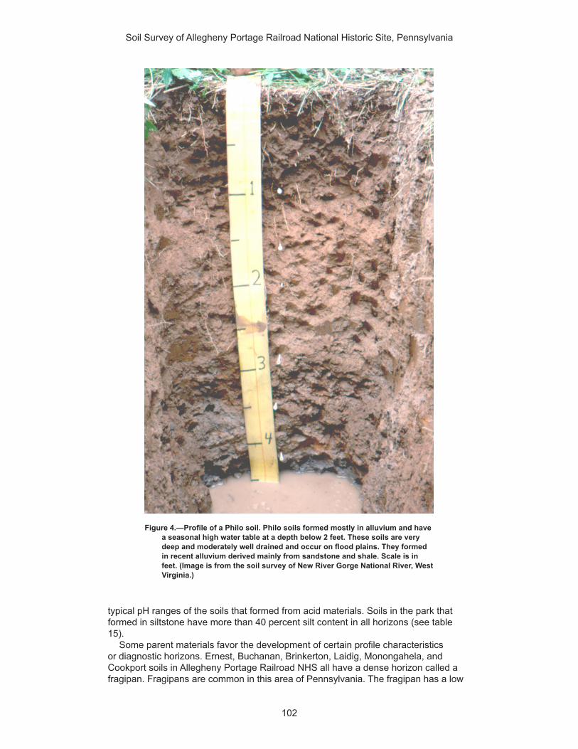
Soil Survey of Allegheny Portage Railroad National Historic Site, Pennsylvania
102
typical pH ranges of the soils that formed from acid materials. Soils in the park that formed in siltstone have more than 40 percent silt content in all horizons (see table 15).
Some parent materials favor the development of certain profile characteristics or diagnostic horizons. Ernest, Buchanan, Brinkerton, Laidig, Monongahela, and Cookport soils in Allegheny Portage Railroad NHS all have a dense horizon called a fragipan. Fragipans are common in this area of Pennsylvania. The fragipan has a low
Figure 4.—Profile of a Philo soil. Philo soils formed mostly in alluvium and have a seasonal high water table at a depth below 2 feet. These soils are very deep and moderately well drained and occur on flood plains. They formed in recent alluvium derived mainly from sandstone and shale. Scale is in feet. (Image is from the soil survey of New River Gorge National River, West Virginia.)

Soil Survey of Allegheny Portage Railroad National Historic Site, Pennsylvania
103
content of organic matter and a high bulk density in relation to the horizons above it. Soils with fragipans have restricted water movement. Restricted water movement is evidenced by grey soil colors (figs. 8 and 9). It is not known exactly how or why fragipans form but there are some generalizations that can be made about them. Soils with fragipans: 1) have evidence of pedogenesis (usually as clay movement downward in the profile), 2) have a higher content of silt and/or very fine sand than geographically associated soils without fragipans, 3) occur in areas where the soil does not freeze, and 4) formed under forested vegetation (Soil Survey Staff, 1999). All soils with a fragipan have “fragi” somewhere in their taxonomic name (see tables 21 and 22).
Climate Differences in climate can result in differences in soils. Temperature and moisture
influence soil formation and are the two most commonly measured features of climate. Weathering is most active when soils are moist and warm because these soil conditions are conducive to rapid chemical reactions and increased biological activity in the soil. Cooler temperatures result in slower chemical reactions. While average temperatures and precipitation amounts are important in determining soil properties, the extremes of climate in any given locale also play a major role in soil formation.
The area of the Appalachian Plateau in which Allegheny Portage Railroad NHS is located receives about 34 to 45 inches of precipitation per year. The rainfall occurs mostly in midsummer, and the rest occurs in autumn and early winter. In summer the rainfall occurs during high-intensity storms. Annual snowfall averages less than 35 inches to more than 50 inches. The average annual temperature is 48 to 56 degrees F. Soils are usually moist (have an udic soil moisture regime) and have a mesic soil temperature regime. Some soils in low-lying positions, such as Holly soils, have an aquic (usually wet) soil moisture regime. Holly soils have reduced iron due to a
Figure 5.—Close-up of a gleyed horizon in Atkins soil. The grey colors result from reduction of iron. Scale is in centimeters.

Soil Survey of Allegheny Portage Railroad National Historic Site, Pennsylvania
104
saturated environment (fig. 10). Reduced iron appears as grey colors in the soil. Holly soils are also classified as hydric (see table 4). Some soils also have seasonal wetness caused by restricted water movement within the profile due to a dense fragipan. Table 19 lists the water features of the soils in the park.
Climate and Frost Heave
Many of the soils in the park have a moderate or high susceptibility to frost heave. Frost heave is a natural pedogenic process that mixes and breaks up the soil surface.
Figure 6.—Profile of a Berks soil. Berks soils formed predominantly in residuum. They are mapped along the east-facing crest of the Allegheny Front. Angular rocks and a lithic contact at a depth of 28 inches are visible. Scale is in inches. (Image is from the soil survey of Gauley River National Scenic River, West Virginia).
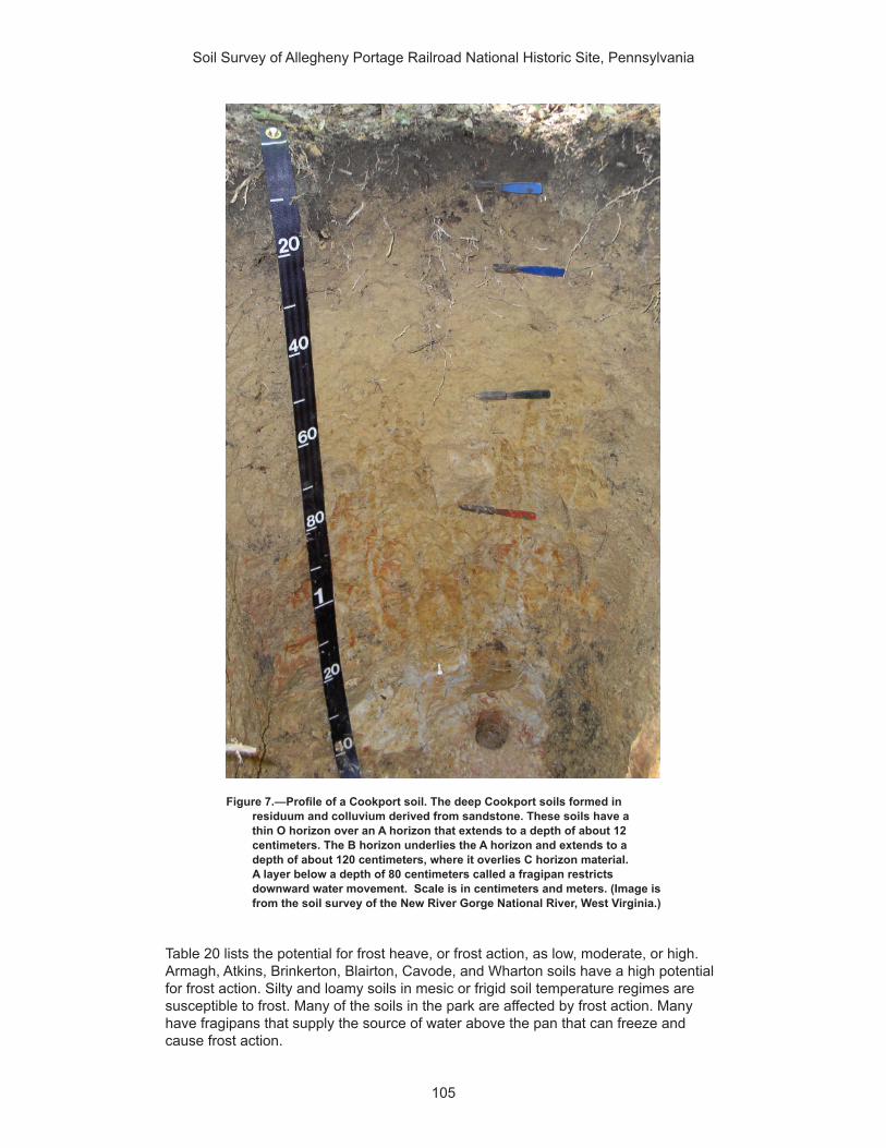
Soil Survey of Allegheny Portage Railroad National Historic Site, Pennsylvania
105
Table 20 lists the potential for frost heave, or frost action, as low, moderate, or high. Armagh, Atkins, Brinkerton, Blairton, Cavode, and Wharton soils have a high potential for frost action. Silty and loamy soils in mesic or frigid soil temperature regimes are susceptible to frost. Many of the soils in the park are affected by frost action. Many have fragipans that supply the source of water above the pan that can freeze and cause frost action.
Figure 7.—Profile of a Cookport soil. The deep Cookport soils formed in residuum and colluvium derived from sandstone. These soils have a thin O horizon over an A horizon that extends to a depth of about 12 centimeters. The B horizon underlies the A horizon and extends to a depth of about 120 centimeters, where it overlies C horizon material. A layer below a depth of 80 centimeters called a fragipan restricts downward water movement. Scale is in centimeters and meters. (Image is from the soil survey of the New River Gorge National River, West Virginia.)

Soil Survey of Allegheny Portage Railroad National Historic Site, Pennsylvania
106
Frost heave can result in road potholes and cracked pavements and foundations. Table 9 identifies the soils that have a limitation for roads and streets due to frost action. The limitation results in higher maintenance costs for park roads and parking lots. Frost heave results from ice forming beneath the surface of soil during atmospheric freezing conditions. The ice grows in the direction of heat loss, which is vertically toward the surface, starting at the freezing boundary in the soil. A water supply is needed to keep the ice crystals growing. The growing ice is restrained by overlying soil, which applies a load that limits its vertical growth and promotes the
Figure 8.—Profile of a Monongahela soil. The very deep Monongahela soils formed in alluvium on river terraces. The alluvium is derived from mostly acid sandstone and shale. These soils have a fragipan that restricts water movement through the profile. Iron becomes reduced due to saturation, resulting in grey colors (visible below the 1 meter mark). Scale is in centimeters and meters. (Image is from the soil survey of New River Gorge National River, West Virginia.)

Soil Survey of Allegheny Portage Railroad National Historic Site, Pennsylvania
107
formation of a lens-shaped area of ice within the soil (fig. 11). The processes of frost heave were more intense during past glacial times than they are today.
During periods of rainfall or snowmelt, water carrying dissolved or suspended solids moves through the soil in a process called leaching. Leaching becomes active with the onset of rainfall or snowmelt. Different temperatures and moisture amounts cause different patterns of weathering and leaching in the soil. Seasonal and daily changes
Figure 9.—Profile of a Laidig soil. Laidigs soils are very deep and well drained. They formed in colluvium derived from sandstone, siltstone, and some shale. These gently sloping to very steep soils occur on benches and footslopes. The slight color change at a depth of 1 meter indicates the fragipan. These soils are mapped along the Old Route 22. (Image is from the soil survey of New River Gorge National River, West Virginia.)
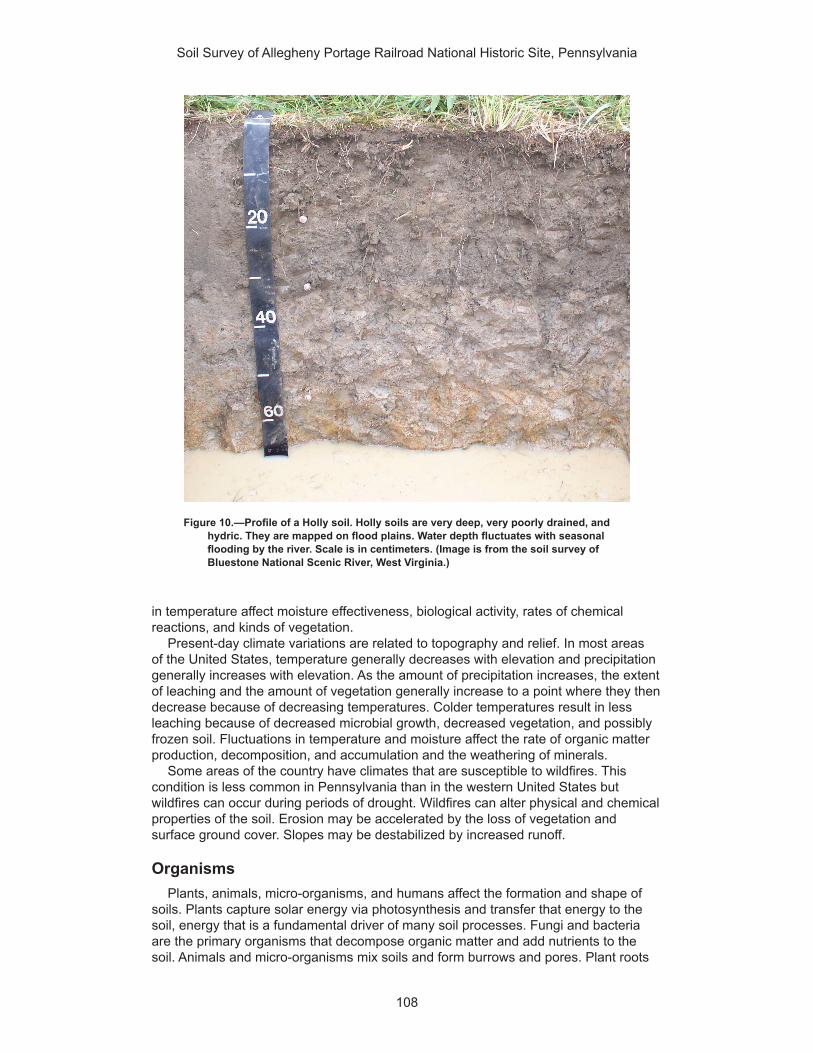
Soil Survey of Allegheny Portage Railroad National Historic Site, Pennsylvania
108
in temperature affect moisture effectiveness, biological activity, rates of chemical reactions, and kinds of vegetation.
Present-day climate variations are related to topography and relief. In most areas of the United States, temperature generally decreases with elevation and precipitation generally increases with elevation. As the amount of precipitation increases, the extent of leaching and the amount of vegetation generally increase to a point where they then decrease because of decreasing temperatures. Colder temperatures result in less leaching because of decreased microbial growth, decreased vegetation, and possibly frozen soil. Fluctuations in temperature and moisture affect the rate of organic matter production, decomposition, and accumulation and the weathering of minerals.
Some areas of the country have climates that are susceptible to wildfires. This condition is less common in Pennsylvania than in the western United States but wildfires can occur during periods of drought. Wildfires can alter physical and chemical properties of the soil. Erosion may be accelerated by the loss of vegetation and surface ground cover. Slopes may be destabilized by increased runoff.
OrganismsPlants, animals, micro-organisms, and humans affect the formation and shape of
soils. Plants capture solar energy via photosynthesis and transfer that energy to the soil, energy that is a fundamental driver of many soil processes. Fungi and bacteria are the primary organisms that decompose organic matter and add nutrients to the soil. Animals and micro-organisms mix soils and form burrows and pores. Plant roots
Figure 10.—Profile of a Holly soil. Holly soils are very deep, very poorly drained, and hydric. They are mapped on flood plains. Water depth fluctuates with seasonal flooding by the river. Scale is in centimeters. (Image is from the soil survey of Bluestone National Scenic River, West Virginia.)

Soil Survey of Allegheny Portage Railroad National Historic Site, Pennsylvania
109
open channels in the soils. Abandoned animal burrows commonly are filled with loose material from the overlying horizons and transmit water more readily than the surrounding undisturbed soil material. Micro-organisms affect chemical exchanges between roots and soil.
Different types of roots have different effects on soils. Grass roots are fibrous and decompose easily, adding organic matter to the soil. Fine grass roots can extend below the surface for many feet. Plant roots also help to develop soil structure and aggregate stability. Tree taproots open pathways through dense layers.
Humans also can mix the soil extensively. Bethesda soils are derived from acid loamy mine spoil derived from interbedded sedimentary rock. These soils are mapped as unstable fill in the map unit Udorthents, strip mine, sloping. They have been recently deposited and consequently have little development. Acid mine drainage and heavy metal contamination that accompanies low pH runoff from these soils can be resource management concerns. The main area of Bethesda soils (classified as Udorthents) is in the Staple Bend Tunnel area of the park that lies to the southwest of the Visitor Center main park unit area.
The large plants of the forested ecosystem in the park affect soil formation. Trees help break up rocks with their growing roots, resulting in channels that increase water penetration. Trees that are blown down help mix the soil when their roots are exposed. The native vegetation depends on climate, topography, and biological factors plus many soil factors, such as soil density, depth, chemistry, temperature, and moisture. Leaves from plants fall to the surface and decompose on the soil. Organisms decompose these leaves and mix them with the upper part of the soil, resulting in cycling of nutrients and energy back to vegetation. The leaf litter, whether leaves or
Figure 11.—Diagram illustrating ice lens formation in soils that results in frost heave or frost action (Williamborg, 2009).

Soil Survey of Allegheny Portage Railroad National Historic Site, Pennsylvania
110
needles, helps prevent nutrient loss, conserves soil moisture, reduces raindrop impact, and limits frost penetration.
The shallow (less than 20 inches deep) Klinesville and Weikert soils are of minor extent in the park and are associated with lithic (cemented) rock outcrop that is slowing being fractured by tree roots. These soils have a high rock content in the subsoil, and their depth is limited due to the hard rock. Most of the forested soils in the park, however, are moderately deep or deeper (more than 20 inches deep). Most well drained soils of the park are associated with the Dry Eastern Hemlock - Oak Forest plant association that occurs on dry upper slopes and is co-dominated by oaks, including chestnut oak (Quercus prinus) (Perles, 2006). Besides the mechanical breaking of rocks by large tree roots, the trees capture energy and substance through photosynthesis, by the decomposition of plant residue, and by forming organic-mineral complexes that are recycled many times within the ecosystem (Buol et al., 2011).
Organisms, such as trees, contribute to the carbon content of soils. Table 17 lists the estimated organic carbon content of each soil in Allegheny Portage Railroad NHS. Soil organic carbon is carbon (C) in soil that originated from a biological source, such as plants, animals, or micro-organisms. Soil organic carbon makes up about one-half the weight of soil organic matter. As carbon levels in soil increase, carbon is “withdrawn” from the atmosphere and “secluded” in the soil. Carbon in the atmosphere (as CO2 or CH4) is implicated in global climate change. The process of soil carbon sequestration transfers CO2 from the atmosphere into the soil. Trees transfer carbon to the soil by decomposition of leaves, needles, and roots. Based on available data, the soils in the park with the highest SOC content are Wharton, Tyler, and Udifluvents. These soils each have 8 kg/m2 of SOC, which equates to about 35 tons per acre.
Wet Soils
The Main Unit of the park contains three plant associations that are common on wet soils along rivers, streams, and drainages (Perles, 2006). This unit of the park contains a single occurrence of the Reed Canarygrass Riverine Grassland association along small drainages in its southeast corner. The Wet Meadow association occurs in a few locations within the Main Unit where herbaceous and graminoid vegetation surrounds small drainages (Perles, 2006). The Sugar Maple Floodplain Forest association covers more area than the other two associations but is limited in extent to areas surrounding Blair Gap Run. In addition, soil hydrologic properties favor the Alder Riverine Shrubland in one small patch along the Little Conemaugh River in the Staple Bend Unit of the park. Soils mapped with these plant associations are Brinkerton, Atkins, Andover, Holly, and Purdy.
Areas too small to delineate as individual soil map units are mapped as inclusions, specifically springs and seeps and wet spots that have “always wet” soil moisture regimes. Soils with wet soil moisture regimes support certain microbe populations that increase humification of soil organic carbon. Humification occurs when wood, roots, and animals decompose and are converted to humic substances. Humic substances are broadly defined as products of organic matter decomposition that are relatively resistant to further microbial decomposition. Humic substances with a high carbon content can persist in the wet meadow soils for a long time. Examples of humic substances are humic and fulvic acids and humins.
Time Time for parent material, climate, organisms, and relief to interact is also a soil-
forming factor. Over time, soils exhibit features that reflect the interaction of other soil-forming factors. Recently deposited material, such as material deposited by a flood, exhibits no features from soil development activities; the properties of soils that formed in this material are mostly inherited from the new material. The previous soil surface and underlying horizons become buried. The time clock resets for these soils.

Soil Survey of Allegheny Portage Railroad National Historic Site, Pennsylvania
111
The different horizons in a soil profile and the degree of development can be directly related to time. Terraces above the active flood plain, while similar in origin to the flood plain, are older land surfaces of old abandoned flood plains and thus have soils exhibiting more horizon development.
A model of how time has acted as a soil-forming factor and the resultant degree of horizonation in the soils of Allegheny Portage Railroad NHS can be developed by looking at specific soils. The youngest soils in the park in terms of time or increasing soil age are Bethesda soils, Holly soils, Atkins soils, Udorthents, and Udifluvents. These soils have minimal soil horizonation and different parent materials. Holly soils, Udifluvents, and Atkins soils are on the flood plains. Bethesda soils and Udorthents are recently human-created soils.
Because of their active landscape positions, Holly soils, Udifluvents, and Atkins soils are not strongly developed. All are subject to flooding. They have O, A, B, and/or C horizons. O horizons have high organic carbon levels and very little mineral content, and C horizons typically have the least amount of soil organic carbon and a high mineral content. The B horizon is a subsoil zone with an accumulation of materials moved from O, A, or E horizons or of soil material that formed in place. Color plays an important part in distinguishing B horizons. The B horizon is the horizon of maximum accumulation of dissolved or suspended materials, such as iron, clay, or calcium carbonate. Not all soils have a B horizon. The B horizon in Holly and Atkins soils shows some color change and weak structure. These soils are classified as Inceptisols.
The next oldest soils, in terms of degree of development or age, are Brinkerton soils. These soils formed in colluvium derived from acid gray shale and siltstone. They are nearly level to sloping and on concave footslopes and around heads of drainageways (fig. 12). They have A-B-C horizonation and greater development than the Inceptisols mentioned above. They differ in having stronger structure and a zone of clay accumulation in the B horizon, having a moderately slow permeability in the upper part of the subsoil, and having slow permeability in a dense layer (fragipan) in the lower part of the subsoil. Brinkerton soils are seasonally wet. They are classified as Alfisols.
The oldest soils in the park in terms of soil profile development are Monongahela, Cookport, Laidig, Buchanan, and Gilpin (fig. 13). They have different subsoil chemistry than the Alfisols due to leaching of cations. They are older due to a surface that is more stable than that of Alfisols or, in some cases, are the most developed because of parent material differences (the chemistry of the parent material may have had fewer cations available to leach initially than the parent materials of the Alfisols). As mentioned earlier, the other soil-forming factors influence how humans perceive time or soil age. The oldest or most developed soils in the park are classified as Ultisols.
Topography and ReliefTopography refers to the shape of the landscape, and relief refers to differences
in elevation. The overall landscape in a park, whether it consists of plateaus, rolling hills, or steep mountains, is the result of erosion and depositional processes. These processes may have occurred in response to changes in climate, fluctuating sea levels, and/or tectonic activities. Cyclic periods of landscape stability and instability influence the types of soils that form on the landscape.
Slope and aspect of the overall landscape can affect the moisture and temperature of the soil. Steep slopes facing the sun are warmer and drier. Steep soils, such as Gilpin and Weikert, may be eroded and lose their surface horizons as they form. Thus, these soils may be thinner than the more nearly level ones that receive deposits from areas upslope. Deeper, darker soils, such as Philo and Atkins, commonly occur on the bottom land. Soil-forming factors continue to affect soils even on stable landscapes. Materials are deposited on the soil surface, and materials are blown or washed away

Soil Survey of Allegheny Portage Railroad National Historic Site, Pennsylvania
112
from the surface. Additions, removals, and alterations are slow or rapid, depending on climate, landscape position, and biological activity.
Most of the soils in Allegheny Portage Railroad NHS are affected by slope instability and high erosion rates if they are left unvegetated. All sloping soils in the park formed in colluvium as well as residuum. Both colluvial and residual parent materials in the park developed in material weathered from interbedded sandstone, siltstone, and, in some places, a minor component of shale. Table 5 lists the major parent material type for the dominant soils in each map unit.
When saturated with water, soils that formed in clay-rich rock units (e.g., shale and mudstone) are prone to fail when exposed on steep slopes. The geologic units underlying the slopes of the park contain a heterogeneous mix of shale, sandstone, siltstone, limestone, dolomite, conglomerate, and mudstone. When more resistant rock units, such as sandstone and limestone, are located above weaker units, undercutting occurs from preferential erosion, causing rock fall hazards. Gilpin soils are moderately deep, well drained soils that formed in residuum of nearly horizontal interbedded shale, siltstone, and some sandstone of the Allegheny Plateau. These soils are mapped on gently sloping to steep, convex, dissected uplands. Figures 14 and 15 are stylized block diagrams of typical soils and landscapes found in the park.
Classification of the SoilsSoils are named and classified on the basis of physical and chemical properties
in their horizons (layers). Color, texture, structure, and other properties of the soil to a depth of 2 meters are used to key the soil into a classification system. This system
Figure 12.—Generalized relationships of soils to landscape and parent material on toeslopes and in drainageways in Allegheny Portage Railroad NHS. Brinkerton soils are in the low-lying landscape positions.
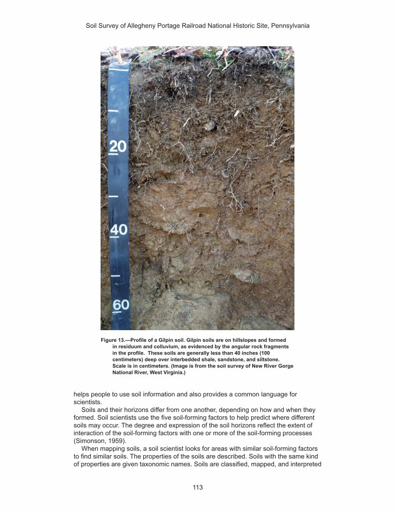
Soil Survey of Allegheny Portage Railroad National Historic Site, Pennsylvania
113
helps people to use soil information and also provides a common language for scientists.
Soils and their horizons differ from one another, depending on how and when they formed. Soil scientists use the five soil-forming factors to help predict where different soils may occur. The degree and expression of the soil horizons reflect the extent of interaction of the soil-forming factors with one or more of the soil-forming processes (Simonson, 1959).
When mapping soils, a soil scientist looks for areas with similar soil-forming factors to find similar soils. The properties of the soils are described. Soils with the same kind of properties are given taxonomic names. Soils are classified, mapped, and interpreted
Figure 13.—Profile of a Gilpin soil. Gilpin soils are on hillslopes and formed in residuum and colluvium, as evidenced by the angular rock fragments in the profile. These soils are generally less than 40 inches (100 centimeters) deep over interbedded shale, sandstone, and siltstone. Scale is in centimeters. (Image is from the soil survey of New River Gorge National River, West Virginia.)

Soil Survey of Allegheny Portage Railroad National Historic Site, Pennsylvania
114
on the basis of various kinds of soil horizons and their arrangement. The distribution of soil orders corresponds with the general patterns of the soil-forming factors within the park.
The system of soil classification used by the National Cooperative Soil Survey has six categories (Soil Survey Staff, 1999 and 2010). Beginning with the broadest, these categories are the order, suborder, great group, subgroup, family, and series. Classification is based on soil properties observed in the field or inferred from those observations or from laboratory measurements. The categories are defined in the following paragraphs.
ORDER. Soil taxonomy at the highest hierarchical level identifies 12 soil orders. The names for the orders and taxonomic soil properties relate to Greek, Latin, or other root words that reveal something about the soil. The differences among orders reflect the dominant soil-forming processes and the degree of soil formation. Each order is identified by a word ending in sol. An example is Ultisol.
Figure 14.—Stylized representation of soil and landscape relationships along the Allegheny Portage Railroad historic incline. View is to the west looking up the grade. Most soils in this view formed from colluvium.

Soil Survey of Allegheny Portage Railroad National Historic Site, Pennsylvania
115
SUBORDER. Each order is divided into suborders primarily on the basis of properties that influence soil genesis and are important to plant growth or properties that reflect the most important variables within the orders. Sixty-four suborders are recognized at the next level of classification. The last syllable in the name of a suborder indicates the order. An example is Udults (Ud meaning humid, plus ult, from Ultisol).
GREAT GROUP. Each suborder is divided into great groups on the basis of close similarities in kind, arrangement, and degree of development of pedogenic horizons; soil moisture and temperature regimes; type of saturation; and base status. There are about 300 great groups. Each great group is identified by the name of a suborder and by a prefix that indicates a property of the soil. An example is Fragiudults (Fragi, indicating the presence of a fragipan, plus Udult, the suborder of the Ultisols that has a udic moisture regime).
SUBGROUP. There are more than 2,400 subgroups. Each great group has a typic subgroup. The typic subgroup is the central concept of the great group; it is not necessarily the most extensive. Other subgroups are intergrades or extragrades. Intergrades are transitions to other orders, suborders, or great groups. Extragrades have some properties that are not representative of the great group but do not indicate transitions to any other taxonomic class. Each subgroup is identified by one or more adjectives preceding the name of the great group. The adjective Aquic identifies the subgroup that is wetter than the typical. An example is Aquic Fragiudults.
FAMILY. Families are established within a subgroup on the basis of physical and chemical properties and other characteristics that affect management. Generally, the
Figure 15.—General relationships of soils to topography and underlying parent material in the vicinity of Allegheny Portage Railroad National Historic Site. View is looking northwest from the southeastern area of the main park unit. (Image is adapted from the soil survey of Fulton County, Pennsylvania.)
Soil Survey of Allegheny Portage Railroad National Historic Site, Pennsylvania
116
properties for family placement are those of horizons below a traditional agronomic plow depth. Among the properties and characteristics considered are particle-size class, mineralogy class, cation-exchange activity class, soil temperature regime, soil depth, and reaction class. A family name consists of the name of a subgroup preceded by terms that indicate soil properties. An example is fine-loamy, mixed, superactive, mesic Aquic Fragiudults.
SERIES. The soil series is the lowest category in the soil classification system. The series consists of soils within a family that have horizons similar in color, texture, structure, reaction, consistence, mineral and chemical composition, and arrangement in the profile. An example is the Ernest series, which classifies as fine-loamy, mixed, superactive, mesic Aquic Fragiudults.
Most parks are mapped to the series level. The names of soil series are selected by the soil scientists during the course of mapping. The series names are commonly geographic place names or are coined. Because of access limitations and soil variability, soils in some remote areas are classified at the great group or subgroup level.
Table 21 indicates the order, suborder, great group, subgroup, and family of the soil series in the park. Table 22 displays the classification as a key sorted by order.

117
American Association of State Highway and Transportation Officials (AASHTO). 2004. Standard specifications for transportation materials and methods of sampling and testing. 24th edition.
American Society for Testing and Materials (ASTM). 2005. Standard classification of soils for engineering purposes. ASTM Standard D2487–00.
Buol, S.W., R.J. Southard, R.C. Graham, and P.A. McDaniel. 2011. Soil genesis and classification. 6th edition.
Cowardin, L.M., V. Carter, F.C. Golet, and E.T. LaRoe. 1979. Classification of wetlands and deep-water habitats of the United States. U.S. Fish and Wildlife Service FWS/OBS-79/31.
Federal Register. July 13, 1994. Changes in hydric soils of the United States.
Federal Register. September 18, 2002. Hydric soils of the United States.
Jenny, Hans. 1941. Factors of soil formation.
National Research Council. 1995. Wetlands: Characteristics and boundaries.
Perles, Stephanie J., Gregory S. Podniesinski, Ephraim A. Zimmerman, Elizabeth Eastman, and Lesley A. Sneddons. 2006. Vegetation classification and mapping at Allegheny Portage Railroad National Historic Site. Technical Report NPS/NER/NRTR—2006/079.
Simonson, Roy W. 1959. Outline of a generalized theory of soil genesis. Soil Science Society of America Proceedings 23:152-156.
Soil Survey Division Staff. 1993. Soil survey manual. Soil Conservation Service. U.S. Department of Agriculture Handbook 18.
Soil Survey Staff. 1999. Soil taxonomy: A basic system of soil classification for making and interpreting soil surveys. 2nd edition. Natural Resources Conservation Service. U.S. Department of Agriculture Handbook 436.
Soil Survey Staff. 2010. Keys to soil taxonomy. 11th edition. U.S. Department of Agriculture, Natural Resources Conservation Service.
Thornberry-Ehrlich, T. 2008. Allegheny Portage Railroad National Historic Site geologic resource evaluation report. Natural Resource Report NPS/NRPC/GRD/NRR—2008/045. National Park Service, Denver, Colorado.
References

Soil Survey of Allegheny Portage Railroad National Historic Site, Pennsylvania
118
Tiner, R.W., Jr. 1985. Wetlands of Delaware. U.S. Fish and Wildlife Service and Delaware Department of Natural Resources and Environmental Control, Wetlands Section.
United States Army Corps of Engineers, Environmental Laboratory. 1987. Corps of Engineers wetlands delineation manual. Waterways Experiment Station Technical Report Y-87-1.
United States Department of Agriculture, Natural Resources Conservation Service. National soil survey handbook, title 430-VI. http://soils.usda.gov/technical/
United States Department of Agriculture, Natural Resources Conservation Service. PLANTS database. National Plant Data Center. http://plants.usda.gov
United States Department of Agriculture, Natural Resources Conservation Service. 2006. Land resource regions and major land resource areas of the United States, the Caribbean, and the Pacific Basin. U.S. Department of Agriculture Handbook 296.
United States Department of Agriculture, Natural Resources Conservation Service. 2010. Field indicators of hydric soils in the United States, Version 7.0. L.M. Vasilas, G.W. Hurt, and C.V. Noble, eds. USDA-NRCS in cooperation with the National Technical Committee for Hydric Soils.
United States Department of Agriculture, Soil Conservation Service. 1961. Land capability classification. U.S. Department of Agriculture Handbook 210.
Williamborg. December 2009. http://en.wikipedia.org/wiki/File:Freezing_air_ice_lens_formation.jpg

119
Aeration, soil. The exchange of air in soil with air from the atmosphere. The air in a well aerated soil is similar to that in the atmosphere; the air in a poorly aerated soil is considerably higher in carbon dioxide and lower in oxygen.
Aggregate, soil. Many fine particles held in a single mass or cluster. Natural soil aggregates, such as granules, blocks, or prisms, are called peds. Clods are aggregates produced by tillage or logging.
Alkali (sodic) soil. A soil having so high a degree of alkalinity (pH 8.5 or higher) or so high a percentage of exchangeable sodium (15 percent or more of the total exchangeable bases), or both, that plant growth is restricted.
Alluvial fan. The fanlike deposit of a stream where it issues from a gorge upon a plain or of a tributary stream near or at its junction with its main stream.
Alluvium. Material, such as sand, silt, or clay, deposited on land by streams.Alpha,alpha-dipyridyl. A dye that when dissolved in 1N ammonium acetate is used to
detect the presence of reduced iron (Fe II) in the soil. A positive reaction indicates a type of redoximorphic feature.
Aquic conditions. Current soil wetness characterized by saturation, reduction, and redoximorphic features.
Argillic horizon. A subsoil horizon characterized by an accumulation of illuvial clay.Aspect. The direction in which a slope faces.Available water capacity (available moisture capacity). The capacity of soils to hold
water available for use by most plants. It is commonly defined as the difference between the amount of soil water at field moisture capacity and the amount at wilting point. It is commonly expressed as inches of water per inch of soil. The capacity, in inches, in a 60-inch profile or to a limiting layer is expressed as:
Very low .................................................................... 0 to 3Low ........................................................................... 3 to 6Moderate ................................................................... 6 to 9High ........................................................................ 9 to 12Very high .......................................................more than 12
Base saturation. The degree to which material having cation-exchange properties is saturated with exchangeable bases (sum of Ca, Mg, Na, and K), expressed as a percentage of the total cation-exchange capacity.
Bedrock. The solid rock that underlies the soil and other unconsolidated material or that is exposed at the surface.
Canopy. The leafy crown of trees or shrubs. (See Crown.)Cation. An ion carrying a positive charge of electricity. The common soil cations are
calcium, potassium, magnesium, sodium, and hydrogen.Cation-exchange capacity. The total amount of exchangeable cations that can be
held by the soil, expressed in terms of milliequivalents per 100 grams of soil at neutrality (pH 7.0) or at some other stated pH value. The term, as applied to soils, is synonymous with base-exchange capacity but is more precise in meaning.
Clay. As a soil separate, the mineral soil particles less than 0.002 millimeter in diameter. As a soil textural class, soil material that is 40 percent or more clay, less than 45 percent sand, and less than 40 percent silt.
Glossary

Soil Survey of Allegheny Portage Railroad National Historic Site, Pennsylvania
120
Claypan. A slowly permeable soil horizon that contains much more clay than the horizons above it. A claypan is commonly hard when dry and plastic or stiff when wet.
Climax plant community. The stabilized plant community on a particular site. The plant cover reproduces itself and does not change so long as the environment remains the same.
Coarse textured soil. Sand or loamy sand. Colluvium. Soil material or rock fragments, or both, moved by creep, slide, or local
wash and deposited at the base of steep slopes.Complex, soil. A map unit of two or more kinds of soil or miscellaneous areas in
such an intricate pattern or so small in area that it is not practical to map them separately at the selected scale of mapping. The pattern and proportion of the soils or miscellaneous areas are somewhat similar in all areas.
Control section. The part of the soil on which classification is based. The thickness varies among different kinds of soil, but for many it is that part of the soil profile between depths of 10 inches and 40 or 80 inches.
Corrosion. Soil-induced electrochemical or chemical action that dissolves or weakens concrete or uncoated steel.
Crown. The upper part of a tree or shrub, including the living branches and their foliage.
Culmination of the mean annual increment (CMAI). The average annual increase per acre in the volume of a stand. Computed by dividing the total volume of the stand by its age. As the stand increases in age, the mean annual increment continues to increase until mortality begins to reduce the rate of increase. The point where the stand reaches its maximum annual rate of growth is called the culmination of the mean annual increment.
Depth, soil. Generally, the thickness of the soil over bedrock. Very deep soils are more than 60 inches deep over bedrock; deep soils, 40 to 60 inches; moderately deep, 20 to 40 inches; shallow, 10 to 20 inches; and very shallow, less than 10 inches.
Drainage class (natural). Refers to the frequency and duration of wet periods under conditions similar to those under which the soil formed. Alterations of the water regime by human activities, either through drainage or irrigation, are not a consideration unless they have significantly changed the morphology of the soil. Seven classes of natural soil drainage are recognized—excessively drained, somewhat excessively drained, well drained, moderately well drained, somewhat poorly drained, poorly drained, and very poorly drained. These classes are defined in the “Soil Survey Manual.”
Drainage, surface. Runoff, or surface flow of water, from an area.Ecological site. An area where climate, soil, and relief are sufficiently uniform to
produce a distinct natural plant community. An ecological site is the product of all the environmental factors responsible for its development. It is typified by an association of species that differ from those on other ecological sites in kind and/or proportion of species or in total production.
Eluviation. The movement of material in true solution or colloidal suspension from one place to another within the soil. Soil horizons that have lost material through eluviation are eluvial; those that have received material are illuvial.
Eolian soil material. Earthy parent material accumulated through wind action; commonly refers to sandy material in dunes or to loess in blankets on the surface.
Erosion. The wearing away of the land surface by water, wind, ice, or other geologic agents and by such processes as gravitational creep.Erosion (geologic). Erosion caused by geologic processes acting over long geologic periods and resulting in the wearing away of mountains and the building

Soil Survey of Allegheny Portage Railroad National Historic Site, Pennsylvania
121
up of such landscape features as flood plains and coastal plains. Synonym: natural erosion.Erosion (accelerated). Erosion much more rapid than geologic erosion, mainly as a result of human or animal activities or of a catastrophe in nature, such as a fire, that exposes the surface.
Escarpment. A relatively continuous and steep slope or cliff breaking the general continuity of more gently sloping land surfaces and resulting from erosion or faulting. Synonym: scarp.
Fertility, soil. The quality that enables a soil to provide plant nutrients, in adequate amounts and in proper balance, for the growth of specified plants when light, moisture, temperature, tilth, and other growth factors are favorable.
Fill slope. A sloping surface consisting of excavated soil material from a road cut. It commonly is on the downhill side of the road.
Fine textured soil. Sandy clay, silty clay, or clay.Flood plain. A nearly level alluvial plain that borders a stream and is subject to
flooding unless protected artificially.Fluvial. Of or pertaining to rivers; produced by river action, as a fluvial plain.Forb. Any herbaceous plant not a grass or a sedge.Forest cover. All trees and other woody plants (underbrush) covering the ground in a
forest.Forest type. A stand of trees similar in composition and development because of
given physical and biological factors by which it may be differentiated from other stands.
Gravel. Rounded or angular fragments of rock as much as 3 inches (2 millimeters to 7.6 centimeters) in diameter. An individual piece is a pebble.
Gravelly soil material. Material that has 15 to 35 percent, by volume, rounded or angular rock fragments, not prominently flattened, as much as 3 inches (7.6 centimeters) in diameter.
Ground water. Water filling all the unblocked pores of the material below the water table.
Hard bedrock. Bedrock that cannot be excavated except by blasting or by the use of special equipment that is not commonly used in construction.
Hill. A natural elevation of the land surface, rising as much as 1,000 feet above surrounding lowlands, commonly of limited summit area and having a well defined outline; hillsides generally have slopes of more than 15 percent. The distinction between a hill and a mountain is arbitrary and is dependent on local usage.
Horizon, soil. A layer of soil, approximately parallel to the surface, having distinct characteristics produced by soil-forming processes. In the identification of soil horizons, an uppercase letter represents the major horizons. Numbers or lowercase letters that follow represent subdivisions of the major horizons. An explanation of the subdivisions is given in the “Soil Survey Manual.” The major horizons of mineral soil are as follows:O horizon.—An organic layer of fresh and decaying plant residue.A horizon.—The mineral horizon at or near the surface in which an accumulation of humified organic matter is mixed with the mineral material. Also, a plowed surface horizon, most of which was originally part of a B horizon.E horizon.—The mineral horizon in which the main feature is loss of silicate clay, iron, aluminum, or some combination of these.B horizon.—The mineral horizon below an A horizon. The B horizon is in part a layer of transition from the overlying A to the underlying C horizon. The B horizon also has distinctive characteristics, such as (1) accumulation of clay, sesquioxides, humus, or a combination of these; (2) prismatic or blocky structure; (3) redder or browner colors than those in the A horizon; or (4) a combination of these.
Soil Survey of Allegheny Portage Railroad National Historic Site, Pennsylvania
122
C horizon.—The mineral horizon or layer, excluding indurated bedrock, that is little affected by soil-forming processes and does not have the properties typical of the overlying soil material. The material of a C horizon may be either like or unlike that in which the solum formed. If the material is known to differ from that in the solum, an Arabic numeral, commonly a 2, precedes the letter C.Cr horizon.—Soft, consolidated bedrock beneath the soil.R layer.—Consolidated bedrock beneath the soil. The bedrock commonly underlies a C horizon, but it can be directly below an A or a B horizon.
Hydrologic soil groups. Refers to soils grouped according to their runoff potential. The soil properties that influence this potential are those that affect the minimum rate of water infiltration on a bare soil during periods after prolonged wetting when the soil is not frozen. These properties are depth to a seasonal high water table, the infiltration rate and permeability after prolonged wetting, and depth to a very slowly permeable layer. The slope and the kind of plant cover are not considered but are separate factors in predicting runoff.
Illuviation. The movement of soil material from one horizon to another in the soil profile. Generally, material is removed from an upper horizon and deposited in a lower horizon.
Infiltration. The downward entry of water into the immediate surface of soil or other material, as contrasted with percolation, which is movement of water through soil layers or material.
Infiltration capacity. The maximum rate at which water can infiltrate into a soil under a given set of conditions.
Infiltration rate. The rate at which water penetrates the surface of the soil at any given instant, usually expressed in inches per hour. The rate can be limited by the infiltration capacity of the soil or the rate at which water is applied at the surface.
Intake rate. The average rate of water entering the soil under irrigation. Most soils have a fast initial rate; the rate decreases with application time. Therefore, intake rate for design purposes is not a constant but is a variable depending on the net irrigation application. The rate of water intake, in inches per hour, is expressed as follows:
Less than 0.2 ........................................................very low0.2 to 0.4 .......................................................................low0.4 to 0.75 ..................................................moderately low0.75 to 1.25 .........................................................moderate1.25 to 1.75 ...............................................moderately high1.75 to 2.5 ................................................................... highMore than 2.5.......................................................very high
Ksat. Saturated hydraulic conductivity. (See Permeability.)Leaching. The removal of soluble material from soil or other material by percolating
water.LEP. See Linear extensibility percent.Linear extensibility (LE). Refers to the change in length of an unconfined clod as
moisture content is decreased from a moist to a dry state. Linear extensibility is used to determine the shrink-swell potential of soils. It is an expression of the volume change between the water content of the clod at 1/3- or 1/10-bar tension (33kPa or 10kPa tension) and oven dryness. Volume change is influenced by the amount and type of clay minerals in the soil. The volume change is the percent change for the whole soil. If it is expressed as a fraction, the resulting value is COLE, coefficient of linear extensibility.
Linear extensibility percent. Refers to the percent change in linear extensibility.Liquid limit. The moisture content at which the soil passes from a plastic to a liquid
state.Loam. Soil material that is 7 to 27 percent clay particles, 28 to 50 percent silt particles,
and less than 52 percent sand particles.

Soil Survey of Allegheny Portage Railroad National Historic Site, Pennsylvania
123
Loess. Fine grained material, dominantly of silt-sized particles, deposited by wind.Low strength. The soil is not strong enough to support loads.Medium textured soil. Very fine sandy loam, loam, silt loam, or silt.Mineral soil. Soil that is mainly mineral material and low in organic material. Its bulk
density is more than that of organic soil.Miscellaneous area. An area that has little or no natural soil and supports little or no
vegetation.Moderately coarse textured soil. Coarse sandy loam, sandy loam, or fine sandy
loam.Moderately fine textured soil. Clay loam, sandy clay loam, or silty clay loam.Neutral soil. A soil having a pH value of 6.6 to 7.3. (See Reaction, soil.)Nutrient, plant. Any element taken in by a plant essential to its growth. Plant nutrients
are mainly nitrogen, phosphorus, potassium, calcium, magnesium, sulfur, iron, manganese, copper, boron, and zinc obtained from the soil and carbon, hydrogen, and oxygen obtained from the air and water.
Organic matter. Plant and animal residue in the soil in various stages of decomposition. The content of organic matter in the surface layer is described as follows:
Very low ............................................less than 0.5 percentLow ........................................................ 0.5 to 1.0 percentModerately low ....................................... 1.0 to 2.0 percentModerate ................................................ 2.0 to 4.0 percentHigh ....................................................... 4.0 to 8.0 percentVery high .........................................more than 8.0 percent
Pan. A compact, dense layer in a soil that impedes the movement of water and the growth of roots. For example, hardpan, fragipan, claypan, plowpan, and traffic pan.
Parent material. The unconsolidated organic and mineral material in which soil forms.Ped. An individual natural soil aggregate, such as a granule, a prism, or a block.Pedon. The smallest volume that can be called “a soil.” A pedon is three dimensional
and large enough to permit study of all horizons. Its area ranges from about 10 to 100 square feet (1 square meter to 10 square meters), depending on the variability of the soil.
Percolation. The movement of water through the soil.Permeability. The quality of the soil that enables water or air to move downward
through the profile. The rate at which a saturated soil transmits water is accepted as a measure of this quality. In soil physics, the rate is referred to as “saturated hydraulic conductivity,” which is defined in the “Soil Survey Manual.” In line with conventional usage in the engineering profession and with traditional usage in published soil surveys, this rate of flow continues to be expressed as “permeability.” Terms describing permeability, measured in inches per hour, are as follows:
Extremely slow ...........................................0.0 to 0.01 inchVery slow .................................................0.01 to 0.06 inchSlow ...........................................................0.06 to 0.2 inchModerately slow ...........................................0.2 to 0.6 inchModerate .......................................... 0.6 inch to 2.0 inchesModerately rapid ......................................2.0 to 6.0 inchesRapid ........................................................6.0 to 20 inchesVery rapid ...........................................more than 20 inches
Phase, soil. A subdivision of a soil series based on features that affect its use and management, such as slope, stoniness, and flooding.
pH value. A numerical designation of acidity and alkalinity in soil. (See Reaction, soil.)Plasticity index. The numerical difference between the liquid limit and the plastic limit;
the range of moisture content within which the soil remains plastic.Plastic limit. The moisture content at which a soil changes from semisolid to plastic.

Soil Survey of Allegheny Portage Railroad National Historic Site, Pennsylvania
124
Plowpan. A compacted layer formed in the soil directly below the plowed layer.Ponding. Standing water on soils in closed depressions. Unless the soils are artificially
drained, the water can be removed only by percolation or evapotranspiration.Poorly graded. Refers to a coarse grained soil or soil material consisting mainly of
particles of nearly the same size. Because there is little difference in size of the particles, density can be increased only slightly by compaction.
Potential native plant community. See Climax plant community.Potential rooting depth (effective rooting depth). Depth to which roots could
penetrate if the content of moisture in the soil were adequate. The soil has no properties restricting the penetration of roots to this depth.
Productivity, soil. The capability of a soil for producing a specified plant or sequence of plants under specific management.
Profile, soil. A vertical section of the soil extending through all its horizons and into the parent material.
Rangeland. Land on which the potential natural vegetation is predominantly grasses, grasslike plants, forbs, or shrubs suitable for grazing or browsing. It includes natural grasslands, savannas, many wetlands, some deserts, tundras, and areas that support certain forb and shrub communities.
Reaction, soil. A measure of acidity or alkalinity of a soil, expressed in pH values. A soil that tests to pH 7.0 is described as precisely neutral in reaction because it is neither acid nor alkaline. The degrees of acidity or alkalinity, expressed as pH values, are:
Ultra acid ........................................................less than 3.5Extremely acid .................................................... 3.5 to 4.4Very strongly acid ............................................... 4.5 to 5.0Strongly acid ....................................................... 5.1 to 5.5Moderately acid .................................................. 5.6 to 6.0Slightly acid ......................................................... 6.1 to 6.5Neutral ................................................................ 6.6 to 7.3Slightly alkaline ................................................... 7.4 to 7.8Moderately alkaline ............................................. 7.9 to 8.4Strongly alkaline ................................................. 8.5 to 9.0Very strongly alkaline .................................. 9.1 and higher
Redoximorphic concentrations. Nodules, concretions, soft masses, pore linings, and other features resulting from the accumulation of iron or manganese oxide. An indication of chemical reduction and oxidation resulting from saturation.
Redoximorphic depletions. Low-chroma zones from which iron and manganese oxide or a combination of iron and manganese oxide and clay has been removed. These zones are indications of the chemical reduction of iron resulting from saturation.
Redoximorphic features. Redoximorphic concentrations, redoximorphic depletions, reduced matrices, a positive reaction to alpha,alpha-dipyridyl, and other features indicating the chemical reduction and oxidation of iron and manganese compounds resulting from saturation.
Relief. The elevations or inequalities of a land surface, considered collectively.Residuum (residual soil material). Unconsolidated, weathered or partly weathered
mineral material that accumulated as consolidated rock disintegrated in place.Rock fragments. Rock or mineral fragments having a diameter of 2 millimeters or
more; for example, pebbles, cobbles, stones, and boulders.Root zone. The part of the soil that can be penetrated by plant roots.Runoff. The precipitation discharged into stream channels from an area. The water
that flows off the surface of the land without sinking into the soil is called surface runoff. Water that enters the soil before reaching surface streams is called ground-water runoff or seepage flow from ground water.
Saline soil. A soil containing soluble salts in an amount that impairs growth of plants. A saline soil does not contain excess exchangeable sodium.
Soil Survey of Allegheny Portage Railroad National Historic Site, Pennsylvania
125
Sand. As a soil separate, individual rock or mineral fragments from 0.05 millimeter to 2.0 millimeters in diameter. Most sand grains consist of quartz. As a soil textural class, a soil that is 85 percent or more sand and not more than 10 percent clay.
Sandstone. Sedimentary rock containing dominantly sand-sized particles.Saprolite. Unconsolidated residual material underlying the soil and grading to hard
bedrock below.Saturation. Wetness characterized by zero or positive pressure of the soil water.
Under conditions of saturation, the water will flow from the soil matrix into an unlined auger hole.
Sedimentary rock. Rock made up of particles deposited from suspension in water. The chief kinds of sedimentary rock are conglomerate, formed from gravel; sandstone, formed from sand; shale, formed from clay; and limestone, formed from soft masses of calcium carbonate. There are many intermediate types. Some wind-deposited sand is consolidated into sandstone.
Series, soil. A group of soils that have profiles that are almost alike. All the soils of a series have horizons that are similar in composition, thickness, and arrangement.
Shale. Sedimentary rock formed by the hardening of a clay deposit.Silt. As a soil separate, individual mineral particles that range in diameter from the
upper limit of clay (0.002 millimeter) to the lower limit of very fine sand (0.05 millimeter). As a soil textural class, soil that is 80 percent or more silt and less than 12 percent clay.
Siltstone. Sedimentary rock made up of dominantly silt-sized particles.Similar soils. Soils that share limits of diagnostic criteria, behave and perform
in a similar manner, and have similar conservation needs or management requirements for the major land uses in the survey area.
Site index. A designation of the quality of a forest site based on the height of the dominant stand at an arbitrarily chosen age. For example, if the average height attained by dominant and codominant trees in a fully stocked stand at the age of 50 years is 75 feet, the site index is 75.
Slope. The inclination of the land surface from the horizontal. Percentage of slope is the vertical distance divided by horizontal distance, then multiplied by 100. Thus, a slope of 20 percent is a drop of 20 feet in 100 feet of horizontal distance.
Sodic (alkali) soil. A soil having so high a degree of alkalinity (pH 8.5 or higher) or so high a percentage of exchangeable sodium (15 percent or more of the total exchangeable bases), or both, that plant growth is restricted.
Sodicity. The degree to which a soil is affected by exchangeable sodium. Sodicity is expressed as a sodium adsorption ratio (SAR) of a saturation extract, or the ratio of Na+ to Ca++ + Mg++. The degrees of sodicity and their respective ratios are:
Slight ............................................................less than 13:1Moderate ................................................................13-30:1Strong ........................................................more than 30:1
Sodium adsorption ratio (SAR). A measure of the amount of sodium (Na) relative to calcium (Ca) and magnesium (Mg) in the water extract from saturated soil paste. It is the ratio of the Na concentration divided by the square root of one-half of the Ca + Mg concentration.
Soft bedrock. Bedrock that can be excavated with trenching machines, backhoes, small rippers, and other equipment commonly used in construction.
Soil. A natural, three-dimensional body at the earth’s surface. It is capable of supporting plants and has properties resulting from the integrated effect of climate and living matter acting on earthy parent material, as conditioned by relief over periods of time.
Soil separates. Mineral particles less than 2 millimeters in equivalent diameter and ranging between specified size limits. The names and sizes, in millimeters, of separates recognized in the United States are as follows:

Soil Survey of Allegheny Portage Railroad National Historic Site, Pennsylvania
126
Very coarse sand ................................................ 2.0 to 1.0Coarse sand ....................................................... 1.0 to 0.5Medium sand .................................................... 0.5 to 0.25Fine sand ........................................................ 0.25 to 0.10Very fine sand ................................................. 0.10 to 0.05Silt ................................................................ 0.05 to 0.002Clay ............................................................less than 0.002
Solum. The upper part of a soil profile, above the C horizon, in which the processes of soil formation are active. The solum in soil consists of the A, E, and B horizons. Generally, the characteristics of the material in these horizons are unlike those of the material below the solum. The living roots and plant and animal activities are largely confined to the solum.
Stone line. A concentration of coarse fragments in a soil. Generally, it is indicative of an old weathered surface. In a cross section, the line may be one fragment or more thick. It generally overlies material that weathered in place and is overlain by recent sediment of variable thickness.
Stones. Rock fragments 10 to 24 inches (25 to 60 centimeters) in diameter if rounded or 15 to 24 inches (38 to 60 centimeters) in length if flat.
Stony. Refers to a soil containing stones in numbers that interfere with or prevent tillage.
Structure, soil. The arrangement of primary soil particles into compound particles or aggregates. The principal forms of soil structure are—platy (laminated), prismatic (vertical axis of aggregates longer than horizontal), columnar (prisms with rounded tops), blocky (angular or subangular), and granular. Structureless soils are either single grained (each grain by itself, as in dune sand) or massive (the particles adhering without any regular cleavage, as in many hardpans).
Subsoil. Technically, the B horizon; roughly, the part of the solum below plow depth.Substratum. The part of the soil below the solum.Subsurface layer. Any surface soil horizon (A, E, AB, or EB) below the surface layer.Surface layer. The soil ordinarily moved in tillage, or its equivalent in uncultivated soil,
ranging in depth from 4 to 10 inches (10 to 25 centimeters). Frequently designated as the “plow layer,” or the “Ap horizon.”
Surface soil. The A, E, AB, and EB horizons, considered collectively. It includes all subdivisions of these horizons.
Terrace. An embankment, or ridge, constructed across sloping soils on the contour or at a slight angle to the contour. The terrace intercepts surface runoff so that water soaks into the soil or flows slowly to a prepared outlet. A terrace in a field generally is built so that the field can be farmed. A terrace intended mainly for drainage has a deep channel that is maintained in permanent sod.
Terrace (geologic). An old alluvial plain, ordinarily flat or undulating, bordering a river, a lake, or the sea.
Texture, soil. The relative proportions of sand, silt, and clay particles in a mass of soil. The basic textural classes, in order of increasing proportion of fine particles, are sand, loamy sand, sandy loam, loam, silt loam, silt, sandy clay loam, clay loam, silty clay loam, sandy clay, silty clay, and clay. The sand, loamy sand, and sandy loam classes may be further divided by specifying “coarse,” “fine,” or “very fine.”
Tilth, soil. The physical condition of the soil as related to tillage, seedbed preparation, seedling emergence, and root penetration.
Topsoil. The upper part of the soil, which is the most favorable material for plant growth. It is ordinarily rich in organic matter and is used to topdress roadbanks, lawns, and land affected by mining.
Upland. Land at a higher elevation, in general, than the alluvial plain or stream terrace; land above the lowlands along streams.

Soil Survey of Allegheny Portage Railroad National Historic Site, Pennsylvania
127
Weathering. All physical and chemical changes produced in rocks or other deposits at or near the earth’s surface by atmospheric agents. These changes result in disintegration and decomposition of the material.
Well graded. Refers to soil material consisting of coarse grained particles that are well distributed over a wide range in size or diameter. Such soil normally can be easily increased in density and bearing properties by compaction. Contrasts with poorly graded soil.


129
Tables

Soil Survey of Allegheny Portage Railroad National Historic Site, Pennsylvania
130
Table 1.—Soil Legend______________________________________________________________________________________________________ | | Percent Map unit symbol and map unit name | Components | of | in map unit | map unit______________________________________________________________________________________________________ | | 541887: | | Armagh silt loam, 0 to 8 percent slopes----------------------------------|Armagh | 85 | | |Cavode | 10 | | |Armagh, very | 5 | stony | | | 541890: | | Berks channery silt loam, 8 to 15 percent slopes-------------------------|Berks | 85 | | |Bedington | 5 | | |Weikert | 4 | | |Blairton | 3 | | |Ernest | 3 | | 541892: | | Blairton silt loam, 3 to 8 percent slopes--------------------------------|Blairton | 90 | | |Brinkerton | 5 | | 541893: | | Blairton silt loam, 8 to 15 percent slopes-------------------------------|Blairton | 90 | | |Brinkerton | 5 | | 541903: | | Cookport and Ernest soils, 3 to 8 percent slopes-------------------------|Cookport | 65 | | |Ernest | 25 | | |Brinkerton | 10 | | 541906: | | Cookport and Ernest very stony soils, 0 to 8 percent slopes--------------|Cookport | 65 | | |Ernest | 25 | | |Brinkerton | 10 | | 541907: | | Cookport and Ernest very stony soils, 8 to 25 percent slopes-------------|Cookport | 70 | | |Ernest | 25 | | |Brinkerton | 5 | | 541908: | | Dumps, industrial wastes-------------------------------------------------|Dumps | 90 | | |Wet spots | 1 | | 541909: | | Dumps, mine--------------------------------------------------------------|Mine dump | 99 | | |Wet spots | 1 | |

Soil Survey of Allegheny Portage Railroad National Historic Site, Pennsylvania
131
Table 1.—Soil Legend—Continued______________________________________________________________________________________________________ | | Percent Map unit symbol and map unit name | Components | of | in map unit | map unit______________________________________________________________________________________________________ | | 541911: | | Gilpin silt loam, 3 to 8 percent slopes----------------------------------|Gilpin | 75 | | |Wharton | 10 | | |Clymer | 5 | | |Cookport | 5 | | |Tilsit | 5 | | 541914: | | Gilpin-Rayne silt loams, 8 to 15 percent slopes--------------------------|Gilpin | 70 | | |Rayne | 30 | | 541919: | | Hazleton channery loam, 3 to 8 percent slopes----------------------------|Hazleton | 90 | | |Cookport | 10 | | 541922: | | Hazleton channery sandy loam, 3 to 8 percent slopes, extremely stony-----|Hazleton | 75 | | |Clymer | 15 | | |Cookport | 10 | | 541925: | | Laidig soils, 25 to 70 percent slopes------------------------------------|Laidig | 100 | | 541938: | | Udorthents, strip mine, sloping------------------------------------------|Bethesda, | 90 | unstable fill | | | |Gilpin | 5 | | |Wharton | 4 | | |Wet spots | 1 | | 541940: | | Urban land-Udorthents complex, gently sloping----------------------------|Urban land | 60 | | |Udorthents | 30 | | |Wet spots | 1 | | 541942: | | Water--------------------------------------------------------------------|Water | 100 | | 541943: | | Wharton silt loam, 3 to 8 percent slopes---------------------------------|Wharton | 80 | | |Cavode | 8 | | |Buchanan | 5 | | |Hartleton | 5 | | |Brinkerton | 2 | |

Soil Survey of Allegheny Portage Railroad National Historic Site, Pennsylvania
132
Table 1.—Soil Legend—Continued______________________________________________________________________________________________________ | | Percent Map unit symbol and map unit name | Components | of | in map unit | map unit______________________________________________________________________________________________________ | | 541944: | | Wharton silt loam, 8 to 15 percent slopes--------------------------------|Wharton | 80 | | |Cavode | 8 | | |Buchanan | 5 | | |Hartleton | 5 | | |Brinkerton | 2 | | 542311: | | Albrights gravelly silt loam, 3 to 8 percent slopes----------------------|Albrights | 90 | | |Brinkerton | 5 | | 542321: | | Berks channery silt loam, 3 to 8 percent slopes--------------------------|Berks | 85 | | |Bedington | 3 | | |Ernest | 3 | | |Blairton | 2 | | |Weikert | 2 | | 542322: | | Berks channery silt loam, 8 to 15 percent slopes-------------------------|Berks | 85 | | |Bedington | 5 | | |Weikert | 4 | | |Blairton | 3 | | |Ernest | 3 | | 542323: | | Berks channery silt loam, 15 to 25 percent slopes------------------------|Berks | 85 | | |Bedington | 5 | | |Weikert | 5 | | |Blairton | 3 | | |Ernest | 2 | | 542324: | | Berks-Weikert channery silt loams, 8 to 15 percent slopes----------------|Berks | 50 | | |Weikert | 35 | | |Ernest | 5 | |

Soil Survey of Allegheny Portage Railroad National Historic Site, Pennsylvania
133
Table 1.—Soil Legend—Continued______________________________________________________________________________________________________ | | Percent Map unit symbol and map unit name | Components | of | in map unit | map unit______________________________________________________________________________________________________ | | 542325: | | Berks-Weikert channery silt loams, 15 to 25 percent slopes---------------|Berks | 45 | | |Weikert | 40 | | |Bedington | 5 | | |Ernest | 5 | | 542326: | | Berks-Weikert channery silt loams, 25 to 70 percent slopes---------------|Berks | 50 | | |Weikert | 40 | | |Bedington | 3 | | |Brinkerton | 2 | | 542329: | | Brinkerton silt loam, 3 to 8 percent slopes------------------------------|Brinkerton | 75 | | |Ernest | 10 | | |Berks | 5 | | |Laidig | 5 | | |Atkins | 3 | | |Philo | 2 | | 542330: | | Brinkerton silt loam, 8 to 15 percent slopes-----------------------------|Brinkerton | 85 | | |Ernest | 10 | | 542333: | | Buchanan extremely stony silt loam, 3 to 8 percent slopes----------------|Buchanan | 90 | | |Andover | 5 | | |Alluvial soils | 3 | | |Berks soils | 2 | | 542334: | | Buchanan extremely stony silt loam, 8 to 25 percent slopes---------------|Buchanan | 85 | | |Hazleton | 5 | | |Andover | 3 | | |Alluvial soils | 2 | | |Bedington | 2 | | |Berks | 2 | | |Springs and | 1 | seeps | | |
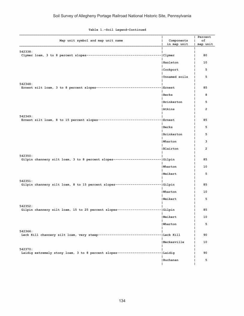
Soil Survey of Allegheny Portage Railroad National Historic Site, Pennsylvania
134
Table 1.—Soil Legend—Continued______________________________________________________________________________________________________ | | Percent Map unit symbol and map unit name | Components | of | in map unit | map unit______________________________________________________________________________________________________ | | 542338: | | Clymer loam, 3 to 8 percent slopes---------------------------------------|Clymer | 80 | | |Hazleton | 10 | | |Cookport | 5 | | |Unnamed soils | 5 | | 542348: | | Ernest silt loam, 3 to 8 percent slopes----------------------------------|Ernest | 85 | | |Berks | 8 | | |Brinkerton | 5 | | |Atkins | 2 | | 542349: | | Ernest silt loam, 8 to 15 percent slopes---------------------------------|Ernest | 85 | | |Berks | 5 | | |Brinkerton | 5 | | |Wharton | 3 | | |Blairton | 2 | | 542350: | | Gilpin channery silt loam, 3 to 8 percent slopes-------------------------|Gilpin | 85 | | |Wharton | 10 | | |Weikert | 5 | | 542351: | | Gilpin channery silt loam, 8 to 15 percent slopes------------------------|Gilpin | 85 | | |Wharton | 10 | | |Weikert | 5 | | 542352: | | Gilpin channery silt loam, 15 to 25 percent slopes-----------------------|Gilpin | 85 | | |Weikert | 10 | | |Wharton | 5 | | 542366: | | Leck Kill channery silt loam, very steep---------------------------------|Leck Kill | 90 | | |Meckesville | 10 | | 542370: | | Laidig extremely stony loam, 3 to 8 percent slopes-----------------------|Laidig | 90 | | |Buchanan | 5 | |

Soil Survey of Allegheny Portage Railroad National Historic Site, Pennsylvania
135
Table 1.—Soil Legend—Continued______________________________________________________________________________________________________ | | Percent Map unit symbol and map unit name | Components | of | in map unit | map unit______________________________________________________________________________________________________ | | 542371: | | Laidig extremely stony loam, 8 to 25 percent slopes----------------------|Laidig | 90 | | |Buchanan | 5 | | 542372: | | Laidig extremely stony loam, 25 to 45 percent slopes---------------------|Laidig | 90 | | |Hazleton | 10 | | 542375: | | Leck Kill channery silt loam, 15 to 25 percent slopes--------------------|Leck Kill | 80 | | |Calvin | 10 | | |Klinesville | 5 | | |Meckesville | 5 | | 542383: | | Meckesville very stony silt loam, 3 to 8 percent slopes------------------|Meckesville | 90 | | |Albrights | 5 | | 542384: | | Meckesville very stony silt loam, 8 to 25 percent slopes-----------------|Meckesville | 90 | | |Albrights | 5 | | 542406: | | Tyler silt loam----------------------------------------------------------|Tyler | 90 | | |Monongahela | 5 | | |Purdy | 5 | | 542407: | | Udifluvents-Dystrochrepts complex----------------------------------------|Udifluvents | 50 | | |Dystrochrepts | 30 | | |Brinkerton | 2 | | |Holly | 2 | | 542410: | | Urban land-Berks complex, 8 to 25 percent slopes-------------------------|Urban land | 65 | | |Berks | 25 | | |Brinkerton | 5 | | |Comly | 5 | | 542420: | | Wharton silt loam, 3 to 8 percent slopes---------------------------------|Wharton | 80 | | |Gilpin | 7 | | |Cavode | 5 | | |Ernest | 5 | | |Brinkerton | 3 | |

Soil Survey of Allegheny Portage Railroad National Historic Site, Pennsylvania
136
Table 1.—Soil Legend—Continued______________________________________________________________________________________________________ | | Percent Map unit symbol and map unit name | Components | of | in map unit | map unit______________________________________________________________________________________________________ | | 542421: | | Wharton silt loam, 8 to 15 percent slopes--------------------------------|Wharton | 75 | | |Gilpin | 12 | | |Cavode | 5 | | |Ernest | 5 | | |Brinkerton | 3 | | ______________________________________________________________________________________________________
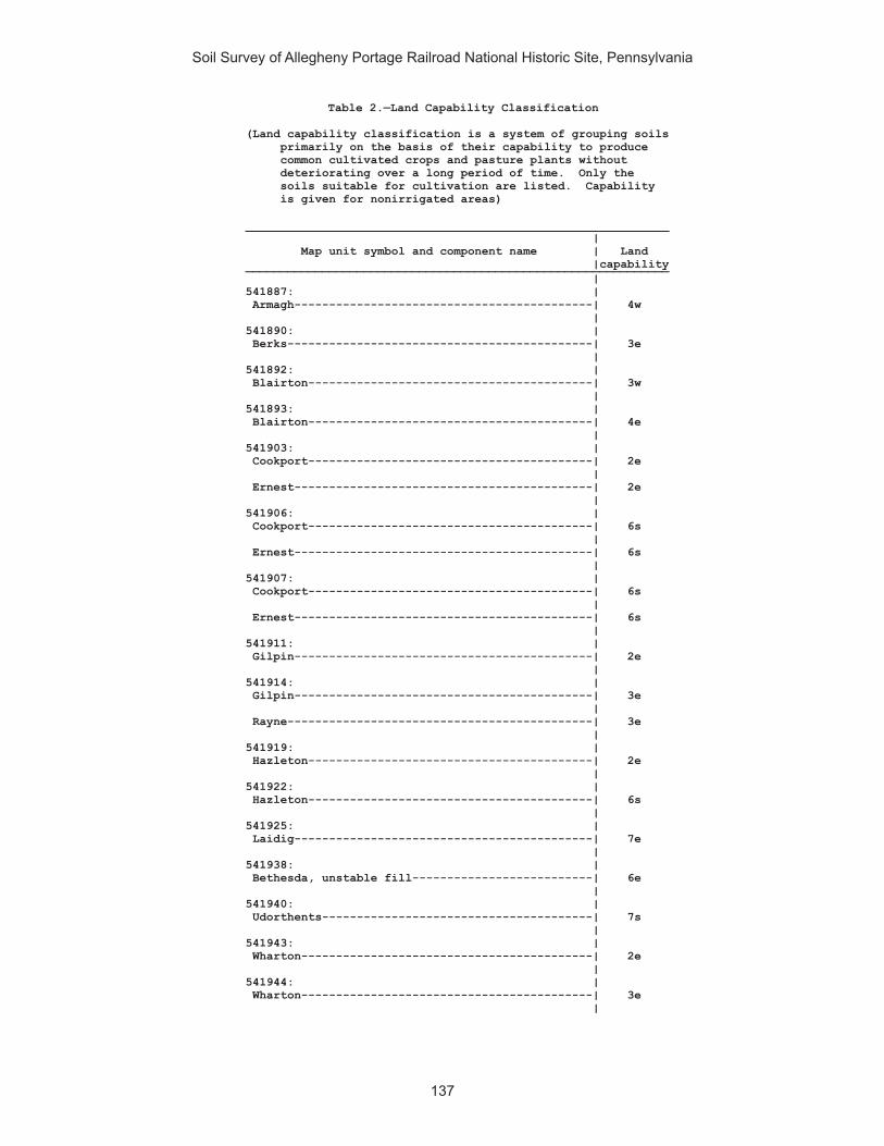
Soil Survey of Allegheny Portage Railroad National Historic Site, Pennsylvania
137
Table 2.—Land Capability Classification
(Land capability classification is a system of grouping soils primarily on the basis of their capability to produce common cultivated crops and pasture plants without deteriorating over a long period of time. Only the soils suitable for cultivation are listed. Capability is given for nonirrigated areas)
_____________________________________________________________ | Map unit symbol and component name | Land |capability_____________________________________________________________ | 541887: | Armagh-------------------------------------------| 4w | 541890: | Berks--------------------------------------------| 3e | 541892: | Blairton-----------------------------------------| 3w | 541893: | Blairton-----------------------------------------| 4e | 541903: | Cookport-----------------------------------------| 2e | Ernest-------------------------------------------| 2e | 541906: | Cookport-----------------------------------------| 6s | Ernest-------------------------------------------| 6s | 541907: | Cookport-----------------------------------------| 6s | Ernest-------------------------------------------| 6s | 541911: | Gilpin-------------------------------------------| 2e | 541914: | Gilpin-------------------------------------------| 3e | Rayne--------------------------------------------| 3e | 541919: | Hazleton-----------------------------------------| 2e | 541922: | Hazleton-----------------------------------------| 6s | 541925: | Laidig-------------------------------------------| 7e | 541938: | Bethesda, unstable fill--------------------------| 6e | 541940: | Udorthents---------------------------------------| 7s | 541943: | Wharton------------------------------------------| 2e | 541944: | Wharton------------------------------------------| 3e |

Soil Survey of Allegheny Portage Railroad National Historic Site, Pennsylvania
138
Table 2.—Land Capability Classification—Continued_____________________________________________________________ | Map unit symbol and component name | Land |capability_____________________________________________________________ | 542311: | Albrights----------------------------------------| 2e | 542321: | Berks--------------------------------------------| 2e | 542322: | Berks--------------------------------------------| 3e | 542323: | Berks--------------------------------------------| 4e | 542324: | Berks--------------------------------------------| 3e | Weikert------------------------------------------| 4e | 542325: | Berks--------------------------------------------| 4e | Weikert------------------------------------------| 6e | 542326: | Berks--------------------------------------------| 7e | Weikert------------------------------------------| 7e | 542329: | Brinkerton---------------------------------------| 4w | 542330: | Brinkerton---------------------------------------| 4w | 542333: | Buchanan-----------------------------------------| 7s | 542334: | Buchanan-----------------------------------------| 7s | 542338: | Clymer-------------------------------------------| 2e | 542348: | Ernest-------------------------------------------| 2e | 542349: | Ernest-------------------------------------------| 3e | 542350: | Gilpin-------------------------------------------| 2e | 542351: | Gilpin-------------------------------------------| 3e | 542352: | Gilpin-------------------------------------------| 4e | 542366: | Leck Kill----------------------------------------| 7e | 542370: | Laidig-------------------------------------------| 7s |

Soil Survey of Allegheny Portage Railroad National Historic Site, Pennsylvania
139
Table 2.—Land Capability Classification—Continued_____________________________________________________________ | Map unit symbol and component name | Land |capability_____________________________________________________________ | 542371: | Laidig-------------------------------------------| 7s | 542372: | Laidig-------------------------------------------| 7s | 542375: | Leck Kill----------------------------------------| 4e | 542383: | Meckesville--------------------------------------| 6s | 542384: | Meckesville--------------------------------------| 6s | 542406: | Tyler--------------------------------------------| 3w | 542407: | Udifluvents--------------------------------------| 7s | Dystrochrepts------------------------------------| 7s | 542410: | Berks--------------------------------------------| 4e | 542420: | Wharton------------------------------------------| 2e | 542421: | Wharton------------------------------------------| 3e | _____________________________________________________________

Soil Survey of Allegheny Portage Railroad National Historic Site, Pennsylvania
140
Table 3.—Prime and Other Important Farmland
(Only the soils considered prime or important farmland are listed. Urban or built-up areas of the soils listed are not considered prime or important farmland) ___________________________________________________________________________________________________ | | Map unit | Map unit name | Farmland classification symbol | | ___________________________________________________________________________________________________ | | 541890 |Berks channery silt loam, 8 to 15 percent slopes |Farmland of statewide importance 541892 |Blairton silt loam, 3 to 8 percent slopes |Farmland of statewide importance 541903 |Cookport and Ernest soils, 3 to 8 percent slopes |All areas are prime farmland 541911 |Gilpin silt loam, 3 to 8 percent slopes |All areas are prime farmland 541914 |Gilpin-Rayne silt loams, 8 to 15 percent slopes |Farmland of statewide importance 541919 |}Hazleton channery loam, 3 to 8 percent slopes |All areas are prime farmland 541943 |Wharton silt loam, 3 to 8 percent slopes |All areas are prime farmland 541944 |Wharton silt loam, 8 to 15 percent slopes |Farmland of statewide importance 542311 |Albrights gravelly silt loam, 3 to 8 percent slopes |All areas are prime farmland 542321 |Berks channery silt loam, 3 to 8 percent slopes |Farmland of statewide importance 542322 |Berks channery silt loam, 8 to 15 percent slopes |Farmland of statewide importance 542338 |Clymer loam, 3 to 8 percent slopes |All areas are prime farmland 542348 |Ernest silt loam, 3 to 8 percent slopes |Farmland of statewide importance 542349 |Ernest silt loam, 8 to 15 percent slopes |Farmland of statewide importance 542350 |Gilpin channery silt loam, 3 to 8 percent slopes |All areas are prime farmland 542351 |Gilpin channery silt loam, 8 to 15 percent slopes |Farmland of statewide importance 542406 |Tyler silt loam |Farmland of statewide importance 542420 |Wharton silt loam, 3 to 8 percent slopes |All areas are prime farmland 542421 |Wharton silt loam, 8 to 15 percent slopes |Farmland of statewide importance | | ___________________________________________________________________________________________________

Soil Survey of Allegheny Portage Railroad National Historic Site, Pennsylvania
141
Table 4.—Hydric Soils
(This report lists only those map unit components that are rated as hydric. Definitions of hydric criteria codes are included at the bottom of the report)
________________________________________________________________________________________________________ | | | | Hydric soils criteria ___________________________________________ Map unit symbol and | Component |Percent| Landform | Hydric | Meets | Meets | Meets map unit name | | of map| | criteria |saturation|flooding| ponding | | unit | | code | criteria |criteria| criteria________________________________________________________________________________________________________ | | | | | | | 541887: | | | | | | | Armagh silt loam, 0 to|Armagh | 85 |hills, | 2B3 | Yes | No | No 8 percent slopes | | | depressions | | | | | | | | | | | |Armagh, very | 5 |depressions | 2B3 | Yes | No | No | stony | | on hills | | | | | | | | | | | 541892: | | | | | | | Blairton silt loam, 3 |Brinkerton | 5 |hills | 2B3 | Yes | No | No to 8 percent slopes | | | | | | | | | | | | | | 541893: | | | | | | | Blairton silt loam, 8 |Brinkerton | 5 |hills | 2B3 | Yes | No | No to 15 percent slopes | | | | | | | | | | | | | | 541903: | | | | | | | Cookport and Ernest |Brinkerton | 10 |depressions | 2B3 | Yes | No | No soils, 3 to 8 percent| | | | | | | slopes | | | | | | | | | | | | | | 541906: | | | | | | | Cookport and Ernest |Brinkerton | 10 |depressions | 2B3 | Yes | No | No very stony soils, 0 | | | | | | | to 8 percent slopes | | | | | | | | | | | | | | 541907: | | | | | | | Cookport and Ernest |Brinkerton | 5 |depressions | 2B3 | Yes | No | No very stony soils, 8 | | | | | | | to 25 percent slopes | | | | | | | | | | | | | | 541908: | | | | | | | Dumps, industrial |Wet spots | 1 |depressions | 2B3 | Yes | No | No wastes | | | | | | | | | | | | | | 541909: | | | | | | | Dumps, mine |Wet spots | 1 |depressions | 2B3 | Yes | No | No | | | | | | | 541938: | | | | | | | Udorthents, strip |Wet spots | 1 |depressions | 2B3 | Yes | No | No mine, sloping | | | | | | | | | | | | | | 541940: | | | | | | | Urban land-Udorthents |Wet spots | 1 |depressions | 2B3 | Yes | No | No complex, gently | | | | | | | sloping | | | | | | | | | | | | | | 541943: | | | | | | | Wharton silt loam, 3 |Brinkerton | 2 |sloughs | 2B3 | Yes | No | No to 8 percent slopes | | | | | | | | | | | | | | 541944: | | | | | | | Wharton silt loam, 8 |Brinkerton | 2 |hills | 2B3 | Yes | No | No to 15 percent slopes | | | | | | | | | | | | | |

Soil Survey of Allegheny Portage Railroad National Historic Site, Pennsylvania
142
Table 4.—Hydric Soils—Continued________________________________________________________________________________________________________ | | | | Hydric soils criteria ___________________________________________ Map unit symbol and | Component |Percent| Landform | Hydric | Meets | Meets | Meets map unit name | | of map| | criteria |saturation|flooding| ponding | | unit | | code | criteria |criteria| criteria________________________________________________________________________________________________________ | | | | | | | 542311: | | | | | | | Albrights gravelly |Brinkerton | 5 |hills | 2B3 | Yes | No | No silt loam, 3 to 8 | | | | | | | percent slopes | | | | | | | | | | | | | | 542326: | | | | | | | Berks-Weikert channery|Brinkerton | 2 |hills | 2B3 | Yes | No | No silt loams, 25 to 70 | | | | | | | percent slopes | | | | | | | | | | | | | | 542329: | | | | | | | Brinkerton silt loam, |Brinkerton | 75 |depressions | 2B3 | Yes | No | No 3 to 8 percent slopes| | | | | | | |Atkins | 3 |flood plains | 2B3 | Yes | No | No | | | | | | | 542330: | | | | | | | Brinkerton silt loam, |Brinkerton | 85 |upland | 2B3 | Yes | No | No 8 to 15 percent | | | drainageways | | | | slopes | | | | | | | | | | | | | | 542333: | | | | | | | Buchanan extremely |Andover | 5 |depressions | 2B3 | Yes | No | No stony silt loam, 3 to| | | | | | | 8 percent slopes | | | | | | | | | | | | | | 542334: | | | | | | | Buchanan extremely |Andover | 3 |depressions | 2B3 | Yes | No | No stony silt loam, 8 to| | | | | | | 25 percent slopes |Springs and | 1 |depressions | 2B3 | Yes | No | No | seeps | | | | | | | | | | | | | 542348: | | | | | | | Ernest silt loam, 3 to|Brinkerton | 5 |depressions | 2B3 | Yes | No | No 8 percent slopes | | | | | | | |Atkins | 2 |flood plains | 2B3 | Yes | No | No | | | | | | | 542349: | | | | | | | Ernest silt loam, 8 to|Brinkerton | 5 |depressions | 2B3 | Yes | No | No 15 percent slopes | | | | | | | | | | | | | | 542406: | | | | | | | Tyler silt loam |Purdy | 5 |depressions | 2B3, 3 | Yes | No | Yes | | | | | | | 542407: | | | | | | | Udifluvents- |Brinkerton | 2 |hills | 2B3 | Yes | No | No Dystrochrepts complex| | | | | | | |Holly | 2 |depressions | 2B3 | Yes | No | No | | | on flood | | | | | | | plains, | | | | | | | backswamps | | | | | | | | | | | 542410: | | | | | | | Urban land-Berks |Brinkerton | 5 |depressions | 2B3 | Yes | No | No complex, 8 to 25 | | | | | | | percent slopes | | | | | | | | | | | | | | 542420: | | | | | | | Wharton silt loam, 3 |Brinkerton | 3 |hills, draws | 2B3 | Yes | No | No to 8 percent slopes | | | | | | | | | | | | | |

Soil Survey of Allegheny Portage Railroad National Historic Site, Pennsylvania
143
Table 4.—Hydric Soils—Continued________________________________________________________________________________________________________ | | | | Hydric soils criteria ___________________________________________ Map unit symbol and | Component |Percent| Landform | Hydric | Meets | Meets | Meets map unit name | | of map| | criteria |saturation|flooding| ponding | | unit | | code | criteria |criteria| criteria________________________________________________________________________________________________________ | | | | | | | 542421: | | | | | | | Wharton silt loam, 8 |Brinkerton | 3 |hills, draws | 2B3 | Yes | No | No to 15 percent slopes | | | | | | | | | | | | | | ________________________________________________________________________________________________________
Explanation of hydric criteria codes: 1. All Histels (except for Folistels), and Histosols (except for Folists), which are, by definition, saturated. 2. Soils in Aquic suborders, great groups, or subgroups, Albolls suborder, Historthels great group, Histoturbels great group, Pachic subgroups, or Cumulic subgroups that: A. are somewhat poorly drained and have a water table at the surface (0.0 feet) during the growing season, or B. are poorly drained or very poorly drained and have either: 1.) a water table at the surface (0.0 feet) during the growing season if textures are coarse sand, sand, or fine sand in all layers within a depth of 20 inches, or 2.) a water table at a depth of 0.5 foot or less during the growing season if permeability is equal to or greater than 6.0 in/hr in all layers within a depth of 20 inches, or 3.) a water table at a depth of 1.0 foot or less during the growing season if permeability is less than 6.0 in/hr in any layer within a depth of 20 inches. 3. Soils that are frequently ponded for periods of long or very long duration during the growing season. 4. Soils that are frequently flooded for periods of long or very long duration during the growing season.
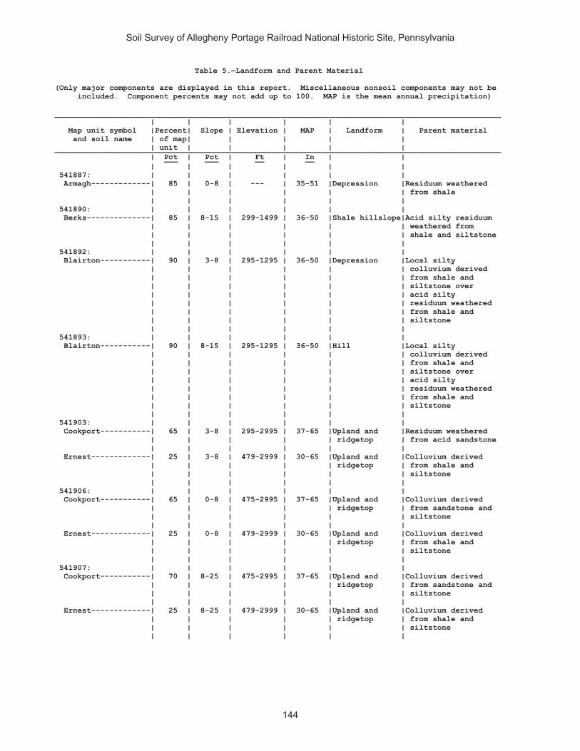
Soil Survey of Allegheny Portage Railroad National Historic Site, Pennsylvania
144
Table 5.—Landform and Parent Material
(Only major components are displayed in this report. Miscellaneous nonsoil components may not be included. Component percents may not add up to 100. MAP is the mean annual precipitation) __________________________________________________________________________________________________ | | | | | | Map unit symbol |Percent| Slope | Elevation | MAP | Landform | Parent material and soil name | of map| | | | | | unit | | | | | __________________________________________________________________________________________________ | Pct | Pct | Ft | In | | ___ ___ __ __ | | | | | | 541887: | | | | | | Armagh-------------| 85 | 0-8 | --- | 35-51 |Depression |Residuum weathered | | | | | | from shale | | | | | | 541890: | | | | | | Berks--------------| 85 | 8-15 | 299-1499 | 36-50 |Shale hillslope|Acid silty residuum | | | | | | weathered from | | | | | | shale and siltstone | | | | | | 541892: | | | | | | Blairton-----------| 90 | 3-8 | 295-1295 | 36-50 |Depression |Local silty | | | | | | colluvium derived | | | | | | from shale and | | | | | | siltstone over | | | | | | acid silty | | | | | | residuum weathered | | | | | | from shale and | | | | | | siltstone | | | | | | 541893: | | | | | | Blairton-----------| 90 | 8-15 | 295-1295 | 36-50 |Hill |Local silty | | | | | | colluvium derived | | | | | | from shale and | | | | | | siltstone over | | | | | | acid silty | | | | | | residuum weathered | | | | | | from shale and | | | | | | siltstone | | | | | | 541903: | | | | | | Cookport-----------| 65 | 3-8 | 295-2995 | 37-65 |Upland and |Residuum weathered | | | | | ridgetop | from acid sandstone | | | | | | Ernest-------------| 25 | 3-8 | 479-2999 | 30-65 |Upland and |Colluvium derived | | | | | ridgetop | from shale and | | | | | | siltstone | | | | | | 541906: | | | | | | Cookport-----------| 65 | 0-8 | 475-2995 | 37-65 |Upland and |Colluvium derived | | | | | ridgetop | from sandstone and | | | | | | siltstone | | | | | | Ernest-------------| 25 | 0-8 | 479-2999 | 30-65 |Upland and |Colluvium derived | | | | | ridgetop | from shale and | | | | | | siltstone | | | | | | 541907: | | | | | | Cookport-----------| 70 | 8-25 | 475-2995 | 37-65 |Upland and |Colluvium derived | | | | | ridgetop | from sandstone and | | | | | | siltstone | | | | | | Ernest-------------| 25 | 8-25 | 479-2999 | 30-65 |Upland and |Colluvium derived | | | | | ridgetop | from shale and | | | | | | siltstone | | | | | |

Soil Survey of Allegheny Portage Railroad National Historic Site, Pennsylvania
145
Table 5.—Landform and Parent Material—Continued __________________________________________________________________________________________________ | | | | | | Map unit symbol |Percent| Slope | Elevation | MAP | Landform | Parent material and soil name | of map| | | | | | unit | | | | | __________________________________________________________________________________________________ | Pct | Pct | Ft | In | | ___ ___ __ __ | | | | | | 541908. | | | | | | Dumps, industrial | | | | | | wastes | | | | | | | | | | | | 541909. | | | | | | Dumps, mine | | | | | | | | | | | | 541911: | | | | | | Gilpin-------------| 75 | 3-8 | 1500-2350 | 35-50 |Mountain slope |Residuum weathered | | | | | | from shale and | | | | | | siltstone | | | | | | 541914: | | | | | | Gilpin-------------| 70 | 8-15 | --- | 37-65 |Hillslope |Residuum weathered | | | | | | from interbedded | | | | | | sedimentary rock | | | | | | Rayne--------------| 30 | 8-15 | --- | 37-65 |Hill |Residuum weathered | | | | | | from interbedded | | | | | | sedimentary rock | | | | | | 541919: | | | | | | Hazleton-----------| 90 | 3-8 | 1099-2500 | 38-46 |Hillside and |Acid sandy residuum | | | | | mountainside | weathered from | | | | | | noncalcareous | | | | | | sandstone | | | | | | 541922: | | | | | | Hazleton-----------| 75 | 0-8 | 1148-2799 | 35-51 |Hillside and |Acid sandy residuum | | | | | mountainside | weathered from | | | | | | noncalcareous | | | | | | sandstone | | | | | | 541925: | | | | | | Laidig-------------| 100 | 25-70 | 400-3799 | 34-60 |Mountain |Mountain slope | | | | | | fine-loamy | | | | | | colluvium derived | | | | | | from interbedded | | | | | | sedimentary rock | | | | | | 541938: | | | | | | Bethesda, unstable | | | | | | fill--------------| 90 | 8-25 | 801-1699 | 36-46 | --- |Acid loamy coal | | | | | | extraction mine | | | | | | spoil derived from | | | | | | interbedded | | | | | | sedimentary rock | | | | | | 541940: | | | | | | Urban land. | | | | | | | | | | | | Udorthents---------| 30 | 3-8 | 200-1001 | 35-45 | --- |Manmade and | | | | | | altered materials | | | | | | from mixed rock | | | | | | types | | | | | | 541942. | | | | | | Water | | | | | | | | | | | |

Soil Survey of Allegheny Portage Railroad National Historic Site, Pennsylvania
146
Table 5.—Landform and Parent Material—Continued __________________________________________________________________________________________________ | | | | | | Map unit symbol |Percent| Slope | Elevation | MAP | Landform | Parent material and soil name | of map| | | | | | unit | | | | | __________________________________________________________________________________________________ | Pct | Pct | Ft | In | | ___ ___ __ __ | | | | | | 541943: | | | | | | Wharton------------| 80 | 3-8 | 295-2400 | 38-46 |Hill |Fine-loamy residuum | | | | | | weathered from | | | | | | shale and siltstone | | | | | | 541944: | | | | | | Wharton------------| 80 | 8-15 | 295-2400 | 38-46 |Hill |Fine-loamy residuum | | | | | | weathered from | | | | | | shale and siltstone | | | | | | 542311: | | | | | | Albrights----------| 90 | 3-8 | 499-1499 | 36-46 |Ridge |Colluvium derived | | | | | | from acid, red | | | | | | sandstone, | | | | | | siltstone, and | | | | | | shale | | | | | | 542321: | | | | | | Berks--------------| 85 | 3-8 | 299-1499 | 36-50 |Shale hillslope|Acid silty residuum | | | | | | weathered from | | | | | | shale and siltstone | | | | | | 542322: | | | | | | Berks--------------| 85 | 8-15 | 299-1499 | 36-50 |Shale hillslope|Acid silty residuum | | | | | | weathered from | | | | | | shale and siltstone | | | | | | 542323: | | | | | | Berks--------------| 85 | 15-25 | 299-1499 | 36-50 |Shale hillslope|Acid silty residuum | | | | | | weathered from | | | | | | shale and siltstone | | | | | | 542324: | | | | | | Berks--------------| 50 | 8-15 | 299-1499 | 36-50 |Gently sloping |Acid silty residuum | | | | | shale | from shale and | | | | | hillslope | siltstone | | | | | | Weikert------------| 35 | 8-15 | 499-1601 | 36-50 |Hill |Residuum weathered | | | | | | from shale and | | | | | | siltstone | | | | | | 542325: | | | | | | Berks--------------| 45 | 15-25 | 299-1499 | 36-50 |Shale hillslope|Acid silty residuum | | | | | | from shale and | | | | | | siltstone | | | | | | Weikert------------| 40 | 15-25 | 499-1601 | 36-50 |Hill |Residuum weathered | | | | | | from shale and | | | | | | siltstone | | | | | | 542326: | | | | | | Berks--------------| 50 | 35-70 | 299-1499 | 36-50 |Ridge |Residuum weathered | | | | | | from shale and | | | | | | siltstone | | | | |Valley | | | | | | | Weikert------------| 40 | 35-70 | 499-1601 | 36-50 |Hill |Residuum weathered | | | | | | from shale and | | | | | | siltstone | | | | | |

Soil Survey of Allegheny Portage Railroad National Historic Site, Pennsylvania
147
Table 5.—Landform and Parent Material—Continued __________________________________________________________________________________________________ | | | | | | Map unit symbol |Percent| Slope | Elevation | MAP | Landform | Parent material and soil name | of map| | | | | | unit | | | | | __________________________________________________________________________________________________ | Pct | Pct | Ft | In | | ___ ___ __ __ | | | | | | 542329: | | | | | | Brinkerton---------| 75 | 3-8 | 299-1299 | 35-50 |Depression |Local fine-silty | | | | | | colluvium derived | | | | | | from sedimentary | | | | | | rock | | | | | | 542330: | | | | | | Brinkerton---------| 85 | 8-15 | 299-1299 | 35-50 |Upland |Colluvium derived | | | | | drainageway | from shale and | | | | | | siltstone | | | | | | 542333: | | | | | | Buchanan-----------| 90 | 0-8 | 600-2402 | 38-46 |Mountain slope |Mountain slope | | | | | and valley | colluvium derived | | | | | side | from sedimentary | | | | | | rock | | | | | | 542334: | | | | | | Buchanan-----------| 85 | 8-25 | 600-2402 | 38-46 |Mountain slope |Mountain slope | | | | | and valley | colluvium derived | | | | | side | from sedimentary | | | | | | rock | | | | | | 542338: | | | | | | Clymer-------------| 80 | 3-8 | 1000-2200 | 36-60 |Ridge on |Residuum weathered | | | | | plateau | from sandstone and | | | | | | shale | | | | | | 542348: | | | | | | Ernest-------------| 85 | 3-8 | 479-2999 | 30-65 |Hill |Local fine-silty | | | | | | colluvium derived | | | | | | from sedimentary | | | | | | rock | | | | | | 542349: | | | | | | Ernest-------------| 85 | 8-15 | 479-2999 | 30-65 |Hillslope in |Local fine-silty | | | | | upland valley | colluvium derived | | | | | | from sedimentary | | | | | | rock | | | | | | 542350: | | | | | | Gilpin-------------| 85 | 3-8 | 1001-1699 | 36-46 |Hill |Acid fine-loamy | | | | | | residuum weathered | | | | | | from shale and | | | | | | siltstone | | | | | | 542351: | | | | | | Gilpin-------------| 85 | 8-15 | 1001-1699 | 36-46 |Hillslope |Acid fine-loamy | | | | | | residuum weathered | | | | | | from shale and | | | | | | siltstone | | | | | | 542352: | | | | | | Gilpin-------------| 85 | 15-25 | 1001-1699 | 36-46 |Hillslope |Acid fine-loamy | | | | | | residuum weathered | | | | | | from shale and | | | | | | siltstone | | | | | | 542366: | | | | | | Leck Kill----------| 90 | 25-60 | 499-1499 | 38-46 |Mountain slope |Reddish residuum | | | | | | derived from | | | | | | sedimentary rock | | | | | |

Soil Survey of Allegheny Portage Railroad National Historic Site, Pennsylvania
148
Table 5.—Landform and Parent Material—Continued __________________________________________________________________________________________________ | | | | | | Map unit symbol |Percent| Slope | Elevation | MAP | Landform | Parent material and soil name | of map| | | | | | unit | | | | | __________________________________________________________________________________________________ | Pct | Pct | Ft | In | | ___ ___ __ __ | | | | | | 542370: | | | | | | Laidig-------------| 90 | 3-8 | 400-3799 | 34-40 |Mountain |Mountain slope | | | | | | colluvium derived | | | | | | from sedimentary | | | | | | rock | | | | | | 542371: | | | | | | Laidig-------------| 90 | 15-25 | 400-3799 | 34-40 |Mountain |Colluvium derived | | | | | | from sandstone | | | | | | and siltstone | | | | | | 542372: | | | | | | Laidig-------------| 90 | 35-45 | 400-3799 | 34-40 |Mountain |Colluvium derived | | | | | | from sandstone and | | | | | | siltstone | | | | | | 542375: | | | | | | Leck Kill----------| 80 | 15-25 | 499-1499 | 38-46 |Shale hillslope|Residuum weathered | | | | | | from shale and | | | | | | siltstone | | | | | | 542383: | | | | | | Meckesville--------| 90 | 3-8 | 600-2799 | 34-48 |Mountain valley|Sandstone, | | | | | | siltstone, and | | | | | | shale colluvium | | | | | | derived from | | | | | | sedimentary rock | | | | | | 542384: | | | | | | Meckesville--------| 90 | 15-25 | 600-2799 | 34-48 |Mountain slope |Sandstone, | | | | | | siltstone, and | | | | | | shale colluvium | | | | | | derived from | | | | | | sedimentary rock | | | | | | 542406: | | | | | | Tyler--------------| 90 | 0-3 | 771-1001 | 36-45 |Terrace |Old alluvium | | | | | | derived from | | | | | | sedimentary rock | | | | | | 542407: | | | | | | Udifluvents--------| 50 | 0-3 | 200-1001 | 35-45 |Flood plain |Alluvium | | | | | | Dystrochrepts------| 30 | 0-3 | 200-1001 | 35-45 |Mountain slope |Residuum weathered | | | | | | from sandstone and | | | | | | shale | | | | | | 542410: | | | | | | Urban land---------| 65 | 8-25 | 295-1495 | 36-46 |Hill, ridge, |Pavement, buildings, | | | | | and valley | and other | | | | | | artifically | | | | | | covered areas | | | | | | Berks--------------| 25 | 8-25 | 499-1499 | 35-50 |Ridge and |Acid brown residuum | | | | | valley | weathered from | | | | | | shale and siltstone | | | | | | 542420: | | | | | | Wharton------------| 80 | 3-8 | 801-1499 | 36-46 |Hill |Acid fine-loamy | | | | | | residuum weathered | | | | | | from shale and | | | | | | siltstone | | | | | |

Soil Survey of Allegheny Portage Railroad National Historic Site, Pennsylvania
149
Table 5.—Landform and Parent Material—Continued __________________________________________________________________________________________________ | | | | | | Map unit symbol |Percent| Slope | Elevation | MAP | Landform | Parent material and soil name | of map| | | | | | unit | | | | | __________________________________________________________________________________________________ | Pct | Pct | Ft | In | | ___ ___ __ __ | | | | | | 542421: | | | | | | Wharton------------| 75 | 8-15 | 801-1499 | 36-46 |Hillslope |Acid fine-loamy | | | | | | residuum weathered | | | | | | from shale and | | | | | | siltstone | | | | | | __________________________________________________________________________________________________

Soil Survey of Allegheny Portage Railroad National Historic Site, Pennsylvania
150
Table 6.—Land Management, Part I (Planting)
(Onsite investigation may be needed to validate the interpretations in this table and to confirm the identity of the soil on a given site. The numbers in the value columns range from 0.01 to 1.00. The larger the value, the greater the limitation. See text for further explanation of ratings in this table)
________________________________________________________________________________________________________ | | | | Map unit symbol |Pct.| Suitability for | Suitability for | Soil rutting hazard and soil name | of | hand planting | mechanical planting | _____________________________________________________________________________ |map | Rating class and |Value| Rating class and |Value| Rating class and |Value |unit| limiting features | | limiting features | | limiting features | ________________________________________________________________________________________________________ | | | | | | | | | | | | | | 541887: | | | | | | | Armagh--------------| 85 |Well suited | |Well suited | |Severe | | | | | | | Low strength |1.00 | | | | | | | 541890: | | | | | | | Berks---------------| 85 |Well suited | |Moderately suited | |Moderate | | | | | Rock fragments |0.50 | Low strength |0.50 | | | | Slope |0.50 | | | | | | | | | 541892: | | | | | | | Blairton------------| 90 |Well suited | |Moderately suited | |Severe | | | | | Slope |0.50 | Low strength |1.00 | | | | Rock fragments |0.50 | | | | | | | | | 541893: | | | | | | | Blairton------------| 90 |Well suited | |Moderately suited | |Severe | | | | | Slope |0.50 | Low strength |1.00 | | | | Rock fragments |0.50 | | | | | | | | | 541903: | | | | | | | Cookport------------| 65 |Well suited | |Moderately suited | |Moderate | | | | | Slope |0.50 | Low strength |0.50 | | | | | | | Ernest--------------| 25 |Well suited | |Moderately suited | |Severe | | | | | Slope |0.50 | Low strength |1.00 | | | | | | | 541906: | | | | | | | Cookport------------| 65 |Well suited | |Moderately suited | |Moderate | | | | | Rock fragments |0.50 | Low strength |0.50 | | | | | | | Ernest--------------| 25 |Well suited | |Moderately suited | |Severe | | | | | Rock fragments |0.50 | Low strength |1.00 | | | | | | | 541907: | | | | | | | Cookport------------| 70 |Well suited | |Poorly suited | |Moderate | | | | | Slope |0.75 | Low strength |0.50 | | | | Rock fragments |0.50 | | | | | | | | | Ernest--------------| 25 |Well suited | |Poorly suited | |Severe | | | | | Slope |0.75 | Low strength |1.00 | | | | Rock fragments |0.50 | | | | | | | | | 541908: | | | | | | | Dumps, industrial | | | | | | | wastes-------------| 90 |Not rated | |Not rated | |Not rated | | | | | | | | 541909: | | | | | | | Dumps, mine---------| 99 |Not rated | |Not rated | |Not rated | | | | | | | | 541911: | | | | | | | Gilpin--------------| 75 |Well suited | |Moderately suited | |Severe | | | | | Rock fragments |0.50 | Low strength |1.00 | | | | Slope |0.50 | | | | | | | | |
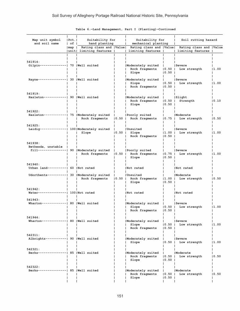
Soil Survey of Allegheny Portage Railroad National Historic Site, Pennsylvania
151
Table 6.—Land Management, Part I (Planting)—Continued________________________________________________________________________________________________________ | | | | Map unit symbol |Pct.| Suitability for | Suitability for | Soil rutting hazard and soil name | of | hand planting | mechanical planting | _____________________________________________________________________________ |map | Rating class and |Value| Rating class and |Value| Rating class and |Value |unit| limiting features | | limiting features | | limiting features | ________________________________________________________________________________________________________ | | | | | | | | | | | | | | 541914: | | | | | | | Gilpin--------------| 70 |Well suited | |Moderately suited | |Severe | | | | | Rock fragments |0.50 | Low strength |1.00 | | | | Slope |0.50 | | | | | | | | | Rayne---------------| 30 |Well suited | |Moderately suited | |Severe | | | | | Slope |0.50 | Low strength |1.00 | | | | Rock fragments |0.50 | | | | | | | | | 541919: | | | | | | | Hazleton------------| 90 |Well suited | |Moderately suited | |Slight | | | | | Rock fragments |0.50 | Strength |0.10 | | | | Slope |0.50 | | | | | | | | | 541922: | | | | | | | Hazleton------------| 75 |Moderately suited | |Poorly suited | |Moderate | | | Rock fragments |0.50 | Rock fragments |0.75 | Low strength |0.50 | | | | | | | 541925: | | | | | | | Laidig--------------| 100|Moderately suited | |Unsuited | |Severe | | | Slope |0.50 | Slope |1.00 | Low strength |1.00 | | | | Rock fragments |0.50 | | | | | | | | | 541938: | | | | | | | Bethesda, unstable | | | | | | | fill---------------| 90 |Moderately suited | |Poorly suited | |Severe | | | Rock fragments |0.50 | Rock fragments |0.75 | Low strength |1.00 | | | | Slope |0.50 | | | | | | | | | 541940: | | | | | | | Urban land----------| 60 |Not rated | |Not rated | |Not rated | | | | | | | | Udorthents----------| 30 |Moderately suited | |Unsuited | |Moderate | | | Rock fragments |0.50 | Rock fragments |1.00 | Low strength |0.50 | | | | Slope |0.50 | | | | | | | | | 541942: | | | | | | | Water---------------| 100|Not rated | |Not rated | |Not rated | | | | | | | | 541943: | | | | | | | Wharton-------------| 80 |Well suited | |Moderately suited | |Severe | | | | | Slope |0.50 | Low strength |1.00 | | | | Rock fragments |0.50 | | | | | | | | | 541944: | | | | | | | Wharton-------------| 80 |Well suited | |Moderately suited | |Severe | | | | | Slope |0.50 | Low strength |1.00 | | | | Rock fragments |0.50 | | | | | | | | | 542311: | | | | | | | Albrights-----------| 90 |Well suited | |Moderately suited | |Severe | | | | | Slope |0.50 | Low strength |1.00 | | | | | | | 542321: | | | | | | | Berks---------------| 85 |Well suited | |Moderately suited | |Moderate | | | | | Rock fragments |0.50 | Low strength |0.50 | | | | Slope |0.50 | | | | | | | | | 542322: | | | | | | | Berks---------------| 85 |Well suited | |Moderately suited | |Moderate | | | | | Rock fragments |0.50 | Low strength |0.50 | | | | Slope |0.50 | | | | | | | | |

Soil Survey of Allegheny Portage Railroad National Historic Site, Pennsylvania
152
Table 6.—Land Management, Part I (Planting)—Continued________________________________________________________________________________________________________ | | | | Map unit symbol |Pct.| Suitability for | Suitability for | Soil rutting hazard and soil name | of | hand planting | mechanical planting | _____________________________________________________________________________ |map | Rating class and |Value| Rating class and |Value| Rating class and |Value |unit| limiting features | | limiting features | | limiting features | ________________________________________________________________________________________________________ | | | | | | | | | | | | | | 542323: | | | | | | | Berks---------------| 85 |Well suited | |Poorly suited | |Moderate | | | | | Slope |0.75 | Low strength |0.50 | | | | Rock fragments |0.50 | | | | | | | | | 542324: | | | | | | | Berks---------------| 50 |Well suited | |Moderately suited | |Moderate | | | | | Rock fragments |0.50 | Low strength |0.50 | | | | Slope |0.50 | | | | | | | | | Weikert-------------| 35 |Well suited | |Moderately suited | |Slight | | | | | Rock fragments |0.50 | Strength |0.10 | | | | Slope |0.50 | | | | | | | | | 542325: | | | | | | | Berks---------------| 45 |Well suited | |Poorly suited | |Moderate | | | | | Slope |0.75 | Low strength |0.50 | | | | Rock fragments |0.50 | | | | | | | | | Weikert-------------| 40 |Well suited | |Poorly suited | |Slight | | | | | Slope |0.75 | Strength |0.10 | | | | Rock fragments |0.50 | | | | | | | | | 542326: | | | | | | | Berks---------------| 50 |Moderately suited | |Unsuited | |Moderate | | | Slope |0.50 | Slope |1.00 | Low strength |0.50 | | | | Rock fragments |0.50 | | | | | | | | | Weikert-------------| 40 |Moderately suited | |Unsuited | |Slight | | | Slope |0.50 | Slope |1.00 | Strength |0.10 | | | | Rock fragments |0.50 | | | | | | | | | 542329: | | | | | | | Brinkerton----------| 75 |Well suited | |Moderately suited | |Severe | | | | | Slope |0.50 | Low strength |1.00 | | | | | | | 542330: | | | | | | | Brinkerton----------| 85 |Well suited | |Moderately suited | |Severe | | | | | Slope |0.50 | Low strength |1.00 | | | | | | | 542333: | | | | | | | Buchanan------------| 90 |Moderately suited | |Poorly suited | |Severe | | | Rock fragments |0.50 | Rock fragments |0.75 | Low strength |1.00 | | | | | | | 542334: | | | | | | | Buchanan------------| 85 |Moderately suited | |Poorly suited | |Severe | | | Rock fragments |0.50 | Slope |0.75 | Low strength |1.00 | | | | Rock fragments |0.75 | | | | | | | | | 542338: | | | | | | | Clymer--------------| 80 |Well suited | |Moderately suited | |Severe | | | | | Slope |0.50 | Low strength |1.00 | | | | Rock fragments |0.50 | | | | | | | | | 542348: | | | | | | | Ernest--------------| 85 |Well suited | |Moderately suited | |Severe | | | | | Slope |0.50 | Low strength |1.00 | | | | Rock fragments |0.50 | | | | | | | | |

Soil Survey of Allegheny Portage Railroad National Historic Site, Pennsylvania
153
Table 6.—Land Management, Part I (Planting)—Continued________________________________________________________________________________________________________ | | | | Map unit symbol |Pct.| Suitability for | Suitability for | Soil rutting hazard and soil name | of | hand planting | mechanical planting | _____________________________________________________________________________ |map | Rating class and |Value| Rating class and |Value| Rating class and |Value |unit| limiting features | | limiting features | | limiting features | ________________________________________________________________________________________________________ | | | | | | | | | | | | | | 542349: | | | | | | | Ernest--------------| 85 |Well suited | |Moderately suited | |Severe | | | | | Slope |0.50 | Low strength |1.00 | | | | | | | 542350: | | | | | | | Gilpin--------------| 85 |Well suited | |Moderately suited | |Severe | | | | | Rock fragments |0.50 | Low strength |1.00 | | | | Slope |0.50 | | | | | | | | | 542351: | | | | | | | Gilpin--------------| 85 |Well suited | |Moderately suited | |Severe | | | | | Rock fragments |0.50 | Low strength |1.00 | | | | Slope |0.50 | | | | | | | | | 542352: | | | | | | | Gilpin--------------| 85 |Well suited | |Poorly suited | |Severe | | | | | Slope |0.75 | Low strength |1.00 | | | | Rock fragments |0.50 | | | | | | | | | 542366: | | | | | | | Leck Kill-----------| 90 |Moderately suited | |Unsuited | |Slight | | | Slope |0.50 | Slope |1.00 | Strength |0.10 | | | | | | | 542370: | | | | | | | Laidig--------------| 90 |Moderately suited | |Poorly suited | |Severe | | | Rock fragments |0.50 | Rock fragments |0.75 | Low strength |1.00 | | | | Slope |0.50 | | | | | | | | | 542371: | | | | | | | Laidig--------------| 90 |Moderately suited | |Poorly suited | |Severe | | | Rock fragments |0.50 | Slope |0.75 | Low strength |1.00 | | | | Rock fragments |0.75 | | | | | | | | | 542372: | | | | | | | Laidig--------------| 90 |Moderately suited | |Unsuited | |Severe | | | Slope |0.50 | Slope |1.00 | Low strength |1.00 | | Rock fragments |0.50 | Rock fragments |0.75 | | | | | | | | | 542375: | | | | | | | Leck Kill-----------| 80 |Well suited | |Poorly suited | |Severe | | | | | Slope |0.75 | Low strength |1.00 | | | | | | | 542383: | | | | | | | Meckesville---------| 90 |Well suited | |Moderately suited | |Severe | | | | | Rock fragments |0.50 | Low strength |1.00 | | | | Slope |0.50 | | | | | | | | | 542384: | | | | | | | Meckesville---------| 90 |Well suited | |Poorly suited | |Severe | | | | | Slope |0.75 | Low strength |1.00 | | | | Rock fragments |0.50 | | | | | | | | | 542406: | | | | | | | Tyler---------------| 90 |Well suited | |Well suited | |Severe | | | | | | | Low strength |1.00 | | | | | | |
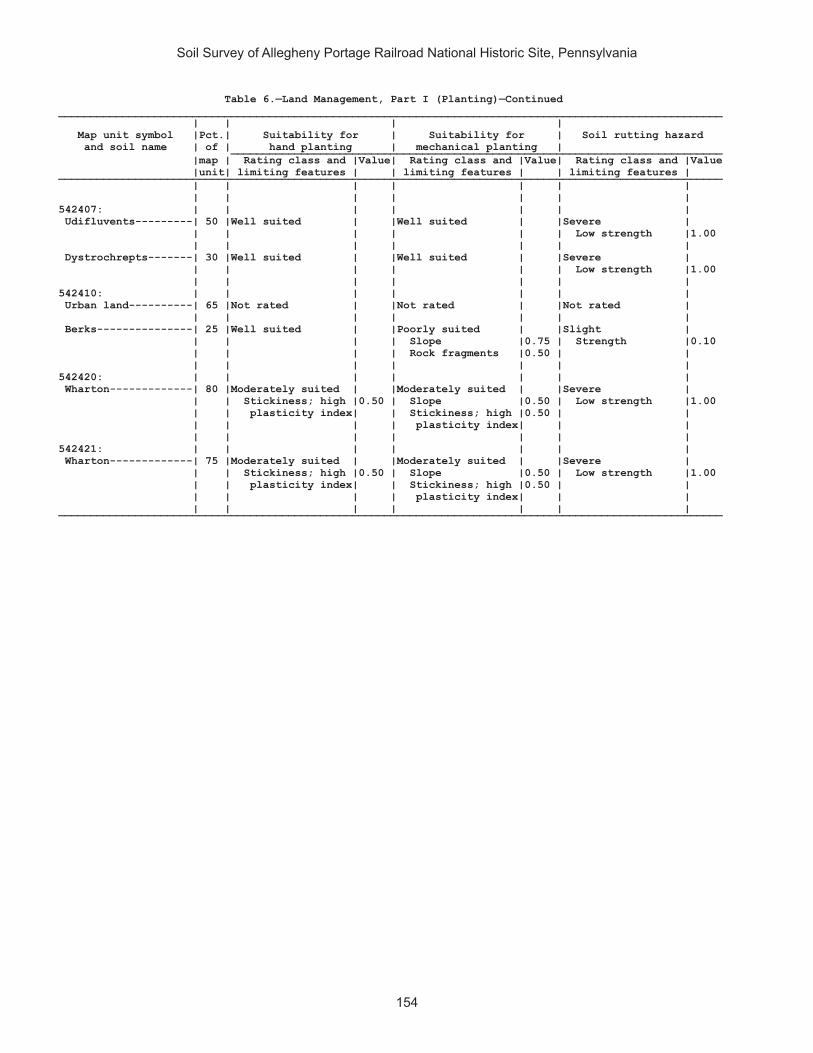
Soil Survey of Allegheny Portage Railroad National Historic Site, Pennsylvania
154
Table 6.—Land Management, Part I (Planting)—Continued________________________________________________________________________________________________________ | | | | Map unit symbol |Pct.| Suitability for | Suitability for | Soil rutting hazard and soil name | of | hand planting | mechanical planting | _____________________________________________________________________________ |map | Rating class and |Value| Rating class and |Value| Rating class and |Value |unit| limiting features | | limiting features | | limiting features | ________________________________________________________________________________________________________ | | | | | | | | | | | | | | 542407: | | | | | | | Udifluvents---------| 50 |Well suited | |Well suited | |Severe | | | | | | | Low strength |1.00 | | | | | | | Dystrochrepts-------| 30 |Well suited | |Well suited | |Severe | | | | | | | Low strength |1.00 | | | | | | | 542410: | | | | | | | Urban land----------| 65 |Not rated | |Not rated | |Not rated | | | | | | | | Berks---------------| 25 |Well suited | |Poorly suited | |Slight | | | | | Slope |0.75 | Strength |0.10 | | | | Rock fragments |0.50 | | | | | | | | | 542420: | | | | | | | Wharton-------------| 80 |Moderately suited | |Moderately suited | |Severe | | | Stickiness; high |0.50 | Slope |0.50 | Low strength |1.00 | | plasticity index| | Stickiness; high |0.50 | | | | | | plasticity index| | | | | | | | | | 542421: | | | | | | | Wharton-------------| 75 |Moderately suited | |Moderately suited | |Severe | | | Stickiness; high |0.50 | Slope |0.50 | Low strength |1.00 | | plasticity index| | Stickiness; high |0.50 | | | | | | plasticity index| | | | | | | | | | ________________________________________________________________________________________________________

Soil Survey of Allegheny Portage Railroad National Historic Site, Pennsylvania
155
Table 6.—Land Management, Part II (Hazard of Erosion and Suitability for Roads)
(Onsite investigation may be needed to validate the interpretations in this table and to confirm the identity of the soil on a given site. The numbers in the value columns range from 0.01 to 1.00. The larger the value, the greater the limitation. See text for further explanation of ratings in this table)
________________________________________________________________________________________________________ | | | | Map unit symbol |Pct.| Hazard of erosion | Hazard of erosion on | Suitability for roads and soil name | of | | roads and trails | (natural surface) _____________________________________________________________________________ |map | Rating class and |Value| Rating class and |Value| Rating class and |Value |unit| limiting features | | limiting features | | limiting features | ________________________________________________________________________________________________________ | | | | | | | 541887: | | | | | | | Armagh--------------| 85 |Slight | |Moderate | |Poorly suited | | | | | Slope/erodibility|0.50 | Wetness |1.00 | | | | | | Low strength |0.50 | | | | | | | 541890: | | | | | | | Berks---------------| 85 |Slight | |Moderate | |Moderately suited | | | | | Slope/erodibility|0.50 | Slope |0.50 | | | | | | | 541892: | | | | | | | Blairton------------| 90 |Slight | |Moderate | |Moderately suited | | | | | Slope/erodibility|0.50 | Wetness |0.50 | | | | | | Low strength |0.50 | | | | | | Slope |0.50 | | | | | | | 541893: | | | | | | | Blairton------------| 90 |Moderate | |Severe | |Moderately suited | | | Slope/erodibility|0.50 | Slope/erodibility|0.95 | Slope |0.50 | | | | | | Wetness |0.50 | | | | | | Low strength |0.50 | | | | | | | 541903: | | | | | | | Cookport------------| 65 |Slight | |Moderate | |Moderately suited | | | | | Slope/erodibility|0.50 | Slope |0.50 | | | | | | | Ernest--------------| 25 |Slight | |Moderate | |Moderately suited | | | | | Slope/erodibility|0.50 | Wetness |0.50 | | | | | | Low strength |0.50 | | | | | | Slope |0.50 | | | | | | | 541906: | | | | | | | Cookport------------| 65 |Slight | |Moderate | |Poorly suited | | | | | Slope/erodibility|0.50 | Wetness |1.00 | | | | | | | Ernest--------------| 25 |Slight | |Moderate | |Moderately suited | | | | | Slope/erodibility|0.50 | Wetness |0.50 | | | | | | Low strength |0.50 | | | | | | | 541907: | | | | | | | Cookport------------| 70 |Moderate | |Severe | |Poorly suited | | | Slope/erodibility|0.50 | Slope/erodibility|0.95 | Wetness |1.00 | | | | | | Slope |1.00 | | | | | | | Ernest--------------| 25 |Moderate | |Severe | |Poorly suited | | | Slope/erodibility|0.50 | Slope/erodibility|0.95 | Slope |1.00 | | | | | | Wetness |0.50 | | | | | | Low strength |0.50 | | | | | | | 541908: | | | | | | | Dumps, industrial | | | | | | | wastes-------------| 90 |Not rated | |Not rated | |Not rated | | | | | | | | 541909: | | | | | | | Dumps, mine---------| 99 |Not rated | |Not rated | |Not rated | | | | | | | |

Soil Survey of Allegheny Portage Railroad National Historic Site, Pennsylvania
156
Table 6.—Land Management, Part II (Hazard of Erosion and Suitability for Roads)—Continued________________________________________________________________________________________________________ | | | | Map unit symbol |Pct.| Hazard of erosion | Hazard of erosion on | Suitability for roads and soil name | of | | roads and trails | (natural surface) _____________________________________________________________________________ |map | Rating class and |Value| Rating class and |Value| Rating class and |Value |unit| limiting features | | limiting features | | limiting features | ________________________________________________________________________________________________________ | | | | | | | 541911: | | | | | | | Gilpin--------------| 75 |Slight | |Moderate | |Moderately suited | | | | | Slope/erodibility|0.50 | Low strength |0.50 | | | | | | | 541914: | | | | | | | Gilpin--------------| 70 |Slight | |Severe | |Moderately suited | | | | | Slope/erodibility|0.95 | Slope |0.50 | | | | | | Low strength |0.50 | | | | | | | Rayne---------------| 30 |Slight | |Severe | |Moderately suited | | | | | Slope/erodibility|0.95 | Slope |0.50 | | | | | | Low strength |0.50 | | | | | | | 541919: | | | | | | | Hazleton------------| 90 |Slight | |Slight | |Moderately suited | | | | | | | Slope |0.50 | | | | | | Landslides |0.01 | | | | | | | 541922: | | | | | | | Hazleton------------| 75 |Slight | |Slight | |Moderately suited | | | | | | | Rock fragments |0.50 | | | | | | | 541925: | | | | | | | Laidig--------------| 100|Moderate | |Severe | |Poorly suited | | | Slope/erodibility|0.50 | Slope/erodibility|0.95 | Slope |1.00 | | | | | | Low strength |0.50 | | | | | | | 541938: | | | | | | | Bethesda, unstable | | | | | | | fill---------------| 90 |Moderate | |Severe | |Poorly suited | | | Slope/erodibility|0.50 | Slope/erodibility|0.95 | Slope |1.00 | | | | | | Low strength |0.50 | | | | | | Landslides |0.10 | | | | | | | 541940: | | | | | | | Urban land----------| 60 |Not rated | |Not rated | |Not rated | | | | | | | | Udorthents----------| 30 |Slight | |Moderate | |Moderately suited | | | | | Slope/erodibility|0.50 | Low strength |0.50 | | | | | | Slope |0.50 | | | | | | | 541942: | | | | | | | Water---------------| 100|Not rated | |Not rated | |Not rated | | | | | | | | 541943: | | | | | | | Wharton-------------| 80 |Slight | |Moderate | |Moderately suited | | | | | Slope/erodibility|0.50 | Low strength |0.50 | | | | | | Slope |0.50 | | | | | | | 541944: | | | | | | | Wharton-------------| 80 |Moderate | |Severe | |Moderately suited | | | Slope/erodibility|0.50 | Slope/erodibility|0.95 | Slope |0.50 | | | | | | Low strength |0.50 | | | | | | | 542311: | | | | | | | Albrights-----------| 90 |Slight | |Moderate | |Moderately suited | | | | | Slope/erodibility|0.50 | Wetness |0.50 | | | | | | Low strength |0.50 | | | | | | Slope |0.50 | | | | | | |

Soil Survey of Allegheny Portage Railroad National Historic Site, Pennsylvania
157
Table 6.—Land Management, Part II (Hazard of Erosion and Suitability for Roads)—Continued________________________________________________________________________________________________________ | | | | Map unit symbol |Pct.| Hazard of erosion | Hazard of erosion on | Suitability for roads and soil name | of | | roads and trails | (natural surface) _____________________________________________________________________________ |map | Rating class and |Value| Rating class and |Value| Rating class and |Value |unit| limiting features | | limiting features | | limiting features | ________________________________________________________________________________________________________ | | | | | | | 542321: | | | | | | | Berks---------------| 85 |Slight | |Slight | |Moderately suited | | | | | | | Slope |0.50 | | | | | | | 542322: | | | | | | | Berks---------------| 85 |Slight | |Moderate | |Moderately suited | | | | | Slope/erodibility|0.50 | Slope |0.50 | | | | | | | 542323: | | | | | | | Berks---------------| 85 |Moderate | |Moderate | |Poorly suited | | | Slope/erodibility|0.50 | Slope/erodibility|0.50 | Slope |1.00 | | | | | | | 542324: | | | | | | | Berks---------------| 50 |Slight | |Moderate | |Moderately suited | | | | | Slope/erodibility|0.50 | Slope |0.50 | | | | | | | Weikert-------------| 35 |Slight | |Severe | |Moderately suited | | | | | Slope/erodibility|0.95 | Slope |0.50 | | | | | | | 542325: | | | | | | | Berks---------------| 45 |Moderate | |Severe | |Poorly suited | | | Slope/erodibility|0.50 | Slope/erodibility|0.95 | Slope |1.00 | | | | | | | Weikert-------------| 40 |Moderate | |Severe | |Poorly suited | | | Slope/erodibility|0.50 | Slope/erodibility|0.95 | Slope |1.00 | | | | | | | 542326: | | | | | | | Berks---------------| 50 |Very severe | |Severe | |Poorly suited | | | Slope/erodibility|0.95 | Slope/erodibility|0.95 | Slope |1.00 | | | | | | | Weikert-------------| 40 |Very severe | |Severe | |Poorly suited | | | Slope/erodibility|0.95 | Slope/erodibility|0.95 | Slope |1.00 | | | | | | | 542329: | | | | | | | Brinkerton----------| 75 |Slight | |Moderate | |Poorly suited | | | | | Slope/erodibility|0.50 | Wetness |1.00 | | | | | | Low strength |0.50 | | | | | | Slope |0.50 | | | | | | | 542330: | | | | | | | Brinkerton----------| 85 |Slight | |Severe | |Poorly suited | | | | | Slope/erodibility|0.95 | Wetness |1.00 | | | | | | Slope |0.50 | | | | | | Low strength |0.50 | | | | | | | 542333: | | | | | | | Buchanan------------| 90 |Slight | |Moderate | |Moderately suited | | | | | Slope/erodibility|0.50 | Rock fragments |0.50 | | | | | | Low strength |0.50 | | | | | | | 542334: | | | | | | | Buchanan------------| 85 |Moderate | |Severe | |Poorly suited | | | Slope/erodibility|0.50 | Slope/erodibility|0.95 | Slope |1.00 | | | | | | Rock fragments |0.50 | | | | | | Low strength |0.50 | | | | | | | 542338: | | | | | | | Clymer--------------| 80 |Slight | |Moderate | |Moderately suited | | | | | Slope/erodibility|0.50 | Slope |0.50 | | | | | | |

Soil Survey of Allegheny Portage Railroad National Historic Site, Pennsylvania
158
Table 6.—Land Management, Part II (Hazard of Erosion and Suitability for Roads)—Continued________________________________________________________________________________________________________ | | | | Map unit symbol |Pct.| Hazard of erosion | Hazard of erosion on | Suitability for roads and soil name | of | | roads and trails | (natural surface) _____________________________________________________________________________ |map | Rating class and |Value| Rating class and |Value| Rating class and |Value |unit| limiting features | | limiting features | | limiting features | ________________________________________________________________________________________________________ | | | | | | | 542348: | | | | | | | Ernest--------------| 85 |Slight | |Moderate | |Moderately suited | | | | | Slope/erodibility|0.50 | Low strength |0.50 | | | | | | | 542349: | | | | | | | Ernest--------------| 85 |Moderate | |Severe | |Moderately suited | | | Slope/erodibility|0.50 | Slope/erodibility|0.95 | Slope |0.50 | | | | | | Low strength |0.50 | | | | | | | 542350: | | | | | | | Gilpin--------------| 85 |Slight | |Moderate | |Moderately suited | | | | | Slope/erodibility|0.50 | Low strength |0.50 | | | | | | Slope |0.50 | | | | | | Landslides |0.01 | | | | | | | 542351: | | | | | | | Gilpin--------------| 85 |Slight | |Severe | |Moderately suited | | | | | Slope/erodibility|0.95 | Slope |0.50 | | | | | | Low strength |0.50 | | | | | | Landslides |0.07 | | | | | | | 542352: | | | | | | | Gilpin--------------| 85 |Moderate | |Severe | |Poorly suited | | | Slope/erodibility|0.50 | Slope/erodibility|0.95 | Slope |1.00 | | | | | | Low strength |0.50 | | | | | | Landslides |0.15 | | | | | | | 542366: | | | | | | | Leck Kill-----------| 90 |Severe | |Severe | |Poorly suited | | | Slope/erodibility|0.75 | Slope/erodibility|0.95 | Slope |1.00 | | | | | | Stickiness; high |0.50 | | | | | | plasticity index| | | | | | | | 542370: | | | | | | | Laidig--------------| 90 |Slight | |Moderate | |Moderately suited | | | | | Slope/erodibility|0.50 | Rock fragments |0.50 | | | | | | Low strength |0.50 | | | | | | Slope |0.50 | | | | | | | 542371: | | | | | | | Laidig--------------| 90 |Moderate | |Severe | |Poorly suited | | | Slope/erodibility|0.50 | Slope/erodibility|0.95 | Slope |1.00 | | | | | | Rock fragments |0.50 | | | | | | Low strength |0.50 | | | | | | | 542372: | | | | | | | Laidig--------------| 90 |Severe | |Severe | |Poorly suited | | | Slope/erodibility|0.75 | Slope/erodibility|0.95 | Slope |1.00 | | | | | | Rock fragments |0.50 | | | | | | Low strength |0.50 | | | | | | | 542375: | | | | | | | Leck Kill-----------| 80 |Moderate | |Severe | |Poorly suited | | | Slope/erodibility|0.50 | Slope/erodibility|0.95 | Slope |1.00 | | | | | | Low strength |0.50 | | | | | | | 542383: | | | | | | | Meckesville---------| 90 |Slight | |Moderate | |Moderately suited | | | | | Slope/erodibility|0.50 | Low strength |0.50 | | | | | | Slope |0.50 | | | | | | |

Soil Survey of Allegheny Portage Railroad National Historic Site, Pennsylvania
159
Table 6.—Land Management, Part II (Hazard of Erosion and Suitability for Roads)—Continued________________________________________________________________________________________________________ | | | | Map unit symbol |Pct.| Hazard of erosion | Hazard of erosion on | Suitability for roads and soil name | of | | roads and trails | (natural surface) _____________________________________________________________________________ |map | Rating class and |Value| Rating class and |Value| Rating class and |Value |unit| limiting features | | limiting features | | limiting features | ________________________________________________________________________________________________________ | | | | | | | 542384: | | | | | | | Meckesville---------| 90 |Moderate | |Severe | |Poorly suited | | | Slope/erodibility|0.50 | Slope/erodibility|0.95 | Slope |1.00 | | | | | | Low strength |0.50 | | | | | | | 542406: | | | | | | | Tyler---------------| 90 |Slight | |Slight | |Moderately suited | | | | | | | Wetness |0.50 | | | | | | Low strength |0.50 | | | | | | | 542407: | | | | | | | Udifluvents---------| 50 |Slight | |Slight | |Poorly suited | | | | | | | Flooding |1.00 | | | | | | Low strength |0.50 | | | | | | | Dystrochrepts-------| 30 |Slight | |Slight | |Poorly suited | | | | | | | Flooding |1.00 | | | | | | Low strength |0.50 | | | | | | | 542410: | | | | | | | Urban land----------| 65 |Not rated | |Not rated | |Not rated | | | | | | | | Berks---------------| 25 |Moderate | |Severe | |Poorly suited | | | Slope/erodibility|0.50 | Slope/erodibility|0.95 | Slope |1.00 | | | | | | | 542420: | | | | | | | Wharton-------------| 80 |Slight | |Moderate | |Moderately suited | | | | | Slope/erodibility|0.50 | Low strength |0.50 | | | | | | | 542421: | | | | | | | Wharton-------------| 75 |Moderate | |Severe | |Moderately suited | | | Slope/erodibility|0.50 | Slope/erodibility|0.95 | Slope |0.50 | | | | | | Low strength |0.50 | | | | | | Landslides |0.21 | | | | | | | ________________________________________________________________________________________________________

Soil Survey of Allegheny Portage Railroad National Historic Site, Pennsylvania
160
Table 6.—Land Management, Part III (Site Preparation)
(Onsite investigation may be needed to validate the interpretations in this table and to confirm the identity of the soil on a given site. The numbers in the value columns range from 0.01 to 1.00. The larger the value, the greater the limitation. See text for further explanation of ratings in this table)
______________________________________________________________________________ | | Suitability for | Suitability for Map unit symbol |Pct.| mechanical site | mechanical site and soil name | of | preparation (deep) | preparation (surface) ___________________________________________________ |map | Rating class and |Value| Rating class and |Value |unit| limiting features | | limiting features | ______________________________________________________________________________ | | | | | 541887: | | | | | Armagh--------------| 85 |Well suited | |Well suited | | | | | | 541890: | | | | | Berks---------------| 85 |Unsuited | |Well suited | | | Restrictive layer|1.00 | | | | | | | 541892: | | | | | Blairton------------| 90 |Unsuited | |Well suited | | | Restrictive layer|1.00 | | | | | | | 541893: | | | | | Blairton------------| 90 |Well suited | |Well suited | | | | | | 541903: | | | | | Cookport------------| 65 |Well suited | |Well suited | | | | | | Ernest--------------| 25 |Well suited | |Well suited | | | | | | 541906: | | | | | Cookport------------| 65 |Well suited | |Well suited | | | | | | Ernest--------------| 25 |Well suited | |Well suited | | | | | | 541907: | | | | | Cookport------------| 70 |Poorly suited | |Poorly suited | | | Slope |0.50 | Slope |0.50 | | | | | Ernest--------------| 25 |Poorly suited | |Poorly suited | | | Slope |0.50 | Slope |0.50 | | | | | 541908: | | | | | Dumps, industrial | | | | | wastes-------------| 90 |Not rated | |Not rated | | | | | | 541909: | | | | | Dumps, mine---------| 99 |Not rated | |Not rated | | | | | | 541911: | | | | | Gilpin--------------| 75 |Poorly suited | |Well suited | | | Restrictive layer|0.50 | | | | | | | 541914: | | | | | Gilpin--------------| 70 |Well suited | |Well suited | | | | | | Rayne---------------| 30 |Well suited | |Well suited | | | | | | 541919: | | | | | Hazleton------------| 90 |Well suited | |Well suited | | | | | | 541922: | | | | | Hazleton------------| 75 |Poorly suited | |Poorly suited | | | Rock fragments |0.50 | Rock fragments |0.50 | | | | |

Soil Survey of Allegheny Portage Railroad National Historic Site, Pennsylvania
161
Table 6.—Land Management, Part III (Site Preparation)—Continued______________________________________________________________________________ | | Suitability for | Suitability for Map unit symbol |Pct.| mechanical site | mechanical site and soil name | of | preparation (deep) | preparation (surface) ___________________________________________________ |map | Rating class and |Value| Rating class and |Value |unit| limiting features | | limiting features | ______________________________________________________________________________ | | | | | 541925: | | | | | Laidig--------------| 100|Poorly suited | |Poorly suited | | | Slope |0.50 | Slope |0.50 | | | | | 541938: | | | | | Bethesda, unstable | | | | | fill---------------| 90 |Poorly suited | |Poorly suited | | | Slope |0.50 | Slope |0.50 | | | | Rock fragments |0.50 | | | | | 541940: | | | | | Urban land----------| 60 |Not rated | |Not rated | | | | | | Udorthents----------| 30 |Well suited | |Poorly suited | | | | | Rock fragments |0.50 | | | | | 541942: | | | | | Water---------------| 100|Not rated | |Not rated | | | | | | 541943: | | | | | Wharton-------------| 80 |Well suited | |Well suited | | | | | | 541944: | | | | | Wharton-------------| 80 |Well suited | |Well suited | | | | | | 542311: | | | | | Albrights-----------| 90 |Well suited | |Well suited | | | | | | 542321: | | | | | Berks---------------| 85 |Unsuited | |Well suited | | | Restrictive layer|1.00 | | | | | | | 542322: | | | | | Berks---------------| 85 |Unsuited | |Well suited | | | Restrictive layer|1.00 | | | | | | | 542323: | | | | | Berks---------------| 85 |Unsuited | |Poorly suited | | | Restrictive layer|1.00 | Slope |0.50 | | Slope |0.50 | | | | | | | 542324: | | | | | Berks---------------| 50 |Unsuited | |Well suited | | | Restrictive layer|1.00 | | | | | | | Weikert-------------| 35 |Unsuited | |Well suited | | | Restrictive layer|1.00 | | | | | | | 542325: | | | | | Berks---------------| 45 |Unsuited | |Poorly suited | | | Restrictive layer|1.00 | Slope |0.50 | | Slope |0.50 | | | | | | | Weikert-------------| 40 |Unsuited | |Poorly suited | | | Restrictive layer|1.00 | Slope |0.50 | | Slope |0.50 | | | | | | |
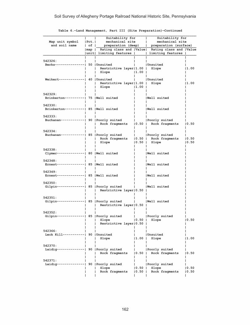
Soil Survey of Allegheny Portage Railroad National Historic Site, Pennsylvania
162
Table 6.—Land Management, Part III (Site Preparation)—Continued______________________________________________________________________________ | | Suitability for | Suitability for Map unit symbol |Pct.| mechanical site | mechanical site and soil name | of | preparation (deep) | preparation (surface) ___________________________________________________ |map | Rating class and |Value| Rating class and |Value |unit| limiting features | | limiting features | ______________________________________________________________________________ | | | | | 542326: | | | | | Berks---------------| 50 |Unsuited | |Unsuited | | | Restrictive layer|1.00 | Slope |1.00 | | Slope |1.00 | | | | | | | Weikert-------------| 40 |Unsuited | |Unsuited | | | Restrictive layer|1.00 | Slope |1.00 | | Slope |1.00 | | | | | | | 542329: | | | | | Brinkerton----------| 75 |Well suited | |Well suited | | | | | | 542330: | | | | | Brinkerton----------| 85 |Well suited | |Well suited | | | | | | 542333: | | | | | Buchanan------------| 90 |Poorly suited | |Poorly suited | | | Rock fragments |0.50 | Rock fragments |0.50 | | | | | 542334: | | | | | Buchanan------------| 85 |Poorly suited | |Poorly suited | | | Rock fragments |0.50 | Rock fragments |0.50 | | Slope |0.50 | Slope |0.50 | | | | | 542338: | | | | | Clymer--------------| 80 |Well suited | |Well suited | | | | | | 542348: | | | | | Ernest--------------| 85 |Well suited | |Well suited | | | | | | 542349: | | | | | Ernest--------------| 85 |Well suited | |Well suited | | | | | | 542350: | | | | | Gilpin--------------| 85 |Poorly suited | |Well suited | | | Restrictive layer|0.50 | | | | | | | 542351: | | | | | Gilpin--------------| 85 |Poorly suited | |Well suited | | | Restrictive layer|0.50 | | | | | | | 542352: | | | | | Gilpin--------------| 85 |Poorly suited | |Poorly suited | | | Slope |0.50 | Slope |0.50 | | Restrictive layer|0.50 | | | | | | | 542366: | | | | | Leck Kill-----------| 90 |Unsuited | |Unsuited | | | Slope |1.00 | Slope |1.00 | | | | | 542370: | | | | | Laidig--------------| 90 |Poorly suited | |Poorly suited | | | Rock fragments |0.50 | Rock fragments |0.50 | | | | | 542371: | | | | | Laidig--------------| 90 |Poorly suited | |Poorly suited | | | Slope |0.50 | Slope |0.50 | | Rock fragments |0.50 | Rock fragments |0.50 | | | | |
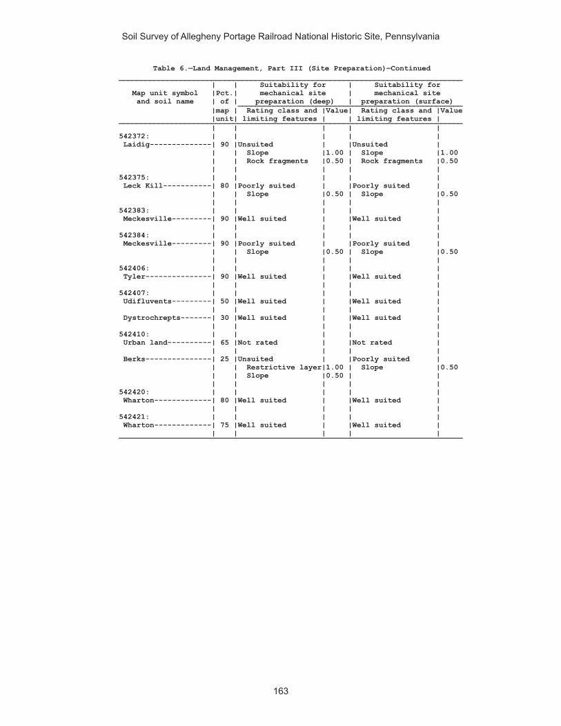
Soil Survey of Allegheny Portage Railroad National Historic Site, Pennsylvania
163
Table 6.—Land Management, Part III (Site Preparation)—Continued______________________________________________________________________________ | | Suitability for | Suitability for Map unit symbol |Pct.| mechanical site | mechanical site and soil name | of | preparation (deep) | preparation (surface) ___________________________________________________ |map | Rating class and |Value| Rating class and |Value |unit| limiting features | | limiting features | ______________________________________________________________________________ | | | | | 542372: | | | | | Laidig--------------| 90 |Unsuited | |Unsuited | | | Slope |1.00 | Slope |1.00 | | Rock fragments |0.50 | Rock fragments |0.50 | | | | | 542375: | | | | | Leck Kill-----------| 80 |Poorly suited | |Poorly suited | | | Slope |0.50 | Slope |0.50 | | | | | 542383: | | | | | Meckesville---------| 90 |Well suited | |Well suited | | | | | | 542384: | | | | | Meckesville---------| 90 |Poorly suited | |Poorly suited | | | Slope |0.50 | Slope |0.50 | | | | | 542406: | | | | | Tyler---------------| 90 |Well suited | |Well suited | | | | | | 542407: | | | | | Udifluvents---------| 50 |Well suited | |Well suited | | | | | | Dystrochrepts-------| 30 |Well suited | |Well suited | | | | | | 542410: | | | | | Urban land----------| 65 |Not rated | |Not rated | | | | | | Berks---------------| 25 |Unsuited | |Poorly suited | | | Restrictive layer|1.00 | Slope |0.50 | | Slope |0.50 | | | | | | | 542420: | | | | | Wharton-------------| 80 |Well suited | |Well suited | | | | | | 542421: | | | | | Wharton-------------| 75 |Well suited | |Well suited | | | | | |______________________________________________________________________________

Soil Survey of Allegheny Portage Railroad National Historic Site, Pennsylvania
164
Table 6.—Land Management, Part IV (Site Restoration)
(Onsite investigation may be needed to validate the interpretations in this table and to confirm the identity of the soil on a given site. The numbers in the value columns range from 0.01 to 1.00. The larger the value, the greater the limitation. See text for further explanation of ratings in this table)
______________________________________________________________________________ | | | Map unit symbol |Pct.| Potential for damage to | Potential for seedling and soil name | of | soil by fire | mortality ___________________________________________________ |map | Rating class and |Value| Rating class and |Value |unit| limiting features | | limiting features | ______________________________________________________________________________ | | | | | 541887: | | | | | Armagh--------------| 85 |Low | |High | | | Texture/rock |0.10 | Wetness |1.00 | | fragments | | | | | | | | 541890: | | | | | Berks---------------| 85 |Moderate | |Low | | | Texture/rock |0.50 | | | | fragments | | | | | | | | 541892: | | | | | Blairton------------| 90 |Low | |Low | | | Texture/rock |0.10 | | | | fragments | | | | | | | | 541893: | | | | | Blairton------------| 90 |Low | |Low | | | Texture/rock |0.10 | | | | fragments | | | | | | | | 541903: | | | | | Cookport------------| 65 |Low | |Low | | | Texture/rock |0.10 | | | | fragments | | | | | | | | Ernest--------------| 25 |Low | |High | | | Texture/rock |0.10 | Wetness |1.00 | | fragments | | | | | | | | 541906: | | | | | Cookport------------| 65 |Low | |High | | | Texture/rock |0.10 | Wetness |1.00 | | fragments | | | | | | | | Ernest--------------| 25 |Low | |High | | | Texture/rock |0.10 | Wetness |1.00 | | fragments | | | | | | | | 541907: | | | | | Cookport------------| 70 |Low | |High | | | Texture/rock |0.10 | Wetness |1.00 | | fragments | | | | | | | | Ernest--------------| 25 |Low | |High | | | Texture/rock |0.10 | Wetness |1.00 | | fragments | | | | | | | | 541908: | | | | | Dumps, industrial | | | | | wastes-------------| 90 |Not rated | |Not rated | | | | | | 541909: | | | | | Dumps, mine---------| 99 |Not rated | |Not rated | | | | | |

Soil Survey of Allegheny Portage Railroad National Historic Site, Pennsylvania
165
Table 6.—Land Management, Part IV (Site Restoration)—Continued______________________________________________________________________________ | | | Map unit symbol |Pct.| Potential for damage to | Potential for seedling and soil name | of | soil by fire | mortality ___________________________________________________ |map | Rating class and |Value| Rating class and |Value |unit| limiting features | | limiting features | ______________________________________________________________________________ | | | | | 541911: | | | | | Gilpin--------------| 75 |Moderate | |Low | | | Texture/surface |0.50 | | | | layer | | | | | thickness/rock | | | | | fragments | | | | | | | | 541914: | | | | | Gilpin--------------| 70 |Low | |Low | | | Texture/rock |0.10 | | | | fragments | | | | | | | | Rayne---------------| 30 |Low | |Low | | | Texture/rock |0.10 | | | | fragments | | | | | | | | 541919: | | | | | Hazleton------------| 90 |Low | |Low | | | Texture/rock |0.10 | | | | fragments | | | | | | | | 541922: | | | | | Hazleton------------| 75 |Low | |Moderate | | | Texture/rock |0.10 | Soil reaction |0.50 | | fragments | | | | | | | | 541925: | | | | | Laidig--------------| 100|Low | |Low | | | | | | 541938: | | | | | Bethesda, unstable | | | | | fill---------------| 90 |High | |Low | | | Texture/rock |1.00 | | | | fragments | | | | | | | | 541940: | | | | | Urban land----------| 60 |Not rated | |Not rated | | | | | | Udorthents----------| 30 |High | |Low | | | Texture/rock |1.00 | | | | fragments | | | | | | | | 541942: | | | | | Water---------------| 100|Not rated | |Not rated | | | | | | 541943: | | | | | Wharton-------------| 80 |Low | |Low | | | Texture/rock |0.10 | | | | fragments | | | | | | | | 541944: | | | | | Wharton-------------| 80 |Low | |Low | | | Texture/rock |0.10 | | | | fragments | | | | | | | | 542311: | | | | | Albrights-----------| 90 |Low | |Low | | | Texture/rock |0.10 | | | | fragments | | | | | | | |
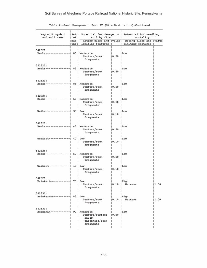
Soil Survey of Allegheny Portage Railroad National Historic Site, Pennsylvania
166
Table 6.—Land Management, Part IV (Site Restoration)—Continued______________________________________________________________________________ | | | Map unit symbol |Pct.| Potential for damage to | Potential for seedling and soil name | of | soil by fire | mortality ___________________________________________________ |map | Rating class and |Value| Rating class and |Value |unit| limiting features | | limiting features | ______________________________________________________________________________ | | | | | 542321: | | | | | Berks---------------| 85 |Moderate | |Low | | | Texture/rock |0.50 | | | | fragments | | | | | | | | 542322: | | | | | Berks---------------| 85 |Moderate | |Low | | | Texture/rock |0.50 | | | | fragments | | | | | | | | 542323: | | | | | Berks---------------| 85 |Moderate | |Low | | | Texture/rock |0.50 | | | | fragments | | | | | | | | 542324: | | | | | Berks---------------| 50 |Moderate | |Low | | | Texture/rock |0.50 | | | | fragments | | | | | | | | Weikert-------------| 35 |Low | |Low | | | Texture/rock |0.10 | | | | fragments | | | | | | | | 542325: | | | | | Berks---------------| 45 |Moderate | |Low | | | Texture/rock |0.50 | | | | fragments | | | | | | | | Weikert-------------| 40 |Low | |Low | | | Texture/rock |0.10 | | | | fragments | | | | | | | | 542326: | | | | | Berks---------------| 50 |Moderate | |Low | | | Texture/rock |0.50 | | | | fragments | | | | | | | | Weikert-------------| 40 |Low | |Low | | | Texture/rock |0.10 | | | | fragments | | | | | | | | 542329: | | | | | Brinkerton----------| 75 |Low | |High | | | Texture/rock |0.10 | Wetness |1.00 | | fragments | | | | | | | | 542330: | | | | | Brinkerton----------| 85 |Low | |High | | | Texture/rock |0.10 | Wetness |1.00 | | fragments | | | | | | | | 542333: | | | | | Buchanan------------| 90 |Moderate | |Low | | | Texture/surface |0.50 | | | | layer | | | | | thickness/rock | | | | | fragments | | | | | | | |

Soil Survey of Allegheny Portage Railroad National Historic Site, Pennsylvania
167
Table 6.—Land Management, Part IV (Site Restoration)—Continued______________________________________________________________________________ | | | Map unit symbol |Pct.| Potential for damage to | Potential for seedling and soil name | of | soil by fire | mortality ___________________________________________________ |map | Rating class and |Value| Rating class and |Value |unit| limiting features | | limiting features | ______________________________________________________________________________ | | | | | 542334: | | | | | Buchanan------------| 85 |Moderate | |Low | | | Texture/surface |0.50 | | | | layer | | | | | thickness/rock | | | | | fragments | | | | | | | | 542338: | | | | | Clymer--------------| 80 |Moderate | |Low | | | Texture/surface |0.50 | | | | layer | | | | | thickness/rock | | | | | fragments | | | | | | | | 542348: | | | | | Ernest--------------| 85 |Low | |Low | | | Texture/rock |0.10 | | | | fragments | | | | | | | | 542349: | | | | | Ernest--------------| 85 |Low | |Low | | | Texture/rock |0.10 | | | | fragments | | | | | | | | 542350: | | | | | Gilpin--------------| 85 |Low | |Low | | | Texture/rock |0.10 | | | | fragments | | | | | | | | 542351: | | | | | Gilpin--------------| 85 |Low | |Low | | | Texture/rock |0.10 | | | | fragments | | | | | | | | 542352: | | | | | Gilpin--------------| 85 |Low | |Low | | | Texture/rock |0.10 | | | | fragments | | | | | | | | 542366: | | | | | Leck Kill-----------| 90 |Low | |Low | | | Texture/rock |0.10 | | | | fragments | | | | | | | | 542370: | | | | | Laidig--------------| 90 |Moderate | |Low | | | Texture/rock |0.50 | | | | fragments | | | | | | | | 542371: | | | | | Laidig--------------| 90 |Moderate | |Low | | | Texture/rock |0.50 | | | | fragments | | | | | | | | 542372: | | | | | Laidig--------------| 90 |Moderate | |Low | | | Texture/slope/ |0.50 | | | | rock fragments | | | | | | | |

Soil Survey of Allegheny Portage Railroad National Historic Site, Pennsylvania
168
Table 6.—Land Management, Part IV (Site Restoration)—Continued______________________________________________________________________________ | | | Map unit symbol |Pct.| Potential for damage to | Potential for seedling and soil name | of | soil by fire | mortality ___________________________________________________ |map | Rating class and |Value| Rating class and |Value |unit| limiting features | | limiting features | ______________________________________________________________________________ | | | | | 542375: | | | | | Leck Kill-----------| 80 |Low | |Low | | | Texture/rock |0.10 | | | | fragments | | | | | | | | 542383: | | | | | Meckesville---------| 90 |Low | |Low | | | Texture/rock |0.10 | | | | fragments | | | | | | | | 542384: | | | | | Meckesville---------| 90 |Low | |Low | | | Texture/rock |0.10 | | | | fragments | | | | | | | | 542406: | | | | | Tyler---------------| 90 |Low | |High | | | Texture/rock |0.10 | Wetness |1.00 | | fragments | | | | | | | | 542407: | | | | | Udifluvents---------| 50 |Low | |Low | | | Texture/rock |0.10 | | | | fragments | | | | | | | | Dystrochrepts-------| 30 |Low | |Low | | | Texture/rock |0.10 | | | | fragments | | | | | | | | 542410: | | | | | Urban land----------| 65 |Not rated | |Not rated | | | | | | Berks---------------| 25 |Low | |Moderate | | | Texture/rock |0.10 | Available water |0.50 | | fragments | | | | | | | | 542420: | | | | | Wharton-------------| 80 |Low | |Low | | | Texture/rock |0.10 | | | | fragments | | | | | | | | 542421: | | | | | Wharton-------------| 75 |Low | |Low | | | Texture/rock |0.10 | | | | fragments | | | | | | | | ______________________________________________________________________________
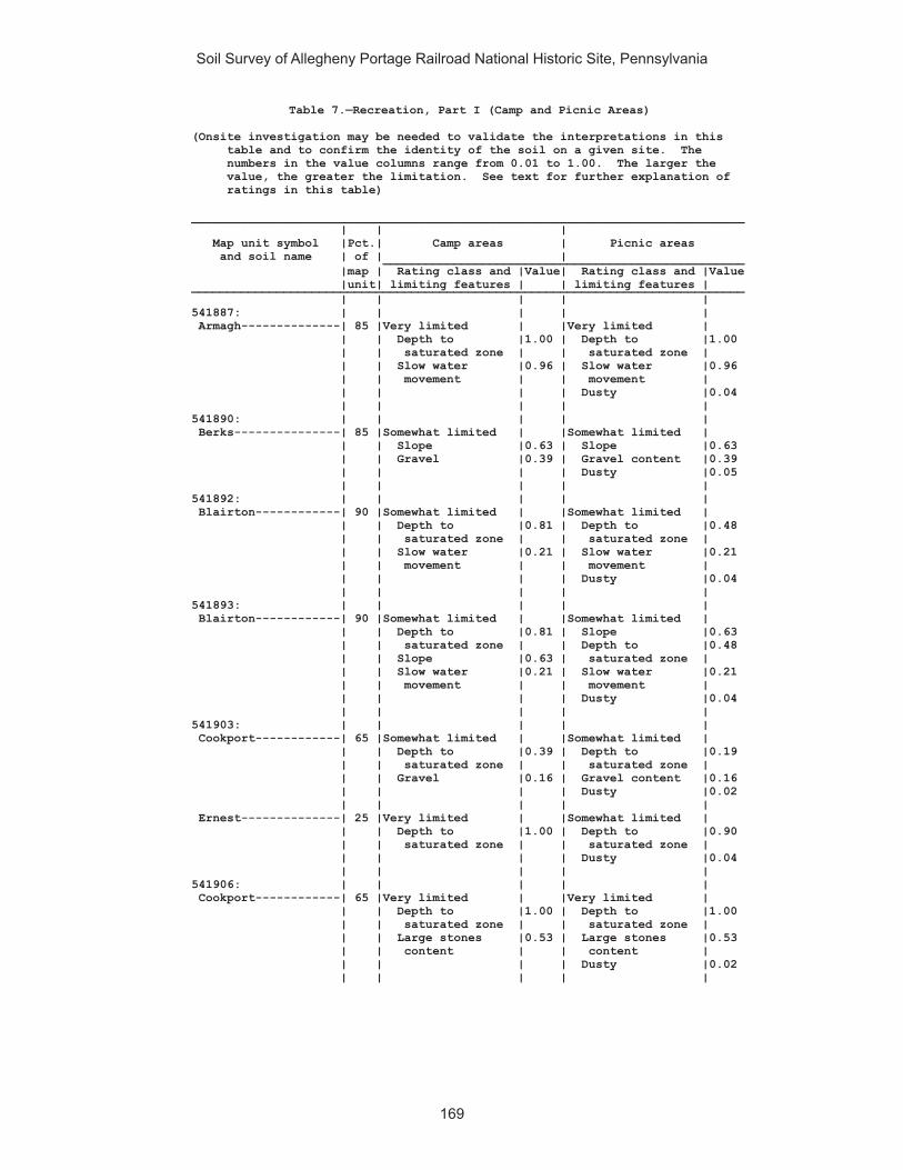
Soil Survey of Allegheny Portage Railroad National Historic Site, Pennsylvania
169
Table 7.—Recreation, Part I (Camp and Picnic Areas)
(Onsite investigation may be needed to validate the interpretations in this table and to confirm the identity of the soil on a given site. The numbers in the value columns range from 0.01 to 1.00. The larger the value, the greater the limitation. See text for further explanation of ratings in this table)
______________________________________________________________________________ | | | Map unit symbol |Pct.| Camp areas | Picnic areas and soil name | of | | ___________________________________________________ |map | Rating class and |Value| Rating class and |Value |unit| limiting features | | limiting features | ______________________________________________________________________________ | | | | | 541887: | | | | | Armagh--------------| 85 |Very limited | |Very limited | | | Depth to |1.00 | Depth to |1.00 | | saturated zone | | saturated zone | | | Slow water |0.96 | Slow water |0.96 | | movement | | movement | | | | | Dusty |0.04 | | | | | 541890: | | | | | Berks---------------| 85 |Somewhat limited | |Somewhat limited | | | Slope |0.63 | Slope |0.63 | | Gravel |0.39 | Gravel content |0.39 | | | | Dusty |0.05 | | | | | 541892: | | | | | Blairton------------| 90 |Somewhat limited | |Somewhat limited | | | Depth to |0.81 | Depth to |0.48 | | saturated zone | | saturated zone | | | Slow water |0.21 | Slow water |0.21 | | movement | | movement | | | | | Dusty |0.04 | | | | | 541893: | | | | | Blairton------------| 90 |Somewhat limited | |Somewhat limited | | | Depth to |0.81 | Slope |0.63 | | saturated zone | | Depth to |0.48 | | Slope |0.63 | saturated zone | | | Slow water |0.21 | Slow water |0.21 | | movement | | movement | | | | | Dusty |0.04 | | | | | 541903: | | | | | Cookport------------| 65 |Somewhat limited | |Somewhat limited | | | Depth to |0.39 | Depth to |0.19 | | saturated zone | | saturated zone | | | Gravel |0.16 | Gravel content |0.16 | | | | Dusty |0.02 | | | | | Ernest--------------| 25 |Very limited | |Somewhat limited | | | Depth to |1.00 | Depth to |0.90 | | saturated zone | | saturated zone | | | | | Dusty |0.04 | | | | | 541906: | | | | | Cookport------------| 65 |Very limited | |Very limited | | | Depth to |1.00 | Depth to |1.00 | | saturated zone | | saturated zone | | | Large stones |0.53 | Large stones |0.53 | | content | | content | | | | | Dusty |0.02 | | | | |

Soil Survey of Allegheny Portage Railroad National Historic Site, Pennsylvania
170
Table 7.—Recreation, Part I (Camp and Picnic Areas)—Continued______________________________________________________________________________ | | | Map unit symbol |Pct.| Camp areas | Picnic areas and soil name | of | | ___________________________________________________ |map | Rating class and |Value| Rating class and |Value |unit| limiting features | | limiting features | ______________________________________________________________________________ | | | | | 541906: | | | | | Ernest--------------| 25 |Very limited | |Somewhat limited | | | Depth to |1.00 | Depth to |0.90 | | saturated zone | | saturated zone | | | Large stones |0.53 | Large stones |0.53 | | content | | content | | | | | Dusty |0.04 | | | | | 541907: | | | | | Cookport------------| 70 |Very limited | |Very limited | | | Depth to |1.00 | Depth to |1.00 | | saturated zone | | saturated zone | | | Slope |1.00 | Slope |1.00 | | Large stones |0.53 | Large stones |0.53 | | content | | content | | | | | Dusty |0.02 | | | | | Ernest--------------| 25 |Very limited | |Very limited | | | Depth to |1.00 | Slope |1.00 | | saturated zone | | Depth to |0.90 | | Slope |1.00 | saturated zone | | | Large stones |0.53 | Large stones |0.53 | | content | | content | | | | | Dusty |0.04 | | | | | 541908: | | | | | Dumps, industrial | | | | | wastes-------------| 90 |Not rated | |Not rated | | | | | | 541909: | | | | | Dumps, mine---------| 99 |Not rated | |Not rated | | | | | | 541911: | | | | | Gilpin--------------| 75 |Not limited | |Somewhat limited | | | | | Dusty |0.05 | | | | | 541914: | | | | | Gilpin--------------| 70 |Somewhat limited | |Somewhat limited | | | Slope |0.63 | Slope |0.63 | | | | Dusty |0.03 | | | | | Rayne---------------| 30 |Somewhat limited | |Somewhat limited | | | Slope |0.63 | Slope |0.63 | | | | Dusty |0.03 | | | | | 541919: | | | | | Hazleton------------| 90 |Somewhat limited | |Somewhat limited | | | Gravel |0.02 | Gravel content |0.02 | | | | Dusty |0.01 | | | | | 541922: | | | | | Hazleton------------| 75 |Very limited | |Very limited | | | Large stones |1.00 | Large stones |1.00 | | content | | content | | | | | Gravel content |0.10 | | | | Dusty |0.01 | | | | | 541925: | | | | | Laidig--------------| 100|Very limited | |Very limited | | | Slope |1.00 | Slope |1.00 | | | | Dusty |0.02 | | | | |
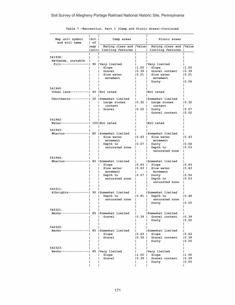
Soil Survey of Allegheny Portage Railroad National Historic Site, Pennsylvania
171
Table 7.—Recreation, Part I (Camp and Picnic Areas)—Continued______________________________________________________________________________ | | | Map unit symbol |Pct.| Camp areas | Picnic areas and soil name | of | | ___________________________________________________ |map | Rating class and |Value| Rating class and |Value |unit| limiting features | | limiting features | ______________________________________________________________________________ | | | | | 541938: | | | | | Bethesda, unstable | | | | | fill---------------| 90 |Very limited | |Very limited | | | Slope |1.00 | Slope |1.00 | | Gravel |0.39 | Gravel content |0.39 | | Slow water |0.21 | Slow water |0.21 | | movement | | movement | | | | | Dusty |0.04 | | | | | 541940: | | | | | Urban land----------| 60 |Not rated | |Not rated | | | | | | Udorthents----------| 30 |Somewhat limited | |Somewhat limited | | | Large stones |0.32 | Large stones |0.32 | | content | | content | | | Gravel |0.02 | Dusty |0.07 | | | | Gravel content |0.02 | | | | | 541942: | | | | | Water---------------| 100|Not rated | |Not rated | | | | | | 541943: | | | | | Wharton-------------| 80 |Somewhat limited | |Somewhat limited | | | Slow water |0.43 | Slow water |0.43 | | movement | | movement | | | Depth to |0.07 | Dusty |0.04 | | saturated zone | | Depth to |0.03 | | | | saturated zone | | | | | | 541944: | | | | | Wharton-------------| 80 |Somewhat limited | |Somewhat limited | | | Slope |0.63 | Slope |0.63 | | Slow water |0.43 | Slow water |0.43 | | movement | | movement | | | Depth to |0.07 | Dusty |0.04 | | saturated zone | | Depth to |0.03 | | | | saturated zone | | | | | | 542311: | | | | | Albrights-----------| 90 |Somewhat limited | |Somewhat limited | | | Depth to |0.81 | Depth to |0.48 | | saturated zone | | saturated zone | | | | | Dusty |0.05 | | | | | 542321: | | | | | Berks---------------| 85 |Somewhat limited | |Somewhat limited | | | Gravel |0.39 | Gravel content |0.39 | | | | Dusty |0.05 | | | | | 542322: | | | | | Berks---------------| 85 |Somewhat limited | |Somewhat limited | | | Slope |0.63 | Slope |0.63 | | Gravel |0.39 | Gravel content |0.39 | | | | Dusty |0.05 | | | | | 542323: | | | | | Berks---------------| 85 |Very limited | |Very limited | | | Slope |1.00 | Slope |1.00 | | Gravel |0.39 | Gravel content |0.39 | | | | Dusty |0.05 | | | | |

Soil Survey of Allegheny Portage Railroad National Historic Site, Pennsylvania
172
Table 7.—Recreation, Part I (Camp and Picnic Areas)—Continued______________________________________________________________________________ | | | Map unit symbol |Pct.| Camp areas | Picnic areas and soil name | of | | ___________________________________________________ |map | Rating class and |Value| Rating class and |Value |unit| limiting features | | limiting features | ______________________________________________________________________________ | | | | | 542324: | | | | | Berks---------------| 50 |Somewhat limited | |Somewhat limited | | | Slope |0.63 | Slope |0.63 | | Gravel |0.39 | Gravel content |0.39 | | | | Dusty |0.05 | | | | | Weikert-------------| 35 |Very limited | |Very limited | | | Depth to bedrock |1.00 | Depth to bedrock |1.00 | | Gravel |0.98 | Gravel content |0.98 | | Slope |0.63 | Slope |0.63 | | | | Dusty |0.04 | | | | | 542325: | | | | | Berks---------------| 45 |Very limited | |Very limited | | | Slope |1.00 | Slope |1.00 | | Gravel |0.39 | Gravel content |0.39 | | | | Dusty |0.05 | | | | | Weikert-------------| 40 |Very limited | |Very limited | | | Slope |1.00 | Slope |1.00 | | Depth to bedrock |1.00 | Depth to bedrock |1.00 | | Gravel |0.98 | Gravel content |0.98 | | | | Dusty |0.04 | | | | | 542326: | | | | | Berks---------------| 50 |Very limited | |Very limited | | | Slope |1.00 | Slope |1.00 | | Gravel |0.39 | Gravel content |0.39 | | | | Dusty |0.05 | | | | | Weikert-------------| 40 |Very limited | |Very limited | | | Slope |1.00 | Slope |1.00 | | Depth to bedrock |1.00 | Depth to bedrock |1.00 | | Gravel |0.98 | Gravel content |0.98 | | | | Dusty |0.04 | | | | | 542329: | | | | | Brinkerton----------| 75 |Very limited | |Very limited | | | Depth to |1.00 | Depth to |1.00 | | saturated zone | | saturated zone | | | | | Dusty |0.04 | | | | | 542330: | | | | | Brinkerton----------| 85 |Very limited | |Very limited | | | Depth to |1.00 | Depth to |1.00 | | saturated zone | | saturated zone | | | Slope |0.63 | Slope |0.63 | | | | Dusty |0.04 | | | | | 542333: | | | | | Buchanan------------| 90 |Very limited | |Very limited | | | Large stones |1.00 | Large stones |1.00 | | content | | content | | | Gravel |0.13 | Gravel content |0.13 | | Depth to |0.07 | Depth to |0.03 | | saturated zone | | saturated zone | | | | | Dusty |0.03 | | | | |

Soil Survey of Allegheny Portage Railroad National Historic Site, Pennsylvania
173
Table 7.—Recreation, Part I (Camp and Picnic Areas)—Continued______________________________________________________________________________ | | | Map unit symbol |Pct.| Camp areas | Picnic areas and soil name | of | | ___________________________________________________ |map | Rating class and |Value| Rating class and |Value |unit| limiting features | | limiting features | ______________________________________________________________________________ | | | | | 542334: | | | | | Buchanan------------| 85 |Very limited | |Very limited | | | Large stones |1.00 | Large stones |1.00 | | content | | content | | | Slope |1.00 | Slope |1.00 | | Gravel |0.13 | Gravel content |0.13 | | Depth to |0.07 | Depth to |0.03 | | saturated zone | | saturated zone | | | | | Dusty |0.03 | | | | | 542338: | | | | | Clymer--------------| 80 |Not limited | |Somewhat limited | | | | | Dusty |0.02 | | | | | 542348: | | | | | Ernest--------------| 85 |Somewhat limited | |Somewhat limited | | | Depth to |0.07 | Dusty |0.04 | | saturated zone | | Depth to |0.03 | | | | saturated zone | | | | | | 542349: | | | | | Ernest--------------| 85 |Somewhat limited | |Somewhat limited | | | Slope |0.63 | Slope |0.63 | | Depth to |0.07 | Dusty |0.04 | | saturated zone | | Depth to |0.03 | | | | saturated zone | | | | | | 542350: | | | | | Gilpin--------------| 85 |Somewhat limited | |Somewhat limited | | | Gravel |0.15 | Gravel content |0.15 | | | | Dusty |0.04 | | | | | 542351: | | | | | Gilpin--------------| 85 |Somewhat limited | |Somewhat limited | | | Slope |0.63 | Slope |0.63 | | Gravel |0.15 | Gravel content |0.15 | | | | Dusty |0.04 | | | | | 542352: | | | | | Gilpin--------------| 85 |Very limited | |Very limited | | | Slope |1.00 | Slope |1.00 | | Gravel |0.15 | Gravel content |0.15 | | | | Dusty |0.04 | | | | | 542366: | | | | | Leck Kill-----------| 90 |Very limited | |Very limited | | | Slope |1.00 | Slope |1.00 | | Gravel |0.05 | Gravel content |0.05 | | | | Dusty |0.03 | | | | | 542370: | | | | | Laidig--------------| 90 |Very limited | |Very limited | | | Large stones |1.00 | Large stones |1.00 | | content | | content | | | | | Dusty |0.06 | | | | | 542371: | | | | | Laidig--------------| 90 |Very limited | |Very limited | | | Slope |1.00 | Large stones |1.00 | | Large stones |1.00 | content | | | content | | Slope |1.00 | | | | Dusty |0.06 | | | | |

Soil Survey of Allegheny Portage Railroad National Historic Site, Pennsylvania
174
Table 7.—Recreation, Part I (Camp and Picnic Areas)—Continued______________________________________________________________________________ | | | Map unit symbol |Pct.| Camp areas | Picnic areas and soil name | of | | ___________________________________________________ |map | Rating class and |Value| Rating class and |Value |unit| limiting features | | limiting features | ______________________________________________________________________________ | | | | | 542372: | | | | | Laidig--------------| 90 |Very limited | |Very limited | | | Slope |1.00 | Large stones |1.00 | | Large stones |1.00 | content | | | content | | Slope |1.00 | | | | Dusty |0.06 | | | | | 542375: | | | | | Leck Kill-----------| 80 |Very limited | |Very limited | | | Slope |1.00 | Slope |1.00 | | Gravel |0.05 | Gravel content |0.05 | | | | Dusty |0.03 | | | | | 542383: | | | | | Meckesville---------| 90 |Somewhat limited | |Somewhat limited | | | Large stones |0.53 | Large stones |0.53 | | content | | content | | | | | Dusty |0.05 | | | | | 542384: | | | | | Meckesville---------| 90 |Very limited | |Very limited | | | Slope |1.00 | Slope |1.00 | | Large stones |0.53 | Large stones |0.53 | | content | | content | | | | | Dusty |0.05 | | | | | 542406: | | | | | Tyler---------------| 90 |Very limited | |Very limited | | | Depth to |1.00 | Depth to |1.00 | | saturated zone | | saturated zone | | | Slow water |0.21 | Slow water |0.21 | | movement | | movement | | | | | Dusty |0.09 | | | | | 542407: | | | | | Udifluvents---------| 50 |Very limited | |Somewhat limited | | | Flooding |1.00 | Flooding |0.40 | | | | Dusty |0.02 | | | | | Dystrochrepts-------| 30 |Not rated | |Not rated | | | | | | 542410: | | | | | Urban land----------| 65 |Not rated | |Not rated | | | | | | Berks---------------| 25 |Very limited | |Very limited | | | Slope |1.00 | Slope |1.00 | | Gravel |0.46 | Gravel content |0.46 | | | | Dusty |0.04 | | | | | 542420: | | | | | Wharton-------------| 80 |Somewhat limited | |Somewhat limited | | | Slow water |0.43 | Slow water |0.43 | | movement | | movement | | | Depth to |0.07 | Dusty |0.04 | | saturated zone | | Depth to |0.03 | | | | saturated zone | | | | | |
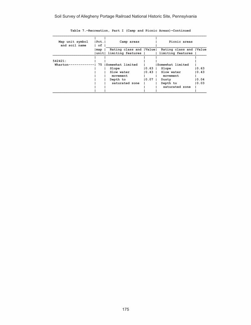
Soil Survey of Allegheny Portage Railroad National Historic Site, Pennsylvania
175
Table 7.—Recreation, Part I (Camp and Picnic Areas)—Continued______________________________________________________________________________ | | | Map unit symbol |Pct.| Camp areas | Picnic areas and soil name | of | | ___________________________________________________ |map | Rating class and |Value| Rating class and |Value |unit| limiting features | | limiting features | ______________________________________________________________________________ | | | | | 542421: | | | | | Wharton-------------| 75 |Somewhat limited | |Somewhat limited | | | Slope |0.63 | Slope |0.63 | | Slow water |0.43 | Slow water |0.43 | | movement | | movement | | | Depth to |0.07 | Dusty |0.04 | | saturated zone | | Depth to |0.03 | | | | saturated zone | | | | | | ______________________________________________________________________________

Soil Survey of Allegheny Portage Railroad National Historic Site, Pennsylvania
176
Table 7.—Recreation, Part II (Trail Management)
(Onsite investigation may be needed to validate the interpretations in this table and to confirm the identity of the soil on a given site. The numbers in the value columns range from 0.01 to 1.00. The larger the value, the greater the limitation. See text for further explanation of ratings in this table)
______________________________________________________________________________ | | | Map unit symbol |Pct.| Foot traffic and | Mountain bike and and soil name | of | equestrian trails | off-road vehicle trails ___________________________________________________ |map | Rating class and |Value| Rating class and |Value |unit| limiting features | | limiting features | ______________________________________________________________________________ | | | | | 541887: | | | | | Armagh--------------| 85 |Very limited | |Very limited | | | Depth to |1.00 | Depth to |1.00 | | saturated zone | | saturated zone | | | | | | 541890: | | | | | Berks---------------| 85 |Not limited | |Not limited | | | | | | 541892: | | | | | Blairton------------| 90 |Somewhat limited | |Somewhat limited | | | Depth to |0.11 | Depth to |0.11 | | saturated zone | | saturated zone | | | | | | 541893: | | | | | Blairton------------| 90 |Very limited | |Very limited | | | Water erosion |1.00 | Water erosion |1.00 | | Depth to |0.11 | Depth to |0.11 | | saturated zone | | saturated zone | | | | | | 541903: | | | | | Cookport------------| 65 |Not limited | |Not limited | | | | | | Ernest--------------| 25 |Somewhat limited | |Somewhat limited | | | Depth to |0.78 | Depth to |0.78 | | saturated zone | | saturated zone | | | | | | 541906: | | | | | Cookport------------| 65 |Very limited | |Very limited | | | Depth to |1.00 | Depth to |1.00 | | saturated zone | | saturated zone | | | Large stones |0.53 | Large stones |0.53 | | content | | content | | | | | | Ernest--------------| 25 |Somewhat limited | |Somewhat limited | | | Depth to |0.78 | Depth to |0.78 | | saturated zone | | saturated zone | | | Large stones |0.53 | Large stones |0.53 | | content | | content | | | | | | 541907: | | | | | Cookport------------| 70 |Very limited | |Very limited | | | Depth to |1.00 | Depth to |1.00 | | saturated zone | | saturated zone | | | Large stones |0.53 | Large stones |0.53 | | content | | content | | | Slope |0.08 | | | | | | | Ernest--------------| 25 |Somewhat limited | |Somewhat limited | | | Depth to |0.78 | Depth to |0.78 | | saturated zone | | saturated zone | | | Large stones |0.53 | Large stones |0.53 | | content | | content | | | Slope |0.08 | | | | | | |

Soil Survey of Allegheny Portage Railroad National Historic Site, Pennsylvania
177
Table 7.—Recreation, Part II (Trail Management)—Continued______________________________________________________________________________ | | | Map unit symbol |Pct.| Foot traffic and | Mountain bike and and soil name | of | equestrian trails | off-road vehicle trails ___________________________________________________ |map | Rating class and |Value| Rating class and |Value |unit| limiting features | | limiting features | ______________________________________________________________________________ | | | | | 541908: | | | | | Dumps, industrial | | | | | wastes-------------| 90 |Not rated | |Not rated | | | | | | 541909: | | | | | Dumps, mine---------| 99 |Not rated | |Not rated | | | | | | 541911: | | | | | Gilpin--------------| 75 |Not limited | |Not limited | | | | | | 541914: | | | | | Gilpin--------------| 70 |Not limited | |Not limited | | | | | | Rayne---------------| 30 |Not limited | |Not limited | | | | | | 541919: | | | | | Hazleton------------| 90 |Not limited | |Not limited | | | | | | 541922: | | | | | Hazleton------------| 75 |Very limited | |Very limited | | | Large stones |1.00 | Large stones |1.00 | | content | | content | | | | | | 541925: | | | | | Laidig--------------| 100|Very limited | |Somewhat limited | | | Slope |1.00 | Slope |0.78 | | | | | 541938: | | | | | Bethesda, unstable | | | | | fill---------------| 90 |Not limited | |Not limited | | | | | | 541940: | | | | | Urban land----------| 60 |Not rated | |Not rated | | | | | | Udorthents----------| 30 |Somewhat limited | |Somewhat limited | | | Large stones |0.32 | Large stones |0.32 | | content | | content | | | | | | 541942: | | | | | Water---------------| 100|Not rated | |Not rated | | | | | | 541943: | | | | | Wharton-------------| 80 |Not limited | |Not limited | | | | | | 541944: | | | | | Wharton-------------| 80 |Very limited | |Very limited | | | Water erosion |1.00 | Water erosion |1.00 | | | | | 542311: | | | | | Albrights-----------| 90 |Somewhat limited | |Somewhat limited | | | Depth to |0.11 | Depth to |0.11 | | saturated zone | | saturated zone | | | | | | 542321: | | | | | Berks---------------| 85 |Not limited | |Not limited | | | | | | 542322: | | | | | Berks---------------| 85 |Not limited | |Not limited | | | | | | 542323: | | | | | Berks---------------| 85 |Somewhat limited | |Not limited | | | Slope |0.50 | | | | | | |

Soil Survey of Allegheny Portage Railroad National Historic Site, Pennsylvania
178
Table 7.—Recreation, Part II (Trail Management)—Continued______________________________________________________________________________ | | | Map unit symbol |Pct.| Foot traffic and | Mountain bike and and soil name | of | equestrian trails | off-road vehicle trails ___________________________________________________ |map | Rating class and |Value| Rating class and |Value |unit| limiting features | | limiting features | ______________________________________________________________________________ | | | | | 542324: | | | | | Berks---------------| 50 |Not limited | |Not limited | | | | | | Weikert-------------| 35 |Not limited | |Not limited | | | | | | 542325: | | | | | Berks---------------| 45 |Somewhat limited | |Not limited | | | Slope |0.50 | | | | | | | Weikert-------------| 40 |Somewhat limited | |Not limited | | | Slope |0.50 | | | | | | | 542326: | | | | | Berks---------------| 50 |Very limited | |Very limited | | | Slope |1.00 | Slope |1.00 | | | | | Weikert-------------| 40 |Very limited | |Very limited | | | Slope |1.00 | Slope |1.00 | | | | | 542329: | | | | | Brinkerton----------| 75 |Very limited | |Very limited | | | Depth to |1.00 | Depth to |1.00 | | saturated zone | | saturated zone | | | | | | 542330: | | | | | Brinkerton----------| 85 |Very limited | |Very limited | | | Depth to |1.00 | Depth to |1.00 | | saturated zone | | saturated zone | | | | | | 542333: | | | | | Buchanan------------| 90 |Very limited | |Very limited | | | Large stones |1.00 | Large stones |1.00 | | content | | content | | | | | | 542334: | | | | | Buchanan------------| 85 |Very limited | |Very limited | | | Large stones |1.00 | Large stones |1.00 | | content | | content | | | Slope |0.08 | | | | | | | 542338: | | | | | Clymer--------------| 80 |Not limited | |Not limited | | | | | | 542348: | | | | | Ernest--------------| 85 |Not limited | |Not limited | | | | | | 542349: | | | | | Ernest--------------| 85 |Very limited | |Very limited | | | Water erosion |1.00 | Water erosion |1.00 | | | | | 542350: | | | | | Gilpin--------------| 85 |Not limited | |Not limited | | | | | | 542351: | | | | | Gilpin--------------| 85 |Not limited | |Not limited | | | | | | 542352: | | | | | Gilpin--------------| 85 |Somewhat limited | |Not limited | | | Slope |0.50 | | | | | | |
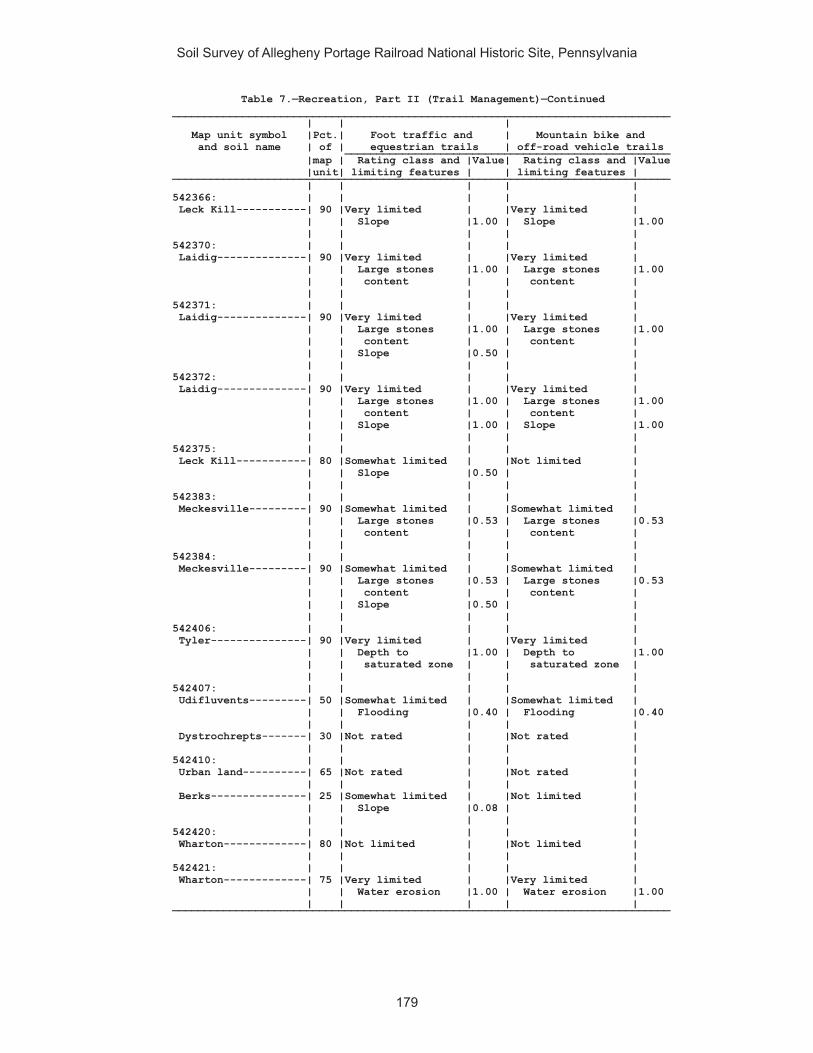
Soil Survey of Allegheny Portage Railroad National Historic Site, Pennsylvania
179
Table 7.—Recreation, Part II (Trail Management)—Continued______________________________________________________________________________ | | | Map unit symbol |Pct.| Foot traffic and | Mountain bike and and soil name | of | equestrian trails | off-road vehicle trails ___________________________________________________ |map | Rating class and |Value| Rating class and |Value |unit| limiting features | | limiting features | ______________________________________________________________________________ | | | | | 542366: | | | | | Leck Kill-----------| 90 |Very limited | |Very limited | | | Slope |1.00 | Slope |1.00 | | | | | 542370: | | | | | Laidig--------------| 90 |Very limited | |Very limited | | | Large stones |1.00 | Large stones |1.00 | | content | | content | | | | | | 542371: | | | | | Laidig--------------| 90 |Very limited | |Very limited | | | Large stones |1.00 | Large stones |1.00 | | content | | content | | | Slope |0.50 | | | | | | | 542372: | | | | | Laidig--------------| 90 |Very limited | |Very limited | | | Large stones |1.00 | Large stones |1.00 | | content | | content | | | Slope |1.00 | Slope |1.00 | | | | | 542375: | | | | | Leck Kill-----------| 80 |Somewhat limited | |Not limited | | | Slope |0.50 | | | | | | | 542383: | | | | | Meckesville---------| 90 |Somewhat limited | |Somewhat limited | | | Large stones |0.53 | Large stones |0.53 | | content | | content | | | | | | 542384: | | | | | Meckesville---------| 90 |Somewhat limited | |Somewhat limited | | | Large stones |0.53 | Large stones |0.53 | | content | | content | | | Slope |0.50 | | | | | | | 542406: | | | | | Tyler---------------| 90 |Very limited | |Very limited | | | Depth to |1.00 | Depth to |1.00 | | saturated zone | | saturated zone | | | | | | 542407: | | | | | Udifluvents---------| 50 |Somewhat limited | |Somewhat limited | | | Flooding |0.40 | Flooding |0.40 | | | | | Dystrochrepts-------| 30 |Not rated | |Not rated | | | | | | 542410: | | | | | Urban land----------| 65 |Not rated | |Not rated | | | | | | Berks---------------| 25 |Somewhat limited | |Not limited | | | Slope |0.08 | | | | | | | 542420: | | | | | Wharton-------------| 80 |Not limited | |Not limited | | | | | | 542421: | | | | | Wharton-------------| 75 |Very limited | |Very limited | | | Water erosion |1.00 | Water erosion |1.00 | | | | | ______________________________________________________________________________
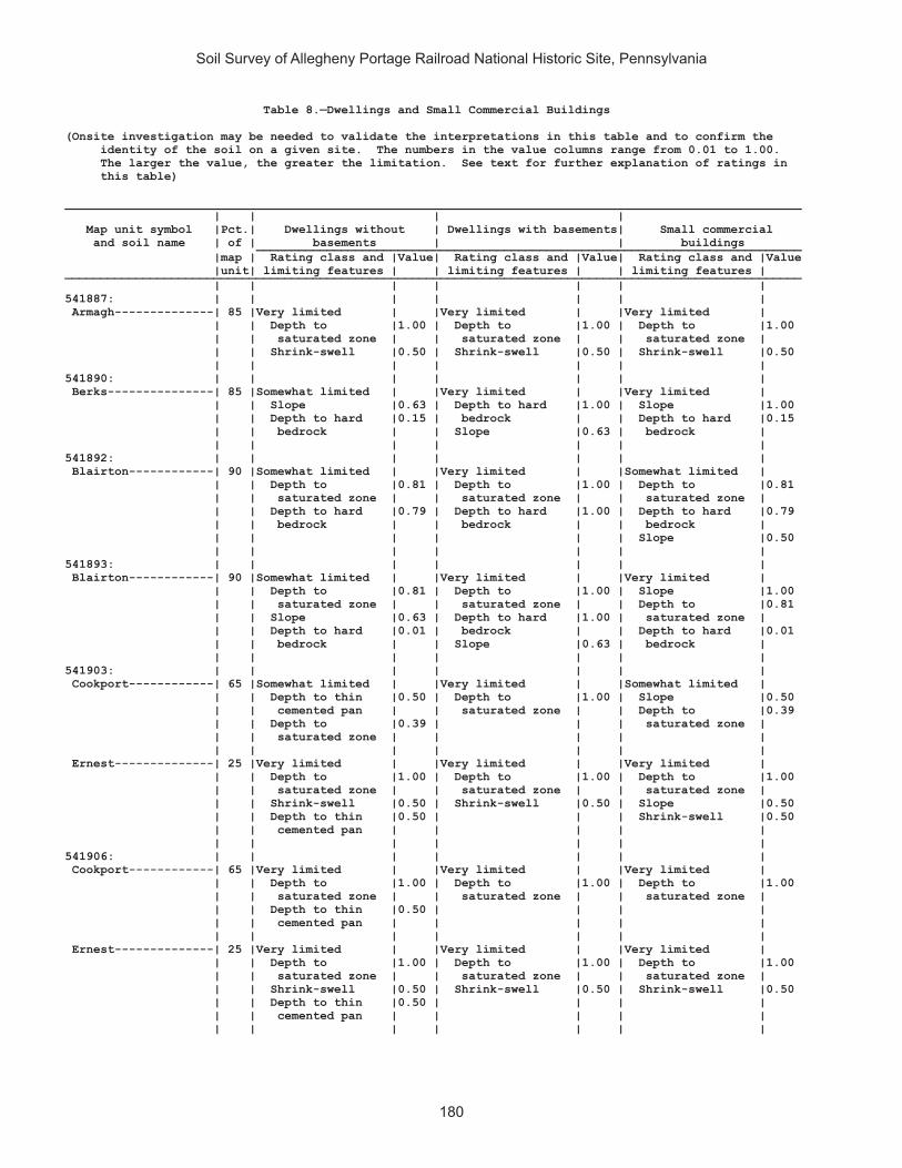
Soil Survey of Allegheny Portage Railroad National Historic Site, Pennsylvania
180
Table 8.—Dwellings and Small Commercial Buildings
(Onsite investigation may be needed to validate the interpretations in this table and to confirm the identity of the soil on a given site. The numbers in the value columns range from 0.01 to 1.00. The larger the value, the greater the limitation. See text for further explanation of ratings in this table)
________________________________________________________________________________________________________ | | | | Map unit symbol |Pct.| Dwellings without | Dwellings with basements| Small commercial and soil name | of | basements | | buildings _____________________________________________________________________________ |map | Rating class and |Value| Rating class and |Value| Rating class and |Value |unit| limiting features | | limiting features | | limiting features | ________________________________________________________________________________________________________ | | | | | | | 541887: | | | | | | | Armagh--------------| 85 |Very limited | |Very limited | |Very limited | | | Depth to |1.00 | Depth to |1.00 | Depth to |1.00 | | saturated zone | | saturated zone | | saturated zone | | | Shrink-swell |0.50 | Shrink-swell |0.50 | Shrink-swell |0.50 | | | | | | | 541890: | | | | | | | Berks---------------| 85 |Somewhat limited | |Very limited | |Very limited | | | Slope |0.63 | Depth to hard |1.00 | Slope |1.00 | | Depth to hard |0.15 | bedrock | | Depth to hard |0.15 | | bedrock | | Slope |0.63 | bedrock | | | | | | | | 541892: | | | | | | | Blairton------------| 90 |Somewhat limited | |Very limited | |Somewhat limited | | | Depth to |0.81 | Depth to |1.00 | Depth to |0.81 | | saturated zone | | saturated zone | | saturated zone | | | Depth to hard |0.79 | Depth to hard |1.00 | Depth to hard |0.79 | | bedrock | | bedrock | | bedrock | | | | | | | Slope |0.50 | | | | | | | 541893: | | | | | | | Blairton------------| 90 |Somewhat limited | |Very limited | |Very limited | | | Depth to |0.81 | Depth to |1.00 | Slope |1.00 | | saturated zone | | saturated zone | | Depth to |0.81 | | Slope |0.63 | Depth to hard |1.00 | saturated zone | | | Depth to hard |0.01 | bedrock | | Depth to hard |0.01 | | bedrock | | Slope |0.63 | bedrock | | | | | | | | 541903: | | | | | | | Cookport------------| 65 |Somewhat limited | |Very limited | |Somewhat limited | | | Depth to thin |0.50 | Depth to |1.00 | Slope |0.50 | | cemented pan | | saturated zone | | Depth to |0.39 | | Depth to |0.39 | | | saturated zone | | | saturated zone | | | | | | | | | | | | Ernest--------------| 25 |Very limited | |Very limited | |Very limited | | | Depth to |1.00 | Depth to |1.00 | Depth to |1.00 | | saturated zone | | saturated zone | | saturated zone | | | Shrink-swell |0.50 | Shrink-swell |0.50 | Slope |0.50 | | Depth to thin |0.50 | | | Shrink-swell |0.50 | | cemented pan | | | | | | | | | | | | 541906: | | | | | | | Cookport------------| 65 |Very limited | |Very limited | |Very limited | | | Depth to |1.00 | Depth to |1.00 | Depth to |1.00 | | saturated zone | | saturated zone | | saturated zone | | | Depth to thin |0.50 | | | | | | cemented pan | | | | | | | | | | | | Ernest--------------| 25 |Very limited | |Very limited | |Very limited | | | Depth to |1.00 | Depth to |1.00 | Depth to |1.00 | | saturated zone | | saturated zone | | saturated zone | | | Shrink-swell |0.50 | Shrink-swell |0.50 | Shrink-swell |0.50 | | Depth to thin |0.50 | | | | | | cemented pan | | | | | | | | | | | |

Soil Survey of Allegheny Portage Railroad National Historic Site, Pennsylvania
181
Table 8.—Dwellings and Small Commercial Buildings—Continued________________________________________________________________________________________________________ | | | | Map unit symbol |Pct.| Dwellings without | Dwellings with basements| Small commercial and soil name | of | basements | | buildings _____________________________________________________________________________ |map | Rating class and |Value| Rating class and |Value| Rating class and |Value |unit| limiting features | | limiting features | | limiting features | ________________________________________________________________________________________________________ | | | | | | | 541907: | | | | | | | Cookport------------| 70 |Very limited | |Very limited | |Very limited | | | Depth to |1.00 | Depth to |1.00 | Slope |1.00 | | saturated zone | | saturated zone | | Depth to |1.00 | | Slope |1.00 | Slope |1.00 | saturated zone | | | Depth to thin |0.50 | | | | | | cemented pan | | | | | | | | | | | | Ernest--------------| 25 |Very limited | |Very limited | |Very limited | | | Depth to |1.00 | Depth to |1.00 | Slope |1.00 | | saturated zone | | saturated zone | | Depth to |1.00 | | Slope |1.00 | Slope |1.00 | saturated zone | | | Shrink-swell |0.50 | Shrink-swell |0.50 | Shrink-swell |0.50 | | Depth to thin |0.50 | | | | | | cemented pan | | | | | | | | | | | | 541908: | | | | | | | Dumps, industrial | | | | | | | wastes-------------| 90 |Not rated | |Not rated | |Not rated | | | | | | | | 541909: | | | | | | | Dumps, mine---------| 99 |Not rated | |Not rated | |Not rated | | | | | | | | 541911: | | | | | | | Gilpin--------------| 75 |Somewhat limited | |Very limited | |Somewhat limited | | | Depth to hard |0.54 | Depth to hard |1.00 | Depth to hard |0.54 | | bedrock | | bedrock | | bedrock | | | | | | | Slope |0.12 | | | | | | | 541914: | | | | | | | Gilpin--------------| 70 |Somewhat limited | |Very limited | |Very limited | | | Slope |0.63 | Depth to hard |1.00 | Slope |1.00 | | Depth to hard |0.01 | bedrock | | Depth to hard |0.01 | | bedrock | | Slope |0.63 | bedrock | | | | | | | | Rayne---------------| 30 |Somewhat limited | |Somewhat limited | |Very limited | | | Slope |0.63 | Slope |0.63 | Slope |1.00 | | | | | | | 541919: | | | | | | | Hazleton------------| 90 |Not limited | |Somewhat limited | |Somewhat limited | | | | | Depth to hard |0.13 | Slope |0.50 | | | | bedrock | | | | | | | | | | 541922: | | | | | | | Hazleton------------| 75 |Not limited | |Somewhat limited | |Not limited | | | | | Depth to hard |0.01 | | | | | | bedrock | | | | | | | | | | 541925: | | | | | | | Laidig--------------| 100|Very limited | |Very limited | |Very limited | | | Slope |1.00 | Slope |1.00 | Slope |1.00 | | Depth to thin |0.50 | Depth to |1.00 | | | | cemented pan | | saturated zone | | | | | | | | | | 541938: | | | | | | | Bethesda, unstable | | | | | | | fill---------------| 90 |Very limited | |Very limited | |Very limited | | | Unstable fill |1.00 | Unstable fill |1.00 | Slope |1.00 | | Slope |1.00 | Slope |1.00 | Unstable fill |1.00 | | Large stones |0.11 | Large stones |0.11 | Large stones |0.11 | | | | | | |
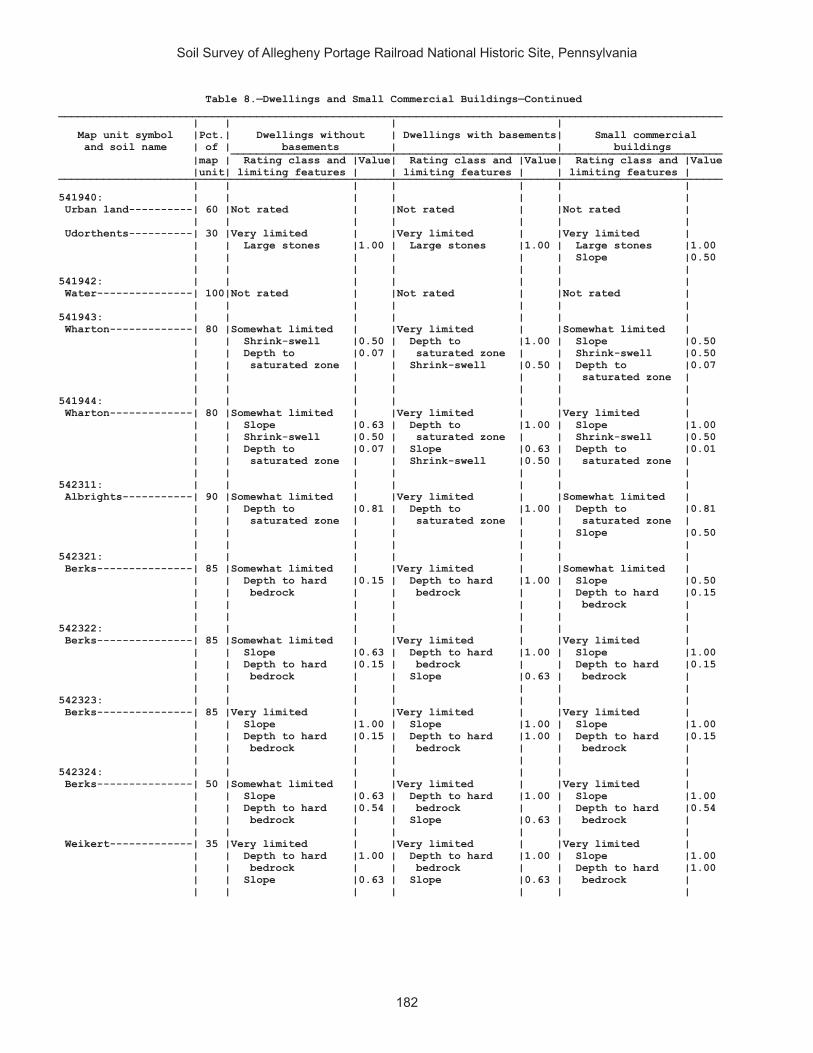
Soil Survey of Allegheny Portage Railroad National Historic Site, Pennsylvania
182
Table 8.—Dwellings and Small Commercial Buildings—Continued________________________________________________________________________________________________________ | | | | Map unit symbol |Pct.| Dwellings without | Dwellings with basements| Small commercial and soil name | of | basements | | buildings _____________________________________________________________________________ |map | Rating class and |Value| Rating class and |Value| Rating class and |Value |unit| limiting features | | limiting features | | limiting features | ________________________________________________________________________________________________________ | | | | | | | 541940: | | | | | | | Urban land----------| 60 |Not rated | |Not rated | |Not rated | | | | | | | | Udorthents----------| 30 |Very limited | |Very limited | |Very limited | | | Large stones |1.00 | Large stones |1.00 | Large stones |1.00 | | | | | | Slope |0.50 | | | | | | | 541942: | | | | | | | Water---------------| 100|Not rated | |Not rated | |Not rated | | | | | | | | 541943: | | | | | | | Wharton-------------| 80 |Somewhat limited | |Very limited | |Somewhat limited | | | Shrink-swell |0.50 | Depth to |1.00 | Slope |0.50 | | Depth to |0.07 | saturated zone | | Shrink-swell |0.50 | | saturated zone | | Shrink-swell |0.50 | Depth to |0.07 | | | | | | saturated zone | | | | | | | | 541944: | | | | | | | Wharton-------------| 80 |Somewhat limited | |Very limited | |Very limited | | | Slope |0.63 | Depth to |1.00 | Slope |1.00 | | Shrink-swell |0.50 | saturated zone | | Shrink-swell |0.50 | | Depth to |0.07 | Slope |0.63 | Depth to |0.01 | | saturated zone | | Shrink-swell |0.50 | saturated zone | | | | | | | | 542311: | | | | | | | Albrights-----------| 90 |Somewhat limited | |Very limited | |Somewhat limited | | | Depth to |0.81 | Depth to |1.00 | Depth to |0.81 | | saturated zone | | saturated zone | | saturated zone | | | | | | | Slope |0.50 | | | | | | | 542321: | | | | | | | Berks---------------| 85 |Somewhat limited | |Very limited | |Somewhat limited | | | Depth to hard |0.15 | Depth to hard |1.00 | Slope |0.50 | | bedrock | | bedrock | | Depth to hard |0.15 | | | | | | bedrock | | | | | | | | 542322: | | | | | | | Berks---------------| 85 |Somewhat limited | |Very limited | |Very limited | | | Slope |0.63 | Depth to hard |1.00 | Slope |1.00 | | Depth to hard |0.15 | bedrock | | Depth to hard |0.15 | | bedrock | | Slope |0.63 | bedrock | | | | | | | | 542323: | | | | | | | Berks---------------| 85 |Very limited | |Very limited | |Very limited | | | Slope |1.00 | Slope |1.00 | Slope |1.00 | | Depth to hard |0.15 | Depth to hard |1.00 | Depth to hard |0.15 | | bedrock | | bedrock | | bedrock | | | | | | | | 542324: | | | | | | | Berks---------------| 50 |Somewhat limited | |Very limited | |Very limited | | | Slope |0.63 | Depth to hard |1.00 | Slope |1.00 | | Depth to hard |0.54 | bedrock | | Depth to hard |0.54 | | bedrock | | Slope |0.63 | bedrock | | | | | | | | Weikert-------------| 35 |Very limited | |Very limited | |Very limited | | | Depth to hard |1.00 | Depth to hard |1.00 | Slope |1.00 | | bedrock | | bedrock | | Depth to hard |1.00 | | Slope |0.63 | Slope |0.63 | bedrock | | | | | | | |

Soil Survey of Allegheny Portage Railroad National Historic Site, Pennsylvania
183
Table 8.—Dwellings and Small Commercial Buildings—Continued________________________________________________________________________________________________________ | | | | Map unit symbol |Pct.| Dwellings without | Dwellings with basements| Small commercial and soil name | of | basements | | buildings _____________________________________________________________________________ |map | Rating class and |Value| Rating class and |Value| Rating class and |Value |unit| limiting features | | limiting features | | limiting features | ________________________________________________________________________________________________________ | | | | | | | 542325: | | | | | | | Berks---------------| 45 |Very limited | |Very limited | |Very limited | | | Slope |1.00 | Slope |1.00 | Slope |1.00 | | Depth to hard |0.54 | Depth to hard |1.00 | Depth to hard |0.54 | | bedrock | | bedrock | | bedrock | | | | | | | | Weikert-------------| 40 |Very limited | |Very limited | |Very limited | | | Slope |1.00 | Slope |1.00 | Slope |1.00 | | Depth to hard |1.00 | Depth to hard |1.00 | Depth to hard |1.00 | | bedrock | | bedrock | | bedrock | | | | | | | | 542326: | | | | | | | Berks---------------| 50 |Very limited | |Very limited | |Very limited | | | Slope |1.00 | Slope |1.00 | Slope |1.00 | | Depth to hard |0.54 | Depth to hard |1.00 | Depth to hard |0.54 | | bedrock | | bedrock | | bedrock | | | | | | | | Weikert-------------| 40 |Very limited | |Very limited | |Very limited | | | Slope |1.00 | Slope |1.00 | Slope |1.00 | | Depth to hard |1.00 | Depth to hard |1.00 | Depth to hard |1.00 | | bedrock | | bedrock | | bedrock | | | | | | | | 542329: | | | | | | | Brinkerton----------| 75 |Very limited | |Very limited | |Very limited | | | Depth to |1.00 | Depth to |1.00 | Depth to |1.00 | | saturated zone | | saturated zone | | saturated zone | | | Shrink-swell |0.50 | Shrink-swell |0.50 | Slope |0.50 | | | | | | Shrink-swell |0.50 | | | | | | | 542330: | | | | | | | Brinkerton----------| 85 |Very limited | |Very limited | |Very limited | | | Depth to |1.00 | Depth to |1.00 | Slope |1.00 | | saturated zone | | saturated zone | | Depth to |1.00 | | Slope |0.63 | Slope |0.63 | saturated zone | | | Shrink-swell |0.50 | Shrink-swell |0.50 | Shrink-swell |0.50 | | | | | | | 542333: | | | | | | | Buchanan------------| 90 |Somewhat limited | |Very limited | |Somewhat limited | | | Depth to thin |0.50 | Depth to |1.00 | Depth to |0.07 | | cemented pan | | saturated zone | | saturated zone | | | Depth to |0.07 | | | | | | saturated zone | | | | | | | | | | | | 542334: | | | | | | | Buchanan------------| 85 |Very limited | |Very limited | |Very limited | | | Slope |1.00 | Depth to |1.00 | Slope |1.00 | | Depth to thin |0.50 | saturated zone | | Depth to |0.07 | | cemented pan | | Slope |1.00 | saturated zone | | | Depth to |0.07 | | | | | | saturated zone | | | | | | | | | | | | 542338: | | | | | | | Clymer--------------| 80 |Not limited | |Somewhat limited | |Somewhat limited | | | | | Depth to hard |0.42 | Slope |0.50 | | | | bedrock | | | | | | | | | |
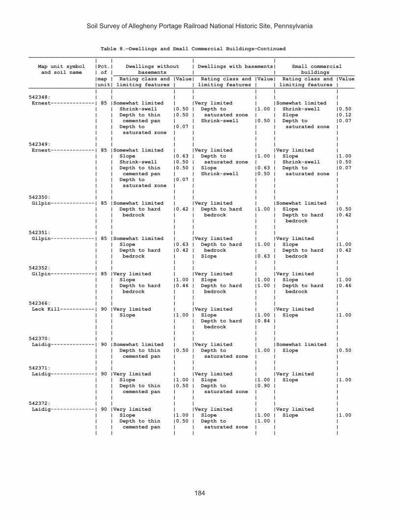
Soil Survey of Allegheny Portage Railroad National Historic Site, Pennsylvania
184
Table 8.—Dwellings and Small Commercial Buildings—Continued________________________________________________________________________________________________________ | | | | Map unit symbol |Pct.| Dwellings without | Dwellings with basements| Small commercial and soil name | of | basements | | buildings _____________________________________________________________________________ |map | Rating class and |Value| Rating class and |Value| Rating class and |Value |unit| limiting features | | limiting features | | limiting features | ________________________________________________________________________________________________________ | | | | | | | 542348: | | | | | | | Ernest--------------| 85 |Somewhat limited | |Very limited | |Somewhat limited | | | Shrink-swell |0.50 | Depth to |1.00 | Shrink-swell |0.50 | | Depth to thin |0.50 | saturated zone | | Slope |0.12 | | cemented pan | | Shrink-swell |0.50 | Depth to |0.07 | | Depth to |0.07 | | | saturated zone | | | saturated zone | | | | | | | | | | | | 542349: | | | | | | | Ernest--------------| 85 |Somewhat limited | |Very limited | |Very limited | | | Slope |0.63 | Depth to |1.00 | Slope |1.00 | | Shrink-swell |0.50 | saturated zone | | Shrink-swell |0.50 | | Depth to thin |0.50 | Slope |0.63 | Depth to |0.07 | | cemented pan | | Shrink-swell |0.50 | saturated zone | | | Depth to |0.07 | | | | | | saturated zone | | | | | | | | | | | | 542350: | | | | | | | Gilpin--------------| 85 |Somewhat limited | |Very limited | |Somewhat limited | | | Depth to hard |0.42 | Depth to hard |1.00 | Slope |0.50 | | bedrock | | bedrock | | Depth to hard |0.42 | | | | | | bedrock | | | | | | | | 542351: | | | | | | | Gilpin--------------| 85 |Somewhat limited | |Very limited | |Very limited | | | Slope |0.63 | Depth to hard |1.00 | Slope |1.00 | | Depth to hard |0.42 | bedrock | | Depth to hard |0.42 | | bedrock | | Slope |0.63 | bedrock | | | | | | | | 542352: | | | | | | | Gilpin--------------| 85 |Very limited | |Very limited | |Very limited | | | Slope |1.00 | Slope |1.00 | Slope |1.00 | | Depth to hard |0.46 | Depth to hard |1.00 | Depth to hard |0.46 | | bedrock | | bedrock | | bedrock | | | | | | | | 542366: | | | | | | | Leck Kill-----------| 90 |Very limited | |Very limited | |Very limited | | | Slope |1.00 | Slope |1.00 | Slope |1.00 | | | | Depth to hard |0.84 | | | | | | bedrock | | | | | | | | | | 542370: | | | | | | | Laidig--------------| 90 |Somewhat limited | |Very limited | |Somewhat limited | | | Depth to thin |0.50 | Depth to |1.00 | Slope |0.50 | | cemented pan | | saturated zone | | | | | | | | | | 542371: | | | | | | | Laidig--------------| 90 |Very limited | |Very limited | |Very limited | | | Slope |1.00 | Slope |1.00 | Slope |1.00 | | Depth to thin |0.50 | Depth to |0.90 | | | | cemented pan | | saturated zone | | | | | | | | | | 542372: | | | | | | | Laidig--------------| 90 |Very limited | |Very limited | |Very limited | | | Slope |1.00 | Slope |1.00 | Slope |1.00 | | Depth to thin |0.50 | Depth to |1.00 | | | | cemented pan | | saturated zone | | | | | | | | | |

Soil Survey of Allegheny Portage Railroad National Historic Site, Pennsylvania
185
Table 8.—Dwellings and Small Commercial Buildings—Continued________________________________________________________________________________________________________ | | | | Map unit symbol |Pct.| Dwellings without | Dwellings with basements| Small commercial and soil name | of | basements | | buildings _____________________________________________________________________________ |map | Rating class and |Value| Rating class and |Value| Rating class and |Value |unit| limiting features | | limiting features | | limiting features | ________________________________________________________________________________________________________ | | | | | | | 542375: | | | | | | | Leck Kill-----------| 80 |Very limited | |Very limited | |Very limited | | | Slope |1.00 | Slope |1.00 | Slope |1.00 | | | | Depth to hard |0.01 | | | | | | bedrock | | | | | | | | | | 542383: | | | | | | | Meckesville---------| 90 |Somewhat limited | |Somewhat limited | |Somewhat limited | | | Depth to thin |0.50 | Depth to |0.95 | Slope |0.50 | | cemented pan | | saturated zone | | | | | | | | | | 542384: | | | | | | | Meckesville---------| 90 |Very limited | |Very limited | |Very limited | | | Slope |1.00 | Slope |1.00 | Slope |1.00 | | Depth to thin |0.50 | Depth to |0.95 | | | | cemented pan | | saturated zone | | | | | | | | | | 542406: | | | | | | | Tyler---------------| 90 |Very limited | |Very limited | |Very limited | | | Depth to |1.00 | Depth to |1.00 | Depth to |1.00 | | saturated zone | | saturated zone | | saturated zone | | | | | | | | 542407: | | | | | | | Udifluvents---------| 50 |Very limited | |Very limited | |Very limited | | | Flooding |1.00 | Flooding |1.00 | Flooding |1.00 | | | | Depth to |0.95 | | | | | | saturated zone | | | | | | | | | | Dystrochrepts-------| 30 |Very limited | |Very limited | |Very limited | | | Flooding |1.00 | Flooding |1.00 | Flooding |1.00 | | | | Depth to |0.95 | | | | | | saturated zone | | | | | | | | | | 542410: | | | | | | | Urban land----------| 65 |Not rated | |Not rated | |Not rated | | | | | | | | Berks---------------| 25 |Very limited | |Very limited | |Very limited | | | Slope |1.00 | Depth to hard |1.00 | Slope |1.00 | | Depth to hard |0.20 | bedrock | | Depth to hard |0.20 | | bedrock | | Slope |1.00 | bedrock | | | | | | | | 542420: | | | | | | | Wharton-------------| 80 |Somewhat limited | |Very limited | |Somewhat limited | | | Shrink-swell |0.50 | Depth to |1.00 | Shrink-swell |0.50 | | Depth to |0.07 | saturated zone | | Slope |0.12 | | saturated zone | | Shrink-swell |0.50 | Depth to |0.07 | | | | | | saturated zone | | | | | | | | 542421: | | | | | | | Wharton-------------| 75 |Somewhat limited | |Very limited | |Very limited | | | Slope |0.63 | Depth to |1.00 | Slope |1.00 | | Shrink-swell |0.50 | saturated zone | | Shrink-swell |0.50 | | Depth to |0.07 | Slope |0.63 | Depth to |0.07 | | saturated zone | | Shrink-swell |0.50 | saturated zone | | | | | | | | ________________________________________________________________________________________________________

Soil Survey of Allegheny Portage Railroad National Historic Site, Pennsylvania
186
Table 9.—Roads and Streets, Shallow Excavations, and Landscaping
(Onsite investigation may be needed to validate the interpretations in this table and to confirm the identity of the soil on a given site. The numbers in the value columns range from 0.01 to 1.00. The larger the value, the greater the limitation. See text for further explanation of ratings in this table)
________________________________________________________________________________________________________ | | | | Map unit symbol |Pct.| Local roads and | Shallow excavations | Landscaping and soil name | of | streets | | _____________________________________________________________________________ |map | Rating class and |Value| Rating class and |Value| Rating class and |Value |unit| limiting features | | limiting features | | limiting features | ________________________________________________________________________________________________________ | | | | | | | 541887: | | | | | | | Armagh--------------| 85 |Very limited | |Very limited | |Very limited | | | Depth to |1.00 | Depth to |1.00 | Depth to |1.00 | | saturated zone | | saturated zone | | saturated zone | | | Frost action |1.00 | Unstable |0.10 | | | | Low strength |1.00 | excavation walls| | | | | Shrink-swell |0.50 | | | | | | | | | | | 541890: | | | | | | | Berks---------------| 85 |Somewhat limited | |Very limited | |Somewhat limited | | | Slope |0.63 | Depth to hard |1.00 | Droughty |0.81 | | Depth to hard |0.15 | bedrock | | Slope |0.63 | | bedrock | | Slope |0.63 | Gravel |0.39 | | | | Unstable |0.10 | Large stones |0.32 | | | | excavation walls| | Depth to bedrock |0.16 | | | | | | | 541892: | | | | | | | Blairton------------| 90 |Very limited | |Very limited | |Somewhat limited | | | Frost action |1.00 | Depth to hard |1.00 | Depth to bedrock |0.80 | | Depth to hard |0.79 | bedrock | | Depth to |0.48 | | bedrock | | Depth to |1.00 | saturated zone | | | Depth to |0.48 | saturated zone | | Droughty |0.33 | | saturated zone | | Unstable |0.10 | | | | | | excavation walls| | | | | | | | | | 541893: | | | | | | | Blairton------------| 90 |Very limited | |Very limited | |Somewhat limited | | | Frost action |1.00 | Depth to hard |1.00 | Slope |0.63 | | Slope |0.63 | bedrock | | Depth to |0.48 | | Depth to |0.48 | Depth to |1.00 | saturated zone | | | saturated zone | | saturated zone | | Depth to bedrock |0.01 | | Depth to hard |0.01 | Slope |0.63 | | | | bedrock | | Unstable |0.10 | | | | | | excavation walls| | | | | | | | | | 541903: | | | | | | | Cookport------------| 65 |Somewhat limited | |Very limited | |Somewhat limited | | | Frost action |0.50 | Depth to |1.00 | Depth to |0.19 | | Depth to |0.19 | saturated zone | | saturated zone | | | saturated zone | | Unstable |0.10 | Gravel |0.16 | | | | excavation walls| | Large stones |0.03 | | | | | | | Ernest--------------| 25 |Very limited | |Very limited | |Somewhat limited | | | Low strength |1.00 | Depth to |1.00 | Depth to |0.90 | | Depth to |0.90 | saturated zone | | saturated zone | | | saturated zone | | Unstable |0.10 | | | | Shrink-swell |0.50 | excavation walls| | | | | Frost action |0.50 | | | | | | | | | | | 541906: | | | | | | | Cookport------------| 65 |Very limited | |Very limited | |Very limited | | | Depth to |1.00 | Depth to |1.00 | Depth to |1.00 | | saturated zone | | saturated zone | | saturated zone | | | Frost action |0.50 | Unstable |0.10 | Large stones |0.95 | | | | excavation walls| | | | | | | | | |

Soil Survey of Allegheny Portage Railroad National Historic Site, Pennsylvania
187
Table 9.—Roads and Streets, Shallow Excavations, and Landscaping—Continued________________________________________________________________________________________________________ | | | | Map unit symbol |Pct.| Local roads and | Shallow excavations | Landscaping and soil name | of | streets | | _____________________________________________________________________________ |map | Rating class and |Value| Rating class and |Value| Rating class and |Value |unit| limiting features | | limiting features | | limiting features | ________________________________________________________________________________________________________ | | | | | | | 541906: | | | | | | | Ernest--------------| 25 |Very limited | |Very limited | |Somewhat limited | | | Low strength |1.00 | Depth to |1.00 | Depth to |0.90 | | Depth to |0.90 | saturated zone | | saturated zone | | | saturated zone | | Unstable |0.10 | | | | Shrink-swell |0.50 | excavation walls| | | | | Frost action |0.50 | | | | | | | | | | | 541907: | | | | | | | Cookport------------| 70 |Very limited | |Very limited | |Very limited | | | Depth to |1.00 | Depth to |1.00 | Depth to |1.00 | | saturated zone | | saturated zone | | saturated zone | | | Slope |1.00 | Slope |1.00 | Slope |1.00 | | Frost action |0.50 | Unstable |0.10 | Large stones |0.95 | | | | excavation walls| | | | | | | | | | Ernest--------------| 25 |Very limited | |Very limited | |Very limited | | | Slope |1.00 | Depth to |1.00 | Slope |1.00 | | Low strength |1.00 | saturated zone | | Depth to |0.90 | | Depth to |0.90 | Slope |1.00 | saturated zone | | | saturated zone | | Unstable |0.10 | Large stones |0.26 | | Shrink-swell |0.50 | excavation walls| | | | | Frost action |0.50 | | | | | | | | | | | 541908: | | | | | | | Dumps, industrial | | | | | | | wastes-------------| 90 |Not rated | |Not rated | |Not rated | | | | | | | | 541909: | | | | | | | Dumps, mine---------| 99 |Not rated | |Not rated | |Not rated | | | | | | | | 541911: | | | | | | | Gilpin--------------| 75 |Somewhat limited | |Very limited | |Somewhat limited | | | Depth to hard |0.54 | Depth to hard |1.00 | Depth to bedrock |0.54 | | bedrock | | bedrock | | Droughty |0.17 | | Frost action |0.50 | Unstable |0.10 | | | | | | excavation walls| | | | | | | | | | 541914: | | | | | | | Gilpin--------------| 70 |Somewhat limited | |Very limited | |Somewhat limited | | | Slope |0.63 | Depth to hard |1.00 | Slope |0.63 | | Frost action |0.50 | bedrock | | Depth to bedrock |0.01 | | Depth to hard |0.01 | Slope |0.63 | | | | bedrock | | Unstable |0.10 | | | | | | excavation walls| | | | | | | | | | Rayne---------------| 30 |Somewhat limited | |Somewhat limited | |Somewhat limited | | | Slope |0.63 | Slope |0.63 | Slope |0.63 | | Frost action |0.50 | Unstable |0.10 | | | | | | excavation walls| | | | | | | | | | 541919: | | | | | | | Hazleton------------| 90 |Somewhat limited | |Very limited | |Somewhat limited | | | Frost action |0.50 | Unstable |1.00 | Large stones |0.03 | | | | excavation walls| | Gravel |0.02 | | | | Depth to hard |0.13 | | | | | | bedrock | | | | | | | | | |

Soil Survey of Allegheny Portage Railroad National Historic Site, Pennsylvania
188
Table 9.—Roads and Streets, Shallow Excavations, and Landscaping—Continued________________________________________________________________________________________________________ | | | | Map unit symbol |Pct.| Local roads and | Shallow excavations | Landscaping and soil name | of | streets | | _____________________________________________________________________________ |map | Rating class and |Value| Rating class and |Value| Rating class and |Value |unit| limiting features | | limiting features | | limiting features | ________________________________________________________________________________________________________ | | | | | | | 541922: | | | | | | | Hazleton------------| 75 |Somewhat limited | |Somewhat limited | |Somewhat limited | | | Frost action |0.50 | Unstable |0.10 | Droughty |0.17 | | | | excavation walls| | | | | | | Depth to hard |0.01 | | | | | | bedrock | | | | | | | | | | 541925: | | | | | | | Laidig--------------| 100|Very limited | |Very limited | |Very limited | | | Slope |1.00 | Slope |1.00 | Slope |1.00 | | Frost action |0.50 | Depth to |1.00 | | | | | | saturated zone | | | | | | | Unstable |0.10 | | | | | | excavation walls| | | | | | | | | | 541938: | | | | | | | Bethesda, unstable | | | | | | | fill---------------| 90 |Very limited | |Very limited | |Very limited | | | Unstable fill |1.00 | Slope |1.00 | Slope |1.00 | | Slope |1.00 | Large stones |0.11 | Gravel |0.39 | | Frost action |0.50 | Unstable |0.10 | Large stones |0.38 | | Large stones |0.11 | excavation walls| | Droughty |0.31 | | | | | | | 541940: | | | | | | | Urban land----------| 60 |Not rated | |Not rated | |Not rated | | | | | | | | Udorthents----------| 30 |Very limited | |Very limited | |Very limited | | | Large stones |1.00 | Large stones |1.00 | Large stones |1.00 | | | | Unstable |0.10 | Droughty |1.00 | | | | excavation walls| | Gravel |0.02 | | | | | | | 541942: | | | | | | | Water---------------| 100|Not rated | |Not rated | |Not rated | | | | | | | | 541943: | | | | | | | Wharton-------------| 80 |Very limited | |Very limited | |Somewhat limited | | | Frost action |1.00 | Depth to |1.00 | Depth to |0.03 | | Low strength |1.00 | saturated zone | | saturated zone | | | Shrink-swell |0.50 | Unstable |0.10 | | | | Depth to |0.03 | excavation walls| | | | | saturated zone | | | | | | | | | | | | 541944: | | | | | | | Wharton-------------| 80 |Very limited | |Very limited | |Somewhat limited | | | Frost action |1.00 | Depth to |1.00 | Slope |0.63 | | Low strength |1.00 | saturated zone | | Depth to |0.03 | | Slope |0.63 | Slope |0.63 | saturated zone | | | Shrink-swell |0.50 | Unstable |0.10 | | | | Depth to |0.03 | excavation walls| | | | | saturated zone | | | | | | | | | | | | 542311: | | | | | | | Albrights-----------| 90 |Somewhat limited | |Very limited | |Somewhat limited | | | Frost action |0.50 | Depth to |1.00 | Depth to |0.48 | | Depth to |0.48 | saturated zone | | saturated zone | | | saturated zone | | Unstable |1.00 | Large stones |0.03 | | | | excavation walls| | | | | | | | | |
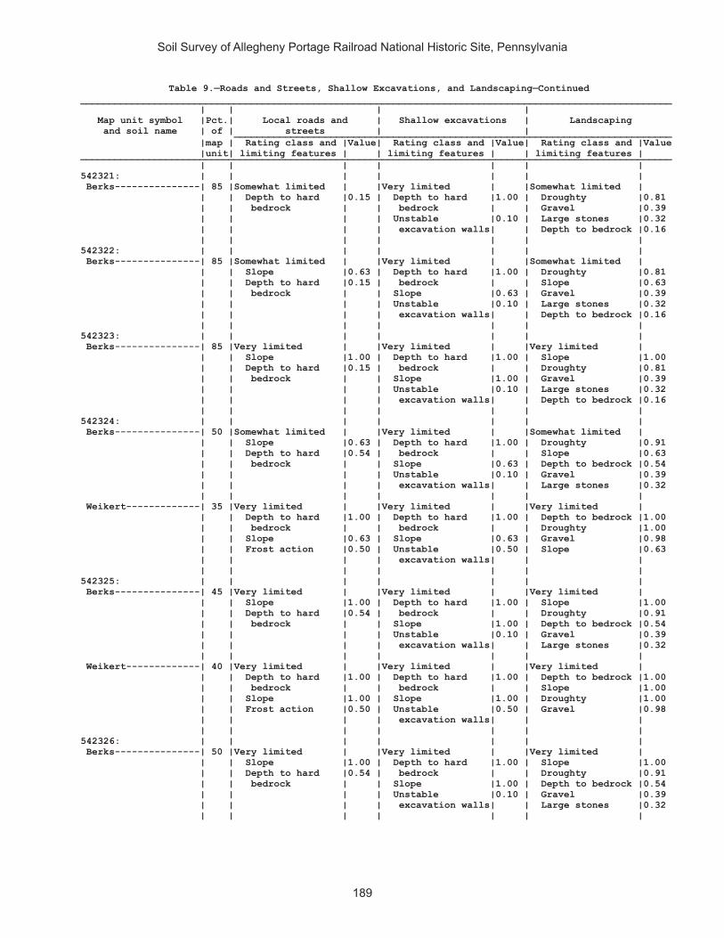
Soil Survey of Allegheny Portage Railroad National Historic Site, Pennsylvania
189
Table 9.—Roads and Streets, Shallow Excavations, and Landscaping—Continued________________________________________________________________________________________________________ | | | | Map unit symbol |Pct.| Local roads and | Shallow excavations | Landscaping and soil name | of | streets | | _____________________________________________________________________________ |map | Rating class and |Value| Rating class and |Value| Rating class and |Value |unit| limiting features | | limiting features | | limiting features | ________________________________________________________________________________________________________ | | | | | | | 542321: | | | | | | | Berks---------------| 85 |Somewhat limited | |Very limited | |Somewhat limited | | | Depth to hard |0.15 | Depth to hard |1.00 | Droughty |0.81 | | bedrock | | bedrock | | Gravel |0.39 | | | | Unstable |0.10 | Large stones |0.32 | | | | excavation walls| | Depth to bedrock |0.16 | | | | | | | 542322: | | | | | | | Berks---------------| 85 |Somewhat limited | |Very limited | |Somewhat limited | | | Slope |0.63 | Depth to hard |1.00 | Droughty |0.81 | | Depth to hard |0.15 | bedrock | | Slope |0.63 | | bedrock | | Slope |0.63 | Gravel |0.39 | | | | Unstable |0.10 | Large stones |0.32 | | | | excavation walls| | Depth to bedrock |0.16 | | | | | | | 542323: | | | | | | | Berks---------------| 85 |Very limited | |Very limited | |Very limited | | | Slope |1.00 | Depth to hard |1.00 | Slope |1.00 | | Depth to hard |0.15 | bedrock | | Droughty |0.81 | | bedrock | | Slope |1.00 | Gravel |0.39 | | | | Unstable |0.10 | Large stones |0.32 | | | | excavation walls| | Depth to bedrock |0.16 | | | | | | | 542324: | | | | | | | Berks---------------| 50 |Somewhat limited | |Very limited | |Somewhat limited | | | Slope |0.63 | Depth to hard |1.00 | Droughty |0.91 | | Depth to hard |0.54 | bedrock | | Slope |0.63 | | bedrock | | Slope |0.63 | Depth to bedrock |0.54 | | | | Unstable |0.10 | Gravel |0.39 | | | | excavation walls| | Large stones |0.32 | | | | | | | Weikert-------------| 35 |Very limited | |Very limited | |Very limited | | | Depth to hard |1.00 | Depth to hard |1.00 | Depth to bedrock |1.00 | | bedrock | | bedrock | | Droughty |1.00 | | Slope |0.63 | Slope |0.63 | Gravel |0.98 | | Frost action |0.50 | Unstable |0.50 | Slope |0.63 | | | | excavation walls| | | | | | | | | | 542325: | | | | | | | Berks---------------| 45 |Very limited | |Very limited | |Very limited | | | Slope |1.00 | Depth to hard |1.00 | Slope |1.00 | | Depth to hard |0.54 | bedrock | | Droughty |0.91 | | bedrock | | Slope |1.00 | Depth to bedrock |0.54 | | | | Unstable |0.10 | Gravel |0.39 | | | | excavation walls| | Large stones |0.32 | | | | | | | Weikert-------------| 40 |Very limited | |Very limited | |Very limited | | | Depth to hard |1.00 | Depth to hard |1.00 | Depth to bedrock |1.00 | | bedrock | | bedrock | | Slope |1.00 | | Slope |1.00 | Slope |1.00 | Droughty |1.00 | | Frost action |0.50 | Unstable |0.50 | Gravel |0.98 | | | | excavation walls| | | | | | | | | | 542326: | | | | | | | Berks---------------| 50 |Very limited | |Very limited | |Very limited | | | Slope |1.00 | Depth to hard |1.00 | Slope |1.00 | | Depth to hard |0.54 | bedrock | | Droughty |0.91 | | bedrock | | Slope |1.00 | Depth to bedrock |0.54 | | | | Unstable |0.10 | Gravel |0.39 | | | | excavation walls| | Large stones |0.32 | | | | | | |

Soil Survey of Allegheny Portage Railroad National Historic Site, Pennsylvania
190
Table 9.—Roads and Streets, Shallow Excavations, and Landscaping—Continued________________________________________________________________________________________________________ | | | | Map unit symbol |Pct.| Local roads and | Shallow excavations | Landscaping and soil name | of | streets | | _____________________________________________________________________________ |map | Rating class and |Value| Rating class and |Value| Rating class and |Value |unit| limiting features | | limiting features | | limiting features | ________________________________________________________________________________________________________ | | | | | | | 542326: | | | | | | | Weikert-------------| 40 |Very limited | |Very limited | |Very limited | | | Depth to hard |1.00 | Depth to hard |1.00 | Depth to bedrock |1.00 | | bedrock | | bedrock | | Slope |1.00 | | Slope |1.00 | Slope |1.00 | Droughty |1.00 | | Frost action |0.50 | Unstable |0.50 | Gravel |0.98 | | | | excavation walls| | | | | | | | | | 542329: | | | | | | | Brinkerton----------| 75 |Very limited | |Very limited | |Very limited | | | Depth to |1.00 | Depth to |1.00 | Depth to |1.00 | | saturated zone | | saturated zone | | saturated zone | | | Frost action |1.00 | Unstable |0.10 | | | | Low strength |0.78 | excavation walls| | | | | Shrink-swell |0.50 | | | | | | | | | | | 542330: | | | | | | | Brinkerton----------| 85 |Very limited | |Very limited | |Very limited | | | Depth to |1.00 | Depth to |1.00 | Depth to |1.00 | | saturated zone | | saturated zone | | saturated zone | | | Frost action |1.00 | Slope |0.63 | Slope |0.63 | | Low strength |0.78 | Unstable |0.10 | | | | Slope |0.63 | excavation walls| | | | | Shrink-swell |0.50 | | | | | | | | | | | 542333: | | | | | | | Buchanan------------| 90 |Somewhat limited | |Very limited | |Somewhat limited | | | Frost action |0.50 | Depth to |1.00 | Large stones |0.95 | | Depth to |0.03 | saturated zone | | Gravel |0.13 | | saturated zone | | Unstable |1.00 | Depth to |0.03 | | | | excavation walls| | saturated zone | | | | | | | | 542334: | | | | | | | Buchanan------------| 85 |Very limited | |Very limited | |Very limited | | | Slope |1.00 | Depth to |1.00 | Slope |1.00 | | Frost action |0.50 | saturated zone | | Large stones |0.95 | | Depth to |0.03 | Unstable |1.00 | Gravel |0.13 | | saturated zone | | excavation walls| | Depth to |0.03 | | | | Slope |1.00 | saturated zone | | | | | | | | 542338: | | | | | | | Clymer--------------| 80 |Somewhat limited | |Somewhat limited | |Somewhat limited | | | Frost action |0.50 | Depth to hard |0.42 | Droughty |0.02 | | | | bedrock | | | | | | | Unstable |0.10 | | | | | | excavation walls| | | | | | | | | | 542348: | | | | | | | Ernest--------------| 85 |Very limited | |Very limited | |Somewhat limited | | | Low strength |1.00 | Depth to |1.00 | Depth to |0.03 | | Shrink-swell |0.50 | saturated zone | | saturated zone | | | Frost action |0.50 | Unstable |0.10 | | | | Depth to |0.03 | excavation walls| | | | | saturated zone | | | | | | | | | | | |

Soil Survey of Allegheny Portage Railroad National Historic Site, Pennsylvania
191
Table 9.—Roads and Streets, Shallow Excavations, and Landscaping—Continued________________________________________________________________________________________________________ | | | | Map unit symbol |Pct.| Local roads and | Shallow excavations | Landscaping and soil name | of | streets | | _____________________________________________________________________________ |map | Rating class and |Value| Rating class and |Value| Rating class and |Value |unit| limiting features | | limiting features | | limiting features | ________________________________________________________________________________________________________ | | | | | | | 542349: | | | | | | | Ernest--------------| 85 |Very limited | |Very limited | |Somewhat limited | | | Low strength |1.00 | Depth to |1.00 | Slope |0.63 | | Slope |0.63 | saturated zone | | Depth to |0.03 | | Shrink-swell |0.50 | Slope |0.63 | saturated zone | | | Frost action |0.50 | Unstable |0.10 | | | | Depth to |0.03 | excavation walls| | | | | saturated zone | | | | | | | | | | | | 542350: | | | | | | | Gilpin--------------| 85 |Somewhat limited | |Very limited | |Somewhat limited | | | Frost action |0.50 | Depth to hard |1.00 | Depth to bedrock |0.42 | | Depth to hard |0.42 | bedrock | | Gravel |0.15 | | bedrock |0.42 | Unstable |0.10 | Large stones |0.05 | | | | excavation walls| | | | | | | | | | 542351: | | | | | | | Gilpin--------------| 85 |Somewhat limited | |Very limited | |Somewhat limited | | | Slope |0.63 | Depth to hard |1.00 | Slope |0.63 | | Frost action |0.50 | bedrock | | Depth to bedrock |0.42 | | Depth to hard |0.42 | Slope |0.63 | Gravel |0.15 | | bedrock | | Unstable |0.10 | Large stones |0.05 | | | | excavation walls| | | | | | | | | | 542352: | | | | | | | Gilpin--------------| 85 |Very limited | |Very limited | |Very limited | | | Slope |1.00 | Depth to hard |1.00 | Slope |1.00 | | Frost action |0.50 | bedrock | | Depth to bedrock |0.46 | | Depth to hard |0.46 | Slope |1.00 | Gravel |0.15 | | bedrock | | Unstable |0.10 | Large stones |0.05 | | | | excavation walls| | | | | | | | | | 542366: | | | | | | | Leck Kill-----------| 90 |Very limited | |Very limited | |Very limited | | | Slope |1.00 | Slope |1.00 | Slope |1.00 | | Frost action |0.50 | Depth to hard |0.84 | Gravel |0.05 | | | | bedrock | | | | | | | Unstable |0.10 | | | | | | excavation walls| | | | | | | | | | 542370: | | | | | | | Laidig--------------| 90 |Somewhat limited | |Very limited | |Very limited | | | Frost action |0.50 | Depth to |1.00 | Large stones |1.00 | | | | saturated zone | | Droughty |0.02 | | | | Unstable |0.10 | | | | | | excavation walls| | | | | | | | | | 542371: | | | | | | | Laidig--------------| 90 |Very limited | |Very limited | |Very limited | | | Slope |1.00 | Slope |1.00 | Slope |1.00 | | Frost action |0.50 | Depth to |0.90 | Large stones |1.00 | | | | saturated zone | | Droughty |0.02 | | | | Unstable |0.10 | | | | | | excavation walls| | | | | | | | | | 542372: | | | | | | | Laidig--------------| 90 |Very limited | |Very limited | |Very limited | | | Slope |1.00 | Slope |1.00 | Slope |1.00 | | Frost action |0.50 | Depth to |1.00 | Large stones |1.00 | | | | saturated zone | | Droughty |0.02 | | | | Unstable |0.10 | | | | | | excavation walls| | | | | | | | | |

Soil Survey of Allegheny Portage Railroad National Historic Site, Pennsylvania
192
Table 9.—Roads and Streets, Shallow Excavations, and Landscaping—Continued________________________________________________________________________________________________________ | | | | Map unit symbol |Pct.| Local roads and | Shallow excavations | Landscaping and soil name | of | streets | | _____________________________________________________________________________ |map | Rating class and |Value| Rating class and |Value| Rating class and |Value |unit| limiting features | | limiting features | | limiting features | ________________________________________________________________________________________________________ | | | | | | | 542375: | | | | | | | Leck Kill-----------| 80 |Very limited | |Very limited | |Very limited | | | Slope |1.00 | Slope |1.00 | Slope |1.00 | | Frost action |0.50 | Unstable |0.10 | Gravel |0.05 | | | | excavation walls| | | | | | | Depth to hard |0.01 | | | | | | bedrock | | | | | | | | | | 542383: | | | | | | | Meckesville---------| 90 |Somewhat limited | |Very limited | |Somewhat limited | | | Frost action |0.50 | Unstable |1.00 | Large stones |0.16 | | | | excavation walls| | | | | | | Depth to |0.95 | | | | | | saturated zone | | | | | | | | | | 542384: | | | | | | | Meckesville---------| 90 |Very limited | |Very limited | |Very limited | | | Slope |1.00 | Slope |1.00 | Slope |1.00 | | Frost action |0.50 | Unstable |1.00 | Large stones |0.16 | | | | excavation walls| | | | | | | Depth to |0.95 | | | | | | saturated zone | | | | | | | | | | 542406: | | | | | | | Tyler---------------| 90 |Very limited | |Very limited | |Very limited | | | Depth to |1.00 | Depth to |1.00 | Depth to |1.00 | | saturated zone | | saturated zone | | saturated zone | | | Frost action |1.00 | Unstable |0.10 | | | | Low strength |1.00 | excavation walls| | | | | | | | | | 542407: | | | | | | | Udifluvents---------| 50 |Very limited | |Very limited | |Very limited | | | Flooding |1.00 | Unstable |1.00 | Flooding |1.00 | | Frost action |0.50 | excavation walls| | | | | | | Depth to |0.95 | | | | | | saturated zone | | | | | | | Flooding |0.80 | | | | | | | | | Dystrochrepts-------| 30 |Very limited | |Very limited | |Not rated | | | Flooding |1.00 | Unstable |1.00 | | | | Frost action |0.50 | excavation walls| | | | | | | Depth to |0.95 | | | | | | saturated zone | | | | | | | Flooding |0.80 | | | | | | | | | 542410: | | | | | | | Urban land----------| 65 |Not rated | |Not rated | |Not rated | | | | | | | | Berks---------------| 25 |Very limited | |Very limited | |Very limited | | | Slope |1.00 | Depth to hard |1.00 | Slope |1.00 | | Depth to hard |0.20 | bedrock | | Droughty |0.79 | | bedrock | | Slope |1.00 | Gravel |0.46 | | | | Unstable |0.10 | Depth to bedrock |0.20 | | | | excavation walls| | Large stones |0.20 | | | | | | | 542420: | | | | | | | Wharton-------------| 80 |Very limited | |Very limited | |Somewhat limited | | | Frost action |1.00 | Depth to |1.00 | Depth to |0.03 | | Low strength |1.00 | saturated zone | | saturated zone | | | Shrink-swell |0.50 | Unstable |0.10 | | | | Depth to |0.03 | excavation walls| | | | | saturated zone | | | | | | | | | | | |

Soil Survey of Allegheny Portage Railroad National Historic Site, Pennsylvania
193
Table 9.—Roads and Streets, Shallow Excavations, and Landscaping—Continued________________________________________________________________________________________________________ | | | | Map unit symbol |Pct.| Local roads and | Shallow excavations | Landscaping and soil name | of | streets | | _____________________________________________________________________________ |map | Rating class and |Value| Rating class and |Value| Rating class and |Value |unit| limiting features | | limiting features | | limiting features | ________________________________________________________________________________________________________ | | | | | | | 542421: | | | | | | | Wharton-------------| 75 |Very limited | |Very limited | |Somewhat limited | | | Frost action |1.00 | Depth to |1.00 | Slope |0.63 | | Low strength |1.00 | saturated zone | | Depth to |0.03 | | Slope |0.63 | Slope |0.63 | saturated zone | | | Shrink-swell |0.50 | Unstable |0.10 | Large stones |0.01 | | Depth to |0.03 | excavation walls| | | | | saturated zone | | | | | | | | | | | | ________________________________________________________________________________________________________
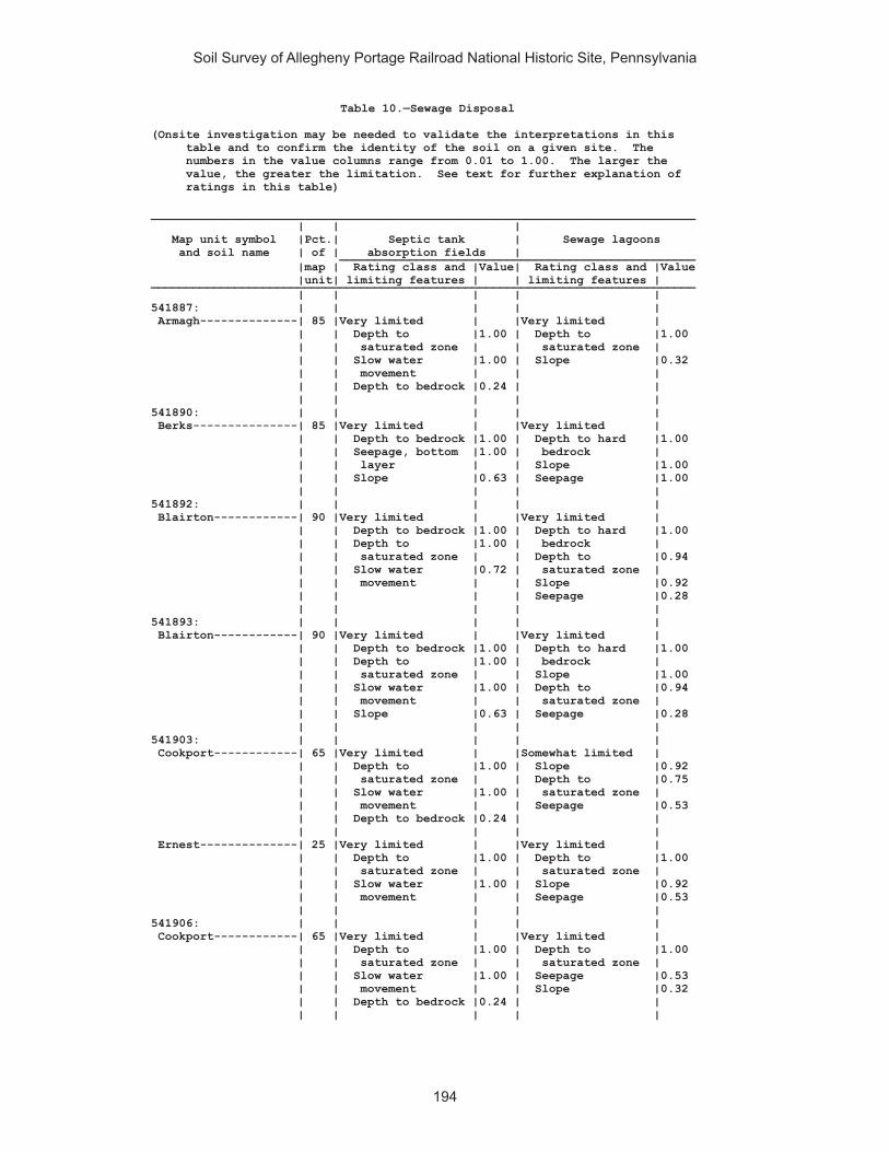
Soil Survey of Allegheny Portage Railroad National Historic Site, Pennsylvania
194
Table 10.—Sewage Disposal
(Onsite investigation may be needed to validate the interpretations in this table and to confirm the identity of the soil on a given site. The numbers in the value columns range from 0.01 to 1.00. The larger the value, the greater the limitation. See text for further explanation of ratings in this table)
______________________________________________________________________________ | | | Map unit symbol |Pct.| Septic tank | Sewage lagoons and soil name | of | absorption fields | ___________________________________________________ |map | Rating class and |Value| Rating class and |Value |unit| limiting features | | limiting features | ______________________________________________________________________________ | | | | | 541887: | | | | | Armagh--------------| 85 |Very limited | |Very limited | | | Depth to |1.00 | Depth to |1.00 | | saturated zone | | saturated zone | | | Slow water |1.00 | Slope |0.32 | | movement | | | | | Depth to bedrock |0.24 | | | | | | | 541890: | | | | | Berks---------------| 85 |Very limited | |Very limited | | | Depth to bedrock |1.00 | Depth to hard |1.00 | | Seepage, bottom |1.00 | bedrock | | | layer | | Slope |1.00 | | Slope |0.63 | Seepage |1.00 | | | | | 541892: | | | | | Blairton------------| 90 |Very limited | |Very limited | | | Depth to bedrock |1.00 | Depth to hard |1.00 | | Depth to |1.00 | bedrock | | | saturated zone | | Depth to |0.94 | | Slow water |0.72 | saturated zone | | | movement | | Slope |0.92 | | | | Seepage |0.28 | | | | | 541893: | | | | | Blairton------------| 90 |Very limited | |Very limited | | | Depth to bedrock |1.00 | Depth to hard |1.00 | | Depth to |1.00 | bedrock | | | saturated zone | | Slope |1.00 | | Slow water |1.00 | Depth to |0.94 | | movement | | saturated zone | | | Slope |0.63 | Seepage |0.28 | | | | | 541903: | | | | | Cookport------------| 65 |Very limited | |Somewhat limited | | | Depth to |1.00 | Slope |0.92 | | saturated zone | | Depth to |0.75 | | Slow water |1.00 | saturated zone | | | movement | | Seepage |0.53 | | Depth to bedrock |0.24 | | | | | | | Ernest--------------| 25 |Very limited | |Very limited | | | Depth to |1.00 | Depth to |1.00 | | saturated zone | | saturated zone | | | Slow water |1.00 | Slope |0.92 | | movement | | Seepage |0.53 | | | | | 541906: | | | | | Cookport------------| 65 |Very limited | |Very limited | | | Depth to |1.00 | Depth to |1.00 | | saturated zone | | saturated zone | | | Slow water |1.00 | Seepage |0.53 | | movement | | Slope |0.32 | | Depth to bedrock |0.24 | | | | | | |

Soil Survey of Allegheny Portage Railroad National Historic Site, Pennsylvania
195
Table 10.—Sewage Disposal—Continued______________________________________________________________________________ | | | Map unit symbol |Pct.| Septic tank | Sewage lagoons and soil name | of | absorption fields | ___________________________________________________ |map | Rating class and |Value| Rating class and |Value |unit| limiting features | | limiting features | ______________________________________________________________________________ | | | | | 541906: | | | | | Ernest--------------| 25 |Very limited | |Very limited | | | Depth to |1.00 | Depth to |1.00 | | saturated zone | | saturated zone | | | Slow water |1.00 | Seepage |0.53 | | movement | | Slope |0.32 | | | | | 541907: | | | | | Cookport------------| 70 |Very limited | |Very limited | | | Depth to |1.00 | Slope |1.00 | | saturated zone | | Depth to |1.00 | | Slow water |1.00 | saturated zone | | | movement | | Seepage |0.53 | | Slope |1.00 | | | | Depth to bedrock |0.24 | | | | | | | Ernest--------------| 25 |Very limited | |Very limited | | | Depth to |1.00 | Slope |1.00 | | saturated zone | | Depth to |1.00 | | Slow water |1.00 | saturated zone | | | movement | | Seepage |0.53 | | Slope |1.00 | | | | | | | 541908: | | | | | Dumps, industrial | | | | | wastes-------------| 90 |Not rated | |Not rated | | | | | | 541909: | | | | | Dumps, mine---------| 99 |Not rated | |Not rated | | | | | | 541911: | | | | | Gilpin--------------| 75 |Very limited | |Very limited | | | Depth to bedrock |1.00 | Depth to hard |1.00 | | Slow water |0.46 | bedrock | | | movement | | Slope |0.68 | | | | Seepage |0.53 | | | | | 541914: | | | | | Gilpin--------------| 70 |Very limited | |Very limited | | | Depth to bedrock |1.00 | Depth to hard |1.00 | | Slope |0.63 | bedrock | | | Slow water |0.46 | Slope |1.00 | | movement | | Seepage |0.53 | | | | | Rayne---------------| 30 |Somewhat limited | |Very limited | | | Slope |0.63 | Slope |1.00 | | Slow water |0.46 | Seepage |0.53 | | movement | | | | | Depth to bedrock |0.24 | | | | | | | 541919: | | | | | Hazleton------------| 90 |Very limited | |Very limited | | | Seepage, bottom |1.00 | Seepage |1.00 | | layer | | Slope |0.92 | | Filtering |1.00 | Depth to hard |0.13 | | capacity | | bedrock | | | Depth to bedrock |0.57 | | | | | | |

Soil Survey of Allegheny Portage Railroad National Historic Site, Pennsylvania
196
Table 10.—Sewage Disposal—Continued______________________________________________________________________________ | | | Map unit symbol |Pct.| Septic tank | Sewage lagoons and soil name | of | absorption fields | ___________________________________________________ |map | Rating class and |Value| Rating class and |Value |unit| limiting features | | limiting features | ______________________________________________________________________________ | | | | | 541922: | | | | | Hazleton------------| 75 |Very limited | |Very limited | | | Seepage, bottom |1.00 | Seepage |1.00 | | layer | | Slope |0.32 | | Filtering |1.00 | Depth to hard |0.01 | | capacity | | bedrock | | | Depth to bedrock |0.34 | | | | | | | 541925: | | | | | Laidig--------------| 100|Very limited | |Very limited | | | Depth to |1.00 | Slope |1.00 | | saturated zone | | Seepage |1.00 | | Slow water |1.00 | Depth to |0.19 | | movement | | saturated zone | | | Slope |1.00 | | | | | | | 541938 | | | | | Bethesda, unstable | | | | | fill---------------| 90 |Very limited | |Very limited | | | Slow water |1.00 | Slope |1.00 | | movement | | Large stones |0.50 | | Unstable fill |1.00 | | | | Slope |1.00 | | | | Large stones |0.11 | | | | | | | 541940: | | | | | Urban land----------| 60 |Not rated | |Not rated | | | | | | Udorthents----------| 30 |Very limited | |Very limited | | | Seepage, bottom |1.00 | Large stones |1.00 | | layer | | Seepage |1.00 | | Large stones |1.00 | Slope |0.92 | | Filtering |1.00 | | | | capacity | | | | | | | | 541942: | | | | | Water---------------| 100|Not rated | |Not rated | | | | | | 541943: | | | | | Wharton-------------| 80 |Very limited | |Somewhat limited | | | Depth to |1.00 | Slope |0.92 | | saturated zone | | Depth to |0.44 | | Slow water |1.00 | saturated zone | | | movement | | | | | Depth to bedrock |0.24 | | | | | | | 541944: | | | | | Wharton-------------| 80 |Very limited | |Very limited | | | Depth to |1.00 | Slope |1.00 | | saturated zone | | Depth to |0.44 | | Slow water |1.00 | saturated zone | | | movement | | | | | Slope |0.63 | | | | Depth to bedrock |0.24 | | | | | | | 542311: | | | | | Albrights-----------| 90 |Very limited | |Somewhat limited | | | Depth to |1.00 | Depth to |0.94 | | saturated zone | | saturated zone | | | Slow water |1.00 | Slope |0.92 | | movement | | Seepage |0.53 | | | | |
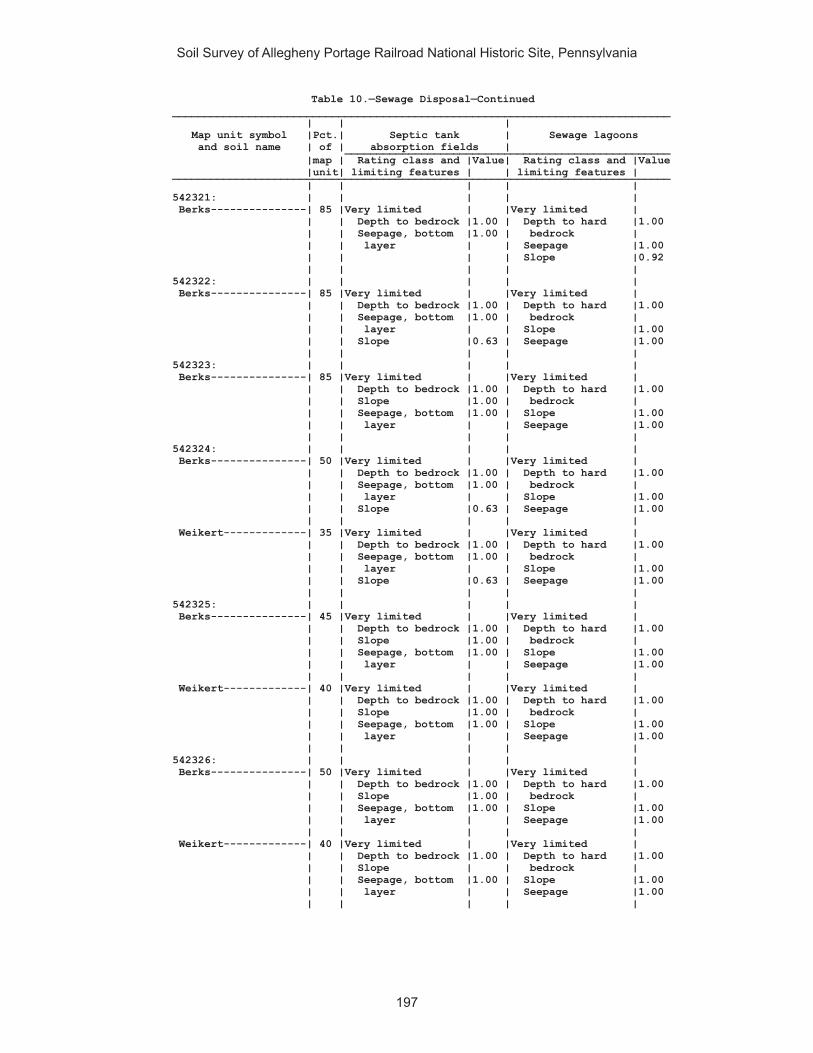
Soil Survey of Allegheny Portage Railroad National Historic Site, Pennsylvania
197
Table 10.—Sewage Disposal—Continued______________________________________________________________________________ | | | Map unit symbol |Pct.| Septic tank | Sewage lagoons and soil name | of | absorption fields | ___________________________________________________ |map | Rating class and |Value| Rating class and |Value |unit| limiting features | | limiting features | ______________________________________________________________________________ | | | | | 542321: | | | | | Berks---------------| 85 |Very limited | |Very limited | | | Depth to bedrock |1.00 | Depth to hard |1.00 | | Seepage, bottom |1.00 | bedrock | | | layer | | Seepage |1.00 | | | | Slope |0.92 | | | | | 542322: | | | | | Berks---------------| 85 |Very limited | |Very limited | | | Depth to bedrock |1.00 | Depth to hard |1.00 | | Seepage, bottom |1.00 | bedrock | | | layer | | Slope |1.00 | | Slope |0.63 | Seepage |1.00 | | | | | 542323: | | | | | Berks---------------| 85 |Very limited | |Very limited | | | Depth to bedrock |1.00 | Depth to hard |1.00 | | Slope |1.00 | bedrock | | | Seepage, bottom |1.00 | Slope |1.00 | | layer | | Seepage |1.00 | | | | | 542324: | | | | | Berks---------------| 50 |Very limited | |Very limited | | | Depth to bedrock |1.00 | Depth to hard |1.00 | | Seepage, bottom |1.00 | bedrock | | | layer | | Slope |1.00 | | Slope |0.63 | Seepage |1.00 | | | | | Weikert-------------| 35 |Very limited | |Very limited | | | Depth to bedrock |1.00 | Depth to hard |1.00 | | Seepage, bottom |1.00 | bedrock | | | layer | | Slope |1.00 | | Slope |0.63 | Seepage |1.00 | | | | | 542325: | | | | | Berks---------------| 45 |Very limited | |Very limited | | | Depth to bedrock |1.00 | Depth to hard |1.00 | | Slope |1.00 | bedrock | | | Seepage, bottom |1.00 | Slope |1.00 | | layer | | Seepage |1.00 | | | | | Weikert-------------| 40 |Very limited | |Very limited | | | Depth to bedrock |1.00 | Depth to hard |1.00 | | Slope |1.00 | bedrock | | | Seepage, bottom |1.00 | Slope |1.00 | | layer | | Seepage |1.00 | | | | | 542326: | | | | | Berks---------------| 50 |Very limited | |Very limited | | | Depth to bedrock |1.00 | Depth to hard |1.00 | | Slope |1.00 | bedrock | | | Seepage, bottom |1.00 | Slope |1.00 | | layer | | Seepage |1.00 | | | | | Weikert-------------| 40 |Very limited | |Very limited | | | Depth to bedrock |1.00 | Depth to hard |1.00 | | Slope | | bedrock | | | Seepage, bottom |1.00 | Slope |1.00 | | layer | | Seepage |1.00 | | | | |

Soil Survey of Allegheny Portage Railroad National Historic Site, Pennsylvania
198
Table 10.—Sewage Disposal—Continued______________________________________________________________________________ | | | Map unit symbol |Pct.| Septic tank | Sewage lagoons and soil name | of | absorption fields | ___________________________________________________ |map | Rating class and |Value| Rating class and |Value |unit| limiting features | | limiting features | ______________________________________________________________________________ | | | | | 542329: | | | | | Brinkerton----------| 75 |Very limited | |Very limited | | | Depth to |1.00 | Depth to |1.00 | | saturated zone | | saturated zone | | | Slow water |1.00 | Slope |0.92 | | movement | | Seepage |0.53 | | | | | 542330: | | | | | Brinkerton----------| 85 |Very limited | |Very limited | | | Depth to |1.00 | Slope |1.00 | | saturated zone | | Depth to |1.00 | | Slow water |1.00 | saturated zone | | | movement | | Seepage |0.53 | | Slope |0.63 | | | | | | | 542333: | | | | | Buchanan------------| 90 |Very limited | |Somewhat limited | | | Depth to |1.00 | Seepage |0.53 | | saturated zone | | Depth to |0.44 | | Slow water |1.00 | saturated zone | | | movement | | Slope |0.32 | | | | | 542334: | | | | | Buchanan------------| 85 |Very limited | |Very limited | | | Depth to |1.00 | Slope |1.00 | | saturated zone | | Seepage |0.53 | | Slow water |1.00 | Depth to |0.44 | | movement | | saturated zone | | | Slope |1.00 | | | | | | | 542338: | | | | | Clymer--------------| 80 |Somewhat limited | |Very limited | | | Depth to bedrock |0.77 | Seepage |1.00 | | Slow water |0.46 | Slope |0.92 | | movement | | Depth to hard |0.42 | | | | bedrock | | | | | | 542348: | | | | | Ernest--------------| 85 |Very limited | |Somewhat limited | | | Depth to |1.00 | Slope |0.68 | | saturated zone | | Seepage |0.53 | | Slow water |1.00 | Depth to |0.44 | | movement | | saturated zone | | | | | | 542349: | | | | | Ernest--------------| 85 |Very limited | |Very limited | | | Depth to |1.00 | Slope |1.00 | | saturated zone | | Seepage |0.53 | | Slow water |1.00 | Depth to |0.44 | | movement | | saturated zone | | | Slope |0.63 | | | | | | | 542350: | | | | | Gilpin--------------| 85 |Very limited | |Very limited | | | Depth to bedrock |1.00 | Depth to hard |1.00 | | Slow water |0.46 | bedrock | | | movement | | Slope |0.92 | | | | Seepage |0.53 | | | | |

Soil Survey of Allegheny Portage Railroad National Historic Site, Pennsylvania
199
Table 10.—Sewage Disposal—Continued______________________________________________________________________________ | | | Map unit symbol |Pct.| Septic tank | Sewage lagoons and soil name | of | absorption fields | ___________________________________________________ |map | Rating class and |Value| Rating class and |Value |unit| limiting features | | limiting features | ______________________________________________________________________________ | | | | | 542351: | | | | | Gilpin--------------| 85 |Very limited | |Very limited | | | Depth to bedrock |1.00 | Depth to hard |1.00 | | Slope |0.63 | bedrock | | | Slow water |0.46 | Slope |1.00 | | movement | | Seepage |0.53 | | | | | 542352: | | | | | Gilpin--------------| 85 |Very limited | |Very limited | | | Depth to bedrock |1.00 | Depth to hard |1.00 | | Slope |1.00 | bedrock | | | Slow water |0.46 | Slope |1.00 | | movement | | Seepage |0.53 | | | | | 542366: | | | | | Leck Kill-----------| 90 |Very limited | |Very limited | | | Slope |1.00 | Slope |1.00 | | Seepage, bottom |1.00 | Seepage |1.00 | | layer | | Depth to hard |0.84 | | Depth to bedrock |0.94 | bedrock | | | | | | 542370: | | | | | Laidig--------------| 90 |Very limited | |Very limited | | | Depth to |1.00 | Seepage |1.00 | | saturated zone | | Slope |0.92 | | Slow water |1.00 | Depth to |0.12 | | movement | | saturated zone | | | | | | 542371: | | | | | Laidig--------------| 90 |Very limited | |Very limited | | | Depth to |1.00 | Slope |1.00 | | saturated zone | | Depth to |1.00 | | Slow water |1.00 | saturated zone | | | movement | | Seepage |1.00 | | Slope |1.00 | | | | | | | 542372: | | | | | Laidig--------------| 90 |Very limited | |Very limited | | | Depth to |1.00 | Slope |1.00 | | saturated zone | | Seepage |1.00 | | Slow water |1.00 | Depth to |0.12 | | movement | | saturated zone | | | Slope |1.00 | | | | | | | 542375: | | | | | Leck Kill-----------| 80 |Very limited | |Very limited | | | Slope |1.00 | Slope |1.00 | | Seepage, bottom |1.00 | Seepage |1.00 | | layer | | Depth to hard |0.01 | | Depth to bedrock |0.34 | bedrock | | | | | | 542383: | | | | | Meckesville---------| 90 |Very limited | |Somewhat limited | | | Depth to |1.00 | Slope |0.92 | | saturated zone | | Seepage |0.53 | | Slow water |1.00 | | | | movement | | | | | | | |

Soil Survey of Allegheny Portage Railroad National Historic Site, Pennsylvania
200
Table 10.—Sewage Disposal—Continued______________________________________________________________________________ | | | Map unit symbol |Pct.| Septic tank | Sewage lagoons and soil name | of | absorption fields | ___________________________________________________ |map | Rating class and |Value| Rating class and |Value |unit| limiting features | | limiting features | ______________________________________________________________________________ | | | | | 542384: | | | | | Meckesville---------| 90 |Very limited | |Very limited | | | Depth to |1.00 | Slope |1.00 | | saturated zone | | Seepage |0.53 | | Slow water |1.00 | | | | movement | | | | | Slope |1.00 | | | | | | | 542406: | | | | | Tyler---------------| 90 |Very limited | |Very limited | | | Depth to |1.00 | Depth to |1.00 | | saturated zone | | saturated zone | | | Slow water |1.00 | | | | movement | | | | | | | | 542407: | | | | | Udifluvents---------| 50 |Very limited | |Very limited | | | Flooding |1.00 | Flooding |1.00 | | Depth to |1.00 | Depth to |1.00 | | saturated zone | | saturated zone | | | Slow water |0.46 | Seepage |1.00 | | movement | | | | | | | | Dystrochrepts-------| 30 |Very limited | |Very limited | | | Flooding |1.00 | Flooding |1.00 | | Depth to |1.00 | Depth to |1.00 | | saturated zone | | saturated zone | | | Slow water |0.46 | Seepage |1.00 | | movement | | | | | | | | 542410: | | | | | Urban land----------| 65 |Not rated | |Not rated | | | | | | Berks---------------| 25 |Very limited | |Very limited | | | Depth to bedrock |1.00 | Depth to hard |1.00 | | Seepage, bottom |1.00 | bedrock | | | layer | | Slope |1.00 | | Slope |1.00 | Seepage |1.00 | | | | | 542420: | | | | | Wharton-------------| 80 |Very limited | |Somewhat limited | | | Depth to |1.00 | Slope |0.68 | | saturated zone | | Depth to |0.44 | | Slow water |1.00 | saturated zone | | | movement | | | | | Depth to bedrock |0.01 | | | | | | | 542421: | | | | | Wharton-------------| 75 |Very limited | |Very limited | | | Depth to |1.00 | Slope |1.00 | | saturated zone | | Depth to |0.44 | | Slow water |1.00 | saturated zone | | | movement | | | | | Slope |0.63 | | | | Depth to bedrock |0.01 | | | | | | | ______________________________________________________________________________

Soil Survey of Allegheny Portage Railroad National Historic Site, Pennsylvania
201
Table 11.—Source of Gravel and Sand
(Onsite investigation may be needed to validate the interpretations in this table and to confirm the identity of the soil on a given site. The ratings given for the thickest layer are for the thickest layer above and excluding the bottom layer. The numbers in the value columns range from 0.00 to 0.99. The greater the value, the greater the likelihood that the bottom layer or thickest layer of the soil is a source of sand or gravel. See text for further explanation of ratings in this table)
______________________________________________________________________________ | | | Map unit symbol |Pct.| Gravel source | Sand source and soil name | of | | ___________________________________________________ |map | Rating class and |Value| Rating class and |Value |unit| limiting features | | limiting features | ______________________________________________________________________________ | | | | | 541887: | | | | | Armagh--------------| 85 |Poor | |Poor | | | Bottom layer |0.00 | Bottom layer |0.00 | | Thickest layer |0.00 | Thickest layer |0.00 | | | | | 541890: | | | | | Berks---------------| 85 |Poor | |Poor | | | Thickest layer |0.00 | Bottom layer |0.00 | | Bottom layer |0.00 | Thickest layer |0.00 | | | | | 541892: | | | | | Blairton------------| 90 |Fair | |Poor | | | Thickest layer |0.00 | Bottom layer |0.00 | | Bottom layer |0.25 | Thickest layer |0.00 | | | | | 541893: | | | | | Blairton------------| 90 |Fair | |Poor | | | Thickest layer |0.00 | Bottom layer |0.00 | | Bottom layer |0.25 | Thickest layer |0.00 | | | | | 541903: | | | | | Cookport------------| 65 |Poor | |Fair | | | Bottom layer |0.00 | Bottom layer |0.04 | | Thickest layer |0.00 | Thickest layer |0.04 | | | | | Ernest--------------| 25 |Poor | |Poor | | | Bottom layer |0.00 | Bottom layer |0.00 | | Thickest layer |0.00 | Thickest layer |0.00 | | | | | 541906: | | | | | Cookport------------| 65 |Poor | |Fair | | | Bottom layer |0.00 | Bottom layer |0.04 | | Thickest layer |0.00 | Thickest layer |0.04 | | | | | Ernest--------------| 25 |Poor | |Poor | | | Bottom layer |0.00 | Bottom layer |0.00 | | Thickest layer |0.00 | Thickest layer |0.00 | | | | | 541907: | | | | | Cookport------------| 70 |Poor | |Fair | | | Bottom layer |0.00 | Bottom layer |0.04 | | Thickest layer |0.00 | Thickest layer |0.04 | | | | | Ernest--------------| 25 |Poor | |Poor | | | Bottom layer |0.00 | Bottom layer |0.00 | | Thickest layer |0.00 | Thickest layer |0.00 | | | | | 541908: | | | | | Dumps, industrial | | | | | wastes-------------| 90 |Not rated | |Not rated | | | | | | 541909: | | | | | Dumps, mine---------| 99 |Not rated | |Not rated | | | | | |

Soil Survey of Allegheny Portage Railroad National Historic Site, Pennsylvania
202
Table 11.—Source of Gravel and Sand—Continued______________________________________________________________________________ | | | Map unit symbol |Pct.| Gravel source | Sand source and soil name | of | | ___________________________________________________ |map | Rating class and |Value| Rating class and |Value |unit| limiting features | | limiting features | ______________________________________________________________________________ | | | | | 541911: | | | | | Gilpin--------------| 75 |Poor | |Poor | | | Thickest layer |0.00 | Bottom layer |0.00 | | Bottom layer |0.00 | Thickest layer |0.00 | | | | | 541914: | | | | | Gilpin--------------| 70 |Fair | |Poor | | | Thickest layer |0.00 | Bottom layer |0.00 | | Bottom layer |0.25 | Thickest layer |0.00 | | | | | Rayne---------------| 30 |Poor | |Poor | | | Thickest layer |0.00 | Bottom layer |0.00 | | Bottom layer |0.00 | Thickest layer |0.00 | | | | | 541919: | | | | | Hazleton------------| 90 |Poor | |Fair | | | Bottom layer |0.00 | Thickest layer |0.04 | | Thickest layer |0.00 | Bottom layer |0.10 | | | | | 541922: | | | | | Hazleton------------| 75 |Poor | |Fair | | | Thickest layer |0.00 | Bottom layer |0.00 | | Bottom layer |0.00 | Thickest layer |0.02 | | | | | 541925: | | | | | Laidig--------------| 100|Poor | |Poor | | | Bottom layer |0.00 | Bottom layer |0.00 | | Thickest layer |0.00 | Thickest layer |0.00 | | | | | 541938: | | | | | Bethesda, unstable | | | | | fill---------------| 90 |Poor | |Poor | | | Bottom layer |0.00 | Bottom layer |0.00 | | Thickest layer |0.00 | Thickest layer |0.00 | | | | | 541940: | | | | | Urban land----------| 60 |Not rated | |Not rated | | | | | | Udorthents----------| 30 |Poor | |Poor | | | Bottom layer |0.00 | Bottom layer |0.00 | | Thickest layer |0.00 | Thickest layer |0.00 | | | | | 541942: | | | | | Water---------------| 100|Not rated | |Not rated | | | | | | 541943: | | | | | Wharton-------------| 80 |Poor | |Poor | | | Thickest layer |0.00 | Bottom layer |0.00 | | Bottom layer |0.00 | Thickest layer |0.00 | | | | | 541944: | | | | | Wharton-------------| 80 |Poor | |Poor | | | Thickest layer |0.00 | Bottom layer |0.00 | | Bottom layer |0.00 | Thickest layer |0.00 | | | | | 542311: | | | | | Albrights-----------| 90 |Poor | |Poor | | | Bottom layer |0.00 | Bottom layer |0.00 | | Thickest layer |0.00 | Thickest layer |0.00 | | | | |
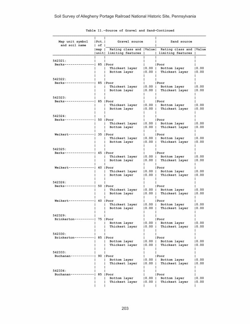
Soil Survey of Allegheny Portage Railroad National Historic Site, Pennsylvania
203
Table 11.—Source of Gravel and Sand—Continued______________________________________________________________________________ | | | Map unit symbol |Pct.| Gravel source | Sand source and soil name | of | | ___________________________________________________ |map | Rating class and |Value| Rating class and |Value |unit| limiting features | | limiting features | ______________________________________________________________________________ | | | | | 542321: | | | | | Berks---------------| 85 |Poor | |Poor | | | Thickest layer |0.00 | Bottom layer |0.00 | | Bottom layer |0.00 | Thickest layer |0.00 | | | | | 542322: | | | | | Berks---------------| 85 |Poor | |Poor | | | Thickest layer |0.00 | Bottom layer |0.00 | | Bottom layer |0.00 | Thickest layer |0.00 | | | | | 542323: | | | | | Berks---------------| 85 |Poor | |Poor | | | Thickest layer |0.00 | Bottom layer |0.00 | | Bottom layer |0.00 | Thickest layer |0.00 | | | | | 542324: | | | | | Berks---------------| 50 |Poor | |Poor | | | Thickest layer |0.00 | Bottom layer |0.00 | | Bottom layer |0.00 | Thickest layer |0.00 | | | | | Weikert-------------| 35 |Poor | |Poor | | | Thickest layer |0.00 | Bottom layer |0.00 | | Bottom layer |0.00 | Thickest layer |0.00 | | | | | 542325: | | | | | Berks---------------| 45 |Poor | |Poor | | | Thickest layer |0.00 | Bottom layer |0.00 | | Bottom layer |0.00 | Thickest layer |0.00 | | | | | Weikert-------------| 40 |Poor | |Poor | | | Thickest layer |0.00 | Bottom layer |0.00 | | Bottom layer |0.00 | Thickest layer |0.00 | | | | | 542326: | | | | | Berks---------------| 50 |Poor | |Poor | | | Thickest layer |0.00 | Bottom layer |0.00 | | Bottom layer |0.00 | Thickest layer |0.00 | | | | | Weikert-------------| 40 |Poor | |Poor | | | Thickest layer |0.00 | Bottom layer |0.00 | | Bottom layer |0.00 | Thickest layer |0.00 | | | | | 542329: | | | | | Brinkerton----------| 75 |Poor | |Poor | | | Bottom layer |0.00 | Bottom layer |0.00 | | Thickest layer |0.00 | Thickest layer |0.00 | | | | | 542330: | | | | | Brinkerton----------| 85 |Poor | |Poor | | | Bottom layer |0.00 | Bottom layer |0.00 | | Thickest layer |0.00 | Thickest layer |0.00 | | | | | 542333: | | | | | Buchanan------------| 90 |Poor | |Poor | | | Bottom layer |0.00 | Bottom layer |0.00 | | Thickest layer |0.00 | Thickest layer |0.00 | | | | | 542334: | | | | | Buchanan------------| 85 |Poor | |Poor | | | Bottom layer |0.00 | Bottom layer |0.00 | | Thickest layer |0.00 | Thickest layer |0.00 | | | | |

Soil Survey of Allegheny Portage Railroad National Historic Site, Pennsylvania
204
Table 11.—Source of Gravel and Sand—Continued______________________________________________________________________________ | | | Map unit symbol |Pct.| Gravel source | Sand source and soil name | of | | ___________________________________________________ |map | Rating class and |Value| Rating class and |Value |unit| limiting features | | limiting features | ______________________________________________________________________________ | | | | | 542338: | | | | | Clymer--------------| 80 |Poor | |Poor | | | Thickest layer |0.00 | Bottom layer |0.00 | | Bottom layer |0.00 | Thickest layer |0.00 | | | | | 542348: | | | | | Ernest--------------| 85 |Poor | |Poor | | | Bottom layer |0.00 | Bottom layer |0.00 | | Thickest layer |0.00 | Thickest layer |0.00 | | | | | 542349: | | | | | Ernest--------------| 85 |Poor | |Poor | | | Bottom layer |0.00 | Bottom layer |0.00 | | Thickest layer |0.00 | Thickest layer |0.00 | | | | | 542350: | | | | | Gilpin--------------| 85 |Fair | |Poor | | | Thickest layer |0.00 | Bottom layer |0.00 | | Bottom layer |0.25 | Thickest layer |0.00 | | | | | 542351: | | | | | Gilpin--------------| 85 |Fair | |Poor | | | Thickest layer |0.00 | Bottom layer |0.00 | | Bottom layer |0.25 | Thickest layer |0.00 | | | | | 542352: | | | | | Gilpin--------------| 85 |Fair | |Poor | | | Thickest layer |0.00 | Bottom layer |0.00 | | Bottom layer |0.25 | Thickest layer |0.00 | | | | | 542366: | | | | | Leck Kill-----------| 90 |Poor | |Poor | | | Thickest layer |0.00 | Bottom layer |0.00 | | Bottom layer |0.00 | Thickest layer |0.00 | | | | | 542370: | | | | | Laidig--------------| 90 |Poor | |Poor | | | Bottom layer |0.00 | Bottom layer |0.00 | | Thickest layer |0.00 | Thickest layer |0.00 | | | | | 542371: | | | | | Laidig--------------| 90 |Poor | |Poor | | | Bottom layer |0.00 | Bottom layer |0.00 | | Thickest layer |0.00 | Thickest layer |0.00 | | | | | 542372: | | | | | Laidig--------------| 90 |Poor | |Poor | | | Bottom layer |0.00 | Bottom layer |0.00 | | Thickest layer |0.00 | Thickest layer |0.00 | | | | | 542375: | | | | | Leck Kill-----------| 80 |Fair | |Poor | | | Thickest layer |0.00 | Bottom layer |0.00 | | Bottom layer |0.06 | Thickest layer |0.00 | | | | | 542383: | | | | | Meckesville---------| 90 |Poor | |Poor | | | Bottom layer |0.00 | Bottom layer |0.00 | | Thickest layer |0.00 | Thickest layer |0.00 | | | | |

Soil Survey of Allegheny Portage Railroad National Historic Site, Pennsylvania
205
Table 11.—Source of Gravel and Sand—Continued______________________________________________________________________________ | | | Map unit symbol |Pct.| Gravel source | Sand source and soil name | of | | ___________________________________________________ |map | Rating class and |Value| Rating class and |Value |unit| limiting features | | limiting features | ______________________________________________________________________________ | | | | | 542384: | | | | | Meckesville---------| 90 |Poor | |Poor | | | Bottom layer |0.00 | Bottom layer |0.00 | | Thickest layer |0.00 | Thickest layer |0.00 | | | | | 542406: | | | | | Tyler---------------| 90 |Poor | |Poor | | | Bottom layer |0.00 | Bottom layer |0.00 | | Thickest layer |0.00 | Thickest layer |0.00 | | | | | 542407: | | | | | Udifluvents---------| 50 |Poor | |Poor | | | Bottom layer |0.00 | Bottom layer |0.00 | | Thickest layer |0.00 | Thickest layer |0.00 | | | | | Dystrochrepts-------| 30 |Poor | |Poor | | | Bottom layer |0.00 | Bottom layer |0.00 | | Thickest layer |0.00 | Thickest layer |0.00 | | | | | 542410: | | | | | Urban land----------| 65 |Not rated | |Not rated | | | | | | Berks---------------| 25 |Poor | |Poor | | | Thickest layer |0.00 | Bottom layer |0.00 | | Bottom layer |0.00 | Thickest layer |0.00 | | | | | 542420: | | | | | Wharton-------------| 80 |Poor | |Poor | | | Thickest layer |0.00 | Bottom layer |0.00 | | Bottom layer |0.00 | Thickest layer |0.00 | | | | | 542421: | | | | | Wharton-------------| 75 |Poor | |Poor | | | Bottom layer |0.00 | Bottom layer |0.00 | | Thickest layer |0.00 | Thickest layer |0.00 | | | | | ______________________________________________________________________________

Soil Survey of Allegheny Portage Railroad National Historic Site, Pennsylvania
206
Table 12.—Source of Reclamation Material, Roadfill, and Topsoil
(Onsite investigation may be needed to validate the interpretations in this table and to confirm the identity of the soil on a given site. The numbers in the value columns range from 0.00 to 0.99. The smaller the value, the greater the limitation. See text for further explanation of ratings in this table)
_________________________________________________________________________________________________________ | | | | Map unit symbol |Pct.| Source of | Roadfill source | Topsoil source and soil name | of | reclamation material | | ______________________________________________________________________________ |map | Rating class and |Value| Rating class and |Value| Rating class and |Value |unit| limiting features | | limiting features | | limiting features | _________________________________________________________________________________________________________ | | | | | | | 541887: | | | | | | | Armagh--------------| 85 |Fair | |Poor | |Poor | | | Too clayey |0.02 | Wetness |0.00 | Wetness |0.00 | | Low content of |0.12 | Low strength |0.00 | Too clayey |0.01 | | organic matter | | Shrink-swell |0.89 | Hard to reclaim |0.02 | | Too acid |0.32 | | | (rock fragments)| | | | | | | | 541890: | | | | | | | Berks---------------| 85 |Poor | |Poor | |Poor | | | Droughty |0.00 | Depth to bedrock |0.00 | Rock fragments |0.00 | | Low content of |0.12 | | | Slope |0.37 | | organic matter | | | | Depth to bedrock |0.84 | | Too acid |0.50 | | | | | | | | | | | 541892: | | | | | | | Blairton------------| 90 |Fair | |Poor | |Poor | | | Droughty |0.01 | Depth to bedrock |0.00 | Rock fragments |0.00 | | Low content of |0.12 | Wetness |0.29 | Depth to bedrock |0.21 | | organic matter | | | | Wetness |0.29 | | Depth to bedrock |0.21 | | | | | | | | | | | 541893: | | | | | | | Blairton------------| 90 |Fair | |Poor | |Fair | | | Low content of |0.12 | Depth to bedrock |0.00 | Rock fragments |0.12 | | organic matter | | Wetness |0.29 | Wetness |0.29 | | Too acid |0.50 | | | Slope |0.37 | | Droughty |0.60 | | | | | | | | | | | 541903: | | | | | | | Cookport------------| 65 |Fair | |Fair | |Poor | | | Too acid |0.12 | Wetness |0.53 | Rock fragments |0.00 | | Low content of |0.12 | | | Wetness |0.53 | | organic matter | | | | Too acid |0.88 | | | | | | | Ernest--------------| 25 |Fair | |Fair | |Fair | | | Low content of |0.12 | Wetness |0.06 | Wetness |0.06 | | organic matter | | Low strength |0.22 | Hard to reclaim |0.88 | | Too acid |0.32 | Shrink-swell |0.98 | (rock fragments)| | | Water erosion |0.90 | | | Rock fragments |0.88 | | | | | | | 541906: | | | | | | | Cookport------------| 65 |Fair | |Poor | |Poor | | | Too acid |0.12 | Wetness |0.00 | Wetness |0.00 | | Low content of |0.12 | | | Too acid |0.59 | | organic matter | | | | Rock fragments |0.72 | | | | | | | Ernest--------------| 25 |Fair | |Fair | |Fair | | | Low content of |0.12 | Wetness |0.06 | Wetness |0.06 | | organic matter | | Low strength |0.22 | Hard to reclaim |0.88 | | Too acid |0.32 | Shrink-swell |0.98 | (rock fragments)| | | Water erosion |0.90 | | | Rock fragments |0.88 | | | | | | |

Soil Survey of Allegheny Portage Railroad National Historic Site, Pennsylvania
207
Table 12.—Source of Reclamation Material, Roadfill, and Topsoil—Continued_________________________________________________________________________________________________________ | | | | Map unit symbol |Pct.| Source of | Roadfill source | Topsoil source and soil name | of | reclamation material | | ______________________________________________________________________________ |map | Rating class and |Value| Rating class and |Value| Rating class and |Value |unit| limiting features | | limiting features | | limiting features | _________________________________________________________________________________________________________ | | | | | | | 541907: | | | | | | | Cookport------------| 70 |Fair | |Poor | |Poor | | | Too acid |0.12 | Wetness |0.00 | Wetness |0.00 | | Low content of |0.12 | Slope |0.92 | Slope |0.00 | | organic matter | | | | Too acid |0.59 | | | | | | | Ernest--------------| 25 |Fair | |Fair | |Poor | | | Low content of |0.12 | Wetness |0.06 | Slope |0.00 | | organic matter | | Low strength |0.22 | Wetness |0.06 | | Too acid |0.32 | Slope |0.92 | Hard to reclaim |0.88 | | | | | | (rock fragments)| | | | | | | | 541908: | | | | | | | Dumps, industrial | | | | | | | wastes-------------| 90 |Not rated | |Not rated | |Not rated | | | | | | | | 541909: | | | | | | | Dumps, mine---------| 99 |Not rated | |Not rated | |Not rated | | | | | | | | 541911: | | | | | | | Gilpin--------------| 75 |Fair | |Poor | |Fair | | | Droughty |0.04 | Depth to bedrock |0.00 | Too clayey |0.29 | | Low content of |0.12 | | | Depth to bedrock |0.46 | | organic matter | | | | Too acid |0.50 | | Depth to bedrock |0.46 | | | | | | | | | | | 541914: | | | | | | | Gilpin--------------| 70 |Fair | |Poor | |Poor | | | Low content of |0.12 | Depth to bedrock |0.00 | Rock fragments |0.00 | | organic matter | | | | Slope |0.37 | | Too acid |0.50 | | | Too acid |0.59 | | Droughty |0.81 | | | | | | | | | | | Rayne---------------| 30 |Fair | |Good | |Poor | | | Low content of |0.12 | | | Rock fragments |0.00 | | organic matter | | | | Hard to reclaim |0.00 | | Too acid |0.32 | | | (rock fragments)| | | | | | | Slope |0.37 | | | | | | | 541919: | | | | | | | Hazleton------------| 90 |Fair | |Fair | |Poor | | | Low content of |0.12 | Cobble content |0.69 | Hard to reclaim |0.00 | | organic matter | | Depth to bedrock |0.87 | (rock fragments)| | | Too acid |0.50 | | | Rock fragments |0.00 | | Droughty |0.92 | | | Too acid |0.59 | | | | | | | 541922: | | | | | | | Hazleton------------| 75 |Fair | |Fair | |Poor | | | Low content of |0.12 | Cobble content |0.94 | Hard to reclaim |0.00 | | organic matter | | Depth to bedrock |0.99 | (rock fragments)| | | Too acid |0.50 | | | Rock fragments |0.00 | | Droughty |0.54 | | | Too acid |0.59 | | | | | | | 541925: | | | | | | | Laidig--------------| 100|Fair | |Poor | |Poor | | | Too acid |0.12 | Slope |0.00 | Slope |0.00 | | Low content of |0.12 | Wetness |0.89 | Rock fragments |0.00 | | organic matter | | | | Hard to reclaim |0.50 | | | | | | (rock fragments)| | | | | | | |

Soil Survey of Allegheny Portage Railroad National Historic Site, Pennsylvania
208
Table 12.—Source of Reclamation Material, Roadfill, and Topsoil—Continued_________________________________________________________________________________________________________ | | | | Map unit symbol |Pct.| Source of | Roadfill source | Topsoil source and soil name | of | reclamation material | | ______________________________________________________________________________ |map | Rating class and |Value| Rating class and |Value| Rating class and |Value |unit| limiting features | | limiting features | | limiting features | _________________________________________________________________________________________________________ | | | | | | | 541938: | | | | | | | Bethesda, unstable | | | | | | | fill---------------| 90 |Fair | |Fair | |Poor | | | Low content of |0.02 | Cobble content |0.09 | Hard to reclaim |0.00 | | organic matter | | | | (rock fragments)| | | Too acid |0.50 | | | Rock fragments |0.00 | | Droughty |0.80 | | | Slope |0.00 | | | | | | | 541940: | | | | | | | Urban land----------| 60 |Not rated | |Not rated | |Not rated | | | | | | | | Udorthents----------| 30 |Poor | |Poor | |Poor | | | Droughty |0.00 | Cobble content |0.00 | Hard to reclaim |0.00 | | Cobble content |0.00 | | | (rock fragments)| | | Low content of |0.12 | | | Rock fragments |0.00 | | organic matter | | | | | | | | | | | | 541942: | | | | | | | Water---------------| 100|Not rated | |Not rated | |Not rated | | | | | | | | 541943: | | | | | | | Wharton-------------| 80 |Fair | |Poor | |Poor | | | Low content of |0.12 | Low strength |0.00 | Hard to reclaim |0.00 | | organic matter | | Wetness |0.76 | (rock fragments)| | | Too acid |0.20 | Shrink-swell |0.87 | Wetness |0.76 | | Water erosion |0.99 | | | Too acid |0.76 | | | | | | | 541944: | | | | | | | Wharton-------------| 80 |Fair | |Poor | |Poor | | | Low content of |0.12 | Low strength |0.00 | Hard to reclaim |0.00 | | organic matter | | Wetness |0.76 | (rock fragments)| | | Too acid |0.20 | Shrink-swell |0.87 | Slope |0.37 | | Water erosion |0.99 | | | Wetness |0.76 | | | | | | | 542311: | | | | | | | Albrights-----------| 90 |Fair | |Fair | |Poor | | | Low content of |0.12 | Wetness |0.29 | Rock fragments |0.00 | | organic matter | | | | Wetness |0.29 | | Too acid |0.50 | | | Hard to reclaim |0.92 | | Droughty |0.92 | | | (rock fragments)| | | | | | | | 542321: | | | | | | | Berks---------------| 85 |Poor | |Poor | |Poor | | | Droughty |0.00 | Depth to bedrock |0.00 | Rock fragments |0.00 | | Low content of |0.12 | | | Depth to bedrock |0.84 | | organic matter | | | | Too acid |0.92 | | Too acid |0.50 | | | | | | | | | | | 542322: | | | | | | | Berks---------------| 85 |Poor | |Poor | |Poor | | | Droughty |0.00 | Depth to bedrock |0.00 | Rock fragments |0.00 | | Low content of |0.12 | | | Slope |0.37 | | organic matter | | | | Depth to bedrock |0.84 | | Too acid |0.50 | | | | | | | | | | | 542323 | | | | | | | Berks---------------| 85 |Poor | |Poor | |Poor | | | Droughty |0.00 | Depth to bedrock |0.00 | Rock fragments |0.00 | | Low content of |0.12 | Slope |0.50 | Slope |0.00 | | organic matter | | | | Depth to bedrock |0.84 | | Too acid |0.50 | | | | | | | | | | |
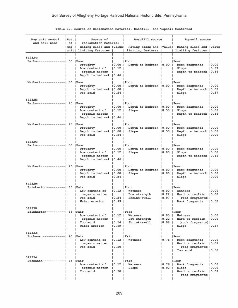
Soil Survey of Allegheny Portage Railroad National Historic Site, Pennsylvania
209
Table 12.—Source of Reclamation Material, Roadfill, and Topsoil—Continued_________________________________________________________________________________________________________ | | | | Map unit symbol |Pct.| Source of | Roadfill source | Topsoil source and soil name | of | reclamation material | | ______________________________________________________________________________ |map | Rating class and |Value| Rating class and |Value| Rating class and |Value |unit| limiting features | | limiting features | | limiting features | _________________________________________________________________________________________________________ | | | | | | | 542324: | | | | | | | Berks---------------| 50 |Poor | |Poor | |Poor | | | Droughty |0.00 | Depth to bedrock |0.00 | Rock fragments |0.00 | | Low content of |0.12 | | | Slope |0.37 | | organic matter | | | | Depth to bedrock |0.46 | | Depth to bedrock |0.46 | | | | | | | | | | | Weikert-------------| 35 |Poor | |Poor | |Poor | | | Droughty |0.00 | Depth to bedrock |0.00 | Rock fragments |0.00 | | Depth to bedrock |0.00 | | | Depth to bedrock |0.00 | | Too acid |0.54 | | | Slope |0.37 | | | | | | | 542325: | | | | | | | Berks---------------| 45 |Poor | |Poor | |Poor | | | Droughty |0.00 | Depth to bedrock |0.00 | Rock fragments |0.00 | | Low content of |0.12 | Slope |0.50 | Slope |0.00 | | organic matter | | | | Depth to bedrock |0.46 | | Depth to bedrock |0.46 | | | | | | | | | | | Weikert-------------| 40 |Poor | |Poor | |Poor | | | Droughty |0.00 | Depth to bedrock |0.00 | Rock fragments |0.00 | | Depth to bedrock |0.00 | Slope |0.50 | Depth to bedrock |0.00 | | Too acid |0.54 | | | Slope |0.00 | | | | | | | 542326: | | | | | | | Berks---------------| 50 |Poor | |Poor | |Poor | | | Droughty |0.00 | Depth to bedrock |0.00 | Rock fragments |0.00 | | Low content of |0.12 | Slope |0.00 | Slope |0.00 | | organic matter | | | | Depth to bedrock |0.46 | | Depth to bedrock |0.46 | | | | | | | | | | | Weikert-------------| 40 |Poor | |Poor | |Poor | | | Droughty |0.00 | Depth to bedrock |0.00 | Rock fragments |0.00 | | Depth to bedrock |0.00 | Slope |0.00 | Depth to bedrock |0.00 | | Too acid |0.54 | | | Slope |0.00 | | | | | | | 542329: | | | | | | | Brinkerton----------| 75 |Fair | |Poor | |Poor | | | Low content of |0.12 | Wetness |0.00 | Wetness |0.00 | | organic matter | | Low strength |0.22 | Hard to reclaim |0.00 | | Too acid |0.54 | Shrink-swell |0.97 | (rock fragments)| | | Water erosion |0.99 | | | Rock fragments |0.50 | | | | | | | 542330: | | | | | | | Brinkerton----------| 85 |Fair | |Poor | |Poor | | | Low content of |0.12 | Wetness |0.00 | Wetness |0.00 | | organic matter | | Low strength |0.22 | Hard to reclaim |0.00 | | Too acid |0.54 | Shrink-swell |0.98 | (rock fragments)| | | Water erosion |0.99 | | | Slope |0.37 | | | | | | | 542333: | | | | | | | Buchanan------------| 90 |Fair | |Fair | |Poor | | | Low content of |0.12 | Wetness |0.76 | Rock fragments |0.00 | | organic matter | | | | Hard to reclaim |0.08 | | Too acid |0.50 | | | (rock fragments)| | | | | | | Too acid |0.50 | | | | | | | 542334: | | | | | | | Buchanan------------| 85 |Fair | |Fair | |Poor | | | Low content of |0.12 | Wetness |0.76 | Rock fragments |0.00 | | organic matter | | Slope |0.92 | Slope |0.00 | | Too acid |0.50 | | | Hard to reclaim |0.08 | | | | | | (rock fragments)| | | | | | | |

Soil Survey of Allegheny Portage Railroad National Historic Site, Pennsylvania
210
Table 12.—Source of Reclamation Material, Roadfill, and Topsoil—Continued_________________________________________________________________________________________________________ | | | | Map unit symbol |Pct.| Source of | Roadfill source | Topsoil source and soil name | of | reclamation material | | ______________________________________________________________________________ |map | Rating class and |Value| Rating class and |Value| Rating class and |Value |unit| limiting features | | limiting features | | limiting features | _________________________________________________________________________________________________________ | | | | | | | 542338: | | | | | | | Clymer--------------| 80 |Fair | |Fair | |Fair | | | Low content of |0.12 | Depth to bedrock |0.58 | Rock fragments |0.03 | | organic matter | | | | Hard to reclaim |0.12 | | Too acid |0.50 | | | (rock fragments)| | | Droughty |0.51 | | | Too acid |0.50 | | | | | | | 542348: | | | | | | | Ernest--------------| 85 |Fair | |Fair | |Fair | | | Low content of |0.12 | Low strength |0.22 | Wetness |0.76 | | organic matter | | Wetness |0.76 | Hard to reclaim |0.88 | | Too acid |0.32 | Shrink-swell |0.98 | (rock fragments)| | | Water erosion |0.90 | | | Rock fragments |0.88 | | | | | | | 542349: | | | | | | | Ernest--------------| 85 |Fair | |Poor | |Fair | | | Low content of |0.12 | Low strength |0.00 | Slope |0.37 | | organic matter | | Wetness |0.76 | Wetness |0.76 | | Too acid |0.32 | Shrink-swell |0.97 | Hard to reclaim |0.88 | | Water erosion |0.90 | | | (rock fragments)| | | | | | | | 542350: | | | | | | | Gilpin--------------| 85 |Fair | |Poor | |Poor | | | Too acid |0.50 | Depth to bedrock |0.00 | Rock fragments |0.00 | | Low content of |0.50 | | | Depth to bedrock |0.58 | | organic matter | | | | Too acid |0.88 | | Droughty |0.56 | | | | | | | | | | | 542351: | | | | | | | Gilpin--------------| 85 |Fair | |Poor | |Poor | | | Too acid |0.50 | Depth to bedrock |0.00 | Rock fragments |0.00 | | Low content of |0.50 | | | Slope |0.37 | | organic matter | | | | Depth to bedrock |0.58 | | Droughty |0.56 | | | | | | | | | | | 542352: | | | | | | | Gilpin--------------| 85 |Fair | |Poor | |Poor | | | Droughty |0.39 | Depth to bedrock |0.00 | Slope |0.00 | | Too acid |0.50 | Slope |0.50 | Rock fragments |0.00 | | Low content of |0.50 | | | Depth to bedrock |0.54 | | organic matter | | | | | | | | | | | | 542366: | | | | | | | Leck Kill-----------| 90 |Fair | |Poor | |Poor | | | Low content of |0.12 | Slope |0.00 | Hard to reclaim |0.00 | | organic matter | | Depth to bedrock |0.16 | (rock fragments)| | | Too acid |0.54 | | | Slope |0.00 | | | | | | Rock fragments |0.00 | | | | | | | 542370: | | | | | | | Laidig--------------| 90 |Poor | |Fair | |Poor | | | Low content of |0.00 | Wetness |0.93 | Rock fragments |0.00 | | organic matter | | | | Hard to reclaim |0.50 | | Too acid |0.50 | | | (rock fragments)| | | | | | | Too acid |0.59 | | | | | | | 542371: | | | | | | | Laidig--------------| 90 |Poor | |Fair | |Poor | | | Low content of |0.00 | Slope |0.50 | Slope |0.00 | | organic matter | | | | Rock fragments |0.00 | | Too acid |0.50 | | | Hard to reclaim |0.50 | | | | | | (rock fragments)| | | | | | | |
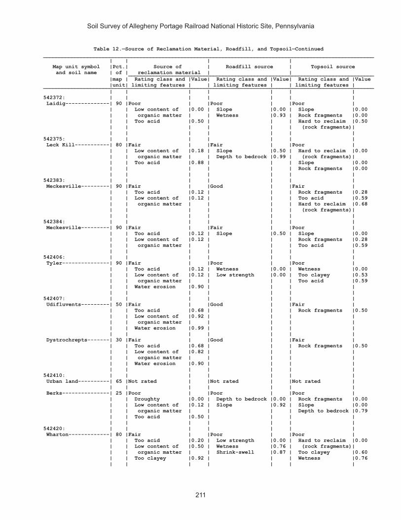
Soil Survey of Allegheny Portage Railroad National Historic Site, Pennsylvania
211
Table 12.—Source of Reclamation Material, Roadfill, and Topsoil—Continued_________________________________________________________________________________________________________ | | | | Map unit symbol |Pct.| Source of | Roadfill source | Topsoil source and soil name | of | reclamation material | | ______________________________________________________________________________ |map | Rating class and |Value| Rating class and |Value| Rating class and |Value |unit| limiting features | | limiting features | | limiting features | _________________________________________________________________________________________________________ | | | | | | | 542372: | | | | | | | Laidig--------------| 90 |Poor | |Poor | |Poor | | | Low content of |0.00 | Slope |0.00 | Slope |0.00 | | organic matter | | Wetness |0.93 | Rock fragments |0.00 | | Too acid |0.50 | | | Hard to reclaim |0.50 | | | | | | (rock fragments)| | | | | | | | 542375: | | | | | | | Leck Kill-----------| 80 |Fair | |Fair | |Poor | | | Low content of |0.18 | Slope |0.50 | Hard to reclaim |0.00 | | organic matter | | Depth to bedrock |0.99 | (rock fragments)| | | Too acid |0.88 | | | Slope |0.00 | | | | | | Rock fragments |0.00 | | | | | | | 542383: | | | | | | | Meckesville---------| 90 |Fair | |Good | |Fair | | | Too acid |0.12 | | | Rock fragments |0.28 | | Low content of |0.12 | | | Too acid |0.59 | | organic matter | | | | Hard to reclaim |0.68 | | | | | | (rock fragments)| | | | | | | | 542384: | | | | | | | Meckesville---------| 90 |Fair | |Fair | |Poor | | | Too acid |0.12 | Slope |0.50 | Slope |0.00 | | Low content of |0.12 | | | Rock fragments |0.28 | | organic matter | | | | Too acid |0.59 | | | | | | | 542406: | | | | | | | Tyler---------------| 90 |Fair | |Poor | |Poor | | | Too acid |0.12 | Wetness |0.00 | Wetness |0.00 | | Low content of |0.12 | Low strength |0.00 | Too clayey |0.53 | | organic matter | | | | Too acid |0.59 | | Water erosion |0.90 | | | | | | | | | | | 542407: | | | | | | | Udifluvents---------| 50 |Fair | |Good | |Fair | | | Too acid |0.68 | | | Rock fragments |0.50 | | Low content of |0.92 | | | | | | organic matter | | | | | | | Water erosion |0.99 | | | | | | | | | | | Dystrochrepts-------| 30 |Fair | |Good | |Fair | | | Too acid |0.68 | | | Rock fragments |0.50 | | Low content of |0.82 | | | | | | organic matter | | | | | | | Water erosion |0.90 | | | | | | | | | | | 542410: | | | | | | | Urban land----------| 65 |Not rated | |Not rated | |Not rated | | | | | | | | Berks---------------| 25 |Poor | |Poor | |Poor | | | Droughty |0.00 | Depth to bedrock |0.00 | Rock fragments |0.00 | | Low content of |0.12 | Slope |0.92 | Slope |0.00 | | organic matter | | | | Depth to bedrock |0.79 | | Too acid |0.50 | | | | | | | | | | | 542420: | | | | | | | Wharton-------------| 80 |Fair | |Poor | |Poor | | | Too acid |0.20 | Low strength |0.00 | Hard to reclaim |0.00 | | Low content of |0.50 | Wetness |0.76 | (rock fragments)| | | organic matter | | Shrink-swell |0.87 | Too clayey |0.60 | | Too clayey |0.92 | | | Wetness |0.76 | | | | | | |

Soil Survey of Allegheny Portage Railroad National Historic Site, Pennsylvania
212
Table 12.—Source of Reclamation Material, Roadfill, and Topsoil—Continued_________________________________________________________________________________________________________ | | | | Map unit symbol |Pct.| Source of | Roadfill source | Topsoil source and soil name | of | reclamation material | | ______________________________________________________________________________ |map | Rating class and |Value| Rating class and |Value| Rating class and |Value |unit| limiting features | | limiting features | | limiting features | _________________________________________________________________________________________________________ | | | | | | | 542421: | | | | | | | Wharton-------------| 75 |Fair | |Poor | |Fair | | | Too acid |0.20 | Low strength |0.00 | Hard to reclaim |0.02 | | Low content of |0.50 | Wetness |0.76 | (rock fragments)| | | organic matter | | Shrink-swell |0.87 | Slope |0.37 | | Too clayey |0.92 | | | Too clayey |0.60 | | | | | | | _________________________________________________________________________________________________________

Soil Survey of Allegheny Portage Railroad National Historic Site, Pennsylvania
213
Table 13.—Ponds and Embankments
(Onsite investigation may be needed to validate the interpretations in this table and to confirm the identity of the soil on a given site. The numbers in the value columns range from 0.01 to 1.00. The larger the value, the greater the limitation. See text for further explanation of ratings in this table)
________________________________________________________________________________________________________ | | | | Map unit symbol |Pct.| Pond reservoir areas | Embankments, dikes, and | Aquifer-fed and soil name | of | | levees | excavated ponds _____________________________________________________________________________ |map | Rating class and |Value| Rating class and |Value| Rating class and |Value |unit| limiting features | | limiting features | | limiting features | ________________________________________________________________________________________________________ | | | | | | | 541887: | | | | | | | Armagh--------------| 85 |Somewhat limited | |Very limited | |Somewhat limited | | | Slope |0.08 | Depth to |1.00 | Slow refill |0.28 | | Seepage |0.02 | saturated zone | | Unstable |0.10 | | | | Piping |0.30 | excavation walls| | | | | | | | 541890: | | | | | | | Berks---------------| 85 |Very limited | |Somewhat limited | |Very limited | | | Seepage |1.00 | Thin layer |0.74 | Depth to water |1.00 | | Slope |1.00 | | | | | | Depth to bedrock |0.74 | | | | | | | | | | | 541892: | | | | | | | Blairton------------| 90 |Somewhat limited | |Very limited | |Very limited | | | Depth to bedrock |0.95 | Depth to |1.00 | Depth to water |1.00 | | Slope |0.68 | saturated zone | | | | | Seepage |0.54 | Piping |1.00 | | | | | | Thin layer |0.95 | | | | | | | | | 541893: | | | | | | | Blairton------------| 90 |Very limited | |Very limited | |Very limited | | | Slope |1.00 | Depth to |1.00 | Depth to water |1.00 | | Depth to bedrock |0.57 | saturated zone | | | | | Seepage |0.54 | Piping |1.00 | | | | | | Thin layer |0.58 | | | | | | | | | 541903: | | | | | | | Cookport------------| 65 |Somewhat limited | |Very limited | |Very limited | | | Seepage |0.72 | Depth to |1.00 | Depth to water |1.00 | | Slope |0.68 | saturated zone | | | | | | | Piping |1.00 | | | | | | | | | Ernest--------------| 25 |Somewhat limited | |Very limited | |Very limited | | | Seepage |0.72 | Depth to |1.00 | Depth to water |1.00 | | Slope |0.68 | saturated zone | | | | | | | Piping |0.86 | | | | | | | | | 541906: | | | | | | | Cookport------------| 65 |Somewhat limited | |Very limited | |Very limited | | | Seepage |0.72 | Depth to |1.00 | Depth to water |1.00 | | Slope |0.08 | saturated zone | | | | | | | Piping |1.00 | | | | | | | | | Ernest--------------| 25 |Somewhat limited | |Very limited | |Very limited | | | Seepage |0.72 | Depth to |1.00 | Depth to water |1.00 | | Slope |0.08 | saturated zone | | | | | | | Piping |0.86 | | | | | | | | |

Soil Survey of Allegheny Portage Railroad National Historic Site, Pennsylvania
214
Table 13.—Ponds and Embankments—Continued________________________________________________________________________________________________________ | | | | Map unit symbol |Pct.| Pond reservoir areas | Embankments, dikes, and | Aquifer-fed and soil name | of | | levees | excavated ponds _____________________________________________________________________________ |map | Rating class and |Value| Rating class and |Value| Rating class and |Value |unit| limiting features | | limiting features | | limiting features | ________________________________________________________________________________________________________ | | | | | | | 541907: | | | | | | | Cookport------------| 70 |Very limited | |Very limited | |Very limited | | | Slope |1.00 | Depth to |1.00 | Depth to water |1.00 | | Seepage |0.72 | saturated zone | | | | | | | Piping |1.00 | | | | | | | | | Ernest--------------| 25 |Very limited | |Very limited | |Very limited | | | Slope |1.00 | Depth to |1.00 | Depth to water |1.00 | | Seepage |0.72 | saturated zone | | | | | | | Piping |0.86 | | | | | | | | | 541908: | | | | | | | Dumps, industrial | | | | | | | wastes-------------| 90 |Not rated | |Not rated | |Not rated | | | | | | | | 541909: | | | | | | | Dumps, mine---------| 99 |Not rated | |Not rated | |Not rated | | | | | | | | 541911: | | | | | | | Gilpin--------------| 75 |Somewhat limited | |Somewhat limited | |Very limited | | | Depth to bedrock |0.88 | Thin layer |0.88 | Depth to water |1.00 | | Seepage |0.72 | Seepage |0.08 | | | | Slope |0.32 | | | | | | | | | | | 541914: | | | | | | | Gilpin--------------| 70 |Very limited | |Very limited | |Very limited | | | Slope |1.00 | Piping |1.00 | Depth to water |1.00 | | Seepage |0.72 | Thin layer |0.58 | | | | Depth to bedrock |0.57 | | | | | | | | | | | Rayne---------------| 30 |Very limited | |Not limited | |Very limited | | | Slope |1.00 | | | Depth to water |1.00 | | Seepage |0.72 | | | | | | | | | | | 541919: | | | | | | | Hazleton------------| 90 |Very limited | |Somewhat limited | |Very limited | | | Seepage |1.00 | Thin layer |0.03 | Depth to water |1.00 | | Slope |0.68 | | | | | | Depth to bedrock |0.03 | | | | | | | | | | | 541922: | | | | | | | Hazleton------------| 75 |Very limited | |Somewhat limited | |Very limited | | | Seepage |1.00 | Seepage |0.26 | Depth to water |1.00 | | Slope |0.08 | | | | | | | | | | | 541925: | | | | | | | Laidig--------------| 100|Very limited | |Somewhat limited | |Very limited | | | Slope |1.00 | Depth to |0.86 | Depth to water |1.00 | | Seepage |1.00 | saturated zone | | | | | | | | | | 541938: | | | | | | | Bethesda, unstable | | | | | | | fill---------------| 90 |Very limited | |Somewhat limited | |Very limited | | | Slope |1.00 | Large stones |0.11 | Depth to water |1.00 | | Seepage |0.04 | | | | | | | | | | | 541940: | | | | | | | Urban land----------| 60 |Not rated | |Not rated | |Not rated | | | | | | | | Udorthents----------| 30 |Very limited | |Very limited | |Very limited | | | Seepage |1.00 | Seepage |1.00 | Depth to water |1.00 | | Slope |0.68 | Large stones |1.00 | | | | | | | | |
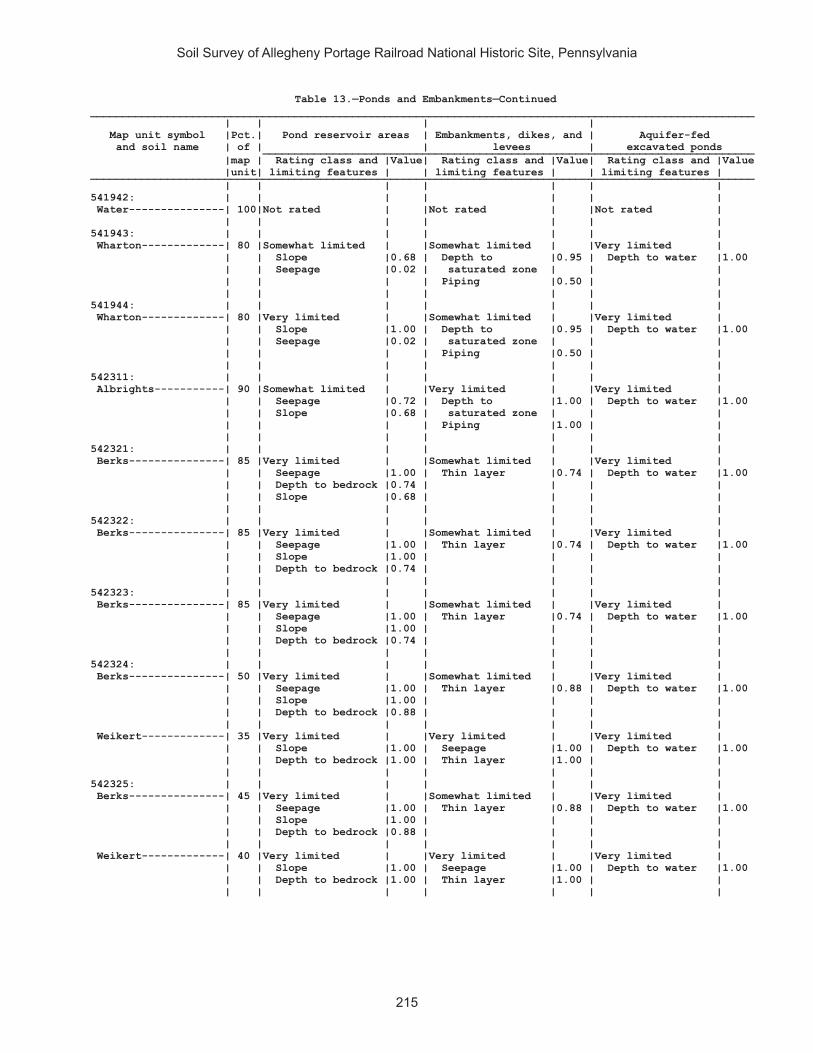
Soil Survey of Allegheny Portage Railroad National Historic Site, Pennsylvania
215
Table 13.—Ponds and Embankments—Continued________________________________________________________________________________________________________ | | | | Map unit symbol |Pct.| Pond reservoir areas | Embankments, dikes, and | Aquifer-fed and soil name | of | | levees | excavated ponds _____________________________________________________________________________ |map | Rating class and |Value| Rating class and |Value| Rating class and |Value |unit| limiting features | | limiting features | | limiting features | ________________________________________________________________________________________________________ | | | | | | | 541942: | | | | | | | Water---------------| 100|Not rated | |Not rated | |Not rated | | | | | | | | 541943: | | | | | | | Wharton-------------| 80 |Somewhat limited | |Somewhat limited | |Very limited | | | Slope |0.68 | Depth to |0.95 | Depth to water |1.00 | | Seepage |0.02 | saturated zone | | | | | | | Piping |0.50 | | | | | | | | | 541944: | | | | | | | Wharton-------------| 80 |Very limited | |Somewhat limited | |Very limited | | | Slope |1.00 | Depth to |0.95 | Depth to water |1.00 | | Seepage |0.02 | saturated zone | | | | | | | Piping |0.50 | | | | | | | | | 542311: | | | | | | | Albrights-----------| 90 |Somewhat limited | |Very limited | |Very limited | | | Seepage |0.72 | Depth to |1.00 | Depth to water |1.00 | | Slope |0.68 | saturated zone | | | | | | | Piping |1.00 | | | | | | | | | 542321: | | | | | | | Berks---------------| 85 |Very limited | |Somewhat limited | |Very limited | | | Seepage |1.00 | Thin layer |0.74 | Depth to water |1.00 | | Depth to bedrock |0.74 | | | | | | Slope |0.68 | | | | | | | | | | | 542322: | | | | | | | Berks---------------| 85 |Very limited | |Somewhat limited | |Very limited | | | Seepage |1.00 | Thin layer |0.74 | Depth to water |1.00 | | Slope |1.00 | | | | | | Depth to bedrock |0.74 | | | | | | | | | | | 542323: | | | | | | | Berks---------------| 85 |Very limited | |Somewhat limited | |Very limited | | | Seepage |1.00 | Thin layer |0.74 | Depth to water |1.00 | | Slope |1.00 | | | | | | Depth to bedrock |0.74 | | | | | | | | | | | 542324: | | | | | | | Berks---------------| 50 |Very limited | |Somewhat limited | |Very limited | | | Seepage |1.00 | Thin layer |0.88 | Depth to water |1.00 | | Slope |1.00 | | | | | | Depth to bedrock |0.88 | | | | | | | | | | | Weikert-------------| 35 |Very limited | |Very limited | |Very limited | | | Slope |1.00 | Seepage |1.00 | Depth to water |1.00 | | Depth to bedrock |1.00 | Thin layer |1.00 | | | | | | | | | 542325: | | | | | | | Berks---------------| 45 |Very limited | |Somewhat limited | |Very limited | | | Seepage |1.00 | Thin layer |0.88 | Depth to water |1.00 | | Slope |1.00 | | | | | | Depth to bedrock |0.88 | | | | | | | | | | | Weikert-------------| 40 |Very limited | |Very limited | |Very limited | | | Slope |1.00 | Seepage |1.00 | Depth to water |1.00 | | Depth to bedrock |1.00 | Thin layer |1.00 | | | | | | | | |

Soil Survey of Allegheny Portage Railroad National Historic Site, Pennsylvania
216
Table 13.—Ponds and Embankments—Continued________________________________________________________________________________________________________ | | | | Map unit symbol |Pct.| Pond reservoir areas | Embankments, dikes, and | Aquifer-fed and soil name | of | | levees | excavated ponds _____________________________________________________________________________ |map | Rating class and |Value| Rating class and |Value| Rating class and |Value |unit| limiting features | | limiting features | | limiting features | ________________________________________________________________________________________________________ | | | | | | | 542326: | | | | | | | Berks---------------| 50 |Very limited | |Somewhat limited | |Very limited | | | Seepage |1.00 | Thin layer |0.88 | Depth to water |1.00 | | Slope |1.00 | | | | | | Depth to bedrock |0.88 | | | | | | | | | | | Weikert-------------| 40 |Very limited | |Very limited | |Very limited | | | Slope |1.00 | Seepage |1.00 | Depth to water |1.00 | | Depth to bedrock |1.00 | Thin layer |1.00 | | | | | | | | | 542329: | | | | | | | Brinkerton----------| 75 |Somewhat limited | |Very limited | |Very limited | | | Slope |0.68 | Depth to |1.00 | Depth to water |1.00 | | Seepage |0.02 | saturated zone | | | | | | | Piping |1.00 | | | | | | | | | 542330: | | | | | | | Brinkerton----------| 85 |Very limited | |Very limited | |Very limited | | | Slope |1.00 | Depth to |1.00 | Depth to water |1.00 | | Seepage |0.02 | saturated zone | | | | | | | Piping |1.00 | | | | | | | | | 542333: | | | | | | | Buchanan------------| 90 |Somewhat limited | |Somewhat limited | |Very limited | | | Seepage |0.72 | Depth to |0.95 | Depth to water |1.00 | | Slope |0.08 | saturated zone | | | | | | | | | | 542334: | | | | | | | Buchanan------------| 85 |Very limited | |Somewhat limited | |Very limited | | | Slope |1.00 | Depth to |0.95 | Depth to water |1.00 | | Seepage |0.72 | saturated zone | | | | | | | | | | 542338: | | | | | | | Clymer--------------| 80 |Very limited | |Somewhat limited | |Very limited | | | Seepage |1.00 | Thin layer |0.11 | Depth to water |1.00 | | Slope |0.68 | | | | | | Depth to bedrock |0.10 | | | | | | | | | | | 542348: | | | | | | | Ernest--------------| 85 |Somewhat limited | |Somewhat limited | |Very limited | | | Seepage |0.72 | Depth to |0.95 | Depth to water |1.00 | | Slope |0.32 | saturated zone | | | | | | | Piping |0.85 | | | | | | | | | 542349: | | | | | | | Ernest--------------| 85 |Very limited | |Somewhat limited | |Very limited | | | Slope |1.00 | Depth to |0.95 | Depth to water |1.00 | | Seepage |0.72 | saturated zone | | | | | | | Piping |0.85 | | | | | | | | | 542350: | | | | | | | Gilpin--------------| 85 |Somewhat limited | |Somewhat limited | |Very limited | | | Depth to bedrock |0.85 | Thin layer |0.85 | Depth to water |1.00 | | Seepage |0.72 | | | | | | Slope |0.68 | | | | | | | | | | | 542351: | | | | | | | Gilpin--------------| 85 |Very limited | |Somewhat limited | |Very limited | | | Slope |1.00 | Thin layer |0.85 | Depth to water |1.00 | | Depth to bedrock |0.85 | | | | | | Seepage |0.72 | | | | | | | | | | |

Soil Survey of Allegheny Portage Railroad National Historic Site, Pennsylvania
217
Table 13.—Ponds and Embankments—Continued________________________________________________________________________________________________________ | | | | Map unit symbol |Pct.| Pond reservoir areas | Embankments, dikes, and | Aquifer-fed and soil name | of | | levees | excavated ponds _____________________________________________________________________________ |map | Rating class and |Value| Rating class and |Value| Rating class and |Value |unit| limiting features | | limiting features | | limiting features | ________________________________________________________________________________________________________ | | | | | | | 542352: | | | | | | | Gilpin--------------| 85 |Very limited | |Somewhat limited | |Very limited | | | Slope |1.00 | Thin layer |0.86 | Depth to water |1.00 | | Depth to bedrock |0.86 | | | | | | Seepage |0.72 | | | | | | | | | | | 542366: | | | | | | | Leck Kill-----------| 90 |Very limited | |Somewhat limited | |Very limited | | | Slope |1.00 | Thin layer |0.26 | Depth to water |1.00 | | Seepage |1.00 | | | | | | Depth to bedrock |0.26 | | | | | | | | | | | 542370: | | | | | | | Laidig--------------| 90 |Very limited | |Somewhat limited | |Very limited | | | Seepage |1.00 | Depth to |0.80 | Depth to water |1.00 | | Slope |0.68 | saturated zone | | | | | | | | | | 542371: | | | | | | | Laidig--------------| 90 |Very limited | |Somewhat limited | |Somewhat limited | | | Slope |1.00 | Depth to |0.24 | Slow refill |0.98 | | Seepage |1.00 | saturated zone | | Depth to |0.38 | | | | | | saturated zone | | | | | | | Unstable |0.10 | | | | | | excavation walls| | | | | | | | 542372: | | | | | | | Laidig--------------| 90 |Very limited | |Somewhat limited | |Very limited | | | Slope |1.00 | Depth to |0.80 | Depth to water |1.00 | | Seepage |1.00 | saturated zone | | | | | | | | | | 542375: | | | | | | | Leck Kill-----------| 80 |Very limited | |Not limited | |Very limited | | | Slope |1.00 | | | Depth to water |1.00 | | Seepage |1.00 | | | | | | | | | | | 542383: | | | | | | | Meckesville---------| 90 |Somewhat limited | |Very limited | |Very limited | | | Seepage |0.72 | Piping |1.00 | Depth to water |1.00 | | Slope |0.68 | Depth to |0.46 | | | | | | saturated zone | | | | | | | | | | 542384: | | | | | | | Meckesville---------| 90 |Very limited | |Very limited | |Very limited | | | Slope |1.00 | Piping |1.00 | Depth to water |1.00 | | Seepage |0.72 | Depth to |0.46 | | | | | | saturated zone | | | | | | | | | | 542406: | | | | | | | Tyler---------------| 90 |Somewhat limited | |Very limited | |Very limited | | | Seepage |0.04 | Depth to |1.00 | Depth to water |1.00 | | | | saturated zone | | | | | | | Piping |0.88 | | | | | | | | | 542407: | | | | | | | Udifluvents---------| 50 |Very limited | |Very limited | |Very limited | | | Seepage |1.00 | Piping |1.00 | Unstable |1.00 | | | | Depth to |0.46 | excavation walls| | | | | saturated zone | | Depth to |0.24 | | | | | | saturated zone | | | | | | | |
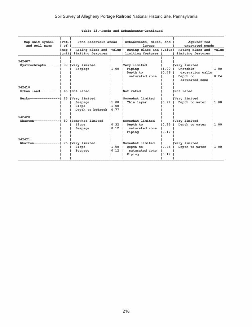
Soil Survey of Allegheny Portage Railroad National Historic Site, Pennsylvania
218
Table 13.—Ponds and Embankments—Continued________________________________________________________________________________________________________ | | | | Map unit symbol |Pct.| Pond reservoir areas | Embankments, dikes, and | Aquifer-fed and soil name | of | | levees | excavated ponds _____________________________________________________________________________ |map | Rating class and |Value| Rating class and |Value| Rating class and |Value |unit| limiting features | | limiting features | | limiting features | ________________________________________________________________________________________________________ | | | | | | | 542407: | | | | | | | Dystrochrepts-------| 30 |Very limited | |Very limited | |Very limited | | | Seepage |1.00 | Piping |1.00 | Unstable |1.00 | | | | Depth to |0.46 | excavation walls| | | | | saturated zone | | Depth to |0.24 | | | | | | saturated zone | | | | | | | | 542410: | | | | | | | Urban land----------| 65 |Not rated | |Not rated | |Not rated | | | | | | | | Berks---------------| 25 |Very limited | |Somewhat limited | |Very limited | | | Seepage |1.00 | Thin layer |0.77 | Depth to water |1.00 | | Slope |1.00 | | | | | | Depth to bedrock |0.77 | | | | | | | | | | | 542420: | | | | | | | Wharton-------------| 80 |Somewhat limited | |Somewhat limited | |Very limited | | | Slope |0.32 | Depth to |0.95 | Depth to water |1.00 | | Seepage |0.12 | saturated zone | | | | | | | Piping |0.17 | | | | | | | | | 542421: | | | | | | | Wharton-------------| 75 |Very limited | |Somewhat limited | |Very limited | | | Slope |1.00 | Depth to |0.95 | Depth to water |1.00 | | Seepage |0.12 | saturated zone | | | | | | | Piping |0.17 | | | | | | | | | ________________________________________________________________________________________________________
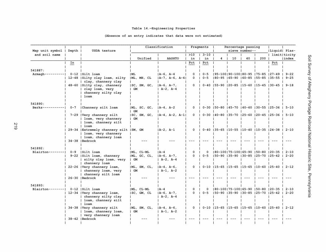
Soil S
urvey of Allegheny P
ortage Railroad N
ational Historic S
ite, Pennsylvania
219
Table 14.—Engineering Properties
(Absence of an entry indicates that data were not estimated)
______________________________________________________________________________________________________________________________________ | | | Classification | Fragments | Percentage passing | | Map unit symbol | Depth | USDA texture | | | sieve number-- |Liquid| Plas- _____________________________________________________________________ and soil name | | | | | >10 | 3-10 | | | | | limit|ticity | | | Unified | AASHTO | in | in | 4 | 10 | 40 | 200 | |index ______________________________________________________________________________________________________________________________________ | In | | | | Pct | Pct | | | | | Pct | __ ___ ___ ___ | | | | | | | | | | | | 541887: | | | | | | | | | | | | Armagh----------| 0-12 |Silt loam |ML |A-6, A-4 | 0 | 0-5 |95-100|90-100|80-95 |75-85 |27-49 | 9-22 | 12-48 |Silty clay loam, silty |ML, MH, CL |A-7, A-6, A-4| 0 | 0-5 |80-95 |65-90 |60-85 |55-85 |35-55 | 9-25 | | clay, channery clay | | | | | | | | | | | 48-60 |Silty clay, channery |SC, SM, GC, |A-6, A-7, | 0 | 0-40 |55-90 |20-85 |15-60 |15-45 |30-45 | 9-18 | | clay loam, very | GM | A-2, A-4 | | | | | | | | | | channery silty clay | | | | | | | | | | | | loam | | | | | | | | | | | | | | | | | | | | | | 541890: | | | | | | | | | | | | Berks-----------| 0-7 |Channery silt loam |ML, SC, GC, |A-4, A-2 | 0 | 0-30 |50-80 |45-70 |40-60 |30-55 |25-36 | 5-10 | | | GM | | | | | | | | | | 7-29 |Very channery silt |SC, SM, GC, |A-4, A-2, A-1| 0 | 0-30 |40-80 |35-70 |25-60 |20-45 |25-36 | 5-10 | | loam, very channery | GM | | | | | | | | | | | loam, channery silt | | | | | | | | | | | | loam | | | | | | | | | | | 29-34 |Extremely channery silt |SM, GM |A-2, A-1 | 0 | 0-40 |35-65 |10-55 |10-40 |10-35 |24-38 | 2-10 | | loam, very channery | | | | | | | | | | | | loam, channery loam | | | | | | | | | | | 34-38 |Bedrock | --- | --- | --- | --- | --- | --- | --- | --- | --- | --- | | | | | | | | | | | | 541892: | | | | | | | | | | | | Blairton--------| 0-9 |Silt loam |ML, CL-ML |A-4 | 0 | 0 |80-100|75-100|65-90 |50-80 |20-35 | 2-10 | 9-22 |Silt loam, channery |ML, GC, CL, |A-6, A-7, | 0 | 0-5 |50-90 |35-90 |30-85 |25-70 |25-42 | 2-20 | | silty clay loam, very | GM | A-2, A-4 | | | | | | | | | | channery loam | | | | | | | | | | | 22-26 |Very channery loam, |ML, SM, CL, |A-4, A-6, | 0 | 0-10 |15-65 |15-65 |15-65 |10-60 |25-40 | 2-12 | | channery loam, very | GM | A-1, A-2 | | | | | | | | | | channery silt loam | | | | | | | | | | | 26-30 |Bedrock | --- | --- | --- | --- | --- | --- | --- | --- | --- | --- | | | | | | | | | | | | 541893: | | | | | | | | | | | | Blairton--------| 0-12 |Silt loam |ML, CL-ML |A-4 | 0 | 0 |80-100|75-100|65-90 |50-80 |20-35 | 2-10 | 12-34 |Very channery loam, |SC, GM, CL |A-6, A-7, | 0 | 0-5 |50-90 |35-90 |30-85 |25-70 |25-42 | 2-20 | | channery silty clay | | A-2, A-4 | | | | | | | | | | loam, channery silt | | | | | | | | | | | | loam | | | | | | | | | | | 34-38 |Very channery silt |ML, SM, CL, |A-4, A-6, | 0 | 0-10 |15-65 |15-65 |15-65 |10-60 |25-40 | 2-12 | | loam, channery loam, | GM | A-1, A-2 | | | | | | | | | | very channery loam | | | | | | | | | | | 38-42 |Bedrock | --- | --- | --- | --- | --- | --- | --- | --- | --- | --- | | | | | | | | | | | |

Soil S
urvey of Allegheny P
ortage Railroad N
ational Historic S
ite, Pennsylvania
220
Table 14.—Engineering Properties—Continued______________________________________________________________________________________________________________________________________ | | | Classification | Fragments | Percentage passing | | Map unit symbol | Depth | USDA texture | | | sieve number-- |Liquid| Plas- _____________________________________________________________________ and soil name | | | | | >10 | 3-10 | | | | | limit|ticity | | | Unified | AASHTO | in | in | 4 | 10 | 40 | 200 | |index ______________________________________________________________________________________________________________________________________ | In | | | | Pct | Pct | | | | | Pct | __ ___ ___ ___ | | | | | | | | | | | | 541903: | | | | | | | | | | | | Cookport--------| 0-14 |Channery loam |SC, SM, CL, |A-6, A-4, A-2| 0 | 0-15 |75-100|60-70 |50-60 |30-55 |20-40 | 1-15 | | | ML | | | | | | | | | | 14-26 |Sandy clay loam, clay |SC, SM, CL, |A-6, A-4 | 0 | 0-15 |85-100|65-100|55-95 |40-75 |20-40 | 4-20 | | loam, channery loam | ML | | | | | | | | | | 26-40 |Sandy clay loam, clay |SC, SM, CL, |A-6, A-4 | 0 | 0-15 |85-100|65-100|55-95 |40-75 |20-40 | 4-20 | | loam, channery loam | ML | | | | | | | | | | 40-60 |Channery sandy loam, |ML, SC-SM, |A-6, A-4, A-2| 0 | 0-15 |60-100|50-95 |40-95 |30-75 |20-40 | 1-15 | | channery loam | CL, GC-GM | | | | | | | | | | 60-62 |Bedrock | --- | --- | --- | --- | --- | --- | --- | --- | --- | --- | | | | | | | | | | | | Ernest----------| 0-8 |Silt loam |ML, CL-ML, CL|A-6, A-4 | 0 | 0-10 |85-100|80-100|70-95 |60-95 |20-40 | 4-15 | 8-26 |Silty clay loam, silt |ML, CL-ML, CL|A-7, A-6, A-4| 0 | 0-15 |75-95 |70-95 |65-90 |55-90 |25-50 | 6-22 | | loam, channery silt | | | | | | | | | | | | loam | | | | | | | | | | | 26-41 |Channery silt loam, |ML, SC, CL, |A-7, A-6, A-4| 0 | 0-20 |70-95 |55-95 |55-90 |45-90 |20-45 | 4-18 | | channery loam, silty | GM | | | | | | | | | | | clay loam | | | | | | | | | | | 41-61 |Channery silt loam, |ML, SC, CL, |A-7, A-6, A-4| 0 | 0-20 |70-95 |45-95 |45-90 |40-90 |25-50 | 6-22 | | silt loam, silty clay | GM | | | | | | | | | | | loam | | | | | | | | | | | | | | | | | | | | | | 541906: | | | | | | | | | | | | Cookport--------| 0-10 |Channery loam |SC, SM, CL, |A-6, A-4, A-2| 0-5 | 2-40 |75-95 |60-70 |50-60 |30-55 |20-40 | 1-15 | | | ML | | | | | | | | | | 10-26 |Sandy clay loam, clay |SC, SM, CL, |A-6, A-4 | 0 | 0-15 |85-100|65-100|55-95 |40-75 |20-40 | 4-20 | | loam, channery loam | ML | | | | | | | | | | 26-40 |Sandy clay loam, clay |SC, SM, CL, |A-6, A-4 | 0 | 0-15 |85-100|65-100|55-95 |40-75 |20-40 | 4-20 | | loam, channery loam | ML | | | | | | | | | | 40-60 |Channery sandy loam, |ML, SC-SM, |A-6, A-4, A-2| 0-2 | 0-15 |60-100|50-95 |40-95 |30-75 |20-40 | 1-15 | | channery loam | CL, GC-GM | | | | | | | | | | 60-62 |Bedrock | --- | --- | --- | --- | --- | --- | --- | --- | --- | --- | | | | | | | | | | | | Ernest----------| 0-8 |Silt loam |ML, CL-ML, CL|A-6, A-4 | 0 | 0-10 |85-100|80-100|70-95 |60-95 |20-40 | 4-15 | 8-26 |Silty clay loam, silt |ML, CL-ML, CL|A-7, A-6, A-4| 0 | 0-15 |75-95 |70-95 |65-90 |55-90 |25-50 | 6-22 | | loam, channery silt | | | | | | | | | | | | loam | | | | | | | | | | | 26-41 |Channery silt loam, |ML, SC, CL, |A-7, A-6, A-4| 0 | 0-20 |70-95 |55-95 |55-90 |45-90 |20-45 | 4-18 | | channery loam, silty | GM | | | | | | | | | | | clay loam | | | | | | | | | | | 41-61 |Channery silt loam, |ML, SC, CL, |A-7, A-6, A-4| 0 | 0-20 |70-95 |45-95 |45-90 |40-90 |25-50 | 6-22 | | silt loam, silty clay | GM | | | | | | | | | | | loam | | | | | | | | | | | | | | | | | | | | | |

Soil S
urvey of Allegheny P
ortage Railroad N
ational Historic S
ite, Pennsylvania
221
Table 14.—Engineering Properties—Continued______________________________________________________________________________________________________________________________________ | | | Classification | Fragments | Percentage passing | | Map unit symbol | Depth | USDA texture | | | sieve number-- |Liquid| Plas- _____________________________________________________________________ and soil name | | | | | >10 | 3-10 | | | | | limit|ticity | | | Unified | AASHTO | in | in | 4 | 10 | 40 | 200 | |index ______________________________________________________________________________________________________________________________________ | In | | | | Pct | Pct | | | | | Pct | __ ___ ___ ___ | | | | | | | | | | | | 541903: | | | | | | | | | | | | Cookport--------| 0-14 |Channery loam |SC, SM, CL, |A-6, A-4, A-2| 0 | 0-15 |75-100|60-70 |50-60 |30-55 |20-40 | 1-15 | | | ML | | | | | | | | | | 14-26 |Sandy clay loam, clay |SC, SM, CL, |A-6, A-4 | 0 | 0-15 |85-100|65-100|55-95 |40-75 |20-40 | 4-20 | | loam, channery loam | ML | | | | | | | | | | 26-40 |Sandy clay loam, clay |SC, SM, CL, |A-6, A-4 | 0 | 0-15 |85-100|65-100|55-95 |40-75 |20-40 | 4-20 | | loam, channery loam | ML | | | | | | | | | | 40-60 |Channery sandy loam, |ML, SC-SM, |A-6, A-4, A-2| 0 | 0-15 |60-100|50-95 |40-95 |30-75 |20-40 | 1-15 | | channery loam | CL, GC-GM | | | | | | | | | | 60-62 |Bedrock | --- | --- | --- | --- | --- | --- | --- | --- | --- | --- | | | | | | | | | | | | Ernest----------| 0-8 |Silt loam |ML, CL-ML, CL|A-6, A-4 | 0 | 0-10 |85-100|80-100|70-95 |60-95 |20-40 | 4-15 | 8-26 |Silty clay loam, silt |ML, CL-ML, CL|A-7, A-6, A-4| 0 | 0-15 |75-95 |70-95 |65-90 |55-90 |25-50 | 6-22 | | loam, channery silt | | | | | | | | | | | | loam | | | | | | | | | | | 26-41 |Channery silt loam, |ML, SC, CL, |A-7, A-6, A-4| 0 | 0-20 |70-95 |55-95 |55-90 |45-90 |20-45 | 4-18 | | channery loam, silty | GM | | | | | | | | | | | clay loam | | | | | | | | | | | 41-61 |Channery silt loam, |ML, SC, CL, |A-7, A-6, A-4| 0 | 0-20 |70-95 |45-95 |45-90 |40-90 |25-50 | 6-22 | | silt loam, silty clay | GM | | | | | | | | | | | loam | | | | | | | | | | | | | | | | | | | | | | 541906: | | | | | | | | | | | | Cookport--------| 0-10 |Channery loam |SC, SM, CL, |A-6, A-4, A-2| 0-5 | 2-40 |75-95 |60-70 |50-60 |30-55 |20-40 | 1-15 | | | ML | | | | | | | | | | 10-26 |Sandy clay loam, clay |SC, SM, CL, |A-6, A-4 | 0 | 0-15 |85-100|65-100|55-95 |40-75 |20-40 | 4-20 | | loam, channery loam | ML | | | | | | | | | | 26-40 |Sandy clay loam, clay |SC, SM, CL, |A-6, A-4 | 0 | 0-15 |85-100|65-100|55-95 |40-75 |20-40 | 4-20 | | loam, channery loam | ML | | | | | | | | | | 40-60 |Channery sandy loam, |ML, SC-SM, |A-6, A-4, A-2| 0-2 | 0-15 |60-100|50-95 |40-95 |30-75 |20-40 | 1-15 | | channery loam | CL, GC-GM | | | | | | | | | | 60-62 |Bedrock | --- | --- | --- | --- | --- | --- | --- | --- | --- | --- | | | | | | | | | | | | Ernest----------| 0-8 |Silt loam |ML, CL-ML, CL|A-6, A-4 | 0 | 0-10 |85-100|80-100|70-95 |60-95 |20-40 | 4-15 | 8-26 |Silty clay loam, silt |ML, CL-ML, CL|A-7, A-6, A-4| 0 | 0-15 |75-95 |70-95 |65-90 |55-90 |25-50 | 6-22 | | loam, channery silt | | | | | | | | | | | | loam | | | | | | | | | | | 26-41 |Channery silt loam, |ML, SC, CL, |A-7, A-6, A-4| 0 | 0-20 |70-95 |55-95 |55-90 |45-90 |20-45 | 4-18 | | channery loam, silty | GM | | | | | | | | | | | clay loam | | | | | | | | | | | 41-61 |Channery silt loam, |ML, SC, CL, |A-7, A-6, A-4| 0 | 0-20 |70-95 |45-95 |45-90 |40-90 |25-50 | 6-22 | | silt loam, silty clay | GM | | | | | | | | | | | loam | | | | | | | | | | | | | | | | | | | | | |
Table 14.—Engineering Properties—Continued______________________________________________________________________________________________________________________________________ | | | Classification | Fragments | Percentage passing | | Map unit symbol | Depth | USDA texture | | | sieve number-- |Liquid| Plas- _____________________________________________________________________ and soil name | | | | | >10 | 3-10 | | | | | limit|ticity | | | Unified | AASHTO | in | in | 4 | 10 | 40 | 200 | |index ______________________________________________________________________________________________________________________________________ | In | | | | Pct | Pct | | | | | Pct | __ ___ ___ ___ | | | | | | | | | | | | 541907: | | | | | | | | | | | | Cookport--------| 0-10 |Channery loam |SC, SM, CL, |A-6, A-4, A-2| 0-5 | 2-40 |75-95 |60-70 |50-60 |30-55 |20-40 | 1-15 | | | ML | | | | | | | | | | 10-26 |Sandy clay loam, clay |SC, SM, CL, |A-6, A-4 | 0 | 0-15 |85-100|65-100|55-95 |40-75 |20-40 | 4-20 | | loam, channery loam | ML | | | | | | | | | | 26-40 |Sandy clay loam, clay |SC, SM, CL, |A-6, A-4 | 0 | 0-15 |85-100|65-100|55-95 |40-75 |20-40 | 4-20 | | loam, channery loam | ML | | | | | | | | | | 40-60 |Channery sandy loam, |ML, SC-SM, |A-6, A-4, A-2| 0-2 | 0-15 |60-100|50-95 |40-95 |30-75 |20-40 | 1-15 | | channery loam | CL, GC-GM | | | | | | | | | | 60-62 |Bedrock | --- | --- | --- | --- | --- | --- | --- | --- | --- | --- | | | | | | | | | | | | Ernest----------| 0-8 |Channery silt loam |ML, CL-ML, CL|A-6, A-4 | 0-5 | 3-15 |65-80 |60-80 |55-75 |55-70 |20-40 | 4-15 | 8-26 |Silty clay loam, silt |ML, CL-ML, CL|A-7, A-6, A-4| 0 | 0-15 |75-95 |70-95 |65-90 |55-90 |25-50 | 6-22 | | loam, channery silt | | | | | | | | | | | | loam | | | | | | | | | | | 26-41 |Channery silt loam, |ML, SC, CL, |A-7, A-6, A-4| 0 | 0-20 |70-95 |55-95 |55-90 |45-90 |20-45 | 4-18 | | channery loam, silty | GM | | | | | | | | | | | clay loam | | | | | | | | | | | 41-61 |Channery silt loam, |ML, SC, CL, |A-7, A-6, A-4| 0-2 | 0-20 |70-95 |45-95 |45-90 |40-90 |25-50 | 6-22 | | silt loam, silty clay | GM | | | | | | | | | | | loam | | | | | | | | | | | | | | | | | | | | | | 541911: | | | | | | | | | | | | Gilpin----------| 0-3 |Silt loam |CL-ML, CL |A-6, A-4 | 0 | 0-5 |80-95 |75-90 |70-85 |65-80 |20-40 | 4-15 | 3-11 |Channery silt loam, |GC, SC, CL, |A-6, A-4, A-2| 0 | 0-30 |50-95 |45-90 |35-85 |30-80 |20-40 | 4-15 | | loam, silty clay loam, | CL-ML | | | | | | | | | | | clay loam | | | | | | | | | | | 11-29 |Channery silty clay |SC, GC-GM, GC|A-4, A-6, | 0-3 | 0-35 |25-95 |20-90 |15-45 |15-40 |20-40 | 4-15 | | loam, silt loam, loam | | A-2-4, A-2 | | | | | | | | | 29-39 |Bedrock | --- | --- | --- | --- | --- | --- | --- | --- | --- | --- | | | | | | | | | | | | 541914: | | | | | | | | | | | | Gilpin----------| 0-10 |Silt loam |CL-ML, CL |A-6, A-4 | 0 | 0-5 |80-95 |75-90 |70-85 |65-80 |20-40 | 4-15 | 10-28 |Channery silty clay |GC, SC, CL, |A-6, A-4, A-2| 0 | 0-30 |50-95 |45-90 |35-85 |30-80 |20-40 | 4-15 | | loam, channery silt | CL-ML | | | | | | | | | | | loam, silty clay loam | | | | | | | | | | | 28-38 |Channery loam, very |GC-GM, GC |A-6, A-4, | 0 | 0-35 |25-55 |20-50 |15-45 |15-40 |20-40 | 4-15 | | channery silt loam, | | A-2-4 | | | | | | | | | | very channery silty | | | | | | | | | | | | clay loam | | | | | | | | | | | 38-42 |Bedrock | --- | --- | --- | --- | --- | --- | --- | --- | --- | --- | | | | | | | | | | | |

Soil S
urvey of Allegheny P
ortage Railroad N
ational Historic S
ite, Pennsylvania
222
Table 14.—Engineering Properties—Continued______________________________________________________________________________________________________________________________________ | | | Classification | Fragments | Percentage passing | | Map unit symbol | Depth | USDA texture | | | sieve number-- |Liquid| Plas- _____________________________________________________________________ and soil name | | | | | >10 | 3-10 | | | | | limit|ticity | | | Unified | AASHTO | in | in | 4 | 10 | 40 | 200 | |index ______________________________________________________________________________________________________________________________________ | In | | | | Pct | Pct | | | | | Pct | __ ___ ___ ___ | | | | | | | | | | | | 541914: | | | | | | | | | | | | Rayne-----------| 0-8 |Silt loam |ML, CL |A-6, A-4 | 0 | 0-5 |85-100|80-100|70-85 |60-80 |22-43 | 6-18 | 8-40 |Loam, channery silty |GM, ML, SC, |A-6, A-4, A-2| 0 | 0-15 |60-95 |55-85 |40-85 |30-60 |20-40 | 2-15 | | clay loam, channery | GC | | | | | | | | | | | clay loam | | | | | | | | | | | 40-60 |Channery sandy loam, |ML, SM, GM, |A-4, A-2-4, | 0 | 0-35 |40-90 |15-80 |15-75 |10-60 |20-35 |NP-10 | | channery silt loam, | GP-GM | A-1 | | | | | | | | | | very channery silty | | | | | | | | | | | | clay loam | | | | | | | | | | | 60-64 |Bedrock | --- | --- | --- | --- | --- | --- | --- | --- | --- | --- | | | | | | | | | | | | 541919: | | | | | | | | | | | | Hazleton--------| 0-6 |Channery loam |SM, ML, GM |A-4, A-2 | 0 | 0-15 |60-85 |60-80 |60-75 |35-55 |22-37 |NP-8 | 6-36 |Channery sandy loam, |SC, SM, GM, |A-4, A-2, A-1| 0 | 0-50 |60-95 |45-90 |35-70 |20-55 |15-30 |NP-8 | | very channery sandy | ML | | | | | | | | | | | loam, very channery | | | | | | | | | | | | loam | | | | | | | | | | | 36-54 |Extremely channery |SC, SM, GC, |A-4, A-2, A-1| 0 | 0-60 |55-80 |35-75 |25-65 |15-50 |15-30 |NP-8 | | loamy sand, very | GM | | | | | | | | | | | channery sandy loam, | | | | | | | | | | | | very channery loamy | | | | | | | | | | | | sand | | | | | | | | | | | 54-58 |Bedrock | --- | --- | --- | --- | --- | --- | --- | --- | --- | --- | | | | | | | | | | | | 541922: | | | | | | | | | | | | Hazleton--------| 0-1 |Slightly decomposed |PT |A-8 | 5-30 | 0 | --- | --- | --- | --- | --- | --- | | plant material | | | | | | | | | | | 1-2 |Moderately decomposed |PT |A-8 | 5-30 | 0 | --- | --- | --- | --- | --- | --- | | plant material | | | | | | | | | | | 2-8 |Channery sandy loam, |SM, ML, GM |A-2, A-4 | 0-3 | 2-10 |45-90 |40-85 |40-80 |25-50 |15-25 |NP-8 | | channery loam | | | | | | | | | | | 8-34 |Very channery sandy |SM, SC, GM |A-2-4, | 0-5 |10-50 |45-90 |40-85 |20-75 |15-45 |15-30 |NP-8 | | loam, channery loam | | A-1-b, A-4 | | | | | | | | | 34-58 |Extremely channery |SC, SM, GC, |A-2-4, | 1-30 |15-60 |35-80 |30-75 |25-65 |10-40 |15-30 |NP-8 | | sandy loam, very | GM | A-1-b, A-1-a| | | | | | | | | | channery sandy loam, | | | | | | | | | | | | very channery loamy | | | | | | | | | | | | sand | | | | | | | | | | | 58-60 |Bedrock | --- | --- | --- | --- | --- | --- | --- | --- | --- | --- | | | | | | | | | | | |

Soil S
urvey of Allegheny P
ortage Railroad N
ational Historic S
ite, Pennsylvania
223
Table 14.—Engineering Properties—Continued______________________________________________________________________________________________________________________________________ | | | Classification | Fragments | Percentage passing | | Map unit symbol | Depth | USDA texture | | | sieve number-- |Liquid| Plas- _____________________________________________________________________ and soil name | | | | | >10 | 3-10 | | | | | limit|ticity | | | Unified | AASHTO | in | in | 4 | 10 | 40 | 200 | |index ______________________________________________________________________________________________________________________________________ | In | | | | Pct | Pct | | | | | Pct | __ ___ ___ ___ | | | | | | | | | | | | 541914: | | | | | | | | | | | | Rayne-----------| 0-8 |Silt loam |ML, CL |A-6, A-4 | 0 | 0-5 |85-100|80-100|70-85 |60-80 |22-43 | 6-18 | 8-40 |Loam, channery silty |GM, ML, SC, |A-6, A-4, A-2| 0 | 0-15 |60-95 |55-85 |40-85 |30-60 |20-40 | 2-15 | | clay loam, channery | GC | | | | | | | | | | | clay loam | | | | | | | | | | | 40-60 |Channery sandy loam, |ML, SM, GM, |A-4, A-2-4, | 0 | 0-35 |40-90 |15-80 |15-75 |10-60 |20-35 |NP-10 | | channery silt loam, | GP-GM | A-1 | | | | | | | | | | very channery silty | | | | | | | | | | | | clay loam | | | | | | | | | | | 60-64 |Bedrock | --- | --- | --- | --- | --- | --- | --- | --- | --- | --- | | | | | | | | | | | | 541919: | | | | | | | | | | | | Hazleton--------| 0-6 |Channery loam |SM, ML, GM |A-4, A-2 | 0 | 0-15 |60-85 |60-80 |60-75 |35-55 |22-37 |NP-8 | 6-36 |Channery sandy loam, |SC, SM, GM, |A-4, A-2, A-1| 0 | 0-50 |60-95 |45-90 |35-70 |20-55 |15-30 |NP-8 | | very channery sandy | ML | | | | | | | | | | | loam, very channery | | | | | | | | | | | | loam | | | | | | | | | | | 36-54 |Extremely channery |SC, SM, GC, |A-4, A-2, A-1| 0 | 0-60 |55-80 |35-75 |25-65 |15-50 |15-30 |NP-8 | | loamy sand, very | GM | | | | | | | | | | | channery sandy loam, | | | | | | | | | | | | very channery loamy | | | | | | | | | | | | sand | | | | | | | | | | | 54-58 |Bedrock | --- | --- | --- | --- | --- | --- | --- | --- | --- | --- | | | | | | | | | | | | 541922: | | | | | | | | | | | | Hazleton--------| 0-1 |Slightly decomposed |PT |A-8 | 5-30 | 0 | --- | --- | --- | --- | --- | --- | | plant material | | | | | | | | | | | 1-2 |Moderately decomposed |PT |A-8 | 5-30 | 0 | --- | --- | --- | --- | --- | --- | | plant material | | | | | | | | | | | 2-8 |Channery sandy loam, |SM, ML, GM |A-2, A-4 | 0-3 | 2-10 |45-90 |40-85 |40-80 |25-50 |15-25 |NP-8 | | channery loam | | | | | | | | | | | 8-34 |Very channery sandy |SM, SC, GM |A-2-4, | 0-5 |10-50 |45-90 |40-85 |20-75 |15-45 |15-30 |NP-8 | | loam, channery loam | | A-1-b, A-4 | | | | | | | | | 34-58 |Extremely channery |SC, SM, GC, |A-2-4, | 1-30 |15-60 |35-80 |30-75 |25-65 |10-40 |15-30 |NP-8 | | sandy loam, very | GM | A-1-b, A-1-a| | | | | | | | | | channery sandy loam, | | | | | | | | | | | | very channery loamy | | | | | | | | | | | | sand | | | | | | | | | | | 58-60 |Bedrock | --- | --- | --- | --- | --- | --- | --- | --- | --- | --- | | | | | | | | | | | |
Table 14.—Engineering Properties—Continued______________________________________________________________________________________________________________________________________ | | | Classification | Fragments | Percentage passing | | Map unit symbol | Depth | USDA texture | | | sieve number-- |Liquid| Plas- _____________________________________________________________________ and soil name | | | | | >10 | 3-10 | | | | | limit|ticity | | | Unified | AASHTO | in | in | 4 | 10 | 40 | 200 | |index ______________________________________________________________________________________________________________________________________ | In | | | | Pct | Pct | | | | | Pct | __ ___ ___ ___ | | | | | | | | | | | | 541925: | | | | | | | | | | | | Laidig----------| 0-7 |Channery loam |ML, SM, CL, |A-4 | 0 | 0-5 |65-90 |50-80 |45-80 |35-70 |15-30 | 1-10 | | | GM | | | | | | | | | | 7-36 |Channery loam, channery |SC, SM, CL, |A-6, A-4, A-2| 0 | 5-20 |70-95 |50-90 |40-80 |20-70 |15-40 | 2-18 | | sandy clay loam, | ML | | | | | | | | | | | channery sandy loam | | | | | | | | | | | 36-50 |Very channery sandy |GC-GM, SC, |A-6, A-4, A-2| 0 | 5-20 |50-90 |40-85 |30-80 |15-70 |15-35 | 2-16 | | loam, channery sandy | CL-ML, GC | | | | | | | | | | | clay loam, very | | | | | | | | | | | | channery loam, | | | | | | | | | | | | channery sandy loam | | | | | | | | | | | 50-65 |Channery sandy clay |GC-GM, SC, |A-6, A-4, A-2| 0 | 5-20 |50-90 |40-85 |30-80 |15-70 |15-35 | 2-16 | | loam, very channery | CL-ML, GC | | | | | | | | | | | loam, channery sandy | | | | | | | | | | | | loam | | | | | | | | | | | | | | | | | | | | | | 541938: | | | | | | | | | | | | Bethesda, | | | | | | | | | | | | unstable fill--| 0-7 |Very channery silt loam |GM, ML, |A-6, A-4 | 0 | 0-24 |67-91 |36-91 |33-91 |28-78 |25-40 | 4-14 | | | CL-ML, GC-GM| | | | | | | | | | 7-65 |Very channery clay |GM, ML, CL, |A-6, A-7, | 0-8 | 8-41 |53-88 |10-88 | 9-88 | 7-80 |24-50 | 3-23 | | loam, extremely | GC | A-2, A-4 | | | | | | | | | | channery silt loam | | | | | | | | | | | | | | | | | | | | | | 541940: | | | | | | | | | | | | Udorthents------| 0-6 |Very channery silt loam |GM, SC-SM, |A-4, A-2, A-1| 0 |30-60 |40-80 |30-70 |20-65 |15-60 |15-25 |NP-10 | | | CL, GC | | | | | | | | | | 6-60 |Very channery silt |GW-GM, |A-2-4, A-1 | 0 |40-70 |25-80 |20-50 |10-30 | 5-30 |15-40 |NP-15 | | loam, very channery | SC-SM, GC, | | | | | | | | | | | sandy loam, very | GM | | | | | | | | | | | channery loam | | | | | | | | | | | | | | | | | | | | | | 541943: | | | | | | | | | | | | Wharton---------| 0-7 |Silt loam |ML, CL |A-6, A-4 | 0 | 0-5 |95-100|90-100|80-95 |70-90 |27-43 | 9-17 | 7-44 |Clay loam, channery |ML, CL |A-7, A-6 | 0 | 0-25 |75-100|70-100|65-95 |60-90 |35-45 |10-25 | | silty clay loam, | | | | | | | | | | | | channery silt loam | | | | | | | | | | | 44-60 |Silt loam, channery |SM, ML, GM |A-6, A-7, | 0 | 0-50 |45-100|30-100|25-95 |25-90 |30-45 | 5-15 | | clay, very channery | | A-2, A-4 | | | | | | | | | | silty clay loam | | | | | | | | | | | 60-70 |Bedrock | --- | --- | --- | --- | --- | --- | --- | --- | --- | --- | | | | | | | | | | | |

Soil S
urvey of Allegheny P
ortage Railroad N
ational Historic S
ite, Pennsylvania
224
Table 14.—Engineering Properties—Continued______________________________________________________________________________________________________________________________________ | | | Classification | Fragments | Percentage passing | | Map unit symbol | Depth | USDA texture | | | sieve number-- |Liquid| Plas- _____________________________________________________________________ and soil name | | | | | >10 | 3-10 | | | | | limit|ticity | | | Unified | AASHTO | in | in | 4 | 10 | 40 | 200 | |index ______________________________________________________________________________________________________________________________________ | In | | | | Pct | Pct | | | | | Pct | __ ___ ___ ___ | | | | | | | | | | | | 541944: | | | | | | | | | | | | Wharton---------| 0-7 |Silt loam |ML, CL |A-6, A-4 | 0 | 0-5 |95-100|90-100|80-95 |70-90 |27-43 | 9-17 | 7-44 |Clay loam, channery |ML, CL |A-7, A-6 | 0 | 0-25 |75-100|70-100|65-95 |60-90 |35-45 |10-25 | | silty clay loam, | | | | | | | | | | | | channery silt loam | | | | | | | | | | | 44-60 |Silt loam, channery |SM, ML, GM |A-6, A-7, | 0 | 0-50 |45-100|30-100|25-95 |25-90 |30-45 | 5-15 | | clay, very channery | | A-2, A-4 | | | | | | | | | | silty clay loam | | | | | | | | | | | 60-70 |Bedrock | --- | --- | --- | --- | --- | --- | --- | --- | --- | --- | | | | | | | | | | | | 542311: | | | | | | | | | | | | Albrights-------| 0-10 |Gravelly silt loam |ML, CL |A-4 | 0 | 0-15 |65-90 |60-85 |55-80 |50-70 |15-30 | 5-10 | 10-22 |Silty clay loam, |SC, SM, CL, |A-6, A-4 | 0 | 0-15 |80-100|65-95 |60-90 |40-85 |25-40 | 3-15 | | gravelly silt loam, | ML | | | | | | | | | | | channery clay loam | | | | | | | | | | | 22-60 |Channery clay loam, |SC, SC-SM, |A-6, A-4, A-2| 0 | 0-15 |65-100|45-95 |40-90 |25-80 |20-40 | 3-15 | | gravelly silty clay | CL, ML | | | | | | | | | | | loam, silt loam | | | | | | | | | | | | | | | | | | | | | | 542321: | | | | | | | | | | | | Berks-----------| 0-7 |Channery silt loam |ML, SC, GC, |A-4, A-2 | 0 | 0-30 |50-80 |45-70 |40-60 |30-55 |25-36 | 5-10 | | | GM | | | | | | | | | | 7-29 |Very channery silt |SC, SM, GC, |A-4, A-2, A-1| 0 | 0-30 |40-80 |35-70 |25-60 |20-45 |25-36 | 5-10 | | loam, very channery | GM | | | | | | | | | | | loam, channery silt | | | | | | | | | | | | loam | | | | | | | | | | | 29-34 |Extremely channery silt |SM, GM |A-2, A-1 | 0 | 0-40 |35-65 |10-55 |10-40 |10-35 |24-38 | 2-10 | | loam, very channery | | | | | | | | | | | | loam, channery loam | | | | | | | | | | | 34-38 |Bedrock | --- | --- | --- | --- | --- | --- | --- | --- | --- | --- | | | | | | | | | | | | 542322: | | | | | | | | | | | | Berks-----------| 0-7 |Channery silt loam |ML, SC, GC, |A-4, A-2 | 0 | 0-30 |50-80 |45-70 |40-60 |30-55 |25-36 | 5-10 | | | GM | | | | | | | | | | 7-29 |Very channery silt |SC, SM, GC, |A-4, A-2, A-1| 0 | 0-30 |40-80 |35-70 |25-60 |20-45 |25-36 | 5-10 | | loam, very channery | GM | | | | | | | | | | | loam, channery silt | | | | | | | | | | | | loam | | | | | | | | | | | 29-34 |Extremely channery silt |SM, GM |A-2, A-1 | 0 | 0-40 |35-65 |10-55 |10-40 |10-35 |24-38 | 2-10 | | loam, very channery | | | | | | | | | | | | loam, channery loam | | | | | | | | | | | 34-38 |Bedrock | --- | --- | --- | --- | --- | --- | --- | --- | --- | --- | | | | | | | | | | | |

Soil S
urvey of Allegheny P
ortage Railroad N
ational Historic S
ite, Pennsylvania
225
Table 14.—Engineering Properties—Continued______________________________________________________________________________________________________________________________________ | | | Classification | Fragments | Percentage passing | | Map unit symbol | Depth | USDA texture | | | sieve number-- |Liquid| Plas- _____________________________________________________________________ and soil name | | | | | >10 | 3-10 | | | | | limit|ticity | | | Unified | AASHTO | in | in | 4 | 10 | 40 | 200 | |index ______________________________________________________________________________________________________________________________________ | In | | | | Pct | Pct | | | | | Pct | __ ___ ___ ___ | | | | | | | | | | | | 541944: | | | | | | | | | | | | Wharton---------| 0-7 |Silt loam |ML, CL |A-6, A-4 | 0 | 0-5 |95-100|90-100|80-95 |70-90 |27-43 | 9-17 | 7-44 |Clay loam, channery |ML, CL |A-7, A-6 | 0 | 0-25 |75-100|70-100|65-95 |60-90 |35-45 |10-25 | | silty clay loam, | | | | | | | | | | | | channery silt loam | | | | | | | | | | | 44-60 |Silt loam, channery |SM, ML, GM |A-6, A-7, | 0 | 0-50 |45-100|30-100|25-95 |25-90 |30-45 | 5-15 | | clay, very channery | | A-2, A-4 | | | | | | | | | | silty clay loam | | | | | | | | | | | 60-70 |Bedrock | --- | --- | --- | --- | --- | --- | --- | --- | --- | --- | | | | | | | | | | | | 542311: | | | | | | | | | | | | Albrights-------| 0-10 |Gravelly silt loam |ML, CL |A-4 | 0 | 0-15 |65-90 |60-85 |55-80 |50-70 |15-30 | 5-10 | 10-22 |Silty clay loam, |SC, SM, CL, |A-6, A-4 | 0 | 0-15 |80-100|65-95 |60-90 |40-85 |25-40 | 3-15 | | gravelly silt loam, | ML | | | | | | | | | | | channery clay loam | | | | | | | | | | | 22-60 |Channery clay loam, |SC, SC-SM, |A-6, A-4, A-2| 0 | 0-15 |65-100|45-95 |40-90 |25-80 |20-40 | 3-15 | | gravelly silty clay | CL, ML | | | | | | | | | | | loam, silt loam | | | | | | | | | | | | | | | | | | | | | | 542321: | | | | | | | | | | | | Berks-----------| 0-7 |Channery silt loam |ML, SC, GC, |A-4, A-2 | 0 | 0-30 |50-80 |45-70 |40-60 |30-55 |25-36 | 5-10 | | | GM | | | | | | | | | | 7-29 |Very channery silt |SC, SM, GC, |A-4, A-2, A-1| 0 | 0-30 |40-80 |35-70 |25-60 |20-45 |25-36 | 5-10 | | loam, very channery | GM | | | | | | | | | | | loam, channery silt | | | | | | | | | | | | loam | | | | | | | | | | | 29-34 |Extremely channery silt |SM, GM |A-2, A-1 | 0 | 0-40 |35-65 |10-55 |10-40 |10-35 |24-38 | 2-10 | | loam, very channery | | | | | | | | | | | | loam, channery loam | | | | | | | | | | | 34-38 |Bedrock | --- | --- | --- | --- | --- | --- | --- | --- | --- | --- | | | | | | | | | | | | 542322: | | | | | | | | | | | | Berks-----------| 0-7 |Channery silt loam |ML, SC, GC, |A-4, A-2 | 0 | 0-30 |50-80 |45-70 |40-60 |30-55 |25-36 | 5-10 | | | GM | | | | | | | | | | 7-29 |Very channery silt |SC, SM, GC, |A-4, A-2, A-1| 0 | 0-30 |40-80 |35-70 |25-60 |20-45 |25-36 | 5-10 | | loam, very channery | GM | | | | | | | | | | | loam, channery silt | | | | | | | | | | | | loam | | | | | | | | | | | 29-34 |Extremely channery silt |SM, GM |A-2, A-1 | 0 | 0-40 |35-65 |10-55 |10-40 |10-35 |24-38 | 2-10 | | loam, very channery | | | | | | | | | | | | loam, channery loam | | | | | | | | | | | 34-38 |Bedrock | --- | --- | --- | --- | --- | --- | --- | --- | --- | --- | | | | | | | | | | | |
Table 14.—Engineering Properties—Continued______________________________________________________________________________________________________________________________________ | | | Classification | Fragments | Percentage passing | | Map unit symbol | Depth | USDA texture | | | sieve number-- |Liquid| Plas- _____________________________________________________________________ and soil name | | | | | >10 | 3-10 | | | | | limit|ticity | | | Unified | AASHTO | in | in | 4 | 10 | 40 | 200 | |index ______________________________________________________________________________________________________________________________________ | In | | | | Pct | Pct | | | | | Pct | __ ___ ___ ___ | | | | | | | | | | | | 542323: | | | | | | | | | | | | Berks-----------| 0-7 |Channery silt loam |ML, SC, GC, |A-4, A-2 | 0 | 0-30 |50-80 |45-70 |40-60 |30-55 |25-36 | 5-10 | | | GM | | | | | | | | | | 7-29 |Very channery silt |SC, SM, GC, |A-4, A-2, A-1| 0 | 0-30 |40-80 |35-70 |25-60 |20-45 |25-36 | 5-10 | | loam, very channery | GM | | | | | | | | | | | loam, channery silt | | | | | | | | | | | | loam | | | | | | | | | | | 29-34 |Extremely channery silt |SM, GM |A-2, A-1 | 0 | 0-40 |35-65 |10-55 |10-40 |10-35 |24-38 | 2-10 | | loam, very channery | | | | | | | | | | | | loam, channery loam | | | | | | | | | | | 34-38 |Bedrock | --- | --- | --- | --- | --- | --- | --- | --- | --- | --- | | | | | | | | | | | | 542324: | | | | | | | | | | | | Berks-----------| 0-12 |Channery silt loam |ML, SC, GC, |A-4, A-2 | 0 | 0-30 |50-80 |45-70 |40-60 |30-55 |25-36 | 5-10 | | | GM | | | | | | | | | | 12-25 |Very channery silt |SC, SM, GC, |A-4, A-2, A-1| 0 | 0-30 |40-80 |35-70 |25-60 |20-45 |25-36 | 5-10 | | loam, very channery | GM | | | | | | | | | | | loam | | | | | | | | | | | 25-29 |Channery silt loam, |SM, GM |A-2, A-1 | 0 | 0-40 |35-65 |25-55 |20-40 |15-35 |24-38 | 2-10 | | very channery silt | | | | | | | | | | | | loam, channery loam | | | | | | | | | | | 29-33 |Bedrock | --- | --- | --- | --- | --- | --- | --- | --- | --- | --- | | | | | | | | | | | | Weikert---------| 0-10 |Channery silt loam |SM, ML, GM |A-4, A-2, A-1| 0 | 0-10 |35-70 |35-70 |25-65 |20-55 |30-40 | 4-10 | 10-14 |Gravelly loam, very |GP-GM, GM |A-2, A-1 | 0 | 0-20 |15-60 |10-55 | 5-45 | 5-35 |28-36 | 3-9 | | channery silt loam, | | | | | | | | | | | | channery loam | | | | | | | | | | | 14-18 |Bedrock | --- | --- | --- | --- | --- | --- | --- | --- | --- | --- | | | | | | | | | | | | 542325: | | | | | | | | | | | | Berks-----------| 0-12 |Channery silt loam |ML, SC, GC, |A-4, A-2 | 0 | 0-30 |50-80 |45-70 |40-60 |30-55 |25-36 | 5-10 | | | GM | | | | | | | | | | 12-25 |Very channery silt |SC, SM, GC, |A-4, A-2, A-1| 0 | 0-30 |40-80 |35-70 |25-60 |20-45 |25-36 | 5-10 | | loam, very channery | GM | | | | | | | | | | | loam | | | | | | | | | | | 25-29 |Channery silt loam, |SM, GM |A-2, A-1 | 0 | 0-40 |35-65 |25-55 |20-40 |15-35 |24-38 | 2-10 | | very channery silt | | | | | | | | | | | | loam, channery loam | | | | | | | | | | | 29-33 |Bedrock | --- | --- | --- | --- | --- | --- | --- | --- | --- | --- | | | | | | | | | | | | Weikert---------| 0-10 |Channery silt loam |SM, ML, GM |A-4, A-2, A-1| 0 | 0-10 |35-70 |35-70 |25-65 |20-55 |30-40 | 4-10 | 10-14 |Gravelly loam, very |GP-GM, GM |A-2, A-1 | 0 | 0-20 |15-60 |10-55 | 5-45 | 5-35 |28-36 | 3-9 | | channery silt loam, | | | | | | | | | | | | channery loam | | | | | | | | | | | 14-18 |Bedrock | --- | --- | --- | --- | --- | --- | --- | --- | --- | --- | | | | | | | | | | | |

Soil S
urvey of Allegheny P
ortage Railroad N
ational Historic S
ite, Pennsylvania
226
Table 14.—Engineering Properties—Continued______________________________________________________________________________________________________________________________________ | | | Classification | Fragments | Percentage passing | | Map unit symbol | Depth | USDA texture | | | sieve number-- |Liquid| Plas- _____________________________________________________________________ and soil name | | | | | >10 | 3-10 | | | | | limit|ticity | | | Unified | AASHTO | in | in | 4 | 10 | 40 | 200 | |index ______________________________________________________________________________________________________________________________________ | In | | | | Pct | Pct | | | | | Pct | __ ___ ___ ___ | | | | | | | | | | | | 542326: | | | | | | | | | | | | Berks-----------| 0-12 |Channery silt loam |ML, SC, GC, |A-4, A-2 | 0 | 0-30 |50-80 |45-70 |40-60 |30-55 |25-36 | 5-10 | | | GM | | | | | | | | | | 12-25 |Very channery silt |SC, SM, GC, |A-4, A-2, A-1| 0 | 0-30 |40-80 |35-70 |25-60 |20-45 |25-36 | 5-10 | | loam, very channery | GM | | | | | | | | | | | loam | | | | | | | | | | | 25-29 |Channery silt loam, |SM, GM |A-2, A-1 | 0 | 0-40 |35-65 |25-55 |20-40 |15-35 |24-38 | 2-10 | | very channery silt | | | | | | | | | | | | loam, channery loam | | | | | | | | | | | 29-33 |Bedrock | --- | --- | --- | --- | --- | --- | --- | --- | --- | --- | | | | | | | | | | | | Weikert---------| 0-10 |Channery silt loam |SM, ML, GM |A-4, A-2, A-1| 0 | 0-10 |35-70 |35-70 |25-65 |20-55 |30-40 | 4-10 | 10-14 |Gravelly loam, very |GP-GM, GM |A-2, A-1 | 0 | 0-20 |15-60 |10-55 | 5-45 | 5-35 |28-36 | 3-9 | | channery silt loam, | | | | | | | | | | | | channery loam | | | | | | | | | | | 14-18 |Bedrock | --- | --- | --- | --- | --- | --- | --- | --- | --- | --- | | | | | | | | | | | | 542329: | | | | | | | | | | | | Brinkerton------| 0-9 |Silt loam |ML |A-7-6, A-6, | 0 | 0-10 |90-100|85-100|85-100|75-100|30-45 | 5-15 | | | | A-4 | | | | | | | | | 9-18 |Silt loam, silty clay |ML |A-7, A-6, A-4| 0 | 0-10 |90-100|85-100|85-100|65-100|30-45 | 5-15 | | loam | | | | | | | | | | | 18-46 |Channery silty clay |ML |A-7, A-6, A-4| 0 | 0-10 |75-100|60-100|60-100|55-100|30-45 | 5-15 | | loam, silty clay loam, | | | | | | | | | | | | silt loam, channery | | | | | | | | | | | | loam | | | | | | | | | | | 46-65 |Channery silt loam, |SC, SM, CL, |A-4, A-6, | 0 | 0-50 |70-90 |25-85 |25-85 |20-75 |30-40 | 5-15 | | channery clay loam | ML | A-1, A-2 | | | | | | | | | | | | | | | | | | | | 542330: | | | | | | | | | | | | Brinkerton------| 0-8 |Silt loam |CL, ML |A-6, A-4 | 0 | 0-10 |90-100|85-100|85-100|75-100|20-40 | 4-13 | 8-19 |Silt loam, silty clay |ML |A-6, A-7, | 0 | 0-10 |90-100|85-100|85-100|65-100|30-45 | 5-15 | | loam | | A-4, A-5 | | | | | | | | | 19-45 |Channery silty clay |ML |A-6, A-7, | 0 | 0-10 |75-100|60-100|60-100|55-100|30-45 | 5-15 | | loam, channery loam, | | A-4, A-5 | | | | | | | | | | channery silt loam | | | | | | | | | | | 45-60 |Very channery silt |SC, SM, CL, |A-4, A-6, | 0 | 0-50 |70-90 |25-85 |25-85 |20-75 |30-40 | 5-15 | | loam, channery loam | ML | A-1, A-2 | | | | | | | | | | | | | | | | | | | |

Soil S
urvey of Allegheny P
ortage Railroad N
ational Historic S
ite, Pennsylvania
227
Table 14.—Engineering Properties—Continued______________________________________________________________________________________________________________________________________ | | | Classification | Fragments | Percentage passing | | Map unit symbol | Depth | USDA texture | | | sieve number-- |Liquid| Plas- _____________________________________________________________________ and soil name | | | | | >10 | 3-10 | | | | | limit|ticity | | | Unified | AASHTO | in | in | 4 | 10 | 40 | 200 | |index ______________________________________________________________________________________________________________________________________ | In | | | | Pct | Pct | | | | | Pct | __ ___ ___ ___ | | | | | | | | | | | | 542326: | | | | | | | | | | | | Berks-----------| 0-12 |Channery silt loam |ML, SC, GC, |A-4, A-2 | 0 | 0-30 |50-80 |45-70 |40-60 |30-55 |25-36 | 5-10 | | | GM | | | | | | | | | | 12-25 |Very channery silt |SC, SM, GC, |A-4, A-2, A-1| 0 | 0-30 |40-80 |35-70 |25-60 |20-45 |25-36 | 5-10 | | loam, very channery | GM | | | | | | | | | | | loam | | | | | | | | | | | 25-29 |Channery silt loam, |SM, GM |A-2, A-1 | 0 | 0-40 |35-65 |25-55 |20-40 |15-35 |24-38 | 2-10 | | very channery silt | | | | | | | | | | | | loam, channery loam | | | | | | | | | | | 29-33 |Bedrock | --- | --- | --- | --- | --- | --- | --- | --- | --- | --- | | | | | | | | | | | | Weikert---------| 0-10 |Channery silt loam |SM, ML, GM |A-4, A-2, A-1| 0 | 0-10 |35-70 |35-70 |25-65 |20-55 |30-40 | 4-10 | 10-14 |Gravelly loam, very |GP-GM, GM |A-2, A-1 | 0 | 0-20 |15-60 |10-55 | 5-45 | 5-35 |28-36 | 3-9 | | channery silt loam, | | | | | | | | | | | | channery loam | | | | | | | | | | | 14-18 |Bedrock | --- | --- | --- | --- | --- | --- | --- | --- | --- | --- | | | | | | | | | | | | 542329: | | | | | | | | | | | | Brinkerton------| 0-9 |Silt loam |ML |A-7-6, A-6, | 0 | 0-10 |90-100|85-100|85-100|75-100|30-45 | 5-15 | | | | A-4 | | | | | | | | | 9-18 |Silt loam, silty clay |ML |A-7, A-6, A-4| 0 | 0-10 |90-100|85-100|85-100|65-100|30-45 | 5-15 | | loam | | | | | | | | | | | 18-46 |Channery silty clay |ML |A-7, A-6, A-4| 0 | 0-10 |75-100|60-100|60-100|55-100|30-45 | 5-15 | | loam, silty clay loam, | | | | | | | | | | | | silt loam, channery | | | | | | | | | | | | loam | | | | | | | | | | | 46-65 |Channery silt loam, |SC, SM, CL, |A-4, A-6, | 0 | 0-50 |70-90 |25-85 |25-85 |20-75 |30-40 | 5-15 | | channery clay loam | ML | A-1, A-2 | | | | | | | | | | | | | | | | | | | | 542330: | | | | | | | | | | | | Brinkerton------| 0-8 |Silt loam |CL, ML |A-6, A-4 | 0 | 0-10 |90-100|85-100|85-100|75-100|20-40 | 4-13 | 8-19 |Silt loam, silty clay |ML |A-6, A-7, | 0 | 0-10 |90-100|85-100|85-100|65-100|30-45 | 5-15 | | loam | | A-4, A-5 | | | | | | | | | 19-45 |Channery silty clay |ML |A-6, A-7, | 0 | 0-10 |75-100|60-100|60-100|55-100|30-45 | 5-15 | | loam, channery loam, | | A-4, A-5 | | | | | | | | | | channery silt loam | | | | | | | | | | | 45-60 |Very channery silt |SC, SM, CL, |A-4, A-6, | 0 | 0-50 |70-90 |25-85 |25-85 |20-75 |30-40 | 5-15 | | loam, channery loam | ML | A-1, A-2 | | | | | | | | | | | | | | | | | | | |
Table 14.—Engineering Properties—Continued______________________________________________________________________________________________________________________________________ | | | Classification | Fragments | Percentage passing | | Map unit symbol | Depth | USDA texture | | | sieve number-- |Liquid| Plas- _____________________________________________________________________ and soil name | | | | | >10 | 3-10 | | | | | limit|ticity | | | Unified | AASHTO | in | in | 4 | 10 | 40 | 200 | |index ______________________________________________________________________________________________________________________________________ | In | | | | Pct | Pct | | | | | Pct | __ ___ ___ ___ | | | | | | | | | | | | 542333: | | | | | | | | | | | | Buchanan--------| 0-4 |Cobbly loam |GM, ML, CL, |A-6, A-4, A-2| 6-20 | 5-20 |50-85 |45-70 |40-70 |30-60 |20-35 | 2-11 | | | CL-ML | | | | | | | | | | 4-30 |Gravelly sandy clay |SM, GC, ML, |A-6, A-4, A-2| 0-3 | 0-20 |50-100|45-90 |40-90 |20-80 |20-35 | 2-15 | | loam, gravelly clay | CL, GM | | | | | | | | | | | loam, gravelly loam, | | | | | | | | | | | | silt loam | | | | | | | | | | | 30-65 |Channery clay loam, |SM, SC, ML, |A-6, A-4, A-2| 0-3 | 0-20 |50-100|30-80 |30-75 |20-60 |20-35 | 2-15 | | very gravelly clay | CL, GM | | | | | | | | | | | loam, gravelly loam, | | | | | | | | | | | | loam | | | | | | | | | | | | | | | | | | | | | | 542334: | | | | | | | | | | | | Buchanan--------| 0-4 |Cobbly loam |GM, ML, CL, |A-6, A-4, A-2| 6-20 | 5-20 |50-85 |45-70 |40-70 |30-60 |20-35 | 2-11 | | | CL-ML | | | | | | | | | | 4-30 |Gravelly sandy clay |SM, GC, ML, |A-6, A-4, A-2| 0-3 | 0-20 |50-100|45-90 |40-90 |20-80 |20-35 | 2-15 | | loam, gravelly clay | CL, GM | | | | | | | | | | | loam, gravelly loam, | | | | | | | | | | | | silt loam | | | | | | | | | | | 30-65 |Channery clay loam, |ML, SM, GM, |A-6, A-4, A-2| 0-3 | 0-20 |50-100|30-80 |30-75 |20-60 |20-35 | 2-15 | | very gravelly clay | SC, CL | | | | | | | | | | | loam, gravelly loam, | | | | | | | | | | | | loam | | | | | | | | | | | | | | | | | | | | | | 542338: | | | | | | | | | | | | Clymer----------| 0-2 |Channery loam, sandy |SM, ML |A-4 | 0 | 0-5 |85-100|75-95 |60-90 |35-85 |10-30 |NP-9 | | loam, loam | | | | | | | | | | | 2-28 |Channery silt loam, |ML, SM, GC, |A-4, A-2 | 0-3 | 0-20 |60-95 |50-95 |45-85 |30-60 |14-32 |NP-9 | | channery loam, | GM | | | | | | | | | | | channery sandy loam, | | | | | | | | | | | | channery clay loam | | | | | | | | | | | 28-50 |Channery sandy loam, |GP-GM, SM, |A-3, A-4, | 0-8 |10-30 |30-75 |25-70 |20-60 | 5-40 |14-32 |NP-9 | | channery silt loam, | GC, GM | A-1, A-2 | | | | | | | | | | channery loam, | | | | | | | | | | | | channery clay loam | | | | | | | | | | | 50-60 |Bedrock | --- | --- | --- | --- | --- | --- | --- | --- | --- | --- | | | | | | | | | | | |

Soil S
urvey of Allegheny P
ortage Railroad N
ational Historic S
ite, Pennsylvania
228
Table 14.—Engineering Properties—Continued______________________________________________________________________________________________________________________________________ | | | Classification | Fragments | Percentage passing | | Map unit symbol | Depth | USDA texture | | | sieve number-- |Liquid| Plas- _____________________________________________________________________ and soil name | | | | | >10 | 3-10 | | | | | limit|ticity | | | Unified | AASHTO | in | in | 4 | 10 | 40 | 200 | |index ______________________________________________________________________________________________________________________________________ | In | | | | Pct | Pct | | | | | Pct | __ ___ ___ ___ | | | | | | | | | | | | 542348: | | | | | | | | | | | | Ernest----------| 0-7 |Silt loam |CL-ML, CL |A-6, A-4 | 0 | 0-10 |85-100|80-100|70-95 |60-95 |20-40 | 4-15 | 7-27 |Channery silt loam, |CL-ML, CL |A-7, A-6, A-4| 0-5 | 0-15 |75-100|70-100|65-90 |55-90 |25-50 | 6-22 | | silt loam, channery | | | | | | | | | | | | silty clay loam | | | | | | | | | | | 27-43 |Silty clay loam, |ML, SC-SM, |A-7, A-6, A-4| 0-5 | 0-20 |70-95 |55-95 |55-90 |45-90 |20-45 | 4-18 | | channery loam, | CL, GM | | | | | | | | | | | channery silty clay | | | | | | | | | | | | loam | | | | | | | | | | | 43-65 |Silty clay loam, silt |SC-SM, GC, CL|A-7, A-6, A-4| 0-5 | 0-20 |70-95 |45-95 |45-90 |40-90 |25-50 | 6-22 | | loam, channery silt | | | | | | | | | | | | loam | | | | | | | | | | | | | | | | | | | | | | 542349: | | | | | | | | | | | | Ernest----------| 0-10 |Silt loam |ML, CL-ML, CL|A-6, A-4 | 0 | 0-10 |85-100|80-100|70-95 |60-95 |20-40 | 4-15 | 10-31 |Channery silt loam, |ML, CL-ML, CL|A-7, A-6, A-4| 0-5 | 0-15 |75-100|70-100|65-90 |55-90 |25-50 | 6-22 | | silt loam, silty clay | | | | | | | | | | | | loam | | | | | | | | | | | 31-43 |Silty clay loam, |ML, SC, CL, |A-7, A-6, A-4| 0-5 | 0-20 |70-95 |55-95 |55-90 |45-90 |20-45 | 4-18 | | channery loam, | GM | | | | | | | | | | | channery silt loam | | | | | | | | | | | 43-63 |Silty clay loam, silt |GM, ML, SC, |A-7, A-6, A-4| 0-5 | 0-20 |70-95 |45-95 |45-90 |40-90 |25-50 | 6-22 | | loam, channery silt | CL | | | | | | | | | | | loam | | | | | | | | | | | | | | | | | | | | | | 542350: | | | | | | | | | | | | Gilpin----------| 0-8 |Channery silt loam |GC, SC, CL, |A-6, A-4, A-2| 0 | 0-18 |50-90 |45-85 |35-75 |30-70 |20-40 | 4-15 | | | CL-ML | | | | | | | | | | 8-24 |Silty clay loam, |GC, SC, CL, |A-6, A-4, A-2| 0 | 0-30 |50-95 |45-90 |35-85 |30-80 |20-40 | 4-15 | | channery silt loam, | CL-ML | | | | | | | | | | | channery loam | | | | | | | | | | | 24-30 |Very channery silt |GC-GM, GC |A-4, A-6, | 0 | 0-35 |25-55 |20-50 |15-45 |15-40 |24-40 | 4-25 | | loam, very channery | | A-1, A-2 | | | | | | | | | | silty clay loam, very | | | | | | | | | | | | channery loam | | | | | | | | | | | 30-35 |Bedrock | --- | --- | --- | --- | --- | --- | --- | --- | --- | --- | | | | | | | | | | | |

Soil S
urvey of Allegheny P
ortage Railroad N
ational Historic S
ite, Pennsylvania
229
Table 14.—Engineering Properties—Continued______________________________________________________________________________________________________________________________________ | | | Classification | Fragments | Percentage passing | | Map unit symbol | Depth | USDA texture | | | sieve number-- |Liquid| Plas- _____________________________________________________________________ and soil name | | | | | >10 | 3-10 | | | | | limit|ticity | | | Unified | AASHTO | in | in | 4 | 10 | 40 | 200 | |index ______________________________________________________________________________________________________________________________________ | In | | | | Pct | Pct | | | | | Pct | __ ___ ___ ___ | | | | | | | | | | | | 542348: | | | | | | | | | | | | Ernest----------| 0-7 |Silt loam |CL-ML, CL |A-6, A-4 | 0 | 0-10 |85-100|80-100|70-95 |60-95 |20-40 | 4-15 | 7-27 |Channery silt loam, |CL-ML, CL |A-7, A-6, A-4| 0-5 | 0-15 |75-100|70-100|65-90 |55-90 |25-50 | 6-22 | | silt loam, channery | | | | | | | | | | | | silty clay loam | | | | | | | | | | | 27-43 |Silty clay loam, |ML, SC-SM, |A-7, A-6, A-4| 0-5 | 0-20 |70-95 |55-95 |55-90 |45-90 |20-45 | 4-18 | | channery loam, | CL, GM | | | | | | | | | | | channery silty clay | | | | | | | | | | | | loam | | | | | | | | | | | 43-65 |Silty clay loam, silt |SC-SM, GC, CL|A-7, A-6, A-4| 0-5 | 0-20 |70-95 |45-95 |45-90 |40-90 |25-50 | 6-22 | | loam, channery silt | | | | | | | | | | | | loam | | | | | | | | | | | | | | | | | | | | | | 542349: | | | | | | | | | | | | Ernest----------| 0-10 |Silt loam |ML, CL-ML, CL|A-6, A-4 | 0 | 0-10 |85-100|80-100|70-95 |60-95 |20-40 | 4-15 | 10-31 |Channery silt loam, |ML, CL-ML, CL|A-7, A-6, A-4| 0-5 | 0-15 |75-100|70-100|65-90 |55-90 |25-50 | 6-22 | | silt loam, silty clay | | | | | | | | | | | | loam | | | | | | | | | | | 31-43 |Silty clay loam, |ML, SC, CL, |A-7, A-6, A-4| 0-5 | 0-20 |70-95 |55-95 |55-90 |45-90 |20-45 | 4-18 | | channery loam, | GM | | | | | | | | | | | channery silt loam | | | | | | | | | | | 43-63 |Silty clay loam, silt |GM, ML, SC, |A-7, A-6, A-4| 0-5 | 0-20 |70-95 |45-95 |45-90 |40-90 |25-50 | 6-22 | | loam, channery silt | CL | | | | | | | | | | | loam | | | | | | | | | | | | | | | | | | | | | | 542350: | | | | | | | | | | | | Gilpin----------| 0-8 |Channery silt loam |GC, SC, CL, |A-6, A-4, A-2| 0 | 0-18 |50-90 |45-85 |35-75 |30-70 |20-40 | 4-15 | | | CL-ML | | | | | | | | | | 8-24 |Silty clay loam, |GC, SC, CL, |A-6, A-4, A-2| 0 | 0-30 |50-95 |45-90 |35-85 |30-80 |20-40 | 4-15 | | channery silt loam, | CL-ML | | | | | | | | | | | channery loam | | | | | | | | | | | 24-30 |Very channery silt |GC-GM, GC |A-4, A-6, | 0 | 0-35 |25-55 |20-50 |15-45 |15-40 |24-40 | 4-25 | | loam, very channery | | A-1, A-2 | | | | | | | | | | silty clay loam, very | | | | | | | | | | | | channery loam | | | | | | | | | | | 30-35 |Bedrock | --- | --- | --- | --- | --- | --- | --- | --- | --- | --- | | | | | | | | | | | |
Table 14.—Engineering Properties—Continued______________________________________________________________________________________________________________________________________ | | | Classification | Fragments | Percentage passing | | Map unit symbol | Depth | USDA texture | | | sieve number-- |Liquid| Plas- _____________________________________________________________________ and soil name | | | | | >10 | 3-10 | | | | | limit|ticity | | | Unified | AASHTO | in | in | 4 | 10 | 40 | 200 | |index ______________________________________________________________________________________________________________________________________ | In | | | | Pct | Pct | | | | | Pct | __ ___ ___ ___ | | | | | | | | | | | | 542351: | | | | | | | | | | | | Gilpin----------| 0-8 |Channery silt loam |GC, SC, CL, |A-6, A-4, A-2| 0 | 0-18 |50-90 |45-85 |35-75 |30-70 |20-40 | 4-15 | | | CL-ML | | | | | | | | | | 8-24 |Silty clay loam, |GC, SC, CL, |A-6, A-4, A-2| 0 | 0-30 |50-95 |45-90 |35-85 |30-80 |20-40 | 4-15 | | channery silt loam, | CL-ML | | | | | | | | | | | channery loam | | | | | | | | | | | 24-30 |Very channery silt |GC-GM, GC |A-4, A-6, | 0 | 0-35 |25-55 |20-50 |15-45 |15-40 |24-40 | 4-25 | | loam, very channery | | A-1, A-2 | | | | | | | | | | silty clay loam, very | | | | | | | | | | | | channery loam | | | | | | | | | | | 30-35 |Bedrock | --- | --- | --- | --- | --- | --- | --- | --- | --- | --- | | | | | | | | | | | | 542352: | | | | | | | | | | | | Gilpin----------| 0-8 |Channery silt loam |GC, SC, CL, |A-6, A-4, A-2| 0 | 0-18 |50-90 |45-85 |35-75 |30-70 |20-40 | 4-15 | | | CL-ML | | | | | | | | | | 8-24 |Silty clay loam, |GC, SC, CL, |A-6, A-4, A-2| 0 | 0-30 |50-95 |45-90 |35-85 |30-80 |20-40 | 4-15 | | channery silt loam, | CL-ML | | | | | | | | | | | channery loam | | | | | | | | | | | 24-30 |Very channery silt |GC-GM, GC |A-4, A-6, | 0 | 0-35 |25-55 |20-50 |15-45 |15-40 |24-40 | 4-25 | | loam, very channery | | A-1, A-2 | | | | | | | | | | silty clay loam, very | | | | | | | | | | | | channery loam | | | | | | | | | | | 30-35 |Bedrock | --- | --- | --- | --- | --- | --- | --- | --- | --- | --- | | | | | | | | | | | | 542366: | | | | | | | | | | | | Leck Kill-------| 0-12 |Channery silt loam |SM, ML, GM |A-4, A-2 | 0 | 0-5 |70-85 |60-80 |50-80 |30-70 | --- | --- | 12-38 |Channery silty clay |GM, SC, CL, |A-6, A-4, A-2| 0 | 0-10 |60-90 |50-85 |40-80 |30-70 |23-40 | 2-17 | | loam, channery loam, | GC | | | | | | | | | | | silt loam | | | | | | | | | | | 38-45 |Very channery loam, |SM, SP-SM, |A-2, A-1 | 0 | 0-30 |30-70 |10-30 | 8-30 | 6-25 |25-40 | 2-13 | | very channery clay | GM, GP-GM | | | | | | | | | | | loam, very channery | | | | | | | | | | | | silt loam | | | | | | | | | | | 45-49 |Bedrock | --- | --- | --- | --- | --- | --- | --- | --- | --- | --- | | | | | | | | | | | | 542370: | | | | | | | | | | | | Laidig----------| 0-6 |Channery loam, very |SC-SM, SM, |A-4 | 2-15 |15-30 |65-90 |50-80 |45-80 |35-70 |15-30 |NP-10 | | channery loam | CL-ML, GC-GM| | | | | | | | | | 6-32 |Channery loam, channery |SC, SM, CL, |A-6, A-4, A-2| 0 | 5-20 |70-95 |50-90 |40-80 |20-70 |15-40 | 2-18 | | sandy loam, channery | ML | | | | | | | | | | | sandy clay loam | | | | | | | | | | | 32-71 |Channery sandy loam, |GC-GM, SC, |A-6, A-4, A-2| 0-2 | 5-20 |50-90 |40-85 |30-80 |15-70 |15-35 | 2-16 | | very channery loam, | CL-ML, GC | | | | | | | | | | | very channery sandy | | | | | | | | | | | | clay loam | | | | | | | | | | | | | | | | | | | | | |

Soil S
urvey of Allegheny P
ortage Railroad N
ational Historic S
ite, Pennsylvania
230
Table 14.—Engineering Properties—Continued______________________________________________________________________________________________________________________________________ | | | Classification | Fragments | Percentage passing | | Map unit symbol | Depth | USDA texture | | | sieve number-- |Liquid| Plas- _____________________________________________________________________ and soil name | | | | | >10 | 3-10 | | | | | limit|ticity | | | Unified | AASHTO | in | in | 4 | 10 | 40 | 200 | |index ______________________________________________________________________________________________________________________________________ | In | | | | Pct | Pct | | | | | Pct | __ ___ ___ ___ | | | | | | | | | | | | 542371: | | | | | | | | | | | | Laidig----------| 0-6 |Very channery loam, |SC-SM, SM, |A-4 | 2-15 |15-30 |65-90 |50-80 |45-80 |35-70 |15-30 |NP-10 | | channery loam | CL-ML, GC-GM| | | | | | | | | | 6-32 |Channery loam, channery |SC, SM, CL, |A-6, A-4, A-2| 0 | 5-20 |70-95 |50-90 |40-80 |20-70 |15-40 | 2-18 | | sandy loam, channery | ML | | | | | | | | | | | sandy clay loam | | | | | | | | | | | 32-71 |Channery sandy loam, |GC-GM, SC, |A-6, A-4, A-2| 0-2 | 5-20 |50-90 |40-85 |30-80 |15-70 |15-35 | 2-16 | | very channery loam, | CL-ML, GC | | | | | | | | | | | very channery sandy | | | | | | | | | | | | clay loam | | | | | | | | | | | | | | | | | | | | | | 542372: | | | | | | | | | | | | Laidig----------| 0-6 |Very channery loam, |SC-SM, SM, |A-4 | 2-15 |15-30 |65-90 |50-80 |45-80 |35-70 |15-30 |NP-10 | | channery loam | CL-ML, GC-GM| | | | | | | | | | 6-32 |Channery loam, channery |SC, SM, CL, |A-6, A-4, A-2| 0 | 5-20 |70-95 |50-90 |40-80 |20-70 |15-40 | 2-18 | | sandy loam, channery | ML | | | | | | | | | | | sandy clay loam | | | | | | | | | | | 32-71 |Channery sandy loam, |GC-GM, SC, |A-6, A-4, A-2| 0-2 | 5-20 |50-90 |40-85 |30-80 |15-70 |15-35 | 2-16 | | very channery loam, | CL-ML, GC | | | | | | | | | | | very channery sandy | | | | | | | | | | | | clay loam | | | | | | | | | | | | | | | | | | | | | | 542375: | | | | | | | | | | | | Leck Kill-------| 0-10 |Channery silt loam |SM, ML, CL |A-4, A-2 | 0 | 0-5 |70-85 |60-80 |50-80 |35-70 |22-37 | 6-13 | 10-43 |Channery silt loam, |GM, SC, CL, |A-6, A-4, A-2| 0 | 0-10 |60-90 |50-85 |40-80 |30-70 |23-40 | 2-17 | | channery loam, silty | GC | | | | | | | | | | | clay loam | | | | | | | | | | | 43-58 |Very channery silt |SM, SP-SM, |A-2, A-1 | 0 | 0-30 |25-70 |10-30 | 8-30 | 6-25 |25-40 | 2-13 | | loam, very channery | GM, GP-GM | | | | | | | | | | | clay loam, very | | | | | | | | | | | | channery loam | | | | | | | | | | | 58-62 |Unweathered bedrock | --- | --- | --- | --- | --- | --- | --- | --- | --- | --- | | | | | | | | | | | | 542383: | | | | | | | | | | | | Meckesville-----| 0-7 |Channery silt loam |ML |A-4 | 0-6 | 3-15 |80-100|70-95 |65-85 |55-80 |25-40 | 2-15 | 7-31 |Gravelly silty clay |ML, CL |A-6, A-4 | 0-1 | 0-20 |60-100|60-95 |60-90 |55-70 |25-40 | 2-15 | | loam, channery silt | | | | | | | | | | | | loam, loam | | | | | | | | | | | 31-60 |Gravelly clay loam, |ML, SC, CL, |A-4, A-2 | 0-1 | 0-20 |45-95 |40-90 |35-85 |30-65 |20-30 | 2-10 | | channery silt loam, | GM | | | | | | | | | | | very channery loam | | | | | | | | | | | 60-64 |Gravelly clay loam, |ML, SC, |A-4, A-2 | 0 | 0-50 |45-90 |30-85 |30-85 |25-60 |20-30 | 2-10 | | channery silt loam, | CL-ML, GM | | | | | | | | | | | loam | | | | | | | | | | | | | | | | | | | | | |
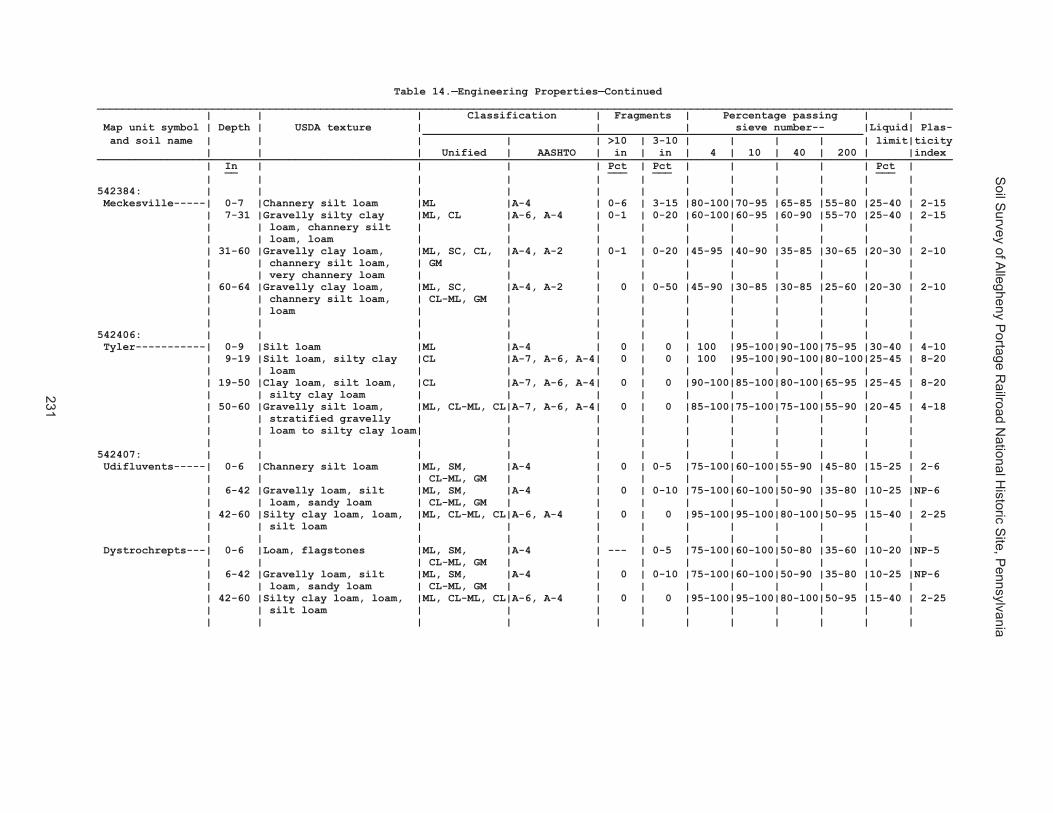
Soil S
urvey of Allegheny P
ortage Railroad N
ational Historic S
ite, Pennsylvania
231
Table 14.—Engineering Properties—Continued______________________________________________________________________________________________________________________________________ | | | Classification | Fragments | Percentage passing | | Map unit symbol | Depth | USDA texture | | | sieve number-- |Liquid| Plas- _____________________________________________________________________ and soil name | | | | | >10 | 3-10 | | | | | limit|ticity | | | Unified | AASHTO | in | in | 4 | 10 | 40 | 200 | |index ______________________________________________________________________________________________________________________________________ | In | | | | Pct | Pct | | | | | Pct | __ ___ ___ ___ | | | | | | | | | | | | 542371: | | | | | | | | | | | | Laidig----------| 0-6 |Very channery loam, |SC-SM, SM, |A-4 | 2-15 |15-30 |65-90 |50-80 |45-80 |35-70 |15-30 |NP-10 | | channery loam | CL-ML, GC-GM| | | | | | | | | | 6-32 |Channery loam, channery |SC, SM, CL, |A-6, A-4, A-2| 0 | 5-20 |70-95 |50-90 |40-80 |20-70 |15-40 | 2-18 | | sandy loam, channery | ML | | | | | | | | | | | sandy clay loam | | | | | | | | | | | 32-71 |Channery sandy loam, |GC-GM, SC, |A-6, A-4, A-2| 0-2 | 5-20 |50-90 |40-85 |30-80 |15-70 |15-35 | 2-16 | | very channery loam, | CL-ML, GC | | | | | | | | | | | very channery sandy | | | | | | | | | | | | clay loam | | | | | | | | | | | | | | | | | | | | | | 542372: | | | | | | | | | | | | Laidig----------| 0-6 |Very channery loam, |SC-SM, SM, |A-4 | 2-15 |15-30 |65-90 |50-80 |45-80 |35-70 |15-30 |NP-10 | | channery loam | CL-ML, GC-GM| | | | | | | | | | 6-32 |Channery loam, channery |SC, SM, CL, |A-6, A-4, A-2| 0 | 5-20 |70-95 |50-90 |40-80 |20-70 |15-40 | 2-18 | | sandy loam, channery | ML | | | | | | | | | | | sandy clay loam | | | | | | | | | | | 32-71 |Channery sandy loam, |GC-GM, SC, |A-6, A-4, A-2| 0-2 | 5-20 |50-90 |40-85 |30-80 |15-70 |15-35 | 2-16 | | very channery loam, | CL-ML, GC | | | | | | | | | | | very channery sandy | | | | | | | | | | | | clay loam | | | | | | | | | | | | | | | | | | | | | | 542375: | | | | | | | | | | | | Leck Kill-------| 0-10 |Channery silt loam |SM, ML, CL |A-4, A-2 | 0 | 0-5 |70-85 |60-80 |50-80 |35-70 |22-37 | 6-13 | 10-43 |Channery silt loam, |GM, SC, CL, |A-6, A-4, A-2| 0 | 0-10 |60-90 |50-85 |40-80 |30-70 |23-40 | 2-17 | | channery loam, silty | GC | | | | | | | | | | | clay loam | | | | | | | | | | | 43-58 |Very channery silt |SM, SP-SM, |A-2, A-1 | 0 | 0-30 |25-70 |10-30 | 8-30 | 6-25 |25-40 | 2-13 | | loam, very channery | GM, GP-GM | | | | | | | | | | | clay loam, very | | | | | | | | | | | | channery loam | | | | | | | | | | | 58-62 |Unweathered bedrock | --- | --- | --- | --- | --- | --- | --- | --- | --- | --- | | | | | | | | | | | | 542383: | | | | | | | | | | | | Meckesville-----| 0-7 |Channery silt loam |ML |A-4 | 0-6 | 3-15 |80-100|70-95 |65-85 |55-80 |25-40 | 2-15 | 7-31 |Gravelly silty clay |ML, CL |A-6, A-4 | 0-1 | 0-20 |60-100|60-95 |60-90 |55-70 |25-40 | 2-15 | | loam, channery silt | | | | | | | | | | | | loam, loam | | | | | | | | | | | 31-60 |Gravelly clay loam, |ML, SC, CL, |A-4, A-2 | 0-1 | 0-20 |45-95 |40-90 |35-85 |30-65 |20-30 | 2-10 | | channery silt loam, | GM | | | | | | | | | | | very channery loam | | | | | | | | | | | 60-64 |Gravelly clay loam, |ML, SC, |A-4, A-2 | 0 | 0-50 |45-90 |30-85 |30-85 |25-60 |20-30 | 2-10 | | channery silt loam, | CL-ML, GM | | | | | | | | | | | loam | | | | | | | | | | | | | | | | | | | | | |
Table 14.—Engineering Properties—Continued______________________________________________________________________________________________________________________________________ | | | Classification | Fragments | Percentage passing | | Map unit symbol | Depth | USDA texture | | | sieve number-- |Liquid| Plas- _____________________________________________________________________ and soil name | | | | | >10 | 3-10 | | | | | limit|ticity | | | Unified | AASHTO | in | in | 4 | 10 | 40 | 200 | |index ______________________________________________________________________________________________________________________________________ | In | | | | Pct | Pct | | | | | Pct | __ ___ ___ ___ | | | | | | | | | | | | 542384: | | | | | | | | | | | | Meckesville-----| 0-7 |Channery silt loam |ML |A-4 | 0-6 | 3-15 |80-100|70-95 |65-85 |55-80 |25-40 | 2-15 | 7-31 |Gravelly silty clay |ML, CL |A-6, A-4 | 0-1 | 0-20 |60-100|60-95 |60-90 |55-70 |25-40 | 2-15 | | loam, channery silt | | | | | | | | | | | | loam, loam | | | | | | | | | | | 31-60 |Gravelly clay loam, |ML, SC, CL, |A-4, A-2 | 0-1 | 0-20 |45-95 |40-90 |35-85 |30-65 |20-30 | 2-10 | | channery silt loam, | GM | | | | | | | | | | | very channery loam | | | | | | | | | | | 60-64 |Gravelly clay loam, |ML, SC, |A-4, A-2 | 0 | 0-50 |45-90 |30-85 |30-85 |25-60 |20-30 | 2-10 | | channery silt loam, | CL-ML, GM | | | | | | | | | | | loam | | | | | | | | | | | | | | | | | | | | | | 542406: | | | | | | | | | | | | Tyler-----------| 0-9 |Silt loam |ML |A-4 | 0 | 0 | 100 |95-100|90-100|75-95 |30-40 | 4-10 | 9-19 |Silt loam, silty clay |CL |A-7, A-6, A-4| 0 | 0 | 100 |95-100|90-100|80-100|25-45 | 8-20 | | loam | | | | | | | | | | | 19-50 |Clay loam, silt loam, |CL |A-7, A-6, A-4| 0 | 0 |90-100|85-100|80-100|65-95 |25-45 | 8-20 | | silty clay loam | | | | | | | | | | | 50-60 |Gravelly silt loam, |ML, CL-ML, CL|A-7, A-6, A-4| 0 | 0 |85-100|75-100|75-100|55-90 |20-45 | 4-18 | | stratified gravelly | | | | | | | | | | | | loam to silty clay loam| | | | | | | | | | | | | | | | | | | | | | 542407: | | | | | | | | | | | | Udifluvents-----| 0-6 |Channery silt loam |ML, SM, |A-4 | 0 | 0-5 |75-100|60-100|55-90 |45-80 |15-25 | 2-6 | | | CL-ML, GM | | | | | | | | | | 6-42 |Gravelly loam, silt |ML, SM, |A-4 | 0 | 0-10 |75-100|60-100|50-90 |35-80 |10-25 |NP-6 | | loam, sandy loam | CL-ML, GM | | | | | | | | | | 42-60 |Silty clay loam, loam, |ML, CL-ML, CL|A-6, A-4 | 0 | 0 |95-100|95-100|80-100|50-95 |15-40 | 2-25 | | silt loam | | | | | | | | | | | | | | | | | | | | | | Dystrochrepts---| 0-6 |Loam, flagstones |ML, SM, |A-4 | --- | 0-5 |75-100|60-100|50-80 |35-60 |10-20 |NP-5 | | | CL-ML, GM | | | | | | | | | | 6-42 |Gravelly loam, silt |ML, SM, |A-4 | 0 | 0-10 |75-100|60-100|50-90 |35-80 |10-25 |NP-6 | | loam, sandy loam | CL-ML, GM | | | | | | | | | | 42-60 |Silty clay loam, loam, |ML, CL-ML, CL|A-6, A-4 | 0 | 0 |95-100|95-100|80-100|50-95 |15-40 | 2-25 | | silt loam | | | | | | | | | | | | | | | | | | | | | |

Soil S
urvey of Allegheny P
ortage Railroad N
ational Historic S
ite, Pennsylvania
232
Table 14.—Engineering Properties—Continued______________________________________________________________________________________________________________________________________ | | | Classification | Fragments | Percentage passing | | Map unit symbol | Depth | USDA texture | | | sieve number-- |Liquid| Plas- _____________________________________________________________________ and soil name | | | | | >10 | 3-10 | | | | | limit|ticity | | | Unified | AASHTO | in | in | 4 | 10 | 40 | 200 | |index ______________________________________________________________________________________________________________________________________ | In | | | | Pct | Pct | | | | | Pct | __ ___ ___ ___ | | | | | | | | | | | | 542410: | | | | | | | | | | | | Berks-----------| 0-10 |Channery loam |ML, SC, GC, |A-4, A-2 | 0 | 5-20 |50-80 |45-70 |40-60 |30-55 |25-36 | 5-10 | | | GM | | | | | | | | | | 10-26 |Very channery silt |SC, SM, GC, |A-4, A-6, | 0 | 0-20 |40-80 |35-70 |30-60 |20-50 |25-36 | 5-15 | | loam, very channery | GM | A-1, A-2 | | | | | | | | | | loam, channery silt | | | | | | | | | | | | loam | | | | | | | | | | | 26-33 |Extremely channery |SM, GM |A-2, A-1 | 0 | 0-30 |35-65 |20-55 |20-40 |15-35 |24-36 | 2-10 | | loam, very channery | | | | | | | | | | | | loam, channery silt | | | | | | | | | | | | loam | | | | | | | | | | | 33-43 |Bedrock | | | --- | --- | --- | --- | --- | --- | 0-14 | --- | | | | | | | | | | | | 542420: | | | | | | | | | | | | Wharton---------| 0-9 |Silt loam |CL |A-6, A-4 | 0 | 0-5 |95-100|90-100|80-95 |70-90 |27-43 | 9-17 | 9-46 |Channery silt loam, |CL |A-7, A-6 | 0 | 0-25 |75-100|70-100|65-95 |60-90 |27-47 |10-25 | | silty clay loam, | | | | | | | | | | | | channery clay loam, | | | | | | | | | | | | channery silty clay | | | | | | | | | | | | loam | | | | | | | | | | | 46-69 |Channery silty clay |GC-GM, CH |A-6, A-7, | 0 | 0-50 |45-100|30-100|25-95 |25-90 |25-55 | 5-30 | | loam, channery clay, | | A-2, A-4 | | | | | | | | | | silt loam | | | | | | | | | | | 69-75 |Bedrock | --- | --- | --- | --- | --- | --- | --- | --- | --- | --- | | | | | | | | | | | | 542421: | | | | | | | | | | | | Wharton---------| 0-9 |Silt loam |CL |A-6, A-4 | 0 | 0-11 |87-100|87-100|78-100|67-87 |27-43 | 9-17 | 9-46 |Channery silt loam, |CL |A-7, A-6 | 0 | 0-24 |76-100|47-100|39-100|34-92 |27-47 |10-25 | | silty clay loam, | | | | | | | | | | | | channery clay loam, | | | | | | | | | | | | channery silty clay | | | | | | | | | | | | loam | | | | | | | | | | | 46-69 |Channery silty clay |GC-GM, CH |A-7, A-6, A-4| 0-16 | 0-43 |52-100|51-100|46-100|40-100|25-55 | 5-30 | | loam, channery clay, | | | | | | | | | | | | silt loam | | | | | | | | | | | 69-75 |Bedrock | --- | --- | --- | --- | --- | --- | --- | --- | --- | --- | | | | | | | | | | | | ______________________________________________________________________________________________________________________________________

Soil S
urvey of Allegheny P
ortage Railroad N
ational Historic S
ite, Pennsylvania
233
Table 14.—Engineering Properties—Continued______________________________________________________________________________________________________________________________________ | | | Classification | Fragments | Percentage passing | | Map unit symbol | Depth | USDA texture | | | sieve number-- |Liquid| Plas- _____________________________________________________________________ and soil name | | | | | >10 | 3-10 | | | | | limit|ticity | | | Unified | AASHTO | in | in | 4 | 10 | 40 | 200 | |index ______________________________________________________________________________________________________________________________________ | In | | | | Pct | Pct | | | | | Pct | __ ___ ___ ___ | | | | | | | | | | | | 542410: | | | | | | | | | | | | Berks-----------| 0-10 |Channery loam |ML, SC, GC, |A-4, A-2 | 0 | 5-20 |50-80 |45-70 |40-60 |30-55 |25-36 | 5-10 | | | GM | | | | | | | | | | 10-26 |Very channery silt |SC, SM, GC, |A-4, A-6, | 0 | 0-20 |40-80 |35-70 |30-60 |20-50 |25-36 | 5-15 | | loam, very channery | GM | A-1, A-2 | | | | | | | | | | loam, channery silt | | | | | | | | | | | | loam | | | | | | | | | | | 26-33 |Extremely channery |SM, GM |A-2, A-1 | 0 | 0-30 |35-65 |20-55 |20-40 |15-35 |24-36 | 2-10 | | loam, very channery | | | | | | | | | | | | loam, channery silt | | | | | | | | | | | | loam | | | | | | | | | | | 33-43 |Bedrock | | | --- | --- | --- | --- | --- | --- | 0-14 | --- | | | | | | | | | | | | 542420: | | | | | | | | | | | | Wharton---------| 0-9 |Silt loam |CL |A-6, A-4 | 0 | 0-5 |95-100|90-100|80-95 |70-90 |27-43 | 9-17 | 9-46 |Channery silt loam, |CL |A-7, A-6 | 0 | 0-25 |75-100|70-100|65-95 |60-90 |27-47 |10-25 | | silty clay loam, | | | | | | | | | | | | channery clay loam, | | | | | | | | | | | | channery silty clay | | | | | | | | | | | | loam | | | | | | | | | | | 46-69 |Channery silty clay |GC-GM, CH |A-6, A-7, | 0 | 0-50 |45-100|30-100|25-95 |25-90 |25-55 | 5-30 | | loam, channery clay, | | A-2, A-4 | | | | | | | | | | silt loam | | | | | | | | | | | 69-75 |Bedrock | --- | --- | --- | --- | --- | --- | --- | --- | --- | --- | | | | | | | | | | | | 542421: | | | | | | | | | | | | Wharton---------| 0-9 |Silt loam |CL |A-6, A-4 | 0 | 0-11 |87-100|87-100|78-100|67-87 |27-43 | 9-17 | 9-46 |Channery silt loam, |CL |A-7, A-6 | 0 | 0-24 |76-100|47-100|39-100|34-92 |27-47 |10-25 | | silty clay loam, | | | | | | | | | | | | channery clay loam, | | | | | | | | | | | | channery silty clay | | | | | | | | | | | | loam | | | | | | | | | | | 46-69 |Channery silty clay |GC-GM, CH |A-7, A-6, A-4| 0-16 | 0-43 |52-100|51-100|46-100|40-100|25-55 | 5-30 | | loam, channery clay, | | | | | | | | | | | | silt loam | | | | | | | | | | | 69-75 |Bedrock | --- | --- | --- | --- | --- | --- | --- | --- | --- | --- | | | | | | | | | | | | ______________________________________________________________________________________________________________________________________
Table 15.—Physical Soil Properties
(Sand, silt, and clay values are shown either as a range or as a representative value. Absence of an entry indicates that data were not estimated. Soil properties are measured or inferred from direct observations in the field or laboratory) ______________________________________________________________________________________________________________ Map unit symbol | Depth | Sand | Silt | Clay | Moist | Permeability| Available | Shrink- | Organic and soil name | | | | | bulk | (Ksat) | water | swell | matter | | | | | density | | capacity |potential| ______________________________________________________________________________________________________________ | In | Pct | Pct | Pct | g/cc | In/hr | In/in | Pct | Pct __ ___ ___ ___ ____ _____ _____ ___ ___ | | | | | | | | | 541887: | | | | | | | | | Armagh----------| 0-12 | 24 | 52 | 15-32| 1.20-1.40 | 0.6-2.0 | 0.18-0.22 | 0.0-2.9 | 1.0-4.0 | 12-48 | 7 | 54 | 35-55| 1.30-1.60 | 0.1-0.2 | 0.10-0.14 | 3.0-5.9 | 0.0-0.5 | 48-60 | 9 | 56 | 15-55| 1.20-1.60 | 0.1-0.6 | 0.08-0.12 | 3.0-5.9 | 0.0-0.5 | | | | | | | | | 541890: | | | | | | | | | Berks-----------| 0-7 | 30 | 56 | 5-23| 1.20-1.50 | 0.6-6.0 | 0.08-0.12 | 0.0-2.9 | 0.5-3.0 | 7-29 | 27 | 54 | 5-32| 1.20-1.60 | 0.6-6.0 | 0.04-0.10 | 0.0-2.9 | 0.0-0.5 | 29-34 | 38 | 52 | 5-20| 1.20-1.60 | 2.0-6.0 | 0.04-0.10 | 0.0-2.9 | 0.0-0.5 | 34-38 | --- | --- | --- | --- | --- | --- | --- | --- | | | | | | | | | 541892: | | | | | | | | | Blairton--------| 0-9 | 27 | 54 | 10-27| 1.40-1.60 | 0.6-2.0 | 0.14-0.18 | 0.0-2.9 | 1.0-4.0 | 9-22 | 18 | 54 | 18-35| 1.50-1.70 | 0.2-0.6 | 0.08-0.14 | 0.0-2.9 | 0.0-0.5 | 22-26 | 43 | 38 | 10-27| 1.40-1.60 | 0.2-2.0 | 0.04-0.10 | 0.0-2.9 | 0.0-0.5 | 26-30 | --- | --- | --- | --- | --- | --- | --- | --- 541893: | | | | | | | | | Blairton--------| 0-12 | 27 | 54 | 10-27| 1.40-1.60 | 0.6-2.0 | 0.14-0.18 | 0.0-2.9 | 1.0-4.0 | 12-34 | 19 | 54 | 18-35| 1.50-1.70 | 0.2-0.6 | 0.08-0.14 | 0.0-2.9 | 0.0-0.5 | 34-38 | 27 | 54 | 10-27| 1.40-1.60 | 0.2-2.0 | 0.04-0.10 | 0.0-2.9 | 0.0-0.5 | 38-42 | --- | --- | --- | --- | --- | --- | --- | --- 541903: | | | | | | | | | Cookport--------| 0-14 | 43 | 38 | 10-27| 1.20-1.40 | 0.6-2.0 | 0.12-0.16 | 0.0-2.9 | 1.0-4.0 | 14-26 | 38 | 36 | 18-35| 1.20-1.50 | 0.6-2.0 | 0.12-0.16 | 0.0-2.9 | 0.0-0.5 | 26-40 | 38 | 36 | 18-35| 1.40-1.70 | 0.1-0.2 | 0.08-0.12 | 0.0-2.9 | 0.0-0.5 | 40-60 | 66 | 15 | 10-27| 1.20-1.50 | 0.2-0.6 | 0.08-0.12 | 0.0-2.9 | 0.0-0.5 | 60-62 | --- | --- | --- | --- | --- | --- | --- | --- | | | | | | | | | Ernest----------| 0-8 | 29 | 53 | 15-20| 1.20-1.40 | 0.6-2.0 | 0.14-0.20 | 0.0-2.9 | 2.0-4.0 | 8-26 | 18 | 54 | 20-35| 1.30-1.50 | 0.6-2.0 | 0.12-0.16 | 3.0-5.9 | 0.0-0.5 | 26-41 | 21 | 55 | 18-30| 1.40-1.70 | 0.1-0.6 | 0.08-0.12 | 0.0-2.9 | 0.0-0.5 | 41-61 | 18 | 55 | 20-35| 1.30-1.60 | 0.1-0.6 | 0.08-0.12 | 3.0-5.9 | 0.0-0.5 | | | | | | | | | 541906: | | | | | | | | | Cookport--------| 0-10 | 43 | 38 | 10-27| 1.20-1.40 | 0.6-2.0 | 0.12-0.16 | 0.0-2.9 | 1.0-5.0 | 10-26 | 38 | 36 | 18-35| 1.20-1.50 | 0.6-2.0 | 0.12-0.16 | 0.0-2.9 | 0.0-0.5 | 26-40 | 38 | 36 | 18-35| 1.40-1.70 | 0.1-0.2 | 0.08-0.12 | 0.0-2.9 | 0.0-0.5 | 40-60 | 66 | 15 | 10-27| 1.20-1.50 | 0.2-0.6 | 0.08-0.12 | 0.0-2.9 | 0.0-0.5 | 60-62 | --- | --- | --- | --- | --- | --- | --- | --- | | | | | | | | | Ernest----------| 0-8 | 29 | 53 | 15-20| 1.20-1.40 | 0.6-2.0 | 0.14-0.20 | 0.0-2.9 | 2.0-4.0 | 8-26 | 18 | 54 | 20-35| 1.30-1.50 | 0.6-2.0 | 0.12-0.16 | 3.0-5.9 | 0.0-0.5 | 26-41 | 21 | 55 | 18-30| 1.40-1.70 | 0.1-0.6 | 0.08-0.12 | 0.0-2.9 | 0.0-0.5 | 41-61 | 18 | 55 | 20-35| 1.30-1.60 | 0.1-0.6 | 0.08-0.12 | 3.0-5.9 | 0.0-0.5
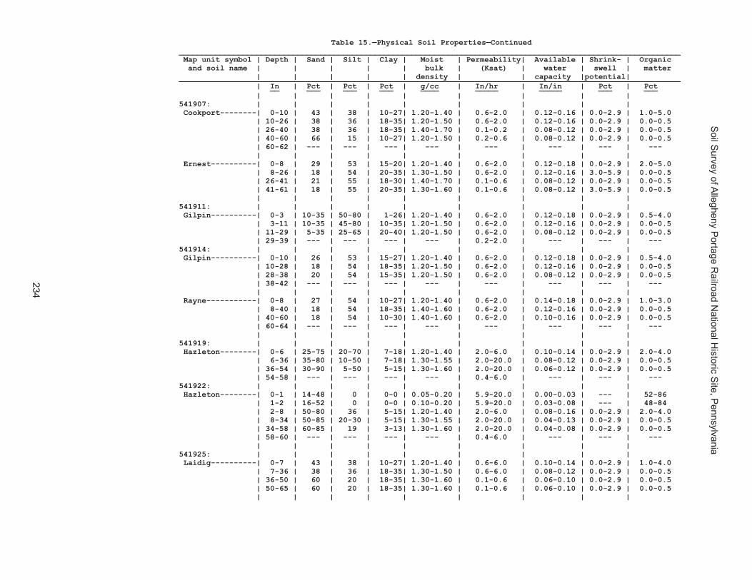
Soil S
urvey of Allegheny P
ortage Railroad N
ational Historic S
ite, Pennsylvania
234
Table 15.—Physical Soil Properties—Continued______________________________________________________________________________________________________________ Map unit symbol | Depth | Sand | Silt | Clay | Moist | Permeability| Available | Shrink- | Organic and soil name | | | | | bulk | (Ksat) | water | swell | matter | | | | | density | | capacity |potential| ______________________________________________________________________________________________________________ | In | Pct | Pct | Pct | g/cc | In/hr | In/in | Pct | Pct __ ___ ___ ___ ____ _____ _____ ___ ___ | | | | | | | | | 541907: | | | | | | | | | Cookport--------| 0-10 | 43 | 38 | 10-27| 1.20-1.40 | 0.6-2.0 | 0.12-0.16 | 0.0-2.9 | 1.0-5.0 | 10-26 | 38 | 36 | 18-35| 1.20-1.50 | 0.6-2.0 | 0.12-0.16 | 0.0-2.9 | 0.0-0.5 | 26-40 | 38 | 36 | 18-35| 1.40-1.70 | 0.1-0.2 | 0.08-0.12 | 0.0-2.9 | 0.0-0.5 | 40-60 | 66 | 15 | 10-27| 1.20-1.50 | 0.2-0.6 | 0.08-0.12 | 0.0-2.9 | 0.0-0.5 | 60-62 | --- | --- | --- | --- | --- | --- | --- | --- | | | | | | | | | Ernest----------| 0-8 | 29 | 53 | 15-20| 1.20-1.40 | 0.6-2.0 | 0.12-0.18 | 0.0-2.9 | 2.0-5.0 | 8-26 | 18 | 54 | 20-35| 1.30-1.50 | 0.6-2.0 | 0.12-0.16 | 3.0-5.9 | 0.0-0.5 | 26-41 | 21 | 55 | 18-30| 1.40-1.70 | 0.1-0.6 | 0.08-0.12 | 0.0-2.9 | 0.0-0.5 | 41-61 | 18 | 55 | 20-35| 1.30-1.60 | 0.1-0.6 | 0.08-0.12 | 3.0-5.9 | 0.0-0.5 | | | | | | | | | 541911: | | | | | | | | | Gilpin----------| 0-3 | 10-35 | 50-80 | 1-26| 1.20-1.40 | 0.6-2.0 | 0.12-0.18 | 0.0-2.9 | 0.5-4.0 | 3-11 | 10-35 | 45-80 | 10-35| 1.20-1.50 | 0.6-2.0 | 0.12-0.16 | 0.0-2.9 | 0.0-0.5 | 11-29 | 5-35 | 25-65 | 20-40| 1.20-1.50 | 0.6-2.0 | 0.08-0.12 | 0.0-2.9 | 0.0-0.5 | 29-39 | --- | --- | --- | --- | 0.2-2.0 | --- | --- | --- 541914: | | | | | | | | | Gilpin----------| 0-10 | 26 | 53 | 15-27| 1.20-1.40 | 0.6-2.0 | 0.12-0.18 | 0.0-2.9 | 0.5-4.0 | 10-28 | 18 | 54 | 18-35| 1.20-1.50 | 0.6-2.0 | 0.12-0.16 | 0.0-2.9 | 0.0-0.5 | 28-38 | 20 | 54 | 15-35| 1.20-1.50 | 0.6-2.0 | 0.08-0.12 | 0.0-2.9 | 0.0-0.5 | 38-42 | --- | --- | --- | --- | --- | --- | --- | --- | | | | | | | | | Rayne-----------| 0-8 | 27 | 54 | 10-27| 1.20-1.40 | 0.6-2.0 | 0.14-0.18 | 0.0-2.9 | 1.0-3.0 | 8-40 | 18 | 54 | 18-35| 1.40-1.60 | 0.6-2.0 | 0.12-0.16 | 0.0-2.9 | 0.0-0.5 | 40-60 | 18 | 54 | 10-30| 1.40-1.60 | 0.6-2.0 | 0.10-0.16 | 0.0-2.9 | 0.0-0.5 | 60-64 | --- | --- | --- | --- | --- | --- | --- | --- | | | | | | | | | 541919: | | | | | | | | | Hazleton--------| 0-6 | 25-75 | 20-70 | 7-18| 1.20-1.40 | 2.0-6.0 | 0.10-0.14 | 0.0-2.9 | 2.0-4.0 | 6-36 | 35-80 | 10-50 | 7-18| 1.30-1.55 | 2.0-20.0 | 0.08-0.12 | 0.0-2.9 | 0.0-0.5 | 36-54 | 30-90 | 5-50 | 5-15| 1.30-1.60 | 2.0-20.0 | 0.06-0.12 | 0.0-2.9 | 0.0-0.5 | 54-58 | --- | --- | --- | --- | 0.4-6.0 | --- | --- | --- 541922: | | | | | | | | | Hazleton--------| 0-1 | 14-48 | 0 | 0-0 | 0.05-0.20 | 5.9-20.0 | 0.00-0.03 | --- | 52-86 | 1-2 | 16-52 | 0 | 0-0 | 0.10-0.20 | 5.9-20.0 | 0.03-0.08 | --- | 48-84 | 2-8 | 50-80 | 36 | 5-15| 1.20-1.40 | 2.0-6.0 | 0.08-0.16 | 0.0-2.9 | 2.0-4.0 | 8-34 | 50-85 | 20-30 | 5-15| 1.30-1.55 | 2.0-20.0 | 0.04-0.13 | 0.0-2.9 | 0.0-0.5 | 34-58 | 60-85 | 19 | 3-13| 1.30-1.60 | 2.0-20.0 | 0.04-0.08 | 0.0-2.9 | 0.0-0.5 | 58-60 | --- | --- | --- | --- | 0.4-6.0 | --- | --- | --- | | | | | | | | | 541925: | | | | | | | | | Laidig----------| 0-7 | 43 | 38 | 10-27| 1.20-1.40 | 0.6-6.0 | 0.10-0.14 | 0.0-2.9 | 1.0-4.0 | 7-36 | 38 | 36 | 18-35| 1.30-1.50 | 0.6-6.0 | 0.08-0.12 | 0.0-2.9 | 0.0-0.5 | 36-50 | 60 | 20 | 18-35| 1.30-1.60 | 0.1-0.6 | 0.06-0.10 | 0.0-2.9 | 0.0-0.5 | 50-65 | 60 | 20 | 18-35| 1.30-1.60 | 0.1-0.6 | 0.06-0.10 | 0.0-2.9 | 0.0-0.5 | | | | | | | | |
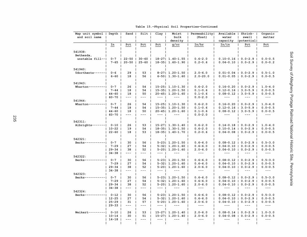
Soil S
urvey of Allegheny P
ortage Railroad N
ational Historic S
ite, Pennsylvania
235
Table 15.—Physical Soil Properties—Continued______________________________________________________________________________________________________________ Map unit symbol | Depth | Sand | Silt | Clay | Moist | Permeability| Available | Shrink- | Organic and soil name | | | | | bulk | (Ksat) | water | swell | matter | | | | | density | | capacity |potential| ______________________________________________________________________________________________________________ | In | Pct | Pct | Pct | g/cc | In/hr | In/in | Pct | Pct __ ___ ___ ___ ____ _____ _____ ___ ___ | | | | | | | | | 541907: | | | | | | | | | Cookport--------| 0-10 | 43 | 38 | 10-27| 1.20-1.40 | 0.6-2.0 | 0.12-0.16 | 0.0-2.9 | 1.0-5.0 | 10-26 | 38 | 36 | 18-35| 1.20-1.50 | 0.6-2.0 | 0.12-0.16 | 0.0-2.9 | 0.0-0.5 | 26-40 | 38 | 36 | 18-35| 1.40-1.70 | 0.1-0.2 | 0.08-0.12 | 0.0-2.9 | 0.0-0.5 | 40-60 | 66 | 15 | 10-27| 1.20-1.50 | 0.2-0.6 | 0.08-0.12 | 0.0-2.9 | 0.0-0.5 | 60-62 | --- | --- | --- | --- | --- | --- | --- | --- | | | | | | | | | Ernest----------| 0-8 | 29 | 53 | 15-20| 1.20-1.40 | 0.6-2.0 | 0.12-0.18 | 0.0-2.9 | 2.0-5.0 | 8-26 | 18 | 54 | 20-35| 1.30-1.50 | 0.6-2.0 | 0.12-0.16 | 3.0-5.9 | 0.0-0.5 | 26-41 | 21 | 55 | 18-30| 1.40-1.70 | 0.1-0.6 | 0.08-0.12 | 0.0-2.9 | 0.0-0.5 | 41-61 | 18 | 55 | 20-35| 1.30-1.60 | 0.1-0.6 | 0.08-0.12 | 3.0-5.9 | 0.0-0.5 | | | | | | | | | 541911: | | | | | | | | | Gilpin----------| 0-3 | 10-35 | 50-80 | 1-26| 1.20-1.40 | 0.6-2.0 | 0.12-0.18 | 0.0-2.9 | 0.5-4.0 | 3-11 | 10-35 | 45-80 | 10-35| 1.20-1.50 | 0.6-2.0 | 0.12-0.16 | 0.0-2.9 | 0.0-0.5 | 11-29 | 5-35 | 25-65 | 20-40| 1.20-1.50 | 0.6-2.0 | 0.08-0.12 | 0.0-2.9 | 0.0-0.5 | 29-39 | --- | --- | --- | --- | 0.2-2.0 | --- | --- | --- 541914: | | | | | | | | | Gilpin----------| 0-10 | 26 | 53 | 15-27| 1.20-1.40 | 0.6-2.0 | 0.12-0.18 | 0.0-2.9 | 0.5-4.0 | 10-28 | 18 | 54 | 18-35| 1.20-1.50 | 0.6-2.0 | 0.12-0.16 | 0.0-2.9 | 0.0-0.5 | 28-38 | 20 | 54 | 15-35| 1.20-1.50 | 0.6-2.0 | 0.08-0.12 | 0.0-2.9 | 0.0-0.5 | 38-42 | --- | --- | --- | --- | --- | --- | --- | --- | | | | | | | | | Rayne-----------| 0-8 | 27 | 54 | 10-27| 1.20-1.40 | 0.6-2.0 | 0.14-0.18 | 0.0-2.9 | 1.0-3.0 | 8-40 | 18 | 54 | 18-35| 1.40-1.60 | 0.6-2.0 | 0.12-0.16 | 0.0-2.9 | 0.0-0.5 | 40-60 | 18 | 54 | 10-30| 1.40-1.60 | 0.6-2.0 | 0.10-0.16 | 0.0-2.9 | 0.0-0.5 | 60-64 | --- | --- | --- | --- | --- | --- | --- | --- | | | | | | | | | 541919: | | | | | | | | | Hazleton--------| 0-6 | 25-75 | 20-70 | 7-18| 1.20-1.40 | 2.0-6.0 | 0.10-0.14 | 0.0-2.9 | 2.0-4.0 | 6-36 | 35-80 | 10-50 | 7-18| 1.30-1.55 | 2.0-20.0 | 0.08-0.12 | 0.0-2.9 | 0.0-0.5 | 36-54 | 30-90 | 5-50 | 5-15| 1.30-1.60 | 2.0-20.0 | 0.06-0.12 | 0.0-2.9 | 0.0-0.5 | 54-58 | --- | --- | --- | --- | 0.4-6.0 | --- | --- | --- 541922: | | | | | | | | | Hazleton--------| 0-1 | 14-48 | 0 | 0-0 | 0.05-0.20 | 5.9-20.0 | 0.00-0.03 | --- | 52-86 | 1-2 | 16-52 | 0 | 0-0 | 0.10-0.20 | 5.9-20.0 | 0.03-0.08 | --- | 48-84 | 2-8 | 50-80 | 36 | 5-15| 1.20-1.40 | 2.0-6.0 | 0.08-0.16 | 0.0-2.9 | 2.0-4.0 | 8-34 | 50-85 | 20-30 | 5-15| 1.30-1.55 | 2.0-20.0 | 0.04-0.13 | 0.0-2.9 | 0.0-0.5 | 34-58 | 60-85 | 19 | 3-13| 1.30-1.60 | 2.0-20.0 | 0.04-0.08 | 0.0-2.9 | 0.0-0.5 | 58-60 | --- | --- | --- | --- | 0.4-6.0 | --- | --- | --- | | | | | | | | | 541925: | | | | | | | | | Laidig----------| 0-7 | 43 | 38 | 10-27| 1.20-1.40 | 0.6-6.0 | 0.10-0.14 | 0.0-2.9 | 1.0-4.0 | 7-36 | 38 | 36 | 18-35| 1.30-1.50 | 0.6-6.0 | 0.08-0.12 | 0.0-2.9 | 0.0-0.5 | 36-50 | 60 | 20 | 18-35| 1.30-1.60 | 0.1-0.6 | 0.06-0.10 | 0.0-2.9 | 0.0-0.5 | 50-65 | 60 | 20 | 18-35| 1.30-1.60 | 0.1-0.6 | 0.06-0.10 | 0.0-2.9 | 0.0-0.5 | | | | | | | | |
Table 15.—Physical Soil Properties—Continued______________________________________________________________________________________________________________ Map unit symbol | Depth | Sand | Silt | Clay | Moist | Permeability| Available | Shrink- | Organic and soil name | | | | | bulk | (Ksat) | water | swell | matter | | | | | density | | capacity |potential| ______________________________________________________________________________________________________________ | In | Pct | Pct | Pct | g/cc | In/hr | In/in | Pct | Pct __ ___ ___ ___ ____ _____ _____ ___ ___ | | | | | | | | | 541938: | | | | | | | | | Bethesda, | | | | | | | | | unstable fill--| 0-7 | 22-50 | 30-60 | 18-27| 1.40-1.55 | 0.6-2.0 | 0.10-0.16 | 0.0-2.9 | 0.0-0.5 | 7-65 | 20-50 | 25-60 | 18-35| 1.60-1.90 | 0.2-0.6 | 0.04-0.10 | 0.0-2.9 | 0.0-0.2 | | | | | | | | | 541940: | | | | | | | | | Udorthents------| 0-6 | 29 | 53 | 8-27| 1.20-1.50 | 2.0-6.0 | 0.01-0.04 | 0.0-2.9 | 0.5-1.0 | 6-60 | 18 | 56 | 6-50| 1.30-1.60 | 2.0-20.0 | 0.01-0.05 | 0.0-2.9 | 0.0-0.5 | | | | | | | | | 541943: | | | | | | | | | Wharton---------| 0-7 | 26 | 54 | 15-25| 1.10-1.30 | 0.6-2.0 | 0.16-0.20 | 0.0-2.9 | 1.0-4.0 | 7-44 | 18 | 54 | 15-35| 1.20-1.50 | 0.1-0.6 | 0.12-0.16 | 3.0-5.9 | 0.0-0.5 | 44-60 | 18 | 50 | 20-45| 1.20-1.60 | 0.1-0.6 | 0.08-0.12 | 3.0-5.9 | 0.0-0.5 | 60-70 | --- | --- | --- | --- | 0.0-2.0 | --- | --- | --- 541944: | | | | | | | | | Wharton---------| 0-7 | 26 | 54 | 15-25| 1.10-1.30 | 0.6-2.0 | 0.16-0.20 | 0.0-2.9 | 1.0-4.0 | 7-44 | 18 | 54 | 15-35| 1.20-1.50 | 0.1-0.6 | 0.12-0.16 | 3.0-5.9 | 0.0-0.5 | 44-60 | 18 | 50 | 20-45| 1.20-1.60 | 0.1-0.6 | 0.08-0.12 | 3.0-5.9 | 0.0-0.5 | 60-70 | --- | --- | --- | --- | 0.0-2.0 | --- | --- | --- | | | | | | | | | 542311: | | | | | | | | | Albrights-------| 0-10 | 26 | 53 | 15-27| 1.30-1.40 | 0.6-2.0 | 0.14-0.18 | 0.0-2.9 | 1.0-4.0 | 10-22 | 19 | 54 | 18-35| 1.30-1.50 | 0.6-2.0 | 0.10-0.14 | 0.0-2.9 | 0.0-0.5 | 22-60 | 18 | 53 | 18-35| 1.40-1.70 | 0.2-0.6 | 0.04-0.08 | 0.0-2.9 | 0.0-0.5 | | | | | | | | | 542321: | | | | | | | | | Berks-----------| 0-7 | 30 | 56 | 5-23| 1.20-1.50 | 0.6-6.0 | 0.08-0.12 | 0.0-2.9 | 0.5-3.0 | 7-29 | 27 | 54 | 5-32| 1.20-1.60 | 0.6-6.0 | 0.04-0.10 | 0.0-2.9 | 0.0-0.5 | 29-34 | 38 | 52 | 5-20| 1.20-1.60 | 2.0-6.0 | 0.04-0.10 | 0.0-2.9 | 0.0-0.5 | 34-38 | --- | --- | --- | --- | --- | --- | --- | --- 542322: | | | | | | | | | Berks-----------| 0-7 | 30 | 56 | 5-23| 1.20-1.50 | 0.6-6.0 | 0.08-0.12 | 0.0-2.9 | 0.5-3.0 | 7-29 | 27 | 54 | 5-32| 1.20-1.60 | 0.6-6.0 | 0.04-0.10 | 0.0-2.9 | 0.0-0.5 | 29-34 | 38 | 52 | 5-20| 1.20-1.60 | 2.0-6.0 | 0.04-0.10 | 0.0-2.9 | 0.0-0.5 | 34-38 | --- | --- | --- | --- | --- | --- | --- | --- 542323: | | | | | | | | | Berks-----------| 0-7 | 30 | 56 | 5-23| 1.20-1.50 | 0.6-6.0 | 0.08-0.12 | 0.0-2.9 | 0.5-3.0 | 7-29 | 27 | 54 | 5-32| 1.20-1.60 | 0.6-6.0 | 0.04-0.10 | 0.0-2.9 | 0.0-0.5 | 29-34 | 38 | 52 | 5-20| 1.20-1.60 | 2.0-6.0 | 0.04-0.10 | 0.0-2.9 | 0.0-0.5 | 34-38 | --- | --- | --- | --- | --- | --- | --- | --- 542324: | | | | | | | | | Berks-----------| 0-12 | 30 | 56 | 5-23| 1.20-1.50 | 0.6-6.0 | 0.08-0.12 | 0.0-2.9 | 0.5-3.0 | 12-25 | 27 | 54 | 5-32| 1.20-1.60 | 0.6-6.0 | 0.04-0.10 | 0.0-2.9 | 0.0-0.5 | 25-29 | 31 | 57 | 5-20| 1.20-1.60 | 2.0-6.0 | 0.04-0.10 | 0.0-2.9 | 0.0-0.5 | 29-33 | --- | --- | --- | --- | --- | --- | --- | --- | | | | | | | | | Weikert---------| 0-10 | 26 | 53 | 15-27| 1.20-1.40 | 2.0-6.0 | 0.08-0.14 | 0.0-2.9 | 1.0-3.0 | 10-14 | 30 | 51 | 15-27| 1.20-1.40 | 2.0-6.0 | 0.04-0.08 | 0.0-2.9 | 0.0-0.5 | 14-18 | --- | --- | --- | --- | --- | --- | --- | --- | | | | | | | | |

Soil S
urvey of Allegheny P
ortage Railroad N
ational Historic S
ite, Pennsylvania
236
Table 15.—Physical Soil Properties—Continued______________________________________________________________________________________________________________ Map unit symbol | Depth | Sand | Silt | Clay | Moist | Permeability| Available | Shrink- | Organic and soil name | | | | | bulk | (Ksat) | water | swell | matter | | | | | density | | capacity |potential| ______________________________________________________________________________________________________________ | In | Pct | Pct | Pct | g/cc | In/hr | In/in | Pct | Pct __ ___ ___ ___ ____ _____ _____ ___ ___ | | | | | | | | | 542325: | | | | | | | | | Berks-----------| 0-12 | 30 | 56 | 5-23| 1.20-1.50 | 0.6-6.0 | 0.08-0.12 | 0.0-2.9 | 0.5-3.0 | 12-25 | 27 | 54 | 5-32| 1.20-1.60 | 0.6-6.0 | 0.04-0.10 | 0.0-2.9 | 0.0-0.5 | 25-29 | 31 | 57 | 5-20| 1.20-1.60 | 2.0-6.0 | 0.04-0.10 | 0.0-2.9 | 0.0-0.5 | 29-33 | --- | --- | --- | --- | --- | --- | --- | --- | | | | | | | | | Weikert---------| 0-10 | 26 | 53 | 15-27| 1.20-1.40 | 2.0-6.0 | 0.08-0.14 | 0.0-2.9 | 1.0-3.0 | 10-14 | 30 | 51 | 15-27| 1.20-1.40 | 2.0-6.0 | 0.04-0.08 | 0.0-2.9 | 0.0-0.5 | 14-18 | --- | --- | --- | --- | --- | --- | --- | --- | | | | | | | | | 542326: | | | | | | | | | Berks-----------| 0-12 | 30 | 56 | 5-23| 1.20-1.50 | 0.6-6.0 | 0.08-0.12 | 0.0-2.9 | 0.5-3.0 | 12-25 | 27 | 54 | 5-32| 1.20-1.60 | 0.6-6.0 | 0.04-0.10 | 0.0-2.9 | 0.0-0.5 | 25-29 | 31 | 57 | 5-20| 1.20-1.60 | 2.0-6.0 | 0.04-0.10 | 0.0-2.9 | 0.0-0.5 | 29-33 | --- | --- | --- | --- | --- | --- | --- | --- | | | | | | | | | Weikert---------| 0-10 | 26 | 53 | 15-27| 1.20-1.40 | 2.0-6.0 | 0.08-0.14 | 0.0-2.9 | 1.0-3.0 | 10-14 | 30 | 51 | 15-27| 1.20-1.40 | 2.0-6.0 | 0.04-0.08 | 0.0-2.9 | 0.0-0.5 | 14-18 | --- | --- | --- | --- | --- | --- | --- | --- | | | | | | | | | 542329: | | | | | | | | | Brinkerton------| 0-9 | 11 | 68 | 15-27| 1.20-1.40 | 0.6-2.0 | 0.18-0.24 | 0.0-2.9 | 1.0-4.0 | 9-18 | 7 | 65 | 18-35| 1.20-1.50 | 0.6-2.0 | 0.14-0.18 | 3.0-5.9 | 0.0-0.5 | 18-46 | 7 | 65 | 15-35| 1.60-1.80 | 0.1-0.2 | 0.08-0.12 | 3.0-5.9 | 0.0-0.5 | 46-65 | 22 | 52 | 15-35| 1.40-1.55 | 0.1-0.6 | 0.14-0.18 | 0.0-2.9 | 0.0-0.5 542330: | | | | | | | | | Brinkerton------| 0-8 | 7 | 70 | 15-30| 1.20-1.40 | 0.6-2.0 | 0.18-0.24 | 0.0-2.9 | 1.0-4.0 | 8-19 | 8 | 63 | 15-35| 1.20-1.50 | 0.6-2.0 | 0.14-0.18 | 3.0-5.9 | 0.0-0.5 | 19-45 | 7 | 68 | 15-35| 1.40-1.70 | 0.1-0.2 | 0.08-0.12 | 3.0-5.9 | 0.0-0.5 | 45-60 | 11 | 69 | 15-25| 1.20-1.55 | 0.1-0.6 | 0.14-0.18 | 0.0-2.9 | 0.0-0.5 | | | | | | | | | 542333: | | | | | | | | | Buchanan--------| 0-4 | 43 | 38 | 10-27| 1.20-1.40 | 0.6-2.0 | 0.11-0.16 | 0.0-2.9 | 1.0-4.0 | 4-30 | 40 | 32 | 18-30| 1.30-1.60 | 0.6-2.0 | 0.10-0.16 | 0.0-2.9 | 0.0-0.5 | 30-65 | 38 | 34 | 18-35| 1.40-1.70 | 0.1-0.2 | 0.06-0.10 | 0.0-2.9 | 0.0-0.5 542334: | | | | | | | | | Buchanan--------| 0-4 | 43 | 38 | 10-27| 1.20-1.40 | 0.6-2.0 | 0.11-0.16 | 0.0-2.9 | 1.0-4.0 | 4-30 | 40 | 32 | 18-30| 1.30-1.60 | 0.6-2.0 | 0.10-0.16 | 0.0-2.9 | 0.0-0.5 | 30-65 | 38 | 34 | 18-35| 1.40-1.70 | 0.1-0.2 | 0.06-0.10 | 0.0-2.9 | 0.0-0.5 | | | | | | | | | 542338: | | | | | | | | | Clymer----------| 0-2 | 30-60 | 20-50 | 5-27| 1.20-1.40 | 0.6-2.0 | 0.10-0.16 | 0.0-2.9 | 1.0-4.0 | 2-28 | 25-55 | 25-60 | 6-35| 1.20-1.50 | 0.6-2.0 | 0.08-0.14 | 0.0-2.9 | 0.0-0.5 | 28-50 | 28-70 | 10-60 | 6-30| 1.20-1.40 | 0.6-2.0 | 0.04-0.08 | 0.0-2.9 | 0.0-0.5 | 50-60 | --- | --- | --- | --- | 2.0-6.0 | --- | --- | --- | | | | | | | | |

Soil S
urvey of Allegheny P
ortage Railroad N
ational Historic S
ite, Pennsylvania
237
Table 15.—Physical Soil Properties—Continued______________________________________________________________________________________________________________ Map unit symbol | Depth | Sand | Silt | Clay | Moist | Permeability| Available | Shrink- | Organic and soil name | | | | | bulk | (Ksat) | water | swell | matter | | | | | density | | capacity |potential| ______________________________________________________________________________________________________________ | In | Pct | Pct | Pct | g/cc | In/hr | In/in | Pct | Pct __ ___ ___ ___ ____ _____ _____ ___ ___ | | | | | | | | | 542325: | | | | | | | | | Berks-----------| 0-12 | 30 | 56 | 5-23| 1.20-1.50 | 0.6-6.0 | 0.08-0.12 | 0.0-2.9 | 0.5-3.0 | 12-25 | 27 | 54 | 5-32| 1.20-1.60 | 0.6-6.0 | 0.04-0.10 | 0.0-2.9 | 0.0-0.5 | 25-29 | 31 | 57 | 5-20| 1.20-1.60 | 2.0-6.0 | 0.04-0.10 | 0.0-2.9 | 0.0-0.5 | 29-33 | --- | --- | --- | --- | --- | --- | --- | --- | | | | | | | | | Weikert---------| 0-10 | 26 | 53 | 15-27| 1.20-1.40 | 2.0-6.0 | 0.08-0.14 | 0.0-2.9 | 1.0-3.0 | 10-14 | 30 | 51 | 15-27| 1.20-1.40 | 2.0-6.0 | 0.04-0.08 | 0.0-2.9 | 0.0-0.5 | 14-18 | --- | --- | --- | --- | --- | --- | --- | --- | | | | | | | | | 542326: | | | | | | | | | Berks-----------| 0-12 | 30 | 56 | 5-23| 1.20-1.50 | 0.6-6.0 | 0.08-0.12 | 0.0-2.9 | 0.5-3.0 | 12-25 | 27 | 54 | 5-32| 1.20-1.60 | 0.6-6.0 | 0.04-0.10 | 0.0-2.9 | 0.0-0.5 | 25-29 | 31 | 57 | 5-20| 1.20-1.60 | 2.0-6.0 | 0.04-0.10 | 0.0-2.9 | 0.0-0.5 | 29-33 | --- | --- | --- | --- | --- | --- | --- | --- | | | | | | | | | Weikert---------| 0-10 | 26 | 53 | 15-27| 1.20-1.40 | 2.0-6.0 | 0.08-0.14 | 0.0-2.9 | 1.0-3.0 | 10-14 | 30 | 51 | 15-27| 1.20-1.40 | 2.0-6.0 | 0.04-0.08 | 0.0-2.9 | 0.0-0.5 | 14-18 | --- | --- | --- | --- | --- | --- | --- | --- | | | | | | | | | 542329: | | | | | | | | | Brinkerton------| 0-9 | 11 | 68 | 15-27| 1.20-1.40 | 0.6-2.0 | 0.18-0.24 | 0.0-2.9 | 1.0-4.0 | 9-18 | 7 | 65 | 18-35| 1.20-1.50 | 0.6-2.0 | 0.14-0.18 | 3.0-5.9 | 0.0-0.5 | 18-46 | 7 | 65 | 15-35| 1.60-1.80 | 0.1-0.2 | 0.08-0.12 | 3.0-5.9 | 0.0-0.5 | 46-65 | 22 | 52 | 15-35| 1.40-1.55 | 0.1-0.6 | 0.14-0.18 | 0.0-2.9 | 0.0-0.5 542330: | | | | | | | | | Brinkerton------| 0-8 | 7 | 70 | 15-30| 1.20-1.40 | 0.6-2.0 | 0.18-0.24 | 0.0-2.9 | 1.0-4.0 | 8-19 | 8 | 63 | 15-35| 1.20-1.50 | 0.6-2.0 | 0.14-0.18 | 3.0-5.9 | 0.0-0.5 | 19-45 | 7 | 68 | 15-35| 1.40-1.70 | 0.1-0.2 | 0.08-0.12 | 3.0-5.9 | 0.0-0.5 | 45-60 | 11 | 69 | 15-25| 1.20-1.55 | 0.1-0.6 | 0.14-0.18 | 0.0-2.9 | 0.0-0.5 | | | | | | | | | 542333: | | | | | | | | | Buchanan--------| 0-4 | 43 | 38 | 10-27| 1.20-1.40 | 0.6-2.0 | 0.11-0.16 | 0.0-2.9 | 1.0-4.0 | 4-30 | 40 | 32 | 18-30| 1.30-1.60 | 0.6-2.0 | 0.10-0.16 | 0.0-2.9 | 0.0-0.5 | 30-65 | 38 | 34 | 18-35| 1.40-1.70 | 0.1-0.2 | 0.06-0.10 | 0.0-2.9 | 0.0-0.5 542334: | | | | | | | | | Buchanan--------| 0-4 | 43 | 38 | 10-27| 1.20-1.40 | 0.6-2.0 | 0.11-0.16 | 0.0-2.9 | 1.0-4.0 | 4-30 | 40 | 32 | 18-30| 1.30-1.60 | 0.6-2.0 | 0.10-0.16 | 0.0-2.9 | 0.0-0.5 | 30-65 | 38 | 34 | 18-35| 1.40-1.70 | 0.1-0.2 | 0.06-0.10 | 0.0-2.9 | 0.0-0.5 | | | | | | | | | 542338: | | | | | | | | | Clymer----------| 0-2 | 30-60 | 20-50 | 5-27| 1.20-1.40 | 0.6-2.0 | 0.10-0.16 | 0.0-2.9 | 1.0-4.0 | 2-28 | 25-55 | 25-60 | 6-35| 1.20-1.50 | 0.6-2.0 | 0.08-0.14 | 0.0-2.9 | 0.0-0.5 | 28-50 | 28-70 | 10-60 | 6-30| 1.20-1.40 | 0.6-2.0 | 0.04-0.08 | 0.0-2.9 | 0.0-0.5 | 50-60 | --- | --- | --- | --- | 2.0-6.0 | --- | --- | --- | | | | | | | | |
Table 15.—Physical Soil Properties—Continued______________________________________________________________________________________________________________ Map unit symbol | Depth | Sand | Silt | Clay | Moist | Permeability| Available | Shrink- | Organic and soil name | | | | | bulk | (Ksat) | water | swell | matter | | | | | density | | capacity |potential| ______________________________________________________________________________________________________________ | In | Pct | Pct | Pct | g/cc | In/hr | In/in | Pct | Pct __ ___ ___ ___ ____ _____ _____ ___ ___ | | | | | | | | | 542348: | | | | | | | | | Ernest----------| 0-7 | 29 | 53 | 15-20| 1.20-1.40 | 0.6-2.0 | 0.14-0.20 | 0.0-2.9 | 2.0-4.0 | 7-27 | 18 | 54 | 20-35| 1.30-1.50 | 0.6-2.0 | 0.12-0.16 | 3.0-5.9 | 0.0-0.5 | 27-43 | 19 | 53 | 18-30| 1.40-1.70 | 0.1-0.6 | 0.08-0.12 | 0.0-2.9 | 0.0-0.5 | 43-65 | 20 | 54 | 20-35| 1.30-1.60 | 0.1-0.6 | 0.08-0.12 | 3.0-5.9 | 0.0-0.5 542349: | | | | | | | | | Ernest----------| 0-10 | 29 | 53 | 15-20| 1.20-1.40 | 0.6-2.0 | 0.14-0.20 | 0.0-2.9 | 2.0-4.0 | 10-31 | 18 | 54 | 20-35| 1.30-1.50 | 0.6-2.0 | 0.12-0.16 | 3.0-5.9 | 0.0-0.5 | 31-43 | 21 | 55 | 18-30| 1.40-1.70 | 0.1-0.6 | 0.08-0.12 | 0.0-2.9 | 0.0-0.5 | 43-63 | 18 | 56 | 20-35| 1.30-1.60 | 0.1-0.6 | 0.08-0.12 | 3.0-5.9 | 0.0-0.5 | | | | | | | | | 542350: | | | | | | | | | Gilpin----------| 0-8 | 26 | 53 | 15-27| 1.20-1.40 | 0.6-2.0 | 0.12-0.20 | 0.0-2.9 | 1.0-4.0 | 8-24 | 23 | 51 | 15-34| 1.20-1.50 | 0.6-2.0 | 0.12-0.18 | 0.0-2.9 | 0.1-1.0 | 24-30 | 26 | 48 | 15-35| 1.20-1.50 | 0.6-2.0 | 0.08-0.12 | 0.0-2.9 | 0.0-0.5 | 30-35 | --- | --- | --- | --- | 0.2-2.0 | --- | --- | --- 542351: | | | | | | | | | Gilpin----------| 0-8 | 26 | 53 | 15-27| 1.20-1.40 | 0.6-2.0 | 0.12-0.20 | 0.0-2.9 | 1.0-4.0 | 8-24 | 23 | 51 | 15-34| 1.20-1.50 | 0.6-2.0 | 0.12-0.18 | 0.0-2.9 | 0.1-1.0 | 24-30 | 26 | 48 | 15-35| 1.20-1.50 | 0.6-2.0 | 0.08-0.12 | 0.0-2.9 | 0.0-0.5 | 30-35 | --- | --- | --- | --- | 0.2-2.0 | --- | --- | --- 542352: | | | | | | | | | Gilpin----------| 0-8 | 26 | 53 | 15-27| 1.20-1.40 | 0.6-2.0 | 0.10-0.19 | 0.0-2.9 | 1.0-4.0 | 8-24 | 23 | 51 | 15-34| 1.20-1.50 | 0.6-2.0 | 0.10-0.17 | 0.0-2.9 | 0.1-1.0 | 24-30 | 26 | 48 | 15-35| 1.20-1.50 | 0.6-2.0 | 0.08-0.12 | 0.0-2.9 | 0.0-0.5 | 30-35 | --- | --- | --- | --- | 0.2-2.0 | --- | --- | --- | | | | | | | | | 542366: | | | | | | | | | Leck Kill-------| 0-12 | 30 | 55 | 10-20| 1.20-1.50 | 0.6-6.0 | 0.14-0.18 | 0.0-2.9 | 1.0-3.0 | 12-38 | 18 | 55 | 17-32| 1.40-1.70 | 0.6-6.0 | 0.12-0.16 | 0.0-2.9 | 0.0-0.5 | 38-45 | 21 | 55 | 17-32| 1.30-1.60 | 0.6-6.0 | 0.04-0.08 | 0.0-2.9 | 0.0-0.5 | 45-49 | --- | --- | --- | --- | --- | --- | --- | --- | | | | | | | | | 542370: | | | | | | | | | Laidig----------| 0-6 | 43 | 40 | 7-27| 1.20-1.40 | 0.6-6.0 | 0.08-0.12 | 0.0-2.9 | 0.0-0.0 | 6-32 | 38 | 36 | 18-35| 1.30-1.50 | 0.6-6.0 | 0.08-0.12 | 0.0-2.9 | 0.0-0.0 | 32-71 | 38 | 36 | 18-35| 1.30-1.60 | 0.1-0.6 | 0.06-0.10 | 0.0-2.9 | 0.0-0.0 542371: | | | | | | | | | Laidig----------| 0-6 | 43 | 40 | 7-27| 1.20-1.40 | 0.6-6.0 | 0.08-0.12 | 0.0-2.9 | 0.0-0.0 | 6-32 | 38 | 36 | 18-35| 1.30-1.50 | 0.6-6.0 | 0.08-0.12 | 0.0-2.9 | 0.0-0.0 | 32-71 | 38 | 36 | 18-35| 1.30-1.60 | 0.1-0.6 | 0.06-0.10 | 0.0-2.9 | 0.0-0.0 542372: | | | | | | | | | Laidig----------| 0-6 | 43 | 40 | 7-27| 1.20-1.40 | 0.6-6.0 | 0.08-0.12 | 0.0-2.9 | 0.0-0.0 | 6-32 | 38 | 36 | 18-35| 1.30-1.50 | 0.6-6.0 | 0.08-0.12 | 0.0-2.9 | 0.0-0.0 | 32-71 | 38 | 36 | 18-35| 1.30-1.60 | 0.1-0.6 | 0.06-0.10 | 0.0-2.9 | 0.0-0.0 | | | | | | | | |

Soil S
urvey of Allegheny P
ortage Railroad N
ational Historic S
ite, Pennsylvania
238
Table 15.—Physical Soil Properties—Continued______________________________________________________________________________________________________________ Map unit symbol | Depth | Sand | Silt | Clay | Moist | Permeability| Available | Shrink- | Organic and soil name | | | | | bulk | (Ksat) | water | swell | matter | | | | | density | | capacity |potential| ______________________________________________________________________________________________________________ | In | Pct | Pct | Pct | g/cc | In/hr | In/in | Pct | Pct __ ___ ___ ___ ____ _____ _____ ___ ___ | | | | | | | | | 542375: | | | | | | | | | Leck Kill-------| 0-10 | 30 | 55 | 10-20| 1.20-1.50 | 0.6-6.0 | 0.14-0.18 | 0.0-2.9 | 1.0-3.0 | 10-43 | 20 | 54 | 17-32| 1.40-1.70 | 0.6-6.0 | 0.12-0.16 | 0.0-2.9 | 0.2-0.5 | 43-58 | 26 | 54 | 15-27| 1.30-1.60 | 0.6-6.0 | 0.04-0.08 | 0.0-2.9 | 0.1-0.3 | 58-62 | --- | --- | --- | --- | --- | --- | --- | --- | | | | | | | | | 542383: | | | | | | | | | Meckesville-----| 0-7 | 27 | 54 | 10-27| 1.10-1.30 | 0.6-2.0 | 0.12-0.16 | 0.0-2.9 | 1.0-4.0 | 7-31 | 18 | 55 | 18-35| 1.20-1.40 | 0.6-2.0 | 0.10-0.14 | 0.0-2.9 | 0.0-0.5 | 31-60 | 35 | 38 | 18-35| 1.30-1.60 | 0.2-0.6 | 0.08-0.12 | 0.0-2.9 | 0.0-0.5 | 60-64 | 40 | 32 | 10-35| 1.20-1.40 | 0.2-0.6 | 0.08-0.12 | 0.0-2.9 | 0.0-0.5 542384: | | | | | | | | | Meckesville-----| 0-7 | 27 | 54 | 10-27| 1.10-1.30 | 0.6-2.0 | 0.12-0.16 | 0.0-2.9 | 1.0-4.0 | 7-31 | 18 | 55 | 18-35| 1.20-1.40 | 0.6-2.0 | 0.10-0.14 | 0.0-2.9 | 0.0-0.5 | 31-60 | 35 | 38 | 18-35| 1.30-1.60 | 0.2-0.6 | 0.08-0.12 | 0.0-2.9 | 0.0-0.5 | 60-64 | 40 | 32 | 10-35| 1.20-1.40 | 0.2-0.6 | 0.08-0.12 | 0.0-2.9 | 0.0-0.5 | | | | | | | | | 542406: | | | | | | | | | Tyler-----------| 0-9 | 11 | 69 | 14-26| 1.30-1.50 | 0.6-2.0 | 0.18-0.22 | 0.0-2.9 | 2.0-4.0 | 9-19 | 8 | 60 | 20-33| 1.40-1.60 | 0.2-0.6 | 0.16-0.20 | 3.0-5.9 | 0.0-0.5 | 19-50 | 9 | 59 | 18-33| 1.60-1.85 | 0.0-0.2 | 0.04-0.12 | 0.0-2.9 | 0.0-0.5 | 50-60 | 21 | 55 | 12-30| 1.30-1.70 | 0.2-0.6 | 0.04-0.12 | 0.0-2.9 | 0.0-0.5 | | | | | | | | | 542407: | | | | | | | | | Udifluvents-----| 0-6 | 30 | 55 | 10-20| 1.00-1.40 | 0.6-2.0 | 0.12-0.17 | 0.0-2.9 | 1.5-6.0 | 6-42 | 50 | 38 | 5-20| 1.00-1.45 | 0.6-6.0 | 0.06-0.12 | 0.0-2.9 | 0.1-3.0 | 42-60 | 19 | 54 | 18-35| 1.20-1.40 | 0.6-2.0 | 0.08-0.14 | 0.0-2.9 | 0.1-1.0 | | | | | | | | | Dystrochrepts---| 0-6 | 46 | 44 | 5-15| 1.00-1.40 | 0.6-2.0 | 0.10-0.15 | 0.0-2.9 | 1.5-7.0 | 6-42 | 52 | 36 | 5-20| 1.00-1.45 | 0.6-6.0 | 0.06-0.12 | 0.0-2.9 | 0.1-3.0 | 42-60 | 20 | 54 | 18-35| 1.20-1.40 | 0.6-2.0 | 0.08-0.14 | 0.0-2.9 | 0.1-0.5 | | | | | | | | | 542410: | | | | | | | | | Berks-----------| 0-10 | 42 | 38 | 5-23| 1.20-1.50 | 0.6-6.0 | 0.08-0.12 | 0.0-2.9 | 2.0-4.0 | 10-26 | 26 | 53 | 5-32| 1.20-1.60 | 0.6-6.0 | 0.04-0.10 | 0.0-2.9 | 0.0-0.5 | 26-33 | 42 | 38 | 5-20| 1.20-1.60 | 2.0-6.0 | 0.04-0.10 | 0.0-2.9 | 0.0-0.5 | 33-43 | --- | --- | --- | --- | 0.2-20.0 | 0.00-0.00 | --- | --- | | | | | | | | | 542420: | | | | | | | | | Wharton---------| 0-9 | 22 | 58 | 15-25| 1.10-1.30 | 0.6-2.0 | 0.16-0.20 | 0.0-2.9 | 1.0-4.0 | 9-46 | 17 | 51 | 15-35| 1.20-1.50 | 0.1-0.6 | 0.12-0.16 | 3.0-5.9 | 0.3-1.0 | 46-69 | 18 | 52 | 20-50| 1.20-1.60 | 0.1-0.6 | 0.08-0.12 | 3.0-5.9 | 0.0-0.5 | 69-75 | --- | --- | --- | --- | 0.0-2.0 | --- | --- | --- 542421: | | | | | | | | | Wharton---------| 0-9 | 22 | 58 | 15-25| 1.10-1.30 | 0.6-2.0 | 0.16-0.20 | 0.0-2.9 | 1.0-4.0 | 9-46 | 17 | 51 | 15-35| 1.20-1.50 | 0.1-0.6 | 0.12-0.16 | 3.0-5.9 | 0.3-1.0 | 46-69 | 18 | 52 | 20-50| 1.20-1.60 | 0.1-0.6 | 0.08-0.12 | 3.0-5.9 | 0.0-0.5 | 69-75 | --- | --- | --- | --- | 0.0-2.0 | --- | --- | --- | | | | | | | | | ______________________________________________________________________________________________________________

Soil Survey of Allegheny Portage Railroad National Historic Site, Pennsylvania
239
Table 15.—Physical Soil Properties—Continued
______________________________________________________________________________________________________________
Map unit symbol | Depth | Sand | Silt | Clay | Moist | Permeability| Available | Shrink- | Organic
and soil name | | | | | bulk | (Ksat) | water | swell | matter
| | | | | density | | capacity |potential|
______________________________________________________________________________________________________________
| In | Pct | Pct | Pct | g/cc | In/hr | In/in | Pct | Pct
__ ___ ___ ___ ____ _____ _____ ___ ___
| | | | | | | | |
542375: | | | | | | | | |
Leck Kill-------| 0-10 | 30 | 55 | 10-20| 1.20-1.50 | 0.6-6.0 | 0.14-0.18 | 0.0-2.9 | 1.0-3.0
| 10-43 | 20 | 54 | 17-32| 1.40-1.70 | 0.6-6.0 | 0.12-0.16 | 0.0-2.9 | 0.2-0.5
| 43-58 | 26 | 54 | 15-27| 1.30-1.60 | 0.6-6.0 | 0.04-0.08 | 0.0-2.9 | 0.1-0.3
| 58-62 | --- | --- | --- | --- | --- | --- | --- | ---
| | | | | | | | |
542383: | | | | | | | | |
Meckesville-----| 0-7 | 27 | 54 | 10-27| 1.10-1.30 | 0.6-2.0 | 0.12-0.16 | 0.0-2.9 | 1.0-4.0
| 7-31 | 18 | 55 | 18-35| 1.20-1.40 | 0.6-2.0 | 0.10-0.14 | 0.0-2.9 | 0.0-0.5
| 31-60 | 35 | 38 | 18-35| 1.30-1.60 | 0.2-0.6 | 0.08-0.12 | 0.0-2.9 | 0.0-0.5
| 60-64 | 40 | 32 | 10-35| 1.20-1.40 | 0.2-0.6 | 0.08-0.12 | 0.0-2.9 | 0.0-0.5
542384: | | | | | | | | |
Meckesville-----| 0-7 | 27 | 54 | 10-27| 1.10-1.30 | 0.6-2.0 | 0.12-0.16 | 0.0-2.9 | 1.0-4.0
| 7-31 | 18 | 55 | 18-35| 1.20-1.40 | 0.6-2.0 | 0.10-0.14 | 0.0-2.9 | 0.0-0.5
| 31-60 | 35 | 38 | 18-35| 1.30-1.60 | 0.2-0.6 | 0.08-0.12 | 0.0-2.9 | 0.0-0.5
| 60-64 | 40 | 32 | 10-35| 1.20-1.40 | 0.2-0.6 | 0.08-0.12 | 0.0-2.9 | 0.0-0.5
| | | | | | | | |
542406: | | | | | | | | |
Tyler-----------| 0-9 | 11 | 69 | 14-26| 1.30-1.50 | 0.6-2.0 | 0.18-0.22 | 0.0-2.9 | 2.0-4.0
| 9-19 | 8 | 60 | 20-33| 1.40-1.60 | 0.2-0.6 | 0.16-0.20 | 3.0-5.9 | 0.0-0.5
| 19-50 | 9 | 59 | 18-33| 1.60-1.85 | 0.0-0.2 | 0.04-0.12 | 0.0-2.9 | 0.0-0.5
| 50-60 | 21 | 55 | 12-30| 1.30-1.70 | 0.2-0.6 | 0.04-0.12 | 0.0-2.9 | 0.0-0.5
| | | | | | | | |
542407: | | | | | | | | |
Udifluvents-----| 0-6 | 30 | 55 | 10-20| 1.00-1.40 | 0.6-2.0 | 0.12-0.17 | 0.0-2.9 | 1.5-6.0
| 6-42 | 50 | 38 | 5-20| 1.00-1.45 | 0.6-6.0 | 0.06-0.12 | 0.0-2.9 | 0.1-3.0
| 42-60 | 19 | 54 | 18-35| 1.20-1.40 | 0.6-2.0 | 0.08-0.14 | 0.0-2.9 | 0.1-1.0
| | | | | | | | |
Dystrochrepts---| 0-6 | 46 | 44 | 5-15| 1.00-1.40 | 0.6-2.0 | 0.10-0.15 | 0.0-2.9 | 1.5-7.0
| 6-42 | 52 | 36 | 5-20| 1.00-1.45 | 0.6-6.0 | 0.06-0.12 | 0.0-2.9 | 0.1-3.0
| 42-60 | 20 | 54 | 18-35| 1.20-1.40 | 0.6-2.0 | 0.08-0.14 | 0.0-2.9 | 0.1-0.5
| | | | | | | | |
542410: | | | | | | | | |
Berks-----------| 0-10 | 42 | 38 | 5-23| 1.20-1.50 | 0.6-6.0 | 0.08-0.12 | 0.0-2.9 | 2.0-4.0
| 10-26 | 26 | 53 | 5-32| 1.20-1.60 | 0.6-6.0 | 0.04-0.10 | 0.0-2.9 | 0.0-0.5
| 26-33 | 42 | 38 | 5-20| 1.20-1.60 | 2.0-6.0 | 0.04-0.10 | 0.0-2.9 | 0.0-0.5
| 33-43 | --- | --- | --- | --- | 0.2-20.0 | 0.00-0.00 | --- | ---
| | | | | | | | |
542420: | | | | | | | | |
Wharton---------| 0-9 | 22 | 58 | 15-25| 1.10-1.30 | 0.6-2.0 | 0.16-0.20 | 0.0-2.9 | 1.0-4.0
| 9-46 | 17 | 51 | 15-35| 1.20-1.50 | 0.1-0.6 | 0.12-0.16 | 3.0-5.9 | 0.3-1.0
| 46-69 | 18 | 52 | 20-50| 1.20-1.60 | 0.1-0.6 | 0.08-0.12 | 3.0-5.9 | 0.0-0.5
| 69-75 | --- | --- | --- | --- | 0.0-2.0 | --- | --- | ---
542421: | | | | | | | | |
Wharton---------| 0-9 | 22 | 58 | 15-25| 1.10-1.30 | 0.6-2.0 | 0.16-0.20 | 0.0-2.9 | 1.0-4.0
| 9-46 | 17 | 51 | 15-35| 1.20-1.50 | 0.1-0.6 | 0.12-0.16 | 3.0-5.9 | 0.3-1.0
| 46-69 | 18 | 52 | 20-50| 1.20-1.60 | 0.1-0.6 | 0.08-0.12 | 3.0-5.9 | 0.0-0.5
| 69-75 | --- | --- | --- | --- | 0.0-2.0 | --- | --- | ---
| | | | | | | | |
______________________________________________________________________________________________________________ Table 16.—Erosion Properties
(Entries under “Erosion factors” apply to the entire profile. Entries under “Wind erodibility group” and “Wind erodibility index” apply only to the surface layer)
__________________________________________________________________________________________ | | Erosion factors | Wind | Wind ___________________________ Map unit symbol | Depth | | | | erodi- | erodi- and soil name | (inches) | Kw | Kf | T | bility | bility | | | | | group | index __________________________________________________________________________________________ | | | | | | 541887: | | | | | | Armagh-------------------| 0-12 | .24 | .24 | 5 | 5 | 56 | 12-48 | .28 | .24 | | | | 48-60 | .17 | .32 | | | | | | | | | 541890: | | | | | | Berks--------------------| 0-7 | .17 | .32 | 3 | 6 | 48 | 7-29 | .17 | .24 | | | | 29-34 | .17 | .24 | | | | 34-38 | --- | --- | | | | | | | | | 541892: | | | | | | Blairton-----------------| 0-9 | .43 | .43 | 3 | 5 | 56 | 9-22 | .32 | .37 | | | | 22-26 | .32 | .43 | | | | 26-30 | --- | --- | | | | | | | | | 541893: | | | | | | Blairton-----------------| 0-12 | .43 | .43 | 3 | 5 | 56 | 12-34 | .32 | .37 | | | | 34-38 | .32 | .43 | | | | 38-42 | --- | --- | | | | | | | | | 541903: | | | | | | Cookport-----------------| 0-14 | .24 | .24 | 3 | 5 | 56 | 14-26 | .24 | .24 | | | | 26-40 | .24 | .24 | | | | 40-60 | .24 | .24 | | | | 60-62 | --- | --- | | | | | | | | | Ernest-------------------| 0-8 | .43 | .43 | 3 | 5 | 56 | 8-26 | .32 | .32 | | | | 26-41 | .32 | .32 | | | | 41-61 | .32 | .32 | | | | | | | | | 541906: | | | | | | Cookport-----------------| 0-10 | .24 | .24 | 3 | 8 | 0 | 10-26 | .24 | .24 | | | | 26-40 | .24 | .24 | | | | 40-60 | .24 | .24 | | | | 60-62 | --- | --- | | | | | | | | | Ernest-------------------| 0-8 | .43 | .43 | 3 | 8 | 0 | 8-26 | .32 | .32 | | | | 26-41 | .32 | .32 | | | | 41-61 | .32 | .32 | | | | | | | | | 541907: | | | | | | Cookport-----------------| 0-10 | .24 | .24 | 3 | 8 | 0 | 10-26 | .24 | .24 | | | | 26-40 | .24 | .24 | | | | 40-60 | .24 | .24 | | | | 60-62 | --- | --- | | | | | | | | | Ernest-------------------| 0-8 | .32 | .43 | 3 | 8 | 0 | 8-26 | .32 | .32 | | | | 26-41 | .32 | .32 | | | | 41-61 | .32 | .32 | | | | | | | | |

Soil Survey of Allegheny Portage Railroad National Historic Site, Pennsylvania
240
Table 16.—Erosion Properties—Continued__________________________________________________________________________________________ | | Erosion factors | Wind | Wind ___________________________ Map unit symbol | Depth | | | | erodi- | erodi- and soil name | (inches) | Kw | Kf | T | bility | bility | | | | | group | index __________________________________________________________________________________________ | | | | | | 541908. | | | | | | Dumps, industrial wastes | | | | | | | | | | | | 541909. | | | | | | Dumps, mine | | | | | | | | | | | | 541911: | | | | | | Gilpin-------------------| 0-3 | .32 | .32 | 3 | 8 | 0 | 3-11 | .24 | .28 | | | | 11-29 | .24 | .32 | | | | 29-39 | --- | --- | | | | | | | | | 541914: | | | | | | Gilpin-------------------| 0-10 | .32 | .32 | 3 | 5 | 56 | 10-28 | .24 | .32 | | | | 28-38 | .24 | .32 | | | | 38-42 | --- | --- | | | | | | | | | Rayne--------------------| 0-8 | .28 | .32 | 4 | 5 | 56 | 8-40 | .20 | .24 | | | | 40-60 | .20 | .24 | | | | 60-64 | --- | --- | | | | | | | | | 541919: | | | | | | Hazleton-----------------| 0-6 | .17 | .28 | 3 | 6 | 48 | 6-36 | .15 | .20 | | | | 36-54 | .15 | .20 | | | | 54-58 | --- | --- | | | | | | | | | 541922: | | | | | | Hazleton-----------------| 0-1 | --- | --- | 3 | 5 | 56 | 1-2 | --- | --- | | | | 2-8 | .15 | .24 | | | | 8-34 | .15 | .24 | | | | 34-58 | .15 | .24 | | | | 58-60 | --- | --- | | | | | | | | | 541925: | | | | | | Laidig-------------------| 0-7 | .28 | .28 | 4 | 5 | 56 | 7-36 | .24 | .24 | | | | 36-50 | .17 | .24 | | | | 50-65 | .17 | .24 | | | | | | | | | 541938: | | | | | | Bethesda, unstable fill--| 0-7 | .28 | .49 | 5 | 8 | 0 | 7-65 | .32 | .64 | | | | | | | | | 541940: | | | | | | Urban land. | | | | | | | | | | | | Udorthents---------------| 0-6 | .10 | .24 | 5 | 5 | 56 | 6-60 | .10 | .24 | | | | | | | | | 541942. | | | | | | Water | | | | | | | | | | | | 541943: | | | | | | Wharton------------------| 0-7 | .37 | .37 | 4 | 5 | 56 | 7-44 | .24 | .28 | | | | 44-60 | .17 | .24 | | | | 60-70 | --- | --- | | | | | | | | |

Soil Survey of Allegheny Portage Railroad National Historic Site, Pennsylvania
241
Table 16.—Erosion Properties—Continued__________________________________________________________________________________________ | | Erosion factors | Wind | Wind ___________________________ Map unit symbol | Depth | | | | erodi- | erodi- and soil name | (inches) | Kw | Kf | T | bility | bility | | | | | group | index __________________________________________________________________________________________ | | | | | | 541944: | | | | | | Wharton------------------| 0-7 | .37 | .37 | 4 | 5 | 56 | 7-44 | .24 | .28 | | | | 44-60 | .17 | .24 | | | | 60-70 | --- | --- | | | | | | | | | 542311: | | | | | | Albrights----------------| 0-10 | .28 | .43 | 3 | 6 | 48 | 10-22 | .28 | .37 | | | | 22-60 | .28 | .37 | | | | | | | | | 542321: | | | | | | Berks--------------------| 0-7 | .17 | .32 | 3 | 6 | 48 | 7-29 | .17 | .24 | | | | 29-34 | .17 | .24 | | | | 34-38 | --- | --- | | | | | | | | | 542322: | | | | | | Berks--------------------| 0-7 | .17 | .32 | 3 | 6 | 48 | 7-29 | .17 | .24 | | | | 29-34 | .17 | .24 | | | | 34-38 | --- | --- | | | | | | | | | 542323: | | | | | | Berks--------------------| 0-7 | .17 | .32 | 3 | 6 | 48 | 7-29 | .17 | .24 | | | | 29-34 | .17 | .24 | | | | 34-38 | --- | --- | | | | | | | | | 542324: | | | | | | Berks--------------------| 0-12 | .17 | .32 | 3 | 6 | 48 | 12-25 | .17 | .24 | | | | 25-29 | .17 | .24 | | | | 29-33 | --- | --- | | | | | | | | | Weikert------------------| 0-10 | .28 | .32 | 2 | 6 | 48 | 10-14 | .28 | .37 | | | | 14-18 | --- | --- | | | | | | | | | 542325: | | | | | | Berks--------------------| 0-12 | .17 | .32 | 3 | 6 | 48 | 12-25 | .17 | .24 | | | | 25-29 | .17 | .24 | | | | 29-33 | --- | --- | | | | | | | | | Weikert------------------| 0-10 | .28 | .32 | 2 | 6 | 48 | 10-14 | .28 | .37 | | | | 14-18 | --- | --- | | | | | | | | | 542326: | | | | | | Berks--------------------| 0-12 | .17 | .32 | 3 | 6 | 48 | 12-25 | .17 | .24 | | | | 25-29 | .17 | .24 | | | | 29-33 | --- | --- | | | | | | | | | Weikert------------------| 0-10 | .28 | .32 | 2 | 6 | 48 | 10-14 | .28 | .37 | | | | 14-18 | --- | --- | | | | | | | | |
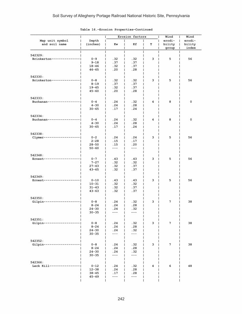
Soil Survey of Allegheny Portage Railroad National Historic Site, Pennsylvania
242
Table 16.—Erosion Properties—Continued__________________________________________________________________________________________ | | Erosion factors | Wind | Wind ___________________________ Map unit symbol | Depth | | | | erodi- | erodi- and soil name | (inches) | Kw | Kf | T | bility | bility | | | | | group | index __________________________________________________________________________________________ | | | | | | 542329: | | | | | | Brinkerton---------------| 0-9 | .32 | .32 | 3 | 5 | 56 | 9-18 | .37 | .37 | | | | 18-46 | .32 | .37 | | | | 46-65 | .20 | .28 | | | | | | | | | 542330: | | | | | | Brinkerton---------------| 0-8 | .32 | .32 | 3 | 5 | 56 | 8-19 | .37 | .37 | | | | 19-45 | .32 | .37 | | | | 45-60 | .20 | .28 | | | | | | | | | 542333: | | | | | | Buchanan-----------------| 0-4 | .24 | .32 | 4 | 8 | 0 | 4-30 | .24 | .28 | | | | 30-65 | .17 | .24 | | | | | | | | | 542334: | | | | | | Buchanan-----------------| 0-4 | .24 | .32 | 4 | 8 | 0 | 4-30 | .24 | .28 | | | | 30-65 | .17 | .24 | | | | | | | | | 542338: | | | | | | Clymer-------------------| 0-2 | .24 | .24 | 3 | 5 | 56 | 2-28 | .15 | .17 | | | | 28-50 | .15 | .20 | | | | 50-60 | --- | --- | | | | | | | | | 542348: | | | | | | Ernest-------------------| 0-7 | .43 | .43 | 3 | 5 | 56 | 7-27 | .32 | .32 | | | | 27-43 | .32 | .37 | | | | 43-65 | .32 | .37 | | | | | | | | | 542349: | | | | | | Ernest-------------------| 0-10 | .43 | .43 | 3 | 5 | 56 | 10-31 | .32 | .32 | | | | 31-43 | .32 | .37 | | | | 43-63 | .32 | .37 | | | | | | | | | 542350: | | | | | | Gilpin-------------------| 0-8 | .24 | .32 | 3 | 7 | 38 | 8-24 | .24 | .28 | | | | 24-30 | .24 | .32 | | | | 30-35 | --- | --- | | | | | | | | | 542351: | | | | | | Gilpin-------------------| 0-8 | .24 | .32 | 3 | 7 | 38 | 8-24 | .24 | .28 | | | | 24-30 | .24 | .32 | | | | 30-35 | --- | --- | | | | | | | | | 542352: | | | | | | Gilpin-------------------| 0-8 | .24 | .32 | 3 | 7 | 38 | 8-24 | .24 | .28 | | | | 24-30 | .24 | .32 | | | | 30-35 | --- | --- | | | | | | | | | 542366: | | | | | | Leck Kill----------------| 0-12 | .24 | .32 | 4 | 6 | 48 | 12-38 | .24 | .28 | | | | 38-45 | .17 | .28 | | | | 45-49 | --- | --- | | | | | | | | |
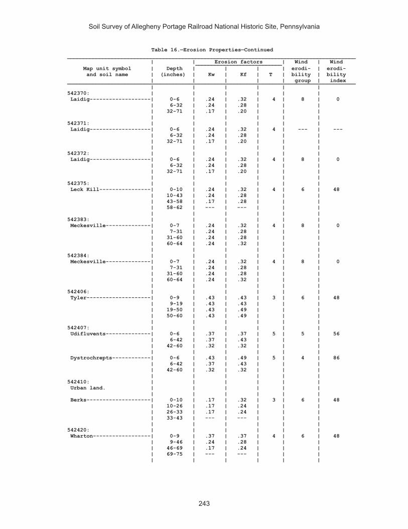
Soil Survey of Allegheny Portage Railroad National Historic Site, Pennsylvania
243
Table 16.—Erosion Properties—Continued__________________________________________________________________________________________ | | Erosion factors | Wind | Wind ___________________________ Map unit symbol | Depth | | | | erodi- | erodi- and soil name | (inches) | Kw | Kf | T | bility | bility | | | | | group | index __________________________________________________________________________________________ | | | | | | 542370: | | | | | | Laidig-------------------| 0-6 | .24 | .32 | 4 | 8 | 0 | 6-32 | .24 | .28 | | | | 32-71 | .17 | .20 | | | | | | | | | 542371: | | | | | | Laidig-------------------| 0-6 | .24 | .32 | 4 | --- | --- | 6-32 | .24 | .28 | | | | 32-71 | .17 | .20 | | | | | | | | | 542372: | | | | | | Laidig-------------------| 0-6 | .24 | .32 | 4 | 8 | 0 | 6-32 | .24 | .28 | | | | 32-71 | .17 | .20 | | | | | | | | | 542375: | | | | | | Leck Kill----------------| 0-10 | .24 | .32 | 4 | 6 | 48 | 10-43 | .24 | .28 | | | | 43-58 | .17 | .28 | | | | 58-62 | --- | --- | | | | | | | | | 542383: | | | | | | Meckesville--------------| 0-7 | .24 | .32 | 4 | 8 | 0 | 7-31 | .24 | .28 | | | | 31-60 | .24 | .28 | | | | 60-64 | .24 | .32 | | | | | | | | | 542384: | | | | | | Meckesville--------------| 0-7 | .24 | .32 | 4 | 8 | 0 | 7-31 | .24 | .28 | | | | 31-60 | .24 | .28 | | | | 60-64 | .24 | .32 | | | | | | | | | 542406: | | | | | | Tyler--------------------| 0-9 | .43 | .43 | 3 | 6 | 48 | 9-19 | .43 | .43 | | | | 19-50 | .43 | .49 | | | | 50-60 | .43 | .49 | | | | | | | | | 542407: | | | | | | Udifluvents--------------| 0-6 | .37 | .37 | 5 | 5 | 56 | 6-42 | .37 | .43 | | | | 42-60 | .32 | .32 | | | | | | | | | Dystrochrepts------------| 0-6 | .43 | .49 | 5 | 4 | 86 | 6-42 | .37 | .43 | | | | 42-60 | .32 | .32 | | | | | | | | | 542410: | | | | | | Urban land. | | | | | | | | | | | | Berks--------------------| 0-10 | .17 | .32 | 3 | 6 | 48 | 10-26 | .17 | .24 | | | | 26-33 | .17 | .24 | | | | 33-43 | --- | --- | | | | | | | | | 542420: | | | | | | Wharton------------------| 0-9 | .37 | .37 | 4 | 6 | 48 | 9-46 | .24 | .28 | | | | 46-69 | .17 | .24 | | | | 69-75 | --- | --- | | | | | | | | |

Soil Survey of Allegheny Portage Railroad National Historic Site, Pennsylvania
244
Table 16.—Erosion Properties—Continued__________________________________________________________________________________________ | | Erosion factors | Wind | Wind ___________________________ Map unit symbol | Depth | | | | erodi- | erodi- and soil name | (inches) | Kw | Kf | T | bility | bility | | | | | group | index __________________________________________________________________________________________ | | | | | | 542421: | | | | | | Wharton------------------| 0-9 | .37 | .37 | 4 | 6 | 48 | 9-46 | .24 | .28 | | | | 46-69 | .17 | .24 | | | | 69-75 | --- | --- | | | | | | | | | __________________________________________________________________________________________

Soil Survey of Allegheny Portage Railroad National Historic Site, Pennsylvania
245
Table 17.—Total Soil Carbon
(This table displays soil organic carbon (SOC) and soil inorganic carbon (SIC) in kilograms per square meter to a depth of 2 meters or to the representative top depth of any kind of bedrock or any cemented soil horizon. SOC and SIC are reported on a volumetric whole soil basis, corrected for representative rock fragments indicated in the database. SOC is converted from horizon soil organic matter of the fraction of the soil less than 2 mm in diameter. If soil organic matter indicated in the database is NULL, SOC is assumed to be zero. SIC is converted from horizon calcium carbonate content fraction of the soil less than 2 mm in diameter. If horizon calcium carbonate indicated in the database is NULL, SIC is assumed to be zero. A weighted average of all horizons is used in the calculations. Only major components of a map unit are displayed in this table)
_________________________________________________________________ | | Map unit symbol, component name, and | SOC | SIC component percent | | | | _________________________________________________________________ | | |kg/m2 | kg/m2 _____ _____ | | 541887: | | Armagh (85%)-------------------------------------| 7 | 0 | | 541890: | | Berks (85%)--------------------------------------| 3 | 0 | | 541892: | | Blairton (90%)-----------------------------------| 5 | 0 | | 541893: | | Blairton (90%)-----------------------------------| 7 | 0 | | 541903: | | Cookport (65%)-----------------------------------| 7 | 0 | | Ernest (25%)-------------------------------------| 6 | 0 | | 541906: | | Cookport (65%)-----------------------------------| 6 | 0 | | Ernest (25%)-------------------------------------| 6 | 0 | | 541907: | | Cookport (70%)-----------------------------------| 6 | 0 | | Ernest (25%)-------------------------------------| 6 | 0 | | 541908. | | Dumps, industrial wastes (90%) | | | | 541909. | | Dumps, mine (99%) | | | | 541911: | | Gilpin (75%)-------------------------------------| 2 | 0 | | 541914: | | Gilpin (70%)-------------------------------------| 5 | 0 | | Rayne (30%)--------------------------------------| 5 | 0 | | 541919: | | Hazleton (90%)-----------------------------------| 4 | 0 | |

Soil Survey of Allegheny Portage Railroad National Historic Site, Pennsylvania
246
Table 17.—Total Soil Carbon—Continued_________________________________________________________________ | | Map unit symbol, component name, and | SOC | SIC component percent | | | | _________________________________________________________________ | | |kg/m2 | kg/m2 _____ _____ | | 541922: | | Hazleton (75%)-----------------------------------| 6 | 0 | | 541925: | | Laidig (100%)------------------------------------| 5 | 0 | | 541938: | | Bethesda, unstable fill (90%)--------------------| 1 | 0 | | 541940: | | Urban land (60%) | | | | Udorthents (30%)---------------------------------| 1 | 0 | | 541942. | | Water (100%) | | | | 541943: | | Wharton (80%)------------------------------------| 5 | 0 | | 541944: | | Wharton (80%)------------------------------------| 5 | 0 | | 542311: | | Albrights (90%)----------------------------------| 6 | 0 | | 542321: | | Berks (85%)--------------------------------------| 3 | 0 | | 542322: | | Berks (85%)--------------------------------------| 3 | 0 | | 542323: | | Berks (85%)--------------------------------------| 3 | 0 | | 542324: | | Berks (50%)--------------------------------------| 3 | 0 | | Weikert (35%)------------------------------------| 4 | 0 | | 542325: | | Berks (45%)--------------------------------------| 5 | 0 | | Weikert (40%)------------------------------------| 4 | 0 | | 542326: | | Berks (50%)--------------------------------------| 5 | 0 | | Weikert (40%)------------------------------------| 4 | 0 | | 542329: | | Brinkerton (75%)---------------------------------| 7 | 0 | | 542330: | | Brinkerton (85%)---------------------------------| 6 | 0 | | 542333: | | Buchanan (90%)-----------------------------------| 3 | 0 | | 542334: | | Buchanan (85%)-----------------------------------| 3 | 0 | |

Soil Survey of Allegheny Portage Railroad National Historic Site, Pennsylvania
247
Table 17.—Total Soil Carbon—Continued_________________________________________________________________ | | Map unit symbol, component name, and | SOC | SIC component percent | | | | _________________________________________________________________ | | |kg/m2 | kg/m2 _____ _____ | | 542338: | | Clymer (80%)-------------------------------------| 3 | 0 | | 542348: | | Ernest (85%)-------------------------------------| 6 | 0 | | 542349: | | Ernest (85%)-------------------------------------| 7 | 0 | | 542350: | | Gilpin (85%)-------------------------------------| 4 | 0 | | 542351: | | Gilpin (85%)-------------------------------------| 4 | 0 | | 542352: | | Gilpin (85%)-------------------------------------| 4 | 0 | | 542366: | | Leck Kill (90%)----------------------------------| 5 | 0 | | 542370: | | Laidig (90%)-------------------------------------| 0 | 0 | | 542371: | | Laidig (90%)-------------------------------------| 0 | 0 | | 542372: | | Laidig (90%)-------------------------------------| 0 | 0 | | 542375: | | Leck Kill (80%)----------------------------------| 5 | 0 | | 542383: | | Meckesville (90%)--------------------------------| 5 | 0 | | 542384: | | Meckesville (90%)--------------------------------| 5 | 0 | | 542406: | | Tyler (90%)--------------------------------------| 8 | 0 | | 542407: | | Udifluvents (50%)--------------------------------| 8 | 0 | | Dystrochrepts (30%)------------------------------| 5 | 0 | | 542410: | | Urban land (65%) | | | | Berks (25%)--------------------------------------| 5 | 0 | | 542420: | | Wharton (80%)------------------------------------| 7 | 0 | | 542421: | | Wharton (75%)------------------------------------| 8 | 0 | | _________________________________________________________________
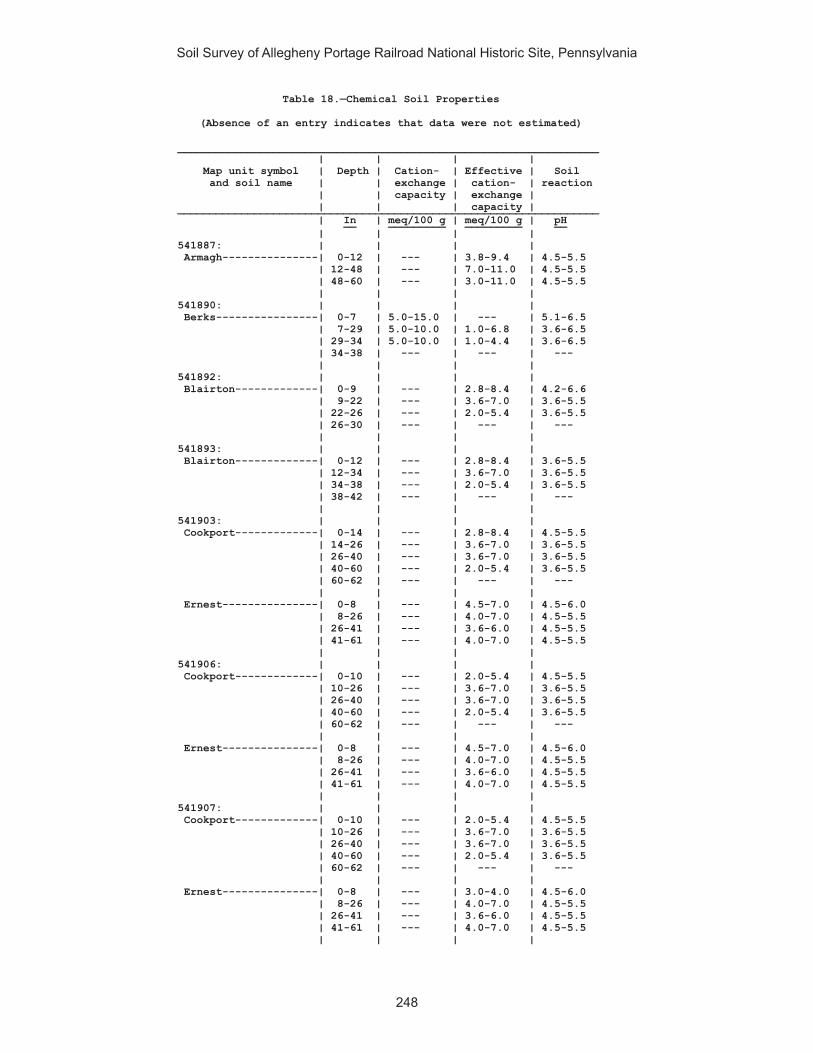
Soil Survey of Allegheny Portage Railroad National Historic Site, Pennsylvania
248
Table 18.—Chemical Soil Properties
(Absence of an entry indicates that data were not estimated)
__________________________________________________________________ | | | | Map unit symbol | Depth | Cation- | Effective | Soil and soil name | | exchange | cation- | reaction | | capacity | exchange | | | | capacity | __________________________________________________________________ | In | meq/100 g | meq/100 g | pH __ _________ _________ __ | | | | 541887: | | | | Armagh---------------| 0-12 | --- | 3.8-9.4 | 4.5-5.5 | 12-48 | --- | 7.0-11.0 | 4.5-5.5 | 48-60 | --- | 3.0-11.0 | 4.5-5.5 | | | | 541890: | | | | Berks----------------| 0-7 | 5.0-15.0 | --- | 5.1-6.5 | 7-29 | 5.0-10.0 | 1.0-6.8 | 3.6-6.5 | 29-34 | 5.0-10.0 | 1.0-4.4 | 3.6-6.5 | 34-38 | --- | --- | --- | | | | 541892: | | | | Blairton-------------| 0-9 | --- | 2.8-8.4 | 4.2-6.6 | 9-22 | --- | 3.6-7.0 | 3.6-5.5 | 22-26 | --- | 2.0-5.4 | 3.6-5.5 | 26-30 | --- | --- | --- | | | | 541893: | | | | Blairton-------------| 0-12 | --- | 2.8-8.4 | 3.6-5.5 | 12-34 | --- | 3.6-7.0 | 3.6-5.5 | 34-38 | --- | 2.0-5.4 | 3.6-5.5 | 38-42 | --- | --- | --- | | | | 541903: | | | | Cookport-------------| 0-14 | --- | 2.8-8.4 | 4.5-5.5 | 14-26 | --- | 3.6-7.0 | 3.6-5.5 | 26-40 | --- | 3.6-7.0 | 3.6-5.5 | 40-60 | --- | 2.0-5.4 | 3.6-5.5 | 60-62 | --- | --- | --- | | | | Ernest---------------| 0-8 | --- | 4.5-7.0 | 4.5-6.0 | 8-26 | --- | 4.0-7.0 | 4.5-5.5 | 26-41 | --- | 3.6-6.0 | 4.5-5.5 | 41-61 | --- | 4.0-7.0 | 4.5-5.5 | | | | 541906: | | | | Cookport-------------| 0-10 | --- | 2.0-5.4 | 4.5-5.5 | 10-26 | --- | 3.6-7.0 | 3.6-5.5 | 26-40 | --- | 3.6-7.0 | 3.6-5.5 | 40-60 | --- | 2.0-5.4 | 3.6-5.5 | 60-62 | --- | --- | --- | | | | Ernest---------------| 0-8 | --- | 4.5-7.0 | 4.5-6.0 | 8-26 | --- | 4.0-7.0 | 4.5-5.5 | 26-41 | --- | 3.6-6.0 | 4.5-5.5 | 41-61 | --- | 4.0-7.0 | 4.5-5.5 | | | | 541907: | | | | Cookport-------------| 0-10 | --- | 2.0-5.4 | 4.5-5.5 | 10-26 | --- | 3.6-7.0 | 3.6-5.5 | 26-40 | --- | 3.6-7.0 | 3.6-5.5 | 40-60 | --- | 2.0-5.4 | 3.6-5.5 | 60-62 | --- | --- | --- | | | | Ernest---------------| 0-8 | --- | 3.0-4.0 | 4.5-6.0 | 8-26 | --- | 4.0-7.0 | 4.5-5.5 | 26-41 | --- | 3.6-6.0 | 4.5-5.5 | 41-61 | --- | 4.0-7.0 | 4.5-5.5 | | | |

Soil Survey of Allegheny Portage Railroad National Historic Site, Pennsylvania
249
Table 18.—Chemical Soil Properties—Continued__________________________________________________________________ | | | | Map unit symbol | Depth | Cation- | Effective | Soil and soil name | | exchange | cation- | reaction | | capacity | exchange | | | | capacity | __________________________________________________________________ | In | meq/100 g | meq/100 g | pH __ _________ _________ __ | | | | 541911: | | | | Gilpin---------------| 0-3 |10.0-14.0 | 3.4-8.4 | 3.5-6.0 | 3-11 | 8.0-12.0 | 3.6-7.0 | 3.5-5.5 | 11-29 | 8.0-12.0 | 3.0-7.0 | 3.5-5.5 | 29-39 | --- | 0.1-0.2 | --- | | | | 541914: | | | | Gilpin---------------| 0-10 | --- | 3.4-8.4 | 3.6-5.5 | 10-28 | --- | 3.6-7.0 | 3.6-5.5 | 28-38 | --- | 3.0-7.0 | 3.6-5.5 | 38-42 | --- | --- | --- | | | | Rayne----------------| 0-8 | --- | 2.8-7.7 | 4.5-5.5 | 8-40 | --- | 3.6-7.0 | 4.5-5.5 | 40-60 | --- | 2.0-6.0 | 4.5-5.5 | 60-64 | --- | --- | --- | | | | 541919: | | | | Hazleton-------------| 0-6 | 3.8-9.9 | --- | 4.2-6.0 | 6-36 | --- | 1.9-8.4 | 3.6-5.5 | 36-54 | --- | 1.3-6.8 | 3.6-5.5 | 54-58 | --- | --- | --- | | | | 541922: | | | | Hazleton-------------| 0-1 | --- | 5.0-60.0 | 3.8-5.0 | 1-2 | --- |10.0-75.0 | 3.5-4.5 | 2-8 | --- | 1.0-3.9 | 3.6-5.5 | 8-34 | --- | 1.3-6.8 | 3.6-5.5 | 34-58 | --- | 0.7-5.8 | 3.6-5.5 | 58-60 | --- | --- | --- | | | | 541925: | | | | Laidig---------------| 0-7 | --- | 2.8-8.4 | 3.6-5.5 | 7-36 | --- | 3.6-7.0 | 3.6-5.5 | 36-50 | --- | 3.6-7.0 | 3.6-5.5 | 50-65 | --- | 3.6-7.0 | 3.6-5.5 | | | | 541938: | | | | Bethesda, unstable | | | | fill----------------| 0-7 | --- | 5.7-13.4 | 3.6-5.5 | 7-65 | --- | 6.3-18.1 | 3.6-5.5 | | | | 541940: | | | | Udorthents-----------| 0-6 | 6.1-18.5 | --- | 4.5-8.4 | 6-60 | 3.6-30.0 | --- | 4.5-8.4 | | | | 541943: | | | | Wharton--------------| 0-7 | --- | 3.8-8.0 | 4.0-5.5 | 7-44 | --- | 3.0-7.0 | 4.0-5.5 | 44-60 | --- | 4.0-9.0 | 4.0-5.5 | 60-70 | --- | --- | --- | | | | 541944: | | | | Wharton--------------| 0-7 | --- | 3.8-8.0 | 4.0-5.5 | 7-44 | --- | 3.0-7.0 | 4.0-5.5 | 44-60 | --- | 4.0-9.0 | 4.0-5.5 | 60-70 | --- | --- | --- | | | |

Soil Survey of Allegheny Portage Railroad National Historic Site, Pennsylvania
250
Table 18.—Chemical Soil Properties—Continued__________________________________________________________________ | | | | Map unit symbol | Depth | Cation- | Effective | Soil and soil name | | exchange | cation- | reaction | | capacity | exchange | | | | capacity | __________________________________________________________________ | In | meq/100 g | meq/100 g | pH __ _________ _________ __ | | | | 542311: | | | | Albrights------------| 0-10 |12.0-18.0 | 3.8-8.4 | 3.6-6.0 | 10-22 | --- | 3.6-7.0 | 3.6-5.5 | 22-60 | 6.0-12.3 | --- | 4.5-6.5 | | | | 542321: | | | | Berks----------------| 0-7 | 5.0-15.0 | --- | 5.1-6.5 | 7-29 | 5.0-10.0 | 1.0-6.8 | 3.6-6.5 | 29-34 | 5.0-10.0 | 1.0-4.4 | 3.6-6.5 | 34-38 | --- | --- | --- | | | | 542322: | | | | Berks----------------| 0-7 | 5.0-15.0 | --- | 5.1-6.5 | 7-29 | 5.0-10.0 | 1.0-6.8 | 3.6-6.5 | 29-34 | 5.0-10.0 | 1.0-4.4 | 3.6-6.5 | 34-38 | --- | --- | --- | | | | 542323: | | | | Berks----------------| 0-7 | 5.0-15.0 | --- | 5.1-6.5 | 7-29 | 5.0-10.0 | 1.0-6.8 | 3.6-6.5 | 29-34 | 5.0-10.0 | 1.0-4.4 | 3.6-6.5 | 34-38 | --- | --- | --- | | | | 542324: | | | | Berks----------------| 0-12 | --- | 1.4-6.9 | 3.6-6.5 | 12-25 | --- | 1.0-6.4 | 3.6-6.5 | 25-29 | --- | 1.0-4.0 | 3.6-6.5 | 29-33 | --- | --- | --- | | | | Weikert--------------| 0-10 | --- | 3.8-7.7 | 4.5-6.0 | 10-14 | --- | 3.0-5.4 | 4.5-6.0 | 14-18 | --- | --- | --- | | | | 542325: | | | | Berks----------------| 0-12 | --- | 1.4-6.9 | 3.6-6.5 | 12-25 | --- | 1.0-6.4 | 3.6-6.5 | 25-29 | --- | 1.0-4.0 | 3.6-6.5 | 29-33 | --- | --- | --- | | | | Weikert--------------| 0-10 | --- | 3.8-7.7 | 4.5-6.0 | 10-14 | --- | 3.0-5.4 | 4.5-6.0 | 14-18 | --- | --- | --- | | | | 542326: | | | | Berks----------------| 0-12 | --- | 1.4-6.9 | 3.6-6.5 | 12-25 | --- | 1.0-6.4 | 3.6-6.5 | 25-29 | --- | 1.0-4.0 | 3.6-6.5 | 29-33 | --- | --- | --- | | | | Weikert--------------| 0-10 | --- | 3.8-7.7 | 4.5-6.0 | 10-14 | --- | 3.0-5.4 | 4.5-6.0 | 14-18 | --- | --- | --- | | | | 542329: | | | | Brinkerton-----------| 0-9 |18.0-26.0 | 3.8-9.0 | 4.5-6.0 | 9-18 |14.0-24.0 | 3.0-7.4 | 4.5-6.0 | 18-46 |14.0-24.0 | 3.0-7.4 | 4.5-6.0 | 46-65 |12.0-22.0 | --- | 5.1-6.5 | | | |
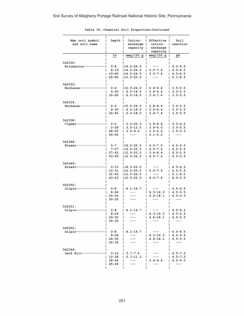
Soil Survey of Allegheny Portage Railroad National Historic Site, Pennsylvania
251
Table 18.—Chemical Soil Properties—Continued__________________________________________________________________ | | | | Map unit symbol | Depth | Cation- | Effective | Soil and soil name | | exchange | cation- | reaction | | capacity | exchange | | | | capacity | __________________________________________________________________ | In | meq/100 g | meq/100 g | pH __ _________ _________ __ | | | | 542330: | | | | Brinkerton-----------| 0-8 |18.0-26.0 | --- | 4.5-6.5 | 8-19 |14.0-24.0 | 3.0-7.4 | 4.5-6.0 | 19-45 |14.0-24.0 | 3.0-7.4 | 4.5-6.0 | 45-60 |12.0-22.0 | --- | 5.1-6.5 | | | | 542333: | | | | Buchanan-------------| 0-4 |10.0-24.0 | 2.8-8.4 | 3.5-5.5 | 4-30 | 6.0-18.0 | 3.6-6.4 | 3.5-5.5 | 30-65 | 6.0-18.0 | 3.6-7.4 | 3.5-5.5 | | | | 542334: | | | | Buchanan-------------| 0-4 |10.0-24.0 | 2.8-8.4 | 3.5-5.5 | 4-30 | 6.0-18.0 | 3.6-6.4 | 3.5-5.5 | 30-65 | 6.0-18.0 | 3.6-7.4 | 3.5-5.5 | | | | 542338: | | | | Clymer---------------| 0-2 | 5.0-20.0 | 3.8-8.4 | 5.0-6.5 | 2-28 | 3.0-12.0 | 3.6-6.0 | 3.5-5.5 | 28-50 | 3.0-9.0 | 3.0-5.4 | 3.5-5.5 | 50-60 | --- | 0.1-0.2 | --- | | | | 542348: | | | | Ernest---------------| 0-7 |18.0-25.0 | 4.5-7.0 | 4.5-6.0 | 7-27 |14.0-25.0 | 4.0-7.4 | 4.5-5.5 | 27-43 |12.0-22.0 | 3.6-6.4 | 4.5-5.5 | 43-65 |12.0-22.0 | 4.0-7.4 | 4.5-5.5 | | | | 542349: | | | | Ernest---------------| 0-10 |18.0-25.0 | --- | 4.5-6.5 | 10-31 |14.0-25.0 | 4.0-7.4 | 4.5-5.5 | 31-43 |12.0-22.0 | --- | 5.1-6.0 | 43-63 |12.0-22.0 | 4.0-7.4 | 4.5-5.5 | | | | 542350: | | | | Gilpin---------------| 0-8 | 8.1-14.7 | --- | 4.5-6.5 | 8-24 | --- | 4.3-14.3 | 4.5-5.5 | 24-30 | --- | 4.6-18.1 | 4.5-5.5 | 30-35 | --- | --- | --- | | | | 542351: | | | | Gilpin---------------| 0-8 | 8.1-14.7 | --- | 4.5-6.5 | 8-24 | --- | 4.3-14.3 | 4.5-5.5 | 24-30 | --- | 4.6-18.1 | 4.5-5.5 | 30-35 | --- | --- | --- | | | | 542352: | | | | Gilpin---------------| 0-8 | 8.1-14.7 | --- | 4.5-6.5 | 8-24 | --- | 4.3-14.3 | 4.5-5.5 | 24-30 | --- | 4.6-18.1 | 4.5-5.5 | 30-35 | --- | --- | --- | | | | 542366: | | | | Leck Kill------------| 0-12 | 3.7-7.4 | --- | 4.5-7.3 | 12-38 | 5.7-11.3 | --- | 4.5-7.3 | 38-45 | --- | 3.4-6.4 | 4.5-6.0 | 45-49 | --- | --- | --- | | | |
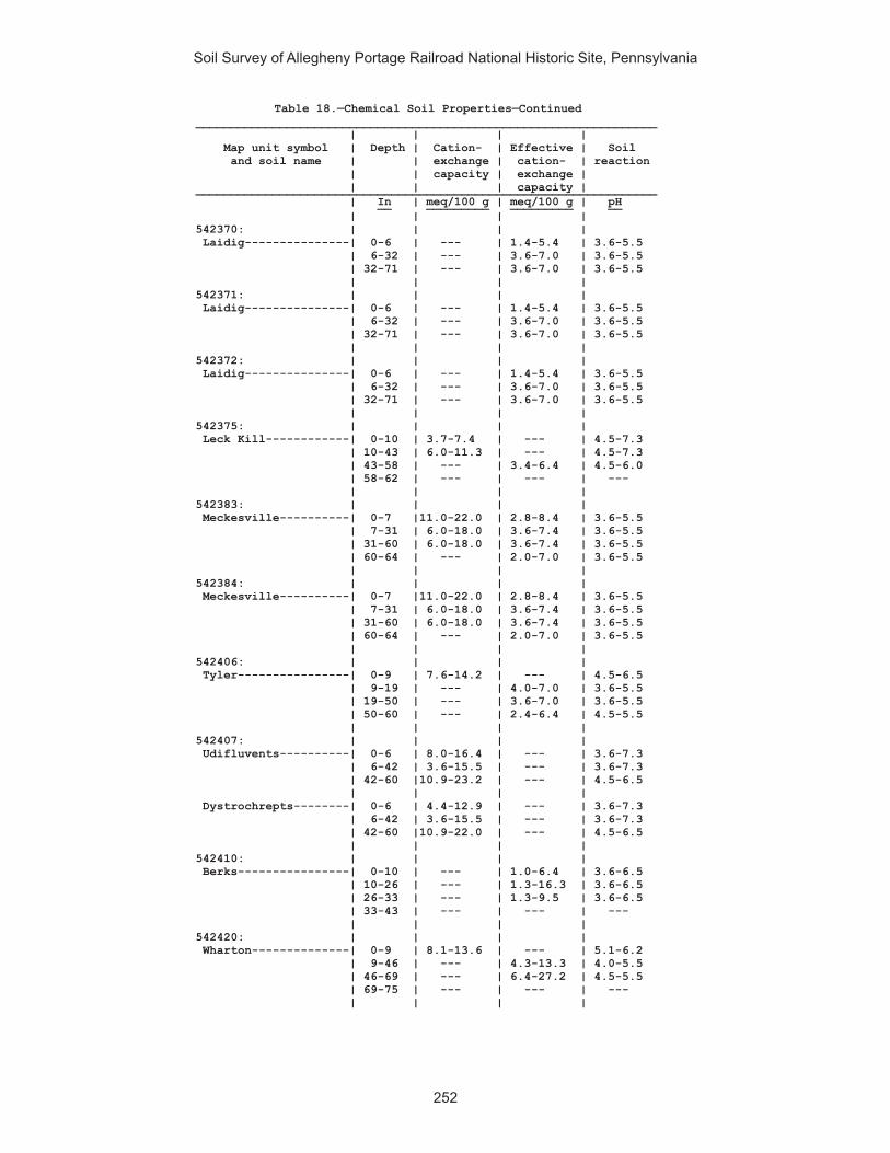
Soil Survey of Allegheny Portage Railroad National Historic Site, Pennsylvania
252
Table 18.—Chemical Soil Properties—Continued__________________________________________________________________ | | | | Map unit symbol | Depth | Cation- | Effective | Soil and soil name | | exchange | cation- | reaction | | capacity | exchange | | | | capacity | __________________________________________________________________ | In | meq/100 g | meq/100 g | pH __ _________ _________ __ | | | | 542370: | | | | Laidig---------------| 0-6 | --- | 1.4-5.4 | 3.6-5.5 | 6-32 | --- | 3.6-7.0 | 3.6-5.5 | 32-71 | --- | 3.6-7.0 | 3.6-5.5 | | | | 542371: | | | | Laidig---------------| 0-6 | --- | 1.4-5.4 | 3.6-5.5 | 6-32 | --- | 3.6-7.0 | 3.6-5.5 | 32-71 | --- | 3.6-7.0 | 3.6-5.5 | | | | 542372: | | | | Laidig---------------| 0-6 | --- | 1.4-5.4 | 3.6-5.5 | 6-32 | --- | 3.6-7.0 | 3.6-5.5 | 32-71 | --- | 3.6-7.0 | 3.6-5.5 | | | | 542375: | | | | Leck Kill------------| 0-10 | 3.7-7.4 | --- | 4.5-7.3 | 10-43 | 6.0-11.3 | --- | 4.5-7.3 | 43-58 | --- | 3.4-6.4 | 4.5-6.0 | 58-62 | --- | --- | --- | | | | 542383: | | | | Meckesville----------| 0-7 |11.0-22.0 | 2.8-8.4 | 3.6-5.5 | 7-31 | 6.0-18.0 | 3.6-7.4 | 3.6-5.5 | 31-60 | 6.0-18.0 | 3.6-7.4 | 3.6-5.5 | 60-64 | --- | 2.0-7.0 | 3.6-5.5 | | | | 542384: | | | | Meckesville----------| 0-7 |11.0-22.0 | 2.8-8.4 | 3.6-5.5 | 7-31 | 6.0-18.0 | 3.6-7.4 | 3.6-5.5 | 31-60 | 6.0-18.0 | 3.6-7.4 | 3.6-5.5 | 60-64 | --- | 2.0-7.0 | 3.6-5.5 | | | | 542406: | | | | Tyler----------------| 0-9 | 7.6-14.2 | --- | 4.5-6.5 | 9-19 | --- | 4.0-7.0 | 3.6-5.5 | 19-50 | --- | 3.6-7.0 | 3.6-5.5 | 50-60 | --- | 2.4-6.4 | 4.5-5.5 | | | | 542407: | | | | Udifluvents----------| 0-6 | 8.0-16.4 | --- | 3.6-7.3 | 6-42 | 3.6-15.5 | --- | 3.6-7.3 | 42-60 |10.9-23.2 | --- | 4.5-6.5 | | | | Dystrochrepts--------| 0-6 | 4.4-12.9 | --- | 3.6-7.3 | 6-42 | 3.6-15.5 | --- | 3.6-7.3 | 42-60 |10.9-22.0 | --- | 4.5-6.5 | | | | 542410: | | | | Berks----------------| 0-10 | --- | 1.0-6.4 | 3.6-6.5 | 10-26 | --- | 1.3-16.3 | 3.6-6.5 | 26-33 | --- | 1.3-9.5 | 3.6-6.5 | 33-43 | --- | --- | --- | | | | 542420: | | | | Wharton--------------| 0-9 | 8.1-13.6 | --- | 5.1-6.2 | 9-46 | --- | 4.3-13.3 | 4.0-5.5 | 46-69 | --- | 6.4-27.2 | 4.5-5.5 | 69-75 | --- | --- | --- | | | |
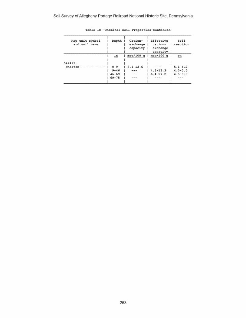
Soil Survey of Allegheny Portage Railroad National Historic Site, Pennsylvania
253
Table 18.—Chemical Soil Properties—Continued__________________________________________________________________ | | | | Map unit symbol | Depth | Cation- | Effective | Soil and soil name | | exchange | cation- | reaction | | capacity | exchange | | | | capacity | __________________________________________________________________ | In | meq/100 g | meq/100 g | pH __ _________ _________ __ | | | | 542421: | | | | Wharton--------------| 0-9 | 8.1-13.6 | --- | 5.1-6.2 | 9-46 | --- | 4.3-13.3 | 4.0-5.5 | 46-69 | --- | 6.4-27.2 | 4.5-5.5 | 69-75 | --- | --- | --- | | | | __________________________________________________________________

Soil Survey of Allegheny Portage Railroad National Historic Site, Pennsylvania
254
Table 19.—Water Features
(See text for definitions of terms used in this table. Estimates of the frequency of ponding and flooding apply to the whole year rather than to individual months. Absence of an entry indicates that the feature is not a concern or that data were not estimated) _________________________________________________________________________________________________________ | | | Water table | Ponding | Flooding _______________________________________________________________________ Map unit symbol|Hydro-| Months | Upper | Lower |Surface|Duration | Frequency| Duration | Frequency and soil name |logic | | limit | limit | water | | | | |group | | | | depth | | | | _________________________________________________________________________________________________________ | | | Ft | Ft | Ft | | | | __ __ __ | | | | | | | | | 541887: | | | | | | | | | Armagh---------| D | | | | | | | | | |January | 0.3 | >6.0 | --- | --- | None | --- | None | |February | 0.3 | >6.0 | --- | --- | None | --- | None | |March | 0.3 | >6.0 | --- | --- | None | --- | None | |April | 0.3 | >6.0 | --- | --- | None | --- | None | |May | 0.3 | >6.0 | --- | --- | None | --- | None | |June | 0.3 | >6.0 | --- | --- | None | --- | None | |October | 0.3 | >6.0 | --- | --- | None | --- | None | |November | 0.3 | >6.0 | --- | --- | None | --- | None | |December | 0.3 | >6.0 | --- | --- | None | --- | None | | | | | | | | | 541890: | | | | | | | | | Berks----------| C | | | | | | | | | |Jan-Dec | --- | --- | --- | --- | None | --- | None | | | | | | | | | 541892: | | | | | | | | | Blairton-------| C | | | | | | | | | |January | 1.7 | 2.2 | --- | --- | None | --- | None | |February | 1.7 | 2.2 | --- | --- | None | --- | None | |March | 1.7 | 2.2 | --- | --- | None | --- | None | |November | 1.7 | 2.2 | --- | --- | None | --- | None | |December | 1.7 | 2.2 | --- | --- | None | --- | None | | | | | | | | | 541893: | | | | | | | | | Blairton-------| C | | | | | | | | | |January | 1.7 | 2.8 | --- | --- | None | --- | None | |February | 1.7 | 2.8 | --- | --- | None | --- | None | |March | 1.7 | 2.8 | --- | --- | None | --- | None | |November | 1.7 | 2.8 | --- | --- | None | --- | None | |December | 1.7 | 2.8 | --- | --- | None | --- | None | | | | | | | | | 541903: | | | | | | | | | Cookport-------| C | | | | | | | | | |January | 2.0 | 2.2 | --- | --- | None | --- | None | |February | 2.0 | 2.2 | --- | --- | None | --- | None | |March | 2.0 | 2.2 | --- | --- | None | --- | None | |April | 2.0 | 2.2 | --- | --- | None | --- | None | |December | 2.0 | 2.2 | --- | --- | None | --- | None | | | | | | | | | Ernest---------| C | | | | | | | | | |January | 1.3 | 2.2 | --- | --- | None | --- | None | |February | 1.3 | 2.2 | --- | --- | None | --- | None | |March | 1.3 | 2.2 | --- | --- | None | --- | None | |April | 1.3 | 2.2 | --- | --- | None | --- | None | |December | 1.3 | 2.2 | --- | --- | None | --- | None | | | | | | | | |

Soil Survey of Allegheny Portage Railroad National Historic Site, Pennsylvania
255
Table 19.—Water Features—Continued_________________________________________________________________________________________________________ | | | Water table | Ponding | Flooding _______________________________________________________________________ Map unit symbol|Hydro-| Months | Upper | Lower |Surface|Duration | Frequency| Duration | Frequency and soil name |logic | | limit | limit | water | | | | |group | | | | depth | | | | _________________________________________________________________________________________________________ | | | Ft | Ft | Ft | | | | __ __ __ | | | | | | | | | 541906: | | | | | | | | | Cookport-------| C | | | | | | | | | |January | 0.3 | 2.3 | --- | --- | None | --- | None | |February | 0.3 | 2.3 | --- | --- | None | --- | None | |March | 0.3 | 2.3 | --- | --- | None | --- | None | |April | 0.3 | 2.3 | --- | --- | None | --- | None | |May | 0.3 | 2.3 | --- | --- | None | --- | None | |October | 0.3 | 2.3 | --- | --- | None | --- | None | |November | 0.3 | 2.3 | --- | --- | None | --- | None | |December | 0.3 | 2.3 | --- | --- | None | --- | None | | | | | | | | | Ernest---------| C | | | | | | | | | |January | 1.3 | 2.2 | --- | --- | None | --- | None | |February | 1.3 | 2.2 | --- | --- | None | --- | None | |March | 1.3 | 2.2 | --- | --- | None | --- | None | |April | 1.3 | 2.2 | --- | --- | None | --- | None | |December | 1.3 | 2.2 | --- | --- | None | --- | None | | | | | | | | | 541907: | | | | | | | | | Cookport-------| C | | | | | | | | | |January | 0.3 | 2.3 | --- | --- | None | --- | None | |February | 0.3 | 2.3 | --- | --- | None | --- | None | |March | 0.3 | 2.3 | --- | --- | None | --- | None | |April | 0.3 | 2.3 | --- | --- | None | --- | None | |May | 0.3 | 2.3 | --- | --- | None | --- | None | |October | 0.3 | 2.3 | --- | --- | None | --- | None | |November | 0.3 | 2.3 | --- | --- | None | --- | None | |December | 0.3 | 2.3 | --- | --- | None | --- | None | | | | | | | | | Ernest---------| C | | | | | | | | | |January | 1.3 | 2.2 | --- | --- | None | --- | None | |February | 1.3 | 2.2 | --- | --- | None | --- | None | |March | 1.3 | 2.2 | --- | --- | None | --- | None | |April | 1.3 | 2.2 | --- | --- | None | --- | None | |December | 1.3 | 2.2 | --- | --- | None | --- | None | | | | | | | | | 541908. | | | | | | | | | Dumps, | | | | | | | | | industrial | | | | | | | | | wastes | | | | | | | | | | | | | | | | | | 541909. | | | | | | | | | Dumps, mine | | | | | | | | | | | | | | | | | | 541911: | | | | | | | | | Gilpin---------| C | | | | | | | | | |Jan-Dec | --- | --- | --- | --- | None | --- | None | | | | | | | | | 541914: | | | | | | | | | Gilpin---------| C | | | | | | | | | |Jan-Dec | --- | --- | --- | --- | None | --- | None | | | | | | | | | Rayne----------| B | | | | | | | | | |Jan-Dec | --- | --- | --- | --- | None | --- | None | | | | | | | | | 541919: | | | | | | | | | Hazleton-------| A | | | | | | | | | |Jan-Dec | --- | --- | --- | --- | None | --- | None | | | | | | | | |

Soil Survey of Allegheny Portage Railroad National Historic Site, Pennsylvania
256
Table 19.—Water Features—Continued_________________________________________________________________________________________________________ | | | Water table | Ponding | Flooding _______________________________________________________________________ Map unit symbol|Hydro-| Months | Upper | Lower |Surface|Duration | Frequency| Duration | Frequency and soil name |logic | | limit | limit | water | | | | |group | | | | depth | | | | _________________________________________________________________________________________________________ | | | Ft | Ft | Ft | | | | __ __ __ | | | | | | | | | 541922: | | | | | | | | | Hazleton-------| B | | | | | | | | | |Jan-Dec | --- | --- | --- | --- | None | --- | None | | | | | | | | | 541925: | | | | | | | | | Laidig---------| C | | | | | | | | | |January | 2.5 | 3.0 | --- | --- | None | --- | None | |February | 2.5 | 3.0 | --- | --- | None | --- | None | |March | 2.5 | 3.0 | --- | --- | None | --- | None | | | | | | | | | 541938: | | | | | | | | | Bethesda, | | | | | | | | | unstable fill-| C | | | | | | | | | |Jan-Dec | --- | --- | --- | --- | None | --- | None | | | | | | | | | 541940: | | | | | | | | | Urban land. | | | | | | | | | | | | | | | | | | Udorthents-----| A | | | | | | | | | |Jan-Dec | --- | --- | --- | --- | None | --- | None | | | | | | | | | 541942. | | | | | | | | | Water | | | | | | | | | | | | | | | | | | 541943: | | | | | | | | | Wharton--------| C/D | | | | | | | | | |January | 2.3 | 4.6 | --- | --- | None | --- | None | |February | 2.3 | 4.6 | --- | --- | None | --- | None | |March | 2.3 | 4.6 | --- | --- | None | --- | None | |November | 2.3 | 4.6 | --- | --- | None | --- | None | |December | 2.3 | 4.6 | --- | --- | None | --- | None | | | | | | | | | 541944: | | | | | | | | | Wharton--------| C/D | | | | | | | | | |January | 2.3 | 4.6 | --- | --- | None | --- | None | |February | 2.3 | 4.6 | --- | --- | None | --- | None | |March | 2.3 | 4.6 | --- | --- | None | --- | None | |November | 2.3 | 4.6 | --- | --- | None | --- | None | |December | 2.3 | 4.6 | --- | --- | None | --- | None | | | | | | | | | 542311: | | | | | | | | | Albrights------| C | | | | | | | | | |January | 1.7 | 1.8 | --- | --- | None | --- | None | |February | 1.7 | 1.8 | --- | --- | None | --- | None | |March | 1.7 | 1.8 | --- | --- | None | --- | None | |November | 1.7 | 1.8 | --- | --- | None | --- | None | |December | 1.7 | 1.8 | --- | --- | None | --- | None | | | | | | | | | 542321: | | | | | | | | | Berks----------| C | | | | | | | | | |Jan-Dec | --- | --- | --- | --- | None | --- | None | | | | | | | | | 542322: | | | | | | | | | Berks----------| C | | | | | | | | | |Jan-Dec | --- | --- | --- | --- | None | --- | None | | | | | | | | | 542323: | | | | | | | | | Berks----------| C | | | | | | | | | |Jan-Dec | --- | --- | --- | --- | None | --- | None | | | | | | | | |

Soil Survey of Allegheny Portage Railroad National Historic Site, Pennsylvania
257
Table 19.—Water Features—Continued_________________________________________________________________________________________________________ | | | Water table | Ponding | Flooding _______________________________________________________________________ Map unit symbol|Hydro-| Months | Upper | Lower |Surface|Duration | Frequency| Duration | Frequency and soil name |logic | | limit | limit | water | | | | |group | | | | depth | | | | _________________________________________________________________________________________________________ | | | Ft | Ft | Ft | | | | __ __ __ | | | | | | | | | 542324: | | | | | | | | | Berks----------| C | | | | | | | | | |Jan-Dec | --- | --- | --- | --- | None | --- | None | | | | | | | | | Weikert--------| C | | | | | | | | | |Jan-Dec | --- | --- | --- | --- | None | --- | None | | | | | | | | | 542325: | | | | | | | | | Berks----------| C | | | | | | | | | |Jan-Dec | --- | --- | --- | --- | None | --- | None | | | | | | | | | Weikert--------| C | | | | | | | | | |Jan-Dec | --- | --- | --- | --- | None | --- | None | | | | | | | | | 542326: | | | | | | | | | Berks----------| C | | | | | | | | | |Jan-Dec | --- | --- | --- | --- | None | --- | None | | | | | | | | | Weikert--------| C | | | | | | | | | |Jan-Dec | --- | --- | --- | --- | None | --- | None | | | | | | | | | 542329: | | | | | | | | | Brinkerton-----| D | | | | | | | | | |January | 0.3 | 1.5 | --- | --- | None | --- | None | |February | 0.3 | 1.5 | --- | --- | None | --- | None | |March | 0.3 | 1.5 | --- | --- | None | --- | None | |April | 0.3 | 1.5 | --- | --- | None | --- | None | |May | 0.3 | 1.5 | --- | --- | None | --- | None | |October | 0.3 | 1.5 | --- | --- | None | --- | None | |November | 0.3 | 1.5 | --- | --- | None | --- | None | |December | 0.3 | 1.5 | --- | --- | None | --- | None | | | | | | | | | 542330: | | | | | | | | | Brinkerton-----| D | | | | | | | | | |January | 0.3 | 2.9 | --- | --- | None | --- | None | |February | 0.3 | 2.9 | --- | --- | None | --- | None | |March | 0.3 | 2.9 | --- | --- | None | --- | None | |April | 0.3 | 2.9 | --- | --- | None | --- | None | |May | 0.3 | 2.9 | --- | --- | None | --- | None | |October | 0.3 | 2.9 | --- | --- | None | --- | None | |November | 0.3 | 2.9 | --- | --- | None | --- | None | |December | 0.3 | 2.9 | --- | --- | None | --- | None | | | | | | | | | 542333: | | | | | | | | | Buchanan-------| C | | | | | | | | | |January | 2.3 | 2.8 | --- | --- | None | --- | None | |February | 2.3 | 2.8 | --- | --- | None | --- | None | |March | 2.3 | 2.8 | --- | --- | None | --- | None | |November | 2.3 | 2.8 | --- | --- | None | --- | None | |December | 2.3 | 2.8 | --- | --- | None | --- | None | | | | | | | | | 542334: | | | | | | | | | Buchanan-------| C | | | | | | | | | |January | 2.3 | 2.8 | --- | --- | None | --- | None | |February | 2.3 | 2.8 | --- | --- | None | --- | None | |March | 2.3 | 2.8 | --- | --- | None | --- | None | |November | 2.3 | 2.8 | --- | --- | None | --- | None | |December | 2.3 | 2.8 | --- | --- | None | --- | None | | | | | | | | |

Soil Survey of Allegheny Portage Railroad National Historic Site, Pennsylvania
258
Table 19.—Water Features—Continued_________________________________________________________________________________________________________ | | | Water table | Ponding | Flooding _______________________________________________________________________ Map unit symbol|Hydro-| Months | Upper | Lower |Surface|Duration | Frequency| Duration | Frequency and soil name |logic | | limit | limit | water | | | | |group | | | | depth | | | | _________________________________________________________________________________________________________ | | | Ft | Ft | Ft | | | | __ __ __ | | | | | | | | | 542338: | | | | | | | | | Clymer---------| B | | | | | | | | | |Jan-Dec | --- | --- | --- | --- | None | --- | None | | | | | | | | | 542348: | | | | | | | | | Ernest---------| C | | | | | | | | | |January | 2.3 | 2.3 | --- | --- | None | --- | None | |February | 2.3 | 2.3 | --- | --- | None | --- | None | |March | 2.3 | 2.3 | --- | --- | None | --- | None | |April | 2.3 | 2.3 | --- | --- | None | --- | None | |December | 2.3 | 2.3 | --- | --- | None | --- | None | | | | | | | | | 542349: | | | | | | | | | Ernest---------| C | | | | | | | | | |January | 2.3 | 2.3 | --- | --- | None | --- | None | |February | 2.3 | 2.3 | --- | --- | None | --- | None | |March | 2.3 | 2.3 | --- | --- | None | --- | None | |April | 2.3 | 2.3 | --- | --- | None | --- | None | |December | 2.3 | 2.3 | --- | --- | None | --- | None | | | | | | | | | 542350: | | | | | | | | | Gilpin---------| C | | | | | | | | | |Jan-Dec | --- | --- | --- | --- | None | --- | None | | | | | | | | | 542351: | | | | | | | | | Gilpin---------| C | | | | | | | | | |Jan-Dec | --- | --- | --- | --- | None | --- | None | | | | | | | | | 542352: | | | | | | | | | Gilpin---------| C | | | | | | | | | |Jan-Dec | --- | --- | --- | --- | None | --- | None | | | | | | | | | 542366: | | | | | | | | | Leck Kill------| B | | | | | | | | | |Jan-Dec | --- | --- | --- | --- | None | --- | None | | | | | | | | | 542370: | | | | | | | | | Laidig---------| C | | | | | | | | | |January | 2.6 | 3.2 | --- | --- | None | --- | None | |February | 2.6 | 3.2 | --- | --- | None | --- | None | |March | 2.6 | 3.2 | --- | --- | None | --- | None | | | | | | | | | 542371: | | | | | | | | | Laidig---------| C | | | | | | | | | |January | 3.2 | 2.6 | --- | --- | None | --- | None | |February | 3.2 | 2.6 | --- | --- | None | --- | None | |March | 3.2 | 2.6 | --- | --- | None | --- | None | | | | | | | | | 542372: | | | | | | | | | Laidig---------| C | | | | | | | | | |January | 2.6 | 3.2 | --- | --- | None | --- | None | |February | 2.6 | 3.2 | --- | --- | None | --- | None | |March | 2.6 | 3.2 | --- | --- | None | --- | None | | | | | | | | | 542375: | | | | | | | | | Leck Kill------| B | | | | | | | | | |Jan-Dec | --- | --- | --- | --- | None | --- | None | | | | | | | | |

Soil Survey of Allegheny Portage Railroad National Historic Site, Pennsylvania
259
Table 19.—Water Features—Continued_________________________________________________________________________________________________________ | | | Water table | Ponding | Flooding _______________________________________________________________________ Map unit symbol|Hydro-| Months | Upper | Lower |Surface|Duration | Frequency| Duration | Frequency and soil name |logic | | limit | limit | water | | | | |group | | | | depth | | | | _________________________________________________________________________________________________________ | | | Ft | Ft | Ft | | | | __ __ __ | | | | | | | | | 542383: | | | | | | | | | Meckesville----| C | | | | | | | | | |January | 3.0 | 3.2 | --- | --- | None | --- | None | |February | 3.0 | 3.2 | --- | --- | None | --- | None | |March | 3.0 | 3.2 | --- | --- | None | --- | None | |April | 3.0 | 3.2 | --- | --- | None | --- | None | |November | 3.0 | 3.2 | --- | --- | None | --- | None | |December | 3.0 | 3.2 | --- | --- | None | --- | None | | | | | | | | | 542384: | | | | | | | | | Meckesville----| C | | | | | | | | | |January | 3.0 | 3.2 | --- | --- | None | --- | None | |February | 3.0 | 3.2 | --- | --- | None | --- | None | |March | 3.0 | 3.2 | --- | --- | None | --- | None | |April | 3.0 | 3.2 | --- | --- | None | --- | None | |November | 3.0 | 3.2 | --- | --- | None | --- | None | |December | 3.0 | 3.2 | --- | --- | None | --- | None | | | | | | | | | 542406: | | | | | | | | | Tyler----------| D | | | | | | | | | |January | 1.0 | 3.4 | --- | --- | None | --- | None | |February | 1.0 | 3.4 | --- | --- | None | --- | None | |March | 1.0 | 3.4 | --- | --- | None | --- | None | |April | 1.0 | 3.4 | --- | --- | None | --- | None | |May | 1.0 | 3.4 | --- | --- | None | --- | None | |November | 1.0 | 3.4 | --- | --- | None | --- | None | |December | 1.0 | 3.4 | --- | --- | None | --- | None | | | | | | | | | 542407: | | | | | | | | | Udifluvents----| B | | | | | | | | | |January | 3.0 | >6.0 | --- | --- | None |Extremely brief| Frequent | |February | 3.0 | >6.0 | --- | --- | None |Extremely brief| Frequent | |March | 3.0 | >6.0 | --- | --- | None |Extremely brief| Frequent | |April | 3.0 | >6.0 | --- | --- | None |Extremely brief| Frequent | |May | --- | --- | --- | --- | None |Extremely brief| Frequent | |June | --- | --- | --- | --- | None |Extremely brief| Frequent | |July | --- | --- | --- | --- | None |Extremely brief| Frequent | |September| --- | --- | --- | --- | None |Extremely brief| Frequent | |October | --- | --- | --- | --- | None |Extremely brief| Frequent | |November | 3.0 | >6.0 | --- | --- | None |Extremely brief| Frequent | |December | 3.0 | >6.0 | --- | --- | None |Extremely brief| Frequent | | | | | | | | | Dystrochrepts--| B | | | | | | | | | |January | 3.0 | >6.0 | --- | --- | None |Extremely brief| Frequent | |February | 3.0 | >6.0 | --- | --- | None |Extremely brief| Frequent | |March | 3.0 | >6.0 | --- | --- | None |Extremely brief| Frequent | |April | 3.0 | >6.0 | --- | --- | None |Extremely brief| Frequent | |May | --- | --- | --- | --- | None |Extremely brief| Frequent | |June | --- | --- | --- | --- | None |Extremely brief| Frequent | |July | --- | --- | --- | --- | None |Extremely brief| Frequent | |September| --- | --- | --- | --- | None |Extremely brief| Frequent | |October | --- | --- | --- | --- | None |Extremely brief| Frequent | |November | 3.0 | >6.0 | --- | --- | None |Extremely brief| Frequent | |December | 3.0 | >6.0 | --- | --- | None |Extremely brief| Frequent | | | | | | | | |

Soil Survey of Allegheny Portage Railroad National Historic Site, Pennsylvania
260
Table 19.—Water Features—Continued_________________________________________________________________________________________________________ | | | Water table | Ponding | Flooding _______________________________________________________________________ Map unit symbol|Hydro-| Months | Upper | Lower |Surface|Duration | Frequency| Duration | Frequency and soil name |logic | | limit | limit | water | | | | |group | | | | depth | | | | _________________________________________________________________________________________________________ | | | Ft | Ft | Ft | | | | __ __ __ | | | | | | | | | 542410: | | | | | | | | | Urban land. | | | | | | | | | | | | | | | | | | Berks----------| C | | | | | | | | | |Jan-Dec | --- | --- | --- | --- | None | --- | None | | | | | | | | | 542420: | | | | | | | | | Wharton--------| C/D | | | | | | | | | |January | 2.3 | 5.8 | --- | --- | None | --- | None | |February | 2.3 | 5.8 | --- | --- | None | --- | None | |March | 2.3 | 5.8 | --- | --- | None | --- | None | |November | 2.3 | 5.8 | --- | --- | None | --- | None | |December | 2.3 | 5.8 | --- | --- | None | --- | None | | | | | | | | | 542421: | | | | | | | | | Wharton--------| C/D | | | | | | | | | |January | 2.3 | 5.8 | --- | --- | None | --- | None | |February | 2.3 | 5.8 | --- | --- | None | --- | None | |March | 2.3 | 5.8 | --- | --- | None | --- | None | |November | 2.3 | 5.8 | --- | --- | None | --- | None | |December | 2.3 | 5.8 | --- | --- | None | --- | None | | | | | | | | | _________________________________________________________________________________________________________
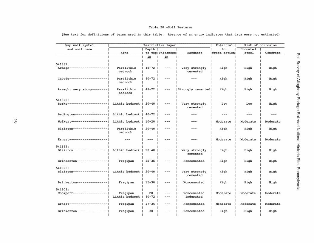
Soil S
urvey of Allegheny P
ortage Railroad N
ational Historic S
ite, Pennsylvania
261
Table 20.—Soil Features
(See text for definitions of terms used in this table. Absence of an entry indicates that data were not estimated)
________________________________________________________________________________________________________________________ Map unit symbol | Restrictive layer | Potential | Risk of corrosion _____________________________________________________ _________________________ and soil name | | Depth | | | for | Uncoated | | Kind | to top|Thickness| Hardness |frost action| steel | Concrete ________________________________________________________________________________________________________________________ | | In | In | | | | __ __ | | | | | | | 541887: | | | | | | | Armagh--------------------| Paralithic | 48-72 | --- | Very strongly | High | High | High | bedrock | | | cemented | | | | | | | | | | Cavode--------------------| Paralithic | 40-72 | --- | --- | High | High | High | bedrock | | | | | | | | | | | | | Armagh, very stony--------| Paralithic | 48-72 | --- |Strongly cemented| High | High | High | bedrock | | | | | | | | | | | | | 541890: | | | | | | | Berks---------------------| Lithic bedrock | 20-40 | --- | Very strongly | Low | Low | High | | | | cemented | | | | | | | | | | Bedington-----------------| Lithic bedrock | 40-72 | --- | --- | --- | --- | --- | | | | | | | Weikert-------------------| Lithic bedrock | 10-20 | --- | --- | Moderate | Moderate | Moderate | | | | | | | Blairton------------------| Paralithic | 20-40 | --- | --- | High | High | High | bedrock | | | | | | | | | | | | | Ernest--------------------| --- | --- | --- | --- | Moderate | Moderate | Moderate | | | | | | | 541892: | | | | | | | Blairton------------------| Lithic bedrock | 20-40 | --- | Very strongly | High | High | High | | | | cemented | | | | | | | | | | Brinkerton----------------| Fragipan | 15-35 | --- | Noncemented | High | High | High | | | | | | | 541893: | | | | | | | Blairton------------------| Lithic bedrock | 20-40 | --- | Very strongly | High | High | High | | | | cemented | | | | | | | | | | Brinkerton----------------| Fragipan | 15-30 | --- | Noncemented | High | High | High | | | | | | | 541903: | | | | | | | Cookport------------------| Fragipan | 28 | --- | Noncemented | Moderate | Moderate | Moderate | Lithic bedrock | 40-72 | --- | Indurated | | | | | | | | | | Ernest--------------------| Fragipan | 17-36 | --- | Noncemented | Moderate | Moderate | Moderate | | | | | | | Brinkerton----------------| Fragipan | 30 | --- | Noncemented | High | High | High | | | | | | |

Soil S
urvey of Allegheny P
ortage Railroad N
ational Historic S
ite, Pennsylvania
262
Table 20.—Soil Features—Continued________________________________________________________________________________________________________________________ Map unit symbol | Restrictive layer | Potential | Risk of corrosion _____________________________________________________ _________________________ and soil name | | Depth | | | for | Uncoated | | Kind | to top|Thickness| Hardness |frost action| steel | Concrete ________________________________________________________________________________________________________________________ | | In | In | | | | __ __ | | | | | | | 541906: | | | | | | | Cookport------------------| Fragipan | 21 | --- | Noncemented | Moderate | Moderate | Moderate | Lithic bedrock | 40-72 | --- | Indurated | | | | | | | | | | Ernest--------------------| Fragipan | 17-36 | --- | Noncemented | Moderate | Moderate | Moderate | | | | | | | Brinkerton----------------| Fragipan | 21 | --- | Noncemented | High | High | High | | | | | | | 541907: | | | | | | | Cookport------------------| Fragipan | 28 | --- | Noncemented | Moderate | Moderate | Moderate | Lithic bedrock | 40-72 | --- | Indurated | | | | | | | | | | Ernest--------------------| Fragipan | 17-36 | --- | Noncemented | Moderate | Moderate | Moderate | | | | | | | Brinkerton----------------| Fragipan | 21 | --- | Noncemented | High | High | High | | | | | | | 541908: | | | | | | | Dumps, industrial wastes. | | | | | | | | | | | | | | Wet spots-----------------| Fragipan | 15-30 | 12-36 | Noncemented | High | High | High | | | | | | | 541909: | | | | | | | Dumps, mine. | | | | | | | | | | | | | | Wet spots-----------------| Fragipan | 15-30 | 12-36 | Noncemented | High | High | Moderate | | | | | | | 541911: | | | | | | | Gilpin--------------------| Lithic bedrock | 20-40 | --- | Indurated | Moderate | Low | High | | | | | | | Wharton-------------------| Lithic bedrock | 40-40 | --- | --- | High | High | High | | | | | | | Clymer--------------------| Lithic bedrock | 40-40 | --- | --- | Moderate | Low | High | | | | | | | Cookport------------------| Lithic bedrock | 40-72 | --- | Indurated | Moderate | Moderate | Moderate | | | | | | | Tilsit--------------------| Lithic bedrock | 40-40 | --- | --- | None | High | High | | | | | | | 541914: | | | | | | | Gilpin--------------------| Lithic bedrock | 20-40 | --- | Very strongly | Moderate | Low | High | | | | cemented | | | | | | | | | | Rayne---------------------| Lithic bedrock | 40-72 | --- | Very strongly | Moderate | Low | High | | | | cemented | | | | | | | | | |

Soil S
urvey of Allegheny P
ortage Railroad N
ational Historic S
ite, Pennsylvania
263
Table 20.—Soil Features—Continued________________________________________________________________________________________________________________________ Map unit symbol | Restrictive layer | Potential | Risk of corrosion _____________________________________________________ _________________________ and soil name | | Depth | | | for | Uncoated | | Kind | to top|Thickness| Hardness |frost action| steel | Concrete ________________________________________________________________________________________________________________________ | | In | In | | | | __ __ | | | | | | | 541906: | | | | | | | Cookport------------------| Fragipan | 21 | --- | Noncemented | Moderate | Moderate | Moderate | Lithic bedrock | 40-72 | --- | Indurated | | | | | | | | | | Ernest--------------------| Fragipan | 17-36 | --- | Noncemented | Moderate | Moderate | Moderate | | | | | | | Brinkerton----------------| Fragipan | 21 | --- | Noncemented | High | High | High | | | | | | | 541907: | | | | | | | Cookport------------------| Fragipan | 28 | --- | Noncemented | Moderate | Moderate | Moderate | Lithic bedrock | 40-72 | --- | Indurated | | | | | | | | | | Ernest--------------------| Fragipan | 17-36 | --- | Noncemented | Moderate | Moderate | Moderate | | | | | | | Brinkerton----------------| Fragipan | 21 | --- | Noncemented | High | High | High | | | | | | | 541908: | | | | | | | Dumps, industrial wastes. | | | | | | | | | | | | | | Wet spots-----------------| Fragipan | 15-30 | 12-36 | Noncemented | High | High | High | | | | | | | 541909: | | | | | | | Dumps, mine. | | | | | | | | | | | | | | Wet spots-----------------| Fragipan | 15-30 | 12-36 | Noncemented | High | High | Moderate | | | | | | | 541911: | | | | | | | Gilpin--------------------| Lithic bedrock | 20-40 | --- | Indurated | Moderate | Low | High | | | | | | | Wharton-------------------| Lithic bedrock | 40-40 | --- | --- | High | High | High | | | | | | | Clymer--------------------| Lithic bedrock | 40-40 | --- | --- | Moderate | Low | High | | | | | | | Cookport------------------| Lithic bedrock | 40-72 | --- | Indurated | Moderate | Moderate | Moderate | | | | | | | Tilsit--------------------| Lithic bedrock | 40-40 | --- | --- | None | High | High | | | | | | | 541914: | | | | | | | Gilpin--------------------| Lithic bedrock | 20-40 | --- | Very strongly | Moderate | Low | High | | | | cemented | | | | | | | | | | Rayne---------------------| Lithic bedrock | 40-72 | --- | Very strongly | Moderate | Low | High | | | | cemented | | | | | | | | | |
Table 20.—Soil Features—Continued________________________________________________________________________________________________________________________ Map unit symbol | Restrictive layer | Potential | Risk of corrosion _____________________________________________________ _________________________ and soil name | | Depth | | | for | Uncoated | | Kind | to top|Thickness| Hardness |frost action| steel | Concrete ________________________________________________________________________________________________________________________ | | In | In | | | | __ __ | | | | | | | 541919: | | | | | | | Hazleton------------------| Lithic bedrock | 40-60 | --- | Indurated | Moderate | Low | High | | | | | | | Cookport------------------| Fragipan | 12-30 | --- | Noncemented | Moderate | Moderate | Moderate | Lithic bedrock | 40-60 | --- | Very strongly | | | | | | | cemented | | | | | | | | | | 541922: | | | | | | | Hazleton------------------| Lithic bedrock | 40-72 | --- | Very strongly | Moderate | Low | High | | | | cemented | | | | | | | | | | Clymer--------------------| Lithic bedrock | 40-60 | --- | Very strongly | Moderate | Low | High | | | | cemented | | | | | | | | | | Cookport------------------| Fragipan | 20-32 | 16-35 | Noncemented | Moderate | Moderate | High | Lithic bedrock | 51-79 | --- | Very strongly | | | | | | | cemented | | | | | | | | | | 541925: | | | | | | | Laidig--------------------| Fragipan | 30-50 | --- | Noncemented | Moderate | Moderate | High | | | | | | | 541938: | | | | | | | Bethesda, unstable fill---| --- | --- | --- | --- | Moderate | Moderate | High | | | | | | | Gilpin--------------------| Lithic bedrock | 20-40 | --- | Very strongly | Moderate | Low | High | | | | cemented | | | | | | | | | | Wharton-------------------| Lithic bedrock | 40-72 | --- | Very strongly | High | High | High | | | | cemented | | | | | | | | | | Wet spots-----------------| Fragipan | 18-35 | 20-35 | Noncemented | High | High | High | | | | | | | 541940: | | | | | | | Urban land. | | | | | | | | | | | | | | Udorthents----------------| --- | --- | --- | --- | Low | High | High | | | | | | | Wet spots-----------------| --- | --- | --- | --- | High | High | High | | | | | | | 541942. | | | | | | | Water | | | | | | | | | | | | | | 541943: | | | | | | | Wharton-------------------| Lithic bedrock | 40-70 | --- | Very strongly | High | High | High | | | | cemented | | | | | | | | | | Cavode--------------------| Lithic bedrock | 40-72 | --- | --- | High | High | High | | | | | | |
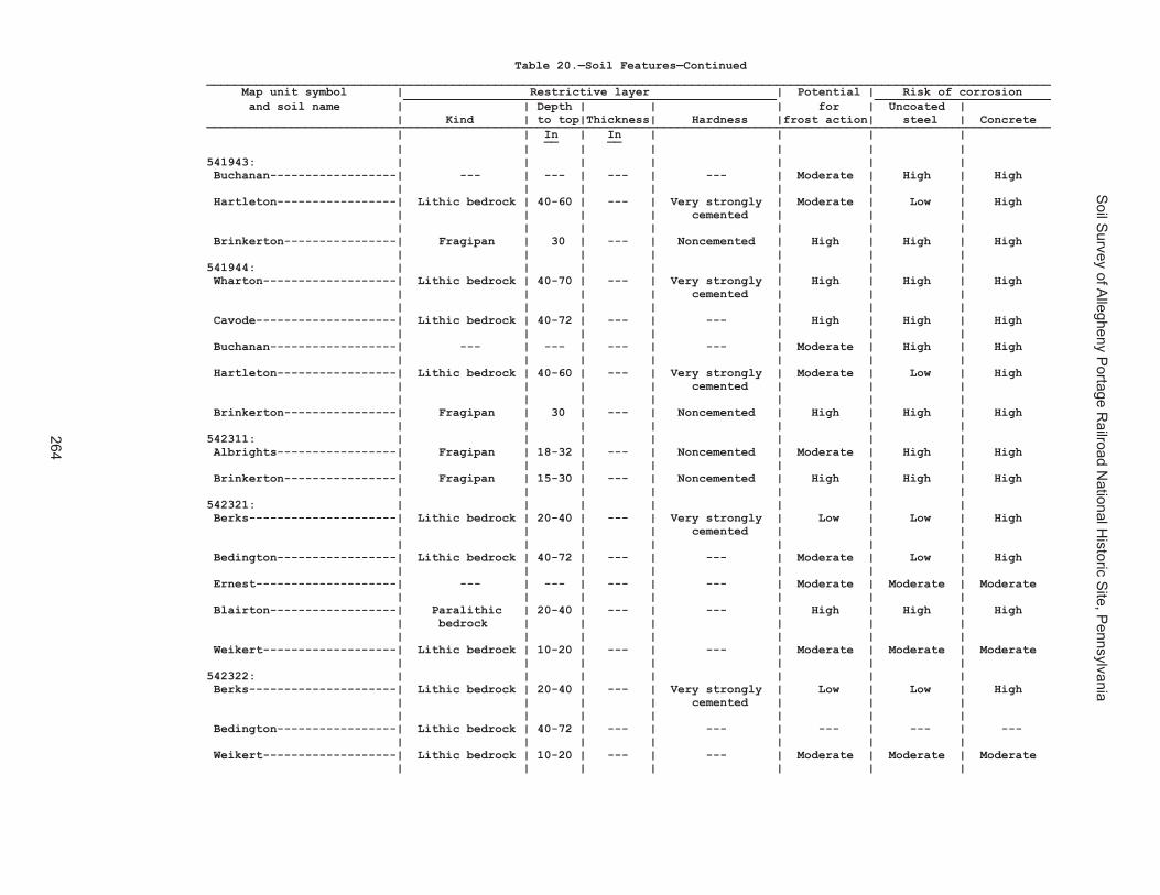
Soil S
urvey of Allegheny P
ortage Railroad N
ational Historic S
ite, Pennsylvania
264
Table 20.—Soil Features—Continued________________________________________________________________________________________________________________________ Map unit symbol | Restrictive layer | Potential | Risk of corrosion _____________________________________________________ _________________________ and soil name | | Depth | | | for | Uncoated | | Kind | to top|Thickness| Hardness |frost action| steel | Concrete ________________________________________________________________________________________________________________________ | | In | In | | | | __ __ | | | | | | | 541943: | | | | | | | Buchanan------------------| --- | --- | --- | --- | Moderate | High | High | | | | | | | Hartleton-----------------| Lithic bedrock | 40-60 | --- | Very strongly | Moderate | Low | High | | | | cemented | | | | | | | | | | Brinkerton----------------| Fragipan | 30 | --- | Noncemented | High | High | High | | | | | | | 541944: | | | | | | | Wharton-------------------| Lithic bedrock | 40-70 | --- | Very strongly | High | High | High | | | | cemented | | | | | | | | | | Cavode--------------------| Lithic bedrock | 40-72 | --- | --- | High | High | High | | | | | | | Buchanan------------------| --- | --- | --- | --- | Moderate | High | High | | | | | | | Hartleton-----------------| Lithic bedrock | 40-60 | --- | Very strongly | Moderate | Low | High | | | | cemented | | | | | | | | | | Brinkerton----------------| Fragipan | 30 | --- | Noncemented | High | High | High | | | | | | | 542311: | | | | | | | Albrights-----------------| Fragipan | 18-32 | --- | Noncemented | Moderate | High | High | | | | | | | Brinkerton----------------| Fragipan | 15-30 | --- | Noncemented | High | High | High | | | | | | | 542321: | | | | | | | Berks---------------------| Lithic bedrock | 20-40 | --- | Very strongly | Low | Low | High | | | | cemented | | | | | | | | | | Bedington-----------------| Lithic bedrock | 40-72 | --- | --- | Moderate | Low | High | | | | | | | Ernest--------------------| --- | --- | --- | --- | Moderate | Moderate | Moderate | | | | | | | Blairton------------------| Paralithic | 20-40 | --- | --- | High | High | High | bedrock | | | | | | | | | | | | | Weikert-------------------| Lithic bedrock | 10-20 | --- | --- | Moderate | Moderate | Moderate | | | | | | | 542322: | | | | | | | Berks---------------------| Lithic bedrock | 20-40 | --- | Very strongly | Low | Low | High | | | | cemented | | | | | | | | | | Bedington-----------------| Lithic bedrock | 40-72 | --- | --- | --- | --- | --- | | | | | | | Weikert-------------------| Lithic bedrock | 10-20 | --- | --- | Moderate | Moderate | Moderate | | | | | | |

Soil S
urvey of Allegheny P
ortage Railroad N
ational Historic S
ite, Pennsylvania
265
Table 20.—Soil Features—Continued________________________________________________________________________________________________________________________ Map unit symbol | Restrictive layer | Potential | Risk of corrosion _____________________________________________________ _________________________ and soil name | | Depth | | | for | Uncoated | | Kind | to top|Thickness| Hardness |frost action| steel | Concrete ________________________________________________________________________________________________________________________ | | In | In | | | | __ __ | | | | | | | 541943: | | | | | | | Buchanan------------------| --- | --- | --- | --- | Moderate | High | High | | | | | | | Hartleton-----------------| Lithic bedrock | 40-60 | --- | Very strongly | Moderate | Low | High | | | | cemented | | | | | | | | | | Brinkerton----------------| Fragipan | 30 | --- | Noncemented | High | High | High | | | | | | | 541944: | | | | | | | Wharton-------------------| Lithic bedrock | 40-70 | --- | Very strongly | High | High | High | | | | cemented | | | | | | | | | | Cavode--------------------| Lithic bedrock | 40-72 | --- | --- | High | High | High | | | | | | | Buchanan------------------| --- | --- | --- | --- | Moderate | High | High | | | | | | | Hartleton-----------------| Lithic bedrock | 40-60 | --- | Very strongly | Moderate | Low | High | | | | cemented | | | | | | | | | | Brinkerton----------------| Fragipan | 30 | --- | Noncemented | High | High | High | | | | | | | 542311: | | | | | | | Albrights-----------------| Fragipan | 18-32 | --- | Noncemented | Moderate | High | High | | | | | | | Brinkerton----------------| Fragipan | 15-30 | --- | Noncemented | High | High | High | | | | | | | 542321: | | | | | | | Berks---------------------| Lithic bedrock | 20-40 | --- | Very strongly | Low | Low | High | | | | cemented | | | | | | | | | | Bedington-----------------| Lithic bedrock | 40-72 | --- | --- | Moderate | Low | High | | | | | | | Ernest--------------------| --- | --- | --- | --- | Moderate | Moderate | Moderate | | | | | | | Blairton------------------| Paralithic | 20-40 | --- | --- | High | High | High | bedrock | | | | | | | | | | | | | Weikert-------------------| Lithic bedrock | 10-20 | --- | --- | Moderate | Moderate | Moderate | | | | | | | 542322: | | | | | | | Berks---------------------| Lithic bedrock | 20-40 | --- | Very strongly | Low | Low | High | | | | cemented | | | | | | | | | | Bedington-----------------| Lithic bedrock | 40-72 | --- | --- | --- | --- | --- | | | | | | | Weikert-------------------| Lithic bedrock | 10-20 | --- | --- | Moderate | Moderate | Moderate | | | | | | |
Table 20.—Soil Features—Continued________________________________________________________________________________________________________________________ Map unit symbol | Restrictive layer | Potential | Risk of corrosion _____________________________________________________ _________________________ and soil name | | Depth | | | for | Uncoated | | Kind | to top|Thickness| Hardness |frost action| steel | Concrete ________________________________________________________________________________________________________________________ | | In | In | | | | __ __ | | | | | | | 542322: | | | | | | | Blairton------------------| Paralithic | 20-40 | --- | --- | High | High | High | bedrock | | | | | | | | | | | | | Ernest--------------------| --- | --- | --- | --- | Moderate | Moderate | Moderate | | | | | | | 542323: | | | | | | | Berks---------------------| Lithic bedrock | 20-40 | --- | Very strongly | Low | Low | High | | | | cemented | | | | | | | | | | Bedington-----------------| Lithic bedrock | 40-72 | --- | --- | --- | --- | --- | | | | | | | Weikert-------------------| Lithic bedrock | 10-20 | --- | --- | Moderate | Moderate | Moderate | | | | | | | Blairton------------------| Paralithic | 20-40 | --- | --- | High | High | High | bedrock | | | | | | | | | | | | | Ernest--------------------| --- | --- | --- | --- | Moderate | Moderate | Moderate | | | | | | | 542324: | | | | | | | Berks---------------------| Lithic bedrock | 20-40 | --- | Very strongly | Low | Low | High | | | | cemented | | | | | | | | | | Weikert-------------------| Lithic bedrock | 10-20 | --- | Very strongly | Moderate | Moderate | Moderate | | | | cemented | | | | | | | | | | Ernest--------------------| Fragipan | 20-36 | 14-40 | Noncemented | Low | Moderate | Moderate | | | | | | | 542325: | | | | | | | Berks---------------------| Lithic bedrock | 20-40 | --- | Very strongly | Low | Low | High | | | | cemented | | | | | | | | | | Weikert-------------------| Lithic bedrock | 10-20 | --- | Very strongly | Moderate | Moderate | Moderate | | | | cemented | | | | | | | | | | Bedington-----------------| Lithic bedrock | 40-65 | --- | --- | Moderate | Low | High | | | | | | | Ernest--------------------| Fragipan | 20-36 | 14-40 | Noncemented | Moderate | Moderate | Moderate | | | | | | | 542326: | | | | | | | Berks---------------------| Lithic bedrock | 20-40 | --- | Very strongly | Low | Low | High | | | | cemented | | | | | | | | | | Weikert-------------------| Lithic bedrock | 10-20 | --- | Very strongly | Moderate | Moderate | Moderate | | | | cemented | | | | | | | | | |

Soil S
urvey of Allegheny P
ortage Railroad N
ational Historic S
ite, Pennsylvania
266
Table 20.—Soil Features—Continued________________________________________________________________________________________________________________________ Map unit symbol | Restrictive layer | Potential | Risk of corrosion _____________________________________________________ _________________________ and soil name | | Depth | | | for | Uncoated | | Kind | to top|Thickness| Hardness |frost action| steel | Concrete ________________________________________________________________________________________________________________________ | | In | In | | | | __ __ | | | | | | | 542326: | | | | | | | Bedington-----------------| Lithic bedrock | 40-65 | --- | --- | Moderate | Low | High | | | | | | | Brinkerton----------------| Fragipan | 15-30 | --- | Noncemented | High | High | High | | | | | | | 542329: | | | | | | | Brinkerton----------------| Fragipan | 15-34 | --- | Noncemented | High | High | High | | | | | | | Ernest--------------------| Fragipan | 20-36 | --- | Noncemented | Moderate | Moderate | Moderate | | | | | | | Berks---------------------| Paralithic | 20-40 | --- | --- | Low | Low | High | bedrock | | | | | | | | | | | | | Laidig--------------------| --- | --- | --- | --- | Moderate | Moderate | High | | | | | | | Atkins--------------------| Lithic bedrock | 60-99 | --- | Very strongly | High | High | Moderate | | | | cemented | | | | | | | | | | Philo---------------------| Lithic bedrock | 40-40 | --- | --- | Moderate | Low | High | | | | | | | 542330: | | | | | | | Brinkerton----------------| Fragipan | 15-36 | --- | Noncemented | High | High | High | | | | | | | Ernest--------------------| Fragipan | 20-36 | --- | Noncemented | Moderate | Moderate | Moderate | | | | | | | 542333: | | | | | | | Buchanan------------------| Fragipan | 20-36 | --- | Noncemented | Moderate | High | High | | | | | | | Andover-------------------| Fragipan | 18-28 | --- | Noncemented | High | High | High | | | | | | | Alluvial soils. | | | | | | | | | | | | | | Berks---------------------| Paralithic | 20-40 | --- | --- | Low | Low | High | bedrock | | | | | | | | | | | | | 542334: | | | | | | | Buchanan------------------| Fragipan | 20-36 | --- | Noncemented | Moderate | High | High | | | | | | | Hazleton------------------| Lithic bedrock | 40-40 | --- | Very strongly | Moderate | Low | High | | | | cemented | | | | | | | | | | Andover-------------------| Fragipan | 18-28 | --- | Noncemented | High | High | High | | | | | | | Alluvial soils. | | | | | | | | | | | | | |

Soil S
urvey of Allegheny P
ortage Railroad N
ational Historic S
ite, Pennsylvania
267
Table 20.—Soil Features—Continued________________________________________________________________________________________________________________________ Map unit symbol | Restrictive layer | Potential | Risk of corrosion _____________________________________________________ _________________________ and soil name | | Depth | | | for | Uncoated | | Kind | to top|Thickness| Hardness |frost action| steel | Concrete ________________________________________________________________________________________________________________________ | | In | In | | | | __ __ | | | | | | | 542326: | | | | | | | Bedington-----------------| Lithic bedrock | 40-65 | --- | --- | Moderate | Low | High | | | | | | | Brinkerton----------------| Fragipan | 15-30 | --- | Noncemented | High | High | High | | | | | | | 542329: | | | | | | | Brinkerton----------------| Fragipan | 15-34 | --- | Noncemented | High | High | High | | | | | | | Ernest--------------------| Fragipan | 20-36 | --- | Noncemented | Moderate | Moderate | Moderate | | | | | | | Berks---------------------| Paralithic | 20-40 | --- | --- | Low | Low | High | bedrock | | | | | | | | | | | | | Laidig--------------------| --- | --- | --- | --- | Moderate | Moderate | High | | | | | | | Atkins--------------------| Lithic bedrock | 60-99 | --- | Very strongly | High | High | Moderate | | | | cemented | | | | | | | | | | Philo---------------------| Lithic bedrock | 40-40 | --- | --- | Moderate | Low | High | | | | | | | 542330: | | | | | | | Brinkerton----------------| Fragipan | 15-36 | --- | Noncemented | High | High | High | | | | | | | Ernest--------------------| Fragipan | 20-36 | --- | Noncemented | Moderate | Moderate | Moderate | | | | | | | 542333: | | | | | | | Buchanan------------------| Fragipan | 20-36 | --- | Noncemented | Moderate | High | High | | | | | | | Andover-------------------| Fragipan | 18-28 | --- | Noncemented | High | High | High | | | | | | | Alluvial soils. | | | | | | | | | | | | | | Berks---------------------| Paralithic | 20-40 | --- | --- | Low | Low | High | bedrock | | | | | | | | | | | | | 542334: | | | | | | | Buchanan------------------| Fragipan | 20-36 | --- | Noncemented | Moderate | High | High | | | | | | | Hazleton------------------| Lithic bedrock | 40-40 | --- | Very strongly | Moderate | Low | High | | | | cemented | | | | | | | | | | Andover-------------------| Fragipan | 18-28 | --- | Noncemented | High | High | High | | | | | | | Alluvial soils. | | | | | | | | | | | | | |
Table 20.—Soil Features—Continued________________________________________________________________________________________________________________________ Map unit symbol | Restrictive layer | Potential | Risk of corrosion _____________________________________________________ _________________________ and soil name | | Depth | | | for | Uncoated | | Kind | to top|Thickness| Hardness |frost action| steel | Concrete ________________________________________________________________________________________________________________________ | | In | In | | | | __ __ | | | | | | | 542334: | | | | | | | Bedington-----------------| Lithic bedrock | 40-72 | --- | Very strongly | Moderate | Low | High | | | | cemented | | | | | | | | | | Berks---------------------| Paralithic | 20-40 | --- | --- | Low | Low | High | bedrock | | | | | | | | | | | | | Springs and seeps---------| --- | --- | --- | --- | High | High | High | | | | | | | 542338: | | | | | | | Clymer--------------------| Lithic bedrock | 40-60 | --- | Indurated | Moderate | Low | High | | | | | | | Hazleton------------------| Lithic bedrock | 40-80 | --- | --- | Moderate | Low | High | | | | | | | Cookport------------------| Lithic bedrock | 40-72 | --- | Indurated | Moderate | Moderate | Moderate | | | | | | | Unnamed soils. | | | | | | | | | | | | | | 542348: | | | | | | | Ernest--------------------| Fragipan | 20-36 | --- | Noncemented | Moderate | Moderate | Moderate | | | | | | | Berks---------------------| --- | --- | --- | --- | Moderate | Low | High | | | | | | | Brinkerton----------------| Fragipan | 15-34 | --- | Noncemented | High | High | High | | | | | | | Atkins--------------------| --- | --- | --- | --- | High | High | Moderate | | | | | | | 542349: | | | | | | | Ernest--------------------| Fragipan | 18-36 | --- | Noncemented | Moderate | Moderate | Moderate | | | | | | | Berks---------------------| Lithic bedrock | 20-40 | --- | --- | Low | Low | High | | | | | | | Brinkerton----------------| Fragipan | 15-34 | --- | Noncemented | High | High | High | | | | | | | Wharton-------------------| Lithic bedrock | 40-72 | --- | --- | High | High | High | | | | | | | Blairton------------------| Paralithic | 20-40 | --- | --- | High | High | High | bedrock | | | | | | | | | | | | | 542350: | | | | | | | Gilpin--------------------| Lithic bedrock | 20-40 | --- | Indurated | Moderate | Low | High | | | | | | | Wharton-------------------| Lithic bedrock | 40-72 | --- | Very strongly | High | High | High | | | | cemented | | | | | | | | | | Weikert-------------------| Lithic bedrock | 10-20 | --- | Very strongly | Moderate | Moderate | Moderate | | | | cemented | | | | | | | | | |

Soil S
urvey of Allegheny P
ortage Railroad N
ational Historic S
ite, Pennsylvania
268
Table 20.—Soil Features—Continued________________________________________________________________________________________________________________________ Map unit symbol | Restrictive layer | Potential | Risk of corrosion _____________________________________________________ _________________________ and soil name | | Depth | | | for | Uncoated | | Kind | to top|Thickness| Hardness |frost action| steel | Concrete ________________________________________________________________________________________________________________________ | | In | In | | | | __ __ | | | | | | | 542351: | | | | | | | Gilpin--------------------| Lithic bedrock | 20-40 | --- | Indurated | Moderate | Low | High | | | | | | | Wharton-------------------| Lithic bedrock | 40-72 | --- | Very strongly | High | High | High | | | | cemented | | | | | | | | | | Weikert-------------------| Lithic bedrock | 10-20 | --- | Very strongly | Moderate | Moderate | Moderate | | | | cemented | | | | | | | | | | 542352: | | | | | | | Gilpin--------------------| Lithic bedrock | 20-40 | --- | Indurated | Moderate | Low | High | | | | | | | Weikert-------------------| Lithic bedrock | 10-20 | --- | Very strongly | Moderate | Moderate | Moderate | | | | cemented | | | | | | | | | | Wharton-------------------| Lithic bedrock | 40-72 | --- | Very strongly | High | High | High | | | | cemented | | | | | | | | | | 542366: | | | | | | | Leck Kill-----------------| Lithic bedrock | 40-60 | --- | Indurated | Moderate | Low | Moderate | | | | | | | Meckesville---------------| --- | --- | --- | --- | Moderate | Moderate | High | | | | | | | 542370: | | | | | | | Laidig--------------------| Fragipan | 18-36 | --- | Noncemented | Moderate | Moderate | High | | | | | | | Buchanan------------------| --- | --- | --- | --- | Moderate | High | High | | | | | | | 542371: | | | | | | | Laidig--------------------| Fragipan | 30-50 | 10-50 | Noncemented | Moderate | Moderate | High | | | | | | | Buchanan------------------| --- | --- | --- | --- | Moderate | High | High | | | | | | | 542372: | | | | | | | Laidig--------------------| Fragipan | 18-36 | --- | Noncemented | Moderate | Moderate | High | | | | | | | Hazleton------------------| Lithic bedrock | 40-70 | --- | --- | Moderate | Low | High | | | | | | | 542375: | | | | | | | Leck Kill-----------------| Lithic bedrock | 40-80 | --- | Very strongly | Moderate | Low | Moderate | | | | cemented | | | | | | | | | | Calvin--------------------| Lithic bedrock | 20-40 | --- | --- | Moderate | Low | Moderate | | | | | | | Klinesville---------------| Lithic bedrock | 10-20 | --- |Strongly cemented| Moderate | Moderate | High | | | | | | | Meckesville---------------| --- | --- | --- | --- | Moderate | Moderate | High | | | | | | |

Soil S
urvey of Allegheny P
ortage Railroad N
ational Historic S
ite, Pennsylvania
269
Table 20.—Soil Features—Continued________________________________________________________________________________________________________________________ Map unit symbol | Restrictive layer | Potential | Risk of corrosion _____________________________________________________ _________________________ and soil name | | Depth | | | for | Uncoated | | Kind | to top|Thickness| Hardness |frost action| steel | Concrete ________________________________________________________________________________________________________________________ | | In | In | | | | __ __ | | | | | | | 542351: | | | | | | | Gilpin--------------------| Lithic bedrock | 20-40 | --- | Indurated | Moderate | Low | High | | | | | | | Wharton-------------------| Lithic bedrock | 40-72 | --- | Very strongly | High | High | High | | | | cemented | | | | | | | | | | Weikert-------------------| Lithic bedrock | 10-20 | --- | Very strongly | Moderate | Moderate | Moderate | | | | cemented | | | | | | | | | | 542352: | | | | | | | Gilpin--------------------| Lithic bedrock | 20-40 | --- | Indurated | Moderate | Low | High | | | | | | | Weikert-------------------| Lithic bedrock | 10-20 | --- | Very strongly | Moderate | Moderate | Moderate | | | | cemented | | | | | | | | | | Wharton-------------------| Lithic bedrock | 40-72 | --- | Very strongly | High | High | High | | | | cemented | | | | | | | | | | 542366: | | | | | | | Leck Kill-----------------| Lithic bedrock | 40-60 | --- | Indurated | Moderate | Low | Moderate | | | | | | | Meckesville---------------| --- | --- | --- | --- | Moderate | Moderate | High | | | | | | | 542370: | | | | | | | Laidig--------------------| Fragipan | 18-36 | --- | Noncemented | Moderate | Moderate | High | | | | | | | Buchanan------------------| --- | --- | --- | --- | Moderate | High | High | | | | | | | 542371: | | | | | | | Laidig--------------------| Fragipan | 30-50 | 10-50 | Noncemented | Moderate | Moderate | High | | | | | | | Buchanan------------------| --- | --- | --- | --- | Moderate | High | High | | | | | | | 542372: | | | | | | | Laidig--------------------| Fragipan | 18-36 | --- | Noncemented | Moderate | Moderate | High | | | | | | | Hazleton------------------| Lithic bedrock | 40-70 | --- | --- | Moderate | Low | High | | | | | | | 542375: | | | | | | | Leck Kill-----------------| Lithic bedrock | 40-80 | --- | Very strongly | Moderate | Low | Moderate | | | | cemented | | | | | | | | | | Calvin--------------------| Lithic bedrock | 20-40 | --- | --- | Moderate | Low | Moderate | | | | | | | Klinesville---------------| Lithic bedrock | 10-20 | --- |Strongly cemented| Moderate | Moderate | High | | | | | | | Meckesville---------------| --- | --- | --- | --- | Moderate | Moderate | High | | | | | | |
Table 20.—Soil Features—Continued________________________________________________________________________________________________________________________ Map unit symbol | Restrictive layer | Potential | Risk of corrosion _____________________________________________________ _________________________ and soil name | | Depth | | | for | Uncoated | | Kind | to top|Thickness| Hardness |frost action| steel | Concrete ________________________________________________________________________________________________________________________ | | In | In | | | | __ __ | | | | | | | 542383: | | | | | | | Meckesville---------------| Fragipan | 25-48 | --- | Noncemented | Moderate | Moderate | High | Lithic bedrock | 72-99 | | Very strongly | | | | | | | cemented | | | | | | | | | | Albrights-----------------| --- | --- | --- | --- | Moderate | High | High | | | | | | | 542384: | | | | | | | Meckesville---------------| Fragipan | 25-48 | --- | Noncemented | Moderate | Moderate | High | Lithic bedrock | 72-99 | | Very strongly | | | | | | | cemented | | | | | | | | | | Albrights-----------------| --- | --- | --- | --- | Moderate | High | High | | | | | | | 542406: | | | | | | | Tyler---------------------| Fragipan | 15-36 | --- | Noncemented | High | High | High | | | | | | | Monongahela---------------| --- | --- | --- | --- | Moderate | High | High | | | | | | | Purdy---------------------| Lithic bedrock | 60-99 | --- | Indurated | High | High | High | | | | | | | 542407: | | | | | | | Udifluvents---------------| --- | --- | --- | --- | Moderate | High | High | | | | | | | Dystrochrepts-------------| --- | --- | --- | --- | Moderate | High | High | | | | | | | Brinkerton----------------| Fragipan | 15-30 | --- | Noncemented | High | High | High | | | | | | | Holly---------------------| --- | --- | --- | --- | High | High | Moderate | | | | | | | 542410: | | | | | | | Urban land. | | | | | | | | | | | | | | Berks---------------------| Lithic bedrock | 20-40 | --- | Very strongly | Low | Low | High | | | | cemented | | | | | | | | | | Brinkerton----------------| Fragipan | 11-30 | --- | Noncemented | High | High | High | Lithic bedrock | 60-99 | | Very strongly | | | | | | | cemented | | | | | | | | | | Comly---------------------| Fragipan | 20-35 | --- | Noncemented | Moderate | High | Moderate | Lithic bedrock | 52-96 | | Very strongly | | | | | | | cemented | | | | | | | | | |

Soil S
urvey of Allegheny P
ortage Railroad N
ational Historic S
ite, Pennsylvania
270
Table 20.—Soil Features—Continued________________________________________________________________________________________________________________________ Map unit symbol | Restrictive layer | Potential | Risk of corrosion _____________________________________________________ _________________________ and soil name | | Depth | | | for | Uncoated | | Kind | to top|Thickness| Hardness |frost action| steel | Concrete ________________________________________________________________________________________________________________________ | | In | In | | | | __ __ | | | | | | | 542420: | | | | | | | Wharton-------------------| Lithic bedrock | 40-72 | --- | Very strongly | High | High | High | | | | cemented | | | | | | | | | | Gilpin--------------------| Lithic bedrock | 20-40 | --- | Indurated | Moderate | Low | High | | | | | | | Cavode--------------------| Lithic bedrock | 40-90 | --- | Very strongly | High | High | High | | | | cemented | | | | | | | | | | Ernest--------------------| Fragipan | 20-36 | 14-40 | Noncemented | Low | Moderate | Moderate | | | | | | | Brinkerton----------------| Fragipan | 15-30 | 12-36 | Noncemented | High | High | High | | | | | | | 542421: | | | | | | | Wharton-------------------| Lithic bedrock | 40-72 | --- | Very strongly | High | High | High | | | | cemented | | | | | | | | | | Gilpin--------------------| Lithic bedrock | 20-40 | --- | Indurated | Moderate | Low | High | | | | | | | Cavode--------------------| Lithic bedrock | 40-90 | --- | Very strongly | High | High | High | | | | cemented | | | | | | | | | | Ernest--------------------| Fragipan | 20-36 | 14-40 | Noncemented | Moderate | Moderate | Moderate | | | | | | | Brinkerton----------------| Fragipan | 15-30 | 12-36 | Noncemented | High | High | High | | | | | | | ________________________________________________________________________________________________________________________

Soil Survey of Allegheny Portage Railroad National Historic Site, Pennsylvania
271
Table 20.—Soil Features—Continued
________________________________________________________________________________________________________________________
Map unit symbol | Restrictive layer | Potential | Risk of corrosion
_____________________________________________________ _________________________
and soil name | | Depth | | | for | Uncoated |
| Kind | to top|Thickness| Hardness |frost action| steel | Concrete
________________________________________________________________________________________________________________________
| | In | In | | | |
__ __
| | | | | | |
542420: | | | | | | |
Wharton-------------------| Lithic bedrock | 40-72 | --- | Very strongly | High | High | High
| | | | cemented | | |
| | | | | | |
Gilpin--------------------| Lithic bedrock | 20-40 | --- | Indurated | Moderate | Low | High
| | | | | | |
Cavode--------------------| Lithic bedrock | 40-90 | --- | Very strongly | High | High | High
| | | | cemented | | |
| | | | | | |
Ernest--------------------| Fragipan | 20-36 | 14-40 | Noncemented | Low | Moderate | Moderate
| | | | | | |
Brinkerton----------------| Fragipan | 15-30 | 12-36 | Noncemented | High | High | High
| | | | | | |
542421: | | | | | | |
Wharton-------------------| Lithic bedrock | 40-72 | --- | Very strongly | High | High | High
| | | | cemented | | |
| | | | | | |
Gilpin--------------------| Lithic bedrock | 20-40 | --- | Indurated | Moderate | Low | High
| | | | | | |
Cavode--------------------| Lithic bedrock | 40-90 | --- | Very strongly | High | High | High
| | | | cemented | | |
| | | | | | |
Ernest--------------------| Fragipan | 20-36 | 14-40 | Noncemented | Moderate | Moderate | Moderate
| | | | | | |
Brinkerton----------------| Fragipan | 15-30 | 12-36 | Noncemented | High | High | High
| | | | | | |
________________________________________________________________________________________________________________________
Table 21.—Taxonomic Classification of the Soils______________________________________________________________________________________________________ | Soil name | Family or higher taxonomic class | ______________________________________________________________________________________________________ | Albrights-----------------|Fine-loamy, mixed, semiactive, mesic Aquic Fragiudalfs Andover-------------------|Fine-loamy, mixed, active, mesic Typic Fragiaquults Armagh--------------------|Clayey, mixed, active, mesic Typic Endoaquults Atkins--------------------|Fine-loamy, mixed, active, acid, mesic Fluvaquentic Endoaquepts Bedington-----------------|Fine-loamy, mixed, active Typic Hapludults Berks---------------------|Loamy-skeletal, mixed, active, mesic Typic Dystrudepts Bethesda------------------|Loamy-skeletal, mixed, active, acid, mesic Typic Udorthents Blairton------------------|Fine-loamy, mixed, active, mesic Aquic Hapludults Blairton taxadjunct-------|Fine-loamy, mixed, active, mesic Aquic Hapludults Brinkerton----------------|Fine-silty, mixed, superactive, mesic Typic Fragiaqualfs Buchanan------------------|Fine-loamy, mixed, semiactive, mesic Aquic Fragiudults Calvin--------------------|Loamy-skeletal, mixed, mesic Typic Dystrochrepts Cavode--------------------|Fine, mixed, active, mesic Aeric Endoaquults Clymer--------------------|Coarse-loamy, siliceous, active, mesic Typic Hapludults Comly---------------------|Fine-loamy, mixed, active, mesic Oxyaquic Fragiudalfs Cookport------------------|Fine-loamy, mixed, active, mesic Aquic Fragiudults Dystrochrepts-------------|Dystrochrepts Ernest--------------------|Fine-loamy, mixed, superactive, mesic Aquic Fragiudults Gilpin--------------------|Fine-loamy, mixed, active, mesic Typic Hapludults Hartleton-----------------|Loamy-skeletal, mixed, active, mesic Typic Hapludults Hazleton------------------|Loamy-skeletal, siliceous, active, mesic Typic Dystrudepts Holly---------------------|Fine-loamy, mixed, active, nonacid, mesic Fluvaquentic Endoaquepts Klinesville---------------|Loamy-skeletal, mixed, active, mesic Lithic Dystrochrepts Laidig--------------------|Fine-loamy, siliceous, active, mesic Typic Fragiudults Leck Kill-----------------|Fine-loamy, mixed, semiactive, mesic Typic Hapludults Meckesville---------------|Fine-loamy, mixed, active, mesic Typic Fragiudults Monongahela---------------|Fine-loamy, mixed, semiactive, mesic Typic Fragiudults Philo---------------------|Coarse-loamy, mixed, active, mesic Fluvaquentic Dystrudepts Purdy---------------------|Fine, mixed, active, mesic Typic Endoaquults Rayne---------------------|Fine-loamy, mixed, active, mesic Typic Hapludults Tilsit--------------------|Fine-silty, mixed, semiactive, mesic Typic Fragiudults Tyler---------------------|Fine-silty, mixed, active, mesic Aeric Fragiaquults Udifluvents---------------|Udifluvents Udorthents----------------|Udorthents Weikert-------------------|Loamy-skeletal, mixed, active, mesic Lithic Dystrudepts Wharton-------------------|Fine-loamy, mixed, active, mesic Aquic Hapludults | ______________________________________________________________________________________________________
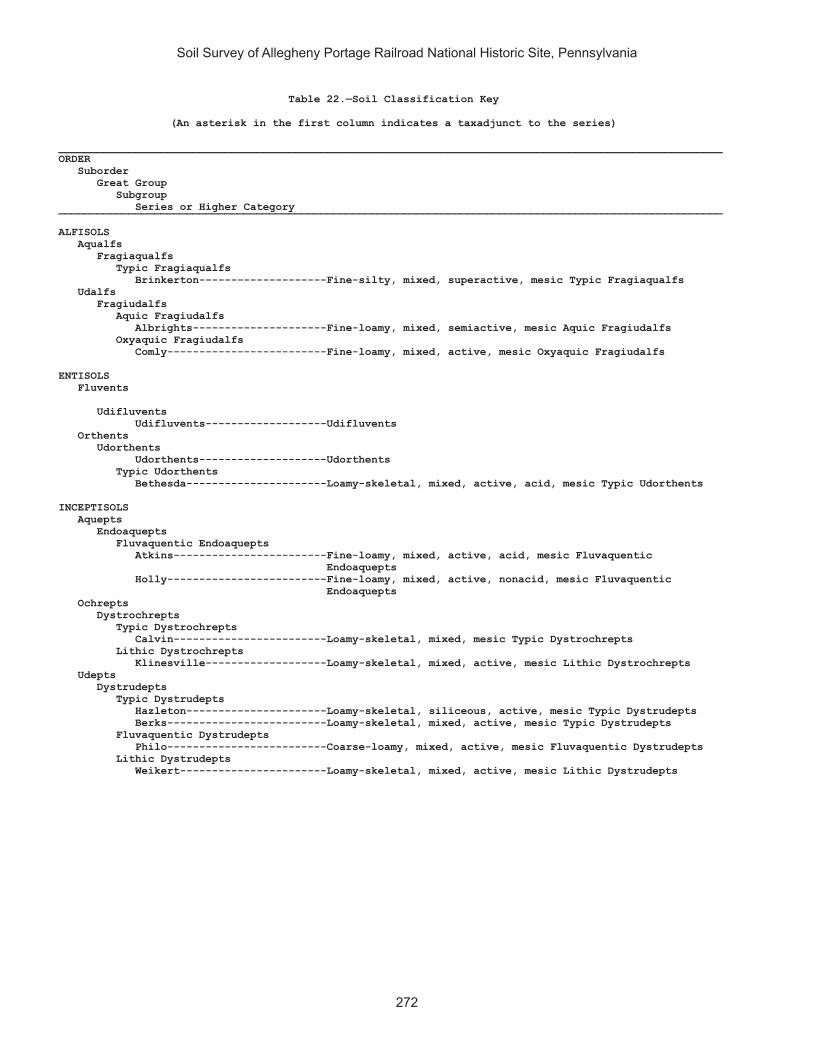
Soil Survey of Allegheny Portage Railroad National Historic Site, Pennsylvania
272
Table 22.—Soil Classification Key
(An asterisk in the first column indicates a taxadjunct to the series)
________________________________________________________________________________________________________ORDER Suborder Great Group Subgroup Series or Higher Category________________________________________________________________________________________________________ ALFISOLS Aqualfs Fragiaqualfs Typic Fragiaqualfs Brinkerton--------------------Fine-silty, mixed, superactive, mesic Typic Fragiaqualfs Udalfs Fragiudalfs Aquic Fragiudalfs Albrights---------------------Fine-loamy, mixed, semiactive, mesic Aquic Fragiudalfs Oxyaquic Fragiudalfs Comly-------------------------Fine-loamy, mixed, active, mesic Oxyaquic Fragiudalfs ENTISOLS Fluvents Udifluvents Udifluvents-------------------Udifluvents Orthents Udorthents Udorthents--------------------Udorthents Typic Udorthents Bethesda----------------------Loamy-skeletal, mixed, active, acid, mesic Typic Udorthents INCEPTISOLS Aquepts Endoaquepts Fluvaquentic Endoaquepts Atkins------------------------Fine-loamy, mixed, active, acid, mesic Fluvaquentic Endoaquepts Holly-------------------------Fine-loamy, mixed, active, nonacid, mesic Fluvaquentic Endoaquepts Ochrepts Dystrochrepts Typic Dystrochrepts Calvin------------------------Loamy-skeletal, mixed, mesic Typic Dystrochrepts Lithic Dystrochrepts Klinesville-------------------Loamy-skeletal, mixed, active, mesic Lithic Dystrochrepts Udepts Dystrudepts Typic Dystrudepts Hazleton----------------------Loamy-skeletal, siliceous, active, mesic Typic Dystrudepts Berks-------------------------Loamy-skeletal, mixed, active, mesic Typic Dystrudepts Fluvaquentic Dystrudepts Philo-------------------------Coarse-loamy, mixed, active, mesic Fluvaquentic Dystrudepts Lithic Dystrudepts Weikert-----------------------Loamy-skeletal, mixed, active, mesic Lithic Dystrudepts
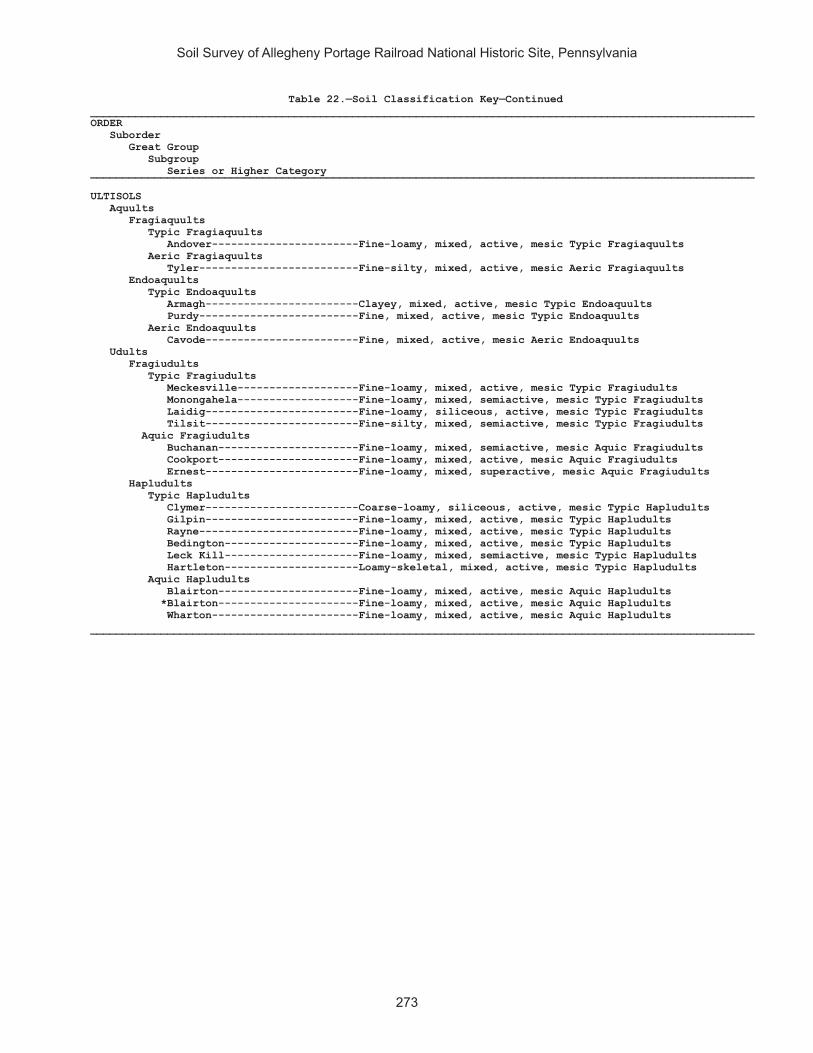
Soil Survey of Allegheny Portage Railroad National Historic Site, Pennsylvania
273
Table 22.—Soil Classification Key—Continued________________________________________________________________________________________________________ORDER Suborder Great Group Subgroup Series or Higher Category________________________________________________________________________________________________________ ULTISOLS Aquults Fragiaquults Typic Fragiaquults Andover-----------------------Fine-loamy, mixed, active, mesic Typic Fragiaquults Aeric Fragiaquults Tyler-------------------------Fine-silty, mixed, active, mesic Aeric Fragiaquults Endoaquults Typic Endoaquults Armagh------------------------Clayey, mixed, active, mesic Typic Endoaquults Purdy-------------------------Fine, mixed, active, mesic Typic Endoaquults Aeric Endoaquults Cavode------------------------Fine, mixed, active, mesic Aeric Endoaquults Udults Fragiudults Typic Fragiudults Meckesville-------------------Fine-loamy, mixed, active, mesic Typic Fragiudults Monongahela-------------------Fine-loamy, mixed, semiactive, mesic Typic Fragiudults Laidig------------------------Fine-loamy, siliceous, active, mesic Typic Fragiudults Tilsit------------------------Fine-silty, mixed, semiactive, mesic Typic Fragiudults Aquic Fragiudults Buchanan----------------------Fine-loamy, mixed, semiactive, mesic Aquic Fragiudults Cookport----------------------Fine-loamy, mixed, active, mesic Aquic Fragiudults Ernest------------------------Fine-loamy, mixed, superactive, mesic Aquic Fragiudults Hapludults Typic Hapludults Clymer------------------------Coarse-loamy, siliceous, active, mesic Typic Hapludults Gilpin------------------------Fine-loamy, mixed, active, mesic Typic Hapludults Rayne-------------------------Fine-loamy, mixed, active, mesic Typic Hapludults Bedington---------------------Fine-loamy, mixed, active, mesic Typic Hapludults Leck Kill---------------------Fine-loamy, mixed, semiactive, mesic Typic Hapludults Hartleton---------------------Loamy-skeletal, mixed, active, mesic Typic Hapludults Aquic Hapludults Blairton----------------------Fine-loamy, mixed, active, mesic Aquic Hapludults *Blairton----------------------Fine-loamy, mixed, active, mesic Aquic Hapludults Wharton-----------------------Fine-loamy, mixed, active, mesic Aquic Hapludults ________________________________________________________________________________________________________


The Natural Resources Conservation Service (NRCS) is committed to making itsinformation accessible to all of its customers and employees. If you are experiencingaccessibility issues and need assistance, please contact our Helpdesk by phone at1-800-457-3642 or by e-mail at [email protected]. For assistance withpublications that include maps, graphs, or similar forms of information, you may alsowish to contact our State or local office. You can locate the correct office and phonenumber at http://offices.sc.egov.usda.gov/locator/app.
NRCS Accessibility Statement


![Untitled-1 [] · Lyceum—Portage Ave., between Smith and Donald. Garrick—Garry St., north of Portage. Odeon—Smith St., north of Portage. Gaiety—Portage and Colony. Drive-In](https://img.pdfslide.us/doc/110x75/5f515bb9e5f918157102d3af/untitled-1-lyceumaportage-ave-between-smith-and-donald-garrickagarry.jpg)