Embed Size (px)
Citation preview

Published by Sida’s Regional Land Management Unit, 2000
TECHNICAL REPORT No. 23
SOILCONSERVATIONIN ERITREA
Some case studies
Amanuel NegassiBo TengnäsEstifanos BeinKifle Gebru


Soil Conservation in Eritrea

ii
RELMA Technical Report Series1. The Revival of Soil Conservation in Kenya. Carl Gösta Wenner�s Personal Notes 1974�81.
Edited by Arne Eriksson. 1992. ISBN 9966-896-00-72. The Wild Lake. By C.A. Gerden, G.M.O. Khawange, J.M. Mallya, J.P. Mbuya, R.C. Sanga.
1992. ISBN 9966-896-01-53. Miljöprofil Kenya (in Swedish). By Lill Lundgren. 1992. ISBN 9966-896-04-X4. Lake Babati, Tanzania, and Its Immediate Surroundings. Part I�Baseline Information. By
James Kahurananga. 1992. ISBN 9966-896-05-85. Lake Babati, Tanzania, and Its Immediate Surroundings. Part II�Management and Action
Plan. 1992. By James Kahurananga. 1992. ISBN 9966-896-06-66. The Catchment Approach to Soil Conservation in Kenya. By Yeraswarq Admassie. 1992.
ISBN 9966-896-08-27. Parks and People: Pastoralists and Wildlife. By Jones R. Kamugisha, Michael Ståhl. 1993.
ISBN 9966-896-09-08. Improving Livestock Production in Babati District, Tanzania. By Josef Jonsson, James
Kahurananga, Augustine Macha. 1993. ISBN 9966-896-10-49. Twenty Years of Soil Conservation in Eastern Africa. By Lill Lundgren. 1993. ISBN 9966-
896-12-010. Environmental Education: Experiences and Suggestions. By V. Lindhe, Miles Goldstick,
Stachys N. Muturi, Paul Rimmerfors. 1993. ISBN 9966-896-13-911. Management of Natural Resources aned Environment in Uganda: Policy and Legislation
Landmarks, 1890�1990. By Jones R. Kamugisha. 1993. ISBN 9966-896-17-112. The Hand of Man: Soil Conservation in Kondoa Eroded Area, Tanzania. By Carl Christiansson,
Alfred C. Mbegu, Anders Yrgard. 1993. ISBN 9966-896-18-X13. Changing Environments: Research on Man�Land Interrelations in Semi-Arid Tanzania. By
Carl Christiansson, Idris S. Kikula. 1996. ISBN 9966-896-25-214. Twenty Years of Soil Conservation in Ethiopia: A Personal Overview. By Berhe Wolde-Aregay.
1996. ISBN 9966-896-26-015. Zero Grazing, an Alternative System for Livestock Production in the Rehabilitated Areas of
Kondoa, Tanzania. By G. Tekie, A.P. Masaoa, C.M. Shayo, H.A. Ulotu, E.J.M. Shirima.1996. ISBN 9966-896-27-9
16. Land Husbandry Education in Agricultural Colleges of Eastern Africa: An Overview. ByTesfaye Abebe. 1997. ISBN 9966-896-28-7
17. Parks and People�Conservation and Livelihoods at the Crossroads: Four Case Histories. ByJ.R. Kamugisha, Z.A. Ogutu, M. Ståhl. 1997. ISBN 9966-896-29-5
18. Participatory Planning and Implementation: Experiences with Farmers from NyandaruaDistrict, Kenya, 1992�1995. By Christine Holding, Kiunga Kareko. 1997. ISBN 9966-896-30-9
19. Evolution of Provision of Tree Seed in Extension Programmes: Case Studies from Kenya andUganda. Edited by Christine Holding, William Omondi. 1998. ISBN 9966-896-34-1
20. Traditions and Innovation in Land Husbandry: Building on Local Knowledge in Kabale,Uganda. By Will Critchley, Dan Miiro, Jim Ellis-Jones, Stephen Briggs, Joy Tumuhairwe.1999. ISBN 9966-896-38-4
21. Application and Utilization of Agroforestry Extension Manuals Produced in Kenya. By StachysMuturi. 1999. ISBN 9966-896-41-4
22. We Work Together: Land Rehabilitation and Household Dynamics in Chepareria Division,West Pokot District, Kenya. Field team: William Makokha, Samwel Lonyakou, MonicahNyang and K. K. Kareko. Supported by: Christine Holding, Jesse T. Njoka and Aichi Kitalyi.1999. ISBN 9966-896-42-2
Technical Report No. 23

Soil Conservation in Eritrea
Some case studies
Amanuel NegassiBo Tengnäs
Estifanos BeinKifle Gebru
Regional Land Management Unit (RELMA)2000

iv
Published byThe Regional Land Management Unit, RELMA/SidaICRAF House, GigiriP.O. Box 63403Nairobi, Kenya
© 2000 Regional Land Management Unit (RELMA), SwedishInternational Development Cooperation Agency (Sida)
Editing, layout, typesetting and production: Caroline Agola, P.O. Box21582, Nairobi
Photographs: The authors
Editor of RELMA series of publications: Alex Oduor/RELMA
Cataloguing-in-publication dataNegassi A, Tengnäs B, Bein E, Gebru K. Soil conservation in Eritrea: some casestudies. 2000. RELMA Technical Report Series 23. Nairobi, Kenya: RegionalLand Management Unit (RELMA), Swedish International DevelopmentCooperation Agency (Sida). 84 p. + viii; includes bibliography.
ISBN 9966-896-43-0
The contents of this manual may be reproduced without special permission.However, acknowledgement of the source is requested. The photographers andartists concerned must be contacted for reproduction of illustrations.
The views expressed in the RELMA series of publications are those of theauthors and do not necessarily reflect the views of RELMA.
Printed by Colourprint Ltd., P.O. Box 44466, Nairobi

Foreword
Mismanagement of land resources emanating from successive colonialadministrations in Eritrea has brought about severe land degradation. Soil erosioninduced by rain is rampant in the central highlands, where the topography ismountainous and undulating with poor vegetation cover. There are insufficientdata on the exact extent of the soil erosion in the country; however, it is estimatedthat 15�35 tonnes per ha of soil are eroded annually. Because of this, soil fertilityis dwindling and agricultural productivity is similarly reduced.
In order to reverse this alarming situation, in the last seven years theGovernment of the State of Eritrea has made a concerted effort to mobilize thewhole community to participate in soil and water conservation and afforestationactivities. Under this programme, massive soil and water conservation terraces,both on farms and on degraded hillsides, have been constructed. On hillsideterraces, a variety of indigenous and exotic trees and shrubs have been planted,while on farm lands efforts are focused on trying to stabilize the physical structuresby planting multipurpose grasses. Local-level initiatives have also complementedthese efforts, especially in the area of soil and water conservation on individualfarms and the development of woodlots in homesteads and near villages.Considering the magnitude of the problem of land degradation, however, mucheffort is still required in order to rehabilitate the degraded landscape.
Experts from the Ministry of Agriculture and the Ministry of Land, Waterand Environment, with the assistance of the Regional Land Management Unit ofSida in Nairobi, Kenya, have prepared this report of some case studies conductedin different settings in the country. I would like to gratefully acknowledge theteam�s efforts in conducting the studies and also extend my gratitude to RELMAfor the invaluable support they gave in the preparation of this report. It is alsomy sincere hope that the users of the published report will help in the preparationof the planned soil and water conservation guidelines.
Mebrahtu IyassuDirector General, Land Resources and Crop Production Department
Ministry of AgricultureAsmara
v

vi
Contents
Foreword ................................................................................................................... v1. Introduction .......................................................................................................... 1
1.1 Land tenure in Eritrea ................................................................................. 11.2 Causes of soil degradation ........................................................................... 11.3 Physical and biological methods of soil conservation ................................ 31.4 Conservation activities in Eritrea ............................................................... 51.5 About this study ........................................................................................... 51.6 Overall impressions as a result of the study .............................................. 61.7 Conclusions from the workshop .................................................................. 7
2. Treatment of degraded hillsides ........................................................................ 82.1 The case of Tsehaflam .................................................................................. 82.2 Catchment treatment: the case of Aditeclai-Adighebru .......................... 122.3 Hillside closure: the case of Mt. Bizen ...................................................... 15
3. Intensively cultivated land (�ghedena�): the case of Emba-derho ................ 203.1 Introduction ................................................................................................ 203.2 Land tenure ................................................................................................ 203.3 Soil conservation ......................................................................................... 213.4 The �ghedena� .............................................................................................. 213.5 The ghedena in Emba-derho ..................................................................... 213.6 Cultural practices ....................................................................................... 22
4. Crop land for rainfed agriculture .................................................................... 244.1 The case of Abarisom village ..................................................................... 244.2 The case of Mekalasit village ..................................................................... 27
5. Villages and permanent settlements ............................................................... 295.1 The case of Afdeyu ..................................................................................... 295.2 Tree planting within villages: the case of Kitmewlie village .................. 32
6. Areas surrounding ponds and dams ............................................................... 366.1 The case of Lamza ...................................................................................... 366.2 The case of Adi-Absha ................................................................................ 406.3 Conflict between irrigation and grazing land: the case of Adi-Shumale
and Adi-Yakulu dam site ........................................................................... 44

7. River-bank stabilization ................................................................................. 467.1 The case of Haicota/Gash river bank ...................................................... 467.2 The case of Akordet /Barka river bank ................................................... 49
8. Roadside tree planting from Dbarwa to Adi-quala ...................................... 528.1 Introduction............................................................................................... 528.2 Species ....................................................................................................... 528.3 Management practice ............................................................................... 528.4 Constraints ................................................................................................ 538.5 Recommendations ..................................................................................... 53
9. Small-scale irrigation ...................................................................................... 549.1 The case of Alaa ........................................................................................ 549.2 The case of Tselima (Halhale) ................................................................. 589.3 The case of Mareba ................................................................................... 61
10. Large-scale spate irrigation: the case of Sheeb ............................................ 6510.1 Introduction ............................................................................................ 6510.2 Soils and topography .............................................................................. 6510.3 Crop production ...................................................................................... 6610.4 Detailed description of the system ......................................................... 6810.5 Constraints .............................................................................................. 7110.6 Recommendations on improvements to traditional spate irrigation .. 71
11. Pastoral land use: case study of Sawa .......................................................... 7211.1 Introduction ............................................................................................ 7211.2 Traditional control of grazing ................................................................ 7311.3 Agricultural expansion........................................................................... 7311.4 Other factors ........................................................................................... 7411.5 Impact on the pastoral production system ........................................... 7411.6 Areas of potential conflict over resources ............................................. 7511.7 Risks ......................................................................................................... 7511.8 Conclusion ............................................................................................... 7611.9 Recommendation..................................................................................... 76
Bibliography ........................................................................................................... 77
Appendices .............................................................................................................. 78Appendix I: �Skills required by an extension worker�:
summary from case studies ..................................................... 78Appendix II: Summary report of the workshop ........................................... 81
Soil Conservation in Eritrea: Case Studies
vii
Maps1. The main physical features of Eritrea ......................................................... viii2. The main agro-climatic zones of Eritrea ......................................................... 23. The main towns and villages of Eritrea .......................................................... 4

viii
Map
1. T
he m
ain
phy
sica
l fea
ture
s of
Eri
trea
Technical Report No. 23

1
Soil Conservation in Eritrea: Case Studies
1. INTRODUCTION
The Ministry of Agriculture of Eritrea and the Regional Land Management Unit(RELMA) agreed to produce a manual on soil and water conservation in Eritreawith financial and technical support from Sida. To ensure that the manual wouldbe relevant to Eritrean conditions, it was agreed that the first step should be abrief review of actual field experience in Eritrea. The findings from this revieware presented here in the form of a number of case studies from areas representingdifferent agro-ecological conditions in the country. The findings were discussedat a workshop held in Asmara on 14 October 1998.
At the end of each case report there is a box headed �skills required�. This is alist of the skills that an extension worker in each of the areas would need in orderto effectively deal with the issues, constraints and potentials noted as being relevantto that area. A summary of all these skills is presented in Appendix I.
1.1 Land tenure in Eritrea
Land tenure in Eritrea has been much influenced by a system known as �dessa�.The main characteristic of the dessa system is that all land within the designatedarea of a village is conceived of as being the common property of the community.Thus, every permanent member of the village is entitled to a share of village landthrough periodical redistribution every 5�7 years. Each villager�s land share isequal in size and fertility; that means every person receives as much of the fertileas of the poor land. This process of distribution of land is carried out by the drawingof lots, referred to as �echa�. This system provides equitable access to land for allmembers of the village. From the land-improvement point of view, however, thesystem has the following disadvantages:● A rotation period of 5�7 years is too short for people to have the incentive to
make long-term investments in improving the land, such as tree planting,digging water wells, making water canals and soil-conservation structures, etc.
● Crop land is open to communal grazing in the post-harvest season, which resultsin the removal of crop residues that could provide ground cover against winderosion and additional organic matter for the soil
● Such land cannot be used as security to obtain credit.
When implemented, recent legislation is likely to bring changes to this tenuresystem.
1.2 Causes of soil degradation
Indiscriminate removal of the land cover over hundreds of years has resulted inserious soil erosion, decline of soil fertility, general land degradation and reductionof agricultural productivity in the highlands of Eritrea.

2
Technical Report No. 23
Map
2. T
he m
ain
agro
-clim
atic
zon
es o
f Eri
trea

3
Soil Conservation in Eritrea: Case Studies
Soil erosion implies the physical removal of topsoil by various agents, includingraindrops, water flowing over and through the soil, wind and gravitational forces.It is a two-phase process consisting of the detachment of individual particles fromthe soil mass followed by transport by erosive agents. This process leads to ageneral decline in soil productivity and, if unchecked, soil erosion can lead tocatastrophic effects for human existence (Morgan 1991).
From time to time it has, however, also been argued that much of theagricultural development in the world has been linked to erosion in highlandareas and development of agriculture in the lowlands. An example sometimescited is the Mediterranean area of Europe. There, the mountainous areas wereonce more productive than nowadays. At present, the lowlands, where much ofthe silt from the highlands has been deposited, are the main agricultural areas.
1.3 Physical and biological methods of soil conservation
Physical soil-conservation measures are generally engineering works. They involveconstruction of physical earthworks such as terraces, contour bunds, checkdams,etc. These structures intercept and slow down runoff water, which then preventsboth sheet and rill erosion and conserves water. The intercepted water soaks intothe soil or, if excessive, is channelled into drainage structures off the farm. InMakel, Debub and part of Anseba Zones soil bunds, stone bunds and benchterraces are commonly constructed. In upper catchment areas, hillside terracesand half-moon-shaped micro-basins are also constructed.
Trees and shrubs stabilize conservation structures and contribute to productiveuse of the land they occupy. Grasses can also be effective in reducing soil erosion.
Figure 1: An area once thickly covered with dense forest.

4
Technical Report No. 23
Map
3. T
he m
ain
tow
ns a
nd v
illag
es o
f Eri
trea

5
Soil Conservation in Eritrea: Case Studies
Methods using both trees and shrubs and grasses have recently received increasingattention in many African countries as cost-effective methods of combating landdegradation.
However, in Eritrea few biological conservation measures have beenimplemented in the course of soil and water conservation activities in crop landscompared to those interventions based on physical conservation structures.
1.4 Conservation activities in Eritrea
Afforestation before independenceBetween 1922 and 1932 some 1.2 million seedlings were planted in Eritrea. Onlylimited information is available on the extent of afforestation activities carriedout in the country from that time up to the early 1970s. The colonial administrationin Ethiopia planted trees on 1,586 hectares of land in Makel and Debub Zonesfrom 1971 to 1978. Between 1979 and 1991, it is estimated that 27,000 hectareswere terraced and planted with Eucalyptus cladocalyx, Eucalyptus camaldulensisand Eucalyptus globulus. These activities were carried out through the food-for-work programmes in which assistance was obtained from the EEC and WFP, buttheir success was minimal because of neglect and mismanagement. In addition,the Eritrean People�s Liberation Front (EPLF) mobilized farmers during the warthrough self-help programmes and about 900 hectares of land in the liberatedareas were planted with trees.
Activities after independenceAfter independence, a series of painstaking soil conservation activities has beencarried out on degraded catchments, including crop lands, by mobilizing localcommunities. Hillside terraces have been constructed on uncultivated land, andtrees and shrubs have been planted to conserve soil and water and to producefuelwood and construction poles.
On cultivated land, bench terraces, soil bunds and stone bunds have beenconstructed. Checkdams have been constructed along waterways to reducesiltation and runoff, and in the lower part of watersheds gullies have been treated.
1.5 About this study
This study was carried out by a team comprising an agro-ecologist, a soilconservationist and an agroforester. Initially, different typical �settings� wereidentified as representative sites for different land uses in the country. Theserepresentative settings and expected examples of issues to be considered were:
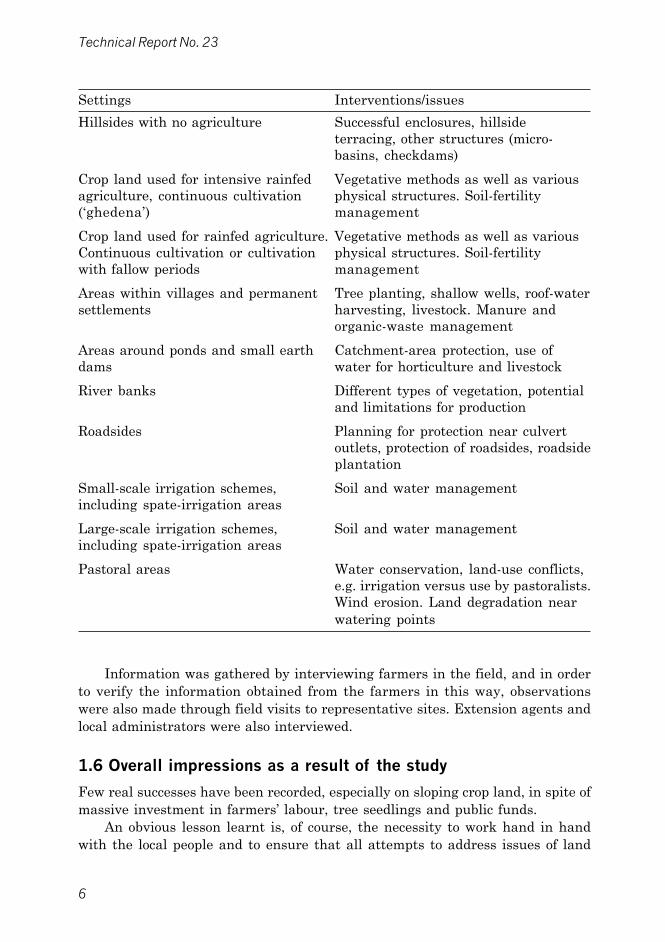
6
Technical Report No. 23
Settings Interventions/issues
Hillsides with no agriculture Successful enclosures, hillsideterracing, other structures (micro-basins, checkdams)
Crop land used for intensive rainfed Vegetative methods as well as variousagriculture, continuous cultivation physical structures. Soil-fertility(�ghedena�) management
Crop land used for rainfed agriculture. Vegetative methods as well as variousContinuous cultivation or cultivation physical structures. Soil-fertilitywith fallow periods management
Areas within villages and permanent Tree planting, shallow wells, roof-watersettlements harvesting, livestock. Manure and
organic-waste management
Areas around ponds and small earth Catchment-area protection, use ofdams water for horticulture and livestock
River banks Different types of vegetation, potentialand limitations for production
Roadsides Planning for protection near culvertoutlets, protection of roadsides, roadsideplantation
Small-scale irrigation schemes, Soil and water managementincluding spate-irrigation areas
Large-scale irrigation schemes, Soil and water managementincluding spate-irrigation areas
Pastoral areas Water conservation, land-use conflicts,e.g. irrigation versus use by pastoralists.Wind erosion. Land degradation nearwatering points
Information was gathered by interviewing farmers in the field, and in orderto verify the information obtained from the farmers in this way, observationswere also made through field visits to representative sites. Extension agents andlocal administrators were also interviewed.
1.6 Overall impressions as a result of the study
Few real successes have been recorded, especially on sloping crop land, in spite ofmassive investment in farmers� labour, tree seedlings and public funds.
An obvious lesson learnt is, of course, the necessity to work hand in handwith the local people and to ensure that all attempts to address issues of land

7
Soil Conservation in Eritrea: Case Studies
degradation take local knowledge into account. Following on from this rathergeneral and sweeping statement, it is important to note that farmers are, at leastto some extent, managers of soil erosion, not only spectators. The case studies inthis report demonstrate how soil lost from sloping land is used by farmers whereverit is deposited. At the farm level, soil and nutrients �lost� from the village orhomestead are used in the intensively managed ghedena fields. This observationmay call for a reconsideration of the concept of loss of soil and nutrients. At leastas far as ghedena is concerned, and the important production from that type offarm land, it is certainly not a loss but a fundamental asset!
At the landscape level, soil and nutrients lost in the highlands are utilizedalong the river banks where sediments accumulate by siltation. The use of suchriverine areas results in land-use conflicts, for example between commercialinvestors in horticultural production, pastoralists and people interested inconservation of the riverine vegetation.
At the national or macro level, soil lost in the Eritrean highlands and notdeposited in the highland valleys is brought down the escarpments during peakflows to be utilized in the spate-irrigation areas in the lowlands.
The techniques involved in managing such deposited soil are well describedin several case reports.
1.7 Conclusions from the workshopAs mentioned earlier, the findings of the survey were discussed during a workshop.Most participants were agricultural officers from within the Ministry of Agriculture(see Appendix II).
The discussions focused on deciding the most important areas to be highlightedin a manual for soil and water conservation for Eritrea. A long list of �skills required�for an extension worker was developed, and workshop participants were asked toconsider the priority subject areas in this list that in their opinion should be coveredin such a manual (see Appendix I). Most of the points in the list were judgedrelevant.
In order to shorten the list, each workshop participant was asked to indicatethe subject areas and agro-ecological settings that most deserve attention. Theresults were as follows.
Most important subject areas● Physical and biological soil conservation● Irrigation technology● Dam construction and/or maintenance● Soil fertility● Extension communication● Agroforestry.

8
Technical Report No. 23
Greater focus on land-use situations● Catchment areas for dams● Rainfed cultivated land● Small-scale irrigation● Hillsides● Spate irrigation.
No/less focus on● Pastoral areas● Roadsides● Ghedena.
A summary of the way the deliberations were conducted at the workshop isgiven in Appendix II.
2. TREATMENT OF DEGRADED HILLSIDES
2.1 The case of Tsehaflam
IntroductionTsehaflam is in Makel Zone, Serejeka Subzone, 20 km north of Asmara along themain Asmara�Keren road. Some 970 people live in Tsehaflam and their mainactivity is agriculture.
The area has a temperate climate as it is in the Central Highlands at analtitude of 2,250 m. The annual rainfall recorded at the nearest meteorologicalstations of Afdeyu and Asmara varies between 400 and 600 mm. Lithosols andreddish brown Cambisols are the most common soils in the area. The naturalvegetation cover and the soils are severely degraded as a result of centuries ofintensive land use, and only a few plant species are still common. Some of theseare Rumex nervosa, Aloe abyssinica, Cynodon dactylon, Echinops giganteus(dander) and Polygonum salicifolium.
It is estimated that soil is lost at the rate of 15�35 tonnes/ha/year in areaswhere there are no soil-conservation measures. This is due to the nature of therainfall, the fragility of the soils, poor vegetation cover and the slope, which rangesfrom 15% to 40%. The Tsehaflam catchment drains into the Tokor, a tributary ofthe Anseba seasonal river.
Afforestation and soil conservationIn order to rehabilitate the degraded catchment, the Tsehaflam community startedplanting trees and terracing the hillsides. Areas selected for tree planting arethose which are not suitable for agriculture. In the upper part of the catchment,

9
Soil Conservation in Eritrea: Case Studies
a small area was planted during the Ethiopian colonial period. However, afterliberation, larger parts of the catchment have been treated and planted with avariety of exotic and indigenous trees and shrubs.
Table 1: Areas treated and afforested, 1994�1997
Year Area (ha) No. of trees Species Numberplanted
1994 22 43,240 Acacia abyssinica 2,500Acacia saligna 23,240Eucalyptus cladocalyx 16,500Olea africana 1,000
1995 27 54,540 Acacia saligna 1,600Eucalyptus camaldulensis 22,150Eucalyptus globulus 25,590Olea africana 500Schinus molle 4,700
1996 11 22,000 Acacia saligna 3,000Eucalyptus cladocalyx 15,500Eucalyptus globulus 3,500
1997 4 7,915 Acacia mollissima 500Acacia saligna 1,000Eucalyptus cladocalyx 4,650Eucalyptus globulus 1,500Schinus molle 265
Total 64 127,695
Figure 2: Tokor afforestation site�planted in 1994.

10
Technical Report No. 23
In the treated area, narrow trenches, commonly called �gradoni�, areconstructed across the hillside and on the contours. The purpose of the terracingis to reduce runoff, increase infiltration and conserve soil.
Before terrace construction starts, a contour line is marked using a line level.The width of the terrace is 1 m. In areas where stones are available, a riser isconstructed with stones and soil filled up behind the riser. If stones are notavailable, the whole terrace is made of soil dug from the contour line. The verticalinterval between the terraces is 1 m, but the horizontal interval varies dependingon the steepness of the slope. This means that in the upper part of the catchment,where slopes are steep, the horizontal distance between the terraces is small, andin the lower part of the catchment, where the slopes are more gentle, the horizontaldistance between the terraces is greater.
Channels are formed when soil is excavated for the terrace. Ridges are left ina channel to prevent water from travelling too far horizontally and to reducedamage if water should overflow the channel during heavy rain. However, sincethe ridges are lower than the sides of the channel, water can spill over to othersections of the channel if one section becomes full.
Pits for planting seedlings are dug every 2.0�2.5 m. Theoretically, thedimensions of each planting pit should be 0.5 x 0.5 x 0.5 m, but it can be less thanthis if the site is difficult to dig.
The survival is very good (about 80%) and the success of this plantation is aresult of:● Good preparation of terraces which harvest sufficient water for plant growth
and survival even during the long dry season● The use of healthy and mature seedlings
Figure 3: Tokor afforestation and soil-conservation site whileconservation work was being carried out.

11
Soil Conservation in Eritrea: Case Studies
● Careful handling, transporting and planting of the seedlings● Planting at the right time (early rainy season)● Seedling and site matching● Care after planting, i.e. protection from livestock, weeding, cultivation, etc.
Checkdams have been built in the waterway of the catchment area. Acheckdam is a stone wall built across a natural or artificial waterway, or in thebottom of a gully, to reduce the speed of runoff. None of the checkdams in thiscatchment area have spillways in the middle to allow runoff; neither are thereaprons on the lower side of the checkdams.
ConstraintsAlthough some progress has been made in this area, there are still someshortcomings:● Some hillside terraces do not follow the contour● Eucalyptus globulus and E. camaldulensis are planted on hillsides, while they
prefer valley bottoms and deep soils● Checkdams do not have spillways in the middle, or aprons● Seedlings are planted in subsoil since the topsoil is excavated to make the terrace
risers● A vertical interval of only 1 m between two consecutive terraces results in much
of the soil being disturbed by digging● The cost of terrace construction is more than 10,000 Nakfa (approximately
equivalent to $US 1,330 at the time of the workshop) per hectare, which is toohigh to be cost effective.
RecommendationsIn order to rehabilitate the highly degraded sites in Tsehaflam village, the followingrecommendations are made:● All hillside terraces should follow the contour so that water can be properly
accumulated for the survival and growth of seedlings● The species should be appropriate to the site, and thus planting Eucalyptus
globulus and E. camaldulensis should be avoided. Instead, other indigenousspecies like Juniperus procera and Olea africana should be mixed with exoticspecies well suited to hillsides, e.g. Eucalyptus cladocalyx and Acacia saligna
● Checkdams should be properly designed, including spillways, aprons, etc.● The topsoil must be collected on one side during excavation, and after the terrace
has been constructed, returned to the pits where the seedlings are to be planted● Terrace spacing should be variable in order to leave more undisturbed space
between consecutive terraces and allow the natural vegetation to regenerate.These vertical intervals could be 2 m, 4 m, 6 m, etc., depending on the remnantnatural vegetation in the vicinity
● Other cost-effective structures like crescent-shaped micro-basins must beincorporated with hillside terraces, especially on gentle slopes.

12
Technical Report No. 23
SKILLS REQUIRED
● Layout of contours.
● Terrace construction.
● The ability to make decisions on appropriate spacing betweenterraces using a vertical interval that is decided according tosoils, vegetation and steepness of slope.
● Construction of checkdams.
● Understanding the importance of topsoil as opposed to subsoiland applying that knowledge practically.
● Knowing the ecological requirements of the most common treespecies.
2.2 Catchment treatment: the case of Aditeclai-Adighebru
IntroductionAditeclai and Adighebru are two adjacent villages in the western part of MakelZone, Berik Subzone, and have a joint local administration. The population ofeach is more or less similar at 300 and 362 households, respectively. The area ispart of the western escarpment of Aditeclai and Adighebru catchment at theperiphery of the moist highlands with a mean annual rainfall of about 500 mm.The elevation is 1,900�2,000 m and the soils are very shallow�mainly Lithosolson steep slopes and Cambisols on the gentle undulating upper slopes. Acaciaetbaica and Euphorbia abyssinica are the dominant species in the naturalvegetation.
Figure 4: Catchment treatment, Aditeclai�Adighebru.

13
Soil Conservation in Eritrea: Case Studies
Soil and water conservation and afforestationAn earth dam was constructed in the valley between the two villages in 1985.The capacity of the dam is estimated at 53,000 m3. The total catchment area isabout 500 ha. Since the catchment area of the dam was not protected, and becauseof some technical faults during construction, it immediately collapsed at the middleof the crest. In view of the need for water both for livestock and small-scale irrigationin the area, the dam was reconstructed in 1996. In order to reduce runoff, erosionand sedimentation, various soil conservation measures were undertaken and avariety of trees and shrubs planted. On the lower side of the dam, the inhabitantsof the two villages have started small-scale irrigated farming to produce vegetableson 8 hectares of land, an initiative that seems very promising.
Upstream, hillside terraces and half-moon-shaped micro-basins have beenconstructed and checkdams in the natural waterways. The hillside terraces arespaced at a vertical interval of 1 m. The micro-basins are eye-brow shaped andsited in a staggered way along the contour to provide small basins to collect waterthat can be utilized by the tree seedlings. The width of each basin is 3 m and theriser height depends on the steepness of the slope. The spacing between consecutivebasins is also 3 m and, therefore, there are 800�900 basins in one hectare.
On the upper periphery of the catchment there is farm land which iscontinuously cultivated. In these areas, on-farm soil conservation structures,mainly fanya juu and fanya chini, have been made. There the slope is less than20%. Fanya juu terraces are made by digging a trench and throwing the soiluphill to form an embankment.
Below the dam site, similar soil conservation structures are being made bythe inhabitants of Aditeclai through a cash-for-work programme in order torehabilitate the degraded watershed.
The catchment area above the dam is well conserved and planted with variousEucalyptus and Acacia species. In the upper part, the majority of the trees areeucalyptus, but there are more Acacia saligna in the lower part. The survivalrate of the planted seedlings is variable. In the upper part of the catchment,including the valley bottoms, the survival is good, i.e. more than 70%. However,in the lower part of the catchment, where the soil is very shallow and stony,survival is less than 40%. Natural vegetation such as Acacia etbaica, Dodonaeaangustifolia, Becium grandiflorum, Aloe abyssinica, Euphorbia abyssinica,Meriandra bengalensis, and grass species such as Cynodon dactylon and �lahu�(Hyparrhenia sp.) are, however, regenerating well.
Management of the plantationThe plantation in this catchment is managed by the respective communities. Twoguards, one from each village, are assigned to protect the plantation fromencroachment. These two guards are each paid 300 Nakfa per month by theMinistry of Agriculture. If livestock are found grazing on the protected area, theowner must pay 5 Nakfa for each small ruminant (sheep and goats) while thefine for cattle, donkeys and the like is 10 Nakfa.

14
Technical Report No. 23
Currently, the villagers benefit from grasses growing in the catchment area.Since 1996, all inhabitants of the community who own livestock have been allowedto cut grass for 3�4 days during May every year. The actual dates when grasscan be cut are announced by the village administration. The grass is cut duringthe dry season because by this time of the year the grazing has been used up andthis protected area is the only source of feed other than hay collected during cropharvest. At this stage, the grass may not be as nutritious as when green, but it isa good practice from the soil-conservation point of view as the grass seeds aredispersed before harvest and thus they immediately germinate at the beginningof the next rains.
ConstraintsThe following constraints to management of the catchment in this study areawere noted:● Community commitment to protecting the plantation site from livestock is poor● In some parts of the catchment, the terraces are not properly constructed and
thus they do not prevent soil erosion or catch enough water for the seedlings towithstand the long dry season
● Maintenance of soil conservation structures is seldom carried out as the peopletend to expect cash payment even for maintaining existing structures
● The species planted in the catchment area are mainly Eucalyptus cladocalyxand Acacia saligna which are not multipurpose species that would also be usefulfor fruit and fodder
● Inadequate design of spillways on the checkdams, as well of hillside terraces,results in frequent damage to these structures.
Recommendations● On such sites it is important to have a combination of micro-basin and hillside
terraces in order to minimize the cost of establishment and to encourageregeneration of the natural vegetation between the conservation structures.
● Closing some parts of the catchment is recommended to encourage regenerationof the natural vegetation and to minimize the cost of rehabilitation.
● The cut-and-carry system should be given more attention by the community.Therefore, a large area should be closed on both sides of the stream in the lowerpart of the catchment. This would enhance the rejuvenation of the remnantnatural vegetation, maintain biodiversity, reduce land degradation and increaselivestock production. Under this system, favoured grasses could also be sown toimprove the quality and quantity of pastures.
● Proper maintenance of the conservation structures should be carried outvoluntarily by the people themselves as this would benefit the entire community.
● Appropriate forage production should be initiated to increase fodder for livestock.● To improve the survival of seedlings on site, the quality of the seedlings in the
respective nurseries should be improved.

15
Soil Conservation in Eritrea: Case Studies
● Spot weeding and cultivation around the planted seedlings could enhancegrowth and infiltration of rainwater
● Non-wood forest products such as honey could be obtained if the communityplaced beehives in the plantation sites.
SKILLS REQUIRED
● Ability to secure the full participation of communities inmanagement and protection.
● Layout of contours, construction of terraces and otherstructures, both on cultivated land and on hillsides.
● Cost-effective designs (few terraces, micro-basins on hillsides).
● Knowledge of a wider range of tree species, for example thosesuitable for fruit and fodder.
● Ability to determine areas that need to be closed.
● Ability to identify areas on hillsides where tree planting is notworthwhile, e.g. where the soil is too shallow.
● Ability to determine when the cut-and-carry system would be arealistic option.
● Knowledge about tree-seedling quality and post-planting care.
● Knowledge about non-wood forest products, e.g. bee-keeping.
2.3 Hillside closure: the case of Mt. Bizen
IntroductionBizen is 25 km east of Asmara along the Asmara�Massawa road in Semenawi-Keih-Bahri Zone, Ghinda Subzone. The topography is mountainous and thehighest point is 2,480 m. The soils are mainly Lithosols on the steep slopes andCambisols on the upper plateau. Mean annual rainfall recorded at the nearestmeteorological station is 550 mm, and the climate is temperate. The meanmaximum temperature of the area is 24°C, while mean minimum temperature is7°C. The vegetation types in the area are open woodland, closed woodland andbush land.
Mt. Bizen was designated a permanent woodland closure in 1992. Closure offorest or woodland means that an area is put under full or partial protectionintended to halt, or at least limit, human and livestock pressure on the area.
There is an old monastery at the top of the mountain occupied by manymonks whose livelihood depends mainly on agriculture and livestock rearing.They especially utilize the areas called Adi-Leito, Zengergera, Zala-Awald, Grat-Adri, Zuguh, Zala-Abi and Zala-Gubo. The surrounding settlements, areas whichmay have an impact on the development of the closure, are Mogot, Laiten, Adi-Rosso, Nefasit and Embatcala.

16
Technical Report No. 23
In this closure, Juniperus procera, Olea africana and Dodonaea angustifoliadominate the vegetation. Juniperus procera is mainly found in the upper part,while Olea africana occurs below the juniper belt. Pioneer species like Dodonaeaangustifolia and Carissa schimperi dominate the lower part of the closure.Opuntia ficus-indica is invading the area, especially in the lower part of thesouthern and western sides of the closure. Natural regeneration of the indigenousspecies is negatively affected as the opuntia cactus is highly competitive in demandfor water and nutrients (see Table 2).
Significance of the closureHistorically Mt. Bizen was known for its species diversity, but due tomismanagement and encroachment, the vegetation became highly degraded.Considering the ecological importance of the area, Mt. Bizen was closed in 1992.Since then, the surrounding communities have been prohibited from farming,grazing, cutting of wood and settlement in the area. The objectives of the closureare to:● Allow the vegetation to recover through natural regeneration● Protect the endangered trees and wildlife species● Control runoff and loss of fertile soils● Enhance infiltration of water● Create an attractive and scenic landscape● Conserve biological diversity.
Closure managementThe Mt. Bizen closure is classified as a �permanent closure� under which theGovernment has reached an agreement with the concerned local government
Figure 5: Mt. Bizen closure.

17
Soil Conservation in Eritrea: Case Studies
Table 2: Status of some species in the closure
Scientific name Vernacular Abundant Common Few
Acacia abyssinica Chea *Acacia etbaica Seraw *Acokanthera schimperi Mebtae *Bersama abyssinica Bersema *Buddleja polystachya Metere *Calpurnia aurea Hitsawis *Canthium schimperiana Tselimo *Carissa edulis Agam *Celtis africana Chebaele *Croton machrostachyus Tambuk *Dodonaea angustifolia Tahses *Dombeya torrida Tambuk debri *Ehretia cymosa Kurwah *Euclea schimperi Kiliaw *Ficus glumosa Chekomte *Ficus sycomorus Sagla *Ficus vasta Daro *Heteromorpha arborescens Murkus-tebi *Juniperus procera Tsehdi *Maytenus arbutifolia Atat *Maytenus senegalensis Arghudi *Maytenus undata At-at *Meriandra bengalensis Nihba *Mimusops kummel Kumel *Nuxia congesta Kentebera *Olea africana Awlie *Otostegia integrifolia Chindog *Phoenix reclinata Agusuana *Plectronia bagojense ShimarghePsida panctulata Thehai-ferhet *Pterolobium stellatum Kontetefe *Rhamnus staddo Tsedo *Rhus abyssinica Amus *Rhus natalensis Teteale *Ricinus communis Gulie *Rumex nervosa Hehot *Sida schimperiana Tifreria *Solanum polyanthemum Korenet *Teclea nobilis Suluh *

18
Technical Report No. 23
administrators and community leaders to limit human and livestock interference.The closure is administered by the Zonal Office of the Ministry of Agriculture.The key actors in this are the Ministry of Agriculture, the Ministry of LocalGovernment and the local people, including the monks of the monastery.
The Mt. Bizen closure includes the adjacent closures of Gheab, Midri-Felestiand Kebabi-Adi-Roso and covers some 40,000 ha. A limited area surrounding themonastery is set aside for the monks for farming and as a grazing area for theirlivestock. The closure is protected by guards assigned by the Ministry of Agricultureon a cash-for-work basis.
In the initial stage of the establishment of the closure, much resistance wasobserved from the pastoralists who come from the coastal plains, especially duringMay�June, as well as from the surrounding agro-pastoralists. During the dryseason, most of the pastoralists from the coastal plains move up towards Mt. Bizenclosure in search of pasture. During this time of the year, more than 1,500 cattle,500 camels and 3,000 goats graze or browse at the periphery of the closure, andsometimes encroach into the protected areas. It has also been reported thatindividuals from the surrounding areas are felling trees, especially Olea africana,during the night. Despite these illegal practices, many trees and shrubs areregenerating. The local people can see the improvement of the vegetation coverthat takes place after the establishment of the closure. However, they still arguethat they need more grazing land, especially during the dry season. Cut-and-carry is not practised in this area, although it is allowed by the Ministry ofAgriculture.
Although bush fires are not frequent in the closure, in 1995, an area estimatedat 2,000 ha was burnt. The cause of the fire was not determined but it wassuspected that nomadic pastoralists set the fire deliberately to demonstrate theiropposition to the establishment of the closure. Juniperus procera and Dodonaeaangustifolia were severely damaged by the fire.
ConstraintsAlthough currently the problems encountered in the management of Mt. Bizenare less serious than initially, there are still many problems that require solutions:● The villagers are now denied the benefits of grazing, and collection of firewood
and construction wood that they used to enjoy before the establishment of theclosure. Therefore, they often encroach on the closure illegally, especially atnight.
● During the dry season, nomadic pastoralists come from the eastern lowlandsand encroach on the closure in search of pasture.
● The monks constantly release their livestock onto the closure as it surroundsthe monastery. Also they often cultivate land outside the designated area.
● Some poachers fell trees, especially Olea africana, on the closure at night.● Extension services to the nearby communities, including the pastoralists, are
provided from far away and are very limited.

19
Soil Conservation in Eritrea: Case Studies
● Aside from protection, no other woodland/forest management is carried out inthe closure.
Recommendations● The closure should be divided into different areas by firebreaks and should be
kept free from any vegetation that encourages fire. The orientation of thefirebreaks should be carefully determined. Roads passing through the closurecan also serve as firebreaks if they are well maintained and free from grass andother vegetation.
● The negative effects of fire should be explained to the local communities throughthe mass media, public meetings and other extension services.
● Fire-protection equipment should be in place.● Fire towers should be erected at the corners of the closure.● There should be more guards assigned to protect Mt. Bizen closure and they
should be well organized.● The community surrounding the closure should be aware of the objectives of
managing it and participating in its protection by understanding that they willget the benefits such as firewood and other non-wood forest products (hay, wildfruit, honey, medicine, etc.).
● Extension agents of the Ministry of Agriculture, as well as administrators, shouldintegrate their conservation efforts.
● The cut-and-carry system should be encouraged to improve the supply of hayfor livestock during the dry season and to reduce the risk of bush fires.
● The monks must collaborate in managing the closure. If the area is well protected,the monastery will be well respected.
● So far, no forest-management measures have been introduced other thanprotection. However, it is vital to encourage regeneration through enrichmentplanting with indigenous trees and shrubs in gaps, especially where land waspreviously used for cultivation.
SKILLS REQUIRED
● Community interaction.
● Methods for securing the people�s participation.
● Fire prevention.
● Extension methods.
● The ability to design and implement a forest-managementsystem that secures benefits for the communities.
● The ability to determine when it is realistic to use the cut-and-carry system.
● Knowledge about tree-seedling quality and post-planting care.
● Knowledge about non-wood forest products, e.g. bee-keeping.

20
Technical Report No. 23
3. INTENSIVELY CULTIVATED LAND (�GHEDENA�):THE CASE OF EMBA-DERHO
3.1 Introduction
Emba-derho is located in the Makel Zone, Serejeka Subzone, about 12 km northof Asmara, and it is one of the biggest villages in the highlands with about 1,200inhabitants. It is accessible by a tarmac rood.
Most of the Emba-derho area is undulating, gently sloping terrain. Both thegentle slopes and the plains in between are arable areas. There are also steeperhills which are mostly used for grazing. The altitude is about 2,200 m.
The dominant soils are Lithosols, Cambisols and Luvisols. These soils aregenerally very shallow, being even less than 20 cm deep in highly erodeduncultivated areas. In the lower plains, where there is a deposition of soil erodedfrom higher areas, the soil depth varies between 0.8 and 1.5 m. Soil managementis very poor. Because of severe erosion and continuous cropping, the organiccontent, and thus the fertility, of the soil is low resulting in low yields.
The climate is mild to fairly cold with a rainy season from June to Augustand annual rainfall of about 500 mm. In recent times, the annual rainfall is saidto have decreased significantly and the distribution and frequency are said tohave become unpredictable and irregular.
The natural vegetation of Emba-derho used to include the following species:● Rumex nervosa● Euphorbia spp.● Echinops giganteus● Aloe spp.● Cynodon dactylon● Hyparrhenia spp.
However, due to intensive use of the land, the vegetation is now sparse. Veryrecently an attempt was made to rehabilitate the vegetation. Various eucalyptusand acacias were planted, and there is also a small area set aside as a closure.
3.2 Land tenure
The land-tenure system in Emba-derho and the surrounding areas is what locallyis called �dessa�. In a dessa system, the land is owned communally by the wholevillage and is redistributed every 5�7 years. In the past, only married malemembers of families were eligible to be allocated land, but very recently a newsystem was introduced by a Government decree allowing both women and menover the age of 18 to obtain land. The land redistribution is performed by electedrepresentatives, normally community elders. Every eligible person in the villagegets an equal amount of land (1.0�1.5 ha), normally in three different locations.

21
Soil Conservation in Eritrea: Case Studies
3.3 Soil conservation
Soil erosion in Emba-derho is very severe, especially in the crop land, water erosionbeing the dominant type of erosion.
The only land rehabilitation measures taken by farmers are manuring andterrace maintenance. Although these are carried out every year, they are notdone properly. As the number of animals is decreasing every year, manure becomesscarce and now most fields are planted without the use of any manure at all.When manure is available, it is applied to selected fields only. As crop yieldsdecrease because of poor management and drought, farmers become less interestedin their land and many fields are poorly managed. Now only a few farmersmaintain their terraces properly, and only those farmers who own a good numberof animals can apply manure.
There is a Government-sponsored cash-for-work programme in Emba-derho.Under this programme the farmers are encouraged to rehabilitate and maintainthe terraces in their fields. On the whole the outcome is encouraging, but it hasbeen noted that physical measures alone are not very effective. Allowing animalsto graze freely on terraced fields, and thus destroy the terraces, or to graze theprotective grass cover, has a negative effect.
3.4 The �ghedena�
Crop fields located very close to the village that receive water draining from thevillage during the rains are known locally as �ghedena�.
Animal droppings, household waste, including ash, and eroded soil from thevillage are carried to the ghedena fields and the flow controlled by well-maintainedterraces. As a result, the ghedena are very productive and are highly valued andwell cared for by farmers everywhere in the highlands of Eritrea.
3.5 The ghedena in Emba-derho
The total area of ghedena fields in Emba-derho is estimated at 120�140 hectares,but it is divided into several small plots. The fields consist of constructed benchterraces and successive deposition of silt. The vertical distance between successiveterraces is usually 0.3�0.8 m, but may be up to 1.5 m in some places. Dependingon the general slope, the horizontal interval between terraces varies from 6 to15 m.
The terrace risers and edges are covered with grass, mainly Bermuda grass,and cutting is prohibited before the end of the cropping season. After the cropsare harvested, the grass is grazed communally by all the animals in the village.This system allows the grass to spread during the rainy season, and this is effectivein stabilizing the terraces. The terraces are further strengthened by adding soilclods during ploughing or by periodically raising them by digging soil adjacent tothe terraces and adding it to the terrace edges. This may create waterlogging for
22
Technical Report No. 23
a few days, but prolonged waterlogging that would be harmful, especially whenthe crop is young, is prevented by making an outlet in the bunds.
3.6 Cultural practices
Land preparationGhedena fields are ploughed two or three times using oxen. The traditional ploughthat is used is usually made of wood with a metal spear-like head embedded inthe tip. The metal tip breaks up the soil, while the flat wooden blades turn the soilover to each side. The first ploughing is done along the contour and the secondacross the contour.
Land preparation begins just after the first rains, so that the water-holdingcapacity of the soil can be improved. Large clods of soil are either broken intopieces or thrown on top of the bunds on the terrace edges.
SowingGhedena fields are normally sown earlier than other fields when the soil is justsufficiently moist. Seed is broadcast by hand and ploughed under using the localplough and following the contour lines.
WeedingThe first weeding is usually done by hand since it is essential to weed when theplants are still very small and using a local plough at this stage could destroy theplants. The second and third weedings are performed either by hand or with alocal plough. During the second and third weeding, weeds are not buried in thesoil but carefully collected and fed to animals. This constitutes the only animalfeed available during this period. Sometimes, the weeds are thrown on the top ofthe terraces to strengthen them and help to conserve moisture. This practice isbeneficial.
CroppingUnlike other fields, the ghedena fields in Emba-derho are normally planted onlywith maize. In the past, potato crops were alternated with maize, but because ofblight, potatoes are no longer planted as extensively as before.
Maize is now valued highly by farmers for the following reasons:● It can be planted very early and matures before other crops, and it can be
consumed even before it is dry thus helping avoid family food shortages. Maizecobs can be sold and fetch a good price.
● After the harvest, weeds and maize stover can be used for animal feed, especiallyfor oxen. Sometimes maize is intercropped with horse beans.
Intercropping, though proven to improve production, is rarely practised bythese farmers. This is because it is difficult to prevent children damaging the cropwhen they go into the fields to collect green beans to eat.

23
Soil Conservation in Eritrea: Case Studies
HarvestingHarvesting is done by hand. Mature dry crops are cut by hand using sickles,placed in heaps and allowed to dry thoroughly before threshing.
Soil-fertility managementSince the ghedena fields are so valuable to the community, there is a socialobligation to ensure that they receive inputs of nutrients every year. A farmerwho does not maintain the fertility of his ghedena is looked down upon. Thisfertility of the ghedena fields is sustained in three ways:● Manure: Organic manure consisting of animal droppings and household waste
is often used. Animal manure, if not used as fuel, is collected every day andstored in the back yard. A few days before the first ploughing, the manure iscarried to the fields on donkeys and spread on the field. It is then ploughedunder and thus mixed with the soil. The amount of manure applied varies fromfarmer to farmer, but is normally less than the recommended amount.
● Inorganic fertilizer: Inorganic fertilizers such as DAP and urea are virtuallyunknown. There are very few attempts to apply them to the fields, and if so ata very low rate. Farmers fear that during drought the fertilizer might �burn�the plants and they would risk losing the entire crop. Consequently, they onlyapply 16�40 kg fertilizer per ha, which is too little to have any significant effect.
● Sediment trapping: As described above, the ghedena fields also benefit fromorganic residues washed down during rains from the nearby residential areas.This contributes greatly to production, provided the terraces are sufficientlywell constructed to trap the sediments. The benefits of these trapped sedimentscontaining much organic matter and fertile topsoil are well understood by thefarmers and thus they make great efforts to take advantage of this.
Case study: Tesfom Kifle�s farm
Tesfom Kifle is a farmer in Emba-derho. He owns a 0.06 ha ghedena. Some yearsago he used to grow potatoes, but now he only plants maize because of potatoblight. He does not take good care of his ghedena field. The only maintenance workhe does is during ploughing when he adds large soil clods to the terrace and thusincreases its height. Unfortunately, his field is not yet quite level; part is gentlysloping and therefore does not conserve moisture as it would if properly levelled.He says that production in this part of his field is significantly poorer, but he doesnot make any effort to level the whole field. Tesfom is satisfied with the yields hegets from his field, however.
Because the maize in the ghedena field is planted earlier than the crops inother fields, it also matures early when most farmers have little to eat. So Tesfomcollects green cobs every day for his family until the other crops are ready forharvest. Last year he also sold about 700 kg of maize cobs on the market. Inaddition, he gets enough feed (weeds and maize stalks and leaves) for his animals(5 cattle and 1 donkey) during the time of most critical fodder shortage.

24
Technical Report No. 23
ConstraintsThe ghedena fields are usually well looked after. Deposition of silt and organicmatter from the inhabited areas depends on its movement from those areas, wherethe soil loss may cause problems. But at the same time, this is a prerequisite forproductivity of the ghedena.
RecommendationsIt is essential to regard each village and its ghedena fields as one entity. Anyactivities aimed at curbing erosion in the inhabited areas may reduce theaugmentation of soil fertility in the ghedena, but there will always be some runoffbringing with it animal droppings and soil that improve fertility.
SKILLS REQUIRED
Understanding the importance and management of ghedena.
4. CROP LAND FOR RAINFED AGRICULTURE
4.1 The case of Abarisom village
IntroductionAbarisom village is in Southern Zone, Adiquala Subzone, about 30 km south ofAdiquala town. The topography is flat to undulating at an altitude of about1,600 m. The village is accessible by the 27 km tarmac Adiquala�Indageorgisroad and then a 3-km gravel road west from Indageorgis.
Abarisom is in the warm moist lowland zone where the climate is influencedby the adjacent moist highlands which have a main rainy season from June tothe end of September with light showers during April and May. According toclimatic data from the meteorological station at Adiquala, the average annualrainfall is 500�600 mm.
The dominant soils on the flat area are Luvisols and on the gentle slopesCambisols, while on the floodplain, Fluvisols are also found. The soils are deepwith a high infiltration capacity.
Some dominant species in the natural vegetation of the area are Acacia seyal,Acacia senegal, Ziziphus spina-christi and Balanites aegyptiaca, and there is agood cover of various lowland tree species. Acacia senegal occurs in both naturaland planted stands, the latter by the Ministry of Agriculture. Both Acacia seyaland A. senegal are important trees economically as they produce valuable gum.Forest cutting and burning is common in the area. Trees are cut for fuelwood andfor construction materials, and burning of trees and bushes is common toencourage regrowth of grasses and to kill harmful insects, rodents and reptiles.

25
Soil Conservation in Eritrea: Case Studies
The main source of water for the village is seasonal streams and the RiverMereb. During the dry season, water is collected from shallow holes dug in theriver beds. Water harvesting from roofs is an unknown method in this area.
Crop and farming practicesThe major crops in the area are:● Finger millet● Sorghum● Taff● Groundnuts● Maize.
Finger millet fields are ploughed twice in the first quarter of the year andthen ploughed and planted simultaneously at the beginning of May. Thinning isdone when the crop is knee high, first weeding in July and a second weeding atthe end of August. Harvest time is from mid-December to mid-March.
Land for sorghum is ploughed and the crop sown at the same time duringJune. No thinning or weeding are practised, but manure and fertilizers are used.Harvesting is in November�December.
For taff, the first ploughing is done at the end of June, the second ploughingin mid-July and the third ploughing and planting from mid-July to the beginningof August. Weeding is done twice during August. No manuring is done, andharvesting is in November�December.
For maize, manure is applied in April before the first ploughing which isdone from early May to June. The second ploughing and planting is done 3 daysafter the first ploughing. Thinning is done when plants are knee high, and weedingduring August. Harvesting is in November�December.
For groundnuts, the first ploughing is done in June and the second ploughingand sowing in July. Sowing is either in rows or by broadcasting. Thinning isdone 21 days after planting and weeding 21 days after thinning. No manure isapplied.
Cotton and sesame can be grown in the area, but the people do not cultivatethese crops on a large scale. Maize is grown as a homestead crop near the villages.
Maize fields are generally given priority with regard to application of manure,whereas other fields receive some manure through the practice of keeping livestockthere during the night in the dry season.
Soil conservationHillside terraces and bunds are common on steep slopes in the area. Properapplication of soil-conservation techniques on cultivated land is not common exceptthat some ridging between plots is practised to retain runoff water. Therefore,soil erosion is severe not only on steep slopes but also on flat and gently slopingland.

26
Technical Report No. 23
Case study: Mohammed Nur�s farm
Mohammed Nur owns 1.5 ha of land. As he has no oxen himself, he arranges withanother farmer who has a pair of oxen to cultivate his land. The two farmers thendivide the harvest equally.
Part of the field is planted with taff and the other part is under finger millet. Dueto exceptionally good rain during this season, the stands of both crops are good.
Mohammed indicates the following yields as normal from his fields:
Good year Bad yearType of crop (kg/ha) (kg/ha)
Finger millet 1,200 50�200Sorghum 1,800 600Taff 600 150Groundnut 600 300
Mohammed rotates the crops as follows: sorghum�taff�finger millet�taff�sorghum.Maize is not rotated with other crops, but there is rotation of different maize varieties,e.g. Greek Chenfer and Biuh varieties.
He does not use manure because he does not have livestock, and neither doeshe use inorganic fertilizers.
ConstraintsThe major constraints in land use in the area are:● Soil erosion resulting in poor fertility● A shortage of draught animals● Lack of good-quality seeds● Shortage of extension agents resulting in ignorance about improved farming
practices● Sparseness of trees.
RecommendationsThe following measures should be considered:● Training for farmers in agronomic practices at village level● Provision of draught animals on a credit basis● Afforestation and soil conservation activities be given priority● Farmers should be encouraged to use intercropping in order to increase yields● Farmers should be supplied with good varieties of seeds that are adapted to the
climatic conditions of the area● The existing physical soil conservation activities should be complemented with
biological soil conservation.

27
Soil Conservation in Eritrea: Case Studies
SKILLS REQUIRED
● General agricultural knowledge: seeds and agronomic practices.
● Knowledge on intercropping: suitable crop combinations, etc.
● Knowledge on afforestation.
● Knowledge on physical and biological soil conservationmeasures and how they can complement each other.
4.2 The case of Mekalasit village
IntroductionMekalasit village is located in Anseba Zone, Keren Subzone, about 15 km northof Keren town. The site is accessible by the Keren�Afabet all-weather gravelroad. The area is sparsely populated and the local economy is based on farmingand rearing of livestock. The village is in a valley surrounded by mountains.
Mekalasit is in the dry highlands with a mean annual rainfall of approximately300 mm. The rains usually start in June and last until the middle of September,but the rainfall is erratic and its effectiveness for crop production depends largelyon its distribution over the season. The crop-growing period is between 60 and 90days, and in most years rainfall is sufficient only for drought-resistant crops.
The natural vegetation in this area is relatively undenuded because theinhabitants fled the area for a long time as a result of the war. Some commonspecies are:● Acacia abyssinica● Acacia mellifera● Acacia seyal● Acacia tortilis● Balanites aegyptiaca● Ziziphus spina-christi.
There are also various grasses such as Cynodon dactylon, Aristida spp. andHyparrhenia spp.
Major soil types are Cambisols, Lithosols, Fluvisols and Regosols. Cambisolsoccur on the gentle slopes and undulating land where most of the cultivated landis situated. Lithosols and Regosols are found on steep slopes and mountainousareas where severe soil erosion occurs.
In the past, the land was owned individually with each person having absoluterights over his own piece of land. According to Land Proclamation No. 58 of 1994,all land in the country now belongs to the Government, but in Mekalasit thefarmers continue to use their former land without rotating occupation, i.e. theyare not following the dessa system.

28
Technical Report No. 23
Soil conservation and soil fertilityThe types of soil conservation structure found in this area are hillside terracesand stone and earth bunds which have been constructed by the Ministry ofAgriculture through the food-for-work programme. The farmers do not constructbench terraces.
Direct application of manure to farm land is not common. However, there isindirect manuring where livestock graze on the fields after the harvest. Farmerswith larger numbers of livestock manure their land by keeping animals in thefields overnight for several days during the dry season.
No leguminous crops that could improve the soil fertility are grown.
Major crops and farming practicesThe important crops in the area are sorghum and pearl millet, and crop rotationis a simple alternation between the two. Most farming activities such as ploughing,cultivation and threshing are done by one man with a pair of oxen. Weeding andharvesting are done by men, women and children.
Seeding is done by broadcasting. The seeds are broadcast and ploughed underimmediately for optimum germination and protection against birds and insects.
For sorghum, the land is ploughed and the seeds are sown at the same timein mid-June. Manure or fertilizers are not applied. No thinning is done, but afirst weeding is done from July to mid-August and a second weeding in earlySeptember. Harvesting is done from the end of October to November. For pearlmillet, the land is also ploughed during mid-June and the seed sown at the sametime. No thinning is carried out, but weeding is done during August, and harvestingfrom the end of September to mid-October. Typical yields are as follows:
Type of crop Good year Bad year(kg/ha) (kg/ha)
Sorghum 800 100Pearl millet 600 150
ConstraintsThe major constraints are:● Soil erosion resulting in poor fertility● Shortage of draught animals● Lack of good-quality seeds.
RecommendationsThe following recommendations can be made:● Implementation of afforestation activities should be encouraged● Training farmers in modern farming practices should be considered

29
Soil Conservation in Eritrea: Case Studies
● Application of biological soil conservation practices such as intercropping, plantingof leguminous crops, mulching, strip cropping, etc.
● Application of manure and inorganic fertilizers should be encouraged.
SKILLS REQUIRED
● Knowledge about afforestation.
● Training skills.
● General agricultural skills.
● Knowledge about biological soil conservation measures.
● Knowledge on use of manure and fertilizers and other methodsof maintaining soil fertility.
5. VILLAGES AND PERMANENT SETTLEMENTS
5.1 The case of Afdeyu
IntroductionAfdeyu village is located in Makel Zone, Serejeka Subzone, about 22 km north ofAsmara. It is accessible by a 20-km tarmac road from Asmara and a 2-km gravelroad from Serejeka. The altitude is about 2,300 m. Afdeyu is on a plateau withgentle slopes, but including some hilly terrain. The total population of Afdeyu isabout 1,650, or about 330 households, and their livelihood depends on farming.
Figure 6: Village woodlot, Afdeyu.

30
Technical Report No. 23
Afdeyu is within the moist highland zone, the climate being characterized by arainy season from June to the end of September and light showers during April�May. The average annual rainfall recorded at Afdeyu meteorological station is450�500 mm. The dominant soils of the area are Lithosols, Cambisols and Luvisols.
Water for both people and livestock is supplied from one borehole with onewater pump and a small partially broken earth dam. This source is fairly faraway from the village and the road is steep. The water is carried by women andyoung girls on their backs.
Some farmers have a system of collecting and storing manure and householdash in a pit. Others keep the manure on the ground and then apply the driedundecomposed manure and ash to the fields just before land preparation.
During the last century, the Afdeyu area was covered by juniperus and oleatrees. But since it is near Asmara, the farmers used to cut and sell these trees tosubsidize their cash earnings. During the war years, most farmers abandonedtheir land because of insecurity and instead depended on selling fuelwood, andat the same time the Ethiopian army, which was concentrated in the area, alsodestroyed trees to meet their firewood needs. Large amounts of wood were alsocut for constructing traditional houses (hidmo). As a result, soil erosion by rainand wind is a serious problem on the steep slopes.
Currently, the soils are very shallow and have low fertility, poor moisture-retention capacity, little resistance to erosion and produce little crop cover. Winderosion occurs on arable and fallow land, especially in the dry season when firstploughing starts before the onset of the rains. The torrential nature of the rainfallresults in erosion.
The major crops grown in the area are:● Barley● Horse beans● Wheat● Flax● Maize● Peas● Potatoes.
Crop yields vary from year to year depending on the reliability of the rains.
Land tenureThe dessa land tenure system has been practised for a long time in Afdeyu.Although in principle all land now belongs to the state, in practice the old communaltenure system is maintained but farm land will not be rotated until actualimplementation of the new land law.
ConstraintsThe major constraints to land use at Afdeyu are:● Lack of awareness in utilizing grass from the area closure by cut and carry

31
Soil Conservation in Eritrea: Case Studies
● Lack of knowledge about the requirements for planting a wider range of treespecies
● Lack of knowledge about improved farming practices● Lack of knowledge about and finance for roof-water harvesting● Lack of knowledge about use of decomposed manure on the part of some farmers.
Case study: Yosief Kiflemariam and Samuel Yosief
Yosief Kiflemariam and Samuel Yosief are father and son. Yosief is 73 years oldand Samuel 31. They have 0.4 ha of farm land, 7 sheep and 2 donkeys.
Samuel has planted 19 eucalyptus trees since 1991, 11 of which are now big, ina fenced 3 x 14 m area near his house. The seedlings were bought from a farmer for50 cents each and were planted mainly to supply wood for house construction. Theseedlings were watered for six months until they were well established and thereafterrainwater was channelled to them from roof catchments through gutters and awooden pipe.
In principle, cutting down privately owned mature trees is allowed by the Ministryof Agriculture at an individual farmer�s discretion. But the Afdeyu communitynormally require that the owner of the trees obtain permission to do so from thevillage administration.
RecommendationsThe following recommendations are made:● The farmers could utilize the grasses growing between the trees in the
plantations for cut-and-carry to feed their livestock.● The farmers of the village should be given training on how to prepare and
preserve decomposed manure for application to agricultural crops and treeplantations.
● Better information should be provided to the farmers on which species of treesand shrubs are best suited for the different environments.
● The farmers need training in gully protection, preparation of diversion ditchesand roof-water harvesting.
● Farmers need information on how to use mulch for tree seedlings.● Ministry of Agriculture extension agents should support the community in
providing fruit- and forage-tree seedlings adapted to the area. The fruit treescan be planted in the homestead, while the forage seedlings can be planted onareas similar to the tree plantation or on farm boundaries.
● Each household with a corrugated-iron or wooden roofed house should try toharvest water from the roof during the rainy season to save the time and energynormally spent fetching water from far away.

32
Technical Report No. 23
Case study: Sumon Tsegai
Sumon Tsegai has 21 trees, of which 4 are Schinus molle. He planted the seedlingsin 1992 and raised them himself on a 10 x 10 m plot of land located near hishouse and a stream. He also has some cactus plants (Opuntia ficus-indica) anduses the fruit for family consumption and the leaves for animal feed. They wereplanted several years ago as a fence.
The farmer collects animal manure and crop residues and mixes them with waterfrom a diversion ditch during the rainy season. The decomposed manure and cropresidues are used as fertilizer for the cactus plants but not the trees as there is aninsufficient amount for both. The application of manure on the cactus plants has ledto improved yields and bigger and better-quality fruits.
Sumon Tsegai sets a good example for encouraging other farmers to plant fruittrees in their homesteads to supplement family food supply. The cactus benefit thefarmer in three ways: the fruits are edible, the leaves are a good source of animalfeed, and it is excellent for controlling soil erosion and flooding. As Sumon Tsegaihas already become conscious of the need to plant fruit trees, he and his neighbourscould be encouraged to plant more such trees of different species.
SKILLS REQUIRED
● Knowledge about management of manure and crop residues.
● Knowledge about fruit and fodder trees.
● Knowledge about roof-water harvesting.
● Knowledge about techniques for gully protection and diversionditches.
● Knowledge about different multipurpose tree and shrub speciesfor different environments.
● Knowledge about the cut-and-carry system, especially todetermine when it is feasible and when not, e.g. with regard todistance.
● Knowledge about the use of mulch on tree seedlings.
5.2 Tree planting within villages: the case of Kitmewlie village
IntroductionKitmewlie is a village located in Makel Zone, Gala-Nefhi Subzone, along theAsmara�Himbirti road, 12 km southwest of Asmara. The topography is more orless flat around the village and undulating towards the north and south. On theflat area, the soils are Luvisols, on the gentle undulating slope Cambisols, and onthe valley sides Lithosols. Being in the moist highlands, Kitmewlie enjoys atemperate climate with a mean annual precipitation of 500�600 mm. Thesurrounding area is more or less bare and mostly arable land. Adjacent to the

33
Soil Conservation in Eritrea: Case Studies
village there are scattered Acacia etbaica, Euclea schimperi and Dodonaeaangustifolia shrubs.
There are 410 households in the village and the total population is 1,932.The average landholding is estimated at 0.4 ha, and because of a severe shortageof land many inhabitants of the village engage in other casual work in Asmaraand elsewhere. The number of livestock in the village is estimated at 1,849, out ofwhich 1,360 are goats and sheep.
Homestead tree plantingKitmewlie is a village where homestead tree planting has become a part of theculture over the last 10 years and is practised by every member of the village.They also plant trees in school and church compounds. As the village is very closeto Asmara, most of the natural woodland has been cut and sold for firewood. Anincreasing population in the village has also contributed to the increase in demandfor wood, both for domestic firewood and house construction, and land foragriculture. The supply of wood for household consumption is now very limitedand the villagers are only allowed to collect firewood from the protected communalwoodland three times a year, i.e. at Christmas, Easter and Epiphany, and onlyone head load per household on each occasion. Therefore, this situation hasobviously influenced the community to plant trees on their plots.
Case study: the farm of Sbhatu Ghebrekiristos and Woini Fsehaye
Sbhatu Ghebrekiristos and Woini Fsehaye are husband and wife. They have 2 childrenand own 0.4 ha of farm land on which they grow sorghum, maize, barley, fingermillet and taff.
There are 60 Eucalyptus cladocalyx trees in front of their hidmo (house) planted in1992. The seedlings were obtained free of charge from Abardae forest nursery.During the rainy season, runoff from the roof catchment is diverted to the youngtrees. To protect the trees from livestock, the plot is fenced with a stone wall about1.5 m high. According to Woini (whom we interviewed), the trees are intended forconstruction poles for renovating their hidmo. She also expects to obtain firewoodfrom the trees if they grow well. As with other village households, they also cut andcollect one load of Acacia etbaica for firewood three times a year and animal dungand crop residues from the field for fuel. They have one kerosene stove and use 4litres of kerosene every three weeks.
The family has one ox. The manure from this ox is made into �cake� and used forfuel. Household waste, including ash from burnt dung and wood, is collected in a pitnear the house and used later to fertilize the fields. However, this is not sufficient tofertilize the whole farm and therefore they also buy inorganic fertilizers such asDAP and urea.

34
Technical Report No. 23
Figure 7: Ato Sbhatu Ghebrekiristos�s homestead woodlot,Kitmewli village.
Case study: Ogbamichael Afewerki�s household
Ogbamichael Afewerki and his wife Letensea Ghebru have 7 children, 3 boys and 4girls.
They planted 38 Eucalyptus cladocalyx in their back yard 8 years ago havingobtained free seedlings from Abardae state forest nursery. During our visit, wefound the young trees had reached an average height of 2.5 m and were 3�4 cm indiameter at breast height. The objective of planting the trees, according to Letensea,is the production of firewood, construction poles and shelter. Shortage of firewoodis a serious problem in the household. The wife and her small children collect animaldung and crop residues from the fields for household fuel, which contributes to thedepletion of soil fertility. They also have a kerosene stove and use 5 litres of keroseneeach week.
The family own 5 sheep whose manure is collected in a shallow pit dug in front oftheir hidmo. Each year, they take this manure to the fields to enrich the soil. However,this is not enough for the 0.6 ha of farm land that the family owns. Thus, they alsobuy 50 kg of inorganic fertilizer, mainly DAP. The major crops grown are sorghum,barley and maize; the yield varies from 500�1,000 kg in a good year to less than300 kg in a poor year. This is not enough to feed the whole family, however, so thefather also works as a mason during the agricultural off-season.
Constraints● There are frequent termite attacks on the planted seedlings and thus some of
them die before reaching maturity.

35
Soil Conservation in Eritrea: Case Studies
● Animal dung and agricultural residues are collected from the fields to supplyhousehold energy, thus contributing to soil depletion.
● Roof-water harvesting is not a common practice in the village, but some peopledivert some roof water to their homestead woodlots.
● All villagers are allowed to cut and collect Acacia etbaica three times a year forfirewood. This will eventually lead to elimination of the remaining woodland.
Recommendations● Other woody species, especially fruit trees and climbers such as Casimiroa edulis,
Prunus persica, Cordia africana and Vitis vinifera, should be planted to providesupplementary food for families.
● Small-scale poultry enterprises that can be managed at household level couldbenefit from the shade of trees and could generate extra income.
● Development of agroforestry, especially planting trees on farm boundaries andon soil-conservation structures, could provide fuelwood and construction polesand act as windbreaks. If leguminous species are planted, they could contributeto soil improvement and agricultural production. Problems may arise, however,since the existing dessa land-tenure system does not provide security of tenurefor such agroforestry investments. However, under the new land laws, a farmerwill be compensated for any permanent structures or woody perennials if theland is subsequently allocated for other purposes.
● Each household should construct a tank, either below or above ground, to harvestwater from roofs. Using such water could help the development of multistoreyhomegardens around farmers� homesteads.
Figure 8: Ato Ogbamichael Afewerki�s homestead woodlot, Kitmewlivillage.

36
Technical Report No. 23
SKILLS REQUIRED
● Knowledge of methods of termite control.
● Knowledge of roof-water harvesting.
● Knowledge of a variety of fruit trees, their requirements,propagation, etc.
● Knowledge on how to set up and run small-scale poultryschemes.
● Knowledge of agroforestry technologies (including homegardendevelopment) and their potential and constraints.
● Knowledge of relevant land-use systems and resultingimplications.
● Knowledge of above- and below-ground water-tank construction.
6. AREAS SURROUNDING PONDS AND DAMS
6.1 The case of Lamza
IntroductionLamza is located about 8 km south of Asmara in the Makel Zone, GalanethiSubzone, at about 2,150 m altitude. The area is accessible by a dry-weather roadand thus farmers have easy access to a market for their agricultural produce.The climate is mild with a rainy season from June to September and an annualrainfall of about 500 mm.
Lamza can be divided into three main areas: plateau, valley and theescarpment. The plateau of slightly stony black-cotton soil is very suitable foragriculture, which is rainfed. The valley is long and narrow and a medium-sizedriver runs through it. The soil is sandy and susceptible to erosion. There is a smalldam at the upper end of the valley which supplies water for irrigation. Theescarpment is very steep with little soil and thus is not suitable for agriculture.
Lamza village is relatively small with about 120 households. It is located in aflat area in the middle of the escarpment, so the farmers have to descend about60 m to the irrigated fields in the valley.
Lamza is well known for its high-quality vegetable production and for itsrelatively efficient utilization of available irrigation water. The farmers in Lamzaare very successful, and this success is attributed to the efficient water-userorganization.
VegetationThe natural vegetation of Lamza had been carefully managed and protected, but

37
Soil Conservation in Eritrea: Case Studies
unfortunately most of it was destroyed by Ethiopian soldiers in 1989�1990. Afterindependence, the area was put under a closure and as a result there is now someregeneration.
Grazing and firewood collection are done in a manner that does not harm thenatural vegetation. In order to avoid overgrazing, farmers are not allowed tokeep more than 1 donkey, 2 oxen and a few sheep. They are also allowed tocollect a certain amount of firewood, but only three or four times a year.
The natural vegetation includes:● Olea africana● Euphorbia abyssinica● Euclea schimperi● Maytenus senegalensis● Rumex nervosa.
There is also a Government-sponsored programme of afforestation witheucalyptus planted on hillsides.
Land tenureLand in Lamza is communally owned. Every 5�10 years, the land is redistributedequally to the farmers. It is permissible to rent land to another farmer from Lamza,but only old people do this.
The total area of irrigated fields allocated to each farmer is about 200 m2
divided into three plots at three different locations.
Agricultural practicesThe irrigated crops at Lamza are vegetables like spinach, cucumber, carrots,tomatoes, onions, potatoes, cabbages and lettuce. The area is known for the highquality of these vegetables, most of which are grown throughout the year.
Each farmer grows his own seedlings, mostly from seeds purchased in amarket. A seedbed is prepared in one corner of a field; but generally farmers lackexperience in proper nursery management, thus the seedlings tend to be poorquality.
All field operations such as ploughing, weeding and cultivation are done bymanual labour. Most farmers perform these operations properly and all the fieldsare well maintained. However, there is a shortage of farm implements.
All of the irrigated fields in Lamza are terraced with bench terraces made ofearth or stones and covered with grass. The terraces are well maintained, partlybecause the grasses grown on them are well established because of the availabilityof irrigation water. Damaged terraces are repaired very quickly otherwise thismay affect the irrigation system. Thus erosion in the fields is minimal or non-existent.
Animal manure is the only type of fertilizer used and the fields are manuredafter every harvest. However, because farmers are only allowed to keep a fewanimals, there is a general scarcity of animal manure and the rate of application

38
Technical Report No. 23
Figure 9: Land preparation for basin irrigation in Lamza.
is very low. Crop residues are left on the ground and later ploughed under.Judging from the stand and vigour of the vegetables in the field, however, thefertility of the soil can be rated as fairly good.
IrrigationThe small earth dam that supplies the irrigation water has a capacity of about150,000 m3. It was constructed in 1981 and is the only source of water for irrigationin the area. There is one motorized pump used to draw water for the whole village,i.e. serving an area of about 5 ha. Seepage water from the dam and excess irrigationwater is collected in small holes and also used for irrigation. A bucket is used todraw such water.
Furrow irrigation is the most common system of irrigation for the vegetablefields, each of which is about 80�100 m2. Border irrigation is also practised forvegetables like carrots, spinach and onions. The beds are 8�14 m2 and the furrowsare made very short (1�3 m long).
All canals are open earthen canals, not properly aligned or constructed, andmany weeds and grasses are allowed to grow in them. The canals do not haveproper flow-control structures, but the water flow is controlled by blocking thecanals with soil.
Most of the fields are irrigated in a continuous rotation. Every day, the water-users� committee assigns two farmers to irrigate specific fields. This means thateach individual farmer does not have to worry about when he can irrigate hisown fields. However, in the case of those fields irrigated from excess water usingbuckets, the individual farmer is responsible only for his own field and is free toirrigate it whenever he chooses.

39
Soil Conservation in Eritrea: Case Studies
Water managementThe strong water-users� committee in Lamza is elected every year and decideshow water should be allocated and any other matters concerning irrigation. Water�laws� are well respected by the farmers. Available water is shared equally by theusers, and if a shortage is anticipated the committee decides to eliminate selectedfields in such a way that the adverse effects are suffered by all farmers equally.
Case study: Tekle Berhe
Tekle Berhe is 38 years old and married with two children. He owns three irrigatedfields with a total area of 220 m2 and rents another 200 m2 of land at a cost of 500Nakfa per year. He spends most of his time working in his fields.
Two-thirds of his fields are irrigated by the communal village water pump. Theother third is irrigated by drawing water using a bucket. The fields are irrigatedevery 4�6 days and his wife helps him with weeding and cultivation. Tekle grows avariety of vegetables and transports them to Asmara market by cart or donkey.His yearly income is about 5,000 Nakfa. Tekle thinks he could manage a larger areathan he now has but it is not easy to obtain additional fields to rent.
ConclusionsThe success of Lamza�s farmers is due to the existence of an efficient water-users�committee. The farmers are well organized and disciplined in the use of theavailable water. The irrigation system at Lamza is relatively efficient and makesthe farming profitable. Further increases in production can be achieved byincreasing the irrigated area.
Recommendations● Introduction of a lined and properly constructed canal system, installation of
water-control structures, and levelling to increase the furrow length.● Profits could be increased by establishing a marketing co-operative.● There is a need for extension activities to introduce a better system of production,
e.g. for improved seedlings.● Provision of credit facilities to enable farmers to buy agricultural implements
which are in short supply.
SKILLS REQUIRED
● Design of small-scale irrigation schemes.
● The ability to facilitate formation of water-users� committees.
● Knowledge of vegetable seedling production and vegetableproduction generally.
● The ability to give advice on credit and marketing cooperatives.

40
Technical Report No. 23
6.2 The case of Adi-Absha
IntroductionAdi-Absha is about 23 km west of Mendefera town in the Debub Zone, Emni-haili Subzone. It is accessible by a dry-weather road which is in fairly goodcondition throughout the year.
Most of the land in Adi-Absha is very rugged with steep hills that are notsuitable for cultivation. The hills are separated from each other by very narrowbut moderately sloping valleys where most of the agricultural activities areconcentrated, though the soils are very shallow and stony. There is one long andnarrow valley, which is also cultivated. At the upper end of the valley, there is adam constructed in 1996 for irrigation purposes.
Adi-Absha is hot and dry for most of the year. The average annual temperatureis 17�21oC. The main rainy season is from mid-June to September and the averageannual rainfall is about 500 mm (Mendefera Meteorological Station).
Originally, the land-tenure system in the area was what is called �tzelmi�,which means individual ownership of the land. This system had been practisedfor many years, but about 15 years ago the dessa system was introduced. Formerly,only married male members of a village were allowed to obtain land, but now allmembers of the village over the age of 18 are eligible.
VegetationSome dominant species in the vegetation of Adi-Absha are:● Dodonaea viscosa● Euclea schimperi● Acacia etbaica● Acacia nubica● Juniperus procera● Cynodon dactylon (grass)● Pennisetum spp. (grass)● Hyparrhenia spp. (grass)● Rumex nervosa.
Until very recently the area was covered with dense vegetation, but now it isone of the most denuded parts of the zone. This is the result of uncontrolledhuman interference. Trees have been cut either for firewood or to acquire landfor cultivation. Much devastation was also caused by the former Ethiopian troopscutting trees for sale.
After independence in 1991, most of the degraded land was put under aclosure with restrictions on grazing, farming and firewood collection. As a result,the natural vegetation is now regenerating.

41
Soil Conservation in Eritrea: Case Studies
Agricultural activitiesThe agricultural system in Adi-Absha was a mixed one with both crop and livestockfarming, but with greater emphasis on livestock production since much of thearea is unsuitable for cultivation. However, because of drought, the number oflivestock in the area decreased drastically and farming then became the dominantactivity for most families.
Thus, soil-conservation activities were started only a few years ago and donot seem to be well understood by the farmers. Most farmers cultivate very steepareas without constructing terraces, which has resulted in soil erosion. The fewterraces that exist are neither properly constructed nor maintained and often donot follow the contours.
Few farmers apply manure to their fields, although its effect on crop yield is well understood.
IrrigationA dam with a capacity of 1.1 million cubic metres of water was built in the area inearly 1996. Its purpose was to supply water for irrigation as well as for drinking,but irrigation was not begun until mid-1997 because of:● Lack of previous irrigation experience among the farmers● Absence of effective Ministry of Agriculture extension programmes for training
farmers● Lack of a water-users� organization to make decisions and manage the operation
of the dam and the sharing of its water.
Figure 10: Harnet dam in Adi-Absha.

42
Technical Report No. 23
In spite of these constraints, a few interested farmers have managed to startirrigation in the area below the dam. At the end of 1997, these farmers took theinitiative to buy a motor pump and started irrigation.
However, no irrigation-layout plan has been prepared. A few inexperiencedfarmers simply obtained motor pumps and began irrigating scattered fields usingseepage water from the dam. There are now three pumps serving about 15 farmers.A large hole is dug to collect seeped water which is then pumped for irrigation. Asthe number of users increases, shortage of water is becoming a very seriousproblem, while the dam is always full and provided with an irrigation outlet sothat farmers could irrigate using gravity. Opening the dam outlet gate couldsolve this water-shortage problem, but a management system for the dam hasnot yet been established.
Neither is there a defined canal system; some farmers use open earthen canalsand others use pipes. Erosion is severe. The furrows and basins used for growingvegetables and some fruit are not regular or well defined and irrigation efficiencyin the area is probably one of the lowest in the country.
Normally each farmer has about 0.15 ha that is suitable for irrigation. Anarrangement is made between the pump owners and other farmers such that thepump owners provide fuel, water and seed, and the land owners provide theirland and labour with the yield being shared equally.
Since irrigation was only introduced in the area one and a half years ago it istoo early to assess the vegetable farming and cultural practices. Crops such astomatoes, peppers, onions and fruit like pawpaw and banana have, however,been tried and seem to do well. There is no nursery, thus each farmer grows hisown seedlings which are of poor quality. Weeding and harrowing are done welland by hand.
Figure 11: Adi-Absha, downstream of the dam before the start ofirrigation.

43
Soil Conservation in Eritrea: Case Studies
Case study: Girma Mengis
Girma Mengis has no previous irrigation experience. When the dam was constructedin 1996, he was looking forward to owning a water pump and starting an irrigatedfarm. He was able to purchase a 12 HP pump from the marketing section of theMinistry of Agriculture on a credit basis.
Girma has been allocated about 0.15 ha of land for irrigation just below the dam.He dug a large hole adjacent to the dam to collect water seeping out of it. He alsoarranged the irrigation of about 1 ha of land with 7 other farmers on a crop-sharingbasis. With this arrangement, a pump owner provides water and seed and thelandowner provides the labour required, with the produce being shared equallybetween them.
Girma grows tomatoes, red peppers, onions and potatoes. However, because ofhis lack of experience, yields of all these crops are low. The crop-rotation cyclefollowed is tomato�onion�potato�red pepper, but this is not yet a well-establishedpractice. No fertilizers are applied, but Girma said that in the future he will try tobuy manure or other fertilizers such as urea and DAP because he believes thiscould increase his yields.
ConclusionTo introduce irrigation in areas where farmers have no previous experience, veryeffective extension work is needed. But this is not available in Adi-Absha, thusthe introduction of irrigation has not been very smooth or effective.
Figure 12: Adi-Absha; inefficient water distribution because of a lackof proper water-control structures.

44
Technical Report No. 23
RecommendationsThe following recommendations are made:● Introduce irrigation techniques through effective extension work and
establishment of a demonstration farm.● Agricultural implements are in short supply. The Ministry of Agriculture should
make credit available to farmers.● Assist farmers to establish water-users� organizations that will manage the dam
and the distribution of irrigation water and other matters of common interest.● Technical assistance is required for initial preparation of the irrigation structures.
SKILLS REQUIRED
● Design of small-scale irrigation, including dam management.
● The ability to facilitate formation of water-users� committees.
● Knowledge of vegetable seedling production and vegetableproduction generally.
● The ability to give advice on obtaining credit.
6.3 Conflict between irrigation and grazing land: the case of Adi-Shumale and Adi-Yakulu dam site
Adi-Shumale and Adi Yakulu villages are located in the Debub Zone, Emni-hailiSubzone about 25 km southwest of Mendefera, the capital of the Southern Zone.The dam, which is under construction, is located between the two villages on theMaidagude seasonal stream. The water catchment area is about 8 km2, the capacityof the dam is about 400,000 m3, and there are about 40 hectares of irrigable land.
The main objective of the dam is to harvest water for more crop production.The beneficiaries are the villagers of Adi-Yakulu who have all the irrigable landbelow the dam, while the land around Adi-Shumale cannot be used for irrigationas it is the catchment area for the dam.
This unequal share of the benefits of the dam between the two villages hasresulted in conflict as grazing land was taken from Adi-Shumale for theconstruction of the dam and for the area closure for the catchment. A substantialpiece of land was taken from the village out of which about 40% was cultivableand about 60% for animal grazing and browsing. Since all Adi-Shumale�s land islocated above the dam, they do not get the benefit of the dam for irrigation andare demanding a share of the irrigated land as compensation, or alternatively tobe allocated other land. This has resulted in some animosity, but the dam siteimplementing agency has not been able to resolve the matter and the case remainspending until the Land Proclamation No. 58 of 1994 is fully implemented.
Although Adi-Shumale farmers are allowed into all the protected areas touse the grass by the cut-and-carry method, few farmers are familiar with the
45
Soil Conservation in Eritrea: Case Studies
method and are still violating regulations by allowing their livestock to graze onthe protected area at night. This is an indication of too hasty decision makingbefore a detailed study was carried out of grazing capacity of the area in relationto the number of livestock in the village.
The construction of the damThe area closure was implemented at the same time as the construction of thedam. In principle, area closure should be implemented at least 2�3 years prior tothe construction of a dam. This would give time for sufficient regeneration of thevegetative cover to control the soil erosion, which would result in siltation of thedam and shortening of its life span.
Constraints● Lack of attention to possible conflicts between villages as a result of area closure
for dam construction.● Delay in compensation in the form of allocation of alternative land to the villages
losing land to the dam project.● General shortage of grazing land.● Lack of awareness of the advantages of cut and carry.
RecommendationsThe following recommendations can be made:● A detailed study should be carried out prior to the implementation of an area
closure. Hasty decisions on area closures may result in overgrazing of otheropen areas.
● Closure of an area should be implemented 2�3 years prior to construction ofdams in order to give more time for vegetation to recover so as to minimizesedimentation.
● Potential conflicts that may arise from closure of an area should be determinedand solved before the implementation of the closure.
● Ways of sharing the benefits of the dam between the people of the two villagesshould be worked out.
SKILLS REQUIRED
● The ability to analyse the socio-economic consequences ofinterventions such as area closures and dams.
● The ability to act as a mediator in situations of conflict betweendifferent groups.
● The ability to assess the consequences for livestock carryingcapacity when area closures are planned in different areas.

46
Technical Report No. 23
7. RIVER-BANK STABILIZATION
7.1 The case of Haicota/Gash river bank
IntroductionHaicota is located in Gash-Barka Zone, along the Barentu�Tessenei road 70 kmfrom Barentu on the Gash seasonal river. It is in the southwestern lowland zonecharacterized by a hot and arid climate with temperatures ranging from 21 to41°C. The mean annual rainfall recorded from the nearest meteorological stationat Tessenei is 200�400 mm, and is very erratic, i.e. distribution both betweenseasons and within a rainy season is very uneven. Uneven spatial distribution isalso very evident even over small distances. The soils on the river bank are alluvialdeposits, mainly Fluvisols, and in the flat areas away from the river bank Luvisolsare dominant. On hilly terrain the soils are very shallow and mainly Lithosols.
Some common species in the riverine vegetation of Haicota are:● Acacia tortilis● Hyphaene thebaica● Prosopis chilensis● Tamarix aphylla● Ziziphus spina-christi.
River-bank erosionDuring the rainy season, the Gash river is wide and shallow with occasionalflash floods. The riverine forest in the Haicota area is being cleared for horticulturaldevelopment resulting in severe erosion of the fertile land. Although there isdeposition of silt to form new land, river-bank erosion has severe ecological andeconomic consequences that could affect long-term agricultural development.
The history of irrigationCommercial irrigated agriculture is the major land-use system on the banks ofthe Haicota. These riverine areas are attractive for agricultural concessionsbecause the soils under the forest are very fertile and, although the rainfall isunreliable, surface and ground-water resources can easily be used for irrigation.This potential has been recognized for a long time and large areas of the riverineforest were cleared during the Italian colonial period, especially during the 1920sand 1930s. However, the Italian investors were conscious of the need to preventchanging the rivers� courses and therefore used gabions and checkdams. From1975 to 1991, most of the horticultural farms in these areas were abandoned as aresult of the liberation war. This situation created the opportunity for the riverineforest to regenerate in the abandoned horticultural areas, but after independencein 1991 concessions were again allocated to investors by the Government.
Once again, the major land-use system along the river is commercial irrigatedagriculture. There are now 22 agricultural investors in the Haicota area allocateda total area of 642 ha, out of which 423.5 ha have already been cleared and
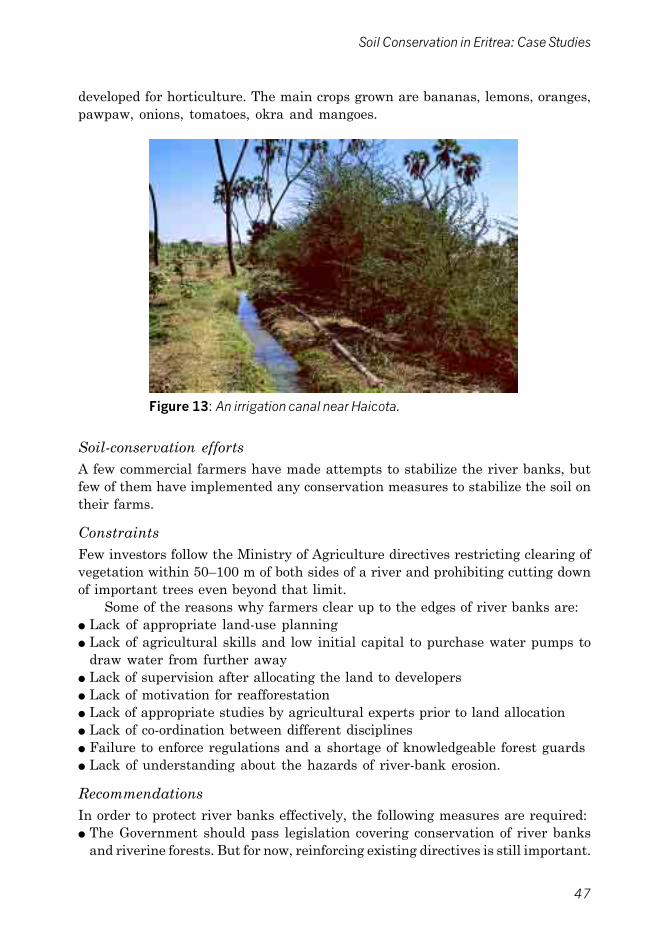
47
Soil Conservation in Eritrea: Case Studies
developed for horticulture. The main crops grown are bananas, lemons, oranges,pawpaw, onions, tomatoes, okra and mangoes.
Soil-conservation effortsA few commercial farmers have made attempts to stabilize the river banks, butfew of them have implemented any conservation measures to stabilize the soil ontheir farms.
ConstraintsFew investors follow the Ministry of Agriculture directives restricting clearing ofvegetation within 50�100 m of both sides of a river and prohibiting cutting downof important trees even beyond that limit.
Some of the reasons why farmers clear up to the edges of river banks are:● Lack of appropriate land-use planning● Lack of agricultural skills and low initial capital to purchase water pumps to
draw water from further away● Lack of supervision after allocating the land to developers● Lack of motivation for reafforestation● Lack of appropriate studies by agricultural experts prior to land allocation● Lack of co-ordination between different disciplines● Failure to enforce regulations and a shortage of knowledgeable forest guards● Lack of understanding about the hazards of river-bank erosion.
RecommendationsIn order to protect river banks effectively, the following measures are required:● The Government should pass legislation covering conservation of river banks
and riverine forests. But for now, reinforcing existing directives is still important.
Figure 13: An irrigation canal near Haicota.

48
Technical Report No. 23
● Only land beyond the riverine forest should be granted for agriculturalconcession.
● Any proposed development project near river banks should first be subject toenvironmental-impact assessment.
● Promote awareness and mechanisms for ensuring the participation of localpeople in combating river-bank erosion.
● Encourage conservation activities in the upper catchment areas.● Allow long-term credit to horticultural investors.● Encourage investors who have already cleared 50�100 m from the river bank
to replant with different species, including fruit trees, grasses and climbers.● Prepare an appropriate land-use plan emphasizing river-bank stabilization and
sustainable agriculture.● Promote links between the extension service, local people and investors.● Promote research to identify vulnerable areas and prepare an appropriate plan
of action for river-bank stabilization.
Case study: Horticulturalist Solomon Hagos
Solomon Hagos returned to Eritrea before independence in 1990 having lived inGermany. He owns about 20 ha of land on which he grows okra, tomatoes, onions,egg plant, pawpaw, guava and lemon.
Initially, he was not aware that clearing the riverine forest could result in erosionof the river bank on his farm. He cleared the forest and is now left with only someHyphaene thebaica, Balanites aegyptiaca, Acacia mellifera, Acacia nilotica, Prosopischilensis and Calotropis procera. But now having been affected by river-bank erosionand flooding, he has planted Arundo donax, Pithecelobium dulce and awir (Tigre) inrows about 10 m apart and 550 m long following the river bank. The awir andArundo donax are propagated by cuttings, but Solomon took the initiative to importseeds of Pithecelobium dulce and raised seedlings in his farm nursery. The seedlingshave survived very successfully, and the river-bank erosion seems to have beencontrolled by these measures.
By contrast, the farm of his neighbour, Ibrahim Tahir, is under great threat. A welloriginally dug 20 m away from the edge of the river is now inside the river bed. Thisindicates that much valuable arable land has already been washed away. Unlessgreat reclamation efforts are made, his investment will be lost and his activitiesmay even negatively affect the adjacent farms.
SKILLS REQUIRED
● Awareness of the importance of riverine vegetation.
● Knowledge on suitable species for planting along river banks,including propagation techniques.
● Knowledge about the appropriate rules and regulations.
● Knowledge on techniques of gabion construction.

49
Soil Conservation in Eritrea: Case Studies
7.2 The case of Akordet/Barka river bank
IntroductionAkordet is along the main Asmara�Barentu road 140 km from Asmara in GashBarka Zone. It is in the northwestern lowland zone and has a hot and arid climate.Rainfall ranges from 150 to 400 mm per annum and the temperature from 15 to45oC.
The soils along the banks of River Barka are alluvial deposits, mainly Fluvisols,and in the flat areas further away from the river mainly Luvisols. In the hillyareas, the soils are shallow and mainly Lithosols.
Common species in the riverine vegetation are:● Acacia tortilis● Hyphaene thebaica● Ziziphus spina-christi.
Some species in the flat and undulating areas are:● Acacia tortilis● Cadaba rotundifolia● Capparis decidua.
The farming systemFarming along the Barka river adjacent to Akordet is mainly based on small-scale irrigation. There are 86 investors in this area who have been allocated816 ha, out of which 532 ha are already planted with different horticulturalcrops. Bananas are dominant, covering 325 hectares, and other minor horticulturalcrops are onions, tomatoes, mangoes, lemons, oranges and guava.
Soil erosion along the river banksFew of the horticultural farm owners comply fully with Ministry of Agriculturedirectives. As a result, heavy floods in August 1998 washed away 10 ha ofbananas, one well and 43 pumping tubes. Local people claim that the agriculturalconcessions in the riverine forest area are causing conflict with traditional landuse, i.e. pastoralism. In the view of the local people, clearing of forests is a greatthreat to the river bank. They also argue that protecting the riparian vegetationfrom clearing is the only remedy if the river bank is to be stabilized.
Although river-bank erosion is a result of complex environmental factors,there is little doubt that riparian vegetation plays a major role in stabilizing thebanks. Once vegetation is removed, a vulnerable spot is created which issusceptible to erosion, particularly when peak floods occur. But in some cases,such biological conservation might not be sufficient without the aid of additionalphysical structures.
ConstraintsIn this area there are two nurseries, Akordet and Engerne, managed by the
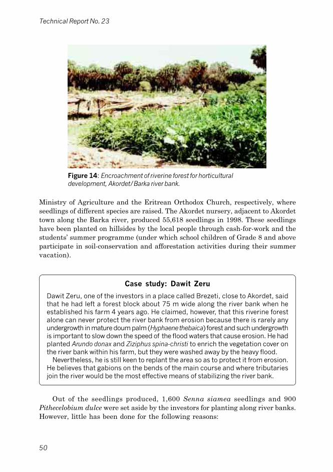
50
Technical Report No. 23
Figure 14: Encroachment of riverine forest for horticulturaldevelopment, Akordet/Barka river bank.
Ministry of Agriculture and the Eritrean Orthodox Church, respectively, whereseedlings of different species are raised. The Akordet nursery, adjacent to Akordettown along the Barka river, produced 55,618 seedlings in 1998. These seedlingshave been planted on hillsides by the local people through cash-for-work and thestudents� summer programme (under which school children of Grade 8 and aboveparticipate in soil-conservation and afforestation activities during their summervacation).
Case study: Dawit Zeru
Dawit Zeru, one of the investors in a place called Brezeti, close to Akordet, saidthat he had left a forest block about 75 m wide along the river bank when heestablished his farm 4 years ago. He claimed, however, that this riverine forestalone can never protect the river bank from erosion because there is rarely anyundergrowth in mature doum palm (Hyphaene thebaica) forest and such undergrowthis important to slow down the speed of the flood waters that cause erosion. He hadplanted Arundo donax and Ziziphus spina-christi to enrich the vegetation cover onthe river bank within his farm, but they were washed away by the heavy flood.
Nevertheless, he is still keen to replant the area so as to protect it from erosion.He believes that gabions on the bends of the main course and where tributariesjoin the river would be the most effective means of stabilizing the river bank.
Out of the seedlings produced, 1,600 Senna siamea seedlings and 900Pithecelobium dulce were set aside by the investors for planting along river banks.However, little has been done for the following reasons:

51
Soil Conservation in Eritrea: Case Studies
● Investors feel that the return they get from planting trees is not as quick asthat from horticultural crops
● Lack of awareness of the potential economic loss due to erosion until floodingand damage actually occur
● Doubt about the efficacy of trees in stabilizing river banks without the aid ofadditional physical structures
● Lack of commitment to implementing the Ministry of Agriculture directives of1994
● Gabion construction on vulnerable spots, coupled with re-vegetation, is effectivebut very expensive.
RecommendationsIn order to protect river banks effectively, the following recommendations aremade:● The Government should pass legislation on the conservation of river banks and
riverine forests; for the time being, enforcing existing directives is still important● Only land beyond the riverine forest should be granted for agricultural concession● Any proposed development project near the river banks should be subject to
environmental-impact assessment● Promote awareness and mechanisms for ensuring the participation of local
people in combating river-bank erosion● Encourage conservation activities in the upper catchment areas● Allow long-term credit to horticultural investors for gabion construction● Encourage investors to replant river-bank areas that have already been cleared
with a variety of species, including fruit trees, grasses and climbers● Prepare land-use or farm plans that take river-bank stabilization into
consideration● Promote links between extension services, local people and investors● Promote research to identify vulnerable areas and prepare an appropriate plan
of action for river-bank stabilization.
SKILLS REQUIRED
● Awareness of the importance of riverine vegetation.
● Knowledge on suitable species for planting along river banks,including propagation techniques.
● Knowledge of the appropriate rules and regulations.
● Knowledge on techniques of gabion construction.

52
Technical Report No. 23
8. ROADSIDE TREE PLANTING FROM DBARWA TOADI-QUALA
8.1 Introduction
A variety of tree species have been planted on both sides of the road from Dbarwato Adi-quala, a distance of 60 kilometres. The Ministry of Agriculture wasresponsible for the overall management and financing of the planting activities,while the local subzone administration organized the participation of the localpeople.
The main objectives of planting the trees were to rehabilitate the vegetationand to provide beauty and shade. The planting was done on 20 June 1995(Martyrs� Day) selected specifically to create awareness among the people in thehope of ensuring their full participation in planting and maintenance of the trees.
8.2 Species
The species planted were:● Grevillea robusta● Jacaranda mimosifolia● Melia azedarach● Acacia saligna● Schinus molle● Casuarina cunninghamiana.
Some 18,775 seedlings were planted at a spacing of approximately 5 m,depending on the species, and about 20 m from the centre of the road. The survivalrate is about 90%. The planting was not designed to protect the roadsides andbridges from erosion since the trees were widely spaced and about 20 m awayfrom the road, which is too far to protect these structures from erosion.
The roadsides and bridges are subject to severe erosion from floods duringheavy rains and the situation requires attention from concerned authorities. Analternative may be to plant deep-rooted grass species such as vetiver grass, as inmany other countries this grass has proved effective for stabilizing structuressuch as dams, canals, and roads. Vetiver grass is available in the Ministry ofAgriculture Betghiorgis nursery and can be obtained on request. Other grasses,locally known as edni and arghe, are equally important for soil conservation.
8.3 Management practice
For five months water for the seedlings was supplied by individuals through thefood-for-work programme. The Ministry of Agriculture provided a water tankerand each plant was fenced off and well protected against livestock. Initially, therewere 60 guards to protect the trees, each guard being responsible for the trees

53
Soil Conservation in Eritrea: Case Studies
within a radius of 2 km. Each guard was paid 7 Nakfa per day, or 210 Nakfa permonth. The seedlings were obtained from the Iyamo, Sememo, Mai-tekela andHalhale Ministry of Agriculture nurseries.
8.4 Constraints
● Roadside tree planting is very costly, especially in watering and protection.● In some areas, the selected species are not adapted to the site conditions.
8.5 Recommendations
● Mulching, weeding and other care of the seedlings should be properly managed.Mulching is particularly important during the hot and dry season to maximizethe moisture available to the plants and help reduce the need for watering.Decayed mulch is also a very important source of nutrients for the plants, andduring heavy rain mulch can prevent erosion around seedlings and suppressweeds.
● While mobilizing the people for planting trees, the road authorities should co-ordinate with the Ministry of Agriculture to have planting of deep-rooted grasseson roadsides included in the programme.
SKILLS REQUIRED
● Knowledge of species of grasses and trees that are suitable forroadside planting.
● Knowledge on road design and requirements (road engineers)to be combined with the ability to assess the risk of erosion ondifferent types of land (agriculturalists).
Figure 15: Roadside plantation, Emni-haili.

54
Technical Report No. 23
9. SMALL-SCALE IRRIGATION
9.1 The case of Alaa
IntroductionAlaa is in the Debub Zone, Dekemare Subzone, about 23 km southwest of Asmara.It is accessible by a 70-km tarmac road from Asmara via Dekemare.
Alaa is on a plain and has an area of about 2,000 ha. It is surrounded bymountains and the plain is intersected by many small streams and rivers. Thereare a few small scattered hills. The average altitude is about 980 m.
Soils and soil conservationThe predominant soils in the area are sandy. In most parts of the plain they aredeep but along the base of the hills they are highly eroded, shallow and stony. Insome cultivable areas, the soils have been improved by deposition of silt throughspate irrigation.
Because of the high sand content of the soils, they are easily eroded by rain,and sheet erosion is the dominant type of erosion in the area. The problem isaggravated by the absence of vegetative cover. The river beds are continuouslymined for construction sand.
To reduce erosion, small earth bunds have been constructed following thecontour in the fields, but since there is no proper maintenance these bunds arenot very effective. Orchards are properly terraced and maintained. Different-sized bench terraces are constructed, either from soil bunds or by using stones.Such terraces are very effective in conserving soil and water.
Natural vegetationThe main species in the upper areas are:● Dodonaea angustifolia● Acacia etbaica● Maytenus senegalensis● Euclea schimperi.
The main species on the flat plain are:● Acacia tortilis● Calotropis procera.
Currently, the natural vegetation is severely depleted. There has been acutecompetition for land suitable for orchards, and farmers who obtained land clearedthe natural vegetation in order to plant such orchards. This resulted indisappearance of the natural vegetation, and because of drought and uncontrolledgrazing regeneration has been minimal.

55
Soil Conservation in Eritrea: Case Studies
ClimateThe mean annual rainfall at Alaa is about 500 mm per annum, but there aresignificant variations so that it is often less than 300 mm per year, and there areyears when there is no rain at all. The rainfall is not only scarce, but thedistribution within the year may also be very irregular and because of this manycrop fields are abandoned and orchard owners rely more and more on flood waterfor irrigation.
AgricultureThe main rainfed crops grown in Alaa are maize and sorghum. Vegetables suchas onions, tomatoes and peppers, and fruits such as oranges, lemons and pawpaware grown under irrigation. Cultivation of the irrigated orchards and vegetablefields is done manually using hoes, and is carried out 5�6 times a year, dependingon the irrigation frequency.
In orchards, one sack (about 50 kg) of manure is applied to each tree peryear. In addition, some rich farmers apply a mixture of urea and DAP. Manureand, rarely, inorganic fertilizers are applied to vegetable fields. The rate ofapplication varies from farmer to farmer, but is normally lower than recommended.
All types of agricultural products are harvested manually. Cereals are threshedby trampling with oxen or donkeys.
Vegetables and fruit are protected from pests by applying chemicals boughtfrom the Ministry of Agriculture. The application is carried out with manuallyoperated knapsack sprayers.
Figure 17: Infertile area reclaimed by diverting spate flow, now undermaize.

56
Technical Report No. 23
IrrigationWater shortage as a result of the erratic rainfall is the most important limitingfactor for development of irrigated agriculture on the Alaa plain. Thus, productionof vegetables and fruit under irrigation is becoming increasingly important andwater from both wells and flood water is used for irrigation.
Each farm has one or more wells. These are hand-dug open wells withoutlining and are 10�25 m deep. Since there is no law regulating the use of groundwater, the farmers are free to exploit any amount that is available. This createssevere competition between them and they have to continuously deepen the wellsto obtain enough water.
When a farm is located near a river or stream, and if the topography allows,the spate flow is diverted directly to the fields. Enough moisture is conserved and,in addition, the sediment carried by the spate flow and deposited in the fieldsincreases fertility substantially. This irrigation is normally carried out 1�3 timesa year, depending on availability of the river flows.
Constraints● Existing river-diversion structures are not provided with an effective mechanism
for controlling water flow. The present traditional system is not sustainabletechnically and environmentally since it is based on the use of branches andstones which are easily broken or carried away in big floods.
● Water is diverted to different branches of the canals by blocking or openingcanal entrances using earth. These are easily breached by the flow, thus makingwater distribution work inefficient and tiresome.
Figure 18: Once infertile rugged area reclaimed by diverting spateflow and now under fruit trees.

57
Soil Conservation in Eritrea: Case Studies
Recommendations● Diverting flood water into a farm is recommended since it adds substantially to
the fertility of the soil.● To properly utilize flood water for crop production, fields must be provided with
water-control structures.● Earthen canals should be replaced by cement-lined canals or with pipelines.● Improved water-diversion structures should be made that allow regulation of
flow.● Easily managed flow-control gates should be introduced.● Strengthening earth embankments by periodically adding soil and consolidating
them by planting grass such as cynodon.
Case study: Tewelde�s fruit farmTewelde owns a fruit farm in the northwestern part of the Alaa plain. It is a medium-sized farm and at present produces mainly citrus under irrigation, but he hopes toexpand to vegetable and dairy production.
The natural-resource base of this farm can almost be described as man-made.When Tewelde inherited it, the land was rugged and stony and unsuitable for anykind of agriculture. But the farm is very close to Gaden river which is in spate atleast twice a year, so Tewelde decided to improve his land by diverting the floodwater carrying sediment from higher areas.
He started this development work by constructing a semi-permanent diversionstructure on the Gaden river and an earth canal about 400 m long to let the floodwater onto his land. He divided the farm itself into 0.5 ha plots and constructedapproximately 1-m high embankments around each plot. He also constructedtemporary intake gates.
Every year he lets flood water into the fields, and by the end of 7 years a veryfertile and deep soil was created from the deposited sediments. Tewelde claimedthat in some of the fields the depth of the soil increased by about 1 m.
Two big wells with diameters of 8�10 m and depths of 12 m were also constructedto irrigate the fields during the dry season. The canal systems are properlyconstructed and therefore very efficient.
Tewelde began planting orange seedlings in 1993, and some trees have alreadystarted to produce fruit.
According to Tewelde, the main problems on the farm are:● In the dry season the water sources are not reliable enough for irrigation● There are no proper structures for controlling flood water, which results in soil
erosion because of the occasional heavy floods.
SKILLS REQUIRED
● Knowledge of irrigation techniques, including construction andmaintenance of water-diversion structures, irrigation canals,embankments, etc.
● Knowledge of fruit and vegetable production.

58
Technical Report No. 23
9.2 The case of Tselima (Halhale)
IntroductionHalhale is located in Debub Zone, Dbarwa Subzone, about 8 km from Dbarwatown along the tarmac road from Asmara to Mendefera. The flat Halhale plain isabout 1,825 m above sea level and is surrounded by fairly high hills on thenorthern, western and southern sides. The population pressure is intense, mainlybecause of the high potential of the area for both crop and livestock production.
Halhale is in the moist highland zone. The climate is characterized by a rainyseason from June to the end of September and a few showers during April andMay; the average annual rainfall is about 550 mm. The average minimum andmaximum temperatures are 6oC and 29oC, respectively; the hottest month is Marchand the coldest months are December and January.
Case study: Kidane Kelit�s farm
Kidane Kelit farms 2 ha of irrigated land, of which about three-quarters is obtainedby a contractual arrangement with 7 other farmers. These arrangements are of twotypes. Under the first kind of contract, he cultivates the land himself without anykind of labour input from the other farmers and then gives each of them a quarterof the resulting produce. Under the second kind of contract, Kidane only suppliesirrigation water to the other farmers, and then he gets a quarter of the producefrom each farmer who has received this water.
The source of water for irrigating the farm is two wells with water pumps, locatedabout 200 m apart. The well in the southern part of the farm is very shallow andhas insufficient water, but the second well supplies enough water, although thewater level does fall during the dry season. The farmer uses the furrow irrigationmethod, but the primary canal is poorly constructed and as a result about 20% ofthe water is lost before it reaches the farm.
The produce is sold at Dbarwa town but the prices obtained are poor as thefarmer has no time to negotiate with merchants as the produce will spoil if kept forlong periods before sale. Kidane obtains his vegetable seed from Asmara merchants,but even though they are expensive their viability is not guaranteed. Kidane hasbegun selecting the healthiest and largest of his own potatoes to use as plantingmaterial. There is always a shortage of fertilizers and he cannot afford to buypesticides.
Soils and vegetationThe major soil type on the flat land is deep brown Vertisols, while on the steepand undulating land both Lithosols and Cambisols occur. Except for some remnantshrubs and grasses, the natural vegetation has almost disappeared because ofintensive cultivation, overgrazing and cutting of trees for firewood.

59
Soil Conservation in Eritrea: Case Studies
Land tenureIn many parts of the country, including the Tselima area, the land-tenure systemis communal. Every piece of land in the village is classified according to its fertility,and the arable land is allocated to the members of the village according to itsquality.
This system gives farmers little incentive to improve land since the rotationcycle of 5�7 years allows too little time for each allottee to reap the benefits oflong-term measures such as tree planting and construction of permanentstructures. In addition, crop land and grazing land are open for communal grazingin the post-harvest season, which may accelerate erosion through trampling andovergrazing. As land cannot be mortgaged or sold, the system also limits theavailability of credit facilities that could be used to make land improvements.
Soil erosion and conservation in TselimaSoil erosion in the area is attributed to overstocking. Expansion of cultivatedland to meet the needs of the increasing population means that more animals arerequired for ploughing and less grazing land is available. Soil erosion also occursbecause of trampling by animals being herded from one grazing area to another,which often results in bare paths which soon develop into gullies. Concentrationof animals around water points also causes erosion.
Soil erosion is a very serious problem on steep slopes and on stream banks.Tselima is one of the most productive areas in the highlands of Eritrea, but it isobvious that the landholdings cannot be further subdivided and, therefore, inorder to meet their increased needs, the people will have to extend cultivation tosteep slopes which are easily eroded.
Figure 19: Irrigated maize in Tselima plain.

60
Technical Report No. 23
Case study: Kidane Belai�s farm
Kidane Belai farms 6 ha in the western part of the Halhale plain near the village ofImnitselim. Kidane obtains most of this land from other farmers under two kinds ofarrangement. The first arrangement is on the basis of direct cash payment to theowner at a rate of 800�1,200 Nakfa per hectare per year. The second arrangementis by voluntary exchange of land. For example, land belonging to another farmerthat is located near Kidane�s well is exchanged for some of Kidane�s land furtheraway from the well. No payment is involved in this type of voluntary land exchange.
The yield of vegetables varies greatly, depending on the availability of water forirrigation and supply of fertilizers and pesticides. But average annual yields ofvegetable products on this farm are:
Tonnes/haTomatoes 12Potatoes 12Onions 12Red pepper 8
Two crops of each vegetable are grown each year and the vegetables are rotatedin the following sequence: tomatoes�onions�potatoes�red peppers. He appliesfertilizers such as DAP, urea and animal manure.
This farmer uses flooding as his method of irrigation, but there is substantial lossof water in the canal due to the high percolation rate. The farm is irrigated twice aweek. The water is obtained from 2 wells about 3 and 10 metres deep, respectively,both with pumps. The shallow well irrigates continuously for 5 hours, while the deepone operates for 12 hours. Both the wells were dug manually and each cost thefarmer about 1,300 Nakfa. The two water pumps cost 13,460 Nakfa. It is difficultto find a nearby workshop to repair these pumps in the event of breakdowns andthen Kidane has to take them to Asmara. The farmer sells his produce at the townof Dbarwa, mostly at prices dictated by the merchants as he has no storage facilitiesfor these perishable products.
Due to the existing land-tenure system, individual farmers are not motivatedto construct permanent soil-conservation structures on their own plots. However,on steep slopes, some soil conservation measures such as construction of stoneand soil bunds and hillside tree planting have been taken. These bunds willeventually develop into bench terraces on the cultivated lands. Bench terracesare used for two purposes aside from soil and water conservation:● Supply of cut-and-carry grass for livestock from the terrace risers, and● Identification or demarcation of farm boundaries.
ConstraintsThe main constraints facing the farmers in the area are:● Lack of good-quality seeds● Shortage of pesticides and insecticides● Low market prices for vegetables

61
Soil Conservation in Eritrea: Case Studies
● Shortage of transportation facilities● Lack of technical know-how on modern irrigation methods● Lack of spare parts for motor pumps● Lack of motor pump repair shops nearby● Lack of storage facilities for the produce● Shortage of land● Lack of fertilizer and on-farm storage facilities for the fertilizer● Lack of protection for the wells against siltation and damage● Lack of types of vegetables that can resist frost.
Recommendations● Good-quality vegetable seeds for small farmers should be available from the
Ministry of Agriculture extension agents.● Availability of reliable and effective chemicals should be ensured.● Imported or local vegetable seeds should be inspected and certified by the
appropriate authorities before they reach the market.● Farmers should organize themselves to establish marketing co-operatives.● Priority should be given to improving transportation facilities in vegetable-
growing areas.
SKILLS REQUIRED
● Knowledge of vegetable production.
● Knowledge of irrigation.
● Ability to assist farmers in establishing marketing co-operatives.
9.3 The case of Mareba
IntroductionMareba is located in Debub Zone, Segheneiti Subzone, about 57 km southeast ofAsmara. It is accessible by an all-weather tarmac road from Asmara. Mereba hasa total population of 1,350 in 410 households. The area is in the moist highlandzone at an altitude of 2,000 m, with average annual rainfall of 450�500 mm andaverage minimum and maximum temperatures of 7°C and 22°C, respectively.
Topographically, it is a hilly area with gentle slopes and some undulatingand flat land on valley bottoms, where most of the irrigated land is located. Somespecies in the natural vegetation are:● Aloe abyssinica● Acacia etbaica● Cordia abyssinica

62
Technical Report No. 23
● Faidherbia albida● Ficus thonningii
The land-tenure system is a communal one with each farmer having anirrigated plot of about 450 m2. Land contract arrangements are not common inthis area because water is available in shallow wells and it is easy for each farmerto dig his own well. This is the main reason why there are no water pumps andalmost all the 410 farm households have wells, which means that most farmershave their own irrigated plots.
Case study: Tesfamariam Hailemichael�s farm
Tesfamariam Hailemichael has 450 m2 of irrigated land as his share of communalland on which he grows cabbages, lettuce, potatoes, onions, maize, peppers andtomatoes.
The average yields of vegetables for the 450 m2 are:
Tonnes/annumCabbage 2.0Lettuce 2.0Potato 0.5Maize 0.2Pepper 1.0Onion 1.0Tomatoes 0.7�1.0
The source of water for irrigation is a hand-dug well which is only about 2 m deepand the water is hand carried from the well. The water only lasts for half an hourafter being drawn and the well fills up again after 2�3 hours. Therefore, the farmerhas to irrigate his land twice a day, and each bed of vegetables is irrigated everythree days. During the rainy season, the land becomes swampy and is out of useuntil the next dry season.
Ploughing and planting are done by hand, and weeding and cultivation are carriedout thoroughly. The ridges between the plots are well established and there are nosigns of erosion.
The vegetables are grown in rotation as follows: cabbage�potato�tomato�lettuce�peppers�onion. If red peppers are planted on fields previously planted withtomatoes, yields are poor, therefore the farmer applies about 70 kg animal manureon the plot three times a year and 2 kg DAP twice a year.
Soils and soil erosionBoth sheet erosion and gullies are visible on the irrigated land, the result offlooding from an old broken earth dam located above the irrigated area. Duringthe rainy season, the irrigated land becomes swampy and cannot be used untilthe dry season commences. It is likely that the dam will be entirely destroyedduring a heavy rainy season, and in this event most of the fertile agriculturalland may be washed away.

63
Soil Conservation in Eritrea: Case Studies
ConstraintsThe major constraints for farmers in Mareba are:● Shortage of enough land to justify using a motor pump● A low farm-gate selling price for vegetables due to poor marketing arrangements● Excessive soil erosion due to flooding from breakage of the old dam, resulting in
a decrease in the amount of land available for irrigation● Lack of good seeds● Insecure land tenure is a disincentive to making permanent land improvements.
RecommendationsThe following recommendations are made:● The old dam should be repaired to minimize soil erosion from flooding and to
increase water supply● Expansion of the area of irrigated land should be considered while repairing
the dam● Viability of the seeds obtained from merchants should be checked before they
are sold to farmers● Conservation activities in the entire valley should be considered in order to
prevent soil erosion and siltation of the dam● The Ministry of Agriculture extension agents should be more efficient in giving
advice to farmers.
SKILLS REQUIRED
● Knowledge on dam construction and management.
● Knowledge on vegetable growing.
● Techniques for soil conservation on hillsides and cultivated land.
● The ability to assist villagers form marketing co-operatives.
● The ability to give advice on horticultural seeds.
Figure 20: Local-level initiative: small-scale irrigation,Mareba.

64
Technical Report No. 23
Case study: Habte Berhanemeskel�s farm
Habte Berhanemeskel has 450 m2 of irrigated land where he grows variousvegetables, the land having been allocated to him by the village as his share duringland distribution. He grows cabbages, lettuce, potatoes, onions, maize, tomatoesand red peppers. His plot is under irrigation only during the dry season as it becomesswampy during the rainy season from June to the end of September.
The average yield of vegetables (kg/ha) is:
Cabbage 2,000Lettuce 1,500�2,000Potato 500�800Maize (mostly consumed when
green; remainder dry) 100Red pepper 800Tomato 700�800Onion 1,000�1,200
The irrigation water comes from a hand-dug well about 2 m deep, and the diggingof furrows and water control is done manually. The main water channel is wellprepared and there is not much water loss during irrigation. The vegetables areirrigated every three days. The water in the well only lasts for half an hour afterbeing drawn and takes about 6 hours to fill up again.
The vegetables are transplanted in rows and the ridges between the rows arewell prepared and clean from weeds. There are well-established bench terracesbetween the vegetable plots, and the grass growing on these is used for cut andcarry to feed the farmer�s livestock. The farm produces two maize crops a year andthe stover is also used for feeding animals.
Most vegetable seeds are bought from merchants in Asmara, but their viability isunreliable. Some farmers produce seeds themselves, but these are of low quality.
This farmer applies animal manure and inorganic fertilizers. DAP and urea areapplied at a rate of 6 kg per year over the whole plot. Manure is applied for allvegetables when it is available.

65
Soil Conservation in Eritrea: Case Studies
10. LARGE-SCALE SPATE IRRIGATION: THE CASE OFSHEEB
10.1 Introduction
The eastern lowlands of the country are characterized by a hot and dry climatewhich cannot sustain any viable rainfed agricultural production. Therefore, about80 years ago the people living there adopted a system of agriculture known as�spate irrigation�. Throughout the eastern lowlands, the techniques used are verysimilar; here we take the case of Sheeb as a representative example for all thespate-irrigated areas.
Sheeb is located in the northern Semenauli Keih Bahri Zone, Sheeb Subzone,some 50 km northwest of Massawa at the foot of the eastern escarpment. Theescarpment drops from an altitude in excess of 2,000 m in the highlands toapproximately 200 m in Sheeb.
Sheeb is hot, arid and desert-like with mean annual rainfall of less than200 mm falling mainly from October to April (winter rain). Mean monthlytemperatures range from about 25°C in January and February to about 35°C inJuly and August, but with maximum temperatures often exceeding 40°C duringthis period. An added hazard during the summer months is afternoon dust stormsand strong winds which make for a hostile and unpleasant working environment.The potential evapotranspiration is extremely high (in the region of 2,000 mmper annum), and irrigation is essential for crop production except for very occasionalcultivation of drought-tolerant short-season crops such as bulrush or finger milletplanted in the river bottoms.
On the eastern escarpments, the �small rains� fall in April�May, and the �mainrains� follow in July�September causing summer runoff which feeds the spate-irrigation area in the lowlands. There, Sheeb receives its main rainfall in winterand benefits indirectly from summer rains. The flood season from July toSeptember contributes about 65% of the annual floods, the remainder occurringfrom October to February, with smaller floods and reduced frequency duringthat period.
10.2 Soils and topography
The seasonally flooded watercourses are sandy in the alluvial plains, but adjacentto them fine sediments of considerable depth have been deposited by many yearsof floods. These deep soils have a high capacity for water retention. In recenttimes, the diversion of the river�s spate flows for irrigation has contributed to theprocess of deposition and soil improvement and it is thought that in much of thearea soils are more than 2 m deep. Although erosion is a serious problem throughoutEritrea, it is not prevalent in Sheeb and much of the agriculture along the riveris carried out on alluvial soils deposited as a result of past erosion in the highlandwatersheds. The spate water is very suitable for irrigation as it carries a

66
Technical Report No. 23
considerable amount of silt, which is highly valued by farmers for land reclamationand improvement of their soils.
The irrigated areas are predominantly flat with slopes rarely being greaterthan 1%. There are a few gullies, depressions and areas of raised land, all causedwhen canals become broken.
The spate-irrigation system has been developed in the eastern lowlands asthe only method of producing crops in this hot and dry area. The system makesuse of short-duration spate-flood flows in otherwise dry river beds, exploiting thelocal deposits of deep highly fertile alluvial silts adjacent to or part of the river�sfloodplain. Spate-irrigation agriculture is practised mainly from September toMarch. Surrounding these rivers, the eastern lowlands are generally sandy,gravely or rocky hills that are eroded and with little potential for livestock grazingand none for crop production.
10.3 Crop production
The yearly crop production activities are repair of broken diversion structuresand canal systems, land preparation, seeding and harvesting.
Repair of diversion structuresPreparations for crop production commence during March and April with therebuilding and repair of the diversion structures in the river. These are semi-permanent structures built out of sand, rocks and branches of thorny bushes.Oxen are used to haul the tree branches, move stones and boulders, and to scoopthe sand into diversion weirs. These structures may be damaged or washed awaywith every strong flood, requiring continuous repair throughout the flood season(typically July and August).
Repair of the canal system and earth bundsOnce the diversion weir is in place, the diversion channels or canals are rebuilt.These structures, which are also frequently damaged or breached during heavyfloods, direct the water into fields separated from each other by soil bunds. Fieldsreceive an annual addition of silt and thus the bunds may need to be raised and/or repaired each year. An earth scoop drawn by a pair of oxen is used to do thiswork, which is done almost every year.
Land preparationWhen flooded fields start to dry, large cracks form in the soil and the moisture inthe soil begins to evaporate. To prevent this loss of soil moisture through thecracks, the fields are ploughed and large soil clods broken up by dragging treetrunks or branches over the field. This loose and finely broken up soil then acts asa blanket on the field reducing water loss by evaporation.

67
Soil Conservation in Eritrea: Case Studies
CropsSeeds are planted in rows. A simple wooden pipe is attached to the plough andthe seed dropped to the ground through this. The main crop is sorghum, which iswell adapted to growing in areas with residual soil moisture as it has a deep andwell-branched rooting system. This plant is efficient at extracting moisture fromdrying soils and can withstand limited waterlogging. The sorghum varieties grownnear the river beds are tall and can be harvested either as green fodder for livestockor left to produce grain. A common practice is to plant the crop densely duringSeptember and then use the thinnings for animal feed in November. When soil-moisture levels permit, a second harvest of grain can be obtained from the sameplants by ratooning. Minor crops are maize, pearl millet, finger millet, watermelon,sesame, groundnut, haricot beans, cotton and vegetables (tomatoes, okra, chilliesand onions). When the floods have been good and soil-moisture levels are high,maize is often planted following harvest of the first sorghum crop. This change tomaize is taking place because farmers usually get more grain from the maize cropthan from a second sorghum crop. This may be attributed to a disruption of theinsect build-up by rotating crops and less bird damage to maize than sorghum.
Fertility maintenanceManuring is not practised in Sheeb. The reasons for this are:● The flood water carries with it soil sediments and many nutrients which increase
the soil fertility● There are few livestock in Sheeb, thus manure is not available. Besides, there
is no tradition of collecting manure.
Figure 21: Sheeb; repair of earth bunds using an ox-drawn scoop.

68
Technical Report No. 23
Figure 22: Sheeb; fresh deposit of fertile alluvial silt.
WeedingThe spate flow carries with it many different weed seeds. Therefore, unless theseweeds are destroyed during ploughing, there is a heavy infestation of weeds inthe fields. Crop fields are neither weeded properly nor harrowed, but the weedsare left to grow and used for animal feed. Therefore, weeding is only carried outwhen farmers want to feed their animals. However, the dense planting of sorghumalso suppresses weeds.
HarvestingCrops are harvested and threshed by hand. The harvested crops are first left todry completely and then threshing is done by beating with a large stick. Thesorghum crop is stored either in woven containers or in sacks. With no control ofinsect pests, post-harvest losses can be as high as 25%.
10.4 Detailed description of the system
Agriculture in Sheeb and elsewhere in the eastern lowlands is dependent onirrigation by diversion of river-spate flows, and very little use is made of groundwater for irrigation.
The principal objective of the spate-irrigation system is to divert and controlsufficient water to flood the fields to a depth of up to 0.5 m. This water soaks intothe deep soil and provides the residual moisture on which the crops survive. Severalfloods and soakings are necessary to fully exploit the water-holding capacity ofthe soil.
A traditional spate-irrigation network typically covers an area ranging from100 ha to more than 4,000 ha. The farmers construct 1�3-m high temporary

69
Soil Conservation in Eritrea: Case Studies
embankments, known as agum, across the river channel upstream of the primarycanal intakes to divert the low-spate flows to adjacent cultivable areas. Theseembankments are made from material scraped up from the river bed, reinforcedas necessary with stones and brushwood. There is seldom provision for a spillwayand, as the flood rises, the earth embankment is either deliberately breached orfails due to over-topping or piping through the embankment. The embankmentis partially or completely washed away.
The agum is rebuilt, but how soon this can be done depends on the intervalbetween consecutive river flows and the availability of draught power. Thus, theembankment cannot always be rebuilt before the next flood.
The primary canals, known locally as musqa, taken off from the river, havea large capacity in relation to the area irrigated because of the short duration ofthe spate flows. The primary canals are subdivided into smaller canals as theyreach the irrigable area and farmers exercise traditional forms of priority andcontrol so that the higher lands receive water first.
There are no permanent structures for the control and distribution of spateflows within the canal system; normally the flow is diverted by blocking the canalsand distributors with temporary earth bunds and breaching them when irrigationdemands are met. The irrigation water is distributed on a field-by-field basis withthe basin bunds being over-topped or breached once an adequate depth of waterhas been applied to each field.
The traditional structures are relatively cheap to build, but require aconsiderable amount of maintenance during the irrigation season. If only smallor medium spates occur during the season, the embankments can be very effective,but larger spates can result in the expenditure of much effort or cash with verylittle benefit as the diversion embankments may be completely swept away. Thus,the probability of achieving effective and regular irrigation of the whole area islow.
Operation and maintenanceEach field is about 0.25 ha, and 10�20 fields are grouped into a block. Each blockin the canal system is irrigated independently.
Water allocation is dealt with by the Village Council (Baito or Mezabaya)and is intended to ensure an equitable distribution of water throughout the area.Nevertheless, within the irrigable area, plots nearest to the path of the water arewatered first and higher ground is watered before lower ground. Traditional formsof water control are still practised, entailing diversion to the highest fields bymeans of a temporary check bund across the canal.
Once the highest field in a block has been filled, one of the field bunds isbreached and the water flows across the top field to fill up the next basin in anordered succession of fields. No field can obtain water until the one preceding hastaken its quota. Ideally, only when every field in a given block has receivedwater is the main canal check bund breached. The flow then continues down to

70
Technical Report No. 23
the check bund commanding the next 10�30 ha block of fields, and so on, untilthe entire spate flow is dissipated.
In the past, the construction and replacement of the embankments anddistribution of flow through the canals were communal activities organized bythe farmers. Costs, usually paid in kind, were shared on the basis of benefitsreceived, which depended on the area of land irrigated per participant, as well asits elevation and proximity to the irrigation supply. In the past, extensive usewas made of animal power, but as a result of the war, livestock have been sodepleted that farmers are unable to carry out these activities without externalassistance. At present, therefore, farmers are being paid to carry out maintenancework under a Government sponsored cash-for-work programme.
Case study: Ahmed Farha
Ahmed Farha is about 48 years old, married and the father of three children. Ahmedhad spent most of his life in Sheeb, but because of the war he was forced toabandon his 1-ha farm there and flee with his family to the Sudan. After living in theSudan for five years, he decided to come back to Sheeb and occupied his farmagain.
Because he lost all his livestock, he gets credit from the Government and alsosome help from his relatives, and has managed to buy a donkey, an ox and threemilking goats.
When he returned to Sheeb, he found his farm totally destroyed. He then had toconstruct bunds around the fields so that they could hold water. Initially, he obtaineddraught animals from friends to prepare his field for planting. Since then, becausehe has only one ox, whenever he wants to plough, repair or maintain his field bundsor canal system, he must share the ox with another farmer or hire one.
His yearly routine is as follows. Before the arrival of the first spate flow, heparticipates in repairing or building of the main diversion structure and canalsystems. (It is compulsory for every farmer in Sheeb to participate.) This may takeabout 2 months. When the flood comes, he waits for his turn and then makes surethat his field is properly irrigated. He must make sure that his irrigation system isfunctioning properly throughout the season, as even a little negligence in this workcould cost him an entire year�s production. When his field is properly watered, heprepares the field for sowing by ploughing it once or twice. After the crop is planted,he spends most of his time protecting the field against animals and birds. He doesnot weed or harrow, but when the sorghum or weeds grow sufficiently to be thinnedor cut he begins to feed the weeds to his animals.
When the crop is ready for harvest, Ahmed, his wife and son cut the sorghum andprepare it for threshing, They also collect the straw and take it to their home tostore as animal feed. In good seasons, Ahmed obtains about 1.6 t from his 1 ha.He could plant maize as a second crop during the short rains, or he could take asecond ratoon sorghum crop, but Ahmed says, because of drought and the difficultyof protecting the crop from animals, he prefers to participate in cash-for-workactivities instead.

71
Soil Conservation in Eritrea: Case Studies
10.5 Constraints
The major problems faced by spate-irrigation farmers in Sheeb are:● The uncertainty of irrigation, i.e. the probability of occurrence of floods, their
magnitude and frequency are unpredictable● The risk of large floods washing away canal intakes and head reaches, and
consequent loss of command● The high cost of maintenance as a result of frequent destruction of the diversion
embankments by spates● The traditional distribution system also lacks adequate control structures; field-
to-field irrigation results in erosion and uneven field elevation because thereare no spillways between individual fields and this results in considerablevariability in the depth of water applied
● The high cost of permanent diversion weir- and flood-protection works, whichcan, however, be justified by the tangible benefits
● A general lack of knowledge on the part of the farmers of appropriatedevelopment concepts and the specific characteristics of spate irrigation andtraditional water rights
● A lack of adequate provision for operation and maintenance after completion ofriver improvement works.
The combined result of these constraints is that the present system is inefficientin use of the available water. Often heavy floods occur at the beginning of theseason and wash away the diversions. By the time the diversion is repaired,which might take several weeks if the river continues to flow, much of the availablewater has passed away downstream and part or all of the irrigation season is lost.
10.6 Recommendations on improvements to traditional spateirrigation
From observations of the spate-irrigation system elsewhere, the best years, interms of area irrigated, are those when below-average runoff occurs becausethen farmers are able to control the flows. Thus, it can be concluded that if flowscould be delivered to farmers in a controlled manner, the volumes diverted andareas irrigated each year could be considerably increased and better use made ofthe available water. This can be achieved by introducing relatively simpleimprovements to the traditional systems, including:● The provision of permanent structures to divert and regulate spate flows from
the main river to replace the existing traditional agum, with arrangements forthe exclusion of unwanted sediment from the main canals and to allow thelarger destructive floods to pass downstream
● The provision of permanent offtake or division structures on the main canalsreplacing the existing traditional structures, to divide flows into manageable

72
Technical Report No. 23
proportions and to reduce the risk of canal degradation and temporary orpermanent loss of command
● The provision of secondary and field-level structures to permit greater controlwithin the system, to improve application efficiencies and to make better use ofthe available water, and
● Training of river courses and bank protection to reduce the risk of bank erosionand temporary or permanent loss of command area.
The volumes of river water diverted and areas irrigated could often be doubledor trebled by installing a permanent weir at the headwork of a spate-irrigationsystem.
SKILLS REQUIRED
● Knowledge on all the techniques involved in the spate-irrigationsystem.
● Knowledge on methods of river-bank protection in lowland areaswith flash floods in seasonal rivers.
11. PASTORAL LAND USE: CASE STUDY OF SAWA
Some of the materials presented here are taken from the papers presented to theconsultation workshop on �Pastoralists, Land and State in Eritrea� held in Keren,9�11 May, 1996.
11.1 Introduction
Sawa is located in the southwestern lowlands in Gash-Barka Zone, Forto Subzone,about 70 km northwest of Akordet and is accessible by a dry-weather road.
The whole of Sawa is a flat plain through which the Sawa river flows�andgiven its name to the area. The altitude is about 600 m and there are a few smallscattered hills. The soils are sandy with low fertility. In the riverine areas, thesoils are formed by silt deposition from successive floods and are usually veryfertile sandy loams.
The dominant tree and shrub species in the riverine areas are:● Acacia mellifera● Acacia oerfota● Acacia tortilis● Hyphaene thebaica● Cadaba rotundifolia● Calotropis procera● Capparis decidua

73
Soil Conservation in Eritrea: Case Studies
● Tamarix aphylla● Zizphus spina-christi.
Away from the river, the natural vegetation is sparse and acacias are thedominant species.
In general, the climate of the western lowlands is hot and dry for most of theyear. The rainfall, when it does occur, is torrential, of short duration and erratic.Thus, this area generally sustains pasture for a period not exceeding 3�4 monthsin a year and drought severely affects most of the browse trees, grasses andlivestock. Sawa has experienced many drought-related disasters in the past, andthis, combined with three decades of war, has greatly diminished the resourcebase. Agricultural expansion, bush fires, demand for fuelwood and overgrazingare some of the other factors which have caused degradation of resources in theserangelands.
River Sawa, which is seasonal, is the only water source for humans andlivestock. There are no natural permanent surface-water bodies, and the ground-water resources are also limited or difficult to exploit. The underground flow ofthe river is exploited by digging shallow wells in the river bed.
11.2 Traditional control of grazing
One of the reasons for the degradation of resources in the pastoral areas is thereduction in or elimination of traditional methods of controlling use of the rangepractised by the pastoralists themselves. For centuries the pastoralists had beenliving in and using these arid and ecologically fragile rangelands without causingany major damage to them. They developed methods and regulations for usingthis natural resource in an ecologically harmonious fashion. Seasonal migrationor nomadism is one of the main strategies developed by pastoralists. Many pastoralcommunities evolved systems not only for controlling the usual seasonalmigrations, but also for using the resources in times of adverse climatic conditions.For example, in the Upper Barka region there was a traditional pastoralist councilknown as Seb Gomat and scouts called Tauray whose main duty was to assessresource conditions and decide livestock movements.
But these traditional systems were unable to work efficiently with outsideinterference. For example, in the case of the Upper Barka region, the interferenceof successive commercial farmers in the communal and free-grazing land-tenuresystem undermined the authority of this traditional system.
11.3 Agricultural expansion
The expansion of agriculture into these arid and marginal rangelands can alsobe a cause of resource degradation. Farmers can cause degradation by clearing ofvegetation, burning, failure to practise proper soil-conservation techniques,

74
Technical Report No. 23
rotation and fallowing. As a result of these practices, the vegetation cover is removedand the soil loosened and exposed to wind and water erosion. The overall effect ofthis is, of course, environmental degradation.
In the western lowlands of Eritrea, where most of the pastoral areas occur,there are few farming activities. But in the late 1950s, agriculture spread,particularly into the fertile riverine areas where there are now many small-scalefarmers and agricultural concessionaires. These areas are very important dry-season grazing, but are now being taken over for horticultural activity.
Most of the commercial farming in Eritrea is irrigated and situated in a narrowbelt along the major river systems of the western lowlands, that is, the Gash,Barka and Sawa rivers. Some rainfed commercial farming for sesame, cotton andsorghum is also practised in areas outside the riverine zone, but not to the sameextent as before the early 1970s.
Since liberation, commercial farming activities have revived. The Governmentof Eritrea is encouraging development of commercial agriculture by offering landconcessions on long leases at a nominal cost in an effort to revitalize the nationaleconomy. Up to the end of 1997, new leases on land totalling more than 11,000ha were made to private investors, and applications covering another 110,000 hawere under consideration. The concession areas are mainly in the westernlowlands, including Sawa.
11.4 Other factors
Bush firesBush fires cause extensive loss of cover, expose the soil to erosion and affect otherfactors which, in turn, also lead to soil degradation. However, bush fires are notas serious a problem in Sawa as in some other parts of the western lowlands ofEritrea, although there have been a few fire incidents in the past.
Fuelwood exploitationAbout 90% of the energy used in Eritrea is derived from biomass, mainly fuelwood.A large proportion of this fuelwood comes from the western lowlands, includingthe Sawa area. This has contributed to the depletion of the acacia woodlands.
OvergrazingAccording to some specialists, overgrazing is not a serious problem in Sawa sincelivestock numbers were significantly reduced by the three decades of war andrecurrent droughts. But there is some evidence of overgrazing in the riverineareas.
11.5 Impact on the pastoral production systemThese riverine areas of the western lowlands traditionally served as dry-seasongrazing for the majority of livestock in the country. Therefore, there will be stiff

75
Soil Conservation in Eritrea: Case Studies
competition between livestock owners and the expanding commercial farming.With this in mind, it is not surprising that the pastoralists in the western lowlandsdo not welcome the rapid expansion of commercial farms in their traditional dry-season grazing areas. The pastoralists object to the commercial farming enterprisesbecause:● They will be deprived of their traditional dry-season grazing resources● The livestock will be cut off from access to watering points in the river beds● The traditional routes to the dry-season grazing areas are being blocked● The riverine forest resources will be depleted.
Because of the expansion of commercial farms, much of the riverine forestvegetation is being depleted and this could lead to further environmentaldegradation. In addition, if this expansion is left to continue, it is to be expectedthat within a few years most of the river banks will be occupied, also adverselyaffecting the pastoral production system.
11.6 Areas of potential conflict over resourcesWhen resources are scarce, and there are competing resource users, there is boundto be a potential for conflict over the resources. In the western lowlands, the maincompeting resource users are the pastoral and agro-pastoral people, subsistencefarmers and commercial farmers. Now returning refugees have added to thiscompetition.
11.7 RisksIt is evident that the impact of the expected resettlement by such large returneecommunities on the environment in general and the pastoral lands in particularwill be significant given the deteriorating environmental conditions in the country.The most serious environmental impacts that are likely to occur are as a result ofagricultural activities, demand for fuelwood, and to a certain extent, construction.In the western lowlands it is expected that some 50,000 ha of farm land will beallocated to returnees. Thus the pastoralists are being deprived of some grazingland, creating pressure for livestock production. In addition, clearing thevegetation on these lands will expose the soil to erosion and loss of fertility. Theamount of wood required for fuel and construction will also be very high.
These resettlements could also have some beneficial impact on theirsurroundings. The production of food and cash crops could contribute to self-sufficiency. The basic services that would be provided to the resettlement sites,such as health, water, education, grinding mills and access roads, will have apositive effect on the surrounding communities. In addition, the surroundingcommunities would have easy access to markets.

76
Technical Report No. 23
The case of Sawa areaSawa can be taken as an example of an area where there is a potential for conflictover resource use. This area is endowed with good soils and riverine vegetation,and it is this resource that has become the source of disagreement. The competingparties are the local pastoralists on the one hand and horticulturalists on the other.
A discussion with these two parties was conducted in May 1995. It was foundthat this riverine area was traditionally a grazing resource for the livestock of thearea, mainly goats. Horticultural activities were started with the permission of theadministration and Baito (local assembly) officials in 1992, mainly by returneesfrom the Sudan and some local people with financial resources. Since then,horticulture has expanded so rapidly that vast riverine areas have been cleared forthis purpose.
The pastoral people said that they had no objection to agriculture in general, butthey object to these horticultural activities near the river because:● Riverine vegetation is being destroyed. Destruction of these resources could
mean the destruction of their livestock and, therefore, of their livelihood.● Since the horticultural gardens are between the villages and the riverbed, they
block access to the water source.● Livestock were being detained, injured and sometimes killed by the
horticulturalists when they happened to stray into their gardens.● The horticultural activities are constantly expanding and causing much resource
destruction. In conclusion, they recommended that such farming should takeplace away from the riverine areas.
For their part, the horticulturalists said that:● The pastoralists deliberately allow their livestock to stray into their gardens.● Livestock should be herded away from the horticultural gardens.● Regulations should be established by the authorities providing for fines to be
imposed on livestock owners who allow their animals to stray into the gardens.
11.8 ConclusionThere is some tension between the competing parties, i.e. the pastoralists and thefarmers/horticulturalists. If this situation is left to continue, the potential conflictcould escalate.
11.9 RecommendationAn attempt should be made to identify and remove the negative environmentaleffects deriving from such development activities.
SKILLS REQUIRED● Knowledge about pastoralist production systems.
● Knowledge about the requirements of farmers andhorticulturalists in the area.
● The ability to mediate in conflicts between farmers andpastoralists.

77
Soil Conservation in Eritrea: Case Studies
BIBLIOGRAPHY
Lal, R. 1990. Soil Erosion in the Tropics: Principles and Management. New York:McGraw-Hill.
Ministry of Agriculture. 1994. Evaluation of current forestry situation and futureviable methodical appliances. Report of Afforestation Committee of the Ministryof Agriculture of the State of Eritrea. Asmara, Eritrea: Ministry of Agriculture.
Morgan, R. 1991. Soil Erosion and Conservation. London: Longman.Young, A. 1991. Agroforestry for Soil Conservation. London: CAB/Wheatons Ltd.

78
Technical Report No. 23
APPENDICES
Appendix I
�Skills required by an extension worker�: summary of case studies
This summarized list of �skills required� has been sorted into three groups basedon the authors� assessment of their relative importance for practical implementationof soil-conservation measures in Eritrea and inclusion in a possible future manualon the subject. The first group includes the points considered relevant; the second,points that may be of marginal importance; and the third points that were felt tobe less relevant.
1. To include in a manual on soil and water conservation● Layout of contours.● Terrace construction.● Ability to make decisions about spacing beween terraces using a vertical interval
that is decided according to soils, vegetation and slope.● Construction of checkdams.● Layout of contours, construction of terraces and other structures, both on
cultivated land and on hillsides.● Cost-effective designs on hillsides (a few terraces or none, micro-basins).● Ability to determine areas that should to be closed.● Understanding the importance and management of ghedena.● Knowledge of biological soil conservation measures.● Knowledge of the use of manure, crop residues and fertilizers and other methods
for soil fertility maintenance.● Knowledge of techniques for gully protection and diversion ditches.● Knowledge of suitable species for planting along river banks, including
propagation techniques.● Knowledge of gabion construction techniques.● Knowledge of methods for river-bank protection in lowland areas with flash
floods in seasonal rivers.● Knowledge of physical and biological soil conservation measures and how they
can complement each other.
2. For possible inclusion● The ability to design and implement a forest management system that secures
benefits to the communities.● Understanding the importance of topsoil versus subsoil and applying that
knowledge practically.● Knowledge of the ecological requirements of the most common tree species.● The ability to secure the full participation of communities in management and
protection of vegetation.

79
Soil Conservation in Eritrea: Case Studies
● Methods for securing the participation of local communities.● Extension methods.● The ability to interact and communicate effectively with local people.● Knowledge of a wider range of tree species, e.g. for fruit and fodder.● Ability to identify areas on hillsides where tree planting is not worthwhile, e.g.
where the soil is too shallow.● Knowledge of tree-seedling quality and post-planting care.● Knowledge of intercropping: suitable crop combinations, etc.● Knowledge of afforestation.● Training skills.● Knowledge of roof-water harvesting.● Knowledge of different tree and shrub species for different environments.● Knowledge of the cut-and-carry system, especially to determine when it is
feasible and when not, e.g. with regard to distance.● Knowledge of the use of mulch for tree seedlings.● Knowledge of agroforestry technologies (including development of
homegardens) and their potential and constraints.● Knowledge of relevant land laws and possible resulting constraints.● Knowledge of construction of above- and below-ground water tanks.● The ability to facilitate formation of water-user committees.● Design of small-scale irrigation systems.● The ability to analyse the socio-economic consequences of interventions such
as area closures and dams.● The ability to act as a mediator in situations of conflict between different groups.● The ability to assess livestock carrying capacity in different areas and in relation
to planning area closures.● Knowledge of the importance of riverine vegetation.● Knowledge of rules and regulations regarding cultivation along rivers.● Knowledge of species of grasses and trees suitable for roadside planting.● Knowledge of road design and requirements (road engineers) to be combined
with the ability to assess erosion on different types of land (agriculturalists).● Knowledge of larger scale irrigation techniques, including construction and
maintenance of water-diversion structures, irrigation canals, embankments,etc.
● Knowledge of dam construction and management.● Knowledge of all the techniques involved in the spate-irrigation system.● Knowledge of pastoralist production systems.● Knowledge of the requirements of farmers and horticulturalists when there is
a conflict of interests between them.● Ability to mediate in conflicts between farmers and pastoralists.
3. Not to be included● Forest-fire prevention.

80
Technical Report No. 23
● Knowledge of non-wood forest products, e.g. bee-keeping.● General agricultural knowledge: seeds, cultural practices.● Knowledge of methods of termite control.● Knowledge of a variety of fruit trees, their requirements, propagation, etc.● Knowledge of small-scale poultry development.● Knowledge of vegetable seedling production and vegetable production
generally.● The ability to give advice on credit and formation of marketing co-operatives.● The ability to assist farmers in establishing marketing co-operatives.

81
Soil Conservation in Eritrea: Case Studies
Appendix II
Summary report of the workshop
Participants
Belay Habtegabr Head Office, Ministry of Agriculture, AsmaraKibrom Beyene Head Office, Ministry of Agriculture, AsmaraEyob Zemical Head Office, Ministry of Agriculture, AsmaraIsaac Kafil Gash Barka Zone (Barentu)Senait Tekle Debub Zone (Halhale)Bahta Tedros Anseba Zone (Keren)Mogos Woldehannes Head Office, Ministry of Agriculture, AsmaraMahamed Salih Head Office, Ministry of Agriculture, AsmaraThomas Beyene Makel Zone (Serejeka)Ghebremical Fesahazon Debub Zone (Dibarwa)Fekadu Tesfamariam Gash Barka Zone (Forto)Semere Zaid Asmara UniversityIyob Zeremariam Head Office, Ministry of Agriculture, AsmaraTeklu Kidane Semenauli Keih Bahri Zone (Sheeb)Aster Weldezghi Makel Zone (Tsodkristian)Teklehaimanot Zerai Anseba Zone (Halhal)Yohannes Habte Debub Zone (Mendefera)Ibrahim Salh Anseba Zone (Keren)Mebrahtu Iyassu Head Office, Ministry of Agriculture, AsmaraBo Tengnäs RELMA (Nairobi)Amanuel Negassi Head Office, Ministry of Agriculture, AsmaraHagos Yohannes Head Office, Ministry of Agriculture, Asmara
1. Welcoming address by Mr Mebrahtu Iyassu, Head of Land Resource and CropDevelopment Department, Ministry of Agriculture.
2. Presentation of the workshop participants.3. Mr Amanuel Negassi explained that the purpose of the workshop was to review
and discuss findings from a number of case studies on soil conservation indifferent agro-ecological settings in Eritrea, and to give advice to the teamproposing to prepare a manual on soil and water conservation on the desirablecontents of such a manual.
4. Mr Negassi presented the case studies and invited the participants to commenton the findings and conclusions. The discussion was extensive and relevantpoints were to be incorporated in the case reports before they are published.
5. The participants were divided into three groups and asked to study thesummarized �skills required� (Appendix I), and to change the classification ofthem such that only two groups would remain, i.e. what to include and whatnot to include in the manual.

82
Technical Report No. 23
6. Findings from the groups: the three groups reported that more or less all thepoints were relevant. One group suggested that �knowledge of the land lawand possible resulting constraints� would not be a priority, another group that�ability to act as a mediator in situations of conflict between different groups�would not be the work of an extension officer and thus not relevant fordiscussion in a manual. Yet another group felt that protection against forestfires was not a prime concern, and another that poultry development may notbe a priority for the manual.
Some new points were added, and after deleting those regarded as doubtful,the list of points suggested for inclusion in a manual was as follows:● Layout of contours.● Terrace construction.● Decision-making ability on spacing between terraces using a vertical interval
that is decided according to soils, vegetation and degree of slope.● Construction of checkdams.● Layout of contours, construction of terraces and other structures, both on
cultivated land and on hillsides.● Cost-effective designs on hillsides (few terraces or none, micro-basins).● Ability to determine areas that should be closed.● Understanding the importance and management of ghedena.● Knowledge of biological soil conservation measures.● Knowledge of use of manure, crop residues and fertilizers and other methods
for soil fertility maintenance.● Knowledge of techniques for gully protection and diversion ditches.● Knowledge of suitable species for planting along river banks, including
propagation techniques.● Knowledge of techniques of gabion construction.● Knowledge of methods of river-bank protection in lowland areas with flash
floods in seasonal rivers.● Knowledge of physical and biological soil conservation measures and how
they can complement each other.● The ability to design and implement a forest management system that secures
benefits to the communities.● Understanding the importance of topsoil versus subsoil and applying that
knowledge practically.● Knowing the ecological requirements of the most common tree species.● The ability to secure the full participation of communities in management
and protection of vegetation.● Methods for securing the participation of the local people.● Extension methods.● The ability to interact and communicate effectively with local people.● Knowledge of a wider range of tree species, e.g. for fruit and fodder.
83
Soil Conservation in Eritrea: Case Studies
● The ability to identify areas on hillsides where tree planting is not worthwhile,e.g. where soil is too shallow.
● Knowledge of tree-seedling quality and post-planting care.● Knowledge of intercropping: suitable crop combinations, etc.● Knowledge of afforestation.● Training and demonstation skills.● Knowledge of roof-water harvesting.● Knowledge of different tree and shrub species for different environments.● Knowledge of the cut-and-carry system, especially to determine when it is
feasible and when not, e.g. with regard to distance.● Knowledge of the use of mulch on tree seedlings.● Knowledge of agroforestry technologies (including homegarden development)
and their potential and constraints.● Knowledge of construction of above- and below-ground water tanks.● The ability to facilitate formation of water-users committees.● Design of small-scale irrigation systems.● The ability to analyse the socio-economic consequences of interventions such
as area closures and dams.● The ability to assess livestock carrying capacity in different areas and in
relation to planning area closures.● Knowledge of the importance of riverine vegetation.● Knowledge of the rules and regulations regarding cultivation along rivers.● Knowledge of the species of grasses and trees suitable for roadside planting.● Knowledge of road design and requirements (road engineers) to be combined
with the ability to assess erosion risk on different types of land(agriculturalists).
● Knowledge of larger-scale irrigation techniques, including construction andmaintenance of water-diversion structures, irrigation canals, embankments,etc.
● Knowledge of dam construction and management.● Knowledge of all the techniques involved in the spate-irrigation system.● Knowledge of pastoralist production systems.● Knowledge of the requirements of farmers and horticulturalists when there
is a conflict of interests between them.● The ability to mediate in conflicts between farmers and pastoralists.● Knowledge of non-wood forest products, e.g. bee-keeping.● General agricultural knowledge: seeds, cultural practices.● Knowledge of methods for termite control.● Knowledge of a variety of fruit trees, their requirements, propagation, etc.● Knowledge of vegetable seedling production and on vegetable production
generally.● The ability to give advice on credit and on marketing co-operatives.● The ability to assist farmers in establishing marketing co-operatives.

84
Technical Report No. 23
● Management of underground water resources, techniques with wells, etc.● Elementary knowledge of machinery that can be used, e.g. tractors.● Simple surveying techniques, e.g. use of a line level.● Use of mulch and other measures for stabilizing soil.● Controlled grazing.● Duration and management of closures.● Grass seeding in closures.● Drainage problems, especially noting that terraces must be drained to avoid
waterlogging.
Other points mentioned were:● A manual for extension workers can be quite elaborate, whereas materials
for farmers must be short and easy to read.● A manual should be enlivened with illustrations and examples from Eritrea.● There is a need for pamphlets and posters to popularize various topics.
7. Bo Tengnäs summarized the points into eight broad subject areas and askedeach participant to select the three subject areas he felt to be most important.The prioritized list of subject areas was as follows, with the figure indicatingthe number of participants mentioning the respective subject:● Physical and biological soil conservation 18● Irrigation technology 16● Dam construction/maintenance 6● Agroforestry 6● Extension, communication skills 6● Soil fertility 2● Rangeland-related issues 2● Horticulture 1
8. Mr Tengnäs then listed eight agro-ecological settings and asked the participantsto prioritize again giving three settings each. The prioritized list of settingswas as follows:● Catchment areas for dams 16● Rainfed cultivated land 14● Small-scale irrigation 10● Hillsides 8● Spate irrigation 6● Pastoral areas 2● Roadsides 1● Ghedena �
9. Mr Negassi thanked the participants and closed the workshop.

The Swedish Development Cooperation Agency (Sida) has supported rural developmentprogrammes in Eastern Africa since the 1960s. It recognises that conservation of soil, waterand vegetation must form the basis for sustainable utilisation of land and increased production
of food, fuel and wood.
In January 1998, Sida inaugurated the Regional Land Management Unit (RELMA) based in Nairobi.RELMA is the successor of the Regional Soil Conservation Unit (RSCU), which had been facilitatingsoil conservation and agroforestry programmes in the region since 1982. RELMA�s mandate is tocontribute towards improved livelihoods and enhanced food security among small-scale land users inthe region, and the geographical area covered remains the same as previously, namely, Eritrea, Ethiopia,Kenya, Tanzania, Uganda and Zambia. RELMA�s objective is to increase technical know-how andinstitutional competence in the land-management field both in Sida-supported programmes and inthose carried out under the auspices of other organisations.
RELMA organises training courses, workshops and study tours, gives technical advice, facilitates exchangeof expertise, and initiates pilot activities for the development of new knowledge, techniques andapproaches to practical land management.
To publicise the experiences gained from its activities in the region, RELMA publishes and distributesvarious reports, training materials and a series of technical handbooks.
About this book:In spite of massive investment in farmers� labour, tree seedlings and public funds, soil erosion is still aserious problem in Eritrea, especially on sloping crop lands. Because of this, soil fertility and agriculturalproductivity have declined.
In 1998, a survey was made of various sites selected as being representative of the different land-usesystems in the country. Information was gathered in interviews with farmers, extension agents andadministrative officers, as well as by observation. Then, the findings of these various case studies werereviewed and discussed at a workshop held in Asmara in October 1998. The discussions focused onselecting the most important subject areas to be covered in a proposed manual for soil and waterconservation. Summaries of the case studies and the results of that workshop are presented in thisreport.
Regional Land Management Unit, RELMA/Sida, ICRAF Building, Gigiri, P. O. Box 63403, Nairobi, KenyaTEL: (+254 2) 52 14 50 Ext. 4418, 52 25 75, FAX: (+254 2) 52 07 62, E-mail: [email protected]
Internet: www.relma.org
ISBN 9966-896-43-0
SWEDISH INTERNATIONAL DEVELOPMENT COOPERATION AGENCY