Embed Size (px)
Citation preview

SOCIAL IMPACT OF THE OK TEDI MINE ON THE YONGGOM VILLAGES OF
THE NORTH FLY, 1992
OK-FLY SOCIAL MONITORING PROJECT REPORT No. 5
for Ok Tedi Mining Limited
Original publication details: Stuart Kirsch Department of Sociology and Anthropology Mount Holyoke College South Hadley Massachusetts USA 01075-1461
General editor: John Burton Pacific Social Mapping 49 Wentworth Avenue CANBERRA ACT 2604 Australia Unisearch PNG Pty Ltd Box 320 UNIVERSITY NCD Papua New Guinea
Reprint publication details: Stuart Kirsch Department of Anthropology 207A West Hall 550 East University Ave. University of Michigan Ann Arbor, MI 48109 USA General editor: John Burton Resource Management in Asia-Pacific Program Research School of Pacific and Asian Studies Australian National University ACT 0200 Australia
July 1993 reprinted October 2004

Author’s Note
This report was written for Unisearch, PNG Pty Ltd under contract to Ok Tedi Mining Limited. It was originally produced as Volume No. 5 of the Ok-Fly Social Monitoring Programme.
So much has been written about the Ok Tedi Mine, located in the Star Mountains of Western Province, that only a brief introduction is necessary. Managed by Ok Tedi Mining Limited (OTML) on behalf of an international consortium of companies, this open-cut copper and gold mine was the largest mine in operation in Papua New Guinea when this research was carried out in 1992. Readers unfamiliar with the history of the mine may wish to consult Pintz (1984) and Jackson (1982, 1992). Anthropologist David Hyndman (e.g. 1991) has written extensively about the mine, particularly its impact on the Wopkaimin, one of a number of indigenous peoples affected by its operations. The great volume of work on the mine by economists reflects the importance of the Ok Tedi Mine in the national economy of Papua New Guinea, particularly since the closing of the Panguna copper mine in Bougainville. Interested persons may wish to consult Howard (1991), Thompson and MacWilliam (1992) and Connell and Howitt (1991) for a range of perspectives on the place of mining in the political economy of the region.
The major shortcoming of existing research on the Ok Tedi Mine has been the lack of investigation of its impact on the people who live downstream along the Ok Tedi and Fly Rivers (although see Kirsch 1989). This report, along with the work of my colleague John Burton (1993a and 1993b), represents an attempt to rectify this omission.
My knowledge of the region is based on two years of doctoral dissertation research from 1987-199 among the Yonggom, one of the groups of people living downstream from the mine (see Kirsch 1991). I returned to the area in 1992 when Unisearch asked me to carry out social monitoring and mapping exercises among the Yonggom living along the Ok Tedi and Fly Rivers. This area has suffered the greatest adverse impact from the mine apart from the excavation site on Mt. Fubilan. Yet the people living here have largely been ignored and the compensation that they have received for the damage that the mine has caused to their environment and resources has been woefully inadequate.
The Yonggom have their own representatives in provincial and national governments, write their own letters of protest and voice their own complaints, and have even established working relationships with international conservation organizations. There is no need for me to speak on their behalf. Nonetheless, I believe that anthropologists have something valuable to contribute to debates about the social and environmental costs of resource extraction projects like the Ok Tedi Mine. In this case, systematic collection of information about a range of social, cultural and ecological issues makes it possible to evaluate the consequences of the mine’s policies.
I think that most readers will agree that the material assembled here supports the assertion that change is needed in the way that OTML handles disposal of its waste materials as well as the way that it manages its relations with the communities located downstream from the mine. In the time that has elapsed since the first draft of this document was distributed, OTML has begun to implement some of its recommendations. I hope that this report will have a positive influence on the policies affecting the people of the Ok Tedi and Fly Rivers.
Stuart Kirsch South Hadley, Massachusetts (U.S.A.)
March 25, 1994
- ii -

FOREWORD
Fieldwork for The Yonggom people of the Ok Tedi and Moian Census Divisions was undertaken for OTML’s Environment Department over a period of three weeks in July/August 1992. The consultant, Stuart Kirsch of Mount Holyoke College, is a fluent Yonggom speaker having spent nearly two years at Dome village, 1987-89, doing research for his doctoral thesis. This was his first return visit to his field area after an absence of three years.
This volume is the fifth in a series of reports for the Ok-Fly Social Monitoring Project. Colin Filer’s Baseline documentation. OFSMP Report No. 1 and my own The Ningerum LGC area. OFSMP Report No. 2, appeared in 1991. Kirsch’s new work means that our the coverage of the project now extends south to the Binge River of the ‘border bulge’, a distance of some 145km from the starting point at the lower Ok Tedi bridge, Tabubil.
My Advance report summary for Ningerum-Awin area study. OFSMP Report No. 3 and David King’s Statistical geography of the Fly River Development Trust. OFSMP Report No. 4 were completed earlier in 1993 and my Development in the North Fly and Ningerum-Awin Area Study. OFSMP Report No. 6 is timed to appear concurrently with the present volume.
Kirsch’s survey includes all but two of the Yonggom villages on the Papua New Guinea side of the border (the exceptions are on Lake Murray). He preceded me into the field in 1992 by two weeks, so that in his third week I was able to accompany him on visits to Kungim, Kungembit and Ambaga villages. We also had the useful opportunity to compare observations in the field together.
John Burton Editor
- iii -

TABLE OF CONTENTS
Chapter 1 Scope and methods ..........................................................................................1 Scope of inquiries ..................................................................................................................................... 1 The study area ........................................................................................................................................... 3
Chapter 2 Zone One: The Fly River between Kiunga and the Ok Tedi.......................8 Kawok village ........................................................................................................................................... 9 Moian village .......................................................................................................................................... 10 Ulawas village......................................................................................................................................... 13 Summary ................................................................................................................................................. 14
Chapter 3 Zone Two: The Fly River from the Ok Tedi to Binge River .....................16 Overview................................................................................................................................................. 16 Erekta village .......................................................................................................................................... 16 Membok village ...................................................................................................................................... 18 Karemgu village...................................................................................................................................... 20 Kukujaba village ..................................................................................................................................... 20 Summary ................................................................................................................................................. 21
Chapter 4 Zone Three: Villages west of the Ok Birim Junction.................................23 Overview................................................................................................................................................. 23 Kungim village........................................................................................................................................ 23 Kungembit village................................................................................................................................... 25 Ambaga village ....................................................................................................................................... 26 Summary ................................................................................................................................................. 27
Chapter 5 Zone Four: Ok Tedi River villages ..............................................................29 Komokpin village.................................................................................................................................... 30 Yogi village............................................................................................................................................. 31 Dome village ........................................................................................................................................... 32 Bige and Konkonda villages ................................................................................................................... 33 Yeran village ........................................................................................................................................... 34 Bongabun village .................................................................................................................................... 35 Atkamba village ...................................................................................................................................... 35 Summary ................................................................................................................................................. 37
Chapter 6 Environmental impacts—discussion............................................................39 How it once was...................................................................................................................................... 39 Key environmental issues ....................................................................................................................... 39 Local interpretations of environmental impact ....................................................................................... 45
Chapter 7 Community development issues ...................................................................50 Cash crops............................................................................................................................................... 50 Rubber..................................................................................................................................................... 51 Opportunities for improved health care .................................................................................................. 53 Cultural heritage...................................................................................................................................... 54 Employment issues.................................................................................................................................. 56 Market issues........................................................................................................................................... 57 Ok Tedi-Fly River Development Trust ................................................................................................... 58 Cash payments: Village Development Funds (VDF).............................................................................. 60 Project planning and its impact on autonomy and dependency .............................................................. 64 Refugee issues......................................................................................................................................... 65
- iv -

Chapter 8 Summary and conclusions ............................................................................68 Main issues.............................................................................................................................................. 68 Environmental damage............................................................................................................................ 68 Mistrust of OTML at village level .......................................................................................................... 69 The potential for civil disorder................................................................................................................ 72 Formal compensation measures .............................................................................................................. 74 Development and the Trust ..................................................................................................................... 75 Summary and conclusions....................................................................................................................... 76
Appendices
1 Yonggom ethnobiological identifications: some affected species along the Ok Tedi....................... 78
2 Situation report on the Ok Tedi by provincial DPI and Health, dated 30 October 1991................... 80
3 Letter from Kungim villagers to Ok Tedi Mining Limited ............................................................... 82
4 Letter from Dome villagers to the North Fly Area Co-ordinator ...................................................... 84
5 Submission to BCL environmental review team from Francis Ona, General Secretary, Panguna Landowners Association..................................................................................................... 86
BIBLIOGRAPHY............................................................................................................88 Project documentation............................................................................................................................. 88 Western Province references................................................................................................................... 89 Other references ...................................................................................................................................... 90
- v -

TERMS AND ABBREVIATIONS
APCM Asia Pacific Christian Mission. Has now become the ECP.
APL Acceptable Particulate Level. As laid down as part of the Sixth Supplemental Agreement with the Papua New Guinea government, the APL is the compliance requirement for ‘suspended particulate matter in the river system resulting from the Company’s mining operations’. The compliance site is Nukumba (i.e. Kuambit).
ECP Evangelical Church of Papua. Successor to the APCM.
MAF Mission Aviation Fellowship. A ‘third level’ airline operated by missions in Papua New Guinea to service the smaller airstrips.
MCM Montfort Catholic Mission, a French Canadian order.
Preferred Area The Kiunga District of Western Province and Telefolmin District of West Sepik Province, designated as having preference over other parts of Papua New Guinea for recruitment purposes. (Kiunga has now been subdivided into the Kiunga and Tabubil Districts.)
PAE Preferred Area Employee. See above.
OTFRDT Ok Tedi-Fly River Development Trust, ‘the Trust’. Set up by OTML in 1989 to contribute to infrastructure projects and to assist in the development of the approximately 100 villages identified as being on, or having land abutting, the Ok Tedi and Fly River systems.
OTML Ok Tedi Mining Limited. The operator of the Ok Tedi mine project. The successor to the discoverer, Kennecott (until March 1975), the Ok Tedi Development Company (March 1975 to March 1976), and Dampier Mining/BHP (March 1976 to February 1981). The shareholders are BHP, Amoco, a consortium of German metal mining institutions, and the Papua New Guinea government
VDF Village Development Fund. Grants of money made as part of the OTFRDT budget to each person recorded by annual census as living in a Trust village.
- vi -

MAPS
Detailed 1:100,000 scale maps of the Ok Tedi impact area, ‘Map 1. Mt. Fubilan to Konkonda’ and ‘Map 2. Konkonda to Binge River’, have been produced separately to accompany reports in this series (Burton 1993c). Further mention of ‘Map 1’ and ‘Map 2’ in the text refer to these maps.
ZONE 1
ZONE 2
ZONE 3
ZONE 4
North Ok TediCensus Division
South Ok TediCensus Division
**in West AwinCensus Division
MoianCensus Division
0 20 km
Membok
Karemgu
Kukujaba
Fly R
iver
Binge River
Erekta
Moian
Ulawas
Kawok
BongabunAtkamba
Yeran
Konkonda
Kungim
Kungembit
Ambaga
Komopkin
Yogi
DomeBige
Rumginae
Ningerum
Kiunga
to Tabu
bilIri
an J
aya
Papu
a Ne
w Gu
inea
Kiu nga
Highway
Figure 1. Location map: villages, zones and census divisions.
- vii -

CHAPTER 1 SCOPE AND METHODS
Scope of inquiries
This report evaluates the social, cultural and environmental impact of change in the three Yonggom-speaking census divisions of Western Province (Figure 1). It is felt that the report would be of limited benefit were it only to address issues or problems directly related to the presence of the Ok Tedi mine. The complex social, cultural and environmental consequences of the mine’s activities cannot be easily or accurately disengaged from other on-going processes. The report is therefore intended to provide a broad overview of current circumstances in these areas, to identify problems and suggest remedies.
My treatment of the key issue: tailings disposal
The foremost issue in the minds of the people living in the study area is tailings disposal. As I will make clear below all of the Yonggom people I interviewed were aggrieved at the level of damage to their environment caused by the dumping of waste rock and ore process wastes into the upper Ok Tedi at the mine site. While a few of their villages are situated inland and away from the river, and others are located on the Fly River upstream of the D’Albertis Junction, most Yonggom villages are in close proximity to the Ok Tedi River, which now carries a greatly increased sediment load. Flooding has caused this sediment to be carried over the banks of the river, producing extensive die-back in the forests along the lower Ok Tedi River. Since 1988, villages along the river have suffered absolute loss of tracts of land amounting to hundreds of hectares, including formerly valuable garden land in the river’s flood plain. Riverine wildlife, including birds, fish, and turtles, have been adversely affected as well.
Obviously, this issue cannot be resolved regardless of what I say or investigate in this report. My challenge is to do justice to the problem in a fair and informative manner. A question that I can raise, but must leave for others to answer, is whether environmental impact at this level can ever be appropriately compensated for with money or other resources.
It is reasonable to assume that cash compensation is a satisfactory solution to ‘small’ and incidental damages occasioned as part of the agreed project plan, even if the amounts paid add up to a considerable sum over a period of time.1 Of course, compensation for garden and forest damage is an OTML policy (Ok Tedi Mining Limited 1992a:i) and would be seen locally as partial mitigation for losses (though none
1 At Porgera, PJV paid out a total of K22.94m in compensation and occupation fees (separate figures not given) between 1989 and late 1992 (Banks 1993:Figure 1). By comparison, the Ok Tedi figures between 1984 and 1991 were K206,000 in compensation and K3.67m in occupation fees (Ok Tedi Mining Limited n.d. section 2, ‘Royalties/Compensation’). Compensation does not include donations, trust payments, gravel royalties and the like. [Ed.]
- 1 -
has actually been paid in the study area at the time of this research). But it would be a mistake to extend a program of piecemeal cash compensation to ‘major’ damage not foreshadowed by the project plan, especially without a great deal of further discussion with representatives of the affected areas. I sincerely hope that this consultation occurs.
If what villagers are saying is not being clearly heard at the distance of Tabubil, Kiunga, Daru or Port Moresby, my report systematically reviews their responses, village by village, to questions about the impact of the mine on their land and resources. The purpose of presenting my findings in this format is to create a permanent record of local opinion in the study area. Direct and accurate representation of the feelings of villagers is an essential precondition for future planning in the area.
My presentation of these views and opinions does not necessarily imply that I endorse them as entirely accurate. I attempt interpretations in the summary and conclusion sections.
Ethical concerns
As a practicing anthropologist, I am bound to consider the ethical issues associated with doing applied research among a people with whom my relationship was established for quite different reasons. Earlier, as a research student, I enjoyed the mutual trust that exists between hosts and guest. My re-entry into the community was thus underwritten by this relationship of trust, and by my ability to speak the Yonggom language. I took every available opportunity to make it clear to villagers that although I was employed by Unisearch, the research was sponsored by OTML. It is my intention to honor the guidelines on ethics that have been set forth in ‘Principles of Professional Responsibility,’ adopted by the Council of the American Anthropological Association (AAA), May 1971:
In research, an anthropologist’s paramount responsibility is to those he studies. When there is a conflict of interest, these individuals must come first. The anthropologist must do everything within his power to protect their physical, social and psychological welfare and to honor their dignity and privacy....
The AAA further indicates that ‘no reports should be provided to sponsors that are not also available to the general public and where practicable, to the population studied’.
I have a contractual duty to my client but, with care, I do not see that this need come into conflict with my professional obligations. I intend to write for a general audience and the report will be submitted, in due course, for publication.2 Most pertinently, I will not include in my report comments or information that will not bear public scrutiny.
This is consistent with the major recommendation of the report, which is that it is imperative to improve communication between OTML and the people of Western Province. This report presents information about the social impact of the Ok Tedi mine
2 This report was subsequently published in 1995 as “Social Impact of the Ok Tedi Mine on the Yonggom Villages of the North Fly, 1992,” Research in Melanesia 19:23-102. The author is grateful to Colin Filer for making this publication possible.
- 2 -
and the views of the people living in its impact area. As such, its eventual publication is intended to contribute to this process of communication.
Questions and outcomes
One way for me to approach this project is to examine the potential for cooperation among two groups whose interests might otherwise be opposed. The interests of the company are to continue to run a profitable mine at Mount Fubilan for the duration of the ore body, which is currently estimated at about eighteen years, and to continue to provide jobs for its employees. The people of Western Province, for the most part, also want the mine to stay in operation because of the benefits that it brings to the region, both directly and indirectly, including improved infrastructure and transportation, employment opportunities, and dramatically enhanced revenues. Additional benefits come from projects supported by the Ok Tedi-Fly River Development Trust and annual cash payments from the Village Development Fund.
One goal of this document is to identify areas in which the interests of the two groups overlap. OTML will obviously cease operating the mine if its costs become too high, although it is impossible for an outsider to calculate this limit. Could OTML engineer an alternative tailings disposal scheme tomorrow and still make a profit? Given suitable technical means, probably. Could they do this, increase wages and improve working conditions, increase benefits to impacted areas and make back-dated compensation payments to people living along the river system? The answer is less clear. Furthermore, given recent events in Bougainville, any financial decision that the mine may make is strongly influenced by the recognition that there are no guarantees that they will be able to continue their operations indefinitely. In other words, it is not only the cost of new tailings disposal facilities that concerns the company, but the likelihood that they will be able to stay in operation long enough to recoup any additional investment.
The current consensus of the parties I concern myself with here, OTML and the people of Western Province, is that the mine should continue to operate. The question thus becomes: what are the circumstances necessary to maintain this consensus?
The study area
The study area includes eighteen villages from the North Ok Tedi, South Ok Tedi and Moian Census Divisions in Western Province, Papua New Guinea, with a total population of 5987 in 1990 (National Statistical Office 1991). All but three of these villages are inhabited by people known as the Yonggom, so that recent Trust village enumerations suggest that about 4649 Yonggom live permanently in Papua New Guinea (King 1993:Table A; cf. Kirsch 1991:2). The Yonggom are part of a much larger cultural-linguistic group which extends westward across the border into Irian Jaya, Indonesia, where they are known as the Muyu. The combined population of the two groups is more than 15,000 persons (Kirsch 1991:2). Primary anthropological research has been carried out among the Yonggom in Papua New Guinea by me (Kirsch 1991) and among their western neighbors by Schoorl (1993 [1957]). Roughly five thousand of the refugees from Irian Jaya that came into Papua New Guinea during the border crossing of 1984 are Muyu (Kirsch 1989).
- 3 -

Local government
The Yonggom villages are split between the Ningerum and Kiunga Local Government Councils; the current list of councillors is given in Table 1. Note that in the Ningerum and Kiunga Councils, the Yonggom wards make up two of the total of 24, and nine of the total of, I think, 25 wards, respectively. The other wards are those of Ningerum and Awin (Aekyom) speakers.
Population counts
I have examined the census figures recently obtained by both the National Statistical Office and the Trust’s field officers (full data in King 1993; summary data here in
) and I have concerns about their accuracy. First, the NSO figures may be dismissed because they make no separation between refugees and bona fide villagers along the border. The Trust census for Dome, the village I know best, seems too high at 423 in 1991. The 1980 figure of 204 I believe to be approximately correct. A June 1988 headcount taken in Dome by a village health care worker produced a figure of 180 persons (Kirsch 1991: 1). Table 1 shows the figure of 242 adults for Dome, a count made by the Kuinga Council for tax
Table 2
Ningerum Local Government Council
Village Councillor Approximate number of adults* Ambaga Kurem KARUNG 94 Birimkamba Kurem KARUNG 13 Kungim Karolus KITOM 165 Kungembit Karolus KITOM 59
Kiunga Local Government Council, Ok Tedi-Moian constituency Village Councillor Approximate number of adults* Membok Vincent VENIP 170 Karemgu Vincent VENIP 184 Erekta Gaitanus ANGEN† 194 Kawok Aloisus BONDIT 142 Moian Aloisus BONDIT 274 Ulawas Kawing KANEMPUT 230 Atkamba Atuk ANGYA 322 Komokpin Thomas KANEM 229 Dome Kati YANGKAP 248 Bongabun Papa IMEN 35 Konkonda Papa IMEN 363 Yogi Thomas KANEM 166 Yeran Thomas KANEM 83 Kukujaba Kaspar KAMETA 111 *Tax payers counted by the councils, 1990-91.
†Kiunga Council Vice-President.
Table 1 List of village councillors in the study area and number of tax payers. Source: Ningerum and Kiunga Local Government Council offices (courtesy of J. Burton).
- 4 -

at any given time. Against this, Table 1 shows the seemingly unlikely total of 248 adults for Dome, a count made by the Kiunga Council for tax purposes. The gap in these figures seems to reflect different assumptions about what constitutes an accurate census. From the Yonggom point of view, people living in Kiunga retain their status as village members even though they may have lived in town for many years. It is not clear which criteria for residence are being applied in each case. The figures for Yogi and Kamokpin reflect this problem as well; it is likely that they include large numbers of people who reside permanently in Kiunga. The case of Birimkaba is also puzzling; I was unaware that anyone still regarded Birimkaba as their primary place of residence until I saw the OTML census figures. The people come under the Ambaga councillor, and the Ningerum Council only place 13 adults there in 1991. The Trust enumerated 211 people in the same year. This problem should be resolved.
Breakdown into zones
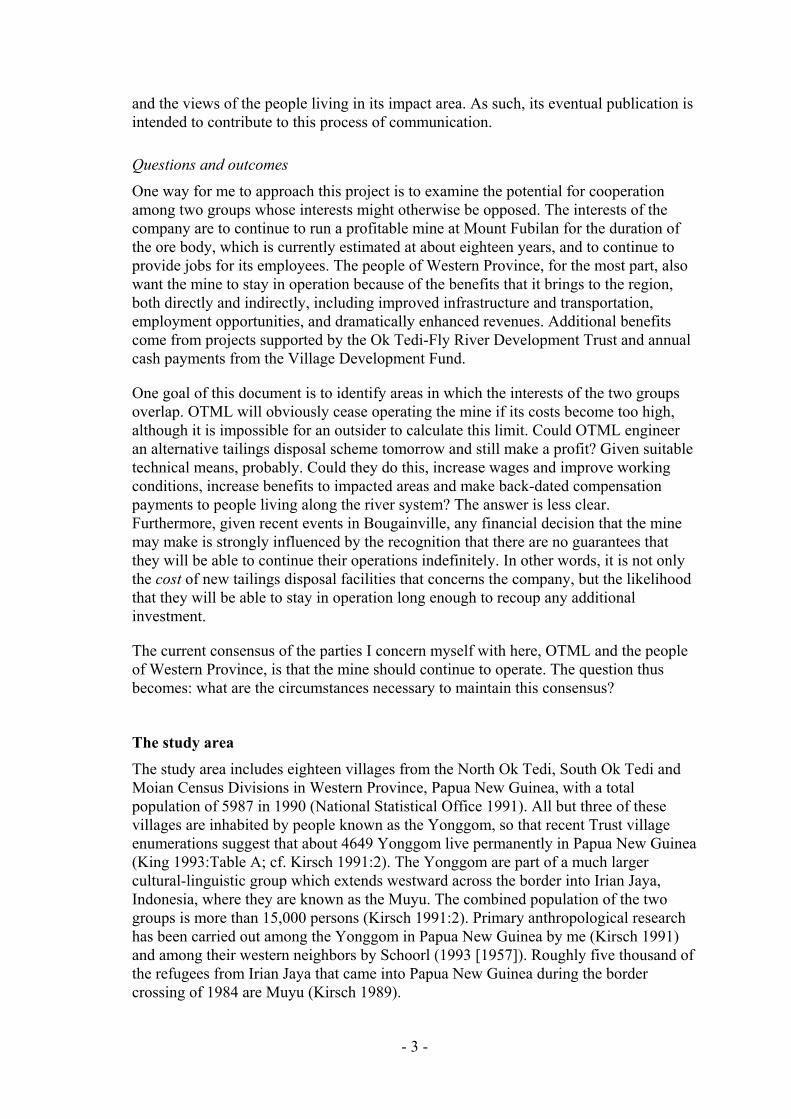
For the purposes of this study, I have divided the study area into four zones comprising groups of villages sharing similar economic and geographic circumstances and a similar level of environmental impact from the mine (Figure 1).
Zone 1 extends down the Fly from Kiunga to the confluence with the Ok Tedi (the D’Albertis Junction). It includes three villages along the Fly River and its tributaries: Ulawas, Moian and Kawok.
Zone 2 extends south along the Fly River from the D’Albertis Junction to the Binge River. It includes one village along the Fly – Erekta – and three villages – Karemgu, Membok and Kukujaba – on the Binge.
Zone 3 comprises the North Ok Tedi Census Division and is bounded by the Ok Tedi, Ok Birim and Ok Kamen Rivers. It includes three villages: Kungim, Kungembit and Ambaga.
Zone 4 comprises the South Ok Tedi Census Division. It includes six Yonggom villages: Komokpin, Yogi, Dome, Yeran, Bongabun and Atkamba. The Awin village of Konkonda, on the east bank of the Ok Tedi, is also in this Census Division, but Bige, also Awin-speaking, is in West Awin Census Division. I have included Bige in my study, because it is situated directly on the Ok Tedi and its villagers have hunting rights on the Yonggom side of the river near Dome.3
Methods
Fieldwork took place over a period of 21 days, from 25 July to 15 August 1992, and included visits to all but one of the seventeen Ok Tedi-Fly River Development Trust villages in the region. I was able to interview members of the last village, and also collected data from Kungim village, which was not included in the trust at the time of study.
3 Yonggom have previously or do now have use rights on the Awin side of the river in several places, opposite Yeran and, according to Leo Austen’s 1923 patrol description, opposite Komopkin.
- 5 -

For each village, I followed a directed interview schedule to collect social, economic and historical information, including clan and lineage membership and patterns of land ownership; the basic data are summarised in Table 2. The second half of each interview was reserved for undirected discussion of the villagers’ perceptions of the social, cultural and environmental impact of the Ok Tedi Mine.
I was also able to collect information in other ways. With Ian Wood, Environmental Department, OTML, and my colleague John Burton, I visited river bank sites by helicopter on 14 August 1992 on the lower Ok Tedi at Dome, Bige and on the meander south of Bige (at approx. WJ 130385) where the impact of sedimentation on gardens and forests has been the greatest (see Figure 7). In addition, I interviewed members of a variety of governmental and non-governmental organizations, many of whom I acknowledge below.
Acknowledgments
Fieldwork was carried out with the assistance of Buka Nandun from Dome village, who served as research assistant for this project. I would like to thank Buka, as well as Atani Wungmo, for their help.
I am also grateful to the villagers who agreed to discuss their problems and concerns with me, despite their apprehension about speaking openly about many of these issues. I hope that this report does justice to their point of view.
I had very useful conversations with Mr. Isadore Kaseng, Premier of Western Province; Mr. Rex Dagi, organizer of ENECO, PNG, an environmental organization; Mr. Alex Maun, member of Ok Tedi Landowners Association; Pastor Kirine Yuandit of the Evangelical Church of Papua, Kiunga; Mr. Hohore Kerekere of the Department of Primary Industry in Kiunga; Mr. Niko Bun, Teacher at Kiunga High School; Mr. Dave Matthews (regarding the proposed North Fly rubber project); Mr. Don Cooper, Area Supervisor at Kiunga Wharf; Mr. Steve Christensen of the Summer Institute of Linguistics, based at Yogi village; Mr. Mathieus Korodi, Committee Member at Dome Border Camp; Bishop Gerard J. Deschamps of Montfort Catholic Mission at Kiunga;4 Dr. Mark Fitzmaurice at Rumginae Hospital; and Dr. Paul Spicer of OTML medical department.
I thank Murray Eagle, Martin Paining and Ian Wood of OTML for assistance with my study. The facilities of the Environment Department at OTML were placed at my disposal during the final week of fieldwork and every assistance was rendered by its staff members; again I thank Andy Markham, Ian Wood and Rose for their assistance. Martin Paining and Jeff Ransley, Community Relations, OTML, provided valuable commentary on their extension work. I also wish to thank my colleague Colin Filer and my colleague and editor, John Burton.
4 Where I quote refugee numbers in border camps other than at villages I visited myself, they are those provided to me by Bishop Deschamps.
- 6 -

Population 1991
Principal facilties
Water supply
Village Radio
Open Trade Stores
Iron RoofHouses
Grade 10 Graduates
Church membership
Refugees nearby
Village Endogamy
Rubber production
Goods to market
Motor canoes
Zone 1
Kawok 116 - 2 tanks - 1 3 6 all Catholic no 71% Not tapping yes 6
Moian 420 School, Aid Post 4 tanks yes 5 7 10 all Catholic no 40% Not tapping yes 8
Ulawas 302 - 5 tanks - - 5 10 all Catholic no 67% Not tapping yes 10
Zone 2
Erekta 289 - 3 tanks - 1 - 7 all Catholic yes 90% Not tapping - 8
Karemgu 586 - 1 tanks - no data 4 5 all Catholic yes no data Not tapping - no data
Membok 413 School, Aid Post no data yes no data 5 10 all Catholic yes 40% Not tapping - 10
Kukujaba 177 - 1 tanks - no data - - all Catholic yes no data Not tapping yes 1
Zone 3
Ambaga 327 School 2 tanks - - - 16 50:50 Cath:ECP - 90% Np trees - (inland)
Kungembit 155 Aid Post 2 tanks - 1 2 10 all Catholic previously 60% Np trees yes (inland)
Kungim ?200 School. Mission 6 tanks yes 4 - 20 all Catholic yes 100% Np trees - (inland)
Zone 4
Atkamba 510 School, Health SC 6 tanks yes 5 11 37 all ECP previously 80% Not tapping - 12
Bongabun 56 - 1 tanks - - 1 no data all ECP previously no data Not tapping - 1
Dome 423 School, Aid Post 3 tanks yes 5 1 20 67:33 Cath:ECP yes 80% Tapping rare - 4
Yeran 108 - 3 tanks - 1 1 3 all ECP previously 50% Not tapping - 1
Yogi 222 - 2 tanks - 3 1 11 all ECP yes 30% Not tapping - 5
Komokpin 334 School, Aid Post 2 tanks - 2 1 11 90:10 ECP:Cath previously 80% Np trees - 4Konkonda (Awin) - no data - - no data no data all ECP no no data Not tapping - 1
Totals 4638
Table 2. Villages in the study area with summary data on aspects of social development and economic activity.

CHAPTER 2 ZONE ONE: THE FLY RIVER BETWEEN
KIUNGA AND THE OK TEDI
Overview
There are three Yonggom villages located along the Fly River between the town of Kiunga and the junction of the Fly River and the Ok Tedi: Kawok, Moian and Ulawas (Figure 1). They all show signs of relative prosperity. The number of permanent houses with iron roofs and canoes with outboard motors (Table 2) indicates a reasonable cash flow. Motor canoes travel with regularity from all three villages to Kiunga, where people sell garden and forest produce at the market.
Kawok, Moian and Ulawas have all acquired the air of ‘suburban’ villages. They make regular use of resources in Kiunga, including the market, health care, schools and occasional wage labor opportunities, while maintaining their subsistence and residential base in the village. There are even people who work in Kiunga during the week and commute to their villages most weekends. From the Yonggom point of view, these developments are largely positive. It provides them with what most would consider to be nearly ideal circumstances: village life with regular access to resources and opportunities in town.
The major need of these villages is to develop alternative sources of cash income so that villagers can maintain their independence without having to seek full-time employment in town. Given the low cost of transport between these villages and the Kiunga market, the villages are well-suited for small scale development projects that would produce goods for sale in town.
The most significant problem in Zone 1, however, is the concern that local people have regarding the impact of OTML’s operations at Kiunga wharf on their environment, particularly downsream along the Fly. Most people in the three villages no longer make use of resources from the Fly River, including fish and other aquatic life, river bank garden land and river bank sago stands. In addition, the villagers no longer sell fish and turtles at Kiunga market, largely because the people in town will not buy riverine produce from this stretch of the Fly River because of concerns about OTML operations. The environmental impact of Kiunga wharf operations, therefore, should be independently evaluated, with the results made accessible to the villagers living in Zone 1 as well as the people living in Kiunga and the adjacent corners.
- 8 -

- 9 -
Kawok village (1980 population, 54; expanded count, 1165) used to be located further east along the Fly River, much closer to Kiunga. The villagers moved in 1961 because ‘too many people were dying’. At that time, no one was living in the area of the current settlement or at the junction of the Ok Tedi and Fly Rivers, even though there had been settlements there in the past.6
Kawok village
Because population density is low and the village is small, the villagers report that there is plenty of game in the forest and swamps surrounding the village. There are no other villages along the north side of the Fly River from the Ok Tedi to Kiunga, so there is little competition for resources. The closest group of refugees is at Kuyu camp, but they do not exploit resources belonging to people from Kawok.
The land on which the village is built is owned by members of two lineages. The other villagers are members of eleven different lineages, with land rights elsewhere. As in most Yonggom villages, land ownership is dispersed over a very wide area and a percentage of villagers must regularly use land that does not belong to them. In other words, land ownership and village residence do not necessarily correspond. Patterns of land ownership for Kawok village are shown in and .
6 The configuration of the junction appears to have changed between MacGregor’s visit in 1890 and that of Karius and Champion in 1926. The narrow canoe passage to the north of the present junction appears to have been the main channel in 1890, with the land between, now marked as Ferguson Island, named Morehead Island by MacGregor (Champion 1966:19). See Map 2. [Ed.]
5 In village descriptions, ‘expanded count’ will refer to OTML’s 1991 enumeration (King 1993:Table A expanded to include people living in town who regard the village as their primary residence).
Table 3
Clan Land
1. Imitman Current site of Kawok village. 2. Wimgo Current site of Kawok village.
3. Ninibiran Northwest of Dome village, along the border; land runs along Ok Nini creek, a western tributary of the Ok Tedi.
4. Wambiran West of Bongabun village, between Ok Tedi & the border. 5. Miripki-Aruawap At the Junction of Ok Tedi & Fly Rivers, known as Derikaba. 6. Kawok At the junction of Ok Tedi & Fly Rivers; lends its name to the village. 7. Yat Northwest of Dome Village, on both sides of the border. 8. Apai Previous village site along Wai Nam creek, closer to Kiunga. 9. Kawubu Previous village site (see above). 10. Anombiran Northwest of Dome Village, near Ok Nini creek (see above). 11. Dimin-Kuk-Yuran West of Yogi village. 12. Kawang-Kibian A Yonggom man from Irian Jaya settled in Nago, at Lake Murray,
where he married a woman who had land rights near Kawok. In 1986, their son moved back to use his mother’s land.
13. Komera In Irian Jaya, northwest of Kungim village.
Table 3. Distribution of land holdings for clan members resident at Kawok.
Figure 2

Although regular transport to Kiunga is available, the people from Kawok do not tap their rubber trees. They explain this in terms of the low price and their distrust of the businessman who controls the provincial rubber trade. They do actively market their produce in Kiunga. There is no medical aid post in the village; if someone becomes ill, he or she will be taken to Kiunga for treatment. Children go to school in Kiunga as well.
Irian
Jay
aPa
pua
New
Guine
a
0 20 km
John Burton 9 July 1993
Locations of all landparcels approximate
Nago (Lake Murray) ca. 50 km
Imitman Wimgo Kawok
Kawubu Apai
BongabunWambiran
Yogi
Dome
Ninibiran Yat Anombiran
Dimin-Kuk-Yuran
Komera
Kungim
Kawok
Figure 2. Distribution of land parcels owned by members of Kawok Village (see Table 3).
There are six canoes with outboard motors based at Kawok. There is one operating tradestore, three houses have iron roofs, and there are two water tanks in the village. There have been six graduates of tenth grade. Seventy percent of recent marriages have been within the village.
The villagers are members of the Catholic Church and are still very active in traditional religious and ceremonial activities. In 1987, the people of Kawok staged a pig feast for which some fifty pigs were slaughtered. They still make use of divination and curing
- 10 -

practices and actively initiate their young men into the male cult. Their most recent initiation ceremony was held in June 1992; five young men from the village participated.
The greatest problem facing the people of Kawok is their fear that OTML operations at the Kiunga wharf are polluting the Fly River. Even though the village is built on the banks of the Fly, the people living at Kawok no longer make use of the river. They do not drink from the river or swim in its waters. They no longer eat fish from the Fly because the fish are said to ‘taste bad’ and have ‘no fat’. Whereas they used to catch turtles with fishing lines and dig up turtle eggs, they report that today few turtles come up the Fly to lay their eggs. They report that someone from the ‘company’ told them not to make sago on the Fly River. Since sago production requires a supply of fresh water, which may be difficult to obtain in sufficient quantities in the swamps, riverine sago palms are a significant resource. Only a few people make gardens along the Fly River because most people fear the pollution from OTML operations in Kiunga. The village has turned its back on the river that once was its raison d’être.
The villagers are also concerned about the recent deaths of several animals that washed ashore. Two turtles, one with a broken shell, recently washed ashore along the Fly and three mature crocodiles were also found dead. The deaths of three pigs kept near the Ok Tedi were blamed onthe ‘harmful effects’ of the river. The villagers attribute these animal deaths to problems in the environment caused by the mine.
Another ecological concern of the Kawok people is that the forest land and swamps to the north and northwest of the village abut onto the Ok Tedi. The villagers are concerned that the Ok Tedi might rise above the river bank at that point, flooding their land and transporting mine wastes into their wetlands. They have seen how areas of forest fringing the Ok Tedi have been damaged, even as far south as the Fly River junction, and are concerned about the potential impact of such a flood. They depend very heavily on these swamps to provide them with fish, prawns and sago. While I do not know the slope or gradient of the land involved, the low-lying land between the Ok Tedi and Kawok may well be in jeopardy.
Moian village
Moian (1980 population, 235; expanded count, 420) is located on Ok King creek, which leads into Ok Inggin, a tributary of the Fly. The village was founded about 1950, about the same time that the government post in Kiunga was re-established after World War II. According to the Electoral Roll of 1967 (Territory of Papua and New Guinea 1967), there were originally three separate settlements, known as Moian #1, Moian #2 and Moian #3, with populations of 65, 41 and 13 adults respectively.
The residents of Moian have rubber trees, but do not wish to tap the rubber until the price increases from the current level of 18 toea/kilo to at least 35 toea/kilo. They sell garden and forest produce at the market in Kiunga, but no longer sell riverine produce out of concern that it will cause illnesses for which they will be held responsible. There is both an aid post and a school in the village, eight or nine canoes with outboard motors, five tradestores open for business, seven houses with iron roofing and four
- 11 -

water tanks. There are no refugee populations nearby. Four of the last ten men from the village to marry found wives from the village.
Villagers are members of the Catholic Church. They still make use of traditional divination and healing techniques, attend pig feasts sponsored by neighboring villages, and participate in male cult ceremonies. Young men often do not wish to participate in these rituals, but the older men are confident that the traditions will continue.
The villagers are quite concerned about the ‘copper pollution’ that is entering the Fly River at the wharf in Kiunga. That this threat is largely invisible, in contrast to the heavy loads of sediment that are clearly borne by the Ok Tedi, seems to increase anxiety about its impact on village resources. While the village stands on land at some distance from the Fly River, the people are very concerned that the ‘copper pollution’ will enter their local waterways and wetlands when the water level of the Fly is high enough to back up into its tributaries.
The people from Moian no longer make use of the resources of the Fly River or the adjacent river banks. They told me that a ‘scientist’ visited the village and told them not to make gardens along the river. Some people make their gardens along the tributaries of the Fly, but most have moved their gardens inland. As a result, their gardens are no longer as productive, because land away from the river only yields one or two crops, whereas land along the more fertile river bank continues to bear fruit. They no longer catch fish or other aquatic life from the Fly. In the meantime, there are plenty of fish, turtles and crocodiles in the feeder streams and swamps, but the people of Moian wonder whether these, too, will soon be affected. They do not harvest sago palms that grow along the Fly River although elsewhere sago is plentiful. There is enough game at present, but they no longer hunt near the Fly. Finally, they have lost access to the cash they used to obtain by selling fish at the markets in Kiunga. They are reluctant to sell fish in urban markets because the buyer might become sick and blame them for the illness.
- 12 -
The people of Moian want OTML or the government to compensate them for their loss of access to resources associated with the Fly River. Whereas OTML might perceive that local losses are far outweighed by general improvement in the region’s economic situation, (for example, many of the people who purchase goods at Kiunga market would not even be employed were it not for the mine), the people of Moian assert that they should be directly compensated for each specific loss of resource. Villagers also want to increase their share of the Village Development Fund monies, which they say amounted to only K32 per person in 1992 (K10,000 divided by 310 people – adults and children). They say that the money is insufficient compensation for the losses they have incurred. One man suggested that K200 or K300 per person would be a reasonable annual payment, but others disagreed with him immediately. They say that they ‘suffer’ as much as the people who live along the Ok Tedi and therefore should receive commensurate VDF payments.
Ulawas village
Ulawas (1980 population, 123; expanded count, 302) is the closest Yonggom village to Kiunga. Yonggom people settled in the area sometime before World War II, after fighting off the local Awin inhabitants. An interesting problem regarding land ownership resulted from this turn of events; no one claims ownership of the land on which the village stands.
Even more than its neighboring villages along the Fly, Ulawas functions as an outlying suburb of Kiunga; its ten motor canoes serve as taxis. Children go to school in Kiunga (or in Moian) and villagers receive health care there as well. There are no trade stores, as people travel easily to Kiunga to make their own purchases. There are five houses with iron roofs and five water tanks in the village. There have been ten graduates of tenth grade. In the last nine marriages, six men found partners in the village.
The people of Ulawas are members of the Catholic Church. Its people still actively participate in traditional activities such as dances, divinations and healing ceremonies. They have, however, given up male cult ceremonies; young men are no longer initiated into the cult. In July of 1992, the villagers were busy constructing a compound for a pig feast that they planned to host in December 1992. This requires a very investment of labor and is a good indication of the vibrancy of the community. People from a number of Ok Tedi and Fly River Yonggom villages were expected to attend.
When the waters of the Fly River are high, they flood into the creek that leads to Ulawas. The people are concerned about what they call ‘copper pollution’ and how this affects riverine life. They say that they no longer make gardens or harvest sago along the Fly. Inland, there is no impact from the mine and there is sufficient game for them to hunt, although they were disturbed by the sight of aconcerned about cassowary with ‘ boils’ that they saw.
Even though the operations at Kiunga have not had a great impact on them yet, they are concerned about the future possibility that the ‘copper pollution’ will enter the local
- 13 -

food chain. They wonder what will become of them should they no longer be able to make a living off the land. Will the company feed them? How will they survive?
People in Ulawas have rubber trees, but do not tap them because of the low market price. They sell food at the market in Kiunga, but they do not sell fish from the Fly River, because they are concerned that it will cause illness.
Summary
People from Kawok, Moian and Ulawas all expressed fear and concern about the impact of OTML operations at the Kiunga wharf on the Fly River. All three villages also report that they were told not to exploit the resources of the Fly River, including river bank garden land and sago stands, as well as fish, crocodiles and turtles. There was disagreement and confusion as to whose instructions these were; some people referred to a ‘German scientist’ and others to either ‘the company’ or ‘government officers’. A second dimension of the problem is that villagers are no longer able to sell riverine produce at the Kiunga market, because the people living in town are also concerned about the possible impact of wharf operations on downstream resources. People at Kawok village also suggested that the fact that a number of crocodiles and turtles washed up onto the river bank during the past year was evidence of the polluted state of the Fly River.
There are at least four potential sources of pollution from wharf operations in Kiunga (Don Cooper, OTML operations, pers. comm.):
(1) Leakage of oil and gas and other petroleum products directly into the Fly River. OTML is currently taking steps to recover and recycle these losses. Part of this effort involves lining the wharf with concrete and the construction of a drainage system. Recovered petroleum products will be transported to Tabubil where they will be burned as fuel.
(2) Release of copper concentrate from the copper dryers in exhaust fumes during system malfunction and miscellaneous wind transport of copper concentrate from the storage sheds and during loading of ships. According to OTML, neither of these problems are enough to pose a serious health threat.
(3) After processing, the excess water from the copper slurry line is released directly into the river system. It is obviously in the company’s economic interest to have a high copper recovery rate and, given recent improvements in the process, OTML claims that there is little danger that significant amounts of particulate copper will be released into this portion of the Fly River. The company has begun construction of several settling tanks, which should increase copper recovery and reduce the discharge of copper into the river. There may be some confusion regarding this process, because the effluents from the town sewage system are released into the river from the wharf as well.
(4) The reagents used to extract the copper concentrate at the wharf, including frothers, collectors, a drying agent and flocculent. First, most of the reagents are organic chemicals, which break down in sunlight. Second, most will adhere to the products and, therefore, will be removed from circulation. Finally, the amount of the chemicals used is very small – in fact, according to OTML, too small even to be measured in the Fly River.
There are several other factors that may influence riverine life along the Fly between the Ok Tedi and Kiunga. The first is the increased river traffic along the Fly, including
- 14 -

mining vessels, supply ships to Kiunga, and quite a number of canoes powered by outboard motors. Collision with the propellers of any of these could be fatal to both crocodiles and turtles. It is possible that the wake of larger vessels may disrupt turtle movements and egg-laying behavior. Also, the changing hydrology of the Ok Tedi affects the flow of the Fly River above the Ok Tedi junction, causing the Fly to back up when the Ok Tedi is flooding. Finally, intensive harvesting of turtles and turtle eggs for sale at the Kiunga market during the 1980s could have had an impact on current populations.
Assuming the accuracy of the information regarding the limited environmental impact of the operations at the Kiunga wharf, the concerns and fears of the villagers along the Fly River between the Ok Tedi and Kiunga may be somewhat exaggerated. Nonetheless, until the people of Kiunga and the villagers living along the Fly River are convinced that the discharge from the wharf is not harmful to them or to their environment, the villagers will not make use of the full range of their resources and will continue to be deprived of what was previously an important source of cash income, the sale of riverine produce at the Kiunga market.
The major need of these villages is an additional source of cash income. Given the low cost of transport between these villages and Kiunga, the villages are well-suited for small scale development projects producing goods for sale at the Kiunga market. This would partially compensate for lost earnings from riverine produce and supplement current sales of pig and cassowary meat, bananas, sago, greens and sweet potatoes at the Kiunga market.
- 15 -

CHAPTER 3 ZONE TWO: THE FLY RIVER FROM THE OK TEDI
TO BINGE RIVER
Overview
There are four villages along the Fly River from the Ok Tedi to the Binge River (see ). Erekta is close to the Fly on the Ok Yimbusi creek. Kukujaba is a Boazi
village on the Binge, not far from the Fly. Membok and Karemgu are Yonggom villages located further upstream along the Binge.
Figure 1
People from all four villages expressed great concern about the impact of OTML on their environment. The amount of suspended sediment in the Fly River has increased greatly since 1989. According to local informants, the trees fringing the Fly River are beginning to show this impact. When the water level of the Fly is high, mine wastes are forced into the Ok Yimbusi, which runs through the center of Erekta village (see Photo 1); the new steel bridge built by the Trust at Erekta becomes submerged during floods. Water from the Fly River also backs up the Binge as far as Kukujaba village. People are worried and frightened about the potential toxic impact of the minerals and chemicals that may be released into the river system by OTML, particularly on local aquatic life. This fear has caused some people to give up exploitation of riverine resources.
Erekta, which used to rely heavily on resources from the Fly River, has the fewest assets of any of the four villages. It is far from the nearest school or aid post and, given that villagers cannot sell fish in the Kiunga market, once their major source of cash income, they are less able to afford the fuel to travel to Kiunga. Refugees from Niogamban camp also make use of their resources. In contrast, the villages of Membok and Karemgu are in relatively good shape economically. However, the people of Kukujaba lag behind their neighbors, which may be attributed in large measure to the fact that they have only recently abandoned their traditional pattern of seasonal movements.
Erekta village
Erekta (1980 population, 146; expanded count, 289) was established at its current location in the mid-1950s; its inhabitants migrated to the region from west of the border near present-day Mindiptanah at least seventy years ago. Legend has it that a man named Wunop was the first Yonggom settler. Wunop killed a python and from its stomach emerged an Awin man. After establishing boundaries between the Yonggom and the Awin, Wunop brought his family east to settle near the Fly River.
The villagers are members of the Catholic Church. They still actively participate in traditional activities; they dance and attend pig feasts, hold curing ceremonies and divinations, and about half of the men in the village are initiated. Nine out of the last ten men to be married found wives from the village.
- 16 -

Erekta is very isolated. Although there are six privately-owned canoes with outboard motors and two more canoes provided by the provincial government, the fuel for the three to four hour trip to Kiunga by motor canoe is very expensive and the villagers have no regular cash income. There are no houses with iron roofs, but there are three water tanks in the village. There have been seven graduates of tenth grade.
They have a large block of rubber trees, but they cannot afford to transport the rubber to Kiunga. Inspection confirmed that there had been no tapping recently. There is no aid post in the village and people must travel to Moian or Kiunga for health care. There is no school in the village, so children attend primary school in Membok, Moian or Kiunga. Parents often find it difficult to raise the money necessary to pay their children’s nominal school fees. There is one operating trade store in the village.
The people at Erekta identify their lack of health care as their biggest problem. They think that there should be an aid post in the village. It takes too long and is too expensive to travel to the nearest aid post in Moian or Membok; as a consequence, when people fall sick they frequently go untreated until they become critically ill.
A second problem that the villagers face is competition for resources by the refugees at Niogamban (1992 population: ca. 400). The refugees clear forest to plant gardens, harvest sago palms belonging to villagers and hunt on land belonging to the villagers. The villagers say that they are displeased about the lack of government initiative in moving the refugees away from their property.
A third problem facing the people from Erekta is the impact of mine wastes on the Fly River and its feeder streams. The Fly River is twenty minutes from the village by foot and thirty minutes by canoe; the people from Erekta used to rely heavily on its resources. When water levels in the Fly River are high, it backs up into the Ok Yimbusi, the creek that runs through the center of the village. When the water recedes, it leaves behind deposits of mine wastes.
The villagers say that the leaves of the trees along the Fly River look different from before. They know that this is one of the effects of the mine and they want to find out why this is happening. They trust their own observations: the river has changed color, the leaves of the trees have changed color and there are fewer fish in the river. They told me that they are concerned because they are unable to determine whether there are harmful chemicals in the water or not. As a result, people do not want to eat any food that has come into contact with water from the Fly River. They said that even if someone from OTML came to the village and talked to them about the effect of the mine on riverine life, they would not know whether they were being told the truth and, hence, whether or not it was safe to eat these foods.
They report that there are still fish and prawns in the Fly and the nearby swamps and creeks, although fewer than before, but that they no longer catch and eat them. Sometimes, when they are hungry for meat, they will eat fish and prawns from the river, but they are afraid that this will make them ill. Erekta people say that people in Kiunga will no longer buy their fish at the market. This, they say, has resulted in a significant loss of cash income and has removed a way of paying for canoe trips to Kiunga.
Gardens used to be made along the Fly, but are no longer maintained there because the sites are covered in mud. This forces them to make their gardens in the forest, where
- 17 -

only one good harvest can be obtained. They say okari trees along the Fly no longer bear fruit. While some of the sago trees along the Fly and the small creeks are unaffected, they say that others only have water inside instead of starch. People have decided not to use the sago palms growing along the Fly any longer and have to travel longer distances to find mature palms. The problem is compounded by the fact that the refugees use their sago trees as well.
When they hunt, they cut open the animals to see whether they are safe to eat. If the animals look healthy (i.e., have ‘fat’ and ‘plenty of blood’), they will eat them. If the animals are too thin or do not look right, they will not eat them.
The villagers do not understand why international law does not protect them against pollution from the mine and why crocodiles, fish and other riverine life are not protected. They think that OTML and the government are crazy (literally ‘lacking sense’) for not protecting the environment. They complain that the ‘government is sleeping’ and that the provincial government wastes the money that it receives in royalties and from the national government. They are frustrated by the lack of coordination between the different agencies that provide them with services, including the company, the government and the church, which causes them to ‘fall through the cracks’.
The people of Erekta say that they are hungry and have no money to buy food, matches, soap, or kerosene, or to pay the school fees for their children. Their second most reliable source of cash income after rubber, selling fish at the market in Kiunga, is no longer an option. They have no health care close by. They no longer make use of important resources from the Fly River and have to compete with the refugees for those that remain.
Membok village
Membok (1980 population, 166; expanded count, 413) was founded in 1963, when two earlier settlements, Ungerrem #1 and Ungerrem #2, combined. While the land surrounding the village is divided among Yonggom villagers, the people from Kukujaba claim ownership of the entire area, saying that they gave the Yonggom people their permission to establish the village.
Because of the airstrip run by the Montfort Catholic Mission, the aid post and the primary school, Membok is the hub of the three Binge River villages. The schoolteachers maintain regular radio contact with the Catholic Mission. A long block of rubber trees runs along the wide path between Membok and Karemgu, but no one taps the trees because of high transport costs and the low price of rubber. People from the village occasionally take goods to the market in Kiunga by motor canoe, but it is a long journey for them. There are ten canoes with outboard motors in the village, but trips to Kiunga are infrequent. There are five houses with iron roofs. The last nine village men to marry found partners divided equally from Membok, Karemgu and the refugee camp at Kuyu. There are ten graduates of tenth grade in Membok.
The villagers are members of the Catholic Church. They hold traditional dances occasionally, usually on calendrical holidays (e.g. Independence and Christmas). They
- 18 -

still use divination and curing practices. They attend pig feasts, such as the 1987 feast at Kawok, but have not taken their young men to male initiation ceremonies in other villages, mainly because of time constraints.
The villagers have had few problems with the refugees living at Kuyu camp (population: 800), largely because of the distance between the camp and the village. Some of the landowners of the Kuyu camp site live in Karemgu. There have been disputes or fights in the past, concerning hunting practices, for example, but they have been resolved.
People in Membok and Karemgu do not garden as extensively as do their neighbors to the north; their major staples are sago and fish. When they do make gardens, the major crops are bananas and cassava; the latter has gained in popularity since the arrival of the refugees in 1984.
The people claim that their local environment is changing. When the water level of the Fly River is high, the Binge reverses directions and water from the Fly is forced upstream. While the mud or sediment from the Fly River is not carried as far as Membok, its ‘power’ is said to affect the local ecosystem. They are not happy with the company because it has been ‘spoiling’ their environment and they no longer have enough to eat.
They are afraid to eat the fish that they catch in nearby creeks. They say that the fish are sometimes very thin, are too white inside, or they have no ‘blood’. They also claim to have found fish with what they call ‘copper rocks’ in their stomachs. Last year a man they identify as a ‘German scientist’ came to the village and reportedly told them not to eat the fish or sell them in the market. According to the local health care worker (aid post orderly), however, even though people complain about the fish, he has not observed any problems. He also says that the people from the village continue to eat the fish. Village health status has stayed relatively constant during his four years; there are serious problems with malaria, but it does not seem to be growing worse.
They report that when they harvest sago palms that have been submerged during flooding of the Fly River, there is no starch inside, only water. In contrast, the sago palms found away from the Binge River are fine. The ‘power’ from the water in the Fly River is said to affect the plants so that their gardens do not develop properly, the bananas are dry and not good to eat, and the sweet potatoes stay hard even after they are cooked. They say that when animals come to drink from the river, and they catch them and cut them open, they do not have ‘blood,’ or their lungs are filled with mucous. Otherwise, there is still enough game for them to hunt.
The village lies on a shallow strip of land surrounded by swamps. Sediment deposited at the mouth of the Binge River causes the river to back up, raising the water level of both the river and the connected wetlands. If this intensifies, it is possible that the village will permanently cede ground to the swamps. Currently, natural flooding affects only the low ground around the village and only for limited periods of time. If current rates of sedimentation continue, it is possible that eventually the village will no longer be fit for habitation.
- 19 -

Their share of the Village Development Funds amounted to about K20 per person, which they do not consider sufficient. They want more money and more projects from the mine in return for its impact on their environment.
Karemgu village
Karemgu (1980 population, 128; expanded count, 586) is close to Membok along a well-travelled path; people from Karemgu make regular use of resources at Membok. There are five graduates of tenth grade from the village. There are four houses with iron roofs and one water tank in the village. The people are all members of the Catholic Church. Given that I interviewed people from both villages together, the information presented above represents the circumstances facing both villages.
Kukujaba village
The people living in Kukujaba (1980 population: 132) are Boazi speakers. They previously lived at the mouth of the creek leading to Membok. In the early 1960s, they moved to a place they call Kukujaba. More recently, they moved to Kimbagaip, which is closer to the mouth of the Binge River (which they call the Bimagai). They are still referred to as the ‘Kukujaba’ despite their move to Kimbagaip. They own all the land along the Binge, including the village sites of Membok and Karemgu.
People from Kukujaba visit Membok frequently; about twenty of their children attend its primary school, they receive medical treatment there and they occasionally fly to Kiunga from its airstrip. Ten or twelve families from Kukujaba with children in the Membok school have built houses on the far side of the airstrip, where they stay during the school year. Despite the presence of a Boazi-speaking schoolteacher from Bosset, the children do not do as well in the school as the Yonggom children. The Boazi and the Yonggom get along well. They can understand some of the other’s language, but do not speak it. They communicate with each other in Motu.
Like their neighbors, as well as the large Boazi community at Bosset, the people at Kukujaba are members of the Catholic Church. They still follow traditions for curing illness and for funerals. They have feasts at which they kill pigs and maintain a men’s house. They have given up many other customs.
Their comments on environmental change are similar to those voiced by people from Karemgu and Membok. They say that when they harvest sago, they say, the pith is soft and watery. Their bananas bear fruit, but the fruits are smaller than normal. The sweet potatoes are no good. Some of the fish they catch have ‘no blood’, so the people refuse to eat them. Before the mine began production, animals used to come to the Fly River or its side creeks to drink, where they could be caught, but now this is uncommon. Today, even when animals do come to the river, they may die and fall into it. When the Fly River floods into the Binge, they are afraid to even touch the water, whereas in the past I saw people sometimes drank water directly from the river, a practice that I witnessed during a visit to Membok and Karemgu in 1986 Today, only some of the villagers are willing to swim or bathe in the Bingge. They will not hunt near the Fly or harvest sago
- 20 -
from beside the river any longer, making it difficult for them to produce enough food to eat. They have to travel long distances for sago and for game.
The Kukujaba people are pleased that the company has established a trust fund and is setting up projects and giving out VDF funds to villagers, but they do not think that the company has given them enough to compensate for the damage to the river that it has caused.
Like their neighbors, they have rubber trees that they do not tap. As they only began sending their children to school in 1985, there are no high school graduates from Kukujaba. Many of the Kukujaba students in the grade school are five or six years older than their Yonggom peers. Compared to their neighbors in Membok and Karemgu, the people from Kukujaba look somewhat bedraggled. This has much to do with their lack of participation in the cash economy. No one from Kukujaba, for example, works in Kiunga, and their only access to cash is through occasional sale of crocodile skins. There are no houses with iron roofs in the village, but there are three water tanks. The people from Kukujaba are relatively isolated from their fellow Boazi, who, because of the long-standing mission presence at Bosset, are otherwise one of the better educated groups in the province. Their subsistence strategies include large hunting expeditions that burn the rain forest to drive the animals, little gardening, and less intensive methods of sago production (see Busse 1987). These strategies may be better suited to a mobile style of life, moving from camp to camp, which they have recently abandoned.
Summary
Erekta is the most adversely affected village in this zone. The villagers now make little use of resources from the Fly River and claim that it is no longer possible to sell fish in Kiunga. This effectively marginalizes them, because it means they can no longer afford to travel to Kiunga or participate in the regional economy. Additional pressure on their resources comes from the 400 refugees at Niogamban Camp who live on Erekta land. Since the nearest aid post is nearly three hours away by outboard motor, villagers at Erekta lack both regular medical care and efficient access to emergency treatment. Informants here expressed frustration with OTML and have had conflicts with staff from the OTML Environment Department in the past.
The villages along the Binge are in relatively good economic shape. Their concerns about the environment, however, need to be addressed. The resources that they exploit need to be examined for negative environmental impact, including the consequences of sedimentation at the junction of the Binge and Fly Rivers. Finally, given their distance from Kiunga, they are not in a position to transport perishable goods to the market. The villages would probably support projects oriented towards local consumption.
- 21 -

CHAPTER 4 ZONE THREE: VILLAGES WEST OF THE OK BIRIM JUNCTION
Overview
Kungim, Kungembit and Ambaga are situated in the foothills west of the junction of the Ok Tedi and Ok Birim Rivers (see Figure 1). People living in these villages own land beside the two rivers, but most subsistence activity takes place in the foothills several kilometers west of the river system. Despite their distance from the Ok Tedi, people from all three villages blame the mine for what they perceive to be a general decline in the productivity of their land and the availability of resources, including gardens, sago stands, game and riverine life.
These detrimental effects were variously attributed to the ‘power’ of the mine, the impact of ‘copper medicine’ on the environment and ‘pollution’ from the mine was described as ‘coming up through the ground’ or ‘in the rain’. These attributions are very similar to statements made by landowners in Bougainville regarding the environmental impact of the Bougainville Copper Mine (discussed on p. 45).
Because Kungim has an airstrip and is a Montfort Catholic Mission Station, it serves as the hub of the three villages. Kungim is not currently a member of the Trust but, for reasons I set out below, I recommend that it should be included in the future.
Kungim village
Kungim village (1980 population, 483; 1990 NSO count, which includes refugees, 1587) is a Catholic Mission Station on a village site founded in 1952 by a Dutch Patrol Officer. When the border was later surveyed in the 1960s, the village was found to be in Australian territory, and administration of the station was taken over by the Montfort mission based in Kiunga. Kungim village lies approximately 4 km northwest of Kungembit and 2 km north of Ambaga (see Figure 1).
The village has no rubber groves, no road access and no means of transporting goods to urban markets. The village is distant from the river and the villagers therefore own no canoes with outboard motors. The people depend almost entirely upon mission aircraft for the transport of goods. There are four trade stores in the village, six water tanks, no houses with iron roofs, and twenty graduates of tenth grade, none of whom have found work. All of the last ten marriages were arranged within the village. While the villagers are members of the Catholic Church, they still stage dances, hold pig feasts, conduct divinations and carry out initiation ceremonies.
The refugees arrived in 1984; a census in 1988 estimated that there were 940 people living in the camp (Preston 1988:21). Today, only a small number of refugees are actually in residence in Kungim at any given time, perhaps only 60 to 100. Several hundred additional refugees claim official residence at the camp, and will return for certain events or census-taking. Regardless of the number of people at the camp today,
- 22 -
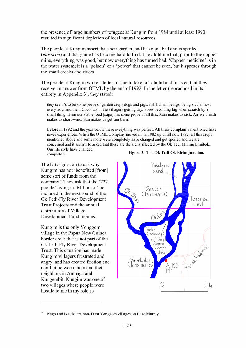
the presence of large numbers of refugees at Kungim from 1984 until at least 1990 resulted in significant depletion of local natural resources.
The people at Kungim assert that their garden land has gone bad and is spoiled (moraron) and that game has become hard to find. They told me that, prior to the copper mine, everything was good, but now everything has turned bad. ‘Copper medicine’ is in the water system; it is a ‘poison’ or a ‘power’ that cannot be seen, but it spreads through the small creeks and rivers.
The people at Kungim wrote a letter for me to take to Tabubil and insisted that they receive an answer from OTML by the end of 1992. In the letter (reproduced in its entirety in Appendix 3), they stated:
they seem’s to be some prove of garden crops dogs and pigs, fish human beings. being sick almost every now and then. Coconuts in the villagers getting dry. Sores becoming big when scratch by a small thing. Even our stable food [sago] has some prove of all this. Rain makes us sick. Air we breath makes us short-wind. Sun makes us get sun burn.
Before in 1992 and the year below these everything was perfect. All these complain’s mentioned have never experiences. When the OTML Company moved in, in 1982 up untill now 1992, all this crops mentioned above and some more were completely have changed and got spoiled and we are concerned and it seem’s to asked that these are the signs affected by the Ok Tedi Mining Limited... Our life style have changed completely. Figure 3. The Ok Tedi-Ok Birim junction.
Yukbit
Island
KoremdoIsland
YukubunditIsland
Deetbit
ALICEPIT
OkBirim
Ok Tedi
(land name)
(Yonggom)or ?DurpiAiemsu(Awin)
0 2 km
Birimkaba(land name) Kiu
nga Hi
ghway
The letter goes on to ask why Kungim has not ‘benefited [from] some sort of funds from the company’. They ask that the ‘722 people’ living in ‘61 houses’ be included in the next round of the Ok Tedi-Fly River Development Trust Projects and the annual distribution of Village Development Fund monies.
Kungim is the only Yonggom village in the Papua New Guinea border area7 that is not part of the Ok Tedi-Fly River Development Trust. This situation has made Kungim villagers frustrated and angry, and has created friction and conflict between them and their neighbors in Ambaga and Kungembit. Kungim was one of two villages where people were hostile to me in my role as
7 Nago and Buseki are non-Trust Yonggom villages on Lake Murray.
- 23 -

interviewer; here they threatened dire consequences if I did not report their complaints to OTML, and get a successful outcome for them.
Inquiries about land holdings revealed two cases of Kungim residents having rights to land on the Ok Tedi, east of their village (see Figure 3). Land on Deetbit Island is partially owned by members of Kigo-Deetbit lineage, who live in both Kungim and Kungembit villages (Awins claim land on the eastern side of the island, opposite Alice Pit – J. Burton, pers. comm.). Land at the junction of the two rivers, in the area known as Birimkaba, is claimed by members of both villages as well. Given that ownership of land on the Ok Tedi is a criterion for membership of the Trust, Kungim village would seem to be so qualified.
(I see from King’s report that ‘Birimkamba’ is listed as a Trust village and, indeed, that 211 people are enumerated as its residents. The existence of this settlement is a surprise to me, as I am only aware of a few garden houses at Birimkaba. Consequently, I cannot say who the residents are. This is not a village listed by the government for census.)
Kungembit village
Kungembit (1980 population, 127; expanded count, 155) was founded about 1955; prior to that, the people lived in very small, scattered hamlets. They have no rubber trees, but sometimes take dried coconuts, sago flour and bananas to Tabubil market. There is a new Yonggom language literacy program for preschool children in the village, but they attend primary school and make use of the aid post in Kungim. Ten students from the village have completed tenth grade. There are two houses with iron roofs and two water tanks in the village.
Given their distance from the river, they have no canoes with outboard motors. Six of the last ten marriage were arranged within the village. They are members of the Catholic Church, but continue to participate in a variety of traditional rituals, including dances, divination and healing ceremonies and pig feasts; in 1992, they held a male initiation ceremony for four village boys.
When the refugees came in 1984, they started making gardens on Kungembit land without first gaining permission to do so; the villagers destroyed the new gardens and chased the refugees away. In response to my questions, they told me that the refugees no longer hunt on their land or fish in their creeks.
It is their opinion that, while the projects supported by the Trust are good, they do not ‘satisfy’ the people. They are also concerned about the present lack of project maintenance. ‘What do we do,’ they asked, ‘if something breaks down?’ As an example, they pointed to the mosquito larvae in the water that collects in the tarp covering a water tank supplied by the Trust. In terms of future development, they want a road project that will connect them to Ningerum.
They complained that no one from the company comes to talk to them apart from the people installing the tanks and the representatives of the Village Development Fund. Furthermore, they say none of these people ‘explain anything’ to them. They want to meet with and talk to people who can explain to them what the mine is doing.
- 24 -

The people at Kungembit also report having difficulties in food production, including their gardens. They say that when they cut down their sago palms, many of them have no starch. They attribute this to mine pollution in the following way: contaminated vapour or smoke rises up into the clouds at the process plant (at the mine), is transported in the clouds, and then falls down on their sago stands and gardens some 50 km away, like acid rain.
Ambaga village
Ambaga (1980 population, 194; expanded count, 327) is a little more than an hour away from Kungim by foot, and roughly four hours walking from Ningerum. They have no rubber trees to tap, no means of transporting produce to urban markets and no trade stores. The nearest aid post and school are at Kungim, but they do have a village literacy program like the one at Kungembit. There are no houses with iron roofs, but there are two water tanks in the village. Because of their long-standing access to school at Kungim, there are sixteen graduates of tenth grade from the village. Nine of the last ten marriages were arranged within the village. Religious affiliation is divided between the Catholic Church and the ECP; members of the former still practice various rituals (e.g. divinations and healing ceremonies), while the latter do not.
Residents of Ambaga appreciate the projects set up by the Trust and request more food-producing projects. They would also like an aid post for the village; Kungim and Komokpin are too far away for sick people to walk. Their annual payment from the Trust amounted to only K43 per person (divided among all men, women and children), which lasted only one or two months. They are aware that people in other villages are receiving larger payments and question the disparity given that they are suffering from a food shortage themselves.
They told me that they could ‘see with their own eyes’ that ‘the river has turned bad’. They say that their crops (banana, taro, etc.) have been affected as well, producing food that is ‘bone only; it has no body’ (kono mo; it yipban). There are similar problems with their sago stands and other important tree crops (pandanus, breadfruit and okari). Their fishing and hunting have also been affected. They say that there are few fish or prawns in their creeks; even with a net they do not have much success. Hunting has similarly declined. Although they claim not to have had any confrontations or problems with refugees from Irian Jaya, the added pressure on the land while the refugees lived in the Kungim camp has probably affected resource use as far south as Ambaga. For example, the path between Ambaga and Kungim was heavily gardened, with little uncultivated land.
Their explanation for the general ecological decline is that the ‘copper marasin’8 used by the mine is carried downstream by the Ok Tedi and comes up through the soil. Although the Ok Tedi does not back up into its tributaries as far as Ambaga even when it is flooding, the ‘copper marasin’ is thought to spread through the small creeks and rivers.
8 The meaning of marasin here is discussed in more depth on p. 43.
- 25 -

People from Ambaga say that while they were previously healthy, there is now a food shortage and people are becoming ill. Their teeth are rotting. Their children are suffering because there is no meat for them to eat. They are concerned that people with illnesses will die because there is not enough food for them. One man told me, ‘If I die, OTML will be responsible (dabap kandanip); they should be afraid’.
Summary
The villages of Kungim, Kungembit and Ambaga are located in the foothills to the northwest of the Ok Tedi. Despite the distance from the river and the difference in elevation, villagers claim that the ‘copper marasin’ in the Ok Tedi has poisoned their environment, affecting everything from wild game to crops in their gardens, and is causing sickness in humans, with symptoms ranging from rotting teeth to difficulties in breathing.
Many of the problems that the people in this region attribute to the mine may be better explained by a combination of general changes in their lifestyle and diet, and the gradual, but nonetheless very real, depletion of local resources, a process greatly accelerated by the presence of a thousand refugees over a five-year period. The refugees have depleted local game resources and their use of garden land may have led villagers to make new gardens after inadequate fallow periods, a practice that could account for reports of substandard yields.
One indication of the stress on resources faced by the villagers in this area is the presence of a new style of gardening that involves intensive cultivation of several varieties of root crops on a small plot. Until recently, the Yonggom had only one type of garden, which was a large, unfenced and mixed garden dominated by bananas but haphazardly planted with a small percentage of other crops and fruit-bearing trees.
The new gardens are significantly different. Typically, the plot is square or rectangular, no more than five to ten meters across. The edge of the garden may be marked with short, crossed sticks. A single row of cassava, referred to locally by the Malay ubi, is often planted along this border. Sweet potatoes are planted in highlands fashion, in the center of mounds separated by drainage channels. Staked yams are planted in another section of the plot, and taro is planted where the plot drains. The Yonggom only infrequently planted root crops in the past. These small gardens, which have become ubiquitous during the past three to four years in the villages along the Ok Tedi (both Zones 3 and 4) are a sign of agricultural intensification in response to land pressure and resource shortages. In addition to their greater yield, these new gardens, which are mulched, are typically made on land not otherwise suitable for use in horticulture. There were, for example, a number of these new root crop gardens in the abandoned refugee area beside Kungim village. These new techniques require more intensive labor, but enable the villagers to make better use of limited land resources.
The people in the three villages are also unable to participate in the regional cash economy because there is no road linking them with Ningerum. Several years ago, villagers took the initiative to begin clearing a road from Kungim to the Ok Tedi-Ok Birim junction. There would be considerable support for government efforts to complete this road.
- 26 -

CHAPTER 5 ZONE FOUR: OK TEDI RIVER VILLAGES
Overview
In Zone 4, the Ok Tedi undergoes a transition from a fast-flowing, sloping river that transports its load of suspended sediment downstream to a sluggish, meandering river that begins to release the finer sediment that it carries. While the volume of deposited mine waste is greatest above Ningerum, Zone 4 is particularly vulnerable to overbank flooding and has sustained a high level of damage from material deposited outside the river channel.
As a consequence, the area has been heavily affected by the mine waste, which has been deposited onto forest and garden land, into adjacent wetland areas and upstream into the numerous creeks and streams that flow into the Ok Tedi. This is in stark contrast to the alluvium that once fertilized the river’s flood plains, turning them into ideal garden land. The mine wastes have had adverse impact wherever they have been deposited, killing plants and trees, and disrupting local ecosystems. The damage extends for approximately forty kilometres along the river, with areas of dead trees on both sides of creeks at distances of three kilometres from the main channel. There has been little regrowth to date, and large areas are virtually devoid of life (see Photo 2 and Photo 3). This land was particularly valuable to the villagers because it is located within easy walking or canoe distance, and because it offered resources not readily available in the rain forest interior. Up to the time of fieldwork, little formal assessment of the environmental damage had been made and no compensation paid.9 As may well be imagined, the villagers in this zone are in a state of despair and, despite the work of the Trust in bringing some new facilities, feel frustrated and ignored in their efforts to obtain restitution.
Over two thousand people live in the eight villages in the area. Another one thousand people live in refugee camps at Dome and Yogi. They are all dependent upon local resources for the vast majority of their subsistence needs. The impact of mine wastes released into the Ok Tedi has challenged the abilities of the people along the lower Ok Tedi to feed themselves. One measure of this is the presence of intensified root crop gardens that have sprung up throughout the region since 1989.
These people have lost access to garden land along the fertile river flood plain, which has been covered by mine wastes. Now they must compete for plots in the rain forest that produce one or two harvests at most. There are fewer fish in the Ok Tedi and most people are afraid to eat them. Few turtles come up the Ok Tedi to lay their eggs; formerly this was an important seasonal resource. Many of the small creeks and streams that feed into the Ok Tedi are choked with mine wastes; it has become difficult to catch prawns and crayfish. Some sago trees along the river have died; other trees in adjacent wetlands are threatened. Still other sago stands have been swallowed by the widening Ok Tedi. The forest fringing the river was also once a rich hunting ground.
9 This was still the situation at the time of writing (mid-1993). See extended discussion on p. 68.
- 27 -

Komokpin village
Komokpin village (1980 population, 123; expanded count, 334) was founded in the 1940s at the direction of an Australian patrol officer. The land on which the village is built belongs to the Marapka lineage and is controlled by a woman named Kupen; her sons will control the land after her death. Most of the villagers are members of the Evangelical Church of Papua; they claim to have given up their ‘customs’ in favor of Christianity. A handful of people consider themselves Catholic, although they do not have a church or hold services in the village. There is an aid post and a school in the village; there are also four canoes with outboard motors, two operating tradestores, eleven graduates of tenth grade, three houses with iron roofs and two water tanks. Of the last ten men from the village to marry, eight of them married women from the village.
In contrast to the other villages in this zone, no rubber trees were ever planted at Komokpin. It takes two days to travel by outboard canoe directly to Kiunga; villagers usually cross the Ok Tedi by canoe and then walk to the Kiunga-Tabubil highway and wait for a vehicle to stop for them. It is too far and too expensive to take vegetables or sago to sell at the market. They gain some cash from urban remittances.
People living in Komokpin say that they do not have enough food to eat. They say that when they cut down sago trees, the pith inside is hard; it does not produce starch. (This is similar to complaints from other villagers, who say that their trees yield a watery substance instead of starch.) Other sago palms fail to mature. They also claim a shortage of protein in their diets. They have tried to raise more pigs to compensate for this problem, but the pigs ruin their gardens. They want the company to help them to fence their gardens by providing them with wire and steel posts. They would like chicken-raising projects in the village, but reject fish projects because of the labor required.
An issue of continuing significance is the abandoned refugee camp to the northwest of the village. From 1984 to 1987, more than a thousand refugees lived there; from a distance, the area looks like an airstrip. Primary forest has been extensively cleared and woody regrowth is gradually taking its place. Even though the refugees left the camp in 1987, it will take another decade before this land will become available for gardening. The presence of game animals has similarly declined. Villagers have turned in part to intensified root-crop agriculture.
The creek leading from the Ok Tedi to the village is called Ok Kamen. While the creek is clear, its bottom and banks are covered in grey mud left behind during the Ok Tedi’s most recent episode of flooding. The villagers say that the water causes tropical ulcers and infections. I was told a story about a child who swam in the Ok Kamen (see Map 1) when the Ok Tedi was backing up into the creek; two days later the top layer of his skin was said to have ‘peeled off’. The child subsequently recovered, but people added that two other children later suffered from the same symptoms.
People from Komokpin want the company to stop releasing mine wastes directly into the river system and they want compensation for damage already done to the environment. If this does not take place, they think that the mine should be closed because their quality of life is no longer good. They prefer a political rather than a violent solution to the problems caused by the mine.
- 28 -
Yogi village
Yogi village (1980 population, 125; expanded count, 222) was founded about 1960. Some of its members used to live at the junction of At Creek and the Ok Tedi (see Atkamba, p. 33). They have rubber trees, but are not tapping them because of the low price paid for rubber. They do not sell goods to the market in Kiunga, both because transport is difficult and because they lack surplus goods and food. The presence of several hundred refugees in the nearby camp (and nearly a thousand more people nearby at Dome and its camp) clearly exacerbate their difficulties in obtaining food.
Some villagers receive small amounts of money from friends and relatives working in Kiunga. There is no aid post or school at Yogi; the people make use of the facilities at Dome. There are five canoes with outboard motors and three operating trade stores in the village. There is one house with an iron roof and there are two water tanks. Eleven students have tenth grade educations. Of the last ten men from the village to marry, three married women from Yogi, three married women from Yogi refugee camp, and two married women from other Yonggom villages along the Ok Tedi.
The villagers are members of the Evangelical Church of Papua. A wave of evangelism, known as the Holy Spirit Movement or holi, swept the village in 1986. Soon after, expatriate missionaries built a large house beside the village. More recently, another expatriate family sponsored by the Summer Institute of Linguistics has taken their place. With the exception of pig feasts, people from Yogi no longer participate in traditional religious activities. They believe that their traditional practices ‘trick people’.
I met with a group of people who voiced the following concerns, which I relate directly: (1) there are no fish in the Ok Tedi, (2) the sediment from the mine is harming the sago trees, (3) there is copper metal scattered along the river bank, (4) OTML does not come and talk to the village people, (5) the sediment from the mine is getting into cuts and tropical ulcers on people’s arms and legs, (6) their river bank gardens have been ruined, (7) gardens away from the river only produce one good crop of bananas, (8) their rain forest gardens are far away, (9) they do not receive enough assistance from OTML, (10) they want road access to the village, (11) they have no food to feed the chickens given to them by OTML, (12) they do not want ‘work projects,’ (13) they would like a small, portable sawmill (‘wokabaut’ sawmill) to cut timber for their houses, (14) OTML should compensate them for damage to the river system, and (15) OTML should find an alternative means of tailings disposal to stop the pollution.
In their opinion, if OTML does not pay them adequate compensation for the damages that it has already caused to their environment, and if OTML does not stop dumping its mine wastes directly into the river, then the mine should close. They will not resort to violence in order to close the mine, but will enlist the support of two local non-governmental organizations, ENECO and the Ok Tedi Landowners Association, in order to bring this about.
Dome village
Dome village (1980 population, 204; expanded count, 423) was established in the early 1960s. Many of the villagers previously lived in now-defunct settlements closer to the border, including those known as Woran, Timin, Kueman and Yat. The land on which
- 29 -

the village is built is owned by members of Od lineage; an earlier settlement called Od or Ot was located to the south of Dome, at the mouth of Wuk creek.
Villagers are divided in religious affiliation between the Evangelical Church of Papua and the Catholic Church. There is occasional conflict between the two groups regarding traditional activities, to which members of the ECP Church may object. Nonetheless, Catholic villagers still hold dances, attend pig feasts, conduct curing ceremonies and divinations, and attend male cult ceremonies in other villages.
Children from both Yogi and Dome attend the primary school at Dome, although their record of acceptance to high school is rather poor. Still, there have been twenty graduates of tenth grade from Dome. There is only one house with an iron roof and there are three water tanks in the village. The aid post at Dome is currently staffed by two medical orderlies and serves close to fifteen hundred people, including the villagers from Yogi and Dome as well as the refugees in both adjacent camps.
The villagers have large rubber groves, which they keep in good shape, but only tap when they need currency for a particular expense (usually an exchange obligation, such as bridewealth payments). It is expensive to transport the rubber and the people are at the mercy of the canoe operators who set the price. There are more than half-a-dozen defunct trade stores in the village; a store recently opened by a police officer who retired to the village has lasted longer than any other. One man from the village earns a living using his outboard canoe to ferry various company, church and school supplies around, but otherwise there are few cash-producing ventures in the village. Many people receive small remittances from relatives employed in Kiunga.
Young men in their twenties are fairly mobile, moving to and from Kiunga, where they stay with relatives. While most prefer village life, they would settle in town if they found regular employment there. In the village, however, they often become tired of a lifestyle based solely on traditional subsistence practices.
The people at Dome are vocal about their anger towards the mine because of the impact that it has had on their environment. The tenor of village life has completely changed. The river beside which the village was built is of no use to them. Instead of obtaining fresh drinking water from nearby creeks, they line up to collect water from a tank. Instead of bathing in the river, they wait for the Trust to build showers. Instead of catching fish and prawns in the river, they use Village Development Fund monies to buy tinned fish. Instead of looking out onto a lush tropical landscape, they see a dirty river surrounded by leafless trees.
Their complaints about the impact of the mine on their environment and their resources echo the concerns of the people from Yogi. They identify lost riverine, garden and forest resources, which they say have been depleted to the extent that they are often hungry. They criticize the lack of communication between OTML and their village; one man showed me a letter of complaint that he said received no response. They say that the water in the Ok Tedi slows the healing of cuts and tropical ulcers. They feel that assistance provided by the Trust to date has been insufficient, and they have not received any direct compensation from OTML for damage to their resources. They say OTML should find another means of tailings disposal. They question whether the chemicals used to extract copper from the ore remain toxic after being released into the
- 30 -

river. They also regard the river as being more dangerous to travel on, because it is shallower and wider than before, producing hazardous currents.
Deforestation is extensive near Yogi and it is felt to be getting worse. The villagers report that their sago stands are being flooded by sedimentation that blocks the flow of water from the swamps, such that some sago palms do not properly produce starch. They say that gardens and sago stands must now be located far away from the village and that hunting is only possible a long way from the village. Like the people in the other Ok Tedi villages (both Zone 3 and Zone 4), the presence of the refugees has compounded the environmental degradation, but there is no question but that the mine’s impact has been particularly severe at Yogi and Dome.
Bige and Konkonda villages
Bige in West Awin CD (1980 population unknown; expanded count, 68) and Konkonda in South Ok Tedi CD (1980 population, 167; expanded count, 370) are the only Awin villages that currently abut directly onto the Ok Tedi. They face many of the same problems as their Yonggom neighbors on the west bank of the river.
Both villages face difficulties in terms of access to resources. Many of the people with the most potential for participation in the cash economy have moved to Kiunga. Given that there is no school or aid post at Konkonda, children and people in need of medical assistance are sent to Kiunga. Up until the time of fieldwork in 1992, this involved a six hour trek on foot, but the OTFRDT and FRPG, in a joint venture road project, were a few weeks away from connecting Konkonda to Kiunga by road. The link has now been completed. Konkonda is one of the proposed points for a bridge crossing of the Ok Tedi, which is quite narrow here.
Many people considered residents of Konkonda actually live in Seven Corners in Kiunga. Although the settlement at Konkonda probably predates contact, its continued viability was in jeopardy before the construction of the road, though recent census counts by OTFRDT field officers, if they can be regarded as accurately representing residence (see King 1993:Table A) show that the resident population is more than double the official 1990 government census count (1990 census, 173; OTFRDT 1991, 370).
Bige is also an old hamlet; the Asia Pacific Christian Mission opened their first North Fly outpost here after World War II. The villagers are members of the Evangelical Church of Papua and no longer acknowledge their traditional religious beliefs. Bige is apparently the only Ok Tedi village that is tapping its rubber trees. There is no aid post or school in the village, so villagers travel to Senamrae, which is north along the Ok Mart (Wai Mari) river. There is one operating trade store.
While the people at Bige expressed satisfaction with the village projects that OTML has organized through the Trust, they are upset and angry about the damage to their ecosystem caused by the mine:
They [OTML] do not know what we are feeling down here. We are hungry and we are not happy with the pollution. We do not want to shut down the mine, we just want them to build a tailings dam.
- 31 -
The people also expressed desire for compensation for the damage already done to their gardens and other land (see Burton 1991:26-27; Plates 1-6). For example, the land on the opposite shore of the Ok Tedi belongs to the Yonggom, but the people from Bige have permission to hunt there. Now that all the trees on this land are dying, there are no animals left to hunt.
Yeran village
Before Yeran (1980 population, 78; expanded count, 108) was founded, Marapka clan had a hamlet on the same site. Members of two clans (Dimin and Ogon) joined them later. The villagers are members of the Evangelical Church of Papua. They currently regard their traditional initiation ceremonies as ‘tricking the people’ and having ‘no meaning’. The related myths are regarded as ‘only stories’. There is little ritual activity in the village.
They have rubber trees, but are not tapping them at the moment due to the difficulty of transport and the low price that rubber commands. They do not sell garden and forest produce in Kiunga because of their own shortage of food. They have no aid post or school, but are able to make use of the facilities at nearby Atkamba village, which is about two hours away by foot. Only three students from the village have completed tenth grade. There is one house in the village with an iron roof and there are three water tanks.
The people at Yeran point out several different effects that the mine has had on them. The mine wastes have affected their gardens along the river as well as their sago trees. Some of their sago stands have been overrun by the widening river. They no longer fish in the Ok Tedi because they are afraid of the effect of the pollution on the fish. The deforestation along the river has also affected their hunting; they used to be successful setting traps and tracking pigs and other animals that came to the river and its side creeks to drink. Like reports from Dome, people from Yeran village say that the mine’s impact has left them hungry. I was also told that people there were becoming very thin and that some adults were greying prematurely.
The people I met with also said that the mine should not have begun production until the tailings could have been dealt with safely; they say that pollution has already ‘spoiled’ their land. They do not want OTML to close down and leave the country, because they want the mine to pay them compensation for damages already incurred.
While the projects that OTML (i.e. the Trust) provides are helpful, they are considered insufficient as compensation for the mine’s impact on their environment. They want projects that will help them increase local food production, but they also want to insure that they will receive proper instruction and support for the projects; they recognize that training and assistance is essential for any project to succeed.
Bongabun village
Bongabun (1980 population, 44; expanded count, 56) is only 25 minutes walking distance from Atkamba. In fact, Bongabun operates largely as an outlying community
- 32 -
of Atkamba. Even the man who owns the land on which Bongabun is built lives in Atkamba. Villagers walk to Atkamba to take advantage of its school, church, aid post and trade stores. Land used by Bongabun villagers includes areas on the east bank of the Ok Tedi, which Awin landowners have given them permission to use. There is one house with an iron roof, one water tank and one canoe with an outboard motor in the village. They have rubber trees, but do not tap them.
They share the opinions of the Atkamba people regarding the mine’s impact on their environment. In addition, they complained that there was an increased incidence of sipoma or grille among their children, and blamed this on contact with the dirty water of the Ok Tedi.
Atkamba village
Atkamba (1980 population, 247; expanded count, 510) is composed of three units, sometimes referred to as the Mission Station, Aran #1 and Aran #2. The village was founded shortly after 1951 by a missionary affiliated with the APCM. Previously, the people lived in independent hamlets along the river and between the Ok Tedi and the border. People currently living in the village own land over a wide area, including the land immediately surrounding the village, along the Ok Tedi both north and south of the village, west of the village as far as the border, west of Komokpin village across the border in Irian Jaya, and along the Muyu River in Irian Jaya. Also, some current residents of Yogi village formerly lived here (see Yogi, p. 29).
Atkamba is a mission station in decline. It was once home to expatriate missionaries and language workers along with the resources they provided. There is a school at Atkamba. The airstrip is still maintained, but its use has largely been relegated to emergency medical transport. Even then, given the limited availability of MAF aircraft, it is often faster to send patients by outboard canoe to the hospital at Rumginae. People still speak in nostalgic tones about the days of the early missionaries, but Atkamba no longer has privileged access to outside resources.10
Perched on a sun-drenched bend in the river, the village was long ago cleared of its ground cover in order to create the broad vista favored by expatriate missionaries. The Trust has built a steel bridge over At Creek, which divides the Mission Station from Aran #1 and #2. The creek used to be green and full of fish and prawns; it now runs murky brown from the backflow of the Ok Tedi. When the river is in flood, the new bridge is submerged and unusable, forcing villagers to paddle their canoes between the two parts of the village, a problem they share with villagers at Yeran.
While the people at Atkamba have rubber trees, they are not tapping them because of the low return and the expense of transporting bulky rubber bags to Kiunga. There are
10 As elsewhere in the District (e.g. Haewenai, J. Burton, pers. comm.) its Health Sub-Centre is not up to staff strength and is functionally little above an ordinary village aid post. It is one of the Sub-Centres that King reveals improbably returned ‘nil births’ in the last reporting period (King 1993:Table B) and of which he says the health statistics are ‘almost uniformly worthless’ (1993:B1). [ed.]
- 33 -

eleven houses with iron roofs, six water tanks and twelve canoes with outboard motors in the village. They only occasionally sell goods at the market in Kiunga.
One economic legacy of the long-standing missionary presence in the village is the number of people with extensive formal education; my impression is that this translates into larger urban remittances as well. The village also benefits monetarily from occasional ECP programs held there. Most villagers are devout evangelical Christians. They consider many Yonggom customs to be inappropriate for Christians, wrong, or even evil. Of the last ten men from the village to marry, eight married women also from Atkamba.
Nearly 600 refugees settled beside Atkamba village in 1984, but they moved to the resettlement center in Iowara (located in East Awin Census Division, Western Province) three years later. In the interim, however, they managed to clear large areas of land for their gardens. This land will not be ready for new gardens for nearly a decade.
The villagers are very upset about the mine’s impact on their environment. They told me how the trees are dying, the river banks are eroding and the currents in the Ok Tedi are rough when the water levels are high. The river is widening and becoming shallow; they find it difficult to paddle a canoe along the river. The grey, sediment-laden water is blamed for sores and grille. People say that some sago palms do not produce starch, only a watery substance. The small creeks are being blocked off at their entrance by sediment from the Ok Tedi and both gardens and tree cover have been lost where sediment has been dumped by floods. The people complain that sweet potatoes and taro grown in gardens near the river do not soften when cooked, but stay hard. They also say that when banana stalks are covered by floodwaters from the Ok Tedi, the fruits open immediately and spoil. Now that they have to make gardens inland, they complain of a food shortage. They pointedly asked me who would feed them, because they do not believe they can make ends meet from normal subsistence practices. In part because of the refugees, there is little game in the forest to the west of the village. The fish in the river are small and people do not want to eat them because they do not taste good; they have ‘no fat’ and ‘no blood’. There are too few fish remaining in the creeks and streams. They no longer find prawns to eat.
Atkamba villagers do not consider the Trust projects and the VDF money to be sufficient compensation for the damage to their environment.11 They said that the damage to their environment, to their forests and to their animals was worth much more than what they have been given.
Summary
It would be difficult to exaggerate the magnitude of the problems faced by people living along the lower Ok Tedi. They have a legitimate right to be angry regarding environmental impacts not predicted at the time of the Sixth Supplemental Agreement
11 They also point to design flaws in the structures built so far; for example, the showers are built with wooden floors rather than cement, and are in the process of rotting through.
- 34 -

or in other project documents (see p. 40) and, consequently, genuine grounds for discontent at the limited benefits that they have received in return.
As I have noted, the form in which grievances are couched bear a striking resemblance to those expressed by Bougainvilleans in 1988. If similar consequences are to be avoided, much greater attention must be paid to the rights and needs of the people living along the Ok Tedi. I need make no judgment or prediction in saying this; I am conveying merely what my informants told me. They will ultimately judge OTML on the extent to which it responds with new policies to safeguard their welfare and protect their environment and resources.
A range of remedial measures will be put forward elsewhere, but of particular note is that health and nutrition problems need investigation, and efforts are urgently required to help subsistence farmers grow more food.
After visiting this zone, it is difficult to believe that the worst is over. I saw no evidence that the destructive processes now in train will not continue to their completion: that all the adjacent lowlands river banks will be covered by mine wastes, resulting in the permanent destruction of all vegetation, including pioneering regrowth; that all of the small creeks leading into the Ok Tedi will eventually become clogged with mud, turning into widening swamps; and that the entire southern portion of the river corridor, extending as far as two or three kilometers to the east and west, will be heavily impacted, with the result that the Ok Tedi will eventually flow through a dead zone more than thirty kilometers long.
- 35 -

CHAPTER 6 ENVIRONMENTAL IMPACTS – DISCUSSION
How it once was
Not many years ago, the Ok Tedi was a lively river and the trees that lined its verdant banks were populated by numerous species of birds. Travelling by canoe, one would likely encounter tiny emerald kingfishers perched along the river’s edge, or see a group of hornbills balanced high above in the treetops. The passage of the canoe would startle snowy egrets into flight and one might see a pair of Eclectus parrots flying together, the green feathered male along with its red feathered mate. A fortunate traveller might glimpse a solitary bird of paradise winging past, its tail feathers alight with neon orange or florescent red. The raucous cry of a Sulphur-Crested Cockatoos would startle the unwary.
In the still of the evening, other animals would come to the river: tree kangaroos, cassowaries, the possum-like cuscus, bush fowls and bush turkeys, even wild pigs. During dry months, these animals often fell prey to Yonggom snare traps as they came for water.
The river itself was home to numerous varieties of fish; any Yonggom speaker knows dozens of names: on kirup, the catfish with razor sharp whiskers, on awat, the eel, on demet, the barramundi, on biwin, on arok, on mitmit and more. A few old crocodiles patrolled the waters, all that was left from a frenzy of skin selling during the 1960s. There were turtles small and large; the latter came to lay their eggs by the dozen on the white sandy beaches along the river. Most villagers have stories to tell about night-time excursions to gather turtle eggs in the silvery moonlight.
The trees along the shore provided shade for the animals that came to drink from the river. They attracted birds and other animals to their fruit. They were a source of cane, used as rope, timber for house building, fiber for weaving mats, bark for cooking containers and wood for making fires. Canoe trees, like at murut and at anga, were particularly valuable, for along the river they grew straight and tall and it was not too difficult to launch the completed canoe.
Less than a decade ago, the Ok Tedi was a lively river, but today it runs silent and muddied, its banks lined with bare, defoliated trees: a winter landscape in the tropics.
Key environmental issues
The complete understanding of an environmental system must include the actions and requirements of its human inhabitants. Human ecology focuses on the interaction between people and their natural environment. It examines human resource use and the relationship between technology, subsistence strategies and natural biota. For example, human ecologists might study how Yonggom gardening techniques, including slash and burn horticulture, relatively small and separated garden plots, multi-cropping within a single garden and long period of fallow all facilitate rain forest regrowth. From this
- 36 -

perspective, it is recognized that people are a central part of the ecosystems in which they participate. From the perspective of human ecology, questions about environmental impact should emphasize the consequences of different policies or practices for the members of local communities. In the following sections I discuss the major issues in human ecology raised by the mine’s impact on the Ok Tedi and Fly River ecosystems.
As the village case studies indicate, the people living in the region are faced with a number of environmental problems In terms of the mine’s impact on food production, the reduced numbers and size of the fish in the rivers and creeks means a diminished fish catch. There has been extensive loss of crops as well as loss of fertile river land through overbank deposition of mine wastes. Damage has been done to sago stands along the river and concerns have been raised about the impact of mine wastes and high rates of sedimentation on the region’s extensive system of creeks and swamps.
Deforestation
The most serious ecological problem is overbank sedimentation along the lower Ok Tedi. A provisional quantitative estimate is that 30 km2 of rain forest along the lower Ok Tedi has been damaged (BHP Minerals 1991:45; cf. Duff 1992). There is also wide dispersal of mine wastes into the feeder streams leading into the Ok Tedi, resulting in localized deforestation of areas three to four kilometres from the river along creeks flowing into the Ok Tedi south of Dome and up the Ok Mart River. On the Fly River below D’Albertis junction, villagers at Erekta report that flood waters loaded with mine wastes back up along the Ok Yimbusi (p. 17). The trees along the Fly near their village also show signs of stress, such as yellowing leaves.
Unfortunately, the problem was not addressed systematically when it became obvious that damage was occurring. There are estimates, but little hard data, of the extent of the damage.12 Too little is known about future impacts.
Without change in the method of tailings disposal, the southern portion of the Ok Tedi River may well become an unrecoverable dead zone several kilometers wide over the next five to ten years. Efforts to monitor the impact of mine wastes on adjacent land must be increased, and new options for reducing the volume of mine wastes transported by the Ok Tedi River are urgently needed. I support plans to investigate the potential for rehabilitating impacted areas.
Loss of fish
Environmental monitoring shows that there was a decline in the number, biomass and species diversity of fish caught in gill nets in the Ok Tedi at Ningerum and Atkamba soon after mining started in the 1980s (Smith 1988:3, Figs.7a-7d. Figs.8a-8d). In 1992, fish abundance at the two places was described as ‘very low’ and as having ‘continued to decline’ respectively (Smith et al. 1992). The loss of fish is obvious to Yonggom informants.
12 Recently completed air photography should help to assess matters [ed.].
- 37 -

Other possible changes are not so clear cut. Local people are concerned about the potential health risks associated with consumption of fish from the Ok Tedi and Fly Rivers. As seen above, informants commonly link river pollution with skin disorders (e.g. pp. 28, 33), persistent sores (e.g. p. 23), illness and birth defects. The consumption of fish from river is viewed in the same light (e.g. pp. 14, 17), as is the reported discovery of fish in the Ok Tedi with skin ulcers or ‘copper rocks’ in their stomachs (p. 19). At best fish ‘taste bad’, have ‘no fat’ or ‘no blood’ (pp. 11, 20, 34; see also pp. 18, 19). Villagers are suspicious of and cannot easily judge assurances of safety made by OTML Environmental Department staff. They lack access to a reliable source of information to help them make such an assessment.
Another issue is the protection of remaining fish populations. Villagers report that there are small fish kills in the rivers from time to time (not to be confused with the large kill in the Ok Tedi River in June 1984). Some dead fish could be from infrequently monitored gill nets. For example, I saw decomposing fish floating close to a net that had been set on the Ok King at Moian. Finally, in this region, after periods of drought, the decomposition of vegetation covered by rising rivers depletes the water’s supply of oxygen, resulting in natural fish kills when the anoxic water enters another system. A large natural fish kill of this type in the Middle Fly was reported at Obo in April 1988 (OTML 1988b:4). Nonetheless, the exaggerated sediment load carried by the river remains the greatest threat to fish in the Ok Tedi and Fly River.
The Yonggom reject the widespread use of gill-netting for commercial fishing operations and in some places even for local consumption because of its potentially detrimental effects on fish populations. Furthermore, people have been counseled by their leaders not to fish using derris root, a local poison, for the same reason. In addition, because of their concerns about its impact on their health, many of the people living in the area are afraid to eat the fish.
Turtles
Informants report a decline in the number of turtles in the Ok Tedi and Fly Rivers (e.g. p. 11). High levels of suspended sediment, habitat change, increased motor traffic along the river corridors (both commercial and private) and increased hunting during the 1980s may all have played a part in this.
Swamps and streams
Riverbed aggradation, high levels of sedimentation and the deposition of mine waste have affected the local system of swamps and streams. Mine wastes move upstream into this wetlands system when water levels in Ok Tedi are high, sometimes for a distance of several kilometres along the meandering streams. While lowland rain forests are among the most diverse ecologies in the world, from the perspective of human ecology, it is the adjacent swamps that are most important in terms of food production. Starch from sago palms, which only grow in swampy areas, is the mainstay of Yonggom diets. Prawns and small fish that are caught in these swamps and streams provide important protein. The rich, decaying vegetative matter in the swamps supports all manner of animal life in the adjacent forest.
Many of these swamps, which used to exit into the Ok Tedi River, are affected by riverbed aggradation and overbank sedimentation, which prevent the swamps from
- 38 -

draining (see concerns of villagers, pp. 11, 19, 31, 34). The consequence is that water levels rise, affecting plants and trees, including sago palms, that grow in the swamps. Other new sand banks block creeks or streams, which causes water to back up and spread out, creating new swamps.
In connection with this, changes to the configuration and extent of swamplands may also alter mosquito breeding patterns. Very high levels of filariasis infections, a disease with a mosquito-borne vector, were recently recorded at the Rumginae hospital (Turner 1991:5) on the edge of the study area; any environmental change that may help mosquitoes infect humans is unwelcome here.
Riverine gardens
Jackson (1979:7) wrote that the Yonggom ‘used the seasonal flood lands of the rivers for bananas and sugarcane cultivation’. These flood plains were the most fertile of Yonggom lands because of the rich soil carried downstream from the mountains. Rain forest gardens that use traditional subsistence techniques generally bear one good crop of bananas, which is the most important Yonggom foodstuff after sago, and a mediocre second crop. In contrast, riverine gardens produce two and sometimes three good harvests. Equally important, the variety of food crops that will thrive on the river soils is far greater than the few that do reasonably well inland. The dry land soils are so poor here, as generally elsewhere in North Fly, that it is not only a question of yields in relation to labour inputs, but also of whether the inland soils will actually grow the supplementary crops, including greens, corn, sweet potato etc., that can turn a poor, monotonous diet into a balanced, adequate one.
Without access to riverine garden land, the Yonggom have had no choice but to turn their attentions inland. This is exacerbated by the presence of the refugees and a recurrent complaint is that of food shortages and actual hunger (pp. 18, 19, 21, 25, 28, 31, 34).
Because environmental damage has reduced the land available along the Ok Tedi, additional pressure has been placed on garden land close to the villages. When gardens are more distant, this has the familiar effect of increasing transport costs as a part of the overall subsistence effort (Rappaport 1971:127; Ellen 1982:147). Given that bananas, the main garden crop, are heavy and bulky, and that women are principally responsible for carrying food back to the family house (as well as subsistence tasks in the garden and processing sago), the added burden is almost wholly borne by them.
Sago palms
The starch extracted from sago palms is the most important traditional staple in the area, yet there has been no research that gauges the impact of mine wastes and increased sedimentation on these swamp-dwelling palms.
As trees appear to be suffering stress resulting from anoxic conditions caused by the deposition of heavy layers of sediment (Duff 1992), the presence of mine waste in the swamps may also disrupt the normal flow of nutrients to the sago palms. Other sago palms are located in swamps whose outlets have been blocked by sedimentation, and permanently-elevated water levels in these areas may be affecting the trees. Variations in the levels of major and trace minerals available to the palm might affect its
- 39 -
maturation process. The possible effects of the mine on riverine and backwater sago stands are really unknown.
Villagers throughout the impact area claimed that there has been an increase in the failure of sago palms to produce edible starch upon maturity. I should say that the Yonggom are very sensitive observers of sago ecology, as well might be expected given the survival value that this knowledge confers. As I have indicated, though, not enough is known at this stage for simple conclusions to be drawn. Future research to answer these questions is imperative.
Hydrology
There have been significant changes in the morphology of the Ok Tedi channel since production at the mine began. The river has become shallower and wider. When the water level is low, the exposed sand banks make the river nearly impassable. When the water level is high, the currents are quite strong, making the river dangerous to travel. Flash floods are particularly dangerous for canoes. River travel is increasingly impractical, impeding the transport of goods, the movement of people and the delivery of medical care. Even casual river crossings to hunting land, garden land, sago stands, and the Kiunga-Tabubil highway have become dangerous as a result of the intensified pattern of flooding.
Given the very flat terrain, the flood plain of the Ok Tedi is quite broad. As a consequence, when the river floods, mine wastes are widely distributed. While aggradation of the riverbed of about 2 meters was predicted for the lower Ok Tedi in 1988,13 overbank flooding and the deposition of sediment does not seem to have been foreseen:
Severe aggradation is predicted at Konkonda/Atkamba ... The predicted aggradation at Kuambit, while probably not severe enough to cause a channel avulsion, is high enough to suggest that navigation problems could arise (OTML 1988b:36; my italics).
With ‘channel avulsion’ dismissed as a likely scenario, the question of ecological damage to land and swamp resources was not addressed. Villagers were originally told in publicity material that their land and wildlife would be quite safe (e.g. OTML 1984:3), but when this could no longer be guaranteed, equally frank warnings of the dangers to them were not issued in the same format. Finally, when flooding was immanent, measures were not taken to mitigate the damage to forests that lined the river.
13 A revised estimate puts the peak at 3.5 m (Markham 1991:Table 3.5).
- 40 -

19841985
19861987
19881989
19901991
1992
Tailings
Waste rock
Vancouver
0
10
20
30
40
50
60
70
Mt/a
Figure 4 Annual volume of various materials entering the Ok Tedi since the start of mining
(source: OTML hydrology reports and Sixth Supplemental Agreement).
The volume of tailings and waste rock from the mine and from the 1989 Vancouver landslide entering the Ok Tedi since production started are shown in Figure 4. Although new inputs of Vancouver material to the system will by now have dwindled to a background level, inputs made in past years, together with coarse materials eroded from the waste rock dumps, still lie in the channel of the Ok Tedi, raising its bed.
Finer material and ore process residues are transported as suspended load and pass through the river system in normal conditions. However, the riverbed aggradation now seen along the Ok Tedi means that the shallower channel cannot cope with flood events, and significant overbank flow will continue to occur until either the banks are considerably higher than they are now or until the river channel has had a chance to degrade again.
The first instances of garden damage occurred are not well documented. However, colour photographs in an environmental report taken from the air in June and October 1987 (Ok Tedi Mining Limited 1987:Plates 6 & 7) show the exact spot south of Bige to which I was taken by helicopter on 14 August 1992 with I. Wood and J. Burton (see
and F ). Forest damage, at least, is not evident at this time. A photograph taken upstream at Ningerum (Ok Tedi Mining Limited 1987:Plate 9) shows the now inundated Alice Farm to be intact. The dates of these photographs coincide with the beginning of my main doctoral fieldwork, September 1987-May 1989. At the end of this period I wrote that,
Figure 6 igure 7
... sediment is being deposited along the riverbanks, forming five and ten metres-wide stretches of knee-deep mud. After a heavy rain in the mountains, the Ok Tedi overflows its banks, depositing waste sediment along what was the most fertile area for gardens, the shoreline (Kirsch 1989:56).
- 41 -

Given that I was writing some four months prior to the Vancouver landslide (Figure 4), the sediment that I saw was not landslide debris, but mine-derived waste. My descriptions thus place the main onset of damage to 1988 and early 1999.
Local interpretations of environmental impact
The Yonggom regard the mine’s environmental policies and its impact on their environment as being similar to sorcery and its harmful effects. Both are perceived as irrational and are considered to pose a threat to human life. Illness, injury and accidents that would have been attributed to sorcery in the past are increasingly accounted for in terms of the mine’s impact on the local environment. The Yonggom use ideas about sorcery to explain pollution and to challenge the environmental policies of the Ok Tedi Mine. Let me illustrate this argument with three case studies.
Case Study #1: The loss of a finger
One day in June of 1992, Awi Dowon went by canoe to Ok Kobom, a heavily silted creek south of Dome village, to fish. He caught a catfish (on kirup), but cut his finger on one of its sharp whiskers. He paddled his canoe home to Dome and his hand got wet along the way. When this happened, Awi later concluded, the ‘copper marasin’ in the Ok Tedi infected his finger. Two days later the finger began to throb and the pain continued unabated for nearly two weeks, when the finger began to swell. Awi consulted the medical orderly in the village, but treatment was unsuccessful and he was transferred to Rumginae, where an operation to amputate his finger had been scheduled. According to Dr. Fitzmaurice, the attending physician, the toxin from the catfish spine caused necrosis in the lower tendons of the finger. It was an unusual occurrence, but not without precedent. Awi Dowon, however, said that he had been poisoned by the mine.
Case Study #2: A broken leg
Ketop Negat from Yeran village was chopping up a dead sago palm beside Ok Kobom, looking for beetle larvae to use as fishing bait. He decided to cut down a mature palm and to return later to shoot any wild pigs that might come to feed on its starch. He was standing knee deep in silt when the tree unexpectedly started falling towards him; he tried to move out of the way, but was not fast enough. The tree struck him below the waist, breaking his leg. According to Alex Maun, Negat would not have been fishing near Ok Kobom but for the mine. Since people are reluctant to fish in the Ok Tedi, they now have to travel greater distances to find food, which exposes them to new dangers. According to Negat’s wife, the mud in which he was standing, which was composed of sediment from the mine transported upstream when the Ok Tedi was flooding, prevented him from moving out of harm’s way. Maun and Negat’s wife agree that the mine is responsible for the broken leg.
Case Study #3: An overturned canoe and a drowning
Late one afternoon in 1987, a canoe with an outboard motor travelling from Kiunga overturned in the strong currents at the junction of the Ok Tedi and the Fly Rivers. Three people drowned. On the 24th of January in 1988, I attended a meeting in Kiunga regarding compensation payments for one of the deaths. At that meeting, it was suggested that the sons of the deceased might be partially to blame for their father’s death. They both had reputations for fighting and causing trouble; it was said that someone angry with the sons might have sought revenge against the father. This seemed to quiet the man’s family, who accepted the canoe owner’s offer of compensation.
- 42 -

As I have described elsewhere at length (Kirsch 1991), Yonggom discussions of this nature do not usually result in consensus. Instead, they generally produce ambiguous results, which act to forestall violent acts of reprisal against persons suspected of sorcery. Opinions about the responsibility for acts of sorcery are often revised as new information comes to light. In this case, while the behavior of the sons was mentioned as a possible motivating factor for the sorcery that caused their father’s death, the final determination of responsibility was left pending.
When I returned in 1992, Case #3 had been ‘re-opened’. In discussions in Kiunga, I was told that the canoe owner planned to seek compensation from OTML for the death of the passengers travelling in his canoe. The mine has changed the morphology of the Ok Tedi river channel, making it dangerous to travel by canoe; this is the current explanation given for the canoe accident.
Misfortune from sorcery as a model for environmental impact
What do these three examples have in common? In each case, the proximate cause of the mishap – the wound from the catfish spine, the collapse of a tree in an unexpected direction, and the strong currents at a river junction – is recognized by those involved. There is no struggle to account for what has happened. But following the basic paradigm for sorcery, in which misfortune is brought about by the actions of persons, rather than the product of chance or the result of natural forces alone, they are trying to discover who is responsible. This is the point at which scientific explanations and belief in sorcery diverge.
What is the relationship between sorcery beliefs and assertions about the mine’s responsibility for these mishaps? Let me first examine the terms that the Yonggom use to describe the mine’s impact on their environment.14 Based on conversations in Yonggom language, the most commonly used term is moraron, which means spoiled, rotten, or corroded, such as food that has gone bad or wood that has rotted. Another frequently used term is the Motu muramura, which means medicine and, by extension, chemicals in general. A third term is the English and Pidgin phrase ‘copper marasin’. Marasin has the same meaning as muramura, which is to say, chemicals with potentially beneficial or harmful effects. As Burton (1993a:2) points out, people use the phrase ‘copper marasin’ to refer to harmful, although not necessarily visible, effects of chemicals used by the mine. Another term employed in a similar fashion is the English ‘power’. Finally, the Yonggom use the English terms ‘chemical’ and ‘poison’ in the standard way, as well as ‘pollution’ and ‘environment,’ neither of which were part of village vernacular until quite recently.
Not once did I hear the Yonggom use the terms bom, mirim, kumka, or kuman, the Yonggom names for different kinds of sorcery, in reference to the mine’s impact on their environment. In other words, the terms used to refer to the effects of the mine are not the same as those used to describe acts of sorcery. Furthermore, none of the terms discussed above have any ‘mystical’ or ‘metaphysical’ implications; they refer to physical or chemical effects (cf. Burton 1993a:3). The Yonggom therefore do not
14 The Yonggom are at the confluence of three trade languages, Motu, Malay, and Pidgin English, from which they borrow freely in everyday speech.
- 43 -

confuse the impact of the mine with sorcery. The last case study demonstrates this unequivocally.
Case #4: Death by assault sorcery
Wurin Maun of Yeran village had to walk seven kilometres from his village in search for prawns. Alone in the rain forest, he was attacked by an assault sorcerer, what the Yonggom call a kuman. His body was not found for several days. None of this, according to his nephew Alex Maun, would have happened were it not for the mine’s impact on local resources, which forced Wurin to go further away from the village than usual for food.
In this case, the proximate cause of the death was attributed to sorcery, but the mine was still considered responsible. The key here is that the mine’s role in the event was clearly differentiated from the act of sorcery. It is not sorcery per se, but rather sorcery accusations that have become the Yonggom model for holding the mine responsible for its environmental impact.
To the Yonggom, equality in exchange, or reciprocity, is the basis of human relationships. A sorcerer is someone who violates this premise and, turning to evil, deliberately brings about harm to others. Sorcery accusations hold people accountable for their behavior; they are a form of social control. A sorcery accusation brings two things together like cause and effect: a person who has been behaving inappropriately and some kind of loss or mishap.
Similarly, when the Yonggom pair instances of misfortune with environmental changes wrought by the mine, they attempt to hold OTML accountable for its impact on their environment. Anthropologists have recently begun to consider the ways in which people like the Yonggom make use of traditional ideas and practices as forms of ‘resistance’ against inequality or harmful policies (e.g. Keesing 1992). The Yonggom use sorcery accusations as a model for their resistance against OTML.
Regarding environmental decline
How does one account for perceptions that the overall fertility and productivity of nature have been diminished by the mine? There are a number of physical reasons why the land surrounding Yonggom villages may be less productive than in the past. First, the pattern of relatively large and permanent settlements is new among the Yonggom (see 58 ff.). Most of these villages were established about thirty years ago and continuous use of adjacent resources may be taking its toll, particularly given traditional subsistence techniques, which make extensive use of land through slash-and-burn horticulture. Second, the refugees, who exploit an overlapping set of resources, have more than doubled the number of people living off the land in this region.
Psychologically, the economic position of villagers with respect to the relative affluence of Kiunga or Tabubil leads to a sense of underdevelopment, which can be added to the physical press on resources. The potential returns from cash-cropping compare poorly to regular wages or what may be imagined as the large incomes of local businesses. It is not difficult to see that people in the bush have greater expectations than their current circumstances will allow them to achieve.
- 44 -
The transformation of local landscapes has also greatly disturbed the Yonggom. Roy Wagner (1981:31) has said that anthropology and so-called Melanesian ‘cargo cults’ have something important in common. Each is an attempt to make sense of the other’s culture. In much the same way, what the Yonggom have to say about the declining fertility and productivity of their land is their version of an environmental impact report, emphasizing the mine’s traumatic impact on their land and resources.
Comparisons between Bougainville and Ok Tedi
There are striking similarities between written complaints about environmental impact made by the Yonggom, reproduced in Appendices 3 and 4, and by Panguna landowners in Bougainville, in a letter to the 1989 environmental review team. Shared concerns about the two copper mines include their impact on resources ranging from garden and food crops to fish and wild animals, their changing landscapes, and the very air that they breathe. Both parties also complain about generalized environmental degradation.
When studying environmental impact from a scientific perspective, one is encouraged to look for changes in biota that can be quantified or measured. In economic terms, one defines the natural environment in terms of resources that have a specific value as commodities, i.e. things that can be bought and sold. Neither of these perspectives on nature comes close to the ‘Melanesian Way’ that Bernard Narokobi (1980) has described. The complaint that there are no more flying foxes on Bougainville, or that no birds fly along the Ok Tedi, are not simply references to change in species composition or economic loss; in both cases the losses are also symbolic of the way in which their environments are being transformed by mining operations.15 In order to bridge the gap between corporate and local perceptions, these claims must be seen for what they are: criticisms of the impact that mining operations have had on their environment.
There is no easy response to assertions about generalized environmental degradation, nor do I have any specific recommendations to make. The basic propositions emphasized throughout this report are appropriate as general guidelines here as well: (1) the need for open and effective communication between the mine and the affected parties, (2) that independent assessment of the mine’s environmental impact be carried out, (3) that the findings of this research be communicated to the people living in the impact zone, and (4) that just and reasonable compensation be paid for the mine’s impact on resources, Ultimately, however, concerns about the environment will never be fully resolved without real change in the mine’s impact.
15 Contra Burton (1991:25).
- 45 -

CHAPTER 7 COMMUNITY DEVELOPMENT ISSUES
Cash crops
There have been experiments with a number of cash crops in the Kiunga area, including coconuts, chillies, peanuts, vanilla and pepper (Jackson 1979:7). Rice was tried in Moian in 1958, but yields are said to have been poor. Coffee showed some promise during trials, but quarantine regulations protecting the highlands coffee industry prevented expansion. Apparently cloves and nutmeg, which Jackson says are grown under similar conditions west of the border, have never been tried in Western Province.
It is not necessarily the case, however, that the fact that a small pilot project failed in a previous decade means that the crop is unsuitable for growth or sale. There are new varieties of commercial plants that are more resistant to disease, better suited to a range of environmental conditions and which produce greater yields. There are new technologies for growing and harvesting various plant products and tree crops. In addition, the transportation network in the province has grown tremendously in the last decade. In particular any potential export crop could take advantage of cargo ships that regularly supply Kiunga but return to Port Moresby virtually empty.
Okari nuts as a potential cash crop
An okari nut (Terminalia sp.) cash crop project is being tried on the Matagalas Plateau, Oro Province (M. Bourke, pers. comm.) while another nut, galip (Canarium sp.), may have potential in the Solomon Islands (Evans 1993). Okari has been considered by the Department of Primary Industry in Western Province since 1984. One problem that needs to be solved is how to preserve the nuts; can they be roasted like peanuts? Most trees are currently planted in old garden sites; okari trees are not numerous in the primary rain forest. Therefore, production would require planting more trees, which is somewhat problematic given the long start-up period (approximately seven years until they bear a full crop) and the seasonality of the crop (bi-annual fruiting). Nonetheless, okari nuts remain an intriguing possibility for development.
The main market would be expected to be local but there may be export potential as well. One way to evaluate sales would be to test market the nuts to expatriates and Papua New Guineans in Tabubil. Brazilian rain forest nuts and nut products, e.g., brittle, candy bars, ingredients in ice cream, are marketed in the United States as ‘green’ or ‘environmentally friendly’ and have had considerable success. It might be possible to create a similar market niche for okari nuts in Australia.
- 46 -

Rubber
In 1979, Jackson asked the following question:
What has gone wrong? Tappable rubber is untapped; yields are rather low; production is only one-tenth of that forecast; fewer than a dozen villages are actually earning income from rubber (Jackson 1979:8-9).
Jackson hypothesized that expectations for participation in and profit from the Ok Tedi mine discouraged local rubber production. Fourteen years later, not many people from the area are employed by the mine overall and village-based rubber production continues to decline (Figure 5).
19871988
1989
1990
1991
1992
Kiunga
Balimo
0
50000
100000
150000
200000
250000
300000
kg
year
Figure 5. Rubber production 1987-92 in the two most productive districts of Western Province,
Balimo and Kiunga. Source: Kalama 1992: Appendix C. (Data for 1992 are Jan-June x 2.)
Of the eighteen villages in the area that I surveyed, only people at Bige (and Dome, rarely) currently tap their rubber trees and bring the rubber to Kiunga. The people say the return is too low. The basic price for cup-lump rubber in Western Province is 18 toea per kilo, according to Babalema Kalama, the Provincial Rubber Co-ordinator in Daru (J. Burton, pers. comm.), although a subsidy may be added,may be added and the cost of transport to Kiunga, at about K4 a bag, must be subtracted. A 50 kg bag is worth only K5 at this rate. Higher figures may be quoted, but even at K12-K15 per bag the viability of rubber is suspect.
- 47 -

The main proposal for rubber that will affect Yonggom growers is the planned processing factory at Kiunga, a joint venture between the existing Kiunga-based buyers, the Progress Company, and the Trust. It is unlikely that rubber will be a successful cash crop unless the factory can substantially increase the price offered to growers and solve the problem of transport where there is no road access.
Opportunities for improved health care
The medical centers nearest to the Yonggom villages are the Rumginae and Kiunga hospitals; I interviewed Dr. Mark Fitzmaurice at Rumginae. Obviously, the Yonggom have benefited significantly from medical treatment, but they also now suffer from a number of introduced diseases (Maddocks 1975; cf. Denoon 1989). Tuberculosis is so prevalent that everyone in the region may show its symptoms at some point during their lifetime (M. Fitzmaurice, pers. comm.). Epidemics of influenza threaten the lives of the young and the elderly, and polio is still a problem.
Other health threats are malaria, pneumonia, chronic coughs, diarrhea, sores and infections, intestinal parasites and filariasis (cf. Taukuro and Nurse 1978-9; Nurse 1990). A key health issue is the cumulative threat to health from multiple infections. This has an impact on (1) childhood growth and development, (2) general health status, including the quality of life and stamina of the individual, (3) reproductive health, (4) outcome or response to morbidity (other ailments), and (5) mortality rates.
The most important factor in improving health has been the development of transportation infrastructure, virtually all of which is directly or indirectly attributable to the mine. However, one weakness in the system is the lack of emergency medical transport. In some cases distance is the limiting factor, as at Erekta village; in others, along the lower Ok Tedi, river travel is difficult when the water levels are low and dangerous when they are high. Air transport is expensive, not always available at call,17 and not all strips are safe for use. The construction of new roads into the lower Ok Tedi area and between its villages, as currently planned, will be a big improvement.
Another area with room for improvement is in maternal-child health care, notably safety in delivery and child immunisation. There are no traditional birth attendants in the area. Pregnant women are usually assisted by their mother and sisters, who may not have special skills as midwives.18 Husbands often veto assistance offered by male health care workers and women frequently go off into forest camps in order to deliver, further removing themselves from emergency health care. Women at high risk, especially those who have previously had multiple births, are least likely to seek
17 A man died of snakebite at Kungim shortly after my visit. The (Catholic) mission pilot was absent from the province at the time.
18 A program to train women from the villages in midwife skills might prove effective here (see McClain 1981, WHO 1979).
- 48 -

assistance. As OTML health personnel are readily aware, government Maternal-Child Health (MCH) patrols have virtually ceased in the North Fly (cf. Spicer 1991:6) and no rural immunisations have taken place recently. The MCH clinic system must be resurrected.
A third area of concern is nutrition. The people in the area have a diet that has traditionally been deficient in protein. Throughout Papua New Guinea, loss of subsistence resources may be compensated for by a higher consumption of store-bought foods. But Yonggom villagers simply do not have the cash incomes that would allow this and supplementary protein (e.g. in canned fish), is not equitably distributed throughout the population. As already discussed (p. 39), many villages report hunger and in one place that people were growing thin; I take this as a reliable enough warning that protein malnutrition along the lower Ok Tedi has become a real concern since my original field research in 1987-89.
Cultural heritage
It is natural that changing conditions, new opportunities and exposure to new ideas will lead to culture change. Such change, however, can take place at such an accelerated rate, or with such intensity, that unnecessary loss and destruction result. The study of culture change in Papua New Guinea has shown that these losses are frequently regretted later on, as revival movements struggle to reclaim what has been forgotten or destroyed, whether religious traditions (e.g., Fortune 1935 on Manus), genres of artistic production (e.g., Crawford 1981 on Balimo), or historical knowledge. Programs that support cultural heritage are therefore not intended to prevent or even discourage change, but rather to preserve knowledge about culture and history for future generations. Indeed, one of the goals of anthropology within Papua New Guinea has been to help develop a permanent ‘cultural record’ (Strathern 1983). Support for local activities that communicate and preserve knowledge of local culture and history, such as local museums and school programs, have also been effective in this regard.
It is important to note, however, that different strategies must be employed in the villages ministered by the two main churches in the region, the Montfort Catholic Mission and the Evangelical Church of Papua. In ECP villages, people have stopped participating in traditional ritual practices such as sorcery divinations, even though belief in sorcery often persists. In addition, these villagers no longer practice the arts of self-decoration that used to accompany ceremonies and dances. Even though the majority of men over twenty-five have taken part in male cult ceremonies in the past, these practices are increasingly disparaged. Given that regional pig feasts held by the Yonggom are probably more important as exchange events than sacred ceremonies, members of the ECP Church still attend, even if ‘only to eat pork’. Cultural heritage programs in ECP villages should probably avoid material that would contravene the teachings of the church.
On the other hand, in Catholic villages, or among Catholic villagers, traditional religious beliefs and practices co-exist comfortably with participation in the Church. Here there are a wider range of practices that might be included in cultural heritage activities.
- 49 -

I propose an effort, perhaps tied in with literacy programs, primary school curricula and the regional high school in Kiunga, to record and preserve secular tradition and oral history. In practical terms, the main option is to make use of professionals at the existing national institutions, by offering grants-in-aid for field collections and the development of written materials. The most important institutions are:
• National Museum of Papua New Guinea • Cultural Studies Division, National Research Institute • Curriculum Development Unit, Department of Education
It is worth noting that this option has been already been successfully pursued by OTML in the past, for modest outlay (e.g. Swadling 1983). A co-operative effort in Enga worth comparing with the needs of North Fly is that of Kyakas, Wiessner and Ipu (1992). I note OTML’s high-profile sponsorship of sport and do not detract from this. However, I do draw attention to the contrast between the allocation of resources to sport, dance teams, and air travel to cultural events – all part of contemporary Papua New Guinea – and more substantial cultural undertakings. Ideally, a balance between cultural events ‘for consumption’ and those with value ‘for posterity’ should be pursued.
Some of this material might be incorporated into reading and writing materials and exercises. Given recent education policy changes aimed at placing teachers in their own language areas, and particularly given the influence of the Catholic Church in education in Western Province, this project might best be carried out through the agency of the school system. Other projects might focus on traditional knowledge of the environment, e.g. names for plant and tree species, or traditional technology. Another focus for cultural preservation might be to develop a small museum or cultural center in Kiunga.
Employment issues
Most modern mining operations, once construction of infrastructure is complete, provide very few jobs for unskilled and semi-skilled laborers. Even with this caveat, the number of Yonggom employees of the mine is rather low. Figures provided by OTML’s Manager for Business and Community Relations in 1989 (M. Bos, letter dated 18 January 1990) indicate that only ten persons were employed directly by OTML from thirteen of the Yonggom villages in the census districts under study. More recent data provided by OTML (King 1993) suggests that this number has increased to thirty-seven.19
The Yonggom claim that OTML has preferentially hired Star Mountains and Telefolmin District workers over people from the area to the south, despite the fact that they are officially regarded as ‘preferred area’ people. Whether this perception of bias is valid or not, greater vigilance is needed to ensure that there is equity in hiring workers. Jackson’s recent monograph has re-opened the subject (1993:75-96), but with the specific aim of testing the predictions of the original impact report (Jackson et al. 1980). A point in question is the inexact recording of the village of origin of OTML
19 See Burton’s report (Burton 1993b) for further analysis of employment figures.
- 50 -

employees; Jackson found that 43 employees listed as of ‘Ningerum’ origin were from West Awin villages (1979:95). Experience at other projects (Kutubu, Burton 1993d:3; Porgera, Banks 1993:34) shows this imprecision to be unexceptional, but it makes the task of proving fairness (and social monitoring) unnecessarily difficult. In any case, given that more than a decade has passed since the mine began construction, it would be timely to undertake a review of the current state of employment.
In the case of the Ok Tedi Mine, most of the subsidiary operations that provide services to the mine are independently owned and run. In other words, OTML is indirectly responsible for a great many more jobs than analysis of its employment records reveals. Looking to a future which must more fully include the economic development of the present study area, a different perspective is required. As noted above, a new development plan is needed for the area, and it is in this context that Kiunga District employment patterns and business successes should be re-examined.
Market issues
In a brief survey of Kiunga market (Table 3), I found people from over forty settlements selling a broad variety of products. The majority were selling garden produce, which ranged from traditional greens and bananas to introduced vegetables and fruits. Others sold tree crops, bush fruits, sago and smoked meat. No fish were on sale when I visited the market. Craft products were being sold by refugees.
Awin sellers out-numbered Yonggom sellers five to one. The Awin have better access to the market from neighborhoods in Kiunga, from settlements built along the Kiunga-Tabubil highway, and from several villages located up-river from Kiunga along the Fly River. Presumably later in the day the balance might have been somewhat different, as people would have had opportunity to arrive from more distant villages. But based on information from people living in the villages, the lack of Yonggom participation in the market is due in part to the difficulty in obtaining affordable transportation and in part to the lack of surplus food to sell. Only one Ningerum seller was at the market; Ningerum people are more likely to sell produce along the highway and in Tabubil.
Category Variety No. on saleGreens 4 Bananas ripe (1), cooking (6) 7 Root Crops sweet potatoes, taro tru, taro kongkong, yam 4 Vegetables cucumber, pumpkin, beans, Chinese cabbage, sugar
cane 5
Fruits papaya, pineapple, lemon, soursop 4 Nuts coconut, okari, peanut 3 Bush fruits 3 Sago 1 Smoked meat pig 1 Fried dough 1 Other bush products stinging nettles (for treating pain or injuries), string,
feathers 3
Finished products string bag, sago strainer, paintings 3 Total 39
Table 4. Products in Kiunga market on 27 July 1992.
- 51 -

I was told that in the past more Yonggom participated in the market, selling fish and other riverine produce. However, as one resident of Kiunga put it, ‘We’re not sure whether it is safe to eat fish from the river’. Buyers are suspicious of fish from mine impacted areas. Given the greater cash return from fish than from garden produce, it is not so easy for people from distant areas to participate in the market as they cannot afford to pay their transportation costs from vegetables alone.
As the population in Kiunga continues to grow, it is reasonable to expect that the market will expand to meet the needs of the local population. The region would benefit from the participation of additional villages in the market; suggestions along these lines are made on a case by case basis in the sections above. It is hoped that alternative sources of income will be developed in order to offset the loss of sales of riverine produce.
Ok Tedi-Fly River Development Trust
In general, the projects implemented by the Ok Tedi-Fly River Development Trust have been well-received. When travelling through the area, the impact of the trust projects is readily apparent. The water tanks, community halls, shower blocks, aid-posts and other facilities have contributed to the overall well-being of the villages.
Nonetheless, the villagers have many unanswered questions regarding the organization of the trust, including the source of the funds, whether or not the company considers this to be ‘compensation’ for its ecological impact, and how decisions are made regarding the distribution of projects and village development funds, etc.
Another concern is the lack of maintenance of trust projects (e.g. pp. 24, 34). While I was informed that this year’s trust patrol will begin to carry out routine maintenance tasks, an annual inspection may not be sufficient. When things break or problems arise, there should be a way for villagers to contact trust officers. For example, in Dome village, the water tank beside the Aid Post has become contaminated with worms and the floor of the tank needs to be re-sealed, a task the villagers cannot carry out themselves.
Villagers also expressed their concern about the haste with which some of the projects seem to have been planned and carried out. For example, many of the water tanks lack proper drainage, such as a concrete catch-basin and a pipe to divert spillage. Discharge from the tanks is currently eroding the foundation of a number of tanks constructed on hillsides. A related criticism is that the projects were not necessarily built to last for a long time. For example, the shower blocks have raised wooden floors, which would seem to be far less durable than concrete. A number of people questioned the value of projects with limited life-spans.
Indeed, the very notion of the Trust was questioned by some, who likened it to a public relations campaign. ‘Too much noise, too much publicity,’ said one person. Another complained that there was no maintenance and no follow-up; the projects amounted to ‘brainwashing’ rather than real compensation. Another person pointed out that before the mine began operations, they could swim in the Ok Tedi and the water in it was drinkable. The Trust has given them drinking water and showers, but this hardly means that they are better off now than before the mine began production.
- 52 -

The first two years of the Trust were focused on infrastructure, which raises some interesting questions. There does not seem to be a positive correlation between the level or standard of facilities – for either health care or for rural education – and the quality of the services delivered
- 53 -

Sellers from Awin settlements
Place Settlement Type Number Haewenai Corner Corner 3 Tmoknai Corner Corner 2 Seven Corner (Kiunga) Corner 2 Rumginae Highway 1 Ki Highway 1 Seven Corner (road) Highway 2 Yomnae Highway 2 Grimgas ?Bush 2 Drimdemasuk Fly River 1 Drimgas Fly River 5 Tipensomnae Fly River 1 Drimgas Fly River 5 Gre ? 3 Somoikwankia Bush 2 Rubber Corner Corner 1 Kusure Fly River 1
Sub-total 34
Sellers from Yonggom Settlements
Place Settlement Type Number Alice Corner Corner 3 Last Corner Corner 1 Atkamba River 1 Michael Corner Corner 1
Sub-total 6
Other Sellers
Place Settlement Type Number Ningerum Corner (Kiunga) Corner 1 Iowara Resettlement Center Refugee Camp 2 Niogamban Border Camp Refugee Camp 2 Kiunga vocational school Urban 1 Woman from the Highlands Urban 1 Michael Corner Corner 1
Sub-total 8
Table 5. Origins of 48 sellers in Kiunga market on 27 July 1992.
or the level of community participation. For example, Dome village has a permanent school building and houses for teachers, yet student absenteeism (and indeed, drop-out rates prior to the completion of sixth grade) are high. In contrast, Komokpin has neither the facilities nor the problems with student attendance. Furthermore, parents at Komokpin are actively involved in the school program, while parents at Dome are reluctant to participate in volunteer work. In another example, Komokpin has both a new Aid Post and a new house for the resident health care worker, but at the time of my
- 54 -

visit, the health care worker had been absent from the village for a month and no one knew when or if he was scheduled to return.
Cash payments: Village Development Funds (VDF)
OTML conducts its own censuses of the villages included in the program, including the number of people, the number of houses and the number of families in each village (see King 1993). A crucial issue in the eligibility for receiving VDF payments is residence in the village, established during the census enumerations.
Let me give an example. A head count at a given moment in time is likely to produce a different figure than the response to the question of ‘who lives in the house?’ There are people who have spent the majority of their adulthood in Kiunga, yet are still considered to ‘live’ in a particular house. Some people maintain their village houses even though they live in town. Is someone who is away for a week in Kiunga during the census patrol to be included in the census? How about someone who was visiting family in the village? Someone who spends several months a year in town? A man whose wife and children live in the village while he works and lives elsewhere? Someone not present during the census patrol, but on a retreat to his land in the rain forest, rather than in town?
In the first two cash distributions, some of the people listed on the census lists actually live in Kiunga. This led villagers to conclude that it was ‘company policy’ to distribute money to some, but not all of the people living in town. Townspeople who did not receive a share of the VDF became angry because they felt unjustly excluded.
Each village was free to divide the money it received any way it chose. The Yonggom divide the VDF monies in terms of one share for each name on the census list. Because of this, Pastor Kirine Yuandit told me that the method of payment ‘imposes Western, individualist ways of treating people’ on the Yonggom. Furthermore, because the company excludes most of the townspeople from payment, Yuandit says that it damages the exchange relationship between townspeople and villagers; the former have helped the latter for years and expect reciprocation which is not forthcoming.
Another question concerns land ownership. Among the Yonggom, land is individually owned (Schoorl 1970). The question arises: should VDF funds be paid to absentee landowners for damage to their property? It might be possible to consider two types of impact that the mine has on people downstream. The first has to do with property rights (land owners are known as ambip kin yariman). A landowner has rights to land and resources whether or not he or she lives in the neighboring village. The second type of impact has to do with livelihood (known as animan od, or ‘food and money’). These people should be compensated for the infringement upon their ability to make a living and feed themselves. The Yonggom consider it unfair that only one class of people being affected by the mine is receiving reparations and that some landowners receive no recompense for damage to their property and resources. It is possible that continued distribution of VDF in this manner may lead to conflict between the two groups of people.
- 55 -

The VDF payments made in 1990 are shown in Table 5, and are taken from Trust records made available to D. King. The payments should be consistent with the number of people in each village, though the amount allocated per head varies in different parts of Western Province. In the present case, while Zone 4 people received K40 per person as against K20-K23 in the other Zones, the amounts appear to vary markedly between villages. It may be that incorrect figures were provided to King or that they mask several kinds of payments made under the guise of the VDF; more information is needed on this. At present all that can be seen is the approximate size of payments.
As the table shows, VDF funds do not add up to very much per person. Sums of K30-K40 are large enough to cause a small increase in trade store receipts – if, indeed, the money is spent in the village – but little else. In fact, the distribution of money in this manner encourages immediate consumption. Even a family’s income of K150-K200 will only meet meagre household needs, such as school fees, clothes, food, small debts, a saucepan, etc.
At Dome village, where people each received K56 in 1990, about K4,000 of the most recent payment went to people living in Kiunga. The trade stores were stocked shortly after the money was distributed and most of the villagers will spend their share buying rice, tinned fish, clothes and other incidentals. The money will not last long, they told me; perhaps a month. They were pleased to get the money, but it will not have a real impact on their quality of life.
Finally, in many villages I was asked questions about the operation of VDF funds. In particular, people wanted to know why some villages received more than others and how these figures were established. They wanted to know how the village lists were drawn up. They also asked whether the funds were intended as ‘compensation’ or some other sort of payment. The disparities in eligibility and amount received have apparently resulted in conflicts and other social problems.
I realize that the VDF program is currently under review. One option for the future is to use the funds to invest in local companies, giving villagers shares of stock. Similar policies have been very effective in the case of start-up companies in the mountains. Before any investment is made, however, I strongly recommend that an independent assessment of the value and the long-term viability of the investment be carried out.
- 56 -

Population VDF-payment VDF payment
1990 1990 per head, 1990 Zone 1 Kawok 113 K2,160 K19 Moian 408 K9,400 K23 Ulawas 293 K4,920 K17 Total (mean) 814 K16,480 K20
Zone 2 Erekta 281 K5,840 K21 Karemgu 586 K5,120 K9 Membok 401 K16,040 K40 Kukujaba 172 K6,000 K35 Total (mean) 1440 K33,000 K23
Zone 3 Birimkamba 205 K2,280 K11 Ambaga 318 K11,640 K37 Kungembit 150 K1,710 K11 Total (mean) 673 K15,630 K23
Zone 4 Komokpin 324 K11,220 K35 Yogi 216 K15,180 K70 Dome 411 K23,220 K56 Yeran 105 K3,780 K36 Bongabun 53 K3,180 K60 Atkamba 495 K17,100 K35 Konkonda 359 K12,180 K34 Bige 66 K3,780 K57 Total (mean) 2029 K89,640 K44
Table 6. VDF payment to villages in the study area, 1990. Source: King 1993:Table C.
Other social problems associated with Village Development Funds
I was in one village when VDF funds were distributed and witnessed a number of recipients engaged in an all-night gambling session. This is one result of the sudden infusion of cash into the village. Although Zimmer (1986) argued that gambling among the Gende of Madang Province reinforces traditional exchange practices, reduces income disparities and provides wage-laborers with stability by renewing their rights to land and resources, in the Yonggom case, gambling appears to have the opposite effect. The Gende begin with disparity and gambling has a leveling effect, while the Yonggom start with equal shares that end up being unequally redistributed.
Those present at the gambling session ranged from unmarried men in their twenties to senior men, including the village councillor and committee members. In addition to unequal redistribution of the monies, the evening resulted in conflict over allegations of cheating and stealing.
I should point out that the Yonggom are familiar with card-playing and gambling from these activities in town. My concern here is with the extension of these activities to the village, something that I had not witnessed before. Another potentially worrisome trend
- 57 -
involves the use of VDF monies to purchase beer for consumption in the villages. When beer is consumed in town, there is little net impact on the village apart from the loss of resources. In contrast, when beer is brought back to the villages, its consumption results in numerous disturbances and fights. I expect the trend to increase and worsen as transportation improves.
The problem of ‘villages’ in the North Fly
As VDF – and all Trust activities – are structured around the concept of the ‘village’, it should be noted with caution that the ‘village’ is really an artificial social unit in the study area. There is no word for ‘village’ in the Yonggom language, hence loan words like kampong in Malay, hanua in Motu, ples in Pidgin or the English ‘village’ are used to refer to local settlements.
Until the 1940s, the Yonggom lived in small hamlets composed of two or three houses each. Some of these settlements were located on or near current village sites along the Ok Tedi; most, however, were located in the rain forest interior between the river and the border. Both the size and the location of these hamlets were partially a response to the predatory head-hunting expeditions of the Middle Fly people, especially the Boazi. Low population density was also efficient for gardening, sago production and hunting.
In the 1940s, Australian patrol officers encouraged the Yonggom to establish nucleated clan settlements, including Dimin, Kueman, and Woran. These settlements had populations between fifty and one hundred people, and were located on or near old hamlet sites, usually away from the river. In the early 1960s, the Yonggom moved once again, this time to their current villages, many of which are on or near the Ok Tedi. These villages were even larger.
As a result of these historical developments, current villages in the North Fly do not represent enduring entities, but recent and fragile groups. They do not have the corporate solidarity or the level of cooperation that we might expect from an established village. Instead, they possess much the same individualistic orientation that we associate with life in towns and cities.
Several important consequences follow from this fact. First, it cannot be reasonably assumed that villagers can reach agreement to work on a development project together. Furthermore, it would be unreasonable to hold the Yonggom accountable for this inability to organize themselves at the village level, any more than it would be to blame a neighborhood in Sydney or Melbourne for not acting in concert.20
A more appropriate strategy for establishing development projects is to focus on existing kin groups within the village. J.W. Schoorl (1970), a Dutch government anthropologist who worked among the Yonggom (or Muyu) in then Netherlands New Guinea during the 1950s, referred to primary Yonggom kin groups as ‘lineages’. Today the operative kin group seems to be the clan, which is typically composed of a number of lineages, which may own land scattered over a wide area. Examples of Yonggom
20 Recent marriage statistics indicate high rates of village endogamy, which will presumably contribute to village solidarity.
- 58 -

clans are Meremko, Woran, Kueman, Dimin, Wambiran, Yetini, and Miripki. Clans are divisible into lineages: Meremko clan, for example, includes the lineage Ogan-Meremko, which owns land at the junction of Wuk creek and the Ok Tedi (south of Dome village), Meremko-Kakburan, which owns land beside the old village of Kawangabun, close to the border, and several additional lineages.
Complicating the system is the fact that clan names used for villages established in the 1940s and 1950s have been redefined in terms of residence, so that they may include members of these settlements, regardless of prior kinship affiliation. In any Yonggom village today, one may find members of approximately five to ten different clans divided up into perhaps as many as twenty lineages.
People from different clans frequently do not trust each other. There is no reliable political structure or authority above the level of the clan. There are no local ‘big men’. Even though there are village councillors and committee members, they are generally regarded as representing their own interests or those of their clan, rather than acting on behalf of the community at large. It is difficult to reach decisions that are widely accepted within the village, and virtually impossible for a leader to impose his will on the community. Hence any project organized at the village level is likely to have limited chances of success.
Ideally, VDF money should be paid out and projects organized at the level of the clan or lineage, and not the village. More detailed social mapping of villages would reveal the main lines of organization, a task which is beyond the scope of the present project.
Project planning and its impact on autonomy and dependency
It is vital to develop projects that not only will be successful and of enduring benefit, but which will also involve local people in decision-making and require a contribution of their labor and other resources. The consequence of ignoring this advice is an unwanted and potentially destabilizing dependency in which expectations will continually increase.
Let me consider an example. One project under consideration is to provide assistance to villagers in building more permanent dwellings. It is certainly the case that house construction using traditional materials and technology (plus steel tools and nails) is laborious, although the resulting dwellings are extremely well-suited to the climate. If villagers were supplied with sheets of galvanized iron for roofing materials, my concern would be that as nothing lasts forever, eventually they would need to be replaced and the people would once again turn to the company.
It would be better, perhaps, to make a portable sawmill (known as a ‘wokabaut’ sawmill) available to a group of villages, to stay in each place for a few weeks or months before moving on. (A variant of this proposal was first suggested to me by people from Yogi village). The cost of the oil and the fuel, plus a surcharge towards major repairs, could be borne by the people who contract out to use the wood produced by the sawmill. If the machine was purchased and maintained by the Trust, and the Trust also paid its operator, the other labor could be provided by persons wishing to cut timber.
- 59 -

The advantages of structuring the project in this way include: (1) benefit to the people without creating inflated expectations, (2) participation is required to receive benefit from the project, and (3) it would create a model for future joint ventures. When the original equipment wears out, perhaps an enterprising businessman could follow the established model, charging slightly higher rates for the use of the sawmill.
Refugee issues
In 1984, more than 10,000 refugees from Irian Jaya crossed into Papua New Guinea on foot. Their motivation was largely political; they were protesting the Indonesian military government that controls Irian Jaya. Many of the refugees naively hoped that their actions would lead to political change within Irian Jaya within a short period of time. Given that this was not to be, however, their commitment to the same ideal, regardless of how long it will take, is nonetheless remarkably undiminished. In the nearly nine years since their arrival in Papua New Guinea, fewer than one third of the refugees have returned home despite promises of safe repatriation. Throughout their stay in Papua New Guinea, the refugees have endured many hardships, including periods of hunger and even starvation, separation from family members who remained behind, limited access to land and other resources necessary for subsistence, limited participation in the cash economy and some restrictions on access to medical care and education for their children. Despite these very real difficulties, the refugees have remained willing to continue their sacrifices with the hope of bringing about political change in Irian Jaya.
Several thousand refugees, most of whom crossed the border into West Sepik Province, have taken up more permanent residence in the resettlement center in Iowara (East Awin Census Division), where conditions are steadily improving. The majority of these people were moved to Iowara after the border camps in which they originally settled were closed.
Roughly 4,000 refugees, however, have resisted attempts to transfer them to the resettlement center at Iowara. They have remained in six camps (see Maps 1 and 2), all located within a day’s walk from the border. According to figures provided by Bishop Deschamps of the Montfort Catholic Church, which provides aid and social services to the Catholic refugees, more than 800 people live at the Timkwi camp. Roughly 60 to 100 people live at Kungim, adjacent to the Yonggom village of the same name, while several hundred more refugees claim official residence there. At Yogi village, the camp houses approximately 400 refugees. At Dome there are another 750 persons, which brings the total population of the area between Dome and Yogi to approximately 1500 people. At Kuyu, where there was no pre-existing Papua New Guinea village, there are more than 800 people and, at Niogamban, another 400 people. Despite basic aid provided by the Catholic mission, the conditions under which these people live are difficult. In particular, the refugees who live close to Papua New Guinea villagers often compete with them for access to limited natural resources.
It has become somewhat fashionable for expatriate observers to claim that the refugees were motivated to come to Papua New Guinea because of economic opportunity. Such assertions reveal ignorance of the conditions in which the refugees live, particularly those who have stayed in the border camps. While the Ok Tedi Mine has transformed
- 60 -

the economy of Western Province, very little of its benefits accrue to the refugees. They have far fewer economic opportunities than their neighbors in nearby villages. They live under much more difficult conditions in Papua New Guinea than they did in Irian Jaya, where they had wide-ranging access to resources, including hunting and garden land, sago stands, and some opportunities for employment. The camps are greatly overcrowded and interpersonal relationships are often strained. Inadequate waste disposal results in contaminated water supplies and greater vulnerability to illness. Available hunting land and sago stands are often great distances from the camps. Basic tools (e.g., steel axes and shovels), kitchen supplies (e.g., cooking pots, dishes) and even clothing are in short supply, and few refugees have access to funds with which to purchase these goods. While this situation is gradually improving through the assistance of the Montfort Catholic Mission, the refugees are among the most disadvantaged people in Papua New Guinea.
Two major issues with regard to the refugees are relevant to this report. First, the refugees live in camps along the Ok Tedi and the Fly River below its junction with the Ok Tedi. This is also the area of OTML’s greatest environmental impact. Given that the population of the camps far outstrips the population of nearby villages, the presence of the refugees has greatly increased pressure on available resources, particularly given traditional subsistence techniques (Kirsch 1989). Even in the case of border camps that were abandoned after several years of occupancy, the impact of the refugees continues to be felt, both in terms of the extensive areas of forest land that were cleared for gardens and must subsequently lay fallow for 10 to 12 years, and in terms of the widespread plundering of game. Refugee consumption of resources and the environmental impact of the mine combine in a destructive synergy that impacts severely on the natural environment. Some of the problems attributed to the direct impact of the mine may be more accurately considered to result from the interaction of the two forces. In other cases, population pressure may have a greater impact on the natural environment than the mine. The second issue, discussed in the next chapter, is the extent to which the refugees might pose a threat to the mine.
- 61 -

CHAPTER 8 SUMMARY AND CONCLUSIONS
Main issues
I identify the following as key issues:
• environmental damage along the Ok Tedi;
• mistrust of OTML in all villages in the study area;
• the potential for civil disorder; and
• compensation and social development.
Environmental damage
While one group ostensibly has little to worry about – those on the arm of the Fly between Kiunga wharf and the Ok Tedi junction – they still have exaggerated fears of the impact of wharf operations. Equally, in the villages to the northwest of the junction of the Ok Tedi and Ok Birim Rivers, the depletion of local resources by large numbers of refugees may lie behind perceptions of environmental degradation, which they attribute to the ‘copper marasin’ or the ‘poison’ having travelled considerable distances from the mine site. But for the remaining villages, environmental damage is real enough.
The resources affected are the river itself, fish and other aquatic life, forested areas along the river, gardens and hunting resources, and sago stands. I have discussed these environmental impacts at length in previous sections, but I wish to briefly address the purpose of environmental monitoring. Properly conceived, monitoring must involve feedback, so that when a problem is discovered, a strategy of mitigation can be devised. In the present case, the feedback loop, which has been devised in terms of company-governments linkages, is faulty, involves too long a delay, or is not proven to exist.21 Specifically, severe environmental damage dates back more than five years along the Ok Tedi River, but measures to mitigate this have not been taken in response. What purpose does monitoring serve when there is no effective response?
Mistrust of OTML at village level
As I report in Chapters 2-5, there is a high level of mistrust of OTML in all villages in the study area. Nothing I discovered in interviews leads me to think that the confidence of the rural people will be easily regained. A key issue is the public acknowledgment
21 The relevant PNG government positions on monitoring and impact mitigation may be found in the Papua New Guinea budget papers for 1991 and 1992 (Department of Finance and Planning 1990:57-62, 1991:20-21). [Ed.]
- 62 -

by OTML of the impact that its mining operations have had on the Ok Tedi and Fly Rivers. The next two decades of continuing production are dependent upon OTML’s ability to secure the trust of the people of Western Province. The necessary first step in this process is to improve communication between the mine and the people.
For a high school teacher in Kiunga from Atkamba village, the main issues were communication and trust. He told me that the people do not understand why one report says one thing and another report says something different. They find it disturbing that reports and plans are held in confidence and kept secret, rather than being circulated and explained. I may add that rumors circulate anyway, and in the absence of reliable information there is no way to stop the spreading of flawed or inflammatory claims about the effects of the mine on the environment.
A case in point is the number of times villagers told me that a ‘scientist’, a ‘German scientist’, ‘the company’ or a ‘government officer’ had visited and told them not to make gardens along the river, use the Fly River, make sago anywhere near it, or catch and sell fish.
In order to overcome the mistrust that I found had built up in the villages, positive steps are needed to facilitate interaction with willing politicians, political action groups, environmental organizations and other inquiring parties. Here I may mention that the largest effort is not required at company headquarters, but in the community at large.
The public need for information: a call for ecological ‘glasnost’
I regard the public’s need for more information regarding the environmental impact of the mine as a key finding of my research. This is not so much a question of releasing ‘data’ – which mean nothing out of context – as of making understandable information much more accessible.
The public’s lack of confidence in OTML is partially the result of the inaccessibility of basic information regarding the mine’s environmental impact. Whereas OTML may have satisfied its legal obligations to the national government of Papua New Guinea with regard to the presentation of environmental data, it is a matter of self-interest to communicate much better than at present with the people living in the environmental impact zone (see Hance, Chess and Sandman 1990).
A first step is to make the results of various studies and reports produced by OTML Environment Department and the work of outside consultants much more accessible to the public: I call this ‘ecological glasnost’.
- 63 -
This might be accomplished in part by establishing a small library and reading room in Kiunga. There are many groups of people that would like access to this material, including school teachers, provincial government officials, extension workers, environmental activists and mission workers. At a higher level, documents relating to all aspects of the mine are in principle held at the Department of Minerals and Petroleum library at Konedobu, but experience shows that the holdings are incomplete. To cover all bases, it is well worthwhile making sure research and archival material reaches the Michael Somare and Matheson libraries at the University of Papua New Guinea and the University of Technology. This would give faculty and students, as well as journalists, politicians and visiting scholars access to accurate, rather than speculative, information regarding the mine and its impact.
It may be difficult for those close to the project to grasp the need for open access to information; but, given the high national importance of the Ok Tedi mine in Papua New Guinea’s post-Independence history, the interested, but not necessarily technically minded, reader finds that many issues cloud ‘the Ok Tedi question’ while clear answers to basic questions are hard to find.
Limiting access to information concerning the environmental impact of the mine really does undermine OTML’s relationship with the people of Western Province. One way to reverse this trend would be to produce and make readily available a comprehensive report and analysis of the mine’s social and environmental impact, as well as predictions for the future.22 The presence of such a document as a matter of public record would lead to more informed debate on the mine and help to clarify numerous popular misconceptions about its impact. It would be useful if more emphasis was placed in future OTML Environment Department reports on summarizing the findings in non-technical language suitable for lay readers.
Suggestions for improved communication between OTML and local people
Beyond the accessibility of information is the evident weakness in formal lines of communication between OTML and the people in the impact zone. The use of the provincial government as a go-between has not proven effective. This is reinforced by the fact that the provincial government’s own formal links with villagers, the council system, has been brought to a standstill through inefficiencies or incompetencies within the bureaucracy (see Burton 1993b). The end result is that villagers have no established way of sitting down to talk with the company, nor the company an established way of delivering its ideas to the villagers. Naturally, Community Relations field officers make visits to villages in the Trust, but I found that villagers were never really clear who they had met – with the exception of the senior staff members – nor how long ago the most recent contact had been nor what this was explicitly for.
22 Ironically, I have found the most comprehensive document produced about the mine in the last ten years to be the in-house rebuttal of the critical Starnberg report (BHP Minerals 1991).
- 64 -

I recommend that OTML establish a group of liaisons from local comunities Their training could be carried out initially by members of the department of environment, who can prepare material on biology, chemistry, hydrology and rain forest ecology. Further, inasmuch as it is possible, the liaisons should become familiar with the operations of the mine. Other people working in the mine can speak to them about the technology used in the mine and the problems of tailings disposal. (The implicit model that I am following is that used to train health care workers in Papua New Guinea).
Over time, such a program could improve communication between people living in the impact zone and OTML. Once liaisons have made some progress, they should go on patrols in order to introduce themselves and begin talking to villagers about their problems and concerns. Their jobs should include facilitating communication in both directions. It is important to have people going into the villages who speak the language and can therefore communicate directly and efficiently with all segments of the population.
OTML may also wish to consider filming short video responses to pressing questions faced by people in the impact zone. These videos may be dubbed into the local language before being shown. A video presentation coupled with discussion led by one or more of these liaisons might be the best way for OTML to disseminate information to the villagers.
OTML should also work to educate its other employees about the mine’s environmental impact. These workers often tell other people in town and in the villages about mine operations; it is imperative that they have access to accurate information. Let me present an example. A man who works on the wharf at Kiunga told me that water from the copper slurry pipeline is released directly into the Fly River. He said that ‘chemicals’ and ‘black waste’ (possibly referring to town sewage) were going into the creeks that surround Kiunga, affecting local flora and fauna. As an ‘eyewitness’ to wharf operations, it is imperative that he have an understanding of the steps that the company is taking to limit, recycle and treat potential contaminants from the wharf operation prior to their release into the river.
OTML may also wish to consider whether it wishes to support the development of local science education. Given that the level of education in Western Province is the lowest in Papua New Guinea (Gibson and Weeks 1990), one possibility is to contribute as a sponsor to in-service courses for provincial science teachers, in conjunction with the development of appropriate curriculum materials.
- 65 -

Finally, education, like communication, should be a two way street. It should be recognized that the local people know much about their own environment that Western scientists have not yet begun to study. Tropical rain forests are complex and easily disturbed ecosystems. As I have mentioned, villagers in the study area are acute observers of nature and, although they may present this information in ways that reflect cultural differences, they may see troubling signs well ahead of scientific confirmation.
The potential for civil disorder
As I have indicated at various points, the people generally support the mine in principle, but the degree of animosity caused by its environmental impacts is high. Sustained anger and frustration over a long period of time could eventually lead to violent action directed against the mine. Without change in the company’s current environmental practices, the mine’s impact on the river system and the adjacent flood plain will remain problematic and, as the overall ‘quality of life’ in the villages continues to decline, the potential for a violent response against the mine will increase.
The potential for violence in the North Fly
Given the violence and continuing problems at the now-closed Panguna Copper Mine in Bougainville, it is reasonable to consider the potential for violence in the North Fly. At the time of this research, despite the fact that people are very critical of OTML’s environmental policies, the general consensus of the people in the North Fly towards the mine is favorable. If their concerns regarding the impact of the mine on their environment are not addressed in the near future, however, this opinion could change.
The people of the North Fly are largely in favor of development, but not at any cost. As John Beyang, an Awin man employed at the mine site in the past, told me:
The people are not unhappy with the mine. We do not want it to close. We just want them to build a tailings dam. Every other developing country that has a mining industry forces their mines to build tailings dams to protect the environment.
To John Beyang and many others, the mine’s impact on the river system and the benefits that the people receive from the mine in the form of trust projects and village development funds, are separate issues. While the ‘trust projects are okay,’ John told me, ‘we still want them to build a tailings dam’. According to this point of view, OTML needs to solve the problem of tailings disposal in order to keep the support of local populations.
Many people argued that it would not be in the best interests of the people of the North Fly if the mine were to close. To paraphrase a schoolteacher in Kiunga:
Why shut the mine down when that would keep them from paying compensation for damages they have already caused?
Furthermore, with the mine open, there is ‘more money around and more work available’. Two representatives from the Ok Tedi Landowners Association echoed this point of view. They said that they had two major demands and that all other concerns were minor in comparison. First, they wanted long-term compensation back-dated to the start of production at the mine in 1984. Second, they wanted OTML to build a tailings
- 66 -
dam. ‘If they cannot meet these demands,’ I was told, ‘then they have to pick up and go’.
This is a very different starting point than the situation in Bougainville, in which mining was opposed from the beginning. Western Province has a history of underdevelopment compared to other provinces, and the desire for development, and increased opportunities has been consistently strong. Even Isadore Kaseng, Premier of Western Province and an outspoken critic of the mine, confirmed that the people of the province do not want the mine to close, but they do insist that its tailings be contained and that appropriate compensation for damage to the environment be paid to the people who have been adversely affected.
From the vantage point of the North Fly, there are two potential scenarios for violence. The first involves the formation of an alliance between the refugees, the OPM (Organisasi Papua Merdeka, or Free Papua Movement) and villagers opposed to the mine. While this remains an unlikely possibility, one lesson from Bougainville is to give such threats serious consideration. Several factors contribute to the possibility that these three groups might decide to act in concert. The most important reason, generally overlooked in other analyses, is that the majority of the refugees living in the border camps speak the same language and share the same customs as the people living in the nearby villages. These villages, located on the Ok Tedi and Fly Rivers, have suffered great environmental disruption caused by the mine. The villagers are frustrated by their inability to communicate with the mine and voice their concerns about the mine’s impact on their environment. The refugees are similarly frustrated by their lack of impact on affairs in Irian Jaya and the OPM may wish to draw further international attention to its efforts.
Although the OPM has had limited military success in the border region, its organizational capabilities should be judged by its successful efforts in spearheading the mass exodus from Irian Jaya in 1984. Thus far, the political interests of the refugees and villagers have not been linked and there is at present little consciousness of the possibility that the Yonggom might act as a corporate group of roughly 15,000 people in order to bring benefit to both local landowners and the refugees. This could change. I do not know, for example, whether developments in Irian Jaya, such as the recent discovery of oil reserves in the nearby Waropko sub-district, could serve as a catalyst for such conceptions.
The second possible scenario for violence is that local people would join up with striking or protesting mine workers. Relations between these two groups generally have been somewhat antagonistic, in part due to low rates of employment of Yonggom men at the mine. During previous worker actions against OTML, however, sentiments of solidarity with the workers were expressed in the village. There were even brief discussions about joining the actions by closing down the Kiunga-Tabubil highway and the Kiunga airstrip.
This discussion is limited because I have neither the specific knowledge nor the general expertise required to evaluate the likelihood that people in the North Fly will resort to violent action against OTML if their demands for environmental protection and compensation are not met. While such action is generally considered to be a matter of
- 67 -

last resort, circumstances will remain calm over the long run if other avenues for discussing environmental problems are created.
Formal compensation measures
While it is OTML’s policy to compensate for garden and forest losses, as of the date of this study, there have not been any such payments in the Yonggom area (cf. p. 27). Burton (1993a:9) has described the shortcomings in the procedure for registering compensation claims, noting that the key problem is the delay between the first notification of complaints at District level, the official investigation by the Port Moresby-based Mining Warden, and the final distribution of payments to villagers by OTML and District staff. In the only cases to have reached the stage of payment (mostly along the Kiunga-Tabubil highway) 23 months elapsed from the date of the first known documentation of the complaints.
With regard to the Yonggom area, field investigations have included inspection tours, but not Mining Warden’s investigations. For example, after a written complaint from Dome village in September 1991, provincial government officials visited the area between Ningerum and the D’Albertis Junction in helicopter provided by OTML on 29 October 1991. Their situation report (see Appendix 2) recommends co-operation between OTML and provincial government divisions to assist the affected villages and adds that food could be supplied to badly affected villages when gardens are destroyed. This is not the same as a field survey for compensation assessment, in which destroyed gardens must be measured and losses properly tabulated; a survey of this kind has yet to be done.
Taking a date of mid-1988 for the start of major damage, as I have reasoned above (p. 42), it is safe to say that the delay in processing Yonggom compensation claims has now stretched to five years.
It is government procedure to calculate compensation for losses by tallying the individual plants and trees that have been destroyed. In the lower Ok Tedi, this method will not be possible to apply because the destruction in question has long since removed any evidence of damage to individual plants; complete gardens have even been removed. Burton (1993b) also argues that however the value of a particular economically useful crop is calculated, the result is never likely to be satisfactory except when damage is (a) very localised and (b) can easily be repaired. An alternative strategy, would be for OTML to extend its mining lease to cover that region. Another alternative, proposed by Rex Dagi of ENECO, an indigenous environmental group, is that landowners be compensated with partial ownership of the mine, i.e. with equity.
In any case, a concerted effort must be made to speed up assessments of damages and to fast-track the claims through the Mining Warden’s office.
Development and the Trust
Where should OTML and the Ok Tedi-Fly River Development Trust go from here? My answers, which should be evident from the discussions above, is that in its present form
- 68 -

the Trust has a rather ambiguous position. It is neither a substitute for compensation nor a proper vehicle for development. With regard to pure compensation matters, the scale of the Trust’s operations are too small to be seen a restitution for losses in the present study area (this may not be true in less impacted areas of the river system). I will note, however, that when compensation does come, its unassisted distribution in cash will predictably not help the villagers because of their limited capacity to make productive investments. (An example of what I mean by this is that investment in commercial agriculture, an obvious choice, is likely to disappoint while prices, transport infrastructure and extension services are so weak).
On the other side of the coin, current Trust activities are spread so thinly that, with a few exceptions, it is unable to bring development at a reasonable and sustained rate to the villages I have visited. Naturally, things may be different when the networks of roads that the Trust has plans to build is completed. However, this is some time off and the people that I visited have very obvious short-term needs that a proper plan for development should address. Among the things I have mentioned in this report, I have no hesitation in singling out health, nutrition and subsistence crop extension services as the areas as those which call out for more attention. I hope that these issues can be seen to in conjunction with provincial and church authorities as a matter of some urgency.
In the long term, the activities of the Trust in the study area would be placed on a much more satisfactory footing if a proper development plan were in place for the North Fly. Technically, the provincial government’s existing five year plan for the area (Department of Western Province 1988) was about to expire at the time of my fieldwork; in practice, it had been abandoned at birth.24 With no plan, I and the other members of the social monitoring team have no benchmarks against which to measure progress. Hopefully, this situation will not last indefinitely.
Summary and conclusions
I have focused on three major issues regarding the social impact of the Ok Tedi mine: (i) the effect of the mine on the environment, as experienced and interpreted locally, (ii) suggestions for improving communication between OTML and the impact area people, and (iii) prospects for long-term relations between the two parties.
Environment
In my view, the company must pay greater attention to the following environmental problems in the study area: river bank overflow, deforestation, damage to sago stands, and siltation of secondary waterways and swamps.
In Zone 1, along the Fly River between Kiunga and the Ok Tedi, concern about the impact of wharf operations on the Fly River has led villagers to abandon use of riverine resources, even though evidence from the OTML Environment Department indicates that this response is probably exaggerated.
24 Information supplied to J. Burton by M. Paining.
- 69 -

In Zone 2, along the Fly River from the Ok Tedi to the Binge, sedimentation has had some impact on local resources and their use. Environmental monitoring needs to be extended here, especially to the Binge River villages, and efforts should be made to safeguard their resources from further impact.
In Zone 3, the villages west of the Ok Birim junction, villagers make claims of widespread ecological degradation, which they attribute to the ‘copper marasin’ or ‘poison’ from the mine. The environmental impact of large refugee populations is great here, and programs should be instituted to increase local subsistence productivity.
Finally, in Zone 4, in the Ok Tedi River villages, the impact of the mine is the greatest. The combination of deforestation, decline in riverine resources, loss of garden and hunting land, and resource use by large refugee populations, poses serious challenges to food production along the lower Ok Tedi. In addition to nutritional assessment studies and development plans, OTML must expedite compensation payments to landowners and residents.
Overall, it is imperative that more attention be paid to the feedback relationship between environmental monitoring and actual production practices. In the long run, it is doubtful that constructive relationships with downstream communities can be maintained unless efforts to reduce the mine’s environmental impact are implemented.
Communication
There is a great need to improve communication between the company and the people in the study area. I have suggested a program of training local tok ples-speaking liaisons. I have also suggested that OTML formulate new policies with regard to disseminating information about its operations. I refer to these endeavors as ‘ecological glasnost’ – the willingness to make information on environmental impact publicly accessible.
Long-term prospects
At current rates of production, there are nearly two decades of ore left at Mount Fubilan. If OTML wants to stay in operation for the duration, it must give these measures the highest priority:
• to improve compensation procedures so that residents and landowners receive appropriate recompense for the losses they have sustained;
• to work to improve relations and communication with local populations;
• to reduce the amount of sediment and mine tailings currently being released into the Ok Tedi and Fly River systems;
• to rehabilitate the damages already incurred along the Ok Tedi and Fly Rivers.
- 70 -
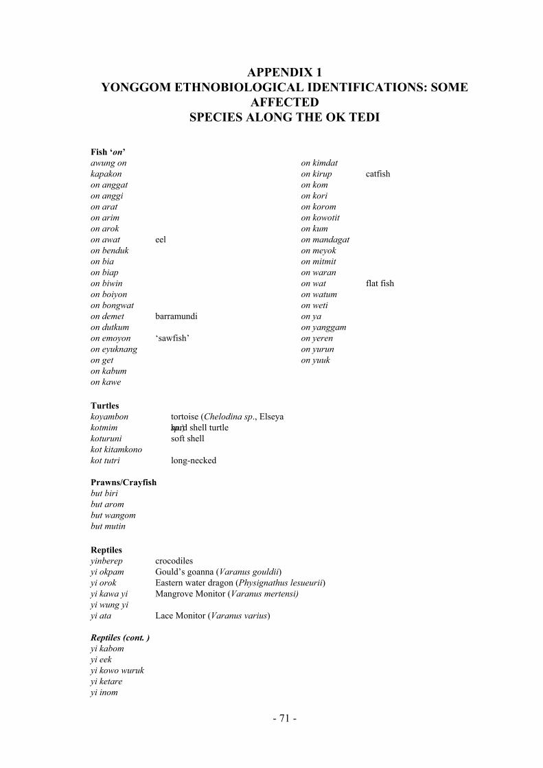
APPENDIX 1 YONGGOM ETHNOBIOLOGICAL IDENTIFICATIONS: SOME
AFFECTED SPECIES ALONG THE OK TEDI
Fish ‘on’ awung on kapakon on anggat on anggi on arat on arim
kotmim hell turtle soft
ono
Prawns/Crayfish
m
eptiles
on arok on awat eel on benduk on bia on biap on biwin on boiyon on bongwat on demet barramundi on dutkum on emoyon ‘sawfish’ on eyuknang on get on kabum on kawe
on kimdat on kirup catfish on kom on kori on korom on kowotit on kum on mandagat on meyok on mitmit on waran on wat flat fish on watum on weti on ya on yanggam on yeren on yurun on yuuk
Turtles koyambon tortoise (Chelodina sp., Elseya
sp.) hard skoturuni shell kot kitamk kot tutri long-necked
but biri but arombut wangobut mutin Ryinberep crocodiles yi okpam Gould’s goanna (Varanus gouldii) yi orok Eastern water dragon (Physignathus lesueurii) yi kawa yi Mangrove Monitor (Varanus mertensi) yi wung yi yi ata Lace Monitor (Varanus varius)
eptiles (cont. ) Ryi kabom
yi eek yi kowo wuruk yi ketare yi inom
- 71 -

yi warani yi goro Boyd’s Forest Dragon (Gonocephalus sp.)
Shellfish/Bivalves
k
Trees – Dead trees opposite Bige Village, along Ok Tedi, with notation of use
uwarot d cassowaries
o make spring snare traps
m ncluding hornbill and the imperial pigeon)
ggam es
mundin tutukoro
at kuruat edible ‘crabs’ live in its bark; bark used as cooking container at dem used as house beams nong aw cane, used as rope at mumuk fruit eaten by pigs anat ayamip used for house beams (rafters) at korot fruit eaten by birds amobon at fruit used to catch turtles at diwit trunk used for house posts, branches used tat ang trunk used for canoes, fruit eaten by cassowaries at ut fruit eaten by birds at yiri fruit eaten by birds (iat bam firewood tree; bark used as cooking container kait pandanus of weaving mats (for use and for sale) at an edible fruit (like rambutan) at murut trunk used for building canoat denek firewood tree; birds eat its fruit at kawok breadfruit tree
- 72 -

APPENDIX 2 SITUATION REPORT ON THE OK TEDI BY PROVINCIAL DPI
AND HEALTH, DATED 30 OCTOBER 1991
Department of Western Province Division of Area Services
Kiunga Lake Murray Authority Primary Industry Branch
SITUATION REPORT
The trip was jointly conducted by OTML Public Relations Office, DPI and Health on and OTML chartered helicopter [on 29 October 1991].
THE TEAM: Martin Tabi - Community Relations Officer - Kiunga David Soni - DPI Kiunga Michael Viriu - Secretary - Health Kiunga R.M. Dmonai - DPI - Kiunga
CHECK LIST:
a) Garden Crops b) Marine life c) Sediment build-up d) Gardening areas relocated due to sediment build up e) Sago swamps Muddy/Sago Palms withering & dying near the river/creeks f) Creeks delta blocked by sediment build-ups leaving still water, places for
mosquitoes to breed. g) Water holes for drinking/bathing burried by sediments.
AIM:
To assess the flood destruction situation by Ok Tedi River of arable crops/trees, Sago and others of importance to the Communities along the river to report to the OTML personnels and the state.
PREVIOUS REPORT:
The trip was conducted after a letter was sent to the OTML public relations office in Tabubil by Mr Michael Aniap of Dome Village, requesting two parties; state and OTML to assess and assist them (help) in any way possible.
THE FINDINGS:
The team started at Ningerum Ferry and went towards the OK Tedi River Delta; stopped at Komokbin and Dome Villages to hear what the Community had to express about the recent flood which they felt destroyed nearly all they had on their gardening lands along the river.
The build-up of Sediments had been massive along the river banks thus, cropping of arable/perennial crops very difficult. Less organic matter in the Soil/Sand leaving high water shrinking rate. This will lead to very low yields to crops as the crops will not be performing very well at all.
The trees/palms in the swamps and along the OK Tedi River were also noted dying from where the team started (Ningerum Ferry) all the way down to the delta of the river.
- 73 -
As Expressed by the two villages Community the yeld of all the crops (kaukau banana, Taro, etc) that were plentiful prior to the mine’s operation has, since the mine went into operation in 1984 decline considerably. This was largely due to the location of their gardens. The people can no longer make garden along the OK Tedi River. They have moved into Araes where they previously used them as hunting grounds.
They find the soil completely different from that along the river. They find that the yields from the crops planted in these locations very low or one third of what they normally would have harvested if planted along the river beds.
Marine life along the river have vanished. People in terms of protein diet can no longer find any in the river. They now largely depend on hunting, no fishing at all. Even hunting for protein is becoming very hard with the border problems between Indonesians and the OPM. People kind of get scared to go too far west whilst hunting as they might be mistaken for the OPM and short at, so the situation gets even worse.
The build-up of the sediments have also minimise the transportation. The outboard motors and canoes that were vital for the peoples movement have been restricted considerably that services to them have also been minimised.
Thus, according to the team the people along the OK Tedi river have been affected by the mine’s operations very badly from their usual way of life to something that they have to cope-up with in the next decade or so.
RECOMMENDATIONS:
1. That the OTML and the state meet and assist these villages through proper planning with the appropriate authorities in both sectors for the short and long remedies if and when the situation warrants.
2. That food be supplied to these villages immediately after Floods / Draughts.
3. That state and OTML to work closely to assist these villages, through appropriate Sections like Provincial Affairs, Commerce, Health and DPI.
4. That OTML gives Priority to these villages, when it comes to the OK Tedi Development Trust project work.
[signed]
DAVID SONI - DPI KIUNGA FOR THE TEAM
- 74 -

APPENDIX 3 LETTER FROM KUNGIM VILLAGERS TO OK TEDI MINING
LIMITED
[rendering of the original] [facsimile of the original] 11 August 1992 11 August 1992
A letter of complaint for a share of compensation money from the Ok Tedi Mining Limited.
A letter of complain for the share of compensation money from the Ok Tedi Mining Limited.
Dear Sir, Dear Sir,
We would like to express our concern over the topic above. We the whole community come to the point of asking you about this. We have continual proof of garden crops, dogs and pigs, fish and human beings being sick. Coconut trees in the villages have died and sores erupt from small scratches. Even our staple food is affected. The rain makes us sick. The air we breath gives us respiratory problems. The sun makes us get sun burnt.
We would like to express our concern over the topic above. We the whole community come to the point of asking you (company) for all this. For all these - they seem’s to be some prove of garden crops, dogs and pigs, fish human beings being sick almost every now and then. Coconuts in the villages getting dry sores becoming big when scratch by a small thing. Even our stable food has some prove of all this. Rain makes us sick. Air we Breath make’s us short wind. Sun make’s us get sun burn.
In earlier years everything was perfect. We did not have these these complaints before. Between the time OTML started operations in 1982 and 1992, the crops mentioned above and some more have completely changed and been spoiled. We are concerned and it seems to [?us] that they have been affected by Ok Tedi Mining Limited. In the experience of the elders of the village, all these things seem to be caused by the mine. Our life style has changed completely. Everything is affected along the Fly River and the Ok Tedi. The villages along the two rivers have at least the benefit of some sort of funds from the company. Nearby villages in the same census division have been given something; our village, the community of Kungim, has not: why is that? Why are we not treated the same as our neighbouring villages? Is there some reason as to why we are not benefitting as others do?
Before in 1992 and the year below these everything was perfect. All these complain’s mentioned have never experienced. When the OTML Company moved in, in 1982 up tutill now 1992, all this crops mentioned above and some more were completely have changed and got spoiled and we are concern and it seem’s to asked that these are the signs affected by the Ok Tedi Mining Limited. Elders of the village experienced that all these seems to be caused of the mine Our life style have changed completely. Everything is affected. Completely alone the fly river and OK TEDI. All the Villages alone the two rivers have atlest benefited some sort of funds from the company. The nearby Villages which we belong to the same division has been given something except Our Village. The Community of Kungim: why is that, that we are not treated the same as our close by villages. Is there some reason for why we are not benefiting as others do.
We are neglected and ignored by the company and the government, the life style of the people and the environment is spoiled and we are suffering now and dying. We are afraid of the danger.
When we are neglceted and ignored by the company or the government and if the life style of the people and the environment is spoiled then we are affected, we would be suffereing as we are now and die. We are afraid to have dangerous things to happen.
On Thursday 6th August, we heard on Radio Daru that the land in Western Province is spoiled. We are worried and most concerned about this environment we live in. Because of this, we would like to be in the next budget of money. We want it to be shared among us when the next round of money is budgetted for the villages affected.
On Thursday 6th August, we heard the news from radio Daru that the graund of Western province is spoiled. On hearing we are worried and most concern of this environment we live in. On behalf of all this, we would like the next budget of money. We want it to be shared among us when the next coming up of the budget of money for the village affected.
We know the total number of people here in Kungim village. This is not counting those born in 1992. There is a total of 722 people living in Kungim altogether. The total number of houses in the village is 61.
We have the total number of people here in Kungim village. Those who are born in 1992, there names or they are not counted. But there is a total of 722 altogether living in Kungim. And the total number of houses being built in the village is 61 which make up the number of 722 people living here in the village of Kungim.
- 75 -

Group leaders who make up the village committee:
Group leaders which make up the committee:
1. Chairman - Amandus Yarokam 1. Chairman - AMANDUS YAROKAM 2. Vice-Chairman -Edo Wanok 2. Vice-Chairman -EDO WANOK 3. Secretaries - Steven Karok & Leo Januariu[s] 3. Secretary - STEVEN KAROK & LEO JANUARIU 4. Treasurer - Laurence Mokmok 4. Treasurer - LAURENCE MOKMOK 5. Committee Member - Dominicus Kayamum 5. Committe - DOMINICUS KAYAMUM 6. Committee Member - Mathius Beman 6. Committe - MATHIUS BEMAN
- 76 -

APPENDIX 4 LETTER FROM DOME VILLAGERS TO THE NORTH FLY AREA
CO-ORDINATOR
[rendering] [facsimile of original] 1 December 1988 DATE 1ST DECEMBER 1988
The Area Co-Ordinator Dept of Provincial Affairs North Fly Division Kiunga Western Province
Border Villagers Ok Tedi, Moian Constituency Kiunga Western Province
THE AREA CO-ORDINATOR DEPT OF PROVINCIAL AFFAIRS NORTH FLY DIVISION KIUNGA WESTERN PROVINCE
BORDER VILLAGERS OK TEDI, MOIAN CONSTITUENCY KIUNGA WESTERN PROVINCE
Subject: petition to the Government for K13.5m SUBJECT.- OUR PETITION TO THE GOVERNMENT
ABOUT THE BORDER DEVELOPMENT SIDE PETITION OF OF 13.5 MILLION KINA
Sir, The reasons for this petition are: SIR, Reasons are as Follows.-
1. The Border Development is not used properly. (1) Function of the Border develo-pement Fund is Not Carried out Properly
2. The Ok Tedi and Fly Rivers are polluted. (2) Polution of Rivers/Ok Tedi And Fly Rivers .
3. [Non-payment of] Ok Tedi copper royalties. (3) Ok Tedi Copper Royalties .
4. Problems with border crossers and refugees. (4) Border Crossers Or Refugees.
Point 1. The border was marked between 1962 and 1964 with cement posts. Money was allocated to a Border Development Fund. However, there has been no development at all in the border areas and none in Ok Tedi-Moian Census Division. The Border Development Fund was supposed to be for the benefit of villages along the border.
Touching Point I Border Was Marked in 1962 - 1964 Both on the Maps And On The Ground Putting Cement Posts And Money Was Also Allocated And Was Called Boarder Developement Fund. Since Then Up To Now 1988 . During This Full solid Twenty - Six (26) Years There as Been No Sign Of Developement Taking Place Along The Border Of Western Province Mainly Ok Tedi, Moian Census Division Villagers. Allocation Of The Fund For The Benefit Of The Boarder Developement Fund is For The Benefit Of The Border Or People Living Along The Boarder.
Point 2. When the Ok Tedi mine became operational in 1981, plants and animals in the river and on its banks began to die.
2) Polution ; When Ok Tedi Copper Minning Came To Full Operation in 1981 Every Living Things Animals And Plants in The River On The Banks, Creeks and Streams Started Killing Them.
Our environment has been destroyed for good as 75% of the copper concentrate [note: the copper concentrate is exported; the writer(s) mean mine wastes and tailings] is dumped into the river at the mine site.
Now you can hardly ever find fish, prawns, crocodiles and turtles, and the river bank gardens have been spolied by mud and ‘copper medicine’ dumped into the Ok Tedi river.
Now Our Environment is Completely Distroyed and Are lost For Good, (75% of copper concencrete is damped into Ok Tedi up at Mining Site) Environment in Bad Condition.
Eg Fish, Prawns, Crocodiles And Turtles, Gardens Along The Banks. You Could Hardly Ever Find Or Notice Them. They Were All Completely Spoliled By Mud And Copper Medicine Dumping Into The Ok Tedi River.
- 77 -

Point 3. Because of the destruction of our environment we, the Yongkom people of Ok Tedi-Moian Census Division, feel entitled to be paid royalties. Why aren’t we? We experience more mining impact than the Ningerum, Awin and Faiwol people who do get paid. We want the Government to look into this.
3) OK TEDI COPPER ROYALTIES By All The Distroyment Have Been Taken Place We The People Called Yongkom.Ok Tedi Moian Census Division is Entitle To In Receiving The Copper Royalties But Not And Why? Because We Are The People Having Problems With Copper Minning Then Ningrum, Awin And Faiwols, Instead They Are Getting The Royalties. Now We Want The Government To Look Into These Problems.
Point 4. The border crossers and refugees are giving us another headache.
They are spoiling our hunting and fishing grounds, sago swamps and garden land.
We, the Yongkom people along the Ok Tedi and Fly River ask the Government for [compensation of] K13.5m.
4) Border Crossers (Refugees) Now The Border Crossers Have Given Us Another Head-Pain Of Distroying The Rest Of Our Environment. Lands For Hunting, Fishing Gardenings, Sago Swamps Are Spoiled By Them So Right Now We The People Called Yongkom Along The Border Of Ok Tedi And Fly River Are Giving Our Petition To The Government Of 13.5 Million Kina To Give It To Us.
[dates not filled in] FROM THE DATE _________ 1988 To _________ 1989.-
We give the Government this time to consider our petition and give us the money we have asked for.
We will not drop our demands.
Thanks a lot...
[this copy not signed]
During The Time We Give The Government have To be Thought About It And Give Us The Answer And The Amount We’ve Asked. This Will Continue If First Petition Is Not Meet.
Thanks Alot. Signed-
- 78 -

APPENDIX 5
SUBMISSION TO BCL ENVIRONMENTAL REVIEW TEAM FROM FRANCIS ONA,
GENERAL SECRETARY, PANGUNA LANDOWNERS ASSOCIATION
An extract from ‘Appendix VI. Landowner’s concerns as expressed to the review team’ in Applied Geology Associates Limited (1989) and dated 24 October 1988.
This is a list of issues submitted by the Panguna Landowners Association (also spelled Panguna Land Owners Association) in respect of environmental damage at Panguna. To verify its claims, the PLA asks that Applied Geology Associates puts a request for environmental studies among their recommendations.
Topics for study requested by the Panguna Land Owners Association
ENVIRONMENTAL STUDY - CASES NOMINATED
By Panguna Land Owners Association
Crops:
Disease in garden crops / shortened growth life of crops / leaves bear rectangluar marks
CROPS - - - -
Increase of disease on garden crops Growth life of crops released Not bearing enough food Rectangular shapes found on leaves
Plants:
Dieback of trees in the Tailings Disposal and Road Leases and SML / an unknown pollutant has caused cocoa trees to stop bearing after a few harvests / introduced plants species are damaging the local flora / loss of forests
PLANTS -
-
-
Trees dying away around Tailings, special mine lease Road lease. Cocoa Trees are affected by the unknown pollution which bears for few rounds and die away Foreign plants have been grown by BCL on our land which are killing local plants Timber forest abuse
Soil:
The SML has experienced landslides / a fifth of the area of the leases is now wasteland / the soil is being poisoned by chemical pollution / creeks along the Tailings Disposal Lease have a heavy load of minerals / the mouth of the Jaba River at Empress Augusta Bay has become silted up
SOIL -
-
- -
- -
Frequent landslides around the mine and its surroundings (special mine lease) About 1/5 of land in the mining lease, Tailings, Road lease have become barren Soil ecology been poisoned Soil nutrition been comtaminated by chemical and other foreign objects Mineral oxidisation on rivers along Tailings Soil sediment at Augusta Bay
Rivers:
There are no fish in the creeks / you could not eat them anyway because of the high mineral content / creeks around the SML have disappeared because of the pit drainage / rivers that people used to wash in are now chemically polluted
RIVERS -
-
-
No fish - Not consumable if any because of high mineral in them Creeks around Guava, Kokore, Poaru villages (i.e. those above Pit drainage tunnel disappearing or sinking Chemical Pollution on people’s swimming rivers
- 79 -

Air:
Sources of air pollution are: the burning of tyres, mineral vapours and pollutants from the process plant, explosives, dust from blasting and industrial activities.
AIR - - - - - -
Air pollution by burning of tyres Mineral vapours Water cycle Blasting fumes or fall out dust from blasting Industrial Pollutions Dust
The water cycle (i.e. evaporation and precipitation at or near the mine) introduces pollutants to the air. BCL used an aerial spray in 1968-69 which resulted in the first damage to plants.
- Aerial spraying carried out by BCL during 1968-69 which have killed plants and many crops. This is a starting point when every things (plants) have received severe effect on them
Effects on humans:
People are continually sick and near the Tailings Disposal Lease they are suffering from skin diseases and infected sores.
HUMAN -
-
Unlimited sickness affect people’s lives (needs medical examination) Skin disease on people down the Tailings including infection sores as well down the Tailings
Animals:
Birds and flying foxes are dying / Fish are dying and are found with sores and without eyes / The game animals are disappearing from the area, i.e. wild pigs, birds and other animals.
ANIMALS - - -
-
Birds dying with unknown disease Flying foxes dying also Fish with sore on their body, no eyes dying for no goods reasons at all The whole wild life from down to Tailings is disappearing i.e. pigs, birds and other animals
All necessary tests and environmental studies are required by the Panguna Landowner’s Association. We will abide by the findings.
Thank you
Francis Ona General Secretary Panguna Land Owners Association
Above all every necessary test whether on human being, animals, plants and environment is required by Panguna Landowners Association. And we will co-operate and the end result will be known without fear or favour.
Thank you. [signature] Francis Ona General Secretary Panguna Land Owners Association
- 80 -

BIBLIOGRAPHY
Project documentation
BHP MINERALS 1991. Starnberg commentary: second confidential draft. Report for Ok Tedi Mining Limited
BURTON, JOHN 1991. The Ningerum LGC Area. Ok-Fly Social Monitoring Project Report No. 2. Report for Ok Tedi Mining Limited. Port Moresby: Unisearch PNG Pty Ltd.
BURTON, JOHN 1993a. General overview and 1992 advance report summary for Ningerum-Awin area study. Ok-Fly Social Monitoring Project Report No. 3. Report for Ok Tedi Mining Limited. Port Moresby: Unisearch PNG Pty Ltd.
BURTON, JOHN 1993b. Development in the North Fly and Ningerum-Awin Area Study. Ok-Fly Social Monitoring Project Report No. 6. Report for Ok Tedi Mining Limited. Port Moresby: Unisearch PNG Pty Ltd.
BURTON, JOHN 1993c. The Ok Tedi Impact Area in maps. Map 1: Mt. Fubilan to Konkonda. Map 2: Konkonda to Binge River. Produced for Ok Tedi Mining Limited. Port Moresby: Unisearch PNG Pty Ltd.
DUFF, GORDON D. 1992. ‘Effects of sediment deposits on rainforest trees on the Ok Tedi - final report to Ok Tedi Mining Limited’. Appendix C, ‘Investigation of forest dieback’, in Ok Tedi Mining Limited Biology Annual Report, 1992. Tabubil: Ok Tedi Mining Limited, Environment Department. Report No. ENV 92-01.
HYNDMAN, DAVID. 1991. ‘Zipping down the Fly on the Ok Tedi project.’ In J. Connell and R. Howitt (eds.) Mining and Indigenous Peoples in Australasia. Melbourne: Syndeny University Press in association with Oxford University Press.
JACKSON, RICHARD, C. EMERSON AND R. WELSCH 1980. The impact of the Ok Tedi project. Port Moresby: Department of Minerals and Energy
JACKSON, RICHARD 1993. Cracked pot or copper bottomed investment? The development of the Ok Tedi project 1982-91, a personal view. Townsville: James Cook University, Melanesian Studies Centre
JACKSON, RICHARD 1982. Ok Tedi: The pot of gold. Waigani. Port Moresby: University of Papua New Guinea.
KING, DAVID 1993. Statistical geography of the Fly River Development Trust. Ok-Fly Social Monitoring Project Report No. 4: Report for Ok Tedi Mining Limited. Port Moresby: Unisearch PNG Pty Ltd.
KIRSCH, STUART 1989. ‘The Yonggom, the refugee camps along the border, and the impact of the Ok Tedi mine.’ Research in Melanesia 13:30-61
MARKHAM, A.J. 1991. Hydrology annual report 1991. Tabubil: Ok Tedi Mining Limited, Environment Department. Report No. ENV/91-02
NURSE, GEORGE 1990. ‘The dynamics of changes in health status in the Ok Tedi impact area’. Research in Melanesia 14:1-21
OK TEDI MINING LIMITED 1984. The Interim Tailings Scheme. Port Moresby: Ok Tedi Mining Limited
OK TEDI MINING LIMITED 1987. Sixth Supplemental Agreement: environmental study progress report No. 3. Tabubil: Ok Tedi Mining Limited, Environment Department. Report No. ENV/87-16
OK TEDI MINING LIMITED 1988a. Sixth Supplemental Agreement: environmental study 1986-1988. Tabubil: Ok Tedi Mining Limited
OK TEDI MINING LIMITED 1988b. Sixth Supplemental Agreement: environmental study progress report No. 4. Tabubil: Ok Tedi Mining Limited, Environment Department. Report No. ENV/88-06
OK TEDI MINING LIMITED 1992a. ‘Copper Mining and the environment in Papua New Guinea: the Ok Tedi case study’. Paper presented at Investment and Development in PNG Mining and Petroleum: Maximizing rewards and minimizing risks, AIC Conferences, Sydney 31 August - 1 September 1992.
- 88 -

OK TEDI MINING LIMITED 1992b. APL Compliance And Additional Environmental Monitoring Program: 1991 Annual Report. An annual report to the Independent State of Papua New Guinea as a part of Ok Tedi Mining Limited’s environmental monitoring requirements. Tabubil: Ok Tedi Mining Limited, Environment Department. Report No. ENV 92-05.
OK TEDI MINING LIMITED N.D. Summary tables 1984-1991 for annual production. royalties/compensation, financial data, education, infrastructure expenditure, local business development, direct employment by OTML, contracts, other benefits to PNG.
SMITH, R.E.W. 1988. Six-monthly biology review 11 October 1987 to 30 March 1988. Tabubil: Ok Tedi Mining Limited, Environment Department. Report No. ENV 88-05.
SMITH, R.E.W., J.T.P. TAIT AND B.D. KARE 1992. Biology annual report 1992.. Tabubil: Ok Tedi Mining Limited, Environment Department. Report No. ENV 92-01
SPICER, PAUL 1991. Medical services for the North Fly region of Western Province – discussion paper. Tabubil: OTML Medical Department
STARNBERG INSTITUTE 1991. Development and the environment: economic-ecological development in Papua New Guinea. A study by the Starnberg Institute. Commissioned by the Department of World Mission of the Evangelical Lutheran Church in Bavaria, Germany. Goroka: The Melanesian Institute for Pastoral and Socio-Economic Services
Western Province references
BUSSE, MARK 1987. Sister Exchange among the Wamek of the Middle Fly. Unpublished doctoral dissertation, University of California, San Diego
CHAMPION, IVAN F. 1966. Across New Guinea from the Fly to the Sepik. Melbourne: Lansdowne Press
CRAWFORD, A.L. 1981. Aida: life and ceremony of the Gogodala. Bathurst: Robert Brown
DEPARTMENT OF WESTERN PROVINCE 1988. Western Province study and development plan 1988-1992. Volume III - North Fly. Kiunga: Department of Provincial Affairs
GIBSON, MARGARET AND SHELDON WEEKS 1990. Improving education in Western Province. Waigani: National Research Institute, Division of Educational Research. Report No. 64
JACKSON, RICHARD 1979. ‘The Awin: free resettlement on the Upper Fly River (Western Province).’ In C.A. and B.L. Valentine (eds.) Going through changes: villagers, settlers and development in Papua New Guinea. Boroko: Institute of Papua New Guinea Studies
KALAMA, BABALEMA 1992. Annual report of small holder rubber rehabilitation and expansion project (SRREP) for 1991. Daru, Western Province: Division of Primary Industry
KIRSCH, STUART 1991. The Yonggom of New Guinea: An ethnography of sorcery, magic, and ritual. Unpublished doctoral dissertation, University of Pennsylvania
OHTSUKA, RYUTARO 1983. Oriomo Papuans: ecology of sago-eaters in lowland Papua. Tokyo: University of Tokyo Press
PINTZ, WILLIAM S. 1984. Ok Tedi: Evolution of a Third World Mining Project. London: Mining Journal Books.
PRESTON, ROSEMARY 1988. Educational needs of West Irian refugees in the East Awin relocation site in Papua New Guinea. Boroko: National Research Institute, Educational Research Division
SCHOORL, J.W. 1957. Kultuur and Kultuurveranderingen in het Moejoe-Gebied. Den Haag: J.H. Voorhoeve.
SCHOORL, J.W. 1970. Muyu land tenure. Boroko: New Guinea Research Unit. Bulletin No. 38
SWADLING, PAMELA 1983. How long have people been in the Ok Tedi impact region? Waigani: National Museum of Papua New Guinea. PNG National Museum Record No. 8
TERRITORY OF PAPUA AND NEW GUINEA 1967. Electoral Roll: Electorate of North Fly. Port Moresby: Government Printer
- 89 -

TURNER, PAUL 1991. Filariasis and hepatitis control programmes in the Western Province of Papua New Guinea. Townsville: James Cooks University, Anton Breinl Centre for Tropical Health and Medicine. Report to the Minister of Defence Science and Personnel.
Other references
AGRICULTURAL DEVELOPMENT SERVICES 1992. Smallholder Rubber Development In Selected Provinces Project. Draft final report. Working Paper No. 11, Economics and marketing aspects. Agricultural Development Services (Singapore) Pte Ltd. Report for Government of Papua New Guinea and Asian Development Bank.
APPLIED GEOLOGY ASSOCIATES 1989. Environmental, Socio-Economic, and Public Health Review of Bougainville Copper Mine, Panguna. Report for Bougainville Copper Ltd. Applied Geology Associates Ltd., New Zealand
BANKS, GLENN 1993. Economic modelling project, first report. Port Moresby: Unisearch PNG Pty Ltd for Porgera Joint Venture. Porgera Social Monitoring Programme Report No. 1
BURTON, JOHN 1993d. Kutubu Petroleum Project. Social monitoring programme: commentary on methodology and results. Port Moresby: Unisearch PNG Pty Ltd for Chevron Niugini
CONNELL, JOHN AND RICHARD HOWITT (EDS.) 1991. Mining and indigenous peoples in Australasia. Sydney: Sydney University Press
DENOON, DONALD 1989. Public health in Papua New Guinea: medical possibility and social restraint. Cambridge: Cambridge University Press
DEPARTMENT OF FINANCE AND PLANNING 1990. Budget papers - Volume I: Development policies and strategies. Port Moresby: Government Printer
DEPARTMENT OF FINANCE AND PLANNING 1991. Budget papers - Volume I: Development policies and strategies. Port Moresby: Government Printer
ELLEN, ROY E. 1982. Environment, subsistence and system: the ecology of snall-scale social formations. Cambridge: Cambridge University Press
EVANS, B. 1993. ‘Canarium nuts – a new cash crop for the Solomon Islands’. Tropical Forest Management Update 3(2): 7, 19
FORTUNE, REO 1935. Manus Religion. Philadelphia: American Philosophical Society
HANCE, B.J., CARON CHESS, AND PETER M. SANDMAN 1990. Industry Risk Communication Manual: Improving Dialogue with Communities. Boca Raton, Florida: Lewis Publishers.
HOWARD, MICHAEL C. 1991. Mining, Politics and D evelopment in the South Pacific. Boulder, Colorado: Westview Press.
KEESING, ROGER M. 1992. Custom and Confrontation: The Kwaio Struggle for Cultural Autonomy. Chicago: University of Chicago Press
KYAKAS, ALOME AND POLLY WIESSNER, WITH ILLUSTRATIONS BY ALBERT WET IPU (1992). From inside the women’s house: Enga women’s lives and traditions. Buranda, Queensland: Robert Brown and Associates
MADDOCKS, I. 1975. ‘Medicine and colonialism . ‘ Australian and New Zealand Journal of Sociology 9(3):27-33
MCCLAIN, CAROL 1981. ‘Traditional midwives and family planning: An assessment of programs and suggestions for the future.’ Medical Anthropology 5:107-136.
NAROKOBI, BERNARD 1980. The Melanesian Way. Boroko: Institute of Papua New Guinea Studies and Suva: University of South Pacific
NATIONAL STATISTICAL OFFICE 1991. 1990 National Population Census. Preliminary figures. Port Moresby: National Statistical Office
RAPPAPORT, ROY A. 1971. ‘The flow of energy in an agricultural society’. Scientific American 224(3):117-132
- 90 -

STRATHERN, ANDREW 1983. ‘Research in Papua New Guinea’. Royal Anthropological Institute Newsletter 58:4-10
TAUKURO, B.D. AND NURSE, G.T. 1978-79. North Fly Clinico-Epidemiological Pilot Study. Reports of teams 1, 2 and 3. Goroka: Papua New Guinea Institute for Medical Research
WAGNER, HERB AND SCOTT MACWILLIAM 1992. The Political Economy of Papua New Guinea: Critical Essays. Manilla, Phillipines: Journal of Contemporary Asia Publishers
WAGNER, ROY 1981. The Invention of Culture. Chicago: University of Chicago PressChicago: University of Chicago Press
WAGNER, ROY 1981. The Invention of Culture. Chicago: University of Chicago Press
WORLD HEALTH ORGANIZATION (WHO) 1979. ‘Traditional birth attendeants: A field guide to their tranining, evaluation, and articulartion with health services.’ Geneva: World Health Organization, Offset publication 44:49-65.
ZIMMER, LAURA 1986. ‘Card-playing among the Gende: A system for keeping money and social relationships alive’. Oceania 56(4):245-263.
- 91 -
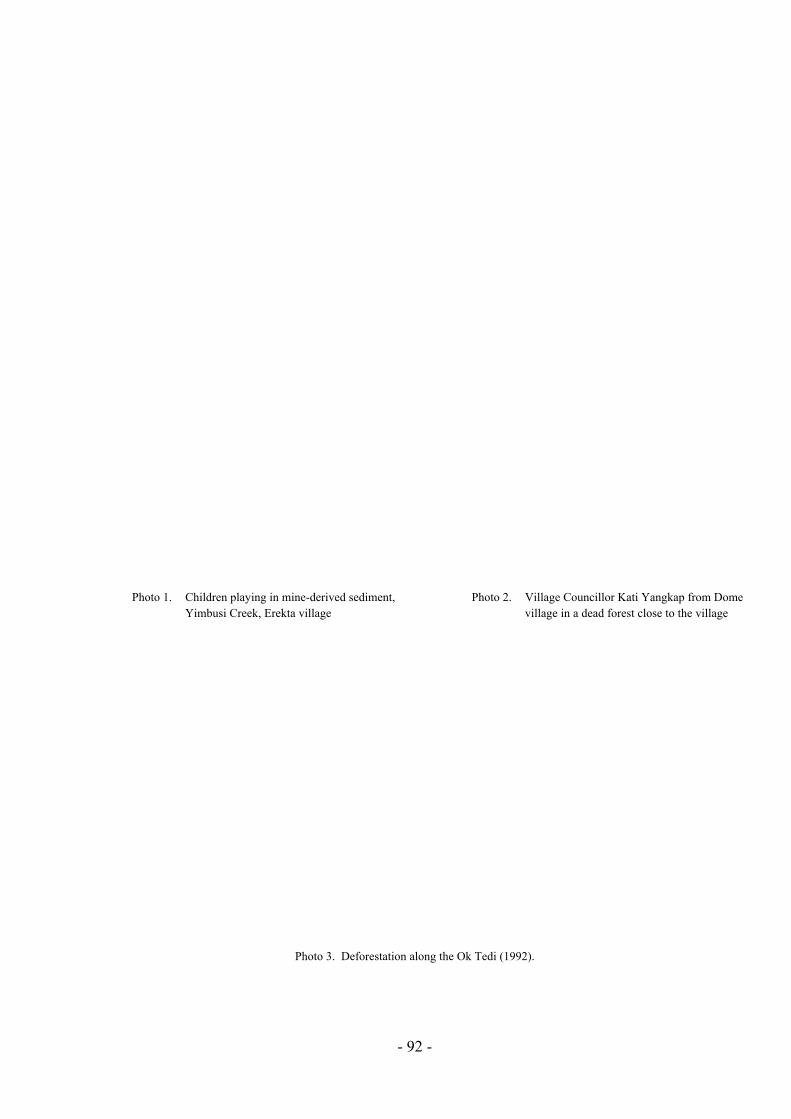
Photo 1. Children playing in mine-derived sediment, Yimbusi Creek, Erekta village
Photo 2. Village Councillor Kati Yangkap from Dome village in a dead forest close to the village
Photo 3. Deforestation along the Ok Tedi (1992).
- 92 -

Figure 6. The Ok Mart junction in mid-1987 (Ok Tedi Mining Limited 1987: Plate 6) [Note: this photograph was referred to in the original report, but we did not obtain a copy of it until later. It is now included for the sake of completeness. Ed.]
Figure 7. The condition of the forest on the banks of Ok Tedi River on 14 August 1992 at a location very near to that shown in Figure 6.
- 93 -