Embed Size (px)
Citation preview

Northwest Avalanche Center www.nwac.us
Snow Lake Divide Avalanche Fatality February 25th, 2018 Report by Jeremy Allyn and Dennis D’Amico, Northwest Avalanche Center Incident snapshot: Occurrence Time and Date: February 25, 2018 (estimated time: 5-6 pm) Recovery/Rescue Time: 8:20 am - 1 pm, February 26, 2018 Lat/Lon: 47.458232°N, -121.446326°W (upper burial location) Location: Snow Lake Divide, Alpental Valley, King Co., Mt. Baker-Snoqualmie NF, WA Number in Party: 2 (1 skier, 1 snowshoer) Number Caught and Killed: 2 Number Completely Buried: 2 Avalanche type: Soft Slab (SS) Trigger: Unknown Size: R3 / D2.5 Start Zone Aspect: South Start Zone Angle: 40 deg (average) Elevation: 4250 ft (highest crown) Height of Crown Face: 36 in (1m) (maximum, estimated) Width of Fracture: 350 ft (107 m) Vertical Fall: 500 ft (152 m) Slab Characteristics: 4F-1F Hardness, Decomposing Fragments/Precipitation Particles (1.0 mm) Weak Layer Characteristics: Rounding Facets (1.0 mm) Bed Surface Characteristics: P Hardness, Melt Freeze Crust, 1 cm thickness Terrain Traps: Cliffs in start zone and large trees in track and runout Avalanche occurred during: Ascent Location of group in relation to start zone during avalanche: Unknown Avalanche safety gear carried by party: Both carried transceivers, shovels, probes. Subject 1 had an ice axe. Subject 2 had an ABS airbag backpack that was not deployed. Avalanche Training and Experience: Subject 1 had taken an AIARE Avalanche Level 1 course the previous year. Subject 2 had taken two avalanche awareness classes. Cause of Deaths: Accidental Asphyxia (final Medical Examiner’s Report pending) Avalanche Classification: SS-U-R3-D2.5-I NWAC Forecast Zone: Snoqualmie Pass

Northwest Avalanche Center www.nwac.us
Avalanche Danger Rating (Below Treeline): High (Avalanche Warning for High Danger was in effect for all elevations in the Snoqualmie Pass Zone)
Avalanche and Terrain
The avalanche on Snow Lake Divide occurred on a South aspect at 4250 ft. The avalanche was observed to be wide relative to slope and to have fractured across complex terrain features. This was due to the combination of a hard bed surface and a persistent grain type capable of propagating a fracture wide distances. Rapid snowfall accumulation during the day likely overloaded the crust/PWL combination and the slope angle was sufficiently steep to produce a large avalanche. Debris measured in excess of 2 meters with snow flagging noted on the uphill sides of old growth trees 2 meters above the snow surface.
The overall terrain can be characterized as a hanging valley headwall above a tight valley floor, with numerous small cliffs, steep convexities and gullies. The alpha angle from the highest crown to Subject 2’s burial location was 32 degrees. NWAC staff and the SAR teams were not able to determine if this was a natural or human-triggered avalanche due to lack of definitive surface clues. The avalanche was classified as SS-U-R3-D2.5-I.
NWAC Professional Observer, Jeremy Allyn, and NWAC Education and Operations Manager, Forest McBrian arrived at the Alpental Ski Area upper parking lot at 1:30 pm on Monday, February 26 and were debriefed by the SAR Incident Commander and members of the SAR teams. They then traveled by skis to the incident site and conducted an avalanche investigation.
After inspecting the burial locations, a snow profile site was chosen 100 feet adjacent to a lower section of crown on the avalanche’s western flank at 4025 feet. Other overhead hazards, as well as residual hang fire from the main slab avalanche were identified and it was determined there was no safe way to ascend to the uppermost crown to conduct a crown profile. The slope for the snow profile was on a convex roll, 42 degrees, South aspect (see snow profile below). Notable snowpack test results were observed down 48 cm from the surface on a sun crust (1 cm thick) that had been buried by storm snow on February 23. The weak layer was observed to be 1 mm Facets (starting to round and sinter) with the sun crust acting as a bed surface. Some portions of the crown face were measured to be 85 cm, however, due to overhead hazard, most of the crown could not be directly measured.
Snowpack and Weather
Along the West Slopes of the Cascades including the Snoqualmie Pass area, a period of cold weather and intermittent light snowfall occurred in the week leading up to the avalanche incident with a stronger storm cycle beginning the weekend of Feb 24th-25th. Preceding the storm cycle, colder than normal temperatures allowed weak layers to develop in the upper snowpack.
This included a persistent weak layer (near surface facets) that developed on top of a sun crust (melt-freeze), found on steep southerly aspects. This interface was buried by light snowfall on 2/23.

Northwest Avalanche Center www.nwac.us
While new snow and wind received on the 24th and especially on the 25th were more than enough to produce new storm snow avalanche hazards, the buried crust/PWL combination identified above was involved in both the Snow Lake Divide and the nearby Cottonwood Lake avalanche fatalities on Feb 25th. It’s worth noting that numerous human triggered avalanches and seven fatalities were reported throughout the Cascades from late February through early March, releasing on some combination of a melt-freeze crust and facets.
Accident Summary
This was an unwitnessed incident. Through interviews with both sets of parents with a knowledge of text messages, NWAC believes Subjects 1 and 2 left the Alpental upper parking lot around 4 pm on February 25th. Their plan remains uncertain and appears to have been affected by competing and uncertain plans, directions from both sets of parents to avoid avalanche terrain, and the late hour of the day. Subject 2 brought alpine skis in addition to snowshoes. Those skis were left in their vehicle. Subject 1 had ski touring gear. Individually they both were aware of the day’s avalanche forecast. Subject 1 was told of the avalanche danger verbally and via text. Subject 2 was shown the forecast on a computer prior to leaving home. Notably, Subject 2 had been on a snowshoe trip along the Snow Lake summer trail the day prior, February 24th. That trip was aborted due to difficult travel conditions and avalanche hazard concerns. Despite recent storm snow, the snowshoe track would have remained intact (albeit partially buried) on the 25th, as it was still visually evident as observed by NWAC and SAR teams the following day. Due to the location of the avalanche crown and the locations of the burials, it is NWAC’s conclusion that the pair were caught and carried in an avalanche while in or below the final switchbacks of the Snow Lake trail.
Rescue Summary
At approximately 9:40 pm on February 25, Seattle Mountain Rescue (SMR) was alerted to 2 overdue backcountry travelers in the Source Lake area. They were reported to have been triangulated by cell phone GPS at a last known location of: 47.45765°N, -121.44576°W. Due to high avalanche danger and another avalanche involvement near Cottonwood Lake, the mission was put on standby for the following day.
On February 26, 4 rescue teams comprised of SMR, King County Explorer Search and Rescue, and the Ski Patrol Avalanche Rescue Team (SPART) departed the Alpental base between 8:20-8:30 am. At approximately 9:30 am, SMR Team 1 reached the suspected avalanche location and immediately received 2 avalanche transceiver signal hits. A combination of transceiver searching, probing, and shoveling resulted in a confirmed probe strike and Subject 1 was located at: 47.458232°N, -121.446326°W, at 3,860 ft on a 28 deg slope uphill of a large tree. Burial depth was 1.5 meters. Hewas found with one ski attached to his backpack as well as an ice axe. SAR personnel found Subject1's ski with a climbing skin affixed. He was not wearing a helmet.
SPART Team 3 located Subject 2 at 9:37 am at: 47.457933°N, -121.446321°W, at 3820 ft on a 18 deg. slope near a stand of large trees. Burial depth was 2.2 meters. He was found wearing one

Northwest Avalanche Center www.nwac.us
snowshoe as well as an ABS avalanche airbag pack that was not deployed. He was wearing a helmet.
At 10:11 am, snow surface instabilities were observed on scene, initiating as the result of solar effect and warming temperatures. One size D2 Wet Loose avalanche released naturally and ran within 100 feet to the west of the incident site. This activity forced all teams to pull back from Subject 1 to Subject 2 (lower in the terrain). After an on-scene safety briefing, more visual avalanche guards were assigned and the the numbers of SAR personnel were reduced to limited exposure to the overhead hazard.
Subject 1 was evacuated from the scene at 10:36 am. SPART Team 3 (along with additional resources) completed the final extrication of Subject 2 at 12:16 pm after which all SAR personnel departed the scene arriving at Alpental base area at 1 pm.
NOTE: All members of this SAR mission deserve special recognition. This was a dangerous scene to work in with very real elements of exposure and vulnerability due to ongoing avalanche activity. The SAR teams did an exemplary job in anticipating, recognizing, and managing the avalanche risk.
Comments: Jeremy Allyn, NWAC Professional Observer
Unwitnessed fatal avalanches are among the most difficult to comment upon. They pit our desire to know the facts and to educate directly against our frequent inability to understand the motivations and decision-making of the individuals directly involved. Without witnesses or other party members to interview, knowledge and understanding can remain elusive and tragedies even more difficult to comprehend.
The fact that this particular slope has a history of producing large avalanches that have also killed people is significant. The slopes on, above, and adjacent to the summer trail leading to Snow Lake Divide are prime avalanche terrain. The same can be said for the other popular route to the Snow Lake Divide via terrain NW of Source Lake. Both routes involve significant overhead hazard and high levels of exposure and commitment. There is no avalanche “safe” route to the Snow Lake Divide.
Avalanche slope history is important and repeat offenders like the slope that produced the fatal avalanche in this report should be taken very seriously relative to their history. Equally important is the history of recreational use in the Alpental Valley where this avalanche occurred. While awareness and use patterns have improved in recent years, the continued, almost daily use of the Snow Lake summer trail during the winter months (especially during periods of elevated avalanche danger) continues to be alarming.
It is clear that both individuals in this incident had more than a passing understanding of the dangers of the route that ended up killing them. They also had knowledge of the most current avalanche forecast and were explicitly and specifically told by parents to avoid all avalanche terrain that afternoon. By all accounts these two young individuals were smart, cautious, and avalanche aware given their ages and experience. And yet, for reasons we will never know, they chose to attempt to

Northwest Avalanche Center www.nwac.us
climb to Snow Lake Divide on the afternoon of February 25. Perhaps a question that we as a community should be asking is not “what were they thinking?” but more along the lines of: “Why do recreationists of all ages, walks of life, experiences, and modes of travel continue to follow the same route, through the same terrain, during periods of elevated avalanche danger?”

Northwest Avalanche Center www.nwac.us
All Photographs were taken by Jeremy Allyn on February 26th, 2018
Avalanche crown from a distance

Northwest Avalanche Center www.nwac.us
Western crown and debris
Western crown
Northwest Avalanche Center www.nwac.us
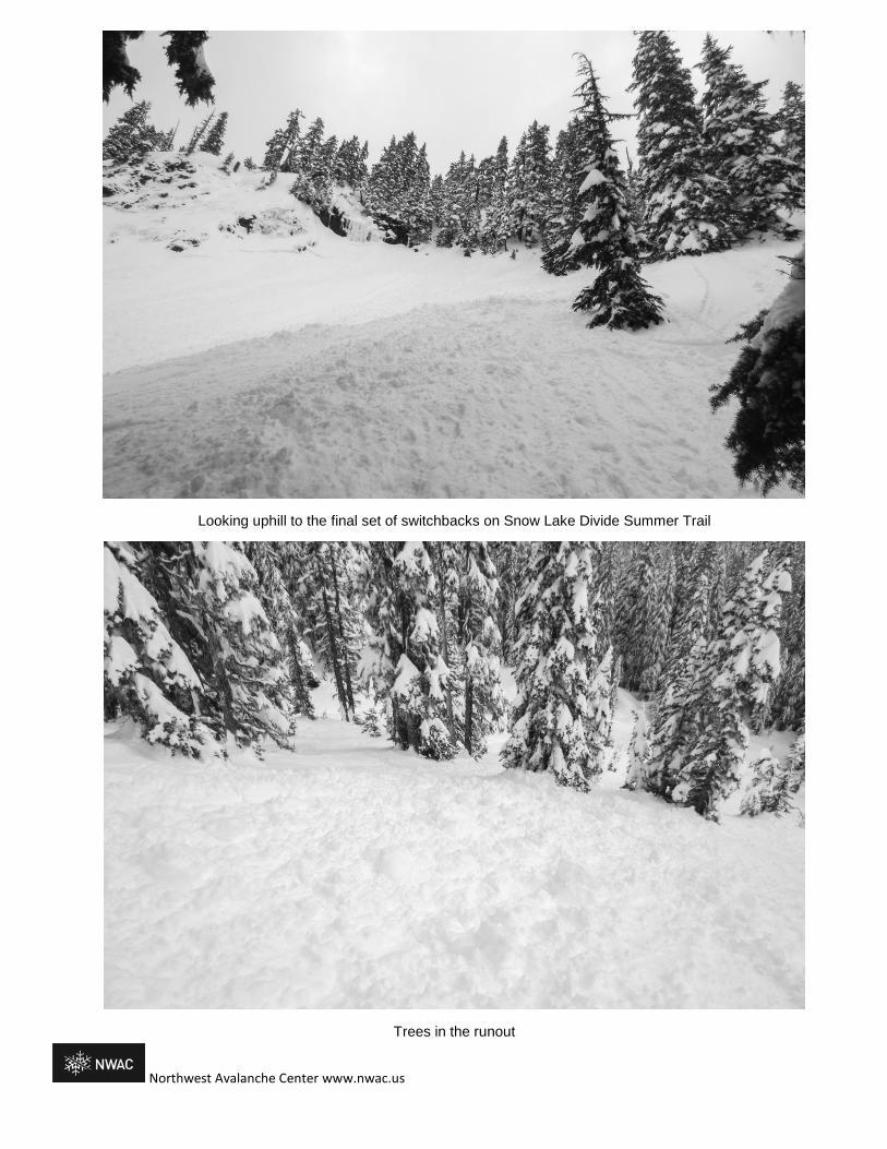
Looking uphill to the final set of switchbacks on Snow Lake Divide Summer Trail
Trees in the runout
Northwest Avalanche Center www.nwac.us
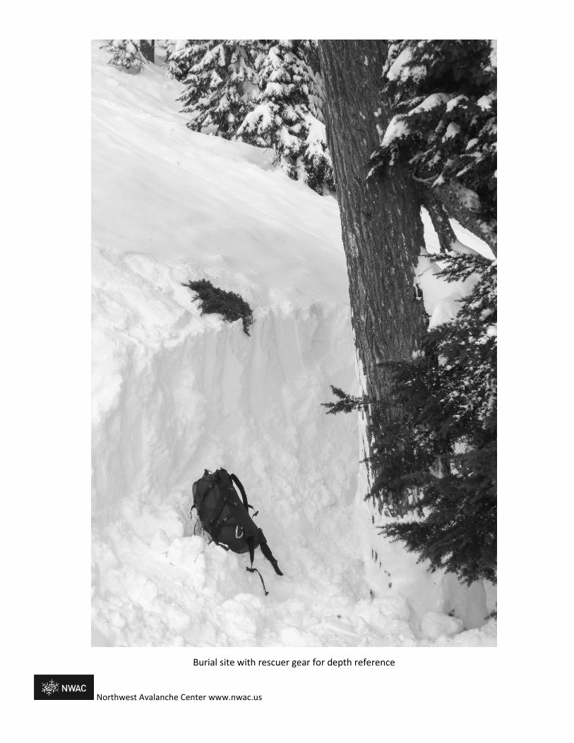
Burial site with rescuer gear for depth reference

Slope Angle Shading:

Northwest Avalanche Center www.nwac.us

Northwest Avalanche Center www.nwac.us

Northwest Avalanche Center www.nwac.us
Snoqualmie Pass Precipitation and Wind Dir/Speed weather station data were used in lieu of Alpental stations that was unreliable during this event.

Snoqualmie PassIssued: 6:55 PM PST Saturday, February 24, 2018 by Josh Hirshberg
NWAC avalanche forecasts apply to backcountry avalanche terrain in the Olympics, Washington Cascades and Mt Hood area. These forecastsdo not apply to developed ski areas, avalanche terrain affecting highways and higher terrain on the volcanic peaks above the Cascade crestlevel.
The Bottom Line: Travel in avalanche terrain is not recommended as very dangerous avalanche conditions exist.Expect widespread avalanches big enough to bury or kill you. Only travel in the backcountry today if you are certain thatyou can avoid avalanche terrain.
Elevation Sunday Outlook for Monday
Above Treeline HighVery dangerous avalanche conditions. Travel in avalanche terrain notrecommended. Considerable
Near Treeline HighVery dangerous avalanche conditions. Travel in avalanche terrain notrecommended. Considerable
Below Treeline HighVery dangerous avalanche conditions. Travel in avalanche terrain notrecommended. Considerable
Avalanche Problems for Sunday
Wind SlabWind slabs can take up to a week to stabilize. They areconfined to lee and cross-loaded terrain features and can beavoided by sticking to sheltered or wind scoured areas.
AvalancheProblem Aspect/Elevation Likelihood Size
Storm SlabsStorm slabs usually stabilize within a few days, and release ator below the trigger point. They exist throughout the terrain, andcan be avoided by waiting for the storm snow to stabilize.
AvalancheProblem Aspect/Elevation Likelihood Size
Persistent Deep SlabDeep, persistent slabs are destructive and deadly events thatcan take months to stabilize. You can triggered them from welldown in the avalanche path, and after dozens of tracks havecrossed the slope. Give yourself a wide safety buffer to handlethe uncertainty, potentially for the remainder of the season. Avalanche
Problem Aspect/Elevation Likelihood Size

Avalanche Forecast for Sunday
Expect widespread avalanches in the new snow including many natural avalanches. Many of these could be big enough to kill you. The most dangerous areaswill be steep slopes where new snow and wind have deposited 2 feet or more of cohesive snow since Friday. Select appropriate terrain to stay safe. Stay out ofopen slopes steeper than 35 degrees. Be aware of areas where avalanches commonly run. Avoid traveling below avalanche terrain and stay out of largeavalanche paths. Only go into the backcountry today if you are sure of your ability to avoid avalanche terrain.
With several overlapping avalanche problems this will be a challenging time to travel in the mountains. While Storm and Wind Slabs exist in the uppersnowpack, very dangerous Deep Slabs lurk below. It’s possible that avalanches in the upper snowpack could step down to deeper layers, triggering a very largeand destructive avalanche. Deep Slab avalanches are very difficult to predict and give little warning sign. While they may be difficult to trigger your chances ofsurviving one are slim. If you dig 2-3 feet below the snow surface, you will find a thin layer of sugar-like facets adjacent to a hard crust. You can dig snowpitsand use snowpack tests to confirm the strong over weak snow layers of the Deep Slab avalanche problem. Your best way to stay safe from these avalanches isto avoid triggering avalanches in the upper snowpack. Excellent travel conditions can still be found on slopes less than 30 degrees that are not connected tosteep overhead slopes.
Avalanche Summary
Heavy snowfall and strong winds have elevated avalanche danger, once again. Up to 1.5 feet of snow accumulated across the West Slopes by Saturdayevening. Another 1-2 feet of snow will fall with strong winds by late Sunday. Snowfall starting at the end of the work week fell on a variety of surfaces includingold snowflakes, surface hoar, and possibly some small facets.
Widespread natural avalanches were reported from the Mt Baker and Snoqualmie pass areas on Saturday. These were soft slab avalanches and some looseavalanches in the recent snow 1-1.5 feet deep with a few reported as big enough to bury a person. Some of these avalanches ran within the new snow whileother slid on the interfce of new and old snow. Observers have not consistently found problematic weak layers at the February 23rd interface.
Last weekend, observers reported a widespread cycle of large to very large avalanches occurring with a potent storm. Avalanches ran in the storm snow as wellas on facets, buried on the 13th of February. In many locations these weak sugar-like facets sit 3 feet below the surface on or adjacent to a hard crust layer.Avalanches, collapses, and whumphs have been triggered on this persistent weak layer well after last weekend’s initial avalanche cycle. Snowpack test andobservations from around the region continue to demonstrate that this layer can fail and produce avalanches. Tests and profiles show the most consistentresults from the Stevens and Snoqualmie pass areas. In the Mount Baker area the weak layer is more intermittent and can often show up as facets around aseries of crusts.
A thin rain crust formed and was buried on 2/17 near and below 4000’ in the Snoqualmie area. Limited information about this snowpack layer has been reportedother than it is ski-supportable.
Below the 2/8 crust there are no significant layers of concern.
Observations
Stevens and Snoqualmie Pass
On Saturday, Alpental Patrol reported that slab avalanches were easily triggered in the recent snow with ski cuts during control work. An NWAC observerreported many similar natural avalanches in the adjacent backountry at Snoqualmie Pass.
Also on Saturday, NWAC staff reported two different locations near Snoqualmie pass. While the 2/13 facet layer is showing rounding, test results indicated thatthe potential for triggering an avalanche still exists. This supports numerous similar snowpack tests results Stevens and Snoqualmie passes, the Crystal and MtRainier backcountry and to some extent the Mt Baker backcountry all conducted over the last week.
On Tuesday NWAC staff traveled through popular backcountry terrain near the Skyline area of Stevens Pass, finding the 2/13 facets on most slopes.
The most recent Persistent Slab avalanche was triggered on Monday at Stevens Pass backcountry (Stevens Pass-Hollywood Bowl-2-19). It failed on facets justabove the 2/5 crust.
South
On Friday NPS rangers in the Paradise area reported 3-4 feet of snow over weak facets. No wind transported snow was observed.
NWAC Forecaster Dallas Glass observed a large audible whumph caused by a collapsing weak layer Tuesday near Paradise. Snowpack tests in the areaindicated the persistent weak layer could fail and produce avalanches up to 4 feet deep.
No recent observations have been received from the Crystal backcountry. A higher level of uncertainty exists in this area.
Mountain Weather Synopsis for Sunday & MondayA 100+ kt westerly jet stream core centered on the WA coast early Sunday morning added a solid punch to a trough moving across the region and the associated frontal moisture Sunday. The strong westerly flow aloft translated down to crest level and combined with heavy precipitation rates to create stormy conditions throughout the forecast region Sunday. This pattern has caused several post frontal or convergence bands of heavier showers to form Sunday afternoon. Most of the heavier shower activity has been targeted to the Stevens Pass area, but certainly not limited to. The flow and subsequent showers should diminish rapidly overnight with convergence bands dissipating. Freezing levels have been lowering since an early morning shallow warm up. The trough will

continue to dig southward as high pressure rebuilds over the eastern North Pacific Sunday night. This should allow for further diminishing flow becoming morenorthwesterly and gradually drying causing diminishing showers overnight Sunday. By Monday the trough along the west coast digs southward to centralCalifornia while the offshore high pressure ridge gains strength. This should cause a weakening NW flow, maintaining cool temperatures and a few scatteredlight snow showers Monday, mainly along the west slope areas, along with partial clearing at times.
24 Hour Quantitative Precipitation ending at 4 am
Location Mon TueHurricane Ridge 1.00 lt .10Mt Baker Ski Area .50 - .75 lt .10Washington Pass .50 lt .10Stevens Pass 1.50 lt .10Snoqualmie Pass 1.00 - 1.50 lt .10Mission Ridge .25 - .50 0Crystal Mt .75 lt .10Paradise 1.00 - 1.50 lt .10White Pass 1.00 - 1.50 lt .10Mt Hood Meadows 2.00 lt .10Timberline 2.00 lt .10
LT = less than; WE or Water equivalent is the liquid waterequivalent of melted snow in hundredths of inches. As arough approximation 1 inch of snow = about .10 inches WE,or 10 inches of snow = about 1 inch WE.
Snow Level/Freezing Level in feet
Day OlympicsNorthwestCascades
NortheastCascades
CentralCascades
SouthCascades
EasterlyFlow inPasses
Sunday Morning 2000' 1000' 1000' 2000' 2500'Sunday Evening 1000' 500' 500' 1000' 2000'Sunday Night 500' 0' 0' 500' 1000'Monday Morning 500' 0' 0' 500' 500'Monday Afternoon 1500' 1000' 1000' 1500' 2000'Monday Night 1000' 500' 500' 1000' 1000'
Cascade Snow / Freezing Levels noted above refer to the north (approximately Mt Baker andWashington Pass), central (approximately Stevens to White Pass) and south (near Mt Hood).Freezing Level is when no precipitation is forecast.
* Note that surface snow levels are common near the passes during easterly pass flow andmay result in multiple snow / freezing levels.
USE AT YOUR OWN RISK
This Backcountry Avalanche Forecast is provided in conjunction with the US Forest Service, and is intended for personal and recreational purposes only. Safebackcountry travel requires preparation and planning, and this information may be used for planning purposes but does not provide all the informationnecessary for backcountry travel. Advanced avalanche education is strongly encouraged.
The user acknowledges that it is impossible to accurately predict natural events such as avalanches in every instance, and the accuracy or reliability of the dataprovided here is not guaranteed in any way. This forecast describes general avalanche conditions and local variations will always occur. This forecast expires24 hours after the posted time unless noted otherwise.

1
American Avalanche Association Forest Service National Avalanche Center Avalanche Incident Report: Short Form
Occurrence Date (YYYYMMDD): 20180225 Time (HHMM):est 500-600 pm
Comments:
Reporting Party Name and Address: Northwest Avalanche Center, 7600 Sandpoint Way NE, Seattle, WA 98115
Avalanche Characteristics: Type: SS Aspect: S Trigger: U Slope Angle: 40 (avg, est) Size: R3 \ D 2.5 Elevation: 4250 ☐m / X ftSliding surface (check one): ☐ In new X New/old ☐ In old ☐ G round
Location: State: WA County: King Forest: Mt. Baker-Snoqualmie NF Peak, Mtn Pass, or Drainage: S Fork Snoqualmie R., Alpental Valley Site Name: Snow Lake Divide Trail Lat/Lon or UTM: 47.458232°N, -121.446326°W (upper burial location)
Group Number of People Time
recovered Duration of burial
Depth to Face
X m / ☐ft Caught 2 Partially Buried—Not critical Partially Buried--Critical Completely Buried
2 N/AV
1.5 m (#1) 2.2 m (#2)
Number of people injured: Number of people killed: 2
Dimensions X m / ☐ft
Average Maximum Height of Crown Face 1 m (est) Width of Fracture 107 m (est) Vertical Fall 152 m (est)
Snow Hardness Grain Type Grain Size (mm) Slab 4F-1F PP 1mm Weak Layer
F FCxr 1mm
Bed Surface
P MFcr 1cm thick
Thickness of weak layer: 0.3mm ☐m m / ☐cm / ☐in
Burial involved a terrain trap? ☐ no X yes → type: Trees Number of people that crossed start zone before the avalanche: 2 Location of group in relation to start zone during avalanche: ☐ high ☐ m iddle ☐ low ☐ below ☐ all X unknow n Avalanche occurred during X ascent ☐ descent
Subject Name Age Gender Address Phone Activity 1 SUBJECT 1 18 M Ski 2 SUBJECT 2 17 M Snowshoe 3 4 5
Equipment Carried 1 2 3 4 5
X X ☐ ☐ ☐ Transceiver X X ☐ ☐ ☐ Shovel X X ☐ ☐ ☐ Probe ☐ ☐ ☐ ☐ ☐
Experience at Activity 1 2 3 4 5
X X ☐ ☐ ☐ Unknown ☐ ☐ ☐ ☐ ☐ Novice ☐ ☐ ☐ ☐ ☐ Intermediate ☐ ☐ ☐ ☐ ☐ Advanced
Avalanche Training 1 2 3 4 5 ☐ ☐ ☐ ☐ ☐ Unknown ☐ ☐ ☐ ☐ ☐ None X X ☐ ☐ ☐ Some ☐ ☐ ☐ ☐ ☐ Advanced

2
☐ ☐ ☐ ☐ ☐ ☐ ☐ ☐ ☐ ☐ Expert ☐ ☐ ☐ ☐ ☐ Expert
Signs of Instability Noted by Group X Unknown ☐ N one ☐ Recent avalanches ☐ Shooting cracks ☐ Collapse or w hum phing ☐ Low test scores
Injuries Sustained 1 2 3 4 5 ☐ ☐ ☐ ☐ ☐ None ☐ ☐ ☐ ☐ ☐ First Aid ☐ ☐ ☐ ☐ ☐ Doctor’s care ☐ ☐ ☐ ☐ ☐ Hospital Stay X X ☐ ☐ ☐ Fatal
Extent of Injuries or Cause of Death 1 2 3 4 5
X X ☐ ☐ ☐ Asphyxiation X ☐ ☐ ☐ ☐ Head Trauma ☐ ☐ ☐ ☐ ☐ Spinal Injury ☐ ☐ ☐ ☐ ☐ Chest Trauma ☐ ☐ ☐ ☐ ☐ Skeletal Fractures ☐ ☐ ☐ ☐ ☐ Other:
Damage Number of Vehicles Caught: Number Structures Destroyed: Estimated Loss: $
Accident Summary Include: events leading to accident, group’s familiarity with location, objectives, route, hazard evaluation, etc.
This was an unwitnessed incident. Through interviews with both sets of parents with a knowledge of text messages, NWAC believes Subjects 1 and 2 left the Alpental upper parking lot around 4 pm on February 25th. Their plan remains uncertain and appears to have been affected by competing and uncertain plans, directions from both sets of parents to avoid avalanche terrain, and the late hour of the day. Subject 2 brought alpine skis in addition to snowshoes. Those skis were left in their vehicle. Subject 1 had ski touring gear. Individually they both were aware of the day’s avalanche forecast. Subject 1 was told of the avalanche danger verbally and via text. Subject 2 was shown the forecast on a computer prior to leaving home. Notably, Subject 2 had been on a snowshoe trip along the Snow Lake summer trail the day prior, February 24th. That trip was aborted due to difficult travel conditions and avalanche hazard concerns. Despite recent storm snow, the snowshoe track would have remained intact (albeit partially buried) on the 25th, as it was still visually evident as observed by NWAC and SAR teams the following day. Due to the location of the avalanche crown and the locations of the burials, it is NWAC’s conclusion that the pair were caught and carried in an avalanche while in or below the final switchbacks of the Snow Lake trail.
Rescue Summary Include: description of initial search, report of accident, organized rescue, etc.
At approximately 9:40 pm on February 25, Seattle Mountain Rescue (SMR) was alerted to 2 overdue backcountry travelers in the Source Lake area. They were reported to have been triangulated by cell phone GPS at a last known location of: 47.45765°N, -121.44576°W. Due to high avalanche danger and another avalanche involvement near Cottonwood Lake, the mission was put on standby for the following day.
On February 26, 4 rescue teams comprised of SMR, King County Explorer Search and Rescue, and the Ski Patrol Avalanche Rescue Team (SPART) departed the Alpental base between 8:20-8:30 am. At approximately 9:30 am, SMR Team 1 reached the suspected avalanche location and immediately received 2 avalanche transceiver signal hits. A combination of transceiver searching, probing, and shoveling resulted in a confirmed probe strike and Subject 1 was located at: 47.458232°N, -121.446326°W, at 3,860 ft on a 28 deg slope uphill of a large tree. Burial depth was 1.5 meters. He was found with one ski attached to his backpack as well as an ice axe. SAR personnel found Subject 1's ski with a climbing skin affixed. He was not wearing a helmet.
SPART Team 3 located Subject 2 at 9:37 am at: 47.457933°N, -121.446321°W, at 3820 ft on a 18 deg. slope near a stand of large trees. Burial depth was 2.2 meters. He was found wearing one snowshoe as well as an ABS avalanche airbag pack that was not deployed. He was wearing a helmet.
At 10:11 am, snow surface instabilities were observed on scene, initiating as the result of solar effect and warming temperatures. One size D2 Wet Loose avalanche released naturally and ran within 100 feet to the west of the incident site. This activity forced all teams to pull back from Subject 1 to Subject 2 (lower in the terrain). After an on-scene safety briefing, more visual avalanche guards were assigned and the the numbers of SAR personnel were reduced to limited exposure to the overhead hazard.
Rescue Method 1 2 3 4 5 ☐ ☐ ☐ ☐ ☐ Self rescueX X ☐ ☐ ☐ Transceiver☐ ☐ ☐ ☐ ☐ Spot probe☐ ☐ ☐ ☐ ☐ Probe line☐ ☐ ☐ ☐ ☐ Rescue dog☐ ☐ ☐ ☐ ☐ Voice☐ ☐ ☐ ☐ ☐ ObjectX X ☐ ☐ ☐ Digging☐ ☐ ☐ ☐ ☐ Other:

3
Subject 1 was evacuated from the scene at 10:36 am. SPART Team 3 (along with additional resources) completed the final extrication of Subject 2 at 12:16 pm after which all SAR personnel departed the scene arriving at Alpental base area at 1 pm. Attach additional pages as needed. Include weather history, snow profiles, reports from other agencies, diagram of site, photographs, and any other supporting information https://www.nwac.us/accidents/accident-reports/
Please send to: CAIC; 325 Broadway WS1; Boulder CO 80305; [email protected]
and to the nearest Avalanche Center.