Embed Size (px)
Citation preview

Sparkle Party Avalanche Incident Report 2/28/2010
Compiled by Ben Wright
Paul Baugher Chet Mowbray Mark Moore
Sparkle Party Avalanche Incident Report Table of Contents
Sparkle Party Avalanche Incident Synopsis ......................................................................... 3
Mark Survivor/Witness Interview......................................................................................... 4
Sparkle Party avalanche accident diagram............................................................................ 4
Sparkle Party avalanche fracture line photos ........................................................................ 5
Fracture Profile...................................................................................................................... 5
Bed surface and Fracture Profile photos ............................................................................... 6
Weather history leading to Sparkle Party avalanche accident .............................................. 7
Detailed avalanche forecast issued on Sunday, February 28, 2010 ...................................... 8
Rescue/ Recovery.................................................................................................................. 11
Dispatch log/List of responding patrollers............................................................................ 12-13
Sparkle Party Avalanche Incident Synopsis 2/28/2010
2
Date: Sunday afternoon, 2/28/2010 ~4:00PM Location: Speed Control (.25mi NE Crystal Mountain Ski Area Boundary) Elevation: 6600 feet Slope/Aspect: ~ 39 degree, North Victim(s): 1 skier caught, buried and injured Avalanche: SS-AS-R2-D2-O, slide traveled ~400ft vertical, ~1000 ft path length Rescue: Victim extricated and evacuated by 7:00PM Preliminary incident narrative: After taking multiple ski runs within the area, one long time local skier decided to leave the Crystal Mountain ski area boundary at around 3:50 PM on Sunday afternoon. He elected to follow a skier’s traverse ~.25 mi under Threeway peak, crossing ~10 avalanche paths mid path zone, and then ascending to the summit of Speed Control. At the top he decided to ski the North aspect known as Sparkle Party. Two previous natural avalanches had crossed the skier traverse line two days prior and a path known as chicken head that was triggered by skiers on Saturday was clearly visible from the entrance to the start zone that the victim skied. In addition, an immediately adjacent path had been ski released only two hours earlier and was witnessed by patrol snow safety. The victim did not carry a beacon, having left it in his jacket in the base area. Unaware of either the avalanche forecast or the current danger levels, the individual may have concluded that snow stability outside the ski area was similar to what they had experienced within area, and they did not consult with any of the ski patrol about the potential danger prior to leaving the area. However, Northwest Weather and Avalanche Center (NWAC) had the previous two days forecasted an increase in the danger on Sunday, with the danger Sunday morning calling for considerable avalanche danger slightly increasing in the afternoon above 6000 feet and moderate below 6000 ft. Approximately 5 turns down the start zone of the uncontrolled north exposure, the victim triggered a ~1.5 foot deep wind slab150 feet wide and 150 feet slope distance. The resultant slide, released on a buried surface hoar layer above an old settled snow surface formed during the two weeks prior to the incident, carried the skier about 100 feet vertical, sweeping him into the tree band and wrapping him around a tree and burying him. Upon stopping, the victim had a hand on the surface and was able to excavate his head and reach his cell phone. He then used his cell phone to summon help. Within 25 minutes of the event, the Crystal Mountain ski patrol arrived on scene and discovered the victim’s tracks leading into the avalanche and made voice contact. As rescuers reached the victim, they noticed that he was buried to his neck. The first rescuer immediately obtained vitals and began excavating and evaluating the patients injuries. The rescue team extricated the victim from the tree well, immobilized him on a back board and belayed him down the remainder of the slide path in a toboggan and proceeded to transport him to the base area where he was transported to Harborview by helicopter. Statement From Crystal Mountain Avalanche Survivor
Mark Callaghan
Posted: 10:54 am PST March 4, 2010 I would like to begin by thanking the Crystal Mountain Ski Patrol and other first responders for their professionalism and for their effort and care in rescuing me from an avalanche in the South Backcountry area adjacent to the ski area on Sunday. It was a difficult rescue that involved the ski patrol transporting equipment to the site through very challenging conditions. They most certainly saved my life. I am also
3

grateful that our region is blessed with such a great trauma care facility at The Harborview Medical Center. As an avid backcountry skier with more than 30 years of experience, I have participated in extensive backcountry safety training including 2 levels of Avalanche Safety courses. I grew up skiing at Crystal Mountain and have skied there most weekends of the ski season for the past 10 years. Ironically, my familiarity with the mountain set the chain of events into place that led to my unfortunate situation. While the Ski Patrol does extensive avalanche control inside the ski area there are no guarantees of protection in adjacent lift accessible areas. In recent years, large numbers of skiers have taken to these areas to enjoy the beauty and challenge of skiing open mountain terrain. I know that venturing into the backcountry requires extra vigilance and attention to safety of yourself and others. First of all, it is extremely important to ski with a partner or in a group, to have proper equipment like avalanche beacons, shovels and probes and training in their proper use, and to make sure you communicate your plans to others. And, it’s always sensible to wear a helmet. I willingly entered the clearly marked “non-Controlled area” in Silver Basin to access a nearby run that I have skied many times in the past years. It was a beautiful sunny day and I skied in the adjacent controlled area several times earlier before heading out for one last run. My comfort and familiarity contributed to complacency on that final run through a patch of pristine powder. In this case, temptation trumped caution. I hope that others will be reminded of the safety precautions that are necessary and deadly serious consequences that complacency can lead to when skiing in our beautiful Washington backcountry.
Sparkle Party avalanche accident diagram:
Victim buried here
4

Sparkle Party avalanche left half of fracture: Skiers traverse to Sparkle Party:
Fracture profile of the Sparkle Party avalanche accident:
5
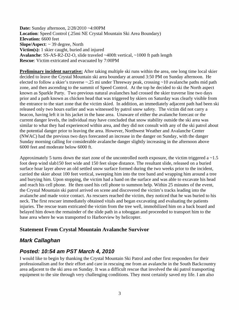
Shear plane and buried surface hoar layer: Buried surface hoar layer shown with sunlight:
5-20mm Buried Surface Hoar: Right half of crown & fracture profile location:
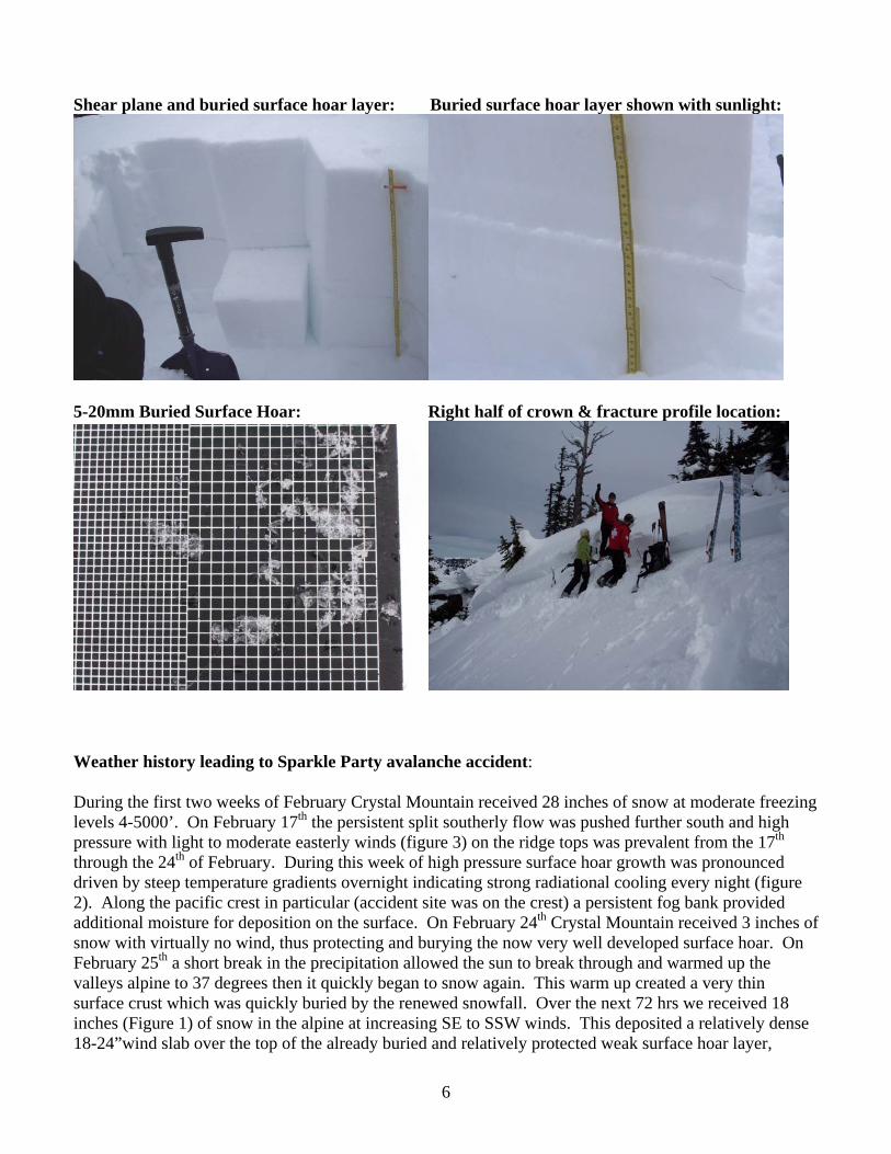
Weather history leading to Sparkle Party avalanche accident: During the first two weeks of February Crystal Mountain received 28 inches of snow at moderate freezing levels 4-5000’. On February 17th the persistent split southerly flow was pushed further south and high pressure with light to moderate easterly winds (figure 3) on the ridge tops was prevalent from the 17th through the 24th of February. During this week of high pressure surface hoar growth was pronounced driven by steep temperature gradients overnight indicating strong radiational cooling every night (figure 2). Along the pacific crest in particular (accident site was on the crest) a persistent fog bank provided additional moisture for deposition on the surface. On February 24th Crystal Mountain received 3 inches of snow with virtually no wind, thus protecting and burying the now very well developed surface hoar. On February 25th a short break in the precipitation allowed the sun to break through and warmed up the valleys alpine to 37 degrees then it quickly began to snow again. This warm up created a very thin surface crust which was quickly buried by the renewed snowfall. Over the next 72 hrs we received 18 inches (Figure 1) of snow in the alpine at increasing SE to SSW winds. This deposited a relatively dense 18-24”wind slab over the top of the already buried and relatively protected weak surface hoar layer,
6

setting the stage for numerous skier triggered avalanches, one of which caught, buried and injured Mark Callaghan. Figure 1:
Figure 2:
7
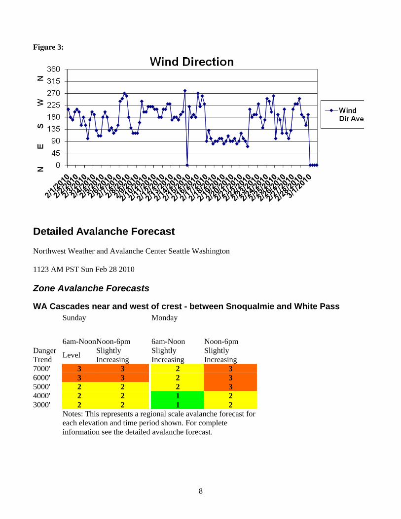
Figure 3:
Detailed Avalanche Forecast
Northwest Weather and Avalanche Center Seattle Washington
1123 AM PST Sun Feb 28 2010
Zone Avalanche Forecasts
WA Cascades near and west of crest - between Snoqualmie and White Pass Sunday Monday
6am-Noon Noon-6pm 6am-Noon Noon-6pm Danger Trend Level Slightly
Increasing Slightly Increasing
Slightly Increasing
7000' 3 3 2 3 6000' 3 3 2 3 5000' 2 2 2 3 4000' 2 2 1 2 3000' 2 2 1 2
Notes: This represents a regional scale avalanche forecast for each elevation and time period shown. For complete information see the detailed avalanche forecast.
8
Forecast
Sunday: Considerable avalanche danger above 6000 feet and moderate below slowly increasing during the late morning and afternoon hours, decreasing overnight.
Monday: Moderate avalanche danger above 4 to 5000 feet and low below increasing during the late morning and afternoon and becoming considerable on southeast through southwest exposures above 5000 feet and moderate elsewhere. Danger decreasing overnight.
Snowpack Analysis
Several weather disturbances mid-late last week deposited up to 1 to 2 feet of snow at mid and upper elevations, slightly heavier along the Cascade west slopes, with generally less at lower elevations where some rain was mixed with the snow. The recent snow was received at gradually warming temperatures and increasing winds and fell on a variety of old snow surfaces including smooth crusts and recycled powder, as well as significant hoar frost layers. Along with periods of strong and shifting winds, this weather created an increasing avalanche danger, especially at higher elevations where strongest winds and greatest snowfall were received. While light showers and some partial clearing Saturday through early Sunday allowed for some stabilization of previous slabs through either slow settlement, some natural slide activity or weak surface crust formation, a considerable danger remains on shaded northwest through northeast exposure slopes above about 6000 feet where cautious route-finding and conservative decision-making are strongly encouraged. Also, some recently formed cornices have been reported as being quite unstable...and these...as well as the slopes below...should be avoided during the warming weather anticipated through Monday.
Although the recently developing surface crust and increasing settlement has helped to decrease the danger to moderate below about 6000 feet, some human triggered wind slabs remain possible here as well...especially on more shaded northwest through northeast exposures where previous surface hoar layers may continue to lurk beneath more isolated wind slabs.
During the past several days, there have been numerous ski area and backcountry reports of unstable slab layers with triggered or natural slides releasing on early lower density storm layers, old hard crusts or surface hoar layers, mainly on northeast through northwest facing slopes above 5500 feet.
Detailed Forecasts
Sunday and Sunday night
After variable mid and high clouds Sunday morning, greatest in the north and Olympics, decreasing clouds later morning hours and mid-day should lead to mostly sunny and slightly warmer weather Sunday afternoon. Along with relatively light winds, this should produce an increasing avalanche danger during the later morning and afternoon hours as sunshine and daytime warming soften, melt and weaken surface snow layers, with some natural loose and wet loose slides expected in sun exposed terrain along with an increased potential for human triggered slides on both sunny and shaded exposures, especially at mid and higher elevations. Mostly fair skies overnight should allow for increasing crust formation and lead to a generally decreasing danger overnight and during early morning hours.
9

Monday and Monday night
Mostly fair weather with scattered high clouds Monday morning should be followed by increasing high clouds but considerable filtered sunshine Monday afternoon. Along with high freezing levels for much of Monday and gradually increasing ridgetop winds, especially in the Olympics, this should produce a significant increase in the avalanche danger, especially on wind sheltered but sun exposed terrain where considerable danger is expected above about 5000 feet with moderate danger elsewhere. In wind sheltered but sun exposed terrain, loose or wet loose slides should become increasingly likely, with some slides possibly entraining much of the new snow over the old crust and triggering some isolated slabs as well. On more shaded but wind sheltered slopes, the warming should increase creep of surface snow and make the snow surface more slablike, both of which should increase the potential for human triggered slides reaching one of several buried weak layers. However, in
Further increasing clouds and some light showers are expected overnight along with further increasing ridgetop winds and slowly lowering freezing levels. With no new snow accumulations likely, more pervasive surface crusts, and little snow remaining available for wind transport, this weather should allow for generally decreasing danger overnight.
Backcountry travelers should be aware that elevation and geographic distinctions are approximate and that a transition zone between dangers exists. Remember there are avalanche safe areas in the mountains during all levels of avalanche danger. Contact local authorities in your area of interest for further information.
Danger Scale Legend 5 = Extreme avalanche danger 4 = High avalanche danger 3 = Considerable avalanche danger 2 = Moderate avalanche danger 1 = Low avalanche danger
Warning = Extreme or high avalanche danger occurring or expected to occur within 12 hours: at or below 4000 feet in the Olympics and/or WA Cascades; at or below 5000 feet in the Mt. Hood Area.
Watch = Warning conditions expected within 12-48 hours.
Special Conditions = Unusual conditions meriting special attention that do not meet Watch or Warning criteria.
Click here for complete definitions of the avalanche danger scale.
NWAC weather data and forecasts are also available by calling 206-526-6677 for Washington, 503-808-2400 for the Mt Hood area, or by visiting our Web site at www.nwac.us. Remember that these avalanche forecasts apply to back country avalanche terrain below 7000 feet outside of developed and operating ski areas or highways.
The NWAC program is administered by the USDA-Forest Service. NWAC forecasts, data and avalanche or mountain weather information are made possible by partnerships between the Forest Service and many important cooperators, including the National Weather Service, Washington State Department of Transportation, Washington State Parks and Recreation Commission, Washington Snowparks and Snowmobile Grants, National Park Service, Ski Washington, Pacific Northwest Ski Area Association, the Friends of the Avalanche Center and others.
10

This forecast is prepared for cooperators and users of the NWAC, as an aide to tranportation and recreational operations, and to help promote public safety in the NW mountains.
Moore/Northwest Weather and Avalanche Center Seattle Washington
Rescue/ Recovery
Witness Statement Feb 28, 2010 ~4:00pm
Ben Bowen and Ben Wright On Saturday February 28th, 2010 at approximately 3:30pm, Mark left the boundary of Crystal
Mountain Ski Area with the intention of skiing a small peak known as “Speed Control”. He traversed underneath the boundary rope line in the “Threeway Exit” and into the area known as “Joes Badass Shoulder” ascended to the top of “Speed Control” and skied into “Sparkle Party”.
Earlier in the weekend the Mark had made several runs in the South Backcountry. The ski patrol had used explosives and ski cutting to mitigate the avalanche hazard in that area on Saturday morning. It was a particularly busy day at Crystal and the skiing public had skied up the slopes in the South Backcountry, further mitigating the avalanche hazard. Based on his experience in the South Backcountry, Mark felt the slopes were “stable”.
Mark had been wearing a transceiver in the morning but then decided to take it off after lunch based on the “stable” conditions he had seen in the South Backcountry. Earlier in the season, Mark had skied the same run, known as “Sparkle Party” and the surrounding terrain without incident.
At the boundary line, Mark traversed under Three Way Peak and then boot packed up “Joe Badass Shoulder”. Once Mark had gained the ridge he skied approximately seventy-five yards until he came to an untouched chute. Mark entered the slope, skied approximately five turns and the slope avalanched taking Mark one hundred vertical feet down slope and pinning him against a large tree and burying him up to his chest.
Mark was unable to extricate himself from the tree due to his injuries but was able to reach his cell phone and contact Crystal Mountain Ski Patrol Dispatch. Dispatch then contact ski patroller Ben Bowen who was sweeping the South Backcountry and he started to the area where Mark was buried. During this time, Mark also contacted his friends at the base area, explained the situation and made sure his children were been taken care of. Ben reached the ridge and was able to find one track that followed the ridge and then disappeared into a chute that had recently avalanched. Ben Bowen evaluated the remaining hazard and deemed it acceptable to venture into the chute. Once able to see into the chute, Ben yelled down the chute and made voice contact with Mark. Ben skied down the chute on the slide’s bed surface contacted Mark, assessed his injuries and began the extraction. Mark’s chief complaint was of sharp, right upper hip pain rated at 9 out of 10. He also was shivering when Ben came on scene. Ben wrapped Mark in his patrol jacket in an effort to keep Mark warm, got his first set of vitals and began digging Mark out as much as he could. Ben continued to take vitals every five minutes until more patrollers arrived.
In approximately twenty minutes, Leah Fisher arrived on scene with a BLS pack, got a blood pressure and administered O2. Chet Mowbray walked up from Silver Basin with an addition BLS pack. Patrick Fleming, Corey Meador and Eric Gullickson arrived about ten minutes later with a backboard and
11
assisted in the extraction of Mark. Mark was carefully rolled onto the backboard and lowered onto the snow platform that Ben and Patrick had dug. Mark was then secured to the backboard and CSM’s were retaken along with vitals. Meanwhile, John Kirner, Max Bunce, Mike Miller and other patrollers were hauling the Aukia sled up the slope to the accident site. Once the aukia was on site Mark was loaded into the sled and then belayed down slope with Max Bunce driving the sled, Ben in the tail rope and Eric belaying. Andrew Longstreth the paramedic on seen administer medication to help the pain.Three hundred feet down slope the sled was taken off belay and Ben and Max ran the sled out the drainage while the rest of the rescuers plowed the snow out of the way to make travel easier. Throughout the extraction sled runners rotated. Ben Wright, Chet, and other rescuers took turn running the sled until they reached the flats of Silver Basin where Blaine Horner was waiting with a snowmobile. Blaine then towed the sled out of Silver Basin with Ben Wright driving the sled and Mike Miller in the tail rope. The sled reached the patrol room and Mark was transported to the landing zone in an ambulance and then transported to Harborview by a helicopter. Dispatch log: Source dispatch notes, cell phone records and interviews of first responders: 4:09 – Dispatch receives call from Mark Callaghan reporting incident location and possible broken femur 4:10 – Ben Bowen is dispatched to the scene 4:15 – Paul Harrington, Leah Fischer, Patrick Fleming responding with BLS, KTD and Belay pack from High Campbell 4:20 – Snowcat wtih Ben Wright, Max Bunce and rescue dog sierra heading up from base with food, water extra O2 bottles and backboard 4:34 – Ben Bowen makes verbal contact with the victim and reports on potential remaining hazard and route in 4:38 – Ben Bowen on scene 4:42 – Ben Bowen reports vitals and injuries 4:55 – Leah and BLS on scene vitals update. 4:56 – Paul H and Patrick on scene, Toboggan en route from top of the King. 5:01 – Ben Wright and Max Bunce on scene w/extra O2 and supplies. 5:08 –Vitals update 5:18 - Backboard on Scene 5:35 - Patient extricated from tree well and on back boardboard. Pelvic deformity and vitals update 6:06- Paramedic Andrew Longstreth on scene 6:16- Sled leaving scene 6:48- Sled in Base area Patrollers on scene: Paul Harrington -Rescuer
Ben Bowen –Rescuer Chet Mowbray -Rescuer Paul Baugher -IC Ben Wright- Rescuer Leah Fischer- Recuer
12

13
Patrick Fleming- Rescuer Max Bunce- Rescuer Andrew Longstreth- Paramedic Eric Gullickson-Rescuer John Kirner- Rescuer Steve Ferkovich-Avalanche guard Christina Von Mertens- Avalanche guard