Embed Size (px)
Citation preview
8/6/2019 Smokie Guide
http://slidepdf.com/reader/full/smokie-guide 1/17
2011 Smokies Trip Planner
National Park Service
U.S. Department of the InteriorGreat Smoky Mountains National Park
Tips on Auto Touring in the National Park
Great Smoky Mountains National Park
encompasses over one-half million acres,
making it one of the largest natural areas in
the East. An auto tour of the park offers
scenic views of mountain streams, weathered
historic buildings, and forests stretching to
the horizon.
There are over 270 miles of road in the
Smokies. Most are paved, and even the gravel
roads are maintained in suitable condition for
standard two-wheel drive automobiles.
Driving in the mountains presents new chal-
lenges for many drivers. When going down-
hill, shift to a lower gear to conserve your
brakes and avoid brake failure. If your vehicle
has an automatic transmission, use “L” or
“2.” Keep extra distance between you and the
vehicle in front of you and watch for sudden
stops or slowdowns.
The following is a partial listing of some of
the park’s most interesting roads. To purchase
a copy of the park’s official road guide, visit
www.theGreatSmokyMountains.org or call
(888) 898-9102.
Newfound Gap Road (33 miles, paved.)
This heavily used U. S. highway crosses
Newfound Gap (5,046' elevation) to connect
Cherokee, NC and Gatlinburg, TN.
Highlights include numerous pullouts with
mountain views and a variety of forest types
as you ascend approximately 3,000 feet up the
spine of the mountains.
Clingmans Dome Road (7 miles, paved;
closed in winter.)
This spur road follows a high ridge to a paved
walking trail that leads 0.5 mile to the park’s
highest peak. Highlights are mountain views
and the cool, evergreen, spruce-fir forest.
Little River Road (18 miles, paved.)
This road parallels the Little River from
Sugarlands Visitor Center to near Townsend,
TN. Highlights include the river, waterfalls,
and wildflowers.
Roaring Fork Motor Nature Trail (6 miles,
paved; closed in winter. Buses and RVs are
not permitted on the motor nature trail.)
A steep, narrow, and scenic route through
deep forest and historic farmsteads. From
downtown Gatlinburg, turn at traffic light #8
and follow Historic Nature Trail-Airport
Road into the national park.
Bears in the SmokiesThe Smokies are one of the few places
remaining in the eastern United States where
black bears can live in wild, natural surround-
ings. Some 1,500 black bears live in the park.
Unlike black bears elsewhere, adult bears in
the Smokies are always black rather thanbrown or cinnamon. They are also relatively
small. Females often weigh 100-150 pounds;
males 125-200. However, bears weighing over
400 pounds do live in the park.
Acorns, berries, grasses, and other plant
materials make up over 80% of a park bear’s
diet. The rest consists of insects, carrion, fish,
mammals, and other animal matter. Feeding
bears in the park or leaving food out for bears
is illegal for a number of reasons. Bears con-
ditioned to human-related food lose their fear
of people and become threats to human safe-
ty. Conditioned bears also cause property
damage and are vulnerable to being shot bypoachers, hit by vehicles, or dying from
ingesting food packaging and other toxins.
Store your food in your vehicle (preferably in
the trunk) when not in use. Never feed a
bear. Dispose of all trash in bearproof cans.
For information about what to do if you see a
bear, please turn to page 11.
National Park Service
Great Smoky Mountains National Park is
managed by the United States National Park
Service. The agency manages the park in
accordance with its mission statement “to
conserve the scenery and the natural and
historic objects and the wild life therein, and
to provide for the enjoyment of the same insuch manner and by such means as will
leave them unimpaired for the enjoyment of
future generations.”
Superintendent Dale Ditmanson asks the
help of all Smokies visitors in conserving
park resources. Please don’t litter, feed
wildlife, or disturb plants. Do your best to
leave the park in better condition than it
was when you came.
For updated park weather
and road closure
information
call (865) 436-1200
8/6/2019 Smokie Guide
http://slidepdf.com/reader/full/smokie-guide 2/17
2 Smokies Trip Planner
Family CampgroundsThe National Park Service maintains
developed campgrounds at ten locations in
the park. Each campground has restrooms
with cold running water and flush toilets, but
there are no showers or electrical or water
hookups in the park. Shower facilities are
available in the communities surrounding the
national park. Please inquire about the
nearest facilities when you check-in at the
campground. Each individual campsite has a
fire grate and picnic table.
During summer and fall, sites at Cades Cove,
Elkmont, Smokemont, and Cosby may be
reserved. New in 2011, sites in Cataloochee
must be reserved in advance. For reserva-
tions call (877) 444-6777 or visit the reserva-
tion web site at http://www.recreation.gov.
Reservations are accepted only for May 15-
Oct. 31. Sites may be reserved six months in
advance. All other campgrounds operate on a
first-come, first-served basis.
No more than six people may occupy a
campsite. Maximum stay during summer and
fall is seven days. Maximum stay during the
off-season is 14 days. Leashed or otherwise
confined pets are allowed in campgrounds.
Quiet hours are from 10 p.m. to 6 a.m.
Park campgrounds are located in areas fre-
quented by bears and other wildlife. All food,
coolers, utensils, stoves, etc., must be stored
out of sight in a closed vehicle when not in
use. Do not throw food scraps or packaging
in fire rings. Feeding wildlife is prohibited.
Group camping sites are available at Big
Creek, Cades Cove, Cataloochee, Cosby,
Deep Creek, Elkmont, and Smokemont.
Group sites must be reserved in advance.
Costs range from $26-$65. Sites may be
reserved one year in advance. Visit
http://www.recreation.gov or phone
(877) 444-6777 for reservations.
Lodging in theParkLe Conte Lodge, on top of Mount Le Conte,
provides the only lodging in the park. The
lodge is accessible only by trail (5 miles
minimum hiking one way). Reservations often
must be made a year in advance. Call (865)
429-5704 or visit www.leconte-lodge.com
AccommodationsOutside the ParkThere are no motels or rental cabins located
within the national park other than Le Conte
Lodge (see information above). However,
communities surrounding the national park
offer a wide choice of accommodations
including hotels, cabins, bed and breakfasts,
and commercial campgrounds. For informationabout accommodations please contact the
following Departments of Tourism:
North Carolina
Bryson City (800) 867-9246
Cherokee (800) 438-1601
Fontana (800) 849-2258
Graham County (800) 470-3790
Haywood County (877) 456-3073
Maggie Valley (800) 624-4431
Tennessee
Cosby/Newport (423) 623-7201
Gatlinburg (800) 267-7088Pigeon Forge (800) 251-9100
Sevierville (800) 738-4378
Townsend (800) 525-6834
PetsDogs are allowed in campgrounds, picnic
areas, and along roads, but must be kept on a
leash at all times. The leash must not exceed 6
feet in length.
Dogs are allowed on two short walking
paths—the Gatlinburg Trail and the
Oconaluftee River Trail. Pets are not allowed
on any other park trails.
Pet excrement must be immediately collected
by the pet handler and disposed of in a trash
receptacle. Pets should not be left unattended
in vehicles or RVs.
Five drive-in horse camps provide ready
access to backcountry horse trails in the
national park. Camps are located at Anthony
Creek (near Cades Cove), Big Creek,
Cataloochee, Round Bottom, and Towstring.
Horse camps are open April 1 - November
13, 2011. For reservations, visit the web site
http://www.recreation.gov or phone
(877) 444-6777 between 10 a.m. and 10 p.m.
Eastern Standard Time.
There is a $20 fee per site, ($25 at Big Creek).
A maximum of four horses and six people are
allowed per site. Sites may be reserved six
months in advance.
Horse Camps
Campground Number Elevation Fee 2011 Open/Close Maximum
of Sites Dates RV Length
Abrams Creek 16 1,125' $14 March 11-Oct 31 12' RVs
Balsam Mt. 46 5,310' $14 May 13-Oct 10 30' RVs
Big Creek 12 1,700' $14 March 11- Oct 31 Tents Only
Cades Cove 159 1,807' $17-20 Open Year Round 35' RVs
Cataloochee* 27 2,610 $17 March 11-Oct 31 31' RVs
Cosby 165 2,459' $14 March 11-Oct 31 25' RVs
Deep Creek 92 1,800' $17 April 1-Oct 31 26' RVs
Elkmont 220 2,150' $17-23 March 11-Nov 30 32' RVs
Look Rock 68 2,600' $14 May 13-Oct 31 No Limit
Smokemont 142 2,198' $17-20 Open Year Round 35' RVs
* Campsites in Cataloochee must be reserved in advance. www.recreation.gov will begin accepting
reservations for Cataloochee on Feb. 1, 2011.
8/6/2019 Smokie Guide
http://slidepdf.com/reader/full/smokie-guide 3/17
Smokies Trip Planner 3
When planning a trip in the park, it is helpful
to keep in mind that elevations in the park
range from 800 feet to 6,643 feet and that the
topography can drastically affect local weath-
er. Temperatures can easily vary 10-20
degrees Fahrenheit from mountain base to
top, and clear skies lower down do not
guarantee equally pleasant weather at higher
elevations. Rainfall averages 55 inches per
year in the lowlands to 85 inches per year at
Clingmans Dome. Some prior planning and
weather-wise clothing will help ensure an
enjoyable visit during any time of the year.
March through May: Spring brings with it
unpredictable weather. Changes occur
rapidly––sunny skies can yield to snow
flurries in a few hours. March is the month
with the most radical changes; snow can fall
at any time during the month, particularly in
the higher elevations. Temperatures in the
lower elevations have a mean high of 61°F.
Low temperatures, which are often below
freezing, have a mean of 42°F. By mid-April
the weather is usually milder. Daytime
temperatures often reach the 70s and
occasionally the 80s. Below freezing
temperatures at night are uncommon in the
lower elevations but still occur higher up.
April averages over four inches of rain,
usually in the form of afternoon showers.
May is warmer, with daytime highs in the 70s
and 80s and lows in the 40s and 50s. May
rainfall averages about 4.5 inches.
June through August: Summer in the
Smokies means heat, haze, and humidity.
Afternoon showers and thunderstorms are
common. Temperatures increase through the
period with July and August afternoon highs
in the 90s in the lower elevations. Evening
lows are usually comfortable with readings in
the 60s and 70s. In the higher elevations, the
weather is much more pleasant. On Mount
Le Conte (6,593' elevation), no temperature
above 80°F has ever been recorded.
To listen to the park'scurrent weather forecast,
dial (865) 436-1200extension 630
September through mid-November: Clear
skies and cooler weather signal the onset of
the fall color season. Warm days alternate
with cool nights. Daytime highs are usually in
the 70s and 80s during September, falling to
the 50s and 60s in early November. The first
frosts often occur in late September. By
November, the lows are usually near freezing
This is the driest period of the year with only
occasional rain showers. In the higher eleva-
tions, snow is a possibility by November.
Mid-November through February: Winter
in the Smokies is generally moderate, but
extremes in weather do occur, especially at
high elevation. It is not unusual to have warm
temperatures in the low elevations and snow
in the higher areas. About half the days in the
winter have high temperatures of 50 degrees
or more. Highs occasionally even reach the
70s. Most nights have lows at or below freez-
ing. But lows of -20°F. are possible at high
elevations. In the low elevations, snows of 1"
or more occur 1-5 times a year. Snow falls
more frequently in the higher mountains and
up to two feet can fall during a storm. January
and February are the months when one is
most likely to find snow in the mountains.
Weather and Climate Information
For Gatlinburg, TN(Low elevation area)
Monthly Monthly Number of
Month High Low Precipitation Snowfall Days with
°F °F Total Precipitation
Jan. 51 28 4.8 2.3 9
Feb. 54 29 4.8 2.3 9
Mar. 61 34 5.3 2.9 9Apr. 71 42 4.5 T 8
May 79 50 4.5 0 9
Jun. 86 58 5.2 0 9
Jul. 88 59 5.7 0 10
Aug. 87 60 5.3 0 10
Sep. 83 55 3.0 0 5
Oct. 73 43 3.1 T 6
Nov. 61 33 3.4 0.7 7
Dec. 52 28 4.5 1.0 8
The following tables give monthly averages for weather in the park. Temperatures are in degreesFahrenheit, precipitation and snow are listed in inches, T=trace.
For Clingmans Dome NC/TN.Based on extrapolations. (High elevation area)
Monthly Monthly Number of
Month High Low Precipitation Snowfall Days with
°F °F Total Precipitation
Jan. 35 19 7.0 18 12
Feb. 35 18 8.2 20 12
Mar. 39 24 8.2 26 12Apr. 49 34 6.5 5 10
May 57 43 6.0 T 10
Jun. 63 49 6.9 0 11
Jul. 65 53 8.3 0 13
Aug. 64 52 6.8 0 12
Sep. 60 47 5.1 T 8
Oct. 53 38 5.4 2 8
Nov. 42 28 6.4 5 9
Dec. 37 21 7.3 8 10

8/6/2019 Smokie Guide
http://slidepdf.com/reader/full/smokie-guide 4/17
4 Smokies Trip Planner
Ranger-GuidedWalks & Talks
Evening campfire programs, guided hikes,
history demonstrations, and other ranger-led
programs are generally conducted from June
through October in the park. Additional pro-
grams may be offered at other times of the
year.
Evening slide programs are traditionally held
one or more nights per week at Elkmont,
Cades Cove, and Smokemont campgrounds.
Guided walks, ranging in length from 0.25
mile to 5.0 miles, are conducted throughout
the park. Specific program times and loca-
tions are listed in the summer and fall edi-
tions of the park’s free newspaper, the
Smokies Guide. The Smokies Guide is available
at visitor centers or by calling (865) 436-7318.
Publication dates are in early June and early
September.
Horses for Hire
Horseback riding is generally available from
mid-March into November. Rider weight
limits may apply. Rates average $20-25 perhour. Please call the following concessions
for details.
Cades Cove (865) 448-9009
Sugarlands (865) 436-3535
Smokemont (828) 497-2373
Smoky Mountain (865) 436-5634
Hayrides
Hayrides and carriage rides are availablearound Cades Cove Loop Road from spring
through fall. Some are ranger-guided. Cost
per person is $6-$8. Call (865) 448-9009 for
information. Smokemont Stables offers
wagon rides. For information, please call
(828) 497-2373.
Things To Do in the National Park
Bicycling
Bicycling is allowed on any park road that is
open to vehicle traffic. However, due to steep
terrain, narrow road surfaces, and heavy
automobile traffic, many park roads are notwell suited for safe and enjoyable bicycle rid-
ing.
The Cades Cove Loop Road is an exception.
The 11-mile-long loop road is the most
popular place in the park for bicycling. Other
areas suitable for bicyclists include
Greenbrier, Lakeview Drive, Tremont Road,
and Cataloochee valley.
Cades Cove Loop Road is closed to motor
vehicles for the benefit of bicyclists and walk-ers from sunrise until 10:00 a.m. every
Saturday and Wednesday morning from
May 11 - September 21, 2011.
Bicycles may be rented from the Cades Cove
store located near Cades Cove Campground.
For information call (865) 448-9034. Serious
accidents occur every year along the loop
road, please heed warning signs. The State of
Tennessee requires that children age 12 and
under wear a helmet. We strongly recom-
mend that all riders wear helmets and ride
properly fitted and well-maintained bicycles.
Bicycles are prohibited on all trails except
the Gatlinburg Trail, Oconaluftee River Trail,
and lower Deep Creek Trail. Mountain biking
trails are open on national forest and recre-
ation lands outside Great Smoky Mountains
National Park. For a listing of other public
lands in the region, please see page 8.
Picnicking
Picnic areas are open year-round at Big
Creek, Cades Cove, Cosby, Chimney Tops,
Deep Creek, Greenbrier, and Metcalf
Bottoms. In addition, picnic area at CollinsCreek, Heintooga, and Look Rock are open
spring through fall. All picnic sites have a
table and fire grate.
Picnic pavilions are available at Collins Creek
Cosby, Deep Creek, Greenbrier, Metcalf
Bottoms, and Twin Creeks. They can be
reserved for in advance on the internet at
http://www.recreation.gov or by calling
(877) 444-6777.
All pavilions except Twin Creeks cost $20 peruse. Twin Creeks' fee ranges from $35-75
depending on the usage.
Become A Junior Ranger
If you're between the ages of 5-12, you can
become a Junior Ranger! Pick up a Junior
Ranger booklet for $2.50 at any park visitor
center or at the Cades Cove or Elkmont
campground. Complete the activities in the
booklet then stop by a visitor center to talk to
a ranger and receive your Junior Ranger
badge.
Older than 12? Stop at a park visitor center
and pick up a brochure to participate in the
park’s Not So Junior Ranger program and
earn a patch. The program is open to anyone
from 13 to 113 years old!
Water recreation is not recommended in the park due to
numerous hazards and dangers. Drowning is one of the
leading causes of death in the park. In addition, numerous
serious injuries have resulted from people swimming and
riding inner tubes in park waters.
8/6/2019 Smokie Guide
http://slidepdf.com/reader/full/smokie-guide 5/17
Smokies Trip Planner 5
Birds, mammals, reptiles, and other forms of
wildlife can be found throughout the park.
However viewing wildlife in the Smokies can
be challenging because most of the park is
covered by dense forest. Open areas like
Cataloochee and Cades Cove offer some of the best opportunities to see white-tailed
deer, black bear, raccoon, turkeys, wood-
chucks, and other animals.
In addition, the narrow, winding road of
Roaring Fork Motor Nature Trail encourages
motorists to travel at a leisurely pace and
sometimes yields sightings of bear and other
wildlife.
Because many animals are most active at
night, it is advantageous to look for wildlifeduring morning and evening. It's also a good
idea to carry binoculars. (Spotlighting wildlife
is prohibited.) Don't forget to scan the trees—
many animals spend their days among the
branches.
During winter wildlife is more visible because
deciduous trees have lost their leaves. Sit qui-
etly beside a trail or near the edge of a field to
see what wildlife will come out of hiding.
Great Smoky Mountains National Park has about
2,115 miles of streams within its boundaries, and
protects one of the last wild trout habitats in the
eastern United States. The park offers a wide
variety of angling experiences from remote,
headwater trout streams to large, coolwater
smallmouth bass streams. Most streams remain at
or near their carrying capacity of fish and offer a
great opportunity to catch these species through-
out the year.
A Tennessee or North Carolina fishing license is
required to fish in the park. Either state license is
valid throughout the park and no trout stamp is
required. Special permits are required for fishing in
the towns of Gatlinburg and Cherokee. Fishing
licenses and permits are not available in the park,
but may be purchased in nearby towns.
The park restricts fishing tackle to single-hooked
artificial lures and flies. The park prohibits use of
live and natural bait, including corn, minnows,
salmon eggs, worms, and cheese.
Fishing is permitted year-round in the park, from
30 minutes before official sunrise to 30 minutes
after official sunset. The park allows fishing in all
streams EXCEPT the following streams and their
tributaries upstream from the points described:
Closed Streams
Bear Creek in North Carolina at its junction with
Forney Creek
Lynn Camp Prong in Tennessee upstream of its
confluence with Thunderhead Prong
These streams are closed to fishing to allow fish to
repopulate following restoration work. For the
Black bears are most visible in summer and
fall as they forage for food. They can be seen
high in the tops of wild cherry trees or
searching for acorns under oaks trees.
Bears retreat to their winter dens from mid-November through March. However, they do
not truly hibernate and may leave the den for
short periods on warm winter days.
Elk are most readily spotted in the fields in
Cataloochee Valley. They are typically active
in the early morning and evening. During the
mating season in September and early
October, male elk make their legendary
bugling calls to challenge other bulls and
attract cows. Their calls may be heard a mile
or more away. Large bulls use their antlers tointimidate and spar with other males.
Don’t be responsible for a bear’s death!
Never feed wildlife or bait animals for closer
observation or photography. Feeding park
wildlife usually guarantees the animal’s
demise.
While most visitors understand that feeding
wildlife is against the law, many people do not
realize that disturbing park wildlife is also a
exact location, consult the appropriate USGS
1:24,000 Quadrangle Map available at park visitor
centers. Detailed information, including a
complete list of regulations and a map of fishable
park waters, is also available at any visitor center
or ranger station.
Fishing pressure tends to be highest nearest the
roads. In addition, many other factors determine
an angler's success--the season, time of day, skilllevel, type of lure, and weather conditions.
Wading in streams can drain body heat and lead
to hypothermia. Rising water levels due to sudden
mountain storms occur quite frequently, so moni-
tor water level. Water currents are swifter than
they appear and footing is treacherous on rocks.
Please visit the park’s website for additional
information about water safety.
Fishing in Great Smoky Mountains National Park
Tips for Watching Wildlifeviolation of federal regulations and can
result in fines and arrest.
The laws protecting park wildlife are
contained in the Code of Federal Regulations
Willfully approaching within 50 yards(150 feet), or any distance that dis-
turbs or displaces bear or elk is pro-
hibited. In addition, feeding, touch-
ing, teasing, frightening, or intention-
ally disturbing any wildlife is prohibit
ed. This includes bear, elk, deer, turkey,
squirrels, snakes, and all other park animals.
Do not approach wildlife. And do not
allow animals to approach you! As a rule of
thumb, if you approach an animal so closely
that it changes its behavior, you are too close.Instead use binoculars, spotting scopes and
cameras with telephoto lenses to enjoy
wildlife.
Watch for any modification in an animal's
behavior that indicates that you have
approached too closely. Move away from the
animal until you reach a distance at which the
animal feels comfortable once again and
resumes whatever activity it was engaged in
before you approached.
8/6/2019 Smokie Guide
http://slidepdf.com/reader/full/smokie-guide 6/17
right at the junction with Indian Creek Trail
and proceed approximately 200' to Indian
Creek Falls. The falls are 25 feet in height.
Access trail: Deep Creek/Indian Creek
Trailhead: Follow the signs through down-
town Bryson City to Deep Creek Camp-
ground. Continue past the campground to
the trailhead at the end of Deep Creek Road.
Juney Whank Falls
Juney Whank Falls is divided into an upper
and lower section. Both can be viewed from
the footbridge which crosses Juney Whank
Branch at the falls. Together they drop 90 feet
from top to bottom. The trail to the waterfall
is 0.8 miles roundtrip and is considered mod-
erate in difficulty.
Access Trail: Juney Whank Falls Trail
Trailhead: Follow the signs through down-
town Bryson City to Deep Creek
Campground. Continue past the campground
to the trailhead at the end of Deep Creek
Road. Backtrack on foot 0.1 mile along the
road to the trail
Rainbow Falls
A rainbow produced by mist from this 80-
foot high waterfall is visible on sunny after-
noons. During extended winter cold spells,
the falls freeze into a hourglass shape.
Between trailhead and falls, the trail gains
about 1,500' in elevation. The 5.4 mile
roundtrip hike is rated moderate in difficulty.
6 Smokies Trip Planner
Laurel Falls
The 80-foot high Laurel Falls is named for
mountain laurel, an evergreen shrub which
blooms along the trail in May. The paved trail
is 2.6 miles roundtrip and considered moder-ate in difficulty.
Laurel Falls is one of the most popular desti-
nations in the park and parking at the trail-
head is limited. The area is especially busy in
summer and on weekends year-round.
Access trail: Laurel Falls Trail
Trailhead: From Sugarlands Visitor Center,
turn toward Cades Cove on Little River Road
and drive 3.9 miles to the trailhead. There are
parking areas on both sides of the road.
Hen Wallow Falls
The trip to Hen Wallow Falls is a pleasant
walk through hemlock and rhododendron
forest. A signed side trail leads to the base of
the falls by way of steep switchbacks. Hen
Wallow Falls is 90 feet high.
The hike to the falls is 4.4 miles roundtrip and
is rated moderate in difficulty. Continue on
the Gabes Mountain Trail beyond the falls to
view an impressive old-growth forest.
Access Trail: Gabes Mountain
Trailhead: Park in the designated hiker park-
ing area at Cosby Picnic Area (near the
entrance to Cosby Campground). Then back-
track on foot approximately 100 yards along
the road to the signed start of the Gabes
Mountain Trail.
Indian Creek Falls
An easy 1.6 mile roundtrip hike will allow you
to enjoy two beautiful waterfalls in the Deep
Creek area. Walk Deep Creek Trail 0.7 mile to
the junction with Indian Creek Trail. On your
way you can view elegant Tom Branch Falls
located on the far side of Deep Creek. Turn
Walks To Waterfalls –– All falls are indicated on map on pages 14-16.
Access Trail: Rainbow Falls Trail
Trailhead: From the parkway in Gatlinburg,
turn at traffic light #8 and follow Historic
Nature Trail into Great Smoky Mountains
National Park. Continue past the Noah “Bud”
Ogle homesite to the clearly signed Rainbow
Falls parking area.
Ramsey Cascades
Ramsey Cascades is the tallest waterfall in the
park and one of the most spectacular. Water
drops 100 feet over rock outcroppings and
collects in a small pool where numerous well-
camouflaged salamanders can be found.
The trail to the waterfall gains over 2,000' in
elevation and the 8-mile roundtrip hike is
considered strenuous in difficulty. It follows
rushing rivers and streams for much of its
length. The last 2 miles pass through old-
growth cove hardwood forest with large tulip
trees, silverbells, and yellow birches.
Access Trail: Ramsey Cascades Trail
Trailhead: Drive six miles east of Gatlinburg
on Highway 321 and turn at the Greenbrier
entrance to the park. Follow the signs 4.7
miles to the trailhead.
Mingo Falls
Mingo Falls is on the Cherokee Indian
Reservation (Qualla Boundary), just outside
the national park. No special permits are
required for access to the reservation. At 120
feet tall, the waterfall is one of the tallest and
most spectacular in the southern mountains.
The hike to the waterfall is only 0.4 miles in
length, but is rated moderate in difficulty.
Access Trail: Pigeon Creek Trail
Trailhead: From Oconaluftee Visitor Center,
drive south (toward Cherokee) on US-441
and take the second left onto Big Cove Road.
At the first stop sign turn left and drive 4.5
miles to Mingo Falls Campground, where the
trail begins.
Do not climb on waterfalls!
Over the years, several fatalities and
innumerable injuries have resulted from
people climbing on rocks near waterfalls.
Rocks are slippery due to mist and algae.
Medical assistance for persons injured around
waterfalls may be many hours away. Closelysupervise children at all times.
8/6/2019 Smokie Guide
http://slidepdf.com/reader/full/smokie-guide 7/17
Smokies Trip Planner 7
Cades Cove
Highlights: historic buildings, wildlife viewing
Cades Cove is a lush valley surrounded by
mountains and one of the most popular desti-nations in the park. Deer are often seen in the
fields and sightings of other wildlife, includ-
ing bear, are possible. A wide array of historic
buildings dating back to the late 19th and
early 20th centuries are scattered through out
the cove. These include a grist mill, a variety
of barns, three churches, and a marvelous
collection of log homes and outbuildings.
An 11-mile one-way loop road takes you
around the cove. Traffic will be heavy during
the tourist season. From sunrise until 10:00a.m. every Saturday and Wednesday morning
from May 5-September 22, 2010, only bicycle
and foot traffic will be allowed on the road.
Mileage to Cades Cove:
from Cherokee––57
from Gatlinburg––27
from Townsend––9
Cataloochee
Highlights: historic buildings, wildlife viewing
including elk
Encircled by mountains, Cataloochee is a
secluded valley rich in cultural heritage.
Historic structures include a school, church,
barn, and homes. Elk and other wildlife can
often be seen in the valley’s fields.
The challenge is getting there. From most
places it requires a fairly long trip on narrow,
winding roads. At least three miles of the trip
is on gravel road. To get there, exit I-40 at
North Carolina exit #20. After 0.2 mile, turn
right onto Cove Creek Road and follow the
signs 11 miles into the Cataloochee Valley.
Mileage to Cataloochee:
from Gatlinburg––65
from Cherokee––39
Clingmans Dome
Highlights: mountain views, high elevation
spruce-fir forest
At 6,643 feet, Clingmans Dome is the highestpeak in the Smokies and the third highest
mountain east of the Mississippi. On clear
days the observation tower on the summit of
the mountain offers spectacular 360° views of
the Smokies and beyond.
To get there, turn onto Clingmans Dome
Road, which starts 0.1 mile south of
Newfound Gap on Newfound Gap Road. It’s
7 miles to the end of the road and there are
scenic pullouts and a self-guiding nature trail
along the way.
The road ends in a parking area from which a
0.5 mile trail leads to the summit. The trail is
paved but steep, and leads to an observation
tower. Besides the trail to the summit, several
other trails start in the area, including Forney
Ridge (to Andrews Bald), the Appalachian
Trail, and Clingmans Dome Bypass.
Mileage to Clingmans Dome:
from Cherokee––25
from Gatlinburg––23
Oconaluftee
Highlights: historic buildings, visitor center
Oconaluftee offers both a visitor center and
the Mountain Farm Museum—a collection of
historic log buildings gathered from through-
out the Smoky Mountains and preserved on a
single site. Buildings include a house, barn,
applehouse, springhouse, and smokehouse.
At the visitor center, rangers can answer your
questions and there is a bookstore with a
broad selection of guides, maps, and other
products.
The easy, 1.5 mile Oconaluftee River Trail
begins near the entrance to the museum. It is
stroller-accessible and follows the river to
Cherokee, N.C.
Mingus Mill, a historic, working grist mill, is
0.5 mile north of Oconaluftee. The mill is
open daily from mid-March through
November. Oconaluftee is 1.0 mile north of
Cherokee, NC on US-441.
Mileage to Oconaluftee:
from Cherokee––2
from Gatlinburg––30
Roaring ForkHighlights: wildflowers, historic buildings,
waterfall walks
The Roaring Fork area is a favorite side trip
for many visitors. The motor nature trail
through Roaring Fork offers views of rushing
mountain streams, glimpses of old-growth
forest, and a number of well-preserved log
cabins, grist mills, and other historic build-
ings. An inexpensive, self-guiding tour book-
let is available at the beginning of the motornature trail.
To access Roaring Fork, turn in Gatlinburg,
TN at traffic light #8 and follow Historic
Nature Trail-Airport Road to the Cherokee
Orchard entrance to the national park. Just
beyond the Rainbow Falls trailhead you have
the option of taking the one-way Roaring
Fork Motor Nature Trail (closed in winter).
This narrow, paved road winds for six miles
beside forests, waterfalls, and streams. Buses,
trailers, and motor homes are not permittedon the motor nature trail.
Mileage to Roaring Fork:
from Gatlinburg—1
from Cherokee—35
Favorite Destinations –– Map available on pages 14-16.

8/6/2019 Smokie Guide
http://slidepdf.com/reader/full/smokie-guide 8/17
8 Smokies Trip Planner
VenomousSnakes, Insects,and PlantsTwo species of venomous snakes live in the
Smokies, the northern copperhead and timber
rattlesnake. Although very few snake bites
occur here, visitors should be cautious where
they place their hands and feet, especiallyaround old buildings and stone fences. No
fatalities from snakebites have ever been
recorded in the park.
Yellowjacket wasps build nests in the ground
and are aggressive when disturbed. Stings
cause local swelling and can lead to severe
allergic reactions in a few sensitive individuals.
Such persons should carry epinephrine kits.
Due to lack of standing water, mosquitoes are
not a major nuisance in the Smokies. However,
biting midges and gnats are common during
spring and summer.
Poison ivy is the most common poisonous
plant here. Learning to identify its three leaflet
form can save you much discomfort.
RegulationsThe laws enforced in Great Smoky Mountains
National Park are contained in two documents
which are available on the park’s website:
Federal regulations covering all NationalPark Service lands are contained in the
Code of Federal Regulations, Title 36,
Chapter 1
In addition, regulations pertaining
specifically to Great Smoky Mountains
National Park are contained in the park's
Compendium of Regulations.
The following is a brief list of regulations:
Picking, digging or damaging plants is pro-
hibited.
Feeding wildlife and improper food storage
are illegal. Approaching and/or disturbing
wildlife is illegal.
Pets are prohibited on most park trails. They
are allowed in campgrounds, picnic areas,
parking areas, and along roads if leashed.
Great Smoky Mountains National Park is
America’s most visited national park. The
park receives approximately nine million
visits per year. However, even in the Smokies
it is possible to find solitude. Here are some
practical tips for avoiding the crowds.
Visit during the "off season"
There are two peak seasons in the Smokies,
mid-summer (June 15-August 15) and the
entire month of October. Visitation is heaviest
in the months of July and October. Weekends
in October are especially crowded, and traffic
delays should be expected.
Tour early in the day
Visitors can avoid the crowds by traveling
early in the day. Most people tour the park
from 10:00 a.m. to 6:00 p.m.
Visit an off-the-beaten-path destinationThe Cades Cove Loop Road and Newfound
Gap Road are the most heavily used areas of
the park and are busy year-round. Many
lesser-used places are waiting to be explored.
These include Abrams Creek, Balsam
Mountain, Cosby, Fontana Lake, Greenbrier
Cove, Heintooga Ridge Road, and Foothills
Parkway east and west.
Visitor Centers
Begin your exploration of the park at a visitor
center. Here you can pick up a park map or
newspaper, have your questions answered by
a ranger, and purchase books and guides tothe park.
All Visitor Centers are open year-round,
except Christmas Day. Hours vary by season.
A complete schedule is available on the park’s
website at www.nps.gov/grsm
Sugarlands 865-436-1291
Oconaluftee 828-497-1904
Avoiding the Crowds
Nearby Parks & ForestsThe Southern Highlands region offers an amazing variety of federal public lands for recreation
and enjoyment. Some public lands outside the Smokies offer a wider range of recreational
opportunities than are available here, including mountain biking, off-road driving, hunting, raft-
ing, and hiking with pets.
During summer and fall color season, these national forests, recreation areas, and historical
parks offer a relatively peaceful alternative to visiting the Great Smoky Mountains. For maps and
information, please call the following numbers or visit www.nps.gov
Big South Fork National River and Recreation Area (423) 286-7275
Blue Ridge Parkway (828) 298-0398
Chattahoochee National Forest (770) 297-3000
Cherokee National Forest (423) 476-9700
Cumberland Gap National Historical Park (606) 248-2817
Nantahala National Forest (828) 257-4200
Mount Rogers National Recreation Area (800) 628-7202
Obed National Scenic River (423) 346-6294
Pisgah National Forest (828) 257-4200
Accessibility
Much of the Smokies can be enjoyed from
your vehicle and from accessible facilities and
programs. Activities range from viewing
scenery to learning about the resourcefulpeople who called these mountains home.
Restrooms at all visitor centers in the national
park (Cades Cove, Oconaluftee, and
Sugarlands) are handicapped accessible. The
Sugarlands Valley all-access nature trail, on
the Newfound Gap Road, is now open.
Please ask at a visitor center for more infor-
mation about accessible facilities in the park.
8/6/2019 Smokie Guide
http://slidepdf.com/reader/full/smokie-guide 9/17
Smokies Trip Planner 9
Hiking andNature StudyAdventures forKids and AdultsAn exciting array of opportunities exists for people
who long to get out and explore the park
accompanied by experienced and knowledgeableguides. Imagine hiking to the top of Mount Le
Conte or observing black bears with a renowned
scientist. How about striking out on an overnight
backpack trip along the famed Appalachian Trail
or day-hiking to Ramsey Cascades?
Dozens of such adventures are offered each year
in the park by Great Smoky Mountains Institute at
Tremont and the Smoky Mountain Field School.
Both nonprofit groups are educational organiza-
tions sanctioned by the National Park Service for
operation in Great Smoky Mountains National
Park.
Some of the programs available for adults include
backpacking trips, elderhostels, Mount Le Conte
overnights, naturalist hiking weeks, teacher week-
ends, geology workshops, landscape photography
and programs on spring wildflowers, birds of the
smokies, park history, and Smokies wildlife.
A variety of Summer Youth Camps for children are
offered by the Great Smoky Mountains Institute at
Tremont, including:
Discovery Camp is for ages 9-12 and lasts for
six days. Activities include hiking to waterfalls,
camping, tubing in a park stream, and more.
Wilderness Adventure Camp hosts young
people ages 13-17 for six days. Activities
include backpacking, tubing, canoeing, and
more.
Field Ecology Adventure offers teenagers the
chance to learn about the natural world and
the methods scientists use to study it by partici-
pating in science projects in the park.
Fees range from $25 for certain day trips to
$1,103 for week-long programs where room and
board are provided for a family of four. For free
brochures that list complete program offerings,
please contact:
Great Smoky Mountains Institute at Tremont
(865) 448-6709
www.gsmit.org
Smoky Mountain Field School
(865) 974-0150
www.ce.utk.edu/Smoky/
Most primary roads and some secondary roads in the park are kept open throughout the
winter. However, all of them are subject to temporary closures during adverse weather.
Restrictions requiring cars to have tire chains or four-wheel drive may be in effect when roads
are snow packed or icy. Newfound Gap Road (US-441), because of its steepness and high ele-
vation at the gap, can be especially hazardous in winter. Temporary closures occur frequently.
When driving downhill on mountain roads, shift to a lower gear (2, 1, or L on automatic
transmissions) to avoid using brakes more than necessary. Leave extra room between you and
the vehicle in front of you. Be aware that icy sections persist on mountain roads even when the
weather is warm in the lowlands.
Below are the planned schedules for seasonal park roads in 2011. For current weather and
temporary weather-related road closures updates, call (865) 436-1200.
Balsam Mountain Road — open May 13 - October 31
Clingmans Dome Road — open April 1 - November 30
Forge Creek Road — open March 11 - December 31
Little Greenbrier Road — open March 11 - December 31Parson Branch Road — open March 11 -November 20
Rich Mountain Road — open March 11 - November 20
Roaring Fork Motor Nature Trail — open March 11 - November 30
Round Bottom Road — open March 11 - November 14
Upper Tremont Road — open year round, weather permitting
Mountain Driving Tips
The timing of natural events such as fall color season and wildflower blooming periods is
dependent on a variety of factors and can vary significantly from year to year. "Peak" seasons
are impossible to predict in advance, however typical bloom times and fall color seasons are
listed below.
Spring Wildflowers
The most abundant display of spring wildflower blooming usually occurs in mid- to late April,
although late March and early April feature good showings of early flowers.
Flame Azalea
This wild shrub will be in bloom at the low and mid-elevations in April and May. On Gregory
Bald they bloom in late June and early July. On Andrews Bald the season is usually in early July.
Mountain LaurelThis lovely shrub shows its white and pink flowers from early May through June.
Rhododendrons
Catawba rhododendron, which grows at elevations above 3,500', blooms in June. Rosebay
rhododendron is in bloom at the lower elevations in June and at mid-elevations during July.
Fall Colors
At high elevations, fall color can be seen during the first two weeks of October. At lower eleva-
tions, leaves typically change between the middle of October and the first part of November.
“Peak” Seasons in the Park
8/6/2019 Smokie Guide
http://slidepdf.com/reader/full/smokie-guide 10/17
10 Smokies Trip Planner
Hikers enjoy the park during all months of
the year with every season offering is own
special rewards. One of the most daunting
tasks facing hikers is choosing a trail. Start by
deciding on what you would like to see.
Waterfalls? Old-growth forests? Views?
Then decide how far you would like to hike.
If you haven't hiked much recently, be con-
servative. Five miles roundtrip is a good max-
imum distance for novices. Be sure to allow
plenty of time to complete your hike before
dark. As a rule of thumb, hikers in the
Smokies travel about 1.5 miles per hour.
Many people travel slower. Sunset times vary
from just after 5:00 p.m. in December to
almost 9:00 p.m. in June.
The Great Smoky Mountains Association
sells a wide variety of hiking books, maps,
and guides to help choose a hiking route and
plan your backcountry trip (See selection on
page 13). Visit the Association's online book-
store at www.theGreatSmokyMountains.orgor phone toll-free (888) 898-9102.
Call the Backcountry Information Office at
(865) 436-1297 for information to plan your
hiking or backpacking trip. The office is open
daily from 9:00 a.m. until noon (Eastern
Standard Time). In addition to answering
your backpacking questions, the experienced
backpackers in the Backcountry Information
Office can provide you with tips to make
your trip safe and enjoyable.
A permit is required for all backcountry
camping in the park. Backcountry permits
are free and are available at the following
self-registration stations:
1. Oconaluftee Visitor Center
2. Sugarlands Visitor Center
3. Twentymile Ranger Station
4. Fontana Marina
5. Fontana Dam Visitor Center
6. Deep Creek Campground Office
7. Smokemont Campground Office
8. Cataloochee Valley near campground
9. Big Creek Ranger Station
10. Cosby Campground Office
11. Greenbrier Ranger Station
12. Elkmont Campground Office
13. Great Smoky Mts. Institute at Tremont
14. Cades Cove Campground Office15. Abrams Creek Ranger Station
Self registration stations are accessible 24
hours a day. Permits must be picked up at
one of the locations listed above. They are
not available by mail or on the Internet.
You must stay at designated campsites and
shelters while camping in the backcountry.
All shelters, and the following backcountry
campsites require reservations: 9, 10, 13, 17,
20, 21, 23, 24, 29, 36, 37, 38, 46, 47, 50, 55, 57,
60, 61, 71, 83, 86, 90, 113. Download a park
trail map at www.nps.gov/grsm/planyourvis-
it/maps.htm to find the location of these sites.
Plan your trip and determine which sites you
wish to camp at. If your itinerary includes a
reserved site or any shelter, you must call the
Backcountry Reservation Office at (865) 436-
1231 to make reservations. The Backcountry
Reservation Office is open from 8:00 a.m.
until 6:00 p.m. (Eastern Standard Time) daily.
You may make reservations up to one month
in advance of the first day of your trip. (For
example, if you wish to camp August 8-12,
you may call the Backcountry Reservation
Office on July 8 to make reservations.) Be
prepared to give your complete trip plan
when calling the Reservation Office.
Reservations for backcountry campsites
may be obtained only by calling the phone
number listed above. They are not available
on the Internet or through email.
Please call the Backcountry Information
Office at (865) 436-1297, rather than the
Reservation Office, for answers to trip plan-
ning questions. The Information Office is
open daily from 9:00 a.m. until noon.
When you arrive in the park, you must
complete a permit at one of the 15 self-
registration stations. Your permit must desig-
nate the campsite or shelter at which you will
stay for each night of your trip. Keep the
permit with you and drop the top copy in the
registration box.
If you do not plan to camp at a shelter or
reserved campsite, then you only need to
complete a permit. You do not need to call
the Backcountry Reservation Office with you
itinerary since no reservation is necessary.
The maximum stay at a campsite is three
consecutive nights. You may not stay more
than one night at any individual shelter. The
use of tents at any shelter is prohibited. The
maximum group size is 8 persons. The park
does not allow pets on backcountry trails.
Please call the reservations office to cancel
your reservations if you change your plans.
Backpacking Permits and Reservations
Hiking in the Smokies
Plan Ahead and Prepare—repackage
food to reduce litter.
Camp and Travel on Durable Surfaces—
stay on established trails; don’t cut switch-backs.
Dispose of Waste Properly—bury feces
and toilet paper.
Leave What You Find—it’s illegal to
remove any object from a national park,
including flowers and rocks.
Minimize Campfire Impacts—use a stove
for cooking, candles or lantern for light.
Respect Wildlife
Be Considerate of Others—keep groups
small.
Leave No TraceEthics
8/6/2019 Smokie Guide
http://slidepdf.com/reader/full/smokie-guide 11/17
Smokies Trip Planner 11
Backpackers and hikers are subject to all
Backcountry Rules and Regulations. Failure
to abide by park regulations may subject you
to a fine and arrest.
1. You must possess a backcountry permitwhile camping in the backcountry.
2. Camping is permitted only at designated
sites and shelters.
3. Use of reserved sites and shelters must be
confirmed through the Backcountry
Reservation Office.
4. You may stay up to three consecutive
nights at a campsite. You may not stay two
nights in a row at a shelter.
5. Maximum camping-party size is eight
persons.
6. Open fires are prohibited except at desig-nated sites. Use only wood that is dead
and on the ground. Use only established
fire rings.
7. The use of tents at shelters is prohibited.
Backcountry Regulations8. Food storage: When not being consumed
or transported, all food and trash must be
suspended at least 10 feet off the ground
and four feet from the nearest limb or
trunk, or shall be stored as otherwise
designated.9. Toilet use must be at least 100 feet from a
campsite or water source and out of sight
of the trail. Human feces must be buried
in a six-inch-deep hole.
10. All trash must be carried out.
11. All plants, wildlife, and natural and
historic features are protected by law. Do
not carve, deface, or cut any trees.
12. Polluting park waters is prohibited. Do
not wash dishes or bathe with soap in a
stream.
13. Pets, motorized vehicles, and bicycles arenot permitted in the backcountry.
14. Hunting is prohibited.
15. Feeding or harassing any wildlife is
prohibited.
You AreResponsible ForYour Own Safety!Travel in Great Smoky Mountains backcountry
areas has inherent risks, and hikers assume com-
plete responsibility for their own safety. Rescue is
not a certainty. Your safety depends on your own
good judgement, adequate preparation, and con-stant attention.
Backcountry users should be in good physical con-
dition and be able to survive on their own. Proper
equipment and the knowledge of how to use it
are essential for a safe trip. Your safety is your
responsibility.
Let someone know where you are going and
when you expect to return. The park is not
responsible for monitoring your whereabouts.
Keep you group together, especially children.
Significant hazards that you may have to contend
with include stream and river crossings, precipi-
tous cliffs and ledges, unstable sedimentary rock,
dangerous wildlife, and ever-changing weather,
including snowstorms and lightning.
The following factors often result in backcountry
emergencies in the Smokies:
Failure to plan and prepare
Inadequate footwear, clothing, or equipment
Lack of skill or fitness level for type of terrain or
outing
Impaired or poor judgement, sometimes
induced by fatigue, exhaustion, or hypothermia
Failure to let family and/or friends know of your
specific plans or route and date of return
Failure to keep your hiking party together
Safety Tips Stay on officially maintained trails.
Don’t climb on rocks around waterfalls.
Avoid hypothermia (the dangerous lowering of
body temperature) by keeping dry. Don’t wear
cotton clothing in cold weather. Eat before
you’re hungry and rest before you’re tired.
Don’t attempt to cross flood-swollen streams;
they will recede rapidly after precipitation stops
and the wait may save your life! When crossing
any stream more than ankle-deep: unbuckle the
waist strap of your pack, wear shoes, and use a
staff to steady yourself.
Treat all water before drinking either by filtering
or boiling.
Parents should keep children in sight at all
times.
Bears in the park are wild and their behavior
is sometimes unpredictable. Although
extremely rare, attacks on humans have
occurred, inflicting serious injuries and
death. Treat bear encounters with extreme
caution and follow these guidelines:
If you see a bear remain watchful. Do not
approach it. If your presence causes the bear
to change its behavior (stops feeding, changes
its travel direction, watches you, etc.)—you’re
too close. Being too close may promote
aggressive behavior from the bear such as
running toward you, making loud noises, or
swatting the ground. The bear is demandingmore space. Don’t run, but slowly back away,
watching the bear. Try to increase the
distance between you and the bear. The bear
will probably do the same.
If a bear persistently follows or approaches
you, without vocalizing, or paw swatting, try
changing your direction. If the bear continues
to follow you, stand your ground. If the bear
gets closer, talk loudly or shout at it. Act
aggressively and try to intimidate the bear.
Act together as a group if you have
companions. Make yourselves look as large
as possible (for example, move to higher
ground). Throw non-food objects such as
rocks at the bear. Use a deterrent such as a
stout stick. Don’t run and don't turn away
from the bear. Don't leave food for the bear;
this encourages further problems.
Most injuries from black bear attacks are
minor and result from a bear attempting to
get at people's food. If the bear's behavior
indicates that it is after your food and you're
physically attacked, separate yourself from
the food and slowly back away.
If the bear shows no interest in your food and
you're physically attacked, fight back aggres-
sively with any available object—the bear may
consider you as prey! Protect others, report
all bear incidents to a ranger immediately.
Above all, keep your distance from bears!
What Do I Do If I See a Bear?

8/6/2019 Smokie Guide
http://slidepdf.com/reader/full/smokie-guide 12/17
12 Smokies Trip Planner
Recommended Reading - To Order Call 1-888-898-9102
Exploring the SmokiesThis award-winning, complete guide to
enjoying the Smokies has a handy “map-
sized” format that fits easily into the glove-
box of your car. Describes all major destina-
tions, including Cades Cove, Greenbrier,
Cataloochee, Clingmans Dome, and more.
Tells where and how to pursue your favorite
vacation activities: camping, fishing, photog-
raphy, horseback riding, waterfall watching,
and hiking. Includes a color pull-out map of
destinations in the park. 128 pages #400595
$9.95
Smokies Road Guide: A CompleteGuide to the Roads of Great SmokyMountains National ParkThe park’s official road guide takes you step-
by-step along the Smokies’ scenic highways
and less-traveled backroads. 154 pages,
#400190 $12.95
Smokies Starter KitA variety of booklets and folders to get you
started exploring the Park.1. BACKCOUNTRY TRAIL MAP
2. DAY HIKES Map & Guide
3. AUTO TOURING Map & Guide
4. NEWFOUND GAP ROAD AUTO TOUR
Booklet
5. CLINGMANS DOME Booklet
6. CADES COVE TOUR Booklet
7. LAUREL FALLS Nature Trail Guide
8. SAFETY IN BEAR COUNTRY Flyer
#100179 All eight for just $5.00!
Smokies Explorer PacketIncludes Smokies Road Guide, Exploring the
Smokies, Day Hikes Map & Guide, Waterfalls
Map & Guide #100170 $19.95 Save $3.95!
The Cades Cove StoryA lively history of this beautiful mountain
community. Includes sections on farming,
homelife, religion, and recreation in Cades
Cove. Illustrated with historic photographs.
116 pages. #400055 $7.95
HIstory Hikes of the SmokiesFor hikers who love history, this book is for
you! Written by Michal Strutin, it features in
depth narratives of the 20 most culturally-
rich trails in the Smokies. Here’s your
chance to learn the stories behind the cab-
ins, barns, chimneys, stone walls, machinery
and other features so often encountered on
Smoky Mountains trails. Includes detailed
trail maps, steepness profiles and loads of
historic
photos. #400650 $12.95
The Walker Sisters of LittleGreenbrierThis full color books tells the intriguing
story of the Walker Sisters who made a rich
life for themselves on a farm in the Smokies.
Rose Houk, 60 pages. #400730 $7.95
The Civil War in the SmokiesThe impacts of the war were far-reaching in
the communities to eventually became part
of the national park. Written by the winner
of Peter Seaborg Award for the best nonfic-
tion book on the Civil War. Noel C. Fisher,
190 pages. #400735 $12.95
Park Map/GuidesThese attractive folders feature full
color park maps which highlight roads and
trails of interest. The reverse sides offer color
photos, charts, detailed maps, safety
information, and other text. 23" X 17".
DAY HIKES #490006 $1.00
WATERFALLS #490010 $1.00
AUTO TOURS #490005 $1.00
HISTORIC AREAS #490008 $1.00
WILDLIFE VIEWING #490011 $1.00
BIRDING #490051 $1.00
TREES & FORESTS #490009 $1.00
WILDFLOWERS #490012 $1.00
GEOLOGY #490007 $1.00
BACKPACK LOOPS #490052 $1.00
Self-guiding Auto Tour BookletsExplore some of the park’s most interesting
roadways with these handy booklets as your
guides. Keyed to numbered posts or land-
marks along the road, these tour booklets
will point out the beauty along Smokies
roadways.
Cades Cove #490025 $1.00
Cataloochee #490027 $1.00
Mountain Farm Museum #490036 $1.00
Roaring Fork Motor Nature Tr. #490037 $1.00
Newfound Gap Road #490034 $1.00
Clingmans Dome #490103 $1.00
Great Smoky Mountains NationPark DVD/VideoThis is the “official park movie” shown at
Sugarlands Visitor Center. It shows the
Smokies in all their seasons and all their splen-
dor; from butterflies to black bears.Interwoven in the natural panorama are the
human stories of rugged mountain farmers,
loggers, and the people who helped create
the national park. 20 minutes.
#200150 DVD $10.99
General Park Information and Guides History
To OrderCall 1-888-898-9102Monday-Friday
8:00 a.m to 4:30 p.m.
Order on-line:TheGreatSmokyMountains.org
8/6/2019 Smokie Guide
http://slidepdf.com/reader/full/smokie-guide 13/17
Smokies Trip Planner 13
Many other itemsavailable.
To OrderCall 1-888-898-9102
Monday-Friday8:00 a.m to 4:30 p.m.
Order on-line:TheGreatSmokyMountains.org
Free catalogavailable.
Waterfalls of The SmokiesThere are over 2,100 miles of streams in the
Smokies, most dotted with sparkling cascades
and waterfalls. This full-color guide to over
40 waterfalls in the Smokies. includes maps,
photographs, and detailed directions to each
waterfall, including elevations and difficulty
of hike. Handy pocket size. 206 pages.
#400266 $12.95
Great Smoky MountainsNational Park: Range of LifeYou will be awed by the absolutely beautiful
color photographs in this book. The textprovides an excellent overview of the
Smokies with sections on wildlife, wildflow-
ers, streams, and more. A great trip primer
and memento. 48 pages, #400429 $8.50
Smoky Mountain Field GuidesThese handy, pocket-sized field guides
feature exceptional color photos of the most
interesting plants and animals in the park.
Each species has its own page complete with
color photo, habitat information, folk lore,and directions on when and where to see it.
Introductory chapters cover suggested walks
and drives.
Birds of the Smokies
167 pages, 100 color photos. #400043 $11.95
Wildflowers of the Smokies
240 pages, 165 color photos. #400282 $12.95
Trees of the Smokies
128 pages, 80 color photos. #400253 $9.95
Reptiles & Amphibians of theSmokies
144 pages, 85 color photos. #400585 $9.95
Ferns of the Smokies
100 pages, color photos. #400725 $8.95
Mammals of the Smokies
#400725 $11.95
Hiking Trails of the SmokiesThe only guide to all designated trails in
Great Smoky Mountains National Park.
Covers all trails with detailed narratives,
including information on history,
wildflowers, geology, and other features of
interest. Includes full color park map, plus
150 trail profiles which show difficulty of
each route. Printed on special lightweight
paper. 584 pages. 11 ozs. #400161 $19.95.
Add Trails Illustrated waterproof topo. map,
$26.95 for both! (#100558)
Day Hikes of the SmokiesCarson Brewer’s classic hiking guide is
back—expanded, updated, and better than
ever. It now includes highly detailed shaded
relief maps and elevation profile charts for
each of the 34 carefully chosen day hikes.
Plus photographs of destinations. You just
can’t beat Mr. Brewer’s folksy writing style
and lifetime experience on the trails of his
beloved Smokies. If you don’t have at least
one copy of this book in your pack or on
your shelf, you’re no Smokies hiker!
208 pages, 41/2" x 6" #400630 $9.95
Day Hikes Map/GuidesThese pocket-sized maps and guides include
full color shaded relief maps, accurate
mileages, and in-depth descriptions of seven
rewarding day hikes in the Deep Creek area,
or nine hikes in the Cades Cove area.
Day Hikes in and Around Cades Cove
guidelet #490101 $1.50
Day Hikes in the Deep Creek Area guidelet#490102 $1.50
Smokies Backcountry MapOfficial park folder shows all trails and
campsites. #450002 $1.00
Great Smoky MountainsNational Park Topo Map
A waterproof topographic map of the
park produced by National Geographic’s
Trails Illustrated. Includes all maintained
trails and numbered backcountry campsites.
Full color. 1:62,500 scale. 36" x 25".
#450008 $11.95 Add Hiking Trails of the
Smokies book— both for just $26.95
(#100558)
Great Smoky MountainsNational Park Angler’s
Companionby Ian Rutter
This is a terrific new step-by-step, stream-by-
stream guide to fishing in and around Great
Smoky Mountains National Park. It covers
how to stalk trout, what flies, casts, and gear
to use, and what streams hold trout and
smallmouth. With lots of color photos, it's
one of the most valuable Smokies fishing
guides ever published. 68 pages. #400656
$19.95
Recommended Reading - www.TheGreatSmokyMountains.or
Hiking and Fishing Guides Nature Guides
8/6/2019 Smokie Guide
http://slidepdf.com/reader/full/smokie-guide 14/17
14 Smokies Trip Planner
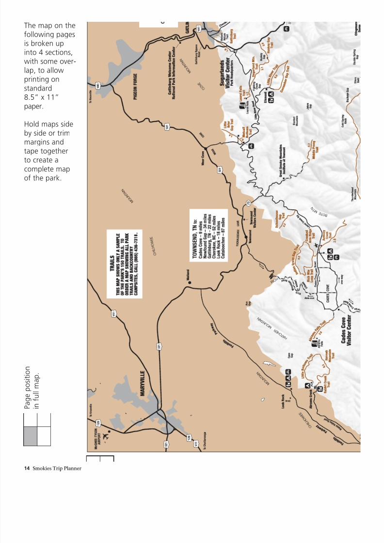
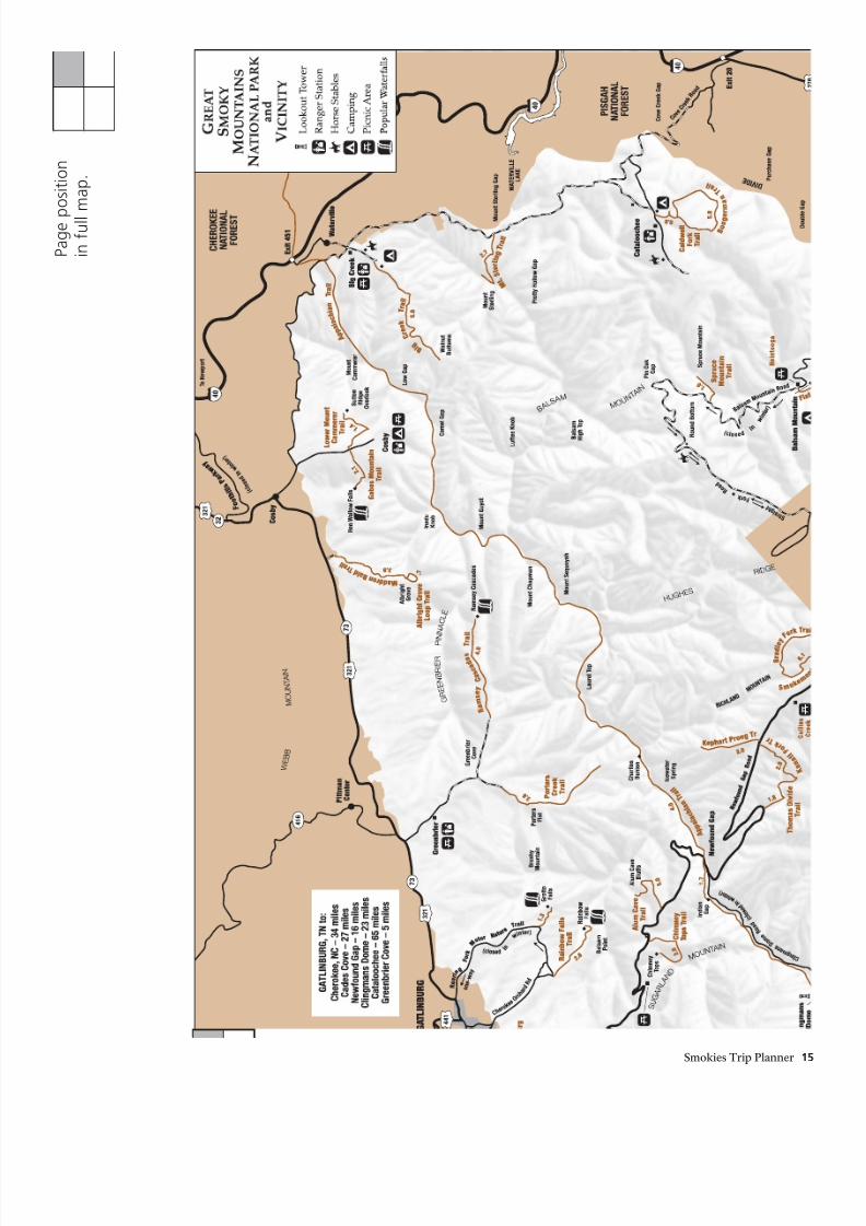
The map on thefollowing pagesis broken upinto 4 sections,with some over-lap, to allowprinting onstandard
8.5” x 11”paper.
Hold maps sideby side or trimmargins andtape togetherto create acomplete mapof the park.
P a g e p o s i t i o n
i n f u l l m a
p .
8/6/2019 Smokie Guide
http://slidepdf.com/reader/full/smokie-guide 15/17
Smokies Trip Planner 15
P a g e p
o s i t i o n
i n f u l l
m a p .
8/6/2019 Smokie Guide
http://slidepdf.com/reader/full/smokie-guide 16/17
16 Smokies Trip Planner
( c l o s e
d
i n
w i n t e r )
P a g e p o s i t i o n
i n f u l l m a p .
8/6/2019 Smokie Guide
http://slidepdf.com/reader/full/smokie-guide 17/17
Smokies Trip Planner 17
P a g e p
o s i t i o n
i n f u l l m a p .