Embed Size (px)
Citation preview

SmartKADASTER: ROLE OF GEOMATICS IN
SUPPORTING SMART CITIES
Simposium Maklumat Geospatial Kebangsaan (NGIS- 8)
ABD RAHMAN MOHD JAZULIJABATAN UKUR DAN PEMETAAN
MALAYSIA

Smart City
2

“A city can be defined as ‘smart’ when investment in human ,social capital,traditional (transport) and modern (ICT) communication infrastructure fuel sustainable economic development and a high
quality of life, with a wise management of natural resources, through participatory action and
engagement”-Caragliu and Nijkamp, 2009
3

55%
World’s population resides in urban areas* Source : UN, World Urbanization Prospect,2018
68%2017/18
2050
The rise of the city
4
World’s population resides in urban areas* Source : UN, World Urbanization Prospect,2018

25M78% urban
35M88% urban
The rise of the city
5

* Source : Intel Smart Cities IoT group,2018
Smart city tech can save every resident 125 hours a year
6

JUPEM - Overview01
SmartKADASTER02
Geomatics 03
Data Acquisition 04
Way forward 05
7
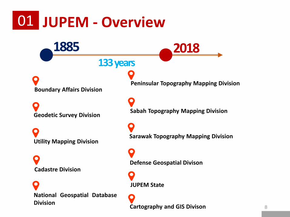
JUPEM - Overview01
20181885133 years
Boundary Affairs Division
Geodetic Survey Division
Utility Mapping Division
Cadastre Division
National Geospatial DatabaseDivision
Peninsular Topography Mapping Division
Sabah Topography Mapping Division
Sarawak Topography Mapping Division
JUPEM State
Cartography and GIS Divison
Defense Geospatial Divison
8

Maps
UAS
Cadastre Survey
Utility Survey
GNSS Observation
9

SmartKADASTER
10

Maximize Geospatial Potential
• The main purpose of the project is to establish a multi-purpose cadastral based spatial analysis platform
• accommodate local requirements.
Geospatial Component 3D City Model & multi-purpose cadastral based spatial analysis platform
SmartKADASTER02
11

SmartKADASTER02
Seeing Is Believingskip.jupem.gov.my/mapportal
(SKiP)
12
3D Model of KL & Putrajaya

SmartKADASTER02
• Accesible via multiple electronic devices
• 91 data features & categories
13

SmartKADASTER02
• 2D Maps
5 Basemaps* Clear Sky* Night Dream* Aerial Image* Shaded Relief* Hybrid View
14

SmartKADASTER02• 2D SKiP Analysis
*Measure Area Function*Measure Distance Function*Calculate Qiblat Direction *Text Search Function *Height Calculation
15

SmartKADASTER02
• 3D Maps
5 Main Function* Navigate* Search Function* View* Measure* Analyse
16
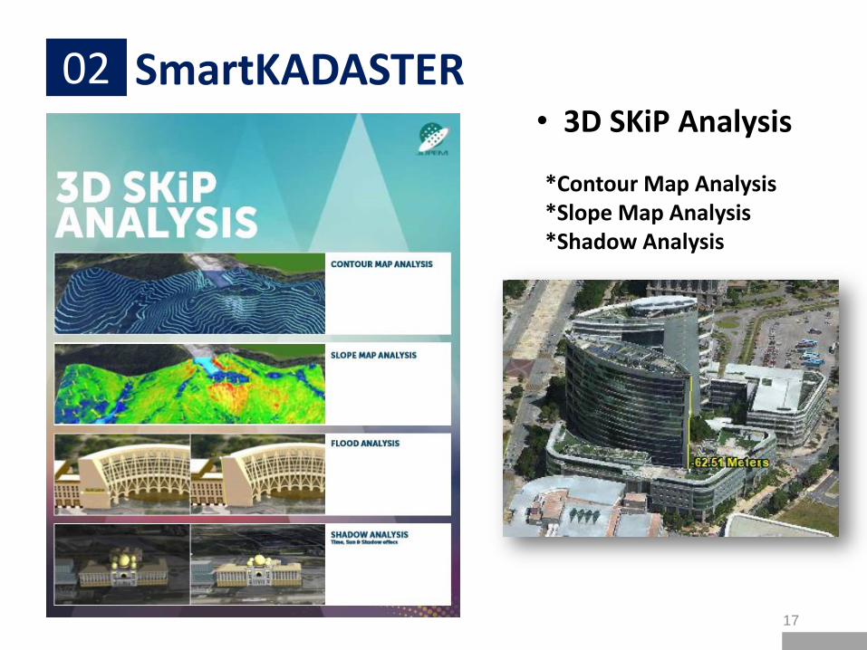
SmartKADASTER02• 3D SKiP Analysis
*Contour Map Analysis*Slope Map Analysis*Shadow Analysis
17

Geomatics
18

It defined as a systemic, multidisciplinary, integrated approach toselecting the instruments and the appropriate techniques for collecting,storing, integrating, modeling, analyzing, retrieving at will,transforming, displaying, and distributing spatially georeferenced datafrom different sources with well-defined accuracy characteristics andcontinuity in a digital format
- Mario A. Gomarasca
What is Geomatics?
Geomatics03
19

Areas of Knowledge
Geodesy and Geodetic
Cadastral Survey
Photogrammetry
Global Positioning System (GNSS)
Geovisualization
GIS Hydrography
LiDAR Spatial Data Analysis
Computer Vision
Cartography
Geomatics03
20

Data Acquisition04SmartKADASTER – Geomatics
• Aerial ImageryPhotogrammetry –Oblique Aerial Imagery
• Aircraft: GAF NOMAD N22B (speed 150-250km/h)• Camera :UltraCam Osprey Prime with UltraNAV and UltraMount 3000• 90 days, 10369 total photos (1709km) & 111 flight lines• ± 10cm
Highly Accurate 3D model of PICC
21
roof
façade

Data Acquisition04SmartKADASTER – Geomatics
• Aerial ImageryPhotogrammetry –Oblique Aerial Imagery
22
Highly Accurate 3D model of Tuanku Mizan Zainal Abidin Mosque
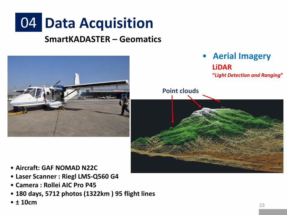
Data Acquisition04SmartKADASTER – Geomatics
• Aerial ImageryLiDAR“Light Detection and Ranging”
• Aircraft: GAF NOMAD N22C• Laser Scanner : Riegl LMS-Q560 G4• Camera : Rollei AIC Pro P45• 180 days, 5712 photos (1322km ) 95 flight lines• ± 10cm
Point clouds
23

Data Acquisition04SmartKADASTER – Geomatics
• Aerial ImageryLiDAR“Light Detection and Ranging”
24

Data Acquisition04SmartKADASTER – Geomatics
• Mobile Laser ScanningLiDAR“Light Detection and Ranging”
• Laser Scanner : Trimble MX8 & RIEGL VQ-450 • GNSS : Trimble R8• Vehicle speed : 60km/h• 120 days• ± 10cm
25

Data Acquisition04SmartKADASTER – Geomatics
• Terrestrial Laser Scanning
• Laser Scanner : Leica Scanstation C10• Accuracy: 6mm• Range: 300m• Scan rate: 50000 points/sec
26

Data Acquisition04SmartKADASTER – Geomatics
• Terrestrial Laser Scanning
27

Way Forward05
SmartKADASTER
• Area expand• Reconstructed 3D geometries – with non-spatial data
Challenges
• 4IR (IoT, Big Data, AI)• HD Maps • 5G Mobile technologies
28

Thank You
Simposium Maklumat Geospatial Kebangsaan (NGIS- 8)