Embed Size (px)
Citation preview
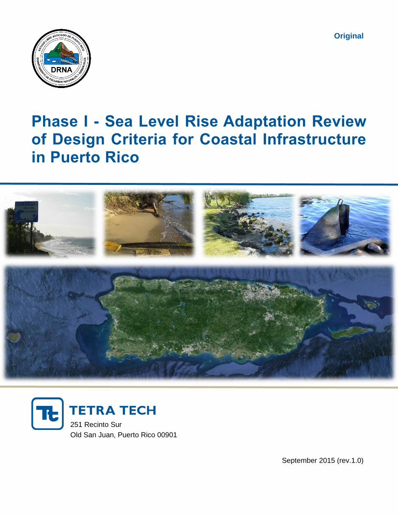
Original
Phase I - Sea Level Rise Adaptation Review of Design Criteria for Coastal Infrastructure in Puerto Rico
September 2015 (rev.1.0)
251 Recinto Sur
Old San Juan, Puerto Rico 00901
Department of Natural and Environmental Resources Edif. Cruz A. Matos, Piso 9 PR-8838 Sector El Cinco Río Piedras, Puerto Rico
Mr. Ernesto Díaz, Director
Coastal Zone Management Program
tetratech.com

Phase I - Sea Level Rise Adaptation Review of Design Criteria for Coastal Infrastructure in Puerto Rico September, 2015
PREPARED FOR PREPARED BY
Department of Natural and Environmental Resources
Edif. Dr. Cruz A. Matos, Piso 9
PR-8838 Sector El Cinco
Río Piedras, Puerto Rico
Tetra Tech
251 Recinto Sur
Old San Juan, PR 00901
P 787-721-7929
F 787-722-4651
www.tetratech.com

i SLR Review of Design Criteria for Coastal Communities
TABLE OF CONTENTS
1 INTRODUCTION ............................................................................................................................ 3
2 INITIAL ASSESSMENT OF BUILDING CODES ON SEA LEVEL RISE ........................................ 4
2.1 Sea Level Rise Adaptation for Transportation and Utilities Infrastructure ................................. 8
2.1.1 Puerto Rico Department of Transportation (PRDOT) ................................................... 9
2.1.2 Puerto Rico Ports Authority (PRPA)............................................................................ 10
2.1.3 Puerto Rico Energy Power Authority (PREPA) ........................................................... 11
2.1.4 Puerto Rico Aqueduct and Sewer Authority (PRASA) ............................................... 12
3 CRITICAL INFRASTRUCTURE AND ADAPTATION TOOLS ..................................................... 13
3.1 Vulnerable Infrastructure and Coastal Communities .............................................................. 13
3.2 Adaptation Approach ............................................................................................................. 14
3.3 Basis for Sea Level Rise Adaptation ...................................................................................... 15
3.4 Adaptation Tools .................................................................................................................... 15
4 SUMMARY OF DESKTOP STUDY ON NORTH AMERICAN COASTAL STATES SLR ADAPTATION PROGRAMS ............................................................................................................... 17
5 PUERTO RICO’S AGENCIES RESPONSE TO OE-2013-016 ..................................................... 18
6 STATUS SUMMARY OF PUERTO RICO’S SLR ADAPTATION STRATEGY ............................. 19
7 CONCLUSIONS AND RECOMMENDATIONS ............................................................................. 21
8 REFERENCES ............................................................................................................................. 23
APPENDIX A ......................................................................................................................................A-1
APENDIX B: HAWAII .........................................................................................................................B-1
APENDIX C: CARIBBEAN COMMUNITY (CARICOM) ......................................................................C-1
APENDIX D: CANADA .......................................................................................................................D-1
APENDIX E: OUTREACH .................................................................................................................. E-1
LIST OF TABLES
Table 1. Relevant Building Codes (Puerto Rico Building Code 2011) .................................................... 6 Table 2. PREPA’s Power Generating Facilities .................................................................................... 11 Table 3. Examples of existing Adaptation Plans. Click on the title of the plan to view. ......................... 21
LIST OF FIGURES
Figure 1. The mean sea level trend........................................................................................................ 4 Figure 2. Relative Sea Level Rise projections for 50- and 100-year planning horizon ............................ 5 Figure 3. PRPA Facilities ..................................................................................................................... 10 Figure 4. Puerto Rico Climate Change Council Visualization Tool ....................................................... 16

ii SLR Review of Design Criteria for Coastal Communities
ACRONYMS/ABBREVIATIONS
Acronyms/Abbreviations Definition
EO Executive Order
FEMA Federal Emergency Management Agency
CIAPR Colegio de Ingenieros y Agrimensores de Puerto Rico
IBC International Building Code
PR Puerto Rico
PRBC Puerto Rico Building Code
PRCCC Puerto Rico Climate Change Council
PRCZMP PR Coastal Zone Management Program
PRDNER Puerto Rico Department of Natural and Environmental Resources
PRASA Puerto Rico Aqueduct and Sewer Authority
PRDOT Puerto Rico Department of Transportation and Public Works
PREPA Puerto Rico Energy Power Authority
PRPA Puerto Rico Port Authority
SLR Sea Level Rise
3 SLR Review of Design Criteria for Coastal Infrastructure
1 Introduction
Sea level is rising and will continue to rise thereby increasing the vulnerability of coastal communities and infrastructure in Puerto Rico. As identified stated by E. Díaz in a PRCCC presentation in 2014, critical or essential facilities within 1 kilometer of the coastline include:
8 ports and 8 airports
7 power generation facilities (5 public and 2 private)
1,080 miles of sanitary infrastructure
14 wastewater treatment plants
81 industrial parks
In order to be prepared and manage the effects associated with sea level rise in coastal communities, our island will require adaptive capacity and resilient infrastructure to ensure long-term sustainability. The vulnerabilities of our coastal communities and infrastructure, associated to sea level rise, are caused by:
Coastal erosion and scouring
Changes to coastal and estuarine habitats and resources
Inundation of low laying coastal communities
Coastal infrastructure failure or disruption
Salt water intrusion into groundwater resources
The PR Coastal Zone Management Program (PRCZMP), under the Puerto Rico Department of Natural and Environmental Resources (PRDNER), is in charge of coordinating the Puerto Rico Climate Change Council (PRCCC). The PRCCC published the Puerto Rico’s State of the Climate 2010-2013: Assessing Puerto Rico’s Social-Economical Vulnerabilities in a Changing Climate. In February 2013, the Governor of PR issued an Executive Order (OE-2013-016) requiring the governmental agencies (agencies) to develop climate change vulnerability assessments on their public infrastructure, assess their risks, and develop adaptation measures to protect their infrastructure and resources from climate change and sea level rise. These adaptation measures will be useful to develop technical guidelines and adaptation tools that can be implemented at various levels (e.g., maintenance/repair, new infrastructure, etc.) and across the different agencies. The Executive Order designated the PRDNER the lead agency responsible for compiling, reviewing, and reporting the various vulnerability assessments and adaptation plans prepared by the agencies. The PRDNER prepared a document which was distributed to all pertinent agencies to be used as guideline for the preparation of Climate Change Adaptation Plans (PRDNER, 2013).
PRDNER contracted Tetra Tech to prepare a Phase I – Sea Level Rise Adaptation Review of Design Criteria for Coastal Infrastructure in Puerto Rico. This initial phase consists of:
1. Assessing building codes (PRBC, IBC, etc.) for existing design criteria for public works, transportation, and utilities infrastructure of governmental entities (i.e., PRDOT, PREPA, PRASA, PRPA, etc.) with emphasis on sea level rise adaptation measures. While conducting these assessments, the principal transportation and utilities agencies were contacted and consulted regarding the measures they are adopting, not just to protect their existing infrastructure from sea level rise, but rather to assess the adaptation strategies they are developing for new infrastructure in terms of design criteria such as set-backs, raised foundations, design elevations, etc. to accommodate for sea level rise.

4 SLR Review of Design Criteria for Coastal Infrastructure
2. Summarizing critical infrastructure and presenting general adaptation tools to manage infrastructure in coastal areas,
3. Reviewing and summarizing a desktop study conducted on SLR Adaptation programs across various coastal states of North America,
4. Providing summary of the status in which the Agencies are today with respect to the development of vulnerability assessments and adaptation plans to sea level rise, as mandated by OE-2013-016.
The Phase II – Sea Level Rise Primer’s objective is to create a resource or tool for PRDNER and other pertinent governmental agencies to identify, evaluate and compare alternatives for adapting to the impacts of sea level rise and other related coastal hazards.
2 Initial Assessment of Building Codes on Sea Level Rise
NOAA has published in their website the mean sea level rise trend based on monthly data collected at a station in San Juan since 1962 until 2014. Figure 1 shows the linear trend without seasonal fluctuation due to coastal ocean temperatures, salinities, winds, atmospheric pressures, and ocean currents. This trend is linear and does not take into account the anticipated accelerations attributed increasing extreme high tides, and extreme storms frequencies.
Figure 1. The mean sea level trend is 1.87 millimeters/year with a 95% confidence interval of +/- 0.42 mm/yr based on monthly mean sea level data from 1962 to 2014 which is equivalent to a change of 0.62 feet in 100 years. (Source: http://tidesandcurrents.noaa.gov/sltrends/sltrends_station.shtml?stnid=9755371#)
The USACE provides guidance for the effects of sea level rise predictions for planning, design and operations and maintenance of public civil works under federal jurisdiction which may be susceptible or vulnerable to changes in sea levels. Through Technical Letter No. 1100-2-1, “Procedures to Evaluate Sea Level Changes: Impact, Response and Adaptation”, 30 June 2014, the USACE, presents the methodologies to incorporate SLR into the planning, engineering and operation of public works to improve its resilience and maximize its performance over time. Although these guidelines address navigation, coastal storm damage reduction, flood damage reduction and ecosystem restoration projects, they are widely applicable to the various types of infrastructure adaptation needs of various agencies in Puerto Rico.

5 SLR Review of Design Criteria for Coastal Infrastructure
The USACE (2013), has also developed Regulation No. 1100-2-8162 (which supersedes EC 1165-2-212) to incorporate sea level changes into all civil works programs. Through this regulation they facilitated a sea level calculator available at http://www.corpsclimate.us/ccaceslcurves_nn.cfm which can be used to compute possible future sea level scenarios, based on an observed historical rate of sea level change. Figure 2 depicts the 50-year and 100-year sea level rise predicted based on the National Research Council (NRC 2012).
Figure 2. Relative Sea Level Rise projections for 50- and 100-year planning horizon for adaptation with SLR estimates ranging from 0.07 to 0.57 meters (0.2 to 1.87 feet) above current mean sea level by the year 2060 and between 0.14 and 1.70 meters (0.40 and 5.59 ft) above current mean sea level by the year 2110. (PRCCC, 2013)
After evaluating several scenarios and considering numerous studies addressing Sea Level Rise in Puerto Rico, the PRCCC concluded and recommended to plan and account for a 0.5- to a 1.0-meter increase in sea level rise by 2100 (PRCCC, 2013).
In addition to these baselines and general guidance, each entity planning, designing and constructing new critical infrastructure, must conduct the appropriate analyses to take into consideration other design criteria such as flooding due to increase precipitation, or wave run-up due to increase in wave action and sea levels, or even subsidence due to potential seismic activities. Furthermore, numerous jurisdictions across the US emphasize the importance of interagency coordination in selecting SLR estimates or design criteria (Caltran_sea_level-guidance.pdf) and (Design Std for US Transp Infrastructure by Meyer.pdf).
For this reason, this study intends to assess the existing building codes and design criteria currently utilized in Puerto Rico by public utility corporations (e.g., PREPA, PRASA, etc.), and infrastructure authorities (PRPA, PRDOT, etc.) Ultimately, an interagency council lead by DNER and the PRCCC, and comprised of utilities corporations and infrastructure authorities, and supplemented by technical advisors from the industry and academia, should be organized to integrate their adaptation plans, and establish consensus on SLR projections and design criteria.

6 SLR Review of Design Criteria for Coastal Infrastructure
A cursory review of the various building codes, including the PR Building Code (as amended in 2011 and 2012, see Table 1) was conducted to assess how sea level rise is being considered in developing design criteria for infrastructure which may be vulnerable or subject to sea level rise.
Table 1. Relevant Building Codes (Puerto Rico Building Code 2011)
Divisions Descriptions
I Scope and Administration
II Amendments to the International Building Code
III Amendments to the International Residential Code
IV Amendments to the International Mechanical Code
V Amendments to the International Plumbing Code
VI Amendments to the International Fire Code
VII Amendments to the International Fuel and Gas Code
VIII Amendments to the International Energy Conservation Code
IX Amendments to the International Existing Building Code
X Amendments to the International Private Sewage Disposal Code
In addition, the direct reference addressing sea level rise identified in the International Building Code, located in Division II, Section 1612: Flood Loads, and Section 3103, F.5.3.4 Sea Level Rise for Marine Oil Terminals (MOTs), states:
The identified building code sections address design criteria for floods due to different scenarios (such as sea level rise, subsidence, wetland loss, shoreline erosion, increased storm frequency/intensity, and levee settlement/failure) and are included herein for reference:
Division I
Section 107.2.5.1 Design flood elevations
“Where design flood elevations are not specified, they shall be established in accordance with Section 1612.3.1, FEMA latest flood maps or as established by a Hydrology and Hydraulic (H&H Study).”
Division II
Chapter 16: Structural Design
Section 1612: Flood Loads

7 SLR Review of Design Criteria for Coastal Infrastructure
1612.3 Establishment of flood hazard areas. To establish flood hazard areas, the applicable governing authority shall adopt a flood hazard map and supporting data. The flood hazard map shall include, at a minimum, areas of special flood hazard as identified by the Federal Emergency Management Agency in an engineering report entitled "The Flood Insurance Study for [INSERT NAME OF JURISDICTION]," dated [INSERT DATE OF ISSUANCE], as amended or revised with the accompanying Flood Insurance Rate Map (FIRM) and Flood Boundary and Floodway Map (FBFM) and related supporting data along with any revisions thereto. The adopted flood hazard map and supporting data are hereby adopted by reference and declared to be part of this section.
1612.3.1 Design flood elevations. Where design flood elevations are not included in the flood hazard areas established in Section 1612.3, or where floodways are not designated, the building official is authorized to require the applicant to:
1. Obtain and reasonably utilize any design flood elevation and floodway data available from a federal, state or other source; or
2. Determine the design flood elevation and/or floodway in accordance with accepted hydrologic and hydraulic engineering practices used to define special flood hazard areas. Determinations shall be undertaken by a registered design professional who shall document that the technical methods used reflect currently accepted engineering practice.
1612.3.2 Determination of impacts. In riverine flood hazard areas where design flood elevations are specified but floodways have not been designated, the applicant shall provide a floodway analysis that demonstrates that the proposed work will not increase the design flood elevation more than 1 foot (305 mm) at any point within the jurisdiction of the applicable governing authority.
1612.4 Design and construction. The design and construction of buildings and structures located in flood hazard areas, including flood hazard areas subject to high-velocity wave action, shall be in accordance with Chapter 5 of ASCE 7 and with ASCE 24.
1612.5 Flood hazard documentation. The following documentation shall be prepared and sealed by a registered design professional and submitted to the building official:
1. For construction in flood hazard areas not subject to high-velocity wave action:
1.1. The elevation of the lowest floor, including the basement, as required by the lowest floor elevation inspection in Section 110.3.3.
1.2. For fully enclosed areas below the design flood elevation where provisions to allow for the automatic entry and exit of floodwaters do not meet the minimum requirements in Section 2.6.2.1 of ASCE 24, construction documents shall include a statement that the design will provide for equalization of hydrostatic flood forces in accordance with Section 2.6.2.2 of ASCE 24.
1.3. For dry floodproofed nonresidential buildings, construction documents shall include a statement that the dry floodproofing is designed in accordance with ASCE 24.
2. For construction in flood hazard areas subject to high-velocity wave action:
2.1. The elevation of the bottom of the lowest horizontal structural member as required by the lowest floor elevation inspection in Section 110.3.3.
2.2. Construction documents shall include a statement that the building is designed in accordance with ASCE 24, including that the pile or column foundation and building or structure to be attached thereto is designed to be anchored to resist flotation, collapse and lateral movement due to the effects of wind and flood loads acting simultaneously on all building components, and other load requirements of Chapter 16.
2.3. For breakaway walls designed to resist a nominal load of less than 10 psf (0.48 kN/m2) or more than 20 psf (0.96 kN/m2), construction documents shall include a statement that the breakaway wall is designed in accordance with ASCE 24.
The American Society of Civil Engineers (ASCE), through ASCE 24-14 specifies the minimum requirements and performance expectations for planning, designing, and constructing buildings and structures within a flood hazard area. ASCE 24-14 intends to meet or exceed the minimum requirements of FEMA’s National Flood Insurance Program (NFIP), and specifies elevations and freeboards relative to the Flood Design Class (which replaces the former Occupancy/Risk Categories) and the nature of the flood hazard areas. For instance, essential facilities (defined as Flood Design Class 4, which includes power generating stations
8 SLR Review of Design Criteria for Coastal Infrastructure
and other public utility facilities required for emergencies, critical aviation facilities, critical communication facilities, etc.) must be designed and constructed above the Base Flood Elevation + 2 ft., or to the Design Flood Elevation, or the 500-year flood elevation, whichever is greater. A summary and highlights of ASCE 24-14 Flood Resistant Design and Construction is included in Appendix E.
In addition, two editions of the Colegio de Ingenieros y Agrimensores de Puerto Rico (CIAPR) published journal “Dimension” (Year 21, Vol. 3, 2007, and Year 25, Vol. 2, April – June 2011), and were identified for having sea level rise related papers. These published articles do not discuss sea level rise adaptation design criteria as they mostly focus on the climate change issue from a macro stand point, and they do not provide recommendations. The CIAPR has several guidance documents available in their website (http://www.ciapr.org/index.php/49-ciapr/publicaciones/113-publicaciones-de-ciapr), however, they are outdated and do not address SLR.
As an additional resource, after informal communications with the CIAPR technical management, it was reported that the CIAPR has not appointed a special Commission for the sea level rise adaptation design criteria and/or vulnerability assessment as of the date of this report. However, the CIAPR is interested in collaborating in a formal study, upon request by the pertinent governmental entities.
As the subject of sea level rise continues to develop importance, an increasing number of local jurisdictions, and governmental agencies across the US and the world are adopting measures and, in some cases, design criteria to accommodate for long term sea level elevation increases. Some of these examples are presented across this document, referenced in Section 8 – References, and Section 4 Summary of Desktop Study on North America’s Coastal States SLR Adaptation Programs.
It is the intent of this study to serve as a baseline and a preliminary Sea Level Rise primer, for the pertinent utility and infrastructure agencies (i.e., PREPA, PRASA, PRDOT, PRPA, etc.) and governmental agencies (i.e., EQB, OGPe, DNER, etc.) to utilize and incorporate the aforementioned minimum design criteria, and further develop specific design and construction criteria to meet or exceed the life-cycle expectancy of the particular infrastructure based on its use and importance.
It is also imperative to emphasize that the design criteria developed or adopted by each agency must not be based on historical or linear extrapolation of past sea level patterns, but rather must incorporate the accelerating, non-linear increases in global temperature and the unpredictability of global natural phenomena observed and documented throughout numerous recent studies on climate change and sea level rise (NRC 2012, USDOT FHA 2013 – “State of Ca SLR Guidance Document, AWWA 2010 – Journal AWWA 102:11, Bloetscher et. Al.), (IPCC 2007)
2.1 Sea Level Rise Adaptation for Transportation and Utilities Infrastructure
The primary transportation infrastructure and public utilities agencies in Puerto Rico own, manage and maintain their infrastructure. In addition, they are responsible for, not just assessing their vulnerabilities and developing adaptation strategies for existing infrastructure, but for planning and incorporating design criteria to provide resiliency and sustainability to critical infrastructure.
The principal public agencies with the most critical infrastructure in Puerto Rico includes the PRDOT, PRPA, PREPA, and PRASA. Other governmental agencies with critical infrastructure are subject to the design development review process established by the PR Planning Board (PRPB) through OGPe, which means that PRPB must also adopt planning regulations to account for SLR. In Puerto Rico, the Board of Professional Engineers and Land Surveyors is organized within the CIAPR. This professional organization

9 SLR Review of Design Criteria for Coastal Infrastructure
has the technical resources through its professional members to collaborate and form part of a technical council to establish design guidelines and criteria for SLR vulnerable infrastructure. This technical advisory council would be comprised of planners, scientist and engineers from various governmental agencies (e.g., PRDNER, PRCCC, CROP, PREPA, PRASA, PRPA, PRDOT, PRPB, etc.) with knowledge and interest in SLR vulnerable and critical infrastructure. The objective of this technical advisory council would be to coordinate design criteria and develop a consensus across all agencies and industry with the ultimate objective of making PR’s infrastructure more resilient to SLR.
This section summarizes the infrastructures which may be vulnerable to sea level rise, and Section 3 provides general recommendations on examples of adaptation tools that may be applied.
2.1.1 Puerto Rico Department of Transportation (PRDOT)
The PRDOT owns and maintains existing terrestrial and marine transportation infrastructure and is responsible for designing and constructing new transportation infrastructure. The PRDOT oversees the Highway and Transportation Authority (HTA), which is responsible for the design, construction and maintenance of the Commonwealth’s roadways, bridges, and related infrastructure, and is therefore the entity responsible for developing and incorporating SLR design criteria. PRDOT also manages the Authority for Integrated Transportation (AIT) which operates the Autoridad Metropolitana de Autobuses (AMA), Tren Urbano (TU) and Autoridad de Transporte Maritimo (ATM), which operates the Ferry Terminals in Fajardo, Vieques, and Culebra, as well as the ferry system AcuaExpreso between San Juan, Cataño, and Hato Rey. PRDOT completed their Vulnerability Assessment Report in August 2015, and concluded that within their operation, several metropolitan bus routes along coastal roadways are severely vulnerable to the 0.5m SLR with a very high probability of occurrence. In addition, the report identified that within the MTA assets (i.e., piers, terminals, and waterfront supporting facilities), none of the facilities are vulnerable to the 0.5m SLR threshold; however, the report identified that five out of seven assets (i.e., San Juan, Cataño, Fajardo, Vieques, and Culebra) are highly vulnerable to the 1.0m SLR threshold with a very high probability of occurrence.
Roadways and bridges which are near the shoreline are subject to sea level rise and therefore must be designed to be resilient to erosion and flooding. There are numerous examples of roadways and bridges along the PR coastline that have already suffered deterioration due to flooding or high energy storm events which cause erosion and scouring. It is a common practice for DTOP to install embankment or scour protection (e.g., gabions, Armorflex, rip-rap, vertical sheet-pile walls, etc.) to protect the existing coastal assets. However, DTOP must consider SLR adaptation measures beyond their standard structural measures when planning and designing future roadways and bridges. These adaptive design criteria should include for instance, for large or critical bridges, that the structure shall accommodate a 100-year, 24-hour storm event with a maximum elevation at the structure’s soffit (or the appropriate DTOP design criteria for these structures), plus a 1-foot freeboard based on a storm surge and high tide with a return period of 10-years taking into consideration sea level rise. Some jurisdictions are adopting forward-looking decadal criteria to allow sufficient time for the pertinent agency to conduct capital improvement planning and funding before assuming risks and associated costs related to long-term sea level predictions (SMART-IOSIS-SLR-2014).
The Federal Highway Administration, Office of Environment and Planning commissioned a study (“Literature Review: Climate Change Vulnerability Assessment, Risk Assessment, and Adaptation Approaches”, ICF International, 2009) which addresses global climate change adaptation strategies developed in the US and internationally applied to transportation systems and infrastructure. Besides presenting vulnerability and risk assessment methodologies, the study presents adaptation options for transportation infrastructure some of which may be applicable to PRDOT. Some typical adaptation approaches to SLR on bridges would include scour protection at their piers base and abutments with riprap,

10 SLR Review of Design Criteria for Coastal Infrastructure
or in the case of coastal roadways, protection of roadway with riprap, or increasing the design flood elevation based on the criteria stipulated in ASTM 24-14, plus an additional elevation to account for wave run-up or wave impact. In isolated or remote areas, where there is only one evacuation route, the roadway should be treated as an essential facility or a critical infrastructure, and should be designed and constructed above the Base Flood Elevation + 2 ft., or to the Design Flood Elevation, or the 500-year flood elevation, whichever is greater (in addition to run-up or wave impacts).
Rapid drainage features for areas subject to extreme precipitation, or heat tolerant asphaltic pavement designs, are also common resilient design approaches to adapt to climate change impacts. PRDOT is in the process of preparing an Adaptation Plan to their vulnerable infrastructure and operations.
2.1.2 Puerto Rico Ports Authority (PRPA)
The Puerto Rico Ports Authority (PRPA) is a public corporation which administers and operates under Act 151 of 1968, also known as “Ley de Muelles y Puertos de Puerto Rico 1968”. PRPA operates, and maintains 8 of the 11 maritime port facilities in PR. In addition, PRPA operates 10 airports, 5 of which are adjacent to the coast and potentially subject to sea level rise (Figure 3). Port facilities are subject to sea level rise and given the importance of this infrastructure to commerce, they must be protected.
Bulkheads, seawalls, piers, and berthing facilities must accommodate SLR. The PRPA completed a vulnerability assessment and is currently preparing an adaptation plan which needs to be presented to PRDNER. The adaptation plan should include increased elevations design criteria for new bulkheads and seawalls, berthing at maritime port facilities, as well as runways and support facilities (fueling and maintenance) at airports. Communication with PRPA personnel suggested that PRPA largely depends on outside consultants to plan and design their infrastructure, and therefore they currently do not have any design criteria to plan for or adapt to SLR. Due to the fiscal situation of the PRPA, they are currently utilizing the Public Private Partnership project development model to maintain, improve, and/or develop new waterfront port facilities or SLR vulnerable infrastructure.
Figure 3. PRPA Facilities (source: www.prpa.gobierno.pr)
11 SLR Review of Design Criteria for Coastal Infrastructure
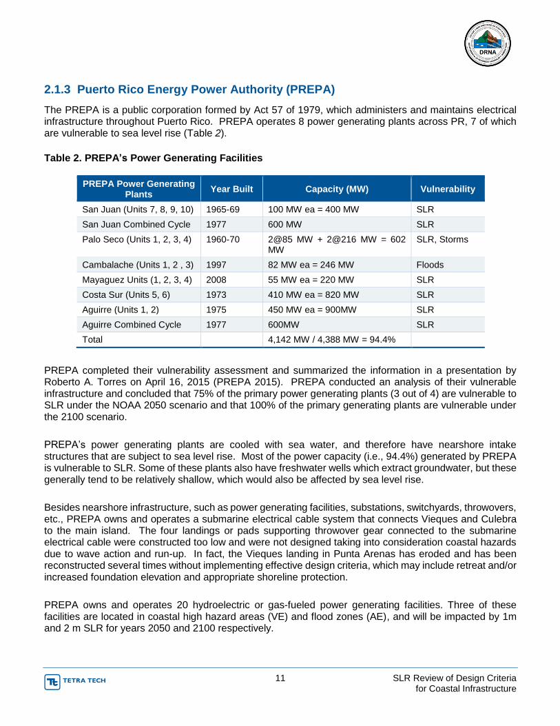
2.1.3 Puerto Rico Energy Power Authority (PREPA)
The PREPA is a public corporation formed by Act 57 of 1979, which administers and maintains electrical infrastructure throughout Puerto Rico. PREPA operates 8 power generating plants across PR, 7 of which are vulnerable to sea level rise (Table 2).
Table 2. PREPA’s Power Generating Facilities
PREPA Power Generating Plants
Year Built Capacity (MW) Vulnerability
San Juan (Units 7, 8, 9, 10) 1965-69 100 MW ea = 400 MW SLR
San Juan Combined Cycle 1977 600 MW SLR
Palo Seco (Units 1, 2, 3, 4) 1960-70 2@85 MW + 2@216 MW = 602 MW
SLR, Storms
Cambalache (Units 1, 2 , 3) 1997 82 MW ea = 246 MW Floods
Mayaguez Units (1, 2, 3, 4) 2008 55 MW ea = 220 MW SLR
Costa Sur (Units 5, 6) 1973 410 MW ea = 820 MW SLR
Aguirre (Units 1, 2) 1975 450 MW ea = 900MW SLR
Aguirre Combined Cycle 1977 600MW SLR
Total 4,142 MW / 4,388 MW = 94.4%
PREPA completed their vulnerability assessment and summarized the information in a presentation by Roberto A. Torres on April 16, 2015 (PREPA 2015). PREPA conducted an analysis of their vulnerable infrastructure and concluded that 75% of the primary power generating plants (3 out of 4) are vulnerable to SLR under the NOAA 2050 scenario and that 100% of the primary generating plants are vulnerable under the 2100 scenario.
PREPA’s power generating plants are cooled with sea water, and therefore have nearshore intake structures that are subject to sea level rise. Most of the power capacity (i.e., 94.4%) generated by PREPA is vulnerable to SLR. Some of these plants also have freshwater wells which extract groundwater, but these generally tend to be relatively shallow, which would also be affected by sea level rise.
Besides nearshore infrastructure, such as power generating facilities, substations, switchyards, throwovers, etc., PREPA owns and operates a submarine electrical cable system that connects Vieques and Culebra to the main island. The four landings or pads supporting throwover gear connected to the submarine electrical cable were constructed too low and were not designed taking into consideration coastal hazards due to wave action and run-up. In fact, the Vieques landing in Punta Arenas has eroded and has been reconstructed several times without implementing effective design criteria, which may include retreat and/or increased foundation elevation and appropriate shoreline protection.
PREPA owns and operates 20 hydroelectric or gas-fueled power generating facilities. Three of these facilities are located in coastal high hazard areas (VE) and flood zones (AE), and will be impacted by 1m and 2 m SLR for years 2050 and 2100 respectively.

12 SLR Review of Design Criteria for Coastal Infrastructure
More than 75% (260 of 343) of PREPA’s substations are located in areas of minimal flood hazard (X Zone), and almost 20% of them (64) are located in flood zones (A, AE, AO or A99). Twenty-four (24) of these substations are located within the 3 ft. threshold by 2050 and thirty-five (35) are within the 6 ft. threshold by 2100.
Another important infrastructure for PREPA includes 81 switchyards, eight (8) of which will be impacted by year 2050 since they are located within the 3 ft. threshold zone, and eleven (11) of which will be impacted by 2100.
PREPA has more than 60 throw overs distributed island wide. Five (5) of these throw overs (including Vieques and Culebra) will be impacted during the next 35 years, when the SLR is expected to reach 1 m over the current sea level, and one additional throw over will be impacted by year 2100.
The engineering design department at PREPA was contacted to inquire about the development of a vulnerability assessment and adaptation plans. According to verbal communication with personnel from the engineering design department, PREPA has not adopted measures to incorporate SLR in their design criteria at this point in time. Given the importance of these infrastructure to the Vieques and Culebra citizens, PREPA should utilize FEMA’s Flood Insurance Rate Maps (FIRM) plus a one to two meter static freeboard to take into consideration SLR. In addition, to the design recommendations stipulated in ASCE 24-14, the appropriate wave run-up and resilient shoreline protection system must be designed by a qualified engineer specializing in waterfront or coastal structures.
2.1.4 Puerto Rico Aqueduct and Sewer Authority (PRASA)
PRASA is a public corporation formed by Law no. 40 of 1945, which administers and maintains potable water, wastewater, and stormwater conveyance systems throughout Puerto Rico. For the potable water treatment and distribution system, PRASA operates reservoirs, raw water intakes, groundwater wells, treatment plants, pumps and pipelines which are vulnerable to climate change and sea level rise. PRASA also operates wastewater treatment plants, and associated pumps and pipeline network, as well as stormwater conveyance systems some of which are currently affected by seasonal changes in sea levels and more of which will be subject to the NOAA one- and two-meter SLR thresholds.
PRASA is a public corporation, formed by Act 40 of 1945, which administers and maintains potable water, wastewater, and stormwater conveyance systems throughout Puerto Rico. For the potable water treatment and distribution system, PRASA operates reservoirs, raw water intakes, groundwater wells, treatment plants, pumps and pipelines which are vulnerable to climate change and sea level rise. PRASA also operates wastewater treatment plants, and associated pumps and pipeline network, as well as stormwater conveyance systems, some of which are currently affected by seasonal changes in sea levels and more of which will be subject to the NOAA one- and two-meter SLR thresholds.
PRASA completed their vulnerability assessment in June 2014 and their adaptation plan in April 2015 (PRASA 2015) and identified their most vulnerable infrastructure as the potable water system including reservoirs, dams, raw water intakes and wells, most of which are vulnerable to precipitation and not SLR. On the other hand, over 200 km of potable water piping and over 260 km of sanitary sewer piping are located within coastal areas and vulnerable to the 1 m SLR threshold. The proposed adaptation strategy for the potable water storage and distribution system is to initially conduct hydraulic/hydrologic studies, bathymetric surveys of the reservoirs, and feasibility studies and preliminary engineering reports to set priorities and plan for capital investment. PRASA anticipates to abandon and relocate (or retreat) its potable and sanitary sewer piping systems as its adaptation strategy. However, due to the proximity of some of these existing infrastructures to the coastal zone, other adaptation strategies such as protection or

13 SLR Review of Design Criteria for Coastal Infrastructure
replacement with more corrosion resistant or resilient materials may be necessary. Potable water distribution systems constructed in coastal areas subject to the corrosive environment of seawater are often designed using PVC or HDPE or other non-corrosive materials. As with other vulnerable existing infrastructure, such as treatment plants and pumping stations, raising critical components may also be a practical adaptation measure. Relocating water wells further inland or away from the predicted saltwater influence regime or installing horizontal wells are also commonly implemented resilient adaptation measures. Other adaptation strategies typically used in coastal areas or tidal influenced areas for sanitary sewer systems are vacuum driven instead of conventional gravity systems, which are more dependent on burial depths and drainage slopes.
The City of Miami Beach, in its Stormwater Management Master Plan, developed adaptation strategies for stormwater management infrastructure which includes installing backflow preventers at outfalls, constructing new stormwater pumping stations with higher Design Flood Elevation, creating additional stormwater storage capacity, and raising seawalls (Miami Beach SWMMP). Similarly, the City of Pompano Beach Utility Management identified several long term adaptation strategies for their long-term water supply plan which included: (1) salinity barriers to protect wells from saltwater intrusion, (2) reclaimed water use to reduce potable water consumption in irrigation, (3) protecting the Biscayne Aquifer water supplies, and (4) a regional stormwater management approach. The city anticipates that significant changes will be required to the regulatory framework and objectives within the city and its departments (AWWA 2010 – Journal AWWA 102:11, Bloetscher et. Al.)
3 Critical Infrastructure and Adaptation Tools
3.1 Vulnerable Infrastructure and Coastal Communities
Critical infrastructure may be defined as those assets which are essential for the subsistence of a community or a group of people, and includes at a minimum transportation (PRDOT), power generating facilities (PREPA, AES, EcoEléctrica), water and wastewater treatment facilities (PRASA), airports and marine ports (PRPA), and other public safety (police departments) and health (hospitals) facilities. Only those critical infrastructures vulnerable to SLR will be addressed here.
In addition to the waterfront infrastructures addressed in Section 2, owned, operated, and maintained by PRDOT, PREPA, PRASA and PRPA, which are critical to the appropriate functioning of commerce and the economy, most coastal communities also have infrastructure which is vulnerable and critical for the subsistence of its people.
Most coastal communities in PR are low lying, and within FEMAs flood plains. Some of these communities (e.g., Loiza, Pozuelo, Palo Seco, etc.) can be easily isolated by the failure of bridges and roadways due to erosion and scouring, potentially aggravated by SLR.
Non-PRASA potable water systems, septic tanks, and storm drain systems in coastal communities are also subject to SLR. SLR can also create saltwater intrusion into low lying coastal areas where water wells are installed for agricultural and domestic uses. For these reasons, in addition to the transportation and utilities companies, other governmental entities with planning, permitting and administrative jurisdiction of coastal infrastructure must be prepared to address SLR. For instance, fishing villages are all subject to SLR and are under the jurisdiction of the PR Department of Agriculture, while storm drains are under the jurisdiction of the 44 coastal municipalities across the PR.

14 SLR Review of Design Criteria for Coastal Infrastructure
The PRCCC has compiled practical and useful information to assist agencies and coastal communities in assessing their vulnerabilities and planning and developing adaptation strategies. Its webpage, www.pr-ccc.org, contains a visualization tool that effectively integrates GIS-based information from most government agencies, including PREPA, PRASA, and PRPA, with layers corresponding to various storm surge scenarios, the 0.5 meter and 1.0 meter SLR impacted areas, and the FEMA 2009 flood zones. This tool is further discussed in Section 3.4.1 – Planning Tools of this document.
3.2 Adaptation Approach
Although each country or state may face different physical conditions and political scenarios, a basic and reasonable adaptation approach to sea level rise is to Protect, Accommodate, Retreat, AND Avoid.
Protect is a reactive adaptation approach, often the first reaction and sometimes the most logical reaction, to preserve an existing asset subject to SLR. Structural protection is commonly applied throughout the world and Puerto Rico, and may include hard structures such as revetments, seawalls, breakwaters, groins, etc. However, these measures can be very expensive and typically require a maintenance program. If not properly applied or designed by a qualified engineer (capable of understanding coastal dynamics), these structures can have an adverse effect on adjacent properties or structures. Other means of protection may be soft structures like beach nourishment, marsh and wetlands creation, or what is commonly known as living shorelines.
Accommodate is a more tolerant reactive adaptation approach which allows for certain loss of the assets or resources caused by erosion and sea level rise. This adaptation approach may include allowing the salt marshes and sand dunes to erode, or abandoning part of the structure and modifying its use, or allowing old infrastructure to deteriorate while new more resilient infrastructure is relocated or built elsewhere (e.g., further from shore or higher).
Retreat is a retraction approach which consists of relocating or moving an existing asset or adopting new ordinances which establish setbacks that consider SLR criteria. This often results in an adaptation approach that favors relocation of existing infrastructure to avoid the hazards of SLR over conventional structural protection. This approach may be applicable to small wooden structures built within the coastal zone delimitation but may not be practical for concrete or larger structures and infrastructure.
Avoid is a proactive adaptation approach that involves planning and building ordinances that create a buffer zone within the SLR vulnerable coastal areas which prevents development to take place or new infrastructure to be installed. This approach is commonly used as a planning and regulatory tool, which may include new zoning, land acquisition, land trusts, permitting restrictions, etc.
Another proactive adaptation approach implemented as a long-term protection may be land reclamation, or creating the buffer zone seaward of the existing shoreline through large beach nourishment projects. These projects are commonly done in Florida and other coastal states that suffer from beach erosion and greatly depend on tourism to sustain their economies.
These projects have multiple benefits as they not only protect waterfront properties and infrastructure, but also have positive economic impacts by creating or reclaiming beaches that have been periodically eroding due the lack of sediment sources and anthropogenic development.
In some instances, these beach nourishment projects can be coupled with submerged artificial reefs or breakwaters parallel to the shoreline and some distance away, which serve as energy dissipaters that prolong the life of the beach nourishment projects. The design of artificial reefs and barrier islands are also
15 SLR Review of Design Criteria for Coastal Infrastructure
commonly used in the US and throughout the world to not only protect the shoreline from coastal erosion and SLR, but also create ecological enhancement opportunities, as well as recreational and educational opportunities. Other adaptation approaches or combinations of the previously mentioned can be formulated and developed as the SLR continues and our adaptation tolerances and resiliency capabilities evolve over time.
3.3 Basis for Sea Level Rise Adaptation
The efforts of compiling and summarizing the information from the various agencies, summarized in Section 5, is part of the process of establishing which agencies are affected by SLR and which are not, and serves as the basis for SLR adaptation. Obviously, those agencies with vulnerable infrastructure will be directly affected, and are required to develop adaptation plans. However, even agencies without vulnerable physical assets, will be indirectly affected because they have a vested interest in vulnerable assets from other agencies (i.e., users) or have administrative or jurisdictional responsibilities (e.g., PRPB, OGPe, FURA, USCOE, USCG and other federal stakeholders). These agencies need to be involved in the decision making process to steer the collective interest in a common direction.
The process of information compilation, which should identify the agencies’ vulnerabilities and the proposed measures to mitigate or adapt, will assist in defining the agencies resources and their ability or inability to develop adaptation plans. This should also create a consensus about the approach to follow in order to develop a SLR Adaptation Primer that takes into consideration the agencies resources, risks, and vulnerabilities.
Likewise, it is important to gather information at the community level in order to establish priorities and a suitable and acceptable adaptation strategy which will facilitate the implementation of a preferred adaptation tool. This information will be utilized for public education and community involvement and participation.
The PRDNER has been developing information gathering tools through their websites and other community outreach efforts to create awareness and to gather and evaluate from the communities and public at large their stance, concerns, and opinions of sea level rise issues.
3.4 Adaptation Tools
Adaptation tools are means by which adaptation strategies can be implemented. In some cases, these tools already exist within PRDNER’s public policy, and PR Planning Board’s and OGPe’s regulatory frameworks. During the development of the SLR Adaptation Primer, these tools will be refined and tailored to each agency and some of the most needed communities or municipalities.
3.4.1 Planning Tools Planning tools can be objectives or polices adopted by regulatory agencies at the central government level (e.g., PRDNER, PRPB), or local governments at the community level (e.g., municipal ordinances). In addition, coastal mapping resources, emergency or hazard mitigation plans, and/or flood insurance maps are examples of planning adaptation tools.
Another existing planning tool commonly used is the development of coastal hazard maps. PRDNER, through the PR Climate Change Council (www.pr-ccc.org) has already developed visualization tools which can be used for planning purposes to assess the vulnerability of coastal areas under various SLR scenarios and hurricane intensities. Figure 4 shows the area of the LMM International Airport flooded under a 0.5 m storm surge and a Category 3 hurricane scenario.

16 SLR Review of Design Criteria for Coastal Infrastructure
Figure 4. Puerto Rico Climate Change Council Visualization Tool: (a) San Juan and LMM International Airport area, (b) flooded under current sea level condition, and (c) 50 cm storm surge scenario.
LMM International Airport
LMM International Airport
LMM International Airport
A
B
C

17 SLR Review of Design Criteria for Coastal Infrastructure
3.4.2 Regulatory Tools
Regulatory tools can be developed to regulate land use, coastal development permits, building and construction regulations (e.g., set-backs). The PRDNER through Rule 4860, defines and regulates the use of the coastal zone, coastal waters, and submerged lands, and is the agency in charge of managing coastal resources, including establishing criteria and procedures by which coastal development permits and concessions are issued.
3.4.3 Land Use Tools
Land use tools such as land acquisition, easements and covenants are also strategies commonly used to manage coastal areas exposed to erosion and SLR. The PR Planning Board regulates land use and OGPe reviews applications for land use modifications and issues permits based on PRPB’s rules and bylaws. The acquisition of private coastal areas by local or central governments has been used in PR to establish trusts or conservation of vulnerable coastal areas (e.g., Las Cabezas de San Juan).
3.4.4 Structural Tools
Structural tools are primarily used to protect a structure or vulnerable infrastructure by installing a structure in front of, or around, the asset. These tools can be seawalls, breakwaters, dikes, groins, etc. Structural adaptation tools are generally permanent and therefore require maintenance. These structural tools must be carefully designed to ensure that they do not have an adverse effect on an adjacent property or coastline, and that they have long-term effectiveness as their capital costs can be considerable. Permitting requirements may be more demanding than for other alternatives that can be perceived as more “environmentally friendly,” such as non-structural tools.
3.4.5 Non-Structural Tools
Non-structural tools are also referred to as soft-structures, such as beach nourishment, marshland and wetland creation, planted sand dunes, and temporary sand filled bags or tubes. These alternatives are perceived as more environmentally suitable than structural tools and sometimes are combined with structural tools to increase its resiliency and protect capital investments. These alternatives can be very costly and therefore are typically applied by the central government with the assistance and support of federal interests (e.g., USACE, NOAA, etc.)
4 Summary of Desktop Study on North American Coastal States SLR Adaptation Programs
4.1 Coastal Management Programs
Numerous coastal states in North America have been developing Sea Level Rise Adaptation Programs which may provide useful information that can be applied to the local decision making framework in Puerto Rico. Therefore, several programs have been evaluated to assess what other states are doing.
Appendix A summarizes the SLR Adaptation Programs in 7 of the 30 US coastal states. Appendix B summarizes Hawaii’s Climate Change Adaptation programs which includes SLR. Appendix C summarizes Caribbean Community and Common Market (CARICOM) strategic approach for managing climate change. Appendix D summarizes Canada’s SLR Adaptation Primer.

18 SLR Review of Design Criteria for Coastal Infrastructure
In general, all coastal states face similar issues to those found in Puerto Rico. The adaptation strategies and tools presented in Section 3 capture, and are consistent with, most of those strategies and tools developed for North American coastal states. Local ordinances and regulations must be adapted to our island’s political reality.
5 Puerto Rico’s Agencies Response to OE-2013-016
5.1 Summary of Agencies Outreach
In February 2013, the Governor of Puerto Rico issued an Executive Order (OE-2013-016) requiring the governmental agencies to: (1) develop climate change vulnerability assessments on their public infrastructure, and (2) for these agencies to develop adaptation measures and plans to protect their infrastructure and resources from climate change and sea level rise. The Executive Order designated the PRDNER the lead agency responsible for compiling, reviewing, and reporting the various vulnerability assessments and adaptation plans prepared by the agencies. A cursory assessment was conducted on governmental entities as part of OE-2013-06 to assess the status of these agencies with respect to the preparation of vulnerability studies and adaptation plans. A questionnaire was prepared and distributed to the agencies as shown in Appendix E. As of September 2015, 10 of 20 agencies required to prepare vulnerability assessments had prepared draft reports. In addition, a survey was conducted in Survey Monkey and sent to the same group of agencies to maximize their input. The results of these outreach efforts to the agencies are summarized in Appendix E. All agencies must end their adaptation plans and implement the Executive Order by the end of 2015.
5.1.1 Puerto Rico Planning Board
The Puerto Rico Planning Board (PRPB) was formed under Act 75 of June 24, 1975, as amended, known as Puerto Rico Planning Board Organic Act, with the purpose of guiding the integral development of Puerto Rico and of establishing planning regulations, among others. Although the PRPB does not own or maintain critical infrastructures, it defines zoning and regulates land uses. The Permits Management Office (OGPe, for its name in Spanish) is responsible for implementing the Joint Permit Regulation (Joint Regulation for the Evaluation and Issue of Permits Related to Land Development and Use, March 24, 2015) which integrates all zoning and land development regulations.
The PRPB does not have a planning regulation to address SLR. It does, however, have the Special Flood Hazard Areas Regulation (Planning Regulation No. 13, January 7, 2010) to address developments in areas subject to flooding.
The document entitled Objectives and Public Policies of the Land Use Plan of Puerto Rico (Objetivos y Políticas del Plan de Uso de Terrenos de Puerto Rico, October 31, 1995) governs current public policy, physically and spatially covering Puerto Rico in its totality. None of the goals and objectives of the public infrastructure policies (Public Policies 20 to 28 of the Objectives and Public Policies of the Land Use Plan of Puerto Rico) mention the effects of SLR. On October 3, 2004, Act 550, known as the Law for the Land Use Plan of the Commonwealth of Puerto Rico, was approved. This Act was established to define the new public policy for the Land Use Plan (PUT, for its name in Spanish), among other reasons. After the approval of Act 550, a process to review the current public policies and objectives has been taking place, to better reflect the present-day realities and the principal objectives of the Act. The Land Use Plan (PUT), which is scheduled to be finalized in November 2015, states as an objective to promote that necessary

19 SLR Review of Design Criteria for Coastal Infrastructure
infrastructures are located outside of risk areas. It also indicates as another objective to take measures to adapt to, and mitigate, climate change impacts.
Chapter 3 (A) (Goal 110) of the draft PUT (page 49), states the following:
Develop resilience to risks: plan and build coastal communities and urban environments in the interior of the island in order to reduce risks to human habitat and infrastructure associated with climate change, i.e., increase in sea level, storm surges, hurricanes, heavy rains, extreme temperatures, and the effects of urban heat.
Chapter 4 (C) (8): Guidelines for mitigation and adaptation to climate change (page 99) states the following:
Promote the safety and welfare of citizens, avoiding infrastructure improvements which may increase the exposure of citizens to natural disasters.
Avoid the responsibility of assuming the financial risks of developing and redeveloping vulnerable coastal or high risk areas.
Ensure that public investments are smart and safe in areas prone to flood due to the increases in sea level. However, adequate conservation efforts along the coast should not prevent important investments in water-related infrastructures, such as ports.
5.1.2 Puerto Rico Emergency Management Agency The Puerto Rico Emergency Management Agency (PREMA) is organized into 12 zones islandwide. The agency identified two (2) of these zones as vulnerable: Ceiba (at the former US Navy Roosevelt Roads Facilities) and Mayagüez (rented facilities) are in areas vulnerable to tsunami. However, this project is not including tsunami hazards in its evaluation. The agency has a total of nine (9) active Regulations but none of them address design criteria for SLR. PREMA received comments to the Vulnerability Assessment from PRDNER last year. The SLR Adaptation Plan was being updated as recommended by PRDNER, as per January 2015.
6 Status Summary of Puerto Rico’s SLR Adaptation Strategy
The Center for Climate Strategies (CCS) is partnering with the Puerto Rican Energy Affairs Administration and Department of Natural and Environmental Resources on a state of the art greenhouse gas emissions inventory and forecast for use in creating a comprehensive climate mitigation plan to meet Executive Order mandates. CCS is providing startup assistance and guidance to agencies of the Commonwealth for implementation of five Executive Orders covering a full range of climate change mitigation and adaptation issues.
FEMA maintains guidance for construction of buildings in high hazards coastal areas. FEMA also provides financial assistance (through a competitive grant process) to state and municipal governments to:
Retrofit homes that have been repetitively damaged by floods
Elevate structures
Move structures
Demolish damaged homes
20 SLR Review of Design Criteria for Coastal Infrastructure
The coasts of Puerto Rico are at risk of erosion, shoreline degradation, amplified storm surges, permanent inundation, and saltwater intrusion, among other risks, as the coasts of the USA. The adaptation strategies have been grouped into four (4) categories: Avoid, Accommodate, Protect, and Retreat. The protective measures to defend the coastal properties and infrastructures should be based on risk (to protect human life and infrastructures) and cost-effective approaches.
Finalize the SLR Adaptation Standards in Puerto Rico
o Set goals
o Determine the design elevation taking into account the SLR impact in 100 years
o Update the GIS shape files in the PRPB to include the vulnerable SLR zones
o Compile the infrastructure inventory within the “SLR Zone” and organize it per agency
o Share the information with the agencies and update the infrastructure inventory
o Categorize and prioritize the infrastructure (e.g., a road that connects to a Medical Center should have a higher score than secondary roads)
o Focus funds initiatives in projects that have short and long benefits
Be green
Enhance natural systems
o Support communities
o Develop and implement educational program (communication and outreach)
Regulations
o Legislate to develop commonwealth initiatives and provide funds
Incentive / disincentives
o Legislate to request local governments (i.e., municipalities) to include SLR considerations in the HMPs, land use codes, etc.
o Autonomous Municipalities Act of the Commonwealth of Puerto Rico of 1991.
enables local municipal governments to be more restrictive than the Regulations issued by the PRPB
o PR Planning Board
Develop SLR Master Plans
Exclude development in susceptible areas to SLR
o Possible changes in land use zones
Create SLR zones
Protection Zones (zones with critical infrastructure and dense urban development)
Accommodation Zones (allow new development but limit intensity and density, limit hard shoreline armoring, require structures to be designed or retrofitted to be more resilient to flood impacts)
o Retreat Zones
o Preservation Zones
o Amend Regulation 13 – Special Flood Hazard Areas Regulation
Revise design guidance to include SLR design guidelines and criteria
o Amend Puerto Rico Building Codes to include:
Resiliency
New SLR Design Elevations
Green infrastructure
Provide for existing and new infrastructure
o Joint Regulation for Construction and Land Use Permits
Include SLR Zones
Criteria to adapt and retreat (when to leave from vulnerable areas)

21 SLR Review of Design Criteria for Coastal Infrastructure
7 Conclusions and Recommendations
The principal public agencies with the most critical infrastructure in Puerto Rico are PRDOT, PRPA, PREPA, and PRASA. According to communications with these agencies, most completed their Vulnerability Assessments by September 2015. However, not all have submitted their final drafts. PRASA submitted their Adaptation Plan by September 2015, however, copies of other agencies’ Adaptation Plans were not available.
Based on published information, and additional communications with technical staff across these agencies, it is concluded that they have not developed or at least adopted SLR-specific design criteria for each of their vulnerable infrastructure.
PRASA was found to be the only agency with an Adaptation Plan which recommends that their critical infrastructure be further assessed and prioritized to develop a programmatic adaptation strategy to be implemented in a phased approach and in accordance with their importance and available funding sources.
This report concludes that numerous coastal states across the US have developed adaptation strategies that are applicable to those similar critical infrastructure found in PR. In addition to the relevant programs summarized in Section 4, and presented in the appendices of this report, Table 3 makes references of other relevant publications which may be used as guidelines or references in developing such adaptation strategies.
Table 3. Examples of existing Adaptation Plans. Click on the title of the plan to view.
Organization State Adaptation Plan
Department of Transportation Florida Development of a methodology for the assessment of sea level rise impacts on Florida’s transportation
modes and infrastructure.
Natural Resources Agency California Interpretive Guidelines for Addressing Sea Level Rise in Local Coastal Programs and Coastal Development
Permits
Department of Transportation California Guidance on Incorporating Sea Level Rise for use in the planning and development of Project Initiation
Documents
Environmental Protection Agency
Federal Being Prepared for Climate Change: A Workbook for Developing Risk-Based Adaptation Plans
Department of Public Works, City of Miami
Florida Storm Water Management Adaptation Plan
Sonoma-Marin Area Rail Transit District, San
Francisco
California Sea Level Rise Vulnerability Assessment and Adaptation Strategy for Initial Operating Segment
(IOS)-1 South and Haystack Landing Bridge Replacement
Department of Transportation Florida Development of a Geographic Information System (GIS) Tool for the Preliminary Assessment of the
Effects of Predicted Sea Level and Tidal Change on Transportation Infrastructure.
Department of Energy Federal Climate Change Adaptation Plan 2014
U.S. Department of Interior Federal Reclamation: Managing Water in the West, Climate Change Adaptation Strategy

22 SLR Review of Design Criteria for Coastal Infrastructure
Organization State Adaptation Plan
California Energy Commission
California Adapting to Sea Level Rise: A Guide to California’s Coastal Communities
Department of Transportation Federal Literature Review: Climate Change Vulnerability Assessment, Risk Assessment, and Adaptation
Approaches
The traditional approach to developing design criteria has been based in historical data or past events. It is widely recognized by now, that SLR predictions are not linear and cannot be based on historical data. Sea Level Rise rates are accelerating and are being affected by other natural and anthropogenic factors.
Considering the accelerating progression of SLR, new developments or infrastructure vulnerable to SLR should be designed based on future projections. As discussed in Section 2, the USACE has developed tools and guidelines to assist planners, engineers and owners of vulnerable coastal infrastructure in determining predicted water elevations based on NOAA and FEMA updated information for any given location, where available.
The Caribbean Regional Ocean Partnership has developed a web-based planning tool (www.caibbean-mp.org) which contains useful information and can be used to visualize coastal critical coastal infrastructure, as well as other resources which may be affected by SLR. In addition, the PRCCC has also developed another web-based planning tool (www.pr-ccc.org) which includes dataset of critical infrastructure as reported by PRDOT, PRPA, PREPA and PRASA, under storm surge scenarios as predicted by numerical models (i.e., ADCIRC and SWAN). As discussed in Section 3, these publicly available visual tools can be used by planners and asset managers to assess the vulnerability or exposure of their pertinent infrastructure.
All federally funded projects, such as drinking water and wastewater infrastructure projects funded through the State Revolving Fund, managed by PREQB, should incorporate SLR design criteria. Also, FEMA under their Hazard Mitigation Program, which is delegated to local governments or municipalities across PR has included a requirement to address SLR in their Hazard Mitigation Plans.
Existing critical infrastructure shall be protected in the present, not in the near future. Those infrastructure which cannot be feasibly protected in the present, shall be relocated or refurbished to above the 1.5m SLR threshold to develop resiliency.
Each agency which owns and or manages critical infrastructure which is vulnerable to SLR must develop design criteria into their new capital improvement programs to develop resilient infrastructure. At a minimum and to start, PRPB Regulation No. 13 should be amended to incorporate projected base elevations due to SLR.
Many similar states, counties, municipalities and cities across the coastal states in the US have been preparing master plans to adapt to climate change and implement measures to protect, accommodate, retreat or ultimately avoid the impacts of SLR in order to become more resilient. Considering the age and conditions of PR’s vulnerable critical infrastructure, it is crucial that a technical council be organized comprised of planners, scientist and engineers from various professional, governmental and private industries (PRDNER, PRCCC, CROP, PREPA, PRASA, PRPA, PRDOT, PRPB, etc.) with knowledge and interest in developing a consensus and to establish design guidelines and criteria to make PR’s infrastructure more resilient to Sea Level Rise.

23 SLR Review of Design Criteria for Coastal Infrastructure
8 References
References are hyperlinked to actual document included as part of this document.
Please click on references.
Act 151 of 1968, Dock and Harbor Act of Puerto Rico of 1968. (23 L.P.R.A. § 2101).
Act 83 of May 2, 1941, Law of the Puerto Rico Power Authority, as amended.
Arlington Group Planning & Architecture, Inc., Tt EBA, (2013, January). Sea Level Rise Adaptation Primer: A Toolkit to Build Adaptive Capacity on Canada’s South Coasts.
Berry, L. (2012). Development of a methodology for the assessment of sea level rise impacts on Florida’s transportation mode and infrastructure. Florida Atlantic University. Available at: http://www.dot.state.fl.us/research-center/Completed_Proj/Summary_PL/FDOT_BDK79_977-01_rpt.pdf
California Department of Transportation, Caltrans Climate Change Workgroup, and HQ Divisions of Transportation, Planning, Design, and Environmental Analysis. (2011). Guidance on Incorporating Sea Level Rise For use in the planning and development of Project Initiation Documents. Available at: http://www.dot.ca.gov/ser/downloads/sealevel/guide_incorp_slr.pdf
California Department of Transportation, Federal Highway Administrations. (2013). State of California Sea-Level Rise Guidance Document. Available at: http://www.opc.ca.gov/2013/04/update-to-the-sea-level-rise-guidance-document/
Center for Science in the Earth System, (2007). Preparing for Climate Change: A guidebook for Local, Regional, and State Governments. Available at: http://cses.washington.edu/db/pdf/snoveretalgb574.pdf
City of Miami Public Works, (2012). Storm Water Management Master Plan. Available at: http://miamibeachfl.gov/publicworks/scroll.aspx?id=27280
Coastal and Ocean Working Group of the California Climate Action Team (CO_CAT). (2013, March). State of California Sea-Level Rise Guidance Document. Available at: http://www.opc.ca.gov/webmaster/ftp/pdf/docs/2013_SLR_Guidance_Update_FINAL1.pdf
Colegio de Ingenieros y Agrimensores de Puerto Rico, (2007). Dimensión. Publishing Resources, Inc. Year 21, Vol. 3. Available at: http://www.ciapr.org/
Colegio de Ingenieros y Agrimensores de Puerto Rico, (2011). Dimensión. Publishing Resources, Inc. Year 25, Vol. 2. Available at: http://www.ciapr.org/
Commonwealth of Puerto Rico, La Fortaleza. (2013, February 28). Executive Order No. OE-2013-016: Executive Order of the Governor of the Commonwealth of Puerto Rico, Hon. J. Alejandro García Padilla, ordering the development of a study on the vulnerability of public infrastructure to climate change and the adoption of plans to confront the study findings.
Department of Natural and Environmental Resources. (1992, December 29). Rule 4860: Regulation for the Use, Vigilance, Conservation and Management of the Territorial Waters, Lands Submerged Thereunder These and the Maritime Terrestrial Zone.

24 SLR Review of Design Criteria for Coastal Infrastructure
Deyle Robert E., Bailey, K. C. & Matheny, A. (2007, September 1). Adaptive Response Planning to Sea Level Rise in Florida and Implications for Comprehensive and Public-Facilities Planning. Florida State University, Department of Urban and Regional Planning. Retrieve form http://research.fit.edu/sealevelriselibrary/documents/doc_mgr/449/Florida_Adaptive_Planning_for_SLR_-_Deyle_et_al._2007.pdf
Executive Office of Energy and Environmental Affairs and the Adaptation Advisory Committee. (2011). Massachusetts: Climate Change Adaptation Report. Retrieve from http://www.mass.gov/eea/docs/eea/energy/cca/eea-climate-adaptation-report.pdf
Federal Emergency Management Administration (FEMA). (2015, July). Highlights of the ASCE 24-14 Flood Resistant Design and Construction.
Hayhoe, K., (2013). Quantifying Key Drivers of Climate Variability and Change for Puerto Rico and the Caribbean. Texas Tech University. Available at: https://s3.amazonaws.com/IndividualGISdata/PDFs/KatherineHayhoe_CaribbeanFinalReport.pdf
Herron, H. (2015, September 14). Draft Survey for Rhode Island Task 1 (Climate Change Overview). Tetra Tech, Inc.
Herzog, Megan M. and Hecht, Sean B., (2013) Combatting Sea-Level Rise in Southern California: How Local Governments Can Seize Adaptation Opportunities While Minimizing Legal Rise. 19 Hastings West Northwest J. Envtl. L. & Pol’y 463 (2013); UCLA School of Law Research Paper No. 13-11. Available at SSRN: http://ssrn.com/abstract=2254069
Horton, R., et al., (2015) New York City Panel on Climate Change 2015 Report: Chapter 2, Sea Level Rise and Coastal Storms. Annals of the New York Academy of Sciences. ISSN 0077-8923. Available at: http://onlinelibrary.wiley.com/doi/10.1111/nyas.12593/epdf
ICF International, Department of Transportation, Federal Highway Administration, Office of Environment and Planning, (2009). Literature Review: Climate Change Vulnerability Assessment, Risk Assessment, and Adaptation Approaches.
International Code Council (ICC). (2011, February 24). Puerto Rico Building Code, Section 107.2.5.1: Design flood elevations.
International Code Council (ICC). (2011, February 24). Puerto Rico Building Code, Section 1612: Flood Loads.
International Code Council (ICC). (2011, February 24). Puerto Rico Building Code, Section 3103, F.5.3.4 Sea Level Rise for Marine Oil Terminals (MOTs).
IPCC, 2007: Climate Change 2007: The Physical Science Basis. Contribution of Working Group I to the Fourth Assessment. Report of the Intergovernmental Panel on Climate Change [Solomon, S., D. Qin, M. Manning, Z. Chen, M. Marquis, K.B. Averyt, M. Tignor and H.L. Miller (eds.)]. Cambridge University Press, Cambridge, United Kingdom and New York, NY, USA, 996 pp.
Jacob, K.H., Edelbaum, N. and Arnold, J. (2000) Metropolitan East Coast Regional Assessment: Risk Increase to Infrastructure due to Sea Level Rise. 2000 Metropolitan East Coast Assessment, Columbia University. Available at: http://metroeast_climate.ciesin.columbia.edu/reports/infrastructure.pdf
Johnson, Z. P. (2000). A Sea Level Rise Response Strategy for the State of Maryland. Annapolis, MD: Maryland Department of Natural Resources. Retrieve from http://www.ecy.wa.gov/climatechange/PAWGdocs/ci/071007CIsealevelstrategy.pdf

25 SLR Review of Design Criteria for Coastal Infrastructure
Maryland Commission on Climate Change. (2008). Comprehensive Greenhouse Gas and Carbon Footprint Reduction Strategy. Available at: http://www.mde.state.md.us/assets/document/air/climatechange/chapter4.pdf
Meyer, M. D., (2006). Design Standards for U.S. Transportation Infrastructure: The Implications of Climate Change. Georgia Institute of Technology. Available at: http://onlinepubs.trb.org/onlinepubs/sr/sr290Meyer.pdf
National Oceanic and Atmospheric Administration. (2015, February 26). Mean Sea Level Trend, 9755371 San Juan, Puerto Rico. Retrieve from (http://tidesandcurrents.noaa.gov/sltrends/sltrends_station.shtml?stnid=9755371
Puerto Rico Aqueducts and Sewer Authority, (2015). Plan de Adaptación.
Puerto Rico Climate Change Council (PRCCC). (2015, February 26). Puerto Rico Climate Change Council Visualization Tool – San Juan and LMM Airport Water Elevations with a Storm Surge Scenario of 0.5m SLR and Category 1 Hurricane. Retrieve from http://pr-ccc.org/
Puerto Rico Climate Change Council (PRCCC). 2013. Puerto Rico’s State of the Climate 2010-2013: Assessing Puerto Rico’s Social-Ecological Vulnerabilities in a Changing Climate. Puerto Rico Coastal Zone Management Program, Department of Natural and Environmental Resources, NOAA Office of Ocean and Coastal Resource Management. San Juan, PR.
Puerto Rico Planning Board. (1995, March 1). Objectives and Public Policies of the Land Uses Plan of Puerto Rico.
Puerto Rico Planning Board. (2010, January 7). Planning Regulation No. 13: Special Flood Areas Regulation.
Puerto Rico Planning Board. (2014, December 19). Memorial of the Use Plan of Puerto Rico – Draft for Public Hearings.
Puerto Rico Planning Board. (2015, March 24). The Joint Regulation for the Evaluation and Issue of Permits Regarding Land Development and Use.
Puerto Rico Ports Authority. (2015, February 26). PRPA Facilities. Retrieve from http://www.prpa.gobierno.pr/info
Russell, N. and Griggs, G., (2012). Adapting to Sea Level Rise: A guide for California’s Coastal Communities. University of California, Santa Cruz. Available at: http://climate.calcommons.org/bib/adapting-sea-level-rise-guide-california%E2%80%99s-coastal-communities
Sea-level rise for the coasts of California, Oregon, and Washington past, present, and future. (2012). Washington, D.C.: National Academies Press. Available at: http://www.nap.edu/catalog/13389/sea-level-rise-for-the-coasts-of-california-oregon-and-washington
Staletovich, J. (2015, October 27). Study Finds South Florida Power Grid Vulnerable to Sea Rise and Hurricanes. Miami Herald. Available at: http://www.miamiherald.com/news/local/environment/article41617284.html
State of California Natural Resources Agency, The California Coastal Commission. (2015). The California Coastal Commission Sea Level Rise Policy Guidance: Interpretive Guidelines for Addressing Sea level Rise in Local Coastal Programs and Coastal Development Permits. Retrieved from: http://documents.coastal.ca.gov/assets/slr/guidance/August2015/0_Full_Adopted_Sea_Level_Rise_Policy_Guidance.pdf

26 SLR Review of Design Criteria for Coastal Infrastructure
State of Maine, Department of Environmental Protection. (2004, December 1). Maine Climate Action Plan: A Climate Action Plan for Maine 2004. Retrieve from http://maineghg.raabassociates.org/Articles/MaineClimateActionPlan2004Volume%201.pdf
Stiles, W., Jr. (2012) A "Toolkit" for Sea Level Rise Adaptation in Virginia. Sea Level Rise and Coastal Infrastructure: pp. 78-100. doi: 10.1061/9780784412008.ch06
Susan Love, T. A. (2013). Preparing for Tomorrow's High Tide: Recommendations for Adapting to Sea Level Rise in Delaware. Retrieve from http://www.dnrec.delaware.gov/coastal/Documents/SeaLevelRise/FinalAdaptationPlanasPublished.pdf
The Florida Oceans and Coastal Council, Tallahassee, Fl. (2010) Climate Change and Sea-Level Rise in Florida: An update of the effects of Climate Change on Florida’s Ocean and Coastal Resources. Available at: http://seagrant.noaa.gov/Portals/0/Documents/what_we_do/climate/Florida%20Report%20on%20Climate%20Change%20and%20SLR.pdf
Thomas, A., Watkins, R. (2013). Development of a Geographical Information System (GIS) tools for the preliminary assessment of the effects of predicted sea level and tidal change on transportation infrastructure. Florida Atlantic University. Available at: http://ntl.bts.gov/lib/48000/48500/48509/FDOT-BDK75-977-63-rpt.pdf
U.S. Army Corps of Engineers, (2013) Incorporating Sea Level Change in Civil Works Programs. Regulation No. 1100-2-8162.
U.S. Army Corps of Engineers, (2013). North Atlantic Coast Comprehensive Study, Overview for Numerical Modeling and Climate Change Webinar: Study Needs. Available at: http://www.nad.usace.army.mil/CompStudy
U.S. Army Corps of Engineers, (2014) Procedures to Evaluate Sea Level Change: Impacts, Responses, and Adaptation. Technical Letter No. 1100-2-1.
U.S. Army Corps of Engineers, (2014). Climate Change Adaptation Plan.
U.S. Army Corps of Engineers. (2009, July 1). Water Resource Policies and Authorities Incorporating Sea-Level Change Considerations in Civil Works Programs. Circular No. 1165-2-211.
U.S. Army Corps of Engineers. (2013, December 13). Incorporating Sea Level Change in Civil Works Programs. Regulation No. 1100-2-8162.
U.S. Environmental Protection Agency, (2014). Being Prepared for Climate Change: A Workbook for Developing Risk-Based Adaptation Plans. Available at: http://www2.epa.gov/sites/production/files/2014-09/documents/being_prepared_workbook_508.pdf
U.S. Environmental Protection Agency, Craghan, M., Martinich, J., (2011). Climate Ready Estuaries 2011 Progress Report. Available at: http://www2.epa.gov/sites/production/files/2014-04/documents/2011-cre-progress-report.pdf
U.S. Federal Emergency Management Agency, (1989). Guía para la construcción de viviendas resistentes a huracanes en Puerto Rico [Guide for the construction of hurricane resistant homes in Puerto Rico].
U.S. Federal Emergency Management Agency, Colegio de Ingenieros y Agrimensores de Puerto Rico, Agencia Estatal para el Manejo de Emergencias y Desastres de Puerto Rico, (2001). Inundaciones y derrumbes en Puerto Rico: guía de mitigación de daños [Inundations and landslides in Puerto Rico: guide for damage mitigation].
27 SLR Review of Design Criteria for Coastal Infrastructure
U.S. Federal Emergency Management Agency, Colegio de Ingenieros y Agrimensores de Puerto Rico, Defensa Civil de Puerto Rico, (1997). Huracanes en Puerto Rico: Guía de Mitigación de Daños [Hurricanes in Puerto Rico: Guide to damage mitigation].
U.S. Federal Emergency Management Agency, Colegio de Ingenieros y Agrimensores de Puerto Rico, Agencia Estatal para el Manejo de Emergencias y Desastres de Puerto Rico, (n.d.). Terremotos y Maremotos en Puerto Rico: Guía de Mitigación de Daños [Earthquakes and Tsunamis in Puerto Rico: Guide for damage mitigation].
U.S. National Ocean and Atmospheric Service, (2012). Global Sea Level Rise Scenarios for the United States National Climate Assessment. Available at: http://scenarios.globalchange.gov/sites/default/files/NOAA_SLR_r3_0.pdf
U.S. National Ocean and Atmospheric Service, (2015). Guidance for Considering the Used of Living Shorelines. Available at: http://www.habitat.noaa.gov/pdf/noaa_guidance_for_considering_the_use_of_living_shorelines_2015.pdf
Union of Concerned Scientists. (2013, January 30). Rapidly Rising Seas: What the Science tells us, Causes of Sea Level Rise. Cambridge. Retrieved from http://www.ucsusa.org/global_warming/science_and_impacts/impacts/causes-of-sea-level-rise.html#.VgRKfvJAQuQ
Volk, M. (2008). An Analysis of Strategies for Adaptation to Sea Level Rise (Lecture). Retrieved from http://research.fit.edu/sealevelriselibrary/documents/doc_mgr/449/Florida_SLR_Adaptation_Options_ppt_-_Volk_2008.pdf
Walter, R., Allen, L., and Jorgensen, R., (2014). Sea level rise vulnerability assessment and adaptation strategy for initial operating segment (IOS)-1 South and Haystack landing bridge replacement. Available at: http://www.sfestuary.org/wp-content/uploads/2014/05/SMART-IOS1S-SLR-2014.pdf

A-1 SLR Review of Design Criteria for Coastal Communities
Appendix A
A total of 30 states are located in the coastline of the USA (Table ): 23 are in contact with the ocean/gulf of Mexico and eight (8) with the Great Lakes. New York is both an ocean and Great Lake state, Florida is an ocean and Gulf of Mexico state, and Alaska is both a Pacific and Arctic Ocean state. The estimated population of states that are always considered coastal states was 171,891,161, as July 2004. This memorandum includes some initiatives from the states of Maine, Massachusetts, New York, Delaware, Maryland, Virginia, and Florida.
Table A.1. List of Coastal States in USA.
Atlantic Ocean states
Pacific Ocean states
Gulf of Mexico states
Great Lake states Arctic Ocean states
Maine California Florida New York Alaska
New Hampshire Oregon Alabama Pennsylvania
Massachusetts Washington Mississippi Ohio
Rhode Island Alaska Louisiana Indiana
Connecticut Hawaii Texas Illinois
New Jersey Michigan
New York Wisconsin
Delaware Minnesota
Maryland
Virginia
North Carolina
South Carolina
Georgia
Florida
Figure 5. Coastal States at Risk from Global SLR
Retrieved January 30, 2015 from: http://www.ucsusa.org/sites/default/files/images/2014/09/Coastal-States-at-Risk-from-SLR_Full-Size.jpg

A-2 SLR Review of Design Criteria for Coastal Communities
1.1 RISKS TO COASTAL STATES
Global average sea level could rise approximately one meter within this century. More than 100 million people (a third of the U.S. population) lives in shoreline areas of the USA (Union of Concerned Scientists, 2013).
Even though all coast states are vulnerable, those with large areas of low-lying land are particularly vulnerable to rising seas and coastal storm surges. This is the case of the States of Louisiana, Florida, North Carolina, California, and South Carolina. Louisiana, Florida, New York, and California have the most residents living on land less than 3.3 feet above hide tide. Some risks to coastal states include:
Shoreline erosion and degradation
Amplified storm surges
Permanent inundation
Saltwater intrusion
1.2 PROTECTIVE MEASURES TO DEFEND COASTAL PROPERTIES AND INFRASTRUCTURE
Defensive approaches that can help protect against flooding and damage but may not provide adequate or sustainable long-term protection
o building seawalls and levees
o replenishing sand along eroded beaches
Maintaining or restoring natural buffers
o barrier islands
o tidal wetlands
o mangroves
Measures that can help accommodate temporary flooding and gradual inundation
o elevating structures
o flood-proofing structures
Most vulnerable coastal communities
o retreat from the rising seas
Limit the long-term risks of sea level rise and the costs of adapting to it
o deep reductions in the global warming
1.3 MANAGING DESIGN CRITERIA AND BUILDING CODES RELATIVE TO SLR ADAPTATION IN USA
1.3.1 Maine
(State of Maine, Department of Environmental Protection, 2004)
The State of Main Published 55 options in the Main Climate Action Plan 2004: A Climate Action Plan for Main 2004. The ones related to SLR and Infrastructure are included as follow:
Improved Residential Building Energy Codes

A-3 SLR Review of Design Criteria for Coastal Communities
Require new buildings or substantial reconstruction to meet the most recent energy code efficiency/ performance standards established by the International Code Council and ASHRAE 6.2 ventilation standards
Implemented by Legislative mandate, followed by outreach to building contractors, local code enforcement officers/ building inspectors, etc.
o The initiative would require compliance records and effective enforcement o Some increase in initial price for buildings or improvement
o Energy efficiency certification can become a value-added aspect of home sales over time
1.3.2 Massachusetts
(Executive Office of Energy and Environmental Affairs and the Adaptation Advisory Committee, 2011)
Adaptation Strategies Elements
Broad-Based Participation
Best Available Science Technology
Strong Leadership
Coordination of Efforts
Assisting Vulnerable Populations
Cost-Effective and Risk-based Approaches Strategy 1: Combine Mitigation and Adaptation Strategies
Association between reduction of greenhouse gas emissions and reduction in climate impact
o Acquisition or conservation of large forest blocks that would diminish stressors
o Implementation of Smart Growth Includes low impact development and Leadership in
Energy and Environmental Design (LEED) building methods
o Greenhouse Gas and Carbon Footprint Reduction Strategy Goals
1990 levels by 2010 10% below 1990 levels by 2020
75% below 1990 levels by 2050 Participate in and support regional greenhouse initiatives (Maine, Vermont, New
Hampshire, Rhode Island, Connecticut, New Jersey, and Delaware) Strategy 2 – Identify and Fill Critical Information Gaps
Obtain up-to-date and accurate information, models, and decision-support tools
o Current information reflect conditions from last several decades Expand mapping, monitoring and assessments of specific parameters and processes
o Use monitoring and modeling Include expansion, acceleration and leveraging of existing efforts
Collect or update information to better predict impacts from storm-relates flooding and SLR, as:
Light Detection and Ranging (LiDAR) – extreme accurate elevation data.
Flood Mapping – update maps areas 100-yr flood
Rainfall Intensity – update the3 design storms 100-yr and 50-yr storms Strategy 3 – Advance Risks and Vulnerability Assessments
Comprehensive risk and vulnerability assessment including
RWE Schott Solar is creating jobs, protecting the climate. They are creating new jobs producing solar panels. The company manufactures and markets high-performing solar electric wafers, cells, and modules, and integrated technical systems. Solar cells do not produce CO2 being a wonderful solution for energy production.

A-4 SLR Review of Design Criteria for Coastal Communities
o Existing critical infrastructure (energy generation, transmission, and distribution; communication networks, drinking and wastewater facilities; roads and highways; shipping, transportation and cruise terminals; ferry and water transportation terminals and facilities; dams, leeves, flood barriers, and breakwaters; health care facilities)
o Economic sector (agriculture and aquaculture; fishing, health care and life sciences, technology, final services, manufacturing, education, government, and tourism
o Vulnerable groups or populations, including economical disadvantaged communities; densely-populated areas; elderly, infirmed, and young, non-English or English-as-second language groups
o Natural Habitats and ecosystems, including forested, freshwater aquatic, coastal, and marine ecosystems
o Community-specific analysis, including local hazards and threats; critical local facilities; local public and private water supplies; businesses; homes and the built environmental cultural and historical sites, and crucial local natural resources
Other Strategies
Strategy 4 – Evaluate and Prioritize Adaptation Strategies for Implementation
Strategy 5 – Support Local Communities
Strategy 6 – Improve Planning and Land Use Practices
Strategy 7 – Enhance Emergency Preparedness
Strategy 8 – Encourage Ecosystem-Based Adaptation
Strategy 9 – Continue to Seek Expert Advice and Stakeholder Input
Strategy 10 – Ensure Agency and Regional Coordination
Strategy 11 – Promote Communication and Outreach
Strategy 12 – Start Now, Be Bold
Infrastructure General Strategies
Massachusetts Coastal Hazard Commission recommended to:
explore coastal construction options
consider mechanisms to address incremental renovations and expansions
encourage the use of strategies to maintain the form and function of natural resources
Strategies are grouped per sectors (Energy, Transportation, Water, Dam Safety and Flood Control, Solid and Hazardous Waste, Built Infrastructure and Buildings, Telecommunications)
General Strategies o Accurate Mapping and Surveys
Update floodplain mapping using new LiDAR elevation surveys and climate models o No Regrets Actions (reduce greenhouse gas emissions and save future investment)
Conservation, efficiencies, and reuse resources Cost-effective and improvements (flood-proofing structures)
o Exploring Possible Changes in Land Uses, Design, Site Selection, and Building Standards Investigate amendments to existing land use planning and zoning laws and
regulations and building codes to account for expected climate change impacts (design and constructing new infrastructure, repairing and upgrading existing infrastructure, and evaluating areas and sites for future development.
o Enhance Natural Systems o Identify Lead Times for Adaptive Constructions

A-5 SLR Review of Design Criteria for Coastal Communities
Energy infrastructure – 30 years
Power plant – 50-60 years
Energy
Transportation
o Protect existing infrastructure
Modifications include elevating, armoring, modifying, or relocating critical infrastructure.
Airport, mass transit, port, and highway agencies should consider sizing stormwater management structures
Revise design standards to be consistent with guidelines reflecting climate considerations issue by entities as the American Association of State Highway and Transportation Officials, Federal Highway Administration, American Public Transit Association, Federal Transit Administration, US Department of Transportation Maritime Administration, and the Federal Aviation Administration
Water Resources
o Continue to facilitate enhancement of natural systems by redirecting inflow from traditional stormwater collection systems into systems using low-impact design technology and restores natural hydrology to keep stormwater on site
o Consider revising the State Plumbing Code
encourage and require water conservation
o Assess the potential to increase water supplies through the reuse on non-potable water and use of greywater technologies
o Promote stormwater infiltration
o Compile critical information on water and wastewater treatment facilities
elevation data, location of pump stations and other affiliated structures
identify the location and capacity of stormwater conveyance waterways and structures
o Revise the Wetland Protection Act Regulation (and others which requires to reflect current conditions) to reflect forecasted flood boundary alterations that may be linked to climate change
Dam Safety and Flood Control
Solid and Hazardous Waste
o Implement the Disaster Debris Management Plan (approved by FEMA)
o Develop a detailed inventory of existing and potential hazardous waste generators and calculate the total hazardous waste facility storage capacity
Built Infrastructure and Buildings
o Require analysis of new construction and major renovation projects to include provisions to address predicted climate change impacts
o Permitting and environmental review processes to recommend:
new and renovation projects should consider the use and protection of basement and first-floor levels
installation of enclosures for roof-top equipment
use green roofs to absorb additional precipitation and decrease cooling needs
enhancement of site work to include bio-swales
use of permeable pavement
construction of wetlands to handle surface water run-off
raising the height of damp-proofing of foundations to accommodate increased flooding
A-6 SLR Review of Design Criteria for Coastal Communities
o Develop universal (accessible) design guidelines for all future projects considering climate change impacts
o Consider allocation of additional space in new building design and existing building retrofits (handle increased heating, ventilation, air conditioning, pumping, or generator capacity)
o Consider purchasing appropriately-sized generators and pumps to handle increased flooding and properly-sizing building structural components to carry additional precipitation and wind loads, and improve drainage around buildings
o Evaluate when and where to fortify existing buildings and when to move, demolish-recycle, or abandon vulnerable structures
o Ensure that the life span of a building is in line with anticipated climate changes
50-year building will not be located in an area where flooding is projected in 30 years‘ time
Telecommunications
o Inventory facilities for vulnerability to coastal and inland elements of climate change
transmission lines, towers, and satellite dishes
underground and underwater structures
computer terminals and peripheral equipment
broadcasting stations
emergency communication systems
o Support rapid updating of topographic and floodplain mapping
o Assume a regional and national analysis of information and communication technology adaptation taking into account the lifecycle costs of these systems
Coastal Zone and Ocean
Residential and Commercial Development, Ports, and Infrastructure
o Analyze strategies for siting new development and redevelopment outside of projected vulnerable and future resource areas
Continue to discourage and avoid siting in current and future vulnerable areas (floodplains, velocity zones, and areas with high erosion rates)
Explore issuing an Executive Order that specifically directs projects out of vulnerable coastal areas
state development
significant redevelopment
state-funded projects
Develop guidance to implement that new buildings for non-water-dependent use intended for human occupancy shall be designed and constructed to incorporate projected sea level rise during the design life of buildings
Update coastal erosion and flood-hazard zones delineations, especially in areas that experience high velocity floodwaters and breaking waves, so that they incorporate projected rather than historic rates of sea level rise
o Seek to reduce the number of vulnerable coastal properties through land acquisition from willing sellers in fee, or by conservation restrictions.
Evaluate the use of Transfer of Development Rights (currently in use)
Coastal Engineering for Shoreline Stabilization and Flood Protection
Coastal, Estuarine, and Marine Habitats, Resources, and Ecosystem Services
1.3.3 New York
Coastal Zones
Coastal Zones Adaptation Vision Statement

A-7 SLR Review of Design Criteria for Coastal Communities
o By 2050, all coastal waterfront communities, including those in the Hudson River estuary, and critical coastal resources and infrastructure, have prepared for and are protected from the changing climate.
Recommendation 1. New York State should endorse a coordinated set of projections for sea level rise and associated changes in flood-recurrence intervals in all coastal areas, including the Hudson River to the Federal Dam at Troy, for use by State and local agencies and authorities for planning and decision-making purposes.
o should be implemented immediately
Recommendation 2. Integrate sea level rise and flood-recurrence interval projections into all relevant agency programs and regulatory, permitting, planning, and funding decisions.
o could reasonably be implemented within two to five years
Recommendation 3. Identify and map areas of greatest current risk from coastal storms and greatest future risk from sea level rise and coastal storms in order to support risk reduction actions in those areas
o could take 2-5 years to develop
Recommendation 4. Reduce vulnerabilities in coastal areas at risk from sea level rise and storms (coastal risk management zone) and support increased reliance on non-structural measures and natural protective features to reduce impacts from coastal hazards.
o Modification of State coastal policies and programs to advocate and support preparation of coastal resilience plans should be proposed in the near term
o minimum of 2- 5 years for the first coastal resilience plans to be prepared after they are initiated
o completion of plans in all of the coastal areas of New York State would take several years depending on the commitment of funding
Telecommunication and Information Infrastructure
Vision Statement
o Prepare for, and adapt to, a changing climate by building increased resilience into the communications infrastructure via opportunities for system-level redundancy, diversity, risk management, and review.
Recommendation 1. Agencies and authorities, including municipalities, with jurisdiction over communication infrastructure, should prepare detailed inventories of telecommunications facilities, networks, and corridors; prioritize critical infrastructure; and complete climate vulnerability assessments of critical infrastructure and corridors within their jurisdictions.
o Agencies and authorities with jurisdiction over telecommunications infrastructure in New York State should identify and inventory existing and proposed communication components, facilities, networks, and corridors; and prioritize infrastructure that is essential to support critical state and local functions such as emergency preparedness and response capabilities.
o Agencies and authorities should conduct vulnerability assessments using New York State-accepted climate change projections to assess the impact of projected climate change on priority communication infrastructure.
Recommendation 2. Incorporate state endorsed climate change projections into all relevant planning, design, funding, and operational decision making within New York State’s telecommunication and information infrastructure sector.
o State agencies responsible for the management of communication infrastructure should develop specific design and operational guidance based on climate change projections and incorporate it into communication projects and investments.
o Direct funding as available for adaptive changes to existing critical communication networks used for emergency preparedness and response that are at greatest risk from climate impacts.

A-8 SLR Review of Design Criteria for Coastal Communities
o Develop models, guidance, standards, and financial support where possible to help local governments implement adaptive measures for priority communication infrastructure.
Recommendation 3. Where feasible and cost effective, reduce vulnerability of telecommunication infrastructure to extreme weather events through efforts to increase redundancy, shift toward a more distributed network, and reduce the interdependency of communication infrastructure and between communication and energy infrastructure.
o Foster a shift toward a more distributed network of communication infrastructure, including expansion of wireless services.
o Planning for investments in communications infrastructure and for changes in operations should support, and be coordinated with, adaptation and operations of other sectors, particularly the energy sector (e.g., smart grid).
o Ensure system redundancies for communications infrastructure, including communication towers, at high risk of flooding and high winds.
Recommendation 4. Improve the dialogue on climate resiliency between state agencies and private telecommunications service providers and provide increased accountability for service disruptions
o To provide increased accountability carriers and other communication service providers should be required to report compliance with the Federal Communications Commission’s standards
Transportation
Vision Statement
o Advance transportation and land-use choices that increase the resilience of the state’s transportation system to climate change; address specific regional vulnerabilities and those in common, including known infrastructure deficiencies; and be consistent with the state’s commitment to smart growth land use, recognizing that all decisions must seek to safeguard and improve the safety and mobility of people, and goods and services with regard to social equity.
Recommendation 1. Encourage all State, regional, and local transportation agencies and authorities, including municipalities with jurisdiction over transportation infrastructure, to prepare detailed inventories and climate vulnerability assessments of critical transportation infrastructure and corridors within their jurisdictions.
o Key transportation corridors, designated according to the critical movement of people and/or freight and their importance to intra- and interstate travel, should be provided to transportation agencies.
o New York State should endorse a coordinated set of climate change projections and provide these to State transportation agencies, regional and local planning agencies and authorities, local municipalities, and other transportation stakeholders such as privately owned railroads, airports and marine shipping operators.
o Integrate climate change into vulnerability assessments, which should include a baseline inventory of existing and proposed transportation infrastructure and analyses of potential financial and social impacts based on climate projections endorsed by New York State.
o To facilitate investment decisions evaluate which freight and passenger transport systems are most resilient to climate change.
Recommendation 2. Prioritize transportation infrastructure that is essential for emergency preparedness and response capabilities.
o Direct funding, as available, for adaptive changes to critical transportation routes used for emergency preparedness and response that are at greatest risk from climate impacts.
Recommendation 3. Incorporate State-endorsed climate change projections into all relevant planning, design, and operational decision making within New York State’s transportation sector.

A-9 SLR Review of Design Criteria for Coastal Communities
o To the extent feasible, State transportation agencies should develop specific design criteria and operational guidance based on climate change projections, to be incorporated into current and future transportation projects and investments.
o Stormwater management techniques and approaches should be incorporated wherever possible into existing contributors and across all sectors— private, commercial, municipal, etc.
o Develop models, guidance, standards, and financial support where possible to help local governments implement adaptive measures for priority transportation infrastructure.
Recommendation 4. The New York State Transportation Master Plan should consider and incorporate State-endorsed climate projections.
o Policy direction for the siting, design, operation, and maintenance of key transportation infrastructure elements should include climate change projections for the entire proposed useful life of those elements.
o Recommendation 5. Transportation investments in New York State must be consistent with smart growth/transit-oriented development principles.
o Infrastructure investments should be assessed for their ability to implement the Transportation and Land Use Technical Work Group long-term vision for transportation, reducing vulnerability to climate impacts while improving travel choices and transportation network efficiency.
o Infrastructure investments should be designed and constructed to protect and preserve natural resources and ecosystems that provide essential climate-adaptation services or benefits in addition to meeting transportation needs.
o Incorporate redundancy and travel choices into the transportation system to adapt to climate change impacts that may affect certain components of the transportation network.
1.3.4 Delaware
(Susan Love, 2013)
The adaptation strategies and Measures in Delaware are grouped in four (4) general categories of adaptation strategies: avoid, accommodate, protect, and retreat.
Avoid
Transfer of Development Rights (TDR) o Landowners opt to sell their development
rights and transfer to encourage development areas
Conservation Easements o Voluntary landowner agreements
establishing deed restrictions to prevent future development
Setbacks o Regulations to direct new development
away from vulnerable areas Accommodate
Elevation o Raising building’s foundation to a level that
accommodates for projections of increased flooding for the area over a specific time
o Timing: Medium-Term – Require elevation of new homes to 18 inches above base flood elevation
Photo 1. Accommodate Case: Dredged Material Reuse Pilot Project. Sediment dredged from Pepper Creek Near Dagsboro in Sussex County, Delaware, used to elevate marsh surfaces.
[ (Susan Love, 2013) taken from DNREC, State of Delaware]

A-10 SLR Review of Design Criteria for Coastal Communities
o Timing: Long-Term – Require construction of new drainage systems
Green Infrastructure
o Use a natural means to address secondary impacts associated with development Example: stormwater management
Floodgates
o Moveable gates that span rivers to control water flow Protect
Beach Nourishment
o Periodic placement of sand on the beach dredged from offshore sand deposits or brought in from inland sources
o Prevents or slow beach erosion and shoreline migration
Bulkheads
o Vertical walls constructed along the shoreline Designed to reduce erosion and to protect existing structures and the land
Dikes
o Elevated earthen or rock structures constructed parallel to a shoreline Prevents flooding and permanent inundation
Retreat
Managed Retreat o Planning for projected increases in sea levels
relocating vulnerable buildings, infrastructure and public facilities before significant inundation occurs
Rolling Easements o Coastal development does not interfere with the natural migration of shorelines
o Implemented by development of state or local statutes placement of conditions on development permits voluntary agreements
o Develop land use restrictions with reference to a tide line, or other natural feature
Land Acquisition o Purchase of vulnerable parcels for permanent protection and management, shoreline
processes to occur naturally
1.3.5 Maryland
(Maryland Commission on Climate Change, 2008)
The Department of Natural Resources of the State of Maryland published “A Sea Level Rise Response Strategy for the State of Maryland” (Johnson, 2000).
Developed as a statewide initiative to examine SLR data
Served as the basis to develop a framework for communities to develop their own response strategies or plan
The Coast Smart Communities Program provides technical assistance, training and grand funds for communities to SLR projects
Greenhouse Gas and Carbon Footprint Reduction Strategy
Goals are consumption-based (designed to reduce emissions resulting from footprint)

A-11 SLR Review of Design Criteria for Coastal Communities
Goals based upon reductions from 2006 base year (the most recent data)
o 2012: 10% reduction from 2006 levels (15% above 1990 levels)
o 2015: 15% reduction from 2006 levels (9% above 1990 levels)
o 2020: 25% reduction from 2006 levels (4% reduction from 1990 levels)
minimum regulatory goal
o 2020: 50% reduction from 2006 levels (36% reduction from 1990 levels)
non-regulatory, market-based tools to reward reductions above 25% and achieve a 50% reduction
o 2050: 90% reduction from 2006 levels (87% reduction from 1990 levels)
Building Codes
Recommends that local governments review building codes and consider strengthening requirements
o Require two or more feet of freeboard for structures located in tidally influenced floodplains
o Require special foundations that are more resilient to erosion and wave impact
o Require the use of flood resilient construction materials
1.3.6 Virginia
Virginia showed the highest rate of measured SLR over the last 100 years among the states in the East coast (William A. Stiles, unkown).
Comprehensive Plans 2009
Exclude construction in floodplains without adequate mitigation
Build on higher ground where it is less susceptible to SLR
Retrofit existing storm drains into state of the art stormwater management facilities
Strategically replace dunes and grasses in the most valuable and vulnerable shorelines
Evaluate and develop measures to increase reasonable structural setbacks in order to effectively protect properties facing the Chesapeake Bay and Atlantic Ocean
Adaptation Program Toolkit
Planning
Incentives/Disincentives
Direct Investment and Public Infrastructure
Land Use and Regulatory
Infrastructure
Prepare critical infrastructure list
o Conduct a preliminary scan of data and determine which types of critical facilities the city already has data layers for (Geodatabase of Critical Facilities)
o Expand the list with the Office of Emergency Management
o Share the list with city’s floodplain workgroup for review and input
o Determine updated needs
Prioritize the list (establish a method)
o Types of critical facilities were classified as public or private
o Score roads was developed using the HMP and the American Society of Civil Engineers Standard 7-10, Minimum Design Loads for Buildings and Other Structures

A-12 SLR Review of Design Criteria for Coastal Communities
1.3.7 Florida
(Robert E. Deyle, 2007)
Greenhouse Gas and Carbon Footprint Reduction Strategy
Goals o 2000 levels by 2017 o 1990 levels by 2025 o 80% below 1990 levels by 2050
Regulations
Adopted broad language to support coastal planning o Florida Statutes Section 163.3178(1): “Therefore, it is the intent of the Legislature that local
government comprehensive plans restrict development activities where such activities would damage or destroy coastal resources, and that such plans protect human life and limit public expenditures in areas that are subject to destruction by natural disaster.”
o Florida Statutes Section 163.3178(2)(f): “The statute provides that the coastal management element shall contain a redevelopment component which outlines the principles which shall be used to eliminate inappropriate and unsafe development in the coastal areas when opportunities arise.”
o Florida Statutes Section 163.3164(1): “Adaptation action area” or “adaptation area” means … and that are vulnerable to the related impacts of rising sea levels for the purpose of prioritizing funding for infrastructure needs and adaptation planning.”
Zoning and Overlay Zones
Implement of Zoning and Overlay Zone in a SLR Context o Local governments may create SLR Zones
Impose special regulations Prohibit or condition the expansion of major renovations (existing structures)
o SLR Zones can be Protection Zones
Zones with critical infrastructure and dense urban development o Coastal armoring is permitted o Soft-armoring techniques where feasible
Accommodation Zones (new development is allowed but intensity and density limited, hard shoreline armoring limited, structures designed or retrofitted to be more resilient to flood impact required)
Retreat Zones - Regulations and incentives can be combined (tax benefits, acquisitions, conservation easement programs)
o Hard armoring prohibited o Rebuilding of damage building prohibited o Removal or relocation of structures that become flooded required
Preservation Zones
Building Codes
Used to regulate construction of structures demanding minimum design requirements in different zones for different types of development (A-Zones have less restrictions than V-Zones). Governments amend codes to address local needs.
o Non-residential buildings in A-Zones – structures can be elevated or flood proofed to one feet above BFE.

A-13 SLR Review of Design Criteria for Coastal Communities
Mechanical, electrical and plumbing equipment (toilets) must be elevated or protected against flood.
o V-Zones – Structures must be built on pilings or columns (lowest floor is elevated above the base flood elevation).
Governments can extend building codes requirements to areas not regulated today. o Apply A-Zones requirements in the 500-year floodplain (FEMA maps shaded X-Zone)
Advantages / Disadvantages o Resilient designs are easier to require for new development but more expensive for
retrofitting existing developments o FEMA offers flood insurance premium discounts for houses with freeboard but developers
and homeowners resist calls to install design features that increase the cost of structures o Resilient design allow some development in vulnerable areas, but may not be sufficient to
protect communities in extreme storm events (storm surge) from SLR. o Design requirements would need some prohibitions to minimize adverse environmental
impacts o The administration and enforcement of design requirements may be difficult depending on
local government knowledge of how SLR will impact their communities (increase of flood baseline elevations, area to be impacted, timeframe) and building inspectors May require technical capacity.
o Governments tends to favor design requirements over restrictions Adaptive Responses: Protection, Retreat, Accommodation
Value of the land and the built environment vs to the costs of protection. o Highly developed coastlines
Combination of hard and soft engineering measures o Areas that might be too expensive to adequately protect
Sea may be allowed to advance Accommodation strategies (raising the land or structures) might be implemented
o Areas not heavily developed but have other intrinsic value (barrier islands, aesthetic value) Areas may be protected
o Less developed areas Retreat strategies without significant investments in infrastructure Natural areas (coastal wetlands) are capable of naturally adapting to SLR
Protection (protect developed areas from erosion and inundation) o Examples: offshore breakwaters, perched beaches, revetments, dikes, floodwalls, seawalls,
bulkheads, and dams, as well as beach nourishment, dune building, and marsh building o Construction of structures will decrease as sea level rises
They will be modified (elevate) or relocated (landward) o Wells
Installation of bentonite slurry walls to reduce the permeability of sediments lying between sea and well field
Enhance freshwater recharge by using canals or injection wells
Retreat o Landowners might be subject to permits conditioned to threatened of the SLR o Central facilities (water and wastewater treatment plants) cannot be easily relocated for
location constrains o Road segments may be abandoned
But this includes the abandon of stormwater, sewer and water supply lines Landowners located on the landward side of roads and other infrastructure will be
affected once the infrastructure become abandoned because the SLR

A-14 SLR Review of Design Criteria for Coastal Communities
Accommodation
o New development can be directed away from areas to be affected by SLR
Build back from shore by some multiple of annual average erosion rate (Florida: 30)
o Do not provide long-term accommodation (50 – 100 years).
o Property rights law
Excellent barriers to prohibit development in affected areas
Public funds are inadequate to buy property owners
o Site new infrastructure outside coastal flood boundaries
o Existing infrastructure accommodation strategies include
Elevation and flood proofing for above-ground facilities when upgrading or replaced onsite (take into account gravity systems)
Bridges can be rebuild with higher elevations
Might need additional ROW

B-1 SLR Review of Design Criteria for Coastal Communities
APENDIX B: HAWAII
IPCC Fourth Assessment Report: Climate Change 2007
According to the IPCC Fourth Assessment Report of 2007, adaptive responses are available in a wide range of options:
technological (e.g., sea defenses)
behavioral (e.g., altered food and recreational choices)
managerial (e.g., altered farm practices)
policy (e.g., planning regulations)
Mimura et al. (2007) included examples of climate change adapting options for vulnerable sectors in the IPCC Fourth Assessment Report: Climate Change 2007. The authors indicates that the limits and costs to adaptation depends on specific risk factors related to geography and climate and institutional, political and economic restrictions. Table 4 includes those options:
Table 4. Examples of Climate Change Adapting Options for Vulnerable Sectors in Hawaii.
Climate Change
Food, fibre and forestry Water
resources Human health
Industry, settlement and
society
Drying/ Drought
Crops: development of new drought-resistant varieties; intercropping; crop residue retention; weed management; irrigation and hydroponic farming; water harvesting
Livestock: supplementary feeding; change in stocking rate; altered grazing and rotation of pasture
Social: Improved extension services; debt relief; diversification of income
Leak reduction
Water demand management through metering and pricing
Soil moisture conservation e.g., through mulching
Desalination of sea water
Conservation of groundwater through artificial recharge
Education for sustainable water use
Grain storage and provision of emergency feeding stations
Provision of safe drinking water and sanitation
Strengthening of public institutions and health systems
Access to international food markets
Improve adaptation capacities, especially for livelihoods
Incorporate climate change in development programmes
Improved water supply systems and co-ordination between jurisdictions
Increased rainfall/ Flooding
Crops: Polders and improved drainage; development and
Enhanced implementation of protection
Structural and non-structural measures. Early-
Improved flood protection infrastructure

B-2 SLR Review of Design Criteria for Coastal Communities
Climate Change
Food, fibre and forestry Water
resources Human health
Industry, settlement and
society
promotion of alternative crops; adjustment of plantation and harvesting schedule; floating agricultural systems
Social: Improved extension services
measures including flood forecasting and warning, regulation through planning legislation and zoning; promotion of insurance; and relocation of vulnerable assets
warning systems; disaster preparedness planning; effective post-event emergency relief
“Flood-proof” buildings
Change land use in high-risk areas
Managed realignment and “Making Space for Water”
Flood hazard mapping; flood warnings
Empower community institutions
Warming/ Heatwaves
Crops: Development of new heat-resistant varieties; altered timing of cropping activities; pest control and surveillance of crops
Livestock: Housing and shade provision; change to heat-tolerant breeds
Forestry: Fire management through altered stand layout, landscape planning, dead timber salvaging, clearing undergrowth. Insect control through prescribed burning, non-chemical pest control
Social: Diversification of income
Water demand management through metering and pricing
Education for sustainable water use
International surveillance systems for disease emergence
Strengthening of public institutions and health systems
National and regional heat warning systems
Measures to reduce urban heat island effects through creating green spaces
Adjusting clothing and activity levels; increasing fluid intake
Assistance programmes for especially vulnerable groups
Improve adaptive capacities
Technological change
Wind speed/ Storminess
Crops: Development of wind-resistant crops (e.g., vanilla)
Coastal defence design and implementation
Early-warning systems; disaster preparedness
Emergency preparedness,

B-3 SLR Review of Design Criteria for Coastal Communities
Climate Change
Food, fibre and forestry Water
resources Human health
Industry, settlement and
society
to protect water supply against contamination
planning; effective post-event emergency relief
including early-warning systems
More resilient infrastructure
Financial risk management options for both developed and developing regions
From Mimura et al. (2007).
The authors defines “adaptation practices” as the actual adjustments in decision process to enhance resilience or reduce vulnerability. Strategies should combine policies with incentive-based approaches and actions include mitigation, adaptation, technological development and research. Efforts to promote sustainable development should be encourage.
The State of Hawaii identified some ways in which climate change impacts their communities:
stresses to water resources;
threats to coastal environments and communities;
negative impacts on human health;
changing demand on energy supply;
disruptions to transportation and agriculture;
increased vulnerability of society and ecosystems to future climate change
They agree that greenhouse gas emissions are the primary contributor to global warming and enacted Act 234, Session Laws of Hawaii 2007. This Act establish the state’s policy framework and requirements to address Hawaii’s GHG emissions to accomplish cost-effective reductions at or below Hawaii’s GHG emissions estimates of 1990 by January 1, 2020.
The legislature of Hawaii enacted Act 20 of June 15, 2009 to establish a task force to address climate change adaptation. The team ceased on June 2011 since they were not founded. Then, the Coastal Zone Management (CZM) Program lead the efforts of climate change adaptation policy organized workshops in August of 2011. The workshops were:
ORMP Joint Planning Meeting Part 1: Visioning Hawai‘i’s Adaptation to Climate Change (August 22-23, 2011)
o Workshop with federal, state, county agencies, academia, non-profits, community organizations, business, insurance companies, and youth representatives to facilitate the development of the foundation for a statewide climate change policy.
o “Alternative Futures Exercise” lead by Hawai’i Research Center for Futures Studies at the University of Hawai’i at Mᾱnoa.
Tool to develop resilient and adaptive policy guidance under high uncertainty. Participants transported to year 2060 Four (4) different futures societies
Growth

B-4 SLR Review of Design Criteria for Coastal Communities
Discipline
Collapse
Transformed o Results included in report titled, Hawaii 2060: Visioning Hawaii’s Adaptation to Climate
Change; A Final Report of the Alternative Futures Exercise at the 2011 Planning Meeting with the Hawaii Ocean Resources Management Plan Partners.
o After the alternative futures experience, participants went through and Appreciative Inquiry session to focus on how they would like climate change to be addressed
This process focus on “what is working” to lead the group to success and generate new possibilities
o Participants agreed on value clusters and then developed the “vision” for climate change adaption
The subjects provided the basis for the state climate change legislative bill o Two (2) priority strategic issues were identified
Educated Public and Political Will Integrated Planning and Collaboration
ORMP Joint Planning Meeting Part 2: Climate Change Alternative Futures Exercise (August 22-23, 2011)
o This document titled “Hawaii 2060: Visioning Hawaii’s Adaptation to Climate Change, A Final Report of the Alternative Futures Exercise at the 2011 Planning Meeting with the Hawaii Ocean Resources Management Plan Partners
o The document compile the points of agreement presented as policy recommendations
As result, Hawaii enacted Act 286 (2012), Climate Change Adaptation Priority Guidelines (codified as HRS §226-109) which is the statewide climate adaptation policy. This policy must be considered in land uses, capital improvements, and program decisions.
To implement the policy, the Office of Planning works with the Ocean Resources Management Plan (ORMP) program. The program includes county, state, and federal stakeholders who implement public projects and programs.
Climate Change Initiatives in Hawaii
State of Hawaii identified different collaborative groups, studies, training, planning and outreach efforts to address climate change initiatives. The effort help them to focus and provide a broad understanding of the activities. The main tasks are listed in the following bullets and the specific activities descriptions, Hawaii’s estimated cost and funding sources are included in Table 5 as an example. The collected information provides the basis for the framework presented in Table 6.
Collaborative Groups focusing on Climate Change
Coordination
Climate Science/Research
Assessments/Studies
Training/Workshops
Outreach/Communications
Planning/Policy

B-5 SLR Review of Design Criteria for Coastal Communities
Table 5. List of Initiatives Performed by the State of Hawaii.
Task/Project Sub-Tasks Costs/
Estimated Costs
Funding Agencies/ Sources
Collaborative Groups focusing on Climate Change
ORMP Working Group Administratively created group focusing on the collaborative implementation of the Hawaii Ocean Resources Management Plan (ORMP) - group determined Climate Change Adaption to be a major focus of efforts
Climate Change Informal coordination group for Climate Change Adaptation in HI
Pacific Islands Climate Change Cooperative (PICCC)
Pacific Sea Level Rise Consortium
Informal coordination group for SLR
Pacific RISA (Regional Integrated Sciences and Assessments)
(1) Conduct place-based assessment of risk and vulnerabilities and develop adaptation strategies (includes climate projections and assessments of groundwater sustainability and the human dimensions of drought); (2) Support the implementation of adaptation strategies for Pacific Island communities by providing useful climate information and outreach; (3) Evaluate adaptation plans and policymaking in the Pacific region.
NOAA
Coordination
Climate Change Initiatives Document/Social Website
Collect Data; Purchase and Set up Website; Outreach to partners about website
$200/year for social website with user generated content capabilities
CZM grant
Climate Science/Research
Downscaling Climate Models for Hawaii
PICCC
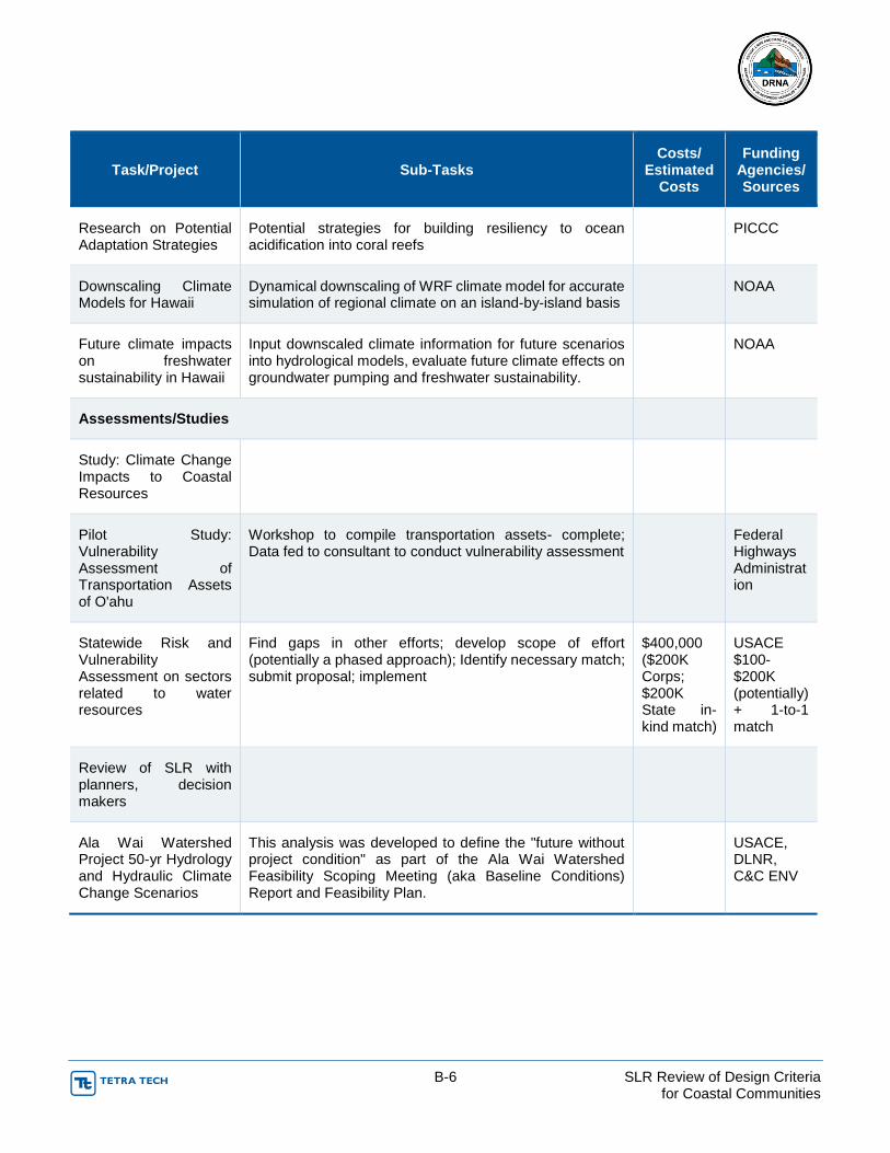
B-6 SLR Review of Design Criteria for Coastal Communities
Task/Project Sub-Tasks Costs/
Estimated Costs
Funding Agencies/ Sources
Research on Potential Adaptation Strategies
Potential strategies for building resiliency to ocean acidification into coral reefs
PICCC
Downscaling Climate Models for Hawaii
Dynamical downscaling of WRF climate model for accurate simulation of regional climate on an island-by-island basis
NOAA
Future climate impacts on freshwater sustainability in Hawaii
Input downscaled climate information for future scenarios into hydrological models, evaluate future climate effects on groundwater pumping and freshwater sustainability.
NOAA
Assessments/Studies
Study: Climate Change Impacts to Coastal Resources
Pilot Study: Vulnerability Assessment of Transportation Assets of O'ahu
Workshop to compile transportation assets- complete; Data fed to consultant to conduct vulnerability assessment
Federal Highways Administration
Statewide Risk and Vulnerability Assessment on sectors related to water resources
Find gaps in other efforts; develop scope of effort (potentially a phased approach); Identify necessary match; submit proposal; implement
$400,000 ($200K Corps; $200K State in-kind match)
USACE $100-$200K (potentially) + 1-to-1 match
Review of SLR with planners, decision makers
Ala Wai Watershed Project 50-yr Hydrology and Hydraulic Climate Change Scenarios
This analysis was developed to define the "future without project condition" as part of the Ala Wai Watershed Feasibility Scoping Meeting (aka Baseline Conditions) Report and Feasibility Plan.
USACE, DLNR, C&C ENV

B-7 SLR Review of Design Criteria for Coastal Communities
Task/Project Sub-Tasks Costs/
Estimated Costs
Funding Agencies/ Sources
Regional Assessment of Potential Climate Impacts to the Civil Works Program in the USACE Honolulu District Area of Responsibility
Summary of climate change impacts, considerations and data gaps specifically related to the USACE Civil Works programs for Honolulu District. This report will identify priority actions needed to assist Honolulu District in addressing climate change within its regulations and planning process.
Assessment of potential impacts of climate change on tourism industry
HTA special fund
Sea-Level Rise Policy Study
(1) Outline strategies to address existing legal and policy opportunities and barriers to climate change adaptation, with a focus on Hawaiʻi sea-level rise; (2) Develop model ordinances or draft policy language that local legislators and government officials can use to facilitate the emerging sea-level rise adaptation policy; and, (3) Plan and implement outreach to legislators and decision-makers throughout the state.
NOAA Coastal Storms Program
Climate and Water Resources in the Central Oʻahu Watershed
The Pacific RISA (Regional Integrated Sciences and Assessments) program is assessing climate-sensitive decisions about freshwater resources in the Central Oʻahu Watershed. Through in-depth stakeholder and agency interviews, surveys, and workshops, the Pacific RISA program is identifying (1) the climate-sensitive decisions or policies stakeholders are making now or likely to make in the future that will be impacted by climate variability and change, (2) what research, tools and information is needed to support such decisions; and, (3) the capacity decision-makers and policymakers have to use climate information to support their decisions.
NOAA Climate Programs Office
Upland/NARS Vulnerability Assessment
Identify stressed ecosystems' vulnerability to climate change.
PICCC

B-8 SLR Review of Design Criteria for Coastal Communities
Task/Project Sub-Tasks Costs/
Estimated Costs
Funding Agencies/ Sources
Pacific RISA Climate Adaptation Law and Policy Analysis
(1) Analyze laws currently on the books and identify barriers and opportunities to adaptive management in Hawaiʻi's freshwater resources sector; (2) Provide a toolkit of adaptation options, as well as model legislation or draft revisions to existing laws for decision-maker consideration; (3) Implement targeted outreach, through interviews, surveys and workshops, to incorporate indigenous environmental knowledge (IEK) and stakeholder input for appropriate and enduring strategies.
NOAA
Training/Workshops
Sea-Level Rise Policy Study
(1) Outline strategies to address existing legal and policy opportunities and barriers to climate change adaptation, with a focus on Hawaiʻi sea-level rise; (2) Develop model ordinances or draft policy language that local legislators and government officials can use to facilitate the emerging sea-level rise adaptation policy; and, (3) Plan and implement outreach to legislators and decision-makers throughout the state.
NOAA Coastal Storms Program
Climate Change Adaptation Trainings
Maui County Training (4 days) NOAA PSC, CZM
Trainings in other counties NOAA PSC, CZM
Pacific Islands Committee (PIC) for National Assoc. of State Foresters (NASF)
Potential coordination with Pacific Regional Ocean Partnerships
Central Oahu Watershed Stakeholders Workshops (for National Climate Assessment)
Two workshops targeting stakeholders in central Oahu watershed region. This workshop will discuss the potential climate-information needs that stakeholders perceive, in support of the National Climate Assessment (NCA).
NOAA
Outreach/Communications
Climate Change PSAs Scriptwriter and Educator contract to develop message and general script(s)
CZM grant

B-9 SLR Review of Design Criteria for Coastal Communities
Task/Project Sub-Tasks Costs/
Estimated Costs
Funding Agencies/ Sources
Solicitation for proposals to produce script CZM grant
Hawaii's Changing Climate Briefing Sheet, 2010
Distributed briefing sheet to federal, state, county, and community decision-makers statewide
C. Fletcher presentation to cabinets
Governor and cabinet; Mayors and cabinet; CCTF (if/when meet)
travel costs for Chip
Climate science fact-sheets
Pacific RISA is working on a series of stakeholder-targeted fact sheets that will be distributed via email and hard copy
NOAA
Planning/Policy
A Framework for Climate Change Adaptation in Hawaii
CZM, Barrel Tax, HTA, USACE, NOAA
State Policy on addressing Climate Change Adaptation
Staff time only (at least initially)
Develop Climate Adaptation Plan
NOAA 309 Projects of Special Merit Program
Draft Executive Order to create a Climate Change Commission
Tasks of the Climate Change Commission drafted to include the development of a State Climate Adaptation Plan
USACE Ecosystem Restoration and Climate Change
Proposed national policy on how to incorporate climate change into USACE funded ecosystem restoration projects.
USACE
EC 1165-2-211 USACE Sea Level Rise Policy Guidance
For USACE projects, provides national guidance on how to address risk and uncertainty related to sea level rise.
USACE
Table 6. Framework for Climate Change Adaptation in Hawaii.

B-10 SLR Review of Design Criteria for Coastal Communities
Steps of Framework for Climate Change
Adaptation in Hawaii
How implementing / Plan to implement
Funding and other Comments
Partners
A Build Climate Change Adaptation Team
ORMP Policy Group, de facto CZM federal (NOAA) funding
B Develop and adopt a long-term vision
Develop Vision, Preferred Future, and Statewide Climate Change Policy at workshop on Aug 22-23, 2011 with ORMP partners
CZM federal (NOAA) funding & USACE Silver Jackets funding
CZM, OP, ORMP, NOAA, USACE, LG office, other stakeholders
C Identify Planning Areas and Opportunities Relevant to CC
TBD, possible to work through ORMP working group - also, piece included in USACE PAS scope of work
ORMP, NOAA, USACE
D Scope Climate Change Impacts to Major Sectors
UH Sea Grant implementing with NOAA funding; Hawaii impacts report to stem from Pacific impacts report; outreach effort to coincide with release of document;
$ UH SG funding $ HTA funding potential CZM federal (NOAA) funding
UHSG, ICAP, HTA, CZM/OP, Leg, counties
Employ impacts document to facilitate process with ORMP partners and focus groups to develop a compelling case for climate change adaptation and building political will
written into CZM's proposal for NOAA $309 Project of Special Merit (PSM) - $200K for 18 mo.
CZM, OP, ORMP, NOAA, Leg
E-F Conduct Vulnerability and Risk Assessments for each Sector
OMPO conducting vul. assessment for critical transportation assets on O'ahu;
$ US FHWA grant OMPO, US FHWA
1 symposium to conduct risk and vul. assessments for CCH; proposing on sectors with less technical needs/data (possibly economic development)
$ NOAA CREST grant to UH ($300K for 2 years- $146,537 for yr. 1)
ICAP, CZM/OP, NOAA PSC, ORMP
1 symposium to conduct risk and vul. assessments for another county; proposing on sectors with
$ NOAA CREST grant to UH ($300K for 2 years: $153,463 for yr. 2)
ICAP, CZM/OP,

B-11 SLR Review of Design Criteria for Coastal Communities
Steps of Framework for Climate Change
Adaptation in Hawaii
How implementing / Plan to implement
Funding and other Comments
Partners
less technical needs/data (e.g., agriculture on Kauai or BI)
NOAA PSC, ORMP
risk and vulnerability assessments for sectors w/ more technical data and needs and related to water resources - Phased approach by county. Phase 1 = CCH.
$USACE PAS funding ($200,00 for 1 year, Phase 1)
USACE, CZM/OP, ICAP, ORMP, BOW, CWRM, CCH DPP
Depending on status of above projects (and others), fill gaps in risk and vulnerability assessments; compile relevant documents for a draft State Adaptation Plan
$ NOAA 309 Project of Special Merit (PSM) - $200K for 18 mo.
NOAA, ORMP, UHSG, UH SOEST
Next Steps
G Prioritize Areas for Adaptation Planning
Depending on status of above projects (and others), may commence implementation of this step with NOAA 309 PSM $
H Set Preparedness Goals
I Develop, Select, and Prioritize Preparedness Actions
J Implement Preparedness Plan
K Monitor Progress and Update Plan as Appropriate
The Ocean Resources Management Plan Working Group of Hawaii prepared the document titled “A Framework for Climate Change Adaptation in Hawaii (November 2009). The document identified the proposed adaptation team members and the potential impacts and adaptation planning considerations. The group highlight the importance of take this challenge instantly in an inclusive manner.

B-12 SLR Review of Design Criteria for Coastal Communities
Adapting to Sea Level Rise in Hawaii
(Source: http://www.pemsea.org/sites/default/files/presentation_t1-6_lowry.pdf)
In the next 100 years ocean levels are expected to rise 39 inches due to global warning.
Estimates for Hawaii
SLR: 0.24 m by 2050, 1m by 2100
Erosion multiplier: 150
0.24 m increase results in beach retreat of 36 m
Short Term Impacts
Beach erosion and retreat
Increased flooding in coastal areas
Reduced access to shoreline attractions
Threats to key infrastructure including roads, sewers, storm drains, electrical lines
Threats to freshwater aquifers
Selected Sea Level Rise Initiatives
Hawaii Ocean Resources Management Plan
Hawaii Greenhouse Gas Emissions Reduction Task Force
Climate Change Task Force [2009]
Center for Island Climate Adaptation and Policy,
University of Hawaii
Coastal Geology Working Group, University of Hawaii
Key Management Tools
Beach nourishment o Waikiki cost $25 million over 5 years
Shoreline setbacks o Minimum 40’ setback line required by state law o Variable setback lines on Maui and Kauai o Variable line = [life expectancy of structures - generally 70 years] x erosion rate adjusted for
sea level rise] o No permanent structures within setback area
Special Management Area [ICM] o Coastal zone management area extending a minimum of 300 ft. landward from shoreline o Land use requires an SMA permit from county subject to coastal policies o Coastal policies require adequate shoreline access, consistency with county land use plans,
no substantial adverse environmental impacts, minimal alteration of landforms, no alteration of beach size etc.
Urban zoning o Multiple categories of land use including residential, commercial, industrial, public facilities—
and hazard and open space o Control over location, density, building height and lot siting o Creates presumption of right to build o May be expensive to down-zone for purposes of creating open space

B-13 SLR Review of Design Criteria for Coastal Communities
Flood zones
o Communities required to identify flood risk zones based on history, hydrology
o Federal subsidies for rebuilding for those who have flood insurance
o Multiple types of zones identified including 100 year flood
o Hawaii maps include tsunami zones and historic hurricane data
Possible “No Regrets” Adaptation Initiatives for Next Decade
Stricter enforcement of illegal seawalls regulations
More beach protection plans (with increased community Involvement)
Stricter building code requirements in flood prone areas
Reduced insurance subsidies for new or re-built structures in most flood- prone areas
Identification of potential 75 - 100 year sea level rise “impact zones” on each island
Possible Interventions for 2050 and Beyond
Identification of areas at high risk of frequent flooding including existing residential and commercial areas
Identification of specific infrastructure or infrastructure systems (e.g. highways or sewage treatment plants) for protection or relocation
Expanded no-build zones, flood-protection infrastructure, relocation of homes, businesses and infrastructure
Possible Criteria for Choosing among Possible Interventions
Construction and maintenance costs
Community risk - is strategy appropriate for anticipated sea level rise?
Economic efficiency - benefits greater than if resources applied to other approaches?
Equity - who benefits and who pays in direct costs and dislocations?
Institutional feasibility - acceptable to the public? Does it require new institutions to implement?
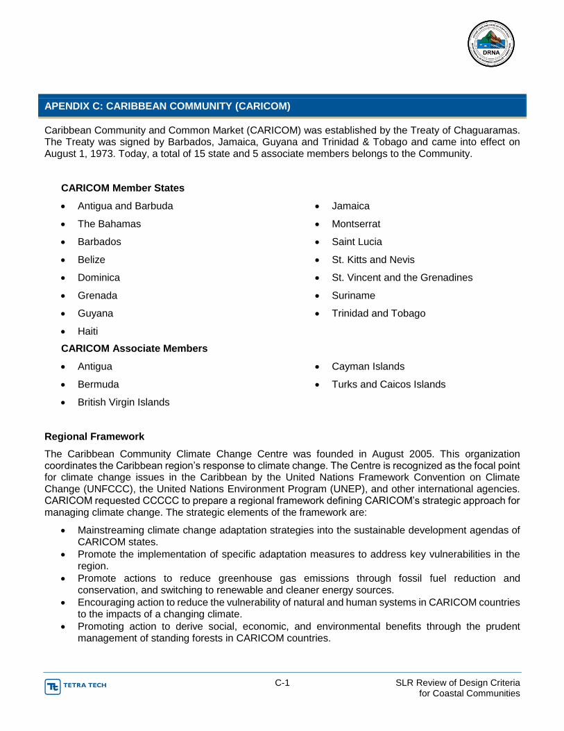
C-1 SLR Review of Design Criteria for Coastal Communities
APENDIX C: CARIBBEAN COMMUNITY (CARICOM)
Caribbean Community and Common Market (CARICOM) was established by the Treaty of Chaguaramas. The Treaty was signed by Barbados, Jamaica, Guyana and Trinidad & Tobago and came into effect on August 1, 1973. Today, a total of 15 state and 5 associate members belongs to the Community.
CARICOM Member States
Antigua and Barbuda
The Bahamas
Barbados
Belize
Dominica
Grenada
Guyana
Haiti
Jamaica
Montserrat
Saint Lucia
St. Kitts and Nevis
St. Vincent and the Grenadines
Suriname
Trinidad and Tobago
CARICOM Associate Members
Antigua
Bermuda
British Virgin Islands
Cayman Islands
Turks and Caicos Islands
Regional Framework
The Caribbean Community Climate Change Centre was founded in August 2005. This organization coordinates the Caribbean region’s response to climate change. The Centre is recognized as the focal point for climate change issues in the Caribbean by the United Nations Framework Convention on Climate Change (UNFCCC), the United Nations Environment Program (UNEP), and other international agencies. CARICOM requested CCCCC to prepare a regional framework defining CARICOM’s strategic approach for managing climate change. The strategic elements of the framework are:
Mainstreaming climate change adaptation strategies into the sustainable development agendas of CARICOM states.
Promote the implementation of specific adaptation measures to address key vulnerabilities in the region.
Promote actions to reduce greenhouse gas emissions through fossil fuel reduction and conservation, and switching to renewable and cleaner energy sources.
Encouraging action to reduce the vulnerability of natural and human systems in CARICOM countries to the impacts of a changing climate.
Promoting action to derive social, economic, and environmental benefits through the prudent management of standing forests in CARICOM countries.

C-2 SLR Review of Design Criteria for Coastal Communities
Implementation Plan
CARICOM requested CCCCC to prepare an implementation plan to deliver the strategies and goals identified in the regional framework. The plan defines the Region’s strategic approach to deal with climate change during years 2011 to 2021. The final document is titled as “Delivering Transformational Change 2011-21, Full Report: Implementing the CARICOM Regional Framework for Achieving Development Resilient to Climate Change. The plan involves:
Establishing how regional and country bodies will work together
Securing investment to support the action plan
Proposing a monitoring and evaluation system
Obtaining buy-in from Governments and relevant funders across the region

D-1 SLR Review of Design Criteria for Coastal Communities
APENDIX D: CANADA
Canada is located in the northern part of the America’s continent and consist of 10 provinces and three (3) territories. The territory covers from the Atlantic to the Pacific and northward into the Arctic Ocean approximately 9.98 million square kilometers in total. This total area extension makes Canada the world's second-largest country and the fourth-largest country by land area. Adaptation tools are presented for the southern coast of Canada: British Columbia, Quebec, New Brunswick, Nova Scotia, Prince Edward Island and Newfoundland and Labrador.
British Columbia
o A study prepared for B.C. (2011) suggested sea level rise planning levels of 0.5 meters for year 2050, 1.0 meter for year 2100 and 2.0 meters for year 2200
Quebec
o Provincial policy established a 10 – 15 meter setback for the protection of the shorelines since 1987
o Some areas has conducted more detailed research on erosion rates and has begun adopting more stringent regulations
New Brunswick
o Coastal Areas Protection Policy was created in year 2002
o Enforced via existing provincial legislation
o Some municipalities have incorporated elements of or the entire coastal zone policy directly into their bylaws
Nova Scotia
o Coastal erosion is their major risk
o Existing Coastal Management Framework
safeguard the sustainable use and protection of coast and resources
o State of Nova Scotia's Coast Report
baseline information to develop the Sustainable Coastal Development Strategy
Prince Edward Island
o Exposed to impacts as coastal erosion and infrastructure damage
coastline - high physical sensitivity to sea level rise

D-2 SLR Review of Design Criteria for Coastal Communities
o The provincial government is the major player in land use planning in P.E.I.,
Province manages about 90% of the land area and 31 municipal governments have jurisdiction over the remaining 10% (comprehensive land use planning)
o Municipal land use plans are more restrictive than provincial ones for the most part, although in the case of coastal area development some are less restrictive than provincial legislation
Newfoundland and Labrador
o Provincial government committed to prepare a dedicated strategy on climate change adaptation for Northern Labrador
Climate Change Action Plan “Charting Our Course” (2011)
Plan includes adaptation strategies
integrates adaptation considerations for public/private sector decision-making
consider climate change implications in the site selection and design of provincial government buildings and infrastructure
o Government of Newfoundland and Labrador released a Coastal and Oceans Management Strategy and Policy Framework (June 2011)
Include coastal land use planning, coastal and marine infrastructure, and climate change
Atlantic Canada
o Includes four (4) provinces
Newfoundland and Labrador has set a province wide high water design standard for sea level rise, storm surge and wave action in coastal areas
1:100 year return period
Other provinces rely on the generally accepted coastal engineering design standards for the life of structures in coastal areas
50 years
8.1 Managing Design Criteria and Building Codes Relative to SLR Adaptation in Canada: Framework for Decision Making
British Columbia Ministry of Environment prepared a Sea Level Rise Adaptation Primer – A Toolkit to Build Adaptive Capacity on Canada’s South Coasts (January 2013). Effective adaptation strategies to climate change and SLR will mainly come from local government and can be grouped into four (4) categories:
Protect
o Reactive strategy to protect people
o Protecting the coastline: structural (dikes, seawalls, etc.)
from large-scale (public projects) to small-scale (individual property owners)
expensive, may have limited long-term effectiveness in highly vulnerable areas
may lead to a false sense of security

D-3 SLR Review of Design Criteria for Coastal Communities
creates an expectation that coastal defenses will be maintained in perpetuity
retreat from urbanized areas is theoretically possible but politically difficult
there are few (if any) examples of successful and peaceful retreat in densely populated areas
can lead to unwanted effects on erosion and sedimentation patterns if not properly implemented
o Non-structural protection measures (beach nourishment, coastal wetland restoration and creation)
can be implemented as sea level rises
may complement or supplement structural protection
can enhance the natural resilience of the coastal zone
can be less expensive than structural protection
Accommodate
o Allows continued occupation of coastal areas
o Can involve retrofitting a building or making it more resilient SLR consequences
o May include liability reduction such as an agreement indemnifying government regardless of protection works that are undertaken
Retreat
o Any strategic decision to withdraw, relocate or abandon private or public assets at risk due to coastal hazards
o Designed to
limit the use of structural protection
discourage development in areas subject to sea level rise
plan for the eventual relocation of buildings and infrastructure
o Homes, cottages, lighthouses and barns have been moved further inland
strategy may include moving roads further inland or completely re-routing them
approach makes sense when
property owners have enough room on their parcel
when the ongoing costs of storm repairs and safety concerns outweigh the costs of retreating
other cases, coastal erosion has resulted in the loss of entire building parcels
o Strategy typically undertaken with a long-term perspective
small scale may include site-specific relocation within a property or relocation
large scale may include an entire community (may or may not be a phased undertaking)

D-4 SLR Review of Design Criteria for Coastal Communities
it is not currently used as frequently as the other strategies
it is anticipated that this strategy will increase in the future if the cost of a protect or accommodate strategy is based on a long-range perspective and a higher rate of sea level rise
Avoid
o Involves planning so that development does not take place in:
areas subject to coastal hazards associated with SLR
where the risk is low at present but will increase over time
o May include identifying future "no build" areas
New structural elements are not part of an avoid strategy
o Regulatory tools may include the zoning of lands for limited development or non-habitable uses
o May include land acquisition or restriction tools
8.2 Sea Level Rise Adaptation Framework
Information gathering, public education and community engagement should commenced previous to start any adaptation tool.
Information Gathering – identify resource limitations and knowledge gaps
Internal capacity building
Study of local conditions that could modify sea level rise
GIS mapping
Assessment of potential local impacts of sea level rise
Determination of cost implications of different adaptation tools
Assessment of risk and vulnerability
Public Education & Community Engagement – ownership and provide value information
Educate and consult stakeholders
Find out what degree of risk the community prepared to live with
Establish community priorities and preferred strategy
Assess community vulnerability
Prepare scenarios, visualizations
Adaptation Tools – ideas at work
Decision-making framework
Risk assessment
Cost benefit analysis
Identification of the most appropriate tool(s) for local context

D-5 SLR Review of Design Criteria for Coastal Communities
Monitoring & Evaluation – incorporate new data and assess effectiveness
Effectiveness of chosen tools
Monitoring of measurable indicators
Re-evaluation of community's acceptable risk
8.3 Options
This section provides some different planning, regulatory, land use change or restriction, and non-structural tools in Canada.
8.3.1 Planning Tools
Objectives & Policies
Growth management objectives, establishment of policies and setting of priorities
Coastal management approach based on sensitivity to impact
Coastal Hazard Mapping
Coastal Floodplain Mapping
Mapping of areas at risk of erosion due to SLR
Identification of minimum floor elevations (Flood Construction Levels, or FCLs)
Risk Management
Identification, assessment, measurement of the likelihood and consequences of risks to property, buildings and people
Cost benefit analysis
Vulnerability assessment
Resilience assessment
Emergency Planning and Preparedness
Prepare emergency plans for flooding and other disasters
Undertake post disaster planning
8.3.2 Regulatory Tools
Subdivision Regulation
Regulation of subdivision to protect development in areas subject to coastal hazards
Regulation where the natural environment would be adversely affected due to SLR
Building Regulation
Regulation of building construction to address safety of land subject to coastal hazards
Regulation of Land Use
Zoning Bylaw to regulate land use, density, siting of buildings and servicing standards
Designation of land as a floodplain

D-6 SLR Review of Design Criteria for Coastal Communities
Minimum building elevations & setbacks for land in floodplain - Floodplain Bylaw
Development Permit
Regulation of specific development plans to protect environment or development from hazard
Examples of Legislative Initiatives in British Columbia
Local Government Act
o Regional Growth Strategy
S. 849, regional growth strategy objectives can include protecting environmentally sensitive areas and achieving settlement patterns that minimize the risk associated with natural hazards
S. 850, the purpose of a regional growth strategy is to guide decisions of social, economic and environmental growth for a period of at least 20 years
S. 852, a regional growth strategy can be mandated by the provincial Minister of Community, Sport and Cultural Development
o Official Community Plan
S. 875 includes statement of objectives and policies to guide land use planning
S. 876 covers bylaw process
S. 877 covers content including land use restrictions due to hazards or environmental sensitivity
S.878 addresses regional context statement
o Zoning bylaw
S. 903 provides authority for local government to regulate land use
Includes siting, location of uses on land, different uses, servicing standards, minimum areas and regulation of density
Also includes the power to prohibit any use in a zone
o Floodplain bylaw
S. 910 addresses
designation of a floodplain by local government bylaw
role of provincial guidelines
construction requirements in a flood plain including setbacks and minimum building elevations
Land Title Act
o Subdivision approval
S. 85(3) allows Approving Officer to refuse subdivision approval if he considers it to be against the public interest

D-7 SLR Review of Design Criteria for Coastal Communities
S. 86 allow a subdivision to be refused if the land is subject to flooding and other hazards
The Approving Officer may require a report by a PE or geoscientist concerning how the land can safely be used as a condition of subdivision approval with the report included in a restrictive covenant on the land title
The conditions under which a subdivision is approved are also included
Examples of Legislative Initiatives in Quebec
Governmental policy for the protection of riverbanks, shorelines, coastlines and floodplains Adopted in 1987, last updated in 2005
o Originally intended to be legislation, this policy outlines coastal protection measures that were encouraged to be included in regional master plans
Section 2.2 outlines a uniform setback
10m if the land grade is less than 30 degrees from the shore
15 meters if the land grade is greater than 30 degrees from the shore
Section 3.1 mandates a special permit for new construction on all shorelines, to ensure compliance with the measures outlined in the policy
Section 3.3 bans all construction directly on the coastline, with some exceptions such as piers, small bridges, water intakes, etc.
Regulation number 02-2005, Interim regulation related to erosion risk zones along the St. Lawrence and for certain river estuaries in the RCM of Sept-Rivières, adopted in 2005, last updated in 2010
o Article 7 on construction indicates that within the non-construction zone, as defined in Appendix 1 and 2 of the regulation, as per the research findings of the inter-ministerial research on erosion rates:
no new construction
no extension of habitable surface to existing buildings
no re-construction permits for buildings that have been destroyed or damaged in an amount equal or greater than half the value of the building, for whatever cause
Some exception provisions apply and are stipulated
o Article 8 on permissible work stipulates that individuals are only allowed to protect their properties from erosion through rebuilding sandbanks
All other structural measures (riprap, dikes, etc.) are prohibited, unless allowed for by special provision
Appendices 1 & 2 establish setback lines for a 25 year protection period, according to the interministerial report recommendations.
Appendix 1 includes the maps and Appendix 2 includes the charts with approximately 240 different setback lines per land sector
o Setbacks range from 30 to 180 meters, with some zones declared non constructible.

D-8 SLR Review of Design Criteria for Coastal Communities
Examples of Legislative Initiatives in Prince Edward Island
The Planning Act Adopted 1988, last updated 2010
o Section 16 requires that, where development is adjacent to a beach, a buffer having a minimum width of 18.3 meters or 60 times the annual erosion rate for the area (whichever is greater), measured from the top of the bank, be provided
The Environmental Protection Act Adopted 1988, last updated 2010
o Sand Dunes and Beaches, Section 22
(1) No person shall, without written permission of the Minister,
(b) carry out any activity that will or may
o (i) interfere with the natural supply or movement of sand to or within a beach or a sand dune,
o (ii) alter, remove, or destroy natural stabilizing features, including vegetation, of a beach or a sand dune
Examples of Legislative Initiatives in Atlantic Canada Municipalities
Prince Edward Island, City of Charlottetown
o Zoning and Development Bylaw
No permits within 23 m of a wetland or watercourse as per provincial requirements under the Environmental Protection Act
o Lot Grading Guidelines
The City requires that habitable space in new buildings be located above 4.93 m above sea level Chart Datum (3.25 m geodetic or contour level).
The building design must consider access to the building and parking in the event of flooding or natural sea level rise over the life expectancy of the building
Basements below the projected sea level rise must not be used for habitable space or for the storage of immovable objects, flammable, explosive, toxic or otherwise toxic material
Electric and mechanical rooms must also be located above 4.93 m (3.25 m Geodetic) elevation or protected or movable as normal water levels rise over the years
Prince Edward Island, City of Summerside
o Zoning Bylaw SS-15-2007
No permits for any use within 10m buffer zone of a watercourse plus an extra 13m for main building, 9m for accessory building and 5m for a street
Prince Edward Island, Town of Cornwall
o Zoning and Subdivision Control (Development) Bylaw

D-9 SLR Review of Design Criteria for Coastal Communities
No building or part allowed within 23m of any watercourses or wetlands (includes coast line)
Prince Edward Island, Town of Souris
o Zoning & Subdivision Control (Development) Bylaw
On those lots adjacent to the shore not having a shoreline buffer, or to which the applicant of a shoreline buffer requirement is impractical, no buildings or structures shall be constructed closer than:
(a) the distance determined by multiplying the annual erosion rate for that shoreline by sixty (60’); or
(b) seventy-five feet (75’), whichever is greater, measured from the top of the bank to the nearest exterior part of the proposed building or structure
Prince Edward Island, Town of Alberton
o Zoning and Subdivision Control (Development) Bylaw
Cannot alter or remove any natural vegetation or deposit or remove fill with 75ft of a watercourse.
Cannot erect any structure with 75 feet of a watercourse or wetland
Prince Edward Island, Community of Eastern Kings
o Zoning & Development Bylaw
No person shall construct within 22.9m or 60 times the annual erosion rate, whichever is greater from a beach measured from the top of a bank. Also includes primary or secondary sand dunes
Prince Edward Island, Community of Borden-Carleton
o Zoning & Development Bylaw
To protect wetland and shoreland areas: no development shall take place within 20m and no structure shall be located with 30m of any watercourse including Northumberland Strait
Prince Edward Island, Resort Municipality of Stanley Bridge, Hope River, Bayview, Cavendish and North Rustico
o Zoning and Subdivision Control (Development) Bylaw 2004
No person shall remove vegetation, remove or deposit fill or erect or place any structure within 75 feet of any watercourse or wetland
Nova Scotia, The Municipality of the County of Kings
o Bylaw #75-County of Kings Land Use Bylaw
14.6-2 – a minimum setback of 50 feet from the top of the bank. Property owners shall provide written confirmation to the development officer stating they are aware their property is prone to erosion and that they understand the risks associated with development
New Brunswick, Beaubassin-est Rural Community
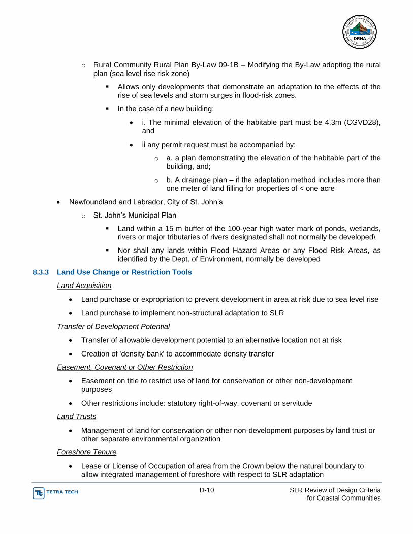
D-10 SLR Review of Design Criteria for Coastal Communities
o Rural Community Rural Plan By-Law 09-1B – Modifying the By-Law adopting the rural plan (sea level rise risk zone)
Allows only developments that demonstrate an adaptation to the effects of the rise of sea levels and storm surges in flood-risk zones.
In the case of a new building:
i. The minimal elevation of the habitable part must be 4.3m (CGVD28), and
ii any permit request must be accompanied by:
o a. a plan demonstrating the elevation of the habitable part of the building, and;
o b. A drainage plan – if the adaptation method includes more than one meter of land filling for properties of < one acre
Newfoundland and Labrador, City of St. John’s
o St. John’s Municipal Plan
Land within a 15 m buffer of the 100-year high water mark of ponds, wetlands, rivers or major tributaries of rivers designated shall not normally be developed\
Nor shall any lands within Flood Hazard Areas or any Flood Risk Areas, as identified by the Dept. of Environment, normally be developed
8.3.3 Land Use Change or Restriction Tools
Land Acquisition
Land purchase or expropriation to prevent development in area at risk due to sea level rise
Land purchase to implement non-structural adaptation to SLR
Transfer of Development Potential
Transfer of allowable development potential to an alternative location not at risk
Creation of 'density bank' to accommodate density transfer
Easement, Covenant or Other Restriction
Easement on title to restrict use of land for conservation or other non-development purposes
Other restrictions include: statutory right-of-way, covenant or servitude
Land Trusts
Management of land for conservation or other non-development purposes by land trust or other separate environmental organization
Foreshore Tenure
Lease or License of Occupation of area from the Crown below the natural boundary to allow integrated management of foreshore with respect to SLR adaptation

D-11 SLR Review of Design Criteria for Coastal Communities
8.3.4 Structural Tools (Flood Protection Works)
Scour Protection
Foundation protection for a new or existing building
Protection of a linear structure base
Protection of underground services
Structural Elevation
Addition of structural fill to raise the land below a building above the flood level risk
Raising the habitable areas of a building or the entire building itself
Dikes
Linear shoreline protection structure as a primary defense from flooding
Includes accessories such as floodboxes and floodgates
Other Hard Protection
Off-site structural works to protect shorelines from flooding
Includes seawall, revetment and storm surge barrier
Secondary protection including roads and back-up dikes
Wet Floodproofing
Installation of building materials that can withstand temporary flood damage
Location of electrical and mechanical fixtures above area subject to flood risk
8.3.5 Non-Structural Tools (Soft Armoring)
Coastal Wetland Creation or Restoration
Creation of a buffer to reduce wave energy
Creation or restoration of wetlands to increase adaptive capacity of ecological areas at risk due to coastal squeeze
Dune Building or Rehabilitation
Creation or rehabilitation of dunes to provide a buffer to reduce flood risk and environmental habitat
Creation of off-shore islands
Beach Nourishment
Addition of sediment on an ongoing basis to satisfy natural erosional forces
E-1 SLR Review of Design Criteria for Coastal Communities
APENDIX E: OUTREACH

Summary of Results to Outreach Efforts to the Agencies
Agency Acronym
in Spanish
Vu
lne
rab
ility
Stu
dy
Dat
e o
f V
uln
era
bili
ty S
tud
y
Vu
lne
rab
le In
fras
tru
ctu
re
Ad
apta
tio
n P
lan
Dat
e o
f A
dap
tati
on
Pla
n
Hav
e t
he
en
tity
co
nsi
de
r
"SLR
" in
de
sign
cri
teri
a fo
r
futu
re in
fras
tru
ctu
re?
Information provided via
Administración de Vivienda Pública (Puerto Rico Public Housing Administration)
AVP N/A N/A N/A N/A N/A N/A e-mail April 8, 2015
Agencia Estatal para el Manejo de Emergencias y Administración de Desastres (Puerto Rico Emergency Management Agency)
AEMEAD Yesi - Yes No - No Phone January 27, 2015
Autoridad de Acueductos y Alcantarillados (Puerto Rico Aqueduct and Sewer Authority)
AAA Yes Task List
Autoridad de Carreteras y Transportación (Puerto Rico Highway and Transportation Authority)
ACT Noii - Yes No - No Phone April 7, 2015
Autoridad de Edificios Públicos (Puerto Rico Public Buildings Authority)
AEP Yes Task List
Autoridad para el Financiamiento para la Infraestructura (Puerto Rico Infrastructure Financing Authority)
AFI N/Aiii N/A N/A N/A N/A N/A Task List
Autoridad de Puertos (Puerto Rico Ports Authority)
AP Yes Task List
Compañía de Turismo (Puerto Rico Tourism Company)
CT Yes Task List
Departamento de Agricultura (Puerto Rico Department of Agriculture)
DA No June 2015
Yes No June 2015
No Survey April 8, 2015
Departamento de Educación (Puerto Rico Department of Education)
DE Yesiv Task List
Departamento de Salud (Department of Health of Puerto Rico)
DS Yes Task List
Departamento de Transportación y Obras Públicas (Puerto Rico Department of Transportation and Public Works)
DTOP No - Yes No - No Phone April 7, 2015

Agency Acronym
in Spanish
Vu
lne
rab
ility
Stu
dy
Dat
e o
f V
uln
era
bili
ty S
tud
y
Vu
lne
rab
le In
fras
tru
ctu
re
Ad
apta
tio
n P
lan
Dat
e o
f A
dap
tati
on
Pla
n
Hav
e t
he
en
tity
co
nsi
de
r
"SLR
" in
de
sign
cri
teri
a fo
r
futu
re in
fras
tru
ctu
re?
Information provided via
Departamento de Vivienda (Puerto Rico Department of Housing)
DV
Junta de Planificación (Puerto Rico Planning Board)
JP Yesv
Draft October
17, 2014;
Updated January 22, 2015
No N/A N/A N/A Task List; Phone Jan 26, 2015
Oficina de Gerencia de Permisos (Puerto Rico Permits Management Office)
OGPe
Departamento de Recursos Naturales y Ambientales (Puerto Rico Department of Natural and Environmental Resources)
DRNA Yesvi Task List
Junta de Calidad Ambiental (Puerto Rico Environmental Quality Board)
JCA
Autoridad para el Financiamiento de la Vivienda (Puerto Rico Public Housing Authority)
AFV
Autoridad de Tierras de Puerto Rico (Puerto Rico Land Authority)
ATPR Yes Task List
Autoridad de Energía Eléctrica (Puerto Rico Energy Power Authority)
AEE
TOTAL 10 4
i AEMEAD is reorganizing the draft document as advised by DNER ii ACT is requesting funds to DTOP iii AFI will not prepare Vulnerability Assessment since the projects are delivered and managed by other agencies.
AFI will adopt the PAC of all agencies as part of Interagency Agreement for construction of new projects. iv Draft v Draft vi DRNA has not received comments of the draft document

Q1: ¿A qué agencia usted representa? Departamento de Agricultura
Q2: ¿Es usted la persona encargada o responsable depreparar el Estudio de Vulnerabilidad por el alza del niveldel mar ?
Sí
Q3: ¿Ha preparado el Estudio de Vulnerabilidad segúnrequerido por el Boletín Administrativo Núm.: OE-2013-016?
No
Q4: Si su respuesta a la pregunta número tres (3) fue"sí", favor de indicar la fecha en que radicó el estudioante el DRNA; si su respuesta fue "no", favor de indicarcuándo planifican radicar el mismo.
Respondent skipped thisquestion
Q5: ¿La agencia que usted representa, tieneinfraestructura vulnerable al alza del nivel del mar?
Sí
Q6: Si su respuesta a la pregunta número cinco (5) fue"sí", favor de identificar y describir cuáles son lasmedidas de adaptación para proteger dichainfraestructura (e.g. tuberías, estaciones de energía,sub-estaciones, transformadores, generadores,carreteras, puentes, cimientos, etc.).
Villas pesqueras
Q7: ¿Ha completado el Plan de Adaptación? No
Q8: Si su respuesta a la pregunta número siete (7) fue"sí", favor de indicar cuándo radicaron el plan deadaptación ante el DRNA, si la respuesta fue "no", favorde indicar cuándo planifican radicarlo.
Respondent skipped thisquestion
Q9: ¿Ha considerado "SLR" en sus criterios de diseñopara infraestructura futura?
No
Q10: Si la respuesta a la pregunta nueve (9) fue "sí",favor de enumerar y discutir los criterios, si surespuesta fue "no", favor de indicar cuál es su plan alrespecto.
Respondent skipped thisquestion
COMPLETECOMPLETECollector:Collector: Web Link 2 Web Link 2 (Web Link)(Web Link)Started:Started: Wednesday, April 08, 2015 9:29:42 AMWednesday, April 08, 2015 9:29:42 AMLast Modified:Last Modified: Wednesday, April 08, 2015 9:42:48 AMWednesday, April 08, 2015 9:42:48 AMTime Spent:Time Spent: 00:13:0600:13:06IP Address:IP Address: 64.185.206.16264.185.206.162
PAGE 1: Instrucciones
#1
1 / 4
Adaptación por el Alza en el Nivel del Mar en Puerto Rico SurveyMonkey

Q1: ¿A qué agencia usted representa? Autoridad de Tierras
Q2: ¿Es usted la persona encargada o responsable depreparar el Estudio de Vulnerabilidad por el alza del niveldel mar ?
Sí
Q3: ¿Ha preparado el Estudio de Vulnerabilidad segúnrequerido por el Boletín Administrativo Núm.: OE-2013-016?
No
Q4: Si su respuesta a la pregunta número tres (3) fue"sí", favor de indicar la fecha en que radicó el estudioante el DRNA; si su respuesta fue "no", favor de indicarcuándo planifican radicar el mismo.
junio 2015
Q5: ¿La agencia que usted representa, tieneinfraestructura vulnerable al alza del nivel del mar?
Sí
Q6: Si su respuesta a la pregunta número cinco (5) fue"sí", favor de identificar y describir cuáles son lasmedidas de adaptación para proteger dichainfraestructura (e.g. tuberías, estaciones de energía,sub-estaciones, transformadores, generadores,carreteras, puentes, cimientos, etc.).
se proveerá información mas adelante
Q7: ¿Ha completado el Plan de Adaptación? No
Q8: Si su respuesta a la pregunta número siete (7) fue"sí", favor de indicar cuándo radicaron el plan deadaptación ante el DRNA, si la respuesta fue "no", favorde indicar cuándo planifican radicarlo.
junio 2015
Q9: ¿Ha considerado "SLR" en sus criterios de diseñopara infraestructura futura?
No
Q10: Si la respuesta a la pregunta nueve (9) fue "sí",favor de enumerar y discutir los criterios, si surespuesta fue "no", favor de indicar cuál es su plan alrespecto.
solo para infraestructura existente.
COMPLETECOMPLETECollector:Collector: Web Link 2 Web Link 2 (Web Link)(Web Link)Started:Started: Wednesday, April 08, 2015 9:52:59 AMWednesday, April 08, 2015 9:52:59 AMLast Modified:Last Modified: Wednesday, April 08, 2015 9:57:52 AMWednesday, April 08, 2015 9:57:52 AMTime Spent:Time Spent: 00:04:5300:04:53IP Address:IP Address: 64.185.206.8964.185.206.89
PAGE 1: Instrucciones
#2
2 / 4
Adaptación por el Alza en el Nivel del Mar en Puerto Rico SurveyMonkey

Q1: ¿A qué agencia usted representa? Departamento de Salud
Q2: ¿Es usted la persona encargada o responsable depreparar el Estudio de Vulnerabilidad por el alza del niveldel mar ?
Sí
Q3: ¿Ha preparado el Estudio de Vulnerabilidad segúnrequerido por el Boletín Administrativo Núm.: OE-2013-016?
Sí
Q4: Si su respuesta a la pregunta número tres (3) fue"sí", favor de indicar la fecha en que radicó el estudioante el DRNA; si su respuesta fue "no", favor de indicarcuándo planifican radicar el mismo.
Noviembre 2014
Q5: ¿La agencia que usted representa, tieneinfraestructura vulnerable al alza del nivel del mar?
Sí
Q6: Si su respuesta a la pregunta número cinco (5) fue"sí", favor de identificar y describir cuáles son lasmedidas de adaptación para proteger dichainfraestructura (e.g. tuberías, estaciones de energía,sub-estaciones, transformadores, generadores,carreteras, puentes, cimientos, etc.).
Educacion y desarrollo de planes para contrarrestar efectos
Q7: ¿Ha completado el Plan de Adaptación? Sí
Q8: Si su respuesta a la pregunta número siete (7) fue"sí", favor de indicar cuándo radicaron el plan deadaptación ante el DRNA, si la respuesta fue "no", favorde indicar cuándo planifican radicarlo.
Preliminar entregado en Enero de 2015
Q9: ¿Ha considerado "SLR" en sus criterios de diseñopara infraestructura futura?
No
Q10: Si la respuesta a la pregunta nueve (9) fue "sí",favor de enumerar y discutir los criterios, si surespuesta fue "no", favor de indicar cuál es su plan alrespecto.
No hay planes para desarrollo de infraestructura al momento pero planes futuros deberán utilizar el Plan de Adaptación creado.
COMPLETECOMPLETECollector:Collector: Web Link 2 Web Link 2 (Web Link)(Web Link)Started:Started: Thursday, April 09, 2015 4:18:40 PMThursday, April 09, 2015 4:18:40 PMLast Modified:Last Modified: Thursday, April 09, 2015 4:26:55 PMThursday, April 09, 2015 4:26:55 PMTime Spent:Time Spent: 00:08:1400:08:14IP Address:IP Address: 136.145.14.146136.145.14.146
PAGE 1: Instrucciones
#3
3 / 4
Adaptación por el Alza en el Nivel del Mar en Puerto Rico SurveyMonkey

Q1: ¿A qué agencia usted representa? Autoridad de los Puertos
Q2: ¿Es usted la persona encargada o responsable depreparar el Estudio de Vulnerabilidad por el alza del niveldel mar ?
Sí
Q3: ¿Ha preparado el Estudio de Vulnerabilidad segúnrequerido por el Boletín Administrativo Núm.: OE-2013-016?
Sí
Q4: Si su respuesta a la pregunta número tres (3) fue"sí", favor de indicar la fecha en que radicó el estudioante el DRNA; si su respuesta fue "no", favor de indicarcuándo planifican radicar el mismo.
20 de noviembre de 2014
Q5: ¿La agencia que usted representa, tieneinfraestructura vulnerable al alza del nivel del mar?
Sí
Q6: Si su respuesta a la pregunta número cinco (5) fue"sí", favor de identificar y describir cuáles son lasmedidas de adaptación para proteger dichainfraestructura (e.g. tuberías, estaciones de energía,sub-estaciones, transformadores, generadores,carreteras, puentes, cimientos, etc.).
Tuberias, sub-estaciones
Q7: ¿Ha completado el Plan de Adaptación? No
Q8: Si su respuesta a la pregunta número siete (7) fue"sí", favor de indicar cuándo radicaron el plan deadaptación ante el DRNA, si la respuesta fue "no", favorde indicar cuándo planifican radicarlo.
julio 2015
Q9: ¿Ha considerado "SLR" en sus criterios de diseñopara infraestructura futura?
No
Q10: Si la respuesta a la pregunta nueve (9) fue "sí",favor de enumerar y discutir los criterios, si surespuesta fue "no", favor de indicar cuál es su plan alrespecto.
N/A
COMPLETECOMPLETECollector:Collector: Web Link 2 Web Link 2 (Web Link)(Web Link)Started:Started: Friday, April 10, 2015 3:54:59 PMFriday, April 10, 2015 3:54:59 PMLast Modified:Last Modified: Friday, April 10, 2015 3:58:09 PMFriday, April 10, 2015 3:58:09 PMTime Spent:Time Spent: 00:03:0900:03:09IP Address:IP Address: 64.89.7.20264.89.7.202
PAGE 1: Instrucciones
#4
4 / 4
Adaptación por el Alza en el Nivel del Mar en Puerto Rico SurveyMonkey
Q1 ¿A qué agencia usted representa?Answered: 4 Skipped: 0
1 / 10
Adaptación por el Alza en el Nivel del Mar en Puerto Rico SurveyMonkey

100.00% 4
0.00% 0
Q2 ¿Es usted la persona encargada oresponsable de preparar el Estudio de
Vulnerabilidad por el alza del niveldel mar ?
Answered: 4 Skipped: 0
Total 4
Sí
No
0% 10% 20% 30% 40% 50% 60% 70% 80% 90% 100%
Answer Choices Responses
Sí
No
2 / 10
Adaptación por el Alza en el Nivel del Mar en Puerto Rico SurveyMonkey
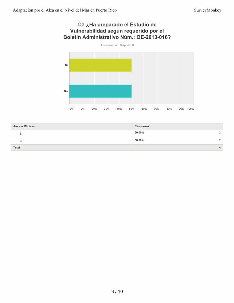
50.00% 2
50.00% 2
Q3 ¿Ha preparado el Estudio deVulnerabilidad según requerido por el
Boletín Administrativo Núm.: OE-2013-016?Answered: 4 Skipped: 0
Total 4
Sí
No
0% 10% 20% 30% 40% 50% 60% 70% 80% 90% 100%
Answer Choices Responses
Sí
No
3 / 10
Adaptación por el Alza en el Nivel del Mar en Puerto Rico SurveyMonkey
Q4 Si su respuesta a la pregunta númerotres (3) fue "sí", favor de indicar la fecha en
que radicó el estudio ante el DRNA; si surespuesta fue "no", favor de indicar cuándo
planifican radicar el mismo.Answered: 3 Skipped: 1
4 / 10
Adaptación por el Alza en el Nivel del Mar en Puerto Rico SurveyMonkey

100.00% 4
0.00% 0
Q5 ¿La agencia que usted representa, tieneinfraestructura vulnerable al alza del nivel
del mar?Answered: 4 Skipped: 0
Total 4
Sí
No
0% 10% 20% 30% 40% 50% 60% 70% 80% 90% 100%
Answer Choices Responses
Sí
No
5 / 10
Adaptación por el Alza en el Nivel del Mar en Puerto Rico SurveyMonkey
Q6 Si su respuesta a la pregunta númerocinco (5) fue "sí", favor de identificar y
describir cuáles son las medidas deadaptación para proteger dicha
infraestructura (e.g. tuberías, estaciones deenergía, sub-estaciones, transformadores,
generadores, carreteras, puentes,cimientos, etc.).
Answered: 4 Skipped: 0
6 / 10
Adaptación por el Alza en el Nivel del Mar en Puerto Rico SurveyMonkey

25.00% 1
75.00% 3
Q7 ¿Ha completado el Plan de Adaptación?Answered: 4 Skipped: 0
Total 4
Sí
No
0% 10% 20% 30% 40% 50% 60% 70% 80% 90% 100%
Answer Choices Responses
Sí
No
7 / 10
Adaptación por el Alza en el Nivel del Mar en Puerto Rico SurveyMonkey

Q8 Si su respuesta a la pregunta númerosiete (7) fue "sí", favor de indicar cuándoradicaron el plan de adaptación ante el
DRNA, si la respuesta fue "no", favor deindicar cuándo planifican radicarlo.
Answered: 3 Skipped: 1
8 / 10
Adaptación por el Alza en el Nivel del Mar en Puerto Rico SurveyMonkey

0.00% 0
100.00% 4
Q9 ¿Ha considerado "SLR" en sus criteriosde diseño para infraestructura futura?
Answered: 4 Skipped: 0
Total 4
Sí
No
0% 10% 20% 30% 40% 50% 60% 70% 80% 90% 100%
Answer Choices Responses
Sí
No
9 / 10
Adaptación por el Alza en el Nivel del Mar en Puerto Rico SurveyMonkey

Q10 Si la respuesta a la pregunta nueve (9)fue "sí", favor de enumerar y discutir los
criterios, si su respuesta fue "no", favor deindicar cuál es su plan al respecto.
Answered: 3 Skipped: 1
10 / 10
Adaptación por el Alza en el Nivel del Mar en Puerto Rico SurveyMonkey