Embed Size (px)
Citation preview
Slope failure and volcanic spreading along the submarine south flank
of Kilauea volcano, Hawaii
Julia K. MorganDepartment of Earth Science, Rice University, Houston, Texas, USA
Gregory F. MooreDepartment of Geology and Geophysics, School of Ocean and Earth Science and Technology (SOEST), University ofHawaii, Honolulu, Hawaii, USA
David A. ClagueMonterey Bay Aquarium Research Institute, Moss Landing, California, USA
Received 19 January 2003; revised 22 April 2003; accepted 7 May 2003; published 5 September 2003.
[1] New multichannel reflection data and high-resolution bathymetry over the submarineslopes of Kilauea volcano provide evidence for current and prior landsliding, suggestinga dynamic interplay among slope failure, regrowth, and volcanic spreading. Disruptedstrata along the upper reaches of Kilauea’s flank denote a coherent slump, correlated withthe active Hilina slump. The slump comprises mostly slope sediments, underlain by adetachment 3–5 km deep. Extension and subsidence along the upper flank is compensatedby uplift and folding of the slump toe, which surfaces about midway down the submarineflank. Uplift of strata forming Papa‘u seamount and offset of surface features along thewestern boundary of Kilauea indicate that the slump has been displaced �3 km in a south-southeast direction. This trajectory matches coseismic and continuous grounddisplacements for the Hilina slump block on land, and contrasts with the southeastvergence of the rest of the creeping south flank. To the northeast, slope sediments arethinned and disrupted within a recessed region of the central flank, demonstratingcatastrophic slope failure in the recent past. Debris from the collapsed flank was shed intothe moat in front of Kilauea, building an extensive apron. Seaward sliding of Kilauea’sflank offscraped these deposits to build an extensive frontal bench. A broad basin formedbehind the bench and above the embayed flank. Uplift and back tilting of young basinfill indicate recent, and possibly ongoing, bench growth. The Hilina slump now impingesupon the frontal bench; this buttress may tend to reduce the likelihood of futurecatastrophic detachment. INDEX TERMS: 0930 Exploration Geophysics: Oceanic structures; 1824
Hydrology: Geomorphology (1625); 3022 Marine Geology and Geophysics: Marine sediments—processes
and transport; 3025 Marine Geology and Geophysics: Marine seismics (0935); 8010 Structural Geology:
Fractures and faults; KEYWORDS: Kilauea volcano, slope failure, landslides, volcanic spreading
Citation: Morgan, J. K., G. F. Moore, and D. A. Clague, Slope failure and volcanic spreading along the submarine south flank of
Kilauea volcano, Hawaii, J. Geophys. Res., 108(B9), 2415, doi:10.1029/2003JB002411, 2003.
1. Introduction
[2] Large-scale landslides and debris avalanches areknown to play an important role in the evolution of oceanicvolcanoes around the world [e.g.,Wolfe et al., 1994; Duffieldet al., 1982; Lenat et al., 1989; Holcomb and Searle, 1991;Krastel et al., 2001; Moore et al., 1994; Watts and Masson,1995]. Volcanic landslides are closely linked with geologichazards such as earthquakes, shoreline collapse or submer-gence, and destructive tsunamis that can impact widespreadcoastal communities [e.g., Lipman et al., 1985; Tilling et al.,1976; Satake et al., 2002; Day et al., 1999; Ward, 2002].
The relative infrequency of catastrophic submarine land-slide events along volcano flanks means that none havebeen captured in the short historical record; their occur-rence, origins, and resulting structural geometries areinterpreted largely from surficial observations [e.g., Mooreet al., 1989; Watts and Masson, 1995]. New observationsalong the submarine flank of Kilauea volcano on Hawaii,currently the most active volcano on Earth, have nowrevealed the subsurface structure of an active submarinelandslide and the remnants of an ancient landslide. Theresults of our study define the sequence of events respon-sible for the present-day configuration and behavior of theactive volcano, which reflect a complicated interplay ofvolcanic processes that may be preserved or repeated atmany other oceanic volcanoes.
JOURNAL OF GEOPHYSICAL RESEARCH, VOL. 108, NO. B9, 2415, doi:10.1029/2003JB002411, 2003
Copyright 2003 by the American Geophysical Union.0148-0227/03/2003JB002411$09.00
EPM 1 - 1
[3] The Hilina slump is an active landslide that breaks themobile southeast flank of Kilauea volcano and is headed onland by a system of seaward facing normal faults, the Hilinafault system (Figure 1). Major rupture and offset occurredalong these faults as recently as 1975, during the M7.2Kalapana earthquake that struck the south coast of Hawaiibeneath Kilauea’s south flank. Coincident with this event, alarge region seaward of the fault zone subsided and slippedabout 8 m seaward, defining the subaerial portion of thelargely submarine, active slump block [Lipman et al., 1985].The offshore extent and geometry of the Hilina slump is notknown. It may be a deep-seated structure, encompassingmuch of the south flank of Kilauea [Lipman et al., 1985;Moore et al., 1989, 1994], or alternatively, a thin, surficialbody restricted to the upper slope strata blanketing thesubmarine flank [Swanson et al., 1976]. These two end-member interpretations have very different implications forthe stability of the Hilina slump and the potential forcatastrophic detachment, as has occurred elsewhere in theislands [e.g., Moore et al., 1989].[4] In recent years, several marine geophysical, mapping,
and sampling surveys have been carried out over Kilauea’ssouth flank, serving to clarify the slump geometry anddeformation history of the flank. In this study, we focuson two surveys conducted in 1998 over the upper north-western region of the flank to evaluate submarine evidencefor slumping along the flank. A multichannel seismic(MCS) survey carried out on board the R/V Maurice Ewingsurveyed the western boundary region and the Halapeshoreline reentrant of Kilauea’s upper flank (Figure 1).Subsequently, a new high-resolution bathymetric surveyusing a SIMRAD EM300 system [e.g., Clague et al.,1998; MBARI Mapping Team, 2001] was conducted overa structural high known as Papa‘u seamount along Kilaueaflank’s western boundary (boxed, in Figure 1).[5] The new data indicate that the active Hilina slump is a
shallow feature encompassing Papa’u seamount, and re-stricted to the upper, northwestern portion of the mobileflank. Buried evidence of thinned and disrupted slope stratato the east of the slump reveals that the south flankexperienced a major, catastrophic failure in the recent past,possibly resulting from the breakup of a much larger proto-Hilina slump. Subsequently, seaward sliding of the south
flank offscraped the scattered landslide debris to form abroad frontal bench, which now buttresses the downslopemotion of the remnant Hilina slump. This complicatedsequence of slumping, slope collapse, and gravitationallydriven volcanic sliding defines a model that may berepeated along the flanks of oceanic volcanoes around theworld.
2. Hilina Slump and Kilauea’s South Flank
[6] The broad shield of Kilauea volcano was built uponthe flank of Mauna Loa volcano along the southeast island ofHawaii; the exact boundary between the two volcanoes ispoorly defined. Two rift zones radiating from Kilauea’ssummit define the eruptive locus of the volcano (Figure 1);the active east rift zone (ERZ) extends nearly 50 km on landand continues offshore an additional 70 km as the Puna ridgeand the southwest rift zone (SWRZ) is morphologicallysubdued and less active due to the buttressing effect ofMauna Loa. Kilauea’s south flank, the tectonic domainembraced by the two rift zones, is cut by a set of arcuate,seawarddippingnormal faults, theHilina fault zone(Figure1),interpreted to mark the head of a large submarine landslide,the Hilina slump [e.g., Stearns and Clark, 1930; Moore andKrivoy, 1964; Swanson et al., 1976; Lipman et al., 1985;Smith et al., 1999]. Cumulative fault scarp relief of �800 mnear the center of the fault system yields a minimum offsetalong the Hilina fault system [Lipman et al., 1985], asponded, postoffset lava flows mask the true displacement ofthe downdropped blocks [e.g., Swanson et al., 1976]. Ashunits dated to �49 ka, exposed along the fault scarps,provide a minimum age for fault activity [Clague et al.,1995]. The Hilina fault scarps lose relief to the southwestand northeast where they have been progressively buried byyounger lava flows (Figure 1).[7] The Hilina slump is active today and subject to
coseismic displacements [e.g., Lipman et al., 1985] andaseismic slip events, as recently captured along the Hilinadetachment following a major rainfall event [Cervelli et al.,2002]. The last two great earthquakes that struck Hawaii’ssoutheast coast, the great Ka’u earthquake of 1868 (M7.9)and the 1975 Kalapana earthquake (M7.2), ruptured signif-icant lengths of the fault zone [Wood, 1914; Wyss, 1988;
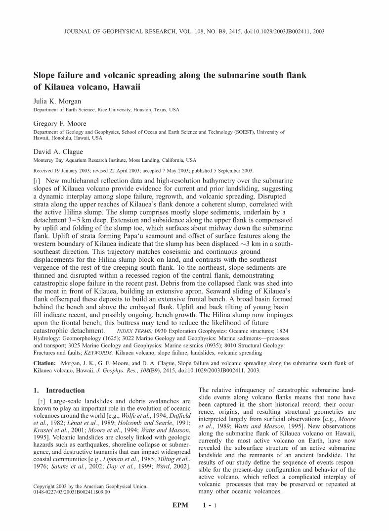
Figure 1. (opposite) (a) Shaded slope map of the south flank of Kilauea volcano on the island of Hawaii (white linedenotes the shoreline; depth contoured at 1000 m). The 8�–12� slope is blanketed by fragmental basalts, which give way tothe east to rougher terrain indicative of submarine erupted lavas. The southwest edge of Kilauea’s mobile flank is boundedby an offshore lineament defined by ridges and scarps, including Papa‘u seamount (PS) and Nali‘ikakani Ridge (NR); boxdenotes area of detail in Figure 2. The upper flank is marked by two embayments (dark hachures): Halape Bay (HB)shoreline reentrant, between Nali‘ikakani Point (NP) and Apua Point (AP), and a central flank embayment above amidslope basin. A broad outer bench extends across the width of the mobile flank and fronts the midslope basin, which ispartly filled with volcaniclastic sediment. The steep outer slope of the bench is incised by several arcuate scarps (whitehachures) with talus piles and debris flows at their bases. Discrete blocks, hummocky morphology, and relative shallowingof the seafloor, indicated by deflections of the 5000 and 5250 m (dotted) contours, suggest a local avalanche deposit in frontof the flank. Seismic reflection lines presented here are indicated by heavy lines with shot point annotations and nearbyseismic lines are indicated by lighter lines. Bathymetry is gridded at 100 m from Smith et al. [1994]. (b) Map of south flankdomains discussed in text. The term ‘‘Hilina slump’’ has commonly been applied to the entire deformed submarine flank ofKilauea, fronted by the outer bench and outlined in bold. We distinguish the active Hilina slump as the coherent portionof the flank showing evidence for downslope displacement, coincident with the western flank shown here by pattern ofvertical lines. The central embayment is white and midslope basin is speckled. GPS ground displacement vectors resolvedfor time interval 1990–1996 [Owen et al., 2000] are superimposed.
EPM 1 - 2 MORGAN ET AL.: SLOPE FAILURE AT KILAUEAVOLCANO
Tilling et al., 1976; Lipman et al., 1985]. Trilateration andsubsidence measurements following the Kalapana earth-quake indicated net downslope movement of the slumpblock, with up to 8 m seaward displacement and 3.5 msubsidence near Halape Bay [Lipman et al., 1985]. Themean displacement vector for the coseismic slump motion
was directed significantly more southward (�S25�–30�E)than time-averaged background displacement trends for therest of the south flank since 1896 [e.g., Swanson et al.,1976; Lipman et al., 1985; Denlinger and Okubo, 1995],suggesting that downslope motion of the Hilina slump issuperimposed upon steady flank motion.
MORGAN ET AL.: SLOPE FAILURE AT KILAUEAVOLCANO EPM 1 - 3
[8] Seaward flankdisplacements havebecomemoreclearlyresolved in recent years [e.g., Owen et al., 1995, 2000;Delaney et al., 1993, 1998]. For the time period 1990–1996,uninterrupted by large flank earthquakes, global positioningsystem (GPS) measurements indicate that the surface of thesouth flank has crept seaward at rates up to 10 cm/yr [Owenet al., 1995]. Even higher rates of seaward motion, rangingup to 40 cm/yr, were measured prior to 1983 and the onset ofthe ongoing rift eruptions [Delaney and Denlinger, 1999].Flank motion is in response to gravitational relaxation ofthe volcanic edifice, assisted by pressurized magma beneaththe summit and rift zones [e.g., Swanson et al., 1976;Dieterich, 1988; Iverson, 1995; Delaney and Denlinger,1999], generally termed volcanic spreading [e.g., Borgia,1994]. Seaward displacement is accommodated by slipalong a decollement horizon modeled near the base of thevolcano [e.g., Owen et al., 1995, 2000], probably facilitatedby sediments on the oceanic plate [e.g., Nakamura, 1980;Iverson, 1995] or viscous dunite beneath the edifice [Clagueand Denlinger, 1994].[9] The geometry and extent of the submarine Hilina
slump are poorly known; interpretations have relied largelyon offshore morphology and only sparse subsurface data[e.g., Moore and Chadwick, 1995; Smith et al., 1999]. Somehave assigned the entire south flank of Kilauea to the Hilinaslump (e.g., Figure 1b), interpreting the Hilina fault zone todip quite steeply, intersecting the subedifice decollement,and mobilizing a deep-seated landslide that encompassesthe flank [Lipman et al., 1985; Moore et al., 1989, 1994;Denlinger and Okubo, 1995]. This interpretation is sup-ported by tomographic evidence for a near-vertical region oflow seismic velocities beneath the fault zone [Okubo et al.,1997]. Within this framework, the laterally continuous outerbench (Figure 1) has been interpreted as a downdroppedslump block [e.g., Lipman et al., 1985; Moore et al., 1989],or more recently, the result of internal shortening and upliftat the toe of the slump [e.g., Denlinger and Okubo, 1995;Smith et al., 1999; Lipman et al., 2002]. Alternatively, theHilina slump is a shallow feature, possibly confined to theslope sediments upon the upper flanks [e.g., Moore andFiske, 1969; Swanson et al., 1976; Hill and Zucca, 1987].[10] The western edge of the Hilina slump coincides with
the southwest boundary of Kilauea’s creeping south flank,marked by a prominent set of southeast trending ridges andscarps that extend downslope from Nali’ikakani Point(Figure 1). Relative uplift along the northeast side of thistrend reflects right lateral strike-slip motion accommodatingseaward displacement of the northeastern block, equatedhere with the mobile south flank of Kilauea [Moore andChadwick, 1995; Denlinger and Okubo, 1995]. The morestable flank to the southwest is influenced primarily by theunderlying, less active, Mauna Loa volcano. Papa‘u sea-mount is a prominent high along the western boundary ofKilauea’s flank and rises up to 1000 m above the surround-ing seafloor (Figure 1). Several interpretations have beenproposed for Papa‘u: (1) a volcanic construction uponKilauea’s flank [Emery, 1955; Macdonald and Abbott,1970; Smith, 1996], (2) a large sandy debris lobe derivedfrom the collapse of the upslope shoreline [Moore and Peck,1965; Moore and Fiske, 1969; Fornari et al., 1979], or (3) acompressional structure due to convergence between theHilina slump and Mauna Loa’s flank [Moore and Chadwick,
1995]. Other features along the boundary, such as thenarrow, nearshore ridge referred to as Nali’ikakani Ridge,and the small, asymmetric ridge just west of Papa‘u sea-mount, West Ridge (Figure 1), likely also relate to faultingalong the boundary.[11] The northeastern boundary of the Hilina slump is not
apparent from the submarine bathymetry (Figure 1). Down-slope of the subaerial edifice, the slopes are draped by ablanket of fragmental basalts and hyaloclastic debris formedby seawater quenching of shoreline crossing lava flows[Moore et al., 1973; Clague et al., 1994; Moore andChadwick, 1995]. This sediment cover thins to the northeastand gives way to the rougher morphology of submarinebasalts over the Puna Ridge, without a distinct change ingrade.[12] The south flank is also characterized by several
embayments. Halape Bay defines a coastal reentrant belowthe high cliffs of Pu’u Kapukapu, floored by a shallow shelf(Figure 1). A broad recess marks the central portion of theupper submarine flank, downslope of the ERZ. Theembayed flank grades downslope into a broad midslopebasin trapped behind the outer bench (Figure 1). Slopeangles over the embayed central flank are 11�–12�, mea-surably steeper than those to the northeast (�9�) and thesouthwest (�6�–8�).
3. SIMRAD EM300 Bathymetry OverPapa‘u Seamount and Adjacent Seafloor
[13] New high-resolution bathymetry, collected using a30 kHz multibeam SIMRAD EM300 sonar system, hullmounted on the M/V Ocean Alert [MBARI Mapping Team,2001], yields unprecedented images of the western bound-ary of Kilauea and Papa‘u seamount. With vertical andhorizontal resolution of approximately 2.0 and 0.2% ofwater depth, respectively, the bathymetric data reveal finesurface details, including shallow slump faults, erosionalgullies, and linear terraces that cut the southwestern slopesof Papa‘u seamount (Figure 2). Several low-relief, arcuateridges lie along the seaward base of the seamount. Thesemorphologic features are characteristic of deformation ofpoorly consolidated slope sediments and unlike volcanicmorphologies observed elsewhere around the island (e.g.,Loihi seamount; Figure 1). This evidence argues stronglyagainst a constructional volcanic origin for Papa‘u.[14] The new bathymetric data also help to pinpoint the
location and attitude of the western boundary fault thataccommodates seaward displacement of Kilauea’s flank.The trace of the fault lies within the narrow valley separat-ing Papa‘u seamount and the smaller West Ridge, andcontinues upslope along a bathymetric step down to thesouthwest (Figure 2). On the regional bathymetry, the faulttrace follows the east side of Nali’ikakani Ridge (Figure 1).The asymmetric West Ridge just west of Papa‘u has a planareastern slope with the same attitude (11�–13� to thenortheast) as Papa‘u’s northeastern slope (Figure 2). Sharptruncation of this surface along the ridgeline of West Ridgesuggests relatively recent exposure. We interpret this surfaceto be the fault plane of the east dipping boundary fault thatdips beneath Papa‘u seamount (Figure 2).[15] Evidence for right-lateral strike-slip displacement
along the western boundary fault is provided by apparent
EPM 1 - 4 MORGAN ET AL.: SLOPE FAILURE AT KILAUEAVOLCANO
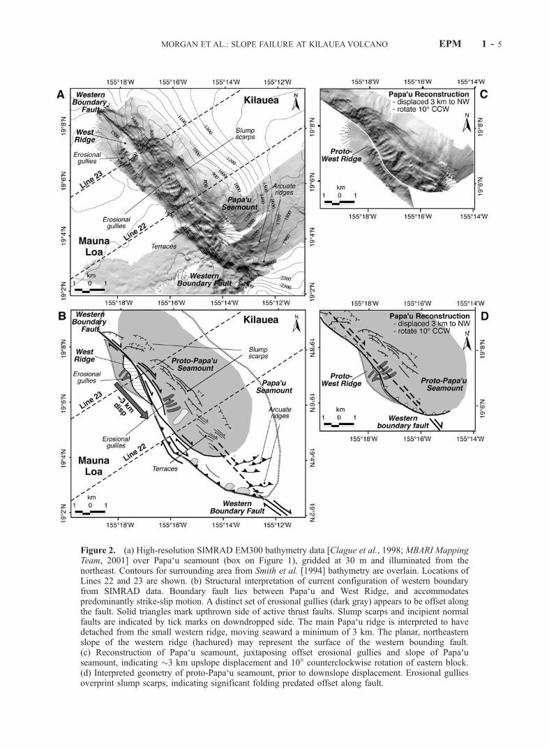
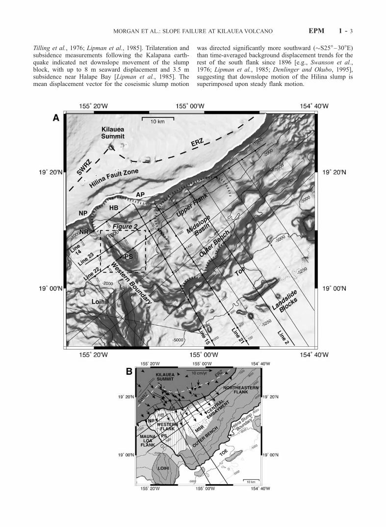
Figure 2. (a) High-resolution SIMRAD EM300 bathymetry data [Clague et al., 1998; MBARI MappingTeam, 2001] over Papa‘u seamount (box on Figure 1), gridded at 30 m and illuminated from thenortheast. Contours for surrounding area from Smith et al. [1994] bathymetry are overlain. Locations ofLines 22 and 23 are shown. (b) Structural interpretation of current configuration of western boundaryfrom SIMRAD data. Boundary fault lies between Papa‘u and West Ridge, and accommodatespredominantly strike-slip motion. A distinct set of erosional gullies (dark gray) appears to be offset alongthe fault. Solid triangles mark upthrown side of active thrust faults. Slump scarps and incipient normalfaults are indicated by tick marks on downdropped side. The main Papa‘u ridge is interpreted to havedetached from the small western ridge, moving seaward a minimum of 3 km. The planar, northeasternslope of the western ridge (hachured) may represent the surface of the western bounding fault.(c) Reconstruction of Papa‘u seamount, juxtaposing offset erosional gullies and slope of Papa‘useamount, indicating �3 km upslope displacement and 10� counterclockwise rotation of eastern block.(d) Interpreted geometry of proto-Papa‘u seamount, prior to downslope displacement. Erosional gulliesoverprint slump scarps, indicating significant folding predated offset along fault.
MORGAN ET AL.: SLOPE FAILURE AT KILAUEAVOLCANO EPM 1 - 5
offset of deep erosional scours along the nearby slopes. Fourparallel gullies crosscut the faulted southwest slope ofPapa‘u and are abruptly truncated at their downslope edges(Figure 2). A larger gully obliquely crosscuts the set ofsmaller incisions. The southwest slope of West Ridge alsoshows similar erosional gullies that are truncated at theridgeline. These two sets of erosional scours on either sideof the western boundary fault can be juxtaposed with a verygood fit by displacing Papa‘u seamount upslope 3 km, with a10� counterclockwise rotation; the resulting surface slopesalso match quite well (Figure 2). The offset gullies appear tohave crosscut preexisting slump faults along Papa‘u’s south-west flank, indicating relatively recent fault-parallel dis-placement following early uplift of the seamount. Wepropose that proto-Papa‘u seamount was originally a smallerstructure than the present ridge, and grew through continuedsoutheast displacement and oblique slip (Figure 2).[16] The new SIMRAD data support the interpretation
that Papa‘u seamount and adjacent seafloor structures resultfrom deformation of Kilauea’s submarine flank along thewestern boundary fault. The preservation of offset morpho-logic features suggests that fault-parallel displacement alongthe fault is recent, and most likely, ongoing. From these dataalone, it is not clear if the western boundary deformation isdue to slumping or seaward displacement of the mobileflank. The seismic reflection data allow us to extend thesefindings into the deformed submarine flank to determine thesubsurface structure of this region.
4. Seismic Reflection Data
[17] We collected 29MCS reflection lines on board theR/VMaurice Ewing over the south flank of the island of Hawaii(Figure 1), forming a three-dimensional network of crosssections intersecting the deep structure of the submarine flankof Kilauea volcano and adjacent seafloor. Several previouspapers describe observations across the distal regions of thesubmarine flank and Hawaiian Moat [Morgan et al., 2000;Hills et al., 2002;Leslie et al., 2002].Herewe focus on severalseismic reflection profiles that cross the upper flanks andsouthwestern margin of Kilauea’s mobile flank, to delineatethe geometry and evolution of the Hilina slump.
4.1. Data Acquisition and Processing
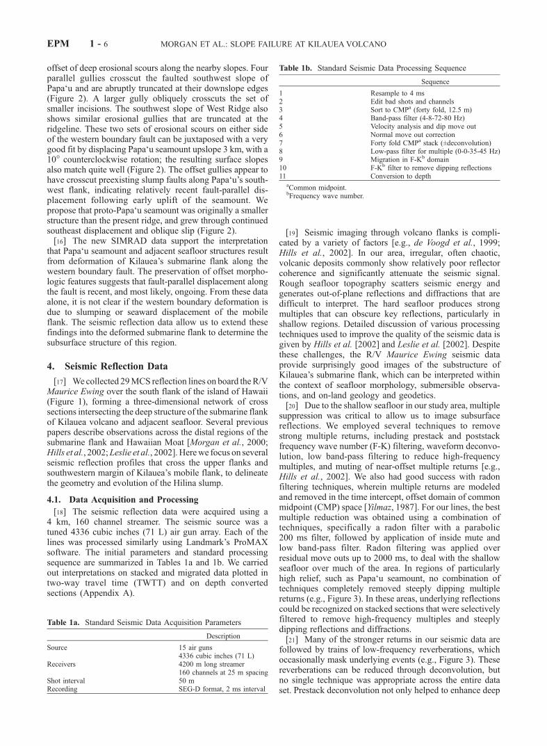
[18] The seismic reflection data were acquired using a4 km, 160 channel streamer. The seismic source was atuned 4336 cubic inches (71 L) air gun array. Each of thelines was processed similarly using Landmark’s ProMAXsoftware. The initial parameters and standard processingsequence are summarized in Tables 1a and 1b. We carriedout interpretations on stacked and migrated data plotted intwo-way travel time (TWTT) and on depth convertedsections (Appendix A).
[19] Seismic imaging through volcano flanks is compli-cated by a variety of factors [e.g., de Voogd et al., 1999;Hills et al., 2002]. In our area, irregular, often chaotic,volcanic deposits commonly show relatively poor reflectorcoherence and significantly attenuate the seismic signal.Rough seafloor topography scatters seismic energy andgenerates out-of-plane reflections and diffractions that aredifficult to interpret. The hard seafloor produces strongmultiples that can obscure key reflections, particularly inshallow regions. Detailed discussion of various processingtechniques used to improve the quality of the seismic data isgiven by Hills et al. [2002] and Leslie et al. [2002]. Despitethese challenges, the R/V Maurice Ewing seismic dataprovide surprisingly good images of the substructure ofKilauea’s submarine flank, which can be interpreted withinthe context of seafloor morphology, submersible observa-tions, and on-land geology and geodetics.[20] Due to the shallow seafloor in our study area, multiple
suppression was critical to allow us to image subsurfacereflections. We employed several techniques to removestrong multiple returns, including prestack and poststackfrequency wave number (F-K) filtering, waveform deconvo-lution, low band-pass filtering to reduce high-frequencymultiples, and muting of near-offset multiple returns [e.g.,Hills et al., 2002]. We also had good success with radonfiltering techniques, wherein multiple returns are modeledand removed in the time intercept, offset domain of commonmidpoint (CMP) space [Yilmaz, 1987]. For our lines, the bestmultiple reduction was obtained using a combination oftechniques, specifically a radon filter with a parabolic200 ms filter, followed by application of inside mute andlow band-pass filter. Radon filtering was applied overresidual move outs up to 2000 ms, to deal with the shallowseafloor over much of the area. In regions of particularlyhigh relief, such as Papa‘u seamount, no combination oftechniques completely removed steeply dipping multiplereturns (e.g., Figure 3). In these areas, underlying reflectionscould be recognized on stacked sections that were selectivelyfiltered to remove high-frequency multiples and steeplydipping reflections and diffractions.[21] Many of the stronger returns in our seismic data are
followed by trains of low-frequency reverberations, whichoccasionally mask underlying events (e.g., Figure 3). Thesereverberations can be reduced through deconvolution, butno single technique was appropriate across the entire dataset. Prestack deconvolution not only helped to enhance deep
Table 1b. Standard Seismic Data Processing Sequence
Sequence
1 Resample to 4 ms2 Edit bad shots and channels3 Sort to CMPa (forty fold, 12.5 m)4 Band-pass filter (4-8-72-80 Hz)5 Velocity analysis and dip move out6 Normal move out correction7 Forty fold CMPa stack (±deconvolution)8 Low-pass filter for multiple (0-0-35-45 Hz)9 Migration in F-Kb domain10 F-Kb filter to remove dipping reflections11 Conversion to depth
aCommon midpoint.bFrequency wave number.
Table 1a. Standard Seismic Data Acquisition Parameters
Description
Source 15 air guns4336 cubic inches (71 L)
Receivers 4200 m long streamer160 channels at 25 m spacing
Shot interval 50 mRecording SEG-D format, 2 ms interval
EPM 1 - 6 MORGAN ET AL.: SLOPE FAILURE AT KILAUEAVOLCANO
reflections, but also introduced strong reverberations at theseafloor that obscured important sedimentary features. Togain the most from the data set, we display multipleprocessed versions of the seismic data below. Poststackdeconvolution improved the resolution of deeper reflections,but severely attenuated reflection amplitudes and degradedshallow arrivals; this technique was therefore used only toconfirm reflection interpretations, and corresponding pro-files are not shown here.
4.2. Results and Interpretation
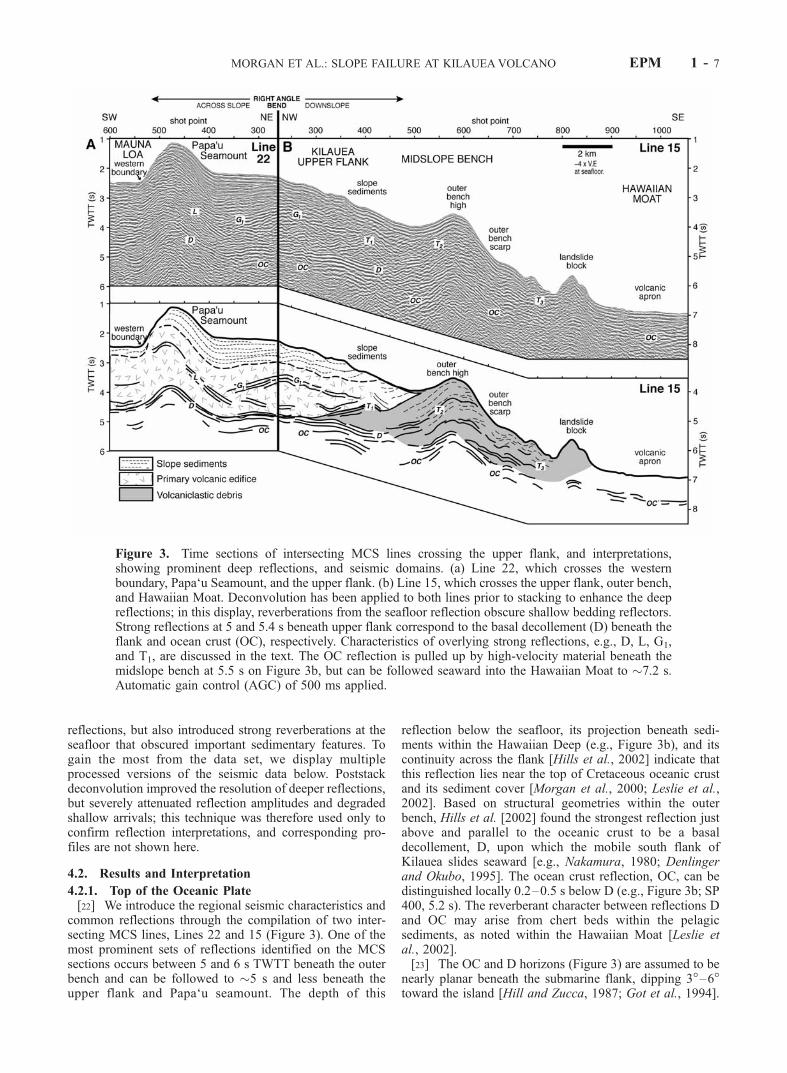
4.2.1. Top of the Oceanic Plate[22] We introduce the regional seismic characteristics and
common reflections through the compilation of two inter-secting MCS lines, Lines 22 and 15 (Figure 3). One of themost prominent sets of reflections identified on the MCSsections occurs between 5 and 6 s TWTT beneath the outerbench and can be followed to �5 s and less beneath theupper flank and Papa‘u seamount. The depth of this
reflection below the seafloor, its projection beneath sedi-ments within the Hawaiian Deep (e.g., Figure 3b), and itscontinuity across the flank [Hills et al., 2002] indicate thatthis reflection lies near the top of Cretaceous oceanic crustand its sediment cover [Morgan et al., 2000; Leslie et al.,2002]. Based on structural geometries within the outerbench, Hills et al. [2002] found the strongest reflection justabove and parallel to the oceanic crust to be a basaldecollement, D, upon which the mobile south flank ofKilauea slides seaward [e.g., Nakamura, 1980; Denlingerand Okubo, 1995]. The ocean crust reflection, OC, can bedistinguished locally 0.2–0.5 s below D (e.g., Figure 3b; SP400, 5.2 s). The reverberant character between reflections Dand OC may arise from chert beds within the pelagicsediments, as noted within the Hawaiian Moat [Leslie etal., 2002].[23] The OC and D horizons (Figure 3) are assumed to be
nearly planar beneath the submarine flank, dipping 3�–6�toward the island [Hill and Zucca, 1987; Got et al., 1994].
Figure 3. Time sections of intersecting MCS lines crossing the upper flank, and interpretations,showing prominent deep reflections, and seismic domains. (a) Line 22, which crosses the westernboundary, Papa‘u Seamount, and the upper flank. (b) Line 15, which crosses the upper flank, outer bench,and Hawaiian Moat. Deconvolution has been applied to both lines prior to stacking to enhance the deepreflections; in this display, reverberations from the seafloor reflection obscure shallow bedding reflectors.Strong reflections at 5 and 5.4 s beneath upper flank correspond to the basal decollement (D) beneath theflank and ocean crust (OC), respectively. Characteristics of overlying strong reflections, e.g., D, L, G1,and T1, are discussed in the text. The OC reflection is pulled up by high-velocity material beneath themidslope bench at 5.5 s on Figure 3b, but can be followed seaward into the Hawaiian Moat to �7.2 s.Automatic gain control (AGC) of 500 ms applied.
MORGAN ET AL.: SLOPE FAILURE AT KILAUEAVOLCANO EPM 1 - 7
On time sections, however, these planar reflections arehighly distorted due to velocity pull-up beneath topographichighs such as the outer bench and Papa‘u seamount(Figure 3). The apparent distortion of the OC and Dreflections on time sections provides a measure of seismicvelocity variations within the volcanic flank, allowing usto convert time sections to depth to interpret structuralrelationships. The method used for depth conversion isdescribed in Appendix A.4.2.2. Seismic Stratigraphy[24] The seismic characteristics of the MCS sections
across the study region help to resolve three compositionaldomains (Figure 3): a region of high-frequency, slope-parallel reflections extending up to 1 s below the seafloor,presumed to consist of fragmental subaerially erupted lavasforming a thin blanket of bedded slope sediments; a deeper,less reflective zone above the strong D and OC reflections,characterized by discrete low-frequency and reverberantreflections, defining the primary volcanic edifice composedof submarine erupted pillow basalts; and a frontal domaincorresponding to the midslope bench and basin (e.g.,Line 15, SP 500–900), composed largely of volcaniclasticdebris [e.g., Morgan et al., 2000; Lipman et al., 2002].[25] Several prominent reflections in addition to D and
OC are found across the study area; these are classified andlabeled in Figure 3 according to their positions within theflank, geometries, and associations with other reflections.An east dipping reflection, L, rises from the D beneathPapa‘u seamount (Line 22, SP 350–500), and is distortedby velocity pull-up beneath the bathymetric high. L is foundon all of the western boundary lines and is interpreted tomark the projection of this boundary to depth. A distinct setof middepth reflections, labeled G1, occurs between 1 and2 s below the seafloor on both Lines 22 and 15; the internalG1 reflections do not intersect either seafloor or decolle-ment, but tend to bound unconformable sequences oflayered strata, discussed in detail below. Line 15 displaysa series of landward dipping reflections that rise from Dbeneath the lower reaches of the upper flank and midslopebench (SP 400–800); these correspond to frontal thrustfaults that have been described previously [Morgan et al.,2000; Hills et al., 2002], and are labeled according to theirproximity to the island, i.e., T1, T2, and T3.4.2.3. Papa‘u Seamount and Upper Flank[26] Line 23 spans much of the upper flank (Figure 1) and
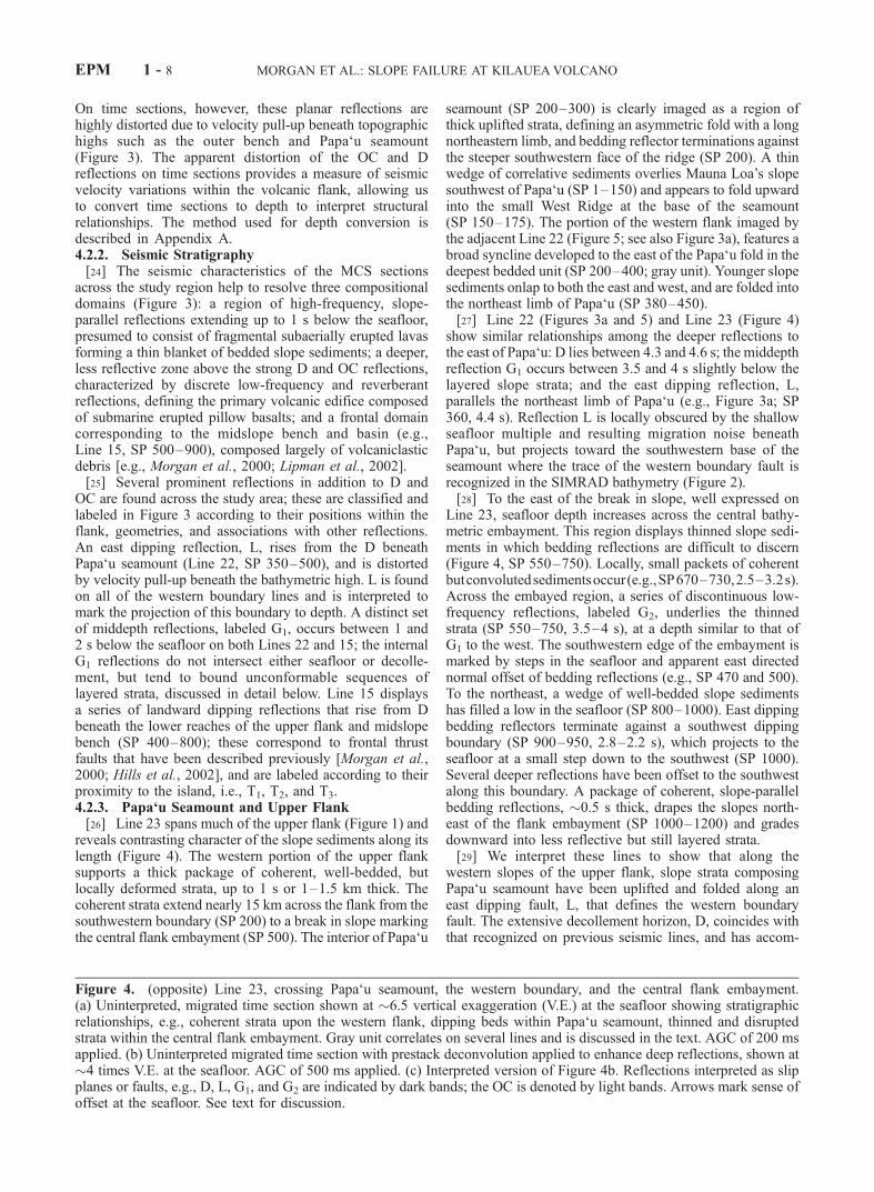
reveals contrasting character of the slope sediments along itslength (Figure 4). The western portion of the upper flanksupports a thick package of coherent, well-bedded, butlocally deformed strata, up to 1 s or 1–1.5 km thick. Thecoherent strata extend nearly 15 km across the flank from thesouthwestern boundary (SP 200) to a break in slope markingthe central flank embayment (SP 500). The interior of Papa‘u
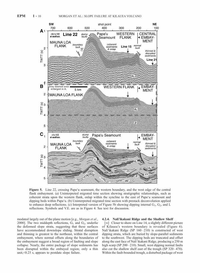
seamount (SP 200–300) is clearly imaged as a region ofthick uplifted strata, defining an asymmetric fold with a longnortheastern limb, and bedding reflector terminations againstthe steeper southwestern face of the ridge (SP 200). A thinwedge of correlative sediments overlies Mauna Loa’s slopesouthwest of Papa‘u (SP 1–150) and appears to fold upwardinto the small West Ridge at the base of the seamount(SP 150–175). The portion of the western flank imaged bythe adjacent Line 22 (Figure 5; see also Figure 3a), features abroad syncline developed to the east of the Papa‘u fold in thedeepest bedded unit (SP 200–400; gray unit). Younger slopesediments onlap to both the east and west, and are folded intothe northeast limb of Papa‘u (SP 380–450).[27] Line 22 (Figures 3a and 5) and Line 23 (Figure 4)
show similar relationships among the deeper reflections tothe east of Papa‘u: D lies between 4.3 and 4.6 s; the middepthreflection G1 occurs between 3.5 and 4 s slightly below thelayered slope strata; and the east dipping reflection, L,parallels the northeast limb of Papa‘u (e.g., Figure 3a; SP360, 4.4 s). Reflection L is locally obscured by the shallowseafloor multiple and resulting migration noise beneathPapa‘u, but projects toward the southwestern base of theseamount where the trace of the western boundary fault isrecognized in the SIMRAD bathymetry (Figure 2).[28] To the east of the break in slope, well expressed on
Line 23, seafloor depth increases across the central bathy-metric embayment. This region displays thinned slope sedi-ments in which bedding reflections are difficult to discern(Figure 4, SP 550–750). Locally, small packets of coherentbutconvolutedsedimentsoccur(e.g.,SP670–730,2.5–3.2s).Across the embayed region, a series of discontinuous low-frequency reflections, labeled G2, underlies the thinnedstrata (SP 550–750, 3.5–4 s), at a depth similar to that ofG1 to the west. The southwestern edge of the embayment ismarked by steps in the seafloor and apparent east directednormal offset of bedding reflections (e.g., SP 470 and 500).To the northeast, a wedge of well-bedded slope sedimentshas filled a low in the seafloor (SP 800–1000). East dippingbedding reflectors terminate against a southwest dippingboundary (SP 900–950, 2.8–2.2 s), which projects to theseafloor at a small step down to the southwest (SP 1000).Several deeper reflections have been offset to the southwestalong this boundary. A package of coherent, slope-parallelbedding reflections, �0.5 s thick, drapes the slopes north-east of the flank embayment (SP 1000–1200) and gradesdownward into less reflective but still layered strata.[29] We interpret these lines to show that along the
western slopes of the upper flank, slope strata composingPapa‘u seamount have been uplifted and folded along aneast dipping fault, L, that defines the western boundaryfault. The extensive decollement horizon, D, coincides withthat recognized on previous seismic lines, and has accom-
Figure 4. (opposite) Line 23, crossing Papa‘u seamount, the western boundary, and the central flank embayment.(a) Uninterpreted, migrated time section shown at �6.5 vertical exaggeration (V.E.) at the seafloor showing stratigraphicrelationships, e.g., coherent strata upon the western flank, dipping beds within Papa‘u seamount, thinned and disruptedstrata within the central flank embayment. Gray unit correlates on several lines and is discussed in the text. AGC of 200 msapplied. (b) Uninterpreted migrated time section with prestack deconvolution applied to enhance deep reflections, shown at�4 times V.E. at the seafloor. AGC of 500 ms applied. (c) Interpreted version of Figure 4b. Reflections interpreted as slipplanes or faults, e.g., D, L, G1, and G2 are indicated by dark bands; the OC is denoted by light bands. Arrows mark sense ofoffset at the seafloor. See text for discussion.
EPM 1 - 8 MORGAN ET AL.: SLOPE FAILURE AT KILAUEAVOLCANO
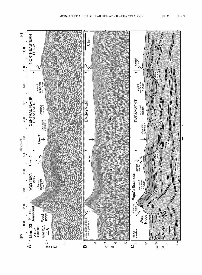
MORGAN ET AL.: SLOPE FAILURE AT KILAUEAVOLCANO EPM 1 - 9
modated largely out of the plane motion [e.g.,Morgan et al.,2000]. The two middepth reflections, G1 and G2, underliethe deformed slope strata, suggesting that these surfaceshave accommodated downslope sliding. Stratal disruptionand thinning is greatest to the northeast, within the centralembayment, where normal offsets along the boundaries ofthe embayment suggest a broad region of faulting and slopecollapse. Nearly, the entire package of slope sediments hasbeen disrupted within the embayed region; only a thinunit,<0.25 s, appears to postdate slope failure.
4.2.4. Nali’ikakani Ridge and the Shallow Shelf[30] Closer to shore on Line 14, a slightly different picture
of Kilauea’s western boundary is revealed (Figure 6).Nali’ikakani Ridge (SP 160–210) is constructed of westdipping strata, which are buried by slope-parallel sedimentsto the southwest. The dipping beds are truncated and offsetalong the east face of Nali’ikakani Ridge, producing a 250 mhigh scarp (SP 200–210). Small, west dipping normal faultsalso cut the shallow shelf east of the trough (SP 320–470).Within the fault-bounded trough, a disturbed package of west
Figure 5. Line 22, crossing Papa‘u seamount, the western boundary, and the west edge of the centralflank embayment. (a) Uninterpreted migrated time section showing stratigraphic relationships, such ascoherent strata upon the western flank, onlap within the syncline to the east of Papa‘u seamount anddipping beds within Papa‘u. (b) Uninterpreted migrated time section with prestack deconvolution appliedto enhance deep reflections. (c) Interpreted version of Figure 5b showing dipping internal G1, G2, and Lreflections. Symbols and V.E. are as in Figure 4. See text for discussion.
EPM 1 - 10 MORGAN ET AL.: SLOPE FAILURE AT KILAUEAVOLCANO
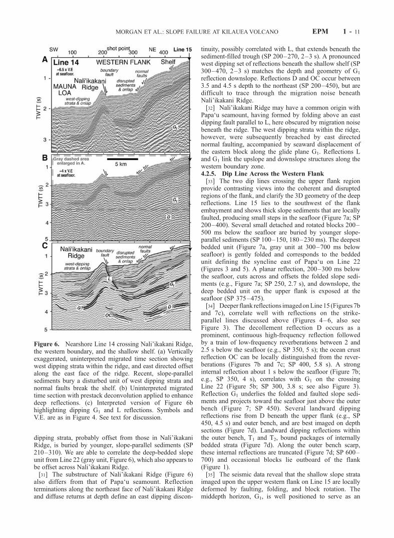
dipping strata, probably offset from those in Nali’ikakaniRidge, is buried by younger, slope-parallel sediments (SP210–310). We are able to correlate the deep-bedded slopeunit from Line 22 (gray unit, Figure 6), which also appears tobe offset across Nali’ikakani Ridge.[31] The substructure of Nali’ikakani Ridge (Figure 6)
also differs from that of Papa‘u seamount. Reflectionterminations along the northeast face of Nali’ikakani Ridgeand diffuse returns at depth define an east dipping discon-
tinuity, possibly correlated with L, that extends beneath thesediment-filled trough (SP 200–270, 2–3 s). A pronouncedwest dipping set of reflections beneath the shallow shelf (SP300–470, 2–3 s) matches the depth and geometry of G1
reflection downslope. Reflections D and OC occur between3.5 and 4.5 s depth to the northeast (SP 200–450), but aredifficult to trace through the migration noise beneathNali’ikakani Ridge.[32] Nali’ikakani Ridge may have a common origin with
Papa‘u seamount, having formed by folding above an eastdipping fault parallel to L, here obscured by migration noisebeneath the ridge. The west dipping strata within the ridge,however, were subsequently breached by east directednormal faulting, accompanied by seaward displacement ofthe eastern block along the glide plane G1. Reflections Land G1 link the upslope and downslope structures along thewestern boundary zone.4.2.5. Dip Line Across the Western Flank[33] The two dip lines crossing the upper flank region
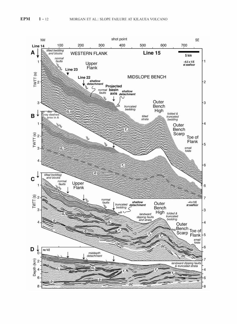
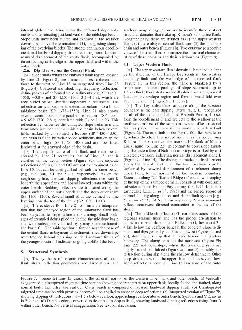
provide contrasting views into the coherent and disruptedregions of the flank, and clarify the 3D geometry of the deepreflections. Line 15 lies to the southwest of the flankembayment and shows thick slope sediments that are locallyfaulted, producing small steps in the seafloor (Figure 7a; SP200–400). Several small detached and rotated blocks 200–500 ms below the seafloor are buried by younger slope-parallel sediments (SP 100–150, 180–230 ms). The deepestbedded unit (Figure 7a, gray unit at 300–700 ms belowseafloor) is gently folded and corresponds to the beddedunit defining the syncline east of Papa‘u on Line 22(Figures 3 and 5). A planar reflection, 200–300 ms belowthe seafloor, cuts across and offsets the folded slope sedi-ments (e.g., Figure 7a; SP 250, 2.7 s), and downslope, thedeep bedded unit on the upper flank is exposed at theseafloor (SP 375–475).[34] Deeper flank reflections imagedonLine15 (Figures 7b
and 7c), correlate well with reflections on the strike-parallel lines discussed above (Figures 4–6, also seeFigure 3). The decollement reflection D occurs as aprominent, continuous high-frequency reflection followedby a train of low-frequency reverberations between 2 and2.5 s below the seafloor (e.g., SP 350, 5 s); the ocean crustreflection OC can be locally distinguished from the rever-berations (Figures 7b and 7c; SP 400, 5.8 s). A stronginternal reflection about 1 s below the seafloor (Figure 7b;e.g., SP 350, 4 s), correlates with G1 on the crossingLine 22 (Figure 5b; SP 300, 3.8 s; see also Figure 3).Reflection G1 underlies the folded and faulted slope sedi-ments and projects toward the seafloor just above the outerbench (Figure 7; SP 450). Several landward dippingreflections rise from D beneath the upper flank (e.g., SP450, 4.5 s) and outer bench, and are best imaged on depthsections (Figure 7d). Landward dipping reflections withinthe outer bench, T1 and T2, bound packages of internallybedded strata (Figure 7d). Along the outer bench scarp,these internal reflections are truncated (Figure 7d; SP 600–700) and occasional blocks lie outboard of the flank(Figure 1).[35] The seismic data reveal that the shallow slope strata
imaged upon the upper western flank on Line 15 are locallydeformed by faulting, folding, and block rotation. Themiddepth horizon, G1, is well positioned to serve as an
Figure 6. Nearshore Line 14 crossing Nali’ikakani Ridge,the western boundary, and the shallow shelf. (a) Verticallyexaggerated, uninterpreted migrated time section showingwest dipping strata within the ridge, and east directed offsetalong the east face of the ridge. Recent, slope-parallelsediments bury a disturbed unit of west dipping strata andnormal faults break the shelf. (b) Uninterpreted migratedtime section with prestack deconvolution applied to enhancedeep reflections. (c) Interpreted version of Figure 6bhighlighting dipping G1 and L reflections. Symbols andV.E. are as in Figure 4. See text for discussion.
MORGAN ET AL.: SLOPE FAILURE AT KILAUEAVOLCANO EPM 1 - 11
EPM 1 - 12 MORGAN ET AL.: SLOPE FAILURE AT KILAUEAVOLCANO
internal glide plane, lying below the deformed slope sedi-ments and terminating just landward of the midslope bench.Slope units have been faulted and exposed at the seafloordownslope, above the termination of G1, suggesting slump-ing of the overlying blocks. The strong, continuous decolle-ment, and landward dipping structures rising from D, recordseaward displacement of the south flank, accompanied bythrust faulting at the edge of the upper flank and within theouter bench.4.2.6. Dip Line Across the Central Flank[36] Slope strata within the embayed flank region, crossed
by Line 21 (Figure 8), are thinner and less coherent thanthose to the west on Line 15, as suggested from Line 23(Figure 4). Contorted and tilted, high-frequency reflectionsdefine packets of deformed slope sediments (e.g., SP 1460–1530, �3.8 s and SP 1550–1600, 3.5–4.0 s), which arenow buried by well-bedded slope-parallel sediments. Thereflective surficial sediments extend unbroken into a broadmidslope basin (SP 1375–1550). Line 21 also showsseveral continuous slope-parallel reflections (SP 1550,4.5 s-SP 1720, 2.8 s), correlated with G2 on Line 23. Thisreflection set underlies the disrupted slope sediments andterminates just behind the midslope basin below severalfolds marked by convoluted reflections (SP 1450–1550).The basin is filled by well-bedded sediments that onlap theouter bench high (SP 1375–1400) and are now tiltedlandward at the seaward edge of the basin.[37] The deep structure of the flank and outer bench
crossed by Line 21 resembles that of Line 15, and isclarified on the depth section (Figure 8d). The separatereflections defining D and OC are not as prominent as onLine 15, but can be distinguished beneath the outer bench(e.g., SP 1300, 5.1 and 5.7 s, respectively). As on theneighboring line, landward dipping reflections rise from Dbeneath the upper flank and bound layered strata within theouter bench. Bedding reflectors are truncated along theupper surface of the outer bench and the steep outer scarp(SP 1100–1200). Several small folds are defined by finelayering near the toe of the flank (SP 1050–1100).[38] The evidence from Line 21 confirms the interpreta-
tion that the embayed region of the submarine flank hasbeen subjected to slope failure and slumping. Small pack-ages of crumpled debris piled up behind the midslope basinand were subsequently buried by young slope sedimentsand basin fill. The midslope basin formed near the base ofthe central flank embayment as sediments shed downslopewere trapped behind the rising bench. Landward tilting ofthe youngest basin fill indicates ongoing uplift of the bench.
5. Structural Synthesis
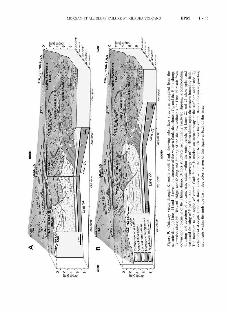
[39] The synthesis of seismic characteristics of southflank strata, reflection geometries and associations, and
seafloor morphology, allow us to identify three distinctstructural domains that make up Kilauea’s submarine flank.Geographically, these are defined as (1) the upper westernflank, (2) the embayed central flank, and (3) the midslopebasin and outer bench (Figure 1b). Two cutaway perspectiveviews of the south flank summarize the structural character-istics of these domains and their relationships (Figure 9).
5.1. Upper Western Flank
[40] The upper western flank domain is bounded upslopeby the shoreline of the Halape Bay reentrant, the westernboundary fault, and the west edge of the recessed flank(Figure 1). In this region, the flank is blanketed by acontinuous, coherent package of slope sediments up to1.5 km thick; these strata are locally deformed along normalfaults in the upslope region and form a broad fold overPapa‘u seamount (Figure 9b; Line 22).[41] The key subsurface structure along the western
boundary is the east dipping lateral fault, L, recognizedon all of the slope-parallel lines. Beneath Papa‘u, L risesfrom the decollement D and projects to the seafloor at thesouthwestern base of the seamount, where offset erosionalfeatures pinpoint the trace of the western boundary fault(Figure 2). The east limb of the Papa‘u fold lies parallel toL, which therefore has served as a thrust ramp carryingKilauea slope strata over the more stable flank of MaunaLoa (Figure 9b; Line 22). In contrast to downslope thrust-ing, the eastern face of Nali’ikakani Ridge is marked by eastdirected extension, indicating normal displacement along L(Figure 9a; Line 14). The discrepant modes of displacementalong the lateral fault L in the two locations can beexplained by seaward displacement of a coherent slumpblock lying to the northeast of the western boundary.Extension along Nali’ikakani Ridge reflects downdroppingof the top of the slumped domain, consistent with coseismicsubsidence near Halape Bay during the 1975 Kalapanaearthquake [Lipman et al., 1985] and the longer record ofnormal faulting along the on-land Hilina fault system [e.g.,Swanson et al., 1976]. Thrusting along Papa‘u seamountreflects southwest directed contraction at the toe of theslump.[42] The middepth reflection G1 correlates across all the
regional seismic lines, and has the proper orientation todefine an internal detachment. Reflection G1 lies about 3–4 km below the seafloor beneath the coherent slope sedi-ments and dips generally south to southwest (Figures 9a and9b), defining a slump that thickens toward the westernboundary. The slump thins to the northeast (Figure 9b;Line 22) and downslope, where the overlying strata arehighly faulted and folded (Figure 9a; Line15), possibly dueto traction during slip along the shallow detachment. Otherdeep structures within the upper flank, such as several low-angle reflections noted on Line 15 landward of the outer
Figure 7. (opposite) Line 15, crossing the coherent portion of the western upper flank and outer bench. (a) Verticallyexaggerated, uninterpreted migrated time section showing coherent strata on upper flank, locally folded and faulted, alongnormal faults that offset the seafloor. Outer bench is composed of layered, landward dipping strata. (b) Uninterpretedmigrated time section with prestack deconvolution applied to enhance deep reflections. (c) Interpreted version of Figure 7b,showing dipping G1 reflections �1–1.5 s below seafloor, approaching seafloor above outer bench. Symbols and V.E. are asin Figure 4. (d) Depth section, converted as described in Appendix A, showing landward dipping reflections rising from Dwithin outer bench. No vertical exaggeration. See text for discussion.
MORGAN ET AL.: SLOPE FAILURE AT KILAUEAVOLCANO EPM 1 - 13
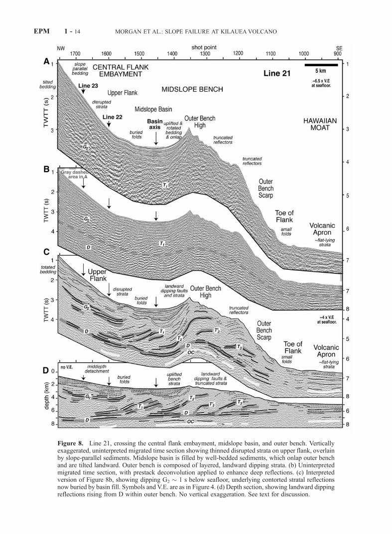
Figure 8. Line 21, crossing the central flank embayment, midslope basin, and outer bench. Verticallyexaggerated, uninterpreted migrated time section showing thinned disrupted strata on upper flank, overlainby slope-parallel sediments. Midslope basin is filled by well-bedded sediments, which onlap outer benchand are tilted landward. Outer bench is composed of layered, landward dipping strata. (b) Uninterpretedmigrated time section, with prestack deconvolution applied to enhance deep reflections. (c) Interpretedversion of Figure 8b, showing dipping G2 � 1 s below seafloor, underlying contorted stratal reflectionsnow buried by basin fill. Symbols and V.E. are as in Figure 4. (d) Depth section, showing landward dippingreflections rising from D within outer bench. No vertical exaggeration. See text for discussion.
EPM 1 - 14 MORGAN ET AL.: SLOPE FAILURE AT KILAUEAVOLCANO
Figure
9.
Cutaway
viewsthroughKilauea’s
south
flankshowingsubsurfacestructurescompiled
from
the
seismic
data.(a)Lines
14and15revealthestructure
ofthewestern
flank,detachmentG1,andtheHilinaslump.
ExtensionalongNali’ikakaniRidge,
andfoldingandfaultingoftheshallow
sedim
ents
onLine15resultfrom
downslopemovem
entoftheHilinaslump.Deeper
structuresareprimarilylandwarddipping,accommodating
thrustingandaccretionofvolcaniclastic
strata
within
theouterbench.(b)Lines
22and21show
uplift
and
westwardthrustingofPapa‘udueto
obliqueconvergence
oftheHilinaslumpuponthewestern
boundaryfault.
Thetransitionto
theregionofcentral
flankfailure
ismarked
anarcuatescarpat
theseafloor,andlistricG2
detachmentat
depth.Im
bricate
thrustsheetswithin
theouterbench
frontthecentral
flankem
bayment,ponding
sedim
entswithin
themidslopebasin.See
colorversionofthisfigure
atbackofthisissue.
MORGAN ET AL.: SLOPE FAILURE AT KILAUEAVOLCANO EPM 1 - 15
bench (Figure 9a; Line 15), appear to relate to deep-seatedthrusting at the toe of the flank [e.g., Morgan et al., 2000].
5.2. Central Flank
[43] The seismic characteristics of Kilauea’s embayedcentral flank domain contrast with those of the west. Littlecoherent bedding is observed, sediment cover is thinned,and the broad midslope basin lies near the base of the upperflank (Figures 1 and 8). Discrete packages of convolutedstrata denote significant internal disruption (Figures 8 and10a), in contrast to the more coherent upper flank strataalong the western flank (Figures 7 and 10b). Normal offsetfaults mark the southwest and northeast edges of theembayment (Figures 4 and 9b). The central flank embay-ment outlines a large sector of the upper flank that experi-enced complete detachment and catastrophic collapsesometime in the past. The shallowest sediments, showingcontinuous, nearly slope-parallel, bedding reflections, havefilled in the bathymetric low, burying the disturbed strataand smoothing the steepened slopes (e.g., Figure 8).[44] The principal detachment surface for the failed
central flank is interpreted to be the reflection set G2
(Figure 9b; intersection of Lines 21 and 22), which lies�1.5–2 km below the seafloor and dies out in the seawarddirection beneath buried, convoluted strata at the landwardedge of the midslope basin (Figure 8, SP 1450–1550). Thepresent depth below sea level of G2 nearly matches that ofthe G1 detachment over the western flank, cutting into theprimary volcanic edifice below the slope sediments (Figure10). Collapse of the central flank apparently involved bothshallow slope sediments and deeper primary pillow basalts.
Both the southwestern and northeastern edges of the centralflank embayment show listric geometries and the arcuateform of lateral breakaway faults that may connect to G2
(Figures 1 and 9). The upslope breakaway fault is notobvious on Line 21, but may now be buried by present-day shoreline deposits. The linkage between the submarinedetachment and on-land fault scarps is not observed on ourdata.
5.3. Midslope Basin and Outer Bench Domain
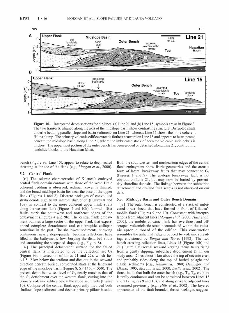
[45] The outer bench is constructed of a stack of imbri-cated thrust sheets that have formed in front of Kilauea’smobile flank (Figures 9 and 10). Consistent with interpre-tations from adjacent lines [Morgan et al., 2000; Hills et al.,2002], the mobile volcanic flank has overthrust and off-scraped volcaniclastic strata accumulated within the volca-nic apron outboard of the edifice. This constructionresembles the anticlinal ridge produced by volcanic spread-ing, envisioned by Borgia and Treves [1992]. The twobench crossing reflection lines, Lines 15 (Figure 10b) and21 (Figure 10a) reveal seaward verging thrust faults risingfrom a gently dipping, subedifice decollement D. In ourstudy area, D lies about 1 km above the top of oceanic crustand probably rides along the top of buried pelagic andclastic sediments [e.g., Nakamura, 1980; Denlinger andOkubo, 1995; Morgan et al., 2000; Leslie et al., 2002]. Thethrust faults that built the outer bench (e.g., T1, T2, etc.) arelaterally continuous and can be correlated between Lines 15and 21 (Figures 9 and 10), and along strike to adjacent linesexamined previously [e.g., Hills et al., 2002]. The layeredappearance of the fault-bounded thrust packages suggests
Figure 10. Interpreted depth sections for dip lines: (a) Line 21 and (b) Line 15; symbols are as in Figure 3.The two transects, aligned along the axis of the midslope basin show contrasting structure. Disrupted strataunderlie bedding parallel slope and basin sediments on Line 21, whereas Line 15 shows the more coherentHilina slump. The primary volcanic edifice extends farthest seaward on Line 15 and appears to be truncatedbeneath the midslope basin along Line 21, where the imbricated stack of accreted volcaniclastic debris isthickest. The uppermost portion of the outer bench has been eroded or detached along Line 21, contributinglandslide blocks to the Hawaiian Moat.
EPM 1 - 16 MORGAN ET AL.: SLOPE FAILURE AT KILAUEAVOLCANO
that the thrust sheets consist largely of volcaniclastic brec-cias and sandstones, which have been found in abundanceacross the outer bench scarp along Kilauea’s south flank[e.g., Lipman et al., 2002; Sisson et al., 2002]. Surfaceerosion and block detachment have incised the outer bench,shedding landslide blocks that are now found within theHawaiian Moat (Figure 1).[46] Despite the similar structure of the outer bench on
both Lines 21 and 15 (Figures 9a and 9b), the transitionfrom bench to upper flank is markedly different. Line 21crosses the midslope basin dammed by the outer bench(Figure 10a). Folding, onlap, and landward dips of sedi-ments within the basin (Figure 8; SP 1370–1430) indicatethat bench growth has continued as the basin filled [Hills etal., 2002]. The bench is narrower on Line 15 and supportsonly a small basin (SP 450–550). The broad basin to thenortheast is missing; in its place is found a structural highthat corresponds to the toe of the slump that breaks theupper flank (projected basin axis, Figure 10b). The primaryvolcanic edifice is interpreted to extend at least 2 km fartherseaward on Line 15 than on Line 21 (Figure 10) reflectingthe flank embayment behind the basin on the latter transect.
6. Discussion
[47] The data presented above reveal a complicatedsubsurface structure for Kilauea’s submarine south flank,resulting from multiple, interacting geologic processes:slumping and slope collapse, erosion and deposition, mag-matic intrusion, and volcanic spreading. For the first time,we are able to constrain the extent of submarine slumpingand slope failure on the active slope of the volcano andassess the interplay among the different processes acting onthe submarine flank.
6.1. Submarine Manifestation of the Hilina Slump
[48] The new seismic reflection and bathymetry data overKilauea’s south flank delineate the offshore boundaries ofthe Hilina slump and clarify the origin of Papa‘u seamountand adjacent morphological features. Our data demonstratethat Papa‘u defines a broad fold composed of coherent,layered slope strata, uplifted by southwest vergent thrustingalong the western boundary of Kilauea’s mobile south flank(Figures 4 and 5). Neither the sandy debris lobe model,arising from collapse and downslope flow of an unstablenearshore lava delta [Fornari et al., 1979; Moore andChadwick, 1995], nor the constructional volcanic interpre-tation [Emery, 1955; Macdonald and Abbott, 1970; Smith,1996] are borne out by our data. Seismic reflections withinthe deeper flank reveal an east dipping boundary fault Lupon which Papa‘u is built and a middepth detachment G1
that accommodated downslope movement of the Hilinaslump block (Figure 9). Net uplift of Papa‘u occurredconcurrently with nearshore extension and subsidence alongNali’ikakani Ridge, and normal faulting along the on-landHilina fault zone, consistent with slump block kinematics.[49] The structure of Nali’ikakani Ridge is puzzling given
the slump model posed above. The boundary ridge is cut byan east directed fault, reflecting subsidence and seawarddisplacement across the lateral boundary of the slump(Figure 9a). However, the ridge is composed of westdipping strata suggesting prior convergence. The shallow
sediments may have been folded during initial stages offlank displacement, concurrent with initial uplift of Papa‘useamount in the downslope regions. This is compatible withuplift and folding of Papa‘u prior to formation of theerosional gullies and offset by fault-parallel slip. Conver-gence between Kilauea and Mauna Loa may have resultedfrom generally south directed gravitational stresses alongthis portion of the flank, directed radially away fromKilauea’s summit. Rupture of the shallow flank and westernboundary fault enabled downslope slumping, accompaniedby continuing convergence, matching present-day groundmotions [e.g., Owen et al., 2000]. Alternatively, the westdipping strata in Nali’ikakani Ridge represent nearshorefragmental basalt deposits comparable to those accumulat-ing below the lava entry to the northeast (Figure 1). Thepresent-day shoreline now lies some 5 km north of theLine 14 crossing of the ridge; however, colinearity ofthe seaward edge of the shallow shelf in Halape Bay withthe shoreline to the northeast (Figure 1) suggests that theshelf is a submerged portion of the subaerial edifice, and theancient shoreline may once have extended to Nali’ikakaniRidge, since subsided below sea level.[50] Papa‘u fold apparently grew over a long period of
concurrent slope sedimentation. Onlap relationships amongthe bedded units composing the eastern limb of Papa‘u foldand the adjacent trough show that continuous deposition waspunctuated by intermittent slump displacement (Figure 5;SP 200–400). Uplift of Papa‘u seamount began after depo-sition of the deepest bedded unit (gray in Figures 4 and 5),which shows relatively uniform thickness across the flank.New geochemical data reveal that this package containsfragmental basalts with Mauna Loa geochemistry, whichmay predate Kilauea [Kimura et al., 2002]. Onset of upliftalong the western boundary trapped pillow basalts and debrisderived from Kilauea along the eastern slopes. As Papa‘ugrew, it incorporated the new strata into its expanding easternlimb, the adjacent trough subsided, and the overlyingdeposits onlapped the edges of the trough. Uplift of the ridgehas continued recently, as even the shallowest slopesediments have been tilted along the eastern flank of the fold(Figure 5; Line 22).
6.2. Geometry and Vergence of the Hilina Slump
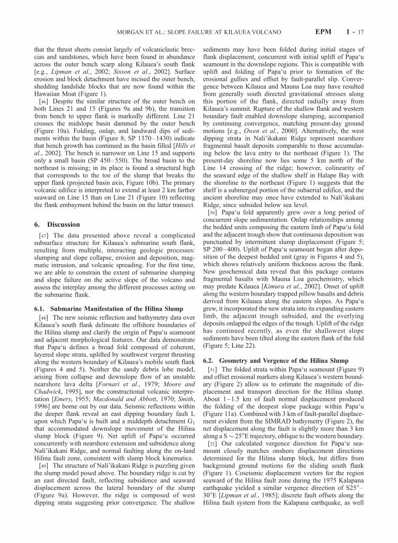
[51] The folded strata within Papa‘u seamount (Figure 9)and offset erosional markers along Kilauea’s western bound-ary (Figure 2) allow us to estimate the magnitude of dis-placement and transport direction for the Hilina slump.About 1–1.5 km of fault normal displacement producedthe folding of the deepest slope package within Papa‘u(Figure 11a). Combined with 3 km of fault-parallel displace-ment evident from the SIMRAD bathymetry (Figure 2), thenet displacement along the fault is slightly more than 3 kmalong a S� 25�E trajectory, oblique to the western boundary.[52] Our calculated vergence direction for Papa‘u sea-
mount closely matches onshore displacement directionsdetermined for the Hilina slump block, but differs frombackground ground motions for the sliding south flank(Figure 1). Coseismic displacement vectors for the regionseaward of the Hilina fault zone during the 1975 Kalapanaearthquake yielded a similar vergence direction of S25�–30�E [Lipman et al., 1985]; discrete fault offsets along theHilina fault system from the Kalapana earthquake, as well
MORGAN ET AL.: SLOPE FAILURE AT KILAUEAVOLCANO EPM 1 - 17
as prehistoric events, also indicate a general south-southeasttrend [Cannon and Burgmann, 2001; Cannon et al., 2001].By comparison, cumulative displacement vectors for thecreeping south flank measured since 1896 are directedgenerally southeast [e.g., Swanson et al., 1976; Lipman etal., 1985; Delaney et al., 1998] approximately normal to thecentral ERZ and the strike of the offshore outer bench [Hillset al., 2002]. Finally, despite little evidence for discretemovement of the Hilina slump since 1975, postseismic GPSmeasurements across the creeping south flank show agradual southward deflection of displacement direction,concurrent with a decrease in magnitude, in the vicinity ofthe Hilina block (Figure 1b): mean flank displacementstrend �S45�E below the central ERZ, about S30�E at ApuaPoint at the northeast edge of Halape Bay, and moresoutherly, S15�E at Nali’ikakani Point [e.g., Owen et al.,2000]. This divergence, modest in scale, may result fromintermittent aseismic slip along the Hilina detachment, asrecently captured following a major rainfall event on thesouth flank [Cervelli et al., 2002].[53] Similar vergence directions estimated for both off-
shore and onshore structures support our interpretation that
Papa‘u seamount is the submarine manifestation of theHilina slump, headed along the on-land Hilina fault zone.A balanced cross section constructed parallel to the calcu-lated transport direction (Figure 11b) shows feasible sub-surface fault geometries for the slump block, constrainedby seismic reflection data presented here. The detachmentG1 is interpreted to be the offshore extension of the Hilinafault zone; the listric geometry of the fault yields an on-land dip of �20�, shallowing to �5� at a depth of 3–4 kmin the offshore region before merging with the easternboundary fault (Figure 11b). This shallow, listric faultconfiguration coincides with other recent models for theHilina fault, based on coseismic fault slip vectors [Cannonand Burgmann, 2001], ground motions [Cannon et al.,2001; Cervelli et al., 2002], and tsunami data [Ma et al.,1999], as well as paleomagnetic constraints for net rota-tions of Hilina fault blocks [Riley et al., 1999]. The slumpblock is composed primarily of slope sediments, as orig-inally hypothesized by Swanson et al. [1976]. The under-lying detachment may take advantage of a distinctmechanical discontinuity near the base of the sediments.More steeply dipping faults, for example, greater than
Figure 11. Two structural cross sections across the upper western flank, oriented (a) perpendicular tothe western boundary fault (e.g., Line 22) and (b) parallel to the transport direction for the Hilinaslump; symbols are as in Figure 3. Ellipses mark depth constraints of reflectors from seismic sections.Insets show reconstructed configurations that can be compared with deformed configuration (dashed).Papa‘u records �1 km fault normal displacement. The slump has experienced about 3 km ofdownslope displacement, based on offset erosional markers from the high-resolution bathymetry (e.g.,Figure 2). The Hilina fault zone is correlated with G1 in this section, yielding a dip of �20�–25�. Seetext for discussion.
EPM 1 - 18 MORGAN ET AL.: SLOPE FAILURE AT KILAUEAVOLCANO
�60� interpreted by others [Lipman et al., 1985; Moore etal., 1989; Okubo et al., 1997] would not be imaged by ouroffshore reflection data and cannot be assessed here.
6.3. Collapse of the Central Flankand Growth of the Outer Bench
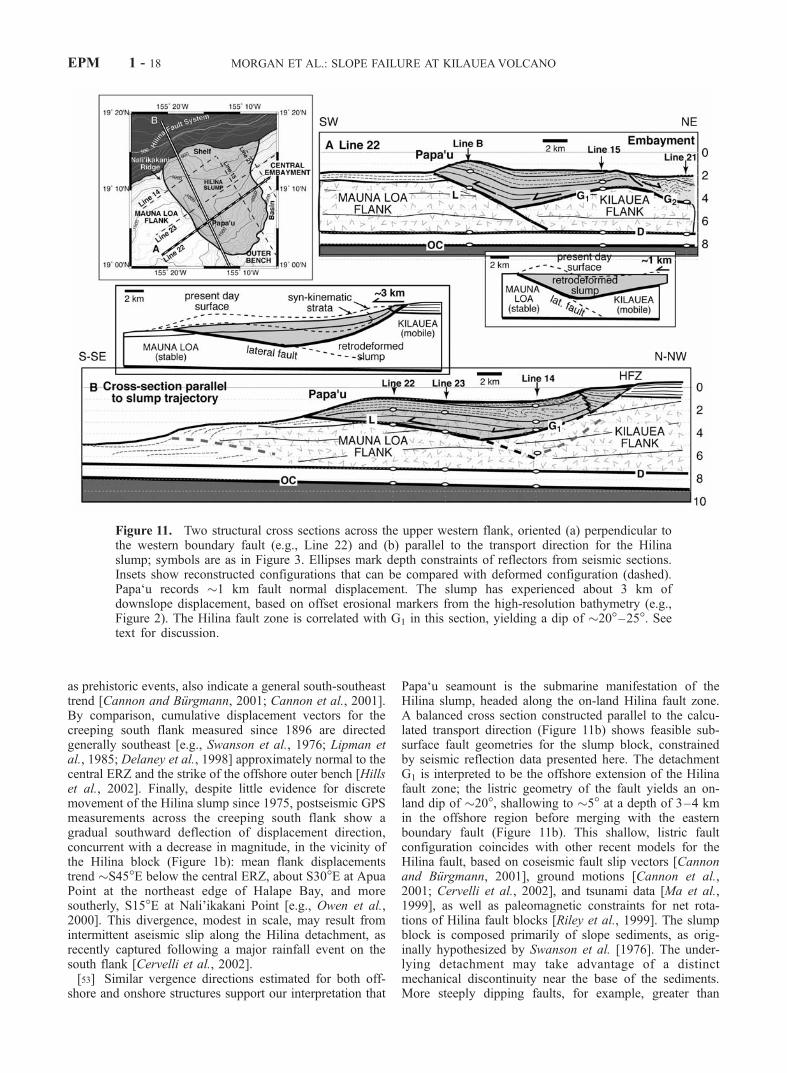
[54] Our MCS data across the upper flank of Kilaueademonstrate that the central portion of the south flank ofKilauea collapsed catastrophically in the recent past. Thedetachment cut through nearly the entire bedded section ofslope sediments, including units that record onset of slip anduplift along the western boundary on Line 23 (Figure 4).Only the youngest strata, which bury the deformed units andspill into the midslope basin and onto the outer bench onLine 21, are relatively undisturbed (Figures 8 and 10). Thisimplies that downslope motion of the slump and conver-gence along the western boundary predated collapse. Thesouth flank was apparently broken by a much larger proto-Hilina slump of which the central portion broke away.[55] Detachment of the central block cut through the
shallow slope sediments and into the primary volcanicedifice, and distributed a mixture of reworked slope unitsand underlying volcanic lithologies into the Hawaiian Moat,where they spread out to form a broad volcaniclastic apron(Figure 12a). The hummocky region outboard of the present
outer bench (Figure 1) has been interpreted as a remnant ofthe debris deposit [Moore et al., 1989; Smith et al., 1999],and thick accumulations of chaotic debris are recognizedacross the frontal moat [Leslie et al., 2002]. However, thelaterally continuous outer bench now fronts the collapsedflank effectively damming further dispersal of slope debris.Recent submersible dives along the outer slopes of thebench observed a rich variety of volcaniclastic lithologiesfrom coarse breccias containing a range of subaerial andsubmarine basalt clasts to well-sorted, subaerially derivedhyaloclastic sandstones and conglomerates [Lipman et al.,2002]. A surprising abundance of clasts have alkalic com-positions, suggesting that ancestral Kilauea was the sourceof the rocks [e.g., Lipman et al., 2002; Sisson et al., 2002].These are interspersed with sands derived from Mauna Loa[Lipman et al., 2002]. The outer bench is now the repositoryof landslide debris derived from the detachment and break-up of the upper flank, which cut through a thin veneer ofyoung Kilauea overlying the submarine edifice of MaunaLoa volcano (Figure 12a).[56] The midslope basin outlines the flank embayment
behind the outer bench, which can now be understood as theghost of the underlying landslide scar. The basin waspreserved because the adjoining, intact flanks drove thrustfaulting outboard of the scar (Figure 12b); only small folds
Figure 12. Schematic model for slope collapse and slumping along Kilauea’s mobile south flank. (a) Thecentral portion of the large proto-Hilina slump detaches catastrophically, depositing chaotic debris out inthe Hawaiian Moat. (b) Collapse of the central sector leads to a change in vergence of the slump, whichimpinges upon the western boundary fault, uplifting Papa‘u seamount. The landslide debris is offscrapedby seaward sliding of the south flank, accommodating extension and southward migration of the centralERZ. Young slope sediments fill in the embayment where the collapse occurred and collect in the midslopebasin dammed behind the outer bench. The midslope basin marks the position of the recessed toe of thecollapsed flank. Recent sediments derived from subaerial lava flows entering the ocean (white)progressively infill the recessed flank and basin, burying the record of past slope failures.
MORGAN ET AL.: SLOPE FAILURE AT KILAUEAVOLCANO EPM 1 - 19
and thrusts developed within the depression and weresubsequently buried by young basin fill, as shown onLine 21 (Figure 8; SP 1450–1550). Intermittently, slumpsand debris flows probably detached from the oversteepenedupper flank depositing thin packages of chaotic debriswithin the basin, particularly downslope of the present lavaentry [e.g., Hills et al., 2002]. Small ridges exposed at theseafloor (e.g., Figure 4; SP 775) may be remnants of suchlocal erosive events.[57] The exact cause of the central flank collapse is not
known, but we can speculate about possible triggers. Flankseismicity, for example, of the magnitude of the great 1868Ka’u (M � 8.0) or the 1975 Kalapana earthquakes (M7.2)would certainly shake the submarine flanks, dislodgingprecarious slope deposits, but such seismicity accompaniesflank sliding and must be ongoing, at least for an extensiveperiod of volcanic evolution. Catastrophic flank collapse ofthe scale observed here, and documented around the islands,is thought to occur relatively late in the evolution of thevolcano [e.g., Moore et al., 1989], and may coincide withunusually energetic volcanic eruptions, perhaps explosive innature [Clague and Dixon, 2000; McMurtry et al., 1999].Kilauea volcano has experienced at least two extraordinaryphreatomagmatic eruptions within the last 50,000 years,both associated with collapse of the summit caldera, andresponsible for massive ash deposits dated at 49 and 23–29 ka [Clague et al., 1995]. Such events are certain to breakthe static equilibrium of the edifice, enabling catastrophicsector collapse.[58] The breakup of the proto-Hilina slump and collapse
of the central flank would have significantly changed theconfiguration and stress state of the south flank, inducingirreversible changes in the behavior of the volcano [e.g.,Morgan and Clague, 2003]. Without an anchor to the east,the remnant Hilina slump to the west may have experienceda shift in vergence toward the south-southeast, convergingupon the western boundary of the flank. Removal ofmaterial from the central flank would have relieved confin-ing stresses acting on the central ERZ, enabling dikeintrusion, rift zone extension, and southward migration toform the distinctive bend in the upper ERZ (Figure 1)[Swanson et al., 1976; Delaney et al., 1998]. A concurrentdecrease in normal stress acting upon the base of thevolcano could also weaken the underlying decollementenabling rapid seaward displacement of the south flank,overthrusting the distal volcaniclastic debris. Discrete thrustsheets were offscraped and accreted to the toe of the slidingflank to form the frontal bench (Figure 12b) [Morgan et al.,2000]. As indicated by uplift and rotation of young strata atthe seaward edge of the midslope basin, the bench continuesto grow and is the submarine manifestation of on-landseaward creep documented geodetically [e.g., Swanson etal., 1976; Owen et al., 1995, 2000; Delaney et al., 1998].[59] The remarkable evidence that the bench is a recent
construction, postdating a flank failure that disrupted allbut the youngest slope units upon the upper flank, impliesrapid seaward sliding of the south flank. Although thetiming of flank collapse is unknown, we speculate that itmay have been triggered by explosive eruptions within25–50 ka [Clague et al., 1995]. Reconstructions of benchdeformation record a minimum of 15 km of displacement[e.g., Denlinger and Okubo, 1995; Lipman et al., 2002]
and possibly up to 24 km or more [Morgan et al., 2000].This amount of shortening implies time-averaged displace-ment rates of 30–60 cm/yr, much higher than present ratesmeasured on land [Owen et al., 1995]. Such high rates arefar from unreasonable for the distal flank, which is drivenby displacement of the deep volcanic edifice; elasticdislocation modeling of present-day surface displacementrates of �10 cm/yr implies slip rates along the basaldecollement on the order of 15–25 cm/yr [e.g., Delaneyet al., 1993; Owen et al., 1995, 2000]. Furthermore, muchhigher rates of flank migration have been measured in therecent past, e.g., up to 40 cm/yr of surface motion prior to1983, apparently modulated by internal magma pressuresand surface eruptions [Delaney and Denlinger, 1999].
6.4. Implications
[60] The Hilina slump, a remnant of the larger proto-Hilina slump, is now restricted to the western portion ofKilauea’s mobile south flank. It is still active, as evidencedby recent coseismic displacements [e.g., Lipman et al.,1985] and aseismic slip triggered by rainfall events [Cervelliet al., 2002]. The evidence for previous catastrophic col-lapse along the central region of Kilauea’s south flankcautions us about future detachment of the extant slumpblock. However, our results suggest that the remnant Hilinaslump may be comparatively stable due to its obliqueconvergence upon the western boundary of the mobile flankand therefore subject only to small intermittent displace-ments as recorded in the slope strata. Over time, slumpactivity may lessen even further as downslope motion isincreasingly buttressed by the growing outer bench. If this isthe case, dire predictions of the future breakaway of theHilina slump [e.g.,Ward, 2002] may be overstated, althoughthere are many external factors that may play a role in flankdeformation in this active volcanic setting.[61] The evidence for rapid bench growth along Kilauea’s
south flank, possibly triggered by precursory slope collapse,suggests that landslides can set off a chain of events thatgovern volcanic behavior and growth for a long period after,and from which it may never recover. At Kilauea volcano,the picture seems simple enough; collapse of the centralflank relieves confining stresses acting on both the ERZ andthe basal detachment, enabling south flank sliding. Initially,rapid rates of displacement decay with time, until eventu-ally, the broken flank is regenerated by intrusion, eruption,and slope deposition. Flank sliding ceases until a new cyclebegins. A surprising twist in this model, however, is theconstruction of a large frontal bench at the base of thesliding flank from volcaniclastic debris derived from previ-ous slope failures. As the bench grows it resists flank slidingand buttresses new slumps forming upon the upper flanks.In order to overcome the added resistance, each triggerevent must be bigger than the last, and only the largestvolcanoes are likely to experience more than one or twosuch events before they become inactive.[62] Finally, our observations suggest that the active
processes we recognize on Kilauea volcano today are theconsequence of changes in south flank configuration andstress state resulting from slope collapse, which we proposeoccurred relatively recently in the evolution of Kilauea.Therefore we are presently capturing a transient stage inKilauea’s growth that may be decaying, setting the stage for
EPM 1 - 20 MORGAN ET AL.: SLOPE FAILURE AT KILAUEAVOLCANO
a new phase, possibly of greater stability. The sequence thatwe recognize at Kilauea likely has been repeated on manyolder Hawaiian volcanoes, in particular, Mauna Loa, leav-ing telltale flank structures and landslide deposits [e.g.,Lipman et al., 1988; Moore et al., 1989; Lipman, 1995;Morgan and Clague, 2003]. However, this pattern may notbe representative of the long-term behavior of Hawaiianvolcanoes. With this recognition, we can better interpretpast events around the islands and throughout the world,and anticipate the consequences of repeated slope collapsealong active volcanic islands.
7. Conclusions
[63] New MCS reflection data and high-resolution ba-thymetry over the southeast submarine slopes of the islandof Hawaii demonstrate a history of past catastrophic land-sliding and present-day stable slumping along Kilauea’smobile south flank. A continuous blanket of slope sedi-ments up to 1.5 km thick has been uplifted and folded toform the prominent Papa‘u seamount along the westernboundary of the active flank. Upslope, sediments haveundergone extension and subsidence consistent with recentcoseismic ground motions of the nearby shoreline. Incombination, these structures define a coherent slump thatis creeping downslope, probably linked to the on-landHilina fault zone. Seismic reflection and high-resolutionSIMRAD bathymetric data constrain an east dipping faultalong the western boundary which accommodates largelyright-lateral slump displacement and a detachment plane�3–4 km below the seafloor allowing downslope motion.Total slump displacement is estimated at slightly more than3 km in the south-southeast direction, matching coseismicand continuous ground displacement vectors for the Hilinaslump block on land, and in contrast with the southeastvergence of the rest of the creeping south flank.[64] To the northeast, a broad, fault-bounded flank
embayment contains thinned and disrupted slope sedi-ments, indicating catastrophic slope failure of the centralflank in the recent past. Debris shed from the collapsedflank must have dispersed into the Hawaiian Moat in frontof Kilauea, forming an extensive volcanic apron. Seawardsliding of Kilauea’s south flank subsequently offscrapedthese deposits to build the frontal bench, recording up to24 km of displacement. A broad basin formed above thebase of the embayed flank and filled with fragmentaldebris shed from upslope. Uplift and rotation of the basinfill indicate recent, and possibly continuing, bench growth.[65] The sequence of deformational events along the
south flank of Kilauea suggests a dynamic interplay amongslope failure, flank regrowth, and volcanic spreading.Large-scale flank collapse may have triggered seawardsliding of the flank, causing sudden, irreversible changesin the state of stress acting on the rift zone and underlyingdecollement plane. Present-day flank motions and deforma-tion may represent a transient phase in Kilauea’s history,and displacement may cease once the flank regeneratesthrough volcanic growth. The large Hilina slump cuts thesurface of the mobile south flank, and has shown recentactivity. Catastrophic detachment of this landslide, however,is increasingly unlikely due to buttressing effects of thewestern boundary fault and the rising midslope bench.
Appendix A: Depth Conversion of MCS Data
[66] Geophysical constraints gained from refraction [e.g.,Hill and Zucca, 1987], flexure [Thurber, 1987], and seis-micity [Got et al., 1994] studies indicate that the top of theocean crust dips 3�–6� landward beneath the south flank ofKilauea and lies at a depth of about 8–9 km beneathKilauea’s summit. We developed velocity models for thevolcanic flank using published velocity ranges [Hill andZucca, 1987] in order to return the OC reflection to thisdipping planar geometry.[67] For our purposes, we iteratively construct three
velocity layers above the oceanic crust, which marks thebase of our region of interest. These correspond to (1) water,with constant velocity of 1500 m/s, (2) bedded sedimentswith seafloor velocities of �2200 m/s that increase linearlywith depth, and (3) primary volcanic strata, with velocities of3700 m/s near the top, increasing to about �5500–6000 m/sat the base, consistent with deep oceanic basalts [e.g.,Salisbury et al., 1996]. We have assumed a constant velocityof 6000 m/s for the oceanic plate. The true velocity structureof the submarine flank may differ from our idealizedthree-layer model, resulting in reflector mislocations up to200–300 m, however, our depth conversions yield reliablerelative positions and geometries of reflections for purposesof structural interpretation.
[68] Acknowledgments. We are especially grateful to the helpful andprofessional shipboard and technical crew of the R/V Maurice Ewing, whoensured the success of the Kilauea seismic cruise and the high quality of theMCS data. Denise Hills, Stephen Leslie, and Jackie Caplan-Auerbachassisted with seismic acquisition and processing. Thoughtful reviews byRoland Burgmann and Daniel Fornari were invaluable in preparing the finalmanuscript. Beatrice de Voogd and several anonymous reviewers providedhelpful critiques of earlier drafts of this paper. Stimulating conversationswith many other colleagues, among them Don Swanson, Jim Moore, andPeter Lipman, helped to clarify our geologic thinking. We acknowledgesupport of this project by Landmark Graphics Corporation via the Land-mark University Grant Program. This work was funded by National ScienceFoundation grant OCE-9711715.
ReferencesBorgia, A., Dynamic basis of volcanic spreading, J. Geophys. Res., 99,17,791–17,804, 1994.
Borgia, A., and B. Treves, Volcanic plates overriding the oceanic crust:Structure and dynamics of Hawaiian volcanoes, in Ophiolites and TheirModern Oceanic Analogues, edited by L. M. Parson, B. J. Murton, andP. Browning, Geol. Soc. Spec. Publ., 60, 277–299, 1992.
Cannon, E. C., and R. Burgmann, Prehistoric fault offsets of the Hilina faultsystem, south flank of Kilauea volcano, Hawaii, J. Geophys. Res., 106,4207–4219, 2001.
Cannon, E. C., R. Burgmann, and S. E. Owen, Shallow normal faulting andblock rotation associated with the 1975 Kalapana earthquake, Kilaueavolcano, Hawaii, Bull. Seismol. Soc. Am., 91, 1553–1562, 2001.
Cervelli, P., P. Segall, K. Johnson, M. Lisowski, and A. Miklius, Suddenaseismic fault slip on the south flank of Kilauea volcano, Nature, 415,1014–1018, 2002.
Clague, D. A., and R. P. Denlinger, Role of olivine cumulates in destabiliz-ing the flanks of Hawaiian volcanoes, Bull. Volcanol., 56, 425–434, 1994.
Clague, D. A., and J. E. Dixon, Extrinsic controls on the evolution ofHawaiian ocean island volcanoes, Geochem. Geophys. Geosyst., 1, Papernumber 1999GC000023, 2000.
Clague, D. A., K. A. Hon, J. L. Anderson, W. W. Chadwick Jr., and C. G.Fox, Bathymetry of Puna Ridge, Kilauea volcano, Hawaii, U.S. Geol.Surv. Misc. Field Stud. Map, MF-2237, 1994.
Clague, D. A., M. H. Beeson, R. P. Denlinger, and L. G. Mastin, Ancientash deposits and calderas at Kilauea volcano (abstract), Eos Trans. AGU,76(46), Fall Meet. Suppl., F666, 1995.
Clague, D. A., J. R. Reynolds, N. Maher, G. Hatcher, W. Danforth, and J. V.Gardner, High-resolution SIMRAD EM300 multibeam surveys near theHawaiian Islands: Canyons, reefs, and landslides (abstract), Eos Trans.AGU, 79(45), Fall Meet. Suppl., F826, 1998.
MORGAN ET AL.: SLOPE FAILURE AT KILAUEAVOLCANO EPM 1 - 21

Day, S. J., S. I. N. Heleno da Silva, and J. F. B. D. Fonseca, A past giantlateral collapse and present-day flank instability of Fogo, Cape VerdeIslands, J. Volcanol. Geotherm. Res., 94, 191–218, 1999.
Delaney, P. T., and R. P. Denlinger, Stabilization of volcanic flanks by dikeintrusion, Bull. Volcanol., 61, 356–362, 1999.
Delaney, P. T., A. Miklius, T. Arnadottir, A. T. Okamura, and M. K. Sako,Motion of Kilauea volcano during sustained eruption from the Puu O’oand Kupai’anaha vents, 1983–1991, J. Geophys. Res., 98, 17,801–17,820, 1993.
Delaney, P. T., R. P. Denlinger, M. Lisowski, A. Miklius, P. G. Okubo, A. T.Okamura, and M. K. Sako, Volcanic spreading at Kilauea, 1976–1996,J. Geophys. Res., 103, 18,003–18,023, 1998.
Denlinger, R. P., and P. Okubo, Structure of the mobile south flank ofKilauea volcano, Hawaii, J. Geophys. Res., 100, 24,499–24,507, 1995.
de Voogd, B., S. Pou Palome, A. Hirn, P. Charvis, J. Gallart, D. Rousset,J. Danobeitia, and H. Perroud, Vertical movements and material trans-port during hotspot activity: Seismic reflection profiling offshore LaReunion, J. Geophys. Res., 104, 2855–2874, 1999.
Dieterich, J. H., Growth and persistence of Hawaiian volcanic rift zones,J. Geophys. Res., 93, 4258–4270, 1988.
Duffield, W. A., L. Stieltjes, and J. Varet, Huge landslide blocks in thegrowth of Piton de la Fournaise, La Reunion, and Kilauea volcano,Hawaii, J. Volcanol. Geotherm. Res., 12, 147–160, 1982.
Emery, K. O., Submarine topography south of Hawaii, Pac. Sci., 9, 286–291, 1955.
Fornari, D. J., J. G. Moore, and L. Calk, A large submarine sand rubbleflow on Kilauea volcano, Hawaii, J. Volcanol. Geotherm. Res., 5, 239–256, 1979.
Got, J.-L., J. Frechet, and F. W. Klein, Deep fault plane geometry inferredfrom multiplet relative relocation beneath the south flank of Kilauea,J. Geophys. Res., 99, 15,375–15,386, 1994.
Hill, D. P., and J. J. Zucca, Geophysical constraints on the structure ofKilauea and Mauna Loa volcanoes and some implications for seismo-magmatic processes, edited by R. W. Decker, T. L. Wright, and P. H.Stauffer, U.S. Geol. Surv. Prof. Pap. 1350, 2, 903–917, 1987.
Hills, D. J., J. K. Morgan, G. F. Moore, and S. C. Leslie, Structural varia-bility along the submarine south flank of Kilauea volcano, Hawaii, from amultichannel seismic reflection survey, in Hawaiian Volcanoes: DeepUnderwater Perspectives, Geophys. Monogr. Ser., vol. 128, edited byE. Takahashi et al., pp. 105–124, AGU, Washington, D. C., 2002.
Holcomb, R. T., and R. C. Searle, Large landslides from oceanic volcanoes,Mar. Geotechnol., 10, 19–32, 1991.
Iverson, R. M., Can magma-injection and groundwater forces cause mas-sive landslides on Hawaiian volcanoes?, J. Volcanol. Geotherm. Res., 66,295–308, 1995.
Kimura, J.-I., T. Sisson, M. Coombs, and P. Lipman, In-place alkalic pillowlavas from offshore Kilauea volcano, Hawaii: Significance in reconstruct-ing ancient Kilauea history, Eos Trans. AGU, 83(47), Fall Meet. Suppl.,Abstract V62B-1397, 2002.
Krastel, S., H.-U. Schmincke, C. L. Jacobs, R. Rihm, T. P. Le Bas, andB. Alibes, Submarine landslides around the Canary Islands, J. Geophys.Res., 106, 3977–3997, 2001.
Lenat, J.-F., P. Vincent, and P. Bacherley, The offshore continuation of anactive basaltic volcanoe: Piton de la Fournaise (Reunion Island, IndianOcean): Structural and geomorphological interpretation from Sea Beammapping, J. Volcanol. Geotherm. Res., 36, 1–36, 1989.
Leslie, S. C., G. F. Moore, J. K. Morgan, and D. J. Hills, Seismic strati-graphy of the Frontal Hawaiian Moat: Implications for sedimentary pro-cesses at the leading edge of an oceanic hotspot trace, Mar. Geol., 184,143–162, 2002.
Lipman, P. W., Declining growth of Mauna Loa during the last 100,000years: Rates of lava accumulation vs. gravitational subsidence, in MaunaLoa Revealed: Structure, Composition, History, and Hazards, Geophys.Monogr. Ser., vol. 92, edited by J. M. Rhodes and J. P. Lockwood,pp. 45–80, AGU, Washington, D. C., 1995.
Lipman, P. W., J. P. Lockwood, R. T. Okamura, D. A. Swanson, and K. M.Yamashita, Ground deformation associated with the 1975 magnitude-7.2earthquake and resulting changes in activity of Kilauea volcano, Hawaii,U.S. Geol. Surv. Prof. Pap., 1276, 45 pp., 1985.
Lipman, P. W., W. R. Normark, J. G. Moore, J. B. Wilson, and C. E.Gutmacher, The giant submarine Alika debris slide, Mauna Loa, Hawaii,J. Geophys. Res., 93, 4279–4299, 1988.
Lipman, P. W., T. W. Sisson, T. Ui, J. Naka, and J. R. Smith, Ancestralsubmarine growth of Kilauea volcano and instability of its south flank,in Hawaiian Volcanoes: Deep Underwater Perspectives, Geophys.Monogr. Ser., vol. 128, edited by E. Takahashi et al., pp. 161–191,AGU, Washington, D. C., 2002.
Ma, K.-F., H. Kanamori, and K. Satake, Mechanism of the 1975 Kalapana,Hawaii earthquake inferred from tsunami data, J. Geophys. Res., 104,13,153–13,167, 1999.
Macdonald, G. A., and A. T. Abbott, Volcanoes in the Sea, Univ. of HawaiiPress, Honolulu, 1970.
MBARI Mapping Team, Hawaii Multibeam Survey, Monterey Bay Aquar-ium Research Institute Digital Data Series No. 2, 2-CD set, 2001.
McMurtry, G. M., E. Herrero-Bervera, M. D. Cremer, J. R. Smith, J. Resig,C. Sherman, and M. E. Torresan, Stratigraphic constraints on the timingand emplacement of the Alika 2 giant Hawaiian submarine landslide,J. Volcanol. Geotherm. Res., 94, 35–58, 1999.
Moore, J. G., and W. W. J. Chadwick, Offshore geology of Mauna Loa andadjacent areas, Hawaii, in Mauna Loa Revealed: Structure, Composition,History, and Hazards, Geophys. Monogr. Ser., vol. 92, edited by J. M.Rhodes and J. P. Lockwood, pp. 21–44, AGU, Washington, D. C., 1995.
Moore, J. G., and R. S. Fiske, Volcanic substructure inferred from dredgesamples and ocean-bottom photographs, Hawaii, Geol. Soc. Am. Bull.,80, 1191–1202, 1969.
Moore, J. G., and H. L. Krivoy, The 1962 flank eruption of Kilauea volcanoand structure of the east rift zone, J. Geophys. Res., 69, 2033–2045, 1964.
Moore, J. G., and D. L. Peck, Bathymetric, topographic, and structural mapof the south-central flank of Kiluea volcano, Hawaii, U.S, Geol. Surv.Misc. Geol. Invest. Map, I-456, 1965.
Moore, J. G., R. L. Phillips, R. W. Grigg, D. W. Peterson, and D. A.Swanson, Flow of lava into the sea, 1969–1971, Kilauea volcano,Hawaii, Geol. Soc. Am. Bull., 84, 537–546, 1973.
Moore, J. G., D. A. Clague, R. T. Holcomb, P. W. Lipman, W. R. Normark,and M. E. Torresan, Prodigious submarine landslides on the HawaiianRidge, J. Geophys. Res., 94, 17,465–17,484, 1989.
Moore, J. G., W. R. Normark, and R. T. Holcomb, Giant Hawaiian land-slides, Annu. Rev. Earth Planet. Sci., 22, 119–144, 1994.
Morgan, J. K., and D. A. Clague, Volcanic spreading on Mauna Loa vol-cano, Hawaii: Evidence from accretion, alteration, and exhumation ofvolcaniclastic sediments, Geology, 30, 411–414, 2003.
Morgan, J. K., G. F. Moore, D. J. Hills, and S. Leslie, Overthrusting andsediment accretion along Kilauea’s mobile south flank, Hawaii: Evidencefor volcanic spreading from marine seismic reflection data, Geology, 28,667–670, 2000.
Nakamura, K., Why do long rift zones develop better in Hawaiian volca-noes? A possible role of thick oceanic sediments, Bull. Volcanol. Soc.Jpn., 25, 255–269, 1980.
Okubo, P. G., H. M. Benz, and B. A. Chouet, Imaging the crustal magmasources beneath Mauna Loa and Kilauea volcanoes, Hawaii, Geology, 25,867–870, 1997.
Owen, S., P. Segall, J. Freymueller, A. Miklius, R. Denlinger, T. Arnadottir,M. Sako, and R. Burgmann, Rapid deformation of the south flank ofKilauea volcano, Hawaii, Science, 267, 1328–1332, 1995.
Owen, S., P. Segall, M. Lisowski, A. Miklius, R. Denlinger, and M. Sako,Rapid deformation of Kilauea volcano: Global positioning system mea-surements between 1990 and 1996, J. Geophys. Res., 105, 18,983–18,998, 2000.
Riley, C. M., J. F. Diehl, J. L. Kirschvink, and R. L. Ripperdan, Paleomag-netic constraints on fault motion in the Hilina fault system, south flank ofKilauea volcano, Hawaii, J. Volcanol. Geotherm. Res., 94, 233–249, 1999.
Salisbury, M. H., N. I. Christensen, and R. H. Wilkens, Nature of the layer2/3 transition from a comparison of laboratory and logging velocities andpetrology at the base of Hole 504B, Proc. Ocean Drill. Program Sci.Results, 148, 409–414, 1996.
Satake, K., J. R. Smith, and K. Shinozaki, Three-dimensional reconstruc-tion and tsunami model of the Nuuanu and Wailau giant landslides,Hawaii, in Hawaiian Volcanoes: Deep Underwater Perspectives, Geo-phys. Monogr. Ser., vol. 128, edited by E. Takahashi et al., pp. 333–346,AGU, Washington, D. C., 2002.
Sisson, T. W., P. W. Lipman, and J. Naka, Submarine alkalic throughtholeiitic shield-stage development of Kilauea volcano, Hawaii, inHawaiian Volcanoes: Deep Underwater Perspectives, Geophys.Monogr. Ser., vol. 128, edited by E. Takahashi et al., pp. 193–219,AGU, Washington, D. C., 2002.
Smith, J. R., Jr., Volcano instability on the submarine south flank of HawaiiIsland, Ph.D. dissertation, Univ. of Hawaii, Honolulu, 1996.
Smith, J. R., A. N. Shor, A. Malahoff, and M. E. Torresan, Southeast flankof Island of Hawaii, SeaBeam multibeam bathymetry, HAWAII MR1sidescan sonar imagery, and magnetic anomalies, in Hawaii SeafloorAtlas, scale 1:250000, sheet 4, Hawaii Inst. of Geophys. and Planetology,Honolulu, Hawaii, 1994.
Smith, J. R., A. Malahoff, and A. N. Shor, Submarine geology of the Hilinaslump and morpho-structural evolution of Kilauea volcano, Hawaii,J. Volcanol. Geotherm. Res., 94, 59–88, 1999.
Stearns, H. T., and W. O. Clark, Geology and water resources of the KauDistrict, Hawaii, U.S. Geol. Surv. Water Supply Pap., 616, 194 pp., 1930.
Swanson, D. A., W. A. Duffield, and R. S. Fiske, Displacement of the southflank of Kilauea volcano: The result of forceful intrusion of magma intothe rift zones, U.S. Geol. Surv. Prof. Pap., 963, 39 pp., 1976.
EPM 1 - 22 MORGAN ET AL.: SLOPE FAILURE AT KILAUEAVOLCANO

Tilling, R. I., R. Y. Koyanagi, P. W. Lipman, J. P. Lockwood, J. P. Moore,and D. A. Swanson, Earthquake and related catastrophic events, island ofHawaii, November 29, 1975: A preliminary report, U.S. Geol. Surv. Circ.,740, 33 pp., 1976.
Thurber, C. H., Seismic structure and tectonics of Kilauea volcano, editedby R. W. Decker, T. L. Wright, and P. H. Stauffer, U.S. Geol. Surv. Prof.Pap., 1350, 2, 919–934, 1987.
Ward, S. N., News and views: Slip-sliding away, Nature, 415, 973–974,2002.
Watts, A. B., and D. G. Masson, A giant landslide on the north flank ofTenerife, Canary Islands, J. Geophys. Res., 100, 24,487–24,498, 1995.
Wolfe, C. J., M. K. McNutt, and R. S. Detrick, The Marquesas archipelagicapron: Seismic stratigraphy and implications for volcano growth, masswasting, and crustal underplating, J. Geophys. Res., 99, 13,591–13,608,1994.
Wood, H. O., On the earthquakes of 1868 in Hawaii, Bull. Seismol. Soc.Am., 4, 169–203, 1914.
Wyss, M., A proposed source model for the great Kau, Hawaii, earthquakeof 1868, Bull. Seismol. Soc. Am., 78, 1450–1462, 1988.
Yilmaz, O., Seismic Data Processing, in Investigations in Geophysics,vol. 2, Soc. of Explor. Geophys., Tulsa, Okla., 1987.
�����������������������D. A. Clague, Monterey Bay Aquarium Research Institute, 7700
Sandholdt Road, Moss Landing, CA 95039-0628, USA. ([email protected])G. F. Moore, Department of Geology and Geophysics, SOEST,
University of Hawaii, 1680 East-West Road, Honolulu, HI 96822, USA.([email protected])J. K. Morgan, Department of Earth Science, Rice University, 6100 Main
Street, MS-126, Houston, TX 77005-1892, USA. ([email protected])
MORGAN ET AL.: SLOPE FAILURE AT KILAUEAVOLCANO EPM 1 - 23
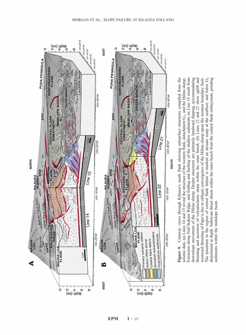
Figure
9.
Cutaway
viewsthroughKilauea’s
south
flankshowingsubsurfacestructurescompiled
from
the
seismicdata.(a)Lines
14and15revealthestructure
ofthewestern
flank,detachmentG1,andtheHilinaslump.
ExtensionalongNali’ikakaniRidge,
andfoldingandfaultingoftheshallow
sedim
entsonLine15resultfrom
downslopemovem
entoftheHilinaslump.Deeper
structuresareprimarilylandwarddipping,accommodating
thrustingandaccretionofvolcaniclastic
strata
within
theouterbench.(b)Lines
22and21show
upliftand
westwardthrustingofPapa‘udueto
obliqueconvergence
oftheHilinaslumpuponthewestern
boundaryfault.
Thetransitionto
theregionofcentral
flankfailure
ismarked
anarcuatescarpat
theseafloor,andlistricG2
detachmentatdepth.Im
bricatethrustsheetswithin
theouterbench
frontthecentralflankem
bayment,ponding
sedim
entswithin
themidslopebasin.
EPM 1 - 15
MORGAN ET AL.: SLOPE FAILURE AT KILAUEAVOLCANO


![Physical modeling of tsunamis generated by three ......[2] Tsunamis are water waves generated by impulsive disturbances such as submarine earthquakes and landslides, volcanic eruptions](https://img.pdfslide.us/doc/110x75/605705a83642e512411472aa/physical-modeling-of-tsunamis-generated-by-three-2-tsunamis-are-water.jpg)
![Submarine record of volcanic island construction and ...seismo.berkeley.edu/~manga/lefriantetal2015.pdf · Wadge, 1984; MacDonald et al., 2000]. Arc volcanism has been active since](https://img.pdfslide.us/doc/110x75/5f0c524c7e708231d434d255/submarine-record-of-volcanic-island-construction-and-mangalefriantetal2015pdf.jpg)